Embed Size (px)
Citation preview

Colorado Department of Transportation
Region 1 ITS Strategic Implementation Plan
May 2008

Colorado Department of Transportation
Region 1 ITS Strategic Implementation Plan
May 2008

Colorado Department of Transportation Region 1 ITS Strategic Implementation Plan
Prepared for:
Colorado Department of Transportation – ITS Branch Project Manager: Bruce Coltharp
Prepared by:
URS Corporation 8181 E. Tufts Ave Denver, CO 80237
303-740-2600
URS Project Number 22239436 May 2008

TABLE OF CONTENTS
Executive Summary ........................................................................................................... i I. Purpose.................................................................................................................... 1 II. Region 1 Corridor Analysis....................................................................................... 6 III. ITS Corridor Project Descriptions........................................................................... 11 IV. Project Sequencing ................................................................................................ 39 V. Conclusion ............................................................................................................. 46
FIGURES
Figure 1: CDOT Region 1 .................................................................................................3 Figure 2: Region 1 Existing ITS Infrastructure ..................................................................4 Figure 3: Region 1 Corridors of Significance ....................................................................7
TABLES Table 1: Region 1 ITS Project Summary........................................................................... ii Table 2: Region 1 Corridors of Significance....................................................................10 Table 3: Region 1 ITS Short Term Corridor Projects ......................................................40 Table 4: Region 1 ITS Medium Term Corridor Projects ..................................................42 Table 5: Region 1 ITS Long Term Corridor Projects.......................................................44 Appendix A: Region 1 ITS Deployment Costs & Locations…........................................A-1 Appendix B: Transportation Service Areas…………………………………………………B-1

ACRONYMS AND ABBREVIATIONS AVL………………………………………………………………….Automatic Vehicle Location C2C……………………………………………………………………………..Center-to-Center CCTV .......................................................................................... Closed Circuit Television CDOT................................................................... Colorado Department of Transportation CFR……………………………………………………………….Code of Federal Regulations CSP………………………………………………………………………..Colorado State Patrol CTMC......................................................... Colorado Transportation Management Center CVO……………………………………………………………Commercial Vehicle Operations DRCOG.............................................................Denver Regional Council of Governments EJT........................................................................................ Eisenhower-Johnson Tunnel EM...............................................................................................Emergency Management ES .......................................................................................................Executive Summary FHWA............................................................................... Federal Highway Administration FVS…………………………………………………………………………Fog Visibility System GIS.................................................................................Geographical Information System HAR..............................................................................................Highway Advisory Radio HLT ...................................................................................................Hanging Lake Tunnel HLTTMC...............................................Hanging Lake Tunnel Traffic Management Center HQ................................................................................................................. Headquarters ITS.................................................................................Intelligent Transportation Systems MDSS…………………………………………………Maintenance Decision Support System MPO............................................................................Metropolitan Planning Organization O&M..................................................................................... Operations and Management POE.................................................................................................................Port of Entry RM………………………………………………………………………………...Ramp Metering RTMS……………………………………………………….Remote Traffic Microwave Sensor RWIS...................................................................Road and Weather Information Systems SEA.....................................................................................Systems Engineering Analysis SH………………………………………………………………………………….State Highway STIP ..............................................................Statewide Transportation Improvement Plan TBD……………………………………………………………………………To Be Determined TTI………………………………………………………………………….Travel Time Indicator TT VMS…………………………………………………..Travel Time Variable Message Sign VMS ...............................................................................................Variable Message Sign VSLS…………………………………………………………………Variable Speed Limit Sign WIM...........................................................................................................Weigh-In-Motion

Region 1 ITS Strategic Implementation Plan Colorado Department of Transportation Executive Summary
i
Executive Summary The Colorado Department of Transportation (CDOT) has invested significant resources in the deployment of intelligent transportation system (ITS) infrastructure in Region 1 including numerous ITS devices such as: fiber optic cable on I-70 and I-25, travel time indicators, closed circuit television (CCTV) cameras, Highway Advisory Radio (HAR), weather stations, weigh in motion (WIM) sensors and variable message signs (VMS). CDOT Region 1 intends to continue this investment in intelligent transportation systems in the future given the mobility and safety benefits derived from actively managing the transportation system and the high benefit to cost ratios associated with ITS technology applications.
To ensure that these ITS resources are effectively and efficiently deployed across multiple jurisdictions and agencies, several ITS planning documents have been developed that contain portions or all of Region 1. These documents include:
1. CDOT Statewide ITS Strategic Plan/Architecture
2. ITS Strategic Plan/Architecture for Southeastern Colorado
3. Denver Regional Council of Governments (DRCOG) ITS Strategic Plan/Architecture
4. Region 1 VMS Plan
5. CDOT Incident Management Plan ITS Recommendations
These ITS planning documents provide the framework and long-range vision for the implementation of ITS applications in Colorado and Region 1. In addition, it should be noted that Region 1 is working on a business plan for operations on I-70 and new vision for Eisenhower Johnson Tunnel operations. These efforts are expected to be completed later this year.
The realization of the strategic objectives for intelligent transportation systems in Colorado and CDOT’s Region 1 is dependent upon developing specific projects to deploy the enabling infrastructure1 and establish the communication and coordination linkage that do not yet fully exist. The purpose of this Region 1 ITS Strategic Implementation Plan is to consolidate all ITS projects for Region 1 into a single document that will enable Region 1 staff (engineers, planners, designers, maintenance personnel, etc.) to manage the planning, programming and deployment of individual ITS projects.
This Region 1 ITS Strategic Implementation Plan contains all known ITS projects from the previously mentioned ITS planning documents and categorizes the projects within their respective corridors of significance. The specific ITS projects and corridors of significance for Region 1 were identified in the development of the other ITS planning documents and this Plan consolidates them in an organized and efficient manner specifically for Region 1. There are twenty seven (27) corridors of significance in Region 1 As identified in the Statewide ITS Strategic Plan, the enabling infrastructure consists of integrating the CTMC and other major TMCs, deployment of fiber-optic backbone and high speed add/drop multiplexers and connection of existing and deployed devices to the fiber optic backbone.

Region 1 ITS Strategic Implementation Plan Colorado Department of Transportation Executive Summary
ii
1. While not all Region 1 corridors of significance (Interstate Highways, statewide significant, significant regional and other regional corridors) currently have ITS projects planned, all corridors have been included in this Plan to facilitate the future development of ITS projects on those corridors. In addition, it should be noted that all ITS projects must be developed using systems engineering analysis (SEA) process.
CDOT is in the process of developing SEA guidelines to be used in conjunction with ITS Regional Architectures regarding project implementation. More information regarding the SEA process is provided in Section 1.
Table 1 below summarizes the Region 1 ITS projects planned for deployment in the short term, med term and long term. The short term, med term, and long term deployment timeframes varied among the three existing ITS planning documents: DRCOG ITS Strategic Plan, ITS Strategic Plan for Southeastern Colorado, and CDOT Incident Management Plan ITS Recommendations. It should be noted that the newly updated DRCOG ITS Strategic Plan does not identify specific projects for deployment and instead uses Transportation Service Areas for guidance on implementing projects. Regardless, all of the Region 1 projects identified in this plan that are in the DRCOG area are consistent with Regional needs.
For purposes of this Plan, all projects for each corridor were considered aggregately in conjunction with the Region’s overall vision of ITS services to be provided on the corridor in order to determine appropriate project deployment timeframes. Although, the plan provides guidance on project deployment timeframes, it should be noted that projects can be accelerated or postponed based on synergies that exist during the decision making process. This allows Region 1 the necessary flexibility to leverage resources and save CDOT implementation costs in the long term.
Table 1 also shows the needed investment (estimated construction costs) in 2007 dollars and is not indexed. The needed investment includes Preliminary and Construction Engineering. It also includes estimated costs for system connectivity. However, it does not include operations and maintenance costs.
Table 1: Region 1 ITS Project Summary
Short Term Med Term Long Term Total
Number of Projects 12 15 28 55
Needed Investment (in
$millions) $22.60 $12.33 $26.98 $61.91

Region 1 ITS Strategic Implementation Plan Colorado Department of Transportation
1
I. Purpose
This Region 1 ITS Strategic Implementation Plan covers the entire geographical area for the Colorado Department of Transportation’s (CDOT) Engineering Region 1. This area extends from the Kansas State Line on the east to Eagle, Lake and Chaffee Counties on the west and approximately from Denver on the north to Colorado Springs on the south while excluding these two cities. Figure 1 depicts the geographic boundaries associated with this Region 1 ITS Strategic Implementation Plan, which is consistent with the area of responsibility for CDOT’s Engineering Region 1.
CDOT has already deployed significant ITS infrastructure in Region 1 including fiber optic cable on I-70 and I-25, travel time indicators, numerous closed circuit television (CCTV) cameras, Highway Advisory Radio (HAR), weather stations, weigh in motion (WIM) sensors and variable message signs (VMS). Figure 2 shows the existing ITS devices that have been deployed in Region 1.
Several intelligent transportation system (ITS) planning documents have been developed to date for Colorado that include portions or all of CDOT’s Region 1. These documents were created in order to define the strategic direction and long-range vision for the deployment of ITS in Colorado, develop a framework for ITS implementation that facilitates multi-jurisdictional coordination and ensure conformance with 23 CFR Part 940. These planning documents include:
1. CDOT Statewide ITS Strategic Plan/Architecture
2. ITS Strategic Plan/Architecture for Southeastern Colorado
3. Denver Regional Council of Governments (DRCOG) ITS Strategic Plan/Architecture
4. Region 1 VMS Plan
5. CDOT Incident Management Plan ITS Recommendations
In addition, it should be noted that Region 1 is working on a business plan for operations on I-70 and new vision for Eisenhower Johnson Tunnel operations. These efforts are expected to be completed later this year.
The objective of this Region 1 ITS Strategic Implementation Plan is to develop a single document that Region 1 staff can utilize to effectively manage the deployment of specific ITS projects referenced in the above documents that pertain to Region 1. This Plan will enable Region 1 staff to “champion” the implementation of ITS in Region 1 and facilitate the planning, programming and design of individual ITS projects that will establish the ITS infrastructure required to fulfill the ITS vision for Region 1.
This Plan consolidates all ITS projects from the above documents into a single document that categorizes the specific projects within their respective corridor of significance i.e., Interstate Highways, statewide significant, significant regional and other regional corridors. The individual projects and corridors were originally prioritized during the development, and within the context, of these other ITS planning documents. As the transportation needs of Region 1 change over time and individual ITS projects are implemented, this Plan should be updated to reflect the current status of the Region 1

Region 1 ITS Strategic Implementation Plan Colorado Department of Transportation
2
ITS program. Revisions can and should include the modification of existing and addition of new ITS projects, changes in priority and sequencing of projects and modification and/or addition of corridors, as appropriate.
This Region 1 ITS Strategic Implementation Plan does not supersede or replace any of the existing ITS planning documents, but rather establishes an ITS planning tool specifically for Region 1. The other ITS planning documents contain valuable information regarding the deployment of ITS. This Plan is specifically targeted for Region 1 utilization, however, and only contains information relevant to ITS implementation in Region 1. The other ITS planning documents should continue to be referenced by the Region 1 staff to ensure that the ITS projects mentioned in subsequent sections are deployed in a manner consistent with multi-jurisdictional objectives. For example, Region 1 ITS projects that are also within the DRCOG area should be implemented in conformance with the DRCOG ITS Architecture to ensure multi-agency communication and coordination is achieved and device interoperability and jurisdictional coordination is facilitated.
An Architecture database has been created using Turbo Architecture version 4.0 for the DRCOG ITS Architecture, and an Architecture database has been created using Turbo Architecture version 3.1, which is scheduled to be updated to version 4.0 in the near future, for the Southeastern Colorado Architecture.
Turbo Architecture is a software tool that allows users to catalogue and organize project and/or regional architectures in a database format. The software also provides users with enhanced functionality in working with architecture stakeholders, elements, market packages, operational concepts, functional requirements, interfaces, standards and agreements. The software defines the architecture, relationships and interconnects between stakeholders and elements and gives the user the ability to access physical and logical diagrams at multiple levels. Use of the software will facilitate consistency, version control, maintenance and subsequent updating of the Regional Architecture. It will also be useful in obtaining and providing project Architecture related information as is required by, and in order to comply with, the Federal systems engineering analysis.

Region 1 ITS Strategic Implementation Plan Colorado Department of Transportation
3
Figure 1: CDOT Region 1

Region 1 ITS Strategic Implementation Plan Colorado Department of Transportation
4
Figure 2: Region 1 Existing ITS Infrastructure

Region 1 ITS Strategic Implementation Plan Colorado Department of Transportation
5
In order to meet the requirements of 23 CFR Part 940 to receive federal funding, an ITS project must demonstrate that a systems engineering analysis was performed during the design of the project. The systems engineering analysis process includes the following seven elements that must to be addressed to ensure a project conforms to the federal ITS requirements:
1. Description of how project fits into the Regional ITS Architecture
2. Roles and responsibilities of participating agencies
3. Requirements definition
4. Analysis of alternative system configurations and technology options
5. Procurement options
6. Applicable ITS standards and testing procedures
7. Procedures and resources necessary for operations and management of the system
CDOT and DRCOG are developing Systems Engineering Analysis (SEA) Guidelines that will describe the method of demonstrating compliance with the federal ITS requirements. The requirement for SEA only applies to those ITS projects that have federal funding, however CDOT and DRCOG believe that there is value in requiring all ITS projects to use the SEA in order to ensure architectural consistency and integrity. In lieu of the SEA Guidelines, and until they are finalized, a common approach to ensuring SEA compliance is to have the project sponsor “self-certify” that they will comply with the ITS requirements. In this way, the project sponsor is taking responsibility for meeting the federal ITS requirements for their project. An official that could commit the organization to compliance (i.e., Public Works Director, Transportation Director) would be required to authorize the certification. The self-certification would take place at two points in the project development cycle:
Planning: At the planning level, the project sponsor would provide a short description of how their ITS project would fit into the Regional ITS Architecture and agree to conduct a systems engineering analysis for the project during the design phase. If the project were not currently addressed in the Regional ITS Architecture, it would be addressed as an incremental change as described in the Architecture Maintenance Process in the DRCOG ITS Architecture.
Design (Prior to Construction): Many of the details about the ITS elements of a project are developed in greater detail during the design phase. Providing in-depth details about the project’s compliance with the new federal ITS requirements is most appropriate during the design phase, prior to construction. The project sponsor would, again, “self-certify” that the systems engineering analysis was completed and provide information on the final project ITS Architecture and its relationship with the Regional ITS Architecture for the purpose of maintaining the Regional ITS Architecture.
Again, the Turbo Architecture databases will be very useful in obtaining and providing much of the project Architecture related information required above in order to comply with the systems engineering analysis. FHWA or FTA may independently request additional documentation on the systems engineering analysis before funds are released for construction.

Region 1 ITS Strategic Implementation Plan Colorado Department of Transportation
6
II. Region 1 Corridor Analysis
The following section describes the various corridors in Region 1. Although not all corridors currently have ITS projects identified, all corridors of significance in Region 1 have been included in this plan to facilitate the management of ITS projects on these corridors in the future.
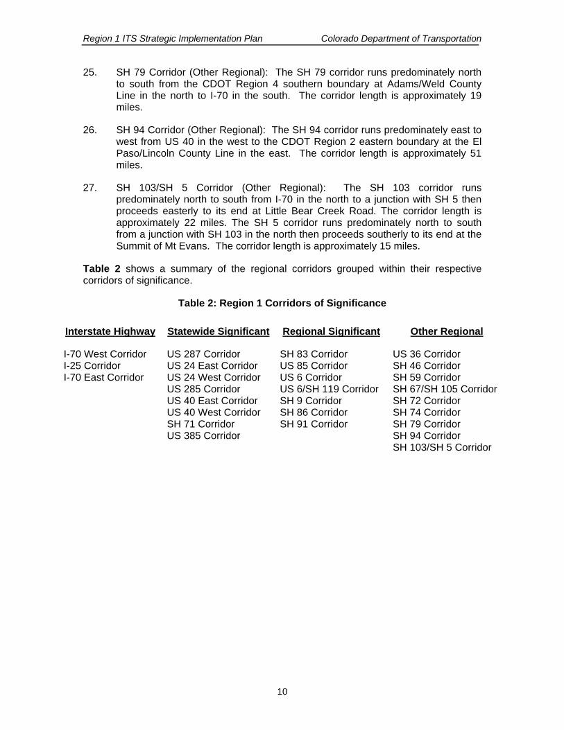
Transportation professionals across the country are utilizing a corridor approach to manage the public transportation network. A corridor management approach enables a comprehensive analysis of the network’s existing infrastructure (capacity), transportation needs (demand), functionality, and operational characteristics. During a Region 1 corridor analysis, CDOT and other stakeholders identified a total of 27 primary corridors of significance (Interstate Highways, statewide significant, regional significant and other regional corridors) for Region 1. These corridors were selected based upon their high level of importance in supporting the commercial and personal surface transportation needs within Region 1. The corridors are categorized and prioritized within their respective corridors of significance area below, and are displayed on the map in Figure 3 and grouped in Table 2. Appendix A provides high-level costs and general locations for ITS deployment on each of the corridors.
Interstate Highways:
1. I-70 West Corridor (Interstate Highway): The I-70 West corridor runs predominately east to west from CDOT Region 6 western boundary at US 40 (Alameda Avenue) in the east to the CDOT Region 3 eastern boundary at the Summit/Eagle County Line in the west. The corridor length is approximately 69 miles.
2. I-25 Corridor (Interstate Highway): The I-25 South corridor runs predominately north to south from the CDOT Region 6 southern boundary at Lincoln Avenue in the north to the CDOT Region 2 northern boundary at Douglas/El Paso County Line in the south. The corridor length is approximately 30 miles.
3. I-70 East Corridor (Interstate Highway): The I-70 East corridor runs predominately east to west from the Kansas State Line in the east to the CDOT Region 6 eastern boundary (approximately Powhaton Road) in the west. The corridor length is approximately 165 miles.
Statewide Significant Corridors:
4. US 287 Corridor (Statewide Significant): The US 287 corridor runs predominately north to south from US 40 (Kit Carson) in the north to the CDOT Region 2 northern boundary at the Kiowa/Cheyenne in the south. The corridor length is approximately 10 miles.
5. US 24 East Corridor (Statewide Significant): The US 24 East corridor runs predominately northeast to southwest from I-70 (Limon) in the northeast to the CDOT Region 2 northern boundary at the El Paso County/Elbert Line in the southwest. The corridor length is approximately 30 miles.

Region 1 ITS Strategic Implementation Plan Colorado Department of Transportation
7
Figure 3: Region 1 Corridors of Significance

Region 1 ITS Strategic Implementation Plan Colorado Department of Transportation
8
Statewide Significant Corridors continued:
6. US 24 West Corridor (Statewide Significant): The SH 24 corridor runs predominately east to west from the CDOT Region 2 western boundary at the Park/Teller County Line in the east to US 285 in the west. The corridor length is approximately 62 miles.
7. US 285 Corridor (Statewide Significant): The US 285 corridor runs predominately northeast to southwest from the CDOT Region 6 western boundary from SH 8 in the northeast to US 24 in the southwest. The corridor length is approximately 87 miles.
8. US 40 East Corridor (Statewide Significant): The US 40 East corridor runs predominately northwest to southeast from I-70 in the northwest to the Kansas State Line in the southeast. The corridor length is approximately 101 miles.
9. US 40 West Corridor (Statewide Significant): The US 40 West corridor runs predominately east to west from I-70 in the east to the CDOT Region 3 southern boundary at the Grand/Clear Creek County Line in the west. The corridor length is approximately 15 miles.
10. SH 71 Corridor (Statewide Significant): The SH 71 corridor runs predominately north to south from the CDOT Region 4 southern boundary at the Washington/Lincoln County Line in the north through Limon to CDOT Region 2 northern boundary at Crowley/Lincoln Line in the south. The corridor length is approximately 77 miles.
11. US 385 Corridor (Statewide Significant): The US 385 corridor runs predominately north to south from the CDOT Region 4 southern boundary at the Kit Carson/Yuma County Line in the north to CDOT Region 2 northern boundary at the Kiowa/Cheyenne County Line in the south. The corridor length is approximately 71 miles.
Regional Significant Corridors:
12. SH 83 Corridor (Regional Significant): The SH 83 corridor runs predominately north to south from the CDOT Region 6 southern boundary at SH 88 (Arapahoe Road) in the north to the CDOT Region 2 northern boundary at the El Paso/Douglas County Line in the south. The corridor length is approximately 35 miles.
13. US 85 Corridor (Regional Significant): The US 85 corridor runs predominately northwest to southeast from the CDOT Region 6 southern boundary (approximately C-470) in the northwest to I-25 in the southeast. The corridor length is approximately 16 miles.
14. US 6 Corridor (Regional Significant): The US 6 corridor runs predominately east to west over Loveland pass and parallel to I-70 from the east side of the Eisenhower Tunnel at I-70/US 6 in the east to I-70/SH 9 at Dillon in the west. The corridor length is approximately 21 miles.

Region 1 ITS Strategic Implementation Plan Colorado Department of Transportation
9
15. US 6/SH 119 Corridor (Regional Significant): The US 6 and SH 119 corridor runs predominately east to west along US 6 from the CDOT Region 6 western boundary at SH 93 in the east to SH 119 in the west and runs predominately north to south from US 6 in the south to SH 72 in the north. The corridor length is approximately 34 miles.
16. SH 9 Corridor (Regional Significant): The SH 9 corridor runs predominately north to south from the CDOT Region 3 southern boundary at the Summit/Grand County Line in the north to the CDOT Region 5 northern boundary at the Fremont/Park County Line in the south. The corridor length is approximately 103 miles.
17. SH 86 Corridor (Regional Significant): The SH 86 corridor runs predominately east to west from I-70 west of Limon in the west to I-25 in the east. The corridor length is approximately 63 miles.
18. SH 91 Corridor (Regional Significant): The SH 91 corridor runs predominately north to south from I-70 in the north to the CDOT Region 3 eastern boundary at the Lake/Summit County Line in the south. The corridor length is approximately 11 miles.
Other Regional Corridors:
19. US 36 Corridor (Other Regional): The US 36 corridor runs predominately east to west from the CDOT Region 4 western boundary at the Adams/Washington County Line in the east to I-70 in the west. The corridor length is approximately 29 miles.
20. SH 46 Corridor (Other Regional): The SH 46 corridor runs predominately east to west from the Jefferson/Gilpin County Line in the east to SH 119 in the west. The corridor length is approximately 7 miles.
21. SH 59 Corridor (Other Regional): The SH 59 corridor runs predominately north to south from the CDOT Region 4 southern boundary at Kit Carson/Washington County Line in the north southerly to a junction with US 40. The corridor length is approximately 60 miles.
22. SH 67/SH 105 Corridor (Other Regional): The SH 105 corridor runs from a junction with SH 67 southeasterly for approximately 4 miles to its end at Wolfensberger Road. The SH 67 corridor runs from a junction with US 85 southwesterly for approximately 10 miles to its end at Rampart Range Road.
23. SH 72 Corridor (Other Regional): The SH 72 corridor runs predominately east to west from the CDOT Region 6 western boundary at SH 93 in the east to SH 119 in the west. The corridor length is approximately 19 miles.
24. SH 74 Corridor (Other Regional): The SH 74 corridor runs predominately east to west from the CDOT Region 6 western boundary at SH 8 in the east to I-70 in the west. The corridor length is approximately 18 miles.
Region 1 ITS Strategic Implementation Plan Colorado Department of Transportation
10
25. SH 79 Corridor (Other Regional): The SH 79 corridor runs predominately north to south from the CDOT Region 4 southern boundary at Adams/Weld County Line in the north to I-70 in the south. The corridor length is approximately 19 miles.
26. SH 94 Corridor (Other Regional): The SH 94 corridor runs predominately east to west from US 40 in the west to the CDOT Region 2 eastern boundary at the El Paso/Lincoln County Line in the east. The corridor length is approximately 51 miles.
27. SH 103/SH 5 Corridor (Other Regional): The SH 103 corridor runs predominately north to south from I-70 in the north to a junction with SH 5 then proceeds easterly to its end at Little Bear Creek Road. The corridor length is approximately 22 miles. The SH 5 corridor runs predominately north to south from a junction with SH 103 in the north then proceeds southerly to its end at the Summit of Mt Evans. The corridor length is approximately 15 miles.
Table 2 shows a summary of the regional corridors grouped within their respective corridors of significance.
Table 2: Region 1 Corridors of Significance
Interstate Highway Statewide Significant Regional Significant Other Regional
I-70 West Corridor I-25 Corridor I-70 East Corridor
US 287 Corridor US 24 East Corridor US 24 West Corridor US 285 Corridor US 40 East Corridor US 40 West Corridor SH 71 Corridor US 385 Corridor
SH 83 Corridor US 85 Corridor US 6 Corridor US 6/SH 119 Corridor SH 9 Corridor SH 86 Corridor SH 91 Corridor
US 36 Corridor SH 46 Corridor SH 59 Corridor SH 67/SH 105 Corridor SH 72 Corridor SH 74 Corridor SH 79 Corridor SH 94 Corridor SH 103/SH 5 Corridor

Region 1 ITS Strategic Implementation Plan Colorado Department of Transportation
11
III. ITS Corridor Project Descriptions
A current listing of ITS projects identified for each of the Region 1 corridors of significance is provided below. This list should be referenced during the implementation of all transportation projects, especially ITS projects, on the corridors and updated as appropriate. For each corridor a table is included that contains the following items:
• Project # - identifies the priority order regarding the project.
• Project Description – provides a brief description of the ITS services to be deployed on the project and project limits.
• ITS Devices Included – identifies the specific type of ITS device and number of device(s) to be deployed on the project.
• Deployment Timeframe – identifies the deployment timeframe as determined by the Region. For Region 1 the following ITS Deployment Timeframes are used:
Short Term: 0-3 years Med Term: 3-6 years Long Term >6 years
• Transportation Service Area – identifies the Transportation Service Area (TSA) that is relevant to the project application. TSAs are major operational areas that were developed for the purpose of providing ITS services in coordination with ITS applications (project) necessary to provide the specific service. The following are the nine TSAs: Regional Traveler Information (1), Regional Transportation Operations and Management (2), Regional Traffic Incident Management (3), Transit Operations and Management (4), Maintenance and Construction (5), Regional Parking Management (6), Regional Data Management (7), Regional Emergency Management (8) and Commercial Vehicle Operations (9). A listing of the TSAs and their definitions is included as Appendix B.
• Source – identifies the Plan where the project originated. See Section 1. For more information regarding the originating Plans. Based on discussions with Region 1 staff in the development of this plan, other ITS implementations were identified as necessary to enhance and maximize Region 1 ITS applications. The source for the other ITS implementations is indicated as “Additional Region 1 Implementations”.
• Needed Investment (in $millions) - shows the needed investment (estimated construction costs) in 2007 dollars and is not indexed. The needed investment includes Preliminary and Construction Engineering. It also includes estimated costs for system connectivity. However, it does not include operations and maintenance costs.

Region 1 ITS Strategic Implementation Plan Colorado Department of Transportation
12
1. I-70 West Project Descriptions Corridor: I-70 West (US 40 (Alameda Avenue) to Vail Pass) (Interstate Highway)
Project # Project Description ITS Devices Included Deployment
Timeframe Transportation Service Area(s) Source Needed Investment
(in $millions)
1
From Golden to the Eisenhower Tunnel Complete the I-70 Mountain Corridor Incident Management System improvements, traffic monitoring and freeway management systems and traffic information dissemination systems. Implement heavy truck management strategies
CCTV (16), TT VMS (6), Gates (4), TTI (4); RM (2)
VSLS (4), VMS (4), Courtesy Patrol
Short Term
1, 2, 3
DRCOG ITS Strategic Plan/ Traffic Incident Management
/Other Region 1 Implementations
$5.10
2 Install fiber optic cable from East Vail (Mile Post 182) to Frisco Fiber Optic Cable In Progress 1, 2, 3 SE Colorado ITS Plan/Architecture
3 Install fiber optic cable from East Vail (Mile Post 182) to Vail (Mile Post 180) including all equipment, connections, and lateral devices for C2C with CSP and local jurisdictions Fiber Optic Cable Short Term 1, 2, 3 SE Colorado ITS
Plan/Architecture $5.2
4 From Eisenhower Tunnel to Vail - Complete the I-70 Mountain Corridor Incident Management system improvements including automated pass maintenance and closure for Loveland Pass and Vail Pass and select freeway management system elements
CCTV (5), VMS (4), TTI (4), RWIS (4) Short Term 3, 5 SE Colorado ITS Plan/Architecture
$1.82
5 Downhill Warning System
Downhill Warning (1) Short Term 1, 5, 9 Other Region 1
Implementations $0.42
6 Develop I-70 & EJMT Business Operations Plan Short Term 1, 2, 3, 5, Other Region 1 Implementations NA
7 Implement MDSS Corridor application from Golden to Vail Bridge De-icing system (locations – EB Loveland bridge, EB Georgetown) Speed monitoring system using radar – Twin Tunnels location (similar to Glenwood Springs)
AVL w/Cam (40), RWIS (4) Bridge De-icing (1)
Speed monitoring (1) Medium Term 1, 5, 9 Other Region 1
Implementations $1.33
8 Chain-up Area Improvements (per grant application) 3 Parking Management Systems Medium Term 2, 6, 9 Other Region 1 Implementations $3.4
9 Implement transit management and multi-modal coordination in Summit County. Project applies to I-70, US 6, SH 9 and SH 91. Information Sharing Long Term 4 SE Colorado ITS
Plan/Architecture $0.5
10 Research Project Hot Brake Detection Long Term 9 DRCOG ITS Strategic Plan $0.07
Total $17.84 • Region 1 ITS Deployment Timeframe: Short Term (0-3 years), Med Term (3-6 years), Long Term (>6 years)

Region 1 ITS Strategic Implementation Plan Colorado Department of Transportation
13
2. I-25 South Project Descriptions Corridor: I-25 (Lincoln Avenue to El Paso/Douglas County Line) (Interstate Highway)
Project # Project Description ITS Devices Included Deployment Timeframe Transportation Service
Area(s) Source Needed
Investment (in $millions)
1 Implement Chain Stations strategies – (SB Chain station at Larkspur rest area) VMS (1), VSLS (2), CCTV (2); flashing beacons (2) Short Term 2, 9 Other Region 1
Implementations $0.49
2 From Lincoln Avenue to Plum Creek Pkwy Complete incident management system improvements, traffic monitoring and freeway management systems and traffic information dissemination systems.
CCTV (2), VMS (2), TTI (9), TT VMS (3), RWIS (1)
RM (5), RTMS(3), Courtesy Patrol
Short Term 1, 2, 3 DRCOG ITS Strategic Plan/ Traffic Incident Management
ITS Recommendations $3.19
3 Implement MDSS Corridor application & Deploy RWIS to support MDSS from Lincoln to El Paso/Douglas County Line AVL w/Cam (20) & RWIS (2) Short Term 1, 5 Other Region 1
Implementations $0.56
4 From Plum Creek Pkwy to El Paso/Douglas County Line Complete incident management system improvements, traffic monitoring and freeway management systems and traffic information dissemination systems.
VMS (1), TTI(1) CCTV (6), TT VMS (2), RWIS
(1), Courtesy Patrol Med Term 1, 2, 3
DRCOG ITS Strategic Plan/ Traffic Incident
Management ITS Recommendations/ Region 1 VMS Plan
$1.84
5 Deploy Truck parking (CVO) (Parking Management)/Deploy truck chain station –NB Greenland
1 Parking Management System Med term 2,6, 9 Other Region 1
Implementations $0.42
6 Deploy Tomah Fog Visibility System FVS Long Term 1, 2, 3 Other Region 1 Implementations $0.07
Total $6.57
• Region 1 ITS Deployment Timeframe: Short Term (0-3 years), Med Term (3-6 years), Long Term (>6 years)

Region 1 ITS Strategic Implementation Plan Colorado Department of Transportation
14
3. I-70 East Project Descriptions Corridor: I-70 East (Powhaton Rd to Kansas State line) (Interstate Highway)
Project # Project Description Recommended ITS Devices Deployment Timeframe Transportation Service
Area(s) Source Needed Investment (in $millions)
1 Implement Chain Stations strategies – Cedar Point (EB Chain station at Agate and WB at Limon) and E-470 and Airpark
VMS (1), VSLs (3), CCTV (3); flashing beacons (3) Short Term 2, 9 Other Region 1
Implementations $0.56
2
From E-470 to Bennett Deploy traffic information dissemination systems Deploy network surveillance, freeway control and incident management systems
WB-TT VMS (3), TTI (2); CCTV (4), VMS (2), RTMS
(2). Short Term 1, 2, 3 DRCOG ITS Strategic Plan $1.25
3 Upgrade Gates at Air Park, Limon Implement MDSS corridor application from Powhaton Rd to Kansas State Line
Gates (2) AVL w/cam for Trucks (40)
& RWIS (6) Short term 1, 5 Other Region 1
Implementations $1.75
4 Implement Parking Management 3 locations( 2 at Limon and 1 at Watkins) Short term 2, 6, 9 Other Region 1
Implementations $1.26
5 From Bennett to Limon Develop incident management and traveler information system
WB-TT VMS (5), TTI (12); CCTV (12), VMS (4),
RTMS (2) Long Term 1, 2, 3 SE Colorado ITS
Plan/Architecture $2.50
6 From Limon to Kansas State Line Develop incident management and traveler information system
CCTV (16), VMS (10), Long term 1, 2, 3 SE Colorado ITS
Plan/Architecture / Region 1 VMS Plan
$3.84
Total $11.16
• Region 1 ITS Deployment Timeframe: Short Term (0-3 years), Med Term (3-6 years), Long Term (>6 years)

Region 1 ITS Strategic Implementation Plan Colorado Department of Transportation
15
4. US 287 ITS Project Description Corridor: US 287 (US 40 to Cheyenne/Kiowa County Line) (Statewide Significant)
Project # Project Description ITS Devices Included Deployment Timeframe Transportation Service Area(s) Source Needed Investment
(in $millions)
1 Implement rural highway management systems on US 287 south of Limon; ground mounted VMS (1) south of Kit Carson; one SB
VMS (2), RWIS (4) Long Term 1, 2, 3 SE Colorado ITS
Plan/Architecture/ Region 1 VMS Plan
$0.98
Total $0.98
• Region 1 ITS Deployment Timeframe: Short Term (0-3 years), Med Term (3-6 years), Long Term (>6 years)

Region 1 ITS Strategic Implementation Plan Colorado Department of Transportation
16
5. US 24 ITS Project Description Corridor: US 24 East (I-70 to Elbert/El Paso County Line) (Statewide Significant)
Project # Project Description ITS Devices Included Deployment Timeframe Transportation Service Area(s) Source Needed Investment
(in $millions)
1 Implement rural highway management systems east of Colorado Springs to Limon; ground mounted VMS (1) west of I-70
VMS (2), RWIS (1), Med Term 1, 2, 3, 5 SE Colorado ITS
Plan/Architecture/ Region 1 VMS Plan
$0.77
Total $0.77
• Region 1 ITS Deployment Timeframe: Short Term (0-3 years), Med Term (3-6 years), Long Term (>6 years)

Region 1 ITS Strategic Implementation Plan Colorado Department of Transportation
17
6. US 24 ITS Project Description Corridor: US 24 West (Park/Teller County Line to Park/Chaffee County Line) (Statewide Significant)
Project # Project Description ITS Devices Included Deployment Timeframe Transportation Service Area(s) Source Needed Investment
(in $millions)
1 Deploy automated pass maintenance and closure management system on US 24 over Wilkerson Pass
RWIS (2), VMS (2), automated gates (2) Long Term 1, 5 SE Colorado ITS Plan/
Architecture $1.33
Total $1.33
• Region 1 ITS Deployment Timeframe: Short Term (0-3 years), Med Term (3-6 years), Long Term (>6 years)

Region 1 ITS Strategic Implementation Plan Colorado Department of Transportation
18
7. US 285 ITS Project Descriptions Corridor: US 285 (SH 8 (Morrison) to US 24) (Statewide Significant)
Project # Project Description ITS Devices Included Deployment Timeframe
Transportation Service Area(s) Source Needed Investment
(in $millions)
1
From SH 8 to US 24 Deploy incident management, network surveillance, traveler information and incident management systems Implement MDSS Corridor application Deploy RWIS to support MDSS ground mounted VMS (8) at US 24, Fairplay, Kenosha Pass (2), Bailey, Crow Hill, Conifer and Pine Junction
CCTV (10), VMS (8), RWIS (4)
Long Term
1, 2, 3, 5
DRCOG ITS Strategic Plan/ Region 1 VMS
Plan $3.29
2 Install Fiber Optic Cable from C-470 to Fairplay Fiber Optic Cable Long Term 1, 2, 3 Other Region 1 Implementations $6.00
Total $9.29
• Region 1 ITS Deployment Timeframe: Short Term (0-3 years), Med Term (3-6 years), Long Term (>6 years)

Region 1 ITS Strategic Implementation Plan Colorado Department of Transportation
19
8. US 40 ITS Project Descriptions Corridor: US 40 East (I-70 to Kansas State line) (Statewide Significant)
Project # Project Description ITS Devices Included Deployment Timeframe Transportation Service
Area(s) Source Needed Investment (in $millions)
1 Deploy ground mounted VMS (2) south of I-70 and west of Kit Carson VMS (2) Long Term 1, 2, 3 Region 1 VMS Plan $0.7
2 Deploy Overhead VMS and RWIS at Cheyenne Wells VMS (1) and RWIS (1) Long Term 1, 2, 3 Other Region 1
Implementations $0.42
Total $1.12
• Region 1 ITS Deployment Timeframe: Short Term (0-3 years), Med Term (3-6 years), Long Term (>6 years)

Region 1 ITS Strategic Implementation Plan Colorado Department of Transportation
20
9. US 40 ITS Project Description Corridor: US 40 West (I-70 to Clear Creek/Grand County Line) (Statewide Significant)
Project # Project Description ITS Devices Included Deployment Timeframe Transportation Service Area(s) Source Needed Investment
(in $millions)
1 Deploy VMS (1) west of I-70 Deploy RWIS to support MDSS Deploy truck parking management
VMS (1) RWIS (2)
1 Parking Management System
Med term 1, 2, 3, 5, 6, 9 SE Colorado ITS Plan/Architecture $0.91
Total $0.91
• Region 1 ITS Deployment Timeframe: Short Term (0-3 years), Med Term (3-6 years), Long Term (>6 years)
Region 1 ITS Strategic Implementation Plan Colorado Department of Transportation
21
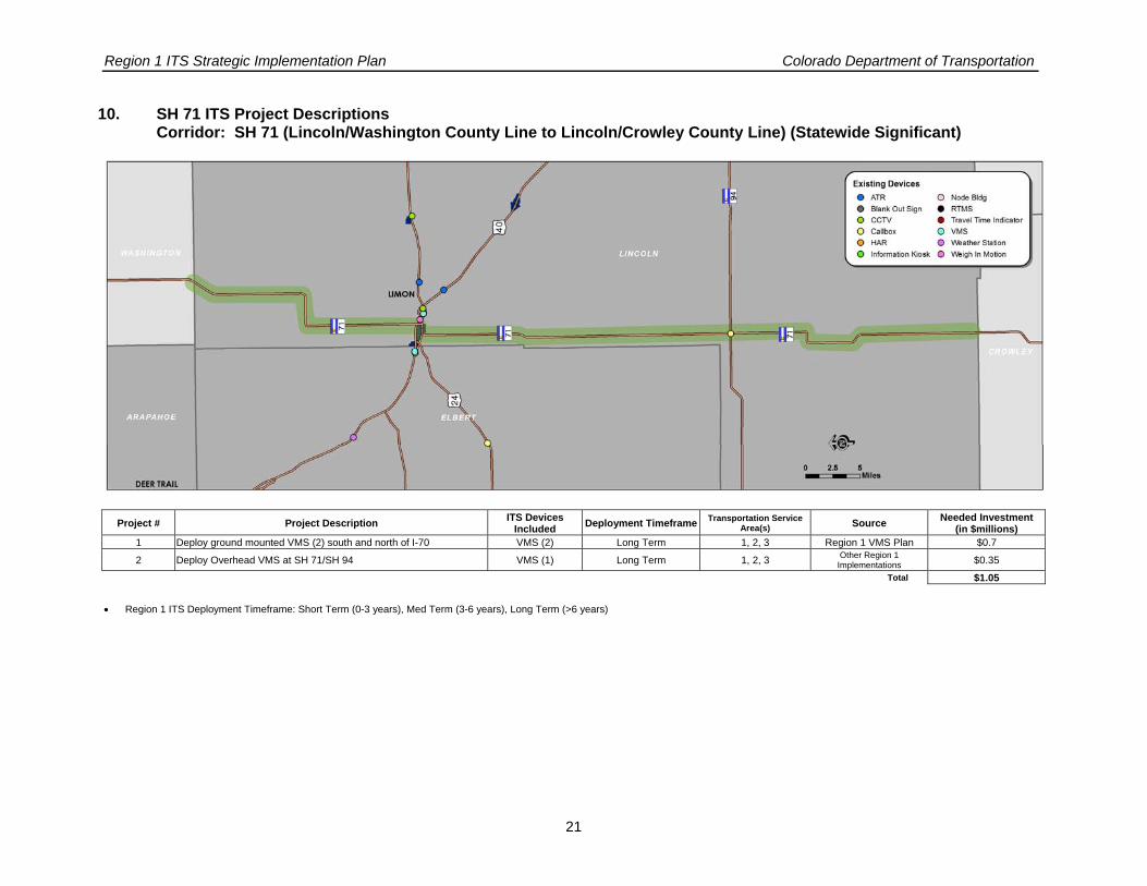
10. SH 71 ITS Project Descriptions Corridor: SH 71 (Lincoln/Washington County Line to Lincoln/Crowley County Line) (Statewide Significant)
Project # Project Description ITS Devices Included Deployment Timeframe Transportation Service
Area(s) Source Needed Investment (in $millions)
1 Deploy ground mounted VMS (2) south and north of I-70 VMS (2) Long Term 1, 2, 3 Region 1 VMS Plan $0.7
2 Deploy Overhead VMS at SH 71/SH 94 VMS (1) Long Term 1, 2, 3 Other Region 1 Implementations $0.35
Total $1.05
• Region 1 ITS Deployment Timeframe: Short Term (0-3 years), Med Term (3-6 years), Long Term (>6 years)

Region 1 ITS Strategic Implementation Plan Colorado Department of Transportation
22
11. US 385 ITS Project Description Corridor: US 385 (Yuma/Kit Carson County Line to Cheyenne/Kiowa County Line) (Statewide Significant)
Project # Project Description ITS Devices Included Deployment Timeframe Transportation Service
Area(s) Source Needed Investment(in $millions)
1 Deploy ground mounted VMS (2) south and north of Burlington VMS (2) Long Term 1, 2, 3 Region 1 VMS Plan $0.7 Total $0.7
• Region 1 ITS Deployment Timeframe: Short Term (0-3 years), Med Term (3-6 years), Long Term (>6 years)

Region 1 ITS Strategic Implementation Plan Colorado Department of Transportation
23
12. SH 83 ITS Project Descriptions Corridor: SH 83 (SH 88 (Arapahoe Road) to Douglas/El Paso County Line) (Regional Significant)
Project # Project Description ITS Devices Included
Deployment Timeframe
Transportation Service Area(s) Source Needed Investment
(in $millions)
1
From E-470 to SH 86 Deploy Incident management, network surveillance, traveler information and incident management systems; CCTV- E-470; Lincoln, Main, Broncos Pkwy, and SH-86; ground mounted VMS (1) south of Arapahoe County Line; south of Lincoln (northbound)
CCTV (5), VMS (2) Long Term 1, 2, 3 DRCOG ITS Strategic Plan $0.81
2 Deploy RWIS to support MDSS RWIS (2) Long Term 1, 5 Other Region 1 Implementations $0.14
Total $0.95
• Region 1 ITS Deployment Timeframe: Short Term (0-3 years), Med Term (3-6 years), Long Term (>6 years)

Region 1 ITS Strategic Implementation Plan Colorado Department of Transportation
24
13. US 85 ITS Project Descriptions Corridor: US 85 (I-25 to C-470) (Regional Significant)
Project # Project Description ITS Devices Included Deployment Timeframe Transportation Service Area(s) Source Needed Investment
(in $millions)
1
Deploy surface street control for the signalized principal arterial network from C-470 to I-25 Deploy incident management, network surveillance, traveler information and incident management systems from C-470 to I-25 Deploy ground mounted VMS (1) south of C-470
Fiber Optic Cable CCTV(2), VMS(1) Long Term 1, 2, 3
DRCOG ITS Strategic Plan/ Region 1 VMS
Plan $0.89
2 Implement MDSS Corridor application AVL W/Cam (2) Med Term 1, 5 Other Region 1 Implementations $0.04
3 Deploy parking facility management, railroad grade crossing, probe surveillance and traffic responsive signal systems from C-470 to I-25
Signal system, Rail Road crossing Long Term 2, 6, 9 DRCOG ITS Strategic
Plan $0.05
Total $0.98
• Region 1 ITS Deployment Timeframe: Short Term (0-3 years), Med Term (3-6 years), Long Term (>6 years)

Region 1 ITS Strategic Implementation Plan Colorado Department of Transportation
25
14. US 6 ITS Project Description Corridor: US 6 (I-70 (Eisenhower Tunnel) to I-70/SH 9 (Dillon)) (Regional Significant)
Project # Project Description ITS Devices Included Deployment Timeframe Transportation Service
Area(s) Source Needed Investment (in $millions)
1 Deploy ground mounted VMS (2) south of I-70 and at Swan Mtn Road VMS (2) Med term 1, 2, 3 Region 1 VMS Plan $0.7
Total $0.7
• Region 1 ITS Deployment Timeframe: Short Term (0-3 years), Med Term (3-6 years), Long Term (>6 years)

Region 1 ITS Strategic Implementation Plan Colorado Department of Transportation
26
15. US 6/SH119 ITS Project Descriptions Corridor: US 6 & SH 119 (SH 58/SH 93 to SH 72) (Regional Significant)
Project # Project Description ITS Devices
Included Deployment Timeframe
Transportation Service Area(s) Source Needed Investment
(in $millions) 1 Deploy ground mounted VMS (3) at SH 46 and Black Hawk (2) VMS (3) Med Term 1, 2, 3 Region 1 VMS Plan $1.05
2 Implement MDSS Corridor application Deploy RWIS to support MDSS Investigate communication solution
RWIS (2) AVL w/Cam (5) Med Term 1, 5 Other Region 1
Implementations $0.25
Total $1.30
• Region 1 ITS Deployment Timeframe: Short Term (0-3 years), Med Term (3-6 years), Long Term (>6 years)

Region 1 ITS Strategic Implementation Plan Colorado Department of Transportation
27
16. SH 9 ITS Project Descriptions Corridor: SH 9 (Summit/Grand County Line to Park/Fremont County Line) (Regional Significant)
Project # Project Description ITS Devices Included Deployment Timeframe Transportation Service Area(s) Source Needed Investment
(in $millions)
1 Install fiber optic cable from I-70 to 0.1 Mile south of Summit County Road 1004 (continuing to CDOT signal shop)
Fiber Optic Cable In Progress 1, 2, 3 Other Region 1 Implementations
2 Deploy ground mounted VMS (1) south of I-70 VMS (1) Med Term 1, 2, 3 Region 1 VMS Plan $0.35
3 Implement MDSS Corridor application Deploy RWIS to support MDSS
RWIS (2) AVL w/Cam (5) Med Term 1, 5 Other Region 1
Implementations $0.25
Total $0.60
• Region 1 ITS Deployment Timeframe: Short Term (0-3 years), Med Term (3-6 years), Long Term (>6 years)

Region 1 ITS Strategic Implementation Plan Colorado Department of Transportation
28
17. SH 86 ITS Project Description Corridor: SH 86 (I-70 to I-25) (Regional Significant)
Project # Project Description ITS Devices
Included Deployment Timeframe
Transportation Service Area(s) Source Needed Investment
(in $millions) 1 Deploy ground mounted VMS (2) west of I-70 and at Founders Pkwy. VMS (2) Med Term 1, 2, 3 Region 1 VMS Plan $0.70
2 Implement MDSS Corridor application Deploy RWIS to support MDSS
RWIS (2) AVL w/Cam (5) Med Term 1, 5 Other Region 1
Implementations $0.25
Total $0.95
• Region 1 ITS Deployment Timeframe: Short Term (0-3 years), Med Term (3-6 years), Long Term (>6 years)

Region 1 ITS Strategic Implementation Plan Colorado Department of Transportation
29
18. SH 91 ITS Project Description Corridor: SH 91 (I-70 to Summit/Lake County Line) (Regional Significant)
Project # Project Description ITS Devices Included Deployment Timeframe Transportation Service
Area(s) Source Needed Investment (in $millions)
1 Deploy VMS (1) north of I-70 VMS (1) Long Term 1, 2, 3 Region 1 ITS Strategic Plan $0.35
Total $0.35
• Region 1 ITS Deployment Timeframe: Short Term (0-3 years), Med Term (3-6 years), Long Term (>6 years)

Region 1 ITS Strategic Implementation Plan Colorado Department of Transportation
30
19. US 36 ITS Project Descriptions Corridor: US 36 (I-70 (Byers) to Adams/Washington County Line) (Other Regional)
Project # Project Description ITS Devices Included Deployment Timeframe Transportation Service Area(s) Source Needed Investment
(in $millions)
1 Deploy RWIS to support maintenance operations RWIS (1) Med Term 1, 5 Other Region 1 Implementations $0.07
2 Deploy VMS (1) east of I-70 VMS (1) Long Term 1, 2, 3 Region 1 ITS Strategic Plan $0.35
Total $0.42
• Region 1 ITS Deployment Timeframe: Short Term (0-3 years), Med Term (3-6 years), Long Term (>6 years)

Region 1 ITS Strategic Implementation Plan Colorado Department of Transportation
31
20. SH 46 ITS Project Description Corridor: SH 46 (SH 119 to Jefferson/Gilpin County Line) (Other Regional)
Project # Project Description ITS Devices Included Deployment Timeframe Transportation Service
Area(s) Source Needed Investment (in $millions)
1 TBD TBD TBD TBD TBD TBD Total TBD
• Region 1 ITS Deployment Timeframe: Short Term (0-3 years), Med Term (3-6 years), Long Term (>6 years)

Region 1 ITS Strategic Implementation Plan Colorado Department of Transportation
32
21. SH 59 ITS Project Description Corridor: SH 59 (US 40 to Washington/Kit Carson County Line) (Other Regional)
Project # Project Description ITS Devices Included Deployment Timeframe Transportation Service Area(s) Source Needed Investment
(in $millions)
1 Deploy VMS (2) north and south of I-70 VMS (2) Long Term 1, 2, 3 Region 1 ITS Strategic Plan $0.7
Total $0.7
• Region 1 ITS Deployment Timeframe: Short Term (0-3 years), Med Term (3-6 years), Long Term (>6 years)

Region 1 ITS Strategic Implementation Plan Colorado Department of Transportation
33
22. SH 67/SH 105 ITS Project Description Corridor: SH 67 & SH 105 (Other Regional)
Project # Project Description ITS Devices Included Deployment Timeframe Transportation Service
Area(s) Source Needed Investment
(in $millions) 1 TBD TBD TBD TBD TBD TBD
Total TBD
• Region 1 ITS Deployment Timeframe: Short Term (0-3 years), Med Term (3-6 years), Long Term (>6 years)

Region 1 ITS Strategic Implementation Plan Colorado Department of Transportation
34
23. SH 72 ITS Project Description Corridor: SH 72 (SH 93 to SH 119) (Other Regional)
Project # Project Description ITS Devices Included Deployment Timeframe Transportation Service Area(s) Source Needed Investment
(in $millions) 1 Deploy VMS at SH 119/SH 72 and SH 93/SH 72 VMS (2) Long Term 1, 2, 3 Other Region 1
Implementations $0.7
Total $0.7
• Region 1 ITS Deployment Timeframe: Short Term (0-3 years), Med Term (3-6 years), Long Term (>6 years)

Region 1 ITS Strategic Implementation Plan Colorado Department of Transportation
35
24. SH 74 ITS Project Description Corridor: SH 74 (SH 8 (Morrison) to I-70) (Other Regional)
Project # Project Description ITS Devices Included Deployment Timeframe
Transportation Service Area(s) Source Needed Investment
(in $millions)
1 Install fiber optic cable from I-70 to Evergreen Parkway (signal interconnect & CCTV) Fiber Optic Cable Short Term 1, 2, 3 Other Region 1
Implementations $1.0
2 Deploy VMS (1) south of I-70 VMS (1) Long Term 1, 2, 3 Region 1 ITS Strategic Plan $0.35
Total $1.35
• Region 1 ITS Deployment Timeframe: Short Term (0-3 years), Med Term (3-6 years), Long Term (>6 years)

Region 1 ITS Strategic Implementation Plan Colorado Department of Transportation
36
25. SH 79 ITS Project Description Corridor: SH 79 (I-70 to Adams/Weld County Line) (Other Regional)
Project # Project Description ITS Devices Included Deployment Timeframe
Transportation Service Area(s) Source Needed Investment
(in $millions) 1 Deploy ground mounted VMS (1) north of I-70 (Southbound) VMS (1) Long Term 1, 2, 3 Region 1 VMS Plan $0.35 Total $0.35
• Region 1 ITS Deployment Timeframe: Short Term (0-3 years), Med Term (3-6 years), Long Term (>6 years)

Region 1 ITS Strategic Implementation Plan Colorado Department of Transportation
37
26. SH 94 ITS Project Description Corridor: SH 94 (US 40 to Lincoln/El Paso County Line) (Other Regional)
Project # Project Description ITS Devices Included Deployment
Timeframe Transportation Service
Area(s) Source Needed Investment(in $millions)
1 Deploy VMS (1) west of US 40 VMS (1) Long Term 1, 2, 3 Region 1 ITS Strategic Plan $0.35
Total $0.35
• Region 1 ITS Deployment Timeframe: Short Term (0-3 years), Med Term (3-6 years), Long Term (>6 years)

Region 1 ITS Strategic Implementation Plan Colorado Department of Transportation
38
27. SH 103/SH 5 ITS Project Descriptions Corridor: SH 103 & SH 5 (I-70 to Mt Evans Summit) (Other Regional)
Project # Project Description ITS Devices Included Deployment
Timeframe Transportation Service
Area(s) Source Needed Investment(in $millions)
1 Deploy VMS (1) south of I-70 Deploy RWIS to support MDSS VMS (1) RWIS (2) Long Term 1, 2, 3, 5 Region 1 ITS Strategic
Plan $0.49
Total $0.49
• Region 1 ITS Deployment Timeframe: Short Term (0-3 years), Med Term (3-6 years), Long Term (>6 years)
Region 1 ITS Strategic Plan Colorado Department of Transportation
39
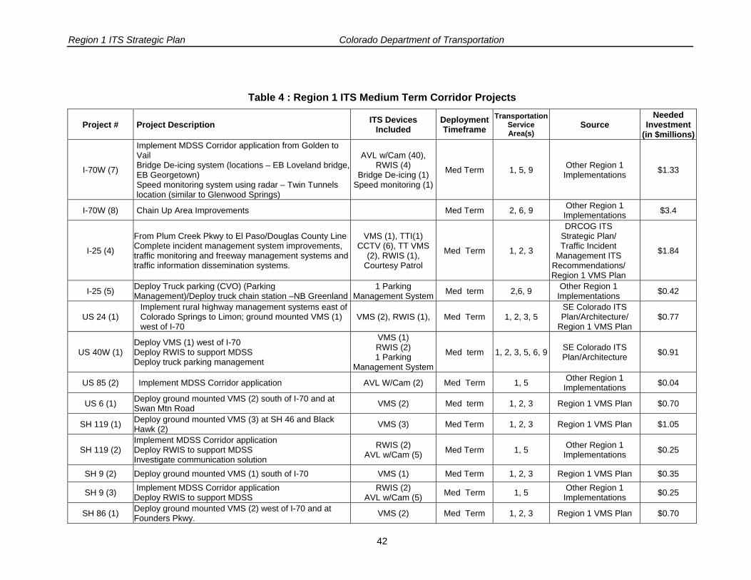
IV. Project Sequencing
The previous section listed the ITS projects according to their respective corridor of significance which will enable quick referencing and coordination with other non-ITS projects planned for each corridor. To help Region 1 engineers manage the proper sequencing of ITS projects across all corridors of significance, the projects have also been grouped according to their deployment timeframe (short, med and long term) in the tables below.

Region 1 ITS Strategic Plan Colorado Department of Transportation
40
Table 3: Region 1 ITS Short Term Corridor Projects
Project # Project Description ITS Devices Included
Deployment Timeframe
Transportation Service Area(s)
Source Needed
Investment(in $millions)
I-70W (1)
From Golden to the Eisenhower Tunnel Complete the I-70 Mountain Corridor Incident Management System improvements, traffic monitoring and freeway management systems and traffic information dissemination systems. Implement heavy truck management strategies
CCTV (16), TT VMS (6), Gates (4), TTI (4);
RM (2) VSLS (4), VMS (4),
Courtesy Patrol
Short Term
1, 2, 3
DRCOG ITS Strategic Plan/ Traffic Incident Management /Other
Region 1 Implementations
$5.10
I-70W (3)
Install fiber optic cable from East Vail (Mile Post 182) to Vail (Mile Post 180) including all equipment, connections, and lateral devices for C2C with CSP and local jurisdictions
Fiber Optic Cable Short Term 1, 2, 3 SE Colorado ITS Plan/Architecture $5.20
I-70W (4)
From Eisenhower Tunnel to Vail Complete the I-70 Mountain Corridor Incident Management system improvements including automated pass maintenance and closure for Loveland Pass and Vail Pass and select freeway management system elements
CCTV (5), VMS (4), TTI (4), RWIS (4) Short Term 3, 5 SE Colorado ITS
Plan/Architecture $1.82
I-70W (5) Downhill Warning System
Downhill Warning (1) Short Term 1, 5, 9 Other Region 1
Implementations $0.42
I-25 (1) Implement Chain Stations strategies – (SB Chain station at Larkspur rest area)
VMS (1), VSLS (2), CCTV (2); flashing
beacons (2) Short Term 2, 9 Other Region 1
Implementations $0.49
I-25 (2)
From Lincoln Avenue to Plum Creek Pkwy Complete incident management system improvements, traffic monitoring and freeway management systems and traffic information dissemination systems.
CCTV (2), VMS (2), TTI (9), TT VMS (3),
RWIS (1) RM (5), RTMS(3), Courtesy Patrol
Short Term 1, 2, 3
DRCOG ITS Strategic Plan/ Traffic Incident
Management ITS Recommendations
$3.19
I-25 (3) Implement MDSS Corridor application & Deploy RWIS to support MDSS from Lincoln to El Paso/Douglas County Line
AVL w/Cam (20) & RWIS (2) Short Term 1, 5 Other Region 1
Implementations $0.56
I-70E (1) Implement Chain Stations strategies – Cedar Point (EB Chain station at Agate and WB at Limon) and E-470 and Airpark
VMS (1), VSLs (3), CCTV (3); flashing
beacons (3) Short Term 2, 9 Other Region 1
Implementations $0.56
I-70E (2)
From E-470 to Bennett Deploy traffic information dissemination systems Deploy network surveillance, freeway control and incident management systems
WB-TT VMS (3), TTI (2); CCTV (4), VMS
(2), RTMS (2). Short Term 1, 2, 3 DRCOG ITS Strategic
Plan $1.25

Region 1 ITS Strategic Plan Colorado Department of Transportation
41
Project # Project Description ITS Devices Included
Deployment Timeframe
Transportation Service Area(s)
Source Needed
Investment(in $millions)
I-70E (3) Upgrade Gates at Air Park, Limon Implement MDSS corridor application from Powhaton Rd to Kansas State Line
Gates (2) AVL w/cam for Trucks
(40) & RWIS (6) Short term 1, 5 Other Region 1
Implementations $1.75
I-70E (4) Implement Parking Management 3 locations( 2 at Limon and 1 at
Watkins) Short term 2, 6, 9 Other Region 1
Implementations $1.26
SH-74 (1) Install fiber optic cable from I-70 to Evergreen Parkway (signal interconnect & CCTV) Fiber Optic Cable Short Term 1, 2, 3 Other Region 1
Implementations $1.0
Total: $22.60
Region 1 ITS Strategic Plan Colorado Department of Transportation
42
Table 4 : Region 1 ITS Medium Term Corridor Projects
Project # Project Description ITS Devices Included
Deployment Timeframe
Transportation Service Area(s)
Source Needed
Investment(in $millions)
I-70W (7)
Implement MDSS Corridor application from Golden to Vail Bridge De-icing system (locations – EB Loveland bridge, EB Georgetown) Speed monitoring system using radar – Twin Tunnels location (similar to Glenwood Springs)
AVL w/Cam (40), RWIS (4)
Bridge De-icing (1) Speed monitoring (1)
Med Term 1, 5, 9 Other Region 1 Implementations $1.33
I-70W (8) Chain Up Area Improvements Med Term 2, 6, 9 Other Region 1 Implementations $3.4
I-25 (4)
From Plum Creek Pkwy to El Paso/Douglas County Line Complete incident management system improvements, traffic monitoring and freeway management systems and traffic information dissemination systems.
VMS (1), TTI(1) CCTV (6), TT VMS
(2), RWIS (1), Courtesy Patrol
Med Term 1, 2, 3
DRCOG ITS Strategic Plan/ Traffic Incident
Management ITS Recommendations/ Region 1 VMS Plan
$1.84
I-25 (5) Deploy Truck parking (CVO) (Parking Management)/Deploy truck chain station –NB Greenland
1 Parking Management System Med term 2,6, 9 Other Region 1
Implementations $0.42
US 24 (1) Implement rural highway management systems east of Colorado Springs to Limon; ground mounted VMS (1) west of I-70
VMS (2), RWIS (1), Med Term 1, 2, 3, 5 SE Colorado ITS Plan/Architecture/
Region 1 VMS Plan $0.77
US 40W (1) Deploy VMS (1) west of I-70 Deploy RWIS to support MDSS Deploy truck parking management
VMS (1) RWIS (2) 1 Parking
Management System
Med term 1, 2, 3, 5, 6, 9 SE Colorado ITS Plan/Architecture $0.91
US 85 (2) Implement MDSS Corridor application AVL W/Cam (2) Med Term 1, 5 Other Region 1 Implementations $0.04
US 6 (1) Deploy ground mounted VMS (2) south of I-70 and at Swan Mtn Road VMS (2) Med term 1, 2, 3 Region 1 VMS Plan $0.70
SH 119 (1) Deploy ground mounted VMS (3) at SH 46 and Black Hawk (2) VMS (3) Med Term 1, 2, 3 Region 1 VMS Plan $1.05
SH 119 (2) Implement MDSS Corridor application Deploy RWIS to support MDSS Investigate communication solution
RWIS (2) AVL w/Cam (5) Med Term 1, 5 Other Region 1
Implementations $0.25
SH 9 (2) Deploy ground mounted VMS (1) south of I-70 VMS (1) Med Term 1, 2, 3 Region 1 VMS Plan $0.35
SH 9 (3) Implement MDSS Corridor application Deploy RWIS to support MDSS
RWIS (2) AVL w/Cam (5) Med Term 1, 5 Other Region 1
Implementations $0.25
SH 86 (1) Deploy ground mounted VMS (2) west of I-70 and at Founders Pkwy. VMS (2) Med Term 1, 2, 3 Region 1 VMS Plan $0.70

Region 1 ITS Strategic Plan Colorado Department of Transportation
43
Project # Project Description ITS Devices Included
Deployment Timeframe
Transportation Service Area(s)
Source Needed
Investment(in $millions)
SH 86 (2) Implement MDSS Corridor application Deploy RWIS to support MDSS
RWIS (2) AVL w/Cam (5) Med Term 1, 5 Other Region 1
Implementations $0.25
US 36 (1) Deploy RWIS to support maintenance operations RWIS (1) Med Term 1, 5 Other Region 1 Implementations $0.07
Total: $12.33

Region 1 ITS Strategic Plan Colorado Department of Transportation
44
Table 5: Region 1 ITS Long Term Corridor Projects
Project # Project Description ITS Devices Included
Deployment Timeframe
Transportation Service Area(s)
Source Needed
Investment(in $millions)
I-70W (9) Implement transit management and multi-modal coordination in Summit County. Project applies to I-70, US 6, SH 9 and SH 91.
Information Sharing Long Term 4 SE Colorado ITS Plan/Architecture $0.50
I-70W (10) Research Project Hot Brake Detection Long Term 9 DRCOG ITS Strategic Plan $0.07
I-25 (6) Deploy Tomah Fog Visibility System FVS Long Term 1, 2, 3 Other Region 1 Implementations $0.07
I-70E (5) From Bennett to Limon Develop incident management and traveler information system
WB-TT VMS (5), TTI (12); CCTV (12), VMS
(4), RTMS (2) Long Term 1, 2, 3 SE Colorado ITS
Plan/Architecture $2.50
I-70E (6) From Limon to Kansas State Line Develop incident management and traveler information system
CCTV (16), VMS (10), Long term 1, 2, 3 SE Colorado ITS
Plan/Architecture / Region 1 VMS Plan
$3.84
US 287 (1) Implement rural highway management systems on US 287 south of Limon; ground mounted VMS (1) south of Kit Carson; one SB
VMS (2), RWIS (4) Long Term 1, 2, 3 SE Colorado ITS Plan/Architecture/
Region 1 VMS Plan $0.98
US 24W (1) Deploy automated pass maintenance and closure management system on US 24 over Wilkerson Pass
RWIS (2), VMS (2), automated gates (2) Long Term 1, 5 SE Colorado ITS Plan/
Architecture $1.33
US 285 (2) Install Fiber Optic Cable from C-470 to Fairplay Fiber Optic Cable Long Term 1, 2, 3 Other Region 1 Implementations $6.00
US 40E (1) Deploy ground mounted VMS (2) south of I-70 and west of Kit Carson VMS (2) Long Term 1, 2, 3 Region 1 VMS Plan $0.70
US 40E (2) Deploy Overhead VMS and RWIS at Cheyenne Wells VMS (1) and RWIS (1) Long Term 1, 2, 3 Other Region 1
Implementations $0.42
SH 71 (1) Deploy ground mounted VMS (2) south and north of I-70 VMS (2) Long Term 1, 2, 3 Region 1 VMS Plan $0.70
SH 71 (2) Deploy Overhead VMS at SH 71/SH 94 VMS (1) Long Term 1, 2, 3 Other Region 1 Implementations $0.35
US 385 (1) Deploy ground mounted VMS (2) south and north of Burlington VMS (2) Long Term 1, 2, 3 Region 1 VMS Plan $0.70
US 85 (3) Deploy parking facility management, railroad grade crossing, probe surveillance and traffic responsive signal systems from C-470 to I-25
Signal system, Rail Road crossing Long Term 2, 6, 9 DRCOG ITS
Strategic Plan $0.05
SH 91 (1) Deploy VMS (1) north of I-70 VMS (1) Long Term 1, 2, 3 Region 1 ITS Strategic Plan $0.35
US 36 (2) Deploy VMS (1) east of I-70 VMS (1) Long Term 1, 2, 3 Region 1 ITS Strategic Plan $0.35

Region 1 ITS Strategic Plan Colorado Department of Transportation
45
Project # Project Description ITS Devices Included
Deployment Timeframe
Transportation Service Area(s)
Source Needed
Investment(in $millions)
US 285 (1)
From SH 8 to US 24 Deploy incident management, network surveillance, traveler information and incident management systemsImplement MDSS Corridor application Deploy RWIS to support MDSS ground mounted VMS (8) at US 24, Fairplay, Kenosha Pass (2), Bailey, Crow Hill, Conifer and Pine Junction
CCTV (10), VMS (8), RWIS (4)
Long Term
1, 2, 3, 5
DRCOG ITS Strategic Plan/ Region 1 VMS
Plan $3.29
SH 83 (1)
From E-470 to SH 86 Deploy Incident management, network surveillance, traveler information and incident management systems; CCTV- E-470; Lincoln, Main, Broncos Pkwy, and SH-86; ground mounted VMS (1) south of Arapahoe County Line; south of Lincoln (northbound)
CCTV (5), VMS (2) Long Term 1, 2, 3 DRCOG ITS Strategic Plan $0.81
SH 83 (2) Deploy RWIS to support MDSS RWIS (2) Long Term 1, 5 Other Region 1 Implementations $0.14
US 85 (1)
Deploy surface street control for the signalized principal arterial network from C-470 to I-25 Deploy incident management, network surveillance, traveler information and incident management systems from C-470 to I-25 Deploy ground mounted VMS (1) south of C-470
Fiber Optic Cable CCTV(2), VMS(1) Long Term 1, 2, 3
DRCOG ITS Strategic Plan/ Region 1 VMS
Plan $0.89
SH 59 (1) Deploy VMS (2) north and south of I-70 VMS (2) Long Term 1, 2, 3 Region 1 ITS Strategic Plan $0.70
SH 72 (1) Deploy VMS (2) north and south of I-70 VMS (2) Long Term 1, 2, 3 Region 1 ITS Strategic Plan $0.70
SH 74 (2) Deploy VMS (1) south of I-70 VMS (1) Long Term 1, 2, 3 Region 1 ITS Strategic Plan $0.35
SH 79 (1) Deploy ground mounted VMS (1) north of I-70 (Southbound) VMS (1) Long Term 1, 2, 3 Region 1 VMS Plan $0.35
SH 94 (1) Deploy VMS (1) west of US 40 VMS (1) Long Term 1, 2, 3 Region 1 ITS Strategic Plan $0.35
SH 103 (1) Deploy VMS (1) south of I-70 Deploy RWIS to support MDSS VMS (1) RWIS (2) Long Term 1, 2, 3, 5 Region 1 ITS Strategic
Plan $0.49
SH 46 (1) TBD TBD TBD TBD TBD TBD
SH 67 (1) TBD TBD TBD TBD TBD TBD
Total: $26.98

Region 1 ITS Strategic Implementation Plan Colorado Department of Transportation
46
V. Conclusion
This Region 1 ITS Strategic Implementation Plan is a consolidation of all planned/desired ITS projects for Region 1 derived from the various previous ITS planning documents. The objective of this plan is to provide a single resource that Region 1 staff can utilize to effectively manage the implementation of the ITS program in Region 1. This plan should be referenced not only during the planning, programming, design, and construction of ITS projects, but also during the planning stages of non-ITS related projects on the 27 corridors of significance to avoid potential project conflicts and to leverage design and construction resources where possible.

Region 1 ITS Strategic Implementation Plan Colorado Department of Transportation
A-1
Appendix A.
Corridor Project(s) Project ITS devices Existing Devices
Proposed Devices Location Unit Price Needed
Investment Total Project
Cost (Millions)
Project Time Frame
CCTV 19 16 C-470 to EJT $21,000 $336,000
TT-VMS 6 C-470 to EJT $140,000 $840,000
Gate Set 4 C-470 to EJT $245,000 $980,000
TTI 6 4 $9,800 $39,200
RM 2 $168,000 $336,000
Blank Out Sign 2
Weigh In Motion 4
VSLs 4 $42,000 $168,000 VMS 6 4 $350,000 $1,400,000
Courtesy Patrol $1,000,000
1
From Golden to the Eisenhower Tunnel Complete the I-70 Mountain Corridor Incident Management System improvements, traffic
monitoring and freeway management systems and traffic information dissemination systems.
Implement heavy truck management strategies.
Call Box 5
$5.10 Short Term
3
Install fiber optic cable from East Vail (Mile Post 182) to Vail (Mile Post 180) including all equipment, connections, and lateral devices for C2C with CSP
and local jurisdictions
FO Cable, Laterals and
Network Equipment
Vail to Frisco $5,200,000 $5.2 Short Term
CCTV 17 5 Vail to Clear Creek County $21,000 $105,000
VMS 10 4 Vail to Clear Creek County $350,000 $1,400,000
TTI 6 4 Vail to Clear Creek County $9,800 $39,200
RWIS 1 4 $70,000 $280,000 ATR 2
Blank Out Sign 9
4
From Eisenhower Tunnel to Vail Complete the I-70 Mountain Corridor Incident Management system improvements including automated pass maintenance and closure for
Loveland Pass and Vail Pass and select freeway management system elements
Call Box 1
$1.82 Short Term
5
Downhill Warning System
Downhill Warning System 1 I-70 Mountain
Corridor $420,000 $420,000 $0.42 Short Term
6 Develop I-70 & EJMT Business Operations Plan N/A N/A Short Term
1. I-70 West (US 40 (Alameda Avenue)
to Vail Pass) - Approx. 69 Miles
7 Implement MDSS Corridor application from Golden
to Vail Bridge De-icing system (locations – EB Loveland AVL w/cam for
trucks 40 Vail Pass, Frisco, El
Rancho, Georgetown, and
$21,000 $840,000 $1.33 Med Term

Region 1 ITS Strategic Implementation Plan Colorado Department of Transportation
A-2
Corridor Project(s) Project ITS devices Existing Devices
Proposed Devices Location Unit Price Needed
Investment Total Project
Cost (Millions)
Project Time Frame
EJT (4) RWIS 4 $70,000 $280,000
Bridge De-icing System 1 I-70 Mountain
Corridor $70,000 $70,000 bridge, EB Georgetown)
Speed monitoring system using radar – Twin Tunnels location (similar to Glenwood Springs)
Speed Monitoring System 1 $140,000 $140,000
8 Chain Up Area Improvements Information Sharing I-70, US 6, SH 9,
and SH 91 $3,400,000 $3.4 Med Term
9 Implement transit management and multi-modal
coordination in Summit County. Project applies to I-70, US 6, SH 9 and SH 91.
Information Sharing
4
$500,000 $0.50 Long Term
10 Research Project Hot Brakes Detections 1 $70,000 $70,000 $0.07 Long Term
Total Corridor Cost $17.84 VMS 1 Lincoln to Founders $350,000 $350,000 VSLS 2 Lincoln to Founders $42,000 $84,000 CCTV 1 2 Lincoln to Founders $21,000 $42,000
Flashing beacons 2 Lincoln to Founders $7,000 $14,000 1 Implement Chain Stations strategies – (SB Chain
station at Larkspur rest area)
Call Box 2
$0.49 Short Term
CCTV 8 2 Founders to El Paso County Line $21,000 $42,000
VMS 3 2 Founders to El Paso County Line $350,000 $700,000
TTI 9 $9,800 $88,200 TT-VMS 3 $140,000 $420,000
RWIS 1 $70,000 $70,000 RM 5 $168,000 $840,000
RTMS 3 $9,600 $28,800
2
From Lincoln Avenue to Plum Creek Pkwy Complete incident management system
improvements, traffic monitoring and freeway management systems and traffic information
dissemination systems.
Courtesy Patrol $1,000,000
$3.19 Short Term
AVL w/cam for trucks 20 I-25 south-Douglas
County $21,000 $420,000 3 Implement MDSS Corridor application & Deploy
RWIS to support MDSS from Lincoln to El Paso/Douglas County Line RWIS 2 $70,000 $140,000
$0.56 Short Term
VMS 1 $350,000 $350,000 TTI 1 $9,800 $9,800
CCTV 6 $21,000 $126,000 TTI VMS 2 $140,000 $280,000
RWIS 1 $70,000 $70,000
2. I-25 (Lincoln Avenue to El
Paso/Douglas County Line)
Approx. 30 Miles
4
From Plum Creek Pkwy to El Paso/Douglas County Line
Complete incident management system improvements, traffic monitoring and freeway management systems and traffic information
dissemination systems. Courtesy Patrol $1,000,000
$1.84 Med Term

Region 1 ITS Strategic Implementation Plan Colorado Department of Transportation
A-3
Corridor Project(s) Project ITS devices Existing Devices
Proposed Devices Location Unit Price Needed
Investment Total Project
Cost (Millions)
Project Time Frame
5 Deploy Truck parking (CVO) (Parking
Management)/Deploy truck chain station –NB Greenland
1 Parking Management
System 1 I-25 through
Colorado Springs $420,000 $420,000 $0.42 Med Term
6 Deploy Tomah Fog Visibility System FVS 1 El Paso County Line $70,000 $70,000 $0.07 Long Term
Total Corridor Cost $6.57
CCTV 2 3 E-470 to Kansas state line $21,000 $63,000
VMS 2 1 E-470 to Kansas state line $350,000 $350,000
VSLS 3 $42,000 $126,000
Flashing beacons 3 E-470 to Kansas state line $7,000 $21,000
RWIS 1
1 Implement Chain Stations strategies – Cedar Point
(EB Chain station at Agate and WB at Limon) and E-470 and Airpark
Weigh In Motion 1
$0.56 Short Term
TT-VMS 3 Air Park, Limon $140,000 $420,000 TTI 2 $9,800 $19,600
CCTV 1 4 $21,000 $84,000 VMS 2 $350,000 $700,000
RTMS 2 $13,440 $26,880 RWIS 1
2
From E 470 to Bennett Deploy traffic information dissemination systems Deploy network surveillance, freeway control and
incident management systems
ATR 1
$1.25 Short Term
Gate 2 $245,000 $490,000 AVL w/cam for
trucks 40 $21,000 $840,000 3 Upgrade Gates at Air Park, Limon
Implement MDSS corridor application from Powhaton Rd to Kansas State Line
RWIS 6 $70,000 $420,000
$1.75 Short Term
4 Implement Parking Management Parking
Management 3 $420,000 $1,260,000 $1.26 Short Term TT-VMS 5 E-470 to Bennett $140,000 $700,000
TTI 12 $9,800 $117,600 CCTV 2 12 $21,000 $252,000 VMS 2 4 $350,000 $1,400,000
RTMS 2 E-470 to Bennett $13,440 $26,880 ATR 1
RWIS 2
5
From Bennett to Limon Develop incident management and traveler
information system
Call Box 2
$2.50 Long Term
CCTV 4 16 Burlington $21,000 $336,000
VMS 3 10 $350,000 $3,500,000
3. I-70 East (Powhaton Rd to
Kansas State line) Approx.165 Miles
6 From Limon to Kansas State Line Develop incident management and traveler
information system ATR 3
$3.84 Long Term

Region 1 ITS Strategic Implementation Plan Colorado Department of Transportation
A-4
Corridor Project(s) Project ITS devices Existing Devices
Proposed Devices Location Unit Price Needed
Investment Total Project
Cost (Millions)
Project Time Frame
Weigh In Motion 1 RWIS 1
Information Kiosk 1 Total Corridor Cost $11.16
VMS 2 2 South of Limon $350,000 $700,000 4. US 287 (US 40 to Cheyenne/Kiowa
County Line) Approx. 10 Miles
1 Implement rural highway management systems on US 287 south of Limon; ground mounted VMS (1)
south of Kit Carson; one SB . RWIS 4 South of Limon $70,000 $280,000 $0.98 Long Term
VMS 2 E/O Colorado Springs to Limon $350,000 $700,000
RWIS 1 E/O Colorado Springs to Limon $70,000 $70,000
5. US 24 East (I-70 to Elbert/El Paso
County Line) Approx. 30 Miles
1 Implement rural highway management systems east of Colorado Springs to Limon; ground mounted VMS
(1) west of I-70 Call Box 3 $0
$0.77 Med Term
RWIS 1 2 US 24 over Wilkerson pass $70,000 $140,000
VMS 2 $350,000 $700,000 Automated Gates 2 $245,000 $490,000
6. US 24 West (Park/Teller County
Line to Park/Chaffee County Line)
Approx. 62 Miles
1 Deploy automated pass maintenance and closure management system on US 24 over Wilkerson Pass
Call Box 4 $0
$1.33 Long Term
CCTV 10 SH 8 to SH 9 $21,000 $210,000
VMS 3 8 C-470 to SH 8 $350,000 $2,800,000
RWIS 1 4
US 24, Fairplay, Kenosha Pass(2), Baily, Crow Hill, Conifer and Pine
Junctions.
$70,000 $280,000
Call Box 17 $0
ATR 1 $0
1
From SH 8 to US 24 Deploy incident management, network surveillance,
traveler information and incident management systems
Implement MDSS Corridor application Deploy RWIS to support MDSS
ground mounted VMS (8) at US 24, Fairplay, Kenosha Pass (2), Bailey, Crow Hill, Conifer and
Pine Junction Blank Out Sign 4 $0
$3.29 Long Term
2 Install Fiber Optic Cable from C-470 to Fairplay Fiber Optic Cable $6,000,000 $6.00 Long Term
7. US 285 (SH 8 (Morrison) to US
24) Approx. 87 Miles
Total Corridor Cost $9.29
8. US 40 East (I-70 to Kansas State 1 Deploy ground mounted VMS (2) south of I-70 and
west of Kit Carson VMS 2 S/O I-70 and W/O Kit Carson $350,000 $700,000 $0.70 Long Term

Region 1 ITS Strategic Implementation Plan Colorado Department of Transportation
A-5
Corridor Project(s) Project ITS devices Existing Devices
Proposed Devices Location Unit Price Needed
Investment Total Project
Cost (Millions)
Project Time Frame
VMS 2 1 Cheyenne Mountain $350,000 $350,000
RWIS 1 1 Cheyenne Mountain $70,000 $70,000
ATR 1
Line) Approx. 101 Miles
2 Deploy Overhead VMS and RWIS at Cheyenne Wells
Call Box 1
$0.42
Total Corridor Cost $1.12
VMS 3 1 W/O I-70 $350,000 $350,000
RWIS 1 2 $70,000 $140,000
PM 1 $420,000 $420,000
Call Box 1
CCTV 1
9. US 40 West (I-70 to Clear
Creek/Grand County Line
Approx. 15 Miles
1 Deploy VMS (1) west of I-70
Deploy RWIS to support MDSS Deploy truck parking management
HAR 1
$0.91 Med Term
1 Deploy ground mounted VMS (2) south and north of I-70 VMS 2 South and North of
I-70 $350,000 $700,000 $0.70
VMS 1 SH 94 $350,000 $350,000 2 Deploy Overhead VMS at SH 71/SH 94
Call Box 1 $0.35
Long Term
10. SH 71 (Lincoln/Washingto
n County Line to Lincoln/Crowley
County Line) Approx. 77 Miles
Total Corridor Cost $1.05 VMS 2 N/O Burlington $350,000 $700,000 ATR 1
Information Kiosk 1
11. US 385 (Yuma/Kit Carson
County Line to Cheyenne/Kiowa
County Line) Approx. 71 Miles
1 Deploy ground mounted VMS (2) south and north of Burlington
CCTV 1
$0.70 Long Term
CCTV 5 E-470 to SH 87 $21,000 $105,000
1
From E 470 to SH 86 Deploy Incident management, network surveillance,
traveler information and incident management systems; CCTV- E-470; Lincoln, Main, Broncos
Pkwy, and SH-86; ground mounted VMS (1) south of Arapahoe County Line; south of Lincoln
(northbound)
VMS 3 2 E-470 to SH 87 $350,000 $700,000 $0.81 Long Term
RWIS 2 To support
Maintenance Operations
$70,000 $140,000 Long Term
12. SH 83 (SH 88 (Arapahoe Road) to
Douglas/El Paso County Line)
Approx. 35 Miles
2 Deploy RWIS to support MDSS
Call Box 7
$0.14

Region 1 ITS Strategic Implementation Plan Colorado Department of Transportation
A-6
Corridor Project(s) Project ITS devices Existing Devices
Proposed Devices Location Unit Price Needed
Investment Total Project
Cost (Millions)
Project Time Frame
Total Corridor Cost $0.95
Fiber Optic Cable (C-470 to I-25) C-470 to I-25 $500,000 $500,000
CCTV 2 C-470 to I-25 $21,000 $42,000 1
Deploy surface street control for the signalized principal arterial network from C-470 to I-25
Deploy incident management, network surveillance, traveler information and incident management
systems from C-470 to I-25 Deploy ground mounted VMS (1) south of C-470 VMS 1 1 $350,000 $350,000
$0.89 Long Term
2 Implement MDSS Corridor application AVL w/cam for trucks 2 S/O C-470 $21,000 $42,000 $0.04 Med Term
3 Deploy parking facility management, railroad grade crossing, probe surveillance and traffic responsive
signal systems from C-470 to I-25
Signal system, railroad crossing 1 C-470 to I-25 $50,000 $50,000 $0.05 Long Term
13. US 85 (I-25 to C-470)
Approx. 16 Miles
Total Corridor Cost $0.98
VMS 1 2 S/O I-70 at Swan Mountain Road $350,000 $700,000 Med Term
HAR 1
14. US 6 (I-70 (Eisenhower
Tunnel) to I-70/SH 9 (Dillon))
Approx. 21 Miles
1 Deploy ground mounted VMS (2) south of I-70 and at Swan Mountain Road
ATR 1
$0.70
1 Deploy ground mounted VMS (3) at SH 46 and Black Hawk (2) VMS 3 SH 46 and Black
Hawk $350,000 $1,050,000 $1.05
RWIS 2 $70,000 $140,000 2
Implement MDSS Corridor application Deploy RWIS to support MDSS
Investigate communication solution AVL w/cam for trucks 5 $21,000 $105,000
Call Box 2 ATR 2
$0.25 Med Term
15. US 6 & SH 119 (SH 58/SH 93 to
SH 72) Approx. 34 Miles
Total Corridor Cost $1.30
2 Deploy ground mounted VMS (1) south of I-70 VMS 3 1 S/O I-70 $350,000 $350,000 $0.35 Med Term
RWIS 2 $70,000 $140,000 3
Implement MDSS Corridor application Deploy RWIS to support MDSS
AVL w/cam for
trucks 5 $21,000 $105,000 $0.25 Med Term
ATR 1
Call Box 4
16.SH 9 (Summit/Grand County Line to Park/Fremont County Line)
Approx. 103 Miles
Total Corridor Cost $0.60 17. SH 86 (I-70 to I-
25) Approx. 63 1 Deploy ground mounted VMS (2) west of I-70 and at Founders Pkwy. VMS 1 2 W/O I-70 at
Founder Rd $350,000 $700,000 $0.70 Med Term

Region 1 ITS Strategic Implementation Plan Colorado Department of Transportation
A-7
Corridor Project(s) Project ITS devices Existing Devices
Proposed Devices Location Unit Price Needed
Investment Total Project
Cost (Millions)
Project Time Frame
RWIS 2 $70,000 $140,000 2 Implement MDSS Corridor application
Deploy RWIS to support MDSS AVL w/cam for trucks 5 $21,000 $105,000
$0.25 Med Term Miles
Total Corridor Cost $0.95 18. SH 91 (I-70 to
Region 3) Approx. 11 Miles
1 North of I-70 Deploy VMS VMS 1 N/O I-70 $350,000 $350,000 $0.35 Long Term
1 Deploy RWIS to support maintenance operation RWIS 1 To support
Maintenance Operations
$70,000 $70,000 $0.07 Med Term
2 East of I-70 Deploy VMS VMS 1 E/O I-70 $350,000 $350,000 $0.35 Long Term
19. US 36 (I-70 to Region
4/Washington County) Approx. 29
Miles Total Corridor Cost $0.42
VMS 2 North and South of I-70 $350,000 $700,000
21. SH 59 (US 40 to Washington/Kit
Carson County Line) Approx. 60
Miles
1 Deploy VMS (2) north and south of I-70
Call Box 1
$0.70 Long Term
23. SH 72 (Region 6 to SH 119)
Approx. 19 Miles 1 Deploy VMS at SH 119/SH 72 and SH 93/SH 72 VMS 2 SH 119 and SH 93 $350,000 $700,000 $0.70 Long Term
1 Install fiber optic cable from I-70 to Evergreen Parkway Fiber Optic Cable $1,000,000 Short Term 24. SH 74 (SH 8
(Morrison) to I-70) Approx. 18 Miles 2 Deploy VMS (1) south of I-70 VMS 1 S/O I-70 $350,000 $350,000
$1.35 Long Term
25. SH 79 (I-70 to Adams/Weld County Line)
Approx. 19 Miles
1 Deploy ground mounted VMS (1) north of I-70 (Southbound) VMS 1 N/O I-70 $350,000 $350,000 $0.35 Long Term
VMS 1 W/O US 40 $350,000 $350,000 26. SH 94 (US 40 to Lincoln/El Paso
County Line) Approx. 51 Miles
1 Deploy VMS (1) west of US 40 Call Box 1
$0.35 Long Term
VMS 1 S/O I-70 $350,000 $350,000
RWIS 2 $70,000 $140,000
CCTV 1
27. SH 103 & SH 5 (I-70 to Mt Evans
Summit) Approx. 22/15
Miles
1 Deploy VMS (1) south of I-70 Deploy RWIS to support MDSS
Call Box 1
$0.49 Long Term
Total of All Corridors: $61.91

Region 1 ITS Strategic Implementation Plan Colorado Department of Transportation
B-1
Appendix B.
ITS Transportation Service Areas Transportation Service Areas are major operational areas that were developed for the purpose of providing ITS services in coordination with ITS applications (project) necessary to provide the specific service. Based on analysis of the major needs in the DRCOG Region, and in conjunction with the update of the DRCOG ITS Strategic Plan/Architecture, including discussions with stakeholders, and review of other transportation and ITS plans, nine ITS Transportation Service Areas were developed to address regional issues and needs.
11.. Regional Traveler Information – Regional traveler information involves a variety of
systems that collect and process transportation data then distribute the information to the public. It includes such information as: traffic conditions, travel times, incident locations, construction closures, weather condition, transit operations, and alternative travel options (e.g. DRCOG’s RideArrangers). The regional vision is to consolidate access to all traveler information sources through CDOT’s traveler information system consisting of the 511 phone system and the CoTrip.org website. This information will also be available for redistribution through other means such as traveler information kiosks, personalized e-mail or text messaging, mobile access, third party traveler information, etc.
22.. Regional Transportation Operations & Management – Regional transportation management provides coordinated transportation monitoring, response, and control functions. Regional partners will collect local data and control their local transportation systems while sharing the data through a display system that offers a regional view of traffic operations (e.g. website). This view will give transportation managers the opportunity to cooperate and respond quickly with management strategies that benefit regional travelers.
33.. Regional Traffic Incident Management – Traffic incident management requires coordination between transportation managers as well as the cooperation of the public safety community. Currently, they have cooperated in the development and use of corridor-level incident management plans (IMPs), but one regional-level incident management plan is envisioned for the future. This plan will have the transportation managers using ITS devices to detect and verify incidents and will disseminate traveler information regarding the incident. Public safety personnel will be responsible for incident site management and incident clearance while coordinating with transportation managers.
44.. Transit Operations & Management – Specific coordination between transit operations and other transportation managers is key to the regional traveler information and the regional transportation operations service areas above. ITS investment in transit operations is intended to improve the operational efficiency and public attractiveness of transit.
55.. Maintenance and Construction – ITS activities will include: coordination in planning and notification for maintenance and construction activity; roadway maintenance systems that are supported by weather data collection; and, the capability to monitor ITS devices from remote locations, thus allowing quick and managed dispatch for repair.
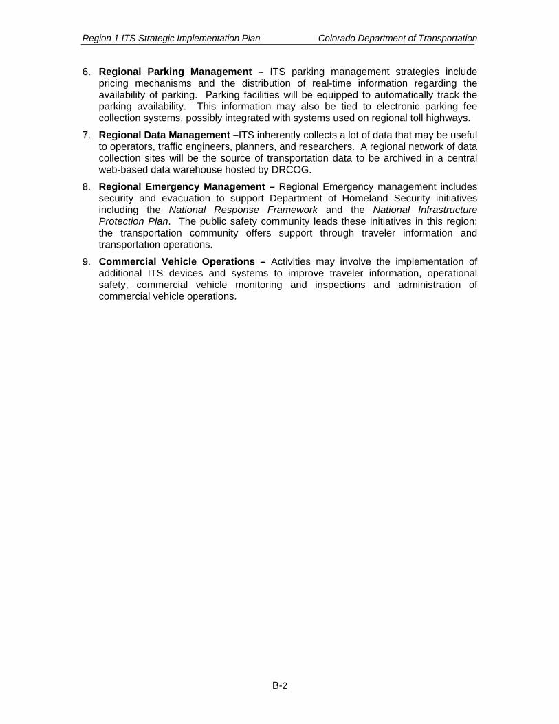
Region 1 ITS Strategic Implementation Plan Colorado Department of Transportation
B-2
66.. Regional Parking Management – ITS parking management strategies include pricing mechanisms and the distribution of real-time information regarding the availability of parking. Parking facilities will be equipped to automatically track the parking availability. This information may also be tied to electronic parking fee collection systems, possibly integrated with systems used on regional toll highways.
77.. Regional Data Management –ITS inherently collects a lot of data that may be useful to operators, traffic engineers, planners, and researchers. A regional network of data collection sites will be the source of transportation data to be archived in a central web-based data warehouse hosted by DRCOG.
88.. Regional Emergency Management – Regional Emergency management includes security and evacuation to support Department of Homeland Security initiatives including the National Response Framework and the National Infrastructure Protection Plan. The public safety community leads these initiatives in this region; the transportation community offers support through traveler information and transportation operations.
99.. Commercial Vehicle Operations – Activities may involve the implementation of additional ITS devices and systems to improve traveler information, operational safety, commercial vehicle monitoring and inspections and administration of commercial vehicle operations.