Embed Size (px)
Citation preview
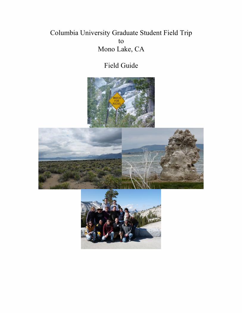
Columbia University Graduate Student Field Trip to
Mono Lake, CA
Field Guide
1
A group of graduate students from Columbia University’s Department of Earth & Environmental Sciences spent four days on a field trip in the Mono Lake, CA area. The following is a field guide put together at the end of the trip. The graduate students would like to thank Sidney and Gary Hemming for acting as the field trip leaders once in the field. This trip would not have been possible without funding from the Storke Memorial Field Work Support Fund.
Table of Contents
Seminar Readings…………………………………………………………………… p. 2 Stop Locations……………………………………………………………………….. p. 3
Day 1- Volcanics ……………………………………………………………………. p. 13
Panum Crater Obsidian Dome Inyo and Mono Craters Mammoth area; Horseshoe Lake and CO2 kill Long Valley Caldera Hot Springs at Hot Creek
Day 2- Mono Basin………………………………………………………………… p. 28
Tufas and Modern Lake Level History Wilson Creek Formation
Glacial history (Lundy Cayon; Lee Vining Canyon, Bloody Canyon) Day 3 - Yosemite…………………………………………………………………… p. 38 Geology Ecology Day 4- Convict Lake and Bishop Tuff ………………………………………….. p. 47 Bishop Tuff
Convict Lake Volcanic Tablelands
2
Seminar Readings
Meeting 1 (April 13): Introduction to Mono Lake
TOPICS: Geology, Tectonic Setting, Glacial History, Lake Setting, Ecology READINGS: -Scholl et al (1967) Age and Origin of Topography Beneath Mono Lake -Russell, Israel (1889) Quaternary history of the Mono Valley, California -Susan Zimmerman’s Thesis (2006) Introduction -Wiens et al (1993) Lessons from Mono Lake (sections on ecosystem and environmental
issues) -John McPhee, Basin and Range (excerpt) optional -Reheis et al (2002) Drainage reversals in Mono Basin during the late Pliocene and
Pleistocene
Meeting 2 (April 20): Mono Lake History and Glacial Features TOPICS: Geomorphology, Aqueous chemistry, Lake-level reconstruction, Climate
READINGS: -Zimmerman et al (2006) Revised chronology for late Pleistocene Mono Lake sediments
based on paleointensity correlation to the global reference curve. -Stine (1990) Late Holocene Fluctuations of Mono Lake, Eastern CA -Benson et al (1998) Correlation of Late-Pleistocene Lake-Level Oscillations in Mono
Lake, California, with North Atlantic Climate Events -Council and Bennett (1993) Geochemistry of Ikaite formation at Mono Lake, Ca:
implications for the origin of tufa mounds. -Stephen L. Harris (1988) The Ice: How a Glacier Works, from Fire Mountains of the West -Putnam, 1949 and 1950 (maps or moraines and June Lake geology) -Bursik and Gillespie (1993) Late Pleistocene Glaciation of Mono Basin, CA -Davis (1999) Pollen Analysis of a Late-Glacial and Holocene Sediment Core from Mono
Lake
Meeting 3 (April 27): Volcanics and Sierra Geology
TOPICS: Volcanism in the Great Basin region, Chronology READINGS: -Stephen L. Harris (1988) The Fire: How a Volcano Works and The Mono Lake-Long
Valley Region from Fire Mountains of the West -Schweickert and Lahren (1999) Triassic Caldera at Tioga Pass -Cousens et al (2008) Geology, geochronology, and geochemistry of the Miocene-
Pliocene Ancestral Cascades arc, northern Sierra Nevada, California and Nevada. -Sieh and Bursik, 1986, Most recent eruption of Mono Craters, eastern central California
-Gilbert et al (1969) Structural and Volcanic History of Mono Basin, California-Nevada
3
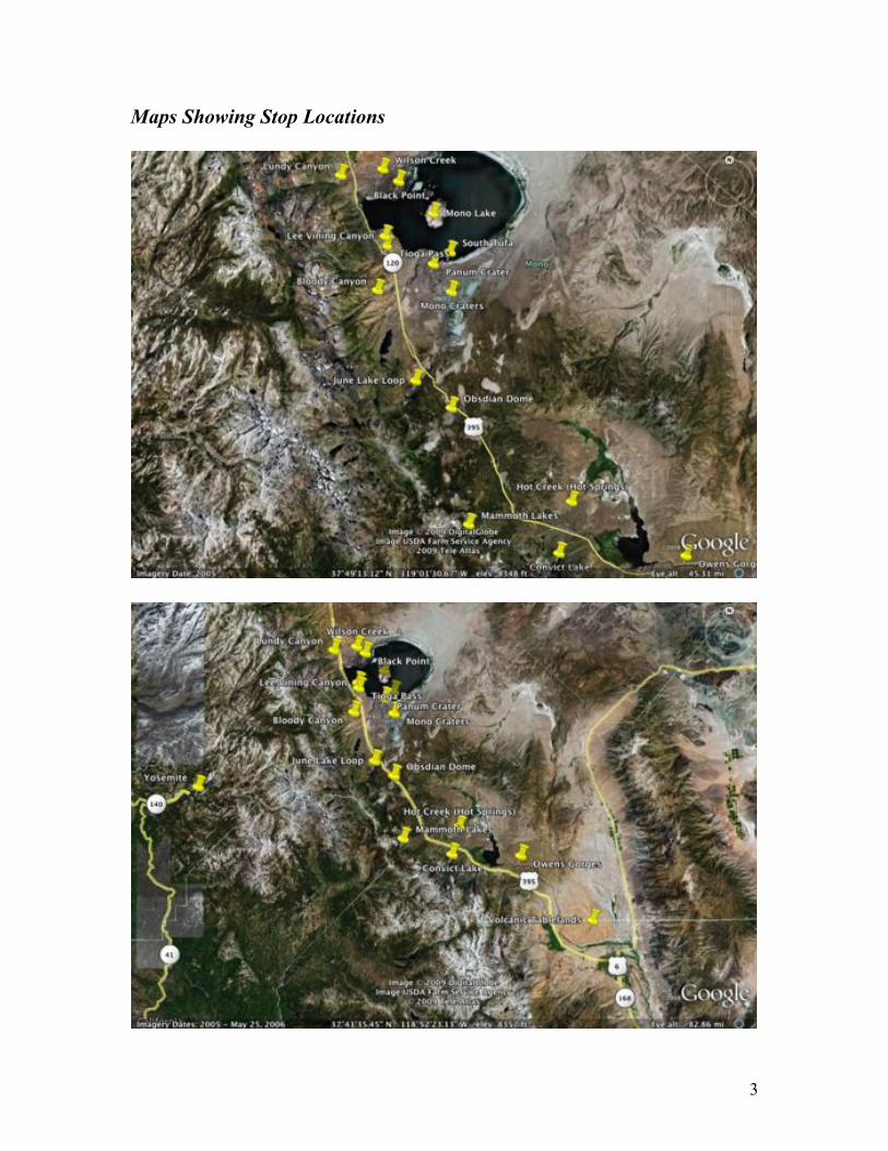
Maps Showing Stop Locations
4
Mono Lake Stops
Directions for each day start from where we stayed (Lee Vining, CA). Lake View Lodge is a good option for large groups, but there are several places right in Lee Vining. There is a small grocery store next to Lake View Lodge, however we recommend saving the large grocery trips for the Reno, NV area when you arrive, or wait until you go into Mammoth Lakes. WE have also included the latitutde and longitude of each stop (from Google Earth, accessed on 1/9/10). In addition to these directions, we recommend that you bring along a map of the area!
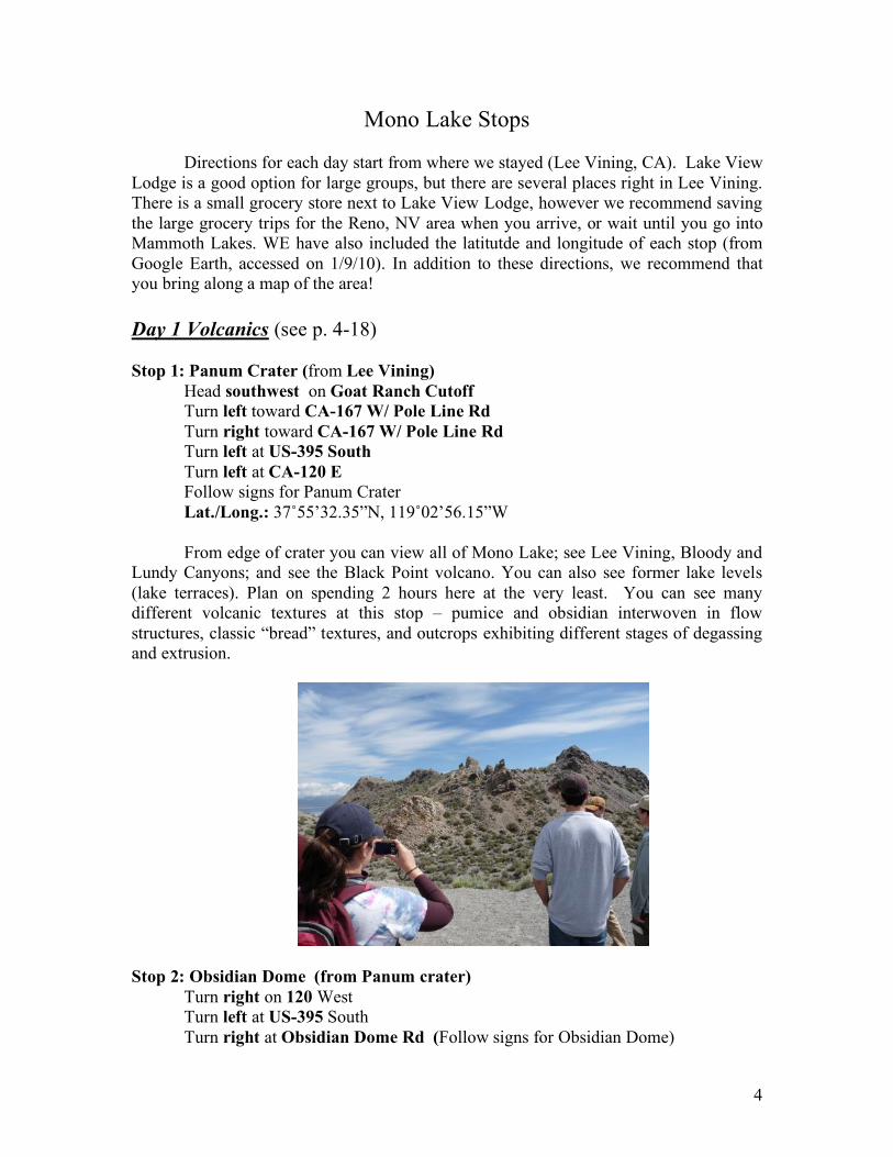
Day 1 Volcanics (see p. 4-18) Stop 1: Panum Crater (from Lee Vining)
Head southwest on Goat Ranch Cutoff Turn left toward CA-167 W/ Pole Line Rd
Turn right toward CA-167 W/ Pole Line Rd
Turn left at US-395 South
Turn left at CA-120 E Follow signs for Panum Crater Lat./Long.: 37˚55’32.35”N, 119˚02’56.15”W From edge of crater you can view all of Mono Lake; see Lee Vining, Bloody and
Lundy Canyons; and see the Black Point volcano. You can also see former lake levels (lake terraces). Plan on spending 2 hours here at the very least. You can see many different volcanic textures at this stop – pumice and obsidian interwoven in flow structures, classic “bread” textures, and outcrops exhibiting different stages of degassing and extrusion.
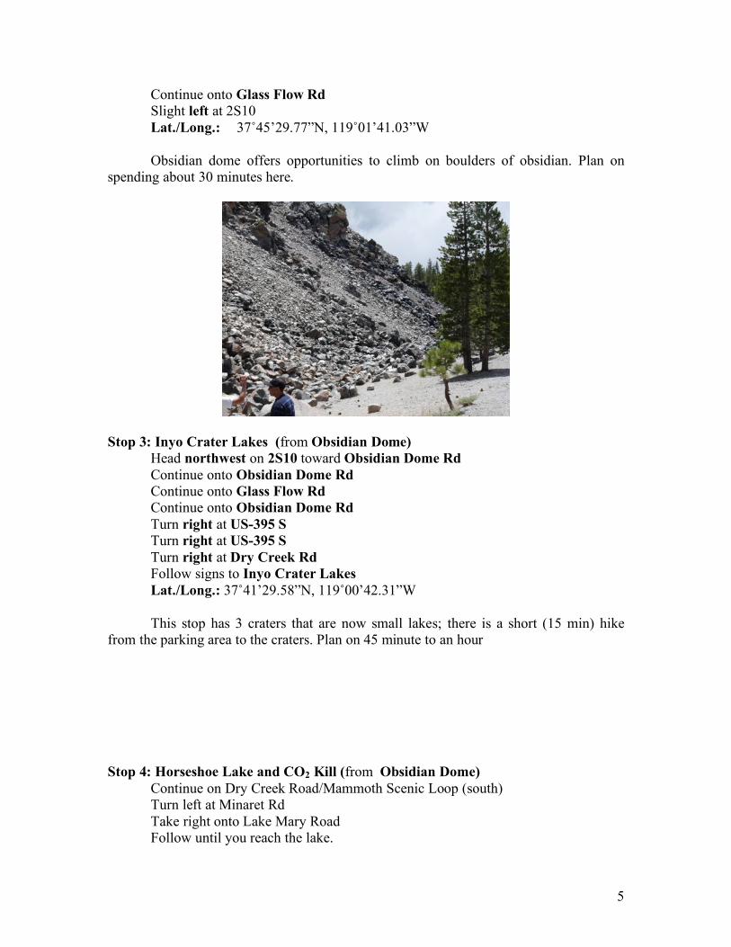
Stop 2: Obsidian Dome (from Panum crater)
Turn right on 120 West Turn left at US-395 South Turn right at Obsidian Dome Rd (Follow signs for Obsidian Dome)
5
Continue onto Glass Flow Rd
Slight left at 2S10 Lat./Long.: 37˚45’29.77”N, 119˚01’41.03”W Obsidian dome offers opportunities to climb on boulders of obsidian. Plan on spending about 30 minutes here.
Stop 3: Inyo Crater Lakes (from Obsidian Dome)
Head northwest on 2S10 toward Obsidian Dome Rd
Continue onto Obsidian Dome Rd
Continue onto Glass Flow Rd
Continue onto Obsidian Dome Rd
Turn right at US-395 S
Turn right at US-395 S
Turn right at Dry Creek Rd
Follow signs to Inyo Crater Lakes
Lat./Long.: 37˚41’29.58”N, 119˚00’42.31”W This stop has 3 craters that are now small lakes; there is a short (15 min) hike from the parking area to the craters. Plan on 45 minute to an hour
Stop 4: Horseshoe Lake and CO2 Kill (from Obsidian Dome)
Continue on Dry Creek Road/Mammoth Scenic Loop (south) Turn left at Minaret Rd
Take right onto Lake Mary Road Follow until you reach the lake.
6
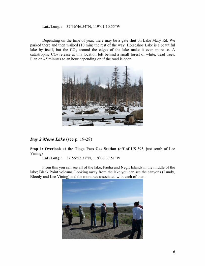
Lat./Long.: 37˚36’46.54”N, 119˚01’10.55”W Depending on the time of year, there may be a gate shut on Lake Mary Rd. We parked there and then walked (10 min) the rest of the way. Horseshoe Lake is a beautiful lake by itself, but the CO2 around the edges of the lake make it even more so. A catastrophic CO2 release at this location left behind a small forest of white, dead trees. Plan on 45 minutes to an hour depending on if the road is open.
Day 2 Mono Lake (see p. 19-28) Stop 1: Overlook at the Tioga Pass Gas Station (off of US-395, just south of Lee Vining) Lat./Long.: 37˚56’52.37”N, 119˚06’37.51”W From this you can see all of the lake; Paoha and Negit Islands in the middle of the lake; Black Point volcano. Looking away from the lake you can see the canyons (Lundy, Bloody and Lee Vining) and the moraines associated with each of them.
7
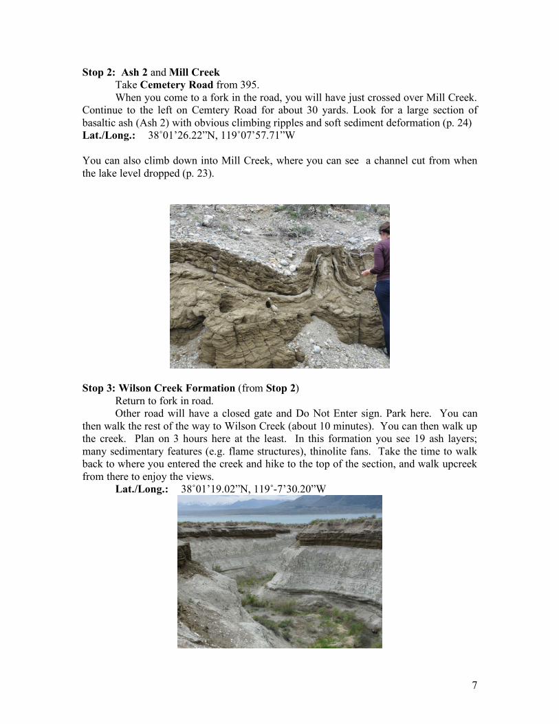
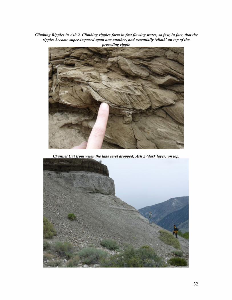
Stop 2: Ash 2 and Mill Creek Take Cemetery Road from 395. When you come to a fork in the road, you will have just crossed over Mill Creek. Continue to the left on Cemtery Road for about 30 yards. Look for a large section of basaltic ash (Ash 2) with obvious climbing ripples and soft sediment deformation (p. 24) Lat./Long.: 38˚01’26.22”N, 119˚07’57.71”W You can also climb down into Mill Creek, where you can see a channel cut from when the lake level dropped (p. 23).
Stop 3: Wilson Creek Formation (from Stop 2) Return to fork in road. Other road will have a closed gate and Do Not Enter sign. Park here. You can then walk the rest of the way to Wilson Creek (about 10 minutes). You can then walk up the creek. Plan on 3 hours here at the least. In this formation you see 19 ash layers; many sedimentary features (e.g. flame structures), thinolite fans. Take the time to walk back to where you entered the creek and hike to the top of the section, and walk upcreek from there to enjoy the views. Lat./Long.: 38˚01’19.02”N, 119˚-7’30.20”W
8
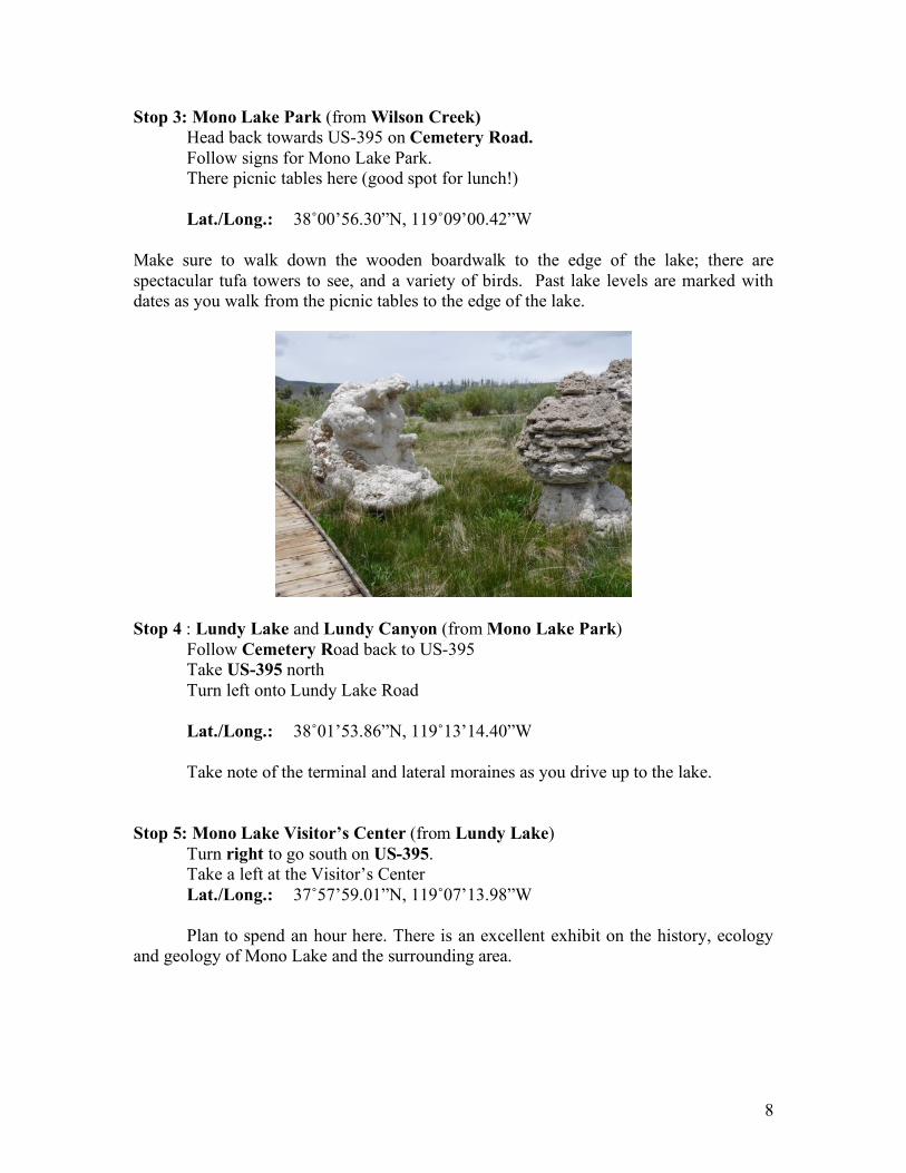
Stop 3: Mono Lake Park (from Wilson Creek) Head back towards US-395 on Cemetery Road. Follow signs for Mono Lake Park. There picnic tables here (good spot for lunch!) Lat./Long.: 38˚00’56.30”N, 119˚09’00.42”W Make sure to walk down the wooden boardwalk to the edge of the lake; there are spectacular tufa towers to see, and a variety of birds. Past lake levels are marked with dates as you walk from the picnic tables to the edge of the lake.
Stop 4 : Lundy Lake and Lundy Canyon (from Mono Lake Park) Follow Cemetery Road back to US-395
Take US-395 north Turn left onto Lundy Lake Road Lat./Long.: 38˚01’53.86”N, 119˚13’14.40”W Take note of the terminal and lateral moraines as you drive up to the lake. Stop 5: Mono Lake Visitor’s Center (from Lundy Lake) Turn right to go south on US-395. Take a left at the Visitor’s Center Lat./Long.: 37˚57’59.01”N, 119˚07’13.98”W Plan to spend an hour here. There is an excellent exhibit on the history, ecology and geology of Mono Lake and the surrounding area.
9
Stop 6: Mono Lake Committee (from Visitor’s Center)
Continue south on US-395 Park in Lee Vining outside of Mono Lake Committee. Lat./Long.: 37˚57’22.09”W, 119˚07’09.74”W Plan on spending 15 minutes here. There are many books and posters for sale here on Mono Lake and the surrounding area.
Stop 7: South Tufa (from Mono Lake Committee) Continue south on US-395
Turn left on CA-120 East
Turn left toward Test Station Road Take the first left onto Test Station Road
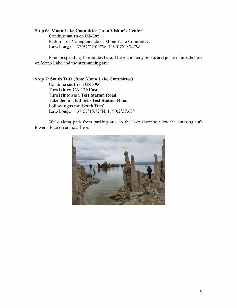
Follow signs for ‘South Tufa’ Lat./Long.: 37˚57’15.72”N, 119˚02’37.63” Walk along path from parking area to the lake shore to view the amazing tufa towers. Plan on an hour here.
10
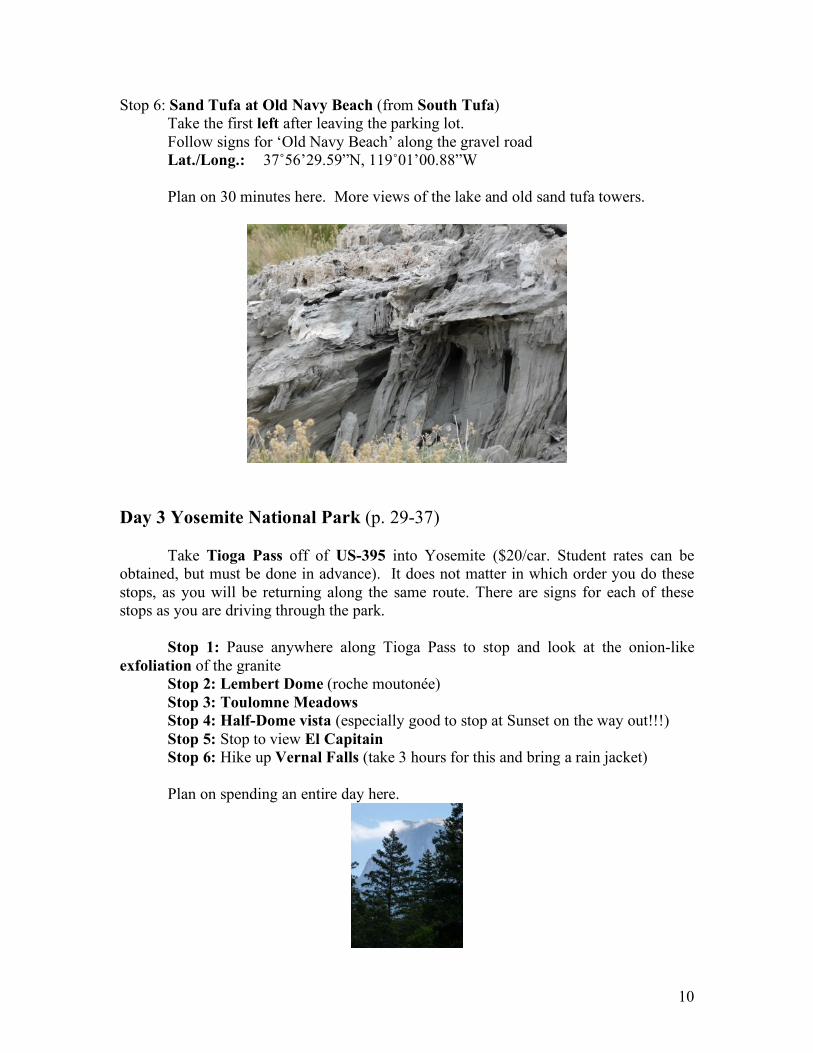
Stop 6: Sand Tufa at Old Navy Beach (from South Tufa) Take the first left after leaving the parking lot. Follow signs for ‘Old Navy Beach’ along the gravel road Lat./Long.: 37˚56’29.59”N, 119˚01’00.88”W Plan on 30 minutes here. More views of the lake and old sand tufa towers.
Day 3 Yosemite National Park (p. 29-37)
Take Tioga Pass off of US-395 into Yosemite ($20/car. Student rates can be obtained, but must be done in advance). It does not matter in which order you do these stops, as you will be returning along the same route. There are signs for each of these stops as you are driving through the park.
Stop 1: Pause anywhere along Tioga Pass to stop and look at the onion-like exfoliation of the granite
Stop 2: Lembert Dome (roche moutonée) Stop 3: Toulomne Meadows
Stop 4: Half-Dome vista (especially good to stop at Sunset on the way out!!!) Stop 5: Stop to view El Capitain
Stop 6: Hike up Vernal Falls (take 3 hours for this and bring a rain jacket)
Plan on spending an entire day here.
11
Day 4 Convict Lake and Bishop Tuff (p. 38-49)
Stop 1: Convict Lake (from Lee Vining) Take US-395 south. Turn right onto Convict Lake Road
Take the time to stop along the way to admire the moraines. Lat./Long.: 37˚35’40.11”N, 118˚51’03.75”W
Plan on 1-2 hours here. Take the hike around the lake. You can see the roof pendants from anywhere along the hike.
Stop 2: Hot Creek Geothermal Area (from Convict Lake) Return to US395 South, take a right to head south
Take first left onto Benton Crossing Rd Turn to left at Whitmore Tubs Rd
Left at Hot Creek Hatchery Rd Follow this to parking area Lat./Long.: 37˚39’41.41”N, 118˚49’38.27”W
12
Stop 3: Owens River Gorge (from Hot Creek) Return to US-395 South Go south past signs for Owen’s Gorge, then make a U-turn to go North on US-395 Turn right to follow signs for Owens River Gorge Lat./Long.: 37˚24’23.72”N, 118˚’04.36”W
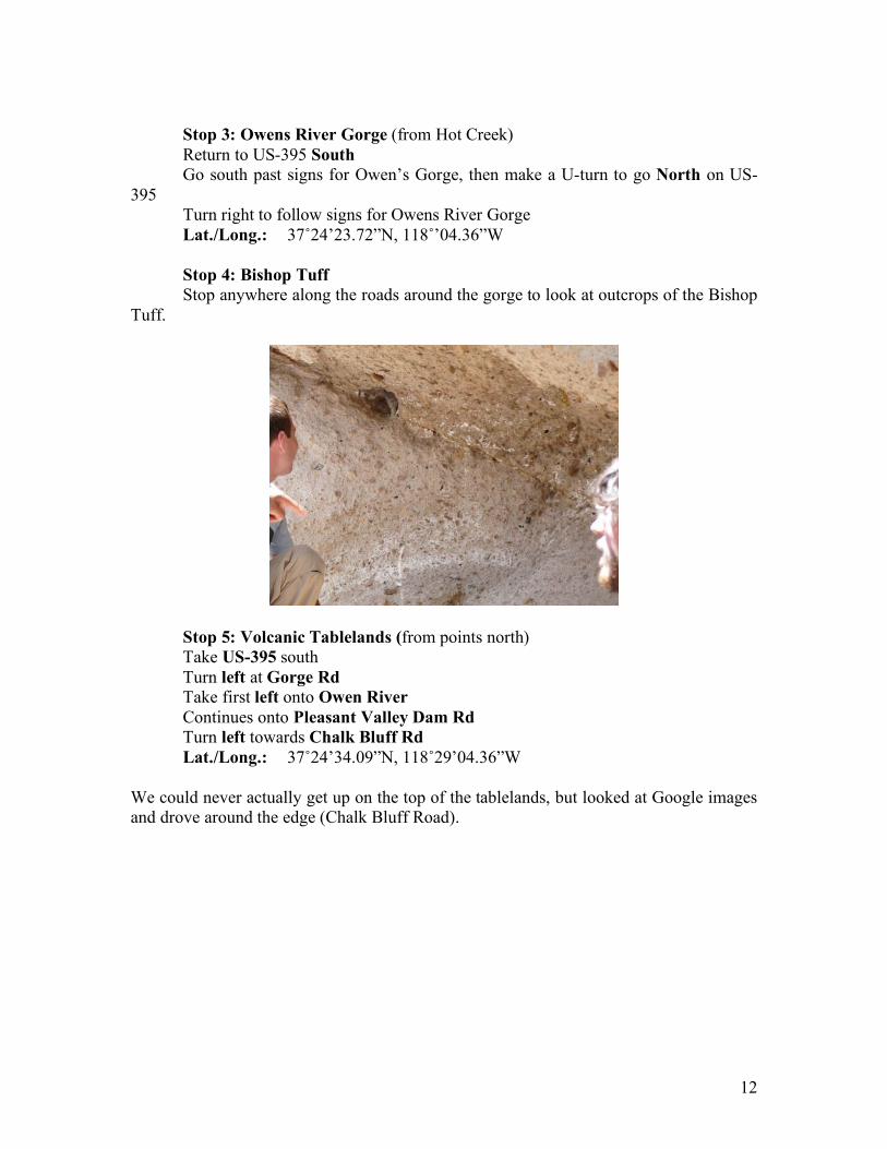
Stop 4: Bishop Tuff
Stop anywhere along the roads around the gorge to look at outcrops of the Bishop Tuff.
Stop 5: Volcanic Tablelands (from points north) Take US-395 south Turn left at Gorge Rd
Take first left onto Owen River
Continues onto Pleasant Valley Dam Rd
Turn left towards Chalk Bluff Rd Lat./Long.: 37˚24’34.09”N, 118˚29’04.36”W
We could never actually get up on the top of the tablelands, but looked at Google images and drove around the edge (Chalk Bluff Road).
13
Day 1: Volcanics
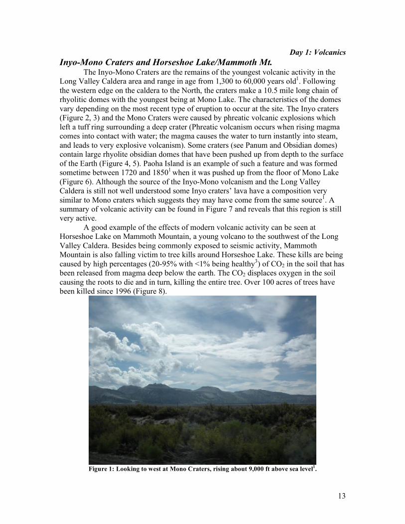
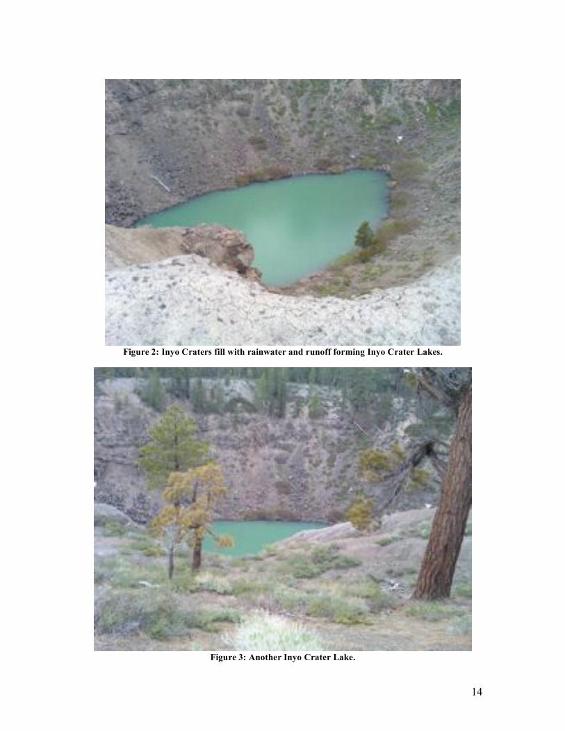
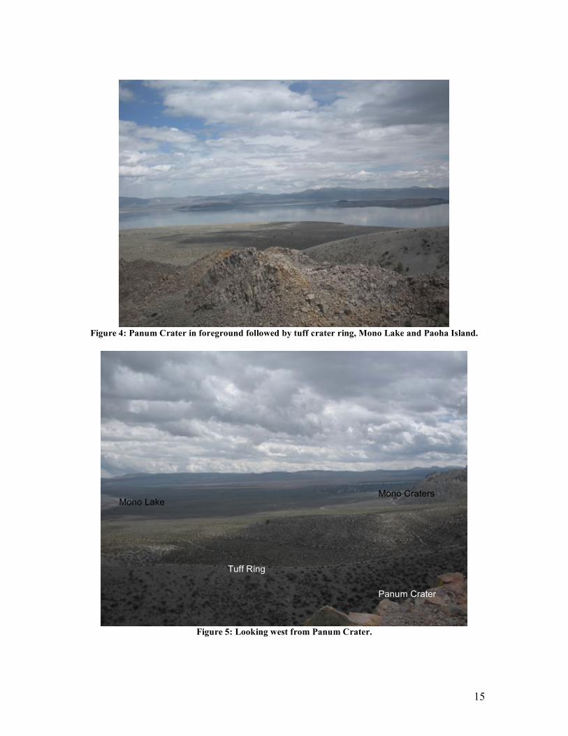
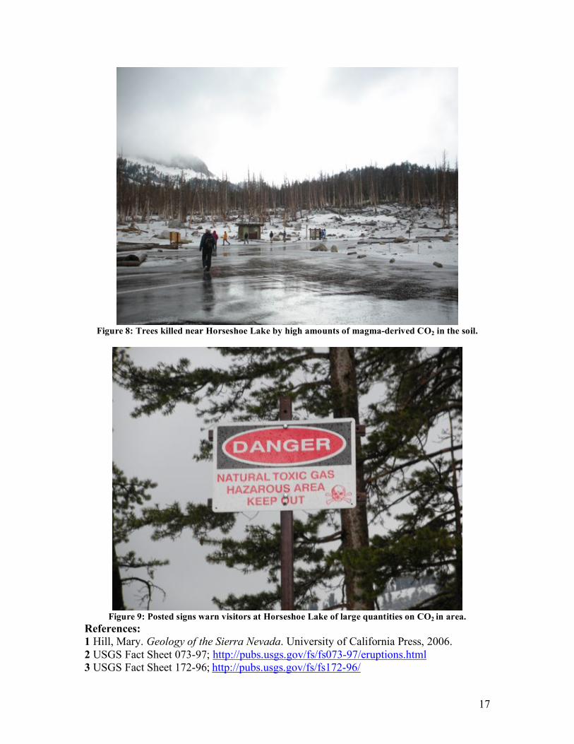
Inyo-Mono Craters and Horseshoe Lake/Mammoth Mt. The Inyo-Mono Craters are the remains of the youngest volcanic activity in the Long Valley Caldera area and range in age from 1,300 to 60,000 years old1. Following the western edge on the caldera to the North, the craters make a 10.5 mile long chain of rhyolitic domes with the youngest being at Mono Lake. The characteristics of the domes vary depending on the most recent type of eruption to occur at the site. The Inyo craters (Figure 2, 3) and the Mono Craters were caused by phreatic volcanic explosions which left a tuff ring surrounding a deep crater (Phreatic volcanism occurs when rising magma comes into contact with water; the magma causes the water to turn instantly into steam, and leads to very explosive volcanism). Some craters (see Panum and Obsidian domes) contain large rhyolite obsidian domes that have been pushed up from depth to the surface of the Earth (Figure 4, 5). Paoha Island is an example of such a feature and was formed sometime between 1720 and 18501 when it was pushed up from the floor of Mono Lake (Figure 6). Although the source of the Inyo-Mono volcanism and the Long Valley Caldera is still not well understood some Inyo craters’ lava have a composition very similar to Mono craters which suggests they may have come from the same source1. A summary of volcanic activity can be found in Figure 7 and reveals that this region is still very active. A good example of the effects of modern volcanic activity can be seen at Horseshoe Lake on Mammoth Mountain, a young volcano to the southwest of the Long Valley Caldera. Besides being commonly exposed to seismic activity, Mammoth Mountain is also falling victim to tree kills around Horseshoe Lake. These kills are being caused by high percentages (20-95% with <1% being healthy3) of CO2 in the soil that has been released from magma deep below the earth. The CO2 displaces oxygen in the soil causing the roots to die and in turn, killing the entire tree. Over 100 acres of trees have been killed since 1996 (Figure 8).
Figure 1: Looking to west at Mono Craters, rising about 9,000 ft above sea level
1.
14
Figure 2: Inyo Craters fill with rainwater and runoff forming Inyo Crater Lakes.
Figure 3: Another Inyo Crater Lake.
15
Figure 4: Panum Crater in foreground followed by tuff crater ring, Mono Lake and Paoha Island.
Figure 5: Looking west from Panum Crater.
Panum Crater
Tuff Ring
Mono Craters Mono Lake
16
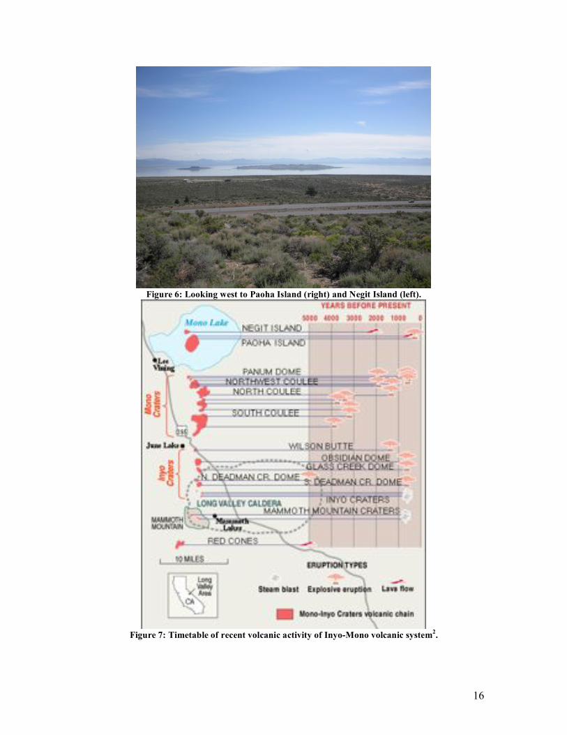
Figure 6: Looking west to Paoha Island (right) and Negit Island (left).
Figure 7: Timetable of recent volcanic activity of Inyo-Mono volcanic system
2.
17
Figure 8: Trees killed near Horseshoe Lake by high amounts of magma-derived CO2 in the soil.
Figure 9: Posted signs warn visitors at Horseshoe Lake of large quantities on CO2 in area.
References:
1 Hill, Mary. Geology of the Sierra Nevada. University of California Press, 2006. 2 USGS Fact Sheet 073-97; http://pubs.usgs.gov/fs/fs073-97/eruptions.html 3 USGS Fact Sheet 172-96; http://pubs.usgs.gov/fs/fs172-96/
18
Day 1: Volcanics
Black Point and Panum Crater
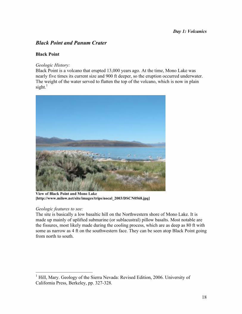
Black Point
Geologic History:
Black Point is a volcano that erupted 13,000 years ago. At the time, Mono Lake was nearly five times its current size and 900 ft deeper, so the eruption occurred underwater. The weight of the water served to flatten the top of the volcano, which is now in plain sight.1
View of Black Point and Mono Lake
[http://www.milow.net/site/images/trips/nocal_2003/DSCN0568.jpg]
Geologic features to see:
The site is basically a low basaltic hill on the Northwestern shore of Mono Lake. It is made up mainly of uplifted submarine (or sublacustral) pillow basalts. Most notable are the fissures, most likely made during the cooling process, which are as deep as 80 ft with some as narrow as 4 ft on the southwestern face. They can be seen atop Black Point going from north to south.
1 Hill, Mary. Geology of the Sierra Nevada: Revised Edition, 2006. University of California Press, Berkeley, pp. 327-328.
19
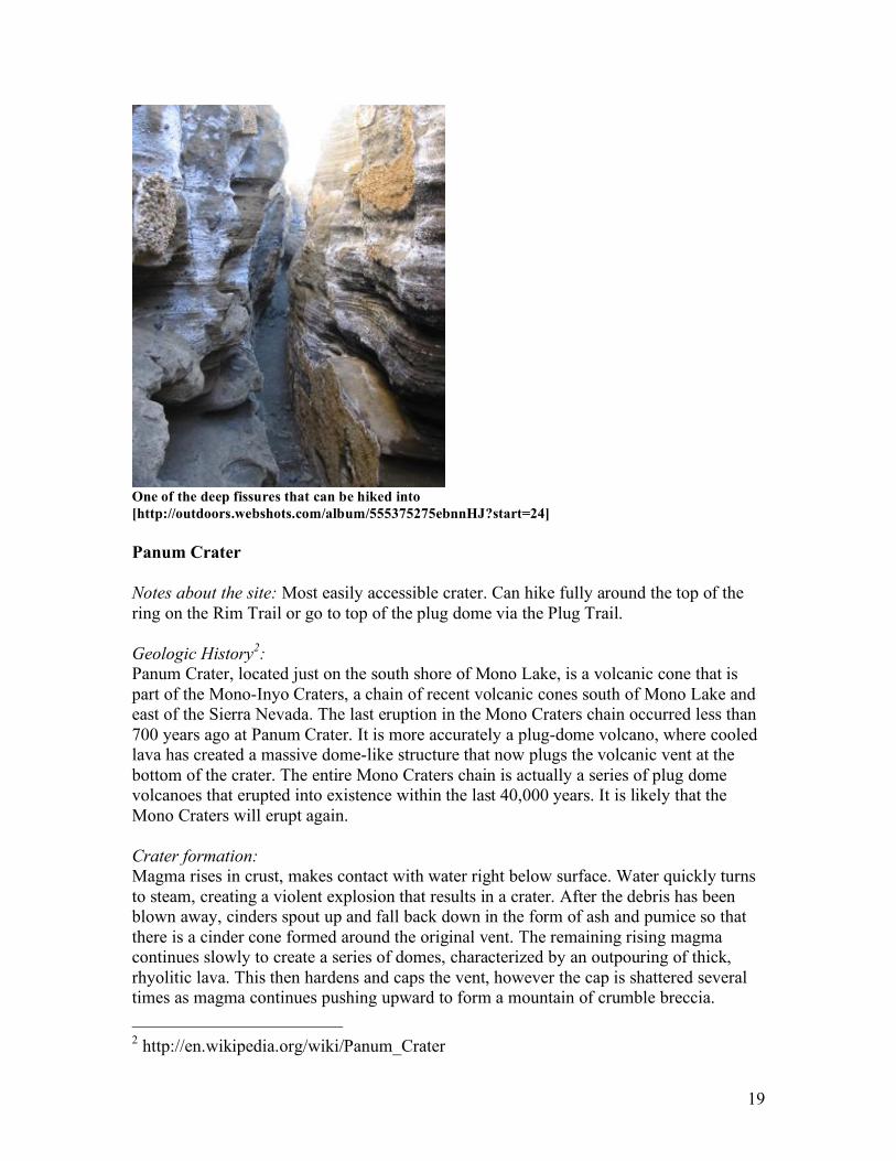
One of the deep fissures that can be hiked into
[http://outdoors.webshots.com/album/555375275ebnnHJ?start=24]
Panum Crater
Notes about the site: Most easily accessible crater. Can hike fully around the top of the ring on the Rim Trail or go to top of the plug dome via the Plug Trail.
Geologic History2:
Panum Crater, located just on the south shore of Mono Lake, is a volcanic cone that is part of the Mono-Inyo Craters, a chain of recent volcanic cones south of Mono Lake and east of the Sierra Nevada. The last eruption in the Mono Craters chain occurred less than 700 years ago at Panum Crater. It is more accurately a plug-dome volcano, where cooled lava has created a massive dome-like structure that now plugs the volcanic vent at the bottom of the crater. The entire Mono Craters chain is actually a series of plug dome volcanoes that erupted into existence within the last 40,000 years. It is likely that the Mono Craters will erupt again. Crater formation:
Magma rises in crust, makes contact with water right below surface. Water quickly turns to steam, creating a violent explosion that results in a crater. After the debris has been blown away, cinders spout up and fall back down in the form of ash and pumice so that there is a cinder cone formed around the original vent. The remaining rising magma continues slowly to create a series of domes, characterized by an outpouring of thick, rhyolitic lava. This then hardens and caps the vent, however the cap is shattered several times as magma continues pushing upward to form a mountain of crumble breccia.
2 http://en.wikipedia.org/wiki/Panum_Crater
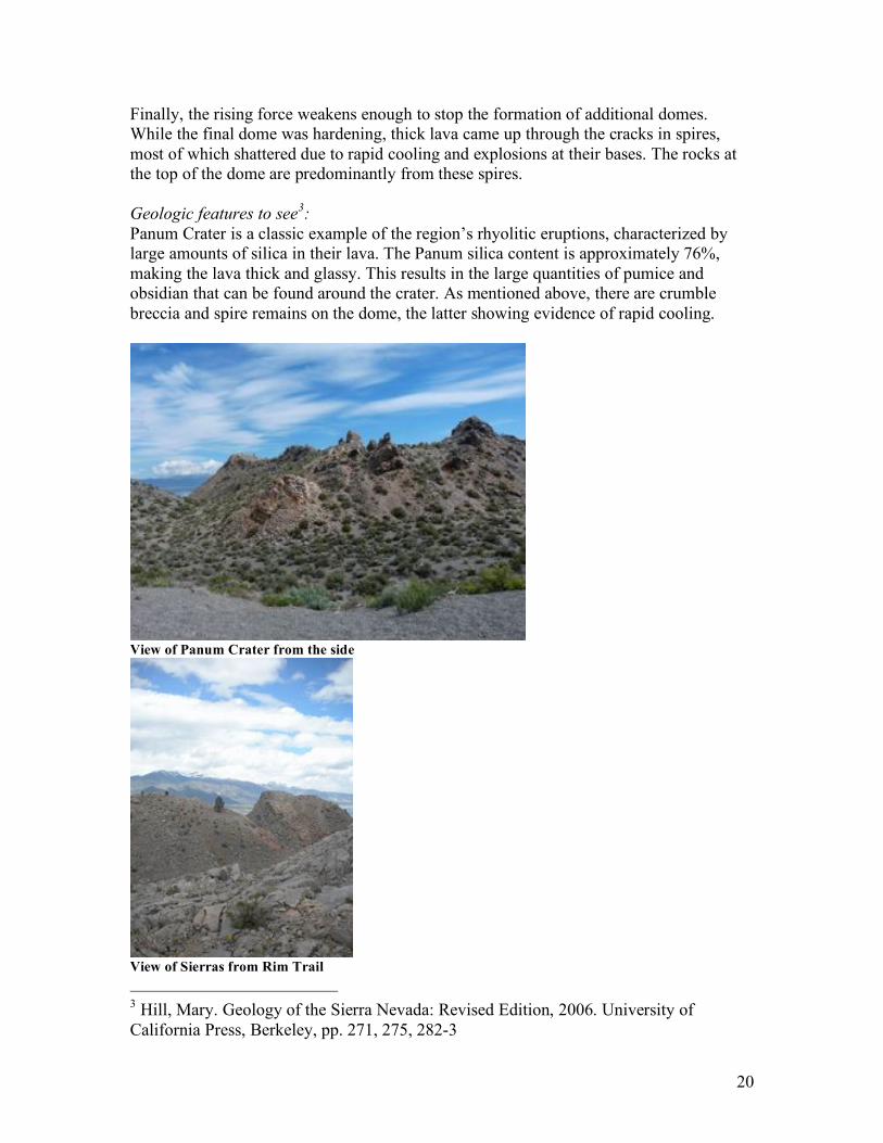
20
Finally, the rising force weakens enough to stop the formation of additional domes. While the final dome was hardening, thick lava came up through the cracks in spires, most of which shattered due to rapid cooling and explosions at their bases. The rocks at the top of the dome are predominantly from these spires. Geologic features to see
3:
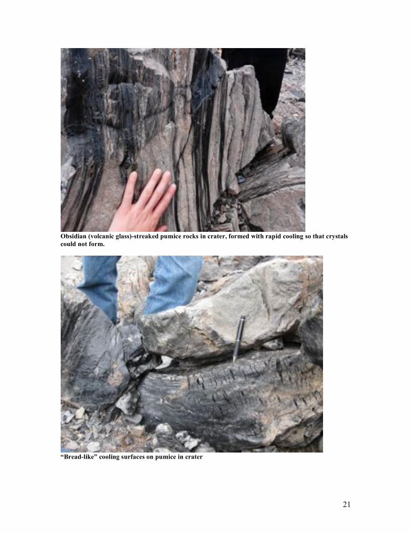
Panum Crater is a classic example of the region’s rhyolitic eruptions, characterized by large amounts of silica in their lava. The Panum silica content is approximately 76%, making the lava thick and glassy. This results in the large quantities of pumice and obsidian that can be found around the crater. As mentioned above, there are crumble breccia and spire remains on the dome, the latter showing evidence of rapid cooling.
View of Panum Crater from the side
View of Sierras from Rim Trail
3 Hill, Mary. Geology of the Sierra Nevada: Revised Edition, 2006. University of California Press, Berkeley, pp. 271, 275, 282-3
21
Obsidian (volcanic glass)-streaked pumice rocks in crater, formed with rapid cooling so that crystals
could not form.
“Bread-like” cooling surfaces on pumice in crater
22
Day 1: Volcanics
Long Valley Caldera
Geological setting from (Bailey et al., 1976)
Long Valley caldera is at the east base of the Sierra Nevada, 50 km northwest of
the town of Bishop and 30 km south of Mono Lake. The caldera is an elliptical
depression about 32 km from east to west by 17 km from north to south; it has an
area of about 450 km2. The eastern half of the caldera, Long Valley proper, is a
broad, crescentic grass and sage-covered valley of low relief, at an elevation near
2070 m (6800 ft). The western half of the caldera is a forested area of higher
relief at an average elevation of 2440 m (8000 ft); it forms the 'Mammoth
embayment; a prominent reentrant in the Sierra Nevada range front near the
town of Mammoth Lakes. In the west central part of the caldera a group of faulted
and dissected hills rises to 2590-m (8500 ft) elevation. Between these central hills
and the caldera walls is an annular moat, which is drained on the north by
Deadman Creek and the upper Owens River and on the south by Mammoth Creek
and Hot Creek. The walls of the caldera are well defined and rise steeply on all
sides except the southeast. On the south the wall rises precipitously to remnants of
a late Tertiary erosion surface at an elevation of 3050 m (10,000 ft) on the
shoulders of McGee and Laurel mountains. In the west the wall rises 500 m to the
eastern slopes of San Joaquin Mountain and Two Teats. On the north and
northeast the wall is formed by the steep south face of Bald Mountain and of
Glass Mountain, which rises 1200 m to an elevation of about 3350 m (11,000 ft).
The east wall, in contrast, is a low terraced escarpment with a maximum relief of
only 250 m, and the southeast wall is little more than an arch that merges with the
surface of the Volcanic Tableland, which slopes gently southeast toward Bishop.
The pre-Tertiary basement rocks in the immediate vicinity of Long Valley caldera
are Jurassic and Cretaceous granodiorites and granites of the Sierra Nevada
batholith and Paleozoic and Mesozoic metamorphic rocks of the Mount Morrison
and Ritter range roof pendants. Overlying the basement rocks on an erosion
surface of moderate relief are late Tertiary volcanic rocks, mainly basalt,
andesite, and rhyodacite. Basalt and andesite flows with a cumulative thickness of
200-250 m crop out in the west wall of the caldera, as well as along part of the
north wall. Thinner, less extensive sequences of flows from small local centers
occur also on the east rim south of Glass Mountain and on the south rim on
McGee Mountain. Rhyodacites overlie the basaltic rocks on the west rim and
form the main mass of San Joaquin Mountain and Two Teats, the dissected
remnants of a large Pliocene volcano northwest of the caldera. Three additional
masses of rhyodacite, the largest of which is Bald Mountain, it occurs on the
north rim (Bailey et al., 1976).
The Long Valley Caldera (LVC) and Obsidian Dome (OD) are located in the same general area as the magmas from the Mono-Inyo chain (OD is a member of this chain),
23
invading the calderas topographical moat. However, these 2 volcanic regions are not materially related. The LVC shows signs that it is moribund (Hildreth, 2004) while the Mono-Inyo chain is probably still active with the most recent activity being 600 years ago.
Long Valley Caldera, a 17- by 32-km elliptical depression on the east front of the Sierra Nevada, formed 0.7 Ma during the eruption of the Bishop Tuff (760,000 years ago). Subsequent intra-caldera volcanism included eruption of (1) aphyric rhyolite 0.68-0.64 Ma ago during resurgent doming of the caldera floor, (2) porphyritic hornblende-biotite rhyolite from centers peripheral to the resurgent dome at 0.5, 0.3, and 0.1 Ma and (3) porphyritic hornblende-biotite rhyodacite from outer ring fractures 0.2 Ma ago to 50,000 yr ago, a sequence that apparently records progressive crystallization of a subjacent chemically zoned magma chamber. Rhyolites of Glass Mountain 2.2-0.79 Ma: These rhyolites are the earliest volcanic rocks that can be related to the Long Valley magma chamber. Glass Mountain is a thick accumulation (>100 m) of domes, flows, and shallow intrusions flanked by extensive fans of pyroclastic deposits that consist of pumice and ash. The eruptive period that built Glass Mountain can be separated into two groups. The first is an older sequence from 2.2 Ma to 1.3 Ma which consisted of at least 24 eruptive units of all high-silica rhyolite but chemically varied. The second sequence is a younger sequence from 1.2-0.79 Ma of at least 35 eruptive units, all geochemically similar to the more evolved end of the compositionally zoned Bishop Tuff spectrum (Bailey et al., 1976;Hildreth, 2004). Bishop Tuff 0.76 Ma: This is a voluminous rhyolite ash flow sheet that erupted about .76 Ma from vents now buried within Long Valley Caldera. The Bishop Tuff is a crystal rich rhyolite tuff that contains up to 30% phenocrysts of quartz, sanidine, plagioclase, biotite, and Fe-Ti oxide. This was erupted in a virtually continuous eruption about 6 days long releasing about 600 km3 of gas-rich rhyolitic magma which was compositionally and thermally zoned. This event caused the roof to subside by 2-3 km creating the caldera. Around half of the Bishop Tuff by volume was emplaced radially as a set of sectorially distributed ignimbrite outflow sheets along with concurrent plinian and coignimbrite fallout. The other half ponded inside the subsiding caldera, where welded intracaldera ignimbrite is as thick as 1500 m (Bailey et al., 1976;Hildreth, 2004).
Early Rhyolites 0.76-0.66 Ma: Almost immediately after subsidence, eruption resumed in the caldera. During this time crystal-poor rhyolite tufts, domes, and flows accumulated on the floor to a thickness of more than 600 m. This volume is as great as that of pre-caldera Glass Mountain and larger than all of the subsequent Long Valley rhyolites erupted in the last 0.5 Ma. The early rhyolites are currently exposed in tilted and uplifted fault blocks in the central part of the caldera. Resurgent Doming .76 Ma-Present: The Formation of the Resurgent Dome was contemporaneous with emplacement of the early rhyolites. The uplift was probably nearly completed by 0.26 Ma though there is evidence for some continued uplift as early as 1991(Langbein et al., ). In this uplift the west central part of the caldera floor was uplifted and deformed into a sub-circular structural dome. This resurgent dome is 10 km in diameter and consists of a mosaic of fault-bounded blocks that rise 500m above the
24
surrounding moat. The highest point of the uplift is Gilbert Dome (2626 m). This dome is the result of positive central uplift rather than differential collapse. The evidence for this is that: 1) Lake terraces tilted outward on the dome at elevations as much as 35 m higher than the highest terrace on the caldera walls 2) There are scattered beach pebbles as much as 80 m higher on the dome than on the caldera walls; and 3) 1- to 2-m-diameter blocks of granitic and metamorphic rocks, interpreted as ice-rafted glacial erratic from the Sierra Nevada, are 200 m higher on the dome than the highest terrace on the caldera walls and 60 m higher than the lowest part of the caldera rim (would have been?) during early post caldera time. These features also indicate that the resurgent dome was an island in a caldera lake during much of its history(Bailey et al., 1976). North-central rhyolite chain 0.53-0.48 Ma: These are also called moat rhyolites. There are 3 sequences of moat rhyolites. The North-central is the earliest of 3 clusters of post-resurgence rhyolites. This chain consists of five units which cross the NE sector of the resurgent dome. Thus not really in the caldera moat at all nor aligned along the ring-fault (Hildreth, 2004). At about 500,000 Ka moat rhyolite began erupting. These are coarsely porphyritic hornblende-biotite rhyolite erupted from three groups of vents in the caldera moat. The distribution of the moat rhyolite eruptions is probably controlled by ring fractures that bound the resurgent dome. The presence of hydrous minerals and the increase in vesicularity suggests that their extrusion and the reopening of the ring fault may have been caused by the increase in volatile pressure due to the crystallization of the magma chamber (Bailey et al., 1976). Southeastern rhyolite Cluster ~0.36-0.29 Ma: This eruption came from a system of 5 vents in the caldera’s low SE moat. Two of these vents arguably extend the trend of the north-central chain and clearly lie along the ring-fault zone. These rocks are hornblende-biotite rhyodacites. They contain less silicic and richer in crystals than the hornblende-biotite rhyolites of the caldera moat. These occur in three localities- Mammoth Mountain on the southwest, Deadman Creek on the northwest and the foot of Glass Moutain on the northeast (Bailey et al., 1976;Hildreth, 2004)
West moat rhyolites 0.16-0.11 Ma: The third moat cluster erupted west of the resurgent dome and consists of four small lava domes and the extensive West Moat Coulee which is 8.5 km2 and as thick as 574 m. All are phenocryst-rich low temperature rhyolites, but chemically there are two variations. Deer Mountain and coulee have high Be and 72-72% SiO2 whereas Dry Creek dome and Mammoth Knolls are more evolved with 76-77% SiO2 and lower Ba (Hildreth, 2004).
Late Basaltic Volcanism: The west moat of Long Valley Caldera contains many basaltic flows and cinder cones that are part of a more extensive chain of mafic volcanic rocks extending from southwest of Mammoth Mountain 45 km northward into Mono basin. This chain includes the trachybasaltic rocks of the Devils Postpile, the trachyandesite cinder cones and flows of the June Lake area, and the sublacustrine cinder cone of Black
25
Point on the north shore of Mono Lake. These rocks appear to have erupted from a north-trending fracture system consisting of north-north west trending en echelon segments that parallel the east front of the Sierra Nevada. Chemically and mineralogically, the rocks are similar to Cenozoic mafic rocks that occur throughout the Basin and Range province, and presumably they have a similar origin. (Bailey et al., 1976)
Holocene Rhyolitic Volcanism (Obsidian Dome): The youngest volcanic features in Long Valley Caldera are the Inyo Craters and Domes. These are aligned on an apparent north trending fracture extending from the west moat to the Mono craters along the east front of the Sierra Nevada. The Inyo domes are five rhyolitic to rhyodacitic lava domes, the three largest of which are the youngest(Bailey et al., 1976). The Inyo chain is a surface expression of a dike or a system of dikes. The initial eruptive activity at Obsidian Dome, South Glass Creek, and Deadman domes consists of explosive magmatic eruptions that produce near-vent pyroclastic fall and flow deposits followed by the extrusion of the rhyolite domes (Vogel et al., 1987).The Inyo domes are of particular interest because they are fault-influenced zone of mixing where magmas of at least four kinds are confluent (Hildreth, 2004) This mixing probably happened near the surface.
Obsidian Dome Obsidian Dome is a 600 year old member of the Inyo chain. It consists entirely of the finely porphyritic rhyolite. This type has a large variation in chemical composition with reference to both major and trace elements (Vogel et al., 1987). Obsidian dome provides two very interesting points to study. First Drill cores have been taken out of Obsidian Dome provides the rare opportunity to examine the transition from volcanic dome to plutonic texture in a silica magma system. The dome records multiple periods of crystallization initiated by changes in under cooling related to variable degassing in the magma. The drastic increase in temperature related to the loss of a vapor phase during the initial stage of eruption caused the formation of microlites. The extrusion of the dry magma caused spherulites and fine-grained rhyolites to crystallize at high temperature. A granophyric texture indicating moderate temperature formed beneath the dome and textures in the intrusion seems to represent crystallization of hydrous rhyolitic magma at shallow depth (Swanson et al., 1989).
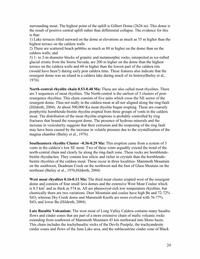
26
Obsidian Dome.
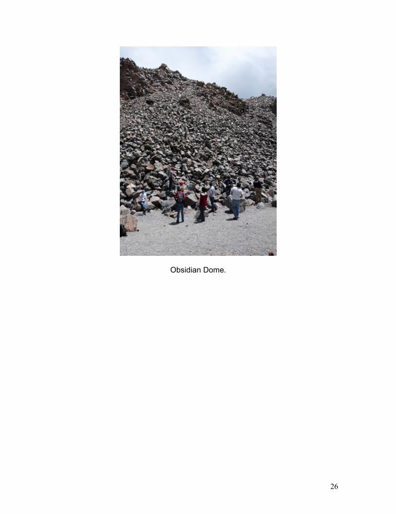
27
Blocks of rhyolite and obsidian at Obsidian Dome. Alison for scale.
References: 1. Bailey R. A., Dalrymple G. B., and Lanphere M. A. (1976) Volcanism, Structure,
and Geochronology of Long Valley Caldera, Mono County, California. J.
Geophys. Res.
2. Hildreth W. (2004) Volcanological perspectives on Long Valley, Mammoth Mountain, and Mono Craters: several contiguous but discrete systems. Journal of
Volcanology and Geothermal Research 136, 169-198.
3. Langbein J., Hill D. P., Parker T. N., and Wilkinson S. K. An Episode of Reinflation of the Long Valley Caldera, Eastern California: 1989!Çô1991. J.
Geophys. Res. 98, 15,851!Çô15,870.
4. Swanson S. E., Naney M. T., Westrich H. R., and Eichelberger J. C. (1989) Crystallization history of Obsidian dome, Inyo domes, California. Bulletin of
Volcanology 51, 161!Çô176.
5. Vogel T. A., Younker L. W., and Schuraytz B. C. (1987) Constraints on magma ascent, emplacement, and eruption: Geochemical and mineralogical data from drill-core samples at Obsidian dome, Inyo chain, California. Geology 15, 405-408.
28
Day 2: Mono Basin
Tufas and Modern Lake Level History
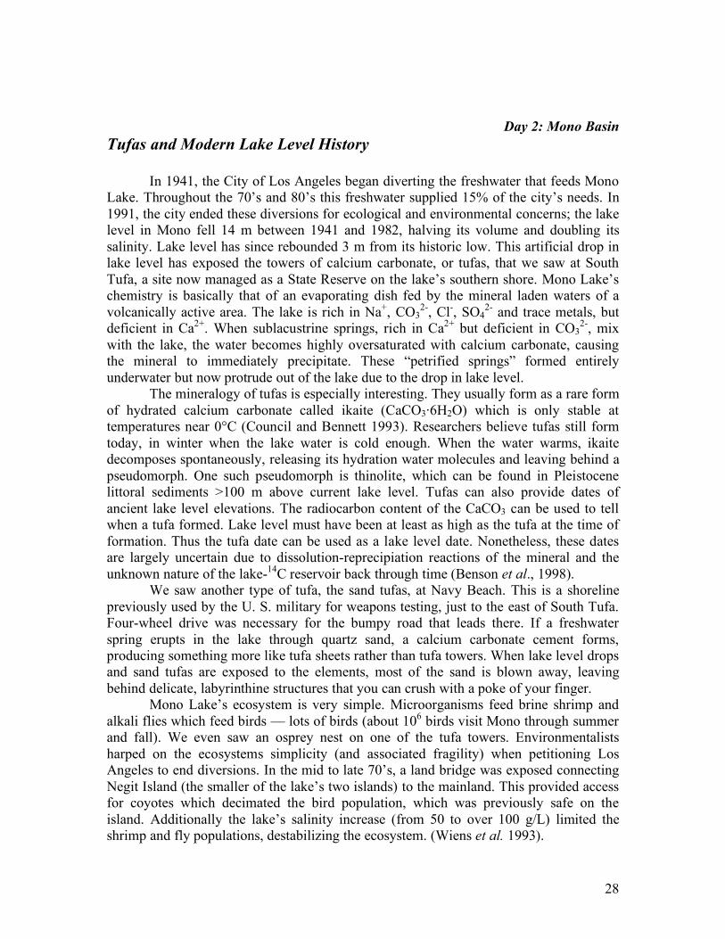
In 1941, the City of Los Angeles began diverting the freshwater that feeds Mono Lake. Throughout the 70’s and 80’s this freshwater supplied 15% of the city’s needs. In 1991, the city ended these diversions for ecological and environmental concerns; the lake level in Mono fell 14 m between 1941 and 1982, halving its volume and doubling its salinity. Lake level has since rebounded 3 m from its historic low. This artificial drop in lake level has exposed the towers of calcium carbonate, or tufas, that we saw at South Tufa, a site now managed as a State Reserve on the lake’s southern shore. Mono Lake’s chemistry is basically that of an evaporating dish fed by the mineral laden waters of a volcanically active area. The lake is rich in Na+, CO3
2-, Cl-, SO42- and trace metals, but
deficient in Ca2+. When sublacustrine springs, rich in Ca2+ but deficient in CO32-, mix
with the lake, the water becomes highly oversaturated with calcium carbonate, causing the mineral to immediately precipitate. These “petrified springs” formed entirely underwater but now protrude out of the lake due to the drop in lake level.
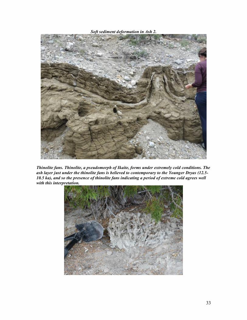
The mineralogy of tufas is especially interesting. They usually form as a rare form of hydrated calcium carbonate called ikaite (CaCO3·6H2O) which is only stable at temperatures near 0°C (Council and Bennett 1993). Researchers believe tufas still form today, in winter when the lake water is cold enough. When the water warms, ikaite decomposes spontaneously, releasing its hydration water molecules and leaving behind a pseudomorph. One such pseudomorph is thinolite, which can be found in Pleistocene littoral sediments >100 m above current lake level. Tufas can also provide dates of ancient lake level elevations. The radiocarbon content of the CaCO3 can be used to tell when a tufa formed. Lake level must have been at least as high as the tufa at the time of formation. Thus the tufa date can be used as a lake level date. Nonetheless, these dates are largely uncertain due to dissolution-reprecipiation reactions of the mineral and the unknown nature of the lake-14C reservoir back through time (Benson et al., 1998).
We saw another type of tufa, the sand tufas, at Navy Beach. This is a shoreline previously used by the U. S. military for weapons testing, just to the east of South Tufa. Four-wheel drive was necessary for the bumpy road that leads there. If a freshwater spring erupts in the lake through quartz sand, a calcium carbonate cement forms, producing something more like tufa sheets rather than tufa towers. When lake level drops and sand tufas are exposed to the elements, most of the sand is blown away, leaving behind delicate, labyrinthine structures that you can crush with a poke of your finger.
Mono Lake’s ecosystem is very simple. Microorganisms feed brine shrimp and alkali flies which feed birds — lots of birds (about 106 birds visit Mono through summer and fall). We even saw an osprey nest on one of the tufa towers. Environmentalists harped on the ecosystems simplicity (and associated fragility) when petitioning Los Angeles to end diversions. In the mid to late 70’s, a land bridge was exposed connecting Negit Island (the smaller of the lake’s two islands) to the mainland. This provided access for coyotes which decimated the bird population, which was previously safe on the island. Additionally the lake’s salinity increase (from 50 to over 100 g/L) limited the shrimp and fly populations, destabilizing the ecosystem. (Wiens et al. 1993).
29
The Mono Lake Committee, the local conservation group, has set a lake level target of 3 meters higher than today’s. This target will secure the ecosystem’s future health, but will also cause many of the tourist-attracting tufas to go back underwater!
References: Benson, L. V., S. P. Lund, J. W. Burdett, M. Kashgarian, T. P. Rose, (1998). "Correlation of Late-Pleistocene Lake-Level Oscialltions
in Mono Lake, California, with North Atlantic Climate Events." Quaternary Research, 1-10.
Council, T. D., P. C. Bennett, (1993). "Geochemistry of Ikaite Formation at Mono Lake, California: Implications for the Origin of
Tufa Mounds." Geology, 971-974.
Wiens, J. A., D. T. Patten, D. B. Botkin, (1993). "Assessing Ecological Impact Assessment: Lessons from Mono Lake, California."
Ecological Applications, 595-609.
Captions (from top, left to right): Mono Lake; Some of Mono’s Birds; South Tufa; Osprey family perched at South Tufa; Sand Tufa at Navy Beach; More Tufas
30
Day 2- Mono Basin
Wilson Creek Formation
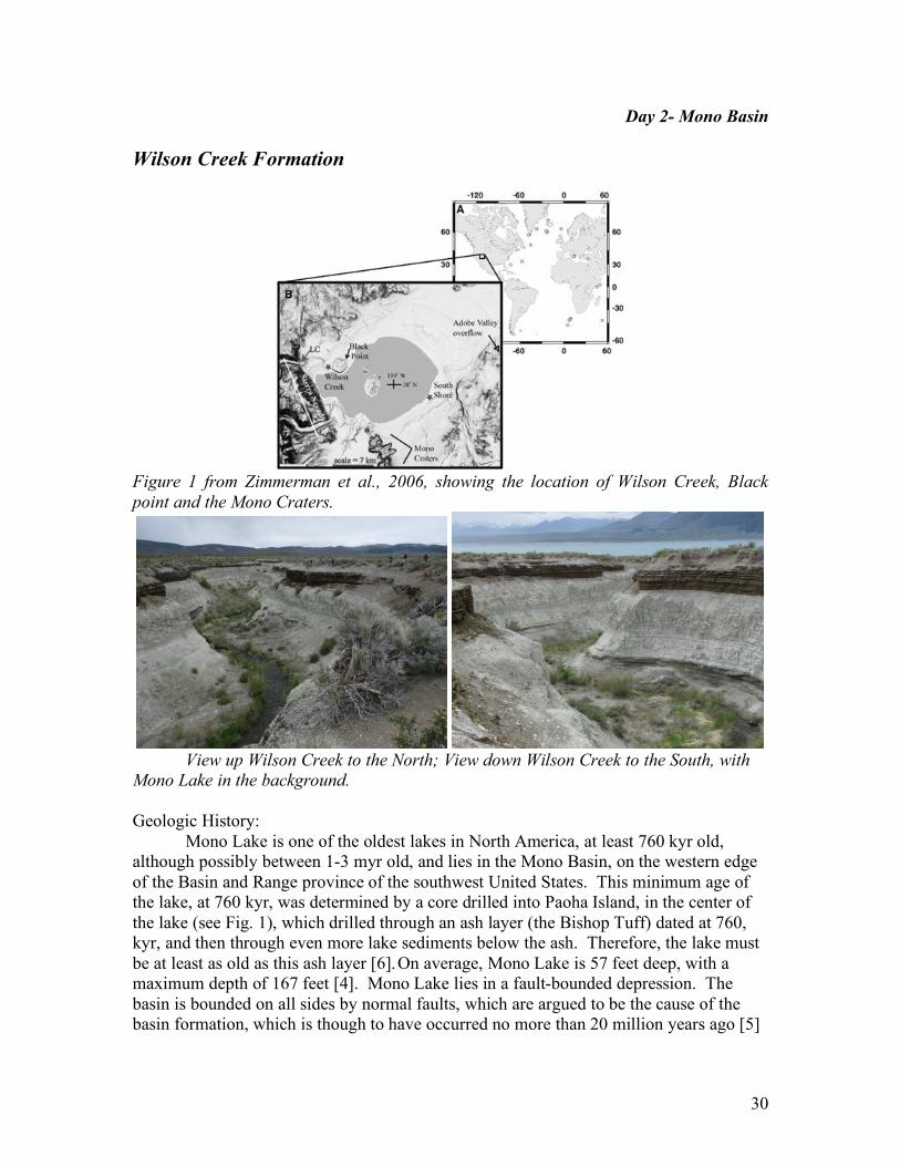
Figure 1 from Zimmerman et al., 2006, showing the location of Wilson Creek, Black
point and the Mono Craters.
View up Wilson Creek to the North; View down Wilson Creek to the South, with
Mono Lake in the background.
Geologic History: Mono Lake is one of the oldest lakes in North America, at least 760 kyr old, although possibly between 1-3 myr old, and lies in the Mono Basin, on the western edge of the Basin and Range province of the southwest United States. This minimum age of the lake, at 760 kyr, was determined by a core drilled into Paoha Island, in the center of the lake (see Fig. 1), which drilled through an ash layer (the Bishop Tuff) dated at 760, kyr, and then through even more lake sediments below the ash. Therefore, the lake must be at least as old as this ash layer [6]. On average, Mono Lake is 57 feet deep, with a maximum depth of 167 feet [4]. Mono Lake lies in a fault-bounded depression. The basin is bounded on all sides by normal faults, which are argued to be the cause of the basin formation, which is though to have occurred no more than 20 million years ago [5]
31
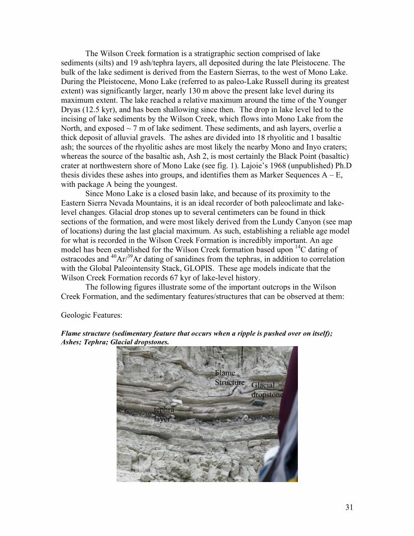
The Wilson Creek formation is a stratigraphic section comprised of lake sediments (silts) and 19 ash/tephra layers, all deposited during the late Pleistocene. The bulk of the lake sediment is derived from the Eastern Sierras, to the west of Mono Lake. During the Pleistocene, Mono Lake (referred to as paleo-Lake Russell during its greatest extent) was significantly larger, nearly 130 m above the present lake level during its maximum extent. The lake reached a relative maximum around the time of the Younger Dryas (12.5 kyr), and has been shallowing since then. The drop in lake level led to the incising of lake sediments by the Wilson Creek, which flows into Mono Lake from the North, and exposed ~ 7 m of lake sediment. These sediments, and ash layers, overlie a thick deposit of alluvial gravels. The ashes are divided into 18 rhyolitic and 1 basaltic ash; the sources of the rhyolitic ashes are most likely the nearby Mono and Inyo craters; whereas the source of the basaltic ash, Ash 2, is most certainly the Black Point (basaltic) crater at northwestern shore of Mono Lake (see fig. 1). Lajoie’s 1968 (unpublished) Ph.D thesis divides these ashes into groups, and identifies them as Marker Sequences A – E, with package A being the youngest. Since Mono Lake is a closed basin lake, and because of its proximity to the Eastern Sierra Nevada Mountains, it is an ideal recorder of both paleoclimate and lake-level changes. Glacial drop stones up to several centimeters can be found in thick sections of the formation, and were most likely derived from the Lundy Canyon (see map of locations) during the last glacial maximum. As such, establishing a reliable age model for what is recorded in the Wilson Creek Formation is incredibly important. An age model has been established for the Wilson Creek formation based upon 14C dating of ostracodes and 40Ar/39Ar dating of sanidines from the tephras, in addition to correlation with the Global Paleointensity Stack, GLOPIS. These age models indicate that the Wilson Creek Formation records 67 kyr of lake-level history. The following figures illustrate some of the important outcrops in the Wilson Creek Formation, and the sedimentary features/structures that can be observed at them: Geologic Features: Flame structure (sedimentary feature that occurs when a ripple is pushed over on itself);
Ashes; Tephra; Glacial dropstones.
Flame Structure
tephra layer
Glacial dropstone
32
Climbing Ripples in Ash 2. Climbing ripples form in fast flowing water, so fast, in fact, that the
ripples become super-imposed upon one another, and essentially ‘climb’ on top of the
preceding ripple
Channel Cut from when the lake level dropped; Ash 2 (dark layer) on top.
33
Soft sediment deformation in Ash 2.
Thinolite fans. Thinolite, a pseudomorph of Ikaite, forms under extremely cold conditions. The
ash layer just under the thinolite fans is believed to contemporary to the Younger Dryas (12.5-
10.5 ka), and so the presence of thinolite fans indicating a period of extreme cold agrees well
with this interpretation.
34
Sources: [1] Russell, Israel (1889) Quaternary history of the Mono Valley, California [2]Zimmerman, S. 2006, Chronology and paleoclimate records of the Late
Pleistocene Wilson Creek Formation at Mono Lake, California Chronology and
paleoclimate records of the Late Pleistocene Wilson Creek Formation at Mono Lake,
California, unpublished thesis. [3] Zimmerman et al (2006) Revised chronology for late Pleistocene Mono Lake
sediments based on paleointensity correlation to the global reference curve. [4] USGS Website: http://lvo.wr.usgs.gov/gallery/MonoLake_1.html (14/7/09) [5] Laboratory of Nuclear Medicine and Radiaiton Biology, UCLA ,1979, An Environmental Overview of Geothermal Development: The Mono-Long Valley KRGA. [6] Mono Lake Committee: http://www.monolakecommittee.org/about/stats (14/7/09)
35
Day 2: Mono Basin
Glacial History
Glaciers from the Sierra Nevada have created some truly stunning features in the
Mono Basin. Huge, U-shaped valleys were carved by the grinding of boulder-studded ice down Sierran bedrock; sharp peaks (“horns”) and bowl-shaped depressions (“cirques”) were scoured out by hanging glaciers; and wide, rocky ridges (“moraines”) formed at the glaciers’ melting edges. Glaciers have advanced several times during the basin’s history, and researchers have divided these into four major events (from oldest to youngest): Mono Basin, Tahoe, Tenaya, and Tioga. These events, recorded by the features listed above, can tell us about past environmental conditions in the basin. When timing of these events is known, we can also compare them to larger regional and global climate records, and gain insight into the bigger picture – how, where, and why does climate change?
To form a glacier, the rate of snow accumulation needs to exceed the rate of snow-melt over a long period of time. As snow grows deeper and thicker, it compacts under the increasing weight of snow above it. Most air spaces are squeezed out, and eventually the snow is transformed to ice (this is sometimes called “firnification”). Glaciers have dramatic effects on their surroundings, not only because they can change the local environment (winds, hydrology, vegetation, etc.), but also because they are always on the move. Snow and ice tend to accumulate at colder, higher elevations and melt at warmer, lower elevations. This means that ice is constantly being created, sliding downwards, and then melting at the glacier’s base. The area where there is net growth (the “zone of accumulation”) and the area where there is net loss, through sublimation and/or melting (the “zone of ablation”) are divided by the equilibrium line, where growth and loss are balanced.
Glaciers can grow hundreds of meters thick, and the weight of all that ice creates high pressure at the contact between the glacier and the bedrock below. If pressure increases enough, it will exceed the melting point of ice, and water will form at the ice-rock boundary. This water lubricates the glacier’s downward motion, and also can re-freeze in depressions and cracks in the bedrock. The expansion of this freezing water breaks the underlying rock into cobbles and boulders, which are picked up by the moving ice. The more material a glacier is carrying, the more erosive it can be – its base moves like a giant slab of sandpaper across the underlying terrain, creating deep scratches (“striations”) and carving a new landscape. Once ice reaches the glacier’s lower edge and melts, it dumps the material it was carrying to create a moraine. All other things being equal, the longer a glacier’s edge stays in the same location, the more material will be deposited and the bigger its moraine will grow.
In the Mono Basin, relative moraine ages have been estimated by several techniques, but absolute ages are still uncertain. Some relative dating techniques include: degree of weathering (depth of weathering pits, grain-scale roughness), moraine morphology and stratigraphic relationships, and clast-sound velocity, or CSV. CSV is based on the idea that as boulders become older, they develop small cracks, which slow the passage of sound waves. (A very qualitative version of this method is informally
36
called “ping and thud,” in which you bang the boulder with a hammer. If it “pings” then it’s young, and if it “thuds” then it’s old. This works because weathered rocks have cracks and looser crystal contacts, which makes sound waves travel slower). We can also learn a lot by examining spatial relationships – if you’re standing in one of Mono’s glacial valleys, you will often see two or three moraines set behind one another, sometimes with small lakes behind them. Outer ridges must be older than inner ridges because if they were younger, their glacial advance would have effectively bulldozed the inner ones away. On the Tioga moraine, cosmogenic 36Cl dates have also been measured (briefly, cosmogenic dating utilizes the fact that the longer a rock surface is exposed to the atmosphere, the more cosmogenic rays will crash into it, converting certain elements into other elements, which can be measured).
Cosmogenic dating on glacially-deposited boulders from this region can improve our understanding of ice-cover in a global context, giving insight into glacial-interglacial transitions. One puzzle that researchers are investigating is the discrepancy between 10Be exposure dates, which imply warming happened at the same time in both hemispheres after the last ice age, and ice core records, which imply the Southern Hemisphere warmed first. Exposure dates from New Zealand, South America, Europe, and North America (including the Bloody Canyon Moraines, which you will see!) all cluster between 19 – 17 kya. Schafer et al (2009) interpret this to mean that the Northern Hemisphere summers did actually warm at the same time as the Southern Hemisphere, but the ice core records don’t show it clearly because at that time, Northen winters were especially cold (which shifts the average annual record to colder values). Aaron Putnam, George Denton, and Joerg Schafer are continuing work in this region to get more detailed records – there is still much to learn about the timing of glaciations in the Sierra Nevada region. References: Schaefer et al., Near-synchronous Interhemispheric Termination of the Last Glacial Maximum in Mid-Latitudes," Science 312, 1510 (2006) Harris, Stephen L. "The Ice: How a glacier works" from Fire Mountains of the West, 1988.
37
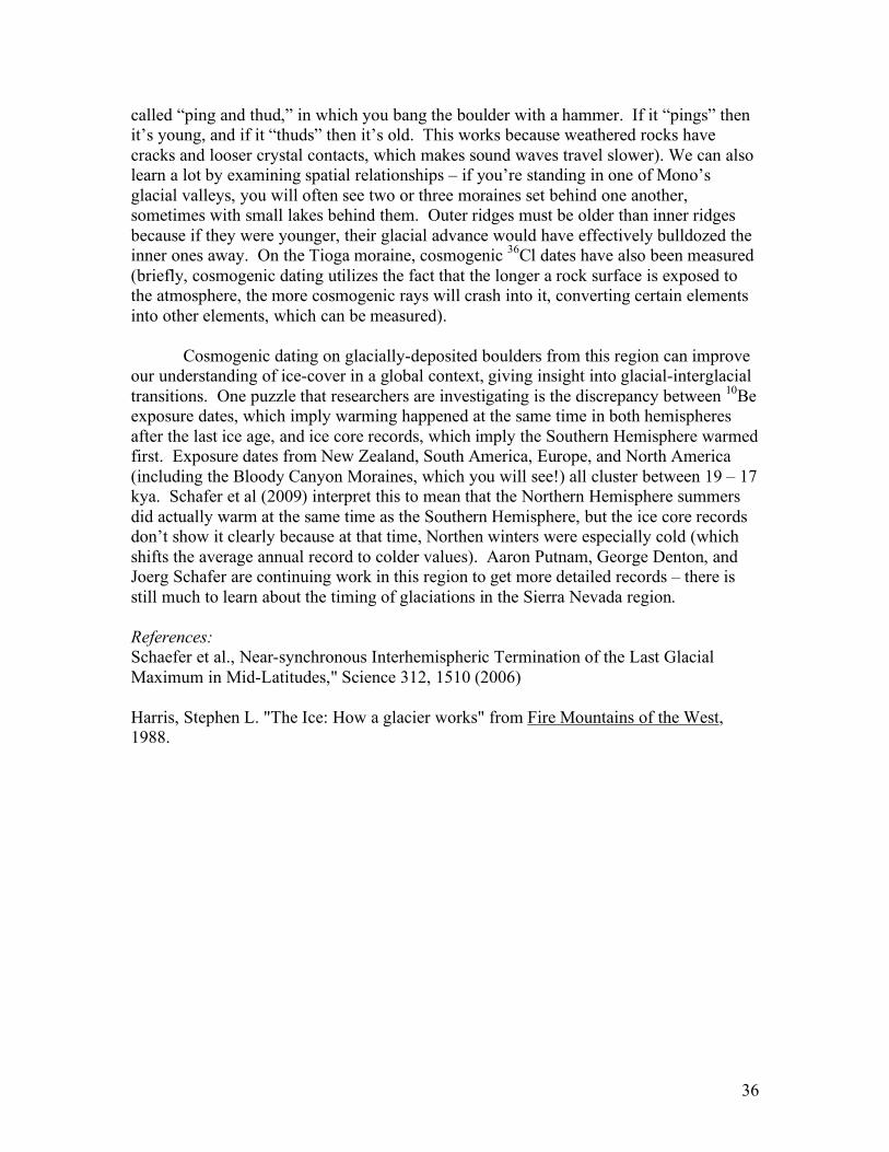
(From top to bottom) View up Bloody Canyon from Mono Lake showing the ‘u-shape’ typical to glacial valleys. The lateral moraine in the foreground has experienced faulting; Hanging valley; Lateral Moraine in Lundy Canyon.
38
Day 3: Yosemite
Geology of Yosemite
The present Yosemite Valley is the result of many different geologic processes operating over a period of time measured in millions of years.
Yosemite Valley is a U-shape valley, caused by ice carving. A million years ago, ice filled what is now Yosemite National Park. The downward movement of this ice carved the Valley to its present U-shape.
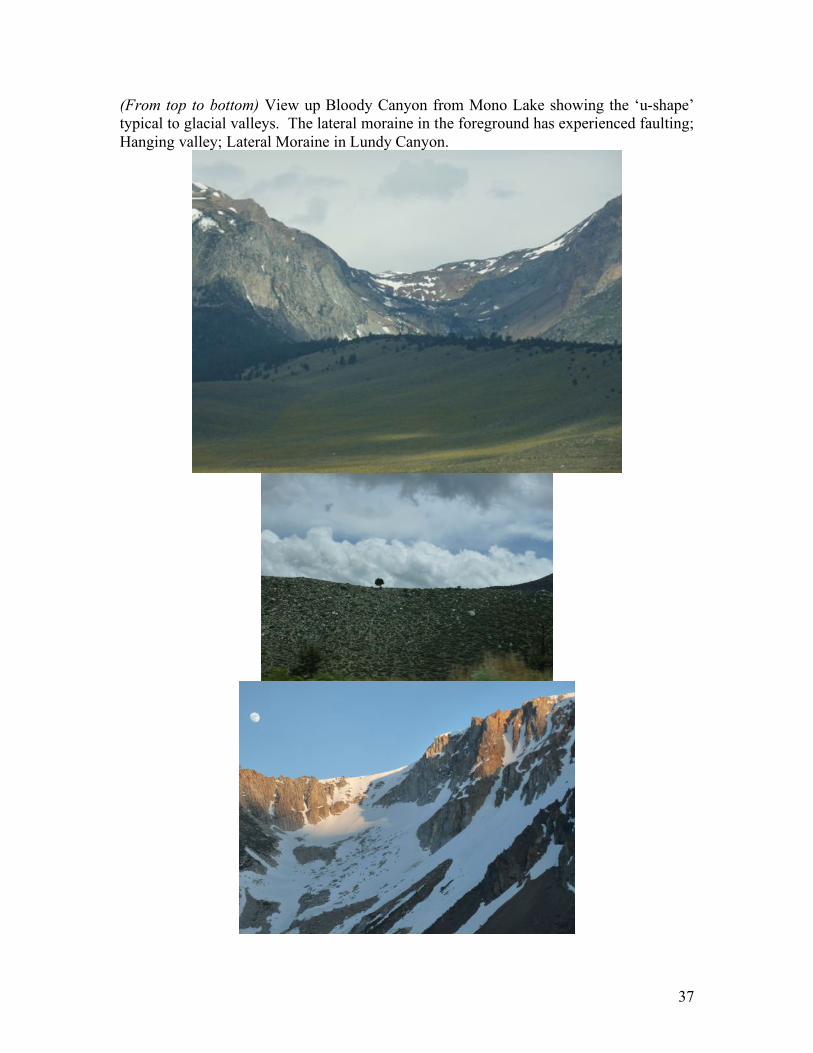
Granitic rocks comprise almost all of Yosemite. One of the most famous outcroppings is El Capitan (see Fig 1), which is the largest single piece of granite in the world. We saw this giant rock on our way into the valley. The El Capitan reaches 3000 feet and is a perfect place for rock climbers.
Most of the rocks at Yosemite are plutonic rock, products of millions years of cooling and crystallization of magma below the Earth’s surface. The composing minerals of plutonic rocks are mainly quartz and feldspar.
Another famous rock we saw is Half Dome (Fig 2). What interesting is we could not find another half of the dome in the valley. The Half Dome reflects the general shape of an intrusion of granodiorite deep underground. As the rock exposed by erosion, the change in pressure caused the rock to crack apart in thin shells, which fall off the sides and leave the mountain clean. The process is called exfoliation. And Half Dome is classic exfoliation dome.
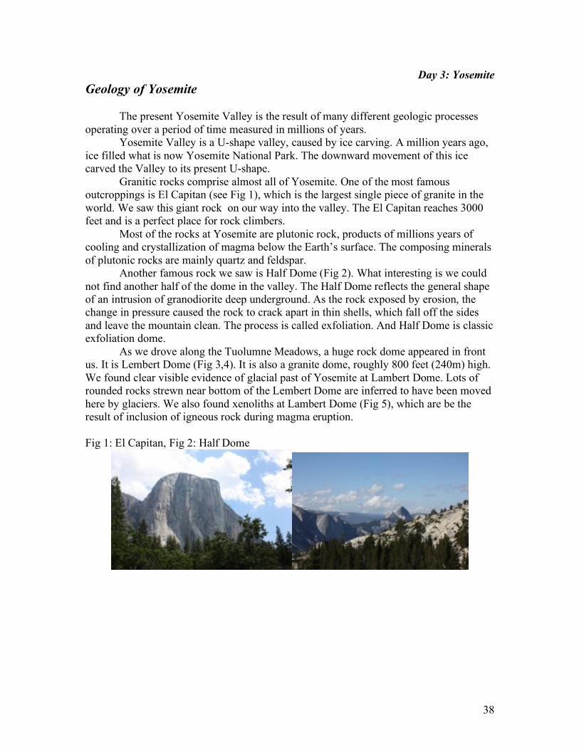
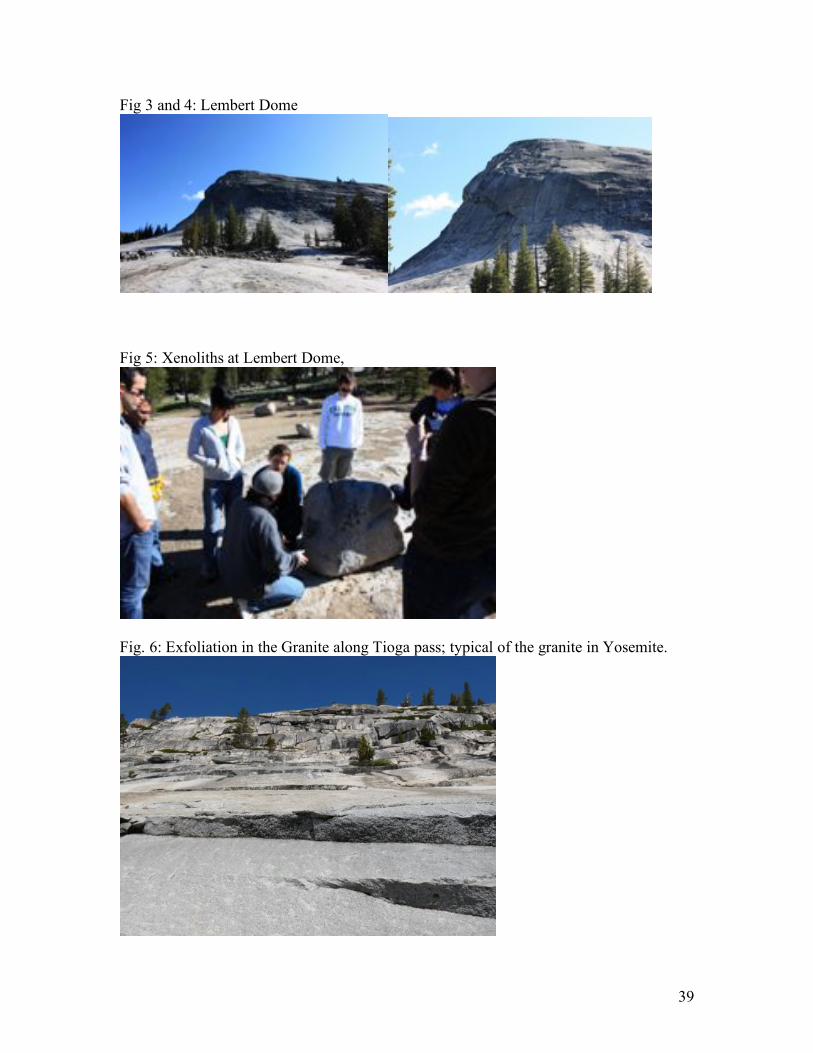
As we drove along the Tuolumne Meadows, a huge rock dome appeared in front us. It is Lembert Dome (Fig 3,4). It is also a granite dome, roughly 800 feet (240m) high. We found clear visible evidence of glacial past of Yosemite at Lambert Dome. Lots of rounded rocks strewn near bottom of the Lembert Dome are inferred to have been moved here by glaciers. We also found xenoliths at Lambert Dome (Fig 5), which are be the result of inclusion of igneous rock during magma eruption. Fig 1: El Capitan, Fig 2: Half Dome
39
Fig 3 and 4: Lembert Dome
Fig 5: Xenoliths at Lembert Dome,
Fig. 6: Exfoliation in the Granite along Tioga pass; typical of the granite in Yosemite.
40
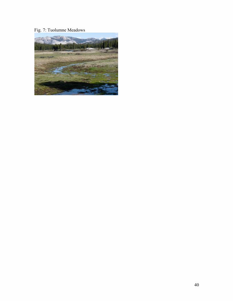
Fig. 7: Tuolumne Meadows
41
Day 3: Yosemite
Glacial Features and Ecology
Glacial Features
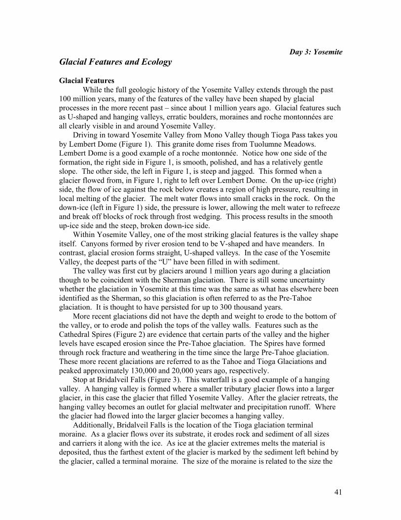
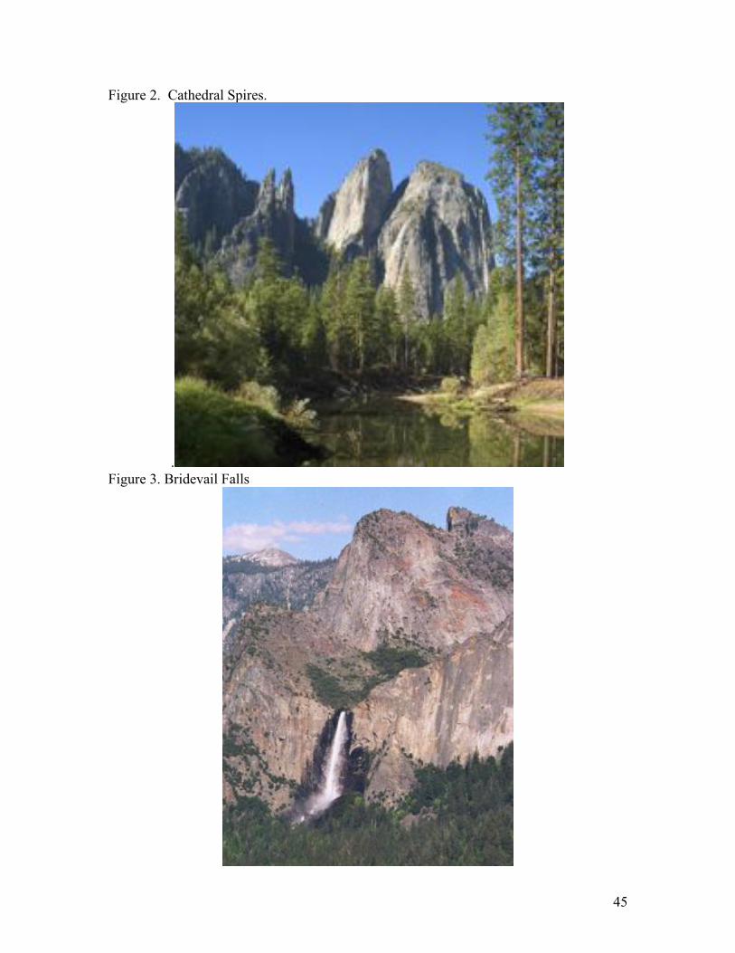
While the full geologic history of the Yosemite Valley extends through the past 100 million years, many of the features of the valley have been shaped by glacial processes in the more recent past – since about 1 million years ago. Glacial features such as U-shaped and hanging valleys, erratic boulders, moraines and roche montonnées are all clearly visible in and around Yosemite Valley. Driving in toward Yosemite Valley from Mono Valley though Tioga Pass takes you by Lembert Dome (Figure 1). This granite dome rises from Tuolumne Meadows. Lembert Dome is a good example of a roche montonnée. Notice how one side of the formation, the right side in Figure 1, is smooth, polished, and has a relatively gentle slope. The other side, the left in Figure 1, is steep and jagged. This formed when a glacier flowed from, in Figure 1, right to left over Lembert Dome. On the up-ice (right) side, the flow of ice against the rock below creates a region of high pressure, resulting in local melting of the glacier. The melt water flows into small cracks in the rock. On the down-ice (left in Figure 1) side, the pressure is lower, allowing the melt water to refreeze and break off blocks of rock through frost wedging. This process results in the smooth up-ice side and the steep, broken down-ice side. Within Yosemite Valley, one of the most striking glacial features is the valley shape itself. Canyons formed by river erosion tend to be V-shaped and have meanders. In contrast, glacial erosion forms straight, U-shaped valleys. In the case of the Yosemite Valley, the deepest parts of the “U” have been filled in with sediment. The valley was first cut by glaciers around 1 million years ago during a glaciation though to be coincident with the Sherman glaciation. There is still some uncertainty whether the glaciation in Yosemite at this time was the same as what has elsewhere been identified as the Sherman, so this glaciation is often referred to as the Pre-Tahoe glaciation. It is thought to have persisted for up to 300 thousand years. More recent glaciations did not have the depth and weight to erode to the bottom of the valley, or to erode and polish the tops of the valley walls. Features such as the Cathedral Spires (Figure 2) are evidence that certain parts of the valley and the higher levels have escaped erosion since the Pre-Tahoe glaciation. The Spires have formed through rock fracture and weathering in the time since the large Pre-Tahoe glaciation. These more recent glaciations are referred to as the Tahoe and Tioga Glaciations and peaked approximately 130,000 and 20,000 years ago, respectively. Stop at Bridalveil Falls (Figure 3). This waterfall is a good example of a hanging valley. A hanging valley is formed where a smaller tributary glacier flows into a larger glacier, in this case the glacier that filled Yosemite Valley. After the glacier retreats, the hanging valley becomes an outlet for glacial meltwater and precipitation runoff. Where the glacier had flowed into the larger glacier becomes a hanging valley. Additionally, Bridalveil Falls is the location of the Tioga glaciation terminal moraine. As a glacier flows over its substrate, it erodes rock and sediment of all sizes and carriers it along with the ice. As ice at the glacier extremes melts the material is deposited, thus the farthest extent of the glacier is marked by the sediment left behind by the glacier, called a terminal moraine. The size of the moraine is related to the size the
42
glacier, how easily eroded the glacial substrate is, and how quickly the glacier transitions from advancing to retreating.
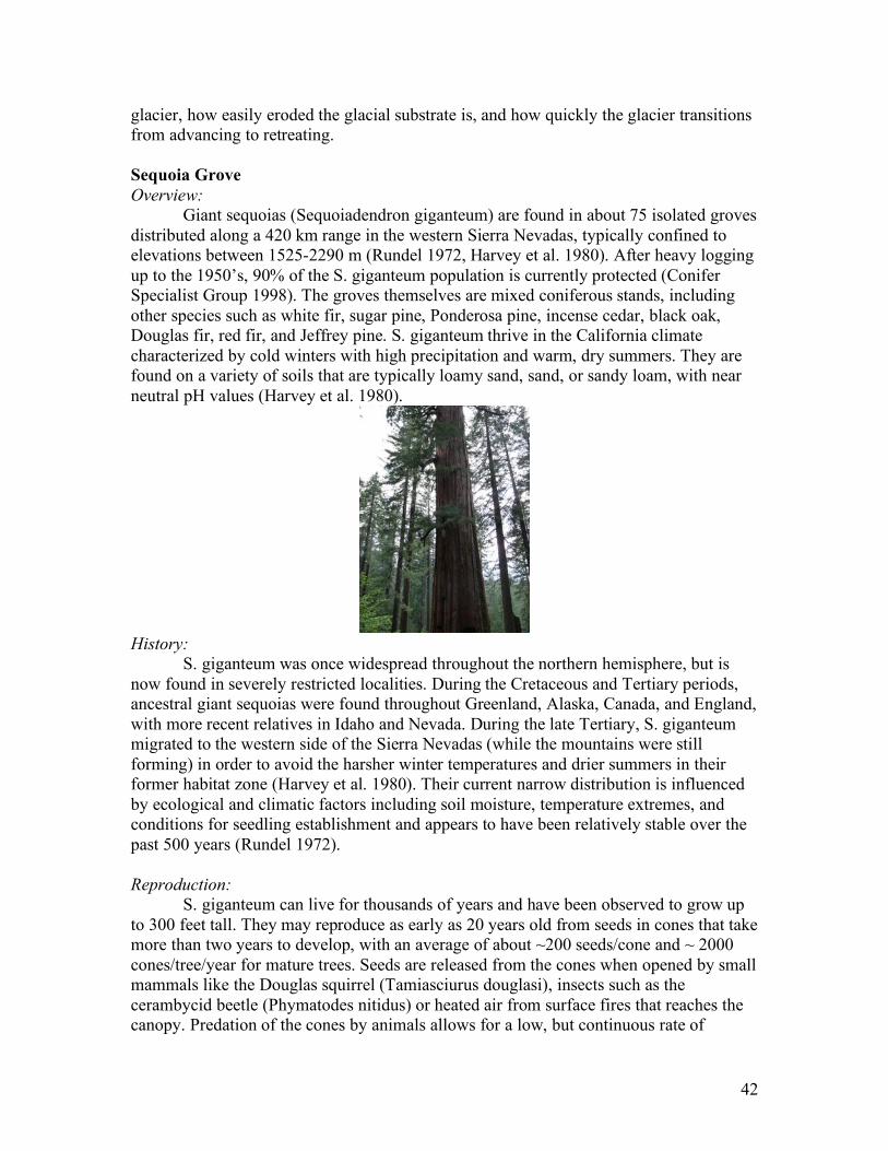
Sequoia Grove
Overview:
Giant sequoias (Sequoiadendron giganteum) are found in about 75 isolated groves distributed along a 420 km range in the western Sierra Nevadas, typically confined to elevations between 1525-2290 m (Rundel 1972, Harvey et al. 1980). After heavy logging up to the 1950’s, 90% of the S. giganteum population is currently protected (Conifer Specialist Group 1998). The groves themselves are mixed coniferous stands, including other species such as white fir, sugar pine, Ponderosa pine, incense cedar, black oak, Douglas fir, red fir, and Jeffrey pine. S. giganteum thrive in the California climate characterized by cold winters with high precipitation and warm, dry summers. They are found on a variety of soils that are typically loamy sand, sand, or sandy loam, with near neutral pH values (Harvey et al. 1980).
History:
S. giganteum was once widespread throughout the northern hemisphere, but is now found in severely restricted localities. During the Cretaceous and Tertiary periods, ancestral giant sequoias were found throughout Greenland, Alaska, Canada, and England, with more recent relatives in Idaho and Nevada. During the late Tertiary, S. giganteum migrated to the western side of the Sierra Nevadas (while the mountains were still forming) in order to avoid the harsher winter temperatures and drier summers in their former habitat zone (Harvey et al. 1980). Their current narrow distribution is influenced by ecological and climatic factors including soil moisture, temperature extremes, and conditions for seedling establishment and appears to have been relatively stable over the past 500 years (Rundel 1972). Reproduction:
S. giganteum can live for thousands of years and have been observed to grow up to 300 feet tall. They may reproduce as early as 20 years old from seeds in cones that take more than two years to develop, with an average of about ~200 seeds/cone and ~ 2000 cones/tree/year for mature trees. Seeds are released from the cones when opened by small mammals like the Douglas squirrel (Tamiasciurus douglasi), insects such as the cerambycid beetle (Phymatodes nitidus) or heated air from surface fires that reaches the canopy. Predation of the cones by animals allows for a low, but continuous rate of
43
reproduction, while fires release an enormous amount of seeds at once (up to 20 million per hectare). Fires also help to create soil conditions with adequate moisture for the seedlings to avoid desiccation during the dry summer months. Seedlings require abundant sunlight to grow, and typically can only establish within a few years of fire or other disturbance that allows sufficient light to penetrate the canopy (Harvey et al. 1980). Fire Management:
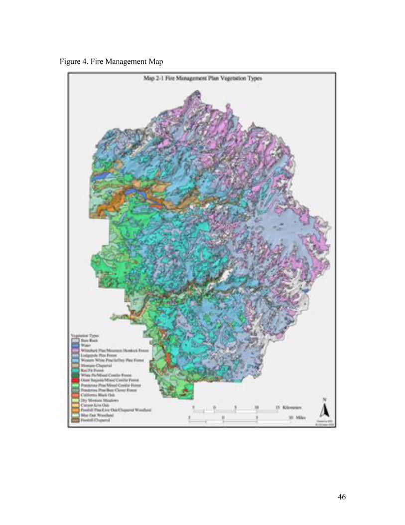
Fires are a crucial component of sequoia growth and reproduction. In the past, fire return intervals within groves were affected by climate variability, with 15-30 years between fires during cooler climatic periods and less than 13 year return intervals during warmer periods. Fire chronologies show a marked decline after the 1860’s, coinciding with the influx of sheep herds and fire suppression policies. These suppression policies actually make fires more dangerous since they allow for much higher fuel loads to accumulate in the groves, which can sustain intense fires that can harm even fire-resistant species (Swetnam 1993). Though John Muir recognized the importance of fires in this ecosystem as early as 1878, fires did not become an official part of the National Park Service policy in 1975 after its importance was recognized in reducing heavy fuel loads and the reproduction of various tree species. Without fires to open the canopy for S. giganteum seedlings, shade-tolerant white firs gradually dominate the mixed groves. Fires also remove the litter layer from the forest floor, which allows sequoia seeds to establish in rich mineral soil while killing potential pathogens that can harm seedlings. However, if temperatures are too intense then seeds and small plants can be consumed. S. giganteum has many adaptations to regular fire occurrence: thick bark (~30 cm near the trunk base), elevated branches to reduce the chance of crown fires, serotinous cones, and rapid growth rates. Yosemite Ecosystem Distribution (Figure 4) Foothill-Woodland Zone:
Scrub and chaparral vegetation dominate at the lowest elevations in Yosemite National Park (~549 m), with species like chamise, mazanita, interior live oak, blue oak, and gray pine. Lower Montane Forest:
An increased amount of winter precipitation to balance hot, dry summers (starting at around 900 m) allows for this diverse forest type that includes the species present in Yosemite Valley, such as California black oak, ponderosa pine, white fir, incense cedar, and the groves of giant sequoias. Upper Montane Forest:
Above 1800 m, red fir, lodgepole pine, and Jeffrey pine dominant the forests due to the climatic zone shift to cooler summers and cold, wet winters. Subalpine Forest:
Tuolumne Meadows in an example of this vegetation zone, which includes western white pine, mountain hemlock, lodgepole pine, and subalpine meadows. It is
44
found above 2450 m where the winters are colder with snow depths usually around three to nine feet. Alpine Zone:
The highest vegetation zone starts around 2900 m, and consists solely of herbaceous plants since the winters are cold and harsh with a growing season that is too short for trees to grow. References:
Harvey, H.T., Shellhammer, H.S., and Stecker, R.E. 1980. Giant Sequoia Ecology- Fire and Reproduction, U.S. Department of the Interior, National Park Service, Washington, D.C.
Conifer Specialist Group 1998. Sequoiadendron giganteum. In: IUCN 2009. IUCN Red List of Threatened Species. Version 2009.1. <www.iucnredlist.org>. Downloaded on 29 June 2009.
Rundel, P.W. 1972. Habitat restriction in giant sequoia: the environmental control of grove boundaries. American Midland Naturalist, 87 (1), 81-99.
Swetnam, T.W. 1993. Fire history and climate change in the giant sequoia groves. Science, 262, 885-889.
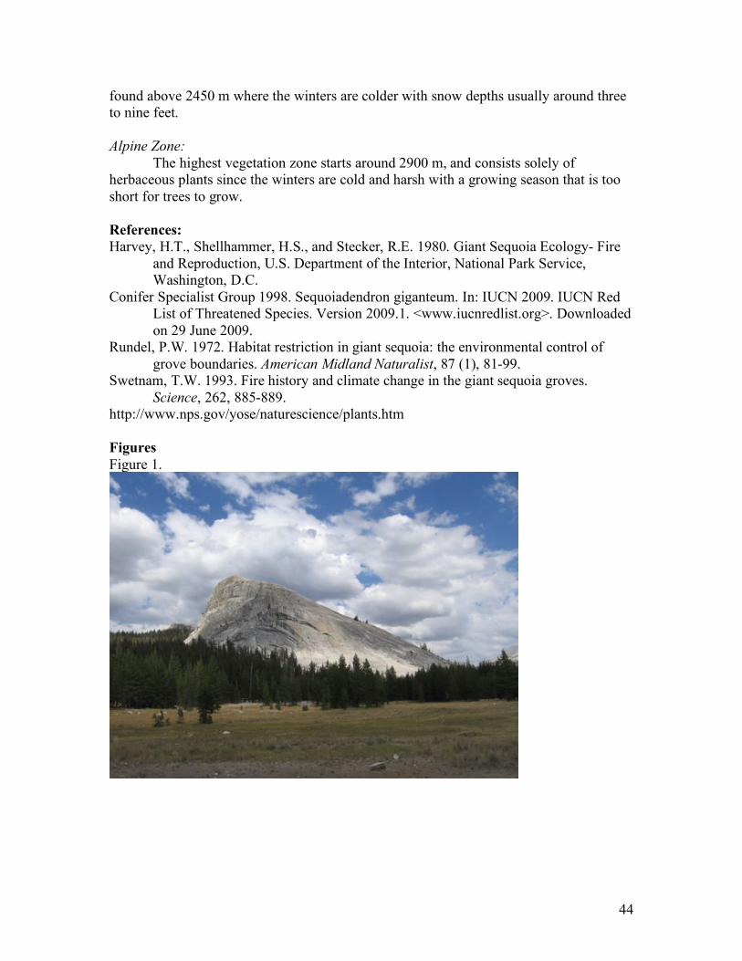
http://www.nps.gov/yose/naturescience/plants.htm Figures Figure 1.
45
Figure 2. Cathedral Spires.
. Figure 3. Bridevail Falls
46
Figure 4. Fire Management Map
47
Day 4- South of Mono Lake
Bishop Tuff of the Long Valley Caldera
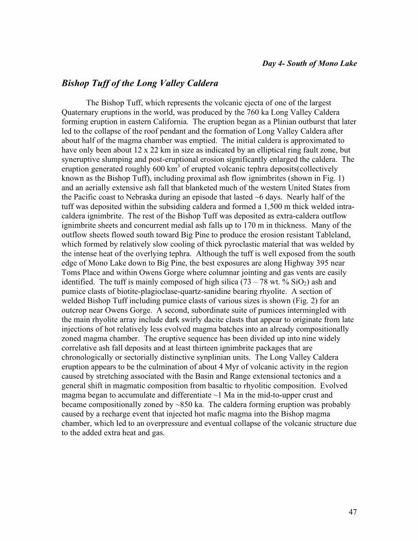
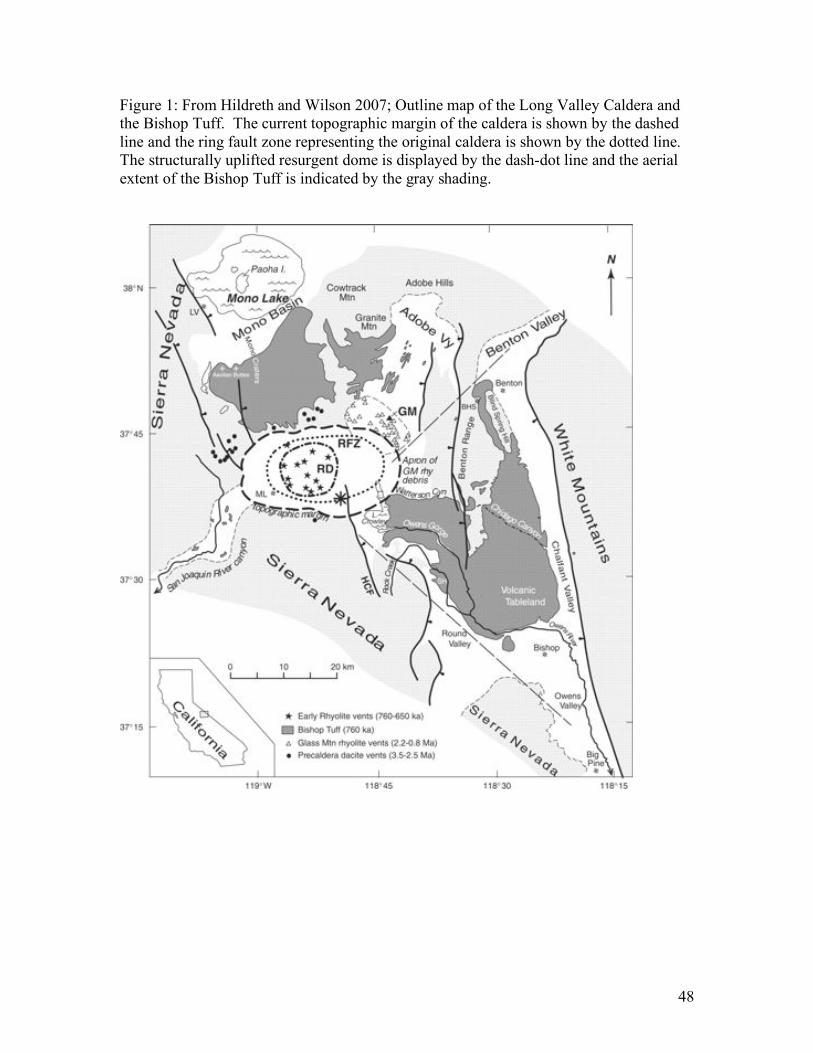
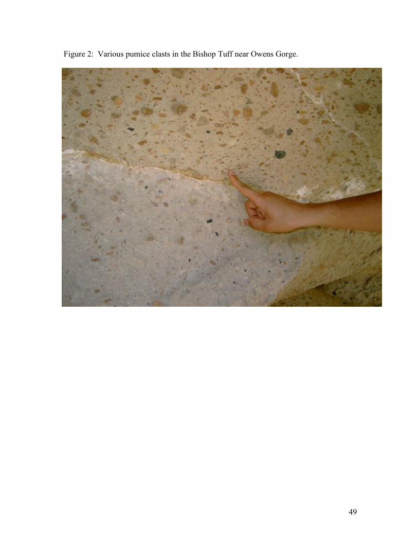
The Bishop Tuff, which represents the volcanic ejecta of one of the largest Quaternary eruptions in the world, was produced by the 760 ka Long Valley Caldera forming eruption in eastern California. The eruption began as a Plinian outburst that later led to the collapse of the roof pendant and the formation of Long Valley Caldera after about half of the magma chamber was emptied. The initial caldera is approximated to have only been about 12 x 22 km in size as indicated by an elliptical ring fault zone, but syneruptive slumping and post-eruptional erosion significantly enlarged the caldera. The eruption generated roughly 600 km3 of erupted volcanic tephra deposits(collectively known as the Bishop Tuff), including proximal ash flow ignimbrites (shown in Fig. 1) and an aerially extensive ash fall that blanketed much of the western United States from the Pacific coast to Nebraska during an episode that lasted ~6 days. Nearly half of the tuff was deposited within the subsiding caldera and formed a 1,500 m thick welded intra-caldera ignimbrite. The rest of the Bishop Tuff was deposited as extra-caldera outflow ignimbrite sheets and concurrent medial ash falls up to 170 m in thickness. Many of the outflow sheets flowed south toward Big Pine to produce the erosion resistant Tableland, which formed by relatively slow cooling of thick pyroclastic material that was welded by the intense heat of the overlying tephra. Although the tuff is well exposed from the south edge of Mono Lake down to Big Pine, the best exposures are along Highway 395 near Toms Place and within Owens Gorge where columnar jointing and gas vents are easily identified. The tuff is mainly composed of high silica (73 – 78 wt. % SiO2) ash and pumice clasts of biotite-plagioclase-quartz-sanidine bearing rhyolite. A section of welded Bishop Tuff including pumice clasts of various sizes is shown (Fig. 2) for an outcrop near Owens Gorge. A second, subordinate suite of pumices intermingled with the main rhyolite array include dark swirly dacite clasts that appear to originate from late injections of hot relatively less evolved magma batches into an already compositionally zoned magma chamber. The eruptive sequence has been divided up into nine widely correlative ash fall deposits and at least thirteen ignimbrite packages that are chronologically or sectorially distinctive synplinian units. The Long Valley Caldera eruption appears to be the culmination of about 4 Myr of volcanic activity in the region caused by stretching associated with the Basin and Range extensional tectonics and a general shift in magmatic composition from basaltic to rhyolitic composition. Evolved magma began to accumulate and differentiate ~1 Ma in the mid-to-upper crust and became compositionally zoned by ~850 ka. The caldera forming eruption was probably caused by a recharge event that injected hot mafic magma into the Bishop magma chamber, which led to an overpressure and eventual collapse of the volcanic structure due to the added extra heat and gas.
48
Figure 1: From Hildreth and Wilson 2007; Outline map of the Long Valley Caldera and the Bishop Tuff. The current topographic margin of the caldera is shown by the dashed line and the ring fault zone representing the original caldera is shown by the dotted line. The structurally uplifted resurgent dome is displayed by the dash-dot line and the aerial extent of the Bishop Tuff is indicated by the gray shading.
49
Figure 2: Various pumice clasts in the Bishop Tuff near Owens Gorge.
50
Day 4- South of Mono Lake
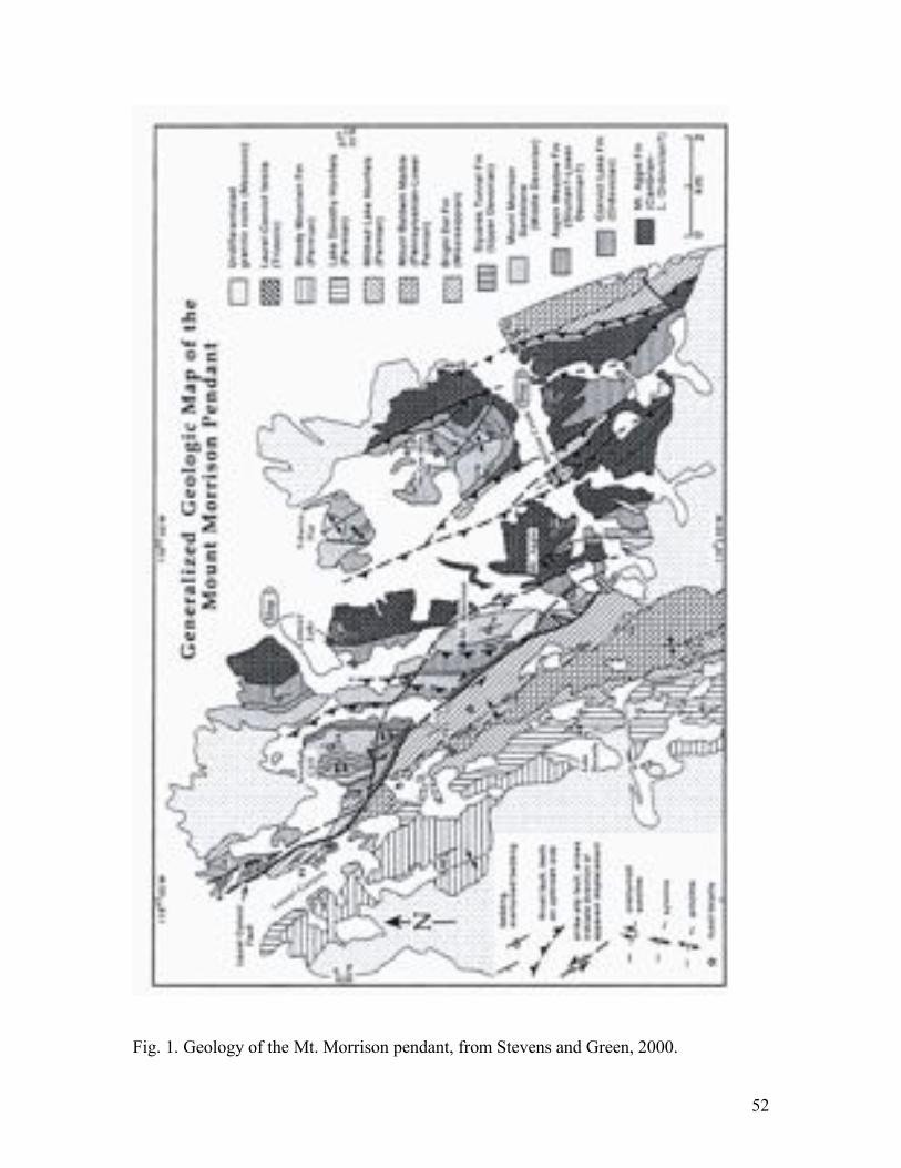
Convict Lake
Convict Lake is formed by water dammed by the moraine systems of previous glaciations. Geologically it is surrounded by the granitic rocks of the Sierra Nevadas and the Mt. Morrison roof pendant. The roof pendant is comprised of metamorphosed sedimentary rocks of Paleozoic age that are exposed to the east, west, and south of Convict Lake. These rocks span the entire Paleozoic era from Cambrian time (about 500 million years ago) to Permian time (about 260 million years ago). The geologic relationships within this pendant are typical of those found in roof pendants throughout the eastern Sierra. What is atypical is the exposure and completeness of the section. The best way to observe the geology is by making the 11/2 mile walk around the lake. The hike follows a relatively level path and can be made in as little as 20 minutes.
The ridge on the northwest side of the lake provides a good exposure of the lower Paleozoic section. On the north side of the lake, the steeply east-dipping rocks comprise the overturned limb of a syncline, so the units will become progressively younger. The first rock unit encountered is the Cambrian Mount Agee Formation. Outcrops are sparse on this side of the lake, but float is abundant. The Mount Aggie is a dark gray siliceous argillite. Continuing to the west, the next unit to outcrop is the Ordovician Convict Lake Formation. It is somewhat lighter in color, and while it is often difficult to distinguish in weathered float the contact can be readily seen in the ridge face. To the west of the Convict Lake Formation lies, the Silurian/Devonian Aspen Meadows Formation. Aspen Meadows float is sparse and the distinctive green-banded hornfels is best seen by making the hike up to the ridge crest. The remainder of the ridge is comprised of the well-indurated quartzite of the Devonian Mt. Morrison Formation. This highly resistant rock forms many of the near vertical slopes of Sevehah Cliff.
At the west end of Convict Lake the view of Sevehah Cliff is truly impressive. The calcareous quartzite of the Mount Morrison Formation is the most prominent unit. Bedding dips steeply to the northeast, more or less parallel to the slope of the cliff creating apparent structural complexity that is actually a function of the steep dip and subsequent erosion. The more gently sloping base of the cliff is caused by metasomatic alteration of the Mt. Morrison by underlying intrusives (Quartz + calcite --> wollastonite, a softer, more easily eroded mineral). On the southern base of the cliff, Aspen Meadows and Convict Lake crop out. Above the Mt. Morrison, on the north end of the cliff, the rusty brown chert and argillite of the Squares Tunnel Formation is a striking marker horizon. At the very top of the cliff, Mt. Morrison lies in fault contact with the underlying Squares Tunnel. At the base of the cliff, the Convict Thrust fault (not visible) repeats the section in the low hills to the southwest. In the far distance Mississippian Bright Dot and Pennsylvanian Mount Baldwin Marble are visible across the main strand of the Laurel Convict fault. On the south side of the lake Convict Lake and Mount Aggie Formations outcrop. Small scale folds in these units mimic the large scale structural complexity seen in Sevehah Cliff. Further to the south, Mount Morrison is the prominent
51
peak on the horizon. It lies to the southeast of the Mount Morrison fault. In our panorama only Devonian Mount Morrison Formation is clearly visible, but from the parking area, a fault (a splay of the Laurel-Convict fault?) can be seen to cut the face of the mountain juxtaposing Aspen Meadow and Convict Lake Formations. The Paleozoic rocks originated as sediments in an ocean that was initially a deep-water basin but gradually became a shallow-water environment starting about 350 million years ago. Most of the units are siliciclastics indicative of deeper water shelf/slope transistional environments. Similar, unmetamorphosed, strata outcrop to the east in the White Mountains. The Mount Morrison Paleozoic section, however, is unlike the shallow water carbonate-dominated Paleozoic sections of the Inyo Mountains and Mojave to the south.
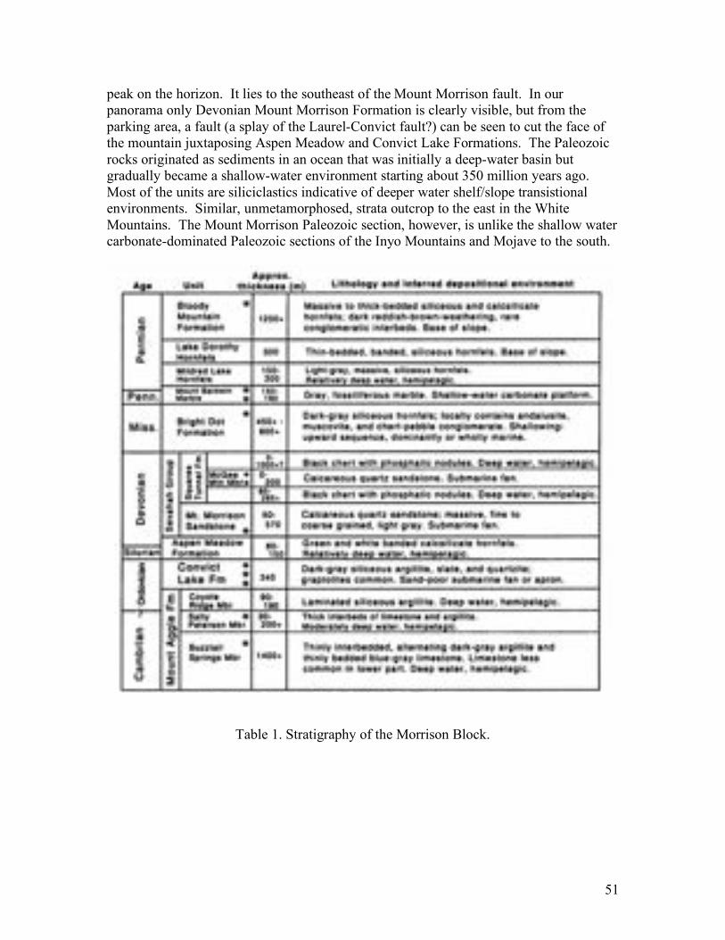
Table 1. Stratigraphy of the Morrison Block.
52
Fig. 1. Geology of the Mt. Morrison pendant, from Stevens and Green, 2000.
53
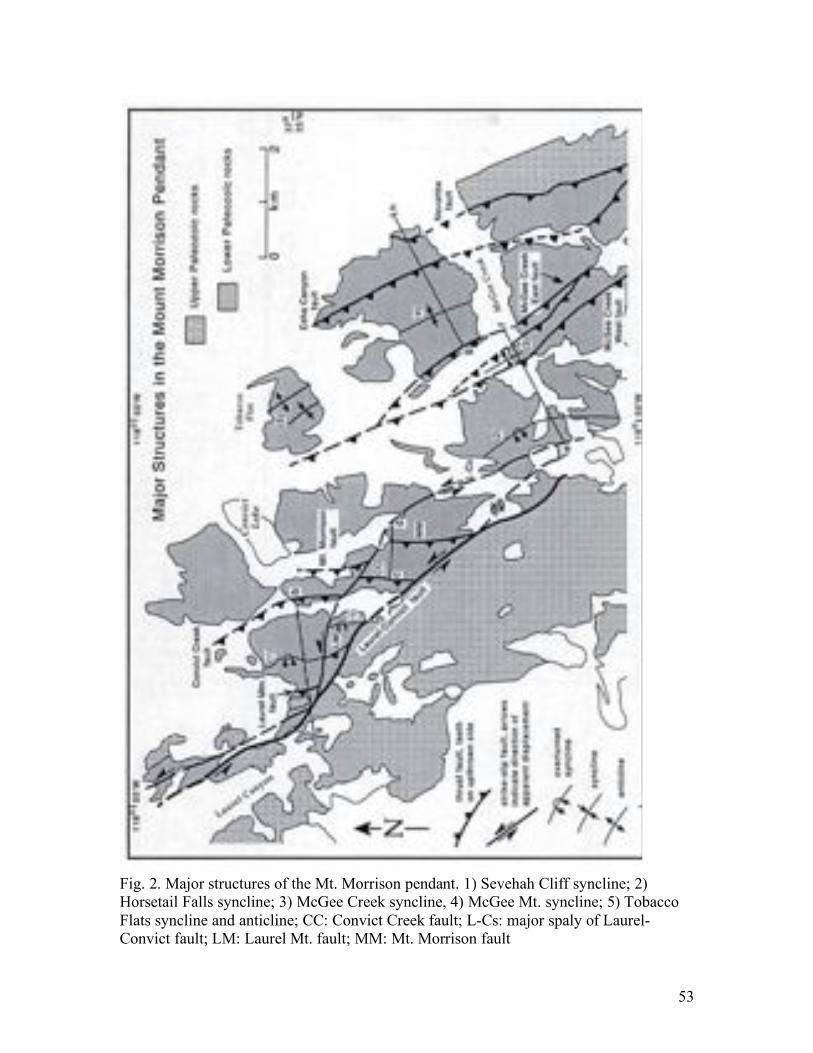
Fig. 2. Major structures of the Mt. Morrison pendant. 1) Sevehah Cliff syncline; 2) Horsetail Falls syncline; 3) McGee Creek syncline, 4) McGee Mt. syncline; 5) Tobacco Flats syncline and anticline; CC: Convict Creek fault; L-Cs: major spaly of Laurel-Convict fault; LM: Laurel Mt. fault; MM: Mt. Morrison fault
54
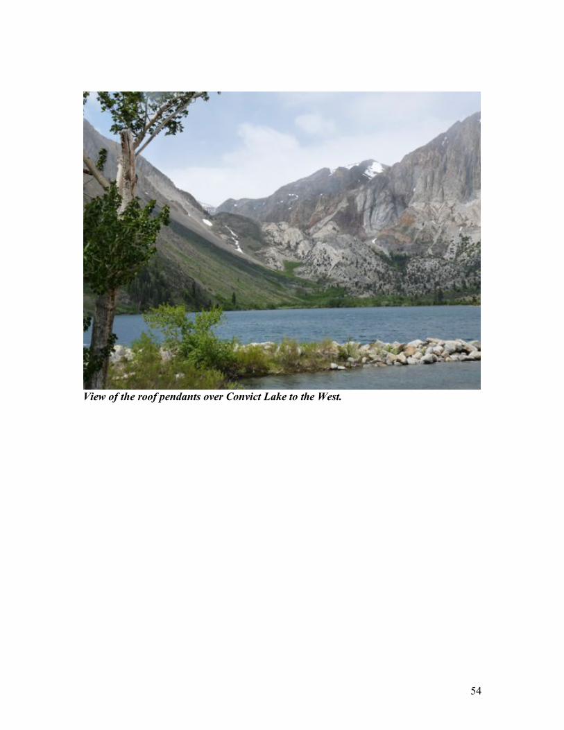
View of the roof pendants over Convict Lake to the West.
55
Day 4 – South of Mono Lake
The Volcanic Tableland The Volcanic Tableland (figure 1) is the surface of a 0.764 Ma ignimbrite sheet (Izett and Obradovich 1988) that lies within the White Mountain seismic gap. The topography and the Quaternary geology of the Owens Valley north of Bishop reflect the eruptive history of Long Valley caldera just to the northwest. The catastrophic eruption 764,000 yrs ago sent an estimated 500 km3 of hot tephra rumbling down into the northern Owens Valley. The surface of the tuff is the Volcanic Tableland, a broad, rocky landform that slopes away from Long Valley and spans close to the full breadth of the valley. The Volcanic Tableland surface is marked by a number of features: cooling joints, fumarole mounds, fluvial channels, and fault scarps. Cooling of the tuff was accompanied by formation of contractional joints, which form dramatic columns in vertical exposures of the tuff, and large dome- shaped mounds and linear ridges related to devitri- fication of the tuff (Sheridan 1970). A network of ancestral fluvial channels, now eroded and faulted, also mark the Tableland surface (Pinter and Keller 1995). The durable surface of the Tableland has preserved a complex pattern of normal faulting in the 764,000 yrs since the surface formed. The extent of the faulting, its state of preservation, and the lack of cover are increasingly attracting researchers working on problems as diverse as structural scaling (Dawers et al. 1993) and models of petroleum migration and accumulation (Hooper et al. 1992). The Volcanic Tableland also is uniquely valuable as a dated marker for determining the rates of tectonic deformation in the Owens Valley. Faulting on this surface documents extensive activity in the northern Owens Valley in a portion of the White Mountain seismic gap of the Eastern California- Central Nevada seismic zone. The Owens Valley is located at the western margin of the Basin and Range province. The valley is a deep, alluviated basin between the Sierra Nevada and the White-Inyo Mountains, formed by active tectonics during approximately the past 2-4 m.y. (Pinter and Keller 1995). The surface of the Volcanic Tableland is marked by hundreds of sharp fault scarps (Bateman 1965; Sheridan 1975). The scarps generally strike nearly north- south and occur individually, en echelon, and in broad, left-stepping arrangements. With the possible exception of the large fault system at the eastern margin of Fish, faults on the Tableland are extensional; a smaller strike- slip component also may be accommodated by the en echelon arrangements of some individual scarps. In map view, individual fault strands are linear to somewhat arcuate. Face on, strands are lens-shaped, displacement varying from zero at the ends to some maximum height at the center of each strand. Upon close examination, scarps follow an irregular, rather than linear, trend at the scale of a few meters, following the joint network in the tuff. Most of the fault scarps are well pre- served, although all show various degrees of degradation. Many of the scarps retain steep free faces, although these elements generally comprise a minority fraction of the total slope and are largely buried by scarp-derived colluvium. Immediately south of the Volcanic Tableland, faults cut three uplifted terraces of the Owens River. The three terraces correlate with the three moraine systems of nearby canyons of the Sierra Nevada, representing the Tioga, Tahoe, and pre- Tahoe advances (Pinter et al. 1994). More
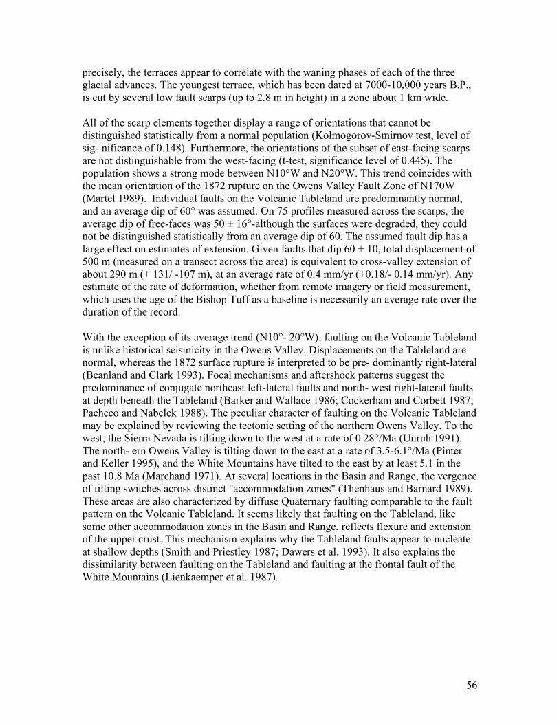
56
precisely, the terraces appear to correlate with the waning phases of each of the three glacial advances. The youngest terrace, which has been dated at 7000-10,000 years B.P., is cut by several low fault scarps (up to 2.8 m in height) in a zone about 1 km wide. All of the scarp elements together display a range of orientations that cannot be distinguished statistically from a normal population (Kolmogorov-Smirnov test, level of sig- nificance of 0.148). Furthermore, the orientations of the subset of east-facing scarps are not distinguishable from the west-facing (t-test, significance level of 0.445). The population shows a strong mode between N10°W and N20°W. This trend coincides with the mean orientation of the 1872 rupture on the Owens Valley Fault Zone of N170W (Martel 1989). Individual faults on the Volcanic Tableland are predominantly normal, and an average dip of 60° was assumed. On 75 profiles measured across the scarps, the average dip of free-faces was 50 ± 16°-although the surfaces were degraded, they could not be distinguished statistically from an average dip of 60. The assumed fault dip has a large effect on estimates of extension. Given faults that dip 60 + 10, total displacement of 500 m (measured on a transect across the area) is equivalent to cross-valley extension of about 290 m (+ 131/ -107 m), at an average rate of 0.4 mm/yr (+0.18/- 0.14 mm/yr). Any estimate of the rate of deformation, whether from remote imagery or field measurement, which uses the age of the Bishop Tuff as a baseline is necessarily an average rate over the duration of the record. With the exception of its average trend (N10°- 20°W), faulting on the Volcanic Tableland is unlike historical seismicity in the Owens Valley. Displacements on the Tableland are normal, whereas the 1872 surface rupture is interpreted to be pre- dominantly right-lateral (Beanland and Clark 1993). Focal mechanisms and aftershock patterns suggest the predominance of conjugate northeast left-lateral faults and north- west right-lateral faults at depth beneath the Tableland (Barker and Wallace 1986; Cockerham and Corbett 1987; Pacheco and Nabelek 1988). The peculiar character of faulting on the Volcanic Tableland may be explained by reviewing the tectonic setting of the northern Owens Valley. To the west, the Sierra Nevada is tilting down to the west at a rate of 0.28°/Ma (Unruh 1991). The north- ern Owens Valley is tilting down to the east at a rate of 3.5-6.1°/Ma (Pinter and Keller 1995), and the White Mountains have tilted to the east by at least 5.1 in the past 10.8 Ma (Marchand 1971). At several locations in the Basin and Range, the vergence of tilting switches across distinct "accommodation zones" (Thenhaus and Barnard 1989). These areas are also characterized by diffuse Quaternary faulting comparable to the fault pattern on the Volcanic Tableland. It seems likely that faulting on the Tableland, like some other accommodation zones in the Basin and Range, reflects flexure and extension of the upper crust. This mechanism explains why the Tableland faults appear to nucleate at shallow depths (Smith and Priestley 1987; Dawers et al. 1993). It also explains the dissimilarity between faulting on the Tableland and faulting at the frontal fault of the White Mountains (Lienkaemper et al. 1987).
57
2 miles
58
Fig 1. top: Location map of the study area, northern Owens Valley, California. Lightly shaded area of map is the Volcanic Tableland. Inset shows location of the Tableland within the regional setting, including surface rupture associated with the 1872 Lone Pine earthquake.botom: Satellite image of same area.
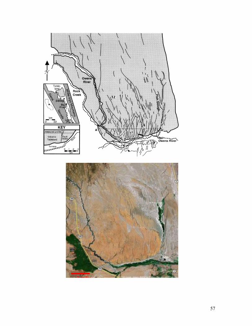
Fig.2. Extension due to flexure of a brittle plate. The rates of tilt and extension are expressed as angle and length change per unit time. Note the extensional kinematics on the outer side of the flexure.
59
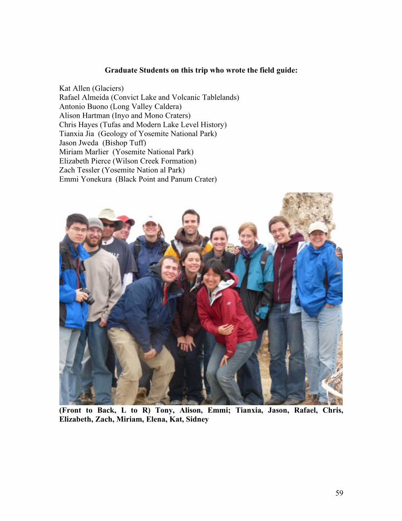
Graduate Students on this trip who wrote the field guide:
Kat Allen (Glaciers) Rafael Almeida (Convict Lake and Volcanic Tablelands) Antonio Buono (Long Valley Caldera) Alison Hartman (Inyo and Mono Craters) Chris Hayes (Tufas and Modern Lake Level History) Tianxia Jia (Geology of Yosemite National Park) Jason Jweda (Bishop Tuff) Miriam Marlier (Yosemite National Park) Elizabeth Pierce (Wilson Creek Formation) Zach Tessler (Yosemite Nation al Park) Emmi Yonekura (Black Point and Panum Crater)
(Front to Back, L to R) Tony, Alison, Emmi; Tianxia, Jason, Rafael, Chris,
Elizabeth, Zach, Miriam, Elena, Kat, Sidney