Embed Size (px)
Citation preview
1
Community Integrated Tourism Development in the
South Pacific
Research Report for the
Project entitled
GIS as a Planning Support Tool for
Community Integrated Tourism Development:
A pilot study for Fiji Islands and the South Pacific
Stephen Doorne Department of Tourism and Hospitality
University of the South Pacific [email protected]
Prepared for ICT Capacity Building at USP, September, 2004

2
Doorne, Stephen Community integrated tourism development in the
South Pacific study / Stephen Doorne. – Suva, Fiji: ICT Capacity Building at USP Project, The University of the South Pacific, 2004. 39 p. ; 30 cm.
“Research report for the ICT Capacity Building Project at USP entitled GIS as a Planning Support Tool for Community Integrated Tourism Development: A pilot study for Fiji Islands and the South Pacific.”
ISBN 982-01-0589-7
1. Tourism—Oceania—Data processing2. Ecotourism—Oceania –Planning3. Geographic information systems—Oceania I. ICT
Capacity Building at USP Project II. Title.
G155.O3D66 2004 338.4791
3
CONTENTS
ACKNOWLOGDEMENTS.................................................................................................4 LIST OF ACRONYMS.......................................................................................................4 ABOUT THE AUTHOR .....................................................................................................5 1.0 EXECUTIVE SUMMARY ........................................................................................5
2.0 INTRODUCTION.....................................................................................................7
3.0 AIMS AND OBJECTIVES.......................................................................................8
4.0 BACKGROUND AND CONTEXT ...........................................................................9
5.0 APPROACH AND METHODOLOGY ...................................................................10 5.1 Participation .......................................................................................................10 5.2 The workshop process.......................................................................................11 5.3 Technical methods.............................................................................................13
6.0 PROJECT OUTPUTS ...........................................................................................19 6.1 GIS database and research process .................................................................19 6.2 Change management facilitation .......................................................................20 6.3 Relationship building..........................................................................................20 6.4 Economic integration and product development................................................21 6.5 Capacity building at the local level.....................................................................22 6.6 Institutional capacity building .............................................................................22 6.7 Qoliqoli Tourism Resource Users Strategic Transition (QTRUST)....................22 6.8 Conferences and presentations.........................................................................23
7.0 DISCUSSION: ISSUES, CHALLENGES AND OPPORTUNITIES.......................24 7.1 Local management and control of the data .......................................................24 7.2 Infrastructure......................................................................................................24 7.3 Training and local capacity building...................................................................25 7.4 Resource management at the local level...........................................................25 7.5 Research capacity .............................................................................................25 7.6 Institutional interests ..........................................................................................27 7.7 Taking an ‘indirect’ approach.............................................................................27 7.8 Other applications..............................................................................................28 7.9 Technical issues ................................................................................................28
8.0 SUMMARY AND RECCOMENDATIONS .............................................................30
9.0 CONCLUSION ......................................................................................................32
10.0 BIBLIOGRAPHY ...................................................................................................33
11.0 APPENDICES .......................................................................................................35

4
ACKNOWLOGDEMENTS
The project entitled ‘GIS as a Planning Support Tool for Community Integrated Tourism Development: A Pilot Study for Fiji Islands and the South Pacific’ is funded by the Japan International Cooperation Agency (JICA). In accordance with the grant contract, copyright for this paper is shared between JICA, the USP and the author.
I would like to thank Maki Kato, Natasha Khan and the team at the ICT Capacity Building at USP Project for their support for the project and their administrative assistance. I would also like to thank Manoa Malani at the Sustainable Tourism Development Unit of the Ministry of Tourism for his partnership in the project, enthusiasm and advice, and also Marika Kuilamu and Suzy Yee Shaw of the Ministry for your assistance during the workshop. Ratu Osea Gavidi, Chairman of the Fiji Tourism Resource Owners Association, and his team deserve special acknowledgement for their assistance in coordinating workshop activities and being facilitators, and his inspiration for developing the project for the benefit of landowners in the tourism development process. I would also particularly like to thank the communities of Bavu, Tau, Lomawai, Kubuna, Navutu and Korokula villages for their time and commitment to the workshop and their hospitality for the subsequent research processes. Thank you also to the management of the Wai District School for use of the school facilities during the workshop. The GIS team for this project, especially Fabrice Lartigou, Rensley Hambu and Michael Govorov, deserve a special note of thanks for their commitment to the project and their management and problem solving efforts along the way. Thank you also to Conway Pene of the Geography Department at USP for his follow-up work and final touches to the database following the departure of Fabrice and Rensley, and also for his contribution to this report. The team at the New Zealand Tourism Research Institute, particularly Simon Milne and Julia Hasse, gave design input during that phase of the project and I thank you for your help, advice and support along the way. And finally, thank you to Esther Williams, John Hosack and Maki Kato for their comments on the draft of this report.
Stephen DoorneDepartment of Tourism and Hospitality (University of the South Pacific)
LIST OF ACRONYMS
AUT Auckland University of Technology FLIS Fiji Land Information System FLMMA Fiji Locally Managed Marine Areas FTROA Fiji Tourism Resource Owners Association GIS Geographic information systems GPS Global Positioning System IT Information technology NGO Non-government organisation NZTRI New Zealand Tourism Research Institute PCDF Partners for Community Development Fiji PWD Public Works Department QTRUST Qoliqoli Tourism Resource Users Strategic Transition project QUANGO Quasi non-government organisation SPTO South Pacific Tourism Organisation USP University of the South Pacific WWF World Wide Fund for Nature
5
ABOUT THE AUTHOR
Dr Stephen Doorne is a Senior Lecturer with the Department of Tourism and Hospitality at the University of the South Pacific. His research activities are focused in the areas of community based tourism, cultural and heritage tourism, small business entrepreneurship in tourism and tourism in peripheral environments, particularly the backpacker phenomenon. He has worked on consulting and academic research projects in New Zealand, Australia, China, South East Asia and Lapland, as well as the South Pacific. He currently lives in Suva with his wife and three children.
1.0 EXECUTIVE SUMMARY
This study takes the position that communities should be actively engaged in the management and control of their resource base. It also regards the networking of community groups with one another and the institutional environment as critical to the sustainable development of tourism. To this end the pilot project at Momi Bay identified the following opportunities and challenges:
Project Outcomes
The project developed two aspects of community integration in the tourism planning process: a GIS database capable of reflecting stakeholder values; and a workshop-centred consultation/participation process capable of replication to subsequent development projects.
The most valuable aspect of the database was its role as a catalyst for a series of broader community development functions. The data gathering process centred on the workshop-initiated capacity building, partnership formation, problem/conflict resolution, change management and local development planning, and facilitated the identification of economic development activities. Collectively these elements integrate community perspectives with planning and decision making structures.
The database has the capacity to integrate sustainability and monitoring indicators for the analysis of social and environmental change over time.
The research process identified an approach for bringing together a range of stakeholders in an open structured forum and facilitating partnerships between government, community and developers. The Fiji Tourism Resource Owners Association (FTROA) has indicated that these relationships should be regarded as the heart of the project. The Association reported that they themselves, as well as the developers, see that the methods employed should be mandatory for all future developments. It would be appropriate that the Ministry and the FTROA play a core coordinating role; however, the involvement of the University also provides a dimension of ‘neutrality’ to the process.
The project has application for a range of resource management issues; for example, the Ministry of Tourism, FTROA and the project team used the project as a template for the development of a strategic transitional process for managing the introduction of proposed qoliqoli (traditional fishing grounds) ownership legislation to the tourism environment.
6
Capacity building
The workshop process built capacity locally through the use of community representatives throughout the organization and implementation phases of the workshop.
The use of Tourism Ministry personnel in the workshop process also played a role in building capacities at the institutional level, particularly with respect to the development and implementation of participatory research practices and approaches.
An obvious constraint for the development objectives of the communities themselves is the dependence on external expertise to create, update and maintain a database. Ideally, such a database should be controlled and managed by those it represents. For the technology to facilitate these goals, capacity building initiatives in the areas of basic computer training and resource management practices would be required.
There was intense interest at the local level about resource management issues. Local resource management using the technology should be regarded as a medium- to long-term goal at any development site and could be developed to contribute to a network of locally-based resource managers, in turn contributing to a nationally integrated database. The opportunities and constraints for the integration of the technology with local resource management practices should be the focus of a dedicated study.
At the institutional level, the adoption of the database and its consultation processes by the Ministry or other agency would require additional resources for individuals with expertise in participatory GIS mapping, participatory development techniques and community-based training methods.
The University of the South Pacific already offers courses that would meet the needs of public sector and community group capacity building for GIS mapping. The New Zealand Tourism Research Institute based at Auckland University of Technology has expertise in training for participatory GIS techniques appropriate to meet local needs.
Methods
This project was initiated after initial negotiations between landowners, developers and investment agencies had taken place. As such the research process applied to the facilitation of ongoing relationships and the identification of baseline social monitoring data. The applicability of the database is to some extent rendered ‘academic’ by this timing. The value of the pilot project, however, is in the testing and development of a technology-based participatory research process capable of replication to future development sites.
The workshop-based process took an ‘indirect’ approach to data collection. Focus was on mapping the daily lives of community groups in terms of land use, activities and cultural heritage sites. Discussions of tourism development were therefore approached from an ‘inside–out’ perspective, which enabled participants to consider change management in terms of their day-to-day context. This approach facilitated
7
change management and the internalization of the tourism development concept. The data gathered established benchmark information for social monitoring.
The workshop process also (inadvertently) provided opportunities to facilitate ideas for economic integration with the resort development. Several participant groups began developing concepts for ‘clip-on’ products for the resort development (e.g. organic salt production/tours, day trips to caves) which have the capacity to stimulate local entrepreneurship and economic integration with the mainstream tourism industry.
The rationale, the soul of participation, its vitality, lies in the conviction That local people have the motivation, the potential and the creativity To solve their own problems, and are realistic in their objectives. (Eylers and Forster, 1998: 107)
2.0 INTRODUCTION
In the South Pacific, nations increasingly challenged by the pressures to integrate with the global economy are embracing tourism as a vehicle for social and economic development. Experiences of governments hosting tourism development in the region have, however, raised questions about the long-term sustainability of mainstream tourism development in terms of environment, society and economy (Britton and Clarke, 1987; Fagence, 1987; Britton, 1991; Hall and Page, 1996, Harrison, 2004). In recent years attempts to foster alternative models of tourism development are being embraced, mostly under the labels ‘eco-tourism’ or ‘community-based tourism’, to deliver development benefits more widely and more directly than mainstream mass tourism (Fagence, 1987; Scheyvens, 2002; Sharpley and Telfer, 2002).
The demand for tourism to perform as an agent of development is emerging across the institutional landscape comprising governments, aid donors, quasi non-government organizations (QUANGOs) and non-government organizations (NGOs) as well as projects initiated by communities themselves. Common to these initiatives is the development of strategies for ensuring that host communities are better represented in development decisions, predominantly through alternative tourism models but also across the wider spectrum of tourism development (Doorne, 2004). The host-government role in tourism development in the South Pacific is frequently that of mediator between investors and the local environment. On the one hand investment is needed to encourage growth and the disbursement of economic benefits yet at the same time host governments must ensure that the structure and nature of investment retains these benefits locally and preserves the cultural, social and environmental integrity of the development site (UNDP, 2001).
The importance of community-based tourism planning in this context cannot be overstated. The Fiji Tourism Development Plan 1998–2005 notes the ‘need to involve the community at the earliest stages of planning’ (Deloitte and Touche et al., 1997: 44). Similarly, the South Pacific Tourism Organization’s Regional Tourism Strategy for the South and Central Pacific notes that ‘successful [tourism initiatives] need careful planning at local level’ (SPTO, 2002: 57). This institutional emphasis on community involvement is consistent with earlier calls from the Forum Secretariat to ‘maximize local
8
participation (ownership and control) in the tourism industry in Fiji’ (Forum Secretariat, 1998: 18).
In order to be effective in facilitating the planning and development process and the set of relationships running through it, host governments require access to a diversity of site specific information including environmental impact assessments, social data, tourism resource attributes landscape data, product and market information, as well as local perspectives on proposed development activities. At present it is not uncommon to find such information scattered amongst a variety of stakeholders, agencies/institutions and communities. This situation presents considerable challenges to the decision making process and in particular, can result in inadequate representation of host perspectives in the management and decision making process (Pearce, 2000). The issue of local representation is significant in that projects are frequently implemented in communities lacking knowledge or experience of tourism development (Scheyvens, 2002; Doorne, 2004). Indeed, communities most in need of ‘development’ benefits are also those most challenged when engaging with the tourism industry and it’s globalize processes of production and consumption (Mowforth and Munt, 1998; Pearce, 2000; Scheyvens, 2002; Sharpley and Telfer, 2002).
By developing a database using geographic information systems (GIS) to build capacity amongst governments or other agencies involved in this planning and development role, this project utilized information and communications technologies to address specific development objectives. The GIS database has been designed to enhance government and agency ability of to make efficient and informed decisions that will serve the social and economic development needs of their constituencies. This report represents the conclusion of the project and the summary and discussion of issues, challenges and opportunities that have emerged from the research.
3.0 AIMS AND OBJECTIVES
The project was guided by the following research questions: How can local perspectives of place, culture and heritage be better represented in
tourism planning and decision making structures? How can the experiences and expectations of host communities and of institutional
agencies be better communicated? How do host communities and institutional agencies measure and assess those
changes and evaluate outcomes deciding which ones constitute successful (‘sustainable’) development and investigating how can discrepancies be reconciled?
How can local perspectives be used to inform the day-to-day management decisions and the direction of future development interventions in community inclusive tourism?
Can the representation of community data in a GIS database play a role in addressing such issues as these by providing a more direct interface for a range of data and value perspectives between the community and the agency responsible?
9
The primary objectives of the study were to: To use GIS for spatial and cultural mapping to represent accurately a range of
community based data and project resource material at the pilot study site. The data will be specifically in three layers: physical data, social data and tourism data.
To develop a tool for the purposes of project monitoring and decision support for development agencies.
To identify opportunities and constraints for the future development of the database as: a product development and marketing tool; a community driven decision support tool, and; as a vehicle for donor harmonization through the communication of lessons learned, methodologies and development models.
The potential implications of the project are: more inclusive planning and development processes at all levels of management; more ‘audible’ voices of marginalized community members in donor policy and
decision making processes; direct stakeholder communication amongst communities, development agencies and
outside investors; transparency of policy processes and informed decision making; and Ability to store spatial and cultural data, cartographic representations and spatial
tools for planning, management and monitoring.
4.0 BACKGROUND AND CONTEXT
This project was a pilot study conducted in partnership with the Ministry of Tourism and Transport, Fiji Islands, to develop the database and examine its applicability for wider implementation both in Fiji and for government and other development agencies (donors, NGOs, QUANGOs) throughout the South Pacific region. The pilot study site was Zone A as identified by the Fiji Tourism Development Plan 1998–2005, with a particular focus on the proposed Marriott resort development at Momi Bay. The development plan’s Zone A constitutes the coastal area between Suva and Lautoka, including the Mamanucas (see Appendix 1).
In September 2003, Dr Stephen Doorne of the Department of Tourism and Hospitality at the University of the South Pacific (USP) began a pilot project in partnership with the Sustainable Development Unit of the Ministry of Tourism. The project, funded by the Japan International Cooperation Agency under their ICT (Information and Communications Technology) Research Grant scheme, intended to develop a GIS-based decision support tool, focusing on proposed developments at Momi Bay. Throughout the project the researchers and the Tourism Ministry also worked closely with the Fiji Tourism Resource Owners Association (FTROA).
The project was a pilot study aiming to explore ways of using GIS technologies together with participatory field methods to develop a database reflecting the development perspectives of landowning villages in the Momi Bay development. Principal emphasis was placed on representing community values in terms of land use, activities and heritage sites in a GIS format so that their perspectives would be represented in decision making processes alongside those of government agencies and the developers themselves.
10
The expectation was that it should be possible to situate the database within the Ministry of Tourism to facilitate ongoing development decisions relating to the area in which the Ministry was involved. The eventual integration of the database with the forthcoming GIS Atlas of the South Pacific website currently being developed by the GIS unit at the University of the South Pacific would make the information accessible to the range of stakeholders involved in the development. In this way information reflecting community perspectives on their daily lives and values relating to the land can, through the Ministry of Tourism, be represented in government decision and policy making structures and processes.
5.0 APPROACH AND METHODOLOGY
After an overview of participatory research theory and practice, this section outlines the workshop process and introduces the use of GIS technologies in participatory research. Finally, technical issues relating to the use and application of the GIS technology are discussed and outlined.
5.1 Participation
‘Tourism for development’ (Scheyvens, 2002) lies at the heart of this project. In order for tourism to perform as an agent for broad socioeconomic development change, communities need to be integrated with planning and development processes (Mowforth and Munt, 1998; Scheyvens, 2002; Sharpley and Telfer, 2002). Recent attention paid to the development opportunities presented by tourism has brought the issue in line with mainstream development thinking and practice. In particular, an emphasis on the empowerment of communities and participatory development approaches reflects the shift in development theory and practice from top-down assumptions towards alternative development models. At its root is the conception of empowerment as a form of developmental change brought about by local problem solving efforts and techniques (Gardner and Lewis, 1996). Empowerment means that people are able to organize and influence change on the basis of their access to knowledge, to political processes and to financial, social and natural resources.
Participatory research practices necessarily go hand in hand with this research paradigm (Kotze, 1997; Kellerman, 1997). Gardner and Lewis (1996) identify three levels of participation: public involvement resulting from the making available of information about a planned
project; involvement through project related activities rather than just information flow — use
of local labour, setting up of local committees etc.; and People’s own initiatives, which are not imposed from outside.
Participation, though, is not a stand-alone technique. Perhaps the biggest challenge to the operationalization of participation lies in the pervasiveness of hierarchical organizational structures in governmental as well as non-governmental organizations (Leurs, 1998: 128). For the participation of communities to be realized, the goal of community participation must be part of the systematic approach to achieving a development objective. To institutionalize participation requires a stable and legitimate institutional environment (Paul, 1998) yet we should also be aware that integrating
11
participatory approaches with institutional structures has the capacity to legitimize top-down approaches and ideas (Gardner and Lewis, 1996).
Researchers in the area of community development persistently confront issues surrounding the role of the ‘expert’ and the status of ‘the project’ as the facilitator of change. The idea that development consists of a transfer of skills or information creates a role for the expert as the only person capable of mediating the transfer of these skills from one person or society to another. For researchers to contribute significantly to project implementation the following issues are important: Community expectations with regard to the role and responsibilities of consultants
during the project implementation should be clarified from the start. It is necessary to ensure that the transfer of complicated technical knowledge is
carried out in ways that are appropriate to the community. Because contractors are tasked to oversee the daily implementation of the project,
consultants need to establish and maintain a healthy relationship with these people (Kellerman 1997: 59).
Geographic information systems are an emerging area of community-based research practice, particularly with the advent of participatory approaches such as PAGIS (participatory action geographic information systems) and MIGIS (mobile interactive geographic information systems). In the area of rural development, approaches based on workshop processes and community interaction have been developed specifically as mechanisms through which community perspectives and activities can be represented in the structures of planning and development administration (see for example McKinnon and McConchie, 2002). Community empowerment in tourism through GIS has also been explored (Hasse et al., 1999). The present project builds on the experiences of these projects and brings together the two contexts, rural development and tourism, to enable further exploration of opportunities for the use of information technologies in bridging the development divide.
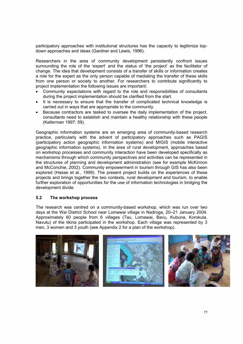
5.2 The workshop process
The research was centred on a community-based workshop, which was run over two days at the Wai District School near Lomawai village in Nadroga, 20–21 January 2004. Approximately 60 people from 6 villages (Tau, Lomawai, Bavu, Kubuna, Korokula, Navutu) of the tikina participated in the workshop. Each village was represented by 3 men, 3 women and 3 youth (see Appendix 2 for a plan of the workshop).
12
The purpose of the workshop activities was to identify issues on the following themes: land use: to identify agriculture, subsistence, fishing activities and the associated
land/site values; history/heritage: to identify taboo sites and other places of cultural significance; Time use/activity: to identify daily routines, activities of particular groups within
the community (women, elder men, and youth) to give insight into how proposed employment with the development might impact on village life.
Participatory research approaches were utilised as the basis of the workshop process. Each group of participants (men, women, young people) was asked to draw on large aerial photographs of their Tikina area, using differently coloured pens for each theme (red for taboo areas, green for land use and blue for daily activities). The information was represented either as polygons (indicating areas or zones), lines (indicating direction of movement) or points (indicating sites of significance). Together with this information participants also recorded additional qualitative information to add depth and context to the mapping information.
In the first phase of the workshop the plenum was divided into village groups and each village was divided into its representative groups. To conduct the mapping exercises, each group of men, women and youth worked with A0 aerial photographs of the wider area and A5 aerial photographs of their village. The facilitators were a combination of both locals and representatives of the Ministry of Tourism. The role of facilitators was to move between groups to ensure that consistency of content and representation was maintained. The second phase of the workshop divided the plenum into three demographic groups (men, women and youth). In this activity each village group fed back and discussed the material they had created in Phase One and took part in discussions in order to clarify issues that were common to several villages. The facilitators also encouraged discussion, focusing on anticipating changes emerging from the development of the resort. These sessions were in part reflective and in part forward focused, in that participants were able to discuss their land use, activities and taboo sites in the context of managing impacts and change. Part of the facilitation process also included discussions around potential relationships of villagers either at or with the resort, either in employment relations or through the development of entrepreneurial initiatives.
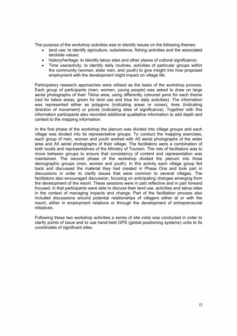
Following these two workshop activities a series of site visits was conducted in order to clarify points of issue and to use hand-held GPS (global positioning systems) units to fix coordinates of significant sites.
13
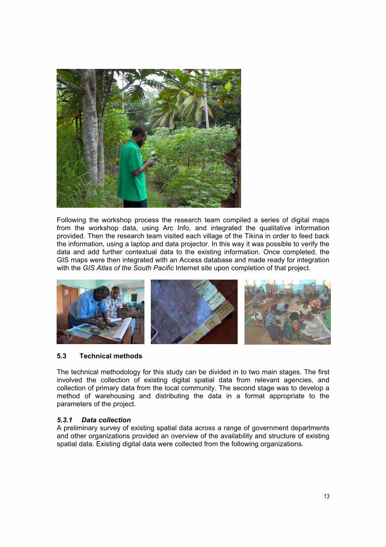
Following the workshop process the research team compiled a series of digital maps from the workshop data, using Arc Info, and integrated the qualitative information provided. Then the research team visited each village of the Tikina in order to feed back the information, using a laptop and data projector. In this way it was possible to verify the data and add further contextual data to the existing information. Once completed, the GIS maps were then integrated with an Access database and made ready for integration with the GIS Atlas of the South Pacific Internet site upon completion of that project.
5.3 Technical methods
The technical methodology for this study can be divided in to two main stages. The first involved the collection of existing digital spatial data from relevant agencies, and collection of primary data from the local community. The second stage was to develop a method of warehousing and distributing the data in a format appropriate to the parameters of the project.
5.3.1 Data collection A preliminary survey of existing spatial data across a range of government departments and other organizations provided an overview of the availability and structure of existing spatial data. Existing digital data were collected from the following organizations.
14
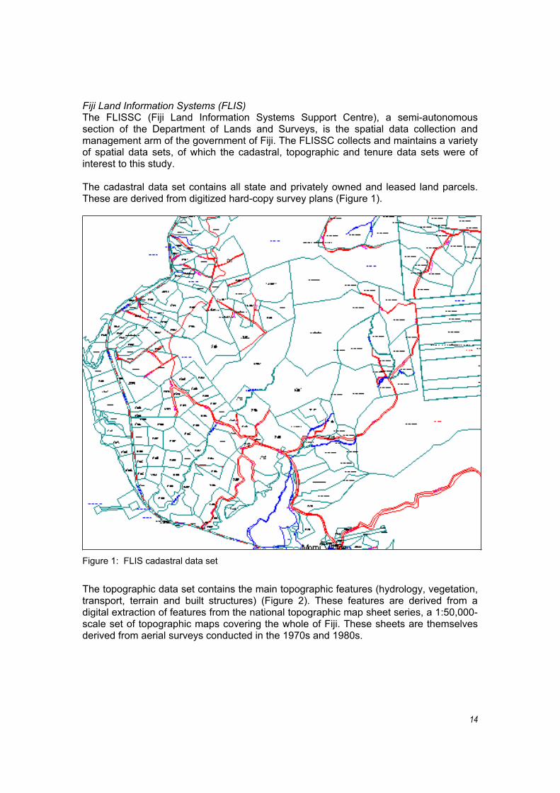
Fiji Land Information Systems (FLIS) The FLISSC (Fiji Land Information Systems Support Centre), a semi-autonomous section of the Department of Lands and Surveys, is the spatial data collection and management arm of the government of Fiji. The FLISSC collects and maintains a variety of spatial data sets, of which the cadastral, topographic and tenure data sets were of interest to this study.
The cadastral data set contains all state and privately owned and leased land parcels. These are derived from digitized hard-copy survey plans (Figure 1).
Figure 1: FLIS cadastral data set
The topographic data set contains the main topographic features (hydrology, vegetation, transport, terrain and built structures) (Figure 2). These features are derived from a digital extraction of features from the national topographic map sheet series, a 1:50,000-scale set of topographic maps covering the whole of Fiji. These sheets are themselves derived from aerial surveys conducted in the 1970s and 1980s.

15
Figure 2: FLIS topographic map sheet, from which digital layers are extracted.
The tenure data set shows traditional land ownership boundaries, determined by the Native Lands and Fisheries Commission (Figure 3). These boundaries were originally mapped in the 1930s and 1940s, and have since been digitized.
Figure 3: FLIS land ownership boundaries showing mataqali and traditional land ownership units.
16
These data sets are maintained in the FLIS data archive, in Intergraph Micro Station GIS Environment (MGE).
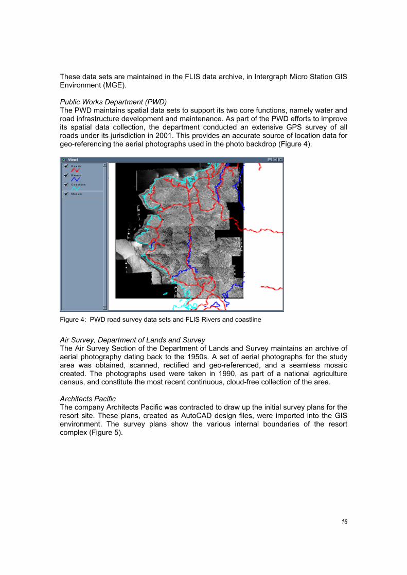
Public Works Department (PWD) The PWD maintains spatial data sets to support its two core functions, namely water and road infrastructure development and maintenance. As part of the PWD efforts to improve its spatial data collection, the department conducted an extensive GPS survey of all roads under its jurisdiction in 2001. This provides an accurate source of location data for geo-referencing the aerial photographs used in the photo backdrop (Figure 4).
Figure 4: PWD road survey data sets and FLIS Rivers and coastline
Air Survey, Department of Lands and Survey The Air Survey Section of the Department of Lands and Survey maintains an archive of aerial photography dating back to the 1950s. A set of aerial photographs for the study area was obtained, scanned, rectified and geo-referenced, and a seamless mosaic created. The photographs used were taken in 1990, as part of a national agriculture census, and constitute the most recent continuous, cloud-free collection of the area.
Architects Pacific The company Architects Pacific was contracted to draw up the initial survey plans for the resort site. These plans, created as AutoCAD design files, were imported into the GIS environment. The survey plans show the various internal boundaries of the resort complex (Figure 5).

17
Figure 5: Hotel site internal boundaries.
Workshop collection The workshop data collection process, as we have seen, was designed to enable the local communities in the study area to map their sites of social and cultural importance in a spatial format that would allow integration of the data collected into a GIS. To achieve this, an aerial photograph mosaic of the study area was created, and printed at a large scale on A0 sheets. Landmarks such as roads, rivers and settlements were superimposed on the aerial photograph mosaic, to enable the community members to orient themselves spatially. The community members were then asked to use coloured pens and stickers to draw areas of significance to them, and to add notes and comments to the maps.
Once the community members had added their annotations to the map sheets, the sheets were returned to the GIS Laboratory at USP, where the spatial and annotation data on the sheets were converted to digital form and added to the existing data sets.
Field collection Field data collection focused on collecting GPS location data to support the sites identified in the workshop, and to collect additional data to assist in rectifying and geo-referencing the aerial photographs. A Thales Mobile Mapper hand-held GPS receiver was used, with a pre-loaded data dictionary and road layer backdrop for reference. The GPS data collected were downloaded from the Mobile Mapper and integrated with the rest of the spatial data sets.
5.3.2 Database development Most GIS-based studies have a core of geo-spatial data, and the development of a suitable management, access and distribution mechanism for this data is an important part of the research process.
5.3.3 Software environment The choice of a software environment to store and manage the data was a challenging decision to make. A number of factors were taken into consideration, including the
18
format of existing data that had been collected, the features of the software and the researchers’ familiarity with the various software options. The decision reached was to manage the data using ESRI Arc View software, primarily because of its rich set of features and ease of use. The question of data format was addressed with the use of a variety of data converters, which allowed all of the existing spatial data to be converted into Arc View-compatible formats.
For the creation of the aerial photograph mosaic, Erdas IMAGINE was used. The aerial photographs of the area were scanned and geo-referenced using both the FLIS roads data set, and the PWD GPS survey of roads. The photographs were then colour balanced and a continuous mosaic of the area created.
5.3.4 Data distribution The management, access and distribution of geo-spatial data can take a variety of forms, and the challenge of a study such as this is to find an appropriate mechanism for this to take place. Various methods exist, ranging from basic ones such as the production of hard-copy maps, to more complex web-based solutions, employing web-mapping technology. The underlying data for this study can be utilised at both ends of this spectrum, depending on the level of technology chosen to distribute the data.
The choice of method depends on what kind of environment the end-user will be working in. If the end-user has no access to a computer and no IT skills, the most appropriate methods would be to print and distribute hard-copy maps. The next step up in methods would be to distribute the digital data; this would require the end-user to have access to IT including GIS software, and to be GIS literate. At the top end of the range, the data would be made available through a web map server, the end-user requiring Internet access but not any specialized GIS software. This is a typical thin-client application, but implementation of the server-side web-mapping technology is only just beginning in the region, and the USP GIS Unit is still investigating various options. Nor is the relatively low level of web access the only problem. A further hindrance to the distribution of the data over the web is the slow speed of connection in Fiji. Web mapping is relatively bandwidth intensive, and while it works well over intranets, it can be problematic over slow, dial-up connections.
The method chosen to distribute the data falls towards the middle of this range of techniques. It is anticipated that the main users of this digital data would be agencies involved in coordinating tourism development. It was assumed that these agencies would have a basic level of information technology infrastructure and skills. This would include both access to computers running a Microsoft Windows operating system and staff with file management skills. The data delivery method is therefore a CD with the collected data (predominantly in the ESRI shapefile format), and including a freely distributable ESRI data viewer called Arc Explorer. Arc Explorer, a low-end data viewer, requiring minimal skill to install and operate, allows the user to view, query and print layers of spatial data (Figure 6). Ann important consideration in maximizing the use of the data is the fact that the use of ArcExplorer means that the end-user does not have to purchase software to view and query the data.

19
Figure 6: Arc Explorer data view, showing sample study data with a point-and-click query result.
6.0 PROJECT OUTPUTS
All of the original objectives of this project, with the exception of the integration of the database with the GIS Atlas project, were achieved. The project also achieved unanticipated outputs in terms of a participatory workshop and research process that accompanies the database. Discussion here covers the principal outputs generated.
6.1 GIS database and research process
The project produced a GIS-based database capable of reflecting land-based values of the six landowning villages forming the Tikina related to the project. The database allows the perspectives of different village and community groups to be isolated and integrated with a range of other data. Included will be: mataqali boundaries; satellite imagery; road, river and infrastructure overlays; hypertext, including qualitative data from the landowners; digital images; and text documents (in PDF format) including reports from a range of agencies relevant to the villages and the development site (e.g. environmental audits, socio-economic assessments, project proposals etc.). The database will also be accessible on the Internet as part of the Pacific GIS Atlas upon completion of that project.
The database has the capacity to integrate environmental and social sustainability and monitoring indicators (see for example Twining-Ward and Butler, 2002). Following the ICT Capacity Building at USP Conference the principal researcher was approached by Mr. Isoda, a JICA-funded expert with the Department of Environment, to discuss opportunities to integrate environmental monitoring data at the Momi Bay site and also opportunities to extend its coverage to the wider Sigatoka area. Mr. Isoda and the Department of Environment were involved in the environmental impact assessment (EIA) recommendations for the development of the Marriott project at Momi Bay.
20
The research process identified an approach for bringing together a range of stakeholders in an open structured forum. The process was invaluable in forming partnerships between government and community and facilitating opportunities for different stakeholders to articulate their development perspectives. The process had two distinct dimensions. It cemented networks and working relationships at the institutional level, i.e. amongst the Ministry of Tourism, the Fiji Tourism Resource Owners Association, the University of the South Pacific and representatives of the project developers; and it strengthened relationships between these agencies and the communities hosting the development.
These relationships, by facilitating informed decision making and policy development, are critical to the successful management of tourism development. It should be noted that although the primary focus of the project is ostensibly the development of a database, it is apparent that the true benefits of the project emerge from the process of consultation and the participation of these actors in the research. In other words, in order to assess the value of the project it is appropriate to think of the technology and the processes of community participation as inseparable dimensions of the same activity, rather than regarding the database as a distinct and separate output.
6.2 Change management facilitation
The workshop process and use of participatory methodologies facilitated elements of the change management process for the communities involved. The structure of the workshops systematically focused on the past, the present and the future. Through this process the participants were able to identify potential issues resulting from the proposed development, discuss the implications of them in an open forum, initiate ongoing discussions, and form specific relationships and networks to address them. For example, discussion addressed potential conflicts of responsibilities for women between their traditional roles (in food preparation, childcare, laundry and housekeeping) and proposed employment opportunities for them at the resort. Through the workshop process women were able to consider potential opportunities and constraints for employment, and move towards establishing strategies for addressing them. Issues facing men and youth centred on the use of traditional fishing grounds by the resort. Through the workshop process these groups were able to discuss the implications of development and move towards addressing change management, through processes of prioritization and identification of strategies for living side by side with other stakeholders.
As part of the development, the resort has arranged to build hall-like structures within each village in order that the villagers may host the workers engaged by the development. These initiatives have been constructed with the expectation that they will provide supplementary income to the village economy, develop basic catering and hospitality skills and, following the completion of the resort, leave a structure that could then be utilized as accommodation for further engagement in the tourism trade. The workshop process and follow-up fieldwork also facilitated discussions about the possible product opportunities these might represent.
6.3 Relationship building
The workshop participation represented the diversity of the stakeholders: the Tourism Ministry, the Fiji Tourism Resource Owners Association, the six landowning villages, the
21
University of the South Pacific and representation from the developers. The workshop provided an opportunity to meet and share perspectives on the development. Following this meeting the relationship between FTROA and the developers has strengthened and has a momentum of its own with the inclusion of the villages. At the workshop the developers expressed interest in working with communities in the development of infrastructure and employment relationships, and integration of product development initiatives.
The FTROA has indicated that this relationship should be regarded as the heart of the project. The Association reported that they and the developers see that the facilitation of similar processes should be mandatory for all future developments. Given that one of the driving objectives for the project is to integrate community perspectives into the developments, this relationship should be regarded as a significant and positive outcome for the project as a whole.
The workshop process also facilitated some forward movement on ongoing issues among the villages themselves, by focusing attention on a sense of common purpose. The workshop also paid particular attention to integrating the perspectives of all villages of the Tikina even though only two of the six villages are likely to be directly affected by the development. This consideration was emphasized in the design phases of the process in light of the relatively high number of disputes between communities that periodically surface across Fiji, stemming from the uneven distribution of benefits from relationships with the tourism industry. In order to focus on issues of equity and distribution it was necessary for participants, at least in part, to address and attempt to resolve ongoing issues, to prepare the way for moving forward.
6.4 Economic integration and product development
The future-focused sessions of the workshop also provided the opportunity for individuals to develop strategies for integrating their local economies with the proposed development. In some instances particular tourism product development initiatives were discussed, such as offering day-trip guided tours to heritage and taboo sites, or ways in which local harvesting and food gathering can be managed so that groups are able to supply produce to the resort, e.g. fruits, seafood. Given the high dependence of the mainstream Fiji tourism industry on imported produce, these sorts of relationships are considered vital in the distribution of economic impacts and the generation of local multipliers and alternative economies. These discussions were further developed during the village visits following the workshop.
One notable example came from Lomawai village, where a group of local women had been working with one of the elder women to learn her skills in traditional salt making. The women had established the operation on-site at the mud flat adjacent to the village and were involved in salt production for ceremonial purposes (e.g. weddings, funerals). Through the workshop activities and the site visits, the project facilitated the development of this activity for tourist consumption. Product development opportunities were discussed, including packaging, site renovation and beautification, experiential product development, marketing and opportunities to ‘package’ the initiative for funding purposes. The women’s group is currently seeking funding with Tekakano Fund. This example illustrates that the development of relationships through the workshop process has the capacity to produce tangible benefits in terms of seeding local entrepreneurship and exploring alternative economic livelihoods.
22
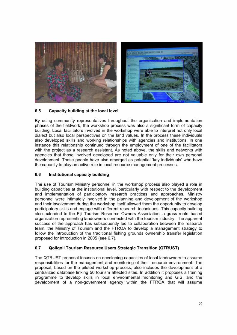
6.5 Capacity building at the local level
By using community representatives throughout the organisation and implementation phases of the fieldwork, the workshop process was also a significant form of capacity building. Local facilitators involved in the workshop were able to interpret not only local dialect but also local perspectives on the land values. In the process these individuals also developed skills and working relationships with agencies and institutions. In one instance this relationship continued through the employment of one of the facilitators with the project as a research assistant. As noted above, the skills and networks with agencies that those involved developed are not valuable only for their own personal development. These people have also emerged as potential ‘key individuals’ who have the capacity to play an active role in local resource management processes.
6.6 Institutional capacity building
The use of Tourism Ministry personnel in the workshop process also played a role in building capacities at the institutional level, particularly with respect to the development and implementation of participatory research practices and approaches. Ministry personnel were intimately involved in the planning and development of the workshop and their involvement during the workshop itself allowed them the opportunity to develop participatory skills and engage with different research techniques. This capacity building also extended to the Fiji Tourism Resource Owners Association, a grass roots–based organization representing landowners connected with the tourism industry. The apparent success of the approach has subsequently led to collaboration between the research team; the Ministry of Tourism and the FTROA to develop a management strategy to follow the introduction of the traditional fishing grounds ownership transfer legislation proposed for introduction in 2005 (see 6.7).
6.7 Qoliqoli Tourism Resource Users Strategic Transition (QTRUST)
The QTRUST proposal focuses on developing capacities of local landowners to assume responsibilities for the management and monitoring of their resource environment. The proposal, based on the piloted workshop process, also includes the development of a centralized database linking 50 tourism affected sites. In addition it proposes a training programme to develop skills in local environmental monitoring and GIS, and the development of a non-government agency within the FTROA that will assume
23
responsibility for the overall management of sites, lease arrangements; user pays relationships and other practices.
The proposal was inspired by the need to integrate local communities with policy structures and to develop local capacities, particularly given the consequent change to their status as resource managers. It also seeks to allay some of the considerable concerns voiced within the tourism industry about the implications of the introduction of the legislation.
The proposal was presented to the Budget Aid Coordinating Committee in April 2004. Its advancement beyond this stage is dependent on Ministerial coordination following due process in the development of the traditional fishing grounds legislation (i.e. no commitment can be given until the precise nature of the legislation is known). The development of the proposal, however, illustrates the level of networking and institutional relationship building the pilot project has played a role in facilitating. It also illustrates just one area to which the approach can be applied to enhance community–industry–government relationships.
6.8 Conferences and presentations
This research has been presented by the principal researcher as follows:
GIS as a Planning Support Tool for Community Integrated Tourism Development: A Pilot Study for Fiji/South Pacific. International Symposium on Village Tourism and Hospitality Cultures. Organized by the School of Business and Tourism Management, Yunnan University, P. R. China and the University of Lapland. Yunnan University, Kunming, P. R. China.27 November – 1 December 2004.
GIS as a Planning Support Tool for Community Integrated Tourism Development: A Pilot Study for Fiji/South Pacific. ‘Information and Communication Technology (ICT) in Our Life’ Conference. Organized by the ICT Capacity Building at USP Project, sponsored by Japan International Cooperation Agency. 16 June 2004. University of the South Pacific, Suva, Fiji Islands.
GIS as a Planning Support Tool for Community Integrated Tourism Development.United Nations Economic and Social Commission for Asia and the Pacific (UNESCAP). 10th Meeting of the Executive Committee of the Network of Asia–Pacific Education and Training Institutes in Tourism (APETIT): Seminar on Planning for Community Tourism Initiatives in Pacific Island Countries. Suva, Fiji Islands, 10–12 July 2004.
GIS as a Planning Support Tool for Community Integrated Tourism Development. New Zealand Tourism Research Institute Seminar on Tourism in the South Pacific. Auckland University of Technology, 10 June 2004.
24
7.0 DISCUSSION: ISSUES, CHALLENGES AND OPPORTUNITIES
This discussion takes the position that communities should be actively engaged in the management and control of their resource base. It also regards the networking of community groups with one another and with players in the institutional environment as critical to the sustainable development of tourism predicated on the integration of communities. The project demonstrated that there is considerable potential for the GIS research process piloted here to contribute to these demands and play a significant role in local resource management processes.
In order for the technology to facilitate the integration of communities in the planning and monitoring process, capacity building initiatives in the areas of basic computer training and resource management practices would be required. The experience of the project in working with communities suggests that the potential benefits of embracing the technology at the local level are such that further research with community groups should be explored in order to identify appropriate pathways for the integration of contemporary and traditional resource management approaches using GIS. The issues that need attention in order to achieve this are identified below.
7.1 Local management and control of the data
An obvious constraint to the ongoing usability of the project is the dependence on external expertise to update and maintain the database. Ideally, a database representing community perspectives should be controlled and managed by those it represents. It was not within the scope of the project to develop resources, capacities and infrastructure to such an extent that the communities could drive the generation of information that represents them. Nevertheless, it was possible to identify key initiatives that will assist this. At the community level a number of capacity building initiatives could be implemented to this end, as identified below.
7.2 Infrastructure
Making available computer hardware and software. Initially, the research team suggested that this would be best housed at the local schools (two primary and two secondary), with appropriate security measures. Schools were suggested for their ‘neutral’ status within the Tikina and also because they feed into the educational and cultural capacities of the area. Alternatively, participants in the workshop and representatives of the Ministry of Tourism and the FTROA suggested, villages could take responsibility for the construction of a purpose-built structure that would house the necessary equipment and serve as a centre for local management and monitoring processes. This would enhance the village sense of ownership of the facility.
Each of the villages in the Tikina had access to the basic infrastructure (electricity and telephone) required to facilitate the local implementation of local management practices. These conditions are probably consistent for most potential development sites within Zone A of the Fiji Tourism Development Plan. For Zones B and C of the pLAN, electricity sites are likely to be more dependent on generator supply and limited telephone or radio connections. In environments where telephone or power supplies are limited, relationships with resort developments could be negotiated as part of lease arrangements. At the workshop, for example, the representative of the developers
25
expressed support for village access to communications infrastructure that would be installed on the development site.
7.3 Training and local capacity building
Training in basic computer skills and GIS applications including database management and mapping. Effective use of the software and hardware for GIS applications requires some basic computer skills. During the workshop process and subsequent village visits it became apparent that the GIS programmes and the concept of mapping activities were well understood and embraced across the demographic groupings involved. The software itself is relatively straightforward to use and with basic training, the mobile mapping devices are also very useable. Basic training of key individuals who would play a lead role in local resource management could potentially produce a network of ‘ranger’ personnel who, with email electronic newsletters and some centralised coordination, could form a network of local resource management groups. These individuals could also include local teachers, NGO representatives working in the area and resort/developer personnel). This concept, together with strategies for training, has been explored further in the QTRUST Project Proposal, a copy of which can be obtained from the Fiji Tourism Resource Owners Association.
For the replication of the project to other development sites, the implementation of specifically designed training programmes would be appropriate. These could take two forms: one as structured 4–6 week intensive training programmes; the other as a ‘train the trainers’ training process run through a central coordinating agency (NGO or specific institution) or in collaboration with an appropriate government department). Expertise for training design and delivery could be sourced through USP where resources permit (see below). Training programmes in GIS applications are also available through the University of the South Pacific. Scholarship and/or study grants would need to be available to community members to allow training in GIS or other IT-related skills, for the purposes of facilitating future workshops and updating the database.
7.4 Resource management at the local level
Throughout the fieldwork it was apparent that there is intense interest at the local level about resource management issues. At Lomawai village the previous activities of WWF have created a heightened awareness of resource management practices and their implications for sustainable livelihoods. These relationships have been instrumental in the receptiveness of communities to the project in general and the potential for the future establishment of local resource management initiatives. For local resource management practices to embed as part of day to day tikina business, it is necessary that appropriate individuals be nurtured as leaders in the local environment and that discussion of resource management issues, using the database, feature as part of the normal calendar of village discussions. The technology, with careful coordination, has the capacity to deliver lessons learned through networking of ‘rangers’. This activity should similarly be coordinated via regular meetings.
7.5 Research capacity
The initial project proposal was developed through a relationship between Dr Stephen Doorne, Principal Researcher with the Tourism Studies Programme (now the Department of Tourism and Hospitality) and the GIS Unit within the Department of
26
Geography at USP. Researchers within the GIS unit included Dr Michael Govorov, Director of the Unit, and Mr. Fabrice Lartigou, together with Mr. Rensly Hambu as research assistant. Half way through the project Dr Govorov resigned his position at USP for personal reasons and Mr. Lartigou subsequently assumed technical management responsibilities within the GIS Unit, supported by Mr. Hambu. In May, prior to the end of the project, Mr. Lartigou’s contract (sponsored by the French Embassy) expired and he returned to France. Mr. Hambu has been involved in the last activities of the project, in particular the follow-up field visits and final data entry. Since Mr. Hambu’s departure in June 2004, follow-up activities and final work on the database have been contracted to Mr. Conway Pene of the GIS unit in the USP Geography Department.
Dr Govorov and Mr. Lartigou were both involved in the development of the GIS Atlas of the South Pacific project, the Internet-based atlas proposed to situate the web site for this project. With the departure of two key staff members from the GIS Unit, the completion date of the Atlas project was moved to the end of 2004. The date for publication of this project’s database on the Internet depends on the completion of this site.
In the design phases of the project the principal researcher sought input from the New Zealand Tourism Research Institute (NZTRI) of which he is a member. The NZTRI has maintained an ongoing interest in the project and has also contributed to the development of the QTRUST Proposal. In June 2004 the Institute funded Dr Doorne to present a seminar at the centre at Auckland University of Technology. The NZTRI is currently exploring opportunities for the establishment of a Pacific-based branch working closely with the Department of Tourism and Hospitality at the University of the South Pacific. The Institute has substantial IT and GIS capacity, and expertise networks that could contribute significantly to future projects.
The partnership between the Tourism and Hospitality Department at USP and the Ministry of Tourism has been positive. In particular, the relationship with the Ministry has opened the door to the establishment of a solid relationship with the Fiji Tourism Resource Owners Association. It was through this network that the QTRUST proposal was developed. Although the staff turnover affecting the GIS Unit is all too clear an illustration of the potential problems of implementing projects with USP, the involvement of a university has been perceived as delivering ‘neutrality’ to research the process.
As noted in section 5 of this report the project produced a database for eventual use by the Tourism Ministry in ongoing development processes. Within the Ministry, however, GIS capability in terms of maintaining and updating the database is limited. It would be appropriate to develop training programmes tailored to the needs of agencies such as the Ministry and the FTROA so that they are able to draw on the database as a resource in the manner intended by the project. At present the contribution the database can make to ongoing decision making processes is limited by the capacities of these two agencies.
At the institutional level it would also be appropriate to integrate the database with ongoing planning and policy making functions, particularly if the project concept is replicated to other development sites in Zone A, as intended by the project proposal. A key consideration here is the need to implement workshop phases and fieldwork phases of the project at the very beginning of negotiations with landowners. It would be appropriate that the Ministry and the FTROA play a core coordinating role. This pilot
27
project was, in effect, initiated one step too late, as many of the location and design decisions had already been made prior to the involvement of the research. Despite this, the database provides a valuable baseline database against which monitoring of impacts (social and environmental) can be gauged.
7.6 Institutional interests
Tourism is by its very nature a multifaceted activity. Any tourism development has implications at the institutional level for a range of government agencies beyond the Ministry of Tourism. For example, this project has relevance for the departments of Fijian Affairs, Environment and Fisheries, the Native Land Trust Board and so on. For the purposes of developing future projects it would be appropriate to include as much input as necessary from other government stakeholders. This would ensure the maximum accrual of benefits and reduce the possibilities for interruption of the project because of disgruntled perceptions of ‘patch invasion’. For example, as a result of uncertainties surrounding appropriate institutional responsibility, the development of the QTRUST proposal encountered difficulties in securing broad-based institutional support.
The relationship between the Ministry of Tourism and the FTROA forms a natural core for the ongoing development of any future projects, not least because of their affiliation with the wider tourism stakeholder community and their ongoing involvement at the community level with resource owners. Should significant funding be sought for a ‘cluster’ of future projects of this nature, the potential for interference and institutional sensitivities will be correspondingly heightened. The development of project proposals should therefore pay attention to inclusive development and seek support of neighbouring agencies where possible.
7.7 Taking an ‘indirect’ approach
This project focused specifically on three aspects of the daily lives of the communities concerned with the development at Momi Bay. In many respects this approach facilitated attention given to issues directly related to the development and allowed participants the opportunity to address and resolve their concerns by themselves and in their own time. This ‘indirect’ approach, whilst providing baseline data and a decision support tool for ongoing environmental and social monitoring, was process-driven and through that process, tangible benefits emerge. The core element of sustainable tourism development is the empowerment of local communities through the inclusion of their voices and perspectives in decision making. The database does provide that inclusion in one way, but this contribution is overshadowed by the importance of the relationship building and networking aspects of the process.
It is difficult to measure at this stage what if any lasting benefits will emerge from this project. Indeed, the project itself has been more about finding ways to proceed in future than about the outputs being an end in them. In this context, it is clear that due attention must be given to the appropriate timing of the project. For if it is at the core of negotiations and relationship building from the very beginning, then the process side of the project has the capacity to deliver significant and lasting benefits for all stakeholders.

28
7.8 Other applications
The project has been focused on two aspects of community integration in development: the database and the working process. In the discussions between the principal researcher and the NZTRI other applications for the database were also considered. In particular the opportunity for web-based representation opens doors for communities to represent themselves in the tourism marketplace. Experience from previous projects at the NZTRI suggests that product development based on local representation (as opposed to being mediated by centralized agencies such as national tourism organizations) can produce a more harmonious mesh between visitor expectations and local capacities to meet those expectations. Research with the Inuit on Baffin Island in Canada, for example, highlights the extent to which the Internet can play a role in delivering realistic consumer–producer relationships (see Hull and Milne, 2001). Furthermore, the technology has the capacity to network otherwise disparate micro–tourism operations, creating sectoral cohesion, particularly in the cultural heritage market (http://www.tri.org.nz/NZTRI/portal/ahi/manualIndex.htm). The emergence of community-based tourism initiatives in Fiji over the last few years suggests that this technology would add significant value not only for environmental monitoring but also through the creation of heritage trails and operator networks through which lessons learned can be shared and coordination can take place.
7.9 Technical issues
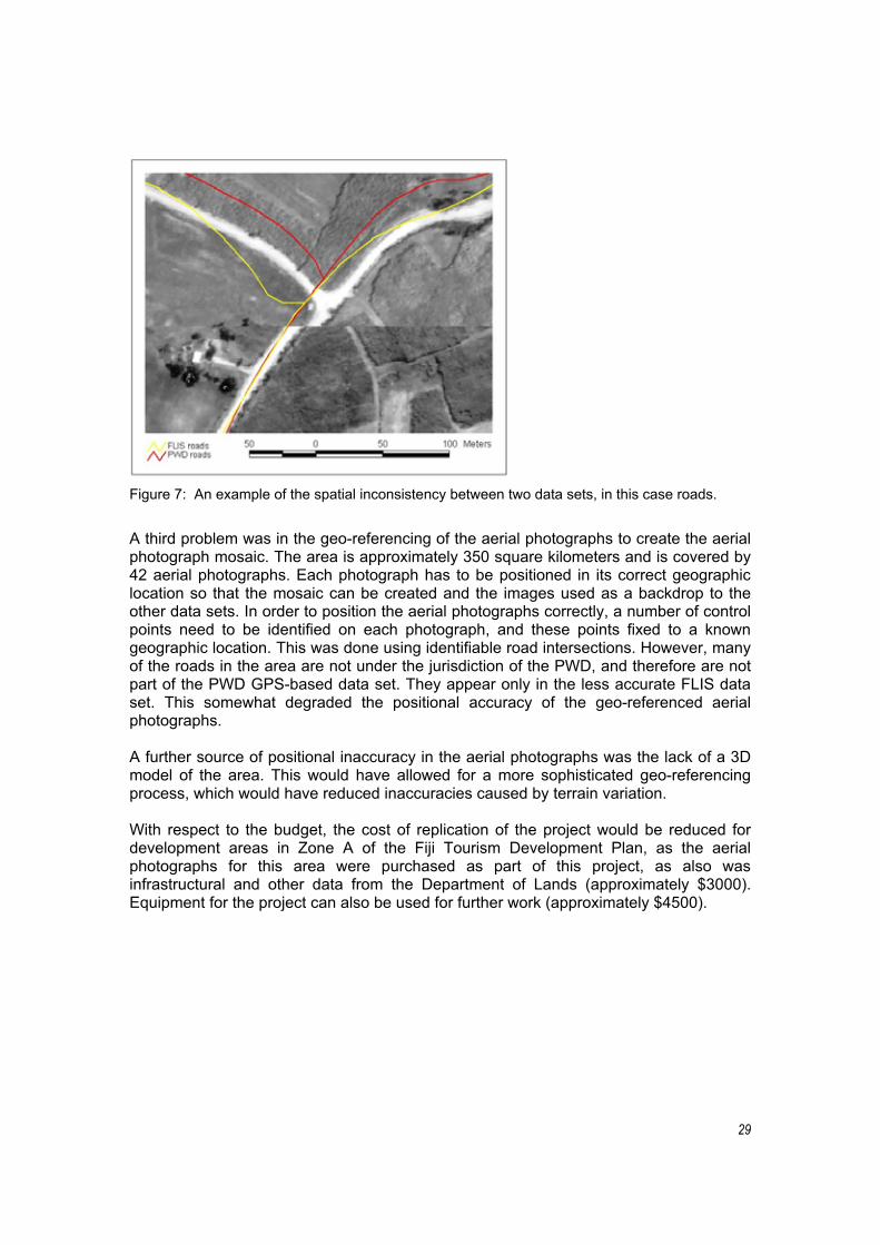
The technical component of this project (involving the collection, management, visualization and distribution of the spatial data) highlighted a number of GIS data management issues. These include spatial accuracy issues between different data sets, the lack of consistent and relevant attribute data for some of the data sets, and issues concerning the creation of the image mosaic.
A common issue when dealing with data from multiple sources is the lack of consistency between the different data sets. This inconsistency was demonstrated in the road data sets, which were acquired separately from the FLIS and the PWD. The FLIS creates roads data from the topographic mapping sheets, based on aerial photographs. The PWD roads data set is created from a differentially corrected GPS survey, which generally provides a higher level of accuracy. Differences of up to 20m were not uncommon between the two data sets.
A second major issue was the lack of useable and relevant attribute data, primarily within the FLIS topographic data set. An example of this was the lack of properly attributed contour lines. The contour lines are drawn at 20m intervals, but without the correct height attribute, they can be used only for 2D map display. This is useful to some extent, but it does not allow the user to utilize the 3D capabilities of the GIS. The FLIS is in the process of rectifying this, but at the time of this project, the data for the study area were not available.
29
Figure 7: An example of the spatial inconsistency between two data sets, in this case roads.
A third problem was in the geo-referencing of the aerial photographs to create the aerial photograph mosaic. The area is approximately 350 square kilometers and is covered by 42 aerial photographs. Each photograph has to be positioned in its correct geographic location so that the mosaic can be created and the images used as a backdrop to the other data sets. In order to position the aerial photographs correctly, a number of control points need to be identified on each photograph, and these points fixed to a known geographic location. This was done using identifiable road intersections. However, many of the roads in the area are not under the jurisdiction of the PWD, and therefore are not part of the PWD GPS-based data set. They appear only in the less accurate FLIS data set. This somewhat degraded the positional accuracy of the geo-referenced aerial photographs.
A further source of positional inaccuracy in the aerial photographs was the lack of a 3D model of the area. This would have allowed for a more sophisticated geo-referencing process, which would have reduced inaccuracies caused by terrain variation.
With respect to the budget, the cost of replication of the project would be reduced for development areas in Zone A of the Fiji Tourism Development Plan, as the aerial photographs for this area were purchased as part of this project, as also was infrastructural and other data from the Department of Lands (approximately $3000). Equipment for the project can also be used for further work (approximately $4500).
30
8.0 SUMMARY AND RECCOMENDATIONS
As a pilot this project has identified a number of areas that have the potential to add value to the planning process at the community and institutional levels. In particular, the workshop and consultation processes establish networks with key stakeholders and pave the way for dialogue and negotiation. Further, the creation and replication of the GIS-based database has the potential to add significant value in terms of environmental and social monitoring through the integration of sustainability indicators. These two elements of the project combined are able to form the basis of resource management networks in which government, community and industry partnerships are the core. It should be noted that this study has identified opportunities and constraints that are particular to the Fiji Islands context. It is therefore necessary to assess the scope and relevance of the process for other cultural, physical and development contexts across the South Pacific region.
For planning and development purposes the pilot study has identified that these processes have the capacity to facilitate improved coordination of monitoring, informed decision making, and inclusive and participatory community development. Whilst this study has focused specifically on tourism development, there are significant opportunities for the application of this approach to focus on, for example, sectoral development such as community-based tourism initiatives or the creation of a coherent cultural heritage sector. The approach also has application for other resource management areas such as integrating tourism management with forestry, fishing, farming and other economic sectors. In order for maximum value to be gained from any subsequent replication of this research the following recommendations are made:
1. A follow-up project to investigate the sustainability and impacts of the Momi Bay project should be initiated in respect of the project outcomes and capacity building. That project should precede the recommendations that follow.
2. The research, workshop and data gathering processes should be initiated in conjunction with the start of any negotiations and development planning. Subsequent resource management and monitoring activities should be integrated with the normal calendar of events and activities at the Tikina and village levels.
3. The use of this process should be ‘projectified’ for the purposes of attracting funding. If possible a clustering of proposed development sites would be appropriate. Costs of future projects would be significantly reduced through Zone A, as much of the government sourced data and aerial photographs are already within the database.
4. A lead agency should be charged with responsibility for the overall coordination and integration of the process with planning activities. The Ministry of Tourism is ideally situated to perform this role but would require some capacity building and additional resourcing.
5. The lead agency should network initiatives with the Fiji Tourism Resource Owners Association in particular, as well as other government agencies and non-government organizations active in the development area, for example the FLMMA network, WWF and PCDF.

31
6. Workshop and consultation processes should be accompanied by product development activities focusing on identifying opportunities for local entrepreneurship and the facilitation of their development into viable project proposals capable of being integrated with proposed developments.
7. Technical expertise should be integrated from local or regional GIS research institutions such as the University of the South Pacific or the New Zealand Tourism Research Institute.
8. Technical expertise delivery should be integrated with capacity building initiatives at the local and institutional levels, including training programmes, ‘train the trainer’ and on the job approaches. Particular emphasis should be given to basic computer skills, GIS applications and database management, and resource management practices. These initiatives should be designed to meet the needs of particular stakeholder groups and should aim to marry contemporary resource management processes with traditional resource management practices.
9. Trained individuals should be coordinated as a network of ‘rangers’, through electronic media as well as through regular workshop activities. Integrating local managers through interaction and experience with other development contexts is vital to the creation of local intellectual capital.
10. Project-based funding proposals should build in training and capacity building initiatives and should include ‘scholarship’ type sponsorship opportunities.
11. The integration of education and training providers should accompany capacity building initiatives. These should include schools (teachers, curriculum) and local/regional training centres as well as tertiary institutions.
12. Workshop activities should be replicated at least annually and built into the normal calendar of events in which the communities participate. These activities should conform to local social and political structures.
13. The introduction of technology infrastructure and training should be piloted at specific sites in order to determine appropriate approaches to maximize the value of their contribution.
14. The opportunities and constraints for the development of this approach should be explored in other South Pacific cultural, environmental and development contexts.
The principal mechanism for the implementation of these recommendations is the project approach. Stakeholders should work together to form partnerships around specific elements of the recommendations and proceed to ‘projectify’ those elements. The JICA ICT project at USP has invited proposals that will proceed with extensions of this pilot project for implementation at other sites and within communities, as recommended in this report. The relationships formed from this project involving the Ministry of Tourism, FTROA and the University of the South Pacific provides a platform for following up and making progress with recommendations.

32
9.0 CONCLUSION
The opportunities presented by the pilot project at Momi Bay, together with the lessons learned, proved valuable for all stakeholders. The potential management and development implications of the database, together with the process dimensions of the project, were identified as having applications for other partnerships between communities and government in the development of tourism sites.
Specifically, the pilot project produced a decision support tool capable of being site specific yet allowing for the centralization and analysis of comparative data across a range of environments and contexts. These attributes were identified as necessary for the development of a policy framework for sustainable resource management that is responsive to particular conditions and exhibits uniformity where necessary. The methodology and approach used by the pilot are also seen as developing valuable relationships and dialogue through which the management of local resources can work through three-way partnerships among industry, communities and government.
Whilst this pilot study has a regional context it is very much apparent that the outcomes and potential applications are Fiji-centric. It is important that the regional relevance of the approach and methodology are explored systematically across a range of development environments. It is also important, given the apparent value added to the development process in Fiji, that the approach developed in this project accompanies future investment and development initiatives in Fiji as a way of encouraging multi-stakeholder participation and cooperation. In this context the Fiji situation is indicative of multinational tourism development across the developing world; it is imperative that communities be integrated and empowered through participation in planning and decision making processes in order for tourism investment to act as an effective agent of social and economic development.

33
10.0 BIBLIOGRAPHY
Britton, S. (1991) ‘Tourism, capital and place: towards a critical geography of tourism’. Environment and Planning D: Society and Space, 9: 451–78.
Britton, S. and W. Clarke (eds) (1987) Ambiguous Alternative: tourism in small developing countries. Suva: University of the South Pacific.
Deloitte and Touche, Government of Fiji & Tourism Council of the South Pacific (1997) Fiji Tourism Development Plan 1998–2005. Suva: Ministry of Tourism and Transport.
Doorne, S. (2004) ‘Bridging the global–local divide: expectations of indigenous tourism experiences in Lomanikaya Village, Fiji Islands’. In T. Huhtamaki (ed.), Tourism and the Experience Economy. Rovaniemi: The Experience Institute. Pp. 6-15.
Eylers, H. & R. Forster (1998) ‘Taking on the challenge of participatory development at GTZ: searching for innovation and reflecting on the experience’. In J. Blackburn & J. Holland (eds), Who Changes? Institutionalising participation in development.London: Intermediate Technology Publications: 100–107.
Fagence, M. (1987) ‘Ecotourism and Pacific Island Countries’. Journal of Tourism Studies, 8(2): 26–38.
Forum Secretariat (1998). Key issues constraining tourism development in Forum Island Counties. Background Paper No. 5 for the Forum Economic Ministers Meeting. Suva: Forum Secretariat.
Gardner, K. & D. Lewis (1996) Anthropology, Development and the Post-Modern Challenge. London: Pluto Press.
Hall, C. M. & S.J. Page (1996) ‘Introduction: The context of tourism development in the South Pacific’. In C. M. Hall & S. J. Page (eds), Tourism in the Pacific: issues and cases. London: International Thomson Business Press. Pp: 1-18.
Harrison, D. (2004) ‘Editor’s introduction: Tourism in Pacific Islands’. Journal of Pacific Studies, 26 (1&2): 1–28.
Hasse, J., S. Milne & J. McKinnon (1999) ‘Tourism stakeholders and sustainable community development: theoretical and methodological reflections’. International Geographic Union Sustainable Tourism Study Group. Oamaru, New Zealand, August 30 – September 2.
Hull, J. & S. Milne (2001) ‘From nets to the net: the case of Quebec’s Lower North Shore’. In Nils Aarsæther and Jørgen Ole Bærenholdt (eds), The Reflexive North,Circumpolar Coping Processes Report: chapter 7.
Kellerman G.E.J. (1997) ‘Implementation of development projects and programmes’. In D.A. Kotze (ed.) Development Administration and Management: a holistic approach.Pretoria: J.L. van Schaik Publishers: 49–60.
34
Kotze D.A. (1997) ‘Successive approaches to development administration and management’. In D.A. Kotze (ed.) Development Administration and Management: a holistic approach. Pretoria: J.L. van Schaik Publishers: 7–16.
Leurs, R. (1998) ‘Current challenges facing participatory rural appraisal’. In J. Blackburn & J. Holland (eds), Who Changes? Institutionalising participation in development.London: Intermediate Technology Publications: 124–34.
Levett, R. & R. McNally (2003) A strategic environmental assessment of Fiji’s Tourism Development Plan. Suva: WWF and Asian Development Bank.
McKinnon, J. & J. McConchie (2002) ‘Using GIS to produce community based maps to promote collaborative natural resource management. Special Report, ASEAN Biodiversity, January–March: 27–34.
Mowforth, M. & I. Munt (1998) Tourism and Sustainability: new tourism in the Third World. London: Routledge.
Paul, B. (1998) ‘Scaling up PRA: lessons from Vietnam’. In J. Blackburn & J. Holland (eds), Who Changes? Institutionalising participation in development. London: Intermediate Technology Publications: 18–22.
Pearce, D. (2000) ‘Tourism plan reviews: methodological considerations and issues from Samoa’. Tourism Management, 21: 191–203.
Scheyvens, R. (2002) Tourism for Development: empowering communities. Harlow: Pearson Education.
Sharpley, R. & D. Telfer (2002) Tourism and Development: concepts and issues.Clevedon: Channel View Publications.
SPTO (2002) Regional tourism strategy for the South and Central Pacific. Suva: South Pacific Tourism Organisation.
Twining-Ward, L. & R. Butler (2002) ‘Implementing STD on a small island: development and the use of sustainable tourism indicators in Samoa’. Journal of Sustainable Tourism,10(5): 363–87.
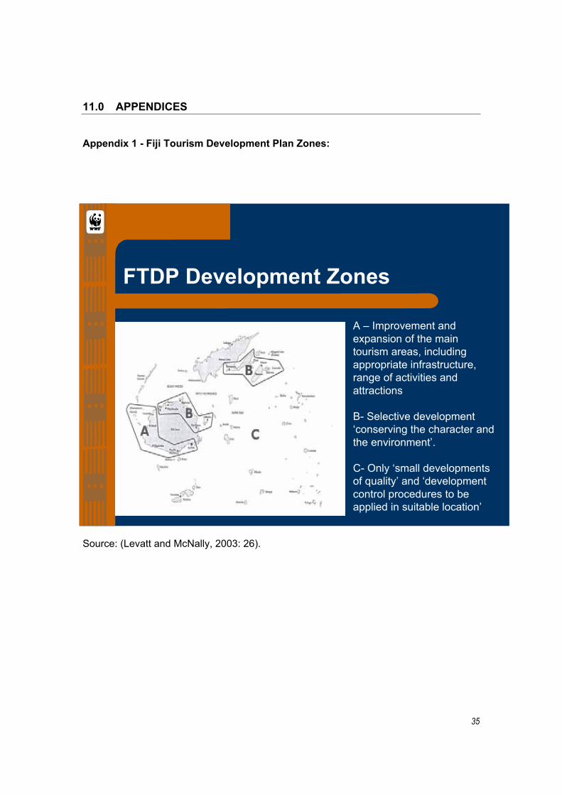
35
11.0 APPENDICES
Appendix 1 - Fiji Tourism Development Plan Zones:
Source: (Levatt and McNally, 2003: 26).
FTDP Development Zones
A – Improvement andexpansion of the maintourism areas, includingappropriate infrastructure,range of activities andattractions
B- Selective development‘conserving the character andthe environment’.
C- Only ‘small developmentsof quality’ and ‘developmentcontrol procedures to beapplied in suitable location’
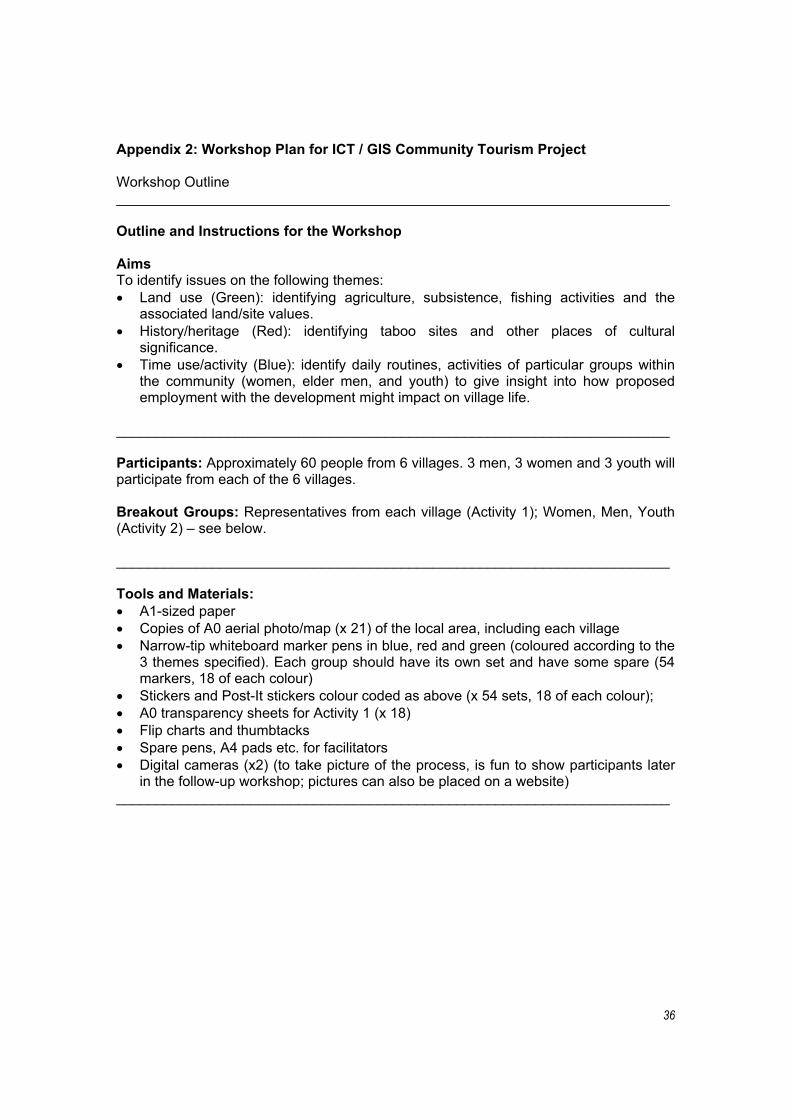
36
Appendix 2: Workshop Plan for ICT / GIS Community Tourism Project
Workshop Outline ______________________________________________________________________
Outline and Instructions for the Workshop
AimsTo identify issues on the following themes: Land use (Green): identifying agriculture, subsistence, fishing activities and the
associated land/site values. History/heritage (Red): identifying taboo sites and other places of cultural
significance. Time use/activity (Blue): identify daily routines, activities of particular groups within
the community (women, elder men, and youth) to give insight into how proposed employment with the development might impact on village life.
______________________________________________________________________
Participants: Approximately 60 people from 6 villages. 3 men, 3 women and 3 youth will participate from each of the 6 villages.
Breakout Groups: Representatives from each village (Activity 1); Women, Men, Youth (Activity 2) – see below.
______________________________________________________________________
Tools and Materials:
A1-sized paper Copies of A0 aerial photo/map (x 21) of the local area, including each village Narrow-tip whiteboard marker pens in blue, red and green (coloured according to the
3 themes specified). Each group should have its own set and have some spare (54 markers, 18 of each colour)
Stickers and Post-It stickers colour coded as above (x 54 sets, 18 of each colour); A0 transparency sheets for Activity 1 (x 18) Flip charts and thumbtacks Spare pens, A4 pads etc. for facilitators Digital cameras (x2) (to take picture of the process, is fun to show participants later
in the follow-up workshop; pictures can also be placed on a website) ______________________________________________________________________
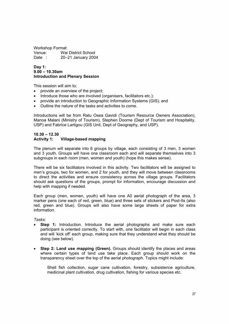
37
Workshop Format: Venue: Wai District School Date : 20–21 January 2004
Day 1: 9.00 – 10.30am Introduction and Plenary Session
This session will aim to: provide an overview of the project; Introduce those who are involved (organisers, facilitators etc.); provide an introduction to Geographic Information Systems (GIS); and Outline the nature of the tasks and activities to come.
Introductions will be from Ratu Osea Gavidi (Tourism Resource Owners Association), Manoa Malani (Ministry of Tourism), Stephen Doorne (Dept of Tourism and Hospitality, USP) and Fabrice Lartigou (GIS Unit, Dept of Geography, and USP).
10.30 – 12.30 Activity 1: Village-based mapping
The plenum will separate into 6 groups by village, each consisting of 3 men, 3 women and 3 youth. Groups will have one classroom each and will separate themselves into 3 subgroups in each room (men, women and youth) (hope this makes sense).
There will be six facilitators involved in this activity. Two facilitators will be assigned to men’s groups, two for women, and 2 for youth, and they will move between classrooms to direct the activities and ensure consistency across the village groups. Facilitators should ask questions of the groups, prompt for information, encourage discussion and help with mapping if needed.
Each group (men, women, youth) will have one A0 aerial photograph of the area, 3 marker pens (one each of red, green, blue) and three sets of stickers and Post-Its (also red, green and blue). Groups will also have some large sheets of paper for extra information.
Tasks:
Step 1: Introduction. Introduce the aerial photographs and make sure each participant is oriented correctly. To start with, one facilitator will begin in each class and will ‘kick off’ each group, making sure that they understand what they should be doing (see below).
Step 2: Land use mapping (Green). Groups should identify the places and areas where certain types of land use take place. Each group should work on the transparency sheet over the top of the aerial photograph. Topics might include:
Shell fish collection, sugar cane cultivation, forestry, subsistence agriculture, medicinal plant cultivation, drug cultivation, fishing for various species etc.

38
Rough working should take place on the transparency sheet. When all are agreed on what should be included, the final information should be drawn upon the aerial photograph, accompanied by stickers and Post-its where necessary. Green stickers should be placed on each site (or draw lines so an area is covered). Each site should be accompanied by descriptions of what takes place there. Use additional paper if needed and take care to code additional information to the site on the photograph. It would be good to collect some basic demographic data on each group: age, gender, etc. It is important that this info is kept with the map. Each group will have a number, which should be on everything they are working on, so the information does not get confused.
Facilitators should assist with translation from Fijian to English for the final copy (i.e. on the photograph).
12.30-1.30 BREAK FOR LUNCH
1.30- 4.30 (Continue Activity 1)
Step 3: Activities and routines (Blue). Repeat the activity for Step 2 but focusing on what people do with their time, and their movements on the following themes:
visits to town, attendance at sporting events, work in hotels/tourism etc., food gathering and preparation, activities associated with farming and fishing etc. (see Step 2), looking after children, laundry, places to socialise or meet, weddings, funerals, school etc.
Note that information should include the frequency of the activity, i.e. how often or regularly it takes place (for example daily, monthly, seasonal, irregular, random activities) and should give some indication of how much time is spent doing it or going there. The time could split the day into morning/midday/evening/night components rather than hourly. In effect you should have time-lines and GIS integrated at the end of this component of the exercise.
Also note that this differs from Step 2 (Land use) because we want to know what those people themselves (and those in their village) actually do or where they go.
Step 4: Taboo and Heritage Sites (Red). Repeat as for Steps 2 and 3, this time asking groups to focus on sites of cultural and historical significance to them. Topics to cover might include:
Archaeological sites, taboo areas, fortifications and battlegrounds, churches, cemeteries, medicinal sites, places for gathering or growing ceremonial dress or craft materials etc.
Note that descriptions and background to the sites identified will be very helpful, again making sure to code any information on separate sheets to correspond with the photograph. Getting participants to draw a timeline maybe helpful to assist them put events in order.

39
Day 2 9.00am – 12.30pm Activity 2: Integrate Village Perspectives
The groups from Day 1 will be brought together and divided up into three groups – all the men together, all the women, and all the youth. Each group will go to a classroom, i.e. there should be 18 in each class – 3 from each of the six villages.
Step 1: Composite mapping. Facilitators should work with participants to draw a new composite map of each of the themes from Day 1 (land use, activities, and taboo/heritage sites). This exercise could be conducted by asking each village group from Day 1 to come forward and transfer their basic information to the new photograph at the front of the class. The exercise will not only bring all men’s, women’s and youths’ perspectives from the area together on one map, but will provide an opportunity for any ‘differences of opinion’ to be aired and resolved.
This session will have to be handled efficiently to make sure all groups are included (six villages/3hrs = ½ hr each), and will need to be handled sensitively in cases of disagreement. Again all final information will need to be in English.
12.00 – 1.00 Workshop Closure and Wrap-up Thank all participants for their time and contribution to the workshop. We will indicate how any additional information can be added and what is to happen from here, e.g. fieldwork, and the future of the project.
1.00 – 2.00 BREAK FOR LUNCH
2.00 – 5.00pm Activity 3: Village Visits and Fieldtrip Planning
The research team will attempt to visit each of the six villages to follow up on any issues emerging from the workshop and to introduce themselves and meet people before returning for follow-up mapping activities. Note that on-site mapping will need to take place during February and March. The village visits will allow fieldworkers the opportunity to orient themselves and plan future fieldtrips more effectively.
Stephen Doorne 17 December 2003