Embed Size (px)
Citation preview

Initial Environmental Examination Document Project Number: 33209-01 June 2009
Nepal: Community -Managed Irrigated Agricultural Sector Project Jayapuri Jogimara Irrigation Subproject, Dhading District Project Proponent: Department of Irrigation Prepared by Central Irrigation Development Division No. 3 (Dhading) This Initial Environmental Examination is a document of the borrower. The views expressed herein do not necessarily represent those of ADB’s Board of Directors, Management, or staff, and may be preliminary in nature.
ABBREVIATIONS
ADB - Asian Development Bank CMIASP - Community-Managed Irrigated Agricultural Sector Project CPMO - Center Project Management Office DADO - District Agriculture Development Office DB - Design Branch DDC - District Development Committee DOI - Department of Irrigation EB - Environment Branch EMP - Environmental Monitoring Plan FMIS - Farmer-managed irrigation systems ha - Hectare IDD - Irrigation Development Division IDSD - Irrigation Development Sub-division IEE - Initial Environmental Examination IPM - Integrated Pest Management ISPM - Institutional Strengthening and Project Management km - Kilo Meter lps - Liter Per Second MEQCB - Monitoring, Evaluation, and Quality Control Branch MoEST - Ministry of Environment, Science and Technology NGO - Non Governmental Organization O&M - Operation and Maintenance PDMED - Planning, Design, Monitoring and Evaluation Division RCC - Reinforce Concrete Cement Rs. - Rupees SISP - Second Irrigation Sector Project SWD - Surface Water Division VDC - Village Development Committee VRB - Village Road Bridge WECS - Water Energy Commission Secretariat WUA - Water User’s Association ZoI - Zone of Influence
WEIGHTS AND MEASURES
ha - hectare km - kilometer l - liter m - meter mo - month s - second t - ton yr - year
CURRENCY EQUIVALENTS
(as of 31 March 2009)
Currency Unit - Nepalese Rupee (NR)
NR 1.00 = $0.01226 $1.00 = NRs 81.54
NOTE
In this report, “$” refers to US Dollars.
GLOSSARY
Terai The southernmost strip of land in Nep al, bordered to the north b y
Himalayan foothills and to the south by the Ganges River. The area was originally covered wit h tropical vegetation, but has been almost completely converted to agricultur al product ion. The Terai is now th e breadbasket of Nepal and is covered with farms.˜
Command Area It is the agriculture or cultivable area which receives assured irrigation through canals, waters, courses, and field channels up to farmers field.
TABLE OF CONTENTS I. INTRODUCTION 1 II. DESCRIPTION OF THE SUBPROJECT 2 III. DESCRIPTION OF THE ENVIRONMENT 6
Physical Environment 6 Ecological Resources 6 Socio-economic Environment 7
IV. SCREENING OF POTENTIAL ENVIRONMENTAL IMPACTS 8 V. POTENTIAL ENVIRONMENTAL IMPACT AND MITIGATION MEASURES 12
Environmental Problem Related to Project Design 12 Environmental Problems Related to Construction Stage: 13 Environmental Problems Resulting from Subproject Operations 15 Realization of Enhancement Potentials 15
VI. ANALYSIS OF ALTERNATIVES 16 VII. INSTITUTIONAL ARRANGEMENTS 17 VIII. ENVIRONMENTAL MANAGEMENT PLAN 19 IX. PUBLIC CONSULTATION AND DISCLOSURE 23 X. FINDINGS AND RECOMMENDATIONS 24 XI. CONCLUSION 25 Annex 1: Details of Proposed Intervention in the Subproject 26
- 1 -
I. INTRODUCTION
1. The Community-Manag ed Irrigated Agricultural Sector Pro ject is designed to improve the agricult ural product ivity and su stainability of farmer-managed irrigation systems (FMI Ss) while strengthening the policies, investment plans, and institutio ns f or irrigated agriculture , following the lessons learned during the Loa n 1437-NEP: Second Irrigation Sector Project (SISP). The Project will be located in the Easter n and Central regions o f Nepal and comprises two parts: (i) participa tory irrigated agricultur e development for FMIS; and (ii) institutional strengthening and proj ect management (ISPM). Under the first pa rt, 210 FMIS will be rehabilitated, resulti ng i n improvements in i rrigated agriculture over 34,000 he ctares (ha ) benefiting a bout 270,000 people. The second component comprises t he development an d implementation of improved institutional mechani sms for FMIS de velopment, further improved policies and regulations, strengthening of the key stakeholders agencies and their linkages.
2. An initial environmenta l examinati on (I EE) was undertaken for the core subproject s based on data collected during the Detailed Design Period. The overall objective of the IEE is to analyze the adverse environmental impacts arising from site selection, design, construction, and operation of the Project can be mitigated to acceptable levels through implementation of a set of clearly defined and cost ed mitigation measures which have been inclu ded in the Project cost estimates. For each additional su bproject, an IEE, and an environmental impact assessmen t (EIA) if warranted, will be carried out in accor dance with the Bank's guidelines a nd relevant government's environmental requir ements during the pr eparation o f subproject feasibility studies.
3. This Initial Environmental Examination (IEE) Report for the Jayapuri Jo gimara Irrigation Subproject has been pr epared to meet the Asia n Development Bank’s ( ADB) requirements for environmental assessment process and documentat ion prior to Subproject approval, followin g the procedu res in ADB’s Environmental Asse ssment Guidelines (2 003), and th e Project’s Environmental Assessment and Review Procedures and Arrangements.
- 2 -
II. DESCRIPTION OF THE SUBPROJECT
4. Project Location. The Jayapuri Jogimara Irrigation subproje ct is located at ward no 1-4 of Jogimara VDC in Dhading distr ict, Bagmati zone. It is located between the l atitude and longitude of 270 46’ 39.5”N to 270 48’ 45”N and 840 38’ 58”E to 840 41’ 8.75”E, respectively. The headworks lie in ward N o. 3 of Kaule VDC. The elevation of the area is about 132 0.00 m from MSL
5. Accessibility. The subproject area is easily accessible. It is one hour walking dista nce from Prithivi Highway. The nearest Agricultural Service Center, Benighat, is 14 km far from sub project.
6. Existing Situation. The proposed Jayapuri Jogimara Irrigation Sub-Project is a traditional old irrigation system de veloped through the indigenous knowledge and hard work b y the farmers of the command area. I t is reported that the i nitiation was made so me 28 years back to cut the t rack a ll the way f rom the present intak e point to t he Jayapuri Bhanj yang (Jayapuri summit- 105 0 above MSL) but du e to the difficult topography onl y 800 m of the canal could run with the water. However, farmers did not stop their effort to get the water to the command area. The difficult la ndscape, rock out crop s in the alignment co mpelled the farmers to look for governme nt agencies. The project wa s taken up under SI SP and effort was made to complet e the project to irrigate targeted 12 0 ha of ara ble land. T he projec t was co mpleted in the later year of the SISP and but crit ical infrastructures like the dro ps (The alignment encounters 3 major drops of 50 m, 200m and 115m at 3+182 , 3+585 and 4+178 respectively) were left undeveloped. Th e project was left defunct. In the due course of time th e alignment encountered landslides and damaged the li ned as well as earthen canal. The subproject has high potential for the irrigation and the farme rs are als o enthusiastic. But comp letion of th e critical st ructures was beyond the farmers ’ capacit y. They were looking for the support from th e external source in the completion of critica l structure. With the additional support, the l arge area could be brought und er irrigation where there is really need. The sub project was critically revi ewed b y ISPMC an d recommended for the implementation.
7. Project Components. In order to meet the aspiration of t he farmers it is propo sed and designed to extend, re habilitate a nd strengthen the existing system. In this approach, the damaged potion of the lined canal shall be rebuilt. The damaged plaster work shall be scrapped out and ne w plastering work will b e done with the ch icken mesh for better adhe sion of the plaster with the old masonry walls. The extension of the canal beyond 5.5 km shall have a small section of RCC lining as the existing ground slope is higher. The detail survey shows that apart from maintenance of existing lined canal, 3 num bers of super passages, 1250m RCC lining, retaining structures at various chainages, 12 numbers of Foot Bridge, Pipe cascade drops and 30 numbers of outlets are required to complete the infrastructure of the proposed system.
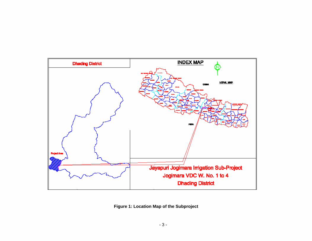
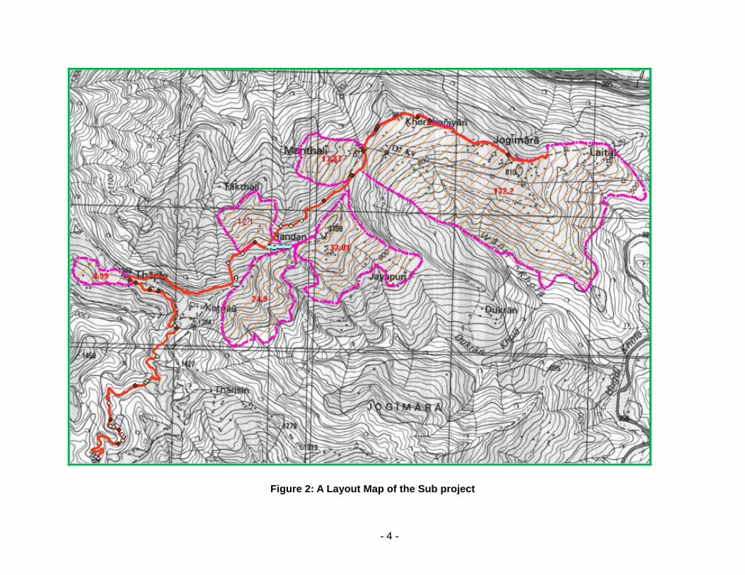
8. There is on ly one main canal which runs on t he right sid e of the Hatthibang Khola. There are 2 branch canals off main canal (BC-1 to BC-2) and 2 tertiary branch cana ls off BC-1 and three t ertiary branches from BC-2 .The lay out map of the su b projects is presented in Figure 1. A list of proposed structu res of the subproject is presented in Annex 1. The salient features of the subproject is presented in Table 1.
- 3 -
Figure 1: Location Map of the Subproject
- 4 -
Figure 2: A Layout Map of the Sub project
- 5 -
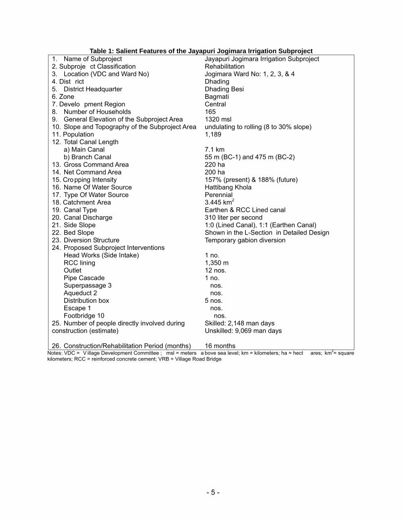
Table 1: Salient Features of the Jayapuri Jogimara Irrigation Subproject 1. Name of Subproject Jayapuri Jogimara Irrigation Subproject 2. Subproje ct Classification Rehabilitation 3. Location (VDC and Ward No) Jogimara Ward No: 1, 2, 3, & 4 4. Dist rict Dhading 5. District Headquarter Dhading Besi 6. Zone Bagmati 7. Develo pment Region Central 8. Number of Households 165 9. General Elevation of the Subproject Area 1320 msl 10. Slope and Topography of the Subproject Area undulating to rolling (8 to 30% slope) 11. Population 1,189 12. Total Canal Length
a) Main Canal 7.1 km b) Branch Canal 55 m (BC-1) and 475 m (BC-2)
13. Gross Command Area 220 ha 14. Net Command Area 200 ha 15. Cropping Intensity 157% (present) & 188% (future) 16. Name Of Water Source Hattibang Khola 17. Type Of Water Source Perennial 18. Catchment Area 3.445 km2 19. Canal Type Earthen & RCC Lined canal 20. Canal Discharge 310 liter per second 21. Side Slope 1:0 (Lined Canal), 1:1 (Earthen Canal) 22. Bed Slope Shown in the L-Section in Detailed Design 23. Diversion Structure Temporary gabion diversion 24. Proposed Subproject Interventions
Head Works (Side Intake) 1 no. RCC lining 1,350 m Outlet 12 nos. Pipe Cascade 1 no. Superpassage 3 nos. Aqueduct 2 nos. Distribution box 5 nos. Escape 1 nos. Footbridge 10 nos.
25. Number of people directly involved during construction (estimate)
Skilled: 2,148 man days Unskilled: 9,069 man days
26. Construction/Rehabilitation Period (months) 16 months Notes: VDC = V illage Development Committee ; msl = meters a bove sea level; km = kilometers; ha = hect ares; km2= square kilometers; RCC = reinforced concrete cement; VRB = Village Road Bridge
- 6 -
III. DESCRIPTION OF THE ENVIRONMENT
Physical Environment
9. Topography. The scheme is located in the Hill in an agricultural are a with land that slopes from south to north at an elevation of 1320 m ab ove msl. The Jayapuri Jogimara Irrigation subproject command area lies on Right banks of the Hathib ang Khola. The existing main canals after reaching the command area tend to be contour canals with the branch canals running down the natura l drains (Kh olsi) and irr igating to bo th sides of the drain. Th e existing system is mostly linned canals and polythin pipe system.
10. Climate. The climate is tropical dur ing the summer and subtropical du ring the winters, so as can b e expected in the central area of Nepal. The average annual rainfall recorded a t Station Dhading (Station Index 1005) is 2281 mm and is presented below. More than 80% of the rainfall is concentrated during the four months of the year, June through September.
11. Soils. The Soil of the command area is moderately well drained light textured soil. Soil texture slightly varies fro m light to medium mo ving across the command area from n orth to the south.. The soil condition is good for the diversified cro ps in the command area which i s described as Hill Terrace Cultivation Type.
12. Water Resources. The perennial Hatthibang Khola with the following flow characteristic is the main water source for the subproject. The catchment area is relatively small at only 3.445 km2. Most of this catchment area is located inside the dense forest and the good forest cover in this area provides the catchment with a high water retaining capacity, which limits the occurance of flash f lood, provides the river with a relat ively stable flow regime and provides for the presence of considerable perennial spring flows. This gives the river considerably higher base flow than is normally expected from streams wit h this small a catchment area in the Hill range. The Hatthibang Khola is ungauged and the flo w regime of the river was estimated with the empirical Medium Irrigation Project (MIP) meth od based o n a spot flo w measurement in the month of April 2007.
Ecological Resources
13. Vegetation and Forest. There is no national forest or communit y f orest within the project command area. There are number of trees of different species of timber, fodder, fuelwood and fruits ( Chilaune, Katus, Khayer, Chiuri, Sal, Utis, Jamuna, Ka man, Ma yal, Orange,Amba) within the subproject command area and homestead but they are not going to be affected by the project activities.
14. Wildlife. As reported by the local people, Jackals, Spotted Leopard and Deer have been occasionally seen within the subproject command area.
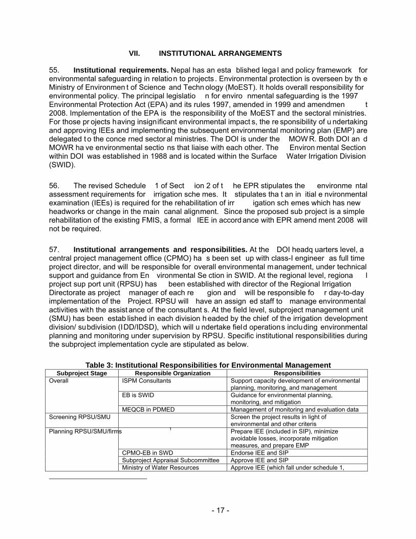
15. Aquatic life. No fish species have been reported as such in the Hattibang River.
- 7 -
Socio-economic Environment
16. The Jayapuri Jogimara ISP covers many s mall and scatter ed settlements or villag es, namely Tha pke Kot Danda, Sis Danda, Randan, Jayapuri, Kuwapanitar, Manthali, Jogimara, Upper Fundree, Lower Fundree, Charpata, Dharmasala, Chamtar, Kha rka, Chanaute Pokhare, Upper Laitak, Tallo Laitak and Majgaun. The total number of households with some land holding in the project area is 165 with the estimated population of 1189.
17. The labour f orce from Rich and Middle Level families is more involved in urban based business and foreign employment while those fr om poor g roup are highly mobile from farm t o nearby urban industry. The main source of agricultural labour for the command area is the Ultra poor group. There is sufficien t labour force to meet the unskille d labour required for infrastructure construction within the proposed project area.
18. Labour from Ultra Poor Group supplement their family income also fro m casual work in cities as factory labour and from their family oc cupation. They also manage their income source by cultivating citrus fruits and selling them.
19. The education level of the communi ty is poor. Within the command area, 1 High school in Jayapuri, 1 primary school in Jogimara and 1 primary boarding sch ool in Jogimara villages were noted. It is report ed that most of the p eople con sidered literat e in the ar ea have not completed even the lower secondary level.
20. On an average, the ho useholds with food deficit work for 3-6 person months outside their area as wage earner. Landless people work on wages and some of them take land on rent for farming on contractual basis. Most of the male members go to work in factories located in the vicinity of the highway, not far from their residence. The wages to labourers working in th e field is provided on the basis of two shifts. Normally the y are paid in kind. The wa ge rate for women is about 20% lower than for men.
- 8 -
IV. SCREENING OF POTENTIAL ENVIRONMENTAL IMPACTS
21. Delineation of geographical boundary of zone of influence (ZoI). : The project area will be del ineated under three cate gory (i) high impact area: the per manent imp act from the project such as perman ent land loss and dewatered zone will be considered as high impact area. Such area will include the are a where the project infrastructures will be located such as headworks, canal alignment and canal structur es (ii) Moderate impact area: This will cover the area where land loss will be temporary during the construction period only. They will include camp sites, quarry sites; borrow areas, labour camp sites etc. (iii) lo w impact area: This will cover the adjoining are as within 200 to 500m (depending u pon the settlement pattern) from the boundary of the sub project area of the VDC that are likely to be affected.
22. The project will be constructing a permanent weir across t he river about 7 m above the existing bed level of the Hattibang River. The screening of the potential impacts is presented in Table 2.
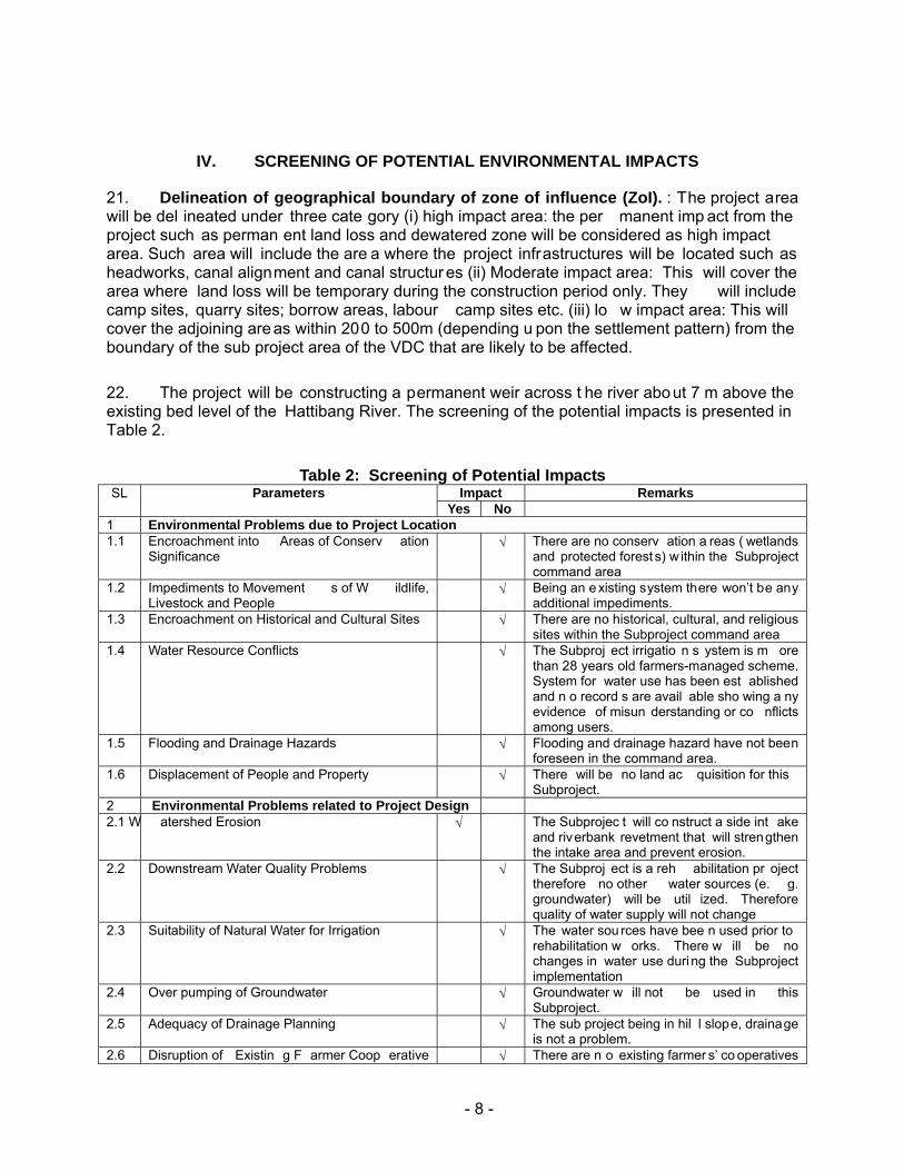
Table 2: Screening of Potential Impacts SL Parameters Impact Remarks
Yes No 1 Environmental Problems due to Project Location1.1 Encroachment into Areas of Conserv ation
Significance √ There are no conserv ation a reas ( wetlands
and protected forest s) w ithin the Subproject command area
1.2 Impediments to Movement s of W ildlife, Livestock and People
√ Being an e xisting system there won’t be any additional impediments.
1.3 Encroachment on Historical and Cultural Sites √ There are no historical, cultural, and religious sites within the Subproject command area
1.4 Water Resource Conflicts √ The Subproj ect irrigatio n s ystem is m ore than 28 years old farmers-managed scheme. System for water use has been est ablished and n o record s are avail able sho wing a ny evidence of misun derstanding or co nflicts among users.
1.5 Flooding and Drainage Hazards √ Flooding and drainage hazard have not been foreseen in the command area.
1.6 Displacement of People and Property √ There will be no land ac quisition for this Subproject.
2 Environmental Problems related to Project Design2.1 W atershed Erosion √ The Subprojec t will co nstruct a side int ake
and riverbank revetment that will strengthen the intake area and prevent erosion.
2.2 Downstream Water Quality Problems √ The Subproj ect is a reh abilitation pr oject therefore no other water sources (e. g. groundwater) will be util ized. Therefore quality of water supply will not change
2.3 Suitability of Natural Water for Irrigation √ The water sou rces have bee n used prior to rehabilitation w orks. There w ill be no changes in water use duri ng the Subproject implementation
2.4 Over pumping of Groundwater √ Groundwater w ill not be used in this Subproject.
2.5 Adequacy of Drainage Planning √ The sub project being in hil l slope, drainage is not a problem.
2.6 Disruption of Existin g F armer Coop erative √ There are n o existing farmer s’ co operatives
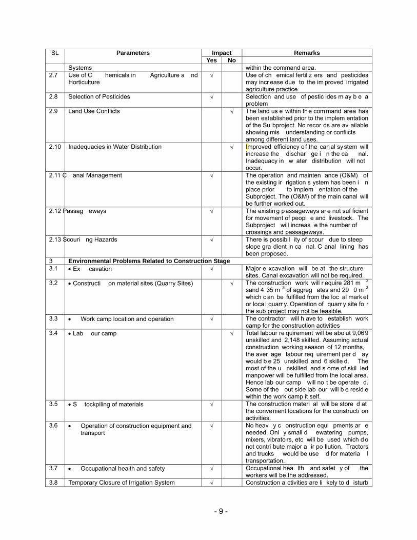
- 9 -
SL Parameters Impact Remarks Yes No
Systems within the command area. 2.7 Use of C hemicals in Agriculture a nd
Horticulture √ Use of ch emical fertiliz ers and pesticides
may incr ease due to the im proved irrigated agriculture practice
2.8 Selection of Pesticides √ Selection and use of pestic ides m ay b e a problem
2.9 Land Use Conflicts √ The land us e within the command area has been established prior to the implem entation of the Su bproject. No recor ds are av ailable showing mis understanding or conflicts among different land uses.
2.10 Inadequacies in Water Distribution √ Improved efficiency o f the canal system will increase the dischar ge i n the ca nal. Inadequacy in w ater distribution will not occur.
2.11 C anal Management √ The operation and mainten ance (O&M) of the existing ir rigation s ystem has been i n place prior to implem entation of the Subproject. The (O&M) of the main canal will be further worked out.
2.12 Passag eways √ The existin g passageways ar e not suf ficient for movement of peopl e and livestock. The Subproject will increas e the number of crossings and passageways.
2.13 Scouri ng Hazards √ There is possibil ity of scour due to steep slope gra dient in ca nal. C anal lining has been proposed.
3 Environmental Problems Related to Construction Stage3.1 • Ex cavation √ Major e xcavation will be at the structure
sites. Canal excavation will not be required. 3.2 • Constructi on material sites (Quarry Sites)
√ The construction work will r equire 281 m 3
sand 4 35 m 3 of aggreg ates and 29 0 m 3 which c an be fulfilled from the loc al mark et or loca l quarr y. Operation of quarr y site fo r the sub project may not be feasible.
3.3 • Work camp location and operation √ The contractor will h ave to establish work camp for the construction activities
3.4 • Lab our camp √ Total labour re quirement will be abo ut 9,069 unskilled and 2,148 skil led. Assuming actual construction working season of 12 months, the aver age labour req uirement per d ay would b e 25 unskilled and 6 skille d. The most of the u nskilled and s ome of skil led manpower will be fulfilled from the local area. Hence lab our camp will no t be operate d. Some of the out side lab our will b e resid e within the work camp it self.
3.5 • S tockpiling of materials √ The construction materi al will be store d at the convenient locations for the constructi on activities.
3.6 • Operation of construction equipment and transport
√ No heav y c onstruction equi pments ar e needed. Onl y small d ewatering pumps, mixers, vibrato rs, etc will be used which d o not contri bute major a ir po llution. Tractors and trucks would be use d for materia l transportation.
3.7 • Occupational health and safety √ Occupational hea lth and safet y of the workers will be the addressed.
3.8 Temporary Closure of Irrigation System √ Construction a ctivities are li kely to d isturb
- 10 -
SL Parameters Impact Remarks Yes No
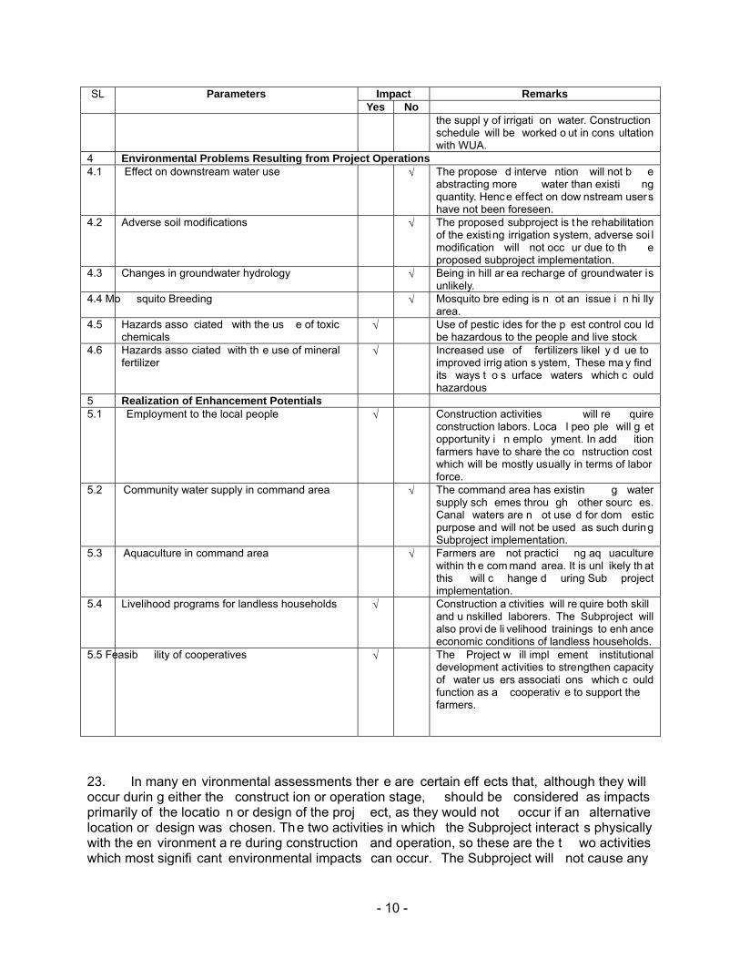
the suppl y of irrigati on water. Construction schedule will be worked o ut in cons ultation with WUA.
4 Environmental Problems Resulting from Project Operations4.1 Effect on downstream water use √ The propose d interve ntion will not b e
abstracting more water than existi ng quantity. Hence ef fect on dow nstream users have not been foreseen.
4.2 Adverse soil modifications √ The proposed subproject is t he rehabilitation of the existi ng irrigation system, adverse soi l modification will not occ ur due to th e proposed subproject implementation.
4.3 Changes in groundwater hydrology √ Being in hill ar ea recharge of groundwater is unlikely.
4.4 Mo squito Breeding √ Mosquito bre eding is n ot an issue i n hi lly area.
4.5 Hazards asso ciated with the us e of toxic chemicals
√ Use of pestic ides for the p est control cou ld be hazardous to the people and live stock
4.6 Hazards asso ciated with th e use of mineral fertilizer
√ Increased use of fertilizers likel y d ue to improved irrig ation s ystem, These ma y find its ways t o s urface waters which c ould hazardous
5 Realization of Enhancement Potentials5.1 Employment to the local people √ Construction activities will re quire
construction labors. Loca l peo ple will g et opportunity i n emplo yment. In add ition farmers have to share the co nstruction cost which will be mostly usually in terms of labor force.
5.2 Community water supply in command area √ The command area has existin g water supply sch emes throu gh other sourc es. Canal waters are n ot use d for dom estic purpose and will not be used as such during Subproject implementation.
5.3 Aquaculture in command area √ Farmers are not practici ng aq uaculture within th e com mand area. It is unl ikely th at this will c hange d uring Sub project implementation.
5.4 Livelihood programs for landless households √ Construction a ctivities will re quire both skill and u nskilled laborers. The Subproject will also provi de li velihood trainings to enh ance economic conditions of landless households.
5.5 Feasib ility of cooperatives √ The Project w ill impl ement institutional development activities to strengthen capacity of water us ers associati ons which c ould function as a cooperativ e to support the farmers.
23. In many en vironmental assessments ther e are certain eff ects that, although they will occur durin g either the construct ion or operation stage, should be considered as impacts primarily of the locatio n or design of the proj ect, as they would not occur if an alternative location or design was chosen. The two activities in which the Subproject interact s physically with the en vironment a re during construction and operation, so these are the t wo activities which most signifi cant environmental impacts can occur. The Subproject will not cause any
- 11 -
significant adverse environmental impacts becau se: (i) most of the indiv idual elements of the Subproject are relatively s mall and involve straightforward construction and op eration, so impacts will be mainly localized and not greatly significant; (ii) most of the predicted impacts are associated with the con struction process, and are produced because t hat process is invasive, involving trenching and other exca vation; and ( iii) mitigati on measures are devised for any negative environmental impacts.
24. These potential environmental impacts may be direct or indirect, a nd reversible or irreversible. The magnitude of the impacts may be high, medium or low and such impacts ma y be of site-specific, lo cal, regional or of national nature. Furthermore, some impa cts may be short-term, particularly related with the upgrading stage, medium-term and long-term duration.
- 12 -
V. POTENTIAL ENVIRONMENTAL IMPACT AND MITIGATION MEASURES
Environmental Problem Related to Project Design
25. Watershed Erosion: An escape structure has been proposed 60 m d/ s of Intake. The riverbank revetment ha s also b een proposed to strength en the inta ke area an d avoid the encroachment during high flood. T his is the p ositive impact with high magnitude local exten t and long term duration.
26. Use of Chemicals in Agriculture and Horticulture: Currently the use of chemical fertilizers is minimal which may increase as t he subproje ct encourag es improve d agricultur al practices. Excess use o f chemical fertilizers in the field may run down i nto surface water along with the runoff. But the excess use of fertilizers would be very rare in practice. Considering the rareness of the occurrence, this impact has been considered of low magnitude, local extent and long term duration.
27. The agricultural development plan has recommended the optimum dose of required chemical fertilizers for each of the proposed crops.
28. Selection of Pesticides: Farmers of the subproject area are not well aware of the toxicity of the pesticides. There could be need of use of the pesticide if the crops are infested by insects. He nce select ion of the pesticide s will be an issu e. The impact associat ed with the pesticides will be low magnitude, local in extent and long term in duration.
29. Include IPM training under agriculture development program. The cost of this training will be covered from ADP.
30. Canal Management: Operation and maintenance of the main canal will have to be worked out, which should not be a p roblem as t hey have been practicing such works for many years. Hen ce this impact has been considere d of low magnitude, local extent an d long term duration.
31. Water management plan will be developed for the canal management.
32. Passageway: There a re some passageways in the existing cana ls which is not adequate fo r move ment of the peo ple. Hence additional p assageways, 10 foot bridges have been propo sed. This is a positive impact of hi gh magnitude, local in extent and long term duration.
33. Scouring Hazards: There is possibility of scouring hazard in the canal due to the steep slope gradient. The ca nal lin ing h as been pr oposed in t he sect ion of the cana l where th e velocity of the flow is more than 1.0 m 3/s. This is a positive impact of h igh magnitude, local in extent and long term in duration.
- 13 -
Environmental Problems Related to Construction Stage:
34. The Subproject will use labour-based, environment-friendly, and particip atory approach, the important features of which are:
• Use of local people as labour, hand tools and small equipment, rather than heavy machinery for construction.
• Balancing cut and fill a nd reuse of excavated materials as constru ction materials, and thus not generating excess spoils as far as possible.
• Use of bio -engineering techniques: integrated use of vegetation, simple civil engineering structures, and proper water management systems for slope protection.
35. Significant adverse negative environment al impacts are not expected during the construction stage mainly because: (i) rehabilita tion works can be const ructed without causing major disruption to irrig ation users; (ii) most construction w ill be condu cted by small teams of farmers working on sho rt lengths at a time so most impa cts will be l ocalized an d short in duration; and (iii) the overall construction program will be relatively short for a project of this nature, and is expected to be completed in 19 months.
36. During the construction phase most of the potential negative environmental impacts are associated with the activities of the construction contractor(s). By i ncluding en vironmental management clause s in the individ ual contract documents, the potential for adverse impacts can be significantly reduced.
37. Excavations. Excavation will be a t the stru ctures locat ions. But as th e structure s are small, quantity of exca vation would not cause serious adverse effects that cause silt run-off , induced erosion, loss of potential cropland, loss of vegetation. After co nstruction, most of the excavated materials would be reutilized in backfilling work.
38. Mitigation measures include: (i) confine excavating operations to the dry season; (ii) use of silt traps; and (iii) spoils shall be disposed of in locations that will not promote instability and result in destruction of property, vegetation, irrigation and drinking water supply. Disposal near wetlands, protected areas, and other areas that will inconvenience or deprive local residents of their livelihood shall not be allowed. Acidic and saline spoils shall not be spread into agricultural land.
39. Work Camp Location and Operation. Potential environmental impacts inclu de (i) temporary air and noise pollution from machine operation; (ii) water pollution from s torage and use of fuel, oils, solvents, and lubricants; (iii) unhygienic conditions from laborers.
40. Mitigation measures include: (i) The Contractor shall consult with WUA and or VDC before locating project offices, sheds, and construction plants; (ii) camps shall not be located near settlements or near drinking water supply intakes; (iii) no trees shall be cut and removal of vegetation shall be minimized; (iv) water and pit latrines facilities shall be provided for laborers;
- 14 -
(v) used oil and lubricants shall be recovered and reused or removed from site by the Contractor; (vi) at conclusion of the Subproject, all wreckage, rubbish, or temporary works that are no longer required shall be removed or given to local residents; (vii) all temporary structures, including office buildings, shelters, and latrines shall be removed; (viii) sites shall be restored to near natural or stable conditions; (ix) exposed areas shall be planted with suitable vegetation; and (x) the Subproject proponent shall report in writing that the camp has been vacated and restored to pre-project conditions before acceptance of the works.
41. Stockpiling of Materials (Storage of topsoil, fill material, gravel, aggregates, and other construction materials). Potential environmental impacts include (i) silt ation and pollution o f surface water resulting from uncontrolled r unoff from storage pile s; and (ii) disturbance to private property.
42. Mitigation measures include: (i) stockpiling shall not be permitted during the rainy season unless covered by a suitable material; (ii) stripped material shall not be stored where natural drainage will be disrupted; (iii) protection of materials from erosion prior to rainy season; and (iv) storage on private property will be allowed only if written permission is obtained from the owner or authorized lessee.
43. Operation of construction equipment and transport: As no h eavy construction equipments are needed, the subproject activit ies will not contribute major air p ollution and excessive noise. However airborne dust particles due to construction materials may result in deposition and possible damage to vegetation, crops, and water resources.
44. Mitigation measures include: (i) stockpiled sand and soil shall be slightly wetted before loading particularly in windy conditions; (ii) vehicles transporting sand and soil shall be covered with a tarpaulin; and (iii) limit and control working practices through contract provisions such as: (a) avoid noise-generating activities at night; (b) consult with local community to inform them of the nature, duration, and likely effects of the construction work; (c) schedule work during dry season
45. Occupational health and safety: In the con struction sites, there will b e movement of local peoples. Despite precautions, possibility of accidents could not be ruled out completely as many types of equipment will be under operation. Hence, construct ion activitie s may pose safety concern to local peoples as well as workers. Although the health and safety will be major concern during the construction sta ge, magnitude of the i mpacts has been evalu ated as low since provision of health and safety measures are ma ndatory in any of the constructio n contracts and due to small scale of construction. The extent will be site specific and duration will be of short term.
Mitigation Measures: Accidental insurance will be covered for all construction workers and staff. An amount of Rs. 31,000.00 has been allocated for the buying the accident insurance policy of the workers. This cost shall be covered from the environmental management cost. In order to minimize the unwanted accidents and possible effects of dust and gaseous emission to construction workers, the project will ensure adequate safety measures such as provision of helmets, masks, ear plugs, road signs, warning signals etc.
- 15 -
46. Temporary closure of irrigation system. The construction activity in the canal system is likely to disturb the supply of the ir rigation water. Hence the provision of temporary closure of irrigation system will have to be made in consultation with WUA.
47. Mitigation Measures: The construction activities will be planned in consultation with the WUA members. The headworks construction will be carried out during the dry season and the alternative measures will be made to keep the canal in running conditions if the construction activities will be carried out during the canal operation time. Flexible hosing and/or diversion canals will be used to supply water to affected users. Cost of alternative arrangement for supplying the water will be part of the civil construction cost.
Environmental Problems Resulting from Subproject Operations
48. Hazards associated with the Use of Toxic Chemicals. Pesticides are the toxic chemicals t hat would b e used in t he agricultu ral crops w henever crops are infe sted by the insects. From the focused group discussion with the farmers, they seemed to be a ware of the toxicity of the pesticides. Use of pes ticides in the project area is minimum. Farmers need some IPM (integrated pest managemen t) training so as to train the farme rs in pest managemen t without the use of pesticides. With this background, it could be assumed that impact associated with the pesticides (toxic chemical s) will be of low magnitude, local in extent and l ong term in duration.
49. Hazards associated with the Use of Mineral Fertilizer. The farmers have been using chemical fertilizers in the crops. Bu t the quantity of usage i s less than the recommended dose for the crops. The subproject intends to carry out training in the crops cultivation to increase the crops yield. Hence th e use of ch emical fertilizers is goin g to be increased with the project implementation. But given the proper training programs, the applicatio n dose will be optimum for the crops and it would not create any hazard as such. Hence the impact is considered of low magnitude, local in extent and long term in duration.
Realization of Enhancement Potentials
50. Employment Opportunity to the Local People. The construction o f the subproject would require both skil led and unskil led labour. Semi skilled and unskil led labours are available in the subproject area as well as its vicinity. The sub project would provide employment opportunity to the local people. In addition, th e farmers will have to make their contribution, which could be in kind and ca sh. The farmers preferred to make co ntribution b y providin g labour.
51. Livelihood Programs for Landless Households. There are ultra poor/landless households in the pro ject area who work as tenants for ot her households who o wn the land . The proposed subproje ct intends t o enhance t he economic condit ion of these ho useholds by implementing different livelihood programs.
52. Feasibility of Cooperatives. The existing irr igation system is bein g operated and maintained by the water users asso ciation. They have defined rules and regulations, which are followed by all the members. The rules and regulations ar e socially binding. The proposed
- 16 -
CMIASP intends to implement a nu mber of inst itutional development activities in str engthening capacities o f the WUAs in agricultu ral production, and poverty alleviation of the pr oject area. The WUA will have the key role to play in these activities. For the pro ject implementation, a coordination committee is planned to be formed. The WUA could also function as the cooperatives to support the farmers in terms of making timely availability of agricultural inputs, marketing of the agricultural production, facilitating the micro credits.
VI. ANALYSIS OF ALTERNATIVES
53. The intake structure is in good condit ion. Hence the proposed intake site at the present location is justified. The subproject will construct an escape structure 60 m d/s of the intake site and riverbank revetment to strengthen the intake area.
54. Since the irrigation system is the tr aditional system, canals already e xist and the re are no alternative alignments for them. There are various alternatives in canal lining; however the farmers preferred to have RCC lining.
- 17 -
VII. INSTITUTIONAL ARRANGEMENTS
55. Institutional requirements. Nepal has an esta blished lega l and policy framework for environmental safeguarding in relation to projects . Environmental protection is overseen by th e Ministry of Environmen t of Science and Techn ology (MoEST). It holds overall responsibility for environmental policy. The principal legislatio n for enviro nmental safeguarding is the 1997 Environmental Protection Act (EPA) and its rules 1997, amended in 1999 and amendmen t 2008. Implementation of the EPA is the responsibility of the MoEST and the sectoral ministries. For those pr ojects having insignificant environmental impact s, the re sponsibility of u ndertaking and approving IEEs and implementing the subsequent environmental monitoring plan (EMP) are delegated t o the conce rned sector al ministries. The DOI is under the MOW R. Both DOI an d MOWR ha ve environmental sectio ns that liaise with each other. The Environ mental Section within DOI was established in 1988 and is located within the Surface Water Irrigation Division (SWID).
56. The revised Schedule 1 of Sect ion 2 of t he EPR stipulates the environme ntal assessment requirements for irrigation sche mes. It stipulates tha t an in itial e nvironmental examination (IEEs) is required for the rehabilitation of irr igation sch emes which has new headworks or change in the main canal alignment. Since the proposed sub project is a simple rehabilitation of the existing FMIS, a formal IEE in accord ance with EPR amend ment 2008 will not be required.
57. Institutional arrangements and responsibilities. At the DOI headq uarters level, a central project management office (CPMO) ha s been set up with class-I engineer as full time project director, and will be responsible for overall environmental management, under technical support and guidance from En vironmental Se ction in SWID. At the regional level, regiona l project sup port unit (RPSU) has been established with director of the Regional Irrigation Directorate as project manager of each re gion and will be responsible fo r day-to-day implementation of the Project. RPSU will have an assign ed staff to manage environmental activities with the assist ance of the consultant s. At the field level, subproject management unit (SMU) has been estab lished in each division headed by the chief of the irrigation development division/ subdivision (IDD/IDSD), which will u ndertake field operations including environmental planning and monitoring under supervision by RPSU. Specific institutional responsibilities during the subproject implementation cycle are stipulated as below.
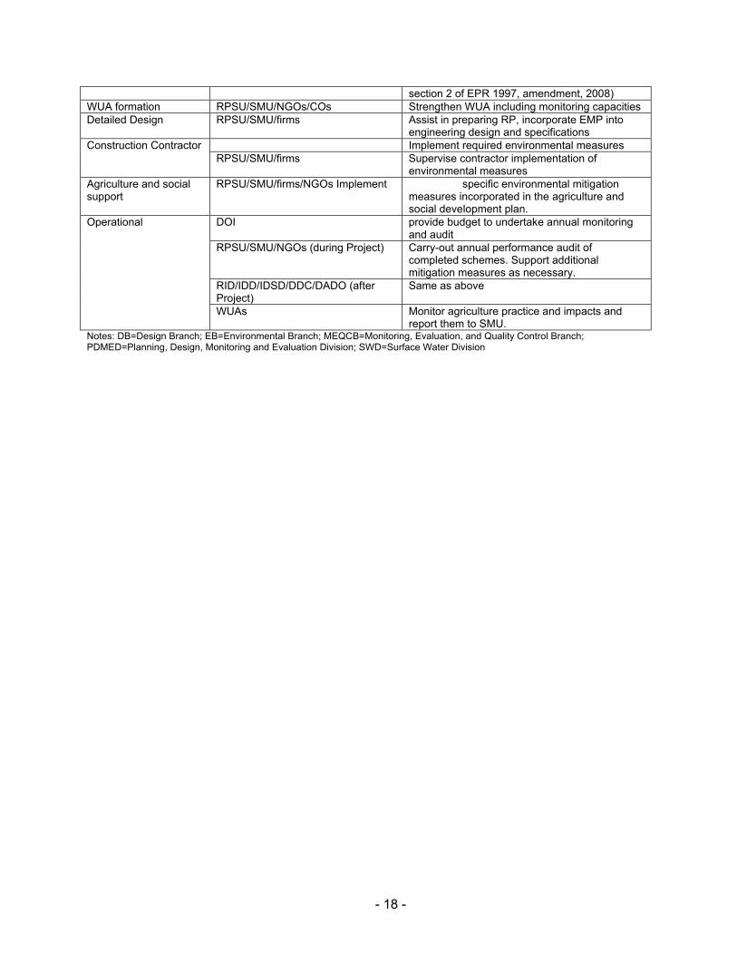
Table 3: Institutional Responsibilities for Environmental Management Subproject Stage Responsible Organization Responsibilities
Overall ISPM Consultants Support capacity development of environmental planning, monitoring, and management
EB is SWID Guidance for environmental planning, monitoring, and mitigation
MEQCB in PDMED Management of monitoring and evaluation data Screening RPSU/SMU Screen the project results in light of
environmental and other criteris Planning RPSU/SMU/firms 1 Prepare IEE (included in SIP), minimize
avoidable losses, incorporate mitigation measures, and prepare EMP
CPMO-EB in SWD Endorse IEE and SIPSubproject Appraisal Subcommittee Approve IEE and SIP Ministry of Water Resources Approve IEE (which fall under schedule 1,
- 18 -
section 2 of EPR 1997, amendment, 2008) WUA formation RPSU/SMU/NGOs/COs Strengthen WUA including monitoring capacities Detailed Design RPSU/SMU/firms Assist in preparing RP, incorporate EMP into
engineering design and specifications Construction Contractor Implement required environmental measures
RPSU/SMU/firms Supervise contractor implementation of environmental measures
Agriculture and social support
RPSU/SMU/firms/NGOs Implement specific environmental mitigation measures incorporated in the agriculture and social development plan.
Operational DOI provide budget to undertake annual monitoring and audit
RPSU/SMU/NGOs (during Project) Carry-out annual performance audit of completed schemes. Support additional mitigation measures as necessary.
RID/IDD/IDSD/DDC/DADO (after Project)
Same as above
WUAs Monitor agriculture practice and impacts and report them to SMU.
Notes: DB=Design Branch; EB=Environmental Branch; MEQCB=Monitoring, Evaluation, and Quality Control Branch; PDMED=Planning, Design, Monitoring and Evaluation Division; SWD=Surface Water Division
- 19 -
VIII. ENVIRONMENTAL MANAGEMENT PLAN
58. The Enviro nmental Ma nagement Plan (EMP) is prepared to guide implementati on of mitigation measures and monitoring require ments. It includes institution and their roles, environmental management activities, environm ental management organizational stru cture and budget for mitigation measures.
59. Essentially, it will be put into operation through data collection at subproject level by SMU with the engage ment of private firms as nece ssary and/or WUA, moni tored and supervised by RPSU through regular management review and f ield confir mation, and processing and analysis by Monitoring and Evaluation Branch of DOI in coordination with DOA. Environmental data will be shared with En vironment Di vision. Monitoring costs have been incorporated into the de sign of the PPME system for the project. The findings of th e monitoring activities will be incorporated in t he regular PPME reports prepare d by CPMO with the assistance of the consultants engaged under institu tional stren gthening and project management, and submitted to ADB.
60. Framework for implementing environmental management plan is shown by Table 4.
- 20 -
Table 4: Environmental Management Plan
Sl
Impact Mitigation Measures Location Method Cost Responsible agencies for Implementation
Monitoring parameters
Responsible Agency for Monitoring
1 Environmental Problem due project location
2 Environmental Problem related to project design Watershed erosion Provide escape st ructure and
riverbank revetment Design Office
Include i n det. design
No cost Design team
provision of escape structure
ISPMC
Canal management Prepare s ub project sp ecific water management plan and O & M Plan.
Design Office
included in det. design
No cost Design team
Prepare si te specific w ater management plan
ISPMC
Passageway P rovide passageway structures Design Office
Include i n det. design
No cost Design team
provide passage as agreed with the farmers
ISPMC
H azards associated with the use of toxic chemicals
Avoid u sing pesticide t o t he extent possible. Use I PM technique to control pest
Design Office
Include i n Agriculture Development Plan.
No cost Design team
Include I PM training package in A griculture Development Plan (ADP.)
ISPMC
3 Environmental Problem related to construction stage Excavation (i)confine ope rations in th e dry
season; (ii) u se of s ilt t raps; (iii) spoils sh all be di sposed of a t t he designated locations
Within t he sub-project
designate t he spoil dis posal area
Part of civi l construction cost
Imp: Contractor Mon: SMU/WUA
spoil d isposal sites
SMU/WUA
Qua rry sites Work Camp Location and
Operation: (i) te mporary air and noise pollution from machine op eration; (ii ) water po llution from storage and us e of fuel, oils, s olvents, an d lubricants; (ii i) unh ygienic conditions fro m l aborers; (iv) disturbance to wildlife
(i) work camp w ill be located away from the settlement ar ea. (i i) n o trees sh all be c ut a nd removal o f vegetation s hall b e minimized (iii) used oi l and l ubricants s hall be recovered and reus ed or rem oved from si te. ( iv) wo rk camps will n ot be a llowed in wildlife hab itats, restriction an d co ntrol of wildlife harassment, il legal hu nting and
Within t he sub-project
Part of civi l construction cost
Contractor
Location of the work camp
SMU/WUA
- 21 -
Table 4: Environmental Management Plan
Sl
Impact Mitigation Measures Location Method Cost Responsible agencies for Implementation
Monitoring parameters
Responsible Agency for Monitoring
poaching by workers (iv) will make own arrangements for
water and sanitation Work camp Included in
environmental cost (Budget: Rs 30,000.00)
Imp: Contractor
disposal a nd sanitary facilities in t he work camp
SMU/WUA
(v) S ite will be placed b ack in the original si te condition an d t he shall report in writing t hat site has been restored t o p re-project conditions before acceptance of the works.
Within t he sub-project
I ncluded in environmental cost (B udget : Rs, 30,000.00)
Imp: Contractor
Condition of t he work camp site before the issue of c ompletion certificate
SMU
Stockpiling of Materials : (i) s iltation and pollution of surface w ater resulting from unc ontrolled runoff from s torage pi les; and (ii ) disturbance to priv ate property.
(i) stockpiling wi ll not be permitted during t he rainy se ason unless covered b y a suitable material; (ii) stripped m aterial will not b e st ored where nat ural drai nage will be disrupted; (iii) p rotection o f materials from erosion prior to rainy season; and (iv ) s torage on private property will b e a llowed only with the w ritten permission from the owner.
Construction sites
ensure go od construction practice
Part of civi l construction cost
Imp: Contractor
Inspection of the construction material stocking site.
SMU/WUA
Operation of construction equipment and transport : em ission of air p ollutants, hi gh concentration of air borne dust res ulting and excessive n oise res ulting annoyance an d potential hazard t o human populations
(i) Stockpiled sand and soil shall be slightly wetted b efore loa ding particularly in wi ndy c onditions; ( ii) vehicles transporting s and a nd s oil shall b e c overed with a tarpaulin; and (iii) l imit and c ontrol working practices th rough contract provisions.
Construction site
ensure go od construction practice
Part of civi l construction cost
Imp: Contractor
SM U/WUA
Oc cupational health and safety
(i) Bu y accident in surance to al l workers. (i i) provide s afety g ears such hel mets, boo ts, ear plug, mouth m ask t o the worker and
Construction site
Provide s afety gears
Included in environmental cost (Budget Rs. 31,000.00)
Imp: Contractor
insurance policy Mon: SMU/WUA
- 22 -
Table 4: Environmental Management Plan
Sl
Impact Mitigation Measures Location Method Cost Responsible agencies for Implementation
Monitoring parameters
Responsible Agency for Monitoring
labours T emporary closure of
irrigation system Plan the in take c onstruction d uring dry season
Intake site No cost Imp: Contractor
Construction plan
Mon: SMU/WUA
Make a lternative arr angement t o keep the canal running
Canals Part o f c ivil construction cost
Imp: Contractor
Enquiry o n canal closure
Mon: SMU/WUA
Environmental Problems Resulting from Project Operations H azards associated with
the use of toxic chemicals Avoid u sing pesticide t o t he extent possible. Use I PM technique to control pest
Command area
Pest co ntrol by IPM
No cost Imp: Farmers
Use o f pesticide in the crops
Mon: DADO
H azards associated with the use of mineral fertilizer
Use re commended dos e of inorganic fertilizers
Command area
Application o f fertilizers
No cost Imp: Farmers
Use of chemical fertilizer in the crops
Mon: DADO
Realization of Enhancement Potentials Employment t o t he l ocal
people Provide employment to local people in priority
Within S ub project area
Hire local labour to t he ex tent possible
No cost Imp: Contractor
Payroll of contractor
Mon: WUA
Livelihood pr ograms for landless households
Provide Live lihood enhancement Program (LEP) trai ning t o t he targeted people
Within s ub project area
Training I nclude in LEP cost
Imp: SMU
Training on LEP Mon: WUA
F easibility of cooperatives Provide institutional development training
Within s ub project area
Training I nclude in Institutional development plan cost.
Imp: SMU
Training o n Institutional development training
Mon: WUA
- 23 -
IX. PUBLIC CONSULTATION AND DISCLOSURE
61. This IEE re port has be en in close consultation with WUA members a nd lead far mers who participated in the walk through survey. The walk through survey was carried out from 19th
to 20 th February 2009. The existing situat ion of the headw orks and ca nal was not ed by GPs
tracking. A long list of the required intervention was noted. The required inter vention was prioritized i n c onsultation wi th t he pa rticipating fa rmer. On 2 0th Februar y, 2009 itse lf a formal meeting was held with t he WUA me mbers and agreed with them on the proposed intervention that could b e under taken by the project. All th e highly prioritized interventions were included whereas the medium and low priority interventions were excluded.
62. A list of the WUA members is presented here below:
S.N Name Position Ward No VDC District1. Mr. Dinesh Pd Adhikari Chairman Ward No 3 Jogimara Dhading 2. Mr.Chandra Bdr. Rana Magar Vice-Chairman Ward No 4 Jogimara Dhading3. Mr. Shanta Bdr Dallakoti Treasure Ward No 1 Jogimara Dhading4. Mr. Arjun Pd. Dallakoti Secretary Ward No 1 Jogimara Dhading5. Hari Pd Khatiwada Joint Secretary Ward No 1 Jogimara Dhading6. Mrs. Pramila Shrestha Member Ward No 1 Jogimara Dhading7. Kumari Dallakoti Member Ward No 1 Jogimara Dhading8. Ramila Dallakoti Member Ward No 1 Jogimara Dhading9. Ram Maya Chepang Member Ward No 2 Jogimara Dhading10. Ganga Bdr. Basnet Member Ward No 1 Jogimara Dhading11. Hom Bdr dallakoti Member Ward No 1 Jogimara Dhading12. Om Pd Shrestha Member Ward No 3 Jogimara Dhading13. Kabi Raj Adhikari Member Ward No 3 Jogimara Dhading14. Bishnu Hari Aryal Member Ward No 3 Jogimara Dhading15. Badri Adhikari Member Ward No 3 Jogimara Dhading16. Sabitri Adhikari Member Ward No 3 Jogimara Dhading17. Bishnu Maya BK Member Ward No 1 Jogimara Dhading
63. The participants in the Walkthrough Survey Team from WUA were Mr. Kabi Raj Adhikari, Bishnu Hari Aryal and Hem Bahadur Dollakoti. Apart from W UA, local farmers Mr. Bidur Bhatta, Mr. Krishna Prasad Shrestha, Ms. Sumitra Dollakoti, and Lok Natha Dallkoti were also present.
- 24 -
X. FINDINGS AND RECOMMENDATIONS
64. The princip al findings are that the Subproj ect provides for inherently environme ntally friendly irrigation interventions and contributes to significantly improved living conditions through (i) communi ty e mphasis on subproject desig n and implementation, (ii) extensive technical support in e liciting sustainable practices in irri gated agriculture and (iii) a ddressing institutional needs for sustained and equitable O&M.
65. The identifi ed adverse environme ntal impacts will be addressed through pr oper planning, design, implementation, and O&M while incorpor ating identified mitigation measures. The screen ing process carried out in the IE E has not identified a ny significa nt negative environmental impacts like ly to be caused by the P roject. Environmental issues were considered throughout development of the Project and nece ssary changes were ma de to the designs to r educe or a void impacts. Potentia l negative impacts associated with constru ction activities can be mitigated by the application of standard health, saf ety, and environmental clauses in contract do cuments, close supervision, and close attention to transparency in tendering, and to quality control and supervision on site. Mitigation measures for oth er impacts are provided in detail in the IEE.
- 25 -
XI. CONCLUSION
66. The subproject is not expected to give rise to any significant negative environmental impacts, and therefore does not require an ADB Environmental Impact Assessment.
67. The proposed subproject is rehabilitation of existing irrigation system, which is already in operation. Hence, the e nvironmental impact dur ing the oper ation phase will not be very much different than the existing situation. Rather the existing system lacks basic structure s like cross drains, slope protection, drop structures. The proposed inter vention will be providing basic civil engineering structure s for the oper ation of the canal. Fro m the proposed interv ention som e adverse impacts of low magnitude have been i dentified during the construction sta ge but they are of short- term duration and cou ld be easi ly mitigated. The proposed intervention will provide round year i rrigation to the entire command area. Taking into considerat ion the adverse impact of low magnitude an d extensive positive im pacts, this subproje ct is re commended for implementation on the environment al perspectives. Mitigation of minor adverse environmental impacts can be carried out as an integral part of the Subproject, during both the detailed design and implementation stages. Appropriate measures will be included in the tender d ocuments for the civil works.
- 26 -
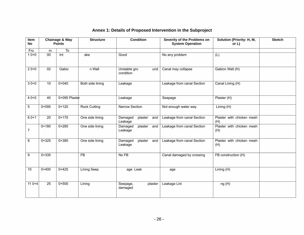
Annex 1: Details of Proposed Intervention in the Subproject
Item No
Chainage & Way Points
Structure Condition Severity of the Problems on System Operation
Solution (Priority: H, M, or L)
Sketch
Fro m To 1 0+0 00
Int ake
Good No any problem (L)
2 0+0 02
Gabio n Wall
Unstable gro und condition
Canal may collapse Gabion Wall (H)
3 0+0 10
0+040
Both side lining Leakage Leakage from canal Section Canal Lining (H)
4 0+0 40
0+095 Plaster Leakage Seapage Plaster (H)
5 0+095 0+120 Rock Cutting
Narrow Section Not enough water way Lining (H)
6 0+1 20
0+170
One side lining Damaged plaster and Leakage
Leakage from canal Section Plaster with chicken mesh (H)
7
0+180
0+285 One side lining Damaged plaster and Leakage
Leakage from canal Section Plaster with chicken mesh (H)
8 0+325 0+380 One side lining Damaged plaster and Leakage
Leakage from canal Section Plaster with chicken mesh (H)
9 0+335 FB No FB Canal damaged by crossing FB construction (H)
10 0+400 0+425 Lining Seep age Leak age Lining (H)
11 0+4 25 0+500 Lining Seepage, plaster damaged
Leakage Lini ng (H)
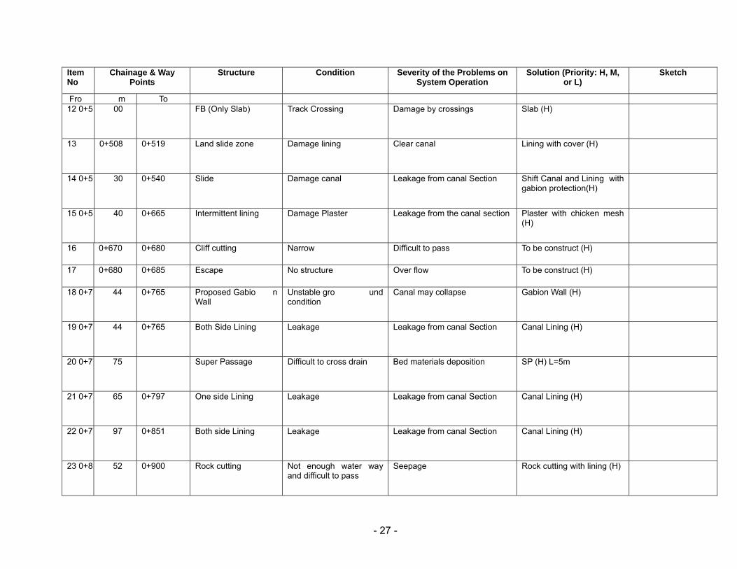
- 27 -
Item No
Chainage & Way Points
Structure Condition Severity of the Problems on System Operation
Solution (Priority: H, M, or L)
Sketch
Fro m To 12 0+5 00
FB (Only Slab)
Track Crossing Damage by crossings Slab (H)
13 0+508 0+519 Land slide zone Damage lining Clear canal Lining with cover (H)
14 0+5 30
0+540
Slide
Damage canal Leakage from canal Section Shift Canal and Lining with gabion protection(H)
15 0+5 40
0+665
Intermittent lining Damage Plaster Leakage from the canal section Plaster with chicken mesh (H)
16 0+670 0+680 Cliff cutting Narrow Difficult to pass To be construct (H)
17 0+680 0+685 Escape No structure Over flow To be construct (H)
18 0+7 44
0+765
Proposed Gabio n Wall
Unstable gro und condition
Canal may collapse Gabion Wall (H)
19 0+7 44
0+765
Both Side Lining Leakage Leakage from canal Section Canal Lining (H)
20 0+7 75
Super Passage Difficult to cross drain Bed materials deposition SP (H) L=5m
21 0+7 65
0+797
One side Lining Leakage Leakage from canal Section Canal Lining (H)
22 0+7 97
0+851
Both side Lining Leakage Leakage from canal Section Canal Lining (H)
23 0+8 52
0+900
Rock cutting Not enough water way and difficult to pass
Seepage Rock cutting with lining (H)
- 28 -
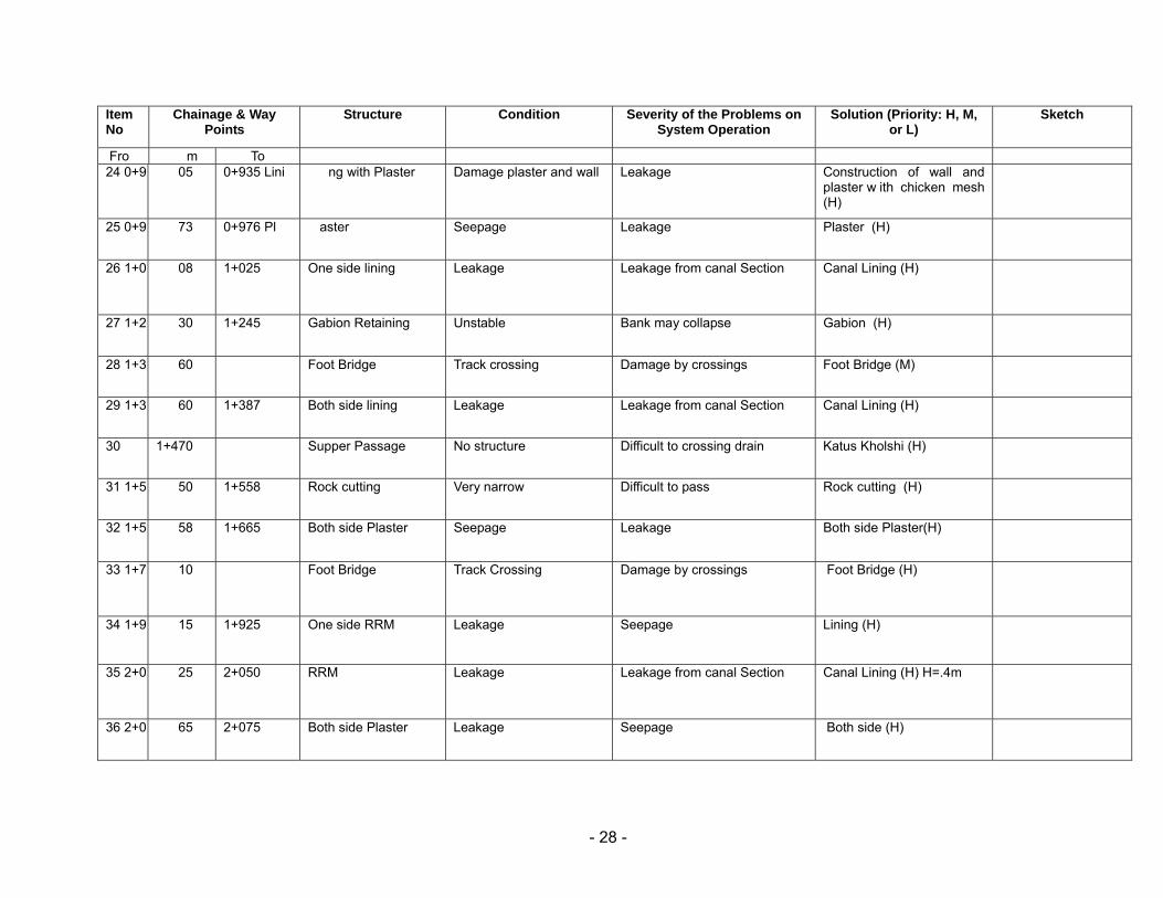
Item No
Chainage & Way Points
Structure Condition Severity of the Problems on System Operation
Solution (Priority: H, M, or L)
Sketch
Fro m To 24 0+9 05
0+935 Lini ng with Plaster
Damage plaster and wall Leakage Construction of wall and
plaster w ith chicken mesh (H)
25 0+9 73
0+976 Pl aster
Seepage Leakage Plaster (H)
26 1+0 08
1+025
One side lining Leakage Leakage from canal Section Canal Lining (H)
27 1+2 30
1+245
Gabion Retaining Unstable Bank may collapse Gabion (H)
28 1+3 60
Foot Bridge Track crossing Damage by crossings Foot Bridge (M)
29 1+3 60
1+387
Both side lining Leakage Leakage from canal Section Canal Lining (H)
30 1+470 Supper Passage No structure Difficult to crossing drain Katus Kholshi (H)
31 1+5 50
1+558
Rock cutting Very narrow Difficult to pass Rock cutting (H)
32 1+5 58
1+665
Both side Plaster
Seepage Leakage Both side Plaster(H)
33 1+7 10
Foot Bridge Track Crossing Damage by crossings Foot Bridge (H)
34 1+9 15
1+925
One side RRM Leakage Seepage Lining (H)
35 2+0 25
2+050
RRM Leakage Leakage from canal Section Canal Lining (H) H=.4m
36 2+0 65
2+075 Both side Plaster Leakage Seepage Both side (H)
- 29 -
Item No
Chainage & Way Points
Structure Condition Severity of the Problems on System Operation
Solution (Priority: H, M, or L)
Sketch
Fro m To 37 2+3 00
2+320
Both side Plaster Leakage Seepage Both side Plaster (H)
38 2+3 50
2+355
Plaster, o ne si de capping
Leakage Leakage from canal Section Plaster with capping (H)
39 2+3 80
F oot Bridge, Only Slab
Track Crossing Damage by crossings Slab (H)
40 2+432 2+450 Slide Clearance Slide on Main Canal Water is not passing Clear Slide (H) Thapke
41 2+496 2+500 Slide Clearance Slide on Main Canal Water can not pass Clear Slide (H) Thapke
42 2+525 2+545 Slide Clearance Slide on Main Canal Water can not pass Clear slide (H) Thapke
43 3+2 35
C ollection Chamber of 1st Drop
Over tapping Spill water Rehab (H)
44 3+2 40
3+245
Slide Clearance Slide on Main Canal Water can not pass Clear Slide (H)
45 3+250 3+255 Slide Clearance Slide on Main Canal Water can not pass Clear Slide (H)
46 3+280 3+285 Slide Clearance Slide on Main Canal Water can not pass Clear Slide (H)
47 3+3 04
3+312
One side Plaster Leakage Leakage from canal Section Canal Plaster (H)
- 30 -
Item No
Chainage & Way Points
Structure Condition Severity of the Problems on System Operation
Solution (Priority: H, M, or L)
Sketch
Fro m To 48 3+3 36
3+344
One side Plaster Leakage Leakage from canal Section Canal Plaster (H)
49 3+3 53
3+362 Slide Clearance Slide on Main Canal Water can not pass Clear Slide (H)
50 3+3 70
3+385
Slide Clearance Slide on Main Canal Water can not pass Clear Slide (H)
51 3+385 3+404 Both Side Plaster Leakage Leakage from canal Section Canal Plaster (H)
52 3+404 3+416 One Side Plaster Leakage Leakage from canal Section Canal Plaster (H)
53 3+416 3+438 Both Side wall Leakage Leakage from canal Section Side wall (H)
54 3+438 3+509 One Side wall Leakage Leakage from canal Section Side wall (H)
55 3+533 3+542 One Side Plaster Leakage Leakage from canal Section Canal Plaster (H)
56 3+542 3+570 Two side lining Leakage Leakage from canal Section Canal Plaster (H)
57 3+570 3+582 Slide Slide on Main Canal Water can not pass Clear Slide (H)
58 3+5 85
3+805
One si de li ning and Collection Pond
Leakage Leakage from canal Section Rehab (H)
- 31 -
Item No
Chainage & Way Points
Structure Condition Severity of the Problems on System Operation
Solution (Priority: H, M, or L)
Sketch
Fro m To 59 3+8 10
3+850
Both side Plaster Leakage Leakage from canal Section Canal Plaster (H)
60 3+8 50
Foot Bridge Track crossing Damage by crossings Foot Bridge (M)
61 3+8 50
3+858
Left wall damaged Water is wasting Water is dropping fro m this section to river
Repair (H)
62 3+8 58
3+875
Both side plaster Leakage Leakage from canal Section Canal Plaster (H)
63 3+7 21
S tart Randan branch Diversion for command area
Fulfill demand o f C ommand area
Branch
64 3+883 3+892 Lining Leakage Leakage from canal Section Canal Plaster (H)
65 3+892 3+902 Capping No capping Damage wall by crossing Capping (H)
66 3+920 3+925 Land Slide Slide on Main Canal Water can not pass Clear Slide (H)
67 3+920 3+937 One side plaster Leakage Leakage from canal Section Canal Plaster (H)
68 3+9 33
Foot Bridge Track crossing Damage by crossings Foot Bridge (M)
69 3+945 Supper Passage Drain Crossing Canal Damage by drain water SP (H)
- 32 -
Item No
Chainage & Way Points
Structure Condition Severity of the Problems on System Operation
Solution (Priority: H, M, or L)
Sketch
Fro m To 70 3+9 33
3+960
One side lining Leakage Leakage from canal Section Canal Lining (H)
71 3+9 60
3+968
One side lining Leakage Leakage from canal Section Canal Lining (H)
72 3+970 Foot Bridge Track crossing Damage by crossings Foot Bridge (M)
73 4+0 25
4+055
Slide Slide on Main Canal Water can not pass Clear Slide (H)
74 4+0 70
Foo t Bridge
Track crossing Damage by crossings Foot Bridge (H)
75 4+1 45
4+170
Lnad Slide
Slide on Main Canal Water can not pass Clear Slide (H)
76 4+178 Out let Third Drop
77 4+4 30
End of Third drop
78 4+5 60
4+575
One side Plaster Leakage Leakage from canal Section Canal Plaster (H)
79 4+6 60
4+665
Slide Slide on Main Canal Water can not pass Clear Slide (H)
80 4+6 80
4+685
Slide
Slide on Main Canal Water can not pass Clear Slide (H)
- 33 -
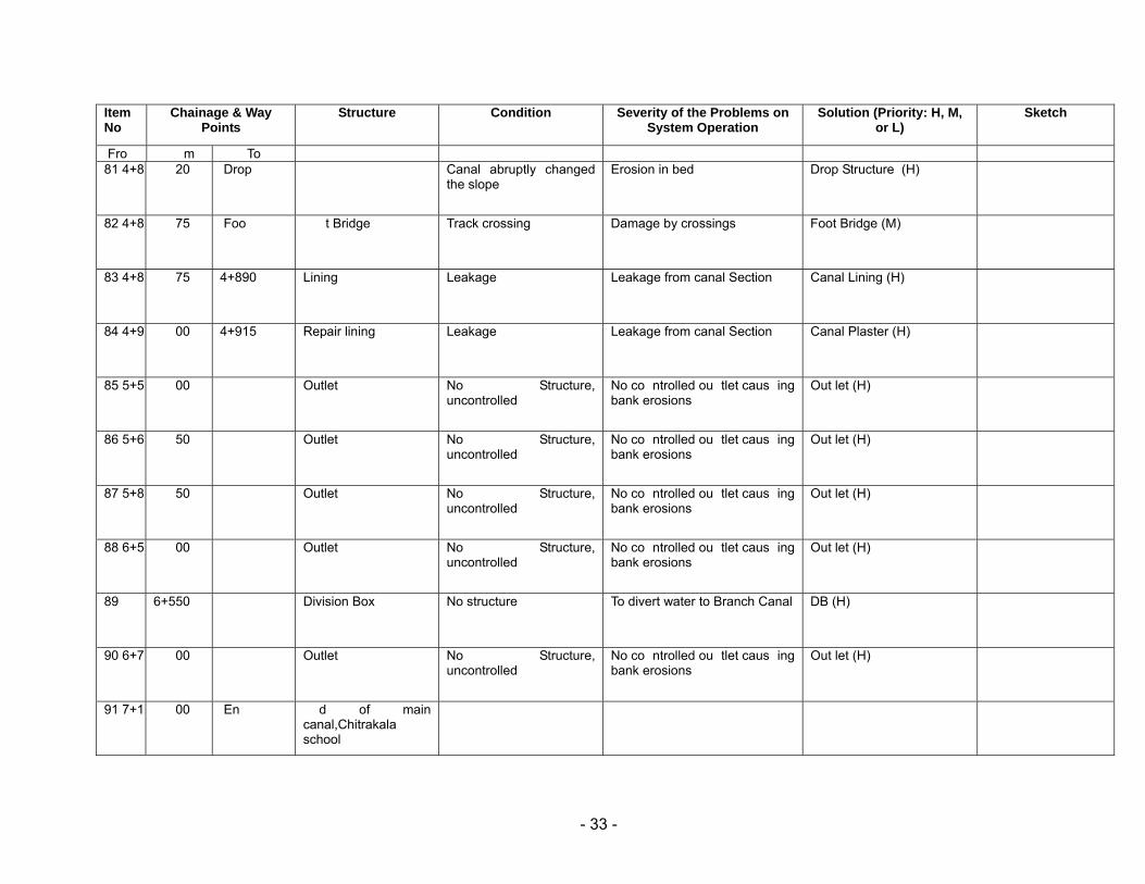
Item No
Chainage & Way Points
Structure Condition Severity of the Problems on System Operation
Solution (Priority: H, M, or L)
Sketch
Fro m To 81 4+8 20
Drop Canal abruptly changed
the slope Erosion in bed Drop Structure (H)
82 4+8 75
Foo t Bridge
Track crossing Damage by crossings Foot Bridge (M)
83 4+8 75
4+890
Lining Leakage Leakage from canal Section Canal Lining (H)
84 4+9 00
4+915
Repair lining
Leakage Leakage from canal Section Canal Plaster (H)
85 5+5 00 Outlet No Structure, uncontrolled
No co ntrolled ou tlet caus ing bank erosions
Out let (H)
86 5+6 50 Outlet No Structure, uncontrolled
No co ntrolled ou tlet caus ing bank erosions
Out let (H)
87 5+8 50 Outlet No Structure, uncontrolled
No co ntrolled ou tlet caus ing bank erosions
Out let (H)
88 6+5 00 Outlet No Structure, uncontrolled
No co ntrolled ou tlet caus ing bank erosions
Out let (H)
89 6+550 Division Box No structure To divert water to Branch Canal DB (H)
90 6+7 00 Outlet No Structure, uncontrolled
No co ntrolled ou tlet caus ing bank erosions
Out let (H)
91 7+1 00
En d of main canal,Chitrakala school
- 34 -
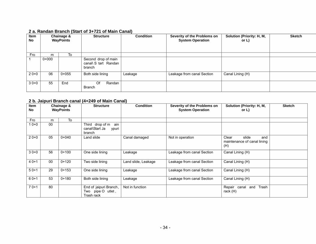
2 a. Randan Branch (Start of 3+721 of Main Canal)
2 b. Jaipuri Branch canal (4+249 of Main Canal)
Item No
Chainage & WayPoints
Structure Condition Severity of the Problems on System Operation
Solution (Priority: H, M, or L)
Sketch
Fro m To 1 0+000 Second drop of main
canal\ S tart Randan branch
2 0+0 06
0+055
Both side lining Leakage Leakage from canal Section Canal Lining (H)
3 0+0 55
End Of Randan Branch
Item No
Chainage & WayPoints
Structure Condition Severity of the Problems on System Operation
Solution (Priority: H, M, or L)
Sketch
Fro m To 1 0+0 00
Third drop of m ain
canal\Start Ja ypuri branch
2 0+0 05
0+040
Land slide Canal damaged Not in operation Clear slide and maintenance of canal lining (H)
3 0+0 56
0+100
One side lining Leakage Leakage from canal Section Canal Lining (H)
4 0+1 00
0+120
Two side lining Land slide, Leakage Leakage from canal Section Canal Lining (H)
5 0+1 29
0+153
One side lining Leakage Leakage from canal Section Canal Lining (H)
6 0+1 53
0+180
Both side lining Leakage Leakage from canal Section Canal Lining (H)
7 0+1 80
End of jaipuri Branch, Two pipe O utlet , Trash rack
Not in function Repair canal and Trash rack (H)