Embed Size (px)
Citation preview
Initial Environmental Examination Report Project Number: 33209-01June 2009
Nepal: Community -Managed Irrigated Agricultural Sector Project Sadhuwa Irrigation Subproject, Parsa District Project Proponent: Department of Irrigation Prepared by Central Irrigation Development Division No. 4 (Parsa) This Initial Environmental Examination is a document of the borrower. The views expressed herein do not necessarily represent those of ADB’s Board of Directors, Management, or staff, and may be preliminary in nature.
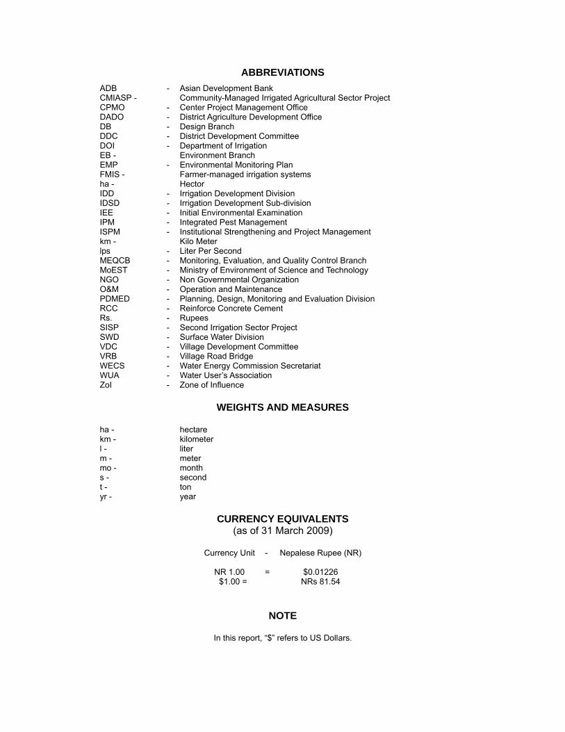
ABBREVIATIONS
ADB - Asian Development Bank CMIASP - Community-Managed Irrigated Agricultural Sector Project CPMO - Center Project Management Office DADO - District Agriculture Development Office DB - Design Branch DDC - District Development Committee DOI - Department of Irrigation EB - Environment Branch EMP - Environmental Monitoring Plan FMIS - Farmer-managed irrigation systems ha - Hector IDD - Irrigation Development Division IDSD - Irrigation Development Sub-division IEE - Initial Environmental Examination IPM - Integrated Pest Management ISPM - Institutional Strengthening and Project Management km - Kilo Meter lps - Liter Per Second MEQCB - Monitoring, Evaluation, and Quality Control Branch MoEST - Ministry of Environment of Science and Technology NGO - Non Governmental Organization O&M - Operation and Maintenance PDMED - Planning, Design, Monitoring and Evaluation Division RCC - Reinforce Concrete Cement Rs. - Rupees SISP - Second Irrigation Sector Project SWD - Surface Water Division VDC - Village Development Committee VRB - Village Road Bridge WECS - Water Energy Commission Secretariat WUA - Water User’s Association ZoI - Zone of Influence
WEIGHTS AND MEASURES
ha - hectare km - kilometer l - liter m - meter mo - month s - second t - ton yr - year
CURRENCY EQUIVALENTS
(as of 31 March 2009)
Currency Unit - Nepalese Rupee (NR)
NR 1.00 = $0.01226 $1.00 = NRs 81.54
NOTE
In this report, “$” refers to US Dollars.
GLOSSARY
Terai The southernmost strip of land in Nep al, bordered to the north b y
Himalayan foothills and to the south by the Ganges River. The area was originally covered wit h tropical vegetation, but has been almost completely converted to agricultur al product ion. The Terai is now th e breadbasket of Nepal and is covered with farms.˜
Command Area It is the agriculture or cultivable area which receives assured irrigation through canals, waters, courses, and field channels up to farmers field.
TABLE OF CONTENTS I. INTRODUCTION 1 II. DESCRIPTION OF THE SUBPROJECT 2 III. DESCRIPTION OF THE ENVIRONMENT 7
Physical Environment 7 Ecological Resources 8 Socio-economic Environment 8
IV. SCREENING OF POTENTIAL ENVIRONMENTAL IMPACTS 10 V. POTENTIAL ENVIRONMENTAL IMPACT AND MITIGATION MEASURES 14
Environmental Problem Related to Project Location 14 Environmental Problem Related to Project Design 14 Environmental Problems Related to Construction Stage: 15 Environmental Problems Resulting from Subproject Operations 17 Realization of Enhancement Potentials 18
VI. ANALYSIS OF ALTERNATIVES 19 VII. INSTITUTIONAL ARRANGEMENTS 20 VIII. ENVIRONMENTAL MANAGEMENT PLAN 22 IX. PUBLIC CONSULTATION AND DISCLOSURE 26 X. FINDINGS AND RECOMMENDATIONS 27 XI. CONCLUSION 28 Annex 1: Details of Proposed Intervention in the Subproject 29
- 1 -
I. INTRODUCTION
1. The Community-Manag ed Irrigated Agricultural Sector Pro ject is designed to improve the agricult ural product ivity and su stainability of farmer-managed irrigation systems (FMI Ss) while strengthening the policies, investment plans, and institutio ns f or irrigated agriculture , following the lessons learned during the Loa n 1437-NEP: Second Irrigation Sector Project (SISP). The Project will be located in the Easter n and Central regions o f Nepal and comprises two parts: (i) participa tory irrigated agricultur e development for FMIS; and (ii) institutional strengthening and proj ect management (ISPM). Under the first pa rt, 210 FMIS will be rehabilitated, resulti ng i n improvements in i rrigated agriculture over 34,000 he ctares (ha ) benefiting a bout 270,000 people. The second component comprises t he development an d implementation of improved institutional mechani sms for FMIS de velopment, further improved policies and regulations, strengthening of the key stakeholders agencies and their linkages.
2. An initial environmenta l examinati on (I EE) was undertaken for the core subproject s based on data collected during the Detailed Design Period. The overall objective of the IEE is to analyze the adverse environmental impacts arising from site selection, design, construction, and operation of the Project is su ch eff ect occur s and its mitigation to acceptable lev els through implementation of a se t of clearly defined and costed mitigation measures which have been included in the Project cost estimates. For each additional subpr oject, an I EE, and a n environmental impact assessment (EIA) if warranted, will be carried out in accorda nce with the Bank's guidelines and relevant government's environmental requirements during the preparation of subproject feasibility studies.
3. This Init ial Environmental Examination (IE E) Report for the Sadhuwa Irrigation Subproject has been pr epared to meet the Asia n Development Bank’s ( ADB) requirements for environmental assessment process and documentat ion prior to Subproject approval, followin g the procedu res in ADB’s Environmental Asse ssment Guidelines (2 003), and th e Project’s Environmental Assessment and Review Procedures and Arrangements.
- 2 -
II. DESCRIPTION OF THE SUBPROJECT
4. Project Location. The Sadhuwa Khola subproject is locate d in Basdilwa VDC of Parsa district of th e Central Development Region of Nepal. It is lo cated in between the latitude and longitude of 27 0 06' 58"N to 27 0 10' 0"N and 8 40 53' 15"E to 84 0 56' 41"E, respectively. The headworks lies in ward No.-1 of Basdilwa VDC. The elevation of the area is ab out 97.00 m above MSL. Its location map is shown in Figure 1.
5. Accessibility. The subproject area is easily accessible t hrough a gravel motorable road (12 km south-west from Jitpur, which is 16 km north from Birganj). Most of the main canal an d the branch canals can be approached through the existing village road. The nearest market is at Jitpur.
6. Existing Situation: The project is the rehabilitation of a FM IS off taking from Sadhuwa River. The name of the source at upstream is Amodevi River whereas downstream the source is known as Madhuwa River. The so urce is perennial fed by a number of springs lo cated in the Amodevi forest. The Sadhuwa system is provid ing irrigation facilities to areas on both sides of the river by canals offtaking from the headworks. These canals had been diverting water fro m the river for man y years by constructing earth en and brushwood bund across the river. Th e repeated co nstruction o f the headworks require s big effort s of the farmers. About 80 people work for 6 days to build the bund by engaging two tractors with trailer to carry t he soil and brushwood from the fore st located 10 km north of the headworks. It was reported that farmers had to repair the earthe n bund 3-4 t imes a year because it is breached by floods. The erosion at the headworks has made the construction of the dam more difficult every year. The system is being operated on rotation during the winter and dry season, when it is operated by the water distributor locally known as "Bhag aita". Ther e are a nu mber of ca nals offtaking from th e Sadhuwa River further downstream of the hea dworks. Each of these systems builds a dam across the river. The location of d iversion of t hese existin g systems seemed to have been planned su ch that water is available for the downstream systems. The protection of the Amodevi forest is very important and crucia l for the sustainability of the irrigation systems in the Sadhuwa River, which has been r ealized by t he farmers in the area. The forest is being managed a nd protecte d by the p eople of 14 VDCs in p artnership with district forest office named as Sabhaiya Partnership Forest Management Group.
7. The people from Basdilwa have the ir traditional water rights on the water to be diverted into the system; howe ver, farmers o f Musaili also get irrigati on water for ward No. 4 , 5, and 6 from the eastern main canal of this subproject. At the same time, Musaili People re ceive water also from the Madhuwa River Bandh. Ratanpur people do not have thei r traditional rights over the water to be diverted from the Sadhuwa Bandh (from where water used to be diverted and the site for t he proposed headworks). People fr om Basdilwa have no problem in sharing water with Musaili.
8. There are no irrigation schemes upstream from the present proposed headworks. Madhuwa e arthen Bandh is the nearest one lying at ab out 1.0 km d/s from t he proposed subproject (Sadhuwa Bandh). Madhuwa Bandh also has its command area on both sides of the river and farmers have developed irrigation canals on left and right sides of the river. At present both Sadhu wa and Madhuwa Bandh are in o peration but in very poor state both in terms of
- 3 -
intake and the conveyance structures. The complete stretch of river is contributing water in the source; hence no scarcity of water has been noticed at Madhuwa Ba ndh ISP e ven when th e Sadhuwa bandh at U/S is under full operation.
9. In general, field to field irrigation is practiced o n the basis of water a vailability in the source. On ly during water scarcity do they irrig ate their f ields by const ructing temporary field channels to minimize loss of water. Water is bei ng distributed on the basis of water availability in the source, tradition al water rights, land holding size and the level of contribution in maintenance. The ope ration and water distrib ution part is done by w ater distr ibutor, who is locally known as "Bhaga ita". 'Bhaga ita' is water distributor who controls not only the operation of intake and outlets but also does water distribution in the canal during operation and identifies damages in the system.
10. During monsoon all can als use water simultaneously. Ho wever, in lea n supply pe riod rotation is in practice. The severity of the nee d is also ke pt in view while allocat ing water t o different canals. The scarcity of water is faced normally in the months of April/May/June.
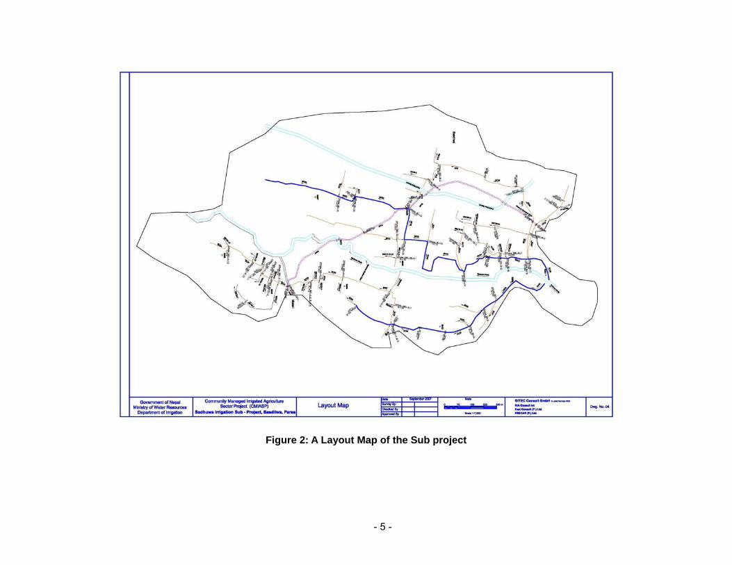
11. Command Area: The gross com mand area of the subp roject is 23 8 ha and th e net command area 202 ha. . A layout map of the sub project area is presented in Figure 2.
12. Project Components. The main objective of t he sub-project is to in crease agriculture productivity in the subpr oject area b y developing a susta inable irrigation system with a view to reduce poverty and improving the income level of small farmer’s community and at the same time creating job opportunity for the landless population.
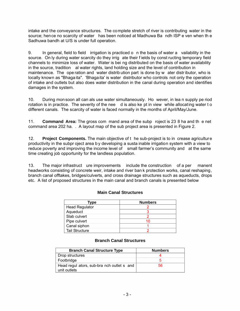
13. The major infrastruct ure improvements include the construction of a per manent headworks consisting of concrete weir, intake and river ban k protection works, canal reshaping, branch canal offtakes, bridges/culverts, and cross drainage structures such as aqueducts, drops etc. A list of proposed structures in the main canal and branch canals is presented below
Main Canal Structures
Type Numbers Head Regulator 2 Aqueduct 3 Slab culvert 2 Pipe culvert 10 Canal siphon 1 Tail Structure 2
Branch Canal Structures
Branch Canal Structure Type Numbers
Drop structures 4 Footbridge 5 Head regul ators, sub-bra nch outlet s and unit outlets
56

- 4 -
Figure 1: Location Map of the Subproject
- 5 -
Figure 2: A Layout Map of the Sub project
- 6 -
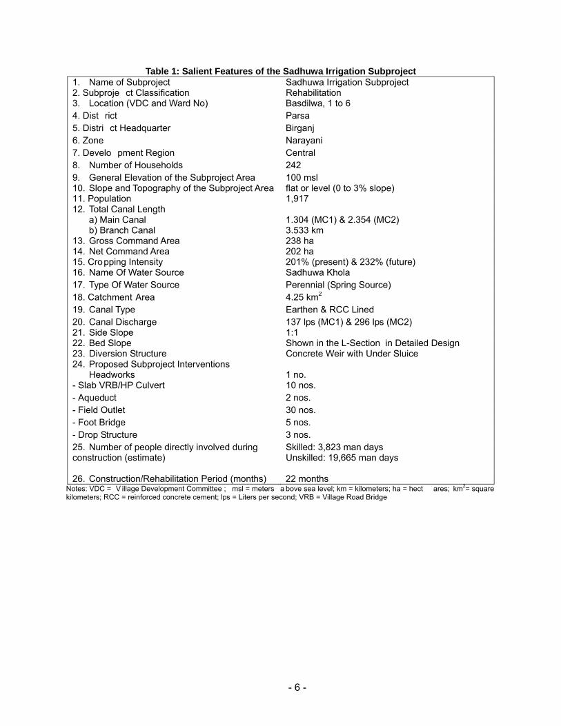
Table 1: Salient Features of the Sadhuwa Irrigation Subproject 1. Name of Subproject Sadhuwa Irrigation Subproject 2. Subproje ct Classification Rehabilitation 3. Location (VDC and Ward No) Basdilwa, 1 to 6 4. Dist rict Parsa 5. Distri ct Headquarter Birganj 6. Zone Narayani 7. Develo pment Region Central 8. Number of Households 242 9. General Elevation of the Subproject Area 100 msl 10. Slope and Topography of the Subproject Area flat or level (0 to 3% slope) 11. Population 1,917 12. Total Canal Length
a) Main Canal 1.304 (MC1) & 2.354 (MC2) b) Branch Canal 3.533 km
13. Gross Command Area 238 ha 14. Net Command Area 202 ha 15. Cropping Intensity 201% (present) & 232% (future) 16. Name Of Water Source Sadhuwa Khola 17. Type Of Water Source Perennial (Spring Source) 18. Catchment Area 4.25 km2 19. Canal Type Earthen & RCC Lined 20. Canal Discharge 137 lps (MC1) & 296 lps (MC2) 21. Side Slope 1:1 22. Bed Slope Shown in the L-Section in Detailed Design 23. Diversion Structure Concrete Weir with Under Sluice 24. Proposed Subproject Interventions
Headworks 1 no. - Slab VRB/HP Culvert 10 nos. - Aqueduct 2 nos. - Field Outlet 30 nos. - Foot Bridge 5 nos. - Drop Structure 3 nos. 25. Number of people directly involved during construction (estimate)
Skilled: 3,823 man days Unskilled: 19,665 man days
26. Construction/Rehabilitation Period (months) 22 months Notes: VDC = V illage Development Committee ; msl = meters a bove sea level; km = kilometers; ha = hect ares; km2= square kilometers; RCC = reinforced concrete cement; lps = Liters per second; VRB = Village Road Bridge
- 7 -
III. DESCRIPTION OF THE ENVIRONMENT
Physical Environment
14. Topography. The scheme is located in the Terai plains in an agricultural area with land that slopes gently from north to south at an elevation of just under 100 m above msl. The Sadhuwa Khola subpro ject command area lie s on both banks of th e Sadhuwa River. The existing main canals af ter reaching the command area tend to be contour canals with the branch can als running down the slight ridges and irrigating to both sides. The canals are earthen with little seepage loss and do not need lining.
15. Climate. The climate of the subproject area is mainly sub-tropical and humid. It has hot and humid climate during summer and moderately high rainfall during the monsoon. There is no meteorological statio n in the project area itself, however, the nearest meteorological station is at Parwa nipur (Station No: - 091 1), and is used as reference. Mea n annual rainfall – varies from 5.9 mm minimum in Nov to 4 42.7 mm maximu m in July. About 80% of the precipitation occurs in monsoon sea son from July to Sept ember. Following are some important hydro-meteorological observations:
• Mean monthly maximum temperature: varies from 21.6 oC in January to 35.6
oC in May • Mean monthly minimum temperature: varies from 8.4oC in January to 26.0 oC
in July • Minimum evaporation: 1.8 mm in January • Maximum evaporation: 6.9 mm in May
16. Soils. The subproject area has moderately drained light textured soil. Soil texture slightly varies from light to heavy silt moving across the command area f rom north to the south. The fertility status of th e soil i s fou nd to be poor to medium in major nutrients of Nitrogen, Phosphorous and Potassium and very poor to poor in organic matter content (0.0 5 to 6.3%). The soil reaction is dominantly neutral. The micro-nutrient d eficiency is generally observed for zinc in ca se of Paddy. The soil cha racteristics (texture, drainage, pH etc) are judged good for the existing and proposed crops.
17. Water Resources. The perennial Sadhuwa Khola with following flow characteristic is the main water source for t he subproject. The catchment area is rela tively small at only 4.25 km 2. The reach of the river upstream of the headworks has considerable perennial spring flow s feeding into it, providing substantia lly more water than is n ormally expected from streams with such a small cat chment area. According to th e feasibility study conducted in early 2007, the lowest mean monthly fl ow is 152 lps in the month of April while the maxi mum mean monthly flow is expected to reach 5,337 lps in the month of August.
- 8 -
Ecological Resources
18. Vegetation and Forest. There is no national forest or communit y f orest within the project command area. There are a number of trees of different sp ecies of timber, fodder, fuelwood and fruits within the project command area and homesteads but they are not going to be affected by the project activities.
19. Wildlife. As reported b y the local people, ther e are no wildlife habitat as such in the project area and its vicinity. So me jackals an d monkeys have been seen within the project command area whereas wild boar and leopard are also reported to be occasional visitors.
20. Aquatic life. Fish spe cies like Maugura, Garai, Commo n carp and Bam ha ve been reported in t he Sadhuwa River. These species are mostly local hab itat and found all along the river stretch. The fish population behind the earthen dam is reported to be quit e high. When the earthen dam is brea ched the fish catch is re ported to be quite high. It could be as high as 200 kg of different species.
Socio-economic Environment
21. Basdilwa and Musaili are the two major settlements located at the head and tail reach of the system, respectively. Basdilwa has highe r concentrat ion of indig enous Tharu1 population but they are not in cultu ral minoritie s. There ar e a larger n umber of large land holders, and therefore rich or medium farmers, in Basdilwa than in Musaili. The ultra poor a re scattered evenly in both settlements. Most of Dalit (occu pational caste groups) a re ultra poo r and vice versa.
22. The main o ccupation of people in the area is f arming. Th e sample h ousehold survey revealed that 87% of households depend on agricultur e for their livelihood. Apart fro m agriculture, 5.4% households supplement their in come from business and 7.8% by service. Most of the farmers rear ducks, goa ts and buffaloes for gett ing meat and milk, which is often also so ld in nearby markets to buy the articles of ot her primary needs. A bout 18% of households meet their needs by working as agriculture labour.
23. The labour f orce from Rich and Middle Level families is more involved in urban based business and foreign employment while those from the poor group are highly mobi le from farm to nearby urban industry. The main source of a gricultural labour for the command area is the Ultra poor group. There is sufficient labour f orce to meet the unskilled labour required for infrastructure construction. 80.5% of sample hh were found fully employed for mo re than 300 days a year, while 13.2% are unemployed.
1 ADB defines “indigenous peoples” as groups with social or cultural identities di stinct from that of
the dominant or mainstre am soci ety. “Indigenous People s” is a generi c con cept that include s cultural minorities, ethnic minorities, tribal people, natives, and aboriginals.

- 9 -
24. The education level of the community is poor. Within the command area 1 High school in Solakpur and 1 primary school each in Prasauni and Prasautipur villages were noted. School drop-out is common, e ven from the primary school located within the vi llage, to join the labour force for family support. But compared to the adjacent Upper Baugi subproject, the literacy rate of farmers of Sadhuwa was found to be much higher at 81.6%. Lit eracy was found lowest amongst Dalits. Only 2-3 women from the entire area have completed SLC level education. As expressed in the FGD, only a few daughters have studie d up to 9th grade and over 95% dropped out after gett ing married. Among the ethnic grou ps, the literacy was fou nd higher in Tharu community. On average, a household has 1.04 sch ool going fe male child a s compared to 1.67 boys.
25. 22.4% of t he househo lds own Pu cca house (cement mortared) while others h ave thatched hu ts. 34.7% h ouseholds have access to electricity. There is no communi ty drinking water supply system. T ubewells with hand pumps are the only source of drinking water. Th e population has access to primary health facilities as 1 health post is located in the ward no. 8 at Bhediyahi Tole of the VDC.
26. A majority (92%) of far mers produce enough food for the mselves. L arge farmers meet all their food requireme nt from their produce, while marginal and landless meet only 33.3% of their food requirements. Those wh o reported insufficie ncy of food me et their requirements by working within and outside the village.
27. There has been a change in the ag e of marriage in recent years. The age of marriage has in creased to 17-1 8 years unlike 12-14 a bout a de cade or two before. Most of th e communities in Terai are suffering from dowry system of marriage. It is a syste m in which a bridegrooms’ family has to offer or pay a large amount of cash or kin d to the bri de’s family during marriage. Tharu community did not have this system until a few years ago. This practice is increasingly adopted even by Tharus these days.
28. The particip ation of bot h men and women in the social a ffairs ha s b een increa sing. Women had participated in casting votes in the previous election whereas men were involved in candidacy and voting also. Jan Ja griti, Basdilwa is a loca l NGO working in the VDC. Private microfinance institutions (MFIs) like Chimeki and Swabalamban banks are other agencies active in this area. These MFIs target wo men a nd provide loan in groups and also provide opportunities for saving.
- 10 -
IV. SCREENING OF POTENTIAL ENVIRONMENTAL IMPACTS
29. Delineation of geographical boundary of zone of influence (ZoI). : The project area will be del ineated under three cate gory (i) high impact area: the per manent imp act from the project such as perman ent land loss and dewatered zone will be considered as high impact area. Such area will include the are a where the project infrastructures will be located such as headworks, canal alignment and canal structur es (ii) Moderate impact area: This will cover the area where land loss will be temporary during the construction period only. They will include camp sites, quarry sites; borrow areas, labour camp sites etc. (iii) lo w impact area: This will cover the adjoining are as within 200 to 500m (depending u pon the settlement pattern) from the boundary of the sub project area of the VDC that are likely to be affected.
30. The project will be constructing a permanent weir across the river about 2.0 m above the existing bed level of the Sadhuwa Khola, which will be inundating a small area at the upstream. Area of inundation and stability of the inundation area would be the major environmental impact under the physical parameters. The screening of the potential impacts is presented in Table 2.
Table 2: Screening of Potential Impacts SL Parameters Impact Remarks
Yes No 1 Environmental Problems due to Project Location1.1 Encroachment into Areas of Conserv ation
Significance √ There are no conserv ation a reas ( wetlands
and protected forest s) w ithin the Subproject command area
1.2 Impediments to Movement s of W ildlife, Livestock and People
√ Being an e xisting system there won’t be any additional impediments.
1.3 Encroachment on Historical and Cultural Sites √ There are no historical, cultural, and religious sites within the Subproject command area
1.4 Water Resource Conflicts √ The Subproject irrigation system is a very old farmers-managed scheme. System for water use h as b een est ablished a nd n o rec ords are ava ilable sho wing a ny ev idence of misunderstanding or conflicts among users.
1.5 Flooding and Drainage Hazards √ The can als carry the surface runof f, would require escape structure. Erosion at the out fall at the drainage.
1.6 Displacement of People and Property √ A concrete weir would inundate certain area but do not affect private property. Enlargement of can al sect ion would be required.
2 Environmental Problems related to Project Design2.1 W atershed Erosion √ The construction of perma nent headworks is
going to prevent erosio n in the vicinit y o f headworks and cultivated land.
2.2 Downstream Water Quality Problems √ The Subproj ect is a reh abilitation pr oject therefore no other water sources (e. g. groundwater) will be util ized. Therefore quality of water supply will not change
2.3 Suitability of Natural Water for Irrigation √ The water sou rces have bee n used prior to rehabilitation w orks. There w ill be no changes in water use duri ng the Subproject implementation
2.4 Over pumping of Groundwater √ Groundwater w ill not be used in this
- 11 -
SL Parameters Impact Remarks Yes No
Subproject. 2.5 Adequacy of Drainage Planning √ Some pro blems at out fall po ints. Protection
will be provided in consultation with WUA. 2.6 Disruption of Existin g F armer Coop erative
Systems √ There are n o existing farmer s’ co operatives
within the command area. 2.7 Use of C hemicals in Agriculture a nd
Horticulture √ Use of chemic al fertilizers an d pesticid es is
likely to be in creased due to the improve d irrigated agriculture practice
2.8 Selection of Pesticides √ Selection and use of pestic ides m ay b e a problem
2.9 Land Use Conflicts √ The land us e within the command area has been established prior to the implem entation of the Su bproject. No recor ds are av ailable showing mis understanding or conflicts among different land uses.
2.10 Inadequacies in Water Distribution √ Necessary improvement work in the s ystem and improved efficiency of th e canal s ystem will increase the disc harge in the c anal. Inadequacy in w ater distribution will not occur.
2.11 C anal Management √ The operation and mainten ance (O&M) of the existi ng irri gation s ystem inclu ding mai n canal has bee n in pl ace prior t o implementation of the Subpr oject. W UA so far have or ganized a nd m anaged qu ite well for O & M of this system.
2.12 Passag eways √ The existin g passageways ar e not suf ficient for movement of peopl e and livestock. The Subproject will increas e the number of crossings and passageways.
2.13 Scouri ng Hazards √ The system has been in o peration for man y years. Scouri ng pro blems has n ot bee n reported. Canal beds are stable
3 Environmental Problems Related to Construction Stage3.1 • Ex cavation √ The excav ation will be re quired at the
structure sites. Being a n e xisting can al no new excavation will be required for canal.
3.2 • Constructi on material sites (Quarry Sites)
√ The construction work will r equire 816 m 3 sand 1,5 52 m 3 of aggregates and 1,1 17 m 3
block sto ne which c an b e f ulfilled from th e local market or local qu arry. Operation of quarry site for the sub proje ct may n ot be feasible.
3.3 • Work camp location and operation √ The contractor will h ave to establish work camp for the construction activities
3.4 • Lab our camp √ Total labour requirement will be about 19,665 unskilled an d 3,823 ski lled man d ays. Assuming ac tual construc tion working season of 15 months, the avera ge la bour requirement per da y would be 44 unski lled and 8 skilled. The most of the unskilled and some of skill ed manp ower w ill b e fulfil led from the local area. Hence labour camp will not be operated. Some of the out side labour will be reside within the work camp it self.
3.5 • S tockpiling of materials √ The construction materi al will be store d at the convenient locations for the constructi on activities.
3.6 • Operation of construction equipment and √ No heav y c onstruction equi pments ar e
- 12 -
SL Parameters Impact Remarks Yes No
transport needed. Onl y small d ewatering pumps, mixers, vibrato rs, etc will be used which d o not contrib ute major air po llution. Tractors, trucks and bullock cart s would b e use d for material transportation.
3.7 • Occupational health and safety √ Occupational hea lth and safet y of the workers will be addressed.
3.8 Temporary Closure of Irrigation System √ Construction a ctivities are li kely to d isturb the suppl y of irrigation water for a short period.
4 Environmental Problems Resulting from Project Operations4.1 Effect on downstream water use √ There are number of irri gation s ystems
offtaking from Sadh uwa Khola at d/s . however ther e is plent y of water af ter diversion by Sadhuwa subproject.
4.2 Adverse soil modifications √ The proposed subproject is t he rehabilitation of the existi ng irrigation system, adverse soi l modification will not occ ur due to th e proposed subproject implementation.
4.3 Changes in groundwater hydrology √ The Subproj ect will im prove the irri gation system which w ill like ly rechar ge the groundwater tables w ithin the command area.
4.4 Mo squito Breeding √ Water pond ing within the comman d are a may lead to incre ases i n inci dence of waterborne diseases and mosquito breeding
4.5 Hazards asso ciated with the us e of toxic chemicals
√ Use of pestic ides for the p est control cou ld be hazardous to the people and live stock
4.6 Hazards asso ciated with th e use of mineral fertilizer
√ Increased use of fertilizers likel y d ue to improved irrig ation s ystem, These ma y find its ways to gro und water an d surface water which could hazardous
5 Realization of Enhancement Potentials5.1 Employment to the local people √ Construction activities will re quire
construction labors. Loca l peo ple will g et opportunity i n emplo yment. In add ition farmers have to share the co nstruction cost which will be mostly usually in terms of labor force.
5.2 Community water supply in command area √ The command area has existin g water supply sc hemes (tube wells). Cana l water i s not used for domestic purp ose and will no t be us ed as such dur ing Sub project implementation.
5.3 Aquaculture in command area √ Farmers do n ot practice aquaculture within the command area at present. However they may take up this practice after subproject.
5.4 Livelihood programs for landless households √ Construction a ctivities will re quire both skill and u nskilled laborers. The Subproject will also provi de li velihood trainings to enh ance economic conditions of landless households.
5.5 Feasib ility of cooperatives √ The Project w ill impl ement institutional development activities to strengthen capacity of water us ers associati ons which c ould function as a cooperativ e to support the farmers.
- 13 -
31. In many en vironmental assessments ther e are certain eff ects that, although they will occur durin g either the construct ion or operation stage, should be considered as impacts primarily of the locatio n or design of the proj ect, as they would not occur if an alternative location or design was chosen. The two activities in which the Subproject interact s physically with the en vironment a re during construction and operation, so these are the t wo activities which most signifi cant environmental impacts can occur. The Subproject will not cause any significant adverse environmental impacts becau se: (i) most of the indiv idual elements of the Subproject are relatively s mall and involve straightforward construction and op eration, so impacts will be mainly localized and not greatly significant; (ii) most of the predicted impacts are associated with the con struction process, and are produced because t hat process is invasive, involving trenching and other exca vation; and ( iii) mitigati on measures are devised for any negative environmental impacts.
32. These potential environmental impacts may be direct or indirect, a nd reversible or irreversible. The magnitude of the impacts may be high, medium or low and such impacts ma y be of site-specific, lo cal, regional or of national nature. Furthermore, some impa cts may be short-term, particularly related with the upgrading stage, medium-term and long-term duration.
- 14 -
V. POTENTIAL ENVIRONMENTAL IMPACT AND MITIGATION MEASURES
Environmental Problem Related to Project Location
33. Flooding and Drainage Hazards: The area is already irrigated. The water flow in the canal is unr egulated. T he excess water in the canal is overtopped from many places. T here are erosion problems at a number of places whe re the water from the agriculture land flows out into the nat ural drains. The proposed intervention will be r egulating the flow in the canal with the provision of escape structures. The propo sed project will be guiding the critical drainage outfalls by providing the outfall structures. These interventions will be positive impact of high magnitude, local extent and long term duration.
34. The escape structures will be provided at the appropriate locations so that the excess water in the canal can be discharged safely into the natural drains and a number of drainage outfall structures will be constructed in consultation with the farmers.
35. Displacement of People and Property: The proposed pond level at the headworks site is above th e field level of the surrounding land. Hence t he construction of the headworks is likely to submerge 4.1 ha of land upstream of the weir. However, the flood emba nkment will reduce the f looded area to 1.28 ha. Some of t he canal s w ill be enlarg ed or resha ped. The enlargement will be quite small not exceeding 30 cm on either side. People agreed to make the enlargement without any compens ation. This impact is considered low in mag nitude, local extent and long term duration.
36. Embankment along both river banks has been proposed to prevent water entering into the farmland.
Environmental Problem Related to Project Design
37. Watershed erosion: The construct ion of the p ermanent headworks is going to pr event the erosion in the vicinit y of the hea dworks and the erosion of the cultivated land. This is the positive impact of high magnitude, local extent and long term duration.
38. Adequacy of Drainage Planning: In general the command area is sloping from north to south and water flow is smooth. But there are some problems at the outfall p oints where erosion has been noticed. Some protection w ill be provid ed in con sultation with t he farmers. This is the positive impact of high magnitude, local extent and long term duration.
39. Use of Chemicals in Agriculture and Horticulture: The project ar ea being lo cated very close t o the big market li ke Bi rgunj, a bor der town wit h India, th e availability o f chemical fertilizers is very convenient. As reported, even the vendors bring them to farmers' door step at the comparatively lower price smuggled from India. The use of chemical fertilizers is likely to be increased a s the project encourages irrigated agricultural p ractices. Excess use of chemical fertilizers in the field may percolate i nto the grou ndwater or run down int o surface w ater along with the runoff. But the excess use of fertilizers would be very rare in practice. Considering the rareness of the occurrence, this impact has been considered of low magnitude, local extent and long term duration.
- 15 -
40. The agricultural development plan has recommended the optimum dose of required chemical fertilizers for each of the proposed crops.
41. Selection of Pesticides: Majority of farmers of the project area are aware of the toxicity of the pest icides. As reported, they hav e n ot undertaken any kind of integr ated pest management (IPM) training. Hence, farme rs need some training on integrated pest management. With this backgroun d, it could be assumed that impact asso ciated with the pesticides will be low magnitude, local in extent and long term in duration.
42. Include IPM training under agriculture development program. The cost of this training will be covered from ADP.
43. Canal Management: The proposed project in tends to operate two main canals and branch can als. The main canal will be carrying the wa ter for all the branch canals. Th e operation and maintenance of the system will be t he responsibil ity of the farmers themselves. Each of the canal system has their own canal management process, which has be en practiced for many years. But op eration and maintenance of the mai n canal will have to be worked out, which should not be a problem as they have been practicing such works for many years. Hence this impact has been considered of low magnitude, local extent and long term duration.
44. Water management plan will be developed for the operation of the system.
45. Passageway: There a re some passageways in the existing cana ls which is not adequate fo r movement of the peo ple. Hence additional passageways, 5 foot brid ges and 10 slab culvert /village road bridges have been pr oposed. This is a positive impact of hig h magnitude, local in extent and long term duration.
Environmental Problems Related to Construction Stage:
46. The Subproject will use labour-based, environment-friendly, and particip atory approach, the important features of which are:
• Use of local people as labour, hand tools and small equipment, rather than heavy machinery for construction.
• Balancing cut and fill a nd reuse of excavated materials as constru ction materials, and thus not generating excess spoils as far as possible.
• Use of bio -engineering techniques: integrated use of vegetation, simple civil engineering structures, and proper water management systems for slope protection.
47. Significant adverse negative environment al impacts are not expected during the construction stage mainly because: (i) rehabilita tion works can be const ructed without causing major disruption to irrig ation users; (ii) most construction w ill be condu cted by small teams of farmers working on sho rt lengths at a time so most impa cts will be l ocalized an d short in
- 16 -
duration; and (iii) the overall construction program will be relatively short for a project of this nature, and is expected to be completed in 18 months.
48. During the construction phase most of the potential negative environmental impacts are associated with the activities of the construction contractor(s). By i ncluding en vironmental management clause s in the individ ual contract documents, the potential for adverse impacts can be significantly reduced.
49. Excavations. Excavati on will be at the headworks and structures l ocations an d few quantities d ue to resha ping of main and bran ch cana ls. But as these are small quantity, excavation would not cause seriou s adverse e ffects that cause silt run off, induced erosion and loss of cropland and vegetation. Aft er construct ion, most of the excavated material would be reutilized in the back filling work.
50. Mitigation measures include: (i) confine operations to the dry season; (ii) use of silt traps; and (iii) spoils of any in excess shall be disposed of in locations that will not promote instability and result in destruction of property, vegetation, irrigation and drinking water supply. Disposal near wetlands, protected areas, and other areas that will inconvenience or deprive local residents of their livelihood shall not be allowed. Acidic and saline spoils shall not be spread into agricultural land.
51. Work Camp Location and Operation. Potential environmental impacts inclu de (i) temporary air and noise pollution from machine operation; (ii) water pollution from s torage and use of fuel, oils, solvents, and lubricants; (iii) unhygienic conditions from laborers.
52. Mitigation measures include: (i) The Contractor shall consult with WUA and or VDC before locating project offices, sheds, and construction plants; (ii) camps shall not be located near settlements or near drinking water supply intakes; (iii) no trees shall be cut and removal of vegetation shall be minimized; (iv) water and pit latrines facilities shall be provided for laborers; (v) used oil and lubricants shall be recovered and reused or removed from site by the Contractor; (vi) at conclusion of the Subproject, all wreckage, rubbish, or temporary works that are no longer required shall be removed or given to local residents; (vii) all temporary structures, including office buildings, shelters, and latrines shall be removed; (viii) sites shall be restored to near natural or stable conditions; (ix) exposed areas shall be planted with suitable vegetation; and (x) the Subproject proponent shall report in writing that the camp has been vacated and restored to pre-project conditions before acceptance of the works. Restoration of the work camp to its original condition will be covered from environmental management cost.
53. Stockpiling of Materials (Storage of topsoil, fill material, gravel, aggregates, and other construction materials). Potential environmental impacts include (i) silt ation and pollution o f surface water resulting from uncontrolled r unoff from storage pile s; and (ii) disturbance to private property.
54. Mitigation measures include: (i) stockpiling shall not be permitted during the rainy season unless covered by a suitable material; (ii) stripped material shall not be stored where natural drainage will be disrupted; (iii) protection of materials from erosion prior to rainy season; and (iv) storage on private property will be allowed only if written permission is obtained from the owner or authorized lessee.
- 17 -
55. Operation of construction equipment and transport: As no h eavy construction equipments are needed, the subproject activit ies will not contribute major air p ollution and excessive noise. However airborne dust p articles du e to const ruction materials durin g transportation and stockpiling may result in d eposition a nd possib le damage to vegetation, crops, and water resources.
56. Mitigation measures include: (i) stockpiled sand and soil shall be slightly wetted before loading particularly in windy conditions; (ii) vehicles transporting sand and soil shall be covered with a tarpaulin; and (iii) limit and control working practices through contract provisions such as: (a) avoid noise-generating activities at night; (b) consult with local community to inform them of the nature, duration, and likely effects of the construction work; (c) schedule work during dry season
57. Occupational health and safety: In the con struction sites, there will b e movement of local peoples. Despite precautions, possibility of accidents could not be ruled out completely as many types of equipment will be under operation. Hence, construct ion activitie s may pose safety concern to local peoples as well as workers. Although the health and safety will be major concern during the construction sta ge, magnitude of the i mpacts has been evalu ated as low since provision of health and safety measures are ma ndatory in any of the constructio n contracts and due to small scale of construction. The extent will be site specific and duration will be of short term.
58. Accidental insurance will be covered for all con struction workers and staff. An amount of Rs. 52,000.00 has bee n allocated for the buying the accident insura nce policy of the worker s. This cost sh all be covered from the environmental management cost. In order to minimize the unwanted accidents and possible effects of dust and gaseous emission to construction workers, the project will ensure adequate safety meas ures such a s provision of helmets, masks, ear plugs, road signs, war ning signa ls etc. The p rovision of t he safety gears also w ill be borne environmental management cost.
59. Temporary closure of irrigation system. The construction activity in the canal system is likely to disturb the supply of the irrigation water for a relatively short period.
60. Mitigation Measures: The construction activities will be planned in consultation with the WUA members. The headworks construction will be carried out during the dry season and the alternative measures will be made to keep the canal in running conditions if the construction activities will be carried out during the canal operation time. Flexible hosing and/or diversion canals will be used to supply water to affected users. Cost of alternative arrangement for supplying the water will be part of the civil construction cost.
Environmental Problems Resulting from Subproject Operations
61. Changes in Groundwater Hydrology. The application of the irrigation water in the field is likely to r echarge the groundwater of the subproject area vicinity an d the groun dwater table will rise in general. But any substantial change i n groundwater hydrology is unlikely due to the proposed project becau se the subproject area is already re ceiving the irrigation water. The

- 18 -
proposed subproject is rehabilitatio n only. Hence the imp act is consi dered of low magnitude, local in extent and long term in duration.
62. Mosquito Breeding. In an irrigation project, the water is flo oded in the field especially during the monsoon season, which could be the breeding ground for t he mosquito, a carrier of diseases. But the proposed subp roject is the rehabilitatio n of the exi sting irrigati on system, which is alr eady in operation. The proposed subproject is not going to have any additional effect on the environment. Hence the impact is considered of low magnitude, local in extent and long term in duration.
63. Hazards associated with the Use of Toxic Chemicals. Pesticides are toxic chemicals that would be used in th e agricultural crops whenever crops are infeste d by the insects. From the focused group discussion with the farmers, they see med to be aware of the t oxicity of th e pesticides. As reported the farmers bury the pesticide s bottles after use . They are not reused for any purpose. A nu mber of farmers r eported having u ndergone th e IPM (integrated pest management) training in which the farmers are trained in pe st management without the use of pesticides. With this background, it cou ld b e assumed that impact asso ciated with the pesticides (toxic chemicals) will be of low magnitude, local in extent and long term in duration.
64. Hazards associated with the Use of Mineral Fertilizer. The farmers have been using chemical fertilizers in the crops. Bu t the quantity of usage i s less than the recommended dose for the crops. The subproject intends to carry out training in the crops cultivation to increase the crops yield. Hence the use of che mical fertilizers is going to be increased with the subproject implementation. But given the proper training programs, the applicatio n dose will be optimum for the crops and it would not create any hazard as such. Hence the impact is considered of low magnitude, local in extent and long term in duration.
Realization of Enhancement Potentials
65. Employment Opportunity to the Local People. The construction o f the subproject would require both skil led and unskil led labour. Semi skilled and unskil led labours are available in the subproject area as well as its vicinity. The sub project would provide employment opportunity to the local people. In addition, th e farmers will have to make their contribution, which could be in kind and ca sh. The farmers preferred to make co ntribution b y providin g labour.
66. Livelihood Programs for Landless Households. There are 193 ultr a poor/landless households in the subproject area who work as tenants for other households who own the land. The proposed subproje ct intends t o enhance t he economic condit ion of these ho useholds by implementing different livelihood programs.
67. Feasibility of Cooperatives. The existing irr igation system is bein g operated and maintained by the water users asso ciation. They have defined rules and regulations, which are followed by all the members. The rules and regulations ar e socially binding. The proposed CMIASP intends to implement a nu mber of inst itutional development activities in str engthening capacities o f the WUAs in agricultu ral production, and poverty alleviation of the pr oject area. The WUA will have the key role to play in these activities. For the pro ject implementation, a coordination committee is planned to be formed. The WUA could also function as the
- 19 -
cooperatives to support the farmers in terms of making timely availability of agricultural inputs, marketing of the agricultural production, facilitating the micro credits.
VI. ANALYSIS OF ALTERNATIVES
68. Since the proposed su bproject is an existing FMIS, there is no othe r option for the headworks site and canal alignment. There were options of the type of headworks and lining of the canal. A concrete weir has be en propose d in con sultation with t he WUA members and canal lining has not been proposed as surface o f the canal is stable and seepage loss through canal is negligible.
- 20 -
VII. INSTITUTIONAL ARRANGEMENTS
69. Institutional requirements. Nepal has an esta blished lega l and policy framework for environmental safeguarding in relation to projects . Environmental protection is overseen by th e Ministry of Environmen t, Science a nd Technology (MoEST). It holds overall responsibility for environmental policy. The principal legislatio n for enviro nmental safeguarding is the 1997 Environmental Protection Act (EPA) and its rules 1997, amended in 1999 and amendmen t 2008. Implementation of the EPA is the responsibility of the MoEST and the sectoral ministries. For those pr ojects having insignificant environmental impact s, the re sponsibility of u ndertaking and approving IEEs and implementing the subsequent environmental monitoring plan (EMP) are delegated t o the conce rned sector al ministries. The DOI is under the MOW R. Both DOI an d MOWR ha ve environmental sectio ns that liaise with each other. The Environ mental Section within DOI was established in 1988 and is located within the Surface Water Irrigation Division (SWID).
70. The revised Schedule 1 of Sect ion 2 of t he EPR stipulates the environme ntal assessment requirements for irrigation sche mes. It stipulates tha t an in itial e nvironmental examination (IEEs) is required for the rehabilitation of irr igation sch emes which has new headworks or change in the main canal alignment. Since the proposed sub project is a simple rehabilitation of the existing FMIS, a formal IEE in accord ance with EPR amend ment 2008 will not be required.
71. Institutional arrangements and responsibilities. At the DOI headq uarters level, a central project management office (CPMO) ha s been set up with class-I engineer as full time project director, and will be responsible for overall environmental management, under technical support and guidance from En vironmental Se ction in SWID. At the regional level, regiona l project sup port unit (RPSU) has been established with director of the Regional Irrigation Directorate as project manager of each re gion and will be responsible fo r day-to-day implementation of the Project. RPSU will have an assign ed staff to manage environmental activities with the assist ance of the consultant s. At the field level, subproject management unit (SMU) has been established in ea ch division headed by the chief of t he irrigation development division/ subdivision (IDD/IDSD), which will u ndertake field operations including environmental planning and monitoring under supervision by RPSU. Specific institutional responsibilities during the subproject implementation cycle are stipulated as below.
Table 3: Institutional Responsibilities for Environmental Management Subproject Stage Responsible Organization Responsibilities
Overall ISPM Consultants Support capacity development of environmental planning, monitoring, and management
EB is SWID Guidance for environmental planning, monitoring, and mitigation
MEQCB in PDMED Management of monitoring and evaluation data Screening RPSU/SMU Screen the project results in light of
environmental and other criteris Planning RPSU/SMU/firms 2 Prepare IEE (included in SIP), minimize
avoidable losses, incorporate mitigation measures, and prepare EMP
CPMO-EB in SWD Endorse IEE and SIPSubproject Appraisal Subcommittee Approve IEE and SIP Ministry of Water Resources Approve IEE (which fall under schedule 1,
- 21 -
section 2 of EPR 1997, amendment, 2008) WUA formation RPSU/SMU/NGOs/COs Strengthen WUA including monitoring capacities Detailed Design RPSU/SMU/firms Assist in preparing RP, incorporate EMP into
engineering design and specifications Construction Contractor Implement required environmental measures
RPSU/SMU/firms Supervise contractor implementation of environmental measures
Agriculture and social support
RPSU/SMU/firms/NGOs Implement specific environmental mitigation measures incorporated in the agriculture and social development plan.
Operational DOI provide budget to undertake annual monitoring and audit
RPSU/SMU/NGOs (during Project) Carry-out annual performance audit of completed schemes. Support additional mitigation measures as necessary.
RID/IDD/IDSD/DDC/DADO (after Project)
Same as above
WUAs Monitor agriculture practice and impacts and report them to SMU.
Notes: DB=Design Branch; EB=Environmental Branch; MEQCB=Monitoring, Evaluation, and Quality Control Branch; PDMED=Planning, Design, Monitoring and Evaluation Division; SWD=Surface Water Division

- 22 -
VIII. ENVIRONMENTAL MANAGEMENT PLAN
72. The Enviro nmental Ma nagement Plan (EMP) is prepared to guide implementati on of mitigation measures and monitoring require ments. It includes institution and their roles, environmental management activities, environm ental management organizational stru cture and budget for mitigation measures.
73. Essentially, it will be put into operation through data collection at subproject level by SMU with the engage ment of private firms as nece ssary and/or WUA, moni tored and supervised by RPSU through regular management review and f ield confir mation, and processing and analysis by Monitoring and Evaluation Branch of DOI in coordination with DOA. Environmental data will be shared with En vironment Di vision. Monitoring costs have been incorporated into the de sign of the PPME system for the project. The findings of th e monitoring activities will be incorporated in t he regular PPME reports prepare d by CPMO with the assistance of the consultants engaged under institu tional stren gthening and project management, and submitted to ADB.
74. Framework for implementing environmental management plan is shown by Table 4.
- 23 -
Table 4: Environmental Management Plan
Sl
Impact Mitigation Measures Location Method Cost Responsible agencies for Implementation
Monitoring parameters
Responsible Agency for Monitoring
1 Environmental Problem due project location
Displacement of Peo ple and Property
Affected households have agreed to give away the l and without any compensation.
Design Office
MOU agreement No cost SMU
MOU Agreement
ISPMC
F looding and drainage hazards
Provide escape structures Design Office
Include i n det. design
No cost Design team
provide e scape structures in the design
ISPMC
2 Environmental Problem related to project design Watershed erosion Provide permanent headworks Design
Office Include i n det. design
No cost Design team
provision of permanent headworks
ISPMC
Canal management Prepare s ub project sp ecific water management plan and O & M Plan.
Design Office
included in det. design
No cost Design team
Prepare si te specific w ater management plan
ISPMC
Passageway P rovide passageway structures Design Office
Include i n det. design
No cost Design team
provide passage as agreed with the farmers
ISPMC
H azards associated with the use of toxic chemicals
Avoid u sing pesticide t o t he extent possible. Use I PM technique to control pest
Design Office
Include i n Agriculture Development Plan.
No cost Design team
Include I PM training package in A griculture Development Plan (ADP)
ISPMC
3 Environmental Problem related to construction stage Excavation (i)confine ope rations in th e dry
season; (ii) u se of s ilt t raps; (iii) spoils sh all be di sposed of a t t he designated locations
Within t he sub-project
designate t he spoil dis posal area
Part of civi l construction cost
Imp: Contractor Mon: SMU/WUA
spoil d isposal sites
SMU/WUA
Qua rry sites Work Camp Location and
Operation: (i) te mporary air and noise pollution from machine op eration; (ii ) water po llution from storage and us e of fuel,
(i) work camp w ill be located away from the settlement ar ea. (i i) n o trees sh all be c ut a nd removal o f vegetation s hall b e minimized (iii) used oi l and l ubricants s hall be recovered and reus ed or rem oved
Within t he sub-project
Part of civi l construction cost
Contractor
Location of the work camp
SMU/WUA
- 24 -
Table 4: Environmental Management Plan
Sl
Impact Mitigation Measures Location Method Cost Responsible agencies for Implementation
Monitoring parameters
Responsible Agency for Monitoring
oils, s olvents, an d lubricants; (ii i) unh ygienic conditions from laborers.
from site.
(iv) will make own arrangements for water and sanitation
Work camp Included in environmental cost (Budget: Rs 30,000.00)
Imp: Contractor
disposal a nd sanitary facilities in t he work camp
SMU/WUA
(v) S ite will be placed b ack in the original site c ondition and shall report in writing t hat site has been restored t o p re-project conditions before acceptance of the works.
Within t he sub-project
I ncluded in environmental cost (B udget : Rs, 30,000.00)
Imp: Contractor
Condition of t he work camp site before the issue of c ompletion certificate
SMU
Stockpiling of Materials : (i) s iltation and pollution of surface w ater resulting from unc ontrolled runoff from s torage pi les; and (ii ) disturbance to priv ate property.
(i) stockpiling wi ll not be permitted during t he rainy se ason unless covered b y a suitable material; (ii) stripped m aterial will not b e st ored where nat ural drai nage will be disrupted; (iii) p rotection o f materials from erosion prior to rainy season; and (iv ) s torage on private property will b e a llowed only with the w ritten permission from the owner.
Construction sites
ensure go od construction practice
Part of civi l construction cost
Imp: Contractor
Inspection of the construction material stocking site.
SMU/WUA
Operation of construction equipment and transport : em ission of air p ollutants, hi gh concentration of air borne dust res ulting and excessive n oise res ulting annoyance an d potential hazard t o human populations
(i) Stockpiled sand and soil shall be slightly wetted b efore loa ding particularly in wi ndy c onditions; ( ii) vehicles transporting s and a nd s oil shall b e c overed with a tarpaulin; and (iii) l imit and c ontrol working practices th rough contract provisions.
Construction site
ensure go od construction practice
Part of civi l construction cost
Imp: Contractor
SM U/WUA
Oc cupational health and safety
(i) Bu y accident in surance to al l workers. (i i) provide s afety g ears
Construction site
Provide insurance &
Included in environmental
Imp: Contractor
insurance policy Mon: SMU/WUA
- 25 -
Table 4: Environmental Management Plan
Sl
Impact Mitigation Measures Location Method Cost Responsible agencies for Implementation
Monitoring parameters
Responsible Agency for Monitoring
such hel mets, boo ts, ear plug, mouth m ask t o t he worker and labours
safety gears cost (Budget Rs. 52,000.00)
T emporary closure of irrigation system
Plan the he ad work co nstruction during dry season
Head works No cost Imp: Contractor
Construction plan
Mon: SMU/WUA
Make a lternative arr angement t o keep the canal running
Canals Part o f c ivil construction cost
Imp: Contractor
Enquiry o n canal closure
Mon: SMU/WUA
Environmental Problems Resulting from Project Operations H azards associated with
the use of toxic chemicals Avoid u sing pesticide t o t he extent possible. Use I PM technique to control pest
Command area
Pest co ntrol by IPM
No cost Imp: Farmers
Use o f pesticide in the crops
Mon: DADO
H azards associated with the use of mineral fertilizer
Use re commended dos e of inorganic fertilizers
Command area
Application o f fertilizers
No cost Imp: Farmers
Use of chemical fertilizer in the crops
Mon: DADO
Realization of Enhancement Potentials Employment t o t he l ocal
people Provide employment to local people in priority
Within S ub project area
Hire local labour to t he ex tent possible
No cost Imp: Contractor
Payroll of contractor
Mon: WUA
Livelihood pr ograms for landless households
Provide Live lihood enhancement Program (LEP) trai ning t o t he targeted people
Within s ub project area
Training I nclude in LEP cost
Imp: SMU
Training on LEP Mon: WUA
F easibility of cooperatives Provide institutional development training
Within s ub project area
Training I nclude in Institutional development plan cost.
Imp: SMU
Training o n Institutional development training
Mon: WUA
- 26 -
IX. PUBLIC CONSULTATION AND DISCLOSURE
75. This IEE re port has be en in close consultation with WUA members a nd lead far mers who participated in the walk through survey. The walk through survey was carried out from 7th
to 10th
February 2009. Th e existing situation of t he headworks and can al was noted by GPs tracking. A long list of the required intervention was noted. The required inter vention was prioritized i n c onsultation wi th t he pa rticipating fa rmer. On 1 0th Februar y, 2009 itse lf a formal meeting was held with t he WUA me mbers and agreed with them on the proposed intervention that could b e under taken by the project. All th e highly prioritized interventions were included whereas the medium and low priority interventions were excluded.
76. A list of the WUA members is presented here below:
S. N. Name Designation Village 1 Mr Dharmendra Pd. Tharu Chairman Basdilwa-2 2 Harendra Pd. yadav Vice-Chairman Musaili-6 3 Devpoojan Pd Gauro Secratory Basdilwa-1 4 Mr Tulasi Pd Mahato Treasurer Basdilwa-1 5 Mr Shyam Babu yadav Member Musaili-6 6 Mr Indradev Mahato Tharu Member Basdilwa-1 7 Mr Dev Bahadur Safi Member Basdilwa-1 8 Mr Ramoon Ram Member Basdilwa-3 9 Ms Ram Dulari Devi Member Musaili-5
10 Ms Sunar Bati Devi Member Basdilwa-5 11 Ms Panchiya Devi Member Musaili-6
- 27 -
X. FINDINGS AND RECOMMENDATIONS
77. The princip al findings are that the Subproj ect provides for inherently environme ntally friendly irrigation interventions and contributes to significantly improved living conditions through (i) communi ty e mphasis on subproject desig n and implementation, (ii) extensive technical support in e liciting sustainable practices in irri gated agriculture and (iii) a ddressing institutional needs for sustained and equitable O&M.
78. The identifi ed adverse environme ntal impacts will be addressed through pr oper planning, design, implementation, and O&M while incorpor ating identified mitigation measures. The screen ing process carried out in the IE E has not identified a ny significa nt negative environmental impacts like ly to be caused by the P roject. Environmental issues were considered throughout development of the Project and nece ssary changes were ma de to the designs to r educe or a void impacts. Potentia l negative impacts associated with constru ction activities can be mitigated by the application of standard health, saf ety, and environmental clauses in contract do cuments, close supervision, and close attention to transparency in tendering, and to quality control and supervision on site. Mitigation measures for oth er impacts are provided in detail in the IEE.
- 28 -
XI. CONCLUSION
79. The project is not expected to give ri se to any significant negative environmental impacts, and therefore does not require an ADB Environmental Impact Assessment.
80. The proposed subproject is rehabilitation of existing irrigation system, which is already in operation. Hence, the e nvironmental impact dur ing the oper ation phase will not be very much different than the existing situation. Rather the existing system lacks basic structures like intake, cross drains, the proposed intervention will be providing basic civil engineering structures for the operation of the canal. From the proposed intervention some adverse impacts of low magnitude have been identified during the construction stage but they are of short-term duration and could be easily mitigated. Th e proposed intervention will provide round ye ar irrigation to the entir e command a rea Taking into consider ation the adverse impac t of low magnitude and extensive positive impacts, this subproject is recomme nded for imp lementation on the en vironmental perspectives. Mitigatio n of minor adverse environmental impacts ca n be carrie d out as an integral part of the Subproject, during both the detailed d esign and implementati on stages. Appropriate measures will be included in the tender documents for the civil works.

- 29 -
ANNEX 1: DETAILS OF PROPOSED INTERVENTION IN THE SUBPROJECT
A. Main Canal 1
Item No
Chainage & WayPoints
Structure Condition Severity of the Problems on System Operation
Solution (Priority: H, M, or L)
Sketch
Fro m To 1 0+0 00
Hea dworks
2 0+0 26
VRB (5M) Road cross es the canal
Road Crossing VRB (H)
3 0+7 79
VRB (5M)
Road cross es the canal
Road Crossing VRB (H)
4 1+0 54
Start of Main canal 2
5 1+2 06
Existing Canal End
6 1+2 83
Bra nch Canal
Diversion for command area
Fulfill demand of Command area
Branch L/S
7 1+7 48
Branch Canal Diversion for command area
Fulfill demand of Command area
Branch L/S
9 2+5 48
Pipe Culvert (5m)
Road Cross es th e Canal
Road Crossing Pipe Culvert (5m)
10 2+9 98
Pipe Culvert ( Existing)
Road Cross es th e Canal
Road Crossing Pipe Culvert
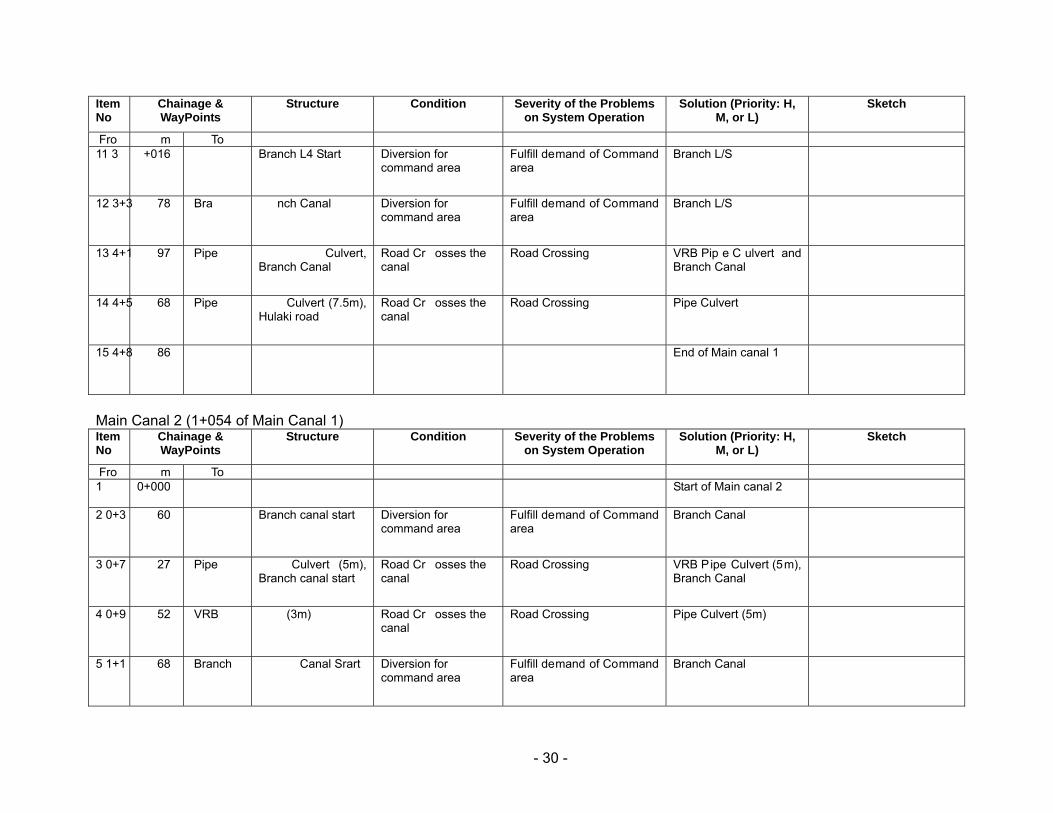
- 30 -
Main Canal 2 (1+054 of Main Canal 1)
Item No
Chainage & WayPoints
Structure Condition Severity of the Problems on System Operation
Solution (Priority: H, M, or L)
Sketch
Fro m To 11 3 +016
Branch L4 Start
Diversion for command area
Fulfill demand of Command area
Branch L/S
12 3+3 78
Bra nch Canal
Diversion for command area
Fulfill demand of Command area
Branch L/S
13 4+1 97
Pipe Culvert, Branch Canal
Road Cr osses the canal
Road Crossing VRB Pip e C ulvert and Branch Canal
14 4+5 68
Pipe Culvert (7.5m), Hulaki road
Road Cr osses the canal
Road Crossing Pipe Culvert
15 4+8 86
End of Main canal 1
Item No
Chainage & WayPoints
Structure Condition Severity of the Problems on System Operation
Solution (Priority: H, M, or L)
Sketch
Fro m To 1 0+000 Start of Main canal 2
2 0+3 60
Branch canal start
Diversion for command area
Fulfill demand of Command area
Branch Canal
3 0+7 27
Pipe Culvert (5m), Branch canal start
Road Cr osses the canal
Road Crossing VRB Pipe Culvert (5m), Branch Canal
4 0+9 52
VRB (3m)
Road Cr osses the canal
Road Crossing Pipe Culvert (5m)
5 1+1 68
Branch Canal Srart
Diversion for command area
Fulfill demand of Command area
Branch Canal
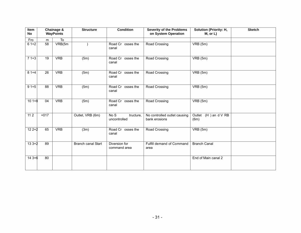
- 31 -
Item No
Chainage & WayPoints
Structure Condition Severity of the Problems on System Operation
Solution (Priority: H, M, or L)
Sketch
Fro m To 6 1+2 58
VRB(5m )
Road Cr osses the canal
Road Crossing VRB (5m)
7 1+3 19
VRB (5m)
Road Cr osses the canal
Road Crossing VRB (5m)
8 1+4 26
VRB (5m)
Road Cr osses the canal
Road Crossing VRB (5m)
9 1+5 88
VRB (5m)
Road Cr osses the canal
Road Crossing VRB (5m)
10 1+8 04
VRB (5m)
Road Cr osses the canal
Road Crossing VRB (5m)
11 2 +017
Outlet, VRB (6m)
No S tructure, uncontrolled
No controlled outlet causing bank erosions
Outlet (H ) an d V RB (6m)
12 2+2 65
VRB (3m)
Road Cr osses the canal
Road Crossing VRB (5m)
13 3+2 89
Branch canal Start
Diversion for command area
Fulfill demand of Command area
Branch Canal
14 3+6 80
End of Main canal 2