Embed Size (px)
Citation preview
Proceedings, 6th International Conference on Cartography and GIS, 13-17 June 2016, Albena, Bulgaria
ISSN: 1314-0604, Eds: Bandrova T., Konecny M.
343
COMPARISON OF METHODS FOR GEOREFERENCING OF
MULTIPLE SHEETS MAP SERIE – MÜLLER'S MAP OF
MORAVIA
Jakub Havlicek
Ing. Jakub Havlicek;
Department of Geomatics, Faculty of Civil Engineering;
Thakurova 7, 166 29 Praha 6, Czech Republic;
+420 728 613 633, [email protected];
Abstract
The paper addresses a problematic aspect encountered during the georeferencing of old maps, namely georeferencing
of multiple sheet map series. Currently, there are several methods available for the georeferencing of multiple sheet
map series. Each method has its specificities and can be used in different cases. The paper describes and compares two
methods. The simplest option is to merge the map sheets into one unit and successively georeference the entire map
series. The second compared method is based on the adjustment with conditions. Each map sheet is georeferenced
separately and conditions are added for the transformation to guarantee that the corners of adjoining map sheets fit.
The comparison of the above examples was performed for Müller’s Map of Moravia. In particular, the results of global
transformation methods were compared – affine transformation and second-order polynomial transformation.
Keywords: georeferencing, conditional adjustment calculation, transformation, Müller’s map of Moravia.
PROBLEMATIC ASPECTS IN GEOREFERENCING
The georeferencing of old maps is a process consisting of a series of individual acts. Not much emphasis is often put on
georeferencing during the map digitising process, and georeferencing itself is affected with numerous errors. Frequent
errors arising in georeferencing are pointed out by Baiocchi and Lelo (2010). The process of georeferencing old maps is
described by Podobnikar (2010) and Molnar, Podobnikar and Timar (2009).
If we want to georeference an old map, first we must scan it. Scanning is performed on large-format calibrated scanners.
A map is usually scanned with a resolution of 400 DPI. Higher resolutions than that mostly only increase the volume of
data. The risk associated with the choice of a lower resolution, on the contrary, is losing map details. In the case of a
resolution of 400 DPI, the size of one pixel is approximately 0.06 mm, and with regard to the minimum width of a line
on the map of 0.1 mm, this resolution is sufficient.
The following step is to locate the scanned map into a coordinate reference system. This step is called georeferencing.
The georeferencing of maps is mentioned by Zlinszky and Molnar (2009). Ground control points are identified on the
scanned map for which coordinates in the local map system (usually pixel coordinate system) and in the respective
coordinate reference system are available. It is of utmost importance in georeferencing to read the coordinates of ground
control points from the same, or a very similar cartographic projection. The original scanned map is always made in
some cartographic projection, and the coordinates identified on the background map should be in the same (or a very
similar) cartographic projection. Cartographic projections with respect to georeferencing were studied in more detail by
Havlicek and Cajthaml (2014 and 2015a), Bayer (2009 and 2009a) and Boutoura and Livieratos (2006).
After getting information on a map and determining ground control points (Havlicek and Cajthaml 2014a), the next
important step is to choose the type of transformation method and the very type of transformation. There are two types
of transformation methods used in practice. The first group are global transformation methods by means of which one
transformation key is calculated from all ground control points using the Least Squares Method. This key, in turn, is
applied to the whole area covered by the map, and, therefore, ground control points do not have their own position in
the final result as some deviations arise at these points in the case of redundant ground control points. The second group
of used transformation methods are local methods. A unique transformation key is calculated for each point on the map.
Ground control points have their own position in the final result of this method. A major drawback is that in the case of
a wrongly determined ground control point this point cannot be identified, and a relatively large map distortion arises in
Proceedings, 6th International Conference on Cartography and GIS, 13-17 June 2016, Albena, Bulgaria
ISSN: 1314-0604, Eds: Bandrova T., Konecny M.
344
its vicinity. Identification of a wrongly assigned ground control points were studied in more detail by Havlíček and
Cajthaml (2015).
The following step usually involves saving information on georeferencing. Currently, there are three saving options
used. The first is creating a world file where information is stored in an auxiliary file to a raster file by means of six
numbers – the pixel size in the x and y axis, the rotation about the x and y axes, and the coordinates of the upper left
corner of the raster. The drawback of this type of saving is that only global transformation methods, namely identity,
similarity and affinity transformation, can be saved within these six values. If higher order polynomial transformations
or local transformation methods are used, the results can no longer be saved in six unknown parameters. Another option
is to save information in an XML file where data on the coordinate reference system, ground control points,
transformation type, etc. are also saved. This type of saving is the best considering the future use. Unfortunately, there
is currently no single XML available for different geographical information programmes, and e.g. the ESRI Company
uses its own AUX.XML file. The third option is resampling the georeferenced raster. A new raster arises in this case
which always has a worse resolution than the original as the pixel values are derived from the surrounding pixels using
a variety of methods. The drawback of this option is the loss of information on ground control points. For more details
on the possibilities of saving the results of georeferencing, consult publications by Cajthaml (2007 and 2012).
The georeferencing of multiple sheet map series represents a special issue. The following three methods are presently
most commonly used for this purpose. In the first method, the map sheets are first merged and the map series is
subsequently georeferenced as a whole. The second method is the conditional, so-called “Cajthaml’s”, method
(Cajthaml 2007 and 2012), based on the adjustment of each map sheet separately with predefined constraints to ensure
the identity of the corners and edges of map sheets. The last method is splicing where a map sheet is adjusted to its
precise size and the map content is then transformed using the TPS method (Cada 2003).
COMPARISON OF METHODS IN GEOREFERENCING A MULTIPLE SHEEP MAP SERIES
The georeferencing of multiple sheet map series is one of problematic aspects. The following three methods are
presently most commonly used for this purpose:
method of merging map sheets into one image first and its subsequent georeferencing,
method of adjustment with conditions where edge matching constraints of adjustment into identical
coordinates are added into transformation equations,
splicing method where a map sheet is adjusted to the precise coordinates of the map frame and the map content
is subsequently transformed using the TPS method.
The splicing method has already been described in a habilitation dissertation of Cada (2003). In the first and the second
method, we do not need to know the precise size and pattern of the map frame. These two methods are applied to
Müller’s Map of Moravia. The result is the comparison of the georeferencing of this multiple sheet map series using
two most frequently applied global transformation methods – the affine transformation and second-order polynomial
transformation.
Method of merging map sheets into one image first and its subsequent georeferencing
This method assumes that at least partial information about the map sheet is available, such as the approximate size of
print matrixes for individual map sheets. Based on these dimensions, a transformation grid is prepared into which the
individual map sheets are transformed. The affine transformation is used for locating as scanned maps have a different
longitudinal and transverse map distortion.
After the grid has been created, the whole raster may be generated by joining individual map sheets into a single map
drawing. Alternatively, each map sheet may be transformed separately in the case that it is located in the local system of
the map series. The global transformation key is then applied to the merged raster of the map series, or individually to
all map sheets.
In the case of a map series composed of a large number of map sheets, it is very likely that the resulting raster will
contain a large amount of data. Working with such a raster is both labour and time consuming.
In the case that a large number of control points (1000 and more) is available, the GIS programme very often computes
the adjustment of one control point after another and the whole computation is very lengthy because of the high
demands for PC hardware. In the case that we want to use global transformation methods, it is advisable to compute the
transformation coefficients in an external mathematical programme (such as AllTran (2009), or to write one’s own
Proceedings, 6th International Conference on Cartography and GIS, 13-17 June 2016, Albena, Bulgaria
ISSN: 1314-0604, Eds: Bandrova T., Konecny M.
345
source code – Matlab, R-project). These coefficients may be applied to a minimum number of control points. For the
affine transformation, three control points are necessary, while the second-order polynomial transformation needs six
control points. The transformation key is then used for all map sheets using only the points identified in the above way.
A continuous georeferenced map drawing in a given reference coordinate system is finally produced.
Method of adjustment with conditions where the constraint of corner adjustment into identical
coordinates is added in transformation equations
This method was invented and applied in the source code by Cajthaml (2012). The method is based on the principle that
each map sheet is adjusted by means of a defined transformation (up to now, this method works for the affine and
second-order polynomial transformation) with the condition that the coordinates of the corners and edges between
adjacent map sheets must be identical.
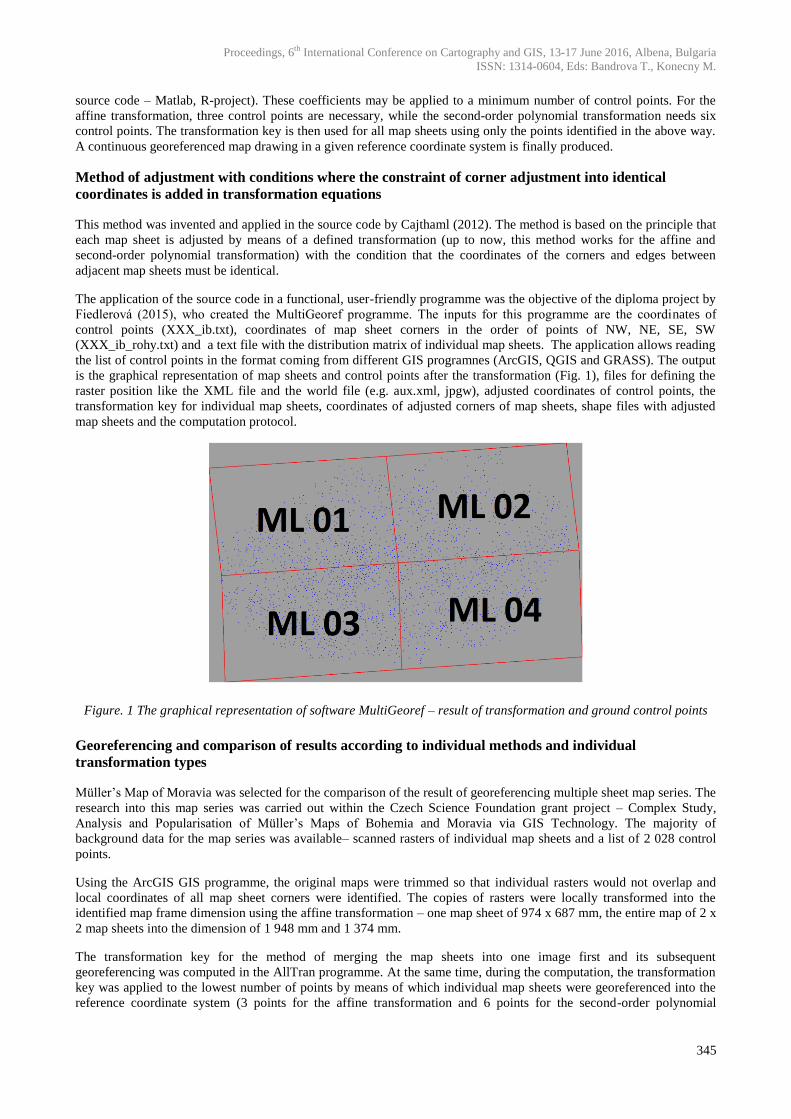
The application of the source code in a functional, user-friendly programme was the objective of the diploma project by
Fiedlerová (2015), who created the MultiGeoref programme. The inputs for this programme are the coordinates of
control points (XXX_ib.txt), coordinates of map sheet corners in the order of points of NW, NE, SE, SW
(XXX_ib_rohy.txt) and a text file with the distribution matrix of individual map sheets. The application allows reading
the list of control points in the format coming from different GIS programnes (ArcGIS, QGIS and GRASS). The output
is the graphical representation of map sheets and control points after the transformation (Fig. 1), files for defining the
raster position like the XML file and the world file (e.g. aux.xml, jpgw), adjusted coordinates of control points, the
transformation key for individual map sheets, coordinates of adjusted corners of map sheets, shape files with adjusted
map sheets and the computation protocol.
Figure. 1 The graphical representation of software MultiGeoref – result of transformation and ground control points
Georeferencing and comparison of results according to individual methods and individual
transformation types
Müller’s Map of Moravia was selected for the comparison of the result of georeferencing multiple sheet map series. The
research into this map series was carried out within the Czech Science Foundation grant project – Complex Study,
Analysis and Popularisation of Müller’s Maps of Bohemia and Moravia via GIS Technology. The majority of
background data for the map series was available– scanned rasters of individual map sheets and a list of 2 028 control
points.
Using the ArcGIS GIS programme, the original maps were trimmed so that individual rasters would not overlap and
local coordinates of all map sheet corners were identified. The copies of rasters were locally transformed into the
identified map frame dimension using the affine transformation – one map sheet of 974 x 687 mm, the entire map of 2 x
2 map sheets into the dimension of 1 948 mm and 1 374 mm.
The transformation key for the method of merging the map sheets into one image first and its subsequent
georeferencing was computed in the AllTran programme. At the same time, during the computation, the transformation
key was applied to the lowest number of points by means of which individual map sheets were georeferenced into the
reference coordinate system (3 points for the affine transformation and 6 points for the second-order polynomial
Proceedings, 6th International Conference on Cartography and GIS, 13-17 June 2016, Albena, Bulgaria
ISSN: 1314-0604, Eds: Bandrova T., Konecny M.
346
transformation). The reference geographical coordinate system which had been indentified during the examination of
Müller’s Map of Moravia was assigned to the rasters (Havlicek 2011). The georeferencing was performed into the
geographical coordinates of a sphere with a radius of 6 233 816 m.
The georeferencing results were projected by means of mathematically defined equations in the GIS programme and
also into the metric coordinate system which had been identified during the examination of Müller’s Map of Moravia.
Mercator projection,
radius of a substitute sphere of 6 233 816 m,
undistorted parallel of 51°38‘.
In the corners of the map sheets, points were created whose metric coordinates were read in order to compare both
methods.
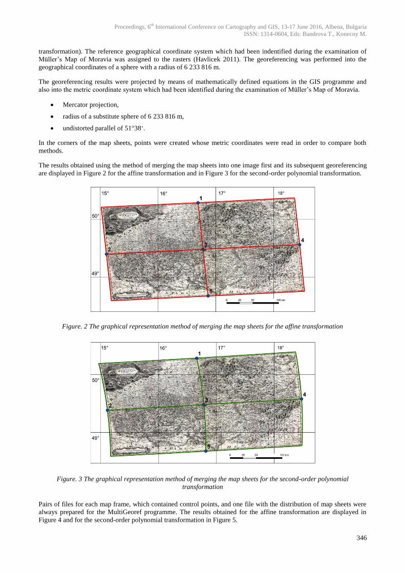
The results obtained using the method of merging the map sheets into one image first and its subsequent georeferencing
are displayed in Figure 2 for the affine transformation and in Figure 3 for the second-order polynomial transformation.
Figure. 2 The graphical representation method of merging the map sheets for the affine transformation
Figure. 3 The graphical representation method of merging the map sheets for the second-order polynomial
transformation
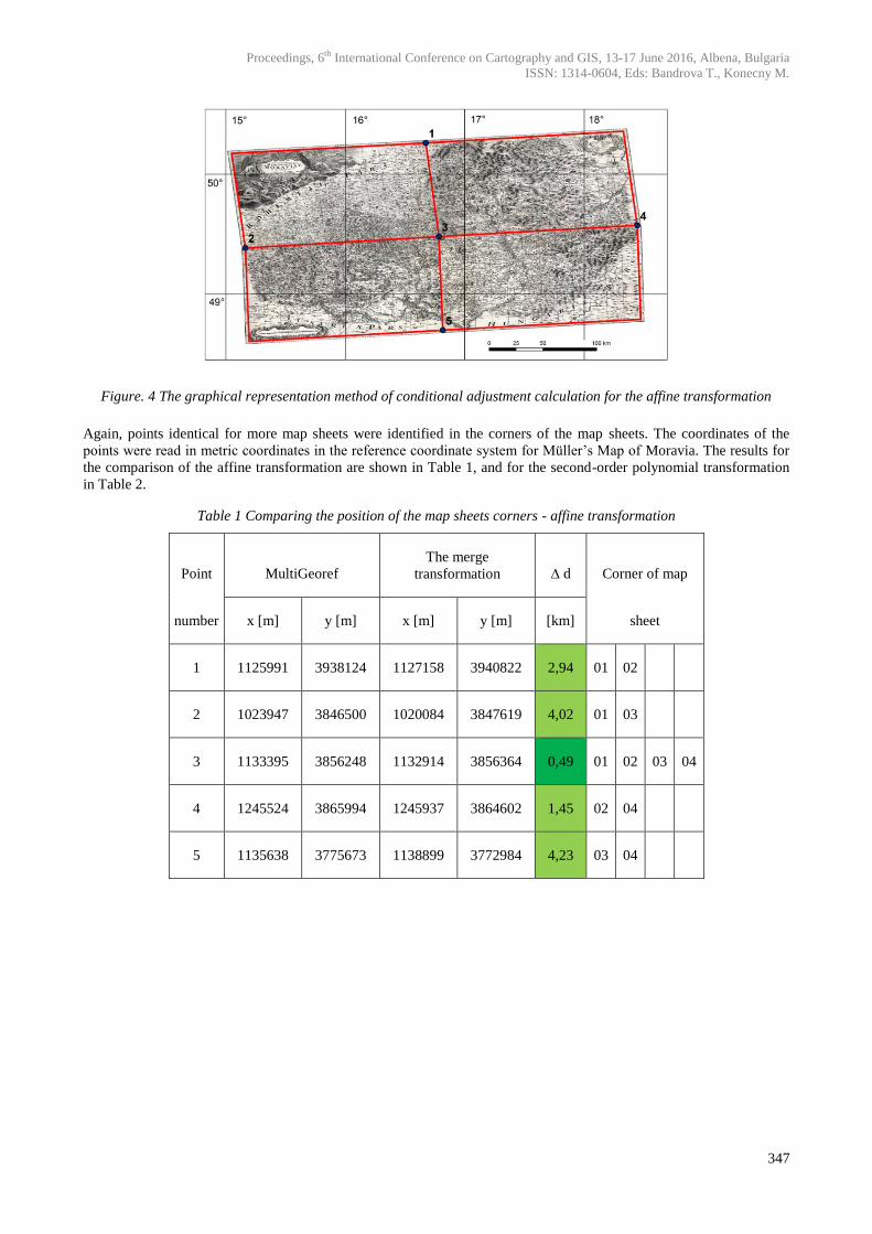
Pairs of files for each map frame, which contained control points, and one file with the distribution of map sheets were
always prepared for the MultiGeoref programme. The results obtained for the affine transformation are displayed in
Figure 4 and for the second-order polynomial transformation in Figure 5.
Proceedings, 6th International Conference on Cartography and GIS, 13-17 June 2016, Albena, Bulgaria
ISSN: 1314-0604, Eds: Bandrova T., Konecny M.
347
Figure. 4 The graphical representation method of conditional adjustment calculation for the affine transformation
Again, points identical for more map sheets were identified in the corners of the map sheets. The coordinates of the
points were read in metric coordinates in the reference coordinate system for Müller’s Map of Moravia. The results for
the comparison of the affine transformation are shown in Table 1, and for the second-order polynomial transformation
in Table 2.
Table 1 Comparing the position of the map sheets corners - affine transformation
Point MultiGeoref
The merge
transformation ∆ d Corner of map
number x [m] y [m] x [m] y [m] [km] sheet
1 1125991 3938124 1127158 3940822 2,94 01 02
2 1023947 3846500 1020084 3847619 4,02 01 03
3 1133395 3856248 1132914 3856364 0,49 01 02 03 04
4 1245524 3865994 1245937 3864602 1,45 02 04
5 1135638 3775673 1138899 3772984 4,23 03 04
Proceedings, 6th International Conference on Cartography and GIS, 13-17 June 2016, Albena, Bulgaria
ISSN: 1314-0604, Eds: Bandrova T., Konecny M.
348
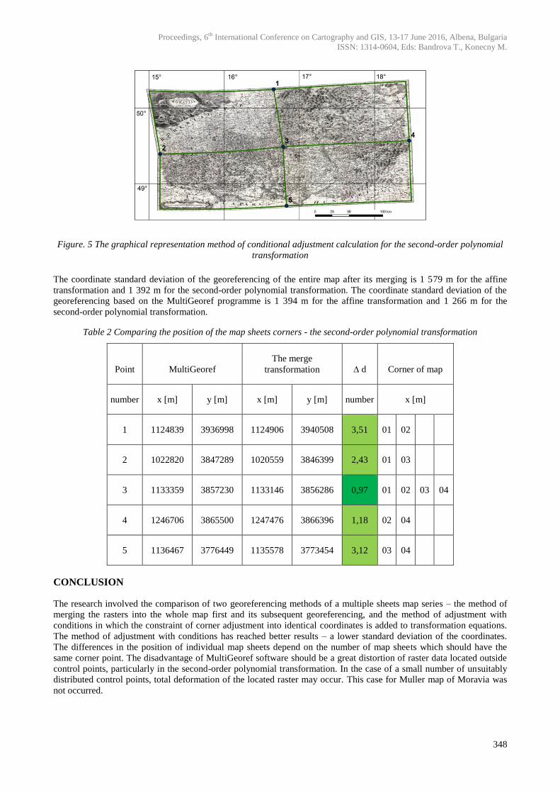
Figure. 5 The graphical representation method of conditional adjustment calculation for the second-order polynomial
transformation
The coordinate standard deviation of the georeferencing of the entire map after its merging is 1 579 m for the affine
transformation and 1 392 m for the second-order polynomial transformation. The coordinate standard deviation of the
georeferencing based on the MultiGeoref programme is 1 394 m for the affine transformation and 1 266 m for the
second-order polynomial transformation.
Table 2 Comparing the position of the map sheets corners - the second-order polynomial transformation
Point MultiGeoref
The merge
transformation ∆ d Corner of map
number x [m] y [m] x [m] y [m] number x [m]
1 1124839 3936998 1124906 3940508 3,51 01 02
2 1022820 3847289 1020559 3846399 2,43 01 03
3 1133359 3857230 1133146 3856286 0,97 01 02 03 04
4 1246706 3865500 1247476 3866396 1,18 02 04
5 1136467 3776449 1135578 3773454 3,12 03 04
CONCLUSION
The research involved the comparison of two georeferencing methods of a multiple sheets map series – the method of
merging the rasters into the whole map first and its subsequent georeferencing, and the method of adjustment with
conditions in which the constraint of corner adjustment into identical coordinates is added to transformation equations.
The method of adjustment with conditions has reached better results – a lower standard deviation of the coordinates.
The differences in the position of individual map sheets depend on the number of map sheets which should have the
same corner point. The disadvantage of MultiGeoref software should be a great distortion of raster data located outside
control points, particularly in the second-order polynomial transformation. In the case of a small number of unsuitably
distributed control points, total deformation of the located raster may occur. This case for Muller map of Moravia was
not occurred.
Proceedings, 6th International Conference on Cartography and GIS, 13-17 June 2016, Albena, Bulgaria
ISSN: 1314-0604, Eds: Bandrova T., Konecny M.
349
REFERENCES
Alltran (2009) Documentation of the library Alltran v 01.01 (Dokumentace knihovny Alltran v 1.01., in Czech), Department of
Special Geodesy, FCE, CTU in Prague.
Bayer T. (2009) Detection of cartographic display: techniques based on the comparison of sets of identical points (Detekce
kartografického zobrazení: techniky založené na srovnáním množin identických bodů, in Czech). Prague: Geodetický a
kartografický obzor. ISSN 0016-7096.
Bayer T. (2009a) Software: Automated detection of cartographic mapping from a set of points using the detection of point patterns
(Automatizovaná detekce kartografického zobrazení z množiny bodů s využitím detekce bodových vzorů, in Czech). Prague.
Baiocchi V. and Lelo K. (2010) Accuracy of 1908 high to medium scale cartography of Rome and its surroundings and related
georeferencing problems. Acta geodetica et geophysica Hungarica. p. 97-104. ISSN 1587-1037.
Boutoura C. and Livieratos E. (2006) Some fundamentals for the study of the geometry of early maps by comparative methods. E-
Perimetron. Vol.1, No. 1, p. 60-70. ISSN 1790-3769.
Cada V. (2003) Habilitation thesis: Robust methods for the creation and management of digital cadastral maps in locations Fathom
Maps (Robustní metody tvorby a vedení digitálních katastrálních map v lokalitách sáhových map, in Czech). Plzeň: University
of west Bohemia.
Cajthaml J. (2012) The analysis of maps in the digital environment on the example of Müllerian map of Bohemia and Moravia
(Analýza starých map v digitálním prostředí na příkladu Müllerových map Čech a Moravy, in Czech). 1. vol. Prague: Czech
technique - publishing, CTU in Prague, 172 p., ISBN 978-800-1050-101.
Cajthaml J. (2007) Dissertation thesis: New technologies for processing and access to maps (Nové technologie pro zpracování a
zpřístupnění starých map, in Czech). Prague, CTU in Prague, supervisor Prof. Ing. Bohuslav Veverka, DrSc.
Fiedlerova T. (2015) Master thesis: Application for georeferencing (Aplikace pro georeferencování vícelistových mapových děl, in
Czech) Prague, CTU in Prague, supervisor Doc. Ing. Jiří Cajthaml, Ph.D.
Havlicek J. (2011) Master thesis: Analysis of the vector models of Müller's map (Analýzy nad vektorovými modely Müllerových
map, in Czech) Prague, CTU in Prague, supervisor Ing. Jiří Cajthaml, Ph.D.
Havlicek J. and Cajthaml J. (2014) The influence of a used reference coordinate system on georeferencing. 5th international
conference on cartography and GIS. Riviera: ICA, vol. 1, p. 130142. ISSN 13140604.
Havlicek J. and Cajthaml J. (2014a) The influence of the distribution of ground control points on georeferencing. 14th international
multidisciplinary scientific geoconference - SGEM 2015, Conference Proceedings vol. III. Sofia: STEF92 Technology Ltd., p.
965972. ISSN 13142704. ISBN 9786197105124.
Havlicek J. and Cajthaml J. (2015) Identification of a wrongly assigned ground control point 15th international multidisciplinary
scientific geoconference - SGEM 2015, Sofia, Bulgaria: STEF92 Technology Ltd., ISBN 978-619-7105-35-3, ISSN 1314-2704,
p. 939-946.
Havlicek J. and Cajthaml J. (2015a) Influence of Replacement Used Reference Coordinate System for Georeferencing of the Old
Map of Europe. International Science Index, Waset.org, US.: World Academy of Science, Engineering and Technology, p. 281-
287.
Molnar G. and Podobnikar T. and Timar (2009) Mosaiking the 1:75,000 maps of the third military survey of the Austro-Hungarian
empire. Geodetski vestnik: glasilo Zveze geodetov Slovenije. p. 459-468. ISSN 0351-0271
Podobnikar T. (2010) Historical maps of Ljubljana for GIS applications. Acta geodetica et geophysica Hungarica. p. 80-88. ISSN
1587-1037.
Zlinszky A. and Molnár G. (2009) Goreferencing the firtst bathymetric maps of lake Balaton, Hungary. Acta geodetica et geophysica
Hungarica. p. 79-94. ISSN 1607-7938.

Proceedings, 6th International Conference on Cartography and GIS, 13-17 June 2016, Albena, Bulgaria
ISSN: 1314-0604, Eds: Bandrova T., Konecny M.
350
BIOGRAPHY
Jakub Havlicek (1985) is a post-graduate student at the Czech Technical University in Prague, Faculty of Civil
Engineering, Department of Geomatics. His specifications of post-graduate study are focused on cartography and GIS.
The main theme of his research are olds maps and problematic aspect of the georeferenced old maps. Jakub Havlicek is
the author of many articles on Czech and international conferences. Currently he is working on two projects of the
Ministry of Culture of the Czech Republic dealing with creating History atlas of the Czech republic and creating
interactive web mapping application of the cultural heritage displayed on old photographs.