Embed Size (px)
Citation preview
i
Confederated Tribes of Coos Lower Umpqua and Siuslaw Indians Tribal Estuary Response Plan
Table of Contents
Section Page Table of Contents i Record of Changes iv List of Acronyms and Abbreviations v 1. Background 1
2. Purpose and Scope 2
3. Tribal Area of Interest 3
Figure 1: CTCLUSI Area of Interest 4 3.1 Physical Features 5
3.1.1 Currents and Tides 6 3.1.2 Winds 6 3.1.3 Temperatures 6 3.1.4 Major Estuaries 6 3.1.5 Other Tribal Waters 8 Table 3.1.5. Other Waters within CTCLUSI Area of Interest 9
4. Tribal Uses and Activities related to Cultural Heritage 10
4.1 Sensitive Sites and Resources at Risk 10 4.1.1 Habitats 11 4.1.2 Fish 11 4.1.3 Wildlife 12 Table 4.1. Traditional Coos Shellfish, Crustaceans,
and Other Foodstuffs in Coos Bay 12 Table 4.2. Traditional Coos Shellfish, Crustaceans,
and Other Foodstuffs in Umpqua Estuary 13 Table 4.3. Traditional Coos Shellfish, Crustaceans,
and Other Foodstuffs in Siuslaw Estuary 14 4.1.4 Culturally Important Sites 14
5. Risk Assessment 16
5.1 Vessels 16 5.2 Pipelines 17 5.3 Bridges 17 5.4 Railways 18 5.5 Industrial Shoreline Facilities 18 5.6 Upland Disposal Sites 19 5.7 Existing Data, Analysis, and Gaps 19
Table 5.7. Existing Data Sources 19

iii
IV.10 Site Control 53 V. Assessing Damage 54 VI. Major Protection Techniques and Cleanup Strategies 55
VI.1 Shoreline Protection Strategies 56 VI.1.1 Booming 56 VI.1.2 Skimming 56 VI.1.3 Barriers/Berms 57 VI.1.4 Physical Herding 57 VI.1.5 Sorbents 57
VI.2 Shoreline Cleanup Strategies 57 VI.2.1 No Action / Natural Recovery 58 VI.2.2 Manual Removal 58 VI.2.3 Passive Collection (Sorbents) 58 VI.2.4 Debris Removal 58 VI.2.5 Trenching 58 VI.2.6 Sediment Removal 59 VI.2.7 Ambient-Water Flooding (Deluge) 59 VI.2.8 Ambient-Water/Low-Pressure & Ambient-Water/
High Pressure Washing 59 VI.2.9 Warm-water/Moderate-to-High Pressure Washing 59 VI.2.10 Hot-Water/High-Pressure Washing 59 VI.2.11 Slurry Sand Blasting 60 VI.2.12 Vacuum 60 VI.2.13 Sediment Reworking 60 VI.2.14 Sediment Removal, Cleansing, and Replacement 60 VI.2.15 Cutting Vegetation 61
VII. Cleanup Strategies for Specific Locations 62 VIII. Complying with the National Historic Preservation Act
During Emergency Response 62 IX. Notice to Response Personnel: Required Actions After Discovery of Cultural Resources 63
iv
RECORD OF CHANGES
CTCLUSI TRIBAL ESTUARY RESPONSE PLAN
Change # Date of Change Substance of Change Entered By
v
LIST OF ACRONYMS AND ABBREVIATIONS
°F degrees Fahrenheit ATSDR Agency for Toxic Substances and Disease Registry BIA United States Bureau of Indian Affairs CAMEO Computer-Aided Management of Emergency Operations CERCLA Comprehensive Environmental Response, Compensation, and
Liability Act CFR Code of Federal Regulations CIS Oregon State Legislature Commission on Indian Services CTCLUSI Confederated Tribes of Coos Lower Umpqua and Siuslaw Indians CTSI Confederated Tribes of Siletz Indians COTP Captain of the Port CSZ Cascadia Subduction Zone CWA Clean Water Act CZMA Coastal Zone Management Act DEQ Oregon Department of Environmental Quality DOGAMI Oregon Department of Geology and Mineral Industries DOT United States Department of Transportation DOI United States Department of Interior DSL Oregon Department of State Lands ECSI Oregon Environmental Cleanup Site Information EPA United States Environmental Protection Agency EPCRA Emergency Planning and Community Right-to-Know Act ERMA Environmental Response Management Application ESA Endangered Species Act ESI Environmental Sensitivity Index FEMA Federal Emergency Management Agency FOSC Federal On-Scene Coordinator FWPCA Federal Water Pollution Control Act GIS geographic information system GPS global positioning system GRP Geographic Response Plan HHS United States Department of Health and Human Services HazMat hazardous material HAZWOPER Hazardous Waste Operations and Emergency Response IC/UC Incident Commander/Unified Command ICS Incident Command System IDLH immediately dangerous to life or health IMT Incident Management Team IO Information Officer IOOS Integrated Ocean Observing System JIC Joint Information Center
vi
NANOOS Northwest Association of Networked Ocean Observing Systems NCP National Oil and Hazardous Substances Pollution Contingency
Plan NHPA National Historic Preservation Act NIMS National Incident Management System NMFS National Marine Fisheries Service NOAA National Oceanic and Atmospheric Administration NPFC National Pollution Fund Center NPMS National Pipeline Mapping System NRC National Response Center NRDA Natural Resource Damage Assessment NRHP National Register of Historic Places NWAC Northwest Area Committee NWACP Northwest Area Contingency Plan OAR Oregon Administrative Rules ODOT Oregon Department of Transportation OEM Oregon Office of Emergency Management OERS Oregon Emergency Response System OHA Oregon Health Authority OPA Oil Pollution Act of 1990 OPAC Oregon Ocean Planning Advisory Council ORS Oregon Revised Statutes OSC On-Scene Coordinator OSHA Occupational Safety and Health Administration OSLTF Oil Spill Liability Trust Fund PHMSA Pipeline and Hazardous Materials Safety Administration PIO Public Information Officer PPE personal protective equipment RCP Regional Contingency Plan RCRA Resource Conservation and Recovery Act PRFA Pollution Removal Funding Authorization PRP Potentially Responsible Party Reserve South Slough National Estuarine Research Reserve RM river mile RP Responsible Party RRT 10 Region 10 Regional Response Team RRT Regional Response Team SARA Superfund Amendments and Reauthorization Act SCAT Shoreline Cleanup Assessment Technique SHPO State Historic Preservation Office SIR Shoreline Inspection Report SOSC State On-scene Coordinator SWMP System-Wide Monitoring Program
vii
TCP Traditional Cultural Property TERC Tribal Emergency Response Commission THPO Tribal Historic Preservation Office TRI Toxics Release Inventory T/V tanker vessel U&A Usual and Accustomed Area USACE United States Army Corps of Engineers U.S.C. United States Code USCG United States Coast Guard USFWS United States Fish and Wildlife Service USGS United States Geological Survey WQS water quality standards
CTCLUSI Estuary Response Plan 2018 1
Tribal Estuary Response Plan
1. Background
The Confederated Tribes of Coos, Lower Umpqua, and Siuslaw Indians (CTCLUSI or the Tribe) are comprised of constituent bands called the Hanis Coos, Miluk Coos, Lower Umpqua, and Siuslaw. Our ancestors are the original inhabitants of 1.6 million acres of the Oregon coast, referred to as the Ancestral Territory. In 1855, we negotiated a treaty in good faith with the United States government. The United States government neither ratified nor honored that treaty. Instead, we were stripped of our Ancestral Territory and marched at gunpoint to from one prison camp to another. Finally, after nineteen years, we refused to be moved again. We returned to our villages and camps only to find that during the years of our captivity, our villages had become town sites and our camps had been farmed and logged. Our land base and our culture were shattered through the loss of our homeland and the forced assimilation resulting from the loss of our economic base. Nevertheless, we maintained our identity as Native People. In 1917, we officially banded together as the CTCLUSI and established a formal elected government that we have maintained ever since. In 1941, the Bureau of Indian Affairs (BIA) took a small parcel into trust for the CTCLUSI in the city of Coos Bay. On this small reservation, the BIA also erected a Tribal Hall that included an assembly hall, kitchen, offices, and medical clinic. Despite our continued existence, the U.S. government terminated our federal recognition in 1954. We refused to accept the termination of our existence as a Tribe. In 1984, after three decades of hard work, our federal recognition was restored. At the time of restoration, the CTCLUSI held only our tribal hall on six acres and three other slivers of land totaling less than eight acres, a far cry from our original 1.6 million acres. Since restoration, we have continued the work of reconstructing our fragmented land base and culture. Part of reconstructing our culture is protecting those resources that we depend on for our physical, mental, and spiritual health. The waters of our Ancestral Territory are perhaps the most precious of such resources. The Tribe seeks to perpetuate our identity through the sense of place by continuing the traditions of protecting, preserving, and enhancing our ancestral coastal waters and inlets where we once gathered and continue to gather and harvest. Our very title as a collective people is a reference to the various waterbodies that we have lived alongside and depended on since time immemorial. As such, the Tribe has endeavored to take an active role in developing a plan for response in the event of a spill or other hazardous release that may affect our estuaries or waters that flow into our estuaries.
CTCLUSI Estuary Response Plan 2018 2
2. Purpose and Scope
This Tribal Estuary Response Plan (Plan) establishes the policies and procedures under which the Tribe will operate in the event of a hazardous materials incident, oil spill, or other release impacting or potentially impacting our estuaries. This Plan is designed to prepare the Tribe for incident response and to minimize the exposure to or damage from materials that could adversely impact human health and safety or tribal resources. Sections 1-12 of the Plan outline the Tribe’s interests and resources at risk, existing information and relevant authorities, and funding and training opportunities. Section 13 of the Plan is the Spill Response Plan, which outlines the roles, responsibilities, procedures and organizational relationships of government agencies and private entities when responding to and recovering from an oil spill or hazardous materials event impacting or potentially affecting the Waters of the United States and Tribal Waters within the Tribe’s Ancestral Territory or broader areas of interest (collectively, the Area of Interest). This Plan is designed to address both oil spills and hazardous materials releases. There are numerous opportunities for spills or releases that impact the waters within the Tribe’s Area of Interest. Although there are many types of spills that can occur, the basic structure of the response remains the same whether the response is to an oil spill or hazardous substance release. And while there are a number of factors that are unique to hazardous substance releases, this Plan serves as a general guide for coordination and response during any type of oil or hazardous substances incident. Pursuant to federal laws including the Oil Pollution Act of 1990 (OPA), 33 U.S.C. § 2701 et seq., the U.S. National Oil and Hazardous Substances Pollution Contingency Plan (NCP), 40 CFR Part 300, and the Comprehensive Emergency Response Compensation and Liability Act of 1980 (CERCLA), 42 U.S.C. § 9601 et seq., the Tribe is to be notified in the event of a release of hazardous material within the Tribe’s area of interest.1 This Plan clarifies the notification and decision points in responding to a release, and highlights the cultural values of estuaries within the Tribe’s ancestral territory and area of interest. This Plan is developed by the Tribe, and is linked to the Northwest Area Contingency Plan and Geographic Response Plans prepared through the efforts of the Oregon Department of Environmental Quality, U.S. Coast Guard, and U.S. Environmental Protection Agency.
1 See Section 7 for further discussion and listing of applicable laws and regulations. In order to expedite notice and confirm that the National Response Center (NRC) will notify the Tribe, the Tribe will apply for an NRC agreement.
CTCLUSI Estuary Response Plan 2018 3
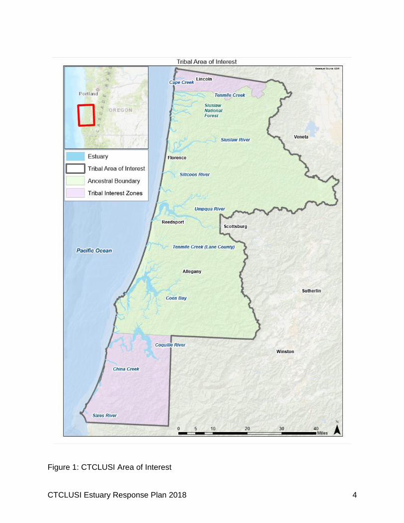
3. Tribal Area of Interest The Tribe’s Area of Interest includes its Ancestral Territory, as well as additional areas that contain the headwaters of rivers or tributaries that flow through the Ancestral Territory and tribally owned lands to the north and south of the Ancestral Territory. The Tribe’s Ancestral Territory extends from the mouth of Tenmile Creek (Lane County) in the north, south to Fivemile Point halfway between the mouths of Whiskey Run Creek and Cut Creek (coinciding with the border between Sections 30 and 31, Township 27 South, Range 14 West, Coos County), thence east to the crest of the Coast Range (to Weatherly Creek on the Umpqua River). The area includes the extensive estuaries of the Siuslaw, Umpqua, and Coos rivers, numerous smaller waterways, as well as rugged cliffs and open beaches, bordered by shifting sand dunes and steep, heavily vegetated mountainsides. The CTCLUSI are the original inhabitants of this area.
CTCLUSI Estuary Response Plan 2018 4
Figure 1: CTCLUSI Area of Interest
CTCLUSI Estuary Response Plan 2018 5
The Tribe’s Area of Interest includes the entire Ancestral Territory, as well as additional areas to the north and south, and includes the outer beaches and marine waters of the Pacific Coast adjacent to these lands. See Figure 1. Areas of interest include, but are not limited to, the five-county service area: Lincoln, Coos, Curry, Douglas, and Lane counties; waters within the Tribe’s Ancestral Territory including Tribally owned and non-Tribally owned lands; and lands that contain headwaters of rivers or tributaries that flow through the Ancestral Territory and/or Tribally owned lands. All of the various tribes along this stretch of the southern Oregon coast present a similar native culture regardless of the differences in their languages and geographic environments. The tribes of this region all intermarried extensively and had trade relations with one another, suggesting to many tribal members that the tribes were of one genetic and cultural family situated within numerous autonomous tribal nations. The people lived in permanent villages with many temporary seasonal and year-round resource encampments for fish, shellfish, and hunting resources. Because of the nature of the estuaries, with their many sloughs, and their many varying degrees of fresh and saltwater environments, there were an immense variety of resources. The people lived in cedar longhouses. Men hunted and fished; women collected berries, roots, and nuts. Their rich diet consisted of seafood, game, sea bird eggs, and other delicacies. Deer and elk skins were fashioned into garments and blankets. Baskets were woven using a variety of materials, from conifers to grasses. This great number of environments offered resources year-round. Beach encampments offered seasonal fishing and shellfish gathering opportunities in the bay, and berry gathering and hunting opportunities on the land. Other seasonal camps higher in the watersheds would be used for gathering berries or hunting. Kinship and trade relationships extended well beyond the Ancestral Territory. The Tribe is spiritually and culturally invested in our Ancestral Territory. Many of our values, meanings, and identities are closely linked with features of this landscape and our interaction with the landscape; wild foods like camas, deer, birds, fish, berries, and seafood provide sustenance for Tribal members. In addition, the landscape and these foods provide cultural connection through language, storytelling, harvesting, crafting, and sharing food. Thus, impacts to and/or the loss of these landscapes and wild foods means more than just a loss of subsistence, it also threatens the Tribe’s culture and identity. 3.1 Physical Features The Tribe’s understanding of its Ancestral Territory comes from collective Traditional Knowledge. This understanding both guides and results from the Tribal community
CTCLUSI Estuary Response Plan 2018 6
members’ close relationships with and responsibilities toward the land, water, plants, and animals that are central to the Tribe’s culture. These ways of knowing have accrued over thousands of years of experience. This Plan incorporates both Traditional Knowledge and Western Science to explain the significance of the estuaries to the Tribe and identifies response mechanisms to protect those areas in the event of an oil spill or hazardous material release. 3.1.1 Currents and Tides: Along the coast of Tribe’s Area of Interest, the nearshore current is predominantly a northern flow in the winter months and a southern flow in the summer months. Beaches are subject to large wave action and highly dynamic and energetic environments. Tides are mixed semidiurnal, with paired highs and lows of unequal duration and amplitude. 3.1.2 Winds: Winds can be very strong at times. Predominant wind direction is from the north to northwest in the summer and the southeast to east in the winter. 3.1.3 Temperatures: The area is generally dominated by a maritime climate with cool summers (average temperature range 60-65°F) and mild winters (average temperature range 40-50°F). Estuary and coastal water temperatures remain relatively constant between 50-55°F. 3.1.4 Major Estuaries: The Tribe’s Area of Interest includes three major river estuaries: Coos, Umpqua, and Siuslaw. Coos Coos Bay is the extensive estuary of the Coos River. Occupying approximately 20 square miles, the bay is the second largest drowned river valley on the Oregon Coast. Tidelands cover approximately 4,569 acres including 2,738 acres of tidal marsh and 1,400 acres of eelgrass beds. Its primary features include the main, expansive bay, an extensive arch of water around a peninsula, and major arms—South Slough, near the entrance of the bay, Jordan Cove, at the heart of the bay, and Haynes Inlet, which extends northeasterly from the main body of the bay. Smaller coves and inlets include Pony Slough, Larson Inlet, Willanch Slough, Coalbank Slough, Isthmus Slough, and Catching Slough on the south side of the bay, and North Slough on the north side of the bay. The natural environment of the Coos estuary supports a diversity of plants and animals of importance to the Tribe. The extensive shallow tidal flats provide habitat for shellfish as well as feeding and spawning habitat for many native fish. Coos Bay is part of the traditional homelands of the Hanis Coos and Miluk Coos people, who had different linguistic dialects or languages.
CTCLUSI Estuary Response Plan 2018 7
For other tribes in the region seasonal encampments were “owned” by a tribe or a band of a tribe, but this does not seem to have been the case at Coos Bay. The Coos Bay tribes had a principal chief of the whole bay, of all the villages, and people were free to visit any resources they needed. There was some specialization of resources gathering, as oral histories from families suggest that they would remain in the bay and take fish and shellfish and would not venture upriver or leave the bay while some individuals may leave for salmon or eel fisheries, or to fish in the Pacific Ocean. Other oral histories suggest that they would leave the bay for visits to Tenmile Lake or the Coquille River for salmon and acorns. Several ancient sites exist in the North Slough area and seem to confirm native stories that this was the main part of the bay at one time. Advancing sand dunes and filling in of the upper bay caused them to be abandoned long ago. The northern parts of the Coos estuary, along the Coos River and as far north as Tenmile Creek were inhabited by the Hanis Coos. The remains of several villages, wooden fish weirs, and middens still exist along Coos estuary shorelines, but many have been buried or substantially disturbed by more recent human development. The bedrock shoreline of parts of the upper Coos River allowed Coos ancestors to build wooden platform structures to spear salmon and other fish with great efficiency. Use of basket traps and bone hooks for fish was prevalent along the river. Gathering sites, or remote gardens, of a wide variety of berries, shoots, roots, tubers, bulbs and nuts were maintained by use of selective harvesting, fire and other means to ensure sustainable harvest for generations to come. The South Slough National Estuarine Research Reserve (the Reserve) is a 5,900-acre area of tidal marshes and tide flats in a sheltered arm that forms the southern end of the Coos estuary. Congress established the Reserve in 1972 as part of the Coastal Zone Management Act (CZMA). It was designated in 1974 as the first unit of the National Estuarine Research Reserve System that is protected and managed for the purpose of long-term research, education, and coastal stewardship. The Miluk Coos people occupied small villages and seasonal camps here, with nearly autonomous gatherings of around 100 people. Middens found along the shores of South Slough provide evidence that the estuary was a productive place to collect crabs and other shellfish. Culturally sensitive sites are known throughout the Reserve. Culturally significant resources also include plant roots, barks, and fibers traditionally used by the Tribe. The Reserve works with the Tribe to protect these resources and make them available for cultural uses. A Traditional Cultural Property (TCP) is a property that is eligible for inclusion in the National Register of Historic Places (NRHP) based on its associations with the cultural practices, traditions, beliefs, lifeways, arts, crafts, or social institutions of a living community. TCPs are rooted in a traditional community’s history and are important in maintaining the continuing cultural identity of the community. Coos Bay has received a
CTCLUSI Estuary Response Plan 2018 8
TCP nomination because the beliefs, customs, and practices associated with Coos Bay have been passed down through generations and help define the traditions of the community. Umpqua The Umpqua River estuary is Oregon’s third largest bay. Head of tide extends to river mile (RM) 27.5. The jetty channel is subject to strong tidal conditions, and breaking waves can be encountered on the bay at any time. The Umpqua River is Oregon’s second longest coastal river and is dominated for much of the year by freshwater runoff from seasonal rains and snowmelt originating in the Cascades. The Smith River is a large coastal river that flows into the Umpqua River estuary 11.5 miles above the jetty. This is the longest stretch of river on the West Coast without a dam. Native fish in the lower Umpqua include: Fall Chinook salmon, Spring Chinook salmon, Coho salmon, Winter steelhead, Coastal Cutthroat trout, Pacific lamprey, Western Brook lamprey, and Umpqua Chub. Chinook Salmon return to the Umpqua in the spring and fall, and to the Smith River in the fall. Umpqua Bay is known for the largest softshell clams of any of Oregon’s bays. The most productive clam beds are located on Bolon Island. Siuslaw The Siuslaw River estuary is narrow and crooked with the main tributary to this estuary being the Siuslaw River. Between 30-40% of the surface area at high tide is dominated by tidal flats, more extensive upstream in the estuary. Head of tide extends to RM 25. The North Fork Siuslaw watershed contains over 100 miles of anadromous fish habitat and historically provided habitat for fall Chinook salmon, Coho salmon, winter steelhead, and sea run cutthroat trout. Historically, the Siuslaw Tribe’s main camp was located along the lower North Fork and main river estuaries. Members harvested clams, mussels, seals, shellfish, ducks, geese, and other abundant saltwater and freshwater foods. Most Siuslaw passed the winter season along the lower river, moving upriver during peak salmon fishing times or for lamprey fishing, hunting and trapping, and berry picking. The Siuslaw used fibrous plants and western red cedar in making baskets, traps, and weirs. The cedar was also important in making houses and canoes. 3.1.5 Other Tribal Waters: In addition to the major estuaries, there are numerous smaller waterways that drain to the Pacific Ocean within the Tribe’s Area of Interest. Many of these waterways are significant to the Tribe’s history, culture, and subsistence. The following list identifies notable waters that drain either directly to the Pacific Ocean or into one of the larger estuaries on the coast, and are therefore covered by this Plan.
CTCLUSI Estuary Response Plan 2018 9
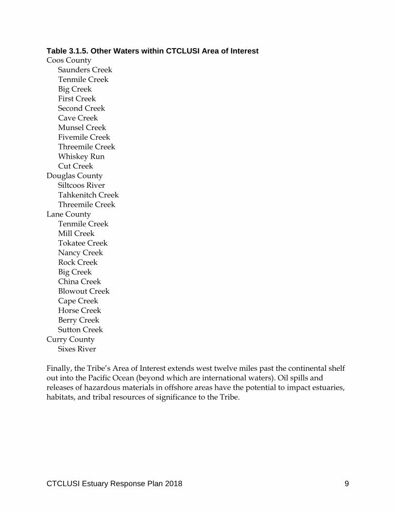
Table 3.1.5. Other Waters within CTCLUSI Area of Interest
Coos County Saunders Creek Tenmile Creek Big Creek First Creek Second Creek Cave Creek Munsel Creek Fivemile Creek Threemile Creek Whiskey Run Cut Creek
Douglas County Siltcoos River Tahkenitch Creek Threemile Creek
Lane County Tenmile Creek
Mill Creek Tokatee Creek Nancy Creek Rock Creek Big Creek China Creek Blowout Creek Cape Creek Horse Creek Berry Creek Sutton Creek
Curry County Sixes River
Finally, the Tribe’s Area of Interest extends west twelve miles past the continental shelf out into the Pacific Ocean (beyond which are international waters). Oil spills and releases of hazardous materials in offshore areas have the potential to impact estuaries, habitats, and tribal resources of significance to the Tribe.
CTCLUSI Estuary Response Plan 2018 10
4. Tribal Uses and Activities related to Cultural Heritage
For the Tribe, environmental resources are cultural resources. For example, when people gather food or materials in a place for thousands of years, that place connects the people through stories, language, and shared experience. Nearly everything was treated as having a spirit, and spirits could exert a positive influence on people’s lives. This Plan emphasizes the Tribe’s cultural resources and cultural connections to the estuarine environment, tribal economic self-sufficiency, and protection of biodiversity. Since time immemorial, tribal members have used the estuaries and waters within the Ancestral Territory for shelter, ceremony, sustenance, and spirituality. Although the condition of the land and the waters has been modified and degraded over the past hundred years, it is of critical importance to the Tribe to protect these resources in order to continue the Tribe’s traditions and way of life. Healthy estuaries are necessary to continue customary fishing and gathering both from shore and offshore; customary hunting; tribal activities and resources related to ceremony, training, song, and story. In addition, actions taken along the shores of Tribal waters can impact historical residences, village sites, burial grounds, and other archeological resources. These resources are irreplaceable in the values they provide to the Tribe’s culture and heritage, its members and way of life. 4.1 Sensitive Sites and Resources at Risk As important as the Tribe’s use of the estuaries, are the many sensitive sites within the Tribe’s Area of Interest. These areas are particularly vulnerable to contamination from oil or other hazardous materials. Sensitive sites can be categorized generally by habitat types, archeological features, and cultural values, and include:
a. Subsistence harvest sites b. Archeological sites c. Culturally important sites d. Submerged aquatic vegetation: all types of subtidal grass beds e. Marine Mammals: haul-out and pupping areas f. Endangered species: habitat areas g. Waterfowl: nesting and wintering concentration areas h. Seabirds: rookeries and wintering concentration areas i. Wading birds: rookeries, important foraging areas j. Gulls/terns: nesting sites k. Raptors: Nest sites, important forage areas l. Salmon/trout: spawning streams m. Nearshore fish species: nursery areas, unique concentration areas n. Shellfish: seed beds, abundant beds
CTCLUSI Estuary Response Plan 2018 11
o. Shrimp: nursery areas p. Crabs: nursery areas, high concentration sites q. Marine sanctuaries
A multitude of sensitive fish and wildlife resources can be found year-round or seasonally within the Tribe’s Area of Interest. Resources of concern to the Tribe include: 4.1.1 Habitats
Intertidal and Shallow Subtidal Mud or Sand Flats: These habitats are rich in benthic organisms and are important foraging areas for salmon, crabs, fish, and shorebirds.
Eelgrass: Eelgrass beds serve as important nursery and foraging areas for salmon, crabs, fish, and waterfowl.
Oyster Beds: Oyster beds and surface deposits of shell fragments support high densities of crabs, invertebrates, and fishes.
Salt Marshes: Salt marshes support a wide variety of insect, bird, fish, plant, and wildlife species.
Tributaries: Smaller rivers and tributary streams flowing into the estuaries serve as important salmon migration routes and provide important spawning and rearing habitats.
Nearshore Waters: Nearshore waters are rich in nutrients and support the food web including fish, birds, and mammals.
Offshore Waters: Deeper waters are important to migrating and resident seabirds, marine fish, and mammals.
Outer Sand Beaches: Beaches provide important shorebird habitat.
Stream Mouths on Outer Beaches: A variety of wildlife congregate at stream mouths.
4.1.2 Fish
Juvenile Salmonids: Estuaries provide important nursery and foraging areas for juvenile salmonids including coastal cutthroat trout, steelhead, Chinook and Coho salmon.
Herring: Herring spawn in eelgrass beds within the estuaries.
Marine Fish: Estuaries provide habitat for marine fish including white and green sturgeon, starry flounder, and eulachon.
Lamprey: The estuaries provide habitat for Pacific lamprey.
Crabs: Estuaries provide nursery areas for juvenile stages of Dungeness crab populations.
Oysters: There are several areas of commercial oyster culture in the estuaries. Both commercial and natural oyster beds provide habitat benefits to native fish and shellfish.
CTCLUSI Estuary Response Plan 2018 12
Clams: Several species of clams and cockles are found throughout the estuaries. 4.1.3 Wildlife
Waterfowl: Waterfowl concentrate in Tribal waters from fall through spring.
Seabirds: The estuaries provide regular feeding, roosting, and resting areas for migrating and resident seabirds.
Eagles: Bald Eagles nest throughout the region and forage in and around the estuaries and other Tribal waters.
Seals: There are many harbor seal foraging, pupping, and haulout areas located in and around the estuaries.
For fish and wildlife resources, the Tribe will emphasize the need to protect habitats where:
Large numbers of animals are concentrated in small areas;
Animals come ashore for birthing, resting, or molting;
Early life stages are present in restricted areas or shallow water (anadromous fish streams);
Habitats are very important to specific life stages or migration patterns;
Specific areas are known to be vital sources for seed or propagation;
The area is an important subsistence harvest site; and/or
A significant percentage of the population is likely to be exposed to contaminants.
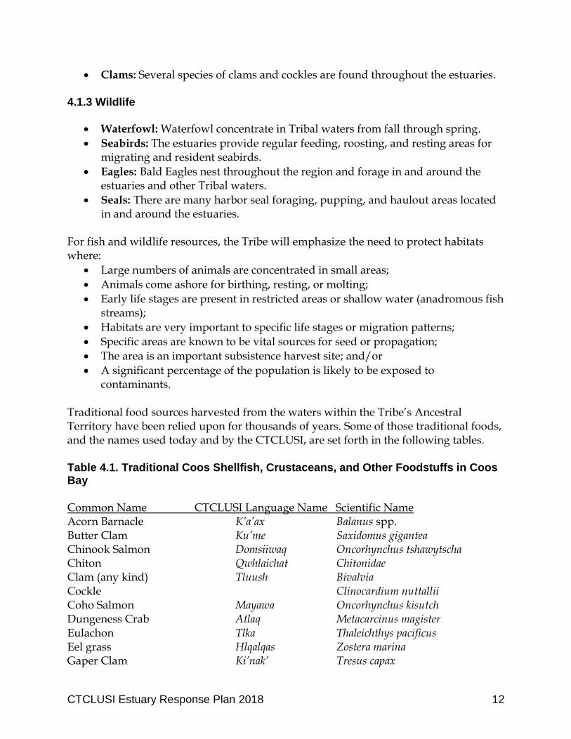
Traditional food sources harvested from the waters within the Tribe’s Ancestral Territory have been relied upon for thousands of years. Some of those traditional foods, and the names used today and by the CTCLUSI, are set forth in the following tables. Table 4.1. Traditional Coos Shellfish, Crustaceans, and Other Foodstuffs in Coos Bay
Common Name CTCLUSI Language Name Scientific Name Acorn Barnacle K’a’ax Balanus spp. Butter Clam Ku’me Saxidomus gigantea Chinook Salmon Domsiiwaq Oncorhynchus tshawytscha Chiton Qwhlaichat Chitonidae Clam (any kind) Tluush Bivalvia Cockle Clinocardium nuttallii Coho Salmon Mayawa Oncorhynchus kisutch Dungeness Crab Atlaq Metacarcinus magister Eulachon Tlka Thaleichthys pacificus Eel grass Hlqalqas Zostera marina Gaper Clam Ki’nak’ Tresus capax
CTCLUSI Estuary Response Plan 2018 13
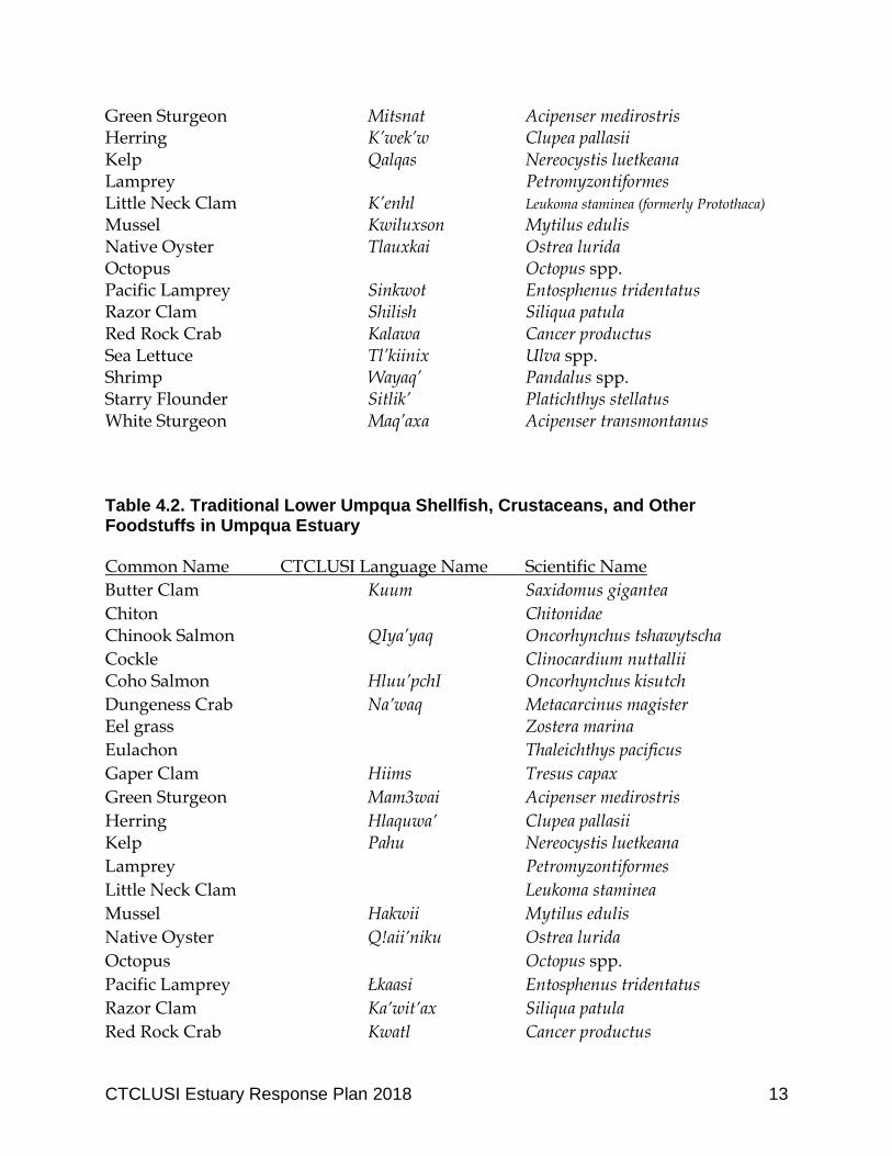
Green Sturgeon Mitsnat Acipenser medirostris Herring K’wek’w Clupea pallasii Kelp Qalqas Nereocystis luetkeana Lamprey Petromyzontiformes Little Neck Clam K’enhl Leukoma staminea (formerly Protothaca)
Mussel Kwiluxson Mytilus edulis Native Oyster Tlauxkai Ostrea lurida Octopus Octopus spp. Pacific Lamprey Sinkwot Entosphenus tridentatus Razor Clam Shilish Siliqua patula Red Rock Crab Kalawa Cancer productus Sea Lettuce Tl’kiinix Ulva spp. Shrimp Wayaq’ Pandalus spp. Starry Flounder Sitlik’ Platichthys stellatus White Sturgeon Maq’axa Acipenser transmontanus Table 4.2. Traditional Lower Umpqua Shellfish, Crustaceans, and Other Foodstuffs in Umpqua Estuary
Common Name CTCLUSI Language Name Scientific Name
Butter Clam Kuum Saxidomus gigantea
Chiton Chitonidae Chinook Salmon QIya’yaq Oncorhynchus tshawytscha
Cockle Clinocardium nuttallii Coho Salmon Hluu’pchI Oncorhynchus kisutch
Dungeness Crab Na’waq Metacarcinus magister Eel grass Zostera marina
Eulachon Thaleichthys pacificus
Gaper Clam Hiims Tresus capax
Green Sturgeon Mam3wai Acipenser medirostris
Herring Hlaquwa’ Clupea pallasii Kelp Pahu Nereocystis luetkeana
Lamprey Petromyzontiformes
Little Neck Clam Leukoma staminea
Mussel Hakwii Mytilus edulis
Native Oyster Q!aii’niku Ostrea lurida
Octopus Octopus spp.
Pacific Lamprey Łkaasi Entosphenus tridentatus
Razor Clam Ka’wit’ax Siliqua patula
Red Rock Crab Kwatl Cancer productus
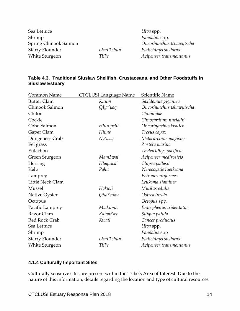
CTCLUSI Estuary Response Plan 2018 14
Sea Lettuce Ulva spp.
Shrimp Pandalus spp. Spring Chinook Salmon Oncorhynchus tshawytscha
Starry Flounder L!mI’kshuu Platichthys stellatus
White Sturgeon Tłii’t Acipenser transmontanus Table 4.3. Traditional Siuslaw Shellfish, Crustaceans, and Other Foodstuffs in Siuslaw Estuary
Common Name CTCLUSI Language Name Scientific Name
Butter Clam Kuum Saxidomus gigantea Chinook Salmon QIya’yaq Oncorhynchus tshawytscha
Chiton Chitonidae
Cockle Clinocardium nuttallii Coho Salmon Hluu’pchI Oncorhynchus kisutch
Gaper Clam Hiims Tresus capax
Dungeness Crab Na’waq Metacarcinus magister Eel grass Zostera marina
Eulachon Thaleichthys pacificus
Green Sturgeon Mam3wai Acipenser medirostris
Herring Hlaquwa’ Clupea pallasii Kelp Pahu Nereocystis luetkeana
Lamprey Petromzontiformes
Little Neck Clam Leukoma staminea
Mussel Hakwii Mytilus edulis
Native Oyster Q!aii’niku Ostrea lurida
Octopus Octopus spp.
Pacific Lamprey Mətkiimis Entosphenus tridentatus
Razor Clam Ka’wit’ax Siliqua patula
Red Rock Crab Kwatl Cancer productus Sea Lettuce Ulva spp.
Shrimp Pandalus spp
Starry Flounder L!mI’kshuu Platichthys stellatus
White Sturgeon Tłii’t Acipenser transmontanus 4.1.4 Culturally Important Sites
Culturally sensitive sites are present within the Tribe’s Area of Interest. Due to the nature of this information, details regarding the location and type of cultural resources
CTCLUSI Estuary Response Plan 2018 15
present are not included in this Plan. To ensure spill response strategies do not inadvertently harm historical and culturally important sites, the Tribe should be consulted before disturbing any soil or sediment during a response action. The Tribe maintains information on the location of culturally sensitive sites and may provide information on cultural resources at risk during response actions. Cultural historical and archeological resources may include, but are not limited to, any of the following items:
Human remains, burial sites, or burial-related materials;
Bone (burned, modified, or in association with other bone, artifacts, or features);
Shell or shell fragments;
Lithic debitage (stone chips and other tool-making byproducts);
Flaked or ground stone tools;
Exotic rock or minerals;
Concentrations of organically stained sediments, charcoal, or ash;
Fire-modified rock;
Rock alignments or rock structures;
Petroglyphs and pictographs;
Fish weirs and traps;
Culturally modified trees; or
Physical locations or features (traditional cultural properties).
CTCLUSI Estuary Response Plan 2018 16
5. Risk Assessment To increase the effectiveness of response measures, it is important to understand and identify potential sources of spills and contamination in advance. A spill is any uncontrolled release of oil or hazardous material. Vessels, railways, roads (bridges), and even gas stations present spill risks. The Oregon Department of Environmental Quality (DEQ) has identified potential spill sources along Oregon’s coastline. In addition to human-caused spills, there are several natural hazard considerations present in this area. Most significant is the Cascadia Subduction Zone (CSZ), a 600-mile fault that lies offshore of the Tribe’s Area of Interest and presents risk of catastrophic earthquake and tsunami. The CSZ has produced magnitude 9.0 or greater earthquakes in the past, and will undoubtedly do so again in the future. The last known CSZ earthquake in the Pacific Northwest was in January of 1700, just over 300 years ago. Geologic evidence shows that these great earthquakes have occurred every 400 to 600 years over the last 3,500 years. Oregon has the potential for a 9.0+ magnitude earthquake and a resulting tsunami of up to 100 feet in height that will impact the coastal area. In addition, climate change will cause sea levels to rise and increasingly extreme weather events. Changes in storm surge heights will result as the occurrence of strong winds and storms increases. These events are likely to cause increased shoreline erosion and related risks to shore-based facilities that may increase risk of spill or release. The Tribe will consider the potential natural risks to the siting and operation of facilities that handle, produce, or otherwise are potential sources of oil spills or hazardous material releases. The following sub-sections set out examples of spill risks from human development within the Tribe’s Area of Interest. 5.1 Vessels
Vessel collisions and groundings are a potential source of contamination and spills. For example, in a 1991 event, the fish processor vessel Tenyo Maru collided with a freighter within Canadian Territorial waters approximately 20 miles northwest of Cape Flattery. Bunker fuel washed up as far south as Lincoln City from the wreck site. Tarballs occasionally wash up on Oregon’s beaches. This demonstrates the vast distances that nearshore currents are capable of transporting floating product. In February 1999, the New Carissa, a 640-foot freighter, ran aground during a major winter storm while carrying nearly 400,000 gallons of fuel oil and diesel. After days of heavy surf, the New Carissa broke in half and released approximately 70,000 to 140,000 gallons of fuel into the marine shore environment. A U.S. Fish and Wildlife Service assessment team estimated that 2,453 seabirds (including 262 marbled murrelets) were killed or injured by the spill. Although the Tribe is now a trustee, we were not included as a partner in the response or restoration projects as a result of the spill, and the Tribe
CTCLUSI Estuary Response Plan 2018 17
has never been compensated for the damages that were done to Tribal resources including traditional harvesting areas to date. Refined fossil fuel products in barges and small tankers are transported close to the Oregon shoreline. Cargo vessels with bunker fuels enter and leave coastal ports. New development of oil and gas terminals will increase the risk of spills. In addition, alterations to the navigation channel within Coos Bay (including for example widening or deepening the channel) may increase vessel traffic and consequently increase risk of oil spills or hazardous materials releases within the estuary. 5.2 Pipelines
During construction, pipelines are a potential source of spill and contamination. Once in operation, pipelines have the potential to present a serious safety hazard for Tribal members and the local communities in the area where they are located. A gas transmission pipeline is located within the Tribe’s Area of Interest. In the Coos Bay area, Northwest Natural operates a gas transmission pipeline that crosses under the Coos Bay from Empire to the North Spit, and also crosses higher in the estuary in the Isthmus Slough near the intersection of US Highway 101 and Sumner-Fairview Road. Pacific Connector Pipeline is proposing to construct a 36-inch diameter natural gas pipeline that would cross the Coos River as well as the main Coos Bay estuary to meet a terminal on the North Spit of Coos Bay. Both pipeline construction and operation present spill risks to important areas to the Tribe including the Coos River and Jordan Cove. 5.3 Bridges
Bridge crossings present a risk due to accident or overturning vehicles. For example, double tanker trucks haul fuel (gasoline or diesel) on highways throughout Oregon. In the event of an accident, the contents of tankers could be released from bridges or roads into nearby waters. Each of the major estuaries in the Tribe’s area of interest is crossed by at least one bridge.
US Highway 101 crosses the Siuslaw River at approximately RM 4.
US Highway 101 crosses the Umpqua River at approximately RM 9.
US Highway 101 crosses the Coos Bay at Haynes Inlet in the north bay and at Coalbank Slough and Davis Slough in the south.
The Cape Arago Highway (Hwy 540) crosses Coos Bay at Charleston/South Slough.
Crown Point Road crosses Coos Bay at Joe Nay Slough (at Crown Point).
The Coos River Highway (Hwy 241) crosses Coos Bay at Catching Slough.
Newport Lane crosses Coos Bay at Isthmus Slough.
Hwy 241 crosses the Coos River at Graveyard Point.
CTCLUSI Estuary Response Plan 2018 18
US Highway 101 also crosses many of the smaller waterways that drain to the Pacific, including: Siltcoos Creek, which drains Siltcoos Lake at RM2; Winchester Creek at RM0; and Tenmile Creek at RM4. 5.4 Railways
Railways pose risk due to the potential for accident or overturning rail cars. In 2016, a Union Pacific train carrying Bakken crude oil derailed in Mosier, Oregon, adjacent to the Columbia River, Rock Creek and a wetland. Sixteen cars derailed, three caught fire and another four discharged oil. Containment booms were used to protect the nearby waterways. Cleanup efforts required excavation of soils, potentially disturbing artifacts or other resources of the nearby Tribes. There are multiple rail crossings and lines in and adjacent to the key estuaries within the Tribe’s Area of Interest. At the Siuslaw River, the Central Oregon & Pacific Line crosses the river near RM 8 and proceeds along the south slough. Within the Umpqua River, several rail lines converge in the vicinity of Bolon Island including the Central Oregon & Pacific Line, Portland and Northern Railway, and Longview Lines. In Coos Bay, a Union Pacific rail bridge crosses the main bay near RM 7, and several other rail spurs and lines are located around the Bay including the Central Oregon and Pacific Railroad on the North Spit, and the Union Pacific line along Haynes Inlet and the North Slough in the north, and crossing at Coalbank Slough and along Isthmus Slough to the south. 5.5 Industrial Shoreline Facilities
Industrial facilities located along the coastal and estuary shoreline have the potential to be a source of release of oil or hazardous materials. For example, in January 2018, a 4,200-gallon tank located under a pier in Astoria began leaking oil into the Columbia River, prompting a spill response action. In Coos Bay, there are several industrial facilities located along the shore including lumber (chip) mills, boat maintenance and repair, and related fueling operations. In Reedsport, the Fred Wahl Marine Construction Company is located near Highway 101 and the Umpqua estuary. Past activities on the site have resulted in contamination on the land, and practices that have resulted in direct discharge of untreated wastewaters directly to the river. Through use of best management practices, most discharges can be controlled at this type of facility. However, where contamination has already occurred, the Tribe is concerned with proper cleanup to reduce the risk of recontamination through sediment disturbance or groundwater migration. The Tribe will remain apprised of new or potential industrial facilities, such as LNG (liquefied natural gas) facilities, to understand the risks they may pose and evaluate spill response plans adopted by the operators of those facilities.
CTCLUSI Estuary Response Plan 2018 19
5.6 Upland Disposal Sites
Upland disposal sites where contaminated dredged materials are placed have the potential to be a source of release in the event of tsunami, earthquake, or sea level rise. In addition, dredging activities within estuaries and coastal waters, such as navigation challenge maintenance dredging or other in-water development can re-distribute legacy chemicals into the environment. The Tribe has an interest in ensuring future development including dredge disposal will be designed and located to avoid contamination by spill or release. 5.7 Existing Data, Analysis and Gaps
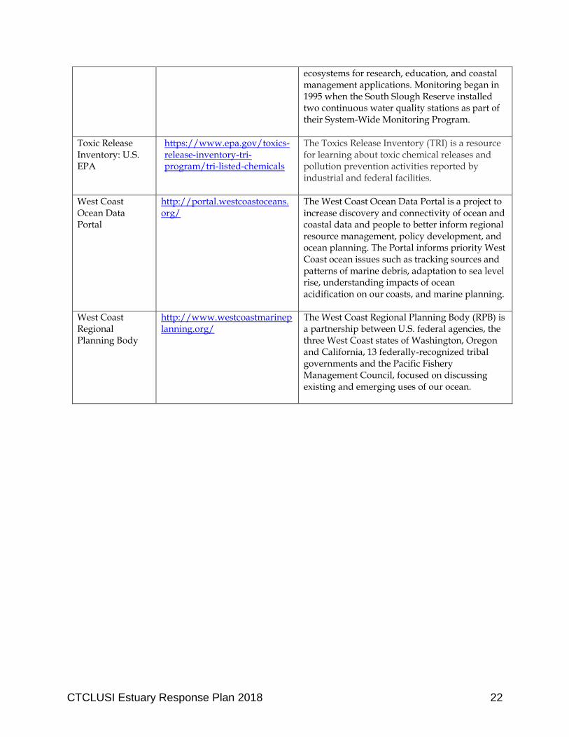
There are many sources of information available to identify sensitive resources, water quality protections, and spill risk locations. These sources should be consulted in preparation for an event. Below is a list of existing data sources that may provide relevant and helpful information for spill response planning. This list should not be considered exclusive, as new databases and information resources continue to be developed. Table 5.7: Existing Data Sources
Data Source Location/Citation Description
CTCLUSI water quality collection data loggers
https://ctclusi.org/waterqualityprogram
The Tribe’s water quality program collects data for water quality parameters including water temperature, turbidity, salinity, pH, dissolved oxygen, and bacteria. Continuous data loggers collect a sample every fifteen minutes.
Environmental Response Management Application (ERMA)
https://erma.noaa.gov/northwest/erma.html
Pacific Northwest ERMA is an online mapping tool that allows stakeholders and communities to visualize ecological, land use, and infrastructure data in one centralized location. With the increase in oil transported by rail in the region, along with existing marine traffic, emergency planners are relying upon ERMA to help prepare and respond to environmental pollution incidents in Washington and Oregon.
Marine Cadastre https://marinecadastre.gov/data/
MarineCadastre.gov is an integrated marine information system that provides data, tools, and technical support for ocean and Great Lakes planning. MarineCadastre.gov was designed specifically to support renewable energy siting on the U.S. Outer Continental Shelf but also is being used for other ocean-related efforts.
Marine Casualty & Pollution Data for Researchers: U.S. Coast Guard
http://www.dco.uscg.mil/Our-Organization/Assistant-Commandant-for-Prevention-Policy-CG-5P/Inspections-Compliance-CG-5PC-/Office-
The Marine Casualty and Pollution Data files provide details about marine casualty and pollution incidents investigated by Coast Guard Offices throughout the United States. The database can be used to analyze marine accidents
CTCLUSI Estuary Response Plan 2018 20
of-Investigations-Casualty-Analysis/Marine-Casualty-and-Pollution-Data-for-Researchers-/
and pollution incidents by a variety of factors including vessel or facility type, injuries, fatalities, pollutant details, location, and date. The data collection period began in 1982 for marine casualties and 1973 for polluting incidents, and is ongoing.
Marine Traditional Knowledge Ethnographic Database
http://tdntek.ecotrust.org/ This tool is the result of a project between the Tolowa Dee-Ni' Nation and Ecotrust to migrate an existing marine traditional ethnographic knowledge into a more user-friendly, spatially enabled web application. It is hoped that this tool will help tribes to retain and organize their traditional knowledge and have a new way to share it with future generations.
National Pipeline Mapping System
https://www.npms.phmsa.dot.gov
The National Pipeline Mapping System (NPMS) Public Map Viewer is a web-based mapping application designed to assist the general public with displaying and querying data related to gas transmission and hazardous liquid pipelines, liquefied natural gas plants, and breakout tanks under Department of Transportation (DOT) Pipeline and Hazardous Materials Safety Administration (PHMSA) jurisdiction.
Northwest Association of Networked Ocean Observing Systems (NANOOS) NVS
http://nvs.nanoos.org/ NANOOS is the Regional Association of the national Integrated Ocean Observing System (IOOS) in the Pacific Northwest, primarily Washington and Oregon. The goals of NANOOS are to present existing and develop new and experimental prediction data and products to address the ocean observing and predicting needs of local stakeholders such as tribes, local governments, educators, and the general public.
NOAA Digital Coast
https://coast.noaa.gov/digitalcoast/
This NOAA-sponsored website is focused on helping communities address coastal issues. The site contains visualization tools, predictive tools, and tools that make data easier to find and use. Training courses are available online. Information is also organized by focus area or topic.
Oregon Coastal Atlas
http://www.coastalatlas.net/ The Oregon Coastal Atlas is a multi-group project that has the goal of being a useful resource for the various audiences that make up
CTCLUSI Estuary Response Plan 2018 21
the management constituency of the Oregon Coastal Zone. The project is a depot for traditional and digital information, which can be used to inform decision-making relating to the Oregon Coastal Zone.
Oregon Department of Geology and Mineral Industries (DOGAMI) LIDAR viewer
https://gis.dogami.oregon.gov/lidarviewer/
The Lidar Data Viewer interactive map shows the current extent of lidar data for the state of Oregon, including downloadable data by 7.5 minute USGS quadrangle. The data are maintained by the Oregon Department of Geology and Mineral Industries (DOGAMI).
Oregon Environmental Cleanup Site Information Database (ECSI)
http://www.oregon.gov/deq/Hazards-and-Cleanup/env-cleanup/Pages/ecsi.aspx
DEQ maintains the ECSI database to track sites in Oregon with known or potential contamination from hazardous substances.
Oregon Ocean Policy Advisory Council (OPAC)
http://www.oregon.gov/LCD/opac/Pages/index.aspx
The Oregon Ocean Policy Advisory Council (OPAC) is a legislatively mandated marine policy advisory body to the Governor of Oregon. Meetings of OPAC are usually held in cities on the Oregon coast.
Oregon Spatial Data Library
http://spatialdata.oregonexplorer.info/geoportal/
The Oregon Spatial Data Library is a joint effort between the Department of Administrative Services Geospatial Enterprise Office and Oregon State University. Currently, hundreds of spatial datasets are accessible from the Oregon Spatial Data Library, including all of the statewide framework data available for Oregon. These datasets serve as base data for a variety of Geographic Information System (GIS) applications that support research, business and public services.
Oregon Water Quality Standards
http://www.oregon.gov/deq/wq/Pages/WQ-Standards.aspx
The Oregon Department of Environmental Quality (DEQ) uses water quality standards to assess whether the quality of Oregon's rivers and lakes is adequate for fish and other aquatic life, recreation, drinking, agriculture, industry and other uses. DEQ also uses the standards as regulatory tools to prevent pollution of the state's waters.
South Slough Reserve water quality monitoring
http://cdmo.baruch.sc.edu/ The System-Wide Monitoring Program (SWMP) is a nationally coordinated effort that provides long-term weather, water quality, biological community, habitat, and land use/cover information about estuaries and coastal
CTCLUSI Estuary Response Plan 2018 22
ecosystems for research, education, and coastal management applications. Monitoring began in 1995 when the South Slough Reserve installed two continuous water quality stations as part of their System-Wide Monitoring Program.
Toxic Release Inventory: U.S. EPA
https://www.epa.gov/toxics-release-inventory-tri-program/tri-listed-chemicals
The Toxics Release Inventory (TRI) is a resource for learning about toxic chemical releases and pollution prevention activities reported by industrial and federal facilities.
West Coast Ocean Data Portal
http://portal.westcoastoceans.org/
The West Coast Ocean Data Portal is a project to increase discovery and connectivity of ocean and coastal data and people to better inform regional resource management, policy development, and ocean planning. The Portal informs priority West Coast ocean issues such as tracking sources and patterns of marine debris, adaptation to sea level rise, understanding impacts of ocean acidification on our coasts, and marine planning.
West Coast Regional Planning Body
http://www.westcoastmarineplanning.org/
The West Coast Regional Planning Body (RPB) is a partnership between U.S. federal agencies, the three West Coast states of Washington, Oregon and California, 13 federally-recognized tribal governments and the Pacific Fishery Management Council, focused on discussing existing and emerging uses of our ocean.
CTCLUSI Estuary Response Plan 2018 23
6. Outreach and Education / Stakeholder Engagement This Plan will be most effective if Tribal leaders, Tribal members, state and federal agencies, and the public are aware of and understand the Plan. To meet that goal, the Tribe will conduct communications and engagement in an inclusive, open, and transparent way. The involvement of Tribal members and local communities are essential to the effectiveness of the Plan. Tribal members and coastal communities will experience the impacts of spill events and have insight into the sensitive and important resources to be protected in the event of a spill event. As part of the development of this plan, the Tribe engaged in discussions with Oregon DEQ, Oregon Office of Emergency Management (OEM), and U.S. Department of Interior (DOI) in order to communicate the Tribe’s intent and integrate this plan with those of other agencies with relevant authorities in responding to spill events. The Tribe will meet with the Captain of the Port and the Northwest Area Committee Regional Response Team to introduce this Plan to the regional team coordinators, develop relationships and build trust in advance of a spill or release and response effort. As part of the development of this Plan, a draft was presented to the community at the Tribal Council meeting in May 2018. Tribal members and Tribal Council members commented in support of the plan, and raised issues including:
Highlighting the Tribe’s historical treatment by the U.S., exclusion from past spill recovery activities, and current role as a trustee;
The importance of shellfish to the Tribe;
Including fish and traditional food sources from the three major estuaries; and
Educating community members about the laws regulating proper use and handling of toxic substances and other methods to reduce risks of spills or intentional discharges to Tribal waters.
Comments received on the Plan during that public process have been incorporated into this Plan. The Tribe will develop outreach materials tailored to address gaps in understanding and inform and promote community member engagement.
CTCLUSI Estuary Response Plan 2018 24
7. Applicable Policies and Legal Authorities Many laws and regulations apply to the development of response plans and cleanup actions. The following provides a brief overview of some of the most relevant provisions applicable to this Plan and the Tribe’s role in responding to oil spills or hazardous materials releases. The Tribe is federally recognized pursuant to the Coos, Lower Umpqua, and Siuslaw Restoration Act of October 17, 1984, Public Law No. 98-481, 98 Stat. 2250. Under that authority, and in accordance with the Indian Reorganization Act of June 18, 1934, 48 Stat. 984, as amended, the Tribe established its Tribal government and adopted its Constitution to protect its unique identity, secure the rights and powers inherent as an Indian tribe, and preserve and promote cultural, religious and historical beliefs, among other purposes. As a federally recognized tribe, the Tribe is entitled to all services and benefits furnished to federally recognized tribes. The Federal Water Pollution Control Act (also known as the Clean Water Act), 33 U.S.C. § 1251 et seq. (specifically 33 U.S.C. § 1321 et seq.), and the Comprehensive Emergency Response Compensation and Liability Act of 1980 (CERCLA, or Superfund), 42 U.S.C. § 9601 et seq., provide for the development of a National Planning and Response System. The Clean Water Act provides for coordination with tribal governments with respect to oil spill prevention, preparedness, response and natural resource damage assessment, and requires the U.S. Coast Guard to include representatives of affected tribes in incident command for spill response and to share information with affected tribes and include tribal governments in spill response decision-making. 33 U.S.C § 1321b. Pursuant to CERCLA, tribes are entitled to receive substantially the same treatment as a state with respect to notification of releases, consultation on remedial actions, access to information, health authorities, and other provisions. 42 U.S.C. § 9626. The National Oil and Hazardous Substances Pollution Contingency Plan (NCP), 40 CFR Part 300, provides for the establishment of Area Committees, composed of personnel from federal and state agencies who coordinate response actions with tribal and local governments. The NCP states that regional planning and coordination of preparedness and response actions shall be accomplished through Regional Response Teams (RRT). 40 CFR § 300.115. The Region 10 RRT and Northwest Area Committee (NWAC) adopted the Northwest Area Contingency Plan (NWACP) as the spill contingency plan for the Northwest Area.2 The NWACP is essentially a Memorandum of Understanding by which all RRT and Area Committee member agencies will conduct responses to releases of hazardous substances and oil discharges. The NWACP recognizes that each federally recognized tribe has the right to initiate government-to-government
2 The 2018 NWACP is available at https://www.rrt10nwac.com/nwacp/ (last visited March 25, 2018).

CTCLUSI Estuary Response Plan 2018 25
consultation on the policies within the NWACP at any time prior to or during an incident. The NWACP states that NWAC agencies seek meaningful tribal engagement and mutually effective policies. The Tribe expects that NWAC agencies will consult with the Tribe on policies that are applicable to the Tribe’s area of interest. The Tribe intends for this Plan to be referenced by, consistent with, and complementary to the NWACP. The Emergency Planning and Community Right-to-Know Act, 42 U.S.C. § 11001 et seq., (EPCRA) serves to inform communities of chemical hazards in their areas. EPCRA Section 313 requires covered facilities to annually report to EPA and their state on releases and transfers of toxic chemicals. EPA is required to make this data available to the public in a database, the Toxics Release Inventory (TRI). EPCRA also encourages and supports planning for responding to environmental emergencies. EPA regulations under EPCRA Section 313 establish requirements for covered facilities located in Indian country to report TRI information to the appropriate tribe(s). See 40 CFR Part 372. The Oil Pollution Act (OPA) amended Section 311 of the Clean Water Act to provide new requirements for preventing, preparing for, and responding to any oil spill affecting inland U.S. waters, expanded liability provisions, and strengthened the Oil Spill Liability Trust Fund to provide greater resources to respond to oil spills. The OPA allows for tribal trustees for natural resources. 33 U.S.C. § 2706. Although the federal government must direct all public and private response efforts to spills, tribes may implement their own non-federal oil programs. Tribal natural resources trustees’ costs incurred in restoring or rehabilitating natural resources damaged by an oil spill can be funded through the Oil Spill Liability Trust Fund. See 33 U.S.C. § 2712. State and federal laws prohibit excavation, destruction or alteration of any archeological site or archeological objects without permits or special permissions. Destruction or damage to any human burial site, human remains or American Indian sacred or special objects is also prohibited. See, e.g., National Historic Preservation Act, 16 U.S.C. § 470 et seq.; Archeological Resources Protection Act, 16 U.S.C. § 470aa-470mm; Native American Graves Protection and Repatriation Act, 25 U.S.C. § 3001 et seq.; Oregon Laws Protecting Indian Graves, ORS 97.740 et seq.; Archaeological Objects and Site Protections, ORS 358.905 et seq. Cultural resources can be affected during various stages of the cleanup process, including site assessment, remedial investigation, and the cleanup action itself. Any investigation or cleanup that has federal involvement triggers Section 106 of the National Historic Preservation Act, requiring consultation with the Tribe regarding potential impacts to religious or culturally important resources. The location and existence of cultural resources is highly sensitive information. To protect these resources, it is important that this information be kept confidential. Oregon public records law allows state agencies to hold sensitive cultural resource information confidential. See ORS 192.501.
CTCLUSI Estuary Response Plan 2018 26
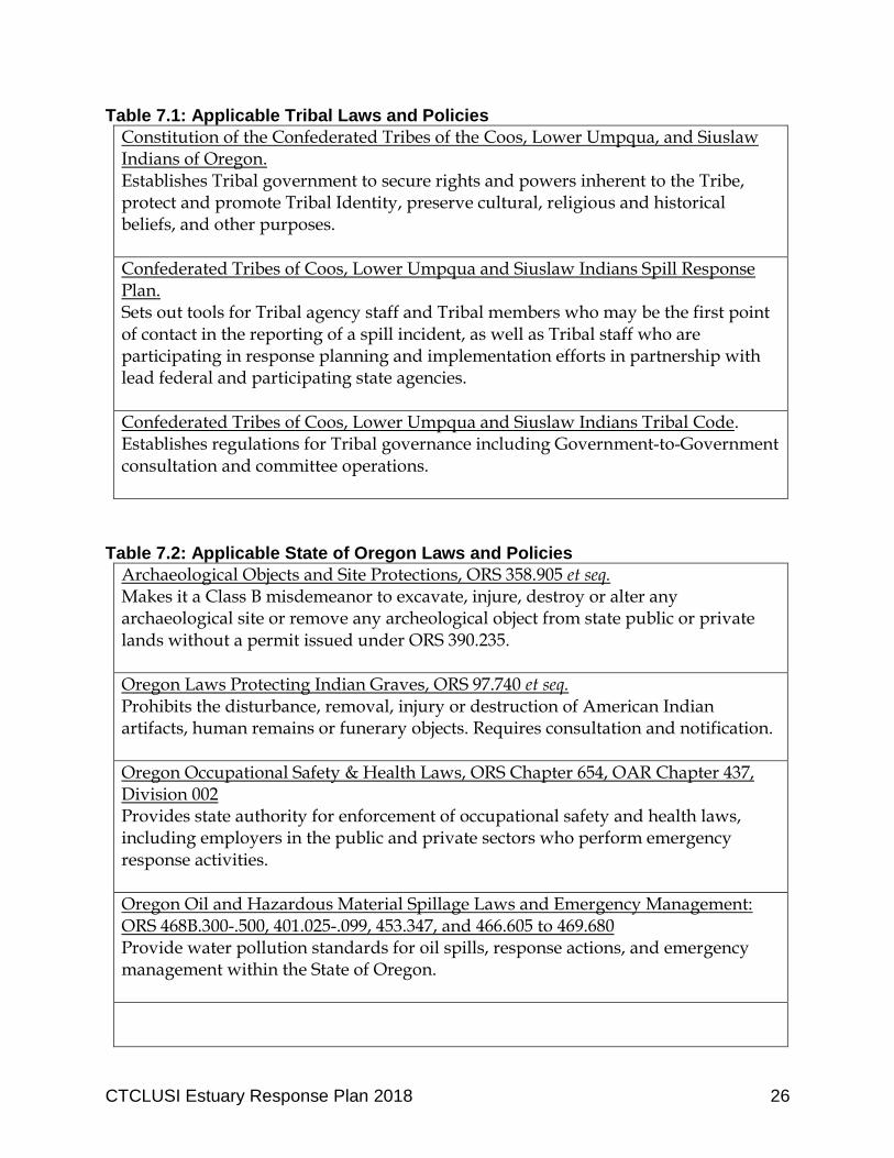
Table 7.1: Applicable Tribal Laws and Policies
Constitution of the Confederated Tribes of the Coos, Lower Umpqua, and Siuslaw Indians of Oregon. Establishes Tribal government to secure rights and powers inherent to the Tribe, protect and promote Tribal Identity, preserve cultural, religious and historical beliefs, and other purposes.
Confederated Tribes of Coos, Lower Umpqua and Siuslaw Indians Spill Response Plan. Sets out tools for Tribal agency staff and Tribal members who may be the first point of contact in the reporting of a spill incident, as well as Tribal staff who are participating in response planning and implementation efforts in partnership with lead federal and participating state agencies.
Confederated Tribes of Coos, Lower Umpqua and Siuslaw Indians Tribal Code. Establishes regulations for Tribal governance including Government-to-Government consultation and committee operations.
Table 7.2: Applicable State of Oregon Laws and Policies
Archaeological Objects and Site Protections, ORS 358.905 et seq. Makes it a Class B misdemeanor to excavate, injure, destroy or alter any archaeological site or remove any archeological object from state public or private lands without a permit issued under ORS 390.235.
Oregon Laws Protecting Indian Graves, ORS 97.740 et seq. Prohibits the disturbance, removal, injury or destruction of American Indian artifacts, human remains or funerary objects. Requires consultation and notification.
Oregon Occupational Safety & Health Laws, ORS Chapter 654, OAR Chapter 437, Division 002 Provides state authority for enforcement of occupational safety and health laws, including employers in the public and private sectors who perform emergency response activities.
Oregon Oil and Hazardous Material Spillage Laws and Emergency Management: ORS 468B.300-.500, 401.025-.099, 453.347, and 466.605 to 469.680 Provide water pollution standards for oil spills, response actions, and emergency management within the State of Oregon.
CTCLUSI Estuary Response Plan 2018 27
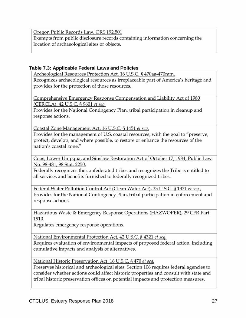
Oregon Public Records Law, ORS 192.501 Exempts from public disclosure records containing information concerning the location of archaeological sites or objects.
Table 7.3: Applicable Federal Laws and Policies
Archeological Resources Protection Act, 16 U.S.C. § 470aa-470mm. Recognizes archaeological resources as irreplaceable part of America’s heritage and provides for the protection of those resources.
Comprehensive Emergency Response Compensation and Liability Act of 1980 (CERCLA), 42 U.S.C. § 9601 et seq. Provides for the National Contingency Plan, tribal participation in cleanup and response actions.
Coastal Zone Management Act, 16 U.S.C. § 1451 et seq. Provides for the management of U.S. coastal resources, with the goal to “preserve, protect, develop, and where possible, to restore or enhance the resources of the nation’s coastal zone.”
Coos, Lower Umpqua, and Siuslaw Restoration Act of October 17, 1984, Public Law No. 98-481, 98 Stat. 2250. Federally recognizes the confederated tribes and recognizes the Tribe is entitled to all services and benefits furnished to federally recognized tribes.
Federal Water Pollution Control Act (Clean Water Act), 33 U.S.C. § 1321 et seq., Provides for the National Contingency Plan, tribal participation in enforcement and response actions.
Hazardous Waste & Emergency Response Operations (HAZWOPER), 29 CFR Part 1910. Regulates emergency response operations.
National Environmental Protection Act, 42 U.S.C. § 4321 et seq. Requires evaluation of environmental impacts of proposed federal action, including cumulative impacts and analysis of alternatives.
National Historic Preservation Act, 16 U.S.C. § 470 et seq. Preserves historical and archeological sites. Section 106 requires federal agencies to consider whether actions could affect historic properties and consult with state and tribal historic preservation offices on potential impacts and protection measures.

CTCLUSI Estuary Response Plan 2018 28
Native American Graves Protection and Repatriation Act, 25 U.S.C. § 3001 et seq. Provides for the protection of Native American graves. Assigns ownership and control of Native American cultural items and human remains to Native Americans.
Oil Pollution Act of 1990, 33 U.S.C. § 2701 et seq. Provides for prevention and response to catastrophic oil spills. Creates a trust fund financed by a tax on oil to clean up spills when responsible party is incapable or unwilling to do so.
U.S. National Oil and Hazardous Substances Pollution Contingency Plan (NCP), 40 CFR Part 300 Provides the organizational structure and procedures for preparing for and responding to discharges of oil and releases of hazardous substances, pollutants, and contaminants.
Superfund Amendments and Reauthorization Act of 1986 (SARA) Title III, the Emergency Planning & Right-to-Know Act (EPCRA), 42 U.S.C. § 11001 et seq., 40 CFR Part 370 – Hazardous Chemical Reporting: Community Right-to-Know Created to help communities prepare for chemical emergencies. Requires industry to report on the storage, use and releases of hazardous substances.
Stafford Act, 42 U.S.C. § 5121 et seq. Provides for emergency relief funding from federal government, through FEMA, available for hazardous material cleanups.
CTCLUSI Estuary Response Plan 2018 29
8. Mitigation The Tribe’s primary goal is avoiding injury to Tribal and community members, and to Tribal resources in the first instance. Mitigation as it is often used to replace lost resources generally is not possible for Tribal resources. This is because the people’s relationship to the place is the result of thousands of years of use, tradition, history, and story, as discussed above. Cultural artifacts simply cannot be replaced. In the event that a spill event causes irreparable damage to a Tribal resource, the responding agencies should confer with Tribal staff to understand the values of the resource that were lost and identify potential restoration opportunities within the Tribe’s Ancestral Territory. In general, the Tribe approaches mitigation in the following steps:
1. Avoid impacting the resource entirely. As discussed above, many tribal resources are irreplaceable. In the event of a spill, swift response action may be effective in avoiding adverse impacts to Tribal resources.
2. Where avoidance is impossible, minimize impacts to the extent possible. The Tribe understands that in some instances impacts cannot be avoided, but expects that all practicable efforts to minimize impacts will be taken. Many of the tools and planning elements of this Plan are designed to minimize adverse impacts to Tribal resources.
3. Impacts that cannot be avoided or minimized should be fully mitigated to the maximum extent. Mitigation may take the form of restoration, rehabilitation, establishment, or enhancement of resources for the purpose of offsetting unavoidable adverse impacts. Mitigation must be planned in consultation with the Tribe.
CTCLUSI Estuary Response Plan 2018 30
9. Regulatory Development Opportunities To effectuate this Plan and support the Tribe’s role in response actions, the Tribe will advance opportunities for legislation and ordinance adoption that recognize the Tribe’s role and authority and reinforce the provisions of this Plan. The Tribe will also review spill response plans developed by major new facilities operating within its Area of Interest. 9.1 Tribal Code
The Tribe will adopt code provisions to enact the provisions of this plan. 9.2 Other Local Code Advocacy
In order to protect the Tribe’s cultural resources in estuaries within its Area of Interest, the Tribe will work with local governments to adopt policies and ordinances to provide for notification and consultation with the Tribe. For example, the Coos Bay Estuary Management Plan Policy 18 (part of the Coos County Comprehensive Plan) provides for notification and consultation with the Tribe and protection of information about archeological sites. The Tribe will advocate for the adoption of similar provisions in Lane and Douglas Counties to require consultation with the Tribe before activities within the Siuslaw and Umpqua estuaries that may impact Tribal resources are permitted. The relevant language of Policy 18 states:
“Local government shall provide protection to historical, cultural and archaeological sites and shall continue to refrain from widespread dissemination of site-specific information about identified archaeological sites. “This strategy shall be implemented by requiring review of all development proposals involving a cultural, archaeological or historical site, to determine whether the project as proposed would protect the cultural, archaeological and historical values of the site. “The development proposal, when submitted shall include a Site Plan Application, showing, at a minimum, all areas proposed for excavation, clearing and construction. Within three (3) working days of receipt of the development proposal, the local government shall notify the Coquille Indian Tribe and Coos, Siuslaw, Lower Umpqua Tribe(s) in writing, together with a copy of the Site Plan Application. The Tribe(s) shall have the right to submit a written statement to the local government within thirty (30) days of receipt of such notification, stating whether the project as proposed would protect the cultural, historical and archaeological
CTCLUSI Estuary Response Plan 2018 31
values of the site, or if not, whether the project could be modified by appropriate measures to protect those values. “‘Appropriate measures’ may include, but shall not be limited to the following:
a. Retaining the prehistoric and/or historic structure in situ or moving it intact to another site; or
b. Paving over the site without disturbance of any human remains or cultural objects upon the written consent of the Tribe(s); or
c. Clustering development so as to avoid disturbing the site; or d. Setting the site aside for non-impacting activities, such as storage; or e. If permitted pursuant to the substantive and procedural requirements
of ORS 97.750, contracting with a qualified archaeologist to excavate the site and remove any cultural objects and human remains, reinterring the human remains at the developer's expense; or
f. Using civil means to ensure adequate protection of the resources, such as acquisition of easements, public dedications, or transfer of title.
“If a previously unknown or unrecorded archaeological site is encountered in the development process, the above measures shall still apply. Land development activities, which violate the intent of this strategy shall be subject to penalties prescribed in ORS 97.990. “This strategy recognizes that protection of cultural, historical and archaeological sites is not only a community's social responsibility, it is also legally required by ORS 97.745. It also recognizes that cultural, historical and archaeological sites are non-renewable cultural resources.”
Coos Bay Estuary Management Plan Policy #18. For this and similar policies to be effective and meaningful, the Tribe must be contacted and engaged as soon as cultural resources are identified as potentially present or impacted. The Tribe works with landowners and regulators to identify avoidance or mitigation measures that could be implemented in advance of any permit for development being issued. If the landowner, local government, or other regulator waits until after permits are issued or work has begun to engage the Tribe, any “consultation” is not meaningful and does not qualify as Tribal consent. 9.3 Review of Facility Spill Response Plans
Facilities that could reasonably be expected to cause substantial harm to the environment by discharging oil into navigable waters are required under Federal law (Section 311(j)(1)(C) of the Clean Water Act as amended by the Oil Pollution Act of
CTCLUSI Estuary Response Plan 2018 32
1990) to prepare and submit facility response plans to the Environmental Protection Agency. Oregon law requires similar plans. When these plans are developed for facilities operating within the Tribe’s Area of Interest, the Tribe will review the plans to ensure the plans are thorough and contain enough information, analyses, and supporting data and documentation to demonstrate the operator’s ability to promptly and properly remove oil or hazardous materials and minimize damage to Tribal resources. The Tribe will compare facility response plans to this Plan to identify any gaps in identified risks, priorities, or protection measures.
CTCLUSI Estuary Response Plan 2018 33
10. Funding
In the event of an oil spill or hazardous material release, trustees (including the Tribe) can obtain access to federal funds. Funds are also available for planning and other response purposes. Oil Spill Liability Trust Fund The National Pollution Fund Center (NPFC) manages the Oil Spill Liability Trust Fund (OSLTF). This fund is a source for payment of removal costs and damages resulting from oil spills or incidents that threaten to spill oil into navigable waters of the United States, adjoining shorelines, or the Exclusive Economic Zone (marine environment). In the event of a hazardous substance release or imminent threat of a release, the federal on-scene coordinator (FOSC) can obtain access to federal funds through CERCLA. Where the Tribe assists the FOSC, it may receive reimbursable funding authority through a Pollution Removal Funding Authorization (PRFA). The authorization to establish and use this funding source is provided by the FOSC. The Tribe may also submit claims for uncompensated removal costs or certain damages (natural resource, real/personal property, loss of profits, loss of subsistence use of natural resources, loss of government revenues, and increased costs of government services) caused by the oil spill to the NPFC if the responsible party does not satisfy the claim. The Tribe may request reimbursement of costs to carry out temporary measures to protect human health and the environment without a contract or cooperative agreement. Reimbursements are limited to $25,000 per hazardous substance response. CERCLA Brownfields Program Under CERCLA Section 128(a), the Tribe may seek grant funding for its Tribal Response Program. Funds can be used to create new or enhance existing environmental response programs. This Plan was developed pursuant to Section 128(a) funding. The Tribe may seek additional funding for future revisions and additional elements of this Plan as needed. Stafford Act Disaster Response Funding The Stafford Act Public Assistance program provides for emergency and natural disaster response funding. The Act reflects federally recognized tribal governments’ status as sovereign nations, giving them the same status as states when requesting federal disaster assistance. A tribe may declare a state of emergency on tribal lands (may be limited to tribally-owned and trust lands) and request access to Stafford Act benefits and federal assistance and hazardous materials cleanup funding. Under the Stafford Act, the federal government pays 75%of costs while a tribe would pay 25%.
CTCLUSI Estuary Response Plan 2018 34
This funding option is therefore more limited and may not be appropriate for oil spill or hazardous material response funding.
CTCLUSI Estuary Response Plan 2018 35
11. Plan for Compensation Schedule Under CERCLA, natural resource trustees are responsible for restoring, rehabilitating, replacing or acquiring the equivalent of natural resources injured by hazardous substance releases and losses of services provided by those natural resources. The trustees, including tribal trustees, determine resource injuries, assess natural resource injuries, present a claim, and recover damages (including the reasonable costs of assessing damages) and develop a plan for restoration of resources. The Tribe will establish a compensation schedule that will provide a simple methodology for assessing damages to Tribal resources from oil or other hazardous material spills into fresh, marine, and estuarine waters. The intent of the compensation schedule is to provide an alternate methodology to the extensive and expensive natural resource damage assessment presently being conducted following oil spills under CERCLA and the Natural Resource Damage Assessment regulations. 40 C.F.R. § 300. The compensation schedule will: (1) Establish the relative vulnerability of Tribal resources to spills by taking into
consideration the relative toxicity of the materials spilled and the sensitivity of Tribal resources present in the receiving environment; and
(2) Determine adequate monetary compensation for injury to Tribal resources resulting from a spill.
The Tribe will develop a compensation schedule with the support of scientific and cultural specialists.
CTCLUSI Estuary Response Plan 2018 36
12. Training and Tools There are a number of trainings and tools available for Tribal response officers. In preparation for participation in a response effort, the Tribe will ensure that at least the Tribal Response Officer has completed trainings on the National Incident Management System and Incident Command System. National Incident Management System The National Incident Management System (NIMS) provides a consistent nationwide template to enable all government, private sector, and nongovernmental organizations to work together during incidents and response actions. NIMS utilizes the Incident Command System (ICS). ICS is a management system that integrates facilities, equipment, personnel, procedures, and communications within a common organizational structure. ICS is normally structured to facilitate activities in five major areas: command, operations, planning, logistics, and finance/administration. The Incident Commander oversees the other four sections, in addition to public information, safety, or liaison officers. In order to effectively participate in a response action, the Tribal Response Officer should complete trainings in NIMS and ICS. These are available online from the Federal Emergency Management Administration (FEMA), at https://training.fema.gov/emiweb/is/icsresource/TrainingMaterials.htm HAZWOPER The Hazardous Waste Operations and Emergency Response Standard (HAZWOPER) applies to employers and employees who are (or are potentially) exposed to hazardous substances or are engaged in cleanup operations. HAZWOPER training must be refreshed every 12 months. Unless specifically required by law, HAZWOPER training will likely not be required for Tribal participation in ICS for response actions. Nevertheless, it may provide helpful context to understand worker safety in a hazardous material response event. Regional Training Exercises The Regional Response Team conducts emergency response drills in the Northwest Region. The Tribe will participate in training exercises with the Regional Response Team (following completion of ICS training) in order to identify information gaps and challenges and better understand how the response action occurs.
CTCLUSI Estuary Response Plan 2018 37
Planning Tools The NOAA Office of Response and Restoration and EPA Office of Emergency Management offer a suite of tools designed to assist emergency planning and response, especially for events related to hazardous chemicals. Computer-Aided Management of Emergency Operations (CAMEO) includes four core software programs that can (1) estimate threat zones from chemical spills including gas clouds, fires and explosions, (2) provide critical response information and physical properties about thousands of hazardous chemicals, (3) manage data about facilities, transportation routes, special locations of interest, past incidents, and response resources in a particular community, and (4) show all of this information together on one map. More information on this tool is available at: https://cameo.noaa.gov/
Spill Response Plan 38
13. Spill Response Plan The Confederated Tribes of Coos Lower Umpqua and Siuslaw Indians developed this spill response plan (Response Plan) for hazardous materials and oil spills for Tribal implementation. This Response Plan is intended to be used by the Tribe and referenced by partner agencies in response to an oil spill or hazardous materials release with the potential to impact the Tribe’s area of interest. The Ancestral Territory of the Confederated Tribes of the Coos, Lower Umpqua, and Siuslaw Indians extends from the mouth of Tenmile Creek (Lane County) in the north, south to Fivemile Point halfway between the mouths of Whiskey Run Creek and Cut Creek (coinciding with the border between Sections 30 and 31, Township 27 South, Range 14 West, Coos County), thence east to the crest of the Coast Range (to Weatherly Creek on the Umpqua River). Areas of interest include, but are not limited to, the five-county service area: Lincoln, Coos, Curry, Douglas, and Lane counties; waters within the Tribe’s Ancestral Territory including Tribally owned and non-Tribally owned lands; and lands that contain headwaters of rivers or tributaries that flow through the Ancestral Territory/Tribally owned lands. In the event of an oil spill or hazardous materials release, federal law dictates that the primary responsive agency will be either the U.S. Coast Guard or the U.S. EPA. Other agencies will be collaborative in the responsive effort. The Tribe’s preference is for low-impact protection techniques such as manual removal, passive collection, and diversion. The Tribe intends to be actively involved in response planning and implementation of cleanup efforts for incidents within its Ancestral Territory. This Response Plan provides tools for Tribal agency staff and Tribal members who may be the first point of contact in the reporting of a spill incident, as well as Tribal staff who are participating in response planning and implementation efforts in partnership with lead federal and participating state agencies. As a corollary to this Response Plan, the Tribe has developed a comprehensive set of maps identifying important and sensitive Tribal resources. The location of cultural resources is confidential to the Tribe; therefore, the cultural resource maps are not included with this public document. In the event of an oil spill or hazardous materials release, responding agencies should contact and consult with the Tribe to identify priority areas for protection.
Spill Response Plan 39
REQUIRED NOTIFICATIONS BY SPILLER
All spills of oil or hazardous substances into navigable waters as defined by the Clean Water Act (CWA) and all spills of a reportable quantity of hazardous substance (40 CFR Part 302) must be immediately reported by the spiller to the National Response Center (NRC). The NRC will contact appropriate local U.S. Coast Guard (USCG) or Environmental Protection Agency (EPA) offices. Notifying state and Tribal offices does not relieve the spiller from federal requirements to notify the NRC or vice versa.
All spills of a reportable quantity* of oil or hazardous substances in Oregon must be reported by the spiller to:
*Reportable Quantity in the State of Oregon: For Oil: If spilled into waters of the state, or escape into waters of the state is likely, any quantity of oil that would produce a visible oily slick, oily solids, or coat aquatic life, habitat or property with oil, but excluding normal discharges from properly operating marine engines; if spilled on the surface of land, any quantity of oil over one barrel (42 gallons). For hazardous substances see OAR 340-142-0050. For spills occurring in inland waters in Oregon, contact:
National Response Center (NRC) 1-800-424-8802 Toll Free
1-202-267-2675 Toll Call
Oregon Emergency Response System (OERS) 24-hour Emergency Spill Response
1-800-452-0311 or 1-800-OILS-911 (in Oregon)
U.S. Environmental Protection Agency, Seattle 1-206-553-1263
(if not available, notify U.S. EPA San Francisco 1-800-300-2193)
Spill Response Plan 40
FIRST RESPONDER GUIDELINES REMAIN UPWIND, UPHILL, OR UPSTREAM OF THE INCIDENT. From a safe distance, assess the scene. Attempt to determine if radiological materials or hazardous substances are present. Observe the following:
o Effects on people, animals, and the environment; o Container types, markings, placards and labels. If available, use the DOT
Emergency Response Guidebook for reference; o Signs of any released or discharged substances and any unusual or pungent
odors (move farther away or upwind if you detect an odor and are not sure it is safe);
o Wind direction and prevailing weather; o Distance and direction of nearby dwellings; and o Distance and direction of any nearby surface water.
The initial responder shall then make notifications as listed in the preceding pages. The initial responder shall not enter an area where the responder may become a victim, even to rescue another. Until help arrives, the initial responder should:
o Cordon off the incident area and establish a safe zone. If chemical vapors or flammable/explosive materials are involved, evacuate all persons from the immediate area and remain upwind of the incident area; if sources of radiation or radioactive materials are suspected to be involved, use the principles of time, distance, and shielding to reduce potential exposure;
o Enter the incident area only if properly trained and equipped with appropriate protective clothing and equipment;
o Render first aid to victims; be sure to notify medical personnel if radiation exposure or contamination is suspected;
o Serve as an on-scene communication point; and o Brief the response team leader or incident commander upon arrival.
Spill Response Plan 41
Initial Assessment and Information Check List The following information should be collected for all spills reported to the Tribe: Date and Time of Call: Caller Name, Address, & Phone Number: Name of Person Taking the Report: Vessel/Facility/Spiller Information: 1. Name and contact information of Potentially Responsible Party 2. Name of vessel/facility, railcar/truck number or other identifying information 3. Type and size of vessel/facility 4. Total quantity of fuel on board or in tank 5. Nationality (vessel only) 6. Location of incident (e.g., street address, lat/long, mile post, river mile) 7. Date and time of incident (or when discovered) 8. Description of spill (i.e., size, color, smell, etc.) 9. Type of incident (i.e., explosion, collision, tank failure, grounding, etc.) 10. Material released
Spill Response Plan 42
11. Source of material released 12. Estimated amount released 13. Resource impacted or potentially impacted (air, water, ground/soil) 14. Weather/sea conditions 15. Vessel/facility agent(s) name and phone 16. Name and contact information of insurance carrier 17. Number and type of injuries or fatalities 18. Description of who is on-scene and what response activities are being done or
have been completed 19. Have evacuations occurred 20. Other agencies notified
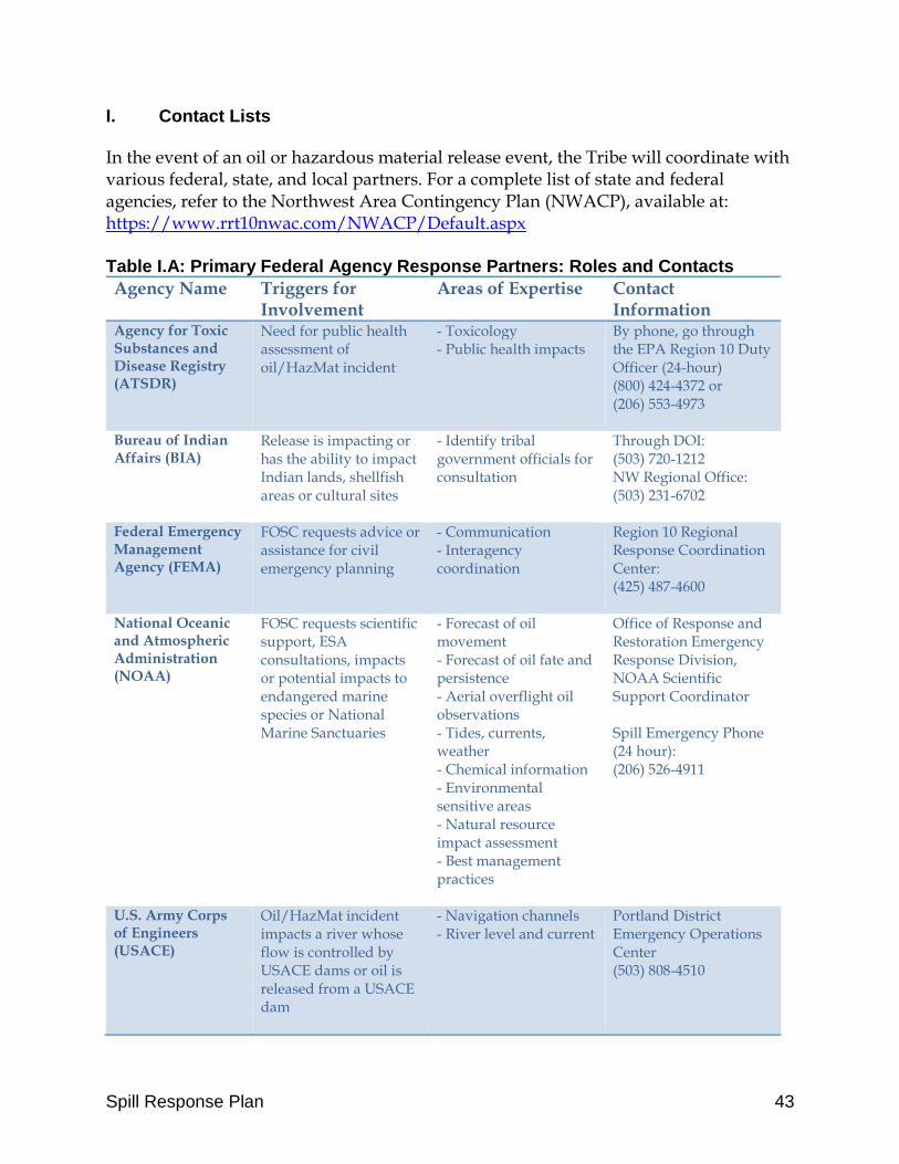
Spill Response Plan 43
I. Contact Lists
In the event of an oil or hazardous material release event, the Tribe will coordinate with various federal, state, and local partners. For a complete list of state and federal agencies, refer to the Northwest Area Contingency Plan (NWACP), available at: https://www.rrt10nwac.com/NWACP/Default.aspx Table I.A: Primary Federal Agency Response Partners: Roles and Contacts
Agency Name Triggers for Involvement
Areas of Expertise Contact Information
Agency for Toxic Substances and Disease Registry (ATSDR)
Need for public health assessment of oil/HazMat incident
- Toxicology - Public health impacts
By phone, go through the EPA Region 10 Duty Officer (24-hour) (800) 424-4372 or (206) 553-4973
Bureau of Indian Affairs (BIA)
Release is impacting or has the ability to impact Indian lands, shellfish areas or cultural sites
- Identify tribal government officials for consultation
Through DOI: (503) 720-1212 NW Regional Office: (503) 231-6702
Federal Emergency Management Agency (FEMA)
FOSC requests advice or assistance for civil emergency planning
- Communication - Interagency coordination
Region 10 Regional Response Coordination Center: (425) 487-4600
National Oceanic and Atmospheric Administration (NOAA)
FOSC requests scientific support, ESA consultations, impacts or potential impacts to endangered marine species or National Marine Sanctuaries
- Forecast of oil movement - Forecast of oil fate and persistence - Aerial overflight oil observations - Tides, currents, weather - Chemical information - Environmental sensitive areas - Natural resource impact assessment - Best management practices
Office of Response and Restoration Emergency Response Division, NOAA Scientific Support Coordinator Spill Emergency Phone (24 hour): (206) 526-4911
U.S. Army Corps of Engineers (USACE)
Oil/HazMat incident impacts a river whose flow is controlled by USACE dams or oil is released from a USACE dam
- Navigation channels - River level and current
Portland District Emergency Operations Center (503) 808-4510

Spill Response Plan 44
U.S. Coast Guard (USCG)
Provides FOSC for coastal oil/HazMat incidents
- Marine oil spill response operations - Mitigation - Vessel safety and navigation - Responder safety
National Response Center (800) 424-8802 www.uscg.mil/d13/
U.S. Department of Health and Human Services (HHS)
HazMat or oil releases that have the potential to impact public health
- Assessment of health hazards at a response site - Protection of response workers - Interpreting monitoring data and issuing public health warnings
By phone, go through the EPA Region 10 Duty Officer (800) 424-4372
U.S. Department of Labor, Occupational Safety and Health Administration (OSHA)
FOSC requests support assessing and mitigating the risk of responder health impacts
- Review of health and safety plans - Review of work practices
Portland Area Office (non-emergency) (503) 231-2017
U.S. Environmental Protection Agency (EPA)
Provides FOSC for inland oil/HazMat incidents
- Environmental sampling - Air and water monitoring - Human health impacts - Mitigation
R10 Duty Officer (800) 424-8802 www.epa.gov/oem
U.S. Fish and Wildlife Service
FOSC requests support for assessing or mitigating risks to fish or wildlife habitat
- Migratory birds, - Waters and wetlands, - Contaminants affecting habitat resources - Laboratory research facilities
Through DOI: (503) 720-1212
Table I.B: Primary State Agency Response Partners: Roles and Contacts
Agency Name Triggers for Involvement
Areas of Expertise Contact Information
Department of State Lands (DSL)
Incidents involving or potentially impacts estuary, tidal, offshore
- State waters and wetlands
Via OERS (24-hour): (800) 452-0311 Non-emergency:
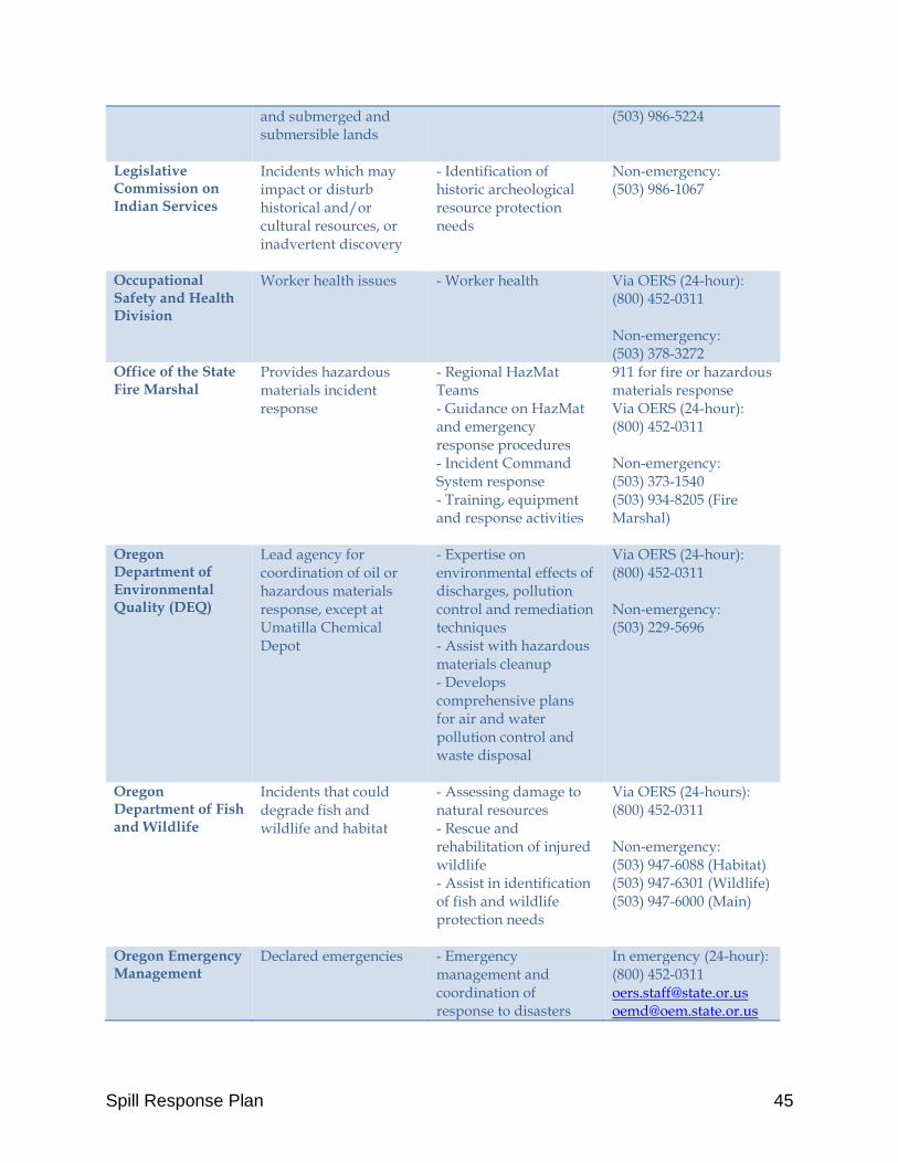
Spill Response Plan 45
and submerged and submersible lands
(503) 986-5224
Legislative Commission on Indian Services
Incidents which may impact or disturb historical and/or cultural resources, or inadvertent discovery
- Identification of historic archeological resource protection needs
Non-emergency: (503) 986-1067
Occupational Safety and Health Division
Worker health issues - Worker health Via OERS (24-hour): (800) 452-0311 Non-emergency: (503) 378-3272
Office of the State Fire Marshal
Provides hazardous materials incident response
- Regional HazMat Teams - Guidance on HazMat and emergency response procedures - Incident Command System response - Training, equipment and response activities
911 for fire or hazardous materials response Via OERS (24-hour): (800) 452-0311 Non-emergency: (503) 373-1540 (503) 934-8205 (Fire Marshal)
Oregon Department of Environmental Quality (DEQ)
Lead agency for coordination of oil or hazardous materials response, except at Umatilla Chemical Depot
- Expertise on environmental effects of discharges, pollution control and remediation techniques - Assist with hazardous materials cleanup - Develops comprehensive plans for air and water pollution control and waste disposal
Via OERS (24-hour): (800) 452-0311 Non-emergency: (503) 229-5696
Oregon Department of Fish and Wildlife
Incidents that could degrade fish and wildlife and habitat
- Assessing damage to natural resources - Rescue and rehabilitation of injured wildlife - Assist in identification of fish and wildlife protection needs
Via OERS (24-hours): (800) 452-0311 Non-emergency: (503) 947-6088 (Habitat) (503) 947-6301 (Wildlife) (503) 947-6000 (Main)
Oregon Emergency Management
Declared emergencies - Emergency management and coordination of response to disasters
In emergency (24-hour): (800) 452-0311 [email protected] [email protected]
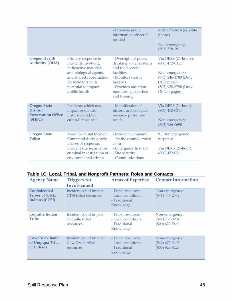
Spill Response Plan 46
- Provides public information officer if needed
(888) 695-1674 (satellite phone) Non-emergency: (503) 378-2911
Oregon Health Authority (OHA)
Primary response to incidents involving radioactive materials and biological agents, and shared coordination for incidents with potential to impact public health
- Oversight of public drinking water systems and food service facilities - Monitors health hazards - Provides radiation monitoring expertise and training
Via OERS (24-hours): (800) 452-0311 Non-emergency: (971) 246-1789 (Duty Officer cell) (503) 938-6790 (Duty Officer pager)
Oregon State Historic Preservation Office (SHPO)
Incidents which may impact or disturb historical and/or cultural resources
- Identification of historic archeological resource protection needs
Via OERS (24-hour): (800) 452-0311 Non-emergency: (503) 986-0690
Oregon State Police
Need for Initial Incident Command during early phases of response, incident site security, or criminal investigation of environmental crimes
- Incident Command - Traffic control, crowd control - Emergency first aid - Site security - Communications
911 for emergency response Via OERS (24-hour): (800) 452-0311
Table I.C: Local, Tribal, and Nonprofit Partners: Roles and Contacts
Agency Name Triggers for Involvement
Areas of Expertise Contact Information
Confederated Tribes of Siletz Indians (CTSI)
Incident could impact CTSI tribal resources
- Tribal resources - Local conditions - Traditional Knowledge
Non-emergency: (541) 444-2532
Coquille Indian Tribe
Incident could impact Coquille tribal resources
- Tribal resources - Local conditions - Traditional Knowledge
Non-emergency: (541) 756-0904 (800) 622-5869
Cow Creek Band of Umpqua Tribe of Indians
Incident could impact Cow Creek tribal resources
- Tribal resources - Local conditions - Traditional Knowledge
Non-emergency: (541) 672-9405 (800) 929-8229

Spill Response Plan 47
Oregon Shores Conservation Coalition
Incident could impact beaches or limit public access to coastal areas
- Volunteers for cleanup efforts and citizen science - Policy and advocacy support
Non-emergency: (503) 754-9303
Port of Coos Bay Incident within the Port of Coos Bay or rail-related incident
- Port operations - Rail operations - Local tides and conditions
Non-emergency: (541) 267-7678
Port of Siuslaw Incident within the Port of Siuslaw
- Port operations - Local tides and conditions
Non-emergency: (541) 997-3426 (541) 997-3040
Port of Umpqua Incident within the Port of Umpqua
- Port operations - Local tides and conditions
Non-emergency: (541) 271-2232
South Slough National Estuarine Research Reserve
Incident could impact South Slough resources
- Coordination with decision-makers - Data collection - local conditions - area maps and access information
Non-emergency: (541) 888-5558
Surfrider Foundation
Incident could impact recreational resources
- Coordination with decision-makers - Volunteers for cleanup efforts - Policy and advocacy support
Non-emergency: Siuslaw Chapter: [email protected] Coos Bay Chapter: [email protected] Oregon Field Manager, Briana Goodwin: [email protected]
II. Coordination Strategies The NCP requires that the Federal On-Scene Coordinator (FOSC) notify Tribal trustees for Tribal natural and cultural resources that may be impacted by a release. The NCP defines trustees to include tribal officials who act on behalf of the public to manage and control natural resources. Trustees must be notified of oil spills and hazardous materials incidents that may impact or threaten resources under their care. If it is unclear whether an incident meets a Tribal trustee’s notification threshold, the trustee should be notified. When EPA or USCG responds to an emergency using its FOSC authority, it shall, as soon as possible, notify and offer emergency coordination to all affected tribes. For CTCLUSI, the points of contact are: Tribal Historic Preservation Officer: Stacy Scott, 541-888-7513
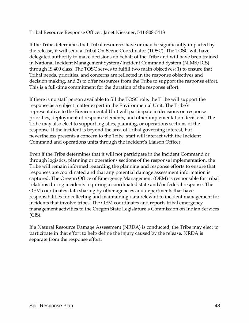
Spill Response Plan 48
Tribal Resource Response Officer: Janet Niessner, 541-808-5413 If the Tribe determines that Tribal resources have or may be significantly impacted by the release, it will send a Tribal On-Scene Coordinator (TOSC). The TOSC will have delegated authority to make decisions on behalf of the Tribe and will have been trained in National Incident Management System/Incident Command System (NIMS/ICS) through IS 400 class. The TOSC serves to fulfill two main objectives: 1) to ensure that Tribal needs, priorities, and concerns are reflected in the response objectives and decision making, and 2) to offer resources from the Tribe to support the response effort. This is a full-time commitment for the duration of the response effort. If there is no staff person available to fill the TOSC role, the Tribe will support the response as a subject matter expert in the Environmental Unit. The Tribe’s representative to the Environmental Unit will participate in decisions on response priorities, deployment of response elements, and other implementation decisions. The Tribe may also elect to support logistics, planning, or operations sections of the response. If the incident is beyond the area of Tribal governing interest, but nevertheless presents a concern to the Tribe, staff will interact with the Incident Command and operations units through the incident’s Liaison Officer. Even if the Tribe determines that it will not participate in the Incident Command or through logistics, planning or operations sections of the response implementation, the Tribe will remain informed regarding the planning and response efforts to ensure that responses are coordinated and that any potential damage assessment information is captured. The Oregon Office of Emergency Management (OEM) is responsible for tribal relations during incidents requiring a coordinated state and/or federal response. The OEM coordinates data sharing by other agencies and departments that have responsibilities for collecting and maintaining data relevant to incident management for incidents that involve tribes. The OEM coordinates and reports tribal emergency management activities to the Oregon State Legislature’s Commission on Indian Services (CIS). If a Natural Resource Damage Assessment (NRDA) is conducted, the Tribe may elect to participate in that effort to help define the injury caused by the release. NRDA is separate from the response effort.
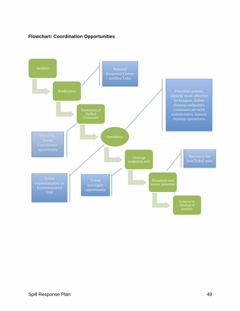
Spill Response Plan 49
National Response Center
notifies Tribe
Flowchart: Coordination Opportunities
Incident
Notification
Formation of Unified
Command
Operations
Cleanup endpoints met
Document and assess penalties
Long term cleanup if
needed
Prioritize actions, identify most effective
techniques, define cleanup endpoints. Communicate with
stakeholders. Sustain cleanup operations.
Tribal On-Scene
Coordinator opportunity
Tribal oversight
opportunity
Recovery for lost Tribal uses
Tribal representative to
Environmental Unit
Spill Response Plan 50
III. Notification Strategies for Incident Outreach
The Tribe will utilize the CTCLUSI Text Alert system to notify members of an incident or spill within the Tribe’s Ancestral Territory or area of interest. In the event of a spill or release, the Tribe will designate a Lead Information Officer (IO). The IO will coordinate with state or federal lead agencies for public information. The IO will:
a. Oversee incident messaging; b. Facilitate information sharing with federal, state, and local partners; c. Serve as subject matter experts as needed; d. Liaise between the decision-makers and the news media; e. Provide timely, accurate, coordinated information to response teams, Tribal
leadership, Tribal members, the public, news media, partners and other interested parties. The information to be provided includes:
i. Nature and extent of the spill or emergency, ii. Areas of Tribal interest that have endured the effects of the spill or
emergency, and areas that may sustain damage in the future, iii. Actions Tribal members should take to protect themselves, and iv. Activities that have been initiated or will be initiated, in response to
the spill, emergency or disaster. f. Inform Tribal leadership and officials on response efforts, protocols and
recovery programs; g. Brief news media as information becomes available. Develop and maintain all
public information news releases, briefing sheets, talking points, background information, and supplemental materials; and
h. Counter rumors with timely release of factual information.

Spill Response Plan 51
IV. Safety Protocols
The protection of emergency response workers is critically important so that they may safely perform their role in protecting the public and mitigating the incident. Safety protocols are established and required by federal law. This section outlines the general safety protocol requirements. The FOSC will appoint a Safety Officer to the Command Staff to assist the Incident Commander with responder safety. The Safety Officer will monitor operations, identify potential safety hazards, correct unsafe situations and develop additional methods and procedures to ensure responder safety. Safety Officers must be trained to the level of the incident. See 29 CFR 1910.120(q). All responders to a hazardous materials incident will: 1) Follow all site-specific safety and health plans that have been developed for a
particular location or site. 2) Adhere to applicable local, state and federal laws, statutes, ordinances, rules,
regulations, guidelines, and established standards pertaining to responder safety. 3) Not exceed individual response certification level in accordance with 29 CFR
1910.120 (HAZWOPER) and OAR Chapter 437 Division 002 training under any circumstance.
In addition, the following protocols shall be followed to ensure responder safety. IV.1 Training
Any person engaged in responding to hazardous emergency situations shall be trained on safety, health and other hazards present on the site, use of personal protective equipment, practices by which they can minimize risks from hazards, safe use of engineering controls and equipment on site, medical surveillance requirements, including recognition of symptoms and signs which might indicate overexposure to hazards, and the contents of applicable site safety and health plans. IV.2 Pre-entry briefing
Before entering the site of a spill or release for initiating response action, information about the site, and safety protocols shall be provided. IV.3 Preliminary evaluation
The first step in a spill response action is to investigate the site. Site investigation allows responders to determine appropriate actions and safety measures. A qualified person with the specific training, knowledge, and experience, must do a preliminary evaluation in order to aid in the selection of appropriate responder protection methods prior to initiating any responsive action. The site evaluation should include:
o The site’s hazards, including the physical or chemical properties of hazardous substances and how workers could be exposed to the hazards;
Spill Response Plan 52
o Health and safety risks associated with exposure to hazardous substances; o Potential leaks of hazardous substances; o Location, size, topography and access to the site; o Required actions and time to accomplish; o Qualifications of emergency responders and approximate response times; and o Personal protective equipment needed.
IV.4 Hazard identification
All suspected conditions that may pose inhalation or skin absorption hazards that are immediately dangerous to life or health, or other conditions that may cause death or serious harm, shall be identified during the preliminary evaluation and survey. Examples of such hazards include, but are not limited to, confined space entry, potentially explosive or flammable situations, visible vapor clouds, or areas where biological indicators such as dead animals or vegetation are located. IV.5 Information required
The following information shall be obtained and provided prior to allowing responders to enter a site:
o Location and approximate size of the site; o Description of the response activity to be performed; o Duration of the planned activity; o Site topography and accessibility by water, air, and roads; o Safety and health hazards expected at the site; o Pathways for hazardous substance dispersion; o Present status and capabilities of other emergency response teams that would
provide assistance at the time of emergency; and o Hazardous substances and health hazards involved or expected at the site,
and their chemical and physical properties.
IV.6 Personal Protective Equipment
Personal protective equipment, which will provide protection to a level of exposure below permissible exposure limits and published exposure levels for known or suspected hazardous substances and health hazards, and which will provide protection against other known and suspected hazards identified during that preliminary site evaluation shall be provided and used during site entry. If the preliminary site evaluation does not produce sufficient information to identify the hazards or suspected hazards of the site, an ensemble providing protection equivalent to Level B personal protective equipment shall be provided as minimum protection, and direct reading instruments shall be used as appropriate to identify conditions immediately dangerous to life or health. Once the hazards of the site have been identified, the appropriate personal protective equipment shall be selected and used.

Spill Response Plan 53
IV.7 Contaminant and/or Hazard Monitoring
When the site evaluation produces information that shows the potential for ionizing radiation or conditions immediately dangerous to life or health (IDLH), or when the site information is not sufficient to reasonably eliminate these possible conditions, the following monitoring shall be conducted during response actions:
o Monitoring with direct reading instruments for hazardous levels of ionizing radiation.
o Monitoring the air with appropriate direct reading test equipment (i.e., combustible gas meters, detector tubes) for IDLH and other conditions that may cause death or serious harm (combustible or explosive atmospheres, oxygen deficiency, toxic substances).
o Visually observing for signs of actual or potential IDLH or other dangerous conditions.
o An ongoing air monitoring program shall be implemented after site characterization has determined the site is safe for the start-up of operations.
IV.8 Risk identification
Once the presence and concentrations of specific hazardous substances and health hazards have been established, the risks associated with these substances shall be identified. Responders who will be working on the site shall be informed of any risks that have been identified. IV.9 Notification
Any available information concerning the chemical, physical, and toxicological properties of each substance known or expected to be present on site shall be made available to responders prior to the commencement of activities. IV.10 Site Control
Appropriate site control procedures shall be implemented to control exposure to hazardous substances before cleanup work begins. Elements of the site control program shall include, at minimum: site map; site work zones; the use of a “buddy system”; site communications including alerting means for emergencies; the standard operating procedures or safe work practices; and identification of nearest medical assistance.
Spill Response Plan 54
V. Assessing Damage When an oil spill or hazardous material release occurs, the Tribe will participate in Shoreline Cleanup and Assessment Technique (SCAT), a systematic method for surveying an affected shoreline after an incident. SCAT is designed to support decision making for shoreline cleanup. SCAT is flexible in its scale of surveys and in the detail of the datasets collected. SCAT surveys begin early in the response to assess initial shoreline conditions, and ideally continue to work in advance of operational cleanup. Surveys continue during the response to verify shoreline oiling, cleanup effectiveness, and eventually to conduct final evaluations of shorelines to ensure they meet cleanup endpoints. The eight steps of SCAT are:
1. Conduct reconnaissance survey(s); 2. Segment the shoreline; 3. Assign teams and conduct SCAT surveys; 4. Develop cleanup guidelines and endpoints; 5. Submit survey reports and shoreline impact sketches to the ICS Planning
Section; 6. Monitor effectiveness of cleanup; 7. Conduct post-cleanup inspections; and 8. Conduct final evaluation of cleanup activities.
When a SCAT team is formed, the Tribe will designate a natural resource staff member to participate as a member of the SCAT team. The Tribe’s representative on the SCAT team will be instrumental in identifying environmentally and culturally sensitive resources in the spill area, and helping to implement constraints on cleanup, if necessary, due to cultural concerns. In order to be an effective participant, the Tribe’s representative will need to be someone with knowledge of shoreline processes, and trained on SCAT terms and cleanup methods.
Spill Response Plan 55
VI. Major Protection Techniques and Cleanup Strategies
This section outlines some general approvals and decision tools for using shoreline cleanup methods. However, the responders’ specific treatment of a particular spill event must integrate field data on shoreline habitats, oil type, degree of shoreline contamination, spill-specific physical processes, and ecological and cultural resource issues. Response techniques have windows of opportunity within which they are most effective. Selection of a proper response method is highly dependent on incident-specific conditions, and must consider trade-offs affecting the options’ potential impacts, appropriateness for the habitat and location, and the timing of the application. Using multiple methods simultaneously throughout an incident can produce a more effective response and minimize impacts. The Tribe’s preference is for low-impact protection techniques such as manual removal, passive collection, and diversion. Cleaning spills using manual removal, collection, and diversion is preferable because it actually removes the contaminant. Aggressive techniques such as in-situ burning or use of dispersants will only be considered in offshore areas and with full consideration of alternatives and potential impacts. Both dispersants and dispersed oil particles are toxic to some marine organisms. Applying dispersants to an oil slick shifts the possibility of oil exposure to animals living in the water column beneath the ocean surface and on the sea floor. In-situ burning presents safety risks both to response workers and the larger community from possible exposure to toxic components of the smoke emitted from combustion. Consistent with the NWAPC, decisions to use these techniques shall be made in consultation with the Tribe as part of the dispersant authorization process and in-situ burning decision tree. The National Oceanic and Atmospheric Administration (NOAA) has developed guides and manuals for spill response planning in marine and shoreline environments that set forth the full set of response techniques as well as feasibility issues and guidelines for selecting response actions. The following sections explain the basics of primary shoreline protection and cleanup strategies for consideration by the Tribe. VI.1 Shoreline Protection Strategies
The basic shoreline protection objective is to prevent or minimize contact between oil and the shore zone (or a resource at risk in the zone). Shoreline protection limitations include the properties of the spilled product, physical and environmental conditions (current, waves, wind, tides, water depth), and logistical constraints (access, bulky heavy equipment, towing positioning and tending equipment, personnel needs, channel traffic, decontamination, recovery and storage, and disposal of contaminated materials).
Spill Response Plan 56
For spills close to shore or in estuaries or bays, the key strategies are to use collection, diversion, or exclusion booming to contain the slick and prevent it from entering areas with sensitive wildlife, fisheries, and Tribal resources. These strategies can be generally defined as follows:
o Containment: hold oil in place. Oil recovery is the main objective. o Deflection: Divert moving oil away from a sensitive area, possibly towards
another area where containment and oil recovery is more feasible. o Exclusion: Barriers to prevent oil from reaching an area; usually without attempt
to recover the oil. o Recovery: Removal of oil by skimmers, sorbent material, or manual pickup.
In open-water areas, responders may use skimmers and netting systems for recovery of oil slicks and highly viscous oils, respectively. VI.1.1 Booming
Booms are floating, physical barriers to oil, made of plastic or other materials, which slow the spread of oil and keep it contained. Booms may be placed across a narrow entrance to the ocean, such as for small streams, creeks, or small inlets, to close off the entrance so that oil cannot pass through into mudflats, wetlands, or sensitive habitat areas. Booms can also be placed to deflect oil away from shellfish beds or beaches used by snowy plovers as nesting habitat. And booms can be placed around a sensitive or important site, to prevent oil from reaching it. Booms are the most common protection method. Booms can be used on all water environments, weather permitting. Booms begin to fail by entrainment when the effective current or towing speed exceeds 0.7 knots perpendicular to the boom. Waves, wind, and debris contribute to boom failure. Placing and maintaining boom and anchoring points should not cause excessive physical disruption to Tribal resources. Booms and anchors must be maintained so they do not fail or tangle and cause more damage. Vehicle and foot traffic to and from boom sites should not disturb wildlife unreasonably or be co-located with cultural resources. Cleaning booms will generate contaminated wastewater that must be collected, treated, and disposed of appropriately. VI.1.2 Skimming
Skimmers are placed at the oil/water interface to recover, or skim, oil from the water’s surface. There are numerous types of skimming devices: brush, disc, drum, paddle, belt, rope mop, sorbent belt, submersion plan, suction, and weir. These may be operated from shore, mounted on vessels, or self-propelled. Skimmers are often placed where oil naturally accumulates in pockets, pools, or eddies.
Spill Response Plan 57
Skimmers can be used on all water environments, weather and visibility permitting. Waves, currents, debris, seaweed, kelp, and viscous oils will reduce skimmer efficiency. VI.1.3 Barriers/Berms
When oil is threatening sensitive areas and booming is not feasible, barriers (other than booms) may be placed across an area to prevent oil from passing. Barriers can consist of earthen berms, trenching, or filter fences. This approach may be suitable at the mouths of creeks or streams to prevent oil from entering, or to prevent oil in the creek from being released into offshore waters. When it is necessary for water to pass because of water volume, underflow, or overflow dams are used. Responders must minimize disturbance to bird nesting areas, beaver dams, or other sensitive areas. Placement of dams and filter fences could cause excessive physical disruptions, particularly in wetlands. VI.1.4 Physical Herding
Plunging water jets, water or air hoses, or propeller wash can be used to dislodge oil trapped in debris or vegetation on water and direct floating oil towards containment and recovery devices, or to divert oil from sensitive areas. Herding can be effective in nearshore areas with little or no current, and in and around man-made structures like wharves and piers. This approach should be considered with caution as it may emulsify the oil or disrupt bottom sediments or submerged aquatic vegetation and contamination of benthic habitats. VI.1.5 Sorbents
Sorbents are organic, inorganic, and synthetic materials that remove surface oil in water or at the waterline through absorption (like a sponge) or adsorption (coating of the sorbent’s surface). Sorbents are placed on the floating oil or water surface, or are used to wipe stranded oil. All sorbent material must be recovered and properly disposed or recycled. In deploying sorbents, access must not adversely affect wildlife or be through soft or sensitive habitats. Improperly deployed or tended sorbents can crush or smother sensitive organisms. VI.2 Shoreline Cleanup Strategies
The selection of cleanup strategies is based upon the degree of oil contamination, shoreline types, and the presence of sensitive resources. Extremely sensitive areas are limited to manual cleanup methods. The primary goal of cleanup is the removal of oil from the shoreline with no further injury or destruction to the environment. Reducing overall impacts usually requires a combination of techniques, including: 1) Natural recovery; 2) Physical washing/flushing; and 3) Physical removal. The following sections describe various cleanup strategies beginning with the least impact and risk
Spill Response Plan 58
and increasing in risks and challenges. The Tribe’s preference is to implement the lowest-impact methods to achieve cleanup. VI.2.1 No Action / Natural Recovery
In some cases, no attempt may be made to remove stranded oil, to minimize impacts, or because there is no proven effective method for cleanup. This may be the appropriate response where the shoreline is extremely remote or inaccessible, when natural removal rates are very fast, or cleanup actions will do more harm than leaving the oil to be removed naturally. This method may be inappropriate where high numbers of mobile animals (e.g. birds, marine mammals, crabs) use the intertidal zone or nearshore waters. VI.2.2 Manual Removal
Manual removal is achieved with the use of hand tools and manual labor to remove surface oil and oily debris. No mechanized equipment is used in this process. This approach is appropriate on shorelines where oil can be easily removed, in light or moderate oiling conditions. Primary constraints with this approach include foot traffic over sensitive areas or seasonal shoreline restrictions due to bird nesting, mammal pupping, or similar events. VI.2.3 Passive Collection (Sorbents)
Passive collection uses sorbent material placed on the surface of the shoreline substrate to absorb oil as it is released by tidal or wave action. This technique is most useful when the oil is of a viscosity and thickness to be released by the substrate and absorbed by the sorbent, and is often used as a secondary treatment after gross oil removal and along sensitive shorelines where access is restricted. Sorbents include peat moss, vermiculate, and clay, or synthetic varieties such as plastic foams or fibers. Oil-filled sorbents must be collected, treated, and removed. VI.2.4 Debris Removal
When driftwood or debris on the upper beach and zone above high tide is heavily contaminated and remains a potential source of chronic oil release or other contamination on the shoreline, removal may be appropriate. Disturbance to adjacent upland areas should be minimized and foot traffic over sensitive intertidal areas restricted. VI.2.5 Trenching
When large quantities of oil penetrate deeply into permeable sediments like sand and gravel, trenching may be effective to remove subsurface oil. This method requires digging trenches to the depth of the oil and removing oil floating on the water table by vacuum pump or sucker. Water flooding or high-pressure spraying at ambient temperatures can be used to flush oil to the trench. The oil must be liquid enough to flow at ambient temperatures. Trenching should not be used in the lower intertidal area when attached algae and organisms are abundant.
Spill Response Plan 59
VI.2.6 Sediment Removal
This technique removes oiled sediments by manual removal or mechanical equipment. The oiled material must be transported and disposed of off-site. Mechanical equipment is not appropriate for rocky shores, and should only be used on beaches and with special supervision to minimize sediment removal. This approach is appropriate where only very limited amounts of oiled sediments must be removed. Use of equipment can cause significant disturbances and therefore should be strictly limited to upper intertidal and areas above the high tide line. VI.2.7 Ambient-Water Flooding (Deluge)
On beaches with coarse sediments or gently sloped rocky shorelines, this approach washes surface oil from crevices and rock interstices to the water’s edge for collection by booms and skimmers. Ambient sea water is pumped through holes in a pipe laid parallel to the shoreline above the oiling. Water flows through the rocks or substrate pushing loose oil ahead of it downslope for pickup. This technique is most effective on heavily oiled shorelines when the oil is still fluid and loosely adhering to the substrate, and where oil has penetrated into cobble or boulder beaches. This technique should not be used at creek mouths. Where the lower intertidal zone contains rich biological communities, flooding should be restricted to tidal stages when the rich zones are under water to prevent secondary oiling. VI.2.8 Ambient-Water/Low-Pressure & Ambient-Water/High Pressure Washing
This approach uses ambient seawater at low or high pressure to remove liquid oil. Both techniques involve spraying ambient seawater with hoses to flush oil to the water’s edge where the oil is trapped by booms and picked up with skimmers or sorbents. Low-pressure washing can be used on gravel beaches or vegetation, while high-pressure washing is appropriate only for hard substrate and human-made surfaces. The timing of flushing should be restricted to tidal elevations where the oil/water effluent does not drain across sensitive low tide habitats. VI.2.9 Warm-water/Moderate-to-High-Pressure Washing
When oil is thick or weathered and adhered to rock surfaces, heated seawater may be sprayed to mobilize and flush oil down the beach to the water’s edge where it can be trapped by booms and picked up with skimmers or sorbents. Similar to other flushing techniques, timing should be restricted to avoid oiling sensitive low-tide habitats. This approach should be restricted adjacent to stream mouths, tide pool communities, and similar rich intertidal communities. VI.2.10 Hot-Water/High-Pressure Washing
Hot water high-pressure washing can dislodge trapped and weathered oil from inaccessible locations and surfaces not amenable to mechanical removal. This technique can be used with immediate use of vacuum to remove the oil/water runoff, or can be
Spill Response Plan 60
used as a deluge system with oil flushed to water’s edge for collection with skimmers or sorbents. This approach requires similar limitations as other washing techniques to avoid sensitive low-tide habitats, stream mouths, and tide pool communities. Released oil must be recovered to prevent further oiling of adjacent environments. VI.2.11 Slurry Sand Blasting
Sandblasting can remove heavy residual oil from seawalls and riprap. Used (oiled) stand may be recovered in some cases. This approach should not be used near oyster or clam beds, or areas with high biological abundance on the shoreline directly below or adjacent to the structures. VI.2.12 Vacuum
A vacuum unit with suction head may be used to recover free oil pooled on substrate surface or from the water’s surface in sheltered areas. Equipment can be mounted on barges, boats, or trucks onshore. Special restrictions should be identified for areas where foot traffic and equipment operation should be limited, such as rich intertidal communities. Operations in wetlands are to be very closely monitored, with a site-specific list of restrictions. VI.2.13 Sediment Reworking
On beaches exposed to significant wave activity, beach sediments can be rototilled or otherwise mixed to break up oil deposits and enhance the rate of oil degradation. Oiled sediments in the upper beach area may be relocated lower on the beach to enhance natural cleanup during reworking by wave activity. This approach may be appropriate for beaches with significant amounts of subsurface oil or where deposits have started to form pavements or hard crusts. However, due to mixing oil into sediments, this process could further expose organisms living below the original oil layer. Re-suspension of exposed oil and fine-grained, oily sediments can affect adjacent waterbodies. Sediment reworking is not appropriate near shellfish-harvest or fish-spawning areas, or near bird nesting or concentration areas. VI.2.14 Sediment Removal, Cleansing, and Replacement
In this approach, oiled sediments are excavated using heavy equipment, loaded into a container for washing and rinsing, and then returned to the original area. The beaches must be exposed to wave activity to allow the replaced sediments to be reworked into a natural distribution. This approach implicates several constraints. Excavating equipment must not intrude upon sensitive habitats. Only the upper and above tide areas should be considered. The washing must not change the grain size of the sediment. This approach is generally restricted in spawning areas. Equipment can be heavy, noisy, and large, and disruptive to wildlife. All resident organisms in the intertidal area will be impacted.
Spill Response Plan 61
VI.2.15 Cutting Vegetation
Where it is necessary to prevent oiling of wildlife, it may be appropriate to remove oiled vegetation by cutting. Cut vegetation is bagged immediately for disposal. This approach is only appropriate where the risk of oiled vegetation contaminating wildlife is greater than the value of the vegetation to be cut, and there is no less destructive method to remove or reduce the risk to acceptable levels. Removal of vegetation will result in loss of habitat for many animals and cut areas will have reduced growth for up to two years. Along exposed shorelines, vegetation may not regrow, resulting in erosion and permanent loss of habitat. Trampled areas (which are inevitable) will recover much more slowly.

Spill Response Plan 62
VII. Cleanup Strategies for Specific Locations
In the event of a spill, the Tribe will identify sensitive areas and Tribal resources at risk of contamination or other damage. Human use resources are most sensitive when:
Contamination can result in human health concerns, such as tainting of subsistence fisheries;
Cultural or archaeological sites are located in the intertidal zone;
Contamination can result in significant losses through fouling, tainting, or avoidance because of perceived negative impact; or
The resource is unique. The Tribe has developed comprehensive maps and other tools to identify specific sensitive locations. These maps contain sensitive information that will remain in the control of the Tribe. The Tribe will share information as needed with response team leaders in order to best protect these resources. For specific location strategies, responsive entities should contact the Tribal Response Officer or Tribal On-Scene Coordinator (TOSC) if one has been assigned, or the Tribe’s Department of Natural Resources and Culture. VIII. Complying with the National Historic Preservation Act during Emergency Response
Although emergency response decisions must be made quickly, they must also be informed decisions. Informed decisions are those made in consultation with the Tribe. There must be formal consultation with the Tribe on newly discovered or unanticipated cultural resources encountered or adverse impacts due to the response. In order to comply with the National Historic Preservation Act (NHPA), the Federal On-Scene Coordinator must first determine whether the spill is subject to categorical exclusion from Section 106. If not, the responder shall notify the Tribal Historic Preservation Office (THPO) and State Historic Preservation Office (SHPO) for consultation and activate a qualified Historic Properties Specialist to develop protective measures for historic properties or cultural resources if determined by consultation. When the response has completed, notify the THPO and SHPO. The Federal On-Scene Coordinator shall ensure that all response personnel are notified of the required actions after any discovery of cultural resources during emergency response activities. Response personnel, including contractors, sub-contractors, emergency responders, cleanup workers, and field crews are the people most likely to encounter cultural resources while in the field. The following notification should be provided to all response personnel:
Spill Response Plan 63
IX. Notice to Response Personnel: Required Actions After Discovery of Cultural Resources In the course of your work, if you find an item that they believe or suspect is cultural or historic, you must:
1. Stop work immediately at, near, and surrounding the area where you discovered the object, item, or artifact.
2. Leave the suspected cultural item in place, undisturbed, exactly where it was discovered. Do not pick the item up, touch it, or work around it.
3. If possible, mark the location where you discovered the item but do not disturb or penetrate the soil with any object or tool. There may be other artifacts under the soil that could be damaged by your actions.
4. Inform the field supervisor of the discovery as soon as possible.
Compliance with these procedures is mandatory; they must be followed by all response personnel. Failure to comply with these procedures by excavating, removing, damaging, altering, or defacing any archeological resource is a violation of multiple State and Federal laws and may result in fines or penalties, criminal prosecution, and imprisonment. For more information on actions related to the discovery of cultural resources, consult with your supervisor or contact the Historic/Cultural Resources Specialist.


![Umpqua bank san francisco [finno]](https://img.pdfslide.net/doc/110x75/54c92db44a7959f7238b45e9/umpqua-bank-san-francisco-finno.jpg)