Embed Size (px)
Citation preview
CONNECTING COMMUNITIES PROGRAM
RAVENNA TO ROOTSTOWN CORRIDOR STUDY
TABLE OF CONTENTS
01 Executive Summary
02 Project Purpose and Anticipated Outcomes
03 Study Area – the R2R Corridor
08 Framing the Issues – Key Focus Areas
09 Provide More Transportation Choices
29 Encourage Investment and Revitalization of Established Neighborhoods
42 Bolster Partnerships to Integrate Land Use and Transportation Decisions
44 Summary of Recommendations
01
The Akron Metropolitan Area Transportation Study (AMATS) established the Connecting Communities Program in 2010. The intent of the initiative is to create more vibrant, livable communities though coordinating resources, partners and stakeholders to integrate transportation and land use planning and decisions in the greater Akron area. In 2012, the City of Ravenna sought and received a Connecting Communities Planning Grant to focus on the Old State Route 44 corridor from State Route 14 south to Tallmadge Road (County Road 16) in Rootstown Township to advance transportation planning in this corridor.
The R2R Corridor is a five mile long corridor in Portage County, Ohio that is centrally located in Northeast Ohio between Akron, Cleveland and Youngstown, and benefits from the close proximity of such strategic assets as IR-76 and the Ohio Turnpike.
The issues identified in the corridor were transportation, revitalization and economic development issues – issues that cannot be addressed without a collaborative and coordinated approach offered by the Connecting Communities Program. However, this program has its limitations. Therefore, AMATS, GPD Group and the City developed an approach that would offer the City of Ravenna and its partners a vision of what could be. This vision outlines the corridor, issues in the corridor and possible solutions all framed within the context of the Connecting Communities Program goals.
The goals of the project are to:
• Increase transit accessibility and emphasize multi-modal transportation;
• Support ongoing and future economic development that will contribute to a vibrant community, and;
• Offers solutions for transportation issues in the corridor.
(A summary of the final recommendations and pictures will be added to the executive summary after the July 23, 2013 meeting.)
EXECUTIVE SUMMARY
The AMATS Connecting Communities program seeks
to create vibrant, livable communities.
02
CONNECTING COMMUNITIES PLANNING GRANT PROGRAM
As stated previously, the Akron Metropolitan Area Transportation Study (AMATS) established the Connecting Communities Program in 2010. The intent of the initiative is to create more vibrant livable communities though coordinating resources, partners and stakeholders to integrate transportation and land use planning and decisions in the greater Akron area. It looks at how transportation funding, project selection and planning can better complement land use planning that encourages investment and revitalization of established neighborhoods and regional collaboration.
The AMATS Connecting Communities Planning Grant Program is designed to provide communities with planning funds to develop transportation plans that would lead to the identification of projects eligible for AMATS allocated transportation funding.
The overarching vision of AMATS is that the resulting plan will create more vibrant, livable communities through:
3 Providing transportation choices; 3 Encouraging investment and revitalization of established
neighborhoods, and; 3 Bolstering partners and stakeholders to integrate land
use and transportation decisions.
Ultimately, the intent of the Connecting Communities Grant Program is to provide the seed money to develop a vision and help it grow.
RAVENNA TO ROOTSTOWN CORRIDOR STUDY
In 2012, the City of Ravenna sought and received a Connecting Communities Planning grant to focus on the Old State Route 44 corridor from State Route 14 south to County Road 16 in Rootstown Township to advance transportation planning in this corridor. The Ravenna to Rootstown (R2R) Corridor Study evolved as a request for funding to focus on providing Safe Alternatives: Less Traffic (SALT) in the R2R Corridor. GPD Group proposed an approach that would focus on the key transportation “nodes” throughout the R2R Corridor.
The purpose of the Ravenna to Rootstown Corridor Study is to:
• Evaluate the key focus areas in the corridor; • Evaluate key drivers influencing the need for
transportation improvements with a focus on opportunities for economic development;
• Review revitalization needs with a focus on downtown Ravenna;
• Develop a range of solutions to the transportation, revitalization and economic challenges influencing the R2R Corridor, and;
• Identify potential funding sources for the solutions.
The findings for the existing conditions and recommendations for the R2R Corridor study will be presented in a manner that supports the principles of the Connecting Communities Grant Program – Create More Livable Communities by Increasing Transportation Choices, Encourage Investment and Revitalization of Existing Neighborhoods, and Bolster Partnerships to Integrate Land Use and Transportation Decisions.
PROJECT PURPOSE AND ANTICIPATED OUTCOMES
03
THE STUDY AREA – THE R2R CORRIDOR
STRATEGIC LOCATION
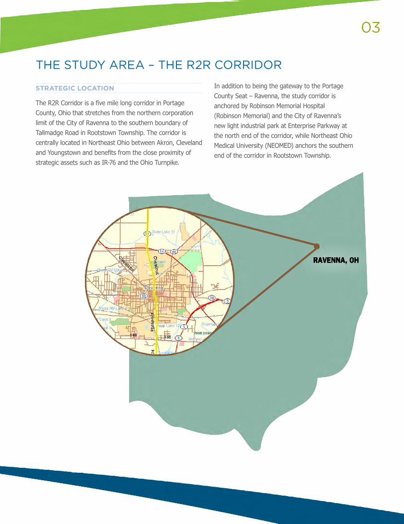
The R2R Corridor is a five mile long corridor in Portage County, Ohio that stretches from the northern corporation limit of the City of Ravenna to the southern boundary of Tallmadge Road in Rootstown Township. The corridor is centrally located in Northeast Ohio between Akron, Cleveland and Youngstown and benefits from the close proximity of strategic assets such as IR-76 and the Ohio Turnpike.
In addition to being the gateway to the Portage County Seat – Ravenna, the study corridor is anchored by Robinson Memorial Hospital (Robinson Memorial) and the City of Ravenna’s new light industrial park at Enterprise Parkway at the north end of the corridor, while Northeast Ohio Medical University (NEOMED) anchors the southern end of the corridor in Rootstown Township.
RAVENNA, OH
04
DEMOGRAPHICS
The demographic analysis will consider a collection of census tracts encompassing the City of Ravenna, the surrounding Ravenna Township and Rootstown Township. The following presents an economic and demographic survey of the area.
DEMOGRAPHIC CONDITIONS
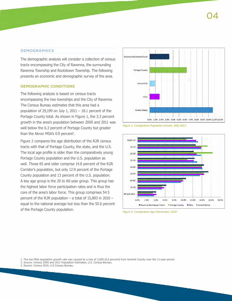
The following analysis is based on census tracts encompassing the two townships and the City of Ravenna. The Census Bureau estimates that this area had a population of 29,199 on July 1, 2011 – 18.1 percent of the Portage County total. As shown in Figure 1, the 3.3 percent growth in the area’s population between 2000 and 2011 was well below the 6.3 percent of Portage County but greater than the Akron MSA’s 0.9 percent1.
Figure 2 compares the age distribution of the R2R census tracts with that of Portage County, the state, and the U.S. The local age profile is older than the comparatively young Portage County population and the U.S. population as well. Those 65 and older comprise 14.8 percent of the R2R Corridor’s population, but only 12.9 percent of the Portage County population and 13 percent of the U.S. population. A key age group is the 20 to 60-year group. This group has the highest labor force participation rates and is thus the core of the area’s labor force. This group comprises 54.5 percent of the R2R population – a total of 15,893 in 2010 – equal to the national average but less than the 55.6 percent of the Portage County population.
Figure 1: Comparative Population Growth, 2001-20112
1. The low MSA population growth rate was caused by a loss of 3,000 (0.6 percent) from Summit County over the 11-year period.2. Source: Census 2000 and 2011 Population Estimates, U.S. Census Bureau.3. Source: Census 2010, U.S Census Bureau.
Figure 2: Comparative Age Distribution, 20103
05
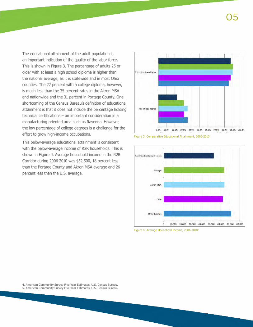
The educational attainment of the adult population is an important indication of the quality of the labor force. This is shown in Figure 3. The percentage of adults 25 or older with at least a high school diploma is higher than the national average, as it is statewide and in most Ohio counties. The 22 percent with a college diploma, however, is much less than the 35 percent rates in the Akron MSA and nationwide and the 31 percent in Portage County. One shortcoming of the Census Bureau’s definition of educational attainment is that it does not include the percentage holding technical certifications – an important consideration in a manufacturing-oriented area such as Ravenna. However, the low percentage of college degrees is a challenge for the effort to grow high-income occupations.
This below-average educational attainment is consistent with the below-average income of R2R households. This is shown in Figure 4. Average household income in the R2R Corridor during 2006-2010 was $52,500, 18 percent less than the Portage County and Akron MSA average and 26 percent less than the U.S. average.
Figure 3: Comparative Educational Attainment, 2006-20104
4. American Community Survey Five-Year Estimates, U.S. Census Bureau.5. American Community Survey Five-Year Estimates, U.S. Census Bureau.
Figure 4: Average Household Income, 2006-20105
06
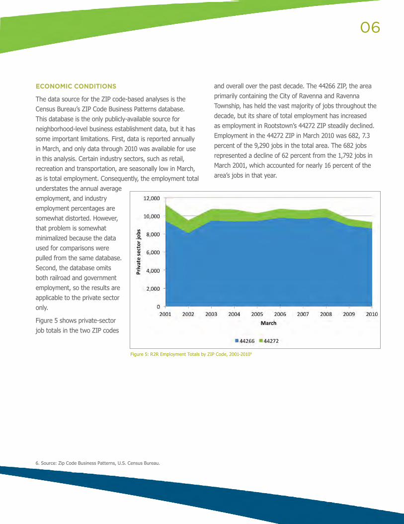
Figure 5: R2R Employment Totals by ZIP Code, 2001-20106
6. Source: Zip Code Business Patterns, U.S. Census Bureau.
ECONOMIC CONDITIONS
The data source for the ZIP code-based analyses is the Census Bureau’s ZIP Code Business Patterns database. This database is the only publicly-available source for neighborhood-level business establishment data, but it has some important limitations. First, data is reported annually in March, and only data through 2010 was available for use in this analysis. Certain industry sectors, such as retail, recreation and transportation, are seasonally low in March, as is total employment. Consequently, the employment total understates the annual average employment, and industry employment percentages are somewhat distorted. However, that problem is somewhat minimalized because the data used for comparisons were pulled from the same database. Second, the database omits both railroad and government employment, so the results are applicable to the private sector only.
Figure 5 shows private-sector job totals in the two ZIP codes
and overall over the past decade. The 44266 ZIP, the area primarily containing the City of Ravenna and Ravenna Township, has held the vast majority of jobs throughout the decade, but its share of total employment has increased as employment in Rootstown’s 44272 ZIP steadily declined. Employment in the 44272 ZIP in March 2010 was 682, 7.3 percent of the 9,290 jobs in the total area. The 682 jobs represented a decline of 62 percent from the 1,792 jobs in March 2001, which accounted for nearly 16 percent of the area’s jobs in that year.
07
6. Source: ZIP Code Business Patterns, U.S. Census Bureau.7. Source: Quarterly Census of Employment and Wages, U.S. Bureau of Labor Statistics.
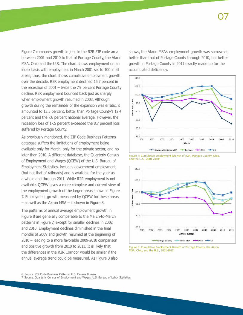
Figure 7 compares growth in jobs in the R2R ZIP code area between 2001 and 2010 to that of Portage County, the Akron MSA, Ohio and the U.S. The chart shows employment on an index basis with employment in March 2001 set to 100 in all areas; thus, the chart shows cumulative employment growth over the decade. R2R employment declined 15.7 percent in the recession of 2001 – twice the 7.9 percent Portage County decline. R2R employment bounced back just as sharply when employment growth resumed in 2003. Although growth during the remainder of the expansion was erratic, it amounted to 13.5 percent, better than Portage County’s 12.4 percent and the 7.6 percent national average. However, the recession loss of 17.5 percent exceeded the 8.7 percent loss suffered by Portage County.
As previously mentioned, the ZIP Code Business Patterns database suffers the limitations of employment being available only for March, only for the private sector, and no later than 2010. A different database, the Quarterly Census of Employment and Wages (QCEW) of the U.S. Bureau of Employment Statistics, includes government employment (but not that of railroads) and is available for the year as a whole and through 2011. While R2R employment is not available, QCEW gives a more complete and current view of the employment growth of the larger areas shown in Figure 7. Employment growth measured by QCEW for these areas – as well as the Akron MSA – is shown in Figure 8.
The patterns of annual average employment growth in Figure 8 are generally comparable to the March-to-March patterns in Figure 7, except for smaller declines in 2002 and 2010. Employment declines diminished in the final months of 2009 and growth resumed at the beginning of 2010 – leading to a more favorable 2009-2010 comparison and positive growth from 2010 to 2011. It is likely that the differences in the R2R Corridor would be similar if the annual average trend could be measured. As Figure 3 also
shows, the Akron MSA’s employment growth was somewhat better than that of Portage County through 2010, but better growth in Portage County in 2011 exactly made up for the accumulated deficiency.
Figure 7: Cumulative Employment Growth of R2R, Portage County, Ohio, and the U.S., 2001-20106
Figure 8: Cumulative Employment Growth of Portage County, the Akron MSA, Ohio, and the U.S., 2001-20117
08
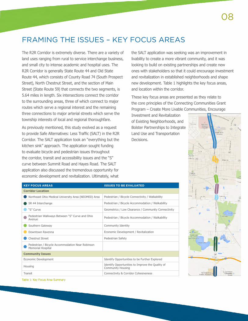
The R2R Corridor is extremely diverse. There are a variety of land uses ranging from rural to service interchange business, and small city to intense academic and hospital uses. The R2R Corridor is generally State Route 44 and Old State Route 44, which consists of County Road 74 (South Prospect Street), North Chestnut Street, and the section of Main Street (State Route 59) that connects the two segments, is 5.64 miles in length. Six intersections connect the corridor to the surrounding areas, three of which connect to major routes which serve a regional interest and the remaining three connections to major arterial streets which serve the township interests of local and regional thoroughfare.
As previously mentioned, this study evolved as a request to provide Safe Alternatives: Less Traffic (SALT) in the R2R Corridor. The SALT application took an “everything but the kitchen sink” approach. The application sought funding to evaluate bicycle and pedestrian issues throughout the corridor, transit and accessibility issues and the “S” curve between Summit Road and Hayes Road. The SALT application also discussed the tremendous opportunity for economic development and revitalization. Ultimately, what
the SALT application was seeking was an improvement in livability to create a more vibrant community, and it was looking to build on existing partnerships and create new ones with stakeholders so that it could encourage investment and revitalization in established neighborhoods and shape new development. Table 1 highlights the key focus areas, and location within the corridor.
These key focus areas are presented as they relate to the core principles of the Connecting Communities Grant Program – Create More Livable Communities, Encourage Investment and Revitalization of Existing Neighborhoods, and Bolster Partnerships to Integrate Land Use and Transportation Decisions.
FRAMING THE ISSUES – KEY FOCUS AREAS
KEY FOCUS AREAS ISSUES TO BE EVALUATED
Corridor Location
Northeast Ohio Medical University Area (NEOMED) Area Pedestrian / Bicycle Connectivity / Walkability
SR 44 Interchange Pedestrian / Bicycle Accommodation / Walkability
“S” Curve Geometrics / Low Clearance / Community Connectivity
Pedestrian Walkways Between “S” Curve and Ohio Avenue Pedestrian / Bicycle Accommodation / Walkability
Southern Gateway Community Identity
Downtown Ravenna Economic Development / Revitalization
Chestnut Street Pedestrian Safety
Pedestrian / Bicycle Accommodation Near Robinson Memorial Hospital
Community Issues
Economic Development Identify Opportunities to be Further Explored
Housing Identify Opportunities to Improve the Quality of Community Housing
Transit Connectivity & Corridor Cohesiveness
Table 1: Key Focus Area Summary
09
The first of the core principles of the Connecting Communities Grant Program is to create more livable communities. Building on the AMATS in the Connecting Communities – A Guide to Integrating Land Use and Transportation 2010 report, a component of livibility is to provide more transportation choices to decrease household transportation costs, reduce America’s dependence on oil, improve air quality and promote public health. In the case of Ravenna, Ravenna Township and Rootstown Township increasing transportation choice will focus on improving the pedestrian and bicycle facilities or the visibility of these non-motorized uses as well as improvements in public transit service.
The City of Ravenna’s Connecting Communities application entitled Safe Alternatives: Less Traffic (SALT) identified pedestrian and bicycle accommodation as a priority outcome of the study. Therefore, discussion of potential accommodations for existing pedestrian and bicycle traffic and planning for future pedestrian traffic throughout the R2R Corridor is a priority of this study. As depicted in the Table 1 on the previous page, there are multiple key focus areas throughout the corridor where pedestrian and bicycle accommodations should be considered – specifically, the NEOMED Area, the interchange with South Prospect Street and State Route 44 and areas with identified travel wear paths. In addition, a unique pedestrian issue needs to be addressed on Chestnut Street near the Circle K. As this study proceeds through the corridor a discussion of the area, issue and potential solutions will be presented.
NEOMED AREA
EXISTING CONDITIONS
The Northeast Ohio Medical University (NEOMED) is a dynamic institution of higher learning. Established in 1973, the University trains physicians, pharmacists, researchers and other health professionals in an interprofessional environment. In 2011, NEOMED became a free standing four-year public university, one of 14 public universities in Ohio.
Over 1,600 students and faculty attend and work at NEOMED, with a large majority commuting daily to NEOMED. However, in 2011, NEOMED began transforming its 450,000 square foot campus with several phases of campus expansion during the next two years in order to offer better education and research facilities, larger accommodations designed to address growing class sizes and expansion, facilities open and available to the surrounding community, and additional student life amenities. NEOMED has started projects to construct the new Research and Graduate Education Building, Residential Housing Village, the Health and Wellness Complex and anticipates undertaking future phases that will develop a retail complex and campus enhancements.
PROVIDE MORE TRANSPORTATION CHOICES
10
FRAMING THE ISSUE
With this expansion, NEOMED will transform from a commuter based university to a residential centric university. This new residential student population will undoubtedly want access to groceries and sundries, recreational facilities, entertainment and eating establishments. Presently, a Giant Eagle is located in the R2R Corridor across from NEOMED. Other nearby uses includes a fast food restaurant and gas station. It is also our understanding that a hotel is in the planning phases and is anticipated to be located north of NEOMED.
State Route 44 is a three lane section in the NEOMED area but turn lanes and two signals are planned for two accesses to the NEOMED Campus. Ultimately, a five lane section is the likely in this section of the R2R Corridor. With a sea of pavement planned to accommodate vehicular traffic in the NEOMED area, it is critical that accommodations for pedestrian and bicycle traffic be incorporated into the designs.
POSSIBLE SOLUTIONS
As part of this study, GPD Group has developed three options that will complement the planned roadway expansion and would accommodate future pedestrian and bicycle traffic as a result of the NEOMED Campus expansion and future development in this section of State Route 44. Drawings and cross section of these options can be reviewed in Attachment A.
Option A offers at-grade crossings with refuge islands to provide pedestrians protection when crossing.
Option B offers at-grade crossings to provide designated crossing locations.
Option C offers a pedestrian bridge at the northern drive of the NEOMED Campus.
In addition to the crossings, sidewalks or shared use paths should be considered throughout the NEOMED Campus area on both sides of State Route 44. The drawings in Attachment A show the relationship between the right of way limits and the proposed shared use paths.
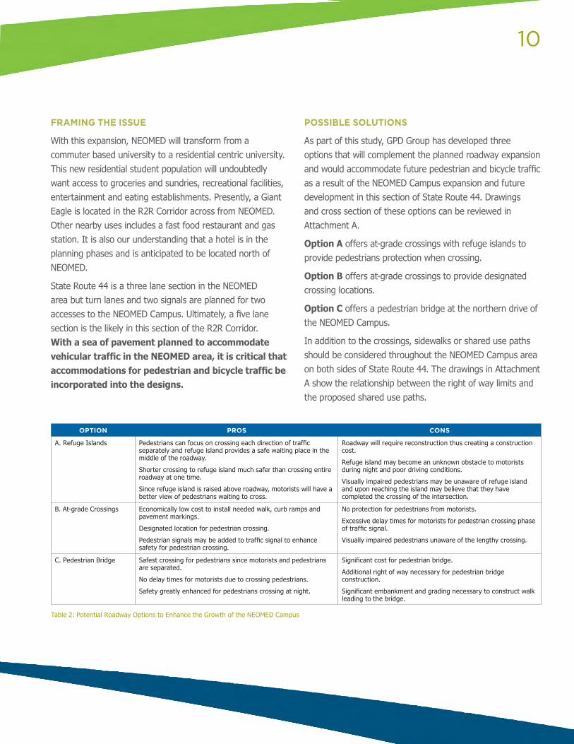
OPTION PROS CONS
A. Refuge Islands Pedestrians can focus on crossing each direction of traffic separately and refuge island provides a safe waiting place in the middle of the roadway.
Shorter crossing to refuge island much safer than crossing entire roadway at one time.
Since refuge island is raised above roadway, motorists will have a better view of pedestrians waiting to cross.
Roadway will require reconstruction thus creating a construction cost.
Refuge island may become an unknown obstacle to motorists during night and poor driving conditions.
Visually impaired pedestrians may be unaware of refuge island and upon reaching the island may believe that they have completed the crossing of the intersection.
B. At-grade Crossings Economically low cost to install needed walk, curb ramps and pavement markings.
Designated location for pedestrian crossing.
Pedestrian signals may be added to traffic signal to enhance safety for pedestrian crossing.
No protection for pedestrians from motorists.
Excessive delay times for motorists for pedestrian crossing phase of traffic signal.
Visually impaired pedestrians unaware of the lengthy crossing.
C. Pedestrian Bridge Safest crossing for pedestrians since motorists and pedestrians are separated.
No delay times for motorists due to crossing pedestrians.
Safety greatly enhanced for pedestrians crossing at night.
Significant cost for pedestrian bridge.
Additional right of way necessary for pedestrian bridge construction.
Significant embankment and grading necessary to construct walk leading to the bridge.
Table 2: Potential Roadway Options to Enhance the Growth of the NEOMED Campus
11
STATE ROUTE 44 / SOUTH PROSPECT STREET 44 INTERCHANGE
EXISTING CONDITIONS
The interchange between State Route 44 and South Prospect Street (County Road 74) consists of a northbound free flowing entrance ramp and southbound free flowing exit ramp. Pedestrians and cyclists use this interchange area along both State Route 44 and as it transitions to South Prospect Street (County Road 74). As is the issue with most free flowing interchanges and intersections, the absence of vehicle queues and delineated paths and crossings can create safety conflicts for pedestrians and conflicts both along the facility and at the intersecting crossing locations.
When crossing free-flow ramps, pedestrians and bicyclists face challenges related to unyielding motorists, high motor vehicle speeds, limited visibility, and the absence of bicycle or pedestrian facilities. Bicyclists additionally face challenges related to unclear path of travel.
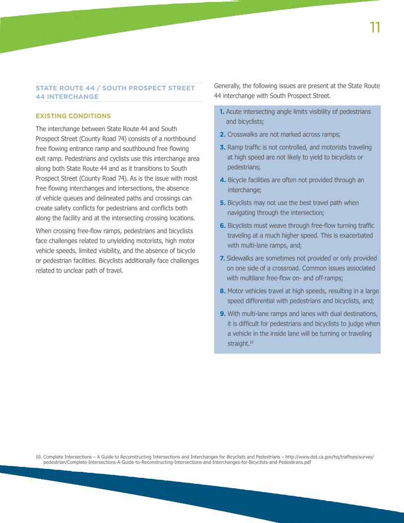
Generally, the following issues are present at the State Route 44 interchange with South Prospect Street.
1. Acute intersecting angle limits visibility of pedestrians and bicyclists;
2. Crosswalks are not marked across ramps;
3. Ramp traffic is not controlled, and motorists traveling at high speed are not likely to yield to bicyclists or pedestrians;
4. Bicycle facilities are often not provided through an interchange;
5. Bicyclists may not use the best travel path when navigating through the intersection;
6. Bicyclists must weave through free-flow turning traffic traveling at a much higher speed. This is exacerbated with multi-lane ramps, and;
7. Sidewalks are sometimes not provided or only provided on one side of a crossroad. Common issues associated with multilane free-flow on- and off-ramps;
8. Motor vehicles travel at high speeds, resulting in a large speed differential with pedestrians and bicyclists, and;
9. With multi-lane ramps and lanes with dual destinations, it is difficult for pedestrians and bicyclists to judge when a vehicle in the inside lane will be turning or traveling straight.10
10. Complete Intersections – A Guide to Reconstructing Intersections and Interchanges for Bicyclists and Pedestrians – http://www.dot.ca.gov/hq/traffops/survey/pedestrian/Complete-Intersections-A-Guide-to-Reconstructing-Intersections-and-Interchanges-for-Bicyclists-and-Pedestirans.pdf
12
POSSIBLE SOLUTIONS
Treatments for pedestrian and bicyclist concerns at on and off-ramps range from striping and signage to make motorists more aware of and more likely to yield to pedestrians and bicyclists, reconstructing the interchange to eliminate all free-flow turning movements and reconfiguring intersections so that on and off ramps meet the crossroad at or near 90-degrees. While reconfiguring the intersection is the preferred engineering treatment, we recognize that
this is likely an infeasible solution. Signage and striping improvements will not solve the significant challenges free-flow ramps present for pedestrians and bicyclists they provide a low-cost safety enhancement that will improve driver awareness of pedestrian and bicycle activities in the interchange area.
Some basic treatments that could be applied to the State Route 44 County Road 74 interchange to provide for bicycle pedestrian accommodation are the following:
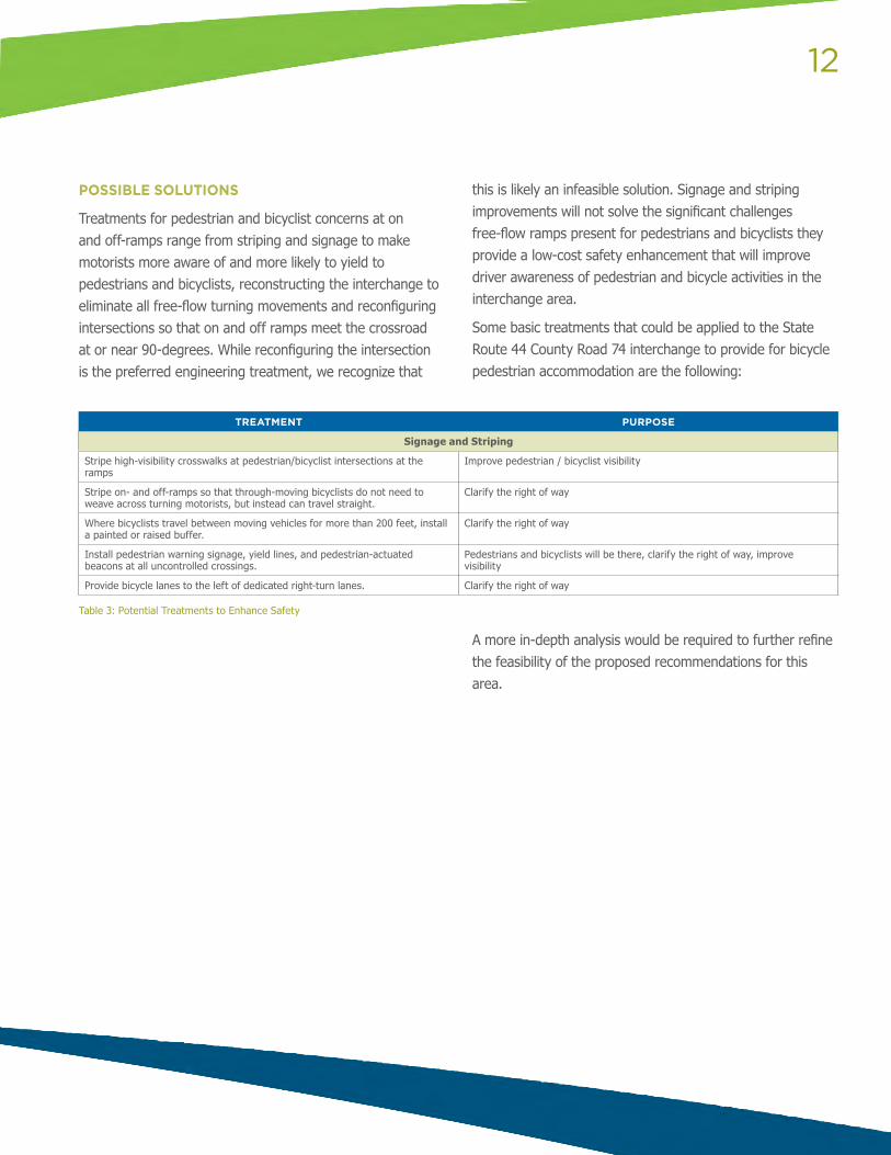
TREATMENT PURPOSE
Signage and Striping
Stripe high-visibility crosswalks at pedestrian/bicyclist intersections at the ramps
Improve pedestrian / bicyclist visibility
Stripe on- and off-ramps so that through-moving bicyclists do not need to weave across turning motorists, but instead can travel straight.
Clarify the right of way
Where bicyclists travel between moving vehicles for more than 200 feet, install a painted or raised buffer.
Clarify the right of way
Install pedestrian warning signage, yield lines, and pedestrian-actuated beacons at all uncontrolled crossings.
Pedestrians and bicyclists will be there, clarify the right of way, improve visibility
Provide bicycle lanes to the left of dedicated right-turn lanes. Clarify the right of way
Table 3: Potential Treatments to Enhance Safety
A more in-depth analysis would be required to further refine the feasibility of the proposed recommendations for this area.
13
RAVENNA TOWNSHIP PEDESTRIAN / BICYCLE ACCOMMODATIONS
EXISTING CONDITIONS
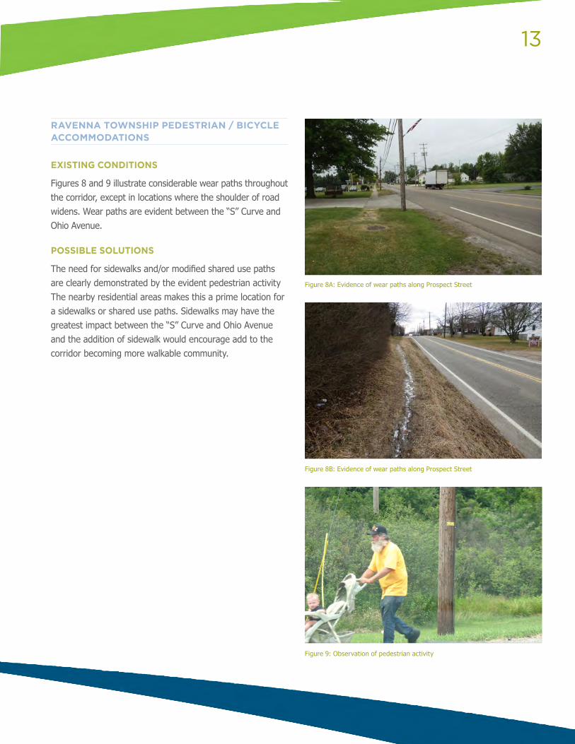
Figures 8 and 9 illustrate considerable wear paths throughout the corridor, except in locations where the shoulder of road widens. Wear paths are evident between the “S” Curve and Ohio Avenue.
POSSIBLE SOLUTIONS
The need for sidewalks and/or modified shared use paths are clearly demonstrated by the evident pedestrian activity The nearby residential areas makes this a prime location for a sidewalks or shared use paths. Sidewalks may have the greatest impact between the “S” Curve and Ohio Avenue and the addition of sidewalk would encourage add to the corridor becoming more walkable community.
Figure 8A: Evidence of wear paths along Prospect Street
Figure 8B: Evidence of wear paths along Prospect Street
Figure 9: Observation of pedestrian activity
14
CHESTNUT STREET
EXISTING CONDITIONS
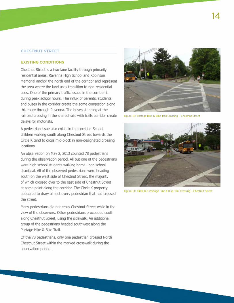
Chestnut Street is a two-lane facility through primarily residential areas. Ravenna High School and Robinson Memorial anchor the north end of the corridor and represent the area where the land uses transition to non-residential uses. One of the primary traffic issues in the corridor is during peak school hours. The influx of parents, students and buses in the corridor create the some congestion along this route through Ravenna. The buses stopping at the railroad crossing in the shared rails with trails corridor create delays for motorists.
A pedestrian issue also exists in the corridor. School children walking south along Chestnut Street towards the Circle K tend to cross mid-block in non-designated crossing locations.
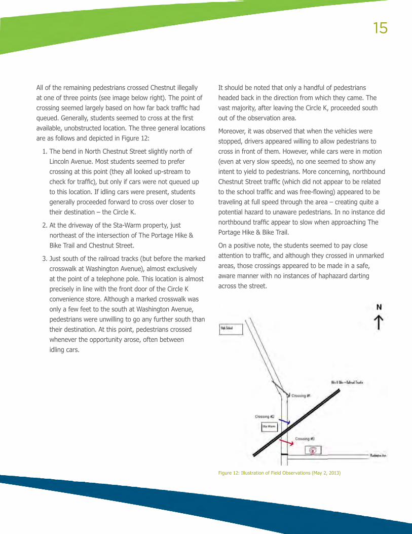
An observation on May 2, 2013 counted 78 pedestrians during the observation period. All but one of the pedestrians were high school students walking home upon school dismissal. All of the observed pedestrians were heading south on the west side of Chestnut Street, the majority of which crossed over to the east side of Chestnut Street at some point along the corridor. The Circle K property appeared to draw almost every pedestrian that had crossed the street.
Many pedestrians did not cross Chestnut Street while in the view of the observers. Other pedestrians proceeded south along Chestnut Street, using the sidewalk. An additional group of the pedestrians headed southwest along the Portage Hike & Bike Trail.
Of the 78 pedestrians, only one pedestrian crossed North Chestnut Street within the marked crosswalk during the observation period.
Figure 10: Portage Hike & Bike Trail Crossing – Chestnut Street
Figure 11: Circle K & Portage Hike & Bike Trail Crossing – Chestnut Street
15
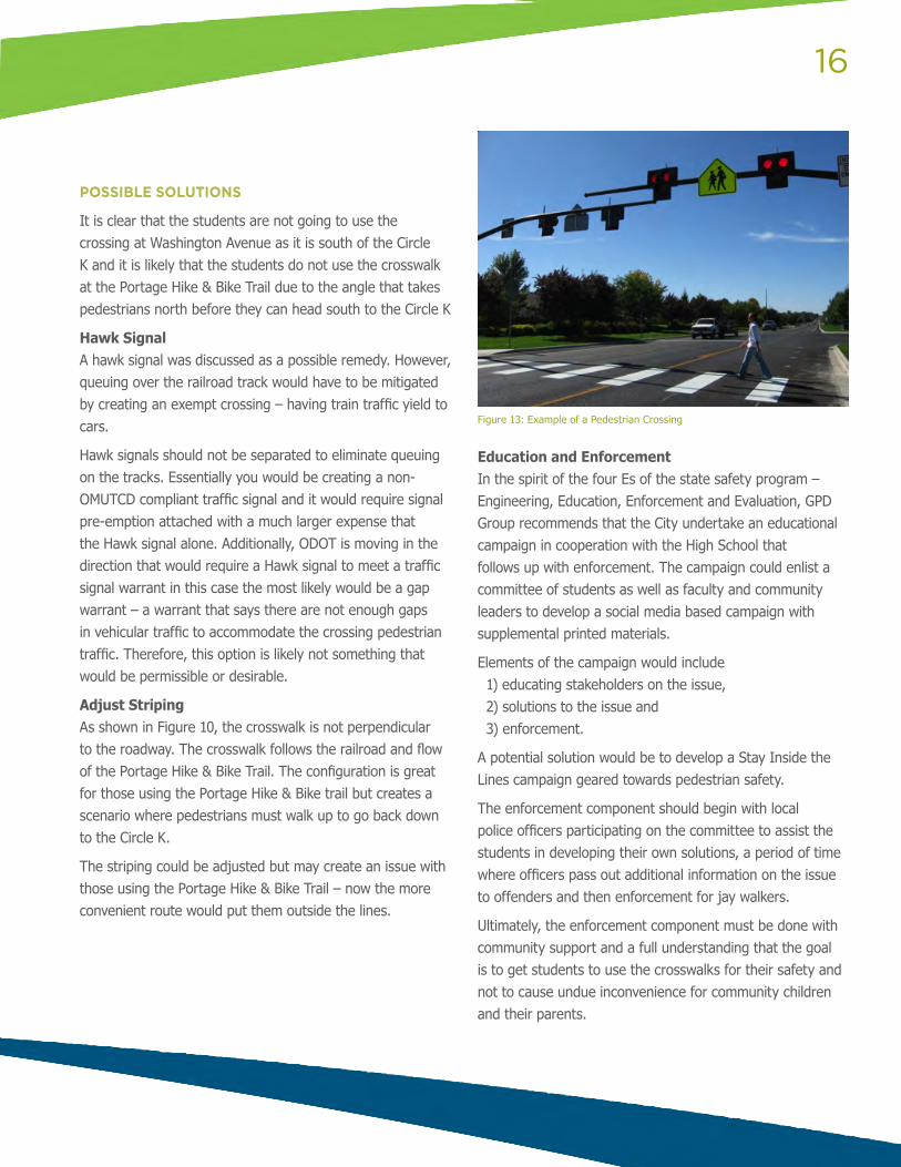
All of the remaining pedestrians crossed Chestnut illegally at one of three points (see image below right). The point of crossing seemed largely based on how far back traffic had queued. Generally, students seemed to cross at the first available, unobstructed location. The three general locations are as follows and depicted in Figure 12:
1. The bend in North Chestnut Street slightly north of Lincoln Avenue. Most students seemed to prefer crossing at this point (they all looked up-stream to check for traffic), but only if cars were not queued up to this location. If idling cars were present, students generally proceeded forward to cross over closer to their destination – the Circle K.
2. At the driveway of the Sta-Warm property, just northeast of the intersection of The Portage Hike & Bike Trail and Chestnut Street.
3. Just south of the railroad tracks (but before the marked crosswalk at Washington Avenue), almost exclusively at the point of a telephone pole. This location is almost precisely in line with the front door of the Circle K convenience store. Although a marked crosswalk was only a few feet to the south at Washington Avenue, pedestrians were unwilling to go any further south than their destination. At this point, pedestrians crossed whenever the opportunity arose, often between idling cars.
It should be noted that only a handful of pedestrians headed back in the direction from which they came. The vast majority, after leaving the Circle K, proceeded south out of the observation area.
Moreover, it was observed that when the vehicles were stopped, drivers appeared willing to allow pedestrians to cross in front of them. However, while cars were in motion (even at very slow speeds), no one seemed to show any intent to yield to pedestrians. More concerning, northbound Chestnut Street traffic (which did not appear to be related to the school traffic and was free-flowing) appeared to be traveling at full speed through the area – creating quite a potential hazard to unaware pedestrians. In no instance did northbound traffic appear to slow when approaching The Portage Hike & Bike Trail.
On a positive note, the students seemed to pay close attention to traffic, and although they crossed in unmarked areas, those crossings appeared to be made in a safe, aware manner with no instances of haphazard darting across the street.
Figure 12: Illustration of Field Observations (May 2, 2013)
16
POSSIBLE SOLUTIONS
It is clear that the students are not going to use the crossing at Washington Avenue as it is south of the Circle K and it is likely that the students do not use the crosswalk at the Portage Hike & Bike Trail due to the angle that takes pedestrians north before they can head south to the Circle K
Hawk Signal A hawk signal was discussed as a possible remedy. However, queuing over the railroad track would have to be mitigated by creating an exempt crossing – having train traffic yield to cars.
Hawk signals should not be separated to eliminate queuing on the tracks. Essentially you would be creating a non-OMUTCD compliant traffic signal and it would require signal pre-emption attached with a much larger expense that the Hawk signal alone. Additionally, ODOT is moving in the direction that would require a Hawk signal to meet a traffic signal warrant in this case the most likely would be a gap warrant – a warrant that says there are not enough gaps in vehicular traffic to accommodate the crossing pedestrian traffic. Therefore, this option is likely not something that would be permissible or desirable.
Adjust Striping As shown in Figure 10, the crosswalk is not perpendicular to the roadway. The crosswalk follows the railroad and flow of the Portage Hike & Bike Trail. The configuration is great for those using the Portage Hike & Bike trail but creates a scenario where pedestrians must walk up to go back down to the Circle K.
The striping could be adjusted but may create an issue with those using the Portage Hike & Bike Trail – now the more convenient route would put them outside the lines.
Education and EnforcementIn the spirit of the four Es of the state safety program – Engineering, Education, Enforcement and Evaluation, GPD Group recommends that the City undertake an educational campaign in cooperation with the High School that follows up with enforcement. The campaign could enlist a committee of students as well as faculty and community leaders to develop a social media based campaign with supplemental printed materials.
Elements of the campaign would include 1) educating stakeholders on the issue, 2) solutions to the issue and 3) enforcement.
A potential solution would be to develop a Stay Inside the Lines campaign geared towards pedestrian safety.
The enforcement component should begin with local police officers participating on the committee to assist the students in developing their own solutions, a period of time where officers pass out additional information on the issue to offenders and then enforcement for jay walkers.
Ultimately, the enforcement component must be done with community support and a full understanding that the goal is to get students to use the crosswalks for their safety and not to cause undue inconvenience for community children and their parents.
Figure 13: Example of a Pedestrian Crossing
17
“S” CURVE AT RAILROAD OVERPASS
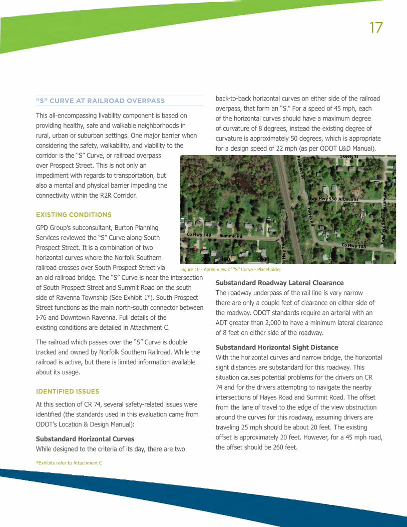
This all-encompassing livability component is based on providing healthy, safe and walkable neighborhoods in rural, urban or suburban settings. One major barrier when considering the safety, walkability, and viability to the corridor is the “S” Curve, or railroad overpass over Prospect Street. This is not only an impediment with regards to transportation, but also a mental and physical barrier impeding the connectivity within the R2R Corridor.
EXISTING CONDITIONS
GPD Group’s subconsultant, Burton Planning Services reviewed the “S” Curve along South Prospect Street. It is a combination of two horizontal curves where the Norfolk Southern railroad crosses over South Prospect Street via an old railroad bridge. The “S” Curve is near the intersection of South Prospect Street and Summit Road on the south side of Ravenna Township (See Exhibit 1*). South Prospect Street functions as the main north-south connector between I-76 and Downtown Ravenna. Full details of the existing conditions are detailed in Attachment C.
The railroad which passes over the “S” Curve is double tracked and owned by Norfolk Southern Railroad. While the railroad is active, but there is limited information available about its usage.
IDENTIFIED ISSUES
At this section of CR 74, several safety-related issues were identified (the standards used in this evaluation came from ODOT’s Location & Design Manual):
Substandard Horizontal CurvesWhile designed to the criteria of its day, there are two
back-to-back horizontal curves on either side of the railroad overpass, that form an “S.” For a speed of 45 mph, each of the horizontal curves should have a maximum degree of curvature of 8 degrees, instead the existing degree of curvature is approximately 50 degrees, which is appropriate for a design speed of 22 mph (as per ODOT L&D Manual).
Substandard Roadway Lateral ClearanceThe roadway underpass of the rail line is very narrow – there are only a couple feet of clearance on either side of the roadway. ODOT standards require an arterial with an ADT greater than 2,000 to have a minimum lateral clearance of 8 feet on either side of the roadway.
Substandard Horizontal Sight DistanceWith the horizontal curves and narrow bridge, the horizontal sight distances are substandard for this roadway. This situation causes potential problems for the drivers on CR 74 and for the drivers attempting to navigate the nearby intersections of Hayes Road and Summit Road. The offset from the lane of travel to the edge of the view obstruction around the curves for this roadway, assuming drivers are traveling 25 mph should be about 20 feet. The existing offset is approximately 20 feet. However, for a 45 mph road, the offset should be 260 feet.
Figure 16 - Aerial View of “S” Curve - Placeholder
*Exhibits refer to Attachment C
18
Substandard Vertical ClearanceThe existing vertical clearance of the railroad bridge is 13 feet, which is 3.5 feet below the minimum required 16.5 feet for an arterial roadway (as per ODOT L&D Manual).
CR 74 / Hayes Road Skewed IntersectionThe existing CR 74 / Hayes Road intersection is a T-intersection. Hayes Road connects with CR 74 at an approximately 50 degree angle along a curved section of CR 74.
POSSIBLE SOLUTIONS
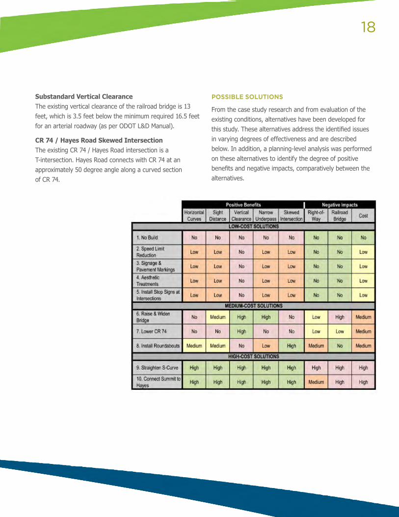
From the case study research and from evaluation of the existing conditions, alternatives have been developed for this study. These alternatives address the identified issues in varying degrees of effectiveness and are described below. In addition, a planning-level analysis was performed on these alternatives to identify the degree of positive benefits and negative impacts, comparatively between the alternatives.
19
The solutions are grouped into three categories:
Low-Cost Solutions include options to address some of the identified issues without structural modifications to the railroad bridge or roadways.
Medium-Cost Solutions include options to address some of the identified issues with structural modifications to either the railroad bridge or roadways.
High-Cost Solutions include options to address all of the identified issues with structural modifications to both the railroad bridge and the roadways.
LOW-COST SOLUTIONS
These alternatives (except the No Build) address some of the identified issues to a minor degree, and they avoid impacts to the railroad bridge, right of way, and major roadway modifications. They are all low-cost solutions so could be implemented in the short-term, depending on funding availability.
1. No Build This option is listed for comparison purposes. All of the identified issues would remain with this alternative, but there would be no impacts to the bridge, roadways or right of way. The only costs associated with this alternative would be the ongoing maintenance of the roadways and bridge.
2. Speed Limit Reduction The posted speed limit is 45 mph in this area. Less than 0.5 mile north of this location at the southern corporation limits of the City of Ravenna, the posted speed limit is 25 mph. Thus, this alternative proposes to reduce the posted speed limit from the southern corporation limit of the City south to just south of Timber Run to 35 mph. This will not only assist in reducing the speed of the traffic well before approaching the S-Curve but will also offer a more incremental transition between the 45 mph section and the 25 mph section of CR
74. There are numerous residences and residential streets within this area, so a lower speed limit would also be more compatible with these land uses.
Impacts: This alternative would not have any impacts to the bridge, roadways, or to right of way. The only costs associated with this alternative would be with the purchase and installation of the speed limit signage.
3. Install / Update Signage and Pavement Markings As shown in Exhibit 3, there is existing signage on both approaches to the S-Curve section that address the horizontal curves and the bridge. This alternative proposes to install additional signage and to update some of the existing signage and pavement markings in order to more clearly warn vehicles of the horizontal curves.
Flashing Warning Signage: Additional horizontal curve warning signage with flashing beacons could be installed on both approaches to the S-Curve. A variation to this option would be to install flashing beacons to the top of the existing vertical clearance warning signage or the directional arrow signs. The flashing beacons would be an additional method of making vehicles aware of the need to slow down for the horizontal curves.
Chevron Signage: Currently, there are three directional chevron signs installed on the southern curve for northbound vehicles on CR 74. For a bigger visual impact, additional chevron signs could be placed in this location to create a larger visual impact along the curve for northbound traffic. In addition, there are no chevron signs north of the bridge, so new chevron signs could be installed that guide southbound vehicles on CR 74 as they approach the northern curve.
Retroreflective Signage Retrofits: Existing and new signs should be installed with high-intensity retroreflective sheeting for better visibility during nighttime driving conditions.
20
Raised Pavement Markers: Raised pavement markers add delineation qualities to the horizontal curves and provide additional benefits to nighttime driving conditions. Raised pavement markers can also be retroreflective (reflect light back to the source) to enhance their visibility in the dark.
Impacts: This alternative would not have any impacts to the bridge or to right of way. Temporary minimal impacts to the roadway would occur during installation of the signs and raised pavement markings related to maintenance of traffic activities. The costs associated with this alternative would be the purchase and installation of the signage and raised pavement markers.
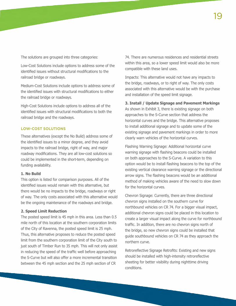
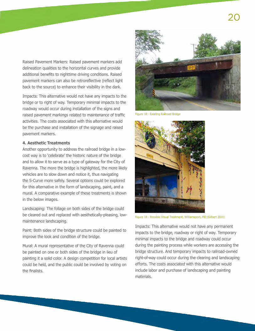
4. Aesthetic Treatments Another opportunity to address the railroad bridge in a low-cost way is to ‘celebrate’ the historic nature of the bridge and to allow it to serve as a type of gateway for the City of Ravenna. The more the bridge is highlighted, the more likely vehicles are to slow down and notice it, thus navigating the S-Curve more safely. Several options could be explored for this alternative in the form of landscaping, paint, and a mural. A comparative example of these treatments is shown in the below images.
Landscaping: The foliage on both sides of the bridge could be cleared out and replaced with aesthetically-pleasing, low-maintenance landscaping.
Paint: Both sides of the bridge structure could be painted to improve the look and condition of the bridge.
Mural: A mural representative of the City of Ravenna could be painted on one or both sides of the bridge in lieu of painting it a solid color. A design competition for local artists could be held, and the public could be involved by voting on the finalists.
Impacts: This alternative would not have any permanent impacts to the bridge, roadway or right of way. Temporary minimal impacts to the bridge and roadway could occur during the painting process while workers are accessing the bridge structure. And temporary impacts to railroad-owned right-of-way could occur during the clearing and landscaping efforts. The costs associated with this alternative would include labor and purchase of landscaping and painting materials.
Figure 18 - Existing Railroad Bridge
Figure 18 - Possible Visual Treatment, Williamsport, MD (Gilbert 2011)
21
5. Install Stop Signs and a Signal at Intersections As shown in Exhibit 6, the two nearby intersections to the S-Curve (CR 74/Summit Road and CR 74/Hayes Road) could be converted to a signalized intersection (at Summit Road) and a three-way stop-controlled intersection (at Hayes Road). Such an application would slow down vehicles in advance of the S-Curve so they could more safety navigate it. In addition, this alternative would address sight distance issues for vehicles navigating the intersections because traffic would be slower and would have to stop prior to moving through the intersections. In fact, the Portage County Engineer plans to install a traffic signal at the Summit Road intersection in addition to left turn lanes on CR 74 at both the Summit Road and Hayes Road intersections.
Impacts: This alternative would not have any impacts to the bridge and minor impacts to right-of-way and the roadway during the conversion to the signalized and three-way stop-controlled intersections related to widening the roadway for the left turn lanes, maintenance of traffic, and some impacts to traffic flow would occur as a result of the conversions since vehicles on CR 74 would now have to stop at these two intersections. The costs associated with this alternative would include new pavement, installation and materials of advanced signage for the intersections, stop signs, signal, and related pavement markings.
MEDIUM-COST SOLUTIONS
These solutions are a balance between the low-cost and high-cost solutions. They address the identified issues as much as possible while restricting impacts to only the bridge or only the roadways, but not both. Depending on final cost estimates and funding availability, these alternatives could be constructed in near-, medium-, or long-term timeframes.
6. Raise and Widen Railroad Bridge As shown in Exhibit 4 and discussed in the identified issues section, the lateral clearance on either side of CR 74 under the bridge is too narrow and the vertical clearance is too low to meet minimum standards. This alternative proposes to raise the railroad bridge from 13 feet to 16.5 feet, in addition to widening the bridge from the approximate two-foot lateral clearance to eight-foot lateral clearance on either side of the roadway to meet minimum standards. However, the limited sight distances would not be addressed with an eight-foot lateral clearance, so the bridge could be widened an additional amount to improve sight distances through the S-Curve.
Impacts: This alternative would not address the substandard horizontal curves or the skewed CR 74 / Hayes Road intersection, but it would effectively address the vertical clearance and narrow underpass issues, in addition to moderately addressing the sight-distance issues. For negative impacts, this alternative would impact the rail lines and the bridge and have high costs associated with reconstructing the bridge and the associated grading work. Temporary impacts to the roadway would occur during the bridge construction related to maintenance of traffic, and but no additional direct roadway impacts should be incurred. And minor strips of right of way may be required with the increase in the bridge footprint but no full right of way takes should be needed.
7. Lower CR 74 To address the vertical clearance issue without major disruption to the rail line operation or bridge, CR 74 could be lowered 3.5 feet. Due to the already narrow lateral clearances, the bridge would need some structural work for reinforcement and retaining walls would be needed.
Impacts: This alternative would address the vertical clearance issues but none of the other issues. For negative
22
impacts, this alternative should not impact the rail line operations, but would impact the supporting structure of the bridge. Impacts to the roadway would occur from excavation and regrading, and minor strips of right of way may be required but no full right of way takes should be needed. The costs would be moderately high for lowering the roadway, reinforcing the bridge structure, and installing retaining walls.
8. Install Roundabouts This alternative proposes to install roundabouts at the CR 74 / Summit Road intersection and CR 74 / Hayes Road intersection (see Exhibit 7). This alternative is similar to Alternative 5 (Three-Way Stop-Controlled Intersection Conversions) because it slows down traffic prior to the S-Curve and allows for vehicles to more easily navigate the two intersections. However, it is a much more effective solution because it allows for a continuous flow in traffic on CR 74 and it addresses the CR 74 / Hayes Road skewed intersection. The roundabouts shown in the exhibit were designed with 130-foot diameters, which is the minimum width needed for a standard single-lane roundabout that can be used by all typical vehicle types at a design speed of 20-25 mph (as per FHWA’s Roundabout Technical Guidance, 2010); however, please note that smaller diameters (down to 90 feet) could be used if all vehicle types do not need to be accommodated.
Impacts: This alternative would address all of the identified issues in varying degrees except for the vertical clearance issue – it will reduce traffic speeds, thus allowing for safer driving of the horizontal curves, shorter needed sight distances, and less of an issue for the narrow underpass and it would realign the skewed intersection. For negative impacts, this alternative would not impact the rail line operations or the bridge. Impacts to the roadway would occur at the two intersections for installation of the
roundabouts. Some permanent right of way would be required to account for the larger roundabout footprint as compared to the existing intersections; however, no total right-of-way takes should be needed and the roundabouts can be situated to minimize right of way impacts. There would not be any costs associated with the bridge but there would be a moderately high cost for installing the roundabouts. Please note that the goal of this alternative was to maximize addressing the identified issues as much as possible while completely avoiding impacts to the railroad bridge and rail line operations.
HIGH-COST SOLUTIONS
These alternatives address all of the identified issues. However, they also have the highest costs because they involve structural modifications to both the railroad bridge and nearby roadways. These alternatives are most likely long-term solutions due to their high costs and high impacts.
9. Straighten CR 74 S-Curve This alternative straightens the S-Curve on CR 74 to meet minimum horizontal curve standards for a 35 mph roadway (see Exhibit 8). It also addresses the skewed CR 74 / Hayes Road intersection so that it would be at a 90 degree angle. The railroad bridge would be reconstructed to account for the new alignment of CR 74 and appropriate lateral clearances, sight distances, and vertical clearances. This alternative addresses all of the identified issues while essentially leaving CR 74 in the same location and keeping the roadway network connectivity the same.
Impacts: This alternative would fully address all of the identified issues, but it results in substantial impacts and costs. The rail line operations and bridge would be impacted while the bridge is rebuilt. The roadways would be impacted due to realignment of CR 74. Permanent right of way
23
would be required to account for realignment of CR 74 and possibly the larger bridge footprint; however, no total right-of-way takes should be needed. As a result there would be high costs associated with the bridge, the roadway, and possibly the right of way acquisition.
10. Connect Summit Road to Hayes Road Instead of attempting to fix the identified issues “in place” as in Alternative 9, this alternative identified a different roadway network connectivity that will address all of the identified issues. This alternative proposes to abandon the current S-Curve location and create a new east-west connection between Summit and Hayes Roads. (see Exhibit 9). As shown in the exhibit, the S-Curve would no longer exist, and all roadways would be straight with 90 degree connections to intersecting roadways. A new railroad bridge would be constructed to the south of the existing one to account for the new connection and would include appropriate lateral clearances, sight distances, and vertical clearances. This alternative addresses all of the identified issues by changing the roadway network connections.
Impacts: This alternative would fully address all of the identified issues, but it results in substantial impacts and costs. The rail line operations would be impacted while the new bridge is built. The roadway network would be impacted due to the new connections but maintenance of traffic may be easier since the existing CR 74 alignment could be maintained during construction of the new bridge and associated connections. Permanent right of way would be required to account for the new connection of Summit and Hayes roads and the new bridge, however, no total right of way takes should be needed. As a result there would be high costs associated with the bridge, the roadway, and possibly the right of way acquisition.
There are many solutions to the “S” Curve and an analysis of varying combinations and phasing strategies of the treatments can be found in Attachment C.
24
PUBLIC TRANSIT
EXISTING CONDITIONS
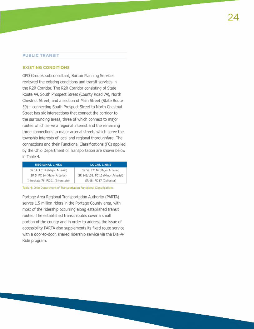
GPD Group’s subconsultant, Burton Planning Services reviewed the existing conditions and transit services in the R2R Corridor. The R2R Corridor consisting of State Route 44, South Prospect Street (County Road 74), North Chestnut Street, and a section of Main Street (State Route 59) – connecting South Prospect Street to North Chestnut Street has six intersections that connect the corridor to the surrounding areas, three of which connect to major routes which serve a regional interest and the remaining three connections to major arterial streets which serve the township interests of local and regional thoroughfare. The connections and their Functional Classifications (FC) applied by the Ohio Department of Transportation are shown below in Table 4.
REGIONAL LINKS LOCAL LINKS
SR 14: FC 14 (Major Arterial)
SR 5: FC 14 (Major Arterial)
Interstate 76: FC 01 (Interstate)
SR 59: FC 14 (Major Arterial)
SR 148/138: FC 16 (Minor Arterial)
SR-18: FC 17 (Collector)
Table 4: Ohio Department of Transportation Functional Classifications
Portage Area Regional Transportation Authority (PARTA) serves 1.5 million riders in the Portage County area, with most of the ridership occurring along established transit routes. The established transit routes cover a small portion of the county and in order to address the issue of accessibility PARTA also supplements its fixed route service with a door-to-door, shared ridership service via the Dial-A-Ride program.
25
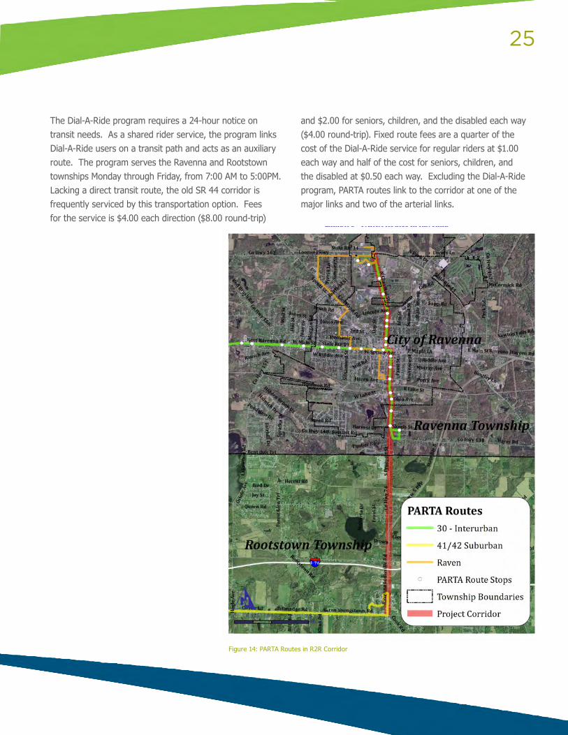
The Dial-A-Ride program requires a 24-hour notice on transit needs. As a shared rider service, the program links Dial-A-Ride users on a transit path and acts as an auxiliary route. The program serves the Ravenna and Rootstown townships Monday through Friday, from 7:00 AM to 5:00PM. Lacking a direct transit route, the old SR 44 corridor is frequently serviced by this transportation option. Fees for the service is $4.00 each direction ($8.00 round-trip)
and $2.00 for seniors, children, and the disabled each way ($4.00 round-trip). Fixed route fees are a quarter of the cost of the Dial-A-Ride service for regular riders at $1.00 each way and half of the cost for seniors, children, and the disabled at $0.50 each way. Excluding the Dial-A-Ride program, PARTA routes link to the corridor at one of the major links and two of the arterial links.
Figure 14: PARTA Routes in R2R Corridor
26
Interurban (30)The primary purpose of the Interurban is to provide transit for county residents to Robinson Memorial Hospital and to link the Kent and Ravenna downtown areas. The rest of the route connects to Downtown Kent and continues into the City of Stow, where it circles major arterials and returns. The route is serviced approximately 32 times throughout the day, Monday through Friday between 6:00 AM and 10:45 PM, and runs roughly every 20 to 30 minutes.
The Interurban runs along 2.79 miles of the corridor from Robinson Memorial Hospital to CR 138 (Hayes Road). The Interurban enters the corridor via the SR 59 (Main Street) intersection and turns south on Prospect Street. At the South Prospect Street and the CR 138 (Hayes Road) intersection, the Interurban follows the loop created by CR 138, Leasure Street, and Skeels Street, before returning north. The Interurban then follows South Prospect Street back to Main Street, turns west onto SR 59, right onto North Chestnut Street, and continues until it reaches Robinson Memorial Hospital. It then retraces its path back to SR 59, where the Interurban go west towards Kent.
The route serves a reasonable portion of residents and connects to several of the communities’ vital interests; Robinson Memorial Hospital, Ravenna High School, residential communities, Downtown Ravenna, and Kent State University.
Raven (80)The Raven serves as a way to provide residents who live outside the core of Ravenna transit options to get to necessary destinations such as the Social Security Administration, Robinson Memorial Hospital, and the County Health Department. The route runs by the Salvation Army and Ravenna City Park, and comes close enough to the downtown area to make it a walkable distance.
The Raven route acts as a circular loop around the Ravenna city core. Beginning at the County Administrative Building, the route travels north on Meridian Street to SR59 where it cuts west and turns north onto Diamond Street. Moving along the periphery of a residential neighborhood, the route eventually travels past a city park before turning north up Cleveland Road to Infirmary Road, where it meets with SR 14. Travelling west on SR 14, the route stops at the Social Security Administration’s building before heading to Robinson Memorial Hospital.
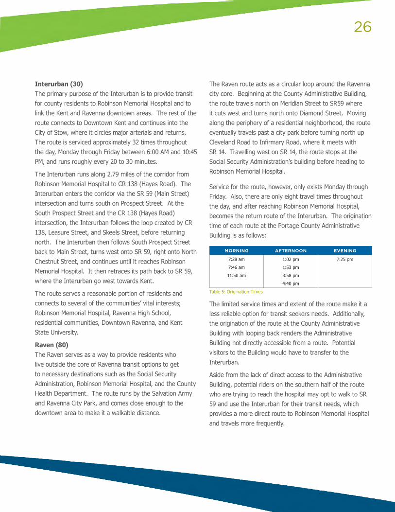
Service for the route, however, only exists Monday through Friday. Also, there are only eight travel times throughout the day, and after reaching Robinson Memorial Hospital, becomes the return route of the Interurban. The origination time of each route at the Portage County Administrative Building is as follows:
MORNING AFTERNOON EVENING
7:28 am
7:46 am
11:50 am
1:02 pm
1:53 pm
3:58 pm
4:40 pm
7:25 pm
Table 5: Origination Times
The limited service times and extent of the route make it a less reliable option for transit seekers needs. Additionally, the origination of the route at the County Administrative Building with looping back renders the Administrative Building not directly accessible from a route. Potential visitors to the Building would have to transfer to the Interurban.
Aside from the lack of direct access to the Administrative Building, potential riders on the southern half of the route who are trying to reach the hospital may opt to walk to SR 59 and use the Interurban for their transit needs, which provides a more direct route to Robinson Memorial Hospital and travels more frequently.
27
Suburban (40)The Suburban Route runs outside the City of Ravenna, Ravenna Township, and Rootstown Township. The route’s primary purpose relevant to its existence along the corridor is to provide alternate transit options for NEOMED students. Twice a day, at 8:15 AM and 3:35 PM, the Suburban stops at the NEOMED campus to serve their recently-established high school.
The route reaches the NEOMED campus via CR 18, thus the bus does not travel along the corridor for any substantial distance, so it does not provide access to transit for other potential riders except the students of the NEOMED school system.
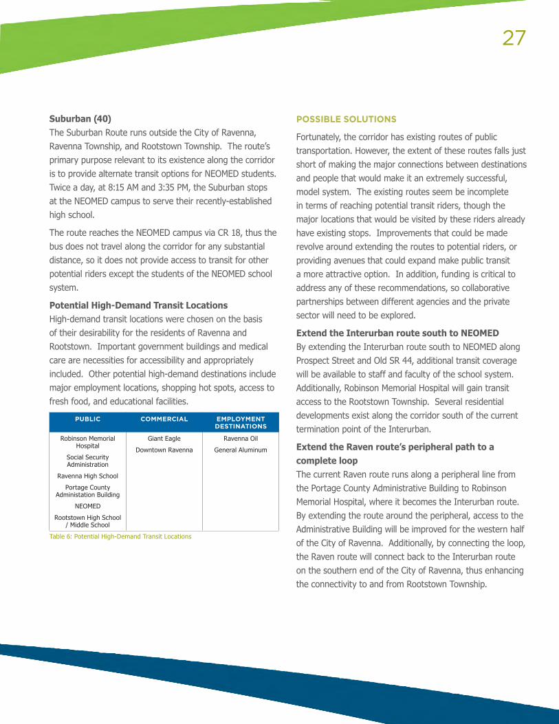
Potential High-Demand Transit Locations High-demand transit locations were chosen on the basis of their desirability for the residents of Ravenna and Rootstown. Important government buildings and medical care are necessities for accessibility and appropriately included. Other potential high-demand destinations include major employment locations, shopping hot spots, access to fresh food, and educational facilities.
PUBLIC COMMERCIAL EMPLOYMENT DESTINATIONS
Robinson Memorial Hospital
Social Security Administration
Ravenna High School
Portage County Administation Building
NEOMED
Rootstown High School / Middle School
Giant Eagle
Downtown Ravenna
Ravenna Oil
General Aluminum
Table 6: Potential High-Demand Transit Locations
POSSIBLE SOLUTIONS
Fortunately, the corridor has existing routes of public transportation. However, the extent of these routes falls just short of making the major connections between destinations and people that would make it an extremely successful, model system. The existing routes seem be incomplete in terms of reaching potential transit riders, though the major locations that would be visited by these riders already have existing stops. Improvements that could be made revolve around extending the routes to potential riders, or providing avenues that could expand make public transit a more attractive option. In addition, funding is critical to address any of these recommendations, so collaborative partnerships between different agencies and the private sector will need to be explored.
Extend the Interurban route south to NEOMEDBy extending the Interurban route south to NEOMED along Prospect Street and Old SR 44, additional transit coverage will be available to staff and faculty of the school system. Additionally, Robinson Memorial Hospital will gain transit access to the Rootstown Township. Several residential developments exist along the corridor south of the current termination point of the Interurban.
Extend the Raven route’s peripheral path to a complete loopThe current Raven route runs along a peripheral line from the Portage County Administrative Building to Robinson Memorial Hospital, where it becomes the Interurban route. By extending the route around the peripheral, access to the Administrative Building will be improved for the western half of the City of Ravenna. Additionally, by connecting the loop, the Raven route will connect back to the Interurban route on the southern end of the City of Ravenna, thus enhancing the connectivity to and from Rootstown Township.
28
Development of a Park & Ride SystemBy establishing parking lots in strategic locations, the use of the extensive transit lines can be improved. Due to the more rural setting of the surrounding residential areas, Park & Ride lots provide a location which transit users can drive to, instead of driving to their destination. Recommended locations for initial Park & Ride locations include:
• Giant Eagle’s Parking Lot: Giant Eagle, south of I-76, has a large parking lot; a section of which PARTA could utilize as a transit stop and Park & Ride location. In addition, this location could be used for shared-ride trips in personal vehicles for trips utilizing I-76, such as to the City of Akron.
• Robinson Memorial Hospital: A partnership with Robinson Memorial Hospital could allow PARTA users to park free in an authorized zone to use the transit system.
Transit Stop Enhancements Many of the existing transit stops in the corridor could use enhancements to make their use by the public more comfortable. Ridership information, including number of riders using each stop and length of wait at stops, should be collecting and analyzed to identify where to focus the transit stop enhancements. Enhancements could include benches, trash receptacles, overhead shelters, bicycle facilities, etc.
Ridership Surveys The current transit system could be better utilized by the public. Ridership numbers are lower than expected. Therefore, it is recommended that a survey be conducted and sent to riders and non-riders alike in the transit route service area to determine current perceptions of the transit system and identify areas of improvement to increase ridership numbers.
Ultimately, the recommendations will be driven by service demand, funding and partnerships.
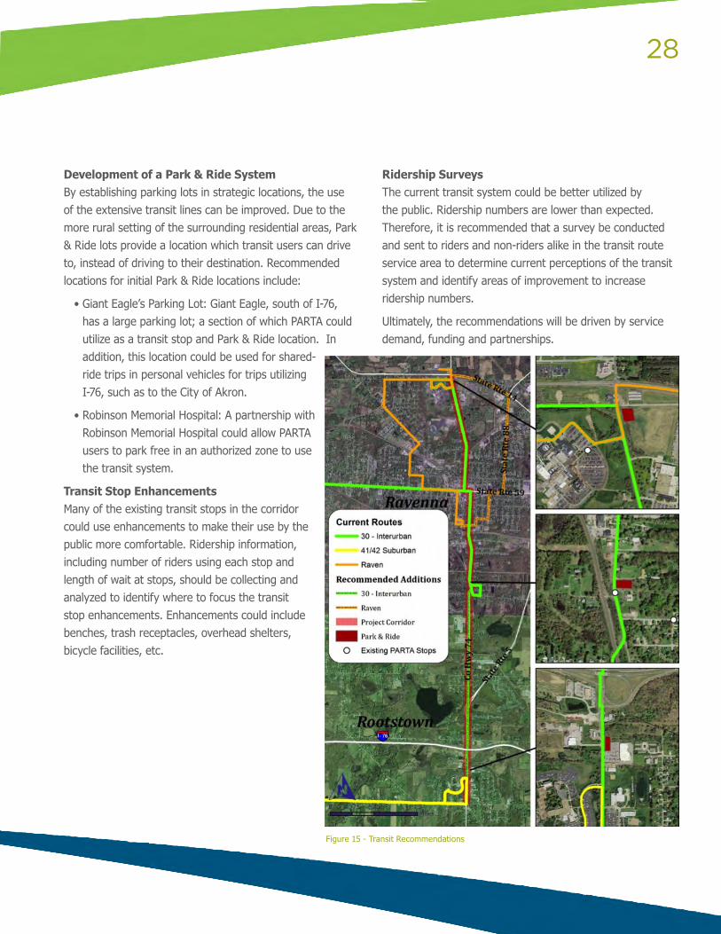
Figure 15 - Transit Recommendations
29
The second principle in the AMATS Connecting Communities Grant Program focuses on encouraging re-investment into existing neighborhoods. It is clear from feedback of the stakeholders that the R2R Corridor lacks cohesiveness and is struggling to find its new identity and build upon the existing sense of community.
HOUSING OPTIONS
HOUSING
Another livability component focuses on housing. The amount, type and condition of housing have a large impact on a community’s quality of life, economic development, image and safety. A community with varying housing options and price points is an asset to residents providing housing at different life stages and incomes. This allows residents to remain and invest in the community throughout their lives and attract new residents.
The appearance and maintenance of housing is also critical. It is important that residents take pride and are confident investing in their in their homes and neighborhood. Housing appearance has positive or negative impacts on residents, as well as visitors who may be potential residents, customers or investors. Vacant homes also continue to be an issue. Vacant homes are a health and safety hazard, bring down community property values and negatively impact the image of the community.
EXISTING CONDITIONS
The City of Ravenna has 5,566 housing units with a vacancy rate of nine percent. Of the occupied housing units, 54 percent were owner-occupied units and 46 percent were renter-occupied. The City currently has several programs focusing on rental properties and property maintenance.
The City requires rental inspections biennially and charges a rental application fee of $100 for new units. Subsequent inspection fee are $40 for one and two unit rentals and $20 per unit for multifamily dwellings and apartments with three or more units. There are approximately 3,500 rental units registered. Rental inspections are performed by PMHA (Portage Metropolitan Housing Authority).
All properties must conform to the Property Maintenance and Housing Code of the City of Ravenna. It is the responsibility of the owner of rental properties to insure compliance. The City has a contract with PMHA to perform property maintenance, including finding violations, recording and notifying owners. In 2012, approximately 400 hours were spent on property maintenance over six months. The majority of that time was spent on trash and garbage collection issues.
ENCOURAGE INVESTMENT AND REVITALIZATION OF ESTABLISHED NEIGHBORHOODS
30
POSSIBLE SOLUTIONS
Compile and Complete Property Rental List Having an accurate and complete rental property list is critical for tracking and ensuring compliance with the Property Maintenance and Housing Code for rental properties in the City. The City currently has a list of known or believed and possible rental properties complied from rental applications and the Portage County Auditor. Having a complete rental property list is also one of the objectives under improving the quality of life in the City’s 2013 Strategic Plan.
Improve Trash and Garbage Collection Trash and garbage collection is a major public health and safety concern as well as a negative impact on community aesthetics. Garbage collection should be addressed on a citywide level so that property maintenance inspectors can spend more time on other issues, such as paint and gutters on houses, fences, bushes and sheds.
Create a Vacant Property Inventory Creating a vacant property inventory would allow the City to track and ensure code enforcement of vacant properties, including those with and without structures. The inventory should rate the state of vacant properties to aid the city in determining what actions to take, such as prioritizing demolitions.
Increase Owner-Occupied Housing Explore programs that increase home ownership, such as those that provide down payment assistance and homebuyer counseling.
Target ResourcesWith limited funding it is important to target resources to have the most impact on the community. This could include code enforcement or home repair programs. Special priority should be given to high visibility corridors, downtown, major gateways and other community priority areas.
Ultimately, the above solutions would move the municipal entities towards addressing the issue of run-down and vacant properties continuing to blight the community.
31
IMPROVE ECONOMIC COMPETITIVENESS OF NEIGHBORHOODS
EXISTING CONDITIONS
Taking a look at the current economic development practices is helpful in determining if there are gaps where business development can be strengthened in the community. Currently, the City of Ravenna offers the State of Ohio’s programs, including the Job Creation Tax Credit. The City of Ravenna is an Enterprise Zone, and recently signed a Joint Economic Development District, or JEDD, agreement with Ravenna Township. The Enterprise Zone provides 75% property tax abatement for 10 years, at a minimum, with 100% abatement for 10 years available if a payment in lieu of taxes is made to the school district. The JEDD provides funding for infrastructure.
A new program has become available to current Ravenna businesses expanding in Ravenna or new businesses locating in Ravenna. The Ravenna Economic Development through Occupancy Program, or REDTOP, is tied to payroll. Businesses can receive a credit of 50% of the total payroll taxes to be paid to Ravenna. Typically, it is a 5 year credit, unless the payroll is over $1 million, at which time the credit will be available for 10 years. An existing facility must be used in order to be eligible for the program. The purpose of this program is to encourage current business to stay in Ravenna and allow city officials to attract new businesses and jobs.
Funds for a Revolving Loan Program come from Community Development Block Grants. These funds can be used to provide low interest loans at favorable rates to low to moderate income residents and employers who wouldn’t otherwise be eligible for loans. Once a borrower pays back a loan, there is funding for additional loans to be issued. The funding can be used for several projects, including façade
improvements. The purpose of this funding is to eliminate slums and blight.
Brownfield Redevelopment through Clean Ohio Grant funds is helping to provide new development sites for business in Ravenna. The Community Improvement Corporation of Ravenna facilitates land banking on behalf of the city. After a No Further Action or Covenant Not to Sue, the land can be used for commercial or industrial development.
POSSIBLE SOLUTIONS
A New Website There are some great things happening in Ravenna. If you take a look at the city website, though, you would never know. A new website that is easily used by the public should be created with the intention of attracting new businesses. The first place anyone will look to learn about the City of Ravenna is the website. The economic development section in particular needs more detail. Available programs should be listed for current as well as new businesses, including the State programs that the city wants to encourage. A section describing how businesses have been assisted by the city in the past would also be helpful. Successful projects could be featured. Contact information for the City of Ravenna should be listed in addition to the State of Ohio contact info. Current Ravenna businesses can be promoted from the City of Ravenna site, as well. A twitter account and facebook page could also be created to improve the city’s visibility.
Tax Increment Financing Tax Increment Financing should be included in available programs offered by the city. This information should be made available on the website as well. Although similar to an Enterprise Zone in that taxes are not being collected by the county, TIFs function differently and therefore should be considered when assisting businesses. While an Enterprise Zone allows a business to benefit from reduced taxes, a TIF can be used to fund infrastructure.
32
Enforce Historic District Guidelines Ravenna’s Historic District guidelines should be enforced. A Downtown Revitalization organization should be formed. The purpose of this group is to market the downtown area as well as administer community events in the downtown area. Some events can be low cost to no cost. This is something that the Historic District may need assessed for in order to fund the organization.
Participate in Trade Shows The city should make economic development a priority by providing man-hours to participate in trade shows. A primary role of the economic development department should be marketing Ravenna to other communities. The economic development department should also be the first point of contact for business. Ravenna businesses should be called on regularly. Checking in with local business owners can make them feel appreciated by the city. Also, communication can foster better relationships as well as knowledge of needs and concerns. This recommendation is already included in the City of Ravenna Strategic Plan 2013.
33
BUSINESS DEVELOPMENT OPPORTUNITIES IN THE R2R CORRIDOR
Another key principle to enhancing “livability” is by improving the economic competitiveness of the area. GPD’s partner, Regionomics© highlighted industries with the potential to assist in revitalizing the R2R Corridor. This section will explore the greatest opportunities – those meeting the needs of key industries in the area.
It is important to note, that efforts to enhance the success of the corridor will provide benefits beyond the corridor itself. Targeted entrepreneurial opportunities will broaden the ability of members of the community to own or work in the new businesses, increasing household incomes and decreasing the unemployment rate. A more vibrant corridor will increase property values in the surrounding neighborhoods, thereby providing more equity to households wishing to improve their homes and increasing the local property tax base. The business analysis will cover two ZIP codes: Ravenna’s 44266 and Rootstown’s 44272.
The aforementioned demographic and economic characteristics of the R2R Corridor will help to identify the specific business development opportunities. Some of these opportunities are appropriate for entrepreneurs, while others require a larger development scale and so are potential candidates for business expansion and attraction efforts by local economic development offices.
The underlying idea of the approach is that the most promising opportunities are those that meet the needs of key industries and households in the corridor, and are currently underrepresented. The degree to which industries are present in the corridor is measured by a statistic called the location quotient. This is the percentage of total employment in a given industry in the two ZIP code area divided by the percentage of total employment in that industry nationally. Therefore, location quotient greater than 1.0 implies that the industry has a larger-than-average
share of total employment. Key industries are those with relatively large employment and location quotients far above one. Conversely, underrepresented industries are those with location quotients much less than one. If these underrepresented industries are also suppliers to the key industries, then they represent a development opportunity.
However, it is important note that satisfying these conditions does not guarantee success! The firms in the key industries are currently meeting their needs for these goods and services somehow, so establishing a successful supplier business requires crafting a compelling case that their purchase patterns should change. Likewise, a supplier industry’s high location quotient does not necessarily mean that a new entrant to that industry in that corridor is doomed to failure. If a new supplier firm can meet the needs of their customers more effectively, they can take business from existing suppliers.
The key subsectors in the 44266 and 44272 ZIP codes – those with the highest location quotients – are the ones for which we need lists of supplier industries. Also required are estimates of the output of these establishments and their supplier purchases. These can be obtained through two interrelated tools: the Regional Impact Modeling System (RIMS II) and the Input-Output (I-O) Accounts, both from the U.S. Bureau of Economic Analysis. RIMS II multipliers are most often used in economic impact analysis – studies that measure the impacts on regional output and employment of firms, activities, and projects – but the model can also be used to estimate the output of an industry employing a given number of workers. The I-O Account coefficients provide estimates of the amount required from each supplier industry nationwide to generate one dollar of output (goods or services) in a given industry. Thus, once the individual outputs are calculated from the RIMS II multipliers, the I-O coefficients can be used to generate lists of supplier industries and an order-of-magnitude estimate of the annual nationwide purchases from each supplier industry.
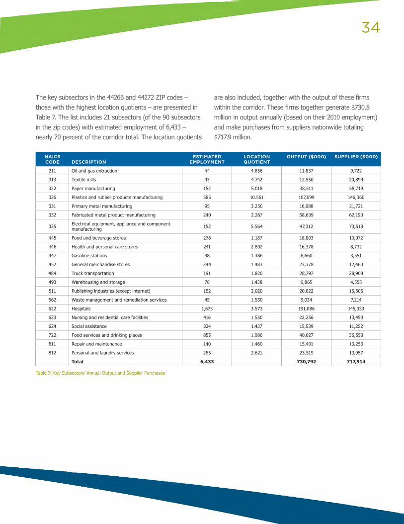
34
NAICS CODE
DESCRIPTION
ESTIMATED EMPLOYMENT
LOCATION QUOTIENT
OUTPUT ($000) SUPPLIER ($000)
211 Oil and gas extraction 44 4.856 11,837 9,722
313 Textile mills 43 4.742 12,550 20,894
322 Paper manufacturing 152 5.018 38,511 58,719
326 Plastics and rubber products manufacturing 585 10.561 107,099 146,360
331 Primary metal manufacturing 95 3.250 16,988 21,721
332 Fabricated metal product manufacturing 240 2.267 58,639 62,190
335 Electrical equipment, appliance and component manufacturing 152 5.564 47,312 73,518
445 Food and beverage stores 278 1.187 18,893 10,072
446 Health and personal care stores 241 2.892 16,378 8,732
447 Gasoline stations 98 1.386 6,660 3,551
452 General merchandise stores 344 1.483 23,378 12,463
484 Truck transportation 191 1.820 28,797 28,903
493 Warehousing and storage 78 1.438 6,865 4,555
511 Publishing industries (except internet) 152 2.020 20,022 15,505
562 Waste management and remediation services 45 1.550 9,034 7,214
622 Hospitals 1,675 3.573 191,086 145,333
623 Nursing and residential care facilities 416 1.550 22,256 13,450
624 Social assistance 324 1.437 15,539 11,252
722 Food services and drinking places 855 1.086 40,027 36,553
811 Repair and maintenance 140 1.460 15,401 13,253
812 Personal and laundry services 285 2.621 23,519 13,957
Total 6,433 730,792 717,914
Table 7: Key Subsectors’ Annual Output and Supplier Purchases
The key subsectors in the 44266 and 44272 ZIP codes – those with the highest location quotients – are presented in Table 7. The list includes 21 subsectors (of the 90 subsectors in the zip codes) with estimated employment of 6,433 – nearly 70 percent of the corridor total. The location quotients
are also included, together with the output of these firms within the corridor. These firms together generate $730.8 million in output annually (based on their 2010 employment) and make purchases from suppliers nationwide totaling $717.9 million.
35
What are these supplier industries and to what extent are they already represented in the local area? Supplier industries can be identified and the purchases from them can be calculated from the I-O Accounts. The dollar purchases of each key subsector from each of their supplier industries are calculated and the purchases from each supplier industry with at least $10,000 in sales to the key industry are totaled across subsectors. The results are given in Attachment B, Exhibit A-2. These suppliers account for $486.7 million, 68 percent of the total in Table 6.
Many supplier firms also have location quotients in Portage County and the Akron MSA well above one. This is not surprising: proximity to customers is a factor contributing to firms’ success. Some industries, however, seem to be promising despite their high location quotient. These include nonresidential building maintenance and repair (230301), data processing and hosting (518200), insurance services (524100 and 524200) and real estate services (531000 – likely real estate leasing and management).
Four sectors require further exploration. Professional, scientific and technical services (NAICS code 54) and administrative support and waste management services (NAICS code 56) are well-represented on the list of suppliers. These are broad sectors without detail at the three-digit level, but have location quotients that are unusually low for a metropolitan area as large as Akron. Wholesale trade (NAICS code 42) has a high location quotient but with $38 million of demand by the drivers, it would be well to take a more detailed look at the sector to see if gaps exist. Finally, retail trade (NAICS code 44-45) has some demand by the key industries, but obviously significant demand from the households in the area.
Employment at the four-digit level in the R2R Corridor and location quotients are presented in Attachment B, Exhibit A-3. Of the $38 million of purchases from wholesalers by the key subsectors, $25 million are by manufacturing firms and another $6.3 million are by healthcare providers. This suggests that industrial and medical supply firms are the most significant wholesale providers to the key subsectors. These would include wholesalers of commercial equipment (NAICS code 4234), metal and mineral wholesalers (4235), electrical goods (4236), drugs (4242) and chemicals (4246). Most of these industry groups have high location quotients at the county and/or MSA level, so the opportunities here may be somewhat limited. Still, a knowledgeable supplier of a specific class of goods required by these firms can carve out a share of a very large market – both in the immediate Ravenna area and beyond.
Some of the location quotients in the retail industry groups are potentially too high. Retail is different from many other sectors in that it serves mostly a local market. Other firms, such as manufacturers, may serve a national or international market and thus have a much greater growth potential. The implication is that the location quotient for manufacturing industries can be very high – as they are for many industries in the R2R Corridor – without signaling a problem. A very high location quotient in retail, however, without extenuating circumstances suggests overconcentration. One circumstance can be a primary regional shopping center located in an outlying county of a large metropolitan area – such as the Polaris Fashion Place and the surrounding shopping centers in Delaware County, which attract shoppers from throughout the Columbus area and beyond. It appears that Portage County is a net attractor of retail activity for the area: Summit County’s location quotient is a
36
fairly low 0.989 and the 1.04 location quotient for the MSA is not overly high. But the fact remains that households in the R2R Corridor have a great deal of retail located relatively close by. Furniture and home furnishing stores (NAICS 442) are one opportunity – these industry groups are low for both Portage County and the MSA as a whole. Many other retail needs are clearly being met by general department stores, which lead to the extremely high location quotients in the corridor and Portage County. Still, opportunities may exist for small, specialized retailers to carve out a niche by offering specialized goods and outstanding service. Food and beverage stores other than grocery stores (NAICS 445) may offer one such opportunity, as may sporting goods and hobby stores (NAICS 4511), florists (NAICS 4531) and office supply stores (NAICS 4532). Qualifying these opportunities will require a careful, detailed assessment of the location and offerings of competitive stores and a clear sense of the value proposition of the new store.
POSSIBLE SOLUTIONS
The two business service sectors, professional and technical services and administrative and support services, are another matter entirely. These location quotients are low both for the county and the MSA, so opportunities may exist to open new establishments that meet the needs of the corridor’s key subsectors. Returning to the estimates of supplier demand in Attachment B, Exhibit A-2, legal services, accounting services, consulting services, employment services (such as temporary employment agencies), and services to buildings all have fairly large demands. Of these, none is highly represented in the corridor and only services to buildings are well-represented at the county level.
To summarize, the following may represent opportunities for business development in the R2R Corridor:
• Nonresidential building maintenance and repair
• Data processing and hosting
• Insurance carriers and brokers
• Commercial real estate leasing and management
• Furniture and home furnishing stores
• Specialized food and beverage stores
• Sporting goods and hobby stores
• Florists
• Office supply stores
• Legal services
• Accounting and bookkeeping services
• Management, scientific and technical consulting services
• Employment services
The caveat discussed earlier bears repeating: the existence of business and household demand documented in this analysis does not guarantee success of start-up firms in these industries, and the high location quotients of other demand industries does not imply that new entrants to these industries will be unsuccessful. In both cases, success requires convincing potential customers to alter their current buying habits by offering goods and services more effectively. Many of these new firms will be entrepreneurial start-ups, so the effort to enhance the R2R Corridor must also include responsive, effective, and accessible
37
entrepreneurial and business development assistance – such as that offered by the Small Business Administration and its network of Small Business Development Centers and some economic development offices and chambers of commerce. One-on-one business owner mentoring programs are another possibility. There already appears to be a healthy climate of entrepreneurship in Portage County. The location quotient for non-farm business proprietors in the county was a respectable 1.142 in 2010, based on statistics from the U.S. Bureau of Economic Analysis. The efforts to enhance the R2R Corridor can enhance that measure as well.
38
DSA BROWNFIELD EFFORTS
The Brownfield Action Plan Program was created by the Ohio Development Services Agency (DSA) to help communities struggling with the impacts of brownfields on an area-wide scale. Corridors, neighborhoods and block clusters are the target of this program. The area-wide approach is intended to result in a more rapid, efficient and comprehensive revitalization of Ohio’s communities.
The area-wide approach to create plans addressing multiple brownfield site in communities is a signature feature designed to view vacant and contaminated site in the planning area in the context of the “whole,” thereby, connecting brownfield redevelopment goals to the housing, transportation and infrastructure goals of the community.
RAVENNA’S PLANNING AREA
In the fall of 2011, the City of Ravenna applied for a Brownfield Action Plan Pilot Program grant from the Ohio DSA. The City saw the area-wide approach to Brownfield redevelopment as the right tool to help their struggling corridors.
The City’s Action Plan focuses on the Main Street (State Route 59) corridor which encompasses part of the City’s Historic District and the Central Business District. The City would like to develop a multi-functional, walkable neighborhood and expand the Commercial and Central Business District. AMATS and GPD Group agree that development along this corridor is critical to the City’s future sustainability. The Main Street Corridor Action Plan will provide strategies to accomplish this goal while creating a more attractive, cohesive and better connected corridor that will spur and support economic and community development. 11
FRAMING THE ISSUE
As discussed with stakeholders, Ravenna has many vacant storefronts, dilapidated housing and a lack of good jobs for its citizens. The DSA Brownfield Action Program effort focuses on the issues of redevelopment and revitalization.
With so many vacant storefronts, dilapidated homes and properties in need of repurposing or redevelopment, the City may ask, “Where to begin?” The Draft DSA Brownfield Action plan discusses several key features that have been discussed throughout the R2R Corridor Study. Specifically, the industrial site that housed a cement factory. As discussed by DSA, the large industrial site divides both the residential area and the commercial area preventing unification and the ability to establish a sense of place and community connectivity.
In discussions with the City, they envision this site as a recreational facility complete with amphitheater. The feasibility of this vision for the redevelopment will hinge on the ability of the site to be remediated, the appropriate context for the land (should it be more commercial for instance) and locating funding for the site.
11 The first three paragraphs are adapted from the DSA DRAFR Brownfield Action Plan – Ravenna but should be credited to the Ohio DSA.
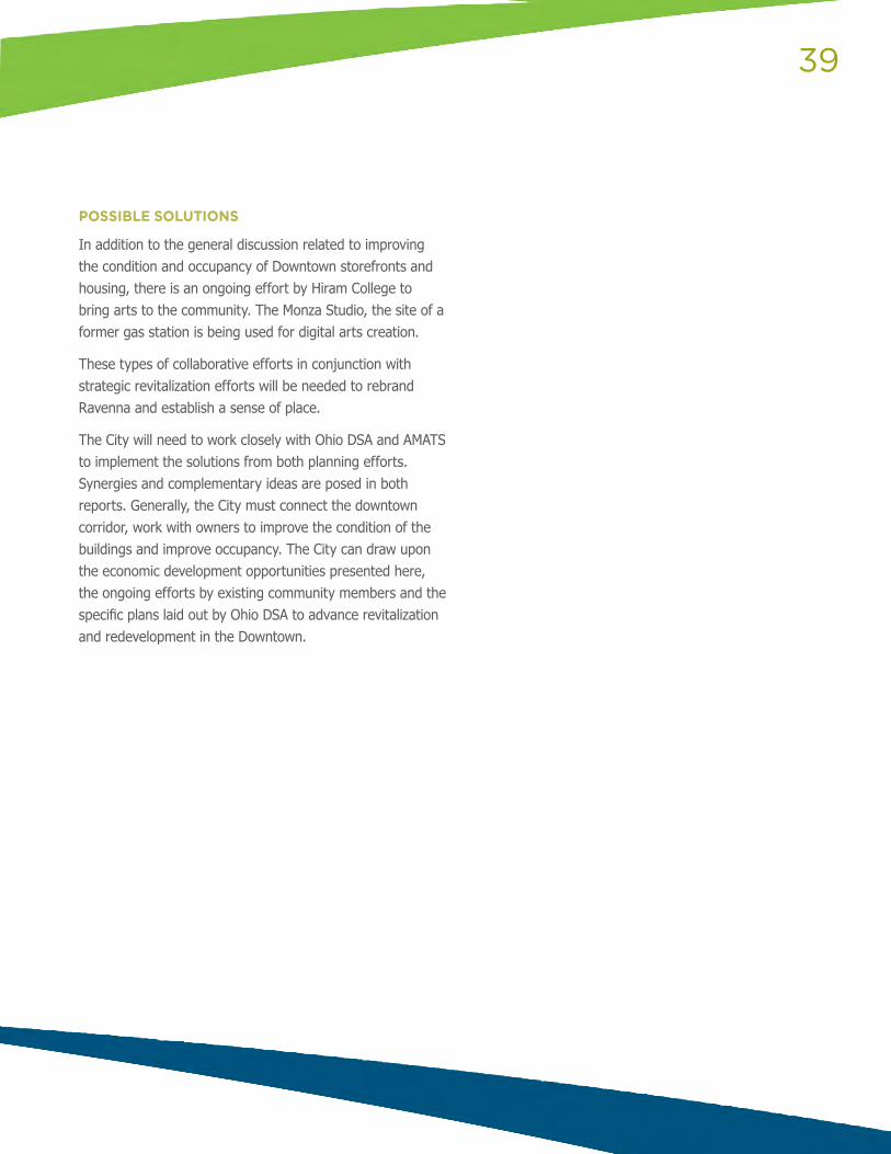
39
POSSIBLE SOLUTIONS
In addition to the general discussion related to improving the condition and occupancy of Downtown storefronts and housing, there is an ongoing effort by Hiram College to bring arts to the community. The Monza Studio, the site of a former gas station is being used for digital arts creation.
These types of collaborative efforts in conjunction with strategic revitalization efforts will be needed to rebrand Ravenna and establish a sense of place.
The City will need to work closely with Ohio DSA and AMATS to implement the solutions from both planning efforts. Synergies and complementary ideas are posed in both reports. Generally, the City must connect the downtown corridor, work with owners to improve the condition of the buildings and improve occupancy. The City can draw upon the economic development opportunities presented here, the ongoing efforts by existing community members and the specific plans laid out by Ohio DSA to advance revitalization and redevelopment in the Downtown.
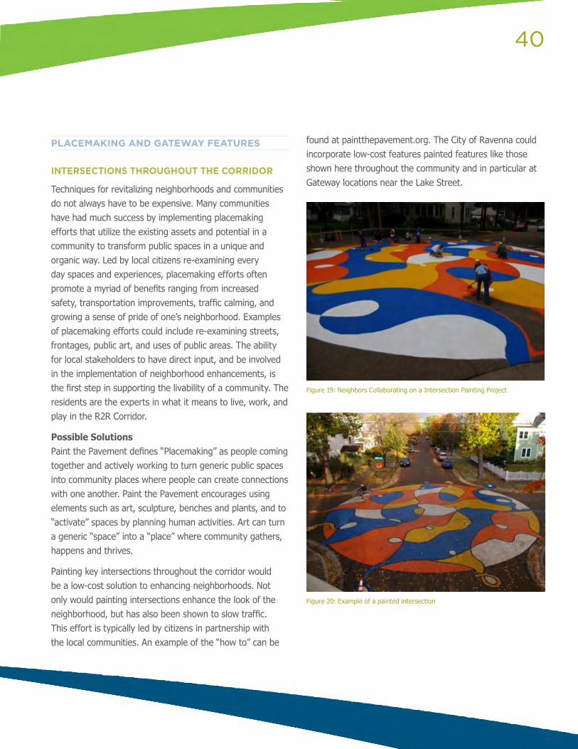
40
PLACEMAKING AND GATEWAY FEATURES
INTERSECTIONS THROUGHOUT THE CORRIDOR
Techniques for revitalizing neighborhoods and communities do not always have to be expensive. Many communities have had much success by implementing placemaking efforts that utilize the existing assets and potential in a community to transform public spaces in a unique and organic way. Led by local citizens re-examining every day spaces and experiences, placemaking efforts often promote a myriad of benefits ranging from increased safety, transportation improvements, traffic calming, and growing a sense of pride of one’s neighborhood. Examples of placemaking efforts could include re-examining streets, frontages, public art, and uses of public areas. The ability for local stakeholders to have direct input, and be involved in the implementation of neighborhood enhancements, is the first step in supporting the livability of a community. The residents are the experts in what it means to live, work, and play in the R2R Corridor.
Possible SolutionsPaint the Pavement defines “Placemaking” as people coming together and actively working to turn generic public spaces into community places where people can create connections with one another. Paint the Pavement encourages using elements such as art, sculpture, benches and plants, and to “activate” spaces by planning human activities. Art can turn a generic “space” into a “place” where community gathers, happens and thrives.
Painting key intersections throughout the corridor would be a low-cost solution to enhancing neighborhoods. Not only would painting intersections enhance the look of the neighborhood, but has also been shown to slow traffic. This effort is typically led by citizens in partnership with the local communities. An example of the “how to” can be
found at paintthepavement.org. The City of Ravenna could incorporate low-cost features painted features like those shown here throughout the community and in particular at Gateway locations near the Lake Street.
Figure 19: Neighbors Collaborating on a Intersection Painting Project
Figure 20: Example of a painted intersection
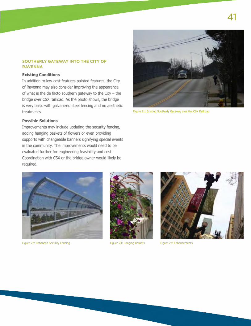
41
SOUTHERLY GATEWAY INTO THE CITY OF RAVENNA
Existing ConditionsIn addition to low-cost features painted features, the City of Ravenna may also consider improving the appearance of what is the de facto southern gateway to the City – the bridge over CSX railroad. As the photo shows, the bridge is very basic with galvanized steel fencing and no aesthetic treatments.
Possible SolutionsImprovements may include updating the security fencing, adding hanging baskets of flowers or even providing supports with changeable banners signifying special events in the community. The improvements would need to be evaluated further for engineering feasibility and cost. Coordination with CSX or the bridge owner would likely be required.
Figure 21: Existing Southerly Gateway over the CSX Railroad
Figure 22: Enhanced Security Fencing Figure 23: Hanging Baskets Figure 24: Enhancements
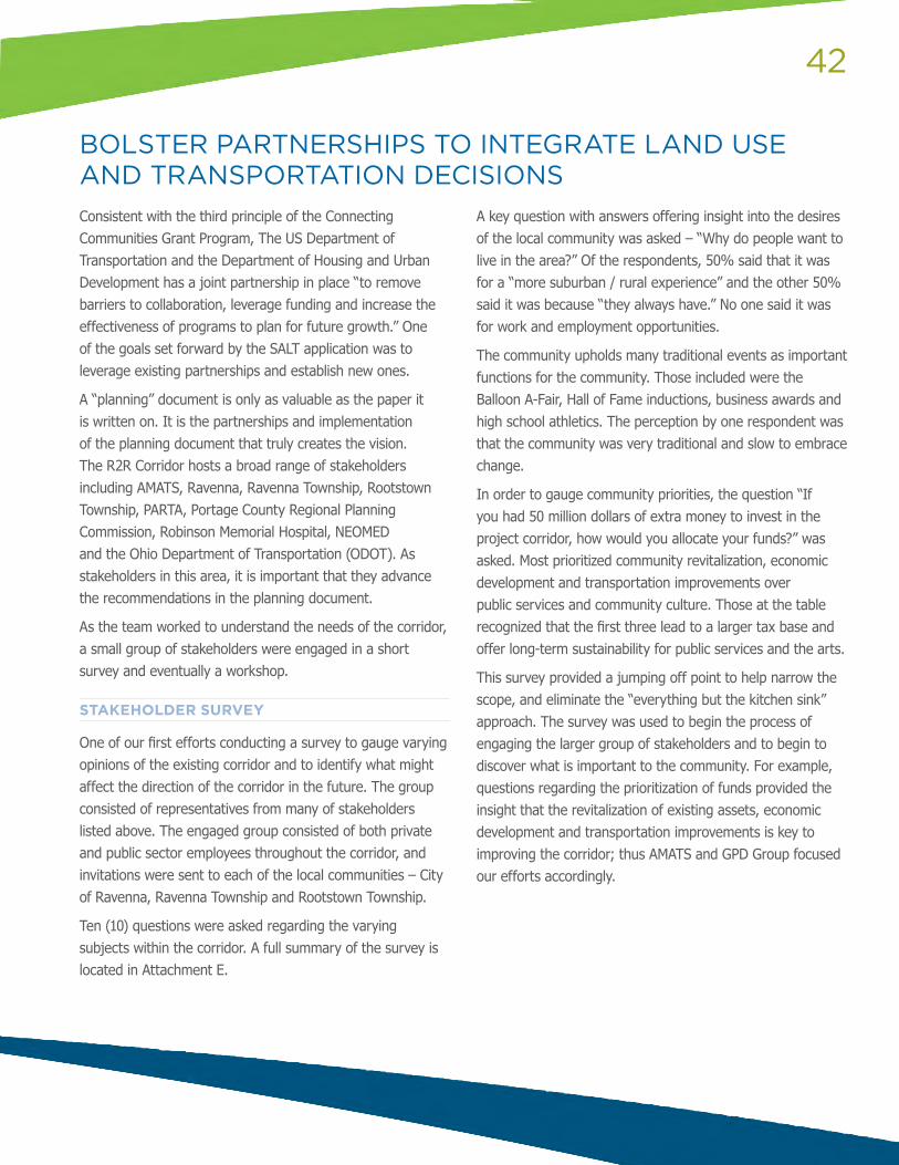
42
Consistent with the third principle of the Connecting Communities Grant Program, The US Department of Transportation and the Department of Housing and Urban Development has a joint partnership in place “to remove barriers to collaboration, leverage funding and increase the effectiveness of programs to plan for future growth.” One of the goals set forward by the SALT application was to leverage existing partnerships and establish new ones.
A “planning” document is only as valuable as the paper it is written on. It is the partnerships and implementation of the planning document that truly creates the vision. The R2R Corridor hosts a broad range of stakeholders including AMATS, Ravenna, Ravenna Township, Rootstown Township, PARTA, Portage County Regional Planning Commission, Robinson Memorial Hospital, NEOMED and the Ohio Department of Transportation (ODOT). As stakeholders in this area, it is important that they advance the recommendations in the planning document.
As the team worked to understand the needs of the corridor, a small group of stakeholders were engaged in a short survey and eventually a workshop.
STAKEHOLDER SURVEY
One of our first efforts conducting a survey to gauge varying opinions of the existing corridor and to identify what might affect the direction of the corridor in the future. The group consisted of representatives from many of stakeholders listed above. The engaged group consisted of both private and public sector employees throughout the corridor, and invitations were sent to each of the local communities – City of Ravenna, Ravenna Township and Rootstown Township.
Ten (10) questions were asked regarding the varying subjects within the corridor. A full summary of the survey is located in Attachment E.
A key question with answers offering insight into the desires of the local community was asked – “Why do people want to live in the area?” Of the respondents, 50% said that it was for a “more suburban / rural experience” and the other 50% said it was because “they always have.” No one said it was for work and employment opportunities.
The community upholds many traditional events as important functions for the community. Those included were the Balloon A-Fair, Hall of Fame inductions, business awards and high school athletics. The perception by one respondent was that the community was very traditional and slow to embrace change.
In order to gauge community priorities, the question “If you had 50 million dollars of extra money to invest in the project corridor, how would you allocate your funds?” was asked. Most prioritized community revitalization, economic development and transportation improvements over public services and community culture. Those at the table recognized that the first three lead to a larger tax base and offer long-term sustainability for public services and the arts.
This survey provided a jumping off point to help narrow the scope, and eliminate the “everything but the kitchen sink” approach. The survey was used to begin the process of engaging the larger group of stakeholders and to begin to discover what is important to the community. For example, questions regarding the prioritization of funds provided the insight that the revitalization of existing assets, economic development and transportation improvements is key to improving the corridor; thus AMATS and GPD Group focused our efforts accordingly.
BOLSTER PARTNERSHIPS TO INTEGRATE LAND USE AND TRANSPORTATION DECISIONS
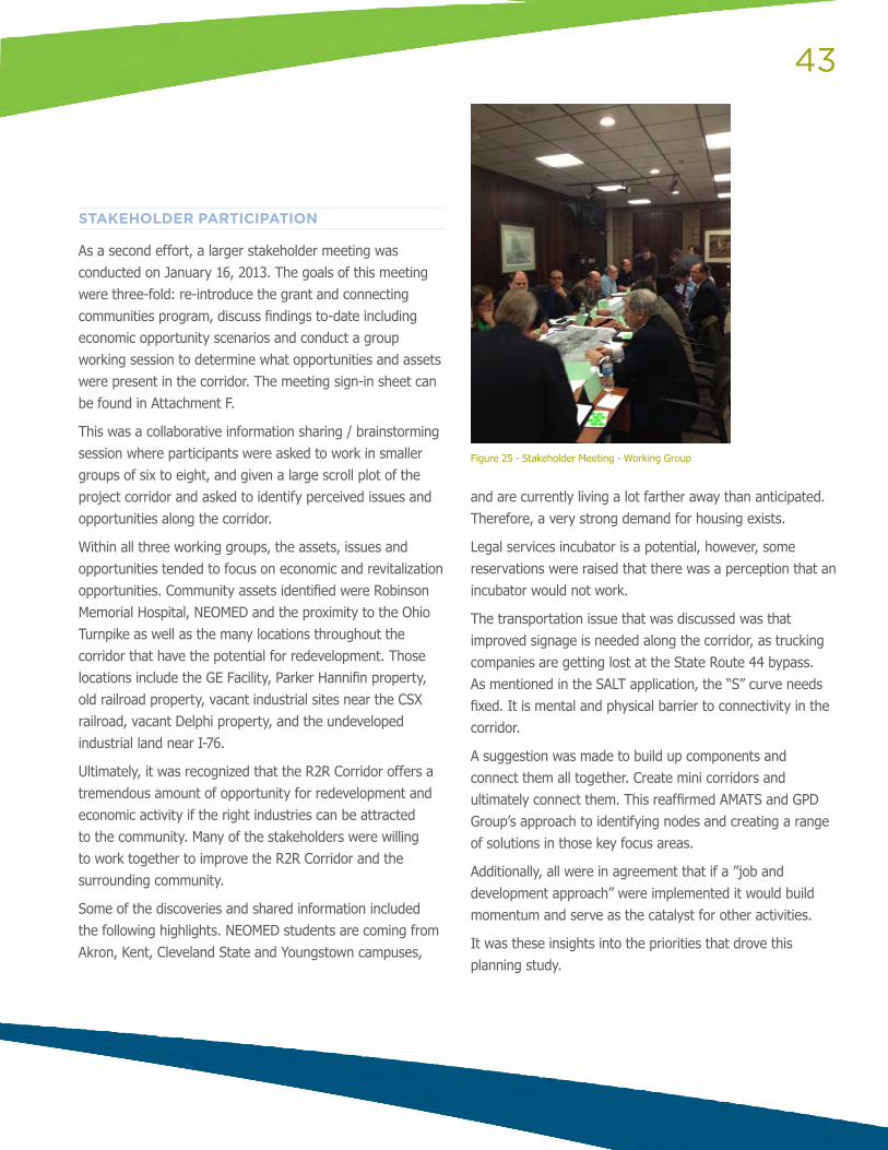
43
STAKEHOLDER PARTICIPATION
As a second effort, a larger stakeholder meeting was conducted on January 16, 2013. The goals of this meeting were three-fold: re-introduce the grant and connecting communities program, discuss findings to-date including economic opportunity scenarios and conduct a group working session to determine what opportunities and assets were present in the corridor. The meeting sign-in sheet can be found in Attachment F.
This was a collaborative information sharing / brainstorming session where participants were asked to work in smaller groups of six to eight, and given a large scroll plot of the project corridor and asked to identify perceived issues and opportunities along the corridor.
Within all three working groups, the assets, issues and opportunities tended to focus on economic and revitalization opportunities. Community assets identified were Robinson Memorial Hospital, NEOMED and the proximity to the Ohio Turnpike as well as the many locations throughout the corridor that have the potential for redevelopment. Those locations include the GE Facility, Parker Hannifin property, old railroad property, vacant industrial sites near the CSX railroad, vacant Delphi property, and the undeveloped industrial land near I-76.
Ultimately, it was recognized that the R2R Corridor offers a tremendous amount of opportunity for redevelopment and economic activity if the right industries can be attracted to the community. Many of the stakeholders were willing to work together to improve the R2R Corridor and the surrounding community.
Some of the discoveries and shared information included the following highlights. NEOMED students are coming from Akron, Kent, Cleveland State and Youngstown campuses,
and are currently living a lot farther away than anticipated. Therefore, a very strong demand for housing exists.
Legal services incubator is a potential, however, some reservations were raised that there was a perception that an incubator would not work.
The transportation issue that was discussed was that improved signage is needed along the corridor, as trucking companies are getting lost at the State Route 44 bypass. As mentioned in the SALT application, the “S” curve needs fixed. It is mental and physical barrier to connectivity in the corridor.
A suggestion was made to build up components and connect them all together. Create mini corridors and ultimately connect them. This reaffirmed AMATS and GPD Group’s approach to identifying nodes and creating a range of solutions in those key focus areas.
Additionally, all were in agreement that if a ”job and development approach” were implemented it would build momentum and serve as the catalyst for other activities.
It was these insights into the priorities that drove this planning study.
Figure 25 - Stakeholder Meeting - Working Group
44
PARTNERSHIPS MOVING FORWARD
The City of Ravenna, Rootstown Township and Ravenna Township have the opportunity to capitalize on the synergies created by these two organizations. The range of possibilities is great, and could include elements such as encouraging supply chains, housing and access to better serve the healthcare industry. Regardless, the communities must work with their anchor tenants to get the most out of the interrelationships that have been created or enhanced by their proximity. In this case, transportation is the means to achieving an end of providing better access for all users and elements for a more livable community. While transportation is only one piece of the puzzle, it is the piece that, if not properly addressed, can leave the puzzle unsolved.
NEOMED AREA
At a minimum, ensure that the roadway improvements planned for the NEOMED area on SR 44 do not preclude pedestrian accommodations. Utility locations and any landscaping should permit the future installation of pedestrian accommodations north of Rootstown High School and in front of NEOMED.
Funding: As the section is now going to be a three lane section without pedestrian facilities, it is recommended that NEOMED, Rootstown Township and Rootstown School System Officials continue to monitor pedestrian activity and work to pursue Safe Routes to School or AMATS funding at a later date when the sidewalks are warranted.
SR 44/SOUTH PROSPECT STREET INTERCHANGE
There are many possible solutions at this interchange. A low-cost solution would include striping high-visibility crosswalks at pedestrian/bicyclist intersections at the ramps to improve pedestrian/bicyclist visibility. Given the range of possibilities and the uncertainty of issues in the area (other than the lack of accommodation), further study the area to
determine which medium cost solutions would best suit the interchange.
Funding: The low-cost options could be funded locally or incorporated into the next ODOT pavement project at this location. Ravenna Township should reach out to ODOT to further coordinate potential improvement opportunities.
RAVENNA TOWNSHIP PEDESTRIAN / BICYCLE ACCOMMODATIONS
Due to the heavy documented pedestrian / bicycle use in this area, sidewalks or shared use paths are critical. GPD recommends that sidewalks be constructed on at least one side of Prospect Street from approximately 1000 feet north of the “S” Curve to Ohio Avenue. The east side of Prospect Street has sidewalks that extend the farthest south. However, utility locations, right-of-way availability and business drive locations will need to be evaluated to determine the solution that contains costs and maximizes safety for pedestrians and bicyclists. The right-of-way should be evaluated to determine if it can accommodate a sidewalk only or a wider shared use path.
Funding: Potential funding sources include AMATS MPO directed funds. AMATS is prepared to work with Ravenna to advance this project.
SUMMARY OF RECOMMENDATIONS
45
CHESTNUT STREET
It is recommended that the City undertake an educational and enforcement campaign in cooperation with the High School that follows up with enforcement. The campaign could enlist a committee of students as well as faculty and community leaders to develop a social media based campaign with supplemental printed materials. A potential solution would be to develop a Stay Inside the Lines campaign geared towards pedestrian safety.
Crosswalk – Placing a defined (painted) cross walk at the North Side of Lincoln Avenue and installing compliant curb ramps. The solution would cost between $3,000 and $5,000.
Funding: Sources for this campaign include Safe Routes to School and Highway Safety Program Funds.
“S” CURVE AT RAILROAD OVERPASS
Overall, there are quite a few options that could be implemented in this area to address the identified issues. The final selections depend on preference, priorities, and funding availability. The more expensive alternatives address a high number of the issues more effectively, but some low-cost alternatives could be the preferred solution, at least for the short-term. If a medium or high-cost solution can be funded, Alternatives 8, 9 and 10 are recommended because they are the alternatives that most effectively address the identified issues. If a low-cost solution is the preference, then a combination of Alternatives 2, 3 and 4 are recommended because they are the least expensive and are the most compatible with the area with the fewest impacts to traffic flow.
Given the recent project of constructing a northbound left turn lane and traffic signal at Summit Road and a new southbound left turn lane at Hayes Road, GPD Group would recommend observing the solution to evaluate the impacts of the improvement, but continue to work towards eliminating the clearance and width constraints presented by the overpass.
Funding: Sources for these alternatives include the Portage County Engineer, AMATS, Federal Transportation funds including loans such as TIFIA and RRIFF as well as CDBG.
TRANSIT
The transit improvements are contingent upon demand. However, it is recommending that the following be considered as funding becomes available and demand continues to grow: • Extend the Interurban route south to NEOMED; • Extend the Raven route’s peripheral path to a complete
loop; • Development of a Park & Ride System; • Transit Stop Enhancements; and, • Ridership Surveys
HOUSING
Ravenna has experienced deterioration in their housing stock, particularly in the urban core. It is recommended that the City of Ravenna take these first few steps to improve the state of repair of homes: • Compile & Complete Property Rental List; • Improve Trash and Garbage Collection; • Create a Vacant Property Inventory; • Increase Owner-Occupied Housing; and, • Target Resources to focus on home improvement and
repair to improve the condition of housing in Ravenna’s core
46
IMPROVE ECONOMIC COMPETITIVENESS OF NEIGHBORHOODS
Ravenna has a lot of opportunities with regards to economic competitiveness. Below are steps to be taken in order to begin to shift momentum: • A New Website sharing the great happenings in Ravenna
and the available programs and resources; • Enforce Historic District Guidelines; • Participate in Trade Shows; • TIFs should be considered as another incentive; and, • Further explore the opportunities for business
development in the R2R Corridor as outlined on Page 36. Two specific opportunities that aligned with City ideas and the data were legal services and bookkeeping and accounting.
DSA BROWNFIELD EFFORTS
The City will need to work closely with Ohio DSA and AMATS to implement the solutions from both planning efforts. Synergies and complementary ideas are posed in both reports. Generally, the City must connect the downtown corridor, work with owners to improve the condition of the buildings and improve occupancy. The City can draw upon the economic development opportunities presented here, the ongoing efforts by existing community members and the specific plans laid out by Ohio DSA to advance revitalization and redevelopment in the Downtown.
Continued support with those seeking to do projects like the Monza Studio will be critical to the success of the revitalization of Ravenna.
PLACEMAKING AND GATEWAY FEATURES
The City of Ravenna needs to identify itself and establish a new sense of place. GPD recommends that Ravenna work to implement low-cost community features such as those found at “Paint the Pavement” and improve the bridge fencing over the railroad north of E. Lake Street.
Funding: “Paint the Pavement” is a low-cost solution that is community driven, and the City of Ravenna may enlist local artists willing to donate time in order to showcase their work. Improving the bridge fencing will require identification of the bridges owner and coordination with them to either add low-cost planters, baskets, lighting or to replace the bridge fencing with a decorative fence.
47
GENERAL RECOMMENDATIONS
As member communities of the R2R Corridor begin to bring in more business, be certain to capture the value of improvements throughout the corridor by using legislative mechanisms. Specifically, look to legislated mechanisms such as tax increment financing, joint economic development districts and other mechanisms to capture the increased value in income taxes and land values for reinvestment in the communities.
In general, when new projects are developed in the R2R Corridor, efforts should be made to pave shoulders for bicycles, and add bike racks downtown and other locations where appropriate.
Ultimately, this document should serve as a guide that provides range possibilities, inclusive of low to high cost solutions, that will support the partnering communities and bolster economic opportunities throughout the R2R Corridor.