Embed Size (px)
Citation preview
Conservation of Freshwater Ecosystem Values Validation Report – Appendices
Department of Pr imary Industr ies and Water

Conservation of Freshwater Ecosystem Values (CFEV) Validation Report – Appendices
National Water Initiative – Australian Government Water Fund
Report to the Conservation of Freshwater Ecosystem Values Project, Water Resources Division,
Department of Primary Industries and Water
Report 1b/6
October 2007
Peter Davies, Laurie Cook, Lois Koehnken and Philip Barker Freshwater Systems and associates: Technical Advice on Water, North
Barker and Associates
© Department of Primary Industries and Water, October 2007
Published by:
Water Resources Division
Department of Primary Industries and Water
GPO Box 44
Hobart Tas 7001
Telephone: (03) 6233 6328
Facsimile: (03) 6233 8749
Email: [email protected]
Website: www.dpiw.tas.gov.au/water
This report forms part of a series of reports produced as part of the ‘Ground-truthing and validation of
the Conservation of Freshwater Ecosystem Values (CFEV) database to support Water Management
Planning’ project.
Financial support contributed by the Australian Government through the National Water Initiative –
Australian Government Water Fund is gratefully acknowledged.
Citation: Davies, P., Cook, L., Koehnken, L. and Barker, P. (2007). Conservation of
Freshwater Ecosystem Values Validation Report – Appendices. Report to the
Conservation of Freshwater Ecosystem Values Project. Department of Primary
Industries and Water, Hobart, Tasmania.
ISBN: 9780724664351
Copyright
All material published in the report by the Department of Primary Industries and Water, as an agent of
the Crown, is protected by the provisions of the Copyright Act 1968 (Cwlth). Other than in accordance
with the provisions of the Act, or as otherwise expressly provided, a person must not reproduce, store
in a retrieval system, or transmit any such material without first obtaining the written permission of the
Department of Primary Industries and Water.
Disclaimer
Whilst the Department of Primary Industries and Water makes every attempt to ensure the accuracy
and reliability of information published in this report, it should not be relied upon as a substitute for
formal advice from the originating bodies or Departments. DPIW, its employees and other agents of
the Crown will not be responsible for any loss, however arising, from the use of, or reliance on this
information.
Contents
Appendix 1. Geomorphological field assessment sheets .......................... 1
Appendix 2. Riparian Vegetation Condition Assessment field sheet and attribute scores ............................................................................................ 56
Appendix 3. Summary of CFEV and field fluvial geomorphic condition scores for river clusters .............................................................................. 59
Appendix 4. CFEV Riparian vegetation condition scores compared to field % native and the field CV .................................................................... 65
Appendix 5. Wetland survey form .............................................................. 68
Conservation of Freshwater Ecosystem Values Validation Report – Appendices
1
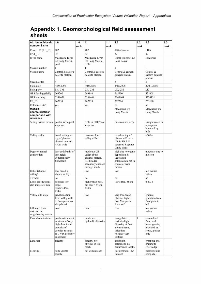
Appendix 1. Geomorphological field assessment sheets Attributes/Mosaic number & site
1.0 1.0
rank
1.1 1.1
rank
1.2 1.2
rank
1.3 1.3
rank
Cluster ID (RC_ID) 782 782 120 u/stream 1106
CAT_ID 32 32 32 32
River name Macquarie River
u/s Long Marsh-
pool
Macquarie River
u/s Long Marsh-
riffle
Elizabeth River d/s
Lake Leake Blackman
Mosaic number 1 1 1 1
Mosaic name Central & eastern
dolerite plateau Central & eastern
dolerite plateau Central & eastern
dolerite plateau Central &
eastern dolerite
plateau
Stream order 4 4 3 3
Field date 4/10/2006 4/10/2006 4/10/2006 22/11/2006
Field party LK, CM LK, CM LK, CM LK
GPS Easting (field) 569202 569140 565700 521008
GPS Northing 5338659 5338668 5349604 5324131
RS_ID 267239 267239 267204 255180
Reference site? yes yes no no
Mosaic characteristics/ comparison with reference
Macquarie u/s
Long Marsh Macquarie u/s
Long Marsh
Setting within mosaic pool in riffle/pool
sequence riffle in riffle/pool
sequence run/drowned riffle straight reach in
open plain
bordered by
hills
Valley width broad setting on
top of plateau, channel controls
~50m wide
narrower local
valley ~25m broad-on top of
plateau ~25 m on LB & RB B/R
outcrops & gentle
valley slope
~500m
Degree channel
constriction
low-both banks of
low height w/hummocky
floodplain
moderate-LB
valley abuts channel margin,
RB-braided
secondary channel through scrub
high due to organic
deposition & vegetation
colonisation-not in
character with mosaic
moderate due to
incision
Relief (channel
setting)
low-broad u-
shaped valley low low low within
valley
Terraces no no no no
Long. profile/slope
elev max/elev min
pool has low
slope,
reach=445m, 434m
higher than pool,
but low = 445m,
434m
low 548m, 568m 0.0034
Valley side slope grad transition
from valley wall
to floodplain, no
sharp break
low very low-broad
plateau- higher
than Macquarie
River ref
gradual-
gradation from
floodplain to
hill
Influence from
u/stream or neighbouring mosaic
none none none low within
valley
Flow characteristics pool environment, evidence of very
high flow flood
deposits of cobbles & sands
& LWD, probably
ephemeral
moderate hydraulic diversity
unregulated periods=high
diversity of flow
environments, irrigation
releases=very
uniform
1 channelised flow, with
heterogeneity
provided by reeds, grasses
only
Land-use forestry forestry-not
obvious in test
reach
grazing in
catchment, no
disturbance locally
cropping and
grazing to
rivers edge
Clearing none visible
locally not within reach in catchment, low
in reach extensive and
complete
Conservation of Freshwater Ecosystem Values Validation Report – Appendices
2
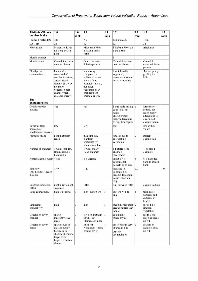
Attributes/Mosaic number & site
1.0 1.0
rank
1.1 1.1
rank
1.2 1.2
rank
1.3 1.3
rank
Cluster ID (RC_ID) 782 782 120 u/stream 1106
CAT_ID 32 32 32 32
River name Macquarie River
u/s Long Marsh-pool
Macquarie River
u/s Long Marsh-riffle
Elizabeth River d/s
Lake Leake Blackman
Mosaic number 1 1 1 1
Mosaic name Central & eastern
dolerite plateau Central & eastern
dolerite plateau Central & eastern
dolerite plateau Central &
eastern dolerite plateau
Flood plain
characteristics
hummocky
composed of
cobbles & stones,
2ndayr flood channel & LWD,
not much
vegetation near channel=high
episodic energy
hummocky
composed of
cobbles & stones,
2ndayr flood channel & LWD,
not much
vegetation near channel=high
episodic energy
low & heavily
vegetated,
secondary channels
heavily vegetated
flat and gently
grading into
hills
Site characteristics
Consistent with
mosaic? Yes yes Large scale setting
consistent, but
reach characteristics
highly altered due
to reg. flow regime
2 large scale
setting, but
reach highly altered due to
clearing ad
channelisation
Influence from
u/stream or
neighbouring mosaic
low low low low within
valley
Planform shape pool in straight
reach mild sinuous,
planform controlled by
boulders/cobbles
sinuous due to
encroaching vegetation
2 straight-
channelised 1
Number of channels 1 with secondary
flood channels
both banks
1 w/secondary
flood channels 1-historic flood
channels
revegetated
1, no flood
channels 1
Approx channel width 4-8 m 6-8 variable variable 4-8,
depositional pockets up to 10m
3 6-8 m eroded
bank to eroded bank
1
Sinuosity
(RS_LENGTH/reach
distance
1.49 1.49 high due to
vegetation &
organic deposition-
doesn't show on map
2.0 1.1 1.0
Site type (pool, run,
riffle)
pool in riffle/pool
sequence riffle run, drowned riffle channelised run 1
Long-connectivity high- culvert u/s 3 high- culvert u/s 3 low-u/s weir &
lake 1 trash gates
u/stream and d/stream of
bridge
1
Latitudinal
connectivity high 3 high 3 medium-vegetation
greater barrier than
natural
2 incised, no
riparian
vegetation
1
Vegetation cover-
channel
sparse
macrophytes & algae
3 low occ. instream
shrub, low filamentous algae
3 continuous
macrophytes 2 reeds along
margins, algae, no wd
1
Vegetation cover-
banks
sparse cover of
grasses-mostly
bare rock in
shadow of u/story, larger trees
begin~10 m from
channel
3 Eucalypt
woodlands- sparse
ground cover
3 tea tree shrub very
abundant, fine
organic
accumulation
2 grasses on
slump blocks,
no wd
1
Conservation of Freshwater Ecosystem Values Validation Report – Appendices
3
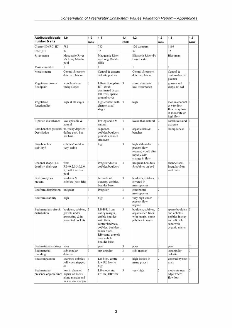
Attributes/Mosaic number & site
1.0 1.0
rank
1.1 1.1
rank
1.2 1.2
rank
1.3 1.3
rank
Cluster ID (RC_ID) 782 782 120 u/stream 1106
CAT_ID 32 32 32 32
River name Macquarie River
u/s Long Marsh-pool
Macquarie River
u/s Long Marsh-riffle
Elizabeth River d/s
Lake Leake Blackman
Mosaic number 1 1 1 1
Mosaic name Central & eastern
dolerite plateau Central & eastern
dolerite plateau Central & eastern
dolerite plateau Central &
eastern dolerite plateau
Vegetation cover-
floodplain
woodlands on
rocky slopes 3 LB-no floodplain,
RT- shrub
dominated occas.
tall trees, sparse ground cover
3 shrub dominate,
low disturbance 2 grasses and
crops, no wd 1
Vegetation
functionality high at all stages 3 high-contact with
channel at all
stages
3 high 3 mod in channel
at very low
flow, very low
at moderate or high flow
1
Riparian disturbance low-episodic &
natural 3 low-episodic &
natural 3 lower than natural 2 continuous and
extreme 1
Bars/benches present?
Description
no-rocky deposits
define pool, but not bars
3 sequence-
cobbles/boulders provide channel
structure
3 organic bars &
benches 2 slump blocks 1
Bars/benches
stability?
cobbles/boulders
very stable 3 high 3 high stab under
present flow
regime, would alter rapidly with
change in flow
2
Channel shape (3-4
depths + thalweg)
from
RB=0.2,0.3,0.5,0.
5,0.4,0.2 across pool
3 irregular due to
cobbles/boulders 3 irregular-boulders
& cobbles on bed 3 channelised -
irregular from
root mats
1
Bedform types
present
boulders &
cobbles (poss BR) 3 bedrock sill
outcrop, cobbles,
boulder base
3 boulders, cobbles
covered in
macrophytes
2
Bedform distribution irregular 3 irregular 3 continuous
macrophytes 2
Bedform stability high 3 high 3 very high under
present flow
regime
3
Bed materials-size &
distribution
boulders, cobbles,
gravels under
armouring & in protected pockets
3 LB-B/R from
valley margin,
cobble boulder with fines,
centre=bedrock,
cobbles, boulders, sands, fines,
RB=sand, gravels
over cobble boulder base
3 boulders, cobbles,
organic rich fines
w/in matrix, some pebbles & sands
2 sparse boulders
and cobbles,
pebbles in clay and silt rich
sand with
organic matter
3
Bed materials sorting poor 3 poor 3 poor 3 poor 3
Bed material
rounding
sub angular
dolerite 3 sub-angular 3 sub-angular 3 subangular
dolerite 3
Bed compaction low/med-cobbles
roll when stepped on
3 LB-high, centre-
low RB low to high
3 high-locked in
many places 2 covered by root
mats 1
Bed material-
presence organic fines
low in channel,
higher on rocks along margin and
in shallow margin
3 LB-moderate,
C=low, RB=low 3 very high 2 moderate near
edge where flow low
2
Conservation of Freshwater Ecosystem Values Validation Report – Appendices
4
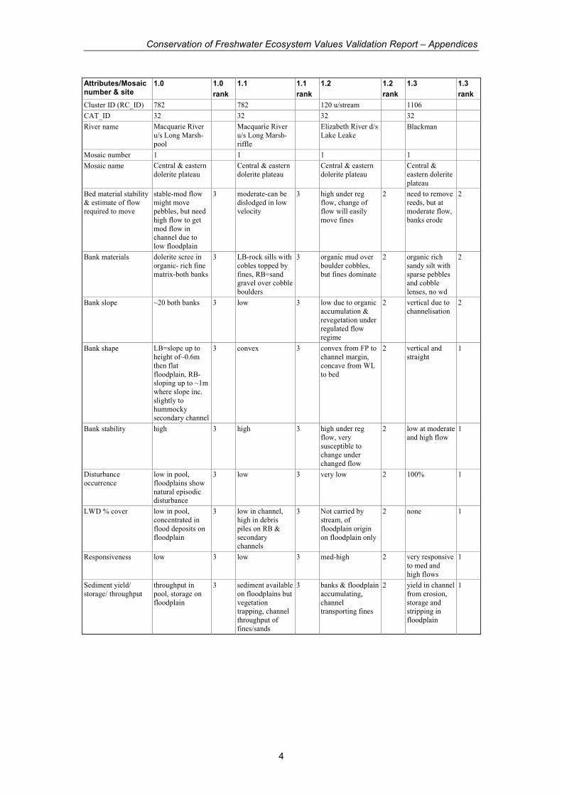
Attributes/Mosaic number & site
1.0 1.0
rank
1.1 1.1
rank
1.2 1.2
rank
1.3 1.3
rank
Cluster ID (RC_ID) 782 782 120 u/stream 1106
CAT_ID 32 32 32 32
River name Macquarie River
u/s Long Marsh-
pool
Macquarie River
u/s Long Marsh-
riffle
Elizabeth River d/s
Lake Leake Blackman
Mosaic number 1 1 1 1
Mosaic name Central & eastern
dolerite plateau Central & eastern
dolerite plateau Central & eastern
dolerite plateau Central &
eastern dolerite
plateau
Bed material stability
& estimate of flow required to move
stable-mod flow
might move pebbles, but need
high flow to get
mod flow in channel due to
low floodplain
3 moderate-can be
dislodged in low velocity
3 high under reg
flow, change of flow will easily
move fines
2 need to remove
reeds, but at moderate flow,
banks erode
2
Bank materials dolerite scree in
organic- rich fine
matrix-both banks
3 LB-rock sills with
cobles topped by
fines, RB=sand gravel over cobble
boulders
3 organic mud over
boulder cobbles,
but fines dominate
2 organic rich
sandy silt with
sparse pebbles and cobble
lenses, no wd
2
Bank slope ~20 both banks 3 low 3 low due to organic
accumulation &
revegetation under regulated flow
regime
2 vertical due to
channelisation 2
Bank shape LB=slope up to
height of~0.6m
then flat
floodplain, RB- sloping up to ~1m
where slope inc.
slightly to hummocky
secondary channel
3 convex 3 convex from FP to
channel margin,
concave from WL
to bed
2 vertical and
straight 1
Bank stability high 3 high 3 high under reg
flow, very
susceptible to change under
changed flow
2 low at moderate
and high flow 1
Disturbance
occurrence
low in pool,
floodplains show
natural episodic disturbance
3 low 3 very low 2 100% 1
LWD % cover low in pool,
concentrated in
flood deposits on
floodplain
3 low in channel,
high in debris
piles on RB &
secondary channels
3 Not carried by
stream, of
floodplain origin
on floodplain only
2 none 1
Responsiveness low 3 low 3 med-high 2 very responsive
to med and
high flows
1
Sediment yield/
storage/ throughput
throughput in
pool, storage on
floodplain
3 sediment available
on floodplains but
vegetation trapping, channel
throughput of
fines/sands
3 banks & floodplain
accumulating,
channel transporting fines
2 yield in channel
from erosion,
storage and stripping in
floodplain
1

Conservation of Freshwater Ecosystem Values Validation Report – Appendices
5
Attributes/Mosaic number & site
1.0 1.0
rank
1.1 1.1
rank
1.2 1.2
rank
1.3 1.3
rank
Cluster ID (RC_ID) 782 782 120 u/stream 1106
CAT_ID 32 32 32 32
River name Macquarie River
u/s Long Marsh-
pool
Macquarie River
u/s Long Marsh-
riffle
Elizabeth River d/s
Lake Leake Blackman
Mosaic number 1 1 1 1
Mosaic name Central & eastern
dolerite plateau Central & eastern
dolerite plateau Central & eastern
dolerite plateau Central &
eastern dolerite
plateau
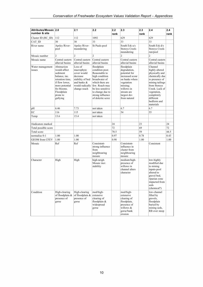
Water management
issues
Stable reach in
excellent condition-
reduction in flows
would reduce disturbance and
inc vegetation on
banks which would reduce
variability,
upstream inc in sed would infill
pools & inc sed on
floodplains
same as for pool
site highly regulated
flow has substantially
changed river
characteristics. Additional changes
in flow pattern
would produce rapid response, but
either more
infilling (less flow), or channel
widening through
erosion of organic. material
incised channel
prone to erosion-inc
baseflow would
inc incision/ erosion,
reduction in
floods, prob little change
pH 7.14 7.14 6.86 8.18
EC 105 105 58 170
Temp 16.8
#indicators marked 27 27 31 28
Total possible score 81 81 93 84
Total score 81 81 67 38
normalise 0-1 1.00 1.00 0.58 0.18
Geom from CFEV 0.85 0.85 0.42 1.00
Mosaic consistent
Character completely
altered by clearing and
channelisation-of no value
with respect to
mosaic
Condition very poor
Conservation of Freshwater Ecosystem Values Validation Report – Appendices
6
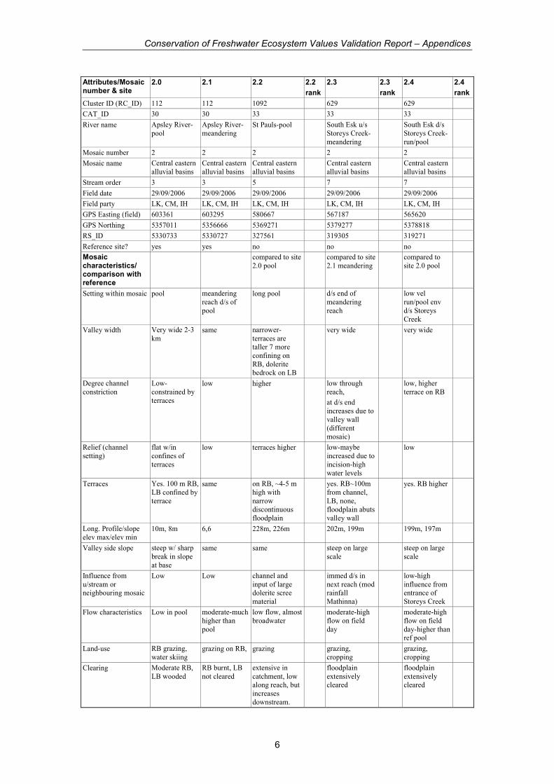
Attributes/Mosaic number & site
2.0 2.1 2.2 2.2
rank
2.3 2.3
rank
2.4 2.4
rank
Cluster ID (RC_ID) 112 112 1092 629 629
CAT_ID 30 30 33 33 33
River name Apsley River-
pool
Apsley River-
meandering St Pauls-pool South Esk u/s
Storeys Creek-
meandering
South Esk d/s
Storeys Creek-
run/pool
Mosaic number 2 2 2 2 2
Mosaic name Central eastern
alluvial basins
Central eastern
alluvial basins
Central eastern
alluvial basins Central eastern
alluvial basins Central eastern
alluvial basins
Stream order 3 3 5 7 7
Field date 29/09/2006 29/09/2006 29/09/2006 29/09/2006 29/09/2006
Field party LK, CM, IH LK, CM, IH LK, CM, IH LK, CM, IH LK, CM, IH
GPS Easting (field) 603361 603295 580667 567187 565620
GPS Northing 5357011 5356666 5369271 5379277 5378818
RS_ID 5330733 5330727 327561 319305 319271
Reference site? yes yes no no no
Mosaic characteristics/ comparison with reference
compared to site
2.0 pool compared to site
2.1 meandering compared to
site 2.0 pool
Setting within mosaic pool meandering
reach d/s of
pool
long pool d/s end of
meandering
reach
low vel
run/pool env
d/s Storeys
Creek
Valley width Very wide 2-3
km same narrower-
terraces are taller 7 more
confining on
RB, dolerite bedrock on LB
very wide very wide
Degree channel
constriction
Low-
constrained by
terraces
low higher low through
reach,
at d/s end
increases due to
valley wall
(different mosaic)
low, higher
terrace on RB
Relief (channel
setting)
flat w/in
confines of
terraces
low terraces higher low-maybe
increased due to
incision-high
water levels
low
Terraces Yes. 100 m RB,
LB confined by
terrace
same on RB, ~4-5 m
high with
narrow discontinuous
floodplain
yes. RB~100m
from channel,
LB, none, floodplain abuts
valley wall
yes. RB higher
Long. Profile/slope
elev max/elev min 10m, 8m 6,6 228m, 226m 202m, 199m 199m, 197m
Valley side slope steep w/ sharp
break in slope
at base
same same steep on large
scale steep on large
scale
Influence from
u/stream or neighbouring mosaic
Low Low channel and
input of large dolerite scree
material
immed d/s in
next reach (mod rainfall
Mathinna)
low-high
influence from entrance of
Storeys Creek
Flow characteristics Low in pool moderate-much
higher than
pool
low flow, almost
broadwater moderate-high
flow on field
day
moderate-high
flow on field
day-higher than ref pool
Land-use RB grazing,
water skiing grazing on RB, grazing grazing,
cropping grazing,
cropping
Clearing Moderate RB,
LB wooded
RB burnt, LB
not cleared
extensive in
catchment, low along reach, but
increases
downstream.
floodplain
extensively cleared
floodplain
extensively cleared
Conservation of Freshwater Ecosystem Values Validation Report – Appendices
7
Attributes/Mosaic number & site
2.0 2.1 2.2 2.2
rank
2.3 2.3
rank
2.4 2.4
rank
Cluster ID (RC_ID) 112 112 1092 629 629
CAT_ID 30 30 33 33 33
River name Apsley River-
pool
Apsley River-
meandering St Pauls-pool South Esk u/s
Storeys Creek-
meandering
South Esk d/s
Storeys Creek-
run/pool
Mosaic number 2 2 2 2 2
Mosaic name Central eastern
alluvial basins
Central eastern
alluvial basins
Central eastern
alluvial basins Central eastern
alluvial basins Central eastern
alluvial basins
Flood plain
characteristics
wide, extending
to valley slope
break
same wide, lower on
RB wide wide,
hummocky due
to deposits of gravels from
Storeys Creek
Site characteristics
Consistent with
mosaic? yes-pool 'facies' yes-meandering
'facies' Yes Yes Yes, but highly
modified due to
presence of
Storeys Creek
Influence from
u/stream or neighbouring mosaic
low low high low, increase for
short reach d/s low
Planform shape linear pool meandering-
runs/pools straight 3 meandering straight
Number of channels 1 1 1 3 1 and secondary
flood channel 1
Approx channel width ~30m 5.8m 30-35m 3 20-25m ~20m
Sinuosity
(RS_LENGTH/reach
distance
1.03 1.31 1.06 1.48 1.04
Site type (pool, run,
riffle) pool run pool run more pool than
run, but higher flow
Long-connectivity high high high 3 high at high
flow, willows in
channel reduces
at lower flow
2.5 high 3
Latitudinal
connectivity high high high 3 high 3 high 3
Vegetation cover-
channel
moderate
macrophytes
high-
continuous macrophytes
moderate
macrophytes & limited reeds
3 moderate
macrophytes, emergents
2 none 1
Vegetation cover-
banks
high-fringing
reeds & tussocks
high ground
cover & trees
high-
groundcover, reeds, trees
3 moderate cover,
some exposed & undercut
2 RB disperse
tussocks, RB, more cover
2
Conservation of Freshwater Ecosystem Values Validation Report – Appendices
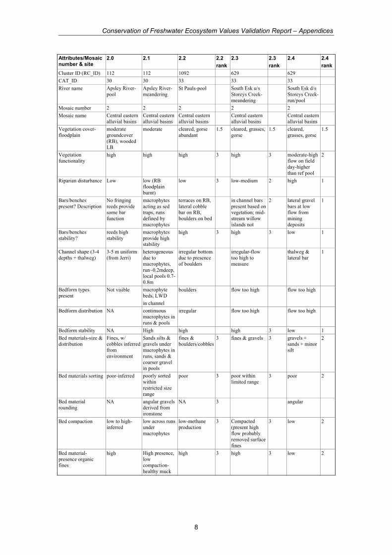
8
Attributes/Mosaic number & site
2.0 2.1 2.2 2.2
rank
2.3 2.3
rank
2.4 2.4
rank
Cluster ID (RC_ID) 112 112 1092 629 629
CAT_ID 30 30 33 33 33
River name Apsley River-
pool
Apsley River-
meandering St Pauls-pool South Esk u/s
Storeys Creek-
meandering
South Esk d/s
Storeys Creek-
run/pool
Mosaic number 2 2 2 2 2
Mosaic name Central eastern
alluvial basins
Central eastern
alluvial basins
Central eastern
alluvial basins Central eastern
alluvial basins Central eastern
alluvial basins
Vegetation cover-
floodplain
moderate
groundcover
(RB), wooded LB
moderate cleared, gorse
abundant 1.5 cleared, grasses,
gorse 1.5 cleared,
grasses, gorse 1.5
Vegetation
functionality high high high 3 high 3 moderate-high
flow on field
day-higher
than ref pool
2
Riparian disturbance Low low (RB
floodplain
burnt)
low 3 low-medium 2 high 1
Bars/benches
present? Description
No fringing
reeds provide some bar
function
macrophytes
acting as sed traps, runs
defined by
macrophytes
terraces on RB,
lateral cobble bar on RB,
boulders on bed
in channel bars
present based on vegetation; mid-
stream willow
islands not
2 lateral gravel
bars at low flow from
mining
deposits
1
Bars/benches
stability?
reeds high
stability
macrophytes
provide high stability
high 3 high 3 low 1
Channel shape (3-4
depths + thalweg)
3-5 m uniform
(from Jerri)
heterogeneous
due to
macrophytes,
run~0.2mdeep, local pools 0.7-
0.8m
irregular bottom
due to presence
of boulders
irregular-flow
too high to
measure
thalweg &
lateral bar 1
Bedform types
present Not visible macrophyte
beds, LWD
in channel
boulders flow too high flow too high
Bedform distribution NA continuous
macrophytes in
runs & pools
irregular flow too high flow too high
Bedform stability NA High high high 3 low 1
Bed materials-size &
distribution
Fines, w/
cobbles inferred from
environment
Sands silts &
gravels under macrophytes in
runs, sands &
coarser gravel in pools
fines &
boulders/cobbles 3 fines & gravels 3 gravels +
sands + minor silt
2
Bed materials sorting poor-inferred poorly sorted
within
restricted size
range
poor 3 poor within
limited range 3 poor 2
Bed material
rounding NA angular gravels
derived from ironstone
NA 3 angular
Bed compaction low to high-
inferred
low across runs
under
macrophytes
low-methane
production 3 Compacted
(present high
flow probably
removed surface fines
3 low 2
Bed material-
presence organic fines
high High presence,
low compaction-
healthy muck
high 3 high 3 low 2
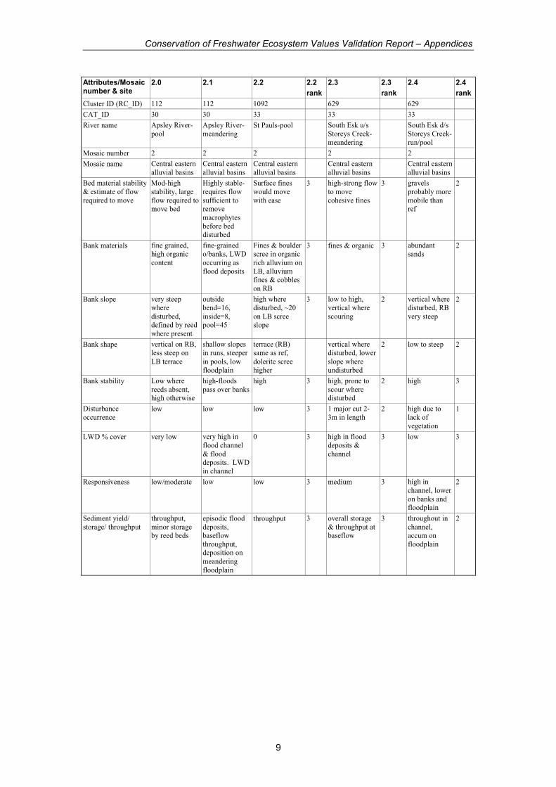
Conservation of Freshwater Ecosystem Values Validation Report – Appendices
9
Attributes/Mosaic number & site
2.0 2.1 2.2 2.2
rank
2.3 2.3
rank
2.4 2.4
rank
Cluster ID (RC_ID) 112 112 1092 629 629
CAT_ID 30 30 33 33 33
River name Apsley River-
pool
Apsley River-
meandering St Pauls-pool South Esk u/s
Storeys Creek-
meandering
South Esk d/s
Storeys Creek-
run/pool
Mosaic number 2 2 2 2 2
Mosaic name Central eastern
alluvial basins
Central eastern
alluvial basins
Central eastern
alluvial basins Central eastern
alluvial basins Central eastern
alluvial basins
Bed material stability
& estimate of flow
required to move
Mod-high
stability, large
flow required to move bed
Highly stable-
requires flow
sufficient to remove
macrophytes
before bed disturbed
Surface fines
would move
with ease
3 high-strong flow
to move
cohesive fines
3 gravels
probably more
mobile than ref
2
Bank materials fine grained,
high organic
content
fine-grained
o/banks, LWD
occurring as
flood deposits
Fines & boulder
scree in organic
rich alluvium on
LB, alluvium fines & cobbles
on RB
3 fines & organic 3 abundant
sands 2
Bank slope very steep
where
disturbed, defined by reed
where present
outside
bend=16,
inside=8, pool=45
high where
disturbed, ~20
on LB scree slope
3 low to high,
vertical where
scouring
2 vertical where
disturbed, RB
very steep
2
Bank shape vertical on RB,
less steep on
LB terrace
shallow slopes
in runs, steeper
in pools, low
floodplain
terrace (RB)
same as ref,
dolerite scree
higher
vertical where
disturbed, lower
slope where
undisturbed
2 low to steep 2
Bank stability Low where
reeds absent, high otherwise
high-floods
pass over banks high 3 high, prone to
scour where disturbed
2 high 3
Disturbance
occurrence low low low 3 1 major cut 2-
3m in length 2 high due to
lack of
vegetation
1
LWD % cover very low very high in
flood channel
& flood deposits. LWD
in channel
0 3 high in flood
deposits &
channel
3 low 3
Responsiveness low/moderate low low 3 medium 3 high in
channel, lower
on banks and floodplain
2
Sediment yield/
storage/ throughput
throughput,
minor storage by reed beds
episodic flood
deposits, baseflow
throughput, deposition on
meandering
floodplain
throughput 3 overall storage
& throughput at baseflow
3 throughout in
channel, accum on
floodplain
2
Conservation of Freshwater Ecosystem Values Validation Report – Appendices
10
Attributes/Mosaic number & site
2.0 2.1 2.2 2.2
rank
2.3 2.3
rank
2.4 2.4
rank
Cluster ID (RC_ID) 112 112 1092 629 629
CAT_ID 30 30 33 33 33
River name Apsley River-
pool
Apsley River-
meandering St Pauls-pool South Esk u/s
Storeys Creek-
meandering
South Esk d/s
Storeys Creek-
run/pool
Mosaic number 2 2 2 2 2
Mosaic name Central eastern
alluvial basins
Central eastern
alluvial basins
Central eastern
alluvial basins Central eastern
alluvial basins Central eastern
alluvial basins
Water management
issues
Abstraction
would affect
sediment balance, inc.
retention time,
if flow lower, more potential
fro blooms.
Floodplain prone to
gullying
Loss of
macrophyte
cover would decrease
stability of bed
and banks & would radically
change reach
floodplain
condition poor.
Reasonable to high condition
broadwater of
which there are few. Reach may
be less sensitive
to change due to strong influence
of dolerite scree
floodplain
degradation,
potential for increased scour
on banks where
vegetation missing;
willows in
stream are largest dev
from natural
Channel
highly altered
physically and chemically due
to presence of
mining tailings from Storeys
Creek. Lack of
vegetation, completely
different
bedform and materials
pH 6.46 7.73 not taken 6.7 6.7
EC 116 115 not taken 54 55
Temp 13.6 15.4 not taken
#indicators marked 24 23 24
Total possible score 72 69 72
Total score 70.5 59 44.5
normalise 0-1 1.00 1.00 0.97 0.78 0.43
GEOM from CFEV 1.00 1.00 0.98 1.00 1.00
Mosaic Ref Ref Consistent-
strong influence
from neighbouring
mosaic
Consistent-
influence in
cluster from neighbouring
mosaic
Consistent
Character High High high-neigh.
Mosaic incr.
stability
medium/high-
presence of
willows in channel alters
character
low-highly
modified due
to mining inputs-pool
altered to
gravel bed, riparian zone
impacted from
seds (chemical?)
Condition High-clearing
of floodplain & presence of
gorse
High-clearing
of floodplain & presence of
gorse
med/high-
extensive clearing of
floodplain & widespread
gorse
med/high-
extensive clearing of
floodplain, presence of
willows &
gorse/bank erosion
low-channel
filled by gravels,
floodplain buried by
mining seds,
RB over steep
Conservation of Freshwater Ecosystem Values Validation Report – Appendices
11
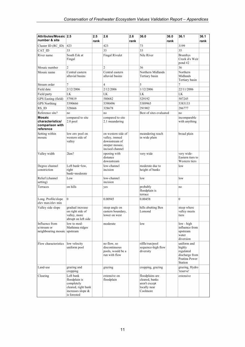
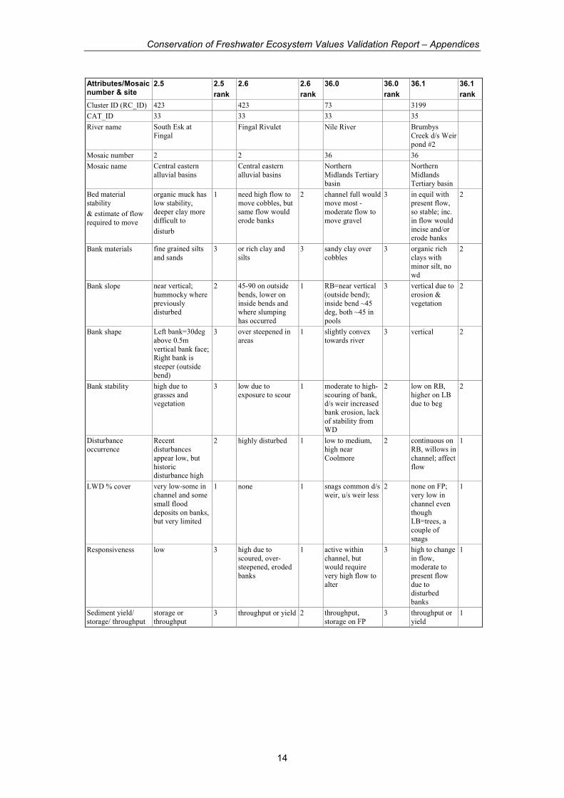
Attributes/Mosaic number & site
2.5 2.5
rank
2.6 2.6
rank
36.0 36.0
rank
36.1 36.1
rank
Cluster ID (RC_ID) 423 423 73 3199
CAT_ID 33 33 33 35
River name South Esk at
Fingal Fingal Rivulet Nile River Brumbys
Creek d/s Weir
pond #2
Mosaic number 2 2 36 36
Mosaic name Central eastern
alluvial basins Central eastern
alluvial basins Northern Midlands
Tertiary basin Northern
Midlands
Tertiary basin
Stream order 7 4 5 7
Field date 2/12/2006 2/12/2006 1/12/2006 22/11/2006
Field party LK LK LK LK
GPS Easting (field) 579819 580682 529192 507245
GPS Northing 5390666 5390496 5389965 5383133
RS_ID 328666 328678 291902 286777
Reference site? no no Best of sites evaluated no
Mosaic characteristics/ comparison with reference
compared to site
2.0 pool compared to site
2.1 meandering incomparable
with anything
Setting within
mosaic
low env pool on
western side of
valley
on western side of
valley, immed
downstream of steeper mosaic,
incised channel
meandering reach
in wide plain broad plain
Valley width 2km? opening with
distance
downstream
very wide very wide-
Eastern tiers to
Western tiers
Degree channel
constriction
Left bank=low,
right bank=moderate
low-channel
incision moderate due to
height of banks low
Relief (channel
setting) Low low-channel
incision low low
Terraces on hills yes probably
floodplain is terrace
no
Long. Profile/slope
elev max/elev min 0 0.00945 0.00458 0
Valley side slope gradual increase
on right side of
valley, more
abrupt on left side
steep angle on
eastern boundary,
lower on west
hills abutting Ben
Lomond steep where
valley meets
tiers
Influence from
u/stream or neighbouring mosaic
low to mod-
Mathinna ridges upstream
moderate low low - high
influence from upstream
water
diversion
Flow characteristics low velocity
uniform pool no flow, so
discontinuous pools, would be a
run with flow
riffle/run/pool
sequence-high flow diversity
uniform and
highly regulated
discharge from
Poatina Power Station
Land-use grazing and
cropping grazing cropping, grazing grazing, Hydro
'reserve'
Clearing Left bank
floodplain is completely
cleared, right bank
increases slope & is forested
extensive on
floodplain floodplains are
cleared, banks aren't except
locally near
Coolmore
extensive
Conservation of Freshwater Ecosystem Values Validation Report – Appendices
12
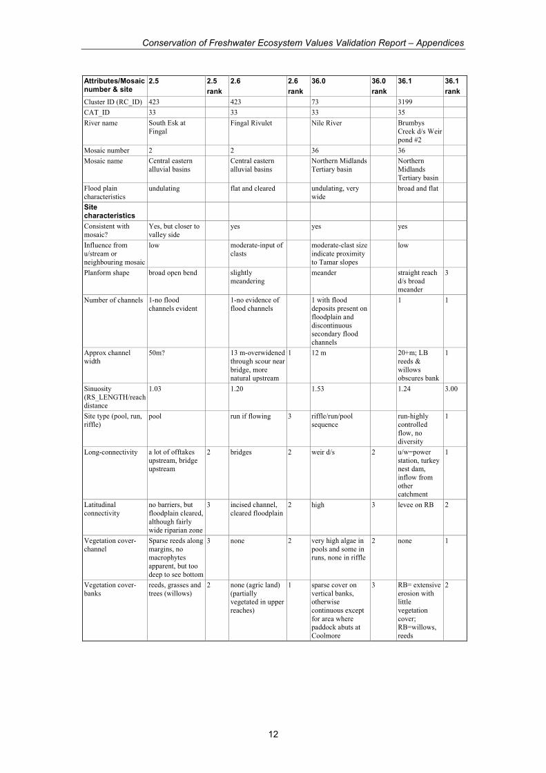
Attributes/Mosaic number & site
2.5 2.5
rank
2.6 2.6
rank
36.0 36.0
rank
36.1 36.1
rank
Cluster ID (RC_ID) 423 423 73 3199
CAT_ID 33 33 33 35
River name South Esk at
Fingal Fingal Rivulet Nile River Brumbys
Creek d/s Weir
pond #2
Mosaic number 2 2 36 36
Mosaic name Central eastern
alluvial basins Central eastern
alluvial basins Northern Midlands
Tertiary basin Northern
Midlands
Tertiary basin
Flood plain
characteristics undulating flat and cleared undulating, very
wide broad and flat
Site characteristics
Consistent with
mosaic?
Yes, but closer to
valley side yes yes yes
Influence from
u/stream or
neighbouring mosaic
low moderate-input of
clasts moderate-clast size
indicate proximity
to Tamar slopes
low
Planform shape broad open bend slightly
meandering meander straight reach
d/s broad meander
3
Number of channels 1-no flood
channels evident 1-no evidence of
flood channels 1 with flood
deposits present on
floodplain and
discontinuous secondary flood
channels
1 1
Approx channel
width 50m? 13 m-overwidened
through scour near
bridge, more natural upstream
1 12 m 20+m; LB
reeds &
willows obscures bank
1
Sinuosity
(RS_LENGTH/reach distance
1.03 1.20 1.53 1.24 3.00
Site type (pool, run,
riffle) pool run if flowing 3 riffle/run/pool
sequence run-highly
controlled
flow, no
diversity
1
Long-connectivity a lot of offtakes
upstream, bridge upstream
2 bridges 2 weir d/s 2 u/w=power
station, turkey nest dam,
inflow from
other catchment
1
Latitudinal
connectivity
no barriers, but
floodplain cleared,
although fairly
wide riparian zone
3 incised channel,
cleared floodplain 2 high 3 levee on RB 2
Vegetation cover-
channel
Sparse reeds along
margins, no macrophytes
apparent, but too
deep to see bottom
3 none 2 very high algae in
pools and some in runs, none in riffle
2 none 1
Vegetation cover-
banks
reeds, grasses and
trees (willows) 2 none (agric land)
(partially vegetated in upper
reaches)
1 sparse cover on
vertical banks, otherwise
continuous except
for area where paddock abuts at
Coolmore
3 RB= extensive
erosion with little
vegetation
cover; RB=willows,
reeds
2
Conservation of Freshwater Ecosystem Values Validation Report – Appendices
13
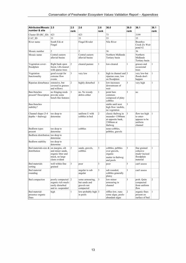
Attributes/Mosaic number & site
2.5 2.5
rank
2.6 2.6
rank
36.0 36.0
rank
36.1 36.1
rank
Cluster ID (RC_ID) 423 423 73 3199
CAT_ID 33 33 33 35
River name South Esk at
Fingal Fingal Rivulet Nile River Brumbys
Creek d/s Weir
pond #2
Mosaic number 2 2 36 36
Mosaic name Central eastern
alluvial basins Central eastern
alluvial basins Northern Midlands
Tertiary basin Northern
Midlands
Tertiary basin
Vegetation cover-
floodplain
Right bank open
forest, LB-cleared with sparse trees
2 cleared pasture 1 low-cleared 1 grasses and
occasional trees
1
Vegetation
functionality
good except for
extreme flow
events
3 very low 1 high in channel and
riparian zone, low
on floodplain
3 very low-but
floods don't
happen
1
Riparian disturbance extensive, but
covered in grasses
and willows
2 highly disturbed 1 low-increases
downstream of
weir
3 very high 1
Bars/benches
present? Description
no fringing reeds
provide some
bench like features
3 no. No woody
debris either 1 point bars
common-
composed of platy cobbles
3 no
Bars/benches
stability? stable until next
high flow=mobile,
no vegetation
3
Channel shape (3-4
depths + thalweg)
too deep to
determine uniform U with
cobbles in bed 2 classic thalweg in
meander=1500mm
at opposite bank, 2300mm at
thalweg
3 flow too high
to enter-
appears to be uniform
channel
1
Bedform types
present
too deep to
determine cobbles none-cobbles,
pebbles, gravels
Bedform distribution too deep to
determine
Bedform stability too deep to
determine
Bed materials-size &
distribution
on margins, silt
and minor sands,
organic litter and
muck, no large clasts evident
2 sands, gravels,
cobbles 3 cobbles, pebbles
over gravels,
organic
matter in thalweg
and pools
3 fine grained
cohesive
muds=incised
floodplain material
1
Bed materials
sorting
well within fine
grained 3 poor 3 poor 3 can't assess
Bed material
rounding angular to sub
angular 3 sub rounded,
cobbles generally
platey
3 can't assess
Bed compaction poorly compacted
organic rich muck-
easily disturbed and re- suspended
2 some armouring,
but sands and
gravels not compacted
3 low-minor
armouring in
channel
3 prob. Quite
compacted
from uniform flow
2
Bed material-
presence organic
fines
high 1 low-probably high
in pools 3 riffles-low, runs-
some algae, pools-
abundant algae
2 organic fines
present on
surface of bed
1
Conservation of Freshwater Ecosystem Values Validation Report – Appendices
14
Attributes/Mosaic number & site
2.5 2.5
rank
2.6 2.6
rank
36.0 36.0
rank
36.1 36.1
rank
Cluster ID (RC_ID) 423 423 73 3199
CAT_ID 33 33 33 35
River name South Esk at
Fingal Fingal Rivulet Nile River Brumbys
Creek d/s Weir
pond #2
Mosaic number 2 2 36 36
Mosaic name Central eastern
alluvial basins Central eastern
alluvial basins Northern
Midlands Tertiary
basin
Northern
Midlands
Tertiary basin
Bed material
stability
& estimate of flow
required to move
organic muck has
low stability, deeper clay more
difficult to
disturb
1 need high flow to
move cobbles, but same flow would
erode banks
2 channel full would
move most -moderate flow to
move gravel
3 in equil with
present flow, so stable; inc.
in flow would
incise and/or erode banks
2
Bank materials fine grained silts
and sands 3 or rich clay and
silts 3 sandy clay over
cobbles 3 organic rich
clays with
minor silt, no
wd
2
Bank slope near vertical;
hummocky where
previously disturbed
2 45-90 on outside
bends, lower on
inside bends and where slumping
has occurred
1 RB=near vertical
(outside bend);
inside bend ~45 deg, both ~45 in
pools
3 vertical due to
erosion &
vegetation
2
Bank shape Left bank=30deg
above 0.5m
vertical bank face; Right bank is
steeper (outside
bend)
3 over steepened in
areas 1 slightly convex
towards river 3 vertical 2
Bank stability high due to
grasses and vegetation
3 low due to
exposure to scour 1 moderate to high-
scouring of bank, d/s weir increased
bank erosion, lack
of stability from WD
2 low on RB,
higher on LB due to beg
2
Disturbance
occurrence
Recent
disturbances
appear low, but
historic disturbance high
2 highly disturbed 1 low to medium,
high near
Coolmore
2 continuous on
RB, willows in
channel; affect
flow
1
LWD % cover very low-some in
channel and some
small flood
deposits on banks, but very limited
1 none 1 snags common d/s
weir, u/s weir less 2 none on FP;
very low in
channel even
though LB=trees, a
couple of
snags
1
Responsiveness low 3 high due to
scoured, over-steepened, eroded
banks
1 active within
channel, but would require
very high flow to
alter
3 high to change
in flow, moderate to
present flow
due to disturbed
banks
1
Sediment yield/
storage/ throughput
storage or
throughput 3 throughput or yield 2 throughput,
storage on FP 3 throughput or
yield 1

Conservation of Freshwater Ecosystem Values Validation Report – Appendices
15
Attributes/Mosaic number & site
2.5 2.5
rank
2.6 2.6
rank
36.0 36.0
rank
36.1 36.1
rank
Cluster ID (RC_ID) 423 423 73 3199
CAT_ID 33 33 33 35
River name South Esk at
Fingal Fingal Rivulet Nile River Brumbys
Creek d/s Weir
pond #2
Mosaic number 2 2 36 36
Mosaic name Central eastern
alluvial basins Central eastern
alluvial basins Northern
Midlands Tertiary
basin
Northern
Midlands
Tertiary basin
Water management
issues
Site unlikely to
respond much to change in slow
because it is a
pool. Reductions in water level
(rather than flow)
would probably affect more
Due to low
vegetation cover, any flow will affect
banks;
In pretty good
condition, except for floodplains.
Lower flow would
increase channel narrowing, more
weirs would
steepen banks downstream
Increase in
flow would inc. channel
widening and
deepening, decrease in
flow would
promote channel
narrowing. No
connection between
floodplain and
channel. A very weird site
pH 6.61 no flow 6.71 6.68
EC 90 63 22
Temp 19.6 16.2 13.7
#indicators marked 21 25 24 25
Total possible score 63 75 72 75
Total score 49 45 64 37
normalise 0-1 0.67 0.40 0.83 0.25
GEOM from CFEV 1.00 1.00 1.00 0.14
Mosaic consistent, with
right floodplain
affected by next mosaic
consistent
Character Similar to other
pools, appears
more resilient to
change because of low velocity, and
slow water level
fluctuations
in channel is
good, but the lack
of floodplain
vegetation has undoubtedly
reduced wd in the
channel. The weir appears to have
lead to over
steepening of the banks
Condition moderate-Left floodplain is
highly cleared,
Right bank has wider riparian
zone
moderate to good in channel, low on
floodplain
Conservation of Freshwater Ecosystem Values Validation Report – Appendices
16
Attributes/Mosaic number & site
36.2 36.2
rank
36.3 36.3
rank
36.4 36.4
rank
36.5 36.5
rank
Cluster ID (RC_ID) 1195 3130 449 236
CAT_ID 35 35 34 34
River name Macquarie at
Longford tributary of
Macquarie Whitemore Creek Liffey River at
Moreton
Cottage
Mosaic number 36 36 36 36
Mosaic name Northern
Midlands Tertiary
basin
Northern Midlands
Tertiary basin Northern Midlands
Tertiary basin Northern
Midlands
Tertiary basin
Stream order 8 3 4 5
Field date 22/11/2006 22/11/2006 1/12/2006 1/12/2006
Field party LK LK LK LK
GPS Easting (field) 510450 514155 494180 499780
GPS Northing 5395970 5383864 5400798 5397170
RS_ID 292226 291270 290141 292018
Reference site? no no no no
Mosaic characteristics/ comparison with reference
no large river
avail as reference Nile 73-Nile 73-Nile
Setting within
mosaic very broad valley low undulating
broad plain unconfined reach
in broad plain unconfined
reach in broad
plain
Valley width km - too wide to
visually estimate very wide very wide-km very wide-km
Degree channel
constriction
RB=low,
LB=higher due to higher
bank/terrace
low-only channel
incision low low
Relief (channel
setting) low low low low
Terraces yes no-undulations
appear like erosion
surfaces
no, but incising
into floodplain no, but
incising into
floodplain
Long. Profile/slope
elev max/elev min 0.0018 0.0029 0.00388 0.00234
Valley side slope steep where valley
meets tiers steep at valley edge Eastern and
Western Tiers Eastern and
Western Tiers
Influence from
u/stream or
neighbouring mosaic
low low low to mod low to mod
Flow characteristics slow run affected
by South Esk flow
(backwater)
no flow-would be
uniform run uniform low
(channelised?)
flow
pool and runs-
some diversity
of flow
Land-use urban, agriculture,
industrial grazing and
cropping crops & grazing cropping and
grazing
Clearing LB=cleared
except for sparse trees, RB, more
vegetation
extensive extensive on
floodplains extensive on
floodplain; left bank has more
riparian
vegetation than right
Conservation of Freshwater Ecosystem Values Validation Report – Appendices
17
Attributes/Mosaic number & site
36.2 36.2
rank
36.3 36.3
rank
36.4 36.4
rank
36.5 36.5
rank
Cluster ID (RC_ID) 1195 3130 449 236
CAT_ID 35 35 34 34
River name Macquarie at
Longford tributary of
Macquarie Whitemore Creek Liffey River at
Moreton
Cottage
Mosaic number 36 36 36 36
Mosaic name Northern
Midlands Tertiary
basin
Northern Midlands
Tertiary basin Northern
Midlands Tertiary
basin
Northern
Midlands
Tertiary basin
Flood plain
characteristics
RB=rising to
terrace, LB=flat to levees
silty, undulating,
some gully erosion broad and low
relief flat near river,
undulating with distance
(terraces?)
Site characteristics
Consistent with
mosaic? yes yes yes yes
Influence from
u/stream or
neighbouring mosaic
low low moderate-input of
clasts low to mod
Planform shape straight reach meandering 3 very straight
reach- probably
channelised
2 straight reach-
prob
historically channelised
2
Number of channels 1 1 1 incised, no
evidence of
secondary
2 1-no flood
evidence 2 1 no flood
channels 2
Approx channel
width 20-25m 1 6-8m between
eroded banks 2 6 m 3 10m-prob
channelised 2
Sinuosity
(RS_LENGTH/reach
distance
1.34 3.00 1.09 3.00 1.03 1.04
Site type (pool, run,
riffle) run 3 run 3 run with pool near
bridge 2 run 3
Long-connectivity bridge d/s 2 bridge 2 bridge and trash
gates 2 a lot of
offtakes
upstream and off river
storages
2
Latitudinal
connectivity
levees being
constructed 1 incised channel, no
riparian vegetation
so too much connectivity when
flooding
2 cleared floodplain 2 cleared
floodplain and
moderately high banks
2
Vegetation cover-
channel
too deep to
observe, but none
at margins
2 grasses where
completely dry, no
vegetation where scoured
2 macrophytes in
shallows, some
reeds along margins
2 none 3
Vegetation cover-banks
LB=discontinuous grasses and
willows,
RB=continuous willows and
grasses
2 some grasses and tussocks u/stream
bridge,
1 low on bank faces, high on break in
slope
2 low cover on vertical mud
banks, shrubs
on bank crest overhang
lower banks
2
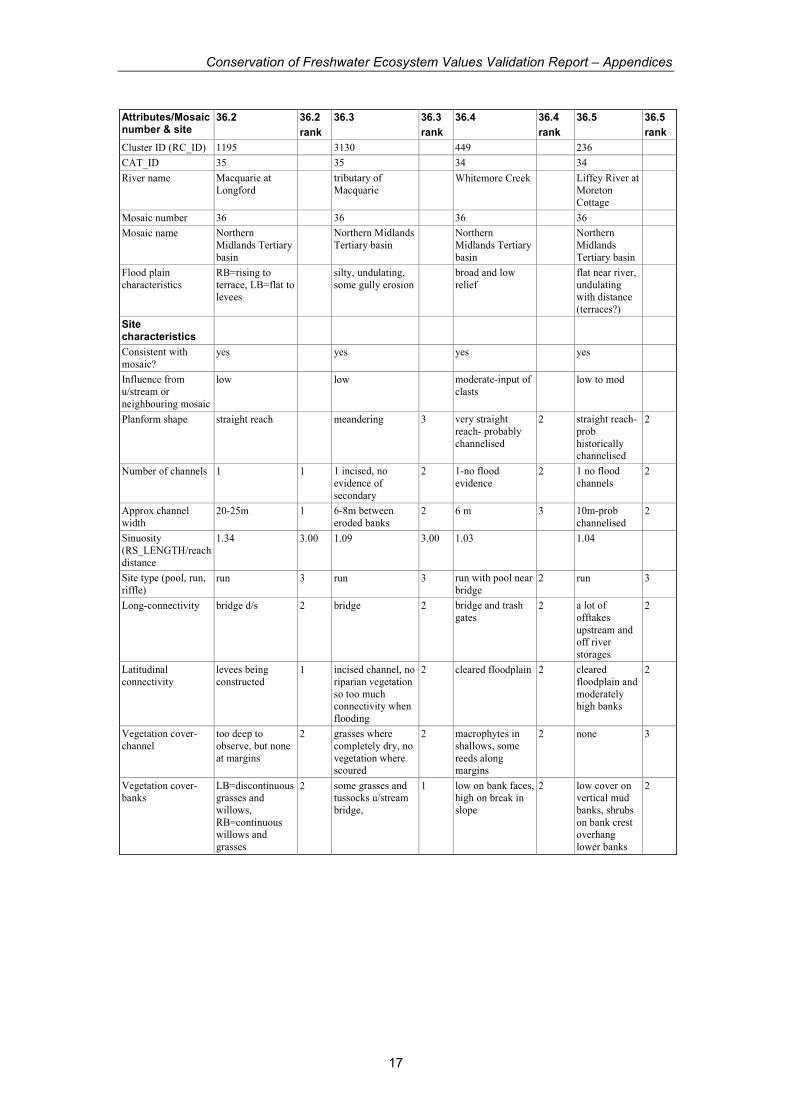
Conservation of Freshwater Ecosystem Values Validation Report – Appendices
18
Attributes/Mosaic number & site
36.2 36.2
rank
36.3 36.3
rank
36.4 36.4
rank
36.5 36.5
rank
Cluster ID (RC_ID) 1195 3130 449 236
CAT_ID 35 35 34 34
River name Macquarie at
Longford tributary of
Macquarie Whitemore Creek Liffey River at
Moreton
Cottage
Mosaic number 36 36 36 36
Mosaic name Northern
Midlands Tertiary
basin
Northern
Midlands Tertiary
basin
Northern Midlands
Tertiary basin Northern
Midlands
Tertiary basin
Vegetation cover-
floodplain
LB=grasses,
RB=more shrubs 2 tussocks near
banks in some areas, grasses
1 none 1 grasses, crops 2
Vegetation
functionality
moderate in
channel, low out
of channel
2 very low 1 low 1 moderate in
channel-
vegetation not
as thick as natural
2
Riparian disturbance high on LB 2 total 1 high 1 in past
probably more disturbed
2
Bars/benches
present? Description slump blocks slumped banks 1 none-no point bars 2 point bars
along runs
which connect
pools
3
Bars/benches
stability? low-scour of
slump blocks common
1 appear active-
vegetation only on higher
areas
3
Channel shape (3-4
depths + thalweg) too deep undulating, ~1.5
m from bed to
floodplain
2 uniform flat with
mud bottom, 2 m
high banks
2 typical
thalweg, with
2.5 m thalweg
3
Bedform types
present grasses and scour pebbles,
gravels and sands-no
bedforms
Bedform distribution
Bedform stability bed stabilised by
grasses where present
2
Bed materials-size &
distribution
silts, clays, sands
along margins, no
WD
2 clays and silt,
minor pebbles 2 clay, pebbles and
gravels in runs 2 pebbles,
gravels over
indurated clay
material- probably
contact with
underlying floodplains
3
Bed materials sorting well along
margins-all fine
grained
3 moderate 3 poor within pebble
sand range 3 poor within
pebble to sand
range
3
Bed material
rounding sub angular 3 sub rounded to
sub angular 3
Bed compaction too deep-along
margins layer of
very fine silts and muds
unconsolidated
2 very compacted
by stock access
and drying
2 low for clasts, high
for mud 2 pebbles and
gravels poorly
compacted, underlying
muds well
compacted
3
Bed material-
presence organic
fines
moderate along
margins 2 in pools algae and
muck 1 moderate-input of
clasts 2 low in run,
low in pools,
but high organic litter
3

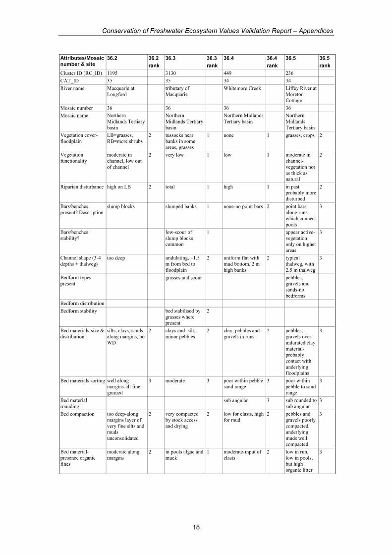
Conservation of Freshwater Ecosystem Values Validation Report – Appendices
19
Attributes/Mosaic number & site
36.2 36.2
rank
36.3 36.3
rank
36.4 36.4
rank
36.5 36.5
rank
Cluster ID (RC_ID) 1195 3130 449 236
CAT_ID 35 35 34 34
River name Macquarie at
Longford tributary of
Macquarie Whitemore Creek Liffey River at
Moreton
Cottage
Mosaic number 36 36 36 36
Mosaic name Northern
Midlands Tertiary
basin
Northern Midlands
Tertiary basin Northern
Midlands Tertiary
basin
Northern
Midlands
Tertiary basin
Bed material
stability & estimate of flow required to
move
margins on LB not
very stable and easily eroded,
RB=more resistant
2 will erode with 1st
wet due to friable nature. Higher flow
events will also
erode
1 sand and gravel
require less than bank full
3 sand and
pebbles would move at
moderate flow
3
Bank materials silts, sands, no
WD 2 clay and silt with
pebble lenses, salt marks present
3 sandy clay and
mud 3 sandy mud-no
pebbles 3
Bank slope 60-90 on LB
where disturbed, low to vertical on
RB
2 near vertical where
slumped, ~20-30 deg downslope of
slumps
1 near vertical, less
where slump blocks present
2 ~65deg at
thalweg 3
Bank shape straight to slightly
concave towards
river
2 broadly concave 1 over steepened in
areas, slightly
concave
2 concave
towards river-
oversteepened in areas
3
Bank stability high where
vegetation present,
low on LB where
disturbed
2 low-actively
eroding 1 friable faces with
no vegetation
cover-low
2 high due to
compacted
material, prone
to scour/friable
3
Disturbance
occurrence widespread 2 extensive slumping
and erosion 1 high 1 low 3
LWD % cover sparse on RB,
none on LB 1 none 1 low 1 some flood
deposits but overall low
2
Responsiveness moderate to low
overall, locally high on LB
2 high due to lack of
beg on banks and exposed bed
1 rapid to changes
within channel 2 low overall,
but dynamic at all flows-
banks prone to scour at high
flow
2
Sediment yield/
storage/ throughput
throughput,
storage when
backwater, storage
on FP, stripping during very high
flow
2 yield or throughput
while flow in
channel, storage in
FP in mod flood, stripping during
high flood
1 throughput 3 throughput 2

Conservation of Freshwater Ecosystem Values Validation Report – Appendices
20
Attributes/Mosaic number & site
36.2 36.2
rank
36.3 36.3
rank
36.4 36.4
rank
36.5 36.5
rank
Cluster ID (RC_ID) 1195 3130 449 236
CAT_ID 35 35 34 34
River name Macquarie at
Longford tributary of
Macquarie Whitemore Creek Liffey River at
Moreton Cottage
Mosaic number 36 36 36 36
Mosaic name Northern
Midlands Tertiary
basin
Northern Midlands
Tertiary basin Northern
Midlands Tertiary
basin
Northern
Midlands
Tertiary basin
Water management
issues
Highly modified
due to upstream
changes to flow, catchment, etc.
Actively eroding
due to lack of
vegetation and channel incision.
Inc in flow leads to
more incision and widening, decrease
in flooding
probably lead to little difference,
except reducing
risk of floodplain stripping
Channel prone to
erosion due to
channelisation, clearing of
floodplain, and
removal of LWD from system
Channel
downcutting into
older mud terraces with
pebbles rolling
over top; erodability of
banks is water
management issue
pH Not taken no flow 6.9 6.26
EC 305 35
Temp 17.2 18.9
#indicators marked 24 29 27 28
Total possible score 72 87 81 84
Total score 47 48 55 72
normalise 0-1 0.48 0.33 0.52 0.79
GEOM from CFEV 0.14 0.49 0.80 0.96
Mosaic consistent consistent lower
order = slightly
more relief as compared to
mainstem
Macquarie
consistent-
surprised not more
larger clasts in bed considering
proximity of
'Tamar slopes'
consistent-more
distal, lower
cobble/pebble content
Character highly modified
due to irrigation flows, Brumbys,
floodplain
clearing, etc
highly modified
due to clearing of banks and
floodplain
highly modified
through removal of woody debris,
channelisation and
clearing
channel has
incised probably due to
floodplain
clearing, banks prone to scour,
low vegetation
on bank aces- is this really
characteristic of
these rivers?
Condition typical midlands
modified river very poor poor moderate
Conservation of Freshwater Ecosystem Values Validation Report – Appendices
21
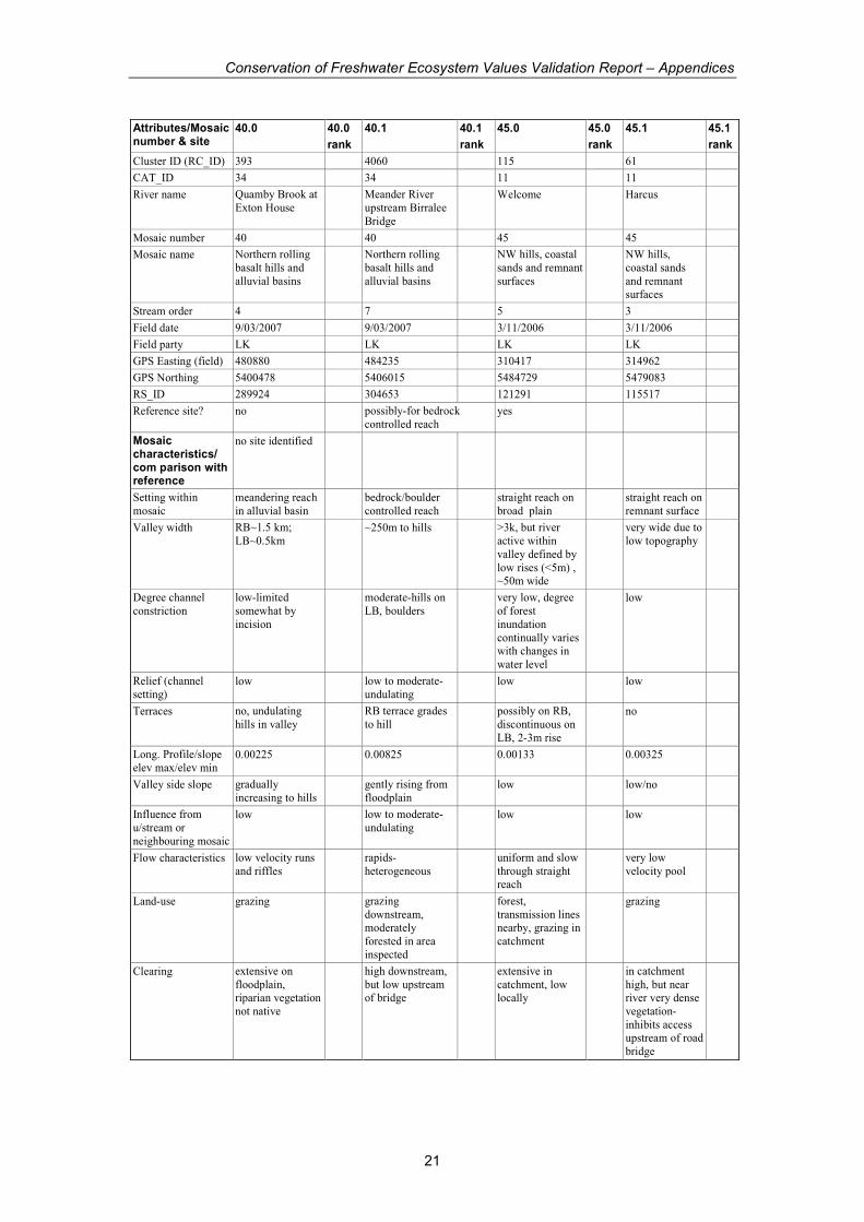
Attributes/Mosaic number & site
40.0 40.0
rank
40.1 40.1
rank
45.0 45.0
rank
45.1 45.1
rank
Cluster ID (RC_ID) 393 4060 115 61
CAT_ID 34 34 11 11
River name Quamby Brook at
Exton House Meander River
upstream Birralee
Bridge
Welcome Harcus
Mosaic number 40 40 45 45
Mosaic name Northern rolling
basalt hills and
alluvial basins
Northern rolling
basalt hills and
alluvial basins
NW hills, coastal
sands and remnant
surfaces
NW hills,
coastal sands
and remnant surfaces
Stream order 4 7 5 3
Field date 9/03/2007 9/03/2007 3/11/2006 3/11/2006
Field party LK LK LK LK
GPS Easting (field) 480880 484235 310417 314962
GPS Northing 5400478 5406015 5484729 5479083
RS_ID 289924 304653 121291 115517
Reference site? no possibly-for bedrock
controlled reach yes
Mosaic characteristics/ com parison with reference
no site identified
Setting within
mosaic
meandering reach
in alluvial basin bedrock/boulder
controlled reach straight reach on
broad plain straight reach on
remnant surface
Valley width RB~1.5 km;
LB~0.5km ~250m to hills >3k, but river
active within
valley defined by
low rises (<5m) , ~50m wide
very wide due to
low topography
Degree channel
constriction
low-limited
somewhat by
incision
moderate-hills on
LB, boulders very low, degree
of forest
inundation
continually varies with changes in
water level
low
Relief (channel
setting) low low to moderate-
undulating low low
Terraces no, undulating
hills in valley RB terrace grades
to hill possibly on RB,
discontinuous on
LB, 2-3m rise
no
Long. Profile/slope
elev max/elev min 0.00225 0.00825 0.00133 0.00325
Valley side slope gradually
increasing to hills gently rising from
floodplain low low/no
Influence from
u/stream or
neighbouring mosaic
low low to moderate-
undulating low low
Flow characteristics low velocity runs
and riffles rapids-
heterogeneous uniform and slow
through straight reach
very low
velocity pool
Land-use grazing grazing
downstream, moderately
forested in area
inspected
forest,
transmission lines nearby, grazing in
catchment
grazing
Clearing extensive on
floodplain, riparian vegetation
not native
high downstream,
but low upstream of bridge
extensive in
catchment, low locally
in catchment
high, but near river very dense
vegetation-
inhibits access upstream of road
bridge
Conservation of Freshwater Ecosystem Values Validation Report – Appendices
22
Attributes/Mosaic number & site
40.0 40.0
rank
40.1 40.1
rank
45.0 45.0
rank
45.1 45.1
rank
Cluster ID (RC_ID) 393 4060 115 61
CAT_ID 34 34 11 11
River name Quamby Brook at
Exton House Meander River
upstream Birralee
Bridge
Welcome Harcus
Mosaic number 40 40 45 45
Mosaic name Northern rolling
basalt hills and
alluvial basins
Northern rolling
basalt hills and
alluvial basins
NW hills, coastal
sands and remnant
surfaces
NW hills,
coastal sands
and remnant surfaces
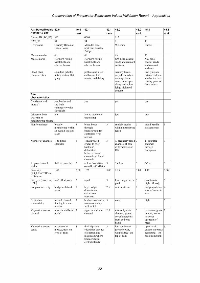
Flood plain
characteristics
abundant pebbles
in fine matrix, flat
lying
pebbles and a few
cobbles in fine
matrix; undulating
scrubby forest,
very dense where
drainage lines
enter, more open along banks, low
lying, high mud
content
low lying and
extensive dense
shrubs, tea tree,
cutting grass ad flood debris
Site characteristics
Consistent with
mosaic?
yes, but incised
and little
connectivity with floodplain
yes yes yes
Influence from
u/stream or
neighbouring mosaic
low low to moderate-
undulating low low
Planform shape broadly
meandering within
an overall straight reach
3 broad bends
through
bedrock/boulder controlled river
section
3 straight section
within meandering
reach
3 broad bend in
straight reach 3
Number of channels 1-no flood
channels 3 1 main which
grades to over
banks-no delineation
between central
channel and flood channels
3 1, secondary flood
channels at base
of terrace/rise on RB
3 1 - multiple
channels
through floodplain
3
Approx channel
width 8-10 m bank full 3 at low flow~20m,
overall, ~80 -100m 3 5 - 7 m 3 5-7 m 3
Sinuosity
(RS_LENGTH/reac
h distance
1.42 3.00 1.22 3.00 1.13 3.00 1.19 3.00
Site type (pool, run,
riffle) run/riffles/pools 3 rapid 3 low energy run or
pool 3 pool (run in
higher flows) 3
Long-connectivity bridge with trash
racks 2 high bridge
downstream,
extractions
upstream
2.5 weir upstream 2 bridge upstream,
a lot of drains in
area
2
Latitudinal
connectivity
incised channel,
fencing in some reaches
2 boulders on banks,
terrace or valley wall on LB
3 none 3 high 3
Vegetation cover-
channel
none-should be in
pools? 2 algae on rocks in
channel 2.5 macrophytes in
channel, ground
cover/emergents
from bed onto banks
3 reeds/emergents
in pool, low or
no cover
upstream of reeds
2
Vegetation cover-
banks
no grasses or
mosses, trees on
crest of bank
1 thick riparian
vegetation on edge
of channel and
midstream where boulders form
central islands
3 low continuous
ground cover,
with tea tree? on
top of bank
3 open scrub,
grasses on banks
beginning ~1m
back from bank
3
Conservation of Freshwater Ecosystem Values Validation Report – Appendices
23
Attributes/Mosaic number & site
40.0 40.0
rank
40.1 40.1
rank
45.0 45.0
rank
45.1 45.1
rank
Cluster ID (RC_ID) 393 4060 115 61
CAT_ID 34 34 11 11
River name Quamby Brook at
Exton House Meander River
upstream Birralee
Bridge
Welcome Harcus
Mosaic number 40 40 45 45
Mosaic name Northern rolling
basalt hills and
alluvial basins
Northern rolling
basalt hills and
alluvial basins
NW hills, coastal
sands and remnant
surfaces
NW hills,
coastal sands
and remnant surfaces
Vegetation cover-
floodplain grasses 2 forested, cleared
downstream of
bridge
3 tea tree/paper
barks and low
shrubs-fairly open
with high woody debris
3 dense scrub and
cutting grass, no
grasses
3
Vegetation
functionality low 1 high 3 high-would affect
water velocity at
all flows
3 high 3
Riparian disturbance very high 1 in river channel
high but natural 3 low 3 low 3
Bars/benches
present? Description
small, muddy
point bars with
pebbles
2 no-boulder /
bedrock distributed
throughout
3 no 3 no-mud banks
only 3
Bars/benches
stability?
low due to fine-
grained muck 2
Channel shape (3-4
depths + thalweg)
irregular-very soft
due to
accumulation of organic muck
2 irregular due to
boulder/bedrock 3 undulating, no
obvious thalweg,
LWD common
3 uniform in
pool(?) too soft
to enter
3
Bedform types
present boulders / bedrock
steps 3 LWD and partial
log jams 3 little LWD in
channel 2
Bedform distribution irregular 3 LWD distributed
continuously 3
Bedform stability very high 3 high-LWD 3 muds high,
overlying muck low
2
Bed materials-size &
distribution
muds with pebbles
and gravels,
organic muck
veneer over surface- gas
bubbles released
during disturbance
2 boulders over
cobbles and
pebbles; gravels
and pebbles in shadow deposits
3 mud and silt 3 med with a few
% sand 3
Bed materials
sorting
poor, but almost
all pebbles or less 2 moderate-almost
all boulders at surface
3 well sorted 3 well sorted 3
Bed material
rounding
angular to
subrounded 3 cobbles rounded to
sub-rounded;
boulders sub
rounded, bedrock sub angular
3 mud and silt 3
Bed compaction very poor-organic
muck layer 1 low in gravels 3 high except for
organic rich think
layer on surface
3 thin layer of
poorly
compacted
organic rich material over
compacted mud
2
Bed material-
presence organic
fines
very high 1 very low, except
for slimy rocks 3 probably higher
than natural 2 moderate to
high- floating
mats
2
Conservation of Freshwater Ecosystem Values Validation Report – Appendices
24
Attributes/Mosaic number & site
40.0 40.0
rank
40.1 40.1
rank
45.0 45.0
rank
45.1 45.1
rank
Cluster ID (RC_ID) 393 4060 115 61
CAT_ID 34 34 11 11
River name Quamby Brook at
Exton House Meander River
upstream Birralee
Bridge
Welcome Harcus
Mosaic number 40 40 45 45
Mosaic name Northern rolling
basalt hills and
alluvial basins
Northern rolling
basalt hills and
alluvial basins
NW hills, coastal
sands and remnant
surfaces
NW hills,
coastal sands
and remnant surfaces
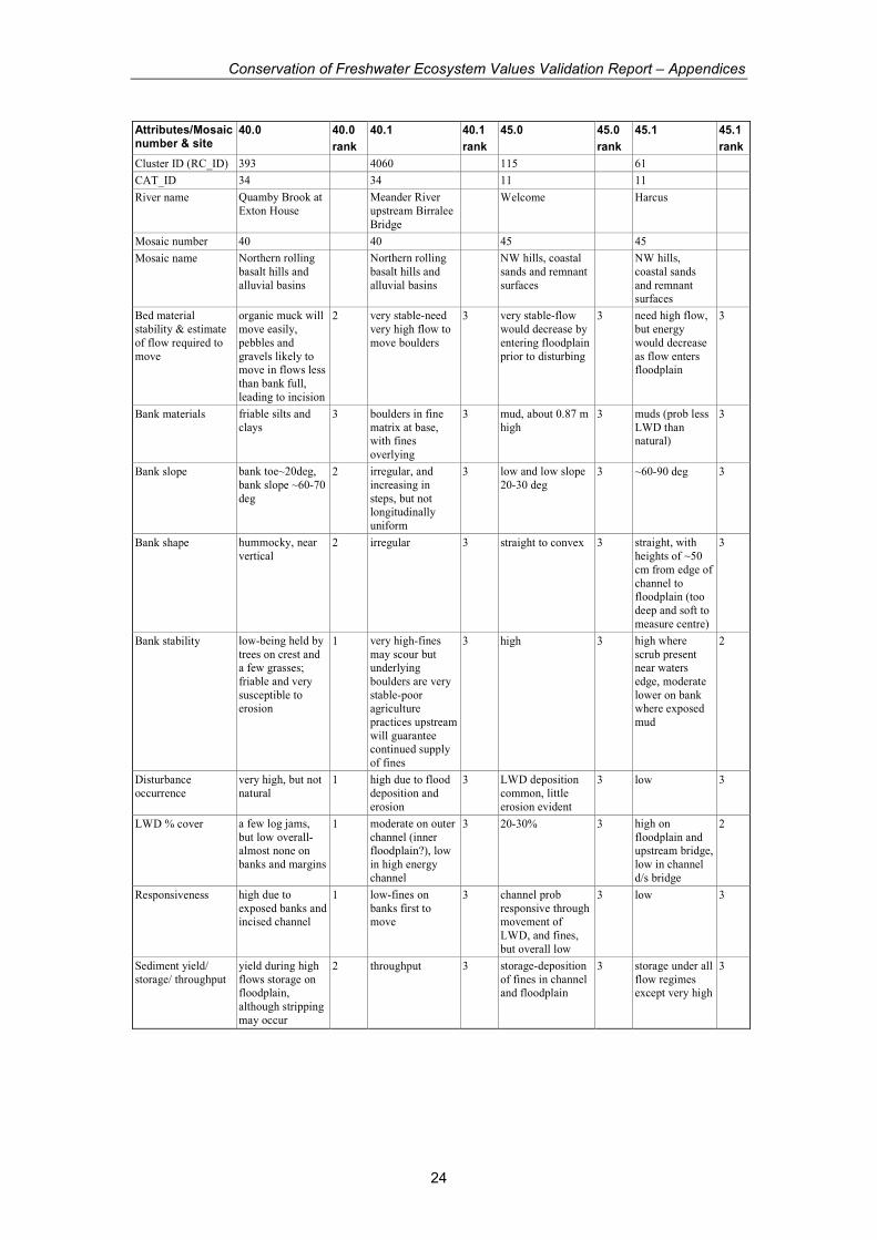
Bed material
stability & estimate
of flow required to
move
organic muck will
move easily,
pebbles and
gravels likely to move in flows less
than bank full,
leading to incision
2 very stable-need
very high flow to
move boulders
3 very stable-flow
would decrease by
entering floodplain
prior to disturbing
3 need high flow,
but energy
would decrease
as flow enters floodplain
3
Bank materials friable silts and
clays 3 boulders in fine
matrix at base, with fines
overlying
3 mud, about 0.87 m
high 3 muds (prob less
LWD than natural)
3
Bank slope bank toe~20deg,
bank slope ~60-70
deg
2 irregular, and
increasing in
steps, but not longitudinally
uniform
3 low and low slope
20-30 deg 3 ~60-90 deg 3
Bank shape hummocky, near
vertical 2 irregular 3 straight to convex 3 straight, with
heights of ~50
cm from edge of
channel to floodplain (too
deep and soft to
measure centre)
3
Bank stability low-being held by
trees on crest and a few grasses;
friable and very
susceptible to erosion
1 very high-fines
may scour but underlying
boulders are very
stable-poor agriculture
practices upstream
will guarantee continued supply
of fines
3 high 3 high where
scrub present near waters
edge, moderate
lower on bank where exposed
mud
2
Disturbance
occurrence
very high, but not
natural 1 high due to flood
deposition and
erosion
3 LWD deposition
common, little
erosion evident
3 low 3
LWD % cover a few log jams,
but low overall-almost none on
banks and margins
1 moderate on outer
channel (inner floodplain?), low
in high energy
channel
3 20-30% 3 high on
floodplain and upstream bridge,
low in channel
d/s bridge
2
Responsiveness high due to
exposed banks and incised channel
1 low-fines on
banks first to move
3 channel prob
responsive through movement of
LWD, and fines,
but overall low
3 low 3
Sediment yield/
storage/ throughput
yield during high
flows storage on floodplain,
although stripping
may occur
2 throughput 3 storage-deposition
of fines in channel and floodplain
3 storage under all
flow regimes except very high
3

Conservation of Freshwater Ecosystem Values Validation Report – Appendices
25
Attributes/Mosaic number & site
40.0 40.0
rank
40.1 40.1
rank
45.0 45.0
rank
45.1 45.1
rank
Cluster ID (RC_ID) 393 4060 115 61
CAT_ID 34 34 11 11
River name Quamby Brook at
Exton House Meander River
upstream Birralee
Bridge
Welcome Harcus
Mosaic number 40 40 45 45
Mosaic name Northern rolling
basalt hills and
alluvial basins
Northern rolling
basalt hills and
alluvial basins
NW hills, coastal
sands and remnant
surfaces
NW hills, coastal
sands and
remnant surfaces
Water management
issues
Clearing of
floodplain and riparian zone and
stock access have
resulted in very poor quality river;
increase in flow
could increase erosion, reduction
in sediment
delivery from upstream could
increase incision
very robust site
due to bedrock/boulder
dominance of
channel, and presence of
riparian
vegetation. Changes in flow
would alter
vegetation patterns, but
unlikely to affect
bed/banks too much
changes to flow
would alter channel width. Constant
high would widen,
reduction would reduce floodplain
variability and
movement of LWD
banks susceptible
to erosion below vegetation, need
to consider flow
regime of Welcome as well,
as water level
may affect this reach.
pH 6.59 7.18 7.75
EC 162 66 1211
Temp 12.2 16.3 13.4
#indicators marked 29 31 31 29
Total possible score 87 93 93 87
Total score 56 92 91 79
normalise 0-1 0.47 0.98 0.97 0.86
GEOM from CFEV 0.58 0.97 0.98 0.98
Mosaic consistent consistent consistent, but
altered by bridge
-less wd
Character very poor-changed
due to loss of floodplain
connectivity, loss
of riparian vegetation
good-probably
receives more flow and mud than
natural due to
upstream channelisation and
clearing, but
overall relationship between channel
and floodplain still
good, large LWD component
reach is modified
by upstream bridge, and
possible changes
to Welcome downstream
which would
affect base level. Bridge reduces
LWD in channel,
nearby drains probably reduce
flooding-
floodplain has thicker vegetation
than Welcome
site, maybe due to lack of
inundation (more
bracken & cutting grass)
Condition poor good-see above
comments re mud
and water
pretty good
condition
considering
proximity to bridge-probably
better condition
upstream, but access not very
easy
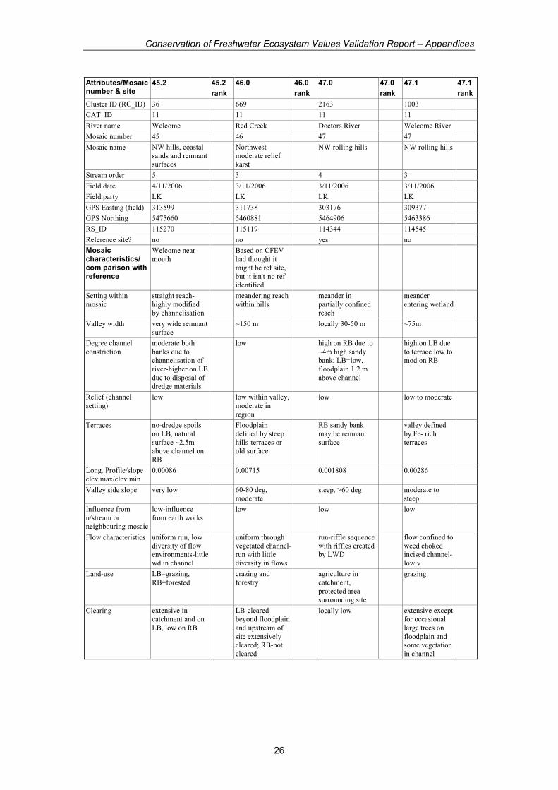
Conservation of Freshwater Ecosystem Values Validation Report – Appendices
26
Attributes/Mosaic number & site
45.2 45.2
rank
46.0 46.0
rank
47.0 47.0
rank
47.1 47.1
rank
Cluster ID (RC_ID) 36 669 2163 1003
CAT_ID 11 11 11 11
River name Welcome Red Creek Doctors River Welcome River
Mosaic number 45 46 47 47
Mosaic name NW hills, coastal
sands and remnant surfaces
Northwest
moderate relief karst
NW rolling hills NW rolling hills
Stream order 5 3 4 3
Field date 4/11/2006 3/11/2006 3/11/2006 3/11/2006
Field party LK LK LK LK
GPS Easting (field) 313599 311738 303176 309377
GPS Northing 5475660 5460881 5464906 5463386
RS_ID 115270 115119 114344 114545
Reference site? no no yes no
Mosaic characteristics/ com parison with reference
Welcome near
mouth Based on CFEV
had thought it
might be ref site,
but it isn't-no ref identified
Setting within
mosaic
straight reach-
highly modified
by channelisation
meandering reach
within hills meander in
partially confined
reach
meander
entering wetland
Valley width very wide remnant
surface ~150 m locally 30-50 m ~75m
Degree channel
constriction
moderate both
banks due to
channelisation of river-higher on LB
due to disposal of
dredge materials
low high on RB due to
~4m high sandy
bank; LB=low, floodplain 1.2 m
above channel
high on LB due
to terrace low to
mod on RB
Relief (channel
setting) low low within valley,
moderate in
region
low low to moderate
Terraces no-dredge spoils
on LB, natural surface ~2.5m
above channel on
RB
Floodplain
defined by steep hills-terraces or
old surface
RB sandy bank
may be remnant surface
valley defined
by Fe- rich terraces
Long. Profile/slope
elev max/elev min 0.00086 0.00715 0.001808 0.00286
Valley side slope very low 60-80 deg,
moderate steep, >60 deg moderate to
steep
Influence from
u/stream or neighbouring mosaic
low-influence
from earth works low low low
Flow characteristics uniform run, low
diversity of flow environments-little
wd in channel
uniform through
vegetated channel-run with little
diversity in flows
run-riffle sequence
with riffles created by LWD
flow confined to
weed choked incised channel-
low v
Land-use LB=grazing,
RB=forested crazing and
forestry agriculture in
catchment,
protected area surrounding site
grazing
Clearing extensive in
catchment and on
LB, low on RB
LB-cleared
beyond floodplain
and upstream of
site extensively cleared; RB-not
cleared
locally low extensive except
for occasional
large trees on
floodplain and some vegetation
in channel

Conservation of Freshwater Ecosystem Values Validation Report – Appendices
27
Attributes/Mosaic number & site
45.2 45.2
rank
46.0 46.0
rank
47.0 47.0
rank
47.1 47.1
rank
Cluster ID (RC_ID) 36 669 2163 1003
CAT_ID 11 11 11 11
River name Welcome Red Creek Doctors River Welcome River
Mosaic number 45 46 47 47
Mosaic name NW hills, coastal
sands and remnant surfaces
Northwest
moderate relief karst
NW rolling hills NW rolling hills
Flood plain
characteristics
Paperbark forest
RB, flat
floodplain, cleared
on LB
organic rich and
covered by
grasses, ground
cover and Restio like reeks, marshy
in areas
discontinuous
floodplain as river
meanders between
valley wall and sand surface, FP
covered with
bracken, small trees with regularly
spaced very lag
trees
cleared-only 20-
50 m in width to
terrace
Site characteristics
Consistent with
mosaic? yes yes-similar to
rolling hills with
exposed Fe- rich slopes, but b/r
outcrops along RB valley wall, and
generally steeper
topography
yes yes
Influence from
u/stream or
neighbouring mosaic
low-but modified
through earth
works
low low low
Planform shape straight reach-
highly modified by channelisation
3 straight section in
meandering reach 3 meander in
partially confined reach
3 broad meander 3
Number of channels 1-no evidence of
recent flooding on
RB floodplain or
LB
2 1 and many
secondary
channels on
floodplain
3 1, flood deposits
on floodplain, but
no channels
3 1 3
Approx channel
width ~7-8m bank full 3 2-3 m 3 2-4 m 3 ~4m 3
Sinuosity
(RS_LENGTH/reach distance
1.37 3.00 1.23 3.00 1.13 3.00 1.44
Site type (pool, run,
riffle) run 3 run, but heavy
vegetated to almost pool
2 riffle-run-riffle in
meander bend 3 slow moving run
/ pool due to vegetation in
channel
2
Long-connectivity high-too few-no
log jams or riffles 2 road crossing at
downstream end 2 high 3 bridge upstream 2
Latitudinal
connectivity
dredging has
incised channel so
connected from floodplain
1 high 3 confined on RB by
sandy bank,
floodplain unconfined to
valley wall-high
3 high-constrained
by steep hill on
LB
3
Vegetation cover-
channel
a few muddy
macrophytes along
channel margin
2 emergent, reeds,
extensive cover 1 none 3 grasses,
emergents, algae 1
Vegetation cover-
banks
RB=tea tree and
sparse grasses and mosses,
LB=grasses and
cutting grass
2 extensive cover,
grasses, reeds; a few exposed areas
on banks
2 discontinuous
groundcover, ferns, mosses
3 grasses,
blackberries, a few trees
2
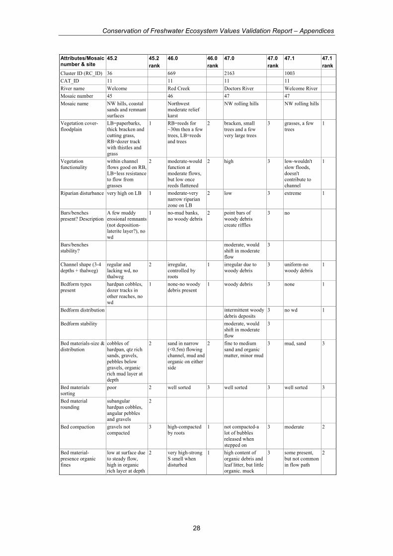
Conservation of Freshwater Ecosystem Values Validation Report – Appendices
28
Attributes/Mosaic number & site
45.2 45.2
rank
46.0 46.0
rank
47.0 47.0
rank
47.1 47.1
rank
Cluster ID (RC_ID) 36 669 2163 1003
CAT_ID 11 11 11 11
River name Welcome Red Creek Doctors River Welcome River
Mosaic number 45 46 47 47
Mosaic name NW hills, coastal
sands and remnant surfaces
Northwest
moderate relief karst
NW rolling hills NW rolling hills
Vegetation cover-
floodplain
LB=paperbarks,
thick bracken and
cutting grass,
RB=dozer track with thistles and
grass
1 RB=reeds for
~30m then a few
trees, LB=reeds
and trees
2 bracken, small
trees and a few
very large trees
3 grasses, a few
trees 1
Vegetation
functionality
within channel
flows good on RB,
LB=less resistance to flow from
grasses
2 moderate-would
function at
moderate flows, but low once
reeds flattened
2 high 3 low-wouldn't
slow floods,
doesn't contribute to
channel
1
Riparian disturbance very high on LB 1 moderate-very
narrow riparian
zone on LB
2 low 3 extreme 1
Bars/benches
present? Description
A few muddy
erosional remnants
(not deposition-laterite layer?), no
wd
1 no-mud banks,
no woody debris 2 point bars of
woody debris
create riffles
3 no
Bars/benches
stability? moderate, would
shift in moderate
flow
3
Channel shape (3-4
depths + thalweg)
regular and
lacking wd, no thalweg
2 irregular,
controlled by roots
1 irregular due to
woody debris 3 uniform-no
woody debris 1
Bedform types
present
hardpan cobbles,
dozer tracks in
other reaches, no
wd
1 none-no woody
debris present 1 woody debris 3 none 1
Bedform distribution intermittent woody
debris deposits 3 no wd 1
Bedform stability moderate, would
shift in moderate
flow
3
Bed materials-size &
distribution
cobbles of
hardpan, qtz rich sands, gravels,
pebbles below
gravels, organic rich mud layer at
depth
2 sand in narrow
(<0.5m) flowing channel, mud and
organic on either
side
2 fine to medium
sand and organic matter, minor mud
3 mud, sand 3
Bed materials
sorting poor 2 well sorted 3 well sorted 3 well sorted 3
Bed material
rounding
subangular
hardpan cobbles,
angular pebbles and gravels
2
Bed compaction gravels not
compacted 3 high-compacted
by roots 1 not compacted-a
lot of bubbles
released when
stepped on
3 moderate 2
Bed material-
presence organic
fines
low at surface due
to steady flow,
high in organic rich layer at depth
2 very high-strong
S smell when
disturbed
1 high content of
organic debris and
leaf litter, but little organic. muck
3 some present,
but not common
in flow path
2
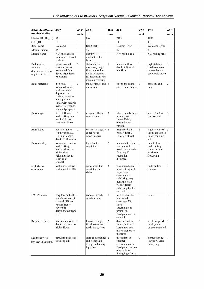
Conservation of Freshwater Ecosystem Values Validation Report – Appendices
29
Attributes/Mosaic number & site
45.2 45.2
rank
46.0 46.0
rank
47.0 47.0
rank
47.1 47.1
rank
Cluster ID (RC_ID) 36 669 2163 1003
CAT_ID 11 11 11 11
River name Welcome Red Creek Doctors River Welcome River
Mosaic number 45 46 47 47
Mosaic name NW hills, coastal
sands and remnant surfaces
Northwest
moderate relief karst
NW rolling hills NW rolling hills
Bed material
stability
& estimate of flow
required to move
gravels would
easily move with
in channel flow
due to high depth of channel
2 stable due to
roots, very large
flow required to
mobilize-need to fill floodplain and
maintain velocity
1 moderate flow
(bank full) would
mobilise
3 high stability
need to remove
grasses before
bed would move
1
Bank materials iron rich,
indurated sands
with qtz sands deposited on
surface, lower on
bank qtz rich sands with organic
matter, LB=sands
and dredge spoils
3 mud, organics and
minor sand 3 fine to med sand
and organic debris 3 sand, silt and
mud 3
Bank slope RB=60-80deg,
undercutting has resulted in over
steepened banks,
2 irregular -flat to
near vertical 3 where muddy bars
present, low slope<20deg;
otherwise near
vertical
3 steep (>60) to
near vertical 3
Bank shape RB=straight to
slightly concave,
LB=hummocky due to earth works
2 vertical to slightly
concave-no
woody debris
2 irregular due to
woody debris,
generally straight
3 slightly convex
due to erosion of
upper bank, no wd
2
Bank stability moderate-prone to
undercutting,
banks subject to
higher flow velocities due to
clearing of
channel
high due to
vegetation 2 moderate to high-
sand on bank
would move under
flow, esp if vegetation
disturbed
3 mod to low-
undercutting
occurring and
erosion on floodplain
1
Disturbance
occurrence
high-undercutting
widespread on RB 1 widespread but
vegetated and stable
3 widespread small
undercutting with vegetation
covering and
stabilising-very dynamic, with
woody debris
stabilising banks and bed
3 undercutting
common 1
LWD % cover very low on banks
and almost none in
channel, RB has
FP has higher cover but
disconnected from
river
1 none-no woody
debris present 1 med to small wd
low overall
coverage<5%,
flood accumulations
present on
floodplain and in channel
3 none 1
Responsiveness banks responsive
due to exposure to
higher flows
1 low-need large
flood to remove
reeds and grasses
2 dynamic within
valley, but stable.
Large trees are
major anchors to planform
3 would respond
quickly after
grasses removed
1
Sediment yield/
storage/ throughput
throughput-no link
to floodplain 1 storage in channel
and floodplain
except under very
high flow
2 throughput in
channel,
accumulation on
floodplain, erosion of sand bank
during high flows
3 storage during
low flow, yield
during high
1

Conservation of Freshwater Ecosystem Values Validation Report – Appendices
30
Attributes/Mosaic number & site
45.2 45.2
rank
46.0 46.0
rank
47.0 47.0
rank
47.1 47.1
rank
Cluster ID (RC_ID) 36 669 2163 1003
CAT_ID 11 11 11 11
River name Welcome Red Creek Doctors River Welcome River
Mosaic number 45 46 47 47
Mosaic name NW hills, coastal
sands and remnant surfaces
Northwest
moderate relief karst
NW rolling hills NW rolling hills
Water management
issues
Already severely
affected by
alterations to
channel and floodplain-not
sure changing
flows would affect it much
Valley wall (Fe-
rich seds) are
unstable where
floodplain cleared; More sed would
choke channel,
removing flow would inc
vegetation in
channel, removing high flow would
increase
vegetation on floodplain
Reduction in
sediment or woody
debris input would
greatly alter channel and
floodplain, as
would decrease in high flows.
very poor present
condition-change
to base flow
would lead to channel widening
or contraction.
Floodplain at risk for erosion
during floods.
pH 7.6 6.75 6.73 6.53
EC 1426 460 553 470
Temp 15.2 15.5 13.6 13.7
#indicators marked 28 28 31 27
Total possible score 84 84 93 81
Total score 53 58 93 49
normalise 0-1 0.45 0.54 1.00 0.41
GEOM from CFEV 1.00 0.83 0.95 0.82
Mosaic consistent-beautiful
reach
Character excellent-
relationship
between
floodplain, channel, sand-
surface, valley wall all functioning
Condition very good
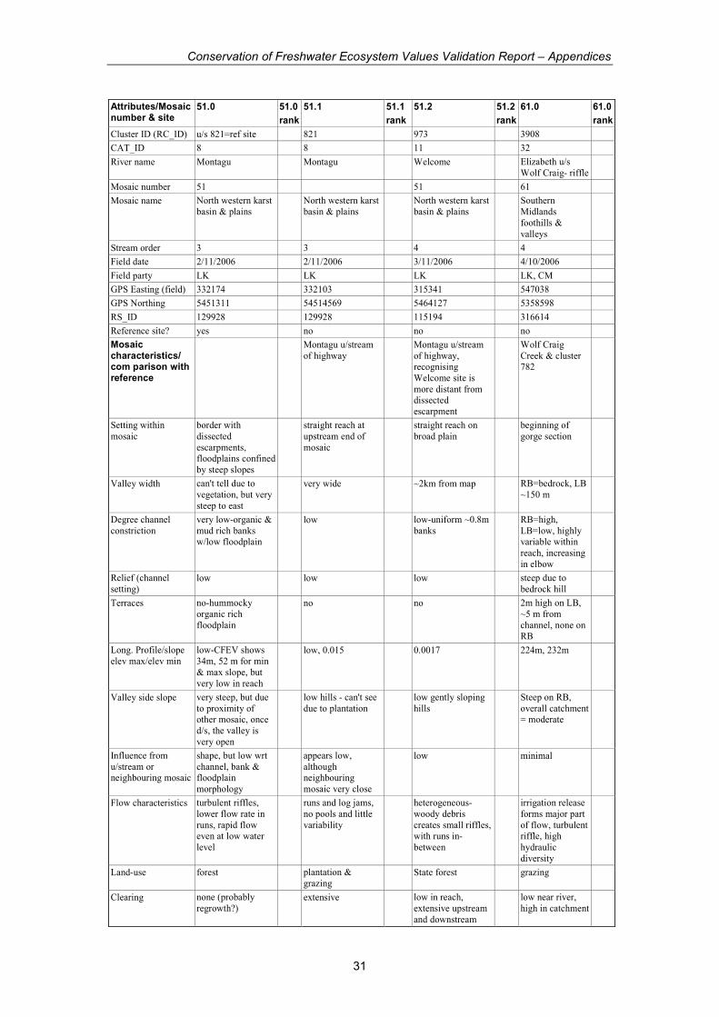
Conservation of Freshwater Ecosystem Values Validation Report – Appendices
31
Attributes/Mosaic number & site
51.0 51.0
rank
51.1 51.1
rank
51.2 51.2
rank
61.0 61.0
rank
Cluster ID (RC_ID) u/s 821=ref site 821 973 3908
CAT_ID 8 8 11 32
River name Montagu Montagu Welcome Elizabeth u/s
Wolf Craig- riffle
Mosaic number 51 51 61
Mosaic name North western karst
basin & plains North western karst
basin & plains North western karst
basin & plains Southern
Midlands
foothills &
valleys
Stream order 3 3 4 4
Field date 2/11/2006 2/11/2006 3/11/2006 4/10/2006
Field party LK LK LK LK, CM
GPS Easting (field) 332174 332103 315341 547038
GPS Northing 5451311 54514569 5464127 5358598
RS_ID 129928 129928 115194 316614
Reference site? yes no no no
Mosaic characteristics/ com parison with reference
Montagu u/stream
of highway Montagu u/stream
of highway, recognising
Welcome site is
more distant from dissected
escarpment
Wolf Craig
Creek & cluster 782
Setting within
mosaic
border with
dissected
escarpments, floodplains confined
by steep slopes
straight reach at
upstream end of
mosaic
straight reach on
broad plain beginning of
gorge section
Valley width can't tell due to
vegetation, but very
steep to east
very wide ~2km from map RB=bedrock, LB
~150 m
Degree channel
constriction
very low-organic &
mud rich banks w/low floodplain
low low-uniform ~0.8m
banks RB=high,
LB=low, highly variable within
reach, increasing
in elbow
Relief (channel
setting) low low low steep due to
bedrock hill
Terraces no-hummocky
organic rich
floodplain
no no 2m high on LB,
~5 m from
channel, none on RB
Long. Profile/slope
elev max/elev min
low-CFEV shows
34m, 52 m for min
& max slope, but
very low in reach
low, 0.015 0.0017 224m, 232m
Valley side slope very steep, but due
to proximity of other mosaic, once
d/s, the valley is
very open
low hills - can't see
due to plantation low gently sloping
hills Steep on RB,
overall catchment = moderate
Influence from
u/stream or neighbouring mosaic
shape, but low wrt
channel, bank & floodplain
morphology
appears low,
although neighbouring
mosaic very close
low minimal
Flow characteristics turbulent riffles,
lower flow rate in
runs, rapid flow even at low water
level
runs and log jams,
no pools and little
variability
heterogeneous-
woody debris
creates small riffles, with runs in-
between
irrigation release
forms major part
of flow, turbulent riffle, high
hydraulic
diversity
Land-use forest plantation &
grazing State forest grazing
Clearing none (probably
regrowth?) extensive low in reach,
extensive upstream
and downstream
low near river,
high in catchment
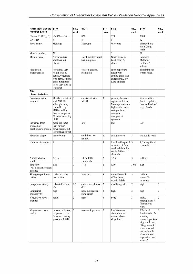
Conservation of Freshwater Ecosystem Values Validation Report – Appendices
32
Attributes/Mosaic number & site
51.0 51.0
rank
51.1 51.1
rank
51.2 51.2
rank
61.0 61.0
rank
Cluster ID (RC_ID) u/s 821=ref site 821 973 3908
CAT_ID 8 8 11 32
River name Montagu Montagu Welcome Elizabeth u/s
Wolf Craig-
riffle
Mosaic number 51 51 61
Mosaic name North western
karst basin &
plains
North western karst
basin & plains North western
karst basin &
plains
Southern
Midlands
foothills & valleys
Flood plain
characteristics
low lying, very
rich in woody
debris, vegetated
with ferns, cutting grass & tall thin
trees, very rich in
leaf litter
cleared, grazed,
plantation open paperbark
forest with
cutting-grass like
understorey, low lying and flat
discontinuous
within reach
Site characteristics
Consistent with
mosaic?
Mostly consistent
with MO 51,
although valley controlled by
MO44- valley floor is tongue of
51 between valley
of 44.
3 consistent with
MO51 3 yes-may be more
organic rich than
Montagu u/stream highway because
no input from dissected
escarpment
upstream
Yes, modified
due to regulated
flow and lack of large floods
Influence from
u/stream or
neighbouring mosaic
more sed input
than farther
downstream, but low influence wrt
low low low
Planform shape meandering 3 straighter than
natural 2 straight reach 3 straight in reach
Number of channels 1 3 1 3 1 with widespread
evidence of flow
on floodplain, but
not in defined channels
3 1, 2ndary flood
channels
Approx channel
width 2-3 m 3 ~1 m, little
variability 2 3-5 m 3 6-10 m
Sinuosity
(RS_LENGTH/reach
distance
1.16 3 1.16 2 1.09 3.00 1.25
Site type (pool, run,
riffle)
riffle-run -pool
over ~50m 3 long run 3 run with small
riffles due to
woody debris
3 riffle in
pool/riffle
sequence
Long-connectivity culvert d/s, none
u/s 2.5 culvert u/s, drains
d/s 2 road bridge d/s 2 high 3
Latitudinal
connectivity high 3 none-no riparian
zone either 2 high 3 high 3
Vegetation cover-
channel none 3 none 3 none 3 sparse
macrophytes &
filamentous algae
2
Vegetation cover-
banks
mosses on banks,
no ground cover,
ferns and cutting
grass and LWD
3 mosses & pasture 2 low % cover-
discontinuous
mosses above
slope break
2 RB=shrub
dominated to 3m
abutting
bedrock, pockets of groundcover,
LB=grasses &
occasional tall trees w/shrub
u/story; more
vegetation than 'natural'
2
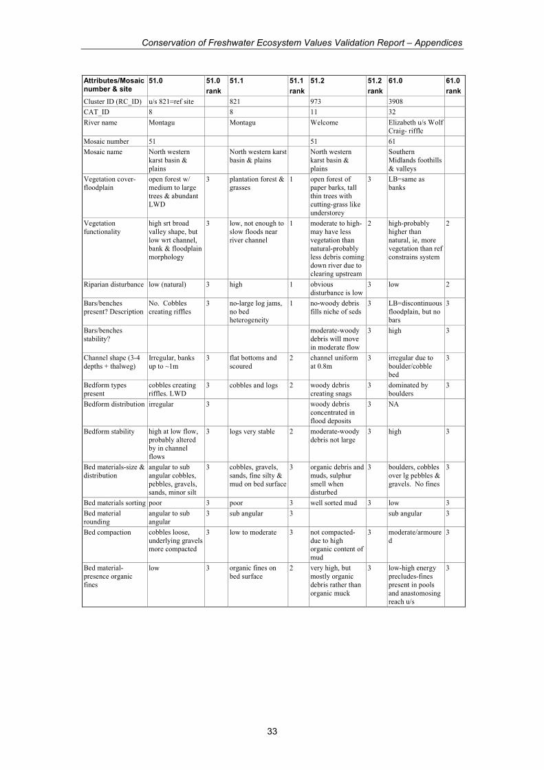
Conservation of Freshwater Ecosystem Values Validation Report – Appendices
33
Attributes/Mosaic number & site
51.0 51.0
rank
51.1 51.1
rank
51.2 51.2
rank
61.0 61.0
rank
Cluster ID (RC_ID) u/s 821=ref site 821 973 3908
CAT_ID 8 8 11 32
River name Montagu Montagu Welcome Elizabeth u/s Wolf
Craig- riffle
Mosaic number 51 51 61
Mosaic name North western
karst basin &
plains
North western karst
basin & plains North western
karst basin &
plains
Southern
Midlands foothills
& valleys
Vegetation cover-
floodplain
open forest w/
medium to large
trees & abundant LWD
3 plantation forest &
grasses 1 open forest of
paper barks, tall
thin trees with cutting-grass like
understorey
3 LB=same as
banks
Vegetation
functionality
high srt broad
valley shape, but
low wrt channel, bank & floodplain
morphology
3 low, not enough to
slow floods near
river channel
1 moderate to high-
may have less
vegetation than natural-probably
less debris coming
down river due to clearing upstream
2 high-probably
higher than
natural, ie, more vegetation than ref
constrains system
2
Riparian disturbance low (natural) 3 high 1 obvious
disturbance is low 3 low 2
Bars/benches
present? Description
No. Cobbles
creating riffles 3 no-large log jams,
no bed heterogeneity
1 no-woody debris
fills niche of seds 3 LB=discontinuous
floodplain, but no bars
3
Bars/benches
stability? moderate-woody
debris will move
in moderate flow
3 high 3
Channel shape (3-4
depths + thalweg)
Irregular, banks
up to ~1m 3 flat bottoms and
scoured 2 channel uniform
at 0.8m 3 irregular due to
boulder/cobble
bed
3
Bedform types
present
cobbles creating
riffles. LWD 3 cobbles and logs 2 woody debris
creating snags 3 dominated by
boulders 3
Bedform distribution irregular 3 woody debris
concentrated in
flood deposits
3 NA
Bedform stability high at low flow,
probably altered by in channel
flows
3 logs very stable 2 moderate-woody
debris not large 3 high 3
Bed materials-size &
distribution
angular to sub
angular cobbles,
pebbles, gravels, sands, minor silt
3 cobbles, gravels,
sands, fine silty &
mud on bed surface
3 organic debris and
muds, sulphur
smell when disturbed
3 boulders, cobbles
over lg pebbles &
gravels. No fines
3
Bed materials sorting poor 3 poor 3 well sorted mud 3 low 3
Bed material
rounding
angular to sub
angular 3 sub angular 3 sub angular 3
Bed compaction cobbles loose,
underlying gravels more compacted
3 low to moderate 3 not compacted-
due to high organic content of
mud
3 moderate/armoure
d 3
Bed material-
presence organic
fines
low 3 organic fines on
bed surface 2 very high, but
mostly organic
debris rather than
organic muck
3 low-high energy
precludes-fines
present in pools
and anastomosing reach u/s
3
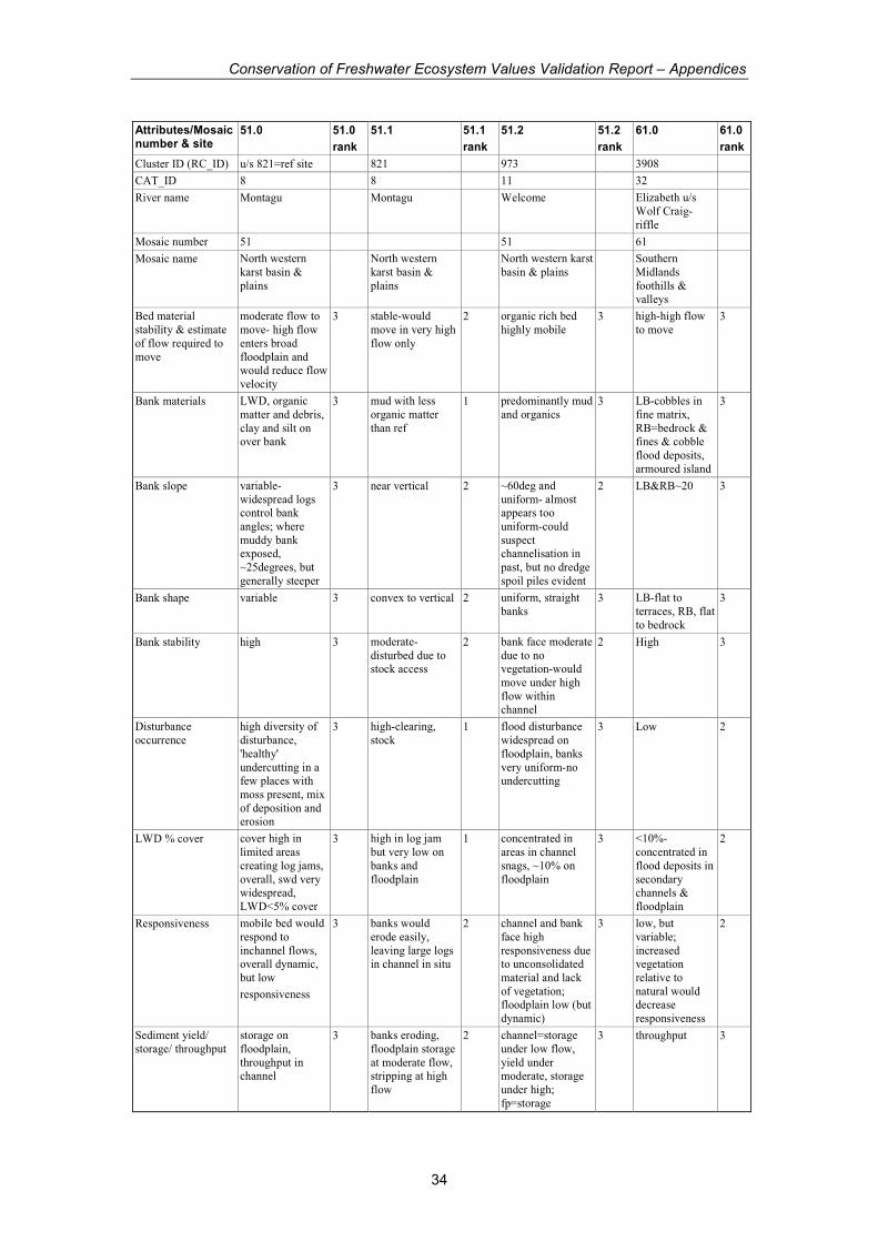
Conservation of Freshwater Ecosystem Values Validation Report – Appendices
34
Attributes/Mosaic number & site
51.0 51.0
rank
51.1 51.1
rank
51.2 51.2
rank
61.0 61.0
rank
Cluster ID (RC_ID) u/s 821=ref site 821 973 3908
CAT_ID 8 8 11 32
River name Montagu Montagu Welcome Elizabeth u/s
Wolf Craig-
riffle
Mosaic number 51 51 61
Mosaic name North western
karst basin &
plains
North western
karst basin &
plains
North western karst
basin & plains Southern
Midlands
foothills & valleys
Bed material
stability & estimate
of flow required to
move
moderate flow to
move- high flow
enters broad
floodplain and would reduce flow
velocity
3 stable-would
move in very high
flow only
2 organic rich bed
highly mobile 3 high-high flow
to move 3
Bank materials LWD, organic
matter and debris,
clay and silt on over bank
3 mud with less
organic matter
than ref
1 predominantly mud
and organics 3 LB-cobbles in
fine matrix,
RB=bedrock & fines & cobble
flood deposits,
armoured island
3
Bank slope variable-
widespread logs control bank
angles; where
muddy bank exposed,
~25degrees, but
generally steeper
3 near vertical 2 ~60deg and
uniform- almost appears too
uniform-could
suspect channelisation in
past, but no dredge
spoil piles evident
2 LB&RB~20 3
Bank shape variable 3 convex to vertical 2 uniform, straight
banks 3 LB-flat to
terraces, RB, flat
to bedrock
3
Bank stability high 3 moderate-
disturbed due to stock access
2 bank face moderate
due to no vegetation-would
move under high
flow within channel
2 High 3
Disturbance
occurrence
high diversity of
disturbance,
'healthy'
undercutting in a few places with
moss present, mix
of deposition and erosion
3 high-clearing,
stock 1 flood disturbance
widespread on
floodplain, banks
very uniform-no undercutting
3 Low 2
LWD % cover cover high in
limited areas
creating log jams,
overall, swd very widespread,
LWD<5% cover
3 high in log jam
but very low on
banks and
floodplain
1 concentrated in
areas in channel
snags, ~10% on
floodplain
3 <10%-
concentrated in
flood deposits in
secondary channels &
floodplain
2
Responsiveness mobile bed would
respond to
inchannel flows, overall dynamic,
but low
responsiveness
3 banks would
erode easily,
leaving large logs in channel in situ
2 channel and bank
face high
responsiveness due to unconsolidated
material and lack
of vegetation; floodplain low (but
dynamic)
3 low, but
variable;
increased vegetation
relative to
natural would decrease
responsiveness
2
Sediment yield/
storage/ throughput
storage on
floodplain,
throughput in channel
3 banks eroding,
floodplain storage
at moderate flow, stripping at high
flow
2 channel=storage
under low flow,
yield under moderate, storage
under high;
fp=storage
3 throughput 3
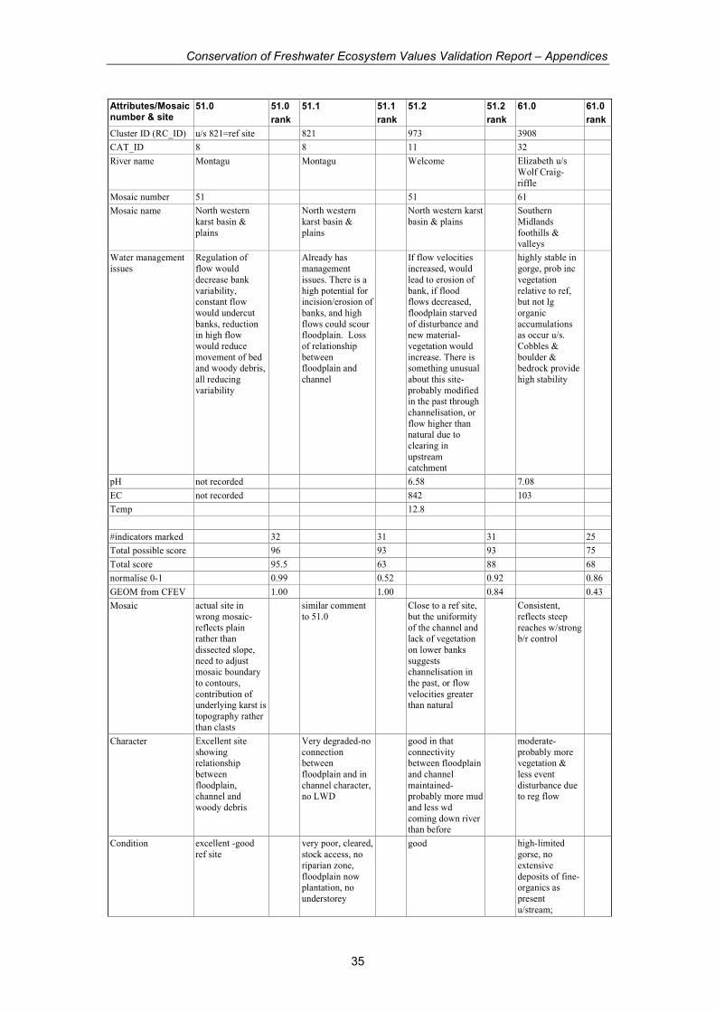
Conservation of Freshwater Ecosystem Values Validation Report – Appendices
35
Attributes/Mosaic number & site
51.0 51.0
rank
51.1 51.1
rank
51.2 51.2
rank
61.0 61.0
rank
Cluster ID (RC_ID) u/s 821=ref site 821 973 3908
CAT_ID 8 8 11 32
River name Montagu Montagu Welcome Elizabeth u/s
Wolf Craig-
riffle
Mosaic number 51 51 61
Mosaic name North western
karst basin &
plains
North western
karst basin &
plains
North western karst
basin & plains Southern
Midlands
foothills & valleys
Water management
issues
Regulation of
flow would
decrease bank
variability, constant flow
would undercut
banks, reduction in high flow
would reduce
movement of bed and woody debris,
all reducing
variability
Already has
management
issues. There is a
high potential for incision/erosion of
banks, and high
flows could scour floodplain. Loss
of relationship
between floodplain and
channel
If flow velocities
increased, would
lead to erosion of
bank, if flood flows decreased,
floodplain starved
of disturbance and new material-
vegetation would
increase. There is something unusual
about this site-
probably modified in the past through
channelisation, or
flow higher than natural due to
clearing in
upstream catchment
highly stable in
gorge, prob inc
vegetation
relative to ref, but not lg
organic
accumulations as occur u/s.
Cobbles &
boulder & bedrock provide
high stability
pH not recorded 6.58 7.08
EC not recorded 842 103
Temp 12.8
#indicators marked 32 31 31 25
Total possible score 96 93 93 75
Total score 95.5 63 88 68
normalise 0-1 0.99 0.52 0.92 0.86
GEOM from CFEV 1.00 1.00 0.84 0.43
Mosaic actual site in
wrong mosaic-
reflects plain rather than
dissected slope,
need to adjust mosaic boundary
to contours,
contribution of underlying karst is
topography rather
than clasts
similar comment
to 51.0 Close to a ref site,
but the uniformity
of the channel and lack of vegetation
on lower banks
suggests channelisation in
the past, or flow
velocities greater than natural
Consistent,
reflects steep
reaches w/strong b/r control
Character Excellent site
showing relationship
between
floodplain, channel and
woody debris
Very degraded-no
connection between
floodplain and in
channel character, no LWD
good in that
connectivity between floodplain
and channel
maintained- probably more mud
and less wd
coming down river than before
moderate-
probably more vegetation &
less event
disturbance due to reg flow
Condition excellent -good
ref site very poor, cleared,
stock access, no
riparian zone,
floodplain now plantation, no
understorey
good high-limited
gorse, no
extensive
deposits of fine- organics as
present
u/stream;
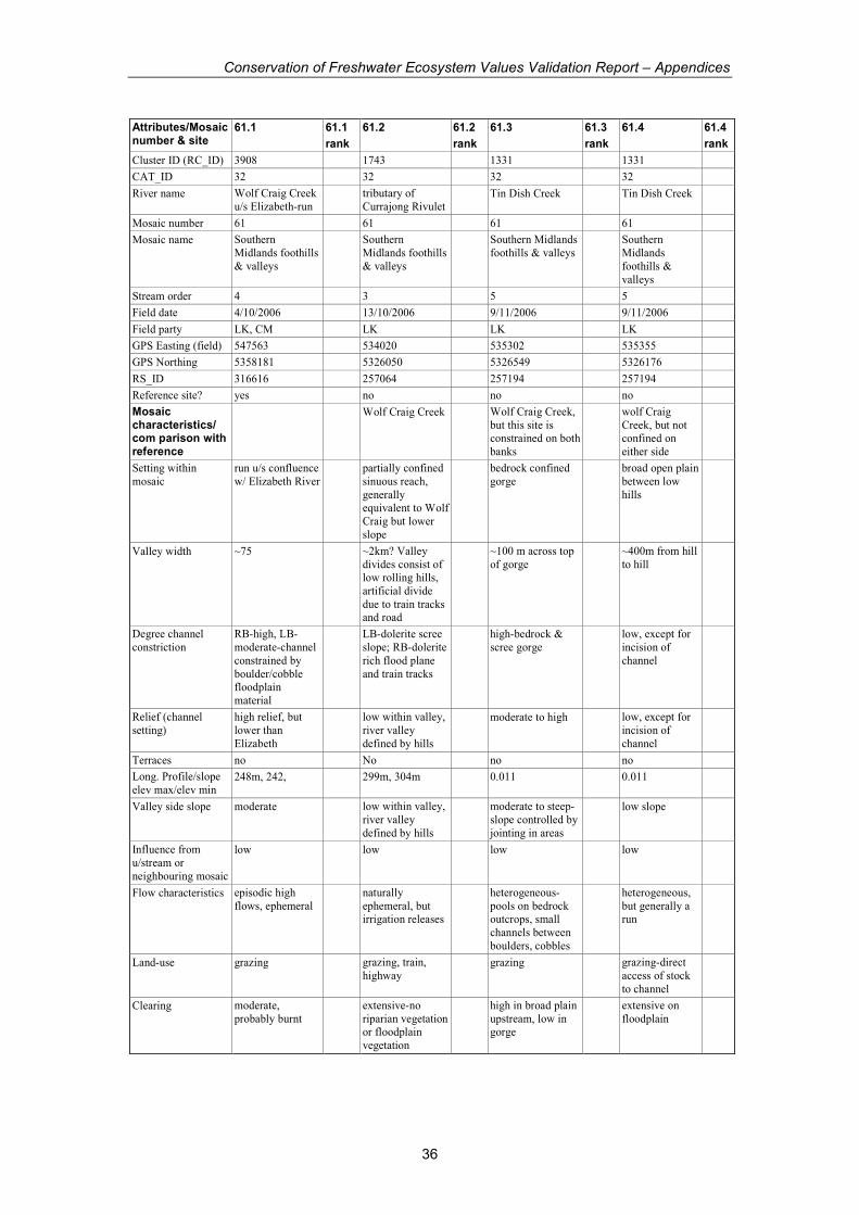
Conservation of Freshwater Ecosystem Values Validation Report – Appendices
36
Attributes/Mosaic number & site
61.1 61.1
rank
61.2 61.2
rank
61.3 61.3
rank
61.4 61.4
rank
Cluster ID (RC_ID) 3908 1743 1331 1331
CAT_ID 32 32 32 32
River name Wolf Craig Creek
u/s Elizabeth-run tributary of
Currajong Rivulet Tin Dish Creek Tin Dish Creek
Mosaic number 61 61 61 61
Mosaic name Southern
Midlands foothills
& valleys
Southern
Midlands foothills
& valleys
Southern Midlands
foothills & valleys Southern
Midlands
foothills &
valleys
Stream order 4 3 5 5
Field date 4/10/2006 13/10/2006 9/11/2006 9/11/2006
Field party LK, CM LK LK LK
GPS Easting (field) 547563 534020 535302 535355
GPS Northing 5358181 5326050 5326549 5326176
RS_ID 316616 257064 257194 257194
Reference site? yes no no no
Mosaic characteristics/ com parison with reference
Wolf Craig Creek Wolf Craig Creek,
but this site is constrained on both
banks
wolf Craig
Creek, but not confined on
either side
Setting within
mosaic
run u/s confluence
w/ Elizabeth River partially confined
sinuous reach,
generally equivalent to Wolf
Craig but lower
slope
bedrock confined
gorge broad open plain
between low
hills
Valley width ~75 ~2km? Valley
divides consist of low rolling hills,
artificial divide
due to train tracks and road
~100 m across top
of gorge ~400m from hill
to hill
Degree channel
constriction
RB-high, LB-
moderate-channel
constrained by
boulder/cobble floodplain
material
LB-dolerite scree
slope; RB-dolerite
rich flood plane
and train tracks
high-bedrock &
scree gorge low, except for
incision of
channel
Relief (channel
setting)
high relief, but
lower than
Elizabeth
low within valley,
river valley
defined by hills
moderate to high low, except for
incision of
channel
Terraces no No no no
Long. Profile/slope
elev max/elev min 248m, 242, 299m, 304m 0.011 0.011
Valley side slope moderate low within valley,
river valley
defined by hills
moderate to steep-
slope controlled by
jointing in areas
low slope
Influence from
u/stream or
neighbouring mosaic
low low low low
Flow characteristics episodic high
flows, ephemeral naturally
ephemeral, but irrigation releases
heterogeneous-
pools on bedrock outcrops, small
channels between
boulders, cobbles
heterogeneous,
but generally a run
Land-use grazing grazing, train,
highway grazing grazing-direct
access of stock
to channel
Clearing moderate,
probably burnt extensive-no
riparian vegetation or floodplain
vegetation
high in broad plain
upstream, low in gorge
extensive on
floodplain
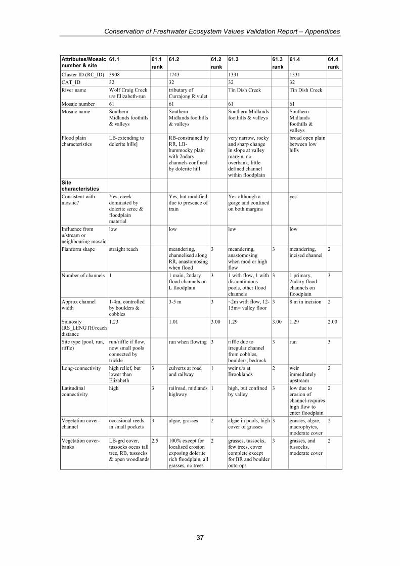
Conservation of Freshwater Ecosystem Values Validation Report – Appendices
37
Attributes/Mosaic number & site
61.1 61.1
rank
61.2 61.2
rank
61.3 61.3
rank
61.4 61.4
rank
Cluster ID (RC_ID) 3908 1743 1331 1331
CAT_ID 32 32 32 32
River name Wolf Craig Creek
u/s Elizabeth-run tributary of
Currajong Rivulet Tin Dish Creek Tin Dish Creek
Mosaic number 61 61 61 61
Mosaic name Southern
Midlands foothills
& valleys
Southern
Midlands foothills
& valleys
Southern Midlands
foothills & valleys Southern
Midlands
foothills &
valleys
Flood plain
characteristics
LB-extending to
dolerite hills] RB-constrained by
RR, LB-hummocky plain
with 2ndary
channels confined by dolerite hill
very narrow, rocky
and sharp change in slope at valley
margin, no
overbank, little defined channel
within floodplain
broad open plain
between low hills
Site characteristics
Consistent with
mosaic?
Yes, creek
dominated by
dolerite scree &
floodplain material
Yes, but modified
due to presence of
train
Yes-although a
gorge and confined
on both margins
yes
Influence from
u/stream or
neighbouring mosaic
low low low low
Planform shape straight reach meandering,
channelised along
RR, anastomosing when flood
3 meandering,
anastomosing
when mod or high flow
3 meandering,
incised channel 2
Number of channels 1 1 main, 2ndary
flood channels on
L floodplain
3 1 with flow, 1 with
discontinuous
pools, other flood
channels
3 1 primary,
2ndary flood
channels on
floodplain
3
Approx channel
width
1-4m, controlled
by boulders & cobbles
3-5 m 3 ~2m with flow, 12-
15m= valley floor 3 8 m in incision 2
Sinuosity
(RS_LENGTH/reach
distance
1.23 1.01 3.00 1.29 3.00 1.29 2.00
Site type (pool, run,
riffle)
run/riffle if flow,
now small pools
connected by
trickle
run when flowing 3 riffle due to
irregular channel
from cobbles,
boulders, bedrock
3 run 3
Long-connectivity high relief, but
lower than Elizabeth
3 culverts at road
and railway 1 weir u/s at
Brooklands 2 weir
immediately upstream
2
Latitudinal
connectivity high 3 railroad, midlands
highway 1 high, but confined
by valley 3 low due to
erosion of
channel-requires
high flow to enter floodplain
2
Vegetation cover-
channel
occasional reeds
in small pockets 3 algae, grasses 2 algae in pools, high
cover of grasses 3 grasses, algae,
macrophytes,
moderate cover
2
Vegetation cover-
banks
LB-grd cover,
tussocks occas tall
tree, RB, tussocks & open woodlands
2.5 100% except for
localised erosion
exposing dolerite rich floodplain, all
grasses, no trees
2 grasses, tussocks,
few trees, cover
complete except for BR and boulder
outcrops
3 grasses, and
tussocks,
moderate cover
2
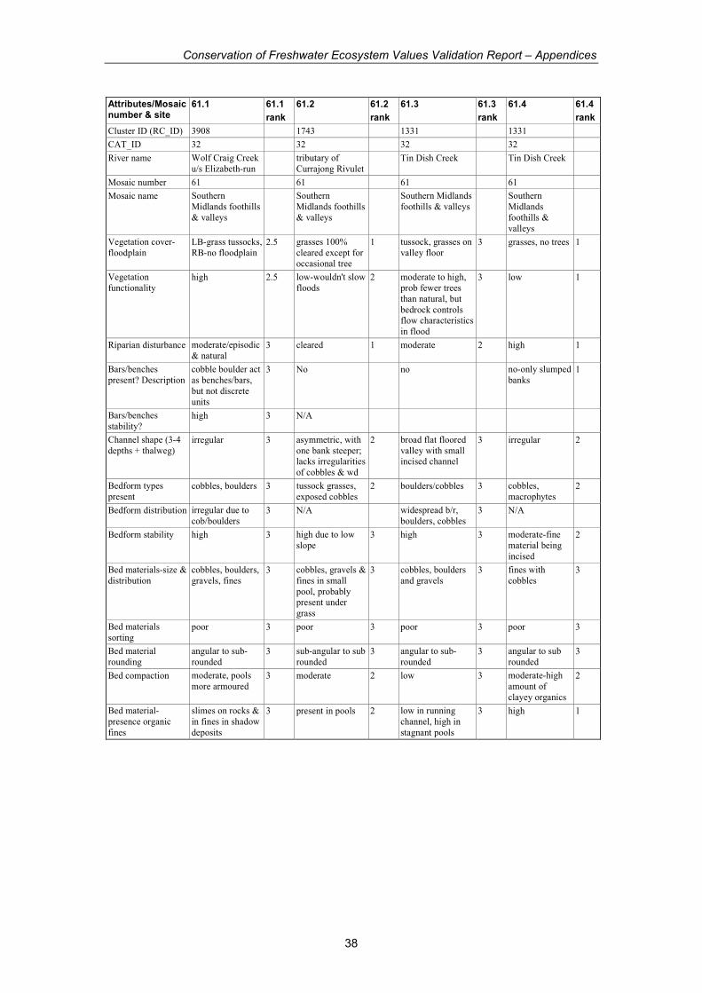
Conservation of Freshwater Ecosystem Values Validation Report – Appendices
38
Attributes/Mosaic number & site
61.1 61.1
rank
61.2 61.2
rank
61.3 61.3
rank
61.4 61.4
rank
Cluster ID (RC_ID) 3908 1743 1331 1331
CAT_ID 32 32 32 32
River name Wolf Craig Creek
u/s Elizabeth-run tributary of
Currajong Rivulet Tin Dish Creek Tin Dish Creek
Mosaic number 61 61 61 61
Mosaic name Southern
Midlands foothills
& valleys
Southern
Midlands foothills
& valleys
Southern Midlands
foothills & valleys Southern
Midlands
foothills &
valleys
Vegetation cover-
floodplain
LB-grass tussocks,
RB-no floodplain 2.5 grasses 100%
cleared except for occasional tree
1 tussock, grasses on
valley floor 3 grasses, no trees 1
Vegetation
functionality high 2.5 low-wouldn't slow
floods 2 moderate to high,
prob fewer trees
than natural, but
bedrock controls flow characteristics
in flood
3 low 1
Riparian disturbance moderate/episodic
& natural 3 cleared 1 moderate 2 high 1
Bars/benches
present? Description
cobble boulder act
as benches/bars,
but not discrete
units
3 No no no-only slumped
banks 1
Bars/benches
stability? high 3 N/A
Channel shape (3-4
depths + thalweg) irregular 3 asymmetric, with
one bank steeper; lacks irregularities
of cobbles & wd
2 broad flat floored
valley with small incised channel
3 irregular 2
Bedform types
present cobbles, boulders 3 tussock grasses,
exposed cobbles 2 boulders/cobbles 3 cobbles,
macrophytes 2
Bedform distribution irregular due to
cob/boulders 3 N/A widespread b/r,
boulders, cobbles 3 N/A
Bedform stability high 3 high due to low
slope 3 high 3 moderate-fine
material being
incised
2
Bed materials-size &
distribution
cobbles, boulders,
gravels, fines 3 cobbles, gravels &
fines in small
pool, probably present under
grass
3 cobbles, boulders
and gravels 3 fines with
cobbles 3
Bed materials
sorting poor 3 poor 3 poor 3 poor 3
Bed material
rounding
angular to sub-
rounded 3 sub-angular to sub
rounded 3 angular to sub-
rounded 3 angular to sub
rounded 3
Bed compaction moderate, pools
more armoured 3 moderate 2 low 3 moderate-high
amount of
clayey organics
2
Bed material-
presence organic
fines
slimes on rocks &
in fines in shadow
deposits
3 present in pools 2 low in running
channel, high in
stagnant pools
3 high 1
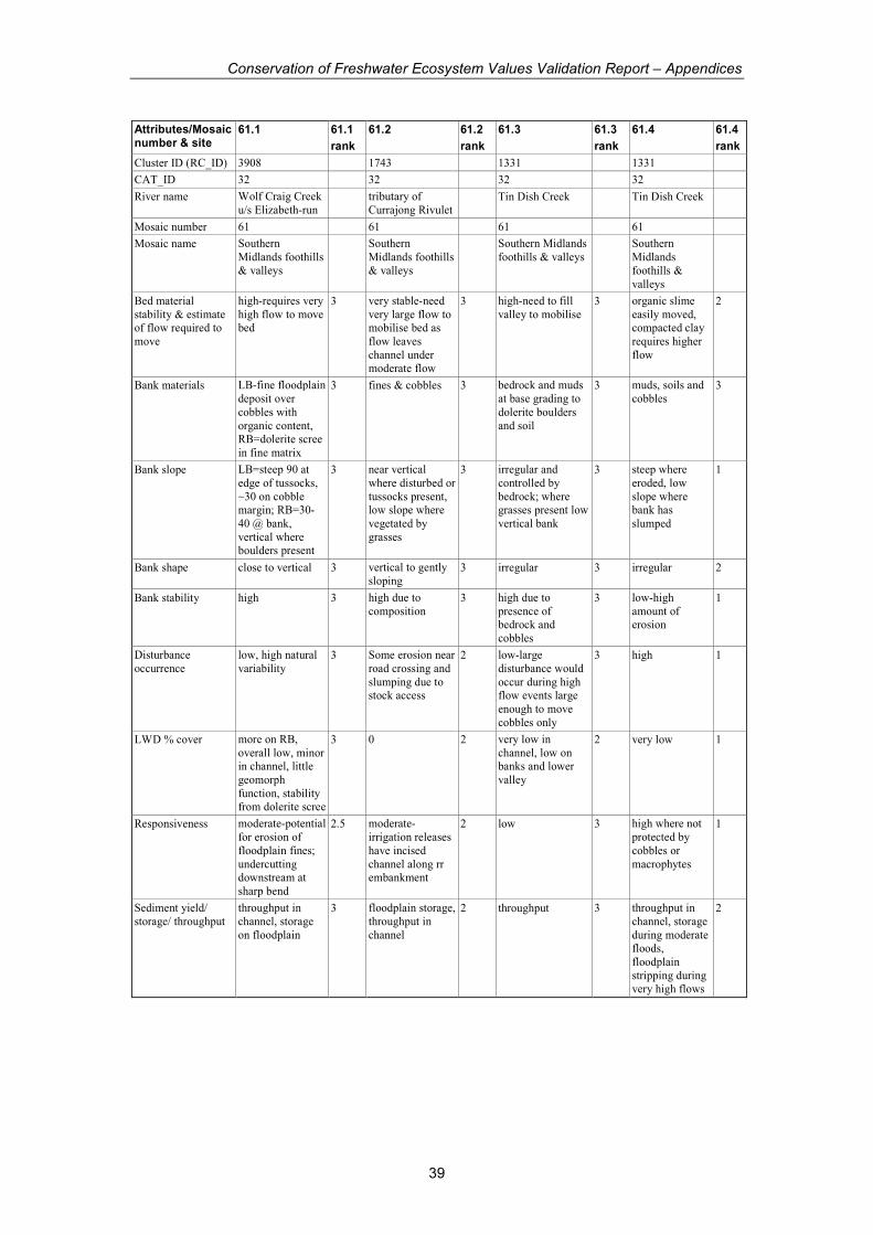
Conservation of Freshwater Ecosystem Values Validation Report – Appendices
39
Attributes/Mosaic number & site
61.1 61.1
rank
61.2 61.2
rank
61.3 61.3
rank
61.4 61.4
rank
Cluster ID (RC_ID) 3908 1743 1331 1331
CAT_ID 32 32 32 32
River name Wolf Craig Creek
u/s Elizabeth-run tributary of
Currajong Rivulet Tin Dish Creek Tin Dish Creek
Mosaic number 61 61 61 61
Mosaic name Southern
Midlands foothills
& valleys
Southern
Midlands foothills
& valleys
Southern Midlands
foothills & valleys Southern
Midlands
foothills &
valleys
Bed material
stability & estimate of flow required to
move
high-requires very
high flow to move bed
3 very stable-need
very large flow to mobilise bed as
flow leaves
channel under moderate flow
3 high-need to fill
valley to mobilise 3 organic slime
easily moved, compacted clay
requires higher
flow
2
Bank materials LB-fine floodplain
deposit over
cobbles with
organic content, RB=dolerite scree
in fine matrix
3 fines & cobbles 3 bedrock and muds
at base grading to
dolerite boulders
and soil
3 muds, soils and
cobbles 3
Bank slope LB=steep 90 at
edge of tussocks,
~30 on cobble margin; RB=30-
40 @ bank,
vertical where boulders present
3 near vertical
where disturbed or
tussocks present, low slope where
vegetated by
grasses
3 irregular and
controlled by
bedrock; where grasses present low
vertical bank
3 steep where
eroded, low
slope where bank has
slumped
1
Bank shape close to vertical 3 vertical to gently
sloping 3 irregular 3 irregular 2
Bank stability high 3 high due to
composition 3 high due to
presence of bedrock and
cobbles
3 low-high
amount of erosion
1
Disturbance
occurrence
low, high natural
variability 3 Some erosion near
road crossing and
slumping due to stock access
2 low-large
disturbance would
occur during high flow events large
enough to move
cobbles only
3 high 1
LWD % cover more on RB,
overall low, minor in channel, little
geomorph
function, stability from dolerite scree
3 0 2 very low in
channel, low on banks and lower
valley
2 very low 1
Responsiveness moderate-potential
for erosion of
floodplain fines;
undercutting downstream at
sharp bend
2.5 moderate-
irrigation releases
have incised
channel along rr embankment
2 low 3 high where not
protected by
cobbles or
macrophytes
1
Sediment yield/
storage/ throughput
throughput in
channel, storage
on floodplain
3 floodplain storage,
throughput in
channel
2 throughput 3 throughput in
channel, storage
during moderate floods,
floodplain
stripping during very high flows
2

Conservation of Freshwater Ecosystem Values Validation Report – Appendices
40
Attributes/Mosaic number & site
61.1 61.1
rank
61.2 61.2
rank
61.3 61.3
rank
61.4 61.4
rank
Cluster ID (RC_ID) 3908 1743 1331 1331
CAT_ID 32 32 32 32
River name Wolf Craig Creek
u/s Elizabeth-run tributary of
Currajong Rivulet Tin Dish Creek Tin Dish Creek
Mosaic number 61 61 61 61
Mosaic name Southern Midlands
foothills & valleys Southern
Midlands foothills
& valleys
Southern
Midlands foothills
& valleys
Southern
Midlands
foothills &
valleys
Water management
issues
changing
ephemeral flow would alter
condition, ie
establish macrophytes,
erosion of
floodplain fines, erosion at d/s bend
in reach due to inc.
sheetwash from cleared floodplain,
channel incision
Very poor riparian
condition. Would scour under large
floods, increased
or continual baseflow would
alter character.
River is in poor condition due to
clearing, and
irrigation flow. Character of
secondary flood
channel is consistent than
Wolf Craig due to
vegetated channel and lower slope.
A highly resistant
site affected by grazing and
probably clearing.
Overall in good condition. Fines
and grasses on
valley floor would erode (channel
widening) under
constant higher baseflow,
reduction of high
flows would promote greater
vegetation on
lower banks
clearing,
grazing, stock access and low
regulation has
lead to erosion and incision of
channel. In very
poor condition. Regulated base
flow could
increase channel incision and
erosion
pH 7.11 no flow 8.01 8.01
EC 1005 no flow 1942 1942
Temp 12.4 12.4
#indicators marked 27 29 30 30
Total possible score 81 87 90 90
Total score 79 68 87 56
normalise 0-1 0.96 0.67 0.95 0.44
GEOM from CFEV 1.00 0.36 0.81 0.81
Mosaic consistent with
mosaic and good
example of gorge section
consistent with
mosaic- highly
degraded floodplain
section
Character Probably less
LWD as
compared to natural, but
geomorph largely
controlled by bedrock/boulders
very poor-loss
of riparian and
floodplain vegetation and
regulation of
flow have altered character
of channel and
FP/channel relationship
Condition very poor-
erosion
widespread,
stock access has damaged banks
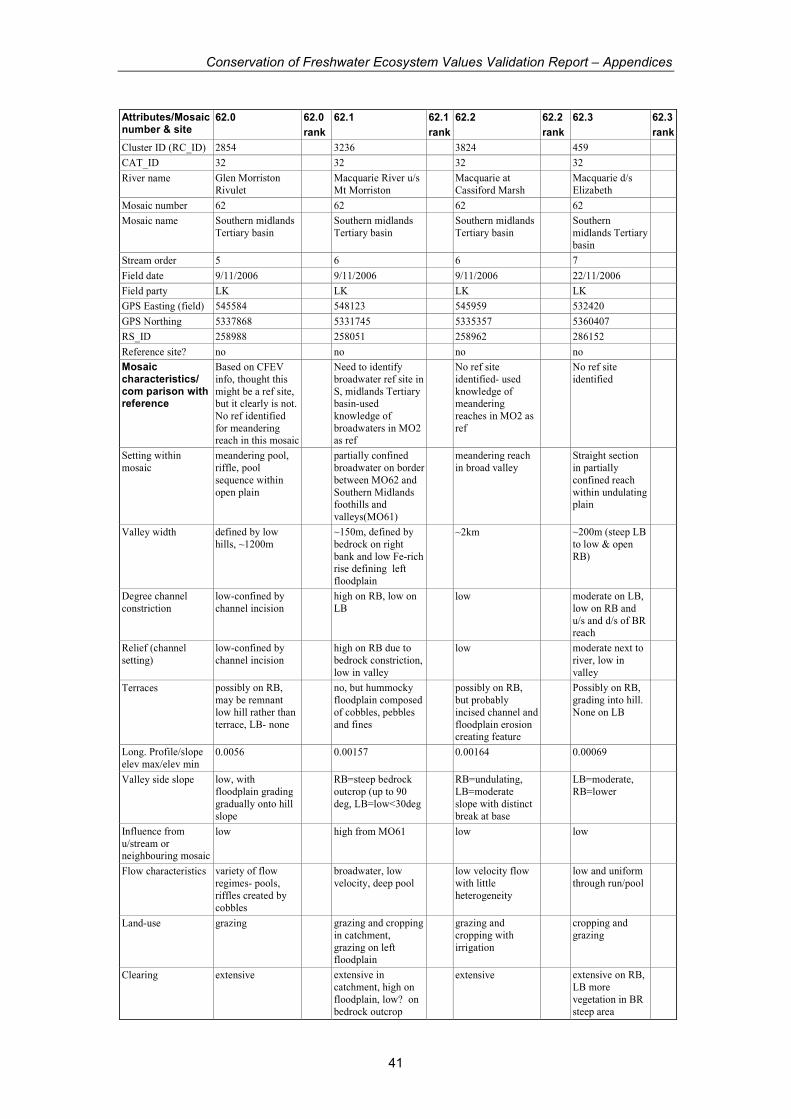
Conservation of Freshwater Ecosystem Values Validation Report – Appendices
41
Attributes/Mosaic number & site
62.0 62.0
rank
62.1 62.1
rank
62.2 62.2
rank
62.3 62.3
rank
Cluster ID (RC_ID) 2854 3236 3824 459
CAT_ID 32 32 32 32
River name Glen Morriston
Rivulet Macquarie River u/s
Mt Morriston Macquarie at
Cassiford Marsh Macquarie d/s
Elizabeth
Mosaic number 62 62 62 62
Mosaic name Southern midlands
Tertiary basin Southern midlands
Tertiary basin Southern midlands
Tertiary basin Southern
midlands Tertiary
basin
Stream order 5 6 6 7
Field date 9/11/2006 9/11/2006 9/11/2006 22/11/2006
Field party LK LK LK LK
GPS Easting (field) 545584 548123 545959 532420
GPS Northing 5337868 5331745 5335357 5360407
RS_ID 258988 258051 258962 286152
Reference site? no no no no
Mosaic characteristics/ com parison with reference
Based on CFEV
info, thought this
might be a ref site, but it clearly is not.
No ref identified
for meandering reach in this mosaic
Need to identify
broadwater ref site in
S, midlands Tertiary basin-used
knowledge of
broadwaters in MO2 as ref
No ref site
identified- used
knowledge of meandering
reaches in MO2 as
ref
No ref site
identified
Setting within
mosaic
meandering pool,
riffle, pool
sequence within
open plain
partially confined
broadwater on border
between MO62 and
Southern Midlands foothills and
valleys(MO61)
meandering reach
in broad valley Straight section
in partially
confined reach
within undulating plain
Valley width defined by low
hills, ~1200m ~150m, defined by
bedrock on right
bank and low Fe-rich rise defining left
floodplain
~2km ~200m (steep LB
to low & open
RB)
Degree channel
constriction
low-confined by
channel incision high on RB, low on
LB low moderate on LB,
low on RB and
u/s and d/s of BR reach
Relief (channel
setting)
low-confined by
channel incision high on RB due to
bedrock constriction,
low in valley
low moderate next to
river, low in
valley
Terraces possibly on RB,
may be remnant
low hill rather than
terrace, LB- none
no, but hummocky
floodplain composed
of cobbles, pebbles
and fines
possibly on RB,
but probably
incised channel and
floodplain erosion creating feature
Possibly on RB,
grading into hill.
None on LB
Long. Profile/slope
elev max/elev min 0.0056 0.00157 0.00164 0.00069
Valley side slope low, with
floodplain grading
gradually onto hill
slope
RB=steep bedrock
outcrop (up to 90
deg, LB=low<30deg
RB=undulating,
LB=moderate
slope with distinct
break at base
LB=moderate,
RB=lower
Influence from
u/stream or neighbouring mosaic
low high from MO61 low low
Flow characteristics variety of flow
regimes- pools,
riffles created by
cobbles
broadwater, low
velocity, deep pool low velocity flow
with little
heterogeneity
low and uniform
through run/pool
Land-use grazing grazing and cropping
in catchment,
grazing on left floodplain
grazing and
cropping with
irrigation
cropping and
grazing
Clearing extensive extensive in
catchment, high on
floodplain, low? on
bedrock outcrop
extensive extensive on RB,
LB more
vegetation in BR
steep area
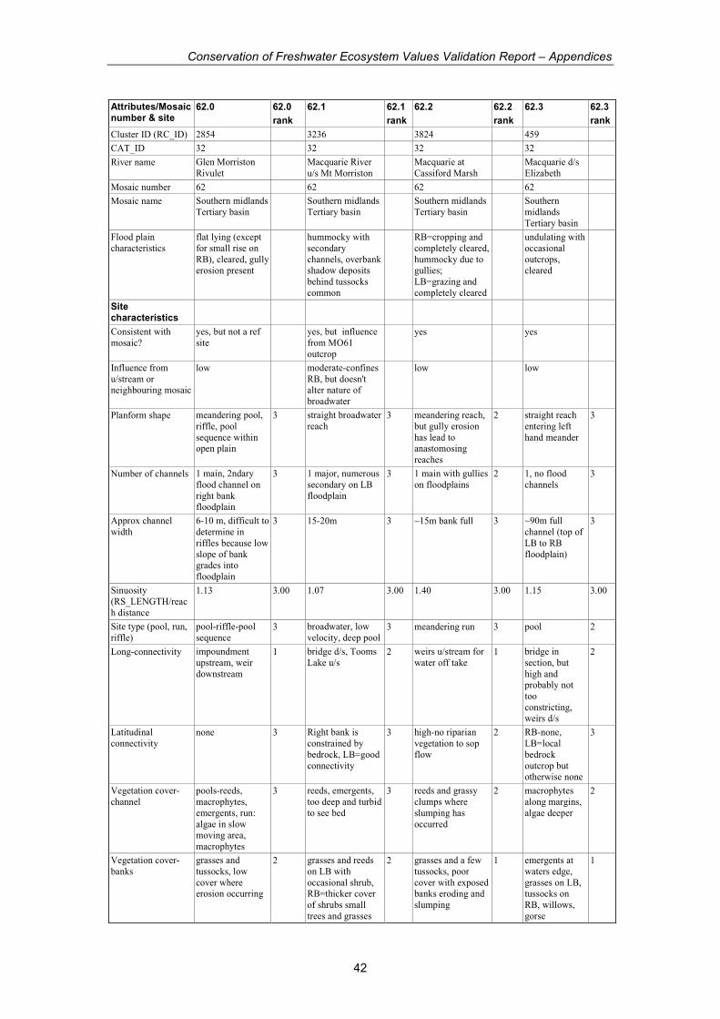
Conservation of Freshwater Ecosystem Values Validation Report – Appendices
42
Attributes/Mosaic number & site
62.0 62.0
rank
62.1 62.1
rank
62.2 62.2
rank
62.3 62.3
rank
Cluster ID (RC_ID) 2854 3236 3824 459
CAT_ID 32 32 32 32
River name Glen Morriston
Rivulet Macquarie River
u/s Mt Morriston Macquarie at
Cassiford Marsh Macquarie d/s
Elizabeth
Mosaic number 62 62 62 62
Mosaic name Southern midlands
Tertiary basin Southern midlands
Tertiary basin Southern midlands
Tertiary basin Southern
midlands
Tertiary basin
Flood plain
characteristics
flat lying (except
for small rise on
RB), cleared, gully erosion present
hummocky with
secondary
channels, overbank shadow deposits
behind tussocks
common
RB=cropping and
completely cleared,
hummocky due to gullies;
LB=grazing and
completely cleared
undulating with
occasional
outcrops, cleared
Site characteristics
Consistent with
mosaic?
yes, but not a ref
site yes, but influence
from MO61
outcrop
yes yes
Influence from
u/stream or neighbouring mosaic
low moderate-confines
RB, but doesn't alter nature of
broadwater
low low
Planform shape meandering pool,
riffle, pool
sequence within open plain
3 straight broadwater
reach 3 meandering reach,
but gully erosion
has lead to anastomosing
reaches
2 straight reach
entering left
hand meander
3
Number of channels 1 main, 2ndary
flood channel on
right bank floodplain
3 1 major, numerous
secondary on LB
floodplain
3 1 main with gullies
on floodplains 2 1, no flood
channels 3
Approx channel
width
6-10 m, difficult to
determine in
riffles because low
slope of bank grades into
floodplain
3 15-20m 3 ~15m bank full 3 ~90m full
channel (top of
LB to RB
floodplain)
3
Sinuosity
(RS_LENGTH/reac
h distance
1.13 3.00 1.07 3.00 1.40 3.00 1.15 3.00
Site type (pool, run,
riffle)
pool-riffle-pool
sequence 3 broadwater, low
velocity, deep pool 3 meandering run 3 pool 2
Long-connectivity impoundment
upstream, weir
downstream
1 bridge d/s, Tooms
Lake u/s 2 weirs u/stream for
water off take 1 bridge in
section, but
high and probably not
too
constricting, weirs d/s
2
Latitudinal
connectivity none 3 Right bank is
constrained by
bedrock, LB=good
connectivity
3 high-no riparian
vegetation to sop
flow
2 RB-none,
LB=local
bedrock
outcrop but otherwise none
3
Vegetation cover-
channel
pools-reeds,
macrophytes,
emergents, run:
algae in slow moving area,
macrophytes
3 reeds, emergents,
too deep and turbid
to see bed
3 reeds and grassy
clumps where
slumping has
occurred
2 macrophytes
along margins,
algae deeper
2
Vegetation cover-
banks
grasses and
tussocks, low
cover where erosion occurring
2 grasses and reeds
on LB with
occasional shrub, RB=thicker cover
of shrubs small
trees and grasses
2 grasses and a few
tussocks, poor
cover with exposed banks eroding and
slumping
1 emergents at
waters edge,
grasses on LB, tussocks on
RB, willows,
gorse
1
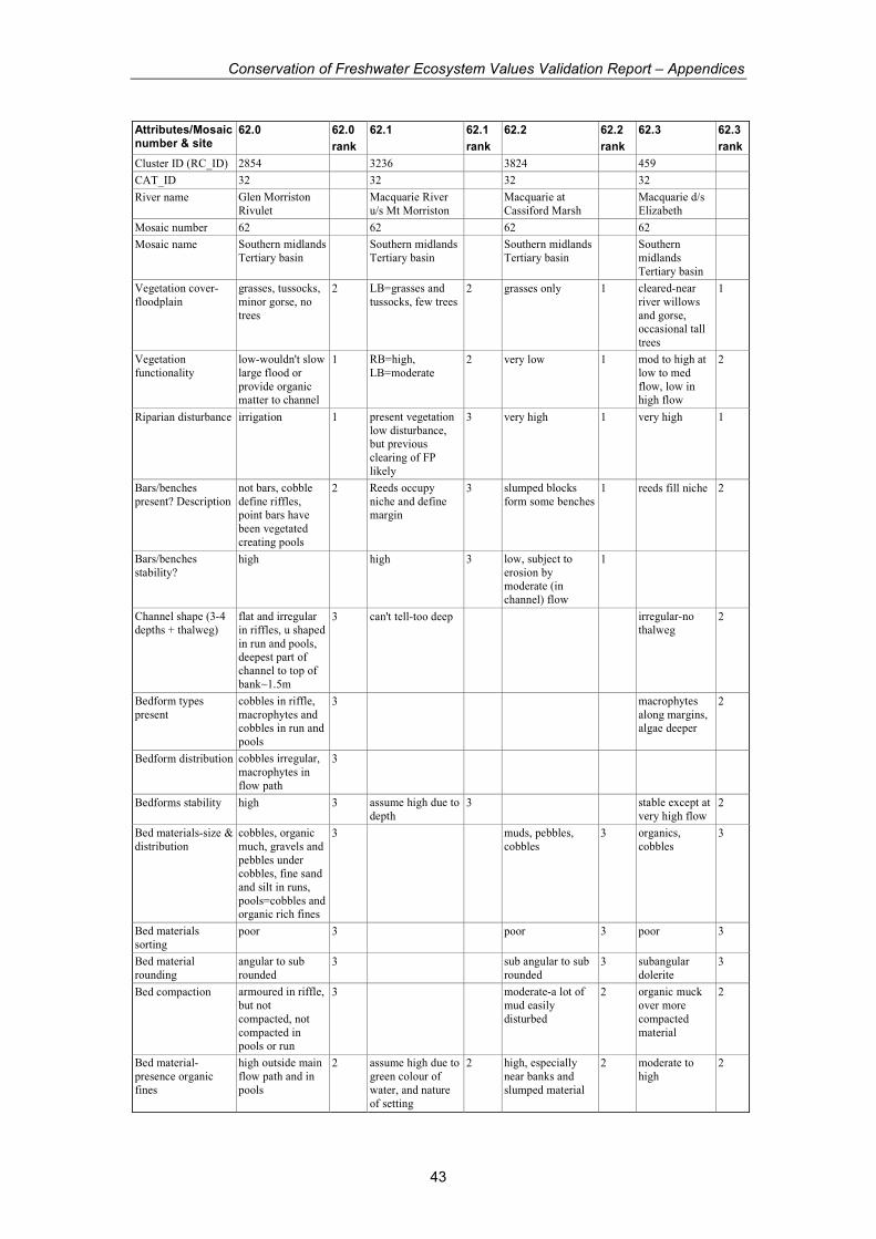
Conservation of Freshwater Ecosystem Values Validation Report – Appendices
43
Attributes/Mosaic number & site
62.0 62.0
rank
62.1 62.1
rank
62.2 62.2
rank
62.3 62.3
rank
Cluster ID (RC_ID) 2854 3236 3824 459
CAT_ID 32 32 32 32
River name Glen Morriston
Rivulet Macquarie River
u/s Mt Morriston Macquarie at
Cassiford Marsh Macquarie d/s
Elizabeth
Mosaic number 62 62 62 62
Mosaic name Southern midlands
Tertiary basin Southern midlands
Tertiary basin Southern midlands
Tertiary basin Southern
midlands
Tertiary basin
Vegetation cover-
floodplain
grasses, tussocks,
minor gorse, no
trees
2 LB=grasses and
tussocks, few trees 2 grasses only 1 cleared-near
river willows
and gorse, occasional tall
trees
1
Vegetation
functionality
low-wouldn't slow
large flood or
provide organic matter to channel
1 RB=high,
LB=moderate 2 very low 1 mod to high at
low to med
flow, low in high flow
2
Riparian disturbance irrigation 1 present vegetation
low disturbance, but previous
clearing of FP
likely
3 very high 1 very high 1
Bars/benches
present? Description
not bars, cobble
define riffles, point bars have
been vegetated
creating pools
2 Reeds occupy
niche and define margin
3 slumped blocks
form some benches 1 reeds fill niche 2
Bars/benches
stability? high high 3 low, subject to
erosion by moderate (in
channel) flow
1
Channel shape (3-4
depths + thalweg)
flat and irregular
in riffles, u shaped
in run and pools, deepest part of
channel to top of
bank~1.5m
3 can't tell-too deep irregular-no
thalweg 2
Bedform types
present
cobbles in riffle,
macrophytes and cobbles in run and
pools
3 macrophytes
along margins, algae deeper
2
Bedform distribution cobbles irregular,
macrophytes in
flow path
3
Bedforms stability high 3 assume high due to
depth 3 stable except at
very high flow 2
Bed materials-size &
distribution
cobbles, organic
much, gravels and
pebbles under cobbles, fine sand
and silt in runs,
pools=cobbles and organic rich fines
3 muds, pebbles,
cobbles 3 organics,
cobbles 3
Bed materials
sorting poor 3 poor 3 poor 3
Bed material
rounding
angular to sub
rounded 3 sub angular to sub
rounded 3 subangular
dolerite 3
Bed compaction armoured in riffle,
but not
compacted, not
compacted in pools or run
3 moderate-a lot of
mud easily
disturbed
2 organic muck
over more
compacted
material
2
Bed material-
presence organic
fines
high outside main
flow path and in
pools
2 assume high due to
green colour of
water, and nature
of setting
2 high, especially
near banks and
slumped material
2 moderate to
high 2
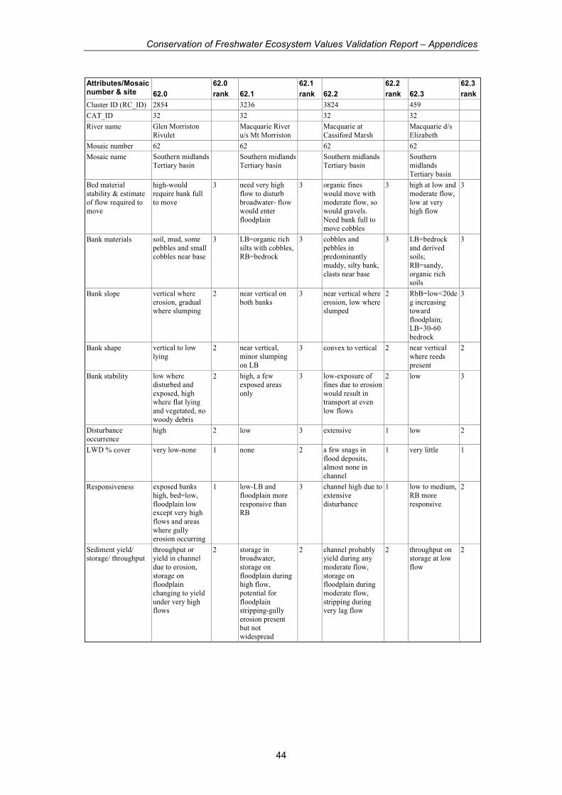
Conservation of Freshwater Ecosystem Values Validation Report – Appendices
44
Attributes/Mosaic number & site
62.0
62.0
rank
62.1
62.1
rank
62.2
62.2
rank
62.3
62.3
rank
Cluster ID (RC_ID) 2854 3236 3824 459
CAT_ID 32 32 32 32
River name Glen Morriston
Rivulet Macquarie River
u/s Mt Morriston Macquarie at
Cassiford Marsh Macquarie d/s
Elizabeth
Mosaic number 62 62 62 62
Mosaic name Southern midlands
Tertiary basin Southern midlands
Tertiary basin Southern midlands
Tertiary basin Southern
midlands
Tertiary basin
Bed material
stability & estimate
of flow required to move
high-would
require bank full
to move
3 need very high
flow to disturb
broadwater- flow would enter
floodplain
3 organic fines
would move with
moderate flow, so would gravels.
Need bank full to
move cobbles
3 high at low and
moderate flow,
low at very high flow
3
Bank materials soil, mud, some
pebbles and small cobbles near base
3 LB=organic rich
silts with cobbles, RB=bedrock
3 cobbles and
pebbles in predominantly
muddy, silty bank,
clasts near base
3 LB=bedrock
and derived soils;
RB=sandy,
organic rich soils
3
Bank slope vertical where
erosion, gradual where slumping
2 near vertical on
both banks 3 near vertical where
erosion, low where slumped
2 RbB=low<20de
g increasing toward
floodplain; LB=30-60
bedrock
3
Bank shape vertical to low
lying 2 near vertical,
minor slumping
on LB
3 convex to vertical 2 near vertical
where reeds
present
2
Bank stability low where
disturbed and
exposed, high where flat lying
and vegetated, no
woody debris
2 high, a few
exposed areas
only
3 low-exposure of
fines due to erosion
would result in transport at even
low flows
2 low 3
Disturbance
occurrence high 2 low 3 extensive 1 low 2
LWD % cover very low-none 1 none 2 a few snags in
flood deposits, almost none in
channel
1 very little 1
Responsiveness exposed banks
high, bed=low,
floodplain low except very high
flows and areas
where gully erosion occurring
1 low-LB and
floodplain more
responsive than RB
3 channel high due to
extensive
disturbance
1 low to medium,
RB more
responsive
2
Sediment yield/ storage/ throughput
throughput or yield in channel
due to erosion,
storage on floodplain
changing to yield
under very high flows
2 storage in broadwater,
storage on
floodplain during high flow,
potential for
floodplain stripping-gully
erosion present
but not widespread
2 channel probably yield during any
moderate flow,
storage on floodplain during
moderate flow,
stripping during very lag flow
2 throughput on storage at low
flow
2

Conservation of Freshwater Ecosystem Values Validation Report – Appendices
45
Attributes/Mosaic number & site
62.0 62.0
rank
62.1 62.1
rank
62.2 62.2
rank
62.3 62.3
rank
Cluster ID (RC_ID) 2854 3236 3824 459
CAT_ID 32 32 32 32
River name Glen Morriston
Rivulet Macquarie River
u/s Mt Morriston Macquarie at
Cassiford Marsh Macquarie d/s
Elizabeth
Mosaic number 62 62 62 62
Mosaic name Southern midlands
Tertiary basin Southern midlands
Tertiary basin Southern midlands
Tertiary basin Southern
midlands
Tertiary basin
Water management
issues
poor condition due
to lack of
vegetation on banks and erosion
in channel.
Erosion related to regulated flow and
lack of vegetation
Good condition
for broadwater,
but broadwater may be result of
downstream flow
alteration. It may not be natural, but
it is in relatively
good condition for a broadwater
Highly disturbed
reach, where
channel and floodplain
dysfunctional.
Additional baseflow would increase
erosion in channel,
reduction of high flows has probably
already occurred
highly modified
due to constant
flow from irrigation.
Releases have
increased bed flora and
changed
channel. In ok condition for an
artificial pool.
Inc in base flow = channel
widening on
RB; reduction in floods=inc
vegetation in
channels and margins
pH 7.6 8.01 obtained at site
2400
EC 1110 133
Temp 14.8 16.9
#indicators marked 31 25 28 30
Total possible score 93 75 84 90
Total score 74 68 54 68
normalise 0-1 0.70 0.86 0.47 0.64
GEOM from CFEV 1.00 0.45 0.47 0.46
Mosaic consistent consistent, but
influenced by MO61
consistent
Character loss of riparian
and floodplain
vegetation, and reg
of flow has altered channel
probably reach in
best condition in
cluster due to
bedrock on RB, and lack of
intensive grazing
on LB. Upstream and downstream
where bedrock is
absence, clearing is more extensive
Highly
modified
compared to
natural due to irrigation flows,
weirs, clearing.
Condition poor moderate to good
assuming site is
natural broadwater
Not in bad
condition given
highly
unnatural character
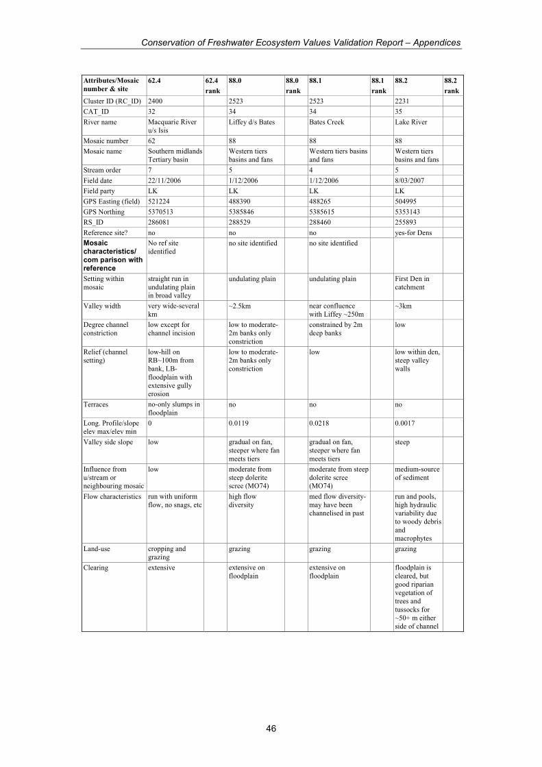
Conservation of Freshwater Ecosystem Values Validation Report – Appendices
46
Attributes/Mosaic
number & site
62.4 62.4
rank
88.0 88.0
rank
88.1 88.1
rank
88.2 88.2
rank
Cluster ID (RC_ID) 2400 2523 2523 2231
CAT_ID 32 34 34 35
River name Macquarie River
u/s Isis Liffey d/s Bates Bates Creek Lake River
Mosaic number 62 88 88 88
Mosaic name Southern midlands
Tertiary basin Western tiers
basins and fans Western tiers basins
and fans Western tiers
basins and fans
Stream order 7 5 4 5
Field date 22/11/2006 1/12/2006 1/12/2006 8/03/2007
Field party LK LK LK LK
GPS Easting (field) 521224 488390 488265 504995
GPS Northing 5370513 5385846 5385615 5353143
RS_ID 286081 288529 288460 255893
Reference site? no no no yes-for Dens
Mosaic characteristics/ com parison with reference
No ref site
identified no site identified no site identified
Setting within
mosaic
straight run in
undulating plain in broad valley
undulating plain undulating plain First Den in
catchment
Valley width very wide-several
km ~2.5km near confluence
with Liffey ~250m ~3km
Degree channel
constriction
low except for
channel incision low to moderate-
2m banks only
constriction
constrained by 2m
deep banks low
Relief (channel
setting)
low-hill on
RB~100m from
bank, LB-
floodplain with extensive gully
erosion
low to moderate-
2m banks only
constriction
low low within den,
steep valley
walls
Terraces no-only slumps in
floodplain no no no
Long. Profile/slope
elev max/elev min 0 0.0119 0.0218 0.0017
Valley side slope low gradual on fan,
steeper where fan
meets tiers
gradual on fan,
steeper where fan
meets tiers
steep
Influence from
u/stream or neighbouring mosaic
low moderate from
steep dolerite scree (MO74)
moderate from steep
dolerite scree (MO74)
medium-source
of sediment
Flow characteristics run with uniform
flow, no snags, etc high flow
diversity med flow diversity-
may have been channelised in past
run and pools,
high hydraulic variability due
to woody debris
and macrophytes
Land-use cropping and
grazing grazing grazing grazing
Clearing extensive extensive on
floodplain extensive on
floodplain floodplain is
cleared, but
good riparian
vegetation of trees and
tussocks for
~50+ m either side of channel
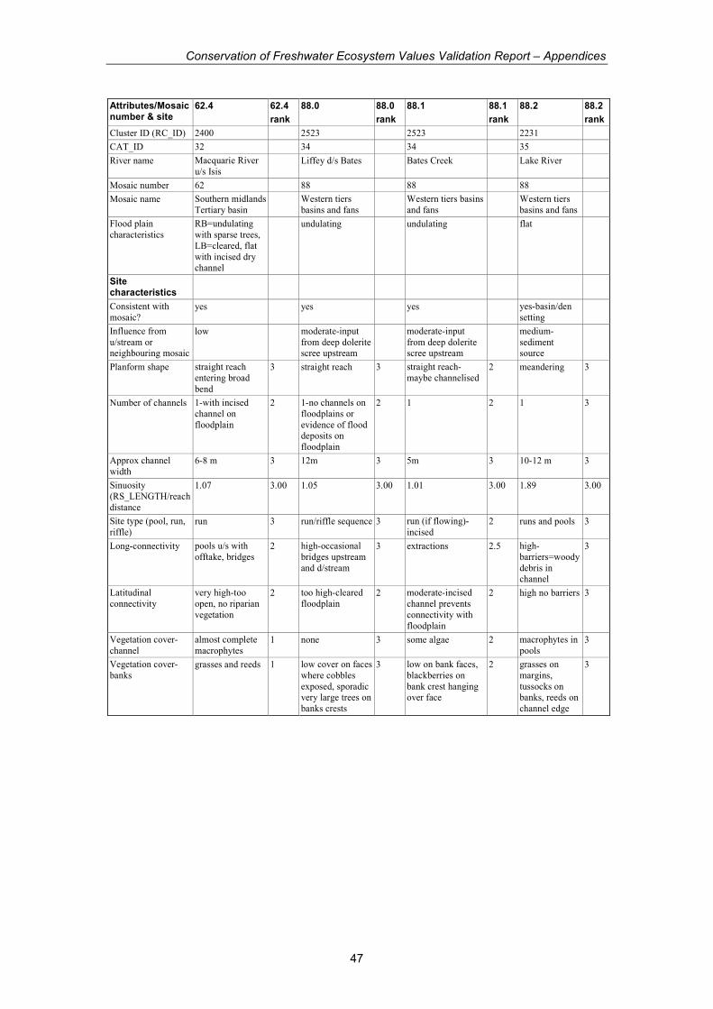
Conservation of Freshwater Ecosystem Values Validation Report – Appendices
47
Attributes/Mosaic number & site
62.4 62.4
rank
88.0 88.0
rank
88.1 88.1
rank
88.2 88.2
rank
Cluster ID (RC_ID) 2400 2523 2523 2231
CAT_ID 32 34 34 35
River name Macquarie River
u/s Isis Liffey d/s Bates Bates Creek Lake River
Mosaic number 62 88 88 88
Mosaic name Southern midlands
Tertiary basin Western tiers
basins and fans Western tiers basins
and fans Western tiers
basins and fans
Flood plain
characteristics
RB=undulating
with sparse trees,
LB=cleared, flat
with incised dry channel
undulating undulating flat
Site characteristics
Consistent with
mosaic? yes yes yes yes-basin/den
setting
Influence from
u/stream or neighbouring mosaic
low moderate-input
from deep dolerite scree upstream
moderate-input
from deep dolerite scree upstream
medium-
sediment source
Planform shape straight reach
entering broad
bend
3 straight reach 3 straight reach-
maybe channelised 2 meandering 3
Number of channels 1-with incised
channel on
floodplain
2 1-no channels on
floodplains or
evidence of flood deposits on
floodplain
2 1 2 1 3
Approx channel
width 6-8 m 3 12m 3 5m 3 10-12 m 3
Sinuosity
(RS_LENGTH/reach
distance
1.07 3.00 1.05 3.00 1.01 3.00 1.89 3.00
Site type (pool, run,
riffle) run 3 run/riffle sequence 3 run (if flowing)-
incised 2 runs and pools 3
Long-connectivity pools u/s with
offtake, bridges 2 high-occasional
bridges upstream
and d/stream
3 extractions 2.5 high-
barriers=woody
debris in channel
3
Latitudinal
connectivity
very high-too
open, no riparian
vegetation
2 too high-cleared
floodplain 2 moderate-incised
channel prevents
connectivity with
floodplain
2 high no barriers 3
Vegetation cover-
channel
almost complete
macrophytes 1 none 3 some algae 2 macrophytes in
pools 3
Vegetation cover-
banks grasses and reeds 1 low cover on faces
where cobbles
exposed, sporadic very large trees on
banks crests
3 low on bank faces,
blackberries on
bank crest hanging over face
2 grasses on
margins,
tussocks on banks, reeds on
channel edge
3
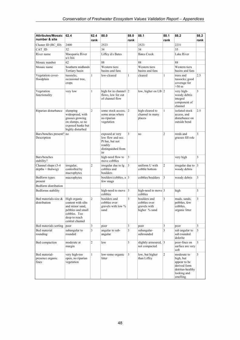
Conservation of Freshwater Ecosystem Values Validation Report – Appendices
48
Attributes/Mosaic number & site
62.4 62.4
rank
88.0 88.0
rank
88.1 88.1
rank
88.2 88.2
rank
Cluster ID (RC_ID) 2400 2523 2523 2231
CAT_ID 32 34 34 35
River name Macquarie River
u/s Isis Liffey d/s Bates Bates Creek Lake River
Mosaic number 62 88 88 88
Mosaic name Southern midlands
Tertiary basin Western tiers
basins and fans Western tiers
basins and fans Western tiers
basins and fans
Vegetation cover-
floodplain
tussocks,
occasional tree,
crops
1 low-cleared 1 cleared 1 trees and
tussocks; good
coverage for
>50 m
2.5
Vegetation
functionality very low 1 high for in channel
flows, low for out of channel flow
2 low, higher on LB 2 very high-
woody debris integral
component of
channel
3
Riparian disturbance slumping
widespread, with
grasses growing on slumps, so no
exposed banks but
highly disturbed
2 some stock access,
some areas where
no riparian vegetation
2 high-cleared to
channel in many
places
1 isolated stock
access, and
disturbance on outside bend
2.5
Bars/benches present?
Description no exposed at very
low flow and occ. Pt bar, but not
readily
distinguished from irr
3 no 2 reeds and
grasses fill role 3
Bars/benches
stability? high-need flow to
move cobbles 3 very high 3
Channel shape (3-4
depths + thalweg)
irregular,
controlled by
macrophytes
2 irregular due to lg
cobbles and
boulders
3 uniform U with
cobble bottom 2 irregular due to
woody debris 3
Bedform types
present macrophytes boulders/cobbles, a
few snags 3 cobbles/boulders 3 woody debris 3
Bedform distribution
Bedforms stability high-need to move
cobbles 3 high-need to move
cobbles 3 high 3
Bed materials-size &
distribution
High organic
content with silts and minor sand,
pebbles and small
cobbles. Too deep to reach
central channel
2 boulders and
cobbles over gravels with low %
sand
3 boulders and
cobbles over gravels with
higher % sand
3 muds, sands,
pebbles, few cobbles,
organic litter
3
Bed materials sorting poor 3 poor 3 poor 3 poor 3
Bed material
rounding
subangular to
rounded 3 angular to sub-
angular 3 subangular-
subrounded 3 sub angular to
sub rounded
dolerite
3
Bed compaction moderate at
margin 2 low 3 slightly armoured,
not compacted 3 poor-fines on
surface are very
soft
3
Bed material-
presence organic
fines
very high-too
open, no riparian
vegetation
1 low-some organic
litter 3 low, but higher
than Liffey 2 moderate to
high, but
appear to be derived form
detritus-healthy
looking and smelling
3
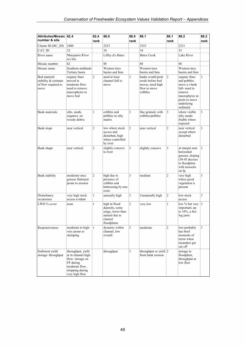
Conservation of Freshwater Ecosystem Values Validation Report – Appendices
49
Attributes/Mosaic number & site
62.4 62.4
rank
88.0 88.0
rank
88.1 88.1
rank
88.2 88.2
rank
Cluster ID (RC_ID) 2400 2523 2523 2231
CAT_ID 32 34 34 35
River name Macquarie River
u/s Isis Liffey d/s Bates Bates Creek Lake River
Mosaic number 62 88 88 88
Mosaic name Southern midlands
Tertiary basin Western tiers
basins and fans Western tiers
basins and fans Western tiers
basins and fans
Bed material
stability & estimate
of flow required to
move
organic fines
moved in
moderate flow-
need to remove macrophytes to
move bed
2 need at least
channel full to
move
3 banks would prob
erode before bed
moves, need high
flow to move cobbles
2 organic fines
and pebbles
move a t bank
full- need to remove
macrophytes in
pools to move underlying
sediment
3
Bank materials silts, sands,
organics, no
woody debris
1 cobbles and
pebbles in silty
matrix
3 fine grained, with
cobbles/pebbles 3 where visible
silty sands-
friable where exposed
3
Bank slope near vertical 2 low where stock
access and disturbed, high
where controlled by river
2 near vertical 2 near vertical
except where disturbed
3
Bank shape near vertical 2 slightly concave
to river 3 slightly concave 3 at margin near
horizontal grasses, sloping
(30-45 decrees
to floodplain with tussocks
on fp.
3
Bank stability moderate-once
grasses flattened
prone to erosion
2 high due to
presence of
cobbles and buttressing by tree
roots
3 medium 2 very high
where good
vegetation is present
3
Disturbance
occurrence
very high stock
access evident 1 naturally high 3 Unnaturally high 2 low-stock
access 3
LWD % cover none 1 high in flood
deposits, some
snags, lower than natural due to
cleared
floodplains
2 very low 1 low % but very
important; up
to 10%, a few log jams
3
Responsiveness moderate to high-
very prone to slumping
1 dynamic within
channel, low overall
3 moderate 2 low-probably
has brief moments of
terror when
meanders get cut off
3
Sediment yield/
storage/ throughput
throughput, yield
at in channel high
flow- storage on
FP during moderate flow,
stripping during
very high flow
throughput 3 throughput or yield
from bank erosion 2 storage in
floodplain,
throughput at
low flow

Conservation of Freshwater Ecosystem Values Validation Report – Appendices
50
Attributes/Mosaic number & site
62.4 62.4
rank
88.0 88.0
rank
88.1 88.1
rank
88.2 88.2
rank
Cluster ID (RC_ID) 2400 2523 2523 2231
CAT_ID 32 34 34 35
River name Macquarie River
u/s Isis Liffey d/s Bates Bates Creek Lake River
Mosaic number 62 88 88 88
Mosaic name Southern midlands
Tertiary basin Western tiers
basins and fans Western tiers
basins and fans Western tiers
basins and fans
Water management
issues
Channel prone to
erosion due to
over steepening of
banks from incision. Increased
base flow=channel
widening, decrease
floods=inc
vegetation
channel condition
okay, clearing of
floodplain is
issue. Channel would be prone to
narrowing with
reduced flows. Increased
baseflows might
erode some areas of lower bank, but
discontinuous
very poor condition
due to clearing, and
possibly
channelisation, changes to flow
would widen or
narrow-less robust than Liffey due to
greater disturbance,
and higher incision.
Incision prob
linked to floodplain
clearing
Very important
to maintain
channel and
floodplain; pools relatively
insensitive to
flow changes as long as
continue to
flow and support
macrophytes;
woody debris input form
floodplain
critical;
pH 7.24 7.04 no flow 6.4
EC 408 53 89
Temp 18.3 18.6 14.4
#indicators marked 26 31 30 30
Total possible score 78 93 90 90
Total score 49 85 67.5 89
normalise 0-1 0.45 0.87 0.63 0.98
GEOM from CFEV 0.44 1.00 1.00 0.39
Mosaic consistent consistent consistent with
den setting
Character very high
quality character
relative to what else exists in
State
Condition very good
condition
except for areas
where stock access
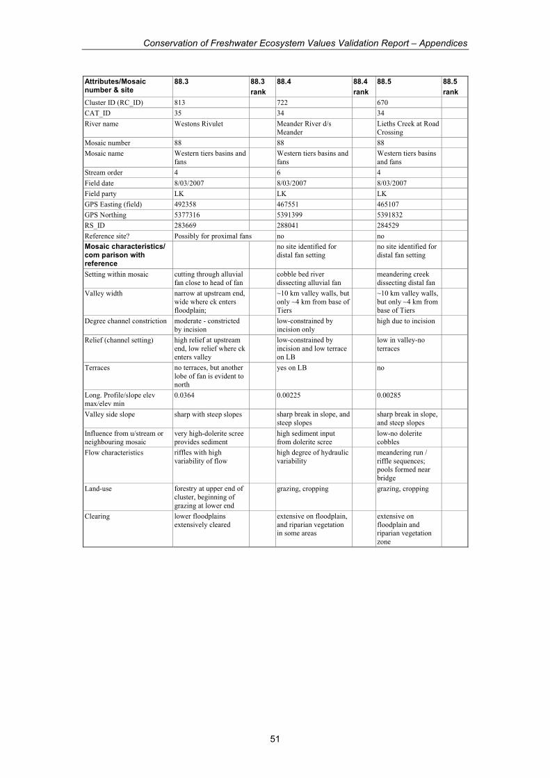
Conservation of Freshwater Ecosystem Values Validation Report – Appendices
51
Attributes/Mosaic number & site
88.3 88.3
rank
88.4 88.4
rank
88.5 88.5
rank
Cluster ID (RC_ID) 813 722 670
CAT_ID 35 34 34
River name Westons Rivulet Meander River d/s
Meander Lieths Creek at Road
Crossing
Mosaic number 88 88 88
Mosaic name Western tiers basins and
fans Western tiers basins and
fans Western tiers basins
and fans
Stream order 4 6 4
Field date 8/03/2007 8/03/2007 8/03/2007
Field party LK LK LK
GPS Easting (field) 492358 467551 465107
GPS Northing 5377316 5391399 5391832
RS_ID 283669 288041 284529
Reference site? Possibly for proximal fans no no
Mosaic characteristics/ com parison with reference
no site identified for
distal fan setting no site identified for
distal fan setting
Setting within mosaic cutting through alluvial
fan close to head of fan cobble bed river
dissecting alluvial fan meandering creek
dissecting distal fan
Valley width narrow at upstream end,
wide where ck enters
floodplain;
~10 km valley walls, but
only ~4 km from base of
Tiers
~10 km valley walls,
but only ~4 km from
base of Tiers
Degree channel constriction moderate - constricted
by incision low-constrained by
incision only high due to incision
Relief (channel setting) high relief at upstream
end, low relief where ck
enters valley
low-constrained by
incision and low terrace
on LB
low in valley-no
terraces
Terraces no terraces, but another
lobe of fan is evident to north
yes on LB no
Long. Profile/slope elev
max/elev min 0.0364 0.00225 0.00285
Valley side slope sharp with steep slopes sharp break in slope, and
steep slopes sharp break in slope,
and steep slopes
Influence from u/stream or
neighbouring mosaic
very high-dolerite scree
provides sediment high sediment input
from dolerite scree low-no dolerite
cobbles
Flow characteristics riffles with high
variability of flow high degree of hydraulic
variability meandering run /
riffle sequences; pools formed near
bridge
Land-use forestry at upper end of
cluster, beginning of
grazing at lower end
grazing, cropping grazing, cropping
Clearing lower floodplains
extensively cleared extensive on floodplain,
and riparian vegetation in some areas
extensive on
floodplain and riparian vegetation
zone
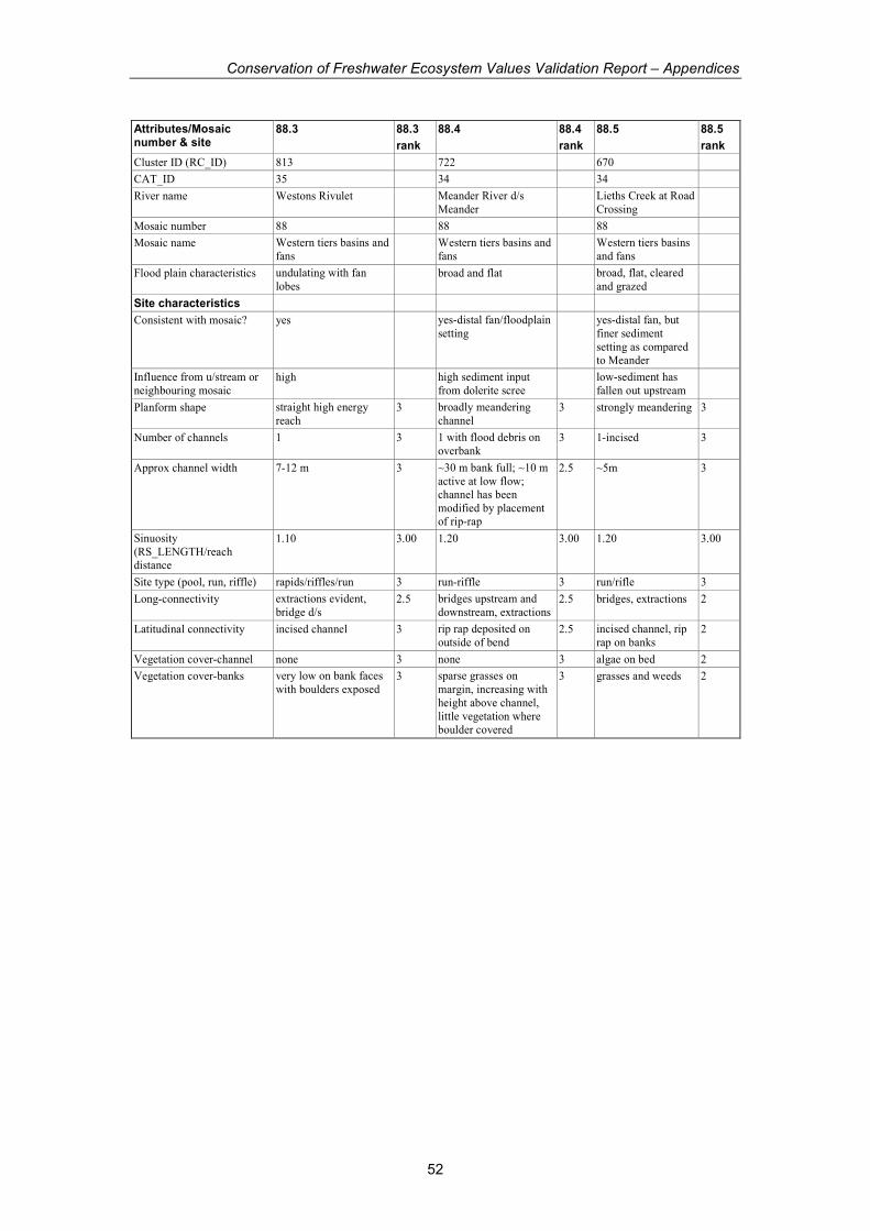
Conservation of Freshwater Ecosystem Values Validation Report – Appendices
52
Attributes/Mosaic number & site
88.3 88.3
rank
88.4 88.4
rank
88.5 88.5
rank
Cluster ID (RC_ID) 813 722 670
CAT_ID 35 34 34
River name Westons Rivulet Meander River d/s
Meander Lieths Creek at Road
Crossing
Mosaic number 88 88 88
Mosaic name Western tiers basins and
fans Western tiers basins and
fans Western tiers basins
and fans
Flood plain characteristics undulating with fan
lobes broad and flat broad, flat, cleared
and grazed
Site characteristics
Consistent with mosaic? yes yes-distal fan/floodplain
setting yes-distal fan, but
finer sediment
setting as compared to Meander
Influence from u/stream or
neighbouring mosaic high high sediment input
from dolerite scree low-sediment has
fallen out upstream
Planform shape straight high energy
reach 3 broadly meandering
channel 3 strongly meandering 3
Number of channels 1 3 1 with flood debris on
overbank 3 1-incised 3
Approx channel width 7-12 m 3 ~30 m bank full; ~10 m
active at low flow; channel has been
modified by placement of rip-rap
2.5 ~5m 3
Sinuosity
(RS_LENGTH/reach distance
1.10 3.00 1.20 3.00 1.20 3.00
Site type (pool, run, riffle) rapids/riffles/run 3 run-riffle 3 run/rifle 3
Long-connectivity extractions evident,
bridge d/s 2.5 bridges upstream and
downstream, extractions 2.5 bridges, extractions 2
Latitudinal connectivity incised channel 3 rip rap deposited on
outside of bend 2.5 incised channel, rip
rap on banks 2
Vegetation cover-channel none 3 none 3 algae on bed 2
Vegetation cover-banks very low on bank faces
with boulders exposed 3 sparse grasses on
margin, increasing with
height above channel,
little vegetation where boulder covered
3 grasses and weeds 2
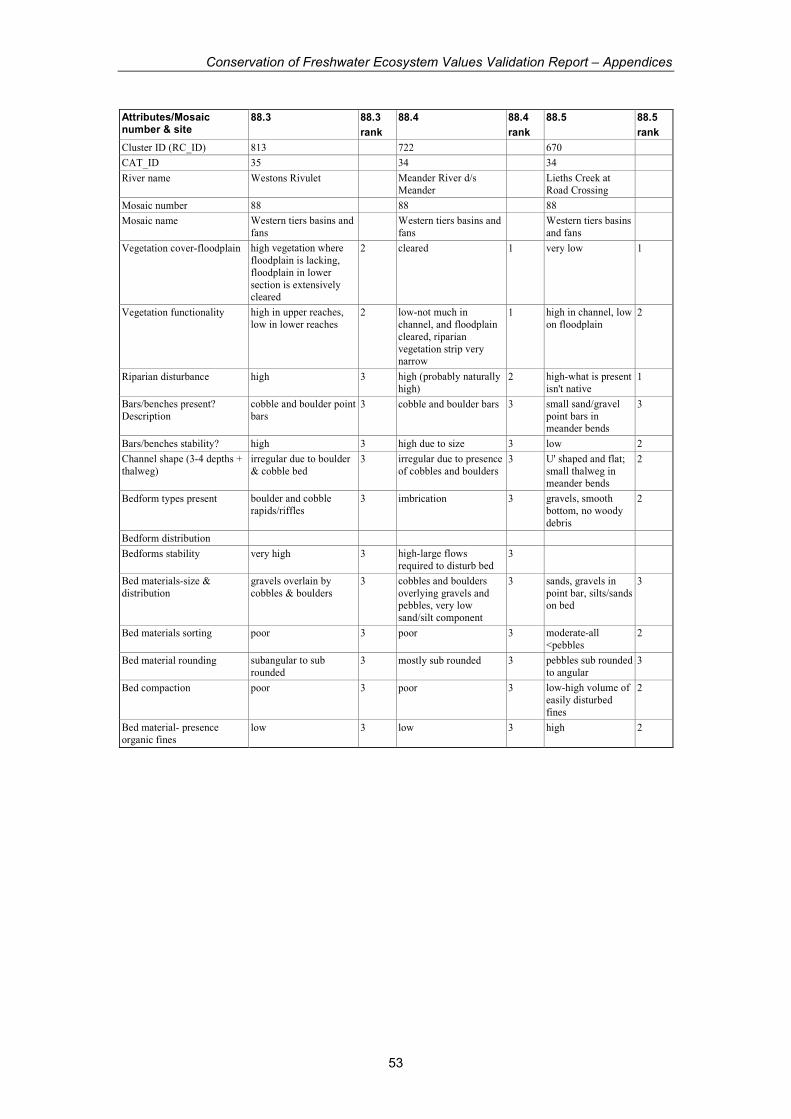
Conservation of Freshwater Ecosystem Values Validation Report – Appendices
53
Attributes/Mosaic number & site
88.3 88.3
rank
88.4 88.4
rank
88.5 88.5
rank
Cluster ID (RC_ID) 813 722 670
CAT_ID 35 34 34
River name Westons Rivulet Meander River d/s
Meander Lieths Creek at
Road Crossing
Mosaic number 88 88 88
Mosaic name Western tiers basins and
fans Western tiers basins and
fans Western tiers basins
and fans
Vegetation cover-floodplain high vegetation where
floodplain is lacking,
floodplain in lower
section is extensively cleared
2 cleared 1 very low 1
Vegetation functionality high in upper reaches,
low in lower reaches 2 low-not much in
channel, and floodplain
cleared, riparian
vegetation strip very narrow
1 high in channel, low
on floodplain 2
Riparian disturbance high 3 high (probably naturally
high) 2 high-what is present
isn't native 1
Bars/benches present?
Description
cobble and boulder point
bars 3 cobble and boulder bars 3 small sand/gravel
point bars in meander bends
3
Bars/benches stability? high 3 high due to size 3 low 2
Channel shape (3-4 depths +
thalweg)
irregular due to boulder
& cobble bed 3 irregular due to presence
of cobbles and boulders 3 U' shaped and flat;
small thalweg in meander bends
2
Bedform types present boulder and cobble
rapids/riffles 3 imbrication 3 gravels, smooth
bottom, no woody
debris
2
Bedform distribution
Bedforms stability very high 3 high-large flows
required to disturb bed 3
Bed materials-size &
distribution
gravels overlain by
cobbles & boulders 3 cobbles and boulders
overlying gravels and pebbles, very low
sand/silt component
3 sands, gravels in
point bar, silts/sands on bed
3
Bed materials sorting poor 3 poor 3 moderate-all
<pebbles 2
Bed material rounding subangular to sub
rounded 3 mostly sub rounded 3 pebbles sub rounded
to angular 3
Bed compaction poor 3 poor 3 low-high volume of
easily disturbed
fines
2
Bed material- presence
organic fines low 3 low 3 high 2
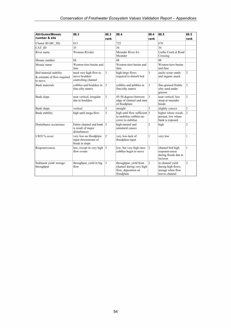
Conservation of Freshwater Ecosystem Values Validation Report – Appendices
54
Attributes/Mosaic number & site
88.3 88.3
rank
88.4 88.4
rank
88.5 88.5
rank
Cluster ID (RC_ID) 813 722 670
CAT_ID 35 34 34
River name Westons Rivulet Meander River d/s
Meander Lieths Creek at Road
Crossing
Mosaic number 88 88 88
Mosaic name Western tiers basins and
fans Western tiers basins and
fans Western tiers basins
and fans
Bed material stability
& estimate of flow required
to move
need very high flow to
move boulders
controlling channel
3 high-large flows
required to disturb bed 3 easily scour sands
and organic muck 2
Bank materials cobbles and boulders in
fine-silty matrix 3 cobbles and pebbles in
fine/silty matrix 3 fine-grained friable
silty sand under grasses
3
Bank slope near vertical, irregular
due to boulders 3 45-50 degrees between
edge of channel and start of floodplain
3 near vertical, less
steep at meander bends
2
Bank shape vertical 3 straight 3 slightly convex 2
Bank stability high until mega-flow 3 high until flow sufficient
to mobilise cobbles-no cover to stabilise
3 higher where weeds
present, low where bank is exposed
2
Disturbance occurrence Entire channel and bank
is result of major
disturbances
3 high-natural and
unnatural causes 2 high 2
LWD % cover very low-no floodplain
input downstream of
break in slope
2 very low-lack of
floodplain input 1 very low 1
Responsiveness low, except in very high
flow events 3 low, but very high once
cobbles begin to move 3 channel bed high
responsiveness
during floods due to incision
1
Sediment yield/ storage/
throughput
throughput, yield in big
flow 3 throughput, yield from
channel during very high
flow, deposition on
floodplain
2 in channel yield
during high flows,
storage when flow
leaves channel
2

Conservation of Freshwater Ecosystem Values Validation Report – Appendices
55
Attributes/Mosaic number & site
88.3 88.3
rank
88.4 88.4
rank
88.5 88.5
rank
Cluster ID (RC_ID) 813 722 670
CAT_ID 35 34 34
River name Westons Rivulet Meander River d/s
Meander Lieths Creek at Road
Crossing
Mosaic number 88 88 88
Mosaic name Western tiers basins and
fans Western tiers basins and
fans Western tiers basins
and fans
Water management issues Most of cluster wouldn't
respond much to flow
changes- possibly some
channel widening; where valley broadens,
removing sed from
damming would result in wide scale erosion
(similar to Meander
scenario)
Floodplain is highly
altered, lack of
vegetation will lead o
high rates of erosion once dam is operating
upstream
river in very poor
geomorph condition
due to clearing of
floodplain and channel incision,
lack of WD. Low
water flows likely to be
affecting water
quality
pH 6.55 6.53
EC 40 42
Temp 15.8 18.6
#indicators marked 31 31 30
Total possible score 93 93 90
Total score 89.5 82.5 65
normalise 0-1 0.94 0.83 0.59
GEOM from CFEV 1.00 1.00 0.75
Mosaic consistent with alluvial
fan setting consistent with distal
alluvial fan/floodplain
setting
consistent with distal
alluvial
fan/floodplain setting, but lacking
cobbles
Character medium to high
character-some changes
due to clearing of
floodplain at downstream end, and
forestry activities at upstream end of cluster
medium-clearing of
floodplain and alteration
to channel
medium to poor-
clearing and
channelising has
altered nature of river
Condition good until floodplain
opens up & clearing is widespread
moderate poor

Conservation of Freshwater Ecosystem Values Validation Report – Appendices
56
Appendix 2. Riparian Vegetation Condition Assessment field sheet and attribute scores
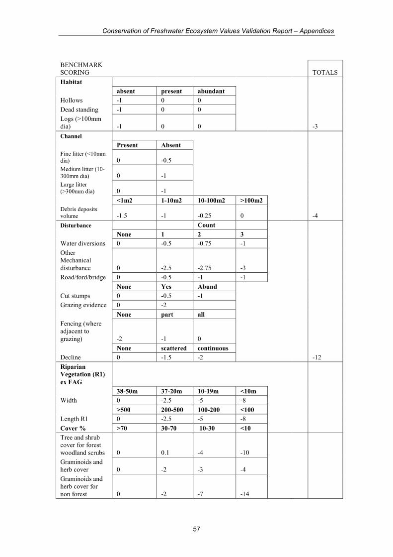
Conservation of Freshwater Ecosystem Values Validation Report – Appendices
57
BENCHMARK
SCORING TOTALS
Habitat
absent present abundant
Hollows -1 0 0
Dead standing -1 0 0
Logs (>100mm
dia) -1 0 0 -3
Channel
Present Absent
Fine litter (<10mm
dia) 0 -0.5
Medium litter (10-
300mm dia) 0 -1
Large litter
(>300mm dia) 0 -1
<1m2 1-10m2 10-100m2 >100m2
Debris deposits
volume -1.5 -1 -0.25 0 -4
Disturbance Count
None 1 2 3
Water diversions 0 -0.5 -0.75 -1
Other
Mechanical
disturbance 0 -2.5 -2.75 -3
Road/ford/bridge 0 -0.5 -1 -1
None Yes Abund
Cut stumps 0 -0.5 -1
Grazing evidence 0 -2
None part all
Fencing (where
adjacent to
grazing) -2 -1 0
None scattered continuous
Decline 0 -1.5 -2 -12
Riparian
Vegetation (R1)
ex FAG
38-50m 37-20m 10-19m <10m
Width 0 -2.5 -5 -8
>500 200-500 100-200 <100
Length R1 0 -2.5 -5 -8
Cover % >70 30-70 10-30 <10
Tree and shrub
cover for forest
woodland scrubs 0 0.1 -4 -10
Graminoids and
herb cover 0 -2 -3 -4
Graminoids and
herb cover for
non forest 0 -2 -7 -14
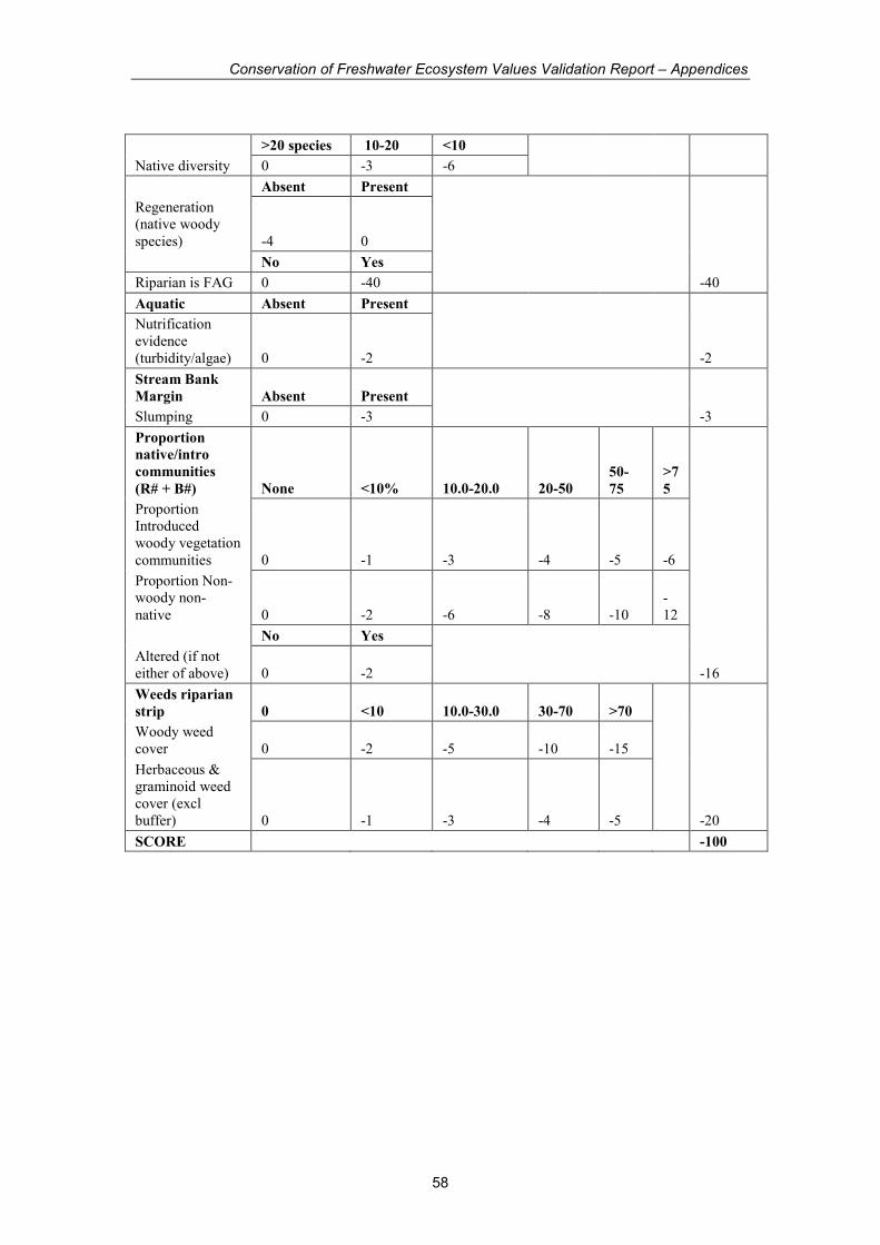
Conservation of Freshwater Ecosystem Values Validation Report – Appendices
58
>20 species 10-20 <10
Native diversity 0 -3 -6
Absent Present
Regeneration
(native woody
species) -4 0
No Yes
Riparian is FAG 0 -40 -40
Aquatic Absent Present
Nutrification
evidence
(turbidity/algae) 0 -2 -2
Stream Bank
Margin Absent Present
Slumping 0 -3 -3
Proportion
native/intro
communities
(R# + B#) None <10% 10.0-20.0 20-50
50-
75
>7
5
Proportion
Introduced
woody vegetation
communities 0 -1 -3 -4 -5 -6
Proportion Non-
woody non-
native 0 -2 -6 -8 -10
-
12
No Yes
Altered (if not
either of above) 0 -2 -16
Weeds riparian
strip 0 <10 10.0-30.0 30-70 >70
Woody weed
cover 0 -2 -5 -10 -15
Herbaceous &
graminoid weed
cover (excl
buffer) 0 -1 -3 -4 -5 -20
SCORE -100
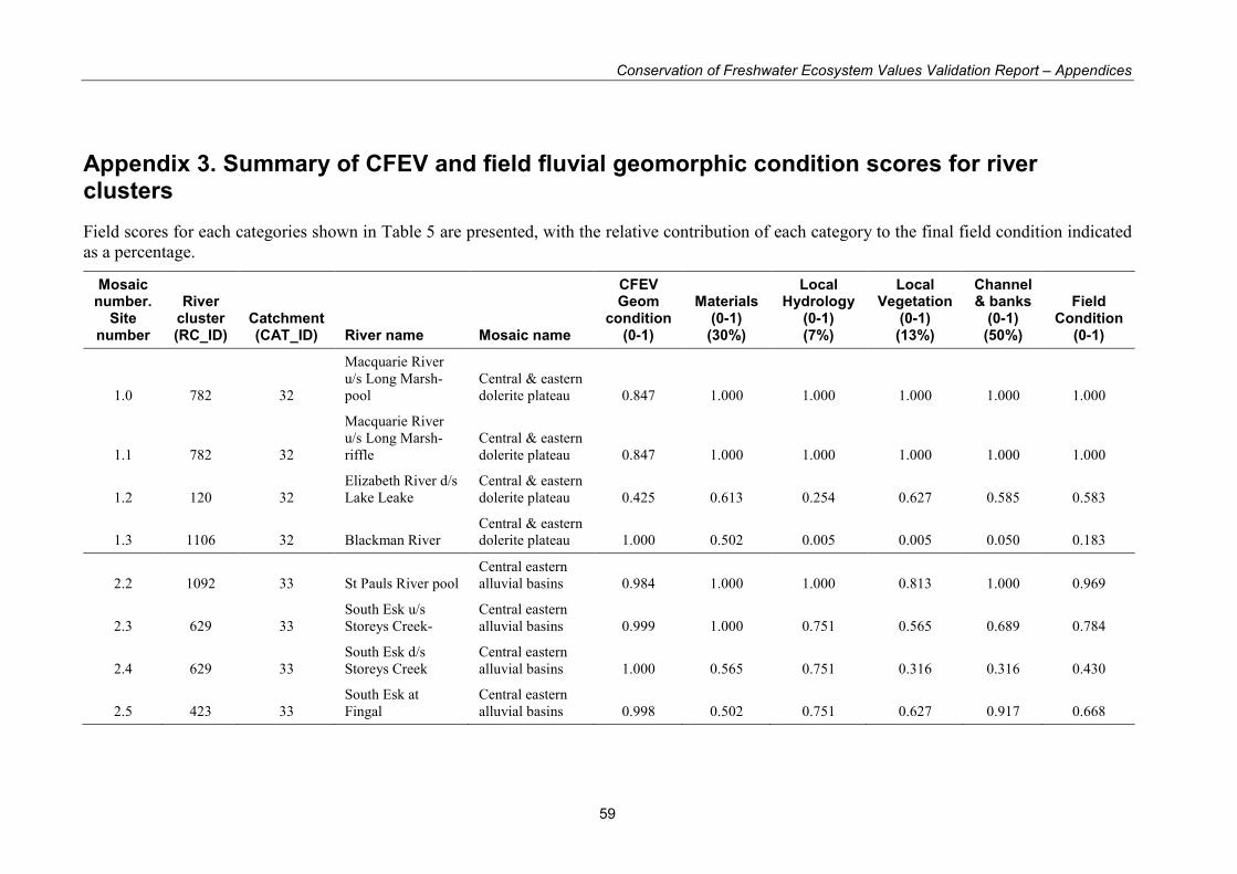
Conservation of Freshwater Ecosystem Values Validation Report – Appendices
59
Appendix 3. Summary of CFEV and field fluvial geomorphic condition scores for river clusters
Field scores for each categories shown in Table 5 are presented, with the relative contribution of each category to the final field condition indicated
as a percentage.
Mosaic number.
Site number
River cluster (RC_ID)
Catchment (CAT_ID) River name Mosaic name
CFEV Geom
condition (0-1)
Materials (0-1) (30%)
Local Hydrology
(0-1) (7%)
Local Vegetation
(0-1) (13%)
Channel & banks
(0-1) (50%)
Field Condition
(0-1)
1.0 782 32
Macquarie River
u/s Long Marsh-
pool
Central & eastern
dolerite plateau 0.847 1.000 1.000 1.000 1.000 1.000
1.1 782 32
Macquarie River
u/s Long Marsh-
riffle
Central & eastern
dolerite plateau 0.847 1.000 1.000 1.000 1.000 1.000
1.2 120 32
Elizabeth River d/s
Lake Leake
Central & eastern
dolerite plateau 0.425 0.613 0.254 0.627 0.585 0.583
1.3 1106 32 Blackman River
Central & eastern
dolerite plateau 1.000 0.502 0.005 0.005 0.050 0.183
2.2 1092 33 St Pauls River pool
Central eastern
alluvial basins 0.984 1.000 1.000 0.813 1.000 0.969
2.3 629 33
South Esk u/s
Storeys Creek-
Central eastern
alluvial basins 0.999 1.000 0.751 0.565 0.689 0.784
2.4 629 33
South Esk d/s
Storeys Creek
Central eastern
alluvial basins 1.000 0.565 0.751 0.316 0.316 0.430
2.5 423 33
South Esk at
Fingal
Central eastern
alluvial basins 0.998 0.502 0.751 0.627 0.917 0.668
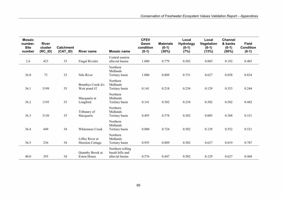
Conservation of Freshwater Ecosystem Values Validation Report – Appendices
60
Mosaic number.
Site number
River cluster (RC_ID)
Catchment (CAT_ID) River name Mosaic name
CFEV Geom
condition (0-1)
Materials (0-1) (30%)
Local Hydrology
(0-1) (7%)
Local Vegetation
(0-1) (13%)
Channel & banks
(0-1) (50%)
Field Condition
(0-1)
2.6 423 33 Fingal Rivulet
Central eastern
alluvial basins 1.000 0.779 0.502 0.005 0.192 0.403
36.0 73 33 Nile River
Northern
Midlands
Tertiary basin 1.000 0.889 0.751 0.627 0.858 0.834
36.1 3199 35
Brumbys Creek d/s
Weir pond #2
Northern
Midlands
Tertiary basin 0.141 0.218 0.254 0.129 0.353 0.244
36.2 1195 35
Macquarie at
Longford
Northern
Midlands
Tertiary basin 0.141 0.502 0.254 0.502 0.502 0.482
36.3 3130 35
Tributary of
Macquarie
Northern
Midlands
Tertiary basin 0.495 0.378 0.502 0.005 0.388 0.331
36.4 449 34 Whitemore Creek
Northern
Midlands
Tertiary basin 0.800 0.724 0.502 0.129 0.552 0.521
36.5 236 34
Liffey River at
Moreton Cottage
Northern
Midlands
Tertiary basin 0.955 0.889 0.502 0.627 0.819 0.787
40.0 393 34
Quamby Brook at
Exton House
Northern rolling
basalt hills and
alluvial basins 0.576 0.447 0.502 0.129 0.627 0.468
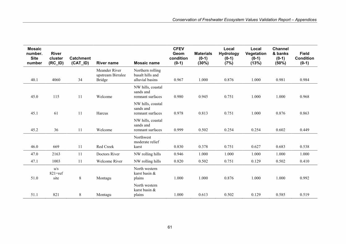
Conservation of Freshwater Ecosystem Values Validation Report – Appendices
61
Mosaic number.
Site number
River cluster (RC_ID)
Catchment (CAT_ID) River name Mosaic name
CFEV Geom
condition (0-1)
Materials (0-1) (30%)
Local Hydrology
(0-1) (7%)
Local Vegetation
(0-1) (13%)
Channel & banks
(0-1) (50%)
Field Condition
(0-1)
40.1 4060 34
Meander River
upstream Birralee
Bridge
Northern rolling
basalt hills and
alluvial basins 0.967 1.000 0.876 1.000 0.981 0.984
45.0 115 11 Welcome
NW hills, coastal
sands and
remnant surfaces 0.980 0.945 0.751 1.000 1.000 0.968
45.1 61 11 Harcus
NW hills, coastal
sands and
remnant surfaces 0.978 0.813 0.751 1.000 0.876 0.863
45.2 36 11 Welcome
NW hills, coastal
sands and
remnant surfaces 0.999 0.502 0.254 0.254 0.602 0.449
46.0 669 11 Red Creek
Northwest
moderate relief
karst 0.830 0.378 0.751 0.627 0.683 0.538
47.0 2163 11 Doctors River NW rolling hills 0.946 1.000 1.000 1.000 1.000 1.000
47.1 1003 11 Welcome River NW rolling hills 0.820 0.502 0.751 0.129 0.502 0.410
51.0
u/s
821=ref
site 8 Montagu
North western
karst basin &
plains 1.000 1.000 0.876 1.000 1.000 0.992
51.1 821 8 Montagu
North western
karst basin &
plains 1.000 0.613 0.502 0.129 0.585 0.519
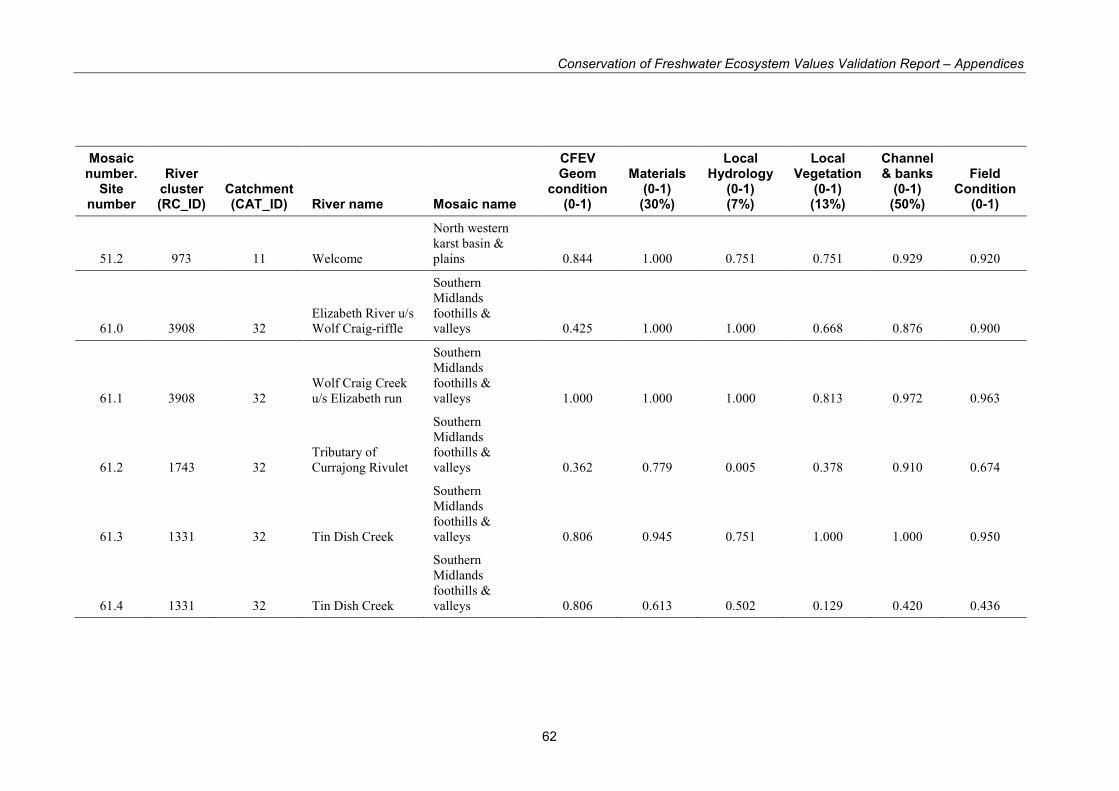
Conservation of Freshwater Ecosystem Values Validation Report – Appendices
62
Mosaic number.
Site number
River cluster (RC_ID)
Catchment (CAT_ID) River name Mosaic name
CFEV Geom
condition (0-1)
Materials (0-1) (30%)
Local Hydrology
(0-1) (7%)
Local Vegetation
(0-1) (13%)
Channel & banks
(0-1) (50%)
Field Condition
(0-1)
51.2 973 11 Welcome
North western
karst basin &
plains 0.844 1.000 0.751 0.751 0.929 0.920
61.0 3908 32
Elizabeth River u/s
Wolf Craig-riffle
Southern
Midlands
foothills &
valleys 0.425 1.000 1.000 0.668 0.876 0.900
61.1 3908 32
Wolf Craig Creek
u/s Elizabeth run
Southern
Midlands
foothills &
valleys 1.000 1.000 1.000 0.813 0.972 0.963
61.2 1743 32
Tributary of
Currajong Rivulet
Southern
Midlands
foothills &
valleys 0.362 0.779 0.005 0.378 0.910 0.674
61.3 1331 32 Tin Dish Creek
Southern
Midlands
foothills &
valleys 0.806 0.945 0.751 1.000 1.000 0.950
61.4 1331 32 Tin Dish Creek
Southern
Midlands
foothills &
valleys 0.806 0.613 0.502 0.129 0.420 0.436
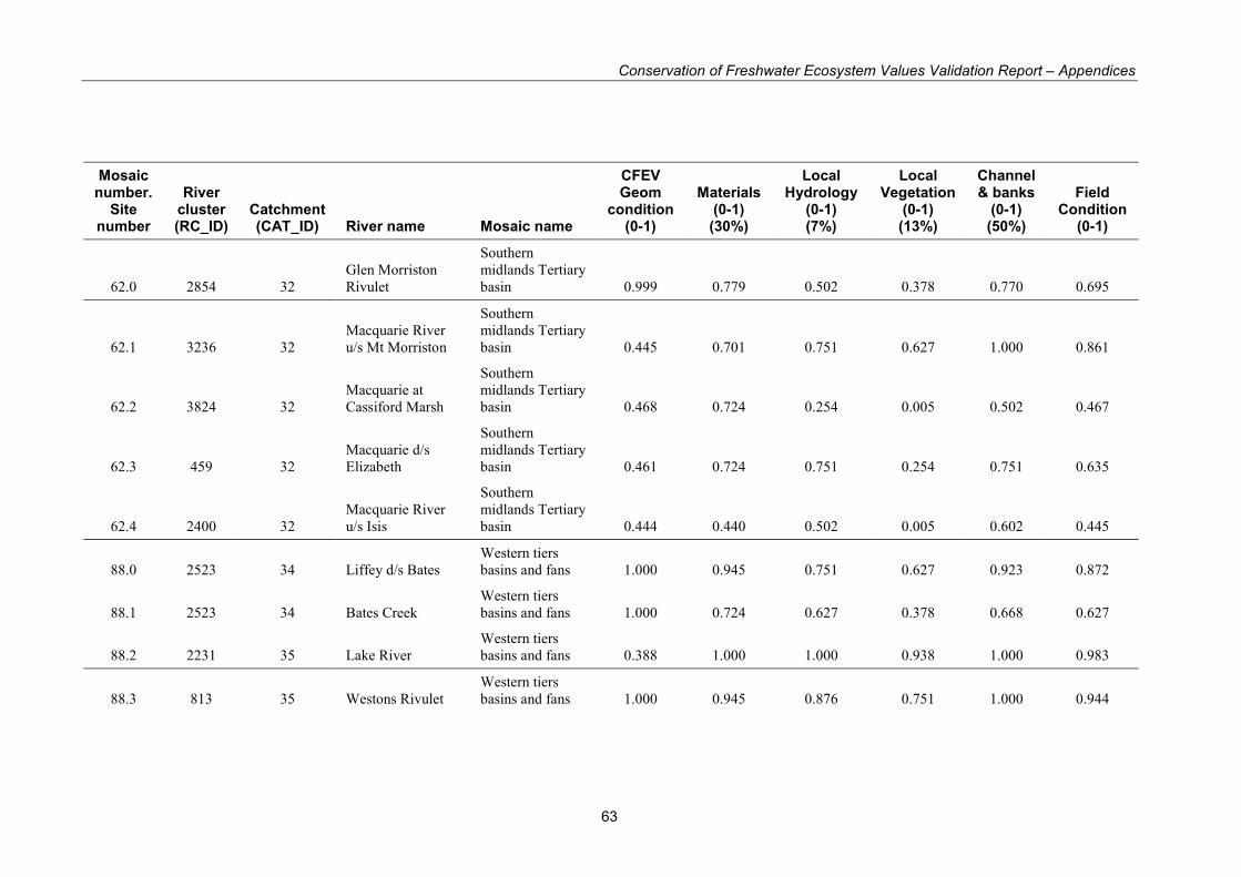
Conservation of Freshwater Ecosystem Values Validation Report – Appendices
63
Mosaic number.
Site number
River cluster (RC_ID)
Catchment (CAT_ID) River name Mosaic name
CFEV Geom
condition (0-1)
Materials (0-1) (30%)
Local Hydrology
(0-1) (7%)
Local Vegetation
(0-1) (13%)
Channel & banks
(0-1) (50%)
Field Condition
(0-1)
62.0 2854 32
Glen Morriston
Rivulet
Southern
midlands Tertiary
basin 0.999 0.779 0.502 0.378 0.770 0.695
62.1 3236 32
Macquarie River
u/s Mt Morriston
Southern
midlands Tertiary
basin 0.445 0.701 0.751 0.627 1.000 0.861
62.2 3824 32
Macquarie at
Cassiford Marsh
Southern
midlands Tertiary
basin 0.468 0.724 0.254 0.005 0.502 0.467
62.3 459 32
Macquarie d/s
Elizabeth
Southern
midlands Tertiary
basin 0.461 0.724 0.751 0.254 0.751 0.635
62.4 2400 32
Macquarie River
u/s Isis
Southern
midlands Tertiary
basin 0.444 0.440 0.502 0.005 0.602 0.445
88.0 2523 34 Liffey d/s Bates
Western tiers
basins and fans 1.000 0.945 0.751 0.627 0.923 0.872
88.1 2523 34 Bates Creek
Western tiers
basins and fans 1.000 0.724 0.627 0.378 0.668 0.627
88.2 2231 35 Lake River
Western tiers
basins and fans 0.388 1.000 1.000 0.938 1.000 0.983
88.3 813 35 Westons Rivulet
Western tiers
basins and fans 1.000 0.945 0.876 0.751 1.000 0.944
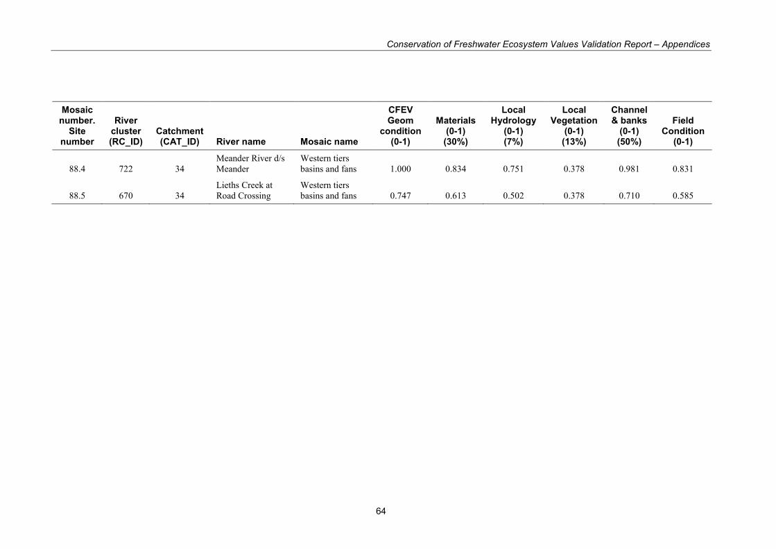
Conservation of Freshwater Ecosystem Values Validation Report – Appendices
64
Mosaic number.
Site number
River cluster (RC_ID)
Catchment (CAT_ID) River name Mosaic name
CFEV Geom
condition (0-1)
Materials (0-1) (30%)
Local Hydrology
(0-1) (7%)
Local Vegetation
(0-1) (13%)
Channel & banks
(0-1) (50%)
Field Condition
(0-1)
88.4 722 34
Meander River d/s
Meander
Western tiers
basins and fans 1.000 0.834 0.751 0.378 0.981 0.831
88.5 670 34
Lieths Creek at
Road Crossing
Western tiers
basins and fans 0.747 0.613 0.502 0.378 0.710 0.585
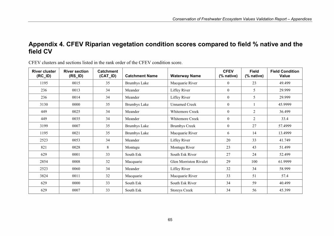
Conservation of Freshwater Ecosystem Values Validation Report – Appendices
65
Appendix 4. CFEV Riparian vegetation condition scores compared to field % native and the field CV
CFEV clusters and sections listed in the rank order of the CFEV condition score.
River cluster (RC_ID)
River section (RS_ID)
Catchment (CAT_ID) Catchment Name Waterway Name
CFEV (% native)
Field (% native)
Field Condition Value
1195 0015 35 Brumbys Lake Macquarie River 0 23 49.499
236 0013 34 Meander Liffey River 0 5 29.999
236 0014 34 Meander Liffey River 0 5 29.999
3130 0000 35 Brumbys Lake Unnamed Creek 0 1 45.9999
449 0025 34 Meander Whitemore Creek 0 2 36.499
449 0035 34 Meander Whitemore Creek 0 2 33.4
3199 0007 35 Brumbys Lake Brumbys Creek 0 27 57.4999
1195 0021 35 Brumbys Lake Macquarie River 6 14 13.4999
2523 0053 34 Meander Liffey River 20 33 41.749
821 0028 8 Montagu Montagu River 23 43 51.499
629 0001 33 South Esk South Esk River 27 24 52.499
2854 0008 32 Macquarie Glen Morriston Rivulet 29 100 61.9999
2523 0060 34 Meander Liffey River 32 34 58.999
3824 0011 32 Macquarie Macquarie River 33 51 57.4
629 0000 33 South Esk South Esk River 34 59 40.499
629 0007 33 South Esk Storeys Creek 34 56 45.399
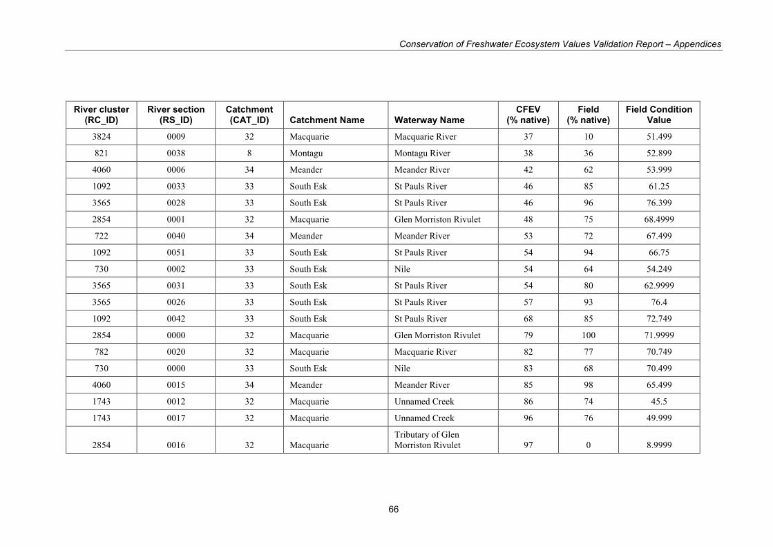
Conservation of Freshwater Ecosystem Values Validation Report – Appendices
66
River cluster (RC_ID)
River section (RS_ID)
Catchment (CAT_ID) Catchment Name Waterway Name
CFEV (% native)
Field (% native)
Field Condition Value
3824 0009 32 Macquarie Macquarie River 37 10 51.499
821 0038 8 Montagu Montagu River 38 36 52.899
4060 0006 34 Meander Meander River 42 62 53.999
1092 0033 33 South Esk St Pauls River 46 85 61.25
3565 0028 33 South Esk St Pauls River 46 96 76.399
2854 0001 32 Macquarie Glen Morriston Rivulet 48 75 68.4999
722 0040 34 Meander Meander River 53 72 67.499
1092 0051 33 South Esk St Pauls River 54 94 66.75
730 0002 33 South Esk Nile 54 64 54.249
3565 0031 33 South Esk St Pauls River 54 80 62.9999
3565 0026 33 South Esk St Pauls River 57 93 76.4
1092 0042 33 South Esk St Pauls River 68 85 72.749
2854 0000 32 Macquarie Glen Morriston Rivulet 79 100 71.9999
782 0020 32 Macquarie Macquarie River 82 77 70.749
730 0000 33 South Esk Nile 83 68 70.499
4060 0015 34 Meander Meander River 85 98 65.499
1743 0012 32 Macquarie Unnamed Creek 86 74 45.5
1743 0017 32 Macquarie Unnamed Creek 96 76 49.999
2854 0016 32 Macquarie
Tributary of Glen
Morriston Rivulet 97 0 8.9999
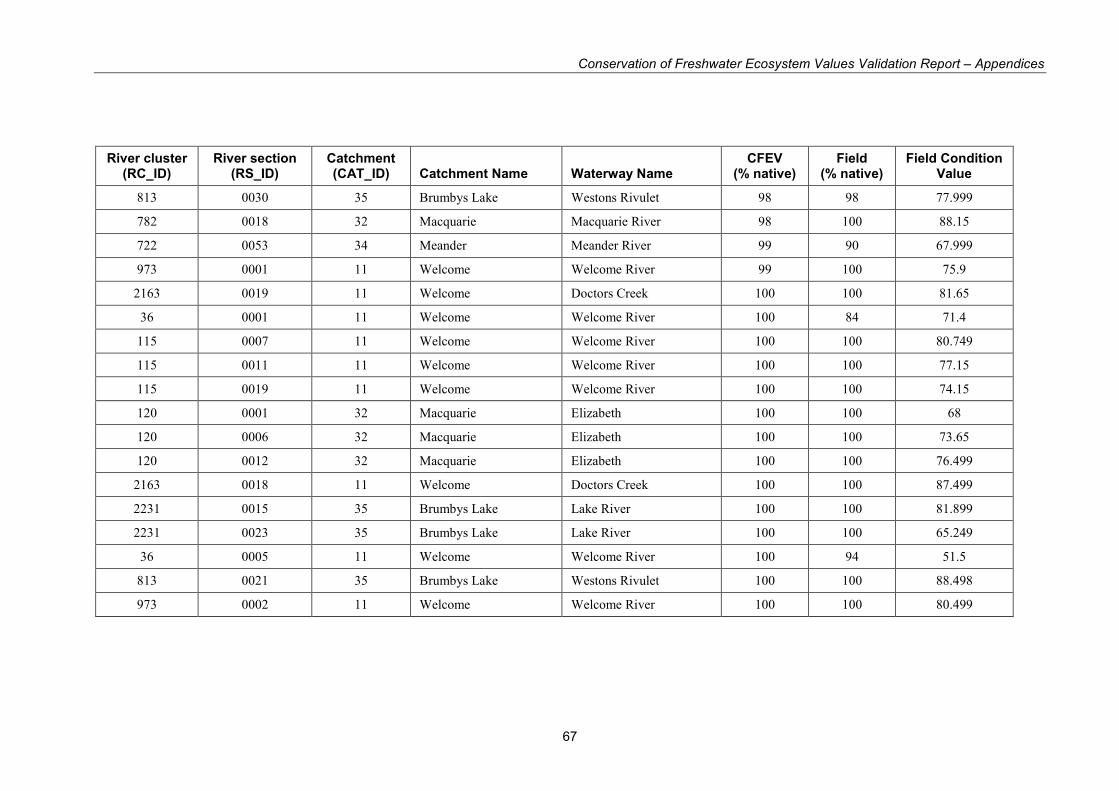
Conservation of Freshwater Ecosystem Values Validation Report – Appendices
67
River cluster (RC_ID)
River section (RS_ID)
Catchment (CAT_ID) Catchment Name Waterway Name
CFEV (% native)
Field (% native)
Field Condition Value
813 0030 35 Brumbys Lake Westons Rivulet 98 98 77.999
782 0018 32 Macquarie Macquarie River 98 100 88.15
722 0053 34 Meander Meander River 99 90 67.999
973 0001 11 Welcome Welcome River 99 100 75.9
2163 0019 11 Welcome Doctors Creek 100 100 81.65
36 0001 11 Welcome Welcome River 100 84 71.4
115 0007 11 Welcome Welcome River 100 100 80.749
115 0011 11 Welcome Welcome River 100 100 77.15
115 0019 11 Welcome Welcome River 100 100 74.15
120 0001 32 Macquarie Elizabeth 100 100 68
120 0006 32 Macquarie Elizabeth 100 100 73.65
120 0012 32 Macquarie Elizabeth 100 100 76.499
2163 0018 11 Welcome Doctors Creek 100 100 87.499
2231 0015 35 Brumbys Lake Lake River 100 100 81.899
2231 0023 35 Brumbys Lake Lake River 100 100 65.249
36 0005 11 Welcome Welcome River 100 94 51.5
813 0021 35 Brumbys Lake Westons Rivulet 100 100 88.498
973 0002 11 Welcome Welcome River 100 100 80.499

Conservation of Freshwater Ecosystem Values Validation Report – Appendices
68
Appendix 5. Wetland survey form
SURVEY SITE
Site No: Date:
Locality:
Recorder/s:
Land Owner:
Contact details:
AMG (of survey point) Easting Northing
Method (e.g 1:25,000 map, GPS etc)
Accuracy (m) Datum
Start time: Finish Time:
Photo record numbers
Macroinvertebrate sample collected? Yes / No Who by?_____________________________________________
How?______________ _____________Habitat sampled?___________________________________________________
Fish sampling conducted? Yes / No Who by?_________________How?___________________________________
Fish species recorded_________________________________________________________________________________
_____________________________________________________________________________________________________
Frogs
Frog species observed, (by sound or visual?)
Comments:
Burrowing crayfish
Crayfish burrows present Crayfish burrows absent
Comments:
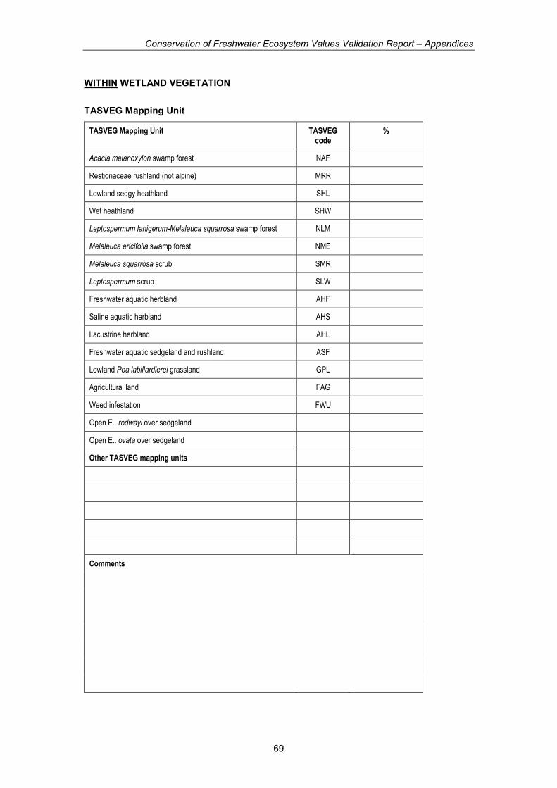
Conservation of Freshwater Ecosystem Values Validation Report – Appendices
69
WITHIN WETLAND VEGETATION
TASVEG Mapping Unit
TASVEG Mapping Unit TASVEG code
%
Acacia melanoxylon swamp forest NAF
Restionaceae rushland (not alpine) MRR
Lowland sedgy heathland SHL
Wet heathland SHW
Leptospermum lanigerum-Melaleuca squarrosa swamp forest NLM
Melaleuca ericifolia swamp forest NME
Melaleuca squarrosa scrub SMR
Leptospermum scrub SLW
Freshwater aquatic herbland AHF
Saline aquatic herbland AHS
Lacustrine herbland AHL
Freshwater aquatic sedgeland and rushland ASF
Lowland Poa labillardierei grassland GPL
Agricultural land FAG
Weed infestation FWU
Open E.. rodwayi over sedgeland
Open E.. ovata over sedgeland
Other TASVEG mapping units
Comments

Conservation of Freshwater Ecosystem Values Validation Report – Appendices
70
WETLAND MACROPHYTES
Dominant Macrophyte Species
Species % cover of entire
wetland
Location
Comments
Other Macrophyte Species
Species % cover of entire
wetland
Location
Comments
WETLAND WATER STATUS
% of entire wetland area where surface water evident:
Conductivity :
Temperature:
Turbidity :
Comments

Conservation of Freshwater Ecosystem Values Validation Report – Appendices
71
WETLAND RIPARIAN VEGETATION
TASVEG Mapping Unit
TASVEG Mapping Unit TASVEG code
%
Acacia melanoxylon swamp forest NAF
Restionaceae rushland (not alpine) MRR
Lowland sedgy heathland SHL
Wet heathland SHW
Leptospermum lanigerum-Melaleuca squarrosa swamp forest NLM
Melaleuca ericifolia swamp forest NME
Melaleuca squarrosa scrub SMR
Leptospermum scrub SLW
Freshwater aquatic herbland AHF
Saline aquatic herbland AHS
Lacustrine herbland AHL
Freshwater aquatic sedgeland and rushland ASF
Lowland Poa labillardierei grassland GPL
Agricultural land FAG
Weed infestation FWU
Other TASVEG mapping units
Comments

Conservation of Freshwater Ecosystem Values Validation Report – Appendices
72
WETLAND CONDITION (Mark appropriate class)
Wetland vegetation
Classification Unit Classification Features
Class
% Native % Exotic or
cleared % Other Natural
Within Wetland native vegetation
Score proportion of native vegetation, exotic vegetation (or fallow land) or natural features (e.g. water, rocks, etc) within wetland.
Wetland riparian vegetation
Score proportion of native vegetation, exotic vegetation (or fallow land) or natural features (e.g. water, rocks, etc) with wetland buffer zone (100 m).
Comments on condition “
MANAGEMENT ISSUES
Key Management Issues Priority Number
(1 highest, 2 etc)
Within Riparian Zone
Within Wetland:
Catchment:

Conservation of Freshwater Ecosystem Values Validation Report – Appendices
73
CONTACT DETAILS
Water Resources Division
Department of Primary Industries and Water
GPO Box 44 Hobart Tas 7001 Telephone: (03) 6233 6328 Facsimile: (03) 6233 8749
Email: [email protected]