Embed Size (px)
Citation preview

Katy Djambazian, Lehman College, CUNY - Student Dr. Yuri Gorokhovich, Lehman College, CUNY – Mentor/Advisor Dr. Vincent Rinterkneht, University of St. Andrews – Mentor/Advisor
ABSTRACT
Constraining the Western Greenland Ice Margin Retreat History and Geometry Using Cosmo Genic Isotope Be-10 Dating. Katy Djambazian (Lehman College, CUNY, Bronx, NY 10468) Dr. Yuri Gorokhovich (Lehman College, CUNY, Bronx, NY 10468) Dr. Vincent Rinterknecht (University of St Andrews, College Gate, St Andrews, Fife KY16 9AJ, Scotland, United Kingdom).
During August of 2014 I conducted field work in Poland and participated in lab work in
Scotland. In the field the objective was to map the locations of glacial deposits and find the
history of deglaciation in the Tatras Mountains, in both the Polish and the Slovakian side.
Deglaciation is important because it helps to establish how climate change affected ice, and how
fast the process of melting continued. By knowing rates of historical deglaciations we can better
understand current climatic fluctuations. A team composed of professors and students looked for
moraines, (evidence of glacial deposits), and mapped the location (at different hiking sites) of
where moraines and boulders, that were adequate for testing, were found. I acquired training on
glacial geomorphology field techniques and sampling; collected samples will be tested at a later
date with surface exposure dating procedures using cosmogenic Beryllium 10 (10Be) isotopes.
At the University of St Andrews, Scotland I continued with the lab work processingcosmogenic
(rock) samples previously collected in Greenland. Upon geochemical processing these samples
will be further prepared in laboratories in France to complete the isotope dating analyses. The
data acquired from these analysis’s will help to improve estimations of ice thinning rates during
the Late Glacial Maximum (10,000 to 13,000 years ago) on the western de-glaciated coastal
margin of Greenland and the Western Carpathian Mountains. My field study during the summer
of 2014 was conducted as a continuation of work that has beengoing in both in Greenland and
the mountains in Europe since the year 2005. The purpose of the study it to reconstruct both the
climate of the Tatras Mountains and the dynamic of the glacier retreat during the Late
Pleistocene period using glacial deposits to better understand what is happening in the context of
global warming today and also to be better prepared for what may take place in the future.

Katy Djambazian, Lehman College, CUNY - Student Dr. Yuri Gorokhovich, Lehman College, CUNY – Mentor/Advisor Dr. Vincent Rinterkneht, University of St. Andrews – Mentor/Advisor
INTRODUCTION
Surface Exposure Dating (SED) “…utilizes primarily the build-up of Beryllium 10 (10Be) in
rock materials over time…” [1], which is produced in-situ within a rock matrix due to exposure
of the rock to cosmic rays, and is used to determine the length of time a rock or boulder has been
exposed to the sun’s rays. This type of examination, at the geochemistry level, is used to
determine the geological timeline of events, dating back to thousands of years ago. When
examining a rock sample at the geochemistry level and to determine its geological age, the fact
must be stated that when rocks are exposed to cosmic (sun) rays, the high energy from the sun is
absorbed by the rocks creating Beryllium 10 (10Be) isotopes within the crystals of the rocks,
usually in the form of the mineral Quartz. However, for rocks that were once covered by ice
from a glacier, the production of 10Be begins once the glacier recedes and the rock is exposed to
the radiation from the sun. This is a time when the geologic clock based on 10Be starts working.
During the Last Glacial Maximum, which is the latest time interval in the history of the Earth
when glaciers reached their maximum volume (about 100,000 to 10,000 years ago) (Lambeck et
al., 2002), there were more ice sheets or glaciers covering the earth than there are today. When
ice sheets or glaciers form, the sea level lowers because the water from the ocean gets trapped in
the glaciers as ice. The sea level even 10,000 years ago was about 120 meters or about 394 feet
lower when compared to the modern sea level. If the Greenland ice sheet of today were to
completely melt, for example, that would result in a rise in sea level of about 6 to 7 meters or
about 20 to 22 feet. In the case of this study, Beryllium 10 (10Be), which is a radioactive isotope
of Beryllium, will be used to determine the dates of when the glacier receded from the areas of
study, mainly the Island of Greenland and the Carpathian Mountains in Europe.
Elevation data from Global Positioning System (GPS) readings obtained from perched
boulders and glaciated bedrock, combined with ages obtained from 10Be and 26Al dating, will

Katy Djambazian, Lehman College, CUNY - Student Dr. Yuri Gorokhovich, Lehman College, CUNY – Mentor/Advisor Dr. Vincent Rinterkneht, University of St. Andrews – Mentor/Advisor
improve the ice thinning rate estimates during the Late Glacial Maximum, which occurred about
13,000 years ago (currently this data is available mostly from glacial models). However, field
work and sampling in Greenland was done in 2008, and the main part of my current project
incurs the preparation and analysis of collected samples. Also, empirical analyses, previously
conducted by this team, suggested higher rates than the ones estimated by current glacial models.
Recent studies by other researchers support these estimations. However, the low number of
samples and uncertainty associated to surface exposure dating requires additional data sampling
and dating, part of which was conducted during this geological expedition in August of 2014.
FIELD WORK IN POLAND
The main objective was to look for glacial sequences in the landscape, the formation of
moraines[2], which are accumulation of rock debris (till) carried or deposited by a
glacier…which also range in size from blocks to boulders, and identify the accumulation of
debris from which samples could be collected. Four different locations, three on the Polish side
of the Tatras Mountains, and one on the Slovakian side of the Tatras Mountains, were visited to
make identification of boulders from which samples could be taken in the future. Unfortunately,
only two of these sites proved to have rocks with adequate size and exposure from which to
collect samples that would give accurate readings.
The work in the field involved: The use of GPS recorders to map terminal and lateral
moraines, but also potential glacial trimlines; the recording of rock sample characteristics for
surface exposure dating; and gathering geographic information, which will be used to develop
pedagogical material and create a GIS database of the information gathered. The geographic
positions of boulders were recorded (using GPS), in the areas where they were accessible. These
areas, where the rocks had less vegetation cover, are the sites which will provide more accurate
Katy Djambazian, Lehman College, CUNY - Student Dr. Yuri Gorokhovich, Lehman College, CUNY – Mentor/Advisor Dr. Vincent Rinterkneht, University of St. Andrews – Mentor/Advisor
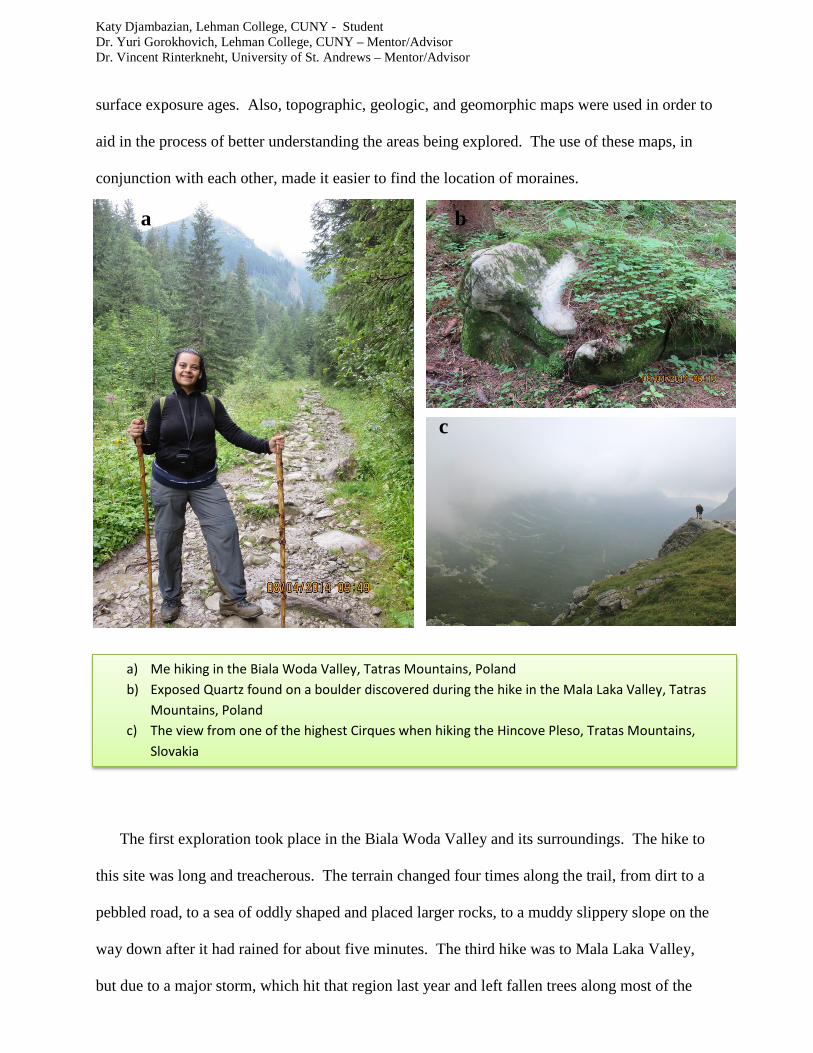
surface exposure ages. Also, topographic, geologic, and geomorphic maps were used in order to
aid in the process of better understanding the areas being explored. The use of these maps, in
conjunction with each other, made it easier to find the location of moraines.
a b
c
The first exploration took place in the Biala Woda Valley and its surroundings. The hike to
this site was long and treacherous. The terrain changed four times along the trail, from dirt to a
pebbled road, to a sea of oddly shaped and placed larger rocks, to a muddy slippery slope on the
way down after it had rained for about five minutes. The third hike was to Mala Laka Valley,
but due to a major storm, which hit that region last year and left fallen trees along most of the
a) Me hiking in the Biala Woda Valley, Tatras Mountains, Poland b) Exposed Quartz found on a boulder discovered during the hike in the Mala Laka Valley, Tatras
Mountains, Poland c) The view from one of the highest Cirques when hiking the Hincove Pleso, Tratas Mountains,
Slovakia

Katy Djambazian, Lehman College, CUNY - Student Dr. Yuri Gorokhovich, Lehman College, CUNY – Mentor/Advisor Dr. Vincent Rinterkneht, University of St. Andrews – Mentor/Advisor
paths, it was impossible to reach the areas where the boulders were (in some of the moraines);
this terrain too was mostly muddy due to the sporadic showers that fall on the mountain during
that time of year, but the terrain was not as steep in Biala Woda Valley. Both these valleys are
found on the Polish side of the Tatras Mountains.
However, the last hike became the best hike, which took place on the sixth day where the
team hiked to one of the highest lakes of the Tatras, Hincove Pleso, on the Slovakian side of the
mountains. Along the path a number of glacial features, crescentic marks and striations on the
bedrock from the glacier and places where meltwater had shaped the rock, could be recognized.
This hike was also long (it took about eight hours to complete) and was the steepest of all the
trails traveled (there were areas along the path where the slope was nearly vertical). Once a
suitable and high enough vantage point was reached, the immense U-shaped valley with a
moraine in the middle, the hanging valley on the right and the avalanche corridor could be seen.
This area had a rich supply of large granite boulders, which were perfect for sampling; mainly
due to the material dumped where the glacier had been carrying it, as it melted.
LAB WORK IN SCOTLAND
Unfortunately, the park permits that were acquired did not allow for rock samples to be
collected from the hiking sites in the Tatras National Park, which is the part of the Mountains
where geological expeditions could be conducted. For this reason, the procedure by which a
sample is taken from a boulder was practiced in the Geology Department of the University of St.
Andrews. First, the coordinates of where the boulders are located within the moraines must be
obtained using maps, a GPS device, and then entered into a geographical information system (if
possible). Once the coordinates are obtained, a compass and a clinometer (used for measuring
the angle or elevation of slopes) must be used to calculate how much cosmogenic radiation the

Katy Djambazian, Lehman College, CUNY - Student Dr. Yuri Gorokhovich, Lehman College, CUNY – Mentor/Advisor Dr. Vincent Rinterkneht, University of St. Andrews – Mentor/Advisor
rock is exposed to. This is done by the measuring of the “shadow” of the rock from its
surrounding area. Then a manual jackhammer (among other tools) is used to extract a sample
from the rock, in this case it was sandstone. All the data is carefully recorded on a prepared
sheet so that when each sample is taken to the lab the information on each of the samples
collected is listed in a clear and systematic manner.
d e
f
Once in the lab, the rock samples that were collected in Greenland, which were
previously separated and marked (each ranging from three thousand to five thousand grams),
were first crushed in a machine called a Jaw Crusher. This was done to reduce their size that
they may be more manageable. The machine first needed to be cleaned with a hard-tooth brush
d &e) Me demonstrating how to use the manual jackhammer to collect samples form a boulder, St. Andrews, Scotland
f) The manual jackhammer, the compass, and the bag in which a collected sample is stored, on a boulder, St. Andrews, Scotland

Katy Djambazian, Lehman College, CUNY - Student Dr. Yuri Gorokhovich, Lehman College, CUNY – Mentor/Advisor Dr. Vincent Rinterkneht, University of St. Andrews – Mentor/Advisor
and with compressed air to assure that no contaminants from previous crushed rocks were mixed
with the new samples. The newly crushed fragments, for each sample, were collected in a plastic
bucket that was also cleaned with compressed air, before being used. Each rock sample was
crushed separately; all the rock samples collected were individually packaged and labeled.
The fragments were then transported to a Type UA Pulverizer to be reduced to a grain
size fraction; the pulverized material was collected in a metal drawer on the bottom of the
machine. The end of the hose of a vacuum cleaner was placed on the outside of this drawer to
vacuum up dust debris that would escape through that space. This process was repeated at least
four times for each rock sample, until the desired fragment size was obtained. The fragments
were poured in from the top of the machine unto the blades that were covered for safety. It is
spinning blades that reduce the size of the fragments to tiny particles, even dust. Each time the
sample had to be run through the Pulverizer, however, the blades had to be adjusted, brought
closer together, to accommodate the decreasing grain size. The grains from the fragments were
then poured onto test sieves. They were separated through sifting in three different size test
sieves; the first test sieve (the one on top) was seven hundred and ten micrometers and the
second sieve (directly underneath it – the middle sieve) was two hundred and fifty micrometers.
The material that had to be run through the pulverizer to continue to reduce the size of the
fragments was taken from the top sieve; it was transported and poured unto the pulverizer in a
small plastic bucket that was cleaned with compressed air before being used.

Katy Djambazian, Lehman College, CUNY - Student Dr. Yuri Gorokhovich, Lehman College, CUNY – Mentor/Advisor Dr. Vincent Rinterkneht, University of St. Andrews – Mentor/Advisor
g
h
g) Me taking the first step into making the rock samples smaller by crushing the samples with the Jaw Crusher (above).
h) Me taking the second step into making the rock samples smaller by running the crushed samples through the Type UA Pulverizer to pulverize the pieces that were newly crushed (below).

Katy Djambazian, Lehman College, CUNY - Student Dr. Yuri Gorokhovich, Lehman College, CUNY – Mentor/Advisor Dr. Vincent Rinterkneht, University of St. Andrews – Mentor/Advisor
i j
Once all of the fragments have been completely pulverized to the desired size, which
should be between two hundred and fifty and seven hundred and ten micrometers, then the
material must be separated, the magnetic material from the non-magnetic. Only the non-
magnetic material is utilized for testing, meaning the quartz. The material is run through a
Frantz isodynamic separator machine, which should yield about three hundred to four hundred
grams of non-magnetic material. There is a distinction between the two types of material: The
non-magnetic is a lighter material than the magnetic, which is darker. Also, this machine must
be precisely calibrated as to not have the magnetic material mix with the non-magnetic. There is
a lever on the machine that controls the strength of the vibration of the chute through which the
material travels while it is being separated. The mixed material is poured into a funnel and
gravity carries it through a split sloped chute that is vibrating. At the same time there is a magnet
on one side, which guides the magnetic material away from the non-magnetic as each is collected
at the end of the chute into labeled containers. The magnetic contents are discarded, but the non-
magnetic are again packaged, in a bag, and labeled.
i & j) Me taking the third step into making the rock sample smaller by running the bigger pieces of the sample through the pulverizer multiple times until the entire sample yielded the desired size grain; and shifting the sample in three different sized sieves.

Katy Djambazian, Lehman College, CUNY - Student Dr. Yuri Gorokhovich, Lehman College, CUNY – Mentor/Advisor Dr. Vincent Rinterkneht, University of St. Andrews – Mentor/Advisor
k l m
RESULTS
While in Poland, readings were taken of both GPS coordinates and geological
descriptions of the moraines that were identified. These locations and settings were recorded and
marked on maps so that the exact locations could be easily located once the permits are acquired
for sampling. The samples, from Greenland, were taken from moraines found while hiking
through terraces and cirques, and the same will be done in the Tatras Mountains in Poland and
Slovakia. The samples collected in Greenland and the samples that will be collected from the
Tatras Mountains will be put through the process of isotope analysis to identify the age of the
rocks. In total, five bags of non-magnetic material, of about three hundred to four hundred
grams each, were prepared for the next phase of analysis in the wet lab.
k & l) Me taking the last step into making the rock sample smaller by running the pulverized sample through the Frantz isodynamic separator machine in order to separate the magnetic material from the Non-Magnetic material within the sample.
m) The final product, which is ready for analysis in the wet lab.

Katy Djambazian, Lehman College, CUNY - Student Dr. Yuri Gorokhovich, Lehman College, CUNY – Mentor/Advisor Dr. Vincent Rinterkneht, University of St. Andrews – Mentor/Advisor
DISCUSSION AND CONCLUSION
Through the use of Geochemistry, and the study of geomorphology methods, it is
possible to discover the time hidden in rocks, but it is also possible to learn about and reconstruct
the nature of events associated with the time interval. While various dating techniques with
inherent accuracies and precisions were used to define the Younger Dryas (11,000 – 13,000
years ago) time frame, these approaches may to some extent have provided the fuel igniting the
debate on the synchrony or asynchrony of events globally [3]. The occurrence of a Late-glacial
cold event has been recognized in many formerly glaciated regions in Europe and in the rest of
the world including the southern hemisphere and the timing of its expression is at the center of
an ongoing debate revolving around climatic lead and lag between the northern and southern
hemisphere [4]. Using Surface Exposure Dating using 10Be coupled with Geographic
Information System the timing and nature of glacial events could be better understood and
mapped across the northern hemisphere. However, depending on the region of study, the
Palaeoclimatic interpretations are correlations become more and more equivocal [5].
The production rates of cosmogenically produced isotopes such as 10Be are affected by
the altitude, latitude and the variation of the geomagnetic field [6]. For this reason this continual
field work and research is being conducted by this team. For example, the thinning of the ice
sheet in Greenland increases concerns regarding possible and future rise in sea level. In order to
appreciate the full extent of its contribution to sea level rise, reconstruction of the ice sheet's
most recent last deglaciation could provide key information on the timing and the height of the
ice sheet at a time of rapid climate readjustment [7]. Further study is needed to reconstruct the
events of the past, in regards to glacial formation and retreat, and the timing of those events in
order to better understand what is happening today and possibly what may happen in the future.

Katy Djambazian, Lehman College, CUNY - Student Dr. Yuri Gorokhovich, Lehman College, CUNY – Mentor/Advisor Dr. Vincent Rinterkneht, University of St. Andrews – Mentor/Advisor
FUTURE WORK
The samples will be then transferred to a wet lab. The process that will take place to
determine the age of the samples is as follows: The samples in each bag will be boiled in
phosphoric acid for a few hours to eliminate all the aluminum silicate in the rock to purify the
quartz as much as possible. Once boiled, the sample is then rinsed and washed, and then leached
three times over a period of 24 hours each (a total of 72 hours), in a solution of hydrofluoric acid
and nitric acid. This is done, with these low acidic solutions, to remove all traces of Beryllium
10 produced in the atmosphere around the grains that could have penetrated into the crystals
through microscopic cracks in the rocks. Once this process is finished the sample is checked for
purity using a very small amount, which is ran through an ICP-MS (Inductively coupled plasma
mass spectrometry), which is used to detect metals and non-metals all at concentrations as low as
one part in 1015 (part per quadrillion ppq); though in this case it is used to detect aluminum
concentration, which needs to be below 200 ppm in the sample. Then the whole sample is
dissolved in pure hydrofluoric acid, and a spike of Beryllium 9 is then added, which is useful
with the measurement in the Accelerator mass spectrometry (AMS) analysis. Because Beryllium
10 is produced in such low quantities it is useful to spike Beryllium 9 into a known quantity to be
able to get a ratio when the samples are analyzed. Once the sample is completely dissolved it is
put through gravity column chromatography; through an anion resin and then a cation to be
purified and to separate unwanted isotopes from the sample. Then the sample is placed on a
rapid incinerator to allow for further unwanted isotopes to evaporate out of the solution. What
should be left are a few micrograms of Beryllium Oxide (about 0.2 grams). This final product is
what will be tested and analyzed to determine the age of the rocks from which the samples were
taken.

Katy Djambazian, Lehman College, CUNY - Student Dr. Yuri Gorokhovich, Lehman College, CUNY – Mentor/Advisor Dr. Vincent Rinterkneht, University of St. Andrews – Mentor/Advisor
REFERENCES
[1] http://www.gns.cri.nz/Home/Services/Laboratories-Facilities/Cosmogenic-Isotope-and-Radiochemistry-Laboratory/About-Isotopes/What-are-10Be-9Be-and-7Be/10Be-for-Surface-exposure-dating-SED [2] http://www.britannica.com/EBchecked/topic/391696/moraine
[3] V. Rinterknecht, A. Matoshko, Y. Gorokhovich, D. Fabel, S. Xu, 2012. Expression of the Younger Dryas cold event in the Carpathian Mountains, Ukraine?
Quaternary Science Reviews 111, pp. 106-114. [4] Ackert, R.P., Becker, R.A., Singer, B.S., Kurz, M.D., Caffee, M.W., Mickelson, D.M., 2008.
Patagonian glacier response during the late Glacial-Holocene transition. Science 321, pp. 392-395.
[5] V. Rinterknecht, A. Matoshko, Y. Gorokhovich, D. Fabel, S. Xu, 2012. Expression of the Younger Dryas cold event in the Carpathian Mountains, Ukraine?
Quaternary Science Reviews 106, pp. 106-114. [6] V. Rinterknecht, A. Matoshko, Y. Gorokhovich, D. Fabel, S. Xu, 2012. Expression of the Younger Dryas cold event in the Carpathian Mountains, Ukraine?
Quaternary Science Reviews 109, pp. 106-114. [7] V. Rinterknecht, Y. Gorokhovich, J. Schaefer, M. Caffee, 2009.
Preliminary 10Be chronology for the last deglaciation of the western margin of the Greenland Ice Sheet. Journal of Quaternary Science 270, pp. 270-278.