Embed Size (px)
Citation preview
CONSTRUCTION OF A DEEP CONSTRUCTION OF A DEEP
TUBE WELLTUBE WELL-- A CASE STUDY.A CASE STUDY.
A PRESENTATION BY T.S. BADRINARAYANAN, GEOSCIENTIST,
B SQUARE GEO TECH SERVICES, KOLLIDAM, SIRKALI TALUK,
NAGAI DISTRICT,TAMILNADU, PIN- 609 102.
E-MAIL: [email protected], MOB- 94430 46102.

BADRI.BADRI. 22
AREA & PURPOSE OF AREA & PURPOSE OF
INVESTIGATIONINVESTIGATION..
Name of the village : Ko.Pavalangudi.Name of the village : Ko.Pavalangudi.
Panchayat Union : Vridhachalam. Panchayat Union : Vridhachalam.
Taluk Taluk : Vridhachalam.: Vridhachalam.
DistrictDistrict : Cuddalore.: Cuddalore.
StateState : Tamilnadu.: Tamilnadu.
Area of extentArea of extent : 100 acres.: 100 acres.
Purpose of Purpose of
investigationinvestigation : To construct a very deep: To construct a very deep
tube well for agriculturaltube well for agricultural
purpose.purpose.

BADRI.BADRI. 33
CUDDALORE DISTICT MAP SHOWING CUDDALORE DISTICT MAP SHOWING
THE AREA OF INVESTIGATIONTHE AREA OF INVESTIGATION..
KO.PAVALANGUDI

BADRI.BADRI. 44
KO.PAVALANGUDI
VRIDHACHALAM UNION MAP

BADRI.BADRI. 55
PROBLEMS.PROBLEMS.
�� The hydrogeological condition is such that, The hydrogeological condition is such that, potential confined aquifers occurs @ a potential confined aquifers occurs @ a very deep depth of > 200 meters below very deep depth of > 200 meters below ground level.ground level.
�� A very huge thick layer of aquiclude.A very huge thick layer of aquiclude.
�� Exploring the very deep aquifer & Exploring the very deep aquifer & construction of well are problematic.construction of well are problematic.
�� A huge investment has to be made for A huge investment has to be made for construction.construction.

BADRI.BADRI. 66
STAGES OF
GW EXPLORATION
IN SEDIMENTARY
TERRAIN.
SURFACE METHODS.WELL SITE
SELECTON BY
INTEGRATED
HYDROGEOLOGICAL
& GEOPHYSICAL
METHODS.
SUB SURFACE METHODS.
DRILLING PILOT
BORE HOLE
LITHOLOG
ELECTRICAL WELL
LOGGING
WELL DEVELOPMENT
BY AIR COMPRESSOR
YIELD ASSESSMENT
WELL COMPLETION
PUMPING TEST-
HYDROGEO CHEMICAL
ANALYSIS OF
WATER SAMPLE.

BADRI.BADRI. 77
METHODOLOGY.METHODOLOGY.
�� Three stages of ground water exploration Three stages of ground water exploration ––surface, surface,
subsurface methods & well development.subsurface methods & well development.
�� Surface methodSurface method-- hydrogeological investigation to select hydrogeological investigation to select
a bore hole point.a bore hole point.
�� Sub surface methodSub surface method--drilling pilot bore welldrilling pilot bore well-- litholog litholog
preparationpreparation-- electrical well logging.electrical well logging.
�� Well designing & constructionWell designing & construction--
�� Well development by compressorWell development by compressor-- yieldyield
assessmentassessment--well completion.well completion.

BADRI.BADRI. 88
GROUND WATER EXPLORATION METHODOLOGY ADAPTED.
SECOND STAGE.
SURFACE METHOD.
HYDROGEOLOGICAL
FIRST STAGE.
SUB SURFACE METHOD.
GEOLOGICAL-LITHOLOG.
HYDROGEOLOGICAL
THIRD STAGE.
PILOT BORE HOLEDRILLING.
SELECTINGFEASIBLE POINT.
GEOPHYSICAL-ELECTRICAL LOGGING.
WELL DESIGNING &CONSTRUCTION.
WELL DEVELOPMENT
WELL COMPLETION

BADRI.BADRI. 99
1.1.FIRST STAGE1.1.FIRST STAGE-- SURFACE SURFACE
METHOD.METHOD.
�� Geological and Hydrogeological Geological and Hydrogeological
investigations to select a investigations to select a
feasible point to drill a pilot feasible point to drill a pilot
bore hole.bore hole.

BADRI.BADRI. 1010
GEOMORPHOLOGY MAP OF CUDDALORE DISTRICT.

BADRI.BADRI. 1111
GEOLOGY OF THE AREA.GEOLOGY OF THE AREA.
�� TerrainTerrain-- Sedimentary terrain.Sedimentary terrain.
�� The area is covered by various geological The area is covered by various geological formations ranging in age from Cretaceous to formations ranging in age from Cretaceous to Recent represented by black clay, calcareous Recent represented by black clay, calcareous sandstones & marls [Upper Cretaceous] overlain sandstones & marls [Upper Cretaceous] overlain by Gopurapuram formations of Eocene age, by Gopurapuram formations of Eocene age, essentially argillaceous, comprising silts, essentially argillaceous, comprising silts, claystones, calcareous sandstones, shales, black claystones, calcareous sandstones, shales, black clay & soils.clay & soils.
�� The area is about 60 to 65 kms away from sea The area is about 60 to 65 kms away from sea shore. shore.
[SOURCE[SOURCE-- CGWB].CGWB].

BADRI.BADRI. 1212
HYDROGEOLOGY.HYDROGEOLOGY.
�� Ground water occurs in all geological formations both Ground water occurs in all geological formations both under confined & unconfined conditions.under confined & unconfined conditions.
�� The area receives maximum rain fall during northeast The area receives maximum rain fall during northeast monsoon period which is the main source for ground monsoon period which is the main source for ground water recharge. water recharge.
�� The shallow unconfined aquifers may not be potential to The shallow unconfined aquifers may not be potential to tap for irrigation purposes.tap for irrigation purposes.
�� The deep confined aquifer occurs below 200 meters The deep confined aquifer occurs below 200 meters below ground level.below ground level.
�� The principal & potential aquifers are sand stones, fine The principal & potential aquifers are sand stones, fine to medium grained sands, pebbles & gravels.to medium grained sands, pebbles & gravels.
�� The depth to water level ranges from 20 to 60 m bgl.The depth to water level ranges from 20 to 60 m bgl.

BADRI.BADRI. 1313
2.1. SECOND STAGE2.1. SECOND STAGE--
SUBSURFACESUBSURFACE METHODMETHOD
�� Drilling of pilot bore holeDrilling of pilot bore hole--
�� Rig engagedRig engaged-- Rotary rig.Rotary rig.
�� Dia & depth of pilot bore holeDia & depth of pilot bore hole-- 300 mm300 mm--
depthdepth-- 312 m.312 m.
�� Soil samples collected for every 6 mSoil samples collected for every 6 m-- litholog litholog
preparedprepared-- soil samples analyzed in depth.soil samples analyzed in depth.

BADRI.BADRI. 1414
MUD PIT.
ROTARY RIG.

BADRI.BADRI. 1515
ROTARY RIG.ROTARY RIG.
PVC CASING PIPES.
ROTARY RIG.
PEBBLES.

BADRI.BADRI. 1616
TYPICAL
ROTARY WELL CONSTRUCTION
SEQUENCE
OVERSIZEDBOREHOLE
DRILLED
IDENTIFYAQUIFER
INSTALL CASING(& SCREEN)
YIELD TEST&
WATER SAMPLING
WELL DEVELOPMENT
GROUTANNULAR
SPACE
1 2 3
6 5 4

BADRI.BADRI. 1717
2.2. LITHOLOG.2.2. LITHOLOG.JEYARAMAN, KO.PAVALANGUDI, LITHO LOG.
34
29
7
25
10
15734
20
18
14
28
6
29
9
26
6165
0
50
100
150
200
250
300
350
DE
PT
H I
N M
BG
L.
BLACK CLAY
GREY COLRED FS-
YELLOWISH BALCK CLAY
FMS
BLACK CLAY
GREY COLRED FS- SST
BLACK CLAYEY SAND
BLACK CLAY + SST
BLACK FINE SILTY CLAY
BLACK CLAYEY SST
BLACK CLAY
SST
BLACK CLAY
SST
BLACK CLAY+ SST
SST
CLAYEY SST
YELLOWISH WHITE SST
BLACK CLAY
TS +YELLOWISH BROWN COLORED CLAY
CONFINEDAQUIFER

BADRI.BADRI. 1818
2.3. GEOPHYSICAL2.3. GEOPHYSICAL--
ELECTRICAL WELL LOGGINGELECTRICAL WELL LOGGING
�� One of the subsurface methods of ground water One of the subsurface methods of ground water
exploration namely the electrical well logging exploration namely the electrical well logging
facilitates continuous recording of electrical facilitates continuous recording of electrical
response verses depth by a sensor when it response verses depth by a sensor when it
moves inside the bore hole. Among the several moves inside the bore hole. Among the several
methods of well logging the common method methods of well logging the common method
used for ground water exploration is electrical used for ground water exploration is electrical
well logging which includes SP log and resistivity well logging which includes SP log and resistivity
logs.logs.

BADRI.BADRI. 1919
WELL LOGGINGWELL LOGGING..

BADRI.BADRI. 2020
LOGGING CONFIGURATIONLOGGING CONFIGURATION..

BADRI.BADRI. 2121
ELECTRICAL WELL LOGGINGELECTRICAL WELL LOGGING
�� Logging equipmentLogging equipment-- Portable spot logger.Portable spot logger.
�� Resistivity meter usedResistivity meter used-- Microprocessor Microprocessor
based signal stacking digital meterbased signal stacking digital meter--
modelmodel-- SSRSSR-- MPMP-- ATAT-- S 0f IGIS, S 0f IGIS,
Hyderabad make.Hyderabad make.
�� Logging modesLogging modes-- SP & Normal resistivitySP & Normal resistivity
loglog-- LNLN--6464’’’’..

BADRI.BADRI. 2222
SP LOGSP LOG..JEYARAMAN, KO.PAVALANGUDI, SP LOG
0
50
100
150
200
250
300
350
50 70 90 110 130 150 170
SP IN MV
DE
PT
H IN
M B
GL
.
SP

BADRI.BADRI. 2323
NORMAL RESISTIVITY LOGNORMAL RESISTIVITY LOG--
LN 64LN 64’’’’JEYARAMAN, KO.PAVALANGUDI, RES LOG- SN-64''
0102030405060708090
100110120130140150160170180190200210220230240250260270280290300310320
0 5 10 15 20 25 30 35
RES IN OHM /M
DE
PT
H IN
M B
GL
.
SN-64''
AQUIFER ZONE.
AQUICLUDE.

BADRI.BADRI. 2424
3.THIRD STAGE3.THIRD STAGE-- WELL DESIGNWELL DESIGN
& CONSTRUCTION.& CONSTRUCTION.
�� The success of well depends on the well design The success of well depends on the well design and construction. The tube well design shall and construction. The tube well design shall ensure an efficient and economical well with a ensure an efficient and economical well with a service life of more than a decade.service life of more than a decade.
�� Well designWell design-- The assembly of plain and slotted The assembly of plain and slotted pipes. The aim of screened & gravel packed well pipes. The aim of screened & gravel packed well is to draw clear water from the aquifer without is to draw clear water from the aquifer without excessive head loss and to keep the aquifer excessive head loss and to keep the aquifer
material cut.material cut.

BADRI.BADRI. 2525
�� Poor construction can affect drinking water Poor construction can affect drinking water quality.quality.
�� Poor construction can contribute, promote, Poor construction can contribute, promote, and facilitate pollution and contamination of and facilitate pollution and contamination of the groundwater aquifer.the groundwater aquifer.
�� Proper construction can prolong the life and Proper construction can prolong the life and yield of the well.yield of the well.
WHY CARE ABOUT WELL WHY CARE ABOUT WELL
CONSTRUCTION ?CONSTRUCTION ?

BADRI.BADRI. 2626
Logging Rest.
-curve
Kankar
Clay
Sandy-
clay
Sand
shale
CONSTRUCTION OF BORE WELL IN SEDIMENTARY TERRAIN
Bore well

BADRI.BADRI. 2727
TYPICAL DRILLED WELL TYPICAL DRILLED WELL CONSTRUCTION WITH SCREEN WELLCONSTRUCTION WITH SCREEN WELL
BADRI.BADRI. 2828
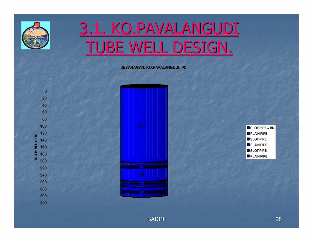
3.1. KO.PAVALANGUDI 3.1. KO.PAVALANGUDI
TUBE WELL DESIGN.TUBE WELL DESIGN.
213
18
36
189
18
0
20
40
60
80
100
120
140
160
180
200
220
240
260
280
300
320
DE
PT
H IN
M B
GL
.
JEYARAMAN, KO.PAVALANGUDI, PD.
SLOT PIPE + BD.
PLAIN PIPE
SLOT PIPE
PLAIN PIPE
SLOT PIPE
PLAIN PIPE

2929
GROUND LEVEL.
CLAY
PACKING.
DRY CLAY
BALL PACKING
PEBBLE
PACKING.
3.3. KO. PAVALANGUDI TUBE WELL CONSTRUCTION
0 TO 213 M PLAIN PIPE.
213 TO 231 M SLOTTED PIPE.
231 TO 267 M PLAIN PIPE.
267 TO 285 M SLOTTED PIPE.
285 TO 294 M PLAIN PIPE.
294 TO 312 M SLOTTED PIPE +
BOTTAM DUMMY.
PVC PLAIN PIPE
SLOTTED PIPE.
175 M
200
312 M
TUBE WELL DEPTH – 312 M.

BADRI.BADRI. 3030
3.4. DEVELOPMENT AND 3.4. DEVELOPMENT AND
COMPLETION OF WELLCOMPLETION OF WELL
�� Development of well is essential to obtain an efficient Development of well is essential to obtain an efficient and long lasting well. The fundamental purpose of and long lasting well. The fundamental purpose of development is to cause reversal of flow through the development is to cause reversal of flow through the screen openings. A permeable zone is created around screen openings. A permeable zone is created around the well screen.the well screen.
�� The tube well constructed was developed after 10 days The tube well constructed was developed after 10 days by an air compressor. 90by an air compressor. 90°° VV-- notch yield was ascertained notch yield was ascertained while developing. The yield of the well is 760 liters per while developing. The yield of the well is 760 liters per minute. The water is very clear and the quality is very minute. The water is very clear and the quality is very good to drink. Finally the well was completed by good to drink. Finally the well was completed by grouting and sealing the casing. grouting and sealing the casing.

BADRI.BADRI. 3131
WELL DEVELOPEPMENT BY WELL DEVELOPEPMENT BY
COMPRESSORCOMPRESSOR

3232
RESULT AND CONCLUSIONRESULT AND CONCLUSION..
�� The depth of tube well [TW] constructedThe depth of tube well [TW] constructed-- 312 m & dia of312 m & dia of
TWTW-- 150 mm. 150 mm.
�� The principal & potential aquifersThe principal & potential aquifers-- sandstone, fine to medium sandstone, fine to medium
grained sand [FMS] & fine sand.grained sand [FMS] & fine sand.
�� The thickness of FMSThe thickness of FMS-- 26 m.26 m.
�� Number of slotted pipes providedNumber of slotted pipes provided-- 18 pipes18 pipes-- 54 m.54 m.
�� Yield of the TW, by 90Yield of the TW, by 90°° VV--notchnotch-- 66’’’’-- 760 LPM.760 LPM.
�� The quality of water is good.The quality of water is good.
�� Thus by integrated geological, hydrogeological & geoelectrical Thus by integrated geological, hydrogeological & geoelectrical
investigations the deep potential confined aquifer could be investigations the deep potential confined aquifer could be
explored & exploited successfullyexplored & exploited successfully..

BADRI.BADRI. 3333
THANK YOU.THANK YOU.
LET US CONSERTVE WATER.