Embed Size (px)
Citation preview

Environment and Planning
Contaminated Land Inspection Report
South Farm
Runcton Holme
April 2017
Reference no. CL72/022147

Written by Alex Grimmer Senior Environmental Quality Officer Reviewed by Fabia Pollard Scientific Officer Approved by Dave Robson Environmental Health Manager Please Note: This report is the property of the Borough Council of King’s Lynn and West Norfolk and its use by any other person without the expressed prior consent of the council is strictly prohibited. For further information please contact: Environmental Quality Team Borough Council of King’s Lynn and West Norfolk King’s Court Chapel Street King’s Lynn Norfolk PE30 1EX Tel: 01553 616200 Email: [email protected]

Contents
Executive Summary ....................................................................................... 5 1. Introduction ................................................................................................ 6 2. Desk Study Information ............................................................................. 6
Location ........................................................................................................ 6 Initial Prioritisation Score .............................................................................. 6 Previous Site Usage ..................................................................................... 6 Present Site Usage ...................................................................................... 6 Ownership .................................................................................................... 6 Environmental Setting .................................................................................. 6
Geology ..................................................................................................... 6
Hydrogeology ............................................................................................ 7
Hydrology .................................................................................................. 7
Local Authority Pollution Prevention and Control Regulations ..................... 7 The Environment Agency Web site records ................................................. 7 MAGIC website records ............................................................................... 7
Historic Maps ................................................................................................... 8 E-map Explorer ............................................................................................ 8 Historic Maps on file at the Borough Council of King’s Lynn and West Norfolk .......................................................................................................... 8 Aerial Photographs ....................................................................................... 9
Planning History ............................................................................................... 9 Environment Agency Records ....................................................................... 10 Norfolk County Council Records .................................................................... 10 3. Site Walkover ........................................................................................... 10 4. Assessment of Site Use .......................................................................... 10
Assessment of probability of a contamination event ................................... 10 Radioactive Contamination ........................................................................ 10 Metal Contamination .................................................................................. 11
Assessment of Hazard ................................................................................... 11 Human Health ............................................................................................ 11
Radioactive Contaminated Land Statutory Guidance, April 2012. ........... 11
Contaminated Land Statutory Guidance (April 2012) .............................. 11
Property ...................................................................................................... 12 Environment ............................................................................................... 12 Controlled Water ........................................................................................ 12
Groundwater............................................................................................ 12
Surface waters ........................................................................................ 12
Conceptual site model ................................................................................... 13 Outcome of Preliminary Risk Assessment ..................................................... 13 5. Site Investigation ..................................................................................... 13 Results ........................................................................................................... 14
Radioactivity ............................................................................................... 14 Metal Contamination .................................................................................. 15
6. Conclusion ............................................................................................... 17 Radioactivity ............................................................................................... 17

Metals ......................................................................................................... 17 Updated Conceptual site model ..................................................................... 17
Human Health ............................................................................................ 18 Controlled Waters ....................................................................................... 18
Part 2A status of the site ................................................................................ 18 Appendices .................................................................................................... 19
Appendix A Site Photographs .................................................................... 20 Appendix B Drawings ................................................................................. 21 Appendix C – Further assessment of potential metal contamination. ......... 31
Bismuth ................................................................................................... 31
Magnesium .............................................................................................. 31
Manganese ............................................................................................. 31
Mercury ................................................................................................... 32
Platinum .................................................................................................. 32
Strontium ................................................................................................. 32
Appendix D. Risk Assessment Methodology. ............................................. 34 Appendix E. Determination of contaminated land – Contaminated Land Statutory Guidance, April 2012. .................................................................. 36

5
Executive Summary
The Borough Council of King’s Lynn and West Norfolk (BCKLWN) has a statutory duty to inspect its district for potentially contaminated land under Part 2A of the Environmental Protection Act 1990. The contaminated land inspection strategy has identified South Farm, Downham Road, Runcton Holme as a site which requires detailed inspection. This site is a former landfill which forms part of a field adjacent to fishing lakes in Runcton Holme within the district of King’s Lynn. An initial assessment of the site was undertaken to assess the potential for harm to human health, water resources and property under Part 2A. To gather information of the site’s history and potential risks a desk study, site walkover and preliminary risk assessment were carried out by the Environmental Quality Team. From the evidence gathered the following can be stated:
The site is recorded as a former landfill.
The landfill was potentially filled with phosphogypsum from the West Norfolk Fertiliser Limited who had the licence to operate the landfill. Phosphogypsum contains naturally occurring radioactive radium and metals.
The site is now being used as a paddock.
The former landfill is in the Tottenhill Gravel member which is a Secondary A Aquifer.
The site is adjacent to three fishing lakes. The potential hazard and the risk associated with the site was assessed. The overall risk rating was: Moderate risk for radioactivity affecting human health Moderate/low risk assigned to property, and Low risk to the environment and controlled waters. Following the initial assessment it was concluded that additional information was required to characterise and categorise the site. Further site investigation was required to assess whether phosphogypsum waste is present and if so what risk that could pose to relevant receptors. Further site investigation was undertaken in December 2016 using a radiation monitor to quantify the level of radiation at the surface of the site. The levels of radiation detected were not statistically different from the recorded natural background levels of radiation. No evidence of waste material was noted at the site’s surface. The site in its current use is unlikely to pose a significant risk to human health, property or the environment. The land does not meet the definition of radioactive contaminated land and would be classified into category 4 for human health regarding metals and metalloids in the waste material. No evidence was found of significant pollution or significant possibility of such pollution of controlled waters. Therefore the site is not considered to be contaminated land under Part 2A of the Environmental Protection Act 1990.

6
1. Introduction This report details a review of information about land at South Farm, Downham Road, Runcton Holme, King’s Lynn and provides a conclusion on the risk to human health, property, groundwater and the wider environment. The Contaminated Land Statutory Guidance (DEFRA, 2012) suggests that where the authority has ceased its inspection and assessment of land as there is little or no evidence to suggest that it is contaminated land the authority should issue a written statement to that effect. This document provides that written statement. 2. Desk Study Information
Location
The site’s location is shown in Appendix B. The grid reference for the centre of the site is 561531, 308071, the nearest postcode is PE33 0AD.
Initial Prioritisation Score
In the council’s initial prioritisation carried out in December 2012 the site was assessed as having a ‘Low’ priority.
Previous Site Usage
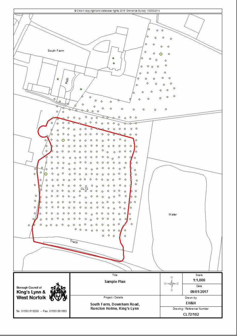
The site (drawing CL72/101) was a former landfill, which additional information has indicated has the potential to have been used to deposit phosphogypsum from West Norfolk Fertilisers Ltd.
Present Site Usage
Its present use comprises a paddock, is adjacent to a fishing lake and holiday park to the south and residential properties to the north. As depicted on the plan in Appendix B.
Ownership
Enquiries have been made to establish land ownership. This report will be made available to the site owners.
Environmental Setting
Geology The Solid and Drift Geology Sheet 160, 1:50,000, 1999 and Regional Hydrological Characteristics Sheet 1 1:125 000 shows the site surface is approximately 5.5 meters above ordnance datum (maOD). The bedrock geology is Kimmeridge Clay Formation - Mudstone. The clay is sedimentary bedrock formed approximately 151 to 156 million years ago in the Jurassic Period.

7
The superficial geology is Tottenhill Gravel Member - Gravel. The gravel is a superficial deposit formed up to 3 million years ago in the Quaternary Period.1
Hydrogeology The bedrock on the site is impermeable and classified as a Non-Aquifer or unproductive strata and as such has no Vulnerability and is not within a Source Protection Zone. The Tottenhill Gravel Member is permeable and is classified as a Secondary A Aquifer with a High Vulnerability.
Hydrology The nearest major water feature are the fishing lakes ~10m south and east of the site. No private water abstractions exist on site, two exist within 500m of the site. These are from the fishing lake to the south of the site and from Warbank Drain ~475m north of the site. These are used for industrial, commercial and public services and agricultural purposes respectively.
Local Authority Pollution Prevention and Control Regulations
No LAPPC processes are on site or within 500m of the site.
The Environment Agency Web site records
The Environment Agency Web site records the following:
The site is not at risk from flooding.
The site is part of an area classified as a Priority Water.
The site is part of an area classified as a Nitrate Vulnerable Zone for Surface Waters.
The site is not within a Drinking Water Safeguard Zone.
The site is classified as a Landfill, named as Runcton Holme, and is recorded as receiving waste from 25th March 1964 and being operated by West Norfolk Fertilisers Ltd
No significant pollution incidents of controlled water
MAGIC website records2
MAGIC website records the following
The site is covered by the MMO Marine Areas (England).
Part of the site is covered by the Woodland Priority Habitat Network (Lower Spatial Priority).
The site is part of a Farm Wildlife Package Area.
The site is part of Countryside Stewardship Water Quality Priority Areas (England) (Medium Priority).
The site is part of a Phosphate Issues Priority Zone (England) (Medium Priority).
The site is part of Woodland - Water Quality (England) (Lower Spatial Priority).
1 British Geological Survey website: http://mapapps.bgs.ac.uk/geologyofbritain/home.html
2 MAGIC website provides information about the natural environment from across government
http://www.natureonthemap.naturalengland.org.uk/

8
The site is part of Keeping Rivers Cool (England).
The site is part of a Nitrate Vulnerable Zones (England) (Surface Water).
The site is part of an area which is habitat for: o Yellow Wagtail. o Turtle Dove. o Tree Sparrow. o Stone Curlew. o Lapwing. o Grey Partridge. o Corn Bunting. o Grassland Assemblage Farmland Birds (Zone 2). o Arable Assemblage Farmland Birds (Zone 5).
The site is covered by a Higher Level Stewardship Theme (East of England Region Theme Area).
The site is covered by an Environment Stewardship Agreements (England) (Entry Level Stewardship).
Historic Maps
E-map Explorer
Enclosure Map 1800 - 1850 – Not available. Tithe map circa 1840 – Not available. Ordnance Survey 1st Ed. 1879-1886 – Not Available.
Historic Maps on file at the Borough Council of King’s Lynn and West Norfolk
Historic Maps are presented in Appendix B and are summarised below: 1843 – 1893: The site is depicted as a field with trees bounding the site to the west and south. A farm and a pond are shown to the northeast of the site; otherwise the site is surrounded by fields. 1891 – 1912: The site was depicted as shown above, with the exception that the trees are no longer shown. 1904 – 1939: The site was depicted as shown above. 1919 – 1943: Not available. 1945 – 1970: The site is shown as an area of water. The farm to the northwest is now shown as South Farm. Two further bodies of water are shown to the south and southeast of the site. 1970 – 1996: Not available.

9
Aerial Photographs
Aerial photographs are presented in Appendix B and summarised below: 1945 – 1946 MOD Aerial Photograph – The site is a field. The farm and pond are visible, but the site is generally as the 1843 – 1893 map. 1988 Aerial Photograph – The site is as depicted above with the exception that an agricultural building has been built to the west of the site. 1999 Aerial Photograph – The site is as described above. 2006-09 Aerial Photograph – The site is as described above. Planning History No planning applications exist on site within the records of the borough council. Eleven planning applications exist adjacent to the site, which are listed below.
2/97/0052/F - Alterations and extensions to dwelling. (Permitted)
2/97/1195/CU - Change of use and conversion to residential dwelling. (Permitted)
2/98/0419/F - Construction of garage building. (Permitted)
2/98/1069/F - Construction of garage building (amended design). (Permitted)
2/99/0371/CU - Change of use of redundant outbuilding to office accommodation. (Permitted)
07/01257/F - Conversion of workshop/garage into residential annexe.
09/00097/FM - 45 log cabins, toilet block and swimming pool and revised site layout. (Withdrawn)
09/01679/FM - Revised site layout incorporating 95 holiday log cabins previously approved under planning permission reference: 2/93/1614/CU and 2/92/1590/CU/F together with the siting of 43 new holiday log cabins (resulting in a total of 138 holiday log cabins) a warden's cabin and manager's cabin, retention of existing shop / reception building and construction of toilet block, swimming pool, play area and tennis court. (Permitted)
09/01679/DISC_A - DISCHARGE OF CONDITION NUMBER 6: Revised site layout incorporating 95 holiday log cabins previously approved under planning permission reference: 2/93/1614/CU and 2/92/1590/CU/F together with the siting of 43 new holiday log cabins (resulting in a total of 138 holiday log cabins) a warden's cabin and manager's cabin, retention of existing shop / reception building and construction of toilet block, swimming pool, play area and tennis court. (Discharged)
12/01148/F - Proposed conversion of existing barn to a one bedroom annex. (Permitted)
14/00515/F - Variation of conditions 2, 3, 4, 5, 6, 7 and 8 of planning permission 09/01679/FM. (Permitted)

10
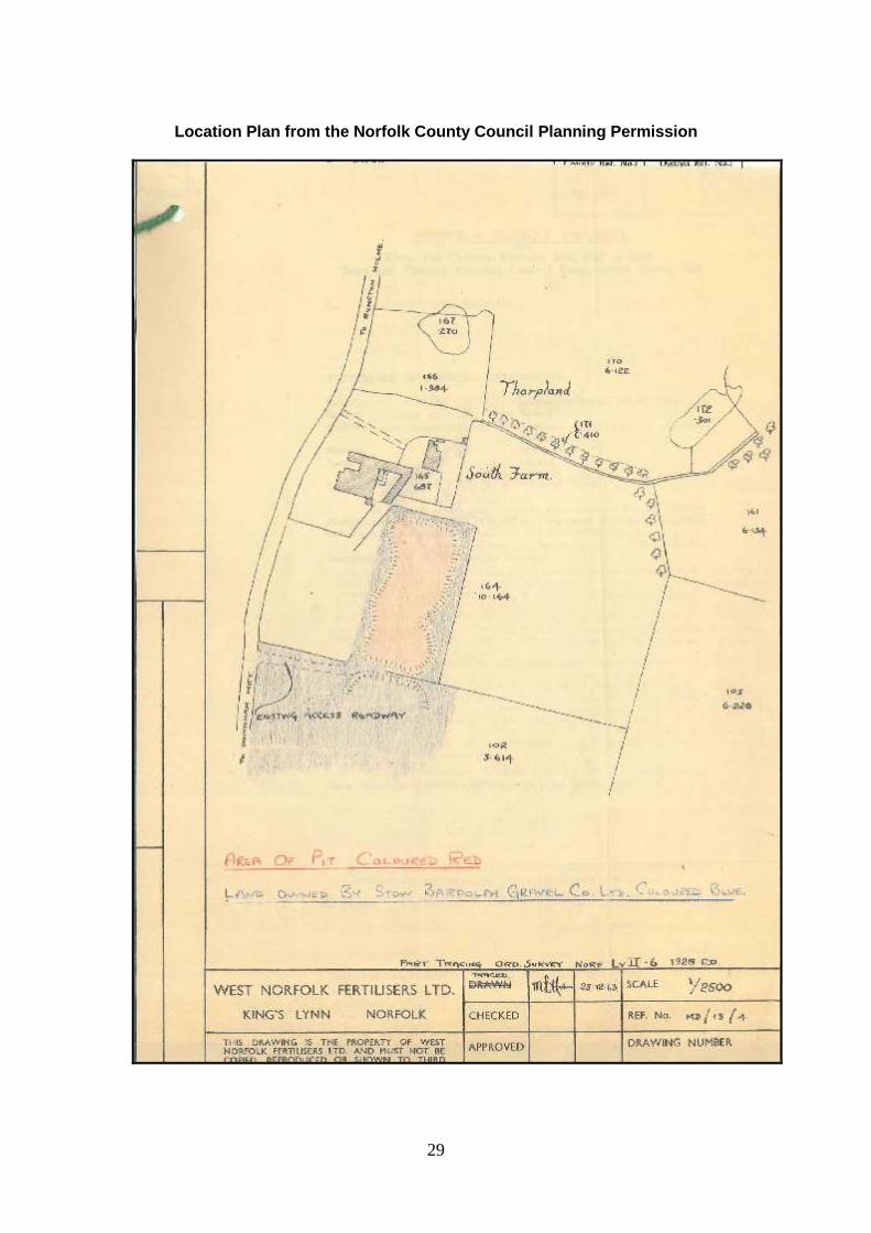
Environment Agency Records Mr Wojtek Koryczan of the Environment Agency was consulted on the 23rd September 2016. He did not have any information available regarding the landfill. But indicated that the groundwater and by inference the lakes would be considered to be Controlled Waters. Norfolk County Council Records After a consultation with Norfolk County Council additional information was provided which indicated that the former quarry was used by the West Norfolk Fertiliser Ltd. as a landfill for the deposition of phosphogypsum. A copy of the planning permission is included in Appendix B. 3. Site Walkover A site visit was carried out by Environmental Quality Officers of the Borough Council of King’s Lynn and West Norfolk on 14/12/2016 and the following was noted. Photographs are presented in the Appendix A. The site is a paddock, which was being used to graze horses. Information provided by the site owner indicated that the landfill did not extend as far south as maps indicated, but did extend beyond the paddock into property to the north belonging to a second land owner. The site owner indicated that the site had been used to landfill phosphogypsum but that the majority of the material used to backfill the excavation was washings from the King’s Lynn sugar beet factory. 4. Assessment of Site Use From the assessment of the site using County Council data, historic maps, aerial photography and a site walk over it has been possible to conclude that the site has been used for mineral extraction and has been backfilled and restored to agricultural use under a planning permission from Norfolk County Council.
Assessment of probability of a contamination event
From information received from Norfolk County Council it is considered that there is the potential for a source of contamination to be present on site. The potential source is a former landfill which was operated by West Norfolk Fertiliser Ltd.
Radioactive Contamination
The site is understood to have been used to deposit soil and beat washings and waste phosphogypsum from the fertiliser works in King’s Lynn. Phosphogypsum is a by-product of the fertiliser production and is known to contain radioactive material and metals. The radio-nuclei have the potential to either be accumulated within the vegetation on the surface of the site or to be leached from the landfill into the fishing lake to the south. Additionally if the cover material has become eroded some powdered phosphogypsum may become available for inhalation either by the horses who use the paddock or the humans who tend the horses/work on the farm. Therefore it is considered that the probability of humans inhaling phosphogypsum particles is LIKELY.

11
One of the radioactive particles which can be present within phosphogypsum is Radium, which due to radioactive decay can degrade into Radon gas. However, it is considered that as there are no buildings on site any Radon gas which is generated would be dispersed to the air without any adverse effects on human health. Therefore it is considered that the probability of humans inhaling Radon is UNLIKELY. The landfill is situated within Tottenhill Gravel which is classified as a Secondary A aquifer with a high vulnerability, which would allow for easy transmission of contaminants. This would indicate that any radioactive particles which are present in the phosphogypsum would be able to leach into the adjacent lakes. The planning permission indicates that an impermeable barrier should be placed along the southern boundary of the landfill to prevent leaching of contamination directly into the lakes. However, this could be bypassed by the percolation of contaminants through the Tottenhill Gravels. This indicates that the probability for the occupants of the holiday park to the south to come into direct contact with the contamination within the water from the lakes either during the fishing activity or when handling fish is LIKELY. As there is considered to be a potential source of contamination and plausible pathways, a contaminant-pathway-receptor relationship could exist to controlled waters. The probability of a controlled water contamination event was assessed as LIKELY.
Metal Contamination
During the processing of gypsum into phosphogypsum any metal contamination present within the gypsum is concentrated into the phosphogypsum. As it is known that phosphogypsum is likely to exist within the landfill it is considered that metal contamination is likely to exist within the landfill. Therefore it is considered that the probability of a contamination event effecting human health, property (via direct contact or inhalation) or groundwater is considered LIKELY. Assessment of Hazard The risks posed by the site have been assessed separately under the separate statutory guidance, the Radioactive Contaminated Land Statutory Guidance and the Contaminated Land Statutory Guidance. This is discussed further below:
Human Health
Radioactive Contaminated Land Statutory Guidance, April 2012. The site is a landfill which had planning permission granted by Norfolk County Council. The planning permission was provided (Appendix B) so it is known that the landfill was used to deposit phosphogypsum. Therefore it has been assumed that radioactive particles are available for direct contact or inhalation by the humans who use the site. The hazard to vulnerable receptors has been classified as MEDIUM. Radon is known to be a chronic hazard to human health therefore the hazard is considered to be MEDIUM. Contaminated Land Statutory Guidance (April 2012) The phosphogypsum deposited in the landfill is assumed to contain elevated levels of metals from the concentration of natural occurring metals within the gypsum. The

12
level of metal contamination within the phosphogypsum has to be considered to be elevated sufficiently to represent a chronic hazard to human health via direct contact and inhalation. As such the hazard to vulnerable receptors has been classified as MEDIUM.
Property
The site is a paddock used to graze horses and is adjacent to fishing lakes and residential properties. The contaminants located within the landfill can be absorbed by the vegetation on site and thereby be ingested by the horses. The level of metals which is assumed to be taken up by the vegetation and be available to the horses is considered to be low. Therefore the hazard to the above property receptors has been classified as LOW. The leachable metals which may be within the landfill could be hazardous to the fish in the adjacent lakes. The hazard to above property receptors has been classified as MEDIUM. When one of the residential properties to the north of the site was being developed under planning permission 12/01148/F ground gas monitoring was undertaken but elevated levels of gases were not noted. The hazard to above property receptors has been classified as LOW.
Environment
The site is a former quarry and landfill, which is now being used as a paddock. The site and area does not contain any of the receptors stipulated in Table 1 of the Statutory Guidance. The hazard to the environment has been classified as LOW.
Controlled Water
Groundwater The metals which may be within the landfilled material are not considered to be a hazard to the Tottenhill Gravel Member which is a Secondary A Aquifer with a High Vulnerability as it is not within a Source Protection Zone (SPZ). As such the hazard to groundwater has been classified as LOW. Surface waters There are no surface waters on site. Three lakes are adjacent to the site to the east, southeast and south. As the landfill is in the Tottenhill Gravel it has to be considered that the water within the landfill would be in direct hydrologic continuity with the water in the lakes. Anecdotal evidence also indicates that the amount of phosphogypsum deposited within the landfill was limited. Therefore the amount of leachable contaminants (metals and radiological particles) present within the landfill. The hazard to surface water receptors has been classified as LOW.

13
Conceptual site model The conceptual site model (Table 1) shows the sources, pathways and receptors identified and the subsequent risk classification. Table 1: Preliminary conceptual site model
Source Pathway Receptor Probability Hazard Risk
Radiation from Phosphogypsum waste Metals and metalloids within waste material
Direct contact
Inhalation Humans Likely Medium Moderate
Radiation from Phosphogypsum waste Metals and metalloids within waste material
Direct Contact
Inhalation
Property (horses)
Low likelihood
Medium Moderate
/Low
Radiation from Phosphogypsum waste Metals and metalloids within waste material
Direct contact
Environment Low
likelihood Low Low
Radiation from Phosphogypsum waste Metals and metalloids within waste material
Direct contact
Controlled water
Low likelihood
Low Low
Outcome of Preliminary Risk Assessment A plausible source pathway receptor linkage was identified and a moderate risk from contamination within the waste was identified to humans using the site. Therefore further site investigation was considered necessary to establish if phosphogypsum waste material was present in near surface soils and to further quantify the risks to humans and property.
5. Site Investigation The site investigation was designed in accordance with the ‘Briefing Note’ ‘Contaminated Land (Part 2A) and Radioactivity’3 produced by the Environment
Agency which states ‘Inspecting potential radioactive land may involve desk studies, site visits for visual inspection and limited analysis of surface deposits for radiation.’ The sampling strategy was designed on a grid structure using non-targeted sampling in accordance with guidance within CIRIA C552 ‘Contaminated Land Risk Assessment’.
3 https://www.gov.uk/government/uploads/system/uploads/attachment_data/file/296723/LIT_7924_904adc.pdf

14
The investigation took place on 14th December 2016. A Tracerco T410 was hired from Nuclear Engineering & Environmental Services Ltd (NEES Ltd) and an assessment of the radioactivity was undertaken across the surface of the suspected landfill. After discussion of the material to be assessed (Phosphogypsum) with Mr A Scougall of NEES Ltd it was decided that as the most likely radioactive contaminant in phosphogypsum was Radium 226. Therefore the setting for Radium 226 (wet) was chosen as the radio-nuclei to be tested for. Given the highly vegetated surface of the site, a spade was used to lift the vegetation which was mostly grass. Readings were taken close to the bare soil. A background reading was taken in the locality but away from the site to be assessed. The site was then analysed in a herringbone pattern based on a grid with 5m centres.
Results
Radioactivity
No visual evidence was observed of waste material at the surface of the site. The results of the radiation survey are presented in table 2 below:
Table 2: Results of radiation survey
Results in Becquerel’s per cm2 (Bq/cm2)
Background 0.64
Peak 0.94
Lowest 0.64
Average 0.68
Standard Deviation
0.043
95th Percentile 0.77
Background radiation measurements were undertaken at a number of locations in the vicinity of the site and the results are presented in table 3 below.
Table 3: Results of background radiation survey
Results in Becquerel’s per cm2 (Bq/cm2)
Peak 0.88
Lowest 0.48
Average 0.71
Standard Deviation
0.11
95th Percentile 0.69

15
Metal Contamination
To assess the likely composition of phosphogypsum waste, sampling results were reviewed from a previous site investigation undertaken on a phosphogypsum lagoon located in King’s Lynn adjacent to the former fertilizer factory. In the King’s Lynn investigation samples were taken from the phosphogypsum and analysed for selected analytes. This material was from the same source as waste deposited at South Farm. The results from the King’s Lynn analysis have been tabulated below in table 4 and compared to human health risk assessment criteria to determine the likely hazard to human health. The exposure assumed is for a residential with home grown vegetables scenario as this is the most conservative and would ensure the lowest level of risk to both human health and groundwater. Where UK risk levels for analytes were not available Dutch Target levels were chosen where available. The majority of the analytes tested for have returned values either below the Limit of Detection or chosen Assessment Criteria where one was available. Mercury exceeded the chosen assessment criteria. Five analytes (Bismuth, Magnesium, Manganese, Platinum and Strontium) have not been identified in technical guidance as priority contaminants and do not have any generic assessment criteria to which they can be compared. A further assessment of these five and mercury was undertaken, based on available literature and this indicated that these concentrations in soil were unlikely to pose a significant risk to human health. The further assessment of these analytes is presented in Appendix C. Planning permission required that an impermeable barrier be placed on the southern boundary of the site to prevent migration with groundwater flow into the adjacent ponds. Although it is possible that some water could flow around the barrier, there is no evidence of significant pollution of controlled waters.

16
Table 4: Results of laboratory analysis of waste from King’s Lynn phosphogypsum lagoons
Sam
ple
An
aly
te
Depth
Antim
ony
3
Ars
enic
4
Bari
um
3
Bery
lliu
m3
Bis
mu
th
Cadm
ium
4
Chro
miu
m5
Coba
lt3
Copp
er4
Lead
5
Magn
esiu
m
Mang
an
ese
Merc
ury
4
Moly
bden
um
3
Nic
kel4
Pla
tin
um
Sele
niu
m4
Silv
er3
Str
ontiu
m
Tin
3
Van
ad
ium
Zin
c4
AC 3 37 160 1.7 11 910 9 2400 200 1.2 3 130 250 15 19 410 3700
AA5/16 0 0.2 0.5 63 N/A N/A 0.31 1.7 N/A N/A 17.7 1 1 1.69 0.5 0.5 N/A 3.59 1.1 389 1.7 2 3
AA5/16 1 N/A 0.6 77 N/A N/A 0.2 2.3 N/A N/A 25.4 13 1 0.86 0.5 0.5 N/A 5.66 1.3 509 1 2 3
AA5/120 0.5 N/A 0.8 76.9 N/A N/A 0.29 0.37 N/A N/A 31.3 251 1 1.01 0.5 0.5 N/A 3.96 0.5 509 0.6 2.6 3
AA7/119 0.5 N/A 1.3 104 N/A 0.2 0.4 5.9 N/A N/A 29.7 416 1 1.18 0.5 0.5 N/A 4.32 0.8 613 0.5 5 5.4
AA7/071 0 0.4 0.8 61 N/A 0.2 0.65 2.9 N/A N/A 23.4 8 1 3.19 0.5 0.5 N/A 3.37 0.7 472 3.5 2 3
AA7/071 1 0.3 0.8 72 N/A N/A 0.36 2.4 N/A N/A 19.2 6 1 4.69 0.5 0.5 N/A 3.52 0.7 514 1.8 2 3 Notes 1. 2. 3.
AC – Assessment Criteria. N/A – Analyte not detected above the limit of detection. Compared to the Dutch Target value as no other value exists in the UK
4.
4. 5. 6.
Compared to the Suitable 4 Use Levels developed by CIEH and LQM5.
Compared to the C4SL6.
Shaded cells indicate levels which exceed the selected Assessment Criteria.
4 http://www.esdat.net/Environmental%20Standards/Dutch/annexS_I2000Dutch%20Environmental%20Standards.pdf
5 The LQM/CIEH S4ULs for Human Health Risk Assessment. ISBN 978-0-9931084-0-2
6 file://homeserver/Users$/agrimmer/Downloads/12356_SP1010PolicyCompanionDocument%20(1).pdf

17
6. Conclusion
Radioactivity
From an assessment of the results of the radiation monitoring, the average recorded value for the site is below the average background value result and below the 95th percentile for the background monitoring. This would indicate that the values of radioactivity which were being recorded on site represented background radiation levels. There was no visual evidence of waste material at the site’s surface. The site was used to landfill both phosphogypsum and soil from washing sugar beet. Therefore, it can be been assumed that the phosphogypsum was buried at depth with a suitable cover of soil from the sugar beet washing placed on top of it and in accordance with the requirements of planning permission.
Metals
Following an assessment of the levels of metals which are likely to be within phosphogypsum, these are not considered to pose a risk to human health, the environment or controlled waters. Updated Conceptual site model The CSM (table 5 below) has been updated based on the site investigation findings. Table 5: Updated conceptual site model
Source Pathway Receptor Probability Hazard Risk
Radiation from Phosphogypsum waste Metals and metalloids within waste material
Direct contact
Inhalation Humans
Low Likelihood
Low Low
Radiation from Phosphogypsum waste Metals and metalloids within waste material
Direct Contact
Inhalation
Property (horses)
Low likelihood
Low Low
Radiation from Phosphogypsum waste Metals and metalloids within waste material
Direct contact
Environment Low
likelihood Low Low
Radiation from Phosphogypsum waste Metals and metalloids within waste material
Direct contact
Controlled water
Low likelihood
Low Low

18
No evidence was noted of significant harm and there is not a strong case to consider that the risks from the land are of sufficient concern that the land poses a significant possibility of significant harm to Humans, Property, Environmental Receptors or Controlled Water as defined in the statutory guidance. CIRIA C552 states that on a site with a low risk classification ‘It is possible that harm could arise to a designated receptor from an identified hazard, but it is likely that this harm, if realised, would at worse normally be mild’7.
Human Health
Following the site investigation the site is assessed as Category 4: Human Health8 as set out in the Statutory Guidance, and no further assessment is considered necessary with regards to the risk to human health.
Controlled Waters
No further inspection is considered to be required with regards to controlled waters as it is considered that there is no reasonable possibility that a significant contaminant linkage exists as set out in the Statutory Guidance 9. This assessment applies to the site’s current use. No further assessment of the site is considered necessary unless additional information is discovered or if the site is considered for redevelopment. Part 2A status of the site
The site is not considered to be contaminated land under Part 2A of the Environmental Protection Act 1990.
7 Contaminated land risk assessment. A guide to good practice. CIRIA C552, ISBN 0860175529.
8 Appendix E sets out the categories of land in the Contaminated Land Statutory Guidance.
9 (Contaminated Land Statutory Guidance April 2016, 2.13). ‘If at any stage the local authority considers, on the basis
of information obtained from inspection activities, that there is no longer a reasonable possibility that a significant contaminant linkage exists on the land, the authority should not carry out any further inspection in relation to that linkage.’

19
Appendices

20
Appendix A Site Photographs
Photograph 1.
Photograph 2.

21
Appendix B Drawings

22
23

24
CL72/103

25
CL72/104

26
CL72/105

27
CL72/106

28
CL72/107
29
Location Plan from the Norfolk County Council Planning Permission
30
Norfolk County Council Planning Permission Conditions.

31
Appendix C – Further assessment of potential metal contamination.
Bismuth Bismuth is a high-density, silvery, pink-tinged metal; its alloys with tin or cadmium have low melting points and are used in fire detectors and extinguishers, electric fuses and solders. It is weakly radioactive: its only primordial isotope, bismuth-209, decays via alpha decay with a half-life more than a billion times the estimated age of the universe. The Committee on Toxicity of Chemicals in Food, Consumer Products and the Environment report, COT Statement on the 2006 UK Diet of metals and Other Elements10 reported that in the ‘Safe upper levels for vitamins and minerals report of the Expert Group on Vitamins and Minerals11 patients being treated with tripotassium dicitratobismuthate for 6 weeks, Gavey et al. found that a daily oral dose of 432 mg/day was without adverse effect. This dose is equivalent to approximately 7000 µg/kg body weight/day for a 60kg adult. The margin of exposure between this human therapeutic dose and the highest estimated dietary exposure (0.217 µg/kg body weight/day; high-level intake by preschool children) is 32300 (rounded to the nearest 100). This margin of exposure indicates a low concern for human health at the highest high-level dietary exposure. The Committee noted that doses used in medicines are very much larger than the estimated dietary exposure. The Committee concluded that dietary exposures to bismuth were unlikely to be of toxicological concern.’ The maximum recorded level of Bismuth in the King’s Lynn phosphogypsum samples was 0.2mg/kg (200µg/kg) which recorded in two samples only and equates to a 27th of the annual dietary intake of the average of pre-school children. As such the levels of bismuth present are not considered to represent a significant risk to human health, controlled waters or the environment. Magnesium Magnesium is a naturally occurring mineral and is essential for health. Magnesium is the eighth most abundant element in the Earth’s crust, but does not occur uncombined in nature. It is found in large deposits in minerals such as magnesite and dolomite. The recommended daily intake of magnesium is between 270mg and 300mg but having up to 400mg day is unlikely to cause any harm12. Therefore as the highest level of magnesium recorded in the King’s Lynn phosphogypsum samples is marginally over this at 416mg/kg it is considered that the level of magnesium within the phosphogypsum is not of significant concern to human health, controlled waters or the environment. Manganese Manganese is an essential element in all known living organisms. Manganese is the fifth most abundant metal in the Earth’s crust. Its minerals are widely distributed, with pyrolusite (manganese dioxide) and rhodochrosite (manganese carbonate)
10
https://cot.food.gov.uk/sites/default/files/cot/cotstatementtds200808.pdf 11
https://cot.food.gov.uk/sites/default/files/vitmin2003.pdf 12
http://www.nhs.uk/Conditions/vitamins-minerals/Pages/Other-vitamins-minerals.aspx#magnesium
32
being the most common. Some soils have low levels of manganese and so it is added to some fertilisers and given as a food supplement to grazing animals. The Committee on Toxicity of Chemicals in Food, Consumer Products and the Environment report, COT Statement on the 2006 UK Diet of metals and Other Elements13 the COT state; ‘The EVM (Expert Group on Vitamins and Minerals14) considered that, based on the results of epidemiological studies of neurological effects associated with concentrations of manganese in drinking water, total manganese intakes of 12.2 mg/day for the general population (equivalent to 200 µg/kg body weight/day for a 60kg adult) and 8.7 mg/day for older people (equivalent to 150 µg/kg body weight/day) would not result in adverse health effects.’ Therefore as the highest level of Manganese detected in the King’s Lynn phosphogypsum samples was 1mg/kg the levels of Manganese present within the phosphogypsum is not considered to be a risk to human health, controlled waters or the environment. Mercury Mercury has no known biological role, but is present in every living thing and widespread in the environment. Mercury rarely occurs in a pure state in nature mostly as cinnabar (mercuric sulphide). The Suitable 4 Use Level scenario Residential with home-grown vegetables is calculated using the inhalation of indoor vapours as the main driver for the risk assessment. On this site it is considered that the main risk drivers would be soil and dust ingestion. Therefore a more suitable scenario for the site has been chosen. The scenarios, allotments, and public open spaces (adjacent to residential properties (POSresi) and parkland (POSpark)), use the soil and dust ingestion pathway as their main risk driver. Therefore the scenario which provides the most conservative value (POSresi – 16mg/kg) has been chosen as a more suitable value to compare the results against.15 This would indicate that the levels of mercury in the King’s Lynn phosphogypsum samples are all below the assessment criteria, as such this is not considered to be a risk to human health, controlled waters or the environment. Platinum Platinum was not recorded above the limit of detection in the King’s Lynn phosphogypsum samples, and therefore is not considered to be a risk to human health, controlled waters or the environment. Strontium Strontium is a naturally occurring element which commonly occurs in gypsum. It is an alkaline earth metal, strontium is a soft silver-white or yellowish metallic element that is highly reactive chemically. Naturally occurring Strontium is generally none radioactive and in the Committee on Toxicity of Chemicals in Food, Consumer Products and the Environment report,
13
https://cot.food.gov.uk/sites/default/files/cot/cotstatementtds200808.pdf 14
https://cot.food.gov.uk/sites/default/files/vitmin2003.pdf 15
The LQM/CIEH S4ULs for Human Health Risk Assessment. ISBN 978-0-9931084-0-2

33
COT Statement on the 2006 UK Diet of metals and Other Elements16 the COT state; ‘There are no epidemiological data concerning the health effects of strontium, although there is a long history of clinical use of strontium in the treatment and prevention of osteoporosis, and relatively high levels of strontium (1700 mg/day) have been given without any clear evidence of toxicity. This dose is equivalent to 28 mg/kg body weight/day for a 60kg adult. The Medicines and Healthcare products Regulatory Agency (MHRA) issued a warning in November 2007 related to hypersensitivity reactions to the molecule, strontium ranelate (also known as protelos), a drug used to treat postmenopausal osteoporosis. The mechanism of this hypersensitivity is unknown and therefore it is uncertain whether it is related to the strontium ion, the molecule as a whole or a specific component. In rat studies, NOAELs of 190 mg/kg body weight/day (bone changes, 20-day study) and 15 mg/kg body weight/day (increased thyroid and pituitary weights, and increased thyroid activity, 90-day study) have been reported. The margin of exposure between the human therapeutic dose and the highest estimated dietary exposure (71.1 µg/kg body weight/day; high-level intake by pre-school children) is 400 (rounded to the nearest 10). The Committee concluded that current dietary exposures to strontium were unlikely to be of toxicological concern.’ The levels of Strontium detected in the King’s Lynn phosphogypsum samples are not considered to represent a significant risk to human health, groundwater or the environment.
16
https://cot.food.gov.uk/sites/default/files/cot/cotstatementtds200808.pdf

34
Appendix D. Risk Assessment Methodology
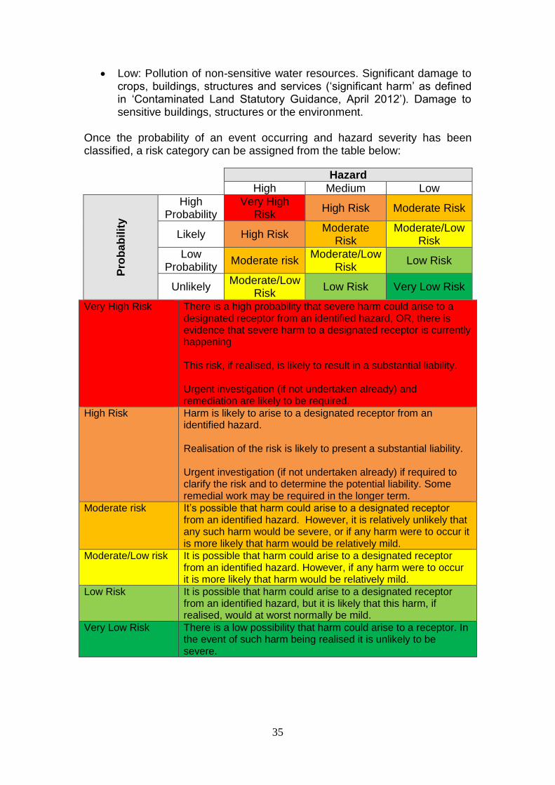
The Model Procedures for the Management of Land Contamination (CLR1117) provide the technical framework for applying a risk management process when dealing with contaminated land. The Borough Council’s Contaminated Land Strategy has identified priority sites based on mapping and documentary information. The Contaminated Land Inspection Report collates all the existing information on the site and develops a conceptual site model to identify and assess potential pollutant linkages and to estimate risk. The risk assessment process focuses on whether there is an unacceptable risk, which will depend on the circumstances of the site and the context of the decision. The Council has used a process adapted from CIRIA C552, Contaminated Land Risk Assessment, a guide to good practice18 to produce the conceptual site model and estimate the risk of harm to defined receptors. This involves the consideration of the probability, nature and extent of exposure and the severity and extent of the effects of the contamination hazard should exposure occur. The probability of an event can be classified as follows:
Highly likely: The event appears very likely in the short term and almost inevitable over the long term, or there is evidence at the receptor of harm or pollution;
Likely: It is probable that an event will occur, or circumstances are such that the event is not inevitable, but possible in the short term and likely over the long term;
Low likelihood: Circumstances are possible under which an event could occur, but it is not certain even in the long term that an event would occur and it is less likely in the short term;
Unlikely: Circumstances are such that it is improbable the event would occur even in the long term.
The severity of the hazard can be classified as follows:
High: Short term (acute) risk to human health likely to result in ‘significant harm’ as defined by the Environment Protection Act 1990, Part IIA. Short term risk of pollution of sensitive water resources. Catastrophic damage to buildings or property. Short term risk to an ecosystem or organism forming part of that ecosystem (note definition of ecosystem in ‘Contaminated Land Statutory Guidance, April 2012’);
Medium: Chronic damage to human health (‘significant harm’ as defined in ‘Contaminated Land Statutory Guidance, April 2012’), pollution of sensitive water resources, significant change in an ecosystem or organism forming part of that ecosystem (note definition of ecosystem in ‘Contaminated Land Statutory Guidance, April 2012’);
17
https://www.gov.uk/guidance/land-contamination-risk-management 18
https://www.brebookshop.com/samples/142102.pdf
35
Low: Pollution of non-sensitive water resources. Significant damage to crops, buildings, structures and services (‘significant harm’ as defined in ‘Contaminated Land Statutory Guidance, April 2012’). Damage to sensitive buildings, structures or the environment.
Once the probability of an event occurring and hazard severity has been classified, a risk category can be assigned from the table below:
Very High Risk There is a high probability that severe harm could arise to a designated receptor from an identified hazard, OR, there is evidence that severe harm to a designated receptor is currently happening This risk, if realised, is likely to result in a substantial liability. Urgent investigation (if not undertaken already) and remediation are likely to be required.
High Risk Harm is likely to arise to a designated receptor from an identified hazard. Realisation of the risk is likely to present a substantial liability. Urgent investigation (if not undertaken already) if required to clarify the risk and to determine the potential liability. Some remedial work may be required in the longer term.
Moderate risk It’s possible that harm could arise to a designated receptor from an identified hazard. However, it is relatively unlikely that any such harm would be severe, or if any harm were to occur it is more likely that harm would be relatively mild.
Moderate/Low risk It is possible that harm could arise to a designated receptor from an identified hazard. However, if any harm were to occur it is more likely that harm would be relatively mild.
Low Risk It is possible that harm could arise to a designated receptor from an identified hazard, but it is likely that this harm, if realised, would at worst normally be mild.
Very Low Risk There is a low possibility that harm could arise to a receptor. In the event of such harm being realised it is unlikely to be severe.
Hazard
High Medium Low
Pro
ba
bilit
y
High Probability
Very High Risk
High Risk Moderate Risk
Likely High Risk Moderate
Risk Moderate/Low
Risk
Low Probability
Moderate risk Moderate/Low
Risk Low Risk
Unlikely Moderate/Low
Risk Low Risk Very Low Risk
36
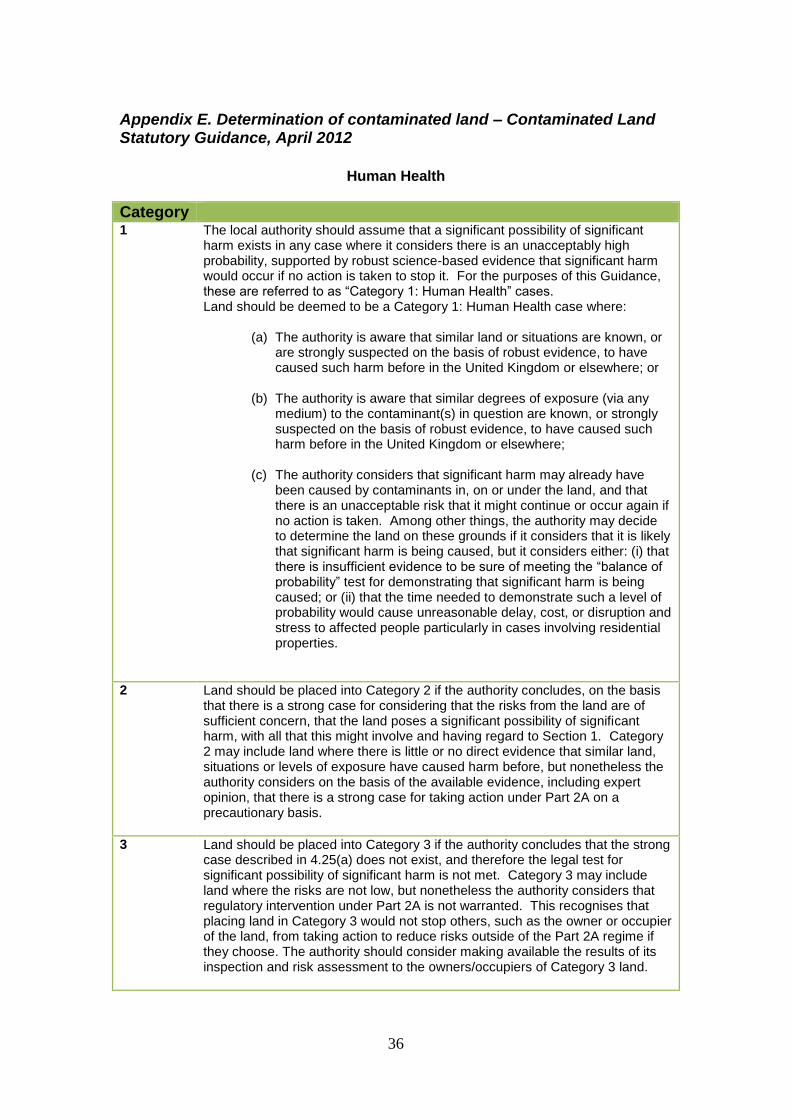
Appendix E. Determination of contaminated land – Contaminated Land Statutory Guidance, April 2012
Human Health
Category 1 The local authority should assume that a significant possibility of significant
harm exists in any case where it considers there is an unacceptably high probability, supported by robust science-based evidence that significant harm would occur if no action is taken to stop it. For the purposes of this Guidance, these are referred to as “Category 1: Human Health” cases. Land should be deemed to be a Category 1: Human Health case where:
(a) The authority is aware that similar land or situations are known, or are strongly suspected on the basis of robust evidence, to have caused such harm before in the United Kingdom or elsewhere; or
(b) The authority is aware that similar degrees of exposure (via any
medium) to the contaminant(s) in question are known, or strongly suspected on the basis of robust evidence, to have caused such harm before in the United Kingdom or elsewhere;
(c) The authority considers that significant harm may already have
been caused by contaminants in, on or under the land, and that there is an unacceptable risk that it might continue or occur again if no action is taken. Among other things, the authority may decide to determine the land on these grounds if it considers that it is likely that significant harm is being caused, but it considers either: (i) that there is insufficient evidence to be sure of meeting the “balance of probability” test for demonstrating that significant harm is being caused; or (ii) that the time needed to demonstrate such a level of probability would cause unreasonable delay, cost, or disruption and stress to affected people particularly in cases involving residential properties.
2 Land should be placed into Category 2 if the authority concludes, on the basis that there is a strong case for considering that the risks from the land are of sufficient concern, that the land poses a significant possibility of significant harm, with all that this might involve and having regard to Section 1. Category 2 may include land where there is little or no direct evidence that similar land, situations or levels of exposure have caused harm before, but nonetheless the authority considers on the basis of the available evidence, including expert opinion, that there is a strong case for taking action under Part 2A on a precautionary basis.
3 Land should be placed into Category 3 if the authority concludes that the strong case described in 4.25(a) does not exist, and therefore the legal test for significant possibility of significant harm is not met. Category 3 may include land where the risks are not low, but nonetheless the authority considers that regulatory intervention under Part 2A is not warranted. This recognises that placing land in Category 3 would not stop others, such as the owner or occupier of the land, from taking action to reduce risks outside of the Part 2A regime if they choose. The authority should consider making available the results of its inspection and risk assessment to the owners/occupiers of Category 3 land.

37
Category 4 The local authority should consider that the following types of land should be
placed into Category 4: Human Health:
(a) Land where no relevant contaminant linkage has been established.
(b) Land where there are only normal levels of contaminants in soil, as explained in Section 3 of this Guidance.
(c) Land that has been excluded from the need for further inspection
and assessment because contaminant levels do not exceed relevant generic assessment criteria in accordance with Section 3 of this Guidance, or relevant technical tools or advice that may be developed in accordance with paragraph 3.30 of this Guidance.
(d) Land where estimated levels of exposure to contaminants in soil
are likely to form only a small proportion of what a receptor might be exposed to anyway through other sources of environmental exposure (e.g. in relation to average estimated national levels of exposure to substances commonly found in the environment, to which receptors are likely to be exposed in the normal course of their lives).

38
Ecological system effects
Relevant types of receptor
Significant harm Significant possibility of significant harm
Any ecological system, or living organism forming part of such a system, within a location which is:
• A site of special scientific interest (under section 28 of the Wildlife and Countryside Act 1981) • A national nature reserve (under s.35 of the 1981 Act) • A marine nature reserve (under s.36 of the 1981 Act) • An area of special protection for birds (under s.3 of the 1981 Act) • A “European site” within the meaning of regulation 8 of the Conservation of Habitats and Species Regulations 2010
• Any habitat or site afforded policy protection under paragraph 6 of Planning Policy Statement (PPS 9) on nature conservation (i.e. candidate Special Areas of Conservation, potential Special Protection Areas and listed Ramsar sites); or • Any nature reserve established under section 21 of the National Parks and Access to the Countryside Act 1949.
The following types of harm should be considered to be significant harm:
• Harm which results in an irreversible adverse change, or in some other substantial adverse change, in the functioning of the ecological system within any substantial part of that location; or • Harm which significantly affects any species of special interest within that location and which endangers the long-term maintenance of the population of that species at that location.
In the case of European sites, harm should also be considered to be significant harm if it endangers the favourable conservation status of natural habitats at such locations or species typically found there. In deciding what constitutes such harm, the local authority should have regard to the advice of Natural England and to the requirements of the Conservation of Habitats and Species Regulations 2010.
Conditions would exist for considering that a significant possibility of significant harm exists to a relevant ecological receptor where the local authority considers that: • Significant harm of that description is more likely than not to result from the contaminant linkage in question; or • There is a reasonable possibility of significant harm of that description being caused, and if that harm were to occur, it would result in such a degree of damage to features of special interest at the location in question that they would be beyond any practicable possibility of restoration. Any assessment made for these purposes should take into account relevant information for that type of contaminant linkage, particularly in relation to the ecotoxicological effects of the contaminant.

39
Property effects
Relevant types of receptor
Significant harm Significant possibility of significant harm
Property in the form of:
• Crops, including timber; • Produce grown domestically, or on allotments, for consumption; • Livestock; • Other owned or domesticated animals; • Wild animals which are the subject of shooting or fishing rights.
For crops, a substantial diminution in yield or other substantial loss in their value resulting from death, disease or other physical damage. For domestic pets, death, serious disease or serious physical damage. For other property in this category, a substantial loss in its value resulting from death, disease or other serious physical damage. The local authority should regard a substantial loss in value as occurring only when a substantial proportion of the animals or crops are dead or otherwise no longer fit for their intended purpose. Food should be regarded as being no longer fit for purpose when it fails to comply with the provisions of the Food Safety Act 1990. Where a diminution in yield or loss in value is caused by a contaminant linkage, a 20% diminution or loss should be regarded as a benchmark for what constitutes a substantial diminution or loss. In this section, this description of significant harm is referred to as an “animal or crop effect”.
Conditions would exist for considering that a significant possibility of significant harm exists to the relevant types of receptor where the local authority considers that significant harm is more likely than not to result from the contaminant linkage in question, taking into account relevant information for that type of contaminant linkage, particularly in relation to the ecotoxicological effects of the contaminant.
Property in the form of buildings. For this purpose, “building” means any structure or erection, and any part of a building including any part below ground level, but does not include plant or machinery comprised in a building, or buried services such as sewers, water pipes or electricity cables.
Structural failure, substantial damage or substantial interference with any right of occupation. The local authority should regard substantial damage or substantial interference as occurring when any part of the building ceases to be capable of being used for the purpose for which it is or was intended. In the case of a scheduled Ancient Monument, substantial damage should also be regarded as occurring when the damage significantly impairs the historic, architectural, traditional, artistic or archaeological interest by reason of which the monument was scheduled. In this Section, this description of significant harm is referred to as a “building effect”.
Conditions would exist for considering that a significant possibility of significant harm exists to the relevant types of receptor where the local authority considers that significant harm is more likely than not to result from the contaminant linkage in question during the expected economic life of the building (or in the case of a scheduled Ancient Monument the foreseeable future), taking into account relevant information for that type of contaminant linkage.
40
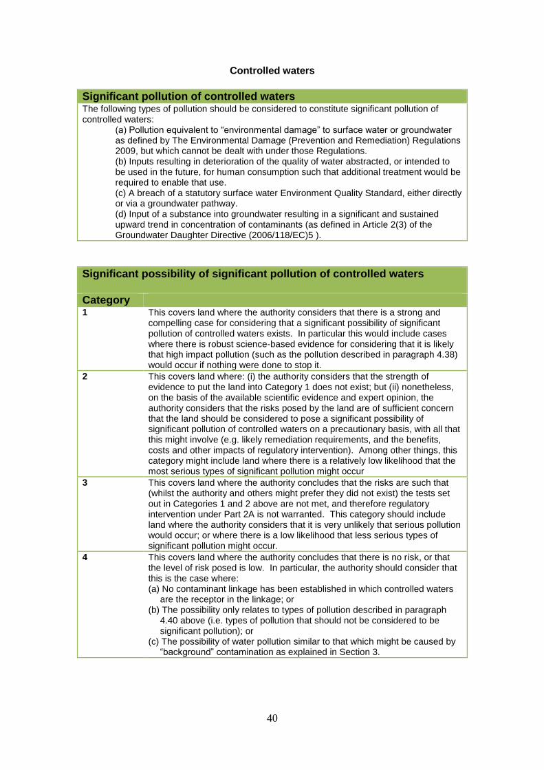
Controlled waters
Significant pollution of controlled waters The following types of pollution should be considered to constitute significant pollution of controlled waters:
(a) Pollution equivalent to “environmental damage” to surface water or groundwater as defined by The Environmental Damage (Prevention and Remediation) Regulations 2009, but which cannot be dealt with under those Regulations. (b) Inputs resulting in deterioration of the quality of water abstracted, or intended to be used in the future, for human consumption such that additional treatment would be required to enable that use. (c) A breach of a statutory surface water Environment Quality Standard, either directly or via a groundwater pathway. (d) Input of a substance into groundwater resulting in a significant and sustained upward trend in concentration of contaminants (as defined in Article 2(3) of the Groundwater Daughter Directive (2006/118/EC)5 ).
Significant possibility of significant pollution of controlled waters
Category 1 This covers land where the authority considers that there is a strong and
compelling case for considering that a significant possibility of significant pollution of controlled waters exists. In particular this would include cases where there is robust science-based evidence for considering that it is likely that high impact pollution (such as the pollution described in paragraph 4.38) would occur if nothing were done to stop it.
2 This covers land where: (i) the authority considers that the strength of evidence to put the land into Category 1 does not exist; but (ii) nonetheless, on the basis of the available scientific evidence and expert opinion, the authority considers that the risks posed by the land are of sufficient concern that the land should be considered to pose a significant possibility of significant pollution of controlled waters on a precautionary basis, with all that this might involve (e.g. likely remediation requirements, and the benefits, costs and other impacts of regulatory intervention). Among other things, this category might include land where there is a relatively low likelihood that the most serious types of significant pollution might occur
3 This covers land where the authority concludes that the risks are such that (whilst the authority and others might prefer they did not exist) the tests set out in Categories 1 and 2 above are not met, and therefore regulatory intervention under Part 2A is not warranted. This category should include land where the authority considers that it is very unlikely that serious pollution would occur; or where there is a low likelihood that less serious types of significant pollution might occur.
4 This covers land where the authority concludes that there is no risk, or that the level of risk posed is low. In particular, the authority should consider that this is the case where: (a) No contaminant linkage has been established in which controlled waters
are the receptor in the linkage; or (b) The possibility only relates to types of pollution described in paragraph
4.40 above (i.e. types of pollution that should not be considered to be significant pollution); or
(c) The possibility of water pollution similar to that which might be caused by “background” contamination as explained in Section 3.