Embed Size (px)
Citation preview
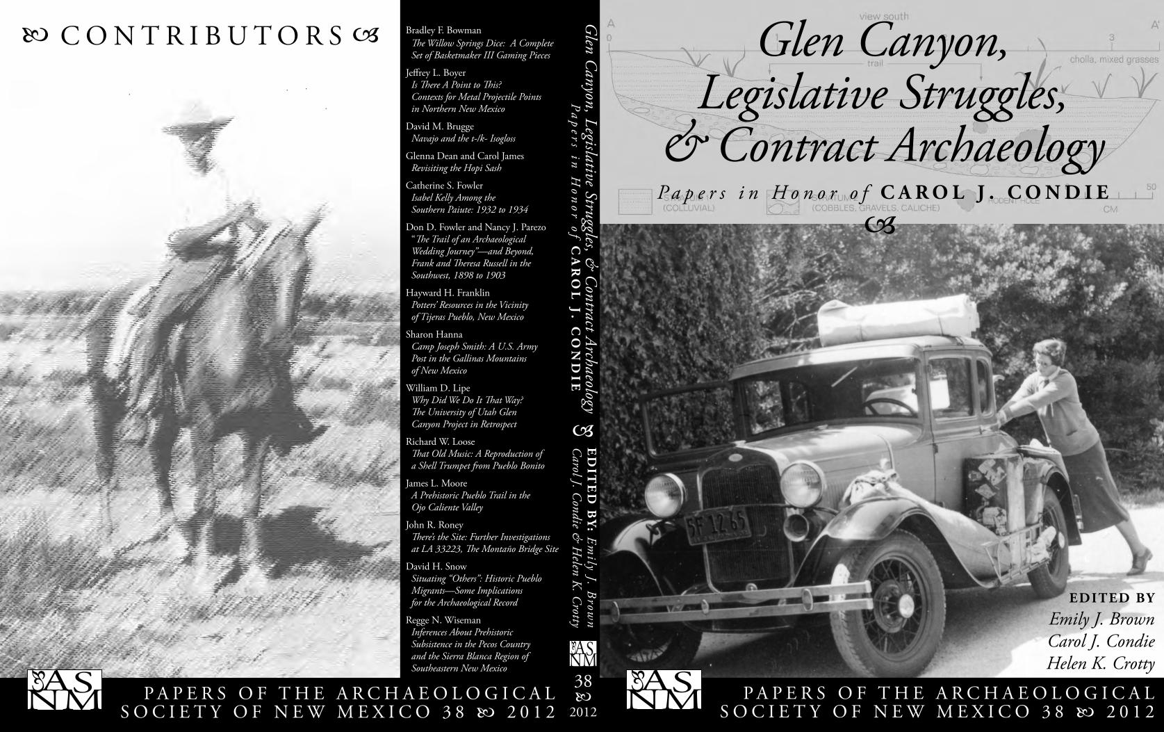
Glen Canyon,Legislative Struggles,
& Contract Archaeology
P A P E R S O F T H E A R C H A E O L O G I C A L S O C I E T Y O F N E W M E X I C O 3 8 2 0 1 2
ASNM
C O N T R I B U T O R S
38
2012
ED
ITE
D B
Y: E
mily J. B
rown
Carol J. C
ondie & H
elen K. C
rotty
ASNM
Glen C
anyon, Legislative Struggles, & C
ontract Archaeology
Bradley F. Bowman Th e Willow Springs Dice: A Complete Set of Basketmaker III Gaming Pieces
Jeff rey L. Boyer Is Th ere A Point to Th is? Contexts for Metal Projectile Points in Northern New Mexico
David M. Brugge Navajo and the t-/k- Isogloss
Glenna Dean and Carol James Revisiting the Hopi Sash
Catherine S. Fowler Isabel Kelly Among the Southern Paiute: 1932 to 1934
Don D. Fowler and Nancy J. Parezo “Th e Trail of an Archaeological Wedding Journey”—and Beyond, Frank and Th eresa Russell in the Southwest, 1898 to 1903
Hayward H. Franklin Potters’ Resources in the Vicinity of Tijeras Pueblo, New Mexico
Sharon Hanna Camp Joseph Smith: A U.S. Army Post in the Gallinas Mountains of New Mexico
William D. Lipe Why Did We Do It Th at Way? Th e University of Utah Glen Canyon Project in Retrospect
Richard W. Loose Th at Old Music: A Reproduction of a Shell Trumpet from Pueblo Bonito
James L. MooreA Prehistoric Pueblo Trail in the Ojo Caliente Valley
John R. Roney Th ere’s the Site: Further Investigations at LA 33223, Th e Montaño Bridge Site
David H. Snow Situating “Others”: Historic Pueblo Migrants—Some Implications for the Archaeological Record
Regge N. Wiseman Inferences About Prehistoric Subsistence in the Pecos Country and the Sierra Blanca Region of Southeastern New Mexico
P A P E R S O F T H E A R C H A E O L O G I C A L S O C I E T Y O F N E W M E X I C O 3 8 2 0 1 2
ASNM
EDITED BY
Emily J. BrownCarol J. CondieHelen K. Crotty
P a p e r s i n H o n o r o f C A R O L J . C O N D I E
Pa
pers in
Hon
or of CA
RO
L J. C
ON
DIE
/ 1
Glen Canyon, Legislative Struggles, & Contract Archaeology
P A P E R S O F T H E A R C H A E O L O G I C A L S O C I E T Y O F N E W M E X I C O 3 8 2 0 1 2
C O N T R I B U T O R S
Bradley F. Bowman
Jeff rey L. Boyer
David M. Brugge
Glenna Dean
Catherine S. Fowler
Don D. Fowler
Hayward H. Franklin
Sharon Hanna
Carol James
William D. Lipe
Richard W. Loose
James L. Moore
Nancy J. Parezo
John R. Roney
David H. Snow
Regge N. Wiseman
E D I T E D B Y
Emily J. Brown
Carol J. Condie
Helen K. Crotty
Paper s in Honor o fCAROL J. CONDIE
2 / Papers of the Archaeological Society of New Mexico: 38
Statements and interpretations presented in the articles are those of the author or authors and do not necessarily refl ect the opinions of the Archaeological Society of New Mexico or its individual members.
Published by the Archaeological Society of New MexicoP.O. Box 3485, Albuquerque, NM 87110
Copyright © Archaeological Society of New Mexico 2012
Printed in the United States of AmericaISSN: 0587-1719
/ 3
iii
Preface . . . . . . . . . . . . . . . . . . . . . . . . . . . . . . . . . . . . . . . . . . . . . . . . . . . . . . . . . . . . . v
Carol J. Condie Carol J. Condie, Autobiographical Notes . . . . . . . . . . . . . . . . . . . . . . . . . . . . . . . . 1
Bradley F. Bowman Th e Willow Springs Dice: A Complete Set of Basketmaker III Gaming Pieces . . . . . 15
Jeff rey L. Boyer Is Th ere A Point to Th is? Contexts for Metal Projectile Points in Northern New Mexico . . . . . . . . . . . . . . . . . . . . . . . . . . . . . . . . . . . . . . . . . . . . . 21
David M. Brugge Navajo and the t-/k- Isogloss . . . . . . . . . . . . . . . . . . . . . . . . . . . . . . . . . . . . . . . . 33
Glenna Dean and Carol James Revisiting the Hopi Sash . . . . . . . . . . . . . . . . . . . . . . . . . . . . . . . . . . . . . . . . . . . 37
Catherine S. Fowler Isabel Kelly Among the Southern Paiute: 1932 to 1934 . . . . . . . . . . . . . . . . . . . . . 45
Don D. Fowler and Nancy J. Parezo “Th e Trail of an Archaeological Wedding Journey”—and Beyond, Frank and Th eresa Russell in the Southwest, 1898 to 1903 . . . . . . . . . . . . . . . . . . 57
Hayward H. Franklin Potters’ Resources in the Vicinity of Tijeras Pueblo, New Mexico . . . . . . . . . . . . . . . 71
Sharon Hanna Camp Joseph Smith: A U.S. Army Post in the Gallinas Mountains of New Mexico . . . . . . . . . . . . . . . . . . . . . . . . . . . . . . . . . . . . . . . . . . . . . . . . . . . . 81
William D. Lipe Why Did We Do It Th at Way? Th e University of Utah Glen Canyon Project in Retrospect . . . . . . . . . . . . . . . . . . . . . . . . . . . . . . . . . . . . . . . . . . . . . . 87
Richard W. Loose Th at Old Music: A Reproduction of a Shell Trumpet from Pueblo Bonito . . . . . . . 105
James L. MooreA Prehistoric Pueblo Trail in the Ojo Caliente Valley . . . . . . . . . . . . . . . . . . . . . . 113
John R. Roney Th ere’s the Site: Further Investigations at LA 33223, Th e Montaño Bridge Site . . . 125
David H. Snow Situating “Others”: Historic Pueblo Migrants—Some Implications for the Archaeological Record . . . . . . . . . . . . . . . . . . . . . . . . . . . . . . . . . . . . . . . . . . . . 139
Regge N. Wiseman Inferences About Prehistoric Subsistence in the Pecos Country and the Sierra Blanca Regionof Southeastern New Mexico . . . . . . . . . . . . . . . . . . . . . . . . 153
TABLE OF CONTENTS

4 / Papers of the Archaeological Society of New Mexico: 38
/ 5
P R E F A C E I first met Carol Condie when I was attending meetings of the Board of Trustees of the Archaeological Society of New Mexico as editor of the newsletter and she was serving as a member of the board. Even before we began to work together more closely, if intermittently, as two members of a group of co-editors of the society’s annual volume, I was impressed by her intelligently thought-out and well-spoken contributions to board discussions. I therefore felt a great sense of relief and gratitude when she volunteered to serve as one of the co-editors on the editing committee, of which I was the chair despite my lack of experience—the whole endeavor would go well after all! Carol’s experience with editing, knowledge of archaeology and linguistics, and meticulous attention to detail continue to ensure that the ASNM annual volumes are professional publications. As I worked with her more closely I began to appreciate her other talents and contributions as well. Her involvement with developing public policy and her work to hold government agencies accountable for protecting archaeological sites on public lands will have a lasting impact. Her archaeological research is meticulous and expertly done, and all the organizations to which she contributes benefi t greatly from her time and talents. Carol knows her own mind , is an excellent role model for those of us at earlier stages in our careers, and knows how to make mean dill pickle. As one contributor to this volume admiringly put it, Carol “is… made of stern stuff , and we love her.”
—Emily J. Brown
v

6 / Papers of the Archaeological Society of New Mexico: 38
1
C O N T E X T
Since I didn’t spring full-blown from the brow of Zeus, a little context may be useful. Both of my parents came from old Mormon families who settled in St. George and Santa Clara in the Virgin River Basin of southwestern Utah. But settlement in the basin wasn’t just happenstance. Although it’s some of the most gorgeous country on earth, Brigham Young, the President of the Mormon Church (1847-1877) had other reasons for wanting that corner of Utah fi lled with permanent settlers. Th e Old Spanish Trail ran nearby and Brigham saw the trail as a route for Mormon converts to follow from California to Utah. He also wanted local Indians converted to Mormonism as a way to safeguard travelers from possible Indian attacks. Perhaps most important, he urgently wanted Mormons to become economically independent and, to that end, handpicked settlers who held a diversity of skills that would lead to self-suffi ciency for each community and for Utah as a whole. (I haven’t done the research, but I suspect he may have imitated practices followed by Spanish colonizers in New Mexico. Th is, and irrigation customs prevailing among both Pueblo and Spanish communities, would have been observed by Mormon offi cials while the Mormon Battalion was in New Mexico in 1846 fi ghting for the U.S. during the Mexican War.) My father’s mother, Annie Staff ord, an orphan raised by an aunt and uncle in Sheffi eld, England, converted to Mormonism at the age of 16. Th e
missionary who converted her paid her passage to the U.S. and on to Utah. She, thus, became a bond servant and went to St. George, where she worked for his wife. When her benefactor completed his mission he returned to Utah and, after Annie had worked out her servitude, he took her as a second wife (which, as in many instances of plural marriage, made his fi rst wife none too happy). Polygamy had been declared illegal in the U.S. in the Anti-Polygamy Act of 1862 and was later strengthened by the Edmunds Bill in 1882. Most Mormons ignored these acts. However, Utah (then the Territory of Deseret), anxious to become a state, had been rejected several times because of polygamy and, in 1890, the president of the church issued a manifesto instructing church members to abstain from polygamy. Th is, of course, created a problem for superfl uous wives and children. Since Annie’s husband was an important offi cial of the church, they, like many others, spent a lot of time in Mexico City and Colonia Juarez running from the Feds. Later, she lived on the Arizona Strip in a community of plural wives. Husbands visited once or twice a year to replenish staples the wives couldn’t raise in their gardens and fl ocks. Th e birth rate did not diminish (for Annie, the fi nal total from this marriage was 12 children). After her husband died, she met and married my grandfather, George Condie, who was not a polygamist, in 1906. Beyond the fact that fi ve Condie brothers joined the church and migrated to Utah and Idaho from Scotland, I know almost nothing about them. My father, Leroy, was three years
Carol J. Condie, Autobiograhical Notes
C A R O L J . C O N D I E
1
2 PAPERS OF THE ARCHAEOLOGICAL SOCIETY OF NEW MEXICO • 38
old and his mother was pregnant with his younger brother, Carl, when George died. Oddly enough, in spite of what seems now a shockingly hard life, Annie was always cheerful and optimistic. My mother’s family was Swiss. Her parents, George Graff and Bertha Stucki, were both descendants of original Santa Clara settlers. Beginning in 1854 Brigham Young had sent people to establish a scattering of small settlements in southwestern Utah. Experimental plots of cotton had been raised successfully since 1855 and after the Civil War began it became apparent that cotton from the States would be in extremely short supply. In October 1861 Brigham “called” 309 families to establish the “Cotton Mission,” with St. George as the administrative center.
(Th e cotton industry became responsible for the name “Utah’s Dixie” being applied to the southwestern corner of Utah.) Among the 309 families were 85 Swiss immigrants from various cantons in Switzerland who had settled at diff erent towns in northern Utah between 1857 and 1861. Th ey were formed into the “Swiss Company” and sent to settle Santa Clara. Th ey were skilled as farmers, vintners, carpenters, and other trades. Since I know their history best, I’ll use my family as a brief example. One was a musician, but had also owned a small cotton spinning factory. Another was a farmer, but was also a turner who made farm implements and spinning wheels. My great grandmother’s family, who arrived in 1874, worked as weavers of fancy silks. We weren’t unique. Every family had a background of useful skills and knowledge. Th e old Swiss lifeway is mainly gone now, but the town’s Swiss heritage is still visible in the beautiful fl ower gardens gracing every front yard.
G R O W I N G U P
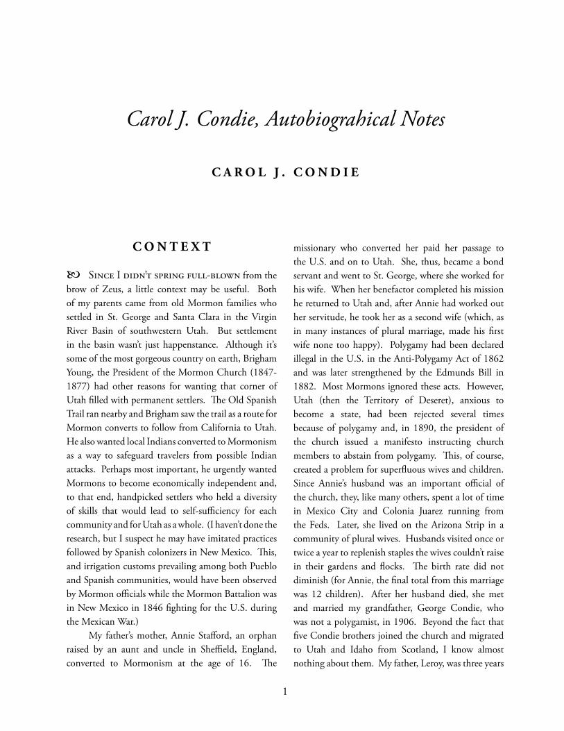
As for my immediate history, I was born in Provo, Utah on December 28, 1931 and my brother, George, followed 18 months later. Our parents were Th elma Graff and LeRoy Condie. After my father fi nished his Bachelor’s degree at Brigham Young University and had worked in business for several years, we moved to New York, where he earned a Master’s degree in Retailing at New York University. Th e idea seemed to be “If you don’t have a good job, go back to school.” In addition to no job, we also didn’t have much money, but we frequented New York’s many wonderful and low-cost museums. Th en—back to Utah and to Salt Lake City. Fortunately, as I became a teenager and began to question Mormon dogma, my parents remained calm. (I realized later that they had made their own peace with the church.) Ours was a happy household, punctuated with lots of laughter. We hiked and roamed around every weekend and took vacations that no one else we knew took (this
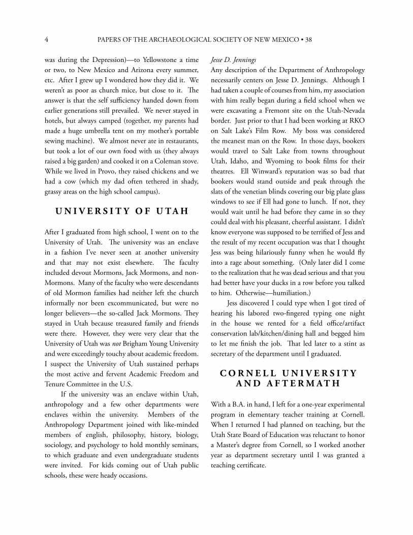
Figure 1. Roy Condie with George and Carol, ca. 1934.
3CAROL J. CONDIE
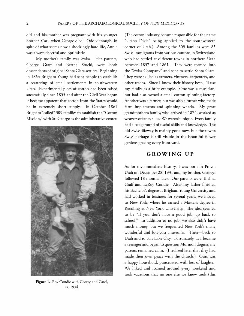
left–Figure 2. Th elma Graff Condie with George and Carol, ca. 1934.
below–Figure 3. Family and friends, Santa Clara, Utah, Easter, ca. 1942. Back row, left to right: Stanley Ray, Leona Ray (Bertha’s sister), Joe Ray, George Graff (Th elma’s father), Th elma Graff Condie, Bertha Graff (Th elma’s mother), Annie Condie (Roy’s mother), Barbara Graff (George Graff ’s mother), Amanda Graff (George Graff ’s sister). Front row, left to right: Charmaine Ray, Marian Ray, Carol Condie, Lorna Graff , George Condie, Dale Gubler, DeLoy Gubler.
4 PAPERS OF THE ARCHAEOLOGICAL SOCIETY OF NEW MEXICO • 38
was during the Depression)—to Yellowstone a time or two, to New Mexico and Arizona every summer, etc. After I grew up I wondered how they did it. We weren’t as poor as church mice, but close to it. Th e answer is that the self suffi ciency handed down from earlier generations still prevailed. We never stayed in hotels, but always camped (together, my parents had made a huge umbrella tent on my mother’s portable sewing machine). We almost never ate in restaurants, but took a lot of our own food with us (they always raised a big garden) and cooked it on a Coleman stove. While we lived in Provo, they raised chickens and we had a cow (which my dad often tethered in shady, grassy areas on the high school campus).
U N I V E R S I T Y O F U T A H
After I graduated from high school, I went on to the University of Utah. Th e university was an enclave in a fashion I’ve never seen at another university and that may not exist elsewhere. Th e faculty included devout Mormons, Jack Mormons, and non-Mormons. Many of the faculty who were descendants of old Mormon families had neither left the church informally nor been excommunicated, but were no longer believers—the so-called Jack Mormons. Th ey stayed in Utah because treasured family and friends were there. However, they were very clear that the University of Utah was not Brigham Young University and were exceedingly touchy about academic freedom. I suspect the University of Utah sustained perhaps the most active and fervent Academic Freedom and Tenure Committee in the U.S. If the university was an enclave within Utah, anthropology and a few other departments were enclaves within the university. Members of the Anthropology Department joined with like-minded members of english, philosophy, history, biology, sociology, and psychology to hold monthly seminars, to which graduate and even undergraduate students were invited. For kids coming out of Utah public schools, these were heady occasions.
Jesse D. JenningsAny description of the Department of Anthropology necessarily centers on Jesse D. Jennings. Although I had taken a couple of courses from him, my association with him really began during a fi eld school when we were excavating a Fremont site on the Utah-Nevada border. Just prior to that I had been working at RKO on Salt Lake’s Film Row. My boss was considered the meanest man on the Row. In those days, bookers would travel to Salt Lake from towns throughout Utah, Idaho, and Wyoming to book fi lms for their theatres. Ell Winward’s reputation was so bad that bookers would stand outside and peak through the slats of the venetian blinds covering our big plate glass windows to see if Ell had gone to lunch. If not, they would wait until he had before they came in so they could deal with his pleasant, cheerful assistant. I didn’t know everyone was supposed to be terrifi ed of Jess and the result of my recent occupation was that I thought Jess was being hilariously funny when he would fl y into a rage about something. (Only later did I come to the realization that he was dead serious and that you had better have your ducks in a row before you talked to him. Otherwise—humiliation.) Jess discovered I could type when I got tired of hearing his labored two-fi ngered typing one night in the house we rented for a fi eld offi ce/artifact conservation lab/kitchen/dining hall and begged him to let me fi nish the job. Th at led later to a stint as secretary of the department until I graduated.
C O R N E L L U N I V E R S I T Y A N D A F T E R M A T H
With a B.A. in hand, I left for a one-year experimental program in elementary teacher training at Cornell. When I returned I had planned on teaching, but the Utah State Board of Education was reluctant to honor a Master’s degree from Cornell, so I worked another year as department secretary until I was granted a teaching certifi cate.
5
In the meantime, I married Kent Stout (and divorced him many years later). I taught third grade for a year, worked for one of the vice presidents of the university for a couple of years, moved to Burlingame, California for a year while Kent worked as an architect for the National Park Service, and returned to Salt Lake, where Carla, our fi rst, was born soon after, in January 1958.
T H E G L E N C A N Y O N P R O J E C T
By this time the Glen Canyon Project was underway and I started back to graduate school and also joined the project to serve as assistant editor of the University of Utah Anthropological Papers and its two sub-series, the Upper Colorado Series and the Glen Canyon Series. Th is meant that a faculty member’s name was shown as editor and I did the editing. (Erik, our second, was born in December 1960.) In what I have always considered a stroke of brilliance, Jess had insisted that the Park Service include a clause in the contract stipulating that funding for the next fi eld season would not be released until reports of the previous season’s fi eldwork had been completed and published. Accordingly, we ran full tilt all year. (A refl ex of this was that when non-project people would attend our parties they frequently wanted to sign on, presumably believing that we partied all the time. If they did come to work for the project they were aghast to discover that, instead of constant partying, we worked like demons!) Th e Glen Canyon Project was good training. Several people went on to illustrious careers. As students and employees of Jess Jennings, we had several precepts drilled fi rmly into our brains. I think Jess would almost have overlooked murder before he would forgive not reporting the results of an excavation. Failing to place the information derived from a site in the public domain made one a looter. Lying about or faking data meant the death of your career. You could be wrong or misguided or stupid, but one lie and you could never recover. He was also violent about authors who were too sloppy to go back
to an original reference, but relied on second-hand interpretations (which, of course, are often wrong or at least skewed). He even invented his own little test to ferret out such people. He would throw a ringer into a paper, complete with a false text citation and false bibliographic reference—then watch to see who cited it, a quick tip-off to who could not be trusted.
A L B U Q U E R Q U E A N D T H E U N I V E R S I T Y O F
N E W M E X I C O
Because my parents had moved to Albuquerque in 1958, we made frequent visits to New Mexico and became permanently enchanted. In 1964 we moved to Albuquerque and Paula, our third and last, was born in October. I started graduate school at the University of New Mexico in the summer of 1965. Like a lot of other people, I thought I was coming to the North American center of the archaeological universe, but was dismayed to discover a remarkable lack of interest in archaeology at UNM during that era. Since my kids were still too young for me to establish a fi eld project of my own and since there were good linguists on the anthropology and linguistics faculties (Stanley Newman, Garland Bills, and Bruce Rigsby), I ultimately switched my focus to linguistics, found a wonderful Zuni speaker, and wrote my Ph.D. dissertation on transitivity in Zuni verbs. After I fi nally graduated, I spent several years at the Maxwell Museum of Anthropology as Education Coordinator and director of the Division of Interpretation until I decided I like working in the open air better than working inside.
T H E W O R L D O F C O N T R A C T
A R C H A E O L O G Y
By this time (1978), the kids were old enough to go to the fi eld (or to stay home alone briefl y), so I started a contract fi rm, Quivira Research Center. It would be more accurate to say I started to start a contract
CAROL J. CONDIE
6 PAPERS OF THE ARCHAEOLOGICAL SOCIETY OF NEW MEXICO • 38
fi rm. In those days, federal agencies could contract only with 501(c)(3) organizations, so I assumed it had to be a 501(c)(3). What I didn’t know was that what seemed like half the people in the U.S. were establishing little churches in order to achieve 501(c)(3) status and avoid income taxes. Th is made the IRS highly suspicious of anyone requesting 501(c)(3) status. It took a couple of years and reams of paper in constant responses to endless queries before IRS was convinced that we really intended to conduct archaeological investigations instead of a scam. By 1983 federal agencies had instituted small business set-asides and I formed Quivira Research Associates, a sole proprietorship.
One of our fi rst contract jobs was to record all of the old buildings at Ft. Bliss in El Paso. I should have known something was wrong because two other contract fi rms had defaulted on their contracts soon after they had started. Since Kent was an architect, we took the job on together. As we were leaving our initial meeting with Rex Gerald, the Principal Investigator, at the University of Texas at El Paso, I casually thought to ask him how many buildings there were at Ft. Bliss. He said “Twelve thousand.” When we got outside, I said to Kent, “Oh, s_ _t, let’s quit!” A few minutes later, however, I realized that an installation the size of Ft. Bliss had to have a list of buildings, if only for maintenance purposes. Kent had been in the Army and said the Post Engineer would have the list. Th ey graciously said they could make us a copy by the next morning—and they had it ready at 8:00 a.m. Would that all organizations documented their buildings so thoroughly! Th e inventory included exact locations, dates of construction, dates of additions, square footage, construction materials, and other pertinent information—cutting our research and recording time down enormously. From then on, the project was fairly standard, with one eerie little exception. We were working on the quad at the old Beaumont Medical Complex. Beaumont had been famous for its beautiful gardens and buildings, but now many of the buildings on the old quad were slated for demolition. Th e entire quad, with its lawn still green and carefully manicured, was vacant and silent. Th e 1921 section of the hospital complex consisted of frame buildings connected by raised, covered walkways that ran above interior gardens. We climbed the ramp of a hospital building, passing oleanders in full bloom, and pushed through swinging doors into the front hall. Somewhere an air conditioner was running at top speed. We opened another door and suddenly found ourselves in an operating theatre with tiled fl oor, tiled ceiling, and tiled walls. Everything looked normal—except that two of the walls were gone, only jagged stubs attesting their former presence. For the space of several seconds it was as if we were the last two people on earth, the only connection to previous human life being the lonely sound of the air conditioner.
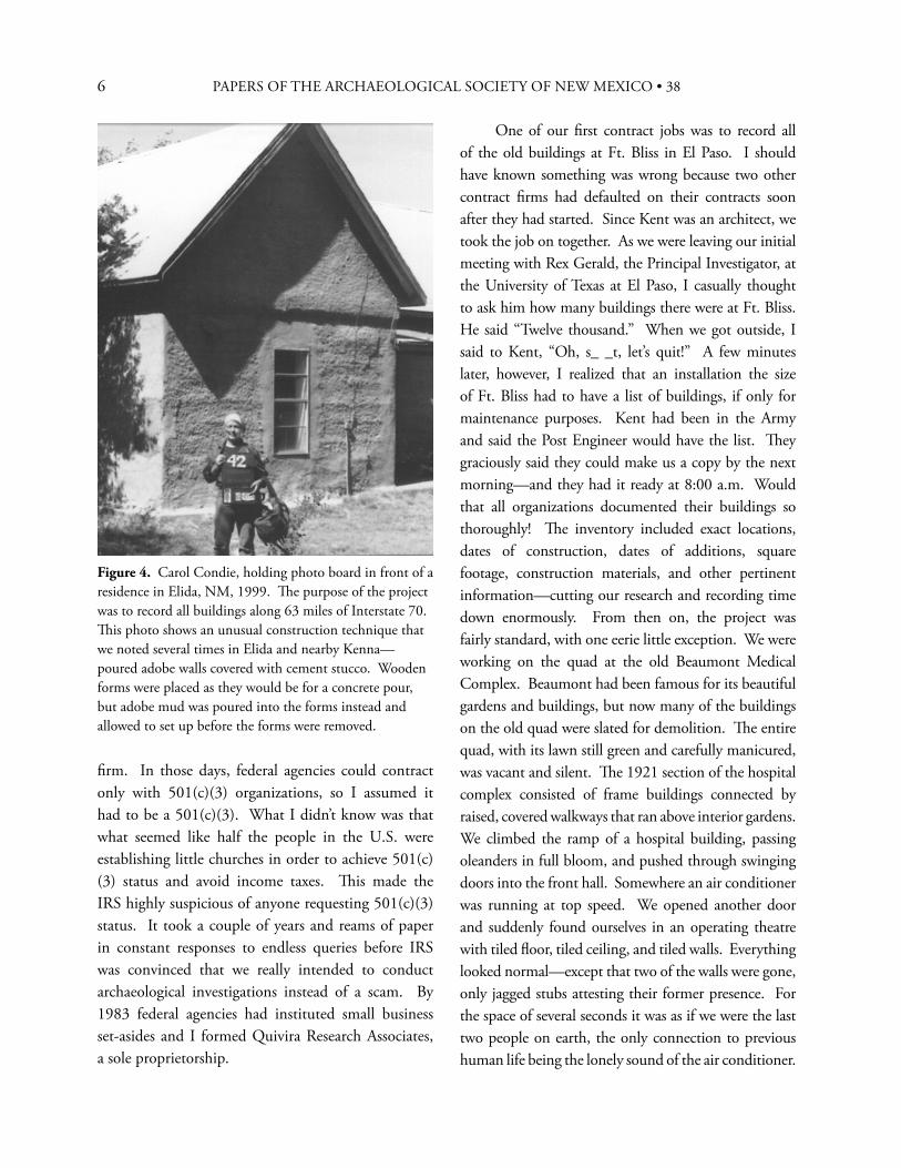
Figure 4. Carol Condie, holding photo board in front of a residence in Elida, NM, 1999. Th e purpose of the project was to record all buildings along 63 miles of Interstate 70. Th is photo shows an unusual construction technique that we noted several times in Elida and nearby Kenna—poured adobe walls covered with cement stucco. Wooden forms were placed as they would be for a concrete pour, but adobe mud was poured into the forms instead and allowed to set up before the forms were removed.
7
I’m sure my career as a contractor has been much like every other small contractor’s. For the fi rst year or two, I was afraid the phone was never going to ring again. A few years down the road and I began to hope it would never ring again. I didn’t know then that contracting, regardless of the specifi c profession, is always feast or famine. One of the pleasures of the business world is the variety of interesting people one meets in the course of work or acquires as clients. Another is that you can fi re unpleasant clients and, if you’re a small independent fi rm, you can also fi re unpleasant or incompetent employees. Enough said about business, with one fi nal story. I know few contractors who don’t have silly stories to tell about the time they left some vital piece of equipment behind and had to improvise a makeshift substitute. In this vein, I should report the dumbest thing I ever did. It will surprise no one who knows me well when I reveal that I don’t have a brain in my head in the morning. Accordingly, I always put all of the small fi eld equipment, maps, work plans, etc. together in two big plastic boxes the night before and check them over, ready to load the next morning. On this occasion, we had a testing project at a small site in an area slated for expansion of the Tri-Sect Landfi ll. Th e landfi ll is about 50 mi southwest of Albuquerque, south of NM-6 and west of the Rio Puerco, a few miles southwest of Pottery Mound. To reach the site it was necessary to go through a locked gate, drive 6 mi south on the haul road, leave the haul road, go through another locked gate, skirt the edge of the existing landfi ll, pass down over a clay hill into a normally dry arroyo, then up the arroyo bed for a mile or so. For some unknown reason, this night, instead of leaving the plastic boxes, cameras, transits, tripods, and pinfl ags in the hallway where we would have to trip over them to get out the door, I put them back in the entry closet, thinking that since they were so big I would notice their absence in the morning and get them out of the closet. When the crew arrived the next morning, we loaded the shovels and screens into the Suburban and prepared to leave. A dim thought crossed my mind that we seemed a little empty, but I decided it was because my son Erik wasn’t
going to the fi eld that day. Th e rest of us drove to the site, jumped out, and got ready to start pinfl agging artifacts. —No pinfl ags! No cameras! No tripods! No fi eld forms! No tapes! No equipment boxes! No nothing except shovels and screens! Obviously, we couldn’t improvise everything we had left behind. A trip back to Albuquerque was the only option. As we were loading the orphaned equipment I told someone to run into my offi ce and turn the computer on to check the weather forecast since a storm had been promised for the following day. Our little site was one of the last places I wanted us to be caught in a fl ash fl ood. We would never get out by ourselves—and, since no one ever passed by, we wouldn’t be found for at least six months. Th e forecast hadn’t changed and another hour found us back at the site, unloaded, and ready to roll. After we’d been pinfl agging for 10 or 15 minutes, I happened to look west toward Lucero Mesa, which marks the edge of the Colorado Plateau in that area, from whence both large and small arroyos plunge down to the Rio Grande rift to the east—to see huge, angry, black clouds boiling off the edge of the mesa. —So, it was throw everything in the vehicle and depart as the fi rst few raindrops hit us. Another hour took us back to Albuquerque, by which time we had been driving for four hours and had accomplished exactly nothing!
T H E R I G H T P L A C E A T T H E R I G H T T I M E
Several times I’ve been fortunate enough to be at the right place at the right time. Although in a few instances, I wasn’t certain “fortunate” was the appropriate word, I feel privileged to have been involved in several extracurricular activities.
Crow Canyon ToursFrom 1986 to 1997, I—along with practically every other archaeologist in the Southwest—served as a seminar leader for Crow Canyon fi eld seminars. (Crow Canyon, a well-respected research and educational organization, is based in Cortez, Colorado.) It was an experience that was good for the soul and humbling
CAROL J. CONDIE
8 PAPERS OF THE ARCHAEOLOGICAL SOCIETY OF NEW MEXICO • 38
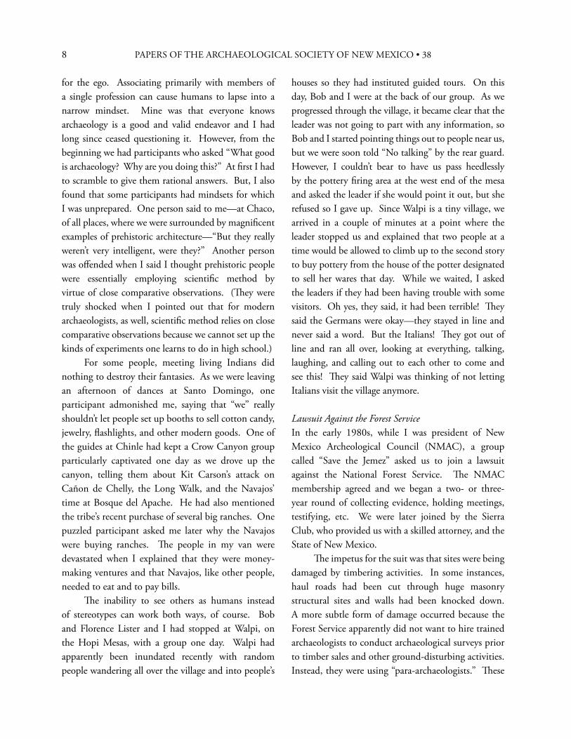
for the ego. Associating primarily with members of a single profession can cause humans to lapse into a narrow mindset. Mine was that everyone knows archaeology is a good and valid endeavor and I had long since ceased questioning it. However, from the beginning we had participants who asked “What good is archaeology? Why are you doing this?” At fi rst I had to scramble to give them rational answers. But, I also found that some participants had mindsets for which I was unprepared. One person said to me—at Chaco, of all places, where we were surrounded by magnifi cent examples of prehistoric architecture—“But they really weren’t very intelligent, were they?” Another person was off ended when I said I thought prehistoric people were essentially employing scientifi c method by virtue of close comparative observations. (Th ey were truly shocked when I pointed out that for modern archaeologists, as well, scientifi c method relies on close comparative observations because we cannot set up the kinds of experiments one learns to do in high school.) For some people, meeting living Indians did nothing to destroy their fantasies. As we were leaving an afternoon of dances at Santo Domingo, one participant admonished me, saying that “we” really shouldn’t let people set up booths to sell cotton candy, jewelry, fl ashlights, and other modern goods. One of the guides at Chinle had kept a Crow Canyon group particularly captivated one day as we drove up the canyon, telling them about Kit Carson’s attack on Cañon de Chelly, the Long Walk, and the Navajos’ time at Bosque del Apache. He had also mentioned the tribe’s recent purchase of several big ranches. One puzzled participant asked me later why the Navajos were buying ranches. Th e people in my van were devastated when I explained that they were money-making ventures and that Navajos, like other people, needed to eat and to pay bills. Th e inability to see others as humans instead of stereotypes can work both ways, of course. Bob and Florence Lister and I had stopped at Walpi, on the Hopi Mesas, with a group one day. Walpi had apparently been inundated recently with random people wandering all over the village and into people’s
houses so they had instituted guided tours. On this day, Bob and I were at the back of our group. As we progressed through the village, it became clear that the leader was not going to part with any information, so Bob and I started pointing things out to people near us, but we were soon told “No talking” by the rear guard. However, I couldn’t bear to have us pass heedlessly by the pottery fi ring area at the west end of the mesa and asked the leader if she would point it out, but she refused so I gave up. Since Walpi is a tiny village, we arrived in a couple of minutes at a point where the leader stopped us and explained that two people at a time would be allowed to climb up to the second story to buy pottery from the house of the potter designated to sell her wares that day. While we waited, I asked the leaders if they had been having trouble with some visitors. Oh yes, they said, it had been terrible! Th ey said the Germans were okay—they stayed in line and never said a word. But the Italians! Th ey got out of line and ran all over, looking at everything, talking, laughing, and calling out to each other to come and see this! Th ey said Walpi was thinking of not letting Italians visit the village anymore.
Lawsuit Against the Forest ServiceIn the early 1980s, while I was president of New Mexico Archeological Council (NMAC), a group called “Save the Jemez” asked us to join a lawsuit against the National Forest Service. Th e NMAC membership agreed and we began a two- or three-year round of collecting evidence, holding meetings, testifying, etc. We were later joined by the Sierra Club, who provided us with a skilled attorney, and the State of New Mexico. Th e impetus for the suit was that sites were being damaged by timbering activities. In some instances, haul roads had been cut through huge masonry structural sites and walls had been knocked down. A more subtle form of damage occurred because the Forest Service apparently did not want to hire trained archaeologists to conduct archaeological surveys prior to timber sales and other ground-disturbing activities. Instead, they were using “para-archaeologists.” Th ese
9
were employees in other specialties who were given brief training sessions in site recognition and then sent out to conduct clearance surveys. In some cases, we believed, a para-archaeologist had a vested interest in fi nding that no sites existed in the area of the proposed disturbance, and in no cases were para-archaeologists the equivalent of degreed and experienced archaeologists. In the end, we settled, rather than going to trial, but the Forest Service throughout the U.S. was thereafter required to employ genuine archaeologists who conducted 100% pedestrian surveys prior to ground-disturbing activities. A small irony was that the morning after the settlement was announced, I received a congratulatory phone call from a colleague in Washington, who asked whether the news had hit the Albuquerque papers. I told him there was a small article on page 2 of the Albuquerque Journal that morning. He responded “It’s on the front page of the Washington Post!” Furthermore, a couple of close friends who were on sabbatical in Peru saw a big article splashed all over the front page of a Sunday paper. So much for those of us who were privileged to be at the eye of the storm!
Petroglyph National MonumentTh e existence of Petroglyph National Monument is the result of hundreds of hours spent by dozens of people over many years, beginning in the 1970s, to convince city, state, and federal leaders of the importance of the remarkable images pecked and carved into the basalt escarpment on Albuquerque’s West Mesa. Th e escarpment runs for 17 mi and contains roughly 20,000 images. My involvement was not as a major player. Someone (lamentably, I can’t remember her name) came into my offi ce at Maxwell Museum in the mid-1970s to urge me to do something about the petroglyphs, which were already under threat of destruction from housing developments. I had no idea how one went about such an undertaking, so I ended up doing nothing. Fortunately, people who did know how appeared on the scene a little later and led the charge. A fairly sizable bunch of us attended
interminable meetings and hearings, led politicians and anyone we deemed infl uential on tours of the escarpment, lobbied the New Mexico legislature and U.S. representatives and senators, and did everything we could think of to sway opinion. Several times it looked as if the monument was a done deal, but just as we began heaving a sigh of relief, a new proposal for a new highway would pop up. Both four-lane and six-lane high-speed highways through the escarpment were proposed to accommodate new housing developments. Although the most destructive impacts were avoided, each threat required mounting a new full-scale response. Finally, the monument was formally established in 1990 and is now jointly managed by the National Park Service and the City of Albuquerque Open Space Division.
Albuquerque Archaeological OrdinanceTh ough it was on-again off -again for more than 20 years and insanely frustrating at times, another instance of being in the right place at the right time was the Albuquerque Archaeological Ordinance. Th e realization that we needed an ordinance stemmed from an instance in 1983 when a sewer line excavation hit human burials. Since there were no guidelines for such situations, several archaeologists began meeting informally and then began calling on the mayor, Bernalillo County Commissioners, and Albuquerque City Councilors. In late 1984 both the city council and the county commission passed resolutions to establish a 10-member City/County Archaeological Resources Planning Advisory Committee (ARPAC). We met every week from February 1985 through August 1985. Mark Harlan was elected Vice President and I was elected President. We produced a detailed report that discussed the history and prehistory of the Albuquerque area and made recommendations for establishing the offi ce of a City/County Archaeologist, setting up a public archaeology program, establishing archaeological compliance procedures for developers, and writing and implementing an ordinance. We had hoped we could present the report to the city and county by late
CAROL J. CONDIE
10 PAPERS OF THE ARCHAEOLOGICAL SOCIETY OF NEW MEXICO • 38
September or October 1985, but fi nal production was out of our hands and the report was not delivered until February 1986. Th e report received the American Planning Association Planning Award for 1985-1986 and was circulated nationwide to help guide other communities trying to establish ordinances. We naively thought we would have no trouble after that in getting a City/County Archaeologist funded and hired and that in two more years a full-fl edged ordinance and a public education and involvement program would be developed. We were wrong, for several reasons. Th e fi rst was that Harry Kinney, the mayor who had been so supportive of developing an ordinance, had left offi ce in November 1985. Th e second was that when we met with the mayor who replaced him, Ken Schultz, he abhorred the thought of an ordinance. Th e third was that we should have moved faster. Had we known how to circumvent the city intern who was supposed to be working for us and who was responsible for the delay, the report would have been submitted while Mayor Kinney was still in offi ce. Th e next few years were no more successful. I met with the next mayor in 1998, who was more polite, but no more enthusiastic than Ken Schultz had been. In the early 1990s, a new committee began meeting and met for several years. Finally, in 1994, we produced an ordinance, which was introduced to the Land Use Planning and Zoning Committee and then went on to the city council, where it drifted and died. Between 1995 and 2005 several of us made sporadic attempts at a grass roots movement, meeting with city councilors, county commissioners, and city and county staff . All of these attempts were dismal failures because we still had no idea what we were doing. But a fi nal surprise awaited us. Unbeknownst to us, Martin Heinrich, then a city councilor (now the U.S. Representative from New Mexico District 1), saw the need for an archaeological ordinance and began discussing it with other councilors. Lawrence KIine, an architect and planner and a friend of Heinrich’s, had served on the original ARPAC committee and told him of our previous ill-fated eff ort. When Lawrence
told me about this we also called David Cushman, who had been on several of the ephemeral committees, had worked at the State Historic Preservation Offi ce in Santa Fe, and had been the historic preservation specialist for Pima County, Arizona for fi ve years. Dave and I met with Lawrence and Councilor Heinrich and off ered our services to help produce an ordinance. Councilor Heinrich had been meeting with developers from early on, telling them he would prefer to have them involved, but he thought he had the votes to pass an ordinance with or without them. Th is time, no committee was established, but Dave and I recruited archaeologists who faithfully attended public meetings when we needed them. We met repeatedly with a group of developers who represented NAIOP (National Association of Industrial and Offi ce Properties). Th ey always cheerfully—and pointedly—began meetings with the fervent wish that we would go away. An attorney for the city council was assigned to write an ordinance, but she found herself in diffi culties because she had little knowledge of archaeology. Th e job was later given to an attorney who had an extensive background in contract archaeology and was able to produce an excellent fi rst draft of a workable ordinance. Dave and I critiqued her subsequent drafts and dickered with the developers. Th e head of the city’s legal department met with us several times and also sat in on some of our meetings with the developers. Th e ordinance was passed unanimously by the city council and was signed by Mayor Martin Chavez in September 2007. Th e moral to this story is that Martin Heinrich knew how the political system worked, went to some pains to meet with developers and listen to their concerns early in the process, knew who the appropriate people in the city hierarchy were to involve in the process, and was determined to pass an ordinance.
Th e Archaeological Society of New Mexico [ASNM] and Th e Archaeological Conservancy [TAC]It has been my good luck to serve on the boards of ASNM (intermittently since 2001) and TAC (since
11
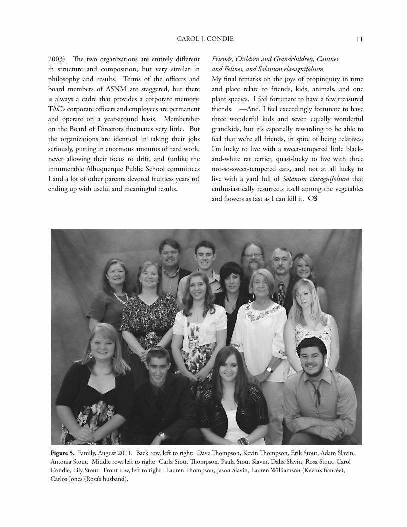
Figure 5. Family, August 2011. Back row, left to right: Dave Th ompson, Kevin Th ompson, Erik Stout, Adam Slavin, Antonia Stout. Middle row, left to right: Carla Stout Th ompson, Paula Stout Slavin, Dalia Slavin, Rosa Stout, Carol Condie, Lily Stout. Front row, left to right: Lauren Th ompson, Jason Slavin, Lauren Williamson (Kevin’s fi ancée), Carlos Jones (Rosa’s husband).
CAROL J. CONDIE
2003). Th e two organizations are entirely diff erent in structure and composition, but very similar in philosophy and results. Terms of the offi cers and board members of ASNM are staggered, but there is always a cadre that provides a corporate memory. TAC’s corporate offi cers and employees are permanent and operate on a year-around basis. Membership on the Board of Directors fl uctuates very little. But the organizations are identical in taking their jobs seriously, putting in enormous amounts of hard work, never allowing their focus to drift, and (unlike the innumerable Albuquerque Public School committees I and a lot of other parents devoted fruitless years to) ending up with useful and meaningful results.
Friends, Children and Grandchildren, Canines and Felines, and Solanum elaeagnifoliumMy fi nal remarks on the joys of propinquity in time and place relate to friends, kids, animals, and one plant species. I feel fortunate to have a few treasured friends. —And, I feel exceedingly fortunate to have three wonderful kids and seven equally wonderful grandkids, but it’s especially rewarding to be able to feel that we’re all friends, in spite of being relatives. I’m lucky to live with a sweet-tempered little black-and-white rat terrier, quasi-lucky to live with three not-so-sweet-tempered cats, and not at all lucky to live with a yard full of Solanum elaeagnifolium that enthusiastically resurrects itself among the vegetables and fl owers as fast as I can kill it.
12 PAPERS OF THE ARCHAEOLOGICAL SOCIETY OF NEW MEXICO • 38
S E L E C T E DB I B L I O G R A P H Y
Condie, Carol J.1973 Problems of a Chomskyan Analysis of Zuni
Transitivity. International Journal of American Linguistics 39(4):207-223.
1976 East Meets West [Oriental and Navajo Floor Rugs]. New Mexico Magazine 54(2):16-20. (with Katina Simmons)
1976 Weavers of the Jade Needle. Fiberarts 3(2)-31.
1977 Review of “Crafts of the North American Indians,” by Richard C. Schneider. Leonardo: International Journal of the Contemporary Arts, Paris, 10:81.
1978 A Brief History of Fort Bliss, Texas, and its Old Buildings. In Settlements Patterns of the Western Hueco Bolson, by Michael E. Whalen, pp. 175-208. El Paso Centennial Museum Publications in Anthropology 6, El Paso. (with M. Kent Stout)
1980 Vocabulary of the Apache or ‘Inde+ Language of Arizona and New Mexico Collected by John Gregory Bourke in the 1870s and 1880s. University of Northern Colorado Occasional Publications in Anthropology, Linguistics Series 7, Greeley, Colorado.
1985 Issues in the Reburial of Human Remains from Archaeological Sites: Native Americans and Anthropologists. American Society for Conservation Archaeology Reports 12:40-46.
1986 Anthropology of the Desert West: Essays in Honor of Jesse D. Jennings. University of Utah Press, Salt Lake City. (editor, with Don D. Fowler)
1986 Stability and Flexibility: Transitivity Derivation in Zuni. In Anthropology of the Desert West: Essays in Honor of Jesse D. Jennings, edited by Carol J. Condie and Don D. Fowler, pp. 203-214. University of Utah Press, Salt Lake City.
1987 Th e Nighthawk Site (LA 5685), a Pithouse Site on Sandia Pueblo Land, Sandoval County, New Mexico. In Secrets of a City: Papers on Albuquerque Area Archaeology in Honor of Richard A. Bice, edited by Anne V. Poore and John Montgomery, pp. 209-227, [Papers of the] Archaeological Society of New Mexico 13, Albuquerque.
1989 Slivers of the Past: New Mexico’s Last Canovas. In From Chaco to Chaco: Papers in Honor of Robert H. Lister and Florence C. Lister, edited by Meliha S. Duran and David T. Kirkpatrick, pp. 103-116, [Papers of the] Archaeological Society of New Mexico 15, Albuquerque.
1990 Th e Red Hill Sites, Rio Arriba County, New Mexico. In Clues to the Past: Papers in Honor of William M. Sundt, edited by Meliha S. Duran and David T. Kirkpatrick, pp. 47-61, [Papers of the] Archaeological Society of New Mexico 16, Albuquerque. (with Landon D. Smith)
1991 Jesse David Jennings. International Dictionary of Anthropologists, compiled by Library-Anthropology Resource Group, pp. 325-326, Christopher Warren, general editor. Garland Publishing, New York.
1996 Th e Th ird Pithouse at the Nighthawk Site (LA 5685). In La Jornada: Papers in Honor of William F. Turney, edited by Meliha S. Duran and David T. Kirkpatrick, pp. 63-76, [Papers of the] Archaeological Society of New Mexico 22, Albuquerque.
1998 David M. Brugge. In Diné Bikéyah: Papers in Honor of David M. Brugge edited by Meliha S. Duran and David T. Kirkpatrick, pp. 1-15, [Papers of the] Archaeological Society of New Mexico 24, Albuquerque.
2002 A Plethora of Walls: Archeological and Historical Investigations at the Vigil Properties, 411 and 412 Romero Street NW, Old Town Albuquerque. In Forward into the Past: Papers in Honor of Teddy Lou and Francis Stickney, edited by Regge N. Wiseman, Th omas C. O’Laughlin, and Cordelia T. Snow, pp. 17-36, [Papers of the] Archaeological Society of New Mexico 28, Albuquerque. (with Cordelia T. Snow and Dan Scurlock)
2003 Albuquerque: A Guide to Its Geology and Culture. New Mexico Bureau of Geology and Mineral Resources Scenic Trip Series 18. New Mexico Institute of Mining and Technology, Socorro, New Mexico. (with Paul W. Bauer, Richard P. Lozinsky, and L. Greer Price)
13
2003 Indigenous and Traditional Use of Fire in Southwestern Grassland, Woodland, and Forest Ecosystems. In Homeowners, Communities, and Wildfi re: Science Findings from the National Fire Plan, Proceedings from the Forest Service Fire Research Symposium held at the Ninth Annual International Symposium on Society and Resource Management in Bloomington, Indiana, June 2-5, 2002, compiled by Pamela J. Jakes, North Central Research Station (USFS) General Technical Reports NC-21. (with Carol Raish)
2004 Doves Along the Ditchbank: La Orilla de la Acequia Historic District. City of Albuquerque Planning Division, Albuquerque. (with Susan Dewitt)
2005 Th e Importance of Traditional Fire Use and Management Practices for Contemporary Land Managers in the American Southwest. Environmental Hazards 6:115-122. (with Carol Raish and Armando González-Cabán.
2007 Los Ranchos Plaza (LA 46638): Test Excavations at a Spanish Colonial Settlement in Bernalillo County, New Mexico, 1996-1997. University of New Mexico Maxwell Museum Technical Series 4, Albuquerque. (editor and contributor)
2010 Costilla Grande—Where a Bison Made a Fatal Mistake on the Sandia Gravel Tongues in 365 B.C. In Th reads, Tints, and Edifi cation: Papers in Honor of Glenna Dean, edited by Emily J. Brown, Karen Armstrong, David M. Brugge, and Carol J. Condie, pp. 39-48. Papers of the Archaeological Society of New Mexico 36, Albuquerque.
2011 Th e Depositional Sequence and Ceramic Change at the Tsogue Site, LA 746, on Tesuque Pueblo Land, Santa Fe County, New Mexico. In Words and Sherds: Papers in Honor of Meliha S. Duran and David T. Kirkpatrick, edited by Emily J. Brown, Carol J. Condie, and Helen K. Crotty, pp. 93-104. Papers of the Archaeological Society of New Mexico 37, Albuquerque. (with Hayward H. Franklin and Peter J. McKenna)
CAROL J. CONDIE

14 PAPERS OF THE ARCHAEOLOGICAL SOCIETY OF NEW MEXICO • 38
15
A human burial was discovered at the Willow Springs Ranch, near the town of Winston, Sierra County, New Mexico, late in 2005. Archaeological investigations conducted at the site (LA 161968) resulted in the controlled excavation of a prehistoric activity surface and a burial pit that contained the skeleton of a Native American male, between 35 and 39 years of age at the time of death. A probably complete set of bone gaming pieces, or dice as defi ned by Culin (1975), was recovered in direct association with the remains, as was a marine shell button or closure device. A grant was solicited from the Archaeological Society of New Mexico, who provided funding for the radiocarbon assay of the remains. Th e resulting lab work produced a date consistent with the area’s Basketmaker III period, suggesting the Willow Springs Ranch gaming pieces may be the earliest complete set of these artifacts documented from New Mexico. Th e purpose of the excavation was to protect the human remains, which otherwise could be targeted by looters. Th e project design was limited to recovering the remains, documenting the site, and collecting only the data necessary to fulfi ll requirements dictated by New Mexico law.
T H E S I T E
Initial work at the site documented a concentration of human skeletal elements eroding from the vertical wall of an arroyo cut-bank directly below a thin dark-stained horizontal lens. Observations and data
Th e Willow Springs Dice: A Complete Set of Basketmaker III Gaming Pieces
B R A D L E Y F. B O W M A N
collection completed during the excavation phase of the project revealed that the coloration of the lens was created as charcoal from a small fi re was displaced, integrating into the soils of a prehistoric activity surface. Th e fi re appears to have existed for only a brief interval as the soils surrounding the main concentration of charcoal exhibit little in the way of thermal-induced color change. Cultural materials were nearly absent in the activity surface deposits, as were additional features or other indicators of a long-term occupation. Th e original location of the fi re was in direct contact with the approximate center of the upper margin of a clay-lined burial pit directly overlying the pelvis and lumbar regions of the corpse. It appears that the placement of a small fi re over an interment is an intentional component of a mortuary rite (Bowman 2003). Th e cultural signifi cance of this practice has not been determined.
T E M P O R A L A F F I L I A T I O N
Th e project was a volunteer group eff ort initiated at the request of the New Mexico Offi ce of Historic Preservation as state funding was not available to recover remains on private land. Subsequently, any expenditure necessary to complete the project became the sole burden of the volunteers. Th e absence of recovered time-sensitive diagnostic evidence demanded the implementation of expensive laboratory dating techniques to determine a temporal
15
16 PAPERS OF THE ARCHAEOLOGICAL SOCIETY OF NEW MEXICO • 38
position for the burial and the associated artifacts. Grant proposals to pay for the laboratory test were submitted to the New Mexico Archeological Council and the Archaeological Society of New Mexico (ASNM). Th e ASNM agreed to pay for the necessary radiocarbon test. A small section of human bone, Sample I.D. (01 Bowman femur sample) was submitted to the University of Arizona’s Accelerator Mass Spectrometer Laboratory, for 14C assessment on May 30, 2007. Bone collagen was extracted from the sample and calculated with the 14 C half-life of 5,568 years, producing an uncalibrated 14 C radiocarbon age of 1373 + 45 years B.P. Th e sample was corrected for isotope fractionation, which generated a d13C value = -10.7. Th e data was then manipulated with the program IntCal09.14c (Heaton et al. 2009) producing both 1σ and 2σ calibration curves. One-sigma calculations yielded the dates, cal A.D. 619 – 679, too low in probability (p= 68.3) to be reliable, but the 2σ intercept produced dates within a (p=95.4) probability, cal A.D. 586 – 679 and cal A.D. 743 -769. Computer-generated graphics from this data displayed a prominent peak at cal A.D. 658. Th e calibration curve, Fairbanks0107 (Fairbanks et al. 2005) produced a mean calendar age of cal A.D. 658 + 24. Th ese corrected date ranges are consistent with the area’s Basketmaker III period occupations.
D I S C U S S I O N
Th e collection of 12 gaming pieces and a culturally altered marine gastropod were the only documented artifacts in association with the burial. Culin (1975) describes in detail historic period Native American usage of objects similar to the Willow Springs artifacts. Th ese objects, made of bone, wood, or cane, were used as gaming pieces, and for convenience, he defi nes all Native American games of chance as “dice games.” He noted the usage of these objects among 130 tribes belonging to 30 linguistic stocks. Culin (1975:44-45) states, “…from no one tribe does [a dice game] appear to have been absent.” Early specimens of bone gaming pieces in the
Southwest have been documented from the Archaic Basketmaker II occupation at the North Shelter site, A.D. 46 through A.D. 260 + near Durango, Colorado (Morris and Burgh 1954). Th ese artifacts occur in elliptical, rectangular, and discoidal forms, usually with one heavily incised fl at surface and an opposite planoconvex surface bearing less surface decoration. Th e North Shelter collection appears to contain possibly three complete sets, and each set appears to have been made by a single craftsman, as is the case with the Willow Springs artifacts. Cougar Springs Cave, a pre A.D. 600 Basketmaker II site in Southern Colorado, produced two specimens (Gross 1986). A partial bone gaming piece was discovered at Ida Jean in the Four Corners area from an occupation dated between A.D. 1050 and 1200 (Brisbin 1973), and four specimens were recovered from the Mesa Verde occupation at Wallace Ruin near Cortez, Colorado (Mathien 1997). Bone gaming pieces have been reported from Pueblo I through Pueblo III sites at Chaco Canyon, and 16 artifacts were recovered from diff erent localities at Pueblo Bonito (Judd 1954). A single gaming piece was discovered at LA 3279 in west central New Mexico. Th e artifact post-dates A.D. 1275 and exhibits dissimilar morphological characteristics to many of the artifacts previously discussed. Th is artifact, though rectangular, lacks the incised surfaces commonly seen on the northern specimens (Oakes and Russell 1999).
T H E W I L L O W S P R I N G S G A M I N G P I E C E S O R
“ D I C E ”
Th e Willow Springs artifacts were recovered left and lateral to the vertebral column near the point of articulation of the fourth and fi fth lumbar vertebral bodies (Figure 1). Th e position of the recovered artifacts near the individual’s waist in association with the gastropod closure device or button suggests that they were interred in a pouch or container. Th e predominantly stacked characteristic of the concentration indicates that the recovered number of
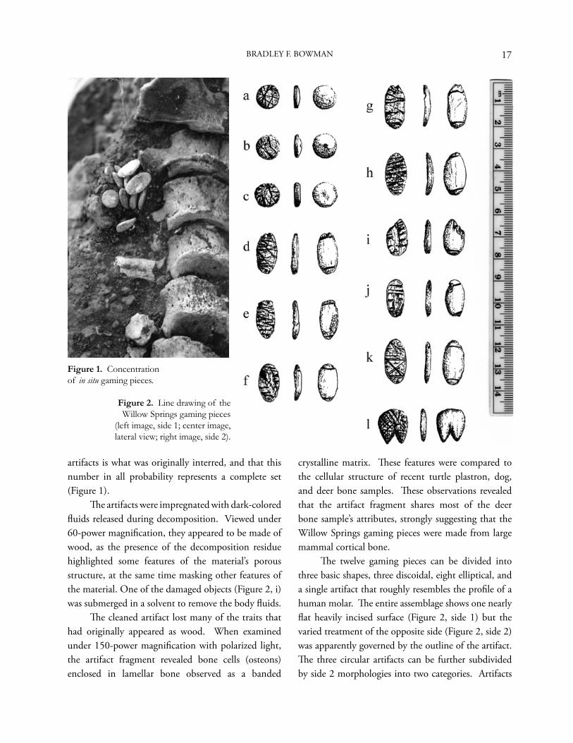
17
artifacts is what was originally interred, and that this number in all probability represents a complete set (Figure 1). Th e artifacts were impregnated with dark-colored fl uids released during decomposition. Viewed under 60-power magnifi cation, they appeared to be made of wood, as the presence of the decomposition residue highlighted some features of the material’s porous structure, at the same time masking other features of the material. One of the damaged objects (Figure 2, i) was submerged in a solvent to remove the body fl uids. Th e cleaned artifact lost many of the traits that had originally appeared as wood. When examined under 150-power magnifi cation with polarized light, the artifact fragment revealed bone cells (osteons) enclosed in lamellar bone observed as a banded
crystalline matrix. Th ese features were compared to the cellular structure of recent turtle plastron, dog, and deer bone samples. Th ese observations revealed that the artifact fragment shares most of the deer bone sample’s attributes, strongly suggesting that the Willow Springs gaming pieces were made from large mammal cortical bone. Th e twelve gaming pieces can be divided into three basic shapes, three discoidal, eight elliptical, and a single artifact that roughly resembles the profi le of a human molar. Th e entire assemblage shows one nearly fl at heavily incised surface (Figure 2, side 1) but the varied treatment of the opposite side (Figure 2, side 2) was apparently governed by the outline of the artifact. Th e three circular artifacts can be further subdivided by side 2 morphologies into two categories. Artifacts
Figure 1. Concentration of in situ gaming pieces.
Figure 2. Line drawing of the Willow Springs gaming pieces
(left image, side 1; center image, lateral view; right image, side 2).
BRADLEY F. BOWMAN
18 PAPERS OF THE ARCHAEOLOGICAL SOCIETY OF NEW MEXICO • 38
a and b exhibit a dome, but artifact c is relatively fl at. Artifact b, side 2, is further embellished with a small shallow depression drilled at the center. Th ese objects are nearly perfectly formed discs, and when each artifact’s minimum and maximum widths are calculated, they reveal a mean diameter of 10.4 mm. Th e maximum thickness of two of these artifacts (Table
1, a and c) is almost identical, 2.55 mm and 2.6 mm; specimen b is considerably thicker at 3.65 mm. Th e eight elliptical artifacts (Figures 1 and 2, d through k) exhibit a single incised line on side 2 at both ends of the oval. Th ese artifacts diff er only slightly from each other and it appears that they were intended to be alike. Maximum lengths (see maximum width, d through k, Table 1) range from 16.94 mm to 19.59 mm with a mean maximum length of 18.15 mm. Minimum widths vary from 7.81 mm to 9.33 mm, producing a mean minimum width of 8.84 mm. Maximum thicknesses range from 2.55 mm to 3.29 mm, with a maximum mean thickness of 2.84 mm (Table 1). Artifact l (Figure 2) is unique in profi le, both to this collection and in the reviewed literature. Side 1 is heavily incised, as is the rest of the collection; side 2 is smooth and devoid of any decoration. Th e minimum width of this specimen is 12.89 mm, maximum width is 14.93 mm, and maximum thickness is 2.8 mm (Table 1).
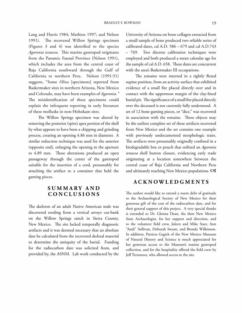
C U LT U R A L L Y A LT E R E D M A R I N E G A S T R O P O D
Evidence of marine shell distribution in the Southwest is well documented (Gladwin et al. 1938;
Figure 3. Agaronia testacea, dorsal view. Figure 4. Agaronia testacea, lateral view.
Artif
act
Iden
tifi c
atio
n
Min
imum
W
idth
(mm
)
Max
imum
W
idth
(mm
)
Max
imum
Th
ickn
ess
a 9.69 10.42 2.55b 10.22 10.65 3.65c 10.62 10-84 2.6d 8.75 /* 3.05e 8.7 17.42 2.85f 8.81 17.08 2.9g / 19.17 2.55h 9.26 18.73 2.77i 9.24 / 3.29j 7.81 16.94 2.71k 9.33 19.59 2.63l 12.89 14.93 2.8
* Incomplete specimen; measurement not possible.
Table 1. Metric Dimensions of Gaming Pieces.
19
Lang and Harris 1984; Mathien 1997; and Nelson 1991). Th e recovered Willow Springs specimen (Figures 3 and 4) was identifi ed to the species Agaronia testacea. Th is marine gastropod originates from the Panamic Faunal Province (Nelson 1991), which includes the area from the central coast of Baja California southward through the Gulf of California to northern Peru. Nelson (1991:51) suggests, “Some Oliva [specimens] reported from Basketmaker sites in northern Arizona, New Mexico and Colorado, may have been examples of Agaronia.” Th e misidentifi cation of these specimens could explain the infrequent reporting in early literature of these mollusks in non-Hohokam sites. Th e Willow Springs specimen was altered by removing the posterior (spire) apex portion of the shell by what appears to have been a chipping and grinding process, creating an opening 4.86 mm in diameter. A similar reduction technique was used for the anterior (opposite end), enlarging the opening in the aperture to 4.89 mm. Th ese alterations produced an open passageway through the center of the gastropod suitable for the insertion of a cord, presumably for attaching the artifact to a container that held the gaming pieces.
S U M M A R Y A N D C O N C L U S I O N S
Th e skeleton of an adult Native American male was discovered eroding from a vertical arroyo cut-bank on the Willow Springs ranch in Sierra County, New Mexico. Th e site lacked temporally diagnostic artifacts and it was deemed necessary that an absolute date be calculated from the recovered skeletal material to determine the antiquity of the burial. Funding for the radiocarbon date was solicited from, and provided by, the ASNM. Lab work conducted by the
University of Arizona on bone collagen extracted from a small sample of bone produced two reliable series of calibrated dates, cal A.D. 586 – 679 and cal A.D.743 – 769. Two discrete calibration techniques were employed and both produced a mean calendar age for the sample of cal A.D. 658. Th ese dates are concurrent with the area’s Basketmaker III occupations. Th e remains were interred in a tightly fl exed supine position, from an activity surface that exhibited evidence of a small fi re placed directly over and in contact with the uppermost margin of the clay-lined burial pit. Th e signifi cance of a small fi re placed directly over the deceased is not currently fully understood. A set of 12 bone gaming pieces, or “dice,” was recovered in association with the remains. Th ese objects may be the earliest complete set of these artifacts recovered from New Mexico and the set contains one example with previously undocumented morphologic traits. Th e artifacts were presumably originally confi ned in a biodegradable box or pouch that utilized an Agaronia testacea shell button closure, evidencing early trade originating at a location somewhere between the central coast of Baja California and Northern Peru and ultimately reaching New Mexico populations.
A C K N O W L E D G M E N T S
Th e author would like to extend a warm debt of gratitude to the Archaeological Society of New Mexico for their generous gift of the cost of the radiocarbon date, and for their general support of this project. A very special thanks is extended to Dr. Glenna Dean, the then New Mexico State Archaeologist, for her support and direction, and to the volunteer fi eld crew, Joleen and Mike Starr, Ann “Andi” Sullivan, Deborah Sweatt, and Brenda Wilkinson. In addition, Patricia Gegick of the New Mexico Museum of Natural History and Science is much appreciated for her generous access to the Museum’s marine gastropod collection, and for the hospitality off ered the fi eld crew by Jeff Terranova, who allowed access to the site.
BRADLEY F. BOWMAN
20 PAPERS OF THE ARCHAEOLOGICAL SOCIETY OF NEW MEXICO • 38
R E F E R E N C E S C I T E D
Bowman, Bradley F.2003 Human Remains Encountered During Trenching
Operations at the Chamisal Site, July 2002. Prepared by the Museum of Archaeology and Material Culture, Cedar Crest, Report Number 6. Manuscript on File, New Mexico Archaeological Records Management Section, Santa Fe.
Brisbin, Joel 1973 Th e Ida Jean Site (North McElmo #8). Manuscript
on File, Crow Canyon Archaeological Center, Cortez.
Culin, Stewart1975 Games of the North American Indians, Dover
Publications, Inc., New York.
Fairbanks, Richard G., Richard A. Mortlock, Tzu ChienChiu, Li Cao, Alexey Kaplan, Th omas P. Guilderson,Todd W. Fairbanks, Arthur L. Bloom, Pieter M. Grootes,Marie-Jose’e Nadeau2005 Radiocarbon Calibration Curve Spanning 0 to
50,000 Years BP Based on Paired 230TH/234U/ 238U and 14C Dates on Pristine Corals. Quarternary Science Reviews 24:1781–1796.
Gladwin, Harold S., Emil W. Haury, E. B. Sayles, and Nora Gladwin 1938 Excavations at Snaketown, Material Culture. 1975
Printing, the University of Arizona Press, Tucson.
Gross, G. Timothy1986 Th e Grass Mesa Locality Testing Program, 1979–
1980. In Dolores Archaeological Program: Early Small Settlements in the Dolores River Canyon and Western Sagehen Flats Area, compiled by Timothy A. Kohler, William D. Lipe, and Allen E. Kane, pp. 47–153. USDI Bureau of Reclamation Engineering and Research Center, Denver.
Heaton, T. J., Paul G. Blackwell, and Caitlain E. Buck2009 A Bayesian Approach to the Estimation of
Radiocarbon Calibration Curves: Th e IntCal09 Methodology. Radiocarbon 51(4):1151-1164.
Judd, Neil M.1954 Th e Material Culture of Pueblo Bonito
Smithsonian Miscellaneous Collections 124.
Lang, Richard W., and Arthur H. Harris 1984 Th e Faunal Remains from Arroyo Hondo Pueblo,
New Mexico, A Study in Short-Term Subsistence Change. Arroyo Hondo Archaeological Series, Vol. 5, School of American Research, Santa Fe.
Mathien, Francis Joan, editor1997 Ceramics, Lithics and Ornaments of Chaco
Canyon: Analysis of Artifacts from the Chaco Project 1971–1978, Volume III, Lithics and Ornaments. Publications in Archeology 18G, National Park Service, Santa Fe.
Morris, Earl H., and Robert F. Burgh1954 Basket Maker II Sites near Durango, Colorado.
Carnegie Institution of Washington Publications 604. Washington, D.C.
Nelson, Richard S.1991 Hohokam Marine Shell Exchange and Artifacts.
Arizona State Museum Archaeological Series 179. Arizona State Museum, University of Arizona, Tucson.
Oakes, Yvonne R., and Glenn S. Russell1999 Archaeology of the Mogollon Highlands: Settlement
Systems and Adaptations. Volume 1, Defi ning the Mogollon, Archaeology Notes 232, edited by Yvonne R. Oakes and Dorothy A. Zamora. Museum of New Mexico Offi ce of Archaeological Studies, Santa Fe.
21
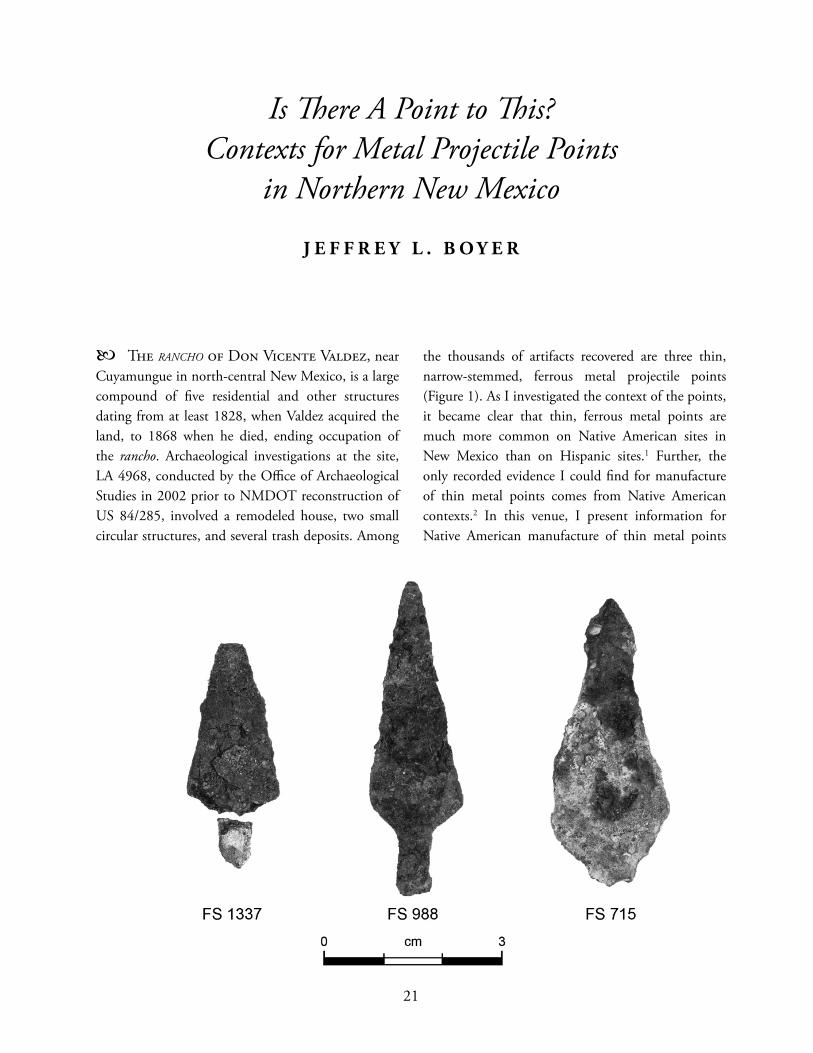
The RANCHO of Don Vicente Valdez, near Cuyamungue in north-central New Mexico, is a large compound of fi ve residential and other structures dating from at least 1828, when Valdez acquired the land, to 1868 when he died, ending occupation of the rancho. Archaeological investigations at the site, LA 4968, conducted by the Offi ce of Archaeological Studies in 2002 prior to NMDOT reconstruction of US 84/285, involved a remodeled house, two small circular structures, and several trash deposits. Among
the thousands of artifacts recovered are three thin, narrow-stemmed, ferrous metal projectile points (Figure 1). As I investigated the context of the points, it became clear that thin, ferrous metal points are much more common on Native American sites in New Mexico than on Hispanic sites.1 Further, the only recorded evidence I could fi nd for manufacture of thin metal points comes from Native American contexts.2 In this venue, I present information for Native American manufacture of thin metal points
Is Th ere A Point to Th is? Contexts for Metal Projectile Points
in Northern New Mexico
J E F F R E Y L . B O Y E R
21
22 PAPERS OF THE ARCHAEOLOGICAL SOCIETY OF NEW MEXICO • 38
in New Mexico and neighboring regions and suggest historical and economic contexts for manufacture that bear upon their presence on Hispanic sites.
E V I D E N C E F O R M E T A L P R O J E C T I L E P O I N T
M A N U F A C T U R E
Eiselt’s (2006:288-290) work at Jicarilla Apache sites in the Rio del Oso drainage, northwest of the US 84/285 project area, recovered materials from metal point manufacturing processes, including fi nished points as well as discarded raw materials (barrel hoop fragments and “clippings”), point blanks, and sharpening stones:
Barrel hoops were cut width-wise into sections according to the length of a desired point. Barrel clasps and short sections of hoop or strap were discarded. Strap blanks were then cut into point blanks using a cold chisel and hammer. Th e clippings and other unwanted parts were discarded. Th e jagged edges of the point were ground off by scoring the edges on a rough stone. Evidence for this stage comes from a vesicular basalt cobble/boulder associated with a rock ring at LA90815 [sic]. When overturned, the surface of the cobble revealed numerous metal gouges. A scatter of metal clippings and several strap blanks were found within a few meters of the cobble. Th e fi nal stage of production entailed beveling and sharpening the smoothed edges of the blades with a sandstone tablet. Each of the two identifi ed tablets found in the Rio del Oso were made of locally-available Santa Fe Formation sandstone. Th ese stones were shaped into a rectangular form roughly fi ve by ten or fi fteen centimeters and contained multiple working surfaces.
Evidence for metal point production and the distribution of fi nished points in the valley demonstrates that the Jicarilla made metal-tipped arrows for their own use in hunting and defense as well as for trade with the [Hispanic] residents of San Lorenzo. Exchange in metals was an important component of male interactions (Eiselt 2006:288, 290, brackets added; Fig. 9.3, page 289).
Johnson et al. (2009:35-37) also recovered points, point blanks, and “debitage” (Eiselt’s “clippings”) from the Jicarilla Apache camp at the Cieneguilla battle site near Pilar, also in north-central New Mexico. Th ey begin a description of the points with a short discussion of metal points manufactured in the English colonies in the late seventeenth and eighteenth centuries for trade with Native groups. Th at discussion is relevant to the points found at the Jicarilla camp because variation in point sizes and styles found at the site may show that they were not commercially manufactured: “Commercially made trade points can often be identifi ed by their uniform shape and thickness, beveled edges, and consistency in size and proportions. Some are stamped with manufacturers marks” (Johnson et al. 2009:35-36). In contrast to that description:
It is remarkable that there is little consistency in the size and shape of [the 42] metal points at this site. In contrast, the size and shape of metal points from Mescalero Apache sites on the Lincoln National Forest in southern New Mexico are generally consistent in size and shape. Th is variation on the Cieneguilla battle site may be a result of the Taos trade fair, where points may have been available from a variety of sources in a variety of styles. It is also possible that a number of diff erent bands were present at the battle, each with their own point style (Johnson et al. 2009:36).
23
Th e battle of Cieneguilla, however, took place in March 1854, much later than the famous Taos trade fairs, which do not seem to have continued with any signifi cance following the opening of the Santa Fe Trail (Cunningham and Miller 1999:101). Consequently, variation in metal point sizes and shapes at the camp and battle site (Johnson et al. 2009:cover photo and Fig. 8, pg. 36) do not refl ect access to metal through that particular venue. Indeed, the presence of manufacturing debris provides little reason to assume the variation refl ects anything outside Apache manufacture. Whether it refl ects styles related to band identity cannot be ascertained and is only proposed by the investigators based on apparent contrast with points found at Mescalero sites (e.g., Adams et al. 2000a, 2000b; see Seymour 2002:296). Along with the points, investigations at the camp and battle site recovered a fragment of barrel hoop, presumed to be a point blank, and an unfi nished point (Johnson et al. 2009:36). In addition:
Fifteen locations of metal debitage were recorded, many forming a distinct cluster of artifacts somewhat between the two ceramic concentrations in the Apache camp. Th e debitage off ers fi rm evidence that the Jicarilla were making their own points on the site. A number of the debitage pieces were trapezoidal in shape. All appear to have been chisel cut (Johnson et al. 2009:37).
Drawing on materials from Mescalero sites and the Jicarilla site, they interpret these artifacts as follows:
Small pieces of metal, cut from a barrel band or other piece of metal, are commonly found on Apache camp sites. Th e scrap metal debitage is primarily the result of point manufacture. Th e chisel-cut fragments exhibit uneven linear cuts and the lateral margins of the fragments are stretched and uneven. Th e iron fragments
can be long triangular cut pieces or small square or trapezoidal shaped angular fragments. Th e long triangular pieces represent the areas cut out along the point edges and the small square angular pieces often represent the tang and stem cuts. Th e shear-cut fragments tend to curl when cut. Th e shapes of the shear cuts mirror the chisel cuts. Th ese fragments are fairly thick, generally from 1 to 1.5 millimeters, are consistent with the thickness of barrel hoops and metal straps, and are thicker than the debris left from tinkler manufacture (Johnson et al. 2009:36).
Simmons and Turley (1980:36-40) discuss interaction between New Mexican Hispanics and Native Americans involving metal items. Th ey do not, unfortunately, clearly distinguish between tools made by forging (hot working) and those made by cold working, and use both Spanish Colonial documents and nineteenth century ethnographic research in presenting the spread of metal tools and other items, including arrow points, from European to Native American groups and between Native American groups. Interestingly, though, they do point out that archaeological and ethnohistorical research at Wichita sites along the Red River in Texas and Oklahoma shows that Wichitas acquired metal items from Spanish and French traders, some of which they modifi ed for other purposes (Simmons and Turley 1980:37; also B. Westbury, personal communication, 2010). Woodall (1967a:180-183) summarizes these items, and some are illustrated in the report (Bell et al. 1967:Figs. 48-49, 54-58). Harris and Harris (1967:160-161) specifi cally discuss metal projectile points from sites examined during the Wichita project, focusing on points from the Longest Site (Bell and Bastian 1967) on the north bank of the Red River and the Upper Tucker Site (Woodall 1967b) on the south side of the Red River. Both sites are assigned to the late eighteenth century, although no chronometric dates are provided. Most of
JEFFREY L. BOYER
24 PAPERS OF THE ARCHAEOLOGICAL SOCIETY OF NEW MEXICO • 38
the metal points from the sites, all made of thin metal, are of the Benton type, a diamond- to leaf-shaped point that is considered the dominant type of the late eighteenth- to early nineteenth-century Norteño Focus (Chandler 1993 and references therein; Harris and Harris 1967:161; Perino 1968:10-11; http://www.texasbeyondhistory.net/st-plains/images/he8.html, accessed October 19, 2010; see also Perino [1971:16-17] for a description of the metal Claremore Point, associated with early nineteenth-century Osage). In addition to the Benton points, stemmed and non-stemmed, triangular, iron and brass points were found at the sites. Woodall (1967a:181) notes that in addition to a variety of metal artifacts recovered from the Wichita project sites, including the points as well as wedges, axes, awls, scissor fragments, ornaments, and items possibly used as scrapers, there are:
Chisels [that] are made from small iron rods rectangular in cross section. One end is hammered round and a narrow chisel point fashioned at its extremity. Proximal ends usually show signs of battering. All chisels recovered are rather delicate tools, and were probably used to cut thin brass, sheet iron, or wood.
Simmons and Turley (1980:37) contend that these artifacts found on Wichita sites show:
that the Wichita along the Red River produced projectile points, awls, scrapers, and other articles from scrap iron. Workshop areas that have been excavated yield hundreds of small metal fragments discarded in the manufacturing process. In practically all cases, it seems, the iron was worked cold. Th e blades of many Wichita axes and wedges show a profusion of chisel marks indicating that these tools served the Indians as makeshift anvils. Th ose examples of chisels that have been
recovered were made from small iron rods rectangular in cross section. Th ey are rather delicate instruments with a narrow cutting edge and a mushroom of metal on the butt end, caused by hammer blows.
Evidence from the Wichita project points to Native manufacture of thin metal projectile points, apparently in the late eighteenth century, while evidence from the Rio del Oso, Cieneguilla, and Wire Horse Apache sites point to Native manufacture in the mid to late nineteenth century. In each case, artifact production was by cold-working methods rather than forging. Pyszczyk (1999:168) quotes Ewers (1958:122) in providing this description of metal point manufacture among the Blackfeet:
Th e Indian arrowhead maker drove an old axe head into the ground and used its top surface for an anvil. He cut out the arrowheads from the hoop iron with a sharp chisel and sharpened their edges with a fi le. Completed arrowheads were either rounded or square-shouldered . . . Th ey measured about two and one-half inches long.
Pyszczyk (1999:168) also cites Wilson (1918:362) who observed that Hidatsa point-makers “fl attened pieces of heated metal on a stone anvil in the tipi to make arrowheads. Th ey cut and shaped the arrowheads with a chisel and hammer.” He also cites Densmore (1918:438), who was told by a Teton Lakota that he “cut arrow points from thin frying pans sold by traders or used by the soldiers.” Th ese would not have been cast iron pans, which could not be cut, and must have been pans made of sheet metal. While the Hidatsa example apparently involved heating the metal, which would make it temporarily softer and more malleable, this should not be confused with actual forging. Ethnographic descriptions cited by Pysczcyk support the manufacturing processes shown by debris and tools reported at Apache sites by Eiselt (2006) and Johnson et al. (2009), and by authors of
25
the Wichita project report (Bell and Bastian 1967; Woodall 1967a).
E V I D E N C E F O R M E T A L P O I N T D I S T R I B U T I O N
Wichita and related people in the southern Great Plains acquired metal items, including points and material to make points, from French traders in the eighteenth century (Harris and Harris 1967). Northern Great Plains groups also acquired metal and points from French, British, and American traders (Birk and Richner 2004; Ferris 1940; Pyszczyk 1999; Russell 1997). In contrast, I can fi nd no substantial evidence pointing to commercially-manufactured points or to Native American manufacture of thin, metal points in New Mexico before the nineteenth century.3 As Simmons and Turley (1980:22-35) point out, the Spanish government in Mexico attempted to maintain strong control over metal and metal-working in New Spain. Consequently, until Mexican independence and the opening of the Santa Fe Trail, metal was in short supply and unlikely to be available for making projectile points, particularly when materials were widely available for chipped stone tools. In those circumstances, we should not expect to fi nd evidence for manufacture of cold-worked, thin metal points in settings dating before about 1820. I suspect, in fact, that cold-worked, thin metal points were not commonly made in pre-1846 settings in New Mexico, but archaeological evidence is insuffi cient to test that proposition at this time. Interestingly, though, Herr et al. (2009) do not include metal projectile points among diagnostic artifacts at pre-1850, pre-reservation Apache sites in the sub-Mogollon Rim region of eastern Arizona, although certain chipped-stone point styles are considered diagnostic and Euroamerican artifacts are present at some sites.4
Kirkpatrick (2010) describes and illustrates several points and point blanks from the Cimarron area in northeastern New Mexico. He notes that the Cimarron area was used and occupied by both Jicarilla Apaches and Moache Utes, and makes no attempt to
assign the Cimarron points to one or both of these groups. Kirkpatrick speculates (D. Kirkpatrick, personal communication, 2010), however, that the points are likely Apache. A metal point was found on a site near Galisteo Spring in Santa Fe County (Pierce 2008) and is used to identify a mid-nineteenth century Apache component on the site. Th ompson’s (1980) points, mostly from surface contexts in southern New Mexico, southwest Texas, and northern Mexico, are ascribed to Apache manufacture. Metal points, including brass points (and tinklers) apparently made from rifl e cartridges, have been found at Carlsbad Caverns National Park; none were in association with Euroamerican sites, and the only Euroamerican artifacts found on the sites were the rifl e cartridges (D. Kayser, personal communication, 2010). Seymour (http://www.seymourharlan.com/My_Homepage_Files/Page60.html, accessed August 30, 2011) provides a photo of a thin metal point and barrel hoop fragments found at the Wire Horse Site (LA 61247) near Roswell in southeastern New Mexico. Th e artifacts may indicate manufacture of metal points or curation of manufacturing materials at the site, which apparently dates after about 1870. Brown and Rohman (1996:32-33) recovered a triangular metal point from LA 105615 in Grant County, New Mexico. Th is specimen does not have a stem, although their illustration (Fig. 5.6, pg. 32) suggests that a stem might have been present at one time. Additionally, they recovered a triangular piece of thin metal that may have been a point blank. Brown and Rohman assign the point to an Apache occupation of the site. Th e type of points recorded in New Mexico by Th ompson (1980), Johnson et al. (2009), and Weber (1995) that are identifi ed as Benton Points in Texas and Oklahoma may also point to trade with Native groups living east of New Mexico, such as Comanches, Kiowas, Southern Cheyennes, and Southern Arapahos. Seymour (2002:296) provides a summary of metal projectile points in the Fort Bliss area that allows opportunity for comments related to econo-socio-cultural contexts:
JEFFREY L. BOYER
26 PAPERS OF THE ARCHAEOLOGICAL SOCIETY OF NEW MEXICO • 38
Th e archaeological record suggests that iron points displace stone projectile points sometime in the early 1800s (perhaps even in the late 1700s), although Katz and Katz (1993) argue for the earlier introduction of metal points, for example at LA 48738 in Carlsbad, New Mexico (A.D. 1600 to 1750). By 1882 arrows and spears were rarely used (Betzinez and Nye 1958:5, 85), presumably because of the widespread availability of rifl es after the Civil War. To date, few stone projectile points have been identifi ed within later sites (e.g., those dating to the 1880s) and when stone points are present they are often on sites that were occupied for long periods, including prior to the start of the nineteenth century. Accounts indicate that stone points were not made after a certain time; according to Betzinez and Nye (1959:5) ‘stone arrowheads had not been made for generations,’ presumably not for 60 or so years before the 1870s or 1880s.
Th e introduction of metal points and in replacement of stone points by metal points by diff erent Native groups was highly variable, and contemporary use of metal and stone points was often a matter of material cost and availability, point function, and tool effi ciency (Pyszczyk 1999:167-168). While metal points might have generally been preferable to stone points, replacing stone points with metal points required other technological considerations and was not merely a matter of changing materials. Further, as Scheiber and Finley (2010) point out, the processes of replacing indigenous material items with items acquired from Euroamericans or made from Euroamerican materials involved aspects of socio-cultural transformation other than just material and technology. Seymour continues, “Two metal points have been found on and near Fort Bliss. Th e smallest of the points may be related to material availability (barrel band size) or to preferences of the local group
or individual who made it. Th e larger point exhibits a serrated stem, much like another point known from Roswell (2002:296).” Pyszczyk (1999) contends that there were diff ering reasons for creating points that are more and less strongly attached to their shafts; serrating the stem should correlate with attaching the point more strongly to the shaft, which, according to Pyszczyk’s research, was related to hunting rather than warfare (e.g., Nordhaus 1995:43). Weber (1995) describes metal points from several surface contexts in the Rio Abajo region. He notes that, “Th e points exhibit considerable variation in confi guration and probably could be classifi ed into several distinct types, if a suffi ciently large collection were available” (Weber 1995:167). As noted earlier, Weber’s illustrations include points that are identifi ed as Benton Points in Texas and Oklahoma. Regarding cultural affi liation, Weber (1995:170) states,
Th e Rio Abajo lies within the northern fringes of the Apachería, land of the Apaches . . . and near southeastern edge of Navajo country . . . by 1800. Both Athapascan [sic] groups traded and raided into Socorro and the nearby villages and farms. Both of these groups are suspect as bearers of the [metal] points . . . However, a less notorious cultural group may have used metal points. Th ese were the local Hispanic New Mexicans, who for lack of fi rearms armed themselves with bow, arrow, and lance. Th is also was true of the organized militia. A review of the militia of the mayorality of Belen on November 4, 1819, states that most members of the 3rd Co. of the 2nd Squadron were armed with gun and lance and 15 cartridges; 7 were armed with bow and 25 arrows, of which 6 also had a lance . . . It may be assumed that the arrows were tipped with metal points.
A similar situation occurred in the Santa Cruz region of north-central New Mexico, when an
27
1806 list of the militia showed that most members were armed only with bows and arrows (D. Snow, personal communication, 2010). Unfortunately, the documents do not describe the arrow points and there is, contra Weber (1995), little reason to assume that militia members and other Hispanic settlers used metal points. Without documentary or archaeological evidence to the contrary, it is just as reasonable to assert that most Hispanic residents of New Mexico, until fi rearms became ubiquitous in the second half of the 1800s, used arrows with chipped stone tips. Th is assertion is supported by the common presence of chipped stone projectile points among other chipped stone tools on Hispanic sites in New Mexico (Moore 1992, 2004, in prep.) and the apparent paucity of metal points on Hispanic sites. Moore (in prep.) provides a detailed discussion of Hispanic contexts in which chipped stone projectile points have been found and the characteristics of those points that distinguish them from points found on Native American sites and that indicate Hispanic rather than Native manufacture. It is also reasonable to contend that Hispanic settlers acquired chipped stone artifacts, including projectile points, by scavenging from archaeological sites and by trading with Native American neighbors (J. Moore, personal communication, 2010).
C O N T E X T U A L I Z I N G M E T A L P R O J E C T I L E
P O I N T S
Th is review of thin, cold-worked, metal projectile points in the archaeological record indicates that the three found at LA 4968 may be among the few recovered, to date, from a Hispanic site in New Mexico. I suspect that this is not, in fact, the case, but it does show the relative paucity of these artifacts in non-Native settings. Following Eiselt (2006), I propose that the points found at LA 4968 represent an aspect of interethnic economic relations in the nineteenth century in north-central New Mexico, and that they were acquired through trade between Hispanic settlers and neighboring Native Americans,
probably Jicarilla Apaches, given the proximity of the US 84/285 project area to mountain areas that were home to the nineteenth century Jicarilla. Eiselt (2006; personal communication, 2010) contends that the metal points and manufacturing debris found in the Rio del Oso represent male-oriented relationships within interethnic economies. As such, they point to activities that complement female-oriented, interethnic relationships represented by, for instance, exchange of ceramic materials and vessels. Her position raises questions of point form and function that Pyszczyk (1999) addresses. For instance, Pyszczyk (1999:168-169) cites diff erences in early nineteenth century Omaha metal point hunting and warring functions that could be identifi ed by point form, particularly the presence of barbed edges. Catlin (1973, cited by Pyszczyk 1999:169) identifi ed similar diff erences for other Plains groups. Because Pyszczyk is primarily interested in technological transitions involving the contemporary and sequential use of metal and chipped stone points, questions of form and function lead him toward examinations of arrow and bow construction and effi ciency rather than implications of metal point form and function within contexts of intra- and intergroup socioeconomics—although warfare might well be considered an aspect of intergroup socioeconomy (Brooks 2002). It is reasonable, nonetheless, to consider those contexts when examining metal points in the Southwest. While I can fi nd no specifi c examinations of Jicarilla Apache metal point forms and functions, it is relevant to look at such points in light of Pyszczyk’s data on arrow construction and use in order to question the functions of points found in isolated situations and on sites, both Native American and Euroamerican. A handful of points from a few Hispanic sites in this project area and in the Rio del Oso do not provide us with suffi cient data for functional comparisons, particularly given the paucity of information on Apache point functions, but they do allow us to wonder about roles played by point forms and functions that were involved in Apache-Euroamerican exchange relationships.
JEFFREY L. BOYER
28 PAPERS OF THE ARCHAEOLOGICAL SOCIETY OF NEW MEXICO • 38
Scheiber and Finley (2010) provide a socio-cultural interpretive context for technological transitions that included use of metal arrow points among Mountain Shoshone. Specifi cally, for their examination of “ethnotechnological” variation at Shoshonean sites, they point out:
Th is mixture of indigenous and introduced items could be seen as representing an increasing use of new materials coinciding with a gradual abandonment of old ones, with ratios of objects seen as proxy measures for estimating temporal placement and culture change. Th is older acculturation model is still generally accepted today: ‘In most cases foragers were understandably eager to obtain manufactured goods such as steel axes, knives, needles, metal pots, guns, and cloth that originated in the industrial core of the world system . . . because they made so many daily tasks easier’ (Bodley 1999:468). Recently, Rodriguez-Alegría (2008) and others have questioned the model of quick replacement of indigenous with European technologies, calling for new narratives of change that emphasize other social, economic, and political factors. Likewise, Silliman (2010) underscores that fact that all materials used by native peoples become indigenous even if they were originally produced for European or American consumers. Th ese objects and the way they were used were incorporated into broader social spheres and imbued with meanings and functions by the native peoples using them.
While their study examines cultural contexts for adoption and adaptation of Euroamerican materials by Native peoples (see also Silliman 2005, especially pp. 282-283 and references therein), their point is that material transfer involves active decision-making on the parts of both parties and that, consequently, transfer
transforms both parties. Rodríguez-Alegría (2008) argues that material and technological transfers are not always rapid or “practical” (likely a highly variable ethnocentric concept, in any case, and one fi lled with dynamic cultural specifi cs), and that they require new examinations and creation of new, non-Eurocentric narratives of material aspects of ethnic interaction. We should expect, then, that the presence of metal projectile points on Hispanic sites represents more than mere exchange. If the LA 4968 points were made by nearby Apaches, probably men (Eiselt 2006), they show 1) movement of “raw material” (metal items) from Euroamerican to Native American peoples, and potentially between Native American peoples, involving gender-defi ned exchange of items that likely embodied diff erent cultural meanings at the time of exchange; 2) use of those materials in ways that do not refl ect their original (i.e., Euroamerican) functions or meanings, involving culturally-defi ned, probably gender-specifi c, manufacture and use that not only altered the materials but changed their culturally-defi ned functions; and 3) return movement of fi nished tools from Native American to Euroamerican peoples representing additional gender-defi ned exchange that also embody diff ering cultural meanings. Th ese issues are, of course, not limited to metal projectile points; by transforming Native American pottery manufacture and style for exchange with Hispanic settlers, for instance, Native American potters transformed the meanings they gave to vessels and styles while Hispanic consumers embodied those vessels with uses, values, and meanings taken from their own cultural foundations. Likewise, the controversial topic of Hispanic pottery manufacture or pottery manufacture in Hispanic communities raises issues of material markers and meanings of cultural transformation.
C O N C L U S I O N S
Th e three thin, ferrous metal projectile points recovered from LA 4968, the rancho of Don Vicente Valdez, refl ect a number of impacts from events and subsequent processes related to U.S. presence in New
29
Mexico, beginning with the opening of the Santa Fe Trail in 1821 and increasing dramatically with the U.S. occupation of New Mexico beginning in 1846. Economically, those events suddenly increased access, on the part of both Native American and Euroamerican New Mexicans, to wider and wider varieties of manufactured goods. In turn, those goods were incorporated into and modifi ed existing settings of intra- and interethnic technology and manufacture, use, and exchange. Processes of incorporation and modifi cation were both “practical” and symbolic, and place metal—and chipped stone—points in the same evolving econo-socio-cultural contexts as Native American and “Hispanic” pottery, domesticated plants and animals, and even building materials and construction methods such as adobe bricks and window panes. Th ose evolving contexts present the most interesting aspects of Euroamerican artifact analyses because they move us beyond static typology and function into dynamic cultural and ethnic interaction, alteration, and development.
E N D N O T E S
1. As noted later in this paper, I am not concerned here with metal points manufactured commercially, apparently in great numbers, for exchange between Euroamerican traders and Native Americans. I am also not concerned here with crossbow bolts or forged point or lance tips found occasionally in Exploration Period (ca. A.D. 1540-1598) contexts.
2. Benjamin Titsworth, a blacksmith in Las Animas County, Colorado, forged several hundred arrow points for a band of Comanches who were camped on his land in the 1870s or 1880s (M. Church, personal communication, 2010). Since the points were forged rather than cold-worked, Mr. Titsworth’s eff orts are not considered to be an exception to this statement.
3. As noted later in this paper, Katz and Katz (1993, cited by Seymour 2002:296; see also Katz and Katz 2006:28-29) contend that LA 48738 near Carlsbad, which yielded a metal projectile point, dates before A.D. 1750. Th e age is, however, based on a radiocarbon date that does not actually fall within their Ethnohistoric 2 Period (ca. A.D. 1600-1750) (Katz and Katz 2006:29), casting doubt on dating the site to the eighteenth century.
4. It is, however, entirely possible that metal used to make projectile points was unavailable or minimally available in the sub-Mogollon Rim regions before 1850.
R E F E R E N C E S C I T E D
Adams, Christopher D., Diane E. White, and David M. Johnson2000a Last Chance Canyon Apache/Cavalry Battle
Site. USDA Forest Service, Southwest Region, Albuquerque.
2000b Dark Canyon Apache Ranchería Battle Site. USDA Forest Service, Southwest Region, Albuquerque.
Bell, Robert E., and Tyler Bastian1967 Preliminary Report upon Excavations at the
Longest Site, Oklahoma. In A Pilot Study of Wichita Indian Archaeology and Ethnohistory, assembled by R. E. Bell, E. B. Jelks, and W. W. Newcomb, pp. 54-118. Final Report to the National Science Foundation, Grant GS-964. Washington, D.C.
Bell, Robert E., Edward B. Jelks, and W. W. Newcomb1967 A Pilot Study of Wichita Indian Archaeology
and Ethnohistory. Final Report to the National Science Foundation, Grant GS-964. Washington, D.C.
Betzinez, Jason, and Wilbur S. Nye1959 I Fought with Geronimo. University of Nebraska
Press, Lincoln.
Birk, Douglas A., and Jeff rey J. Richner2004 From Th ings Left Behind: A Study of Selected Fur
Trade Sites and Artifacts, Voyageurs National Park and Environs, 2001-2002. Technical Report Number 84, Midwest Archeological Center, USDA National Park Service, Lincoln, Nebraska; Reports of Investigations Number 606, Institute for Minnesota Archaeology, Minneapolis.
Bodley, John H.1999 Hunter-Gatherers and the Colonial Encounter.
In Th e Cambridge Encyclopedia of Hunter and Gatherers, edited by Richard B. Lee and Richard Daly, pp. 465-472. Cambridge University Press, Cambridge.
Brooks, James F.2002 Captives and Cousins: Slavery, Kinship, and
Community in the Southwest Borderlands. University of North Carolina Press, Chapel Hill.
JEFFREY L. BOYER
30 PAPERS OF THE ARCHAEOLOGICAL SOCIETY OF NEW MEXICO • 38
Brown, Gary M., and Marian J. Rohman1996 Archaeological Testing and Further Surface
Documentation at Five Sites in the Poison Spring Area, Continental Mine, Grant County, New Mexico. Report No. WCRM(F)083. Western Cultural Resources Management, Inc., Farmington.
Catlin, George1973 Letters and Notes on the Manners, Customs, and
Conditions of the North American Indians, Volume 1. Dover Publications, New York.
Chandler, C. K.1993 Metal Projectile Points from Medina County,
Texas. La Tierra 20(4):29-32.
Cobb, Charles E., editor2003 Stone Tool Traditions in the Contact Era.
University of Alabama Press, Tuscaloosa.
Cunningham, Elizabeth, and Skip Miller1999 Trade Fairs in Taos, Prehistory to 1821. In
El Camino Real de Tierra Adentro, Volume 2, compiled by Gabrielle G. Palmer and Stephen L. Fosberg, pp. 87-101. Cultural Resource Series, No. 13. USDI Bureau of Land Management, New Mexico State Offi ce, Santa Fe.
Densmore, Frances1918 Teton Sioux Music. Bureau of American
Ethnology Bulletins 61. Smithsonian Institution, Washington, D.C.
Eiselt, B. Sunday2006 Th e Emergence of Jicarilla Apache Enclave
Economy during the 19th Century in Northern New Mexico. Unpublished Ph.D. dissertation, Department of Anthropology, University of Michigan, Ann Arbor.
Ewers, John1958 Th e Blackfeet: Raiders of the Northwestern Plains.
University of Oklahoma Press, Norman.
Ferris, William A.1940 Life in the Rocky Mountains, A Diary of
Wanderings on the Sources of the Rivers Missouri, Columbia, and Colorado from February, 1830, to November, 1835. F. A. Rosenstock, Old West Publishers, Denver.
Harris, R. K., and Inus M. Harris1967 Trade Beads, Projectile Points, and Knives.
In A Pilot Study of Wichita Indian Archaeology
and Ethnohistory, assembled by Robert E. Bell, Edward B. Jelks, and W. W. Newcomb, pp. 129-162. Final Report to the National Science Foundation, Grant GS-964. Washington, D.C.
Herr, Sarah, Chris North, and J. Scott Wood2009 Scouting for Apache Archaeology in the Sub-
Mogollon Rim Region. Kiva 75(1):35-62.
Johnson, David M., Chris Adams, Charles Hawk, andSkip Keith Miller2009 Final Report on the Battle of Cieneguilla, A Jicarilla
Apache Victory over the U.S. Dragoons, March 30, 1854. Report No. 20. USDA Forest Service, Southwestern Region, Albuquerque.
Katz, Susanna R., and Paul Katz1993 An Archaeological Overview of Southeastern New
Mexico. Prepared for the New Mexico Historic Preservation Division, Santa Fe.
2006 Regional Culture History. In Loving Lakes and Dunes: Research Design and Data Recovery Plan for Eight Archaeological Sites on NM 128, Eddy County, New Mexico, by Nancy J. Akins, Susanna R. Katz, Paul Katz, James L. Moore, H. Wolcott Toll, Mollie S. Toll, and Regge N. Wiseman, pp. 11-30. Archaeology Notes 383. Offi ce of Archaeological Studies, Museum of New Mexico, Santa Fe.
Kirkpatrick, David2010 Metal Projectile Points from the Cimarron
District, Northeastern New Mexico. In Th reads, Tints, and Edifi cation: Papers in Hon or of Glenna Dean, edited by E. J. Brown, Karen Armstrong, David M. Brugge, and Carol J. Condie, pp. 111-126. Papers of the Archaeological Society of New Mexico 36, Albuquerque.
Moore, James L.1992 Spanish Colonial Stone Tool Use. In Current
Research on the Late Prehistory and Early History of New Mexico, edited by Bradley J. Vierra, pp. 239-244. Special Publication No. 1. New Mexico Archaeological Council, Albuquerque.
2004 Spanish Chipped Stone Artifacts. In Adaptations on the Anasazi and Spanish Frontiers: Excavations at Five Sites near Abiquiú, Rio Arriba County, New Mexico, by James L. Moore, Jeff rey L. Boyer, and Daisy F. Levine, pp. 179-200. Archaeology Notes 187. Offi ce of Archaeological Studies, Museum of New Mexico, Santa Fe.
31
In prep. Chapter 9: Patterns of Historic Spanish Chipped Stone Use and Manufacture. In Land Use, Settlement, and Community in the Southern Tewa Basin. Volume 2: Th e Euroamerican Sites and Site Components, edited by James L. Moore. Archaeology Notes 404. Offi ce of Archaeological Studies, Museum of New Mexico, Santa Fe.
Nordhaus, Robert J.1995 Tipi Rings: A Chronicle of the Jicarilla
Apache Land Claim. Bowarrow Publishing, Albuquerque.
Perino, Gregory1968 Guide to the Identifi cation of Certain American
Indian Projectile Points. Special Bulletin No. 3. Oklahoma Archaeological Society, Norman.
1971 Guide to the Identifi cation of Certain American Indian Projectile Points. Special Bulletin No. 4. Oklahoma Archaeological Society, Norman.
Pierce, Derek P.2008 A Heritage Resources Inventory for a Proposed
Wetlands Restoration Project near Galisteo Spring, Santa Fe County, New Mexico. Report 2008-15. Townsend Archaeological Consultants, Las Vegas.
Psyzczyk, Heinz W.1999 Historic Period Metal Projectile Points
and Arrows, Alberta Canada: A Th eory for Aboriginal Arrow Design on the Great Plains. Plains Anthropologist 44(168):163-187.
Rodriguez-Alegría, Enrique2008 Narratives of Conquest, Colonialism,
and Cutting-Edge Technology. American Anthropologist 110(1):33-43.
Russell, Carl P.1997 Firearms, Traps, and Tools of the Mountain Men.
University of New Mexico Press, Albuquerque.
Scheiber, Laura L., and Judson B. Finley2010 Mountain Shoshone Technological Transitions
Across the Great Divide. In Across a Great Divide: Continuity and Change in Native North American Societies, 1400-1900, edited by Laura L. Scheiber and Mark D. Mitchell, pp. 128-148. Amerind Studies in Archaeology. University of Arizona Press, Tucson.
Seymour, Deni J.2002 Conquest and Concealment: After the El Paso
Phase on Fort Bliss. An Archaeological Study of the Manso, Suma, and Early Apache. Lone Mountain Report 525/528. Lone Mountain Archaeological Services, El Paso.
Silliman, Stephen W.2005 Social and Physical Landscapes of Contact. In
North American Archaeology, edited by Timothy R. Pauketat and Diana DiPaolo Loren, pp. 273-296. Blackwell Publishing, London.
2010 Indigenous Traces in Colonial Spaces: Archaeologies of Ambiguity, Origins, and Practices. Journal of Social Archaeology 10(1):28-58.
Simmons, Marc, and Frank Turley1980 Spanish Colonial Ironwork: Th e Spanish
Blacksmithing Tradition. Museum of New Mexico Press, Santa Fe.
Th ompson, Marc1980 A Survey of Aboriginal Metal Points from the
Apachería. Th e Artifact 18(1):1-10.
Weber, Robert H.1995 Metal Arrow Points of the Rio Abajo. In Of Pots
and Rocks: Papers in Honor of A. Helen Warren, edited by M. S. Duran and D. T. Kirkpatrick, pp. 167-173. [Papers of ] the Archaeological Society of New Mexico 21, Albuquerque.
Wilson, G. L.1918 Unpublished Field Notes on Hidatsa
Ethnography, Volume 22. Th e American Museum of Natural History, New York.
Woodall, J. Ned1967a Miscellaneous European Trade Goods. In A
Pilot Study of Wichita Indian Archaeology and Ethnohistory, assembled by Robert E. Bell, Edward B. Jelks, and W. W. Newcomb, pp. 180-183. Final Report to the National Science Foundation, Grant GS-964. Washington, D.C.
1967b Th e Upper Tucker Site. In A Pilot Study of Wichita Indian Archaeology and Ethnohistory, assembled by Robert E. Bell, Edward B. Jelks, and W. W. Newcomb, pp. 3-14. Final Report to the National Science Foundation, Grant GS-964. Washington, D.C.
JEFFREY L. BOYER

32 PAPERS OF THE ARCHAEOLOGICAL SOCIETY OF NEW MEXICO • 38
33
The clearest phonological division, or isogloss, between the eastern and western Apachean languages is the shift from western Apachean stem-initial t- to eastern Apachean stem-initial k-,1 sometimes referred to as the t-/k- isogloss, not an entirely accurate description as the shift in Kiowa-Apache holds true only before –a and –o, becoming ch’- before –e and –i. Otherwise t- becomes k- in Jicarilla Apache and Lipan Apache and remains t- in Navajo, Western Apache, Chiricahua Apache and Mescalero Apache. (Young 1983 following Hoijer 1938) Th ese changes are paralleled in part by several other consonants, but quite irregularly so. Most changes are found in Kiowa-Apache, clearly suggesting that Kiowa-Apache diff erentiated considerably earlier than the separation of the other languages from each other. Th e split between the others had to be later, but the division must have been early enough that the westerners retained the stem-initial t- while the Jicarillas and Lipans shared the stem-initial k-with the Kiowa-Apaches. A scenario that explains this change seems diffi cult to visualize, although the most likely might be continued but looser contact between the Kiowa-Apaches and other Apaches on the Great Plains. Th e proliferation of Spanish names for Apachean groups on the Plains prior to the Comanche advance in the eighteenth century seems to indicate that the major ancestral branch of the westerners split relatively early, probably following bison across the Rocky Mountains into western Colorado and Utah. Th e stem-initial t- is the ancestral form and is widespread among the
Northern Athabaskans. (Brugge 2008) In 1974 Muriel Saville-Troike published a paper in which she described nineteenth century word lists in an attempt to gain historical insights into language change among the Southern Athabaskans. She had, of course, to deal with transcriptions by many persons unfamiliar with the sound systems that occur in Apachean languages and whose attempts to render these in the English alphabet varied in many ways among themselves. Only one, Albert S. Gatschet, had received instructions from the Smithsonian Institution and demonstrated some sophistication in his recordings. In addition, the dialects of their fi rst languages infl uenced how they perceived some of the Apachean sounds. (Saville-Troike 1974:68-69) She used a substantial number of vocabularies, mostly in the form of word lists, but a few dictionaries. She had 14 Navajo word lists and 10 Apachean lists divided among several tribes and bands. Th e three dictionaries were from the twentieth century. In addition she had data from her own observations and those of Richard O’Brien to draw on. (Saville-Troike 1974:83-84) A further complication was the depth of knowledge of the Apachean languages of the various informants. Some were native speakers, but others included people who were or had been captives among the Apacheans for various lengths of time.2
A number of the changes over time that she describes are simple semantic changes in usage preferences, all with relation to Navajo. Some of her
Navajo and the t-/k- Isogloss
D A V I D M . B R U G G E
33
34 PAPERS OF THE ARCHAEOLOGICAL SOCIETY OF NEW MEXICO • 38
data on recent usages come from observation of the speech of Navajo children, both in elementary school and teenage informants (Saville-Troike 1974:70-72, 83, n.2). Most of her presentation, however, is devoted to phonological change. She deals with both intertribal distributions and intratribal variations over time and space. Most signifi cant is her questioning the validity of the t-/k- isogloss in its relationship to Navajo and her proposal to include several other phonological changes in the description of the isogloss. (Saville-Troike 1974:74-82) It is not easy to follow all of her descriptions in terms of her methods of orthography and determinations of locations. With regard to the latter, she specifi es the tribe, group or band by abbreviations in her tables, but the ordering of these confuses the reader as to which tribe the band or group names relate. For instance, Cop, Coppermine,3 is a band within Ch, the Chiricahua Tribe, while PL, Pina Leño [sic] and SC, San Carlos, are Western Apache groups along with WM, White Mountain, but none of these are placed together in the tables. Pina Leño might refer to either the San Carlos Group or the White Mountain Group (Goodwin 1942:2). Only J, Jicarilla, L, Lipan and KA, Kiowa-Apache are in a logical order4. (Saville-Troike 1974:73-74, 77) In her analysis of the t-/k- isogloss, she fi nds no use of stem initial t- in Jicarilla, Lipan, or Kiowa-Apache. In the western Apachean languages she fi nds two instances of the use of stem-initial k- in Mescalero, one instance in the dialect of the Eastern Band of the Chiricahuas and only two for the Western Apaches, these one each for the White Mountain Group and the group sometimes called Pinaleño in the nineteenth century. Th ere are no data for the three unmentioned Western Apache groups, the Cibecue and the Northern and Southern Tonto. Th is amounts to a total of fi ve instances in the 10 samples from these tribes. In the 14 samples from the Navajos there were four reports for the k- usage involving two words, “three” (taa/kaa) and “turtle” (istyel/eskel). (Saville-Troike 1974:74) Th e k- usage in Navajo was found in sources dated 1865, 1868, 1870, and 1874. Th e two earliest
dates are said to have been collected “east of the Lukachukai Mountains” (Saville-Troike 1974:75), but under what circumstances is not mentioned. In 1865 most Navajos were in exile at Ft. Sumner as they were for the fi rst half of 1868, but in the remainder of 1868 they were receiving rations fi rst at Ft. Wingate and then at Ft. Defi ance as they had just returned from exile and were largely without resources for living again in their old country. Th ere were also Navajos, probably a substantial number, who escaped captivity and successfully hid, most in the far western reaches of their own country or even beyond (Iverson and Roessel 2002:51-67). It is noteworthy that all evidence of the k- usage among the Navajos occurs during and shortly after the exile at Ft. Sumner. Th e assertion that this was the primary usage among the Navajos in all the vast extent of their range east of the Lukachukais up until the late nineteenth century rests on only two sources. Th e other phonological changes that Saville-Troike (1974:78-79) would group with this asserted Navajo k- usage are y/z, gh/w or y, o/u and what she terms consonant and vowel harmony within morphemes. Th e y/z rule is illustrated best by the long recognized Navajo use of yas in the west and zas in the east for “snow.” In her sample of six words she fi nds at least some y- use in all Apachean languages but Kiowa-Apache while z or zh is also the standard or alternate choice in all but Kiowa-Apache and Mescalero Apache. Th ere is really no distinct pattern in these usages contrasting eastern and western Apachean (Saville-Troike 1974:73-75). Th e data for gh/w or y have an equally unimpressive distribution based on a sample of only three words. Since locations within Navajo country are given for few of the Navajo records, it is probable that there are no signifi cant patterns either temporally or geographically (Saville-Troike 1974:75-76). Th ere does seem to be some sort of east-west diff erence in the o/u usage among the Navajos at present, but with suffi cient exceptions and overlap in her distributions that it cannot be defi ned in any precise terms, a typically Navajo “fuzzy” pattern that
35
defi es easy characterization (Saville-Troike 1974:77-78). Th e tendency among the Navajos to regularize consonant and vowel harmony does seem to increase through time, but it does not seem to have followed this development in the other Apachean languages, at least with regard to the consonants (Saville-Troike 1974:78-81; see also Bray 1998 and Phone et al. 2007). Variations in observed speech in Navajo can be the result of several causes: formal versus informal speech, change to fi t into a song, archaic forms—especially in religious discourse, generational diff erences, idiosyncratic habits, and, of course, localized dialects or usages, not to mention speech by persons for whom Navajo is a second language. Th e fl exibility that I have casually noted of the phoneme n from enhancement to syllabic status to reduction to nasalization of an adjacent vowel, especially in the varied ways Navajos pronounce names with historic depths, such as names for sacred places (Dibé Nitsaa versus Dibéntsaa, “Big Sheep Mountain”) and older clans (Kin yaa’ áanii versus Kįįyaa’aanii “Towering House People”) is a good example of this fabled fuzzy quality. Overall there is some “fuzziness” in the diff erences between the Apachean languages that blurs any easy historical description. Th is is true also among the Northern Athabaskans to the extent that “relationships...cannot be adequately described in terms of discrete family tree branches, [which has been attributed to] the fact that these languages are not isolated but surrounded by related dialects. Diff usion from various directions was always possible” (Krauss and Golla 1981:68). In the north, particularly in the boreal forest and on the barren grounds, resources were limited and undependable, making starvation a very real danger (Rogers and Smith 1981:135-137; Van Stone 1974:27, 31). It was important to be able to rely on neighbors in times of need and to be willing to help as well. I believe this orientation toward taking in the starving has survived among the Apacheans and
accounts for readiness to accept outsiders that led to the adoption of many foreign clans by the Navajos and in close relations with other tribes such as the Kiowa-Apaches with the Kiowas, the Navajos with the San Juan Paiutes and the Tontos with the Yavapais. Th is may also be as much a factor as any other behind the perplexing distribution of phonological and semantic usages among the Apacheans today, including the sporadic violations of the t-/k- isogloss. I do not doubt that there may have been in the past and perhaps even today be a few speakers of Apachean dialects diff ering from Navajo dialects among the Navajos, such as might be attributed to spouses from other Apachean tribes, captives taken from those tribes or even present as refugees escaping persecution or captivity among colonial powers or accusations of witchcraft among their own people. I need to conclude with the fact that having worked for many years recording place names, clan names, and personal names, many of which incorporate to’, “water,” or tábąąh, “shore” or “water’s edge,” throughout all parts of Navajo country in the course of writing descriptions of Navajo archaeological sites and interviewing Navajo elders on oral history, without any of these names using a stem initial k- for either of these two words, I immediately doubted the contention that the dividing line for the t-/k- isogloss is or ever had been at the Lukachukai Mountains. A great many of the personal and place names I recorded were obviously of considerable antiquity and as such it might be expected that an older form could be preserved. Th ere is, of course, the possibility that there once existed among the Navajos a community or local group of some sort where the stem initial k- was in use, just as there does today among the Chipewyan (Krauss and Golla 1981:80) but the data that we have today are far too sparse to allow us to do any more than hazard guesses as to dialect diff erences within the tribe prior to 1900.
DAVID M. BRUGGE
36 PAPERS OF THE ARCHAEOLOGICAL SOCIETY OF NEW MEXICO • 38
A C K N O W L E D G M E N T S
I am indebted to David H. Snow, Oswald Werner, William J. de Reuse, and Anthony K. Webster for discussions about and/or sources on Athabaskan languages. None have had an opportunity to comment on this paper, however, and I am the only one responsible for any errors or overly rash conclusions herein. I should note that it was the fact that Carol Condie edited Bourke’s data on Chiricahua Apache that led me to choose this subject for her volume. As usual, Lauren Rimbert has put up with my fussy instructions to again produce an excellent typescript. Ahéhee’ to all of you.
E N D N O T E S
1. Th e t and k in this case are the heavily aspirated stops, not those unaspirated which have been variously transcribed as t or d and k or g respectively.
2. One, the informant for the Whipple Navajo word list was a Mexican who had spent only six months as a captive of the Navajos (Gordon 1988:136, n.14, 230).
3. Coppermine is an old name for the Chiricahua Eastern Band (Opler 1941:1).
4. Th ere are discrepancies in some of the words used for comparisons. For example, due to typographic errors and poorly understood orthographies, “seven” is included in Table II, but it does not have aspirated t or k.
R E F E R E N C E S C I T E D
Bray, Dorothy, editor1998 Western Apache-English Dictionary: A Community-
Generated Bilingual Dictionary. Bilingual Press/Editorial Bilingüe, Tempe.
Brugge, David M.2008 Emergence of the Navajo People. Paper presented
at the 73rd Annual Meeting of the Society for Archaeology, Vancouver, B.C.
Condie, Carol J., editor1980 Vocabulary of the Apache or ’Indé+ Language of
Arizona and New Mexico Collected by John Gregory Bourke in the 1870’s and 1880’s. Linguistics Series No. 7. Museum of Anthropology, University of Northern Colorado, Greeley.
Goodwin, Grenville1924 Th e Social Organization of the Western Apache.
University of Chicago Press, Chicago.
Gordon, Mary McDougall1988 Th rough Indian Country to California: John P.
Sherburn’s Diary of the Whipple Expedition, 1853-1854. Stanford University Press, Stanford.
Hoijer, Harry1938 Th e Southern Athapaskan Languages. American
Anthropologist 40(1):75-87.
Iverson, Peter, and Monty Roessel2002 Diné: A History of the Navajos. University of New
Mexico Press, Albuquerque.
Krauss, Michael E., and Victor K. Golla1981 Northern Athapaskan Languages. In Subarctic,
edited by June Helm, pp. 338-349, Handbook of North American Indians, Vol. 6. Smithsonian Institution, Washington, D.C.
Opler, Morris Edward1941 An Apache Lifeway: Th e Economic, Social, and
Religious Institutions of the Chiricahua Indians. University of Chicago Press, Chicago.
Phone, Wilhemina, Maureen Olson, and Matilda Martinez2007 Dictionary of Jicarilla Apache: Abáachi Mizza
Ilkee’ Siijai. University of New Mexico Press, Albuquerque.
Roger, Edward S., and James G. E. Smith1981 Environment and Culture of the Shield and
McKenzie Borderlands. In Subarctic, edited by June Helm, pp. 130-145, Handbook of North American Indians, Vol. 6. Smithsonian Institution, Washington, D.C.
Saville-Troike, Muriel1974 Diversity in Southwestern Athabaskan: A
Historical Perspective. Navajo Language Review (Dine Bizaad Na Ni Ii’I’h) 1(2):67-84.
Van Stone, James W.1974 Athapaskan Adaptations: Hunters and Fishermen of
the Subarctic Forests. Aldine Publishing Company, Chicago.
Young, Robert W.1983 Apachean Languages. In Southwest, edited
by Alfonso Ortiz, pp. 393-400, Handbook of North American Indians, Vol. 10. Smithsonian Institution, Washington, D.C.
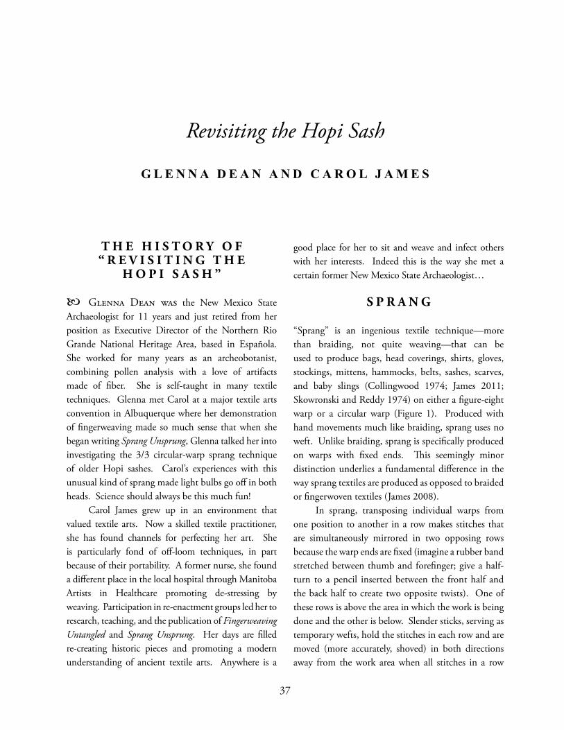
37
T H E H I S T O R Y O F “ R E V I S I T I N G T H E
H O P I S A S H ”
Glenna Dean was the New Mexico State Archaeologist for 11 years and just retired from her position as Executive Director of the Northern Rio Grande National Heritage Area, based in Española. She worked for many years as an archeobotanist, combining pollen analysis with a love of artifacts made of fi ber. She is self-taught in many textile techniques. Glenna met Carol at a major textile arts convention in Albuquerque where her demonstration of fi ngerweaving made so much sense that when she began writing Sprang Unsprung, Glenna talked her into investigating the 3/3 circular-warp sprang technique of older Hopi sashes. Carol’s experiences with this unusual kind of sprang made light bulbs go off in both heads. Science should always be this much fun! Carol James grew up in an environment that valued textile arts. Now a skilled textile practitioner, she has found channels for perfecting her art. She is particularly fond of off -loom techniques, in part because of their portability. A former nurse, she found a diff erent place in the local hospital through Manitoba Artists in Healthcare promoting de-stressing by weaving. Participation in re-enactment groups led her to research, teaching, and the publication of Fingerweaving Untangled and Sprang Unsprung. Her days are fi lled re-creating historic pieces and promoting a modern understanding of ancient textile arts. Anywhere is a
good place for her to sit and weave and infect others with her interests. Indeed this is the way she met a certain former New Mexico State Archaeologist…
S P R A N G
“Sprang” is an ingenious textile technique—more than braiding, not quite weaving—that can be used to produce bags, head coverings, shirts, gloves, stockings, mittens, hammocks, belts, sashes, scarves, and baby slings (Collingwood 1974; James 2011; Skowronski and Reddy 1974) on either a fi gure-eight warp or a circular warp (Figure 1). Produced with hand movements much like braiding, sprang uses no weft. Unlike braiding, sprang is specifi cally produced on warps with fi xed ends. Th is seemingly minor distinction underlies a fundamental diff erence in the way sprang textiles are produced as opposed to braided or fi ngerwoven textiles (James 2008). In sprang, transposing individual warps from one position to another in a row makes stitches that are simultaneously mirrored in two opposing rows because the warp ends are fi xed (imagine a rubber band stretched between thumb and forefi nger; give a half-turn to a pencil inserted between the front half and the back half to create two opposite twists). One of these rows is above the area in which the work is being done and the other is below. Slender sticks, serving as temporary wefts, hold the stitches in each row and are moved (more accurately, shoved) in both directions away from the work area when all stitches in a row
Revisiting the Hopi Sash
G L E N N A D E A N A N D C A R O L J A M E S
37
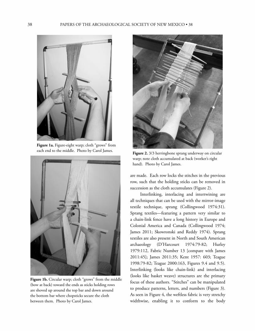
38 PAPERS OF THE ARCHAEOLOGICAL SOCIETY OF NEW MEXICO • 38
are made. Each row locks the stitches in the previous row, such that the holding sticks can be removed in succession as the cloth accumulates (Figure 2). Interlinking, interlacing and intertwining are all techniques that can be used with the mirror-image textile technique, sprang (Collingwood 1974:31). Sprang textiles—featuring a pattern very similar to a chain-link fence have a long history in Europe and Colonial America and Canada (Collingwood 1974; James 2011; Skowronski and Reddy 1974). Sprang textiles are also present in North and South American archaeology (D’Harcourt 1974:79-82; Hurley 1979:112, Fabric Number 13 [compare with James 2011:45]; James 2011:35; Kent 1957: 603; Teague 1998:79-82; Teague 2000:163, Figures 9.4 and 9.5). Interlinking (looks like chain-link) and interlacing (looks like basket weave) structures are the primary focus of these authors. “Stitches” can be manipulated to produce patterns, letters, and numbers (Figure 3). As seen in Figure 4, the weftless fabric is very stretchy widthwise, enabling it to conform to the body
Figure 1b. Circular warp; cloth “grows” from the middle (bow at back) toward the ends as sticks holding rows are shoved up around the top bar and down around the bottom bar where chopsticks secure the cloth between them. Photo by Carol James.
Figure 2. 3/3 herringbone sprang underway on circular warp; note cloth accumulated at back (worker’s right hand). Photo by Carol James.
Figure 1a. Figure-eight warp; cloth “grows” from each end to the middle. Photo by Carol James.
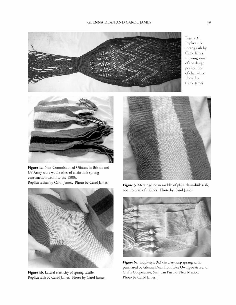
39
Figure 3. Replica silk sprang sash by Carol James showing some of the design possibilities of chain-link. Photo by Carol James.
Figure 4a. Non-Commissioned Offi cers in British and US Army wore wool sashes of chain-link sprang construction well into the 1800s. Replica sashes by Carol James. Photo by Carol James.
Figure 4b. Lateral elasticity of sprang textile. Replica sash by Carol James. Photo by Carol James.
Figure 5. Meeting-line in middle of plain chain-link sash; note reversal of stitches. Photo by Carol James.
Figure 6a. Hopi-style 3/3 circular-warp sprang sash, purchased by Glenna Dean from Oke Owingue Arts and Crafts Cooperative, San Juan Pueblo, New Mexico. Photo by Carol James.
GLENNA DEAN AND CAROL JAMES
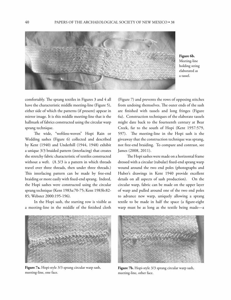
40 PAPERS OF THE ARCHAEOLOGICAL SOCIETY OF NEW MEXICO • 38
comfortably. Th e sprang textiles in Figures 3 and 4 all have the characteristic middle meeting-line (Figure 5), either side of which the patterns (if present) appear in mirror image. It is this middle meeting-line that is the hallmark of fabrics constructed using the circular warp sprang technique. Th e wide, “weftless-woven” Hopi Rain or Wedding sashes (Figure 6) collected and described by Kent (1940) and Underhill (1944, 1948) exhibit a unique 3/3 braided pattern (interlacing) that creates the stretchy fabric characteristic of textiles constructed without a weft. (A 3/3 is a pattern in which threads travel over three threads, then under three threads.) Th is interlacing pattern can be made by free-end braiding or more easily with fi xed-end sprang. Indeed, the Hopi sashes were constructed using the circular sprang technique (Kent 1983a:70-75; Kent 1983b:82-85; Webster 2000:195-196). In the Hopi sash, the starting row is visible as a meeting-line in the middle of the fi nished cloth
Figure 6b. Meeting-line holding string elaborated as a tassel.
Figure 7a. Hopi-style 3/3 sprang circular warp sash, meeting-line, one face.
Figure 7b. Hopi-style 3/3 sprang circular warp sash, meeting-line, other face.
(Figure 7) and prevents the rows of opposing stitches from undoing themselves. Th e outer ends of the sash are fi nished with tassels and long fringes (Figure 6a). Construction techniques of the elaborate tassels might date back to the fourteenth century at Bear Creek, far to the south of Hopi (Kent 1957:579, 597). Th e meeting-line in the Hopi sash is the giveaway that the construction technique was sprang, not free-end braiding. To compare and contrast, see James (2008, 2011). Th e Hopi sashes were made on a horizontal frame dressed with a circular (tubular) fi xed-end sprang warp wound around the two end poles (photographs and Huber’s drawings in Kent 1940 provide excellent details on all aspects of sash production). On the circular warp, fabric can be made on the upper layer of warp and pulled around one of the two end poles to advance new warp, uniquely allowing a sprang textile to be made in half the space (a fi gure-eight warp must be as long as the textile being made—a
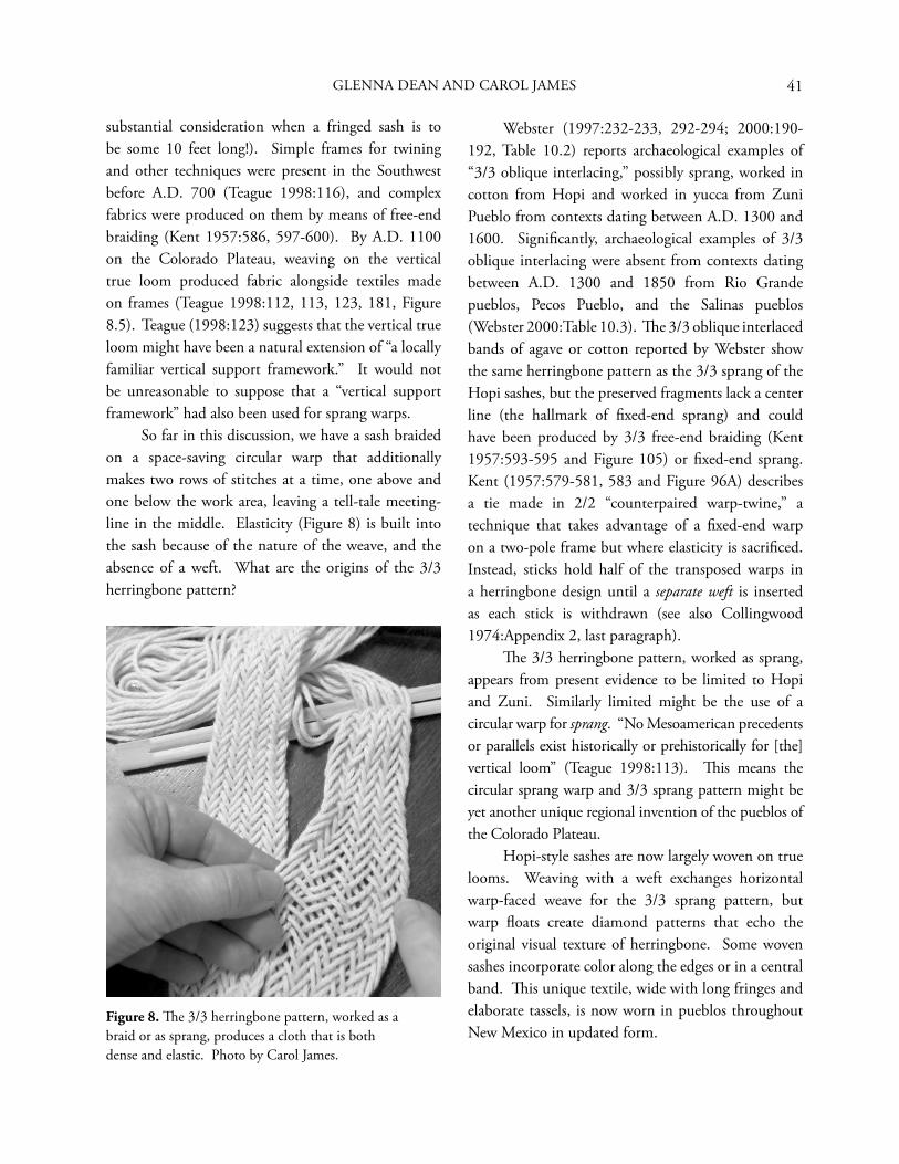
41
substantial consideration when a fringed sash is to be some 10 feet long!). Simple frames for twining and other techniques were present in the Southwest before A.D. 700 (Teague 1998:116), and complex fabrics were produced on them by means of free-end braiding (Kent 1957:586, 597-600). By A.D. 1100 on the Colorado Plateau, weaving on the vertical true loom produced fabric alongside textiles made on frames (Teague 1998:112, 113, 123, 181, Figure 8.5). Teague (1998:123) suggests that the vertical true loom might have been a natural extension of “a locally familiar vertical support framework.” It would not be unreasonable to suppose that a “vertical support framework” had also been used for sprang warps. So far in this discussion, we have a sash braided on a space-saving circular warp that additionally makes two rows of stitches at a time, one above and one below the work area, leaving a tell-tale meeting-line in the middle. Elasticity (Figure 8) is built into the sash because of the nature of the weave, and the absence of a weft. What are the origins of the 3/3 herringbone pattern?
Webster (1997:232-233, 292-294; 2000:190-192, Table 10.2) reports archaeological examples of “3/3 oblique interlacing,” possibly sprang, worked in cotton from Hopi and worked in yucca from Zuni Pueblo from contexts dating between A.D. 1300 and 1600. Signifi cantly, archaeological examples of 3/3 oblique interlacing were absent from contexts dating between A.D. 1300 and 1850 from Rio Grande pueblos, Pecos Pueblo, and the Salinas pueblos (Webster 2000:Table 10.3). Th e 3/3 oblique interlaced bands of agave or cotton reported by Webster show the same herringbone pattern as the 3/3 sprang of the Hopi sashes, but the preserved fragments lack a center line (the hallmark of fi xed-end sprang) and could have been produced by 3/3 free-end braiding (Kent 1957:593-595 and Figure 105) or fi xed-end sprang. Kent (1957:579-581, 583 and Figure 96A) describes a tie made in 2/2 “counterpaired warp-twine,” a technique that takes advantage of a fi xed-end warp on a two-pole frame but where elasticity is sacrifi ced. Instead, sticks hold half of the transposed warps in a herringbone design until a separate weft is inserted as each stick is withdrawn (see also Collingwood 1974:Appendix 2, last paragraph). Th e 3/3 herringbone pattern, worked as sprang, appears from present evidence to be limited to Hopi and Zuni. Similarly limited might be the use of a circular warp for sprang. “No Mesoamerican precedents or parallels exist historically or prehistorically for [the] vertical loom” (Teague 1998:113). Th is means the circular sprang warp and 3/3 sprang pattern might be yet another unique regional invention of the pueblos of the Colorado Plateau. Hopi-style sashes are now largely woven on true looms. Weaving with a weft exchanges horizontal warp-faced weave for the 3/3 sprang pattern, but warp fl oats create diamond patterns that echo the original visual texture of herringbone. Some woven sashes incorporate color along the edges or in a central band. Th is unique textile, wide with long fringes and elaborate tassels, is now worn in pueblos throughout New Mexico in updated form.
Figure 8. Th e 3/3 herringbone pattern, worked as a braid or as sprang, produces a cloth that is both dense and elastic. Photo by Carol James.
GLENNA DEAN AND CAROL JAMES
42 PAPERS OF THE ARCHAEOLOGICAL SOCIETY OF NEW MEXICO • 38
S U M M A R Y
Textile fragments exhibiting a 3/3 herringbone pattern have been found at several archaeological sites in the American Southwest spanning several centuries. It is a distinctive and uncommon textile structure that can be produced by several methods. Whatever its antecedents, the 3/3 herringbone sprang sash with its center meeting-line and long complex fringes is a textile unique to the Hopi people. Without using a weft, it employs a specifi c technique that produces two mirror-image rows for every row of work, a clever but almost forgotten method of textile production worthy of greater attention. Th e distinctive middle meeting-line in older-style Hopi sashes demonstrates that circular warp sprang was known on the Colorado Plateau, perhaps the only place in North American history. Th e sprang technique seems to have been very well known all across Europe in the 1700s and early 1800s and then precipitously fell into oblivion. Collingwood (1974:35) summarizes the history of sprang: “Although it is now realized that sprang has a wide distribution both in time and space, at the end of the last century it seems to have been unknown to European textile specialists.” Knowledge of even the chain-link version of sprang was nearly lost between 1820 and 1880, and was rescued by archaeological fi nds. Display of a Bronze Age hairnet and its exact copy in chain-link sprang aroused considerable interest at the 1889 Paris World Fair, the result of a student’s analysis of the ancient artifact and recreation of the basic technique (Collingwood 1974:35-36).
Looking ahead, sprang fabrics worked on a circular warp in the 3/3 herringbone pattern have an uncertain future, as the utility of sprang’s remarkable density and elasticity appears only occasionally in indigenous sashes and perhaps no other textiles. Archaeological evidence could establish that 3/3 circular warp sprang developed independently in North America. Toward that end, researchers are encouraged to familiarize themselves with the method by trying the 3/3 herringbone method for themselves. A ball of string and a couple of straight sticks are all that are needed to follow instructions on setting up the circular warp and commence the pattern (James 2011:68-69). A half hour spent exploring this technique will open doors to understanding and admiration of this ingenious weftless structure. You must know what you are looking for to fi nd it.
A C K N O W L E D G M E N T S
Glenna Dean thanks Carol Condie for her enthusiastic demonstrations of natural dyeing and other interpretive activities as part of several New Mexico Archaeology Fairs, as well as for wide-ranging conversations and for providing a seemingly endless supply of madder seedlings in support of a cranky dye garden (I think the last one fi nally took!). I thank Carol James for including the Hopi sash in her sprang research and for the patient creation of samples and photos for my personal education. Although Carol hasn’t yet met Carol, I look forward to that opportunity and an intricate obliquely interlaced conversation. Carol James thanks Manitoba Heritage and the Manitoba Arts Council for funding part of the research that resulted in Sprang Unsprung and this article. She is grateful for this opportunity to evangelize archaeologists, hoping they will come to share her enthusiasm for these exciting textile techniques.
43
R E F E R E N C E S C I T E D
Collingwood, Peter1974 Th e Techniques of Sprang. Watson-Guptill
Publications, New York.
D’Harcourt, Raoul1974 Textiles of Ancient Peru and their Techniques,
edited by Grace B. Denny and Carolyn M. Osborne, translated by Sadie Brown. University of Washington Press, Seattle.
Hurley, William M.1979 Prehistoric Cordage: Identifi cation of Impressions
on Pottery. Aldine Manuals on Archeology 3. Taraxacum Inc., Washington, D.C.
James, Carol2008 Fingerweaving Untangled: An Illustrated Beginner’s
Guide Including Detailed Patterns and Common Mistakes. Published by Carol James, Fiber Artist, 140 rue Notre Dame, Winnipeg, Manitoba, R2H 0C1, Canada, www.SashWeaver.ca.
2011 Sprang Unsprung: An Illustrated Guide to Interlinking, Interlacing and Intertwining. Published by Carol James, Sashweaver, 140 rue Notre Dame, Winnipeg, Manitoba, R2H 0C1, Canada, www.SashWeaver.ca.
Kent, Kate Peck1940 Th e Braiding of a Hopi Wedding Sash. Plateau
12:46-52.1957 Th e Cultivation and Weaving of Cotton in
the Prehistoric Southwestern United States. Transactions of the American Philosophical Society 47(3). Th e American Philosophical Society, Philadelphia.
1983a Prehistoric Textiles of the Southwest. School of American Research Press, Santa Fe.
1983b Pueblo Indian Textiles: A Living Tradition. School of American Research Press, Santa Fe.
Skowronski, Hella, and Mary Reddy1974 Sprang: Th read Twisting, A Creative Textile
Technique. Van Nostrand Reinhold Company, New York.
Teague, Lynn S.1998 Textiles in Southwestern Prehistory. University of
New Mexico Press, Albuquerque.2000 Revealing Clothes: Textiles of the Upper Ruin,
Tonto National Monument. In Beyond Cloth and Cordage: Archaeological Textile Research in the Americas, edited by Penelope Ballard Drooker and Laurie D. Webster, pp. 161-177. University of Utah Press, Salt Lake City.
Underhill, Ruth1944 Pueblo Crafts. United States Department of
the Interior, Bureau of Indian Aff airs, Offi ce of Education Programs. Haskell Indian Junior College, Lawrence, Kansas.
1948 Pueblo Crafts, edited by Willard W. Beatty. Department of the Interior, United States Indian Service, Education Division. Haskell Institute Print Shop, Lawrence, Kansas
Webster, Laurie D.1997 Eff ects of European Contact on Textile
Production and Exchange in the Northern American Southwest: A Pueblo Case Study. Unpublished Ph.D. dissertation, Department of Anthropology, University of Arizona, Tucson.
2000 Th e Economics of Pueblo Textile Production and Exchange in Colonial New Mexico. In Beyond Cloth and Cordage: Archaeological Textile Research in the Americas, edited by Penelope Ballard Drooker and Laurie D. Webster, pp. 179-204. University of Utah Press, Salt Lake City.
GLENNA DEAN AND CAROL JAMES

44 PAPERS OF THE ARCHAEOLOGICAL SOCIETY OF NEW MEXICO • 38
45
Isabel Truesdell Kelly (1906-1983) had a distinguished career in anthropology that spanned 55 years of concentrated work as an ethnographer, archaeologist, and applied anthropologist. An avid fi eld worker, often in rigorous situations, she pursued research topics in several locations in the western United States and Mexico as well as in Colombia, El Salvador, Ecuador, Chile, Puerto Rico, Bolivia and Pakistan. Trained as an academic anthropologist at the University of California, Berkeley, she entered the fi eld at a time when women were beginning to seek and expect full recognition of their professional abilities. Although fulltime academic work eluded her, perhaps in part because she chose to live in Mexico, she was consistently employed in a professional capacity throughout her career. Her body of work is impressive, a legacy to her determination to be an anthropologist and to work in interesting places and on interesting problems of her choosing (Fowler and Kemper 2008:139). Here I focus on an early aspect of her career, her fi eldwork among the Southern Paiute people of southern Utah, northern Arizona and southeastern California. Southern Utah is familiar ground to this year’s honoree, Carol Condie, as both of her parents came from the small community of Santa Clara in its southwestern section. Another connection to Kelly for Carol is that she edited Kelly’s monograph while working for the Glen Canyon Archaeological Project at the University of Utah (Kelly 1964). Th e story that follows, related largely in Kelly’s own words from
her letters from the fi eld,1 is one of a “plucky” and independent person doing the job she set out to do to the best of her abilities—something that is also characteristic of our honoree. Both also place great value on collecting deeply descriptive and detailed data through fi eldwork and making them central to any analytical and theoretical statements.
S O U T H E R N PA I U T E F I E L D W O R K , 1 9 3 2
In February, 1932, while engaged in post-doctoral ethnographic fi eldwork among the Coast Miwok in California, Isabel Kelly received word that she had been granted a fellowship in the Biological Sciences by the National Research Council for a one year study titled “A Determination of the Ethnic Groupings of a Great Basin Tribe, with Special Reference to the Geographic and Subsistence Bases” (Robbins to Kelly, February 9, 1932, KADL). Th is project was an outgrowth of her recently completed dissertation, “Th e Fundamental Basis of Great Basin Culture,” which was a comparison of the subsistence systems and adaptations of Great Basin peoples based on the extant literature. Th e fellowship project was designed to gather specifi c fi eld data on the relationship of cultural to environmental variation, a topic Kelly had explored in her dissertation and as a graduate student in courses from mentors A. L. Kroeber and Carl O. Sauer at the University of California, Berkeley. Th e orientation for this project was to be specifi cally
Isabel Kelly Among the Southern Paiute: 1932 to 1934
C A T H E R I N E S . F O W L E R
45
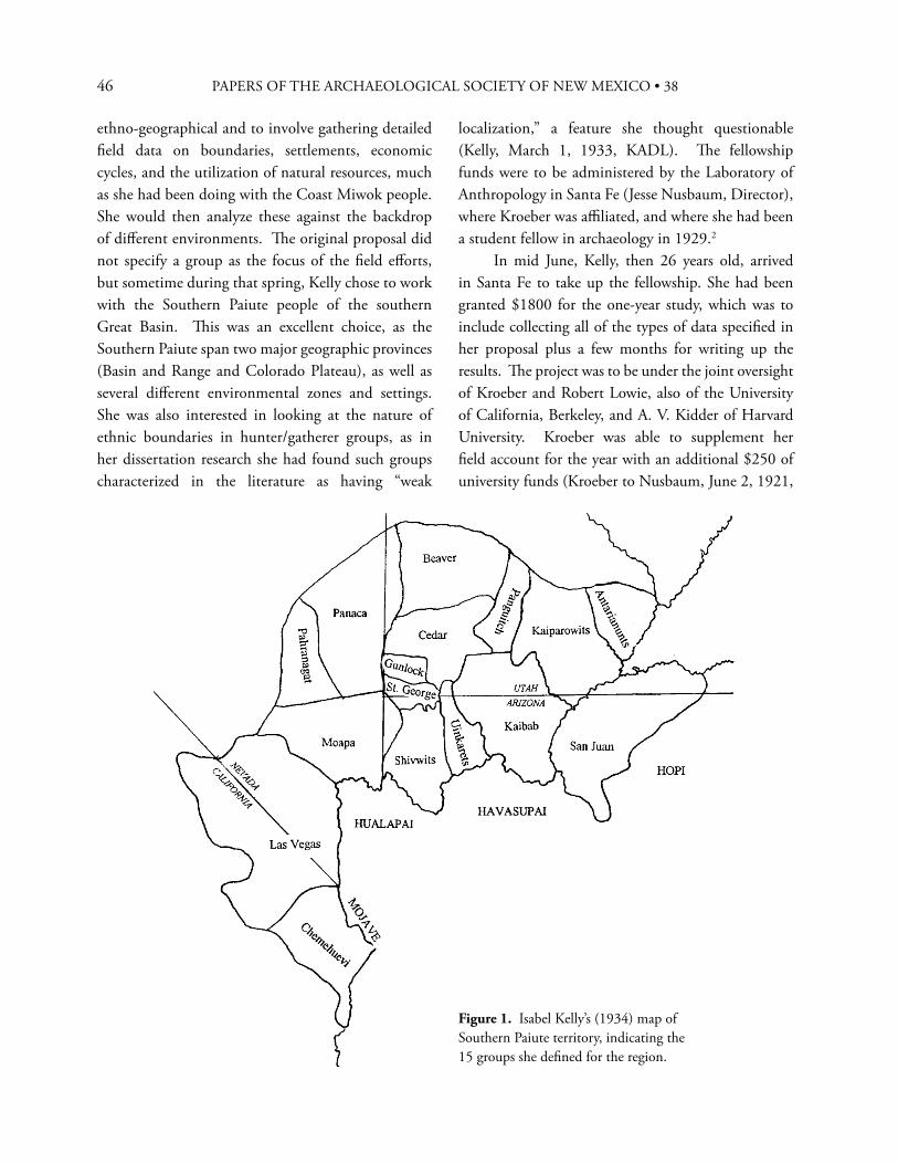
46 PAPERS OF THE ARCHAEOLOGICAL SOCIETY OF NEW MEXICO • 38
ethno-geographical and to involve gathering detailed fi eld data on boundaries, settlements, economic cycles, and the utilization of natural resources, much as she had been doing with the Coast Miwok people. She would then analyze these against the backdrop of diff erent environments. Th e original proposal did not specify a group as the focus of the fi eld eff orts, but sometime during that spring, Kelly chose to work with the Southern Paiute people of the southern Great Basin. Th is was an excellent choice, as the Southern Paiute span two major geographic provinces (Basin and Range and Colorado Plateau), as well as several diff erent environmental zones and settings. She was also interested in looking at the nature of ethnic boundaries in hunter/gatherer groups, as in her dissertation research she had found such groups characterized in the literature as having “weak
localization,” a feature she thought questionable (Kelly, March 1, 1933, KADL). Th e fellowship funds were to be administered by the Laboratory of Anthropology in Santa Fe (Jesse Nusbaum, Director), where Kroeber was affi liated, and where she had been a student fellow in archaeology in 1929.2 In mid June, Kelly, then 26 years old, arrived in Santa Fe to take up the fellowship. She had been granted $1800 for the one-year study, which was to include collecting all of the types of data specifi ed in her proposal plus a few months for writing up the results. Th e project was to be under the joint oversight of Kroeber and Robert Lowie, also of the University of California, Berkeley, and A. V. Kidder of Harvard University. Kroeber was able to supplement her fi eld account for the year with an additional $250 of university funds (Kroeber to Nusbaum, June 2, 1921,
Figure 1. Isabel Kelly’s (1934) map of Southern Paiute territory, indicating the 15 groups she defi ned for the region.
47
LAA). She also had roughly $400 additional from the Laboratory of Anthropology, Harvard’s Peabody Museum, and the American Museum of Natural History to purchase ethnographic objects for their collections Wissler to Nusbaum, June 15, 1932, LAA. Th is level of funding ($2,450 for the year), even though partly committed to purchases, was thought to be adequate, particularly considering the scarceness of funding (and jobs) in Great Depression period. Kelly would ultimately spend roughly 15 months in the fi eld over the next two and a half years on this amount plus a second year National Resource Council supplement of $1,000. Th e extension in fi eld time was partly due to the diffi culty of the fi eld situation and partly to an auto accident she suff ered in the fi eld and the recovery time required. She fi nished the fi eldwork in 1934,
amassing large amounts of primary data on Southern Paiute ethno-geography and ethnography throughout their pre-contact territory, which she was the fi rst to defi ne (Kelly 1934) (Figure 1). Unfortunately, with the time delays, there was almost no time remaining for synthesis and write-up, and she was unable to publish the bulk of the data at that time. Th ey are now being prepared for publication.3
Kelly arrived in Santa Fe in her single seat 1932 Ford (Figure 2) with a fellow Berkeley student, Jane Gabbert, sent with her by Kroeber because of an incident that had occurred on a Southwest reservation that previous summer.4 As noted, she was not totally new to ethnographic fi eldwork when she took on this project, as she had spent a summer among the Surprise Valley Northern Paiute of northeastern California after
Figure 2. Isabel Kelly leaving Berkeley, California, for the fi eld in June, 1932, in her new Ford. Courtesy of DeGolyer Library, Southern Methodist University and Robert Van Kemper.
CATHERINE S. FOWLER
48 PAPERS OF THE ARCHAEOLOGICAL SOCIETY OF NEW MEXICO • 38
her senior year in college and had completed a year’s intensive ethnographic work among the Coast Miwok immediately after fi nishing her doctoral work. Her experiences in Surprise Valley had been diffi cult, with various Native people in the community refusing to talk with her, even “siccing the dogs” on her more than once. But in her inexperience, she thought that that was the normal course of fi eldwork. Kroeber later assured her that that was not necessarily the case, but that in his own fi eld work, he had found Great Basin peoples particularly diffi cult.5 Her Coast Miwok experience had been much more positive, although she reported in her letters from the fi eld that she and her consultants were often totally exhausted at the end of each day (Kelly to Kroeber, January 24, 1932, DABL). She also worried over her lack of preparation in linguistics and that there would never be time enough to adequately analyze the data properly (Kelly to Giff ord, February 20, 1932, DABL). Th us, Kelly was prepared for what might be a diffi cult time with the people, but also, to some degree with the country. In the 1930s, the region was quite remote, with few roads and accommodations, and with diff erent environments from low, very hot deserts to high and cold plateaus. None of this deterred her from taking on the task soon after she arrived in Santa Fe. Kelly and Gabbart left Santa Fe on June 26 for Kaibab, Arizona, the fi rst stop in her fi eld circuit. Th ey drove via northern New Mexico and southern Colorado, passing Mesa Verde, then into Utah and northern Arizona, arriving on July 1. On July 2, Kelly reported to Nusbaum on their adventures along the way:
Aside from minor details, we had a most enjoyable trip. We ran into heavy and continuous rain above Abiquiu, and it took us some hours to negotiate the stretch from there to Canijilon—going sideways most of the time. We mired twice, and the juniper forest in that region is considerably depleted from our chopping activities. We spent the night at Pagosa—apparently
missing a good deal of fi ne scenery after dark. From there we had an easy run to Mesa Verde. What glorious country we went through! Th e entrance to the park is magnifi cent beyond words. Although the sunset was not up to specifi cations, the panorama alone is worth the entire trip… Both Jane and I felt, however, that the ruins were somewhat dwarfed by the breath-taking scenery (Kelly to Nusbaum, July 2, 1932, LAA).
In the same letter (Kelly to Nusbaum, July 2, 1932, LAA), she describes the situation at Kaibab and her fi eld accommodations:
Th e immediate Paiute situation is not bad at all. We arrived last evening and after much consultation, it was decided that we might camp in the school kitchen. We were grateful for this kind gesture, as we brought a thorough-going rain with us. Th e kitchen is of more than ample size and is equipped with three tables, a kitchen range, and running water. Luxury beyond our fondest hopes!
And rather immediately, Kelly got to work. Much to her surprise:
We discovered that Dr. [C. Hart] Merriam had been there only three days ago. Last evening his informant presented himself, unsolicited, and was engaged. Th e very thought of a Paiute who volunteers services as an informant makes me cross my fi ngers. Th is morning I tore over hill and dale with him and his wife, and we collected thirty or so plant specimens. Th e entire camp takes a fl attering interest in our activities, and we are continually receiving impromptu calls, and what not. About fi fteen perch outside the door and, all told, things are quite
49
diff erent from the surly Northern Paiute (Kelly to Nusbaum, July 2, 1932, LAA).
Kelly’s initial enthusiasm was tempered somewhat when the person who presented himself as a consultant turned out to be too young for, as she later characterized her fi eld approach, the “unabashedly how-it-was-in-your-grandfather’s-day” approach (Kelly 1964:iii). She wrote about three weeks later:
From the expressions of sympathy, I judge that my letter to Dr. [H. P.] Mera must have been highly lugubrious. I am famous for the mournful letters which I send in from the fi eld. Since I wrote, I have changed informants and am now working with a man who claims to know everything. Although he falls somewhat short of his modest claim, he is really an excellent informant, and I am genuinely pleased with the material that is accumulating. I am trying to do the Kaibab rather thoroughly in order to supplement the nucleus that [Edward] Sapir has.6 With the other Paiute I shall confi ne myself more to straight ethno-geography (Kelly to Nusbaum, July 27, 1932, LAA).
Given that Kelly also had funds to collect Southern Paiute material culture for various museums, she was anxious to learn what was available and what the museums were expecting. She wrote to Nusbaum: “I am anxious to discover what sort of museum specimens Dr. [Clark] Wissler [of the American Museum of Natural History] wants. We have been off ered the usual buckskin gauntlets, etc., but I have wind of a seed gathering apparatus which might be nice. I suppose Dr. Wissler would prefer a somewhat bedraggled but genuine article to a neat looking model?” (Kelly to Nusbaum, July 2, 1932, LAA). When she still had not heard from Wissler by month’s end, Kelly devised her own plan:
I shall do the very best that I can in the way of specimens, but of course, Paiute specimens are not likely to be particularly inspiring. I think that I shall be able to get a rather nice series of the old basketry styles–save possibly the water jar. I wonder if he would care to have any of the modern tourist basketry products? Th ey are not frightfully expensive, and fi fty years from now they might hold some interest for anyone who wanted to study the craft and its developments. I have explicit information that this modern style was learned from the Moapa, and so it might prove of interest to compare the original and the Kaibab version. To date I have a model of a woman’s bark skirt; a model of a yucca sandal; and a cradle just outgrown by my informant’s great grandchild (Kelly to Nusbaum, July 27, 1932, LAA).
Ultimately, in the course of her entire fi eld studies, Kelly acquired some 325 items of material culture from 12 Southern Paiute/Chemehuevi subgroups for the various museums.7 Th e collections are similar in depth and breadth, very well documented and form an excellent corpus for comparison (Figure 3). In a letter to Wissler she wrote:
Naturally there is not very much of the old culture left, and I should say that about half of the lot are models, but they are good models, conscientiously made. For every specimen I have the name of the maker, together with his band affi liation or affi liations–data which should be useful for comparative purposes... I think that I can say complacently enough, that I have bought every object obtainable which could be of any conceivable interest either now or in the future (Kelly to Wissler, December 16, 1932, KADL).
CATHERINE S. FOWLER
50 PAPERS OF THE ARCHAEOLOGICAL SOCIETY OF NEW MEXICO • 38
Kelly remained at Kaibab for roughly two months, working with people she termed the “last four of the old Kaibab.” Her companion, Jane Gabbert, left to return to school, and from here on, Kelly was on her own with her trusted Ford and her camping tent. But, she added in a letter to A. V. Kidder: “I just can’t tell you how splendidly things have gone so far. Really, life is good. I have been getting good material, so good that my fi ngers have been crossed since the fi rst week out” (Kelly to Kidder, September 19, 1932, KADL). She had added considerably to the general ethnographic notes taken by Edward Sapir during conversations with Tony Tillohash in 1910, which he had kindly sent her. In 1964, Kelly published the bulk of her data on the Kaibab Southern Paiute group along with some of Sapir’s material in the monograph for the Glen Canyon Project (Kelly 1964). She also included in that publication her basic data from the Panguitch, Kaiparowits and San Juan groups. While at Kaibab, Kelly had the opportunity to work with two individuals from Escalante, Utah, near the Kaiparowits Plateau. One, a man, she refers to as “impossibly deaf,” and the other, a woman, as “moderately good” (Kelly to Kidder, September 19, 1932, KADL). In an interesting note on fi eld methods, she says that the woman was “less than satisfactory on ethno-geography” until they took a fi eld trip to her
home country, which she had not visited in 35 years. Upon seeing the area, the woman remarked on several changes to the environment that occurred in her absence, including marked arroyo cutting, reduction of vegetation and increased aridity. Kelly commented that these observations would be of great interest to any cultural geographer or economist. Th e value of working with people directly in the fi eld and at sites they knew had been espoused by geographer Carl Sauer at Berkeley, and Kelly was following suit. Kelly moved on to Cedar City, Utah in early September, 1932. From that base, she traveled to several areas, and interviewed the few individuals she could fi nd from diff erent groups in that vicinity (Cedar, Beaver, Parowan, Panguitch, Indian Peak). In all cases, she referred to them as the “last survivors” of their particular groups—undoubtedly speaking to their knowledge of the “old ways” rather than to their actual status. Regarding Indian Peak, near the Utah/Nevada border, she wrote to Kidder:
Th e past week I have been camped in the wilds at Indian Peak, sixty miles from here, on exceedingly chummy terms with 7 Paiute, 9 horses, and countless canines resident there. Th is does not include the amiable bobcat which wandered into my tent one moonlight night. Material on the bands in that vicinity is pretty scrappy, mostly because one has to deal with lone survivors who know only their own little local settlement (Kelly to Kidder, September 19, 1932, KADL).
Kelly speaks further to Kidder of her plans to go in search of the elusive San Juan Southern Paiute people who live south of the Colorado River in what is now called the Navajo Strip but was once the Paiute Strip:
I leave Th ursday for Navajo Spring, near Lee’s Bridge, where I hope to tackle an isolated family hailing originally from the Paiute strip. Kroeber advised against trying
Figure 3. Pitch container, carried by man on hunting trip; pitch was applied periodically to moccasin soles to prevent their wearing out. Made by Mary Ann Frank, Las Vegas/Moapa Southern Paiute (willow, devil’s claw, buckskin; 5.2 in. long). Collections of the Museum of Indian Arts and Culture, Santa Fe, NM (Cat # 9990/12). Photo by C.S. Fowler.
51
to reach this band—one must travel some miles by horse through the heart of Navajo country. I thought though that I might have my cake and eat it too. If the Navajo Spring informant is even passable, I should be able to get at least the boundaries and thus complete my map. Incidentally, I should like to have a crack at these so-called “Tuba City Paiute”. Th ey ought to be interesting because of their isolation from the whites and because of their Ute-Navajo contacts. Evidently it is they who supply basketry for the Navajo trade. As you can see, the Paiute are strewn all over the Southwest, and about the same can be said for me (Kelly to Kidder, September 19, 1932, KADL).
Th us, in early October, Kelly backtracked to Navajo Spring, near Lee’s Ferry and Marble Canyon. Once there, she makes the following comment on weather conditions: “Winter draws on apace and I am still trailing gaily over the Plateau, fl irting with the chance of a snowstorm that will close the roads. As a matter of fact, the road here from Kanab was quite washed out in spots, and there was a heavy downpour of rain last night. My trusty tent is still fl apping in the breeze, dry inside thank heaven” (Kelly to Nusbaum, October 2, 1932, LAA). She had great diffi culty fi nding families, and once she did, she could not enlist a satisfactory interpreter. However, she persevered and managed to collect “a few scant data on the Paiute strip people—not nearly as much as I should like, but better than nothing” (Kelly to Kidder, November 7, 1932, KADL). Th ey were largely unknown at the time, although in the late 1930s, Omer Stewart would also fi nd them and complete a Culture Element Distribution list (Stewart 1942). Th eir importance in the trade in Navajo ceremonial baskets, as well as the development of fi ne coiled weaving generally, would also become better known (McGreevy and Whiteford 1985; Stewart 1938; Tschopik 1940), as would their ethnography (Bunte and Franklin 1987). Kelly’s San
Juan data are included in her publication (Kelly 1964). After her sojourn at Navajo Spring, Kelly moved on to Santa Clara, Utah, near the Shivwits Reservation. She attempted to enlist Tony Tillohash, Sapir’s consultant for his Southern Paiute linguistic studies in 1910 (Sapir 1930-31), but failed as he was “too busy harvesting pine nuts” (Kelly to Sapir, March 9, 1933, KADL). She conveyed a copy of Sapir’s volume to Tony, who was very pleased and “spoke warmly of you and asked to have greetings relayed.” She was able to do some of her best ethno-geography here, however, working closely with one of the last men familiar with the Shivwits Plateau, on the north side of the Grand Canyon. She and he mapped much of the area, cataloging its many springs, their camps and the local subsistence resources.8 She wrote to Kidder:
Business continues to be amazingly good. I have been at Santa Clara nearly a month; have just fi nished with the Shivwits and am beginning to pry into the aff airs of the St. George band. Th ese Paiute bands seem endless and are invariably represented by a lone survivor. Th e latter are trying as they frequently know little, and even that can’t be checked. Some nice items on trade are coming to light, though (Kelly to Kidder, November 7, 1932, KADL).
Kelly comments to Kidder a bit on the local scene (Kelly to Kidder, November 7, 1932, KADL), lamenting some of the conditions in St. George:
Even the simplest things are hard to fi nd in this country. And as for a primary commodity like money, it’s absolutely not to be had. I have to trot 75 miles to Cedar City to cash a check. Th e local bank is cagey and would not even deign to examine my barrage of cancelled checks, bank statements, and certifi cates of this and that. I always thought I had an honest face! Th ey did accept a check for collection
CATHERINE S. FOWLER
52 PAPERS OF THE ARCHAEOLOGICAL SOCIETY OF NEW MEXICO • 38
on my Santa Fe account (two weeks ago and still no action) and naively asked if Santa Fe were near Los Angeles!
Kelly also laments to Kidder that she barely has time to do anything but her ethnographic work. Particularly vexing are all of the archaeological sites she is seeing in her fi eld wanderings, and a lack of time to investigate them. After all, as she wrote Kroeber when she was doing fi eldwork among the Northern Paiute in Surprise Valley, “archaeology is my fi rst love and my only love” (Kelly to Kroeber, May 27, 1930, DABL). She had been a student at the Laboratory of Anthropology archaeological fi eld school in the summer of 1929 with Kidder, excavating at Tecolote Ruin, and in all of her correspondence with him, she continually speaks of the many sites in the northern Arizona/southern Utah area that she wished she could explore. After her Southern Paiute fi eld work, she would get the chance to realize her dream of working in archaeology again, in southern Arizona and west Mexico (Fowler and Kemper 2008). By the time Kelly fi nished at Santa Clara, she was able to say that she had relatively full ethnographies in addition to ethno-geographies of the Shivwits and St. George groups. In mid November, Kelly returned to Berkeley to consult with Kroeber and also to prepare the specimens she had collected thus far for photographing, illustration, and shipment to the museums. She had intended to spend the month of December in the fi eld at Moapa, Nevada, but was unable to do so because of a fl are-up of back troubles exacerbated by travel over rough roads. As she wrote to Nusbaum in December:
I have been obliged to take an enforced vacation which Harold Hitchcock, the famous bone specialist, claims has been brought on by too much Ford-driving. He insists that everyone who drives a Ford must pay a penalty sooner or later and that account is being taken of me because of my having averaged something like 2000 miles monthly since June. At any rate, I
must confess that although I have always been a rugged and hearty soul, the last few weeks have been made miserable with a stiff back—all of which involves sleeping on planks, sporting 20 inches of adhesive tape, and desisting from driving. All of this is a perfect nuisance... (Kelly to Nusbaum, December 20, 1932, LAA).
S O U T H E R N PA I U T E F I E L D W O R K , 1 9 3 3 - 3 4
After a month’s fi eld study on the Moapa Reservation, Nevada, in January, 1933, where again Kelly received excellent cooperation and data, she returned to Berkeley to begin writing up her materials and to again see to the collections. She also applied for a renewal of her National Research Council fellowship for a second year, during which time she planned to concentrate her work among the westernmost Southern Paiute groups in southern Nevada and California—the Las Vegas people and the Chemehuevi, their close linguistic and cultural kinsmen. Th ese groups, along with the Moapa people, live in the Mojave Desert as opposed to the Great Basin Desert, an environment of considerable interest to Kelly for comparative ethno-geographic purposes. She was granted the extension the following June, and after three months in Santa Fe working on her fi eld notes from the previous year, she again set out for Berkeley before returning to the fi eld. Th is time, however, her spirit of adventure led to diffi culty. While in Santa Fe, she had met two Harvard students in the Southwest on Rockefeller fellowships, and they had asked if they could meet her in Flagstaff and join her on her trip to the coast after they had visited Grand Canyon. On September 11, she picked them up in Flagstaff and the three headed north in her trusty one-seat Ford. At Cameron, one of the men began driving, and apparently unfamiliar with the hazards of dirt roads, rolled the car, ejecting the three. After a four-hour wait for help, the three were taken by truck to the Flagstaff hospital. Kelly wrote to Nusbaum that the two men escaped major
53
injury (dislocated shoulder; back sprain), but she had fractured three vertebrae. Of her car and belongings she reported: “Th e hack is a mess—one whole side demolished. We were strewn all over the lot and the baggage strewn about for 50 feet. Even a whisk broom in the pocket of the Ford and the tools from beneath the seat were widely disseminated…” (Kelly to Nusbaum, September 13, 1933, LAA). Her most immediate concern after the accident was for her fi eld notes which she initially feared were lost, but which were ultimately recovered in her battered trunk. Kelly quipped: “Just as I suspected, it isn’t safe to travel about with a Rockefeller student” (Kelly to Nusbaum, September 13, 1933, LAA). Kelly spent two months in the hospital recuperating, cheered by periodic visits from Harold and Mary Colton and Katherine Bartlett of the Museum of Northern Arizona.9
After additional time recuperating in Berkeley, Kelly was back in the fi eld by mid November, fi rst at Moapa, and then at Parker, Arizona, for Chemeheuvi fi eldwork, and then later Las Vegas for additional studies with that group. Her interest in the Chemehuevi was piqued by the comparative ethno-geographic problems, but also by the more recent history of at least some Chemehuevi people’s move to the fl ood plain of the Colorado River where they were infl uenced by the “virile and distinctive Mohave river culture” (Kelly to National Research Council, December 15, 1933, KADL). She remarked of her fi eld situation in Parker:
Parker is pleasant as regards temperature, but the town itself is about as dismal, dusty, and uninviting as anything I have seen in years. Work is coming on satisfactorily, but not with such success that I am frenzied with enthusiasm. My Las Vegas informant is a more satisfactory informant than the local people—but he is blind and 200 miles from his native heath. However, the local material is supplementing his very nicely (Kelly to Nusbaum, January 29, 1934, KADL).
Th e following month, she wrote to Nusbaum that things were continuing to go well and that the supplementary funds he had just sent to purchase collections for the Laboratory of Anthropology were most appreciated: “you may be sure that the sum will be stretched as far as humanly possible. Field work is a pernicious disease—there is just no giving in as long as one can manage to scrape along” (Kelly to Nusbaum, February 16, 1934, LAA). She continued, saying that her notes from the Chemehuevi were by now “voluminous,” and that given the warm weather and all the work she has been doing outside, “in complexion I am coming to look like a cross between a Rhode Island Red and a Plymouth Rock” (Kelly to Nusbaum, February 16, 1934, LAA). In a letter to Kroeber, Kelly refers as well to star gazing with the Chemehuevi during the very pleasant nights at Parker. She was impressed by their knowledge of constellations, fi nding the data quite comparable to those reported by Leslie Spier (1928) for the Havasupai. She regretted that she could not spend another couple more months there, as the materials were continuing to “roll in most satisfactorily” (Kelly to Kroeber, March 14, 1934, KADL). After leaving Parker, Kelly moved to Las Vegas, where she worked for a month, and then back to Moapa for another short period. She returned to Berkeley in mid April, 1934 after spending some fi ve months in the low desert areas.
P O S T F I E L D W O R K Y E A R S
In the next few years, Kelly was able to publish some of her voluminous Southern Paiute data in a series of papers, mostly focusing on group boundaries and on shamanism. Her paper on boundaries and territories was the fi rst, and remains the primary statement on Southern Paiute territorial distribution (Kelly 1934). In it she speaks not only of the careful mapping she tried to do in the fi eld, but of her consultants’ impressions of dialectic variation, economic distinctiveness and other features separating as well as unifying the fi fteen large groups she identifi ed. Her works on
CATHERINE S. FOWLER
54 PAPERS OF THE ARCHAEOLOGICAL SOCIETY OF NEW MEXICO • 38
shamanism (Southern Paiute and Chemehuevi) provide rich consultant accounts of specifi c practices and of the persons known to have been involved in the latter part of the nineteenth and early twentieth centuries. Two of the papers were written to honor her mentors at Berkeley, Robert Lowie (Kelly 1939) and A. L. Kroeber (Kelly 1936). Th e remainder of her Southern Paiute fi eld notes were then set aside—but not forgotten—for some three decades, while she pursued her “fi rst love,” archaeology, fi rst in southern Arizona (Hodges Ruin) and then in west Mexico (Fowler and Kemper 2008). Kelly returned to her Southern Paiute materials in the 1960s, in between continuing various projects in Mexico as well as elsewhere. In the 1950s, the Indian Claims Commission was established, and lawyers for tribes as well as the federal government began looking for published and especially unpublished data for the cases being brought before it for compensation to tribes for lands taken by illegal appropriation. Kelly’s unpublished materials were focal points for both sides in various cases involving Southern Paiute/Chemehuevi tribes. Th is stimulated her to think about writing up her materials, especially when her mentor, Kroeber, suggested that they do a joint monograph on the Chemehuevi (Kroeber to Kelly, August 20, 1955, KADL). She responded that in addition to her Southern Paiute materials, she had at least 10 other major projects that she needed to fi nish, and added: “I’ll never be able to liquidate all that, if I live to be 150, as I write very slowly and painfully (Kelly to Kroeber, September 4, 1955, KADL). Although Kroeber died before either could
complete the monograph on the Chemehuevi, Kelly did publish the data on her eastern Southern Paiute groups at the request of J. D. Jennings as part of the Glen Canyon Project, thereby relieving her of roughly one-third of the burden she felt regarding her Southern Paiute materials (Kelly 1964). She fully intended to continue with publication of the remaining materials as well, but the nine other tasks she listed for Kroeber intervened. In the 1970s, however, she worked on a comparative sketch on the Southern Paiute for the massive Smithsonian Institution project, Handbook of North American Indians, which she had largely completed by the time of her death in 1983 (Kelly and Fowler 1986). She also authored a sketch of the Coast Miwok for the California volume of the same Handbook of North American Indians series (Kelly 1978). Th e remainder of her equally voluminous Coast Miwok ethnographic materials appeared posthumously (Collier and Th alman 1991). Kelly’s fi eldwork, including that among the Southern Paiute people, is but one of the numerous major fi eld projects she conducted, most of them multi-year, in the U.S., Mexico and many other areas of Latin America as well as Pakistan (Fowler and Kemper 2008:166-7). Her professional vita is a very long one, characterized by many publications that are deeply analytical and theoretical, but always based on rich data that she personally collected in the fi eld. She was professionally employed throughout her life, although not in an academic setting. Perhaps because of this, she was able to pursue her research with a vigor and rigor that many would envy.
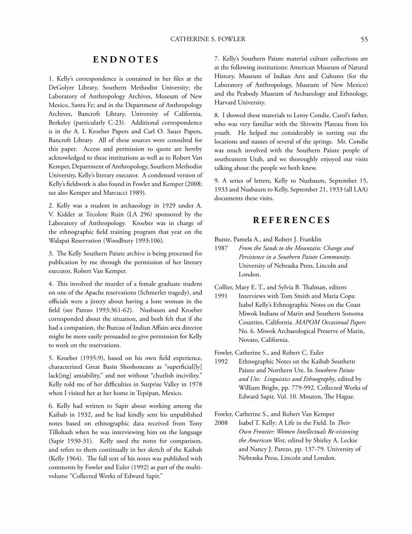
55
E N D N O T E S
1. Kelly’s correspondence is contained in her fi les at the DeGolyer Library, Southern Methodist University; the Laboratory of Anthropology Archives, Museum of New Mexico, Santa Fe; and in the Department of Anthropology Archives, Bancroft Library, University of California, Berkeley (particularly C-23). Additional correspondence is in the A. L Kroeber Papers and Carl O. Sauer Papers, Bancroft Library. All of these sources were consulted for this paper. Access and permission to quote are hereby acknowledged to these institutions as well as to Robert Van Kemper, Department of Anthropology, Southern Methodist University, Kelly’s literary executor. A condensed version of Kelly’s fi eldwork is also found in Fowler and Kemper (2008; see also Kemper and Marcucci 1989).
2. Kelly was a student in archaeology in 1929 under A. V. Kidder at Tecolote Ruin (LA 296) sponsored by the Laboratory of Anthropology. Kroeber was in charge of the ethnographic fi eld training program that year on the Walapai Reservation (Woodbury 1993:106).
3. Th e Kelly Southern Paiute archive is being processed for publication by me through the permission of her literary executor, Robert Van Kemper.
4. Th is involved the murder of a female graduate student on one of the Apache reservations (Schmerler tragedy), and offi cials were a jittery about having a lone woman in the fi eld (see Parezo 1993:361-62). Nusbaum and Kroeber corresponded about the situation, and both felt that if she had a companion, the Bureau of Indian Aff airs area director might be more easily persuaded to give permission for Kelly to work on the reservations.
5. Kroeber (1935:9), based on his own fi eld experience, characterized Great Basin Shoshoneans as “superfi cial[ly] lack[ing] amiability,” and not without “churlish incivility.” Kelly told me of her diffi culties in Surprise Valley in 1978 when I visited her at her home in Tepépan, Mexico.
6. Kelly had written to Sapir about working among the Kaibab in 1932, and he had kindly sent his unpublished notes based on ethnographic data received from Tony Tillohash when he was interviewing him on the language (Sapir 1930-31). Kelly used the notes for comparison, and refers to them continually in her sketch of the Kaibab (Kelly 1964). Th e full text of his notes was published with comments by Fowler and Euler (1992) as part of the multi-volume “Collected Works of Edward Sapir.”
7. Kelly’s Southern Paiute material culture collections are at the following institutions: American Museum of Natural History, Museum of Indian Arts and Cultures (for the Laboratory of Anthropology, Museum of New Mexico) and the Peabody Museum of Archaeology and Ethnology, Harvard University.
8. I showed these materials to Leroy Condie, Carol’s father, who was very familiar with the Shivwits Plateau from his youth. He helped me considerably in sorting out the locations and names of several of the springs. Mr. Condie was much involved with the Southern Paiute people of southeastern Utah, and we thoroughly enjoyed our visits talking about the people we both knew.
9. A series of letters, Kelly to Nusbaum, September 15, 1933 and Nusbaum to Kelly, September 21, 1933 (all LAA) documents these visits.
R E F E R E N C E S
Bunte, Pamela A., and Robert J. Franklin1987 From the Sands to the Mountain: Change and
Persistence in a Southern Paiute Community. University of Nebraska Press, Lincoln and London.
Collier, Mary E. T., and Sylvia B. Th alman, editors1991 Interviews with Tom Smith and Maria Copa:
Isabel Kelly’s Ethnographic Notes on the Coast Miwok Indians of Marin and Southern Sonoma Counties, California. MAPOM Occasional Papers No. 6. Miwok Archaeological Preserve of Marin, Novato, California.
Fowler, Catherine S., and Robert C. Euler1992 Ethnographic Notes on the Kaibab Southern
Paiute and Northern Ute. In Southern Paiute and Ute: Linguistics and Ethnography, edited by William Bright, pp. 779-992. Collected Works of Edward Sapir, Vol. 10. Mouton, Th e Hague.
Fowler, Catherine S., and Robert Van Kemper2008 Isabel T. Kelly: A Life in the Field. In Th eir
Own Frontier: Women Intellectuals Re-visioning the American West, edited by Shirley A. Leckie and Nancy J. Parezo, pp. 137-79. University of Nebraska Press, Lincoln and London.
CATHERINE S. FOWLER
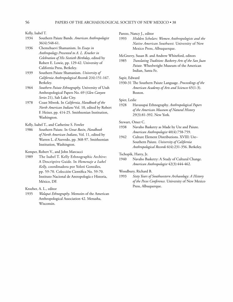
56 PAPERS OF THE ARCHAEOLOGICAL SOCIETY OF NEW MEXICO • 38
Kelly, Isabel T.1934 Southern Paiute Bands. American Anthropologist
36(4):548-61.1936 Chemehuevi Shamanism. In Essays in
Anthropology Presented to A. L. Kroeber in Celebration of His Sixtieth Birthday, edited by Robert E. Lowie, pp. 129-42. University of California Press, Berkeley.
1939 Southern Paiute Shamanism. University of California Anthropological Records 2(4):151-167. Berkeley.
1964 Southern Paiute Ethnography. University of Utah Anthropological Papers No. 69 (Glen Canyon Series 21), Salt Lake City.
1978 Coast Miwok. In California, Handbook of the North American Indians Vol. 10, edited by Robert F. Heizer, pp. 414-25. Smithsonian Institution, Washington.
Kelly, Isabel T., and Catherine S. Fowler1986 Southern Paiute. In Great Basin, Handbook
of North American Indians, Vol. 11, edited by Warren L. d’Azevedo, pp. 368-97. Smithsonian Institution, Washington.
Kemper, Robert V., and John Marcucci1989 The Isabel T. Kelly Ethnographic Archive:
A Descriptive Guide. In Homenaje a Isabel Kelly, coordinadora por Yoloti Gonzáles, pp. 59-70. Colección Cientifi ca No. 59-70. Instituto Nacional de Antropología e Historia, México, DF.
Kroeber, A. L., editor1935 Walapai Ethnography. Memoirs of the American
Anthropological Association 42. Menasha, Wisconsin.
Parezo, Nancy J., editor1993 Hidden Scholars: Women Anthropologists and the
Native American Southwest. University of New Mexico Press, Albuquerque.
McGreevy, Susan B. and Andrew Whiteford, editors1985 Translating Tradition: Basketry Arts of the San Juan
Paiute. Wheelwright Museum of the American Indian, Santa Fe.
Sapir, Edward1930-31 Th e Southern Paiute Language. Proceedings of the
American Academy of Arts and Sciences 65(1-3). Boston.
Spier, Leslie1928 Havasupai Ethnography. Anthropological Papers
of the American Museum of Natural History 29(3):81-392. New York.
Stewart, Omer C.1938 Navaho Basketry as Made by Ute and Paiute.
American Anthropologist 40(4):758-759.1942 Culture Element Distributions. XVIII: Ute–
Southern Paiute. University of California Anthropological Records 6(4):231-356. Berkeley.
Tschopik, Harry, Jr.1940 Navaho Basketry: A Study of Cultural Change.
American Anthropologist 42(3):444-462.
Woodbury, Richard B.1993 Sixty Years of Southwestern Archaeology: A History
of the Pecos Conference. University of New Mexico Press, Albuquerque.
57
57
“Live in Gallup?” inquired the porter. “Oh, no. Our home is in the East.” “Lawd! Must have a grudge agin yourselves then, stoppin here!” (T. Russell 1906:39). Th us begins Th eresa Peet Russell’s delightful narrative tale of her three-month archaeological honeymoon trip with husband Frank Russell by horse, mule and wagon across northern Arizona Territory in the summer of 1900. Th ey had been married two days before in Iowa and immediately set out for the Southwest.1 How the Russells came to make their honeymoon journey, coupled with Frank’s earlier solo Southwest trip in 1898; their nine-month mule and wagon archaeological reconnaissance in 1901 south to north from Tucson across Arizona into southern Utah and back to Tucson; their seven months adventure in ethnography with the Pima in 1901-02; Frank’s untimely death in 1903; and the beginning of a whole new life and career for Th eresa, is the stuff of our story.
T H E H O N E Y M O O N T R I P
Th e Russells got off the Santa Fe Railway train at 3:00 A.M. on July 3, 1900 and were taken to a hotel which looked out on the railroad yards and the Harvey House. Th e next day, John Lorenzo Hubbell arrived with some of his family. Frank had met Hubbell in 1898 and now would contract with him to outfi t Frank’s exploring party for the summer. In 1900 “Don Lorenzo” was 47 years old and controlled several trading posts on
the Navajo Reservation, centered on the home post at Ganado. He and his sometimes partner, C. N. Cotton, dominated the Navajo weaving industry and market for many years. In July, 1900, Hubbell was returning from the Republican national convention.2 On July 5, “the Russell family [and the Hubbells] were loaded up in a brand new road wagon with spring seats and cushions thrown in.” Th e party traveled to Ganado, stopping for lunch at Cienega, site of “then-a-building” St. Michael’s Mission (T. Russell 1900:2).3
B E G I N N I N G S
Frank Russell (1868-1903) (Figure 1) and Frances Th eresa Peet (1873-1936) (Figure 2) were born and grew up in Iowa. Frank enrolled in the University of Iowa in 1887. He is said to have arrived at the university with ten dollars in his pocket, but managed to partly work his way through school as a scientifi c illustrator. Frank became a student and assistant of the famed naturalist Charles Cleveland Nutting (1858-1927), curator of the university museum. In 1891, Frank accompanied Nutting and A. G. Smith, a mathematics professor, on a collecting trip to the Saskatchewan River region of Canada. When Russell returned to the university for the 1891 fall term, he apparently met entering freshman Th eresa Peet. Later, during their honeymoon trip, in her September 1, 1900 journal entry, Th eresa wrote (T. Russell 1990:71) that she spent a miserable rainy
“Th e Trail of an Archaeological Wedding Journey”—and Beyond, Frank and Th eresa Russell
in the Southwest, 1898 to 1903
D O N D . F O W L E R A N D N A N C Y J . PA R E Z O
58 PAPERS OF THE ARCHAEOLOGICAL SOCIETY OF NEW MEXICO • 38
Figure 1. Frank Russell, Sacaton, Arizona, 1902. Photograph by Th eresa Russell. Courtesy Stanford University Library Special Collections, Negative Number BP-3617.
Figure 2. Th eresa Russell, ca. 1920. Photographer unknown. Courtesy Stanford University Library Special Collections, Negative Number BP-3616.
night huddled in the covered wagon somewhere in the Painted Desert waiting for Frank, who had gone off on foot to scout a new route toward Keams Canyon, “... no fervent revivalist ever inquired “Where is my wandering boy tonight?” more anxiously than I did. For he must be out there somewhere in the storm, with not even a coat to keep him dry. And on our ninth anniversary too! What a celebration!” Frank, in fact, had managed to stay dry and returned safely early the next morning. Frank graduated from the University of Iowa in 1892 with a B.A. in zoology. During the 1891 Arctic trip, he had met Roderick Ross MacFarlane (1833-1920), a long-time Factor for the Hudson’s Bay Company. MacFarlane made signifi cant ornithological and other collections across the Arctic North for the Smithsonian Institution and Canadian museums for 40 years (Preble 1922). Russell wrote, “His enthusiastic descriptions of the fi eld, as yet almost unexplored, roused in me a strong desire to visit the Far North” (Russell 1898a:iii-iv). Nutting received approval from the University regents for Russell to
make a two-year solo expedition. Unfortunately, they did not appropriate any monies, but the fi rst year was covered by the University president and the second year by faculty, students, and townspeople. It was an epic journey, across hundreds of miles of the Arctic North on foot and snowshoes, by dogsled, by canoe and skiff , and an occasional steamboat, battling voracious mosquitoes in the summers and suff ering intense cold in the winters. Th e adventure was capped by a canoe trip down the Mackenzie River from Great Slave Lake to its estuary in the Arctic Sea and on to Herschel Island. In the 1890s whalers over-wintering at Herschel Island made brief summer hunts and then sailed around Alaska and southward to the United States. Russell was able to get aboard a whaler there and arrived in San Francisco on October 27, 1894. On November 2, he arrived by train in Iowa City to
59
be enthusiastically met “by the faculty, students, and citizens, to the number of several hundred” (Russell 1898a:157). Although he doesn’t say so, presumably Th eresa was among them. Russell’s book, Explorations in the Far North, chronicling his astounding travels and containing ethnographic sketches of several First Nations groups was published by the University of Iowa (Russell 1898a). Russell received a master’s degree from the University in 1895 and then entered Harvard to study anthropology. He was made an Instructor in Anthropology, taking a bachelor’s degree in 1896, a master’s in 1897, and a doctorate in 1898 (Russell 1898b). Regarded as “a rising star,” he was made a permanent faculty member in 1899, serving alongside Frederic Ward Putnam and Roland B. Dixon. Russell returned to the Arctic in the summer of 1897 to do some ethnography and collect ethnographic and skeletal material. Sometime during the summer, however, he contracted the tuberculosis that would change his and Th eresa’s lives. Th eresa graduated Phi Beta Kappa from the University of Iowa in 1895, majoring in philosophy and English, and began teaching in Iowa schools. She and Frank clearly were deeply committed to each other. Th ey courted when they could, given Frank’s Arctic sojourn and his move to Harvard in 1895. In 1898, with his prospects of a permanent position at Harvard in the offi ng, Th eresa enrolled for the 1898-99 school year at Radcliff e College.
B E G I N N I N G T H E S O U T H W E S T S O J O U R N S
Frank’s tuberculosis changed everything. He could no longer work in the Arctic, and humid and wintery Cambridge exacerbated his condition. He was advised to move to the dry Southwest for “the rest cure.” But lolling idly about was not to his liking. Russell was very ambitious to advance in his chosen fi eld of anthropology. His mentor, Frederic Ward Putnam, was a long-time permanent Secretary
of the American Association for the Advancement of Science (AAAS), and Frank soon became involved in the organization. Th rough the AAAS he met the anthropological luminaries of the day, especially W. J. McGee, a fellow Iowan. McGee was John Wesley Powell’s protégé. After 1894, when Powell was forced to resign as Director of the U.S. Geological Survey and retreat to his beloved Bureau of American Ethnology (BAE), McGee became de facto head of the Bureau, giving himself the title Ethnologist-in-charge (Fowler 2010:104-116, 144-147). McGee, always wanting to advance Washington-based science, saw helping Russell as a way to consolidate Washington-Boston anthropology.
F R A N K ’ S 1 8 9 8 S O U T H W E S T S O J O U R N
Rather than opt for a rest cure, Russell undertook an active southwestern trip in 1898, with some support from McGee. He spent July 1 through September 16 working with the Jicarilla Apache in Dulce, New Mexico, where he recorded origin and trickster myths, a curing ceremony (involving sand paintings), and conducted the fi rst ethno-botanical research in the region (F. Russell 1898c-e). Frank badly wanted to see the ceremonial dances at Hopi. An avid bicyclist, as many were in the 1890s-1900s, he headed off , later reporting to McGee that, “I rode the entire distance [700 miles, from Dulce, New Mexico to Hopi and back] on my wheel over blind trails, sand, two mountain ranges, and forded the San Juan fi ves time and ‘astonished the natives,’ both white and red, with the appearance of a bicycle in the back country” (FR to WJM August 31, 1898). During the trip he became acquainted with J. L. Hubbell at Ganado and Th omas Keam at Keams Canyon. Russell then apparently traveled to southern Arizona, presumably by train, and began initial ethnographic work with the Pima. He returned to Cambridge, writing reports and teaching during the period 1899 to the summer of 1900.
DON D. FOWLER AND NANCY J. PAREZO
60 PAPERS OF THE ARCHAEOLOGICAL SOCIETY OF NEW MEXICO • 38
T H E 1 9 0 0 T R I P
Russell pushed for continued support from, and possibly a job with, the BAE that would allow him to spend most of his time in the fi eld in the Southwest to help his tuberculosis. In 1900 McGee had no money to help out, but provided encouragement. Russell decided to make a trip anyway under Harvard University auspices, partly using his own funds. He applied to the Offi ce of Indian Aff airs for a permit to excavate archaeological sites on the Hopi Reservation, hoping to fi nd large, undisturbed ruins with extensive, intact burial grounds from which to collect skeletal material and artifacts. In 1898 he had heard from various sources that such ruins existed; but they proved to be mostly chimerical.
B E G I N N I N G T H E W E D D I N G J O U R N E Y
Hubbell outfi tted the Russells with a team (two horses and two mules), “a prairie schooner carrying over a ton in load,” two Hispanic teamsters, Nosifor and Erminio, and a Navajo guide, cook, and interpreter, Net Sliver, who had worked for Hubbell since he was a teenager. Th e load included a typewriter. As would his archaeological successors a century later, Russell began his survey with the most up-to-date word processing equipment. Th us outfi tted, the party headed across the Chinle Valley with Black Mesa on the far horizon. Th eresa, who had never been west of Iowa, nor apparently ever before camped out, took it all in stride (T. Russell 1900, 1906). In 1900, the only sure guides to archaeological sites in the area were reports by the Mindeleff s (C. Mindeleff 1900; V. Mindeleff 1891), and they were of sites on or adjacent to the Hopi Mesas. Frank was looking for new sites. As they proceeded, they inquired of various Navajos they met about large ruins and received vague directions to “heap big casas, plenty wesos [huesos meaning bones], ollas, mucho everything” (T. Russell 1906 IV:281). Such places turned out to be “undeniably chiquito,” or not where
they were said to be, or both, and if found at all were usually looted. After various wrong turns on poor to non-existent roads, dry camps, muddy springs yielding murky “lejoy” water, wayward horses and mules, and fi nding only disturbed and “chiquito” archaeological sites, they headed to Keams Canyon. Th ere they were received hospitably by Th omas Varker Keam (1842-1904) and his staff . By 1900 Keam was at the height of his powers as an Indian trader and broker for the frantic collecting of Southwestern archaeological and ethnographic materials by Eastern and European museums in the closing decades of the nineteenth century (Parezo 1986, 1987; see also Fowler 2010:104-116, 138; Graves 1998:139-170; Wade and McChesney 1981). Well fed and rested, the Russells continued onto the Hopi Reservation. Frank and Sliver spent much time and eff ort chasing rumored large, intact ruins in Blue Canyon, Oraibi Wash, Polacca Wash, and elsewhere. Some of the sites they saw had been recorded earlier by the Mindeleff s; none were suitable for Frank’s purposes. Th ey ultimately found some small ruins to excavate in the vicinity of Antelope Mesa, an area previously exploited by Keam’s diggers. Th ey paused at the ruins of Awatovi long enough for Th eresa to do her laundry and hang the clothes on the ruined walls of the church, using stones as clothes pins (Davis 2008). At Awatovi, they encountered a party led by Charles L. Owen, from the Field Columbian Museum in Chicago. Owen had recently been hired and sent to Arizona by George Amos Dorsey, the Field Museum anthropology curator, to make prehistoric and historic Hopi pottery collections. He apparently succeeded, for the following year Dorsey would brag that “we have left Washington [i.e., the Smithsonian Institution] in the rear so far as prehistoric pottery is concerned” (Dorsey 1901). On August 18, 1900, a letter from Putnam with an enclosed letter from the Offi ce of Indian Aff airs fi nally reached Frank, denying his application for a permit to excavate on the Hopi Reservation. Th e Russells also learned that Charles E. Burton from the Offi ce of Indian Aff airs was due back from the
61
East, expecting to question Frank about why he had proceeded without a permit. Th ey concluded that their “day of grace was short, and since the Moki Snake Dance was to take place at Shongopovi ... it was deemed advisable to take the whole outfi t to the middle Mesa; at which point we would be twenty miles on our way to the Colorado Chiquito where we decided to spent the rest of the summer” (T. Russell 1900:54-55). Th e Little Colorado River was also conveniently off the Hopi Reservation and beyond Burton’s jurisdiction. Th e Russells (probably correctly) assumed that George Dorsey was behind the denial of the permit. Dorsey saw himself and the Field Museum, established in 1893, in fi erce competition with other museums, especially the Smithsonian, for artifact collections, using political connections if necessary to gain an advantage (Almazan and Coleman 2003). Th e Russells did witness the Snake Dance at Shongopovi, which Th eresa described in wide-eyed detail (T. Russell 1900:55-61). At the end of the ceremony, they were summoned to meet with Burton and show their offi cial permission to excavate on the reservation. Th ey sent their regrets, broke camp at the foot of the mesa and hastened toward the Little Colorado (T. Russell 1900:62). Th e rest of the summer was spent searching for the always elusive large, intact sites. Th e only one they found was on private property; the owner wanting to dig it for himself. After various adventures and misadventures, the pair headed home. Th ey reached Ganado on September 13, settled their accounts, and bought some Navajo weavings and silver. Th ey boarded a train at Gallup on September 16 and reached Boston on September 20. Th eresa wrote that “a little dose of domestication” would not be hard to take. But,
I fancy a nine month accumulation of juicy steaks and fresh fruits, of daily newspapers and gowns en traine, of gossip and theater...will not be suffi cient to tarnish the haunting memory and majestic infl uence of sand and sagebrush, tortillas and frijoles, of
camp and caballos, of Sliver and Erminio, of the agua that was always “very lejoy,” of smiling skies; so that next June...[we might return] (T. Russell 1900:82).
T H E 1 9 0 1 S E A S O N
But in fact the Russells were back in the Southwest by early March, 1901. Frank’s tuberculosis fl ared again, making a return to the dry and warm Southwest imperative. McGee now off ered Frank a salaried position with the BAE, starting March, 1901. He found money for the position by furloughing Matilda Cox Stevenson on the grounds that she was years behind in fi nishing a report on her work at Zuni Pueblo. It was a serious mistake. She had powerful political connections in Washington and McGee was forced to hire her back in 1902 (Parezo 1993; Miller 2007). On the promise of the Bureau job, Russell resigned his position at Harvard in late January, 1901, and he and Th eresa arrived in Tucson in early March. His assignment was two-fold. First, to conduct a major archaeological reconnaissance of southern and central Arizona, and second, to continue and enlarge his ethnographic fi eldwork with the Pima Indians.
Th e Extended ReconnaissanceTh e reconnaissance in fact covered sections of southern and east-central Arizona, a transect across northern Arizona as far as the fl anks of Kaibito Plateau, northeastward across Monument Valley and the San Juan River to Bluff , Utah, and on to southwestern Colorado. Th ey then returned to Tucson by traveling southward along the New Mexico-Arizona border.4
Th e Southern Arizona SurveyTh e Russells began surveying the Tucson Basin in early March, 1901, at fi rst using their bicycles, sometimes on horseback, or walking. For longer trips another mode of transportation was required. Frank purchased a team of mules and harness and wagon for $400, which, he told McGee, he considered a private contribution; he paid the teamster from his government stipend. It is
DON D. FOWLER AND NANCY J. PAREZO
62 PAPERS OF THE ARCHAEOLOGICAL SOCIETY OF NEW MEXICO • 38
unclear how long the teamster was with them. On April 7, 1901, the party headed north from Tucson to the San Pedro River Valley. Th ey camped along the river and made side trips to see cave sites and pictograph panels. Th ey then went north to the confl uence of the San Pedro and Gila rivers. Next, they turned southeast and visited “cliff houses” in the Galiuro Mountains, then on into the Gila River drainage. Th ey continued up the Gila River valley to Solomonville and Saff ord, where they recorded numerous ruins, most of them destroyed by the new canals for the burgeoning agricultural development then underway in eastern and central Arizona. After returning briefl y to Tucson, the pair headed southeast through Apache Pass, Bisbee, and Naco, and probed the fl anks of the Huachuca Mountains. Leaving Th eresa and the team to rest in Fairbanks, Frank walked 25 miles to Benson and took the train back. Th ey then headed to Patagonia and Greaterville, Pantano, Tanque Verde, and back to Tucson. Russell reported in May that they had traveled 927 miles by mule and wagon that he had walked an additional 75 miles, and recorded about 100 ruins. On May 1, 1901 Frank fi nally received his offi cial appointment as a staff member of the BAE. However, there were bureaucratic complications. When he sent in his forms for reimbursement of expenses, he was told that he hadn’t been properly sworn in as a federal employee. Frank replied, “Your note has just reached me. No, I was not aware that a plain ‘ethnologist’ was expected to swear on beginning to drive mules in this benighted country. However, having driven them seven weeks, I am ready to swear to anything if you will explain what” (Russell to W. J. McGee, May 16, 1901, BAEC). Th ere were further complications. Frank could not become an offi cial government employee until he had taken a civil service exam, required of all federal appointive positions by the Civil Service Act of 1883. Th e exam, probably written by McGee, came from Washington, but there were delays in getting it administered. Finally, an appropriate person, apparently a postal employee, was found. Russell
wrote: “It was fi nally held in the back of the post offi ce. Th e Commissioner began sweeping out the post offi ce as I began the examination and it was also hot. I hope you will not read the papers!” (Russell to W. J. McGee, June 10, 1901, BAEC).
Th e Second ReconnaissanceOn June 12, the Russells left Tucson by wagon, headed north. Th ey examined some sites near Florence and continued on to Casa Grande, the fi rst archaeological site to be set aside by the U.S. government in 1892. Russell wrote, “Th e place needs a custodian.5 Th e warning against defacing the building seems to act as an incentive to some persons to do that which is forbidden” (Russell 1901-02:June Report 1). Th ey explored along the foothills of the Phoenix Mountains, noting several sites that might warrant further investigation. But it was growing hotter, and they headed east for higher country, exploring in the Tonto and upper Salt River valleys and adjacent areas, including the Sierra Ancha region. Th ey recorded numerous archaeological sites that would later be associated with the Mogollon and Salado cultures (Haury 1934; Reid and Whittlesey 2005), a number of them undisturbed. Th e two then turned northwest toward the Verde Valley, stopping to see Tonto Natural Bridge before proceeding to Montezuma Castle and Montezuma Well. When the 1906 Antiquities Act was passed, Montezuma Castle was one of the fi rst sites to be declared a national monument. Montezuma Well, on the other hand, did not come under government control until 1947. By the end of June, the Russells were in Flagstaff where they rested for several days. Th ey continued north to Willow Springs, six miles west of Tuba City. Near the spring are several very large boulders of red Wingate sandstone. Th ey are covered with Hopi clan symbols, left by those who followed the legendary Salt Trail from the Hopi mesas and down into the end of Marble Canyon at the confl uence of the Little Colorado and Colorado rivers (Colton and Colton 1931; C. Mindeleff 1900).
63
Frank knew of the Salt Trail and had heard reports of archaeological sites in Marble Canyon and the lower end of Glen Canyon and planned to survey in that direction. However, a Southern Paiute man told him that the tinajas they would have to depend on for water were dry that year. Frank then shifted his gaze to the canyons of the Kaibito Plateau and adjacent areas toward Navajo Mountain. At the Red Lake Trading Post he hired trader Eugene Powell as a guide and Navajo interpreter. Th e trio was met at the mouth of a tributary of Navajo Canyon by:
...a small deputation of well armed Navajo who announced that that was the end of our journey. Mr. Powell explained and re-explained that the Great Captain at Washington had sent me to see and to photograph the ruins. ...they did not want a white man in the maze of canyons... Th ey cited the case of the Field Columbian Museum parties that worked the Little Colorado ruins last year. Th at party they said, (and they spoke truly for I saw them myself ) had dug about the ruins of the ancient people and left their bones lying about on the ground. ‘If any of our women who are with child see these bones while herding the sheep it will be bad for them’ (Russell 1901-02:June report, 8-9).
Eventually the Russells were permitted to proceed, but there was little grass for the animals; so they only stayed a short time. Th ey did, however, visit about 20 ruins, two of which were relatively large. Th ey tried a second time, but were again turned back because of drought conditions and Navajo concerns. Th e Russells returned to Red Lake, again resting for a few days before heading northeast to Marsh Pass, down Laguna Creek and on through Monument Valley to the San Juan River. Th ey apparently surveyed for sites in the Marsh Pass area, although it is unclear if they entered Tsegi Canyon. Th ey crossed Monument Valley quickly due to a lack
of water and feed for the animals. Th ey did hear that the Wetherills had taken “fi ve hundred boxes of pottery and the like out of that district” (Russell, September Report, pg. 1). Th e “fi ve hundred boxes” probably refl ects local lore about the activities of the Wetherill brothers in the 1890s when they spent about a month digging in Keet Seel and elsewhere in Tsegi Canyon. In the spring of 1895, Richard Wetherill wrote to Talbot Hyde, “We dug from one burial mound 400 pieces of pottery—very fi ne. ...this is by all odds the fi nest collection of pottery I have ever seen” (cited in Fowler 2010:194). Th e Russells crossed the San Juan River at Bluff City, Utah. Th ere they learned of a site north of town that the local Mormons intended to clear out and preserve as an example of “Hebrew architecture.” Th is may be the Chacoan outlier known as the Bluff Great House, recently excavated by Catherine Cameron and Steven Lekson (Cameron 2009). Th ey heard of ruins farther north, toward and in the Abajo Mountains, as indeed there are, including the Alkali Ridge sites, excavated by J. O. Brew (1946) in the 1930s, and the hundreds of sites around Blanding, Utah and on Cedar Mesa (Matson 2006) and adjacent areas, many looted for over a century by the locals. Th ey also heard of sites of the “so-called ‘Basket-Makers’[that] may yield valuable information on general problems of relationship and migration” (Russell, September Report, pp. 1-2). Russell was probably referring to the sites that the Wetherills and others had excavated in Grand Gulch and adjacent canyons in the 1890s (Blackburn and Williamson 1997). Th ey had found rich troves of burials, baskets, and other material items (but no pottery) stratigraphically beneath “Cliff Dwellers” materials. In 1897 T. Mitchell Prudden (1897) had published a popular article, “An Elder Brother of the Cliff Dweller,” calling attention to the earlier culture the Wetherills had named “Basket Makers” (later Basketmakers). In 1914, A. V. Kidder and Samuel Guernsey (1919) began a systematic and successful search for Basketmaker sites in the Monument Valley-Marsh Pass area, validating the Wetherills’ observations and
DON D. FOWLER AND NANCY J. PAREZO

64 PAPERS OF THE ARCHAEOLOGICAL SOCIETY OF NEW MEXICO • 38
providing a fi rm foundation for subsequent research on Ancestral Puebloan sites in the San Juan Basin and adjacent areas (Fowler 2010:313-320). Th e Russells then headed east, visiting some of the well-known ruins in the Hovenweep area fi rst described by William Henry Jackson (1875, 1876) and William Henry Holmes (1876). Th ey stopped at Cannonball Ruin, recorded by A. V. Kidder, S. G. Morley and J. G. Fletcher during the legendary 1907 School of American Archaeology fi eld school led by Edgar Lee Hewett (Fowler 2010:265-266) and partially excavated by Morley (1908) the following year. Apparently leaving their wagon and animals at a livery stable in Mancos, the Russells boarded a Denver and Rio Grande (D&RG) train for Denver to attend the AAAS meeting during the last week in August. McGee was at the meeting (Science 1901:349), and he and Frank discussed Frank’s work and future plans. At the conclusion of the meeting, the Russells joined a junket by train, wagon, and horseback to Mesa Verde (Ring 1901:01 [reprinted in Nusbaum 1980:65]). Th e trip was arranged by the Colorado Cliff Dwellers Association, a women’s group incorporated in 1900 to call attention to Mesa Verde and seek its designation as a national park. Th ey and others were ultimately successful in getting Mesa Verde declared as the fi rst cultural national park in 1906 (Fowler 2010:306-309). On September 8, the Russells rode the D&RG train from Mancos to Antonito, transferred to the Texas, Santa Fe, and Northern Railroad (the famed “Chile Line”) and traveled to Santa Fe. Over the next week, they visited Santa Clara and San Ildefonso pueblos and the Pajarito Plateau, probably examining Puyé and adjacent sites. Th ey then returned by train to Mancos on September 15 or 16, retrieved their mules and wagon, and drove to Bloomfi eld, New Mexico and then south to Chaco Canyon. On September 19 and 20 they visited ruins, “within a radius of seven miles of Pueblo Bonito” and found little evidence of excavations therein. “I should say without hesitation that the stories of vandalism that have been circulated concerning that region
are utterly false,” Russell wrote to McGee (Russell 1901-02:September Report 2). Th e reference here is to the campaign then being waged by Edgar Lee Hewett and others to drive the Wetherills and the Hyde Exploration Company out of Chaco Canyon (Snead 2001:48-57; Fowler 2010:199-200). Th e Russells continued on, possibly stopping at St. Michael’s Mission, thence to Gallup and on to Zuni, reaching there by September 23 or 24. After a brief stop, they headed south along the New Mexico-Arizona border to Clifton, Arizona. Leaving the team in Clifton, Frank rode for four days along the eastern border of the San Carlos Reservation and recorded several large masonry ruins, which he thought were previously unknown, including, apparently, the Point of Pines complex. Th e weary pair arrived back in Tucson on October 10, 1901. Frank estimated that since June they had traveled 1,535 miles in their wagon, 200 miles in others’ wagons, over 220 miles by rail, 50 miles by horseback, and over 100 miles on foot. In a later letter to Harvard president Charles W. Eliot, Russell said they had traveled 1,000 miles during their March to June survey in southern Arizona—probably an over-estimate. For the entire reconnaissance he added, “We sometimes drove our wagon where vehicles had never gone before.... Sometimes we walked all day in burning sand with the temperature ranging as high as one hundred and twenty in the shade” (Russell to Eliot, February 3, 1902, copy in PMA). Whatever the actual number of bone-jarring miles, the entire reconnaissance eff ort was epochal, probably never equaled again.
Th e Russells, José Lewis, and the Pima6
When the Russells reached Tucson in early October, 1901, Frank settled in to write his reports, but his tuberculosis fl ared again and he was periodically confi ned to his bed. In mid-November he and Th eresa moved to Sacaton, the main settlement for the Pima (Akimel O’odham) Gila River Reservation. McGee urged Russell to hire a Papago (Tohono O’odham) man, José Lewis, whom McGee had earlier
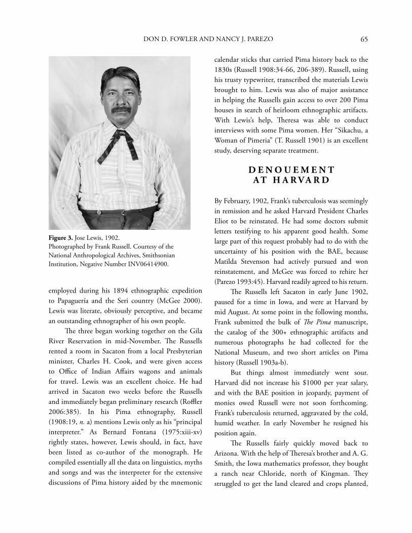
65
Figure 3. Jose Lewis, 1902. Photographed by Frank Russell. Courtesy of the National Anthropological Archives, Smithsonian Institution, Negative Number INV06414900.
employed during his 1894 ethnographic expedition to Papaguería and the Seri country (McGee 2000). Lewis was literate, obviously perceptive, and became an outstanding ethnographer of his own people. Th e three began working together on the Gila River Reservation in mid-November. Th e Russells rented a room in Sacaton from a local Presbyterian minister, Charles H. Cook, and were given access to Offi ce of Indian Aff airs wagons and animals for travel. Lewis was an excellent choice. He had arrived in Sacaton two weeks before the Russells and immediately began preliminary research (Roffl er 2006:385). In his Pima ethnography, Russell (1908:19, n. a) mentions Lewis only as his “principal interpreter.” As Bernard Fontana (1975:xiii-xv) rightly states, however, Lewis should, in fact, have been listed as co-author of the monograph. He compiled essentially all the data on linguistics, myths and songs and was the interpreter for the extensive discussions of Pima history aided by the mnemonic
calendar sticks that carried Pima history back to the 1830s (Russell 1908:34-66, 206-389). Russell, using his trusty typewriter, transcribed the materials Lewis brought to him. Lewis was also of major assistance in helping the Russells gain access to over 200 Pima houses in search of heirloom ethnographic artifacts. With Lewis’s help, Th eresa was able to conduct interviews with some Pima women. Her “Sikachu, a Woman of Pimeria” (T. Russell 1901) is an excellent study, deserving separate treatment.
D E N O U E M E N T A T H A R V A R D
By February, 1902, Frank’s tuberculosis was seemingly in remission and he asked Harvard President Charles Eliot to be reinstated. He had some doctors submit letters testifying to his apparent good health. Some large part of this request probably had to do with the uncertainty of his position with the BAE, because Matilda Stevenson had actively pursued and won reinstatement, and McGee was forced to rehire her (Parezo 1993:45). Harvard readily agreed to his return. Th e Russells left Sacaton in early June 1902, paused for a time in Iowa, and were at Harvard by mid August. At some point in the following months, Frank submitted the bulk of Th e Pima manuscript, the catalog of the 300+ ethnographic artifacts and numerous photographs he had collected for the National Museum, and two short articles on Pima history (Russell 1903a-b). But things almost immediately went sour. Harvard did not increase his $1000 per year salary, and with the BAE position in jeopardy, payment of monies owed Russell were not soon forthcoming. Frank’s tuberculosis returned, aggravated by the cold, humid weather. In early November he resigned his position again. Th e Russells fairly quickly moved back to Arizona. With the help of Th eresa’s brother and A. G. Smith, the Iowa mathematics professor, they bought a ranch near Chloride, north of Kingman. Th ey struggled to get the land cleared and crops planted,
DON D. FOWLER AND NANCY J. PAREZO
66 PAPERS OF THE ARCHAEOLOGICAL SOCIETY OF NEW MEXICO • 38
but Frank’s condition continued to deteriorate. He died on November 7, 1903, age 35. His body was shipped to California and cremated. His peers celebrated his short and brilliant career and mourned his passing (Hodge 1903; Pepper 1904). Some months later, Th eresa received a check from the BAE for $500 as fi nal payment for the manuscript. Th e published report appeared in 1908 (Russell 1908, 1975). Th eresa later edited and published a series of Pima myths Frank had collected (Russell 1909). Th e ranch was sold and Th eresa returned to Iowa and then to Cambridge.
T H E R E S A R U S S E L L’ S S E C O N D L I F E
Th eresa had met the Pragmatist philosopher/psychologist William James (Richardson 2011), perhaps during her time at Radcliff e in 1898-99, or as a faculty spouse at Harvard, 1900-1902. James (1842-1910) was obviously impressed with her. In 1906, he gave a series of lectures at Stanford University. Th eresa went with him, serving as an Assistant in Philosophy while he was there. She remained at Stanford as an Instructor in English. Subsequently, she attended Columbia University to study with Ashley H. Th orndike (1871-1933), an expert on English literature. Her doctoral dissertation was “Satire in the Victorian Novel” (T. Russell 1920). She returned to Stanford to teach English literature and was promoted to full professor in 1930. During the 1920s, she published essays on the English poet Robert Browning (1812-1889), collected as One Word More on Browning (T. Russell 1927). Her fi nal major work was the delightful Touring Utopia, the Realm of Constructive Humanism (T. Russell 1932). She never remarried, but shared a house with another Stanford faculty member, Elizabeth Buckingham. She died of cancer in 1936, bringing to a close a little remembered, but epic saga of two remarkable and devoted individuals and their archaeological and ethnographic lives and work together in the American Southwest at the turn of the twentieth century.
E N D N O T E S
1. We draw on several archives. Th e Frances Th eresa Russell papers and some of Frank Russell’s papers are in Special Collections in the Stanford University Library. Other Frank Russell materials are in the Harvard Peabody Museum Archives. Th e F. Russell and W. J. McGee correspondence is in the BAEC letter fi les in the National Anthropological Archives; other McGee papers are in the Library of Congress.
2. On John Lorenzo Hubbell, his life, family, trading empire, and political activities see especially Blue (2000), Brugge (1993),McNitt (1962), and Powers (2001).
3. Both Frank and Th eresa Russell kept daily journals of the 1900 trip. Only a portion of Frank’s journal, from July 3 to July 29 has survived. Th eresa’s handwritten journal is complete. In 1906 she published her journal and occasionally indulged in some literary license (Russell 1906). For example, in the published version, she has them riding their bicycles from Gallup to St. Michael’s Mission (T. Russell 1906 I:44-46). Th eir 1900 journals state they rode to the Mission and on to Ganado in Hubbell’s “road wagon.”
4. Russell (1901-02) chronicled these amazing trips in his monthly reports to and correspondence with McGee. Elsewhere (Parezo and Fowler 2012) we trace in detail the routes taken by the Russells during their reconnaissance and discuss some of the sites they visited. Here we briefl y summarize the highlights of their trips. Unfortunately, Russell’s detailed notes on sites he recorded throughout the 8-month journey disappeared from the BAE fi les sometime before the 1950s. Th ey may have been copied or used by Jesse Walter Fewkes as background to the excavations he undertook in northern Arizona after 1903 (see Fowler 2005:17-24). We are left with Russell’s somewhat terse monthly reports and a few letters to McGee.
5. In fact, 20-year-old Frank Pinkley (1881-1940) was appointed as custodian in September, 1901, the beginning of his legendary forty-year career, at fi rst at Casa Grande, and later (after the formation of the National Park Service in 1916) as Superintendent of the Southwestern National Monuments management unit of the National Park Service, overseeing 27 national monuments (National Park Service 2011:Chapter 18).
6. We are aware that the current names for Pima and Papago are Akimel O’odham and Tohono O’Odham, respectively. Here we use the names used by the Russells and other Anglos in 1901-02.
67
R E F E R E N C E S C I T E D
AbbreviationsBAEC: Bureau of American Ethnology Correspondence, 1900-08. National Anthropological Archives, Smithsonian Institution, Washington, D.C.PMA: Frank Russell Correspondence; Archives of the Peabody Museum of Archaeology and Ethnology at Harvard University, Cambridge.
Published WorksAlmazan, Tristan, and Sarah Coleman2003 George Amos Dorsey: A Curator and his
Comrades. In Curators, Collections and Contexts: Anthropology at the Field Museum, 1893-2002, edited by Stephen E. Nash and Gary Feinman, pp. 87-98. Fieldiana. Anthropology n.s. No. 36, Publication 1525, Chicago.
Blackburn Fred M., and Ray A. Williamson1997 Cowboys and Cave Dwellers. Basketmaker
Archaeology in Utah’s Grand Gulch. School of American Research Press, Santa Fe.
Blue, Martha 2000 Indian Trader, Th e Life and Times of J. L. Hubbell.
Kiva Publishing, Walnut, California.
Brew, John Otis1946 Th e Archaeology of Alkali Ridge, Southeastern
Utah. Papers of the Peabody Museum of American Archaeology and Ethnology 21. Harvard University, Cambridge.
Brugge, David M. 1993 Hubbell Trading Post National Historic Site.
Southwest Parks and Monuments Association, Tucson.
Cameron, Catherine M.2009 Chaco and After in the Northern San Juan:
Excavations at the Bluff Great House. University of Arizona Press, Tucson.
Colton, Mary Ferrell R., and Harold S. Colton1931 Petroglyphs, the Record of a Great Adventure.
American Anthropologist 33(1):32-37.
Davis, Hester A.2008 Remembering Awatovi: Th e Story of an
Archaeological Expedition in Northern Arizona, 1935-1939. Peabody Museum Press, Cambridge.
Dorsey, George1901 Letter to Henry R. Voth, April 3, 1901. Dorsey
Papers, Department of Anthropology Archives, Field Museum of Natural History, Chicago.
Fontana, Bernard1975 Introduction, Citation Sources, and Bibliography
to Th e Pima Indians by Frank Russell. University of Arizona Press, Tucson.
Fowler, Don D.2005 Th e Formative Years: Southwest Archaeology,
1890-1910. In Southwest Archaeology in the Twentieth Century, edited by Linda Cordell and Don D. Fowler, pp. 16-26. University of Utah Press, Salt Lake City.
2010 A Laboratory for Anthropology. Science and Romanticism in the American Southwest, 1846 to 1930. University of Utah Press, Salt Lake City.
Graves, Laura1998 Th omas Varker Keam, Indian Trader. University of
Oklahoma Press, Norman.
Haury, Emil W.1934 Canyon Creek Ruins and the Cliff Dwellers of
the Sierra Ancha. Medallion Papers 14, Globe, Arizona.
Hodge, Frederick W.1903 Frank Russell. American Anthropologist 5:737-38.
Holmes, William Henry1876 A Note on the Ancient Remains of Southwestern
Colorado Examined during the Summer of 1875. Bulletin of the Geological and Geographical Survey of the Territories 2(1):3-24.
Jackson, William Henry1875 Ancient Ruins in Southwestern Colorado.
Bulletin of the Geological and Geographical Survey of the Territories 1:17-30.
1876 A Notice of Ancient Ruins in Arizona and Utah Lying about the Rio San Juan. Bulletin of the Geological and Geographical Survey of the Territories 2(2):25-45.
Kidder, Alfred V., and Samuel J. Guernsey1919 Archeological Explorations in Northeastern Arizona.
Bureau of American Ethnology Bulletin 65. Washington, D.C.
DON D. FOWLER AND NANCY J. PAREZO

68 PAPERS OF THE ARCHAEOLOGICAL SOCIETY OF NEW MEXICO • 38
Matson, R. G.2006 Basketmaker II and Cedar Mesa. In Tracking
Ancient Footsteps: William D. Lipe’s Contributions to Southwestern Prehistory and Public Archaeology, edited by R. G. Matson and T. A. Kohler, pp. 45-62. Washington State University Press, Pullman.
McGee, W. J. 2000 Trails to Tiburón: Th e 1894 and 1895 Field Diaries
of W J McGee, transcribed by Hazel McFeely Fontana; annotated and introduction by Bernard L. Fontana. University of Arizona Press, Tucson.
McNitt, Frank 1962 Th e Indian Traders. University of Oklahoma
Press, Norman.
Miller, Darlis A.2007 Matilda Coxe Stevenson, Pioneering Anthropologist.
University of Oklahoma Press, Norman.
Mindeleff , Cosmos1900 Localization of Tusayan Clans. Nineteenth Annual
report of the Bureau of American Ethnology for 1897-98, Part 2:635-653.
Mindeleff , Victor1891 A Study of Pueblo Architecture: Tusayan and
Cibola. Eighth Annual Report of the Bureau of Ethnology, 1886-87:3-228. Reprint, Smithsonian Institution Press, Washington, D.C.
Morley, Sylvanus G.1908 Th e Excavations of Cannonball Ruins in
Southwest Colorado. American Anthropologist 10:598-610
National Park Service2011 Frank “Boss” Pinkley (1881-1940), National
Park Service: First Seventy Five Years, Biographical Vignettes. http://www.cr.nps.gov/history/online_bookstore.
Nusbaum, Rosemary, editor 1980 Tierra Dulce: Reminiscences from the Jesse
Nusbaum Papers. Sunstone Press, Santa Fe.
Parezo, Nancy J.1986 Now is the Time to Collect. Masterkey 59(4):11-18.1987 Th e Formation of Ethnographic Collections:
Th e Smithsonian Institution in the American Southwest. Advances in Archaeological Method and Th eory 10:1-46.
1993 Matilda Coxe Stevenson: Pioneer Ethnologist. In Hidden Scholars: Women Anthropologists and the Native American Southwest, edited by Nancy J. Parezo, pp. 38-62. University of New Mexico Press, Albuquerque.
Parezo, Nancy J., and Don D. Fowler2012 Frank Russell’s Grand Tour: Th e 1901
Archaeological Surveys of Arizona. In press.
Pepper, George H.1904 Section H – Anthropology. Science 19(481):449-
453.
Powers, Willow Roberts 2001 Navajo Trading: Th e End of an Era. University of
New Mexico Press, Albuquerque.
Preble, E. A.1922 Roderick Ross MacFarlane, 1833-1920. Th e Auk
39:203-209.
Prudden, T. Mitchell1897 An Elder Brother of the Cliff Dweller. Harper’s
New Monthly Magazine 95:56-62.
Reid, J. Jeff erson, and Stephanie M. Whittlesey2005 Seven Years that Reshaped Southwest Prehistory.
In Southwest Archaeology in the Twentieth Century, edited by Linda S. Cordell and Don D. Fowler, pp. 47-59. University of Utah Press, Salt Lake City.
Richardson, Robert2011 Th e Heart of William James. Harvard University
Press, Cambridge.
Ring, Helen M.1901 Scientists Visit Cliff Palace. Th e [Denver] Daily
News, Sept. 20, 1901 [reprinted in Nusbaum 1980:65].
Roffl er, Joshua2006 Frank Russell at Gila River: Constructing an
Ethnographic Description. Kiva 71(4):373-395.
Russell, Frank 1898a Explorations in the Far North. University of Iowa,
Ames.1898b A Study of a Collection of Eskimo Crania from
Labrador, With Observations on the Prevailing System of Craniometry. Unpublished Ph.D. dissertation, Harvard University, Cambridge.

69
1898c An Apache Medicine Dance. American Anthropologist 11(12):367-372.
1898d Myths of the Jicarilla Apache. Journal of American Folklore 11 (43):253-272.
1898e Th e Jicarilla Apache. Manuscript 1302-a, National Anthropological Archives, Smithsonian Institution, Washington, D.C.
1900 Journal, Summer of 1900. Partial manuscript in F. T. Russell papers, Special Collections Department, Stanford University Library, Stanford.
1901-02 Monthly Reports to Bureau of American Ethnology, May, 1901-July 1902. BAEC, National Anthropological Archives, Smithsonian Institution, Washington, D.C.
1903a Pima Annals. American Anthropologist 5(1):76-80.1903b A Pima Constitution, With Notes by Frank
Russell. Journal of American Folklore 16:222-228.1908 Th e Pima Indians. Twenty-sixth Annual Report of
the Bureau of American Ethnology for 1904-05, pp. 3-389.
1909 Pima Myths. Out West Magazine 30:485-95, 571-82; 31: 643-46, 828-34, 890-95.
1975 Th e Pima Indians. Issued with Introduction, Citation Sources and Bibliography by Bernard L. Fontana. University of Arizona Press, Tucson.
Russell, Th eresa Peet1900 Journal Kept during the Summer of 1900.
Manuscript in F. T. Russell papers, Special Collections Department, Stanford University Library, Stanford.
1901 Sikachu, a Woman of Pimería. Manuscript in F. T. Russell papers, Special Collections Department, Stanford University Library, Stanford.
1906 In Pursuit of a Graveyard: Being the Trail of an Archaeological Wedding Journey. Out West Magazine 24:39-49, 139-147, 201-207, 278-289, 300-307, 312-15, 401-14, 544-48; 25:132-38, 247-57, 341-47, 511-17.
1920 Satire in the Victorian Novel. Macmillan Co., New York.
1927 One More Word on Browning. Stanford University Press, Stanford.
1932 Touring Utopia: Th e Realm of Constructive Humanism. Dial Press, New York.
Science1901 Proceedings of the Denver Meeting. Science
14:345-348.
Snead, James E.2001 Ruins and Rivals: Th e Making of Southwest
Archaeology. University of Arizona Press, Tucson.
Wade, Edwin I., and Lea McChesney1981 Historic Hopi Ceramics: Th e Th omas V. Keam
Collection of the Peabody Museum of Archaeology and Ethnology, Harvard University. Peabody Museum Press, Cambridge.
DON D. FOWLER AND NANCY J. PAREZO

70 PAPERS OF THE ARCHAEOLOGICAL SOCIETY OF NEW MEXICO • 38
71
71
Tijeras Pueblo (LA 581) is one of the best known settlements of the late P III–early P IV (Coalition into early Classic) Periods in New Mexico. As a large settlement situated in a strategic geographic location, the importance of Tijeras Pueblo, both prehistorically and currently, has been recognized by many archaeologists. Owing to its location within the Cibola National Forest, the site and its immediate surroundings have been protected, unlike the fate that befell most Classic Period towns along the middle Rio Grande drainage. Th e major occupation began about A.D. 1250 and lasted until about 1425 (Cordell 1980:181). With over 400 dendrochronological dates now available, it is a well-dated locality. Its ceramics span the period between the black-on-white ceramics of the Coalition period (Santa Fe Black-on-white [B/W], Wiyo B/W and Galisteo B/W) and the earliest Rio Grande glazeware pottery (Los Padillas and Arenal Glaze-polychrome (G/P), and Agua Fria Glaze-on-red (G/R) (Eighth Ceramic Seminar 1966). Indeed, the earliest dates on Rio Grande glazeware (ca. A.D. 1315) were obtained at Tijeras Pueblo (Cordell 1975). Th e ceramics have been discussed in Cordell (1975, 1980), Warren (1980), Anschuetz (1984), Eckert (2006), and Habicht-Mauche (2011). Th e site was partially excavated during the period of ca. A.D. 1971 to 1976 by the University of New Mexico fi eld school under the direction of James Judge and, later, Linda Cordell. Despite the excellent fi eld work, succeeding years saw only limited
laboratory analyses of the collections. Rough sorting of artifacts and annual reporting occurred during fi eld schools, but the only actual major publication was by Cordell (1980). Contributors to that small volume provided syntheses of their analytic work on diff erent classes of artifacts. Helene Warren was one of the contributors, and her short account of the site’s ceramics aff ords some conclusions, but little analytical detail and no raw data. Th us, despite its importance, it is surprising how little is known about the Tijeras artifact assemblages.
R E S E A R C H B A C K G R O U N D
In recent years there has been much attention given to the production and distribution of Rio Grande glazeware pottery, for example, Habicht-Mauche et al. (2006). New studies dealing with the obtaining of glaze paint materials have shown that ceramics materials were often traded widely. Exchange of fi nished wares was also extensive during this time, and the measurement of this trade obviously depends on adequately identifying the production of each pueblo, or at least its local district, as was pointed out by Shepard (1942). While the transport of distinctly diff erent types and wares aff ords an obvious line of evidence, exchange within the same ware/type sphere (such as Rio Grande glazeware or utility ware) is much more diffi cult to identify (Schleher 2010). For example, analyses of P IV glazeware
Potters’ Resources in the Vicinity of Tijeras Pueblo, New Mexico
H A Y WA R D H . F R A N K L I N
72 PAPERS OF THE ARCHAEOLOGICAL SOCIETY OF NEW MEXICO • 38
site assemblages on the Middle Rio Grande and its tributaries have been hampered by the inability to identify “internal” localized ceramic trade relations in any detail. Th us, due to the lack of detailed knowledge of Tijeras ceramics, it has been diffi cult to identify trade ceramics from Tijeras Pueblo when present as imported pottery within the assemblages of other contemporary pueblos. Analyses of ceramics from Pottery Mound (Eckert 2003; Franklin 2010), as well as Valencia (Franklin 1997), Montaño Bridge (Franklin 2008), and Chamisal pueblos (Franklin, in process) have attempted to elucidate inter-village trade relationships that were clearly complex during the P IV period. Th ese eff orts are hampered, however, by lack of detailed information about ceramic production at key locations, one of which is Tijeras Pueblo. Distinguishing pottery made specifi cally at Tijeras is diffi cult, since all the pottery types, painted and utility, manufactured here were also produced elsewhere. Potters in the Middle Rio Grande Valley, Galisteo Basin, and Pa-ako all made many of the same black-on-white and glazed pottery types as those of Tijeras Pueblo (Eckert 2006). Trade ware from the western pueblos, especially the Little Colorado area (Wingate, St. Johns and Heshotauthla Polychromes) also appears at Tijeras, and certainly suggests strong contacts with that region. Painted wares from the west are generally typifi ed by white to light buff pastes and potsherd tempers. Nevertheless, it is now seen that white clays similar in color to those employed in the Acoma-Zuni wares was also available locally to Tijeras potters. Furthermore, both Tijeras and the western wares utilized ground potsherd as their main temper ingredient. Th is makes it much more diffi cult to separate the “real” imported western pottery from the local Tijeras Glaze A glazewares.
P U R P O S E O F T H I S S T U D Y
A small study was designed to gain additional data on a small ceramic collection to confi rm and
augment Warren’s (1980) report. In order to gain a glimpse of the materials incorporated into typical Tijeras pottery, and to be able to use this “signature” to identify it as intrusive in other contexts, I studied a small collection of early glaze and utility wares from various surface proveniences. At the same time, with U.S. Forest Service approval, samples of local clays were obtained from likely sources near the main site in 2009. Some tempering material, especially mica schist, was also collected from nearby sources. Matching ceramics to clays and tempers of the immediate environment would yield information on sources of potters’ materials that could have been, and probably were, utilized in ceramic manufacture at Tijeras. No study of clay resources had been done previously, and only limited information on temper sources was available. With these limited objectives, this study has shown some promising results, reported here. Th ese are preliminary fi ndings, however, in two respects. First, limited time in early 2009 prevented a thorough survey of all clays and tempers which may lie within the broader environment or catchment area around the site. Second, as of this writing in 2011, Judith Habicht-Mauche is currently undertaking a larger study of Tijeras ceramics which will be more comprehensive than this brief examination. In addition, Steven Rospopo is in the process of conducting X-ray tests at Sandia Laboratories. Th erefore, this small study is to be seen only as a prelude to future projects.
C O L L E C T I O N O F C L A Y S A N D T E M P E R I N G
M A T E R I A L S
ClaysSmall samples of clays were collected at several locations in the immediate vicinity of Tijeras Pueblo in March 2009. An attempt was made to cover all the most obvious clay sources that might have been utilized by prehistoric potters within a close catchment area. Indeed, it has been known for some time that good quality red clay is available near the habitations.
73
Clearly, clays and tempers are probably available at greater distances, but the proximity of these sources makes it more likely that the potters would have preferred them. Ten samples were obtained: eight from deposits in and around the drainage immediately north of the site, and two from across the highway (NM 337) in the road cut on the west side of the roadway. All came from surface exposures and are easily extracted with simple tools today, as they would have been in the past. Collection locations were recorded with photographs and UTM coordinates. Samples 1-4 were obtained from red and white clay deposits outcropping in the wash immediately north of the main part of the site, in an area where it is believed early potters may have extracted materials (Habicht-Mauche 2010). Here, the main clay is a red to reddish brown material derived from decay of the Permian Abo and Yeso formation strata. Th ese red beds of sandstone cover an area to the east of Tijeras (Bauer et. al. 2003:85; Connell 2006). Th e Abo formation contains mudstone, purplish to reddish brown, with some gray layers within it (Kelley and Northrup 1975:50). Th eir decay yields red clays, evidently utilized both here and the at the Salinas pueblos of Quarai and Abo to the south. Near Tijeras, veins of white clay are exposed in close proximity to the red beds, and aff orded a source of material suitable for white slips. Samples 1 and 4 are of the white material, while 2 and 3 are the nearby red clay. Moving to the east of the closest clay beds, samples 5 and 6 were collected from exposed red clays in the same drainage bordering the site to the northeast. Geologically, they have the same origins as samples 2 and 3, although mixture with silt and soil makes each locality slightly diff erent in color and workability. Downstream to the west, sample 7 has a more purple-red color. Sample 8 was collected from the drainage coming from the south, which passes the visitor center and parking lot (Cedro Arroyo or a tributary of it). Here the deposits are not as red, and are generally brown-tan in surface exposures. Clay
here tends to be of lower quality than the red Abo beds. Finally, samples 9 and 10 were collected on the west side of the paved highway opposite the visitor center. Here, the gray Madera limestone overlies earlier beds of the Sandia formation (Bauer et. al. 2003:182). Although these are harder and more compacted sedimentary deposits, they might have off ered a greater variety of diff erent colors than the main Abo red beds, above. Sample 9 is purplish-red; sample 10 is dark yellow-white in raw appearance.
TempersPotters typically needed to add aplastic materials to clays as temper to reduce drying shrinkage and to add strength to vessel walls. A variety of materials was used for this purpose in the Southwest, including crushed potsherds from old pottery and various lithic materials. At Tijeras, examination of temper materials has revealed that crushed potsherd was by far the most common temper in both whiteware and glazeware types (Habicht-Mauche 2010; Warren 1980). While other materials are sometimes seen, it appears that potsherd temper dominated in Santa Fe and Galisteo B/W, as well as the red-slipped glazewares of Glaze A times (Los Padillas G/P and Agua Fria G/R) that are common at Tijeras Pueblo. Conversely, the utility pottery, including corrugated styles and plain gray, were customarily tempered with rock, not sherds. Here, the preferred rock material was micaceous schist, or phyllite schist, which appears as laminated chunks within the cross-section of utilityware sherds at Tijeras. Consistent use of this schist in utility pottery at Tijeras has been noted by others (Habicht-Mauche 2010; Warren 1980:156). Although Warren (1980:166) also recorded minor schist temper in the glazeware, none was observed in this sample. A bit of schist could become included in painted wares by way of sherd temper derived from utility vessels. Geological availability of this schistose rock is also within the local potential catchment area of prehistoric potters. Exposures of schistose rock appear as bands or veins within the metamorphic rocks which
HAYWARD H. FRANKLIN
74 PAPERS OF THE ARCHAEOLOGICAL SOCIETY OF NEW MEXICO • 38
underlie the massive Sandia Granite of the Sandia uplift. Th ese metamorphic deposits are revealed along the east side of the Manzano Mountains south of Tijeras Canyon and are clearly visible within the canyon itself. Th e metamorphic zone includes gneiss, schist, quartzite, phyllite and greenstone (Kelley and Northrup 1975:22). Modern road cuts at the edges of old Route 66 (NM 333) clearly reveal the metamorphic rocks in the lower canyon, typically of a brown to purple color (Bauer et. al. 2003:82). Th ese are exposed only in the lower part of the canyon and are not seen in the upper canyon, as they are covered there by more recent strata. However, at “Deadman’s Curve” on old Route 66, several large outcrops of schistose rock are visible and accessible. Several hand specimens of this rock were collected for comparison to pottery temper. Th e rocks vary from quartz-mica to mainly densely compacted laminar planes of gray-green phyllite schist. It is noteworthy that these are not simply scattered mica fl ecks in granite, which also occur in the region. Th is is a specifi c and identifi able material of local geological origin. According to geological maps (Connell 2006), the metamorphic exposures containing schist do not outcrop farther east than the cut at Deadmans’s Curve. If so, then potters would have needed to travel about 2 mi down the canyon to collect materials they needed for utility pottery temper. Warren (1980:156) also recorded “schist rock a mile or two west of Tijeras Pueblo.” Small amounts of sand are seen in the pottery, and it often accompanies the major materials, sherd and schist. In the utility and glaze-on-red sherds observed here, sand was never the major ingredient, and it is possible some of it found its way into the paste clay inadvertently.
P O T S H E R D S A M P L E
A small comparative sample of 20 sherds, 10 glaze-on-red and 10 utility, were drawn from surface collections stored at the Maxwell Museum. Th ese derive from at least six proveniences across the site, and thus are fairly randomly distributed. No sherds were believed
to come from the same original vessels. Th is small group is clearly not adequate to represent the site’s entire repertoire of ceramic types; but it is suffi cient to determine whether the two dominant kinds of pottery could have been made using locally available materials.
T E S T I N G O F C L A Y S A N D P O T S H E R D S
ClaysFirst, the clay samples were pulverized with a hammer. Th e dry color was recorded with reference to the Munsell Soil Color chart. Each clay was soaked for two days in suffi cient water to achieve the best plasticity. Clay was then worked manually to evaluate plasticity and workability. Purity of the clay was estimated, and it was then formed into small briquettes and allowed to dry in open shade for several days. Briquettes were fi red in an electric kiln in an oxidizing atmosphere (900° C for 10 minutes). Munsell colors of the fi red briquettes were recorded in open shade. Photographs recorded the colors of the dry, and then the fi red, briquettes. Shepard (1963) describes the theory and method of clay-ceramic comparison using oxidation techniques.
PotsherdsEach sherd in the sample was clipped, and the temper identifi ed with a binocular microscope. Clips were fi red in oxidizing atmosphere to 900° C for 10 minutes, as were the clay briquettes. Later the color was compared to a Munsell Soil Color chart by sunlight in open shade. Photographs were taken of sherds, clips, and temper inclusions.
R E S U LT S
Clay Body clay of glazed pottery and utility wares made at Tijeras was red, while slips and paints utilized white, and possibly yellow, clays. Black-on-white pottery utilized white-gray fi ring clays, of course. Foot survey revealed abundant clay and temper resources available
75
near Tijeras Pueblo. Clays spanning red, brown, purple, yellow, and white and gray are available. Not all are equally pliable, and not all may have been utilized prehistorically. Nevertheless, clays matching those of the body and slip clays are defi nitely present in close proximity to habitation areas. Indeed, there is a wider range of colors in the raw clays than was employed in the fi nished pottery. Table 1 gives the oxidized colors of the clay samples; Table 2 shows the colors of the potsherd sample. As is the case with oxidized fi rings, all the clays became lighter and redder after fi ring. Th is is caused by raising the iron-based minerals to their highest and brightest levels of oxidation; organic impurities are burned out. Th e white-gray samples (1 and 4) contain little iron, and so became simply white when fi red. Th e pale yellow sample (10) from the road cut became a bit more intense. All the other red-based clays became more intense; on the Munsell scale, they started out on the 7.5YR page, and after oxidation ended up on the 5YR or even the 2.5YR pages, which are redder. At the same time, the chroma (saturation) and value (brightness) increased. Comparison of oxidized sherds to oxidized raw clays is shown in Table 3. Here, the range of Munsell colors represented by both the clays and potsherds are listed, together with the name of the color group from
the Munsell book. Colors in the table are arranged vertically in order of the pages, from 10YR (for the pale white-gray) to 2.5YR (red), and descending order of value (brightness). Next, clay sample numbers and their oxidized colors are given. Th ird, the corresponding colors of refi red sherds of glazeware and utility ware are listed (20 in all). Several trends are seen in this tabulation. First, oxidized clay colors, like their raw colors, span a wide range of colors from white to light yellow and various reds and brownish reds. Th e majority of the clay samples fall into the range of reddish yellow to medium red on the 5YR and 2.5YR Munsell chart pages. Two samples, however, (1 and 4), fi red pale buff -white (10YR). Second, the totals of the 20 sherds show a distribution that coincides with this range of raw clay colors entirely (Table 1). No pottery fi red to a color lying outside the range of the clays tested here. Further, 12 sherds (both decorated and utility) match exactly with one of the Munsell colors of the clays. In another 7 sherds, the color diff erence was only a matter of an adjacent color chip from a clay sample; that is, on the same page, and only one chip apart. Only 1 sherd was more distant on the chart; it diff ered by only 2 color chips from the nearest clay. Th us, all tested sherds fell within the range of tested clays, and
Sample Natural Dry ColorRefi red Color 900 degrees C. Plasticity and shrinkage
1) 10YR 8/1 – 10YR 7/1“white” “light gray”
10YR 8/1- 10YR 8/2 excellent
2) 7.5YR 5/4 – 7.5YR 5/6 “brown” 5YR 6/6 good
3) 7.5YR 5/6 “brown” 5YR 6/8 excellent
4) 10YR 7/1 “light gray” 10YR 8/2 excellent (same as 1 but harder)
5) 7.5YR 5/4 “brown” 2.5YR 5/8 fair (clay mixed with sand & soil)
6) 7.5YR 5/4 “brown” 2.5YR 5/8 good (clay is more pure)
7) 5YR 5/4 “reddish brown” 5YR 7/6 excellent
8) 7.5 YR 5/4 “brown” 5YR 6/8 fair
9) 7.5YR 6/2 “pinkish gray” 2.5YR 6/6 good (dense, hard)
10) 2.5Y 8/2 “pale yellow” 7.5YR 7/6 fair to good (shale clay, gray with some yellow)
Table 1. Tijeras clays collected in March 2009, near Tijeras Pueblo.
HAYWARD H. FRANKLIN
76 PAPERS OF THE ARCHAEOLOGICAL SOCIETY OF NEW MEXICO • 38
most coincided exactly with a specifi c Munsell color chip, or nearly so. Clay samples 1 and 4 (white clays) were probably utilized for whiteware manufacture and white slips. Th e red-fi ring potsherd body clays of the glaze and utility wares cluster mostly with the clays from the red beds of the Abo formation (samples 2, 3, 5 and 6). As suspected, the high-quality clays that are also the closest to the pueblo appear to be the closest match to the majority of the 20 sherds tested. Th ird, when the glaze-on-red sherds are separated from the utility sherds, some color diff erences appear. Overall, the utility sherds still fall into the same range of Munsell colors as the glazeware and the raw clays (Tables 1 and 2). However, minor diff erences are noted. Utility sherds tend to fi re darker red than their glazeware counterparts. All are within the 5YR and 2.5YR hues, but the value and chroma tend to be lower (i.e., less intense and darker). While the utility ware was seemingly produced from the same red clay resources, the net result diff ers somewhat in color. Th is
could be caused by several factors. Even if the clay selected were the same, the clay for utility purposes may have not been refi ned as much, leaving in more organic debris. Even with kiln oxidation, the organics can still aff ect the outcome. A second factor might be the inclusion of large amounts of schist, aff ecting the overall darkness of the potsherd cross section. Th us, it seems that basic clay resources were the same for both kinds of pottery, but that other factors ultimately yielded a darker and redder appearance to some of the utility ware examples. Th e white clays (samples 1 and 4) could have been used for slip clays or body clays. Th e presence of substantial quantities of late P III whiteware pottery (Santa Fe, Wiyo, and Galisteo B/Ws) at Tijeras is well documented. Whether their white-gray color is due to reduced-oxygen fi ring practices or the use of a low-iron clay is not known. Further testing of whitewares would answer this question, since these types were not included in this study. However, it is now seen that
Bag Sample Type Refi red Color Temper
6975 1) Agua Fria G/R 5YR 6/8 sherd, fi ne sand6975 2) Agua Fria G/R 10YR 8/3 sherd6975 3) corrugated clapboard 5YR 5/8 schist6975 4) plain gray utility 5YR 5/8 schist6975 5) smeared indented corr. 5YR 5/6 schist6973 6) Agua Fria G/R 5YR 6/8 fi ne sherd, sand6973 7) Agua Fria G/R 5YR 6/8 fi ne sherd, sand6973 8) plain gray utility 2.5 YR 5/8 schist6973 9) smeared indented corr 5YR 6/8 schist6973 10) plain gray utility 2.5YR 5/8 schist6963 11) Agua Fria G/R 5YR 6/8 crushed granite6963 12) plain gray utility 5YR 5/8 schist and sand6963 13) plain gray utility 5YR 5/8 schist and quartz6974 14) Agua Fria G/R 5YR 6/8 sherd, fi ne sand6974 15) Agua Fria G/R 5YR 6/8 sherd, fi ne sand6974 16) Agua Fria G/R 5YR 6/8 fi ne sand, sherd6889 17) Agua Fria G/R 5YR 7/8 sherd (red and white)6889 18) plain gray utility 2.5YR 5/8 schist and quartz6889 19) plain gray utility 5YR 5/8 schist and quartz7000 20) Los Padillas G/P 2.5YR 6/8 sherd and fi ne sand
Table 2. Tijeras LA 581, Refi red Sherds.
77
good deposits of white-gray clays were close at hand and could have been used to produce the whiteware bodies. White is also desirable for slip and paint on glazeware vessels. Used as paint on Los Padillas and Arenal Polychromes and as slip on San Clemente G/P, this white material would also have been valued. While essentially all the locally made glazeware utilized reddish body clay, one anomalous sherd (Table 2, number 2) has a white-gray body clay. Th is piece may represent an intrusive (possibly Kwakina Polychrome) from the Acoma-Zuni region, but the fragment is too small for certain identifi cation. Th e pale yellow clay (Table 1, sample 10) may not have been utilized by Tijeras potters, as it does not match body or slip clays seen on fi nished pottery. Presumably, it could have been used for a yellow slip, as known on Cieneguilla G/Y and polychrome. However, yellow-slipped pottery seems to not have been produced at Tijeras Pueblo, neither was it imported in any signifi cant amount (Warren 1980:162).
TemperTemper inclusions for the 20 potsherds are given in Table 2. All the glazeware sherds except one had potsherd temper as the main aplastic material. In several cases, small amounts of sand accompanied the
potsherd temper. Th e single exception contained an igneous rock, probably granite. Potsherd is known to be the main temper inclusion in decorated pottery at Tijeras (Warren 1980:155). No micaceous schist was seen in any of the glazeware in this sampling, although Warren (1980:166) mentions schist as a secondary temper type in glazeware. Utility grayware pottery universally showed large chunks of micaceous schist as the major temper. Small amounts of fi ne sand sometimes accompanied the schist, and may have been an unintentional addition. Schist temper dominates regardless of corrugated or plain-surfaced utility style. Th is agrees with utility ware studied by Warren (1980:156). Tijeras shows a clear dichotomy between the painted and utility wares. Tempering materials were selected according to the ware being made. Th e nearly universal use of micaceous schist or phyllite schist in utility vessels suggests that the potters were aware of the advantages of mica in cooking vessels. Th e strength, durability, and heat retention are still recognized for micaceous cooking pots today, and these continue to be made by Pueblo and non-Pueblo potters today. Th e same desirable traits aff orded by mica temper were appreciated prehistorically. Th ese tempering materials were all available in the Tijeras environment, as we have seen with the clays.
Clays Refi red Sherds
Munsell Color
Munsell Name
Clay Sample No.
Oxidized Clay Glaze/red
Utility ware
Total Sherds
10YR 8/2 white 1, 4 2 1 17.5YR 7/6 light reddish yellow 10 1
light 5YR 7/8 reddish yellow 1 1
5YR 7/6 reddish yellow 7 15YR 6/8 reddish yellow 3, 8 2 7 1 85YR 6/6 dark reddish yellow 2 15YR 5/8 yellowish red 5 5
dark 5YR 5/6 yellowish red 1 1light 2.5YR 6/6 light red 9 1
2.5YR 6/8 light red 1 1dark 2.5YR 5/8 red 5, 6 2 3 3
Totals 10 10 10 20
Table 3. Color Distribution of Tijeras Oxidized Clays and Sherds.
HAYWARD H. FRANKLIN
78 PAPERS OF THE ARCHAEOLOGICAL SOCIETY OF NEW MEXICO • 38
Potsherd temper was as near as the local midden. At Tijeras, the mica is not in the form of loose fl akes, but thick chunks of schistose laminar plates, as it comes from the outcrops. Th is material was available in the canyon, and is still seen outcropping in roadcuts along old Route 66. As noted above, the distance to this source is about two miles from the site, as also estimated by Warren (1980:156).
C O N C L U S I O N S
Technically, this preliminary examination relied only on Munsell color and binocular microscope. However, a basic template of Tijeras glazed and utility pottery emerged. Th e varied palette of local environmental clays would permit the construction of vessels belonging to all major pottery types known at Tijeras. Santa Fe B/W and Galisteo B/W required clay with low mineral content (samples 1 and 4) and fi ring without abundant oxygen. Glazeware utilized the reddish yellow to red clays for the vessel body. Glazeware also required fi ne red and white clays for slips, in order to produce Los Padillas G/P, Agua Fria G/R, and San Clemente G/P. Th e same basic red-fi ring clays were employed for the body of utility wares, with an emphasis on the redder end of the spectrum. Local resources could have supported the making of all these types. Although a yellowish clay (sample 10) was available, it is not certain if it was ever employed to produce a yellow-slipped glazeware (Cieneguilla G/Y) at this settlement. Tempering materials seen in Tijeras wares are likewise abundant in the vicinity. Th e dichotomy between the tempers of service wares (sherd or sherd-sand) and utility gray wares (schist or schist-sand) is notable. Potsherds for temper were obviously abundant. Schist was readily available down the canyon at a distance of about two miles. Procurement of such basic body materials at some distances was probably commonplace at this time. Th e rarity of paint pigments and refi ned slip clays of certain colors promoted travel and materials exchange over long distances, as is well recorded in the Southwest. Body clays and desirable
tempers also required some transport, however. For instance, P IV potters making glazed and utility wares with basalt temper were able to collect large quantities of this rock at distances of up to fi ve miles from home, as recorded at Pottery Mound, Montaño Bridge, and Chamisal pueblos (Franklin 2010, 2008). In sum, this small study has confi rmed what was known from Warren’s earlier work. It has also shown that abundant clay resources and tempering materials were available to Tijeras potters, and match those used in glazed and utility pottery closely. Indeed, proximity of ceramic materials suggests that this factor may have been one of many which led to the choice of this location by Pueblo people.
D I S C U S S I O N
Returning to the challenging question of the uniqueness of Tijeras characteristics, it was noted that the basic local pottery types are widespread in the Rio Grande glazeware realm. Furthermore, incomplete data from other P IV pueblos makes comparisons inadequate. It remains important, however, to know if the paste and temper attributes are unique enough to distinguish Tijeras manufacture. Can Tijeras pottery then be identifi ed when present in the assemblages of other villages? Certainly, it does seem that the vast majority of glazeware pottery made at Tijeras employed the distinctive local red to reddish-yellow paste clays. In this respect, they are remain similar to what is known of contemporary Glaze A glazeware production centers along the Middle Rio Grande Valley. Th e range of oxidized body clay color at Tijeras probably overlaps with that of other glazeware centers in the Valley, although the use of very red clays (2.5YR) may be exceptional. Consistent use of sherd tempers in the earliest Rio Grande glazeware is likewise not confi ned to Tijeras, although Valley potters adopted crushed rock, especially basalt, as a preferred material early in P IV times. At Tijeras, sherd temper remained dominant in glazeware until abandonment about A.D. 1425. In utility wares, Tijeras maintained consistent
79
preference for the local mica schist, while Valley settlements preferred basalt or crushed granitic rock tempers. However, micaceous pastes and/or tempers are also found in Valley contexts, these are present in substantial quantities at most P IV towns in the Rio Grande Valley. Th e question of where all the micaceous utility ware was made and how widely it was traded remains to be answered (Franklin 2008; Warren 1981). In part, the solution lies in separating varieties of micaceous wares. While the Tijeras product is marked by large chunks of dense schistose rock, other micaceous wares may have mica fl akes of muscovite or biotite scattered throughout the paste. In some cases, a micaceous clay (residual clay) must have had mica in it already, and mica was not added as a temper. Biotite mica is a common mafi c mineral in the Sandia Granite (Kelley 1977), and residual clay deposits deriving from decomposition of such rocks may thus be micaceous in composition. Much more research will be needed to begin to identify the hard-rock and residual micaceous clay resources, as well as the pottery made from them in the Middle Rio Grande. Eiselt has made progress with micaceous wares of the Northern Rio Grande (Eiselt and Ford 2007), but much more needs to be learned elsewhere.
A C K N O W L E D G M E N T S
Color photos of the clay and sherd samples are available on request via email: <[email protected]>. I would like to thank Dave Phillips, Karen Armstrong, Lou Schuyler, Steven Rospopo, Judith Habicht-Mauche and her students, as well as the U.S. Forest Service, for their assistance. Th e Friends of Tijeras Pueblo worked tirelessly to clean, rebox, and catalog the Tijeras Pueblo collection at the Maxwell Museum, without which this and future artifact studies would be impossible.
R E F E R E N C E S C I T E D
Anschuetz, Kurt F.1984 Prehistoric Change in Tijeras Canyon, New Mexico.
Unpublished Master’s thesis, Department of Anthropology, University of New Mexico, Albuquerque.
Bauer, Paul W., Richard P. Lozinsky, Carol J. Condie, L. Greer Price2003 Albuquerque, A Guide to its Geology and Culture.
New Mexico Bureau of Geology and Mineral Resources, Socorro.
Connell, Sean D.2006 Preliminary Geologic Map of the Albuquerque—
Rio Rancho Metropolitan Area and Vicinity, Bernalillo and Sandoval Counties, New Mexico. Open-File Report 496, New Mexico Bureau of Geology and Mineral Resources, Socorro.
Cordell, Linda S.1975 Th e 1974 Excavation of Tijeras Pueblo, Cibola
National Forest, New Mexico. USDA Forest Service, Southwestern Region, Archaeological Report No. 5. Albuquerque, New Mexico.
Cordell, Linda S., editor1980 Tijeras Canyon: Analyses of the Past. Maxwell
Museum of Anthropology, University of New Mexico Press.
Eckert, Suzanne L.2003 Social Boundaries, Immigration and Ritual Systems:
A Case Study from the American Southwest. Unpublished Ph.D. dissertation, Department of Anthropology, Arizona State University, Tempe.
2006 Black-on-White to Glaze-on-Red: the Adoption of Glaze technology in the Central Rio Grande Valley. In Th e Social Life of Pots: Glaze Wares and Cultural Dynamic in the Southwest, AD 1250-1680, edited by Judith A. Habicht-Mauche, Suzanne L. Eckert, and Deborah L. Huntley, pp. 163-178. University of Arizona Press, Tucson.
HAYWARD H. FRANKLIN
80 PAPERS OF THE ARCHAEOLOGICAL SOCIETY OF NEW MEXICO • 38
Eighth Southwestern Ceramic Seminar1966 Rio Grande Glazes. Museum of New Mexico,
September 23-24, 1966, Santa Fe, New Mexico.
Eiselt, B. Sunday, and Richard I. Ford2007 Sangre de Cristo Micaceous Clays: Geochemical
Indices for Source and Raw Material Distribution, Past and Present. Kiva 73(2):219-238.
Franklin, Hayward H.1997 Valencia Pueblo Ceramics. In Excavations At
Valencia Pueblo (LA 953) and a Nearby Hispanic Settlement (LA 67321), Valencia County, New Mexico, edited by Kenneth L. Brown and Bradley J. Vierra, pp. 125-246. Offi ce of Contract Archaeology, University of New Mexico, Albuquerque.
2008 Montaño Bridge (LA 33223) Ceramic Analysis. Report for Criterion Environmental Consultants, Albuquerque, New Mexico.
2010 Th e Pottery of Pottery Mound: A Study of the 1979 UNM Field School Collection, Part 2: Ceramic Materials and Regional Exchange. Maxwell Museum Technical Series No. 12, Albuquerque.
Habicht-Mauche, Judith A.2010 Lecture presented at a meeting of the Friends of
Tijeras Pueblo, September 14, 2010, Tijeras, New Mexico.
2011 Dr. Strangesherd: Or, How I Learned to Stop Worrying and Love Tijeras White Ware. Paper presented at the 76th Annual Meeting of the Society for American Archaeology, Sacramento, California.
Habicht-Mauche, Judith A., Suzanne L. Eckert, andDeborah L. Huntley, editors2006 Th e Social Life of Pots: Glaze Wares and Cultural
Dynamics in the Southwest, A.D. 1250–1680. University of Arizona Press, Tucson.
Kelley, Vincent C.1977 Geology of the Albuquerque Basin, New Mexico.
New Mexico Bureau of Mines and Mineral Resources Memoir 33. New Mexico Institute of Mining and Technology, Socorro.
Kelley, V. C., and S. A. Northrop1975 Geology of the Sandia Mountains and Vicinity, New
Mexico, New Mexico Bureau Mines and Mineral Resources Memoir 29. New Mexico Institute of Mining and Technology, Socorro.
Schleher, Kari L.2010 Th e Role of Standardization in the Specialization
of Ceramic Production at San Marcos Pueblo, New Mexico. Unpublished Ph.D. dissertation, Department of Anthropology, University of New Mexico, Albuquerque.
Shepard, Anna O.1942 Rio Grande Glaze-Paint Ware: A Study Illustrating
the Place of Ceramic Technological Analysis in Archaeological Research. Contributions to American Anthropology and History No. 39. Publication 528 of the Carnegie Institution, pp. 129-262. Washington D.C.
1963 Ceramics for the Archaeologist. Publication 609. Carnegie Institution, Washington, D.C.
Warren, A. Helene1980 Prehistoric Pottery of Tijeras Canyon. In Tijeras
Canyon: Analyses of the Past, edited by Linda S. Cordell, pp. 149-168. Maxwell Museum of Anthropology and University of New Mexico Press, Albuquerque.
1981 Th e Micaceous Pottery of the Rio Grande. In Collected Papers in Honor of Erik Kellerman Reed, edited by Albert H. Schroeder, pp. 149-165. Papers of the Archaeological Society of New Mexico 6, Albuquerque.
81
81
Camp Joseph Smith: A U.S. Army Post in the Gallinas Mountains of New Mexico
S H A R O N H A N N A
For several decades local residents have been aware of the mysterious arrangement of rock rubble at a location in the Gallinas Mountains. Th e formations resemble foxholes, which may have contributed to the legend that it was the site of a battle between Buff alo Soldiers and Indians. In the spring of 2005, while searching for a local historian who might have information about the connection between possible military camps and nineteenth-century Fort Stanton in Lincoln County, I was referred by the Lincoln County Historical Society to Walter Earl Pittman, a military historian, and to Charles Haecker, who has investigated many military sites and Apache encampments as a National Park Service archaeologist. Th at summer both Pittman and Haecker visited our ranch headquarters. Based upon artifacts found there, Haecker believed the headquarters had been an Apache as well as a military campsite. Later investigations revealed it was known as “Lagunitas.”
Two years later the Torrance County Archaeological Society (TCAS) organized a fi eld trip to the site in the Gallinas Mountains. Haecker and Pittman attended, along with Gary Cozzens, Archivist for Fort Stanton. After the trip, Pittman and Cozzens began researching Fort Stanton correspondence in the U.S. Army records at the National Archives and forwarding transcriptions of the letters related to the Gallinas Mountains to me for my research on the local sites. Th e history of the site related below is largely a result of their eff orts.
Although the U.S. Forest Service had done a
surface survey using volunteers with metal detectors at the site of the rock rubble depressions a few years earlier, in November 2008, Forest Service Archeologist Erin Hudson organized a two-day survey of the area with the assistance of TCAS members trained as SiteWatch monitors. Th is survey showed there was much more to study than our time permitted that weekend. With the cooperation of the Forest Service, I recruited TCAS SiteWatch member Mitchell Stucker and his wife Linda, who had previously done surface surveys for the Bureau of Land Management, to oversee a surface survey of the camp area in July, 2009. A summary report of our fi ndings follows the history of the camp.
T H E H I S T O R I C A L R E C O R D
With the establishment of Fort Stanton in Lincoln County, New Mexico in 1855, the military needed roads to connect the new fort with other established military facilities. In March, 1855, Brevet Major James H. Carleton and a column of men were sent out to open a road from Los Lunas to the site of the new fort (Ryan 2003:4). Major Carleton built dams at water features along the way (2nd Lt. Th omas Henderson to Capt. G. S. Hollister, September 20, 1863, NAR). A signifi cant water stop along this road was a spring in the Gallinas Mountains of present day Lincoln and Torrance counties. Pottery sherds and scarred trees indicate that the Gallinas spring
82 PAPERS OF THE ARCHAEOLOGICAL SOCIETY OF NEW MEXICO • 38
had long been a major source of water for Indian tribes traveling through the area.
References in military records point to signifi cant military encounters with various tribes at or near the site. In August, 1861, during the occupation of Fort Stanton by Confederate forces, four Confederate soldiers manning a lookout on Gallinas Peak were attacked by Kiowa. One soldier survived and escaped back to Fort Stanton. A few days later, two of the dead soldiers were buried where they were found by the Confederate burial detail (Lt. R. Pulliam to Lt. Col. J. R. Baylor August 25, 1861, NAR). Th is incident and another with Mescaleros convinced Colonel Baylor that he could not fi ght the Union army and the Indians at the same time. He ordered the abandonment of Fort Stanton after occupying it for less than a month (Ryan 2003:41).
On October 18, 1862, Captain James Graydon, leading the First Mounted New Mexico Volunteers in the Union Army’s return to Fort Stanton, attacked a group of Mescaleros camped near the west Gallinas spring. Th e Mescaleros had already agreed to surrender to Colonel Christopher [Kit] Carson and were on their way to Santa Fe to do so when they encountered Graydon and his men. Th e chief had previously surrendered his children to Colonel Carson, who had given the chief a pass and asked him to bring in more of his people. Graydon, who had just received General Carleton’s order to kill all Apache and Navajo males, acted accordingly. At least 11 (Ryan 2003:47-48) or 16 Indians (Sanchez 2009:28-35) were killed, and several more wounded (Graydon to B. C. Cutler, Acting Assistant Adjutant General, October 23, 1862, NAR). Apaches removed most of the bodies before the next group of soldiers arrived at the scene; the remaining four bodies were buried by those soldiers (Maj. A. Morrison to B. C. Cutler, October 24, 1862, NAR). Apparently, none of Graydon’s men were wounded in the encounter. Th e Mescalero realized that talking about peace would no longer be suffi cient; to survive they had to surrender (Ryan, 2003:47-48). Another repercussion from this event led to a gun battle at Fort Stanton on November 5, 1862, resulting in the deaths
of Captain Graydon and Dr. John Whitlock, a friend of Kit Carson (Th ompson 1992:51-63).
In September, 1863, 40 soldiers from Fort Stanton were assigned to build a camp at the spring in the Gallinas Mountains and stay there for three months. Th e camp was named Camp Joseph Smith in honor of their commander (Capt. George Hollister to Lt. W. H. Higdon, October 13, 1863, NAR). Th e soldiers cleaned and developed the main spring, building a wooden fl ume to transport water down the hillside to a cement-lined rock reservoir. Th e reservoir, with a capacity of 30,000 gallons, took the men three days to build. On a ridge above the reservoir, log huts were built among lookout trees used for observation of the trails approaching the Gallinas Mountains (Maj. J. Smith to B. C. Cutler, October 4, 1863, NAR).
While the soldiers occupied Camp Joseph Smith, their objectives were to patrol traffi c on the crossroads of trails in the area, develop water sources, make their presence known to the tribes still using the area, and to investigate the potential for mining for precious minerals (particularly gold) in the mountains, which apparently was a very signifi cant reason for their presence according to reports by Major Smith (Smith to Cutler, October 4, 1863, NAR). Th e springs in the Gallinas Mountains continued to provide water for travelers and freighters until 1900, when the arrival of the railroad into the area eliminated the need for the former military road.
T H E S U R F A C E S U R V E Y
On July 7-10, 2009, SiteWatch-trained volunteers Mitch and Linda Stucker, Evelyn Moran, Jack Woodson, and I performed a surface survey of Camp Joseph Smith and the surrounding area. Th e site surveyed included the main spring, wooden corrals and an adjacent concrete-lined rock reservoir, foundation rubble of huts on the ridge with lookout trees, and the remains of the rock walls of a nearby building (Figure 1). Th e wooden features are decaying and would be destroyed by a wildfi re. Recording their existence was the primary goal of this survey. Th e survey crew divided the area into three sections: the camp on the
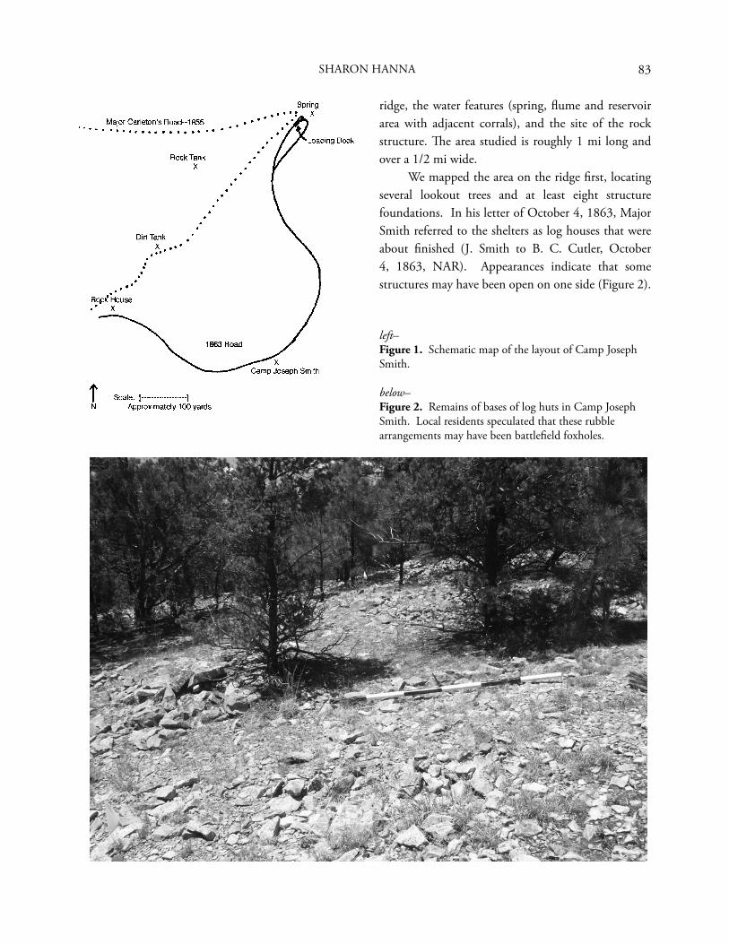
83
ridge, the water features (spring, fl ume and reservoir area with adjacent corrals), and the site of the rock structure. Th e area studied is roughly 1 mi long and over a 1/2 mi wide.
We mapped the area on the ridge fi rst, locating several lookout trees and at least eight structure foundations. In his letter of October 4, 1863, Major Smith referred to the shelters as log houses that were about fi nished (J. Smith to B. C. Cutler, October 4, 1863, NAR). Appearances indicate that some structures may have been open on one side (Figure 2).
SHARON HANNA
left–Figure 1. Schematic map of the layout of Camp Joseph Smith.
below–Figure 2. Remains of bases of log huts in Camp Joseph Smith. Local residents speculated that these rubble arrangements may have been battlefi eld foxholes.
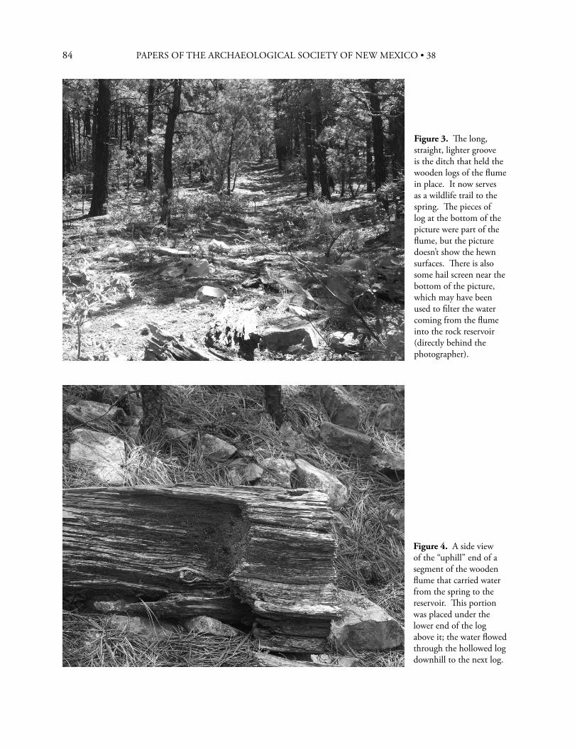
84 PAPERS OF THE ARCHAEOLOGICAL SOCIETY OF NEW MEXICO • 38
Figure 3. Th e long, straight, lighter groove is the ditch that held the wooden logs of the fl ume in place. It now serves as a wildlife trail to the spring. Th e pieces of log at the bottom of the picture were part of the fl ume, but the picture doesn’t sho w the hewn surfaces. Th ere is also some hail screen near the bottom of the picture, which may have been used to fi lter the water coming from the fl ume into the rock reservoir (directly behind the photographer).
Figure 4. A side view of the “uphill” end of a segment of the wooden fl ume that carried water from the spring to the reservoir. Th is portion was placed under the lower end of the log above it; the water fl owed through the hollowed log downhill to the next log.
85
Th e original roads were traced as much as possible. Th e most prominent road runs through the camp site to the spring, where a turn-around looped across a loading dock below the spring. Vance Haynes had identifi ed the loading dock during his visit to the site earlier in the year. A trench had been dug to open up the source of the water in the spring. Th e wooden supports for the loading dock are still in place near the lower end of that trench. Beside the spring is the remainder of a rock building 14 ft square with solid walls 2 ft thick, a short hallway, and a lower fl oor in the remaining room, much like an early-day root cellar.
Segments of the wooden fl ume are still visible between the spring and the reservoir (Figures 3 and 4). Water marks on the reservoir show that it held a considerable amount of water at times (Figure 5). Pipes extend through two sides of the reservoir (Figure 6), and a portion of a hollowed log used for a drinking trough still exists in one corral. Th e two large corrals near the reservoir were built from logs laid horizontally between vertical support posts with no nails or bolts used in the construction (Figure 7). Enough of the fence is still visible to defi ne the boundaries of the corrals to investigators willing to crawl through the junipers and oak brush.
Figure 7. A portion of the corral fence. Th e ends of the logs overlapped between the vertical posts. Th e ends are badly decayed, and the logs now lie on top of the logs below, making the fence much lower than the original would have been.
Figure 5. Th e interior of the rock reservoir. Th e measuring stick is 6 ft long. Calculations based upon measurements indicate the full capacity of the reservoir was 30,000 gallons.
Figure 6. Pipe extending from side of rock reservoir to supply a drinking trough in the corral.
Down the ridge from the camp is a small clearing containing the remains of a rock building. According to local lore, the building was used as a ranch house and a school in the early 1900s. Th e dimensions of the walls match those used in buildings constructed at New Fort Wingate in 1868; all walls, interior and exterior, were 2 ft thick (Giese 1995:3).
A dirt tank dug below the spring and south of the reservoir washed out long ago; its berm now
SHARON HANNA
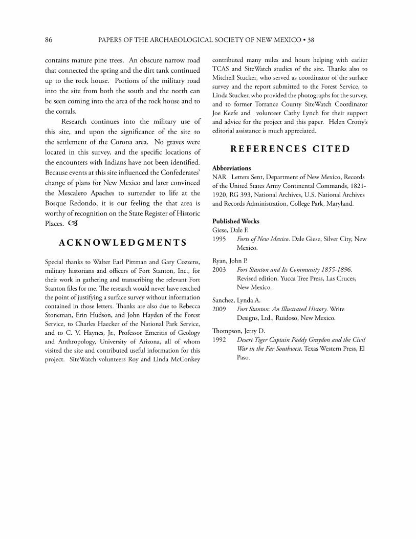
86 PAPERS OF THE ARCHAEOLOGICAL SOCIETY OF NEW MEXICO • 38
contains mature pine trees. An obscure narrow road that connected the spring and the dirt tank continued up to the rock house. Portions of the military road into the site from both the south and the north can be seen coming into the area of the rock house and to the corrals.
Research continues into the military use of this site, and upon the signifi cance of the site to the settlement of the Corona area. No graves were located in this survey, and the specifi c locations of the encounters with Indians have not been identifi ed. Because events at this site infl uenced the Confederates’ change of plans for New Mexico and later convinced the Mescalero Apaches to surrender to life at the Bosque Redondo, it is our feeling the that area is worthy of recognition on the State Register of Historic Places.
A C K N O W L E D G M E N T S
Special thanks to Walter Earl Pittman and Gary Cozzens, military historians and offi cers of Fort Stanton, Inc., for their work in gathering and transcribing the relevant Fort Stanton fi les for me. Th e research would never have reached the point of justifying a surface survey without information contained in those letters. Th anks are also due to Rebecca Stoneman, Erin Hudson, and John Hayden of the Forest Service, to Charles Haecker of the National Park Service, and to C. V. Haynes, Jr., Professor Emeritis of Geology and Anthropology, University of Arizona, all of whom visited the site and contributed useful information for this project. SiteWatch volunteers Roy and Linda McConkey
contributed many miles and hours helping with earlier TCAS and SiteWatch studies of the site. Th anks also to Mitchell Stucker, who served as coordinator of the surface survey and the report submitted to the Forest Service, to Linda Stucker, who provided the photographs for the survey, and to former Torrance County SiteWatch Coordinator Joe Keefe and volunteer Cathy Lynch for their support and advice for the project and this paper. Helen Crotty’s editorial assistance is much appreciated.
R E F E R E N C E S C I T E D
AbbreviationsNAR Letters Sent, Department of New Mexico, Records of the United States Army Continental Commands, 1821-1920, RG 393, National Archives, U.S. National Archives and Records Administration, College Park, Maryland.
Published WorksGiese, Dale F.1995 Forts of New Mexico. Dale Giese, Silver City, New
Mexico.
Ryan, John P.2003 Fort Stanton and Its Community 1855-1896.
Revised edition. Yucca Tree Press, Las Cruces, New Mexico.
Sanchez, Lynda A.2009 Fort Stanton: An Illustrated History. Write
Designs, Ltd., Ruidoso, New Mexico.
Th ompson, Jerry D.1992 Desert Tiger Captain Paddy Graydon and the Civil
War in the Far Southwest. Texas Western Press, El Paso.
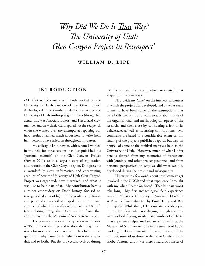
87
87
I N T R O D U C T I O N
Carol Condie and I both worked on the University of Utah portion of the Glen Canyon Archeological Project2—she as de facto editor of the University of Utah Anthropological Papers (though her actual title was Associate Editor) and I as a fi eld crew member and crew chief. Carol spared not the red pencil when she worked over my attempts at reporting our fi eld results. I learned much about how to write from her—lessons I have relied on throughout my career. My colleague Don Fowler, with whom I worked in the fi eld for three seasons, has just published his “personal memoir” of the Glen Canyon Project (Fowler 2011) set in a larger history of exploration and research in the Glen Canyon region. Don presents a wonderfully clear, informative, and entertaining account of how the University of Utah Glen Canyon Project was organized, how it worked, and what it was like to be a part of it. My contribution here is a minor embroidery on Don’s history, focused on trying to shed a bit of light on the academic, cultural, and personal contexts that shaped the structure and conduct of what I’ll hereafter refer to as “the UGCP” (thus distinguishing the Utah portion from that administered by the Museum of Northern Arizona). Th e primary answer to the question in the title is “Because Jess Jennings said to do it that way.” But it is a bit more complex that that. Th e obvious next question is why Jennings thought about it the way he did, and so forth. But the project also evolved during
its lifespan, and the people who participated in it shaped it in various ways. I’ll provide my “take” on the intellectual context in which the project was developed, and on what seem to me to have been some of the assumptions that were built into it. I also want to talk about some of the organizational and methodological aspects of the research, and then close by considering a few of its defi ciencies as well as its lasting contributions. My comments are based to a considerable extent on my reading of the project’s published reports, but also on perusal of some of the archival materials held at the University of Utah. However, much of what I off er here is derived from my memories of discussions with Jennings and other project personnel, and from personal perspectives on why we did what we did, developed during the project and subsequently. I’ll start with a few words about how I came to get involved in the UGCP, and what experience I brought with me when I came on board. Th at last part won’t take long. My fi rst archaeological fi eld experience was in 1956 at the University of Arizona fi eld school at Point of Pines, directed by Emil Haury and Ray Th ompson. While there, I demonstrated the ability to move a lot of dirt while not digging through masonry walls and still fi nding an adequate number of artifacts. Th at experience helped me land an assistantship at the Museum of Northern Arizona in the summer of 1957, working for Dave Breternitz. Toward the end of the summer, some of us drove to the Pecos Conference in Globe, Arizona, and it was there I heard Bob Lister of
Why Did We Do It Th at Way? Th e University of Utah
Glen Canyon Project in Retrospect1
W I L L I A M D . L I P E
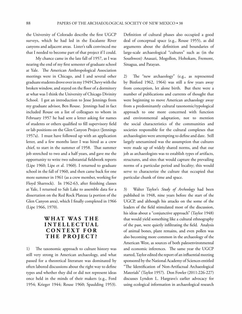
88 PAPERS OF THE ARCHAEOLOGICAL SOCIETY OF NEW MEXICO • 38
the University of Colorado describe the fi rst UGCP surveys, which he had led in the Escalante River canyons and adjacent areas. Lister’s talk convinced me that I needed to become part of that project if I could. My chance came in the late fall of 1957, as I was nearing the end of my fi rst semester of graduate school at Yale. Th e American Anthropological Association meetings were in Chicago, and I and several other graduate students drove over in my 1949 Chevy with the broken window, and stayed on the fl oor of a dormitory at what was I think the University of Chicago Divinity School. I got an introduction to Jesse Jennings from my graduate advisor, Ben Rouse. Jennings had in fact included Rouse on a list of colleagues to whom in February 1957 he had sent a letter asking for names of students or others qualifi ed to fi ll supervisory fi eld or lab positions on the Glen Canyon Project (Jennings 1957a). I must have followed up with an application letter, and a few months later I was hired as a crew chief, to start in the summer of 1958. Th at summer job stretched to two and a half years, and gave me the opportunity to write two substantial fi eldwork reports (Lipe 1960; Lipe et al. 1960). I returned to graduate school in the fall of 1960, and then came back for one more summer in 1961 (as a crew member, working for Floyd Sharrock). In 1962-63, after fi nishing classes at Yale, I returned to Salt Lake to assemble data for a dissertation on the Red Rock Plateau (a portion of the Glen Canyon area), which I fi nally completed in 1966 (Lipe 1966, 1970).
W H A T WA S T H E I N T E L L E C T U A LC O N T E X T F O R T H E P R O J E C T ?
1) Th e taxonomic approach to culture history was still very strong in American archaeology, and what passed for a theoretical literature was dominated by often labored discussions about the right way to defi ne types and whether they did or did not represent ideas once held in the minds of their makers (e.g., Ford 1954; Krieger 1944; Rouse 1960; Spaulding 1953).
Defi nition of cultural phases also occupied a good deal of conceptual space (e.g., Rouse 1955), as did arguments about the defi nition and boundaries of large-scale archaeological “cultures” such as (in the Southwest) Anasazi, Mogollon, Hohokam, Fremont, Sinagua, and Patayan.
2) Th e “new archaeology” (e.g., as represented by Binford 1962, 1964) was still a few years away from conception, let alone birth. But there were a number of publications and currents of thought that were beginning to move American archaeology away from a predominantly cultural taxonomic/typological approach to one more concerned with function and environmental adaptation, not to mention the social characteristics of the communities and societies responsible for the cultural complexes that archaeologists were attempting to defi ne and date. Still largely unexamined was the assumption that cultures were made up of widely shared norms, and that our job as archaeologists was to establish types of artifacts, structures, and sites that would capture the prevailing norms of a particular period and locality; this would serve to characterize the culture that occupied that particular chunk of time and space.
3) Walter Taylor’s Study of Archeology had been published in 1948, nine years before the start of the UGCP, and although his attacks on the some of the leaders of the fi eld stimulated most of the discussion, his ideas about a “conjunctive approach” (Taylor 1948) that would yield something like a cultural ethnography of the past, were quietly infi ltrating the fi eld. Analysis of animal bones, plant remains, and even pollen was also becoming more common in the archaeology of the American West, as sources of both paleoenvironmental and economic inferences. Th e same year the UGCP started, Taylor edited the report of an infl uential meeting sponsored by the National Academy of Sciences entitled “Th e Identifi cation of Non-Artifactual Archaeological Materials” (Taylor 1957). Don Fowler (2011:226-227) discusses Lyndon L. Hargrave’s earlier advocacy for using ecological information in archaeological research
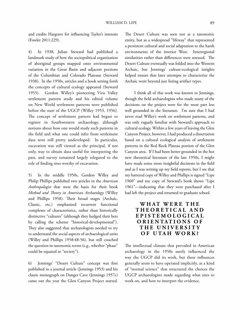
89
and credits Hargrave for infl uencing Taylor’s interests (Fowler 2011:229).
4) In 1938, Julian Steward had published a landmark study of how the sociopolitical organization of aboriginal groups mapped onto environmental variation in the Great Basin and adjacent portions of the Columbian and Colorado Plateaus (Steward 1938). In the 1950s, articles and a book setting forth the concepts of cultural ecology appeared (Steward 1955). Gordon Willey’s pioneering Viru Valley settlement pattern study and his edited volume on New World settlement patterns were published before the start of the UGCP (Willey 1953, 1956). Th e concept of settlement pattern had begun to register in Southwestern archaeology, although notions about how one would study such patterns in the fi eld and what one could infer from settlement data were still pretty undeveloped. In particular, excavation was still viewed as the principal, if not only, way to obtain data useful for interpreting the past, and survey remained largely relegated to the role of fi nding sites worthy of excavation.
5) In the middle 1950s, Gordon Willey and Philip Phillips published two articles in the American Anthropologist that were the basis for their book Method and Th eory in American Archaeology (Willey and Phillips 1958). Th eir broad stages (Archaic, Classic, etc.) emphasized recurrent functional complexes of characteristics, rather than historically distinctive “cultures” (although they hedged their bets by calling the scheme “historical-developmental”). Th ey also suggested that archaeologists needed to try to understand the social aspects of archaeological units (Willey and Phillips 1958:48-56), but still couched the question in taxonomic terms (e.g., whether “phase” could be equated to “society”).
6) Jennings’ “Desert Culture” concept was fi rst published in a journal article (Jennings 1953) and his classic monograph on Danger Cave (Jennings 1957c) came out the year the Glen Canyon Project started.
Th e Desert Culture was seen not as a taxonomic entity, but as a widespread “lifeway” that represented a persistent cultural and social adaptation to the harsh environments of the interior West. Interregional similarities rather than diff erences were stressed. Th e Desert Culture eventually was folded into the Western Archaic, but Jennings’ culture-ecological insights helped ensure that later attempts to characterize the Archaic went beyond just listing artifact types.
I think all of this work was known to Jennings, though the fi eld archaeologists who made many of the decisions on the project were for the most part less well grounded in the literature. I’m sure that I had never read Willey’s work on settlement patterns, and was only vaguely familiar with Steward’s approach to cultural ecology. Within a few years of leaving the Glen Canyon Project, however, I had produced a dissertation based on a cultural ecological analysis of settlement patterns in the Red Rock Plateau portion of the Glen Canyon area. If I had been better grounded in the hot new theoretical literature of the late 1950s, I might have made some more insightful decisions in the fi eld and as I was writing up my fi eld reports, but I see that my battered copy of Willey and Phillips is signed “Lipe 1960” and my copy of Steward’s book shows “Lipe 1961”—indicating that they were purchased after I had left the project and returned to graduate school.
W H A T W E R E T H E T H E O R E T I C A L A N D E P I S T E M O L O G I C A L O R I E N T A T I O N S O F
T H E U N I V E R S I T Y O F U T A H W O R K ?
Th e intellectual climate that prevailed in American archaeology in the 1950s surely infl uenced the way the UGCP did its work, but these infl uences generally seem to have operated implicitly, as a kind of “normal science” that structured the choices the UGCP archaeologists made regarding what sites to work on, and how to interpret the evidence.
WILLIAM D. LIPE
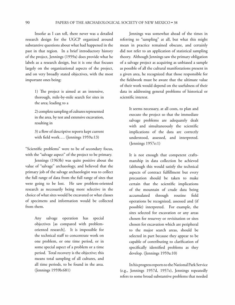
90 PAPERS OF THE ARCHAEOLOGICAL SOCIETY OF NEW MEXICO • 38
Insofar as I can tell, there never was a detailed research design for the UGCP organized around substantive questions about what had happened in the past in that region. In a brief introductory history of the project, Jennings (1959a) does provide what he labels as a research design, but it is one that focuses largely on the organizational aspects of the project, and on very broadly stated objectives, with the most important ones being:
1) Th e project is aimed at an intensive, thorough, mile-by-mile search for sites in the area; leading to a
2) complete sampling of cultures represented in the area, by test and extensive excavation, resulting in
3) a fl ow of descriptive reports kept current with fi eld work…. (Jennings 1959a:13)
“Scientifi c problems” were to be of secondary focus, with the “salvage aspect” of the project to be primary. Jennings (1963b) was quite positive about the value of “salvage” archaeology, and believed that the primary job of the salvage archaeologist was to collect the full range of data from the full range of sites that were going to be lost. He saw problem-oriented research as necessarily being more selective in the choice of what sites would be excavated or what classes of specimens and information would be collected from them.
Any salvage operation has special objectives [as compared with problem-oriented research]. It is impossible for the technical staff to concentrate work on one problem, or one time period, or in some special aspect of a problem or a time period. Total recovery is the objective; this means total sampling of all cultures, and all time periods, to be found in the area. (Jennings 1959b:681)
Jennings was somewhat ahead of the times in referring to “sampling” at all, but what this might mean in practice remained obscure, and certainly did not refer to an application of statistical sampling theory. Although Jennings saw the primary obligation of a salvage project as acquiring as unbiased a sample as possible of all the cultural manifestations present in a given area, he recognized that those responsible for the fi eldwork must be aware that the ultimate value of their work would depend on the usefulness of their data in addressing general problems of historical or scientifi c interest.
It seems necessary, at all costs, to plan and execute the project so that the immediate salvage problems are adequately dealt with and simultaneously the scientifi c implications of the data are correctly understood, assessed, and interpreted. (Jennings 1957e:1)
It is not enough that competent crafts-manship in data collection be achieved (although this would satisfy the technical aspects of contract fulfi llment but every precaution should be taken to make certain that the scientifi c implications of the mountain of crude data being accumulated through routine fi eld operations be recognized, assessed and (if possible) interpreted. For example, the sites selected for excavation or any areas chosen for resurvey or revisitation or sites chosen for excavation which are peripheral to the major search areas, should be selected in part because they appear to be capable of contributing to clarifi cation of specifi cally identifi ed problems as they develop. (Jennings 1959a:10)
In his progress reports to the National Park Service (e.g., Jennings 1957d, 1957e), Jennings repeatedly refers to some broad substantive problems that needed
91
to be addressed. Th ese focused on the chronology of occupation in the region and on the kinds of cultures that were represented. Included were the search for solid evidence of preceramic occupations, defi ning the spatial and temporal relationships among major Formative-level “cultures” (Mesa Verde, Kayenta, and Virgin Branch Anasazi, as well as Fremont), and using archaeology to expand knowledge of later cultures in the area—Paiute, Navajo, and historic Anglo. He frequently mentions the diffi culties posed by the lack of comparative data from surrounding areas, due to a lack of previous archaeological research, especially to the west and north. Jennings understood that “facts are derived from observations, and observations are always made to some scale and within some context, either explicit or assumed” (Jennings 1963a:16). In practice, however, there was little explicit discussion of what observations the fi eldwork should be expected to yield, and the concepts of “collecting raw data,” “complete recovery,” and “descriptive reporting” come up repeatedly in his progress reports and, as I recall, in conversations. Th ese contributed to an implicit expectation that archaeological data could be generated from the physical archaeological record in a fairly straightforward and even self-evident way, if appropriate fi eld methods were used and archaeologists kept their eyes open. Jennings knew that given the scope and logistical diffi culties of the UGCP, much of the day-to-day fi eldwork decision making (usually including which sites to test and, in some cases, which sites to dig) would depend on the knowledge and judgment of the fi eld supervisor.
In reservoir salvage work there is a heavier burden on the fi eld supervisor than in any other kind of archeology, since the completion of the dam and the fi lling of the reservoir precludes further opportunity to check, verify or add to the information acquired through fi eldwork. (Jennings 1959b:681)
Jennings necessarily relied on the judgment of the fi eld archaeologists (and more generally, on the “best practices” for survey and excavation that were current at the time) to dictate how the archaeological record would be investigated at particular sites, and in fact, how sites would be selected for what level of investigation. He expected that an understanding of the prehistory of the project area would fl ow from the direct encounter between perceptive archaeologists and the archaeological record, both in the fi eld and in the lab. And he hoped he had hired archaeologists who were perceptive enough to get the most relevant information for the time and money expended. If we look at some of the choices and interpreta-tions that were made during the project, there is evidence for an underlying theoretical framework that could be considered culture-ecological, though this was seldom explicit. Th e inclusion of several kinds of biological and geological studies as part of the project indicated a concern with obtaining data both from present-day and past environments in order to help place the prehistoric cultural manifestations in ecological and adaptive contexts. In the interpretive papers he published on the project, Jennings (e.g., 1963a, 1966) clearly takes a generalized functional and ecological approach rather than the taxonomic one that was still dominant in Southwestern archaeology. Th at is, he spends more ink on how people lived in relation to their environment than on whether the sites in question were Pueblo II or III or Kayenta or Mesa Verde Branch, or whether the pottery in them was Mancos or McElmo Black-on-white. Another indicator of a broadly culture-ecological approach is that, unlike projects today, the fi eldwork—including excavation—was not confi ned just to the area directly impacted by development—in this case, by reservoir construction. Rather, a broader regional approach was taken, with surveys and excavations conducted well outside the reservoir boundaries. Th is approach was explicitly encouraged by Charlie Steen, the Park Service’s archaeologist in charge of overseeing the project:
WILLIAM D. LIPE
92 PAPERS OF THE ARCHAEOLOGICAL SOCIETY OF NEW MEXICO • 38
You should not concern yourself only with the land which will actually be fl ooded, but should extend your surveys, wherever possible or desirable, to and somewhat beyond the canyon rims. We shall not attempt to set a specifi c limit, or to ask you to search for sites to a line a certain distance from the rims, for there can be no closely followed procedure in such terrain. I believe you should instruct your Chiefs of Party to look over all the lands adjacent to the canyon which give promise of being of importance in any fi eld of investigation. We are very anxious to know just what archeological, historical, and biological resources exist in the Glen Canyon region. (Steen 1957; also quoted in Jennings, 1959a)
One assumption that seemed to underlie this approach was that the small Puebloan sites located in the canyons that would be fl ooded needed to be understood in relation to larger sites in the higher surrounding areas or at least in terms of the cultural infl uences that presumably emanated from more populous areas. Th is assumption was more explicitly developed by the Museum of Northern Arizona’s project team, but I believe it structured the University of Utah approach as well, at least at the outset. Jennings was able to implement work in neighboring upland areas (e.g., excavations on the Kaiparowits Plateau and in Harris Wash in the upper Escalante [Fowler 2011:294]) by obtaining non-project funds from the Wenner-Gren Foundation, the University of Utah Research Fund, and the National Science Foundation, and by arranging for the University of Colorado’s 1959 fi eld schools at the Coombs site. Today, we would more explicitly use the concept of regional settlement system to relate the highland and canyon sites.
W H A T W E R E T H E D I S T I N C T I V E
M E T H O D O L O G I C A L A N D O R G A N I Z A T I O N A L A S P E C T S O F T H E U G C P ?
In contrast to the broader intellectual underpinnings of the project, its organizational and methodological aspects were more explicit. Th e UGCP fi eld manual, published in 1959, is quite instructive, as are several papers Jennings wrote in the 1960s on the administration of contract salvage projects. Jennings welcomed the defi nitiveness of the contract salvage format, because it required that a certain amount of money would be allocated to achieve certain results or produce certain products within a specifi c amount of time. Th is approach is one he was familiar with from his varied work career in the non-academic world, and he saw no reason why such common-sense requirements would not apply to a research project as well. Jennings is probably the fi nest research administrator I have ever encountered, bar none, and a large salvage project gave him the opportunity to show what he could do. It is also clear to me that he saw some of the academic research of the time as little more than undisciplined dawdling, and felt that some of his colleagues were more wedded to particular techniques or to achieving spurious levels of precision than to fi guring out how to learn the most from the archaeological record with the least expenditure of time and money. Several principles seem to me to have structured Jennings’ approach to successfully carrying out an archaeological salvage project under contract.
1) “Use the coarsest tool which will do the work—i.e., recover the data” (Jennings 1966:7).
2) “My preference is to get 95% of the data from ten sites instead of 99% from one” (Jennings 1963b:263).
93
3) Although troweling and screening are sometimes appropriate, routinely excavating with trowels and screens instead of shovels and no screens is usually a waste of time, in terms of the amount of information obtained per unit of eff ort expended. (In his summary report on the UGCP, Jennings unleashes a fi nal rant against the “spurious accuracy” achieved by “the slow brushing away of a site with trowels and the plotting of each scrap…” [Jennings 1966:6]). Not envisioned was a role for screening in promoting comparability of the artifact samples collected during excavations.
4) A well-coordinated team of full-time workers (in both fi eld and lab) is better than a single individual working the same total number of hours over a longer period (see especially Jennings 1963b:284).
5) Maintaining data quality is essential, but the level of quality sought should be appropriate. Perfection is not achievable and the attempt to achieve it is a waste of time.
6) In the area of data quality, the fi eld record is preeminent. A researcher can always reclassify the artifacts that have been collected, but he or she cannot not go back and re-excavate the portions of a site that have already been dug. (On a reservoir salvage project, this was, of course, true even for the unexcavated portions of sites).
7) If you want to achieve data comparability among several research teams and over the life of a multi-year project, it is essential to take explicit steps to ensure that this happens; otherwise, it won’t. Th us, most of the pages in the project’s operational manual (Jennings 1959b:687-707) are devoted to discussing forms and procedures for record-keeping in the fi eld and lab.
8) Fieldwork unreported is equivalent to fi eldwork never done; furthermore, it has resulted in the destruction of a site with no resulting gain in information about the past. “Unpublished data don’t exist” (cited in Fowler 2011:272).
9) Report deadlines are essential—”Th is puts the burden of completion in sharp focus from the very beginning of the project. Th us it…establishes [a]…schedule to which the work must be geared” (Jennings 1963b:284).
10) Th e principal product of a salvage project will be descriptive reports, produced in a timely fashion, that put basic data on record. “…preoccupation with extensive comparisons, synthesis or interpretation must be deferred or held as incidental until the gathering of data is curtailed by fi lling of the reservoir…” (Jennings 1959a:9).
11) Archaeological sites and artifacts don’t belong to the individual archaeologist, and neither do the archaeologist’s records. Records of archaeological fi eld research must remain available for future use.
Jennings was also strongly committed to not prejudging the evidence—and wanted to avoid setting up a conceptual structure that would determine conclusions in advance. Th is was expressed, for example, in the feature system he designed for taking notes (Jennings 1959b:692-693). Features were numbered so they could be tracked, but otherwise, they were “empty” containers for observations. A feature was anything in the archaeological record about which you wanted to record observations—it could be a stratum, a possible intrusive pit, a discolored area where a fi re might once have been built, a structure, an area of the site, or whatever. Interpretive names, such as “hearth” or “kiva” were assigned only after all the observations had been made, and the archaeologist had had the time to refl ect on them. Th e point was to separate observation from inference. Th e notes on a particular feature were kept open and could be added to until work on that feature had been completed. I believe this approach implicitly operated at the project as well as at the site level, and was designed to keep project archaeologists from jumping to premature conclusions about the chronological, cultural, and functional relationships of the sites
WILLIAM D. LIPE
94 PAPERS OF THE ARCHAEOLOGICAL SOCIETY OF NEW MEXICO • 38
they were excavating. Th e fi rst job was to encounter the archaeological record by excavating and studying an unbiased sample of whatever was in the project area. On the other hand, in some cases it provided an excuse to attempt no interpretations beyond those necessary to give artifacts and features descriptive or typological labels. Jennings’ approach to excavating and to taking fi eld notes also reveals a concern for what would now be called site formation process. In his instructions to fi eld supervisors, he urged designing the excavation to effi ciently explore horizontal and vertical relationships between cultural and stratigraphic features. He abhorred rote excavation by grid square and arbitrary level, seeing it as an excuse for not thinking about how best to expose and understand the relationships observable in the archaeological deposits. He preferred trenching to pit excavations, because trenches allowed one to connect diff erent areas of the site and also to expose vertical relationships. He ridiculed the then-common Southwestern practice of publishing cross-sections of structures that showed the architecture, but not the strata that had once fi lled them, so there was no way to infer how they had fi lled. I recall him remarking “But what happened to the dirt?”—whether he actually said just those words or not, that critique came through loud and clear. Crew chiefs were expected to regularly write summaries of what they were fi nding out about the archaeological record of the site they were working on. Th is was done in “Feature 1,” a running journal in which all the features recently excavated were mentioned, and their stratigraphic and spatial relationships discussed. Th e purpose was to force archaeologists to think about how the archaeological record had been formed, while they were still in the fi eld. If the work was far enough along, interpretive names could be tentatively assigned to features, and the chronological and functional interpretation of the archaeological record could begin. As a result of the above-mentioned concerns with data quality, there were fairly elaborate systems in both fi eld and lab that were designed to ensure that
the provenience controls assigned in the fi eld were maintained through analysis and into curation. One of Jennings’ signal contributions to data quality was to read all the fi eld notes, copies of which his crew chiefs sent in every two weeks. If you have ever managed a large project, with multiple crews in the fi eld at the same time, you know what that took in terms of discipline on his part. But it was very eff ective—receiving a succinctly stated note from Jennings pointing out some inconsistency or outright blunder in your fi eld notes certainly got your attention. On the UGCP, steps taken to promote data comparability included having standardized recording forms in both the fi eld and the lab; having one person (ordinarily the crew chief ) take most or all of the notes on the site; using standard artifact classifi cations across all sites; and labeling artifacts individually and classifying them without taking provenience into account, so that locations and associations would not bias assignment to classes. Th is allowed all the artifacts from a site (or even several sites) to be spread out on a table, then pushed into piles representing classes or types, and then tabulated by provenience. Jennings placed prompt analysis and the timely publication of descriptive site reports on an equal footing with the fi eldwork itself, in keeping with the above-mentioned principle that if the results are not published, all the other steps may as well never have occurred. He successfully fought for funding of analysis and reporting (including publication of the reports) in an era when salvage contracts often supported only the fi eldwork, on the frequently unfounded presumption that academic researchers or their students would eventually do the follow-up work. Jennings did not believe, however, that it was the federal government’s responsibility to pay for problem-oriented studies that went beyond descriptive reporting. In order to carry out the reporting obligation, a rigorous schedule was set up to produce and disseminate inexpensive descriptive reports. While requiring the reports to have thorough (by the standards of the day) descriptions of the archaeological contexts, Jennings recognized that
95
he had to forestall what he saw as the reluctance of some archaeologists to leave anything out. Th is was particularly clear with regard to the issue of lumping versus splitting proveniences when reporting the horizontal and vertical distribution of artifacts at sites. Jennings was clearly a lumper, and promoted the principle that if two proveniences did not diff er enough to indicate a chronological or functional separation, they should be lumped when reporting the artifacts that came from them. Th is resulted in a remarkable simplifi cation of data tables. Th e previously mentioned concern to ensure that archaeological collections and records be preserved for the future resulted in a signifi cant investment, during the life of the project, in seeing that fi eld and lab notes, maps, photos, other records, artifacts, and other specimens were ready for long-term curation. And in fact these materials have been preserved and are accessible for research and educational purposes. Th e collections are housed in the Utah Museum of Natural History, but some of the paper records are at the University of Utah archives and the University Archaeological Center.
I N H I N D S I G H T, W H A T W E R E T H E M A I N
D E F I C I E N C I E S O F T H E U G C P ?
It is, of course, easy to critique procedures instituted and work done on an archaeological project carried out 50 and more years ago and often in very diffi cult logistical contexts. Some of the problems that the UGCP faced “came with the territory”—that is, were the result of events beyond control of the project personnel. Others, however, were at least in part the result of some of the assumptions and overall philosophy that undergirded the project—factors that, in many cases, also contributed to its successes. Th e UGCP began before even the 1960 Reservoir Salvage Act was in place, let alone the 1966 National Historic Preservation Act or the 1974 Historic and Archeological Preservation Act. Th e only legislative
authorities for the project were the Antiquities Act of 1906 and the Historic Sites Act of 1935. Because of the scale of the project, it was dependent on annual appropriations by Congress; hence, there was considerable insecurity from year to year regarding how much money would be available, and there was always the threat that the project would be terminated mid-course. Jennings (1963b:285), however, saw that a long-term contract could overcome this disadvantage by allowing funds not expended one year to be rolled over into the next. Th us, as a prudent project manager, he was able to build up a cushion against the vicissitudes of the annual appropriation process. A signifi cant operational problem present from the outset was the lack of systematic survey data for many parts of the project area prior to the start of full-scale work. Th us, the contracted schedule for the project demanded that in some locales, survey, testing, and excavation had to be undertaken in the same fi eld season. Th ere had been some prior survey, mostly in the Glen Canyon proper (see Adams 1960; Adams et al. 1961; Fowler 1959a, 2011). However, coverage of the areas to be impacted was very incomplete, especially in the tributary canyons and even more so in the adjacent areas outside the full pool level. For example, Don Fowler spent most of the summers of 1958 and 1959 surveying (with one helper) the main stem of the Glen Canyon and the lower parts of the tributary canyons (Fowler 1959a, 1959b). At the same time, I was directing the “river crew” in excavations. We worked out of the same fi eld camp to the extent that Fowler’s survey locations permitted. Th e same pattern of survey concurrent with excavation was repeated when we moved to portions of Moqui and Lake Canyons that were too far upstream to access from the river and had to be accessed overland. Away from the canyons, some of the UGCP surveys were clearly designed as exploratory reconnaissance, although the survey of portions of the Kaiparowits Plateau (Gunnerson 1959a) was intensive (by the standards of the day). Would it have made a diff erence if the survey of the project area had been completed in advance?
WILLIAM D. LIPE
96 PAPERS OF THE ARCHAEOLOGICAL SOCIETY OF NEW MEXICO • 38
Possibly, but only if the survey data had been subjected to more intensive chronological analysis and if it had been used more systematically as a way to develop hypotheses about site types and settlement patterns for particular periods and locales. As noted earlier, this role for survey data was still in its infancy in American archaeology in general, not just on the UGCP. As it was, we were usually able to plan excavations for a particular season around survey data obtained the previous season or earlier (e.g., Lipe 1959). Th e surveys I am most familiar with are those carried out by Fowler and later Kent Day in the Glen Canyon Main Stem and the Red Rock Plateau. Th e records and collections from these surveys are superior to those of most contemporary surveys in the Southwest, in my opinion. I was later able to make good use of this survey data (along with the excavation results) in developing a phase scheme and settlement pattern interpretations for the Basketmaker II through Pueblo III periods in the Red Rock Plateau (Lipe 1966, 1970). However, there is no question that the body of survey data generated by the UGCP has gaps and biases. Schroedl and Newsome (2000),3 on the basis of resurvey of portions of the UGCP area and a review of its records, note that some of the sites missed in Lake and Moqui Canyons
…were small, open Anasazi structural sites located on small prominences within the canyon. Th ese sites were missed by the GCP inventory teams because the crews were focused on searching for Anasazi sites in alcoves and along the canyon walls. (Schroedl and Newsome 2000:43)
A larger bias was that “the Archaic occupation of the benchlands and uplands surrounding Glen Canyon also went unrecognized” (Schroedl and Newsome 2000:43). Th is is undoubtedly true, although the presence of such sites was certainly known to the UGCP team. In a memo to the Park Service assessing the results of the 1958 fi eld season, Jennings notes:
…the consistent presence, from Comb Wash to Wahweap Creek, of a strong lithic complex associated with dunes or rock terraces. All these sites had previously been dismissed (when noted) as chipping areas adjunct to the Anasazi remains. Many, no doubt, are just that. Others, however, can be recognized as having distinctive artifact lists and other traits (location, size, etc.) which mark the existence of a separate complex. Typologically, however, no staff member recognizes the artifact types. No age ascriptions are warranted, but there does appear to exist a non-Anasazi occupation. It seems to be something new; while the complex may be earlier than the dominant Anasazi it could equally well be post-Anasazi in age. (Jennings 1958:3-4)
Unfortunately, the UGCP staff was never able to get much beyond this state of puzzlement. In their defense, most of the surrounding “benchlands and uplands” were above the full pool level, and given the huge area staked out as of interest to the project, they received less attention. I also think that the prevailing approach to doing archaeology overwhelmingly favored excavation, and to the fi eld archaeologists charged with getting the most information for the time available, the lithic sites outside the canyons appeared largely surfi cial and probably “not worth digging” despite Jennings’ repeated expressions of interest in learning more about them. Th e prevailing emphasis on excavation as the primary source of reliable information perhaps reinforced this attitude. I think an underlying problem, however, was a largely implicit assumption by the project staff that the occupation of the Glen Canyon area did not have a great deal of time depth. Th is was a common attitude in the Southwest prior to the 1950s, and by the time the UGCP got underway, only a few papers had appeared reporting on probable pre-agricultural complexes in the Four Corners area (e.g., Bryan and Toulouse 1943; Mohr and Sample 1959).
97
More importantly, however, the UGCP as a whole did not focus at all eff ectively on chronology in a methodological sense. For the preceramic part of the record, some expenditure of project funds on radiocarbon dating would have paid substantial dividends. As it was, only one radiocarbon sample was dated (Geib 2006:37) and that one (from the Lone Tree Dune Basketmaker II site [Sharrock et al. 1963]) was submitted as part of my dissertation research after the fi eld phase of the UGCP was completed. Radiocarbon dating was not developed until 1949, but by the early 1950s, it had begun to be used by archaeologists all over the world (Johnson 1951) and had played an important role in acceptance of the early dates from the lower levels of Danger Cave. Dendrochronology was of course an established method for dating contexts of the later periods in the northern Southwest. However, virtually all the sites excavated or tested by the UGCP were at too low an elevation to yield coniferous wood samples suitable for tree-ring dating; samples from a few higher elevation sites were submitted, but did not date. An exception was the Coombs Site (Bannister et al. 1969:12-13; Lister and Lister 1961), but here only a few samples were submitted, even though a number of burned rooms had been excavated. Th e UGCP’s emphasis on “descriptive” reporting of “raw” data, with the postponement of problem-oriented studies until later, may also have contributed to a lack of focus on chronology. Th e goal was to get a publishable descriptive report of one season’s fi eldwork done before the next fi eld season started. Th is provided an excuse to put off addressing some of the harder issues, of which dating non-ceramic assemblages was one. I also think those of us doing and reporting on the fi eldwork took too much to heart Jennings’ (1959b:686-687) assertion: “Excavators are further reminded that the data, the sequence of events, and the relationships at any given site are observable. Th ey are in the ground and must be dug for.” Th us, we may subconsciously have been expecting to fi nd another Danger Cave to convince us that an Archaic occupation was in fact present.
Th ere was also a tendency—again largely implicit—to favor functional over chronological explanations for diff erences among assemblages from the same site or from a set of sites in a given locality. For example, in my report on 1958 excavations at Jug Shelter, I conclude,
Th e absence of pottery in association with the stone tools and debris in the lower levels of Jug Shelter may be due to the presence of a preceramic distribution below a ceramic one. More probably, however, the distribution of artifacts refl ects a changing emphasis from chipping to camping. Th ere is no stratigraphic break between the non-ceramic and ceramic levels. (Lipe 1960:24)
(“Chipping station” was a frequently used label for surface lithic sites, and one that was fairly frequently employed to characterize a site type.) In the same volume, I also used the lack of a clear stratigraphic break to question whether the non-ceramic midden levels at Lizard Alcove represented a signifi cantly earlier occupation (Lipe 1960:83). However, when Geib (2006:35-38) much later examined the artifacts from this site, he identifi ed both Basketmaker II and Archaic sandal types from the preceramic levels. Similar examples can be found elsewhere in UGCP reports. In some cases, interpretations of non-ceramic levels were simply not off ered. Th e report on 1957 excavations at the Alvey Site off ers essentially no discussion of chronology, other than to note that excavations had “revealed cultural material to a depth of 12 ft.” (Gunnerson 1959b:50), and that the lowest of three levels lacked pottery. Table 10 (Gunnerson 1959b:92) shows that specimens of maize were found in all levels. In an earlier report to the Park Service, Jennings (1957d:8-9) had observed about this site “Th e non-pottery basal level (if it proves to be actually pre-pottery) will presumably equate with early Basketmaker II or even with the late phases of the Uncompahgre complex.” Radiocarbon dates
WILLIAM D. LIPE
98 PAPERS OF THE ARCHAEOLOGICAL SOCIETY OF NEW MEXICO • 38
on samples from the lower levels at the Alvey Site subsequently confi rmed occupation in a Basketmaker II time frame (Geib 1996:17). Post-UGCP fi eldwork and reanalysis of collections made by the project has shown, of course, that there was relatively abundant Basketmaker II and not insignifi cant Archaic occupation in the Glen Canyon area (Geib 1996, 2006). To the credit of the UGCP, several Basketmaker II sites were identifi ed and reported as such (e.g., Honeycomb Alcove, Bernheimer Alcove, and Rehab Center in Moqui Canyon, and Lone Tree Dune and Greenwater Spring in upper Castle Wash) (Sharrock et al. 1963). Geib (1996:27) tabulates a substantial number of dates from the late centuries B.C. and early centuries A.D. for the Glen Canyon region, quite a few of them run on samples of maize. Th is indicates that an Early Agricultural period occupation was probably more widespread in the UGCP area than was recognized at the time. His conclusions were based in part on restudy and dating of specimens from the UGCP. I’ve speculated (as noted in Geib 2006) that the prevailing view of the Glen Canyon area as “marginal” for Puebloan farmers was implicitly generalized to an expectation that it would have been even more marginal for foragers or semi-agriculturalists (which was how Basketmaker II was perceived at the time). However, I could fi nd no specifi c statement of this in the published or archival materials I reviewed—it’s just a hunch based on my recollections of how we tended to think about questions like this. An additional reason for our lack of success in defi ning Archaic occupations may have been that projectile points of styles clearly predating the Basketmaker II period were quite rare, as a glance through the artifact illustrations in the UGCP reports shows. I think if Jennings had been doing the fi eldwork himself, his encounters with the archaeological record would probably have led him to recognize that in some cases he was dealing with signifi cant time depth, but crew chiefs as inexperienced as I was lacked that perspective. In retrospect, it would have helped if there had been a project design that provided some concrete
expectations about how cultural variations due to chronological diff erences would be distinguished from those due to diff erences in site function. A lack of sharp focus on chronology also characterized some of the interpretations off ered for the Pueblo period sites. For example, in the report of the 1961 excavations, a number of reasons are given for not providing fi ne-grained date estimates:
Th e problem involved in assigning dates to Castle Wash and Moqui Canyon is much the same as for other areas of the Glen Canyon…no beams suitable for dating have been located; radiocarbon dating latitude is impractical for the relatively short time involved; ceramic dates for several reasons are of dubious value for dating Glen Canyon sites because of a) some presumed lag between their inception at culture hearths and the arrival of the style or actual vessel in Glen Canyon, b) holdover of the style after abandonment at the culture hearth, c) possible reuse of abandoned vessels at a much later time.… (Sharrock et al. 1963:18)
However, I had earlier been able to successfully use Kayenta tradition pottery types for a simple graphical seriation of assemblages from sites excavated in 1959; I also assembled credible date estimates for these sites based on the standard pottery type dates published in the Southwestern literature (Lipe et al. 1960:4-9). If the factors listed by Sharrock et al. (1963) had been heavily in play, this should not have been possible. To my knowledge, this 1960 attempt was the only use of seriation on the UGCP. I’ll conclude this section of the paper by briefl y discussing one last self-infl icted defi ciency of the UGCP: the strict “guys in the fi eld, girls in the lab” approach to staff assignments. To a great extent, this was a product of the attitudes of the time; the 1950s probably represented the nadir of opportunities for women to work as fi eld archaeologists in the
99
Southwest. In several of the communications about staffi ng that I unearthed in the University of Utah archives (e.g., Jennings 1957a, 1957b), Jennings consistently refers to recruiting “men.” However, some of his earlier projects had included women at least as fi eld school students or fi eld hands. I suspect that it was the remoteness and potential dangers of the Glen Canyon region that promoted a culturally conservative stance on his part. He and/or his dean probably correctly anticipated that the Department of Anthropology and by extension the university would have been mercilessly pilloried in the local media if a young woman was seriously injured while working on the project. Furthermore, it would then have been revealed that tender young ladies were being sent out to live in the wilds, unchaperoned, with groups of undoubtedly randy young men, some of them perhaps even sporting beards. Don Fowler (2011:275-276) recalls that at the beginning of the 1959 fi eld season, our lab director, Dee Ann Suhm, accompanied Jennings and his son David to our fi eld camp, and was able to participate in the fi eldwork for a short time. Our camp location was accessible by jeep and presumably the supervision provided by Jennings made a diff erence. Later, as Dee Ann Story of the University of Texas, she became famous for training generations of students in how to do good dirt archaeology. Many of her students—male and female—have gone on to successful careers as archaeologists.4
W H A T W E R E T H E L O N G -T E R M C O N T R I B U T I O N S O F
T H E U G C P T O A M E R I C A N A R C H A E O L O G Y ?
1) Th e project fi eld and lab crews and a number of the crew chiefs and other personnel were graduate or advanced undergraduate students from colleges and universities around the U.S. Th ese students gained experience in fi eld techniques, laboratory analysis, report preparation, and project administration and
logistics. Because the project occurred just in advance of an employment boom in both the academic and “salvage archaeology” (later “CRM”) fi elds, many of these students found that their UGCP experience helped them become full-time professionals. Consequently, the project resulted in training and professional development for a rather large cohort of archaeologists.
2) In substantive terms, the long shelf of published descriptive reports that the UGCP produced helped put this area of the Southwest “on the record” archaeologically. Although William Adams (1960) has documented a surprisingly large number of earlier archaeological expeditions to the Glen Canyon basin, virtually none of these produced substantive archaeological reports. Th e UGCP reports remain a signifi cant research resource in the study of Southwestern archaeology, especially for the Puebloan occupations of southeastern Utah.
3) Th e abundance of small Pueblo period sites documented by the UGCP provided a departure from the then-prevailing Southwestern focus on large pueblos, and contributed to an emerging under-standing of variability in settlement, community, and mobility patterns among Southwestern horticulturalists. By the end of the UGCP, Jennings had recognized that a fl exible dispersed settlement pattern of small sites was typical of wide areas of the northern Southwest. He became
inclined…to view the inhabitants of the Mesa Verde cliff dwellings as no more typically Anasazi than the modern cliff dwellers of New York City are typically American…the idea that the typical Anasazi lifeway falls into a rancheria-scrounger pattern, instead of a pattern of high centers radiating stimuli outward to backwoods farmers, will require examination. (Jennings 1963a:13)
WILLIAM D. LIPE
100 PAPERS OF THE ARCHAEOLOGICAL SOCIETY OF NEW MEXICO • 38
4) Pre-Pueblo components were recognized and reported on in some cases, especially those dating to the Basketmaker II period. Th ese studies did provide some evidence of time depth for the region, and have contributed in various ways to development of the productive fi eld studies of the Basketmaker II and Archaic periods that have been undertaken in recent years in the general Glen Canyon area (e.g., Geib 1996; Jennings 1980; Matson et al. 1988).
5) Th e extremely variable and episodic history of occupation of various portions of the project area, and in fact of the area as a whole, was an important fi nding that has contributed to a better appreciation of not only forager but agricultural settlement dynamics in the Southwest. Eff orts to link changes in rainfall regimes to episodes of population expansion into and withdrawal from the Glen Canyon region were stimulated by this recognition (e.g., Lipe 1970), and have continued since. Unequivocal evidence that Pueblo agriculturalists were periodically moving into and out of the region also served as an antidote to the tendency of Southwestern archaeologists in the 1970s and 1980s to dismiss migration as a source of cultural dynamics.
6) From the beginning of the UGCP, Jennings (1957e:2) recognized that one of the UGCP’s goals should be a search for archaeological evidence of Native American occupations that post-dated the Pueblo III period. After several years of fi eldwork failed to produce clear evidence of these occupations, he brought Catherine Sweeney (later Fowler) and Robert Euler on board to implement an ethnographic and ethnohistoric approach to the problem. Th is was quite successful in documenting occupation of the area by Numic speaking groups, and in discovering some of the archaeological sites associated with these occupations (Euler 1966; Sweeney and Euler 1963). Th e regular UGCP archaeological surveys also recorded a number of sites with Pueblo IV period Hopi pottery (Lipe 1970:137-138), evidently the result either of occasional trips to the area to visit
ancestral sites or resource areas or of activities by Numic groups that had acquired Hopi pottery. In addition, at least one historic period probable Ute site was excavated (Sharrock et al. 1961:123-128), and a Navajo habitation site was recorded on Cedar Mesa, with late nineteenth century tree-ring dates obtained from structural timbers (Day 1964:144-146).
7) Under the leadership of Greg Crampton of the University of Utah, numerous historic “Anglo” sites were recorded, in conjunction with documentary research. Th is work resulted in a string of publications in the University of Utah Anthropological Papers (see Jennings 1966 for a listing) as well as articles in other scholarly outlets, and several successful popular books (e.g., Crampton 1964, 1986). Although excavations at some of the historic period sites would undoubtedly have yielded interesting information, this seems not to have been considered in the design of the UGCP. Historical archaeology was not a well developed specialty in western North America at the time, and even nationally; the Society for Historical Archaeology was not formed until 1968.
8) Ecological reconnaissances were also carried out under the aegis of the UGCP, resulting in a number of publications (see Jennings 1966 for a listing of these contributions). Various ancillary studies also contributed to understandings of the archaeological contexts and the cultural ecology of the early inhabitants of the region.
9) Th e UGCP made signifi cant contributions to the design and administration of multi-year, multi-team, multi-disciplinary archaeological projects, both through the training that project participants received, and through Jennings’ publications on these topics that utilized what he had learned from the UGCP. Th e UGCP served as a model for future projects through the development of procedures to ensure rigorous project administration; coordination and oversight of multiple fi eld teams; clear division of labor within lab and fi eld teams; routine use of
101
standard fi eld and laboratory forms; explicit eff orts to produce comparable data; prompt reporting of results; and proper curation of all notes, records and specimens for future use.
10) Th e University of Utah “feature system” for fi eld recording was carried to other institutions and has evolved in various ways. When the Dolores Archaeological Project began, the University of Colorado archaeologists who were in charge were using a version of the feature system that I speculate had been carried from the UGCP to Colorado by Robert Lister, and transmitted to his faculty colleague Dave Breternitz, who further modifi ed it for use on his own fi eld projects. Breternitz subsequently became Principal Investigator on the Dolores Archaeological Project. When I joined the Dolores project as leader of a subcontract group from Washington State University, I used my UGCP experience with the feature system to help adapt it to the demands of creating a computerized database of fi eld records. Subsequently, I and some others who had worked on the Dolores Project became involved with the Crow Canyon Archaeological Center in Colorado, where shadows of the University of Utah feature system can still be detected in the fi eld recording system used by that institution.
11) Underlying the structure and conduct of the UGCP was Jennings’ conviction that salvage archaeology involved a public trust. Public funds were being used to build a reservoir project that would destroy archaeological sites. Public funds were also available to recover and study a sample of the archaeological remains that would be aff ected, leading to new knowledge about the past. To ensure that this public benefi t was realized, however, the work would have to be done effi ciently, the basic results would have to be reported thoroughly and promptly, and
the resulting collections and records would have to continue to be available for further study in a public repository. I believe that the UGCP was successful in meeting these goals, and that it helped infl uence the further development of public archaeology in the U.S. in the years that followed.
E N D N O T E S
1. Th is paper had its origins in one of the same title read in 1997 at the Annual Meeting of the Society for American Archaeology in a symposium organized by Don Fowler on “Th e Glen Canyon Project and After: Archaeology in the ‘Place No One Knew,’ 1957-1997.”
2. Th e Glen Canyon Archeological Project (technically the Upper Colorado River Basin Archeological Salvage Project) was designed to study archaeological, historical, and ecological sites that would be destroyed or aff ected by the formation of Lake Powell behind the Glen Canyon Dam. Th e dam was constructed by the Bureau of Reclamation, but the archaeological salvage contract was administered by the National Park Service. Lake Powell began to fi ll in 1962, and at full pool extends 186 mi up the Glen Canyon of the Colorado River and into the lower portions of its tributaries, including the San Juan River. Th e southern part of the reservoir is in Arizona, with the remainder in Utah. Th e Museum of Northern Arizona was responsible for salvage archaeology on the San Juan River portion of the project area, and on the left bank of the Colorado (facing downstream) from the mouth of the San Juan to the dam site. Th e University of Utah was responsible for the work in the remainder of the project area. Th is paper covers only the University of Utah portion of the salvage project.
3. Schroedl and Newsome (2000) fault Jennings’ claim that “the precise location of over 2000 sites is now known” (Jennings 1966:43). In their review of the site records of the UGCP, they account for only 1635 sites. However, it is clear from the outset of Jennings’ 1966 summary report that he intended to cover the work of the Museum of Northern Arizona portion of the Glen Canyon Project, as well as that of the Utah team.
4. Unfortunately, Dee Ann Story passed away in December 2010.
WILLIAM D. LIPE
102 PAPERS OF THE ARCHAEOLOGICAL SOCIETY OF NEW MEXICO • 38
R E F E R E N C E S C I T E D
Adams, William Y. 1960 Ninety Years of Glen Canyon Archaeology, 1869-
1959. Museum of Northern Arizona Bulletins No. 33. Flagstaff .
Adams, William Y., Alexander J. Lindsay, Jr., and Christy G. Turner, II
1961 Survey and Excavations in Lower Glen Canyon, 1952-1958. Museum of Northern Arizona Bulletins No. 36. Flagstaff .
Bannister, Bryant, Jeff rey S. Dean, and William J. Robinson
1969 Tree-Ring Dates from Utah S-W, Southern Utah Area. Laboratory of Tree-Ring Research, University of Arizona, Tucson.
Binford, Lewis R.1962 Archaeology as Anthropology. American Antiquity
28:217-225.1964 A Consideration of Archaeological Research
Design. American Antiquity 29:425-441.
Bryan, Kirk, and Joseph H. Toulouse, Jr.1943 Th e San José Non-ceramic Culture and its
Relation to a Puebloan Culture in New Mexico. American Antiquity 8:269-280.
Crampton, Gregory1964 Standing Up Country. Alfred Knopf, New York.1986 Ghosts of Glen Canyon: History Beneath Lake
Powell. Publishers Place, St. George, Utah.
Day, Kent C.1964 Survey and Tested Sites. Appendix II in 1962
Excavations, Glen Canyon Area, by Floyd W. Sharrock. University of Utah Anthropological Papers No. 73. Salt Lake City.
Euler, Robert C.1966 Southern Paiute Ethnohistory. University of Utah
Anthropological Papers No. 78. Salt Lake City.
Ford, James A., with discussion by Julian H. Steward1954 On the Concept of Types: Th e Type Concept
Revisited (Ford) and Types of Types (Steward). American Anthropologist 56:42-57.
Fowler, Don D.1959a Glen Canyon Main Stem Survey. In Th e Glen
Canyon Archeological Survey, Part II, by Don D. Fowler, James H. Gunnerson, Jesse D.
Jennings, Robert H. Lister, Dee Ann Suhm, and Ted Weller, pp. 473-539. University of Utah Anthropological Papers No. 39, Part II. Salt Lake City.
1959b Th e Glen Canyon Archeological Survey, Part III. University of Utah Anthropological Papers No. 39, Part III. Salt Lake City.
2011 Th e Glen Canyon Country: A Personal Memoir. University of Utah Press, Salt Lake City.
Geib, Phil R. 1996 Glen Canyon Revisited. University of Utah
Anthropological Papers No. 119. Salt Lake City.2006 Glen Canyon Archaeology, Th en and Now:
Contributions in Hindsight. In Tracking Ancient Footsteps: William D. Lipe’s Contributions to Southwestern Prehistory and Public Archaeology, edited by R. G. Matson and Timothy A. Kohler, pp. 29-43. Washington State University Press, Pullman.
Gunnerson, James H.1959a Archeological Survey of the Kaiparowits Plateau.
In Th e Glen Canyon Archeological Survey, Part II, by Don D. Fowler, James H. Gunnerson, Jesse D. Jennings, Robert H. Lister, Dee Ann Suhm, and Ted Weller, pp. 317-471. University of Utah Anthropological Papers No. 39, Part II. Salt Lake City.
1959b 1957 Excavations, Glen Canyon Area. University of Utah Anthropological Papers No. 43. Salt Lake City.
Jennings, Jesse D.1953 Danger Cave: A Progress Summary. El Palacio
60:179-213. 1957a Letter of February 4, 1957 to Drs. Bird, Brew,
Cole, Cressman, DiPeso, Ford, Griffi n, Haag, Harrington, Haury, Heizer, Krieger, Lister, Martin, Meighan, Reed, Rouse, Spaulding, Steen, Strong, Stubbs, Wendorf, and Willey. University of Utah Archives, Salt Lake City.
1957b Letter of April 5, 1957 to Dean Sterling McMurrin. University of Utah Archives, Salt Lake City.
1957c Danger Cave. University of Utah Anthropological Papers No 27. Salt Lake City.
1957d Monthly Progress Report, August 1957. University of Utah—National Park Service. Upper Colorado River Basin Archeological Salvage Project, Contracts # 14-10-333-215 and
103
# 14-10-333-235. University of Utah Archives, Salt Lake City.
1957e Special Report. 1957 Field Season, Upper Colorado River Basin Archeological Salvage, Contract #14-10-333-235. Report to the National Park Service, October 15, 1957. University of Utah Archives, Salt Lake City.
1958 Special Report, 1958 Field Season. Upper Colorado River Basin Archeological Salvage, Contracts #14-10-333-235 and 14-10-333-429. University of Utah Archives, Salt Lake City.
1959a Introductory History. In Th e Glen Canyon Archeological Survey, Part I, by Don D. Fowler, James H. Gunnerson, Jesse D. Jennings, Robert H. Lister, Dee Ann Suhm, and Ted Weller, pp. 1-13. University of Utah Anthropological Papers No. 39, Part I. Salt Lake City.
1959b Operational Manual: University of Utah—National Park Service Upper Colorado River Basin Archeological Salvage Project. In Th e Glen Canyon Archaeological Survey, Part II, by Don D. Fowler, James H. Gunnerson, Jesse D. Jennings, Robert H. Lister, Dee Ann Suhm, and Ted Weller, Appendix A, pp. 681-707. University of Utah Anthropological Papers No. 39, Part II. Salt Lake City.
1963a Anthropology and the World of Science. Twenty-seventh Annual Frederick William Reynolds Lecture. Bulletins of the University of Utah 54(18):5-18. Salt Lake City.
1963b Administration of Contract Emergency Archaeological Programs. American Antiquity 28:282-285.
1966 Glen Canyon: A Summary. University of Utah Anthropological Papers No. 81. Salt Lake City.
1980 Cowboy Cave. University of Utah Anthropological Papers No. 104. Salt Lake City.
Johnson, Frederick, assembler1951 Radiocarbon Dating. Memoirs of the Society for
American Archaeology No. 8.
Krieger, Alex D.1944 Th e Typological Concept. American Antiquity
9:271-288.
Lipe, William D.1959 Prospectus—1959 Glen Canyon Excavations.
Memo from William Lipe to Jesse D. Jennings,
attached to a letter from Jennings to Charlie R. Steen, dated May 14, 1959. University of Utah Archives, Salt Lake City.
1960 1958 Excavations, Glen Canyon Area. University of Utah Anthropological Papers No. 44. Salt Lake City.
1966 Anasazi Culture and Its Relationship to the Environment in the Red Rock Plateau Region, Southeastern Utah. Ph.D. dissertation, Department of Anthropology, Yale University, New Haven.
1970 Anasazi Communities in the Red Rock Plateau. In Reconstructing Prehistoric Pueblo Societies, edited by William Longacre, pp. 84-139. University of New Mexico Press, Albuquerque.
Lipe, William D., Floyd W. Sharrock, David S. Dibble, and Keith M. Anderson1960 1959 Excavations, Glen Canyon Area. University
of Utah Anthropological Papers No. 49. Salt Lake City.
Lister, Robert H., and Florence C. Lister1961 Th e Coombs Site: Part III, Summary and
Conclusions. University of Utah Anthropological Papers No. 41, Part III. Salt Lake City.
Matson, R.G., William D. Lipe, and William R. Haase1988 Adaptational Continuities and Occupational
Discontinuities: Th e Cedar Mesa Anasazi. Journal of Field Archaeology 15:245-264.
Mohr, Albert, and L. L. Sample1959 San Jose Sites in Southeastern Utah. El Palacio
66(4):109-119.
Rouse, Irving B.1955 On the Correlation of Phases of Culture.
American Anthropologist 57:713-722. 1960 Th e Classifi cation of Artifacts in Archaeology.
American Antiquity 25:313-323.
Schroedl, Alan, and Daniel K. Newsome2000 A Final Tabulation of Sites Recorded in the
Greater Glen Canyon Area by the University of Utah During the Glen Canyon Project. Utah Archaeology 13(1):39-44.
Sharrock, Floyd W., Keith M. Anderson, Don D. Fowler,and David S. Dibble1961 1960 Excavations, Glen Canyon Area. University
of Utah Anthropological Papers 52. Salt Lake City.
WILLIAM D. LIPE
104 PAPERS OF THE ARCHAEOLOGICAL SOCIETY OF NEW MEXICO • 38
Sharrock, Floyd W., Kent C. Day, and David S. Dibble1963 1961 Excavations, Glen Canyon Area. University
of Utah Anthropological Papers No. 63. Salt Lake City.
Spaulding, Albert1953 Statistical Techniques for the Discovery of
Artifact Types. American Antiquity 18:305-313.
Steen, Charlie R.1957 Letter of July 23, 1957 from Charlie R. Steen,
Regional Archeologist, to Jesse D. Jennings (also quoted in Jennings 1959a:5). University of Utah Archives, Salt Lake City.
Steward, Julian H.1938 Basin-Plateau Aboriginal Sociopolitical Groups.
Bureau of American Ethnology Bulletins 120. Washington.
1955 Th eory of Culture Change. University of Illinois Press, Urbana.
Sweeney, Catherine L., and Robert C. Euler1963 Southern Paiute Archaeology in the Glen Canyon
Drainage: A Preliminary Report. Nevada State Museum Anthropological Papers No. 9. Carson City.
Taylor, Walter W.1948 A Study of Archeology. American Anthropological
Association Memoirs No. 69.
Taylor, Walter W., editor1957 Th e Identifi cation of Non-Artifactual Archaeological
Materials. National Academy of Sciences—National Research Council Publications 565. Washington.
Willey, Gordon R.1953 Prehistoric Settlement Patterns in the Viru Valley.
Bureau of American Ethnology Bulletins No. 155. Washington.
Willey, Gordon R., editor1956 Prehistoric Settlement Patterns in the New World.
Viking Fund Publications in Anthropology No. 23. Wenner-Gren Foundation for Anthropological Research, New York.
Willey, Gordon R., and Philip Phillips1958 Method and Th eory in American Archaeology.
University of Chicago Press, Chicago.
105
105
B A C K G R O U N D
My interest in shell trumpets began while I was making some outdoor recordings at Chaco Canyon. Th is was part of a research project jointly sponsored by the Navajo Tribe and the National Park Service (Loose 2008; Stein et al. 2007). I had been tasked to record some unusual echoes and sound eff ects along the cliff face between Pueblo Bonito and Chetro Ketl. I had been using a laptop computer with a tone generating program, a battery powered audio amplifi er, and a metal outdoor public address speaker to generate tones loud enough to get a good audio recording of the echoes. Around 80 decibels (dB) was the loudest tone that I could generate. During some background research, I learned that a least 12 shell trumpets had been found during excavations at Pueblo Bonito. I decided to make a reproduction trumpet and was pleasantly surprised to measure horn blasts at over 90 dB. Th e shell trumpet was much easier to use as a portable sound source for creating echoes when compared to the complex electronic setup.
D I S T R I B U T I O N O F S H E L L T R U M P E T S
In 1916, J. Wilfrid Jackson published a short article describing the wide spread use of marine shells as horns or trumpets. Dr. Jackson was the Honorable Librarian of the Conchological Society of Great Britain and Ireland. Th e term “conchological” refers
to the study of mollusks. Th e Conchological Society was founded in 1876 and is still active today. Th e paper was published in the Memoirs and Proceedings of the Manchester Literary and Philosophical Society covering the years of 1915 and 1916 (Jackson 1916). Th e content of his publication was comprehensive and is still quite relevant to current research. He included a world map showing the distribution of shell trumpets in North and South America, across the Pacifi c in Oceania, New Zealand, New Guinea, Borneo, Indo-China, Japan, India, Mesopotamia (Persia), the Mediterranean, Europe, and Great Britain. Th e time span of conch shell trumpet use is equally impressive, going back to at least the second millennium B.C. in Minoan Crete (Braun 2002).
E T H N O G R A P H I C A C C O U N T S
Jackson combined descriptions of archeological and modern ethnographic examples. He cited uses to include herding cattle, signaling, sounding alarms, and scaring thieves and birds away from vineyards and gardens. He noted that Triton shells (Triton nodiferus) in particular are still used to announce church services in some communities in Italy. Also in a religious context, the Chank shell (Turbinella pyrum) is used in India for summoning the god Krishna’s attention, announcing the commencement of principal rites, and calling the devout to worship. Th e Chank shell
Th at Old Music: A Reproduction of a Shell Trumpet from Pueblo Bonito
R I C H A R D L O O S E
106 PAPERS OF THE ARCHAEOLOGICAL SOCIETY OF NEW MEXICO • 38
trumpet can also be used to scare away hostile and evil spirits. In Bengal, Chank shell trumpets are blown during eclipses and earthquakes until the eclipse or earthquake is over. Th e Chank is also used in South India and Ceylon to summon plantation workers to their duties. In many of the South Pacifi c islands, the shell trumpet was used as a call to war. In the American Southwest, the conch shell trumpet has been associated with warfare. E. Brown (2005) quotes Tyler (1975) regarding the use of a “Big Shell” at Zuni Pueblo during their initial contact with Europeans. Th e Zuni War Chief was the keeper of the Big Shell.
Th e Big Shell seems to have been an actual conch shell which was blown as a trumpet in times of dire threat, with the expectation of magically dispelling the enemy. It was probably this or a similar Big Shell that appeared, according to accounts, in the resistance to Coronado’s attack of 1540…. On the previous night one group of Spaniards had heard the “trumpet” sounded by a scouting party of the Zuni and had interpreted it as a call for retreat by the Indians. Doubtless it was not this, but the fi rst attempt to drive off the invaders by means of Big Shell’s magic (Tyler 1975).
In terms of historic ritual contexts, it has been reported that the Zunis and Hopis associate the sound of shell trumpets with the roar of the Great Plumed Serpent (D. Brown 1971; E. Brown 2005; Mills and Ferguson 2008). Th e Hopi refer to the Great Plumed Serpent as Paalölöqangw, and his Zuni name is Kolowisi. E. Brown (2005) provides an informative discussion of the signifi cance of this association including possible links to the Mesoamerican gods Tlaloc and the Quetzalcoatl Plumed Serpent. Mills and Ferguson (2008) mention that the Plumed Serpent controls rain and brings good things. Th ey also report that shell trumpets are thought to have magical powers and can actually take the life of
witches and enemies if properly used. Blackhorse et al. (2002) have documented the use of shell trumpets by Navajo Hataalii (Chanters) during a ceremonial called Chiihwojoolye of Tsebiinaholts’a Yalti. Th is Taal (Chant) is still performed by modern practitioners at a natural amphitheater in Chaco Canyon. Th e acoustical properties of this amphitheater were recorded using modern electronic equipment as part of the research project mentioned above.
A R C H A E O L O G I C A L A C C O U N T S
Although shell trumpets have a world-wide distribution, I will only discuss pre-Columbian shell trumpets from New Mexico, Arizona, and Casas Grandes (Paquimé) in northern Mexico. I will make one exception for a recent and spectacular fi nd at Chavin de Huantar in Peru.
Th e American SouthwestI was fortunate to fi nd two excellent investigations into shell trumpets from the American Southwest. One is from Barbara Mills and T. J. Ferguson (Mills and Ferguson 2008) and the other is Emily Brown’s doctoral dissertation (E. Brown 2005). Mills and Ferguson considered shell trumpets only, while Brown examined all types of pre-Columbian musical instruments from the Southwest. A short summary of their work follows. Brown’s research considered at total of 43 shell trumpets. Mills and Ferguson catalogued 317 examples. Th e site of Paquimé accounted for 181 specimens, while the Grewe Site in Arizona produced a total of 42. Th e most common conch trumpets were made from the shell of Strombus galeatus. Other species included Strombus gracilor, Murex nigritus, Melongena patula, Muricanthus negritus, and Phyllonotus nitidus. Shell length ranged from 5.25 cm (2.0 in) to 21.0 cm (8.26 in) with a mean value of 12.0 cm (4.72 in). Diameters ranged from 3.5 cm (1.37 in) to 15 .0 cm (5.90 in) (Brown 2005). With regard to the term “conch shell trumpet”, it
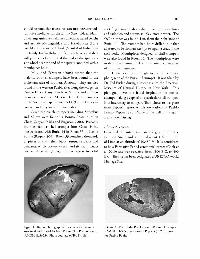
107RICHARD LOOSE
should be noted that true conchs are marine gastropods (univalve mollusks) in the family Strombidae. Many other large univalve shells are sometimes called conchs and include Melongenidae, and Fasiolariidae (horse conch) and the sacred Chank (Shanka) of India from the family Turbinellidae. In fact, any large spiral shell will produce a loud tone if the end of the spire or a side whorl near the end of the spire is modifi ed with a mouthpiece hole. Mills and Ferguson (2008) report that the majority of shell trumpets have been found in the Hohokam area of southern Arizona. Th ey are also found in the Western Pueblo sites along the Mogollon Rim, at Chaco Canyon in New Mexico, and at Casas Grandes in northern Mexico. Use of the trumpets in the Southwest spans from A.D. 900 to European contact, and they are still in use today. Seventeen conch trumpets including Strombus and Murex were found in Bonito Phase ruins in Chaco Canyon (Mills and Ferguson 2008). Probably the most famous shell trumpet from Chaco is the one associated with Burial 14 in Room 33 of Pueblo Bonito (Pepper 1909). Room 33 contained thousands of pieces of shell, shell beads, turquoise beads and pendants, whole pottery vessels, and six nearly intact wooden fl ageolets (fl utes). Other objects included
a jet fi nger ring, Haliotis shell disks, turquoise frogs and tadpoles, and turquoise inlay mosaic work. Th e shell trumpet was found 4 in. from the right knee of Burial 14. Th e trumpet had holes drilled in it that appeared to be from an attempt to repair a crack in the shell body. Mouthpieces designed for shell trumpets were also found in Room 33. Th e mouthpieces were made of pitch, gum, or clay. One contained an inlay of turquoise fragments. I was fortunate enough to receive a digital photograph of the Burial 14 trumpet. It was taken by Dr. Ted Frisbie during a recent visit to the American Museum of Natural History in New York. Th is photograph was the initial inspiration for me to attempt making a copy of this particular shell trumpet. It is interesting to compare Ted’s photo to the plate from Pepper’s report on his excavations at Pueblo Bonito (Pepper 1920). Some of the shell in the repair area is now missing.
Chavin de HuantarChavin de Huantar is an archeological site in the Peruvian Andes and is located about 160 mi north of Lima at an altitude of 10,480 ft. It is considered to be a Formative Period ceremonial center (Cook et al. 2010) and was occupied from 1500 B.C. to 400 B.C. Th e site has been designated a UNESCO World Heritage Site.
Figure 1. Recent photograph of the conch shell trumpet associated with Burial 14 from Room 33 in Pueblo Bonito (AMNH H/3653). Photo courtesy of Ted Frisbie.
Figure 2. Plate of the Pueblo Bonito Room 33 trumpet (AMNH H/3653) as shown in Pepper’s (1920) report on Pueblo Bonito.
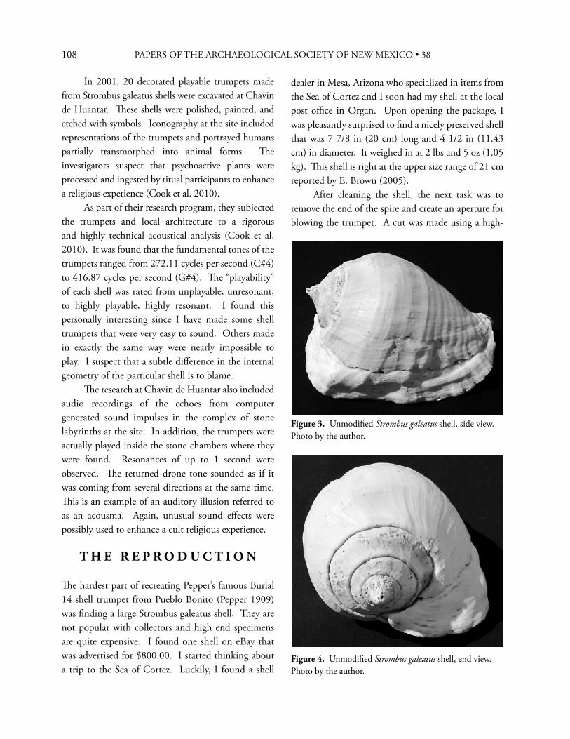
108 PAPERS OF THE ARCHAEOLOGICAL SOCIETY OF NEW MEXICO • 38
In 2001, 20 decorated playable trumpets made from Strombus galeatus shells were excavated at Chavin de Huantar. Th ese shells were polished, painted, and etched with symbols. Iconography at the site included representations of the trumpets and portrayed humans partially transmorphed into animal forms. Th e investigators suspect that psychoactive plants were processed and ingested by ritual participants to enhance a religious experience (Cook et al. 2010). As part of their research program, they subjected the trumpets and local architecture to a rigorous and highly technical acoustical analysis (Cook et al. 2010). It was found that the fundamental tones of the trumpets ranged from 272.11 cycles per second (C#4) to 416.87 cycles per second (G#4). Th e “playability” of each shell was rated from unplayable, unresonant, to highly playable, highly resonant. I found this personally interesting since I have made some shell trumpets that were very easy to sound. Others made in exactly the same way were nearly impossible to play. I suspect that a subtle diff erence in the internal geometry of the particular shell is to blame. Th e research at Chavin de Huantar also included audio recordings of the echoes from computer generated sound impulses in the complex of stone labyrinths at the site. In addition, the trumpets were actually played inside the stone chambers where they were found. Resonances of up to 1 second were observed. Th e returned drone tone sounded as if it was coming from several directions at the same time. Th is is an example of an auditory illusion referred to as an acousma. Again, unusual sound eff ects were possibly used to enhance a cult religious experience.
T H E R E P R O D U C T I O N
Th e hardest part of recreating Pepper’s famous Burial 14 shell trumpet from Pueblo Bonito (Pepper 1909) was fi nding a large Strombus galeatus shell. Th ey are not popular with collectors and high end specimens are quite expensive. I found one shell on eBay that was advertised for $800.00. I started thinking about a trip to the Sea of Cortez. Luckily, I found a shell
dealer in Mesa, Arizona who specialized in items from the Sea of Cortez and I soon had my shell at the local post offi ce in Organ. Upon opening the package, I was pleasantly surprised to fi nd a nicely preserved shell that was 7 7/8 in (20 cm) long and 4 1/2 in (11.43 cm) in diameter. It weighed in at 2 lbs and 5 oz (1.05 kg). Th is shell is right at the upper size range of 21 cm reported by E. Brown (2005). After cleaning the shell, the next task was to remove the end of the spire and create an aperture for blowing the trumpet. A cut was made using a high-
Figure 3. Unmodifi ed Strombus galeatus shell, side view. Photo by the author.
Figure 4. Unmodifi ed Strombus galeatus shell, end view. Photo by the author.
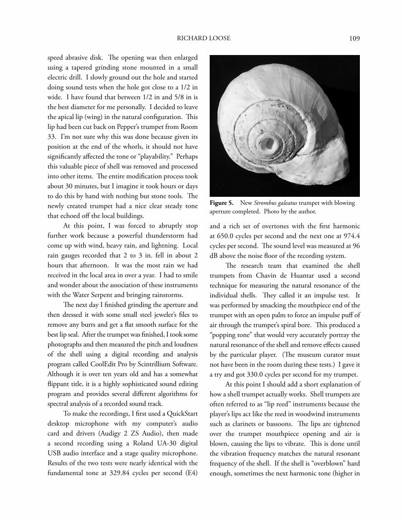
109
speed abrasive disk. Th e opening was then enlarged using a tapered grinding stone mounted in a small electric drill. I slowly ground out the hole and started doing sound tests when the hole got close to a 1/2 in wide. I have found that between 1/2 in and 5/8 in is the best diameter for me personally. I decided to leave the apical lip (wing) in the natural confi guration. Th is lip had been cut back on Pepper’s trumpet from Room 33. I’m not sure why this was done because given its position at the end of the whorls, it should not have signifi cantly aff ected the tone or “playability.” Perhaps this valuable piece of shell was removed and processed into other items. Th e entire modifi cation process took about 30 minutes, but I imagine it took hours or days to do this by hand with nothing but stone tools. Th e newly created trumpet had a nice clear steady tone that echoed off the local buildings. At this point, I was forced to abruptly stop further work because a powerful thunderstorm had come up with wind, heavy rain, and lightning. Local rain gauges recorded that 2 to 3 in. fell in about 2 hours that afternoon. It was the most rain we had received in the local area in over a year. I had to smile and wonder about the association of these instruments with the Water Serpent and bringing rainstorms. Th e next day I fi nished grinding the aperture and then dressed it with some small steel jeweler’s fi les to remove any burrs and get a fl at smooth surface for the best lip seal. After the trumpet was fi nished, I took some photographs and then measured the pitch and loudness of the shell using a digital recording and analysis program called CoolEdit Pro by Scintrillium Software. Although it is over ten years old and has a somewhat fl ippant title, it is a highly sophisticated sound editing program and provides several diff erent algorithms for spectral analysis of a recorded sound track. To make the recordings, I fi rst used a QuickStart desktop microphone with my computer’s audio card and drivers (Audigy 2 ZS Audio), then made a second recording using a Roland UA-30 digital USB audio interface and a stage quality microphone. Results of the two tests were nearly identical with the fundamental tone at 329.84 cycles per second (E4)
and a rich set of overtones with the fi rst harmonic at 650.0 cycles per second and the next one at 974.4 cycles per second. Th e sound level was measured at 96 dB above the noise fl oor of the recording system. Th e research team that examined the shell trumpets from Chavin de Huantar used a second technique for measuring the natural resonance of the individual shells. Th ey called it an impulse test. It was performed by smacking the mouthpiece end of the trumpet with an open palm to force an impulse puff of air through the trumpet’s spiral bore. Th is produced a “popping tone” that would very accurately portray the natural resonance of the shell and remove eff ects caused by the particular player. (Th e museum curator must not have been in the room during these tests.) I gave it a try and got 330.0 cycles per second for my trumpet. At this point I should add a short explanation of how a shell trumpet actually works. Shell trumpets are often referred to as “lip reed” instruments because the player’s lips act like the reed in woodwind instruments such as clarinets or bassoons. Th e lips are tightened over the trumpet mouthpiece opening and air is blown, causing the lips to vibrate. Th is is done until the vibration frequency matches the natural resonant frequency of the shell. If the shell is “overblown” hard enough, sometimes the next harmonic tone (higher in
Figure 5. New Strombus galeatus trumpet with blowing aperture completed. Photo by the author.
RICHARD LOOSE
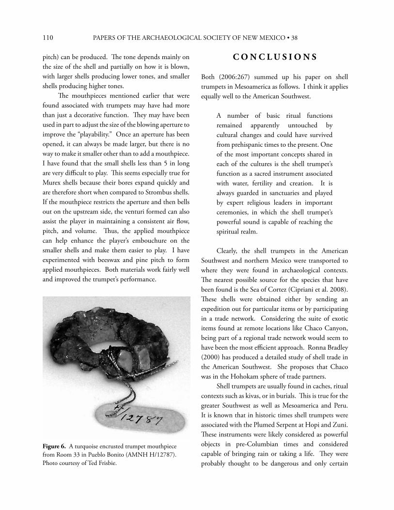
110 PAPERS OF THE ARCHAEOLOGICAL SOCIETY OF NEW MEXICO • 38
pitch) can be produced. Th e tone depends mainly on the size of the shell and partially on how it is blown, with larger shells producing lower tones, and smaller shells producing higher tones. Th e mouthpieces mentioned earlier that were found associated with trumpets may have had more than just a decorative function. Th ey may have been used in part to adjust the size of the blowing aperture to improve the “playability.” Once an aperture has been opened, it can always be made larger, but there is no way to make it smaller other than to add a mouthpiece. I have found that the small shells less than 5 in long are very diffi cult to play. Th is seems especially true for Murex shells because their bores expand quickly and are therefore short when compared to Strombus shells. If the mouthpiece restricts the aperture and then bells out on the upstream side, the venturi formed can also assist the player in maintaining a consistent air fl ow, pitch, and volume. Th us, the applied mouthpiece can help enhance the player’s embouchure on the smaller shells and make them easier to play. I have experimented with beeswax and pine pitch to form applied mouthpieces. Both materials work fairly well and improved the trumpet’s performance.
C O N C L U S I O N S
Both (2006:267) summed up his paper on shell trumpets in Mesoamerica as follows. I think it applies equally well to the American Southwest.
A number of basic ritual functions remained apparently untouched by cultural changes and could have survived from prehispanic times to the present. One of the most important concepts shared in each of the cultures is the shell trumpet’s function as a sacred instrument associated with water, fertility and creation. It is always guarded in sanctuaries and played by expert religious leaders in important ceremonies, in which the shell trumpet’s powerful sound is capable of reaching the spiritual realm.
Clearly, the shell trumpets in the American Southwest and northern Mexico were transported to where they were found in archaeological contexts. Th e nearest possible source for the species that have been found is the Sea of Cortez (Cipriani et al. 2008). Th ese shells were obtained either by sending an expedition out for particular items or by participating in a trade network. Considering the suite of exotic items found at remote locations like Chaco Canyon, being part of a regional trade network would seem to have been the most effi cient approach. Ronna Bradley (2000) has produced a detailed study of shell trade in the American Southwest. She proposes that Chaco was in the Hohokam sphere of trade partners. Shell trumpets are usually found in caches, ritual contexts such as kivas, or in burials. Th is is true for the greater Southwest as well as Mesoamerica and Peru. It is known that in historic times shell trumpets were associated with the Plumed Serpent at Hopi and Zuni. Th ese instruments were likely considered as powerful objects in pre-Columbian times and considered capable of bringing rain or taking a life. Th ey were probably thought to be dangerous and only certain
Figure 6. A turquoise encrusted trumpet mouthpiece from Room 33 in Pueblo Bonito (AMNH H/12787). Photo courtesy of Ted Frisbie.
111
qualifi ed practitioners were allowed to use them. Th ese individuals, in turn, obtained high status and power by knowing how to use these devices. Th ey were even capable of eff ecting actions at a distance because the sound of a shell trumpet can be heard two or three miles away. So, in addition to bringing rain, the trumpets could have been used in ritual practices associated with curing, warfare, and sorcery.
R E F E R E N C E S C I T E D
Blackhorse, Taft, John R. Stein, June-el Piper, and J. S. Williams2002 Navajo Oral History of a Precolumbian
Amphitheater in Chaco Canyon, New Mexico. Paper presented to the Acoustical Society of America, Cancún.
Bradley, Ronna J.2000 Networks of Shell Ornament Exchange:
A Critical Assessment of Prestige Economies in the North American Southwest. In Th e Archaeology of Regional Interaction: Religion, Warfare, and Exchange Across the American Southwest and Beyond, edited by Michelle Hegmon, pp. 167-187. University Press of Colorado, Boulder.
Braun, Joachim2002 Music in Ancient Israel/Palestine: Archaeological,
Written, and Comparative Sources. Wm. B. Eerdmans Publishing Company, Grand Rapids.
Both, A. A.2006 Shell Trumpets in Mesoamerica. International
Study Group on Music Archaeology (ISGMA). Deutsches Archaeologisches Institut, Orient-Abteilung Podbrielskiallee, Berlin.
Brown, Donald N.1971 Ethnomusicology and the Prehistoric Southwest.
Ethnomusicology 15(3):363-378. Brown, Emily J.2005 Instruments of Power: Musical Performance in
Ritual of the Ancestral Puebloans of the American Southwest. Unpublished Ph.D. Dissertation, Department of Anthropology, Columbia University.
Cipriani, Roberto, Hector M. Guzman, Angel J. Vega, and Melina Lopez2008 Population Assessment of the Conch Strombus
Galeatus (Gastropoda, Strombidae) in Pacifi c Panama. Journal of Shellfi sh Research 27(4):889-896.
Cook, Perry R., Jonathan S. Abel, Miriam A. Kolar, Patty Huang, Jyri Huopaniemi, John W. Rick, Chris Chafe, and John M. Chowning2010 Acoustic Analysis of the Chavin Pututus
(Strombus Galeatus Marine Shell Trumpets). Paper presented at the 2nd Pan American/Iberian Meeting on Acoustics, Cancún.
Jackson, Wilfrid J.1916 Shell Trumpets and their Distribution in the
Old and New World. Memoirs and Proceedings of the Manchester Literary and Philosophical Society. Manchester, England.
Loose, Richard2008 Tse’Biinaholts’a Yalti (Curved Rock that Speaks).
Time and Mind 1:31-50.
Mills, Barbara J., and T. J. Ferguson2008 Animate Objects: Shell Trumpets and Ritual
Networks in the Greater Southwest. Journal of Archaeological Method and Th eory, 15:338-361. Published online: 10 October 2008, Springer Science + Business Media LLC.
Pepper, George H.1909 Th e Exploration of a Burial Room in Pueblo
Bonito, New Mexico. In Putnam Anniversary Volume, Anthropological Essays Presented to Frederick Ward Putnam in Honor of His Seventieth Birthday, edited by Franz Boas, pp. 196-252. G. E. Stechert, New York.
1920 Pueblo Bonito. Archeological Papers of the American Museum of Natural History 27, New York.
Stein, John R., Richard Friedman, Taft Blackhorse, and Richard Loose2007 Revisiting Downtown Chaco. In Th e Architecture
of Chaco Canyon, edited by Stephen Lekson, pp. 199-223. University of Utah Press, Salt Lake City.
Tyler, Hamilton A.1975 Pueblo Animals and Myths. University of
Oklahoma Press, Norman.
RICHARD LOOSE

112 PAPERS OF THE ARCHAEOLOGICAL SOCIETY OF NEW MEXICO • 38
113
113
I N T R O D U C T I O N
In preparation for the widening of U.S. 285 by the New Mexico Department of Transportation, the Offi ce of Archaeological Studies examined a series of Classic period terrace top gravel-mulched fi elds along the east side of the Ojo Caliente Valley near the small community of Gavilan. As we examined these sites on the terrace top, we noted relatively narrow linear shelves on the slopes below most of the sites being investigated. Closer inspection of the shelves showed that they represented a trail that was broken into numerous segments by erosion and historic construction activities. Designated as LA 118549, the trail was visible from the modern road at the time of discovery, allowing it to be traced for at least 9.2 km, beginning just south of the modern village of Ojo Caliente and running at least as far south as the Classic period village of Ponsipa’akeri. Th ere it was met by two short trail segments that originate at Ponsipa’akeri and end at LA 118549, probably representing access corridors from the village to this thoroughfare. Our assumption was that construction and use of the trail was related to the Classic period occupation of the Ojo Caliente Valley, which included the large Pueblo villages of Howiri, Hupobi, Nuté, Ponsipa’akeri, and Posi’ouinge, and the smaller village of Hilltop Pueblo adjacent to, and possibly related to, Nuté. However, it was possible that the trail could have been a historic travel route or was related in some way to highway construction along U.S. 285. Before
a prehistoric Pueblo affi liation could be assumed, these possibilities had to be ruled out. Th at process is discussed in more detail later, but fi rst a description of the trail and a discussion of some of our investigations along it are presented.
D E S C R I P T I O N O F T H E T R A I L
Most segmentation of the trail was created by the cutting of erosional channels that drain the terrace and form narrow valleys between fi ngers along its west edge. Smaller channels cut through trail segments in many places, but enough of this linear feature remained intact that it could be easily traced. Th e trail tends to meander across the west ends of terrace fi ngers, occasionally ascending to the terrace top and seemingly always curving down to descend to the fl oors of the small intervening valleys. Th ere it disappears, only to reappear on the other side of the valley where it ascends back up the terrace slope. Th ough no evidence of the trail was visible on the intervening valley fl oors, this lack can be attributed to the action of erosion occurring in the centuries since the trail was regularly used for travel. When the trail was in use the various segments that are now visible were parts of an uninterrupted travel corridor. Segments that were both adjacent to the farming sites and that extended into project limits were examined and described. Each of these segments was mapped along with features on the adjacent farming
A Prehistoric Pueblo Trail in the Ojo Caliente Valley
J A M E S L . M O O R E
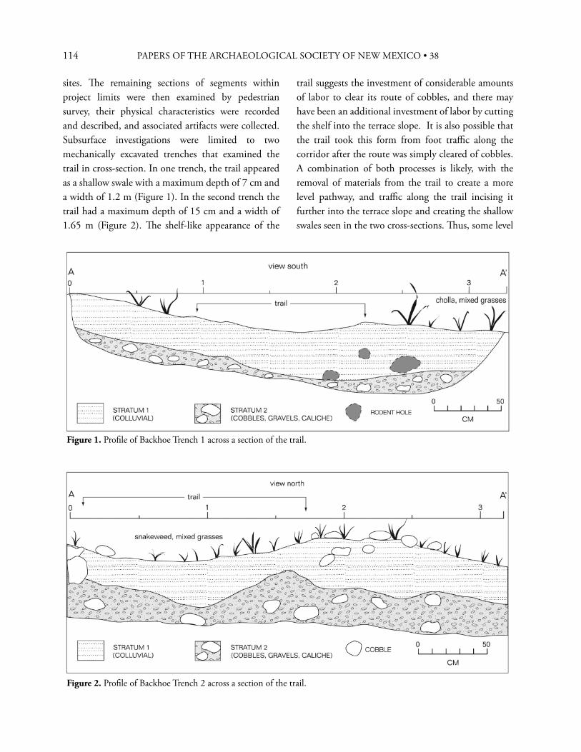
114 PAPERS OF THE ARCHAEOLOGICAL SOCIETY OF NEW MEXICO • 38
sites. Th e remaining sections of segments within project limits were then examined by pedestrian survey, their physical characteristics were recorded and described, and associated artifacts were collected. Subsurface investigations were limited to two mechanically excavated trenches that examined the trail in cross-section. In one trench, the trail appeared as a shallow swale with a maximum depth of 7 cm and a width of 1.2 m (Figure 1). In the second trench the trail had a maximum depth of 15 cm and a width of 1.65 m (Figure 2). Th e shelf-like appearance of the
trail suggests the investment of considerable amounts of labor to clear its route of cobbles, and there may have been an additional investment of labor by cutting the shelf into the terrace slope. It is also possible that the trail took this form from foot traffi c along the corridor after the route was simply cleared of cobbles. A combination of both processes is likely, with the removal of materials from the trail to create a more level pathway, and traffi c along the trail incising it further into the terrace slope and creating the shallow swales seen in the two cross-sections. Th us, some level
Figure 1. Profi le of Backhoe Trench 1 across a section of the trail.
Figure 2. Profi le of Backhoe Trench 2 across a section of the trail.
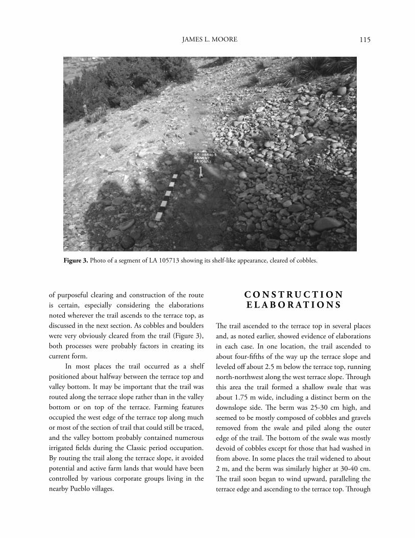
115JAMES L. MOORE
Figure 3. Photo of a segment of LA 105713 showing its shelf-like appearance, cleared of cobbles.
of purposeful clearing and construction of the route is certain, especially considering the elaborations noted wherever the trail ascends to the terrace top, as discussed in the next section. As cobbles and boulders were very obviously cleared from the trail (Figure 3), both processes were probably factors in creating its current form. In most places the trail occurred as a shelf positioned about halfway between the terrace top and valley bottom. It may be important that the trail was routed along the terrace slope rather than in the valley bottom or on top of the terrace. Farming features occupied the west edge of the terrace top along much or most of the section of trail that could still be traced, and the valley bottom probably contained numerous irrigated fi elds during the Classic period occupation. By routing the trail along the terrace slope, it avoided potential and active farm lands that would have been controlled by various corporate groups living in the nearby Pueblo villages.
C O N S T R U C T I O N E L A B O R A T I O N S
Th e trail ascended to the terrace top in several places and, as noted earlier, showed evidence of elaborations in each case. In one location, the trail ascended to about four-fi fths of the way up the terrace slope and leveled off about 2.5 m below the terrace top, running north-northwest along the west terrace slope. Th rough this area the trail formed a shallow swale that was about 1.75 m wide, including a distinct berm on the downslope side. Th e berm was 25-30 cm high, and seemed to be mostly composed of cobbles and gravels removed from the swale and piled along the outer edge of the trail. Th e bottom of the swale was mostly devoid of cobbles except for those that had washed in from above. In some places the trail widened to about 2 m, and the berm was similarly higher at 30-40 cm. Th e trail soon began to wind upward, paralleling the terrace edge and ascending to the terrace top. Th rough
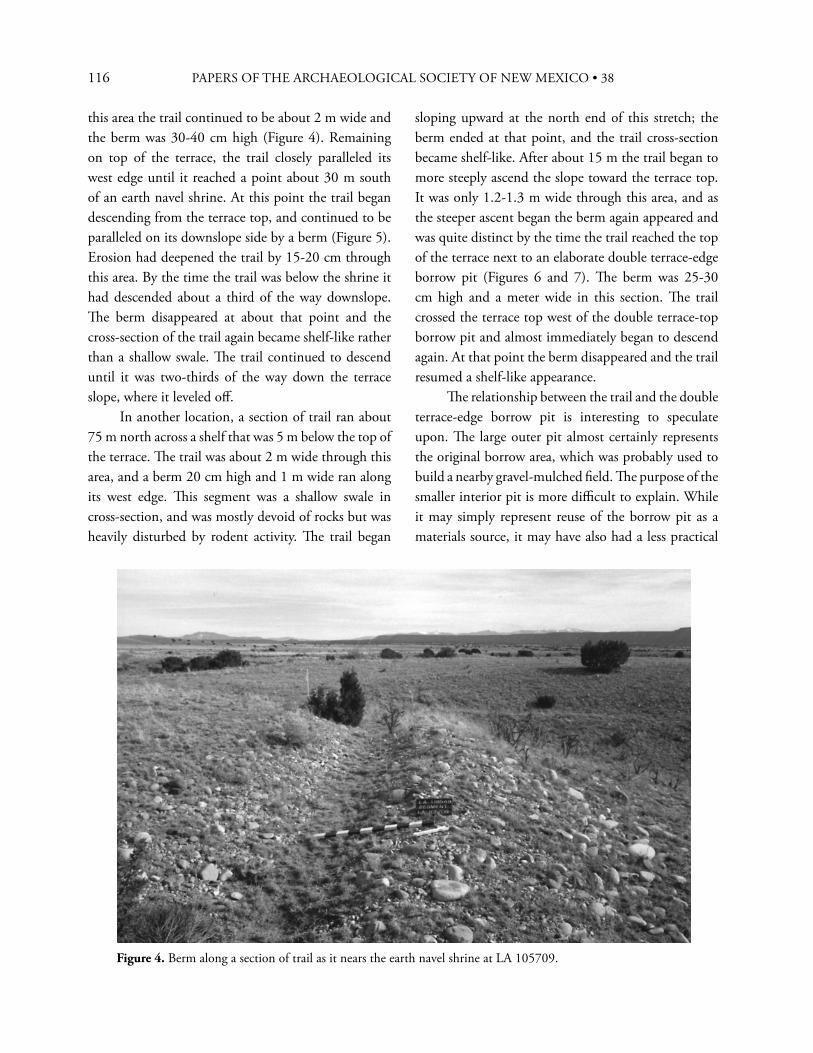
116 PAPERS OF THE ARCHAEOLOGICAL SOCIETY OF NEW MEXICO • 38
Figure 4. Berm along a section of trail as it nears the earth navel shrine at LA 105709.
this area the trail continued to be about 2 m wide and the berm was 30-40 cm high (Figure 4). Remaining on top of the terrace, the trail closely paralleled its west edge until it reached a point about 30 m south of an earth navel shrine. At this point the trail began descending from the terrace top, and continued to be paralleled on its downslope side by a berm (Figure 5). Erosion had deepened the trail by 15-20 cm through this area. By the time the trail was below the shrine it had descended about a third of the way downslope. Th e berm disappeared at about that point and the cross-section of the trail again became shelf-like rather than a shallow swale. Th e trail continued to descend until it was two-thirds of the way down the terrace slope, where it leveled off . In another location, a section of trail ran about 75 m north across a shelf that was 5 m below the top of the terrace. Th e trail was about 2 m wide through this area, and a berm 20 cm high and 1 m wide ran along its west edge. Th is segment was a shallow swale in cross-section, and was mostly devoid of rocks but was heavily disturbed by rodent activity. Th e trail began
sloping upward at the north end of this stretch; the berm ended at that point, and the trail cross-section became shelf-like. After about 15 m the trail began to more steeply ascend the slope toward the terrace top. It was only 1.2-1.3 m wide through this area, and as the steeper ascent began the berm again appeared and was quite distinct by the time the trail reached the top of the terrace next to an elaborate double terrace-edge borrow pit (Figures 6 and 7). Th e berm was 25-30 cm high and a meter wide in this section. Th e trail crossed the terrace top west of the double terrace-top borrow pit and almost immediately began to descend again. At that point the berm disappeared and the trail resumed a shelf-like appearance. Th e relationship between the trail and the double terrace-edge borrow pit is interesting to speculate upon. Th e large outer pit almost certainly represents the original borrow area, which was probably used to build a nearby gravel-mulched fi eld. Th e purpose of the smaller interior pit is more diffi cult to explain. While it may simply represent reuse of the borrow pit as a materials source, it may have also had a less practical
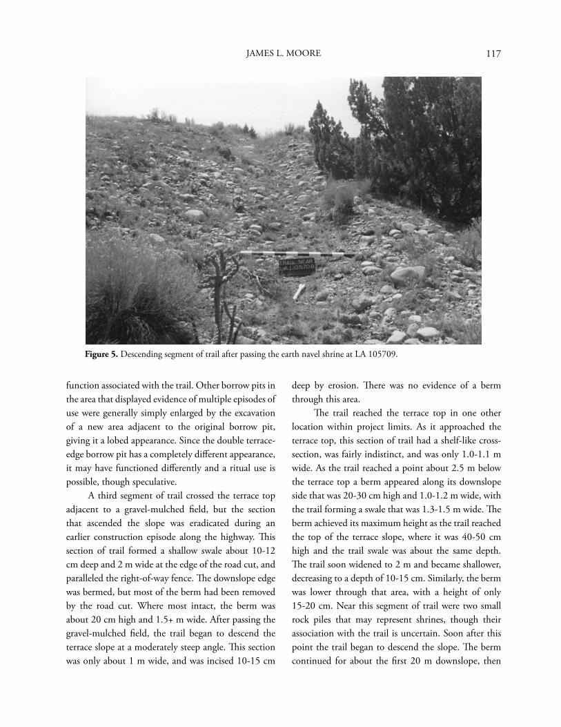
117
Figure 5. Descending segment of trail after passing the earth navel shrine at LA 105709.
function associated with the trail. Other borrow pits in the area that displayed evidence of multiple episodes of use were generally simply enlarged by the excavation of a new area adjacent to the original borrow pit, giving it a lobed appearance. Since the double terrace-edge borrow pit has a completely diff erent appearance, it may have functioned diff erently and a ritual use is possible, though speculative. A third segment of trail crossed the terrace top adjacent to a gravel-mulched fi eld, but the section that ascended the slope was eradicated during an earlier construction episode along the highway. Th is section of trail formed a shallow swale about 10-12 cm deep and 2 m wide at the edge of the road cut, and paralleled the right-of-way fence. Th e downslope edge was bermed, but most of the berm had been removed by the road cut. Where most intact, the berm was about 20 cm high and 1.5+ m wide. After passing the gravel-mulched fi eld, the trail began to descend the terrace slope at a moderately steep angle. Th is section was only about 1 m wide, and was incised 10-15 cm
deep by erosion. Th ere was no evidence of a berm through this area. Th e trail reached the terrace top in one other location within project limits. As it approached the terrace top, this section of trail had a shelf-like cross-section, was fairly indistinct, and was only 1.0-1.1 m wide. As the trail reached a point about 2.5 m below the terrace top a berm appeared along its downslope side that was 20-30 cm high and 1.0-1.2 m wide, with the trail forming a swale that was 1.3-1.5 m wide. Th e berm achieved its maximum height as the trail reached the top of the terrace slope, where it was 40-50 cm high and the trail swale was about the same depth. Th e trail soon widened to 2 m and became shallower, decreasing to a depth of 10-15 cm. Similarly, the berm was lower through that area, with a height of only 15-20 cm. Near this segment of trail were two small rock piles that may represent shrines, though their association with the trail is uncertain. Soon after this point the trail began to descend the slope. Th e berm continued for about the fi rst 20 m downslope, then
JAMES L. MOORE
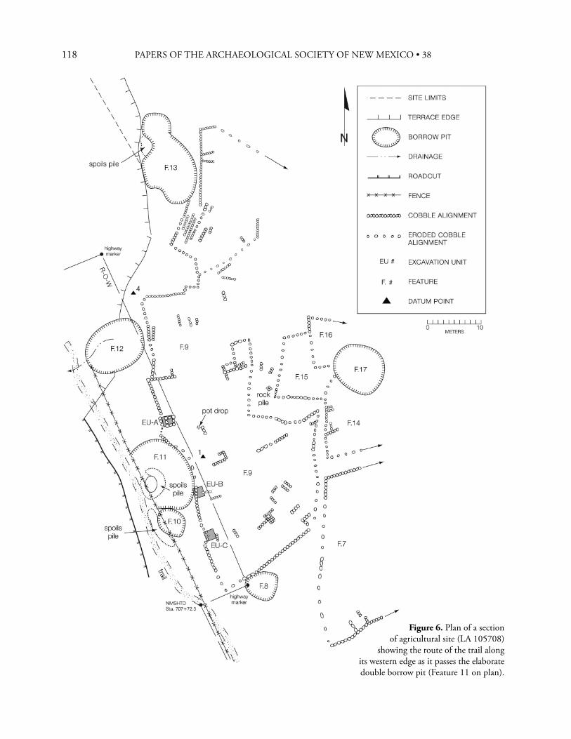
118 PAPERS OF THE ARCHAEOLOGICAL SOCIETY OF NEW MEXICO • 38
Figure 6. Plan of a section of agricultural site (LA 105708)
showing the route of the trail along its western edge as it passes the elaborate double borrow pit (Feature 11 on plan).
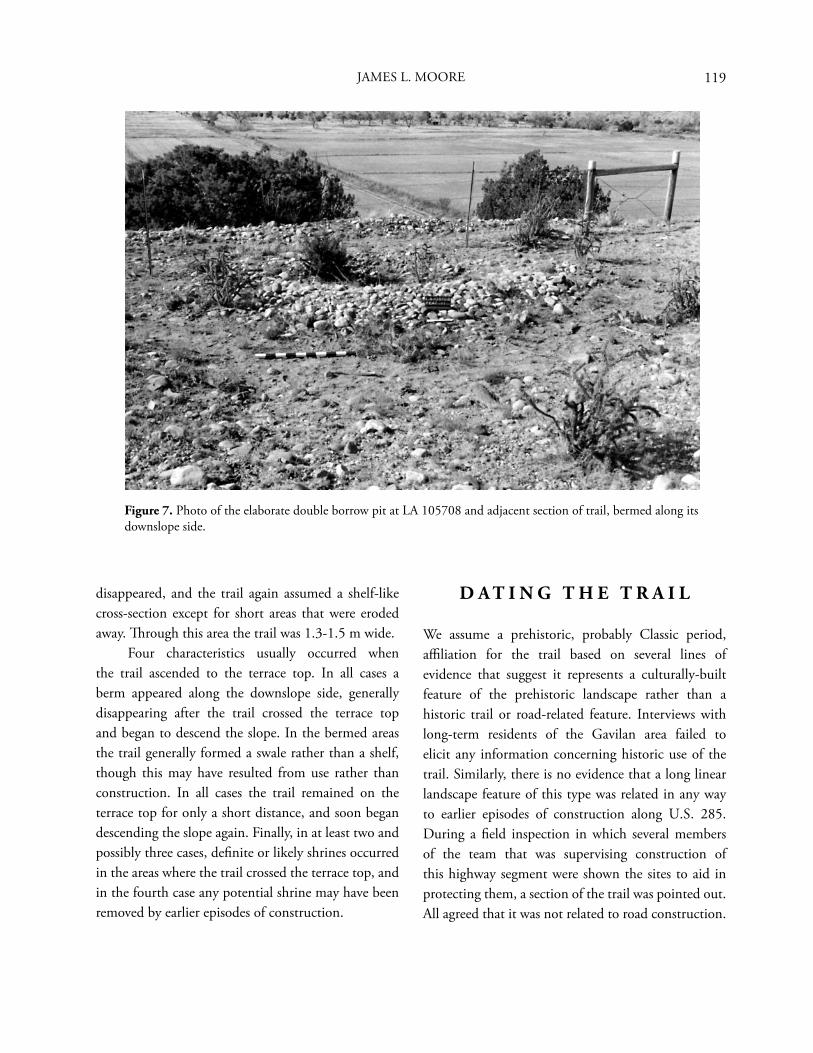
119
disappeared, and the trail again assumed a shelf-like cross-section except for short areas that were eroded away. Th rough this area the trail was 1.3-1.5 m wide. Four characteristics usually occurred when the trail ascended to the terrace top. In all cases a berm appeared along the downslope side, generally disappearing after the trail crossed the terrace top and began to descend the slope. In the bermed areas the trail generally formed a swale rather than a shelf, though this may have resulted from use rather than construction. In all cases the trail remained on the terrace top for only a short distance, and soon began descending the slope again. Finally, in at least two and possibly three cases, defi nite or likely shrines occurred in the areas where the trail crossed the terrace top, and in the fourth case any potential shrine may have been removed by earlier episodes of construction.
D A T I N G T H E T R A I L
We assume a prehistoric, probably Classic period, affi liation for the trail based on several lines of evidence that suggest it represents a culturally-built feature of the prehistoric landscape rather than a historic trail or road-related feature. Interviews with long-term residents of the Gavilan area failed to elicit any information concerning historic use of the trail. Similarly, there is no evidence that a long linear landscape feature of this type was related in any way to earlier episodes of construction along U.S. 285. During a fi eld inspection in which several members of the team that was supervising construction of this highway segment were shown the sites to aid in protecting them, a section of the trail was pointed out. All agreed that it was not related to road construction.
Figure 7. Photo of the elaborate double borrow pit at LA 105708 and adjacent section of trail, bermed along its downslope side.
JAMES L. MOORE
120 PAPERS OF THE ARCHAEOLOGICAL SOCIETY OF NEW MEXICO • 38
In addition, plans from the initial construction and paving of U.S. 285 in 1939 were obtained and examined (NMSHTD 1939). Nothing remotely resembling the location or confi guration of LA 118549 was scheduled for building in those plans. In a further attempt to provide a minimum date for the trail, two junipers that were growing out of the trail or the associated berm within the existing right-of-way in areas scheduled for removal by slope cuts were sectioned. Two counts at diff erent locations were made for the fi rst sample, yielding totals of 80 and 82 rings, the latter being considered the more accurate. Five counts at diff erent locations were made for the second sample, yielding totals of 70, 65, 64, 57, and 56 rings, with the fi rst three being considered the most accurate. Th e second juniper sample was very convoluted, and diff erent axes produced diff erent counts because of the way in which the tree had grown. If the trail had been built in conjunction with highway construction, neither tree should predate those building episodes. Th e samples were obtained in 1998; Sample 1 would therefore have begun growing sometime around 1916 to 1918, and Sample 2 around 1928 to 1934. As both trees began growing before the initial construction and paving of U.S. 285 in 1939, as well as all subsequent road building episodes, construction and use of the trail defi nitely predates the early years of the twentieth century. Th e very structure and routing of the trail argue for a prehistoric affi nity. No modern highway construction-related feature would become more elaborate as it approached and crossed the terrace top, nor would it be expected to leave the terrace slope. A historic trail built and used by the Spanish also would not demonstrate these tendencies. Spanish transportation corridors would be expected to occur in valley bottoms because they would have needed to accommodate livestock and wagons as well as foot traffi c. A prehistoric affi nity is much more likely because the elaborate sections of trail tend to occur near features of probable ritual importance to the prehistoric Pueblo occupants of the region. Th us, we conclude that LA 118549 seems to represent a prehistoric trail linking
several large villages and associated fi elds on the west side of the Rio Ojo Caliente. H arrington (1916) presents a detailed discussion of Tewa ethnogeography, but while he describes numerous trails in the region, there is no mention of any in the Ojo Caliente Valley. Th is is an interesting omission, but Harrington does note that it was diffi cult to obtain adequate information on old trails from the Tewa (Harrington 1916:107). One possible reason for this is that certain ancient trails may have become classifi ed as sacred, no matter how mundane their original nature might have been. Th is may have been especially true of trails leading to important shrines or that were used for ceremonial purposes. One such feature was recorded near San Ildefonso (Moore and Levine 1987), and was said to be a sacred hunting trail. Interestingly, that trail was similar in cross-section and traversed landforms like those crossed by the trail in the Ojo Caliente Valley.
I N T E R P R E T I N G T H E T R A I L
Trails in the Pueblo region were mainly used as pedestrian corridors to travel from one location to another, but they also at times served as ritual pathways. For example, trail segments have been extensively documented in the Chaco region in northwest New Mexico and, rather than pedestrian corridors, they seem to have been “...cosmological corridors that link ceremonial architecture to various topographic features, horizon markers, and directional-astronomical orientations” (Marshall 1997:71). Most of the known trails in the Northern Rio Grande seem to have functioned mainly as pedestrian corridors, and thus fi lled a diff erent niche than the Chacoan roads did, though some ritual pathways have also been identifi ed in the Northern Rio Grande. An example of a ritual pathway in the Northern Rio Grande is at the well-documented directional earth navel shrine on top of Tsikomo Peak, which is sacred to many Native American groups, especially the Pueblos. Douglas (1912, 1917) indicates that
121
each Pueblo that uses this shrine has its own trail, all radiating out from the eastern shrine entrance. Parsons’ (1929:241) drawing of the entrance to this shrine disagrees with Douglas’ description, instead showing a single trail leading into the enclosure, with several secondary trails joining it just before the main trail enters the shrine. Jeançon (1923:70-71) described the landscape around the Classic period village of Poshu’ouinge in the Chama Valley, noting that paths lead out from the village in many directions, all apparently ending at shrines. While the features Jeançon saw at Poshu’ouinge may indeed have been formal trails leading to shrines, it is also possible that he was describing some of the cobble-bordered gravel-mulched fi elds occurring around that village. However, a similar trail seems to approach the large earth navel shrine south of Posi’ouinge in the Ojo Caliente Valley. As we suggested for Jeançon’s formal pathways at Poshu’ouinge, this trail is lined by cobble alignments that appear to border gravel-mulched fi elds. Th us, the formal-looking trail that approaches the shrine may represent an area that was intentionally left clear during fi eld-building to allow unrestricted access to the shrine. Harrington (1916) documents several trails in the Tewa Basin. He notes the existence of trails passing through Santa Clara and Guaje Canyons to the Jemez area, one in the El Rito region leading to the Tierra Amarillo area, and several others. Th e entire Cochiti region (including Frijoles Canyon) is said to be covered by a network of trails (Harrington 1916:421). Two trails were noted for the general Ojo Caliente area, but both cross Canoe Mesa and do not extend into our project area, one continuing into Comanche Canyon and leading into Ute territory (Harrington 1916:199). Bandelier (Lange et al. 1975:86) found a well-defi ned trail leading to Posi’ouinge, and barely perceptible trails heading north along the mesa that forms the west rim of the Ojo Caliente Valley. Steen (1982:7) reports that trails are common on the Pajarito Plateau, and are usually associated with habitations. However, near the upper end of
Mortendad Canyon he found a trail that is deeply cut into tuff and lacks associated habitation sites (Steen 1982:7). At Bandelier National Monument, Powers and Van Zandt (1999:142) found seven habitation structures associated with well-defi ned trail segments. Hewett (1906:16) describes a trail at Navajú, a prehistoric Pueblo village on the Pajarito Plateau, as worn hip-deep by foot traffi c. Two basic types of corridors seem to be represented by trails. Th e most common type is a pedestrian corridor, usually leading from one residential site to another or to an area that is used for farming or contains resources used on a regular basis. Th e second type is a ritual corridor leading to a location of esoteric importance, usually a shrine or a source for important ritual materials. Some trails were used for both purposes. Th e Zuni had three trails that led to Acoma, which were used both as trade routes and to access sacred areas (Holmes 1989:18). Th e Zunis also used at least two trails for their pilgrimages to Zuni Salt Lake, one for foot traffi c and a second suitable for burros (Kelley 1988:2-7). Acoma and Laguna had their own separate trail to Zuni Salt Lake (Kelley 1988:2-8). Th ese trails had shrines along them, at which off erings were left by pilgrims on their way to gather salt (Kelley 1988). Th e Acoma-Laguna trail was marked in places by cairns, and the shrines along it were small earth navels that opened to the east (Kelley 1988:2-8). Another trail led from Zuni Salt Lake to the confl uence of the Zuni and Little Colorado rivers, which is where the Zuni say they originated (Kelley 1988:2-8). Th is trail is sacred to both Zuni and Acoma, and has shrines along it (Kelley 1988:2-8). If the trail recorded as LA 118549 was used for ritual as well as mundane purposes, it should lead to an important ritual location. Th e most important ritual location in the Ojo Caliente Valley, so far as we know, is the hot spring located just below the ancestral village of Posi’ouinge that is now part of a resort in the village of Ojo Caliente. All springs are considered sacred by the Tewa, but some springs may have been more important than others. For example, the Tewa place of emergence is a small brackish lake located in the
JAMES L. MOORE
122 PAPERS OF THE ARCHAEOLOGICAL SOCIETY OF NEW MEXICO • 38
sand dunes north of Alamosa, Colorado (Harrington 1916:564-565; Hewett and Dutton 1945:23). Sacred waters are associated with the four cardinal directions; for example, the sacred spring of the west is located less than a mile southwest of Perage (Hewett 1938), a Classic period village situated across the Rio Grande from San Ildefonso Pueblo. Harrington (1916:164) indicates that the hot spring at Ojo Caliente is considered by the Tewa to be one of their most sacred places. Besides the usual sacred nature of springs and other bodies of water, this hot spring has important associations with Poseyemu, the Tewa culture hero. Poseyemu is said to have occasionally entered the hot spring when he still lived among the Tewa. Th e hot spring is also considered the home of Poseyemu’s grandmother, and he is said to visit her there once a year (Harrington 1916:164). People at San Juan Pueblo (now known as Okay Owingeh) told Harrington (1916:164) that the Tewas still drank water from the hot spring and, presumably, had done so in the past. Th e importance extended to the hot spring at Ojo Caliente suggests that visits to that area were probably common and associated with ritual in prehistoric as well as historic times. Th e nature of the trail also suggests that it may not have been simply a pedestrian corridor. Th e route that it follows is certainly not the easiest way to traverse the Ojo Caliente Valley, since it mostly travels along a terrace slope, about halfway up. Normal pedestrian traffi c would be expected to take an easier route, though the land tenure system may have helped determine where such corridors could be placed. If most of the valley fl oor and the rim of the terrace that forms the east edge of the Ojo Caliente Valley were covered with fi elds, the terrace slope may have been one of the few corridors open to pedestrian traffi c that would not cause friction with local farmers. However, the fi elds that rimmed the terrace edge formed a comparatively narrow band, so a simple ascension of the terrace and a short walk to the other side of the band of gravel-mulched fi elds would have carried travelers to a fairly fl at area where foot-travel was easier and no modifi cations to the corridor were needed.
If the trail was the main route to the gravel-mulched fi elds, one would expect it to ascend to the terrace top at fairly regular intervals. It does not do this. Indeed, the trail topped out in very few places within our study area, and when it did there was often a shrine or shrine-like feature at that point. Th e trail does not even ascend to the terrace top at the village of Ponsipa’akeri. Instead, two trails documented by Bugé (1978) lead down to it. A few faint traces of trails leading up to fi elds were noted during our study, but none of these was improved or as well-defi ned as was LA 118549 itself. When all of this information is combined, our suspicion is that LA 118549 does not represent a simple pedestrian corridor. Rather, it seems more likely that this trail was a ritual pilgrimage route from the south to the hot spring at Ojo Caliente. Th e berming noted along segments that approach and cross the terrace top is similar in idea to the earthworks that occur along Chacoan roads as they approach great houses (Nials et al. 1987:15). While no connection to the Chacoan system is suggested for the Ojo Caliente trail, in both this case and the case of the Chacoan roads more elaborate construction approaching ritually important locations would have generated spoils—most easily discarded by simply placing them along the road or trail. Th is would have further emphasized the corridor in those areas, enhancing the more elaborate aspects of construction. Th ough the trail does not connect with the earth navel shrine identifi ed at one of the farming sites, a segment located to the south of that shrine contains the longest and most elaborate approach to the terrace top of those that were documented. At the next ascent of the trail to the terrace top it was bermed along its downslope side as it approached and crossed the terrace top. Th e only possible shrines identifi ed in that area were two rock piles, which may have been used as fi eld shrines rather than representing ritually important locations accessed by the trail, though the latter cannot be ruled out. And, as a reading of Harrington (1916) shows, many Tewa shrines would be invisible to non-initiates. Th e next point at which
123
the trail ascended to the terrace top was adjacent to the elaborate double borrow pit, and its downslope side was again bermed through that area. At the fi nal approach to the terrace top (heading north up the valley) within project limits, a short section of trail crosses the terrace top at the edge of a farming site and its downslope side was bermed, though much of the berm, the ascending section of trail, and probably whatever ritual feature occurred in that area were removed by earlier construction along U.S. 285. Th ese were the only places in which the trail ascended to the terrace top within our study area. However, the descent of the trail and its disappearance in an area between Hilltop Pueblo and Nuté suggests that a strictly ritual use cannot be assigned to this landscape feature. Part of its function must have been as a pedestrian corridor, otherwise, why would it disappear in this area? Th is idea is supported by the paths connecting the trail to the village of Ponsipa’akeri, suggesting mundane use in addition to its probable ritual function. Like some of the trails between Zuni and Acoma, LA 118549 probably had multiple purposes. As we have seen, trails could be simple pedestrian corridors, they could be paths linking important ritual locations, or they could serve both of these functions at diff erent times. Because the trail seems to have continued south beyond Ponsipa’akeri, it may have linked the Tewa villages in the Ojo Caliente Valley with related villages along the Rio Grande, and was probably used by the inhabitants of those villages for pilgrimages to the hot spring.
C O N C L U S I O N S
During an archaeological study in the Ojo Caliente Valley we were able to document a trail that is almost certainly of Classic period origin that represents a pedestrian corridor with multiple uses. While the most important function of the trail may have been as a ritual corridor for pilgrimages to the hot
spring situated below the village of Posi’ouinge, it also served to link several of the large Classic period villages together, probably extending as far south as the Tewa villages in the Rio Grande Valley. Farmers also undoubtedly used this convenient route to access their fi elds on the terrace top. But fi rst and foremost, the trail may have represented the main route used to access the sacred hot spring, providing access to other shrines along the way. While the hot spring is known to have important connections to Poseyemu, a further level of importance may have been assigned to this landscape feature. As in the Tewa view all waters are connected, the Ojo Caliente hot spring could also have at times served as a substitute for the lake of emergence located much further to the north. In this way, the essence of an important ritual location would have been ascribed to a landscape feature that was not as diffi cult or time consuming to access as the original, especially for village elders who might not have been up to making the actual pilgrimage. Trails often seem to have led to locations of ritual importance, and this was probably an important if not the main function of this trail that runs along the east side of the Ojo Caliente Valley, though it was undoubtedly also used for more mundane journeys. Whether as a substitute for the lake of emergence or because of its association with Poseyemu, the primary endpoint appears to have been a hot spring that was one of the most ritually important landscape features for the Tewa.
A C K N O W L E D G M E N T S
I would like to express my gratitude to the New Mexico Department of Transportation, which sponsored the project upon which this paper is based. Th anks also to Rob Turner of the Offi ce of Archaeological Studies, who drafted the fi gures and cleaned up the photos used in this paper. Finally, I would like to thank the crew and volunteers (especially my wife, Jane) who diligently worked through all types of weather to gather the data used in this study.
JAMES L. MOORE
124 PAPERS OF THE ARCHAEOLOGICAL SOCIETY OF NEW MEXICO • 38
R E F E R E N C E S C I T E D
Bugé, David E.1978 Preliminary Report: 1978 excavations at NM-01-
1407, Ojo Caliente, New Mexico. Unpublished report on fi le at the Laboratory of Anthropology, Museum of New Mexico, Santa Fe.
Douglas, William B.1912 A World-Quarter Shrine of the Tewa Indians.
Records of the Past 11(4):159-173.1917 Notes on the Shrines of the Tewa and Other
Pueblo Indians of New Mexico. Proceedings of the Nineteenth International Congress of Americanists:344-378. Washington, D. C.
Harrington, John P.1916 Th e Ethnogeography of the Tewa Indians. Twenty-
Ninth Annual Report of the Bureau of American Ethnology. Government Printing Offi ce, Washington, D.C.
Hewett, Edgar L.1906 Antiquities of the Jemez Plateau, New Mexico.
Bureau of American Ethnology Bulletins 32, Washington, D.C.
1938 Pajarito Plateau and its Ancient People. Handbooks of Archaeological History. University of New Mexico Press, Albuquerque.
Hewett, Edgar L., and Bertha Dutton1945 Th e Pueblo Indian World. University of New
Mexico Press and School of American Research, Albuquerque and Santa Fe.
Holmes, Barbara E.1989 American Indian Use of El Malpais. Zuni
Archaeological Program Report No. 302. Zuni, New Mexico.
Jeançon, Jean A.1923 Excavations in the Chama Valley, New Mexico.
Bureau of American Ethnography Bulletins 81, Washington, D.C.
Kelley, Klara1988 Archeological Investigations in West-Central New
Mexico, Volume 2: Historic Cultural Resources. New Mexico Bureau of Land Management Cultural Resources Series No. 4. Santa Fe.
Lange, Charles H., C. Riley, and E. Lange, editors1975 Th e Southwestern Journals of Adolph F. Bandelier:
1885-1888. University of New Mexico Press, Albuquerque.
Marshall, Michael P.1997 Th e Chaco Roads: A Cosmological
Interpretation. In Anasazi Architecture and American Design, edited by B. Morrow and V. Price, pp. 62-74. University of New Mexico Press, Albuquerque.
Moore, James L., and Daisy F. Levine1987 An Archaeological Survey of Proposed Adjustments
and Realignments to State Road 4, Santa Fe County, New Mexico. Laboratory of Anthropology Notes No. 408. Museum of New Mexico, Santa Fe.
New Mexico State Highway and Transportation Department(NMSHTD)1939 WPA Project #13. Construction plans on
fi le at the New Mexico State Highway and Transportation Department, Santa Fe.
Nials, Fred, John Stein, and John Roney1987 Chacoan Roads in the Southern Periphery: Results
of Phase II of the BLM Chaco Roads Project. New Mexico Bureau of Land Management Cultural Resource Series 1. Santa Fe.
Parsons, Elsie C.1929 Th e Social Organization of the Tewa of
New Mexico. Memoirs of the American Anthropological Association No. 36. Th e Collegiate Press, Menasha, Wisconsin.
Powers, Robert P., and Tineke Van Zandt1999 An Introduction to Bandelier. In Th e Bandelier
Archaeological Survey: Volume I, edited by Robert Powers and Jan Orcutt, pp. 1-31. Intermountain Cultural Resources Management Professional Paper No. 57. USDI National Park Service, Santa Fe, New Mexico.
Steen, Charlie R.1982 Pajarito Plateau Archaeological Survey and
Excavations, II. Los Alamos National Laboratory Report LA-8860-NERP. Los Alamos, New Mexico.
125
125
LA 33223, also known as the Taylor Ranch Site and the Montaño Site or Montaño Bridge Site was an important prehistoric archaeological property located on the western bank of the Rio Grande (Figure 1). Its original extent was from near the intersection of Coors Boulevard and Montaño Road, eastward along both sides of Montaño Road to the Rio Grande fl oodplain. Th e site has now been largely destroyed or covered over by commercial real estate development, as well as road and infrastructure construction. However, multiple investigations took place prior to this development (see Raymond 2009b for a summary), and in 1988 the City of Albuquerque required a major data recovery project prior to construction of the Montaño Bridge. Although extensive fi eldwork was undertaken at that time, circumstances prevented immediate completion of a fi nal report. In 2008 the City engaged Criterion Environmental Services to fi nish the remaining analyses and to write a fi nal report (Raymond 2009a). Th is paper is intended to summarize some of the major fi ndings from earlier components at this site, and to place them in a wider context.
D A T I N G
Twenty years elapsed between major fi eldwork at LA 33223 and the fi nal analysis and reporting of the archaeological work. One unfortunate result of this delay was the loss of about 14 radiocarbon samples, probably those that were originally selected for analysis. On the other hand, there have been
important advances in radiocarbon dating during those intervening 20 years, and we were able to obtain much more reliable results than would have been possible in the late 1980s. Fortunately, the excavators collected multiple samples, and from the 11 available samples, we selected eight for Accelerator Mass Spectrometry (AMS) radiocarbon dating. Th e radiocarbon samples collected in 1988 consisted of multiple pieces of charcoal from identifi ed proveniences. In order to take advantage of the strengths of AMS dating, we fi rst identifi ed the plant species represented in each sample. Almost all of the 11 remaining samples included remains of annual plants, twigs, or charcoal from shrubs that would minimize error resulting from old wood and cross-section eff ects. We selected eight archeological samples for AMS radiocarbon dating, based on these identifi cations of the charred materials and on an assessment of their archaeological contexts. Th e dating results are presented in Table 1.
M I D D L E A R C H A I C O C C U PA T I O N , C A . 2 4 0 0 B . C .
Th e earliest occupation at the Montaño Bridge Site is a deeply buried Middle Archaic component, radiocarbon-dated to around 2400 cal B.C. Th is occupation was in the western part of the site, and was buried approximately 2.5 m below modern grade. Because of this, the Middle Archaic component is
Th ere’s the Site: Further Investigations at LA 33223, Th e Montaño Bridge Site
J O H N R . R O N E Y
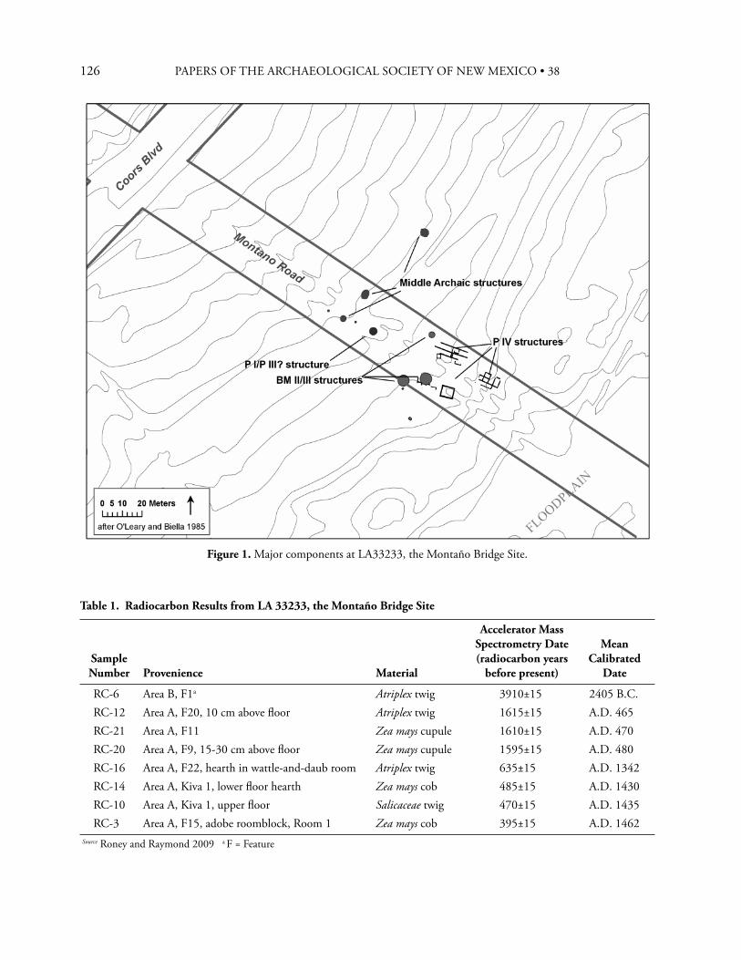
126 PAPERS OF THE ARCHAEOLOGICAL SOCIETY OF NEW MEXICO • 38
Table 1. Radiocarbon Results from LA 33233, the Montaño Bridge Site
Sample Number Provenience Material
Accelerator Mass Spectrometry Date (radiocarbon years
before present)
Mean Calibrated
Date
RC-6 Area B, F1a Atriplex twig 3910±15 2405 B.C.RC-12 Area A, F20, 10 cm above fl oor Atriplex twig 1615±15 A.D. 465RC-21 Area A, F11 Zea mays cupule 1610±15 A.D. 470RC-20 Area A, F9, 15-30 cm above fl oor Zea mays cupule 1595±15 A.D. 480RC-16 Area A, F22, hearth in wattle-and-daub room Atriplex twig 635±15 A.D. 1342RC-14 Area A, Kiva 1, lower fl oor hearth Zea mays cob 485±15 A.D. 1430RC-10 Area A, Kiva 1, upper fl oor Salicaceae twig 470±15 A.D. 1435RC-3 Area A, F15, adobe roomblock, Room 1 Zea mays cob 395±15 A.D. 1462
Source Roney and Raymond 2009 a F = Feature
Figure 1. Major components at LA33233, the Montaño Bridge Site.
127JOHN R. RONEY
eff ectively isolated from later components, with a very low probability of contamination. Th e component included two and possibly three shallow pit structures, as well as an outdoor activity area (Marshall 2009:4-8—4-11). Th ese features resemble other excavated Middle Archaic components on the Albuquerque West Mesa. Th e three pit structures are shallow basins between 3.0 and 4.8 m in diameter and 20 to 40 cm deep. No postholes or direct evidence of a superstructure were found, but it is assumed that these structures were made of brush and logs. Th e activity area was located at the same depth as the two excavated pit structures, just a few meters to the west. It was a 4.0 m by 3.5 m area, with charcoal and a few lithic artifacts mixed into a 10 cm thick lens. At least two of the pit structures included internal features in the form of shallow, basin-shaped pits, all of which lacked oxidation or other evidence of use as hearths (Marshall 2009). A single radiocarbon date was obtained from one of the structures. Th e sample, a twig of salt bush (Atriplex) (RC-6), was taken from a dark, charcoal-laden, 20 cm thick deposit resting on the fl oor of the structure. AMS dating of this sample yielded a date of about 2400 cal B.C. (Table 1). Th e other pit structures and the activity area are assumed to be of equivalent age based on their proximity and similar stratigraphic positions. Th e radiocarbon date places this component in the San Jose Phase of the local Archaic sequence, or the Middle Archaic in more general Southwestern terms. Only three pieces of debitage from this component were available for analysis, so little can be said about lithic technology. However, the collections did include a large unnotched biface and a Northern Side-Notched projectile point (Okun 2009). Both of these tools were found within the structure that provided the radiocarbon date. Consequently, association between these two artifacts and the radiocarbon date is especially strong. Several quartzite manos and a sandstone metate fragment are also reported from this component (Arena 1987; Mattson 2009). A single fl otation sample from the dated pit structure provided several charred goosefoot seeds
(Toll 2009). Th e faunal assemblage attributed to the Middle Archaic component consisted of 30 bone fragments, of which only fi ve were identifi able to genus. Predictably, the identifi ed species consisted of cottontail (Sylvilagus sp.) and jackrabbit (Lepus californicus) (Duncan 2009).
B A S K E T M A K E R I I / I I I O C C U PA T I O N ,
C A . A . D . 5 0 0
Th e second documented occupation at the Montaño Bridge site took place at a crucial point in the culture history of the Albuquerque Basin—right at the transition between Archaic and Early Formative times. Th e component includes three pit structures, an apparent outdoor activity area, an infant burial, and an isolated hearth (Marshall 2009). Th ree AMS radiocarbon dates place the occupation at or slightly before ca. A.D. 500. Th e most impressive of the three pit structures was 5.9 m in diameter and 75 cm deep, with both fl oors and walls covered with a 5 to 10 cm thick layer of adobe. A second pit structure at the site was similar in size, but walls and fl oor were unlined. Th e third pit structure attributed to this occupation was smaller (3.2 by 2.85 m), and was shallow, making it comparable to pit structures of the preceding Archaic Period. However, its fl oors and walls were also lined with adobe. Each of the three structures had one or more interior hearths, as well as interior pits and basins presumably used for storage. One featured a bell-shaped pit, a more specialized storage facility often associated with early dependence on agriculture. Th ere was no evidence of a roof support system, and no evidence of entryways at any of the three structures. Th e apparent outdoor activity area was a shallow basin that included three small pits and a small concentration of fi re-cracked rock. A small number of intrusive Glaze A red and yellow slipped ceramics were found in this group of features, but a maize cupule yielded a radiocarbon date of about cal A.D. 470 correlating closely with the Basketmaker II/III
128 PAPERS OF THE ARCHAEOLOGICAL SOCIETY OF NEW MEXICO • 38
occupation. In addition, O’Leary and Biella (1987) attribute a burial found just outside one of the pit structures (and left in situ) to this occupation based on stratigraphic relationships. Okun (2009) analyzed over 200 pieces of lithic debitage from this component, and found that in technological characteristics they closely resembled the much larger sample from later Pueblo IV contexts. However, the Basketmaker II/III lithic assemblage was notable in the number of formal and expedient tools it contained. Expedient tools included eight retouched fl akes, eight used fl akes, one hammerstone, an expedient drill/perforator, an early stage biface, and an informal uniface. Formal chipped stone artifacts included three bifaces and 17 projectile points. Two of the projectile points are unnotched, and could be classifi ed as Cottonwood Triangular; 16 are broadly similar to the Trujillo type. Th e groundstone assemblage from this component included several unusual artifacts, such as two fragments of a pipe made from pumice, a stone bowl also made of pumice, and an unworked piece of sandstone with yellow pigment on one surface. Other groundstone tools included two handstones and a quartzite mano (Mattson 2009). In the three structures attributed to this component, only one sherd (a Plain Gray utility ware) was found in fl oor contact. A small amount of ceramic material identifi ed as Lino Gray and Fugitive Red was found in other contexts on the site, but cannot be confi dently associated with the features attributed to this component. Th is could indicate that little or no pottery was being used at the Montaño Bridge at ca. A.D. 480, despite the appearance the bow and arrow, plaster-covered walls, and other characteristics usually associated with early Basketmaker III components. An assemblage of 102 faunal elements was available from the Basketmaker II/III component. Th e most common identifi able bone was rabbit, both jackrabbit and cottontail. Other identifi ed species included rock squirrel, pronghorn antelope, and Cervidae (either deer or elk). One possible piece of
worked bone seemed to be part of a Bitsitsi whistle, although this is not certain. (A Bitsitsi whistle consists of two small, identical, rectangular segments of long bone shafts, usually bird bone, bound together with the concave sides facing each other and a piece of grass or other material between them to serve as a reed [Beach and Causey 1984:210]. Th e whistle, still in use today in the Southwest, is carried between the lips of a ceremonial personage—and is invisible to an onlooker.) Th e faunal assemblage from this component also included several pieces of worked and unworked shell. Th e two worked pieces were both ornaments. One was a fragment of clam-like bivalve mollusk shell (possibly Mercenaria) worked into a bracelet or pendant with a drill hole. Th e other was a spiral shell drilled in the center (Duncan 2009). Flotation samples were processed from the large pit structure and the smallest pit structure. Both included corn, but the most exciting discovery was a charred bean cotyledon (Phaseolus vulgaris), an important cultigen that is seldom preserved in the macrofossil record. Other economic species included charred remains of tansy mustard, goosefoot, purslane, juniper seeds, and ricegrass. According to Toll (2009) seeds of these species are available from early through late summer. Pollen was also analyzed from these proveniences. Extremely high frequencies of Cheno/Am pollen suggested gathering and use of these plants for food. Other potential economic plants that were well represented in the pollen record include sunfl owers, mormon tea, sage, cholla, and four o’clock (Dean 2009).
L A T E R C O M P O N E N T S
Th e focus of this paper is on the earlier components at LA 32233, but brief mention should be made of the subsequent occupations represented at this site. Th ere is a substantial pithouse that dates sometime prior to Pueblo III times. Architecture and pottery apparently associated with the structure (a predominance of plain gray with traces of corrugated-indented, plain fugitive red, and Red Mesa Black-
129
on-white) suggest Pueblo I affi nity (Marshall 2009), but three radiocarbon dates suggest a Pueblo II-III temporal affi liation (Harper 1988). Th e most intensive occupation at the Montaño Bridge Site was during Pueblo IV times, which can be divided into several episodes. Th e earliest may be two semi-subterranean wattle and daub structures, one of which yielded a radiocarbon date from a saltbush twig of around cal A.D. 1330 (Table 1). In any case, by Glaze A times (ca. A.D. 1460) there was a substantial Puebloan occupation. A large midden and a kiva dating to this interval were excavated, although the residential structures that presumably accompanied these two features were not found. Subsequently, the kiva was abandoned and fi lled with Glaze C trash. Th is trash deposit was associated with a roomblock built over the earlier Glaze A midden. Th e onset of Glaze C ceramics is bracketed by radiocarbon dates between ca. cal A.D. 1435 and 1463 (Table 1). Final abandonment of the site occurred around A.D. 1500, prior to the onset of Glaze D ceramics (Franklin 2009).
C O M P A R A T I V E D A T A
In recent years there have been a number of archaeological excavations in the Albuquerque area, especially on the West Mesa. In an eff ort to place results from the Montaño Bridge Site into a wider context, I reviewed literature from testing and excavations in the Albuquerque area, defi ned loosely as the area covered by 16 USGS 7.5 minute topographic maps roughly centered on the Montaño Bridge Site. Th is corresponds to the area covered by Connell’s (2008) recent detailed geologic map of the Albuquerque-Rio Rancho Metropolitan Area. It is an area bounded on the west by the Cejo del Rio Puerco and Rio Puerco itself. Its northern boundary reaches to areas near San Ysidro and San Felipe Pueblo, taking in the lower reaches of the Rio Jemez. On the east it includes the Creston de Moctezuma and the easternmost slopes of the Sandia Mountains, and on the south it ends just a little beyond Tijeras Arroyo.
Over 300 radiocarbon dates are available from archaeological excavations in this area. I reviewed this data emphasizing associations between chronometric dates and cultigens, diagnostic artifacts, and architecture. Th e radiocarbon dates were calibrated using OxCal 4.1, employing the IntCal 09 curve (Bronk Ramsey 2009). As most readers know, a radiocarbon date is actually a range of possible dates. For ease of presentation, I frequently use the mean calibrated date, which is the calendrical date calculated by averaging the upper and lower boundaries of the one standard deviation interval.
When Does Corn First Appear in the Albuquerque Area?It is not surprising that no evidence of agriculture was found in the Middle Archaic component at the Montaño Bridge Site. Th e earliest corn (Zea mays) yet discovered in New Mexico was found at the Old Corn Site near Quemado, dating to about 2260 cal B.C. (Huber and VanWest 2005; Merrill et al. 2009). Th erefore, the Archaic component at the Montaño Bridge site predates the earliest known maize in New Mexico by about 150 years. Even taking the standard error of the radiocarbon date into account, it is probable that the Middle Archaic component predates the introduction of maize agriculture in New Mexico. When was maize fi rst used in the Albuquerque area? Despite a surprisingly large number of excavated Middle and Late Archaic sites, we do not yet have a defi nitive answer. Table 2 tabulates reports of possible early maize in the Albuquerque area and places them in the context of well documented occurrences of corn elsewhere in New Mexico. As the table indicates, there are doubts about all of the earliest possible discoveries of early corn in the Albuquerque area. Some are based on tenuous phytolith evidence (Jones-Bartholomew et al. 2002:67-71), and in other cases identifi cation of corn cupules is not defi nite (Jones-Bartholomew et al. 2002; Seymour et al. 1997:278). Several reports document maize in questionable contexts, where associations between maize remains and the radiocarbon date are not
JOHN R. RONEY
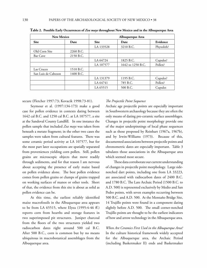
130 PAPERS OF THE ARCHAEOLOGICAL SOCIETY OF NEW MEXICO • 38
secure (Fletcher 1997:73; Kovacik 1998:73-81). Seymour et al. (1997:134-173) make a good case for pollen evidence in contexts dating between 1642 cal B.C. and 1250 cal B.C. at LA 107577, a site at the Sandoval County Landfi ll. In one instance the pollen sample that included Zea mays was taken from beneath a metate fragment; in the other two cases the samples were taken from cultural features. Th ere was some ceramic period activity at LA 107577, but for the most part later occupations are spatially separated from proveniences yielding corn pollen. Still, pollen grains are microscopic objects that move readily through sediments, and for that reason I am nervous about accepting the presence of early maize based on pollen evidence alone. Th e best pollen evidence comes from pollen grains or clumps of grains trapped on working surfaces of manos or other tools. Short of that, the evidence from this site is about as solid as pollen evidence can be. At this time, the earliest reliably identifi ed maize macrofossils in the Albuquerque area appears to be from LA 65515, where Elyea (1995:4-46 ff .) reports corn from hearths and storage features in two superimposed pit structures. Juniper charcoal from the fl oors of the two structures yielded two radiocarbon dates right around 500 cal B.C. After 500 B.C., corn is common but by no means ubiquitous in macrobotanical assemblages from the Albuquerque area.
Th e Projectile Point SequenceArchaic age projectile points are especially important in Southwestern archaeology because they are often the only means of dating pre-ceramic surface assemblages. Changes in projectile point morphology provide one of the major underpinnings of local phase sequences such as those proposed by Reinhart (1967a, 1967b), and by Irwin-Williams (1973). Because of this, documented associations between projectile points and chronometric dates are especially important. Table 3 tabulates those associations in the Albuquerque area which seemed most secure. Th ese data corroborate our current understanding of changes in projectile point morphology. Large side-notched dart points, including one from LA 33223, are associated with radiocarbon dates of 2400 B.C. and 1780 B.C. Th e Late Archaic Period (1500 B.C. to A.D. 500) is represented exclusively by Medio and San Pedro points, with seven examples occurring between 500 B.C. and A.D. 500. At the Montaño Bridge Site, 14 Trujillo points were found in a component dating slightly before A.D. 500. Th e small corner-notched Trujillo points are thought to be the earliest indicators of bow and arrow technology in the Albuquerque area.
When Are Ceramics First Used in the Albuquerque Area?In the culture historical framework widely accepted for the Albuquerque area, the Archaic Period (including Basketmaker II) ends and Basketmaker
Table 2. Possible Early Occurrences of Zea mays throughout New Mexico and in the Albuquerque Area
New Mexico Albuquerque Area
Site Date Site Date EvidenceLA 133528 3210 B.C. Phytolith?
Old Corn Site 2260 B.C.Bat Cave 2150 B.C.
LA 64724 1825 B.C. Cupules?LA 107577 1642 to 1250 B.C. Pollen?
Las Cruces 1510 B.C.San Luis de Cabezon 1400 B.C.
LA 131379 1195 B.C. Cupules?LA 64741 785 B.C. Pollen?LA 65515 500 B.C. Cupules
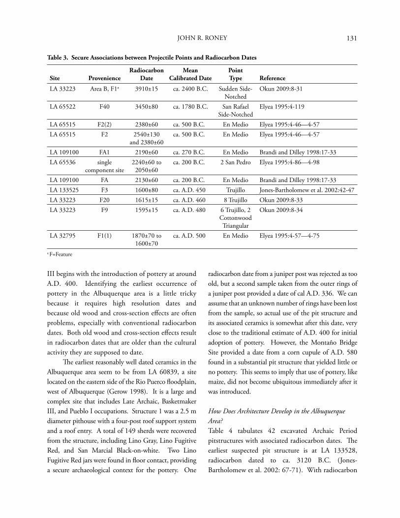
131
Table 3. Secure Associations between Projectile Points and Radiocarbon Dates
Site ProvenienceRadiocarbon
DateMean
Calibrated DatePoint Type Reference
LA 33223 Area B, F1a 3910±15 ca. 2400 B.C. Sudden Side-Notched
Okun 2009:8-31
LA 65522 F40 3450±80 ca. 1780 B.C. San Rafael Side-Notched
Elyea 1995:4-119
LA 65515 F2(2) 2380±60 ca. 500 B.C. En Medio Elyea 1995:4-46—4-57LA 65515 F2 2540±130
and 2380±60ca. 500 B.C. En Medio Elyea 1995:4-46—4-57
LA 109100 FA1 2190±60 ca. 270 B.C. En Medio Brandi and Dilley 1998:17-33LA 65536 single
component site2240±60 to
2050±60ca. 200 B.C. 2 San Pedro Elyea 1995:4-86—4-98
LA 109100 FA 2130±60 ca. 200 B.C. En Medio Brandi and Dilley 1998:17-33LA 133525 F3 1600±80 ca. A.D. 450 Trujillo Jones-Bartholomew et al. 2002:42-47LA 33223 F20 1615±15 ca. A.D. 460 8 Trujillo Okun 2009:8-33LA 33223 F9 1595±15 ca. A.D. 480 6 Trujillo, 2
Cottonwood Triangular
Okun 2009:8-34
LA 32795 F1(1) 1870±70 to 1600±70
ca. A.D. 500 En Medio Elyea 1995:4-57—4-75
a F=Feature
III begins with the introduction of pottery at around A.D. 400. Identifying the earliest occurrence of pottery in the Albuquerque area is a little tricky because it requires high resolution dates and because old wood and cross-section eff ects are often problems, especially with conventional radiocarbon dates. Both old wood and cross-section eff ects result in radiocarbon dates that are older than the cultural activity they are supposed to date. Th e earliest reasonably well dated ceramics in the Albuquerque area seem to be from LA 60839, a site located on the eastern side of the Rio Puerco fl oodplain, west of Albuquerque (Gerow 1998). It is a large and complex site that includes Late Archaic, Basketmaker III, and Pueblo I occupations. Structure 1 was a 2.5 m diameter pithouse with a four-post roof support system and a roof entry. A total of 149 sherds were recovered from the structure, including Lino Gray, Lino Fugitive Red, and San Marcial Black-on-white. Two Lino Fugitive Red jars were found in fl oor contact, providing a secure archaeological context for the pottery. One
radiocarbon date from a juniper post was rejected as too old, but a second sample taken from the outer rings of a juniper post provided a date of cal A.D. 336. We can assume that an unknown number of rings have been lost from the sample, so actual use of the pit structure and its associated ceramics is somewhat after this date, very close to the traditional estimate of A.D. 400 for initial adoption of pottery. However, the Montaño Bridge Site provided a date from a corn cupule of A.D. 580 found in a substantial pit structure that yielded little or no pottery. Th is seems to imply that use of pottery, like maize, did not become ubiquitous immediately after it was introduced.
How Does Architecture Develop in the Albuquerque Area?Table 4 tabulates 42 excavated Archaic Period pitstructures with associated radiocarbon dates. Th e earliest suspected pit structure is at LA 133528, radiocarbon dated to ca. 3120 B.C. (Jones-Bartholomew et al. 2002: 67-71). With radiocarbon
JOHN R. RONEY
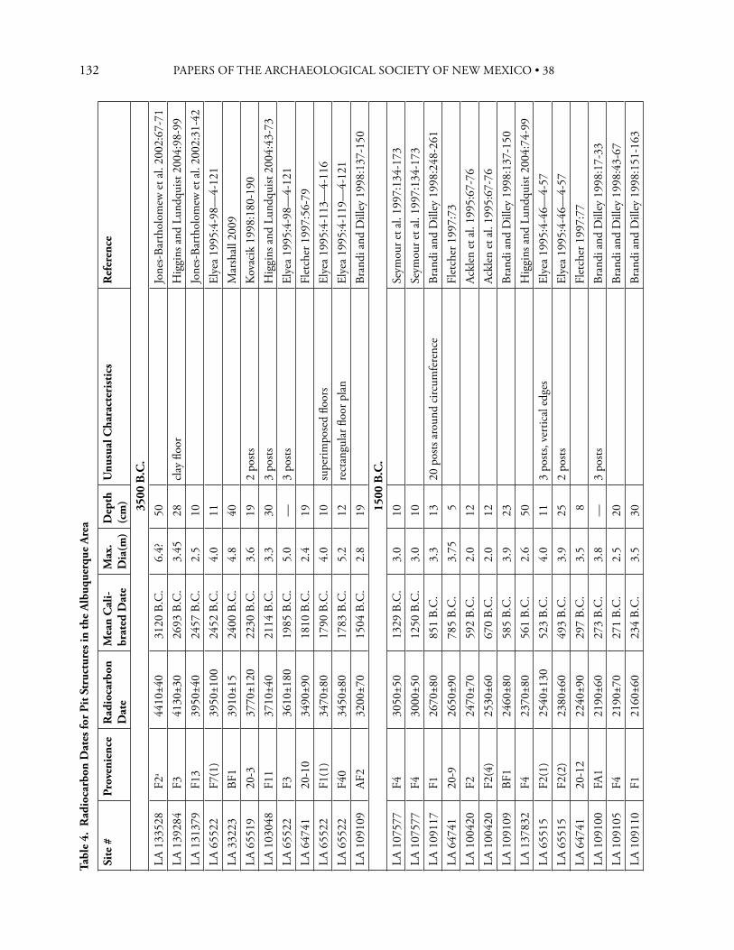
132 PAPERS OF THE ARCHAEOLOGICAL SOCIETY OF NEW MEXICO • 38Ta
ble
4. R
adio
carb
on D
ates
for
Pit S
truc
ture
s in
the
Alb
uque
rque
Are
a
Site
#Pr
oven
ienc
eR
adio
carb
on
Dat
eM
ean
Cal
i-br
ated
Dat
eM
ax.
Dia
(m)
Dep
th
(cm
)U
nusu
al C
hara
cter
isti
csR
efer
ence
3500
B.C
.
LA 1
3352
8F2
a44
10±4
031
20 B
.C.
6.4?
50Jo
nes-
Bart
holo
mew
et a
l. 20
02:6
7-71
LA 1
3928
4F3
4130
±30
2693
B.C
.3.
4528
clay
fl oo
rH
iggi
ns a
nd L
undq
uist
2004
:98-
99LA
131
379
F13
3950
±40
2457
B.C
.2.
510
Jone
s-Ba
rtho
lom
ew e
t al.
2002
:31-
42LA
655
22F7
(1)
3950
±100
2452
B.C
.4.
011
Elye
a 19
95:4
-98—
4-12
1LA
332
23BF
139
10±1
524
00 B
.C.
4.8
40M
arsh
all 2
009
LA 6
5519
20-3
3770
±120
2230
B.C
.3.
619
2 po
stsK
ovac
ik 1
998:
180-
190
LA 1
0304
8F1
137
10±4
021
14 B
.C.
3.3
303
posts
Hig
gins
and
Lun
dqui
st 20
04:4
3-73
LA 6
5522
F336
10±1
8019
85 B
.C.
5.0
—3
posts
Elye
a 19
95:4
-98—
4-12
1LA
647
4120
-10
3490
±90
1810
B.C
.2.
419
Flet
cher
199
7:56
-79
LA 6
5522
F1(1
)34
70±8
017
90 B
.C.
4.0
10su
perim
pose
d fl o
ors
Elye
a 19
95:4
-113
—4-
116
LA 6
5522
F40
3450
±80
1783
B.C
.5.
212
rect
angu
lar fl
oor
pla
nEl
yea
1995
:4-1
19—
4-12
1LA
109
109
AF2
3200
±70
1504
B.C
.2.
819
Bran
di a
nd D
illey
199
8:13
7-15
015
00 B
.C.
LA 1
0757
7F4
3050
±50
1329
B.C
.3.
010
Seym
our e
t al.
1997
:134
-173
LA 1
0757
7F4
3000
±50
1250
B.C
.3.
010
Seym
our e
t al.
1997
:134
-173
LA 1
0911
7F1
2670
±80
851
B.C
.3.
313
20 p
osts
arou
nd c
ircum
fere
nce
Bran
di a
nd D
illey
199
8:24
8-26
1LA
647
4120
-926
50±9
078
5 B.
C.
3.75
5Fl
etch
er 1
997:
73LA
100
420
F224
70±7
059
2 B.
C.
2.0
12Ac
klen
et a
l. 19
95:6
7-76
LA 1
0042
0F2
(4)
2530
±60
670
B.C
.2.
012
Ackl
en e
t al.
1995
:67-
76LA
109
109
BF1
2460
±80
585
B.C
.3.
923
Bran
di a
nd D
illey
199
8:13
7-15
0LA
137
832
F423
70±8
056
1 B.
C.
2.6
50H
iggi
ns a
nd L
undq
uist
2004
:74-
99LA
655
15F2
(1)
2540
±130
523
B.C
.4.
011
3 po
sts, v
ertic
al e
dges
Elye
a 19
95:4
-46—
4-57
LA 6
5515
F2(2
)23
80±6
049
3 B.
C.
3.9
252
posts
Elye
a 19
95:4
-46—
4-57
LA 6
4741
20-1
222
40±9
029
7 B.
C.
3.5
8Fl
etch
er 1
997:
77LA
109
100
FA1
2190
±60
273
B.C
.3.
8—
3 po
stsBr
andi
and
Dill
ey 1
998:
17-3
3LA
109
105
F421
90±7
027
1 B.
C.
2.5
20Br
andi
and
Dill
ey 1
998:
43-6
7LA
109
110
F121
60±6
023
4 B.
C.
3.5
30Br
andi
and
Dill
ey 1
998:
151-
163
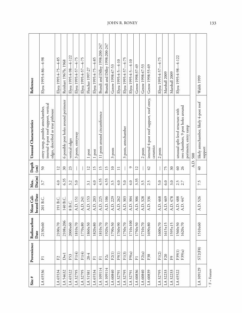
133
Site
#Pr
oven
ienc
eR
adio
carb
on
Dat
eM
ean
Cal
i-br
ated
Dat
eM
ax.
Dia
(m)
Dep
th
(cm
)U
nusu
al C
hara
cter
isti
csR
efer
ence
LA 6
5536
F121
30±6
020
1 B.
C.
3.7
50en
try
ram
p, p
ossib
le a
ntec
ham
ber,
inte
rnal
4-p
ost r
oof s
uppo
rt, v
ertic
al
edge
s, de
scrib
ed a
s tru
e pi
thou
se
Elye
a 19
95:4
-86—
4-98
LA 6
5534
F221
00±7
019
1 B.
C.
4.0
12El
yea
1995
:4-7
5—4-
85LA
546
32D
w1
2108
±206
140
B.C
.6.
3530
6 po
ssib
le p
ost h
oles
aro
und
perim
eter
Rein
hart
196
7b; 1
968
LA 6
5522
F53
2000
±60
8 B.
C.
3.2
23ve
rtic
al e
dges
Elye
a 19
95:4
-98—
4-12
2LA
327
95F1
(4)
1810
±70
A.D
. 151
5.0
—3
posts
, ent
ryw
ayEl
yea
1995
:4-5
7—4-
75LA
327
95F1
(4)
1770
±80
A.D
. 241
—El
yea
1995
:4-5
7—4-
75LA
515
8120
-418
60±5
0A.
D. 1
533.
112
1 po
stFl
etch
er 1
997:
27LA
655
34F1
1820
±80
A.D
. 203
4.0
151
post
Elye
a 19
95:4
-75—
4-85
LA 1
0911
4F1
1810
±70
A.D
. 225
4.55
1511
pos
ts ar
ound
circ
umfe
renc
eBr
andi
and
Dill
ey 1
998:
200-
247
LA 1
0911
4F2
c19
20±7
0A.
D. 1
064.
5515
Bran
di a
nd D
illey
199
8:20
0-24
7LA
608
40F2
(1)
1790
±50
A.D
. 229
3.5
103
posts
Ger
ow 1
998:
47-5
3LA
327
91F9
(1)
1760
±90
A.D
. 262
4.0
11El
yea
1995
:4-5
—4-
10LA
327
95F1
(3)
1750
±70
A.D
. 303
5.0
—3
posts
, ant
echa
mbe
rEl
yea
1995
:4-5
7—4-
75LA
327
91F9
(u)
1710
±100
A.D
. 304
4.0
9El
yea
1995
:4-5
—4-
10LA
608
36F1
1750
±50
A.D
. 306
3.35
12G
erow
199
8:37
-49
LA 6
0840
F2(u
)17
10±7
0A.
D. 3
283.
5—
2 po
stsG
erow
199
8:47
-53
LA 6
0839
F38
1690
±80
A.D
. 336
2.5
42in
tern
al 4
-pos
t roo
f sup
port
, roo
f ent
ry,
cera
mic
sG
erow
199
8:55
-69
LA 3
2795
F1(2
)16
00±7
0A.
D. 4
685.
0—
2 po
stsEl
yea
1995
:4-5
7—4-
75LA
322
33F2
016
15±1
5A.
D. 4
696.
075
Mar
shal
l 200
9LA
322
33F9
1595
±15
A.D
. 478
3.0
30M
arsh
all 2
009
LA 6
5522
F39(
1)F3
9(u)
1560
±50
1620
±70
A.D
. 488
A.D
. 447
2.5
2.7
60 26un
usua
l spl
it-le
vel s
truc
ture
with
tw
o ch
ambe
rs, 9
pos
t hol
es a
roun
d pe
rimet
er, e
ntry
ram
p
Elye
a 19
95:4
-98—
4-12
2
A.D
. 500
LA 1
0912
9ST
2(F8
)15
10±6
0A.
D. 5
267.
540
likel
y an
tech
ambe
r, lik
ely
4-po
st ro
of
supp
ort
Wal
th 1
999
a F
= Fe
atur
e
JOHN R. RONEY
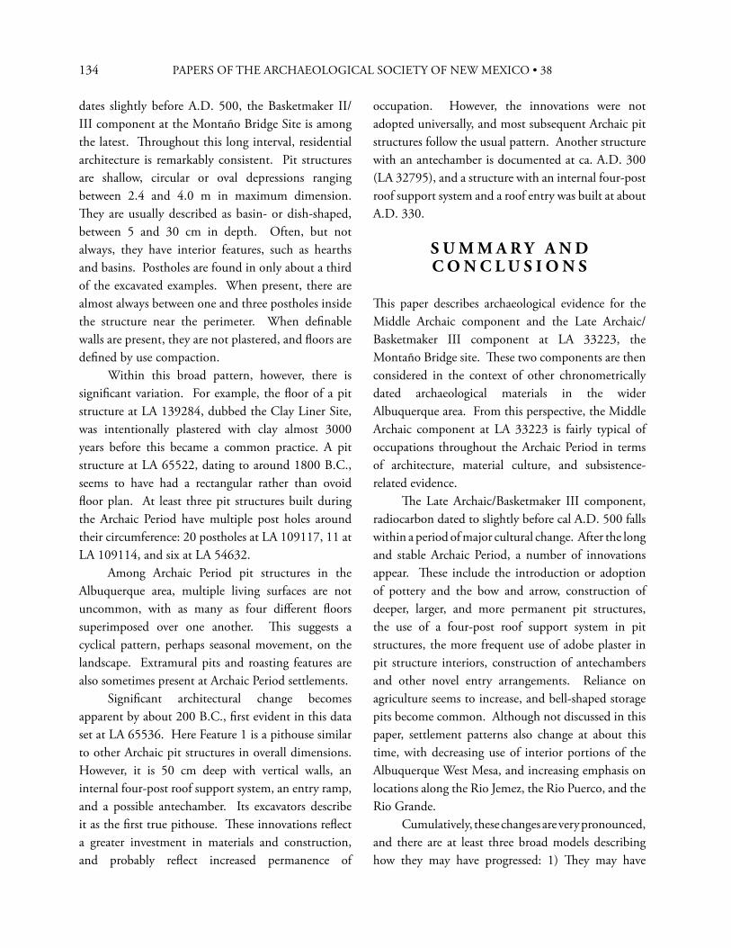
134 PAPERS OF THE ARCHAEOLOGICAL SOCIETY OF NEW MEXICO • 38
dates slightly before A.D. 500, the Basketmaker II/III component at the Montaño Bridge Site is among the latest. Th roughout this long interval, residential architecture is remarkably consistent. Pit structures are shallow, circular or oval depressions ranging between 2.4 and 4.0 m in maximum dimension. Th ey are usually described as basin- or dish-shaped, between 5 and 30 cm in depth. Often, but not always, they have interior features, such as hearths and basins. Postholes are found in only about a third of the excavated examples. When present, there are almost always between one and three postholes inside the structure near the perimeter. When defi nable walls are present, they are not plastered, and fl oors are defi ned by use compaction. Within this broad pattern, however, there is signifi cant variation. For example, the fl oor of a pit structure at LA 139284, dubbed the Clay Liner Site, was intentionally plastered with clay almost 3000 years before this became a common practice. A pit structure at LA 65522, dating to around 1800 B.C., seems to have had a rectangular rather than ovoid fl oor plan. At least three pit structures built during the Archaic Period have multiple post holes around their circumference: 20 postholes at LA 109117, 11 at LA 109114, and six at LA 54632. Among Archaic Period pit structures in the Albuquerque area, multiple living surfaces are not uncommon, with as many as four diff erent fl oors superimposed over one another. Th is suggests a cyclical pattern, perhaps seasonal movement, on the landscape. Extramural pits and roasting features are also sometimes present at Archaic Period settlements. Signifi cant architectural change becomes apparent by about 200 B.C., fi rst evident in this data set at LA 65536. Here Feature 1 is a pithouse similar to other Archaic pit structures in overall dimensions. However, it is 50 cm deep with vertical walls, an internal four-post roof support system, an entry ramp, and a possible antechamber. Its excavators describe it as the fi rst true pithouse. Th ese innovations refl ect a greater investment in materials and construction, and probably refl ect increased permanence of
occupation. However, the innovations were not adopted universally, and most subsequent Archaic pit structures follow the usual pattern. Another structure with an antechamber is documented at ca. A.D. 300 (LA 32795), and a structure with an internal four-post roof support system and a roof entry was built at about A.D. 330.
S U M M A R Y A N D C O N C L U S I O N S
Th is paper describes archaeological evidence for the Middle Archaic component and the Late Archaic/Basketmaker III component at LA 33223, the Montaño Bridge site. Th ese two components are then considered in the context of other chronometrically dated archaeological materials in the wider Albuquerque area. From this perspective, the Middle Archaic component at LA 33223 is fairly typical of occupations throughout the Archaic Period in terms of architecture, material culture, and subsistence-related evidence. Th e Late Archaic/Basketmaker III component, radiocarbon dated to slightly before cal A.D. 500 falls within a period of major cultural change. After the long and stable Archaic Period, a number of innovations appear. Th ese include the introduction or adoption of pottery and the bow and arrow, construction of deeper, larger, and more permanent pit structures, the use of a four-post roof support system in pit structures, the more frequent use of adobe plaster in pit structure interiors, construction of antechambers and other novel entry arrangements. Reliance on agriculture seems to increase, and bell-shaped storage pits become common. Although not discussed in this paper, settlement patterns also change at about this time, with decreasing use of interior portions of the Albuquerque West Mesa, and increasing emphasis on locations along the Rio Jemez, the Rio Puerco, and the Rio Grande. Cumulatively, these changes are very pronounced, and there are at least three broad models describing how they may have progressed: 1) Th ey may have
135
resulted from rapid internal change within the local Archaic tradition; 2) Th ey may have resulted from population replacement, with new peoples introducing new technologies and a diff erent economic emphasis; 3) Finally, they may have resulted from ethnogenesis, a combination of the preceding two scenarios resulting in a new and greatly altered cultural adaptation. Each of these models has diff erent implications, and more precise chronological control is an important tool that can help us distinguish among them. Recent advances in radiocarbon dating provide dates with tight confi dence intervals and make it possible to minimize other unquantifi ed sources of error such as old wood and cross-section eff ects. Th ese steady improvements in the precision of radiocarbon dating promise much more precise chronological control and should allow us to address these issues in a convincing way.
R E F E R E N C E S C I T E D
Acklen, John C., John A. Evaskovich, David V. Hill,Richard D. Holmes, William B. Hudspeth, Dorothy L. Larson, Philippe D. LeTourneau, David P. Staley, andChristopher A. Turnbow1995 Data Recovery at LA 100419 and LA 100420,
Albuquerque International Airport Expansion, Bernalillo County, New Mexico. Technical Report 11288-0020. TRC Mariah Associates, Inc., Albuquerque.
Arena, Peter1987 Lithics. In Montaño River Crossing: Archeological
Testing Within the Road Right-of-Way, edited by Randy A. Harper, pp. 32-33. Offi ce of Contract Archeology, University of New Mexico, Albuquerque.
Beach, Marshall A., and Christopher S. Causey1984 Bone Artifacts from Arroyo Hondo Pueblo.
In Th e Faunal Remains from Arroyo Hondo Pueblo, New Mexico, by Richard W. Lang and Arthur H. Harris, pp. 187-225. Arroyo Hondo Archaeological Series 5. School of American Research Press, Santa Fe.
Brandi, James M., and Michael J. Dilley1998 Archaeological Investigation of Fourteen Sites
in Unit 22 (Northern Meadows), Rio Rancho, New Mexico. Rio Grande Consultants, Inc., Albuquerque.
Bronk Ramsey, C.2009 Bayesian Analysis of Radiocarbon Dates.
Radiocarbon 51(1):337-360.
Connell, Sean D.2008 Geologic Map of the Albuquerque-Rio Rancho
Metropolitan Area and Vicinity, Bernalillo and Sandoval Counties, New Mexico. Geologic Map 78. New Mexico Bureau of Geology and Mineral Resources, Socorro.
Dean, Glenna2009 [Submitted 1989] Chapter 12: Pollen Analysis
of Samples from LA 33223, the Montaño Pueblo Site. In Report on 1988 Data Recovery at the Montaño Site Complex, LA 33223, City of Albuquerque, New Mexico and Subsequent Analysis of Collections, edited by Gerry Raymond, pp. 12-11—12-12. Criterion Environmental Consulting, LLC, Albuquerque.
Duncan, Gwyneth A.2009 Chapter 10: Faunal Remains from the Montaño
Site Complex (LA 33223). In Report on 1988 Data Recovery at the Montaño Site Complex, LA 33223, City of Albuquerque, New Mexico and Subsequent Analysis of Collections, edited by Gerry Raymond, pp. 10-11—10-19. Criterion Environmental Consulting, LLC, Albuquerque.
Elyea, Janette1995 Macbeth Data Recovery Program Final Report.
Offi ce of Contract Archeology, University of New Mexico, Albuquerque.
Fletcher, Th omas F.1997 Archaeological Testing at Five Sites Along the
Proposed Northwest Corridor, Sandoval County, New Mexico. Keystone Environmental and Planning, Inc., Albuquerque.
JOHN R. RONEY
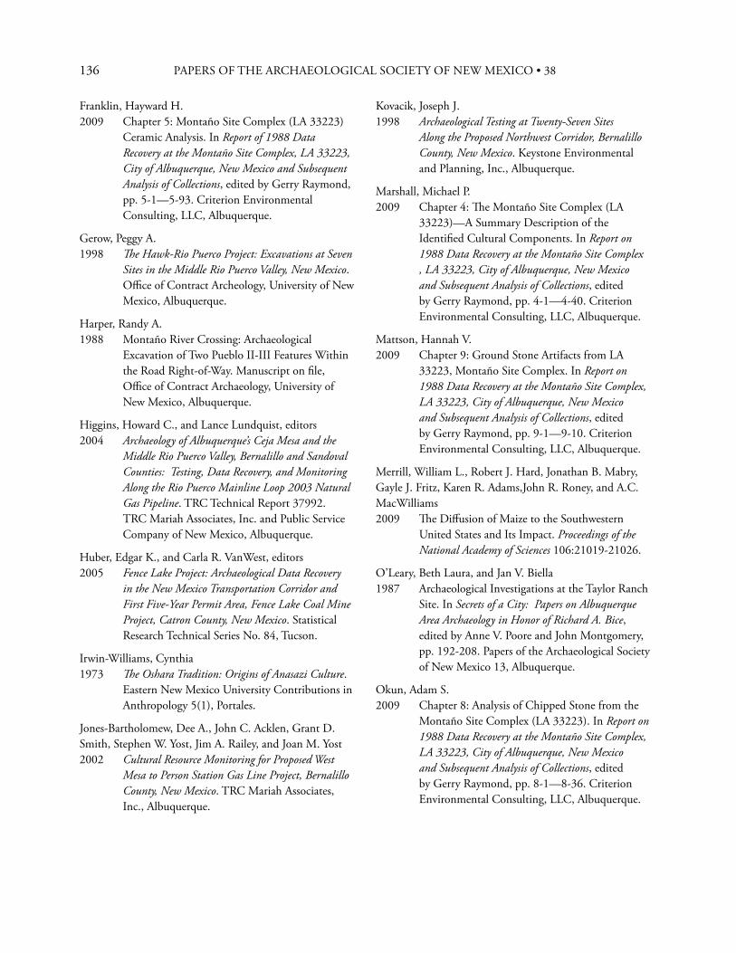
136 PAPERS OF THE ARCHAEOLOGICAL SOCIETY OF NEW MEXICO • 38
Franklin, Hayward H.2009 Chapter 5: Montaño Site Complex (LA 33223)
Ceramic Analysis. In Report of 1988 Data Recovery at the Montaño Site Complex, LA 33223, City of Albuquerque, New Mexico and Subsequent Analysis of Collections, edited by Gerry Raymond, pp. 5-1—5-93. Criterion Environmental Consulting, LLC, Albuquerque.
Gerow, Peggy A.1998 Th e Hawk-Rio Puerco Project: Excavations at Seven
Sites in the Middle Rio Puerco Valley, New Mexico. Offi ce of Contract Archeology, University of New Mexico, Albuquerque.
Harper, Randy A.1988 Montaño River Crossing: Archaeological
Excavation of Two Pueblo II-III Features Within the Road Right-of-Way. Manuscript on fi le, Offi ce of Contract Archaeology, University of New Mexico, Albuquerque.
Higgins, Howard C., and Lance Lundquist, editors2004 Archaeology of Albuquerque’s Ceja Mesa and the
Middle Rio Puerco Valley, Bernalillo and Sandoval Counties: Testing, Data Recovery, and Monitoring Along the Rio Puerco Mainline Loop 2003 Natural Gas Pipeline. TRC Technical Report 37992. TRC Mariah Associates, Inc. and Public Service Company of New Mexico, Albuquerque.
Huber, Edgar K., and Carla R. VanWest, editors2005 Fence Lake Project: Archaeological Data Recovery
in the New Mexico Transportation Corridor and First Five-Year Permit Area, Fence Lake Coal Mine Project, Catron County, New Mexico. Statistical Research Technical Series No. 84, Tucson.
Irwin-Williams, Cynthia1973 Th e Oshara Tradition: Origins of Anasazi Culture.
Eastern New Mexico University Contributions in Anthropology 5(1), Portales.
Jones-Bartholomew, Dee A., John C. Acklen, Grant D. Smith, Stephen W. Yost, Jim A. Railey, and Joan M. Yost2002 Cultural Resource Monitoring for Proposed West
Mesa to Person Station Gas Line Project, Bernalillo County, New Mexico. TRC Mariah Associates, Inc., Albuquerque.
Kovacik, Joseph J.1998 Archaeological Testing at Twenty-Seven Sites
Along the Proposed Northwest Corridor, Bernalillo County, New Mexico. Keystone Environmental and Planning, Inc., Albuquerque.
Marshall, Michael P.2009 Chapter 4: Th e Montaño Site Complex (LA
33223)—A Summary Description of the Identifi ed Cultural Components. In Report on 1988 Data Recovery at the Montaño Site Complex , LA 33223, City of Albuquerque, New Mexico and Subsequent Analysis of Collections, edited by Gerry Raymond, pp. 4-1—4-40. Criterion Environmental Consulting, LLC, Albuquerque.
Mattson, Hannah V.2009 Chapter 9: Ground Stone Artifacts from LA
33223, Montaño Site Complex. In Report on 1988 Data Recovery at the Montaño Site Complex, LA 33223, City of Albuquerque, New Mexico and Subsequent Analysis of Collections, edited by Gerry Raymond, pp. 9-1—9-10. Criterion Environmental Consulting, LLC, Albuquerque.
Merrill, William L., Robert J. Hard, Jonathan B. Mabry,Gayle J. Fritz, Karen R. Adams,John R. Roney, and A.C.MacWilliams2009 Th e Diff usion of Maize to the Southwestern
United States and Its Impact. Proceedings of the National Academy of Sciences 106:21019-21026.
O’Leary, Beth Laura, and Jan V. Biella1987 Archaeological Investigations at the Taylor Ranch
Site. In Secrets of a City: Papers on Albuquerque Area Archaeology in Honor of Richard A. Bice, edited by Anne V. Poore and John Montgomery, pp. 192-208. Papers of the Archaeological Society of New Mexico 13, Albuquerque.
Okun, Adam S.2009 Chapter 8: Analysis of Chipped Stone from the
Montaño Site Complex (LA 33223). In Report on 1988 Data Recovery at the Montaño Site Complex, LA 33223, City of Albuquerque, New Mexico and Subsequent Analysis of Collections, edited by Gerry Raymond, pp. 8-1—8-36. Criterion Environmental Consulting, LLC, Albuquerque.
137
Raymond, Gerry2009a Chapter 1: Th e History of Research at the
Montaño Site Complex (LA 33223) and the 1988 Research Program. In Report on 1988 Data Recovery at the Montaño Site Complex, LA 33223 City of Albuquerque, New Mexico and Subsequent Analysis of Collections, edited by Gerry Raymond, pp. 1-1—1-9. Criterion Environmental Consulting, LLC, Albuquerque.
2009b Report of 1988 Data Recovery at the Montaño Site Complex, LA 33223, City of Albuquerque, New Mexico and Subsequent Analysis of Collections [Gerry Raymond, editor]. Criterion Environmental Consulting, LLC, Albuquerque.
Reinhart, Th eodore R.1967a Th e Alameda Phase: An Early Basketmaker III
Culture in the Middle Rio Grande Valley, New Mexico. Southwestern Lore 33(1):24-32.
1967b Th e Rio Rancho Phase: A Preliminary Report on Early Basketmaker Culture in the Middle Rio Grande Valley, New Mexico. American Antiquity 32:458-470.
1968 Late Archaic Cultures of the Middle Rio Grande Valley, New Mexico: A Study of the Process of Culture Change. Unpublished Ph.D. dissertation, Department of Anthropology, University of New Mexico, Albuquerque.
Roney, John R., and Gerry Raymond2009 Chapter 7: Radiocarbon Dating and Chronology.
In Report on 1988 Data Recovery at the Montaño Site Complex, LA 33223, City of Albuquerque, New Mexico and Subsequent Analysis of Collections, edited by Gerry Raymond, pp. 7-1—7-6. Criterion Environmental Consulting, LLC, Albuquerque.
Seymour, Deni J., Jeff rey H. Hokanson, and Vicky J. T. Cunningham1997 Excavations at Lru-Kish Kachreu and Other Sites
at the Sandoval County Landfi ll. LMAS Report 15. Lone Mountain Archaeological Services, Inc., Albuquerque.
Toll, Mollie S.2009 [Submitted 1992] Chapter 11: Flotation and
Macrobotanical Remains from Montaño Pueblo (LA 33223). In Report on 1988 Data Recovery at the Montaño Site Complex, LA 33223, City of Albuquerque, New Mexico and Subsequent Analysis of Collections, edited by Gerry Raymond, pp. 11-11—11-12. Criterion Environmental Consulting, LLC, Albuquerque.
Walth, Cherie K.1999 Chapter 9: LA 109129. In Vol. 3, Data Recovery
Along the 1995 Mapco Four Corners Pipeline: Sites in the Jemez and Las Huertas Drainages, Sandoval County, New Mexico, edited by Kenneth L. Brown, pp. 71-130. University of New Mexico, Offi ce of Contract Archeology, Albuquerque.
JOHN R. RONEY

138 PAPERS OF THE ARCHAEOLOGICAL SOCIETY OF NEW MEXICO • 38
139
139
H I S T O R I C M I G R A N T S
Timothy Pauketat (2008:241) reminds us that what we call Pueblo communities in the Southwest,
are wracked with tensions and inequalities, may be variously engendered, and can be composed of people with dramatically diff erent histories, memories, origin stories, and affi liations. In a very real sense, some Southwestern “communities” were not shared identities at all!
Indeed, the ethnographic and historical records underscore Pauketat’s observations and, in some cases, such tensions and inequalities appear to have their roots in the assimilation of “others” into existing communities. In his Foreword to Elsie Clews Parson’s study of Jemez Pueblo, Kidder noted that the Pecos emigration to Jemez “is of exceptional interest, as it refl ects a process which has been going on in the Southwest for many centuries” (Parsons 1925:xi-x), a process that continues to reverberate. Both Parsons and Joe Sando (1982:149), of Pecos heritage, commented on tensions between Jemez people and those of Pecos descent, and noted that recent eff orts by the latter to have returned to them a sacred cave in the upper Pecos River canyon are a reminder of their separate history and identity (and see Levine 1999:156-157).
Conservative Laguna migrants to Isleta, ca.1880, consisted of “seven male heads of family,” including 12 men and women. Th ese were followed by others “with the children” (Parsons 1932:349), to form a “colony” of some 30 to 40 persons. Following negotiations with Isleta’s religious leaders, the migrants were provided land for residences and farming at the place Isletans called “Oraibi.” Among the migrants were the “principal ceremonialists” who brought their “mothers” with them, and they were met outside Isleta by the cacique, war chief, and governor, who informed them of conditions for settling there, in return for the ritual and ceremonial “power” of the Laguna religious leaders (Euler 1954:371).2 In the early 1920s, the Indian agent noted that Isleta’s “reactionary element” was in the majority, “but there is a Bull Moose [“progressive”] faction, led by such men as Pablo Abeita....” (Crane 1928:315). “Progressive,” Pablo Abeita, according to Parsons, was said to “hate the Laguna people,” that he wanted to “cut their ways,” and “keep up his own ways,” and that “he wants to destroy the others.” “In general,” Parsons wrote, “Laguna descendants are bilingual, but Keres had not been learned by the Isletans,” and her informant said the Laguna people still provided their own secular offi ces of governor and teniente (similarly, at Pecos [Levine 1999:156-157]). Hopi people at Oraibi recounted to Mischa Titiev (1944:155) the story of the arrival there of the Kokop clan, who
Situating “Others”: Historic Pueblo Migrants—
Some Implications for the Archaeological Record1
D A V I D H . S N O W
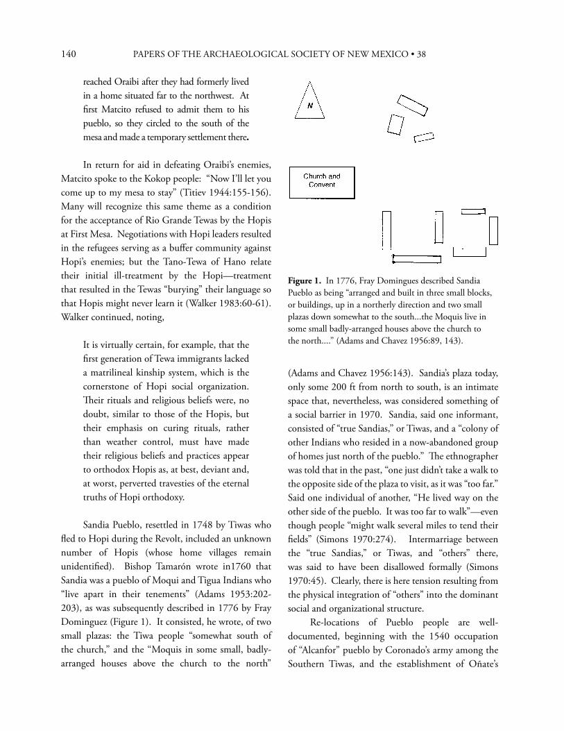
140 PAPERS OF THE ARCHAEOLOGICAL SOCIETY OF NEW MEXICO • 38
reached Oraibi after they had formerly lived in a home situated far to the northwest. At fi rst Matcito refused to admit them to his pueblo, so they circled to the south of the mesa and made a temporary settlement there.
In return for aid in defeating Oraibi’s enemies, Matcito spoke to the Kokop people: “Now I’ll let you come up to my mesa to stay” (Titiev 1944:155-156). Many will recognize this same theme as a condition for the acceptance of Rio Grande Tewas by the Hopis at First Mesa. Negotiations with Hopi leaders resulted in the refugees serving as a buff er community against Hopi’s enemies; but the Tano-Tewa of Hano relate their initial ill-treatment by the Hopi—treatment that resulted in the Tewas “burying” their language so that Hopis might never learn it (Walker 1983:60-61). Walker continued, noting,
It is virtually certain, for example, that the fi rst generation of Tewa immigrants lacked a matrilineal kinship system, which is the cornerstone of Hopi social organization. Th eir rituals and religious beliefs were, no doubt, similar to those of the Hopis, but their emphasis on curing rituals, rather than weather control, must have made their religious beliefs and practices appear to orthodox Hopis as, at best, deviant and, at worst, perverted travesties of the eternal truths of Hopi orthodoxy.
Sandia Pueblo, resettled in 1748 by Tiwas who fl ed to Hopi during the Revolt, included an unknown number of Hopis (whose home villages remain unidentifi ed). Bishop Tamarón wrote in1760 that Sandia was a pueblo of Moqui and Tigua Indians who “live apart in their tenements” (Adams 1953:202-203), as was subsequently described in 1776 by Fray Dominguez (Figure 1). It consisted, he wrote, of two small plazas: the Tiwa people “somewhat south of the church,” and the “Moquis in some small, badly-arranged houses above the church to the north”
(Adams and Chavez 1956:143). Sandia’s plaza today, only some 200 ft from north to south, is an intimate space that, nevertheless, was considered something of a social barrier in 1970. Sandia, said one informant, consisted of “true Sandias,” or Tiwas, and a “colony of other Indians who resided in a now-abandoned group of homes just north of the pueblo.” Th e ethnographer was told that in the past, “one just didn’t take a walk to the opposite side of the plaza to visit, as it was “too far.” Said one individual of another, “He lived way on the other side of the pueblo. It was too far to walk”—even though people “might walk several miles to tend their fi elds” (Simons 1970:274). Intermarriage between the “true Sandias,” or Tiwas, and “others” there, was said to have been disallowed formally (Simons 1970:45). Clearly, there is here tension resulting from the physical integration of “others” into the dominant social and organizational structure. Re-locations of Pueblo people are well-documented, beginning with the 1540 occupation of “Alcanfor” pueblo by Coronado’s army among the Southern Tiwas, and the establishment of Oñate’s
Figure 1. In 1776, Fray Domingues described Sandia Pueblo as being “arranged and built in three small blocks, or buildings, up in a northerly direction and two small plazas down somewhat to the south...the Moquis live in some small badly-arranged houses above the church to the north....” (Adams and Chavez 1956:89, 143).
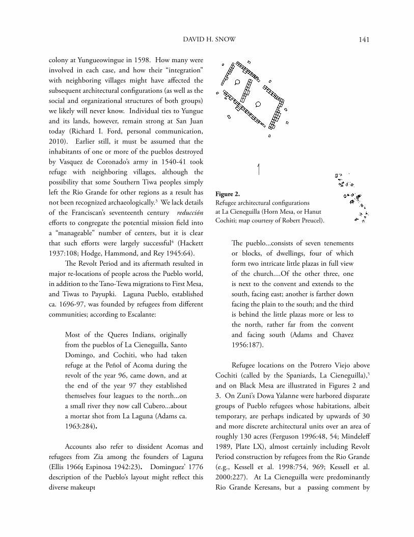
141
colony at Yungueowingue in 1598. How many were involved in each case, and how their “integration” with neighboring villages might have aff ected the subsequent architectural confi gurations (as well as the social and organizational structures of both groups) we likely will never know. Individual ties to Yungue and its lands, however, remain strong at San Juan today (Richard I. Ford, personal communication, 2010). Earlier still, it must be assumed that the inhabitants of one or more of the pueblos destroyed by Vasquez de Coronado’s army in 1540-41 took refuge with neighboring villages, although the possibility that some Southern Tiwa peoples simply left the Rio Grande for other regions as a result has not been recognized archaeologically.3 We lack details of the Franciscan’s seventeenth century reducción eff orts to congregate the potential mission fi eld into a “manageable” number of centers, but it is clear that such eff orts were largely successful4 (Hackett 1937:108; Hodge, Hammond, and Rey 1945:64). Th e Revolt Period and its aftermath resulted in major re-locations of people across the Pueblo world, in addition to the Tano-Tewa migrations to First Mesa, and Tiwas to Payupki. Laguna Pueblo, established ca. 1696-97, was founded by refugees from diff erent communities; according to Escalante:
Most of the Queres Indians, originally from the pueblos of La Cieneguilla, Santo Domingo, and Cochiti, who had taken refuge at the Peñol of Acoma during the revolt of the year 96, came down, and at the end of the year 97 they established themselves four leagues to the north...on a small river they now call Cubero...about a mortar shot from La Laguna (Adams ca. 1963:284).
Accounts also refer to dissident Acomas and refugees from Zia among the founders of Laguna (Ellis 1966; Espinosa 1942:23). Dominguez’ 1776 description of the Pueblo’s layout might refl ect this diverse makeup:
Th e pueblo...consists of seven tenements or blocks, of dwellings, four of which form two intricate little plazas in full view of the church....Of the other three, one is next to the convent and extends to the south, facing east; another is farther down facing the plain to the south; and the third is behind the little plazas more or less to the north, rather far from the convent and facing south (Adams and Chavez 1956:187).
Refugee locations on the Potrero Viejo above Cochiti (called by the Spaniards, La Cieneguilla),5
and on Black Mesa are illustrated in Figures 2 and 3. On Zuni’s Dowa Yalanne were harbored disparate groups of Pueblo refugees whose habitations, albeit temporary, are perhaps indicated by upwards of 30 and more discrete architectural units over an area of roughly 130 acres (Ferguson 1996:48, 54; Mindeleff 1989, Plate LX), almost certainly including Revolt Period construction by refugees from the Rio Grande (e.g., Kessell et al. 1998:754, 969; Kessell et al. 2000:227). At La Cieneguilla were predominantly Rio Grande Keresans, but a passing comment by
Figure 2. Refugee architectural confi gurations at La Cieneguilla (Horn Mesa, or Hanut Cochiti; map courtesy of Robert Preucel).
DAVID H. SNOW
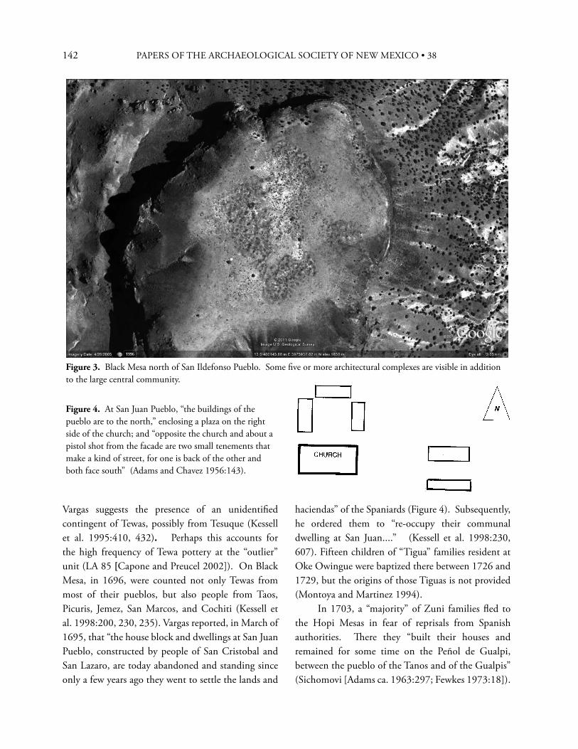
142 PAPERS OF THE ARCHAEOLOGICAL SOCIETY OF NEW MEXICO • 38
Vargas suggests the presence of an unidentifi ed contingent of Tewas, possibly from Tesuque (Kessell et al. 1995:410, 432). Perhaps this accounts for the high frequency of Tewa pottery at the “outlier” unit (LA 85 [Capone and Preucel 2002]). On Black Mesa, in 1696, were counted not only Tewas from most of their pueblos, but also people from Taos, Picuris, Jemez, San Marcos, and Cochiti (Kessell et al. 1998:200, 230, 235). Vargas reported, in March of 1695, that “the house block and dwellings at San Juan Pueblo, constructed by people of San Cristobal and San Lazaro, are today abandoned and standing since only a few years ago they went to settle the lands and
Figure 3. Black Mesa north of San Ildefonso Pueblo. Some fi ve or more architectural complexes are visible in addition to the large central community.
Figure 4. At San Juan Pueblo, “the buildings of the pueblo are to the north,” enclosing a plaza on the right side of the church; and “opposite the church and about a pistol shot from the facade are two small tenements that make a kind of street, for one is back of the other and both face south” (Adams and Chavez 1956:143).
haciendas” of the Spaniards (Figure 4). Subsequently, he ordered them to “re-occupy their communal dwelling at San Juan....” (Kessell et al. 1998:230, 607). Fifteen children of “Tigua” families resident at Oke Owingue were baptized there between 1726 and 1729, but the origins of those Tiguas is not provided (Montoya and Martinez 1994). In 1703, a “majority” of Zuni families fl ed to the Hopi Mesas in fear of reprisals from Spanish authorities. Th ere they “built their houses and remained for some time on the Peñol de Gualpi, between the pueblo of the Tanos and of the Gualpis” (Sichomovi [Adams ca. 1963:297; Fewkes 1973:18]).
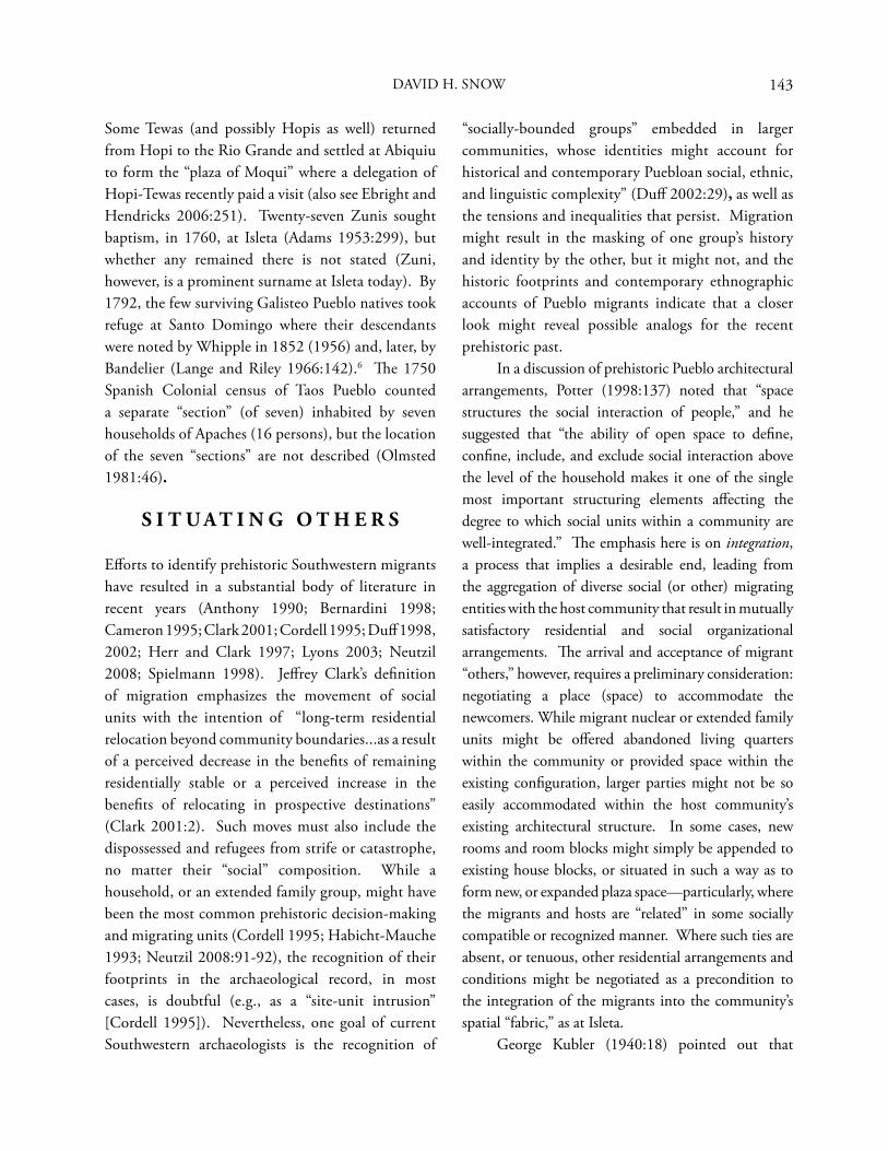
143
Some Tewas (and possibly Hopis as well) returned from Hopi to the Rio Grande and settled at Abiquiu to form the “plaza of Moqui” where a delegation of Hopi-Tewas recently paid a visit (also see Ebright and Hendricks 2006:251). Twenty-seven Zunis sought baptism, in 1760, at Isleta (Adams 1953:299), but whether any remained there is not stated (Zuni, however, is a prominent surname at Isleta today). By 1792, the few surviving Galisteo Pueblo natives took refuge at Santo Domingo where their descendants were noted by Whipple in 1852 (1956) and, later, by Bandelier (Lange and Riley 1966:142).6 Th e 1750 Spanish Colonial census of Taos Pueblo counted a separate “section” (of seven) inhabited by seven households of Apaches (16 persons), but the location of the seven “sections” are not described (Olmsted 1981:46).
S I T U A T I N G O T H E R S
Eff orts to identify prehistoric Southwestern migrants have resulted in a substantial body of literature in recent years (Anthony 1990; Bernardini 1998; Cameron 1995; Clark 2001; Cordell 1995; Duff 1998, 2002; Herr and Clark 1997; Lyons 2003; Neutzil 2008; Spielmann 1998). Jeff rey Clark’s defi nition of migration emphasizes the movement of social units with the intention of “long-term residential relocation beyond community boundaries...as a result of a perceived decrease in the benefi ts of remaining residentially stable or a perceived increase in the benefi ts of relocating in prospective destinations” (Clark 2001:2). Such moves must also include the dispossessed and refugees from strife or catastrophe, no matter their “social” composition. While a household, or an extended family group, might have been the most common prehistoric decision-making and migrating units (Cordell 1995; Habicht-Mauche 1993; Neutzil 2008:91-92), the recognition of their footprints in the archaeological record, in most cases, is doubtful (e.g., as a “site-unit intrusion” [Cordell 1995]). Nevertheless, one goal of current Southwestern archaeologists is the recognition of
“socially-bounded groups” embedded in larger communities, whose identities might account for historical and contemporary Puebloan social, ethnic, and linguistic complexity” (Duff 2002:29), as well as the tensions and inequalities that persist. Migration might result in the masking of one group’s history and identity by the other, but it might not, and the historic footprints and contemporary ethnographic accounts of Pueblo migrants indicate that a closer look might reveal possible analogs for the recent prehistoric past. In a discussion of prehistoric Pueblo architectural arrangements, Potter (1998:137) noted that “space structures the social interaction of people,” and he suggested that “the ability of open space to defi ne, confi ne, include, and exclude social interaction above the level of the household makes it one of the single most important structuring elements aff ecting the degree to which social units within a community are well-integrated.” Th e emphasis here is on integration, a process that implies a desirable end, leading from the aggregation of diverse social (or other) migrating entities with the host community that result in mutually satisfactory residential and social organizational arrangements. Th e arrival and acceptance of migrant “others,” however, requires a preliminary consideration: negotiating a place (space) to accommodate the newcomers. While migrant nuclear or extended family units might be off ered abandoned living quarters within the community or provided space within the existing confi guration, larger parties might not be so easily accommodated within the host community’s existing architectural structure. In some cases, new rooms and room blocks might simply be appended to existing house blocks, or situated in such a way as to form new, or expanded plaza space—particularly, where the migrants and hosts are “related” in some socially compatible or recognized manner. Where such ties are absent, or tenuous, other residential arrangements and conditions might be negotiated as a precondition to the integration of the migrants into the community’s spatial “fabric,” as at Isleta. George Kubler (1940:18) pointed out that
DAVID H. SNOW
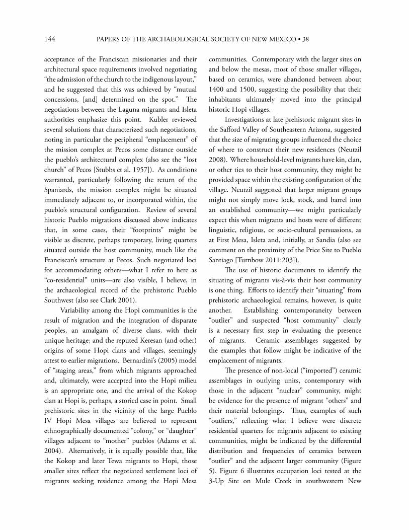
144 PAPERS OF THE ARCHAEOLOGICAL SOCIETY OF NEW MEXICO • 38
acceptance of the Franciscan missionaries and their architectural space requirements involved negotiating “the admission of the church to the indigenous layout,” and he suggested that this was achieved by “mutual concessions, [and] determined on the spot.” Th e negotiations between the Laguna migrants and Isleta authorities emphasize this point. Kubler reviewed several solutions that characterized such negotiations, noting in particular the peripheral “emplacement” of the mission complex at Pecos some distance outside the pueblo’s architectural complex (also see the “lost church” of Pecos [Stubbs et al. 1957]). As conditions warranted, particularly following the return of the Spaniards, the mission complex might be situated immediately adjacent to, or incorporated within, the pueblo’s structural confi guration. Review of several historic Pueblo migrations discussed above indicates that, in some cases, their “footprints” might be visible as discrete, perhaps temporary, living quarters situated outside the host community, much like the Franciscan’s structure at Pecos. Such negotiated loci for accommodating others—what I refer to here as “co-residential” units—are also visible, I believe, in the archaeological record of the prehistoric Pueblo Southwest (also see Clark 2001). Variability among the Hopi communities is the result of migration and the integration of disparate peoples, an amalgam of diverse clans, with their unique heritage; and the reputed Keresan (and other) origins of some Hopi clans and villages, seemingly attest to earlier migrations. Bernardini’s (2005) model of “staging areas,” from which migrants approached and, ultimately, were accepted into the Hopi milieu is an appropriate one, and the arrival of the Kokop clan at Hopi is, perhaps, a storied case in point. Small prehistoric sites in the vicinity of the large Pueblo IV Hopi Mesa villages are believed to represent ethnographically documented “colony,” or “daughter” villages adjacent to “mother” pueblos (Adams et al. 2004). Alternatively, it is equally possible that, like the Kokop and later Tewa migrants to Hopi, those smaller sites refl ect the negotiated settlement loci of migrants seeking residence among the Hopi Mesa
communities. Contemporary with the larger sites on and below the mesas, most of those smaller villages, based on ceramics, were abandoned between about 1400 and 1500, suggesting the possibility that their inhabitants ultimately moved into the principal historic Hopi villages. Investigations at late prehistoric migrant sites in the Saff ord Valley of Southeastern Arizona, suggested that the size of migrating groups infl uenced the choice of where to construct their new residences (Neutzil 2008). Where household-level migrants have kin, clan, or other ties to their host community, they might be provided space within the existing confi guration of the village. Neutzil suggested that larger migrant groups might not simply move lock, stock, and barrel into an established community—we might particularly expect this when migrants and hosts were of diff erent linguistic, religious, or socio-cultural persuasions, as at First Mesa, Isleta and, initially, at Sandia (also see comment on the proximity of the Price Site to Pueblo Santiago [Turnbow 2011:203]). Th e use of historic documents to identify the situating of migrants vis-à-vis their host community is one thing. Eff orts to identify their “situating” from prehistoric archaeological remains, however, is quite another. Establishing contemporaneity between “outlier” and suspected “host community” clearly is a necessary fi rst step in evaluating the presence of migrants. Ceramic assemblages suggested by the examples that follow might be indicative of the emplacement of migrants. Th e presence of non-local (“imported”) ceramic assemblages in outlying units, contemporary with those in the adjacent “nuclear” community, might be evidence for the presence of migrant “others” and their material belongings. Th us, examples of such “outliers,” refl ecting what I believe were discrete residential quarters for migrants adjacent to existing communities, might be indicated by the diff erential distribution and frequencies of ceramics between “outlier” and the adjacent larger community (Figure 5). Figure 6 illustrates occupation loci tested at the 3-Up Site on Mule Creek in southwestern New
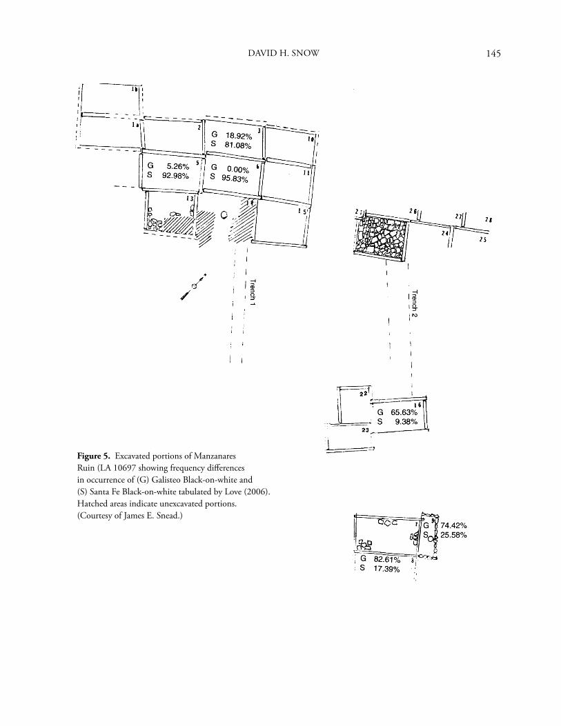
145
Figure 5. Excavated portions of Manzanares Ruin (LA 10697 showing frequency diff erences in occurrence of (G) Galisteo Black-on-white and (S) Santa Fe Black-on-white tabulated by Love (2006). Hatched areas indicate unexcavated portions. (Courtesy of James E. Snead.)
DAVID H. SNOW
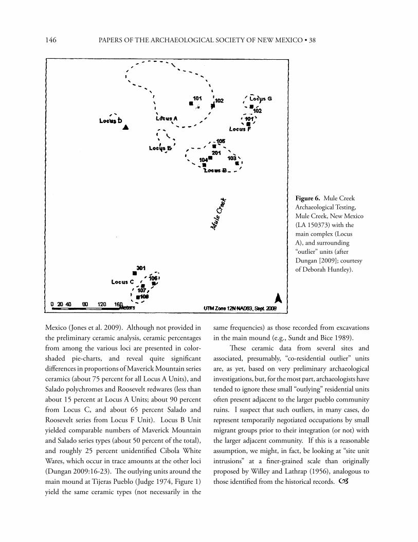
146 PAPERS OF THE ARCHAEOLOGICAL SOCIETY OF NEW MEXICO • 38
Mexico (Jones et al. 2009). Although not provided in the preliminary ceramic analysis, ceramic percentages from among the various loci are presented in color-shaded pie-charts, and reveal quite signifi cant diff erences in proportions of Maverick Mountain series ceramics (about 75 percent for all Locus A Units), and Salado polychromes and Roosevelt redwares (less than about 15 percent at Locus A Units; about 90 percent from Locus C, and about 65 percent Salado and Roosevelt series from Locus F Unit). Locus B Unit yielded comparable numbers of Maverick Mountain and Salado series types (about 50 percent of the total), and roughly 25 percent unidentifi ed Cibola White Wares, which occur in trace amounts at the other loci (Dungan 2009:16-23). Th e outlying units around the main mound at Tijeras Pueblo (Judge 1974, Figure 1) yield the same ceramic types (not necessarily in the
same frequencies) as those recorded from excavations in the main mound (e.g., Sundt and Bice 1989). Th ese ceramic data from several sites and associated, presumably, “co-residential outlier” units are, as yet, based on very preliminary archaeological investigations, but, for the most part, archaeologists have tended to ignore these small “outlying” residential units often present adjacent to the larger pueblo community ruins. I suspect that such outliers, in many cases, do represent temporarily negotiated occupations by small migrant groups prior to their integration (or not) with the larger adjacent community. If this is a reasonable assumption, we might, in fact, be looking at “site unit intrusions” at a fi ner-grained scale than originally proposed by Willey and Lathrap (1956), analogous to those identifi ed from the historical records.
Figure 6. Mule Creek Archaeological Testing, Mule Creek, New Mexico (LA 150373) with the main complex (Locus A), and surrounding “outlier” units (after Dungan [2009]; courtesy of Deborah Huntley).
147
E N D N O T E S
1. Revised and expanded version of a presentation at the 2010 Annual Meeting of the Archaeological Society of New Mexico, Santa Fe, entitled: “Migration, Residence Patterns, and the Persistence of Identity in the Puebloan Southwest.”
2. Fray Morfí, writing in 1782 (Th omas 1932:159-60) noted that friars had brought down some families from Oraibi in 1742, for reason of “discord over the election of a chief in Oraibi,” resulting in two sides taking “arms against one another.” Th e least powerful, he said “… (which was composed of said families and others....) being hated because of its temerity or fearful of other encounters took refuge on the little mesa on which the Tiguas were already, these also previously indisposed with the rest of that province” (my emphasis). Presumably, the presence of Payupki people (as Sandia Pueblo is called today by Hopis [Hodge 1910:218, 429]) on Second Mesa is referred to, and their presence, seemingly, was not universally well “disposed” by some Hopis. Th e place at Isleta called “Oraibi” might recall Tiwas among the Oraibi immigrants brought down in 1742 to the Rio Grande (Hackett 1937:390-91).
3. Th e interrogation of Jerónimo, in 1682, native of Puaray Pueblo, revealed to the Spaniards that “the Tiguas of Alameda, Puaray, and Sandia, because their pueblos have been burned, have discussed going to settle at Sima and in the jurisdiction of La Canada....” (Hackett and Shelby 1942:361; my emphasis). Brandt (1979:345) mistakenly cited this as “Sima in the jurisdiction of La Canada” (my emphasis). Th us, “Sima” lay elsewhere, possibly the Hopi Mesa region, where Tiwas from Puaray, Alameda, Sandia, and Isleta took refuge against the return of the Spaniards following the Pueblo Revolt. A 1909 manuscript by J. P. Harrington refers to a Sima dialect of Sandia, “words of which were collected at Ysleta del Sur,” but no other information was available (Brandt 1979:345). Lujan’s account of the 1582 Espejo expedition to New Mexico (Hammond and Rey 1966:153-212) named 13 pueblos of the province where the friars had been martyred previously (the “province of Puaray”). In addition to “Guagua” (almost certainly, Kuaua), is “Simassa” (Hammond and
Rey 1966:203), written in Oñate’s 1598 list as “Tziymatzi,” a Tiwa pueblo (Hammond and Rey 1953:346), next to “Paurai” in that list. I surmise that the people of “Simassa” either were reduced early in the seventeenth century, or fl ed to parts unknown—perhaps to the Hopi Mesas.
A section of Cochiti Pueblo identifi ed as the “Butterfl y group” (butterfl y, bekarana ~ bu·raika in Keresan [Davis 1964:165; Father Hillaire, personal communication, 2010], lies south of the plaza and church. Informants gave no particular signifi cance to the name (Lange 1952:End Map 2), but possibly refl ects descendants of former migrants. A sketch map in Leslie White’s Santo Domingo ethnography (1935:180; reproduced in Armstrong et al. 2011:38) depicts a series of numbered villages said to have been destroyed by Plains enemies in the past. Number 9 on the map is labeled Peña Blanca, and identifi ed as “Be’rakana.” Another migrant group, cited by Sandia elders, is a 10-room ruin with Glaze E pottery some 2 mi north of the pueblo, said to have been settled by migrants from “Abo” [!] (Marshall 2008:74).
4. Perhaps hyperbole on the part of Governor Diego de Peñalosa in 1665, he claimed that “he reduced to peace two heathen nations, the Cruzados and the Coninas, and made them settle by assembling them in two large pueblos in the province of Moqui” (Hackett 1937:264). If true, where were they, and how might archaeologists recognize them?
5. La Cieneguilla, the 1693-96 refugee pueblo on Horn Mesa (Potrero Viejo), does not refer to its situation in a “little marshy area,” but rather, almost certainly was so called by the Spaniards as a result of the establishment thereon by the inhabitants of the abandoned pueblo of La Cienega. Th is lay some 15 mi below Santa Fe on a tributary to the river of that name, and was a visita of San Marcos mission (e.g., Snow 2008)
6. Th at some of the San Marcos people remained with those who returned to re-establish Santo Domingo is evident from their eff orts to gain possession of the Cerrillos Hills (e.g., Schroeder 1975) and the fact that their descendants recall their ancestral heritage (personal communication to the writer 2008; name withheld on request).
DAVID H. SNOW
148 PAPERS OF THE ARCHAEOLOGICAL SOCIETY OF NEW MEXICO • 38
R E F E R E N C E S C I T E D
Adams, E. Charles, Vincent M. LaMotta, and Kurt Dongoske2004 Hopi Settlement Clusters Past and Present. In
Th e Protohistoric Pueblo World, A.D. 1275-1600, edited by E. Charles Adams and Andrew I. Duff , pp. 128-136. University of Arizona Press, Tucson.
Adams, Eleanor B., translator and editor1953 Bishop Tamarón’s Visitation of New Mexico,
1760. New Mexico Historical Review 28(3-4):192-315.
ca. 1963 Fray Silvestre Vélez de Escalante’s “Extractos de Noticias.” Biblioteca Nacional, Mexico, BNM legajo 3, num. 1.
Adams, Eleanor B., and Fray Angelico Chavez, translators and editors1956 Th e Missions of New Mexico, 1776: A Description
by Fray Francisco Atanasio Dominguez, and other Contemporary Documents. University of New Mexico Press, Albuquerque.
Anthony, David W.1990 Migration in Archaeology. American
Anthropologist 92:895-914.
Armstrong, Karen, Th omas M. Morales, and David H. Snow2011 Tunque Redux: A Work in Progress. In Words
and Sherds, Papers in Honor of Meliha S. Duran & David T. Kirkpatrick, edited by Emily J. Brown, Carol J. Condie, and Helen K. Crotty, pp. 33-41. Papers of the Archaeological Society of New Mexico 37, Albuquerque.
Bernardini, Wesley1998 Confl ict, Migration, and the Social Environment:
Interpreting Architectural Change in Early and Late Pueblo IV Aggregations. In Migration and Reorganization: Th e Pueblo IV Period in the American Southwest, edited by Katherine A. Spielmann, pp. 91-114. Arizona State University Anthropological Research Papers 51, Tempe.
2005 Hopi Oral Tradition and the Archaeology of Identity. University of Arizona Press, Tucson.
Brandt, Elizabeth A.1979 Sandia Pueblo. In Southwest, edited by Alfonso
Ortiz, pp. 343-350, Handbook of North American
Indians, Vol. 9. Smithsonian Institution, Washington.
Cameron, Catherine M. 1995 Migration and the Movement of Southwestern
peoples. In Migration and the Movement of Southwestern Peoples, edited by Catherine M. Cameron, pp. 203-211. Journal of Anthropological Archaeology 14(2).
Capone, Patricia W., and Robert W. Preucel2002 Ceramic Simiotics: Women, Pottery, and Social
Meanings in Kotyiti Pueblo. Archaeologies of the Pueblo Revolt: Identity, Meaning, and Renewal in the Pueblo World, edited by R. W. Preucel, pp. 99-113. University of New Mexico Press, Albuquerque.
Clark, Jeff ery J.2001 Tracking Prehistoric Migrations: Pueblo Settlers
among the Tonto Basin Hohokam. Anthropological Papers of the University of Arizona 65. Tucson.
Cordell, Linda S.1995 Tracing Migration Pathways from the Receiving
End. In Migration and the Movement of Southwestern Peoples, edited by Catherine M. Cameron, pp. 23-32. Journal of Anthropological Archaeology 14(2).
Crane, Leo1928 Desert Drums: Th e Pueblo Indians of New Mexico,
1540-1928. Little, Brown and Company, Boston.
Davis, Irvine1964 Th e Language of Santa Ana Pueblo. Bureau of
American Ethnology Anthropological Papers 69. Washington.
Dungan, Katherine2009 “Ceramic Analysis,” In Preliminary Report: 2008
Investigations at the 3-Up Site (LA 150373) Mule Creek, New Mexico, by Robert M. Jones, Kathleen A. Dungan, Deborah L. Huntley, J. Brett Hill, and Jeff rey Clark, pp. 16-23. Manuscript on fi le, Center of Desert Archaeology, Tucson.
Duff , Andrew I.1998 Th e Process of Migration in the Late Prehistoric
Southwest. Migration and Reorganization: Th e Pueblo IV Period in the American Southwest, edited by Katherine A. Spielman, pp. 31-52. Arizona State University Anthropological Research Papers 51. Tempe.
149
2002 Western Pueblo Identities: Regional Interaction, Migration, and Transformations. University of Arizona Press, Tucson.
Ebright, Malcolm, and Rick Hendricks2006 Th e Witches of Abiquiu: Th e Governor, the Priest,
the Genizaro Indians, and the Devil. University of New Mexico Press, Albuquerque.
Ellis, Florence Hawley1966 On Distinguishing Laguna from Acoma
Polychrome. El Palacio 73(3):37-39.
Espinosa, J. Manuel1942 Crusaders of the Rio Grande. Institute of Jesuit
History, Chicago.
Euler, Robert C.1954 Notes on Land Tenure at Isleta Pueblo. El Palacio
61(11):368-373.
Ferguson, T. J.1996 Historic Zuni Architecture and Society: An
Archaeological Application of Space Syntax. Anthropological Papers of the University of Arizona 60. Tucson.
Fewkes, Jesse Walter1973 Designs on Prehistoric Hopi Pottery. Dover
Publications, New York.
Habicht-Mauche, Judith A.1993 Th e Pottery from Arroyo Hondo Pueblo, New
Mexico: Tribalization and Trade in the Northern Rio Grande. School of American Research Press, Santa Fe.
Hackett, Charles W.1937 Historical Documents relating to New Mexico,
Nueva Vizcaya, and Approaches Th ereto, to 1773 (Vol. 3). Carnegie Institution of Washington Publications 330, Washington.
Hackett, Charles W., and Charmion Clair Shelby1942 Revolt of the Pueblo Indians of New Mexico and
Otermin’s Attempted Reconquest, 1680-1682 (Vol. 9). University of New Mexico Press, Albuquerque.
Hammond, George P., and Agapito Rey1953 Don Juan de Oñate, Colonizer of New Mexico,
1595-1628 (Part 1). University of New Mexico Press, Albuquerque.
1966 Th e Rediscovery of New Mexico. University of New Mexico Press, Albuquerque.
Herr, Sarah, and Jeff rey J. Clark1997 Patterns in the Pathways: Early Historic
Migrations in the Rio Grande Pueblos. Kiva 62(4):365-390.
Hodge, Frederick Webb, editor1910 Handbook of American Indians North of Mexico
(Part 2). Bureau of American Ethnology Bulletins 30. Washington.
Hodge, Frederick Webb, George P. Hammond, andAgapito Rey1945 Fray Alonso de Benavides’ Revised Memorial
of 1634. University of New Mexico Press, Albuquerque.
Jones, Robert M., Kathleen A. Dungan, Deborah L. Huntley, J. Brett Hill, and Jeff rey Clark2009 Preliminary Report: 2008 Investigations at
the 3-Up Site (LA 150373) Mule Creek, New Mexico. Manuscript on fi le, Center for Desert Archaeology, Tucson.
Judge, James W.1974 Th e Excavation of Tijeras Pueblo 1971-1973:
Preliminary Report, Cibola National Forest, New Mexico. USDA Forest Service Archeological Reports 3. Albuquerque.
Kessell, John L., Rick Hendricks, and Meredith Dodge, editors,1995 To the Royal Crown Restored: Th e Journals of
Don Diego de Vargas, New Mexico, 1692-1694. University of New Mexico Press, Albuquerque.
1998 Blood on the Boulders: Th e Journals of Don Diego de Vargas, New Mexico, 1694-97. University of New Mexico Press, Albuquerque.
Kessell, John L., Rick Hendricks, Meredith D. Dodge, and Larry D. Miller, editors2000 Th at Disturbances Cease: Th e Journals of Don
Diego de Vargas, New Mexico 1697-1700. University of New Mexico Press, Albuquerque.
Kubler, George1940 Th e Religious Architecture of New Mexico in the
Colonial Period and Since the American Occupation. Th e Taylor Museum, Colorado Springs.
DAVID H. SNOW
150 PAPERS OF THE ARCHAEOLOGICAL SOCIETY OF NEW MEXICO • 38
Lange, Charles H.1952 Cochiti: A New Mexico Pueblo, Past and Present.
University of Texas Press, Austin.
Lange, Charles H., and Carroll L. Riley, editors1966 Th e Southwestern Journals of Adolph F. Bandelier,
1880–1882. University of New Mexico Press, Albuquerque.
Levine, Frances1999 Our Prayers are in Th is Place: Pecos Pueblo, Identity
Over the Centuries. University of New Mexico Press, Albuquerque.
Love, Lori B.2006 Preliminary Ceramic Report: Review of LA
10607 (Manzanares) Collection at the Laboratory of Anthropology, Summer 2006. Paper prepared for ANTH 499, Independent Research. Manuscript on fi le, George Mason University, Fairfax.
Lyons, Patrick D.2003 Ancestral Hopi Migrations. Anthropological
Papers of the University of Arizona 68. Tucson.
Marshall, Michael P.2008 Archeological Monitoring for the Sandia Pueblo
Water and Wastewater Improvement Project, Sandoval County, New Mexico. Cibola Research Consultants Reports 444. Corrales, New Mexico.
Mindeleff , Victor1989 A Study of Pueblo Architecture in Tusayan and
Cibola. Eighth Annual Report of the Bureau of Ethnology, 1886-87 (originally published 1891). Smithsonian Institution, Washington
Montoya, Benito, and Th omas D. Martinez1994 San Juan de los Caballeros Baptisms, 1726-
1870. Baptism database of archives held by the Archdiocese of Santa Fe and the State Archive of New Mexico. San Jose, California.
Neutzil, Anna A.2008 In the Aftermath of Migration: Renegotiating
Ancient Identity in Southeastern Arizona. University of Arizona Press, Tucson.
Olmsted, Virginia L.1981 Spanish and Mexican Censuses of New Mexico:
1750-1830. New Mexico Genealogical Society, Inc., Albuquerque.
Parsons, Elsie Clews1925 Th e Pueblo of Jemez. Yale University Press, New
Haven.1932 Th e Pueblo of Isleta. Forty-seventh Annual Report
of the Bureau of American Ethnology, 1929-1930, pp. 193-465. Washington.
Pauketat, Timothy R.2008 Th e Grounds for Agency in Southwest
Archaeology. In Th e Social Construction of Communities: Agency, Structure, and Identity in the Prehispanic Southwest, edited by Mark D. Varien and James M. Potter, pp. 233-250. Altamira Press, Walnut Creek.
Potter, James M.1998 Th e Structure of Open Space in Late Prehistoric
Settlements in the Southwest. In Migration and Reorganization: Th e Pueblo IV Period in the American Southwest, edited by Katherine A. Spielmann, pp. 137-163. Arizona State University Anthropological Research Papers 51, Tempe.
Sando, Joe S.1982 Nee Hemish: A History of Jemez Pueblo.
University of New Mexico Press, Albuquerque.
Schroeder, Albert H.1975 A History of the Area Along the Eastern Line of
the Santo Domingo Pueblo Aboriginal Title Area. Manuscript prepared for the U.S. Department of Justice.
Simons, Suzanne Lee1970 Sandia Pueblo: Persistence and Change in a
New Mexican Indian Community. Unpublished Ph.D. dissertation, Department of Anthropology, University of New Mexico, Albuquerque.
Snow, David H.2008 Who were the San Marcosenos? In Chasing Chaco
and the Southwest, Papers in Honor of Frances Joan Mathien, edited by Regge N. Wiseman, Th omas C. O’Laughlin, Cordelia T. Snow, and Cathy Travis, pp. 187-196. Papers of the Archaeological Society of New Mexico 34, Albuquerque.
Spielmann, Katherine A., editor1998 Migration and Reorganization: Th e Pueblo IV Period
in the American Southwest. Arizona State University Anthropological Research Papers 51, Tempe.
151
Stubbs, Stanley A., Bruce T. Ellis, and Alfred E. Dittert1957 Th e “Lost” Pecos Church. El Palacio 64(2-3):67- 92.
Sundt, William M., and Richard A. Bice1989 Preliminary Report: Tijeras Canyon Sites AS-10.
Albuquerque Archaeological Society, Albuquerque.
Th omas, Alfred B., editor and translator1932 Forgotten Frontiers: A Study of the Spanish Indian
Policy of Don Juan Bautista de Anza, Governor of New Mexico, 1777-1787. University of Oklahoma Press, Norman.
Titiev, Mischa1944 Old Oraibi: A Study of the Hopi Indians of
Th ird Mesa. Papers of the Peabody Museum of American Archaeology and Ethnology 22(1). Harvard University, Cambridge.
Turnbow, Christopher2011 Th e Price Site (LA 728): A Tiguex Province
Outlier. In Words and Sherds, Papers in Honor of Meliha S. Duran & David T. Kirkpatrick, edited by Emily J. Brown, Carol J. Condie, and Helen K. Crotty, pp. 193-203. Papers of the Archaeological Society of New Mexico 37, Albuquerque.
Walker, Willard1983 Th e Tewas and the Hopis. In Hopis, Tewas and
the American Road, edited by Willard Walker and Lydia Wyckoff , pp. 39-56. Weslyan University Press, Middletown, Connecticut.
Whipple, Lt. A. W.1956 Extracts from the [preliminary] report of
Explorations for a Railway route, near the thirty-fi fth parallel of north latitude, from the Mississippi river to the Pacifi c ocean, by Lieutenant A. W. Whipple, Corps of Topographical Engineers. House of Representatives, 32nd Congress, 2d Session, Executive Document No. 91, Vol. 3, p. 90. U.S. Government Printing Offi ce, Washington.
White, Leslie A.1935 Th e Pueblo of Santo Domingo, New Mexico.
Memoirs of the American Anthropological Association 43.
Willey, Gordon R., and Donald W. Lathrap1956 An Archaeological Classifi cation of Culture
Contact Situations. In Seminars in Archaeology: 1955, edited by Robert Wauchope, pp. 3-30. Memoirs of the Society for American Archaeology 11.
DAVID H. SNOW

152 PAPERS OF THE ARCHAEOLOGICAL SOCIETY OF NEW MEXICO • 38
153
153
It is not often that archaeologists have access to large numbers of metates for the purposes of study and comparison. Th rough the years the author has taken the opportunity to measure and describe fi ve large collections of complete metates from four counties (Chaves, Eddy, Lincoln, Otero) in south-central and southeastern New Mexico (Figure 1). Th e importance of a data base of this size is that we can now compare certain aspects of grinding equipment across this large region. At the present time, the Late Prehistoric societies of Lincoln and Otero counties are demonstrated to have engaged in farming to as yet an unspecifi ed degree. Suffi ce it to say, corn remains and sometimes other cultigens are fairly commonly recovered from village sites in this, the Sierra Blanca region as defi ned by Jane Kelley (1984). On the other hand, the prehistoric inhabitants of Chaves (excepting the Roswell oasis) and Eddy counties are only presumed to have been farmers on the basis of the presence of pottery and rare instances of structures. More recent studies, however, suggest that most of the groups in Eddy and Chaves counties were hunter-gatherers, not farmers. Th us, we would expect to fi nd diff erences in the metates used by each group. Because farmers were growing corn and consuming more grain than hunter-gatherers, they are believed to have ground more plant foodstuff s on their metates. In general, the farmers’ metates should have larger grinding surfaces for greater effi ciency in grinding larger amounts of corn in a given
amount of time. Conversely, hunter-gatherer metates are generally known to have had fairly small grinding surfaces refl ective of the fact that they evidently used smaller amounts of seeds at a given meal. Are size diff erences refl ected in the grinding surfaces of the metates from the study collections? It is also pertinent to note that farmers elsewhere in the Southwest developed specialized forms of metates, and in some cases, increased grinding performance by stabilizing them in permanent facilities called mealing or grinding bins. Did the farmers in Lincoln and Otero counties use more specialized forms of metates, and did they place them in mealing bins? Th ese questions pertain not only to the comparisons to be made with the metates from Chaves and Eddy counties but also pertain to comparisons that can be made between the Sierra Blanca region and other areas of the Southwest. As mentioned earlier, several forms of metates are known for the Southwestern fi eld, and Southwestern archaeologists have devised names for each of these types. Th e same is true for archaeologists working elsewhere in the United States. Th e trouble is, the same word is sometimes used in adjacent regions but in diff erent ways. Accordingly, archaeologists working in southeastern New Mexico have to be aware of the diff erences in terms used by Southwesternists versus Texas and Southern Plains archaeologists. Th e reader should note that this paper follows Southwestern usages and, in particular, those applied to Ancestral Puebloan (“Anasazi”) and Historic Puebloan cultures of the Four Corners region. Th ere, three general types
Inferences About Prehistoric Subsistence in the Pecos Country and the Sierra Blanca Region
of Southeastern New Mexico
R E G G E N . W I S E M A N
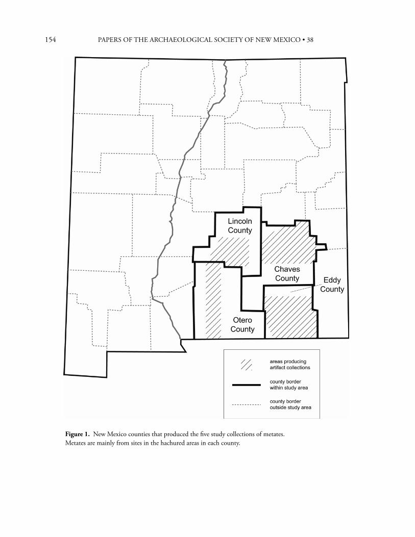
154 PAPERS OF THE ARCHAEOLOGICAL SOCIETY OF NEW MEXICO • 38
Figure 1. New Mexico counties that produced the fi ve study collections of metates. Metates are mainly from sites in the hachured areas in each county.
155
of metates are recognized—basin, trough, and slab (or “fl at”). Generally speaking for the Southwest, these metate types were developed and used sequentially through time. Basin metates, being the smallest in grinding surface area, are believed to have been used for grinding small amounts of materials, whether they were foodstuff s, medicines, paints, salt, or other materials. Th ey were most common in the early periods but became less common as the reliance on corn increased through time. Small numbers of basin metates were used well into the Historic period, but usually for grinding materials other than corn (Wiseman 1969). As corn became more important in the diet, trough metates were developed to process the larger quantities needed on a periodic (daily?) basis. Trough metates could be taken from storage and propped at an angle using stones to create a temporary work station. Or, they could be installed in permanent mealing bins. Adams (1993) discusses the physical and energy benefi ts involved in grinding and how these change with the type of metate. Th e fi nal step in the commitment to corn was the development of slab or fl at metates that provided maximum grinding surface confi ned in the most stable of positions, the mealing bin. Slab/fl at metates could be used only when mounted in mealing bins because the stones lacked raised areas to keep the meal gathered for grinding; the sides of the mealing bin served this function. Th e regular appearance of mealing bins signals the ever increasing commitment to corn in terms of time, dedicated work space, and quantities ground. Before the arrival of the Spanish in the mid A.D. 1500s, some Native American groups used several types of stone to make slab metates. Some stones are more grainy or coarsely textured and others are less grainy. Placed in adjoining compartments of a multi-compartment bin, each successive grade of stone ground the meal into fi ner and fi ner particles. By the time multiple-compartment grinding bins appeared, corn was clearly a major foodstuff that was ground and consumed on a daily basis.
T Y P E S O F M E T A T E S
Basin metates have oval grinding surfaces that curve gently and evenly in all directions from the rim of the stone. Basin metates occur on stone slabs, chunky rocks, boulders, and exposures of bedrock. Th e working position of most, if not all, basin metates was probably fl at on the ground in a horizontal position. It is important to note that, to Texas and Plains archaeologists, a slab metate is not the shaped artifact just described. To them, a slab metate is a relatively large slab of rock bearing a small grinding surface on one face. (Southwestern archaeologists commonly know this type of metate as an Archaic period metate.) Trough metates have grinding surfaces that are long compared to width. Across the width, the curvature of the grinding surface is slightly concave until it reaches the vertical side walls. Th e side walls, which deepen with use, serve to confi ne the grinding to a forward/backward motion and to keep the material being ground from spilling laterally. Th e ends of the grinding surface of the trough metate can be of one of two types: “one-end-open” and “through.” In the one-end-open type, one end curves up fairly abruptly to the rim of the stone (similar to the sides of the trough) and the lower end is left open to allow the meal to be moved out of the metate and into a receptacle (often a pottery bowl) placed there for the purpose. Th e “through” trough metate has both ends “open.” On the slab or fl at metate, the grinding surface covers the entire top of the stone. Quite often, the sides, ends, and even bottom of the stone have also been shaped to remove excess rock and facilitate installation in grinding or mealing bins. A mealing bin consists of one or more contiguous rectangular compartments formed by vertical rock slabs. In each compartment, a metate is propped up at an approximate 45 degree angle and plastered into place with copious amounts of mud. Compartments per bin range from one to eight. Archaeologically, two to four compartments per bin appear to be the most common. Ethnographic accounts suggest that in historic times three is the more usual number.
REGGE N. WISEMAN
156 PAPERS OF THE ARCHAEOLOGICAL SOCIETY OF NEW MEXICO • 38
S U M M A R Y O F T H E P R E H I S T O R Y O F
S O U T H - C E N T R A L A N D S O U T H E A S T E R N
N E W M E X I C O
In 1948 Don Lehmer (1948) published his seminal defi nition of the Jornada branch of the Mogollon culture. He defi ned the territory of the Jornada Mogollon as a diamond-shaped region that stretches from Carrizozo, New Mexico on the north to below Villa Ahumada, State of Chihuahua, Mexico on the south. Th e east-west dimension extends from west of Deming, New Mexico to Carlsbad, New Mexico, placing El Paso, Texas, at the center of the region. Th en, in 1965, John Corley of the Lea County Archaeological Society (LCAS) in Hobbs proposed extension of the Jornada Mogollon concept to include the archaeological remains lying east of the Pecos River in southeastern New Mexico. Th is proposal seems to have become universally accepted and is known as the Eastern Extension of the Jornada Mogollon. Since then, archaeologists have simply “connected the dots” and included the territory between these two regions within the concept. Given the dearth of actual archaeological data at the time, this idea seemed sensible. And thus, for the past 60+ years, archaeologists have accepted this vast region as essentially constituting one culturally homogeneous region during prehistoric times. Over the years, however, data have accumulated to the point that it has become necessary to reevaluate this thesis and to reformulate the cultural relationships in this part of the state (Wiseman, in prep.). Th ese fi ndings are summarized here in order to provide a background for the discussion of the metates. Lehmer (1948) proposed two sequences of phases for the Jornada Mogollon: 1) the Mesilla, Doña Ana, and El Paso phases for the lowland basins around El Paso, Texas, and north to at least Alamogordo; 2) the Capitan, Th ree Rivers, and San Andres phases in the northern sequence for upland areas to the north and east. He initially believed that both sequences
started about A.D. 900 and ended about 1400. Th ese dates have since been adjusted to about A.D. 200 to 1450 by Miller and Kenmotsu (2004). In the El Paso region, the early Jornada Mogollon people had a pithouse-dwelling, pottery-making, hunting-gathering culture with low-level corn farming. Th e fi rst houses were brush huts or wickiup-like structures with shallowly excavated fl oors. Th ese were later replaced with larger structures that began to take on characteristics of true pithouses in terms of interior fl oor features and somewhat deeper excavations of the fl oors. Corn was farmed, but it was only a minor part of the diet for several hundred years. About A.D. 1000 the people began building surface structures of multi-cellular pueblo form, but not until somewhat later (about A.D. 1250 or 1300) did they signifi cantly increase their reliance on corn (Miller and Kenmotsu 2004). By this later date, some of the pueblos were as large as 100 or more rooms arranged as parallel blocks of rooms or as linear roomblocks arranged in squares around open spaces or plazas. Th e primary indigenous pottery at these late villages is El Paso Polychrome, but numerous imported pottery types are also found in small numbers. Descendant populations and their cultural remains have not been fi rmly identifi ed. Lehmer, on the basis of pottery assemblages and the surface characteristics of a few sites, boldly assumed that the sites in the upland regions were essentially the same as those of the lowlands. Corley’s (1965; see Leslie 1979 for amplifi cation) proposal for the Eastern Extension involves a sequence patterned on Lehmer’s sequences but uses the terms Querecho, Maljamar, and Ochoa for the phase names. Also, like Lehmer, he suggests dates based on associated pottery types, many of which are the same as those on El Paso sites, but off sets them 50 years later to allow for “diff usion” from the Jornada Mogollon heartland. Th e LCAS data base for the Eastern Extension includes several excavated sites and observations and surface collections at dozens of other sites scattered between the Pecos River on the west, U.S. 380 (Roswell to Tatum highway) on the north, and the two Texas state lines on the east and south. Th e excavations at
157
the Merchant site near Hobbs, New Mexico, were the most productive in terms of useful data (Leslie 1965). Th is site, the most thoroughly investigated by the LCAS, produced Ochoa Indented Corrugated pottery, small amounts of Jornada Mogollon pottery types made west of the Pecos River, two deep pithouses (only one completely excavated), and several small, above-ground surface rooms (rectangular outlines or cimientos [“foundations”] of rocks forming individual and multi-room units). Merchant and a few other sites bearing cimiento surface structures were assigned to the Ochoa Phase, the latest prehistoric phase and the one thought to be equivalent in time to the El Paso Phase of the Jornada Mogollon proper. Earlier Eastern Extension sites are characterized mainly by brown ware pottery, occasional Jornada types (all made west of the Pecos), and rare structural remains presumed to be pithouses but much more like wickiups. Corley assigned these sites to the Querecho and Maljamar phases and believed them to be cognates of the Mesilla and Doña Ana phases of the El Paso region. Dates for the Querecho and Maljamar are suggested on the basis of the associated imported pottery types, many of which are also found on Mesilla and Doña Ana sites. It is no coincidence, then, that the form of the Eastern Extension sequence (Querecho, Maljamar, and Ochoa phases), along with their suggested dates, greatly resemble the Mesilla/Doña Ana/El Paso sequence and its dates in the El Paso region. Although recovery techniques for micro-remains (for fl otation and pollen analyses) have not been performed on sediments from any of this original group of investigated sites, no corn or other cultigens have yet been identifi ed. Given the extensive excavations at the Merchant and a couple of other sites, this suggests that the people of the Eastern Extension subsisted on hunted and gathered wild products but not on corn. It is clear that the archaeological culture in New Mexico east of the Pecos River is very unlike that of the El Paso region, especially the manifestations dating after about A.D. 1000, and should not be considered part of them in any proper archaeological sense. Th e fi rst important addition to the regional
literature appeared in 1966 as Jane Kelley’s dissertation at Harvard University, but it was not made readily available until publication in 1984. Th e sites described and analyzed in this work lie within the northeastern high country or Sierra Blanca region originally included within Lehmer’s (1948) defi nition of the Jornada Mogollon. However, Kelley’s results demonstrate conclusively that the post-A.D. 1000/1200 archaeological remains in the Sierra Blanca country, while similar in some respects to those of the greater El Paso region, are clearly not El Paso Phase in character and should not be regarded as such. Kelley devised two taxonomic sequences to characterize her Sierra Blanca materials—the early and late periods of the Glencoe Phase for those remains situated on the eastern fl anks of Sierra Blanca (northern Otero and southern Lincoln counties) and the Corona and Lincoln phases for those remains situated around the Capitan, Jicarilla, and eastern slopes of the Gallinas mountains in Lincoln county. Th roughout the Glencoe Phase (ca. A.D. 500 to 1400?), the people lived in large pithouses, made quantities of plain Jornada Brown pottery, hunted/gathered wild plants and animals, and grew corn and beans. Glencoe people evidently were the earliest population that can be culturally identifi ed in the Sierra Blanca country. Corona Phase peoples lived in small pueblo-style structures that had depressed fl oors but that appeared on the ground surface as cimiento structures (similar to those described earlier). Later, during the succeeding Lincoln Phase, the people built larger structures of 10 to 100 rooms arranged in linear roomblocks and plaza pueblos situated on the then current grade. Corona Phase sites are characterized by plain Jornada Brown pottery that was replaced during the Lincoln Phase with the indented corrugated ware Corona Corrugated. Chupadero Black-on-white was the primary service ware used during both phases. During both phases, subsistence needs were met by hunting and gathering wild animals and plants and growing corn and beans. During the Lincoln Phase the people traded widely for pottery and other products. A number of characteristics of both the Corona and
REGGE N. WISEMAN
158 PAPERS OF THE ARCHAEOLOGICAL SOCIETY OF NEW MEXICO • 38
Lincoln phases suggest important connections, and perhaps ultimate origins, in the Gran Quivira region of central New Mexico (southwestern Torrance and eastern Socorro counties). Th e Corona and Lincoln phases thrived between about A.D. 1000 and 1400 or later. Another important addition to the literature is by Paul and Susana Katz (1985) concerning their work at Brantley Reservoir on the Pecos River, Carlsbad, and next to the eastern foothills of the Guadalupe Mountains. Th ey analyze and interpret their Brantley data in light of the archaeology of the Guadalupes as well as the Pecos Valley. In so doing, they provide a broader, better founded set of interpretations for the Carlsbad region as a whole. Th e sites at Brantley include a variety of burned rock and artifact locations, including two general types of burned rock middens—mounded and scattered. Th e only type of prehistoric habitations found on the project are stone enclosures (Katz and Katz 2002), the fi rst such reported for this part of New Mexico (see Wiseman 2002a). Importantly, the Katzes did not fi nd pithouses, pueblos, or even the fl oors of brush structures, though brush structures were later found nearby by Zamora (2000). Th e small amounts of pottery recovered from some of the Brantley and Guadalupe Mountain sites were clearly made (again on the basis of tempering materials) in the Sierra Blanca and El Paso regions and traded into the Carlsbad region. Subsistence pursuits in the Brantley locale involved hunting and gathering of wild terrestrial and riverine species. No unambiguous evidence of farming or gardening of corn or other domesticates has yet been found. Th e culture of the Brantley/Guadalupe Mountains region is clearly much more like that of the Trans-Pecos region to the south in Texas and defi nitely is unlike that of the Jornada Mogollon described by Lehmer (1948). Several of the most recent studies conducted in southeastern New Mexico have taken place within a 15 km radius of the city of Roswell. Previously, Jane Kelley (1984:Appendix 6) reported on the prehistoric adobe pueblo-style village of Bloom Mound. Excavations at this site by the Roswell Archaeological
Society recovered hundreds of stone and shell discoidal beads, seven copper bells, large amounts of El Paso Polychrome pottery, and a number of other unique items that really made this small pueblo stand out. Th is is especially so because of its small size and its location on the southeastern edge of the Southwestern pueblo world. Kelley postulated that the site was a fourteenth century trading post between the El Paso region and Pecos Pueblo (and by extension, the Southern Plains). Subsequent work at other Roswell sites such as Henderson (Speth 2004), Rocky Arroyo (Wiseman 1985), and the Fox Place (Wiseman 2002b) have resulted in the identifi cation of yet other unique characteristics of the Roswell locality. Because of the nature of the architectural, ceramic, artifactual, and subsistence remains recovered at these and a few other sites in the immediate area, it is clear that these sites represent both unique and familiar cultures. Because of the hydrologic characteristics of the area and the resulting fl oral and faunal communities, I believe the area immediately around and including Roswell can be characterized during prehistoric times as an oasis in the classic sense of the term.1
At least three diff erent prehistoric peoples seem to be represented at sites within the Roswell oasis. Th e fi rst were the people who probably had inhabited the region for a number of centuries or even millennia (see Rocek and Speth 1986) prior to the arrival of the other two. Th e inhabitants of the Fox Place and the Henderson site appear to represent late period examples of this original group. Th e Fox Place was a village of very small pithouses bearing all the characteristics of hunter-gatherers; they ate corn, but whether or not they grew that corn or obtained it from nearby Glencoe(?) farmers has not been established. A large socio-religious structure, bearing Glencoe Phase characteristics, was found among the pithouses, and is interpreted as evidence of religious proselytizing by Glencoe Phase peoples (Wiseman 2002b). Th e Henderson site, which may have been built, at least in part, by former occupants of the Fox Place, is a large, poorly constructed pueblo-style building of 75 to 100 rooms. Speth (2004) has defi ned two periods
159
of occupation of the site, both of which included corn farming. During the later period, subsistence practices became more Plains-like in character with an emphasis on hunting bison, communal consumption practices, and the like. Also during the later period, exchange relations with surrounding regions intensifi ed. A broader range of Southwestern pottery types made their way into the site, and the village social organization shifted toward an integrated, community-wide confi guration (Speth 2004). Th e second and third groups immigrated into the Roswell oasis from the Sierra Blanca country to the west. Although their arrival times have not been established except in the most general terms, these groups included Glencoe peoples who inhabited Rocky Arroyo and perhaps other nearby sites, and Lincoln peoples, who apparently built only one site, Bloom Mound. Th e social atmosphere created among these three groups apparently varied. Th e Glencoe people and the indigenous people appear to have gotten along with one another, but the occupants of Bloom Mound experienced violence on more than one occasion. Burned, unburied skeletons and individuals who appear to have been killed and then formally buried (Kelley 1984; Newlander and Speth 2009) have been recovered from Bloom. Newlander and Speth discuss the possibility that the attackers of Bloom Mound were prehistoric Central Texas peoples known as Toyahs. However, other possibilities need to be explored as well, for other examples of violence are also documented in the Sierra Blanca region (Wiseman 1997). In broad outline, then, the archaeological remains of the four study counties in this paper can be divided into pairs, with those of Eddy and Chaves counties (except for the Roswell oasis) being characterized as hunter-gatherers and those of Lincoln and Otero counties being farmers. Given the above view of Late Prehistoric cultures in southeastern New Mexico, what are our expectations regarding metates used by hunter-gatherers versus those of farmers? Current thinking suggests the
following. Hunter-gatherer metates, especially the grinding surfaces, should generally be smaller because they were used primarily for grinding relatively small quantities of wild plant foods at any one time. On the other hand, the metates of farmers should be larger because they were used more frequently and were used to grind larger quantities of plant foodstuff s (especially corn) at a given time. Th ese expectations are in concert with previous studies that have shown a general correlation of increasing mano and mano grinding surface size as being indicative of increasing reliance on corn consumption (Hard et al. 1996). Also, relative dependence on corn is also believed to be refl ected in the type of metate used and whether or not it was mounted in permanent mealing bins.
M E T A T E S O F T H E S T U D Y C O L L E C T I O N S
Large collections of complete and nearly complete metates from southeastern New Mexico are rare. As is often the case, the collections exist because certain artifact collectors were active over long periods of time in specifi c areas. Th e collections considered here include items taken mostly from surface and some excavation contexts at sites in four counties of southeastern New Mexico. Th e collections reported here represent:
(1) Eddy County, the Carlsbad region; the sandhills east of the Pecos River and the Guadalupe Mountains west of the river—47 metates bearing 53 grinding surfaces; collection prior to 1990 by several people, including Quentin Rodgers and Harvey Hicks.
(2) Chaves County, the northern half (north, east, and west of Roswell)—37 metates bearing 44 grinding surfaces; collected by Jack A. Ross between about 1950 and 1980.
(3) Chaves County. Bedrock basin metates are less common than their portable counterparts. Th e one example of a bedrock basin metate site included in this analysis is the Los Molinos site (LA 68182) located
REGGE N. WISEMAN
160 PAPERS OF THE ARCHAEOLOGICAL SOCIETY OF NEW MEXICO • 38
on the northern outskirts of the city of Roswell. Th e 57 basin metates at Los Molinos were documented for the New Mexico Department of Transportation (Wiseman 2004).
(4) Lincoln County, the southern half (i.e., centered on the communities of Lincoln, Capitan, White Oaks, and Encinoso)—90 metates bearing 92 grinding surfaces; collected by Clark C. “Duke” Pfi ngsten between 1920 and 1990.
(5) Otero County, the western half (from Th ree Rivers on the north to the New Mexico/Texas state line on the south)—29 metates (29 grinding surfaces); collected by Virginia Wunder prior to 1972.
Th e combined study collection for this paper, then, involves a total of 260 metates. Fifteen have two grinding surfaces each, raising the total number of analyzable grinding surfaces to 275. Because a few of the metates are not quite complete and could not be analyzed for all attributes (such as the dimension of length), the numbers presented in the tables and the text do not always add up to the collection totals just presented. Th e Eddy County metates are held by the Carlsbad City Museum. Th e Los Molinos bedrock metates are now beneath U.S. 70 at the overpass on U.S. 285 north of Roswell. All other collections are still in private hands. Records of exact proveniences were not kept by the collectors, so we have no specifi c temporal or spatial control. Th e metates from Eddy and Chaves counties were retrieved mainly from surface contexts. Th ose from Lincoln and Otero counties came from both surface and excavated contexts. For the Lincoln County metates, most of the excavated contexts involved pottery period sites, especially Glencoe and Lincoln phase contexts. However, judging by certain characteristics, eleven of the Lincoln County specimens and three from Otero County appear to represent the Archaic period. As will be seen, these facts do not appear to have particularly serious consequences. Th e variability
within each collection and among the collections is surprisingly small, suggesting little change in metate characteristics and uses over the time periods represented. It is probably safe to assume that, for most or even all of the collections, that time period probably extends from at least the Late Archaic to the Late Prehistoric, or the period from about the beginning of the Christian Era to about A.D. 1400 or 1450. Evenness of representation of the various sub-periods of time is impossible to judge at this time. Because of space limitations, this paper is confi ned to characterization of the basin metates, the most common type of metate in all fi ve collections.
M E T A T E T Y P E S A N D M A T E R I A L S
Overall, the vast majority (95.8 percent) of the metates in the study collections are of the basin type (Table 1). Although grinding basins display considerable range in sizes and depths, these metates conform well to the defi nitions for the type. It is important to note that only fi ve portable metates are of the true trough type and six others are of the true slab or fl at type. It is not surprising that most of the slab metates known for the Sierra Blanca country were recovered from late contexts north of the Capitan Mountains (Kelley 1984:90), suggesting that they were probably introductions from more northerly areas. As discussed earlier, trough and slab/fl at metates imply greater commitment to the use of corn than do basin metates, but the small numbers of metates of both types together suggest that a higher commitment to corn in Lincoln County was not widespread. In support of this conclusion, only one possible mealing bin has been documented in the region, and that is at LA 2945 in Gallo Canyon (Wendorf 1956) at the far northern limit of the Sierra Blanca region as defi ned by Kelley. Th e site is also close to the Gran Quivira region where excellent examples of these facilities have been found (Hayes et al. 1981). Th e materials of which the metates are made refl ect the geological environment of each county (Table 2). Overall, sedimentary, igneous, and metamorphic
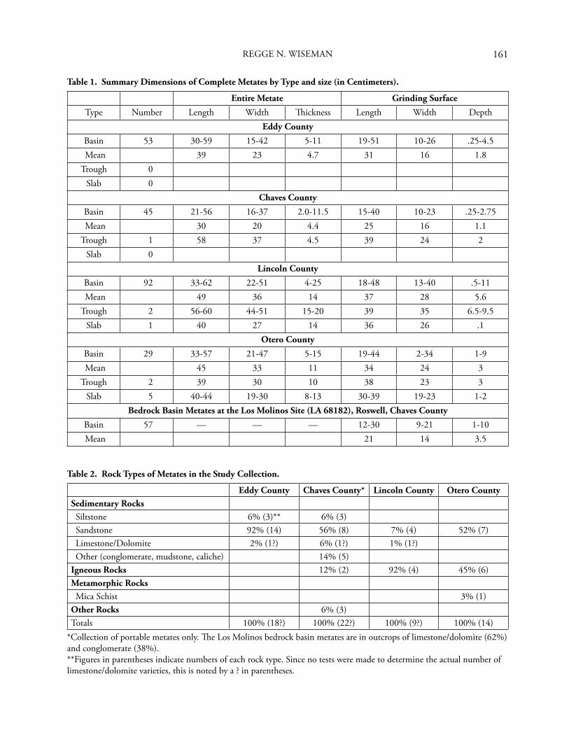
161
Table 1. Summary Dimensions of Complete Metates by Type and size (in Centimeters).
Entire Metate Grinding Surface
Type Number Length Width Th ickness Length Width DepthEddy County
Basin 53 30-59 15-42 5-11 19-51 10-26 .25-4.5 Mean 39 23 4.7 31 16 1.8
Trough 0Slab 0
Chaves County
Basin 45 21-56 16-37 2.0-11.5 15-40 10-23 .25-2.75 Mean 30 20 4.4 25 16 1.1
Trough 1 58 37 4.5 39 24 2Slab 0
Lincoln County
Basin 92 33-62 22-51 4-25 18-48 13-40 .5-11 Mean 49 36 14 37 28 5.6
Trough 2 56-60 44-51 15-20 39 35 6.5-9.5Slab 1 40 27 14 36 26 .1
Otero County
Basin 29 33-57 21-47 5-15 19-44 2-34 1-9 Mean 45 33 11 34 24 3
Trough 2 39 30 10 38 23 3Slab 5 40-44 19-30 8-13 30-39 19-23 1-2
Bedrock Basin Metates at the Los Molinos Site (LA 68182), Roswell, Chaves County
Basin 57 — — — 12-30 9-21 1-10 Mean 21 14 3.5
REGGE N. WISEMAN
Table 2. Rock Types of Metates in the Study Collection.
Eddy County Chaves County* Lincoln County Otero CountySedimentary Rocks Siltstone 6% (3)** 6% (3) Sandstone 92% (14) 56% (8) 7% (4) 52% (7) Limestone/Dolomite 2% (1?) 6% (1?) 1% (1?) Other (conglomerate, mudstone, caliche) 14% (5)Igneous Rocks 12% (2) 92% (4) 45% (6)Metamorphic Rocks Mica Schist 3% (1)Other Rocks 6% (3)Totals 100% (18?) 100% (22?) 100% (9?) 100% (14)
*Collection of portable metates only. Th e Los Molinos bedrock basin metates are in outcrops of limestone/dolomite (62%) and conglomerate (38%).**Figures in parentheses indicate numbers of each rock type. Since no tests were made to determine the actual number of limestone/dolomite varieties, this is noted by a ? in parentheses.
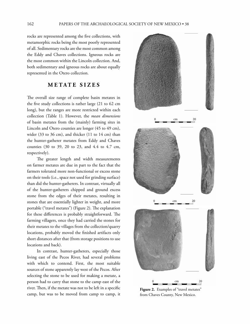
162 PAPERS OF THE ARCHAEOLOGICAL SOCIETY OF NEW MEXICO • 38
rocks are represented among the fi ve collections, with metamorphic rocks being the most poorly represented of all. Sedimentary rocks are the most common among the Eddy and Chaves collections. Igneous rocks are the most common within the Lincoln collection. And, both sedimentary and igneous rocks are about equally represented in the Otero collection.
M E T A T E S I Z E S
Th e overall size range of complete basin metates in the fi ve study collections is rather large (21 to 62 cm long), but the ranges are more restricted within each collection (Table 1). However, the mean dimensions of basin metates from the (mainly) farming sites in Lincoln and Otero counties are longer (45 to 49 cm), wider (33 to 36 cm), and thicker (11 to 14 cm) than the hunter-gatherer metates from Eddy and Chaves counties (30 to 39, 20 to 23, and 4.4 to 4.7 cm, respectively). Th e greater length and width measurements on farmer metates are due in part to the fact that the farmers tolerated more non-functional or excess stone on their tools (i.e., space not used for grinding surface) than did the hunter-gatherers. In contrast, virtually all of the hunter-gatherers chipped and ground excess stone from the edges of their metates, resulting in stones that are essentially lighter in weight, and more portable (“travel metates”) (Figure 2). Th e explanation for these diff erences is probably straightforward. Th e farming villagers, once they had carried the stones for their metates to the villages from the collection/quarry locations, probably moved the fi nished artifacts only short distances after that (from storage positions to use locations and back). In contrast, hunter-gatherers, especially those living east of the Pecos River, had several problems with which to contend. First, the most suitable sources of stone apparently lay west of the Pecos. After selecting the stone to be used for making a metate, a person had to carry that stone to the camp east of the river. Th en, if the metate was not to be left in a specifi c camp, but was to be moved from camp to camp, it
Figure 2. Examples of “travel metates” from Chaves County, New Mexico.
0 cm 20
0 cm 20
0 cm 20
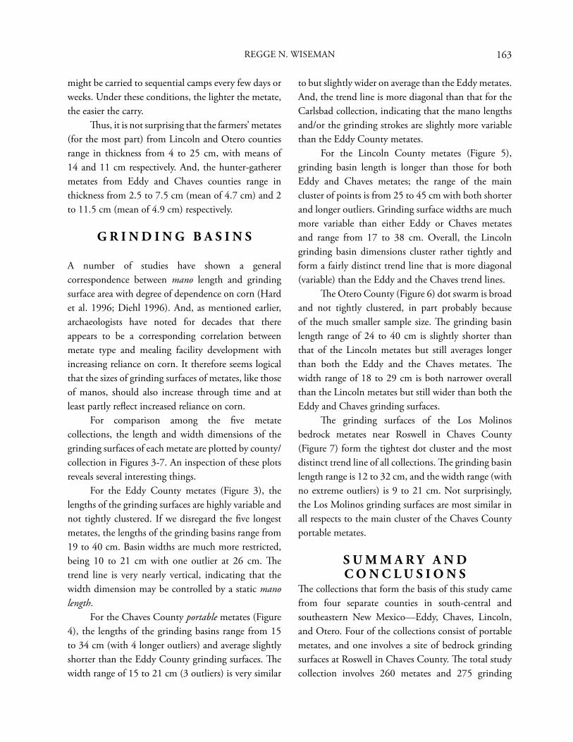
163
might be carried to sequential camps every few days or weeks. Under these conditions, the lighter the metate, the easier the carry. Th us, it is not surprising that the farmers’ metates (for the most part) from Lincoln and Otero counties range in thickness from 4 to 25 cm, with means of 14 and 11 cm respectively. And, the hunter-gatherer metates from Eddy and Chaves counties range in thickness from 2.5 to 7.5 cm (mean of 4.7 cm) and 2 to 11.5 cm (mean of 4.9 cm) respectively.
G R I N D I N G B A S I N S
A number of studies have shown a general correspondence between mano length and grinding surface area with degree of dependence on corn (Hard et al. 1996; Diehl 1996). And, as mentioned earlier, archaeologists have noted for decades that there appears to be a corresponding correlation between metate type and mealing facility development with increasing reliance on corn. It therefore seems logical that the sizes of grinding surfaces of metates, like those of manos, should also increase through time and at least partly refl ect increased reliance on corn. For comparison among the fi ve metate collections, the length and width dimensions of the grinding surfaces of each metate are plotted by county/collection in Figures 3-7. An inspection of these plots reveals several interesting things. For the Eddy County metates (Figure 3), the lengths of the grinding surfaces are highly variable and not tightly clustered. If we disregard the fi ve longest metates, the lengths of the grinding basins range from 19 to 40 cm. Basin widths are much more restricted, being 10 to 21 cm with one outlier at 26 cm. Th e trend line is very nearly vertical, indicating that the width dimension may be controlled by a static mano length. For the Chaves County portable metates (Figure 4), the lengths of the grinding basins range from 15 to 34 cm (with 4 longer outliers) and average slightly shorter than the Eddy County grinding surfaces. Th e width range of 15 to 21 cm (3 outliers) is very similar
to but slightly wider on average than the Eddy metates. And, the trend line is more diagonal than that for the Carlsbad collection, indicating that the mano lengths and/or the grinding strokes are slightly more variable than the Eddy County metates. For the Lincoln County metates (Figure 5), grinding basin length is longer than those for both Eddy and Chaves metates; the range of the main cluster of points is from 25 to 45 cm with both shorter and longer outliers. Grinding surface widths are much more variable than either Eddy or Chaves metates and range from 17 to 38 cm. Overall, the Lincoln grinding basin dimensions cluster rather tightly and form a fairly distinct trend line that is more diagonal (variable) than the Eddy and the Chaves trend lines. Th e Otero County (Figure 6) dot swarm is broad and not tightly clustered, in part probably because of the much smaller sample size. Th e grinding basin length range of 24 to 40 cm is slightly shorter than that of the Lincoln metates but still averages longer than both the Eddy and the Chaves metates. Th e width range of 18 to 29 cm is both narrower overall than the Lincoln metates but still wider than both the Eddy and Chaves grinding surfaces. Th e grinding surfaces of the Los Molinos bedrock metates near Roswell in Chaves County (Figure 7) form the tightest dot cluster and the most distinct trend line of all collections. Th e grinding basin length range is 12 to 32 cm, and the width range (with no extreme outliers) is 9 to 21 cm. Not surprisingly, the Los Molinos grinding surfaces are most similar in all respects to the main cluster of the Chaves County portable metates.
S U M M A R Y A N D C O N C L U S I O N S
Th e collections that form the basis of this study came from four separate counties in south-central and southeastern New Mexico—Eddy, Chaves, Lincoln, and Otero. Four of the collections consist of portable metates, and one involves a site of bedrock grinding surfaces at Roswell in Chaves County. Th e total study collection involves 260 metates and 275 grinding
REGGE N. WISEMAN
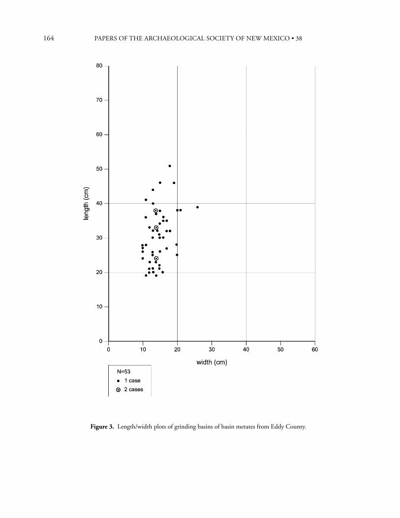
164 PAPERS OF THE ARCHAEOLOGICAL SOCIETY OF NEW MEXICO • 38
Figure 3. Length/width plots of grinding basins of basin metates from Eddy County.

165
Figure 4. Length/width plots of grinding basins of basin metates from Chaves County.
REGGE N. WISEMAN
166 PAPERS OF THE ARCHAEOLOGICAL SOCIETY OF NEW MEXICO • 38
Figure 5. Length/width plots of grinding basins of basin metates from Lincoln County.
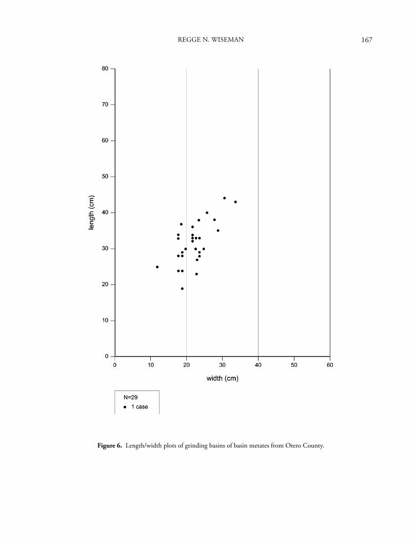
167
Figure 6. Length/width plots of grinding basins of basin metates from Otero County.
REGGE N. WISEMAN
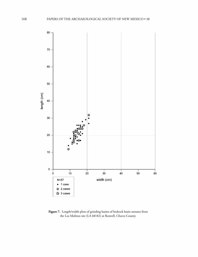
168 PAPERS OF THE ARCHAEOLOGICAL SOCIETY OF NEW MEXICO • 38
Figure 7. Length/width plots of grinding basins of bedrock basin metates from the Los Molinos site (LA 68182) at Roswell, Chaves County.
169
surfaces. Except for the bedrock metate site (LA 68182), none of the metates have known proveniences other than the knowledge of the areas habitually collected by the people responsible for bringing the artifacts together. Th is study has revealed two surprises. First, all but six of the portable metates are classifi ed as basin type metates. Very few trough metates and slab/fl at metates are in the collections, and all but one of those are from Lincoln and Otero counties. A preponderance of the basin type is expected for Archaic and pottery period hunter-gatherer metates, but it is not generally expected for farming peoples because they were reliant to some degree on corn. A search of the regional literature reveals that only one possible mealing bin has been found in excavated sites, and that one is a single-compartment bin in a Lincoln Phase pueblo near the town of Corona in the far northwestern corner of the study region. Together, these two criteria, preponderance of basin metates and virtual absence of mealing bins, suggest that large quantities of corn were not ground in Lincoln Phase sites or any other sites in our study region and that the study area residents relied less on corn than did many of the contemporary societies elsewhere in the Southwest. In contrast, the late prehistoric peoples in the Gran Quivira region immediately west of Corona are known to have used large quantities of corn as evidenced by fi nds of corn remains in excavations. Th e majority of their metates are of the trough (38 percent) and slab (47 percent) types (n=916), and multi-compartment mealing bins are occasionally found in their sites (Hayes et al. 1981). A closer look at the grinding basins of the study metates reveals another interesting facet. In terms of grinding surface area, the Eddy and Chaves county examples are the smallest, as would be expected for
hunter-gatherer societies. Also as would be expected, the Lincoln and Otero county farmer metates have the largest grinding surfaces. However, the diff erences between the two groups of metates are not as great as one might expect; the size ranges overlap to a signifi cant extent, particularly as regards grinding basin length. Th e primary grinding area discriminator is grinding basin width. Th is factor agrees well with the proposition advanced by Hard et al. (1996), among others, that mano length (corresponding with grinding basin width) is an indicator of relative dependence on corn—the longer the mano (and the larger its grinding surface area), the greater the dependence on corn. Th e same appears to be true of metate grinding surface areas.
E N D N O T E S
1. Most archaeologists will probably view the following paragraphs concerning the Roswell oasis and areas east of the Pecos river with much skepticism, if not consider them straightforward heresy. However, these perceptions have formed over a period of nearly 50 years during which I have studied the prehistoric remains of southeastern New Mexico in considerable detail. In these interpretations, I have been infl uenced to some degree by Art Jelinek (especially his idea about the Middle Pecos peoples giving up farming to become bison hunters, which, at the time [1967], I thought was stretching things a bit) and especially by John Speth with regard to his work at the Henderson and Bloom Mound sites. However, I also am under no illusion that either of these gentlemen will agree with all aspects of my interpretations. Perhaps I have spent too much of my life in the hot sun?!
A C K N O W L E D G M E N T S
I would like to thank Robert DelloRusso for reading and commenting on an earlier version of this paper.
REGGE N. WISEMAN
170 PAPERS OF THE ARCHAEOLOGICAL SOCIETY OF NEW MEXICO • 38
R E F E R E N C E S C I T E D
Adams, Jenny L.1993 Toward Understanding the Technological
Development of Manos and Metates. Kiva 58(3):331-344.
Corley, John A.1965 Proposed Eastern Extension of the Jornada
Branch of the Mogollon. Transactions of the First Regional Archeological Symposium for Southeastern New Mexico and Western Texas, pp. 31-36. Midland Archeological Society, Midland, Texas.
Diehl, Michael W.1996 Th e Intensity of Maize Processing and Production
in Upland Mogollon Pithouse Villages, A.D. 200-1000. American Antiquity 61:102-115.
Hard, Robert J., Raymond P. Mauldin, and Gerry R. Raymond1996 Mano Size, Stable Carbon Isotope Ratios, and
Macrobotanical Remains as Multiple Lines of Evidence of Maize Dependence in the American Southwest. Journal of Archaeological Method and Th eory 3(4):253-318.
Hayes, Alden C., Jon Nathan Young, and A. Helene Warren1981 Excavation of Mound 7, Gran Quivira National
Monument, New Mexico. Publications in Archeology 16, U.S. Department of the Interior, National Park Service, Washington, D.C.
Jelinek, Arthur J.1967 A Prehistoric Sequence in the Middle Pecos
Valley, New Mexico. University of Michigan Anthropological Papers 31, Ann Arbor.
Katz, Susana R., and Paul Katz1985 Th e Prehistory of the Carlsbad Basin, Southeastern
New Mexico. Incarnate Word College, San Antonio, Texas.
2002 Th e Brantley Stone Enclosure Site (SM 108; LA 38326) Near Carlsbad, New Mexico. Transactions of the 37th Regional Archeological Symposium for Southeastern New Mexico and Western Texas, edited by Pinky Robertson, pp. 79-105. Iraan Archeological Society, Iraan, Texas.
Kelley, Jane H.1984 Th e Archaeology of the Sierra Blanca Region of
Southeastern New Mexico. University of Michigan Anthropological Papers 74, Ann Arbor.
Lehmer, Doñald J.1948 Th e Jornada Branch of the Mogollon. University of
Arizona Social Science Bulletins 17, Tucson.
Leslie, Robert H.1965 Th e Merchant Site, L.C.A.S. No. E-4. Transactions
of the First Regional Archeological Symposium for Southeastern New Mexico and Western Texas, pp. 24-29. Midland Archeological Society, Midland, Texas.
1979 Th e Eastern Jornada Mogollon, Extreme Southeastern New Mexico (A Summary). In Jornada Mogollon Archaeology: Proceedings of the First Jornada Conference, edited by Patrick H. Beckett and Regge N. Wiseman, pp. 179-199. New Mexico State University, Las Cruces and the Historic Preservation Bureau, State of New Mexico, Santa Fe.
Miller, Myles R., and Nancy A. Kenmotsu2004 Prehistory of the Jornada Mogollon and Eastern
Trans-Pecos Regions of West Texas. In Th e Prehistory of Texas, edited by Timothy K. Perttula, Chapter 7, pp. 205-265. Texas A & M University Press, College Station.
Newlander, Khori, and John D. Speth2009 Interaction Patterns in the Southern Plains as
Seen Th rough Ultraviolet Fluorescence (UVF) Study of Cherts from Late Prehistoric Villages in the Pecos Valley, New Mexico. In Quince: Papers from the 15th Biennial Jornada Mogollon Conference, edited by Marc Th ompson, pp. 43-60. El Paso Museum of Archaeology, El Paso.
Rocek, Th omas R., and John D. Speth1986 Th e Henderson Site Burials: Glimpses of a
Late Prehistoric Population in the Pecos Valley. Research Reports in Archaeology 13, Museum of Anthropology, University of Michigan, Ann Arbor.
Speth, John D., editor2004 Life on the Periphery: Economic Change in Late
Prehistoric Southeastern New Mexico. Memoirs of the Museum of Anthropology, University of Michigan 37, Ann Arbor.
171
Wendorf, Fred1956 A Fragmentary Pueblo Near Corona, New
Mexico. In Highway Salvage Archaeology, 2(9):87-105. New Mexico State Highway Department and the Museum of New Mexico, Santa Fe.
Wiseman, Regge N.1969 Th e Usage and Distribution of Manos and
Metates at Sapawe. Manuscript on fi le at the library, Laboratory of Anthropology/Museum of Indian Arts and Culture, Santa Fe. 46 pages.
1985 Bison, Fish, and Sedentary Occupations: Startling Data from Rocky Arroyo (LA 25277), Chaves County, New Mexico. In Views of the Jornada Mogollon, edited by Colleen M. Beck, pp. 30-32. Eastern New Mexico University Contributions in Anthropology 12, Portales.
1997 A Preliminary Look at Evidence for Late Prehistoric Confl ict in Southeastern New Mexico. In Layers of Time: Papers in Honor of Robert H. Weber, edited by Meliha S. Duran and David T. Kirkpatrick, pp. 135-146. Papers of the Archaeological Society of New Mexico 23, Albuquerque.
2002a Stone Enclosure Structures Along the Rocky Mountain Front: How Do Th ey Relate to the Cielo Complex of the Texas Big Bend? Transactions of the 37th Regional Archeological Symposium for Southeastern New Mexico and Western Texas, edited by Pinky Robertson, pp. 55-75. Iraan Archeological Society, Iraan, Texas.
2002b Th e Fox Place, A Late Prehistoric Hunter-Gatherer Pithouse Village Near Roswell, New Mexico. Archaeology Notes 234, Offi ce of Archaeological Studies, Museum of New Mexico, Santa Fe.
2004 Prehistory of the Berrendo River System in the Southern Plains of New Mexico. Archaeology Notes 236, Offi ce of Archaeological Studies, Museum of New Mexico, Santa Fe.
In prep. Th e Prehistoric Social Landscape of the Roswell Oasis and the 1980 Excavations at the Rocky Arroyo Site (LA 25277), Chaves County, New Mexico.
Zamora, Dorothy A.2000 Prehistoric Burned Brush Structures and a Quarry
Site Along the Carlsbad Relief Route, Eddy County, New Mexico. Archaeology Notes 203, Offi ce of Archaeological Studies, Museum of New Mexico, Santa Fe.
REGGE N. WISEMAN

172 PAPERS OF THE ARCHAEOLOGICAL SOCIETY OF NEW MEXICO • 38

173
P U B L I C A T I O N S O F T H E A R C H A E O L O G I C A L S O C I E T Y O F N E W M E X I C O
No. 1 Collected Papers in Honor of Lyndon Lane Hargrave 1968 Out of Print
No. 2 Collected Papers in Honor of Florence Hawley Ellis 1975 Out of Print
No. 3 Collected Papers in Honor of Marjorie Ferguson Lambert 1976 Out of Print
No. 4 Collected Papers in Honor of Bertha Pauline Dutton 1979 Out of Print
No. 5 Collected Papers in Honor of Helen Greene Blumenschien 1980 Out of Print
No. 6 Collected Papers in Honor of Erik Kellerman Reed 1981 Out of Print
No. 7 Collected Papers in Honor of John Runyon 1982 Out of Print
No. 8 Collected Papers in Honor of Charlie Steen, Jr. 1983 Out of Print
No. 9 Collected Papers in Honor of Harry L. Hadlock 1984 Out of Print
No. 10 Southwestern Culture History: Collected Papers in Honorof Albert H. Schroeder 1985 Out of Print
No. 11 Prehistory and History in the Southwest: Collected Papersin Honor of Alden C. Hayes 1985 Out of Print
No. 12 By Hands Unknown: Papers on Rock Art and Archaeologyin Honor of James G. Bain 1986 Out of Print
No. 13 Secrets of a City: Papers on Albuquerque Area Archaeologyin Honor of Richard A. Bice 1987 Out of Print
No. 14 Refl ections: Papers on Southwestern Culture Historyin Honor of Charles H. Lange 1988 Out of Print
No. 15 From Chaco to Chaco: Papers in Honor of Robert H. Listerand Florence C. Lister 1989 Out of Print
No. 16 Clues to the Past: Papers in Honor of William M. Sundt 1990 Out of Print
No. 17 Puebloan Past and Present: Papers in honor of Stewart Peckham 1991 $24.95
No. 18 Archaeology, Art, and Anthropology: Papers in Honor of J. J. Brody 1992 Out of Print
No. 19 Why Museums Collect: Papers in Honor of Joe Ben Wheat 1993 $24.95
No. 20 Artifacts, Shrines, and Pueblos: Papers in Honor of Gordon Page 1994 Out of Print
No. 21 Of Pots and Rocks: Papers in Honor of A. Helene Warren 1995 Out of Print
No. 22 La Jornada: Papers in Honor of William F. Turney 1996 $24.95
No. 23 Layers of Time: Papers in Honor of Robert H. Weber 1997 $24.95
173
174 PAPERS OF THE ARCHAEOLOGICAL SOCIETY OF NEW MEXICO • 38
No. 24 Diné Bikéyah: Papers in Honor of David M. Brugge 1998 $24.95
No. 25 La Frontera: Papers in Honor of Patrick H. Beckett 1999 Out of Print
No. 26 Th e First 100 Years: Papers in Honor of the State and LocalArchaeological Societies of New Mexico 2000 $24.95
No. 27 Following Th rough: Papers in Honor of Phyllis S. Davis 2001 $24.95
No. 28 Forward Into the Past: Papers in Honor of Teddy Lou andFrancis Stickney 2002 $24.95
No. 29 Climbing the Rocks: Papers in Honor of Helen and Jay Crotty 2003 Out of Print
No. 30 Ever Westward: Papers in Honor of Elizabeth Kelly 2004 $24.95
No. 31 Inscriptions: Papers in Honor of Richard and Nathalie Woodbury 2005 $24.95
No. 32 Southwestern Interludes: Papers in Honor of Charlotte J. andTh eodore Frisbie 2006 $29.95
No. 33 Texas and Points West: Papers in Honor of John A. Hedrick andCarol P. Hedrick 2007 Out of Print
No. 34 Chasing Chaco and the Southwest: Papers in Honor of FrancesJoan Mathien 2008 Out of Print
No. 35 Between the Mountains, Beyond the Mountains: Papers in Honorof Paul Williams 2009 Out of Print
No. 36 Th reads, Tints, and Edifi cation: Papers in Honor of Glenna Dean 2010 $29.95
No. 37 Words and Sherds: Papers in Honor of Meliha S. Duran andDavid T. Kirkpatrick 2011 $29.95
S P E C I A L P U B L I C A T I O N S E R I E S
No. 1 Ancient Communities in the American Desert, by E. L. Hewett 1993 Out of Print
No. 2 Th ree Rivers Petroglyph site, by M. S. Duran and H. K. Crotty 1999 $10.00
No. 3 Prehistory of the Middle Rio Puerco Valley, edited by L. L. Bakerand S. R. Durand 2003 $22.00
175
175
Bradley F. Bowman Museum of Archeology and Material Culture P.O. Box 582 Cedar Crest, NM 87008
Jeff rey L. Boyer Offi ce of Archaeological Studies Museum of New Mexico P.O. Box 2087 Santa Fe, NM 87504-2087
David M. Brugge 4300 Bryn Mawr NE, Apt. 31 Albuquerque, NM 87107
Glenna Dean P.O. Box 658 Abiquiu, NM 87510
Catherine S. Fowler 1010 Foothill Road Reno, NV 89811-9428
Don D. Fowler 1010 Foothill Road Reno, NV 89811-9428
Hayward H. Franklin 1127 Marigold NE Albuquerque, NM 87122
Sharon Hanna HC 68, Box 17 Corona, NM 88318
Carol James 140, Rue Notre Dame Winnepeg, Manitoba R2H 0C1 Canada
William D. Lipe Department of Anthropology College Hall 150 Washington State University Pullman, WA 99164-4910
Richard W. Loose P.O. Box 278 Organ, NM 88052
James L. Moore Offi ce of Archaeological Studies Museum of New Mexico P.O. Box 2087 Santa Fe, NM 87504-2087
Nancy J. Parezo American Indian Studies Program University of Arizona Harvill Hall 235c Tucson, AZ 85721
John R. Roney Colinas Cultural Resource Consulting 316 Osuna Road NE, Suite 102 Albuquerque, NM 87107
David H. Snow 1616 Prospect Ave. NW Albuquerque, NM 87104
Regge N. Wiseman Offi ce of Archaeological Studies Museum of New Mexico P.O. Box 2087 Santa Fe, NM 87504-2087
2 0 1 2 C O N T R I B U T O R S

176 PAPERS OF THE ARCHAEOLOGICAL SOCIETY OF NEW MEXICO • 38