Embed Size (px)
Citation preview
20/03/2009 Basin Development & Petroleum Prospectivity, MVS
p1
Underhill, Monaghan & Browne
Page 1 of 52
Controls on Structural Styles, Basin Development and Petroleum
Prospectivity in the Midland Valley of Scotland
John R. Underhill *1, Alison A. Monaghan 2 & Mike A.E. Browne 2
* Corresponding Author:
1 Grant Institute of Earth Science, School of Geosciences, The University of Edinburgh,
King's Buildings, West Mains Road, Edinburgh, Scotland, EH9 3JW
e.mail: [email protected];
Tel. No: +44 131 650 8518 (direct line);
Fax No: +44 131 668 3184
2 British Geological Survey, Murchison House, West Mains Road, Edinburgh, EH9 3LA
e.mail addresses: [email protected]; [email protected]
Submitted to Marine & Petroleum Geology
20/03/2009 Basin Development & Petroleum Prospectivity, MVS
p2
Underhill, Monaghan & Browne
Page 2 of 52
Abstract
Integration of well-calibrated seismic data from the Firth of Forth with field and
subsurface data from neighbouring onshore areas provide important new insights into
the structural evolution and petroleum habitat in the Midland Valley of Scotland. The
results demonstrate that the NNE-SSW striking Midlothian-Leven Syncline, and its
flanking Burntisland and D’Arcy-Cousland anticlines, developed as major growth
folds during the Late Palaeozoic under a predominantly dextral strike-slip regime.
These syn-sedimentary folds controlled depositional thicknesses, facies and dispersal
patterns in Early to Late Carboniferous (Viséan-Westphalian) times. Structural
geometries suggest that the folds experienced tightening during Late Carboniferous
(Variscan) deformation events before being transected by E-W striking dykes and
extensional faulting during the Late Carboniferous (Westphalian D) and Early
Permian. Although direct evidence for the basin’s post-Permian burial history is no
longer present, it can be inferred that the area had at least 1km of cover prior to
Cenozoic uplift.
The new understanding of the eastern Midland Valley’s structural and subsidence history
provides the means by which the occurrence of petroleum in the basin can be explained. It is
apparent that the burial of Lower Carboniferous (Dinantian) oil-shale source rocks beneath
the Midlothian-Leven Syncline was the primary driver in the maturation and up-dip
migration of waxy crude oil into age-equivalent clastic reservoirs located in adjacent
anticlines. Initial oil charging is thought to have taken place during the Late Carboniferous,
20/03/2009 Basin Development & Petroleum Prospectivity, MVS
p3
Underhill, Monaghan & Browne
Page 3 of 52
was renewed during Mesozoic reburial and appears to continue today despite the effects of
significant Cenozoic uplift. In contrast, only small volumes of oil are thought to have been
generated by direct contact between the source rocks and igneous intrusions. The new,
regional model for oil migration suggests that exploration success in the basin has been
governed by the presence of unbreached palaeostructures lying directly up-dip from an oil
kitchen, developed in the core of the Midlothian-Leven Syncline during the Late
Carboniferous and Mesozoic-Recent stages of burial.
Keywords: Midland Valley; Petroleum Prospectivity; Scotland; oil shale; Carboniferous
20/03/2009 Basin Development & Petroleum Prospectivity, MVS
p4
Underhill, Monaghan & Browne
Page 4 of 52
1. Petroleum Habitat in the Midland Valley
The Midland Valley of Scotland (MVS) forms a major, ~80km wide, >150-km long
WSW-ENE trending, fault-bounded, Late Palaeozoic sedimentary basin that can be
traced from Ayrshire and Renfrewshire in the west, through the central belt to the
Angus, Perth, Fife and East Lothian coasts in the east (Fig.1). It is believed that the
basin extends west to Northern Ireland and eastward to underlie the Forth Approaches
(Cartwright et al., 2001).
It has long been recognised that the MVS has petroleum exploration potential (Lees
& Cox, 1937; Lees & Taitt, 1946). Indeed, it was from West Lothian that the first oil
in the UK was extracted in commercial quantities through the mining and distillation
of oil-shale (Cameron & McAdam, 1978; Hallett et al., 1985; Underhill, 2003). The
success of the oil-shale industry, occurrence of natural seeps and the recognition of
surface anticlines helped to initiate subsurface oil exploration in the basin during the
early part of the 19th Century (Lees & Cox, 1937; Lees & Taitt, 1946; Selley, 1992).
Political uncertainty immediately prior to the outbreak of the Second World War
renewed interest in oil potential in onshore areas of the UK. In the MVS, onshore
licenses were awarded to the D’Arcy Exploration Company (which was later to
become Anglo-Iranian and eventually BP) and Anglo-American Company (a
subsidiary of Standard Oil) along the D’Arcy-Cousland Anticline, which lies some
20km east of Edinburgh. Their drilling programme led to the discovery of petroleum
20/03/2009 Basin Development & Petroleum Prospectivity, MVS
p5
Underhill, Monaghan & Browne
Page 5 of 52
in Lower Carboniferous, interbedded, fluvio-deltaic and shallow marine clastic
reservoirs (now ascribed to the Strathclyde Group), contained within two separate
structural culminations along the anticline. In total, around 30,000 barrels of oil and
330 million standard cubic feet of gas were produced from the combined structure,
termed the Midlothian Field, before it was abandoned in the late 1960s (Hallett et al.,
1985).
Subsequent exploration by Pentex, Burmah Oil and Conoco resulted in the Milton of
Balgonie discovery in Fife and the 25/26-1 discovery in the Firth of Forth
respectively. Having found a column of oil and numerous oil and gas shows in the
25/26-1 well, Conoco ran three production tests. However, since the oil found within
the Early Carboniferous clastic reservoirs proved to be very waxy and near to its pour
point, no production was possible and the discovery was considered uneconomic and
abandoned.
Despite the long history of oil exploration in the basin, no published models have
been proposed to explain its petroleum habitat. The release of well and seismic data
from offshore waters of the Firth of Forth and from adjacent onshore areas of Lothian
and Fife provides a unique opportunity to document the petroleum system and
produce a unifying model to explain the basin’s prospectivity. This has been
undertaken primarily through the analysis and interpretation of the structural and
stratigraphic elements of the petroleum system within the eastern MVS. When
combined with inferences made regarding the basin’s Mesozoic and Cenozoic

20/03/2009 Basin Development & Petroleum Prospectivity, MVS
p6
Underhill, Monaghan & Browne
Page 6 of 52
history, the new structural model gives important insights into the controls on
petroleum generation in and around the Midlothian-Leven Syncline and provides an
explanation for exploration success in the two onshore discoveries at the Midlothian
and Milton of Balgonie fields and offshore in the 25/26-1 well (Firth of Forth-1).
20/03/2009 Basin Development & Petroleum Prospectivity, MVS
p7
Underhill, Monaghan & Browne
Page 7 of 52
2. Basin Development
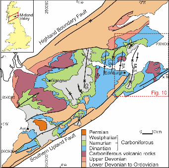
The MVS developed on the eroded and deformed remnants of the Caledonian
Mountains, which had formed as a consequence of the closure and suturing of the
Iapetus Ocean (the Caledonian Orogeny) at the end of the Early Palaeozoic (Cameron
& Stephenson, 1985; Glennie & Underhill, 1998; Read et al., 2002). The basin is
bounded to the north-west and south-east by the Highland Boundary Fault System
and Southern Upland Fault System respectively (Fig.1), both of which formed
important lineaments during the Caledonian Orogeny (Cameron & Stephenson, 1985;
Read et al, 2002). It is the differential weathering of rock units that crop out either
side of the two fault systems that has resulted in the morphologically distinct, central
lowland belt of Scotland.
The stratigraphy of the MVS consists of a variety of sedimentary, volcanic and
igneous rocks. Field mapping has demonstrated that in the eastern MVS, outcrop
patterns define several major NNE-SSW striking folds including the Clackmannan,
Midlothian and Leven Synclines (each of which contain significant coalfields), which
are separated from each other by the intervening Balmule, Burntisland and D'Arcy-
Cousland Anticlines (Cameron & Stephenson, 1985; Read et al., 2002). Field
relations show that the formation of these intra-basinal structures was complete by the
end of the Carboniferous since they are cross-cut by a suite of E-W striking, latest
Carboniferous-Early Permian dykes, normal faults and extensional fractures (Rippon
et al., 1996; Browne & Woodhall, 1999; Monaghan and Parrish, 2006). Despite the
20/03/2009 Basin Development & Petroleum Prospectivity, MVS
p8
Underhill, Monaghan & Browne
Page 8 of 52
fact that Carboniferous rocks occur at outcrop, there is little direct tectonic evidence
for any subsequent major tectonic events having affected the area because E-W
trending Permian intrusions and faults have remained largely undeformed.
Uncertainty has long surrounded the plate tectonic driving mechanism and the precise
kinematics behind Late Palaeozoic basin development in Northern Britain (e.g.
Leeder, 1982; Gawthorpe, 1987; Underhill et al., 1988; Haszeldine, 1988; Fraser &
Gawthorpe, 1990; Coward, 1993; Chadwick et al., 1995; Maynard et al., 1997).
Controversy has been particularly intense with regard to the Carboniferous evolution
of the MVS, which developed within the Caledonian terrane. The basin was originally
thought to conform to a classic rift valley comprising a graben that was bounded to
the NW and the SE by prominent normal faults (George, 1960). Regional evidence
led Leeder (1982) to attribute the development of Late Devonian-Early Carboniferous
basins of northern Britain, including the Bowland Basin, Northumberland Trough,
Solway Basin and MVS, to a phase of N-S (back-arc) extension and late
Carboniferous thermal subsidence.
Subsequent studies contested Leeder’s idea and suggested instead that the presence of
important intra-basinal N-S striking structures implied that the MVS’s formation was
the result of E-W tension (Stedman, 1988; Haszeldine, 1988). Their theme of
dominantly E-W extension was developed further by Gibbs (1990), who suggested
that the basin’s internal structure was controlled by a linked family of structures
consisting of extensional faults with ramp-flat and listric geometries and steeply-
20/03/2009 Basin Development & Petroleum Prospectivity, MVS
p9
Underhill, Monaghan & Browne
Page 9 of 52
dipping transfer faults. In contrast, work built upon subsurface data derived primarily
from coal mining activities (e.g. in the Kincardine Basin of Clackmannan) and
fieldwork in Fife, led others to propose that strike- or oblique-slip movements may
have played a significant role in the development and deformation of the basin (e.g.
Read, 1988; McCoss, 1988; Rippon et al., 1996). The notion that transcurrent
movement played a role in the tectonic development of the MVS was also promoted
by Ritchie et al. (2003) to explain structures recognised beneath the Firth of Forth.
20/03/2009 Basin Development & Petroleum Prospectivity, MVS
p10
Underhill, Monaghan & Browne
Page 10 of 52
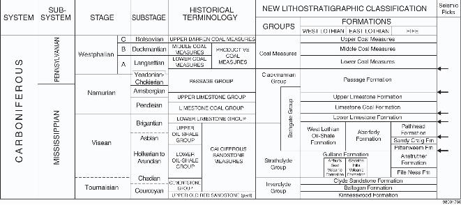
3. Basin Stratigraphy
Integration of field exposures with subsurface data, largely derived from extensive
coal mining activity over the past two centuries, has enabled a unifying
lithostratigraphic framework to be constructed for the Carboniferous rocks of the
MVS (Fig.2; Browne et al., 1999). In the scheme now used, the sedimentary
succession is subdivided into four main groups: the Inverclyde, Strathclyde,
Clackmannan and Coal Measures groups (Fig.2; Browne et al., 1999). Although
component formations may be identified in the Clackmannan and Coal Measures
groups, lithological variability and facies changes have meant that a regionally
consistent subdivision at formation level has not been possible for the lower two
groups. Thus, local formation and member names are still used in West Lothian, East
Lothian and Fife (Fig.2).
The bulk of the Lower Carboniferous (lower to middle Mississippian) succession is
subdivided into two parts: a lower, Courceyan-Chadian (Tournasian-lower Viséan)
Inverclyde Group (INV) and an upper, Asbian-Brigantian (Viséan), Strathclyde
Group (SYG). The Inverclyde Group has been subdivided into three formations: the
Kinnesswood, Ballagan and Clyde Sandstone Formations (Fig.2). The Strathclyde
Group has been separated into ten lithostratigraphic formations, which reflect
important facies changes that affected the area during lower to middle Mississippian
times. Five of the component formations are recognised in Fife: the Pathhead, Sandy
Craig, Pittenweem, Anstruther and Fife Ness Formations (Fig.2) and five in Lothian:
20/03/2009 Basin Development & Petroleum Prospectivity, MVS
p11
Underhill, Monaghan & Browne
Page 11 of 52
the West Lothian Oil-Shale, Aberlady, Gullane, Garleton Hills Volcanic and Arthur’s
Seat Volcanic Formations (Fig.2). In addition, the Kinghorn Volcanic Formation
includes the volcanic rocks that occur within the Sandy Craig Formation. Together
with the Clyde Sandstone and Ballagan Formations, the component parts of the
Strathclyde Group were previously assigned to the Calciferous Sandstone Measures
(Greensmith, 1962 & 1965; Macgregor, 1968; Fig.2).
In Fife and East Lothian, the sedimentary rocks form a significant south-westerly
prograding, easterly thickening, sandy clastic, fluvial-deltaic wedge (Greensmith,
1962 & 1965; Browne & Monro, 1989). In contrast, coeval sedimentation in parts of
West Lothian and the Edinburgh area was dominated by lacustrine oil-shale that has
led to the definition of "Lake Cadell" (e.g. Cadell, 1925; Greensmith, 1962 & 1965).
The transition between the two facies types is gradational and, whilst ill-defined, lies
on the eastern flank of the Leven Syncline in Fife, where shale-sandstone
intercalations predominate. The Viséan algal oil-shales that characterise western parts
of the study area (West Lothian Oil-Shale and Gullane formations) have long been
considered the most likely source of petroleum in the basin, a suspicion confirmed by
biomarker analysis (Raymond, 1991) and reflected in the waxy nature of the crude oil
found in well 25/26-1.
The Strathclyde Group is succeeded by the Middle Mississippian-Lower
Pennsylvanian Clackmannan Group of Brigantian-Langsettian (Upper Viséan-
Namurian) age. The Clackmannan Group comprises four formations: the Lower
20/03/2009 Basin Development & Petroleum Prospectivity, MVS
p12
Underhill, Monaghan & Browne
Page 12 of 52
Limestone (LLGS), Limestone Coal (LSC), Upper Limestone (ULGS) and the
Passage (PGP) formations (Fig.2). Whilst the Lower and Upper Limestone formations
represent more marine successions, the Limestone Coal Formation represents a return
to predominantly non-marine/paralic deposition from which significant quantities of
coal have been extracted. The Passage Formation straddles both the Mississippian-
Pennsylvanian and Namurian-Westphalian stage boundaries and marks the upward
transition into coal-bearing strata of the Coal Measures Group.
The Coal Measures Group represents the youngest observable sedimentary rocks in
the eastern part of the basin. They range up to Middle Pennsylvanian (Westpahlian C;
Bolsovian stage) in age and are subdivided into three formations: the Lower (LCMS),
Middle (MCMS) and “barren”, Upper Coal Measures formations (UCMS). Although
younger Carboniferous deposition is thought to have occurred, no sedimentary rocks
of Middle or Upper Pennsylvanian (Westphalian D, Stephanian or Autunian) age are
known from the basin and they are presumed to have been eroded during either Late
Carboniferous (Variscan) deformation or Paleogene uplift events. Whilst direct
evidence for the later uplift event is scarce in the immediate area, the occurrence of
Permian and successively younger strata beneath the offshore waters of the Forth
Approaches Basin (Thomson, 1978; Cartwright et al., 2001) and the Permian,
Mauchline Basin in Ayrshire (Monro, 1999) suggests that the MVS may itself have,
once had a significant Permian cover. Evidence from the MVS itself (e.g. Vincent &
Rowley, 2004; Smith, 2005) and from neighbouring areas of the North Sea (e.g. the
Inner Moray Firth; Argent et al., 2002) also suggest that the extent of Mesozoic and
20/03/2009 Basin Development & Petroleum Prospectivity, MVS
p13
Underhill, Monaghan & Browne
Page 13 of 52
earliest Paleogene sedimentation was more substantive over Scotland in general and
the MVS in particular, prior to Paleogene and younger uplift events.
.
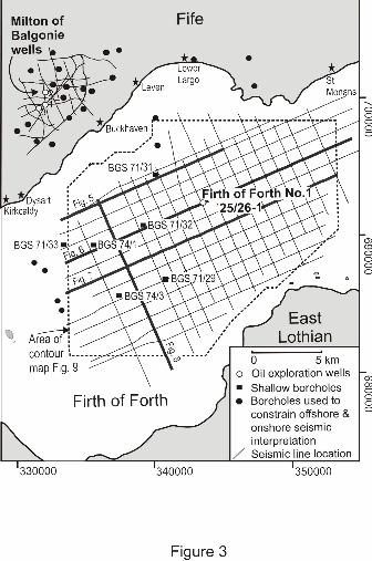
4. Seismic and Well Database
This paper primarily focuses upon subsurface (seismic and well) data obtained
from the Firth of Forth, which lies between the Fife and Midlothian coastlines and
adjacent onshore areas including the Glenrothes area in Fife and parts of
Midlothian, SE of Edinburgh (Fig.3). The subsurface data from the region have
been used to provide important insights into the development and evolution of
structural styles, subcrop patterns and thickness variations in and around one of
the most significant intra-basinal folds, the Midlothian-Leven Syncline. When
combined with evidence from surface mapping, the seismic interpretation allows
the offshore extent of some important onshore faults, such as the Pentland,
Crossgatehall and Ardross faults, to be determined (Ritchie et al., 2003), and the
trace of previously proposed structures such as the Firth of Forth Fault (Thomson,
1978) to be tested. The data also provide constraints on the nature of the anticlinal
marginal folds that lie on the flanks of the main Midlothian-Leven Syncline,
namely: the structure tested by the 25/26-1 exploration well; the Earl’s Seat
Anticline, which was tested by three deep exploration wells (Milton of Balgonie-
1, -2 and -3); and the Burntisland Anticline.
20/03/2009 Basin Development & Petroleum Prospectivity, MVS
p14
Underhill, Monaghan & Browne
Page 14 of 52
5. Seismic Interpretation
The seismic database in the Firth of Forth consists of thirty-three, 2-D seismic
reflection profiles in an approximate 1km x 1km grid (Figs.3, 5-8) with a combined
line-length of nearly 600km. The seismic data are calibrated by exploration well,
25/26-1 (also sometimes referred to as Firth of Forth-1), drilled by Conoco in 1990,
and by eight shallow stratigraphic boreholes (Fig.3), drilled by the Institute of
Geological Sciences (now the British Geological Survey) and the National Coal
Board (NCB) (Thomson, 1978).
Exploration well 25/26-1 was drilled to a depth of 2009.5m. It entered the Limestone
Coal Formation beneath a thin Quaternary cover and proceeded to penetrate the
Lower Limestone, Pathhead, Sandy Craig, Kinghorn Volcanic, Pittenweem
Formations and Anstruther formations before terminating in the Fife Ness Formation
(Fig.4). Correlation of the seismic data to the well and borehole data (Fig.6) allows
accurate, contoured top structure maps to be produced for the following six main
stratigraphic levels over an area that exceeds 150 km2:
Top Passage Formation (which also represents the Top Clackmannan Group and
Base Coal Measures Group);
Top Upper Limestone Formation;
Top Lower Limestone Formation;
Top Pathhead Formation (Top Strathclyde Group);
20/03/2009 Basin Development & Petroleum Prospectivity, MVS
p15
Underhill, Monaghan & Browne
Page 15 of 52
Top Sandy Craig Formation;
Base Pittenweem Formation (equivalent to the Base West Lothian Oil Shale
Formation;
Top Anstruther Formation; Fig.6);
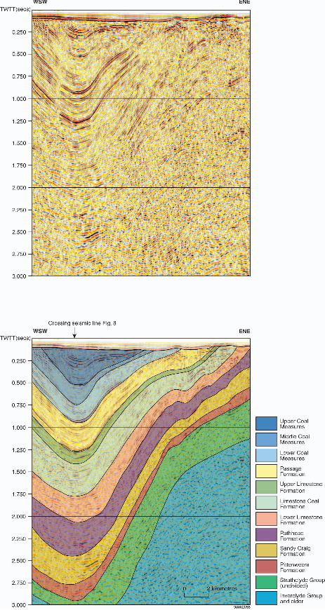
The WSW-ESE trending seismic lines from Conoco’s survey provide representative
cross-sections across the offshore extent of the Midlothian-Leven Syncline and
demonstrate that the structure represents a NNE-SSW striking, symmetrical, open
synclinal fold (Figs.5, 6, 7). Both limbs of the synclinal structure are either, steeply-
dipping and undeformed (as in Fig.5), or locally kinked and broken by steeply-
inclined, inward-verging folds or faults. Significantly, each of the seismic-
stratigraphic packages is characterised by internal thickening towards the synformal
axis and pronounced onlap towards its flanks (Figs. 5, 6, 7), thus demonstrating the
importance of syn-sedimentary growth in the development of the fold from the
Middle Mississippian into the Middle Pennsylvanian (mid-late Viséan to Westphalian
times).
The eastern flank of the main syncline is dominated by a broad open anticline on
which smaller parasitic folds are superimposed, one of which formed the target for
well 25/26-1 (Figs.6 & 7). At depth, the broad anticline appears to converge and may
be cut by upward-divergent steeply-dipping fault planes that branch from a central
zone of deformation (Fig.6). As such, the folding exhibited by the offshore seismic
data is analogous in size and structural character to the small parasitic folding that has
20/03/2009 Basin Development & Petroleum Prospectivity, MVS
p16
Underhill, Monaghan & Browne
Page 16 of 52
been described from cross-sections across the onshore folds in an analogous position
(i.e. the D'Arcy-Cousland Anticline; Hallett et al., 1985). The geometries displayed
by seismic and onshore structures directly along-strike, are consistent with flower
structures found along transcurrent faults (Harding, 1985; Naylor et al., 1986; Richard
et al., 1995).
In the eastern-most part of the survey, it is evident that the component parts of the
Strathclyde Group (e.g. the Anstruther Formation) show evidence of divergence to
give the appearance of an easterly-thickening sedimentary wedge (Figs.6 & 7).
Although no clinoform geometries are apparent, the overall geometry of the
Strathclyde Group is consistent with field observations along the Fife coast, and are
interpreted to form part of a major, westerly-prograding wedge of fluvio-deltaic
sediments built out into a lacustrine environment dominated by oil-shales
(Greensmith, 1962 & 1965).
As well as enabling top structure and isochore maps to be constructed (e.g. Fig.9), the
seismic interpretation also allows subcrop patterns to be determined. These can be
combined with onshore data to allow the Midlothian-Leven Syncline to be traced
across the Firth of Forth (Fig. 10). The mapping demonstrates that the axis of the
Midlothian-Leven Syncline is S-shaped with two, separate NNE-SSW trending lows
separated by a pronounced saddle (e.g. Fig. 8). The core of the more northerly Leven
Syncline lies approximately 5km east of Kirkcaldy and the core of the Midlothian
Syncline lies 5km south-east of the Portobello district of Edinburgh. Subcrop of the
20/03/2009 Basin Development & Petroleum Prospectivity, MVS
p17
Underhill, Monaghan & Browne
Page 17 of 52
Middle Coal Measures replaces the Upper Coal Measures over the culmination
defined between two synclines (Fig. 10).
Significantly, no evidence has been found for either the continuation of the Pentland
or Ardross faults or for the existence of pervasive E-W trending Permian faults within
the survey. Furthermore, in agreement with Ritchie et al. (2003), there now seems to
be absolutely no seismic evidence for the previously proposed Firth of Forth Fault in
the area (cf. Thomson, 1978).
20/03/2009 Basin Development & Petroleum Prospectivity, MVS
p18
Underhill, Monaghan & Browne
Page 18 of 52
6. Structural and Stratigraphic Relationships in Fife and the Lothians
Geological and geophysical data obtained from the onshore areas that surround the
Firth of Forth can be used to further develop an understanding of the structural
development and stratigraphic evolution of the MVS. In the next section, key
localities in Fife and East Lothian are examined which supplement the seismic
interpretation. The integration with the subsurface data allows their significance with
regard to basin development to be deduced.
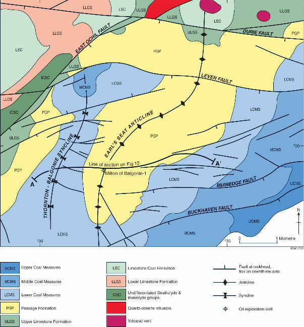
6.1. Earl’s Seat Anticline, Glenrothes, Fife
The availability of fifteen 2-D seismic lines (shot in the 1980s by Pentex, Burmah Oil
and Anvil; Fig.3) provides the basis for determining the structure beneath the Earl’s
Seat Anticline (Fig.11) and Thornton-Balgonie Syncline, south-westerly plunging
folds, formed on the western limb of the broader Midlothian-Leven Syncline (Fig.10).
The seismic data are calibrated by three exploration boreholes (Milton of Balgonie-1,
-2 and –3), drilled between 1985 and 1988 by Burmah Oil and Pentex (Fig.3). Use
has also been made of four other deep boreholes (Balfour G1-4), which were drilled
in 1938 and 1939 by D’Arcy, twenty other stratigraphic boreholes drilled to depths
greater than 100m (Fig.3), mine abandonment plans, opencast coal site records and
field mapping, all of which reside in the BGS data stores.
20/03/2009 Basin Development & Petroleum Prospectivity, MVS
p19
Underhill, Monaghan & Browne
Page 19 of 52
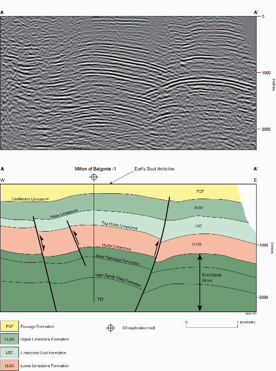
The seismic data demonstrate that a series of en-echelon N-S and NNE-SSW trending
contractional (reverse) faults characterise the Earl’s Seat Anticline at depth (Fig. 12).
The structures appear to steepen with depth, are curved in plan-view and bound the
anticlinal crest. Importantly, interpretation of the seismic data demonstrates that
Middle Mississippian-Lower Pennsylvanian (Viséan and Namurian) strata (up to and
including the Upper Limestone Formation) show a progressive easterly thickening
towards the Midlothian-Leven Syncline (Fig. 12). Data from BGS archived boreholes
drilled to the south of the Leven Fault confirm that interpretation with the Upper
Limestone Formation thickening from <300m in the Thornton-Balgonie Syncline, to
between 300 and 500m thick over the Earl’s Seat Anticline and >600m in thickness
on the western limb of the Midlothian-Leven Syncline.
The integration of the subsurface data with field relations in the Glenrothes area
implies that the Midlothian-Leven Syncline initially grew as a large-scale regional
structure during Viséan-Namurian times and was tightened thereafter. In contrast, the
data demonstrate that the Earl’s Seat Anticline and Thornton-Balgonie Syncline
formed after the Namurian wholly as a result of post-depositional (Variscan)
contractional deformation. All of the folds are cut by several, E-W trending normal
faults (Figs.10 & 11) that formed after deposition of sedimentary rocks of Middle
Pennsylvanian (Westphalian C) age, probably as a result of latest Carboniferous -
Early Permian extension.
20/03/2009 Basin Development & Petroleum Prospectivity, MVS
p20
Underhill, Monaghan & Browne
Page 20 of 52
6.2. Burntisland Anticline
The Burntisland Anticline is a broad arch over 20km wide whose ill-defined axis
appears to strike approximately N-S but is deflected towards the NE as it approaches
the surface trace of the East Ochil Fault (Fig.10, 13). It forms the western flank of the
Midlothian-Leven Syncline and the eastern side of the Lochore Syncline (Fig.1). The
structure is coincident with the outcrop of the Kinghorn Volcanic Formation (Fig.
10). Whilst Francis (1991) invoked a basement control on its formation, MacGregor
(1996) records that the anticline is associated with a persistent area of reduced
subsidence from the lower Strathclyde Group to deposition of the Passage Formation
and estimated the thicknesses for this lithostratigraphic interval to be >676m on the
Burntisland Anticline as opposed to 1963m in the Leven Syncline. What is apparent
from the structural dips is that the anticline was accentuated by Late Carboniferous
(Variscan) contractional deformation. Unfortunately, only limited borehole and very
little seismic data exist to help constrain the deeper structure of the anticline.
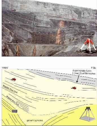
6.3. Westfield Basin, Fife
The Westfield Basin is a small (2km wide) SW-NE striking syncline containing
Upper Mississippian-Middle Pennsylvanian (Namurian and Westphalian)
sedimentary rocks that lies to the NNW of the Burntisland Anticline (Fig.13) and is
transected by the East Ochil Fault on its northern side (Fig.10 &13). The basin
contains coal-bearing strata that have largely been extracted by opencast methods.
20/03/2009 Basin Development & Petroleum Prospectivity, MVS
p21
Underhill, Monaghan & Browne
Page 21 of 52
Field observations obtained during the course of opencast mine activities provide
important information regarding the development and evolution of the basin.
Structures in the coal-bearing Lower Pennsylvanian (Namurian-Westphalian A)
Passage Formation provide spectacular evidence that the Westfield Basin was an
important syn-sedimentary growth fold (Fig.14). Over a distance of about 250m,
strata are seen to thicken by over 400% into the core of the syncline (from 28m on its
flanks to 130m in its core; Brand et al., 1980). The geometry is similar to that seen on
a larger scale in the Firth of Forth (e.g. Fig.6).
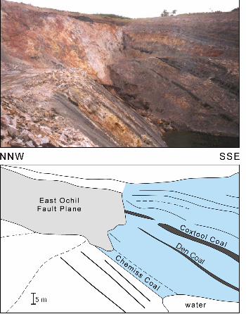
E-W trending normal faulting controlled the dissection of the syncline (e.g. the East
Ochil Fault; Figs.13 & 15). Significantly, evidence that footwall strata are not baked
by the adjacent Midland Valley quartz-dolerite sill complex at Westfield (Browne &
Woodhall, 1999; Fig. 15) implies that here, unlike the West Ochil Fault at Stirling,
further extensional activity post-dated igneous intrusion and can thus be interpreted as
latest Carboniferous or younger in age.
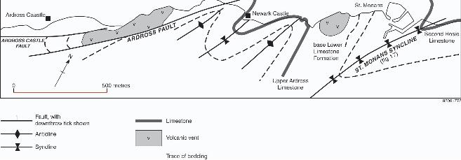
6.4. Ardross, Fife
NNE-SSW striking folding also affects Middle-Upper Mississippian (Upper Viséan
and Lower Namurian) strata that occur to the east of the Midlothian-Leven Syncline,
along the East Neuk coastline of SE Fife between Elie and Anstruther (Fig.16;
Forsyth & Chisholm, 1977). The structures form a suite of spectacular folds such as
20/03/2009 Basin Development & Petroleum Prospectivity, MVS
p22
Underhill, Monaghan & Browne
Page 22 of 52
the St Monans Syncline (Fig.17) that lie adjacent to, and are transected by, a series of
SW-NE striking wrench faults along which Upper Pennsylvanian (Stephanian)
volcanic necks and dykes were intruded (Forsyth & Rundle, 1978). Their orientation
is consistent with transpressional folds generated adjacent to strike-slip faults in
analogue models (e.g. Wilcox et al., 1973) and field-based studies of transcurrent
faults (e.g. Sylvester, 1988). It has been suggested that the disposition of the
structures is consistent with a phase of post-depositional dextral transpression having
occurred along the Ardross Fault (Cumming, 1936; McCoss, 1988).
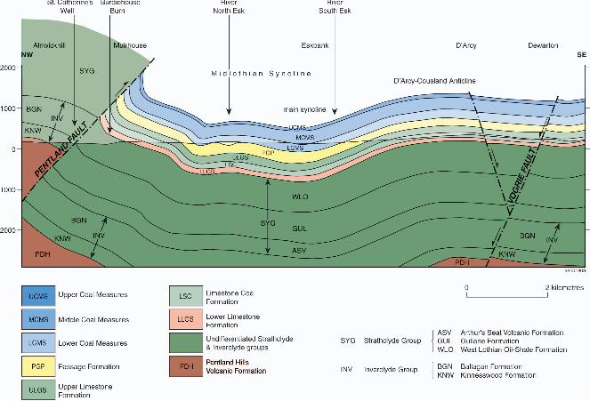
6.5. East Lothian
The expression of the Midlothian-Leven Syncline may be traced onshore (Figs.10 & 18). The
D’Arcy-Cousland and Herbershaw anticlines form its south-eastern flank and the Pentland
Fault, defines and transects its north-western margin (Tulloch & Walton, 1958). The
Midlothian Syncline, which actually consists of two synclinal folds offset from each other
(i.e. the Penicuik and Midlothian Synclines; Fig.10), contains the highly productive
Midlothian Coalfield (Tulloch & Walton, 1958). Significantly, isopach maps demonstrate
that the original Carboniferous depositional axis runs obliquely to the present one (Goodlet,
1957; Tulloch & Walton, 1958), thus implying that significant post-depositional tightening
occurred in addition to demonstrable syn-sedimentary growth.

20/03/2009 Basin Development & Petroleum Prospectivity, MVS
p23
Underhill, Monaghan & Browne
Page 23 of 52
The Pentland Fault may be traced onshore for over 45km to its branch point with the
Southern Upland Fault. For most of its length it juxtaposes Carboniferous and Siluro-
Devonian (Old Red Sandstone) rocks implying a throw of >>1km (Fig.10; BGS, 2003).
However, displacement diminishes progressively to the north east and Carboniferous rocks
lie either side of the fault towards the Firth of Forth coast (Fig.18). Field relations along its
trace demonstrate that the Carboniferous strata on its eastern (footwall) side are tilted to
vertical or locally overturned (BGS 2003; Fig.18), consistent with the structure forming a
north-westerly dipping, steep, reverse fault (Peach et al., 1910; McLintock & Phemister,
1929; Lees & Taitt, 1946).It has been suggested that the last phase of movement on the
Pentland Fault occurred after Permo-Carboniferous events, which is thought by some to have
involved sinistral wrench movement (e.g. Anderson, 1951).
Surface data demonstrate that the D’Arcy-Cousland Anticline is a NNE-SSW striking
elongate, slightly asymmetric pericline. Subsurface data have demonstrated that the structure,
which affects Middle Mississippian-Lower Pennsylvanian (Viséan and Namurian) strata, lies
above a series of downward-convergent, steep, post-depositional reverse faults (Hallett et al.,
1985; see their fig.3) suggesting that it has a similar structural genesis to the Earl’s Seat
structure in Fife.
Like other areas of the MVS, the Midlothian Syncline is transected by a series of E-W
striking dykes and normal faults that cross-cut and offset late Carboniferous strata. Whilst
their last movement was evidently post-depositional, there is some evidence from
geophysical data (Hipkin pers comm., 2004) and boreholes that at least one of the major

20/03/2009 Basin Development & Petroleum Prospectivity, MVS
p24
Underhill, Monaghan & Browne
Page 24 of 52
normal faults, the Roslin-Vogrie Fault (Fig. 10) also had syn-sedimentary activity on it
during the Carboniferous (Fig. 19).
In contrast to the Westfield Basin where intrusion of latest Carboniferous- Early Permian
quartz-dolerite pre-dated E-W faulting, to the east of Edinburgh E-W striking quartz-dolerite
dykes cut across and thus post-date E-W striking faults (BGS 2003), consistent with linked
latest Carboniferous- Early Permian intrusion and extension at the regional scale.

20/03/2009 Basin Development & Petroleum Prospectivity, MVS
p25
Underhill, Monaghan & Browne
Page 25 of 52
7. Structural Controls on the Development of the Midland Valley of Scotland
Integration of the subsurface and outcrop data affords the opportunity to test previous
hypotheses and produce the following, new model which details the Middle to Late
Carboniferous, Permian and post-Permian tectonic history of the MVS. The results allow us
to extend the work of Ritchie et al. (2003) by considering the basin in its regional context
from offshore to surrounding onshore areas and provide new constraints on the structural
development of the MVS.
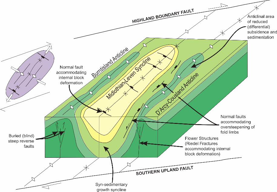
7.1 Mid-late Carboniferous Evolution
Syn-sedimentary growth from the Middle Mississippian to the Middle Pennsylvanian (Late
Viséan-Westphalian) characterises the Midlothian-Leven Syncline and is inferred to have
occurred during the development of the NNE-SSW striking Clackmannan Syncline to the
west (e.g. Read, 1988, Rippon et al., 1996; Hooper, 2003). This development of syn-
sedimentary folds at high angles to the active NE-SW striking, fault-bounded basin margins
is characteristic of subsiding strike- or oblique-slip structural settings. Comparison with sand-
box models, which have replicated field observations and structural analogues are both
consistent with the synclines having developed within an overall dextral strike-slip regime
(Wilcox et al., 1973; Fig.19).
20/03/2009 Basin Development & Petroleum Prospectivity, MVS
p26
Underhill, Monaghan & Browne
Page 26 of 52
Independent evidence in support of a dextral strike-slip origin for Late Carboniferous
structural styles in MVS comes from the nature of some of the coeval igneous material in the
basin, much of which has a very unusual character. In particular, the unique record of mantle
xenoliths is thought to indicate their derivation from deep-seated, sub-vertical fault zones
that, unlike faults that commonly characterise extensional and contractional settings, transect
the crust to tap a mantle source (Macintyre et al., 1981).
Tightening of folds and the occurrence of steeply-inclined reverse faults (e.g. the Pentland
Fault) and faults with a notably strike- or oblique-slip component on them (e.g. the Ardross
Fault) affecting sedimentary rocks belonging to the Coal Measures Group imply that the
Midlothian-Leven Syncline continued to tighten during the late Carboniferous. Vincent and
Rowley (2004) estimate that >0.4km of sediment was removed from the Firth of Forth area
and c.0.7km was eroded from the Milton of Balgonie area as a result of Variscan uplift.
The tightened folds probably occurred either as a result of the continued, long-lived effects of
the dextral shear process or through added complexity due to transpressional deformation
resulting from the effects of deformation across the Variscan foreland (e.g. Underhill et al.,
1988; Corfield et al., 1996; Glennie & Underhill, 1998), which are believed by some to reach
northern Scotland (e.g. Easter Ross and the Inner Moray Firth; Underhill & Brodie, 1993). A
dextral strike-slip control on the development and evolution of the MVS at this time is
consistent with structural relations seen in basins that formed along the eastern seaboard of
North America during the Carboniferous (Belt, 1969).
20/03/2009 Basin Development & Petroleum Prospectivity, MVS
p27
Underhill, Monaghan & Browne
Page 27 of 52
7.2 Latest Carboniferous-Permian deformation
Late Carboniferous sedimentary rocks are cut by numerous E-W striking faults and quartz-
dolerite dyke swarms dated at Latest Carboniferous (Stephenson et al., 2003; Monaghan &
Parrish 2006). Their occurrence, allied to the lack of evidence for continued differential
subsidence in the synformal depocentres, demonstrates that dextral strike-slip had been
replaced by N-S tension by latest Carboniferous and early Permian times, probably in
response to the opening of the Northern and Southern Permian Basins that now underlie the
North Sea (Glennie & Underhill, 1998).
Although it is hard to discern whether extensional faulting resulted in the formation of major
Permian basins in the immediate area, circumstantial evidence suggests that such basins may
have developed. Firstly, fault-controlled Permian basins occur elsewhere in Southern
Scotland (e.g. Ayrshire; Mykura et al., 1967) or have been proposed (e.g. on the southern
side of the Ochil Fault; Rippon et al., 1996). Secondly, carbonaceous lithologies in the Coal
Measures have reached bituminous grade, implying burial to significant depths after
deposition. Anthracite grade coal is only seen next to sills (Macgregor & Macgregor, 1948)
and vitrinite reflectance analyses on samples found distant from intrusions indicate relatively
high ranks (c.0.7-0.9%VR, Raymond 1991).
20/03/2009 Basin Development & Petroleum Prospectivity, MVS
p28
Underhill, Monaghan & Browne
Page 28 of 52
7.3 Post-Permian History
Subcrop patterns in the Forth Approaches Basin, that lies to the east of the Firth of Forth, are
consistent with evidence from other areas that suggest that the British Isles experienced
increasing amounts of regional uplift during the Paleogene towards the west (best
documented in the Inner Moray Firth; Hillis et al., 1994). It seems plausible that any post-
Carboniferous sedimentary rocks were removed during this event. Support for this proposal
comes from thermal modelling studies around the Midlothian-Leven Syncline that imply
burial of Carboniferous strata by up to 2km prior to Cenozoic uplift (Vincent & Rowley,
2004) and from unpublished fission track results (e.g. from the 25/26-1 well), which suggest
that >1.3km of sedimentary cover has been removed from the area (Green, pers. comm.,
2000). Some structural reactivation of the basin-bounding and intrabasinal faults (such as the
Pentland Fault) may have occurred during later events (e.g. Early Cenozoic uplift; Anderson,
1951).
20/03/2009 Basin Development & Petroleum Prospectivity, MVS
p29
Underhill, Monaghan & Browne
Page 29 of 52
8. Implications for Petroleum Prospectivity
Integration of the new structural and stratigraphic data with the sedimentary record
provides important new insights into the controls on the petroleum system in the
eastern MVS. The results extend the understanding of the Carboniferous reservoir
plays from previous studies that have focused upon the east Midlands, northern
England and the Southern North Sea (Fraser & Gawthorpe, 1990; Corfield et al.,
1996).
8.1. Elements of the Petroleum System
The MVS evidently contains all the main ingredients to make a petroleum province in that it
has a rich source rock (the Strathclyde Group oil shales, see section 3), potential reservoir-
seal pairs (in interbedded sedimentary rocks of the Strathclyde Group) and well defined
anticlinal trapping geometries present (Fig. 23). However, whilst the presence of an active oil
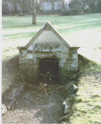
seep along the Pentland Fault, at St. Catherine's Well, in the Liberton area of Edinburgh
(Fig.20), the production of hydrocarbons from the Midlothian Field, and the occurrence of oil
in well 25/26-1 well and the Milton of Balgonie discovery, all clearly attest to source rock
maturation and petroleum migration having occurred at some time in the basin, key questions
remain regarding the genesis, timing and extent of petroleum maturation and migration.
Raymond and Murchison (1988) showed that local heating of source rocks adjacent to
igneous intrusions was important locally. Murchison and Raymond (1989) proposed that,
20/03/2009 Basin Development & Petroleum Prospectivity, MVS
p30
Underhill, Monaghan & Browne
Page 30 of 52
along with burial history, widespread igneous activity was significant in the organic
maturation of coals. However, integration of the seismic interpretation presented here with
the field data provide support for an exclusive burial-related explanation for petroleum
generation in the basin.
Evidence from surface sampling of the potential source rocks suggests that whilst they
locally approach the threshold for liquid hydrocarbon generation, they are all immature at
outcrop. However, the occurrence of good quality bituminous coals in the Midlothian and
Fife coalfields, together with geochemical analyses of samples from the BGS shallow
borehole 73/16, and well 25/26-1 show that units within the Strathclyde Group lie close to
the oil window. Since both boreholes were drilled in structurally elevated positions on the
flanks of the main syncline, the obvious conclusion is that oil-shales within the Strathclyde
Group sited in the core of the synclines, which were buried much more deeply, have at some
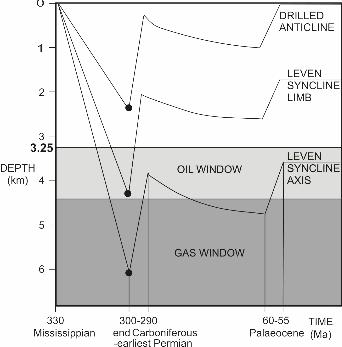
time heated sufficiently to mature and become oil-bearing (Fig.21). Construction of
schematic burial curves for the highly productive West Lothian Oil Shale Formation for
various positions in and around the Midlothian-Leven Syncline demonstrates the effect that
their respective differential subsidence histories had for source rock maturation and suggests
that maturation is largely restricted to the core and flanks of the fold (Fig.21).
It appears from the burial histories that initial maturation and petroleum charge may have
occurred during the Carboniferous prior to Variscan uplift. This is in agreement with
Raymond & Murchison (1989) who proposed that the current level of vitrinite maturation
was reached prior to sill intrusion at 295 Ma. As in other areas of the UK (e.g. east
20/03/2009 Basin Development & Petroleum Prospectivity, MVS
p31
Underhill, Monaghan & Browne
Page 31 of 52
Midlands; Fraser & Gawthorpe, 1990), however, the effects of subsequent Mesozoic and
earliest Paleogene burial appear to have been crucial in promoting renewed charge into
prospective structures.
Extrapolation of a typical geothermal gradient recorded from the region are in the order of 26
degrees C/km (e.g. in well 25/26-1) suggests that petroleum generation may continue in
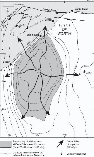
deeper parts (>3.25km) of the Midlothian-Leven Syncline today. The extent of the present-
day kitchen area can be deduced from the seismic interpretation (e.g. Fig 9) and appears to
cover an area of >25 sq.km (Fig.22). Importantly, since deeper burial of the Strathclyde
Group oil-shales is implied prior to Paleogene uplift, the effective kitchen area and hence,
palaeo oil migration into neighbouring structures would certainly have been much more
extensive during the Cretaceous and Early Paleogene.
8.2. Remaining Potential
Prospectivity in and around the Midlothian-Leven Syncline is enhanced by the occurrence of
anticlinal folds adjacent to, up-dip from, and in direct communication with the deeply-buried,
mature, source rocks. Consequently, exploration potential might be expected in any
culmination located along the length of the neighbouring long-lived, intrabasinal anticlinal
folds. However, the fact that the sedimentary facies within the Strathclyde Group becomes
more sand-rich towards its easterly, proximal source (Greensmith, 1965), suggests that the
eastern flanking structures (e.g. 25/26-1 and the D’Arcy-Cousland anticline) would have
20/03/2009 Basin Development & Petroleum Prospectivity, MVS
p32
Underhill, Monaghan & Browne
Page 32 of 52
better reservoir potential than the axis of the Burntisland Anticline. Indeed, this may explain
why the Midlothian Field produced commercial quantities of oil and gas whilst those
discoveries sited farther west have not.
Whilst potential exists to develop the 25/26-1 and Milton of Balgonie discoveries or to drill
other folds containing suitable clastic reservoirs around the Midlothian-Leven kitchen, any
structures are likely to be relatively small. Instead, the greater value of understanding the
petroleum habitat in the MVS may be to elucidate the petroleum exploration potential in
Devono-Carboniferous folds lying buried beneath the Forth Approaches to the east
(Cartwright et al., 2001).
Finally, the new model of the petroleum system which governs plays in the MVS presented
herein may also be a good structural analogue for basins lying along the eastern seaboard of
North America (e.g. Nova Scotia and Newfoundland; Belt, 1969), where exploration activity
is currently taking place.
20/03/2009 Basin Development & Petroleum Prospectivity, MVS
p33
Underhill, Monaghan & Browne
Page 33 of 52
9. Conclusions
Integration of subsurface data with outcrop information and strategic field localities has
helped resolve the long-standing controversy regarding the structural controls on the Mid-
Late Carboniferous development and evolution of the MVS. The data are consistent with the
basin forming as a result of progressive dextral strike-slip along its basin-bounding Highland
Boundary and Southern Upland fault systems during late Viséan to Westphalian times.
Internal deformation consequent upon wrench motion on the basin margins, led to
differential subsidence and the progressive development of several NNE-SSW striking syn-
sedimentary growth folds, the most prominent of which was the Midlothian-Leven Syncline.
Burial in the axis of that important fold resulted in maturation of and derivation of petroleum
from oil-shale source rocks belonging to the Strathclyde Group and migration of oil out from
its core during the Late Carboniferous. Despite being affected by subsequent Variscan and
Paleogene uplift events, Permian to earliest Paleogene burial appears to have been sufficient
to permit further petroleum maturation in the axis of the syncline that continues at the
present-day despite the effects of Paleogene regional uplift and an easterly tilt being
emparted on the basin. The main successful play type consists of the up-dip migration and
charge of flanking palaeostructures, such as the D’Arcy-Cousland and Earl’s Seat Anticlines
and the culmination drilled by well 25/26-1. Further untested petroleum potential appears to
exist in analogous fold structures located beneath a Permian and younger cover sequence in
the Forth Approaches to the east.
20/03/2009 Basin Development & Petroleum Prospectivity, MVS
p34
Underhill, Monaghan & Browne
Page 34 of 52
10. Acknowledgements
We acknowledge Conoco UK Ltd. for access to and permission to publish sections from their
seismic and well data and thank Steve Daines and Jim Farrell for their enthusiastic support of
the studies reported herein. Alison Monaghan and Mike Browne publish with the permission
of the Executive Director of the British Geological Survey. Seismic interpretation was
carried out using Geoquest iesx software, which was kindly provided by Sclumberger Geco-
Prakla, on workstations housed in The University of Edinburgh’s seismic interpretation
laboratory. We thank Maxine Akhurst and Chris Thomas (BGS) and Al Fraser (BP
Exploration) for their helpful reviews of the manuscript.
20/03/2009 Basin Development & Petroleum Prospectivity, MVS
p35
Underhill, Monaghan & Browne
Page 35 of 52
11. References
Anderson, E.M. 1951. The Dynamics of Faulting and Dyke Formation with
Applications to Britain. 2nd Edition. Edinburgh.
Argent et al., 2002
Belt, E.S. 1969. Newfoundland Carboniferous stratigraphy and its relation to the
Maritimes and Ireland. In: North Atlantic; geology and continental drift. AAPG
Memoir, 12, 734-753.
BGS 1971a. Sheet 41 North Berwick solid edition. British Geological Survey.
Scotland 1:50 000 series
BGS 1971b. Sheet 40 Kinross solid edition. British Geological Survey. Scotland 1:50
000 series
BGS 1980. Sheet 33E Dunbar solid edition. British Geological Survey. Scotland 1:50
000 series
BGS 1983. Sheet 33W Haddington solid edition. British Geological Survey. Scotland
1:50 000 series
20/03/2009 Basin Development & Petroleum Prospectivity, MVS
p36
Underhill, Monaghan & Browne
Page 36 of 52
BGS 1996. Kinglassie NT29NW solid edition. British Geological Survey. Scotland
1:10 000 series
BGS 1998. Sheet 32W Livingston solid edition. British Geological Survey. Scotland
1:50 000 series
BGS 1999. Sheet 40E Kirkcaldy solid edition. British Geological Survey. Scotland
1:50 000 series
BGS 2003. Sheet 32E Bedrock Edinburgh 1:50 000 scale.
Brand, P.J., Armstrong, M. & Wilson, R.B. 1980. The Carboniferous strata at the
Westfield opencast site, Fife, Scotland. Report of the Institute of Geological Sciences
(79/11). HMSO London. ISBN 0118841238
Browne, M.A.E. & Monro, S.K. 1989. Evolution of the coal basins of Central
Scotland: In Congres International de Stratigraphie et de Geologie du Carbonifere
11th 1987 Beijing; Nanjing University of Press; 1-19.
Browne, M.A.E. & Woodhall, D.G. 1999. Geology of the Kirkcaldy district - a brief
explanation of the geological map. Sheet Explanation of the British Geological
Survey, 1:50 000 Series. Sheet 40E (Scotland).
20/03/2009 Basin Development & Petroleum Prospectivity, MVS
p37
Underhill, Monaghan & Browne
Page 37 of 52
Browne, M.A.E., Dean, M.T., Hall, I.H.S., McAdam, A.D., Monro, S.K. & Chisholm,
J.I. 1999. A lithostratigraphical framework for the Carboniferous rocks of the Midland
Valley of Scotland. British Geological Survey Research Report, RR/99/07.
Cadell, H.M. 1925. The rocks of west Lothian: an account of the geological and
mining history of the west Lothian district. (Edinburgh: Oliver and Boyd.).
Cameron, I.B. & McAdam, A.D. 1978. The oil-shales of the Lothians, Scotland:
present resources and former workings. Report of the Institute of Geological Sciences
78/28.
Cameron, I.B. & Stephenson, D. 1985. British regional geology: the Midland Valley
of Scotland. (3rd edition). HMSO, London for the British Geological Survey.
Cartwright, J., Stewart, S. & Clark, J. 2001. Salt dissolution and salt-related deformation
of the Forth Approaches Basin, UK North Sea. Marine and Petroleum Geology, 18, 757-
778
Chadwick, R.A, Holliday, D.W, Holloway, S. & Hulbert, A.G. 1995. The structure
and evolution of the Northumberland-Solway Basin and adjacent areas. Subsurface
Memoir of the British Geological Survey.
20/03/2009 Basin Development & Petroleum Prospectivity, MVS
p38
Underhill, Monaghan & Browne
Page 38 of 52
Corfield, S.M, Gawthorpe, R.L, Gage, M, Fraser, A.J, & Besly, B.M. 1996. Inversion
tectonics of the Variscan foreland of the British Isles. Journal of the Geological
Society, London, 153, 17-32.
Coward, M.P. 1993. The effect of Late Caledonian and Variscan continental escape
tectonics on basement structure, Palaeozoic basin kinematics and subsequent
Mesozoic basin development in N W Europe. In: Parker, J R (Ed.) Petroleum Geology
of Northwest Europe: Proceedings of the 4th Conference. (London: The Geological
Society). 1095-1108.
Cumming, G.A. 1936. The structural and volcanic geology of the Elie-St Monance
district, Fife. Transactions of the Edinburgh Geological Society, 13, 340-365.
Forsyth, I.H, & Chisholm, J.I. 1977. The Geology of East Fife. Memoir of the
Geological Survey of Great Britain, Sheet 41 and part of 49 (Scotland).
Forsyth, I.H, & Rundle, C.C. 1978. The age of the volcanic and hypabyssal rocks of
East Fife. Bulletin of the Geological Survey of Great Britain, No. 60, 23-29.
Francis, E.H. 1991. Carboniferous. In: Craig, G.Y. (ed.): Geology of Scotland (3rd
Edition). Geological Society, London, 347-392.
20/03/2009 Basin Development & Petroleum Prospectivity, MVS
p39
Underhill, Monaghan & Browne
Page 39 of 52
Fraser, A.J & Gawthorpe, R.L. 1990. Tectono-stratigraphic development and
hydrocarbon habitat of the Carboniferous in northern England. In: Hardman, R.F.P. &
Brooks, J. (Eds.). Geological Society, London, Special Publications, 55: 49 - 86.
Gawthorpe, R.L. 1987. Tectono-sedimentary evolution of the Bowland Basin, N
England, during the Dinantian. Journal of the Geological Society, 144, 59-71.
George, T.N. 1960. The stratigraphic evolution of the Midland Valley. Transactions
of the Geological Society of Glasgow, 24, 32-107.
Gibbs, A.D. 1990. Linked fault families in basin formation. Journal of Structural
Geology, 12, 795-803.
Glennie, K.W. & Underhill J.R. 1998. Origin, development and evolution of structural
styles. In Glennie, K.W. (Ed.): Petroleum Geology of the North Sea: Basic Concepts
and Recent Advances. 42-84.
Goodlet, G.A. 1957. Lithological variation in the Lower Limestone Group of the
Midland Valley of Scotland. Bulletin of the Geological Survey of Great Britain, 12,
52-65.
Greensmith, J.T. 1962. Rhythmic deposition in the Carboniferous oil-shale group of
Scotland: Journal of Geology 70, 355-364
20/03/2009 Basin Development & Petroleum Prospectivity, MVS
p40
Underhill, Monaghan & Browne
Page 40 of 52
Greensmith, J.T. 1965. Calciferous Sandstone Series sedimentation at the eastern end
of the Midland Valley of Scotland. Journal of Sedimentary Research, 35, 223-242
Hallett, D., Durant, G.P. & Farrow, G.E. 1985. Oil exploration and production in
Scotland. Scottish Journal of Geology, 21, 547-570.
Harding, T.P. 1985. Seismic characteristics and identification of negative flower
structures, positive flower structures and positive structural inversion. AAPG Bulletin,
69, 582-600.
Haszeldine, R.S. 1988. Crustal lineaments in the British Isles: their relationship to
Carboniferous basins. In: Besly, B M, and Kelling, G (Eds.): Sedimentation in a
synorogenic basin complex: the Upper Carboniferous of northwest Europe. 53-68.
(Glasgow: Blackie and Son.)
Hillis, R.R, Thomson, K. & Underhill, J.R. 1994. Quantification of Tertiary erosion
from the Inner Moray Firth using sonic velocity data from the Chalk and Kimmeridge
Clay. Marine and Petroleum Geology, 11, 283-293.
Holliday, D.W. & Molyneux, S.G. 2006. Editorial Statement: New official names for
the subsystems, series and stages of the Carboniferous System, Proceedings of the
Yorkshire Geological Society, 56, 57-58.
20/03/2009 Basin Development & Petroleum Prospectivity, MVS
p41
Underhill, Monaghan & Browne
Page 41 of 52
Hooper, M.D. 2003. The Carboniferous Evolution of the Central Coalfield Basin,
Midland Valley of Scotland. Unpublished PhD thesis, University of Leicester 166pp.
Leeder, M.R. 1982. Upper Palaeozoic basins of the British Isles - Caledonian
inheritance versus Hercynian plate marginal processes. Journal of the Geological
Society of London, 139, 479-491.
Lees, G.M. & Cox, P.T. 1937. The geological basis for the search for oil in Great
Britain by the D'Arcy Exploration Co. Ltd. Quarterly Journal of the Geological
Society, 93, 156-90.
Lees, G.M. & Taitt, A.H. 1946. The geological results of the search for oilfields in
Great Britain. Quarterly Journal of the Geological Society, 101, 255-317.
Macintyre, R.M, Cliff, R.A. & Chapman, N.A. 1981. Geochronological evidence for
phased volcanic activity in Fife and Caithness necks, Scotland. Transactions of the
Royal Society of Edinburgh: Earth Sciences, 72, 1-7.
MacGregor, A.R. 1996. Fife and Angus geology. An excursion guide. (3rd Edition).
(Edinburgh: The Pentland Press).
20/03/2009 Basin Development & Petroleum Prospectivity, MVS
p42
Underhill, Monaghan & Browne
Page 42 of 52
Macgregor, M & Macgregor, A.G. 1948. The Midland Valley of Scotland. 2nd
Edition. British Regional Geology. Geological Survey.
McCoss, A.M. 1988. Restoration of transpression/ transtension by generating the
three-dimensional segmented helical loci of deformed lines across structure contour
maps. Journal of Structural Geology, 10, 109-120.
McLintock, W.F.P. & Phemister, J. 1929. A Gravitational Survey over the Pentland
Fault, near Portobello, Midlothian, Scotland. Sum.Prog.Geol.Surv. for 1928, 10-28.
Maynard, J.R., Hofmann. W., Dunay, R.E., Bentham. P.N., Dean, K.P. & Watson, I.
1997. The Carboniferous of Western Europe: the development of a petroleum system.
Petroleum Geoscience, 3, 97-115.
Monaghan, A.A. & Parrish R.R. 2006. Geochronology of Carboniferous–Permian
volcanism in the Midland Valley of Scotland: implications for regional tectono-
magmatic evolution and the numerical timescale. Journal of the Geological Society of
London, 163, 15-28.
Monro, S.K. 1999. Geology of the Irvine district. Memoir of the British Geological
Survey, Sheet 22W and part of Sheet 21E (Scotland).
20/03/2009 Basin Development & Petroleum Prospectivity, MVS
p43
Underhill, Monaghan & Browne
Page 43 of 52
Murchison, D.G. & Raymond, A.C. 1989. Igneous activity and organic maturation in
the Midland Valley of Scotland. International Journal of Coal Geology, 14, 47-82.
Mykura, W., Calver, M. A. & Wilson, R. B. 1967. The Upper Carboniferous rocks of
south-west Ayrshire. Bulletin of the Geological Survey of Great Britain, 26, 23-98.
Naylor, M.A., Mandl, G & Sijpesteijn, C.H.K.1986. Fault geometries in basement-
induced wrench faulting under different initial stress states. Journal of Structural
Geology, 8, 737-752.
Peach, B.N., Clough, C.T., Hinxman, L.W., Grant Wilson, J.S., Crampton, C.B.,
Maufe, H.B. & Bailey, E.B. 1910. The Geology of the Neighbourhood of Edinburgh.
2nd Edition. Mem Geol.Surv.
Raymond, A.C. & Murchison, D.G. 1988. Development of organic maturation in the
thermal aureoles of sills and its relation to sediment compaction. FUEL, 67, 1599-
1608.
Raymond, A.C. & Murchison, D.G. 1989. Organic maturation and its timing in a
Carboniferous sequence in the central Midland Valley of Scotland: comparisons with
northern England. FUEL, 68, 328-334.
20/03/2009 Basin Development & Petroleum Prospectivity, MVS
p44
Underhill, Monaghan & Browne
Page 44 of 52
Raymond, A.C. 1991. Carboniferous rocks of the Eastern and Central Midland Valley of
Scotland: organic petrology, organic geochemistry and effects of igneous activity.
Unpublished Ph.D Thesis, University of Newcastle upon Tyne
Read, W.A. 1988. Controls on Silesian sedimentation in the Midland Valley of
Scotland. 222-241 in Sedimentation in a synorogenic basin complex: the Upper
Carboniferous of northwest Europe. Besly, B M, and Kelling, G (Eds.). (Glasgow:
Blackie and Son.).
Read, W.A., Browne M.A.E., Stephenson D. & Upton B.J.G. 2002. Carboniferous. In
Trewin N.H. (ed) The Geology of Scotland. Fourth Edition. The Geological Society,
London, 251-300.
Richard, P.D., Naylor, M.A. & Koopman, A. 1995. Experimental Models of Strike
Slip Tectonics. Petroleum Geoscience, 1, 71-80.
Rippon, J., Read, W.A, & Park, R.G. 1996. The Ochil Fault and the Kincardine basin:
key structures in the tectonic evolution of the Midland Valley of Scotland. Journal of
the Geological Society, London, 153, 573-587.
Ritchie, J.D., Johnson, H., Browne, M.A.E. & Monaghan A.A. 2003. Late Devonian-
Carboniferous tectonic evolution within the Firth of Forth, Midland Valley, as
revealed from 2D seismic reflection data. Scottish Journal of Geology, 39, 121-134.
20/03/2009 Basin Development & Petroleum Prospectivity, MVS
p45
Underhill, Monaghan & Browne
Page 45 of 52
Selley, R.C. 1992. Petroleum seepages and impregnations in Great Britain. Marine
and Petroleum Geology, 9, 226-244.
Smith, I.F. 2005. Editor: Digital Geoscience Spatial Model Project. Final Report.
British Geological Survey Occasional Publication, 9, 56pp.
Stedman, C. 1988. Namurian E1 tectonics and sedimentation in the Midland Valley of
Scotland: rifting versus strike-slip influence. In; Besly, B M, & Kelling, G (Eds.):
Sedimentation in a synorogenic basin complex: the Upper Carboniferous of northwest
Europe. (Glasgow: Blackie & Son.), 242-254.
Stephenson, D., Loughlin, S.C., Millward, D., Waters, C.N. & Williamson, I. T. 2003.
Carboniferous and Permian Igneous Rocks of Great Britain North of the Variscan
Front. Geological Conservation Review Series Number 27, Joint Nature Conservation
Committee, Peterborough.
Sylvester, A. G., 1988. Strike-slip faults. Geological Society of America Bulletin,
100, 1666-1703.
Thomson, M.E.,1978. IGS studies of the geology of the Firth of Forth and its
Approaches. Report of the Institute of Geological Sciences Great Britain 77/17.
HMSO London, ISBN 0118840657.
20/03/2009 Basin Development & Petroleum Prospectivity, MVS
p46
Underhill, Monaghan & Browne
Page 46 of 52
Tulloch, W. & Walton, H.S. 1958. The Geology of the Midlothian Coalfield.
Memoirs of the Geological Survey.
Underhill, J.R. 2003. The tectonic and stratigraphic framework of the United
Kingdom's oil and gas fields. In: Gluyas, J.G. & Hichens, H.M (Eds.): United
Kingdom oil and gas fields. Memoir of the Geological Society, 20, 17-59.
Underhill, J.R. & Brodie, J.A, 1993. Structural geology of Easter Ross, Scotland
implications for movement on the Great Glen Fault zone. Journal of the Geological
Society, 150, 515-527.
Underhill, J.R., Gayer, R.A., Woodcock, N.H., Donnelly, R., Jolley, E. & Stimpson,
I.G. 1988. The Dent Fault, northern England - reinterpreted as a major oblique slip
fault zone. Journal of the Geological Society, 145, 313-316.
Vincent, C.J. & Rowley, W.J. 2004. Thermal modeling in the Midland Valley of
Scotland using BasinMod and HotPot: British Geological Survey report IR/04/144.
Wilcox, R.E., Harding, T.P. & Seely, D.R. 1973. Basic Wrench tectonics. AAPG
Bulletin, 57, 74-96.
20/03/2009 Basin Development & Petroleum Prospectivity, MVS
p47
Underhill, Monaghan & Browne
Page 47 of 52
12. Figure Captions:
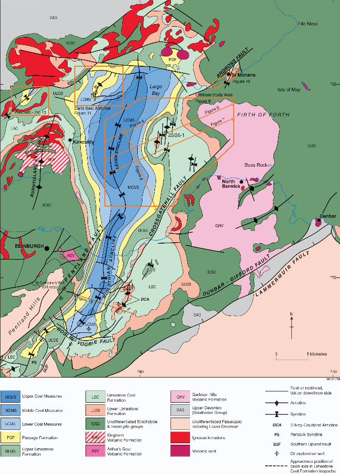
Fig.1: Summary Geological map of the Midland Valley Basin, Scotland with major faults
and folds, six figure National Grid references and latitude/longitude shown. The basin is
defined by the Highland Boundary and Southern Uplands Faults and is dominated internally
by the occurrence of numerous N-S trending folds including the Clackmannan Syncline (CS),
the Burntisland Anticline (BA), Midlothian-Leven Syncline (MLS).
Fig.2: Carboniferous Stratigraphy of the Midland Valley Basin (after Browne et al., 1999)
and with stratigraphic level of seismic picks shown by arrow on right hand side. The time-
scale subdivisions follow revisions accepted by the Subcommission on Carboniferous
Stratigraphy (SCCS) and ratified by the International Commission on Stratigraphy (ICS) and
The International Union of Geological Sciences (IUGS) (Holliday & Molyneaux, 2006). The
Holkerian to Arundian substage boundaries are not shown because they are not recognised by
biostratigraphy in the MVS.
Fig.3: Seismic and Well Database consisting of Conoco’s 2-D seismic lines from the Firth of
Forth, Burmah, Anvil and Pentex 2-D seismic lines from the Earl’s Seat Anticline in Fife and
all available oil exploration well and other coalfield and BGS borehole data. Location of the
seismic lines used in Figures 5-8 are highlighted.
Fig.4: Summary well-log for Conoco’s 25/26-1 (Firth of Forth-1) well highlighting the main
identifiable stratigraphic horizons used to constrain the seismic interpretation (Modified after
20/03/2009 Basin Development & Petroleum Prospectivity, MVS
p48
Underhill, Monaghan & Browne
Page 48 of 52
Ritchie et al., 2003). Top Passage Formation pick and Top Upper Limestone Formation pick
are above sea level in 25/26-1. The Top Anstruther Formation (Base Pittenween Formation)
marker has been used to contour the maps because it is present across the whole area.
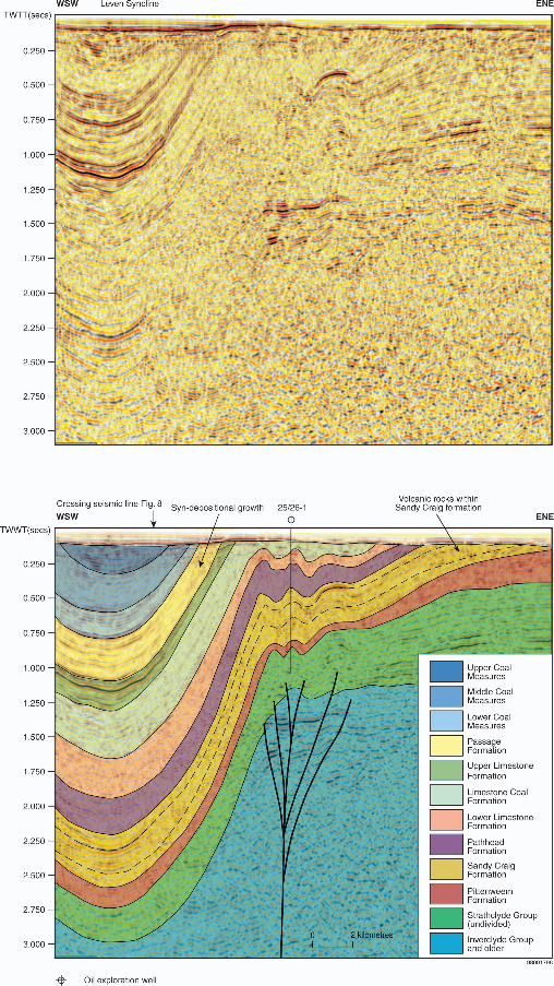
*Fig.5: WSW-ENE striking seismic line depicting the subsurface nature of the Midlothian-
Leven Syncline beneath the Firth of Forth. The section is constrained by the 25/26-1 well and
demonstrates the open asymmetric fold geometry that characterises the regional structure.
Fig.6: WSW-ENE striking seismic line depicting the subsurface nature of the Midlothian-
Leven Syncline beneath the Firth of Forth. The section is constrained by the 25/26-1 well and
demonstrates the open asymmetric fold geometry that characterises the regional structure.
*Fig.7: WSW-ENE striking seismic line depicting the subsurface nature of the Midlothian-
Leven Syncline beneath the Firth of Forth. The section is constrained by the 25/26-1 well and
demonstrates the open asymmetric fold geometry that characterises the regional structure.
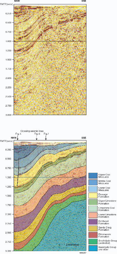
*Fig.8: NNW-SSE striking seismic line depicting the subsurface nature of the Midlothian-
Leven Syncline beneath the Firth of Forth. The section is constrained by the 25/26-1 well and
demonstrates the open asymmetric fold geometry that characterises the regional structure.
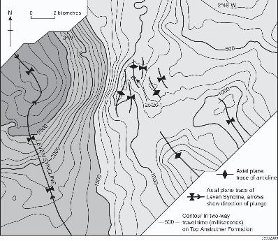
Fig.9: Contoured structure map for the Top Anstruther Formation (Base Pittenweem
Formation). The map highlights the doubly-plunging, canoe-shaped form of the Leven
Syncline.
20/03/2009 Basin Development & Petroleum Prospectivity, MVS
p49
Underhill, Monaghan & Browne
Page 49 of 52
Fig.10: Summary map integrating the outcrop and subcrop data from offshore waters of the
Firth of Forth with data obtained from neighbouring land areas. Onshore data modified and
simplified after BGS (1971a, 1971b, 1980, 1983, 1998, 1999, 2003).
Fig.11: Geological map of the Earl’s Seat Anticline, Fife modified after BGS (1999). The
structure is one of a number of SW-NE trending, transected folds that occur throughout the
basin. The map shows the location of the Milton of Balgonie-1 well and the line of section
used in Fig.12.
Fig.12: Uninterpreted seismic reflection profile and interpreted geological cross-section
across the Earl’s Seat Anticline, Fife. The section demonstrates the important role that post-
depositional compression along steeply dipping, upward diverging reverse faults play in the
evolution of the basin. (TD= total depth of Milton of Balgonie well).
Fig.13: Geological map of the Westfield area, Fife simplified after BGS (1971b, 1999) with
fold axes on the Westfield Shale Coal from BGS (1996). Its precise location is given on
Fig.10.
Fig.14: Photograph and line drawing interpretation of the Westfield Coalfield opencast site
showing the field evidence for spectacular thickening in the core regions of the syncline
during deposition of the Passage Formation (shown in yellow). The stratigraphic and
sedimentological relationships demonstrate the effects of pronounced syn-sedimentary
20/03/2009 Basin Development & Petroleum Prospectivity, MVS
p50
Underhill, Monaghan & Browne
Page 50 of 52
growth folding that affected the area during Namurian times. The view is looking NNE with
dumper trucks for scale. ©BGS photograph.
Fig.15: Photograph and line drawing interpretation of the East Ochil Fault, Westfield,
showing. The fact that the normal fault cuts strata in the syncline up to Westphalian in age
and a latest Carboniferous intrusion of the MVS tholeiitic sill complex does not bake
adjacent hangingwall strata thus demonstrates the direct field evidence for post-depositional,
post-intrusion Permian E-W striking extensional faulting in the basin. (©BGS photograph).
Fig.16: Map depicting the highly folded nature of Carboniferous sediments adjacent to the
Ardross Fault on the Fife Coast. The obliquity between the dominantly NNE-SSW striking
folds and the ENE-WSW faults with which they are directly associated supports the view that
the deformation results from dextral strike-slip on the latter.
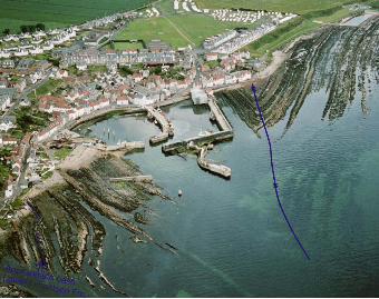
Fig.17: Oblique aerial photograph (looking approximately NE) showing the NE-SW striking
St Monans Syncline (axis highlighted in blue) affecting the Middle Mississippian
(Brigantian) Lower Limestone Formation, (©BGS photograph number D02796). The NE-
plunging tight fold structure is one of a number of folds found along the East Fife coast that
are interpreted to have formed as a result of strike-slip deformation on intra-basinal faults
affecting the Midland Valley during the Carboniferous.
Fig.18: Cross-section showing the asymmetric, south-easterly verging footwall syncline
developed in the immediate footwall to the steeply-dipping, contractional, Pentland Fault.
20/03/2009 Basin Development & Petroleum Prospectivity, MVS
p51
Underhill, Monaghan & Browne
Page 51 of 52
The structural and stratigraphic relationships associated with the Midlothian Syncline
demonstrate that the Pentland Fault represents a post-depositional reverse fault formed in
Late Carboniferous (Variscan) times. Although impossible to determine from the field
evidence, it is thought that the fault may also have been reactivated during subsequent
Cenozoic uplift.
Fig.19: Schematic cartoon illustrating the structural controls on stratigraphic architecture in
the Midland Valley during the Carboniferous. The model highlights the connection between
observed structural styles and those developed in analogue models and field exposures
associated with dextral strike-slip on boundary faults. The deformation is consistent with
basic wrench tectonic principles (e.g. Wilcox et al., 1973; Sylvester, 1988)
Fig.20: Field photograph depicting the bituminous Balm or “Oyly” Well in the grounds of St
Catherine’s House, Mortonhall, South Liberton Edinburgh (Grid Reference: NT273684). The
feature represents the site of an active oil seep found along the trace of the Pentland Fault (©
BGS photograph). Its occurrence demonstrates the fact that source rock maturity has
prevailed and the role that intra-basinal faulting in this case, the Pentland Fault, has had in
controlling oil migration. Oil from the seep was used as balming oil for the treatment of skin
ailments until the early 20th Century. The well has historical significance too, being a place of
pilgrimage for many Scottish monarchs including James IV, who visited it in 1504 and by
James VI (James I of Great Britain), who had it protected by a well in 1617. Although
Cromwell’s troops destroyed the well in 1650, it was restored in 1889.
20/03/2009 Basin Development & Petroleum Prospectivity, MVS
p52
Underhill, Monaghan & Browne
Page 52 of 52
Fig.21: Schematic burial history plot for the West Lothian Oil Shale Formation, a component
part of the Strathclyde Group in the Firth of Forth area. The plot depicts curves constructed
for different parts of the Midlothian-Leven Syncline and demonstrates that oil-shales within
axial parts of the fold first reached maturity in the Late Carboniferous. The oil-shales also
appear to have remained mature during their subsequent history of uplift and burial and are
even locally mature in the core of the Leven Syncline at the present-day.
Fig.22: Map depicting the areal extent of the present-day kitchen area for the most prolific
oil-shale source rocks of the West Lothian Oil Shale Formation that occur within the
Strathclyde Group. The map highlights the hydrocarbon migration pathways in and around
the Leven Syncline beneath north-western parts of the Firth of Forth.
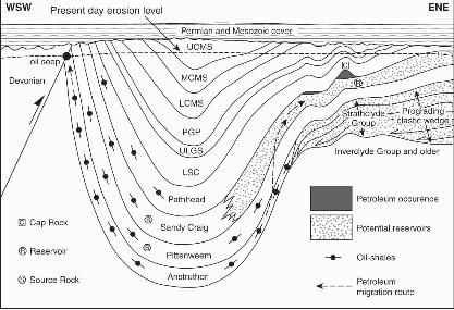
Fig.23: Cartoon depicting the main elements of the petroleum system in the eastern Midland
Valley of Scotland. The diagram highlights the main play type, namely up-dip migration and
charge of flanking, reservoir-bearing anticlines lying on the eastern flank of the Midlothian-
Leven synclinal fold, the buried core of which contains the oil-shale source rock kitchen.