Embed Size (px)
Citation preview
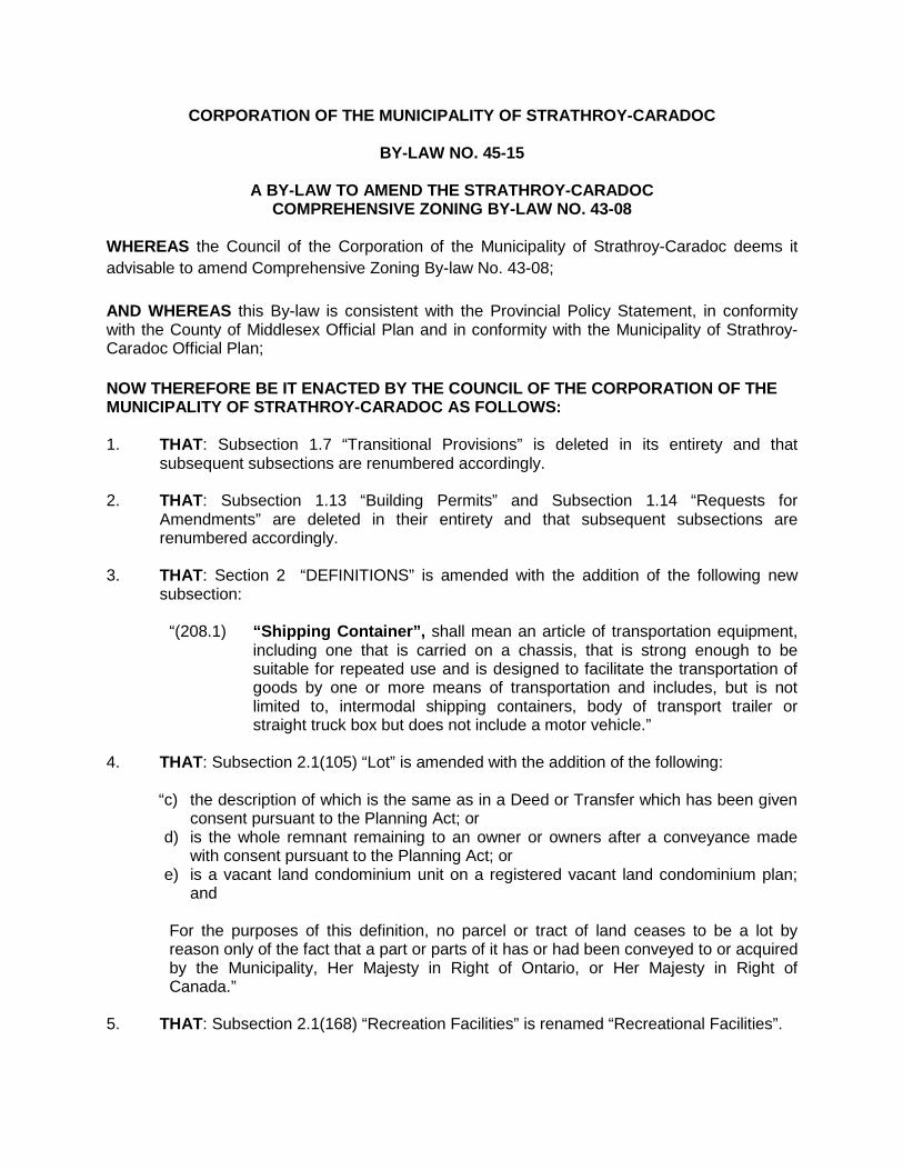
CORPORATION OF THE MUNICIPALITY OF STRATHROY-CARADOC
BY-LAW NO. 45-15
A BY-LAW TO AMEND THE STRATHROY-CARADOC COMPREHENSIVE ZONING BY-LAW NO. 43-08
WHEREAS the Council of the Corporation of the Municipality of Strathroy-Caradoc deems it advisable to amend Comprehensive Zoning By-law No. 43-08; AND WHEREAS this By-law is consistent with the Provincial Policy Statement, in conformity with the County of Middlesex Official Plan and in conformity with the Municipality of Strathroy-Caradoc Official Plan; NOW THEREFORE BE IT ENACTED BY THE COUNCIL OF THE CORPORATION OF THE MUNICIPALITY OF STRATHROY-CARADOC AS FOLLOWS: 1. THAT: Subsection 1.7 “Transitional Provisions” is deleted in its entirety and that
subsequent subsections are renumbered accordingly. 2. THAT: Subsection 1.13 “Building Permits” and Subsection 1.14 “Requests for
Amendments” are deleted in their entirety and that subsequent subsections are renumbered accordingly.
3. THAT: Section 2 “DEFINITIONS” is amended with the addition of the following new subsection:
“(208.1) “Shipping Container”, shall mean an article of transportation equipment, including one that is carried on a chassis, that is strong enough to be suitable for repeated use and is designed to facilitate the transportation of goods by one or more means of transportation and includes, but is not limited to, intermodal shipping containers, body of transport trailer or straight truck box but does not include a motor vehicle.”
4. THAT: Subsection 2.1(105) “Lot” is amended with the addition of the following:
“c) the description of which is the same as in a Deed or Transfer which has been given consent pursuant to the Planning Act; or
“d) is the whole remnant remaining to an owner or owners after a conveyance made with consent pursuant to the Planning Act; or
“e) is a vacant land condominium unit on a registered vacant land condominium plan; and
For the purposes of this definition, no parcel or tract of land ceases to be a lot by reason only of the fact that a part or parts of it has or had been conveyed to or acquired by the Municipality, Her Majesty in Right of Ontario, or Her Majesty in Right of Canada.”
5. THAT: Subsection 2.1(168) “Recreation Facilities” is renamed “Recreational Facilities”.
2
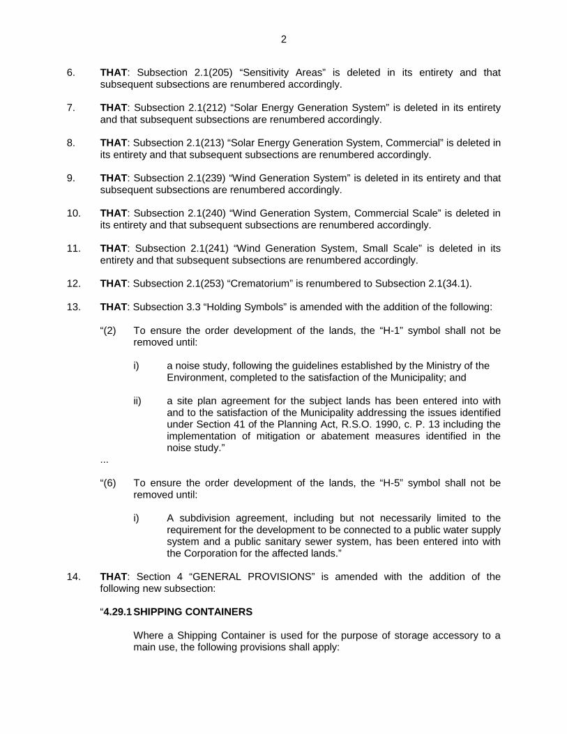
6. THAT: Subsection 2.1(205) “Sensitivity Areas” is deleted in its entirety and that subsequent subsections are renumbered accordingly.
7. THAT: Subsection 2.1(212) “Solar Energy Generation System” is deleted in its entirety
and that subsequent subsections are renumbered accordingly. 8. THAT: Subsection 2.1(213) “Solar Energy Generation System, Commercial” is deleted in
its entirety and that subsequent subsections are renumbered accordingly. 9. THAT: Subsection 2.1(239) “Wind Generation System” is deleted in its entirety and that
subsequent subsections are renumbered accordingly.
10. THAT: Subsection 2.1(240) “Wind Generation System, Commercial Scale” is deleted in its entirety and that subsequent subsections are renumbered accordingly.
11. THAT: Subsection 2.1(241) “Wind Generation System, Small Scale” is deleted in its
entirety and that subsequent subsections are renumbered accordingly. 12. THAT: Subsection 2.1(253) “Crematorium” is renumbered to Subsection 2.1(34.1). 13. THAT: Subsection 3.3 “Holding Symbols” is amended with the addition of the following:
“(2) To ensure the order development of the lands, the “H-1” symbol shall not be
removed until:
i) a noise study, following the guidelines established by the Ministry of the Environment, completed to the satisfaction of the Municipality; and
ii) a site plan agreement for the subject lands has been entered into with
and to the satisfaction of the Municipality addressing the issues identified under Section 41 of the Planning Act, R.S.O. 1990, c. P. 13 including the implementation of mitigation or abatement measures identified in the noise study.”
...
“(6) To ensure the order development of the lands, the “H-5” symbol shall not be removed until:
i) A subdivision agreement, including but not necessarily limited to the
requirement for the development to be connected to a public water supply system and a public sanitary sewer system, has been entered into with the Corporation for the affected lands.”
14. THAT: Section 4 “GENERAL PROVISIONS” is amended with the addition of the
following new subsection:
“4.29.1 SHIPPING CONTAINERS
Where a Shipping Container is used for the purpose of storage accessory to a main use, the following provisions shall apply:
3
a) A Shipping Container shall only be permitted in an Industrial Zone; and
b) A Shipping Container shall only be permitted in a rear yard in compliance with the rear yard depth requirements of the zone in which the said container is located.”
15. THAT: Section 4.2(1) “Accessory Uses Permitted in All Zones” is amended by deleting
clause c) and replacing it with the following:
“shall, with the exception of buildings and structures for agricultural uses, be erected in the front yard or exterior side yard in the case of a corner lot.”
16. THAT: Section 4.2(3) “Garage, Private” in respect of clause d) regarding R5 zones by
deleting the requirement for the minimum rear / interior side lot line setback and replacing it with “1 m”.
17. THAT: Section 4.2(3) “Garage, Private” in respect of clause e) regarding the A1 and A2
zones by deleting the requirement for the minimum rear / interior side lot line setback and replacing it with “1 m”.
18. THAT: Subsection 4.3 “Access” is amended by adding the following before the last word
“or” at the end of clause 1b): “or a private common element road integral to a registered plan of condominium;”
19. THAT: Subsection 4.3 “Access” is further amended by deleting clauses (2) and (3) in
their entirety. 20. THAT: Subsection 4.6 “Dwelling Units” is amended by deleting clause c) and the last
italicized paragraph.
21. THAT: Subsection 4.12 “Groundwater Management Areas” is deleted in its entirety and that subsequent subsections are renumbered accordingly.
22. THAT: Subsection 4.14 “Home Occupations” is amended by deleting clause g) and replacing it with the following: “i) Boarding/Rooming House vi) Machine Shop ii) Dry Cleaning Establishment vii) Restaurant iii) Garage, Public viii) Retail Store i) Industrial Use ix) Salvage Yard ii) Long Term Care Facility x) Taxi Service
xi) Use of a swimming pool in a Settlement Area”
23. THAT: Subsection 4.16 “Lands Adjacent to the “Environmental Protection” Zone &
Within the Natural Environment Overlay” is deleted in its entirety and that subsequent subsections are renumbered accordingly.
24. THAT: Subsection 4.17 “Lands Adjacent to Sensitivity Areas” is deleted in its entirety
and that subsequent subsections are renumbered accordingly.
4
25. THAT: Subsection 4.20 “Liquid Manure Storage Facilities (Construction, Size & Sealing)”
is deleted in its entirety and that subsequent subsections are renumbered accordingly.
26. THAT: Subsection 4.22 “Minimum Distance Separation (MDS) Formulae” is deleted in its entirety and replaced with the following: “All lands within the Municipality shall be subject to MDS I and MDS II; which in the case of MDS I, provides the minimum distance separation for new development from existing livestock facilities; and in the case of MDS II, provides minimum distance separation for new or expanding livestock facilities from existing development.”
27. THAT: Subsection 4.23 “Non-complying buildings, structures and lots and non-conforming uses” is amended by the addition of the following clause: “(2.1) Existing Lots
Notwithstanding any other provisions of this By-law, existing lots with less than the required area, lot frontage, or lot depth, or which exceed the maximum lot area, may be used, and buildings and structures erected or altered thereon, for the purpose specified in the zone in which they are situated, provided all other regulations of this By-law are satisfied.”
28. THAT: Subsection 4.23(4) “Non-complying buildings, structures and lots and non-conforming uses” is amended by adding the word “replaced” after the word “repaired”.
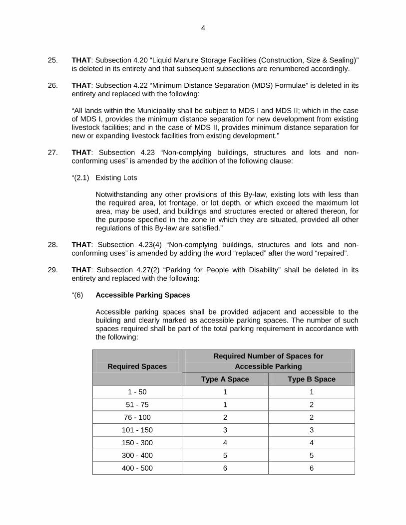
29. THAT: Subsection 4.27(2) “Parking for People with Disability” shall be deleted in its entirety and replaced with the following: “(6) Accessible Parking Spaces
Accessible parking spaces shall be provided adjacent and accessible to the building and clearly marked as accessible parking spaces. The number of such spaces required shall be part of the total parking requirement in accordance with the following:
Required Spaces Required Number of Spaces for
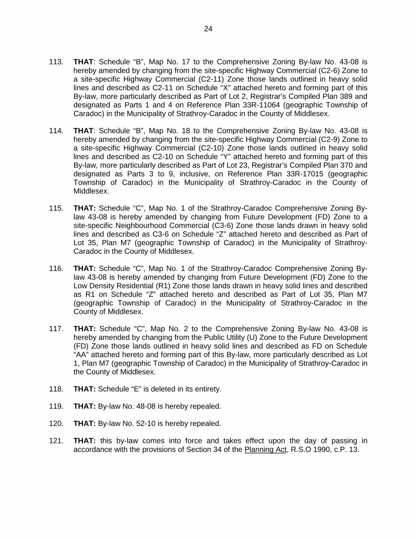
Accessible Parking Type A Space Type B Space
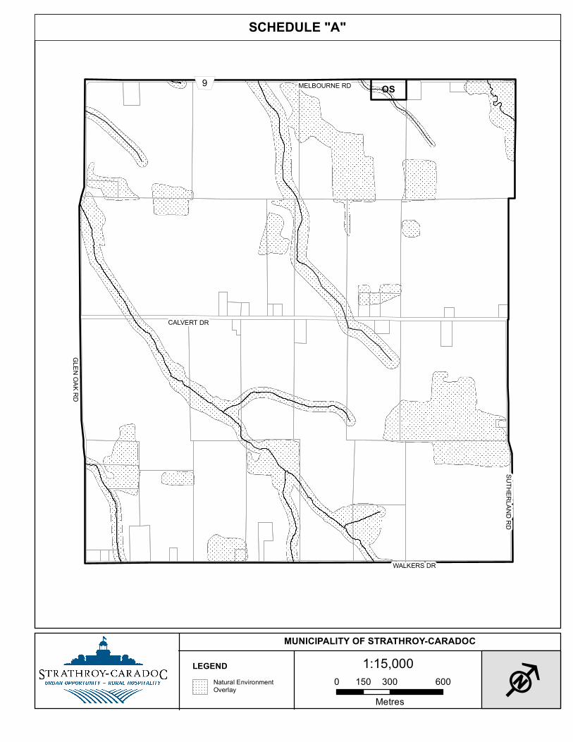
1 - 50 1 1
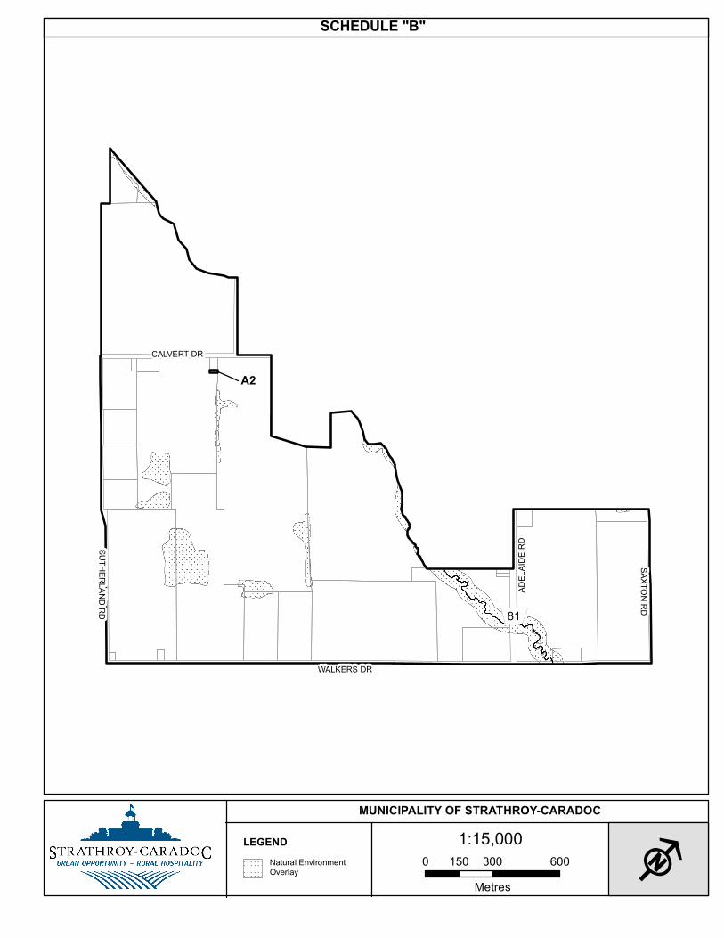
51 - 75 1 2
76 - 100 2 2
101 - 150 3 3
150 - 300 4 4
300 - 400 5 5
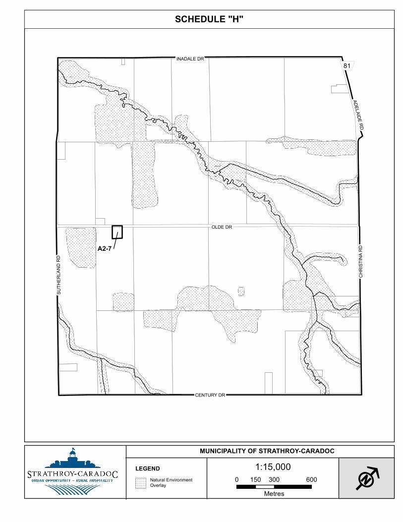
400 - 500 6 6
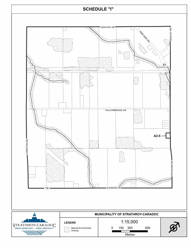
5
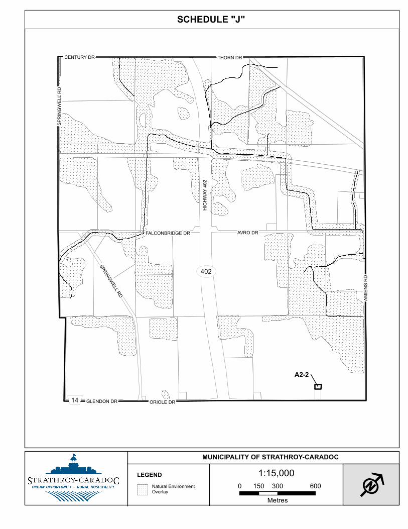
To facilitate access to the motor vehicle, every accessible parking space shall have an aisle, 1.5 m in width, extending the full length of the parking space which aisle may be shared by two accessible parking spaces.”
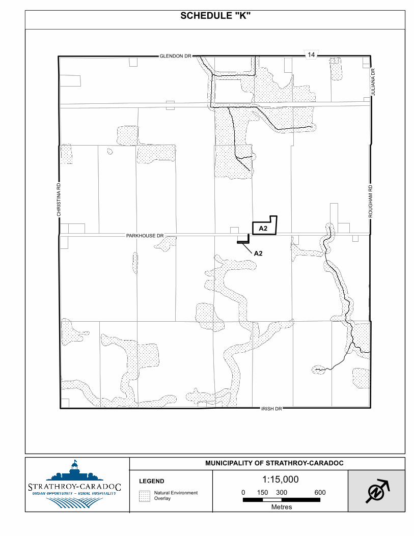
30. THAT: Subsection 4.27(5) “Residential Parking Requirements” and specifically clause b)
be amended by the addition of the following:
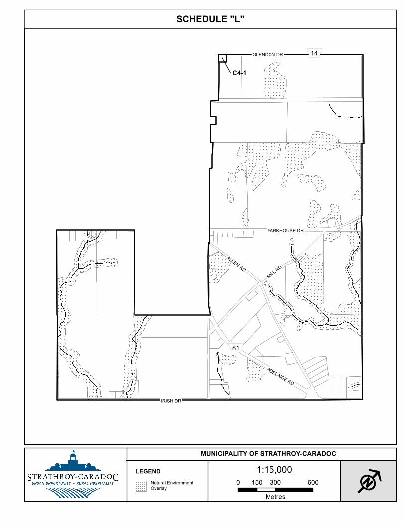
“No cargo trailer having dimensions greater than 2.4 m of width, 2.4 m of height above ground or 6 m of length shall be parked or stored on a residential lot.”
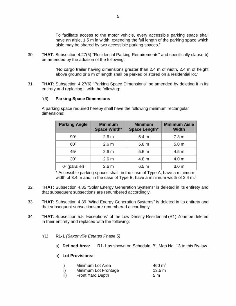
31. THAT: Subsection 4.27(6) “Parking Space Dimensions” be amended by deleting it in its
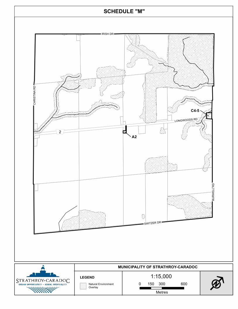
entirety and replacing it with the following: “(6) Parking Space Dimensions
A parking space required hereby shall have the following minimum rectangular dimensions:
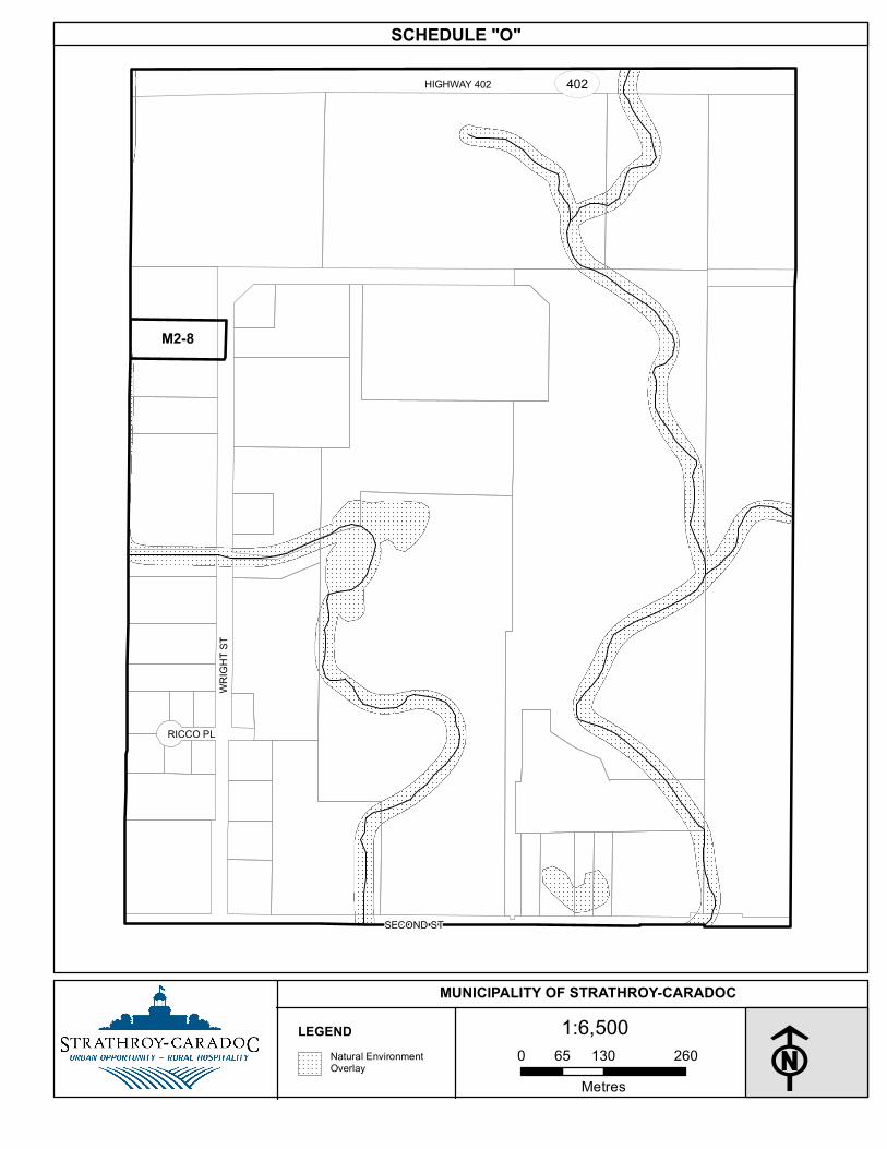
Parking Angle Minimum
Space Width* Minimum
Space Length* Minimum Aisle
Width
90º 2.6 m 5.4 m 7.3 m
60º 2.6 m 5.8 m 5.0 m
45º 2.6 m 5.5 m 4.5 m
30º 2.6 m 4.8 m 4.0 m
0º (parallel) 2.6 m 6.5 m 3.0 m * Accessible parking spaces shall, in the case of Type A, have a minimum width of 3.4 m and, in the case of Type B, have a minimum width of 2.4 m.”
32. THAT: Subsection 4.35 “Solar Energy Generation Systems” is deleted in its entirety and
that subsequent subsections are renumbered accordingly.
33. THAT: Subsection 4.39 “Wind Energy Generation Systems” is deleted in its entirety and that subsequent subsections are renumbered accordingly.
34. THAT: Subsection 5.5 “Exceptions” of the Low Density Residential (R1) Zone be deleted in their entirety and replaced with the following:
“(1) R1-1 (Saxonville Estates Phase 5)
a) Defined Area: R1-1 as shown on Schedule ‘B’, Map No. 13 to this By-law.
b) Lot Provisions:
i) Minimum Lot Area 460 m2 ii) Minimum Lot Frontage 13.5 m iii) Front Yard Depth 5 m
6
iv) Exterior Side Yard Width 1.2 m v) Side Yard Width 1.2 m vi) Rear Yard Depth 8 m vii) Maximum Lot Coverage 40%
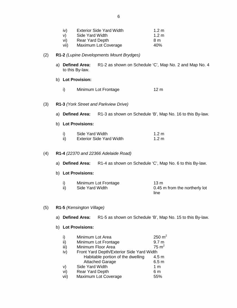
“(2) R1-2 (Lupine Developments Mount Brydges)
a) Defined Area: R1-2 as shown on Schedule ‘C’, Map No. 2 and Map No. 4
to this By-law.
b) Lot Provision:
i) Minimum Lot Frontage 12 m
“(3) R1-3 (York Street and Parkview Drive)
a) Defined Area: R1-3 as shown on Schedule ‘B’, Map No. 16 to this By-law.
b) Lot Provisions:
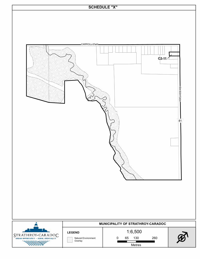
i) Side Yard Width 1.2 m ii) Exterior Side Yard Width 1.2 m
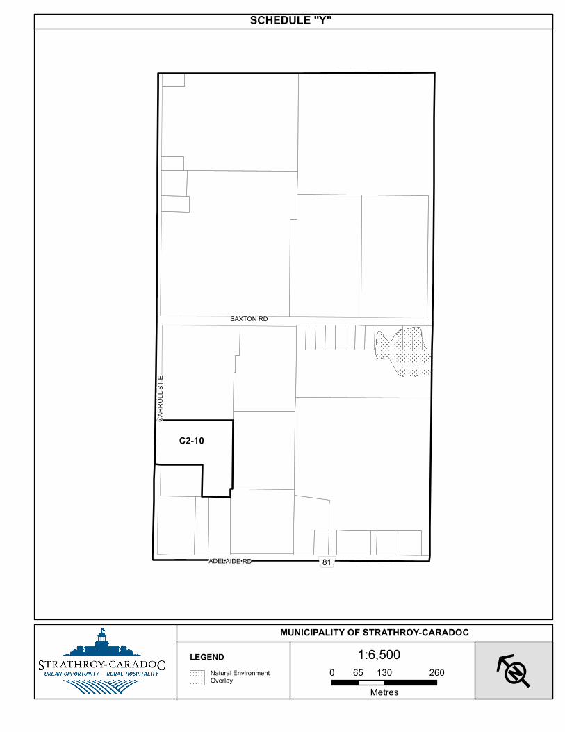
“(4) R1-4 (22370 and 22366 Adelaide Road)
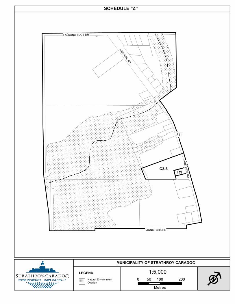
a) Defined Area: R1-4 as shown on Schedule ‘C’, Map No. 6 to this By-law.
b) Lot Provisions:
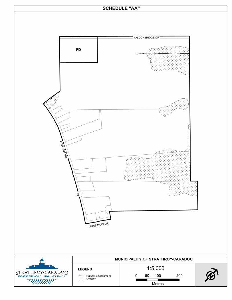
i) Minimum Lot Frontage 13 m ii) Side Yard Width 0.45 m from the northerly lot
line
“(5) R1-5 (Kensington Village)
a) Defined Area: R1-5 as shown on Schedule ‘B’, Map No. 15 to this By-law.
b) Lot Provisions:
i) Minimum Lot Area 250 m2 ii) Minimum Lot Frontage 9.7 m iii) Minimum Floor Area 75 m2 iv) Front Yard Depth/Exterior Side Yard Width Habitable portion of the dwelling 4.5 m Attached Garage 6.5 m v) Side Yard Width 1 m vi) Rear Yard Depth 6 m vii) Maximum Lot Coverage 55%
7
“(6) R1-6 (Kensington Village)
a) Defined Area: R1-6 as shown on Schedule ‘B’, Map No. 15 to this By-law.
b) Lot Provisions:
i) Maximum Height 6 m
“ (7) R1-7 (Saxonville Estates)
a) Defined Area: R1-7 as shown on Schedule ‘B’, Map No. 13 to this By-law.
b) Lot Provisions:
i) Front Yard Depth 5 m ii) Exterior Side Yard Width 1.2 m iii) Side Yard Width 1.2 m
“(8) R1-8 (343 and 369 Metcalfe Street East)
a) Defined Area: R1-8 as shown on Schedule ‘B’, Map No. 10 to this By-law.
b) Lot Provisions:
i) Minimum Lot Area 390 m2 ii) Minimum Lot Frontage 11.5 m iii) Front Yard Depth/Exterior Side Yard Width Attached Garage 4.5 m iv) Side Yard Width 1 m v) Rear Yard Depth* 6 m vi) Maximum Lot Coverage 55%
*For Lots (Units) 1 through 7, inclusive, the rear yard depth of 6 m shall also apply to accessory uses.
“(9) R1-9 (Thorne Drive, Agnes Drive ....)
a) Defined Area: R1-9 as shown on Schedule ‘B’, Map No. 4 to this By-law.
b) Lot Provisions:
i) Front Yard Depth 6 m ii) Exterior Side Yard Width 3 m iii) Side Yard Width 1.2 m iv) Rear Yard Depth 7.5 m v) Maximum Lot Coverage 35%”
8
35. THAT: Subsection 6.5 “Exceptions” of the Medium Density Residential (R2) Zone be deleted in their entirety and replaced with the following:
“(1) R2-1 (Katie Lane west of Agnes Drive)
a) Defined Area: R2-1 as shown on Schedule ‘B’, Map No. 4 to this By-law.
b) Permitted Uses: dwelling, single detached
c) Lot Provisions:
i) Minimum Lot Area 384 m2 ii) Minimum Lot Frontage 13.5 m iii) Front Yard Depth 5 m iv) Exterior Side Yard Width 3 m v) Side Yard Width 1.2 m vi) Rear Yard Depth 7.5 m vii) Maximum Lot Coverage 34% viii) Minimum Landscaped Open Space 50%
(2) R2-2 (15 Caradoc Street South)
a) Defined Area: R2-2 as shown on Schedule ‘B’, Map No. 15 to this By-law.
b) Permitted Uses: professional office all other permitted uses of the R2 zone
(3) R2-3 (49-55 McKellar Street)
a) Defined Area: R2-3 as shown on Schedule ‘B’, Map No. 14 to this By-law.
b) Permitted Uses: dwelling, townhouse
c) Lot Provisions:
i) Minimum Lot Area 160 m2 ii) Minimum Lot Frontage 5.2 m iii) Front Yard Depth 4.5 m iv) Exterior Side Yard Width 4.5 m v) Side Yard Width* 2 m vi) Rear Yard Depth 8 m vii) Maximum Lot Coverage 40% viii) Minimum Landscaped Open Space 30%
*a side yard width shall apply between the common wall dividing individual townhouse dwelling units.”
9
36. THAT: Subsection 7.5 “Exceptions” of the High Density Residential (R3) Zone be deleted in their entirety and replaced with the following:
“(1) R3-1 (290 – 298 Mogg Street)
a) Defined Area: R3-1 as shown on Schedule ‘B’, Map No. 15 to this By-law.
b) Permitted Use: dwelling, single detached
c) Lot Provisions:
i) Minimum Lot Area 210 m2 ii) Minimum Lot Frontage 12 m iii) Front Yard Depth 6 m iv) Side Yard Width 1.2 m v) Rear Yard Depth 6 m vi) Maximum Lot Coverage 45%
“(2) R3-2 (423 Saulsbury Street)
a) Defined Area: R3-2 as shown on Schedule ‘B’ Map No. 6 to this By-law.
b) Lot Provisions:
i) Side Yard Width 15 m ii) Rear Yard Depth 5 m
“(3) R3-3 (25 Colborne Street)
a) Defined Area: R3-3 as shown on Schedule ‘B’ Map No. 8 to this By-law.
b) Permitted Use: townhouse dwelling
c) Lot Provisions:
i) Maximum Height 8 m to a maximum of 1 storey”
37. THAT: Subsection 9.2 “Use & Building Provisions” of the Rural Residential (R5) Zone is amended by deleting “(3) Wind Energy Generation System, Small Scale”.
38. THAT: Subsection 10.5 “Exceptions” of the General Commercial (C1) Zone is amended in respect of clause (2)b) by deleting “C1-1” and replacing it with “C1-2”.
39. THAT: Subsection 11.3 “Lot Provisions” of the Highway Commercial (C2) Zone is amended by adding the following: “(6) Maximum Lot Coverage 45%”
10
40. THAT: Subsection 11.5 “Exceptions” of the Highway Commercial (C2) Zone is amended
by deleting all items subsequent to item (5) and replacing them with the following: “(6) C2-6 (83 Metcalfe Street East)
a) Defined Area: C2-6 as shown on Schedule ‘B’, Map No. 8 to this By-law.
b) Permitted Use: clinic
“(7) C2-7 (175 Metcalfe Street East)
a) Defined Area: C2-7 as shown on Schedule ‘B’, Map No. 9 to this By-law.
b) Permitted Uses: garage, public
dwelling, single detached
“(8) C2-8 (101 Metcalfe Street East)
a) Defined Area: C2-8 as shown on Schedule ‘B’, Map No. 9 to this By-law.
b) Permitted Uses: office, professional dwelling, single detached
“(9) C2-9 (214 Caradoc Street South)
a) Defined Area: C2-9 as shown on Schedule ‘B’, Map No. 14 to this By-law.
b) Permitted Uses: financial institution
all other permitted uses of the C2 zone
“(10) C2-10 (96 Carroll Street East)
a) Defined Area: C2-10 as shown on Schedule ‘B’, Map No. 18 to this By-law.
b) Permitted Uses: financial institution (which may include a drive-through)
retail store (including all retail stores defined elsewhere in this By-law) all other permitted uses of the C2 zone
c) Special Provisions: i) Maximum floor area for Large Format Retail Store 464.5 m2 ii) Maximum number of Retail Store units 5 iii) Minimum floor area for per Retail Store 88 m2 iv) Maximum number of Financial Institutions 1
11
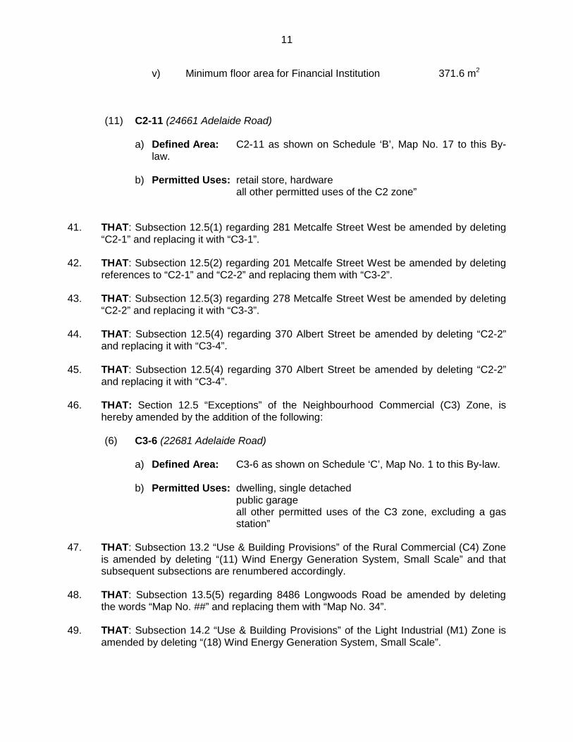
v) Minimum floor area for Financial Institution 371.6 m2
“(11) C2-11 (24661 Adelaide Road)
a) Defined Area: C2-11 as shown on Schedule ‘B’, Map No. 17 to this By-law.
b) Permitted Uses: retail store, hardware
all other permitted uses of the C2 zone”
41. THAT: Subsection 12.5(1) regarding 281 Metcalfe Street West be amended by deleting
“C2-1” and replacing it with “C3-1”.
42. THAT: Subsection 12.5(2) regarding 201 Metcalfe Street West be amended by deleting references to “C2-1” and “C2-2” and replacing them with “C3-2”.
43. THAT: Subsection 12.5(3) regarding 278 Metcalfe Street West be amended by deleting
“C2-2” and replacing it with “C3-3”. 44. THAT: Subsection 12.5(4) regarding 370 Albert Street be amended by deleting “C2-2”
and replacing it with “C3-4”.
45. THAT: Subsection 12.5(4) regarding 370 Albert Street be amended by deleting “C2-2” and replacing it with “C3-4”.
46. THAT: Section 12.5 “Exceptions” of the Neighbourhood Commercial (C3) Zone, is hereby amended by the addition of the following: “(6) C3-6 (22681 Adelaide Road)
a) Defined Area: C3-6 as shown on Schedule ‘C’, Map No. 1 to this By-law.
b) Permitted Uses: dwelling, single detached
public garage all other permitted uses of the C3 zone, excluding a gas station”
47. THAT: Subsection 13.2 “Use & Building Provisions” of the Rural Commercial (C4) Zone
is amended by deleting “(11) Wind Energy Generation System, Small Scale” and that subsequent subsections are renumbered accordingly.
48. THAT: Subsection 13.5(5) regarding 8486 Longwoods Road be amended by deleting
the words “Map No. ##” and replacing them with “Map No. 34”.
49. THAT: Subsection 14.2 “Use & Building Provisions” of the Light Industrial (M1) Zone is amended by deleting “(18) Wind Energy Generation System, Small Scale”.
12
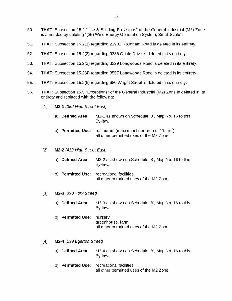
50. THAT: Subsection 15.2 “Use & Building Provisions” of the General Industrial (M2) Zone is amended by deleting “(25) Wind Energy Generation System, Small Scale”.
51. THAT: Subsection 15.2(1) regarding 22931 Rougham Road is deleted in its entirety.
52. THAT: Subsection 15.2(2) regarding 9386 Oriole Drive is deleted in its entirety.
53. THAT: Subsection 15.2(3) regarding 8229 Longwoods Road is deleted in its entirety.
54. THAT: Subsection 15.2(4) regarding 8557 Longwoods Road is deleted in its entirety. 55. THAT: Subsection 15.2(6) regarding 680 Wright Street is deleted in its entirety.
56. THAT: Subsection 15.5 “Exceptions” of the General Industrial (M2) Zone is deleted in its
entirety and replaced with the following: “(1) M2-1 (352 High Street East)
a) Defined Area: M2-1 as shown on Schedule ‘B’, Map No. 16 to this
By-law.
b) Permitted Use: restaurant (maximum floor area of 112 m2) all other permitted uses of the M2 Zone
“(2) M2-2 (412 High Street East)
a) Defined Area: M2-2 as shown on Schedule ‘B’, Map No. 16 to this By-law.
b) Permitted Use: recreational facilities
all other permitted uses of the M2 Zone
“(3) M2-3 (390 York Street)
a) Defined Area: M2-3 as shown on Schedule ‘B’, Map No. 16 to this By-law.
b) Permitted Use: nursery
greenhouse, farm all other permitted uses of the M2 Zone
“(4) M2-4 (139 Egerton Street)
a) Defined Area: M2-4 as shown on Schedule ‘B’, Map No. 16 to this By-law.
b) Permitted Use: recreational facilities
all other permitted uses of the M2 Zone
13
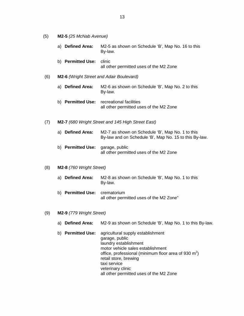
(5) M2-5 (25 McNab Avenue)
a) Defined Area: M2-5 as shown on Schedule ‘B’, Map No. 16 to this
By-law.
b) Permitted Use: clinic all other permitted uses of the M2 Zone
“(6) M2-6 (Wright Street and Adair Boulevard)
a) Defined Area: M2-6 as shown on Schedule ‘B’, Map No. 2 to this
By-law.
b) Permitted Use: recreational facilities all other permitted uses of the M2 Zone
“(7) M2-7 (680 Wright Street and 145 High Street East)
a) Defined Area: M2-7 as shown on Schedule ‘B’, Map No. 1 to this
By-law and on Schedule ‘B’, Map No. 15 to this By-law.
b) Permitted Use: garage, public all other permitted uses of the M2 Zone
“(8) M2-8 (760 Wright Street)
a) Defined Area: M2-8 as shown on Schedule ‘B’, Map No. 1 to this
By-law.
b) Permitted Use: crematorium all other permitted uses of the M2 Zone”
“(9) M2-9 (779 Wright Street)
a) Defined Area: M2-9 as shown on Schedule ‘B’, Map No. 1 to this By-law.
b) Permitted Use: agricultural supply establishment
garage, public laundry establishment motor vehicle sales establishment office, professional (minimum floor area of 930 m2) retail store, brewing taxi service veterinary clinic all other permitted uses of the M2 Zone
14
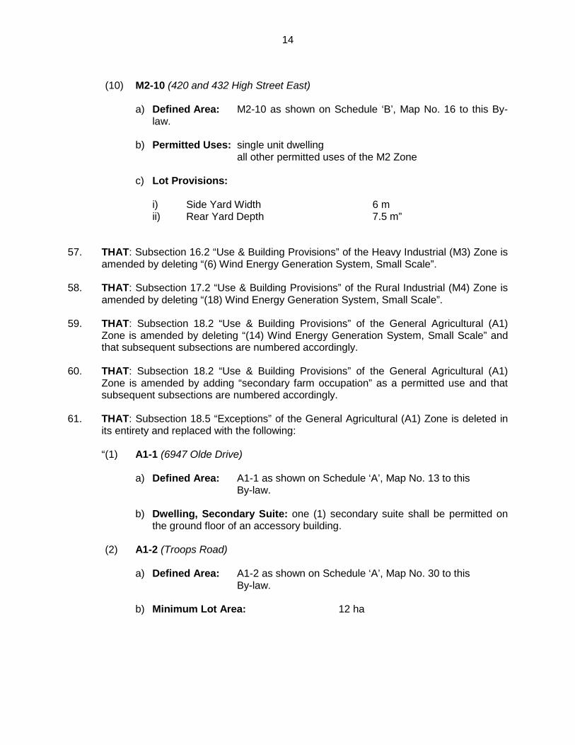
“(10) M2-10 (420 and 432 High Street East)
a) Defined Area: M2-10 as shown on Schedule ‘B’, Map No. 16 to this By-
law.
b) Permitted Uses: single unit dwelling all other permitted uses of the M2 Zone
c) Lot Provisions:
i) Side Yard Width 6 m ii) Rear Yard Depth 7.5 m”
57. THAT: Subsection 16.2 “Use & Building Provisions” of the Heavy Industrial (M3) Zone is
amended by deleting “(6) Wind Energy Generation System, Small Scale”. 58. THAT: Subsection 17.2 “Use & Building Provisions” of the Rural Industrial (M4) Zone is
amended by deleting “(18) Wind Energy Generation System, Small Scale”. 59. THAT: Subsection 18.2 “Use & Building Provisions” of the General Agricultural (A1)
Zone is amended by deleting “(14) Wind Energy Generation System, Small Scale” and that subsequent subsections are numbered accordingly.
60. THAT: Subsection 18.2 “Use & Building Provisions” of the General Agricultural (A1) Zone is amended by adding “secondary farm occupation” as a permitted use and that subsequent subsections are numbered accordingly.
61. THAT: Subsection 18.5 “Exceptions” of the General Agricultural (A1) Zone is deleted in its entirety and replaced with the following:
“(1) A1-1 (6947 Olde Drive)
a) Defined Area: A1-1 as shown on Schedule ‘A’, Map No. 13 to this
By-law.
b) Dwelling, Secondary Suite: one (1) secondary suite shall be permitted on the ground floor of an accessory building.
“(2) A1-2 (Troops Road)
a) Defined Area: A1-2 as shown on Schedule ‘A’, Map No. 30 to this
By-law.
b) Minimum Lot Area: 12 ha
“
15
(3) A1-3 (24321 Saxton Road)
a) Defined Area: A1-3 as shown on Schedule ‘A’, Map No. 9 to this By-law.
b) Minimum Lot Area: 19 ha
“(4) A1-4 (24364 Saxton Road)
a) Defined Area: A1-4 as shown on Schedule ‘A’, Map No. 10 to this By-law.
b) Minimum Lot Area: 10 ha”
62. THAT: Subsection 19.2 “Use & Building Provisions” of the Agricultural Small Holdings
(A2) Zone is amended by deleting “(11) Wind Energy Generation System, Small Scale” and that subsequent subsections are numbered accordingly.
63. THAT: Subsection 19.5 “Exceptions” of the Agricultural Small Holdings (A2) Zone is
deleted in its entirety and replaced with the following:
“(1) A2-1 (7216 Olde Drive)
a) Defined Area: A2-1 as shown on Schedule ‘A’, Map No. 14 to this By-law.
b) Front Yard Depth: 13.95 m
“(2) A2-2 (9386 Oriole Drive)
a) Defined Area: A2-2 as shown on Schedule ‘A’, Map No. 24 to this By-law.
b) Maximum size of Accessory Buildings: 180 m2
“(3) A2-3 (8229 Longwoods Road)
a) Defined Area: A2-3 as shown on Schedule ‘A’, Map No. 24 to this By-law.
b) Maximum size of Accessory Buildings: 465 m2
16
“(4) A2-4 (7719 Century Drive)
a) Defined Area: A2-4 as shown on Schedule ‘A’, Map No. 21 to this By-law.
b) Maximum size of Accessory Buildings: existing as of September 20, 2010
“(5) A2-5 (22391 Rougham Road)
a) Defined Area: A2-5 as shown on Schedule ‘A’, Map No. 22 to this
By-law.
b) Maximum size of Accessory Buildings: 320.5 m2
“(6) A2-6 (8557 Longwoods Road)
a) Defined Area: A2-6 as shown on Schedule ‘A’, Map No. 24 to this
By-law.
b) Maximum size of Accessory Buildings: 610 m2
“ (7) A2-7 (7641 Olde Drive)
a) Defined Area: A2-7 as shown on Schedule ‘A’, Map No. 15 to this
By-law.
b) Maximum size of Accessory Buildings: 435 m2”
64. THAT: Subsection 20.2 “Use & Building Provisions” of the Agricultural Purposes Only
(A3) Zone is amended by deleting “(9) Wind Energy Generation System, Small Scale” and that subsequent subsections are numbered accordingly.
65. THAT: Subsection 21.2 “Use & Building Provisions” of the Agricultural Industrial (A4) Zone is amended by deleting “(12) Wind Energy Generation System, Small Scale”.
66. THAT: Subsection 22.5 “Exceptions” of the Institutional (I) Zone is deleted in its entirety and replaced with the following:
“(1) I-1 (24513 Adelaide Road)
a) Defined Area: I-1 as shown on Schedule ‘B’, Map No. 17 to this
By-law.
b) Front Yard Depth: 80 m for a public park and recreational facilities”
17
67. THAT: Subsection 24.2 “Use & Building Provisions” of the Public Utility (U) Zone is amended by deleting “(8) Wind Energy Generation System, Small Scale”.
68. THAT: Subsection 26.5(1) regarding 8562 Glendon Drive be amended by renumbering it to Subsection 26.5(2), deleting all references to “FD-1” and replacing them with “FD-2” and by deleting the words “Map No. 6” and replacing them with “Map No. 3”.
69. THAT: Subsection 23.2 “Use & Building Provisions” of the Open Space (OS) Zone is
amended by deleting “(9) Wind Energy Generation System, Small Scale”. 70. THAT: Schedule “A”, Map No. 2 to the Comprehensive Zoning By-law No. 43-08 is
hereby amended by changing from the General Agricultural (A1) Zone to the Open Space (OS) Zone those lands outlined in heavy solid lines and described as OS on Schedule “A” attached hereto and forming part of this By-law, more particularly described as Part of Lot 7, Concession 10 and designated as Parts 6 and 9 on Reference Plan 33R-17335 (geographic Township of Caradoc) in the Municipality of Strathroy-Caradoc in the County of Middlesex.
71. THAT: Schedule “A”, Map No. 3 to the Comprehensive Zoning By-law No. 43-08 is
hereby amended by changing from the General Agricultural (A1) Zone to the Agricultural Small Holdings (A2) Zone those lands outlined in heavy solid lines and described as A2 on Schedule “B” attached hereto and forming part of this By-law, more particularly described as Part of Lot 9, Concession 9 and designated as Part 2 on Reference Plan 33R-18050 (geographic Township of Caradoc) in the Municipality of Strathroy-Caradoc in the County of Middlesex.
72. THAT: Schedule “A”, Map No. 4 to the Comprehensive Zoning By-law No. 43-08 is
hereby amended by changing from the Open Space (OS) Zone to the General Agricultural (A1) Zone those lands outlined in heavy solid lines and described as A1 on Schedule “C” attached hereto and forming part of this By-law, more particularly described as Part of Lot 16, Concession 10 and designated as Part 1 on Reference Plan 34R-1577 (geographic Township of Caradoc) in the Municipality of Strathroy-Caradoc in the County of Middlesex.
73. THAT: Schedule “A”, Map No. 9 to the Comprehensive Zoning By-law No. 43-08 is
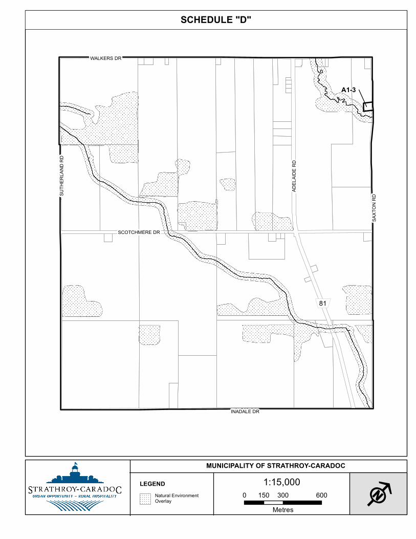
hereby amended by changing from the site-specific General Agricultural (A1-1) Zone to a site-specific General Agricultural (A1-3) Zone those lands outlined in heavy solid lines and described as A1-3 on Schedule “D” attached hereto and forming part of this By-law, more particularly described as Part of Lot 12, Concession 8 and designated as Part 1 on Reference Plan 34R-1295 (geographic Township of Caradoc) in the Municipality of Strathroy-Caradoc in the County of Middlesex.
74. THAT: Schedule “A”, Map No. 10 to the Comprehensive Zoning By-law No. 43-08 is
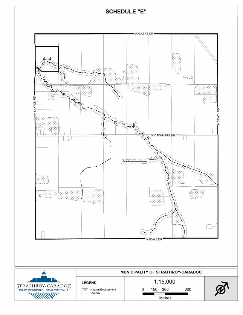
hereby amended by changing from the site-specific General Agricultural (A1-2) Zone to a site-specific General Agricultural (A1-4) Zone those lands outlined in heavy solid lines and described as A1-4 on Schedule “E” attached hereto and forming part of this By-law, more particularly described as Part of Lot 13, Concession 8 and designated as Part 1 on Reference Plan 33R-17706 (geographic Township of Caradoc) in the Municipality of Strathroy-Caradoc in the County of Middlesex.
18
75. THAT: Schedule “A”, Map No. 16 to the Comprehensive Zoning By-law No. 43-08 is
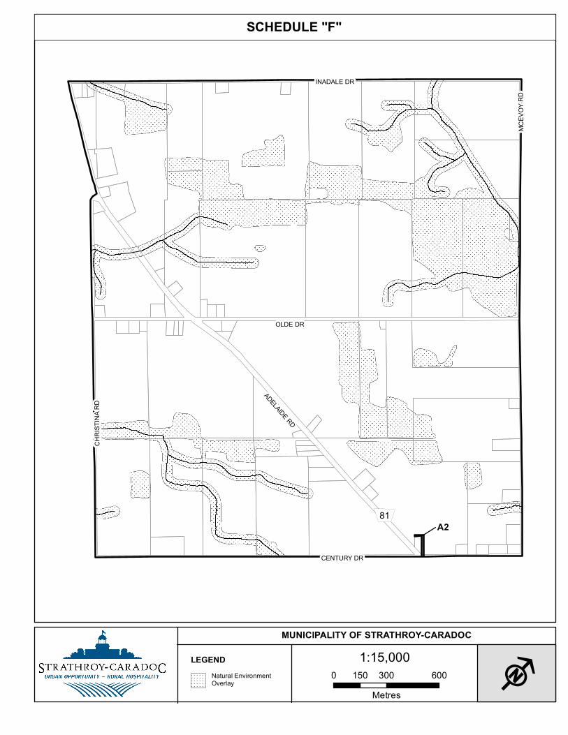
hereby amended by changing from the General Agricultural (A1) Zone to the Agricultural Small Holdings (A2) Zone those lands outlined in heavy solid lines and described as A2 on Schedule “F” attached hereto and forming part of this By-law, more particularly described as Part of Lot 16, Concession 5 and designated as Part 3 on Reference Plan 33R-18719 (geographic Township of Caradoc) in the Municipality of Strathroy-Caradoc in the County of Middlesex.
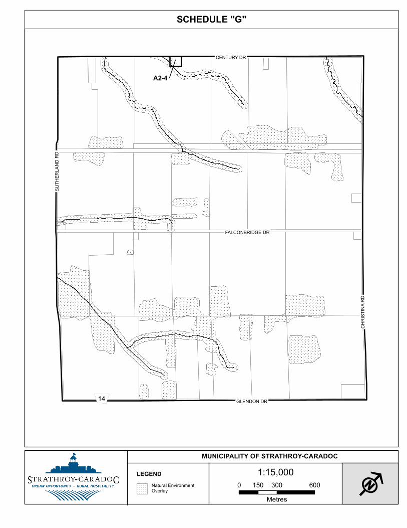
76. THAT: Schedule “A”, Map No. 21 to the Comprehensive Zoning By-law No. 43-08 is hereby amended by changing from the site-specific Agricultural Small Holdings (A2-1) Zone to a site-specific Agricultural Small Holdings (A2-4) Zone those lands outlined in heavy solid lines and described as A2-4 on Schedule “G” attached hereto and forming part of this By-law, more particularly described as Part of Lot 10, Concession 4 and designated as Parts 1 and 2 on Reference Plan 33R-17889 (geographic Township of Caradoc) in the Municipality of Strathroy-Caradoc in the County of Middlesex.
77. THAT: Schedule “A”, Map No. 15 to the Comprehensive Zoning By-law No. 43-08 is hereby amended by changing from the site-specific Agricultural Small Holdings (A2-1) Zone to a site-specific Agricultural Small Holdings (A2-7) Zone those lands outlined in heavy solid lines and described as A2-7 on Schedule “H” attached hereto and forming part of this By-law, more particularly described as Part of Lot 9, Concession 5 and designated as Part 1 on Reference Plan 33R-18735 (geographic Township of Caradoc) in the Municipality of Strathroy-Caradoc in the County of Middlesex.
78. THAT: Schedule “A”, Map No. 22 to the Comprehensive Zoning By-law No. 43-08 is hereby amended by changing from the site-specific Agricultural Small Holdings (A2-1) Zone to a site-specific Agricultural Small Holdings (A2-5) Zone those lands outlined in heavy solid lines and described as A2-5 on Schedule “I” attached hereto and forming part of this By-law, more particularly described as Part of Lot 16, Concession 3 and designated as Part 1 on Reference Plan 33R-18179 (geographic Township of Caradoc) in the Municipality of Strathroy-Caradoc in the County of Middlesex.
79. THAT: Schedule “A”, Map No. 24 to the Comprehensive Zoning By-law No. 43-08 is hereby amended by changing from the Agricultural Small Holdings (A2) Zone to the site-specific Agricultural Small Holdings (A2-2) Zone those lands outlined in heavy solid lines and described as A2-2 on Schedule “J” attached hereto and forming part of this By-law, more particularly described as Part of Lot 24, Concession 3 and designated as Part 1 on Reference Plan 33R-18373 (geographic Township of Caradoc) in the Municipality of Strathroy-Caradoc in the County of Middlesex.
80. THAT: Schedule “A”, Map No. 28 to the Comprehensive Zoning By-law No. 43-08 is hereby amended by changing from the General Agricultural (A1) Zone to the Agricultural Small Holdings (A2) Zone those lands outlined in heavy solid lines and described as A2 on Schedule “K” attached hereto and forming part of this By-law, more particularly described as Part of Lot 15, Concession 1 and designated as Part 1 on Reference Plan 33R-17887 (geographic Township of Caradoc) in the Municipality of Strathroy-Caradoc in the County of Middlesex.
19
81. THAT: Schedule “A”, Map No. 28 to the Comprehensive Zoning By-law No. 43-08 is
hereby amended by changing from the General Agricultural (A1) Zone and Agricultural Small Holdings (A2) to the Agricultural Small Holdings (A2) Zone those lands outlined in heavy solid lines and described as A2 on Schedule “K” attached hereto and forming part of this By-law, more particularly described Part of Lot 15, Concession 2 and designated as Parts 1 and 2 on Reference Plan 33R-16546 (geographic Township of Caradoc) in the Municipality of Strathroy-Caradoc in the County of Middlesex.
82. THAT: Schedule “A”, Map No. 29 to the Comprehensive Zoning By-law No. 43-08 is hereby amended by changing from the Agricultural Small Holdings (A2) Zone to the site-specific Agricultural Industrial (C4-1) those lands outlined in heavy solid lines and described as C4-1 on Schedule “L” attached hereto and forming part of this By-law, more particularly described as Part of Lot 19, Concession 2 (geographic Township of Caradoc) in the Municipality of Strathroy-Caradoc in the County of Middlesex.
83. THAT: Schedule “A”, Map No. 34 to the Comprehensive Zoning By-law No. 43-08 is hereby amended by changing from the Agricultural Purposes Only (A3) Zone to the Agricultural Small Holdings (A2) Zone those lands outlined in heavy solid lines and described as A2 on Schedule “M” attached hereto and forming part of this By-law, more particularly described as Part of Lot 15, Range 1, South of the Longwoods Road and designated as Part 1 on Reference Plan 33R-18213 (geographic Township of Caradoc) in the Municipality of Strathroy-Caradoc in the County of Middlesex.
84. THAT: Schedule “A”, Map No. 34 of the Strathroy-Caradoc Comprehensive Zoning By-law 43-08 is hereby amended by changing from Agricultural Small Holdings (A2) Zone to a site-specific Rural Commercial (C4-5) Zone those lands drawn in heavy solid lines and shown as C4-5 on Schedule “M” attached hereto and described as Part of Lot 16, Range I North (geographic Township of Caradoc) in the Municipality of Strathroy-Caradoc in the County of Middlesex.
85. THAT: Schedule “A”, Map No. 35 to the Comprehensive Zoning By-law No. 43-08 is hereby amended by changing from the General Agricultural (A1) Zone to the Agricultural Small Holdings (A2) Zone those lands outlined in heavy solid lines and described as A2 on Schedule “N” attached hereto and forming part of this By-law, more particularly described as Part of Lot 20, Range 1, North of the Longwoods Road and designated as Part 2 on Reference Plan 33R-18446 (geographic Township of Caradoc) in the Municipality of Strathroy-Caradoc in the County of Middlesex.
86. THAT: Schedule “B”, Map No. 1 to the Comprehensive Zoning By-law No. 43-08 is
hereby amended by changing from the site-specific General Industrial (M2-7) Zone to a site-specific General Industrial (M2-8) Zone those lands outlined in heavy solid lines and described as M2-8 on Schedule “O” attached hereto and forming part of this By-law, more particularly described as Part of Lot 22, Concession 2, SER and designated as Parts 1 and 2 on Reference Plan 33R-18132 (geographic Township of Adelaide) in the Municipality of Strathroy-Caradoc in the County of Middlesex.

20
87. THAT: Schedule “B”, Map No. 4 to the Comprehensive Zoning By-law No. 43-08 is
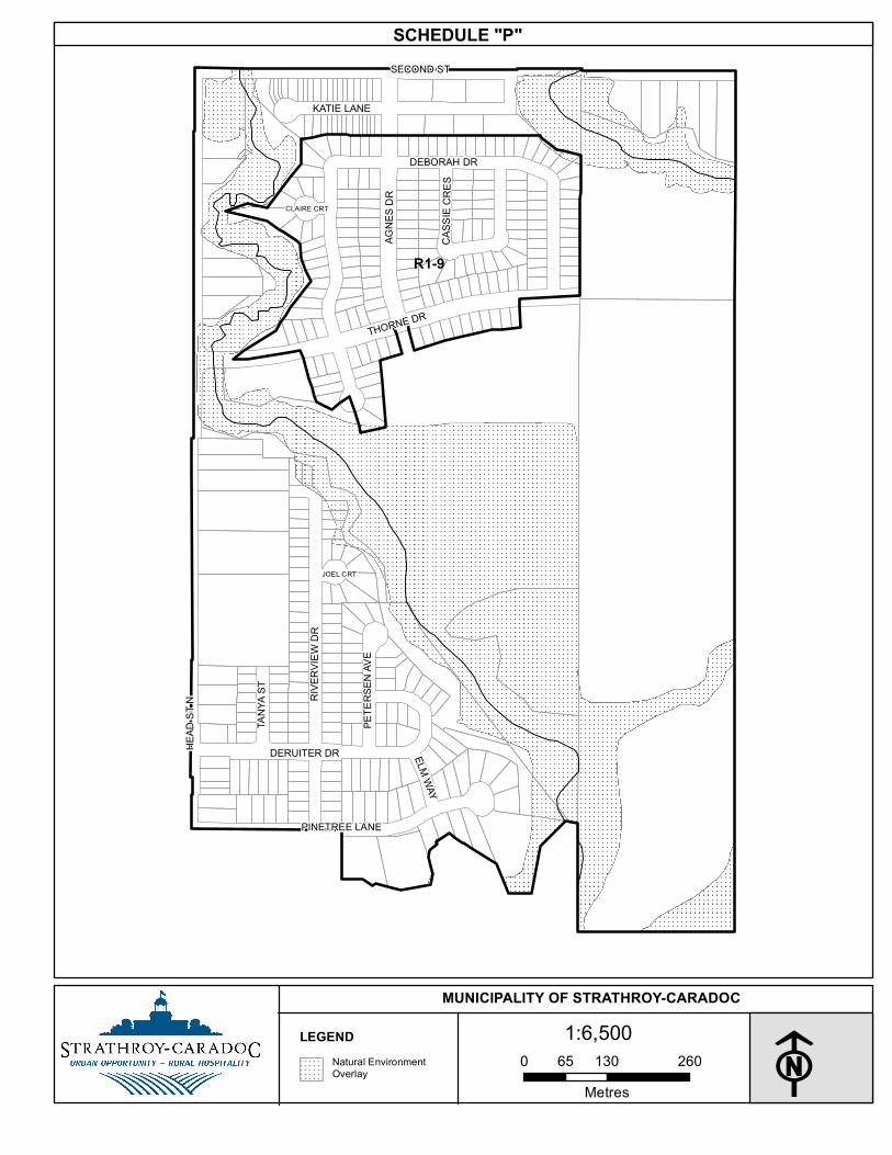
hereby amended by changing from the Low Density Residential (R1) Zone to a site-specific Low Density Residential (R1-9) Zone those lands outlined in heavy solid lines and described as R1 on Schedule “P” attached hereto and forming part of this By-law, more particularly described as Lots 1 to 192, inclusive, on Plan 33M-322 (geographic Township of Adelaide) in the Municipality of Strathroy-Caradoc in the County of Middlesex.
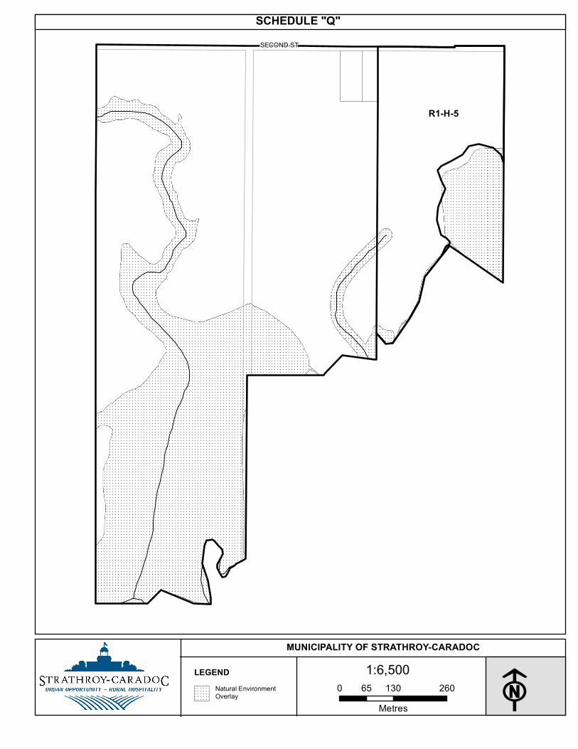
88. THAT: Schedule “B”, Map No. 5 to the Comprehensive Zoning By-law No. 43-08 is hereby amended by changing from the Future Development (FD) Zone to the Low Density Residential – Holding (R1-H-5) Zone those lands outlined in heavy solid lines and described as R1-5 on Schedule “Q” attached hereto and forming part of this By-law, more particularly described as Part of Lot 25, Concession 3 SER (geographic Township of Adelaide) and designated as Part 1 on Reference Plan 33R-865 in the Municipality of Strathroy-Caradoc in the County of Middlesex.
89. THAT: Schedule “B”, Map No. 6 to the Comprehensive Zoning By-law No. 43-08 is
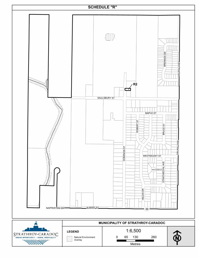
hereby amended by changing from the Low Density Residential (R1) Zone to the Medium Density Residential (R2) Zone those lands outlined in heavy solid lines and described as R2 on Schedule “R” attached hereto and forming part of this By-law, more particularly described as Part of Lots 32 and 33, Plan 239 and designated as Part 1 on Reference Plan 33R-17183 in the Municipality of Strathroy-Caradoc in the County of Middlesex.
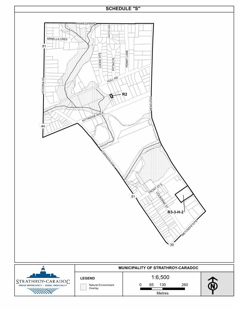
90. THAT: Schedule “B”, Map No. 8 to the Comprehensive Zoning By-law No. 43-08 is hereby amended by changing from the Low Density Residential (R1) Zone to the Medium Density Residential (R2) Zone those lands outlined in heavy solid lines and described as R2 on Schedule “S” attached hereto and forming part of this By-law, more particularly described as Part of Lot 10, Plan 280 and designated as Part 1 on Reference Plan 34R-1887 in the Municipality of Strathroy-Caradoc in the County of Middlesex.
91. THAT: Schedule “B”, Map No. 8 to the Comprehensive Zoning By-law No. 43-08 is hereby amended by changing from the site-specific High Density Residential – Holding (R3-3-H) Zone to a site-specific Medium Density Residential (R3-3-H-2) Zone those lands outlined in heavy solid lines and described as R3-3-H-2 on Schedule “S” attached hereto and forming part of this By-law, more particularly described as all of Lots 3 and 4 and part of Lots 2 and 5 West of Head Street and Part of the Lane (Closed by By-law No. 1604 registered as Instrument Number MW84096, all on Registered Plan Number 93(C) (geographic Town of Strathroy), Municipality of Strathroy Caradoc, in the County of Middlesex.
92. THAT: Schedule “B”, Map No. 13 to the Comprehensive Zoning By-law No. 43-08 is
hereby amended by changing from the site-specific Low Density Residential (R1-2) Zone to the site-specific Low Density Residential (R1-7) Zone those lands outlined in heavy solid lines and described as R1-7 on Schedule “T” attached hereto and forming part of this By-law, more particularly described as Lots 1 to 30, inclusive and Lots 48 to 83, inclusive, all on Plan 33M-648 in the Municipality of Strathroy-Caradoc in the County of Middlesex.
21
93. THAT: Schedule “B”, Map No. 13 to the Comprehensive Zoning By-law No. 43-08 is hereby amended by changing from the site-specific Low Density Residential - Holding (R1-1-H) Zone to the Low Density Residential (R1-1) Zone those lands outlined in heavy solid lines and described as R1-1 on Schedule “T” attached hereto and forming part of this By-law, more particularly described as Lots 31 to 47, inclusive, all on Plan 33M-648 in the Municipality of Strathroy-Caradoc in the County of Middlesex.
94. THAT: Schedule “B”, Map No. 13 to the Comprehensive Zoning By-law No. 43-08 is hereby amended by changing from the site-specific Low Density Residential - Holding (R1-1-H) Zone to the Low Density Residential (R1-1) Zone those lands outlined in heavy solid lines and described as R1-1 on Schedule “T” attached hereto and forming part of this By-law, more particularly described as Lots 31 to 47, inclusive, all on Plan 33M-648 in the Municipality of Strathroy-Caradoc in the County of Middlesex.
95. THAT: Schedule “B”, Map No. 13 to the Comprehensive Zoning By-law No. 43-08 is
hereby amended by changing from the site-specific Low Density Residential - Holding (R1-H) Zone to the Low Density Residential (R1) Zone those lands outlined in heavy solid lines and described as R1 on Schedule “T” attached hereto and forming part of this By-law, more particularly described as Lot 84 on Plan 33M-648 in the Municipality of Strathroy-Caradoc in the County of Middlesex.
96. THAT: Schedule “B”, Map No. 14 to the Comprehensive Zoning By-law No. 43-08 is
hereby amended by changing from the site-specific Medium Density Residential (R2-2) Zone to a site-specific Medium Density Residential (R2-3) Zone those lands outlined in heavy solid lines and described as R2-3 on Schedule “U” attached hereto and forming part of this By-law, more particularly described as Block A and Parts of Lots 7 and 8 and designated as Parts 2 to 7, inclusive, and Parts 9 and 10, on Reference Plan 33R-18384 in the Municipality of Strathroy-Caradoc in the County of Middlesex.
97. THAT: Schedule “B”, Map No. 14 to the Comprehensive Zoning By-law No. 43-08 is hereby amended by changing from the Low Density Residential (R1) Zone to the Medium Density Residential (R2) Zone those lands outlined in heavy solid lines and described as R2 on Schedule “U” attached hereto and forming part of this By-law, more particularly described as Part of Lot 1, Plan 230 and designated as Part 2 on Reference Plan 34R-1907 in the Municipality of Strathroy-Caradoc in the County of Middlesex.
98. THAT: Schedule “B”, Map No. 14 to the Comprehensive Zoning By-law No. 43-08 is hereby amended by changing from the Low Density Residential (R1) Zone to the Medium Density Residential (R2) Zone those lands outlined in heavy solid lines and described as R2 on Schedule “U” attached hereto and forming part of this By-law, more particularly described as Part of Lots 36 and 37, Plan 294 and designated as Parts 1 and 2 on Reference Plan 34R-250 in the Municipality of Strathroy-Caradoc in the County of Middlesex.
99. THAT: Schedule “B”, Map No. 14 to the Comprehensive Zoning By-law No. 43-08 is hereby amended by changing from the Low Density Residential (R1) Zone to the Medium Density Residential (R2) Zone those lands outlined in heavy solid lines and described as R2 on Schedule “U” attached hereto and forming part of this By-law, more particularly described as Part of Lot 5, Plan 177 and designated as Part 1 on Reference Plan 34R-2135 in the Municipality of Strathroy-Caradoc in the County of Middlesex.
22
100. THAT: Schedule “B”, Map No. 14 to the Comprehensive Zoning By-law No. 43-08 is hereby amended by changing from the Low Density Residential – Holding (R1-H) Zone to the Low Density Residential (R1) Zone those lands outlined in heavy solid lines and described as R1 on Schedule “U” attached hereto and forming part of this By-law, more particularly described as Part of Lot 17, Plan 104 and designated as Part of Part 1 on Reference Plan 34R-697 in the Municipality of Strathroy-Caradoc in the County of Middlesex.
101. THAT: Schedule “B”, Map No. 15 to the Comprehensive Zoning By-law No. 43-08 is hereby amended by changing from the Future Development (FD) Zone to the Low Density Residential (R1) Zone those lands outlined in heavy solid lines and described as R1 on Schedule “V” attached hereto and forming part of this By-law, more particularly described as Lots 267 and 268 on Plan 33M-619, in the Municipality of Strathroy-Caradoc in the County of Middlesex.
102. THAT: Schedule “B”, Map No. 15 to the Comprehensive Zoning By-law No. 43-08 is
hereby amended by changing from the Future Development (FD) Zone to the site-specific Low Density Residential (R1-5) Zone those lands outlined in heavy solid lines and described as R1-5 on Schedule “V” attached hereto and forming part of this By-law, more particularly described as Lots 1 to 13, inclusive, Lots 133 to 142, inclusive, Lots 210 to 218, inclusive, all on Plan 33M-619 in the Municipality of Strathroy-Caradoc in the County of Middlesex.
103. THAT: Schedule “B”, Map No. 15 to the Comprehensive Zoning By-law No. 43-08 is
hereby amended by changing from the Future Development (FD) Zone to the site-specific Low Density Residential – Holding (R1-5-H-5) Zone those lands outlined in heavy solid lines and described as R1-5-H-5 on Schedule “V” attached hereto and forming part of this By-law, more particularly described as Lots 14 to 132, inclusive, Lots 143 to 209, inclusive, all on Plan 33M-619 in the Municipality of Strathroy-Caradoc in the County of Middlesex.
104. THAT: Schedule “B”, Map No. 15 to the Comprehensive Zoning By-law No. 43-08 is hereby amended by changing from the Future Development (FD) Zone to the site-specific Low Density Residential (R1-6) Zone those lands outlined in heavy solid lines and described as R1-6 on Schedule “V” attached hereto and forming part of this By-law, more particularly described as Lots 265 and 266 on Plan 33M-619 in the Municipality of Strathroy-Caradoc in the County of Middlesex.
105. THAT: Schedule “B”, Map No. 15 to the Comprehensive Zoning By-law No. 43-08 is hereby amended by changing from the Future Development (FD) Zone to the site-specific Low Density Residential – Holding (R1-6-H-5) Zone those lands outlined in heavy solid lines and described as R1-6-H-5 on Schedule “V” attached hereto and forming part of this By-law, more particularly described as Lots 219 to 264, inclusive on Plan 33M-619, in the Municipality of Strathroy-Caradoc in the County of Middlesex.
106. THAT: Schedule “B”, Map No. 15 to the Comprehensive Zoning By-law No. 43-08 is hereby amended by changing from the Low Density Residential (FD) Zone to the Open Space (OS) Zone those lands outlined in heavy solid lines and described as OS on Schedule “V” attached hereto and forming part of this By-law, more particularly described as Blocks 269 to 274, inclusive, and Blocks 278 and 279, all on Plan 33M-619 in the Municipality of Strathroy-Caradoc in the County of Middlesex.
23
107. THAT: Schedule “B”, Map No. 15 to the Comprehensive Zoning By-law No. 43-08 is hereby amended by changing from the Medium Density Residential (R2) Zone to the General Commercial (C1) Zone those lands outlined in heavy solid lines and described as C1 on Schedule “V” attached hereto and forming part of this By-law, more particularly described Part of Lots 14 and 15, Plan 190 (geographic Town of Strathroy) in the Municipality of Strathroy-Caradoc in the County of Middlesex.
108. THAT: Schedule “B”, Map No. 16 to the Comprehensive Zoning By-law No. 43-08 is hereby amended by changing from the Future Development (FD) Zone to a site-specific General Industrial (M2-10) Zone those lands outlined in heavy solid lines and described as M2-10 on Schedule “W” attached hereto and forming part of this By-law, more particularly described as Part of Lot 18, Plan 147 (geographic Town of Strathroy) in the Municipality of Strathroy-Caradoc in the County of Middlesex.
109. THAT: Schedule “B”, Map No. 16 to the Comprehensive Zoning By-law No. 43-08 is hereby amended by changing from the General Industrial (M2) Zone to the Low Density Residential (R1) Zone those lands outlined in heavy solid lines and described as R1 on Schedule “W” attached hereto and forming part of this By-law, more particularly described as Part of Lot 14, Concession 10 (geographic Town of Strathroy) and designated as Parts 2 and 3 on Reference Plan 33R-17603 in the Municipality of Strathroy-Caradoc in the County of Middlesex.
110. THAT: Schedule “B”, Map No. 16 to the Comprehensive Zoning By-law No. 43-08 is hereby amended by changing from the site-specific General Industrial (M2-2) Zone to the site-specific General Industrial (M2-4) Zone those lands outlined in heavy solid lines and described as M2-4 on Schedule “W” attached hereto and forming part of this By-law, more particularly described as Part of Lot 17, Plan 147 and designated as Part 1 on Reference Plan 33R-19078 in the Municipality of Strathroy-Caradoc in the County of Middlesex.
111. THAT: Schedule “B”, Map No. 16 to the Comprehensive Zoning By-law No. 43-08 is hereby amended by changing from the Future Development (FD) Zone to the Low Density Residential (R1) Zone those lands outlined in heavy solid lines and described as R1 on Schedule “W” attached hereto and forming part of this By-law, more particularly described as Part of Lot 18, Plan 147 and designated as Part 1 on Reference Plan 33R-16136 in the Municipality of Strathroy-Caradoc in the County of Middlesex.
112. THAT: Schedule “B”, Map No. 16 to the Comprehensive Zoning By-law No. 43-08 is hereby amended by changing from the Future Development (FD) Zone to the High Density Residential – Holding (R3-H-1) Zone those lands outlined in heavy solid lines and described as R3 on Schedule “W” attached hereto and forming part of this By-law, more particularly described as Part of Lot 18, Plan 147 and designated as Part 2 and 3 on Reference Plan 33R-16136 in the Municipality of Strathroy-Caradoc in the County of Middlesex.
24
113. THAT: Schedule “B”, Map No. 17 to the Comprehensive Zoning By-law No. 43-08 is
hereby amended by changing from the site-specific Highway Commercial (C2-6) Zone to a site-specific Highway Commercial (C2-11) Zone those lands outlined in heavy solid lines and described as C2-11 on Schedule “X” attached hereto and forming part of this By-law, more particularly described as Part of Lot 2, Registrar’s Compiled Plan 389 and designated as Parts 1 and 4 on Reference Plan 33R-11064 (geographic Township of Caradoc) in the Municipality of Strathroy-Caradoc in the County of Middlesex.
114. THAT: Schedule “B”, Map No. 18 to the Comprehensive Zoning By-law No. 43-08 is
hereby amended by changing from the site-specific Highway Commercial (C2-9) Zone to a site-specific Highway Commercial (C2-10) Zone those lands outlined in heavy solid lines and described as C2-10 on Schedule “Y” attached hereto and forming part of this By-law, more particularly described as Part of Lot 23, Registrar’s Compiled Plan 370 and designated as Parts 3 to 9, inclusive, on Reference Plan 33R-17015 (geographic Township of Caradoc) in the Municipality of Strathroy-Caradoc in the County of Middlesex.
115. THAT: Schedule “C”, Map No. 1 of the Strathroy-Caradoc Comprehensive Zoning By-law 43-08 is hereby amended by changing from Future Development (FD) Zone to a site-specific Neighbourhood Commercial (C3-6) Zone those lands drawn in heavy solid lines and described as C3-6 on Schedule “Z” attached hereto and described as Part of Lot 35, Plan M7 (geographic Township of Caradoc) in the Municipality of Strathroy-Caradoc in the County of Middlesex.
116. THAT: Schedule “C”, Map No. 1 of the Strathroy-Caradoc Comprehensive Zoning By-law 43-08 is hereby amended by changing from Future Development (FD) Zone to the Low Density Residential (R1) Zone those lands drawn in heavy solid lines and described as R1 on Schedule “Z” attached hereto and described as Part of Lot 35, Plan M7 (geographic Township of Caradoc) in the Municipality of Strathroy-Caradoc in the County of Middlesex.
117. THAT: Schedule “C”, Map No. 2 to the Comprehensive Zoning By-law No. 43-08 is hereby amended by changing from the Public Utility (U) Zone to the Future Development (FD) Zone those lands outlined in heavy solid lines and described as FD on Schedule “AA” attached hereto and forming part of this By-law, more particularly described as Lot 1, Plan M7 (geographic Township of Caradoc) in the Municipality of Strathroy-Caradoc in the County of Middlesex.
118. THAT: Schedule “E” is deleted in its entirety.
119. THAT: By-law No. 48-08 is hereby repealed.
120. THAT: By-law No. 52-10 is hereby repealed.
121. THAT: this by-law comes into force and takes effect upon the day of passing in accordance with the provisions of Section 34 of the Planning Act, R.S.O 1990, c.P. 13.

25
Read a FIRST, SECOND AND THIRD TIME AND FINALLY PASSED IN OPEN COUNCIL this 10th day of August 2015. Mayor Clerk
MELBOURNE RD
WALKERS DR
SUTHERLAND RD
GLEN OAK RD
CALVERT DR
9
A2
OS
MUNICIPALITY OF STRATHROY-CARADOC
LEGENDNatural EnvironmentOverlay
0 300 600150Metres
1:15,000 F
SCHEDULE "A"
CALVERT DR
ADEL
AIDE
RD
SAXTON RD
WALKERS DR
SUTHERLAND RD 81
A2
A1-3
R1-7
C2-11
MUNICIPALITY OF STRATHROY-CARADOC
LEGENDNatural EnvironmentOverlay
0 300 600150Metres
1:15,000 F
SCHEDULE "B"
GLENGYLE DR
WALKERS DR
MCEVOY RD
CARROLL ST E
HICKORY DR
SAXTON RD
39
A1
MUNICIPALITY OF STRATHROY-CARADOC
LEGENDNatural EnvironmentOverlay
0 300 600150Metres
1:15,000 F
SCHEDULE "C"
SAXT
ON R
D
INADALE DR
ADEL
AIDE
RD
SUTH
ERLA
ND R
D
SCOTCHMERE DR
WALKERS DR
81
A1-3A1-4
MUNICIPALITY OF STRATHROY-CARADOC
LEGENDNatural EnvironmentOverlay
0 300 600150Metres
1:15,000 F
SCHEDULE "D"
MCEV
OY R
D
INADALE DR
SCOTCHMERE DR
WALKERS DRSA
XTON
RD
A1-3A1-4
MUNICIPALITY OF STRATHROY-CARADOC
LEGENDNatural EnvironmentOverlay
0 300 600150Metres
1:15,000 F
SCHEDULE "E"
CHRI
STIN
A RD
ADELAIDE RD
MCEV
OY R
D
OLDE DR
CENTURY DR
INADALE DR
81A2
MUNICIPALITY OF STRATHROY-CARADOC
LEGENDNatural EnvironmentOverlay
0 300 600150Metres
1:15,000 F
SCHEDULE "F"
CHRI
STIN
A RD
SUTH
ERLA
ND R
D
FALCONBRIDGE DR
CENTURY DR
GLENDON DR14
A2-4
MUNICIPALITY OF STRATHROY-CARADOC
LEGENDNatural EnvironmentOverlay
0 300 600150Metres
1:15,000 F
SCHEDULE "G"
SUTH
ERLA
ND R
DADELAIDE RD
CENTURY DR
OLDE DR
CHRI
STIN
A RD
INADALE DR81
A2-4
A2-7
MUNICIPALITY OF STRATHROY-CARADOC
LEGENDNatural EnvironmentOverlay
0 300 600150Metres
1:15,000 F
SCHEDULE "H"
MCEV
OY R
D
FALCONBRIDGE DR
GLENDON DR
CHRI
STIN
A RD
ADELAIDE RD
ROUG
HAM
RD
CENTURY DR
14
81
A2
A2-5
MUNICIPALITY OF STRATHROY-CARADOC
LEGENDNatural EnvironmentOverlay
0 300 600150Metres
1:15,000 F
SCHEDULE "I"
ORIOLE DR
AVRO DR
THORN DRSP
RING
WEL
L RD
CENTURY DR
FALCONBRIDGE DR
HIGH
WAY 4
02
SPRINGWELL RD
AMIE
NS R
D
GLENDON DR
402
14
A2-2
MUNICIPALITY OF STRATHROY-CARADOC
LEGENDNatural EnvironmentOverlay
0 300 600150Metres
1:15,000 F
SCHEDULE "J"
ROUG
HAM
RD
CHRI
STIN
A RD
PARKHOUSE DR
JULIA
NA D
R
GLENDON DR
IRISH DR
14
A2
A2
MUNICIPALITY OF STRATHROY-CARADOC
LEGENDNatural EnvironmentOverlay
0 300 600150Metres
1:15,000 F
SCHEDULE "K"
ADELAIDE RD
PARKHOUSE DR
GLENDON DR
MILL RD
IRISH DR
ALLEN RD
81
14
C4-1
MUNICIPALITY OF STRATHROY-CARADOC
LEGENDNatural EnvironmentOverlay
0 300 600150Metres
1:15,000 F
SCHEDULE "L"
CHRI
STIN
A RD
SWITZER DR
LONGWOODS RD
BURW
ELL R
D
IRISH DR
2A2
C4-5
MUNICIPALITY OF STRATHROY-CARADOC
LEGENDNatural EnvironmentOverlay
0 300 600150Metres
1:15,000 F
SCHEDULE "M"
MILL
RD
ADELAIDE RD
IRISH DR
SWITZER DR
LONGWOODS RD
MUNCEY RD
COOKS RD
GIBS
ON R
D
BURW
ELL R
D
81
11
2
A2
C4-5
A2
MUNICIPALITY OF STRATHROY-CARADOC
LEGENDNatural EnvironmentOverlay
0 300 600150Metres
1:15,000 F
SCHEDULE "N"
WRIG
HT ST
RICCO PL
SECOND ST
HIGHWAY 402 402
M2-8
MUNICIPALITY OF STRATHROY-CARADOC
LEGENDNatural EnvironmentOverlay
0 130 26065Metres
1:6,500
F
SCHEDULE "O"
AGNE
S DR
SECOND ST
TANY
A ST
ELM WAYCA
SSIE
CRES
DERUITER DR
PETE
RSEN
AVE
CLAIRE CRT
JOEL CRT
PINETREE LANE
HEAD
ST N
DEBORAH DR
THORNE DRRI
VERV
IEW
DR
KATIE LANE
R1-9
MUNICIPALITY OF STRATHROY-CARADOC
LEGENDNatural EnvironmentOverlay
0 130 26065Metres
1:6,500
F
SCHEDULE "P"
SECOND ST
R1-H-5
MUNICIPALITY OF STRATHROY-CARADOC
LEGENDNatural EnvironmentOverlay
0 130 26065Metres
1:6,500
F
SCHEDULE "Q"
DOMI
NION
ST
ROBE
RT ST
BREN
NAN
DR
HELE
N DR
DRUR
Y LAN
E
WESTMOUNT ST
WESTERN ST
DRUR
Y LAN
E
BRUC
E ST
ALBERT ST
MAPLE ST
SAULSBURY ST
NAPPERTON DR
STRA
THRO
YAL A
VE
39
R2
MUNICIPALITY OF STRATHROY-CARADOC
LEGENDNatural EnvironmentOverlay
0 130 26065Metres
1:6,500
F
SCHEDULE "R"
CARADOC ST NKITTRIDGE AVE E
PENN
Y LAN
E
COLBORNE ST
LOCK
E HTS
PITTA
O PL
ARNELLA CRES MART
IN C
RESPANNELL LANE
HULL RD
VICTO
RIA S
T
METCALFE ST E
FRONT ST E
HEAD
ST N
81
39
81
44
R2
R3-3-H-2
MUNICIPALITY OF STRATHROY-CARADOC
LEGENDNatural EnvironmentOverlay
0 130 26065Metres
1:6,500
F
SCHEDULE "S"
OAK A
VE
SOUT
HFIE
LD D
R
PEAR
SON A
VEWE
STGA
TE AV
E
RIDG
E ST
BRID
LE PA
TH
LAMA
NTIA
AVE
VINE A
VE
BURNS ST
SHARPE DR
SAXO
NVILL
E CR
T BRIDLE LANE
CARL
YLE C
RT
NAGE
L GAT
E
WARB
LER
WOOD
S PL
VEAL
E CRE
S
METCALFE ST W
CARROLL ST W
PARK
ST
PARK ST
PARK
ST
ASHB
Y CRE
S
SPENCE DR
WOOD
S PL
9R1-1
R1
A2
R1-7 R1
MUNICIPALITY OF STRATHROY-CARADOC
LEGENDNatural EnvironmentOverlay
0 130 26065Metres
1:6,500 F
SCHEDULE "T"
BEECH ST
BUCHANAN ST
BEAT
TIE ST
CAMPBELL ST
ERIE ST
ONTARIO ST
MOFF
ATT L
ANE
MAITLAND TERR
HERITAGE CRT
DELL CRT
PRIN
CESS
STLAUGHTON CRES
CARA
DOC
ST S
HIGH ST W
SCOTT ST W
CARROLL ST W
CARA
DOC
ST S
BURNS ST
OAK S
T
MILL
INER
ST
ADEL
AIDE
ST
METCALFE ST W
MCKE
LLAR
ST
KEEFER ST
OAK A
VE
DELL DR
MCKE
LLAR
ST
81
399
R2-3
R2
R2
R2
R1
MUNICIPALITY OF STRATHROY-CARADOC
LEGENDNatural EnvironmentOverlay
0 130 26065Metres
1:6,500 F
SCHEDULE "U"
HENRY STQU
EEN
ST
ENGLISH ST
FIRES
TONE
RD
ZIMME
RMAN
AVE
CLARENCE ST
HIGH ST E
FRAN
CES
ST
MCNA
B ST
FRASER ST
TANTON ST
BELLA ST
QUEENSWAY DR
CANAAN ST
CONCORD ST
ABBOTT ST
PAYN
E
CIR
HEAD
ST S
DAVIS TERR
SCOTT ST
FULL
ARTO
N ST
MOGG
ST
ROSEWOOD CRT
ALEX
ANDE
R CI
R
METCALFE ST E
ELLO
R ST
DOUNE ST
ONTARIO ST
CARA
DOC
ST S
WILLIS AVE
QUEE
N ST
NEWT
ON C
IR
CARROLL ST E
COOPER GATE
DENN
IS ST
DAVIS TERR
MOORE ST
39
81
R3-3-H-2
R1-5
R1-5-H-5
OS
R1-6-H-5
OS OS
OSOS
R1-6R1
OS
R2
R2
C1
MUNICIPALITY OF STRATHROY-CARADOC
LEGENDNatural EnvironmentOverlay
0 130 26065Metres
1:6,500 F
SCHEDULE "V"
PARK
VIEW
CRES
PARKVIEW DR
WILL
OW C
RES
JUNI
PER
CRES
KING
ST
BRAD
LEY S
T
METCALFE TERR
INDUSTRIAL RD
HICK
ORY B
LVD
W
SCOTT ST E
CALV
IN C
RT
WALN
UT CR
T
HEMLOCK BLVD
CRAW
FORD
CRT
EGER
TON
AVE
CARROLL ST E
LOTH
IAN A
VE
WILL
IS AV
E
METCALFE ST EMC
NAB
ST YORK
ST
PARK
VIEW
DR
GLENGYLE DR
HIGH ST E
FIRES
TONE
RD
39
A1
R1-5-H-5
OS
OS
M2-10
R1
M2-4
R1R3-H-1
MUNICIPALITY OF STRATHROY-CARADOC
LEGENDNatural EnvironmentOverlay
0 130 26065Metres
1:6,500 F
SCHEDULE "W"
CARROLL ST W
ADEL
AIDE
RD
81
A2
R2
C2-11
MUNICIPALITY OF STRATHROY-CARADOC
LEGENDNatural EnvironmentOverlay
0 130 26065Metres
1:6,500 F
SCHEDULE "X"
SAXTON RD
CARR
OLL S
T E
ADELAIDE RD 81
R1-5
R1-5-
H-5
OS
R1-6-
H-5
OSOS
OSOS
R1-6
R1
C2-11
C2-10
MUNICIPALITY OF STRATHROY-CARADOC
LEGENDNatural EnvironmentOverlay
0 130 26065Metres
1:6,500
F
SCHEDULE "Y"
ADELAIDE RD
LIONS PARK DR
ADELAIDE RD
FALCONBRIDGE DR
81A2-5
C3-6 R1
MUNICIPALITY OF STRATHROY-CARADOC
LEGENDNatural EnvironmentOverlay
0 100 20050Metres
1:5,000 F
SCHEDULE "Z"
LIONS PARK DR
FALCONBRIDGE DR
ADELAIDE RD
81
C3-6 R1
FD
MUNICIPALITY OF STRATHROY-CARADOC
LEGENDNatural EnvironmentOverlay
0 100 20050Metres
1:5,000 F
SCHEDULE "AA"