Embed Size (px)
Citation preview
CORRIDOR DEVELOPMENT PLAN
FINAL REPORT
CDOT CO 7 Corridor (Brighton to Boulder)
Prepared for:
Colorado Department of Transportation (CDOT) Region 1 North Program
4670 Holly Street Denver, CO 80216
Prepared by:
Hg Consult, Inc
681 Meadowleaf Lane Highlands Ranch, CO 80126
In Association With:
Felsburg Holt & Ullevig
Plaza Tower One 6400 S. Fiddlers Green Circle, Suite 1500
Greenwood Village, CO 80111
February 2021
Cor r i dor Deve lopment P l an
P a g e i
Table of Contents Executive Summary ................................................................................... ES-1
1. Introduction ........................................................................................... 1
1.1 Background ..................................................................................... 1
1.2 Defining the Project .......................................................................... 2
1.3 Corridor Development Plan .................................................................. 3
1.4 Planning and Design Context – The Corridor Vision ...................................... 3
1.4.1 Outstanding Planning Issues ....................................................... 6
1.4.2 Outstanding Design Issues .......................................................... 6
1.5 Planned Future Corridor Funding ........................................................... 8
2. Corridor Development Plan Process .............................................................. 9
2.1 Purpose and Need Summary ................................................................. 9
2.2 Project Goals ................................................................................. 10
2.3 BRT Implementation Playbook ............................................................. 11
3. Current Setting (Changed Conditions) .......................................................... 14
3.1 Land Use ....................................................................................... 14
3.2 Existing Transportation System ............................................................ 16
3.2.1 System Characteristics (Roadway, Bicycle and Pedestrian Facilities) ...... 16
3.2.2 Highway Operations and Reliability ............................................. 18
3.2.3 Intersection Capacity .............................................................. 19
3.2.4 Highway Safety ..................................................................... 22
3.2.5 Bicycle and Pedestrian Service ................................................... 24
3.2.6 Transit Service and Intermodal Connections ................................... 25
3.3 Environmental Resources ................................................................... 28
4. Project Development Process .................................................................... 30
4.1 Proposed Action Framework ................................................................ 30
4.2 Fiscal Constraint.............................................................................. 33
4.3 Project Development and NEPA Process .................................................. 34
5. Environmental Analysis Approach ............................................................... 35
6. Project Technical Methodologies ................................................................ 40
6.1 Design Methods Approach ................................................................... 40
6.2 Programmatic Design Methods ............................................................. 40
6.3 Proposed Action Design Methods ........................................................... 41
7. Proposed Actions .................................................................................... 43
7.1 Description of Potential Proposed Actions................................................ 43

Cor r i dor Deve lopment P l an
P a g e i i
7.2 Evaluation of Potential Proposed Actions................................................. 44
7.3 Proposed Action Priorities .................................................................. 47
8. Project Delivery Plan ............................................................................... 50
8.1 Program Management ....................................................................... 50
8.2 Project Budget and Schedule ............................................................... 52
8.3 Future Funding Sources ..................................................................... 55
8.4 Communications Management Plan ........................................................ 56
8.4.1 Stakeholder Identification and Analysis ......................................... 57
8.4.2 Strategic Communications ........................................................ 57
8.4.3 Communications Elements ........................................................ 58
8.5 Phased Implementation Strategy .......................................................... 58
8.6 Conceptual Construction Staging Plan .................................................... 62
8.7 Action Plan .................................................................................... 65
8.7.1 Staff Assignments and Mobilization .............................................. 65
8.7.2 Coordination of Active Design in Progress ...................................... 65
8.7.3 Detailed Work Programs ........................................................... 65
8.7.4 Advance Lead Items ................................................................ 65
Appendices Appendix A. Multimodal Sections
Appendix B. List of Potential Proposed Actions
Appendix C. Proposed Actions Evaluation and Ratings
Appendix D. Supporting Analysis
Appendix E. Potential Funding Sources
Cor r i dor Deve lopment P l an
P a g e i i i
Lis t of F igures Figure 1. The CO 7 Corridor (Brighton to Boulder) .................................................... 1
Figure 2. Summary of Previous Recommendations and Outstanding Issues ........................ 5
Figure 3. Corridor Development Plan Process .......................................................... 9
Figure 4. Existing and Active Developments ........................................................... 14
Figure 5. Project Changes in Households (2020 to 2050) ............................................ 15
Figure 6. Projected Changes in Employment (2020 to 2050) ........................................ 16
Figure 7. Existing Roadway, Bicycle and Pedestrian Facilities along the Corridor ............... 17
Figure 8. AM Average Arterial Speed (2015 to 2019) ................................................. 20
Figure 9. PM Average Arterial Speed (2015 to 2019) ................................................. 20
Figure 10. Average Volume/Capacity Ratios and LOS (2015 to 2019) .............................. 21
Figure 11. Intersection Crash Patterns (2015 to 2019) ............................................... 23
Figure 12. Bicyclist Comfort Analysis ................................................................... 24
Figure 13. Pedestrian Comfort Analysis ................................................................ 25
Figure 14. Existing and Planned Regional Transit and Intermodal Facilities ...................... 26
Figure 15. Previous Environmental Studies ............................................................ 28
Figure 16. Minimum Sections of Independent Utility (SIU) for the CO 7 Corridor ............... 31
Figure 17. Project Development Process............................................................... 34
Figure 18. Environmental Analysis Approach .......................................................... 35
Figure 19. Recommended Plan - Priority 1 Proposed Actions ....................................... 47
Figure 20. Program Management and Project Delivery Organization .............................. 51
Figure 21. Project Schedule – Program Management and Proposed Actions ...................... 54
Figure 22. Construction Staging Plan ................................................................... 64
Cor r i dor Deve lopment P l an
P a g e i v
Lis t of Tables Table 1. Summary of Previous Planning Study Recommendations .................................. 4
Table 2. Planned Future Funding for the Corridor ..................................................... 8
Table 3. Existing and Active Developments ........................................................... 15
Table 4. Existing and Committed Capital Improvement Projects .................................. 18
Table 5. Pedestrian Street Score Criteria .............................................................. 25
Table 6. CO 7 Corridor Minimum Sections of Independent Utility (SIU) ........................... 31
Table 7. Existing Bridges and Service Conditions within CO 7 Corridor ........................... 33
Table 8. Recommended Environmental Approach During Future NEPA Analysis ................. 37
Table 9. Programmatic Preliminary Design Items .................................................... 41
Table 10. Preliminary Engineering Methods for Multimodal Roadway Section ................... 42
Table 11. Project Use Categories and Potential Proposed Actions ................................. 43
Table 12. Evaluation Methodologies for the Potential Proposed Actions .......................... 45
Table 13. Evaluation Rating Guide for Project Goals ................................................ 45
Table 14. Priority Ranking Guidelines for Potential Proposed Actions ............................ 45
Table 15. Potential Proposed Action Evaluation Logic ............................................... 46
Table 16. Priority 1 Proposed Actions .................................................................. 48
Table 17. Priority 2 Proposed Actions .................................................................. 48
Table 18. Delivery Team Positions and Functions .................................................... 52
Table 19. Budget Summary – Program of Proposed Actions ......................................... 53
Table 20. Potential Future Funding Sources ........................................................... 56
Table 21. Project Communications Team Roles and Responsibilities .............................. 58
Cor r i dor Deve lopment P l an
P a g e E S - 1
Executive Summary
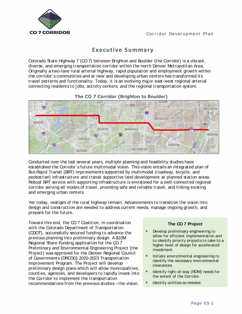
Colorado State Highway 7 (CO 7) between Brighton and Boulder (the Corridor) is a vibrant, diverse, and emerging transportation corridor within the north Denver Metropolitan Area. Originally a two-lane rural arterial highway, rapid population and employment growth within the corridor’s communities and at new and developing urban centers has transformed its travel patterns and functionality. Today, it is an evolving major east-west regional arterial connecting residents to jobs, activity centers, and the regional transportation system.
The CO 7 Corridor (Brighton to Boulder)
Conducted over the last several years, multiple planning and feasibility studies have established the Corridor’s future multimodal vision. This vision entails an integrated plan of Bus Rapid Transit (BRT) improvements supported by multimodal (roadway, bicycle, and pedestrian) infrastructure and transit supportive land development at planned station areas. Robust BRT service with supporting infrastructure is envisioned for a well-connected regional corridor serving all modes of travel, providing safe and reliable travel, and linking existing and emerging urban centers. Yet today, vestiges of the rural highway remain. Advancements to transition the vision into design and construction are needed to address current needs, manage ongoing growth, and prepare for the future. Toward this end, the CO 7 Coalition, in coordination with the Colorado Department of Transportation (CDOT), successfully secured funding to advance the previous planning into preliminary design. A $10M Regional Share Funding application for the CO 7 Preliminary and Environmental Engineering Project (the Project) was approved for the Denver Regional Council of Governments (DRCOG) 2020-2023 Transportation Improvement Program. The Project will develop preliminary design plans which will allow municipalities, counties, agencies, and developers to rapidly invest into the Corridor to implement the transportation recommendations from the previous studies – the vision.
The CO 7 Project
Develop preliminary engineering to allow for efficient implementation and to identify priority projects to take to a higher level of design for accelerated investment.
Initiate environmental engineering to identify the necessary environmental clearances.
Identify right-of-way (ROW) needs for the extent of the Corridor.
Identify utilities as needed.

Cor r i dor Deve lopment P l an
P a g e E S - 2
In collaboration with the CO 7 Technical Advisory Committee (TAC), comprised of technical staff from the CO 7 Coalition membership and participants, a Corridor Development Plan (CDP) was prepared to establish the overall work program and oversight framework for the Project. Because the allocated funding is insufficient to achieve all objectives fully across the Corridor, a plan is needed to optimize the Project while strategically preparing for future, additional funding. The CDP fulfills this purpose. It will help ensure the Project fulfills its goals, is responsive to agency expectations, is effectively delivered with accountability, maximizes the use of the previous studies, and provides the best possible use of the allocated funds. Working closely with the TAC, the formulation of the CDP entailed a thoughtful and collaborative process of identifying the goals of the Project and aligning, evaluating, and prioritizing elements of the recommended improvements (called Proposed Actions) for inclusion in the Project. These Proposed Actions represent independent functional components of the Corridor’s vision, such as constructing an improved intersection or building the multimodal section between two intersections. This process produced collective agreement on the Project’s more-detailed definition. Combined with an overall delivery framework, including budget, schedule, and resource planning, the CDP enables the Project to move forward into execution.
Recommended Plan (Proposed Actions) for the Project
The Corridor Development Plan (CDP)
Analysis • Establish the goals for the Project • Identify the changed conditions
along the Corridor • Define the environmental analysis
approach • Identify the technical
methodologies • Prioritize the elements of the
Project • Define the budget, schedule, and
resource plans for delivery • Document the plan in a final report
Products • Program of Project elements
(scope, budget, schedule, and resources plan)
• Implementation plan for full Corridor multimodal deployment
• Communications plan for Project delivery
• Funding opportunities for full Corridor improvement
Cor r i dor Deve lopment P l an
P a g e E S - 3
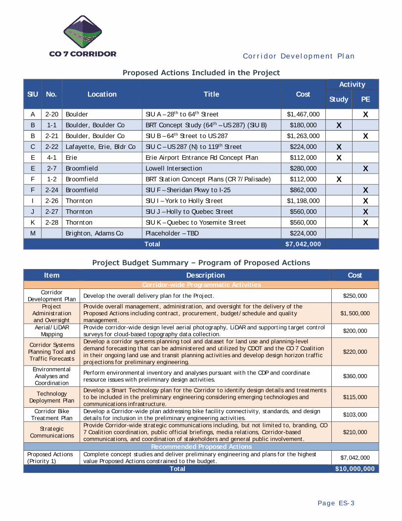
Proposed Actions Included in the Project
SIU No. Location Title Cost Activity
Study PE
A 2-20 Boulder SIU A – 28th to 64th Street $1,467,000 X B 1-1 Boulder, Boulder Co BRT Concept Study (64th – US 287) (SIU B) $180,000 X B 2-21 Boulder, Boulder Co SIU B – 64th Street to US 287 $1,263,000 X C 2-22 Lafayette, Erie, Bldr Co SIU C – US 287 (N) to 119th Street $224,000 X E 4-1 Erie Erie Airport Entrance Rd Concept Plan $112,000 X E 2-7 Broomfield Lowell Intersection $280,000 X F 1-2 Broomfield BRT Station Concept Plans (CR 7/Palisade) $112,000 X F 2-24 Broomfield SIU F – Sheridan Pkwy to I-25 $862,000 X I 2-26 Thornton SIU I – York to Holly Street $1,198,000 X J 2-27 Thornton SIU J – Holly to Quebec Street $560,000 X K 2-28 Thornton SIU K – Quebec to Yosemite Street $560,000 X M Brighton, Adams Co Placeholder – TBD $224,000
Total $7,042,000
Project Budget Summary – Program of Proposed Actions
Item Description Cost Corridor-wide Programmatic Activities
Corridor Development Plan Develop the overall delivery plan for the Project. $250,000
Project Administration and Oversight
Provide overall management, administration, and oversight for the delivery of the Proposed Actions including contract, procurement, budget/schedule and quality management.
$1,500,000
Aerial/LiDAR Mapping
Provide corridor-wide design level aerial photography, LiDAR and supporting target control surveys for cloud-based topography data collection. $200,000
Corridor Systems Planning Tool and Traffic Forecasts
Develop a corridor systems planning tool and dataset for land use and planning-level demand forecasting that can be administered and utilized by CDOT and the CO 7 Coalition in their ongoing land use and transit planning activities and develop design horizon traffic projections for preliminary engineering.
$220,000
Environmental Analyses and Coordination
Perform environmental inventory and analyses pursuant with the CDP and coordinate resource issues with preliminary design activities. $360,000
Technology Deployment Plan
Develop a Smart Technology plan for the Corridor to identify design details and treatments to be included in the preliminary engineering considering emerging technologies and communications infrastructure.
$115,000
Corridor Bike Treatment Plan
Develop a Corridor-wide plan addressing bike facility connectivity, standards, and design details for inclusion in the preliminary engineering activities. $103,000
Strategic Communications
Provide Corridor-wide strategic communications including, but not limited to, branding, CO 7 Coalition coordination, public official briefings, media relations, Corridor-based communications, and coordination of stakeholders and general public involvement.
$210,000
Recommended Proposed Actions Proposed Actions (Priority 1)
Complete concept studies and deliver preliminary engineering and plans for the highest value Proposed Actions constrained to the budget. $7,042,000
Total $10,000,000
Cor r i dor Deve lopment P l an
P a g e E S - 4
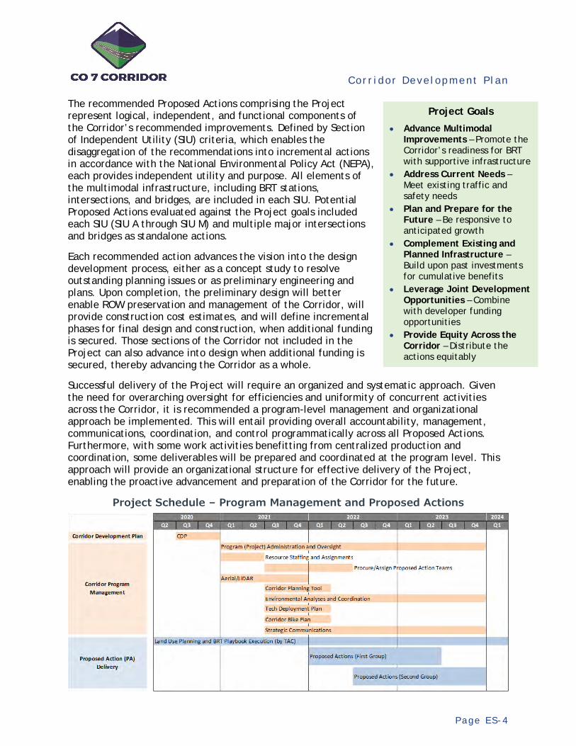
The recommended Proposed Actions comprising the Project represent logical, independent, and functional components of the Corridor’s recommended improvements. Defined by Section of Independent Utility (SIU) criteria, which enables the disaggregation of the recommendations into incremental actions in accordance with the National Environmental Policy Act (NEPA), each provides independent utility and purpose. All elements of the multimodal infrastructure, including BRT stations, intersections, and bridges, are included in each SIU. Potential Proposed Actions evaluated against the Project goals included each SIU (SIU A through SIU M) and multiple major intersections and bridges as standalone actions.
Each recommended action advances the vision into the design development process, either as a concept study to resolve outstanding planning issues or as preliminary engineering and plans. Upon completion, the preliminary design will better enable ROW preservation and management of the Corridor, will provide construction cost estimates, and will define incremental phases for final design and construction, when additional funding is secured. Those sections of the Corridor not included in the Project can also advance into design when additional funding is secured, thereby advancing the Corridor as a whole.
Successful delivery of the Project will require an organized and systematic approach. Given the need for overarching oversight for efficiencies and uniformity of concurrent activities across the Corridor, it is recommended a program-level management and organizational approach be implemented. This will entail providing overall accountability, management, communications, coordination, and control programmatically across all Proposed Actions. Furthermore, with some work activities benefitting from centralized production and coordination, some deliverables will be prepared and coordinated at the program level. This approach will provide an organizational structure for effective delivery of the Project, enabling the proactive advancement and preparation of the Corridor for the future.
Project Schedule – Program Management and Proposed Actions
Project Goals
• Advance Multimodal Improvements – Promote the Corridor’s readiness for BRT with supportive infrastructure
• Address Current Needs – Meet existing traffic and safety needs
• Plan and Prepare for the Future – Be responsive to anticipated growth
• Complement Existing and Planned Infrastructure – Build upon past investments for cumulative benefits
• Leverage Joint Development Opportunities – Combine with developer funding opportunities
• Provide Equity Across the Corridor – Distribute the actions equitably
Cor r i dor Deve lopment P l an
P a g e 1
1. Introduction
1 .1 Background
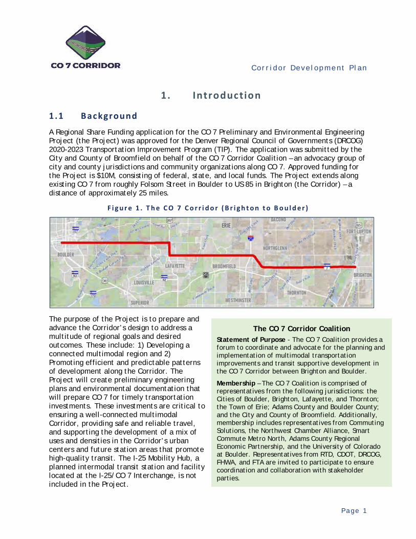
A Regional Share Funding application for the CO 7 Preliminary and Environmental Engineering Project (the Project) was approved for the Denver Regional Council of Governments (DRCOG) 2020-2023 Transportation Improvement Program (TIP). The application was submitted by the City and County of Broomfield on behalf of the CO 7 Corridor Coalition – an advocacy group of city and county jurisdictions and community organizations along CO 7. Approved funding for the Project is $10M, consisting of federal, state, and local funds. The Project extends along existing CO 7 from roughly Folsom Street in Boulder to US 85 in Brighton (the Corridor) – a distance of approximately 25 miles.
F i g u r e 1 . T h e C O 7 C o r r i d o r ( B r i g h t o n t o B o u l d e r )
The purpose of the Project is to prepare and advance the Corridor’s design to address a multitude of regional goals and desired outcomes. These include: 1) Developing a connected multimodal region and 2) Promoting efficient and predictable patterns of development along the Corridor. The Project will create preliminary engineering plans and environmental documentation that will prepare CO 7 for timely transportation investments. These investments are critical to ensuring a well-connected multimodal Corridor, providing safe and reliable travel, and supporting the development of a mix of uses and densities in the Corridor’s urban centers and future station areas that promote high-quality transit. The I-25 Mobility Hub, a planned intermodal transit station and facility located at the I-25/CO 7 Interchange, is not included in the Project.
The CO 7 Corridor Coalition Statement of Purpose - The CO 7 Coalition provides a forum to coordinate and advocate for the planning and implementation of multimodal transportation improvements and transit supportive development in the CO 7 Corridor between Brighton and Boulder.
Membership – The CO 7 Coalition is comprised of representatives from the following jurisdictions: the Cities of Boulder, Brighton, Lafayette, and Thornton; the Town of Erie; Adams County and Boulder County; and the City and County of Broomfield. Additionally, membership includes representatives from Commuting Solutions, the Northwest Chamber Alliance, Smart Commute Metro North, Adams County Regional Economic Partnership, and the University of Colorado at Boulder. Representatives from RTD, CDOT, DRCOG, FHWA, and FTA are invited to participate to ensure coordination and collaboration with stakeholder parties.
Cor r i dor Deve lopment P l an
P a g e 2
Pursuant with the funding application, the Project is to be administered and delivered by CDOT in collaboration with the CO 7 Corridor Coalition. To aid this collaboration and provide ongoing technical coordination, a Technical Advisory Committee (TAC) has been convened comprised of staff representatives from the CO 7 Coalition membership. CDOT will work closely with the TAC in the formulation and delivery of the Project.
1.2 Defin ing the Project
The approved funding application defines the scope and intent of the Project. Based on previous planning study recommendations, the Project will develop preliminary plans which will allow municipalities, counties, agencies, and developers to rapidly invest into the Corridor to implement the transportation recommendations. Specific elements include:
Develop preliminary engineering to achieve a sufficient level of design for projects on the Corridor to allow for efficient implementation and to identify priority projects to take to a higher level of design for accelerated investment.
Initiate environmental engineering to identify the necessary environmental clearances. Identify right-of-way (ROW) needs for the extent of the Corridor allowing the
responsible municipalities, counties, developers, and agencies to acquire and preserve the land necessary to build the Corridor transportation improvements. Some ROW may be acquired with the Project funds as necessary.
Identify utilities as needed.
Funding for the Project is comprised of DRCOG Regional Share Funding combined with Subregional Federal Funding from the Adams, Boulder, and Broomfield Subregions; CDOT (state) funding from Regions 1 and 4; and local agency contributions. Earmarked uses of the funds include design, environmental, and ROW. It is not envisioned that the Project will entail construction. Expenditures are planned from FY 2020 to FY 2023.
Technical Advisory Committee (TAC)
Participants include staff from the following:
City of Boulder City of Brighton City of Lafayette City of Thornton Town of Erie Adams County Boulder County City and County of Broomfield Commuting Solutions Smart Commute Metro North Regional Transportation District (RTD) Adams County Regional Economic Partnership Northwest Chamber Alliance
Project Funding
Source: DRCOG Project application

Cor r i dor Deve lopment P l an
P a g e 3
1.3 Corr idor Development Pl an
Previously completed multimodal planning studies provide the foundation for the Project. The Project’s stated purpose is to advance the defined improvement recommendations from these studies – the multimodal vision for the Corridor. However, based on these recommendations that establish the vision and its multimodal infrastructure, the objectives for the Project may be accomplished in a variety of ways and in varying degrees. Project funding is insufficient to achieve all objectives across the full Corridor. Priorities within the Corridor need to be identified to direct where and to what level of detail the Project’s activities should be focused. Furthermore, direction is needed beyond the Project to advance the full Corridor. Therefore, a plan is needed to define the Project and layout subsequent activities for when additional funding is secured.
In collaboration with the TAC, a Corridor Development Plan (CDP) was prepared for this purpose. It establishes the overall work program and oversight framework for the Project. This ensures 1) fulfillment of the Project’s goals, 2) responsiveness to agency expectations, 3) effective delivery and accountability, 4) maximum use of the previous studies, and 5) best and optimal use of the specified funds. Preparations entailed identifying the goals and expectations of the partnering agencies; assessing the basis (i.e., level of detail, mapping, data collection methods, etc.) for the preliminary design and environmental analysis activities; prioritizing the Project elements; assessing optional governance, oversight structures, and resourcing for the Project’s execution; and memorializing consensus in a final report.
1.4 Planning and D es ign Context – The Corr idor Vis ion
Previous planning studies have established the multimodal vision for the Corridor. These studies include specific recommendations for the scope, concept, and interaction of multimodal improvements along the full Corridor. These study recommendations provide the framework and definition (i.e., Planning and Design Context) for any necessary additional study and analyses of any unresolved planning issues and for the advancement of the Project’s engineering design and environmental analyses.
The Corridor vision, as defined by the previous planning studies, includes an integrated plan of Bus Rapid Transit (BRT) improvements, extending from Brighton to Boulder, supported by multimodal infrastructure and transit supportive land development at planned station areas (to be administered by the local jurisdictions in coordination with the CO 7 Coalition). Robust BRT service with supporting infrastructure is envisioned for a well-connected regional Corridor serving all modes of travel, providing safe and reliable travel, and linking existing
The Corridor Development Plan (CDP)
Analysis • Establish the goals for the
Project • Identify the changed conditions
along the Corridor • Define the environmental
analysis approach • Identify the technical
methodologies • Prioritize the elements of the
Project • Define the budget, schedule,
and resource plans for delivery • Document the plan in a final
report Products
• Program of Project elements (scope, budget, schedule, and resources plan)
• Implementation plan for full Corridor multimodal deployment
• Communications plan for Project delivery
• Funding opportunities for full Corridor improvement
Cor r i dor Deve lopment P l an
P a g e 4
and emerging urban centers. Completed station area plans provide guidance and conceptual schematics for planned BRT stations, surrounding transit supportive land use, and complementary First and Final Mile (FFM) bike, pedestrian, and micro-transit infrastructure improvements. Recommended improvements along the Corridor include: bus transit lanes (exclusive or shoulder running, depending on location); bus transit queue jump lanes at major intersections; bus transit stations (in-line, within intersections, or off alignment); roadway general purpose lane additions (depending on location); shared and continuous bike lanes; and continuous shared-use paths. Combined, they provide an integrated multimodal regional corridor-based transportation system.
Appendix A presents the recommended multimodal cross section templates from the previous planning studies, depending on location, for the Corridor.
T a b l e 1 . S u m m a r y o f P r e v i o u s P l a n n i n g S t u d y R e c o m m e n d a t i o n s
Year Description General Infrastructure Recommendations (See Note)
2008
SH 7 (Cherryvale Road to 75th Street) Environmental Assessment
Two general purpose lanes with median and shoulders (to be converted to transit lanes) with transition to an expanded roadway section at Cherryvale, extending to the west, plus intersection improvements (as-completed construction).
2014 SH 7 Planning & Environmental Linkages Study (US 287 to US 85)
Depending on location, maintain existing two-lane or four to six-lane roadway widening combined with continuous shoulders for peak period transit and bicycle use, median, and shared-use paths plus intersection improvements and access management modifications.
2018
SH 7 Planning & Environmental Linkages Study (75th Street to US 287)
Two general purpose lanes with continuous shoulders for peak period transit and bicycle use and shared-use paths plus intersection improvements with the option of a directional or bi-directional managed lane (to be determined).
2018
East Arapahoe Transportation Plan (Folsom Street to 75th Street)
Four general purpose lanes west of 55th Street and transitioning to two lanes to the east combined with continuous transit lanes, signal transit priority, median, bike lanes and shared-use paths plus intersection improvements.
2018 SH 7 Bus Rapid Transit Feasibility Study
BRT operations and routing plan and station locations for regular service between Brighton and Boulder.
2020 SH 7 BRT Station Area Design
BRT station concept plans and configurations, First and Final Mile infrastructure and Transit Oriented Development guidance at 15 planned station locations.
Note: Details on the recommended multimodal improvements are available in the previous study reports.
The previous planning efforts and Planning and Environmental Linkages (PEL) Studies were conducted in accordance with standard and accepted CDOT and Federal Highway Administration (FHWA) guidance and processes, including the consideration of environmental impacts. Based on the framework of recommendations, this enables the subsequent NEPA (National Environmental Policy Act) environmental analyses and preliminary engineering to be streamlined by reference to the earlier studies and decision making, to the extent conditions upon which the recommendations were made have not changed. Notwithstanding these potential changed conditions, the previous planning either narrows the range of alternatives for more-detailed study for any unresolved planning issues or enables the advancement of the recommendations into preliminary engineering and environmental analysis.
Cor r i dor Deve lopment P l an
P a g e 5
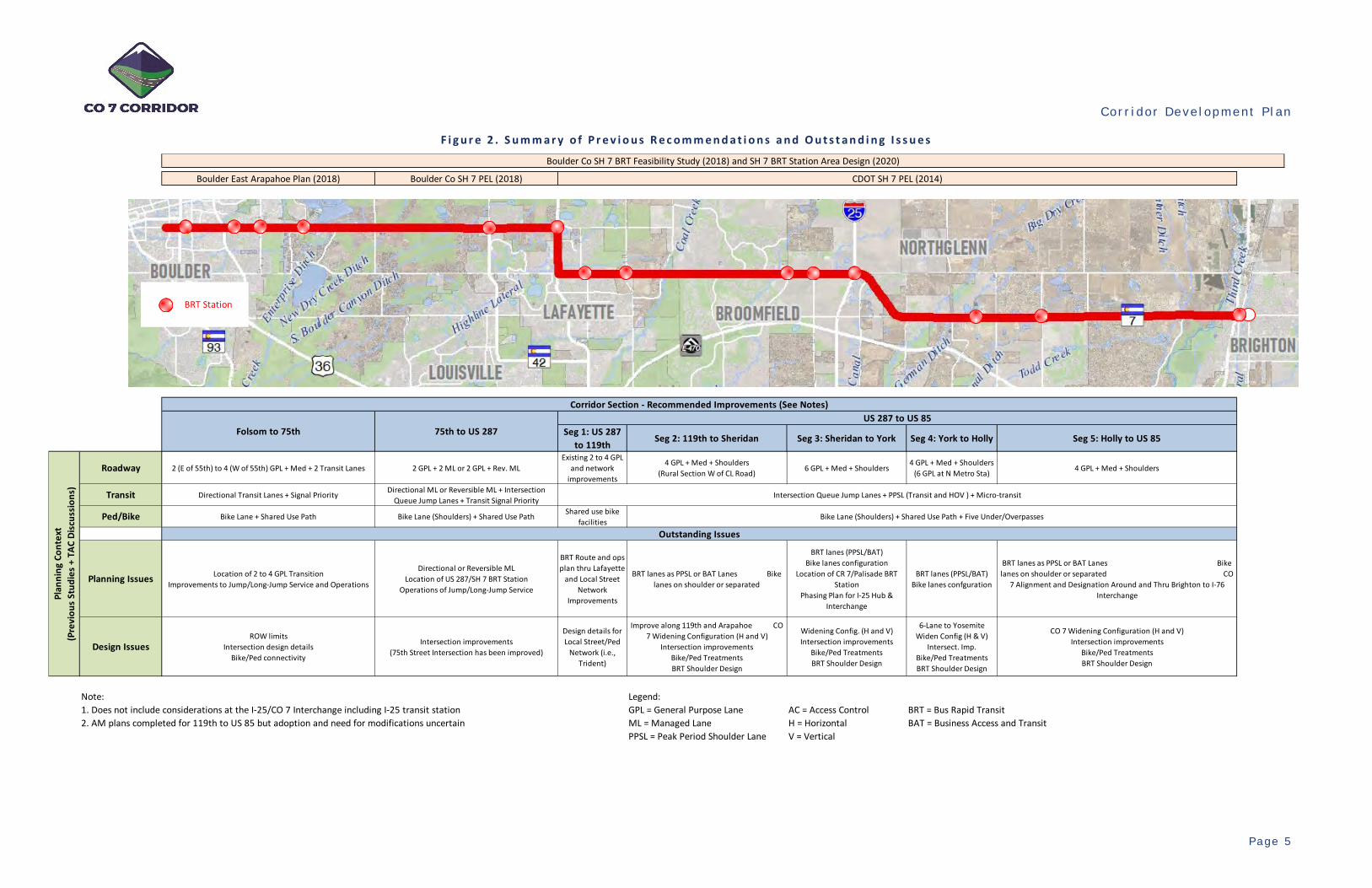
F i g u r e 2 . S u m m a r y o f P r e v i o u s R e c o m m e n d a t i o n s a n d O u t s t a n d i n g I s s u e s
Boulder East Arapahoe Plan (2018) Boulder Co SH 7 PEL (2018)
Seg 1: US 287 to 119th
Seg 2: 119th to Sheridan Seg 3: Sheridan to York Seg 4: York to Holly Seg 5: Holly to US 85
2 (E of 55th) to 4 (W of 55th) GPL + Med + 2 Transit Lanes 2 GPL + 2 ML or 2 GPL + Rev. MLExisting 2 to 4 GPL
and network improvements
4 GPL + Med + Shoulders (Rural Section W of CL Road) 6 GPL + Med + Shoulders
4 GPL + Med + Shoulders (6 GPL at N Metro Sta) 4 GPL + Med + Shoulders
Directional Transit Lanes + Signal Priority Directional ML or Reversible ML + Intersection Queue Jump Lanes + Transit Signal Priority
Bike Lane + Shared Use Path Bike Lane (Shoulders) + Shared Use Path Shared use bike facilities
Location of 2 to 4 GPL Transition Improvements to Jump/Long-Jump Service and Operations
Directional or Reversible ML Location of US 287/SH 7 BRT Station
Operations of Jump/Long-Jump Service
BRT Route and ops plan thru Lafayette
and Local Street Network
Improvements
BRT lanes as PPSL or BAT Lanes Bike lanes on shoulder or separated
BRT lanes (PPSL/BAT) Bike lanes configuration
Location of CR 7/Palisade BRT Station
Phasing Plan for I-25 Hub & Interchange
BRT lanes (PPSL/BAT) Bike lanes confguration
BRT lanes as PPSL or BAT Lanes Bike lanes on shoulder or separated CO
7 Alignment and Designation Around and Thru Brighton to I-76 Interchange
ROW limits Intersection design details
Bike/Ped connectivity
Intersection improvements (75th Street Intersection has been improved)
Design details for Local Street/Ped
Network (i.e., Trident)
Improve along 119th and Arapahoe CO 7 Widening Configuration (H and V)
Intersection improvements Bike/Ped Treatments BRT Shoulder Design
Widening Config. (H and V) Intersection improvements
Bike/Ped Treatments BRT Shoulder Design
6-Lane to Yosemite Widen Config (H & V)
Intersect. Imp. Bike/Ped Treatments BRT Shoulder Design
CO 7 Widening Configuration (H and V) Intersection improvements
Bike/Ped Treatments BRT Shoulder Design
Note: Legend:1. Does not include considerations at the I-25/CO 7 Interchange including I-25 transit station GPL = General Purpose Lane AC = Access Control BRT = Bus Rapid Transit2. AM plans completed for 119th to US 85 but adoption and need for modifications uncertain ML = Managed Lane H = Horizontal BAT = Business Access and Transit
PPSL = Peak Period Shoulder Lane V = Vertical
Ped/Bike
Planning Issues
Design Issues
Corridor Section - Recommended Improvements (See Notes)
Folsom to 75th 75th to US 287US 287 to US 85
Intersection Queue Jump Lanes + PPSL (Transit and HOV ) + Micro-transit
Bike Lane (Shoulders) + Shared Use Path + Five Under/Overpasses
Plan
ning
Con
text
(Pre
viou
s St
udie
s +
TAC
Disc
ussi
ons)
CDOT SH 7 PEL (2014)
Boulder Co SH 7 BRT Feasibility Study (2018) and SH 7 BRT Station Area Design (2020)
Outstanding Issues
Roadway
Transit
BRT Station
Cor r i dor Deve lopment P l an
P a g e 6
1 . 4 . 1 O u t s t a n d i n g P l a n n i n g I s s u e s
Remaining and outstanding planning issues along the Corridor which could have traffic and/or environmental implications and require further, more-detailed study include the following:
Bus Transit Concept (63rd Street to US 287) – Existing transit lanes to the west begin and end just east of 63rd Street. The SH 7 PEL Study (75th Street to US 287) identified a range of potential BRT concepts within this section including directional transit lanes (Peak Period Shoulder Lanes (PPSL)) or a reversible (i.e., contraflow) BRT lane. Within this section, the East Arapahoe Transportation Plan identified the location of the two to four-lane roadway transition, somewhere east of 55th Street, as an outstanding issue.
City of Lafayette Local Street Network – The previous planning study recommended improvements to the local alternative street network, in lieu of direct capacity treatments to CO 7, through the City of Lafayette. This alternative network system extends from the 119th Street intersection to the west, via north and south system connections, to US 287. For CO 7, this northern system connection includes a combination of Arapahoe Road and 119th Street between the US 287 (North) and 119th Street intersections. This alternative network recommendation has not been studied further to assess what multimodal enhancements, if any, are needed along these alternate routes and the spatial relationship to the adjacent open space. The previous study also recommended roadway upgrades and sidewalk upgrades and connectivity improvements along existing CO 7 through the city.
BRT Station Locations – Current planning for the BRT stations identified several with undetermined locations. These include up to three undetermined sites within the City of Boulder and the CR 7/Palisade location within the City and County of Broomfield. Further study of these locations could be coordinated with the adjacent and associated development plans as they are developed.
SH 7 Realignment (Brighton to I-76) – The SH 7 PEL Study (US 287 to US 85) identified the potential northern realignment of CO 7 just west of Brighton to the existing 168th Avenue (County Line Road) alignment and extending to the east to the existing I-76/168th Avenue Interchange as an unresolved issue. This concept is included in the 2016 Brighton Transportation Master Plan. Also, planning for a new US 85/168th Avenue Interchange is currently underway. In coordination with the CDP, the City of Brighton has indicated that the realignment concept should not be included in the Project and will be addressed through the current and ongoing update of the City’s Transportation Master Plan.
While not directly related to outstanding issues from previous CO 7 planning study recommendations, there are a number of interrelated and ongoing planning studies that could affect the Corridor. These include the US 287 BRT Study, ongoing planning for the I-25 Mobility Hub, and several other regional transit planning corridors. An update of the planned regional transit system and their relationships to the Corridor is presented in the Current Setting (Changed Conditions) Section.
1 . 4 . 2 O u t s t a n d i n g D e s i g n I s s u e s
For those portions of the Corridor not affected by the outstanding planning issues, the remaining design-related issues for the recommended improvements entail more-detailed definition of the cross-sectional limits and spatial relationship (horizontal and vertical) of the improved multimodal Corridor relative to the existing infrastructure and ROW. The advancement of preliminary engineering and environmental analyses would address these issues. Overall, sufficient detail is

Cor r i dor Deve lopment P l an
P a g e 7
needed to establish the ultimate ROW requirements considering construction staging, maintenance of traffic (MOT), and developer coordination for phased implementation. Furthermore, a sufficient basis of design is needed to support the associated environmental analysis and provide reliable final design and construction cost estimates for budgeting and programming. Based on the identified priorities, the level of detail of the preliminary design could vary along the Corridor, where warranted, to prepare for accelerated investments.
In general, preliminary engineering design and environmental analysis, at a minimum, is needed to:
Determine the horizontal and vertical roadway alignment and cross-sectional limits, including shoulder details for BRT use, bike lane provisions, shared-use path locations, and multimodal system connectivity. Planned in-line BRT stations should be included in the preliminary roadway engineering and design per the conceptual designs included in the SH 7 BRT Station Area Design Study.
Identify improved intersection configurations and limits, including north-south roadway approach improvements and BRT station provisions (per the SH 7 BRT Station Area Design Study), as appropriate.
Establish the limits of where the ultimate 6-lane roadway section is needed and how to transition to the adjoining 4-lane roadway sections.
Update and re-establish the access management plans along the Corridor, as needed. Identify existing utilities and needed utility relocations. Define the needed ROW for the multimodal improvements along and directly associated with
the Corridor. Define provisions within the Corridor for emerging Automated Vehicle (AV) and Connected
Vehicle (CV) technologies and Smart Technology applications. Integrate and delimit planned multimodal regional network system connections and
improvements associated with CO 7 for an efficient and well-connected regional corridor. Examples include connected local adjacent street, trail, and bike facilities through the City of Lafayette, and the integration of the I-25 Mobility Hub, currently under preliminary design.
Subsequent to the planning studies, the various jurisdictions along the Corridor have advanced local and isolated elements of the planning study recommendations into design and construction. These activities are ongoing and include the following:
Land Development – Within the identified station areas, jurisdictions have coordinated with development plans to include transit supportive land uses and densities and FFM infrastructure and micro-transit improvements.
Access Management – Jurisdictions and CDOT have implemented the access control plans to manage existing and new roadway access to CO 7 including permitting of new access in coordination with adjacent development plans. These improvements include turn lanes and auxiliary lanes in localized areas.
Intersection Improvements – In coordination with adjacent development plans or publicly led (i.e., funded from public sources), several major intersections have been or are committed to be improved and signalized pursuant with the recommendations, to the extent possible. In varying degrees, these improvements have included intersection approach

Cor r i dor Deve lopment P l an
P a g e 8
widening, intersection BRT queue jumps, pedestrian crosswalks, and localized bike lane provisions.
Roadway Widening – In coordination with adjacent development plans or publicly led (i.e., funded from public sources), the existing roadway has been or is committed to be widened pursuant with the recommendations, to the extent possible, in localized areas. Typically, the widening is an interim improvement. Improvements typically include bike lane provisions, shared-use paths, and acquisition of the full-width ROW.
1.5 Planned Fut ure Corr idor Funding
The Project’s current funding was obtained through the DRCOG regional and subregional project selection process for the development of the 2020-2023 TIP. In addition, a number of other currently planned future funding sources have been identified. While these sources are not currently included in the Project, they do provide foreseeable opportunities for additional funding for advancing the Corridor beyond the Project. These sources are not currently committed but are planned and represent reasonable projections of future funding that could become available.
As shown, CDOT Bridge Enterprise funding is an existing funding source available for eligible bridges. Funding for CO 7 is included in the CDOT 10-year Vision, but the source of the funding has not yet been identified. The DRCOG Regional Transportation Plan (RTP) is currently being updated and is in draft form. This draft currently includes funding for the CO 7 Corridor and the I-25/CO 7 Interchange and is subject to adoption.
This is not an exhaustive list of all potential funding sources, but rather where CO 7 has been included in existing funding plans. Existing and committed funding for the Corridor is not included.
T a b l e 2 . P l a n n e d F u t u r e F u n d i n g f o r t h e C o r r i d o r
Source Description Funding CDOT Bridge Enterprise
Bridge Enterprise eligible: Bridge D-15-AQ (Westbound SH 7 over Boulder Creek) Undetermined
CDOT 10-year Vision Projects in Years 5-10: Highway – I-25 and SH 7 Interchange Mobility Hub (Project ID 2694) $5M
CDOT 10-year Vision Projects in Years 5-10: Highway – SH 7 Priority Intersection Improvements (Project ID 2586) $15M
CDOT 10-year Vision Projects in Years 5-10: Transit – I-25 and SH 7 Interchange Mobility Hub (Project ID 2694) $5M
CDOT 10-year Vision Projects in Years 5-10: Transit – SH 7 Priority Intersection Improvements (Project ID 2641) $5M
Note: Existing planning documents identify CO 7 as SH 7.

Cor r i dor Deve lopment P l an
P a g e 9
2. Corridor Development Plan Process
Preparations of the CDP entailed a thoughtful and collaborative process of identifying the goals of the Project and aligning, evaluating, and prioritizing Project elements to determine the optimal uses of the available funding. Working with the TAC and CO 7 Coalition, this process produced collective agreement on the more-detailed definition of the Project. Combined with an overall delivery framework, including budget, schedule and resource planning, the CDP, through consensus and agreement with the TAC and CO 7 Coalition, enables the Project to move forward into execution.
Overall alignment of the CDP was guided by the Purpose and Need Statements from the previous planning studies. Accordingly, through individual discussions with TAC members, overarching goals for the Project were identified. These discussions further identified uniform and uniting themes which influenced the CDP development. Based on ideas and suggestions from the TAC for potential priorities, each “Proposed Action” was evaluated comparatively on how well it would accomplish the Project goals. Each potential Proposed Action (i.e., independent and functional element of the Project to be constructed when funded) was categorized by the various types of project uses. Constrained by the available funding, the recommended Proposed Actions were adjusted considering overall equity and packaging for economies of scale to comprise the more-detailed definition of the Project. An overlay of management and implementation considerations was then developed for the delivery of the plan to form the CDP.
2.1 Purpose and Need Summary
The previous planning studies defined the purpose of and need for the Corridor improvements which provided the basis for their recommendations. In varying degrees, each study provided a Purpose and Need Statement applicable to the extent of its limits.
Accordingly, each study’s recommendations, including BRT, bike, pedestrian, and roadway improvements, reflect its determination of how best to fulfill and address the identified needs. Consequently, combined, these statements provide an overarching framework of the needs to be addressed by the Project. For compliance with the transportation planning process, each element of the Project needs to ideally be aligned with and address the identified and relevant needs. While each study’s statement is unique to its context, a unifying framework can help guide the process of defining the Project and ensuring alignment.
In general, the combined and reconstituted Purpose and Need Summary for the Project is as follows:
Purpose: The purpose of the Project is to improve traveler safety, improve personal travel efficiency and operations, and improve access to multimodal travel along the CO 7 Corridor between Brighton and Boulder.
F i g u r e 3 . C o r r i d o r D e v e l o p m e n t P l a n P r o c e s s
Purpose
Project Activities: Use of Project Funds (excludes construction): Scope of PE Design:1. Develop PE for efficient implementation/priorities 1. Study unresolved issues 1. Based on "ultimate" multimodal recommendations2. Identify environmental clearances 2. Perform PE and environmental analysis 2. Interim (phasing) projects to be developed based3. Identify right-of-way for preservation 3. Aquire right-of-way (optional) on Project PE design4. Identify utilities 4. Manage for future - programmatic tools
Advance Address Plan & Prepare Complement Leverage ProvideMultimodal Current for the Existing & Planned Joint Equity
Improvements Needs Future Infrastructure Opportunities Across theCorridor
Plan
ning
Con
text
(P
revi
ous
Stud
ies)
Need
TAC
Disc
ussi
ons
Project Goals
Pote
ntia
l Pro
ject
El
emen
ts
(P
ropo
sed
Actio
ns)
for PredictableFuture
"Prepare and advance the Corridor for developing a connected multimodal region and promoting efficient and predictable development patterns"
Project Uses
Traveler Safety Personal Travel Efficiency and Operations Access to Multimodal Travel
Applications
Manage
Improve traveler safety Improve person throughput along the Corridor Improve regional and local access to travel options
BRT Implementation Strategy (Playbook)
AdvanceDesign Issues
(PE and Environmental Analysis)Right-of-way Acquisition
TBD TBD
The Project
UnresolvedPlanning
Issues
TBD TBD
1 2 3 4 5 6 7 … n1 Advance Multimodal2 Address Current Needs3 Plan/Prepare for Future4 Complement E+C Infra.5 Leverage Joint Dev.
6 Equity across Corridor
1. PE Projects - Priority 1 (Constrained by budget), Priority 2, Priority 3 4. Priority 1 Resource and Delivery Plan2. Environmental (NEPA) approach 5. Funding Opportunities3. Corridor Implementation Plan (Scenario Based) 6. Communications Plan
Potential Project Elements (Proposed Actions)
Evaluate Equity and Repackage/Balance Priority Projects Constrained by Budget (Priority 1 - 2 - 3)
Corridor Development Plan - Project Priorities, Budgets and Schedules
PE P
roje
ct P
riorit
ies
Anal
ysis
/Eva
luat
ion
Met
hods
Goal
Evaluation of Potential PE Proposed Actions
1 2 3 4 5 6
Cor r i dor Deve lopment P l an
P a g e 1 0
Need: The Project is needed to address:
Traveler Safety – Previous studies identified the need to improve the safety of the traveling public by reducing vehicular crashes at intersections and conflict points, especially rear-end crashes, and providing safe conditions for pedestrians and bicyclists of all capabilities.
Personal Travel Efficiency and Operations – Previous studies identified the need to increase and improve person throughput efficiencies and operations, such as travel time reliability and vehicular occupancies, through: Corridor improvements, including transit station and intersection improvements, to support a CO 7 regional arterial BRT route and service from Brighton to Boulder; pedestrian and bicycle accommodations throughout the Corridor; and increased roadway lane (in some areas) and intersection capacities.
Access to Multimodal Travel – Previous studies identified the need to improve regional and local access to travel options including: bus transit stations with park-n-ride facilities, which do not currently fully exist and lack supporting multimodal infrastructure; bicycle, pedestrian, and micro-transit facilities (i.e., FFM) which lack consistent accommodations and station connections; and roadway access matching land development demands.
2.2 Project G oals
As an extension of the Project’s Purpose and Need Summary, through discussions with individual TAC members, the following goals for the Project were identified:
Advance Multimodal Improvements – Promote transit supportive land development and the incorporation of multimodal (bus transit, roadway, bicycle, pedestrian, and micro-transit) infrastructure along the Corridor and at planned station areas for phased transit implementation, including the integration of the I-25 Mobility Hub (not included in the Project).
Address Current Needs – Identify elements of the Project which address existing and immediately foreseeable operational and safety needs.
Plan and Prepare for the Future – Phase the implementation of the multimodal (bus transit, roadway, bicycle, pedestrian, and micro-transit) improvements responsive to the Corridor’s anticipated growth, including provisions for future transit operations and technology considerations.
Complement Existing and Planned Infrastructure – Build upon past and committed infrastructure improvements to cumulatively benefit the multimodal (bus transit, roadway, bicycle, pedestrian, and micro-transit) system and address system deficiencies (i.e., gaps).
Project and CDP Themes
The following central themes were identified through TAC discussions which informed and guided the Project and CDP development:
• Multimodal Vision – Strong unity and commitment
• Transit Delivery Strategy – An overall strategy is needed
• Implementation Guidance – More detail is needed for developer coordination
• Incremental Implementation – A phasing and staging plan is needed
• Intersections – Phasing should reflect the role intersections play in overall Corridor operations
• Unresolved Planning Issues – A few outstanding planning issues exist
• Future Funding – All available sources of funding need to be identified and pursued
Cor r i dor Deve lopment P l an
P a g e 1 1
Leverage Joint Development Opportunities – Maximize the effectiveness of developer or other third-party infrastructure improvements with integrated and combined elements of the Project (i.e., Joint Development Opportunities).
Provide Equity Across the Corridor – Distribute the advancement of the Project fairly across the Corridor while addressing needs and opportunities.
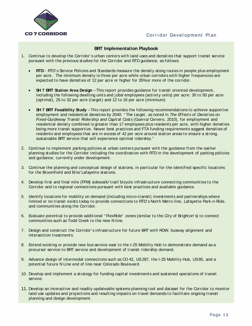
2.3 BRT Implementat ion Playbook
The vision for the Corridor includes high-quality BRT, extending from Brighton to Boulder. Previous planning studies have identified and defined the BRT operations plan, routing, and supportive multimodal infrastructure. Recommended improvements, to be implemented as part of the Project, include:
Running Way – Exclusive transit lanes from Boulder to US 287 and shared-use shoulders (PPSL) east of Lafayette.
Intersection Provisions – Bus queue jump lanes at major intersections and bus stations as identified by earlier BRT station area planning.
BRT Stations – 15 planned stations, plus an intermodal station at the I-25 Mobility Hub, with supporting FFM and micro-transit infrastructure.
Transit Oriented Development (TOD) – Implementation of land use plans and densities and mobility on demand (including micro-transit) at the planned station locations supportive of bus transit.
The Institute for Transportation & Development Policy provides guidance on planning for high performing BRT systems. In its report entitled Bus Rapid Transit, Good Practice Guide by the C40 Cities Climate Leadership Group, good design principles for effective BRT systems were identified. Underlying and important planning principles include: 1) encouraging compact development patterns to reduce car use and promote sustainable travel patterns; 2) providing mobility options to the use of private vehicles with sustainable, higher occupancy modes; and 3) managing the road space and travel demand to promote alternative modes. The multimodal vision, past improvement recommendations, and ongoing development management and practices by the various jurisdictions are in the process of fulfilling these key principles for the Corridor.
The report also identifies a number of essential system design standards and accepted best practices for a high performing BRT system. Many relate to the design of the stations and their interaction with the buses, passengers, and the nearby infrastructure and development. Details of these interactions and bus fleet specifications would be identified in preliminary engineering and design for the BRT system. Currently, design concepts have been developed for each planned station along the Corridor based on these best practices. Furthermore, ongoing and active planning and coordination by the local jurisdictions for the promotion of TOD patterns and densities with supporting infrastructure are preparing the Corridor for BRT deployment – another identified best practice.
Other identified design standards relate specifically to the travel way. Each relates to the assurance of travel time savings and reliability for sustained bus operations and ridership. Pursuant to the vision and past study recommendations, application of these standards is planned for the Corridor and is incorporated into the Project, including:

Cor r i dor Deve lopment P l an
P a g e 1 2
Dedicated ROW – Dedicated or shared-use lanes are planned to ensure buses can move unimpeded by congestion.
Busway Alignment – The busway is located to minimize conflicts with other traffic, especially turning movements.
Intersection Treatments – Major intersection improvements are to include queue jumps with signal priorities for buses.
While the vision is based on sound principles and the Corridor is to be designed and delivered accordingly, realizing the vision is a matter of funding and timing. Typically, the funding strategy for a BRT start-up includes some form of federal capital assistance through a grant process. Depending on the size of the assistance and project, the Federal Transit Administration (FTA) offers several programs to assist local transit agencies and local sponsors with BRT deployment. Applicants are typically judged by the overall performance of the proposed BRT services and the local funding contribution. The ability to fund sustained operations locally is also an essential requirement.
While multiple strategies for funding and operating BRT services along the Corridor could be available, including perhaps future reimagining of regional transit services which could enable more local control, essential to successfully funding and operating a BRT system is its overall performance. Regardless of the funding and governance structure, ridership needs to be sufficient to justify the service and implementation costs need to be low enough to be affordable.
Currently, the means of funding and operating the BRT services have not been identified. Furthermore, while supportive development patterns are emerging, current densities and resulting travel markets have not yet matured to be competitive, whether through the FTA grant process or within the RTD system. Therefore, for the CO 7 Corridor, the execution of a funding and deployment strategy goes hand-in-hand with the realization of the land development patterns and infrastructure which support the BRT start-up.
Typically, under the right circumstances, the next step to advance BRT along the Corridor would be to initiate preliminary engineering and environmental analyses. Launching this step typically coincides with the confidence of meeting the performance expectations in a timely manner and the ability to fund sustained operations. However, given the current state of the Corridor and lack of funding, additional advancements are needed to fulfill these prerequisites. The vision and ongoing development practices lay the groundwork, but additional efforts need to continue to prepare the Corridor for eventual BRT implementation.
To guide these efforts, a BRT Implementation Playbook is needed. Working together in partnership with CDOT, RTD, and others, these strategies and tactics by the CO 7 Coalition would enhance the self-determination of fulfilling the prerequisites for a BRT start-up and realizing the goal of a connected multimodal corridor and region. These ongoing efforts will prepare the Corridor for effective and high-quality BRT service.
Cor r i dor Deve lopment P l an
P a g e 1 3
BRT Implementation Playbook
1. Continue to develop the Corridor’s urban centers with land uses and densities that support transit service pursuant with the previous studies for the Corridor and RTD guidance, as follows:
• RTD - RTD’s Service Policies and Standards measure the density along routes in people plus employment per acre. The minimum density is three per acre while urban corridors with higher frequencies are expected to have densities of 12 per acre or higher for 35% or more of the corridor.
• SH 7 BRT Station Area Design – This report provides guidance for transit oriented development, including the following dwelling units and jobs/employees (activity units) per acre: 30 to 50 per acre (optimal), 25 to 32 per acre (target) and 12 to 16 per acre (minimum)
• SH 7 BRT Feasibility Study – This report provides the following recommendations to achieve supportive employment and residential densities by 2040: “The target, as noted in The Effects of Densities on Fixed-Guideway Transit Ridership and Capital Costs (Guerra/Cervero, 2010), for employment and residential density combined is greater than 17 employees plus residents per acre, with higher densities being more transit supportive. Newer best practices and FTA funding requirements suggest densities of residents and employees that are in excess of 42 per acre around station areas to ensure a strong, sustainable BRT service that will experience optimal ridership.”
2. Continue to implement parking policies at urban centers pursuant with the guidance from the earlier planning studies for the Corridor including the coordination with RTD in the development of parking policies and guidance, currently under development.
3. Continue the planning and conceptual design of stations, in particular for the identified specific locations for the Broomfield and Erie/Lafayette stations.
4. Develop first and final mile (FFM) sidewalk/trail/bicycle infrastructure connecting communities to the Corridor and to regional connections pursuant with best practices and available guidance.
5. Identify locations for mobility on demand (including micro-transit) investments and partnerships where limited or no transit exists today to provide connections to RTD’s North Metro line, Lafayette Park-n-Ride, and communities along the Corridor.
6. Evaluate potential to provide additional “FlexRide” zones (similar to the City of Brighton’s) to connect communities such as Todd Creek to the new N line.
7. Design and construct the Corridor’s infrastructure for future BRT with ROW, busway alignment and intersection treatments.
8. Extend existing or provide new bus service east to the I-25 Mobility Hub to demonstrate demand as a precursor service to BRT service and development of transit ridership demand.
9. Advance design of intermodal connections such as CO 42, US 287, the I-25 Mobility Hub, US 85, and a potential future N Line end of line near Colorado Boulevard.
10. Develop and implement a strategy for funding capital investments and sustained operations of transit service.
11. Develop an interactive and readily updateable systems planning tool and dataset for the Corridor to monitor land use updates and projections and resulting impacts on travel demands to facilitate ongoing transit planning and design development.

Cor r i dor Deve lopment P l an
P a g e 1 4
3. Current Setting (Changed Conditions)
With the passage of time since the previously completed planning studies, conditions within the CO 7 Corridor have changed. For purposes of the CDP, a cursory assessment of these changed conditions was performed. This high-level assessment was performed to 1) evaluate if the changes affect the basis of the previous improvement recommendations; 2) reset the understanding of the current environmental setting for the purposes of the CDP evaluation and plan development; and 3) provide the basis for the environmental analysis methodologies to be applied to the Project.
Previously identified environmental and transportation resources within the Corridor were reviewed for changed conditions. A detailed evaluation of the previously identified resources was not performed. Rather, changes to the current setting were identified for significant resource considerations potentially affecting the CDP development and its execution moving forward. These identified changes, combined with the previously recorded environmental setting, provide the basis for the environmental analysis for the Project. Resources evaluated include land use, the transportation system, and major environmental resources potentially impacting the Project.
3.1 Land Use
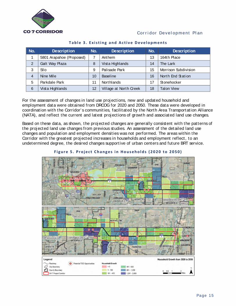
Changes in existing and projected land use are reflected by the current and active development within the Corridor and by updated land use projections (i.e., households and employment).
As shown, there are multiple notable and ongoing developments along the Corridor. These developments are consistent with the projected areas of land use changes from the earlier studies.
F i g u r e 4 . E x i s t i n g a n d A c t i v e D e v e l o p m e n t s
Changed Conditions Assessment
In general, the updated understanding of the existing setting reflects the predicted and projected conditions within the Corridor, as described in the earlier planning studies. Current conditions are consistent with and support the previous study improvement recommendations. No changed conditions were identified necessitating the re-evaluation of these recommendations. Through coordination with CDOT and the local communities, changes within the Corridor’s land use and transportation system are generally as planned and are consistent with the advancement of the multimodal vision.
Cor r i dor Deve lopment P l an
P a g e 1 5
T a b l e 3 . E x i s t i n g a n d A c t i v e D e v e l o p m e n t s
No. Description No. Description No. Description 1 5801 Arapahoe (Proposed) 7 Anthem 13 164th Place
2 Galt Way Plaza 8 Vista Highlands 14 The Lark
3 Silo 9 Palisade Park 15 Morrison Subdivision
4 Nine Mile 10 Baseline 16 North End Station
5 Parkdale Park 11 Northlands 17 Stonehocker
6 Vista Highlands 12 Village at North Creek 18 Talon View
For the assessment of changes in land use projections, new and updated household and employment data were obtained from DRCOG for 2020 and 2050. These data were developed in coordination with the Corridor’s communities, facilitated by the North Area Transportation Alliance (NATA), and reflect the current and latest projections of growth and associated land use changes.
Based on these data, as shown, the projected changes are generally consistent with the patterns of the projected land use changes from previous studies. An assessment of the detailed land use changes and population and employment densities was not performed. The areas within the Corridor with the greatest projected increases in households and employment reflect, to an undetermined degree, the desired changes supportive of urban centers and future BRT service.
F i g u r e 5 . P r o j e c t C h a n g e s i n H o u s e h o l d s ( 2 0 2 0 t o 2 0 5 0 )

Cor r i dor Deve lopment P l an
P a g e 1 6
F i g u r e 6 . P r o j e c t e d C h a n g e s i n E m p l o y m e n t ( 2 0 2 0 t o 2 0 5 0 )
3.2 Exist ing Transportat ion System
The description of the existing transportation system reflects the system at the time of the previous studies plus improvements constructed since their completion and currently committed projects. This description includes the roadway characteristics, bicycle/pedestrian facilities, and transit – changes in travel patterns were not evaluated.
3 . 2 . 1 S y s t e m C h a r a c t e r i s t i c s ( R o a d w a y , B i c y c l e a n d P e d e s t r i a n F a c i l i t i e s )
The existing and funded roadway, bicycle, and pedestrian facilities along the Corridor are characterized in the Figure 7. As shown, since the previous studies, other than west of 63rd Street, additional roadway lanes have been constructed or are funded for construction in localized areas throughout. The existing bus lanes are identified near 63rd Street. Bicycle and pedestrian facilities currently exist or are to be constructed sporadically along the Corridor. The planned median is currently provided within the City of Boulder and other isolated areas. As shown, incremental progress has been made throughout the Corridor towards building the recommended multimodal improvements.

Cor r i dor Deve lopment P l an
P a g e 1 7
F i g u r e 7 . E x i s t i n g R o a d w a y , B i c y c l e a n d P e d e s t r i a n F a c i l i t i e s a l o n g t h e C o r r i d o r
Cor r i dor Deve lopment P l an
P a g e 1 8
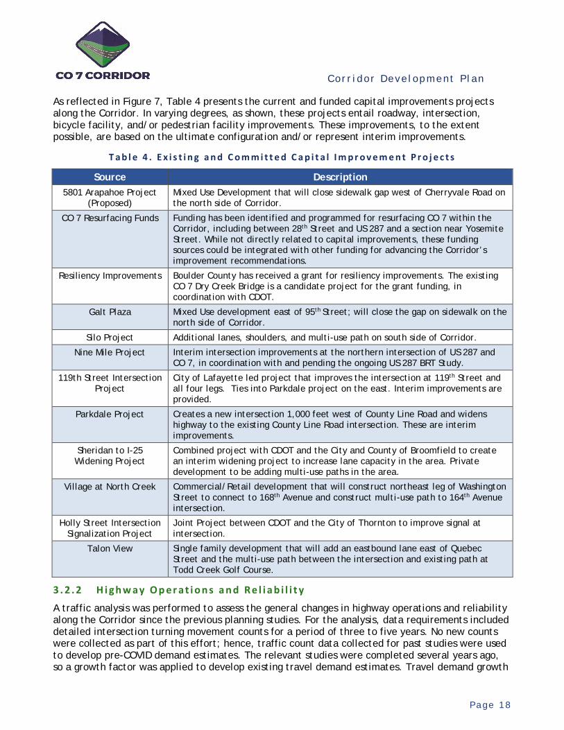
As reflected in Figure 7, Table 4 presents the current and funded capital improvements projects along the Corridor. In varying degrees, as shown, these projects entail roadway, intersection, bicycle facility, and/or pedestrian facility improvements. These improvements, to the extent possible, are based on the ultimate configuration and/or represent interim improvements.
T a b l e 4 . E x i s t i n g a n d C o m m i t t e d C a p i t a l I m p r o v e m e n t P r o j e c t s
Source Description 5801 Arapahoe Project
(Proposed) Mixed Use Development that will close sidewalk gap west of Cherryvale Road on the north side of Corridor.
CO 7 Resurfacing Funds Funding has been identified and programmed for resurfacing CO 7 within the Corridor, including between 28th Street and US 287 and a section near Yosemite Street. While not directly related to capital improvements, these funding sources could be integrated with other funding for advancing the Corridor’s improvement recommendations.
Resiliency Improvements Boulder County has received a grant for resiliency improvements. The existing CO 7 Dry Creek Bridge is a candidate project for the grant funding, in coordination with CDOT.
Galt Plaza Mixed Use development east of 95th Street; will close the gap on sidewalk on the north side of Corridor.
Silo Project Additional lanes, shoulders, and multi-use path on south side of Corridor.
Nine Mile Project Interim intersection improvements at the northern intersection of US 287 and CO 7, in coordination with and pending the ongoing US 287 BRT Study.
119th Street Intersection Project
City of Lafayette led project that improves the intersection at 119th Street and all four legs. Ties into Parkdale project on the east. Interim improvements are provided.
Parkdale Project Creates a new intersection 1,000 feet west of County Line Road and widens highway to the existing County Line Road intersection. These are interim improvements.
Sheridan to I-25 Widening Project
Combined project with CDOT and the City and County of Broomfield to create an interim widening project to increase lane capacity in the area. Private development to be adding multi-use paths in the area.
Village at North Creek Commercial/Retail development that will construct northeast leg of Washington Street to connect to 168th Avenue and construct multi-use path to 164th Avenue intersection.
Holly Street Intersection Signalization Project
Joint Project between CDOT and the City of Thornton to improve signal at intersection.
Talon View Single family development that will add an eastbound lane east of Quebec Street and the multi-use path between the intersection and existing path at Todd Creek Golf Course.
3 . 2 . 2 H i g h w a y O p e r a t i o n s a n d R e l i a b i l i t y
A traffic analysis was performed to assess the general changes in highway operations and reliability along the Corridor since the previous planning studies. For the analysis, data requirements included detailed intersection turning movement counts for a period of three to five years. No new counts were collected as part of this effort; hence, traffic count data collected for past studies were used to develop pre-COVID demand estimates. The relevant studies were completed several years ago, so a growth factor was applied to develop existing travel demand estimates. Travel demand growth
Cor r i dor Deve lopment P l an
P a g e 1 9
estimates were used to convert previous data to 2019 pre-COVID levels. This was achieved by using growth estimates provided in CDOT’s Online Transportation Information System (OTIS) for CO 7.
Current traffic operations along the Corridor were analyzed in two ways – Corridor-wide Operations and Isolated Signalized Intersection Operations.
Corridor wide operations were analyzed using the Synchro/SimTraffic software package for the AM and PM peak hours. A scaled model of the entire Corridor was developed in Synchro in which each intersection was first analyzed in isolation followed by a corridor-wide analysis that collected performance measures through multiple micro-simulation runs in SimTraffic. The Synchro/ SimTraffic model was calibrated based on available data such as existing geometry (number of through lanes, auxiliary lanes, turn lanes, shoulders, etc.), lane alignment, available fleet mix (OTIS data for heavy vehicle percentage), link speed limits (speeds used to control average desired link speeds), and intersection turning speeds.
SimTraffic simulations were completed for the Corridor and average arterial speeds for each segment between intersections were recorded. Arterial speeds for corridor-wide operations were shown graphically as a ratio of the average segment speeds to the segment free flow speed.
Free Flow Speed (FFS) represents the average speed of vehicles along a segment of roadway under low traffic volume conditions when drivers are free to drive at their desired speed and are not constrained by other vehicles or downstream traffic control devices. For the purposes of this analysis, FFS has been assumed to be the link speed limit plus five miles per hour (MPH). Figure 8 and Figure 9 show the average speeds for the AM and PM periods, respectively, as a color range based on five strata derived from Average Travel Speed/FFS ratios. Note that these strata are similar to, but not the same as, those used in the Highway Capacity Manual (HCM) for Urban Street Facilities. In general, ratios greater than 0.55 represent relatively stable traffic conditions while ratios less than 0.55 (shown in red) represent undesirable (unstable and low speed) operations.
3 . 2 . 3 I n t e r s e c t i o n C a p a c i t y
Utilizing the travel demand estimates from the corridor-wide operational analysis, the Isolated Signalized Intersection Operations analysis was completed based on the HCM, 6th Edition methodology. For each major signalized intersection, this was performed utilizing critical volume to capacity (V/C) ratio analysis and Level of Service (LOS) analysis. These methodologies provide an assessment of available intersection capacity (critical V/C ratio) and average control delay experienced by road users.
V/C is referred to as the degree of saturation for an intersection. The sum of the critical movement ratios at an intersection represents the sufficiency of an intersection to accommodate traffic demand. The critical V/C for each intersection was based on the procedures provided by the HCM.
Average control delay is the delay experienced by a road user due to the presence of a traffic control device and is represented by Level of Service. LOS is a quantitative stratification of a performance measure representing quality of service provided and the HCM defines six LOS (A to F) with LOS A representing best operation conditions from the traveler’s perspective and LOS F, the worst. The LOS for each intersection was determined in the Synchro traffic analysis software that provides LOS for an intersection per the HCM methodology.
Figure 10 presents the average V/C ratios for the major intersections from 2015 to 2019 according to LOS, shown by color and scale.
Cor r i dor Deve lopment P l an
P a g e 2 0
F i g u r e 8 . A M A v e r a g e A r t e r i a l S p e e d ( 2 0 1 5 t o 2 0 1 9 )
F i g u r e 9 . P M A v e r a g e A r t e r i a l S p e e d ( 2 0 1 5 t o 2 0 1 9 )

Cor r i dor Deve lopment P l an
P a g e 2 1
F i g u r e 1 0 . A v e r a g e V o l u m e / C a p a c i t y R a t i o s a n d L O S ( 2 0 1 5 t o 2 0 1 9 )
Cor r i dor Deve lopment P l an
P a g e 2 2
3 . 2 . 4 H i g h w a y S a f e t y
A generalized safety analysis was completed for the purposes of the CDP. The goal of this analysis was to summarize the history of crash occurrence, the severity of crashes, and locations of priority based on issues highlighted in the crash data. The majority of crashes along the Corridor have occurred at intersections; thus, the safety analysis primarily looked at the total number of crashes and the severity of crashes at intersection locations. However, fatal crashes that occurred at non-intersection locations were also identified.
Crash data used was the latest available five years of CDOT crash data for CO 7 and US 287 (2015 to 2019). CDOT crash data provide a detailed crash listing for each incident, which can be used to determine patterns and statistically significant issues though a quantitative predictive analysis and an audit of field conditions. Such next steps in analysis would be performed as part of a more focused safety analysis.
Figure 11 provides the total number of crashes at each major intersection within the Corridor, as represented by circles that are scaled based on the relative number of crashes over the five-year period. Also shown is the relative distribution of crash severity (property damage only crashes and injury plus fatality crashes) at each intersection and the location of fatal crashes.
Cor r i dor Deve lopment P l an
P a g e 2 3
F i g u r e 1 1 . I n t e r s e c t i o n C r a s h P a t t e r n s ( 2 0 1 5 t o 2 0 1 9 )
Cor r i dor Deve lopment P l an
P a g e 2 4
3 . 2 . 5 B i c y c l e a n d P e d e s t r i a n S e r v i c e
A high-level analysis was conducted to determine the current state of service for the bicycle and pedestrian users along the Corridor. Separate analyses were performed for the bicycle and pedestrian facilities using common and readily acceptable methodologies.
For the bicycle facilities, a Level of Traffic Stress (LTS) analysis was conducting using existing infrastructure configurations and posted roadway speeds. A rating of one (1) to four (4) was assigned with a one (1) being a highly comfortable setting for all users to ride a bicycle and a four (4) being only suitable for the most experienced riders. For any area that has a standalone multi-use path separated from the adjacent roadway, an LTS of 1 was assigned. Per the LTS methodology, a score of one (1) was assigned to areas having a dedicated six foot-wide or wider bike lane adjacent to a travel lane in each direction and speeds of 30 mph or less. LTS 2 reflect areas where a bike lane of less than six foot-wide is provided, two travel lanes, and speeds less than 30 mph. LTS 3 are areas where there are bike lanes with more than two travel lanes in each direction and speeds are posted at 35 mph. Finally, LTS 4 are segments that have greater than two lanes of traffic, narrow bike lanes, and speeds above 40 mph. For this analysis, speed was with primary indicator of LTS in each direction of travel. Figure 12 presents the results of the bicyclist LTS analysis.
F i g u r e 1 2 . B i c y c l i s t C o m f o r t A n a l y s i s
The comfort analysis for the Corridor’s pedestrian facilities used a similar approach, by using a Streetscore rating. Again, the scoring ranges from one (1) to four (4), with a one (1) being a walkable and friendly pedestrian environment, and a four (4) being areas with little to no dedicated pedestrian space resulting in little to no comfort for the pedestrian. The following table was used to determine the high-level “Streetscore” for the Corridor’s pedestrian facilities. Figure 13 presents the results of the analysis across the Corridor.
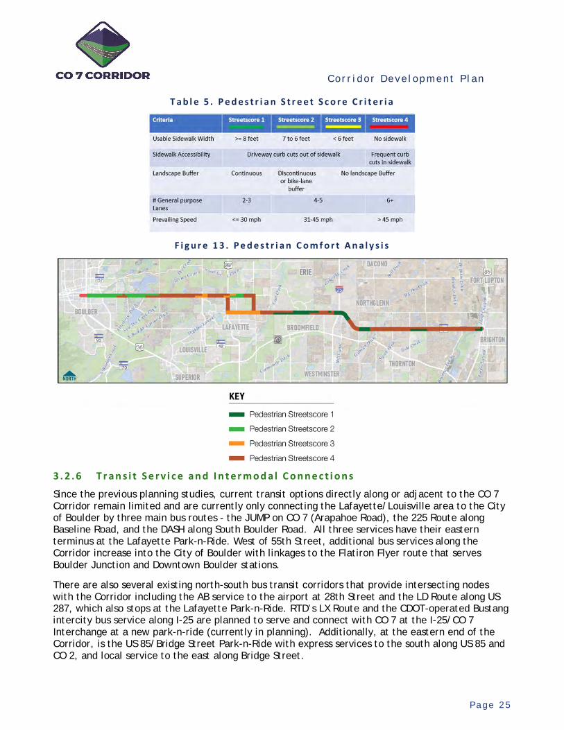
Cor r i dor Deve lopment P l an
P a g e 2 5
T a b l e 5 . P e d e s t r i a n S t r e e t S c o r e C r i t e r i a
F i g u r e 1 3 . P e d e s t r i a n C o m f o r t A n a l y s i s
3 . 2 . 6 T r a n s i t S e r v i c e a n d I n t e r m o d a l C o n n e c t i o n s
Since the previous planning studies, current transit options directly along or adjacent to the CO 7 Corridor remain limited and are currently only connecting the Lafayette/Louisville area to the City of Boulder by three main bus routes - the JUMP on CO 7 (Arapahoe Road), the 225 Route along Baseline Road, and the DASH along South Boulder Road. All three services have their eastern terminus at the Lafayette Park-n-Ride. West of 55th Street, additional bus services along the Corridor increase into the City of Boulder with linkages to the Flatiron Flyer route that serves Boulder Junction and Downtown Boulder stations.
There are also several existing north-south bus transit corridors that provide intersecting nodes with the Corridor including the AB service to the airport at 28th Street and the LD Route along US 287, which also stops at the Lafayette Park-n-Ride. RTD’s LX Route and the CDOT-operated Bustang intercity bus service along I-25 are planned to serve and connect with CO 7 at the I-25/CO 7 Interchange at a new park-n-ride (currently in planning). Additionally, at the eastern end of the Corridor, is the US 85/Bridge Street Park-n-Ride with express services to the south along US 85 and CO 2, and local service to the east along Bridge Street.
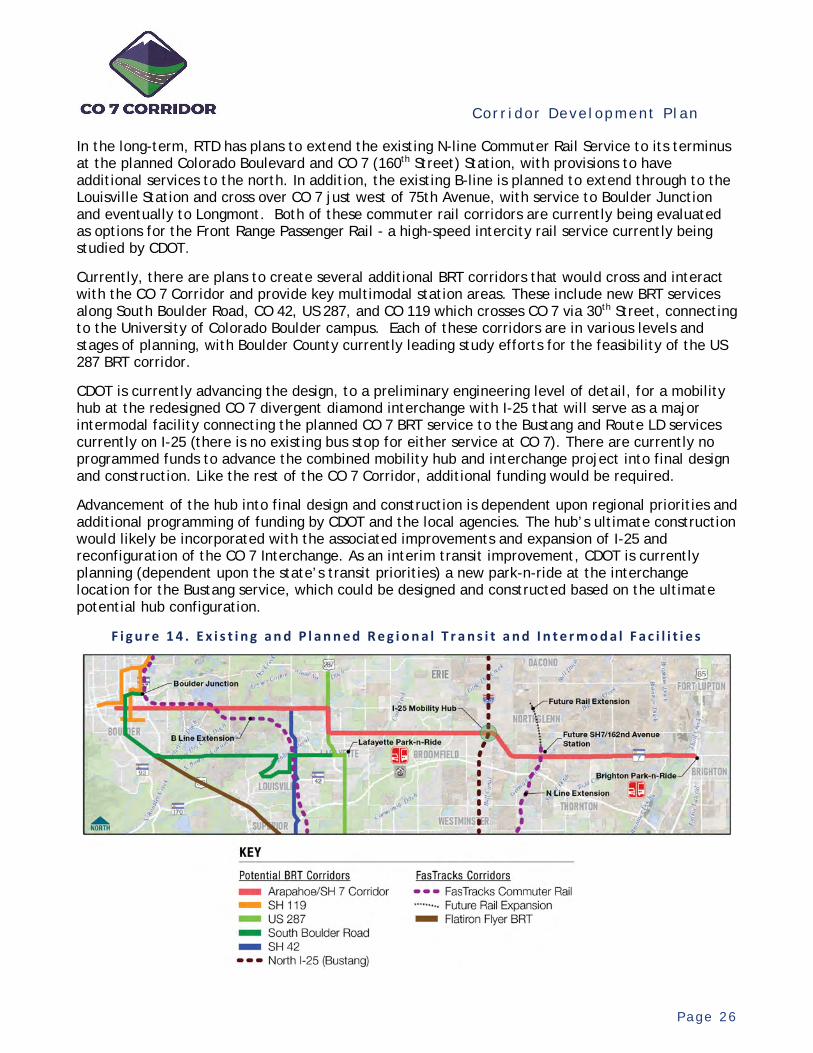
Cor r i dor Deve lopment P l an
P a g e 2 6
In the long-term, RTD has plans to extend the existing N-line Commuter Rail Service to its terminus at the planned Colorado Boulevard and CO 7 (160th Street) Station, with provisions to have additional services to the north. In addition, the existing B-line is planned to extend through to the Louisville Station and cross over CO 7 just west of 75th Avenue, with service to Boulder Junction and eventually to Longmont. Both of these commuter rail corridors are currently being evaluated as options for the Front Range Passenger Rail - a high-speed intercity rail service currently being studied by CDOT.
Currently, there are plans to create several additional BRT corridors that would cross and interact with the CO 7 Corridor and provide key multimodal station areas. These include new BRT services along South Boulder Road, CO 42, US 287, and CO 119 which crosses CO 7 via 30th Street, connecting to the University of Colorado Boulder campus. Each of these corridors are in various levels and stages of planning, with Boulder County currently leading study efforts for the feasibility of the US 287 BRT corridor.
CDOT is currently advancing the design, to a preliminary engineering level of detail, for a mobility hub at the redesigned CO 7 divergent diamond interchange with I-25 that will serve as a major intermodal facility connecting the planned CO 7 BRT service to the Bustang and Route LD services currently on I-25 (there is no existing bus stop for either service at CO 7). There are currently no programmed funds to advance the combined mobility hub and interchange project into final design and construction. Like the rest of the CO 7 Corridor, additional funding would be required.
Advancement of the hub into final design and construction is dependent upon regional priorities and additional programming of funding by CDOT and the local agencies. The hub’s ultimate construction would likely be incorporated with the associated improvements and expansion of I-25 and reconfiguration of the CO 7 Interchange. As an interim transit improvement, CDOT is currently planning (dependent upon the state’s transit priorities) a new park-n-ride at the interchange location for the Bustang service, which could be designed and constructed based on the ultimate potential hub configuration.
F i g u r e 1 4 . E x i s t i n g a n d P l a n n e d R e g i o n a l T r a n s i t a n d I n t e r m o d a l F a c i l i t i e s
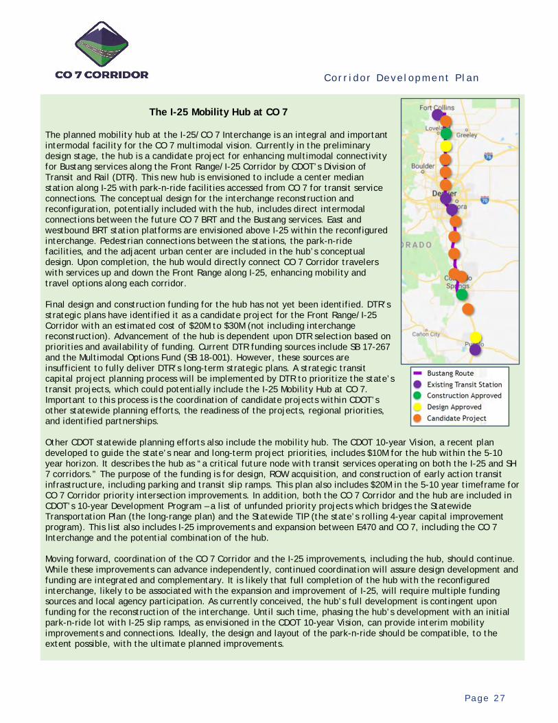
Cor r i dor Deve lopment P l an
P a g e 2 7
The I-25 Mobility Hub at CO 7
The planned mobility hub at the I-25/CO 7 Interchange is an integral and important intermodal facility for the CO 7 multimodal vision. Currently in the preliminary design stage, the hub is a candidate project for enhancing multimodal connectivity for Bustang services along the Front Range/I-25 Corridor by CDOT’s Division of Transit and Rail (DTR). This new hub is envisioned to include a center median station along I-25 with park-n-ride facilities accessed from CO 7 for transit service connections. The conceptual design for the interchange reconstruction and reconfiguration, potentially included with the hub, includes direct intermodal connections between the future CO 7 BRT and the Bustang services. East and westbound BRT station platforms are envisioned above I-25 within the reconfigured interchange. Pedestrian connections between the stations, the park-n-ride facilities, and the adjacent urban center are included in the hub’s conceptual design. Upon completion, the hub would directly connect CO 7 Corridor travelers with services up and down the Front Range along I-25, enhancing mobility and travel options along each corridor. Final design and construction funding for the hub has not yet been identified. DTR’s strategic plans have identified it as a candidate project for the Front Range/I-25 Corridor with an estimated cost of $20M to $30M (not including interchange reconstruction). Advancement of the hub is dependent upon DTR selection based on priorities and availability of funding. Current DTR funding sources include SB 17-267 and the Multimodal Options Fund (SB 18-001). However, these sources are insufficient to fully deliver DTR’s long-term strategic plans. A strategic transit capital project planning process will be implemented by DTR to prioritize the state’s transit projects, which could potentially include the I-25 Mobility Hub at CO 7. Important to this process is the coordination of candidate projects within CDOT’s other statewide planning efforts, the readiness of the projects, regional priorities, and identified partnerships. Other CDOT statewide planning efforts also include the mobility hub. The CDOT 10-year Vision, a recent plan developed to guide the state’s near and long-term project priorities, includes $10M for the hub within the 5-10 year horizon. It describes the hub as “a critical future node with transit services operating on both the I-25 and SH 7 corridors.” The purpose of the funding is for design, ROW acquisition, and construction of early action transit infrastructure, including parking and transit slip ramps. This plan also includes $20M in the 5-10 year timeframe for CO 7 Corridor priority intersection improvements. In addition, both the CO 7 Corridor and the hub are included in CDOT’s 10-year Development Program – a list of unfunded priority projects which bridges the Statewide Transportation Plan (the long-range plan) and the Statewide TIP (the state’s rolling 4-year capital improvement program). This list also includes I-25 improvements and expansion between E470 and CO 7, including the CO 7 Interchange and the potential combination of the hub. Moving forward, coordination of the CO 7 Corridor and the I-25 improvements, including the hub, should continue. While these improvements can advance independently, continued coordination will assure design development and funding are integrated and complementary. It is likely that full completion of the hub with the reconfigured interchange, likely to be associated with the expansion and improvement of I-25, will require multiple funding sources and local agency participation. As currently conceived, the hub’s full development is contingent upon funding for the reconstruction of the interchange. Until such time, phasing the hub’s development with an initial park-n-ride lot with I-25 slip ramps, as envisioned in the CDOT 10-year Vision, can provide interim mobility improvements and connections. Ideally, the design and layout of the park-n-ride should be compatible, to the extent possible, with the ultimate planned improvements.
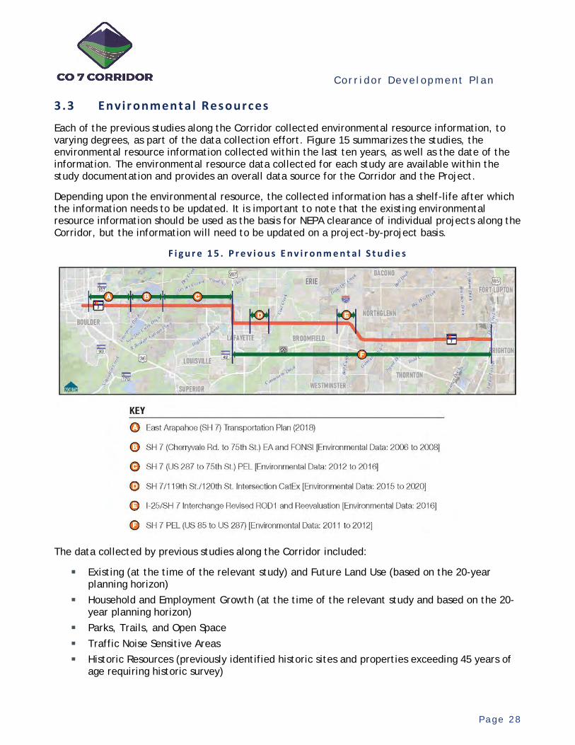
Cor r i dor Deve lopment P l an
P a g e 2 8
3.3 Envir onment al Res ources
Each of the previous studies along the Corridor collected environmental resource information, to varying degrees, as part of the data collection effort. Figure 15 summarizes the studies, the environmental resource information collected within the last ten years, as well as the date of the information. The environmental resource data collected for each study are available within the study documentation and provides an overall data source for the Corridor and the Project.
Depending upon the environmental resource, the collected information has a shelf-life after which the information needs to be updated. It is important to note that the existing environmental resource information should be used as the basis for NEPA clearance of individual projects along the Corridor, but the information will need to be updated on a project-by-project basis.
F i g u r e 1 5 . P r e v i o u s E n v i r o n m e n t a l S t u d i e s
The data collected by previous studies along the Corridor included:
Existing (at the time of the relevant study) and Future Land Use (based on the 20-year planning horizon)
Household and Employment Growth (at the time of the relevant study and based on the 20-year planning horizon)
Parks, Trails, and Open Space Traffic Noise Sensitive Areas Historic Resources (previously identified historic sites and properties exceeding 45 years of
age requiring historic survey)
Cor r i dor Deve lopment P l an
P a g e 2 9
Floodways and 100-year Floodplains Wetlands and Other Waters of the U.S. Wildlife Corridors Threatened and Endangered Species Habitat Special Status Species (Migratory Birds and State Listed Species) Noxious Weeds Properties with known or potential hazardous material concerns Known Coal Mine Facilities Oil and Gas Facilities
Information that is considered a changed condition for the purpose of this CDP and could have an effect on the Proposed Actions includes:
Household and Employment Growth (2020 and 2050), Parks, open space, and trails, and Oil and gas facilities.
These resources included household and employment growth (2020 and 2050) due to the amount of development that has occurred over the last ten years and planned development to occur over the next 30 years along with the consequent effect to traffic operations, transit, and bicycle and pedestrian facilities; parks, open space, and trails that have continued to be designated or developed over the last ten years; and the on-going development of oil and gas wells and associated facilities along the corridor. The remaining environmental data collected as part of the previous planning studies are still relevant for the purpose of the Proposed Actions; however, this information would be updated during future NEPA analysis and final engineering design and not updated at this time. Depending upon the specific environmental resource, the data collected has a shelf-life. For example, a delineation of wetlands and other waters of the U.S. must be updated after five years. This information should be updated during the future NEPA analysis.
Cor r i dor Deve lopment P l an
P a g e 3 0
4. Project Development Process
Based on the previous studies, the Project is the next step in advancing the improvement recommendations. It entails the more detailed design development of the Corridor's improvements through additional study and conceptual design of unresolved planning issues and preliminary engineering and environmental analyses.
4.1 Proposed Act ion Framewor k
Elements of the Project to advance into more detailed development include “Proposed Actions” which comprise logical and functional components of the Corridor’s improvements. Each Proposed Action, which represent elements of the Project to be constructed when fully funded, need to advance in compliance with NEPA guidance. Previous planning study recommendations provide the framework for defining the scope, limits, and purpose of each Proposed Action. This framework enables the identification of the potential Proposed Actions for consideration of inclusion within the Project.
To disaggregate the Corridor’s recommended improvements into separate, independent, and coordinated components (i.e., Proposed Actions), which combined comprise the full Corridor vision, Section of Independent Utility (SIU) criteria should be used. These criteria ensure decisions or preliminary designs, with associated environmental analyses, in one Proposed Action do not have unacceptable impacts on adjoining sections. Adjoining sections can be combined for efficiencies.
The scope, limits, and purpose of each Proposed Action are based on the following SIU criteria:
Purpose and Need – Provide local application of the Corridor’s Purpose and Need, as defined by the previous planning studies.
Logical and Independent Utility – The termini or limits of the Proposed Action need to provide independent function, use, and utility.
Range of Issues – Based on the type of Proposed Action, the scope and limits need to fully encompass either the identified unresolved planning issues or the remaining design issues, based on the previous planning studies.
Environmental Resource Impacts – Proposed Action termini need to avoid the potential bifurcation or fragmentation of impacts to relevant environmental resources, including cumulative impact considerations.
In review of the environmental setting, including changes since the completion of previous planning studies, and the Corridor improvement recommendations, minimum SIU have been identified to frame and advance the Project. These definitions represent the minimally acceptable disaggregation of the Corridor’s improvements for advancement, pursuant with the SIU criteria. As shown in Figure 16 and Table 6, the types of Proposed Actions include planning studies and preliminary engineering and environmental analysis.

Cor r i dor Deve lopment P l an
P a g e 3 1
F i g u r e 1 6 . M i n i m u m S e c t i o n s o f I n d e p e n d e n t U t i l i t y ( S I U ) f o r t h e C O 7 C o r r i d o r
T a b l e 6 . C O 7 C o r r i d o r M i n i m u m S e c t i o n s o f I n d e p e n d e n t U t i l i t y ( S I U )
SIU Limits (Termini)
Study PE Comment From To
A 28th Street 64th Street X B 64th Street US 287 (North) X X Concept study is needed for scope of BRT busway. C US 287 (North) 119th Street
X This section is located along Arapahoe Road and 119th Street and would entail conceptual study and design.
D 119th Street County Line Road NA This section is currently in the design phase and
planned for construction – not included in Project. E County Line
Road Sheridan Parkway X
F Sheridan Parkway
I-25 (West Ramp) X Interim roadway widening and intersection
improvements are currently in design for this SIU. G I-25 (West
Ramp) I-25 (East
Ramp) NA The I-25 Mobility Hub is currently in planning and conceptual design and is not included in the Project.
H I-25 (East Ramp) York Street X I York Street Holly Street X J Holly Street Quebec Street X K Quebec Street Yosemite Street X L Yosemite Street Riverdale Road X M Riverdale Road US 85 X

Cor r i dor Deve lopment P l an
P a g e 3 2
As shown, potential Proposed Actions include multimodal sections of the Corridor, all major intersections, existing bridges, and planned BRT stations. Application of the SIU criteria defines the multimodal sections, with each extending between two major intersections as section termini. Each identified SIU would include all infrastructure elements, such as intersections and bridges, within its limits. All major intersections, due to their independent function and utility, also satisfy the SIU criteria and can be considered as standalone actions. Similarly, each major bridge can advance as an independent Proposed Action. While having independent utility, pursuant to the BRT Implementation Playbook, the advancement of each planned bus station into engineering design would need to be associated with the overall preliminary engineering for an initial BRT project. Therefore, preliminary engineering for stations is not included as a potential Proposed Action. However, continued planning and conceptual design for unresolved station planning issues are a potential Proposed Action.
Thirteen separate multimodal SIUs have been identified within the Corridor. Several of these, including SIU B and SIU C, require additional more-detailed study to determine the general concept and scope of the recommended improvements. Others, including SIU D and SIU G, are not included in the Project. All other SIUs would entail preliminary engineering of the multimodal recommendations from the previous studies. Additional comments and clarifications for the atypical SIU include the following:
SIU B (64th Street to US 287 (North)) – A concept study for this SIU is needed to define the recommended transit concept, configuration, and multimodal roadway section. Following the study, the recommended improvements can advance into preliminary engineering as a complete SIU or as individual components within the section.
SIU C (US 287 (North) to 119th Street) – The earlier planning study for this section identified an alternate local street network recommendation within the City of Lafayette. As it relates to CO 7, this recommendation would entail the multimodal improvement of the Arapahoe Road and 119th Street routes north of CO 7. This recommendation would not realign or redesignate CO 7 but would improve the local street network to relieve traffic-related needs along CO 7 within the City and provide bicycle and pedestrian connectivity. As shown, this SIU therefore includes the conceptual study and design of multimodal improvements along Arapahoe Road and 119th Street – the scope and content of these improvements being undefined by the earlier study. Following the SIU C study, the advancement of its recommendations into preliminary engineering would be subject to additional coordination between CDOT and the local agencies and is not included in the Project. While the Project’s scope of work for this SIU would be along the alternate route, the earlier study’s recommendations did include sidewalk and roadway standard upgrades directly along CO 7. These improvements directly along CO 7 should be advanced by the City of Lafayette, in coordination with CDOT, and would be independent of the Project.
SIU D (119th Street to County Line Road) – This section is currently under design as two connected and coordinated intersection improvement projects – 119th Street and the relocated County Line Road. As such, this SIU is not included in the Project. It is recommended that these ongoing designs include considerations of the ultimate multimodal recommendations within this section.
SIU F (Sheridan Parkway to I-25) – Within this section, CDOT and the City and County of Broomfield are currently coordinating an Interagency Agreement for interim roadway widening and intersection improvements. This section is included in the Project and would entail the preliminary engineering of the ultimate multimodal improvements in coordination with the interim improvements.
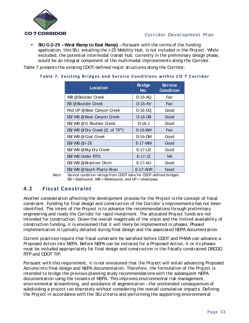
Cor r i dor Deve lopment P l an
P a g e 3 3
SIU G (I-25 – West Ramp to East Ramp) – Pursuant with the terms of the funding application, this SIU, entailing the I-25 Mobility Hub, is not included in the Project. While excluded, the potential intermodal transit hub, currently in the preliminary design phase, would be an integral component of the multimodal improvements along the Corridor.
Table 7 presents the existing CDOT-defined major structures along the Corridor:
T a b l e 7 . E x i s t i n g B r i d g e s a n d S e r v i c e C o n d i t i o n s w i t h i n C O 7 C o r r i d o r
Location Bridge No.
Service Condition
WB @ Boulder Creek D-15-AQ Fair
EB @ Boulder Creek D-15-AV Fair
Ped UP @ Bear Canyon Creek D-16-DQ Good
EB/WB @ Bear Canyon Creek D-16-DB Good
EB/WB @ S. Boulder Creek D-16-J Good
EB/WB @ Dry Creek (E. of 75th) D-16-BW Fair
EB/WB @ Coal Creek D-16-DM Good
EB/WB @ I-25 E-17-MW Good
EB/WB @ Big Dry Creek E-17-UZ Good
EB/WB Under RTD E-17-JZ NA
EB/WB @ Brantner Ditch E-17-AU Good
EB/WB @ South Platte River E-17-ADR Good Note: Service condition ratings from CDOT data for CDOT-defined bridges
EB = Eastbound, WB = Westbound, and UP = Underpass
4.2 Fis ca l Constra int
Another consideration affecting the development process for the Project is the concept of fiscal constraint. Funding for final design and construction of the Corridor’s improvements has not been identified. The intent of the Project is to advance the recommendations through preliminary engineering and ready the Corridor for rapid investment. The allocated Project funds are not intended for construction. Given the overall magnitude of the vision and the limited availability of construction funding, it is envisioned that it will likely be implemented in phases. Phased implementation is typically detailed during final design and the associated NEPA documentation.
Current practices require that fiscal constraint be satisfied before CDOT and FHWA can advance a Proposed Action into NEPA. Before NEPA can be initiated for a Proposed Action, it or its phases must be included appropriately for final design and construction in the fiscally constrained DRCOG RTP and CDOT TIP.
Pursuant with this requirement, it is not envisioned that the Project will entail advancing Proposed Actions into final design and NEPA documentation. Therefore, the formulation of the Project is intended to bridge the previous planning study recommendations with the subsequent NEPA documentation using the tenants of NEPA. This improves environmental risk management, environmental streamlining, and avoidance of segmentation – the unintended consequences of subdividing a project too discretely without considering the overall cumulative impacts. Defining the Project in accordance with the SIU criteria and performing the supporting environmental
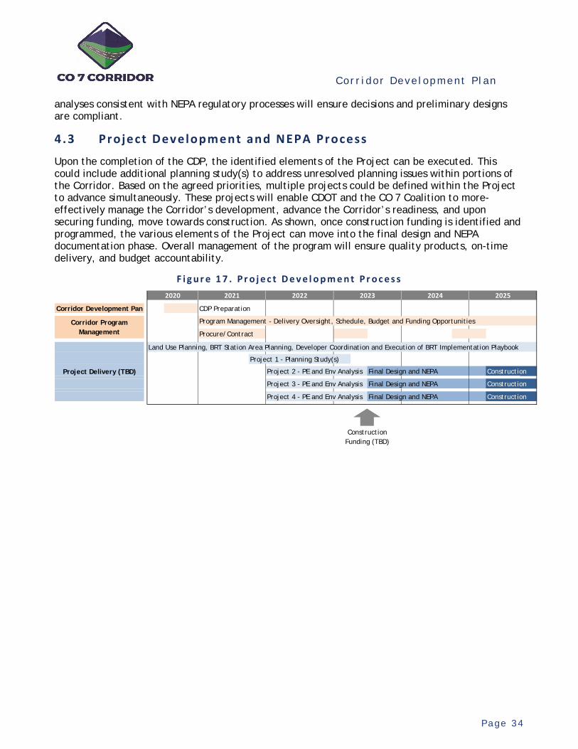
Cor r i dor Deve lopment P l an
P a g e 3 4
analyses consistent with NEPA regulatory processes will ensure decisions and preliminary designs are compliant.
4.3 Project Development and NEPA Process
Upon the completion of the CDP, the identified elements of the Project can be executed. This could include additional planning study(s) to address unresolved planning issues within portions of the Corridor. Based on the agreed priorities, multiple projects could be defined within the Project to advance simultaneously. These projects will enable CDOT and the CO 7 Coalition to more-effectively manage the Corridor’s development, advance the Corridor’s readiness, and upon securing funding, move towards construction. As shown, once construction funding is identified and programmed, the various elements of the Project can move into the final design and NEPA documentation phase. Overall management of the program will ensure quality products, on-time delivery, and budget accountability.
F i g u r e 1 7 . P r o j e c t D e v e l o p m e n t P r o c e s s
CDP Preparation
Program Management - Delivery Oversight, Schedule, Budget and Funding Opportunities
Procure/Contract
Land Use Planning, BRT Station Area Planning, Developer Coordination and Execution of BRT Implementation Playbook
Project 1 - Planning Study(s)
Project 2 - PE and Env Analysis Final Design and NEPA Construction
Project 3 - PE and Env Analysis Final Design and NEPA Construction
Project 4 - PE and Env Analysis Final Design and NEPA Construction
2025
Corridor Program Management
2024
Construction Funding (TBD)
Project Delivery (TBD)
Corridor Development Pan
2020 2021 2022 2023
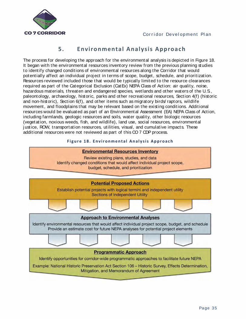
Cor r i dor Deve lopment P l an
P a g e 3 5
5. Environmental Analysis Approach
The process for developing the approach for the environmental analysis is depicted in Figure 18. It began with the environmental resources inventory review from the previous planning studies to identify changed conditions of environmental resources along the Corridor that would potentially affect an individual project in terms of scope, budget, schedule, and prioritization. Resources reviewed included those that would be typically limited to the resource clearances required as part of the Categorical Exclusion (CatEx) NEPA Class of Action: air quality, noise, hazardous materials, threaten and endangered species, wetlands and other waters of the U.S., paleontology, archaeology, historic, parks and other recreational resources, Section 4(f) (historic and non-historic), Section 6(f), and other items such as migratory birds/raptors, wildlife movement, and floodplains that may be relevant based on the existing conditions. Additional resources would be evaluated as part of an Environmental Assessment (EA) NEPA Class of Action, including farmlands, geologic resources and soils, water quality, other biologic resources (vegetation, noxious weeds, fish, and wildlife), land use, social resources, environmental justice, ROW, transportation resources, utilities, visual, and cumulative impacts. These additional resources were not reviewed as part of this CO 7 CDP process.
F i g u r e 1 8 . E n v i r o n m e n t a l A n a l y s i s A p p r o a c h
Cor r i dor Deve lopment P l an
P a g e 3 6
Based on the available information from the previous planning studies, as updated, the environmental resources were evaluated with the potential Proposed Actions to identify key resources that could affect the preliminary engineering and design. Because the Project does not include the initiation of NEPA, the recommended environmental approach is to provide the necessary and supporting environmental analyses for the preliminary engineering and design in compliance with NEPA processes to streamline the subsequent environmental documentation to be conducted later for final design and construction. These analyses will entail 1) coordination of all relevant resources and 2) additional study and assessment for those key resources that could affect the preliminary design. Additional environmental analysis will be required as part of any future NEPA analysis and documentation.
The environmental resources that present the greatest risk to a Proposed Action in terms of scope, budget, schedule, and potential design impacts include:
Traffic Noise – The unexpected addition of noise mitigation to a project can be costly for the design and construction of the noise mitigation, which can lead to delays and budget concerns, and can impact ROW requirements.
Historic – Properties adjacent to and within the project area that include structures greater than 40 years of age will need to be surveyed for their eligibility for inclusion on the National Register of Historic Places (NRHP). Typically, properties greater than 45 years of age are surveyed for their eligibility to account for the time necessary for the NEPA process, preliminary and final engineering design, as well as the potential acquisition of property for ROW. Due to the long-term implementation of this CDP, structures greater than 40 years of age will be surveyed to account for additional time for project development. The Section 106 consultation process with the State Historic Preservation Officer (SHPO) and Section 4(f) process, if an adverse effects determination is made, can typically take approximately one year to complete. The Section 4(f) process requires avoidance, minimization, and mitigation of impacts to Section 4(f) resources, which can affect engineering design and project prioritization.
Parks, Trails and Open Space – Publicly owned parks and recreational facilities are afforded protection under Section 4(f). The Section 4(f) process depends on the type of transportation use and acceptance by the local agency Parks and Open Space Department (Official with Jurisdiction). The Section 4(f) process can typically take approximately six months to complete and affect the project in terms of scope, schedule, as well as engineering design and project prioritization. Properties that have received Land and Water Conservation Fund Act funds are protected under Section 6(f) and require coordination with the affected local agency, as well as approval from the Colorado Parks and Wildlife (CPW) and National Parks Service (NPS) to convert Section 6(f) assisted land for transportation improvements. The Section 6(f) process can typically take approximately six months to one year to complete affect the project in terms of scope, schedule, as well as engineering design and project prioritization.

Cor r i dor Deve lopment P l an
P a g e 3 7
Consequently, the following environmental analyses are to be included with the Project to support the preliminary engineering design of the Proposed Actions and to facilitate future NEPA analyses and documentation:
Corridor Management – Coordinate with the project teams, local agencies, CDOT, and FHWA, as necessary, during preliminary engineering design of the Proposed Actions to avoid, minimize, and mitigate potential environmental impacts and to facilitate future NEPA analyses.
Traffic Noise – Conduct a Type I noise analysis for the Corridor to identify noise mitigation requirements for inclusion into preliminary engineering due to the addition of a through-lane. This includes the addition of a through-traffic lane, that functions as a bus lane. Type I projects are defined by 23 CFR 772.5, and CDOT guidance is provided in the 2020 Noise Analysis and Abatement Guidelines. The Type I noise analysis will identify existing and future noise conditions and noise sensitive receptors and will evaluate impacts and potential noise mitigation for inclusion in preliminary and final engineering design and construction cost estimates.
Historic Survey – Prepare an area of potential affect (APE) based on conceptual design project area and conduct a survey of properties within the APE that include structures greater than 40 years of age for the Corridor to identify eligible and potentially-eligible properties for the NRHP. Consultation with SHPO in accordance with Section 106 will be conducted by CDOT.
Parks, Trails and Open Space – Review parks, open space, and trails along the Corridor to identify Section 4(f) and Section 6(f) properties; coordinate with the preliminary design for any necessary design alternatives analyses to avoid and minimize impacts; and develop a potential mitigation strategy, as needed, for potentially impacted sites.
The following table summarizes the recommended environmental approach for other environmental resources during future NEPA.
T a b l e 8 . R e c o m m e n d e d E n v i r o n m e n t a l A p p r o a c h D u r i n g F u t u r e N E P A A n a l y s i s
Env. Resource
SIU Notes
A B C D E F G H I J K L M Air Quality Regional Conformity
X X X X X X X X X X X X X The RTP and the current TIP are the adopted fiscally-constrained air-quality-conforming plan and program for DRCOG. Federally funded projects need to be included in the current RTP and TIP before a NEPA decision document can be signed.
Air Quality Local Conformity
X X X X X X X X X X X X X Local conformity is demonstrated by assessing whether future traffic conditions may cause an exceedance of a National Ambient Air Quality Standard (NAAQS) on a smaller basis. The proposed project must not lead to violations of a NAAQS.
Hazardous Materials
X X X X X Properties to be acquired will require a site-specific Phase I Environmental Site Assessment (ESA) or Initial Site Assessment (ISA) with an updated search of environmental databases as part of the ROW acquisition process. Contamination from hazardous materials is most likely to be encountered during ground-disturbing activities in areas near properties with potential or recognized environmental conditions (hazardous materials). During the design process, the information
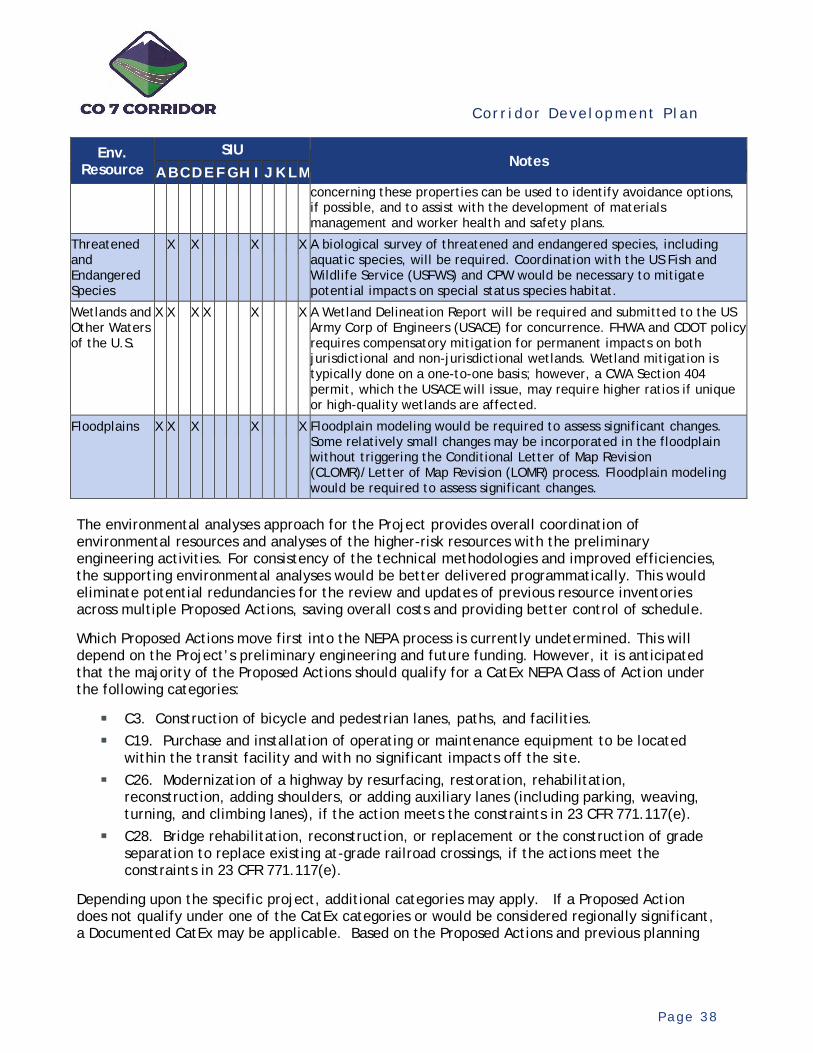
Cor r i dor Deve lopment P l an
P a g e 3 8
Env. Resource
SIU Notes
A B C D E F G H I J K L M concerning these properties can be used to identify avoidance options, if possible, and to assist with the development of materials management and worker health and safety plans.
Threatened and Endangered Species
X X X X A biological survey of threatened and endangered species, including aquatic species, will be required. Coordination with the US Fish and Wildlife Service (USFWS) and CPW would be necessary to mitigate potential impacts on special status species habitat.
Wetlands and Other Waters of the U.S.
X X X X X X A Wetland Delineation Report will be required and submitted to the US Army Corp of Engineers (USACE) for concurrence. FHWA and CDOT policy requires compensatory mitigation for permanent impacts on both jurisdictional and non-jurisdictional wetlands. Wetland mitigation is typically done on a one-to-one basis; however, a CWA Section 404 permit, which the USACE will issue, may require higher ratios if unique or high-quality wetlands are affected.
Floodplains X X X X X Floodplain modeling would be required to assess significant changes. Some relatively small changes may be incorporated in the floodplain without triggering the Conditional Letter of Map Revision (CLOMR)/Letter of Map Revision (LOMR) process. Floodplain modeling would be required to assess significant changes.
The environmental analyses approach for the Project provides overall coordination of environmental resources and analyses of the higher-risk resources with the preliminary engineering activities. For consistency of the technical methodologies and improved efficiencies, the supporting environmental analyses would be better delivered programmatically. This would eliminate potential redundancies for the review and updates of previous resource inventories across multiple Proposed Actions, saving overall costs and providing better control of schedule.
Which Proposed Actions move first into the NEPA process is currently undetermined. This will depend on the Project’s preliminary engineering and future funding. However, it is anticipated that the majority of the Proposed Actions should qualify for a CatEx NEPA Class of Action under the following categories:
C3. Construction of bicycle and pedestrian lanes, paths, and facilities. C19. Purchase and installation of operating or maintenance equipment to be located
within the transit facility and with no significant impacts off the site. C26. Modernization of a highway by resurfacing, restoration, rehabilitation,
reconstruction, adding shoulders, or adding auxiliary lanes (including parking, weaving, turning, and climbing lanes), if the action meets the constraints in 23 CFR 771.117(e).
C28. Bridge rehabilitation, reconstruction, or replacement or the construction of grade separation to replace existing at-grade railroad crossings, if the actions meet the constraints in 23 CFR 771.117(e).
Depending upon the specific project, additional categories may apply. If a Proposed Action does not qualify under one of the CatEx categories or would be considered regionally significant, a Documented CatEx may be applicable. Based on the Proposed Actions and previous planning
Cor r i dor Deve lopment P l an
P a g e 3 9
studies, an EA NEPA Class of Action is not expected at this time. One exception could include the BRT Preliminary Engineering Project, depending on the specifics and scope of the project.
The final determination of the NEPA Class of Action will be made by CDOT, FHWA, and FTA, as appropriate.
Cor r i dor Deve lopment P l an
P a g e 4 0
6. Project Technical Methodologies
6 .1 Design Methods Appr oach
The methods for preparing preliminary engineering and plans, with associated environmental analysis, need to be defined. These methods can vary within the Corridor, depending on the findings of the CDP. Through a prioritization process in coordination with the TAC, the CDP will define the Project and identify which elements of the Corridor’s improvements will advance into preliminary design and to what level of detail. The scope and limits of the priority elements for preliminary engineering will be based on the SIU definitions for the Corridor.
A material issue to this prioritization process is identifying the desired methods to be utilized in the Project’s execution. This is important to identify programmatic opportunities for economies of scale and efficiencies; to identify the intent of the design to position the element for rapid investment as desired; and to optimize the use of the Project’s budget to equitably advance as much of the Corridor as desired.
The design methods consist of the technical basis for the data collection, investigations, engineering and environmental analyses, engineering design, and plan production which comprise preliminary engineering. For the purposes of preparing the CDP, two general levels of detail have been identified for each component of the Corridor’s multimodal improvements – Multimodal Roadway Section, Major Intersection and Bridge Crossing. Level II reflects the prescriptive CDOT milestone of Field Inspection Review (FIR) Plans, roughly estimated as 30% plans. This level reflects the highest degree of detail (design and plan production) for preliminary design. As an option, a lower level of detail (Level I) could be prepared to reduce the costs of the preliminary engineering. Level I would stretch the Project funding farther but would not advance and prepare the Corridor as far for rapid investment. Each level would include supporting environmental analysis, would provide ROW information for preservation activities, and would identify utilities, but at varying levels of detail and precision. Construction cost estimates would be provided for each for programming the improvements.
6.2 Programmatic Des ign Methods
Depending on the delivery plan for the Project, it may be more efficient and beneficial to perform some of the technical and supporting activities programmatically. Candidate activities are those that would be more efficient to be performed across the full Project, in lieu of being performed repetitively within each element of the Project. An additional benefit, beyond cost, schedule, and administrative efficiencies, is the assurance of technical consistency across the Project.
In coordination with CDOT and the TAC, several items were identified which would benefit from centralized oversight and delivery. These items either reduce redundancies within the Proposed Actions, thereby being more efficient and saving costs, or are overall Corridor-wide products that would guide and inform the preliminary design activities for consistency.

Cor r i dor Deve lopment P l an
P a g e 4 1
T a b l e 9 . P r o g r a m m a t i c P r e l i m i n a r y D e s i g n I t e m s
Item Description Comments
Aerial/Lidar Mapping
Provide Corridor-wide design level aerial photography, Lidar and supporting target control surveys for cloud-based topography data collection.
More cost efficient to acquire aerial photomosaics and digital ground database for full corridor.
Corridor Systems Planning Tool and Traffic Forecasts
Develop a corridor systems planning tool and dataset for land use and planning-level demand forecasting that can be administered and utilized by CDOT and the CO 7 Coalition in their ongoing land use and transit planning activities and develop design horizon traffic projections for preliminary engineering.
Travel demand forecasts are needed for preliminary design of Proposed Actions and provide consistency and cost savings. Tool can be used by the CO 7 Coalition for the administration and management of the Corridor.
Environmental Analyses and Coordination
Perform environmental inventory and analyses pursuant with the CDP and coordinate resource issues with preliminary design activities.
Single source environmental search and analyses removes potential redundancies between the Proposed Action environmental activities.
Technology Deployment
Plan
Develop a Smart Technology plan for the Corridor to identify design details and treatments to be included in the preliminary engineering considering emerging AV/CV Technologies and traveler communications infrastructure.
This plan provides a standard communication infrastructure template for the design activities and better prepares the Corridor for long-term technology advances.
Corridor Bike Treatment Plan
Develop a Corridor-wide plan addressing bike facility connectivity, standards, and design details for inclusion in the preliminary engineering activities.
Common standards are needed for the preliminary design activities to assure Corridor-wide applications.
Strategic Communications
Provide Corridor-wide strategic communications including activities such as branding, CO 7 Coalition coordination, public official briefings, media coordination, Corridor-based communications, and coordination of public involvement.
Overall strategic direction is needed for the public involvement activities to be provided locally for each Proposed Action.
6.3 Proposed Act ion Des ign Methods
Optional design methodologies (Level I and Level II) and associated costs for preliminary engineering have been defined for the basic components of the Corridor’s improvements. These levels of design detail and costs are to be applied on a per unit basis to the priority elements of the Project, as selected by the CDP evaluation process. Applying these options variably enables the Project to be tailored to the desires of the TAC. Some elements of the Project, as desired, can be developed at a higher level of detail (Level II) for a higher degree of readiness and others at Level I to stretch the budget for more equity across the Corridor. For sections of the Project including multiple components, the costs would be aggregated for a total estimate of preliminary engineering.
Multimodal Roadway Section – Applied for the preliminary design of the multimodal roadway, bike, and pedestrian section along the Corridor on a per mile basis (see Table 10). For sections including major intersections or bridges, costs were included per the methodologies for those elements.
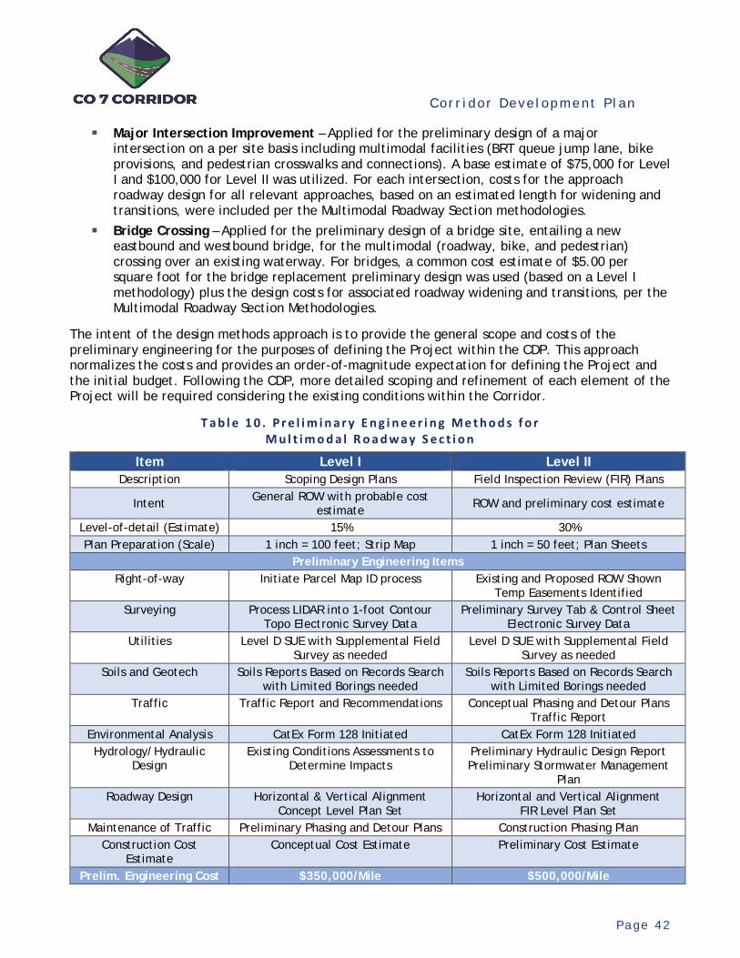
Cor r i dor Deve lopment P l an
P a g e 4 2
Major Intersection Improvement – Applied for the preliminary design of a major intersection on a per site basis including multimodal facilities (BRT queue jump lane, bike provisions, and pedestrian crosswalks and connections). A base estimate of $75,000 for Level I and $100,000 for Level II was utilized. For each intersection, costs for the approach roadway design for all relevant approaches, based on an estimated length for widening and transitions, were included per the Multimodal Roadway Section methodologies.
Bridge Crossing – Applied for the preliminary design of a bridge site, entailing a new eastbound and westbound bridge, for the multimodal (roadway, bike, and pedestrian) crossing over an existing waterway. For bridges, a common cost estimate of $5.00 per square foot for the bridge replacement preliminary design was used (based on a Level I methodology) plus the design costs for associated roadway widening and transitions, per the Multimodal Roadway Section Methodologies.
The intent of the design methods approach is to provide the general scope and costs of the preliminary engineering for the purposes of defining the Project within the CDP. This approach normalizes the costs and provides an order-of-magnitude expectation for defining the Project and the initial budget. Following the CDP, more detailed scoping and refinement of each element of the Project will be required considering the existing conditions within the Corridor.
T a b l e 1 0 . P r e l i m i n a r y E n g i n e e r i n g M e t h o d s f o r M u l t i m o d a l R o a d w a y S e c t i o n
Item Level I Level II Description Scoping Design Plans Field Inspection Review (FIR) Plans
Intent General ROW with probable cost estimate ROW and preliminary cost estimate
Level-of-detail (Estimate) 15% 30% Plan Preparation (Scale) 1 inch = 100 feet; Strip Map 1 inch = 50 feet; Plan Sheets
Preliminary Engineering Items Right-of-way Initiate Parcel Map ID process Existing and Proposed ROW Shown
Temp Easements Identified Surveying Process LIDAR into 1-foot Contour
Topo Electronic Survey Data Preliminary Survey Tab & Control Sheet
Electronic Survey Data Utilities Level D SUE with Supplemental Field
Survey as needed Level D SUE with Supplemental Field
Survey as needed Soils and Geotech Soils Reports Based on Records Search
with Limited Borings needed Soils Reports Based on Records Search
with Limited Borings needed Traffic Traffic Report and Recommendations Conceptual Phasing and Detour Plans
Traffic Report Environmental Analysis CatEx Form 128 Initiated CatEx Form 128 Initiated Hydrology/Hydraulic
Design Existing Conditions Assessments to
Determine Impacts Preliminary Hydraulic Design Report Preliminary Stormwater Management
Plan Roadway Design Horizontal & Vertical Alignment
Concept Level Plan Set Horizontal and Vertical Alignment
FIR Level Plan Set Maintenance of Traffic Preliminary Phasing and Detour Plans Construction Phasing Plan
Construction Cost Estimate
Conceptual Cost Estimate Preliminary Cost Estimate
Prelim. Engineering Cost $350,000/Mile $500,000/Mile
Cor r i dor Deve lopment P l an
P a g e 4 3
7. Proposed Actions
7 .1 Des cr ipt ion of Potent ia l Pr oposed Act ions
Working together with the TAC, a shortlist of potential Proposed Actions was identified for consideration and evaluation for the Project. These Proposed Actions were categorized into four identified uses, as follows:
Unresolved Planning Issues – Proposed Action would entail the more detailed study of unresolved issues remaining within the Corridor.
Advance Design Issues – Proposed Action would entail preliminary engineering and environmental analysis for an element of the Project, based on the prescribed minimum SIU definitions.
Right-of-way Acquisition – Acquire ROW to prepare the Corridor for construction of the ultimate improvements. The advanced identification of the necessary ROW would be dependent upon the completion of preliminary engineering and was therefore identified as to be determined (TBD).
Manage for Predictable Future – Proposed Action would facilitate the preparation and readiness of the Corridor for the advancement of the Project and subsequent final design and construction.
T a b l e 1 1 . P r o j e c t U s e C a t e g o r i e s a n d P o t e n t i a l P r o p o s e d A c t i o n s
Unresolved Planning Issues
Advance Design Issues (PE and Environmental
Analysis)
Right-of-way Acquisition
Manage for Predictable Future
• BRT Concept Study (64th Street to US 287)
• BRT Station Location (CR 7/Palisade)
• Selected Major Intersections
• Corridor Sections (All SIU identified in Figure 16 and Table 6)
• Selected Major Bridges • Left-turn Lanes
(Willow Creek/Park Lane)
TBD
• Erie Airport Entrance Road Concept Plan
For the evaluation and selection of the potential Proposed Actions, each action was considered as a discreet standalone action. This enabled each to be considered and assessed on its own merits and to provide flexibility for the selection process. As a result, there are scope redundancies between the various Proposed Actions. For example, an SIU (advancing the multimodal recommendations fully between intersections as defined in Figure 16 and Table 6) includes all infrastructure elements within its limits, yet those elements could also be considered as individual actions. Based on the results of the evaluation process, to the extent necessary, these redundancies were then reconciled within the final plan formulation.
While all major intersections could be standalone actions, a reasonable shortlist was developed for consideration. Based on discussions with the TAC and the supporting analyses for the current setting, the following major intersections (including their SIU location) were identified as potential Proposed Actions:
Cor r i dor Deve lopment P l an
P a g e 4 4
28th Street (SIU A) 30th Street (SIU A) 55th Street (SIU A) 63rd Street (SIU A) 95th Street (SIU B) US 287 (North) (SIU B) Lowell Blvd (SIU E)
Sheridan Pkwy (SIU E/F) CR 7/Palisade (SIU F) Washington Street (SIU H) 164th/166th Street (SIU H) York Street (SIU H/I) Colorado Blvd (SIU I) Holly Street (SIU I/J)
Quebec Street (SIU J/K) Yosemite Street (SIU K/L) Havana Street (SIU L) Riverdale Road (SIU L/M)
These major intersections represent standalone potential Proposed Actions. The CR 7 and Palisade intersections were combined into one intersection due to their close proximity and interaction. For the Colorado Boulevard intersection, the Proposed Action includes the existing intersection and the planned relocated route intersection to the east. This action would not include route studies for the realignment of Colorado Boulevard and would be based on the current and latest concept studies by RTD.
Based on discussions with the TAC and a cursory evaluation of potential funding, service condition, and compatibility with the Corridor vision, the following major bridges were identified as potential Proposed Actions:
Bridge over Boulder Creek (SIU A) Bridge over S. Boulder Creek (SIU A) Bridge over Dry Creek (SIU B) Bridge over Coal Creek (SIU E)
Bridge over Big Dry Creek (SIU I) Railroad Bridge over CO 7 (SIU I) Bridge over Brantner Ditch (SIU M) Bridge over South Platte River (SIU M)
Appendix B provides a listing of all identified potential Proposed Actions, including a description and a cost estimate for each.
7.2 Evaluat ion of Potent ia l Proposed Act ions
Each of the potential Proposed Actions was evaluated and compared according to its ability to fulfill the Project goals. For each, based on supporting analysis, a qualitative evaluation for Goal 1 through Goal 5 was performed to rate the Proposed Action. Conceptual-level analyses using readily available data and analyses and information from the previous planning studies provided the basis for the evaluations. Ratings were based on a subjective scale ranging from 3 - High, 2 – Medium, and 1 - Low. The resulting composite score, based on the average of the ratings for each goal, provided the basis for ranking each action into priority categories. Potential actions rated the highest were constrained by the available funding and included in the Project (Priority 1). Others were identified as later priorities (Priority 2) and will be advanced following the Project upon securing additional funding.
Following the rating, ranking, and priority categorization, an evaluation of the overall results was performed in fulfillment of Goal 6 (Provide Equity Across the Corridor). This entailed a review of the locations of the Priority 1 actions to assure they are equitably and appropriately distributed geographically across the Corridor. In addition, based on potential overlaps or redundancies within the potential actions, and in consideration of efficiencies, Priority 1 projects were repackaged accordingly. This repackaging resulted in a rebalancing of the actions within the priority categories, with the highest scoring actions in Priority 2 moving into the budget-constrained Priority 1
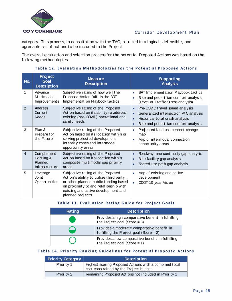
Cor r i dor Deve lopment P l an
P a g e 4 5
category. This process, in consultation with the TAC, resulted in a logical, defensible, and agreeable set of actions to be included in the Project.
The overall evaluation and selection process for the potential Proposed Actions was based on the following methodologies:
T a b l e 1 2 . E v a l u a t i o n M e t h o d o l o g i e s f o r t h e P o t e n t i a l P r o p o s e d A c t i o n s
No. Project
Goal Description
Measure Description
Supporting Analysis
1 Advance Multimodal Improvements
Subjective rating of how well the Proposed Action fulfills the BRT Implementation Playbook tactics
• BRT Implementation Playbook tactics • Bike and pedestrian comfort analysis
(Level of Traffic Stress analysis)
2 Address Current Needs
Subjective rating of the Proposed Action based on its ability to address existing (pre-COVID) operational and safety needs
• Pre-COVID travel speed analysis • Generalized intersection V/C analysis • Historical total crash analysis • Bike and pedestrian comfort analysis
3 Plan & Prepare for the Future
Subjective rating of the Proposed Action based on its location within or serving projected development intensity zones and intermodal opportunity areas
• Projected land use percent change map
• Map of intermodal connection opportunity areas
4 Complement Existing & Planned Infrastructure
Subjective rating of the Proposed Action based on its location within composite multimodal gap priority areas
• Roadway lane continuity gap analysis • Bike facility gap analysis • Shared-use path gap analysis
5 Leverage Joint Opportunities
Subjective rating of the Proposed Action’s ability to utilize third party or other planned public funding based on proximity to and relationship with existing and active development and planned projects
• Map of existing and active development
• CDOT 10-year Vision
T a b l e 1 3 . E v a l u a t i o n R a t i n g G u i d e f o r P r o j e c t G o a l s
Rating Description
Provides a high comparative benefit in fulfilling the Project goal (Score = 3)
Provides a moderate comparative benefit in fulfilling the Project goal (Score = 2)
Provides a low comparative benefit in fulfilling the Project goal (Score = 1)
T a b l e 1 4 . P r i o r i t y R a n k i n g G u i d e l i n e s f o r P o t e n t i a l P r o p o s e d A c t i o n s
Priority Category Description Priority 1 Highest scoring Proposed Actions with a combined total
cost constrained by the Project budget. Priority 2 Remaining Proposed Actions not included in Priority 1
●◒○
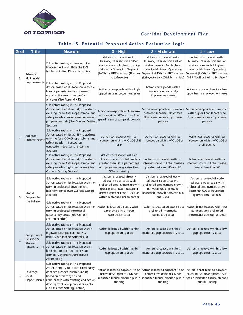
Cor r i dor Deve lopment P l an
P a g e 4 6
T a b l e 1 5 . P o t e n t i a l P r o p o s e d A c t i o n E v a l u a t i o n L o g i c
Goal Title Measure 3 - High 2 - Moderate 1 - Low
Subjective rating of how well the Proposed Action fulfills the BRT Implementation Playbook tactics
Action corresponds with busway, intersection and/or
station area in highest priority Minimum Operating Segment
(MOS) for BRT start-up (Boulder to Lafayette)
Action corresponds with busway, intersection and/or station area in 2nd highest priority Minimum Operating
Segment (MOS) for BRT start-up (Lafayette to I-25 Mobility Hub)
Action corresponds with busway, intersection and/or station area in 3rd highest priority Minimum Operating
Segment (MOS) for BRT start-up (I-25 Mobility Hub to Brighton)
Subjective rating of the Proposed Action based on its location within a bike or pedestrian improvement opportunity area from comfort analyses (See Appendix D)
Action corresponds with a high opportunity improvement area
Action corresponds with a moderate opportunity
improvement area
Action corresponds with a low opportunity improvement area
Subjective rating of the Proposed Action based on its ability to address existing (pre-COVID) operational and safety needs - travel speed in am and pm peak periods (See Current Setting Section)
Action corresponds with an area with less than 60% of free flow speed in am or pm peak periods
Action corresponds with an area between 60% and 80% of free flow speed in am or pm peak
periods
Action corresponds with an area with higher than 80% of free flow speed in am or pm peak
periods
Subjective rating of the Proposed Action based on its ability to address existing (pre-COVID) operational and safety needs - intersection congestion (See Current Setting Section)
Action corresponds with an intersection with a V/C LOS of E
or F
Action corresponds with an intersection with a V/C LOS of
D
Action corresponds with an intersection with a V/C LOS of
A through C
Subjective rating of the Proposed Action based on its ability to address existing (pre-COVID) operational and safety needs - high crash areas (See Current Setting Section)
Action corresponds with an intersection with total crashes greater than 80, a percentage of injury crashes greater than
50%, or fatality
Action corresponds with an intersection with total crashes
greater between 60 and 80
Action corresponds with an intersection with total crashes
greater less than 60
Subjective rating of the Proposed Action based on its location within or serving projected development intensity zones (See Current Setting Section)
Action is located directly adjacent to an area with
projected employment growth greater than 800, household
growth greater than 1,200, or within a planned urban center
Action is located directly adjacent to an area with
projected employment growth between 600 and 800 or
household growth between 600 and 1,200
Action is located directly adjacent to an area with
projected employment growth less than 600 or household
growth less than 600
Subjective rating of the Proposed Action based on its location within or serving projected intermodal opportunity areas (See Current Setting Section)
Action is located directly within a projected intermodal
connection area
Action is located adjacent to a projected intermodal
connection area
Action is not located within or adjacent to a projected
intermodal connection area
Subjective rating of the Proposed Action based on its location within highway lane gap connectivity priority areas (See Appendix D)
Action is located within a high gap opportunity area
Action is located within a moderate gap opportunity area
Action is located within a low gap opportunity area
Subjective rating of the Proposed Action based on its location within bike and pedestrian facility gap connectivity priority areas (See Appendix D)
Action is located within a high gap opportunity area
Action is located within a moderate gap opportunity area
Action is located within a low gap opportunity area
5Leverage Joint Opportunities
Subjective rating of the Proposed Action’s ability to utilize third party or other planned public funding based on proximity to and relationship with existing and active development and planned projects (See Current Setting Section)
Action is located adjacent to an active development AND has
identifed future planned public funding
Action is located adjacent to an active development OR has
identifed future planned public funding
Action is NOT located adjacent to an active development AND
has no identifed future planned public funding
Complement Existing & Planned Infrastructure
4
1Advance Multimodal Improvements
2Address Current Needs
3Plan & Prepare for the Future
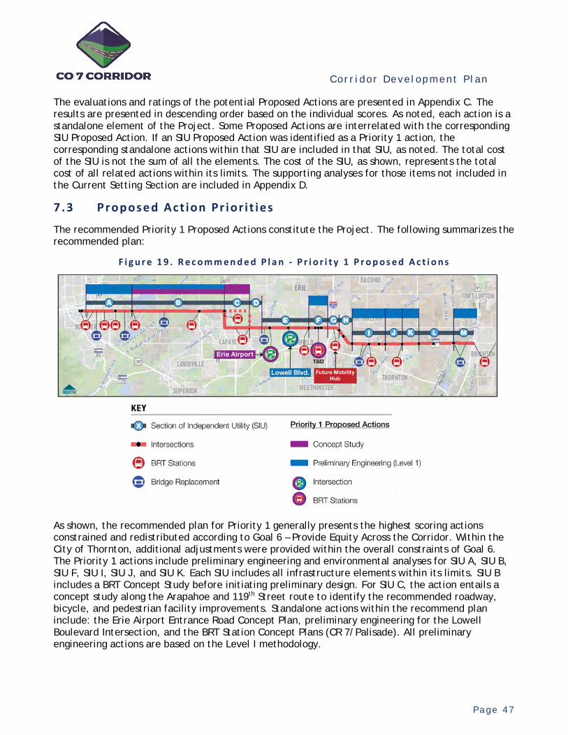
Cor r i dor Deve lopment P l an
P a g e 4 7
The evaluations and ratings of the potential Proposed Actions are presented in Appendix C. The results are presented in descending order based on the individual scores. As noted, each action is a standalone element of the Project. Some Proposed Actions are interrelated with the corresponding SIU Proposed Action. If an SIU Proposed Action was identified as a Priority 1 action, the corresponding standalone actions within that SIU are included in that SIU, as noted. The total cost of the SIU is not the sum of all the elements. The cost of the SIU, as shown, represents the total cost of all related actions within its limits. The supporting analyses for those items not included in the Current Setting Section are included in Appendix D.
7.3 Proposed Act ion Pr ior i t ies
The recommended Priority 1 Proposed Actions constitute the Project. The following summarizes the recommended plan:
F i g u r e 1 9 . R e c o m m e n d e d P l a n - P r i o r i t y 1 P r o p o s e d A c t i o n s
As shown, the recommended plan for Priority 1 generally presents the highest scoring actions constrained and redistributed according to Goal 6 – Provide Equity Across the Corridor. Within the City of Thornton, additional adjustments were provided within the overall constraints of Goal 6. The Priority 1 actions include preliminary engineering and environmental analyses for SIU A, SIU B, SIU F, SIU I, SIU J, and SIU K. Each SIU includes all infrastructure elements within its limits. SIU B includes a BRT Concept Study before initiating preliminary design. For SIU C, the action entails a concept study along the Arapahoe and 119th Street route to identify the recommended roadway, bicycle, and pedestrian facility improvements. Standalone actions within the recommend plan include: the Erie Airport Entrance Road Concept Plan, preliminary engineering for the Lowell Boulevard Intersection, and the BRT Station Concept Plans (CR 7/Palisade). All preliminary engineering actions are based on the Level I methodology.
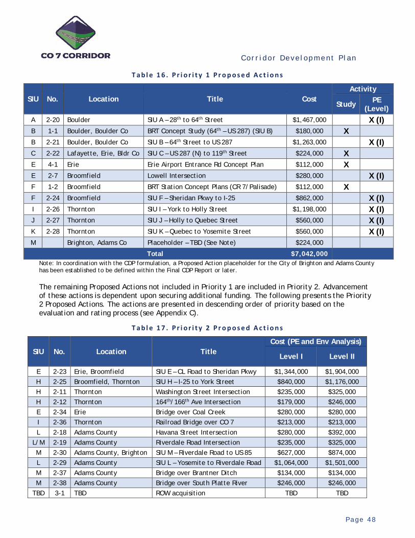
Cor r i dor Deve lopment P l an
P a g e 4 8
T a b l e 1 6 . P r i o r i t y 1 P r o p o s e d A c t i o n s
SIU No. Location Title Cost Activity
Study PE (Level)
A 2-20 Boulder SIU A – 28th to 64th Street $1,467,000 X (I) B 1-1 Boulder, Boulder Co BRT Concept Study (64th – US 287) (SIU B) $180,000 X B 2-21 Boulder, Boulder Co SIU B – 64th Street to US 287 $1,263,000 X (I) C 2-22 Lafayette, Erie, Bldr Co SIU C – US 287 (N) to 119th Street $224,000 X E 4-1 Erie Erie Airport Entrance Rd Concept Plan $112,000 X E 2-7 Broomfield Lowell Intersection $280,000 X (I) F 1-2 Broomfield BRT Station Concept Plans (CR 7/Palisade) $112,000 X F 2-24 Broomfield SIU F – Sheridan Pkwy to I-25 $862,000 X (I) I 2-26 Thornton SIU I – York to Holly Street $1,198,000 X (I) J 2-27 Thornton SIU J – Holly to Quebec Street $560,000 X (I) K 2-28 Thornton SIU K – Quebec to Yosemite Street $560,000 X (I) M Brighton, Adams Co Placeholder – TBD (See Note) $224,000
Total $7,042,000 Note: In coordination with the CDP formulation, a Proposed Action placeholder for the City of Brighton and Adams County has been established to be defined within the Final CDP Report or later. The remaining Proposed Actions not included in Priority 1 are included in Priority 2. Advancement of these actions is dependent upon securing additional funding. The following presents the Priority 2 Proposed Actions. The actions are presented in descending order of priority based on the evaluation and rating process (see Appendix C).
T a b l e 1 7 . P r i o r i t y 2 P r o p o s e d A c t i o n s
SIU No. Location Title Cost (PE and Env Analysis)
Level I Level II
E 2-23 Erie, Broomfield SIU E – CL Road to Sheridan Pkwy $1,344,000 $1,904,000 H 2-25 Broomfield, Thornton SIU H – I-25 to York Street $840,000 $1,176,000 H 2-11 Thornton Washington Street Intersection $235,000 $325,000 H 2-12 Thornton 164th/166th Ave Intersection $179,000 $246,000 E 2-34 Erie Bridge over Coal Creek $280,000 $280,000 I 2-36 Thornton Railroad Bridge over CO 7 $213,000 $213,000 L 2-18 Adams County Havana Street Intersection $280,000 $392,000
L/M 2-19 Adams County Riverdale Road Intersection $235,000 $325,000 M 2-30 Adams County, Brighton SIU M – Riverdale Road to US 85 $627,000 $874,000 L 2-29 Adams County SIU L – Yosemite to Riverdale Road $1,064,000 $1,501,000 M 2-37 Adams County Bridge over Brantner Ditch $134,000 $134,000 M 2-38 Adams County Bridge over South Platte River $246,000 $246,000
TBD 3-1 TBD ROW acquisition TBD TBD

Cor r i dor Deve lopment P l an
P a g e 4 9
Cost estimates for both Level I and Level 2 design methodologies are provided. This information should be utilized in pursuit of additional funding for preliminary engineering and subsequent planning for how to best advance the Corridor beyond the Project. The estimates represent the standalone costs of each action.

Cor r i dor Deve lopment P l an
P a g e 5 0
8. Project Del ivery Plan
Successful delivery of the Project will require an organized and systematic approach. Organizational structures to assure the Proposed Actions are delivered on time, within budget, and of high quality are needed. This entails a management and administrative structure effectively organized to assure accountability with clear lines of authority and communications. Detailed work planning for each Proposed Action, effectively administered, assures the control of delivery. Initiating production with well-conceived plans, followed by effective tracking and monitoring, reduces the risks of scope creep, cost overruns, and schedule delays. Equally important are the resources required for delivery. Mobilizing the Proposed Actions through effective resource planning ensures staff are appropriately assigned to meet deliverable timelines. All of these delivery activities are intertwined and effective execution of each is essential for success.
For the Project’s delivery, the overall organizational approach and resource planning need to fulfill the following goals:
Accountability – Provide well-defined and understood roles and responsibilities for staff and stakeholders with clear lines of communication and oversight for tracking and monitoring delivery status and progress, including costs and schedules.
Cost Efficiency – Eliminate unnecessary work activities and redundancies through an effective and efficient delivery organization with descriptive work plans executed by qualified and dedicated staff.
High Quality and Reliable Products – Deploy and administer a system of quality management, assurance, and control for the delivery of quality products including reliable preliminary plans and construction cost estimates free of errors and omissions.
Technical Uniformity – Provide oversight, coordination, and guidance to ensure the correct and consistent application of the vision’s multimodal infrastructure, the preliminary design and environmental methodologies, and the communications strategies to fulfill the Project’s purpose and intent.
Timeliness – Deliver the Proposed Actions in a timely manner, in balance with the other goals, to expeditiously advance the Project, enable the management of the Corridor, and position for future funding.
Coordination – Effectively coordinate key decisions and collaborate with the TAC and CO 7 Coalition and provide overall coordination with other partnering agencies and interested parties as appropriate.
8.1 Program Management
Delivering the Project will entail multiple facets of management and oversight administered and coordinated simultaneously for multiple Proposed Actions across the Corridor. Given the delivery goals and concurrent activities across the Corridor, it is recommended a program-level management and organizational approach be implemented. This will entail providing overall accountability, management, communications, coordination, and control programmatically across all Proposed Actions. Furthermore, with some work activities benefitting from centralized production and coordination, some deliverables will be prepared and coordinated at the program level. This approach will provide an organizational structure for accountable and efficient delivery of the Project.
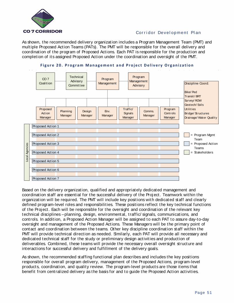
Cor r i dor Deve lopment P l an
P a g e 5 1
As shown, the recommended delivery organization includes a Program Management Team (PMT) and multiple Proposed Action Teams (PATs). The PMT will be responsible for the overall delivery and coordination of the program of Proposed Actions. Each PAT is responsible for the production and completion of its assigned Proposed Action under the coordination and oversight of the PMT.
F i g u r e 2 0 . P r o g r a m M a n a g e m e n t a n d P r o j e c t D e l i v e r y O r g a n i z a t i o n
Based on the delivery organization, qualified and appropriately dedicated management and coordination staff are essential for the successful delivery of the Project. Teamwork within the organization will be required. The PMT will include key positions with dedicated staff and clearly defined program-level roles and responsibilities. These positions reflect the key technical functions of the Project. Each will be responsible for the oversight and coordination of the relevant key technical disciplines – planning, design, environmental, traffic/signals, communications, and controls. In addition, a Proposed Action Manager will be assigned to each PAT to assure day-to-day oversight and management of the Proposed Actions. These Managers will be the primary point of contact and coordination between the teams. Other key discipline coordination staff within the PMT will provide technical direction as needed. Similarly, each PAT will provide all necessary and dedicated technical staff for the study or preliminary design activities and production of deliverables. Combined, these teams will provide the necessary overall oversight structure and interactions for successful delivery and fulfillment of the delivery goals.
As shown, the recommended staffing functional plan describes and includes the key positions responsible for overall program delivery, management of the Proposed Actions, program-level products, coordination, and quality review. The program-level products are those items that benefit from centralized delivery as the basis for and to guide the Proposed Action activities.
Discipline Coord:
Bike/PedTransit/BRTSurvey/ROWGeotech/SoilsUtilitiesBridge/StructuresDrainage/Water Quality
Proposed Action 1
Proposed Action 2 = Program MgmtTeam
Proposed Action 3 = Proposed ActionTeams
Proposed Action 4 = Stakeholders
Proposed Action 5
Proposed Action 6
Proposed Action 7
Traffic/ Signals
Manager
Loca
l Age
ncie
s
Comms. Manager
Program Controls Manager
Proposed Action
Manager
Technical Advisory
Committee
CO 7 Coalition
Program Management
Advisory
Program Management
Planning Manager
Design Manager
Env. Manager

Cor r i dor Deve lopment P l an
P a g e 5 2
T a b l e 1 8 . D e l i v e r y T e a m P o s i t i o n s a n d F u n c t i o n s
8.2 Project B udget and Schedule
The overall budget for the program of Proposed Actions is based on the Project’s total budget - $10M. All work activities to deliver the Project are included within the budget. As shown, itemized budget items include programmatic activities and delivery of the Proposed Actions.
Position Role Responsibility
Ove
rsee
for
Suc
cess
ful D
eliv
ery
Man
age
the
Prop
osed
Act
ions
Prod
uce
Prog
ram
Pro
duct
s
Coor
dina
te P
ropo
sed
Acti
ons
Qua
lity
Revi
ew
Program and Proposed Action Products
Program Management
Oversight of the overall program of projects (Proposed Actions)
Oversee successful delivery of the program of Proposed Actions including overall budget, schedule, quality and satisfaction and coordination
X
Proposed Action Manager
Day-to-day oversight and management of each
Proposed Action
Manage the procurement and delivery of each Proposed Action including scope, budget, schedule and quality products
X X X X
Planning ManagerOversee the planning-
related activities in the program
Manage the planning-specific Proposed Actions and coordinate planning-related tasks within each Proposed Action
X X
Design ManagerCoordinate the design
activities in the program
Coordinate design criteria, design details, and plans for consistency and compliance for each Proposed Action
X X X Design procedures
Environmental Manager
Perform program-level and coordinate environmental activites in the program
Manage and perfom the programmatic environmental investigations and coordinate related analyses for each Proposed Action
X X X Corridor-wide resources identification
Traffic/Signals Manager
Perform program-level and coordinate traffic, signal
and ITS-related activites in the program
Manage and perform the programmatic traffic, signal and ITS-related activites and coordinate related designs for each Proposed Action
X X XCorridor travel demand, systems planning tool,
Corridor Technology Plan
Communications Manager
Perform program-level and coordinate
communciations in the program
Manage and perform the strategic communications activities and oversee and coordinate the related activities for each Proposed Action
X X X Corridor-wide communications materials
Program Controls Manager
Perform and coordinate overall control activities in
the program
Manage and oversee contracts/change management; budgets, costs and schedules; document management; procurements for the Propsoed Actions; and overall quality procedures for the Proposed Action deliveries
X XProgram and Proposed Action
performance tracking and montoring reports
Key Discipline Coordinators
Coordinate key discipline activities in the program
Coordinate the planning and design activities for key disciplines (bike/ped, transit/BRT, survey/ROW, geotech/soils, utilities, bridge/structures and drainage/water quality) for program-level applications for each Proposed Action
X X X Bike/Ped Systems Plan
Deliver each Proposed Action
Deliver each Proposed Action in coordination with the Program Mangement Team X X X Proposed Action deliverables
Prog
ram
Man
agem
ent
Team
Proposed Action(s) Teams
Program and Project (Proposed Actions) Delivery Functions
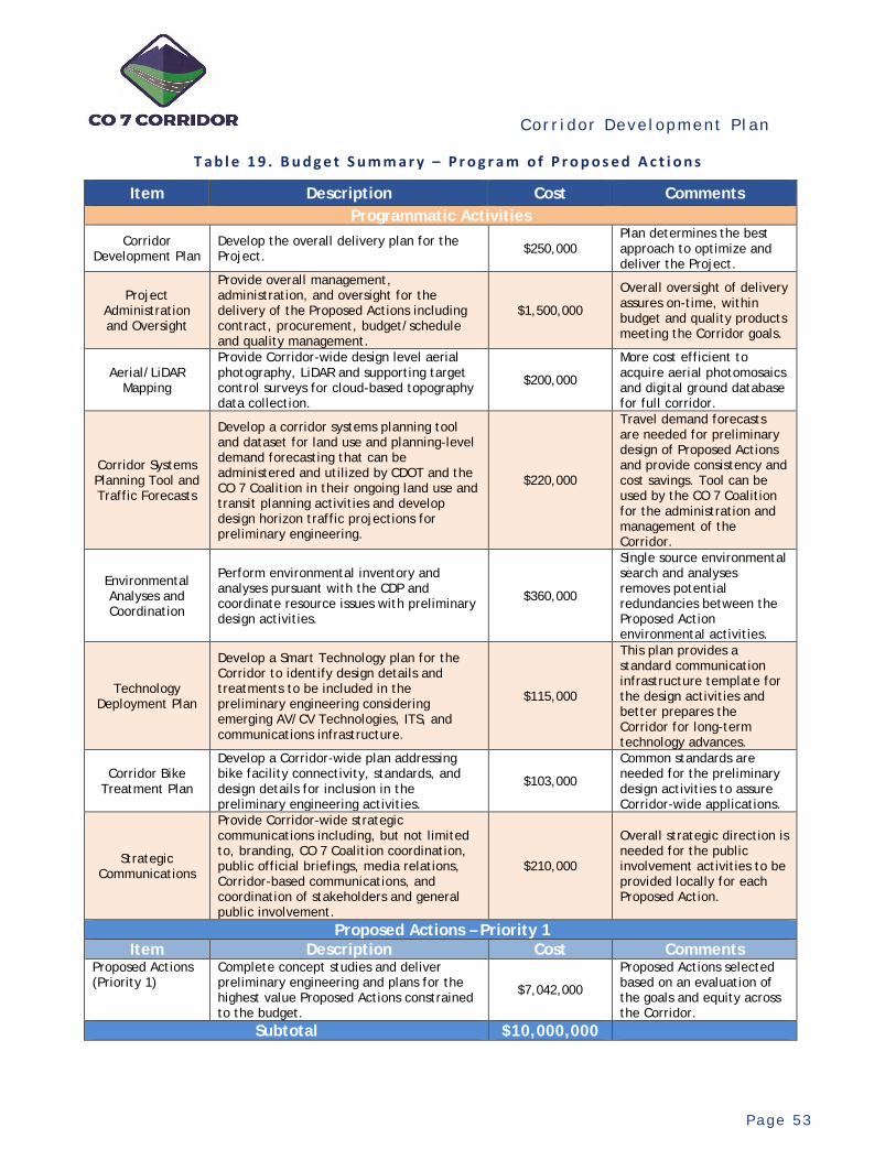
Cor r i dor Deve lopment P l an
P a g e 5 3
T a b l e 1 9 . B u d g e t S u m m a r y – P r o g r a m o f P r o p o s e d A c t i o n s
Item Description Cost Comments Programmatic Activities
Corridor Development Plan
Develop the overall delivery plan for the Project. $250,000
Plan determines the best approach to optimize and deliver the Project.
Project Administration and Oversight
Provide overall management, administration, and oversight for the delivery of the Proposed Actions including contract, procurement, budget/schedule and quality management.
$1,500,000
Overall oversight of delivery assures on-time, within budget and quality products meeting the Corridor goals.
Aerial/LiDAR Mapping
Provide Corridor-wide design level aerial photography, LiDAR and supporting target control surveys for cloud-based topography data collection.
$200,000
More cost efficient to acquire aerial photomosaics and digital ground database for full corridor.
Corridor Systems Planning Tool and Traffic Forecasts
Develop a corridor systems planning tool and dataset for land use and planning-level demand forecasting that can be administered and utilized by CDOT and the CO 7 Coalition in their ongoing land use and transit planning activities and develop design horizon traffic projections for preliminary engineering.
$220,000
Travel demand forecasts are needed for preliminary design of Proposed Actions and provide consistency and cost savings. Tool can be used by the CO 7 Coalition for the administration and management of the Corridor.
Environmental Analyses and Coordination
Perform environmental inventory and analyses pursuant with the CDP and coordinate resource issues with preliminary design activities.
$360,000
Single source environmental search and analyses removes potential redundancies between the Proposed Action environmental activities.
Technology Deployment Plan
Develop a Smart Technology plan for the Corridor to identify design details and treatments to be included in the preliminary engineering considering emerging AV/CV Technologies, ITS, and communications infrastructure.
$115,000
This plan provides a standard communication infrastructure template for the design activities and better prepares the Corridor for long-term technology advances.
Corridor Bike Treatment Plan
Develop a Corridor-wide plan addressing bike facility connectivity, standards, and design details for inclusion in the preliminary engineering activities.
$103,000
Common standards are needed for the preliminary design activities to assure Corridor-wide applications.
Strategic Communications
Provide Corridor-wide strategic communications including, but not limited to, branding, CO 7 Coalition coordination, public official briefings, media relations, Corridor-based communications, and coordination of stakeholders and general public involvement.
$210,000
Overall strategic direction is needed for the public involvement activities to be provided locally for each Proposed Action.
Proposed Actions – Priority 1 Item Description Cost Comments
Proposed Actions (Priority 1)
Complete concept studies and deliver preliminary engineering and plans for the highest value Proposed Actions constrained to the budget.
$7,042,000
Proposed Actions selected based on an evaluation of the goals and equity across the Corridor.
Subtotal $10,000,000

Cor r i dor Deve lopment P l an
P a g e 5 4
The Project’s conceptual schedule is based on the itemized work activities by the PMT and generalized delivery of the Proposed Actions. As shown (see Figure 21), immediate mobilization of the CDP is planned upon completion. At the outset, resource staffing and assignment planning will be performed to fill the PMT functional positions. This process will identify the planned mix of CDOT and outside resources for overall delivery and will determine the overall schedule in more detail. Accordingly, the overall resources plan will assure sufficient resources are available to fulfill the schedule. Based on the overall resources plan, the lead program-level activities will be performed in advance of the Proposed Actions. Simultaneously, the procurement of the PATs, based on the resource plan, will be conducted and the necessary lead time for these activities is shown. It is anticipated that the mobilization of these teams could be staggered, as individual teams are procured, contracted, and mobilized. This is illustrated in Figure 21 as two groups of Proposed Actions. The order and sequencing of which and how the Proposed Actions are mobilized is currently undetermined but will be coordinated with the TAC as the overall resource planning is developed. The sequencing will need to consider interdependencies within the Proposed Actions. Procurement of outside resources will utilize CDOT’s standard consultant procurement procedures for professional services. As shown, full completion of the Project is anticipated by the end of 2023.
F i g u r e 2 1 . P r o j e c t S c h e d u l e – P r o g r a m M a n a g e m e n t a n d P r o p o s e d A c t i o n s
The Project Schedule is conceptual, allowing flexibility by CDOT in coordination with the TAC, and reflects a reasonable overall plan for the completion of the program of Proposed Actions (Priority 1). It is subject to changes and adjustments according to CDOT’s overall resource planning. As the CDP is delivered, refinements and adjustments are anticipated. In coordination with the resources plan, adjustments could include the delivery of work activities by CDOT, foregoing the necessity of consultant procurement, as assumed. Lead times for any necessary procurements could be adjusted based on the procurement vehicle and other time savings. Furthermore, Proposed Actions could be combined or repackaged for efficiencies.

Cor r i dor Deve lopment P l an
P a g e 5 5
8.3 Future Funding Sour ces
Identifying and securing future funding is essential to realizing the multimodal vision for the Corridor. This section identifies potential funding sources from federal and state sources to support the construction of the multimodal CO 7 Corridor. Local funding sources vary by jurisdiction and the ability to leverage private development funding will need to be evaluated on a case-by-case basis.
When funding is pursued, the continued viability of the funding source and eligibility requirements will need to be verified by the lead agency or applicant(s). DRCOG administers all federally funded projects through the TIP that manages actions to be completed by CDOT, RTD, local governments, and other project sponsors over a rolling four-year period. Next Call for projects is anticipated by 2022 for FY2024 to FY2027. This next TIP cycle will have regional and subregional calls for projects, providing an opportunity for the CO 7 Coalitions to work together to leverage resources. Additionally, DRCOG has set aside funding sources that would likely be applicable, including:
Community Mobility Planning and Implementation (CMPI) – Projects which support the development of connected urban centers and multimodal corridors; support a transportation system that is well-connected and serves all modes of travel; and expand access to opportunity for residents of all ages, incomes, and abilities. Next call for projects is anticipated in the summer 2021.
Regional Transportation Operations and Technology (RTO&T) – Projects which improve transportation system performance and reliability, improve transportation safety and security, improve bicycle and pedestrian accessibility, and improve interconnections of the multimodal transportation system within and beyond the region for people and freight. Call for projects to likely follow the TIP application schedule.
Safer Main Streets Initiative - CDOT in collaboration with DRCOG developed the Safer Main Streets Initiative in 2020. This program was developed to support infrastructure projects that improve safety and accessibility along urban arterials (non-freeway corridors in the Denver Metro area) especially for vulnerable users who depend on a reliable urban street network, such as pedestrians, bicyclists, motorcyclists, transit users, the elderly, and those with disabilities. The projects submitted for review must be within Adams, Arapahoe, Boulder, Broomfield, Denver, Douglas, Jefferson, and SW Weld Counties - consistent with both CDOT and DRCOG’s Vision Zero efforts.
The following list is not exhaustive and is intended as the starting point to investigate potential sources as potential projects are developed. To aid in the application process, the uses of the funds are identified by the applicable uses, as follows:
Highway / Safety – These funds are allocated for highway capacity, intersection improvements, and safety-related projects.
Transit – These funds are allocated for BRT projects including mixed travel corridors, station development, and access to transit.
Multi-Modal – These Funds are allocated for bicycle and pedestrian improvements, that can be on street bike lanes, ADA ramp improvements, multi-use paths, and off corridor trails.
A brief description is provided for each funding source with a link to additional on-line resources in Appendix E.
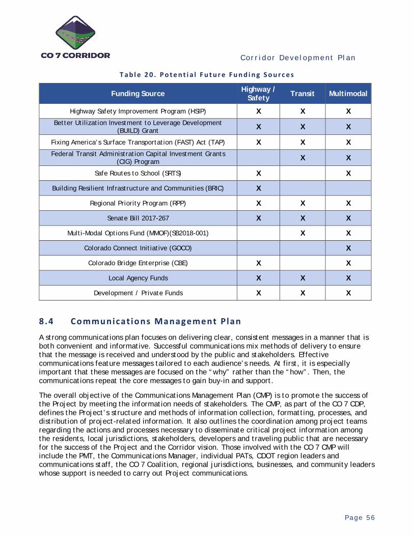
Cor r i dor Deve lopment P l an
P a g e 5 6
T a b l e 2 0 . P o t e n t i a l F u t u r e F u n d i n g S o u r c e s
Funding Source Highway / Safety Transit Multimodal
Highway Safety Improvement Program (HSIP) X X X Better Utilization Investment to Leverage Development
(BUILD) Grant X X X
Fixing America’s Surface Transportation (FAST) Act (TAP) X X X Federal Transit Administration Capital Investment Grants
(CIG) Program X X
Safe Routes to School (SRTS) X X
Building Resilient Infrastructure and Communities (BRIC) X
Regional Priority Program (RPP) X X X
Senate Bill 2017-267 X X X
Multi-Modal Options Fund (MMOF)(SB2018-001) X X
Colorado Connect Initiative (GOCO) X
Colorado Bridge Enterprise (CBE) X X
Local Agency Funds X X X
Development / Private Funds X X X
8.4 Communicat ions Management Plan
A strong communications plan focuses on delivering clear, consistent messages in a manner that is both convenient and informative. Successful communications mix methods of delivery to ensure that the message is received and understood by the public and stakeholders. Effective communications feature messages tailored to each audience’s needs. At first, it is especially important that these messages are focused on the “why” rather than the “how”. Then, the communications repeat the core messages to gain buy-in and support.
The overall objective of the Communications Management Plan (CMP) is to promote the success of the Project by meeting the information needs of stakeholders. The CMP, as part of the CO 7 CDP, defines the Project’s structure and methods of information collection, formatting, processes, and distribution of project-related information. It also outlines the coordination among project teams regarding the actions and processes necessary to disseminate critical project information among the residents, local jurisdictions, stakeholders, developers and traveling public that are necessary for the success of the Project and the Corridor vision. Those involved with the CO 7 CMP will include the PMT, the Communications Manager, individual PATs, CDOT region leaders and communications staff, the CO 7 Coalition, regional jurisdictions, businesses, and community leaders whose support is needed to carry out Project communications.
Cor r i dor Deve lopment P l an
P a g e 5 7
The CMP provides an outline structure for Project communications. Each individual element will then be developed further with specific details and requirements providing the Communications Manager and supporting staff direction and guidance for effective Project communications.
8 . 4 . 1 S t a k e h o l d e r I d e n t i f i c a t i o n a n d A n a l y s i s
At the outset of the CMP execution, it is recommended a Stakeholder analysis be conducted to identify key stakeholders along the Corridor and their issues and concerns. Communications with all key stakeholders will be coordinated to make sure all messaging is clear, concise and consistent. Key themes and means of communications will be identified to guide the overall communications.
8 . 4 . 2 S t r a t e g i c C o m m u n i c a t i o n s
A thorough and well-planned CMP is critical for a successful project. Project communications must be frequent (as appropriate), timely, consistent across the Corridor, clear, and specific to ensure the residents, stakeholders, local jurisdictions, businesses, and the traveling public are well informed as delivery progresses and have ample opportunity for engagement. These communications must be consistent and accurate with information on Project milestones, meetings, traffic impacts, property impacts, etc.
As an important first step in advancing the Corridor, the Project will prepare preliminary engineering designs and plans that will shape and form portions of the Corridor’s future infrastructure, in accordance with the multimodal vision. As additional funding is secured, preliminary engineering across the full corridor can be completed, leading to final design and construction. Full completion of the multimodal vision will take many years and incremental advancements as final design and construction funding is secured. Correspondingly, the CMP needs to strategically communicate the long-term vision regionally while engaging the audiences locally at each step of the development process. It needs to lay the foundation for sustained communications for the Corridor’s vision, implemented over time, and be specifically formulated and deployed for the Project.
Key messages, and how they are developed and delivered, should reflect the audiences and the specifics of their need for engagement and information. For efficiency, a well-coordinated team of resources and staff, led by the Communications Manager, is needed. Efficient development and delivery will depend on content and ownership of the information to be shared. Per the Program Management and Project Delivery Organization, this will entail overall centralized oversight and coordination of communications and the development and delivery of Corridor-wide materials and messages. Local and site-specific information will be then be developed and delivered within each PAT, in coordination with the Communications Manager. Each team will include a public involvement specialist responsible for local and specific public engagement within their respective Proposed Action. The assignment of the specialists will depend on the overall organization of the PATs.
The Communications Manager will be an essential position for both the Project and for future sustained communications, as potential additional funding is secured. This position will be part of the overall PMT and will serve as communications oversight for the whole Corridor. This position should be filled by a qualified communications specialist with experience working on larger programs. The Corridor will have several PATs working on simultaneous design and environmental analyses activities throughout the duration of the Project, which requires detailed and consistent project communications overseen by the Communications Manager. This position will serve as the PMT point of contact for the specialist within each PAT for local communications and the liaison for
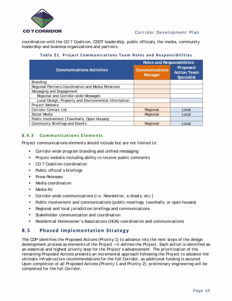
Cor r i dor Deve lopment P l an
P a g e 5 8
coordination with the CO 7 Coalition, CDOT leadership, public officials, the media, community leadership and business organizations and partners.
T a b l e 2 1 . P r o j e c t C o m m u n i c a t i o n s T e a m R o l e s a n d R e s p o n s i b i l i t i e s
Communications Activities
Roles and Responsibilities
Communications Manager
Proposed Action Team
Specialist Branding Regional Partners Coordination and Media Relations Messaging and Engagement
Regional and Corridor-wide Messages Local Design, Property and Environmental information
Project Website Corridor Contact List Regional Local Social Media Regional Local Public Involvement (Townhalls, Open Houses) Community Briefings and Events Regional Local
8 . 4 . 3 C o m m u n i c a t i o n s E l e m e n t s
Project communications elements should include but are not limited to:
Corridor-wide program branding and unified messaging Project website including ability to receive public comments CO 7 Coalition coordination Public official’s briefings Press Releases Media coordination Media Kit Corridor-wide communications (i.e. Newsletter, e-blasts, etc.) Public involvement and communications (public meetings, townhalls, or open houses) Regional and local jurisdiction briefings and communications Stakeholder communication and coordination Residential Homeowner’s Associations (HOA) coordination and communications
8.5 Phased Implementat ion Strateg y
The CDP identifies the Proposed Actions (Priority 1) to advance into the next steps of the design development process as elements of the Project – it defines the Project. Each action is identified as an essential and highest priority step for the Project’s advancement. The prioritization of the remaining Proposed Actions presents an incremental approach following the Project to advance the ultimate infrastructure recommendations for the full Corridor, as additional funding is secured. Upon completion of all Proposed Actions (Priority 1 and Priority 2), preliminary engineering will be completed for the full Corridor.

Cor r i dor Deve lopment P l an
P a g e 5 9
With the completion of preliminary engineering, whether for the full Corridor or in parts, CDOT and the Coalition can then coordinate with developers for the dedication of the ultimate ROW; can implement interim improvements consistent with the ultimate multimodal configuration, wherever possible; and can identify logical and functional phases of the Corridor’s improvements for final design, NEPA and construction, as funding is identified. Completing preliminary engineering enables all parties to identify phasing opportunities, and as possible and as funding allows, build the improvements according to the ultimate configuration. However, coordination with developers and limited public funding may not always enable the ultimate layout to be built. Interim improvements which address the immediate needs and opportunities may be necessary but may not be fully compatible with the ultimate configuration.
Due to funding limitations, an overall strategy and approach is needed to build the ultimate improvements in incremental phases and stages with interim improvements as funding is available. The recommended approach to incrementally deliver the Corridor recommendations is based on the following overarching actions:
1. Execute and coordinate the tactics in the BRT Implementation Playbook, including the pursuit of funding for BRT implementation.
2. Complete the Project entailing the advancement of the Priority 1 Proposed Actions. Preliminary design should be based upon, to the extent practicable, the Conceptual Construction Staging Plan.
3. Continue the coordination and pursuit of funding for the Priority 2 Proposed Actions and when secured, complete the preliminary design (based on the Conceptual Construction Staging Plan) for the full Corridor. This will enable ROW preservation and advance readiness for the entire Corridor.
4. Continue the coordination and pursuit of funding for final design, NEPA and construction of the Corridor’s multimodal improvements.
5. Implement the Conceptual Construction Staging Plan whenever funding is identified for final design and construction, whether in coordination with a developer or publicly led.
6. Implement the Phased Implementation Strategy for prioritizing incremental phases of the Corridor’s full and complete build-out as funding is identified for final design and construction.
The strategy for implementing the multimodal vision entails advancing the Corridor’s infrastructure incrementally in response to current conditions and needs while preparing for the future. In concept, it will guide and inform future efforts for securing funding for design and construction. When funding is available, it can then guide the application of the funding towards those elements of the Corridor that best advance the vision strategically.
This strategy needs to be flexible, recognizing its completion depends on the timing, amount, and scope of future funding, as it is secured incrementally. Future funding may have specifically prescribed applications or uses, depending on sources, which may limit its use to specific areas or elements within the Corridor. The implementation strategy provides overall conceptual guidance while enabling the Corridor’s advancement to adjust and respond to funding opportunities as they arise.
Cor r i dor Deve lopment P l an
P a g e 6 0
Critical to advancing the Corridor’s infrastructure are the basic principles within the typical project development process. Typically, this process would entail completing preliminary design and environment analyses throughout to define the ultimate infrastructure configuration. This then enables the identification of interim phases of construction consistent with the final phase. For optimal phasing, it is recommended that preliminary engineering be completed throughout the Corridor to set the stage for prioritizing and building the improvements in a logical and efficient sequence, responsive to needs and opportunities. However, this is not a prerequisite for a project to move forward. While completing preliminary engineering would be beneficial, other areas or needs within the Corridor should be addressed as opportunities arise. If a project is identified as a priority, it may move further into design and construction independent of whether or not preliminary engineering has been fully executed along the entire corridor. This may be done based on local priorities and opportunities, in coordination with CDOT.
The Phased Implementation Strategy is a composite of multiple priority scenarios. Each scenario reflects an overall approach or emphasis for prioritizing the initial Corridor’s improvement. These scenarios represent alternative ideas for the initial priorities to advance the Corridor, not the full build-out of the vision. Combined, the overall strategy represents a comprehensive layered approach without comparing the relative merits of the various priority approaches. This enables all areas or portions of the Corridor to advance in parallel and in unison, without priority segment preferences, and responsive to both regional and local improvement opportunities. Based on analyses of the Corridor, the relative importance of the various elements of the Corridor’s infrastructure reflects a logical sequencing of the ultimate build-out over time. These scenarios are not based on benefit and cost analyses for the improvements, but rather an aggregation of implementation approaches.
The composite strategy is based on the following implementation scenarios:
Advance BRT Scenario – Implement phased improvements which prioritize the infrastructure preparations for BRT operations, per the BRT Implementation Playbook, and enhance existing bus operations within the Corridor.
Phasing Logic: Trip patterns (where travel comes from and goes to) described in the SH 7 BRT Feasibility Study identify the travel market between Boulder and Lafayette/Erie as the highest inter-community trip connection within the Corridor – both today and in the future. This travel market represents roughly 84% of all inter-community travel. As a result and per the BRT Implementation Playbook, the logical initiation of preliminary engineering for a BRT start-up project would likely entail an initial minimum operating segment between the Cities of Boulder and Lafayette. The timing of when this occurs depends on the confidence of meeting performance and funding prerequisites. In preparation, the BRT Implementation Playbook prescribes advancing the supporting infrastructure to reduce the capital costs of the start-up. The logic of this scenario therefore entails building the critical and major busway elements relating to the CO 7 infrastructure that would affect BRT operations and performance. This scenario would not fully build-out all BRT-related infrastructure, but rather those major elements where significant existing deficiencies exist with high capital improvement costs for the initial operating segment. In addition, the BRT Implementation Playbook recommends extending existing bus services to and from Boulder east of Lafayette to the future site of the planned I-25 Mobility Hub as a precursor for BRT operations.
Cor r i dor Deve lopment P l an
P a g e 6 1
High Priority Improvement Phases: • Construct ultimate CO 7/95th Street Intersection improvements. • Subject to the BRT Concept Study for SIU B, add full-width continuous shoulders along
CO 7, compatible for future potential peak period bus operations, between the 75th Street and US 287 (North) intersections.
• Construct a new park-n-ride facility and bus station for connections with CDOT’s Inter-city Bustang Service at the I-25/CO 7 Interchange. Considerations should be given to the layout and construction of this facility for compatibility with the planned I-25 Mobility Hub currently in a preliminary design phase.
Choke Points Scenario – Implement phased improvements which prioritize significant
existing physical and operational choke points within the Corridor.
Phasing Logic: Based on observations from the traffic analyses, there are several choke points within the existing CO 7 infrastructure which impact the Corridor’s overall travel operations and efficiencies. These infrastructure bottlenecks consist of major intersections and network connectivity inefficiencies, which operationally constrain travel and lack multimodal connectivity.
High Priority Improvement Phases: • Construct ultimate intersection improvements at the following locations: 95th Street US 287 (North) 119th Street (In Progress) Lowell Boulevard
• Based on the Concept Study for SIU C, extending along Arapahoe Road and 119th Street between the US 287 (north) and 119th Street intersections, construct the recommended roadway, intersection, bike and pedestrian improvements as an alternative relief route for CO 7 through the City of Lafayette as part of the recommended network solution from the previous planning study.
• Construct ultimate intersection improvements at all other major intersections based on needs as funding opportunities arise.
Operational Continuity Scenario – Implement phased section-based multimodal
improvements which prioritize portions of the Corridor where existing lane continuity is notably inconsistent, travel demand is highest and adjacent development currently exists, is active and growing.
Phasing Logic: In response to areas where traffic volumes are the highest and existing travel lanes are inconsistent with continuity gaps, this scenario initially builds out the core and central portion of the Corridor. Depending on available funding, the intent would be to provide a continuous 4-lane multimodal cross section and backbone through the Corridor’s central segment which can then be expanded to six lanes in the future as traffic grows. This logic would address the immediate traffic and operational needs of the Corridor within its

Cor r i dor Deve lopment P l an
P a g e 6 2
core while enabling expansion within and expansion to the west and east to logically build-out the Corridor incrementally over time.
High Priority Improvement Phases: • Construct a continuous 4-lane multimodal improvement, based on the ultimate 6-lane
configuration, between Sheridan Boulevard and York Street including intersection improvements.
• In response to traffic growth, future development, and regional system improvements, expand the Corridor’s infrastructure as follows, depending on funding and timing triggers: In coordination with the expansion of the I-25 corridor, improve the I-25/CO 7
Interchange to provide six continuous travel lanes and multimodal facility continuity along CO 7 through the interchange. This improvement could include the I-25 Mobility Hub, depending on funding and future capital improvement programming.
Complete the expansion to six lanes through the Corridor’s core, extending west and east from I-25 in a functional and logical sequencing.
Expand the 4-lane multimodal section, based on the ultimate configuration, west of Sheridan Boulevard and east of York Street in sequenced sections of improvement, extending to the next major intersection in logical progression.
While the composite implementation strategy provides general guidance for priority focuses, other areas or needs within the Corridor should be addressed as opportunities arise. It is intended to provide focused guidance to augment the overarching strategies for the full Corridor from the previous studies. These strategies include keep projects advancing; focus on intersections first; enhance transit; preserve ROW; and maximize the use of incremental investments.
8.6 Conceptua l Construct i on Stag ing P lan
Building the full Corridor vision will take a number of years to complete. It will be built over time in phases as construction funding is secured. In many cases, interim improvements will likely need to be built due to funding limitations. Furthermore, due to the limited scope of developer funded improvements, as well as the timing of the need for the full build-out of the recommended ultimate improvements, building the Corridor in interim stages can be expected. Guidance is needed to ensure phased and incremental staged construction is compatible with the ultimate improvement configuration to reduce construction throwaways and improve efficiencies.
To guide the incremental construction, a Corridor Construction Staging plan is needed. This plan is to guide the Project’s preliminary design activities, which sets the stage for more efficient phasing and interim staged construction. The goal of the plan is to build the improvements, to the fullest extent possible depending on the amount of incremental funding, compatible with the ultimate multimodal configuration, both horizontally and vertically. When the full phased build-out is unaffordable or is unnecessary at the time, this enables the ultimately required ROW to be acquired at the outset for preservation and dedication, whenever coordinating with a developer, and in the long term, reduces wasted and throwaway construction.
The preliminary design will determine the centerline alignment for the ultimate improvement configuration based on the recommended multimodal cross section (BRT busway, roadway, bike treatments, and shared-use path). Ideally, preliminary design is needed in advance of interim
Cor r i dor Deve lopment P l an
P a g e 6 3
construction to set the ultimate alignment and identify the required ROW relative to the existing infrastructure. This allows for the consideration of building interim improvements consistent with the ultimate, or if funding is available, the construction of the ultimate multimodal section.
Depending on the location, the ultimate cross section includes a median of varying width. In concept, as shown in Figure 22, it is recommended the roadway centerline be shifted, either to the north or south, to account for the median space. This concept has the additional advantage of simplifying construction staging for MOT during construction. The preliminary engineering and supporting environmental analysis will determine the new centerline alignment, both horizontally and vertically. In some cases where development has already encroached on the ultimate ROW width, modifications to the conceptual staging plan and/or multimodal cross section may be necessary, but without altering the desired functionality. At a minimum, this approach enables the ultimate ROW to be acquired and the shared-use paths on both sides to be built in their final location.
The ability to fully build the ultimate configuration or build interim improvements depends on sufficient funding and timing. Upon completion of preliminary engineering, it is recommended the construction be staged as follows:
Ultimate Stage – If funding is sufficient, whether in coordination with a developer or fully publicly funded, the ultimate stage configuration should be constructed whenever possible. This approach would maximize future compatibility and eliminate or reduce interim construction throwaways. Critical to this approach is the creation of the median space. With the ROW and shared-use paths set based upon the ultimate configuration, the outside roadway and shoulder edges could be phased based on funding and operational needs. Future phases could include adding additional outside lanes per the ultimate configuration. For example, for multimodal sections ultimately recommended to include six lanes with other multimodal treatments, four lanes could be provided as an initial phase with the remaining lanes to provided later when needed.
Interim (Based on Ultimate) Stage – If interim improvements are needed and funding is insufficient to fully implement the ultimate improvement configuration, whether or not including developer contributions, the Interim (Based on Ultimate) Stage should be constructed. In concept, this approach would set the ultimate ROW, would build the shared-use paths in their final location, and would reduce the roadway construction throwaways to one side of the existing centerline.
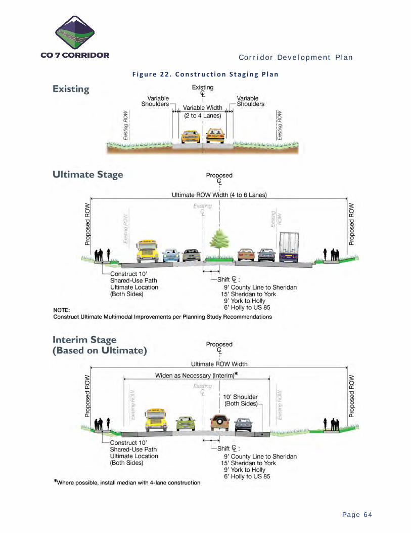
Cor r i dor Deve lopment P l an
P a g e 6 4
F i g u r e 2 2 . C o n s t r u c t i o n S t a g i n g P l a n

Cor r i dor Deve lopment P l an
P a g e 6 5
8.7 Act ion P lan
Upon the acceptance and concurrence of the CDP recommendations by the TAC and CO 7 Coalition, there are a number of recommended early actions to effectively and timely mobilize the plan. These actions transition the CDP recommendations into the next steps towards delivery. Critical to this transition is the continued and regular coordination with the TAC and CO 7 Coalition.
8 . 7 . 1 S t a f f A s s i g n m e n t s a n d M o b i l i z a t i o n
Program Management Team (PMT) – Multiple key positions are identified within the PMT. The early identification and assignment of staff is needed to transition the CDP into action and mobilize the delivery of the Project. Several lead items have been identified that need to be produced to guide and inform the preliminary engineering and environmental analyses. Appropriate availability and qualifications for these staff are essential to fulfilling the delivery goals.
Proposed Action Teams (PATs) – An overall organizational and assignment approach for the PATs, based on resource teams, needs to be determined. This approach could include combining or packaging similar or adjoining Proposed Actions for efficiencies, all within the resource capacities of the teams. Appropriate availability and qualifications for these teams, relevant to the types of technical activities of each Proposed Action, are essential for fulfilling the delivery goals. This overall approach will provide the overall structure to initiate the procurement processes, as appropriate.
8 . 7 . 2 C o o r d i n a t i o n o f A c t i v e D e s i g n i n P r o g r e s s
Two SIUs are currently in the design phase by others, in coordination with CDOT. Coordination with these designs, currently in progress, needs to be performed to ensure the preliminary design is based on the ultimate multimodal infrastructure configuration with final design based on the desired interim improvements. These two SIUs include:
SIU D (119th Street to County Line Road) SIU F (Sheridan Parkway to I-25)
8 . 7 . 3 D e t a i l e d W o r k P r o g r a m s
Detailed work programs need to be developed for the PMT deliverables and the Proposed Actions to reflect the goals of each, the existing conditions, the basis of information, and interactions with the PMT for the Proposed Actions (i.e., items and coordination to be provided by CDOT). Details and clarifications are needed to eliminate any redundancies and define elements to be studied or designed. The detailed work plans need to be coordinated with the relevant TAC members before engagement with the PATs. Refinements of the work activities will be based on the overall framework of the CDP.
8 . 7 . 4 A d v a n c e L e a d I t e m s
Aerial/LiDAR Mapping – This activity is a lead item and provides the basis for the Project’s preliminary design activities. Procurement of these services, to be provided by outside sources, should commence immediately to prepare the mapping for the Corridor.
Central Corridor Communications Website – One of the recommended elements of the Communications Management Plan is a centralized website for agency and public communications. As an early action, it is recommended the CDP and other relevant

Cor r i dor Deve lopment P l an
P a g e 6 6
information be made available on an initial website as the plan is mobilized. The advance launch of the site, either before or along with the assignment of the Corridor Communications Manager, can provide an initial repository for Corridor information and initiate the public interface for the Project. The site can then be updated and revised as the CMP is mobilized.
Corridor Communications Manager - Early identification and assignment of the Corridor Communications Manager would facilitate the website and early Corridor communications. This would also help establish the branding for the Project and push out early communications through various channels.
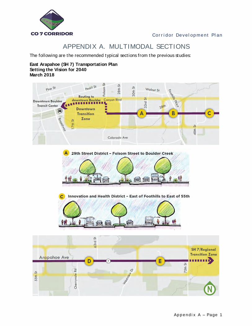
Cor r i dor Deve lopment P l an
A p p e n d i x A – Pa g e 1
APPENDIX A. MULTIMODAL SECTIONS The following are the recommended typical sections from the previous studies:
East Arapahoe (SH 7) Transportation Plan Setting the Vision for 2040 March 2018
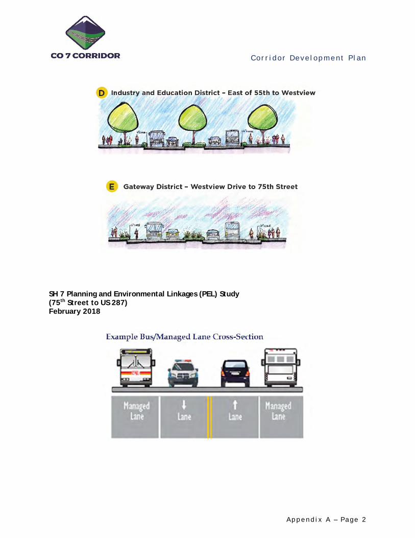
Cor r i dor Deve lopment P l an
A p p e n d i x A – Pa g e 2
SH 7 Planning and Environmental Linkages (PEL) Study (75th Street to US 287) February 2018

Cor r i dor Deve lopment P l an
A p p e n d i x A – Pa g e 3
State Highway 7 Planning and Environmental Linkages (PEL) Study (US 287 to US 85) February 2014
US 287 to 119th Street
119th Street to Relocated County Line Road
Relocated County Line Road to Sheridan Parkway
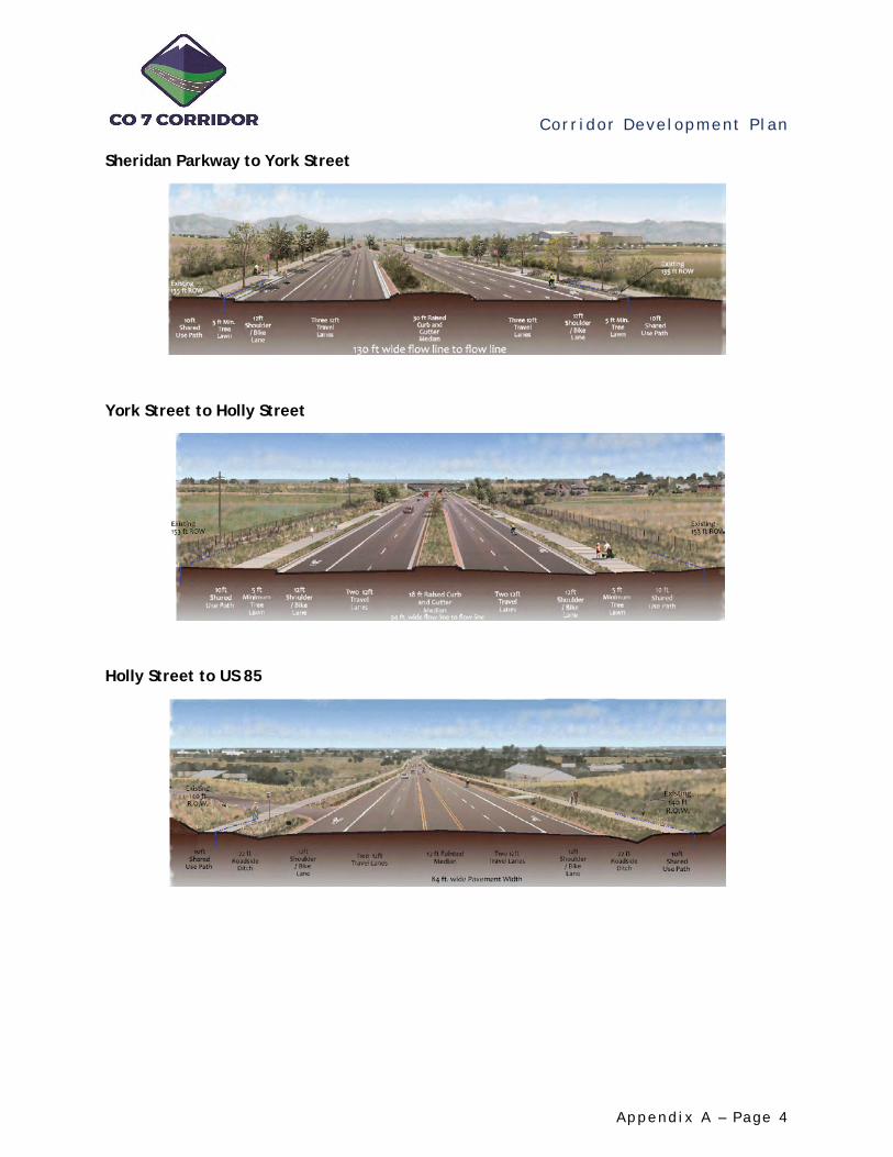
Cor r i dor Deve lopment P l an
A p p e n d i x A – Pa g e 4
Sheridan Parkway to York Street
York Street to Holly Street
Holly Street to US 85

Cor r i dor Deve lopment P l an
A p p e n d i x B – Pa g e 1
APPENDIX B. LIST OF POTENTIAL PROPOSED ACTIONS
1. Unresolved Planning Issues – Planning Concept Studies SIU No. Location Title Description Cost
B
1-1 Boulder, Boulder County
BRT Concept Study (64th – US 287) (SIU B)
Identify the recommended BRT concept and scope for an exclusive busway, directional or bi-directional, including shoulder use and overall roadway template including bike and pedestrian facilities and rough estimate of required right-of-way.
$180,000
F
1-2 Broomfield BRT Station Concept Plans (CR 7/Palisade)
In coordination with ongoing development planning, refine conceptual planning for BRT station including FFM infrastructure, development layouts, micro-transit commitments, and a grade-separated pedestrian crossing.
$112,000
2. Advance Design Issues – PE and Environmental Analysis
SIU No. Location Title Description Cost Level I Level II
A 2-1 Boulder 28th Street Intersection
Preliminary plans for ultimate intersection improvements.
$280,000 $392,000
A 2-2 Boulder 30th Street Intersection
Preliminary plans for ultimate intersection improvements.
$280,000 $392,000
A 2-3 Boulder 55th Street Intersection
Preliminary plans for ultimate intersection improvements.
$280,000 $392,000
A 2-4 Boulder 63rd Street Intersection
Preliminary plans for ultimate intersection improvements.
$235,000 $325,000
B 2-5 Boulder County
95th Street Intersection
Preliminary plans for ultimate intersection improvements.
$280,000 $392,000
B/C 2-6 Boulder
County, Lafayette, Erie
US 287 (North) Intersection
Preliminary plans for ultimate intersection improvements.
$280,000 $392,000
E 2-7 Broomfield Lowell Intersection
Preliminary plans for ultimate intersection improvements.
$280,000 $392,000
E/F 2-8 Broomfield Sheridan Pkwy Intersection
Preliminary plans for ultimate intersection improvements.
$280,000 $392,000
F 2-9 Broomfield County Road 7 Intersection
Preliminary plans for ultimate intersection improvements.
$459,000 $638,000
F
2-10 Broomfield CR 7/Palisade Intersection
Preliminary plans for ultimate intersection improvements. (Intersections are combined due to close proximity.)
$459,000 $638,000
H 2-11 Thornton Washington Street
Preliminary plans for ultimate intersection improvements.
$235,000 $325,000
H 2-12 Thornton 164th/166th Ave Intersection
Preliminary plans for ultimate intersection improvements.
$179,000 $246,000
H/I 2-13 Thornton York Street Intersection
Preliminary plans for ultimate intersection improvements.
$325,000 $448,000
I
2-14 Thornton Relocated Colorado Blvd Intersection
Advance the concept plan development for the relocation of Colorado Blvd and prepare preliminary plans for ultimate intersection improvements (includes existing Colorado Blvd intersection).
$476,000 $672,000
I/J 2-15 Thornton Holly Street Intersection
Preliminary plans for ultimate intersection improvements.
$280,000 $392,000
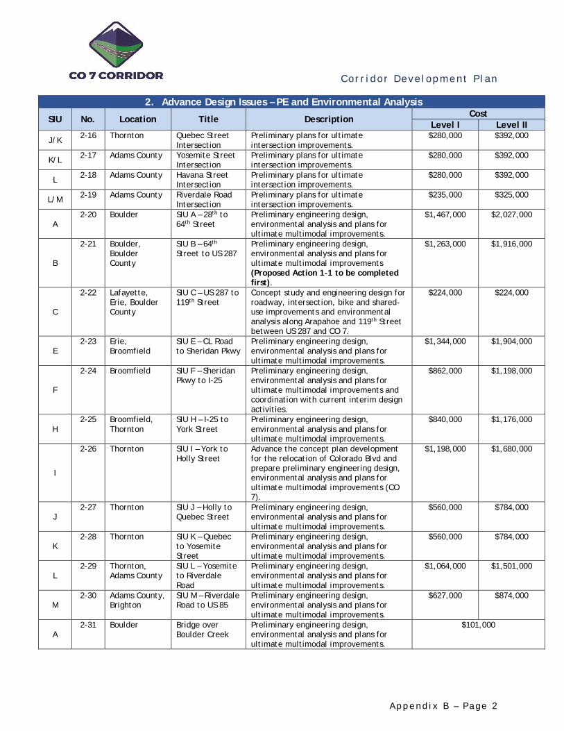
Cor r i dor Deve lopment P l an
A p p e n d i x B – Pa g e 2
2. Advance Design Issues – PE and Environmental Analysis
SIU No. Location Title Description Cost Level I Level II
J/K 2-16 Thornton Quebec Street Intersection
Preliminary plans for ultimate intersection improvements.
$280,000 $392,000
K/L 2-17 Adams County Yosemite Street Intersection
Preliminary plans for ultimate intersection improvements.
$280,000 $392,000
L 2-18 Adams County Havana Street Intersection
Preliminary plans for ultimate intersection improvements.
$280,000 $392,000
L/M 2-19 Adams County Riverdale Road Intersection
Preliminary plans for ultimate intersection improvements.
$235,000 $325,000
A 2-20 Boulder SIU A – 28th to
64th Street Preliminary engineering design, environmental analysis and plans for ultimate multimodal improvements.
$1,467,000 $2,027,000
B
2-21 Boulder, Boulder County
SIU B – 64th Street to US 287
Preliminary engineering design, environmental analysis and plans for ultimate multimodal improvements (Proposed Action 1-1 to be completed first).
$1,263,000 $1,916,000
C
2-22 Lafayette, Erie, Boulder County
SIU C – US 287 to 119th Street
Concept study and engineering design for roadway, intersection, bike and shared-use improvements and environmental analysis along Arapahoe and 119th Street between US 287 and CO 7.
$224,000 $224,000
E 2-23 Erie,
Broomfield SIU E – CL Road to Sheridan Pkwy
Preliminary engineering design, environmental analysis and plans for ultimate multimodal improvements.
$1,344,000 $1,904,000
F
2-24 Broomfield SIU F – Sheridan Pkwy to I-25
Preliminary engineering design, environmental analysis and plans for ultimate multimodal improvements and coordination with current interim design activities.
$862,000 $1,198,000
H 2-25 Broomfield,
Thornton SIU H – I-25 to York Street
Preliminary engineering design, environmental analysis and plans for ultimate multimodal improvements.
$840,000 $1,176,000
I
2-26 Thornton SIU I – York to Holly Street
Advance the concept plan development for the relocation of Colorado Blvd and prepare preliminary engineering design, environmental analysis and plans for ultimate multimodal improvements (CO 7).
$1,198,000 $1,680,000
J 2-27 Thornton SIU J – Holly to
Quebec Street Preliminary engineering design, environmental analysis and plans for ultimate multimodal improvements.
$560,000 $784,000
K 2-28 Thornton SIU K – Quebec
to Yosemite Street
Preliminary engineering design, environmental analysis and plans for ultimate multimodal improvements.
$560,000 $784,000
L 2-29 Thornton,
Adams County SIU L – Yosemite to Riverdale Road
Preliminary engineering design, environmental analysis and plans for ultimate multimodal improvements.
$1,064,000 $1,501,000
M 2-30 Adams County,
Brighton SIU M – Riverdale Road to US 85
Preliminary engineering design, environmental analysis and plans for ultimate multimodal improvements.
$627,000 $874,000
A 2-31 Boulder Bridge over
Boulder Creek Preliminary engineering design, environmental analysis and plans for ultimate multimodal improvements.
$101,000
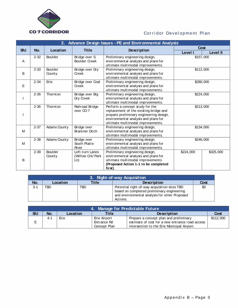
Cor r i dor Deve lopment P l an
A p p e n d i x B – Pa g e 3
2. Advance Design Issues – PE and Environmental Analysis
SIU No. Location Title Description Cost Level I Level II
A 2-32 Boulder Bridge over S.
Boulder Creek Preliminary engineering design, environmental analysis and plans for ultimate multimodal improvements.
$157,000
B 2-33 Boulder
County Bridge over Dry Creek
Preliminary engineering design, environmental analysis and plans for ultimate multimodal improvements.
$112,000
E 2-34 Erie Bridge over Coal
Creek Preliminary engineering design, environmental analysis and plans for ultimate multimodal improvements.
$280,000
I 2-35 Thornton Bridge over Big
Dry Creek Preliminary engineering design, environmental analysis and plans for ultimate multimodal improvements.
$224,000
I
2-36 Thornton Railroad Bridge over CO 7
Perform a concept study for the replacement of the existing bridge and prepare preliminary engineering design, environmental analysis and plans for ultimate multimodal improvements.
$213,000
M 2-37 Adams County Bridge over
Brantner Ditch Preliminary engineering design, environmental analysis and plans for ultimate multimodal improvements.
$134,000
M 2-38 Adams County Bridge over
South Platte River
Preliminary engineering design, environmental analysis and plans for ultimate multimodal improvements.
$246,000
B
2-39 Boulder County
Left-turn Lanes (Willow Crk/Park Ln)
Preliminary engineering design, environmental analysis and plans for ultimate multimodal improvements (Proposed Action 1-1 to be completed first).
$224,000 $325,000
3. Right-of-way Acquisition
No. Location Title Description Cost 3-1 TBD TBD Potential right-of-way acquisition sites TBD
based on completed preliminary engineering and environmental analysis for other Proposed Actions.
$0
4. Manage for Predictable Future
SIU No. Location Title Description Cost
E 4-1 Erie Erie Airport
Entrance Rd Concept Plan
Prepare a concept plan and preliminary estimate of cost for a new entrance road access intersection to the Erie Municipal Airport.
$112,000

Cor r i dor Deve lopment P l an
A p p e n d i x C – P a g e 1
APPENDIX C. PROPOSED ACTIONS EVALUATION AND RATINGS
SIU No. Location Title
Evaluation Rating by Goal
Total Score
Cost (Level I)
See Note
Cost (Level II)
See Note
6. Provide Equity Across the Corridor
Comment
See Note
1 - Advance Multimodal
Improvements
2 - Address Current Needs
3. Plan & Prepare for the Future
4. Complement Existing & Planned
Infrastructure
5. L
ever
age
Join
t O
ppor
tuni
ties
Prio
rity
1
(Con
stra
ined
)
Prio
rity
2
BRT
Play
book
Com
fort
A
naly
sis
Trav
el S
peed
Inte
rsec
tion
V/
C
Tota
l Cr
ashe
s an
d Se
veri
ty
Gro
wth
A
reas
Inte
rmod
al
Conn
ecti
vity
Hig
hway
La
ne G
ap
Bike
/Ped
G
ap
A 2-1 Boulder 28th Street Intersection
2.80 $280,000 $392,000 X Included in 2-20
A 2-2 Boulder 30th Street Intersection
2.70 $280,000 $392,000 X Included in 2-20
F 2-24 Broomfield SIU F – Sheridan Pkwy to I-25
2.70 $862,000 $1,198,000 X Level I
F 1-2 Broomfield BRT Station Concept Plans (CR 7/Palisade)
2.50 $112,000 $112,000 X Concept Study
F 2-10 Broomfield CR 7/Palisade Intersection (Combined)
2.50 $459,000 $638,000 X Included in 2-24
B 1-1 Boulder, Boulder County
BRT Concept Study (64th – US 287) (SIU B)
2.40 $180,000 $180,000 X Concept Study
A 2-20 Boulder SIU A – 28th to 64th Street
2.40 $1,467,000 $2,027,000 X Level I
B 2-21 Boulder, Boulder County
SIU B – 64th Street to US 287
2.40 $1,263,000 $1,916,000 X Level I
A 2-3 Boulder 55th Street Intersection
2.30 $280,000 $392,000 X Included in 2-20
B 2-6 Boulder County, Lafayette, Erie
US 287 (North) Intersection
2.30 $280,000 $392,000 X Included in 2-21
E/F 2-8 Broomfield Sheridan Pkwy Intersection
2.30 $280,000 $392,000 X Included in 2-24
F 2-9 Broomfield County Road 7 Intersection
2.30 $459,000 $638,000 X Included in 2-24
● ● ● ● ● ● ● ○ ● ●● ● ● ◒ ● ● ● ○ ● ●◒ ● ● ◒ ● ● ● ● ◒ ●◒ ● ● ◒ ● ● ○ ● ◒ ●◒ ● ● ◒ ● ● ○ ● ◒ ●● ◒ ● ● ● ◒ ● ○ ○ ●● ● ● ● ● ○ ● ○ ● ○● ◒ ● ● ● ◒ ● ○ ○ ●● ● ◒ ● ○ ○ ● ○ ● ●● ◒ ● ● ○ ● ● ○ ○ ●◒ ● ◒ ○ ● ● ○ ● ◒ ●◒ ● ● ◒ ○ ● ○ ● ◒ ●

Cor r i dor Deve lopment P l an
A p p e n d i x C – P a g e 2
SIU No. Location Title
Evaluation Rating by Goal
Total Score
Cost (Level I)
See Note
Cost (Level II)
See Note
6. Provide Equity Across the Corridor
Comment
See Note
1 - Advance Multimodal
Improvements
2 - Address Current Needs
3. Plan & Prepare for the Future
4. Complement Existing & Planned
Infrastructure
5. L
ever
age
Join
t O
ppor
tuni
ties
Prio
rity
1
(Con
stra
ined
)
Prio
rity
2
BRT
Play
book
Com
fort
A
naly
sis
Trav
el S
peed
Inte
rsec
tion
V/
C
Tota
l Cr
ashe
s an
d Se
veri
ty
Gro
wth
A
reas
Inte
rmod
al
Conn
ecti
vity
Hig
hway
La
ne G
ap
Bike
/Ped
G
ap
E 2-23 Erie, Broomfield SIU E – CL Road to Sheridan Pkwy
2.30 $1,344,000 $1,904,000 X
B 2-5 Boulder County 95th Street Intersection
2.20 $280,000 $392,000 X Included in 2-21
E 2-7 Broomfield Lowell Intersection
2.20 $280,000 $392,000 X Level I
H 2-25 Broomfield, Thornton
SIU H – I-25 to York Street
2.20 $840,000 $1,176,000 X
H/I 2-13 Thornton York Street Intersection
2.10 $325,000 $448,000 X Included in 2-26
A 2-4 Boulder 63rd Street Intersection
2.00 $235,000 $325,000 X Included in 2-20
H 2-11 Thornton Washington Street
2.00 $235,000 $325,000 X
I 2-14 Thornton Relocated Colorado Blvd Intersection
2.00 $476,000 $672,000 X Included in 2-26 (Does not
include Colorado Blvd alignment study)
H 2-12 Thornton 164th/166th Ave Intersection
1.90 $179,000 $246,000 X
I 2-26 Thornton SIU I – York to Holly Street
1.90 $1,198,000 $1,680,000 X Level I
A 2-31 Boulder Bridge over Boulder Creek
1.90 $101,000 $101,000 X Included in 2-20
E 2-34 Erie Bridge over Coal Creek
1.90 $280,000 $280,000 X
E 4-1 Erie Erie Airport Entrance Rd Concept Plan
1.90 $112,000 $112,000 X Concept Study
I/J 2-15 Thornton Holly Street Intersection
1.70 $280,000 $392,000 X Included in 2-26
◒ ● ● ● ○ ◒ ○ ● ◒ ●● ◒ ● ● ● ◒ ○ ○ ○ ●◒ ● ● ● ○ ○ ○ ● ◒ ●○ ● ● ○ ○ ○ ● ● ● ●○ ● ● ○ ○ ◒ ○ ● ● ●● ● ◒ ◒ ○ ○ ○ ○ ● ●○ ● ● ○ ○ ○ ○ ● ● ●○ ◒ ● ○ ○ ● ● ◒ ○ ●○ ● ◒ ○ ○ ○ ○ ● ● ●○ ◒ ● ○ ○ ● ◒ ◒ ○ ●● ● ◒ ○ ○ ○ ○ ○ ● ●◒ ● ● ○ ○ ◒ ○ ● ◒ ○○ ● ● ○ ○ ● ○ ● ◒ ○○ ◒ ◒ ○ ○ ● ○ ◒ ○ ●

Cor r i dor Deve lopment P l an
A p p e n d i x C – P a g e 3
SIU No. Location Title
Evaluation Rating by Goal
Total Score
Cost (Level I)
See Note
Cost (Level II)
See Note
6. Provide Equity Across the Corridor
Comment
See Note
1 - Advance Multimodal
Improvements
2 - Address Current Needs
3. Plan & Prepare for the Future
4. Complement Existing & Planned
Infrastructure
5. L
ever
age
Join
t O
ppor
tuni
ties
Prio
rity
1
(Con
stra
ined
)
Prio
rity
2
BRT
Play
book
Com
fort
A
naly
sis
Trav
el S
peed
Inte
rsec
tion
V/
C
Tota
l Cr
ashe
s an
d Se
veri
ty
Gro
wth
A
reas
Inte
rmod
al
Conn
ecti
vity
Hig
hway
La
ne G
ap
Bike
/Ped
G
ap
A 2-32 Boulder Bridge over S. Boulder Creek
1.70 $157,000 $157,000 X Included in 2-20
I 2-36 Thornton Railroad Bridge over CO 7
1.70 $213,000 $213,000 X
C 2-22 Lafayette, Erie, Boulder County
SIU C – US 287 to 119th Street
1.60 $224,000 $224,000 X Concept Study
J/K 2-16 Thornton Quebec Street Intersection
1.50 $280,000 $392,000 X Included in 2-27
K/L 2-17 Adams County Yosemite Street Intersection
1.50 $280,000 $392,000 X Included in 2-28
J 2-27 Thornton SIU J – Holly to Quebec Street
1.50 $560,000 $784,000 X Level I
B 2-33 Boulder County Bridge over Dry Creek
1.50 $112,000 $112,000 X Included in 2-21
I 2-35 Thornton Bridge over Big Dry Creek
1.50 $224,000 $224,000 X Included in 2-26
B 2-39 Boulder County Left-turn Lanes (Willow Crk/Park Ln)
1.50 $224,000 $325,000 X Included in 2-21
L 2-18 Adams County Havana Street Intersection
1.40 $280,000 $392,000 X
L/M 2-19 Adams County Riverdale Road Intersection
1.40 $235,000 $325,000 X
M 2-30 Adams County, Brighton
SIU M – Riverdale Road to US 85
1.40 $627,000 $874,000 X
K 2-28 Thornton SIU K – Quebec to Yosemite Street
1.20 $560,000 $784,000 X Level I
L 2-29 Adams County SIU L – Yosemite to Riverdale Road
1.20 $1,064,000 $1,501,000 X
● ● ◒ ○ ○ ○ ○ ○ ● ○○ ◒ ● ○ ○ ◒ ● ◒ ○ ●◒ ○ ● ● ○ ◒ ○ ○ ○ ○○ ◒ ◒ ○ ○ ◒ ○ ○ ○ ●○ ◒ ◒ ○ ○ ○ ○ ◒ ○ ●○ ◒ ◒ ○ ○ ◒ ○ ○ ○ ●● ◒ ● ○ ○ ○ ○ ○ ○ ○○ ◒ ● ○ ○ ◒ ○ ◒ ○ ○● ◒ ● ○ ○ ○ ○ ○ ○ ○○ ○ ◒ ○ ○ ○ ○ ◒ ○ ●○ ○ ◒ ○ ○ ○ ○ ◒ ○ ●○ ○ ◒ ○ ○ ○ ● ◒ ○ ○○ ◒ ◒ ○ ○ ○ ○ ○ ○ ○○ ○ ◒ ○ ○ ○ ○ ◒ ○ ○
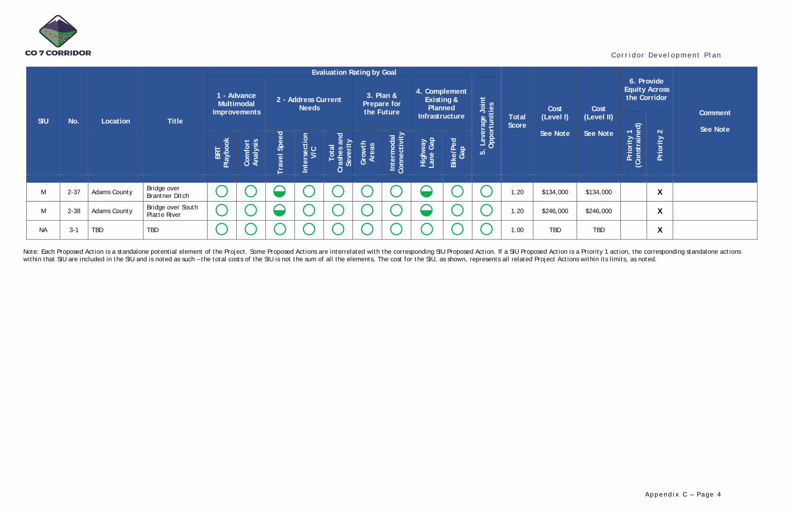
Cor r i dor Deve lopment P l an
A p p e n d i x C – P a g e 4
SIU No. Location Title
Evaluation Rating by Goal
Total Score
Cost (Level I)
See Note
Cost (Level II)
See Note
6. Provide Equity Across the Corridor
Comment
See Note
1 - Advance Multimodal
Improvements
2 - Address Current Needs
3. Plan & Prepare for the Future
4. Complement Existing & Planned
Infrastructure
5. L
ever
age
Join
t O
ppor
tuni
ties
Prio
rity
1
(Con
stra
ined
)
Prio
rity
2
BRT
Play
book
Com
fort
A
naly
sis
Trav
el S
peed
Inte
rsec
tion
V/
C
Tota
l Cr
ashe
s an
d Se
veri
ty
Gro
wth
A
reas
Inte
rmod
al
Conn
ecti
vity
Hig
hway
La
ne G
ap
Bike
/Ped
G
ap
M 2-37 Adams County Bridge over Brantner Ditch
1.20 $134,000 $134,000 X
M 2-38 Adams County Bridge over South Platte River
1.20 $246,000 $246,000 X
NA 3-1 TBD TBD
1.00 TBD TBD X
Note: Each Proposed Action is a standalone potential element of the Project. Some Proposed Actions are interrelated with the corresponding SIU Proposed Action. If a SIU Proposed Action is a Priority 1 action, the corresponding standalone actions within that SIU are included in the SIU and is noted as such – the total costs of the SIU is not the sum of all the elements. The cost for the SIU, as shown, represents all related Project Actions within its limits, as noted.
○ ○ ◒ ○ ○ ○ ○ ◒ ○ ○○ ○ ◒ ○ ○ ○ ○ ◒ ○ ○○ ○ ○ ○ ○ ○ ○ ○ ○ ○

Cor r i dor Deve lopment P l an
A p p e n d i x D – P a g e 1
APPENDIX D. SUPPORTING ANALYSIS Roadway Lane Continuity Gap Analysis
Based on existing highway lane configurations and discontinuity, areas within the Corridor were subjectively categorized into High, Moderate, and Low opportunity zones for local improvements to provide cumulative benefits for lane connectivity.
Bike Facility and Shared Use Path Gap Analysis
Based on existing bicycle and pedestrian configurations and discontinuity, areas within the Corridor were subjectively categorized into High, Moderate, and Low opportunity zones for local improvements to provide cumulative benefits for facility connectivity.
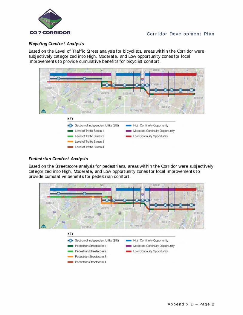
Cor r i dor Deve lopment P l an
A p p e n d i x D – P a g e 2
Bicycling Comfort Analysis
Based on the Level of Traffic Stress analysis for bicyclists, areas within the Corridor were subjectively categorized into High, Moderate, and Low opportunity zones for local improvements to provide cumulative benefits for bicyclist comfort.
Pedestrian Comfort Analysis
Based on the Streetscore analysis for pedestrians, areas within the Corridor were subjectively categorized into High, Moderate, and Low opportunity zones for local improvements to provide cumulative benefits for pedestrian comfort.
Cor r i dor Deve lopment P l an
A p p e n d i x E – Pa g e 1
APPENDIX E. POTENTIAL FUNDING SOURCES Federal Funding Sources
Highway Safety Improvement Program (HSIP)
The HSIP provides $2.4 billion nationally for projects and programs that help communities achieve significant reductions in traffic fatalities and serious injuries on all public roads, bikeways, and walkways. Infrastructure and non-infrastructure projects are eligible for HSIP funds. Pedestrian and bicycle safety improvements, enforcement activities, traffic calming projects, and crossing treatments for active transportation users in school zones are all examples of eligible projects. In order to be eligible for the HSIP, all states must have developed a Strategic Highway Safety Plan (SHSP) that identifies projects or strategies to reduce identified safety problems. All HSIP projects must be consistent with the state’s Strategic Highway Safety Plan (SHSP) of achieving zero deaths on Colorado roads. Funds are awarded on an annual basis from the Federal Highway Administration and the Colorado Department of Transportation.
Funds are programmed by the Colorado Department of Transportation. https://www.codot.gov/library/traffic/hsip
Better Utilization Investments to Leverage Development (BUILD) Discretionary Grant
The BUILD grant, formerly known as Transportation Investment Generating Economic Recovery (TIGER) Discretionary Grants Program, allows sponsors at the state and local levels to obtain funding for multimodal, multi-jurisdictional projects that are more difficult to support through traditional Department of Transportation (DOT) funding programs. Recreational trails are an eligible project category among other active transportation and recreation categories. Projects are evaluated based on merit criteria that include safety, economic competitiveness, quality of life, environmental sustainability, state of good repair, innovation, and partnership. Grants applications are accepted annually in May.
Funds are programmed by the U.S. Department of Transportation. https://www.transportation. gov/BUILDgrants
Federal Transit Agency Capital Investment Program (CIG) - Small Starts
This FTA discretionary grant program funds transit capital investments, including BRT Corridors. Federal transit law requires transit agencies seeking Capital Investment Grant funding to complete a series of steps over several years. For Small Starts projects, the law requires completion of one phase in advance of receipt of a construction grant agreement – Project Development. The law also requires projects to be rated by FTA at various points in the process according to statutory criteria evaluating project justification and local financial commitment.
Funds are programmed by the Federal Transit Agency https://www.transit.dot.gov/funding/grant-programs/capital-investments/about-program

Cor r i dor Deve lopment P l an
A p p e n d i x E – Pa g e 2
Transportation Alternatives (TA)
The Fixing America’s Surface Transportation (FAST) Act recently replaced the former Transportation Alternatives Program (TAP) with set-aside funds under the Surface Transportation Block Grant Program (STBG). For administrative purposes, the Federal Highway Administration (FHWA) refers to these funds as TA Set-Aside. Projects eligible for TA Set-Aside funds include on and off-road active transportation facilities, improvements to non-driver access to transit, recreational trails, and safe routes to school. State DOTs and MPOs are not eligible entities as defined under 23 U.S.C. 133(h)(4)(B) and therefore are not eligible project sponsors for TAP funds. However, State DOTs and MPOs may partner with an eligible entity project sponsor to carry out a project.
Funds are programmed by the Colorado Department of Transportation. https://www.codot.gov/programs/planning/documents/grants/tap/TAP-guidelines.pdf
Safe Routes to School (SRTS)
The SRTS program provides a source of funding for education, enforcement, evaluations, and infrastructure improvements (e.g., sidewalks, bike parking, etc.) that encourage elementary and middle school students to walk or bike to school. The Colorado Department of Transportation (CDOT) administers these programs using Federal Surface Transportation Block Grant Set-Aside funds and HSIP Program funds. Eligible entities include local governments, regional transportation authorities, transit authorities, natural resource or public land agencies, and school districts. Funds are available for SRTS programs that benefit elementary and middle school children in Kindergarten through 8th grade. Eligible projects must be within a 2-mile radius of the identified schools.
Funds are programmed by the Colorado Department of Transportation https://www.codot.gov/inf_fy19srts_instructionsandguidelines.pdf
Building Resilient Infrastructure and Communities (BRIC)
Building Resilient Infrastructure and Communities (BRIC) will support states, local communities, tribes, and territories as they undertake hazard mitigation projects, reducing the risks they face from disasters and natural hazards. BRIC is a new FEMA pre-disaster hazard mitigation program that replaces the existing Pre-Disaster Mitigation (PDM) program. The BRIC program guiding principles are supporting communities through capability and capacity-building; encouraging and enabling innovation; promoting partnerships; enabling large projects; maintaining flexibility; and providing consistency.
Funds are administered by the Federal Emergency Management Administration https://www.fema.gov/grants/mitigation/building-resilient-infrastructure-communities
Cor r i dor Deve lopment P l an
A p p e n d i x E – Pa g e 3
State and Regional Funding Sources
Denver Regional Council of Governments (DRCOG) Transportation Improvement Program
The Transportation Improvement Program (TIP) will specifically program the federally funded transportation improvements and management actions to be completed by CDOT, the Regional Transportation District (RTD), local governments, and other project sponsors over a four-year period. DRCOG initiated a new process for determining what projects should be included in the 2020-2023 TIP. This “dual model” process provided opportunities for subregions to fund local priority projects in addition to regional priority projects with continued focus on Metro Vision and the Regional Transportation Plan. Next Call for projects is anticipated in 2022.
Funds are programmed by the Denver Regional Council of Governments https://drcog.org/planning-great-region/transportation-planning/transportation-improvement-program
DRCOG Community Mobility Planning and Implementation (CMPI) Set-Aside
The purpose of the CMPI set-aside is to support small area planning and small infrastructure projects that contribute to the implementation of key outcomes within Metro Vision and the Metro Vision Regional Transportation Plan. The program goals are to support diverse, livable communities; support the development of connected urban centers and multimodal corridors; support a transportation system that is well-connected and serves all modes of travel; and support healthy and active choice and expand access to opportunity for residents of all ages, incomes, and abilities. Next call for Projects is anticipated in summer 2021.
Funds are programmed by the Denver Regional Council of Governments https://drcog.org/services-and-resources/data-maps-and-modeling/denver-regional-visual-resources/transportation
DRCOG Regional Transportation Operations and Technology (RTO&T) Set Aside
The purpose of the Regional Transportation Operations & Technology (RTO&T) set-aside is to fund transportation technology and systems improvements that contribute to the implementation of key outcomes within Metro Vision and the Metro Vision Regional Transportation Plan. The primary objectives of this set-aside are to improve transportation system performance and reliability, improve transportation safety and security, improve bicycle and pedestrian accessibility, and improve interconnections of the multimodal transportation system within and beyond the region for people and freight.
Funds are programmed by the Denver Regional Council of Governments https://drcog.org/planning-great-region/transportation-planning/transportation-improvement-program/transportation
Colorado Connect Initiative
GOCO’s Connect Initiative is a five-year strategy aimed at increasing access to outdoor experiences through the construction of non-motorized trails of local, regional, and statewide significance. This program aims to increase access to the outdoors in Colorado communities by filling trail gaps, building new trails, and providing better walkable and bikeable access for youth and families. Applicants may request up to $2 million for trail construction projects.
Cor r i dor Deve lopment P l an
A p p e n d i x E – Pa g e 4
Eligible grantees include municipalities, counties, and Title 32 special park and recreation districts that receive Conservation Trust Fund monies from the Department of Local Affairs. Projects must be primarily for trail construction; however, land acquisitions may be considered with staff approval. There is no requirement for surface type. Projects that present an exciting opportunity to leverage partnerships and outside funding, connect important trail segments, and are shovel-ready may score more competitively.
Funds are programmed by the Colorado Parks and Wildlife https://goco.org/grants/apply/connect-initiative-grants
Colorado Multimodal Options Fund
The Colorado Multimodal Options Fund (MMOF) seeks to fund multimodal transportation projects and operations throughout the state because, in addition to the general benefits that it provides to all Coloradans, a complete and integrated multimodal transportation system benefits seniors by making aging in place more feasible for them, provides enhanced mobility for persons with disabilities; and provides safe routes to schools for children. Eligible projects are selected to receive local Multimodal Options Funds (MMOF) by the Regional Planning Commissions (RPC) of the 15 Transportation Planning Regions (TPRs).
Funds are programmed by the Colorado Department of Transportation https://www.codot.gov/programs/planning/grants/mmof-local
Colorado Bridge Enterprise
The Colorado Bridge Enterprise (CBE) was formed in 2009 as part of the Funding Advancement for Surface Transportation and Economic Recovery (FASTER) legislation. It operates as a government-owned business within the Colorado Department of Transportation. The Colorado Transportation Commission serves as the Colorado Bridge Enterprise Board. The purpose of the CBE is to finance, repair, reconstruct and replace designated bridges as defined by SB-09-108. In spring 2009, when the FASTER legislation went into effect, 128 bridges were determined to be eligible for the program. An assessment is performed semi-annually to identify newly eligible structures.
Funds are programmed by the Colorado Department of Transportation https://www.codot.gov/programs/BridgeEnterprise
Regional Priority Program
At the start of each 24-month planning cycle the Transportation Commission determines the amount of the Regional Priority Program (RPP) funding for the planning cycle. As part of CDOT’s continuous and comprehensive planning process, region staff (including the Regional Transportation Directors, Program Engineers, and Region Planners) collaborate with the MPOs (Metropolitan Planning Organizations) and TPRs (Transportation Planning Regions) to determine regional priorities and project selection. Selected MPO projects are programmed into the Transportation Improvement Plan (TIP) and are used to leverage other funding sources.
Funds are programmed by the Colorado Department of Transportation https://www.codot.gov/business/project-management/asset-and-fund-management-guidebook/regional-priority-program
Cor r i dor Deve lopment P l an
A p p e n d i x E – Pa g e 5
Senate Bill 2017-267
In 2017, the Colorado General Assembly enacted Senate Bill 17-267 (SB-267) “Concerning the Sustainability of Rural Colorado.” SB-267 authorizes the State of Colorado to execute lease-purchase agreements on state facilities totaling up to $2.0 billion to be issued in equal amounts over four years beginning in fiscal year 2018-19. CDOT is the recipient of up to $1.88 billion of the proceeds. The projects must be qualified federal aid highway projects that are included in Tier 1 of CDOT’s Ten-Year Development Program and no more than 90 percent of the proceeds shall be expended for highway purposes or capital improvements, and at least 10 percent of the proceeds shall be expended for transit purposes or for transit-related capital improvements.
Funds are programmed by the Colorado Department of Transportation https://leg.colorado.gov/sites/default/files/cdot_qa_on_sb17-267s_effects_on_transportation_funding.pdf