Embed Size (px)
Citation preview

�������� ����� ��
Cosmic ray exposure dating on the large landslide of Sechilienne (WesternAlps): A synthesis to constrain the slope evolution
Stephane Schwartz, Swann Zerathe, Denis Jongmans, Laurent Baillet,Julien Carcaillet, Laurence Audin, Thierry Dumont, Didier Bourles, RegisBraucher, Vincent Lebrouc
PII: S0169-555X(16)30524-4DOI: doi:10.1016/j.geomorph.2016.11.014Reference: GEOMOR 5836
To appear in: Geomorphology
Received date: 27 June 2016Accepted date: 16 November 2016
Please cite this article as: Schwartz, Stephane, Zerathe, Swann, Jongmans, Denis, Bail-let, Laurent, Carcaillet, Julien, Audin, Laurence, Dumont, Thierry, Bourles, Didier,Braucher, Regis, Lebrouc, Vincent, Cosmic ray exposure dating on the large landslide ofSechilienne (Western Alps): A synthesis to constrain the slope evolution, Geomorphology(2016), doi:10.1016/j.geomorph.2016.11.014
This is a PDF file of an unedited manuscript that has been accepted for publication.As a service to our customers we are providing this early version of the manuscript.The manuscript will undergo copyediting, typesetting, and review of the resulting proofbefore it is published in its final form. Please note that during the production processerrors may be discovered which could affect the content, and all legal disclaimers thatapply to the journal pertain.

ACC
EPTE
D M
ANU
SCR
IPT
ACCEPTED MANUSCRIPT
1
Cosmic ray exposure dating on the large landslide of Séchilienne (Western
Alps): a synthesis to constrain the slope evolution.
Stéphane Schwartz1*
, Swann Zerathe1, Denis Jongmans
1, Laurent Baillet
1, Julien Carcaillet
1,
Laurence Audin1, Thierry Dumont
1, Didier Bourlès
2, Régis Braucher
2, Vincent Lebrouc
1
1-Université Grenoble Alpes, CNRS, IRD, ISTerre, F-38000 Grenoble
2-CEREGE, Université Aix-Marseille-CNRS, France
*Corresponding author. Tel: 33 4 76 63 59 04; Fax: 33 4 76 51 40 58
E-mail address: [email protected]
Abstract
The 60×106 m
3 Séchilienne landslide (Belledonne Massif, Western Alps) locates on the right
bank of the East-West trending Romanche valley, shaped by glacial and alluvial processes
during the Quaternary. Previous cosmic ray exposure (CRE) dating on the main scarp (Le
Roux et al., 2009) revealed that the initiation of instability occurred several thousand years
after ice down-wastage in the valley but the internal evolution of the landslide remained
unknown. In this paper, we provide 63 additional 10
Be samples collected from the internal
scarps and the main scarp, as well as on glacially polished rock surfaces. The aim is to
constrain the global landslide kinematics and its possible relation to the glacier retreat.
Results from glacially polished surfaces point out that complex shielding processes (relict
moraines, soil deposits and seasonal snow cover) might have occurred after the glacial
retreat. Despite age scattering resulting from these processes, our dataset evidence a glacial
retreat achieved between 17.5 and 13 ka. Exposure ages obtained on gravitational scarps
revealed that the landslide initiation occurred 8 to 6 ka ago. At this stage and until 2 ka the

ACC
EPTE
D M
ANU
SCR
IPT
ACCEPTED MANUSCRIPT
2
gravitational kinematics was slow (~2 mm.yr-1
) and focused around on the main scarp,
leading to a general slope subsidence. After 2 ka, the rates increased significantly (~8
mm.yr-1
) in association with the development of pervasive internal deformation of the
landslide mass. This new slope evolution scenario of the Séchilienne area reflects
progressive rock-slope weakening since 8 ka, associated to a continuous activity of a deep-
seated failure surface.
Keywords: Western Alps, Séchilienne landslide, cosmic ray exposure dating, slope
evolution.

ACC
EPTE
D M
ANU
SCR
IPT
ACCEPTED MANUSCRIPT
3
1. Introduction
Alpine valley morphology has been strongly influenced by glaciations that have probably
been the predominant erosional mechanism affecting glaciated mountain belts over the
Quaternary (Montgomery, 2002 and references therein). The imprint of glacial erosion in
the landscape is expressed by typical features such as U-shaped and overdeepened valleys,
hanging valleys, stepped profiles, polished and striated surfaces and grooves, associated
with the deposition of erosional products in moraines (Kelly et al., 2004; Anderson and
Anderson, 2012). Numerous erosion models have been developed to explain how ice is able
to shape the relief, both on longitudinal and transverse valley profiles (Harbor, 1992;
Augustinus, 1995; McGregor et al., 2000; Anderson et al., 2006, Herman and Braun, 2008).
In particular, Harbor (1992 and 1995) simulated the evolution of transverse valley profile
during steady occupation by a glacier, showing that the valley propagates vertically as a U-
shape form with lateral steepened rock-slopes. Numerous studies of longitudinal profiles of
glaciated valleys have shown the presence of steps that usually coincide with coalescence of
headwater valleys, tributary junctions or variations in rock resistance (McGregor et al.,
2000; Anderson et al., 2006). It turned out that glacial erosion and the resulting landscape
are strongly controlled by the bedrock hardness and strength, as well as by the fracturing
(Dunforth et al. 2010, Krabbendam and Glasser, 2011; Salcher et al., 2014).
Deglaciation in the Alps left many slopes oversteepened, which have been subsequently
affected by large rock-slope instabilities (Erismann and Abele, 2001). The cause usually
cited for triggering rock-slope failure in deglaciated mountain areas is the lateral stress
release resulting from ice melting (debutressing) (among others, Cruden and Hu, 1993;
Blair, 1994; Evans and Clague, 1994; Holm et al., 2004; Cossart et al., 2008). However, the
initiation of large-scale landslides in the Alps has also been associated with other factors like
earthquakes, subsequent climatic changes, tectonic stresses, uplift rate and river and bedrock

ACC
EPTE
D M
ANU
SCR
IPT
ACCEPTED MANUSCRIPT
4
erosion (e.g., Ballantyne, 2002; Seijmonsbergen et al., 2005; Cossart et al., 2008; Hormes et
al., 2008; Le Roux et al., 2009; Sanchez et al., 2009, Zerathe et al., 2014). As all these
factors are potentially active, identifying the major cause responsible for triggering rock-
slope instability remains a strongly debated question (Korup, 2008; Zerathe et al, 2014) and
the timing of events is a key issue to better understand the real mechanism(s) driving
instabilities in a post-glacial period.
In the last decade, CRE (Cosmic Ray Exposure) dating has been increasingly and
extensively used for assessing the timing of large rock-slope failures in the Alps (among
others, Ivy-Ochs et al., 1998; Bigot-Cormier et al., 2005; Hippolyte et al., 2006; Hormes et
al. 2008, Le Roux et al., 2009; Ivy-Ochs et al., 2009; Delunel et al., 2010a; Ostermann et al.,
2012). The same technique was also applied to constrain the timing of the last deglaciation
by dating late glacial moraine deposits and glacially polished bedrock surfaces (e.g.
Darnault et al., 2012), allowing the chronology of both valley deglaciation and rock-slope
instability to be established at specific sites (Bigot-Cormier et al., 2005; Cossart et al., 2008;
Hormes et al., 2008; Ivy-Ochs et al., 2009; Prager et al., 2009, Le Roux et al. 2009; Martin
at al., 2014). Major findings are that the last glacial retreat occurred simultaneously across
the Alps (Darnault et al., 2012) and that some large landslides did not trigger during
deglaciation but after a delay of several thousand years after the valley is ice-free (Le Roux
et al., 2009; McColl, 2012). A recent synthesis of the failure-ages chronicles obtained for the
large-scale landslides throughout the Alps (Zerathe et al., 2014) identified two main periods
of landslide activity, from 11 to 8 ka (Pre-Boreal and Boreal periods) and from 5 to 3 ka
(Subboreal period). The authors related the first activity period (11 to 8 ka) to two alpine-
glacier recession phases at 10.9 ± 1.1 ka (end of the Younger Dryas period) and 8.4 ± 0.9 ka
(beginning of the Holocene climatic optimum) (Darnault et al., 2012) and proposed the
isostatic rebound following the glacial retreat as the main triggering factor. However, during

ACC
EPTE
D M
ANU
SCR
IPT
ACCEPTED MANUSCRIPT
5
those two periods, the lower elevation valleys were totally deglaciated, as shown by Le
Roux et al. (2009) and Martin et al. (2014), and have then been unaffected by the subsequent
glacial retreats which occurred at higher elevations. Indeed, even for higher elevations, the
documented cases (McColl, 2012) indicate that most large post-glacial failures have
typically occurred some thousands of years after ice retreat (Hormes et al., 2008; Ivy-Ochs
et al. 2009, Prager et al., 2009; Le Roux et al., 2009; Martin et al., 2014). Three main
reasons have been generally evoked to explain this delay (McColl, 2012): the time lag
between local slope stress-redistribution and the development of sheeting joints, the lag
between regional glacio-isostatic rebound and a potential period of enhanced seismicity, and
the effect of climatic factors such as warmer temperatures and increased rainfall which were
more significant in the middle and early Holocene (Le Roux et al., 2009; Zerathe et al.,
2014). Recently, Lebrouc et al. (2013) also proposed that the persistence of permafrost could
have played a role in delaying instability initiation. Modeling the thermal response of the
Séchilienne slope (Romanche valley, Western Alps) during the last 21,000 years, they
suggested that the permafrost probably vanished around 10 to 11 ka, at least 3000 to 4000
years after the total ice down-wastage in the valley.
Most of the CRE studies on large landslides were focused on the dating of head scarps, of
sliding planes or of blocks resulting from a rock avalanche process (see Zerathe et al., 2014
and the references herein). To our knowledge, no attempt has been made so far to date the
internal scarps of a landslide in order to obtain its kinematics. This paper presents a
comprehensive study to constrain the chronology of the large Séchilienne landslide (Western
Alps) that affects the right slope of the Romanche valley between 450 m and 1140 m a.s.l.
and its relation with the Romanche glacier retreat.
The head scarp and a few polished rock surfaces located in the upper part of the landslide
were already locally dated from 23 samples (Le Roux et al., 2009). Application of the CRE
ACC
EPTE
D M
ANU
SCR
IPT
ACCEPTED MANUSCRIPT
6
method along the 35 m high head scarp yielded an initiation of the rock-slope failure at 6.4 ±
1.4 10
Be ka and a continuous rock-slope failure activity with a mean head scarp exposure
rate of 0.6 cm.yr-1
. Glacier retreat at ~1100 m a.s.l. was estimated at 16.6 ± 0.6 10
Be ka, with
total deglaciation of the valley achieved at least by 13.3 ka. This chronological constraint
was however obtained from the Tinée valley located 130 km southeast from the Romanche
Valley (Bigot-Cormier et al., 2005).
Here, we sampled rock outcrops within the landslide, at an elevation between 840 and 1140
m a.s.l. with a four-fold objective: (1) to confirm the timing of the failure triggering over
the head scarp length, including the main lateral scarp, (2) to assess the vertical glacial
retreat rate in the Romanche valley from the dating of polished and striated rock surfaces at
lower elevations, (3) to date internal scarps of different sizes and types (valley facing and
counter scarps) in order to assess their origin (glacial erosion or gravitational movement)
and (4) to get some insight in the landslide kinematics. A total of 63 samples were taken in
the upper part of the landslide. In contrast with the major near-vertical head scarp studied by
Le Roux et al. (2009), internal scarps were frequently affected by rockfalls, rejuvenating the
outcrops and locally providing young ages. The glacially polished outcrops in the landslide
often exhibit a wide range of 10
Be concentrations, with unexpected low values that suggest
that some outcrops have been temporary masked by deposits and subsequently exposed after
their erosion. Exposure of rocks to cosmic rays on the Séchilienne slope then turned out to
be dependent on multiple processes including the glacial retreat, the erosion of till deposits,
the local fall of blocks and gravitational movements. The analysis of this large data set
allowed to assess the influence of the different phenomena and to constrain the kinematics
of the Séchilienne slope since the Last Glacial Maximum (LGM) around 21 ka (Clarke et al.,
2009).

ACC
EPTE
D M
ANU
SCR
IPT
ACCEPTED MANUSCRIPT
7
2. Geological setting and dynamics of the landslide
The Séchilienne landslide is located in the southern part of the Belledonne massif (Western
Alps) along the East-West trending Romanche valley at 20 km South-East of Grenoble City
(Fig.1). This massif, which extends over more 120 km in a N30 direction with a maximum
elevation of 3000 m a.s.l., is one of the Paleozoic External Crystalline Massifs of the French
Western Alps. It is a part of the Hercynian orogeny that has been overprinted by Alpine
shortening and uplift (Guillot et al., 2009). The Paleozoic basement consists of a complex of
different metamorphic rocks including gneisses, amphibolites and micaschists
unconformably overlain by Mesozoic carbonate sediments and Quaternary deposits (Fig. 1).
The incision of the Romanche valley results from alternate activity of water and ice during a
succession of Quaternary glaciations including the LGM when the Romanche valley was
covered with ice to an elevation of 1200 m a.s.l. (Montjuvent and Winistörfer, 1980).
The present-day landform of the lower Romanche valley shows an important glacial imprint
(van der Beek and Bourbon, 2008; Delunel et al., 2010b; Le Roux et al., 2010) such as steep
slopes dipping 35° to 40°, overdeepened troughs and glacial deposits. These morphological
characteristics suggest a temperate thermal regime for the glacier during the LGM (Lebrouc
et al., 2013). Moreover, the right side of the Romanche valley is overlooked by a glacial
plateau (Mont Sec plateau in Fig.1) at an elevation higher than 1100 m a.s.l., showing stoss-
and-lee surfaces locally covered by peat bogs and moraines. The orientation of grooves and
striae is consistent with a north-south trending ice flow on the Mont Sec plateau (Fig. 2).
Along the glacial slope, at an elevation lower than 1000 m, rare flow directions are parallel
to the Romanche valley direction. The metamorphic rocks in the landslide are affected by
three main sets of near-vertical fractures oriented N20, N70 and N110 to N120 (Lebrouc et
al., 2013). The N20 fractures are near-parallel to the major late Paleozoic vertical fault so-
called the Belledonne Middle Fault (BMF) and their orientation fits the main foliation plane

ACC
EPTE
D M
ANU
SCR
IPT
ACCEPTED MANUSCRIPT
8
measured in the micaschists over the slope. The N70 and N110-120 fracture sets correspond
to a major regional fracturing network evidenced on both sides of the BMF, in the
micaschists and the amphibolites, and is probably inherited from the regional Hercynian and
Alpine tectonic framework (Le Roux et al., 2010). In addition, a dense set of N75-oriented
short fractures dipping 40-50°S, near parallel to the slope, is observed from the slope surface
down to 100 m depth in the Séchilienne landslide (Bièvre et al., 2012).
The Séchilienne landslide has been the subject of multiple investigation campaigns and of
monitoring for thirty years (Evrard et al., 1990; Vengeon et al., 1999; Guglielmi et al., 2002;
Duranthon et al., 2003; Helmstetter and Garambois, 2010; Le Roux et al., 2011; Cappa et
al., 2014). The volume affected by the landslide was estimated to 50-60×106 m
3 with a
maximum destabilization depth about 150 m (Le Roux et al., 2011). The global destabilized
mass displays medium activity with slow displacement rates (> 2 cm.yr-1
), while, lower in
the slope, a frontal mass (The Ruines area in Fig. 2) with a volume of about 3×10⁶ m
3
exhibits high velocity reaching a maximum of 100 cm.yr-1
and generates frequent rockfalls,
as attested by the large scree at the slope foot (Fig. 2).
3. Main morphological features
The Séchilienne slope dominates the right bank of the Romanche valley and three distinct
morphological zones can be distinguished from north to south (Figs. 2 and 3a): the near-
horizontal preserved glacial plateau, the depleted part of the plateau affected by the landslide
and the steeper glacial slope mainly destabilized by recent rockfalls. The preserved glacial
plateau (Mont Sec plateau in Figs. 2 and 3) with an elevation of 1140 m a.s.l. has a
morphology consisting of alternating North-South elongated depressions carved in
micaschist lithology (Figs. 2 and 3a). The rock surfaces are polished, reflecting the erosive
activity of the glacier during the last glacial maximum (Fig. 3b), and locally exhibit some

ACC
EPTE
D M
ANU
SCR
IPT
ACCEPTED MANUSCRIPT
9
remnant metric glacial striae indicating a southward direction of the ice flow (Fig. 3c). The
longest depressions (> 50 m) are infilled by peat bog (Fig. 3b) with a maximum thickness of
about 10 m (Legchenko et al., 2011). The plateau is locally covered by moraine deposits of
variable thickness, which are mostly preserved in small topographic depressions. These
deposits are made of centimeter-size rounded clasts of amphibolite and gneiss in fine-
grained matrix. The preserved plateau is delineated to the South by the main landslide scarp
(head scarp) of over 1000 m in length, reaching a maximum height of 40 m (Figs. 2, 3a and
3d). Below this head scarp, the second morphological zone is a gentle sloping area situated
at an elevation between 1120 and 1000 m a.s.l.. This zone, which is interpreted as the
depleted glacial plateau, exhibits a series of depressions delineated by a succession of
valley-facing scarps and counter scarps reaching 5 to more than 10 m high (Figs. 2, 3a).
These structures are oriented N20 and N110 and follow major inherited fracture directions
(Fig. 2; Le Roux et al., 2010). The upper near-horizontal surfaces locally exhibit N/S to
NE/SW oriented glacial striae (Fig. 3e), in line with the ice flow direction observed on the
preserved plateau Mont Sec. These glacial imprint features are often covered and hidden by
moraine deposits with a thickness of a few meters. The lower part of the landslide exhibit
steep (> 35°) convex slopes underlined by a succession of several hundred meters long
cliffs, several tens of meters in height and oriented N60°E to N70°E. This feature is
interpreted as the lateral steepened rock-slopes of a typical U-shape valley (glacial slope).
The cliffs are affected by numerous rockfalls with the development of detrital cones at their
foot (Fig. 3g). Despite of this rockfalls activity, relics of near-vertical glacially polished
surfaces are visible in the slope (Fig. 3f), with the presence of horizontal grooves several
tens of meters in length and of rare near-horizontal striae. In this zone, the grooves and striae
indicate an ice flow direction parallel to the Romanche valley (N70) (Fig. 1), which is
different from the ice flow orientation observed on the glacial plateau. These glacial features

ACC
EPTE
D M
ANU
SCR
IPT
ACCEPTED MANUSCRIPT
10
have been interpreted as resulting from the action of the glaciers of the Isére and Romanche
valleys, flowing southward and nearly westward, respectively (Montjuvent and Winistörfer,
1980). This lower part of the landslide is interpreted as an accumulation zone (Vengeon et
al., 1999).
In summary, the Séchilienne slope shows both a pronounced glacial morphological imprint
and numerous morphological witnesses inherited from the last glacial phase have been
preserved on the Mont Sec Plateau and in the slope. After the deglaciation, the slope has
been affected by major gravitational movements and rockfalls activity in areas with strong
topographic gradient. In an attempt to date both the ice disappearance and the gravitational
destabilization, we have sampled quartz on (1) near-horizontal glacially polished surfaces on
the Mont Sec plateau (depleted zone), (2) polished surfaces in the steep glacial slope, (3) the
main landslide scarp and (4) internal gravitational scarps.
4. In-situ 10
Be dating
Cosmic Ray Exposure (CRE) is a geochronological dating method that is based on the
accumulation of Terrestrial Cosmogenic Nuclides (TCNs, such as 36
Cl, 10
Be, or 26
Al) in
superficial rocks. TCNs are produced within mineral lattice through nuclear reactions
between the nucleus of the elements that form the minerals and the incident secondary
cosmic ray particles derived from the high-energy galactic cosmic radiation (see a review in
Gosse and Phillips, 2001). Because the production rate of these in situ TCNs decreases
exponentially with depth (Lal, 1991), their concentrations are directly related to the near-
surface exposure history of the analyzed samples and allow determining the exposure ages
of the sampled surfaces. In this paper, the dominant endogenous lithology of the bedrock
favored the use of the in-situ produced 10
Be cosmogenic nuclide within quartz.
ACC
EPTE
D M
ANU
SCR
IPT
ACCEPTED MANUSCRIPT
11
4.1. Sampling strategy
Samples for CRE dating were collected from micaschist outcrops hosting quartz veins. The
sampling locations are given in Figure 4, while the characteristics of the sampled surfaces
are provided in Table 1. Two types of rock surface were sampled: (1) near-vertical scarps of
gravitational origin (S1 to S13) and (2) glacially polished surfaces (P14 to P20) (Table 1). In
total, 63 quartz-rich samples were collected in order to obtain chronological constrain by
CRE dating. This study also takes into account the 23 data presented in Le Roux et al.
(2009), marked with an asterisk in Table 1 (S1 to S3, P3, P16 and P17). For consistency, the
corresponding ages were recalculated using the most recent update parameters (Heyman,
2014). The new gravitational sampled surfaces (Fig. 4) include 10 scarps (S4 to S14). In
total, this study analyses 6 profiles along the main scarp (S1, S2, S3, S4, S5 and S9) and 7
internal scarps of low height (< 10 m) including 3 valley-facing scarps (S10, S11, S12) and
4 counter scarps (S6, S7, S8, S13). All these scarps exhibit steep slope over 70°. The new
sampled glacially surfaces (Fig. 4) include 12 flat polished surfaces (P4, P6 to P13, P18, P19
and P20) located at the top of the scarps and 2 vertical profiles along steep (62° and 65°)
polished surfaces (P14 and P15). The number of samples per surface varies between 1 and
11, depending on the profile height and the surface type.
All sampled surfaces are located at an elevation ranging from 840 to 1140 m a.s.l.. Indeed,
most of the cliffs located below the depleted zone are strongly affected by rockfalls, making
it difficult to date their exposure. For both surface types (gravitational and glacial), outcrops
exhibiting signs of significant and recent blockfall activity were discarded. However,
numerous near-vertical sampled surfaces (8 over 15, see Table 1) exhibit surface
morphology with local roughness, which might be caused by blockfalls. This issue will be
discussed further in section.

ACC
EPTE
D M
ANU
SCR
IPT
ACCEPTED MANUSCRIPT
12
4.2. Nuclide extraction and age calculation
Beryllium-10 (10
Be) targets were prepared at the LN2C (Laboratoire National des Nucléides
Cosmogéniques, CEREGE, France) following procedures adapted from Brown et al. (1991)
and Merchel and Herpers (1999). Crushed rocks were sieved at 200-500 µm and the
magnetic grains were separated using a magnetic Frantz separator. Pure quartz was obtained
by repeated H2SiF6-HCl etching and then atmospheric 10
Be was removed by three sequential
dissolutions (each eliminating 10% of the weight) with diluted HF. After addition of 100 µl
of an in-house 3.10-3
g/g 9Be carrier solution prepared from deep-mined phenakite
(Chmeleff et al., 2010), residual grains were dissolved in 48% HF excess solution. After
complete evaporation of the HF, the remaining solutions were purified and beryllium was
separated using anion and cation exchange columns. The final precipitate was dried and
heated at 900°C to obtain BeO.
Measurements were carried out at the French National AMS facility (Arnold et al., 2013,
ASTER, CEREGE, Aix-en-Provence). The 10
Be / 9Be ratios were calibrated against NIST
Standard Reference Material 4325 with an assigned 10
Be / 9Be ratio of 2.79×10
-11
(Nishiizumi et al. 2007) and a 10
Be half-life of 1.387 ± 0.012 106 yr (Korschinek et al., 2009;
Chmeleff et al., 2010).
Ages were calculated using the online Cronus calculator (Balco et al., 2008), considering no
erosion rate and a mean rock density of 2.7. The ages have been computed using the scaling
scheme of Lal (1991) modified by Stone (2000) and taking into account the effect of
paleomagnetic variations (see Balco et al., 2008 for details). The topographic shielding was
estimated according to Dunne et al. (1999). We used a global averaged time-dependent

ACC
EPTE
D M
ANU
SCR
IPT
ACCEPTED MANUSCRIPT
13
SLHL 10
Be production rate of 3.94 ± 0.20 at.g-1
.yr-1
recently compiled by Heyman (2014) on
the basis on 20 site production rates. All calculated 10
Be ages are minimum exposure ages.
Analytical uncertainties, involving AMS external error (0.5%), standard reproducibility
(Arnold et al., 2013) and chemical blank measurements (10
Be/9Beblank = 2.46 ± 0.74 × 10
−15)
have subsequently been propagated through the parameter simulations and are reported
within the uncertainties of the resulting exposure ages. All data are presented in Table 2,
following the recommendations made by Dunai and Stuart (2009).
4.3. Role of inheritance
A key property of the CRE dating tool is the exponential decrease of the cosmogenic nuclide
production rate as a function of depth (Lal, 1991). Within a rock-medium of density of ~2.7,
the production rate is known to be reduced to 50%, 20% and < 5% of the surface production,
at 0.5 m, 1 m and 2 m depth, respectively (applying equations and parameters provided in
Zerathe et al., 2013 and references therein). This strong attenuation makes the CRE dating a
particularly useful and efficient tool to date the exhumation of a large set of
geomorphological features, as well as the timing of their recent evolution. Despite the rapid
decrease of the production rate below the earth-surface (neutronic component) some specific
particles (especially muons), characterized by higher attenuation length, produce a non-
negligible accumulation of TCNs at depth as great as 20 m (Braucher et al., 2011). This
accumulation of TCNs at depth, prior to the direct-exposure of the studied surface, is called
inheritance. In some specific geomorphic configurations (ie. shallow buried faults or
landslide scarps), recent studies (Zerathe et al., 2013, 2014) have shown that the inheritance
component may represent a non-negligible percentage of the measured cosmogenic nuclide
ACC
EPTE
D M
ANU
SCR
IPT
ACCEPTED MANUSCRIPT
14
concentration. Thus, neglecting this parameter for the age calculation may lead to too old
apparent ages and incorrect conclusions.
In the case of the Séchilienne landslide, an inherited component of cosmogenic nuclide
might be inferred in the upper part of the sampled scarps, due to their shallow burying and,
in some case, their low height (Table 1). Unfortunately, the online CRONUS calculator still
does not permit to take this parameter into account. Hence, we theoretically calculated the
10Be concentration that would have been inherited along a synthetic scarp, using the
classical equation and the parameters of Lal (1991) provided in Zerathe et al. (2013). The
calculus was done following a realistic scenario of pre-exposure duration in the studied area,
based on constrains from previously published local work (Le Roux et al., 2009). This
scenario includes the following hypotheses of : (1) a rock-medium free of inheritance before
the local glacier retreat; (2) a pre-exposure duration of 10 ka taking into account a glacier
retreat at 16 ka and a landslide activation at 6 ka. An uncertainty of ± 4 ka on the pre-
exposure duration; (3) a mean 10
Be surface-production rate scaled at 1100 m a.s.l., zero
surface erosion and a topographic shielding factor of 1.
The measured 10
Be concentrations, and the theoretical curve of 10
Be concentration
accumulated after a glacier retreat at 16 ka, are plotted against depth in Figure 5a. Most of
the measured values are higher than the potentially inherited concentrations under this
scenario, indicating that measured 10
Be along scarps predominantly comes from direct
exposure production. Figure 5b shows the ratio of the theoretically inherited 10
Be
concentrations and the measured ones for the same scenario, with error bars. The histogram
for the same data is drawn in Figure 5c. These figures highlight that the inherited component
of 10
Be rapidly decreases with depth. Below 3 meters (representing 80% of the measured
samples, Fig. 5c), the inheritance part represents less than 10% of the measured one, falling
within the age uncertainties (Table 2). Thus, a good confidence can be expected on the

ACC
EPTE
D M
ANU
SCR
IPT
ACCEPTED MANUSCRIPT
15
exposure age for the samples below a depth of 3 m, whereas those located in the first 3 m
may be affected by non-negligible inheritance.
5. Results
5.1. Glacially polished surface exposure ages
The dating results obtained along the glacially polished rock surfaces show a large
variability of apparent exposure ages (Table 2). For the glacial Mont Sec plateau, the
obtained exposure ages range from 1.9 ± 0.2 ka (P18) to 17.5 ± 1.1 ka (P17), while they vary
from 2.4 ± 0.3 ka (P14-2) to 15.4 ± 1 ka (P15-3) on the glacial slope. The two dataset
analysis lead to the probability density plots shown in Figures 6 and 7c. On the Mont Sec
plateau, two main peaks of higher probability appear, despite the data scattering: one at ca. 8
ka and another at ca. 12 ka (Fig. 6). Along the glacial slope, the probability density analysis
of ages over the two profiles P14 and P15 (Figs. 7a and b) reveals two groups of ages,
ranging from 2 to 6 ka and from 11 to 16 ka (Fig. 7c).
5.2. Gravitational surface exposure ages
The exposure ages obtained along thirteen near-vertical gravitational scarps of the
Séchilienne landslide are presented in Figure 8. Ages generally progressively decrease from
the scarp top to the base, consistently with the expected downward motion of the landslide
mass along the scarps. Few exceptions, including outliers, may reveal more complex
histories and will be discussed below. For the main scarps the exposure ages range from 0 to
8 ka (Fig. 8a and Table 2). For the internal scarps exposure ages are significantly younger

ACC
EPTE
D M
ANU
SCR
IPT
ACCEPTED MANUSCRIPT
16
(from 1 to 4 ka; Fig. 8b and Table 2), as clearly evidenced by the differences in shape
between the two probability density plots (Fig. 8c).
6. Interpretation and discussion
6.1. Deglaciation scenario of the Séchilienne slope
In order to discuss the deglaciation history of the study area, we compare the mean annual
air temperature curve (Tmaa) from the last 21,000 years (Lebrouc et al., 2013) with the
summed probability curves for 10
Be ages measured on polished surfaces (Fig. 9). From the
temperature curve fluctuations (Fig. 9a), two cold thermal periods are distinguished (labeled
A and YD). The A period extends from 21 ka (LGM) to 14.7 ka with Tmaa around −8°C. It
corresponds to the end of the LGM while the YD period (Younger Dryas) ranges from 13.0
ka to 11.6 ka with Tmaa around −10°C.
The exposure ages measured on the polished surfaces on the Mont Sec glacial plateau are
very scattered, ranging from about 1.9 to 17.5 ka (Fig. 9b). Source of scattering and
presence of outliers are frequent in the field of cosmogenic nuclide dating (Heyman et al.,
2011; Balco 2011) and several discrepancy sources have been pointed out. First, some
inheritance accumulated during previous exposure history or produced at depth before the
exposure event, may lead to an age older than expected (Heyman et al., 2011). That is very
unlikely for the Séchilienne slope rocks because of the long-time screening of the temperate
Romanche glacier and its associated basal erosion (Lebrouc et al., 2013). In contrast,
geological processes may have affected the rock outcrops, making exposure ages
significantly younger than the tendency. The two main phenomena are the screening effect
of local soil deposits over glacial surfaces (Benson et al, 2004; Briner, 2009; Darnault et al.,

ACC
EPTE
D M
ANU
SCR
IPT
ACCEPTED MANUSCRIPT
17
2012) and blockfalls locally rejuvenating near-vertical surfaces (Heymann et al., 2011). On
flat surfaces the snow cover can also participate to the screening effect. Indeed, such proton-
rich materials strongly attenuate the energy of high-energy neutrons and can reduce the
production rate of in-situ 10
Be (Delunel et al., 2014). In the Séchilienne area the snow cover
might reach few meters during three to six months at the present day (Le Roux et al., 2009),
but its thickeness and persistance thousands of years ago remain unknown and speculative.
All these processes make age interpretations complex in terms of deglaciation timing.
The oldest age is measured on the Mont Sec plateau (17.5 ± 1.1 ka) and it corresponds to the
end of the cold period of the LGM (Fig. 9a). Before that time, the plateau was completely
covered by several tens of meters of ice (Montjuvent and Winistörfer, 1980), screening
cosmic rays and thus resetting the 10
Be clock. Because of the absence of nearby high reliefs
allowing ice recharge, this value of 17.5 ± 1.1 ka may be assumed to be the minimum age
for the plateau deglaciation at ca. 1140 m a.s.l.. This timing is consistent with the regional
ice retreat chronology proposed by Delunel (2010), both in the high Romanche valley (13.5
± 0.4 10
Be ka for an elevation of 2500 m a.s.l.) and in the Isère valley, South of the
Chartreuse subalpine zone (15.9 ± 0.4 10
Be ka at 940 m a.s.l.). With this interpretation, all
ages younger than about 17.5 ± 1.1 ka are assumed to have experienced an incomplete
exposure history due to local screening effects (Heyman et al., 2011). In terms of 10
Be
concentrations, a deficit of about 80% is found between the oldest sample (P17: 17.5 ka) and
the youngest sample (P18: 1.9 ka) in the plateau. As the radioactive decay is negligible (<
1%) over the considered time span (Gosse and Phillips, 2001), this 10
Be concentration deficit
is directly related to a deficit of same magnitude in the local production rate. Considering a
density of ca. 2 g.cm-3
for tills (Tailor and Blum, 1995), a reduction of 80% in the 10
Be
production rate is achieved at ca. 2 m deep (Gosse et Phillips, 2001). Furthermore, the
presence of water in such soils (likely saturated) would even increase the phenomena

ACC
EPTE
D M
ANU
SCR
IPT
ACCEPTED MANUSCRIPT
18
(Delunel et al, 2014). Morainic relics and several peat bogs with a thickness of several
meters are locally covering the Mont Sec plateau (Figs. 1 and 2; Legchenko et al., 2011).
Hence, the scenario in which the 10
Be production has been hampered by several meters thick
sediments seems plausible to explain the anomalously young ages.
The same age scattering is observed over the glacial slope (Fig. 9c), with a succession of old
and young ages (Fig. 7b). The irregular slope morphology suggests the regular occurrence of
blockfalls, as supported by the presence of block accumulations at cliff foot. For near-
vertical surfaces, this supports the hypothesis of a rejuvenation by post-glacial rockfall
activity. Considering the oldest age, these results suggest that the glacial slope at an
elevation of about 950 m a.s.l. was free of ice at a minimum age of about 15 ± 0.6 ka (Fig.
9c), just at the limit of the cold period A.
The newly acquired and recalculated data sets (23 and 4 exposure ages, respectively, Table
2) allow a consistent deglaciation scenario of the Séchilienne area to be proposed (Fig. 10).
Before ca. 17 ka, the valley was entirely filled by the Romanche glacier. The ice recharge of
Romanche glacier system was located to the east in the Belledonne high relief area, about 20
km away. Striae on the plateau indicate a southward ice flow direction (Figs. 2 and 10a),
compatible with a overflow of the main Romanche glacier (Fig. 1). The glacier retreat at
1140 m over the plateau is dated about 17 ka. Then the down-wastage progressed in the
valley with the persistence of a glacial tongue until 13 ka (Fig. 10a). The glacier retreat left a
valley floor 150 m below the current level at the front of Séchilienne slope, as shown by
geophysical investigation (Le Roux et al., 2010). Since 13 ka (Fig. 10b), the valley has been
progressively filled with alluvial deposits from the Romanche River. Along this period, the
lateral river erosion may have played an important role, increasing the basal slope steepness.
This phenomenon could have been a conditioning factor for the landslide initiation recorded
between 8 to 6 ka (Fig. 10c).

ACC
EPTE
D M
ANU
SCR
IPT
ACCEPTED MANUSCRIPT
19
6.2. Séchilienne landslide kinematics over the Holocene
Figure 11 shows the exposure ages versus the distance from the top for the main scarps, the
valley facing internal scarps and the counter scarps. The dataset shows that ages generally
decrease down the scarp, indicating a progressive subsidence of the glacial plateau due to
gravitational motion of the Séchilienne slope. Different activity periods can be distinguished
on the profiles, consistently with previous kinematic interpretations proposed by Le Roux et
al. (2009). On the main scarps, linear fits of the exposure ages over the first ten meters
reveal a first period of activity characterized by slow exposure rates (V1) ranging from 0.9 to
2.6 mm.yr-1
(Fig. 11a). Below, between 10 to 35 m, the exposure rate is higher, about 8
mm.yr-1
(V2), corresponding to a second period of activity. This change in velocity along the
main scarp occurred at ca. 2 ka. The main scarp initiation age can be assessed by the
extrapolation of the linear fit (V1) until the surface, which gives a time window between 8 to
6 ka for the landslide initiation. Determining scarp initiation with accuracy is generally
difficult (Zerathe et al., 2014) because measurements in the first meters may be affected by
inherited cosmogenic nuclide components and by erosional processes such as blockfalls. For
example, the young ages obtain at shallow depth along the S4 and S9 scarps may reflect
recent blockfall activity (Fig. 11a).
The exposure rates recorded along the counter scarps are similar to those of the first period
of activity (V1) recorded along the main scarps (Fig. 11b). However their initiation ages are
younger and bracketed between 6 to 4 ka. The exposure rates of the valley facing internal
scarps are less constrained as they belong on only few ages by profiles (Fig. 11c).
Nevertheless, the profile S10 shows accurate exposure rate similar to those determined for
the second period of activity (V2), determined along the main scarps. The profile S11 seems

ACC
EPTE
D M
ANU
SCR
IPT
ACCEPTED MANUSCRIPT
20
to indicate a rapid or instantaneous failure. Their initiations seem to be synchronous with the
transition (from V1 to V2), dated at ca. 2 ka along the main scarps. The internal scarp S12
shows a different behavior with an older period of activity (8 to 6 ka), but measurements
were made on two samples only.
6.3. Scenario of the Séchilienne slope deformation
The new chronological constraints (63 over 86) confirm the previous interpretation (Le
Roux et al., 2009) that the landslide initiation occurred from 8 to 6 ka, during the Holocene
Climatic Optimum, a few thousand years after the main deglaciation of the valley (13 ka).
This points out a delay of minimum 5 ka between the glacier retreat and the landslide
initiation. This conclusion is consistent with recent finding of Ballantyne et al. (2014)
showing that dozen of post-glacial rock-slope failures occurred within ca. 5 ka after
deglaciation. This delay is interpreted as a period required to release stress and to
progressively propagate failure surfaces. Another factor that may explain this delay is the
temporal persistence of thick permafrost layers. The permafrost modeling performed in the
Séchilienne slope since the last 21 ka (Lebrouc et al., 2013) suggests that the permafrost
expansion damaged significantly the rock-slope. This numerical simulation also shows that
the permafrost depth expansion fits well with the landslide thickness deduced from
geophysical investigations (Le Roux et al., 2011). However, its disappearance did not trigger
the landslide but its persistence probably delays the rupture by mechanically strengthening
the slope. Otherwise a climatic control on the landslide triggering and/or the role of a major
earthquake cannot be ruled out.
The following scenario is proposed for the deformation of the Séchilienne slope (Fig. 12).
From 8 to 6 ka, the failure of the Séchilienne head scarp initiated (Figs. 12a and b),

ACC
EPTE
D M
ANU
SCR
IPT
ACCEPTED MANUSCRIPT
21
associated with the subsidence of a part of the Mont Sec plateau at a vertical motion rate of a
few mm.yr-1
. No or little deformation occurred in the landslide mass during this period. The
head scarp was probably connected to a deep rupture surface, the geometry of which will be
discussed further (Fig. 12b). The depth of this basal sliding surface is upper-bracketed by the
thickness of the deconsolidated mass (about 150 m), determined from geophysical
prospecting (Le Roux et al., 2011). At the same time, lower in the slope, the destabilization
also affected The Ruines area with the initiation of a main scarp (S4) producing a local
subsidence of the area (Fig. 12a).
From 6 to 2 ka (Figs. 12c and d), the counter scarps initiated in the depleted zone at the foot
of the head scarp. They recorded a continuous and low subsidence rate at about 2 mm.yr-1
,
while the destabilized glacial plateau continued subsiding with the same velocity. The
initiation of these morpho-structures, which is the first evidence of internal fracturing of the
sliding mass, was spatially localized in a thin band of about 100 m at the foot of the head
scarp and accommodated the horizontal component of tensional deformation. This indicates
that the overall moving mass (depleted plateau) did not only subside but also slide laterally.
This result suggests the presence of a continuous deep sliding surface in the upper part of the
Séchilienne slope (between 1140 and 850 m), consistent with the deconsolidated mass
boundary imaged by large geophysical investigations (Le Roux et al., 2011).
Then, at around 2 ka and up to present (Figs. 12e and f), the vertical motion along the head
scarp, which reached 10 m to 15 m, accelerated with an increase in exposure rate up to 8
mm.yr-1
. At the same time, two valley facing internal scarps activated with high velocity (>
8 mm.yr-1
). We propose that this reflects the downward propagation of the deformation
through the glacial slope in response to the development of a second sliding surface (Fig.
12f), that may enhance the slope destructuration and significant blockfalls activity. The

ACC
EPTE
D M
ANU
SCR
IPT
ACCEPTED MANUSCRIPT
22
progressive subsidence of the depleted plateau may generate bulging of the glacial slope
associated with toppling and rockfalls (Fig. 12f).
The motions recorded along the valley facing internal scarps were also fast around 8 mm.yr-
1, whereas the counter scarps were less active with lower exposure rates (2 mm.yr
-1).
Interestingly, the kinematics of The Ruines area is synchronous to the acceleration of the
Séchilienne head scarp and the global mass movement (compare profiles S4 and S1 in Fig.
11).
At this stage, the geometry of the basal surface rupture can be constrained by recent seismic
profiles performed over the slope and two deep boreholes (Le Roux et al., 2011).
Considering the lower limit of the deconsolidated mass as the basal rupture surface, the
geometry of this deep surface (150 m) exhibits uneven curvature implying multiple rupture
planes and internal deformation of the moving mass (Fig. 12f). Of particular interest is the
variation in dip of the rupture surface at an elevation of about 850-900 m. Our interpretation
is that this listric surface has generated the numerous scarps and counter-scarps in the
depleted zone. The locations where these rupture planes daylight in the slope are uncertain
due to the lack of morphological expression (Fig. 12f). The current lower limit is fixed by
geodetic data and seismic data (Le Roux et al., 2011).
The gravitational kinematics has been continuous and progressive, with several dozen
meters of displacement since 8 ka. The internal deformation of the moving mass probably
results from the development of a deep uneven basal rupture surface of listric style with
multiple branches, and following the geometry of the deconsolidated zone evidenced by
geophysical prospecting. This deformation type corresponds to the case of rock compound
slide in the classification of Hungr et al. (2014), which is defined as a sliding of a rock mass
on a rupture plane consisting of several planes, or a surface of uneven curvature, so that

ACC
EPTE
D M
ANU
SCR
IPT
ACCEPTED MANUSCRIPT
23
motion is kinematically possible only if accompanied by significant internal distortion of the
moving mass. Horst-and-graben features at the head are typically associated with a listric
rupture surface, as observed in the Séchilienne slope or in other deep-seated landslides (e.g.
Agliardi et al., 2001; Braathen et al., 2004; Crosta et al., 2014).
7. Conclusion
In this study we bring 63 new CRE ages to decipher the kinematics of the large Séchilienne
landslide and it relationship with the deglaciation scenario of the Romanche valley. The
previously acquired CRE data (23 samples) were recalculated and combined to the new
dataset. Exposure ages acquired on glacially polished surfaces allow two main glacier retreat
events to be dated, (i) the early ice melting on the Mont Sec Plateau at 17.5 ka above 1140 m
a.s.l., and (ii) the late down-wastage completely achieved in the Romanche valley at ca. 13
ka. The temporal evolution of the slope deglaciation has proved difficult to establish, due to
an important scattering of the apparent exposure ages likely influenced by shielding (relict
moraines, soil deposits and seasonal snow cover) and rejuvenation (rockfalls) effects on the
sampled surfaces.
The gravitational kinematics of the Séchilienne slope is constrained by 12 vertical exposure-
age profiles sampled along the main landslide morpho-structures (head scarp, counter scarps
and valley facing scarps). We confirm that the landslide initiation occurred from 8 to 6 ka, a
few thousand years after the total down-wastage of the valley. The gravitational deformation
was initiated along the main scarp (head scarp), leading to a general subsidence of the Mont
Sec plateau. At this stage and until 2 ka, the displacement rate recorded along the head scarp
was slow (ca. 2 mm.yr-1
) in response to a homogeneous motion of the upper part of the
Séchilienne slope due to an activation of deep-seated rupture surface with uneven curvature.

ACC
EPTE
D M
ANU
SCR
IPT
ACCEPTED MANUSCRIPT
24
The progressive tensional opening at the foot of the head scarp was accommodated by
counter scarp activations starting at ca. 6 ka. After 2 ka, the displacement rates increased up
to ca. 8 mm.yr-1
in association with the development of internal valley facing scarps. We
suggest that this may reflect the downward propagation of the gravitational deformation.
The deformation scenario of the Séchilienne slope reflects a progressive rock-slope
weakening since 8 ka, associated to a continuous activity of a deep failure surface.
Acknowledgements
This study was supported by the project “ANR-09-RISK-008" (SLAMS) funded by Agence
Nationale de la Recherche (France). We thank R. Delunel and an anonymous reviewer for
helpful comments that significantly improved the manuscript.

ACC
EPTE
D M
ANU
SCR
IPT
ACCEPTED MANUSCRIPT
25
Figure captions.
Fig. 1. Location map of the Séchilienne landslide in the Romanche valley. The location of figure 2 is
indicated.
Fig. 2. Geomorphological map of the Séchilienne slope. The study area is subdivided in three main
zones with strong glacial imprints: the Mont Sec plateau, the depleted plateau and the glacial slope
(see text for details). The zones of active cliffs are shown in yellow. The location of figure 4 is
indicated.
Fig. 3. Main morphological features of the Séchilienne slope. (a) Topographic profile of the
Séchilienne slope with the three main morphological zones and the location of the photographic
views. (b) Glacially polished surface surrounding a peat bog in the preserved Mont Sec Plateau. (c)
Example of near-horizontal glacial surface with preserved glacial striae indicating a southward
motion (Mont Sec plateau). (d) View of the head scarp. (e) Succession of counter scarps in the
depleted glacial plateau. The upper part of the scarp corresponds to the preservation of glacially
polished surface. (f) Example of internal valley facing scarp affecting the depleted glacial plateau.
(g) Recent rockfall deposits in the footwall of a major cliff. (h) Near-vertical glacially surface with
preserved near-horizontal glacial grooves oriented parallel to the Romanche valley (ENE/WSW).
Fig. 4. Digital Model Elevation of the upper part of the Séchilienne slope (between 800 m and 1140
m in elevation). The location of the sampled surfaces is indicated with circles. Gravitational scarps
are labeled S1 to S13, while polished glacial surfaces are labeled P14 to P20. The circle color
indicates additional information on the surface type (gravitational or glacial) and on the dip
orientation (for the internal scarps). Some gravitational scarps exhibit glacially polished surfaces at

ACC
EPTE
D M
ANU
SCR
IPT
ACCEPTED MANUSCRIPT
26
their top (half circle in blue). Most glacial surfaces are flat, except P14 and P15 that are located in
the glacial slope. The depleted plateau is highlighted in blue.
Fig. 5. (a) 10
Be concentrations plotted as a function of depth for all samples. The back curve
corresponds to the theoretically expected inherited concentration of 10
Be considering a glacier retreat
16 ka ago (see text for details). The upper and lower dashed lines are calculated for a glacier retreat
at 12 ka and 20 ka, respectively. (b) For each sample, the percentage of the theoretically inherited
10Be concentration since 16 ka (Ninh) against the measured
10Be concentration (N10) is plotted as a
function of depth. The error bars take into account ± 4 ka in the timing of the glacier retreat. (c)
Frequency/histogram analysis of the same dataset.
Fig. 6. Probability density plot computed for the 16 exposure ages derived from glacially polished
surfaces of the Mont Sec plateau. The 16 individual Gaussian curves corresponding to single
exposure age are drawn as thin black lines. The thick black curve is the summed probability curve
for the 16 exposure ages.
Fig. 7. Exposure age obtained along the glacial slope. (a) and (b), 10
Be ages reported along the near-
vertical glacially polished surfaces P15 and P14, respectively. (c) Probability density plot showing
the 11 individual Gaussian curves (thin black line) and the summed probability curve (thick black
line) for the two profiles.
Fig. 8. Vertical profiles of exposure ages obtained along the different gravitational features of the
Séchilienne landslide (see location in Fig. 4). (a) Main scarps. (b) Internal scarps. The distinction is
made between scarps that are facing to the valley and counter scarps looking upward. (c) On the

ACC
EPTE
D M
ANU
SCR
IPT
ACCEPTED MANUSCRIPT
27
right panel, the probability density plots for the main and internal scarps are shown, taking into
account the 37 and 22 exposure ages, respectively (see Table 2).
Fig. 9. Mean annual air temperature (Tmaa) variation of the Séchilienne area (a) since the Late Glacial
Maximum (Lebrouc et al., 2013) versus summed probability density curves of the glacial plateau (b)
and the glacial slope (c). The two cold periods (A and YD) are indicated in in blue and the Holocene
Climatic Optimum period is in grey. The timing of the landslide initiation is indicated (8-6 ka). The
values 17.5 and 15 ka correspond to maximum ages for glacial retreat on the plateau and on the
Séchilienne slope, respectively.
Fig. 10. Deglaciation scenario for the Romanche valley and the initiation of the Sécilienne landslide.
(a) Between 21 to 13 ka, progressive Romanche glacier melting. (b) Between 13 to 8 ka, alluvial
infill of the Romanche valley. (c) Between 8 to 6, initiation of the landslide along the head scarp.
The landslide limit in depth is indicated in red imaged by P-waves seismic velocity (Le Roux et al.,
2011).
Fig. 11. Exposure ages versus distance to the top of the gravitational scarps for the (a) main scarps,
(b) valley facing scarps and (c) counter scarps. White samples are considered as outliers (see text).
V1 and V2 show the scarp exposure rate for two different periods of activity when sufficient data are
available.
Fig. 12. Séchilienne slope evolution presented on map and along a Y-Y’ cross section at three
different periods from 8 ka to present. (a) and (b) Initiation of the landslide between 8 to 6 ka along
the head scarp related to a slow sliding surface activity producing the Mont Sec plateau subsidence.
At the same period The Ruines area is destabilized and records a subsidence. (c) and (d) Between 6

ACC
EPTE
D M
ANU
SCR
IPT
ACCEPTED MANUSCRIPT
28
to 2 ka, the deformation is still localized on the head scarp and counter scarps slowly developed at its
foot, both with an activity at about 2 mm.yr-1
. (e) and (f) Between 2 ka to present day the
deformation accelerates up to reach 8 mm.yr-1
and propagates downward with the development of
valley facing scarps activity and rockfalls. For this period, the counter scarps activity generates a
highly fractured zone with lower velocity always to the same magnitude around 2 mm.yr-1
. The
landslide geometry in depth was imaged by P-waves seismic velocity (Le Roux et al., 2011).
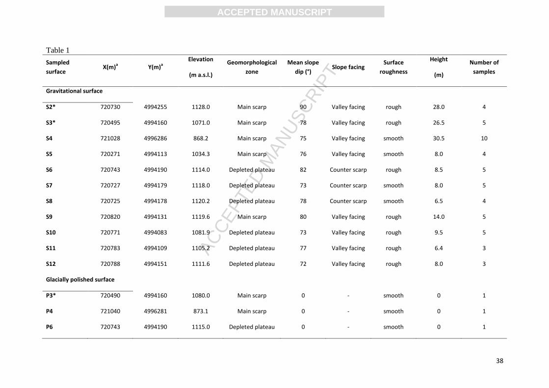
Table 1. Morphological characteristics of the sampled surfaces and number of samples. S:
Gravitational scarp; P: Glacially polished surface. Glacially polished surfaces with the same number
(e.g. P13) as gravitational surfaces are located at the top pf the scarp (e.g. S13). Counter scarps are
facing north while the valley facing scarps are dipping to the south. The data from Le Roux et al.
(2009) are marked with an asterisk (S1 to S3, P3, P16 and P17).
Table 2. Analytical CRE results of the Séchilienne site, with S: Gravitational scarp, P: Glacially
polished surface. The data from Le Roux et al. (2009) are marked with an asterisk.

ACC
EPTE
D M
ANU
SCR
IPT
ACCEPTED MANUSCRIPT
29
References
Agliardi, F., Crosta, G., Zanchi, A., 2001. Structural constraints on deep-seated slope
deformation kinematics. Engineering Geology 59 (1), 83–102.
Anderson, R.S., Anderson, S.P., 2012. The Mechanics and Chemistry of Landscapes,
Cambridge University Press.
Anderson, R. S., Molnar, P., Kessler, M.A., 2006. Features of glacial valley profiles simply
explained. Journal of Geophysical Research, 111, F01004, doi:10.1029/2005JF000344.
Arnold, M., Aumaître, G., Bourlès, D.L., Keddaddouche, K., Braucher, R., Finkel, R.C.,
Nottoli, E., Benedetti, L., Merchel, S., 2013. The French accelerator mass spectrometry
facility ASTER after 4 years: status and recent developments on 36
Cl and 129
I Nuclear
Instruments and Methods in Physics Research B 294, 24–28.
Augustinus, P.C., 1995. Glacial valley cross-profile development: the influence of in situ
rock stress and rock mass strength, with examples from the southern Alps, New Zealand.
Geomorphology 14, 87–97.
Balco, G., 2011. Contributions and unrealized potential contributions of cosmogenic-nuclide
exposure dating to glacier chronology 1990–2010. Quaternary Science Reviews 30, 3–27.
Balco, G., Stone, J.O., Lifton, N.A., Dunai, T.J., 2008. A complete and easily accessible
means of calculation surface exposure ages or erosion rates from 10
Be and 26
Al
measurements. Quaternary Geochronology 3, 174–195.
Ballantyne, C.K., 2002. Paraglacial geomorphology. Quaternary Science Reviews 21, 1935–
2017.
Ballantyne, C.K., Sanderman, G.F., Stone, J.O., Wilson, P., 2014. Rock-slope failure
following Late Pleistocene deglaciation on tectonically stable mountainous terrain.
Quaternary Science Reviews 86, 144–157.

ACC
EPTE
D M
ANU
SCR
IPT
ACCEPTED MANUSCRIPT
30
Braathen, A., Blikra, L.H., Berg, S.S., Karlsen, F., 2004. Rock-slope failures in Norway;
type, geometry, deformation mechanisms and stability. Norwegian Journal of Geology 84,
67–88.
Benson, L., Madole, R., Phillips, W., Landis, G., Thomas, T., Kubik, P., 2004. The probable
importance of snow and sediment shielding on cosmogenic ages of north-central Colorado
Pinedale and pre-Pinedale moraines. Quaternary Science Reviews 23, 193-206.
Bièvre, G., Kasperski, J., Pothérat, P., 2012. Séchilienne - Programme de reconnaissances.
Interprétation géologique des sondages. Technical report CETE de Lyon 40320-1 and
41106-1, CETE de Lyon, Lyon, France.
Bigot-Cormier, F., Braucher, R., Bourlès, D., Guglielmi, Y., Dubar, M., Stéphan, J.F., 2005.
Chronological constraints on processes leading to large active landslides. Earth and
Planetary Science Letters 235, 141–150.
Blair, R.W., 1994. Moraine and valley wall collapse due to rapid deglaciation in Mount
Cook National Park, New Zealand. Mountain Research and Development 14, 347–358.
Braucher, R., Merchel, S., Borgomano, J., Bourlès, D., 2011. Production of cosmogenic
radionuclides at great depths: a multi element approach. Earth and Planetary Science Letters
309, 1–9.
Brown, E.T., Edmond, J.M., Raisbeck, G.M., Yiou, F., Kurz, M.D., Brook, E.J., 1991.
Examination of surface exposure ages of moraines in Arena Valley, Antartica, using in situ
produced 10
Be and 26
Al. Geochimica et Cosmochimica Acta 55, 2269–2283.
Briner, J P., 2009. Moraine pebbles and boulders yield indistinguishable 10
Be ages: a case
study from Colorado, USA. Quaternary Geochronology 4, 299-305.
Cappa, F., Guglielmi, Y., Viseur, S., Garambois, S., 2014. Deep fluids can facilitate rupture
of slow-moving giant landslides as a result of stress transfer and frictional weakening.
Geophysical Research Letters 41, 1–6, doi:10.1002/2013GL058566
Chmeleff, J., von Blanckenburg, F., Kossert, K., Jakob, J., 2010. Determination of the 10
Be
half-life by multicollector ICP-MS and liquid scintillation counting. Nuclear Instruments
and Methods in Physics Research B 268 (2), 192–199.

ACC
EPTE
D M
ANU
SCR
IPT
ACCEPTED MANUSCRIPT
31
Clark, P.U., Dyke, A.S., Shakum, J.D., Carlson, A.E., Clark, J., Wohlfarth, B., Mitrovica,
J.X., Hostetler, S.W., McCabe, A.M., 2009. The last glacial maximum. Science 325, 710-
714.
Cossart, E., Braucher, R., Fort, M., Bourlès, D.L., Carcaillet, J., 2008. Slope instability in
relation to glacial debutressing in alpine areas (upper durance catchment, southeastern
France): Evidence from field data and 10
Be cosmic ray exposure ages. Geomorphology 95,
3–26.
Crosta, G., Di Prisco, C., Frattini, P., Frigerio, G., Castellanza, R., Agliardi, F. (2014).
Chasing a complete understanding of the triggering mechanisms of a large rapidly evolving
rockslide. Landslides 11(5), 747–764.
Cruden, D.M., Hu, X.Q., 1993. Exhaustion and steady states models for predicting
landslides hazards in the Canadian Rocky Mountains. Geomorphology 8, 279–285.
Darnault, R., Rolland, Y., Braucher, R., Bourlès, D., Revel, M., Sanchez, G., Bouissou, S.,
2012. Timing of the last deglaciation revealed by receding glaciers at the Alpine-scale:
impact on mountain geomorphology. Quaternary Science Reviews 31, 127–142.
Delunel, R., 2010. Evolution géomorphologique du massif des Ecrins-Pelvoux depuis le
Dernier Maximum Glaciaire. Apports des nucléides cosmogéniques produits in-situ.
Géomorphologie. PhD Thesis, Université Joseph-Fourier - Grenoble I.
Delunel, R., Hantz, D., Braucher, R., Bourlès, D.L., Schoeneich, P., Deparis, J., 2010a.
Surface exposure dating and geophysical prospecting of the Holocene Lauvitel rock slide
(French Alps). Landslide 7, 393–400.
Delunel, R., van der Beek, P., Carcaillet, J., Bourlès, D., Valla, P., 2010b. Frost-cracking
control on catchment denudation rates: Insights from in situ produced 10
Be concentrations in
stream sediments (Ecrins–Pelvoux massif, French Western Alps). Earth and Planetary
Science Letters 293, 72–83.
Delunel, R., Bourlès, D., van der Beek, P., Schlunegger, F., Leya, I., Masarik, J., Paquet, E.,
2014. Snow shielding factors for cosmogenic nuclide dating inferred from long-term neutron
detector monitoring. Quaternary Geochronology 24, 16-26.

ACC
EPTE
D M
ANU
SCR
IPT
ACCEPTED MANUSCRIPT
32
Dunforth, M., Anderson, R.S., Ward, D., Stock, G.M., 2010. Bedrock fracture control of
glacial erosion processes and rates. Geology 28, 423-426.
Dunai, T., Stuart, F.M., 2009. Reporting of cosmogenic nuclide data for exposure age and
erosion rate determinations. Quaternary Geochronology 4, 437–440.
Dunne, A., Elmore, D., Muzicar, P., 1999. Scaling of cosmogenic nuclide production rates
for geometric shielding and attenuation at depth on sloped surfaces. Geomorphology 27, 3–
11.
Duranthon, J.P., Effendiantz, L., Memier, M., Previtali, I., 2003. Apport des méthodes
topographiques et topométriques au suivi du versant rocheux instable des ruines de
Séchilienne. Revue XYZ 94, 31-38.
Erismann, T.H., Abele, G., 2001. Dynamics of Rockslides and Rockfalls. Springer-Verlag,
Berlin. 316 pp.
Evans, S.G., Clague, J.J., 1994. Recent climatic change and catastrophic geomorphic
processes in mountain environments. Geomorphology 10, 107–128.
Evrard, H., Gouin, T., Benoit, A., Duranthon, J.P., 1990. Séchilienne, risques majeurs
d'éboulements en masse; point sur la surveillance du site. Bulletin de Liaison des Ponts et
Chaussées 165, 7-16.
Gosse, J.C., Phillips, F.M., 2001. Terrestrial in situ cosmogenic nucleides: theory and
application. Quaternary Science Reviews 20, 1475–1560.
Guglielmi, Y., Vengeon, J.M., Bertrand, C., Mudry, J., Follacci, J.P., Giraud, A., 2002.
Hydrogeochemistry: an investigation tool to evaluate infiltration into large moving rock
masses (case study of La Clapière and Séchilienne alpine landslides). Bulletin of
Engineering Geology and the Environment 61, 311–324.
Guillot, S., Di Paola, S., Ménot, R.P., Ledru, P., Spalla, M.I., Gosso, G., Schwartz, S., 2009.
Suture zones and importance of strike‐slip faulting for Variscan geodynamic reconstructions
of the External Crystalline Massifs of the western Alps. Bulletin de la Société Geologique de
France 180, 483–500.

ACC
EPTE
D M
ANU
SCR
IPT
ACCEPTED MANUSCRIPT
33
Harbor, J. M., 1992. Numerical modeling of the development of U-shaped valleys by
glacial erosion. Geological Society of American Bulletin 104(10), 1364–1375.
Harbor, J. M., 1995, Development of glacial-valley crosssections under conditions of
spatially variable resistance to erosion. Geomorphology 14, 99–107.
Helmstetter, A. and Garambois, S., 2010. Seismic monitoring of Séchilienne rockslide
(French Alps): Analysis of seismic signals and their correlation with rainfalls, Journal of
Geophysical Research, 115, F03016, doi:10.1029/2009JF001532
Herman, F., Braun, J., 2008. Evolution of the glacial landscape of the Southern Alps of
New Zealand: Insights from a glacial erosion model. Journal of Geophysical Research 113,
F02009, doi:10.1029/2007JF000807.
Hippolyte, J.C., Brocard, G., Tardy, M., Nicoud, G., Bourlès, D., Braucher, R., Ménard, G.,
Souffaché, B., 2006. The recent fault scarps of the Western Alps (France): Tectonic surface
ruptures or gravitational sacking scarps? A combined mapping, geomorphic, levelling, and
10Be dating approach. Tectonophysics 418, 255–276.
Holm, K., Bovis, M., Jakob, J., 2004. The landslide response of alpine basins to post-Little
Ice Age glacial thinning and retreat. Geomorphology 57, 201–216
Hormes, A., Ivy-Ochs, S., Kubik, P.W., Ferreli, L., Michetti, A.L., 2008. 10Be exposure
ages of a rock avalanche and a late glacial moraine in Alta Valtellina, Italian Alps.
Quarternary International 190, 136–145.
Heyman, J., Stroeven, A.P., Harbor, J.M., Caffee, M.W., 2011. Too young or too old:
evaluating cosmogenic exposure dating based on an analysis of compiled boulder exposure
ages. Earth and Planetary Science Letters 302, 71-80.
Heyman, J., 2014. Paleoglaciation of the Tibetan Plateau and surrounding mountains based
on exposure ages and ELA depression estimates. Quaternary Science Reviews, 91, 30-41.
Hungr, O., Leroueil, S., Picarelli, L., 2014. The Varnes classification of landslide types, an
update. Landslides 11, 167–194.

ACC
EPTE
D M
ANU
SCR
IPT
ACCEPTED MANUSCRIPT
34
Ivy-Ochs, S., Heuberger, H., Kubik, P.W., Kerschner, H., Bonani, G., Frank, M., Schlüchter,
C., 1998. The age of the Köfels event: relative, 14C and cosmogenic isotope dating of an
early Holocene landslide in the Central Alps (Tyrol, Austria). Z. Gletsch. kd. Glazialgeol.
34/1, 57–68.
Ivy-Ochs, S., Poschinger, A.v., Synal, H.-A., Maisch, M., 2009. Surface exposure dating of
the Flims landslide, Graubünden, Switzerland. Geomorphology 103, 104–112.
Kelly, M.A., Buoncristiani, J.F., Schluchter, C., 2004. Are construction of the last glacial
maximum (LGM) ice-surface geometry in the western Swiss Alps and contiguous Alpine
regions in Italy and France. Eclogae Geologicae Helvetiae 97, 57–75.
Korschinek, G., Bergmaier, A., Faestermann, T., Gerstmann, U.C., Knie, K., Rugel, G.,
Wallner, A., Dillmann, I., Dollinger, G., von Gostomski Lierse, Ch., Kossert, K., Maitia, M.,
Poutivtsev, M., Remmert, A., 2009. A new value for the half-life of 10
Be by heavy-ion
elastic recoil detection and liquid scintillation counting. Nuclear Instruments and Methods in
Physics Research B 268 (2), 187–191.
Korup, O., 2008. Rock type leaves topographic signature in landslide-dominated mountain
ranges. Geophysical Research Letters 35, L11402. doi:10.1029/2008GL034157.
Krabbendam, M., Glasser, N.F., 2011. Glacial erosion and bedrock properties in NW
Scotland: Abrasion and plucking, hardness and joint spacing. Geomorphology 130, 374–
383.
Lal, D., 1991. Cosmic ray labeling of erosion surfaces: in situ nuclide production rates and
erosion models. Earth and Planetary Science Letters 104, 424–439.
Lebrouc, V., Schwartz, S., Baillet, L., Jongmans, D., Gamond, J.F., 2013. Permafrost
extension modeling in a rock slope since the Last Glacial Maximum : application to the
large Séchilienne landslide (French Alps). Geomorphology 198, 189–200.
Legchenko, A., Clément, R., Garambois, S., Maury, E., Mic, L.M., Laurent, J.P.,
Desplanque, C., Guyard, H., 2011. Investigating water distribution in the Luitel Lake peat
bog using MRS, ERT and GPR. Near Surface Geophysics 9, 201–209.

ACC
EPTE
D M
ANU
SCR
IPT
ACCEPTED MANUSCRIPT
35
Le Roux, O., Jongmans, D., Kaperski, J., Schwartz, S., Potherat, P., Lebrouc, V.,
Lagabrielle, R., Meric, O., 2011. Deep geophysical investigation of the large Séchilienne
landslide (western Alps, France) and calibration with geological data. Engineering Geology
120, 18–31.
Le Roux, O., Schwartz, S., Gamond, J.F., Jongmans, D., Bourlès, D., Braucher, R.,
Mahaney, W., Carcaillet, J., Leanni, L., 2009. CRE dating on the head scarp of a major
landslide (Séchilienne, French Alps), age constraints on Holocene kinematics, Earth and
Planetary Science Letters 280, 236–245.
Le Roux, O., Schwartz, S., Gamond, J.F., Jongmans, D., Tricart, P., Sébrier, M., 2010.
Interaction between tectonic and erosion processes on the morphogenesis of an alpine
valley: geological and geophysical investigations in the lower Romanche valley (Belledonne
massif, western Alps). International Journal of Earth Sciences 99, 427–441.
MacGregor, K.C., R.S. Anderson, S.P. Anderson, Waddington, E.D., 2000. Numerical
simulations of longitudinal profile evolution of glacial valleys. Geology 28, 1031–1034.
McColl, S.T., 2012. Paraglacial rock-slope stability. Geomorphology 153-154, 1–16.
Martin, S., Campedel, P., Ivy-Ochs, S., Viganò, A., Alfimov, V., Vockenhuber, C., Rigo,
M., 2014. Lavini di Marco (Trentino, Italy): 36
Cl exposure dating of a polyphase rock
avalanche. Quaternary Geochronology 19, 106-116.
Merchel, S., Herpers, U., 1999. An update on radiochemical separation techniques for the
determination of long-lived radionuclides via accelerator mass spectrometry. Radiochimica
Acta 84, 215–219.
Montgomery, D.R., 2002. Valley formation by fluvial and glacial erosion. Geology 30,
1047–1050.
Montjuvent, G., Winistörfer, J., 1980. Glaciers quaternaires dans les Alpes franco-suisses et
leur piedmont. Géologie Alpine 56, 251-282.
Nishiizumi, K., Imamura, M., Caffee, M., Southon, J., Finkel, R., McAnich, J., 2007.
Absolute calibration of 10Be AMS standards. Nuclear Instruments and Methods in Physics
Research B 258, 403–413.

ACC
EPTE
D M
ANU
SCR
IPT
ACCEPTED MANUSCRIPT
36
Ostermann, M., Sanders, D., Ivy-Ochs, S., Alfimov, V., Rockenschaub, M., Römer, A.,
2012. Early Holocene (8.6 ka) rock avalanche deposits, Obernberg valley (Eastern Alps):
landform interpretation and kinematics of rapid mass movement. Geomorphology 171-172,
83–93.
Prager, C., Ivy-Ochs, S., Ostermann, M., Synal, H.A., Patzelt, G., 2009. Geology and
radiometric 14
C, 36Cl and Th-/U-dating of the Fernpass rockslide (Tyrol, Austria).
Geomorphology 103, 93–103.
Salcher B.C., Kober F., Kissling E. and Willett S.D, 2014. Glacial impact on short-
wavelength topography and long-lasting effects on the denudation of a deglaciated mountain
range, Global and Planetary Change 115, 59–70.
Sanchez, G., Rolland, Y., Corsini, M., Braucher, R., Bourlès, D., Arnold, M. Aumaître, G.,
2009. Relationships between tectonics, slope instability and climate change: cosmic ray
exposure dating of active faults, landslides and glacial surfaces in the SW Alps.
Geomorphology 117, 1–13.
Seijmonsbergen, A.C., Woning, M.P., Verhoef, P.N.W., de Graaff, L.W.S., 2005. The
failure mechanism of a Late Glacial Sturzstrom in the Subalpine Molasse (Leckner Valley,
Vorarlberg, Austria). Geomorphology 66, 277–286.
Stone, J.O., 2000. Air pressure and cosmogenic isotope production. Journal of Geophysical
Research 105 (B10), 23753–23759.
Taylor, A., Blum, J.D., 1995. Relation between soil age and silicate weathering rates
determined from the chemical evolution of a glacial chronosequence. Geology 23, 979-982.
van der Beek, P., Bourbon, P., 2008. A quantification of the glacial imprint on relief
development in the French western Alps. Geomorphology 97, 52–72.
Vengeon, J.M., Giraud, A., Antoine, P., Rochet, L., 1999. Analysis of the deformation and
toppling of rock slopes in crystallophyllian terrain. Canadian Geotechnical Journal 36,
1123–1136.
Zerathe, S., Braucher, R., Lebourg, T., Bourlès, D., Manetti, M., Leanni, L., 2013. Dating
chert (diagenetic silica) using in-situ produced 10Be: possible complications revealed

ACC
EPTE
D M
ANU
SCR
IPT
ACCEPTED MANUSCRIPT
37
through the comparison with 36
Cl applied on coexisting limestone. Quaternary
Geochronology 17, 81-93.
Zerathe, S., Lebourg T., Braucher R., Bourles D., 2014. Mid-Holocene cluster of large-scale
landslides revealed in the Southwestern Alps by Cl-36 dating. Insight on an Alpine-scale
landslide activity. Quaternary Science Reviews 90, 106–127.
ACC
EPTE
D M
ANU
SCR
IPT
ACCEPTED MANUSCRIPT
38
Table 1
Sampled
surface X(m)
a Y(m)
a
Elevation
(m a.s.l.)
Geomorphological
zone
Mean slope
dip (°) Slope facing
Surface
roughness
Height
(m)
Number of
samples
Gravitational surface
S2* 720730 4994255 1128.0 Main scarp 90 Valley facing rough 28.0 4
S3* 720495 4994160 1071.0 Main scarp 78 Valley facing rough 26.5 5
S4 721028 4996286 868.2 Main scarp 75 Valley facing smooth 30.5 10
S5 720271 4994113 1034.3 Main scarp 76 Valley facing smooth 8.0 4
S6 720743 4994190 1114.0 Depleted plateau 82 Counter scarp rough 8.5 5
S7 720727 4994179 1118.0 Depleted plateau 73 Counter scarp smooth 8.0 5
S8 720725 4994178 1120.2 Depleted plateau 78 Counter scarp smooth 6.5 4
S9 720820 4994131 1119.6 Main scarp 80 Valley facing rough 14.0 5
S10 720771 4994083 1081.9 Depleted plateau 73 Valley facing rough 9.5 5
S11 720783 4994109 1105.2 Depleted plateau 77 Valley facing rough 6.4 3
S12 720788 4994151 1111.6 Depleted plateau 72 Valley facing rough 8.0 3
Glacially polished surface
P3* 720490 4994160 1080.0 Main scarp 0 - smooth 0 1
P4 721040 4996281 873.1 Main scarp 0 - smooth 0 1
P6 720743 4994190 1115.0 Depleted plateau 0 - smooth 0 1
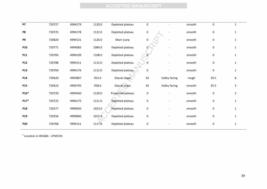
ACC
EPTE
D M
ANU
SCR
IPT
ACCEPTED MANUSCRIPT
39
P7 720727 4994179 1120.0 Depleted plateau 0 - smooth 0 1
P8 720725 4994178 1122.0 Depleted plateau 0 - smooth 0 1
P9 720820 4994131 1120.0 Main scarp 0 - smooth 0 1
P10 720771 4994083 1084.0 Depleted plateau 0 - smooth 0 1
P11 720783 4994109 1108.0 Depleted plateau 0 - smooth 0 1
P12 720788 4994151 1115.0 Depleted plateau 0 - smooth 0 1
P13 720769 4994176 1112.0 Depleted plateau 0 - smooth 0 1
P14 720620 4993807 953.0 Glacial slope 62 Valley facing rough 29.5 8
P15 720423 4993795 958.0 Glacial slope 65 Valley facing smooth 35.5 3
P16* 720720 4994560 1120.0 Preserved plateau 0 - smooth 0 2
P17* 720725 4994175 1121.0 Depleted plateau 0 - smooth 0 1
P18 720277 4990920 1023.0 Depleted plateau 0 - smooth 0 1
P19 720256 4990840 1015.0 Depleted plateau 0 - smooth 0 1
P20 720768 4994151 1117.0 Depleted plateau 0 - smooth 0 1
a Location in WGS84 - UTM31N

ACC
EPTE
D M
ANU
SCR
IPT
ACCEPTED MANUSCRIPT
40
Table 2
Sample X
a
(m)
Y a
(m)
Elevation
(m a.s.l)
Z b
(m)
D c
(m)
T d
(cm) St
e
Scaled production rates
(atoms/g/yr)
10Be concentration
f
(atoms/g)
Ages g
(ka)
Spallation Muons N10 σN10 T min Ext. σT Int.
σT
S1-1* 720830 4994190 1139.0 2.1 2.2 2.0 0.50 5.05 0.263 30408 1804 5.7 0.5 0.3
S1-2* 720830 4994190 1137.0 4.1 4.3 2.0 0.50 5.04 0.263 33962 4699 6.4 0.9 0.9
S1-3* 720830 4994190 1131.8 9.3 9.7 2.0 0.50 5.02 0.263 20542 1794 3.9 0.4 0.3
S1-4* 720830 4994190 1125.0 16.1 16.8 2.0 0.50 4.99 0.262 11061 901 2.1 0.2 0.2
S1-5* 720830 4994190 1124.0 17.1 17.8 2.0 0.50 4.99 0.262 7740 1103 1.5 0.2 0.2
S1-6* 720830 4994190 1123.6 17.5 18.2 2.0 0.50 4.99 0.262 10392 1581 2.0 0.3 0.3
S1-7* 720830 4994190 1121.0 20.1 20.9 2.0 0.50 4.98 0.262 11695 1236 2.3 0.3 0.2
S1-8* 720830 4994190 1119.3 21.8 22.7 2.0 0.50 4.97 0.262 6982 2023 1.4 0.4 0.4
S1-9* 720830 4994190 1116.0 25.1 26.1 2.0 0.49 4.86 0.261 5982 864 1.2 0.2 0.2
S1-10* 720830 4994190 1112.3 28.8 30.0 2.0 0.48 4.74 0.261 3370 970 0.7 0.2 0.2
S1-11* 720830 4994190 1109.0 32.1 34.4 2.0 0.47 4.63 0.261 1730 722 0.4 0.2 0.1
S2-1* 720730 4994255 1128.0 2.0 2.0 2.0 0.45 4.51 0.262 15444 1718 3.3 0.4 0.4
S2-2* 720730 4994255 1126.5 3.5 3.5 2.0 0.45 4.50 0.262 6915 1271 1.5 0.3 0.3
S2-3* 720730 4994255 1125.5 4.5 4.5 2.0 0.45 4.50 0.262 7576 2628 1.6 0.6 0.6

ACC
EPTE
D M
ANU
SCR
IPT
ACCEPTED MANUSCRIPT
41
S2-4* 720730 4994255 1120.0 10.0 10.0 2.0 0.55 5.47 0.262 17978 2196 3.2 0.4 0.4
P3* 720490 4994160 1080.0 - - 2.0 0.93 8.96 0.258 139574 4028 15.1 0.9 0.4
S3-1* 720495 4994160 1071.0 8.3 8.5 2.0 0.55 5.26 0.257 29833 3334 5.4 0.7 0.6
S3-2* 720495 4994160 1066.5 12.8 13.1 2.0 0.50 4.77 0.257 6127 1509 1.2 0.3 0.3
S3-3* 720495 4994160 1062.5 16.8 17.2 2.0 0.50 4.75 0.257 9194 2534 1.9 0.5 0.5
S3-4* 720495 4994160 1057.5 21.8 22.3 2.0 0.50 4.73 0.256 10617 1931 2.2 0.4 0.4
P4 721040 4996281 873.1 - - 1.0 0.99 8.18 0.242 120202 4351 14.2 0.9 0.5
S4-1 721028 4996286 868.2 1.2 1.3 2.0 0.59 4.78 0.241 10957 1645 2.2 0.4 0.3
S4-2 721028 4996286 866.7 2.7 2.8 3.0 0.59 4.73 0.240 6621 1042 1.3 0.2 0.2
S4-3 721040 4996286 864.0 5.4 5.6 1.5 0.59 4.78 0.241 17694 1633 3.5 0.4 0.3
S4-4 721040 4996286 862.4 7.0 7.3 1.5 0.59 4.77 0.240 13310 1389 2.7 0.3 0.3
S4-5 721040 4996286 861.4 8.0 8.3 3.5 0.59 4.69 0.239 8916 1346 1.8 0.3 0.3
S4-6 721028 4996286 857.3 12.1 12.6 2.0 0.59 4.73 0.240 4837 796 1.0 0.2 0.2
S4-7 721034 4996286 855.1 14.3 14.9 2.5 0.59 4.71 0.239 2161 679 0.5 0.1 0.1
S4-8 721040 4996286 852.6 16.8 17.5 1.5 0.59 4.74 0.240 962 679 0.2 0.1 0.1
S4-9 721028 4996286 849.1 20.3 21.1 3.0 0.59 4.66 0.239 1445 518 0.3 0.1 0.1
S5-1 720271 4994113 1034.3 0.8 0.8 1.5 0.57 5.36 0.255 40448 2292 7.2 0.5 0.4
S5-2 720271 4994113 1033.8 1.3 1.3 4.0 0.52 4.78 0.253 27192 2503 5.4 0.6 0.5

ACC
EPTE
D M
ANU
SCR
IPT
ACCEPTED MANUSCRIPT
42
S5-3 720271 4994113 1030.8 4.3 4.4 2.0 0.52 4.84 0.254 7465 1521 1.5 0.3 0.3
S5-4 720271 4994113 1029.1 6.0 6.2 2.5 0.52 4.82 0.254 11782 2327 2.3 0.5 0.5
P6 720743 4994190 1115.0 - - 2.1 0.97 9.59 0.261 57674 2873 5.8 0.4 0.3
S6-1 720743 4994190 1114.0 1.0 1.0 4.5 0.64 6.28 0.260 21427 1661 3.3 0.3 0.3
S6-2 720743 4994190 1112.5 2.5 2.5 2.5 0.64 6.37 0.261 20139 1597 3.1 0.3 0.2
S6-3 720743 4994190 1111.1 3.9 3.9 2.0 0.64 6.39 0.261 21210 1644 3.2 0.3 0.2
S6-4 720743 4994190 1109.2 5.8 5.9 2.0 0.64 6.38 0.261 11095 1153 1.7 0.2 0.2
P7 720727 4994179 1120.0 - - 1.5 0.98 9.81 0.262 112327 4370 11.1 0.7 0.4
S7-1 720727 4994179 1118.0 2.0 2.1 2.0 0.71 7.04 0.261 28452 1901 3.9 0.3 0.3
S7-2 720727 4994179 1117.0 3.0 3.1 3.0 0.71 6.98 0.261 21715 2121 3.0 0.3 0.3
S7-3 720727 4994179 1116.1 3.9 4.1 2.0 0.71 7.03 0.261 17399 2122 2.4 0.3 0.3
S7-4 720727 4994179 1112.8 7.2 7.5 2.5 0.71 6.99 0.261 8712 1161 1.2 0.2 0.2
P8 720725 4994178 1122.0 - - 1.5 0.99 9.87 0.262 87628 3081 8.6 0.5 0.3
S8-1 720725 4994178 1120.2 1.8 1.8 1.5 0.63 6.31 0.262 22969 1994 3.5 0.4 0.3
S8-2 720725 4994178 1119.4 2.6 2.7 2.0 0.63 6.28 0.262 8846 1121 1.4 0.2 0.2
S8-3 720725 4994178 1117.3 4.7 4.8 1.5 0.63 6.30 0.262 7554 1169 1.2 0.2 0.2
P9 720820 4994131 1120.0 - - 2.0 0.96 9.53 0.262 76852 4241 7.8 0.6 0.4
S9-1 720820 4994131 1119.6 0.4 0.4 4.5 0.50 4.88 0.260 22046 1576 4.3 0.4 0.3

ACC
EPTE
D M
ANU
SCR
IPT
ACCEPTED MANUSCRIPT
43
S9-2 720820 4994131 1116.6 3.4 3.3 1.0 0.50 5.00 0.262 18860 1542 3.6 0.3 0.3
S9-3 720820 4994131 1114.2 5.8 5.7 1.0 0.50 4.99 0.262 24122 1964 4.6 0.4 0.4
S9-4 720820 4994131 1112.8 7.2 7.1 4.5 0.50 4.85 0.260 17802 1907 3.5 0.4 0.4
S9-5 720820 4994131 1111.6 8.4 8.2 2.0 0.50 4.94 0.261 12803 1327 2.5 0.3 0.3
P10 720771 4994083 1084.0 - - 2.0 0.92 8.91 0.259 72389 3149 7.8 0.5 0.3
S10-1 720771 4994083 1081.9 2.1 2.2 4.5 0.65 6.19 0.257 10954 1563 1.7 0.3 0.2
S10-2 720771 4994083 1080.9 3.1 3.2 1.0 0.65 6.36 0.259 11531 1300 1.8 0.2 0.2
S10-3 720771 4994083 1079.0 5.0 5.2 2.0 0.65 6.26 0.258 9574 1417 1.5 0.2 0.2
S10-4 720771 4994083 1076.8 7.2 7.5 1.0 0.65 6.30 0.259 7413 1317 1.1 0.2 0.2
P11 720783 4994109 1108.0 - - 4.5 0.86 8.34 0.259 95054 3530 11.0 0.7 0.4
S11-1 720783 4994109 1105.2 2.8 2.9 2.0 0.42 4.10 0.26 9574 1417 2.2 0.3 0.3
S11-2 720783 4994109 1103.9 4.1 4.2 2.5 0.42 4.08 0.26 10345 1456 2.4 0.4 0.3
P12 720788 4994151 1115.0 - - 1.0 0.89 8.98 0.262 84041 3083 9.0 0.6 0.3
S12-1 720788 4994151 1111.6 3.4 3.6 1.0 0.52 5.22 0.262 47718 2916 8.6 0.7 0.5
S12-2 720788 4994151 1109.4 5.6 5.9 4.5 0.52 5.06 0.259 30269 3498 5.7 0.7 0.7
P13 720769 4994176 1112.0 - - 2.1 0.98 9.72 0.261 126916 1402 12.7 0.7 0.1
S13-1 720769 4994176 1110.2 1.8 1.9 4.5 0.45 4.33 0.259 12617 1355 2.8 0.3 0.3
S13-2 720769 4994176 1108.4 3.6 3.7 2.5 0.45 4.40 0.26 11553 1382 2.5 0.3 0.3

ACC
EPTE
D M
ANU
SCR
IPT
ACCEPTED MANUSCRIPT
44
S13-3 720769 4994176 1107.0 5.0 5.2 1.0 0.45 4.45 0.261 8750 1272 1.9 0.3 0.3
P14-0 720620 4993807 953.0 - - 1.5 0.99 8.61 0.248 98462 4365 11.1 0.7 0.5
P14-1 720620 4993807 950.2 2.8 3.2 2.5 0.52 4.53 0.247 22652 1654 4.7 0.4 0.3
P14-2 720620 4993807 948.6 4.4 5.0 2.0 0.52 4.55 0.247 11425 1316 2.4 0.3 0.3
P14-3 720620 4993807 945.2 7.8 8.9 3.0 0.52 4.50 0.246 54590 2555 11.5 0.8 0.5
P14-4 720620 4993807 939.1 13.9 15.8 2.1 0.52 4.51 0.246 27502 2120 5.8 0.5 0.4
P14-5 720620 4993807 936.5 16.5 18.7 4.5 0.52 4.41 0.245 15004 1754 3.2 0.4 0.4
P14-6 720620 4993807 930.7 22.3 25.3 2.5 0.52 4.46 0.245 43381 2443 9.2 0.7 0.5
P14-7 720620 4993807 929.2 23.8 27.0 4.5 0.52 4.39 0.244 26775 2080 5.8 0.5 0.5
P15-1 720423 4993795 958.0 2.0 2.2 2.0 0.45 3.95 0.248 60659 3420 14.4 1.1 0.8
P15-2 720423 4993795 948.0 12.0 13.3 2.0 0.45 3.92 0.247 47469 2868 11.4 0.9 0.7
P15-3 720423 4993795 946.0 14.0 15.6 2.0 0.59 5.09 0.247 82263 3501 15.4 1.0 0.7
P16-1* 720720 4994560 1120.0 - - 2.0 1.00 9.95 0.262 77437 5812 7.5 0.7 0.6
P16-2* 720720 4994570 1120.0 - - 2.0 1.00 9.95 0.262 126746 4534 12.4 0.8 0.4
P17* 720725 4994175 1121.0 - - 2.0 0.98 9.76 0.262 176621 6140 17.5 1.1 0.6
P18 720277 4990920 1023.0 - - 1.5 0.88 8.14 0.254 15718 1698 1.9 0.2 0.2
P19 720256 4990840 1015.0 - - 1.5 0.96 8.86 0.253 44890 2044 4.9 0.3 0.2
P20 720768 4994151 1117.0 - - 1.0 0.98 9.86 0.262 123154 4947 12.1 0.8 0.5

ACC
EPTE
D M
ANU
SCR
IPT
ACCEPTED MANUSCRIPT
45
a Location in WGS84 - UTM31N
b The real depth location of the sample from the top of the scarp
c The sampling distance from the top of the scarp the natural main slope
d T is the sample thickness
e Topographic shielding calculated following Dunne et al. (1999)
f Results have been corrected from the chemical blank (
10Be/
9Be blank = 2.46 ± 0.74 × 10
−15). Propagated uncertainties include counting statistics, a conservative estimate of
1% for instrumental variability, the uncertainty of the standard deviation and chemical blank.
g Ages have been computed with the Cronus Calculator (Balco et al., 2008) using the time-dependent scaling scheme of Lal (1991) modified by Stone (2000). Uncertainties
are 1 σ. Internal uncertainties consider the analytical uncertainties, while the external uncertainties include uncertainty in the production rate (~8%) and uncertainty in the 10
Be decay constant (~8%).

ACC
EPTE
D M
ANU
SCR
IPT
ACCEPTED MANUSCRIPT
46
Fig. 1

ACC
EPTE
D M
ANU
SCR
IPT
ACCEPTED MANUSCRIPT
47
Fig. 2
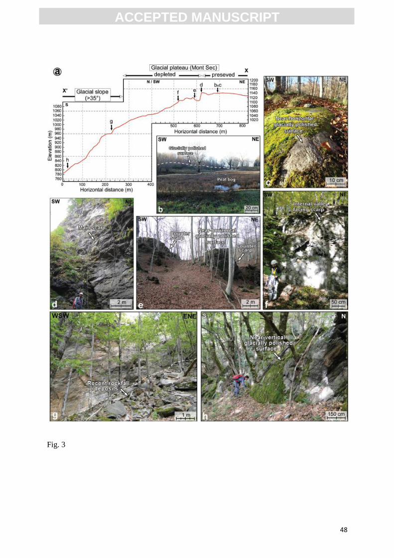
ACC
EPTE
D M
ANU
SCR
IPT
ACCEPTED MANUSCRIPT
48
Fig. 3

ACC
EPTE
D M
ANU
SCR
IPT
ACCEPTED MANUSCRIPT
49
Fig. 4

ACC
EPTE
D M
ANU
SCR
IPT
ACCEPTED MANUSCRIPT
50
Fig. 5

ACC
EPTE
D M
ANU
SCR
IPT
ACCEPTED MANUSCRIPT
51
Fig. 6

ACC
EPTE
D M
ANU
SCR
IPT
ACCEPTED MANUSCRIPT
52
Fig. 7

ACC
EPTE
D M
ANU
SCR
IPT
ACCEPTED MANUSCRIPT
53
Fig. 8

ACC
EPTE
D M
ANU
SCR
IPT
ACCEPTED MANUSCRIPT
54
Fig. 9

ACC
EPTE
D M
ANU
SCR
IPT
ACCEPTED MANUSCRIPT
55
Fig. 10

ACC
EPTE
D M
ANU
SCR
IPT
ACCEPTED MANUSCRIPT
56
Fig. 11

ACC
EPTE
D M
ANU
SCR
IPT
ACCEPTED MANUSCRIPT
57
Fig. 12