Embed Size (px)
Citation preview
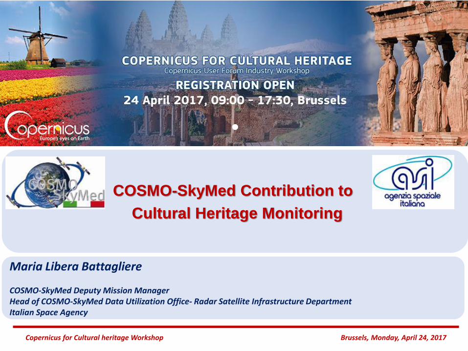
COSMO-SkyMed Contribution to
Cultural Heritage Monitoring
Copernicus for Cultural heritage Workshop Brussels, Monday, April 24, 2017
Maria Libera Battagliere
COSMO-SkyMed Deputy Mission ManagerHead of COSMO-SkyMed Data Utilization Office- Radar Satellite Infrastructure DepartmentItalian Space Agency
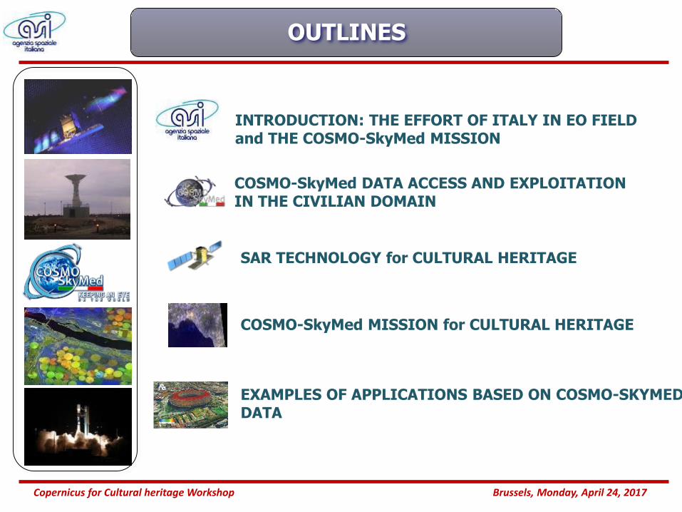
OUTLINES
INTRODUCTION: THE EFFORT OF ITALY IN EO FIELD and THE COSMO-SkyMed MISSION
2Copernicus for Cultural heritage Workshop Brussels, Monday, April 24, 2017
COSMO-SkyMed DATA ACCESS AND EXPLOITATION IN THE CIVILIAN DOMAIN
SAR TECHNOLOGY for CULTURAL HERITAGE
COSMO-SkyMed MISSION for CULTURAL HERITAGE
EXAMPLES OF APPLICATIONS BASED ON COSMO-SKYMED DATA
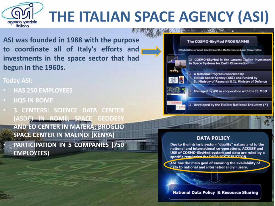
THE ITALIAN SPACE AGENCY (ASI)
ASI was founded in 1988 with the purposeto coordinate all of Italy's efforts andinvestments in the space sector that hadbegun in the 1960s.
Today ASI:
• HAS 250 EMPLOYEES
• HQS IN ROME
• 3 CENTERS: SCIENCE DATA CENTER(ASDC) IN ROME; SPACE GEODESYAND EO CENTER IN MATERA; BROGLIOSPACE CENTER IN MALINDI (KENYA)
• PARTICIPATION IN 5 COMPANIES (750EMPLOYEES)
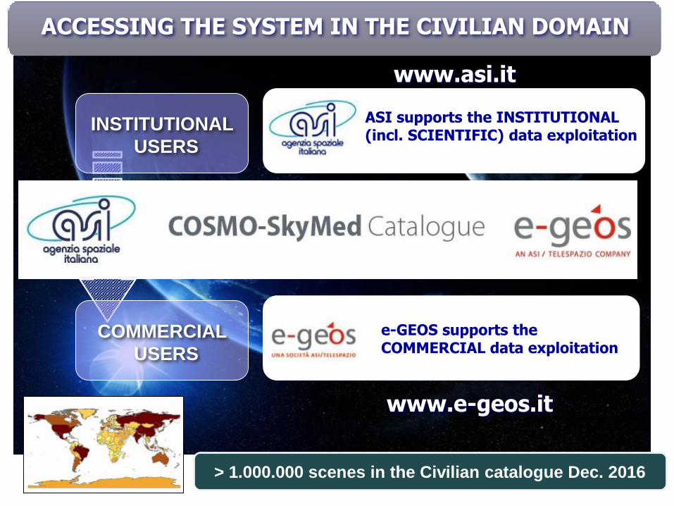
IF REQUESTED
ASI supports the INSTITUTIONAL (incl. SCIENTIFIC) data exploitation
INSTITUTIONAL
USERS
e-GEOS supports the COMMERCIAL data exploitation
COMMERCIAL
USERS
www.e-geos.it
www.asi.it
> 1.000.000 scenes in the Civilian catalogue Dec. 2016
ACCESSING THE SYSTEM IN THE CIVILIAN DOMAIN
“ON DEMAND” ISTITUTIONAL
and COMMERCIAL USERS
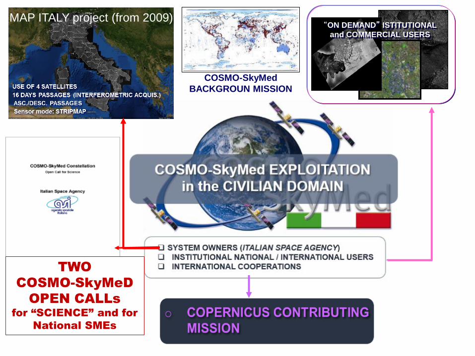
MAP ITALY project (from 2009)
COSMO-SkyMed
BACKGROUN MISSION
TWO
COSMO-SkyMeD
OPEN CALLs for “SCIENCE” and for
National SMEs
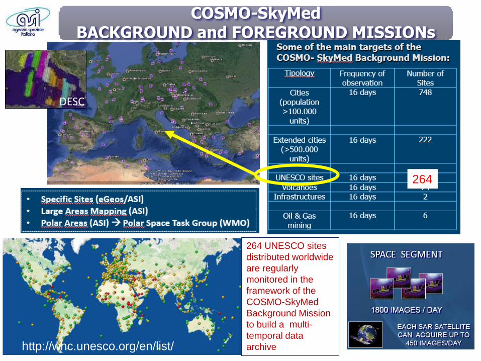
COSMO-SkyMed BACKGROUND and FOREGROUND MISSIONs
264 UNESCO sites
distributed worldwide
are regularly
monitored in the
framework of the
COSMO-SkyMed
Background Mission
to build a multi-
temporal data
archivehttp://whc.unesco.org/en/list/
DESC
264
71
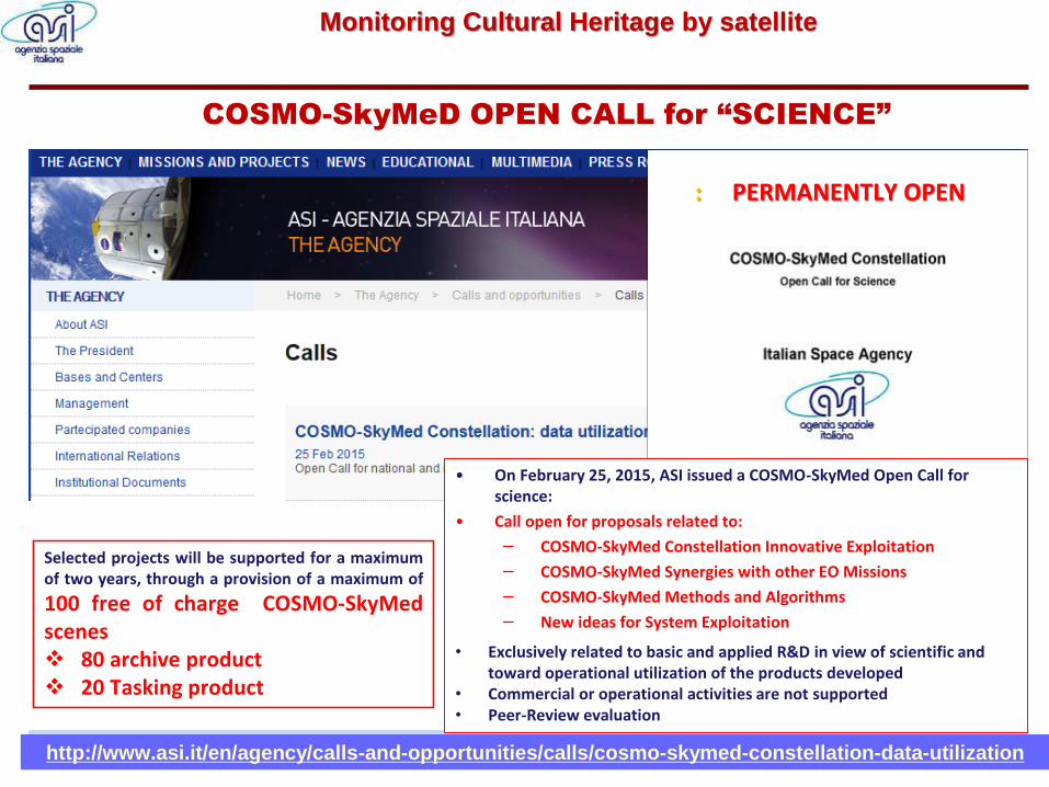
COSMO-SkyMeD OPEN CALL for “SCIENCE”
Selected projects will be supported for a maximumof two years, through a provision of a maximum of
100 free of charge COSMO-SkyMedscenes❖ 80 archive product❖ 20 Tasking product
• On February 25, 2015, ASI issued a COSMO-SkyMed Open Call for science:
• Call open for proposals related to:
− COSMO-SkyMed Constellation Innovative Exploitation
− COSMO-SkyMed Synergies with other EO Missions
− COSMO-SkyMed Methods and Algorithms
− New ideas for System Exploitation
• Exclusively related to basic and applied R&D in view of scientific and toward operational utilization of the products developed
• Commercial or operational activities are not supported• Peer-Review evaluation
http://www.asi.it/en/agency/calls-and-opportunities/calls/cosmo-skymed-constellation-data-utilization
: PERMANENTLY OPEN
Monitoring Cultural Heritage by satellite
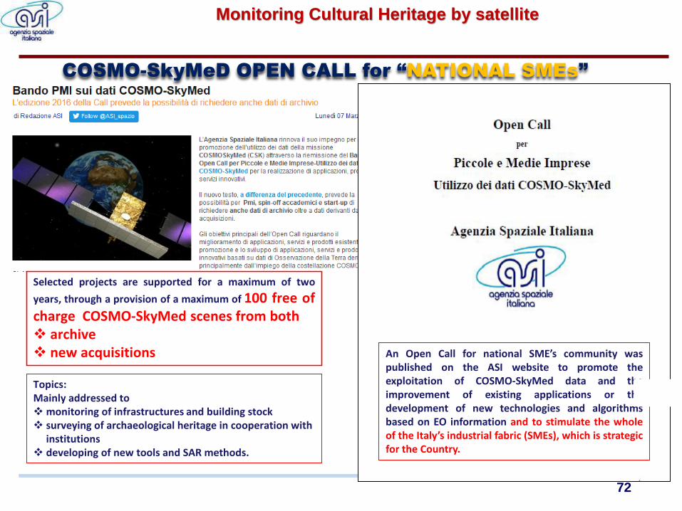
An Open Call for national SME’s community waspublished on the ASI website to promote theexploitation of COSMO-SkyMed data and theimprovement of existing applications or thedevelopment of new technologies and algorithmsbased on EO information and to stimulate the wholeof the Italy’s industrial fabric (SMEs), which is strategicfor the Country.
COSMO-SkyMeD OPEN CALL for “NATIONAL SMEs”
Selected projects are supported for a maximum of two
years, through a provision of a maximum of 100 free ofcharge COSMO-SkyMed scenes from both❖ archive❖ new acquisitions
Topics: Mainly addressed to ❖monitoring of infrastructures and building stock❖ surveying of archaeological heritage in cooperation with
institutions ❖ developing of new tools and SAR methods.
72
Monitoring Cultural Heritage by satellite
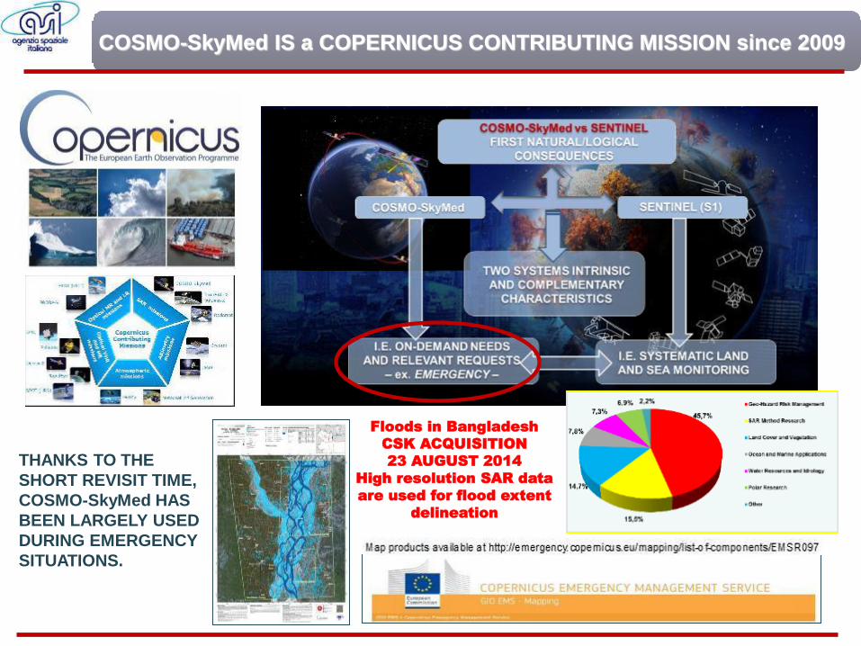
COSMO-SkyMed IS a COPERNICUS CONTRIBUTING MISSION since 2009
Floods in Bangladesh
CSK ACQUISITION
23 AUGUST 2014
High resolution SAR data
are used for flood extent
delineation
THANKS TO THE
SHORT REVISIT TIME,
COSMO-SkyMed HAS
BEEN LARGELY USED
DURING EMERGENCY
SITUATIONS.
SAR technology for CULTURAL HERITAGE
Early applications of SAR data in archaelogy date
back to 1980s and enabled numerous important
discoveries, reveling new insights in vast desert
areas.
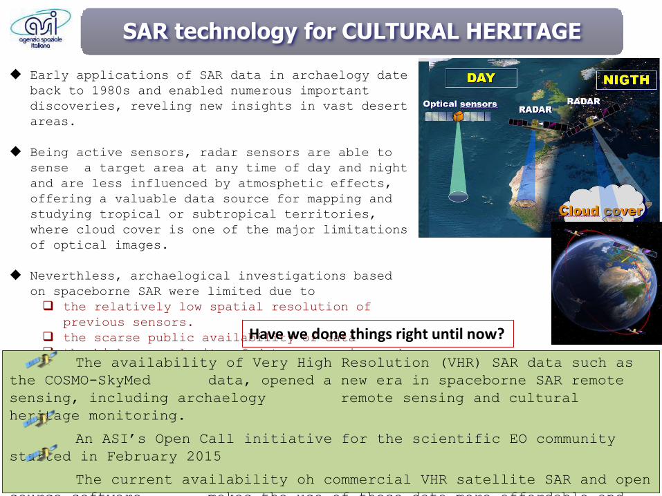
Being active sensors, radar sensors are able to
sense a target area at any time of day and night
and are less influenced by atmosphetic effects,
offering a valuable data source for mapping and
studying tropical or subtropical territories,
where cloud cover is one of the major limitations
of optical images.
Neverthless, archaelogical investigations based
on spaceborne SAR were limited due to
the relatively low spatial resolution of
previous sensors.
the scarse public availability of data
the higher complexity of data processing and
software compared with optical dataThe availability of Very High Resolution (VHR) SAR data such as
the COSMO-SkyMed data, opened a new era in spaceborne SAR remote
sensing, including archaelogy remote sensing and cultural
heritage monitoring.
An ASI’s Open Call initiative for the scientific EO community
started in February 2015
The current availability oh commercial VHR satellite SAR and open
source software makes the use of these data more affordable and
Have we done things right until now?
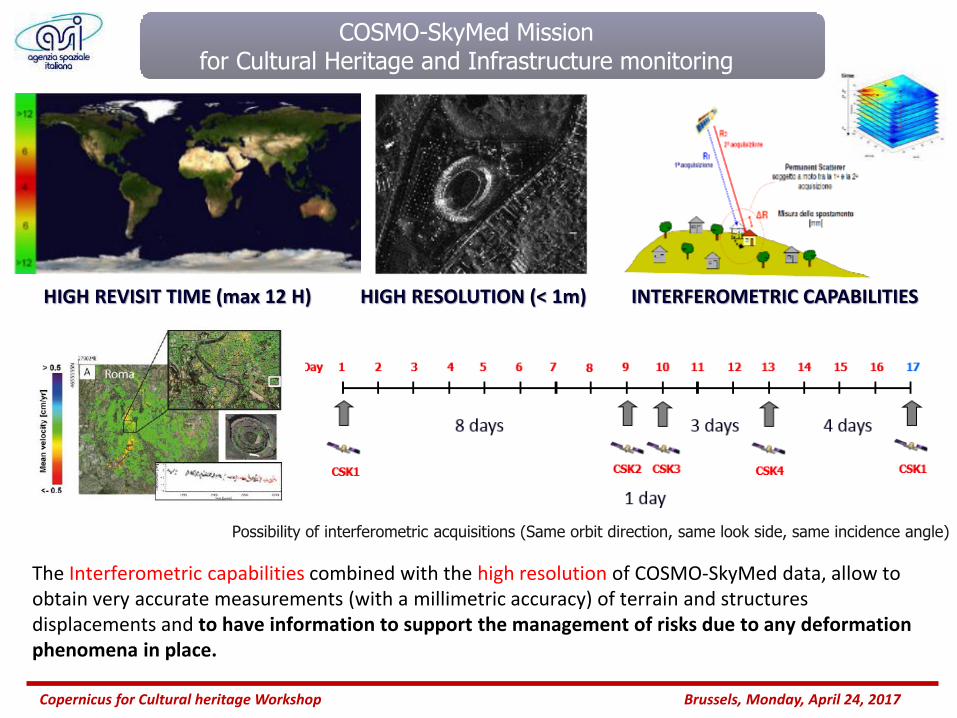
HIGH REVISIT TIME (max 12 H)
Copernicus for Cultural heritage Workshop Brussels, Monday, April 24, 2017
The Interferometric capabilities combined with the high resolution of COSMO-SkyMed data, allow to obtain very accurate measurements (with a millimetric accuracy) of terrain and structures displacements and to have information to support the management of risks due to any deformation phenomena in place.
INTERFEROMETRIC CAPABILITIESHIGH RESOLUTION (< 1m)
COSMO-SkyMed Mission for Cultural Heritage and Infrastructure monitoring
Possibility of interferometric acquisitions (Same orbit direction, same look side, same incidence angle)
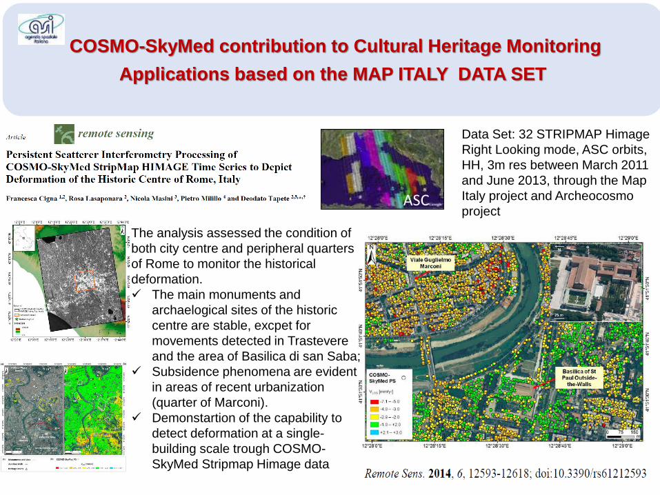
COSMO-SkyMed contribution to Cultural Heritage Monitoring
Applications based on the MAP ITALY DATA SET
Data Set: 32 STRIPMAP Himage
Right Looking mode, ASC orbits,
HH, 3m res between March 2011
and June 2013, through the Map
Italy project and Archeocosmo
projectASC
The analysis assessed the condition of
both city centre and peripheral quarters
of Rome to monitor the historical
deformation.
✓ The main monuments and
archaelogical sites of the historic
centre are stable, excpet for
movements detected in Trastevere
and the area of Basilica di san Saba;
✓ Subsidence phenomena are evident
in areas of recent urbanization
(quarter of Marconi).
✓ Demonstartion of the capability to
detect deformation at a single-
building scale trough COSMO-
SkyMed Stripmap Himage data
Page 13e-GEOS Proprietary
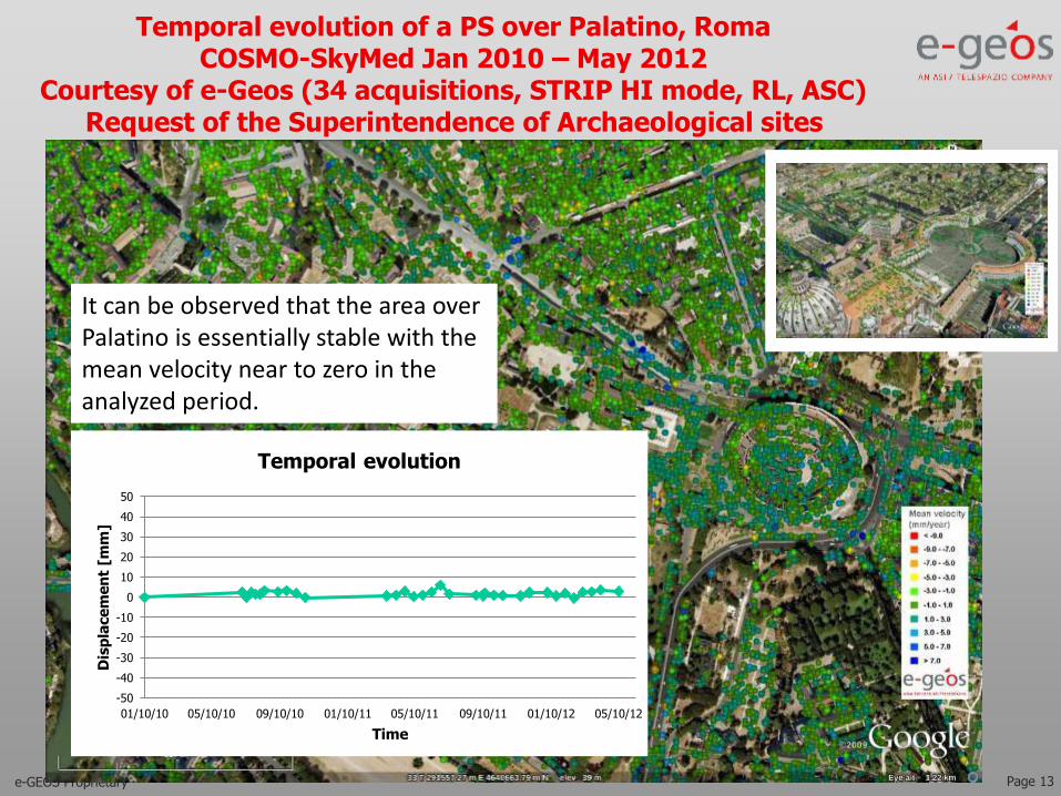
Temporal evolution of a PS over Palatino, RomaCOSMO-SkyMed Jan 2010 – May 2012
Courtesy of e-Geos (34 acquisitions, STRIP HI mode, RL, ASC)Request of the Superintendence of Archaeological sites
-50
-40
-30
-20
-10
0
10
20
30
40
50
01/10/10 05/10/10 09/10/10 01/10/11 05/10/11 09/10/11 01/10/12 05/10/12
Dis
pla
ce
me
nt
[mm
]
Time
Temporal evolution
It can be observed that the area over Palatino is essentially stable with the mean velocity near to zero in the analyzed period.
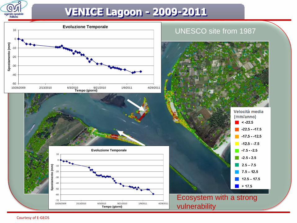
VENICE Lagoon - 2009-2011
Evoluzione Temporale
-70
-60
-50
-40
-30
-20
-10
0
10
10/26/2009 2/13/2010 6/3/2010 9/21/2010 1/9/2011 4/29/2011
Tempo (giorni)
Sp
os
tam
en
to (
mm
)
Evoluzione Temporale
-50
-40
-30
-20
-10
0
10
10/26/2009 2/13/2010 6/3/2010 9/21/2010 1/9/2011 4/29/2011Tempo (giorni)
Sp
osta
men
to (
mm
)
Courtesy of E-GEOS
UNESCO site from 1987
Ecosystem with a strong
vulnerability
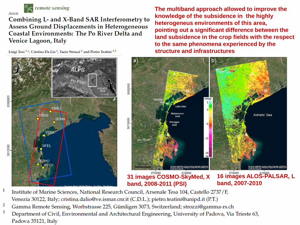
The multiband approach allowed to improve the
knowledge of the subsidence in the highly
heterogeneus environments of this area,
pointing out a significant difference between the
land subsidence in the crop fields with the respect
to the same phenomena experienced by the
structure and infrastructures
16 images ALOS-PALSAR, L
band, 2007-2010 31 images COSMO-SkyMed, X
band, 2008-2011 (PSI)
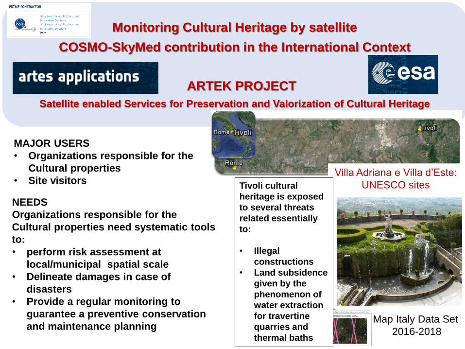
Monitoring Cultural Heritage by satellite
COSMO-SkyMed contribution in the International Context
ARTEK PROJECT
Satellite enabled Services for Preservation and Valorization of Cultural Heritage
Map Italy Data Set
2016-2018
Villa Adriana e Villa d’Este:
UNESCO sitesTivoli cultural
heritage is exposed
to several threats
related essentially
to:
• Illegal
constructions
• Land subsidence
given by the
phenomenon of
water extraction
for travertine
quarries and
thermal baths
MAJOR USERS
• Organizations responsible for the
Cultural properties
• Site visitors
NEEDS
Organizations responsible for the
Cultural properties need systematic tools
to:
• perform risk assessment at
local/municipal spatial scale
• Delineate damages in case of
disasters
• Provide a regular monitoring to
guarantee a preventive conservation
and maintenance planning
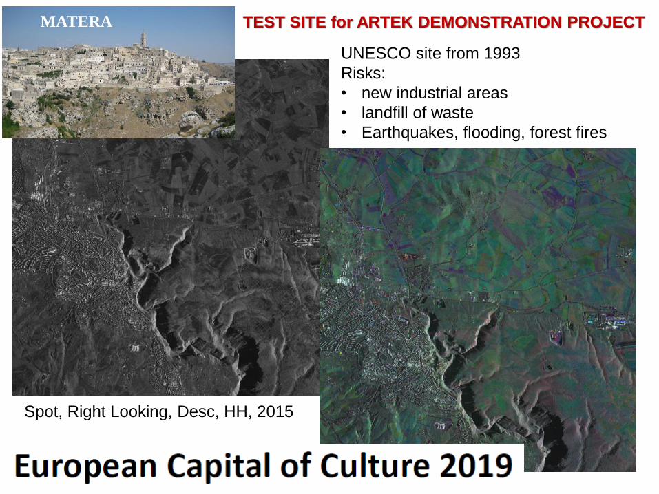
Spot, Right Looking, Desc, HH, 2015
UNESCO site from 1993
Risks:
• new industrial areas
• landfill of waste
• Earthquakes, flooding, forest fires
MATERA TEST SITE for ARTEK DEMONSTRATION PROJECT
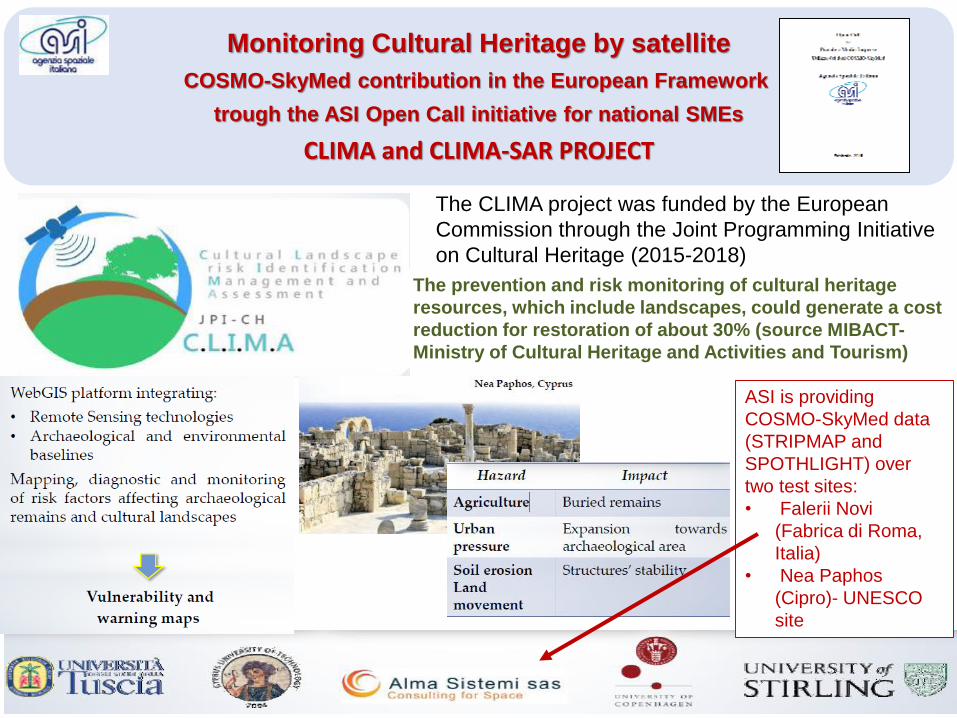
Monitoring Cultural Heritage by satellite
COSMO-SkyMed contribution in the European Framework
trough the ASI Open Call initiative for national SMEs
CLIMA and CLIMA-SAR PROJECT
The CLIMA project was funded by the European
Commission through the Joint Programming Initiative
on Cultural Heritage (2015-2018)
The prevention and risk monitoring of cultural heritage
resources, which include landscapes, could generate a cost
reduction for restoration of about 30% (source MIBACT-
Ministry of Cultural Heritage and Activities and Tourism)
ASI is providing
COSMO-SkyMed data
(STRIPMAP and
SPOTHLIGHT) over
two test sites:
• Falerii Novi
(Fabrica di Roma,
Italia)
• Nea Paphos
(Cipro)- UNESCO
site
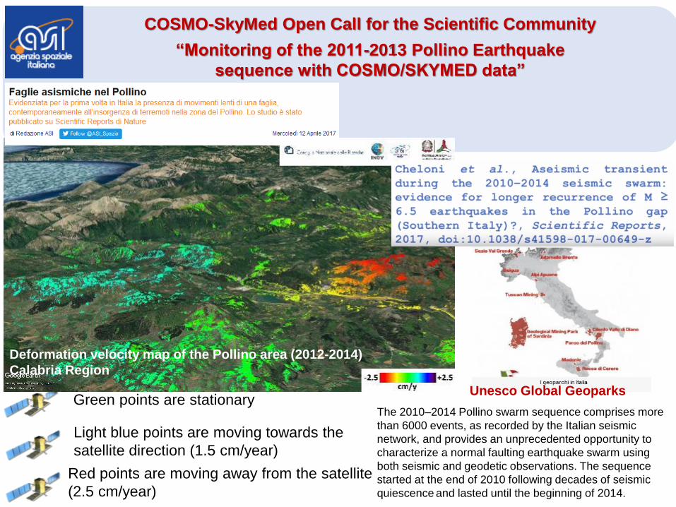
Green points are stationaryThe 2010–2014 Pollino swarm sequence comprises more
than 6000 events, as recorded by the Italian seismic
network, and provides an unprecedented opportunity to
characterize a normal faulting earthquake swarm using
both seismic and geodetic observations. The sequence
started at the end of 2010 following decades of seismic
quiescence and lasted until the beginning of 2014.
Unesco Global Geoparks
Light blue points are moving towards the
satellite direction (1.5 cm/year)
Red points are moving away from the satellite
(2.5 cm/year)
Deformation velocity map of the Pollino area (2012-2014)
Calabria Region
COSMO-SkyMed Open Call for the Scientific Community
“Monitoring of the 2011-2013 Pollino Earthquake
sequence with COSMO/SKYMED data”
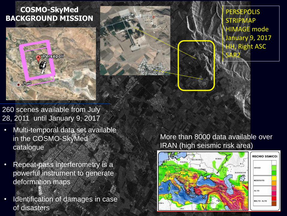
PERSEPOLISSTRIPMAP HIMAGE modeJanuary 9, 2017HH, Right ASCSAR2
COSMO-SkyMed BACKGROUND MISSION
260 scenes available from July
28, 2011 until January 9, 2017
• Multi-temporal data set available
in the COSMO-SkyMed
catalogue
• Repeat-pass interferometry is a
powerful instrument to generate
deformation maps
• Identification of damages in case
of disasters
More than 8000 data available over
IRAN (high seismic risk area)
EGYPTIAN-ITALIAN SCIENCE FORUM 2012 ROME – JANUARY 16-17 2012
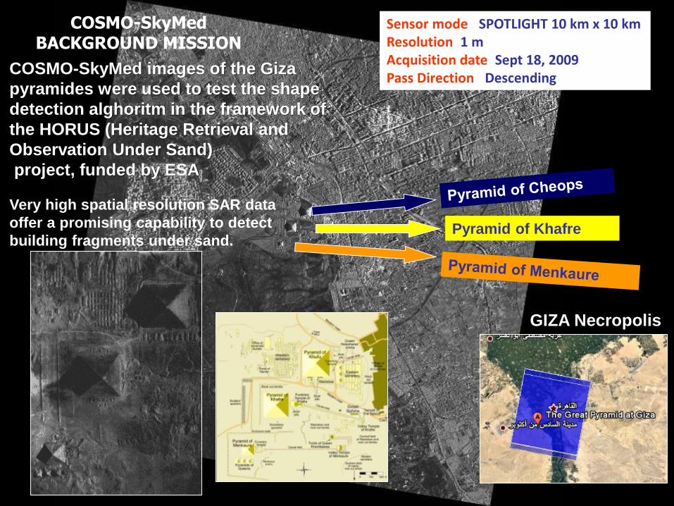
Sensor mode: SPOTLIGHT 10 km x 10 kmResolution: 1 mAcquisition date: Sept 18, 2009Pass Direction: Descending
Pyramid of Khafre
GIZA Necropolis
COSMO-SkyMed BACKGROUND MISSION
COSMO-SkyMed images of the Giza
pyramides were used to test the shape
detection alghoritm in the framework of
the HORUS (Heritage Retrieval and
Observation Under Sand)
project, funded by ESA
Very high spatial resolution SAR data
offer a promising capability to detect
building fragments under sand.
EGYPTIAN-ITALIAN SCIENCE FORUM 2012 ROME – JANUARY 16-17 2012
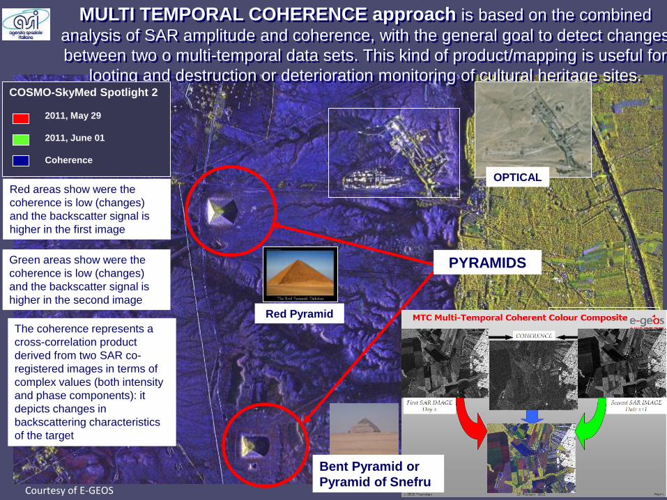
MULTI TEMPORAL COHERENCE approach is based on the combined
analysis of SAR amplitude and coherence, with the general goal to detect changes
between two o multi-temporal data sets. This kind of product/mapping is useful for
looting and destruction or deterioration monitoring of cultural heritage sites.
PYRAMIDS
Red Pyramid
OPTICAL
COSMO-SkyMed Spotlight 2
2011, May 29
2011, June 01
Coherence
Courtesy of E-GEOS
Green areas show were the
coherence is low (changes)
and the backscatter signal is
higher in the second image
Red areas show were the
coherence is low (changes)
and the backscatter signal is
higher in the first image
Bent Pyramid or
Pyramid of Snefru
The coherence represents a
cross-correlation product
derived from two SAR co-
registered images in terms of
complex values (both intensity
and phase components): it
depicts changes in
backscattering characteristics
of the target
EGYPTIAN-ITALIAN SCIENCE FORUM 2012 ROME – JANUARY 16-17 2012
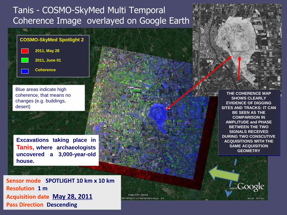
Tanis - COSMO-SkyMed Multi TemporalCoherence Image overlayed on Google Earth
COSMO-SkyMed Spotlight 2
2011, May 28
2011, June 01
Coherence
2 meter resolution
Excavations taking place in
Tanis, where archaeologists
uncovered a 3,000-year-old
house.
THE COHERENCE MAP
SHOWS CLEARLY
EVIDENCE OF DIGGING
SITES AND TRACKS: IT CAN
BE SEEN AS THE
COMPARISON IN
AMPLITUDE and PHASE
BETWEEN THE TWO
SIGNALS RECEIVED
DURING TWO CONSCUTIVE
ACQUISITIONS WITH THE
SAME ACQUISITION
GEOMETRY
Sensor mode: SPOTLIGHT 10 km x 10 kmResolution: 1 m
Acquisition date: May 28, 2011Pass Direction: Descending
Blue areas indicate high
coherence, that means no
changes (e.g. buildings,
desert)
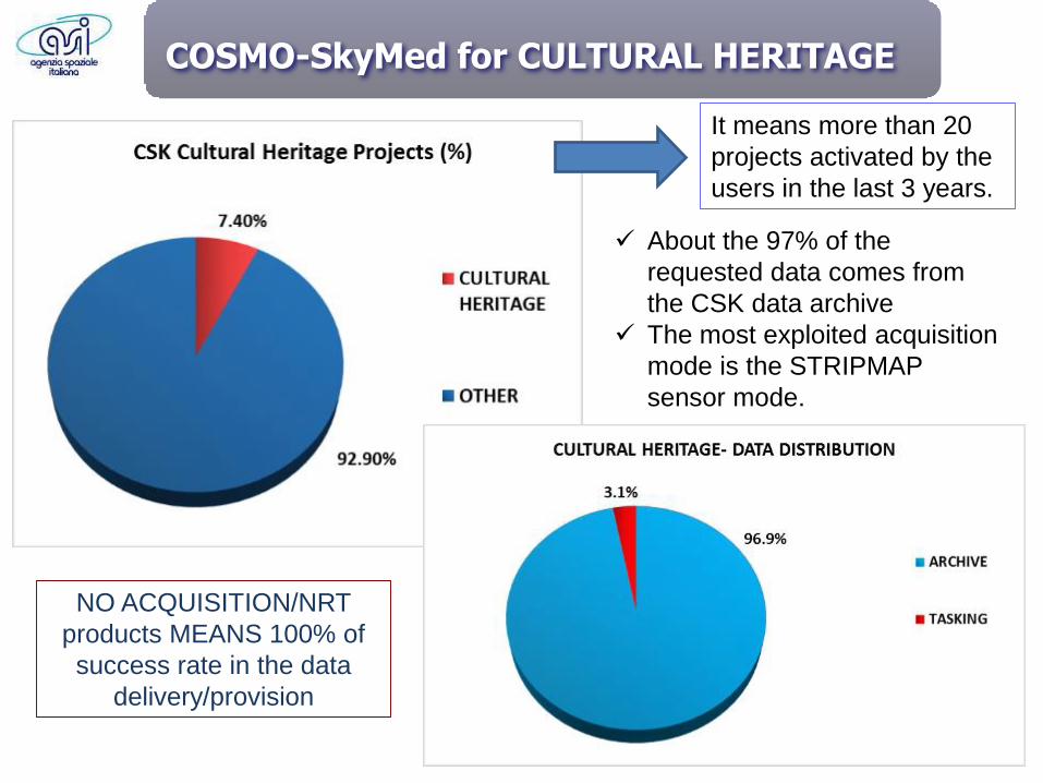
COSMO-SkyMed for CULTURAL HERITAGE
It means more than 20
projects activated by the
users in the last 3 years.
✓ About the 97% of the
requested data comes from
the CSK data archive
✓ The most exploited acquisition
mode is the STRIPMAP
sensor mode.
NO ACQUISITION/NRT
products MEANS 100% of
success rate in the data
delivery/provision
Conclusions
Earth Observation is recognized as a key instrument to support monitoring actions at localand global scale aimed to ensure environmental sustainability of human activities. A strategicrole is represented by missions such as COSMO-SkyMmed for its peculiarities as high spatialresolution and high revisit time.
The Earth Observation satellites are powerful instruments for identification and evaluations ofnatural and anthropogenic hazards that can have a negative impact over cultural assets.They are useful to identify changes over monitored areas and to assess the state ofconservation.
Italian Space Agency is providing its contribution at both National and International leveltrought the use of COSMO-SkyMed data.In this context the Open Call initiative for the Scientific Community, which is permanentlyopen, represents a source of data free of charge for scientists and Organizations responsiblefor Cultural properties.
It was estimated that a regular monitoring of cultural heritage resources, which includelandscapes, could generate a cost reduction for restoration and manteinance of about 30%(source MIBACT - Ministry of Cultural Heritage and Activities and Tourism)
Contact Points:
Alessandro Coletta - COSMO-SkyMed Mission Director - [email protected]
Maria L. Battagliere - COSMO-SkyMed Deputy Mission Manager - [email protected]
ThankYou!
Copernicus for Cultural heritage Workshop Brussels, Monday, April 24, 2017