Embed Size (px)
Citation preview

Country ProjectCountry Project
Madeline AvallonMadeline Avallon
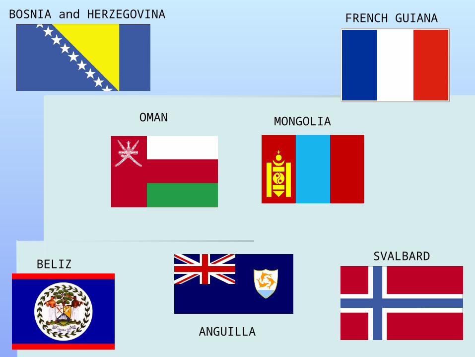
OMAN
ANGUILLA
FRENCH GUIANA
MONGOLIA
SVALBARDBELIZE
BOSNIA and HERZEGOVINA
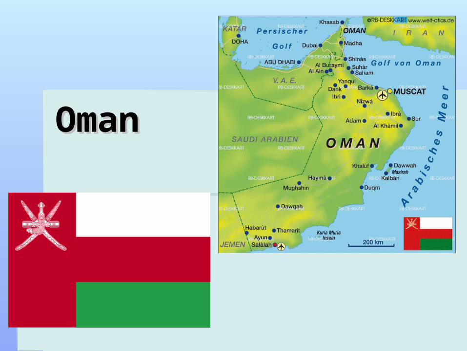
OmanOman
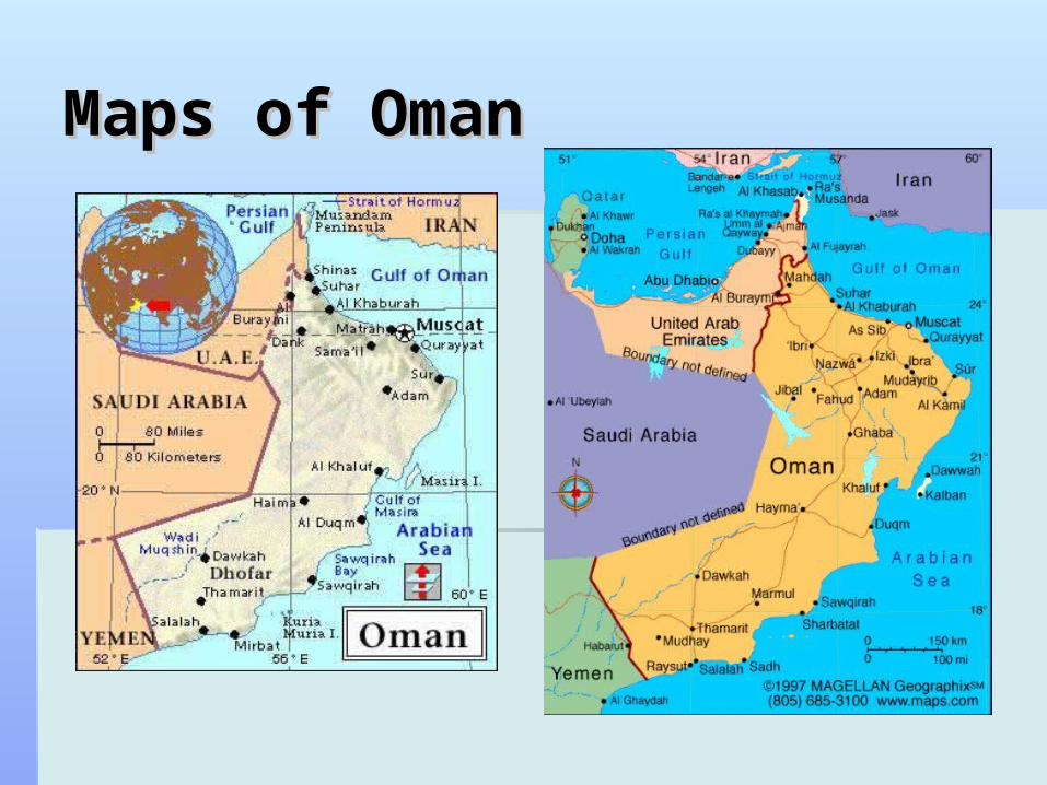
Maps of OmanMaps of Oman
DescriptionDescription
Total Area: Total Area: 309,500 sq km309,500 sq km 0 sq km of water0 sq km of water
LocationLocation: 21 00 N, 57 00 E : 21 00 N, 57 00 E In the Middle EastIn the Middle East bordering the Arabian Sea, Gulf of Oman, and Persian Gulf.bordering the Arabian Sea, Gulf of Oman, and Persian Gulf. between Yemen and UAEbetween Yemen and UAE
Population: Population: 3,027,9593,027,959 Climate:Climate: arid subtropical, the climate differs from one arid subtropical, the climate differs from one
region to another. the interior is normally very hot, with region to another. the interior is normally very hot, with temperatures from May to October. The coastal areas temperatures from May to October. The coastal areas are hot and humid from April to October. The summer are hot and humid from April to October. The summer wind, the wind, the GharbiGharbi, makes the heat more oppressive. the , makes the heat more oppressive. the south has a more moderate climate.south has a more moderate climate.
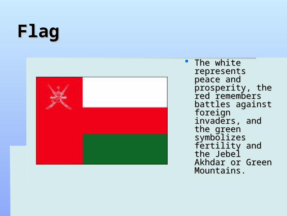
FlagFlag
The white The white represents peace represents peace and prosperity, and prosperity, the red the red remembers remembers battles against battles against foreign invaders, foreign invaders, and the green and the green symbolizes symbolizes fertility and the fertility and the Jebel Akhdar or Jebel Akhdar or Green Mountains.Green Mountains.
GeographyGeography
desert plains in the centerdesert plains in the center rugged mountains in the north and southrugged mountains in the north and south lowest point: Arabian Sea 0 m.lowest point: Arabian Sea 0 m. highest point: Jabal Shams 2,980 mhighest point: Jabal Shams 2,980 m it is broken into 5 regions: Ad Dakhiliyah, Al Batinah, it is broken into 5 regions: Ad Dakhiliyah, Al Batinah,
Al Wusta, Ash Sharqiyah and Az Zahirah, and 3 Al Wusta, Ash Sharqiyah and Az Zahirah, and 3 governorates: Masqat, Musandam and Zufurgovernorates: Masqat, Musandam and Zufur
There are no lakes in Oman, the country has two large There are no lakes in Oman, the country has two large areas of salt flats, one in the west-central region and areas of salt flats, one in the west-central region and another off the eastern coast.another off the eastern coast.
Capital: MuscatCapital: Muscat
Geography (continued)Geography (continued)
Wildlife includes: leopard, Oryx, gazelle, ibex, desert Wildlife includes: leopard, Oryx, gazelle, ibex, desert foxes, wild cats, 400 species of birds, exotic marine life foxes, wild cats, 400 species of birds, exotic marine life like turtles, tropical fish, and also 22 species of whale like turtles, tropical fish, and also 22 species of whale and dolphin in warm watersand dolphin in warm waters
Oman offers some of the most stunning beaches with a Oman offers some of the most stunning beaches with a coastline of 1700km.coastline of 1700km.
Khawr Najd, Kumzar Village located in the far north of Khawr Najd, Kumzar Village located in the far north of Musandam peninsula, and Salalah a well known Musandam peninsula, and Salalah a well known beach, the city of Muscat, its museums and mosques; beach, the city of Muscat, its museums and mosques; the coastal sea town of Sur; the historical monuments the coastal sea town of Sur; the historical monuments of Nizwa - the country's ancient capital; the Musandam of Nizwa - the country's ancient capital; the Musandam Peninsula with endless fishing and scuba diving are Peninsula with endless fishing and scuba diving are just a few interesting attractionsjust a few interesting attractions
HistoryHistory
Little is known about Oman's pre-Islamic past but recent Little is known about Oman's pre-Islamic past but recent discoveries say that early civilizations existed at least 5,000 years discoveries say that early civilizations existed at least 5,000 years ago.ago.
The Omanis are believed to have come from Yemen or northern The Omanis are believed to have come from Yemen or northern Arabia.Arabia.
The conversion to Islam occurred in the 7th century. Muscat, the The conversion to Islam occurred in the 7th century. Muscat, the capital was occupied by the Portuguese from 1508 to 1648, then capital was occupied by the Portuguese from 1508 to 1648, then the Ottoman Turks. in 1741, Ahmad Ibn Sa'id forced the Turks the Ottoman Turks. in 1741, Ahmad Ibn Sa'id forced the Turks out, and the descendants of Sultan Ahmad rule Oman today.out, and the descendants of Sultan Ahmad rule Oman today.
On July 23, 1970, the sultan, Sa'id bin Taimur, was overthrown by On July 23, 1970, the sultan, Sa'id bin Taimur, was overthrown by his son, Qabus Ibn Sa'id, who promised to establish a modern his son, Qabus Ibn Sa'id, who promised to establish a modern government Oman joined the Arab League and the United Nations government Oman joined the Arab League and the United Nations in 1971.in 1971.
History (continued)History (continued)
In 1997, Sultan Qabus granted women the right In 1997, Sultan Qabus granted women the right to be elected to the country's consultative to be elected to the country's consultative body, the Shura Council. body, the Shura Council.
In 2003, the sultan extended voting rights to In 2003, the sultan extended voting rights to everyone over 21; previously, voters were everyone over 21; previously, voters were selected from among the elite, and only about selected from among the elite, and only about a quarter of the population was allowed to vote.a quarter of the population was allowed to vote.
A long border dispute with Yemen was A long border dispute with Yemen was resolved in Oct. 1992; in 1997,resolved in Oct. 1992; in 1997,
Current DayCurrent Day
In late February 2011, protesters took to the In late February 2011, protesters took to the streets of Sohar in the northeast, and streets of Sohar in the northeast, and demanded higher salaries, more employment demanded higher salaries, more employment opportunities, and other political reform. Police opportunities, and other political reform. Police moved in and fired rubber bullets at the moved in and fired rubber bullets at the demonstrators, killing two people. After the demonstrators, killing two people. After the violence, Sultan Qabus promised to create violence, Sultan Qabus promised to create 50,000 jobs and offered each person seeking 50,000 jobs and offered each person seeking employment about $390 per month.employment about $390 per month.
EconomyEconomy
Natural resources include: oil, natural gas, copper, marble, Natural resources include: oil, natural gas, copper, marble, limestone, and chromium.limestone, and chromium.
ProductsProducts include dates, bananas, mangos, alfalfainclude dates, bananas, mangos, alfalfa Fisheries include kingfish, tuna, shrimp, lobster, abalone.Fisheries include kingfish, tuna, shrimp, lobster, abalone. Trade (2008):Trade (2008):
ExportsExports-$37.72 billion. -$37.72 billion. Major marketsMajor markets--China, U.A.E., Japan, South Korea, Thailand. --China, U.A.E., Japan, South Korea, Thailand.
ImportsImports--$22.92 billion: machinery, transportation equipment, --$22.92 billion: machinery, transportation equipment, manufactured goods, food, livestock, lubricants. manufactured goods, food, livestock, lubricants.
Major suppliersMajor suppliers--U.A.E., Japan, United States, China, India.--U.A.E., Japan, United States, China, India. Major industries include: crude oil production and refining, natural Major industries include: crude oil production and refining, natural
and liquefied natural gas production; construction, cement, and liquefied natural gas production; construction, cement, copper, steel, chemicals, optic fiber.copper, steel, chemicals, optic fiber.
Economy/PoliticsEconomy/Politics
Oman is a middle-income economy.Oman is a middle-income economy. it is dependent on oil resources but because of it is dependent on oil resources but because of
declining reserves, it has actively pursued a declining reserves, it has actively pursued a development plan that focuses on diversification, development plan that focuses on diversification, industrialization, and privatization, to reduce the oil industrialization, and privatization, to reduce the oil sector's contribution to GDPsector's contribution to GDP
Tourism and gas-based industries are key Tourism and gas-based industries are key components of the government's diversification components of the government's diversification strategy. strategy.
Government type- MonarchyGovernment type- Monarchy Government Leader- Sultan AhmadGovernment Leader- Sultan Ahmad
PeoplePeople
Ethnic Groups: Arab, Baluchi, South Asian (Indian, Ethnic Groups: Arab, Baluchi, South Asian (Indian, Pakistani, Sri Lankan, Bangladeshi), AfricanPakistani, Sri Lankan, Bangladeshi), African
Religions: Ibadhi Muslim 75%,Sunni Muslim, Shia Religions: Ibadhi Muslim 75%,Sunni Muslim, Shia Muslim, HinduMuslim, Hindu
Arabic (official), English, Baluchi, Urdu, Indian dialectsArabic (official), English, Baluchi, Urdu, Indian dialects Literacy:Literacy:
total population: total population: 81.4%81.4% male: male: 86.8%86.8% female: female: 73.5%73.5%
20% of Oman’s population uses internet20% of Oman’s population uses internet
People (continued)People (continued)
Life ExpectancyLife Expectancy total population: 74.22 yearstotal population: 74.22 years male: 72.38 yearsmale: 72.38 years femalefemale: : 76.16 years76.16 years
ClothingClothing Omani men wear dishdasha, simple collarless gowns to the ankle. Omani men wear dishdasha, simple collarless gowns to the ankle.
Furakha is a tassel sewn into the neckline of this dress, dipped in Furakha is a tassel sewn into the neckline of this dress, dipped in perfume. A plain piece of cloth is worn below the dishdasha covering perfume. A plain piece of cloth is worn below the dishdasha covering the body. they also wear different headdresses. Some men carry an the body. they also wear different headdresses. Some men carry an ornamental stick called assa. Most men wear sandals on their feet.ornamental stick called assa. Most men wear sandals on their feet.
Omani women dress in colorful, ornate clothing to reflect regions. The Omani women dress in colorful, ornate clothing to reflect regions. The main component is a sirwal and a headdress called lihaf. they wear main component is a sirwal and a headdress called lihaf. they wear elaborate gold and silver jewelry around the head, neck, wrists, elaborate gold and silver jewelry around the head, neck, wrists, ankles, fingers and toes. Most women wear sandals and many paint ankles, fingers and toes. Most women wear sandals and many paint their hands and feet with henna, especially before weddings, holidays their hands and feet with henna, especially before weddings, holidays and festivals.and festivals.
CultureCulture
Omani food represent a variety and are unique from other Arab Omani food represent a variety and are unique from other Arab counties.counties.
Kahwa is a bitter drink like coffee flavored. It is served with Kahwa is a bitter drink like coffee flavored. It is served with Lokhemat, a deep-fried ball of flour and yeast spiced with dry fruits Lokhemat, a deep-fried ball of flour and yeast spiced with dry fruits and nuts. Rice, meat, fish and bread are the main ingredients of and nuts. Rice, meat, fish and bread are the main ingredients of most Omani dishes, like maqbous and aursia. Other specials are most Omani dishes, like maqbous and aursia. Other specials are buttermilk drinks, salads and soups. buttermilk drinks, salads and soups.
Shuva is a popular festive meal requiring an elaborate Shuva is a popular festive meal requiring an elaborate preparation, often by the whole village community. To make this, a preparation, often by the whole village community. To make this, a whole cow is roasted up for two days in a special oven placed in a whole cow is roasted up for two days in a special oven placed in a pit dug in the ground. The meat becomes extremely tender and is pit dug in the ground. The meat becomes extremely tender and is then spiced elaborately.then spiced elaborately.
Culture (continued)Culture (continued)
Oman people have a great appreciation for tradition, Oman people have a great appreciation for tradition, the country preserves the richness of Arabian culture the country preserves the richness of Arabian culture
They make ornate silverware and detailed embroideryThey make ornate silverware and detailed embroidery The music has rhythm that adds a unique touch to the The music has rhythm that adds a unique touch to the
tunes. Music is a big part of the peoples’ life.tunes. Music is a big part of the peoples’ life. They use instruments like the mizmar, rababa, and tanbura. They use instruments like the mizmar, rababa, and tanbura.
Dance in Oman is marked by vibrant movements and Dance in Oman is marked by vibrant movements and all forms share a common dependency on beats and all forms share a common dependency on beats and movement. movement.
ConclusionConclusion
Oman is a country very rich in tradition Oman is a country very rich in tradition and heritage. It has a variety of wildlife and heritage. It has a variety of wildlife and resources. Although they have no and resources. Although they have no water internally it is surrounded by water water internally it is surrounded by water so fishing is very successful. The so fishing is very successful. The government is very dependent on oil government is very dependent on oil resource and are industrializing to reduce resource and are industrializing to reduce oil use.oil use.
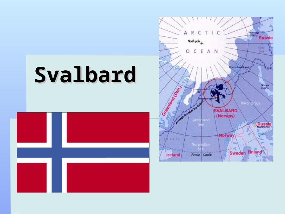
SvalbardSvalbard
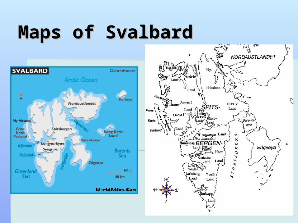
Maps of SvalMaps of Svalbardbard
DescriptionDescription
Total area: 62,045 sq kmTotal area: 62,045 sq km waterwater: : 0 sq km0 sq km slightly smaller than West Virginiaslightly smaller than West Virginia
Climate: Arctic, cool summers, cold Climate: Arctic, cool summers, cold winters; North Atlantic Current flows winters; North Atlantic Current flows along west and north coasts, keeping along west and north coasts, keeping water open and navigable most of the water open and navigable most of the yearyear
DescriptionDescription
Located in Northern EuropeLocated in Northern Europe between the Arctic Ocean, Barents Sea, between the Arctic Ocean, Barents Sea,
Greenland Sea, and Norwegian SeaGreenland Sea, and Norwegian Sea north of Norway north of Norway 78 00 N, 20 00 E78 00 N, 20 00 E
Population : 2,019Population : 2,019 Capital: LongyearbyenCapital: Longyearbyen
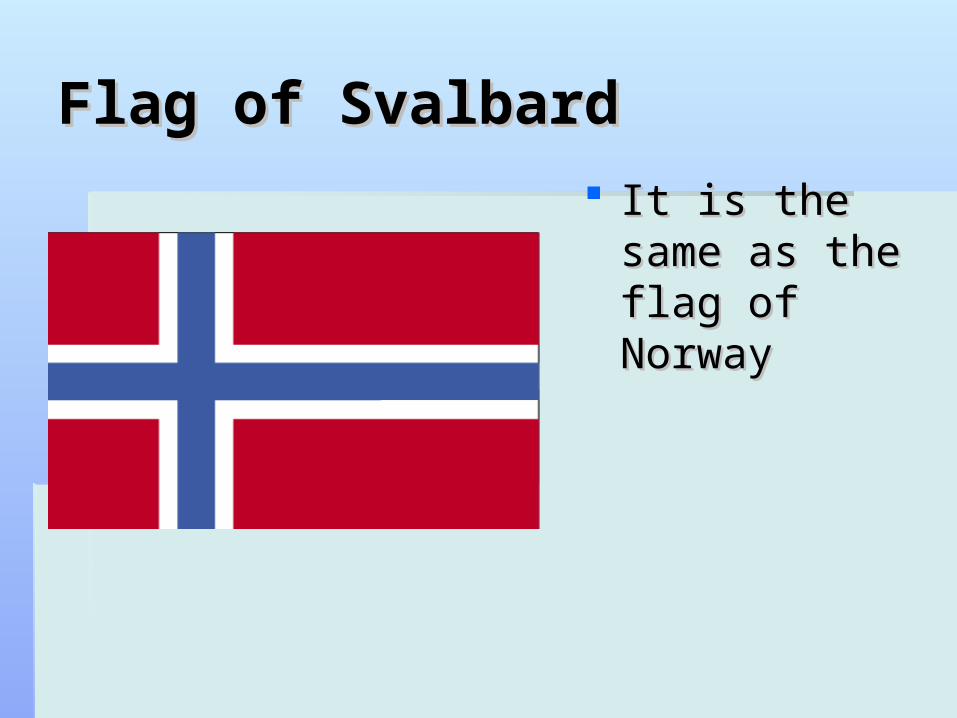
Flag of SvalbardFlag of Svalbard It is the same It is the same
as the flag of as the flag of NorwayNorway
GeographyGeography
rugged mountainsrugged mountains much land is ice coveredmuch land is ice covered west coast clear of ice for about one-half of the yearwest coast clear of ice for about one-half of the year fjords along west and north coastsfjords along west and north coasts
long, narrow inlet with steep sideslong, narrow inlet with steep sides lowest point: Arctic Ocean 0 mlowest point: Arctic Ocean 0 m highest point: Newtontoppen 1,717 mhighest point: Newtontoppen 1,717 m northernmost part of the Kingdom of Norway; consists northernmost part of the Kingdom of Norway; consists
of nine main islands; glaciers and snowfields cover of nine main islands; glaciers and snowfields cover 60% of the total area 60% of the total area
GeographyGeography
The principal islands are Spitsbergen, The principal islands are Spitsbergen, Nordaustlandet, Barentsøya, Edgeøya, Kong Nordaustlandet, Barentsøya, Edgeøya, Kong Karls Land, Prins Karls Forland, and Bjørnøya Karls Land, Prins Karls Forland, and Bjørnøya (Bear Island). (Bear Island).
there are few lakes on Svalbard. Most lakes there are few lakes on Svalbard. Most lakes are small and shallow, and many bottom-freeze are small and shallow, and many bottom-freeze in winter. in winter. The best known and studied lake on Svalbard is The best known and studied lake on Svalbard is
Linné vatnet,. Linné vatnet,. It is more than 5 km long.It is more than 5 km long.
WildlifeWildlife
The only indigenous land mammals in Svalbard are the The only indigenous land mammals in Svalbard are the Arctic fox, the Svalbard reindeer and the polar bear. Arctic fox, the Svalbard reindeer and the polar bear.
Sea mammals include the ringed and the bearded seal, Sea mammals include the ringed and the bearded seal, walruses and various species of whales, especially walruses and various species of whales, especially minky whales and belugas. minky whales and belugas.
Svalbard has a very rich bird life in summer. The Svalbard has a very rich bird life in summer. The ptarmigan is the only bird to remain on the island a ptarmigan is the only bird to remain on the island a whole year. The most common birds are auks, arctic whole year. The most common birds are auks, arctic owls and gulls. owls and gulls.
There are no trees, but the polar willow and the dwarf There are no trees, but the polar willow and the dwarf birch form small bushes. birch form small bushes.
Most common plants are mosses, lichen and fungi, but Most common plants are mosses, lichen and fungi, but there are also about 170 vascular plants.there are also about 170 vascular plants.
AttractionsAttractions
Most tourists arrive during spring and summer. Spitsbergen is one Most tourists arrive during spring and summer. Spitsbergen is one of the few places in Norway where a snowmobile can be driven in of the few places in Norway where a snowmobile can be driven in open country without special permission.open country without special permission.
This is the only place in Europe where polar bears can be seen This is the only place in Europe where polar bears can be seen living in their natural habitat.living in their natural habitat.
With few roads outside these settlements and the main way to see With few roads outside these settlements and the main way to see more of the island is on foot, snowmobile or by boat.more of the island is on foot, snowmobile or by boat.
Expedition cruises arrive throughout the summer so tourists can Expedition cruises arrive throughout the summer so tourists can explore the coast, see huge glaciers, visit the settlements and explore the coast, see huge glaciers, visit the settlements and watch the wildlife. You can also join expeditions and go hiking and watch the wildlife. You can also join expeditions and go hiking and kayaking on the mountains and in the fjords.kayaking on the mountains and in the fjords.
In winter you can do many things like snowmobiling and husky In winter you can do many things like snowmobiling and husky sledding.sledding.
HistoryHistory
the Dutch voyager Willem Barents, in search of a the Dutch voyager Willem Barents, in search of a northeast passage to China is the first visitor from the northeast passage to China is the first visitor from the European mainland. He named the islands European mainland. He named the islands Spitsbergen, or ‘sharp mountains’. The Norwegian Spitsbergen, or ‘sharp mountains’. The Norwegian name, Svalbard, comes from the Old Norse for ‘cold name, Svalbard, comes from the Old Norse for ‘cold coast’.coast’.
In 1920 the Svalbard Treaty granted Norway In 1920 the Svalbard Treaty granted Norway sovereignty over the islands and restricted military sovereignty over the islands and restricted military activities. Initially signed by nine nations, it now has activities. Initially signed by nine nations, it now has over 40 adherents, whose citizens enjoy the same over 40 adherents, whose citizens enjoy the same rights on the islands as Norwegians themselves.rights on the islands as Norwegians themselves.
PoliticsPolitics
territory of Norwayterritory of Norway administered by the Polar Department of the Ministry administered by the Polar Department of the Ministry
of Justice, through a governor residing in of Justice, through a governor residing in Longyearbyen, Spitsbergen;Longyearbyen, Spitsbergen;
sovereignty was awarded to Norway by treaty (9 sovereignty was awarded to Norway by treaty (9 February 1920)February 1920)
chief of state: King Harald V of Norwaychief of state: King Harald V of Norway head of government: Governor Odd Olsen Ingerohead of government: Governor Odd Olsen Ingero Assistant Governor Lars FauseAssistant Governor Lars Fause no elections, the monarchy is hereditary; no elections, the monarchy is hereditary;
EconomyEconomy
Coal mining, tourism, and international Coal mining, tourism, and international research are the major businessesresearch are the major businesses
There is also hunting of seals, reindeer, There is also hunting of seals, reindeer, and foxes. and foxes.
Export $197.6 millionExport $197.6 million Trade partners: UK, Germany, Trade partners: UK, Germany,
Netherlands, France, Sweden, USNetherlands, France, Sweden, US
CultureCulture
Traditions: fur trappingTraditions: fur trapping You can dog sleigh or scooterYou can dog sleigh or scooter They have colorful houses to contrast with the mountainsThey have colorful houses to contrast with the mountains Kayaking or hiking, many adventurous activitiesKayaking or hiking, many adventurous activities Food: Lapskois- traditional food, is potato simmered with diced Food: Lapskois- traditional food, is potato simmered with diced
beef, carrots and sausages. beef, carrots and sausages. Fish is also very important because of Svalbard’s locationFish is also very important because of Svalbard’s location Protestant religionProtestant religion
Language : English, Norwegian is spoken in Norwegian Language : English, Norwegian is spoken in Norwegian
settlements, and Russian in Russian settlements.settlements, and Russian in Russian settlements.
ConclusionConclusion
Svalbard is Europe’s northern most Svalbard is Europe’s northern most territory, it is a territory of Norway and is territory, it is a territory of Norway and is made up of several different islands. Coal made up of several different islands. Coal mining and tourism are their most mining and tourism are their most successful businesses. Many tourists go successful businesses. Many tourists go to see the ice and glaciers and other to see the ice and glaciers and other beautiful sites. beautiful sites.
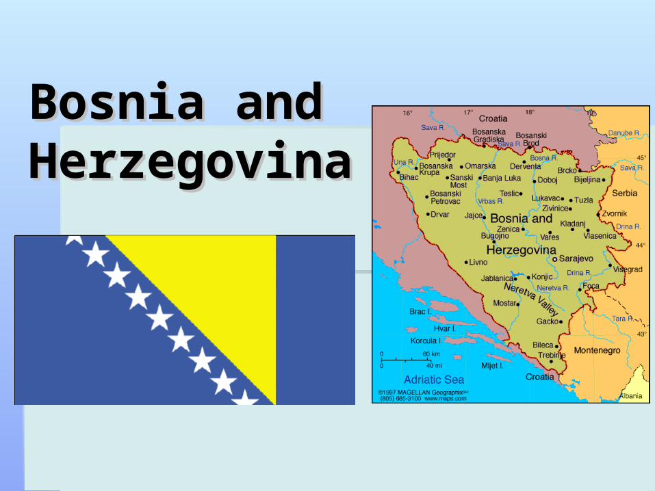
Bosnia and Bosnia and HerzegovinaHerzegovina
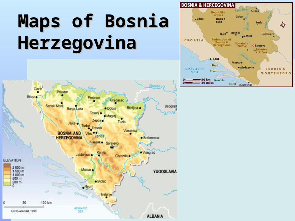
Maps of Bosnia Maps of Bosnia HerzegovinaHerzegovina
DescriptionDescription
Capital: SarajevoCapital: Sarajevo Location: Southeastern EuropeLocation: Southeastern Europe
bordering Croatia, Montenegro, Serbia and the Adriatic Seabordering Croatia, Montenegro, Serbia and the Adriatic Sea 44 00 N, 18 00 E44 00 N, 18 00 E
Total Area:Total Area: 51,197 sq km51,197 sq km water:water: 10 sq km10 sq km slightly smaller than West Virginiaslightly smaller than West Virginia
Climate: hot summers and cold winters; Climate: hot summers and cold winters; Areas of high elevation have short, cool summers and long, Areas of high elevation have short, cool summers and long,
severe winters while the coast has mild, rainy winterssevere winters while the coast has mild, rainy winters Population: 4,622,163 Population: 4,622,163
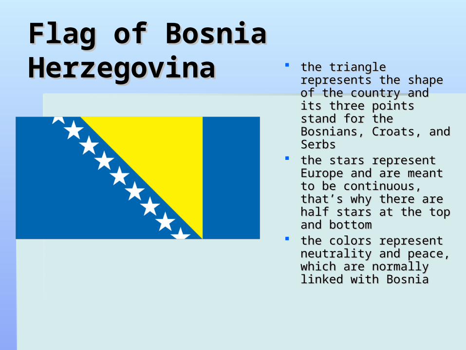
Flag of Bosnia Flag of Bosnia Herzegovina Herzegovina the triangle represents the triangle represents
the shape of the country the shape of the country and its three points stand and its three points stand for the Bosnians, Croats, for the Bosnians, Croats, and Serbs and Serbs
the stars represent the stars represent Europe and are meant to Europe and are meant to be continuous, that’s why be continuous, that’s why there are half stars at the there are half stars at the top and bottom top and bottom
the colors represent the colors represent neutrality and peace, neutrality and peace, which are normally linked which are normally linked with Bosniawith Bosnia
GeographyGeography
It is made up of many mountains and valleysIt is made up of many mountains and valleys lowest point: Adriatic Sea 0 mlowest point: Adriatic Sea 0 m highest point: Maglic 2,386 mhighest point: Maglic 2,386 m Natural resources: coal, iron ore, bauxite, copper, lead, Natural resources: coal, iron ore, bauxite, copper, lead,
zinc, chromite, cobalt, manganese, nickel, clay, zinc, chromite, cobalt, manganese, nickel, clay, gypsum, salt, sand, timber, hydropowergypsum, salt, sand, timber, hydropower
Rivers and Lakes: Glina , Sava Bosna, Neretva and Rivers and Lakes: Glina , Sava Bosna, Neretva and Bijela are a few of the many bodies of water found Bijela are a few of the many bodies of water found there.there.
Wildlife: Eurasian lynx, bears, hundreds of species of Wildlife: Eurasian lynx, bears, hundreds of species of birds, which are attracted to the many species of fishbirds, which are attracted to the many species of fish
AttractionsAttractions
Sarajevo is the “European Jerusalem” Sarajevo is the “European Jerusalem” because of its many mosques, because of its many mosques, synagogues, and churches.synagogues, and churches.
Sarajevo bridges, The City Hall- the Sarajevo bridges, The City Hall- the biggest building from the Austro-biggest building from the Austro-Hungarian period, Emperor's mosque Hungarian period, Emperor's mosque and Cathedral of Jesus' Sacred Heart and Cathedral of Jesus' Sacred Heart
HistoryHistory
Bosnia-Herzegovina is annexed to Austria-Hungary. Bosnia-Herzegovina is annexed to Austria-Hungary. Austria-Hungary collapses at the end of world war I. Austria-Hungary collapses at the end of world war I.
Bosnia-Herzegovina becomes part of the Kingdom of Bosnia-Herzegovina becomes part of the Kingdom of Serbs, Croats and Slovenes.Serbs, Croats and Slovenes.
It becomes a republic within the Yugoslav Socialist It becomes a republic within the Yugoslav Socialist Federation.Federation.
conflict breaks out between Muslims and Croatsconflict breaks out between Muslims and Croats In 1995 Dayton peace accord creates two lands, one In 1995 Dayton peace accord creates two lands, one
for Bosnian Muslims and Croats, the other for Serbs for Bosnian Muslims and Croats, the other for Serbs 2011- Bosnia's central government has still not yet 2011- Bosnia's central government has still not yet
been formed been formed
PoliticalPolitical
It is trying to become a federal It is trying to become a federal democratic republicdemocratic republic
Chairman of the Presidency Nebojsa Chairman of the Presidency Nebojsa RadmanovicRadmanovic
Chairman of the Council of Ministers Chairman of the Council of Ministers Nikola Spiric Nikola Spiric
EconomyEconomy
second poorest republic of the former Yugoslavia second poorest republic of the former Yugoslavia Major industries: steel, coal, iron ore, lead, zinc, Major industries: steel, coal, iron ore, lead, zinc,
manganese, aluminum, vehicle assembly, textiles, manganese, aluminum, vehicle assembly, textiles, tobacco products, wooden furniture, ammunition, tobacco products, wooden furniture, ammunition, domestic appliances, oil refiningdomestic appliances, oil refining
Agriculture: wheat, corn, fruits, vegetables; livestockAgriculture: wheat, corn, fruits, vegetables; livestock Exports: metals, clothing, wood productsExports: metals, clothing, wood products
Partners: Croatia, Slovenia, Italy, Germany, AustriaPartners: Croatia, Slovenia, Italy, Germany, Austria Imports: machinery and equipment, chemicals, fuels, Imports: machinery and equipment, chemicals, fuels,
foodfood Partners: Croatia, Germany, Slovenia, Italy, Austria, Hungary Partners: Croatia, Germany, Slovenia, Italy, Austria, Hungary
CultureCulture
Food: The food is influenced by its Balkan neighbors.Food: The food is influenced by its Balkan neighbors. bread, soups, stews, kebabs, cevapcici-minced meat bread, soups, stews, kebabs, cevapcici-minced meat
sausages, and stuffed peppers. Side dishes, such as sour sausages, and stuffed peppers. Side dishes, such as sour cabbage, tomato and onion salad and yogurt, are often cabbage, tomato and onion salad and yogurt, are often served.served.
Sarajevski sahan: vegetables stuffed with meat and rice.Sarajevski sahan: vegetables stuffed with meat and rice. Bosnian pot: thick stew-like soup made of veal and vegetables Bosnian pot: thick stew-like soup made of veal and vegetables
flavored spices like cardamom, cloves and cinnamonflavored spices like cardamom, cloves and cinnamon Desserts eaten are fruit, pancakes, cakes and pastries.Desserts eaten are fruit, pancakes, cakes and pastries.
Language: Bosnian, Croatian and SerbianLanguage: Bosnian, Croatian and Serbian Religion: about 40% Muslim, a little over 30% Religion: about 40% Muslim, a little over 30%
Orthodox Church, about 15% Roman Catholic. Orthodox Church, about 15% Roman Catholic. the end of Ramadan is celebrated with a large family the end of Ramadan is celebrated with a large family
meal and sweets and pastriesmeal and sweets and pastries
Culture (cont)Culture (cont)
Bosnia has a patriarchal tradition in which Bosnia has a patriarchal tradition in which women are expected to be subservient to menwomen are expected to be subservient to men
Women are responsible for all domestic tasks, Women are responsible for all domestic tasks, including cooking, cleaning, and child rearingincluding cooking, cleaning, and child rearing
inheritance follows a system of primogenitureinheritance follows a system of primogeniture It is traditional to remove one's shoes and put It is traditional to remove one's shoes and put
on a pair of slippers.on a pair of slippers. Kissing is a common form of greeting for both Kissing is a common form of greeting for both
men and women, three kisses on the cheeksmen and women, three kisses on the cheeks
ConclusionConclusion
Bosnia and Herzegovina is influenced greatly Bosnia and Herzegovina is influenced greatly by its surrounding nations. Its economy is not by its surrounding nations. Its economy is not doing very well, it is one of the poorest of the doing very well, it is one of the poorest of the former Yugoslavia lands. There is also difficulty former Yugoslavia lands. There is also difficulty forming a central government.forming a central government.
There are many places to visit and many There are many places to visit and many species of fish and birds all around. It is a species of fish and birds all around. It is a patriarchal and most women work in the homespatriarchal and most women work in the homes
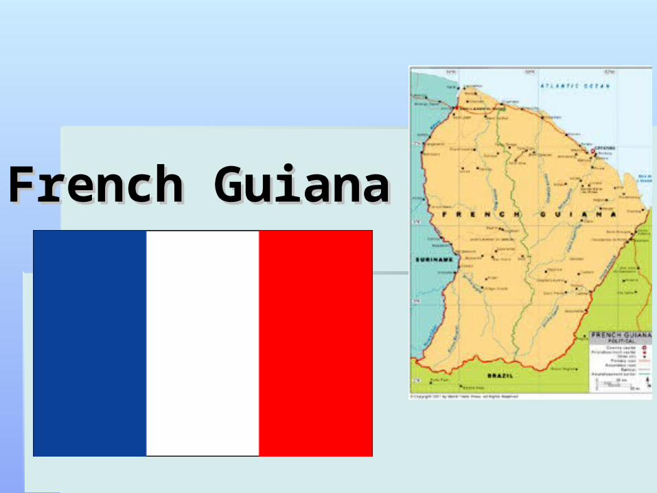
French GuianaFrench Guiana
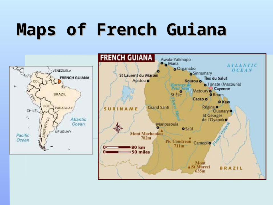
Maps of French GuianaMaps of French Guiana
DescriptionDescription
Capital: CayenneCapital: Cayenne Location: northeast coast of South America, Location: northeast coast of South America,
north of Brazil, east of Suriname north of Brazil, east of Suriname Total Area: 35,135 sq mi Total Area: 35,135 sq mi
Water:714 sq mi.Water:714 sq mi. Population: 203,321 (2007)Population: 203,321 (2007) Climate: TropicalClimate: Tropical
Dry season is August to December; rainy season is Dry season is August to December; rainy season is December, January and April to July. December, January and April to July.
Average temperature is 85°F year roundAverage temperature is 85°F year round
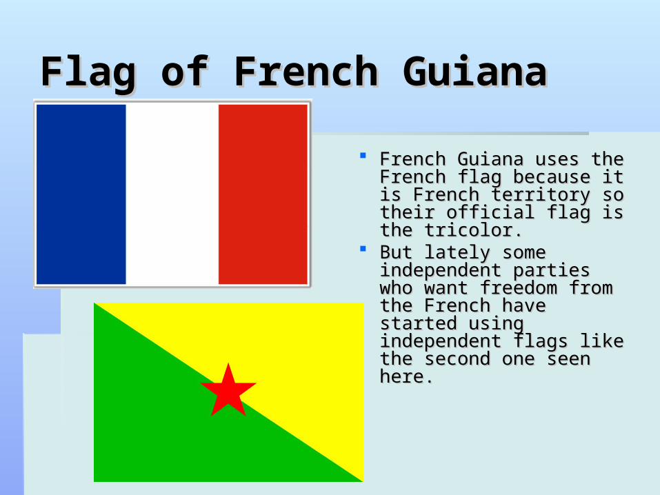
Flag of French GuianaFlag of French Guiana
French Guiana uses the French Guiana uses the French flag because it is French flag because it is French territory so their French territory so their official flag is the tricolor.official flag is the tricolor.
But lately some But lately some independent parties who independent parties who want freedom from the want freedom from the French have started French have started using independent flags using independent flags like the second one seen like the second one seen here. here.

GeographyGeography
Lowland moist forest, swamp forest, low summit forestLowland moist forest, swamp forest, low summit forest Amazon, Negro and Orinoco riversAmazon, Negro and Orinoco rivers It has twenty-six different regionsIt has twenty-six different regions Cayenne River, Wanapi River, Inini River, and the Cayenne River, Wanapi River, Inini River, and the
Mana River are a few of the rivers in French GuianaMana River are a few of the rivers in French Guiana It is a French territoryIt is a French territory Opossum, armadillo, sloth, anteater, rabbit, crocodile, Opossum, armadillo, sloth, anteater, rabbit, crocodile,
iguana, snake, stork, parrot, shark, ray and bat are all iguana, snake, stork, parrot, shark, ray and bat are all found herefound here
Places of InterestPlaces of Interest
Iles du SalutIles du Salut Devil’s Island – where political prisoners Devil’s Island – where political prisoners
were heldwere held
KourouKourou- The main French Space Center- The main French Space Center Emerald Jungle VillageEmerald Jungle Village Fort DiamantFort Diamant Salvation IslandsSalvation Islands
HistoryHistory
1498 French Guiana was first visited by Christopher Columbus on 1498 French Guiana was first visited by Christopher Columbus on his third voyage and his third voyage and
In 1604 France tried to settle there, but had to abandon it because In 1604 France tried to settle there, but had to abandon it because of the Portuguese, who said it violated the Treaty of Tordesillas.of the Portuguese, who said it violated the Treaty of Tordesillas.
French settlers returned, however, in 1643 and managed to French settlers returned, however, in 1643 and managed to establish a settlement at Cayenneestablish a settlement at Cayenne
French Guiana became an overseas French Guiana became an overseas departmentdepartment of France in of France in 1946.1946.
The penal colonies, including Devil's Island, were phased out and The penal colonies, including Devil's Island, were phased out and then formally closed in 1951. then formally closed in 1951.
At first, only those freed prisoners who could raise the fare for At first, only those freed prisoners who could raise the fare for their return passage to France were able to go home, so French their return passage to France were able to go home, so French Guiana was haunted after the official closing of the prisons by Guiana was haunted after the official closing of the prisons by freed convictsfreed convicts
Government Government
chief of state: President of France: Jacques chief of state: President of France: Jacques CHIRAC CHIRAC It is a territory of France It is a territory of France
President of the General Council Stephan President of the General Council Stephan PHINERA PHINERA
General Council-19 seats, members are General Council-19 seats, members are elected by popular vote, serve six-year termselected by popular vote, serve six-year terms
Regional Council-31 seats, members are Regional Council-31 seats, members are elected by popular vote, serve six-year terms elected by popular vote, serve six-year terms
EconomyEconomy
Exports: shrimp, timber, gold, rum, rosewood essence, Exports: shrimp, timber, gold, rum, rosewood essence, clothing, fishclothing, fish Partners: France, Switzerland, US Partners: France, Switzerland, US
Imports: food machinery and transport equipment, fuels Imports: food machinery and transport equipment, fuels and chemicals and chemicals Partners: France, US, Trinidad and Tobago, Italy Partners: France, US, Trinidad and Tobago, Italy
It is dependent on importingIt is dependent on importing Main industry: construction, shrimp processing, forestry Main industry: construction, shrimp processing, forestry
products, rum, gold mining products, rum, gold mining Agriculture products: corn, rice, sugar, cocoa, Agriculture products: corn, rice, sugar, cocoa,
vegetables, bananas; cattle, poultryvegetables, bananas; cattle, poultry
CultureCulture
languages: French (official), Creole languages: French (official), Creole religion: Christianity religion: Christianity Life expectancy: 72 years (men), 78 years Life expectancy: 72 years (men), 78 years
(women) (women) Food: a lot of fish, fruits and vegetables, many Food: a lot of fish, fruits and vegetables, many
spices, hot peppers, curryspices, hot peppers, curry Roti is a popular dish its made with meat and vegetables, Roti is a popular dish its made with meat and vegetables,
cooked with curry and wrapped in bread.cooked with curry and wrapped in bread. 83% literacy rate83% literacy rate 20.5% internet usage (2007)20.5% internet usage (2007)
ConclusionConclusion
French Guiana is a territory of France so French Guiana is a territory of France so it has many things in common with it has many things in common with France. The people rely on importing France. The people rely on importing items very much. The warm temperature items very much. The warm temperature is good for many animals that live there is good for many animals that live there as well as for items to exportas well as for items to export
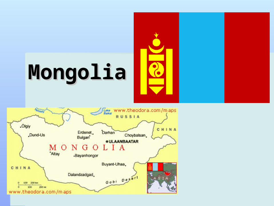
MongoliaMongolia

Maps of MongoliaMaps of Mongolia
DescriptionDescription
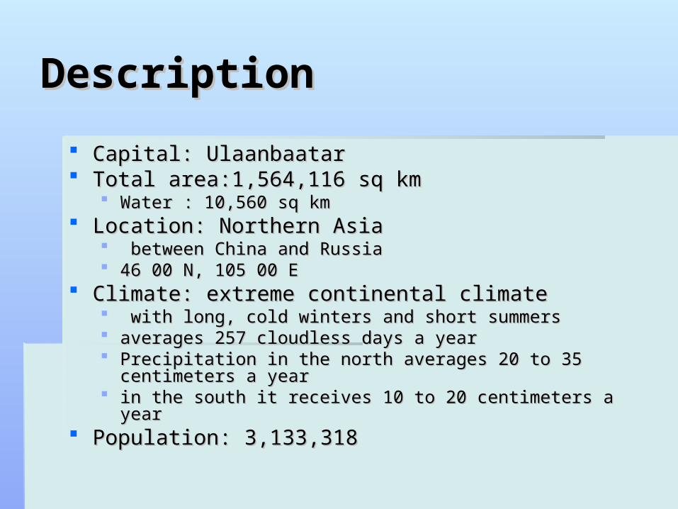
Capital: UlaanbaatarCapital: Ulaanbaatar Total area:1,564,116 sq kmTotal area:1,564,116 sq km
Water : 10,560 sq km Water : 10,560 sq km Location: Northern AsiaLocation: Northern Asia
between China and Russiabetween China and Russia 46 00 N, 105 00 E46 00 N, 105 00 E
Climate: extreme continental climateClimate: extreme continental climate with long, cold winters and short summerswith long, cold winters and short summers averages 257 cloudless days a yearaverages 257 cloudless days a year Precipitation in the north averages 20 to 35 centimeters a yearPrecipitation in the north averages 20 to 35 centimeters a year in the south it receives 10 to 20 centimeters a yearin the south it receives 10 to 20 centimeters a year
Population: 3,133,318 Population: 3,133,318
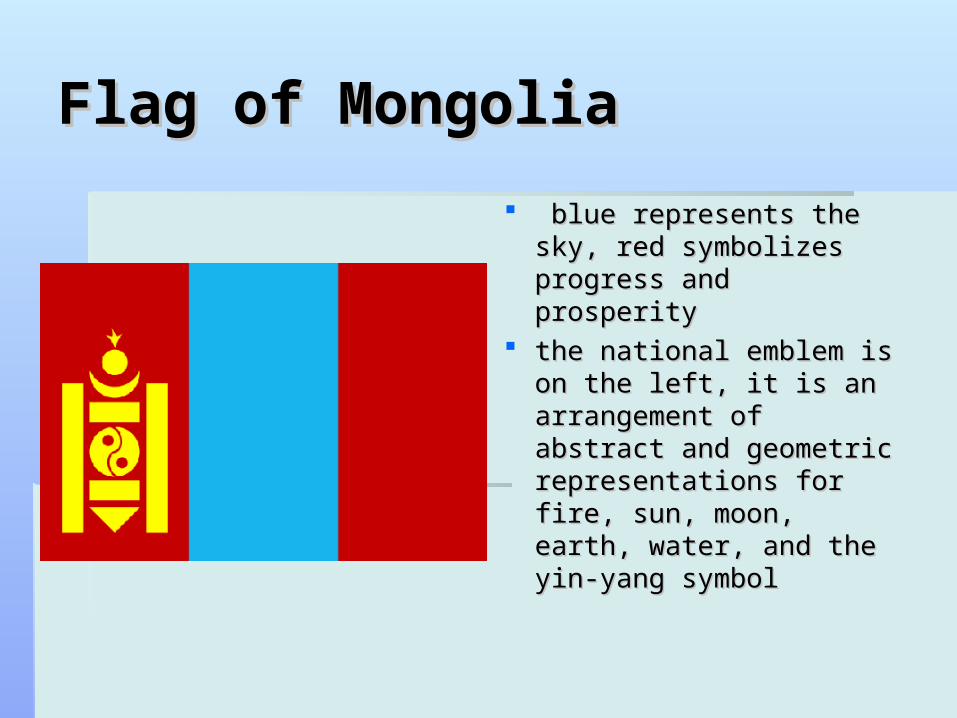
Flag of MongoliaFlag of Mongolia
blue represents the sky, blue represents the sky, red symbolizes progress red symbolizes progress and prosperityand prosperity
the national emblem is the national emblem is on the left, it is an on the left, it is an arrangement of abstract arrangement of abstract and geometric and geometric representations for fire, representations for fire, sun, moon, earth, water, sun, moon, earth, water, and the yin-yang symboland the yin-yang symbol
GeographyGeography semi-desert and desert plains, grassy steppe, semi-desert and desert plains, grassy steppe,
mountains in west and southwest; Gobi Desert in mountains in west and southwest; Gobi Desert in south-centralsouth-central
lowest point: Hoh Nuur 560 mlowest point: Hoh Nuur 560 m highest point: Nayramadlin Orgil 4,374 mhighest point: Nayramadlin Orgil 4,374 m Landlocked, some areas have limited fresh waterLandlocked, some areas have limited fresh water Lakes and rivers: Lake Khövsgöl, many salt lakes, Lakes and rivers: Lake Khövsgöl, many salt lakes,
Beltes River, Khogorog River, Selenge RiverBeltes River, Khogorog River, Selenge River Wildlife: 136 mammal species,400 types of birds, 76 Wildlife: 136 mammal species,400 types of birds, 76
species of fish. Wolves, snow leopards, wild boar, elk, species of fish. Wolves, snow leopards, wild boar, elk, brown bears, marmot, muskrat, fox, steppe fox, wild brown bears, marmot, muskrat, fox, steppe fox, wild horses and sable are just a fewhorses and sable are just a few..
HistoryHistory
1206-1263 after the unification of the Mongol tribes, 1206-1263 after the unification of the Mongol tribes, Genghis Khan launches create the world's biggest land Genghis Khan launches create the world's biggest land empire. empire. 1636 - The Manchu (Qing) empire conquers the southern 1636 - The Manchu (Qing) empire conquers the southern
Mongols, creating Inner Mongolia. Mongols, creating Inner Mongolia. 1691 - The Qing empire offers protection to the northern 1691 - The Qing empire offers protection to the northern
Mongols, creating Outer MongoliaMongols, creating Outer Mongolia 1919 - The Chinese army occupies Outer Mongolia 1919 - The Chinese army occupies Outer Mongolia Mongolian People's Republic is proclaimed Mongolian People's Republic is proclaimed 1992 - new constitution gives human rights and 1992 - new constitution gives human rights and
freedoms. freedoms.
GovernmentGovernment
Government type: parliamentaryGovernment type: parliamentary It has 21 provincesIt has 21 provinces Government leaders:Government leaders:
President- Tsakhia Elbegdorj President- Tsakhia Elbegdorj Prime Minister- Sukhbaatar BatboldPrime Minister- Sukhbaatar Batbold Deputy Prime- Minister Miegombyn Deputy Prime- Minister Miegombyn
ENKHBOLD ENKHBOLD
EconomyEconomy herding and agriculture, construction and construction herding and agriculture, construction and construction
materials; mining (coal, copper, molybdenum, materials; mining (coal, copper, molybdenum, fluorspar, tin, tungsten, and gold); oil; food and fluorspar, tin, tungsten, and gold); oil; food and beverages; processing of animal products, cashmere beverages; processing of animal products, cashmere and natural fiber manufacturingand natural fiber manufacturing
wheat, barley, vegetables, forage crops; sheep, goats, wheat, barley, vegetables, forage crops; sheep, goats, cattle, camels, horsescattle, camels, horses
Exports: copper, apparel, livestock, animal products, Exports: copper, apparel, livestock, animal products, cashmere, wool, hides, fluorspar, coalcashmere, wool, hides, fluorspar, coal Partners: China, Canada, RussiaPartners: China, Canada, Russia
Imports: machinery and equipment, fuel, cars, food Imports: machinery and equipment, fuel, cars, food products, industrial consumer goods, chemicals, products, industrial consumer goods, chemicals, building materials, sugar, teabuilding materials, sugar, tea Partners: China, Russia, South Korea, Japan Partners: China, Russia, South Korea, Japan
CultureCulture
Culture has been shaped by the extreme climate, the Mongol Culture has been shaped by the extreme climate, the Mongol peoples nomadic way, their ability to adapt, and the vision of peoples nomadic way, their ability to adapt, and the vision of Genghis KhanGenghis Khan
Music: conveys a deep appreciation for their country, its Music: conveys a deep appreciation for their country, its beauty and vast landscape. beauty and vast landscape. songs are often about beloved horses and the Mongolian countryside. songs are often about beloved horses and the Mongolian countryside.
Herders sing while riding their horses Herders sing while riding their horses Food: meat is a big part of Mongolian dietFood: meat is a big part of Mongolian diet
The main meats are mutton and beef The main meats are mutton and beef fried pancakes made from mutton and flourfried pancakes made from mutton and flour Butter, yogurt, cheese and milk Butter, yogurt, cheese and milk Fish is sometimes availableFish is sometimes available
Religion: Buddhist Lamaist 50%, Shamanist and Christian 6%, Religion: Buddhist Lamaist 50%, Shamanist and Christian 6%, Muslim 4%, 40% no religionMuslim 4%, 40% no religion
Culture (cont)Culture (cont)
Language: Khalkha Mongol 90%, Turkic, Language: Khalkha Mongol 90%, Turkic, RussianRussian
12.5% of Mongolians use the internet12.5% of Mongolians use the internet 98.4% literacy rate98.4% literacy rate Clothing: The del is the traditional clothing. Clothing: The del is the traditional clothing.
typically it is made of wool and worn by both typically it is made of wool and worn by both men and women. Dels look like knee-length men and women. Dels look like knee-length togas. They have a silk sash around the waist. togas. They have a silk sash around the waist. They’re more functional than beautiful because They’re more functional than beautiful because of nomadic people living in the northern climes. of nomadic people living in the northern climes.
ConclusionConclusion
Mongolia is a country with very important Mongolia is a country with very important traditions. They follow traditions from the traditions. They follow traditions from the nomadic Mongols very much. They nomadic Mongols very much. They appreciate there land and country very appreciate there land and country very much. They have many different animals much. They have many different animals living their even though the climate is living their even though the climate is cold most of the year.cold most of the year.
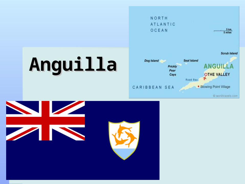
AnguillaAnguilla
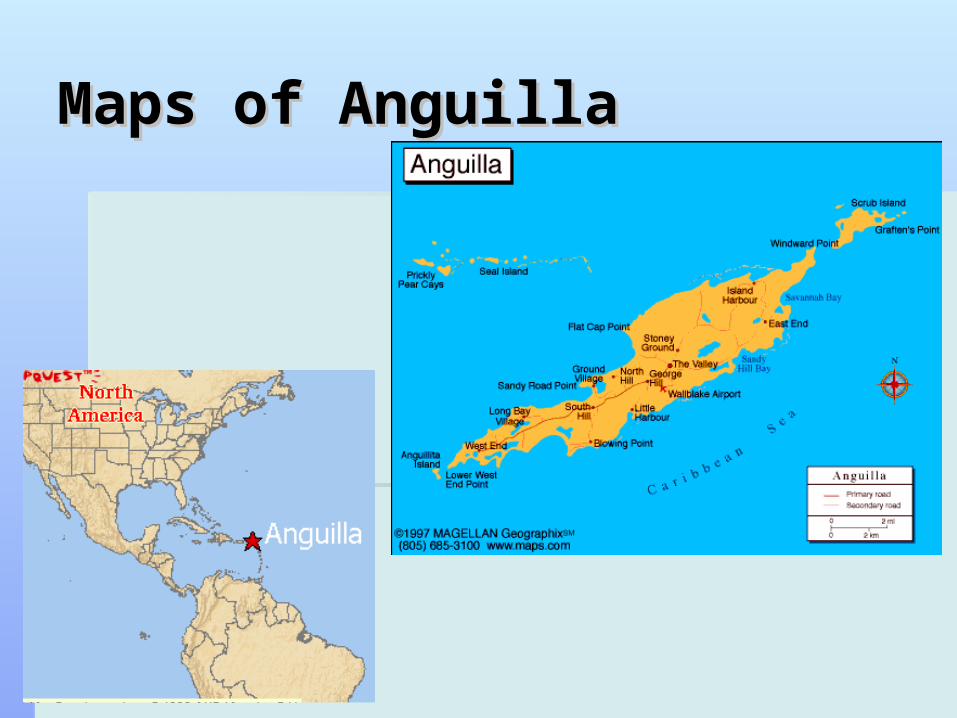
Maps of AnguillaMaps of Anguilla
DescriptionDescription
Location: between the Caribbean Sea and North Location: between the Caribbean Sea and North Atlantic Ocean, east of Puerto Rico Atlantic Ocean, east of Puerto Rico 18 15 N, 63 10 W18 15 N, 63 10 W
Total area:91 sq kmTotal area:91 sq km Water 0 sq kmWater 0 sq km
Climate: tropical humid; climate depends on Northeast Climate: tropical humid; climate depends on Northeast Trade Winds. Trade Winds.
average rainfall 900-1000 mm average rainfall 900-1000 mm June to November are hurricane months June to November are hurricane months Capital: The ValleyCapital: The Valley Population: 15,094 Population: 15,094 It is a British overseas territory It is a British overseas territory
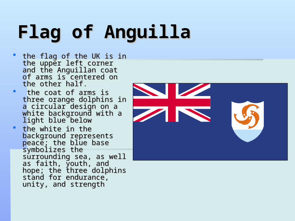
Flag of AnguillaFlag of Anguilla the flag of the UK is in the the flag of the UK is in the
upper left corner and the upper left corner and the Anguillan coat of arms is Anguillan coat of arms is centered on the other half.centered on the other half.
the coat of arms is three the coat of arms is three orange dolphins in a circular orange dolphins in a circular design on a white design on a white background with a light blue background with a light blue below below
the white in the background the white in the background represents peace; the blue represents peace; the blue base symbolizes the base symbolizes the surrounding sea, as well as surrounding sea, as well as faith, youth, and hope; the faith, youth, and hope; the three dolphins stand for three dolphins stand for endurance, unity, and endurance, unity, and strengthstrength
GeographyGeography
lowest point: Caribbean Sea 0 mlowest point: Caribbean Sea 0 m highest point: Crocus Hill 65 mhighest point: Crocus Hill 65 m Anguilla is a coral and limestone islandAnguilla is a coral and limestone island It is covered with sparse vegetation, It is covered with sparse vegetation, no rivers; several salt ponds, used for the no rivers; several salt ponds, used for the
production of salt.production of salt. Wildlife: flamingos, island goats, scorpion, Wildlife: flamingos, island goats, scorpion,
craps, tortoises, cows, lizards and birds, these craps, tortoises, cows, lizards and birds, these animals have adapted to Anguillas harsh animals have adapted to Anguillas harsh climate to surviveclimate to survive
HistoryHistory
Anguilla is administered by the British Government Anguilla is administered by the British Government through Antigua from 1667 to 1824through Antigua from 1667 to 1824
Placed under control of St. Kitts and suffer for yearsPlaced under control of St. Kitts and suffer for years They expel St. Kitts-directed police force and demand They expel St. Kitts-directed police force and demand
direct links with Britain. direct links with Britain. Britain invades Anguilla, the military force is met by a Britain invades Anguilla, the military force is met by a
few children and journalists, not a shot was fired. world few children and journalists, not a shot was fired. world press heaps scorn on Britain(1969)press heaps scorn on Britain(1969)
1980: Britain agrees to allows Anguilla to become a 1980: Britain agrees to allows Anguilla to become a British Dependent TerritoryBritish Dependent Territory
GovernmentGovernment
Queen Elizabeth II, represented by Queen Elizabeth II, represented by Governor Alistair Harrison Governor Alistair Harrison
head of government: Chief Minister head of government: Chief Minister Hubert HughesHubert Hughes
overseas territory of the UK overseas territory of the UK
EconomyEconomy
Anguilla is not industrialized Anguilla is not industrialized few natural resources; the economy depends few natural resources; the economy depends
tourism, offshore banking, lobster fishing, and tourism, offshore banking, lobster fishing, and remittances from emigrantsremittances from emigrants
Exports: lobster, fish, livestock, salt, concrete Exports: lobster, fish, livestock, salt, concrete blocks, rumblocks, rum
Imports: fuels, foodstuffs, manufactures, Imports: fuels, foodstuffs, manufactures, chemicals, trucks, textileschemicals, trucks, textiles
Great Britain and its neighboring islands are Great Britain and its neighboring islands are Anguilla's major trade partnersAnguilla's major trade partners
CultureCulture
men make up the majority of the workforce. But women men make up the majority of the workforce. But women own shops or work in the tourist business, in hotels, own shops or work in the tourist business, in hotels, restaurants, or markets. Women are also employed in restaurants, or markets. Women are also employed in agricultural workagricultural work
Politeness and manners are considered important Politeness and manners are considered important Religion: Protestant mainly Anglican and Methodist, Religion: Protestant mainly Anglican and Methodist,
Roman Catholic is second-largest religious group, Roman Catholic is second-largest religious group, Obeah, which is similar to voodoo is practiced by some. Obeah, which is similar to voodoo is practiced by some.
Language: English, Creole language- a mixture of Language: English, Creole language- a mixture of English and African languages.English and African languages.
46.3% of Anguilla’s population uses the internet46.3% of Anguilla’s population uses the internet Literacy rate: 95%Literacy rate: 95%
ConclusionConclusion
Although Anguilla is not industrialized it Although Anguilla is not industrialized it seems to be doing pretty well and may seems to be doing pretty well and may be in the process of industrialization. be in the process of industrialization. They have a 95% literacy rate. Men They have a 95% literacy rate. Men make up most of the work force but make up most of the work force but women can work as well. Their economy women can work as well. Their economy depends heavily on tourism and their depends heavily on tourism and their tropical climate makes tourism very tropical climate makes tourism very successful.successful.
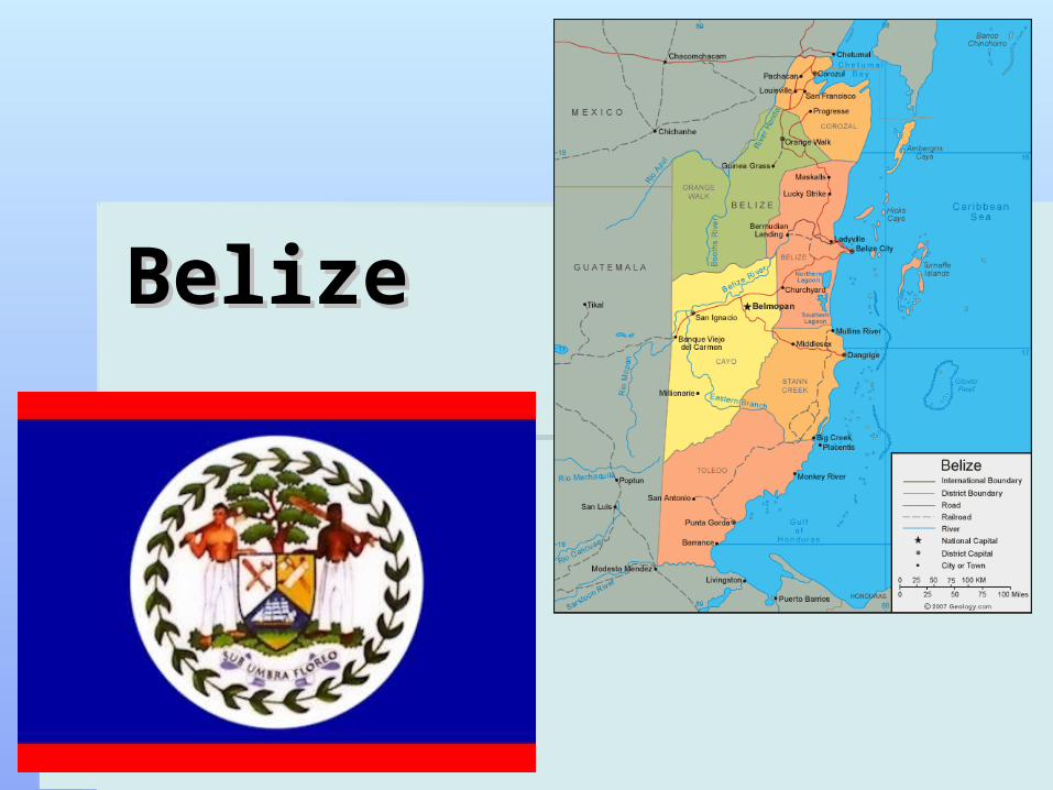
BelizeBelize
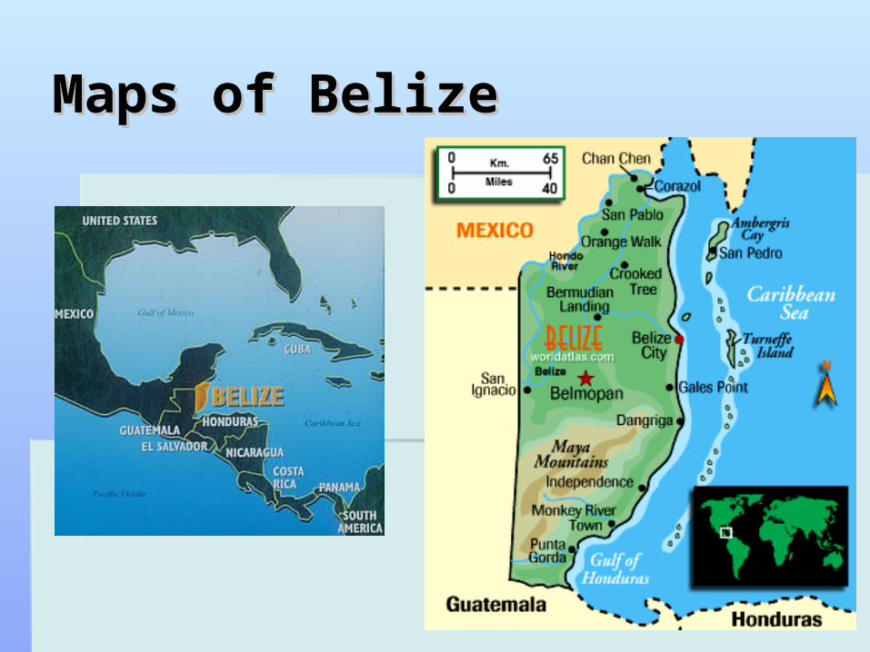
Maps of BelizeMaps of Belize
DescriptionDescription
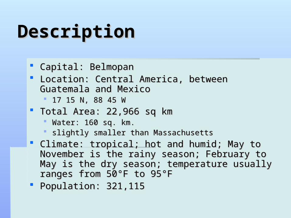
Capital: Belmopan Capital: Belmopan Location: Central America, between Guatemala and Location: Central America, between Guatemala and
MexicoMexico 17 15 N, 88 45 W17 15 N, 88 45 W
Total Area: 22,966 sq kmTotal Area: 22,966 sq km Water: 160 sq. km.Water: 160 sq. km. slightly smaller than Massachusettsslightly smaller than Massachusetts
Climate: tropical; hot and humid; May to November is Climate: tropical; hot and humid; May to November is the rainy season; February to May is the dry season; the rainy season; February to May is the dry season; temperature usually ranges from 50temperature usually ranges from 50°F°F to 95 to 95°F°F
Population: 321,115 Population: 321,115
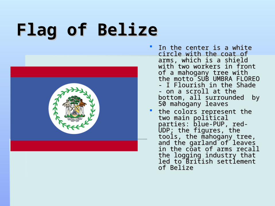
Flag of BelizeFlag of Belize In the center is a white circle In the center is a white circle
with the coat of arms, which with the coat of arms, which is a shield with two workers is a shield with two workers in front of a mahogany tree in front of a mahogany tree with the motto SUB UMBRA with the motto SUB UMBRA FLOREO - I Flourish in the FLOREO - I Flourish in the Shade - on a scroll at the Shade - on a scroll at the bottom, all surrounded by 50 bottom, all surrounded by 50 mahogany leavesmahogany leaves
the colors represent the two the colors represent the two main political parties: blue-main political parties: blue-PUP, red-UDP; the figures, PUP, red-UDP; the figures, the tools, the mahogany tree, the tools, the mahogany tree, and the garland of leaves in and the garland of leaves in the coat of arms recall the the coat of arms recall the logging industry that led to logging industry that led to British settlement of BelizeBritish settlement of Belize
GeographyGeography The land is a flat, swampy coastal plain; low The land is a flat, swampy coastal plain; low
mountains in south, it has a lot of forestsmountains in south, it has a lot of forests lowest point: Caribbean Sea 0 mlowest point: Caribbean Sea 0 m highest point: Victoria Peak at 1120 mhighest point: Victoria Peak at 1120 m The Belize River is the main river.The Belize River is the main river.
Golden Stream, Middle River, Deep River, Freshwater Creek , Golden Stream, Middle River, Deep River, Freshwater Creek , Mango Creek, Anacleto River, Brian Chan River and Israel Mango Creek, Anacleto River, Brian Chan River and Israel Pond are just a few more rivers and lakes.Pond are just a few more rivers and lakes.
6 districts: Belize, Cayo, Corozal, Orange 6 districts: Belize, Cayo, Corozal, Orange Walk, Stann Creek, ToledoWalk, Stann Creek, Toledo
Places of InterestPlaces of Interest
St. John's Cathedral- the oldest building St. John's Cathedral- the oldest building in Belizein Belize
Bliss Institute for the Performing Arts, Bliss Institute for the Performing Arts, House of Culture Museum and Baron House of Culture Museum and Baron Bliss Lighthouse MonumentBliss Lighthouse Monument
Swing Bridge- the only functional Swing Bridge- the only functional manually operated swing bridge in the manually operated swing bridge in the world today world today
HistoryHistory
That Mayan civilization flourished here for eons; great cities were That Mayan civilization flourished here for eons; great cities were formed, massive ceremonial buildings, palaces, temples and formed, massive ceremonial buildings, palaces, temples and personal dwellings were constructed, and the people farmed the personal dwellings were constructed, and the people farmed the land very well.land very well.
The Spanish tried to take over the Mayans in Belize but could The Spanish tried to take over the Mayans in Belize but could never succeed. never succeed.
There was conflict between the Spanish and British over control of There was conflict between the Spanish and British over control of Belize.Belize.
The British had limited power while the Spanish had sovereignty The British had limited power while the Spanish had sovereignty over Belize until September 10, 1798 when there was a Spanish over Belize until September 10, 1798 when there was a Spanish attack on the Settlement of Belizeattack on the Settlement of Belize
The British won and the Spanish never tried to control Belize The British won and the Spanish never tried to control Belize againagain
Caste War of Yucatán was the war of the Mayan people against Caste War of Yucatán was the war of the Mayan people against those of European descentthose of European descent
Current DayCurrent Day
The Central Bank of Belize and The Belize Bank are in The Central Bank of Belize and The Belize Bank are in a court battle. The Central Bank wants the Belize Bank a court battle. The Central Bank wants the Belize Bank to stop parallel banking. This was brought up because to stop parallel banking. This was brought up because of the dept of the Luke Espat Group which is a total of of the dept of the Luke Espat Group which is a total of 190 million Belize dollars. 150 million is being covered 190 million Belize dollars. 150 million is being covered by the Turks and Cairos but the rest is for the Belize by the Turks and Cairos but the rest is for the Belize Bank. Bank.
They went to court because the Belize Bank doesn't They went to court because the Belize Bank doesn't think the Central Bank has the authority to tell them to think the Central Bank has the authority to tell them to stop parallel banking. The trial will begin on March 23. stop parallel banking. The trial will begin on March 23. The outcome can have a great effect on how Belize's The outcome can have a great effect on how Belize's largest banks operate.largest banks operate.

GovernmentGovernment
It is a parliamentary democracy and a Commonwealth It is a parliamentary democracy and a Commonwealth realmrealm
chief of state:chief of state: Queen Elizabeth II, represented by Queen Elizabeth II, represented by Governor General Sir Colville Young, Sr. Governor General Sir Colville Young, Sr.
Prime Minister Dean Oliver Barrow Deputy Prime Minister Dean Oliver Barrow Deputy Prime Minister Gaspar VegaPrime Minister Gaspar Vega The Cabinet is appointed by the governor general with The Cabinet is appointed by the governor general with
the advice of the prime minister.the advice of the prime minister. National Assembly: Senate -12 seats-serve five-year National Assembly: Senate -12 seats-serve five-year
terms and the House of Representatives -31 seats, terms and the House of Representatives -31 seats, members are elected by direct popular vote and serve members are elected by direct popular vote and serve five-year termsfive-year terms
EconomyEconomy
Tourism is the best industry followed by Tourism is the best industry followed by exports of marine products, citrus, cane sugar, exports of marine products, citrus, cane sugar, bananas, and garments.bananas, and garments.
Exports : sugar, bananas, citrus, clothing, fish Exports : sugar, bananas, citrus, clothing, fish products, molasses, wood, crude oilproducts, molasses, wood, crude oil Partners: US, UK, Nigeria, Cote d'IvoirePartners: US, UK, Nigeria, Cote d'Ivoire
Imports : machinery and transport equipment, Imports : machinery and transport equipment, manufactured goods, fuels, chemicals, manufactured goods, fuels, chemicals, pharmaceuticals; food, beverages, tobaccopharmaceuticals; food, beverages, tobacco Partners: US, Mexico, Cuba, Guatemala, Spain, Partners: US, Mexico, Cuba, Guatemala, Spain,
China China
CultureCulture
Belize’s culture is a unique mix of Mayans, Mennonites, Kriols, Belize’s culture is a unique mix of Mayans, Mennonites, Kriols, Garifuna, Mestizos, Spanish, English, Lebanese, East Indian Garifuna, Mestizos, Spanish, English, Lebanese, East Indian and Chineseand Chinese
The official language is English, but Spanish is used a lot too. The official language is English, but Spanish is used a lot too. The Mayans, Garifuna and Mennonites speak in their own The Mayans, Garifuna and Mennonites speak in their own languages. languages.
Religion: Roman CatholicReligion: Roman Catholic Rice is part of their daily diet. They eat rice and beans, with Rice is part of their daily diet. They eat rice and beans, with
fried chicken, or sweet beef. They use red beans instead of the fried chicken, or sweet beef. They use red beans instead of the black bean, which are used in other Latin American countries.black bean, which are used in other Latin American countries.
Some taditional foods are: relleno, tamales, escabeche, tacos, Some taditional foods are: relleno, tamales, escabeche, tacos, chimole and negro. Fruit and vegetable salad also are chimole and negro. Fruit and vegetable salad also are important parts of Belizean food. Corn is important for making important parts of Belizean food. Corn is important for making tortillas, bollos and tamalitostortillas, bollos and tamalitos..
Culture (cont)Culture (cont)
The people love festivals, like the San Pedro The people love festivals, like the San Pedro International Costa Maya Festival, Belize Carnival or International Costa Maya Festival, Belize Carnival or International Film Festival BelizeInternational Film Festival Belize. .
The Europeans brought instruments like polkas, The Europeans brought instruments like polkas, schottisches, waltzes and quadrilles, while Africans schottisches, waltzes and quadrilles, while Africans brought instruments like the marimba. brought instruments like the marimba.
The mix of Mestizo, African, Mayan and British The mix of Mestizo, African, Mayan and British influence give their music a unique soundinfluence give their music a unique sound
brukdown music, is famous in the interior logging brukdown music, is famous in the interior logging camps and is played using a banjo, guitar, drums, camps and is played using a banjo, guitar, drums, dingaling bell, accordion and an ass' jawbone, is a dingaling bell, accordion and an ass' jawbone, is a tradition in Belizetradition in Belize
Daily LifeDaily Life
Literacy rate: total population:Literacy rate: total population: 76.9% 76.9% male:male: 76.7% 76.7% female:female: 77.1% 77.1%
Clothing: Clothing: Women wear long dresses, normally plain, bright Women wear long dresses, normally plain, bright
colors with lace around the collar and sleevescolors with lace around the collar and sleeves Men wear Euro-American style clothing mostlyMen wear Euro-American style clothing mostly
10.6% of the population uses internet10.6% of the population uses internet
Conclusion Conclusion
Belize’s tropical climate attracts many tourists. Belize’s tropical climate attracts many tourists. Tourism supports the economy the most. The Tourism supports the economy the most. The culture is a mixture of many different cultures culture is a mixture of many different cultures which makes it very uniquewhich makes it very unique
Random Facts: Random Facts: only country in Central America without a coastline only country in Central America without a coastline
on the North Pacific Oceanon the North Pacific Ocean Belize's flag is the only national flag that shows Belize's flag is the only national flag that shows
human beings on ithuman beings on it

Works CitedWorks Cited https://www.cia.gov/library/publications/the-world-factbook/index.htmlhttps://www.cia.gov/library/publications/the-world-factbook/index.html http://www.belizenet.com/history/chap3.html http://www.belizenet.com/history/chap3.html http://www.mapsofworld.com/flags/french-guiana-flag.htmlhttp://www.mapsofworld.com/flags/french-guiana-flag.html http://www.atlapedia.com/online/countries/bosnia.htmhttp://www.atlapedia.com/online/countries/bosnia.htm http://www.colonialvoyage.com/america/eng/central/anguilla/climate.htmlhttp://www.colonialvoyage.com/america/eng/central/anguilla/climate.html http://countrystudies.us/belize/20.htmhttp://countrystudies.us/belize/20.htm http://www.belizenet.com/weather/climate.html#tophttp://www.belizenet.com/weather/climate.html#top http://www.infoplease.com/ipa/A0107544.htmlhttp://www.infoplease.com/ipa/A0107544.html http://www.mapsofworld.com/belize/culture/ http://www.mapsofworld.com/belize/culture/ http://worldstogethertravel.com/belize/quich-culture.htm http://worldstogethertravel.com/belize/quich-culture.htm
http://www.svalbard.com/SvalbardFAQ.html#religion http://www.svalbard.com/SvalbardFAQ.html#religion http://news.bbc.co.uk/2/hi/europe/country_profiles/1066981.stm http://news.bbc.co.uk/2/hi/europe/country_profiles/1066981.stm http://www.everyculture.com/Bo-Co/Bosnia-and-Herzegovina.html http://www.everyculture.com/Bo-Co/Bosnia-and-Herzegovina.html http://www.everyculture.com/A-Bo/Anguilla.html http://www.everyculture.com/A-Bo/Anguilla.html http://www.anguillian.com/article/articleview/84/1/11/ http://www.anguillian.com/article/articleview/84/1/11/ http://www.mongolianculture.com/about.html http://www.mongolianculture.com/about.html http://www.rahul.net/dold/mongfood.htm http://www.rahul.net/dold/mongfood.htm http://www.accu.or.jp/litdbase/policy/mng/index.htm http://www.accu.or.jp/litdbase/policy/mng/index.htm http://www.umsl.edu/services/govdocs/wofact98/88.htm http://www.umsl.edu/services/govdocs/wofact98/88.htm