Embed Size (px)
Citation preview
Country Report: Floods and Flood Forecasting System
in Myanmar
Ms. Tin Yi
Director
Department of Meteorology and Hydrology
MYANMAR
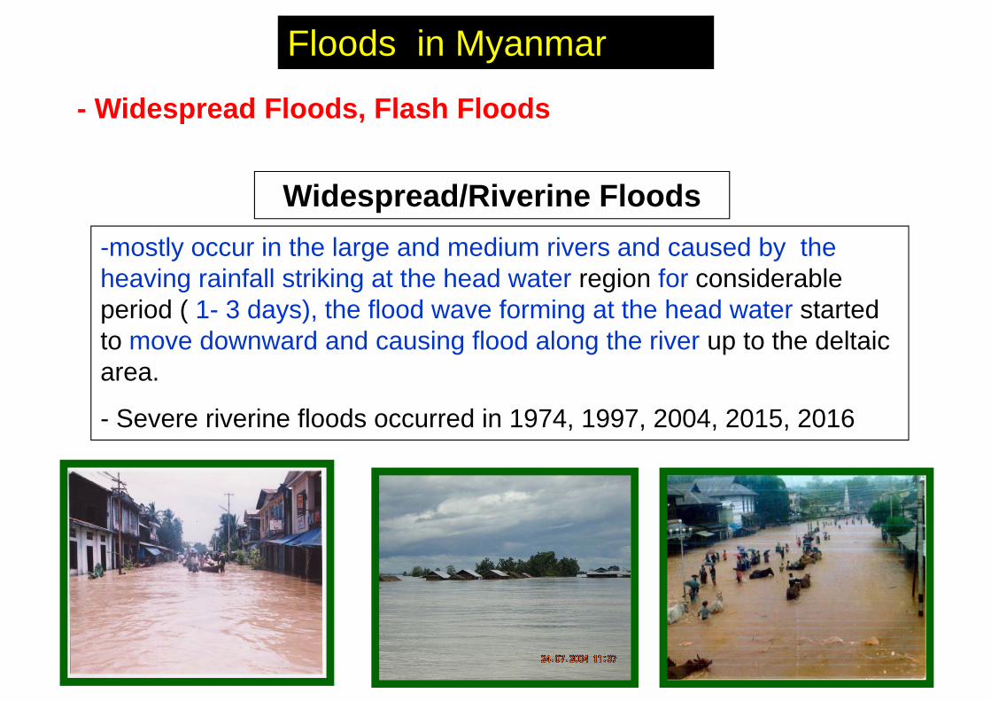
-mostly occur in the large and medium rivers and caused by the heaving rainfall striking at the head water region for considerable period ( 1- 3 days), the flood wave forming at the head water started to move downward and causing flood along the river up to the deltaic area.
- Severe riverine floods occurred in 1974, 1997, 2004, 2015, 2016
Widespread/Riverine Floods
Floods in Myanmar
- Widespread Floods, Flash Floods
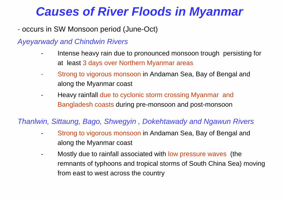
Causes of River Floods in Myanmar- occurs in SW Monsoon period (June-Oct)
Ayeyarwady and Chindwin Rivers- Intense heavy rain due to pronounced monsoon trough persisting for
at least 3 days over Northern Myanmar areas
- Strong to vigorous monsoon in Andaman Sea, Bay of Bengal and along the Myanmar coast
- Heavy rainfall due to cyclonic storm crossing Myanmar and Bangladesh coasts during pre-monsoon and post-monsoon
Thanlwin, Sittaung, Bago, Shwegyin , Dokehtawady and Ngawun Rivers- Strong to vigorous monsoon in Andaman Sea, Bay of Bengal and
along the Myanmar coast
- Mostly due to rainfall associated with low pressure waves (the remnants of typhoons and tropical storms of South China Sea) moving from east to west across the country
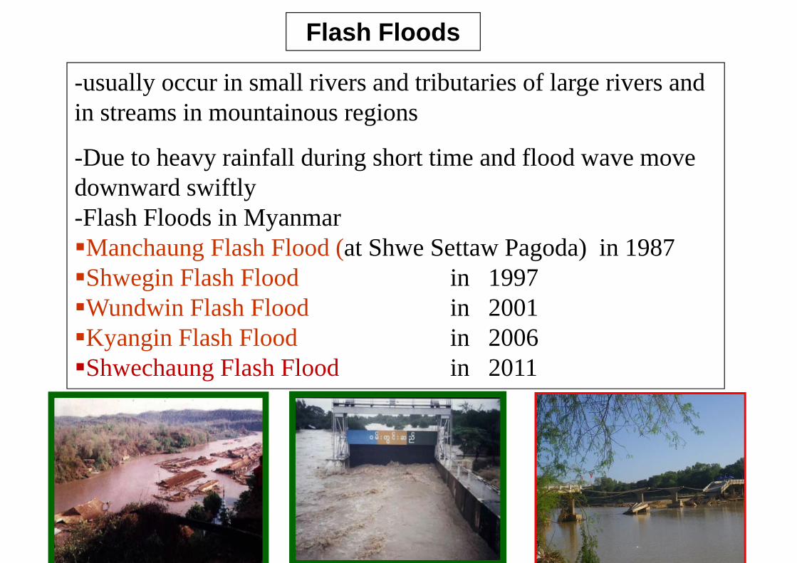
-usually occur in small rivers and tributaries of large rivers and in streams in mountainous regions
-Due to heavy rainfall during short time and flood wave move downward swiftly -Flash Floods in MyanmarManchaung Flash Flood (at Shwe Settaw Pagoda) in 1987Shwegin Flash Flood in 1997Wundwin Flash Flood in 2001Kyangin Flash Flood in 2006Shwechaung Flash Flood in 2011
Flash Floods
Pakokku
Zalun
Seiktha
Zaugtu
NTG
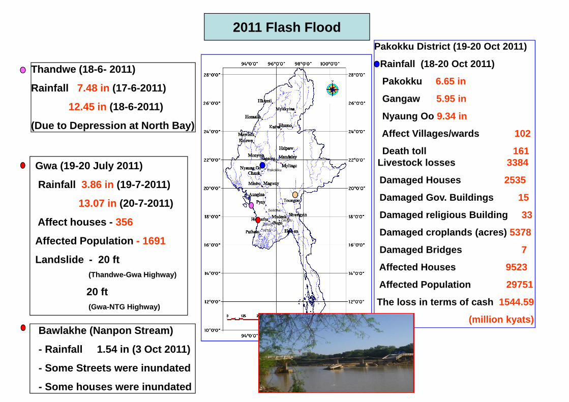
Thandwe (18-6- 2011)
Rainfall 7.48 in (17-6-2011)
12.45 in (18-6-2011)
(Due to Depression at North Bay)
2011 Flash Flood
Gwa (19-20 July 2011)
Rainfall 3.86 in (19-7-2011)
13.07 in (20-7-2011)
Affect houses - 356
Affected Population - 1691
Landslide - 20 ft (Thandwe-Gwa Highway)
20 ft(Gwa-NTG Highway)
Pakokku District (19-20 Oct 2011)
- Rainfall (18-20 Oct 2011)
Pakokku 6.65 in
Gangaw 5.95 in
Nyaung Oo 9.34 in
Affect Villages/wards 102
Death toll 161Livestock losses 3384
Damaged Houses 2535
Damaged Gov. Buildings 15
Damaged religious Building 33
Damaged croplands (acres) 5378
Damaged Bridges 7
Affected Houses 9523
Affected Population 29751
The loss in terms of cash 1544.59
(million kyats)Bawlakhe (Nanpon Stream)
- Rainfall 1.54 in (3 Oct 2011)
- Some Streets were inundated
- Some houses were inundated
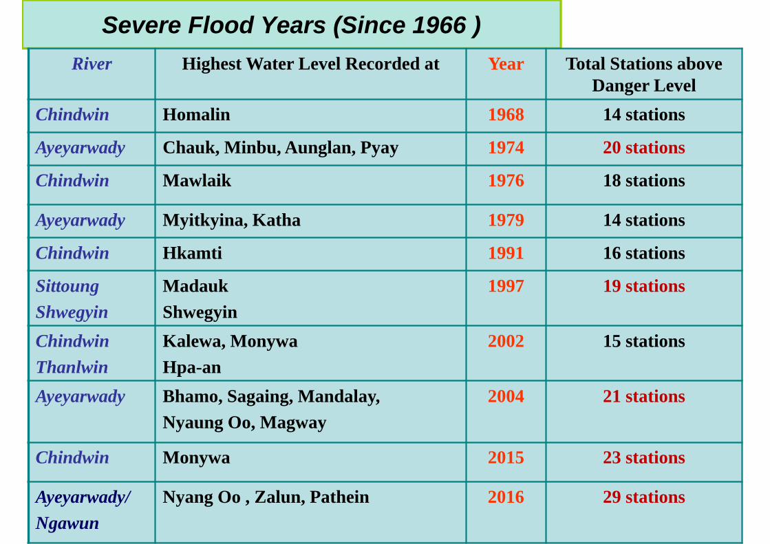
Severe Flood Years (Since 1966 )River Highest Water Level Recorded at Year Total Stations above
Danger LevelChindwin Homalin 1968 14 stations
Ayeyarwady Chauk, Minbu, Aunglan, Pyay 1974 20 stations
Chindwin Mawlaik 1976 18 stations
Ayeyarwady Myitkyina, Katha 1979 14 stations
Chindwin Hkamti 1991 16 stations
SittoungShwegyin
MadaukShwegyin
1997 19 stations
ChindwinThanlwin
Kalewa, MonywaHpa-an
2002 15 stations
Ayeyarwady Bhamo, Sagaing, Mandalay, Nyaung Oo, Magway
2004 21 stations
Chindwin Monywa 2015 23 stations
Ayeyarwady/Ngawun
Nyang Oo , Zalun, Pathein 2016 29 stations
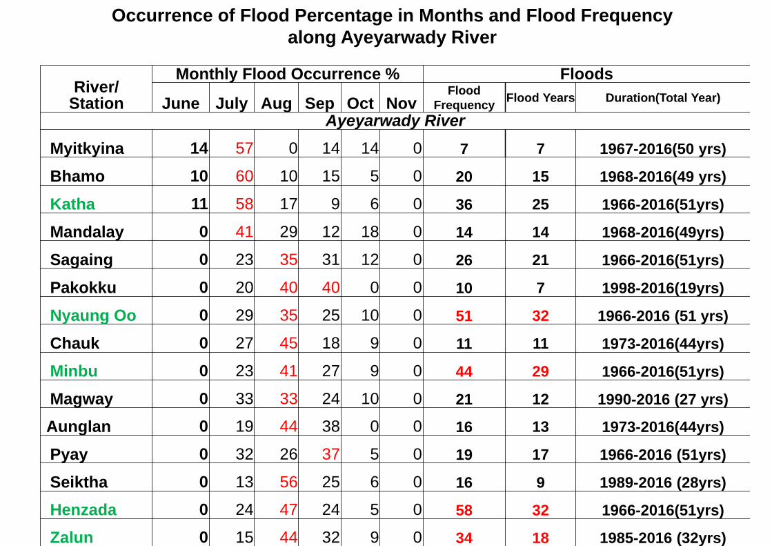
River/Station
Monthly Flood Occurrence % Floods
June July Aug Sep Oct NovFlood
Frequency Flood Years Duration(Total Year)
Ayeyarwady RiverMyitkyina 14 57 0 14 14 0 7 7 1967-2016(50 yrs)
Bhamo 10 60 10 15 5 0 20 15 1968-2016(49 yrs)
Katha 11 58 17 9 6 0 36 25 1966-2016(51yrs)
Mandalay 0 41 29 12 18 0 14 14 1968-2016(49yrs)
Sagaing 0 23 35 31 12 0 26 21 1966-2016(51yrs)
Pakokku 0 20 40 40 0 0 10 7 1998-2016(19yrs)
Nyaung Oo 0 29 35 25 10 0 51 32 1966-2016 (51 yrs)
Chauk 0 27 45 18 9 0 11 11 1973-2016(44yrs)
Minbu 0 23 41 27 9 0 44 29 1966-2016(51yrs)
Magway 0 33 33 24 10 0 21 12 1990-2016 (27 yrs)
Aunglan 0 19 44 38 0 0 16 13 1973-2016(44yrs)
Pyay 0 32 26 37 5 0 19 17 1966-2016 (51yrs)
Seiktha 0 13 56 25 6 0 16 9 1989-2016 (28yrs)
Henzada 0 24 47 24 5 0 58 32 1966-2016(51yrs)
Zalun 0 15 44 32 9 0 34 18 1985-2016 (32yrs)
Occurrence of Flood Percentage in Months and Flood Frequency along Ayeyarwady River
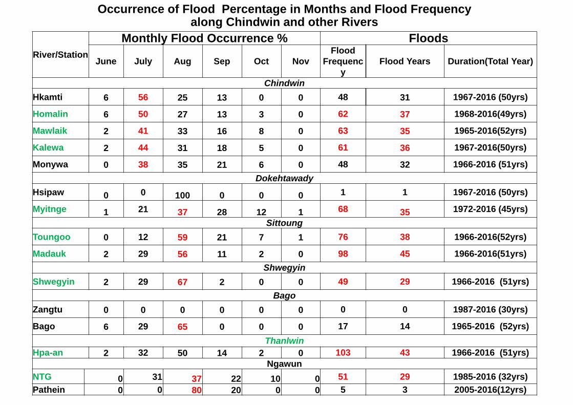
River/StationMonthly Flood Occurrence % Floods
June July Aug Sep Oct NovFlood
Frequency
Flood Years Duration(Total Year)
ChindwinHkamti 6 56 25 13 0 0 48 31 1967-2016 (50yrs)
Homalin 6 50 27 13 3 0 62 37 1968-2016(49yrs)
Mawlaik 2 41 33 16 8 0 63 35 1965-2016(52yrs)
Kalewa 2 44 31 18 5 0 61 36 1967-2016(50yrs)
Monywa 0 38 35 21 6 0 48 32 1966-2016 (51yrs)Dokehtawady
Hsipaw 0 0 100 0 0 0 1 1 1967-2016 (50yrs)
Myitnge 1 21 37 28 12 1 68 35 1972-2016 (45yrs)Sittoung
Toungoo 0 12 59 21 7 1 76 38 1966-2016(52yrs)
Madauk 2 29 56 11 2 0 98 45 1966-2016(51yrs)Shwegyin
Shwegyin 2 29 67 2 0 0 49 29 1966-2016 (51yrs)Bago
Zangtu 0 0 0 0 0 0 0 0 1987-2016 (30yrs)
Bago 6 29 65 0 0 0 17 14 1965-2016 (52yrs)Thanlwin
Hpa-an 2 32 50 14 2 0 103 43 1966-2016 (51yrs)Ngawun
NTG 0 31 37 22 10 0 51 29 1985-2016 (32yrs)Pathein 0 0 80 20 0 0 5 3 2005-2016(12yrs)
Occurrence of Flood Percentage in Months and Flood Frequency along Chindwin and other Rivers
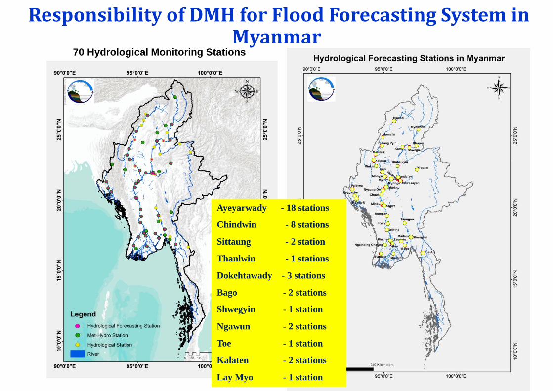
ResponsibilityofDMH forFloodForecastingSysteminMyanmar
70 Hydrological Monitoring Stations
Telemetry observation Stations
Ayeyarwady - 18 stations
Chindwin - 8 stations
Sittaung - 2 station
Thanlwin - 1 stations
Dokehtawady - 3 stations
Bago - 2 stations
Shwegyin - 1 station
Ngawun - 2 stations
Toe - 1 station
Kalaten - 2 stations
Lay Myo - 1 station
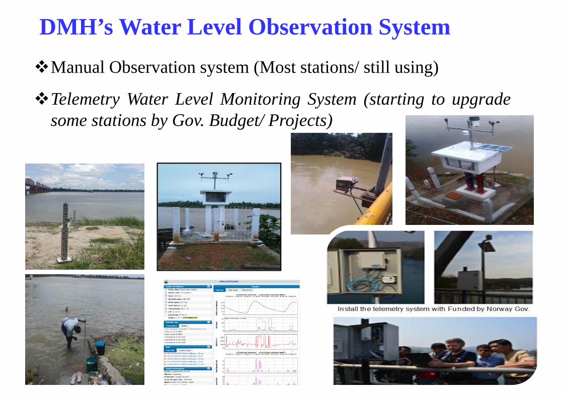
DMH’s Water Level Observation System Manual Observation system (Most stations/ still using)
Telemetry Water Level Monitoring System (starting to upgradesome stations by Gov. Budget/ Projects)
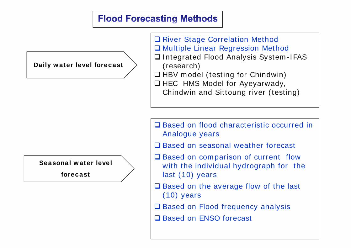
Based on flood characteristic occurred in Analogue years
Based on seasonal weather forecast Based on comparison of current flow
with the individual hydrograph for the last (10) years
Based on the average flow of the last (10) years
Based on Flood frequency analysis Based on ENSO forecast
River Stage Correlation MethodMultiple Linear Regression Method Integrated Flood Analysis System-IFAS
(research) HBV model (testing for Chindwin) HEC HMS Model for Ayeyarwady,
Chindwin and Sittoung river (testing)
Daily water level forecast
Seasonal water level
forecast
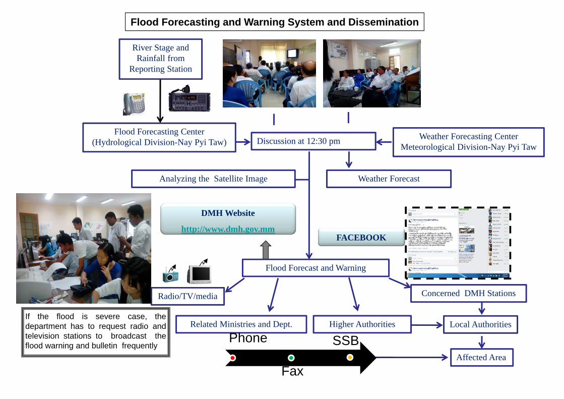
Flood Forecasting and Warning System and Dissemination
Flood Forecasting Center (Hydrological Division-Nay Pyi Taw)
River Stage and Rainfall from
Reporting Station
Discussion at 12:30 pm Weather Forecasting CenterMeteorological Division-Nay Pyi Taw
Weather Forecast
Flood Forecast and Warning
Analyzing the Satellite Image
Related Ministries and Dept.
Radio/TV/media Concerned DMH Stations
Higher Authorities
DMH Website
http://www.dmh.gov.mm
Local Authorities
Affected Area
If the flood is severe case, thedepartment has to request radio andtelevision stations to broadcast theflood warning and bulletin frequently
Phone
Fax
SSB
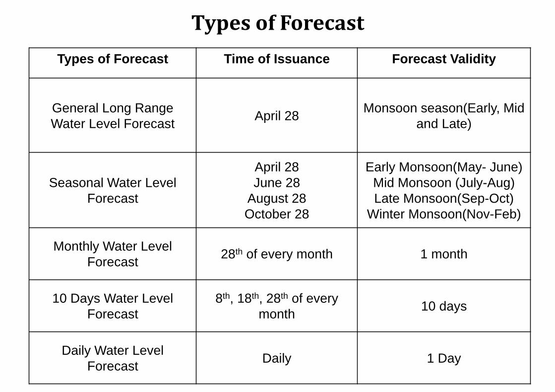
TypesofForecastTypes of Forecast Time of Issuance Forecast Validity
General Long Range Water Level Forecast April 28 Monsoon season(Early, Mid
and Late)
Seasonal Water Level Forecast
April 28June 28
August 28October 28
Early Monsoon(May- June)Mid Monsoon (July-Aug)Late Monsoon(Sep-Oct)
Winter Monsoon(Nov-Feb)
Monthly Water Level Forecast 28th of every month 1 month
10 Days Water Level Forecast
8th, 18th, 28th of every month 10 days
Daily Water LevelForecast Daily 1 Day
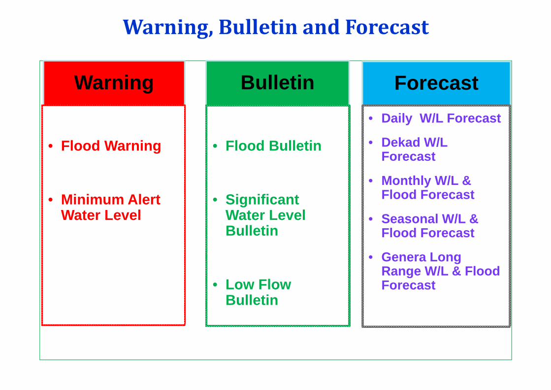
Warning,BulletinandForecast
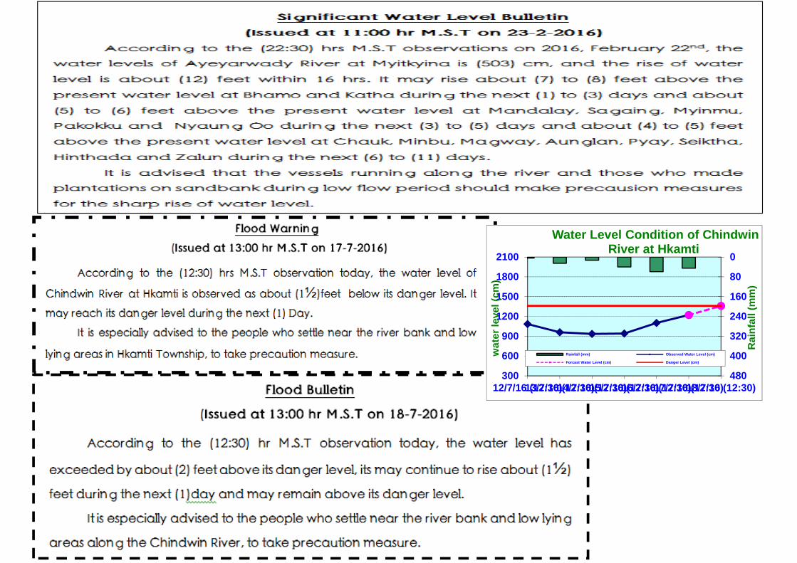
Warning
• Flood Warning
• Minimum Alert Water Level
Forecast• Daily W/L Forecast
• Dekad W/L Forecast
• Monthly W/L & Flood Forecast
• Seasonal W/L & Flood Forecast
• Genera Long Range W/L & Flood Forecast
Bulletin
• Flood Bulletin
• Significant Water Level Bulletin
• Low Flow Bulletin
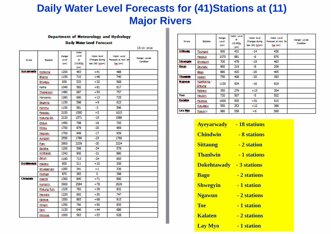
Daily Water Level Forecasts for (41)Stations at (11) Major Rivers
Ayeyarwady - 18 stations
Chindwin - 8 stations
Sittaung - 2 station
Thanlwin - 1 stations
Dokehtawady - 3 stations
Bago - 2 stations
Shwegyin - 1 station
Ngawun - 2 stations
Toe - 1 station
Kalaten - 2 stations
Lay Myo - 1 station
0
80
160
240
320
400
480300
600
900
1200
1500
1800
2100
12/7/16 (12:30)13/7/16 (12:30)14/7/16 (12:30)15/7/16 (12:30)16/7/16 (12:30)17/7/16 (12:30)18/7/16 (12:30)
Rai
nfal
l (m
m)
wat
er le
vel (
cm)
Water Level Condition of Chindwin River at Hkamti
Rainfall (mm) Observed Water Level (cm)
Forcast Water Level (cm) Danger Level (cm)
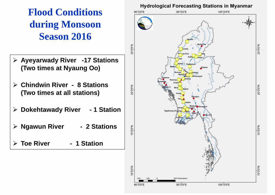
Flood Conditions during Monsoon
Season 2016
Ayeyarwady River -17 Stations (Two times at Nyaung Oo)
Chindwin River - 8 Stations (Two times at all stations)
Dokehtawady River - 1 Station
Ngawun River - 2 Stations
Toe River - 1 Station
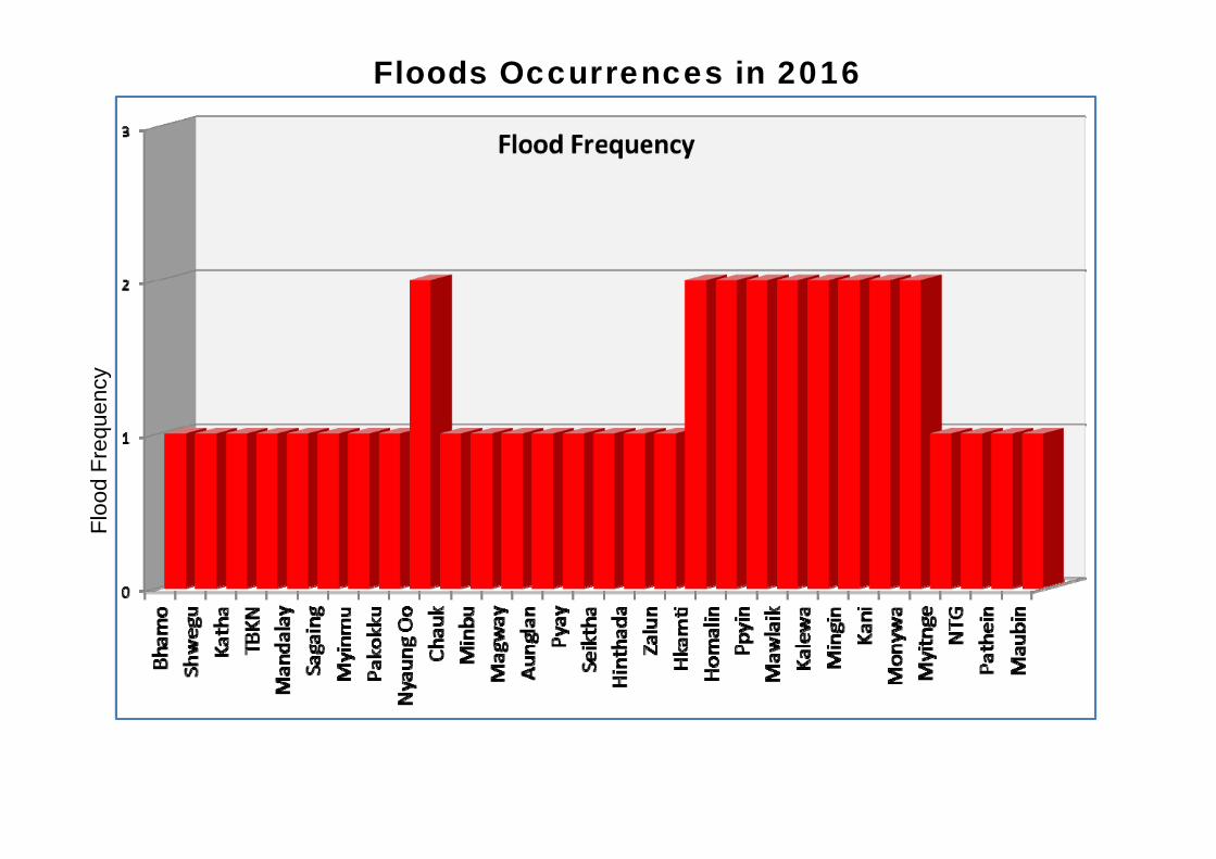
Occurrences of floods in 2016
Floo
d Fr
eque
ncy
Floods Occurrences in 2016
0
10
20
30
40
50
60
70
800
1
2
3
4
5
6
7
8
9
10Bh
amo
Shw
egu
Kath
aTB
KNM
anda
lay
Saga
ing
Myi
nmu
Pako
kku
Nya
ung
Oo
Cha
ukM
inbu
Mag
way
Aung
lan
Pyay
Seik
tha
Hin
thad
aZa
lun
Hka
mti
Hom
alin
Ppyi
n
Maw
laik
Kale
wa
Min
gin
Kani
Mon
ywa
Myi
tnge
NTG
Path
ein
Mau
bin
Duration(Day) Above Danger Level(FT)
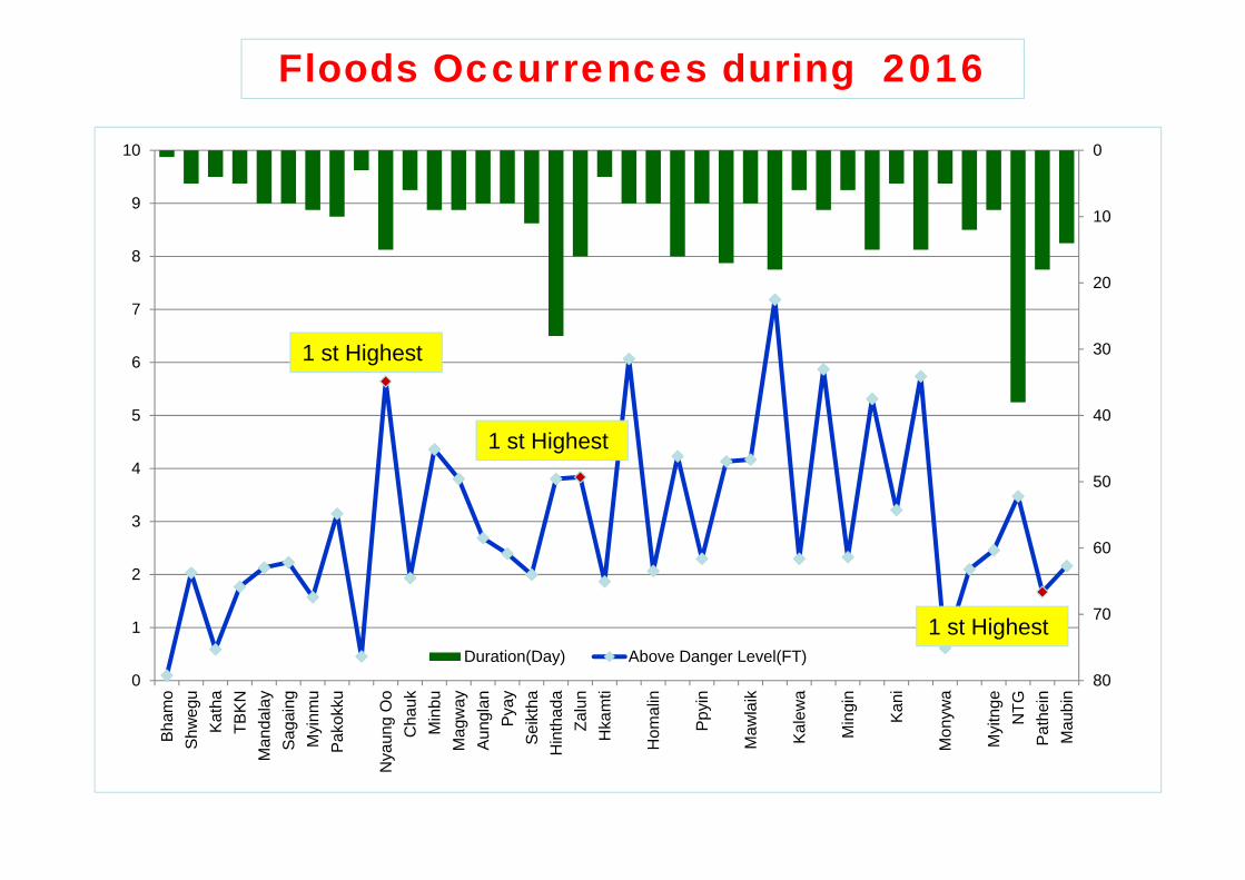
1 st Highest
Floods Occurrences during 2016
1 st Highest
1 st Highest
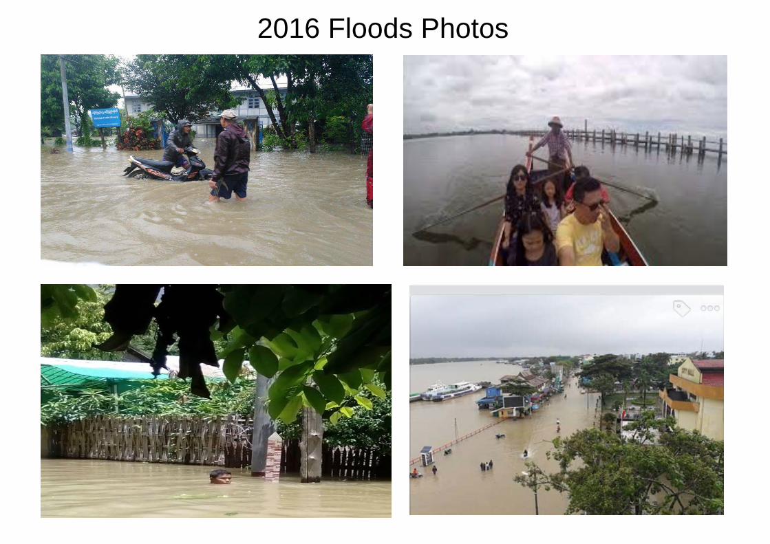
2016 Floods Photos
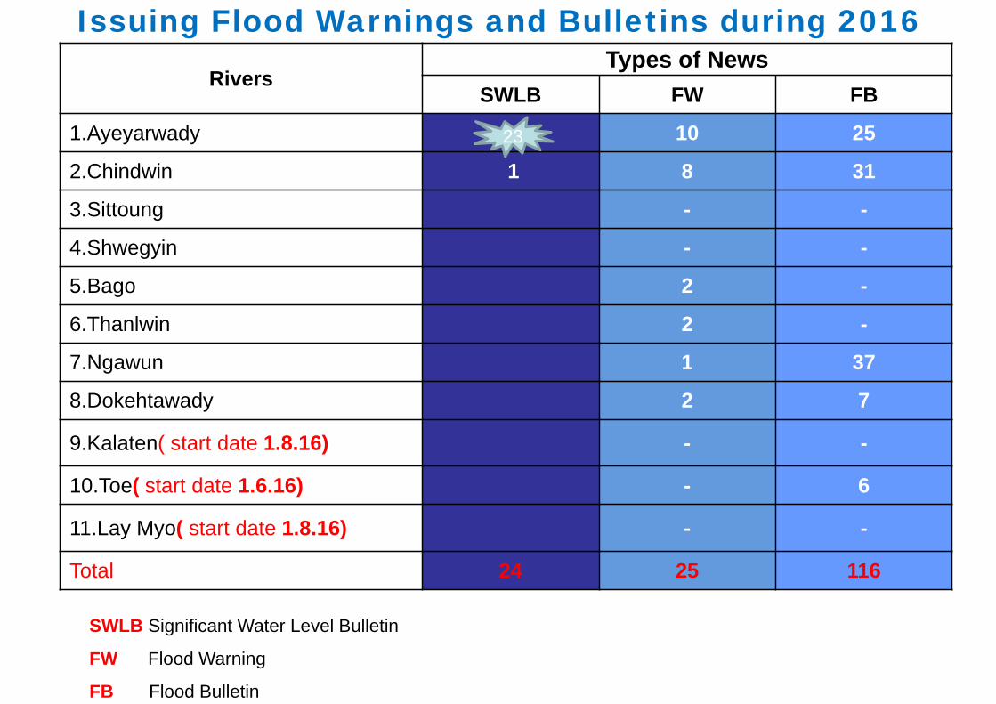
Issuing Flood Warnings and Bulletins during 2016
SWLB Significant Water Level Bulletin
FW Flood Warning
FB Flood Bulletin
RiversTypes of News
SWLB FW FB
1.Ayeyarwady . 10 25
2.Chindwin 1 8 31
3.Sittoung - -
4.Shwegyin - -
5.Bago 2 -
6.Thanlwin 2 -
7.Ngawun 1 37
8.Dokehtawady 2 7
9.Kalaten( start date 1.8.16) - -
10.Toe( start date 1.6.16) - 6
11.Lay Myo( start date 1.8.16) - -
Total 24 25 116
23
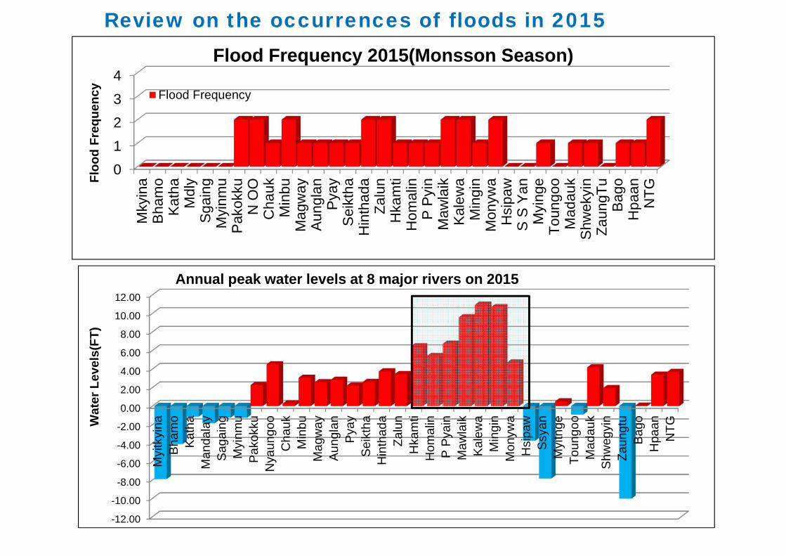
Review on the occurrences of floods in 2015
01234
Mky
ina
Bha
mo
Kat
haM
dly
Sga
ing
Myi
nmu
Pak
okku
N O
OC
hauk
Min
buM
agw
ayA
ungl
anP
yay
Sei
ktha
Hin
thad
aZa
lun
Hka
mti
Hom
alin
P P
yin
Maw
laik
Kal
ewa
Min
gin
Mon
ywa
Hsi
paw
S S
Yan
Myi
nge
Toun
goo
Mad
auk
Shw
ekyi
nZa
ungT
uB
ago
Hpa
anN
TG
Flood Frequency 2015(Monsson Season)
Flood FrequencyFl
ood
Freq
uenc
y
-12.00
-10.00
-8.00
-6.00
-4.00
-2.00
0.00
2.00
4.00
6.00
8.00
10.00
12.00
Myi
tkyi
naB
ham
oK
atha
Man
dala
yS
agai
ngM
yinm
uP
akok
kuN
yaun
goo
Cha
ukM
inbu
Mag
way
Aun
glan
Pya
yS
eikt
haH
inth
ada
Zalu
nH
kam
tiH
omal
inP
Pya
inM
awla
ikK
alew
aM
ingi
nM
onyw
aH
sipa
wS
syan
Myi
tnge
Toun
goo
Mad
auk
Shw
egyi
nZa
ungt
uB
ago
Hpa
anN
TGWat
er L
evel
s(FT
)
Annual peak water levels at 8 major rivers on 2015
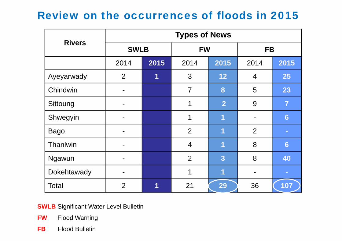
Review on the occurrences of floods in 2015
SWLB Significant Water Level Bulletin
FW Flood Warning
FB Flood Bulletin
RiversTypes of News
SWLB FW FB
2014 2015 2014 2015 2014 2015
Ayeyarwady 2 1 3 12 4 25
Chindwin - 7 8 5 23
Sittoung - 1 2 9 7
Shwegyin - 1 1 - 6
Bago - 2 1 2 -
Thanlwin - 4 1 8 6
Ngawun - 2 3 8 40
Dokehtawady - 1 1 - -
Total 2 1 21 29 36 107
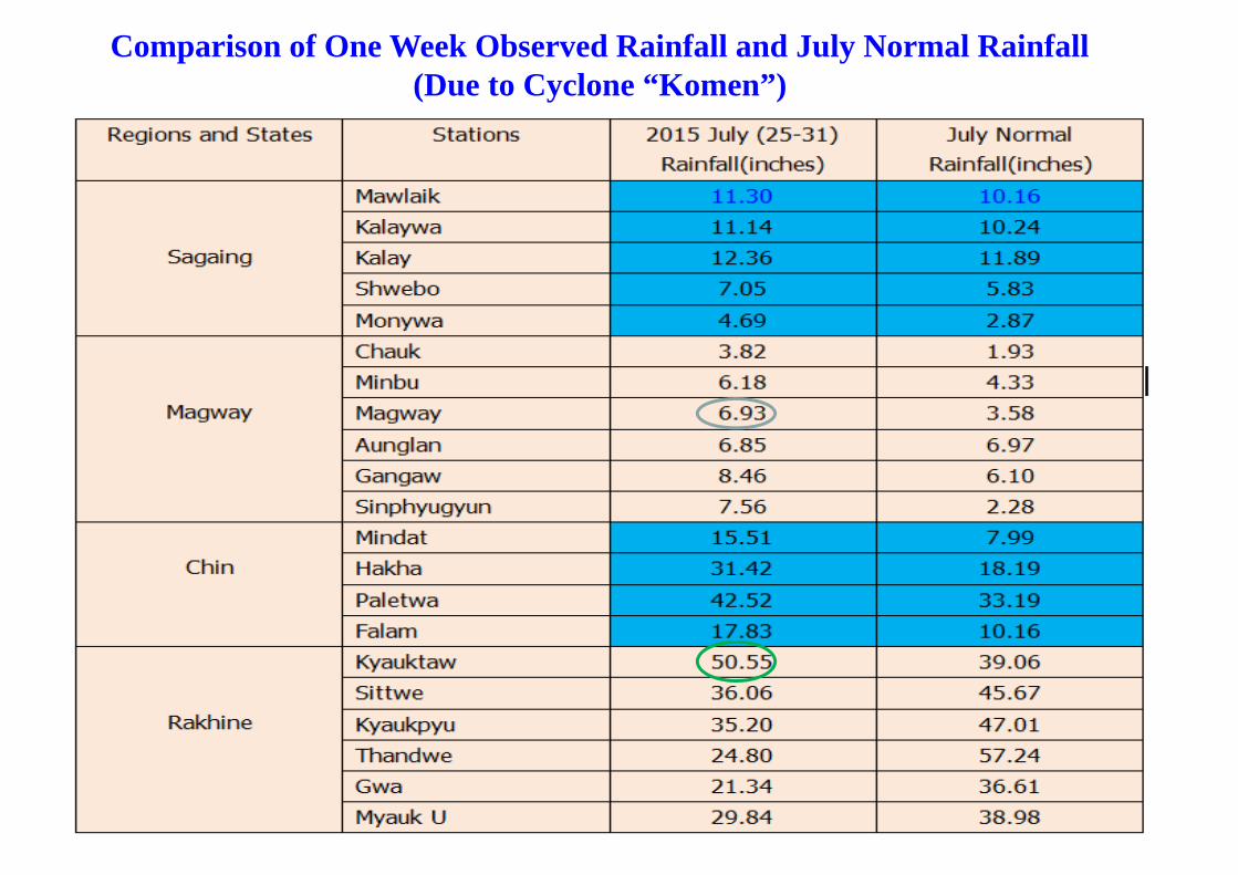
Comparison of One Week Observed Rainfall and July Normal Rainfall (Due to Cyclone “Komen”)
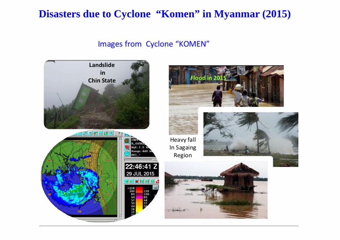
Disasters due to Cyclone “Komen” in Myanmar (2015)
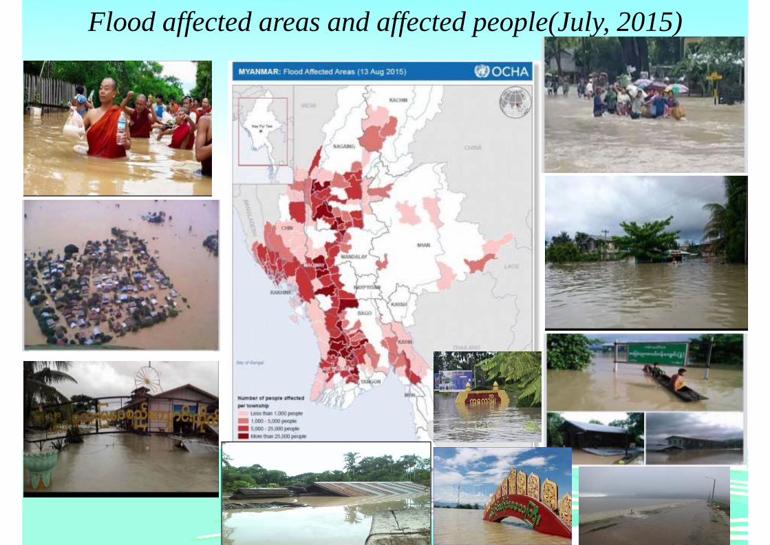
Flood affected areas and affected people(July, 2015)
2015 Severe flood in Myanmar• Cause - severe flood and landslide by unusually
heavy rainfall and also cyclone Komen
• Period - 20 July 2015 to August
• Affected areas - 12 States and Regions except from
Kayah and Thanintharyi
• H.E President, in line with the section 11 of Natural Disaster
Management Law, declared Chin State, Sagaing Region,
Magway Region and Rakhine State as the worst disaster-
affected areas on July 31.
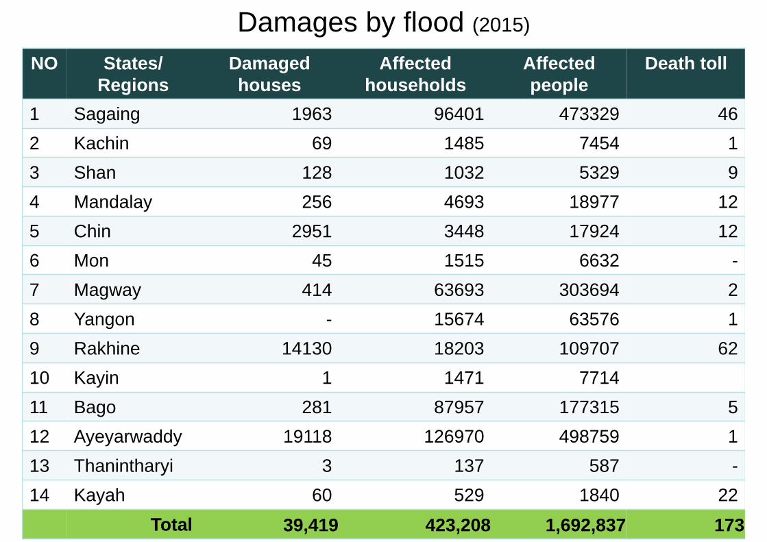
Damages by flood (2015)
NO States/Regions
Damaged houses
Affected households
Affectedpeople
Death toll
1 Sagaing 1963 96401 473329 462 Kachin 69 1485 7454 13 Shan 128 1032 5329 94 Mandalay 256 4693 18977 125 Chin 2951 3448 17924 126 Mon 45 1515 6632 -7 Magway 414 63693 303694 28 Yangon - 15674 63576 19 Rakhine 14130 18203 109707 6210 Kayin 1 1471 771411 Bago 281 87957 177315 512 Ayeyarwaddy 19118 126970 498759 113 Thanintharyi 3 137 587 -14 Kayah 60 529 1840 22
Total 39,419 423,208 1,692,837 173
No. Regions/States
Flooded Acre
Affected Acre
Damaged Acre
Replanting Acre
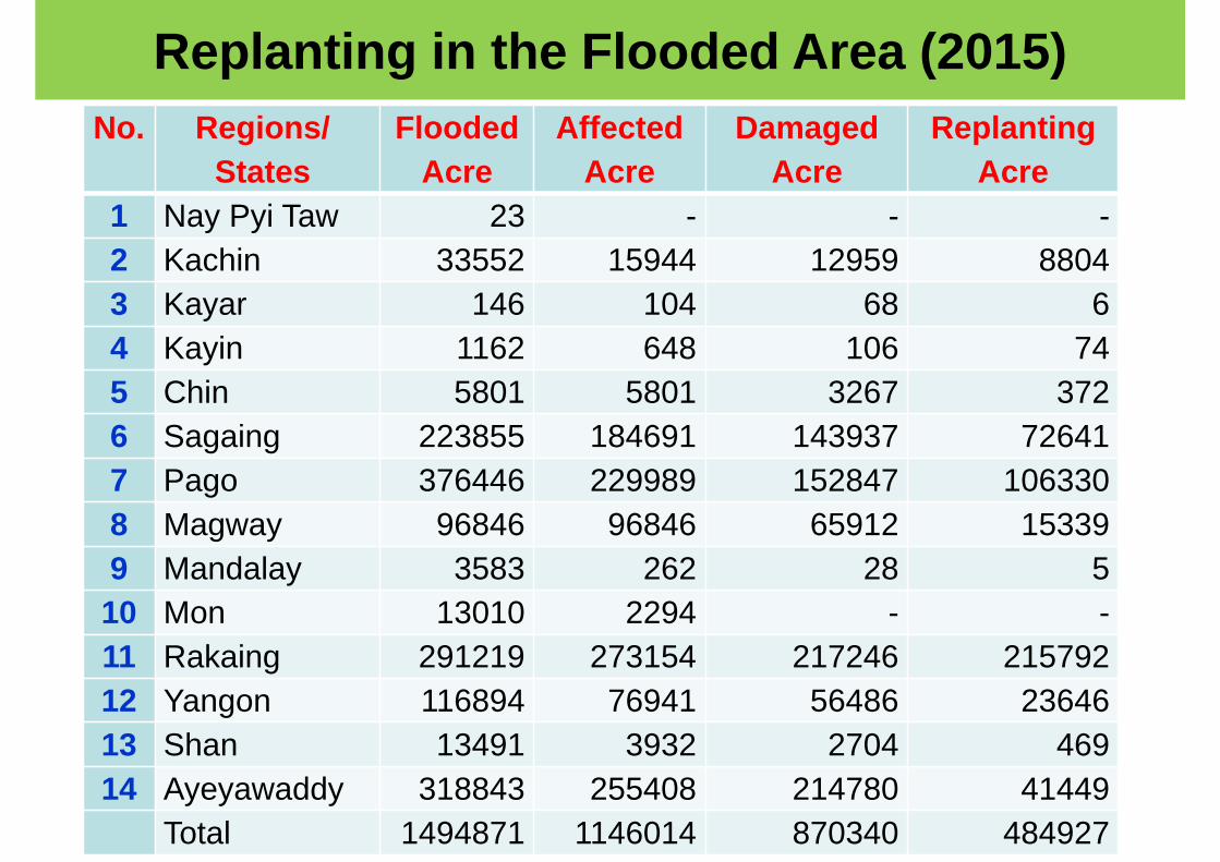
1 Nay Pyi Taw 23 - - -2 Kachin 33552 15944 12959 88043 Kayar 146 104 68 64 Kayin 1162 648 106 745 Chin 5801 5801 3267 3726 Sagaing 223855 184691 143937 726417 Pago 376446 229989 152847 1063308 Magway 96846 96846 65912 153399 Mandalay 3583 262 28 510 Mon 13010 2294 - -11 Rakaing 291219 273154 217246 21579212 Yangon 116894 76941 56486 2364613 Shan 13491 3932 2704 46914 Ayeyawaddy 318843 255408 214780 41449
Total 1494871 1146014 870340 484927
Replanting in the Flooded Area (2015)
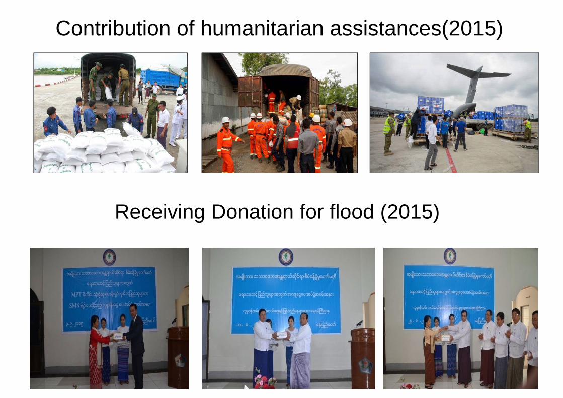
Contribution of humanitarian assistances(2015)
Receiving Donation for flood (2015)
0
1
2
3
4
5
6
Mky
ina
Bha
mo
Kat
haM
dly
Sga
ing
Pak
okku NU
Cha
ukM
inbu
Mag
way
Aun
glan
Pya
yS
eikt
haH
inth
a…Za
lun
Hka
mti
Hom
alin
Maw
laik
Kal
ewa
Mon
ywa
Hsi
paw
Myi
nge
Toun
goo
Mad
auk
Shw
e…Za
ung…
Bag
oH
paan
NTG
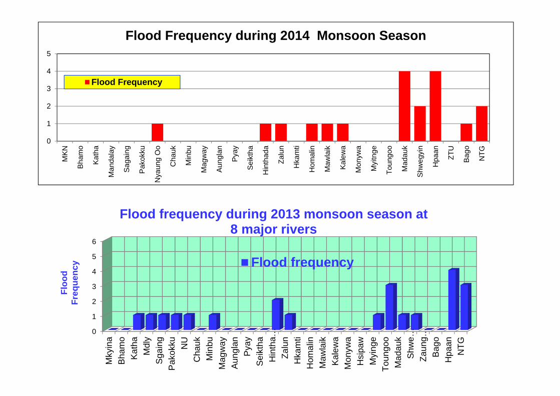
Flood frequency during 2013 monsoon season at 8 major rivers
Flood frequency
Floo
d Fr
eque
ncy
0
1
2
3
4
5M
KN
Bham
o
Kath
a
Man
dala
y
Saga
ing
Pako
kku
Nya
ung
Oo
Cha
uk
Min
bu
Mag
way
Aung
lan
Pyay
Seik
tha
Hin
thad
a
Zalu
n
Hka
mti
Hom
alin
Maw
laik
Kale
wa
Mon
ywa
Myi
tnge
Toun
goo
Mad
auk
Shw
egyi
n
Hpa
an
ZTU
Bago
NTG
Flood Frequency during 2014 Monsoon Season
Flood Frequency
0
100
200
300
4000
100
200
300
400
500
600
700
800
900
1000
1-Ju
l-13
8-Ju
l-13
15-J
ul-1
3
22-J
ul-1
3
29-J
ul-1
3
5-A
ug-1
3
12-A
ug-1
3
19-A
ug-1
3
26-A
ug-1
3
2-Se
p-13
9-Se
p-13
16-S
ep-1
3
23-S
ep-1
3
30-S
ep-1
3
7-O
ct-1
3
14-O
ct-1
3
21-O
ct-1
3
28-O
ct-1
3
4-N
ov-1
3
Rai
nfal
l (m
m)
Wat
er L
evel
(cm
)
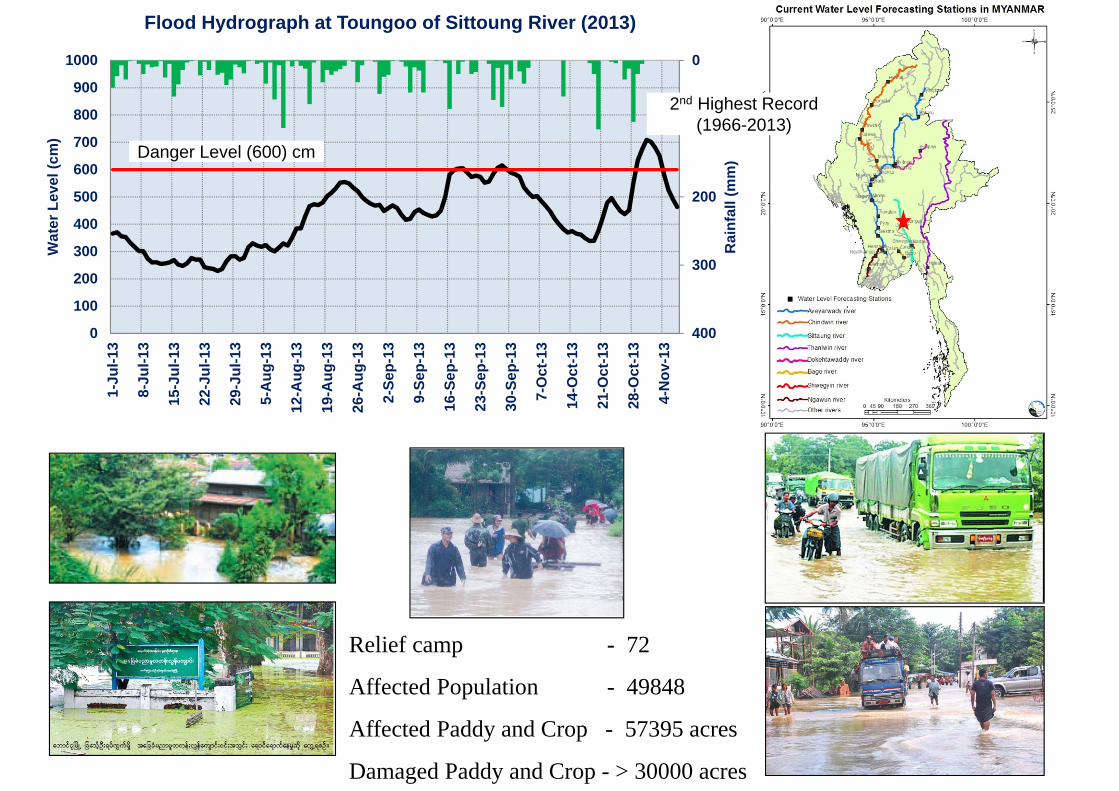
Flood Hydrograph at Toungoo of Sittoung River (2013)
Danger Level (600) cm
Relief camp - 72
Affected Population - 49848
Affected Paddy and Crop - 57395 acres
Damaged Paddy and Crop - > 30000 acres
2nd Highest Record (1966-2013)
01234
Mky
ina
Bha
mo
Kat
haM
dly
Sga
ing
Pak
okku NU
Cha
ukM
inbu
Mag
way
Aun
glan
Pya
yS
eikt
haH
inth
ada
Zalu
nH
kam
tiH
omal
inM
awla
ikK
alew
aM
onyw
aH
sipa
wM
ying
eTo
ungo
oM
adau
kS
hwek
yin
Zaun
gTu
Bag
oH
paan
NTG
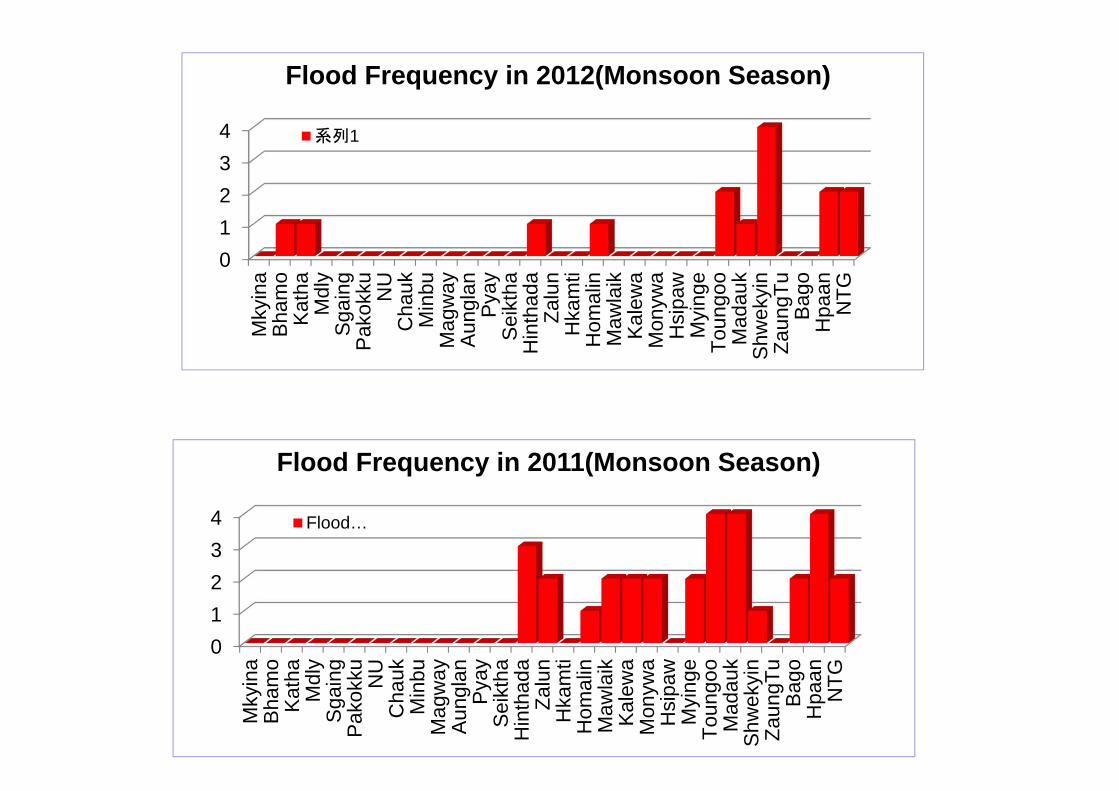
Flood Frequency in 2011(Monsoon Season)
Flood…
01234
Mky
ina
Bha
mo
Kat
haM
dly
Sga
ing
Pak
okku NU
Cha
ukM
inbu
Mag
way
Aun
glan
Pya
yS
eikt
haH
inth
ada
Zalu
nH
kam
tiH
omal
inM
awla
ikK
alew
aM
onyw
aH
sipa
wM
ying
eTo
ungo
oM
adau
kS
hwek
yin
Zaun
gTu
Bag
oH
paan
NTG
Flood Frequency in 2012(Monsoon Season)
系列1
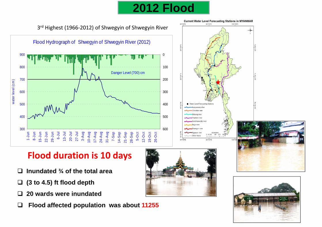
Flood Hydrograph of Shwegyin of Shwegyin River (2012)
300
400
500
600
700
800
900
1-Ju
n
8-Ju
n15
-Jun
22-J
un
29-J
un6-
Jul
13-J
ul
20-J
ul
27-J
ul3-
Aug
10-A
ug
17-A
ug24
-Aug
31-A
ug
7-S
ep14
-Sep
21-S
ep
28-S
ep5-
Oct
12-O
ct
19-O
ct26
-Oct
wat
er le
vel (
cm)
0
100
200
300
400
500
600
Danger Level (700) cm
Inundated ¾ of the total area
(3 to 4.5) ft flood depth
20 wards were inundated
Flood affected population was about 11255
3rd Highest (1966‐2012) of Shwegyin of Shwegyin River
Flood duration is 10 days
2012 Flood
Pakokku
Zalun
Seiktha
Zaugtu
NTG
0
100
200300
400
500
600700
800
9001000
1-M
ay
15-M
ay
29-M
ay
12-J
un
26-J
un
10-J
ul
24-J
ul
7-Au
g
21-A
ug
4-Se
p
18-S
ep
2-O
ct
16-O
ct
30-O
ct
wat
er le
vel (
cm)
Date
Comparison of 2010 and 2011 Water Levels of Hpaan of Thanlwin River
2010 2011
Danger Level 750 cm
Comparison of 2010 and 2011 Water Levels of Toungoo of Sittoung River
0
100
200
300
400
500
600
700
800
1-M
ay
15-M
ay
29-M
ay
12-J
un
26-J
un
10-J
ul
24-J
ul
7-A
ug
21-A
ug
4-S
ep
18-S
ep
2-O
ct
16-O
ct
30-O
ct
Date
wat
er le
vel (
cm)
2010 2011
Danger Level 600 cm
0
200
400
600
800
1000
1200
1400
1-M
ay
15-M
ay
29-M
ay
12-J
un
26-J
un
10-J
ul
24-J
ul
7-Au
g
21-A
ug
4-Se
p
18-S
ep
2-O
ct
16-O
ct
30-O
ct
wat
er le
vel (
cm)
Date
Comparison of 2010 and 2011 Water Levels of Madauk of Sittoung River
2010 2011
Danger Level 1070
4th Lowest (1967~2011)
2nd Lowest (1968~2011)
2nd Lowest (1966~2011)
3rd Lowest (1968~2011)
1st Lowest (1967~2011)
4th Lowest (1968~2011)
2011 Annual Peak/ Lowest Water level
1st Highest (1965-2011)
2nd Highest (1966-2011)
Fig (9) Comparison of 2010 Water Level and 2011 Water Level during Monsoon Period at Shwegyin of Shwegyin River
0
100
200
300
400
500
600
700
800
1-Ju
n8-
Jun
15-Ju
n22
-Jun
29-Ju
n6-
Jul
13-Ju
l20
-Jul
27-Ju
l3-
Aug10
-Aug
17-A
ug24
-Aug
31-A
ug7-
Sep14
-Sep
21-S
ep28
-Sep
5-Oct
12-O
ct19
-Oct
26-O
ct
Date
wat
er le
vel (
cm)
2010 Water Level
2011 Water Level
Danger Level (700 cm)
Fig (1) Comparison of 2010 Water Level and 2011 Water Level during Monsoon Period at Myitkyina of Ayeyarwady River
0
200
400
600
800
1000
1200
1400
1-Ju
n8-
Jun
15-Ju
n22
-Jun
29-Ju
n6-
Jul
13-Ju
l20
-Jul
27-Ju
l3-
Aug
10-A
ug17
-Aug
24-A
ug31
-Aug
7-Se
p14
-Sep
21-S
ep28
-Sep
5-Oct
12-O
ct19
-Oct
26-O
ct
Date
wat
er le
vel (
cm)
2010 Water Level2011 Water Level
Danger Level (1200 cm)
Fig (4) Comparison of 2010 Water Level and 2011 Water Level during Monsoon Period at Hkamti of Chindwin River
0
200
400
600
800
1000
1200
1400
1-Ju
n8-
Jun
15-Ju
n22
-Jun
29-Ju
n
6-Ju
l13
-Jul
20-Ju
l27
-Jul
3-Au
g10
-Aug
17-A
ug24
-Aug
31-A
ug7-
Sep
14-S
ep21
-Sep
28-S
ep5-
Oct12
-Oct
19-O
ct26
-Oct
Date
wat
er le
vel (
cm)
2010 Water Level
2011 Water Level
Danger Level (1360 cm)
Floods in 2011
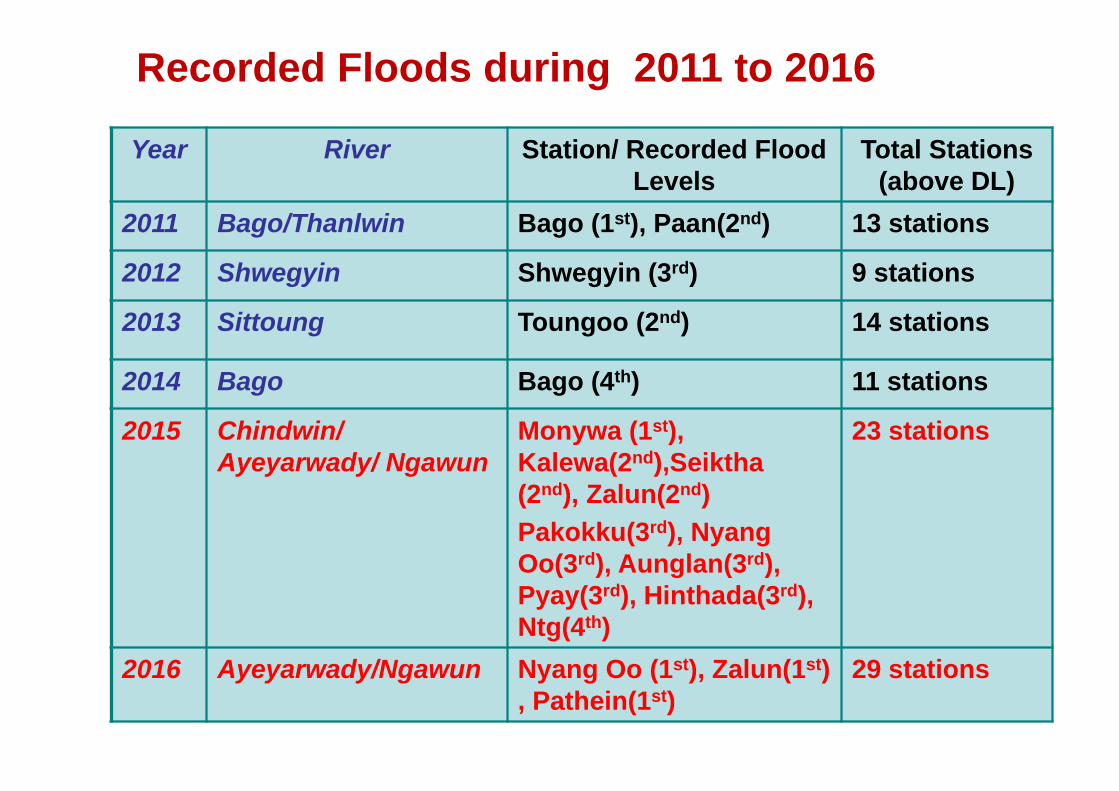
Recorded Floods during 2011 to 2016
Year River Station/ Recorded Flood Levels
Total Stations (above DL)
2011 Bago/Thanlwin Bago (1st), Paan(2nd) 13 stations
2012 Shwegyin Shwegyin (3rd) 9 stations
2013 Sittoung Toungoo (2nd) 14 stations
2014 Bago Bago (4th) 11 stations
2015 Chindwin/ Ayeyarwady/ Ngawun
Monywa (1st), Kalewa(2nd),Seiktha(2nd), Zalun(2nd)Pakokku(3rd), NyangOo(3rd), Aunglan(3rd), Pyay(3rd), Hinthada(3rd), Ntg(4th)
23 stations
2016 Ayeyarwady/Ngawun Nyang Oo (1st), Zalun(1st) , Pathein(1st)
29 stations
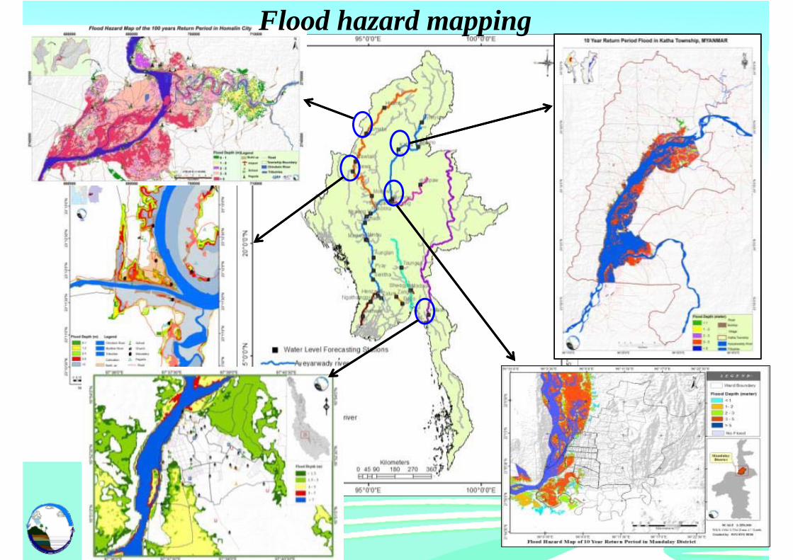
Flood hazard mapping
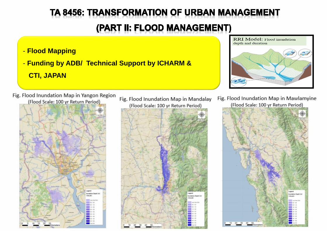
- Flood Mapping
- Funding by ADB/ Technical Support by ICHARM &
CTI, JAPAN
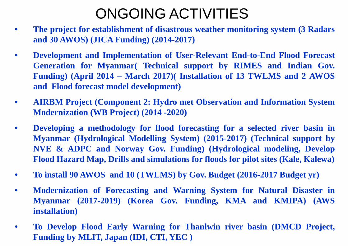
• The project for establishment of disastrous weather monitoring system (3 Radarsand 30 AWOS) (JICA Funding) (2014-2017)
• Development and Implementation of User-Relevant End-to-End Flood ForecastGeneration for Myanmar( Technical support by RIMES and Indian Gov.Funding) (April 2014 – March 2017)( Installation of 13 TWLMS and 2 AWOSand Flood forecast model development)
• AIRBM Project (Component 2: Hydro met Observation and Information SystemModernization (WB Project) (2014 -2020)
• Developing a methodology for flood forecasting for a selected river basin inMyanmar (Hydrological Modelling System) (2015-2017) (Technical support byNVE & ADPC and Norway Gov. Funding) (Hydrological modeling, DevelopFlood Hazard Map, Drills and simulations for floods for pilot sites (Kale, Kalewa)
• To install 90 AWOS and 10 (TWLMS) by Gov. Budget (2016-2017 Budget yr)
• Modernization of Forecasting and Warning System for Natural Disaster inMyanmar (2017-2019) (Korea Gov. Funding, KMA and KMIPA) (AWSinstallation)
• To Develop Flood Early Warning for Thanlwin river basin (DMCD Project,Funding by MLIT, Japan (IDI, CTI, YEC )
ONGOING ACTIVITIES
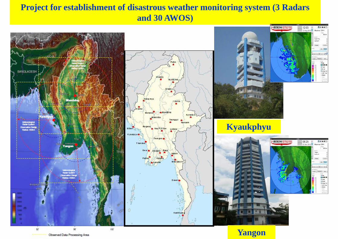
Project for establishment of disastrous weather monitoring system (3 Radars and 30 AWOS)
Yangon
Kyaukphyu
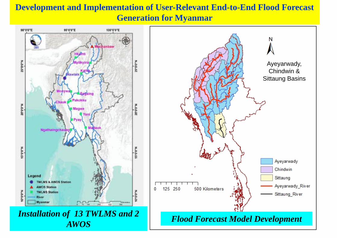
Installation of 13 TWLMS and 2 AWOS Flood Forecast Model Development
Ayeyarwady, Chindwin &
Sittaung Basins
Development and Implementation of User-Relevant End-to-End Flood Forecast Generation for Myanmar
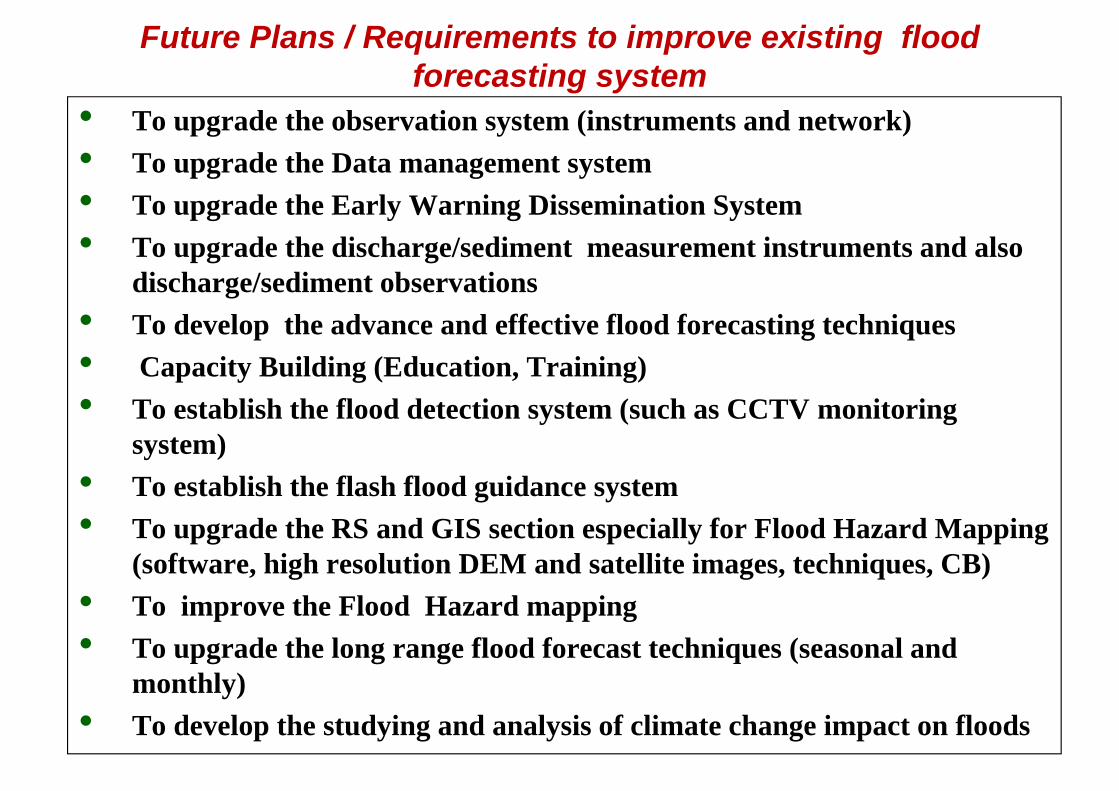
Future Plans / Requirements to improve existing flood forecasting system
• To upgrade the observation system (instruments and network)• To upgrade the Data management system • To upgrade the Early Warning Dissemination System• To upgrade the discharge/sediment measurement instruments and also
discharge/sediment observations• To develop the advance and effective flood forecasting techniques• Capacity Building (Education, Training) • To establish the flood detection system (such as CCTV monitoring
system)• To establish the flash flood guidance system• To upgrade the RS and GIS section especially for Flood Hazard Mapping
(software, high resolution DEM and satellite images, techniques, CB)• To improve the Flood Hazard mapping• To upgrade the long range flood forecast techniques (seasonal and
monthly)• To develop the studying and analysis of climate change impact on floods
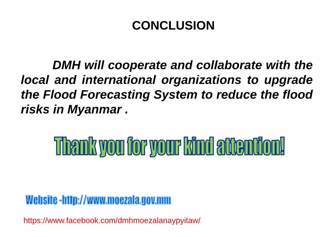
DMH will cooperate and collaborate with thelocal and international organizations to upgradethe Flood Forecasting System to reduce the floodrisks in Myanmar .
CONCLUSION
https://www.facebook.com/dmhmoezalanaypyitaw/