Embed Size (px)
Citation preview
CASE FOR NATIONAL SKILLS STANDARDS
COUNCIL ENDORSEMENT
of the Surveying and Spatial Information Services
Qualifications and Units of Competency
CPP07 Property Services Training Package Version 12
Table of Contents1 Overview........................................................................1
1.1 Rationale for the continuous improvement project..............................................21.2 Project objectives................................................................................................41.3 Project design.....................................................................................................41.4 Project process and endorsement proposal........................................................5
Figure 1: CPP07 SSIS project process...............................................................................51.5 Project governance.............................................................................................6
2 Responsiveness and recognition quality principles...........72.1 Evidence of responsiveness and recognition......................................................72.2 Report by exception............................................................................................8
3 Flexibility and functionality quality principles...................94 Impact of the continuous improvement project...............115 Components for endorsement........................................12
5.1 Draft endorsed material.....................................................................................125.2 Licensing requirements or specific assessment................................................125.3 Mapping information..........................................................................................13
Mapping CPP07 Version 12 qualifications to Version 11.....................................................13Table 1: Mapping of CPP07 SSIS Version 12 qualifications to Version 11......................15
Mapping CPP07 Version 12 units of competency to Version 11..........................................15Table 2: Mapping of CPP07 SSIS Version 12 units to Version 11...................................47
5.4 CPP07 Version Modification History.................................................................48
Appendices......................................................................50Appendix 1 Draft endorsed material........................................................................51
SSIS qualifications...............................................................................................................51SSIS units.............................................................................................................................84
Appendix 2 SSIS qualifications and vocational roles..............................................88Appendix 3 Holistic quality assurance report..........................................................90Appendix 4 SSIS commencement and completion data.......................................101
CPSISC Case for Endorsement CPP07 V12: SSIS material Page iSeptember 2012
1 Overview
Construction and Property Services Industry Skills Council (CPSISC) submits for endorsement the reviewed surveying and spatial information services (SSIS) – formerly spatial information services (SIS) – qualifications and units of competency.
This Case for Endorsement also includes one new qualification and twelve new units of competency in surveying and spatial information services for inclusion in CPP07 Property Services Training Package Version 12.
At the same time, seven existing qualifications and 80 existing units of competency have been reviewed and are also submitted for endorsement.
Consequently, the endorsement submission comprises:
• the addition of one new SSIS qualification: CPP60312 Advanced Diploma of Surveying
• the addition of 12 new SSIS units of competency:o CPPSIS4036A Operate spatial software applicationso CPPSIS4037A Produce computer-aided drawingso CPPSIS4038A Prepare and present GIS data o CPPSIS5060A Use complex spreadsheets for spatial informationo CPPSIS5061A Locate underground services in surveying practice o CPPSIS5062A Conduct photogrammetric mapping o CPPSIS5063A Produce GIS datao CPPSIS5064A Manipulate and analyse GIS datao CPPSIS6041A Compile mine survey planso CPPSIS6042A Coordinate information gathering and GIS development o CPPSIS6043A Develop, monitor and maintain geographic information systemso CPPSIS6044A Manage GIS data
• the following seven reviewed SSIS qualifications:o CPP20112 Certificate II in Surveying and Spatial Information Serviceso CPP30112 Certificate III in Surveying and Spatial Information Serviceso CPP40112 Certificate IV in Surveyingo CPP40212 Certificate IV in Spatial Information Serviceso CPP50112 Diploma of Surveyingo CPP50212 Diploma of Spatial Information Serviceso CPP60112 Advanced Diploma of Spatial Information Services
• 80 reviewed SSIS units of competency (see list in Appendix 1).
CPSISC Case for Endorsement CPP07 V12: SSIS material Page 1September 2012
1.1 Rationale for the continuous improvement projectThe representation to further develop qualifications and units of competency in SSIS, as well as review existing SSIS material, was made in the context of continuous improvement. While the SSIS qualification structure was redeveloped in 2007, subsequent feedback received was that these qualifications needed enhancing to sufficiently address industry’s current requirements.
The review was strongly supported by the industry umbrella organisation, the Surveying and Spatial Sciences Institute (SSSI), key industry personnel, and major registered training organisations (RTOs) delivering surveying and spatial information services qualifications.
SSIS practitioners determine the boundaries, area, or elevations of land or structures on the earth's surface by measuring angles and distances, using the techniques of geometry and trigonometry. SSIS qualifications relate to vocational training in mapping science, remote sensing, surveying, cartography, town planning and geographic information services. Surveying qualifications relate to mine surveying, land surveying, mapping services, etc. Surveyors are subject to regulatory requirements in States and Territories. See 5.2 for more information.
Meeting industry needsIt was clear that the qualifications for SSIS had to be expanded to reflect a broad range of skill and knowledge requirements and properly acknowledge the complexity of the work undertaken by the practitioners.
Project consultation and analysis identified a number of key themes of vital importance to the sector, which were reflected in the design and content of the qualifications and units of competency. Vocational activity in SSIS is frequently ‘process driven’. That is, the work follows defined steps, which does not mean routine tasks. It is clear that surveyors and image analysts, for example, have sophisticated technical and underpinning knowledge, the capacity to exercise judgment, broad knowledge of integrated services – environmental, land, geographic and IT systems – and the ability to coordinate complex tasks and liaise with diverse groups ranging from clients to local government planning authorities to ‘co-professionals’, such as structural engineers.
A key attribute of SSIS professionals are strong technical skills and mathematical aptitude. The design of the qualifications, in meeting industry’s needs, reflects the complexity of the work that is undertaken and also fosters the opportunity for articulation into higher education qualifications. The framework allows for existing skilled and experienced practitioners to have their existing competency recognised via recognition of prior learning (RPL), which may also facilitate access to higher education. Many of the TAFE Institutes that deliver SSIS qualifications have processes in place for transition from vocational qualifications to higher education (these include Central TAFE, Curtin University and dual sector institutes, such as RMIT). Given that surveying is an ageing profession, stakeholders agreed that there is a need for qualification pathways for technical skills and specialisation in surveying occupations.
CPSISC Case for Endorsement CPP07 V12: SSIS material Page 2September 2012
One of the requirements of this review project was to meet industry needs by ensuring appropriate distinction between the work of surveyors and the various components of the spatial information services industry. See Appendix 2 for more information on the SSIS industry. The drive for the new Advanced Diploma of Surveying originated from Western Australia to meet their licensing requirements, and was strongly supported through the national consultation and development process.
The review of the SSIS qualifications was strongly supported by industry associations and practitioners, with substantial engagement being achieved through the SSSI, the CPSISC sponsored Spatial Information Services RTO network and web input.
The surveying and spatial information services sector is a relatively new area in the VET arena. Low levels of awareness still exist amongst some employers and RTOs. The challenge ahead is to build on the experience of the qualifications to develop career pathways in this industry. The TAFE network is viewed as a crucial supplier of vocational education and training for the industry and an important vehicle for promoting SSIS.
IssuesThe major issue to arise during the review was the difficulty in meeting the needs of all the jurisdictions due to the differences in surveying registration requirements (see 5.2), which led to varying opinions on entrance requirements between qualifications. The point that all stakeholders agreed on is that the key to progression and learning in surveying and spatial information services is sound training delivery to build on participants’ spatial and mathematical aptitude.
Following discussion, stakeholders agreed that entry to a qualification is largely a training issue, i.e. RTOs need to determine the participants’ spatial and mathematical aptitude before entry into the higher level surveying and spatial information services qualifications. Regarding entry into the Advanced Diploma of Surveying, agreement was reached that the Diploma of Surveying or demonstrated equivalence would be the entrance for this qualification.
An implementation issue is the poor completion figures for the SSIS qualifications (see qualification figures in the Attachment to this Case for Endorsement)
While industry stakeholders would like to improve completion rates, they also note that the NCVER figures are not a true reflection of the success of SSIS training - the ‘non-completion’ figures include training participants who have discontinued their VET qualifications because they have been able to secure a job in the industry and participants who transfer from VET qualifications to higher education qualifications.
CPSISC Case for Endorsement CPP07 V12: SSIS material Page 3September 2012
1.2 Project objectivesThe project objectives were focused on meeting the needs of enterprises and a diverse range of industry workers within the surveying and spatial information services sector, while also adhering to the requirements for national endorsement by the National Skills Standards Council.
Specifically, the objectives of the project were to:
• deliver a high quality new qualification in surveying and high quality new units of competency to meet identified industry gaps
• improve the quality of the existing SSIS units of competency and qualifications.
1.3 Project designThe project design included research, consultation and development, followed by validation and reporting. The methodology allowed implementation of effective project management and reporting processes, and regular informal progress reports outlining the processes and outcomes of each stage.
The review of SSIS links directly to the Continuous Improvement Plan of CPSISC. The project was heavily informed by work undertaken by the CPSISC sponsored Spatial Information Services RTO Network and consultation with industry primarily facilitated by the SSSI. Several government agencies were also involved. This resulted in a very precise understanding of the nature of the redevelopment work to be undertaken. All key stakeholder groups involved in the initial process supported the redevelopment brief.
CPSISC Case for Endorsement CPP07 V12: SSIS material Page 4September 2012
The extensive consultation processes that facilitated industry and RTOs input fostered good will and a spirit of cooperation.
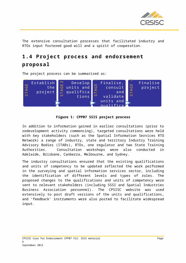
1.4 Project process and endorsement proposalThe project process can be summarised as:
Figure 1: CPP07 SSIS project process
In addition to information gained in earlier consultations (prior to redevelopment activity commencing), targeted consultations were held with key stakeholders (such as the Spatial Information Services RTO Network) a range of industry, state and territory Industry Training Advisory Bodies (ITABs), RTOs, one regulator and two State Training Authorities. Consultation workshops were also conducted in Adelaide, Brisbane, Canberra, Melbourne, and Sydney.
The industry consultations ensured that the existing qualifications and units of competency to be updated reflected the work performed in the surveying and spatial information services sector, including the identification of different levels and types of roles. The proposed changes to the qualifications and units of competency were sent to relevant stakeholders (including SSSI and Spatial Industries Business Association personnel). The CPSISC website was used extensively to post draft versions of the units and qualifications, and ‘feedback’ instruments were also posted to facilitate widespread input.
The review has been conducted in consultation with industry and meets the Training Package Quality Principles. The resultant qualifications framework addresses the contemporary needs of the SSIS industry by supporting genuine vocational outcomes across Australia and accommodates and facilitates the transition between education and the workforce. The language and style used also meet the diversity of individual and enterprise needs in this sector and support sound training delivery and assessment practice.
The work responds to contemporary industry and workforce needs, effective in recognising an individual’s competency across spatial and surveying industries and occupations (see table in Appendix 2 detailing relationship between SSIS qualifications and vocational roles); provides flexibility to meet individual enterprise and learner needs; and designed in a manner that is consistent with industry practices and the Training Package Quality Principles.
CPSISC Case for Endorsement CPP07 V12: SSIS material Page 5September 2012
STA
GE
1 Establish the project
STA
GE
2 Develop units and
qualifications STA
GE
3 Finalise, consult and
validate units and
qualifications
STA
GE
4 Finalise project
Strong support exists for the use of competency standards as a way to define training needs and to drive delivery of vocational education and training for the SSIS industry. The qualifications were improved by addressing the issues identified in the 2010 CPSISC Continuous Improvement Plan. These improvements included:
• developing the Advanced Diploma of Surveying• reviewing the existing Advanced Diploma in Spatial Information Services to ensure that it
meets the needs of the spatial information services stream now that the qualification no longer encompasses surveying
• reviewing all existing units to ensure that the required skills and knowledge can be assessed effectively
• developing twelve new units to meet gaps in the qualifications• updating all imported units to ensure currency.
1.5 Project governanceA project steering committee (PSC) was established at the commencement of the project. Two PSC teleconferences meetings were conducted for the project.
The PSC comprised the following industry, provider and regulator representatives:
• Noel Hamey (Chair), Surveying and Spatial Sciences Institute• Beryl Caldis, Department of Training and Workforce Development (WA)• Damien Cole, TAFE NSW• Peter Douglas, Central Institute of Technology, WA• George Havakis, Workforce Solutions Pty Ltd• Bill Hirst, ACT Planning and Land Authority • Allan Jones, Financial, Administrative and Professional Services Training Council Inc,
WA• Rob Koch, TAFE SA • Jack de Lange, Spatial Industries Business Association• Dr Ken Lyons, Spatial Information Services Pty Ltd• David Magee (Project Manager), Construction and Property Services Industry Skills
Council• Craig Moss, Department of Transport and Main Roads, QLD• Tony Snow, Curtin University WA• Lynnette Terrett, RapidMap Global Pty Ltd • Bert Veenendaal, Curtin University WA
The PSC assisted in ensuring that project processes were open and transparent, and included consultation with a wide range of stakeholders including those industry members providing technical input into the development of the units and qualification. The Spatial Information Services RTO network provided extensive technical input through their meetings.
CPSISC Case for Endorsement CPP07 V12: SSIS material Page 6September 2012
2 Responsiveness and recognition quality principles
2.1 Evidence of responsiveness and recognitionCPSISC is seeking endorsement of Version 12 of CPP07 Property Services Training Package incorporating the reviewed surveying and spatial information services qualifications.
The ISC is confident that the project outcomes meet the requirements of the quality principles detailed below.
1 Reflect contemporary work organisation and job profilesEngagement of industry associations, Spatial Information Services RTO network, the project steering committee (PSC), and face-to-face and website consultation ensured the project outcomes reflect industry needs and the particular requirements of various job profiles.
2 Driven by industry’s needsThe project commenced with a clearly articulated review brief based on industry consultation and was strengthened via industry engagement, which was overseen by a representative PSC. The PSC was active in ensuring the industry’s needs were met.
3 Respond to government broad policy initiativesThe review of national qualifications within Training Packages is supportive of government initiatives, particularly in those sectors that are fully or partially regulated. The project also saw the development of units of competency and the review of qualifications to reflect technological and sustainability issues.
4 Recognise the convergence and connectivity of skillsCPSISC sought to use, wherever possible, units of competency imported from other Training Packages in order to support candidates’ access, and to recognise the interconnection of industries and the convergence of skills.
5 Support the movement of skills within and across organisations and sectors
The project saw the use of relevant units from across other CPSISC sectors that are aimed at enhancing the transportability of skills and the movement of people.
6 Promote national and international portability The review of SSIS qualifications was cognisant of AQF requirements. The qualifications and units of competency reference Australian standards and codes of practice, where relevant, and are nationally and internationally portable. They are also relevant to a range of surveying and spatial information services vocations.
CPSISC Case for Endorsement CPP07 V12: SSIS material Page 7September 2012
7 Reflect licensing and regulatory requirementsSpatial information services professions are not licensed.
With regard to surveying, all states and territories, apart from WA distinguish between technician surveyors and qualified surveyors. In WA graduates with a vocational Diploma of Surveying are accepted by the WA Surveyors Board as qualified surveyors. There is no distinction between technician surveyors and surveyors in WA. The vocational qualifications are only accepted for surveying registration purposes in WA. In other areas of jurisdiction, the vocational qualifications lead to technical surveying positions but not registered surveying positions. They do however open up career pathways and enable negotiated transition to higher education. This transition will be further enhanced in all areas of jurisdiction by the introduction of the Advanced Diploma of Surveying. In WA this qualification is reflective of the Land Surveyors Licensing Board requirements. For further information on licensing requirements see 5.2.
2.2 Report by exceptionIssues registerAn issues register was maintained during the course of the project. Issues raised and their proposed outcomes were addressed and agreed by the PSC. There are no outstanding issues.
CPSISC Case for Endorsement CPP07 V12: SSIS material Page 8September 2012
3 Flexibili ty and functionality quality principles
CPSISC is confident the project outcomes meet the requirements of the quality principles.
1 Meet the diversity of individual and enterprise needs The detailed industry and workplace functional analysis that underpins these qualifications has ensured their relevance. Qualifications do not contain requirements that act as barriers to entry, and packaging rules are flexible and readily adaptable to differing enterprise and student requirements.
The Advanced Diploma of Spatial Information Services has had an entrance requirement removed. The previous version of this qualification had an entrance requirement that reflected regulatory requirements of the surveying sector, which could be removed given that the qualification no longer covers that sector.
As mentioned in Section 1.1 of this Case for Endorsement, due to the regulatory requirements of the surveying sector, the new Advanced Diploma of Surveying has an entrance requirement, strongly supported in Western Australia (WA) and by the WA STA due to that state’s regulatory requirements.
This entrance requirement is consistent with the view of the PSC. As the new Advanced Diploma of Surveying was driven primarily by industry’s needs in WA and is not likely to be widely accessed in other jurisdictions, the PSC did not consider the entrance requirement to represent an unnecessary barrier – particularly given that demonstrated equivalent competency to the required Diploma of Surveying is acceptable.
2 Support equitable access and progression of learnersPlease see comments to prior point. Prerequisite units are not used within the Training Package in order to maximise access and simplify delivery. The units have been written clearly and explicitly. The unit evidence guides require that reasonable adjustments are made to accommodate differing learner requirements.
3 Support learner transition between education sectorsThe development of an Advanced Diploma of Surveying affords real opportunities for articulation to be negotiated into higher education cadastral surveying qualifications.
4 Support implementation across a range of settingsThe units of competency are written to support assessment in a range of settings, including the workplace and simulated settings.
5 Support sound assessment practiceRobust and sound assessment practices are reflected in the Training Package Assessment Guidelines, as well as the evidence guides of individual units of competency.
6 Do not impose structural barriers to implementationThere are no structural barriers to implementation.
CPSISC Case for Endorsement CPP07 V12: SSIS material Page 9September 2012
All independent quality reports were completed by members of the Quality Assurance Panels. The holistic quality assurance report is included in Appendix 3.
CPSISC Case for Endorsement CPP07 V12: SSIS material Page 10September 2012
4 Impact of the continuous improvement project
The development of the new qualification and units of competency will have implications for RTOs as they will now have to revise delivery and assessment resources. It is assumed that many of the existing teaching and assessment resources could be mapped across to the new Advanced Diploma qualification. All qualifications (including the new Advanced Diploma of Surveying) are suitable for Australian Apprenticeship pathways.
The work of a surveyor is project-based and documented comprehensively so this should allow an Australian Apprenticeship pathway that has significant focus on work-based projects supported by the employer and comprehensive evidence for assessment.
The regulators and industry associations in a number of jurisdictions have indicated a strong interest in the progress of this project, and will use the endorsed qualification to progress initiative in this industry sector.
For information, the SSIS commencement and completion data generated by NCVER may be found in Appendix 4.
CPSISC Case for Endorsement CPP07 V12: SSIS material Page 11September 2012
5 Components for endorsement
5.1 Draft endorsed materialThe following eight SSIS qualifications and Employability Skills Qualifications Summary are submitted for endorsement.
• Seven revised qualifications:o CPP20112 Certificate II in Surveying and Spatial Information Services o CPP30112 Certificate III in Surveying and Spatial Information Services o CPP40112 Certificate IV in Surveying o CPP40212 Certificate IV in Spatial Information Services o CPP50112 Diploma of Surveyingo CPP50212 Diploma of Spatial Information Services o CPP60112 Advanced Diploma of Spatial Information Services
• One new qualification:o CPP60312 Advanced Diploma of Surveying
In addition, twelve new units of competency and 80 revised units of competency are also submitted for endorsement.
The draft qualifications are included in Appendix 1, along with a list of SSIS new and revised units of competency.
5.2 Licensing requirements or specific assessmentDepending on location, new entrants in the surveying industry must satisfy the following state-based registration and licensing requirements in order to practice:
• Board of Surveying and Spatial Information (NSW)• Surveyor General for the ACT• Surveyors Registration Board of Victoria• Land Surveyors Licensing Board (WA)• Surveyors Board Qld, supporting the two-tier system – Cadastral surveying is 4 years
(specialisations at 3 year degree in mining or hydrographic aligned with SSSI; voluntary endorsements may include consulting, engineering, hydro and mining)
• Other regulators as recognised by SSSI from time to time.
CPSISC Case for Endorsement CPP07 V12: SSIS material Page 12September 2012
Licensing for cadastral surveying typically requires a four-year, degree-level university qualification and a period of supervised field experience under a qualified surveyor for a period of between six to 12 months. Differences in regulations between states and territories are highlighted by the fact that in WA graduates with a vocational Diploma of Surveying are accepted by the WA Surveyors Board as qualified surveyors. There is no distinction between technician surveyors and surveyors in WA as there is in other states. In Queensland mining is underground coal mining, whereas most mining in WA is metalliferous coal mining, which is not as dangerous. To ensure that the surveying training arrangements are robust to meet industry requirements (specifically in Western Australia), the Diploma of Surveying is the entry requirement for the Advanced Diploma.
Surveying occupations are regulated but all states and territories, apart from WA, only accept higher education qualifications for surveyors.
5.3 Mapping information
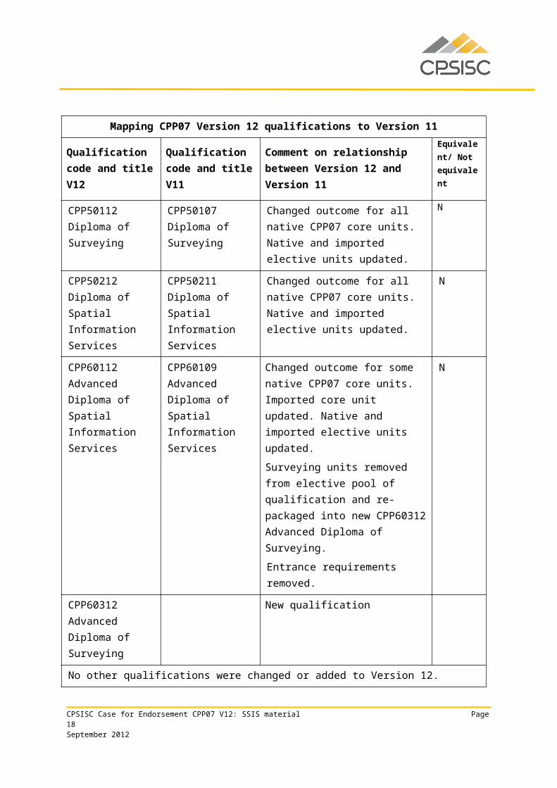
Mapping CPP07 Version 12 qualifications to Version 11The following mapping information is provided in Volume 1 of Version 12 of CPP07.
Mapping CPP07 Version 12 qualifications to Version 11
Qualification code and title V12
Qualification code and title V11
Comment on relationship between Version 12 and Version 11
Equivalent/ Not equivalent
CPP20112 Certificate II in Surveying and Spatial Information Services
CPP20111 Certificate II in Surveying and Spatial Information Services
Changed outcome for some native CPP07 core units. Native and imported elective units updated.
N
CPP30112 Certificate III in Surveying and Spatial Information Services
CPP30111 Certificate III in Surveying and Spatial Information Services
Overall number of units required for qualification remains unchanged, but core units reduced from 7 to 5 by moving the following two core units to the elective pool: CPPSIS3002A Store and retrieve spatial data (which has however been replaced by CPPSIS4022A Store and retrieve spatial data) and CPPSIS3011A Apply map presentation principles and.
Changed outcome for some native CPP07 core units. Imported core
N
CPSISC Case for Endorsement CPP07 V12: SSIS material Page 13September 2012
Mapping CPP07 Version 12 qualifications to Version 11
Qualification code and title V12
Qualification code and title V11
Comment on relationship between Version 12 and Version 11
Equivalent/ Not equivalent
unit updated. Native and imported elective units updated.
CPP40112 Certificate IV in Surveying
CPP40109 Certificate IV in Surveying
Overall number of units required for qualification remains unchanged, but core units reduced from 8 to 7 by removing the following core unit: ICAU2006B Operate computing packages; number of required elective units increased from 7 to 8.
Changed outcome for some native CPP07 core units. Imported unit replaced with new native unit. Native and imported elective units updated.
N
CPP40212 Certificate IV in Spatial Information Services
CPP40211 Certificate IV in Spatial Information Services
Overall number of units required for qualification remains unchanged, but core units reduced from 9 to 7, by deleting ICAU2006B Operate computing packages from qualification and moving the following core unit to the elective pool: RIISTD201A Read and interpret maps.
Changed outcome for some native CPP07 core units. Native and imported elective units updated.
N
CPP50112 Diploma of Surveying
CPP50107 Diploma of Surveying
Changed outcome for all native CPP07 core units. Native and imported elective units updated.
N
CPP50212 Diploma of Spatial Information Services
CPP50211 Diploma of Spatial Information Services
Changed outcome for all native CPP07 core units. Native and imported elective units updated.
N
CPP60112 Advanced Diploma
CPP60109 Advanced Diploma
Changed outcome for some native CPP07 core units. Imported core
N
CPSISC Case for Endorsement CPP07 V12: SSIS material Page 14September 2012
Mapping CPP07 Version 12 qualifications to Version 11
Qualification code and title V12
Qualification code and title V11
Comment on relationship between Version 12 and Version 11
Equivalent/ Not equivalent
of Spatial Information Services
of Spatial Information Services
unit updated. Native and imported elective units updated.
Surveying units removed from elective pool of qualification and re-packaged into new CPP60312 Advanced Diploma of Surveying.
Entrance requirements removed.
CPP60312
Advanced Diploma of Surveying
New qualification
No other qualifications were changed or added to Version 12.
Table 1: Mapping of CPP07 SSIS Version 12 qualifications to Version 11
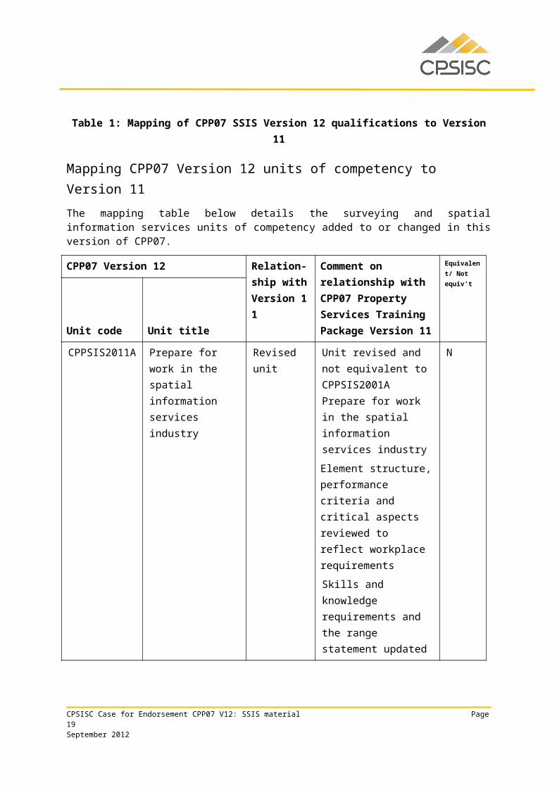
Mapping CPP07 Version 12 units of competency to Version 11The mapping table below details the surveying and spatial information services units of competency added to or changed in this version of CPP07.
CPP07 Version 12 Relation-ship with Version 11
Comment on relationship with CPP07 Property Services Training Package Version 11
Equivalent/ Not equiv’t
Unit code Unit titleCPPSIS2011A Prepare for work in
the spatial information services industry
Revised unit Unit revised and not equivalent to CPPSIS2001A Prepare for work in the spatial information services industry
Element structure, performance criteria and critical aspects reviewed to reflect workplace requirements
Skills and knowledge
N
CPSISC Case for Endorsement CPP07 V12: SSIS material Page 15September 2012
CPP07 Version 12 Relation-ship with Version 1
Comment on relationship with CPP07 Property
Equivalent/ Not equiv’t
Unit code Unit titlerequirements and the range statement updated
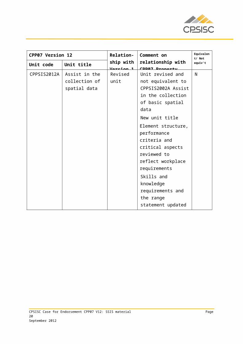
CPPSIS2012A Assist in the collection of spatial data
Revised unit Unit revised and not equivalent to CPPSIS2002A Assist in the collection of basic spatial data
New unit title
Element structure, performance criteria and critical aspects reviewed to reflect workplace requirements
Skills and knowledge requirements and the range statement updated
N
CPPSIS2013A Assist in the storage and retrieval of spatial data
Revised unit Unit revised and not equivalent to CPPSIS2003A Assist in the storage and retrieval of spatial data
Element structure, performance criteria and critical aspects reviewed to reflect workplace requirements
Skills and knowledge requirements and the range statement updated
N
CPPSIS2014A Assist in the selection, operation and maintenance of equipment and supplies
Revised unit Unit revised and not equivalent to CPPSIS2004A Assist in the selection, operation and maintenance of equipment and supplies
Element structure, performance criteria and critical aspects reviewed
N
CPSISC Case for Endorsement CPP07 V12: SSIS material Page 16September 2012
CPP07 Version 12 Relation-ship with Version 1
Comment on relationship with CPP07 Property
Equivalent/ Not equiv’t
Unit code Unit titleto reflect workplace requirements
Skills and knowledge requirements and the range statement updated
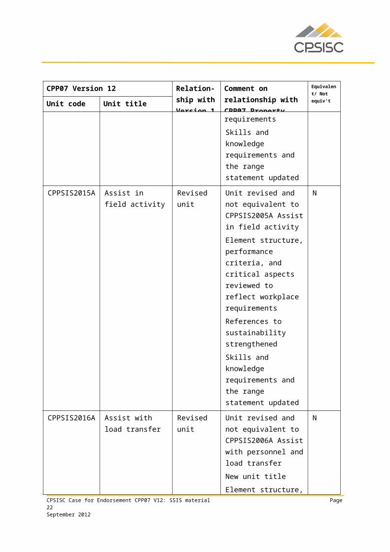
CPPSIS2015A Assist in field activity
Revised unit Unit revised and not equivalent to CPPSIS2005A Assist in field activity
Element structure, performance criteria, and critical aspects reviewed to reflect workplace requirements
References to sustainability strengthened
Skills and knowledge requirements and the range statement updated
N
CPPSIS2016A Assist with load transfer
Revised unit Unit revised and not equivalent to CPPSIS2006A Assist with personnel and load transfer
New unit title
Element structure, performance criteria and critical aspects reviewed to reflect workplace requirements
Skills and knowledge requirements and the range statement updated
N
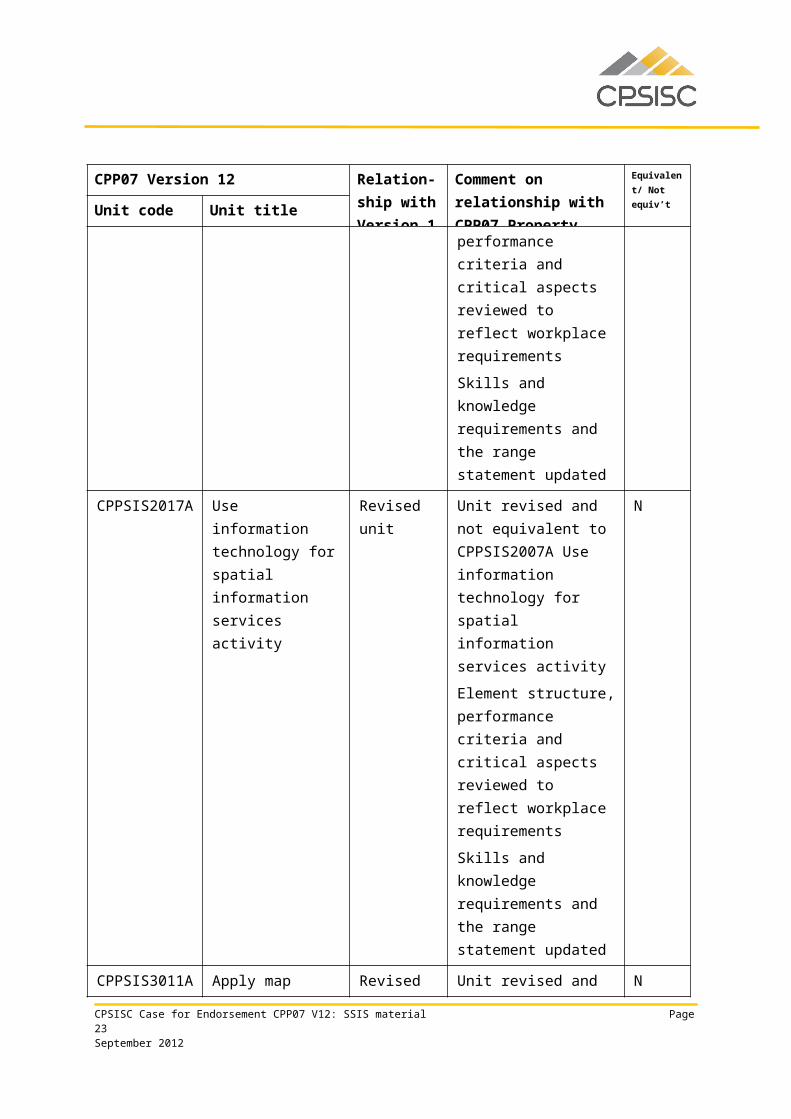
CPPSIS2017A Use information technology for spatial information services activity
Revised unit Unit revised and not equivalent to CPPSIS2007A Use information technology
N
CPSISC Case for Endorsement CPP07 V12: SSIS material Page 17September 2012
CPP07 Version 12 Relation-ship with Version 1
Comment on relationship with CPP07 Property
Equivalent/ Not equiv’t
Unit code Unit titlefor spatial information services activity
Element structure, performance criteria and critical aspects reviewed to reflect workplace requirements
Skills and knowledge requirements and the range statement updated
CPPSIS3011A Apply map presentation principles
Revised unit Unit revised and not equivalent to CPPSIS3001A Apply map presentation principles
Element structure, performance criteria and critical aspects reviewed to reflect workplace requirements
Skills and knowledge requirements and the range statement updated
N
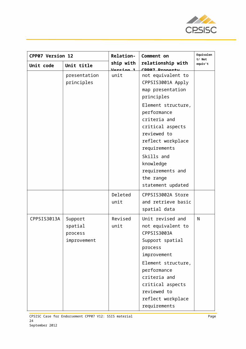
Deleted unit CPPSIS3002A Store and retrieve basic spatial data
CPPSIS3013A Support spatial process improvement
Revised unit Unit revised and not equivalent to CPPSIS3003A Support spatial process improvement
Element structure, performance criteria and critical aspects reviewed to reflect workplace requirements
Skills and knowledge requirements and the
N
CPSISC Case for Endorsement CPP07 V12: SSIS material Page 18September 2012
CPP07 Version 12 Relation-ship with Version 1
Comment on relationship with CPP07 Property
Equivalent/ Not equiv’t
Unit code Unit titlerange statement updated
References to sustainability strengthened
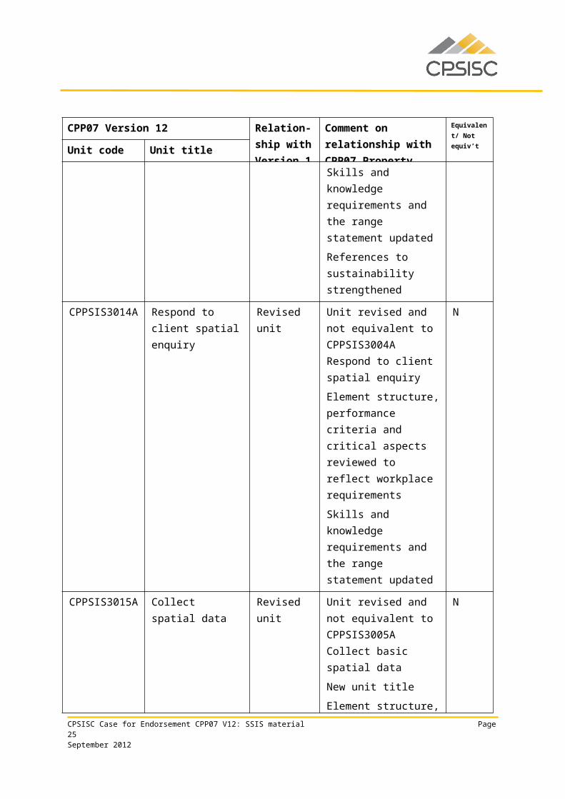
CPPSIS3014A Respond to client spatial enquiry
Revised unit Unit revised and not equivalent to CPPSIS3004A Respond to client spatial enquiry
Element structure, performance criteria and critical aspects reviewed to reflect workplace requirements
Skills and knowledge requirements and the range statement updated
N
CPPSIS3015A Collect spatial data Revised unit Unit revised and not equivalent to CPPSIS3005A Collect basic spatial data
New unit title
Element structure, performance criteria and critical aspects reviewed to reflect workplace requirements
Skills and knowledge requirements and the range statement updated
N
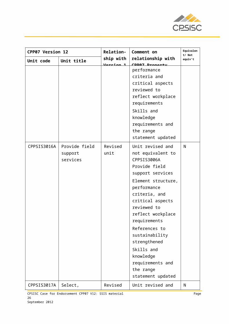
CPPSIS3016A Provide field support services
Revised unit Unit revised and not equivalent to CPPSIS3006A Provide field support services
Element structure, performance criteria, and critical aspects reviewed to reflect workplace
N
CPSISC Case for Endorsement CPP07 V12: SSIS material Page 19September 2012
CPP07 Version 12 Relation-ship with Version 1
Comment on relationship with CPP07 Property
Equivalent/ Not equiv’t
Unit code Unit titlerequirements
References to sustainability strengthened
Skills and knowledge requirements and the range statement updated
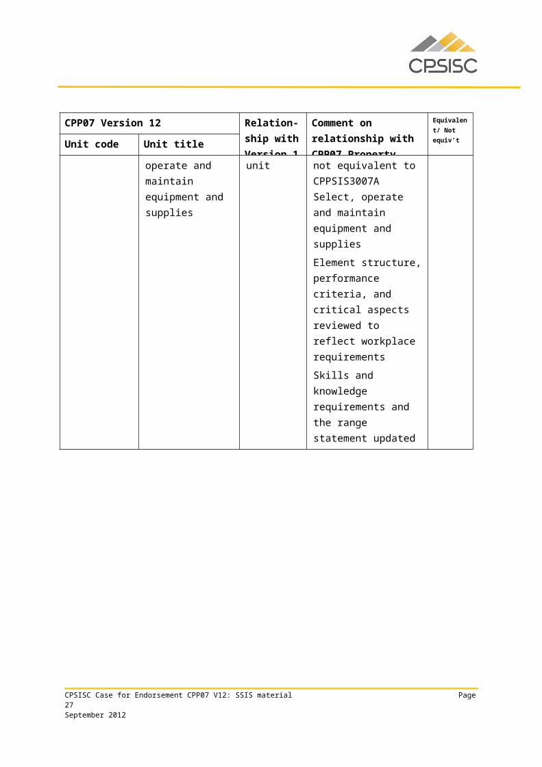
CPPSIS3017A Select, operate and maintain equipment and supplies
Revised unit Unit revised and not equivalent to CPPSIS3007A Select, operate and maintain equipment and supplies
Element structure, performance criteria, and critical aspects reviewed to reflect workplace requirements
Skills and knowledge requirements and the range statement updated
N
CPPSIS3018A Transfer personnel and loads
Revised unit Unit revised and not equivalent to CPPSIS3008A Transfer personnel and loads
Element structure, performance criteria, and critical aspects reviewed to reflect workplace requirements
Skills and knowledge requirements and the range statement updated
N
CPPSIS3019A Perform basic drafting
Revised unit Unit revised and not equivalent to CPPSIS3009A Perform basic drafting
Element structure, performance criteria, and
N
CPSISC Case for Endorsement CPP07 V12: SSIS material Page 20September 2012

CPP07 Version 12 Relation-ship with Version 1
Comment on relationship with CPP07 Property
Equivalent/ Not equiv’t
Unit code Unit titlecritical aspects reviewed to reflect workplace requirements
Skills and knowledge requirements and the range statement updated
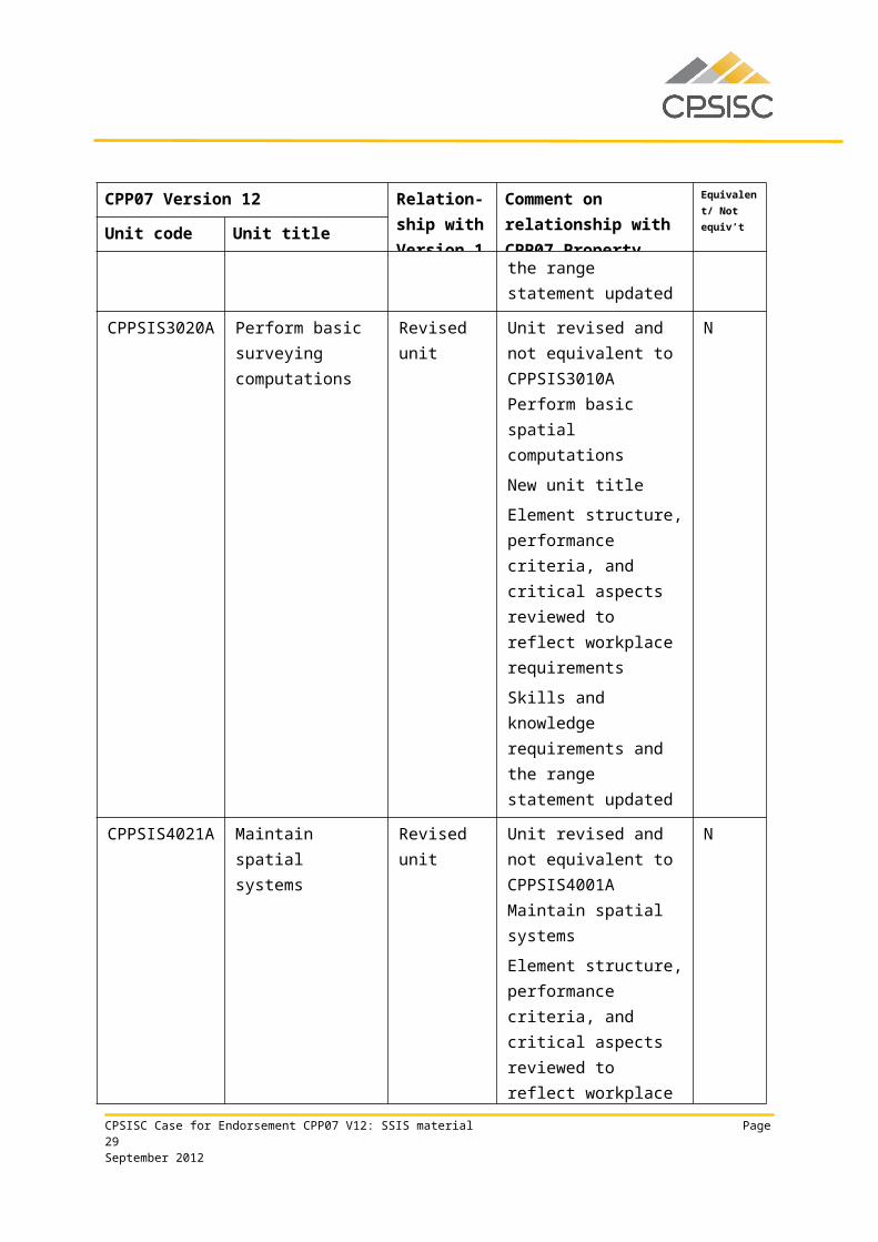
CPPSIS3020A Perform basic surveying computations
Revised unit Unit revised and not equivalent to CPPSIS3010A Perform basic spatial computations
New unit title
Element structure, performance criteria, and critical aspects reviewed to reflect workplace requirements
Skills and knowledge requirements and the range statement updated
N
CPPSIS4021A Maintain spatial systems
Revised unit Unit revised and not equivalent to CPPSIS4001A Maintain spatial systems
Element structure, performance criteria, and critical aspects reviewed to reflect workplace requirements
Skills and knowledge requirements and the range statement updated
N
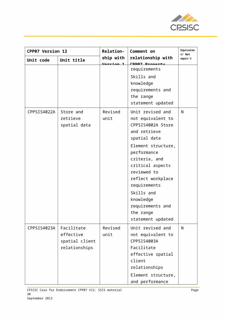
CPPSIS4022A Store and retrieve spatial data
Revised unit Unit revised and not equivalent to CPPSIS4002A Store and retrieve spatial data
Element structure, performance criteria, and
N
CPSISC Case for Endorsement CPP07 V12: SSIS material Page 21September 2012
CPP07 Version 12 Relation-ship with Version 1
Comment on relationship with CPP07 Property
Equivalent/ Not equiv’t
Unit code Unit titlecritical aspects reviewed to reflect workplace requirements
Skills and knowledge requirements and the range statement updated
CPPSIS4023A Facilitate effective spatial client relationships
Revised unit Unit revised and not equivalent to CPPSIS4003A Facilitate effective spatial client relationships
Element structure, and performance criteria, reviewed to reflect workplace requirements
Skills and knowledge requirements and the range statement updated
N
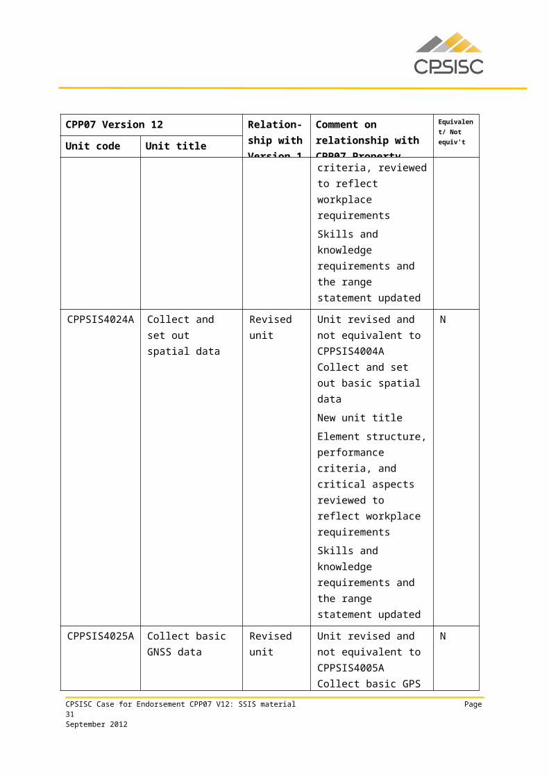
CPPSIS4024A Collect and set out spatial data
Revised unit Unit revised and not equivalent to CPPSIS4004A Collect and set out basic spatial data
New unit title
Element structure, performance criteria, and critical aspects reviewed to reflect workplace requirements
Skills and knowledge requirements and the range statement updated
N
CPPSIS4025A Collect basic GNSS data
Revised unit Unit revised and not equivalent to CPPSIS4005A Collect basic GPS data
New unit title
Terminology updated
N
CPSISC Case for Endorsement CPP07 V12: SSIS material Page 22September 2012
CPP07 Version 12 Relation-ship with Version 1
Comment on relationship with CPP07 Property
Equivalent/ Not equiv’t
Unit code Unit titleElement structure, performance criteria, and critical aspects reviewed to reflect workplace requirements
Skills and knowledge requirements and the range statement updated
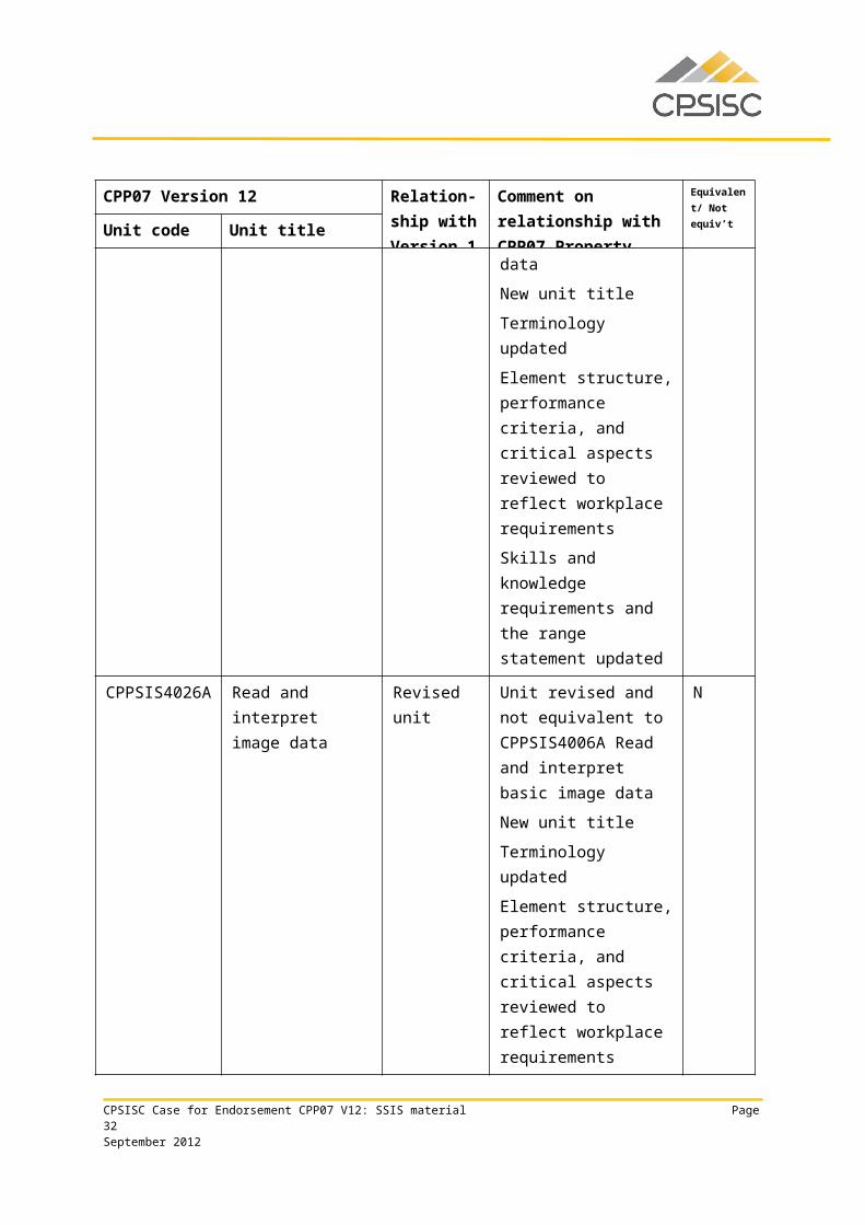
CPPSIS4026A Read and interpret image data
Revised unit Unit revised and not equivalent to CPPSIS4006A Read and interpret basic image data
New unit title
Terminology updated
Element structure, performance criteria, and critical aspects reviewed to reflect workplace requirements
Skills and knowledge requirements and the range statement updated
N
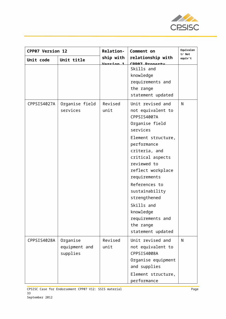
CPPSIS4027A Organise field services
Revised unit Unit revised and not equivalent to CPPSIS4007A Organise field services
Element structure, performance criteria, and critical aspects reviewed to reflect workplace requirements
References to sustainability strengthened
Skills and knowledge requirements and the range statement updated
N
CPSISC Case for Endorsement CPP07 V12: SSIS material Page 23September 2012
CPP07 Version 12 Relation-ship with Version 1
Comment on relationship with CPP07 Property
Equivalent/ Not equiv’t
Unit code Unit titleCPPSIS4028A Organise equipment
and suppliesRevised unit Unit revised and not
equivalent to CPPSIS4008A Organise equipment and supplies
Element structure, performance criteria, and critical aspects reviewed to reflect workplace requirements
Skills and knowledge requirements and the range statement updated
N
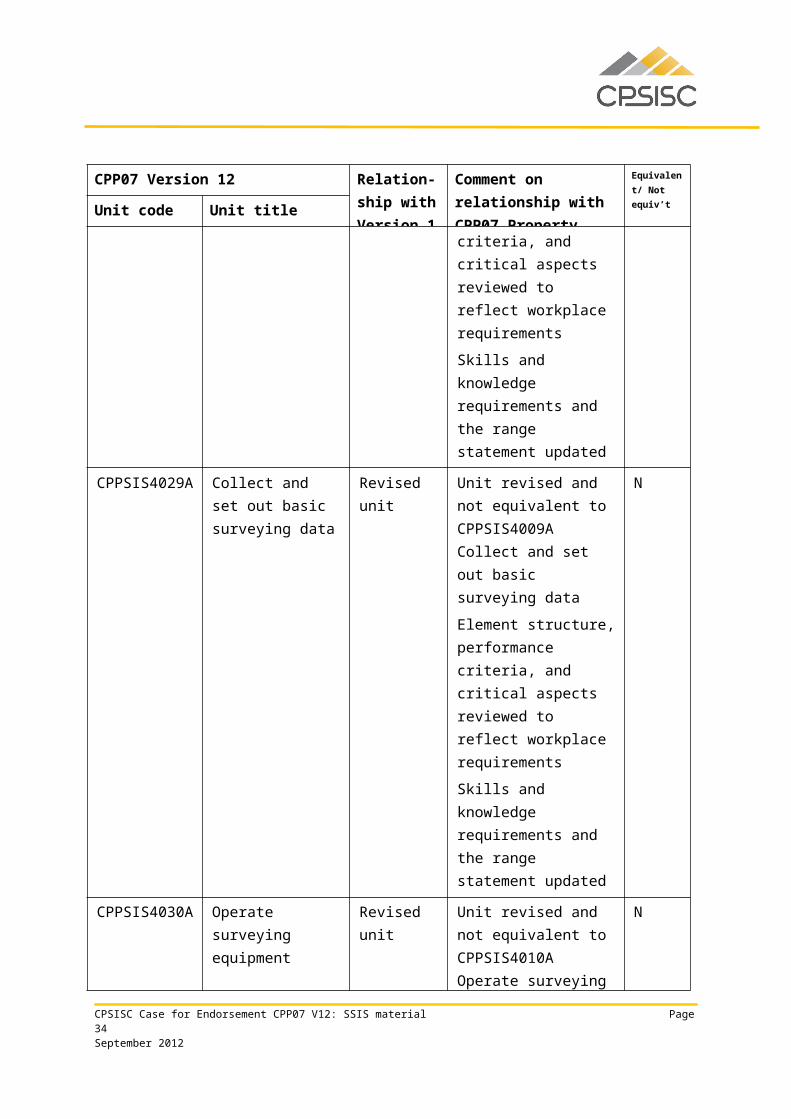
CPPSIS4029A Collect and set out basic surveying data
Revised unit Unit revised and not equivalent to CPPSIS4009A Collect and set out basic surveying data
Element structure, performance criteria, and critical aspects reviewed to reflect workplace requirements
Skills and knowledge requirements and the range statement updated
N
CPPSIS4030A Operate surveying equipment
Revised unit Unit revised and not equivalent to CPPSIS4010A Operate surveying equipment
Element structure, performance criteria, and critical aspects reviewed to reflect workplace requirements
Skills and knowledge requirements and the range statement updated
N
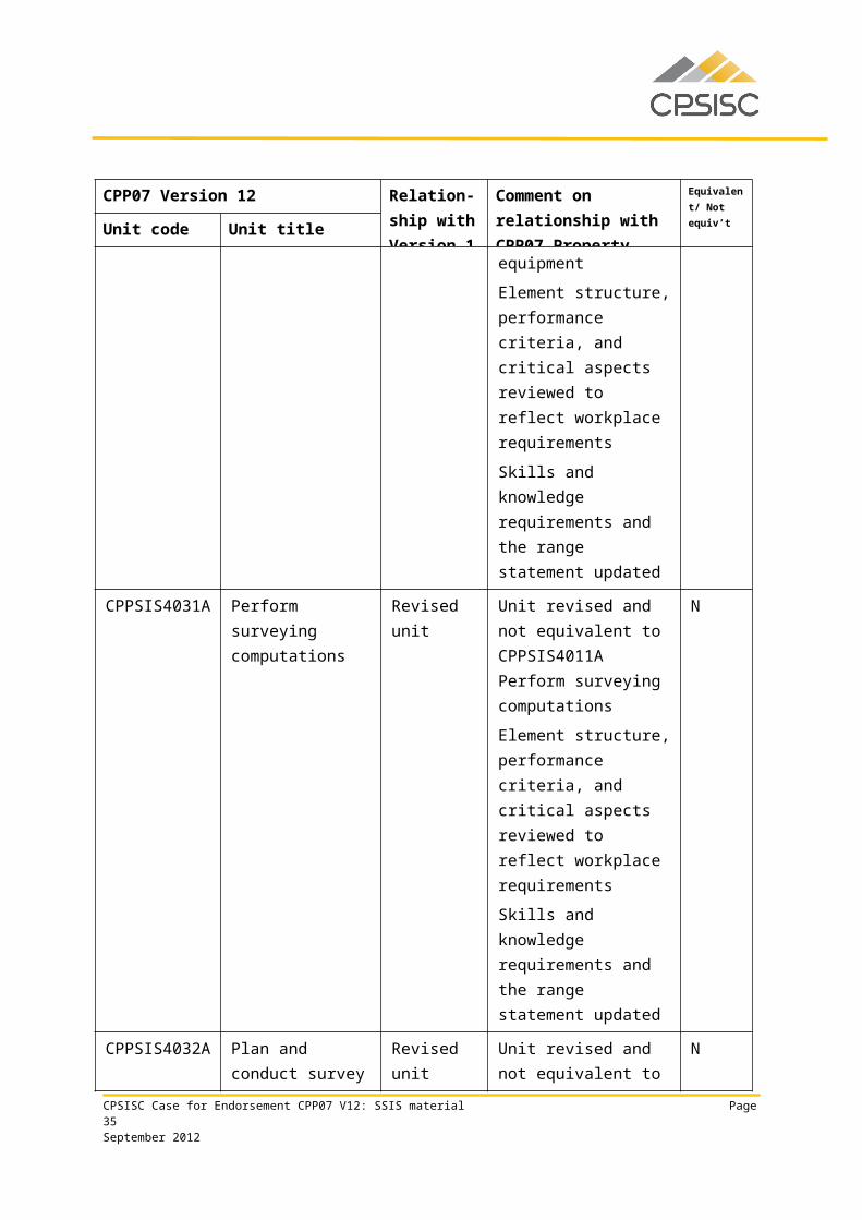
CPPSIS4031A Perform surveying Revised unit Unit revised and not N
CPSISC Case for Endorsement CPP07 V12: SSIS material Page 24September 2012
CPP07 Version 12 Relation-ship with Version 1
Comment on relationship with CPP07 Property
Equivalent/ Not equiv’t
Unit code Unit titlecomputations equivalent to
CPPSIS4011A Perform surveying computations
Element structure, performance criteria, and critical aspects reviewed to reflect workplace requirements
Skills and knowledge requirements and the range statement updated
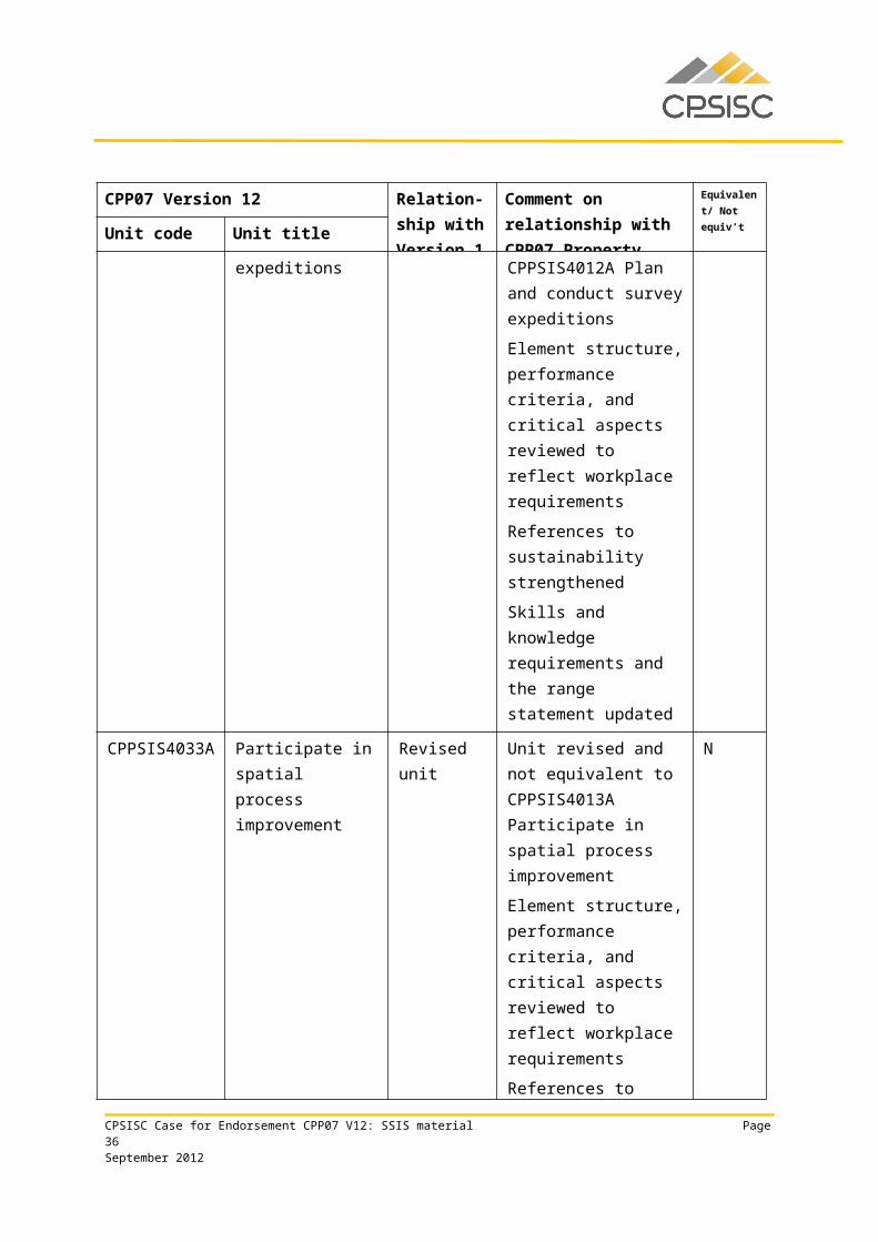
CPPSIS4032A Plan and conduct survey expeditions
Revised unit Unit revised and not equivalent to CPPSIS4012A Plan and conduct survey expeditions
Element structure, performance criteria, and critical aspects reviewed to reflect workplace requirements
References to sustainability strengthened
Skills and knowledge requirements and the range statement updated
N
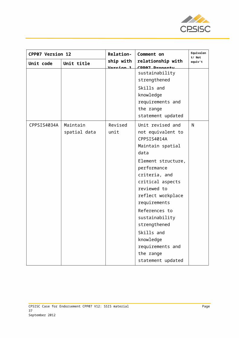
CPPSIS4033A Participate in spatial process improvement
Revised unit Unit revised and not equivalent to CPPSIS4013A Participate in spatial process improvement
Element structure, performance criteria, and critical aspects reviewed to reflect workplace requirements
References to
N
CPSISC Case for Endorsement CPP07 V12: SSIS material Page 25September 2012
CPP07 Version 12 Relation-ship with Version 1
Comment on relationship with CPP07 Property
Equivalent/ Not equiv’t
Unit code Unit titlesustainability strengthened
Skills and knowledge requirements and the range statement updated
CPPSIS4034A Maintain spatial data
Revised unit Unit revised and not equivalent to CPPSIS4014A Maintain spatial data
Element structure, performance criteria, and critical aspects reviewed to reflect workplace requirements
References to sustainability strengthened
Skills and knowledge requirements and the range statement updated
N
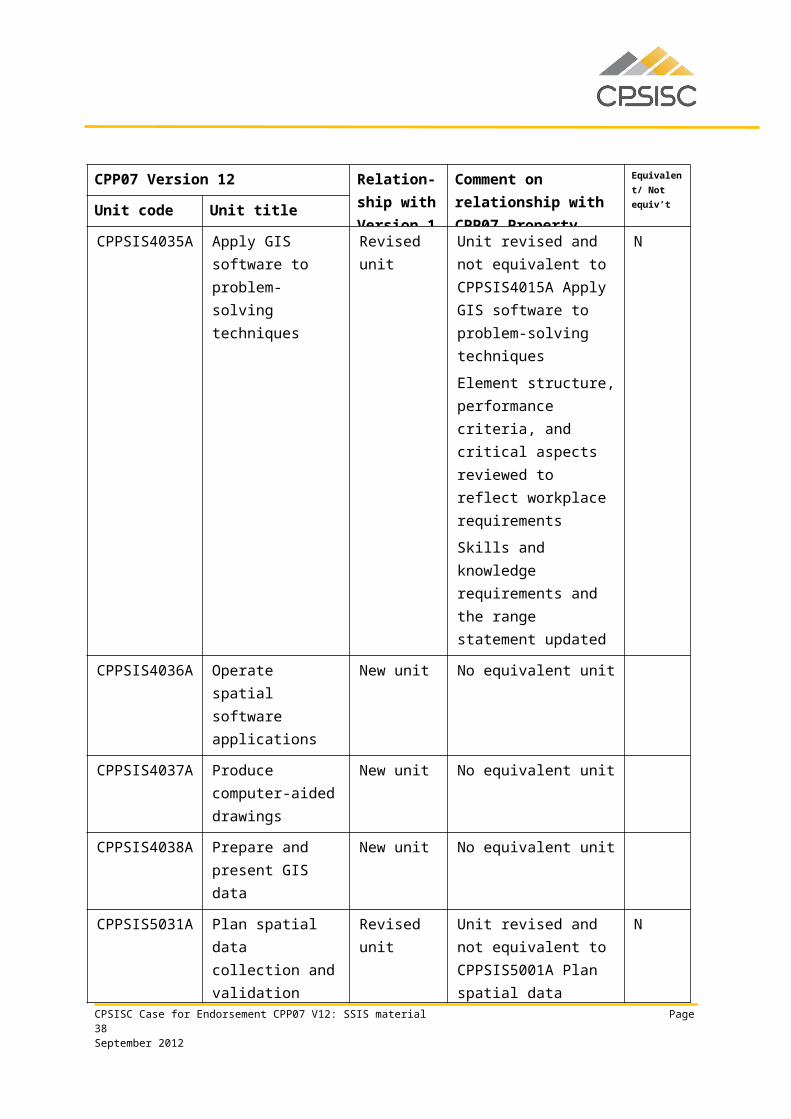
CPPSIS4035A Apply GIS software to problem-solving techniques
Revised unit Unit revised and not equivalent to CPPSIS4015A Apply GIS software to problem-solving techniques
Element structure, performance criteria, and critical aspects reviewed to reflect workplace requirements
Skills and knowledge requirements and the range statement updated
N
CPPSIS4036A Operate spatial software applications
New unit No equivalent unit
CPPSIS4037A Produce computer- New unit No equivalent unit
CPSISC Case for Endorsement CPP07 V12: SSIS material Page 26September 2012
CPP07 Version 12 Relation-ship with Version 1
Comment on relationship with CPP07 Property
Equivalent/ Not equiv’t
Unit code Unit titleaided drawings
CPPSIS4038A Prepare and present GIS data
New unit No equivalent unit
CPPSIS5031A Plan spatial data collection and validation
Revised unit Unit revised and not equivalent to CPPSIS5001A Plan spatial data collection and validation
Element structure, performance criteria, and critical aspects reviewed to reflect workplace requirements
Skills and knowledge requirements and the range statement updated
N
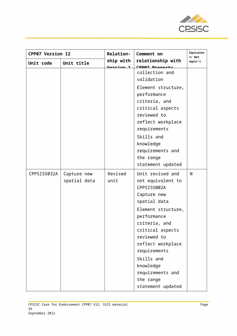
CPPSIS5032A Capture new spatial data
Revised unit Unit revised and not equivalent to CPPSIS5002A Capture new spatial data
Element structure, performance criteria, and critical aspects reviewed to reflect workplace requirements
Skills and knowledge requirements and the range statement updated
N
CPSISC Case for Endorsement CPP07 V12: SSIS material Page 27September 2012
CPP07 Version 12 Relation-ship with Version 1
Comment on relationship with CPP07 Property
Equivalent/ Not equiv’t
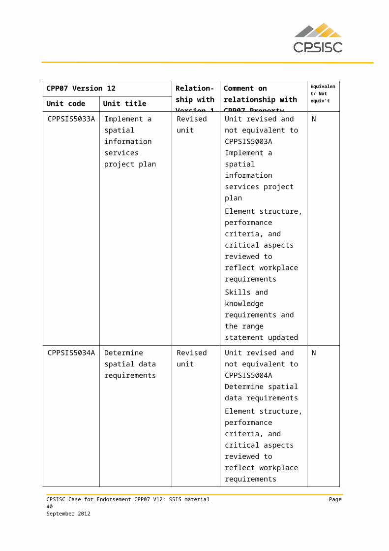
Unit code Unit titleCPPSIS5033A Implement a spatial
information services project plan
Revised unit Unit revised and not equivalent to CPPSIS5003A Implement a spatial information services project plan
Element structure, performance criteria, and critical aspects reviewed to reflect workplace requirements
Skills and knowledge requirements and the range statement updated
N
CPPSIS5034A Determine spatial data requirements
Revised unit Unit revised and not equivalent to CPPSIS5004A Determine spatial data requirements
Element structure, performance criteria, and critical aspects reviewed to reflect workplace requirements
Skills and knowledge requirements and the range statement updated
N
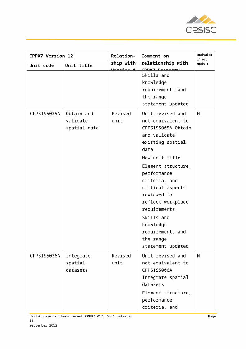
CPPSIS5035A Obtain and validate spatial data
Revised unit Unit revised and not equivalent to CPPSIS5005A Obtain and validate existing spatial data
New unit title
Element structure, performance criteria, and critical aspects reviewed to reflect workplace requirements
Skills and knowledge
N
CPSISC Case for Endorsement CPP07 V12: SSIS material Page 28September 2012
CPP07 Version 12 Relation-ship with Version 1
Comment on relationship with CPP07 Property
Equivalent/ Not equiv’t
Unit code Unit titlerequirements and the range statement updated
CPPSIS5036A Integrate spatial datasets
Revised unit Unit revised and not equivalent to CPPSIS5006A Integrate spatial datasets
Element structure, performance criteria, and critical aspects reviewed to reflect workplace requirements
Skills and knowledge requirements and the range statement updated
N
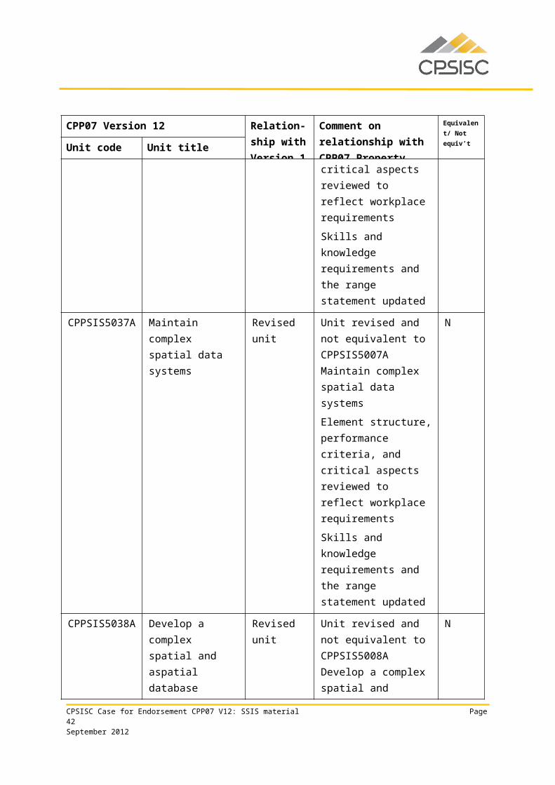
CPPSIS5037A Maintain complex spatial data systems
Revised unit Unit revised and not equivalent to CPPSIS5007A Maintain complex spatial data systems
Element structure, performance criteria, and critical aspects reviewed to reflect workplace requirements
Skills and knowledge requirements and the range statement updated
N
CPPSIS5038A Develop a complex spatial and aspatial database
Revised unit Unit revised and not equivalent to CPPSIS5008A Develop a complex spatial and aspatial database
Element structure, performance criteria, and critical aspects reviewed to reflect workplace requirements
N
CPSISC Case for Endorsement CPP07 V12: SSIS material Page 29September 2012
CPP07 Version 12 Relation-ship with Version 1
Comment on relationship with CPP07 Property
Equivalent/ Not equiv’t
Unit code Unit titleSkills and knowledge requirements and the range statement updated
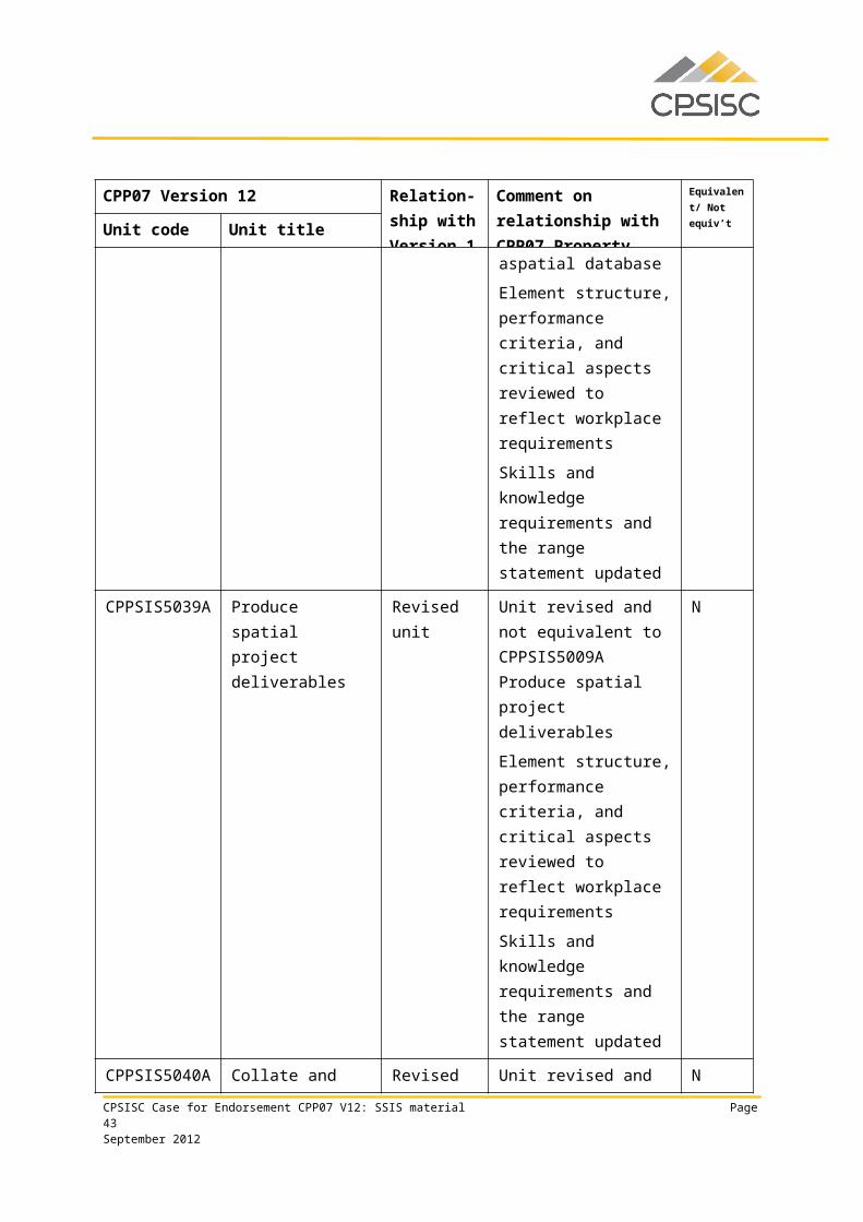
CPPSIS5039A Produce spatial project deliverables
Revised unit Unit revised and not equivalent to CPPSIS5009A Produce spatial project deliverables
Element structure, performance criteria, and critical aspects reviewed to reflect workplace requirements
Skills and knowledge requirements and the range statement updated
N
CPPSIS5040A Collate and interpret spatial data
Revised unit Unit revised and not equivalent to CPPSIS5010A Collate and interpret spatial data
Element structure, performance criteria, and critical aspects reviewed to reflect workplace requirements
Skills and knowledge requirements and the range statement updated
N
CPPSIS5041A Monitor and control the spatial components of projects
Revised unit Unit revised and not equivalent to CPPSIS5011A Monitor and control the spatial components of projects
Element structure, performance criteria, and critical aspects reviewed to reflect workplace requirements
N
CPSISC Case for Endorsement CPP07 V12: SSIS material Page 30September 2012
CPP07 Version 12 Relation-ship with Version 1
Comment on relationship with CPP07 Property
Equivalent/ Not equiv’t
Unit code Unit titleReferences to sustainability strengthened
Skills and knowledge requirements and the range statement updated
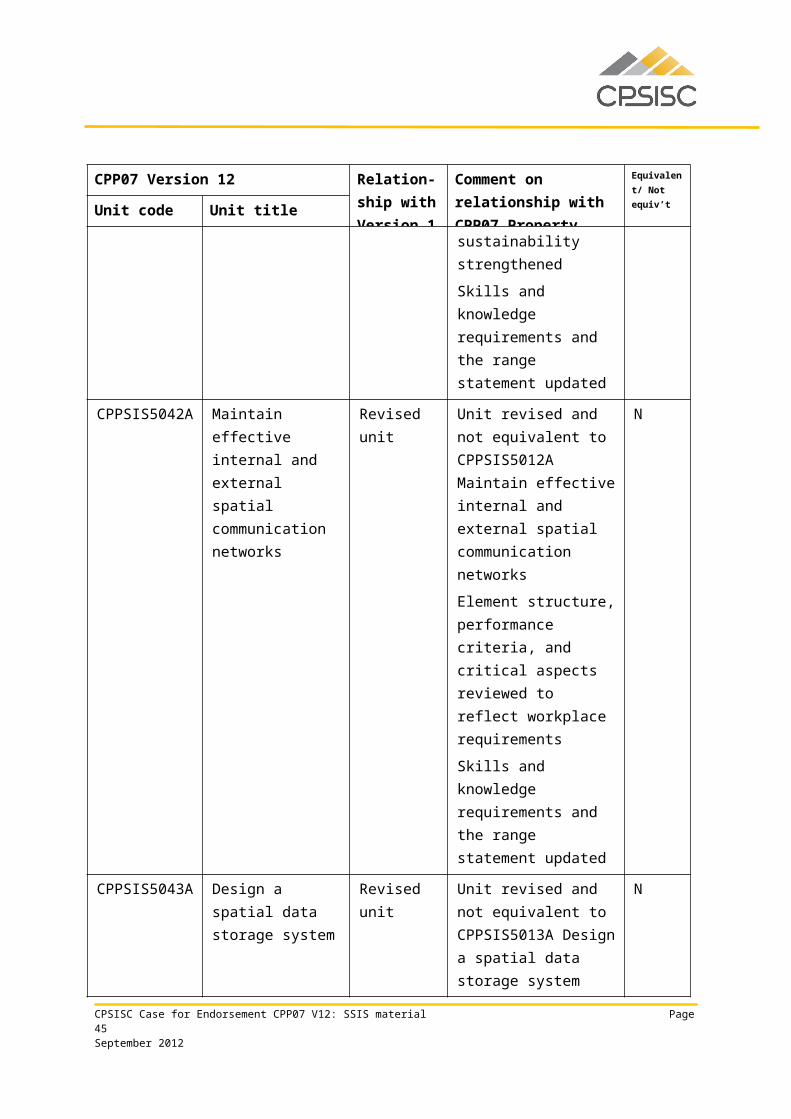
CPPSIS5042A Maintain effective internal and external spatial communication networks
Revised unit Unit revised and not equivalent to CPPSIS5012A Maintain effective internal and external spatial communication networks
Element structure, performance criteria, and critical aspects reviewed to reflect workplace requirements
Skills and knowledge requirements and the range statement updated
N
CPPSIS5043A Design a spatial data storage system
Revised unit Unit revised and not equivalent to CPPSIS5013A Design a spatial data storage system
Element structure, performance criteria, and critical aspects reviewed to reflect workplace requirements
Skills and knowledge requirements and the range statement updated
N
CPSISC Case for Endorsement CPP07 V12: SSIS material Page 31September 2012
CPP07 Version 12 Relation-ship with Version 1
Comment on relationship with CPP07 Property
Equivalent/ Not equiv’t
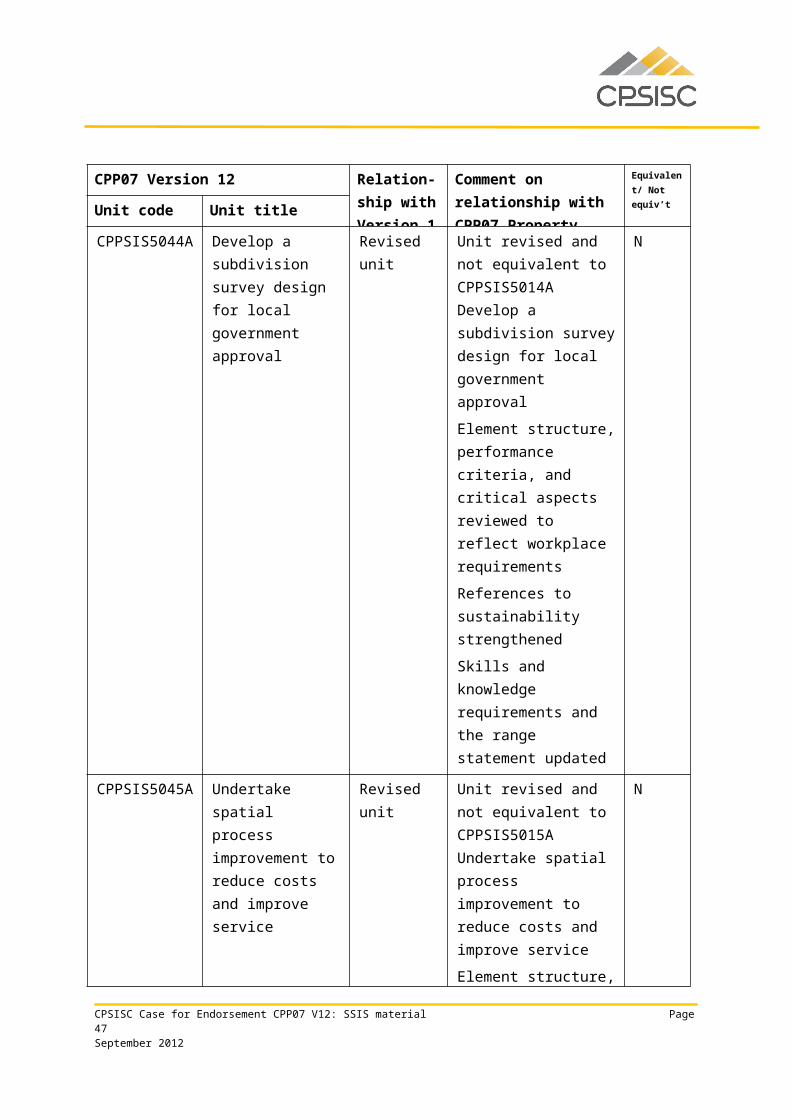
Unit code Unit titleCPPSIS5044A Develop a
subdivision survey design for local government approval
Revised unit Unit revised and not equivalent to CPPSIS5014A Develop a subdivision survey design for local government approval
Element structure, performance criteria, and critical aspects reviewed to reflect workplace requirements
References to sustainability strengthened
Skills and knowledge requirements and the range statement updated
N
CPPSIS5045A Undertake spatial process improvement to reduce costs and improve service
Revised unit Unit revised and not equivalent to CPPSIS5015A Undertake spatial process improvement to reduce costs and improve service
Element structure, performance criteria, and critical aspects reviewed to reflect workplace requirements
References to sustainability strengthened
Skills and knowledge requirements and the range statement updated
N
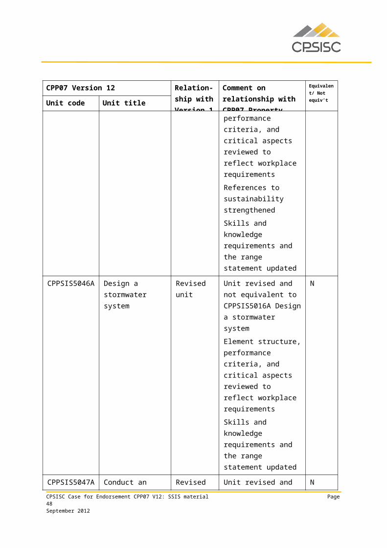
CPPSIS5046A Design a stormwater system
Revised unit Unit revised and not equivalent to CPPSIS5016A Design a
N
CPSISC Case for Endorsement CPP07 V12: SSIS material Page 32September 2012
CPP07 Version 12 Relation-ship with Version 1
Comment on relationship with CPP07 Property
Equivalent/ Not equiv’t
Unit code Unit titlestormwater system
Element structure, performance criteria, and critical aspects reviewed to reflect workplace requirements
Skills and knowledge requirements and the range statement updated
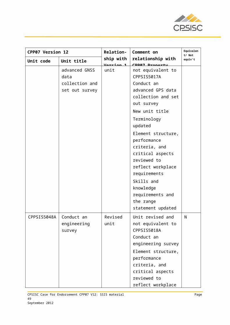
CPPSIS5047A Conduct an advanced GNSS data collection and set out survey
Revised unit Unit revised and not equivalent to CPPSIS5017A Conduct an advanced GPS data collection and set out survey
New unit title
Terminology updated
Element structure, performance criteria, and critical aspects reviewed to reflect workplace requirements
Skills and knowledge requirements and the range statement updated
N
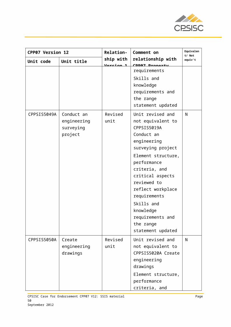
CPPSIS5048A Conduct an engineering survey
Revised unit Unit revised and not equivalent to CPPSIS5018A Conduct an engineering survey
Element structure, performance criteria, and critical aspects reviewed to reflect workplace requirements
Skills and knowledge requirements and the range statement updated
N
CPSISC Case for Endorsement CPP07 V12: SSIS material Page 33September 2012
CPP07 Version 12 Relation-ship with Version 1
Comment on relationship with CPP07 Property
Equivalent/ Not equiv’t
Unit code Unit titleCPPSIS5049A Conduct an
engineering surveying project
Revised unit Unit revised and not equivalent to CPPSIS5019A Conduct an engineering surveying project
Element structure, performance criteria, and critical aspects reviewed to reflect workplace requirements
Skills and knowledge requirements and the range statement updated
N
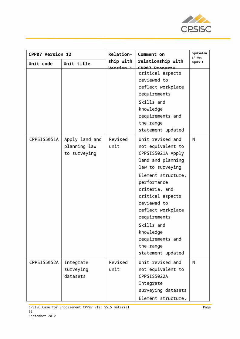
CPPSIS5050A Create engineering drawings
Revised unit Unit revised and not equivalent to CPPSIS5020A Create engineering drawings
Element structure, performance criteria, and critical aspects reviewed to reflect workplace requirements
Skills and knowledge requirements and the range statement updated
N
CPSISC Case for Endorsement CPP07 V12: SSIS material Page 34September 2012
CPP07 Version 12 Relation-ship with Version 1
Comment on relationship with CPP07 Property
Equivalent/ Not equiv’t
Unit code Unit titleCPPSIS5051A Apply land and
planning law to surveying
Revised unit Unit revised and not equivalent to CPPSIS5021A Apply land and planning law to surveying
Element structure, performance criteria, and critical aspects reviewed to reflect workplace requirements
Skills and knowledge requirements and the range statement updated
N
CPPSIS5052A Integrate surveying datasets
Revised unit Unit revised and not equivalent to CPPSIS5022A Integrate surveying datasets
Element structure, performance criteria, and critical aspects reviewed to reflect workplace requirements
Skills and knowledge requirements and the range statement updated
N
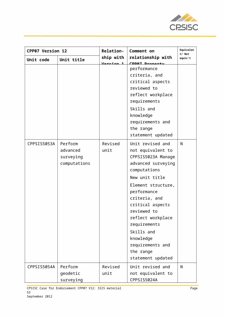
CPPSIS5053A Perform advanced surveying computations
Revised unit Unit revised and not equivalent to CPPSIS5023A Manage advanced surveying computations
New unit title
Element structure, performance criteria, and critical aspects reviewed to reflect workplace requirements
Skills and knowledge requirements and the
N
CPSISC Case for Endorsement CPP07 V12: SSIS material Page 35September 2012
CPP07 Version 12 Relation-ship with Version 1
Comment on relationship with CPP07 Property
Equivalent/ Not equiv’t
Unit code Unit titlerange statement updated
CPPSIS5054A Perform geodetic surveying computations
Revised unit Unit revised and not equivalent to CPPSIS5024A Perform geodetic surveying computations
Element structure and performance criteria reviewed to reflect workplace requirements
Skills and knowledge requirements and the range statement updated
N
CPPSIS5055A Plan and conduct major survey expeditions
Revised unit Unit revised and not equivalent to CPPSIS5025A Plan and conduct major survey expeditions
Element structure, performance criteria, and critical aspects reviewed to reflect workplace requirements
Skills and knowledge requirements and the range statement updated
N
CPPSIS5056A Design road and railway
Revised unit Unit revised and not equivalent to CPPSIS5026A Design road and railway
Element structure, performance criteria, and critical aspects reviewed to reflect workplace requirements
Skills and knowledge requirements and the
N
CPSISC Case for Endorsement CPP07 V12: SSIS material Page 36September 2012
CPP07 Version 12 Relation-ship with Version 1
Comment on relationship with CPP07 Property
Equivalent/ Not equiv’t
Unit code Unit titlerange statement updated
CPPSIS5057A Carry out a precision survey
Revised unit Unit revised and not equivalent to CPPSIS5027A Carry out a precision survey
Element structure, performance criteria, and critical aspects reviewed to reflect workplace requirements
Skills and knowledge requirements and the range statement updated
N
CPPSIS5058A Conduct geodetic surveying
Revised unit Unit revised and not equivalent to CPPSIS5028A Conduct geodetic surveying
Element structure and performance criteria reviewed to reflect workplace requirements
Skills and knowledge requirements and the range statement updated
N
CPSISC Case for Endorsement CPP07 V12: SSIS material Page 37September 2012
CPP07 Version 12 Relation-ship with Version 1
Comment on relationship with CPP07 Property
Equivalent/ Not equiv’t
Unit code Unit titleCPPSIS5059A Determine suitable
information sources to create new spatial datasets
Revised unit Unit revised and not equivalent to CPPSIS5029A Determine suitable information sources to create new spatial datasets
Element structure and performance criteria reviewed to reflect workplace requirements
Skills and knowledge requirements and the range statement updated
N
CPPSIS5060A Use complex spreadsheets for spatial information
New unit No equivalent unit
CPPSIS5061A Locate underground services in surveying practice
New unit No equivalent unit
CPPSIS5062A Conduct photogrammetric mapping
New unit No equivalent unit
CPPSIS5063A Produce GIS data New unit No equivalent unit
CPPSIS5064A Manipulate and analyse GIS data
New unit No equivalent unit
CPPSIS6021A Conduct open mine pit surveying
Revised unit Unit revised and not equivalent to CPPSIS6001A Conduct open mine pit surveying
Element structure, performance criteria, and critical aspects reviewed to reflect workplace requirements
Skills and knowledge requirements and the range statement updated
N
CPSISC Case for Endorsement CPP07 V12: SSIS material Page 38September 2012
CPP07 Version 12 Relation-ship with Version 1
Comment on relationship with CPP07 Property
Equivalent/ Not equiv’t
Unit code Unit titleCPPSIS6022A Create mine
drawingsRevised unit Unit revised and not
equivalent to CPPSIS6002A Create mine drawings
Element structure, performance criteria, and critical aspects reviewed to reflect workplace requirements
Skills and knowledge requirements and the range statement updated
N
CPPSIS6023A Determine client spatial requirements
Revised unit Unit revised and not equivalent to CPPSIS6003A Determine client spatial requirements
Element structure, performance criteria, and critical aspects reviewed to reflect workplace requirements
Skills and knowledge requirements and the range statement updated
N
CPPSIS6024A Design a spatial project plan
Revised unit Unit revised and not equivalent to CPPSIS6004A Design a spatial project plan
Element structure, performance criteria, and critical aspects reviewed to reflect workplace requirements
Skills and knowledge requirements and the range statement updated
N
CPPSIS6025A Apply quality Revised unit Unit revised and not N
CPSISC Case for Endorsement CPP07 V12: SSIS material Page 39September 2012
CPP07 Version 12 Relation-ship with Version 1
Comment on relationship with CPP07 Property
Equivalent/ Not equiv’t
Unit code Unit titlecontrol measures to spatial information services industry
equivalent to CPPSIS6005A Apply quality control measures to spatial information services industry
Element structure, performance criteria, and critical aspects reviewed to reflect workplace requirements
Skills and knowledge requirements and the range statement updated
CPPSIS6026A Develop and maintain spatial information services contractual relationships
Revised unit Unit revised and not equivalent to CPPSIS6006A Develop and maintain spatial information services contractual relationships
Element structure, performance criteria, and critical aspects reviewed to reflect workplace requirements
References to sustainability strengthened
Skills and knowledge requirements and the range statement updated
N
CPPSIS6027A Design spatial information services project deliverables
Revised unit Unit revised and not equivalent to CPPSIS6007A Design spatial information services project deliverables
Element structure, performance criteria, and
N
CPSISC Case for Endorsement CPP07 V12: SSIS material Page 40September 2012
CPP07 Version 12 Relation-ship with Version 1
Comment on relationship with CPP07 Property
Equivalent/ Not equiv’t
Unit code Unit titlecritical aspects reviewed to reflect workplace requirements
References to sustainability strengthened
Skills and knowledge requirements and the range statement updated
CPPSIS6028A Conduct design and set out survey
Revised unit Unit revised and not equivalent to CPPSIS6008A Conduct design and set out survey
Element structure, performance criteria, and critical aspects reviewed to reflect workplace requirements
Skills and knowledge requirements and the range statement updated
N
CPPSIS6029A Educate the public on spatial information services
Revised unit Unit revised and not equivalent to CPPSIS6009A Educate the public on spatial information services
Element structure, performance criteria, and critical aspects reviewed to reflect workplace requirements
Skills and knowledge requirements and the range statement updated
N
CPPSIS6030A Undertake spatial information services research and development
Revised unit Unit revised and not equivalent to CPPSIS6010A Undertake spatial information
N
CPSISC Case for Endorsement CPP07 V12: SSIS material Page 41September 2012
CPP07 Version 12 Relation-ship with Version 1
Comment on relationship with CPP07 Property
Equivalent/ Not equiv’t
Unit code Unit titleservices research and development
Element structure, performance criteria, and critical aspects reviewed to reflect workplace requirements
References to sustainability strengthened
Skills and knowledge requirements and the range statement updated
CPPSIS6031A Carry out basic mine design
Revised unit Unit revised and not equivalent to CPPSIS6011A Carry out basic mine design
Element structure, performance criteria, and critical aspects reviewed to reflect workplace requirements
References to sustainability strengthened
Skills and knowledge requirements and the range statement updated
N
CPPSIS6032A Conduct an advanced GNSS control survey
Revised unit Unit revised and not equivalent to CPPSIS6012A Conduct an advanced GPS control survey
New unit title
Terminology updated
Element structure, performance criteria, and critical aspects reviewed
N
CPSISC Case for Endorsement CPP07 V12: SSIS material Page 42September 2012
CPP07 Version 12 Relation-ship with Version 1
Comment on relationship with CPP07 Property
Equivalent/ Not equiv’t
Unit code Unit titleto reflect workplace requirements
Skills and knowledge requirements and the range statement updated
CPPSIS6033A Conduct underground mine surveying
Revised unit Unit revised and not equivalent to CPPSIS6013A Conduct underground mine surveying
Element structure, performance criteria, and critical aspects reviewed to reflect workplace requirements
References to sustainability strengthened
Skills and knowledge requirements and the range statement updated
N
CPPSIS6034A Conduct mining geology operations
Revised unit Unit revised and not equivalent to CPPSIS6014A Conduct mining geology operations
Element structure, performance criteria, and critical aspects reviewed to reflect workplace requirements
References to sustainability strengthened
Skills and knowledge requirements and the range statement updated
N
CPPSIS6035A Conduct complex Revised unit Unit revised and not NCPSISC Case for Endorsement CPP07 V12: SSIS material Page 43September 2012

CPP07 Version 12 Relation-ship with Version 1
Comment on relationship with CPP07 Property
Equivalent/ Not equiv’t
Unit code Unit titleengineering set out surveys
equivalent to CPPSIS6015A Conduct complex engineering set out surveys
Element structure, performance criteria, and critical aspects reviewed to reflect workplace requirements
Skills and knowledge requirements and the range statement updated
CPPSIS6036A Monitor complex engineering surveying structures
Revised unit Unit revised and not equivalent to CPPSIS6016A Monitor complex engineering surveying structures
Element structure, performance criteria, and critical aspects reviewed to reflect workplace requirements
Skills and knowledge requirements and the range statement updated
N
CPPSIS6037A Conduct advanced remote sensing analysis
Revised unit Unit revised and not equivalent to CPPSIS6017A Conduct advanced remote sensing analysis
Element structure, performance criteria, and critical aspects reviewed to reflect workplace requirements
Skills and knowledge requirements and the range statement updated
N
CPSISC Case for Endorsement CPP07 V12: SSIS material Page 44September 2012
CPP07 Version 12 Relation-ship with Version 1
Comment on relationship with CPP07 Property
Equivalent/ Not equiv’t
Unit code Unit titleCPPSIS6038A Design spatial
networks and geocoding
Revised unit Unit revised and not equivalent to CPPSIS6018A Design spatial networks and geocoding
Element structure, performance criteria, and critical aspects reviewed to reflect workplace requirements
Skills and knowledge requirements and the range statement updated
N
CPPSIS6039A Develop distributed mapping applications
Revised unit Unit revised and not equivalent to CPPSIS6019A Develop distributed mapping applications
Element structure, performance criteria, and critical aspects reviewed to reflect workplace requirements
Skills and knowledge requirements and the range statement updated
N
CPPSIS6040A Develop 2-D and 3-D terrain visualisations
Revised unit Unit revised and not equivalent to CPPSIS6020A Develop 2-D and 3-D terrain visualisations
Element structure, performance criteria, and critical aspects reviewed to reflect workplace requirements
Skills and knowledge requirements and the
N
CPSISC Case for Endorsement CPP07 V12: SSIS material Page 45September 2012
CPP07 Version 12 Relation-ship with Version 1
Comment on relationship with CPP07 Property
Equivalent/ Not equiv’t
Unit code Unit titlerange statement updated
CPPSIS6041A Compile mine survey plans
New unit No equivalent unit
CPPSIS6042A Coordinate information gathering and GIS development
New unit No equivalent unit
CPPSIS6043A Develop, monitor and maintain geographic information systems
New unit No equivalent unit
CPPSIS6044A Manage GIS data New unit No equivalent unit
No other changes were made to any native CPP07 units in the upgrade of CPP07 from Version 11 to Version 12.
Table 2: Mapping of CPP07 SSIS Version 12 units to Version 11
5.4 CPP07 Version Modification HistoryThe Version Modification History table for CPP07 Property Services Training Package is provided below. The latest information is at the top of the table.
Version Release date
Comments
12 NSSC endorsement for the:• the addition of one new SSIS qualification: CPP60312
Advanced Diploma of Surveying• the deletion of one SSIS unit of competency: CPPSIS3002A
Store and retrieve basic spatial data• the addition of 12 new SSIS units of competency:
o CPPSIS4036A Operate spatial software applicationso CPPSIS4037A Produce computer-aided drawingso CPPSIS4038A Prepare and present GIS datao CPPSIS5060A Use complex spreadsheets for spatial
informationo CPPSIS5061A Locate underground services in surveying
practiceo CPPSIS5062A Conduct photogrammetric mapping
CPSISC Case for Endorsement CPP07 V12: SSIS material Page 46September 2012
Version Release date
Comments
o CPPSIS5063A Produce GIS datao CPPSIS5064A Manipulate and analyse GIS datao CPPSIS6041A Compile mine survey planso CPPSIS6042A Coordinate information gathering and GIS
developmento CPPSIS6043A Develop, monitor and maintain
geographic information systemso CPPSIS6044A Manage GIS data
• revision of the following seven non-equivalent SSIS qualifications:o CPP20112 Certificate II in Surveying and Spatial
Information Serviceso CPP30112 Certificate III in Surveying and Spatial
Information Serviceso CPP40112 Certificate IV in Surveyingo CPP40212 Certificate IV in Spatial Information Serviceso CPP50112 Diploma of Surveyingo CPP50212 Diploma of Spatial Information Serviceso CPP60112 Advanced Diploma of Spatial Information
Services
• revision of 80 existing SSIS units of competency to reflect industry requirements and sustainability policy changes since their first release (see unit mapping table for list of units and their changes), resulting in code changes and non-equivalence.
ISC upgrade to:
• update superseded imported units in existing SSIS qualifications
• change skill set title to reflect inclusion of ‘surveying’ in sector name: Induction to Surveying and Spatial Information Services
• delete two SSIS skill sets:• Provide Technical Assistance with Field Surveys• Analyse Basic GIS Data
• update SSIS skill sets to reflect the revision of imported units and native CPP07 units and their subsequent code changes
• make other minor editorial changes.
CPSISC Case for Endorsement CPP07 V12: SSIS material Page 47September 2012
Appendices
CPSISC Case for Endorsement CPP07 V12: SSIS material Page 48September 2012
Appendix 1 Draft endorsed material
SSIS qualificationsCPP20112 Certificate II in Surveying and Spatial Information Services
Qualification requirementsThis qualification applies to those undertaking pre-vocational programs or entering the workforce who, while possibly responsible for routine surveying or spatial information services (SSIS) activity, would be under close supervision.
The qualification is suitable for VET in Schools programs and an Australian Apprenticeship pathway.
Packaging rules
To achieve this qualification, the candidate must demonstrate competency in:
8 units of competency:• 4 core units 4 elective units.
The elective units must ensure the integrity of the AQF alignment and contribute to a valid, industry-supported vocational outcome and are to be chosen as follows:
up to 4 units from the elective units listed below up to 2 units may be chosen from other Certificate II or III qualifications in CPP07 or another
current Training Package or accredited course.
Core units
CPPCMN2002A Participate in workplace safety arrangements
CPPSIS2011A Prepare for work in the spatial information services industry
CPPSIS2012A Assist in the collection of spatial data
CPPSIS2013A Assist in the storage and retrieval of spatial data
Elective units
BSBSUS201A Participate in environmentally sustainable work practices
CPPCMN2003A Provide effective client service
CPPSIS2014A Assist in the selection, operation and maintenance of equipment and supplies
CPSISC Case for Endorsement CPP07 V12: SSIS material Page 49September 2012
CPPSIS2015A Assist in field activity
CPPSIS2016A Assist with load transfer
CPPSIS2017A Use information technology for spatial information services activity
ICAICT101A Operate a personal computer
ICAICT102A Operate word processing applications
ICAICT105A Operate spreadsheet applications
ICAICT203A Operate application software packages
ICAICT210A Operate database applications
PSPGOV202B Use routine workplace communication techniques
RIIRIS201B Conduct local risk control
Employability Skills Qualification Summary
Employability skill Industry/enterprise requirements for this qualification include:
Communication
• assess and record information from varied sources• communicate in a clear and concise manner, in written and verbal modes• apply literacy skills to:
• assess and use workplace information• interpret and understand basic legal, financial, procedural and technical
requirements• process workplace documentation• read and record data
• research and access routine sources of spatial data• use basic workplace documents and user manuals• document metadata according to accepted industry standards• maintain and update records according to workplace procedures• record data according to organisational guidelines• report to the appropriate personnel any occurrence in the work area that may
affect the safety and efficiency of operations• use basic workplace documents and user manuals
Teamwork • assist in gathering basic spatial data and finalising the collection process• carry out support tasks under direction, often in a team environment, and
according to specifications• present spatial data to relevant personnel• relate to people from a range of social, cultural and ethnic backgrounds and with a
range of physical and mental abilities• use interpersonal skills such as cooperation and flexibility
CPSISC Case for Endorsement CPP07 V12: SSIS material Page 50September 2012
Employability Skills Qualification Summary
Employability skill Industry/enterprise requirements for this qualification include:
• work within a team in a range of SSIS activities• work effectively as part of a team
Problem solving
• address minor technical vehicle problems as directed, using problem-solving techniques
• apply appreciation of height, depth, breadth, dimension and position to basic virtual representation
• apply understanding of height, depth, breadth, dimension and position to actual operational activity (basic)
• assess procedural requirements and OHS issues relevant to employment in the SSIS industry
• identify and apply industry information• identify and research existing data sources for suitability• report contingencies that may affect equipment usage• select and assess appropriate categories of data sources• use basic problem-solving techniques
Initiative and enterprise
• identify opportunities for vocational development in consultation with appropriate persons
• use analytical skills in relation to a limited range of routine areas
Planning and organising
• assist in accessing, retrieving and storing spatial data• estimate time to complete activities and prioritise tasks• compile and record basic spatial data administrative, legal and operational
requirements for data collection• prepare to collect basic spatial data• collect spatial and aspatial data using electronic equipment and SSIS technologies• store all data and documentation according to organisational guidelines
Self-management
• apply organisational skills to prioritise daily activities• comply with all legislation associated with job specifications and procedures• prioritise daily activities• take into account personal values and attitudes regarding work and business when
planning for future work/career directions• work on an individual basis
Learning
• apply knowledge of terms and conditions of employment• identify future career opportunities• update skills and knowledge to accommodate the vocational needs of the SSIS
sector• update skills and knowledge to accommodate changes in work environment
CPSISC Case for Endorsement CPP07 V12: SSIS material Page 51September 2012
Employability Skills Qualification Summary
Employability skill Industry/enterprise requirements for this qualification include:
Technology
• select equipment, resources and SSIS technologies according to the task requirements
• store tools, resources and equipment, and SIS technologies safely and in appropriate locations, and according to manufacturer specifications
• use computers to perform basic data collection• use and maintain equipment under supervision• use a range of equipment in the field safely and accurately, as required for the
task
Due to the high proportion of electives required by this qualification, the industry/enterprise requirements described above for each employability skill are representative of the property industry in general and may not reflect specific job roles. Learning and assessment strategies for this qualification should be based on the requirements of the units of competency for this qualification.
This table is a summary of employability skills that are typical of this qualification and should not be interpreted as definitive.
CPSISC Case for Endorsement CPP07 V12: SSIS material Page 52September 2012
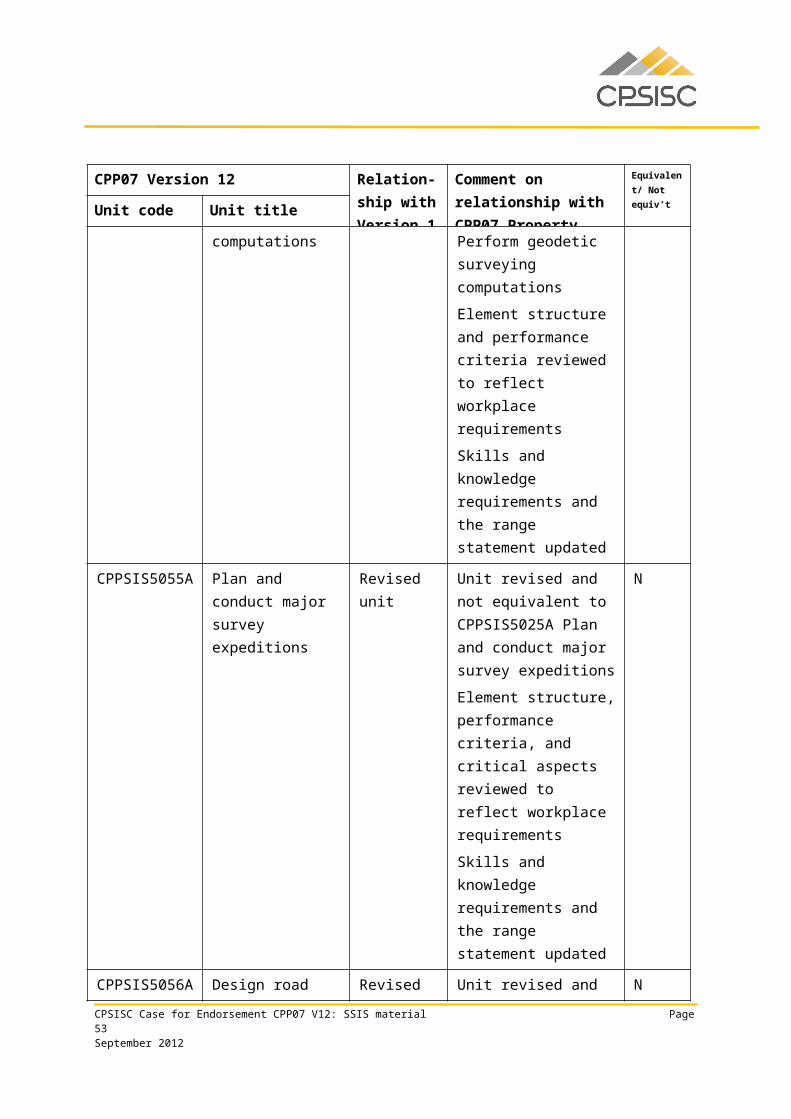
CPP30112 Certificate III in Surveying and Spatial Information Services
Qualification requirementsThis qualification applies to those who apply a broad range of competencies in a varied work context using some discretion, judgement and relevant theoretical knowledge. Under supervision, they may be responsible for operational surveying or spatial information services (SSIS) activity, including supporting a team.
The qualification is suitable for VET in Schools programs and an Australian Apprenticeship pathway.
Packaging rules
To achieve this qualification, the candidate must demonstrate competency in:
11 units of competency:• 5 core units 6 elective units.
The elective units must ensure the integrity of the AQF alignment and contribute to a valid, industry-supported vocational outcome and are to be chosen as follows:
up to 6 units from the elective units listed below up to 2 units may be chosen from other Certificate II, III or IV qualifications in CPP07 or another
current Training Package or accredited course.
Core units
CPPCMN3003A Contribute to workplace safety arrangements
CPPSIS3014A Respond to client spatial enquiry
CPPSIS3015A Collect spatial data
CPPSIS3020A Perform basic surveying computations
RIISTD201A Read and interpret maps
Elective units
BSBCUS301B Deliver and monitor a service to customers
BSBFLM305C Support operational plan
BSBFLM309C Support continuous improvement systems and processes
BSBPMG510A Manage projects
CPPCMN3001B Participate in environmentally sustainable work practices
CPSISC Case for Endorsement CPP07 V12: SSIS material Page 53September 2012
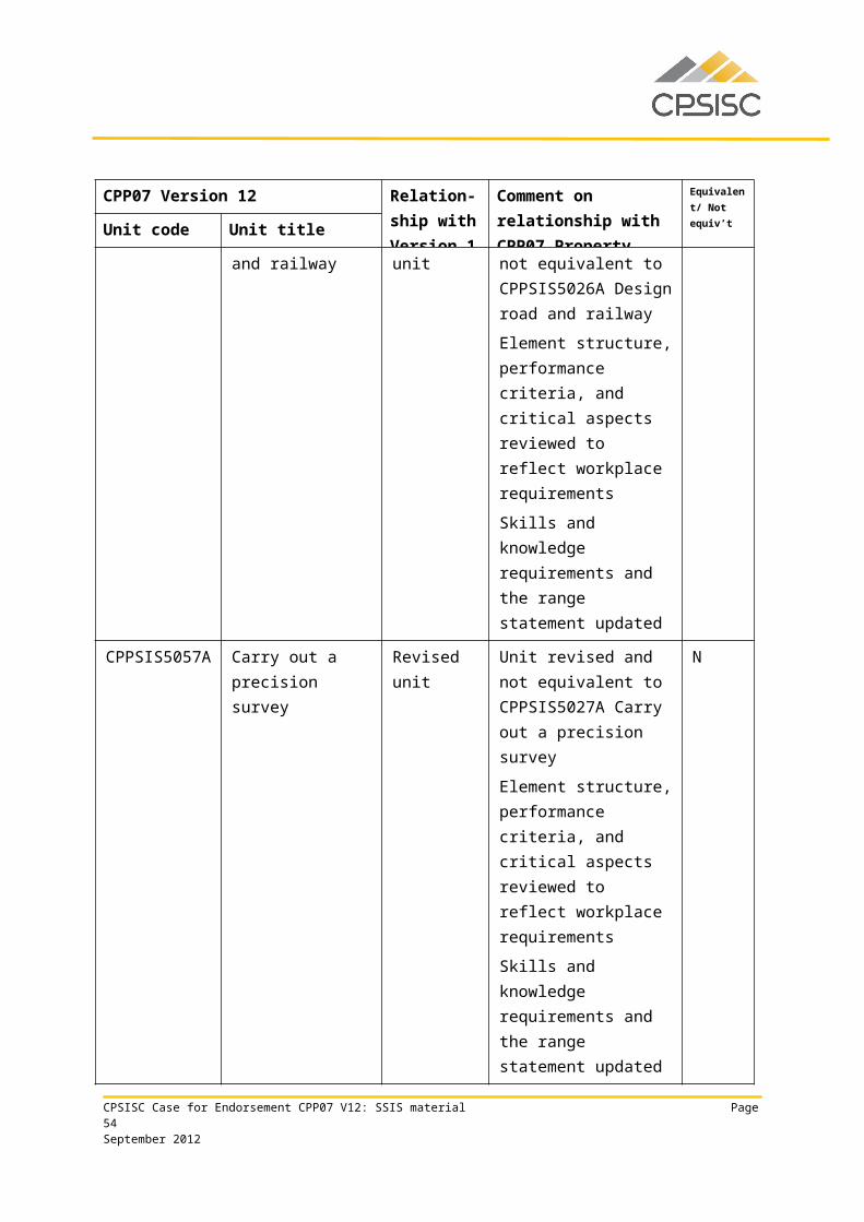
CPPSIS2011A Prepare for work in the spatial information services industry
CPPSIS3011A Apply map presentation principles
CPPSIS3013A Support spatial process improvement
CPPSIS3016A Provide field support services
CPPSIS3017A Select, operate and maintain equipment and supplies
CPPSIS3018A Transfer personnel and loads
CPPSIS3019A Perform basic drafting
CPPSIS4022A Store and retrieve spatial data
CPPSIS4026A Read and interpret image data
CPPSIS4030A Operate surveying equipment
HLTFA301C Apply first aid
ICAICT203A Operate application software packages
RIIRIS301B Apply risk management processes
TLIC2025A Operate four wheel drive vehicle
Employability Skills Qualification Summary
Employability skill
Industry/enterprise requirements for this qualification include the following facets:
Communication
• communicate in a clear and concise manner in both written and verbal modes• apply literacy skills to:
• assess and use workplace information• interpret and understand basic legal, financial, procedural and technical
requirements• process workplace documentation• read and record data
• record spatial data in index according to organisational guidelines• record and report discrepancies between specifications and actual activities• record administrative and legal requirements for spatial data• report any occurrence in the work area which may affect the safety and efficiency
of operations to appropriate personnel• complete spatial business documentation according to established work procedures
and organisational guidelines• provide appropriate information and follow-up on a variety of predictable issues• address client in a courteous and businesslike manner
CPSISC Case for Endorsement CPP07 V12: SSIS material Page 54September 2012
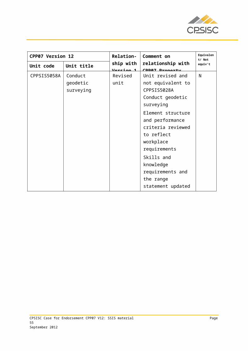
Employability Skills Qualification Summary
Employability skill
Industry/enterprise requirements for this qualification include the following facets:
Teamwork
• relate to people from a range of social, cultural and ethnic backgrounds and with a range of physical and mental abilities
• assist relevant personnel in the data-collection process• apply interpersonal skills e.g. cooperation and flexibility• work within a team in a range of SSIS activities• work with others in performing set task requirements• work with others on site to perform key organisational requirements within an
SSIS framework• advise co-workers and supervisors of work implications, where appropriate
• carry out support tasks under direction and according to specifications
Problem solving
• identify and describe different types of maps• identify nature and type of spatial enquiry• apply spatial skills to understand implications of height, depth, breadth, dimension
and position to actual operational activity and virtual representation• perform key organisational requirements within a spatial information services
framework, working from site drawings and specifications
• determine and mark surface positions according to accepted standards using information available from site drawings and references
Initiative and enterprise
• interpret and create simple maps• interpret and act upon available information using discretion and judgement• apply analytical skills• assess client needs in routine matters
• restore site as near as practicable to original condition
Planning and organising
• apply purpose, application and scope of cartography in the context of the project objective
• allocate a priority for enquiries regarding additional spatial research• document metadata according to accepted industry standards• collect basic data through a range of methods• update relevant files and records
• plan and adhere to OHS requirements
CPSISC Case for Endorsement CPP07 V12: SSIS material Page 55September 2012
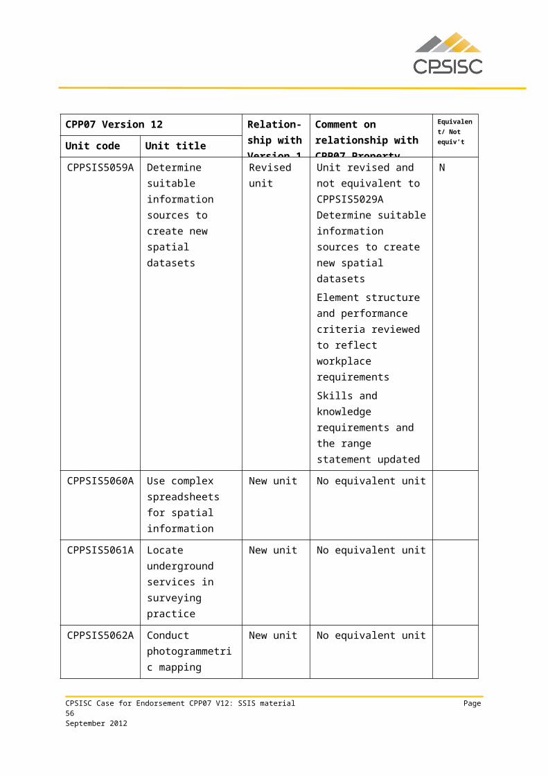
Employability Skills Qualification Summary
Employability skill
Industry/enterprise requirements for this qualification include the following facets:
Self-management
• use time management skills• use personal protective equipment according to OHS guidelines• prioritise daily activities
• establish client spatial requirements and degree of urgency
Learning
• update skills and knowledge to accommodate changes in:• client enquiries• field support services• equipment and operating procedures
Technology
• use computers and software systems (basic)• use spatial reference systems to measure, locate and plot features on maps• use indexing system to locate basic spatial data source• use a range of equipment in the field safely and accurately• perform a range of basic activities in the use of information technology and
equipment within a spatial information handling framework• select equipment, supplies and spatial information services technologies according
to task requirements• check equipment to ensure it is in safe working order• organise repair work for unsafe or faulty tools and equipment
• operate appropriate equipment according to task requirements and manufacturer specifications
Due to the high proportion of electives required by this qualification, the industry/enterprise requirements described above for each employability skill are representative of the property industry in general and may not reflect specific job roles. Learning and assessment strategies for this qualification should be based on the requirements of the units of competency for this qualification.
This table is a summary of employability skills that are typical of this qualification and should not be interpreted as definitive.
CPSISC Case for Endorsement CPP07 V12: SSIS material Page 56September 2012
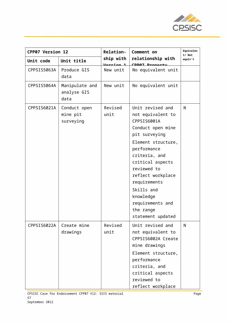
CPP40112 Certificate IV in Surveying
Qualification requirementsThis qualification applies to those who use well-developed skills and a broad knowledge base in a wide variety of surveying contexts. They may be responsible for wide-ranging operational surveying technical activity and a defined range of unpredictable problems.
This qualification is suitable for an Australian Apprenticeship pathway.
Packaging rules
To achieve this qualification, the candidate must demonstrate competency in: 15 units of competency:
• 7 core units 8 elective units.
The elective units must ensure the integrity of the AQF alignment and contribute to a valid, industry-supported vocational outcome and are to be chosen as follows: up to 8 units from the elective units listed below up to 2 units may be chosen from Certificate III, IV or Diploma qualifications in CPP07 or
another current Training Package or accredited course.
Core units
CPPSIS4022A Store and retrieve spatial data
CPPSIS4025A Collect basic GNSS data
CPPSIS4026A Read and interpret image data
CPPSIS4029A Collect and set out basic surveying data
CPPSIS4030A Operate surveying equipment
CPPSIS4031A Perform surveying computations
CPPSIS4037A Produce computer-aided drawings
Elective units
BSBLED401A Develop teams and individuals
BSBPMG510A Manage projects
BSBWOR402A Promote team effectiveness
CPPCMN4002B Implement and monitor environmentally sustainable work practices
CPPCMN4005A Facilitate effective teamwork
CPPCMN4006A Facilitate effective workplace relationships
CPSISC Case for Endorsement CPP07 V12: SSIS material Page 57September 2012
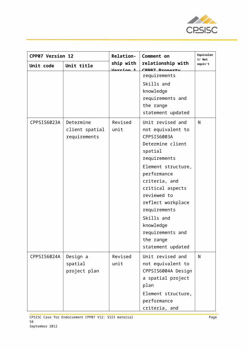
CPPDSM3009A Maintain workplace safety in the property industry
CPPSIS4027A Organise field services
CPPSIS4028A Organise equipment and supplies
CPPSIS4032A Plan and conduct survey expeditions
CPPSIS4033A Participate in spatial process improvement
CPPSIS4036A Operate spatial software applications
CPPSIS4038A Prepare and present GIS data
ICADBS502A Design a database
RIIRIS401A Apply site risk management system
Employability Skills Qualification Summary
Employability skill Industry/enterprise requirements for this qualification include the following facets:
Communication
• apply communication skills to discuss vocational issues effectively with colleagues and impart knowledge and ideas through oral, written and visual means
• apply literacy skills to:• assess and use workplace information• interpret and understand legal, financial and procedural requirements• process workplace documentation
read and record data and write routine reports• research and access routine sources of spatial data
• complete required documentation according to organisational guidelines
Teamwork
• plan and execute set tasks in a team environment• apply interpersonal skills e.g. cooperation and flexibility• relate to people from a range of social, cultural and ethnic backgrounds and with a
range of physical and mental abilities• support, and often lead, team debate on the application of various improvement
processes• show team leadership• work effectively as part of a team
• discuss and evaluate ideas with team to determine viability and compliance with relevant legislation
Problem solving • solve surveying problems involving circular curves• identify and address any discrepancies between specifications and actual activities• identify problems and communicate to relevant personnel to improve service and
prevent recurrence according to organisational guidelines
CPSISC Case for Endorsement CPP07 V12: SSIS material Page 58September 2012
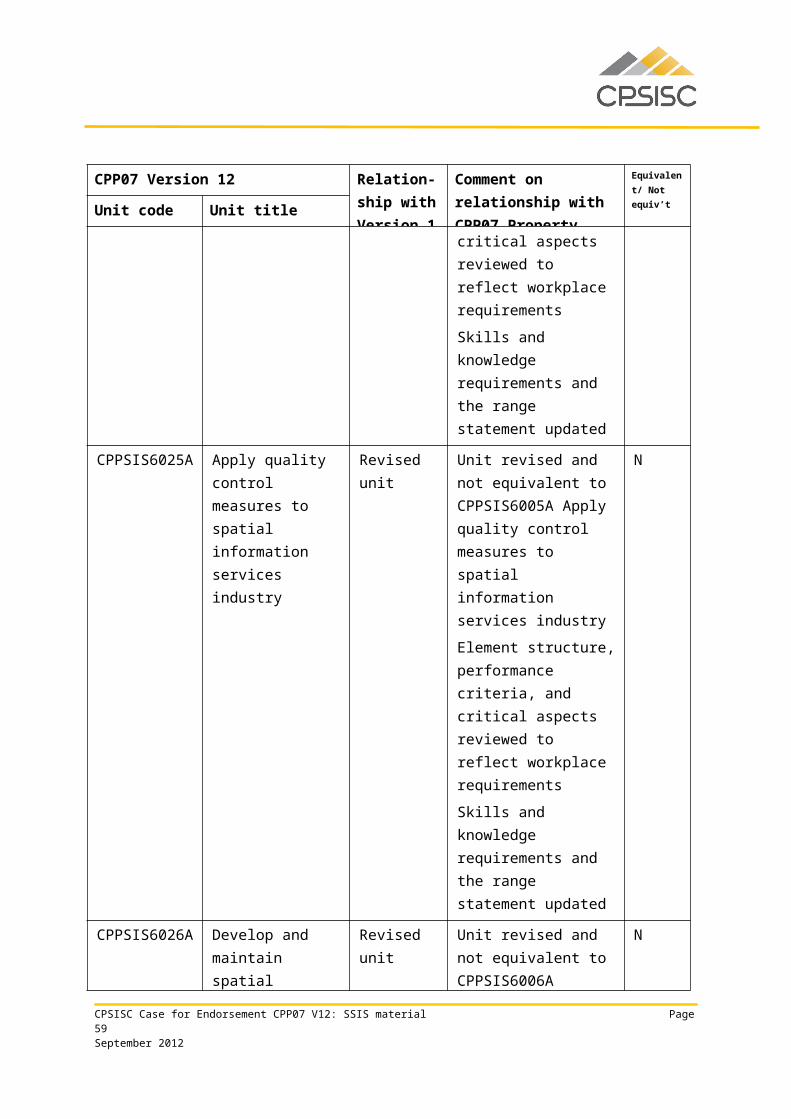
Employability Skills Qualification Summary
Employability skill Industry/enterprise requirements for this qualification include the following facets:
• identify, analyse and evaluate image data to fulfill project requirements• apply spatial skills to:
• understand the holistic implications of height, depth, breadth, dimension, direction and position to actual operational activity and virtual representation
• exercise precision and accuracy in surveying computations• perform global positioning system data archival and retrieval• perform global positioning system data management and manipulation• perform file management• solve basic problems relating to height, depth, breadth, dimension, direction
and position in actual operational activity and virtual representation• interpret technical task requirements• validate and record measurements according to project specifications
• solve problems involving acquired image data according to organisational policies and principles
Initiative and enterprise
• apply analytical skills to determine the data requirements of a survey project• apply negotiation skills• create, extract and output information from engineering plans
• participate in assessing the viability of new ideas and implementing new or improved processes
Planning and organising
• archive spatial data according to project specifications• use organisational skills to prioritise activities to meet contractual requirements
and to prepare and administer documentation• prepare and collect data using basic global positioning system equipment• prepare to perform traverse computations• plan survey field work
• plan and adhere to OHS requirements
Self-management • manage own time and prioritise activities
• adhere to correct OHS practices
Learning
• update skills and knowledge to accommodate changes in spatial reference systems and in equipment and operations
• train others in the use of equipment
• operate global navigation satellite system (GNSS) equipment according to manufacturer specifications and organisational guidelines
CPSISC Case for Endorsement CPP07 V12: SSIS material Page 59September 2012
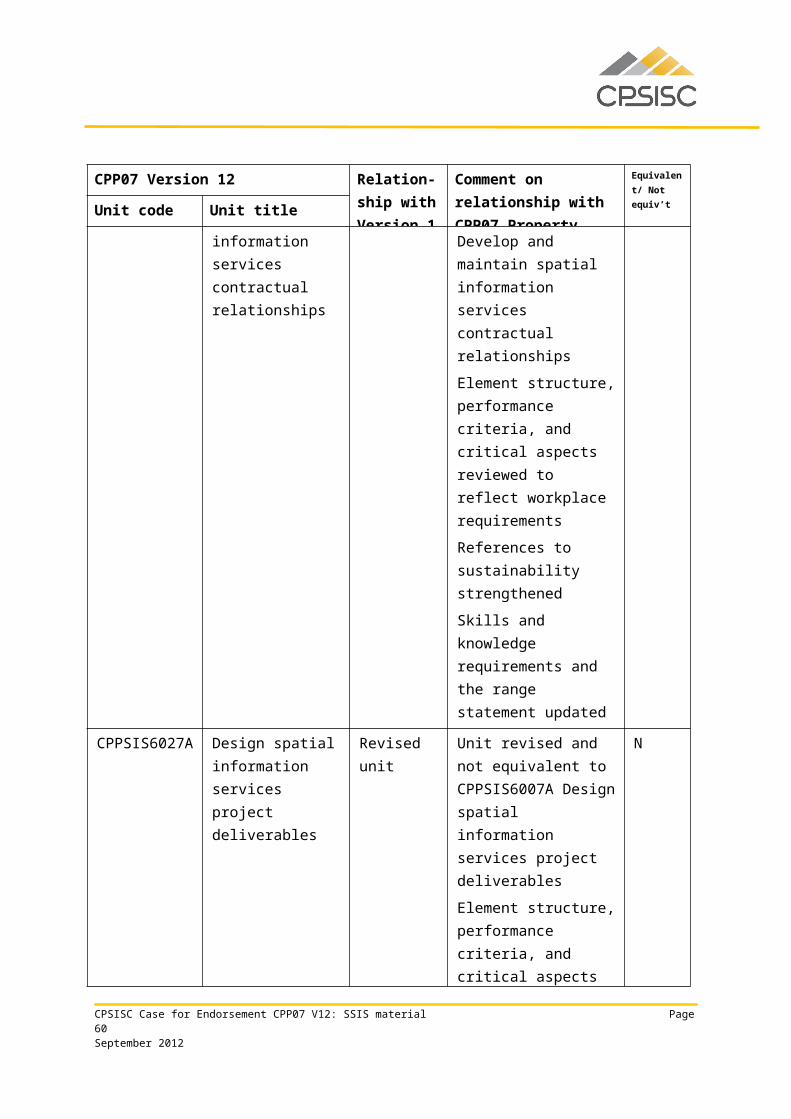
Employability Skills Qualification Summary
Employability skill Industry/enterprise requirements for this qualification include the following facets:
Technology
• use computers (technical user level) to complete business documentation• use suitable software to communicate with a GNSS receiver• conduct navigation operations• select and use appropriate tools
• maintain equipment
Due to the high proportion of electives required by this qualification, the industry/enterprise requirements described above for each employability skill are representative of the property industry in general and may not reflect specific job roles. Learning and assessment strategies for this qualification should be based on the requirements of the units of competency for this qualification.
This table is a summary of employability skills that are typical of this qualification and should not be interpreted as definitive.
CPSISC Case for Endorsement CPP07 V12: SSIS material Page 60September 2012
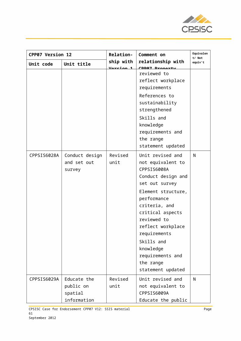
CPP40212 Certificate IV in Spatial Information Services
Qualification requirementsThis qualification applies to those who use well-developed skills and a broad knowledge base in a wide variety of spatial information services contexts. They may be responsible for wide-ranging operational surveying technical activity and a defined range of unpredictable problems.
This qualification is suitable for an Australian Apprenticeship pathway.
Packaging rules
To achieve this qualification, the candidate must demonstrate competency in: 15 units of competency:
• 7 core units 8 elective units.
The elective units must ensure the integrity of the AQF alignment and contribute to a valid, industry-supported vocational outcome and are to be chosen as follows: up to 8 units from the elective units listed below up to 2 units may be chosen from Certificate III, IV or Diploma qualifications in CPP07 or
another current Training Package or accredited course.
Core units
CPPDSM3009A Maintain workplace safety in the property industry
CPPSIS4021A Maintain spatial systems
CPPSIS4022A Store and retrieve spatial data
CPPSIS4025A Collect basic GNSS data
CPPSIS4026A Read and interpret image data
CPPSIS4034A Maintain spatial data
CPPSIS5035A Obtain and validate spatial data
Elective units
BSBINM401A Implement workplace information system
BSBWOR402A Promote team effectiveness
CPPCMN3001B Participate in environmentally sustainable work practices
CPPCMN4005A Facilitate effective teamwork
CPPCMN4006A Facilitate effective workplace relationships
CPPSIS4023A Facilitate effective spatial client relationships
CPSISC Case for Endorsement CPP07 V12: SSIS material Page 61September 2012
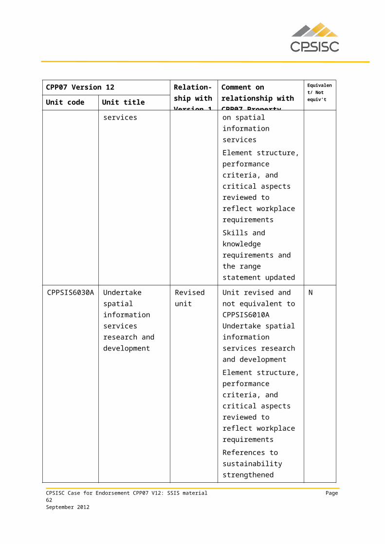
CPPSIS4024A Collect and set out spatial data
CPPSIS4027A Organise field services
CPPSIS4028A Organise equipment and supplies
CPPSIS4030A Operate surveying equipment
CPPSIS4033A Participate in spatial process improvement
CPPSIS4035A Apply GIS software to problem-solving techniques
CPPSIS4036A Operate spatial software applications
CPPSIS4037A Produce computer-aided drawings
CPPSIS4038A Prepare and present GIS data
CUVACD301A Produce drawings to communicate ideas
ICADBS502A Design a database
ICAICT302A Install and optimise operating system software
ICAWEB401A Design a website to meet technical requirements
ICAWEB411A Produce basic client-side script for dynamic web pages
ICAWEB429A Create a markup language document to specification
RIIRIS401A Apply site risk management system
RIISTD201A Read and interpret maps
Employability Skills Qualification Summary
Employability skill Industry/enterprise requirements for this qualification include the following facets:
Communication • apply communication skills to discuss vocational issues effectively with colleagues
• impart knowledge and ideas through oral, written and visual means• apply communication skills that assist in facilitating client relationships,
including:• accessing, synthesising and using information• assertiveness• communicating effectively on the telephone• displaying empathy, tact and diplomacy• negotiating• written skills to document follow-up action
• apply literacy skills to:• assess and use workplace information
CPSISC Case for Endorsement CPP07 V12: SSIS material Page 62September 2012
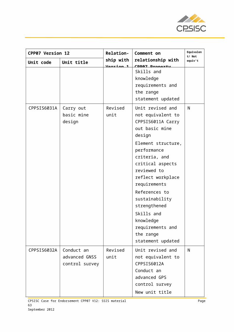
Employability Skills Qualification Summary
Employability skill Industry/enterprise requirements for this qualification include the following facets:
• interpret and understand legal, financial and procedural requirements• process workplace documentation• read, record data and write routine reports• research and access routine sources of spatial data
• document spatial data collection and set out process
• complete required documentation according to organisational guidelines
Teamwork
• plan and execute set tasks in a team environment• apply interpersonal skills e.g. cooperation and flexibility• relate to people from a range of social, cultural and ethnic backgrounds and with a
range of physical and mental abilities• work with and lead others on site
• monitor team activity according to plan
Problem solving
• assess client needs and provide appropriate information and follow-up on a variety of issues within the spatial information handling framework
• develop basic policies and guidelines pertaining to spatial data systems• interpret surveying task requirements• apply spatial skills to:
• understand the holistic implications of height, depth, breadth, dimension, direction and position to actual operational activity and virtual representation
• perform spatial data archival and retrieval• perform spatial data management and manipulation• perform file management• solve basic problems relating to height, depth, breadth, dimension, direction
and position in actual operational activity and virtual representation• interpret technical manuals• interpret surveying task requirements• verify data reliability
• solve problems involving acquired image data according to organisational policies and principles
Initiative and enterprise
• apply analytical skills to determine data requirements of a survey project• analyse and evaluate spatial information from a variety of sources• identify and access spatial information for set task requirements• manage contingencies• establish business contacts and networks• work effectively with business contacts
• apply negotiation skills
CPSISC Case for Endorsement CPP07 V12: SSIS material Page 63September 2012
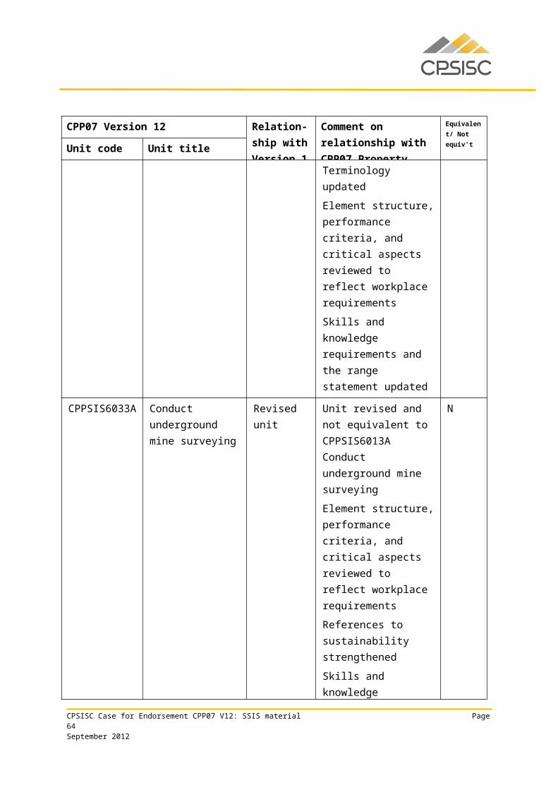
Employability Skills Qualification Summary
Employability skill Industry/enterprise requirements for this qualification include the following facets:
Planning and organising
• confirm reliability of spatial systems• amend spatial data according to changes identified, spatial systems and
organisational requirements• source basic spatial data to prepare for data set out• carry out data backup and recovery• archive data• use organisational skills to prioritise activities to meet contractual requirements
and to prepare and administer documentation
• prepare and collect data using basic global navigation satellite system (GNSS) equipment
Self-management • adhere to correct OHS practices
• manage time
Learning
• apply knowledge of organisational policies and guidelines regarding spatial data maintenance
• update skills and knowledge to accommodate changes in data requirements• apply knowledge of industry requirements and standards
• apply knowledge of legislative, statutory and industry requirements and standards
Technology• use computers (technical user level) to complete business documentation• use suitable software to communicate with a GNSS receiver
• select and use appropriate tools
Due to the high proportion of electives required by this qualification, the industry/enterprise requirements described above for each employability skill are representative of the property industry in general and may not reflect specific job roles. Learning and assessment strategies for this qualification should be based on the requirements of the units of competency for this qualification.
This table is a summary of employability skills that are typical of this qualification and should not be interpreted as definitive.
CPSISC Case for Endorsement CPP07 V12: SSIS material Page 64September 2012
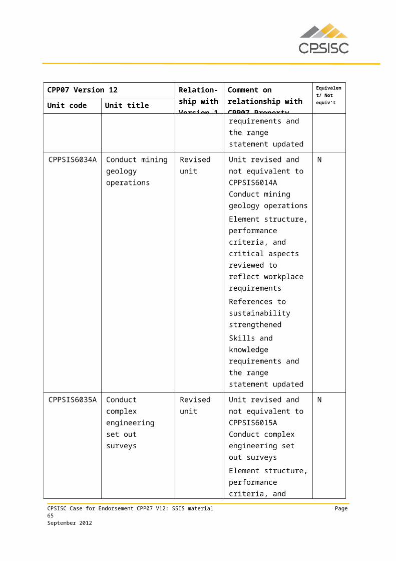
CPP50112 Diploma of SurveyingQualification requirementsThis qualification applies to those who provide guidance in surveying activity. They analyse, design and execute judgements using wide-ranging technical, creative and conceptual competencies. Their knowledge base may be highly specialised or broad within the surveying field and they may be responsible for group outcomes.
This qualification is suitable for an Australian Apprenticeship pathway.
Packaging rules
To achieve this qualification, the candidate must demonstrate competency in:
16 units of competency: 7 core units 9 elective units.
The elective units must ensure the integrity of the AQF alignment and contribute to a valid, industry-supported vocational outcome and are to be chosen as follows:
up to 9 units from the elective units listed below up to 2 units may be chosen from Certificate IV, Diploma or Advanced Diploma qualifications
in CPP07 or another current Training Package or accredited course.
Core units
CPPSIS5031A Plan spatial data collection and validation
CPPSIS5047A Conduct an advanced GNSS data collection and set out survey
CPPSIS5048A Conduct an engineering survey
CPPSIS5050A Create engineering drawings
CPPSIS5053A Perform advanced surveying computations
CPPSIS5054A Perform geodetic surveying computations
CPPSIS5058A Conduct geodetic surveying
Elective units
AHCLPW404A Produce maps for land management purposes
BSBOHS509A Ensure a safe workplace
CPCCSV5007A Undertake site surveys and set-out procedures for building projects
CPPCMN4002B Implement and monitor environmentally sustainable work practices
CPPSIS4038A Prepare and present GIS data
CPSISC Case for Endorsement CPP07 V12: SSIS material Page 65September 2012
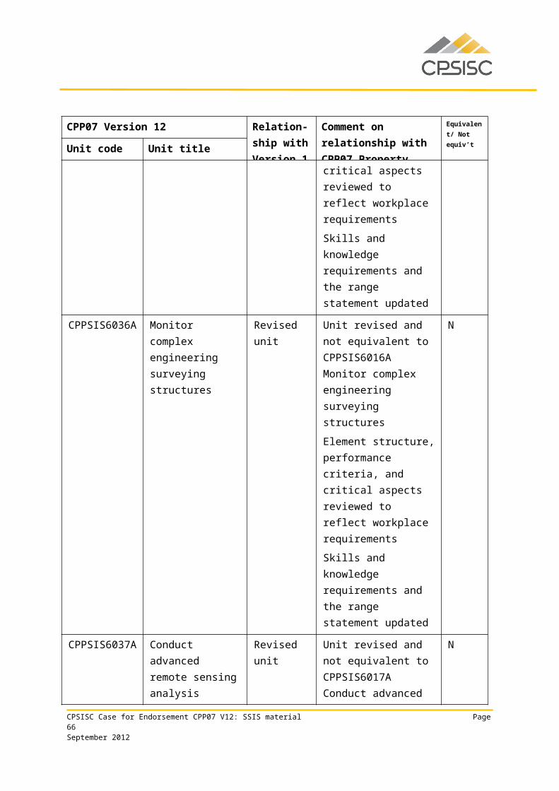
CPPSIS5033A Implement a spatial information services project plan
CPPSIS5037A Maintain complex spatial data systems
CPPSIS5040A Collate and interpret spatial data
CPPSIS5043A Design a spatial data storage system
CPPSIS5044A Develop a subdivision survey design for local government approval
CPPSIS5045A Undertake spatial process improvement to reduce costs and improve service
CPPSIS5046A Design a stormwater system
CPPSIS5049A Conduct an engineering surveying project
CPPSIS5051A Apply land and planning law to surveying
CPPSIS5052A Integrate surveying datasets
CPPSIS5055A Plan and conduct major survey expeditions
CPPSIS5056A Design road and railway
CPPSIS5057A Carry out a precision survey
CPPSIS5059A Determine suitable information sources to create new spatial datasets
CPPSIS5060A Use complex spreadsheets for spatial information
CPPSIS5061A Locate underground services in surveying practice
CPPSIS5064A Manipulate and analyse GIS data
CPPSIS6021A Conduct open mine pit surveying
CPPSIS6022A Create mine drawings
CPPSIS6033A Conduct underground mine surveying
PSPLAND308A Compile and check survey plans
RIIMEX405A Apply and monitor systems and methods of surface coal mining
RIIRIS401A Apply site risk management system
Employability Skills Qualification Summary
Employability skill Industry/enterprise requirements for this qualification include the following facets:
Communication • discuss vocational issues effectively with colleagues• impart knowledge and ideas through oral, written and visual means• apply literacy skills to:
• assess and use workplace information• locate and interpret legislation and other written documentation
CPSISC Case for Endorsement CPP07 V12: SSIS material Page 66September 2012
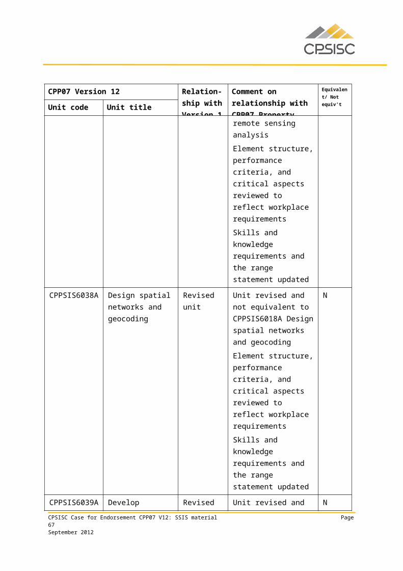
Employability Skills Qualification Summary
Employability skill Industry/enterprise requirements for this qualification include the following facets:
• prepare and manage documentation and information flow• read and write key performance reports, including technical reports• research and evaluate (high level) in order to source surveying or spatial
information services (SSIS) educational information• document project objectives, deliverables, constraints, principal work activities
and equipment requirements according to spatial data specifications and client requirements
• implement and maintain agreed communication processes between project members, clients and other stakeholders
• complete required documentation promptly, accurately and according to organisational guidelines
• implement and apply agreed communication processes between project members, clients and other stakeholders
Teamwork
• relate to people from a range of social, cultural and ethnic backgrounds and with a range of physical and mental abilities
• present project specifications to relevant personnel
• inform relevant personnel of the results according to organisational guidelines
Problem solving
• evaluate spatial information to apply knowledge to plan future collection requirements
• scope spatial data acquisition requirements• analyse client instructions to determine specific needs and spatial data
requirements• evaluate available collection options• research and adhere to pertinent legal and statutory standards• create, extract and output information from engineering plans• spatial skills to:
• understand the holistic implications of height, depth, breadth, dimension, direction and position to actual operational activity and virtual representation
• exercise precision and accuracy in relation to surveying• solve complex problems relating to height, depth, breadth, dimension,
direction and position in actual operational activity and virtual representation
• design and interpret technical documentation
Initiative and enterprise
• select preferred option on the basis of client needs and organisational capability and priorities
• develop spatial data collection and validation plan
• create survey drawings using suitable software
CPSISC Case for Endorsement CPP07 V12: SSIS material Page 67September 2012
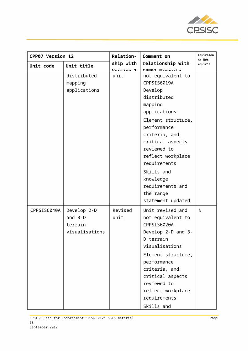
Employability Skills Qualification Summary
Employability skill Industry/enterprise requirements for this qualification include the following facets:
Planning and organising
• plan spatial data collection and validation• plan the processes and procedures involved in undertaking field surveys,
including access, layout, development and provision of services, according to organisational and OHS guidelines
• organise resources for survey operations• prepare computer-aided design environment• implement project management mechanisms to measure, record and report
progress of activities in relation to the agreed schedule and plans
• archive spatial data according to project specifications
Self-management
• delegate duties• prioritise activities
• adhere to OHS requirements throughout the conduct of design and drawing procedures
Learning
• train others in spatial precision techniques• update skills and knowledge to accommodate changes in operating environment
and equipment
• apply knowledge of terminology and nomenclature applicable to surveying
Technology
• use a computer (high technical user level) to develop business documentation• create survey drawings using suitable software• conduct operational elements of surveying operations
• understand and apply high-level, relevant engineering-related tasks and associated computations
Due to the high proportion of electives required by this qualification, the industry/enterprise requirements described above for each employability skill are representative of the property industry in general and may not reflect specific job roles. Learning and assessment strategies for this qualification should be based on the requirements of the units of competency for this qualification.
This table is a summary of employability skills that are typical of this qualification and should not be interpreted as definitive.
CPSISC Case for Endorsement CPP07 V12: SSIS material Page 68September 2012
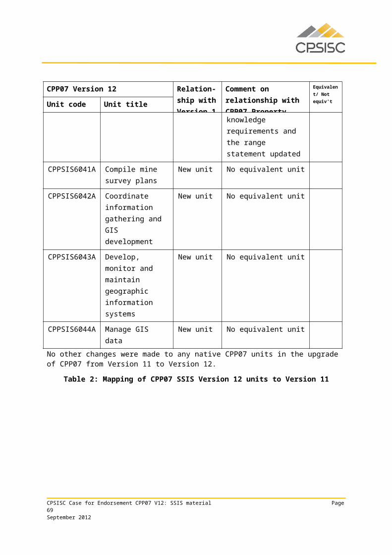
CPP50212 Diploma of Spatial Information Services
Qualification requirementsThis qualification applies to those who provide guidance in spatial information services activity. They analyse, design and execute judgements using wide-ranging technical, creative and conceptual competencies. Their knowledge base may be highly specialised or broad within the surveying and spatial information services (SSIS) field, and they may be responsible for group outcomes.
This qualification is suitable for an Australian Apprenticeship pathway.
Packaging rules
To achieve this qualification, the candidate must demonstrate competency in:
16 units of competency: 7 core units 9 elective units.
The elective units must ensure the integrity of the AQF alignment and contribute to a valid, industry-supported vocational outcome and are to be chosen as follows:
up to 9 units from the elective units listed below up to 2 units may be chosen from Certificate IV, Diploma or Advanced Diploma qualifications
in CPP07 or another current Training Package or accredited course.
Core units
CPPSIS5031A Plan spatial data collection and validation
CPPSIS5032A Capture new spatial data
CPPSIS5033A Implement a spatial information services project plan
CPPSIS5036A Integrate spatial datasets
CPPSIS5039A Produce spatial project deliverables
CPPSIS5059A Determine suitable information sources to create new spatial datasets
CPPSIS6040A Develop 2-D and 3-D terrain visualisations
Elective units
AHCLPW404A Produce maps for land management purposes
BSBFIM501A Manage budgets and financial plans
BSBITU402A Develop and use complex spreadsheets
BSBOHS509A Ensure a safe workplace
BSBWOR502B Ensure team effectiveness
CPSISC Case for Endorsement CPP07 V12: SSIS material Page 69September 2012
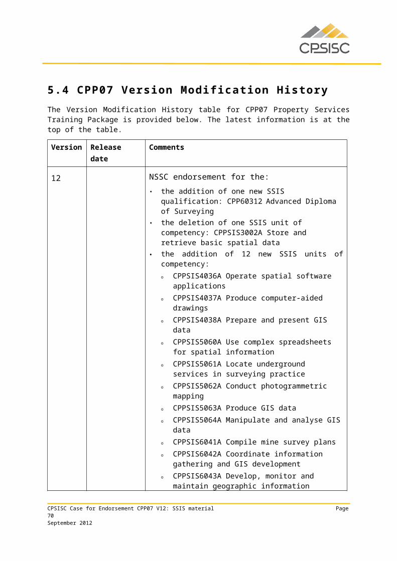
CPPCMN4002B Implement and monitor environmentally sustainable work practices
CPPSIS5034A Determine spatial data requirements
CPPSIS5035A Obtain and validate spatial data
CPPSIS5037A Maintain complex spatial data systems
CPPSIS5038A Develop a complex spatial and aspatial database
CPPSIS5040A Collate and interpret spatial data
CPPSIS5041A Monitor and control the spatial components of projects
CPPSIS5042A Maintain effective internal and external spatial communication networks
CPPSIS5043A Design a spatial data storage system
CPPSIS5045A Undertake spatial process improvement to reduce costs and improve service
CPPSIS5060A Use complex spreadsheets for spatial information
CPPSIS5062A Conduct photogrammetric mapping
CPPSIS5063A Produce GIS data
CPPSIS5064A Manipulate and analyse GIS data
ICAICT307A Customise packaged software applications for clients
ICAICT308A Use advanced features of computer applications
ICAICT409A Develop macros and templates for clients using standard products
ICPKN315C Apply knowledge and requirements of the multimedia sector
RIIRIS401A Apply site risk management system
PSPLAND302A Investigate tenure and land use history
PSPLAND501A Review planning documents and environmental assessments
Employability Skills Qualification Summary
Employability skill Industry/enterprise requirements for this qualification include the following facets:
Communication • communicate data acquisition requirements to relevant personnel• communicate and consult effectively with clients and colleagues• impart knowledge and ideas through oral, written and visual means• apply literacy skills to:
• assess and use workplace information• locate and interpret legislation and other written documentation• prepare and manage documentation
CPSISC Case for Endorsement CPP07 V12: SSIS material Page 70September 2012
Employability Skills Qualification Summary
Employability skill Industry/enterprise requirements for this qualification include the following facets:
• read and write technical reports• research and evaluate
Teamwork
• relate to people from a range of social, cultural and ethnic backgrounds and with a range of physical and mental abilities
• work effectively as a team• apply team leadership skills• guide staff assisting in the data-collection process• allocate work to individuals matching known competency and capacity to work
within organisational policy• consult relevant personnel to identify requirements for spatial data and constraints• refer exception reports to relevant personnel• encourage clients to evaluate spatial product and service options to satisfy their
needs according to company requirements• work effectively with business contacts
• advise co-workers and supervisors promptly of work implications
Problem solving
• evaluate spatial information to apply knowledge to plan future collection requirements
• scope spatial data acquisition requirements• analyse client instructions to determine specific needs and spatial data
requirements• evaluate available collection options• capture new data using a variety of methods• apply spatial skills to:
• understand the holistic implications of height, depth, breadth, dimension, direction and position to actual operational activity and virtual representation
• exercise precision and accuracy in relation to terrain visualisations• solve complex problems relating to height, depth, breadth, dimension,
direction and position in actual operational activity and virtual representation
Initiative and enterprise
• select preferred option on the basis of client needs and organisational capability and priorities
• develop spatial data collection and validation plan• incorporate technical problems and management requirements and apply
appropriate solutions to a range of data collection situations• apply creative and conceptual skills• create 2-D drawings• create and modify a 3-D model or digital elevation model
• use a contour plan of an area for analytical purposes
CPSISC Case for Endorsement CPP07 V12: SSIS material Page 71September 2012
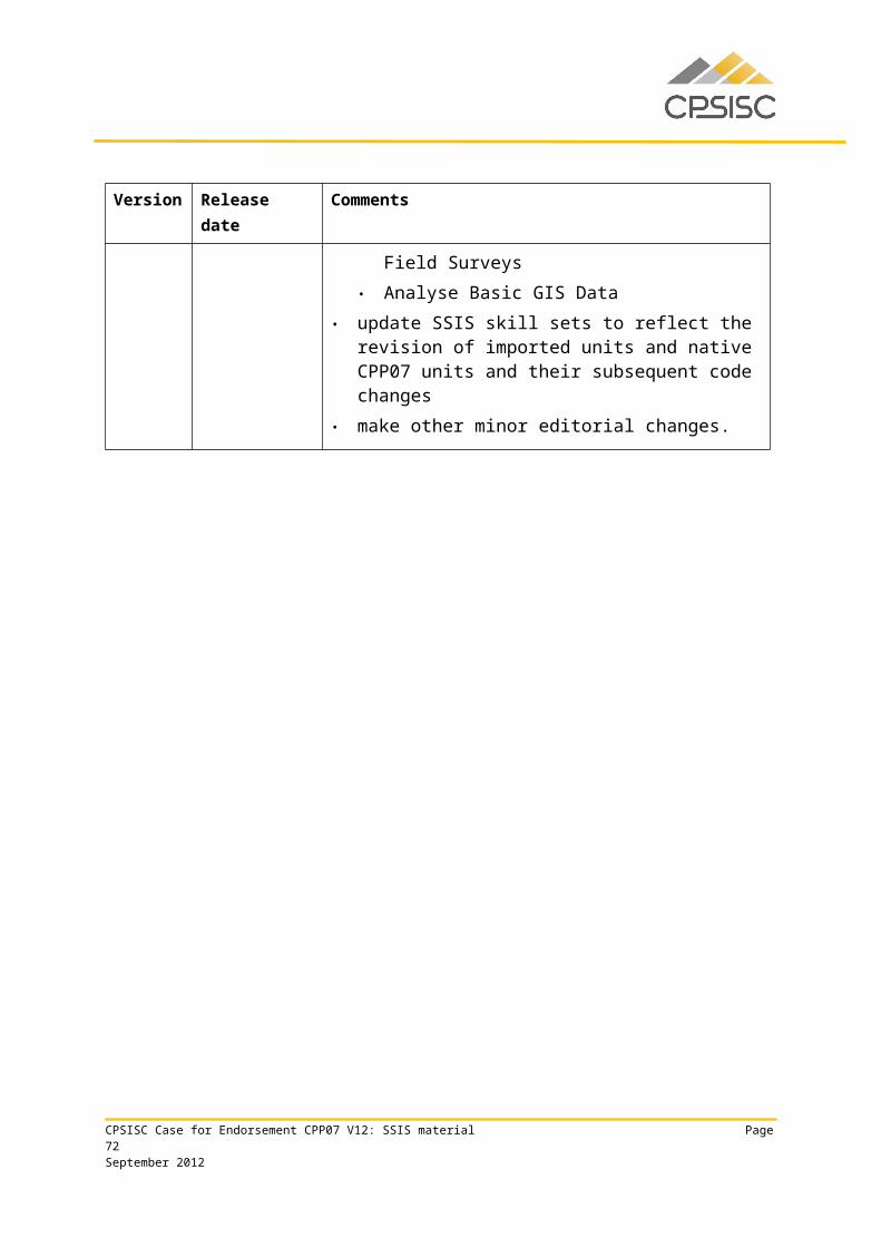
Employability Skills Qualification Summary
Employability skill Industry/enterprise requirements for this qualification include the following facets:
Planning and organising
• plan spatial data collection and validation• plan and execute the data capture process in a supervisory capacity• prepare for data collection• schedule key activities and timelines with full consideration given to specification,
available resources and organisational requirements
• prepare 2-D or 3-D digital elevation model
Self-management• delegate duties• prioritise activities• apply time management skills
Learning• update skills and knowledge to accommodate changes in spatial data acquisition
requirements and in operating environment and equipment
• train others in spatial precision techniques
Technology
• use a computer (high technical user level) to complete business documentation• exercise precision and accuracy in relation to the use of electronic equipment
• assess spatial computing platforms and software systems for suitability against specification
Due to the high proportion of electives required by this qualification, the industry/enterprise requirements described above for each employability skill are representative of the property industry in general and may not reflect specific job roles. Learning and assessment strategies for this qualification should be based on the requirements of the units of competency for this qualification.
This table is a summary of employability skills that are typical of this qualification and should not be interpreted as definitive.
CPSISC Case for Endorsement CPP07 V12: SSIS material Page 72September 2012

CPP60112 Advanced Diploma of Spatial Information Services
Qualification requirementsThis qualification applies to those who provide strategic direction for using spatial information services. They analyse, design and execute judgements using wide-ranging highly technical, creative, and conceptual competencies, often in an unpredictable variety of contexts. Their knowledge base may be highly specialised or broad across a range of spatial information services. These individuals may be responsible for group outcomes and for the overall performance of the spatial information services activity of a business unit.
This qualification is suitable for an Australian Apprenticeship pathway.
Packaging rules
To achieve this qualification, the candidate must demonstrate competency in:
13 units of competency: 6 core units 7 elective units.
The elective units must ensure the integrity of the AQF alignment and contribute to a valid, industry-supported vocational outcome and are to be chosen as follows:
up to 7 units from the elective units listed below up to 2 units may be chosen from Certificate IV, Diploma or Advanced Diploma
qualifications in CPP07 or another current Training Package or accredited course.
Core units
BSBRSK501B Manage risk
CPPSIS6023A Determine client spatial requirements
CPPSIS6024A Design a spatial project plan
CPPSIS6025A Apply quality control measures to spatial information services industry
CPPSIS6027A Design spatial information services project deliverables
CPPSIS6030A Undertake spatial information services research and development
Elective units
BSBFIM501A Manage budgets and financial plans
BSBMGT502B Manage people performance
BSBMGT605B Provide leadership across the organisation
BSBMGT616A Develop and implement strategic plans
BSBMKG502B Establish and adjust the marketing mix
CPSISC Case for Endorsement CPP07 V12: SSIS material Page 73September 2012
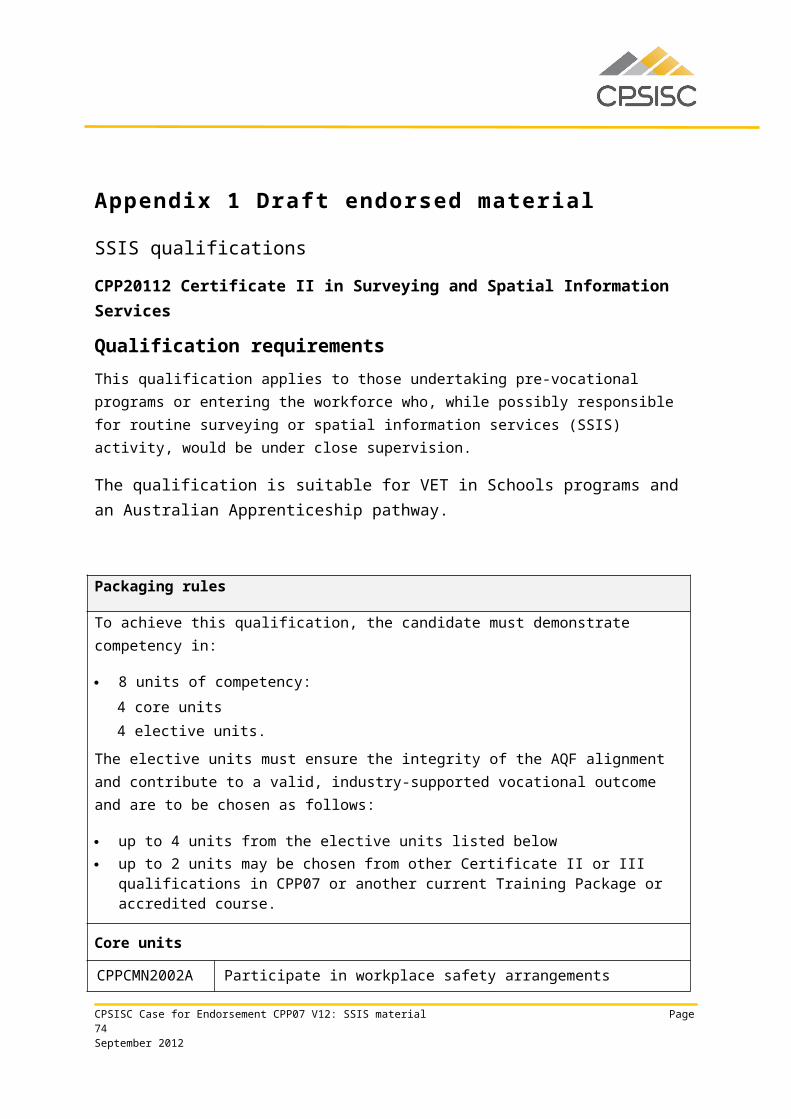
BSBMKG608A Develop organisational marketing objectives
BSBWOR502B Ensure team effectiveness
CPCCSV6012A Facilitate community development consultation
CPPCMN4001B Develop workplace policies and procedures for sustainability
CPPDSM5036A Prepare tender documentation in the property industry
CPPSIS5043A Design a spatial data storage system
CPPSIS6022A Create mine drawings
CPPSIS6026A Develop and maintain spatial information services contractual relationships
CPPSIS6029A Educate the public on spatial information services
CPPSIS6031A Carry out basic mine design
CPPSIS6032A Conduct an advanced GNSS control survey
CPPSIS6034A Conduct mining geology operations
CPPSIS6037A Conduct advanced remote sensing analysis
CPPSIS6038A Design spatial networks and geocoding
CPPSIS6039A Develop distributed mapping applications
CPPSIS6040A Develop 2-D and 3-D terrain visualisations
CPPSIS6042A Coordinate information gathering and GIS development
CPPSIS6043A Develop, monitor and maintain geographic information systems
CPPSIS6044A Manage GIS data
Employability Skills Qualification Summary
Employability skill Industry/enterprise requirements for this qualification include the following facets:
Communication • apply verbal and written communication skills to:• build on others’ ideas to advance discussion and question others to
clarify ideas• encourage feedback• provide clear sequenced oral instructions to others• explore ideas in discussion• listen and question to clarify and elicit information• participate effectively in verbal interactions
• discuss vocational issues effectively with colleagues and impart knowledge and ideas through oral, written and visual means
CPSISC Case for Endorsement CPP07 V12: SSIS material Page 74September 2012
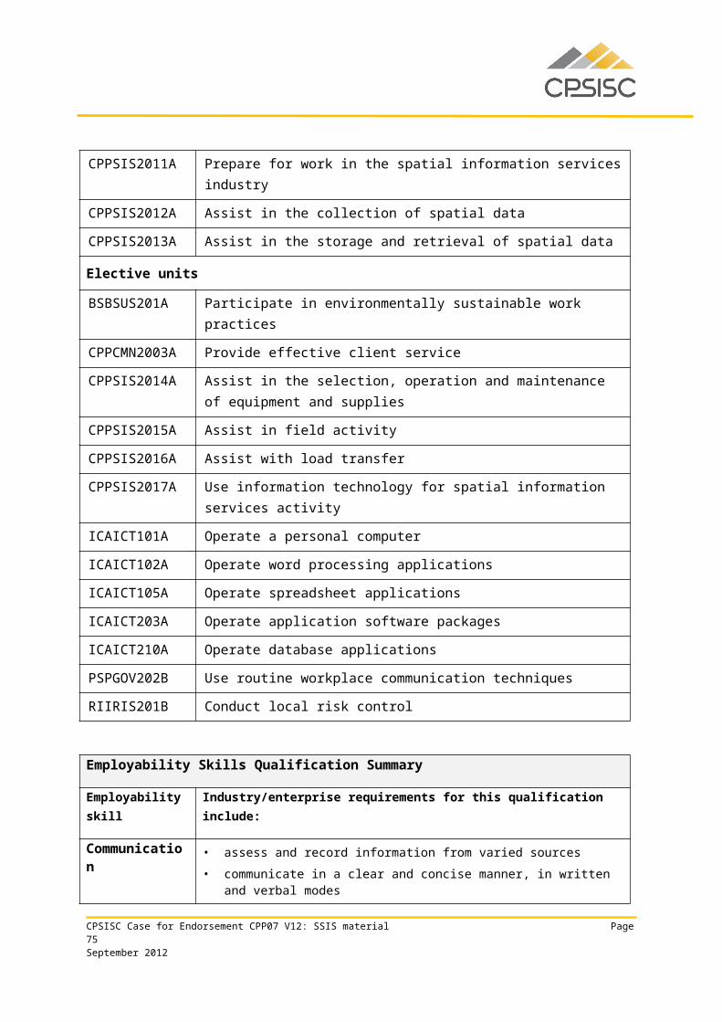
Employability Skills Qualification Summary
Employability skill Industry/enterprise requirements for this qualification include the following facets:
• apply literacy skills to:• assess and use workplace information• locate and interpret legislation and other written documentation• prepare and manage documentation read and write technical reports• research and evaluate
• complete required documentation according to organisational guidelines• define and document project objectives, deliverables, constraints, principal
work activities and equipment requirements according to spatial data specifications and client requirements
• implement and maintain agreed communication processes between project members, clients and other stakeholders
Teamwork
• inform relevant personnel of the results according to organisational guidelines
• relate to people from a range of social, cultural and ethnic backgrounds and with a range of physical and mental abilities
• select personnel and work teams for the project activity• work effectively as part of a team
Problem solving
• apply theoretical spatial concepts to a range of situations in order to determine, create and facilitate acceptance by users of a suitable spatial data and attribute storage system
• determine functional requirements• conduct an audit of existing spatial data sources to determine their
suitability, usability, spatial data dependencies and adaptability• create and test a prototype or adopt standard format to confirm that design
meets functional requirements• apply spatial skills to:
• understand the holistic implications of height, depth, breadth, dimension, direction and position to actual operational activity and virtual representation
• exercise precision and accuracy in relation to complex engineering surveying
• solve complex problems relating to height, depth, breadth, dimension, direction and position in actual operational activity and virtual representation
Initiative and enterprise
• create and test system design• apply research and analytical skills to:
• assemble evidence and evaluate for accuracy and relevance• use and follow academic procedure for research techniques and
copyright requirements
CPSISC Case for Endorsement CPP07 V12: SSIS material Page 75September 2012
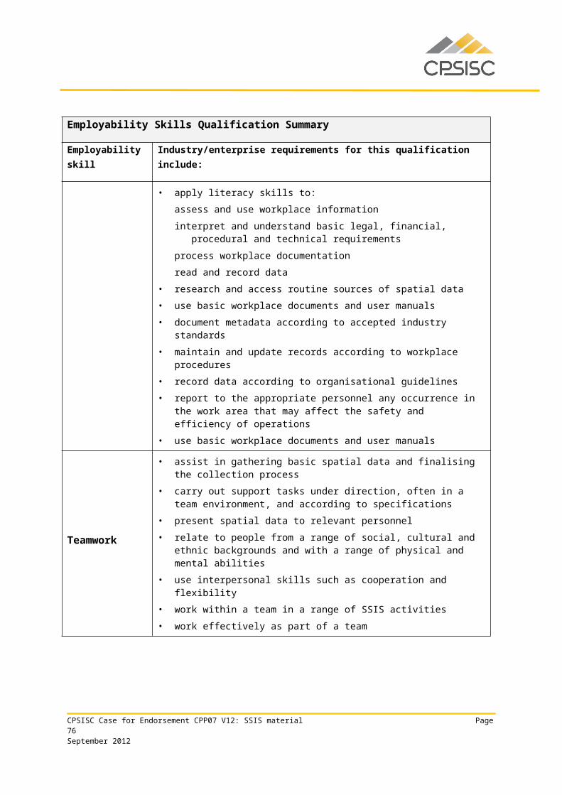
Employability Skills Qualification Summary
Employability skill Industry/enterprise requirements for this qualification include the following facets:
• use a variety of strategies for planning• apply creative and conceptual skills• apply delegation skills• undertake business negotiation• create 2-D drawings• create and modify a 3-D model or digital elevation model
Planning and organising
• apply project management skills, including the ability to meet deadlines• develop a plan based on functional requirements detailing spatial data flow
dependencies• develop a schedule for the introduction of the system• archive spatial data according to project specifications• prepare data for geocoding• prepare for examination and assessment of product or service quality• implement project management mechanisms to measure, record and report
progress of activities in relation to the agreed schedule and plans• organise project resources• select a strategy for developing a web-based geographic information system
application• prepare 2-D or 3-D digital elevation model
Self-management
• manage time• prioritise activities• adhere to correct OHS practices
• comply with, and develop or amend, organisational guidelines
Learning• apply knowledge of organisational policies and guidelines• update skills and knowledge to accommodate changes in environment and
equipment, including global navigation satellite system (GNSS) equipment• train others in spatial precision techniques
CPSISC Case for Endorsement CPP07 V12: SSIS material Page 76September 2012
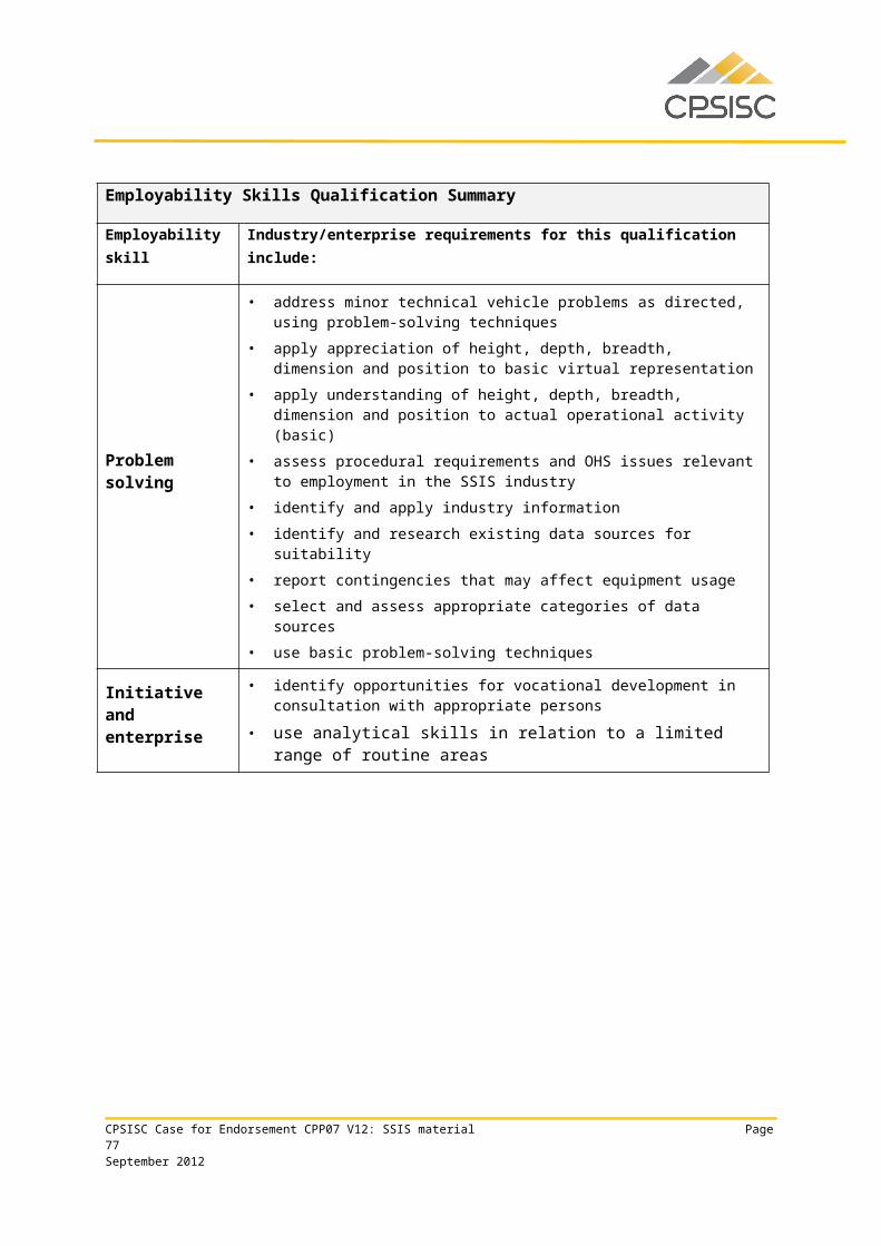
Employability Skills Qualification Summary
Employability skill Industry/enterprise requirements for this qualification include the following facets:
Technology
• use a computer (high technical user level) to complete business documentation and apply software and hardware
• assess spatial computing platforms and software systems for suitability against specification
• analyse and design networks• select suitable computing platforms and software systems• maximise the potential of the web-based geographic information systems
application by the specification of possible software tools and links• develop geographic information systems to run within the internet and
private intranets
• check equipment to be in good working order
Due to the high proportion of electives required by this qualification, the industry/enterprise requirements described above for each employability skill are representative of the property industry in general and may not reflect specific job roles. Learning and assessment strategies for this qualification should be based on the requirements of the units of competency for this qualification.
This table is a summary of employability skills that are typical of this qualification and should not be interpreted as definitive.
CPSISC Case for Endorsement CPP07 V12: SSIS material Page 77September 2012
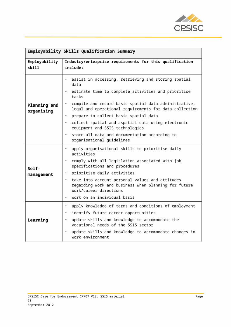
CPP60312 Advanced Diploma of Surveying
Qualification requirementsThis qualification applies to individuals who provide strategic direction in surveying. They analyse, design and execute judgements using wide-ranging highly technical, creative, or conceptual competencies, often in an unpredictable variety of contexts. Their knowledge base may be highly specialised or broad within surveying. These individuals may be responsible for group outcomes and for the overall performance of the surveying services activity of a business unit.
This qualification is suitable for an Australian Apprenticeship pathway.
Entry Requirements
The entry requirement to this qualification is CPP50112 Diploma of Surveying, or demonstrated equivalent competency.
Packaging rulesTo achieve this qualification, the candidate must demonstrate competency in:
9 units of competency: 4 core units 5 elective units.
The elective units must ensure the integrity of the AQF alignment and contribute to a valid, industry-supported vocational outcome and are to be chosen as follows:
up to 5 units from the elective units listed below up to 2 units may be chosen from other Diploma, Advanced Diploma, Vocational Graduate
Certificate or Vocational Graduate Diploma qualifications in CPP07 or another current Training Package or accredited course.
Core units
CPPSIS6023A Determine client spatial requirements
CPPSIS6032A Conduct an advanced GNSS control survey
CPPSIS6035A Conduct complex engineering set out surveys
CPPSIS6036A Monitor complex engineering surveying structures
Elective units
BSBRSK501B Manage risk
CPCCSV5007A Undertake site surveys and set-out procedures for building projects
CPPSIS6028A Conduct design and set out survey
CPPSIS5044A Develop a subdivision survey design for local government approval
CPSISC Case for Endorsement CPP07 V12: SSIS material Page 78September 2012
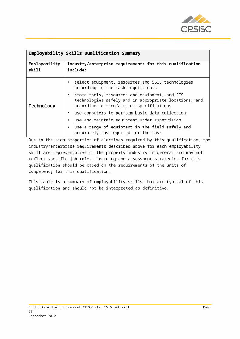
CPPSIS5046A Design a stormwater system
CPPSIS5051A Apply land and planning law to surveying
CPPSIS5057A Carry out a precision survey
CPPSIS6024A Design a spatial project plan
CPPSIS6025A Apply quality control measures to spatial information services industry
CPPSIS6031A Carry out basic mine design
CPPSIS6033A Conduct underground mine surveying
CPPSIS6034A Conduct mining geology operations
CPPSIS6037A Conduct advanced remote sensing analysis
CPPSIS6041A Compile mine survey plans
FNSORG501A Develop and manage a budget
Employability Skills Qualification Summary
Employability skill Industry/enterprise requirements for this qualification
Communication • apply verbal and written communication skills to:
• build on others‘ ideas to advance discussion and question others to clarify ideas
• encourage feedback• provide clear sequenced oral instructions to others• explore ideas in discussion• listen and question to clarify and elicit information• participate effectively in verbal interactions
• discuss vocational issues effectively with colleagues and impart knowledge and ideas through oral, written and visual means
• apply literacy skills to: assess and use workplace information
locate and interpret legislation and other written documentation
prepare and manage documentation
read and write technical reports
research and evaluate
• complete required documentation according to organisational guidelines• define and document project objectives, deliverables, constraints, principal work
activities and equipment requirements according to spatial data specifications and client requirements
• implement and maintain agreed communication processes between project
CPSISC Case for Endorsement CPP07 V12: SSIS material Page 79September 2012
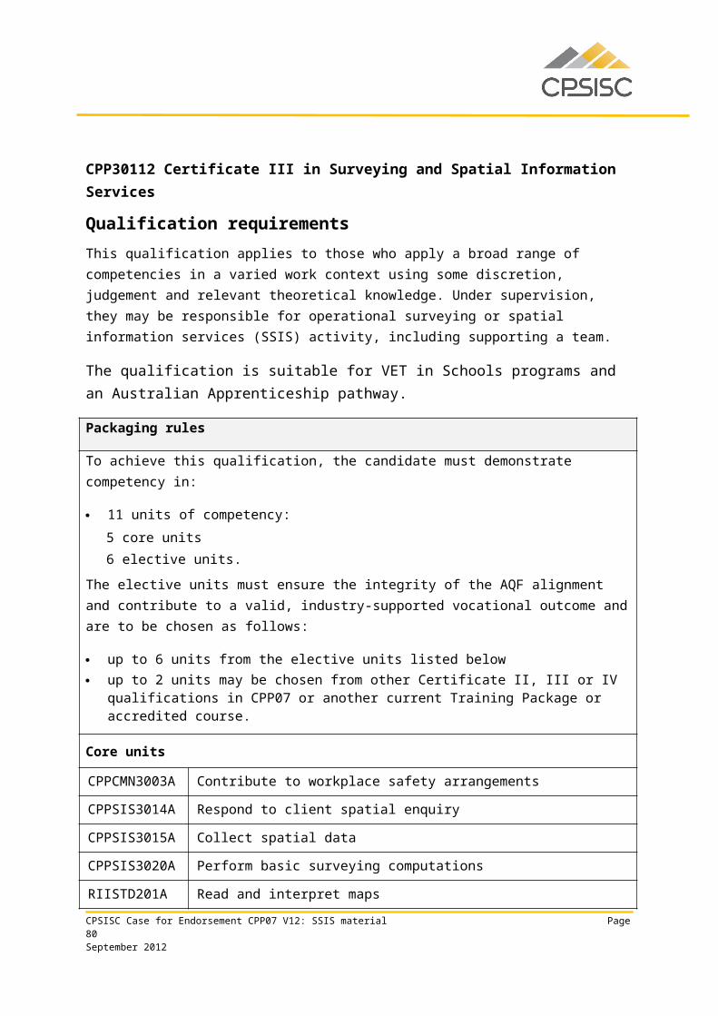
Employability Skills Qualification Summary
Employability skill Industry/enterprise requirements for this qualification
members, clients and other stakeholders
Teamwork
• inform relevant personnel of the results according to organisational guidelines• relate to people from a range of social, cultural and ethnic backgrounds and with
a range of physical and mental abilities• select personnel and work teams for the project activity• work effectively as part of a team
Problem solving
• apply surveying theory to a range of situations in order to determine, create and facilitate acceptance by users of a suitable spatial data and attribute storage system
• determine functional requirements• conduct an audit of existing surveying data sources to determine their suitability,
usability, dependencies and adaptability• create and test a prototype or adopt standard format to confirm that design meets
functional requirements• apply spatial skills and surveying practise knowledge to:
• understand the holistic implications of height, depth, breadth, dimension, direction and position to actual operational activity and virtual representation
• exercise precision and accuracy in relation to complex engineering surveying
• solve complex problems relating to height, depth, breadth, dimension, direction and position in actual operational activity and virtual representation
Initiative and enterprise
• create and test system design• apply research and analytical skills to:
assemble evidence and evaluate for accuracy and relevance
use and follow academic procedure for research techniques and copyright requirements
use a variety of strategies for planning
apply creative and conceptual skills
apply delegation skills
undertake business negotiation
CPSISC Case for Endorsement CPP07 V12: SSIS material Page 80September 2012
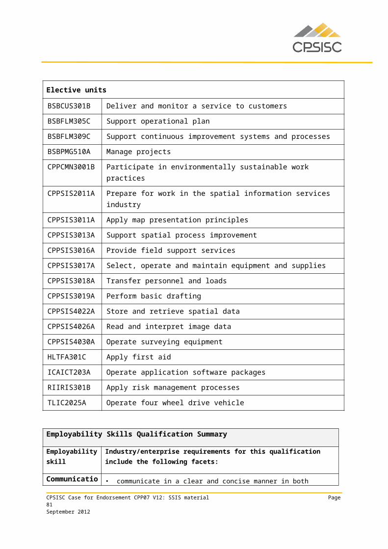
Employability Skills Qualification Summary
Employability skill Industry/enterprise requirements for this qualification
Planning and organising
• apply project management skills, including the ability to meet deadlines• develop a plan based on surveying data capture data set out methodologies and
practices, according to jurisdictional requirements• prepare for examination and assessment of product or service quality• implement project management mechanisms to measure, record and report
progress of activities in relation to the agreed schedule and planning control processes
• organise project resources and use required surveying reference systems
Self-management
• manage time• prioritise activities• adhere to correct OHS practices• comply with, and develop or amend, organisational guidelines
Learning
• apply knowledge of organisational policies and guidelines• update skills and knowledge to accommodate changes in environment and
equipment, including global navigation satellite system (GNSS) equipment• train others in spatial precision techniques
Technology
• use a computer (high technical user level) to complete business documentation and apply software and hardware
• assess surveying equipment and software systems for suitability against specification
• analyse survey practice procedures• select suitable computing platforms and software systems• use technology to lodge survey plans online• develop geographic information systems to run within the internet and private
intranets• check equipment is calibrated to required specifications
Due to the high proportion of electives required by this qualification, the industry/enterprise requirements described above for each employability skill are representative of the property industry in general and may not reflect specific job roles. Learning and assessment strategies for this qualification should be based on the requirements of the units of competency for this qualification.
This table is a summary of employability skills that are typical of this qualification and should not be interpreted as definitive.
CPSISC Case for Endorsement CPP07 V12: SSIS material Page 81September 2012
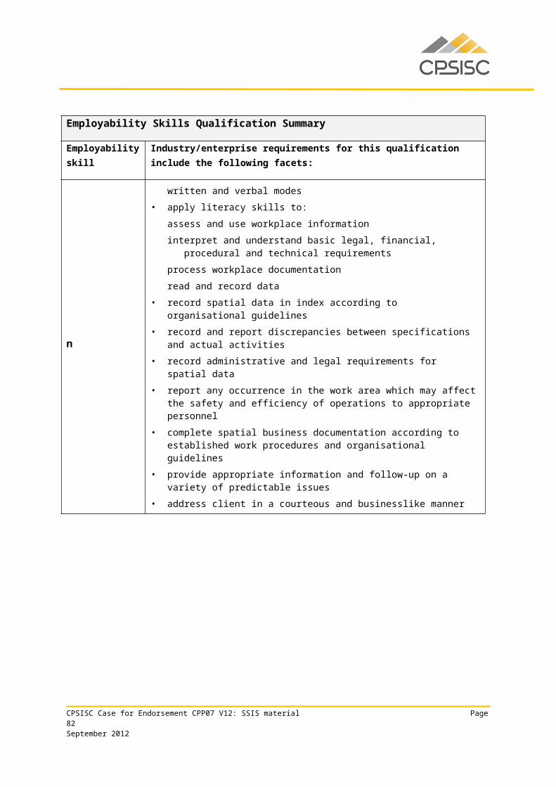
SSIS unitsThis endorsement submission comprises the following new and revised native units of competency:
New units
CPPSIS4036A Operate spatial software applications
CPPSIS4037A Produce computer-aided drawings
CPPSIS4038A Prepare and present GIS data
CPPSIS5060A Use complex spreadsheets for spatial information
CPPSIS5061A Locate underground services in surveying practice
CPPSIS5062A Conduct photogrammetric mapping
CPPSIS5063A Produce GIS data
CPPSIS5064A Manipulate and analyse GIS data
CPPSIS6041A Compile mine survey plans
CPPSIS6042A Coordinate information gathering and GIS development
CPPSIS6043A Develop, monitor and maintain geographic information systems
CPPSIS6044A Manage GIS data
Revised units
CPPSIS2011A Prepare for work in the spatial information services industry
CPPSIS2012A Assist in the collection of spatial data
CPPSIS2013A Assist in the storage and retrieval of spatial data
CPPSIS2014A Assist in the selection, operation and maintenance of equipment and supplies
CPPSIS2015A Assist in field activity
CPPSIS2016A Assist with load transfer
CPPSIS2017A Use information technology for spatial information services activity
CPPSIS3011A Apply map presentation principles
CPPSIS3013A Support spatial process improvement
CPPSIS3014A Respond to client spatial enquiry
CPPSIS3015A Collect spatial data
CPPSIS3016A Provide field support services
CPSISC Case for Endorsement CPP07 V12: SSIS material Page 82September 2012
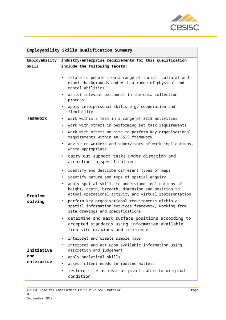
CPPSIS3017A Select, operate and maintain equipment and supplies
CPPSIS3018A Transfer personnel and loads
CPPSIS3019A Perform basic drafting
CPPSIS3020A Perform basic surveying computations
CPPSIS4021A Maintain spatial systems
CPPSIS4022A Store and retrieve spatial data
CPPSIS4023A Facilitate effective spatial client relationships
CPPSIS4024A Collect and set out spatial data
CPPSIS4025A Collect basic GNSS data
CPPSIS4026A Read and interpret image data
CPPSIS4027A Organise field services
CPPSIS4028A Organise equipment and supplies
CPPSIS4029A Collect and set out basic surveying data
CPPSIS4030A Operate surveying equipment
CPPSIS4031A Perform surveying computations
CPPSIS4032A Plan and conduct survey expeditions
CPPSIS4033A Participate in spatial process improvement
CPPSIS4034A Maintain spatial data
CPPSIS4035A Apply GIS software to problem-solving techniques
CPPSIS5031A Plan spatial data collection and validation
CPPSIS5032A Capture new spatial data
CPPSIS5033A Implement a spatial information services project plan
CPPSIS5034A Determine spatial data requirements
CPPSIS5035A Obtain and validate spatial data
CPPSIS5036A Integrate spatial datasets
CPPSIS5037A Maintain complex spatial data systems
CPPSIS5038A Develop a complex spatial and aspatial database
CPPSIS5039A Produce spatial project deliverables
CPPSIS5040A Collate and interpret spatial data
CPSISC Case for Endorsement CPP07 V12: SSIS material Page 83September 2012
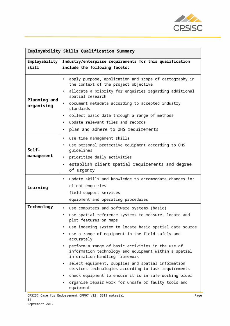
CPPSIS5041A Monitor and control the spatial components of projects
CPPSIS5042A Maintain effective internal and external spatial communication networks
CPPSIS5043A Design a spatial data storage system
CPPSIS5044A Develop a subdivision survey design for local government approval
CPPSIS5045A Undertake spatial process improvement to reduce costs and improve service
CPPSIS5046A Design a stormwater system
CPPSIS5047A Conduct an advanced GNSS data collection and set out survey
CPPSIS5048A Conduct an engineering survey
CPPSIS5049A Conduct an engineering surveying project
CPPSIS5050A Create engineering drawings
CPPSIS5051A Apply land and planning law to surveying
CPPSIS5052A Integrate surveying datasets
CPPSIS5053A Perform advanced surveying computations
CPPSIS5054A Perform geodetic surveying computations
CPPSIS5055A Plan and conduct major survey expeditions
CPPSIS5056A Design road and railway
CPPSIS5057A Carry out a precision survey
CPPSIS5058A Conduct geodetic surveying
CPPSIS5059A Determine suitable information sources to create new spatial datasets
CPPSIS6021A Conduct open mine pit surveying
CPPSIS6022A Create mine drawings
CPPSIS6023A Determine client spatial requirements
CPPSIS6024A Design a spatial project plan
CPPSIS6025A Apply quality control measures to spatial information services industry
CPPSIS6026A Develop and maintain spatial information services contractual relationships
CPPSIS6027A Design spatial information services project deliverables
CPPSIS6028A Conduct design and set out survey
CPPSIS6029A Educate the public on spatial information services
CPPSIS6030A Undertake spatial information services research and development
CPSISC Case for Endorsement CPP07 V12: SSIS material Page 84September 2012
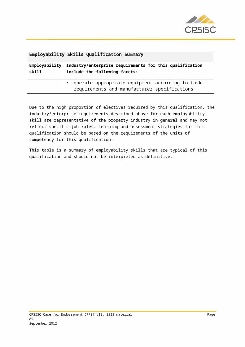
CPPSIS6031A Carry out basic mine design
CPPSIS6032A Conduct an advanced GNSS control survey
CPPSIS6033A Conduct underground mine surveying
CPPSIS6034A Conduct mining geology operations
CPPSIS6035A Conduct complex engineering set out surveys
CPPSIS6036A Monitor complex engineering surveying structures
CPPSIS6037A Conduct advanced remote sensing analysis
CPPSIS6038A Design spatial networks and geocoding
CPPSIS6039A Develop distributed mapping applications
CPPSIS6040A Develop 2-D and 3-D terrain visualisations
The draft new and revised SSIS units of competency are in separate documents to this submission.
CPSISC Case for Endorsement CPP07 V12: SSIS material Page 85September 2012
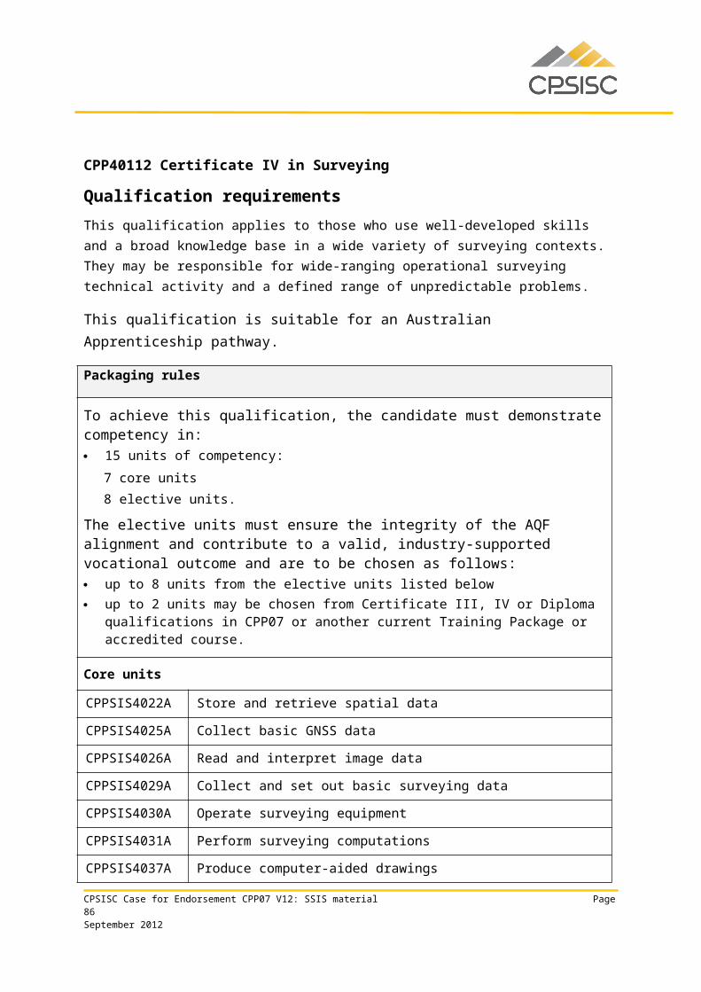
Appendix 2 SSIS qualifications and vocational rolesConsultation and research clearly indicated that spatial data is critical to solving today's complex environmental, economic, and social problems. More and more spatial information system technologies are used to digitally analyse spatial problems. This has, in turn created a demand for vast amounts of digital spatial data. Spatial system technologies include land information systems (LIS) and geographic information systems (GIS) as well as automated mapping and facilities management systems and image processing systems that use aerial and satellite imagery.
The use of spatial information technology makes abstract information far simpler to comprehend by displaying it in a graphical or visual manner. Many business owners and managers are finding that using spatial data can provide their businesses with a significant commercial advantage. For example:
• By understanding the demographics, businesses can target their markets more precisely or even introduce new products or services that are related to the customer's location and their relationship to the service provider.
• Transport, courier and taxi operators can all benefit from better knowledge of the location of their vehicle fleet, the demand for their services and the optimum manner in which they can service their clients.
Twelve thousand surveying personnel work in approximately 1,975 surveying businesses but workforce numbers could drop by 400 to 500 by the end of 2012. While the number of surveyors required has declined due to technological advancements, there is a need to train to meet industry new and replacement needs because surveying is an ageing profession. The sector has mainly small establishments with the industry’s four largest players accounting for only 5% of annual industry revenue. Surveying firms and consultants provide surveying services such as cadastral surveys, construction surveying, mapping services (including geophysical), and the provision of geospatial image acquisition (from aircraft and satellites), processing, and sales and also expert witness services. 1
Surveying industry revenue is anticipated to grow by an average of 3% annually to 20152 due to expansion in building construction. As discussed, surveying work and skills required are impacted by new technologies with increased accuracy of surveys and data analysis such as Global Navigation Satellite Systems (GNSS) for surveying and map making.3 GNSS and Total Station systems mean the traditional technical skills of the surveying industry are changing rapidly and this has to be reflected in the professional training.
SSIS vocational roles and the relationship they could have to existing qualifications, is included below.
1 L7822 Surveying Services in Australia, IBISWorld, October 20102 Ibid3 Noel Hamey, A/Director Building and Environment Centre, Spatial Education Advisory Committee (SEAC), Surveying and Spatial Sciences Institute (SSI) interview 13 October 2010 Extract from the CPSISC 2011-2012 E’Scan page 7CPSISC Case for Endorsement CPP07 V12: SSIS material Page 86September 2012
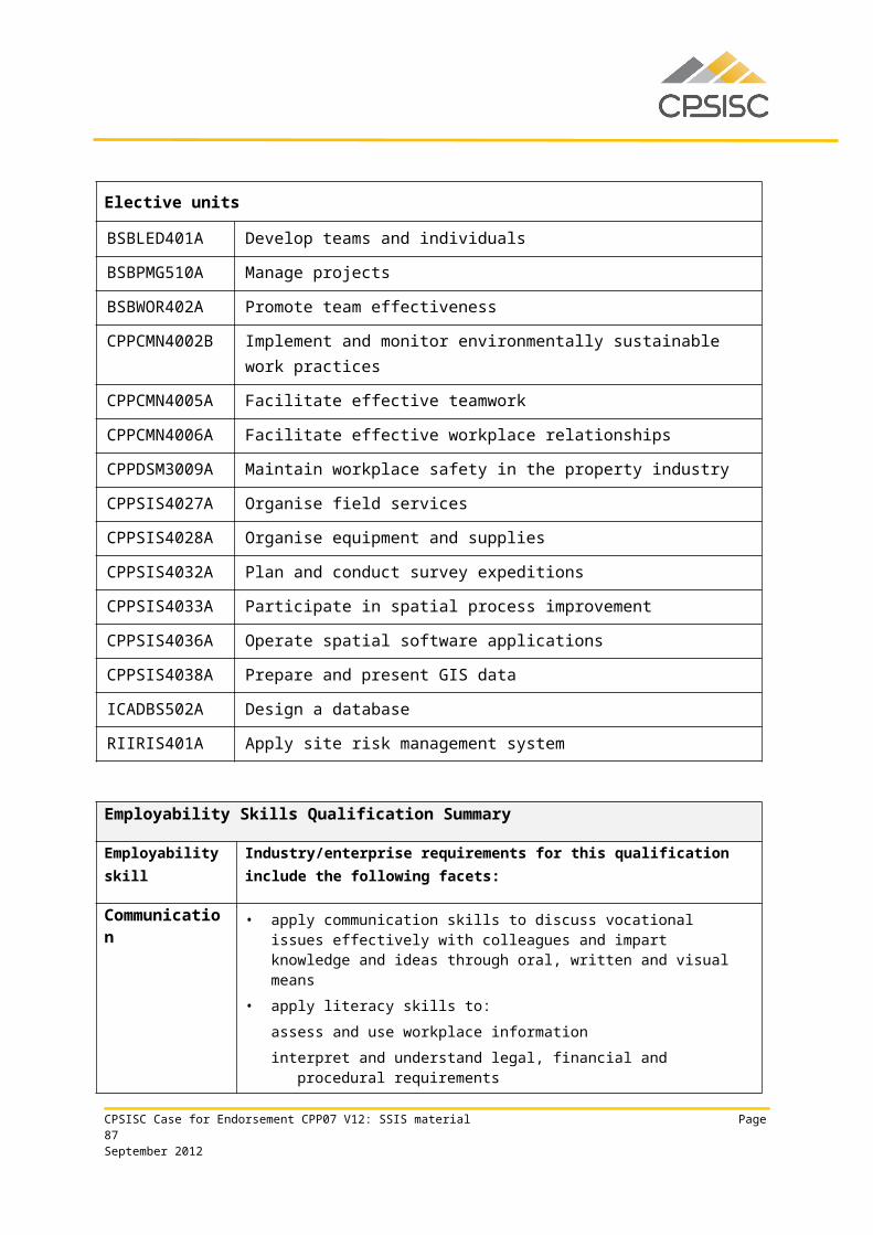
Certificate II Certificate III Certificate IV Diploma of Spatial
Information Services and Diploma of Surveying
Advanced Diploma of Spatial Information
Services and Advanced Diploma of Surveying
Guide to occupational profiles
Field hand Survey field assist (field hand)
Spatial information officer
Geographic information services officer
Manager or supervisor of services in:
▪ remote sensing▪ surveying▪ geographic information
services▪ town planning▪ mapping
Data collection assistant
Data collection officer
Survey technician/
Assistant
Senior Spatial information officer
Survey team leader
Spatial information officer
Geographic information services officer
Survey Technician Spatial data manager
Assistant Geographic information services officer
Land development (town planning) officer
Cartographer Surveyor (licensed in some states)
GIS database officer
GIS data manager Spatial imagery analyst
Image analyst GIS analyst Cartographer
Photogrammetrist
Note: Many of these job titles/roles and classifications are dependent on industry/state and territory awards/Government and NGO’s structure, and finally on the relevant industry experience.
CPSISC Case for Endorsement CPP07 V12: SSIS material Page 87September 2012
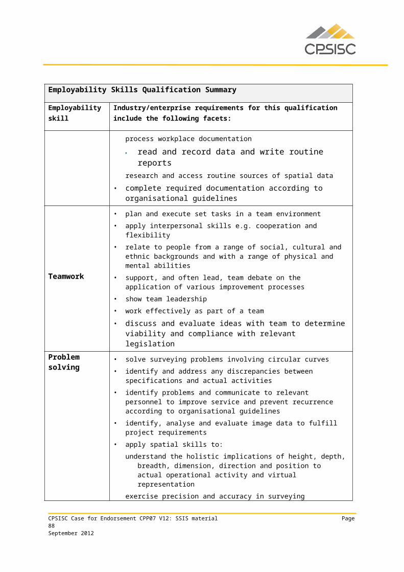
Appendix 3 Holistic quality assurance report
CPSISC Case for Endorsement CPP07 V12: SSIS material Page 88September 2012
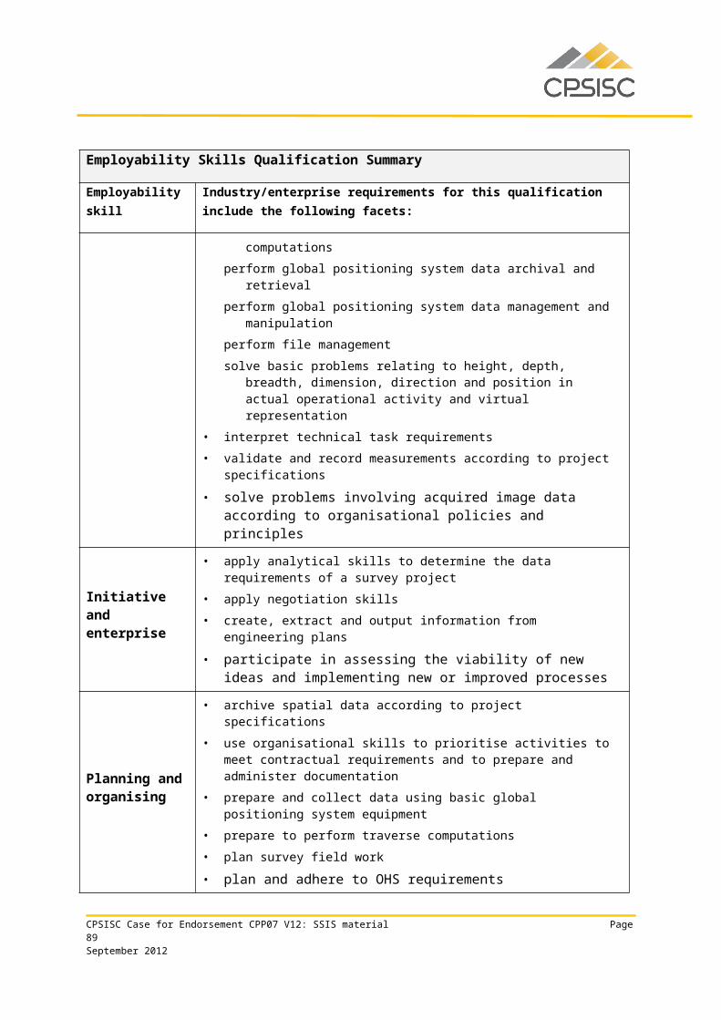
QUALITY REPORTPROPERTY SERVICES TRAINING PACKAGE: CPP07 VERSION 12NEW AND REV IS ED UNITS AND QUAL IF ICAT IONS FOR SURVEYING AND SPAT IAL INFORMAT ION SERV ICES
PREPARED FOR CONSTRUCTION AND PROPERTY SERV ICES INDUSTRY SKILLS COUNCIL BY :Nicola Burridge
TMI Management Solutions
July 2012
CPSISC Case for Endorsement CPP07 V12: SSIS material Page 89September 2012
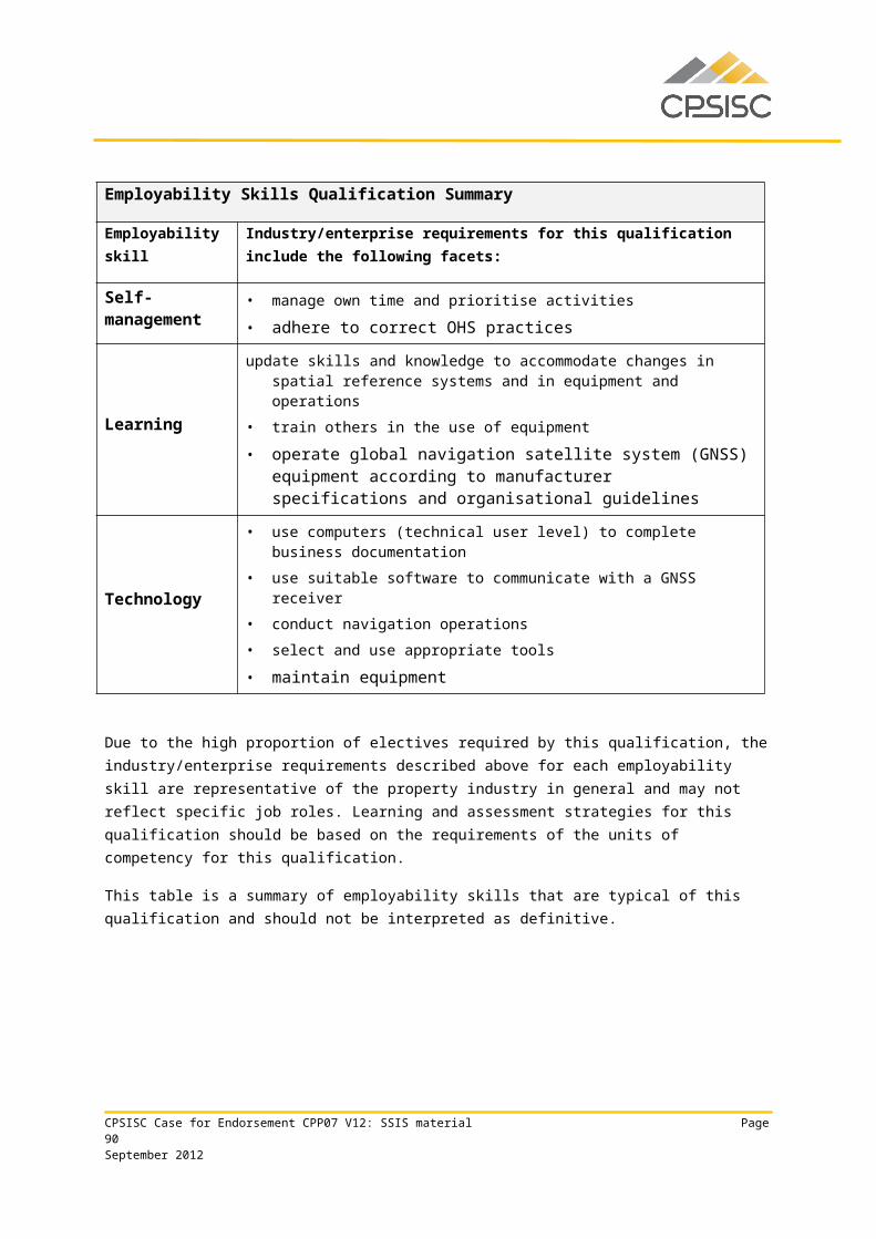
SECT ION 1: DETAILS OF DRAFT TRAIN ING PACKAGE COMPONENTS
INFORMAT ION REQUIRED
DETAIL
Training Package title and code
Property Services Training Package (CPP07) Version 12
Number of new or revised qualifications or total number if a whole Training Package review
1 new qualification: CPP60312 Advanced Diploma of Surveying
7 revised qualifications: CPP20112 Certificate II in Surveying and Spatial Information
Services CPP30112 Certificate III in Surveying and Spatial Information
Services CPP40112 Certificate IV in Surveying CPP40212 Certificate IV in Spatial Information Services CPP50112 Diploma of Surveying CPP50212 Diploma of Spatial Information Services CPP60112 Advanced Diploma of Spatial Information Services
Number of new or revised units or total number if a whole Training Package review
12 new units of competency: CPPSIS4036A Operate spatial software applications CPPSIS4037A Produce computer-aided drawings CPPSIS4038A Prepare and present GIS data CPPSIS5060A Use complex spreadsheets for spatial
information CPPSIS5061A Locate underground services in surveying
practice CPPSIS5062A Conduct photogrammetric mapping CPPSIS5063A Produce GIS data CPPSIS5064A Manipulate and analyse GIS data CPPSIS6041A Compile mine survey plans CPPSIS6042A Coordinate information gathering and GIS
development CPPSIS6043A Develop, monitor and maintain geographic
information systems CPPSIS6044A Manage GIS data
80 revised units of competencySampling size of units 10 units
CPSISC Case for Endorsement CPP07 V12: SSIS material Page 90September 2012
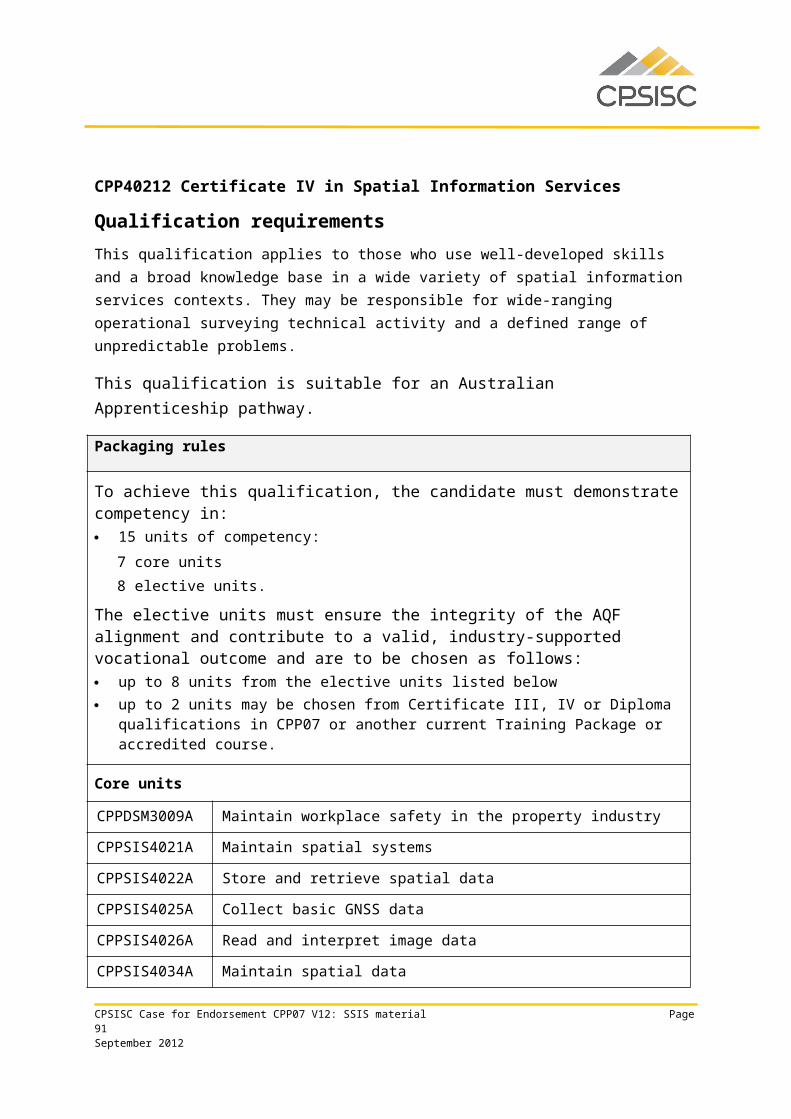
Summary of comments including a definitive statement on whether the draft endorsed components meet the Training Package Quality Principles in Section 2
The panel member has reviewed draft units of competency, qualifications and case for endorsement plus equity & editing reports. Those reports are included in the Case for Endorsement and confirm that draft components mostly meet requirements. Summary comments are as follows:
Responsiveness: new content responds to industry needs (better differentiation of surveying skills and a qualification to support licensing in Western Australia) and to Registered Training Organisation feedback about gaps and deficiencies in current content; appropriate stakeholders were involved on the Project Steering Committee and in broader consultation.
Recognition: qualifications make extensive use of cross-industry units and units from other Training Packages; new units recognise the complexity of spatial information skills, and in particular, recognition of the specific skills of surveyors is enhanced in this version through the development of additional units and a new Advanced Diploma qualification in surveying; licensing and regulatory requirements are supported by the draft components –the new surveying qualification directly reflects these requirements in Western Australia.
Flexibility: qualifications meet flexibility policy requirements; there are no pre-requisite units or entry requirement and units are written for application in diverse contexts.
One qualification, the new CPP60312 Advanced Diploma of Surveying, has an entry requirement expressed as the achievement of the CPP50112 Diploma of Surveying or equivalent competency. The panel member’s interpretation of policy is that entry requirements need to be expressed either as units of competency or vocational expertise, and not whole qualifications. The ISC advises that stakeholders in Western Australia strongly support maintaining the whole qualification as the requirement.
Functionality: the mix of old and new content, and limited scope of work on older content are factors that contribute to some variation in the functionality of the draft components; there is room for additional work to enhance the clarity and quality of the SSIS units of competency and CPSISC acknowledges this as a key aspect of future streamlining work; apart from the item above related to entry requirements, Training Package policy is met.
Note that new units retain the ‘A’ identifier and CPSISC has advised that it had previously discussed its intended approach with the Office of the NSSC; that is, to include an "A" for all new units being readied for endorsement as part of this reporting cycle.
In summary, subject to consideration of the entry requirement item raised above, and an acknowledgment that further work needs to be undertaken on units of competency as part of the full streamlining process, it is the view of the panel member that draft components mostly Training Package Quality Principles.
CPSISC Case for Endorsement CPP07 V12: SSIS material Page 91September 2012
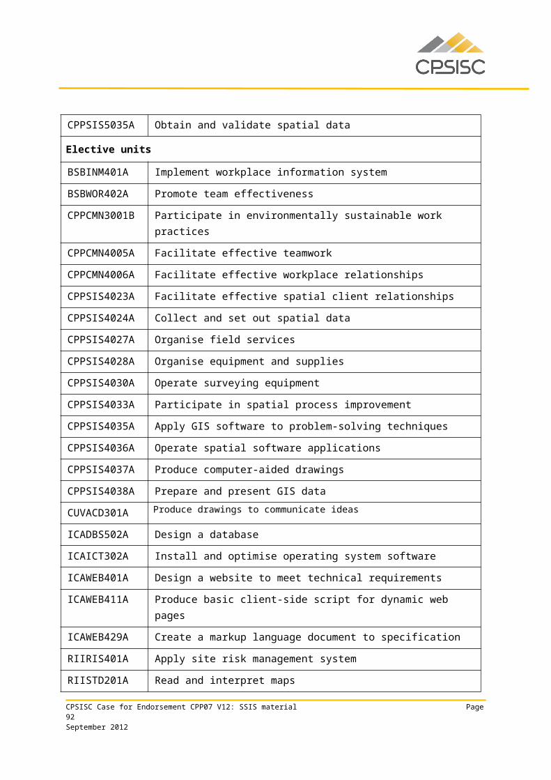
Panel member completing Quality Report
Nicola Burridge, TMI Management Solutions
Statement confirming Panel member has not been involved in the development or validation activities associated with this Training Package
Nicola Burridge has not been involved in development or validation activities associated with this Training Package
Date completed 26 July 2012
CPSISC Case for Endorsement CPP07 V12: SSIS material Page 92September 2012
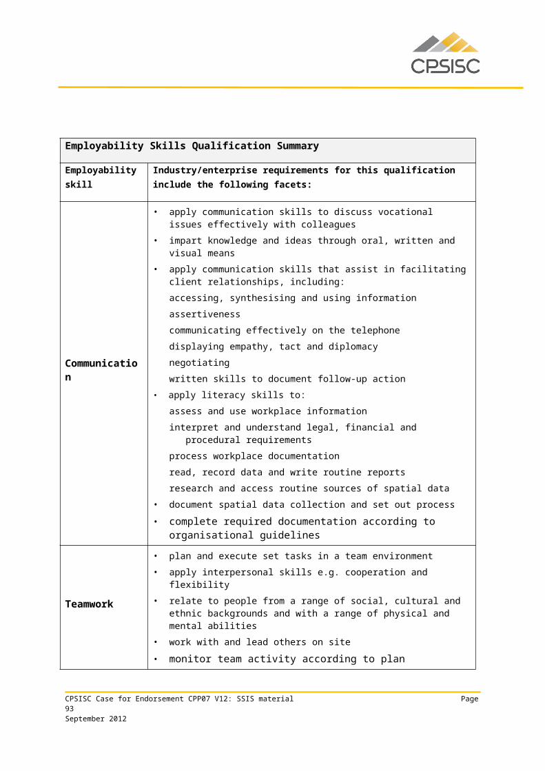
SE C T I O N 2 : CO MM E N T S O N HO W DR A F T TR A IN I NG PA C K A G E CO MP O NE N T S ME E T QU A L I T Y PR IN C IP L E S
Q U A L I T Y P R I N C I P L E S
K E Y F E A T U R E S
E V I D E N C E C O M M E N T S
The endorsed components of a Training Package must …
How do the endorsed components of a Training Package achieve this?
Provide brief commentary on the whether the draft endorsed components meet the Quality Principles with specific reference to the evidence provided
Responsiveness
…to the needs of contemporary
industry and its workforce
Reflect contemporary work organisation and job profiles incorporating a futures orientation
Open and inclusive consultation and validation commensurate with scope and impact is conducted
Other national and international standards for skills are considered
The draft components were developed in response to two key industry and training drivers identified in CPSISC’s continuous improvement plan:The need for better distinction
between the skills or surveyors and others working in Spatial Information Services, in particular the need for the new CPP60312 Advanced Diploma of Surveying to meet industry needs in Western Australia, but also supported nationally
Feedback from the RTO network delivering the qualifications about gaps in existing content and the need to more fully articulate the complexity of skill requirements
Consultation and governance processes were appropriate in scope and included:Establishment of a Project
Steering Committee comprising representation from key industry organisations (Surveying and Spatial Sciences Institute (SSSI), Spatial Industries Business Association) RTOs, higher education and State Training Authorities – this met on 4 occasions to review and confirm approaches
Consultation workshops in
Be driven by industry’s needs
Clever, sustainable approaches to incorporate feedback from stakeholders
Respond to government broad policy initiatives
Innovative responses to government policy initiatives
CPSISC Case for Endorsement CPP07 V12: SSIS material Page 93September 2012
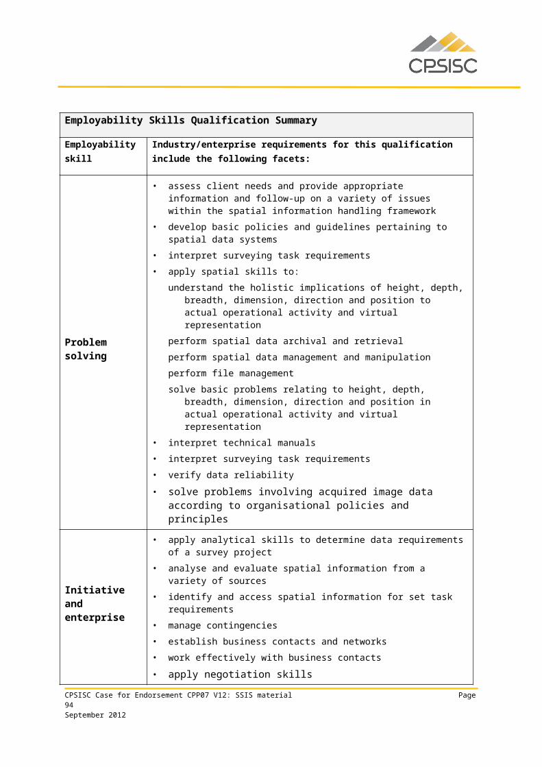
Q U A L I T Y P R I N C I P L E S
K E Y F E A T U R E S
E V I D E N C E C O M M E N T S
Adelaide, Perth, Brisbane, Canberra, Melbourne, and Sydney
Meetings with some regulators and other targeted consultations
Use of web-based consultation.
Recognition
..of an individual’s competence
across industries and occupations
Recognise convergence and connectivity of skills
Incorporation of cross industry units and qualifications
Qualifications incorporate units from a wide range of other Training Packages, most notably Business Services (BSB07), Information and Communications Technology (ICA11) and Resources and Infrastructure (RII09). Common units from CPP07 are also used.
Qualifications are clearly and consistently expressed
The panel member did raise some questions around a perception that some units first packaged at a Certificate IV level seemed quite simplistic in nature. The ISC advised that for some occupations Certificate IV was the entry level. This is supported by the underpinning mathematical and technical knowledge requirement in the sector.
CPP07 includes 19 skill sets for surveying and spatial information services. Only minor changes to update codes and titles were made to skill sets and skill sets were not reviewed as part of the holistic quality assurance process.
Licensing and registration requirements for surveyors in different jurisdictions. Higher education qualifications are needed for registration as a cadastral surveyor in all states and
Support movement of skills within and across organisations and sectors
Clear and consistent packaging rules for qualifications
Qualification framework and pathways are effectively designed
Incorporation of skill sets
Promote national and international portability
Qualification outcomes are aligned with the Australian Qualifications Framework
Other national and international standards for skills are considered
Reflect licensing and regulatory requirements
Solutions to incorporate licensing and regulatory requirements are brokered
CPSISC Case for Endorsement CPP07 V12: SSIS material Page 94September 2012
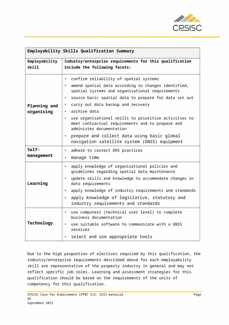
Q U A L I T Y P R I N C I P L E S
K E Y F E A T U R E S
E V I D E N C E C O M M E N T S
territories apart from Western Australia. Hence the new Advanced Diploma qualification is most relevant to that state, though it may be used as a pathway to higher education in other jurisdictions. Information about different requirements is included in the Training Package Assessment Guidelines
Flexibility
…to meet individual
enterprise and learner needs
Meet the diversity of individual and enterprise needs
Clear and consistent packaging rules for qualifications
Provide flexible qualifications that enable application in different contexts
Qualifications meet flexibility requirements with at least one third electives, and one sixth of electives able to be selected from other Training Packages and accredited courses.
Only one of the eight SSIS qualifications has an entry requirement, this being the new CPP60312 Advanced Diploma of Surveying, where the entry requirement is achievement of the CPP50112 Diploma of Surveying or equivalent competency. The panel member’s interpretation of policy is that entry requirements should be expressed either as units of competency or vocational expertise, and not whole qualifications. The ISC advises that stakeholders in Western Australia require the requirement of the whole qualification.
There are no pre-requisite units of competency in the draft components.
Units may be applied in diverse areas of surveying and spatial information services
Pathways advice is provided in the introductory section of the Training Package and examples of
Support equitable access and progression of learners
Provide multiple entry and exit points1.
Pre and co-requisite units of competency are minimized
Units of competency are clearly written and have consistent breadth and depth
Support learner transition between education sectors
Advice is provided on implementation/pathways
CPSISC Case for Endorsement CPP07 V12: SSIS material Page 95September 2012

Q U A L I T Y P R I N C I P L E S
K E Y F E A T U R E S
E V I D E N C E C O M M E N T S
outcomes at each level are included, using skill sets as the basis of those examples.
Functionality
…through ease of understanding,
clever design and consistency with policy and
publication requirements
Support implementation across a range of settings
Advice is provided on implementation/pathways
Draft components comprise both new and revised units of competency. As also noted in Editing and Equity reports, there is significant opportunity to enhance content as part of the streamlining process. CPSISC acknowledges that this is the case. In particular, the following items are noted:Many Evidence guide sections
provide generic information only, and some of that information is not clear (e.g. under Context of Assessment, the statement is Holistic: based on the performance criteria, evidence guide, range statement, and required skills and knowledge which provides little information). Note that the section headings vary slightly from current national template.
More guidance could be provided around the parameters of knowledge (e.g. features and functions of commercial software packages, spatial information systems). This item was also raised in the Equity Report.
The relationship between these units and other units could also be reviewed (e.g. in CPPSIS4038A Prepare and present GIS data. required knowledge includes procedures for the use of the following applications:
Support sound assessment practice
Units of competency are clearly written and have consistent breadth and depth
Not impose structural barriers to implementation
Clear and consistent packaging rules for qualifications
Compliance with the National Training Information System (NTIS)/National Register standard for loading and publication
Compliance with Training Package policy
CPSISC Case for Endorsement CPP07 V12: SSIS material Page 96September 2012
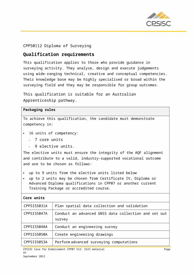
Q U A L I T Y P R I N C I P L E S
K E Y F E A T U R E S
E V I D E N C E C O M M E N T S
computer-aided design (CAD), graphic animation, desktop mapping, desktop publishing, multimedia, plotters, though no animation or multimedia units in CPP07 or elsewhere are included or referenced in the qualifications.
While required skills are quite comprehensive, there were some items where the meaning or relationship was not clear to the panel member (e.g. interpreting project requirements was usually nominated as a self-management skill, though on occasion as a literacy skill) or where the skill requirement seemed in excess of what was actually required by the unit
Scope and level of units might be usefully reviewed to better support sound and consistent assessment. The ISC advises industry preference to keep the units and unit requirements very broad.
Draft content is not in the CAT format though this is not an issue because of TGA.
It is noted that the ISC has retained version identifiers in all unit codes. CPSISC advised that it had discussed its intended approach with the Office of the NSSC; that is, to include an "A" for all new units and increment to "B" or "C" for existing units for the current sectors being readied for endorsement as part of this reporting cycle.
CPSISC Case for Endorsement CPP07 V12: SSIS material Page 97September 2012
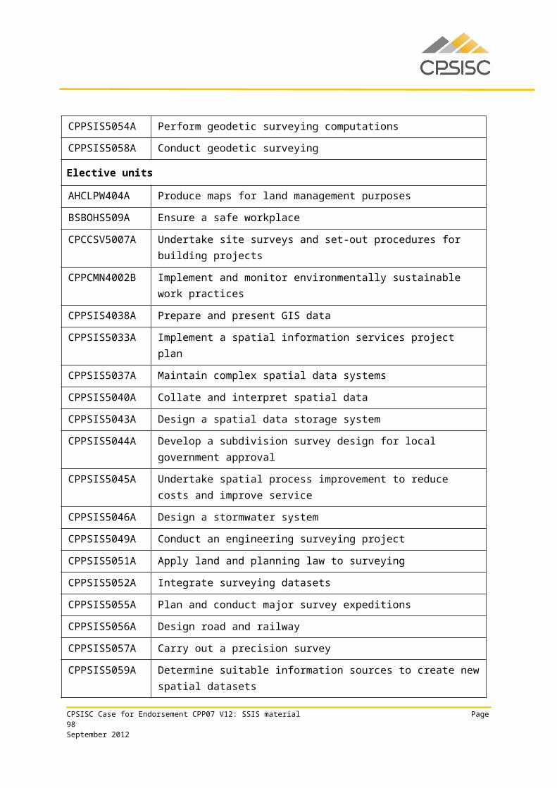
Q U A L I T Y P R I N C I P L E S
K E Y F E A T U R E S
E V I D E N C E C O M M E N T S
A further point is that while Training Package policy advises that if a new code is assigned to a unit the title should change, the ISC has not changed unit titles given the large number of changes that would have been required and the perceived barrier to implementation this would represent.
Training package policy is met with the exception of the item raised under Flexibility about the entry requirement for the CPP60312 Advanced Diploma of Surveying.
CPSISC Case for Endorsement CPP07 V12: SSIS material Page 98September 2012
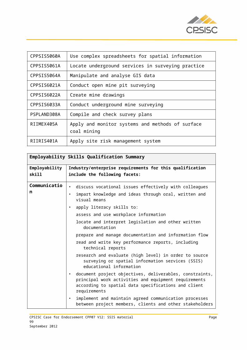
Appendix 4 SSIS commencement and completion data
CPSISC Case for Endorsement CPP07 V12: SSIS material Page 99September 2012
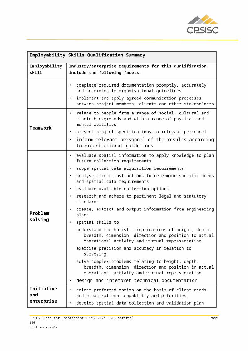
The following data has been obtained from NCVER VOCSTATS.
The table includes the number of commencements and completions of apprenticeships and traineeships in Surveying and Spatial Information Services qualifications for the 12 month period to June 2011.
All data relates to Versions 6 and 7 of the CPP07 Training Package, as there is no data available for later versions.
Surveying and Spatial Information Services Australian Apprenticeships in 12months to June 2011
Qualification Title Commencements
Completions
CPP20107 Certificate II in Spatial Information Services
- -
CPP30107 Certificate III in Spatial Information Services
- 5
CPP30109 Certificate III in Spatial Information Services
20 6
CPP40107 Certificate IV in Surveying - -CPP40109 Certificate IV in Surveying 4CPP40209 Certificate IV in Spatial Information Services
24 1
CPP50107 Diploma of Surveying 3 -CPP50207 Diploma of Spatial Information Services
4 -
Total 56 12
CPSISC Case for Endorsement CPP07 V12: SSIS material Page 100September 2012
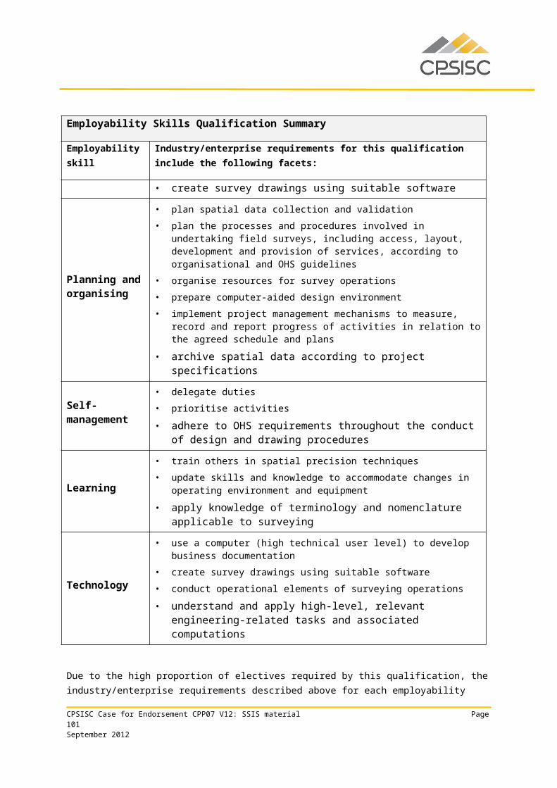
Surveying and Spatial Information Services VET Student enrolments in 12months to Dec 2010
Qualification Title Commencements
Completions
CPP20107 Certificate II in Spatial Information Services
48 25
CPP30107 Certificate III in Spatial Information Services
135 102
CPP30109 Certificate III in Spatial Information Services
148 41
CPP40107 Certificate IV in Surveying 47 11CPP40109 Certificate IV in Surveying 89 19CPP40207 Certificate IV in Spatial Information Services
10 1
CPP40209 Certificate IV in Spatial Information Services
138 25
CPP50107 Diploma of Surveying 219 58CPP50207 Diploma of Spatial Information Services
164 36
CPP60107 Advanced Diploma of Spatial Information Services
16 1
CPP60109 Advanced Diploma of Spatial Information Services
29 18
Total 1043 337
CPSISC Case for Endorsement CPP07 V12: SSIS material Page 101September 2012