Embed Size (px)
Citation preview
CRASH LEVEL ANALYSIS FILE USER’S GUIDE July 2011 Produced under contract for
New Mexico Department of Transportation (NMDOT) Office of Programs
Traffic Safety Bureau
Produced by Division of Government Research (DGR)
University of New Mexico
TABLE OF CONTENTS INTRODUCTION ............................................................................................................. 1
1.1. CRASH REPORT NUMBER ................................................................................. 2
1.2. CRASH DATE ....................................................................................................... 2
1.3. MONTH OF CRASH .............................................................................................. 2
1.4. DAY OF MONTH OF CRASH ............................................................................... 2
1.5. YEAR OF CRASH ................................................................................................. 3
1.6. TIME OF CRASH .................................................................................................. 3
1.7. HOUR OF CRASH ................................................................................................ 3
1.8. DAY OF WEEK ..................................................................................................... 3
1.9. REPORTING AGENCY ......................................................................................... 4
1.10. CRASH SEVERITY ............................................................................................... 4
1.11. HIT AND RUN CRASH .......................................................................................... 4
1.12. CRASH LOCATION............................................................................................... 5
1.13. POPULATION GROUP ......................................................................................... 7
1.14. COUNTY ............................................................................................................... 7
1.15. LICENSE COUNTY ............................................................................................... 8
1.16. STATE DOT MAINTENANCE DISTRICT .............................................................. 8
1.17. STATE DOT COMMISSION DISTRICT ................................................................ 9
1.18. STATE POLICE DISTRICT ................................................................................... 9
1.19. HIGHWAY ELEMENT CODE ................................................................................ 9
1.20. ROADWAY RELATION ....................................................................................... 10
1.21. CRASH CLASSIFICATION ................................................................................. 10
1.22. CRASH ANALYSIS ............................................................................................. 11
1.23. STATE HIGHWAY DEPARTMENT PROPERTY ................................................ 18
1.24. LIGHTING ........................................................................................................... 18
1.25. WEATHER .......................................................................................................... 19
1.26. ROAD CHARACTER ........................................................................................... 19
1.27. ROAD GRADE .................................................................................................... 19
1.28. AMBULANCE NAME ........................................................................................... 20
1.29. OCCUPANTS IN ENTIRE CRASH ...................................................................... 21
1.30. OCCUPANTS KILLED ......................................................................................... 21
1.31. OCCUPANTS WITH AN INCAPACITATING INJURY ......................................... 21
1.32. OCCUPANTS WITH A NON-INCAPACITATING INJURY .................................. 21
1.33. OCCUPANTS WITH A NON-VISIBLE INJURY ................................................... 22
1.34. OCCUPANTS UNHURT (PROPERTY DAMAGE ONLY) .................................... 22

1.35. INVOLVEMENT OF NON-LOCAL DRIVERS ...................................................... 22
1.36. PEDESTRIAN INVOLVEMENT ........................................................................... 23
1.37. MOTORCYCLE INVOLVEMENT ........................................................................ 23
1.38. PEDALCYCLIST INVOLVEMENT ....................................................................... 24
1.39. ALCOHOL INVOLVEMENT ................................................................................. 24
1.40. DRUG INVOLVEMENT ....................................................................................... 24
1.41. HEAVY TRUCK INVOLVEMENT ........................................................................ 25
1.42. HAZARDOUS MATERIAL INVOLVEMENT ........................................................ 25
1.43. NUMBER OF VEHICLES AND PEDESTRIANS INVOLVED .............................. 25
1.44. HIGHEST ENFORCEMENT ACTION ................................................................. 25
1.45. MAXIMUM VEHICLE DAMAGE .......................................................................... 26
1.46. HIGHEST CONTRIBUTING FACTOR IN CRASH .............................................. 27
1.47. MAJOR STREET ................................................................................................. 29
1.48. SECONDARY STREET ....................................................................................... 29
1.49. MILES FROM INTERSECTION .......................................................................... 29
1.50. FEET FROM INTERSECTION ............................................................................ 29
1.51. DIRECTION FROM INTERSECTION.................................................................. 30
1.52. DESIGNATED ROUTE NAME ............................................................................ 30
1.53. DESIGNATED ROUTE NAME IN HPMS FORMAT ............................................ 30
1.54. POST ................................................................................................................... 31
1.55. MILE POST ......................................................................................................... 31
1.56. ADMINISTRATIVE ROUTE ................................................................................. 32
1.57. ADMINISTRATIVE ROUTE ORIGINAL ............................................................... 32
1.58. ROUTE STATUS ................................................................................................. 33
1.59. MILE LOG ........................................................................................................... 33
1.60. LOG ..................................................................................................................... 33
1.61. FUNCTIONAL CLASS OF ROADWAY ............................................................... 34
1.62. ROAD SYSTEM .................................................................................................. 34
1.63. MAJOR STREET CODE ..................................................................................... 35
1.64. SECONDARY STREET CODE ........................................................................... 35
1.65. DIVIDED HIGHWAY ............................................................................................ 35
1.66. DIVIDED HIGHWAY DIRECTION ....................................................................... 35
1.67. CRASH DIRECTION ........................................................................................... 36
1.68. FILE DATE .......................................................................................................... 36
INDEX BY VARIABLE DESCRIPTION / FULL NAME................................................... 37
INDEX BY VARIABLE NAME ........................................................................................ 39

Questions and comments regarding this material should be directed to:
Division of Government Research University of New Mexico
MSC06 3510, 1 University of New Mexico Albuquerque, NM 87131-0001
(505) 277-3305 www.dgr.unm.edu
Originally written under Grant # 1-TR-95-01 Revised February, 1980, under Grant # 3-TRS-80-08-01-04 Revised December, 1980, under Grant # 1-TRS-81-08-01-01 Revised September, 1981, under Grant # 1-TRS-81-08-01-01 Revised November, 1984, under Grant # 1-TR-85-08-01-01 Revised June, 1989, under Grant # 1-TR-89-01-01-01 Revised August, 1995, under Grant # 1-TR-95-01
Revised February, 2000, under Contract # C03744 Revised July, 2011, under Contract # C05407

CRASH FILE CODES Produced by the Division of Government Research, UNM
Under Contract # C05407 from the NM Traffic Safety Division
1
INTRODUCTION This is a technical guide to the traffic crash data (“TSTATB Crash File”) collected by the New Mexico Department of Transportation, Traffic Safety Bureau, Traffic Records Program (NMDOT). The crash data are structured into three groups: data on each crash (“Crash Level”), data on individual vehicles involved in each crash (“Vehicle Level”), and data on occupants of each vehicle (“Occupant Level”). There are technical guides for each level: This document lists data available in the Crash Level File, i.e. data collected on each crash. Crash level data are best used in the analysis of the types, locations, severity and causes of crashes in the State of New Mexico. Below is a guide to each numbered item. Items in this guide include references to SAS formats: DGR uses SAS (www.sas.com) to process and analyze the large number of crash records. Access to the SAS format library is available through DGR. Alphabetical indices by Full Name and Variable Name are at the end of this guide. This documentation reflects the state of the file as of 2004, although changes between 2000 and 2004 were quite minor. For data files prior to 2000, see the 2000 version of this documentation. SAMPLE OF INFORMATION IN THIS GUIDE:
Full Name
Variable Name in database Format of data type in SAS (Ex. 10-digit alphanumeric field)
Database format form A = character form N = numeric form Date = date form
Description
TSTATB Crash File = copied from original TSTATB file Program derived from VARIABLE = Calculated by DGR using the specified variable
Record 0 = Crash level data Record 1 = Vehicle and driver identification data Record 2 = Conditions & contributing factors to crashes Record 3 = Occupant data
Column locations in .txt format if copied directly from TSTATB Crash File
CRASH FILE CODES Produced by the Division of Government Research, UNM
Under Contract # C05407 from the NM Traffic Safety Division
2
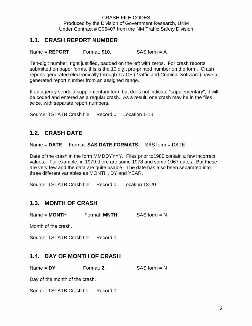
1.1. CRASH REPORT NUMBER Name = REPORT Format: $10. SAS form = A Ten-digit number, right justified, padded on the left with zeros. For crash reports submitted on paper forms, this is the 10 digit pre-printed number on the form. Crash reports generated electronically through TraCS (Traffic and Criminal Software) have a generated report number from an assigned range. If an agency sends a supplementary form but does not indicate "supplementary", it will be coded and entered as a regular crash. As a result, one crash may be in the files twice, with separate report numbers. Source: TSTATB Crash file Record 0 Location 1-10
1.2. CRASH DATE Name = DATE Format: SAS DATE FORMATS SAS form = DATE Date of the crash in the form MMDDYYYY. Files prior to1980 contain a few incorrect values. For example, in 1979 there are some 1978 and some 1967 dates. But these are very few and the data are quite usable. The date has also been separated into three different variables as MONTH, DY and YEAR. Source: TSTATB Crash file Record 0 Location 13-20
1.3. MONTH OF CRASH Name = MONTH Format: MNTH SAS form = N Month of the crash. Source: TSTATB Crash file Record 0
1.4. DAY OF MONTH OF CRASH Name = DY Format: 2. SAS form = N Day of the month of the crash. Source: TSTATB Crash file Record 0

CRASH FILE CODES Produced by the Division of Government Research, UNM
Under Contract # C05407 from the NM Traffic Safety Division
3
1.5. YEAR OF CRASH Name = YEAR Format: 4. SAS form = N Year of the crash in the form YYYY. Source: TSTATB Crash file Record 0
1.6. TIME OF CRASH Name = TIME Format: $4. SAS form = A Time of the crash (24 hour clock). Every year there is a small percentage (e.g., about 0.1 percent in 1980) of TIME coded as 2401 to 2459. Time 0000 generally means unknown, not midnight. Source: TSTATB Crash file Record 0 Location 24-27
1.7. HOUR OF CRASH Name = HOUR Format: HOUR. SAS form = N Hour of the crash. This field is only on SAS files since 1984. Source: Program derived
1.8. DAY OF WEEK Name = DAY Format: DAYW. SAS form = N
1 Sunday 2 Monday 3 Tuesday 4 Wednesday 5 Thursday 6 Friday 7 Saturday
Source: TSTATB Crash file Record 0 Location 35
CRASH FILE CODES Produced by the Division of Government Research, UNM
Under Contract # C05407 from the NM Traffic Safety Division
4
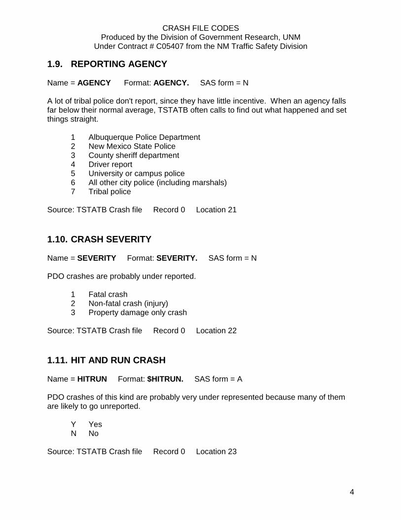
1.9. REPORTING AGENCY Name = AGENCY Format: AGENCY. SAS form = N A lot of tribal police don't report, since they have little incentive. When an agency falls far below their normal average, TSTATB often calls to find out what happened and set things straight.
1 Albuquerque Police Department 2 New Mexico State Police 3 County sheriff department 4 Driver report 5 University or campus police 6 All other city police (including marshals) 7 Tribal police
Source: TSTATB Crash file Record 0 Location 21
1.10. CRASH SEVERITY Name = SEVERITY Format: SEVERITY. SAS form = N PDO crashes are probably under reported.
1 Fatal crash 2 Non-fatal crash (injury) 3 Property damage only crash
Source: TSTATB Crash file Record 0 Location 22
1.11. HIT AND RUN CRASH Name = HITRUN Format: $HITRUN. SAS form = A PDO crashes of this kind are probably very under represented because many of them are likely to go unreported.
Y Yes N No
Source: TSTATB Crash file Record 0 Location 23

CRASH FILE CODES Produced by the Division of Government Research, UNM
Under Contract # C05407 from the NM Traffic Safety Division
5
1.12. CRASH LOCATION Name = CITY Format: CITY. SAS form = N Some crashes in Bernalillo County areas such as Cedar Crest, Tijeras, and Los Ranchos de Albuquerque are coded as Albuquerque. Codes correspond to urban areas rather than official city limits. Some cities are not very diligent about sending in crash report forms. Reservation police do not always report. Crashes on roads through reservations are coded as reservation crashes. Los Alamos county has more crashes than Los Alamos city even though it is a class H county (combined city-county) and should have the same for both. TSTATB developed a locational guide (and other locational aids) which began to improve data in early and middle 1979.
Place Code Place Code
Rural 000 Alamogordo 010
Albuquerque 015 Anthony 016
Angel Fire 017 Artesia 020 Aztec 025 Bayard 030 Belen 035 Bernalillo 040 Bloomfield 045 Bosque Farms 046 Capitan 050 Carlsbad 055 Carrizozo 060 Causey 063 Central 065 Chama 067 Cimarron 070 Clayton 075
Cloudcroft 080
Corona 095 Corrales 097 Cuba 098 Deming 100 Des Moines 105 Dexter 110 Dora 111 Eagle Nest 112 Elida 113 Encino 115 Española 120 Estancia 125 Eunice 130 Farmington 135 Floyd 138 Folsom 140 Ft. Sumner 145 Gallup 150 Grady 155 Grants 160 Grenville 165
Clovis 085 Columbus 090
Hagerman 170 Hatch 175

CRASH FILE CODES Produced by the Division of Government Research, UNM
Under Contract # C05407 from the NM Traffic Safety Division
6
Crash Location (continued) Place Code Hobbs 180 Hope 185 House 187 Hurley 190 Jal 200 Jemez Springs 210
Lake Arthur 215 La Mesilla 217 Las Cruces 220 Las Vegas 225 Logan 232 Lordsburg 235 Los Alamos 240 Los Lunas 245 Los Ranchos 247 Loving 250 Lovington 255 Magdalena 260 Maxwell 265 Melrose 270 Milan 280 Moriarty 285 Mosquero 290 Mountainair 295 Pecos 305 Portales 310 Questa 315 Raton 325 Red River 327 Reserve 328 Rio Rancho 329 Roswell 330 Roy 335 Ruidoso 340 Ruidoso Downs 345
San Jon 355 San Ysidro 356 Santa Fe 360 Santa Rosa 370 Shiprock 375 Silver City 380
Place Code Socorro 385 Springer 395 Sunland Park 400 Taos 405 Tatum 410 Texico 415 Tijeras 416 Truth or Consequences 420 Tucumcari 425 Tularosa 430 Vaughn 435 Virden 440 Wagon Mound 445 Willard 450 Williamsburg 452 Acoma 455 Alamo-Navajo 456 Canoncito Navajo 457 Cochiti 458 Isleta 459 Jemez 460 Jicarilla Apache 461 Laguna 462 Mescalero Apache 463 Nambe 464 Navajo 465 Picuris 466 Pojoaque 467 Ramah Navajo 468 Sandia 469 San Felipe 470 San Ildefonso 471 San Juan 472 Santa Ana 473 Santa Clara 474 Santo Domingo 475 Taos Pueblo 476 Tesuque 477 Zia 478 Zuni 479
Source: TSTATB Crash file Record 0 Location 28-30

CRASH FILE CODES Produced by the Division of Government Research, UNM
Under Contract # C05407 from the NM Traffic Safety Division
7
1.13. POPULATION GROUP Name = POPGRP Format: POPGRP. SAS form = N POPGRP has 1970 census figures for data through 1980. Starting with calendar 1981 data, 1980 census counts are used.
5 Outside city limits, but within urban boundaries 6 Under 2,500 7 2,500 – 5,000 8 5,000 - 10,000 9 10,000 - 25,000 11 25,000 - 50,000 12 Over 50,000
Source: TSTATB Crash file Record 0 Location 31-32
1.14. COUNTY Name = COUNTY Format: COUNTY. SAS form = N Alphabetic county code. NM76 from Española to Chimayo snakes along the border between Santa Fe and Rio Arriba counties and may get coded incorrectly.
1 Bernalillo 12 Harding 23 Roosevelt 2 Catron 13 Hidalgo 24 Sandoval 3 Chaves 14 Lea 25 San Juan 4 Cibola 15 Lincoln 26 San Miguel 5 Colfax 16 Los Alamos 27 Santa Fe 6 Curry 17 Luna 28 Sierra 7 De Baca 18 McKinley 29 Socorro 8 Doña Ana 19 Mora 30 Taos 9 Eddy 20 Otero 31 Torrance 10 Grant 21 Quay 32 Union 11 Guadalupe 22 Rio Arriba 33 Valencia
Source: Program derived from LCOUNTY

CRASH FILE CODES Produced by the Division of Government Research, UNM
Under Contract # C05407 from the NM Traffic Safety Division
8
1.15. LICENSE COUNTY Name = LCOUNTY Format: LCOUNTY. SAS form = N Motor Vehicle Division county code. See the discussion of COUNTY.
1 Santa Fe 12 San Miguel 23 Hidalgo 2 Bernalillo 13 McKinley 24 Guadalupe 3 Eddy 14 Valencia 25 Socorro 4 Chaves 15 Otero 26 Lincoln 5 Curry 16 San Juan 27 De Baca 6 Lea 17 Rio Arriba 28 Catron 7 Doña Ana 18 Union 29 Sandoval 8 Grant 19 Luna 30 Mora 9 Colfax 20 Taos 31 Harding 10 Quay 21 Sierra 32 Los Alamos 11 Roosevelt 22 Torrance 33 Cibola
Source: TSTATB Crash file Record 0 Location 33-34
1.16. STATE DOT MAINTENANCE DISTRICT Name = SHDTDIST Format: $2. SAS form = N The NM DOT has two kinds of districts: Commission districts which are based on county, and maintenance districts which are modifications of the commission districts to make them more suitable for maintenance operations. State Highway Department maintenance district. Possible values range from 1 to 6. For crashes on state system roads that match by milepost, this is derived from the ALCG; for others it is assigned by county. Source: TSTATB Crash file Record 0 Location 103

CRASH FILE CODES Produced by the Division of Government Research, UNM
Under Contract # C05407 from the NM Traffic Safety Division
9
1.17. STATE DOT COMMISSION DISTRICT Name = MDC Format: $2. SAS form = N The NM DOT has two kinds of districts: Commission districts which are based on county, and maintenance districts which are modifications of the commission districts to make them more suitable for maintenance operations. State Highway Department commission district. Possible values range from 1 to 6. It is assigned by county. Source: Program derived
1.18. STATE POLICE DISTRICT Name = SPDIST Format: $2. SAS form = N SPDIST was added since 1989 or 1990. Source: TSTATB Crash file Record 0 Location 116-117
1.19. HIGHWAY ELEMENT CODE Name = ELEMENT Format: ELEMENT. SAS form = N ELEMENT depends on the judgment of the reporting officer.
1 Intersection 2 Non-intersection 3 Intersection related 4 Driveway access 5 Railroad crossing 6 Bridge, overpass, culvert 7 Crossover-divided roadway 8 Underpass 9 Alley 0 Not stated
Source: TSTATB Crash file Record 0 Location 36

CRASH FILE CODES Produced by the Division of Government Research, UNM
Under Contract # C05407 from the NM Traffic Safety Division
10
1.20. ROADWAY RELATION Name = ROADREL Format: ROADREL. SAS form = N No problems found.
1 First harmful event was on the roadway 2 First harmful event was off the roadway
Source: TSTATB Crash file Record 0 Location 63
1.21. CRASH CLASSIFICATION Name = CLASS Format: CLASS. SAS form = N This is the classification of the first harmful event which can sometimes hide important events that may have occurred after this.
01 Overturn 07 Railroad train 02 Other non-collision 08 Pedalcyclist
03 Pedestrian 09 Animal 04 Other vehicle 10 Fixed object 05 Vehicle on other roadway 11 Other object 06 Parked vehicle 00 Other
* See ANSI D-16 traffic crash manual for definitions Source: TSTATB Crash file Record 0 Location 64-65
CRASH FILE CODES Produced by the Division of Government Research, UNM
Under Contract # C05407 from the NM Traffic Safety Division
11
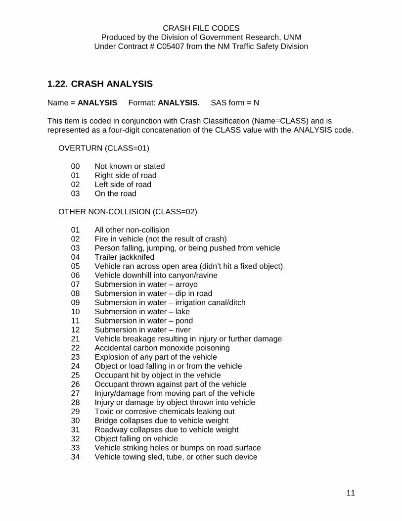
1.22. CRASH ANALYSIS Name = ANALYSIS Format: ANALYSIS. SAS form = N This item is coded in conjunction with Crash Classification (Name=CLASS) and is represented as a four-digit concatenation of the CLASS value with the ANALYSIS code. OVERTURN (CLASS=01)
00 Not known or stated 01 Right side of road 02 Left side of road 03 On the road
OTHER NON-COLLISION (CLASS=02)
01 All other non-collision 02 Fire in vehicle (not the result of crash) 03 Person falling, jumping, or being pushed from vehicle 04 Trailer jackknifed 05 Vehicle ran across open area (didn’t hit a fixed object) 06 Vehicle downhill into canyon/ravine 07 Submersion in water – arroyo 08 Submersion in water – dip in road 09 Submersion in water – irrigation canal/ditch 10 Submersion in water – lake 11 Submersion in water – pond 12 Submersion in water – river 21 Vehicle breakage resulting in injury or further damage 22 Accidental carbon monoxide poisoning 23 Explosion of any part of the vehicle 24 Object or load falling in or from the vehicle 25 Occupant hit by object in the vehicle 26 Occupant thrown against part of the vehicle 27 Injury/damage from moving part of the vehicle 28 Injury or damage by object thrown into vehicle 29 Toxic or corrosive chemicals leaking out 30 Bridge collapses due to vehicle weight 31 Roadway collapses due to vehicle weight 32 Object falling on vehicle 33 Vehicle striking holes or bumps on road surface 34 Vehicle towing sled, tube, or other such device

CRASH FILE CODES Produced by the Division of Government Research, UNM
Under Contract # C05407 from the NM Traffic Safety Division
12
CRASH ANALYSIS (continued) PEDESTRIAN (CLASS=03)
01 Vehicle going straight 02 Vehicle turning right 03 Vehicle turning left 04 Vehicle backing 05 All others and not known
COLLISION WITH OTHER VEHICLE (CLASS=04)
If a collision with another vehicle is intersection-related, then the ANALYSIS code is assigned using items 00 – 24 below. Intersection-related crashes are defined using the Highway Element Code (ELEMENT) where ELEMENT is coded as INTERSECTION (1) or INTERSECTION RELATED (3).
00 Not stated - Intersection-related crash 01 Entering at angle - Both going straight 02 " - One right turn 03 " - One left turn 04 " - Both turning right 05 " - Both turning left 06 " - One stopped 07 " - All others 08 From same direction - Both going straight 09 " - One right turn 10 " - One left turn 11 " - Both turning right 12 " - Both turning left 13 " - One stopped 14 " - Vehicle backing 15 " - All others 16 From opposite direction - Both going straight 17 " - One right turn 18 " - One left turn 19 " - Both turning left 20 " - All others 21 Opposite direction - Head on collision 22 " - Sideswipe collision 23 Same direction - Rear end collision 24 " - Sideswipe collision

CRASH FILE CODES Produced by the Division of Government Research, UNM
Under Contract # C05407 from the NM Traffic Safety Division
13
CRASH ANALYSIS (continued) If a collision with another vehicle is non-intersection-related, then the ANALYSIS code is assigned using items 25 – 62 below. Non-intersection-related crashes are defined using the Highway Element Code (ELEMENT) where ELEMENT is coded as NON-INTERSECTION (2), DRIVEWAY (4), RAILROAD CROSSING (5), BRIDGE (6), CROSSOVER (7), UNDERPASS (8), or ALLEY (9). 25 One car - Parked improper location 26 " - Stopped in traffic 27 " - Entering parked position 28 " - Forward from parked position 29 " - Backing from parked position 30 " - Entering driveway access 31 " - Leaving driveway access 32 " - Backing from driveway access 33 " - Backing from other than driveway 34 All other non-intersection (use for process of u-turns on highway, road, street) 35 Not stated - Non-intersection related crash 36 One Car - Stalled in traffic 37 Opposite direction – one vehicle spun on roadway before being hit 38 Same direction – one vehicle spun on roadway before being hit 40 Vehicle wrong way on divided highway – ramp used incorrectly 41 " - other improper entry 42 " - U turn from same lanes 43 " - access to road unknown 50 Parts – tire 51 Parts – lug nuts/wheel parts 52 Parts – miscellaneous vehicle parts 53 Trailer disconnected 54 Towed vehicle disconnected 55 Vehicle load fell – gravel/rocks 56 " - construction materials 57 " - trash/branches/etc. 58 " - furniture 59 " - all other 60 Gravel/rocks from roadway 61 Snow/ice/slush 62 Water

CRASH FILE CODES Produced by the Division of Government Research, UNM
Under Contract # C05407 from the NM Traffic Safety Division
14
CRASH ANALYSIS (continued) COLLISION WITH VEHICLE ON OTHER ROADWAY (CLASS=05)
01 Vehicle other roadway – NS 02 Vehicle crossed intersection gore area 03 Vehicle crossed shoulder to other roadway 04 Vehicle crossed median – out of control 05 " - making a U turn 06 " - all others 10 Circumstances not stated 20 Parts – tire 21 Parts – lug nuts/wheel parts 22 Parts – miscellaneous vehicle parts 23 Trailer disconnected 24 Towed vehicle disconnected 25 Vehicle load fell – gravel/rocks 26 " - construction material 27 " - trash/branches/etc. 28 " - furniture 29 " - all other 30 Gravel/rocks from roadway 31 Snow/ice/slush 32 Water
PARKED VEHICLE (CLASS =06)
00 Not known or stated 01 Vehicle parked in proper location 02 Vehicle parked in improper location 03 Vehicle backing into parked vehicle 04 All others
RAILROAD TRAIN (CLASS =07)
00 Not known or stated 01 Vehicle struck train 02 Train struck vehicle 03 Vehicle parked or stranded on tracks 04 Train derailed and struck vehicle 05 Other motorized railway device on tracks

CRASH FILE CODES Produced by the Division of Government Research, UNM
Under Contract # C05407 from the NM Traffic Safety Division
15
CRASH ANALYSIS (continued) PEDALCYCLIST (CLASS=08)
00 Not stated 01 Vehicle struck cyclist from behind 02 Vehicle struck cyclist head on 03 Vehicle struck cyclist at angle 04 Cyclist struck vehicle
ANIMAL (CLASS=09)
00 Not stated 01 Domestic animal (Cattle, horse, pigs, etc.) 02 Game animal (deer, elk, etc.) 03 Other animal (dogs, cats, etc.) 04 Bird 11 Cow 12 Horse 13 Pig 14 Sheep 15 Goat 21 Deer 22 Elk 23 Bear 24 Antelope 25 Cougar 31 Dog 32 Cat 33 Porcupine 34 Skunk 35 Badger 36 Coyote 41 Eagle 42 Hawk 43 Crow 44 Buzzard

CRASH FILE CODES Produced by the Division of Government Research, UNM
Under Contract # C05407 from the NM Traffic Safety Division
16
CRASH ANALYSIS (continued) COLLISION WITH FIXED OBJECTS (CLASS=10) 00 Other and not stated
01 Abutment or pier 02 Barricade 03 Bridge 04 Building 05 Cattle guard 06 Construction material or equipment 07 Culvert or drain pipe (cement) 08 Ditch 09 Drain or drain cover (man holes) 10 Embankment 11 Equipment (work or construction) 12 Fence (wood, brick, stone) 13 Fire hydrant 14 Guard or reflector posts 15 Gas meter 16 Guard rail 17 Guard rail at bridge or culvert 18 Hydro cells or tor shok device 19 Light standard (light pole) 20 Median (raised) or curb 21 Sign or sign post (traffic) 22 Sign or sign post (commercial) 23 Tree 24 Utility post or telephone pole 25 Traffic signal standard 26 Parking meter 27 Fence (barbed wire) 28 Boulder/rocks 29 Cliff wall 30 Dry arroyo 31 Dry irrigation ditch 32 Dumpster/trash receptacles 33 Embankment – earth 34 Embankment - rock/stone 35 Embankment - manmade - concrete, wire mesh 36 Embankment - material type unknown 37 Mailbox 38 Man-made items (phone boxes, picnic tables, etc.) 39 Overhead wires
CRASH FILE CODES Produced by the Division of Government Research, UNM
Under Contract # C05407 from the NM Traffic Safety Division
17
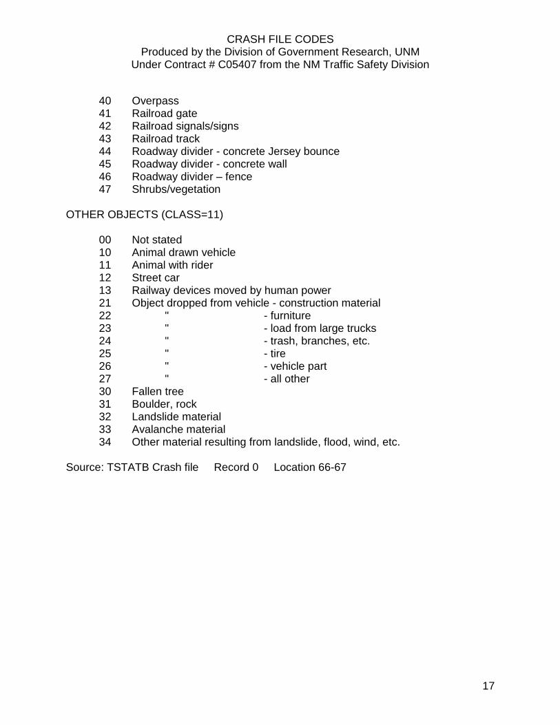
40 Overpass 41 Railroad gate 42 Railroad signals/signs 43 Railroad track 44 Roadway divider - concrete Jersey bounce 45 Roadway divider - concrete wall 46 Roadway divider – fence 47 Shrubs/vegetation
OTHER OBJECTS (CLASS=11)
00 Not stated 10 Animal drawn vehicle 11 Animal with rider 12 Street car 13 Railway devices moved by human power 21 Object dropped from vehicle - construction material 22 " - furniture 23 " - load from large trucks 24 " - trash, branches, etc. 25 " - tire 26 " - vehicle part 27 " - all other 30 Fallen tree 31 Boulder, rock 32 Landslide material 33 Avalanche material 34 Other material resulting from landslide, flood, wind, etc.
Source: TSTATB Crash file Record 0 Location 66-67

CRASH FILE CODES Produced by the Division of Government Research, UNM
Under Contract # C05407 from the NM Traffic Safety Division
18
1.23. STATE HIGHWAY DEPARTMENT PROPERTY Name = SHDTPROP Format: SHDTPROP. SAS form = N Crashes involving the State Highway Department’s property. Codes for 18 and 19 are not assigned in the ARCS coding manual maintained by the NMDOT, Traffic Safety Division, Traffic Records. 1 Guardrail 11 Culverts 2 Bridgerail 12 Bridge Structure 3 Concrete Barrier Wall 13 Field/Hog Fence 4 Attenuator/Sand Barrels 14 Signal Boxes 5 Chain Link Fence 15 Delineators 6 Barb Wire Fence 16 Mileposts 7 Signs 17 Pavement Gouges 8 Traffic Signals 20 Chemical Spill 9 Light Poles 21 Fuel Spill 10 All Other 22 Sand/Gravel Spill 23 Other Load Spills Source: TSTATB Crash file Record 0 Location 101-102
1.24. LIGHTING Name = LIGHT Format: LIGHT. SAS form = N Every year about 0.2 percent are coded zero. Accuracy is questionable. Often it may be coded according to conditions when the officer got there - not when the crash occurred.
1 Daylight 2 Dawn 3 Dusk 4 Dark (lighted) 5 Dark (not lighted) 6 Other or not stated
Source: TSTATB Crash file Record 0 Location 95

CRASH FILE CODES Produced by the Division of Government Research, UNM
Under Contract # C05407 from the NM Traffic Safety Division
19
1.25. WEATHER Name = WEATHER Format: WEATHERS. SAS form = N No problems found.
0 Not stated 1 Clear 2 Raining 3 Snowing 4 Fog 5 Dust 6 Wind 7 Other
Source: TSTATB Crash file Record 0 Location 96
1.26. ROAD CHARACTER Name = CHARACT Format: CHARACT. SAS form = N
0 Not stated 1 Straight 2 Curve
Source: TSTATB Crash file Record 0 Location 97
1.27. ROAD GRADE Name = GRADE Format: GRADE. SAS form = N 0 Not stated
1 Level 2 Hillcrest 3 On grade 4 Dip
Source: TSTATB Crash file Record 0 Location 98

CRASH FILE CODES Produced by the Division of Government Research, UNM
Under Contract # C05407 from the NM Traffic Safety Division
20
1.28. AMBULANCE NAME Name = AMBNAME Format: $25. SAS form = A Name of the ambulance service for the crash. Along with misspellings, a serious problem is that standard codes are not used. Generally, for ambulances with at least 15 calls, each service is coded about seven different ways. For example Aircare has 25 different codings, Santa Fe has 40 different codes for SFCAS and nine for Rock Mountain Ambulance Service, Albuquerque has about 50 different ways to code Albuquerque Ambulance Service and 40 for AFD, Las Cruces has six for its ambulance service, Rio Rancho has 20 for RRAS, and Roswell has 17 different codes. Almost every year there are numbers of one or more digits entered by themselves into this field. Most appear to be the number of the ambulance, but as there are many services that use the same numbering systems, these numbers are not often useful. From 1988 to 1992 there were 13 (as well as one blank and one entry of 2v), 1993 has five, 1994 has six, 1995 has five, 1996 has 1, 1997 has six (one dash and one entry of 4PV), 1998 has eight. The computer can't recognize all of these, so human effort must be used. Abbreviations (which are not always used): AMB Ambulance SER Service ASSO Association
PV Private vehicle FD Fire department PD Police department
Source: TSTATB Crash file Record 0 Location 68-92

CRASH FILE CODES Produced by the Division of Government Research, UNM
Under Contract # C05407 from the NM Traffic Safety Division
21
1.29. OCCUPANTS IN ENTIRE CRASH Name = TOTAL Format: 2. SAS form = N The total number of people involved in a crash. This is not the total number of crashes, as there can be multiple people involved in one crash. The term “occupants” includes drivers, passengers, pedestrians, pedalcyclists and motorcyclists. Source: Program derived from the occupant level
1.30. OCCUPANTS KILLED Name = KILLED Format: 2. SAS form = N The number of people killed in a crash. The terms fatalities and deaths are synonymous with killed. This is not the number of fatal crashes, as there can be multiple people killed in one fatal crash. The term “occupants” includes drivers, passengers, pedestrians, pedalcyclists and motorcyclists. Source: Program derived from the occupant level
1.31. OCCUPANTS WITH AN INCAPACITATING INJURY Name = CLASSA Format: 2. SAS form = N The number of people with an incapacitating (Class A) injury in a crash (i.e. the injured person was incapacitated and had to be carried from the scene of the crash). This is not the total number of injury crashes, as there can be multiple people injured in one crash. The term “occupants” includes drivers, passengers, pedestrians, pedalcyclists and motorcyclists. The term “serious injuries” refers to Class A plus Class B injuries. Source: Program derived from the occupant level
1.32. OCCUPANTS WITH A NON-INCAPACITATING INJURY Name = CLASSB Format: 2. SAS form = N The number of people with a non-incapacitating (Class B) injury in a crash (i.e. the injured person was visible injured but able to walk away from the crash). This is not the total number of injury crashes, as there can be multiple people injured in one crash. The term “occupants” includes drivers, passengers, pedestrians, pedalcyclists and motorcyclists. The term “serious injuries” refers to Class A plus Class B injuries.

CRASH FILE CODES Produced by the Division of Government Research, UNM
Under Contract # C05407 from the NM Traffic Safety Division
22
Source: Program derived from the occupant level
1.33. OCCUPANTS WITH A NON-VISIBLE INJURY Name = CLASSC Format: 2. SAS form = N The number of people with a non-visible (Class C) injury in a crash (i.e. the person was not visibly injured but complained of an injury). This is not the total number of injury crashes, as there can be multiple people injured in one crash. The term “occupants” includes drivers, passengers, pedestrians, pedalcyclists and motorcyclists. Source: Program derived from the occupant level
1.34. OCCUPANTS UNHURT (PROPERTY DAMAGE ONLY) Name = UNHURT Format: 2. SAS form = N The number of people unhurt (Class O) in a crash (i.e. there was property damage only). The term “occupants” includes drivers, passengers, pedestrians, pedalcyclists and motorcyclists. Source: Program derived from the occupant level
1.35. INVOLVEMENT OF NON-LOCAL DRIVERS Name = NONLOCAL Format: NONLOCAL. SAS form = N This field is mainly for picking up out of state involvement which it does well, except for the possibility of false ID's. The distinction between local and non-local in-state is not very precise; it is a quick guess job by the coders who compare the driver’s address to the crash location.
0 Local 1 Out of state
2 Non-local in-state 3 Both Source: Program derived from the detail level
CRASH FILE CODES Produced by the Division of Government Research, UNM
Under Contract # C05407 from the NM Traffic Safety Division
23
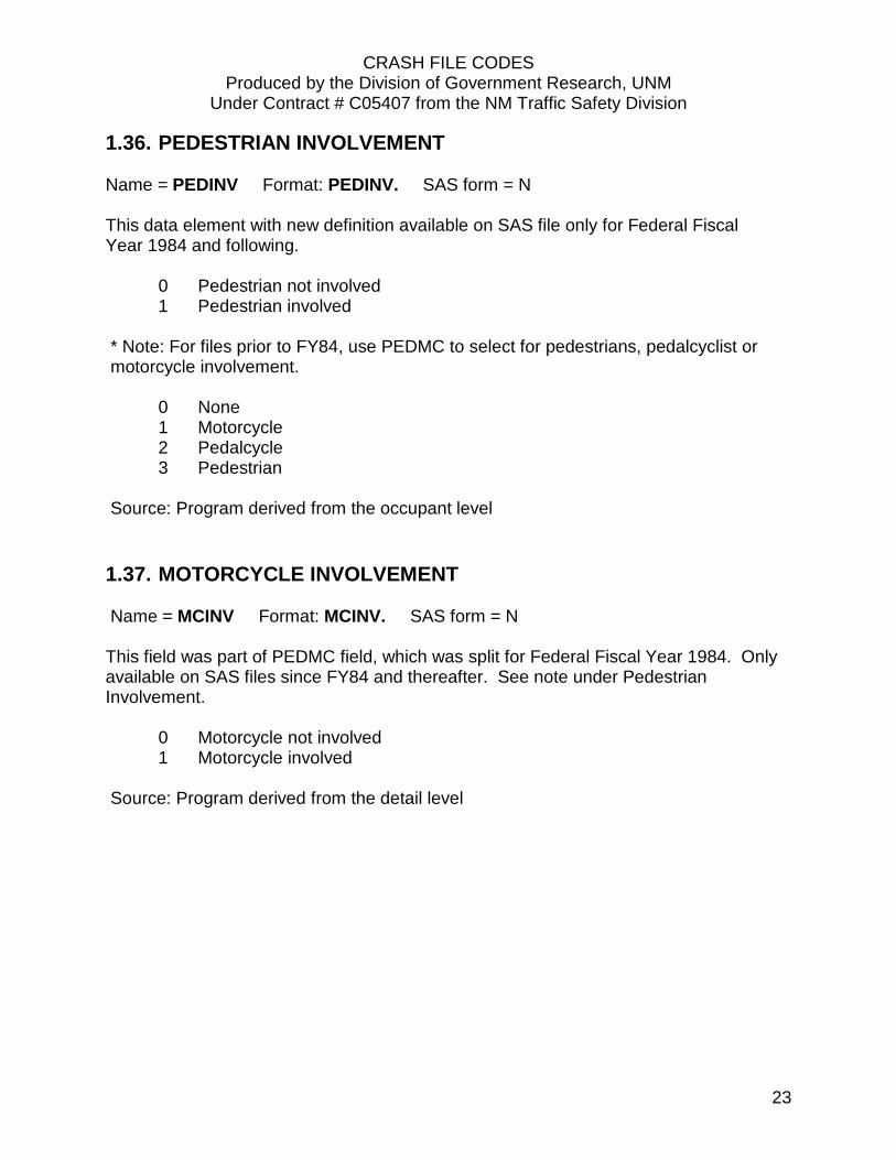
1.36. PEDESTRIAN INVOLVEMENT Name = PEDINV Format: PEDINV. SAS form = N This data element with new definition available on SAS file only for Federal Fiscal Year 1984 and following. 0 Pedestrian not involved 1 Pedestrian involved * Note: For files prior to FY84, use PEDMC to select for pedestrians, pedalcyclist or motorcycle involvement. 0 None 1 Motorcycle 2 Pedalcycle 3 Pedestrian Source: Program derived from the occupant level
1.37. MOTORCYCLE INVOLVEMENT Name = MCINV Format: MCINV. SAS form = N This field was part of PEDMC field, which was split for Federal Fiscal Year 1984. Only available on SAS files since FY84 and thereafter. See note under Pedestrian Involvement. 0 Motorcycle not involved 1 Motorcycle involved Source: Program derived from the detail level

CRASH FILE CODES Produced by the Division of Government Research, UNM
Under Contract # C05407 from the NM Traffic Safety Division
24
1.38. PEDALCYCLIST INVOLVEMENT Name = PECINV Format: PECINV. SAS form = N This field was part of PEDMC field, which was split for Federal Fiscal Year 1984. Only available on SAS files since FY84 and thereafter. See note under Pedestrian Involvement. 0 Pedalcyclist not involved 1 Pedalcyclist involved Source: Program derived from the detail level
1.39. ALCOHOL INVOLVEMENT Name = ALCINV Format: ALCINV. SAS form = N Highest code from the Detail record: (If more than one code applies, the one with the highest number is used.)
0 None indicated 1 From sobriety field
2 From contributing factors 3 Cited for DWI Source: Program derived from the detail level
1.40. DRUG INVOLVEMENT Name = DRUGINV Format: ALCINV. SAS form = N Highest code from the Detail record: (If more than one code applies, the one with the highest number is used.)
0 None indicated 1 From sobriety field
2 From contributing factors 3 Cited for DWI Source: Program derived from the detail level
CRASH FILE CODES Produced by the Division of Government Research, UNM
Under Contract # C05407 from the NM Traffic Safety Division
25
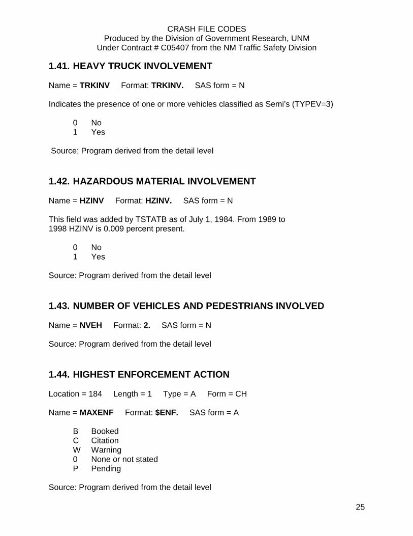
1.41. HEAVY TRUCK INVOLVEMENT Name = TRKINV Format: TRKINV. SAS form = N Indicates the presence of one or more vehicles classified as Semi’s (TYPEV=3) 0 No 1 Yes Source: Program derived from the detail level
1.42. HAZARDOUS MATERIAL INVOLVEMENT Name = HZINV Format: HZINV. SAS form = N This field was added by TSTATB as of July 1, 1984. From 1989 to 1998 HZINV is 0.009 percent present. 0 No 1 Yes Source: Program derived from the detail level
1.43. NUMBER OF VEHICLES AND PEDESTRIANS INVOLVED Name = NVEH Format: 2. SAS form = N Source: Program derived from the detail level
1.44. HIGHEST ENFORCEMENT ACTION Location = 184 Length = 1 Type = A Form = CH Name = MAXENF Format: $ENF. SAS form = A
B Booked C Citation W Warning 0 None or not stated P Pending
Source: Program derived from the detail level

CRASH FILE CODES Produced by the Division of Government Research, UNM
Under Contract # C05407 from the NM Traffic Safety Division
26
1.45. MAXIMUM VEHICLE DAMAGE Name = MAXDAM Format: MAXDAM. SAS form = N No problems found. Code 5 corresponds to minimal damage, code 6 to maximal. From Detail record vehicle damage codes:
1 Disabling damage (cannot be driven) 2 Functional damage (affects operation of vehicle) 3 Other vehicle damage (usually affects only appearance: dents, glass, cracks, trim) 4 Other property damage (if no damage to vehicle, damage to other property
involved) 5 No damage (none apparent; usually injury incurred by occupant or pedestrian)
6 Vehicle caught on fire as a result of the crash Source: Program derived from the detail level

CRASH FILE CODES Produced by the Division of Government Research, UNM
Under Contract # C05407 from the NM Traffic Safety Division
27
1.46. HIGHEST CONTRIBUTING FACTOR IN CRASH Name = TOPCFACC Format: TOPCF. SAS form = N Failure to yield and driver inattention are “catchalls.” Numbers 26, 27 and 28 are confused at times. These are derived from the contributing factors codes in a priority order provided by the Traffic Safety Division. When more than one contributing factor is coded, the one with the lowest number on this list is used. From the Detail record highest contributing factors field:
1 Impaired driving (includes alcohol and drugs) 2 Pedestrian error 3 Passed red light 4 Passed stop sign 5 Failure to yield (includes FTY for Police or Emergency Vehicle) 6 Excessive speed 7 Too fast for conditions 8 Left of center 9 Following too close 10 Improper turn
11 Improper overtake 12 Improper lane change 13 Improper backing 14 Traffic control out 15 Defective steering 16 Defective brakes 17 Defective tires 18 Mechanical defect 19 Road defect 20 Avoid other vehicle 21 Avoid other item 22 Driverless vehicle 23 Skid -- no braking 24 Driver inattention (includes cell phone) 25 Improper driving 26 Other -- no driver error 27 None 28 No indication
Source: Program derived from the detail level

CRASH FILE CODES Produced by the Division of Government Research, UNM
Under Contract # C05407 from the NM Traffic Safety Division
28
Notes on Location Coding using ASTREET, BSTREET, MILEPOST and MILELOG The primary location fields on the crash form are the name of the roadway that the crash occurred on (ASTREET), the name of the intersecting street (BSTREET), and the name of a permanent landmark, intersection or milepost (if not at an intersection). The latter two fields are both coded into the Secondary Street (BSTREET) variable. There are also fields to specify the distance and direction from the landmark/intersection/milepost. The street name fields are the basis of almost all location data in the TSTATB crash file. For most crashes, the city code, major street and secondary street are the primary location data. For 2005-2009 data, approximately 70% of crashes were located by street names, 15% by milepost, and 15% have neither. For crashes on the rural state highway system the milepost location is important. When crashes are entered, coders attempt to identify the milepost if it was not specified on the report. The SAS program that reads the TSTATB file works to identify all state system crashes and to be sure the milepost is reasonable. It extracts route names from the major street to the extent possible and mile posts from the secondary street when the mile post is not coded. The primary location system used by the NMDOT is the designated route name and mile post. An older location system based on administrative route code and log mile was used for many years. In the late 1980’s, the NMDOT renamed routes and made other changes to the designated route system to fix problems with mile post locations. After these changes, the administrative route system was phased out. It is still used in some applications at DGR, so it is maintained on the TSTATB crash file. Until 1981, the Big I area was often coded LPnnNW (or SW, etc.). This is for the light post that the crash was closest to. There are numerous problems with ASTREET and BSTREET. Misspellings abound, especially for the smaller cities. Along with misspellings, one street may be coded many different ways. For example; 4th street is often coded as SR 85, ALT 85 or US 85. Some streets change names as they go, so synonyms need to be taken into account at certain intersections such as Copper at Carlisle (in Albuquerque), which is also Campus at Carlisle. A street may also have changed names completely and so synonyms would be needed there also. Physical features, business names, park names, things like "canal", "ditch", "dirt road" and other unrecognizable codes also show up in the data. For the Big I, codes of I40 and I25 are found in the street name fields. Also, Big I crashes are sometimes coded as the Candelaria intersection off ramp. Another complication is that each ramp has its own five-digit code. Ramp crashes are often coded as being on the freeway. The five-digit code for the freeway sometimes is replaced by I40W, I25N, etc.

CRASH FILE CODES Produced by the Division of Government Research, UNM
Under Contract # C05407 from the NM Traffic Safety Division
29
1.47. MAJOR STREET Name = ASTREET Format: $25. SAS form = A ASTREET is the name of the roadway that the crash occurred on as designated on the crash report. Source: TSTATB Crash file Record 0 Location 133-157
1.48. SECONDARY STREET Name = BSTREET Format: $25. SAS form = A BSTREET is the name of the nearest intersection or nearest street or landmark. Source: TSTATB Crash file Record 0 Location 158-182
1.49. MILES FROM INTERSECTION Name = MILES Format: 3.1 SAS form = N Distance from the intersection or landmark to the closest tenth of a mile. In general, the MILES field is not used. Rarely is it coded to the nearest tenth of a mile as it should be. Source: TSTATB Crash file Record 0 Location 55-57
1.50. FEET FROM INTERSECTION Name = FEET Format: 4. SAS form = N Distance from intersection or landmark in feet, if specified. Often, FEET is not used or, if it is used, it is expressed as round numbers. It is probably most accurate when the crash was fatal. Numbers greater than 25 feet are probably just eyeball estimates and inaccurate. There is no documented standard for the origin of the intersection to measure from; in fact, most are not measured. A large percentage of the time, the coders guess from the diagram, taking the distance from the cross walk area. Source: TSTATB Crash file Record 0 Location 58-61

CRASH FILE CODES Produced by the Division of Government Research, UNM
Under Contract # C05407 from the NM Traffic Safety Division
30
1.51. DIRECTION FROM INTERSECTION Name = IDIREC Format: $DIREC. SAS form = A IDIREC is left out about 60 percent of the time. Sometimes it is present when FEET is zero. Sometimes it is absent when FEET is nonzero. Blank None or not stated
N North S South E East
W West Source: TSTATB Crash file Record 0 Location 62
1.52. DESIGNATED ROUTE NAME Name = RTNAME Format: $8. SAS form = A RTNAME is derived from ASTREET by recognizing the common ways to write route name (I-25, I 25, Interstate 25, HWY 25, etc.) and creating a standardized form (I 25). Since route numbers in NM are unique (there is no NM 25 or US 25) the route number is used to look up the route in the HPMS file and derive the correct prefix (I, NM, or US) for the route. The HPMS file is an extract from the official road inventory file maintained by the NM DOT. Also, the milepost is checked against the range of mileposts for the route. If a route does not match to the HPMS or the milepost is out of range, RTNAME and milepost are missing. Source: RTNAME: Program derived
1.53. DESIGNATED ROUTE NAME IN HPMS FORMAT Name = CHDBRT Format: $6. SAS form = A CHDBRT is coded in the TSTATB crash file. It is a designated route name in a format that matches the HPMS (I00025, NM0048, US0064). CHDBRT is updated from the match to HPMS for crashes that match. Source: CHDBRT: TSTATB Crash file Record 0 Location 46-50
CRASH FILE CODES Produced by the Division of Government Research, UNM
Under Contract # C05407 from the NM Traffic Safety Division
31
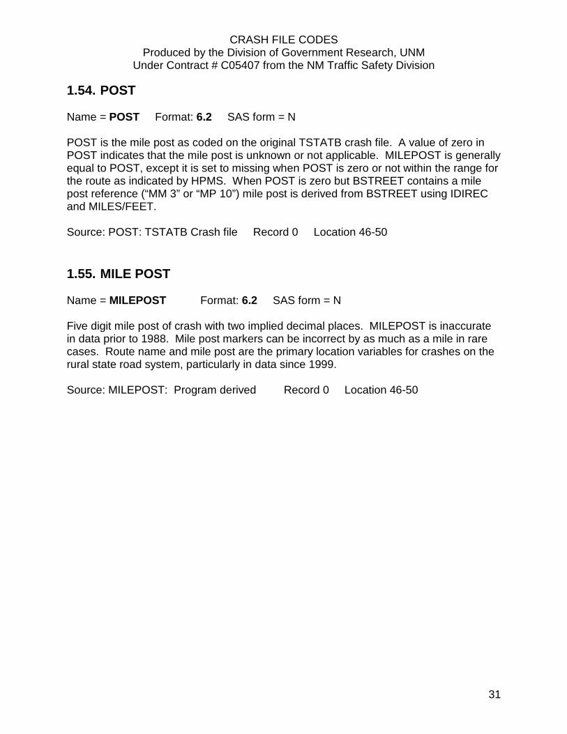
1.54. POST Name = POST Format: 6.2 SAS form = N POST is the mile post as coded on the original TSTATB crash file. A value of zero in POST indicates that the mile post is unknown or not applicable. MILEPOST is generally equal to POST, except it is set to missing when POST is zero or not within the range for the route as indicated by HPMS. When POST is zero but BSTREET contains a mile post reference (“MM 3” or “MP 10”) mile post is derived from BSTREET using IDIREC and MILES/FEET. Source: POST: TSTATB Crash file Record 0 Location 46-50
1.55. MILE POST Name = MILEPOST Format: 6.2 SAS form = N Five digit mile post of crash with two implied decimal places. MILEPOST is inaccurate in data prior to 1988. Mile post markers can be incorrect by as much as a mile in rare cases. Route name and mile post are the primary location variables for crashes on the rural state road system, particularly in data since 1999. Source: MILEPOST: Program derived Record 0 Location 46-50

CRASH FILE CODES Produced by the Division of Government Research, UNM
Under Contract # C05407 from the NM Traffic Safety Division
32
1.56. ADMINISTRATIVE ROUTE Name = ROUTE Format: $4. SAS form = A This is the administrative route code indicating crash location. MILELOG is used with ROUTE to provide the exact location (do not use milepost with route). Full description of the codes is available in a separate document available from the Division of Government Research. While ROUTE is still coded on the TSTATB crash file, the primary location system used by the NMDOT since 1988 is based on route name and milepost. ROUTE is determined from the Accident Location Coding Guide (ALCG) file based on RTNAME and MILEPOST. See OROUTE for the administrative route originally coded in the TSTATB file. Examples of codes are:
Code Status Highway
0401 1-4,or 7 I-40 Federal aid interstate - FAI (purple) 0311 US666 Federal aid primary - FAP (green) 1217 5 NM176 Federal aid secondary - FAS (red) 2042 NM42 Other state roads (brown) 3000 All local roads 4000 5 Federal aid urban (state) FAU (blue) 4000 6 Federal aid urban (local) FAU (orange) 6000 Municipal arterial project MAP (pink) 7032 INDIAN 32 Tribal or BIA 8145 FR 145 Forest service 9206 A CR 206A County roads according to district
Source: ROUTE: program derived Record 0 Location 128-131
1.57. ADMINISTRATIVE ROUTE ORIGINAL Name = OROUTE Format: $4. SAS form = A OROUTE is the administrative route originally coded in the TSTATB crash file. See ROUTE. Source: OROUTE: TSTATB Crash file Record 0 Location 128-131

CRASH FILE CODES Produced by the Division of Government Research, UNM
Under Contract # C05407 from the NM Traffic Safety Division
33
1.58. ROUTE STATUS Name = STATUS Format: $STATUS. SAS form = A Because of a variety of county road numbering schemes, any alpha or numeric character is possible in this field.
0 No status 1,2,3 Interstate routes in various stages of completion
4 Other incomplete interstate and primary loops 5 All federal aid secondary routes 6 Federal aid urban route – state and local 7 Interstate frontage road (including some of US66, US85)
A,B,C County roads (generally indicated commission district) Source: TSTATB Crash file Record 0 Location 132
1.59. MILE LOG Name = MILELOG Format: 6.2 SAS form = N Five digit mile log of crash with two implied decimal places. Precision is probably not always to tenths as it should be. MILELOG is used with ROUTE (not RTNAME) to provide location. As provided on the TSTATB crash file, LOG has been interpolated incorrectly using the ALCG (Accident Location Coding Guide). The interpolation is corrected by DGR in SAS and the corrected output is MILELOG. . Source: MILELOG: program derived Record 0 Location 37-41
1.60. LOG Name = LOG Format: 6.2 SAS form = N Use MILELOG. As provided on the TSTATB file from NMDOT, LOG has been interpolated incorrectly using the ALCG (Accident Location Coding Guide). The interpolation is corrected by DGR in SAS and the corrected output is MILELOG. . Source: LOG: TSTATB Crash file Record 0 Location 37-41
CRASH FILE CODES Produced by the Division of Government Research, UNM
Under Contract # C05407 from the NM Traffic Safety Division
34
1.61. FUNCTIONAL CLASS OF ROADWAY Name = FUNCTCL Format: FUNCTCL. SAS form = N The urban data can be usable as long as one knows what one is doing and can recode some of the data. For rural data, major and minor are not coded, so the data are essentially unusable. This field was added as of January 1, 1980. 0 Unknown
1 Rural interstate 2 Rural principal arterial non-interstate 6 Rural minor arterial 7 Rural major collector 8 Rural minor collector 9 Rural local 11 Urban principal arterial-interstate 12 Urban principal arterial freeway connecting link 13 Urban principal arterial freeway not connecting link 14 Urban principal arterial other connecting link 15 Urban principal arterial other non connecting link 16 Urban minor arterial 17 Urban collector
19 Urban local Source: TSTATB Crash file Record 0 Location 183-184
1.62. ROAD SYSTEM Name = SYSTEM Format: SYS. SAS form = N Since SYSTEM is derived from POPGRP and ROUTE, data through 1980 is based on the 1970 census. Starting with calendar 1981 data, 1980 census counts are used. The "urban" category includes interstate routes within cities. 1 Rural non-interstate
2 Urban (towns of 5,000 or more) 3 Rural interstate
Source: Program derived

CRASH FILE CODES Produced by the Division of Government Research, UNM
Under Contract # C05407 from the NM Traffic Safety Division
35
1.63. MAJOR STREET CODE Name = STRCODE1 Format: $5. SAS form = A Street code number associated with ASTREET in the street name coding list (tsbutil strts). Source: TSTATB Crash file Record 0 Location 118-122
1.64. SECONDARY STREET CODE Name = STRCODE2 Format: $5. SAS form = A Street code number associated with BSTREET in the street name coding list. Source: TSTATB Crash file Record 0 Location 123-127
1.65. DIVIDED HIGHWAY Name = DIVHWY Format: $1. SAS form = A Indicates whether the highway is divided or not. Possible values are 0, 1, or 2. Present only for crashes on the rural state system that matched by milepost. 0 Not Divided Highway 1 Divided Highway North/South (e.g. I-25) 2 Divided Highway East/West (e.g. I-40) Source: TSTATB Crash file Record 0 Location 99
1.66. DIVIDED HIGHWAY DIRECTION Name = DHDIREC Format: $1. SAS form = A Indicates direction of travel on divided highway. Possible values are E, W, N, S. Present only for crashes on the rural state system that matched by milepost. Source: TSTATB Crash file Record 0 Location 100

CRASH FILE CODES Produced by the Division of Government Research, UNM
Under Contract # C05407 from the NM Traffic Safety Division
36
1.67. CRASH DIRECTION Name = ACCDIR Format: $1. SAS form = A Indicates the direction of travel of the vehicle with the top contributing factor in the crash. Present for all crashes. Source: Program derived from the detail level.
1.68. FILE DATE Name = FILEDATE Format: SAS Date Formats SAS Form = DATE The date the raw TSTATB crash file was extracted from ARCS. Source: Source: TSTATB Crash file Record 0 Location 42-45 & 51-54

CRASH FILE CODES Produced by the Division of Government Research, UNM
Under Contract # C05407 from the NM Traffic Safety Division
37
INDEX BY VARIABLE DESCRIPTION / FULL NAME
A
ADMINISTRATIVE ROUTE 32 ADMINISTRATIVE ROUTE ORIGINAL 32 ALCOHOL INVOLVEMENT 24 AMBULANCE NAME 20
C
COUNTY 7 CRASH ANALYSIS 11 CRASH CLASSIFICATION 10 CRASH DATE 2 CRASH DIRECTION 36 CRASH LOCATION 5 CRASH REPORT NUMBER 2 CRASH SEVERITY 4
D
DAY OF MONTH OF CRASH 2 DAY OF WEEK 3 DESIGNATED ROUTE NAME 30 DESIGNATED ROUTE NAME IN HPMS
FORMAT 30 DIRECTION FROM INTERSECTION 30 DIVIDED HIGHWAY 35 DIVIDED HIGHWAY DIRECTION 35 DRUG INVOLVEMENT 24
F
FEET FROM INTERSECTION 29 FILE DATE 36 FUNCTIONAL CLASS OF ROADWAY 34
H
HAZARDOUS MATERIAL INVOLVEMENT 25 HEAVY TRUCK INVOLVEMENT 25
HIGHEST CONTRIBUTING FACTOR IN CRASH
27 HIGHEST ENFORCEMENT ACTION 25 HIGHWAY ELEMENT CODE 9 HIT AND RUN CRASH 4 HOUR OF CRASH 3
I
INVOLVEMENT OF NON-LOCAL DRIVERS 22
L
LICENSE COUNTY 8 LIGHTING 18 LOG 33
M
MAJOR STREET 29 MAJOR STREET CODE 35 MAXIMUM VEHICLE DAMAGE 26 MILE LOG 33 MILE POST 31 MILES FROM INTERSECTION 29 MONTH OF CRASH 2 MOTORCYCLE INVOLVEMENT 23
N
NUMBER OF VEHICLES AND PEDESTRIANS INVOLVED 25
O
OCCUPANTS IN ENTIRE CRASH 21 OCCUPANTS KILLED 21 OCCUPANTS UNHURT (PROPERTY DAMAGE
ONLY) 22

CRASH FILE CODES Produced by the Division of Government Research, UNM
Under Contract # C05407 from the NM Traffic Safety Division
38
OCCUPANTS WITH A NON-INCAPACITATING INJURY 21
OCCUPANTS WITH A NON-VISIBLE INJURY 22 OCCUPANTS WITH AN INCAPACITATING
INJURY 21
P
PEDALCYCLIST INVOLVEMENT 24 PEDESTRIAN INVOLVEMENT 23 POPULATION GROUP 7 POST 31
R
REPORTING AGENCY 4 ROAD CHARACTER 19 ROAD GRADE 19 ROAD SYSTEM 34 ROADWAY RELATION 10 ROUTE STATUS 33
S
SECONDARY STREET 29 SECONDARY STREET CODE 35 STATE DOT COMMISSION DISTRICT 9 STATE DOT MAINTENANCE DISTRICT 8 STATE HIGHWAY DEPARTMENT PROPERTY
18 STATE POLICE DISTRICT 9
T
TIME OF CRASH 3
W
WEATHER 19
Y
YEAR OF CRASH 3

CRASH FILE CODES Produced by the Division of Government Research, UNM
Under Contract # C05407 from the NM Traffic Safety Division
39
INDEX BY VARIABLE NAME
ACCDIR ...................................................... 36 AGENCY ....................................................... 4 ALCINV....................................................... 24 AMBNAME ................................................ 20 ANALYSIS ................................................... 11 ASTREET .................................................... 29 BSTREET..................................................... 29 CHARACT ................................................... 19 CHDBRT ..................................................... 30 CITY ............................................................. 5 CLASS ......................................................... 10 CLASSA ...................................................... 21 CLASSB....................................................... 21 CLASSC ....................................................... 22 COUNTY ....................................................... 7 DATE ............................................................ 2 DAY .............................................................. 3 DHDIREC .................................................... 35 DIVHWY ..................................................... 35 DRUGINV ................................................... 24 DY ................................................................ 2 ELEMENT ..................................................... 9 FEET ........................................................... 29 FILEDATE ................................................... 36 FUNCTCL .................................................... 34 GRADE ....................................................... 19 HITRUN ........................................................ 4 HOUR ........................................................... 3 HZINV ........................................................ 25 IDIREC ........................................................ 30 KILLED ........................................................ 21 LCOUNTY ..................................................... 8 LIGHT ......................................................... 18 LOG ............................................................ 33
MAXDAM................................................... 26 MAXENF .................................................... 25 MCINV ....................................................... 23 MDC............................................................. 9 MILELOG .................................................... 33 MILEPOST .................................................. 31 MILES ......................................................... 29 MONTH ....................................................... 2 NONLOCAL ................................................ 22 NVEH ......................................................... 25 OROUTE ..................................................... 32 PECINV....................................................... 24 PEDINV ...................................................... 23 POPGRP ....................................................... 7 POST .......................................................... 31 REPORT ........................................................ 2 ROADREL ................................................... 10 ROUTE ....................................................... 32 RTNAME .................................................... 30 SEVERITY ..................................................... 4 SHDTDIST..................................................... 8 SHDTPROP ................................................. 18 SPDIST ......................................................... 9 STATUS ...................................................... 33 STRCODE1 ................................................. 35 STRCODE2 ................................................. 35 SYSTEM ...................................................... 34 TIME ............................................................ 3 TOPCFACC ................................................. 27 TOTAL ........................................................ 21 TRKINV ...................................................... 25 UNHURT .................................................... 22 WEATHER .................................................. 19 YEAR ............................................................ 3