Embed Size (px)
Citation preview
CRITERIA FOR A "GOOD" URBAN RENEWAL PROJECT: THE CASE OF KADIFEKALE URBAN
RENEWAL PROJECT (IZMIR, TURKEY)
A Thesis Submitted to the Graduate School of Engineering and Sciences of
İzmir Institute of Technology in Partial Fulfillment of the Requirements for the Degree of
MASTER OF SCIENCE
in City Planning
by Elif MUTLU
October 2009 İZMİR
We approve the thesis of Elif MUTLU
Asst. Prof. Fatma ŞENOL
Supervisor
Inst. Dr. Erkal SERİM
Committee Member
Asst. Prof. Şebnem YÜCEL YOUNG
Committee Member
6 October 2009
Assoc. Prof. Semahat ÖZDEMİR Assoc. Prof. Talat YALÇIN Head of the Department of Dean of the Graduate School of City and Regional Planning Engineering and Sciences
ACKNOWLEDGMENTS
I would like to express my sincere thanks to my supervisor, Asst. Prof. Fatma
ŞENOL, for her guidance and endless support. Her comments made me to rethink over
every chapter in the field of the study. Although I have some difficulties in some
periods of my study, her endless support courage me to develop this study. I would also
like to thank other committee members Inst. Dr. Erkal SERİM and Asst. Prof. Şebnem
YÜCEL YOUNG for their beneficial suggestions and comments.
I would to like thank Assoc. Prof. Semahat Özdemir for her encouragements and
Prof. Dr. Diogo MATEUS for his support while developing my study abroad in Lisbon.
I am thankful to the Head of the Muğla Regional Board for the Conservation of
Cultural and Natural Assets, Fikret Gürbüzer for his patience and understanding, and to
my friends there; Burcu Irgat Ergin, Evrim Güner, Betül Büyükgök, Aylin Kılçık,
Berrin Kaya for their support to encourage me to write this thesis.
Special thanks to my friends İlgi Atay Ayşegül Yüksel, Gönül Yılmaz for their
friendships and support.
Finally, I would like to express my gratefulness to my sisters Eda and Seda
Mutlu, my parents; Rubil and Nurten Mutlu and also my grandfather Halis Mutlu for
their endless patience and support during this period. This thesis would not be
developed without their support.
iv
ABSTRACT
CRITERIA FOR A "GOOD" URBAN RENEWAL PROJECT: THE CASE OF KADIFEKALE URBAN RENEWAL PROJECT
(IZMIR, TURKEY)
Urban renewal project strategies such as; urban rehabilitation, urban
redevelopment, urban revitalization, urban regeneration have been taking an important
place in the public discussions and urban planning agenda especially for the last two
decades. Because urban renewal projects that have been applied in various urban areas
such as; urban decline areas, disaster prone areas, squatter housing areas, old, historical
quarters of cities not only causing changes in the physical structure of cities, they are
also affecting the social, economic and environmental dynamics in the built
environment. These widespread applications bring out questions whether the urban
renewal projects are good or not.
The aim of the study is to develop criteria for a good urban renewal project.
Thus, this thesis assesses the urban renewal projects in terms of planning outcome
(physical, economic, social, environmental criteria) and planning process. The case of
the thesis is the on the on-going “Kadifekale Urban Renewal Project (KURP)” in Izmir
and the study tries to answer the question whether KURP is a good urban renewal
project depending on the developed set of criteria.
Key Words: Urban Renewal, Criteria for a Good Urban Renewal Project
v
ÖZET
"İYİ" BİR KENTSEL YENİLEME PROJESİ İÇİN ÖLÇÜTLER: KADİFEKALE KENTSEL YENİLEME PROJESİ ÖRNEĞİ
(İZMİR, TÜRKİYE)
Kentsel iyileştirme, kentsel yeniden geliştirme, kentsel canlandırma kentsel
yenileşme gibi kentsel yenileme stratejileri kamu tartışmalarında ve kentsel planlama
gündeminde özellikle son yirmi yıldır önemli bir yer tutmaktadır. Çünkü kentsel
çöküntü alanları, afete maruz alanlar, gecekondu alanları, eski tarihi kent parçaları gibi
çeşitli kentsel alanlarda uygulanan kentsel yenileme projeleri yalnızca fiziksel çevreyi
değil, kentteki sosyal ekonomik ve çevresel dinamikleri de etkilemektedir. Bu yaygın
uygulamalar kentsel yenileme projelerinin iyi olup olmadığını soran soruları ortaya
çıkarmaktadır.
Çalışmanın amacı iyi bir kentsel yenileme projesi için ölçütler belirlemektir. Bu
yüzden bu tez kentsel yenileme projelerini planlama sonuçları (fiziksel, ekonomik,
sosyal, çevresel kriterler) ve planlama süreci açısından değerlendirir. Tezin örnek
çalışma alanı: İzmir’de devam eden Kadifekale Kentsel Yenileme Projesi’dir (KURP)
ve bu tez KURP ‘un iyi bir kentsel yenileme proje olup olmadığı, belirlenen ölçütler
çerçevesinde cevaplandırmaya çalışmaktadır.
Anahtar Kelimeler: Kentsel Yenileme, İyi bir Kentsel Yenileme Projesi için ölçütler
vi
TABLE OF CONTENTS
LIST OF FIGURES ....................................................................................................... viii
LIST OF TABLES ........................................................................................................... x
CHAPTER 1. INTRODUCTION ..................................................................................... 1
1.1. Reseach Question.................................................................................... 5
1.2. Study Approach ...................................................................................... 5
1.3. The Study Site and Methodology ........................................................... 6
1.4. Study Findins and Outline of the Thesis............................................... 10
CHAPTER 2. FACTORS , REASONS AND STRATEGIES FOR URBAN
RENEWAL ROJECTS........................................................................... 12
2.1. Urban Projects in the United States of America and in Europe............ 16
2.1.1. The First Period: From Industrial Revolution to World War II...... 17
2.1.2. The Second Period: 1945-1960....................................................... 21
2.1.3. The Third Period: 1960-1980 ......................................................... 23
2.1.4. The Fourth Period: 1980s to 2000s................................................. 26
2.1.5. The Fifth Period: 2000s to Presnt ................................................... 30
2.2. Urban Renewal Projects in Turkey ....................................................... 33
2.2.1. The First Period: The Early Republican Period (1923-1950)......... 34
2.2.2. The Second Period: 1950-1980....................................................... 35
2.2.3. The Third Period: 1980 to 2000...................................................... 37
2.2.4. The Fourth Period: 2000 to Present ................................................ 41
CHAPTER 3. SET OF CRITERIA FOR “GOOD”URP................................................ 44
3.1. Scholarly Works.................................................................................... 44
3.2. International Chartes............................................................................. 48
3.3. European Union EU Guidance on Urban Rehabilitation (2004) .......... 54
3.4. Graduate Theses in the Turkish Universities ........................................ 56
3.5. An Evaluation: A Final Set of Criteria about "Good" URPs ................ 59
vii
3.6 The Set of Criteria for Good URPs........................................................ 62
CHAPTER 4. THE CASE STUDY CONTEXT: KADIFEKALE (KONAK)URBAN
RENEWALPROJECT............................................................................ 64
4.1. The Study Site....................................................................................... 65
4.1.1. Urbanization Process and Urban Projects in Kadifekale District ... 66
4.1.2. Kadifekale District in the Master Plans of Izmir since 1920s ........ 68
4.1.3. KURP in Comparison to Other Urban Projects in Izmir in 2000s.. 74
4.2. Kadifekale Urban Renewal Project....................................................... 79
4.2.1. Aim of the KURP ........................................................................... 88
4.2.2. Phases of the Project ...................................................................... 89
4.2.3. Institutional, Partners of the Project ............................................... 92
4.2.3.1. The Housing Development Administration of Turkey (TOKİ) 93
4.2.3.2. Konak Municipality and Izmir Metropolitan Municipality ...... 93
4.2.4. Relocation Area (Uzundere) .......................................................... 93
CHAPTER 5. EVALUATION OF THE KURP............................................................. 97
5.1 Evaluation of the Planning Outcomes and Planning Processof the
KURP..................................................................................................... 97
5.1.1. Physical Outcomes........................................................................ 101
5.1.2. Economic Outcomes ..................................................................... 102
5.1.3. Social Outcomes ........................................................................... 103
5.1.4. Ecological Outcomes .................................................................... 104
5.2 Evaluation of the Planning Process of the KURP................................ 106
5.2.1. Access to information about KURP.............................................. 106
5.2.2. Community Involvement in KURP .............................................. 114
CHAPTER 6. CONCLUSION ..................................................................................... 118
REFERENCES ............................................................................................................. 121
APPENDIX A QUESTIONAIRE ................................................................................ 128
viii
LIST OF FIGURES
Figure Page
Figure 2.1. City and Village population ratio between 1927 and 2000 .......................... 36
Figure 4.1. Izmir (Smyrne) in Roman Period ................................................................. 67
Figure 4.2. Kadifekale (Pagos) Castle in 1865 ............................................................... 67
Figure 4.3. At the end of the 19th Century, the Kadifekale Castle from Izmir port....... 68
Figure 4.4. The area determined with red line show the afforestration area on the
hillside of Kadifekale in Danger and Prost plan, 1924 ................................ 69
Figure 4.5. The Plan of le Corbusier in 1949 at 1/20000................................................ 70
Figure 4.6. Expansion of residential areas in Izmir in 1950 ........................................... 71
Figure 4.7. The plan of K. Aru, E. Canpolat and G. Özdeş in 1952............................... 72
Figure 4.8. Master Plan for Metropolitan Region of Izmir at 1/25000 scale.................. 73
Figure 4.9. View from a) Kadifekale in 1880s, b) View from Kadifekale today ........... 74
Figure 4.10. Dominat URPs in the boundries of Izmir Metropolitan Municipality ....... 75
Figure 4.11. Landslide and Rock fall areas of Izmir Metropolitan Area........................ 76
Figure 4.12. Fourteen Urban Renewal and Rehabilitation Areas identified with a
different colour in the agenda of Izmir Metropolitan Municipality............ 77
Figure 4.13. Second Stage of the Revision Plan for Conservation
(Conservation Plan) ................................................................................... 79
Figure 4.14. Quarters in the Field of Kadifekale UrbanTransformation Project ............ 80
Figure 4.15. Views from Vezirağa and İmariye districts................................................ 81
Figure 4.16. Home Country of Household Heads .......................................................... 83
Figure 4.17. Education Level.......................................................................................... 84
Figure 4.18. Picture of a street seller .............................................................................. 85
Figure 4.19. Woman in traditional clothes selling carpets that were produced
by her in the Kadifekale Castle................................................................... 85
Figure 4.20. Rates of Length of Residency in any neighborhood of the
city of Izmir ................................................................................................ 85
Figure 4.21 Rates of Length of Residency in the KURP area ........................................ 86
Figure 4.22. Variety of Reasons for choosing the neighborhoods in
Kadifekale district....................................................................................... 87
ix
Figure 4.23. Distribution of number of rooms................................................................ 87
Figure 4.24. Distribution of size of homes .................................................................... 88
Figure 4.25. The Map shows the project area and the new residential area
(Uzundere) ................................................................................................. 94
Figure 4.26. Type one (B), a) Front View of B block b) Left view of B blocks ............ 95
Figure 4.27. Type two (C), a) Front View b) Left view of C blocks.............................. 96
Figure 5.1. Site Plan of new relocation area in Uzundere ............................................ 105
Figure 5.2. Distribution of information level about KURP .......................................... 106
Figure 5.3. Definition of the Project by Households .................................................... 107
Figure 5.4. Information periods of KURP .................................................................... 108
Figure 5.5. Information tools of the Project.................................................................. 108
Figure 5.6. Reasons for KURP ..................................................................................... 109
Figure 5.7. Landslide information periods.................................................................... 110
Figure 5.8. Effects of Landslide in the project area...................................................... 111
Figure 5.9. Evaluation of preferences of the inhabitants whether they are
willing to move to Uzundere .................................................................... 111
Figure 5.10. Distributions of the reasons of dissatisfaction with the new
residential area .......................................................................................... 112
Figure 5.11. Evaluation of the ideas of the households about the Project .................... 113
Figure 5.12. Introduction level of the Project ............................................................... 114
Figure 5.13. Distribution of the Participation level of the Project................................ 115
Figure 5.14. Evaluation of community involvement in the Project.............................. 116
Figure 5.15. Comments, Views of Households for the Project .................................... 116
x
LIST OF TABLES
Table Page
Table 1.1. The graduate theses in the Turkish universities searched according
to the keywords in the electronic archive of the National Thesis
Center of Council of Higher Education............................................................ 9
Table 2.1. The Evaluation of Urban Regeneration in Western Countries ...................... 29
Table 2.2. Legislative Framework of Urban Transformation in Turkey ...................... 43
Table 3.1. Evaluation of Reseach Methods of scholarly works about URPs ................. 45
Table 3.2. Works talking about “good” URP strategies ................................................ 45
Table 3.3. Actions for “good” URPs according to the Scholarly Works ....................... 47
Table 3.4. A set of international charters related to the URP strategies ........................ 50
Table 3.5. “Good” URPs according to the related international charters ...................... 51
Table 3.6. “Good” URPs according to the EU Guidance on
Urban Rehabilitation (2004) .......................................................................... 55
Table 3.7. “Good” URPs according to the Graduate Theses in Turkey ........................ 57
Table 3.8. An Evaluation of all of the Sets of Works about “Good” URPs. ................. 60
Table 3.9. A Final Set of Criteria for “Good” URPs ..................................................... 63
Table 4.1. Distribution of urban renewal and rehabilitation program
areas of Izmir Metropolitan Municipality among neighborhoods ................ 78
Table 4.2. Ownership Pattern (57 out of 59 households answer the question).............. 83
Table 4.3. Distribution of number of housing units according to types of stories ......... 90
Table 4.4. Distribution of building types according to number and area (m2).............. 91
Table 4.5. Housing types in New Residential Area in Uzundere .................................. 95
Table 5.1. Evaluation of KURP according to Set of criteria in Table 3.9 ...................... 98
1
CHAPTER 1
INTRODUCTION
This thesis develops out of a scholarly concern about the wide usage of the
“urban transformation project” nearly for all kinds of urban projects in Turkey in recent
decades. As an umbrella term and a neoliberal tool of the state-market collaborations, it
hides not only the reasons for and goals of the related project, but also importantly our
senses about what a “good” urban project is. As the roots of all interventions types in
the built environment space related to urban projects are evolved from urban renewal
strategies, this thesis questions how to develop a “good” urban project in the example of
urban renewal projects (URPs). Examining the factors, reasons and strategies/ tools for
developing URPs abroad and in Turkey, this study aims at creating a list of criteria for
“good” URPs based on a various groups of works basically in scholarly literature and
international charters and guidances related to the subject. Ultimately, this thesis applies
this list to evaluate an on-going urban renewal project in Izmir (Turkey), namely,
Kadifekale Urban Renewal Project (KURP).
Urban renewal projects are an important strategy for public and private
interventions in urban space. The reasons for and the ways of implementing URPs have
been shaped by political-economic, social, and environmental factors, and also the
international concerns related to these factors and the changes in the quality of the built
environment. Meanwhile, URPs have been taking an important place in urban planning
discussions and policies and also in popular discussions especially since the last two
decades in Turkey and worldwide. The reasons for the widespread popularity of the
subjects related to the shifts in political-economic approaches from liberalism to neo-
liberalism, which has been re-innovating and re-using urban space. Within this
economic shift, for instance, the service sector has started to take place in city centers
and young professions of advanced service sectors started to settle down in city centers.
Partial planning approaches have become trendy besides comprehensive planning
approaches, because of inadequate financial sources. Central or local governments have
been making collaborations with private sector to apply URPs. Moreover, the
2
tendencies for preserving cultural heritage have been presenting the old city districts as
attractive to the global tourism sector (Knox 1991, Şahin 2003).
What is an URP? URPs are a way of intervening in urban space by urban
planners, designers and policy-makers. URPs guide the ways of how to develop the
built environment. They are an important activity for the real estate and other related
industries. Also, they are an important tool for the state to deal with the social and
physical problems related to the built environment, such as urban decline, uneven and
unbalanced urban growth, diseases, and social unrests. Finally, they are important to
arrange spatial regulations, to create secure livable environments (Anderson 2004, Knox
2001).
The need for URPs varies across temporal and geographical contexts based on
the changing, socio- economic, political, demographic and urban factors. Also, related
to such factors, the reasons and the ways of implementing URPs might vary across
countries and sometimes even across cities of an individual country. Yet based on the
long history of urban projects across countries, urban planning literature has already
recognized many similar reasons and also common techniques and strategies for
implementing URPs.
In the countries of the west at the beginning of the 19th century, URPs generally
aimed at sustaining social health, hygiene and social order. In the following periods, the
aims of URPs in these countries included the upgrading the areas with urban decline,
old industrial zones and down-graded historical sites, turning disinvestment areas into
investments area, and increasing values of urban land for a better urban economy.
In Turkey, URPs were part of the comprehensive urban plans that aimed at
improving living standards of the squatter areas and of planned urban environments
until the 1980s. Between the time periods from 1980s to 2000s, to legalize the existing
building stock and solve the ownership problems in squatter areas, multiple numbers of
amnesty laws were put into force. In general, URPs were ended up with constructing
high rise mass housing units to replace the squatter housing stock of that era. Since the
early 2000s, with Turkey’s prospective membership to European Union (EU), the 1999
Marmara Earthquake and new legal arrangements about the URPs have increased the
number of URPs across the country. Called widely as “urban transformation projects,”
these projects have been accepted as an important strategy especially by policy makers
to overcome physical, social, economic and environmental problems of metropolitan
and mid-sized cities. Since then, they have been implemented in squatter housing
3
districts, old industrial zones, and disaster prone areas and also in old historical city
quarters (Şahin 2003).
Overall, the complexity and variety of problems in urban space have caused the
emergence of different strategies for implementing URPs. We can classify different
strategies of URPs according to the certain variables such as their implementation scale,
relative location in cities, and time interval. The strategies for URPs can be called as
urban regeneration, urban reconstruction, redevelopment, urban improvement and urban
rehabilitation all which have developed since 19th century in order to transform
intentionally urban space (Özdemir and Eğercioglu 2007). The historical eras with the
popularity of each strategy for UP might vary. In Europe, for instance, the tendencies
for implementing urban rehabilitation projects have increased since 1980s. Because
after 1980s, participatory approaches and the awareness of the importance of cultural
and environmental heritage have led governments to rehabilitate especially historical
and old quarters of the city. Moreover, the tourism potential of these areas and
economic gains after URPs have been also realized (EU Guidance 2004).
Turkey has been experiencing a process about the ways of URPs differently than
Europe. Contrast to an accumulative knowledge about URPs in urban planning
literature, the recent discussions and practices of URPs in Turkey have been widely
using the term of urban transformation project to refer to all kinds of urban projects
implemented in all kinds of urban areas. The direct translation of the Turkish term
‘kentsel dönüşüm’ into English is “urban transformation.” However, some argue that in
the English written literature, the term of ‘kentsel dönüşüm’ matches with the terms of
urban renewal or urban regeneration (Bayram 2006). The question at this point is why
we in Turkey are using “urban transformation project” in public debates, popular media
and importantly, in scholarly discussions and publications. And much importantly, does
this usage help urban planners’ ways of developing “good” urban projects?
Within the context of Turkey, it is fair to say that the term of urban
transformation project has become a cliché without any content defining the reasons and
strategies for implementing URPs. Not only public authorities and media but also urban
planning literature in Turkey has been using this as an umbrella term for all kinds of
urban projects at different urban scales. Whereas URPs in Turkey might differ from
each other in terms of their aim, objectives, techniques, scales, time period or
stakeholders, the “urban transformation project” hides such details of the relevant
4
projects. Thus, it creates a blurred area for urban planners especially searching for the
criteria for “good” urban projects.
Discussing the factors, reasons, and strategies of URPs across various
international contexts and in Turkey, this thesis aims at developing a list of criteria for a
“good” urban renewal project based on a various groups of studies, and then assessing
that list for evaluating the case study of an urban project in Izmir (Turkey), called
Kadifekale Urban Renewal Project (KURP).
To understand why the usage of urban transformation project as an umbrella
term for all kinds of URPs in Turkey is problematic, we need to describe what urban
transformation means. There are various definitions about urban transformation in the
literature. Urban transformation is the transition from an existing urban pattern or
structure to another one. Urban transformation defines the changes in the whole or
certain parts of urban areas (Keleş 2004). Thus, it refers to all kinds of changes in
physical, social, economic structures of urban space. According to Ataöv and Osmay
(2007), the concept of urban transformation contains all physical, social and economic
transformation processes in the built environment.
Cagla and Inam (2008) describe this concept in a wider base and tell that “urban
transformation has been perceived as an era of revision of the approaches for
urbanization, forming continuous and healthy places in a city, giving a new content to
the current reconstruction plans by revising the plans and their applications” (Cagla and
Inam 2008). Bayram (2006) adds to this view by pointing out that the term of urban
transformation is a tool and material to transform the neo-liberal policies and global city
aspects into the real by creating, for instance, prestige buildings and shopping centers.
He also argues that the content of urban transformation includes more than the “urban
renewal,” because areas which are not developed before are also in the scope of urban
transformation (Bayram 2006).
Tekeli (2003) identifies mostly the stakeholders at urban transformation
processes. He suggests that urban transformation is formed by the accumulation of the
demands of land owners and can be realized by certain powerful actors, such as the
state. Additionally, increases in urban population cause in the development of new
urban lands, creates new potentials for urban rant and results in the increasing cost of
developing the urban land (Tekeli 2003).
5
1.1. Reseach Question
This thesis mainly examines what the criteria are for a “good/ successful” URP.
It aims at creating a list of criteria for “good” URPs based on a various groups of
works basically in scholarly literature and international charters related to the subject,
following its examination of the factors, reasons and strategies/ tools for developing
urban projects (URPs) abroad and in Turkey. Based on my case study of the Kadifekale
Urban Renewal Project (KURP) that has been continuing since 2006 in two different
parts of the city of Izmir (Kadifekale and Uzundere), the thesis details the following
questions:
—What are the appropriate URP strategies that could describe the KURP?
—Is KURP a good/successful URP?
—What aspects of KURP should be improved in order to make KURP as a good
URP, if any?
The examination of these questions is important for various reasons. The
widespread of urban projects in Turkey makes it necessary to develop and make project
evaluations based on a set of criteria for “good” URP in advance. URPs do not only
causes visible changes in the built environment, but also they have invisible outcomes
that urban planners should take into account, such as social, political, environmental and
economic outcomes. However, the critiques about URPs in Turkey in the last decades
underline that these projects are implemented in such a way that it neglects especially
the social ties of inhabitants and community involvement in URPs. To make a further
critique about the “urban transformation projects” in Turkey, moreover, this thesis aims
at defining the factors, reasons and the strategies for URPs in an historical view
especially in western countries (United States of America and Europe) and in Turkey.
1.2. Study Approach
This thesis considers political- economic, social, environmental or ecological
factors, international agreements and concerns, and changing quality of built
6
environment and urban structure that have been shaping urban space as a result of
political economic processes. Similarly, URPs are driven by the socio-economic factors.
Historical trends of economic processes impact directly the trends of interventions in
urban space, especially via urban planning. Here, URPs become an important tool to
transform built environment and to sustain adaptation to new mode of production
systems, to the trends from economic to “none”-economic factors or to “new” economic
factors.
This thesis uses the term of “good” project in the sense that a good URP
provides innovations by producing solutions for existing social, physical, economic and
environmental problems in the built environment. Overall the identification of an URP
as good URP is the extensions of the definitions related to successful or qualitative URP
To assess a project as successful, reaching effective solution on one target can be
enough. For instance; creating healthy, modern built environments in place of squatter,
low quality housing stock can be determined as successful physical application.
However, if the URP does not take into account of the sense of the neighborhood
identity and doesn’t obtain accessibility of good or services for the majority of the
dwellers, the project can not be defined as a good URP.
To identify an urban project as good URP, it should provide the application of
the majority of both the planning outcome which includes physical, economic, social
and environmental criteria and planning process criteria.
1.3. The Study Site and Methodology
This thesis evolves around the case study of the “Konak Urban Renewal
Project”. In the daily usage, the project site has been described as a part of Kadifekale
district. Thus, in public debates the project has been named as the “Kadifekale Urban
Renewal Project.” The following sections call the project name as “Kadifekale Urban
Renewal Project”, or briefly KURP.
The area of KURP contains various parts of nine neighborhoods in Kadifekale
district. These are the neighborhood of Kadifekale, Imariye, Kosova, Altay, 1st Kadriye,
Hasan Özdemir, 19 Mayıs, Vezirağa and Yeşildere. It only includes one whole
7
neighborhood (Imariye). The 50% percentage of the housing stock in the project area is
squatter housing (Izmir Chamber of Commerce 2005).
The coverage of KURP is about 48 hectares. The project area is located near to
the administration, trade and cultural sectors of the city centre. In 1978 the area is
announced as a disaster prone area with the risk of landslide. The KURP is an on-going
project. I chose this area for the case study of this thesis because KURP is the biggest
and first example of urban renewal project among the number of projects which have
been continuing since 2000s in Izmir. The site and project was also accessible for me as
a graduate student in Izmir.
The study methodology of this thesis has two parts: a literature review for
defining the criteria for a “good” URP, and a field study on the project site with various
ethnographic methods.
My literature review includes the scholarly documents, the international charters,
a recent guidance by the European Union and also the graduate theses in urban planning
departments of Turkish universities.
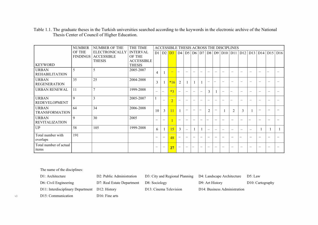
As a part of my literature review, I examined also the graduate thesis in the
Turkish Universities that were electronically available at the archive of the National
Thesis Center of Council of Higher Education (www.yok.gov.tr). Rather than with their
content, meanwhile, a comparison of the graduate theses that are relevant for the
research question of this thesis (three out of total ninety-one thesis) suggests that my
thesis differs from these thesis methodologically and with study findings.
There are three theses that directly relates to the research question of this thesis.
In my search of the graduate thesis at the search engine of the Archive of National
Thesis Center of Council of Higher Education (Turkey), I used the keywords such as
urban regeneration, urban rehabilitation, urban renewal, urban redevelopment, urban
transformation, urban revitalization and urban projects. The total number of the
graduate thesis that appeared in sixteen scholarly disciplines was a hundred ninety one,
including the overlapped keywords. Of this total, the numbers of the electronically
accessible thesis were one hundred and five and were completed between the year of
1999 and 2008. This thesis took into account of the graduate thesis that was completed
in the discipline of city and regional planning. In this discipline, the total numbers of
findings with the overlapping keywords were forty-eight, whereas the actual total
number of items was twenty-seven (Table1.1). Sixteen of these twenty-seven theses are
avoided because their contexts did not match with the research themes of this thesis. I
8
examined the rest, nine of them, according to the research context. Finally, the newer
pool of three items (Duzcu 2006, Doyduk 2008 and Özden 2002) was selected, as these
concentrated on developing a set of criteria for a “good” UP either urban renewal, urban
rehabilitation are left, whereas the rest were talking about such criteria in general. Two
of these three theses focus on the urban renewal projects, whereas the other one relates
to the urban regeneration projects. When developing their set of criteria for a “good”
urban renewal or urban regeneration project, the first thesis (Duzcu 2006) develops a
literature survey, the second one (Doyduk 2008) takes into account of the principles of
Vienna Seminar Report (1994), and the third one (Özden 2002) has a model for urban
renewal projects and determines objectives to reach successful URPs. When developing
its set of criteria for a “good” URP, the thesis focuses on both the scholarly works and
also international charters and the European Union Guidance (2004), besides the
graduate thesis.
In addition to the literature review, this thesis also had fieldworks based on a
questionnaires and face-to-face interviews. I completed the field survey in July-August -
November 2008 and April 2009. I developed questionnaires to complete with %3
sample in the case study site, that is, with the 59 households in the KURP area. The
themes of the questionnaire aimed at identifying the dwellers’ socio- economic
characteristics and reflections towards the existing urban transformation project,
understanding their local social ties and interactions with their living environment, and
also determining their participation levels in the process of the KURP. I also had face to
face interviews with five muhtars (headman of each neighborhood) and two public
authorities at the relevant municipalities--the Izmir Metropolitan Municipality and
Konak Municipality related to the KURP.
9
Table 1.1. The graduate theses in the Turkish universities searched according to the keywords in the electronic archive of the National Thesis Center of Council of Higher Education.
ACCESSIBLE THESIS ACROSS THE DISCIPLINES
KEYWORD
NUMBER OF THE FINDINGS
NUMBER OF THE ELECTRONICALLY ACCESSIBLE THESIS
THE TIME INTERVAL OF THE ACCESSIBLE THESIS
D1 D2 D3 D4 D5 D6 D7 D8 D9 D10 D11 D12 D13 D14 D15 D16
URBAN REHABILITATION
5 5 2005-2007 4 1
_ _ _ _ _ _ _ _ _ _ _ _ _ _
URBAN REGENERATION
35 25 2004-2008 3 1 *16 2 1 1 1
_ _ _ _ _ _ _ _ _
URBAN RENEWAL 11 7 1999-2008 _ _ *3 _ _ _ _ 3 1 _ _ _ _ _ _ _
URBAN REDEVELOPMENT
9 3 2005-2007 1 _ 2
_ _ _ _ _ _ _ _ _ _ _ _ _
URBAN TRANSFORMATION
64 34 2006-2008 10 3 11 1
_ _ _ 2
_ 1 2 3 1
_ _ _
URBAN REVITALIZATION
9 30 2005 _ _ 1
_ _ _ _ _ _ _ _ _ _ _ _ _
UP 58 105 1999-2008 6 1 15 3 _ 1 1 _ _ _ _ _ _ 1 1 1 Total number with overlaps
191 _ _ 48
_ _ _ _ _ _ _ _ _ _ _ _ _
Total number of actual items
_ _ 27
_ _ _ _ _ _ _ _ _ _ _ _ _
The name of the disciplines:
D1: Architecture D2: Public Administration D3: City and Regional Planning D4: Landscape Architecture D5: Law
D6: Civil Engineering D7: Real Estate Department D8: Sociology D9: Art History D10: Cartography
D11: Interdisciplinary Department D12: History D13: Cinema Television D14: Business Administration
D15: Communication D16: Fine arts
9
10
1.4. Study Findings and Outline of the Thesis
The study findings suggest that the criteria for “good” urban renewal projects
vary across various aspects of planning outcomes and also planning processes. Planning
process criteria mainly focus on developing strategic planning approaches and public
participation in planning. Along with, within planning outcome criteria, items of social
criteria to assess URPs are much more than physical, economic and ecological criteria.
Physical criteria detail the importance of improving the quality of the urban fabric
especially for low income groups in addition to physical urban structure. The
development of multi-cultural activities and creating new job opportunities by
encouraging local job potentials are in the scope of economic criteria. Moreover, social
criteria contains the topics of developing the cultural identity, social ties and respecting
living style for all and increasing the accessibility of “have nots” to basic goods and
services. Finally, ecological criteria pay attention to increasing public awareness on
ecological issues and environmentally sustainable development approaches.
When using these criteria in the assessment of the Kadifekale, this thesis reached
to the conclusion that urban renewal strategies for KURP are multiple. These are
clearance, relocation, rehabilitation and redevelopment. Also, as a result of the
assessment of KURP according to the developed set of criteria, Kadifekale is not a good
urban project, especially in terms of the criteria about planning process and planning
outcome. Although the local authorities’ have some efforts for sustaining community
involvement in KURP, transforming a landslide area into a recreational area, creating
secure environment, my assessment of the KURP based on the criteria for good projects
suggests that the government has neglected especially the social ties, economic and
environmental criteria. To develop good urban renewal projects both planning outcome
and planning process should be improved.
This thesis develops in six chapters. The first chapter introduces the reasons for
calling all kinds of urban projects in Turkey as an urban transformation project and
describes the research question, aim, method and findings of the study. The second
chapter gives a conceptual framework of URPs within respect to the economic, social,
environmental and urban factors and reasons for URPs within a historical trajectory of
URP strategies in EU and US and also in Turkey. The third chapter determines the set
11
of criteria for a “good” URP depending on my review of scholarly literature,
international charters, the EU Guidance on Urban Rehabilitation (2004), and also
graduate theses in the Turkish universities. The fourth chapter describes the case study
context with its urbanization process and projects in Kadifekale district, and details the
content of the KURP and study site. The fifth chapter evaluates the KURP according to
the set of criteria that is developed by the Chapter Three. The Chapter Six, the
Conclusion Chapter, has a general evaluation of the research and tries to offer some
suggestions for how to develop KURP as a good URP.
12
CHAPTER 2
FACTORS, REASONS AND STRATEGIES FOR URBAN
RENEWAL PROJECTS
This chapter examines in general the factors that have shaped the conditions for
URPs, the reasons for and also the strategies that URPs have been implemented. To do
this, first, it overall describes the factors, reasons and the strategies for URPs. Then it
details how all of them have been realized in different time periods of the United States
of America and Europe and then in Turkey. These periods for USA and Europe start in
the industrial period in 19th Century and for Turkey, in the Early Republican period
between 1920s-1940s.
The factors that shape the conditions for URPs are various. This thesis considers
that the most effective factors for URPs are political economic factors. This chapter
details the political economic factors in relation to the modes of production systems
such as; fordism and post-fordism and to the approaches about the state and market
relations such as liberalism, Keynesian economy with welfare state policies, and neo-
liberalism. Shaped directly also by political economic factors, other factors for URPs
are social factors, environmental or ecological factors, international agreements and
concerns, and also the quality of built environment and of urban structure. Overall, each
factor might have differing roles in each era, or none. Some factors were dominant in
certain eras for instance, the environmental factors and international concerns between
1980s and 2000s and some factors are relevant for all periods, for instance, the changes
in the quality of urban structure such as the constructions of highways for improving
transportation facilities and designing parks for creating healthier and livable
environments.
The reasons for URPs are various too, and are shaped by the political economic
and other factors described above. As the factors change across different eras and
contexts, so do these reasons. Overall, in any period of time in cities, there have been
URPs. One of the main reasons for URPs is to keep and maintain the urban space in
hygiene and social order and thus, to arrange spatial regulations and sustain social
13
control over society (Choay 1989, Boyer 1990). The other reasons for URPs generally
relate to the economic values of the built environment, because the investments in built
environment are long lasting and serve to profit-making and fixed capital of the
entrepreneurs (Harvey 1990). URPs have been also developed as a result of certain
location and physical characteristics of urban areas, and thus, in urban decline areas,
squatter housing districts, old and low quality building stocks, disaster prone areas, and
in the areas with the changing urban economy. Also, built environment is always under
the pressure of change and transformation and outer unexpected impacts. For instance,
the expansion of cities as a result of rapid increase in population with migrations or high
birth rates changes the rate of land values. These factors can solely create rant demands
and thus, in new URPs in the built environment (Tekeli 2003).
Moreover, the development of urban economy and economic integration with
the new world economies also cause in changes in all parts of the cities. According to
the Harvey, “urban” has a specific meaning under the capitalist mode of production and
defines the framework of capitalism with the themes of accumulation and class struggle.
Capitalists search for new sources to maximize their profit. So built environment
becomes a profitable commodity for investors (Harvey 1990).
David Harvey’s analysis of urban process in capitalism is crucial to understand
the reasons for the development of URPs in the built environment. Overall, the
accumulation of capital and class struggle are two important issues to understand
capitalist activity in and related to built environment. Harvey (1981) defines the
characteristic property of capitalist society as the “domination of labor by capital.”
Labor power is the source for capitalist profit. Capitalists organize the working
processes to produce profit for themselves (that is, surplus value). Moreover, capital
accumulation is necessary for the continuity of the capitalist system. In relation to the
development of the URPs, Harvey’s redefinition of the “circuit of capital” of Marx is
important. This circuit has three stages. For Marx, in the primary circuit of capital, the
surplus value increases as a result of the increase in the length of working day or the
work process which cause raise in the productivity of labor. In this process, production
and consumption exist within one time period. At first, capitalists make the labor class
to be able to buy the produced commodities by the arrangement of the wages. Over-
accumulation of commodities causes in glut in the market. This situation creates a
decrease in the rate of profit. The over-accumulation of capital makes the capitalists to
search for new areas to invest and maximize their profit. So the circuit of capital passes
14
to the secondary circuit of capital. At this circuit, the built environment became a place
for production. Because fixed capital in built environment is immobile in space, it can
not be moved without being destroyed. Investments are long lasting and take place in
large scale. Because of that in the last two decades urban projects became popular in
cities. The last step of the circuit of capital is the tertiary circuit of capital. At this stage,
progress in science and technology changed production process (Harvey 1981).
To respond increasing social expenditures of labor class the state also involves
in the process of capital accumulation (Harvey 1981). Public investments, such as
construction of urban transportation network system, subway systems, express roads,
and university campus areas, too shape the built environment. The accumulations of
landowner’s demands, depreciation, and obsolescence in building stock are other
demands that ask for URPs (Tekeli 2003). Furthermore, urban decline in the built
environment based on the transition of socio economic structures is one of the most
effective and dominant reason for URPs in European and North American cities.
Anderson (2004) mentions that if the inner stabilization of districts breaks down and
produces marginal and unacceptable situation, the interventions in the built environment
by the state become necessary. Properties of urban decline areas are generally physical
decay, lack of investments and infrastructure services, dense social problems and
demolished and vacant building blocks. Such insecure areas also create conditions for
social problems (Anderson 2004).
Urban renewal projects have a process of remodeling urban areas by the means
of rehabilitation; conservation and redevelopment. URPs are implemented in various
ways in urban space. The main URP strategies are urban revitalization, urban
redevelopment, urban rehabilitation and urban regeneration.
According to Weaver (1963), there are two types of application or usage of
urban renewal. The first usage refers to many activities, such as slum clearance and
urban redevelopment. Redevelopment of highways, public works, demolition and
construction activities which change the physical structure of cities. This type of urban
renewal policies was widespread after the industrial period until World War II (WW II).
The second usage relates to the “institutional form and type of activities facilitated by
the federal governments with urban renewal programs related to urban rehabilitation
which were financed by local and private funds” (Weaver 1963). This second usage of
URP was dominant mostly in 1970s.
15
Moreover, out of the two types of urban renewal, Weaver (1963) adds that the
reactions to the relocation were ambiguous, because relocation is the displacement of
inhabitants where public works takes place in and attributed to the institutional form of
urban renewal (Weaver 1963).
Urban redevelopment as an URP strategy includes the demolishment of existing
buildings and change of the land use in there (Keleş 2004). Moreover, redevelopment
approaches refers to the implementation of new projects in place of existing building
stock which “are in seriously deteriorated condition and have no preservation value, or
in which the arrangement of buildings are such that the area cannot provide satisfactory
living conditions” (Miller 1959 (quoted in Broudehoux 1994)) and add new functional
properties to make project area more vital socially and economically. Generally
redevelopment projects contain reconstruction of new buildings in cleared lands. Urban
redevelopment projects generally applied in 1980s and after the WWII.
Urban revitalization is “the process through which the mismatch between the
services offered by the fabric of the historic quarters and the contemporary needs can be
reconciled” (Tiesdell 1996 (quoted in Doratlı 2005)). Urban revitalization aims at
sustaining vibrant economy in inner city areas and regaining the declining areas by
developing new functions there. Urban revitalization projects have been dominant in
declining areas since 1960s.
Urban rehabilitation is understood as “a vast array of interventions, which aims
to recover and update a lost or deteriorated function. Rehabilitation offers different
scales of interventions, from the territory and urban fields (city, district or street) to the
building itself” (UNESCO International Seminar 2007). Rehabilitation projects aim at
improving the conditions of existing building stock, infrastructure, preserving the
original character of the urban fabric and removing the physical stock that causes the
urban decline (Duzcu 2006). Urban rehabilitation projects have been started to taken
place in the built environment in western countries since 1960s.
Günay (1991) explains urban revitalization and urban rehabilitation projects as
“the efforts trying to keep existing inhabitants and property ownership pattern in the
target area” (Günay 1991 (quoted in Duzcu 2006)). Urban regeneration is a
“comprehensive and integrated vision and action which leads to resolution of urban
problems and which seeks to bring about wasting improvement in the economic,
physical, social and environmental condition of an area that has been subject to change”
(Roberts and Sykes 2000). Lichfield (1992) identified urban regeneration as a
16
comprehensive and integrated vision and action which leads to the resolution of urban
problems and which seeks to bring about a lasting improvement in the economic,
physical, social and environmental condition of an area that has been subject to change
(Lichfield 1992 (quoted in Roberts 2000)). Donnison (1993) explains that it is a new
way of tackling our problems which focus in a co ordinates way on problems and on the
areas where those problems are concentrated (Donnison 1993 (quoted in Roberts
2000)).
2.1. Urban Projects in the United States of America and Europe
This thesis, when examining URPs in USA and Europe, differentiates five
periods. While defining these periods, I especially consider the changes in the political-
economic factors that are basically related to the changes in modes of production and
the market-state relations. This part explains the reasons for URPs and the ways of
implementations for URP strategies in USA and Europe in a historical context.
The first period includes the time interval from industrial revolution to WWII
(1945) and explains the effects of liberalism over urban structure. The dominant urban
projects in this period are slum clearance, urban renewal and urban redevelopment.
The second period starts from the postwar period until 1960s. In this period
welfare state policies were developed to decrease the effects of WWII and to improve
the fordist mode of production. New technological changes also increased the number
of urban development projects in general. Urban reconstruction and redevelopment are
the most wide spread strategies of urban renewal projects in this period.
The third period includes the years between 1960 and 1980. 1960s is an
important turning point for socio- economic and political assumptions. The mode of
production systems shifted from fordism to post fordism at the end of the 1970s. The
reflections of societies increased towards environmental and social issues. Inner city
problems became apparent. Urban revitalization and urban rehabilitation projects were
developed to solve urban problems.
The fourth period includes the time period from 1980 to 2000s. Neo-liberal
economic policies shaped the urban renewal project strategies. New concepts such as
17
sustainability and heritage emerged in urban debates. Urban rehabilitation and urban
development projects are dominant in this period.
The fifth period is from 2000s to up to now. The issues of heritage and its
preservation, public participation, and local identities have become much more crucial
than before. The numbers of urban rehabilitation and urban regeneration projects have
increased in this period. Urban rehabilitation and regeneration projects are the main
URP strategies of the fifth period.
2.1.1 The First Period: From Industrial Revolution to the World War II (WWII)
URPs have been existed since the earliest human settlements. Projects have been
developed to solve social and physical problems of cities. Especially with the
Enlightenment Period in Europe that was accepted as the period of freedom of
individual thought, it was believed that all problems can be solved based on the human
mind. Bourgeoisie started to think over the built environment and its problems along
with their interest in religion and art (Li 2003).
Following the Enlightenment Period in Europe, “all forms of city planning from
ancient to modern were in fact formulated for the first time during the second half of the
nineteenth century” (Choay 1989). Urban planning as a discipline has been an outcome
of important flows and revolutions such as the Industrial Revolution, the French
Revolution and the Enlightenment philosophy of the 18th and 19th centuries (Boyer
1990). Before the Industrial Revolution, the intervention in the built environment was
physical. The development of technological inventions like the steam engine in 1765
and then electricity resulted in an increase in the production rate in industry and in the
technological and economic progress of the society. Furthermore, development of
railway systems decreased the distances between rural and urban areas and caused new
expansions of urban areas. Between the years 1830-1900, the population in the Europe’s
industrial capital cities increased rapidly as a result of rural migrations. For instance; the
population of London was doubled and the population of Paris increased from one
million to more than two million (Choay 1989). Because mechanization in agriculture
decreased the needs for workers in agricultural production, new job opportunities and
18
progress in transportation with railways made urban areas more attractive. In the mid of
the 19th century, the cores of the industrial cities became very congested, polluted and
decayed. The working classes were living in city centers or peripheral slums, whereas
high income groups were migrating to suburban areas (Hamer 2000). During the first
decade of the 20th century city, the population of American cities increased rapidly too
as a result of industrialization process and also the municipal investments (Boyer 1990).
As a profession, planning became influential on the development of the built
environment up to now. During the 19th century, planning was an important tool for
government to create perfect governed city, to sustain centralized authority, and to cope
with urban disorder and diseases. Planning was also very important to control and
arrange land use regulations. According to Boyer (1990), creating an efficiently
organized and hierarchically controlled urban space was the desire of city improvers in
the early twentieth century.
Boyer (1990) adds that “The process of planning conceives of city as an
instrument of capitalist development.” Also it is one of the most important tools for
capitalist development for gaining maximum utility from spatial arrangements. Marx
also explains that capitalists demand spatial organizations to increase the rate of
exchange value. For instance, the demand of capitalists for infrastructure is related to
their production needs. With urban planning, the barriers in front of the capitalist
production system can be removed. To sustain efficient circulation of produced goods,
transportation networks—such as new bridges, tunnels and building constructions—and
communication networks take place in investment areas. Moreover, city plans have
been developed to encourage commercial activities (Boyer 1990).
The ways that URPs are developed and that urban planners develop plans are
shaped by the political-economic factors of that era and context. Modes of production
and the approaches that shape the state and market relations are important factors that
shape the changes in the capitalist investments and thus, in the built environment. In the
first time period, from Industrial Revolution to the end of WWII, fordism was the main
mode of production and liberalism was the main approach that shapes the state and
market relations in US and Europe.
Liberalism as a political ideology is the extension of the Age of Enlightenment
that emphasizes the individual, civil and property rights and limitations on the power of
governments. The accumulation of capital had created a powerful class, bourgeoisie,
after the Industrial Revolution. According to the liberalism in the 19th century, the state
19
should remove the barriers in front of the capitalists and extend the individual human
rights. There are two types of liberalism; modern liberalism and classical liberalism.
Classical liberalism defends that the state should own a minimal role in economy.
Laissez-faire economic policies are their leading policies. However, modern liberalism
advocates that state must be an active participant in the economy (Çetin 2002).
Meanwhile, fordism is a kind of production system which gets its name from
Henry Ford, a capitalist in the early 20th century. The development of car production
with assembly line production is the starting point of fordist production system.
According to Ford, mass production means mass consumption. Because of that, the
living standards of the labor class should be increased to raise their income and
consumption levels and thus, the production levels. This aim also forms a new term
called “consumerism.” The fordist production system takes place in the 20th century
modernism. It seems as a way of creating modern society. Mass production and mass
consumption refers to standardization of production process and the product (outcome).
The shifts in economy also cause changes in society and built environment. For
instance, increases in car ownership have caused suburbanization in US especially after
WW II (Harvey 1990).
Fordism as a way of producing goods spread to Europe between the years 1930
and 1950. In the great economic depression of the 1930s, the failure of laissez-faire
economies that advocates for the market operate best without the state intervention
made the adaptation necessary to the new mode of regulation that matches with the
requirements of fordist production system and rearranges the state role in the economy.
The fordist mode of production system standardized and functional properties
also affected the design of the built environment. Fordist mode of production system
was matching with modernist approaches. The functional and comprehensive design
methods were applied in cities in parallel to the modernist planning approaches (Harvey
1990).
From industrial revolution to the WWII the main urban renewal strategies focused
on slum clearance, urban renewal and urban redevelopment. URPs during the 19th
century aimed at solving the problems of industrial cities and sustaining healthy and
livable areas. Also, the regulation of the disordered city with urban plans took important
place in the field of urban policy. For instance, the plan of Haussman for Paris was
developed between the years 1809-1891. As a result, the general priorities of the
planning approaches that emerged in the nineteenth century are hygiene, order and
20
creating more productive living conditions for working class. Urban restructuring and the
City Beautiful Movement and Garden Cities Movement were the reflections of these
aims in the built environment in the 19th century. With the Housing Act in 1851 in
England, the state aimed at applying urban renewal strategies to sustain social housing
projects and reducing the public diseases. In addition to this important policy,
Haussmann pioneered the urban renewal movements in Paris from 1851 to 1873.
Haussmann applications in Paris had urban renewal strategies, such as the nationalization
of urban land, urban clearance to create large open spaces and reconstruction. Ultimately,
new boulevards and streets were opened in the centre of Paris (Choay 1989).
As an extension of the design determinism approach, it was believed that well
planned city creates good community. Utopian idealists’ projects were creating
solutions to solve industrial city problems at this period. To develop healthy and livable
urban areas first urban renewal projects intend to increase the area of public spaces. So,
the Park Movements accelerated after the mid point of 19th century. In Europe Garden
City Movement and in America City beautiful movement developed in parallel to each
other. During the first period of 20th century modernist movement developed after
Garden City Movement and the dominant flows in urban fabric were; the
suburbanization movements. Studies focused on expansion of cities (Hamer 2000, Li
2003).
Urban renewal practices took the form of the slum clearance policies in Europe
and the federal bulldozer in America in 1930s (Günay 1991 (quoted in Duzcu 2006)).
Slum areas were reflecting the poor conditions of labor class after the industrialization
process. This scenery was also in contrast to the view of modernism. Depending on bad
living conditions in slum areas, health problems occurred. Discourses focused on the
necessity of transforming these areas into livable places. Physical renewal became a
dominant strategy to eradicate diseases, to improve living conditions of residents.
Unregulated urban growth was also seen in developed countries. Suburban growth
increased with the railway constructions and later with the development in transportation
technologies and increases in car ownership (Roberts and Sykes 2000).
In US at the beginning of the 1930s, the main planning applications were based
on zoning ordinances and construction of new parks and recreational areas. Urban
renewal projects were slum clearance, or “Negro clearance,” as some called. Meanwhile,
many Americans moved from city centers to suburbs, as they had complained about the
increasing physical deterioration of the city neighborhoods. “The depression of 1930s
21
intensified the association of the older districts of cities with poverty and unemployment,
and such areas became very run-down and neglected” (Hamer 2000). Increases in the
number of street cars and buses made easier the transportation to the suburbs. Rapid
movements of whites to the suburbs made the people of color to migrate to the empty
buildings in city centers between the years 1940-1950, which resulted in spatial
segregation in the city. So slum clearance affected generally the people of color who
were living in slums (Gotham 2001).
2.1.2. The Second Period: 1945-1960
The context of URPs changed radically after the World War II. Redevelopment
of capitalist economies with the Keynesian policies of the welfare states caused the need
for new URP strategies. Overall, the Keynesian economic theory defends the mixed
economic system where both the state and the private sector have important roles.
According to this theory, the state supplies housing, education, health services to
everybody to reduce inequalities in the society which is called as the welfare state
policies (Harvey 1990). “State-sponsored reconstruction of war torn economies,
suburbanization particularly in the United States, urban renewal, geographical
expansion of transport and communication systems and infrastructural development
both within and outside the advanced capitalist world’’ (Harvey 1990).
After the WW II many cities in Europe had faced with problems such as
economic decline, environmental destruction and social dereliction. As a result of
improvements in transportation system, decentralization of cities caused changes in the
population patterns of city centers and city centers lost their competitive advantages
against suburban areas. Within this period, government gave importance to urban
reconstruction to eradicate physical problems of the war. Reconstructing demolished
European cities and removing the effects of war by slum clearance also became
priorities of governments. Eventually, URPs transferred from utopian idealism to
applicable statue (Li 2003).
Meanwhile, in USA and Western Europe residents migrated from city center to
suburbs to get rid of air and noise pollution in central areas. But employment and urban
22
services did not decentralize as rapidly as residential areas. As a result of these
developments, decline of city centers became an important problem and physical
problems in abandoned residential areas in city centers became more apparent in 1960s
(Hall 2002).
After the 1950s in USA and Europe, fundamental transitions occurred in
economic structures of cities. These changes were a result of two important tendencies
or reasons especially in USA. The first reason is the increasing unemployment rate
among blue colored workers. The other reason is the removal of middle class city
dwellers from city centers to suburban areas. In Europe, many mass housing units were
constructed in suburbs for low income groups but in USA these groups lived in old city
quarters (Anderson 2004).
After the WWII, taking the attention of residents to sustain the movements back
to city centers became an important issue for the state (Li 2003). Urban redevelopment,
urban renewal, downtown revitalization, reconstruction of demolished areas and public
housing programs were the main interests of the state. Also, the economic profits (or
returns) of urban redevelopment projects became attractive for investors and the state.
The sale of new and modern units that are located in city centers supplied lots of profit.
Creating social and economic vitality with the commercial and social activity by re-
using the city centers increased high income interests and tax revenues. Higher
population density needs for services increase employment opportunities and also, give
acceleration to the modernization process of city centers, and ultimately, becomes a tool
for the state to prevent inner cities from urban decline (Zhu Zixuan 1989 (quoted in
Broudehoux 1994)).
Thus, the main aim of redevelopment projects in this period was to sustain job
opportunities by creating flagship projects in older parts of the city centers and
increasing the demands for these areas. According to Mirbod (1984) these projects are
removed the poorer in city centers and could not have any success to prevent the slums.
Because slum areas emerged another parts of the city (Broudehoux 1994). The critiques
of urban redevelopment projects underline the destruction of social ties as a result of
demolishing and relocation processes of these URPs and negative impacts of the
adaptation process to new environment on residents (Broudehoux 1994).
Urban renewal projects focused on the eradication of the scenery that had
emerged after the World War II to until 1960s. So demolished, old houses were cleaned
out and the reconstruction process started. Highway construction increased in parallel to
23
the increases in car ownership. This public works forced some residents to leave their
homes. Displacement of residents created new problems such as relocation of dwellers.
So the state gave importance to the construction of standard housing units. But for some
residents, the rents or costs of new constructed units could not be affordable. Although
government sustain some subsidies and credits, it was not enough. On the one hand, the
center of cities becomes more commercial areas and the population in residential areas
decreased as a result of displacement policies and suburbanization. On the other hand,
the importance of the preservation of cultural and natural heritage improved the
awareness of society over the historical areas in inner cities. Then evaluating the
existing large number of vacant housing stock in historical districts in inner cities
became an important approach in the governmental agendas. So, URP of this period
emphasized upon urban rehabilitation (Weaver 1963).
2.1.3. The Third Period: 1960-1980
Some key concepts, such as sustainable development, urban identity, community
life, as well as safety, health care and medical assistance, and social factors, such as
changes in demographic and family structures have became increasingly sensitive
matters for planners and planning processes since the 1960s (The New Athens Charter
2003).
The fordist production system had accumulation of capital from 1945 to 1970s.
The number of industries based on technologies increased. Living standards rose, crisis
were contained, mass democracy was preserved, and threats of capitalist wars kept
remote (Harvey 1990).
Nonetheless, during the mid-1960s, problems occurred related with the fordist
production system. Certain factors caused high inflation and social depression in 1970s:
Internal market reached saturated point because of the surplus of commodities. More
and more workers were displaced from manufacturing. After the Vietnam War,
declining productivity and profitability after 1966 caused fiscal problems in the United
States. The rigidity of long term and large scale fixed capital investments in mass
production systems blocked economy. OPEC decided to raise oil prices and made
24
embargo on oil exports to the west during the 1973 Arab – Israeli War. Standardization
in economy, social life and built environment increased unrest in society (Kaya 2002).
The effects of the Vietnam War and increases in the prices of fuel oil had made a
negative influence over the economies of industrialized countries. Starting from the
1960s, at the end of the 1970s inner city problems especially depending on economic
decline and environmental decay caused restless in societies. Depending on job losses
and increases in the rents of houses, number of homeless people increased (Soja 2000,
Hall 2002).
In US the increasing welfare rate with economic development in 1960s,
increased the migration to suburbs. So the number of urban declined areas increased.
However, between 1960 and1970s, European cities faced with urban decline problems
in mass housing units which were constructed in place of old housing areas (Anderson
2004). Inner city problems in Europe have been noticed since the late 1960s. At the
beginning of 1970s it was perceived that the inner city problem as much social as it was
economic. At the end of 1970s, the number of urban regeneration projects increased in
inner parts of the cities where economic decline, environmental decay, community
dereliction, growing unemployment and some social problems took place (Li 2003).
After the economic crises in 1973, the real estate industry became important
with the investments for the large-scale projects. Development industries started to
follow more flexible strategies and to take into account of the preferences of distinctive
sub-groups and employers of advanced service sectors.
In 1960s, urban improvement and urban revitalization policies were accepted as
the main URP strategies to increase vitality of old city centers. Doratlı (2005) identifies
two types of urban revitalization. These are physical revitalization and economic
revitalization. Physical revitalization is a mode of renewal comprises demolition,
refurbishment and conversion. Urban rehabilitation has more than revitalization because
it includes social improvement and an aim for increasing an awareness of society about
urban heritage. In addition to this, urban revitalization is an objective in urban
rehabilitation processes (Doratlı 2005).
Economic revitalization is a strategy to create vibrant economy in old historical
districts and economically declined areas. Historical urban quarters are important
resources especially for tourism. The economic potential of historical districts has been
realized for the last three decades. The adaptation process of historical urban quarters to
global economic policies was sustained by the strategies of URPs, such as urban
25
revitalization. In addition to this, the development of commercial and business centers
in the declining inner parts of cities have also created vibrant economic environments.
The common properties of urban renewal projects between the years 1960s and 1970s
were their comprehensiveness (Akkar 2006).
The area based urban renewal was the dominant discourse in 1970s. URP
strategies refer to the social and physical rehabilitation of ancient areas in city centers.
In Europe, the protection of historical and cultural heritage was initially focused on the
preservation of monumental buildings and individual buildings for their architectural
significance. However, there has been a considerable change in the attitudes towards
protection/conservation of historic urban quarters since 1960. The scale of urban design
projects changed because the city environment expanded and the crises in economy
made it difficult to intervene in urban areas.
The diversification of projects also formed new definitions through the
application of urban design projects. As mentioned in the New Athens Charter (2003),
the projects enhance streets, squares, footpaths and other thoroughfares as key linkages
in the urban framework. Rehabilitation became important in the urban fabric. Also,
increasing feeling of security and the opportunities for leisure and recreation, to sum up
planning for social benefits by conserving natural and cultural heritage are positive
developments in urban policies (The New Charter of Athens 2003).
According to the Doratlı (2005), recognition of the value of historic urban
quarters as capital stock in addition to their intangible aesthetic value, architectural and
environmental quality, value as a part of cultural heritage, value for the continuity of the
memory of cities/community took a crucial role in the changes in attitudes towards the
protection/conservation of these areas (Doratli 2005).
Urban rehabilitation projects applied in historical heritage sites which contain
distinctive architectural style of buildings and took an important value in cities’ history,
association. Urban rehabilitation is applied for buildings which have lost their original
quality. Conservation contains protection of buildings which still owns a functional
usage and in their existing environment which carries historical, architectural and
cultural values. One of the aims of urban rehabilitation policies is to attract middle-class
people to settle down in historic sites (Harvard Law Review 1969). Urban rehabilitation
projects has also generated rapid population change in the neighborhoods with “
gentrification, “where elderly and lower class households were replaced by younger and
wealthier families” (UNESCO International Seminar 2007). Overall, the importance of
26
physical conservation of heritage sites has been recognized by governmental authorities,
private investors and interested scholars all over the word for various reasons. The
interests of private sector, international organizations and authorities of tourism industry
in these sites have increased their investments to attract visitors to these sites. One of
the best ways of preserving historical sites is recognized as sustaining economic vitality
by cycle of human activities in those sites. So including series of international charters
and declarations have been developed to maintain attention of authorities over this
issue. Moreover, the conservation methods, standards and quality have been discussed
to reach better solutions for such sites (EU Guidance 2004).
2.1.4. The Fourth Period: 1980s to 2000s
Cities were major manufacturing centers before the impacts of globalization.
Especially after the crises in 1970s to rescue from the bad economic conditions, post-
fordist production methods were developed with neo-liberal policies. Expansion of free
market policies all over the world with the collapse of the Communist Bloc at the end of
the 1980s and developments in communication and transportation technologies also
changed the structure of cities. The shifts in economies from liberal to neo-liberal
policies made the core of the cities more valuable.
The 1980s had changes in the dynamics of economy, production system and
urban environment. City centers were redeveloped as the centers of the service sector.
The dominant approach of urban policies in 1980s was the economic development
based on sustainability approach with the project based urban designs. Partial planning
approaches increased because of inadequate financial sources. Governments made
partnership with private sector to apply URPs. Neoliberal approaches that support the
minimum intervention of the state in market economy and the effects of post-modern
thoughts that build upon the idea of compulsory participation in public space had
influences over this period (Şahin 2003).
According to a view, neo–liberalism emerged as a political economic
restructuring program to solve the economic crises in developing countries. It extends
the individual freedom and private property and accepts these rights as fundamental
27
rights besides social rights. But it does not extend the rights of working people as much
as of corporations and abolish the role of the state (Kleinbach 1999).
Besides the affects of neo –liberal political- economic factors, environmental
factors too were important after 1980s while implementing URP strategies. The
expansions of cities, have affected the natural areas around cities and caused the
disappearance of these areas under economic pressure. Besides that, the environmental
quality, climate changes like air pollution increased by the scale of economic activities,
dispersal of residential areas with a growing demand for land, the neglect of public
spaces and open spaces and also of biodiversity too have affected negatively the quality
of urban life (The New Athens Charter 2003).
According to Knox (1991), two shifts that cause change in the economic and
socio-cultural structure of societies since 1980s have influence the URPs in the built
environment. The first shift is from fordism (from mass consumption and production) to
the concepts of advanced capitalism, such as flexible accumulation, post-fordism, and
postmodernism. The Second shift involves “a philosophical, cultural and attitudinal
shift away from modernism towards postmodernism” (Knox 1991).
Depending on these shifts, Knox reaches an outcome that the new urban patterns
and landscapes occur as a result of the relations between demand/consumption and
supply/ production. For instance, urban decline areas have occurred in the built
environment as a result of the changes in demand and supply circuit. Shifts in the mode
of production also reconstruct the occupational structures. Advertising agencies,
financial services, media specialists have became new popular sectors for the last two
decades. These sectors have created new bourgeoisie and have started to take place in
the core of the cities and the employers of these sectors living tendencies changed from
suburbs to city centers. Historic preservation of old city quarters also attracts these
groups and gentrification has become inevitable (Knox 1991).
In relation to these shifts, like Harvey (1985), he describes the transformation in
the built environment as the “restless formation and reformation of geographical
landscapes” (Knox 1991). The tendencies for historic preservation, gentrification, or
postmodern architecture became popular in the reformation of the built environment
after 1980s. These terms are the most visible reflections of new policies of new world
orders in the built environment.
Meanwhile, at the beginning of the 1990s, the integration process of Eastern
Europe with the new world orders was fastened. The urbanization process of Eastern
28
European countries developed as socialist urbanization until the fall of Iron Curtain in
1989. Before 1990, rather than market forces, the central governments shaped planning
applications. Large scale public housing developments and an economic system based
on manufacturing instead of service sector were typical properties of the socialist
urbanization in Eastern Europe. After 1989 Eastern European countries transformed
economically and politically. Their integration in the new world orders, such as neo-
liberalism and globalization, increased the demand of international investments in their
urban land market. These rapid transformations caused some conflicts in historical parts
of the cities inner city districts. Physical decay took place in old, working class houses
and tenement buildings around the city centre. In addition to this, replacement of
business functions instead of residential functions increased the population of old
residential areas and marginalized these districts, whereas the profile of the population
was usually with the single family households generally with elderly people or the
groups of unskilled workers with children (UNESCO International Seminar 2007).
According to (Roberts 2000), urban regeneration projects are the dominant urban
strategy in 1990s (see Table 2.1). Especially in Europe, these projects applied for
revitalization, improvement, and preservation historical city centers or industrial and
commercial centers. Keleş (2003) adds that “over the last two decades, the concept of
regeneration has moved from a physical definition to a more complex set of
propositions which integrate social, cultural and economic goals. In most of the
regeneration projects a significant amount of urban employment is generally provided”
(Keleş 2003).
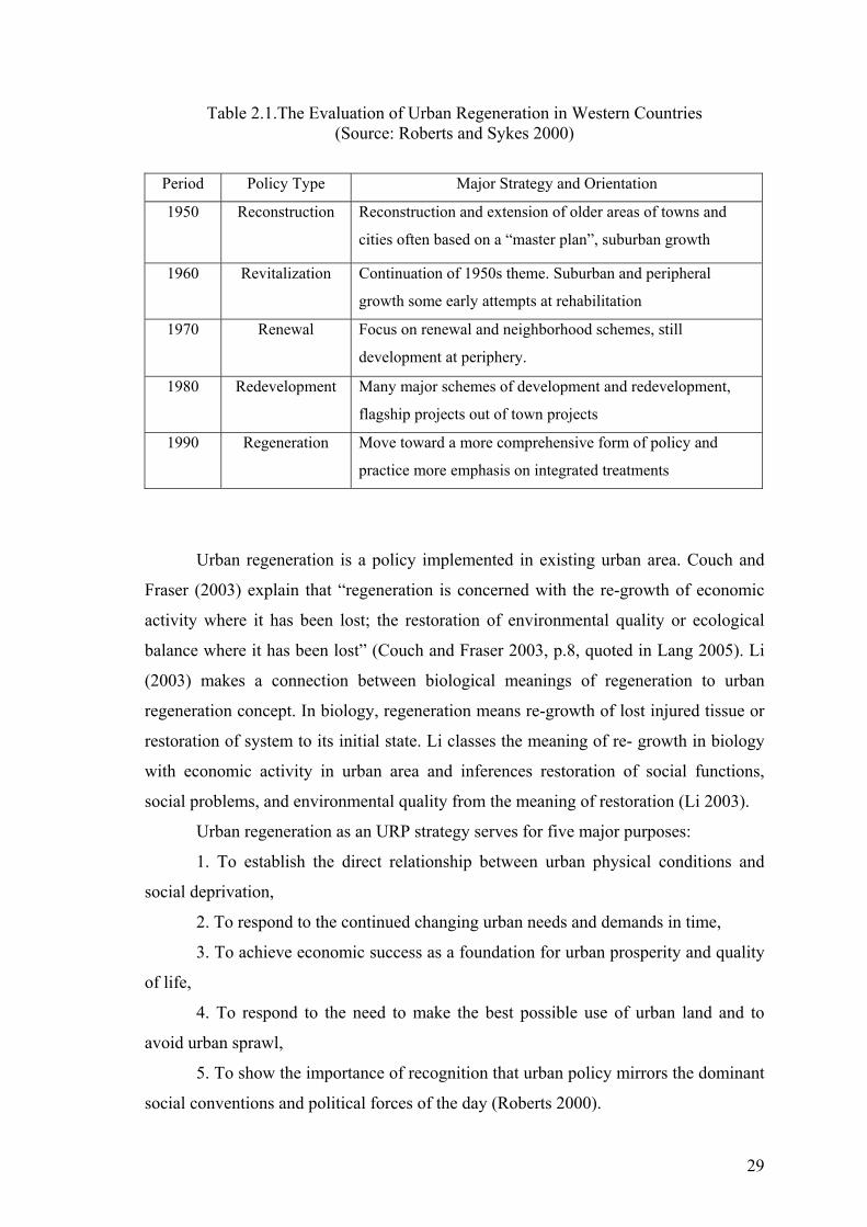
29
Table 2.1.The Evaluation of Urban Regeneration in Western Countries (Source: Roberts and Sykes 2000)
Period Policy Type Major Strategy and Orientation
1950 Reconstruction Reconstruction and extension of older areas of towns and
cities often based on a “master plan”, suburban growth
1960 Revitalization Continuation of 1950s theme. Suburban and peripheral
growth some early attempts at rehabilitation
1970 Renewal Focus on renewal and neighborhood schemes, still
development at periphery.
1980 Redevelopment Many major schemes of development and redevelopment,
flagship projects out of town projects
1990 Regeneration Move toward a more comprehensive form of policy and
practice more emphasis on integrated treatments
Urban regeneration is a policy implemented in existing urban area. Couch and
Fraser (2003) explain that “regeneration is concerned with the re-growth of economic
activity where it has been lost; the restoration of environmental quality or ecological
balance where it has been lost” (Couch and Fraser 2003, p.8, quoted in Lang 2005). Li
(2003) makes a connection between biological meanings of regeneration to urban
regeneration concept. In biology, regeneration means re-growth of lost injured tissue or
restoration of system to its initial state. Li classes the meaning of re- growth in biology
with economic activity in urban area and inferences restoration of social functions,
social problems, and environmental quality from the meaning of restoration (Li 2003).
Urban regeneration as an URP strategy serves for five major purposes:
1. To establish the direct relationship between urban physical conditions and
social deprivation,
2. To respond to the continued changing urban needs and demands in time,
3. To achieve economic success as a foundation for urban prosperity and quality
of life,
4. To respond to the need to make the best possible use of urban land and to
avoid urban sprawl,
5. To show the importance of recognition that urban policy mirrors the dominant
social conventions and political forces of the day (Roberts 2000).
30
2.1.5. The Fifth Period: 2000s to Present
Rapid development of technology and progresses in science especially reached its
highest level in the world history at the beginning of the 21st century. These
developments affected the socio-spatial structures, economy, and quality of life in cities
(The New Athens Charter 2003).
Ways of production and structure of employment have changed and new
requirements in terms of urban systems have emerged. Knowledge based economy,
neglect of local interest and globalization of economy have weakened the traditional
local economy and strengthened the impact of external factors upon urban development.
As a result of globalization, the loss of economic and cultural bonds in city has
deepened the social exclusion and deprivation. To avoid these negative impacts, the
promotion of historical identity and environmental quality has been recognized as a
competitive advantage of cities of the future (The New Athens Charter 2003).
In the development of urban policies, the international concerns and thus,
charters and declarations have become important and extended the strategies of
governments for URPs. The concerns over, for instance, natural and cultural heritage
conservation, environment, participation processes, and sustainability have been taken
into account in these international charters related to URPs.
International Charters also have effective impact on urban policies. ICOMOS
(International Non Governmental Organizations of Professionals, Dedicates to the
World’s Historical Monuments and Sites) Venice Charter (1964) for the Conservation
and Restoration of Monuments and Sites is the extension of the Athens Charter of 1931,
constructs standards for the preservation and restoration of ancient buildings and
develops the reorganization over the importance of heritage (EU Guidance 2004).
United Nations Conference on the Human Environment in Stockholm in 1972
increased the awareness of people towards environment. The environmental problems
discussed at the first time at international level. The relationship between economic and
social development was taken into account and it was implied that living in an
unpolluted healthy environment is one of the fundamental urban rights. World
Commission on Environment and Development (WCED) was founded by United
31
Nations in 1983 to evaluate the process after Stockholm Conference. Then the
commission published Brundtland Report in 1987 (Yazar 2006).
The Conference of Habitat I in Vancouver in 1976 placed local community
concerns on the international agenda and highlighted the importance of inclusiveness. It
symbolized inclusiveness, with balanced participation from public, private and civil
society sectors. As a result of the inequitable economic growth and uncontrolled
urbanization, “One third or more of the entire population of developing world lives in
slums and squatter settlements” (WUF 2006).
The European Urban Charter organized by the Council of Europe from 1980s to
1982 focused on the improvement of European cities by projects concentrated on four
main general areas in the integration process of Europe after the defeat of Soviet Union:
the improvement of physical urban environment, the rehabilitation of existing housing
stock, the creation of social and cultural opportunities in towns and community
development, and the public participation (The European Urban Charter).
Sustainability became one of the more popular concepts in 1990s. The concept
of sustainability first declared in Brundtland Report in 1987. Because awareness of the
limitations in built environment and deepening environmental and social problems in
urban fabric at the end of 1980s caused problems both in developing and developed
countries (Yazar 2006).
In the HABITAT II, Istanbul, 1996 revival or renewal of inner cities and urban
centers were the main topics. In the 1996 program on human settlements, minimum
standards (Habitat II Agenda) to be satisfied, in order to guarantee everyone access to
decent housing were defined (UNESCO 2007, Habitat II Report 1996).
The Rio Charter in 2004 represents commitments about “the Purpose of
Universal Design” that includes generating accessible environments and programs to
serve needs, to make possible social participation and to enable access to the goods and
services for all people especially who have difficulties to manage to reach these services
(Rio Charter 2004).
The vision of the New Athens Charter in 2003 focused on the concept of
‘‘connected city’’ which follows a goal about integration of all stakeholders in the
process of sustainable urban development and management with taking into account of
the time –space relationship. To understand the urban problems such as unemployment,
poverty, exclusion, criminality and violence, the concept of connected city is very
significant because each problem has influences over the emergency of other problems.
32
The concept of urban renaissance also took place in New Athens Charter. In the New
Athens Urban Charter urban design seems as a key element for the renaissance of cities
of tomorrow. It is mentioned that planner will be a key actor in this processes in the
steps of policy, measure and intervention (The New Charter of Athens 2003).
Both spatial segregation and social polarization too are accepted as one of the
important problems in the built environment. For the last three decades in developing
countries, the general problems are the expansion of slum areas at peripheral locations,
the increases in the number of ‘‘have nots’’ and the increase in the rate of poverty,
whereas in highly developed countries main problems have seen as inner city decline.
This situation has formed also social exclusion. The term social sustainability has taken
into account of social problems of urban areas besides physical, economic problems.
Today and in the future easing inequalities, social segregation and strengthening social
cohesion is possible by improving living conditions of all citizens and sustaining
integration of different social groups from various origins (UNESCO 2007).
Finally, to sustain guidance for future rehabilitation projects, new urban
rehabilitation strategy and new sustainable urban policy depending on the experiences
gained from successful examples of urban rehabilitation projects in European Countries
was developed by the Council of Europe within the framework of “Technical Co-
operation and Consultancy Program” to carry out the projects related to the Integrated
Conservation of the Cultural and Natural Heritage, social cohesion and human rights.
There is a guidance document developed for rehabilitation projects to construct
the new standards of Europe and to match the “democratic principles promoted by the
Council of Europe.” This document called the “Guidance on Urban Rehabilitation” by
the European Union (2004) is prepared within the framework of the technical co-
operation and consultancy program taking into account of the advices and experiences
of two Council of Europe expert groups: “the group on rehabilitation of housing in
historic city centers and the “Rochefort Group” on the values and principles derived
from technical consultancy (EU Guidance 2004).Urban rehabilitation with sustainable
development is one of the most dominant concerns in the agenda of central and western
European countries. To sustain integration of local authorities to urban rehabilitation
have been an important aim to protect urban heritage, to increase housing conditions
especially in urban decline areas. Furthermore, urban regeneration is the extension of
urban policy to present conditions and strategies. So the definitions of other urban
policies which became more dominant in different time intervals such as urban renewal,
33
urban rehabilitation, urban revitalization or urban redevelopment match with these aims
originally (EU Guidance 2004).
However, now these means of action must comply with the democratic
principles that have been promoted by the Council of Europe since the 1960s (EU
Guidance 2004). Urban rehabilitation thus comes under an overall urban design (urban
development plan), requiring an integrated, cross-sector approach to all urban policies.
“From this perspective it is apparent that the concept of urban rehabilitation has
changed considerably since the mid-1960s, to respond to our contemporaries’ changing
issues and concerns in the field of urban development. The fundamental change in the
concept of urban rehabilitation from the ’heritage protection’ in historic centers to the
completion of a bona fide “urban project” based on a multidisciplinary approach,
integrating all urban policies” (EU Guidance 2004).
2.2. Urban Renewal Projects in Turkey
This part of the chapter focuses on the main factors, reasons and strategies for
URPs in the history of Turkish Republic.
The reasons for URPs in Turkey have included the upgrading living conditions
in low quality, old housing stock, such as squatter housing districts, urban declined
areas and historical districts. Sustaining safer environments, increasing rant in economy
have been other reasons for URPs. Thus, in Turkey, URPs have been overall developed
in squatter housing areas recently in disaster prone areas that are under the risk of
natural disasters, such as earthquake, flood and landslide, slum areas, urban decline
areas and old historical districts (Keleş 2004). Meanwhile, Tekeli (2003) explains that
there are “resistance mechanisms” in the built environment, which are barrier to the
URPs. These barriers are obsolesce of building in a long time, symbolic, historical and
architectural values of buildings that increases institutionalization of preservation
especially in the last three decades, and finally, the diversity in landownership and
restrictions of development rights with plans and laws (Tekeli 2003). Moreover, Tezel
points out that if possible outcomes of URPs cause socio economic, political loses, and
this factor also forms a resistance mechanism towards URPs.
34
When we look at the urbanization history in Turkish Republic, we can classify
four groups of main reasons for URPs. These are the illegally constructed settlements,
obsolescence in existing building stock, inner city problems, and disaster fact (Özden
and Kubat 2003).
This part of the thesis focuses on the evolution of URP strategies in the history
of Turkish Republic in four periods.
The First Period: Early Republican Period (1923-1945 )
The Second Period: 1945 -1980
The Third Period: 1980–2000
The Fourth Period: From 2000s to the Present
2.2.1. The First Period: The Early Republican Period (1923-1945)
The interventions of the state in the built environment have generally based on
the public improvements that shaped the built environment physically since the
modernization movements in the Ottoman Empire. When the planning practices of
Europe and Turkey was compared with each other, in Turkish planning practice,
conservation plans and master plans are dominant in place of comprehensive planning
approaches. However, Turkish cities are under the similar global effects. Moreover,
urban renewal project are the strategies that were developed as a tool of comprehensive,
sustainable planning approach in Europe (Kocamemi 2006).
After the defeat of Ottoman Empire, Turkish Republic was founded in 1923. At
this period, the main purpose of the state was to reconstruct the national economy and
make institutional developments in economy. In 1923, the first National Economy
Congress was organized in Izmir. In 1927, the “Industry Support Act” was put into
execution and at the beginning of 1930s Central Bank of the Republic of Turkey was
founded (Kazgan 1999). Moreover, to encourage agricultural production, new funds and
subsidies were provided to farmers. The improvements also developed in other sectors,
such as education, culture, and infrastructure. Because creating a modern society would
came true only with the development of all these developments all together. To create
new and modern environments the state made reforms and applied new master plans to
35
eradicate the 1st World War effects and to transform the traditional Turkish society into
a modern society. National economic policies were applied to create a bourgeoisie class
and to fasten the social- economic transformation (Aksoylu 2003).
To create modern built environments, the Turkish government of early
republican period made a competition to plan new capital city, Ankara. Hermann
Jansen’s plan won the competition and was applied. New master plans were also done
for the other Turkish cities to sustain physical transformation in built environment under
the effects of modernization movements and the approaches of the International
Congress of Modern Architecture, CIAM. Big public works and urban reconstruction
projects were applied in Turkish cities in the process of the establishment of new
country. Danger Plan for Izmir, Jansen Plan for Ankara and Prost plan for Istanbul are
examples of master plans at this period (Aksoylu 2003).
2.2.2. The Second Period: 1945-1980
In the mid of 1940s, the Marshall Aids increased mechanization in agriculture.
For sustaining economic developments, the government encouraged the development of
national industry. As a result of mechanization, the need for labor decreased in
agricultural production system. Ultimately, the labor force in rural areas migrated to
cities to find new jobs and to get benefits from urban areas (Uzun 2006).
Moreover, between the years of 1950 and 1980 economic growth in large cities
pulled people from rural to urban area. As a result of rapid urbanization, vacant areas in
large cities were transformed into squatter housing areas (Köroğlu and Ercoşkun 2006).
Thus, the main problems of Turkish cities in the second period are uneven development
and emergence of illegally constructed settlements in big Turkish cities like Istanbul,
Ankara and Izmir (Ataöv 2007).
We can say that the subsidies of central government for housing construction in
developed countries as a result of welfare state policies matches with the policies of
government in Turkey in 1950s. Because according to a view, in Turkey the
governments allowed the invasion of public land by low income groups (Kurtuluş
2006). In 1970s, especially when in Western countries participatory approaches in urban
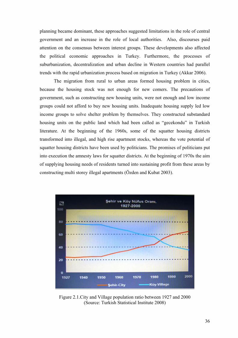
36
planning became dominant, these approaches suggested limitations in the role of central
government and an increase in the role of local authorities. Also, discourses paid
attention on the consensus between interest groups. These developments also affected
the political economic approaches in Turkey. Furthermore, the processes of
suburbanization, decentralization and urban decline in Western countries had parallel
trends with the rapid urbanization process based on migration in Turkey (Akkar 2006).
The migration from rural to urban areas formed housing problem in cities,
because the housing stock was not enough for new comers. The precautions of
government, such as constructing new housing units, were not enough and low income
groups could not afford to buy new housing units. Inadequate housing supply led low
income groups to solve shelter problem by themselves. They constructed substandard
housing units on the public land which had been called as “gecekondu” in Turkish
literature. At the beginning of the 1960s, some of the squatter housing districts
transformed into illegal, and high rise apartment stocks, whereas the vote potential of
squatter housing districts have been used by politicians. The promises of politicians put
into execution the amnesty laws for squatter districts. At the beginning of 1970s the aim
of supplying housing needs of residents turned into sustaining profit from these areas by
constructing multi storey illegal apartments (Özden and Kubat 2003).
Figure 2.1.City and Village population ratio between 1927 and 2000 (Source: Turkish Statistical Institute 2008)
37
After 1950s, the squatter housing areas became apparent in city pattern. These
areas lacked social- technical infrastructure and were constructed in public land. So, the
immense changes in the built environment have been started with squatter housing
districts (Köroğlu and Ercoşkun 2006). Public discourses about such projects focused
on constructing healthy, livable urban areas, sustaining housing demand and adaptation
problems of immigrants or citizens who are living in squatter housing districts to urban
life. As an URP strategy urban redevelopment projects were applied in the squatter
areas to improve the living conditions of these areas.
In Turkey, since 1960s URPs generally have taken place in squatter housing
areas to redevelop contemporary housing areas. The law and regulations have also
played an important role at this process. With the Law of Gecekondu numbered 775 in
1966, the squatter areas have gained infrastructure opportunities, such as sewage system
and new roads. Until 1960s, squatter housing units had been constructed by low income
groups for solving their housing needs. After 1960s, this aim changed. Whenever the
economic power of old user of squatter housing unit increased, they constructed another
squatter housing and newcomers became their tenants. So, squatter districts became
profitable areas (Köroğlu and Ercoşkun 2006).
As a result, in the second period urban reconstruction and urban redevelopment
project are applied in Turkish cities as an extension of URP strategies.
2.2.3. The Third Period: 1980-2000
The third period is between the years 1980-2000. During this period big cities
were affected from liberal policies and globalization. Suburbanization, new residential
developments was seen in the outer parts of the cities. Besides residential areas, the
transformation was also seen in industrial and central business districts. Moreover,
gentrification processes took place in historical districts (Ataöv 2007).
According to Erkip (2000), in Turkey after 1980s, the new distribution of power
between central and local governments made urban land more available for big
constructions. Also, along with various different patterns in the built environment, there
have appeared social and economic inequalities among citizens. The globalization
38
process has increased the gap between the upper and lower income groups, whereas the
feeling of “otherness” and social segregation in communities have related with the
physical pattern in the built environment (Erkip 2000).
Within the neoliberal economic policies, two intervention of the state have
caused changes in the structure of Turkish cities:
i) Urban transformation with urban improvement plans since 1980s.
Improvement plans are the first solution for the squatter housing areas.
ii) Urban transformation with URPs with public- private partnerships since
1980s.
Moreover, to legalize the existing building stock and to solve the ownership
problems, series of amnesty laws has been put into force since 1980. In 1984 with the
last Amnesty Act numbered 2981, improvement plans were prepared for squatter
districts (Köroğlu and Ercoşkun 2006).
In 1986 the squatter amnesty act numbered 3290 enlarged the rights of squatter
housing residents. Because the law excuses not only the squatter residential buildings, it
also excuses the commercial use transformed from residential uses (Özden and Kubat
2003). With the Law numbered 3414 in 1988, some statements of the law of Gecekondu
numbered 775 that restricted and sustained control over squatter houses within the
boundaries of municipalities were changed. The law gave authority from governorship
and metropolitan municipalities to local municipalities and also declared off the rule
that restricted the sale or transfer of land or house within 20 years which were sustained
by government. Afterwards, the owners of the squatter housing units started to sale
these units and gained economic profit. Especially after 1985, land speculation
increased to increase the land values on unfair grounds.
Today squatter housing areas became one of the important places for urban
renewal applications. At the beginning of the development process of squatter districts,
they exist near the industries out of city center, at the edge corners of the cities. Yet
with the rise in urban population and the expansion of cities, they became parts of the
city. So the economic pressures to transform these areas into more profitable places
increased its effect and made these areas more attractive places (Özden and Kubat
2003).
Also, obsolescence in existing building stock and inner city problems are other
main problems of cities in the third period. Doratlı (2005) explains that changes in
physical form of cities in socio-economic, cultural and political conditions in cities at
39
any point in time as well as the variance in developing needs and expectations through
time would result in a mismatch or conflict between the capability of a building or a
group of building or the area. This mismatch, which is named as ‘obsolescence’ as an
aforementioned, leads such an area deep into the process of deterioration and decay.
The substandard, poor maintenance, lack of contemporary usages, lack of infrastructure
facilities caused deterioration or decay in building stocks. After 1980s inner city decline
started to appear as a problem in Turkish cities especially in old housing stock districts,
in old industrial zones that occupies central parts of the cities. Moreover,
suburbanization process at the beginning of 1990s also fastened the obsolescence in the
core of the big cities. To increase health standards, to create livable environments, to
sustain vital social life and to evaluate existing historical vacant housing areas, urban
regeneration projects have been an important intervention strategy of government
(Doratlı 2005).
The detritions in the building stock and the encouragements by legal
arrangements for transformation of the illegally constructed settlements have increased
the importance of URPs after 1980s. The physical transformation of space has focused
on two main issues since 1980. One of them comprises the reconstruction of the ties
between the state and the capital with neo-liberal policies and arrangement of
ownership/property rights in high income groups’ favor. The other factor focuses on the
assumption of public space as a commodity (Uzun 2006).
Within the last three decades, rehabilitation of squatter districts with
improvement plans could not solve the problems in squatter areas. High rise and
illegally constructed buildings emerged in the scenery of squatter districts. Urban
sprawl occurred with decentralization of residential areas and effects of neo-liberal
policies in globalization process have turned government attention into urban renewal
projects. Social effects of URPs started to be discussed. Moreover, to revitalize urban
economy URPs also became a main strategy of the government (Uzun 2006).
Inner city districts became popular for URPs with their accessibility and
increasing land value. Flagships projects took place in inner cities. Not surprisingly,
slum areas and squatter housing districts that became a part of centers in the extension
processes of cities were seen as a barrier in front of the contemporary development. So,
discourses on URPs at this scope include transforming squatter housing districts into
more reliable and healthy areas with eradicating physical and economic decay.
However, social, environmental impacts of urban transformation projects have not been
40
taking into account sufficiently (Izmir Metropolitan Municipality, Kentsel Donüşüm
2008).
It is estimated that with URPs only in Istanbul (the biggest city of Turkey),
nearly from 1.5 to 2 million residents, mostly poor and low-middle income groups are
going to be relocated from their living areas (Izmir Metropolitan Municipality, Kentsel
Donüşüm 2008). In the Strategic Plan of Istanbul between the years 2008 and 2011, it is
mentioned clearly that owners of squatter houses are going to be moved and modern
houses are going to be constructed for low income groups. Thus, critiques against these
projects focuses on that changing living tendencies of these groups, removing
relationships and historical roots with their living environment deepens the social and
physical segregation and increases the tensions in society (Gelişim 2008).
In addition to these, URPs are also seen as partial and incremental interventions
that can not respond to the new problems in a short time, immediately after the projects’
applications. So, 1980 was also an important turning point in planning approaches.
Before 1980s, urban transformation had been applied with dominant urban plans
whereas, whereas since 1980 urban transformations have been done with URPs (Şahin
2003).
Moreover, international concerns and rapid changes in socio-economic-political
and environmental issues canalize government to put into force new legal arrangements,
including new laws and regulations. The elite groups’ awareness about the importance
of natural and cultural heritage increased recognitions of government. The important
laws which were put into force after 1980 are; Environment Act (No: 2872) (1983), The
Act (No: 2960) (1983), Natural Parks Act (No: 2873) (1983), Greater Municipality Act
numbered (No: 3030) (1984), Mass Housing Act (No: 2985) (1984), Improvement Act
(No: 3194) (1985), Amnesty Act (No: 2805) (1983), Amnesty Act (No:2981)(1984),
Preservation of Cultural and Natural Assets Act (No: 2863) (1983), Greater
Municipality Act (No: 5216) (2004), Urban Transformation Act (2005) (Özdemir and
Egercioğlu 2007). These applications are the extensions of the increasing environmental
sustainability concerns and the development of importance of preservation of natural
and cultural heritage, in worldwide. Depending on new legal arrangements, URPs also
took place on the agenda of local government and its influence and popularity have
increased in society.
The improvement plans provide new parcel pattern for the construction of
apartment blocks. The first solution of improvement plans was improving 1-2 storey
41
squatter houses into 4-storey apartment blocks. As a result of this process, although
population density increased in squatter areas, adequate social and infrastructure could
not be obtained. In addition to this, high rise uncontrolled housing stock became a risk
factor in disaster prone areas (Dündar 2001).
In 1990s new legal arrangements gave rapid acceleration to URPs. Prestigious,
international projects are developed and implemented. Natural disasters also became a
reason for URPs. Conservation, restoration and rehabilitation of historical districts took
important place as a result of new urbanism flow all over the world.
The popularity of URPs has been increased since 1980s, whereas public and
private authorities believe in that all problems of cities can be solved with URPs. The
projects also became a prestige factor for local authorities. To become a global city, to
sustain market mechanism demands by changing spatial relations in metropolitan areas,
URPs became an important strategy. The collaboration of local authorities with private
sector has been strengthened to apply URPs (Altinörs and Yörük 2006).
2.2.4. The Fourth Period: 2000s to Present
During the fourth period, the collaboration of local government with private
sector increased. URPs have been applied not only in squatter housing areas but also in
historical districts, disaster prone, and urban decline areas vice versa. Competitions
between large cities to become a global city have increased since 2000s. Urban
gentrification, urban rehabilitation, urban redevelopment projects are dominant URP
strategies at this period (Ataöv 2007).
Marmara Earthquake in 1999 is also a turning point in URP strategies in Turkey.
To prepare cities for possible natural hazards, the state has aimed at determining
disaster prone areas with high damage risk and at rehabilitating the building stock with
substandard conditions. Especially because of their illegally and substandard structure
and strategic locations in cities, squatter housing districts became one of the interest
topic of the state, private sector and NGOs (Özden and Kubat 2003).
But since the Eastern Marmara Earthquake, the number of legal arrangements
related to URPs increased. this situation also proved that URPs have become also a
42
policy of the state to encourage local municipalities for developing URPs, whereas local
authorities have been in charged of the application of URPs within the boundaries of
metropolitan areas according to the Municipality Act numbered 5393 in 2005 (Uzun
2006).
The central government explained the reasons of “Urban Transformation and
Development Bill” in 2005. According to this statement, rapid urbanization has been
one of the fundamental problems of Turkey. In this process, immigrants have settled
down especially in old city centers and historical districts which later became urban
decline areas with loss of their economic vitality and value. In addition to this, because
of the uncontrolled building structure, these areas threatened the life and property of
society. The Act of Greater Municipality numbered 5216 (2004) valued the power of
local authorities. The Act of Urban Transformation (2005), meanwhile, enlarged the
boundaries for the areas for the implementations of URPs (Özdemir and Egercioglu
2007).
According to Ataöv (2007), URPs are shaped by the managerial and
implementation dynamics of Turkey in 2000s TOKİ (Housing Development
Administration of Turkey) and the metropolitan municipalities prepare big projects that
are also taking attentions of global capital and real estate agencies. European Union,
World Bank, international financial associations are also giving financial support to
these projects.
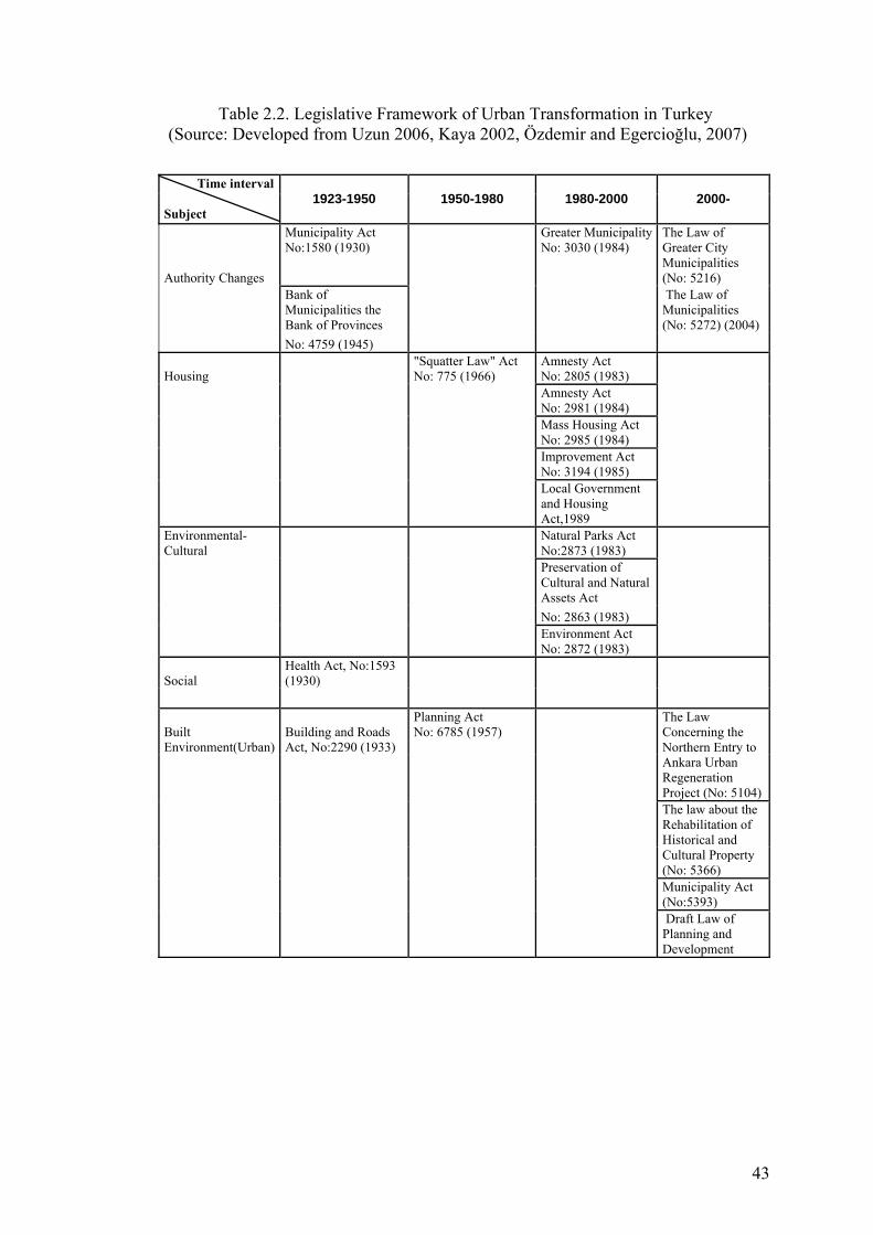
43
Table 2.2. Legislative Framework of Urban Transformation in Turkey (Source: Developed from Uzun 2006, Kaya 2002, Özdemir and Egercioğlu, 2007)
Time interval Subject
1923-1950 1950-1980 1980-2000 2000-
Authority Changes
Municipality Act No:1580 (1930)
Greater Municipality No: 3030 (1984)
The Law of Greater City Municipalities (No: 5216)
Bank of Municipalities the Bank of Provinces
The Law of Municipalities (No: 5272) (2004)
No: 4759 (1945)
Housing "Squatter Law" Act No: 775 (1966)
Amnesty Act No: 2805 (1983)
Amnesty Act No: 2981 (1984)
Mass Housing Act No: 2985 (1984)
Improvement Act No: 3194 (1985)
Local Government and Housing Act,1989
Environmental-Cultural
Natural Parks Act No:2873 (1983)
Preservation of Cultural and Natural Assets Act
No: 2863 (1983)
Environment Act No: 2872 (1983)
Social Health Act, No:1593 (1930)
Built Environment(Urban)
Building and Roads Act, No:2290 (1933)
Planning Act No: 6785 (1957)
The Law Concerning the Northern Entry to
Ankara Urban Regeneration Project (No: 5104)
The law about the Rehabilitation of Historical and
Cultural Property (No: 5366)
Municipality Act (No:5393)
Draft Law of Planning and Development
44
CHAPTER 3
SET OF CRITERIA FOR “GOOD” URPS
This chapter aims at producing a set of criteria for good URP by examination of
the scholarly books, articles, working papers, the related International Charters, the
European Union (EU) Guidance on Urban Rehabilitation (2004), the graduate thesis in
the Turkish universities and evaluates the sources above and searches for the “good” in
terms of planning outcomes and planning processes. The aim for developing a good
URP does not only match with an idea of making physical changes in the built
environment. It should also consider social, economic, and cultural factors of the project
context. Especially after 1960s, increasing concentration of the problems of
disadvantaged groups, awareness on cultural heritage and architectural heritage,
importance of public participation in decision making processes and changing
perceptions about planning approaches approve that multiple dimensions of urban
interventions such as URPs should be considered while making an overall assessment
(EU Guidance 2004, Kaya 2002).
Furthermore, since 1980s, the decreasing role of the state in public policies has
underlined the importance of of public-private partnerships in urban projects. Within the
following years in 1990s, the urban policies started to depend on more consensual style.
Increasing awareness on ecological/environmental issues also caused the emergency of
environmentally sustainable development approaches in urban policies (Roberts 2000).
3.1. Scholarly Works
The scholarly works that I examined for developing a set of criteria for “good”
URPs include books, articles, and working papers. Thirty number of scholarly works
which develops mainly on five research methods; descriptive, historical, case study,
comparative and normative were analyzed. From twenty-two scholarly works out of
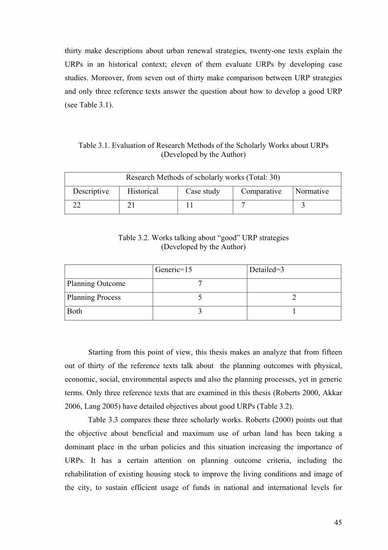
45
thirty make descriptions about urban renewal strategies, twenty-one texts explain the
URPs in an historical context; eleven of them evaluate URPs by developing case
studies. Moreover, from seven out of thirty make comparison between URP strategies
and only three reference texts answer the question about how to develop a good URP
(see Table 3.1).
Table 3.1. Evaluation of Research Methods of the Scholarly Works about URPs (Developed by the Author)
Research Methods of scholarly works (Total: 30)
Descriptive Historical Case study Comparative Normative
22 21 11 7 3
Table 3.2. Works talking about “good” URP strategies
(Developed by the Author)
Generic=15 Detailed=3
Planning Outcome 7
Planning Process 5 2
Both 3 1
Starting from this point of view, this thesis makes an analyze that from fifteen
out of thirty of the reference texts talk about the planning outcomes with physical,
economic, social, environmental aspects and also the planning processes, yet in generic
terms. Only three reference texts that are examined in this thesis (Roberts 2000, Akkar
2006, Lang 2005) have detailed objectives about good URPs (Table 3.2).
Table 3.3 compares these three scholarly works. Roberts (2000) points out that
the objective about beneficial and maximum use of urban land has been taking a
dominant place in the urban policies and this situation increasing the importance of
URPs. It has a certain attention on planning outcome criteria, including the
rehabilitation of existing housing stock to improve the living conditions and image of
the city, to sustain efficient usage of funds in national and international levels for
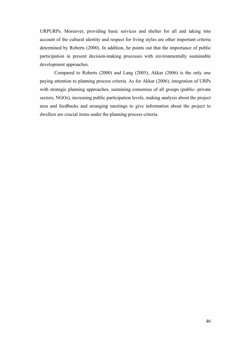
46
URPURPs. Moreover, providing basic services and shelter for all and taking into
account of the cultural identity and respect for living styles are other important criteria
determined by Roberts (2000). In addition, he points out that the importance of public
participation in present decision-making processes with environmentally sustainable
development approaches.
Compared to Roberts (2000) and Lang (2005), Akkar (2006) is the only one
paying attention to planning process criteria. As for Akkar (2006), integration of URPs
with strategic planning approaches, sustaining consensus of all groups (public- private
sectors, NGOs), increasing public participation levels, making analysis about the project
area and feedbacks and arranging meetings to give information about the project to
dwellers are crucial items under the planning process criteria.
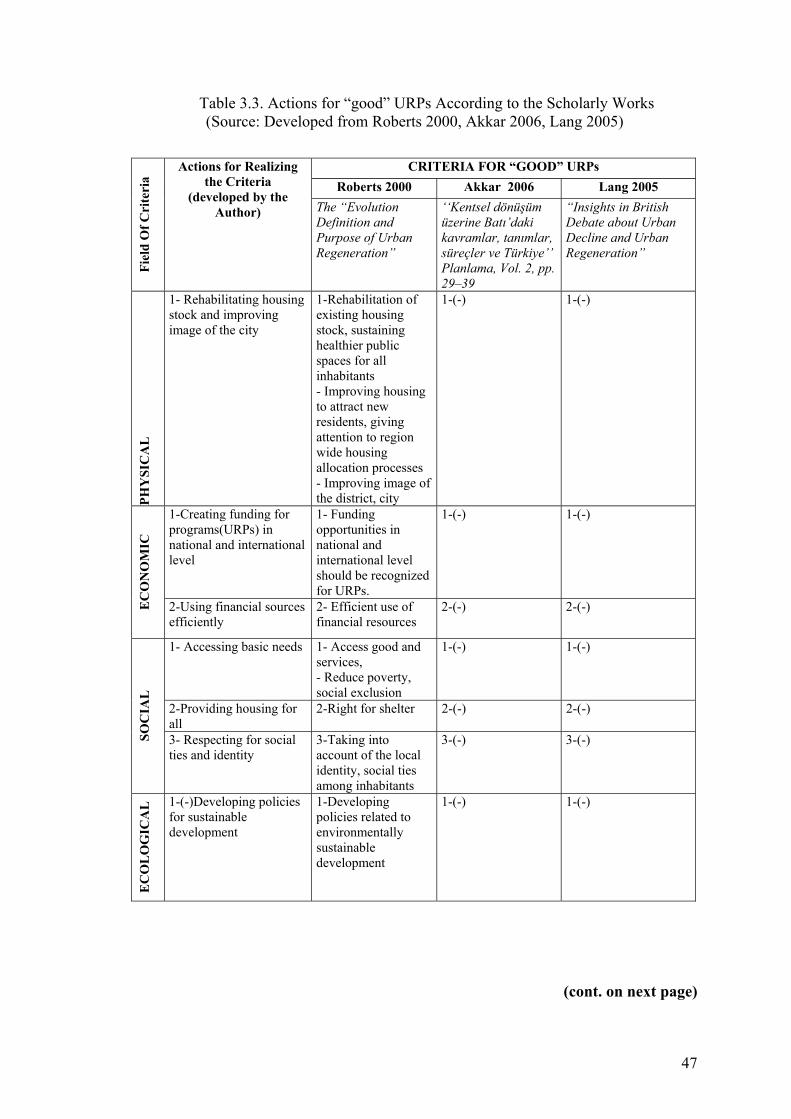
47
Table 3.3. Actions for “good” URPs According to the Scholarly Works (Source: Developed from Roberts 2000, Akkar 2006, Lang 2005)
CRITERIA FOR “GOOD” URPs
Roberts 2000 Akkar 2006 Lang 2005
Fiel
d O
f Cri
teri
a
Actions for Realizing the Criteria
(developed by the Author) The “Evolution
Definition and Purpose of Urban Regeneration”
‘‘Kentsel dönüşüm üzerine Batı’daki kavramlar, tanımlar, süreçler ve Türkiye’’ Planlama, Vol. 2, pp. 29–39
“Insights in British Debate about Urban Decline and Urban Regeneration”
PHY
SIC
AL
1- Rehabilitating housing stock and improving image of the city
1-Rehabilitation of existing housing stock, sustaining healthier public spaces for all inhabitants - Improving housing to attract new residents, giving attention to region wide housing allocation processes - Improving image of the district, city
1-(-) 1-(-)
1-Creating funding for programs(URPs) in national and international level
1- Funding opportunities in national and international level should be recognized for URPs.
1-(-) 1-(-)
EC
ON
OM
IC
2-Using financial sources efficiently
2- Efficient use of financial resources
2-(-) 2-(-)
1- Accessing basic needs 1- Access good and services, - Reduce poverty, social exclusion
1-(-) 1-(-)
2-Providing housing for all
2-Right for shelter 2-(-) 2-(-)
SOC
IAL
3- Respecting for social ties and identity
3-Taking into account of the local identity, social ties among inhabitants
3-(-) 3-(-)
EC
OL
OG
ICA
L 1-(-)Developing policies
for sustainable development
1-Developing policies related to environmentally sustainable development
1-(-) 1-(-)
(cont. on next page)
48
Table 3.3. (cont.)
1-Developing projects with strategic planning approach
1-(-) 1-The projects are the parts of strategies which were developed as an extension of certain visions.
1-(-)
2-Improving public participation processes
2-Sustaining public participation in decision making processes
2-Sustain Consensus of all groups, collaboration of various sectors (public- private sectors, NGOs) and increase public participation levels
2-Developing partnership between public and private actors
3-Taking into account of the multi-dimensional factors in URPs
3-(-) 3-Besides physical dimensions of the URPs socio-economic-cultural dimensions should be considered and feedbacks should be done in the process of the project.
3-Urban regeneration is a multidimensional process
4- Meeting the community’s real needs
4-(-) 4-Making research about the project area to make true analysis, to reach successful solutions
4-(-)
5- Setting up an institutional organization according to urban policies and strategies related to URPs
5-(-) 5-Foundation of URP, communication departments in municipalities…etc.
5-(-)
PLA
NN
ING
PR
OC
ESS
6-Developing access to information and knowledge
6-(-) 6-Sustain inhabitants to access information related to their living environment
6-(-)
3.2. International Charters
International charters are crucial guidelines for all countries. They represent
agreements and declaration of the countries that propose to follow the suggestions,
responsibilities and rules that mentioned in the relevant declaration documents. So that
49
signing these charters have an international effect over the socio-economic, cultural, and
ecological policies of countries.
In the Oxford Dictionary, the definition of “charter” explained as a “written
grant by a sovereign or legislature by which a body such as a university is created or its
rights defined.” The term “convention” means socially acceptable behavior, an
agreement between countries, a large meeting or conference. Declaration is a formal
statement or announcement, an act of declaring (Oxford Dictionary 2009).
There are several international charters related to or with an influence about
URPs (Table 3.5.). This thesis has identified three effective international charters which
determines principles and standards related to the quality of built environment and with
set of criteria for good URPs: International Charter (Rio conference-Agenda-21 (1992),
Habitat II Conference (1996) and New Athens Charter (2003) (Table 3.4.).
The Agenda 21 (1992), which is the extension document of Rio Declaration
aims at determining the principles related to the environmentally sustainable
development. Thus, in Table 3.4 the agglomerations of items exist in the planning
process and ecological (environmental) criteria.
Habitat II (Second United Nations Conference on Human Settlements, 1996)
focuses mainly on the shelter theme and improving physical quality in the built
environment, sustaining accessibility of all to basic needs, such as education, health and
services. So, the dominant approach of the Habitat II Conference is about planning
outcomes, especially physical, economic, and social criteria outcomes. According to the
United Nations,
“Adequate shelter means more than a roof over one’s head. It also means
adequate privacy; adequate space; physical accessibility; adequate security; security of
tenure; structural stability and durability; adequate lighting, heating and ventilation;
adequate basic infrastructure, such as water-supply, sanitation and waste-management
facilities; suitable environmental quality and health-related factors; and adequate and
accessible location with regard to work and basic facilities: all of which should be
available at an affordable cost” (Habitat II 1996 (quoted in EU Guidance 2004)).
The New Athens Charter (2003) explains the importance of cultural heritage and
cultural diversity for cities and points out that the urban design projects are important
key factors for revival of cities and sustaining connection of the inhabitants with past
and the present. Although The New Athens Charter considers both planning outcome
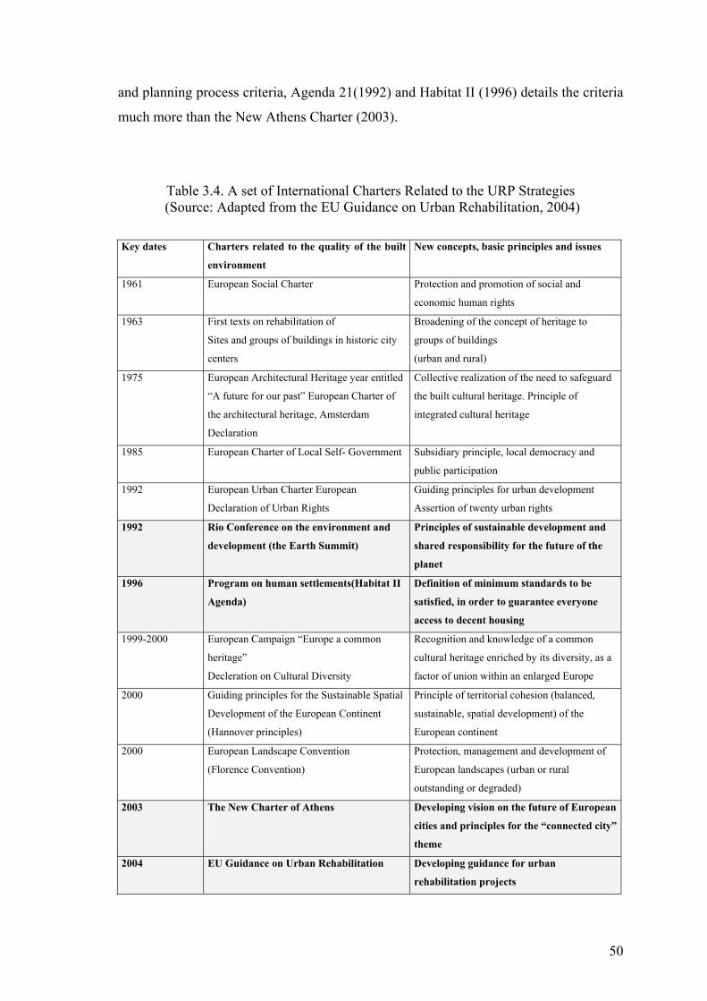
50
and planning process criteria, Agenda 21(1992) and Habitat II (1996) details the criteria
much more than the New Athens Charter (2003).
Table 3.4. A set of International Charters Related to the URP Strategies (Source: Adapted from the EU Guidance on Urban Rehabilitation, 2004)
Key dates Charters related to the quality of the built
environment
New concepts, basic principles and issues
1961 European Social Charter Protection and promotion of social and
economic human rights
1963 First texts on rehabilitation of
Sites and groups of buildings in historic city
centers
Broadening of the concept of heritage to
groups of buildings
(urban and rural)
1975 European Architectural Heritage year entitled
“A future for our past” European Charter of
the architectural heritage, Amsterdam
Declaration
Collective realization of the need to safeguard
the built cultural heritage. Principle of
integrated cultural heritage
1985
European Charter of Local Self- Government Subsidiary principle, local democracy and
public participation
1992
European Urban Charter European
Declaration of Urban Rights
Guiding principles for urban development
Assertion of twenty urban rights
1992 Rio Conference on the environment and
development (the Earth Summit)
Principles of sustainable development and
shared responsibility for the future of the
planet
1996 Program on human settlements(Habitat II
Agenda)
Definition of minimum standards to be
satisfied, in order to guarantee everyone
access to decent housing
1999-2000
European Campaign “Europe a common
heritage”
Decleration on Cultural Diversity
Recognition and knowledge of a common
cultural heritage enriched by its diversity, as a
factor of union within an enlarged Europe
2000 Guiding principles for the Sustainable Spatial
Development of the European Continent
(Hannover principles)
Principle of territorial cohesion (balanced,
sustainable, spatial development) of the
European continent
2000 European Landscape Convention
(Florence Convention)
Protection, management and development of
European landscapes (urban or rural
outstanding or degraded)
2003
The New Charter of Athens
Developing vision on the future of European
cities and principles for the “connected city”
theme
2004 EU Guidance on Urban Rehabilitation Developing guidance for urban
rehabilitation projects

51
Table 3.5. “Good” URPs According to the Related International Charters (Source: Adapted from Agenda 21 (1992), Habitat II (1996), New Athens Charter (2003))
Fiel
d of
Cri
teri
a Actions for Realizing the Criteria
(developed by the Author)
Agenda 21, 1992 Habitat II Second United Nations Conference On
Human Settlements
Istanbul, Turkey (3-14 June 1996)
New Athens Charter, 2003
1-Improving the living standards in the built environment
1- (-) 1- Extending public services and infrastructure, creating safe living environments
1-Improving image of the city
2-Promoting historical and cultural heritage
2-(-) 2-Promoting the conservation, rehabilitation and maintenance of buildings, monuments, open spaces, landscapes and settlement patterns of historical, cultural, architectural, natural, religious and spiritual value.
2-(-)
PHY
SIC
AL
3-Revivaling urban design 3-(-) 3-(-) 3-Revival of urban design to improve the conditions in the built environment such as streets
1- Generating jobs 1-(-) 1-Generating sufficient employment opportunities
1-
2- Improving functions of city centers
2-(-) 2- 2-Improving functions of city centers
EC
ON
NO
MIC
3- Financing shelter provision -Financing access to land
3-(-) 3-Financing shelter and human settlements - Enhancing access to land and credit and assisting those who are unable to participate in housing markets
3-Sustaining accessibility to services and housing with affordable prices
(cont. on next page)
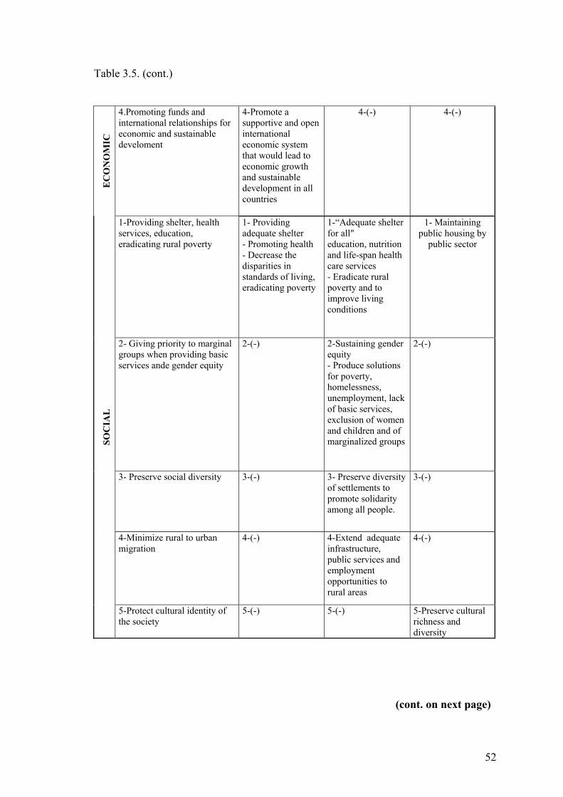
52
Table 3.5. (cont.)
E
CO
NO
MIC
4.Promoting funds and international relationships for economic and sustainable develoment
4-Promote a supportive and open international economic system that would lead to economic growth and sustainable development in all countries
4-(-) 4-(-)
1-Providing shelter, health services, education, eradicating rural poverty
1- Providing adequate shelter - Promoting health - Decrease the disparities in standards of living, eradicating poverty
1-“Adequate shelter for all" education, nutrition and life-span health care services - Eradicate rural poverty and to improve living conditions
1- Maintaining public housing by
public sector
2- Giving priority to marginal groups when providing basic services ande gender equity
2-(-) 2-Sustaining gender equity - Produce solutions for poverty, homelessness, unemployment, lack of basic services, exclusion of women and children and of marginalized groups
2-(-)
3- Preserve social diversity 3-(-) 3- Preserve diversity of settlements to promote solidarity among all people.
3-(-)
4-Minimize rural to urban migration
4-(-) 4-Extend adequate infrastructure, public services and employment opportunities to rural areas
4-(-)
SOC
IAL
5-Protect cultural identity of the society
5-(-) 5-(-) 5-Preserve cultural richness and diversity
(cont. on next page)
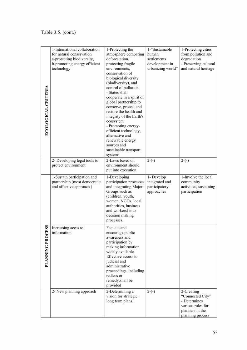
53
Table 3.5. (cont.)
1-International collaboration for natural conservation a-protecting biodiversity, b-promoting energy efficient technology
1-Protecting the atmosphere combating deforestation, protecting fragile environments, conservation of biological diversity (biodiversity), and control of pollution - States shall cooperate in a spirit of global partnership to conserve, protect and restore the health and integrity of the Earth's ecosystem - Promoting energy-efficient technology, alternative and renewable energy sources and sustainable transport systems
1-“Sustainable human settlements development in urbanizing world”
1-Protecting cities from pollution and degradation - Preserving cultural and natural heritage
EC
OL
OG
ICA
L C
RIT
ER
IA
2- Developing legal tools to protect environment
2-Laws based on environment should put into execution.
2-(-) 2-(-)
1-Sustain participation and partnership (most democratic and affective approach )
1-Developing participation processes and integrating Major Groups such as (children, youth, women, NGOs, local authorities, business and workers) into decision making processes.
1- Develop integrated and participatory approaches
1-Involve the local community activities, sustaining participation
Increasing acess to information
Facilate and encourage public awareness and participation by making information widely available. Effective access to judicial and administrative proceedings, including redless or remedy,shall be provided
PLA
NN
ING
PR
OC
ESS
2- New planning approach 2-Determining a vision for strategic, long term plans.
2-(-) 2-Creating “Connected City” - Determines various roles for planners in the planning process
54
3.3. European Union (EU) Guidance on Urban Rehabilitation (2004)
European Union’s guiding documents about urban projects about are important
for not only describing how to do but also encouraging and promoting both member
countries of the European Union and also associate counties, such as Turkey.
The document called the EU Guidance on Urban Rehabilitation (2004) aims at
promoting sustainable spatial development of the European continent. Both the criteria
for planning outcomes and for planning process developed by this document are
detailed in the Table 3.6. The items in the column for the criteria of planning process
underline that the involvement of all groups in decision making process, sustaining
political commitment by operational teams and by getting public acceptance, organizing
interdisciplinary teams, paying attention to scales of URPs in local and regional levels
are crucial for having good URPs.
According to this document, URPs are integral part of the urban policy but their
levels of implementation make the policy makers to consider the effects and properties
of an URP in detail. At district level, independent, original projects should be
developed. Because every district owns an identity, memory of locality, the planners
and designers should understand the local communal life. Neighborhoods might have
strong social bonds. Besides understanding socio-cultural properties of a
neighborhood/district, it is also important to identify the characteristics of the built
environment (streets, squares, open spaces and inner gardens of housing groups), the
level of accessibility to basic needs and facilities to determine real needs of the
community, to achieve the goal of social cohesion.
At town/city level, public authorities should take into account of the factors of
urban transformations, and coordinate rehabilitation policies, whereas urban policies
and rehabilitation projects must be an integral part of an overall urban development
plan. In general, respect for cultural diversity, promoting basic needs and shelter for all
and rehabilitating old town centers to avoid urban expansion and to get benefits from
existing building stock and to revival of historical cultural sites are basic items within
criteria of planning outcomes that are described as the main criteria by the EU Guidance
on urban rehabilitation.
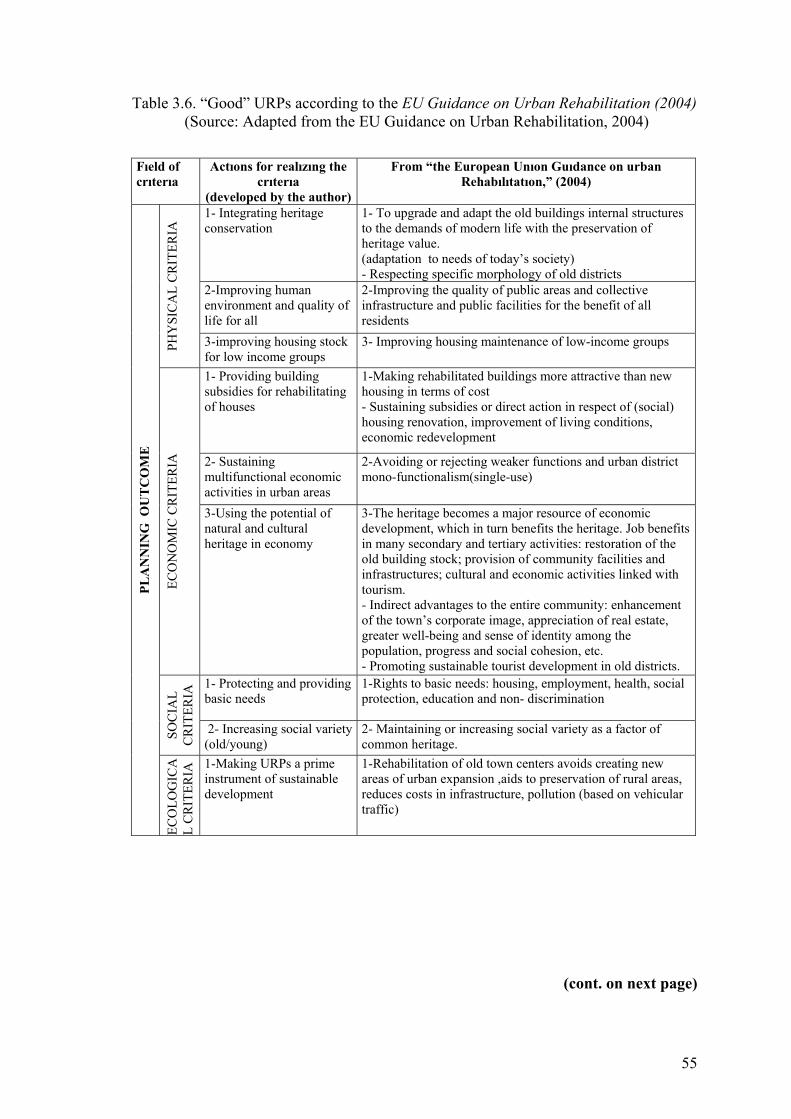
55
Table 3.6. “Good” URPs according to the EU Guidance on Urban Rehabilitation (2004) (Source: Adapted from the EU Guidance on Urban Rehabilitation, 2004)
Fıeld of crıterıa
Actıons for realızıng the crıterıa
(developed by the author)
From “the European Unıon Guıdance on urban Rehabılıtatıon,” (2004)
1- Integrating heritage conservation
1- To upgrade and adapt the old buildings internal structures to the demands of modern life with the preservation of heritage value. (adaptation to needs of today’s society) - Respecting specific morphology of old districts
2-Improving human environment and quality of life for all
2-Improving the quality of public areas and collective infrastructure and public facilities for the benefit of all residents
PHY
SIC
AL
CR
ITER
IA
3-improving housing stock for low income groups
3- Improving housing maintenance of low-income groups
1- Providing building subsidies for rehabilitating of houses
1-Making rehabilitated buildings more attractive than new housing in terms of cost - Sustaining subsidies or direct action in respect of (social) housing renovation, improvement of living conditions, economic redevelopment
2- Sustaining multifunctional economic activities in urban areas
2-Avoiding or rejecting weaker functions and urban district mono-functionalism(single-use)
ECO
NO
MIC
CR
ITER
IA
3-Using the potential of natural and cultural heritage in economy
3-The heritage becomes a major resource of economic development, which in turn benefits the heritage. Job benefits in many secondary and tertiary activities: restoration of the old building stock; provision of community facilities and infrastructures; cultural and economic activities linked with tourism. - Indirect advantages to the entire community: enhancement of the town’s corporate image, appreciation of real estate, greater well-being and sense of identity among the population, progress and social cohesion, etc. - Promoting sustainable tourist development in old districts.
1- Protecting and providing basic needs
1-Rights to basic needs: housing, employment, health, social protection, education and non- discrimination
SOC
IAL
CR
ITER
IA
2- Increasing social variety (old/young)
2- Maintaining or increasing social variety as a factor of common heritage.
PLA
NN
ING
OU
TC
OM
E
ECO
LOG
ICA
L C
RIT
ERIA
1-Making URPs a prime instrument of sustainable development
1-Rehabilitation of old town centers avoids creating new areas of urban expansion ,aids to preservation of rural areas, reduces costs in infrastructure, pollution (based on vehicular traffic)
(cont. on next page)
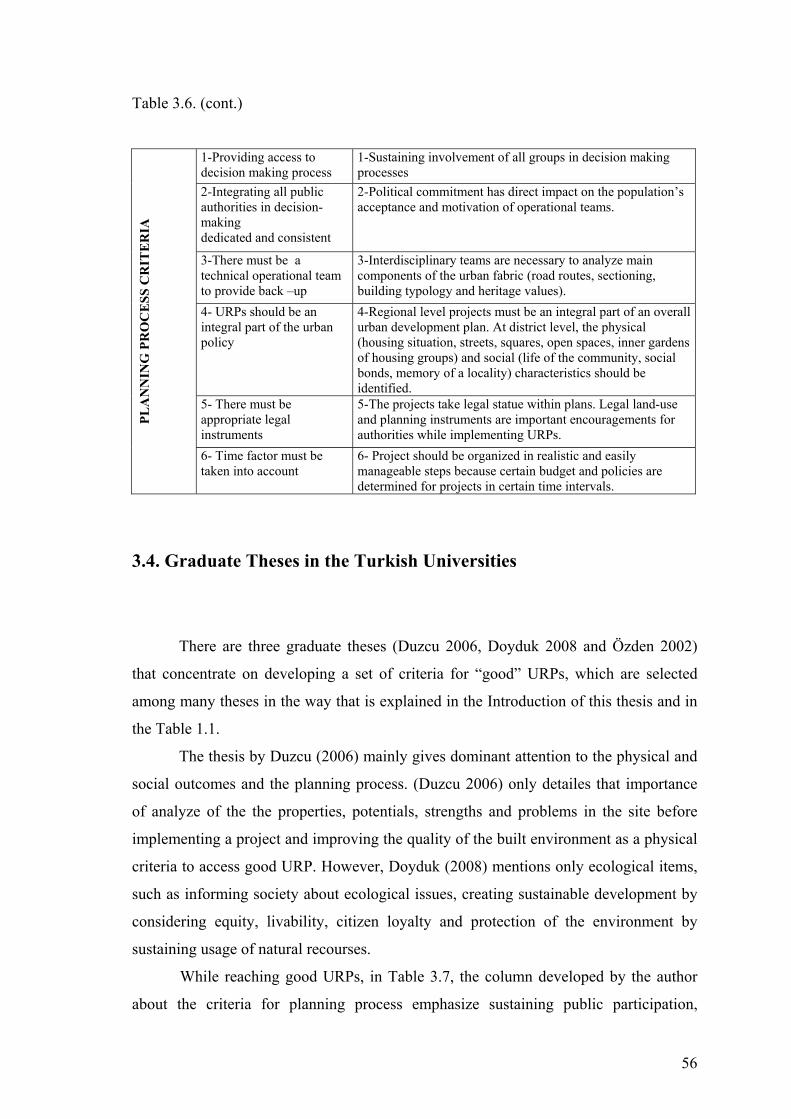
56
Table 3.6. (cont.)
1-Providing access to decision making process
1-Sustaining involvement of all groups in decision making processes
2-Integrating all public authorities in decision-making dedicated and consistent
2-Political commitment has direct impact on the population’s acceptance and motivation of operational teams.
3-There must be a technical operational team to provide back –up
3-Interdisciplinary teams are necessary to analyze main components of the urban fabric (road routes, sectioning, building typology and heritage values).
4- URPs should be an integral part of the urban policy
4-Regional level projects must be an integral part of an overall urban development plan. At district level, the physical (housing situation, streets, squares, open spaces, inner gardens of housing groups) and social (life of the community, social bonds, memory of a locality) characteristics should be identified.
5- There must be appropriate legal instruments
5-The projects take legal statue within plans. Legal land-use and planning instruments are important encouragements for authorities while implementing URPs.
PLA
NN
ING
PR
OC
ESS
CR
ITE
RIA
6- Time factor must be taken into account
6- Project should be organized in realistic and easily manageable steps because certain budget and policies are determined for projects in certain time intervals.
3.4. Graduate Theses in the Turkish Universities
There are three graduate theses (Duzcu 2006, Doyduk 2008 and Özden 2002)
that concentrate on developing a set of criteria for “good” URPs, which are selected
among many theses in the way that is explained in the Introduction of this thesis and in
the Table 1.1.
The thesis by Duzcu (2006) mainly gives dominant attention to the physical and
social outcomes and the planning process. (Duzcu 2006) only detailes that importance
of analyze of the the properties, potentials, strengths and problems in the site before
implementing a project and improving the quality of the built environment as a physical
criteria to access good URP. However, Doyduk (2008) mentions only ecological items,
such as informing society about ecological issues, creating sustainable development by
considering equity, livability, citizen loyalty and protection of the environment by
sustaining usage of natural recourses.
While reaching good URPs, in Table 3.7, the column developed by the author
about the criteria for planning process emphasize sustaining public participation,
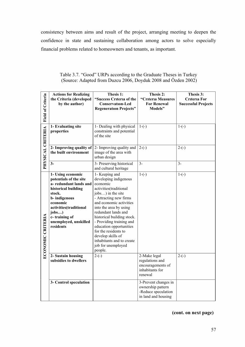
57
consistency between aims and result of the project, arranging meeting to deepen the
confidence in state and sustaining collaboration among actors to solve especially
financial problems related to homeowners and tenants, as important.
Table 3.7. “Good” URPs according to the Graduate Theses in Turkey (Source: Adapted from Duzcu 2006, Doyduk 2008 and Özden 2002)
Fiel
d of
Cri
teri
a Actions for Realizing the Criteria (developed
by the author)
Thesis 1: “Success Crıterıa of the
Conservatıon-Led Regeneratıon Projects”
Thesis 2: “Crıterıa Measures
For Renewal Models”
Thesis 3: Crıterıa For
Successful Projects
1- Evaluating site properties
1- Dealing with physical constraints and potential of the site
1-(-) 1-(-)
2- Improving quality of the built environment
2- Improving quality and image of the area with urban design
2-(-) 2-(-)
PHY
SIC
AL
CR
ITE
RIA
3- 3- Preserving historical and cultural heritage
3- 3-
1- Using economic potentials of the site a- redundant lands and historical building stock. b- indigenous economic activities(traditional jobs…) c- training of unemployed, unskilled residents
1- Keeping and developing indigenous economic activities(traditional jobs…) in the site - Attracting new firms and economic activities into the area by using redundant lands and historical building stock.- Providing training and education opportunities for the residents to develop skills of inhabitants and to create job for unemployed people.
1-(-) 1-(-)
2- Sustain housing subsidies to dwellers
2-(-) 2-Make legal regulations and encouragements of inhabitants for renewal
2-(-) EC
ON
OM
IC C
RIT
ER
IA
3- Control speculation 3-Prevent changes in ownership pattern -Reduce speculation in land and housing
(cont. on next page)
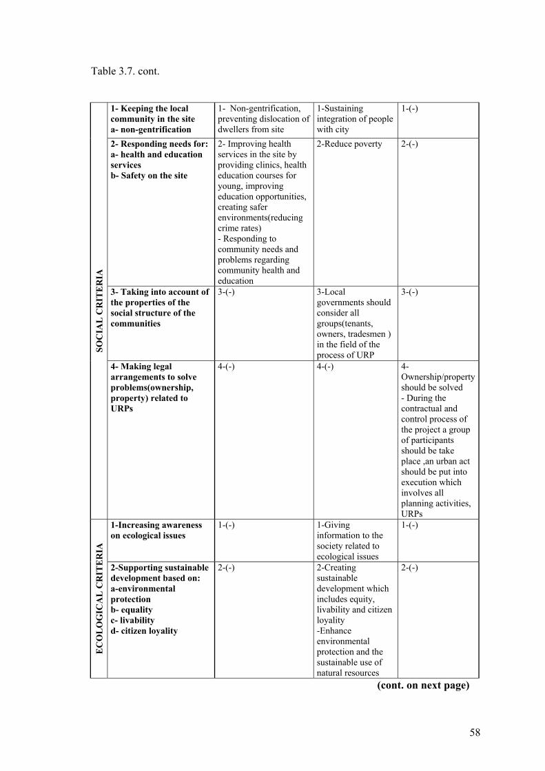
58
Table 3.7. cont.
1- Keeping the local community in the site a- non-gentrification
1- Non-gentrification, preventing dislocation of dwellers from site
1-Sustaining integration of people with city
1-(-)
2- Responding needs for: a- health and education services b- Safety on the site
2- Improving health services in the site by providing clinics, health education courses for young, improving education opportunities, creating safer environments(reducing crime rates) - Responding to community needs and problems regarding community health and education
2-Reduce poverty 2-(-)
3- Taking into account of the properties of the social structure of the communities
3-(-) 3-Local governments should consider all groups(tenants, owners, tradesmen ) in the field of the process of URP
3-(-)
SOC
IAL
CR
ITE
RIA
4- Making legal arrangements to solve problems(ownership, property) related to URPs
4-(-) 4-(-) 4-Ownership/property should be solved - During the contractual and control process of the project a group of participants should be take place ,an urban act should be put into execution which involves all planning activities, URPs
1-Increasing awareness on ecological issues
1-(-) 1-Giving information to the society related to ecological issues
1-(-)
EC
OL
OG
ICA
L C
RIT
ER
IA
2-Supporting sustainable development based on: a-environmental protection b- equality c- livability d- citizen loyality
2-(-) 2-Creating sustainable development which includes equity, livability and citizen loyality -Enhance environmental protection and the sustainable use of natural resources
2-(-)
(cont. on next page)
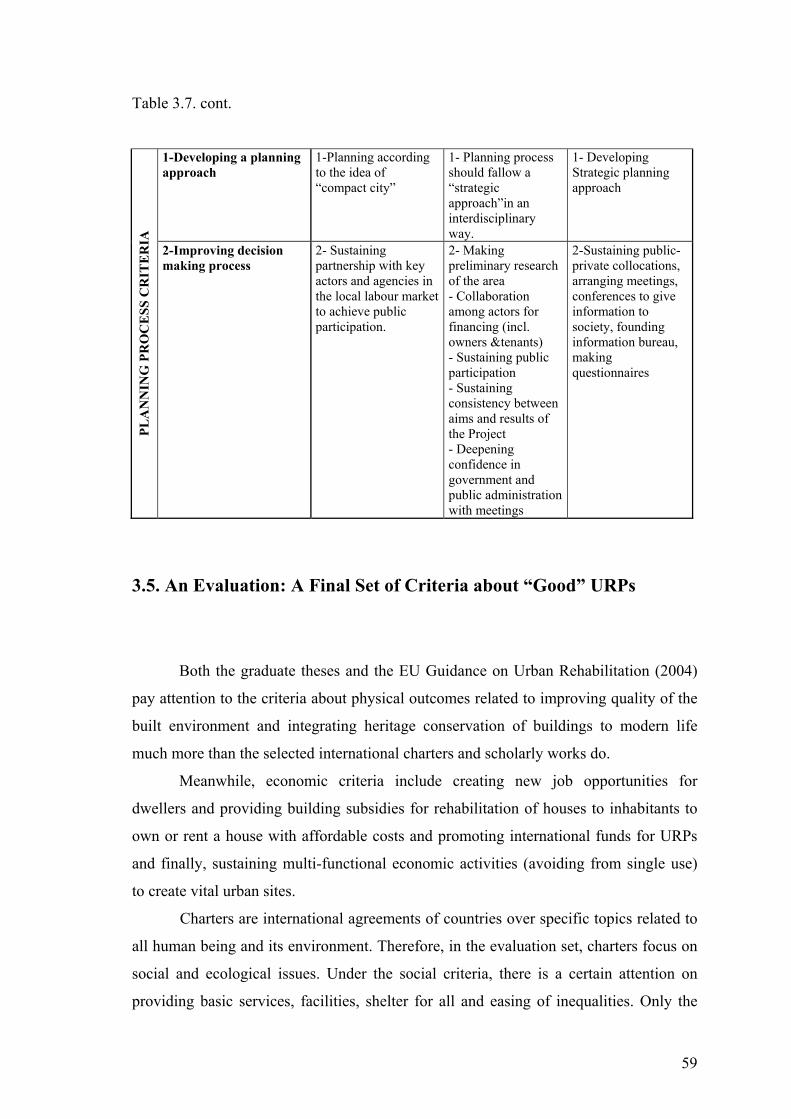
59
Table 3.7. cont.
1-Developing a planning approach
1-Planning according to the idea of “compact city”
1- Planning process should fallow a “strategic approach”in an interdisciplinary way.
1- Developing Strategic planning approach
PLA
NN
ING
PR
OC
ESS
CR
ITE
RIA
2-Improving decision making process
2- Sustaining partnership with key actors and agencies in the local labour market to achieve public participation.
2- Making preliminary research of the area - Collaboration among actors for financing (incl. owners &tenants) - Sustaining public participation - Sustaining consistency between aims and results of the Project - Deepening confidence in government and public administration with meetings
2-Sustaining public- private collocations, arranging meetings, conferences to give information to society, founding information bureau, making questionnaires
3.5. An Evaluation: A Final Set of Criteria about “Good” URPs
Both the graduate theses and the EU Guidance on Urban Rehabilitation (2004)
pay attention to the criteria about physical outcomes related to improving quality of the
built environment and integrating heritage conservation of buildings to modern life
much more than the selected international charters and scholarly works do.
Meanwhile, economic criteria include creating new job opportunities for
dwellers and providing building subsidies for rehabilitation of houses to inhabitants to
own or rent a house with affordable costs and promoting international funds for URPs
and finally, sustaining multi-functional economic activities (avoiding from single use)
to create vital urban sites.
Charters are international agreements of countries over specific topics related to
all human being and its environment. Therefore, in the evaluation set, charters focus on
social and ecological issues. Under the social criteria, there is a certain attention on
providing basic services, facilities, shelter for all and easing of inequalities. Only the
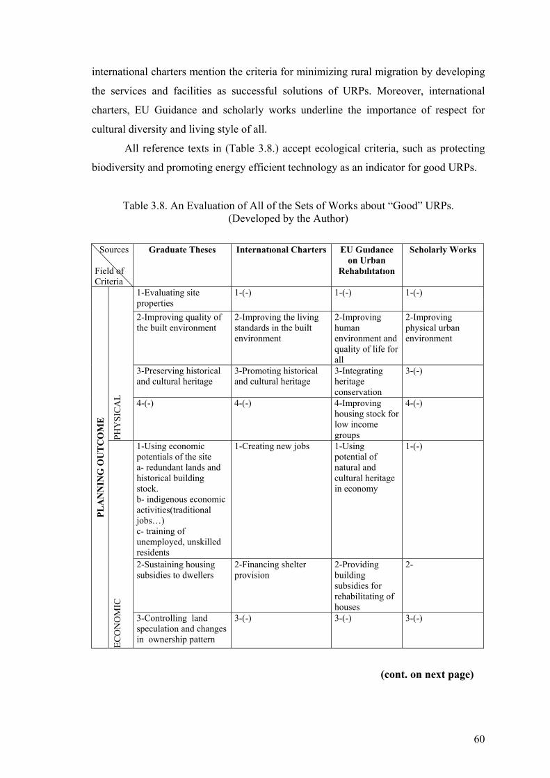
60
international charters mention the criteria for minimizing rural migration by developing
the services and facilities as successful solutions of URPs. Moreover, international
charters, EU Guidance and scholarly works underline the importance of respect for
cultural diversity and living style of all.
All reference texts in (Table 3.8.) accept ecological criteria, such as protecting
biodiversity and promoting energy efficient technology as an indicator for good URPs.
Table 3.8. An Evaluation of All of the Sets of Works about “Good” URPs. (Developed by the Author)
Sources Field of Criteria
Graduate Theses Internatıonal Charters EU Guıdance on Urban
Rehabılıtatıon
Scholarly Works
1-Evaluating site properties
1-(-) 1-(-) 1-(-)
2-Improving quality of the built environment
2-Improving the living standards in the built environment
2-Improving human environment and quality of life for all
2-Improving physical urban environment
3-Preserving historical and cultural heritage
3-Promoting historical and cultural heritage
3-Integrating heritage conservation
3-(-)
PHY
SIC
AL 4-(-) 4-(-) 4-Improving
housing stock for low income groups
4-(-)
1-Using economic potentials of the site a- redundant lands and historical building stock. b- indigenous economic activities(traditional jobs…) c- training of unemployed, unskilled residents
1-Creating new jobs 1-Using potential of natural and cultural heritage in economy
1-(-)
2-Sustaining housing subsidies to dwellers
2-Financing shelter provision
2-Providing building subsidies for rehabilitating of houses
2-
PLA
NN
ING
OU
TC
OM
E
ECO
NO
MIC
3-Controlling land speculation and changes in ownership pattern
3-(-) 3-(-) 3-(-)
(cont. on next page)
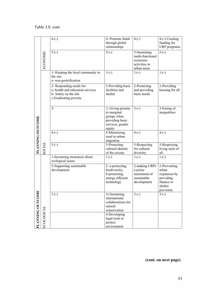
61
Table 3.8. cont.
4-(-) 4- Promote funds through global relationships
4-(-) 4-(-) Creating funding for URP programs
EC
ON
OM
IC
5-(-) 5-(-) 5-Sustaining multi-functional economic activities in urban areas
5-(-)
1- Keeping the local community in the site a- non-gentrification
1-(-) 1-(-) 1-(-)
2- Responding needs for: a- health and education services b- Safety on the site c-Eradicating poverty
2-Providing basic facilities and shelter
2-Protecting and providing basic needs
2-Providing housing for all
3- 3- Giving priority to marginal groups when providing basic services, gender equity
3-(-) 3-Easing of inequalities
4-(-) 4-Minimizing rural to urban migration
4-(-) 4-(-)
PL
AN
NIN
G O
UT
CO
ME
SOC
IAL 5-(-) 5-Protecting
cultural identity of the society
5-Respecting for cultural diversity
5-Respecting living style of all
1-Increasing awareness about ecological issues
1-(-) 1-(-) 1-(-)
2-Supporting sustainable development
2- a-protecting biodiversity, b-promoting energy efficient technology
2-making URPs a prime instrument of sustainable development
2-Preventing urban expansion by providing finance to shelter provision
3-(-) 3) Sustaining international collaborations for natural conservation
3-(-) 3-(-)
PLA
NN
ING
OU
TC
OM
E
ECO
LOG
ICA
L
4-Developing legal tools to protect environment
(cont. on next page)
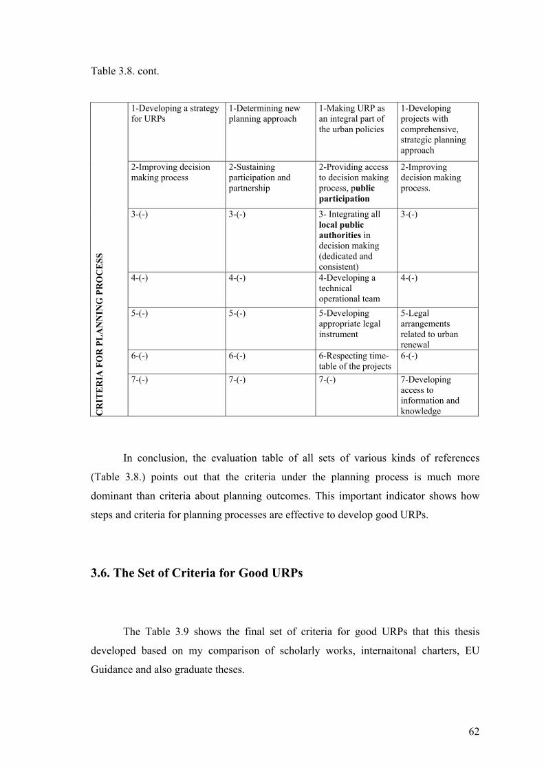
62
Table 3.8. cont.
1-Developing a strategy for URPs
1-Determining new planning approach
1-Making URP as an integral part of the urban policies
1-Developing projects with comprehensive, strategic planning approach
2-Improving decision making process
2-Sustaining participation and partnership
2-Providing access to decision making process, public participation
2-Improving decision making process.
3-(-) 3-(-) 3- Integrating all local public authorities in decision making (dedicated and consistent)
3-(-)
4-(-) 4-(-) 4-Developing a technical operational team
4-(-)
5-(-) 5-(-) 5-Developing appropriate legal instrument
5-Legal arrangements related to urban renewal
6-(-) 6-(-) 6-Respecting time-table of the projects
6-(-)
CR
ITE
RIA
FO
R P
LA
NN
ING
PR
OC
ESS
7-(-) 7-(-) 7-(-) 7-Developing access to information and knowledge
In conclusion, the evaluation table of all sets of various kinds of references
(Table 3.8.) points out that the criteria under the planning process is much more
dominant than criteria about planning outcomes. This important indicator shows how
steps and criteria for planning processes are effective to develop good URPs.
3.6. The Set of Criteria for Good URPs
The Table 3.9 shows the final set of criteria for good URPs that this thesis
developed based on my comparison of scholarly works, internaitonal charters, EU
Guidance and also graduate theses.
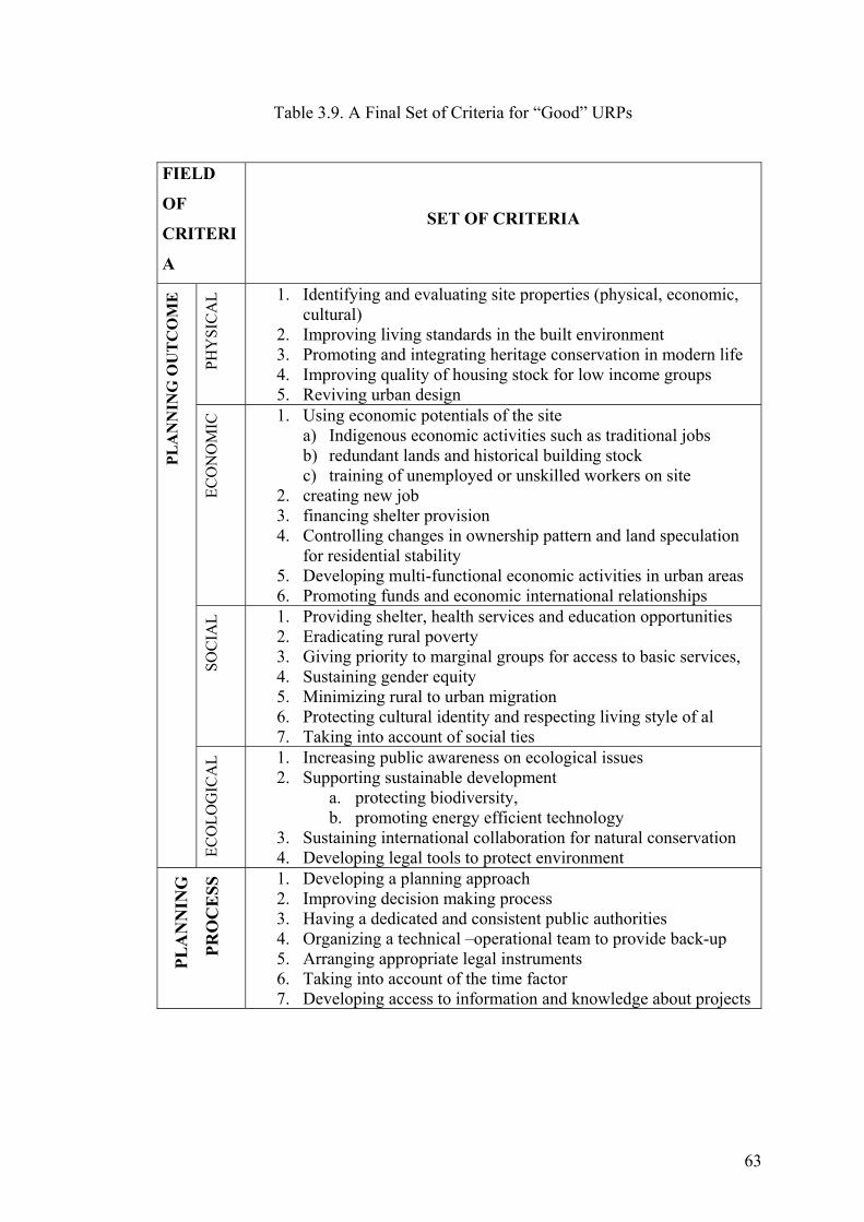
63
Table 3.9. A Final Set of Criteria for “Good” URPs
FIELD
OF
CRITERI
A
SET OF CRITERIA PH
YSI
CA
L 1. Identifying and evaluating site properties (physical, economic, cultural)
2. Improving living standards in the built environment 3. Promoting and integrating heritage conservation in modern life 4. Improving quality of housing stock for low income groups 5. Reviving urban design
ECO
NO
MIC
1. Using economic potentials of the site a) Indigenous economic activities such as traditional jobs b) redundant lands and historical building stock c) training of unemployed or unskilled workers on site
2. creating new job 3. financing shelter provision 4. Controlling changes in ownership pattern and land speculation
for residential stability 5. Developing multi-functional economic activities in urban areas 6. Promoting funds and economic international relationships
SOC
IAL 1. Providing shelter, health services and education opportunities
2. Eradicating rural poverty 3. Giving priority to marginal groups for access to basic services, 4. Sustaining gender equity 5. Minimizing rural to urban migration 6. Protecting cultural identity and respecting living style of al 7. Taking into account of social ties
PLA
NN
ING
OU
TC
OM
E
ECO
LOG
ICA
L 1. Increasing public awareness on ecological issues 2. Supporting sustainable development
a. protecting biodiversity, b. promoting energy efficient technology
3. Sustaining international collaboration for natural conservation 4. Developing legal tools to protect environment
PLA
NN
ING
PRO
CE
SS 1. Developing a planning approach
2. Improving decision making process 3. Having a dedicated and consistent public authorities 4. Organizing a technical –operational team to provide back-up 5. Arranging appropriate legal instruments 6. Taking into account of the time factor 7. Developing access to information and knowledge about projects
64
CHAPTER 4
THE CASE STUDY CONTEXT:
KADIFEKALE (KONAK) URBAN RENEWAL PROJECT
This chapter focuses on the case study subject, “Kadifekale URP,” orKURP as
this thesis calls. KURP is planned to implement in the Kadifekale district, a central area
of the city of Izmir (Turkey). The chapter describes urbanization process and urban
projects in Kadifekale district and details the content of Kadifekale Urban Renewal
Project including in the project aims and objectives, project phases and also institutional
partners. Finally, it includes information related to new residential area (Uzundere)
suggested as the relocation area for the dwellers of the project site in Kadifekale district.
The on-going Kadifekale URP was chosen as the case study of this thesis,
because KURP is the biggest one and first example of URP among the number of
projects that have been continuing since 2000 in Izmir. It was also an accessible place
for me as a master student in Izmir.
KURP area is on the landslide zone that contains nine neighborhoods in
Kadifekale district within the boundaries of Konak Municipality in Izmir. About 50 %
of the case study site contains squatter housing units. The project area is close to a
major highway.It is also near an archeological site which contains an ancient castle
called as Kadifekale Castle. However, the study site is not within the archeological site
boundaries. The Castle is at the south part of the city at a distance of about 2 km from
the shoreline that offers some of the best views of the city of Izmir. The slope of the
Kadifekale district differs but it is around 35% (IZTO Report 2005).
For this case study, I gathered information at three main steps. The first step
contains literature review from articles, thesis, and web based researches, local and
national newspapers about Kadifekale district and also about KURP. I got visual
information, such as maps, from both literature survey and Izmir Metropolitan
Municipality. In the second step, I had interviews with the Managery of Nationalization,
New Settlements and Urban Renewal Department of Izmir Metropolitan Municipality. I
also intervieweed muhtars, or headmen, of five out of nine neighborhoods in KURP
65
area. Because a headman of a neighborhood has an idea about the general opinions of
local dwellers and can follow the project process as a local actor. Interviews were done
with the headmen of İmariye, Kadifekale, Hasan Özdemir, Kosova and Vezirağa
neighborhoods. Moreover, the interviews with the departments of local government
related to KURP point out information about the KURP, process and objectives of the
project and also views of local authorities about the KURP
In the third step, questionnaires were completed in the site for getting opinions of
the dwellers affected by KURP about KURP. Questionnaire technique was executed in
59 different squatter housing units at the case study area with 3 % sampling. The
interviews also determine the general ideas about the household, socio-economic
structure, and level of participation in the project implementation process.The
questionnaires were done with 59 household in the project area of Kadifekale and its
environment. Developed questions were focused on having an idea about the living
structure of the inhabitants in the landslide zone and measuring their attitude towards
KURP. Moreover, the results of questionnaires based on socio-economic structure,
family size, building types and quality of the living environment help me to develop a
comparison between their living environment in Kadifekale district and the new
environment (Uzundere district) where they will be relocated according to KURP. The
questionnaires were developed according to five main themes followed: (i) Socio
economic structure of the site, (ii) Urban public services and civic services, (iii)
Housing characteristics, (iv) Household structures, and (v) Information about
involvement in the process of KURP.
The fourth step includes my field observations about KURP area and new
residential area (Uzundere) while making comparison of two physical built
environments.
4.1. The Study Site
The official name of the study site is “Konak URP.” But in daily usage the project
site has been described as “Kadifekale district.” The project is part of Kadifekale
district, so in public debates the project is called as “Kadifekale Urban Renewal
66
Project.” Beginning from this point of view, the following sections define the project
name as “Kadifekale Urban Renewal Project,” or briefly KURP.
This part of the study gives information about urbanization process overall in
Kadifekale district. Then, it takes into account of the effects of master plans of Izmir
since 1920s upto now with KURP, and also makes comparison of KURP with other
urban projects in Izmir.
4.1.1. Urbanization Process and Urban Projects in Kadifekale District
Kadifekale district is located on a hill with an ancient castle placed at the top of
the same hill. In Roman Empire period the hill and castle was named as “Pagos,” which
literally means “hill” (Wikipedia 2008).
Kadifekale, founded by Alexander the Great, became an important harbor city
since 3 BC. According to a story, Alexander the Great who was going for hunting on
foot to Pagos Mountain, felt asleep under a plane tree and saw a dream that there were
two water fairies.Water fairies told him to re-construct Smyrna city on the Pagos hill
and settled down the inhabitants of Smyrna there (see Figure 4.2) (IZTO Report 2005).
So, a castle was founded on the top of the hill. The Pagos hill also had a strategic
importance because the hill was providing an easy control over the harbor. In the re-
construction process of new Smyrna, a stadium, a theater and an agora was also
constructed, which still exist in the archeological site area in the boundaries of Konak
Municipality (see Figure 4.1).
Kadifekale and its environment had been always an important settlement in
Hellenistic, Roman, Byzantine and Ottoman period too because of its geopolitical
location.
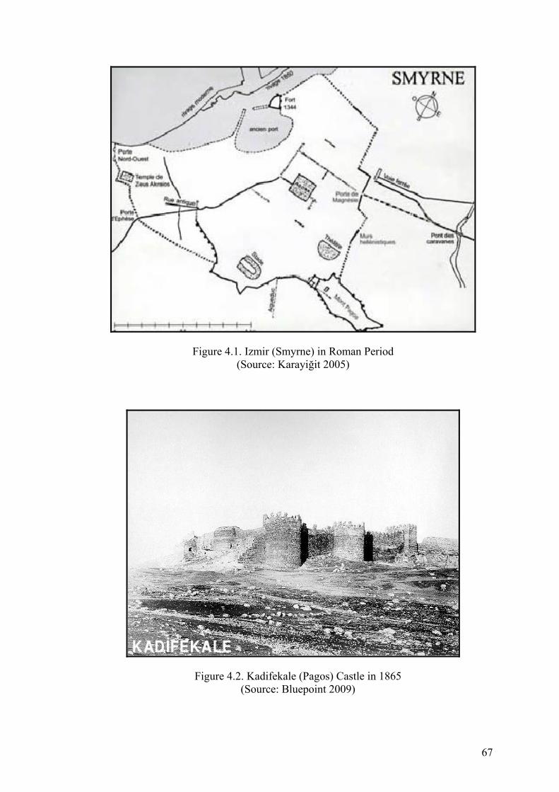
67
Figure 4.1. Izmir (Smyrne) in Roman Period (Source: Karayiğit 2005)
Figure 4.2. Kadifekale (Pagos) Castle in 1865 (Source: Bluepoint 2009)
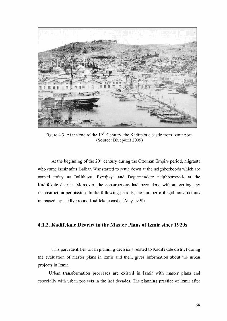
68
Figure 4.3. At the end of the 19th Century, the Kadifekale castle from Izmir port. (Source: Bluepoint 2009)
At the beginning of the 20th century during the Ottoman Empire period, migrants
who came Izmir after Balkan War started to settle down at the neighborhoods which are
named today as Ballıkuyu, Eşrefpaşa and Degirmendere neighborhoods at the
Kadifekale district. Moreover, the constructions had been done without getting any
reconstruction permission. In the following periods, the number ofillegal constructions
increased especially around Kadifekale castle (Atay 1998).
4.1.2. Kadifekale District in the Master Plans of Izmir since 1920s
This part identifies urban planning decisions related to Kadifekale district during
the evaluation of master plans in Izmir and then, gives information about the urban
projects in Izmir.
Urban transformation processes are existed in Izmir with master plans and
especially with urban projects in the last decades. The planning practice of Izmir after
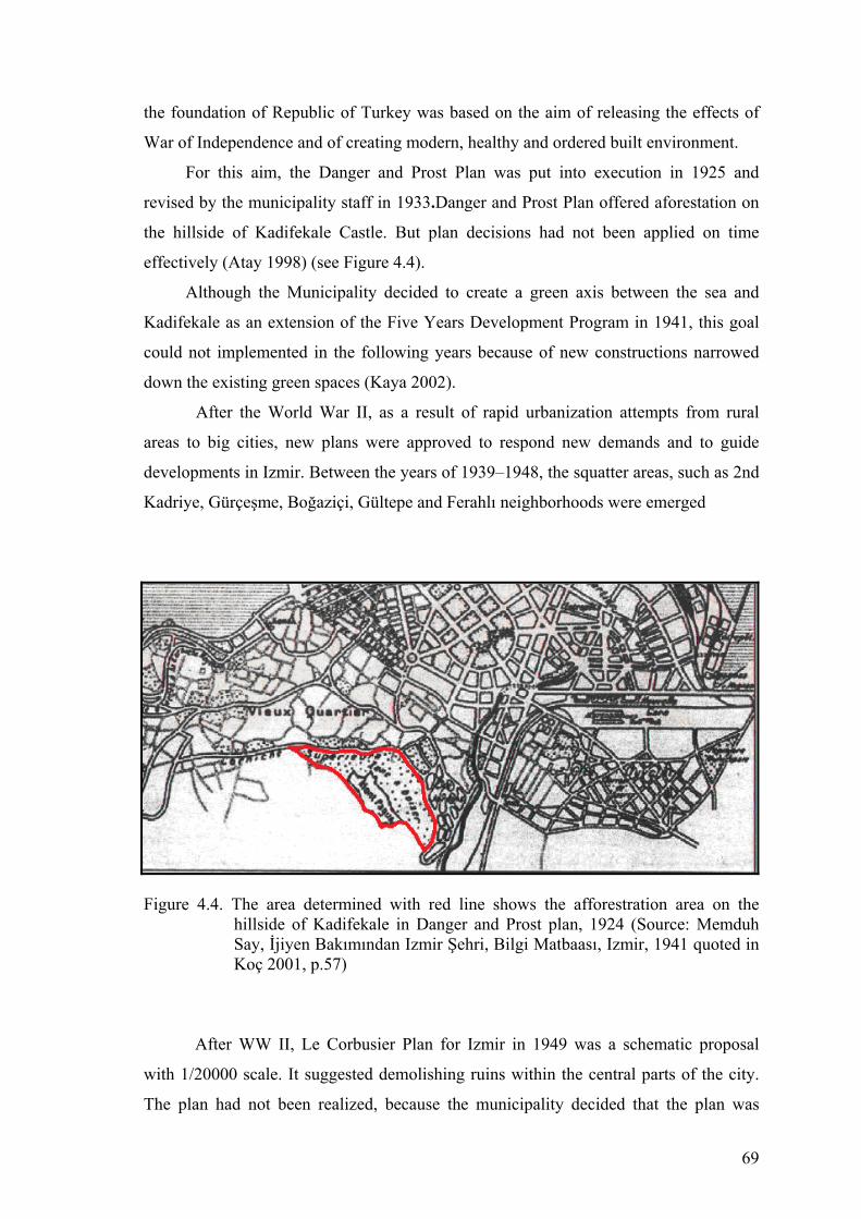
69
the foundation of Republic of Turkey was based on the aim of releasing the effects of
War of Independence and of creating modern, healthy and ordered built environment.
For this aim, the Danger and Prost Plan was put into execution in 1925 and
revised by the municipality staff in 1933.Danger and Prost Plan offered aforestation on
the hillside of Kadifekale Castle. But plan decisions had not been applied on time
effectively (Atay 1998) (see Figure 4.4).
Although the Municipality decided to create a green axis between the sea and
Kadifekale as an extension of the Five Years Development Program in 1941, this goal
could not implemented in the following years because of new constructions narrowed
down the existing green spaces (Kaya 2002).
After the World War II, as a result of rapid urbanization attempts from rural
areas to big cities, new plans were approved to respond new demands and to guide
developments in Izmir. Between the years of 1939–1948, the squatter areas, such as 2nd
Kadriye, Gürçeşme, Boğaziçi, Gültepe and Ferahlı neighborhoods were emerged
Figure 4.4. The area determined with red line shows the afforestration area on the hillside of Kadifekale in Danger and Prost plan, 1924 (Source: Memduh Say, İjiyen Bakımından Izmir Şehri, Bilgi Matbaası, Izmir, 1941 quoted in Koç 2001, p.57)
After WW II, Le Corbusier Plan for Izmir in 1949 was a schematic proposal
with 1/20000 scale. It suggested demolishing ruins within the central parts of the city.
The plan had not been realized, because the municipality decided that the plan was
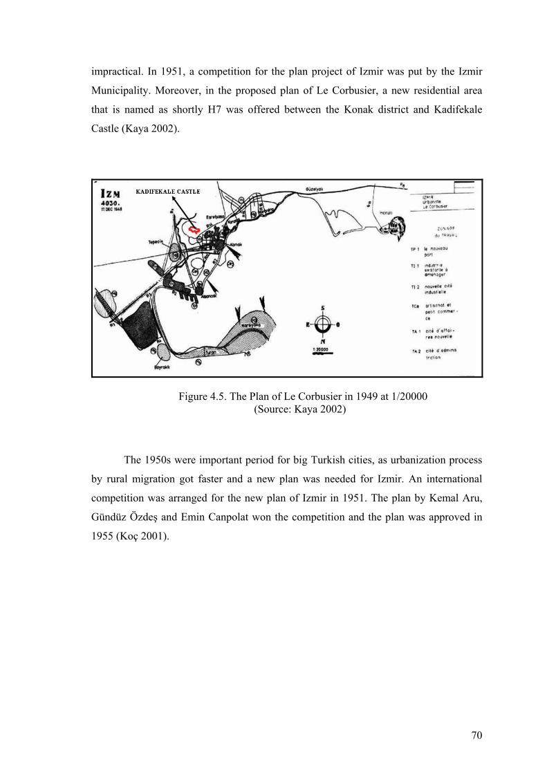
70
impractical. In 1951, a competition for the plan project of Izmir was put by the Izmir
Municipality. Moreover, in the proposed plan of Le Corbusier, a new residential area
that is named as shortly H7 was offered between the Konak district and Kadifekale
Castle (Kaya 2002).
Figure 4.5. The Plan of Le Corbusier in 1949 at 1/20000 (Source: Kaya 2002)
The 1950s were important period for big Turkish cities, as urbanization process
by rural migration got faster and a new plan was needed for Izmir. An international
competition was arranged for the new plan of Izmir in 1951. The plan by Kemal Aru,
Gündüz Özdeş and Emin Canpolat won the competition and the plan was approved in
1955 (Koç 2001).
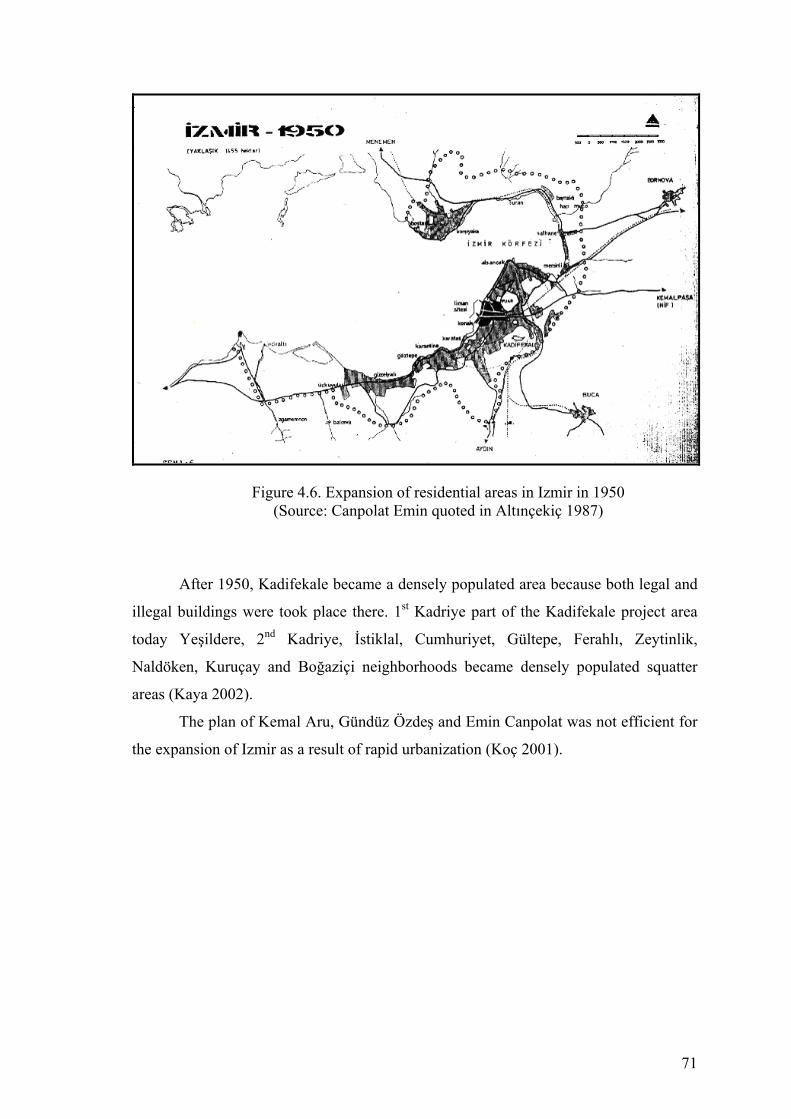
71
Figure 4.6. Expansion of residential areas in Izmir in 1950 (Source: Canpolat Emin quoted in Altınçekiç 1987)
After 1950, Kadifekale became a densely populated area because both legal and
illegal buildings were took place there. 1st Kadriye part of the Kadifekale project area
today Yeşildere, 2nd Kadriye, İstiklal, Cumhuriyet, Gültepe, Ferahlı, Zeytinlik,
Naldöken, Kuruçay and Boğaziçi neighborhoods became densely populated squatter
areas (Kaya 2002).
The plan of Kemal Aru, Gündüz Özdeş and Emin Canpolat was not efficient for
the expansion of Izmir as a result of rapid urbanization (Koç 2001).
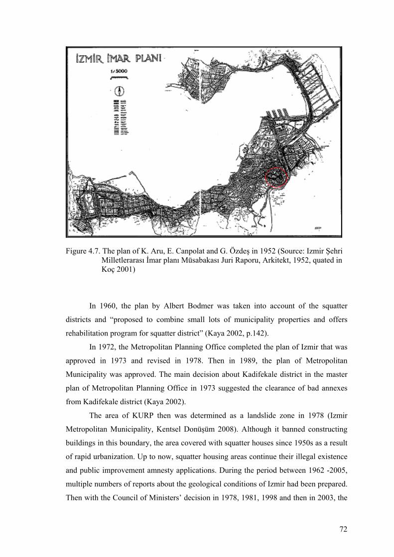
72
Figure 4.7. The plan of K. Aru, E. Canpolat and G. Özdeş in 1952 (Source: Izmir Şehri Milletlerarası İmar planı Müsabakası Juri Raporu, Arkitekt, 1952, quated in Koç 2001)
In 1960, the plan by Albert Bodmer was taken into account of the squatter
districts and “proposed to combine small lots of municipality properties and offers
rehabilitation program for squatter district” (Kaya 2002, p.142).
In 1972, the Metropolitan Planning Office completed the plan of Izmir that was
approved in 1973 and revised in 1978. Then in 1989, the plan of Metropolitan
Municipality was approved. The main decision about Kadifekale district in the master
plan of Metropolitan Planning Office in 1973 suggested the clearance of bad annexes
from Kadifekale district (Kaya 2002).
The area of KURP then was determined as a landslide zone in 1978 (Izmir
Metropolitan Municipality, Kentsel Donüşüm 2008). Although it banned constructing
buildings in this boundary, the area covered with squatter houses since 1950s as a result
of rapid urbanization. Up to now, squatter housing areas continue their illegal existence
and public improvement amnesty applications. During the period between 1962 -2005,
multiple numbers of reports about the geological conditions of Izmir had been prepared.
Then with the Council of Ministers’ decision in 1978, 1981, 1998 and then in 2003, the
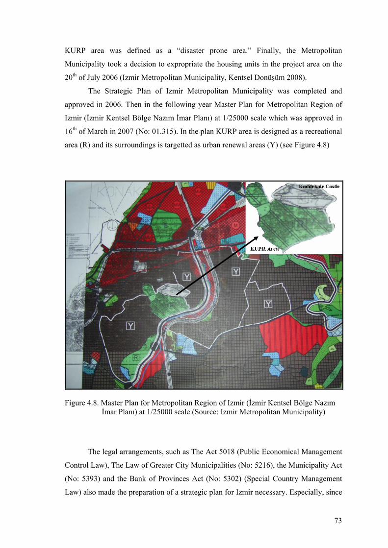
73
KURP area was defined as a “disaster prone area.” Finally, the Metropolitan
Municipality took a decision to expropriate the housing units in the project area on the
20th of July 2006 (Izmir Metropolitan Municipality, Kentsel Donüşüm 2008).
The Strategic Plan of Izmir Metropolitan Municipality was completed and
approved in 2006. Then in the following year Master Plan for Metropolitan Region of
Izmir (İzmir Kentsel Bölge Nazım İmar Planı) at 1/25000 scale which was approved in
16th of March in 2007 (No: 01.315). In the plan KURP area is designed as a recreational
area (R) and its surroundings is targetted as urban renewal areas (Y) (see Figure 4.8)
Figure 4.8. Master Plan for Metropolitan Region of Izmir (İzmir Kentsel Bölge Nazım İmar Planı) at 1/25000 scale (Source: Izmir Metropolitan Municipality)
The legal arrangements, such as The Act 5018 (Public Economical Management
Control Law), The Law of Greater City Municipalities (No: 5216), the Municipality Act
(No: 5393) and the Bank of Provinces Act (No: 5302) (Special Country Management
Law) also made the preparation of a strategic plan for Izmir necessary. Especially, since
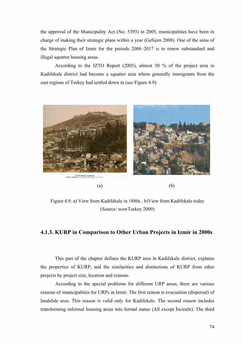
74
the approval of the Municipality Act (No: 5393) in 2005, municipalities have been in
charge of making their strategic plans within a year (Gelişim 2008). One of the aims of
the Strategic Plan of Izmir for the periods 2006–2017 is to renew substandard and
illegal squatter housing areas.
According to the IZTO Report (2005), almost 50 % of the project area in
Kadifekale district had become a squatter area where generally immigrants from the
east regions of Turkey had settled down in (see Figure 4.9).
(a) (b)
Figure 4.9. a) View from Kadifekale in 1880s , b)View from Kadifekale today
(Source: wowTurkey 2009)
4.1.3. KURP in Comparison to Other Urban Projects in Izmir in 2000s
This part of the chapter defines the KURP area in Kadifekale district, explains
the properties of KURP, and the similarities and distinctions of KURP from other
projects by project size, location and reasons.
According to the special problems for different URP areas, there are various
reasons of municipalities for URPs in Izmir. The first reason is evacuation (dispersal) of
landslide area. This reason is valid only for Kadifekale. The second reason includes
transforming informal housing areas into formal statue (All except İnciraltı). The third
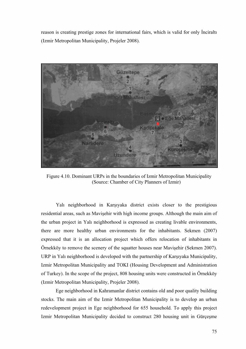
75
reason is creating prestige zones for international fairs, which is valid for only İnciraltı
(Izmir Metropolitan Municipality, Projeler 2008).
Figure 4.10. Dominant URPs in the boundaries of Izmir Metropolitan Municipality (Source: Chamber of City Planners of Izmir)
Yalı neighborhood in Karşıyaka district exists closer to the prestigious
residential areas, such as Mavişehir with high income groups. Although the main aim of
the urban project in Yalı neighborhood is expressed as creating livable environments,
there are more healthy urban environments for the inhabitants. Sekmen (2007)
expressed that it is an allocation project which offers relocation of inhabitants in
Örnekköy to remove the scenery of the squatter houses near Mavişehir (Sekmen 2007).
URP in Yalı neighborhood is developed with the partnership of Karşıyaka Municipality,
Izmir Metropolitan Municipality and TOKI (Housing Development and Administration
of Turkey). In the scope of the project, 808 housing units were constructed in Örnekköy
(Izmir Metropolitan Municipality, Projeler 2008).
Ege neighborhood in Kahramanlar district contains old and poor quality building
stocks. The main aim of the Izmir Metropolitan Municipality is to develop an urban
redevelopment project in Ege neighborhood for 655 household. To apply this project
Izmir Metropolitan Municipality decided to construct 280 housing unit in Gürçeşme
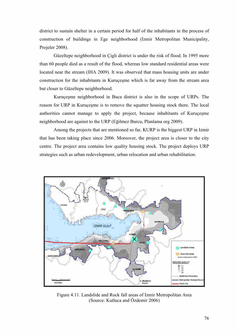
76
district to sustain shelter in a certain period for half of the inhabitants in the process of
construction of buildings in Ege neighborhood (Izmir Metropolitan Municipality,
Projeler 2008).
Güzeltepe neighborhood in Çigli district is under the risk of flood. In 1995 more
than 60 people died as a result of the flood, whereas low standard residential areas were
located near the stream (IHA 2009). It was observed that mass housing units are under
construction for the inhabitants in Kuruçeşme which is far away from the stream area
but closer to Güzeltepe neighborhood.
Kuruçeşme neighborhood in Buca district is also in the scope of URPs. The
reason for URP in Kuruçeşme is to remove the squatter housing stock there. The local
authorities cannot manage to apply the project, because inhabitants of Kuruçeşme
neighborhood are against to the URP (Eğilmez Burcu, Planlama org 2009).
Among the projects that are mentioned so far, KURP is the biggest URP in Izmir
that has been taking place since 2006. Moreover, the project area is closer to the city
centre. The project area contains low quality housing stock. The project deploys URP
strategies such as urban redevelopment, urban relocation and urban rehabilitation.
Figure 4.11. Landslide and Rock fall areas of Izmir Metropolitan Area (Source: Kutluca and Özdemir 2006)
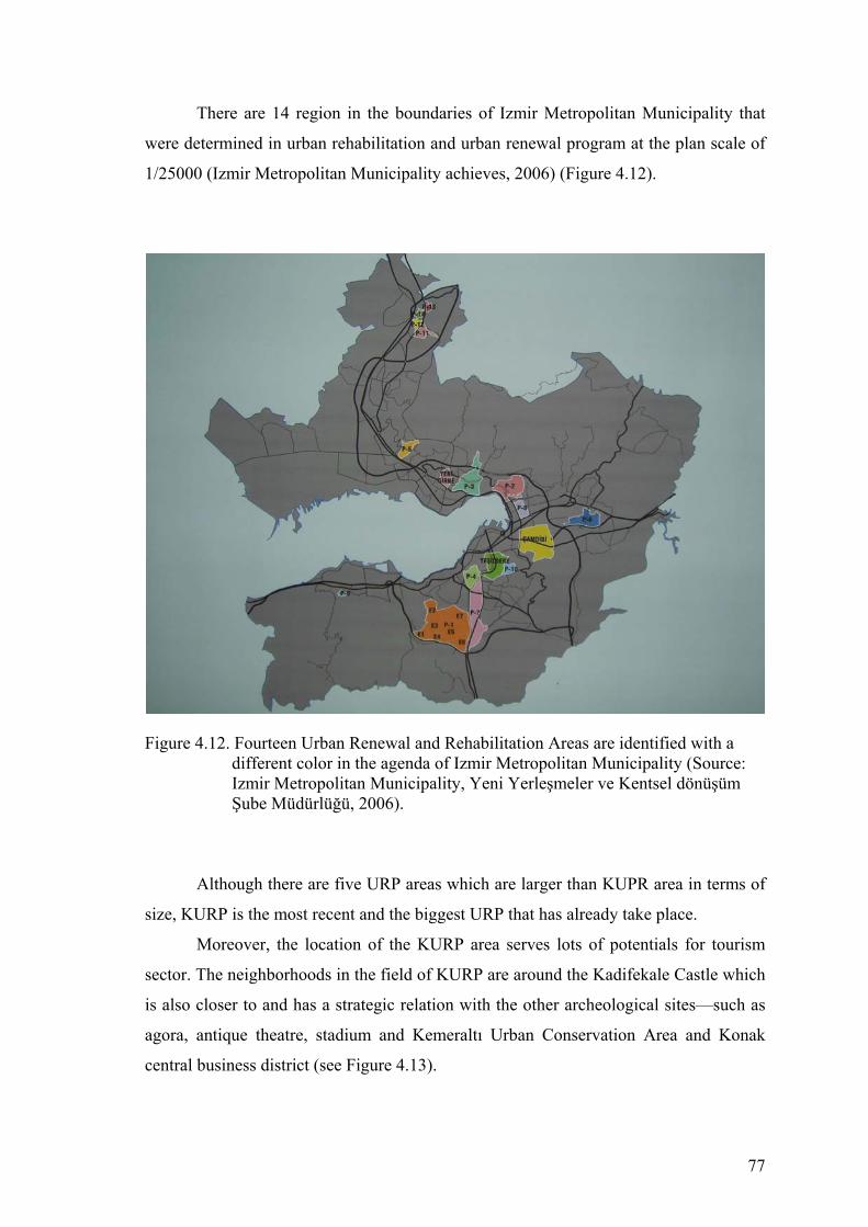
77
There are 14 region in the boundaries of Izmir Metropolitan Municipality that
were determined in urban rehabilitation and urban renewal program at the plan scale of
1/25000 (Izmir Metropolitan Municipality achieves, 2006) (Figure 4.12).
Figure 4.12. Fourteen Urban Renewal and Rehabilitation Areas are identified with a different color in the agenda of Izmir Metropolitan Municipality (Source: Izmir Metropolitan Municipality, Yeni Yerleşmeler ve Kentsel dönüşüm Şube Müdürlüğü, 2006).
Although there are five URP areas which are larger than KUPR area in terms of
size, KURP is the most recent and the biggest URP that has already take place.
Moreover, the location of the KURP area serves lots of potentials for tourism
sector. The neighborhoods in the field of KURP are around the Kadifekale Castle which
is also closer to and has a strategic relation with the other archeological sites—such as
agora, antique theatre, stadium and Kemeraltı Urban Conservation Area and Konak
central business district (see Figure 4.13).
78
Table 4.1. Distribution of urban renewal and rehabilitation program areas of Izmir Metropolitan Municipality among neighborhoods (Source: Izmir Metropolitan Municipality, Yeni Yerleşmeler ve Kentsel dönüşüm Şube Müdürlüğü).
Name of the Districts under the urban renewal and rehabilitation
program of Izmir Metropolitan Municipality
Total program area
(ha)
P1: Cennetçeşme, Uzundere, Aktepe, Emrez and Peker neigborhood 1207 ha
P2: Bayraklı, Çiçek, Alparslan, Cengizhan, M.Erener neighborhood 310 ha
P3: Yamanlar, Gümüşpala, Emek neighborhoods 347 ha
P4: Kadifekale, İmariye neighborhoods 165 ha
P5: Güzeltepe, Şirintepe neighborhoods 120 ha
P6: Mevlana, Doğanlar neighborhoods 237 ha
P7: Karabağlar, Uğurmumcu, Akıncılar, Seyhan neighborhoods 510 ha
P8: Adalet, Mansuroğlu neighborhoods 107 ha
P9: Atatürk ,2nd İnönü neighborhoods 24 ha
P10: Gültepe, 26 Agustos neighborhoods 81,5 ha
P11: Asarlık-1 neigborhood 93,4 ha
P12: Asarlık-2 neighborhoods 42.1 ha
P13: Asarlık-3neigborhood 27,2 ha
P14: Menemen district 30,6 ha
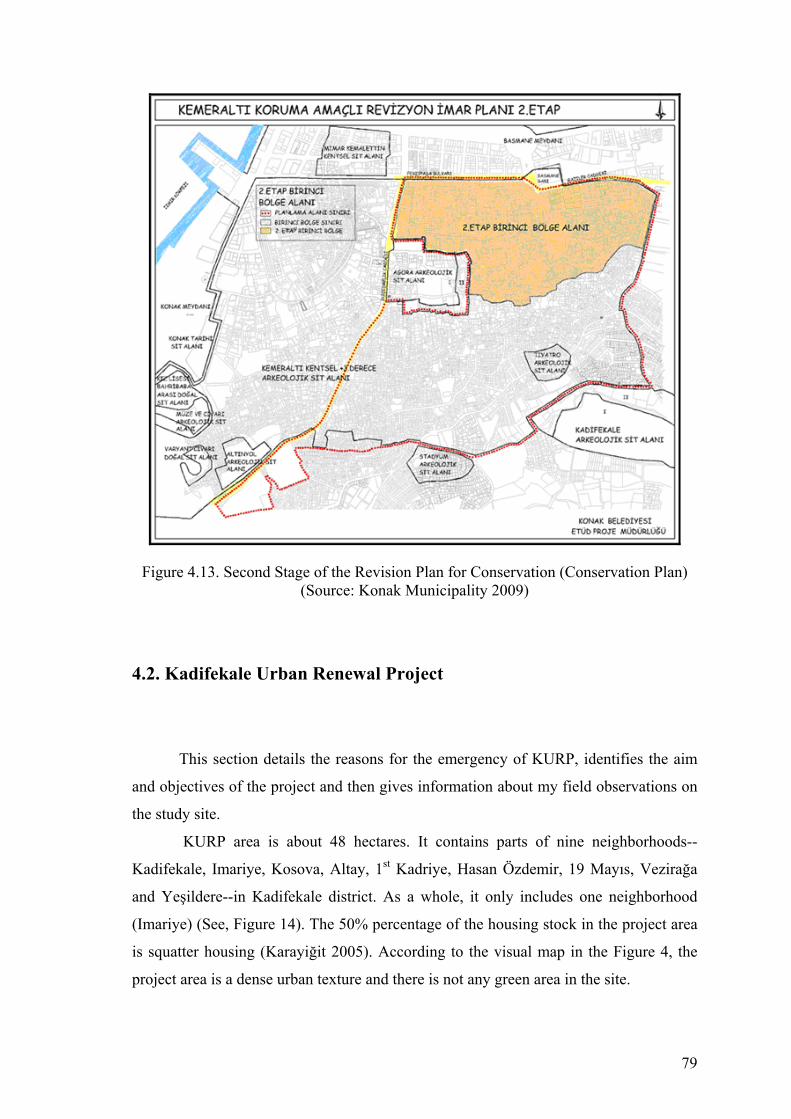
79
Figure 4.13. Second Stage of the Revision Plan for Conservation (Conservation Plan) (Source: Konak Municipality 2009)
4.2. Kadifekale Urban Renewal Project
This section details the reasons for the emergency of KURP, identifies the aim
and objectives of the project and then gives information about my field observations on
the study site.
KURP area is about 48 hectares. It contains parts of nine neighborhoods--
Kadifekale, Imariye, Kosova, Altay, 1st Kadriye, Hasan Özdemir, 19 Mayıs, Vezirağa
and Yeşildere--in Kadifekale district. As a whole, it only includes one neighborhood
(Imariye) (See, Figure 14). The 50% percentage of the housing stock in the project area
is squatter housing (Karayiğit 2005). According to the visual map in the Figure 4, the
project area is a dense urban texture and there is not any green area in the site.
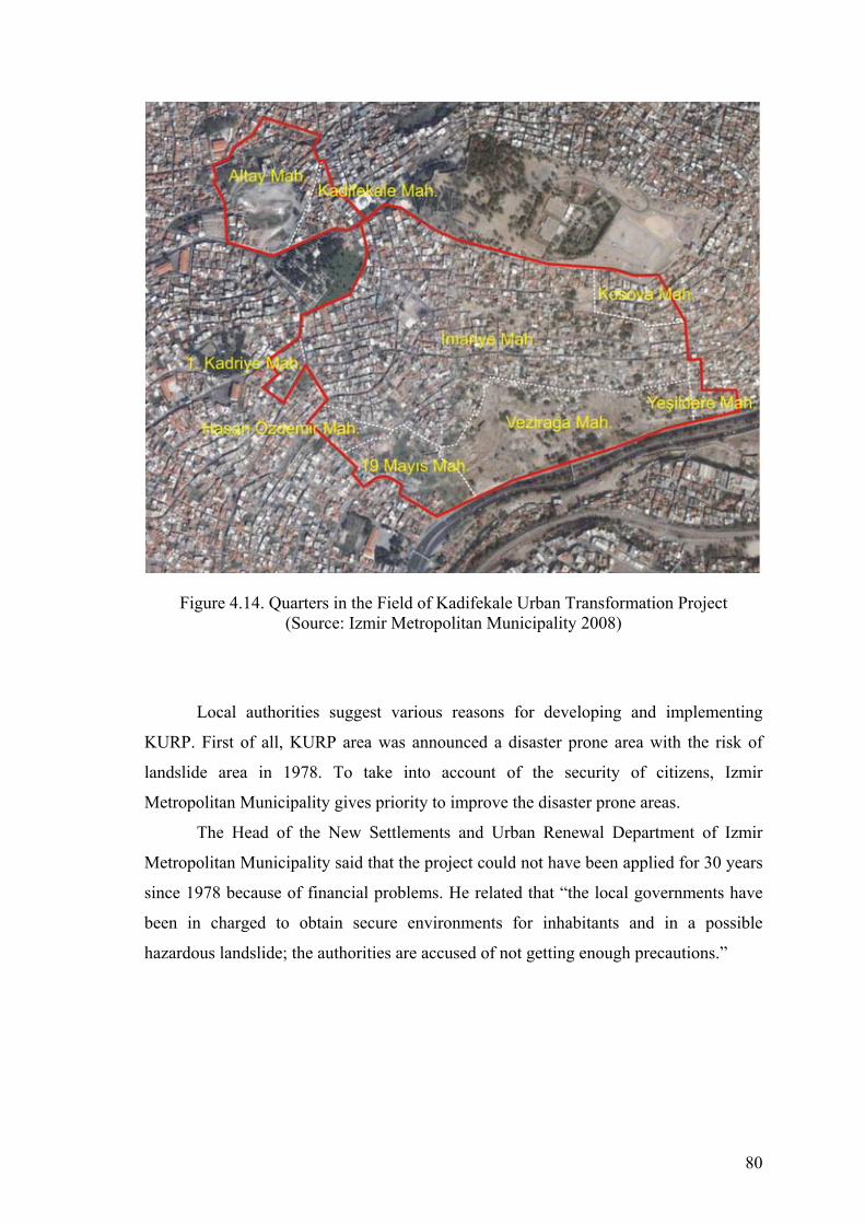
80
Figure 4.14. Quarters in the Field of Kadifekale Urban Transformation Project (Source: Izmir Metropolitan Municipality 2008)
Local authorities suggest various reasons for developing and implementing
KURP. First of all, KURP area was announced a disaster prone area with the risk of
landslide area in 1978. To take into account of the security of citizens, Izmir
Metropolitan Municipality gives priority to improve the disaster prone areas.
The Head of the New Settlements and Urban Renewal Department of Izmir
Metropolitan Municipality said that the project could not have been applied for 30 years
since 1978 because of financial problems. He related that “the local governments have
been in charged to obtain secure environments for inhabitants and in a possible
hazardous landslide; the authorities are accused of not getting enough precautions.”
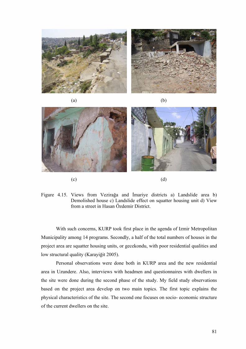
81
(a) (b)
(c) (d)
Figure 4.15. Views from Vezirağa and İmariye districts a) Landslide area b)
Demolished house c) Landslide effect on squatter housing unit d) View from a street in Hasan Özdemir District.
With such concerns, KURP took first place in the agenda of Izmir Metropolitan
Municipality among 14 programs. Secondly, a half of the total numbers of houses in the
project area are squatter housing units, or gecekondu, with poor residential qualities and
low structural quality (Karayiğit 2005).
Personal observations were done both in KURP area and the new residential
area in Uzundere. Also, interviews with headmen and questionnaires with dwellers in
the site were done during the second phase of the study. My field study observations
based on the project area develop on two main topics. The first topic explains the
physical characteristics of the site. The second one focuses on socio- economic structure
of the current dwellers on the site.
82
The physical characteristics of the KURP can be defined as followed. There
were demolished houses in various parts of the study site (see Figure 4.15). Moreover, I
saw landslide effects on the walls of some houses. The street structure was composed of
narrow axis, stairs, and no sidewalks.
Local commercial activities have been existed on the site, such as handcrafts like
carpets and bags. The carpets are sold inside the castle to visitors. Mussel production is
also an important economic activity for families. Street-peddler sell these mussels.
Local economy also depends on certain commercial activities like groceries and tailor
shops. Except a police station there were no services, such as banks or post offices on
the site. There were not any open spaces like parks, sport areas, bazaar, and square vice
versa. A closed health care centre and a demolished school were seen during the field
survey. Moreover it was observed that the social ties of inhabitants were so strong. The
doors of the homes were directly opening to the street, which was sustaining direct
communication among the neighbors.
The second step of environmental monitoring consists of the new residential area
(Uzundere). As of 2009, in Uzundere the construction of mass housing units has been
finished but the socio-cultural facilities are still under construction. The new residential
area is located in the peripheries of Izmir. The area is far away from the city centre.
There is not any economic, social or recreational vitality in Uzundere environment
except small scale substandard housing units which were one or two storey. However,
the new residential area suggests a high leve of population density supported by high
rise mass housing units, which can increase the urban sprawl and urban traffic. Thirdly,
negative perceptions of inhabitants outside the KURP site tell that the project area is a
potential “crime area” with “drug dealers” (IZTO 2005).
In my interview with the headman of Altay neighborhood, he told that “KURP is
a project that aims spreading the inhabitants in the KURP area around.” However, all
headmen whom I had interviewed said that the project has been done because of the risk
of landslide in the area. Along with, the headman of Kadifekale added that historical
heritage that serves an important potential to the site and squatter housing units were
other reasons for project.
Out of my questionnaires with 59 household, 57 of them answered the question
related to the ownership pattern. The majority of the households are owner-occupants of
their homes (Table 4.2.). Meanwhile, it seems that the households mostly came from out
of the city of Izmir. 77 % (45 out of 59) of the survey population home country is
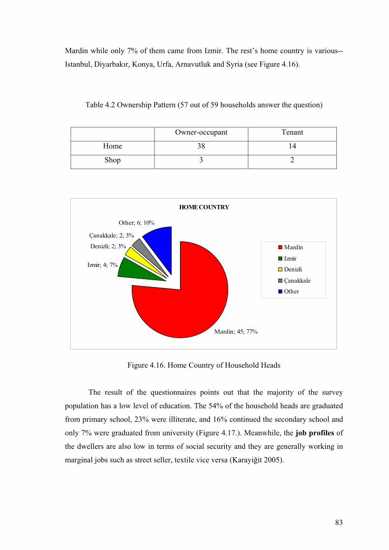
83
Mardin while only 7% of them came from Izmir. The rest’s home country is various--
Istanbul, Diyarbakır, Konya, Urfa, Arnavutluk and Syria (see Figure 4.16).
Table 4.2 Ownership Pattern (57 out of 59 households answer the question)
Owner-occupant Tenant
Home 38 14
Shop 3 2
HOME COUNTRY
Mardin; 45; 77%
Izmir; 4; 7%
Denizli; 2; 3%
Çanakkale; 2; 3%
Other; 6; 10%
Mardin
Izmir
Denizli
Çanakkale
Other
Figure 4.16. Home Country of Household Heads
The result of the questionnaires points out that the majority of the survey
population has a low level of education. The 54% of the household heads are graduated
from primary school, 23% were illiterate, and 16% continued the secondary school and
only 7% were graduated from university (Figure 4.17.). Meanwhile, the job profiles of
the dwellers are also low in terms of social security and they are generally working in
marginal jobs such as street seller, textile vice versa (Karayiğit 2005).
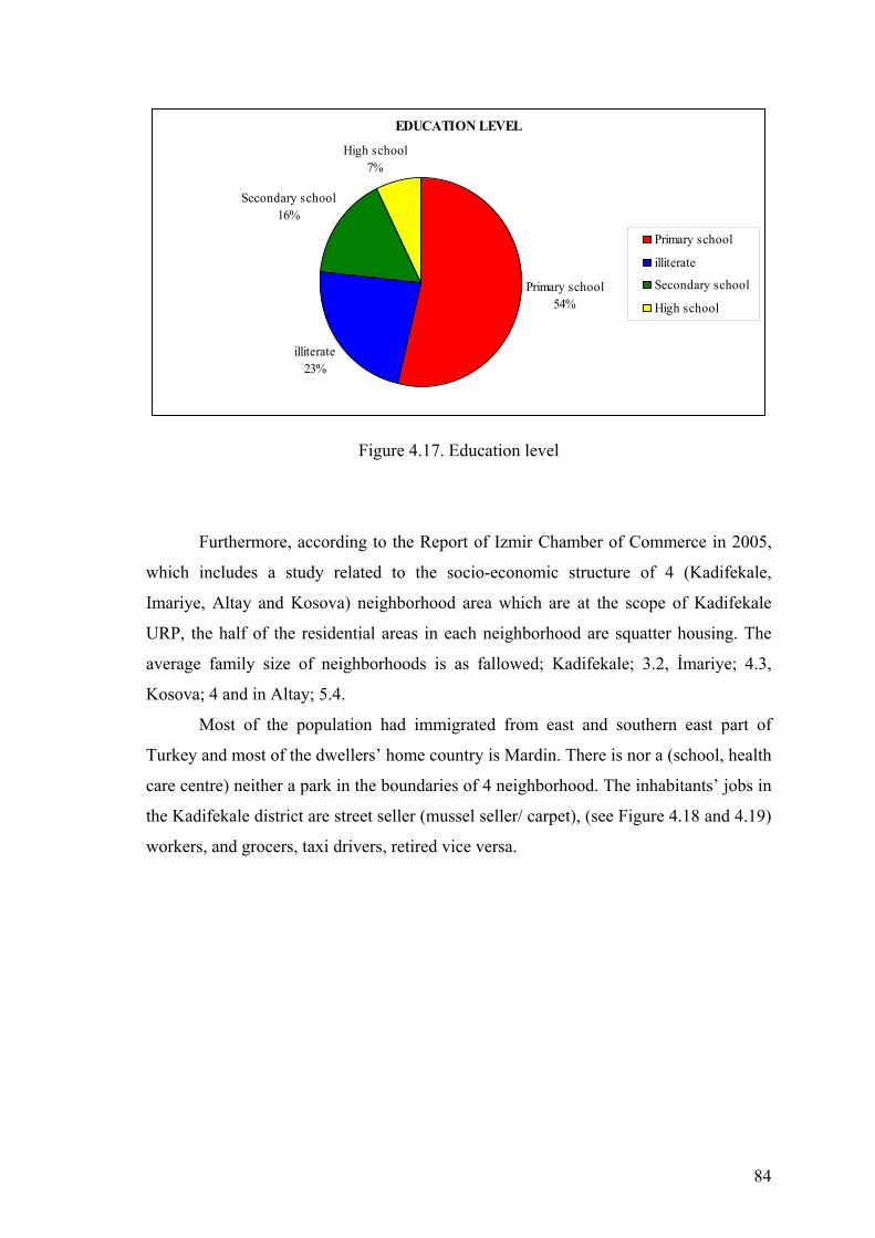
84
EDUCATION LEVEL
Primary school54%
illiterate23%
Secondary school16%
High school7%
Primary school
illiterate
Secondary school
High school
Figure 4.17. Education level
Furthermore, according to the Report of Izmir Chamber of Commerce in 2005,
which includes a study related to the socio-economic structure of 4 (Kadifekale,
Imariye, Altay and Kosova) neighborhood area which are at the scope of Kadifekale
URP, the half of the residential areas in each neighborhood are squatter housing. The
average family size of neighborhoods is as fallowed; Kadifekale; 3.2, İmariye; 4.3,
Kosova; 4 and in Altay; 5.4.
Most of the population had immigrated from east and southern east part of
Turkey and most of the dwellers’ home country is Mardin. There is nor a (school, health
care centre) neither a park in the boundaries of 4 neighborhood. The inhabitants’ jobs in
the Kadifekale district are street seller (mussel seller/ carpet), (see Figure 4.18 and 4.19)
workers, and grocers, taxi drivers, retired vice versa.
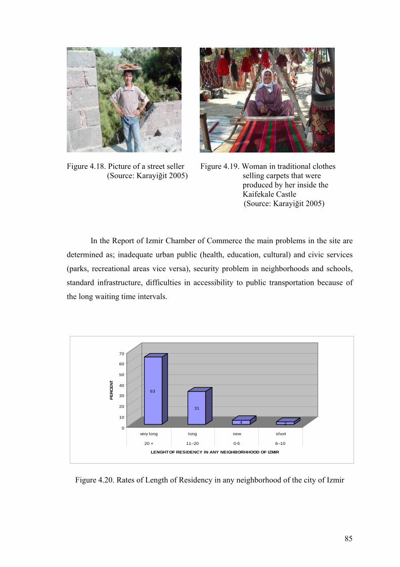
85
Figure 4.18. Picture of a street seller Figure 4.19. Woman in traditional clothes (Source: Karayiğit 2005) selling carpets that were produced by her inside the Kaifekale Castle
(Source: Karayiğit 2005)
In the Report of Izmir Chamber of Commerce the main problems in the site are
determined as; inadequate urban public (health, education, cultural) and civic services
(parks, recreational areas vice versa), security problem in neighborhoods and schools,
standard infrastructure, difficulties in accessibility to public transportation because of
the long waiting time intervals.
63
31
4 20
10
20
30
40
50
60
70
PE
RC
EN
T
very long long new short
20 + 11--20 0-5 6--10
LENGHT OF RESIDENCY IN ANY NEIGHBORHHOOD OF IZMIR
Figure 4.20. Rates of Length of Residency in any neighborhood of the city of Izmir
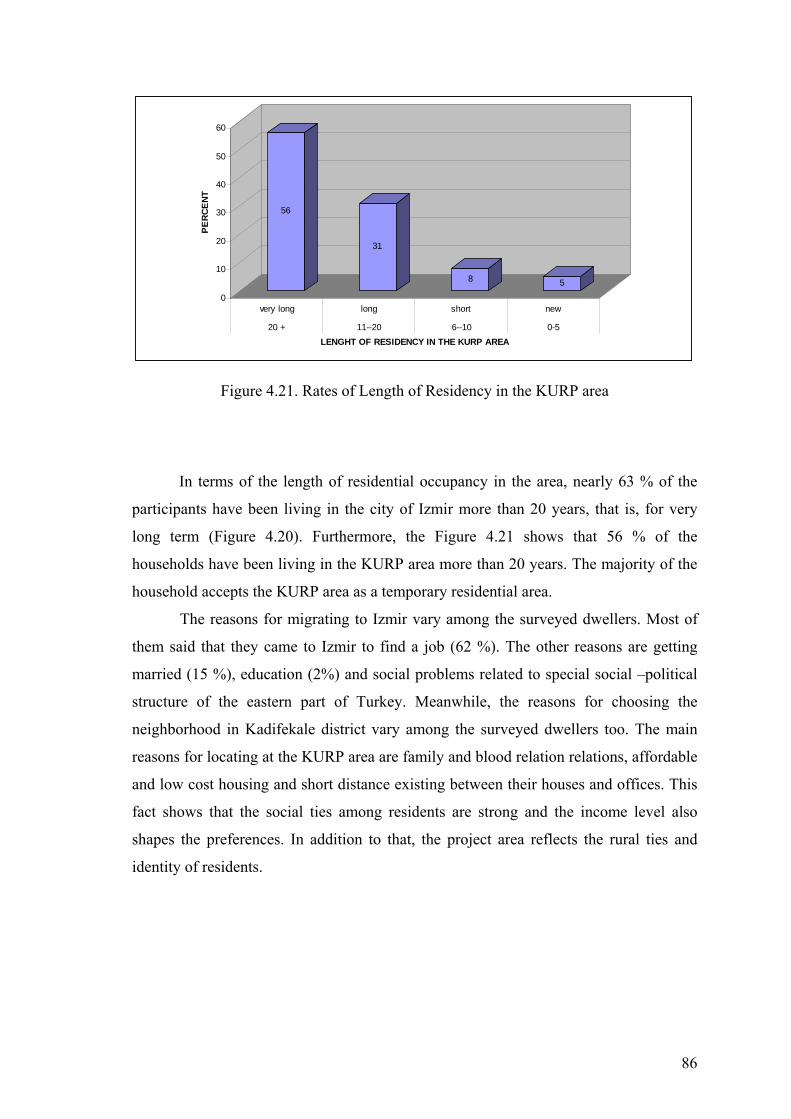
86
56
31
8 5
0
10
20
30
40
50
60
PERC
ENT
very long long short new
20 + 11--20 6--10 0-5LENGHT OF RESIDENCY IN THE KURP AREA
Figure 4.21. Rates of Length of Residency in the KURP area
In terms of the length of residential occupancy in the area, nearly 63 % of the
participants have been living in the city of Izmir more than 20 years, that is, for very
long term (Figure 4.20). Furthermore, the Figure 4.21 shows that 56 % of the
households have been living in the KURP area more than 20 years. The majority of the
household accepts the KURP area as a temporary residential area.
The reasons for migrating to Izmir vary among the surveyed dwellers. Most of
them said that they came to Izmir to find a job (62 %). The other reasons are getting
married (15 %), education (2%) and social problems related to special social –political
structure of the eastern part of Turkey. Meanwhile, the reasons for choosing the
neighborhood in Kadifekale district vary among the surveyed dwellers too. The main
reasons for locating at the KURP area are family and blood relation relations, affordable
and low cost housing and short distance existing between their houses and offices. This
fact shows that the social ties among residents are strong and the income level also
shapes the preferences. In addition to that, the project area reflects the rural ties and
identity of residents.
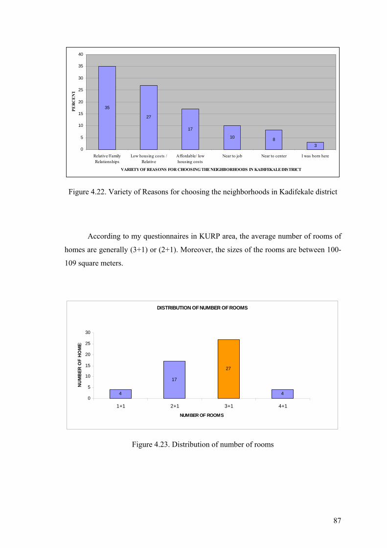
87
35
27
17
10 83
0
5
10
15
20
25
30
35
40
Relative/FamilyRelationships
Low housing costs /Relative
Affordable/ lowhousing costs
Near to job Near to center I was born here
VARIETY OF REASONS FOR CHOOSING THE NEIGHBORHOODS IN KADIFEKALE DISTRICT
PER
CE
NT
Figure 4.22. Variety of Reasons for choosing the neighborhoods in Kadifekale district
According to my questionnaires in KURP area, the average number of rooms of
homes are generally (3+1) or (2+1). Moreover, the sizes of the rooms are between 100-
109 square meters.
DISTRIBUTION OF NUMBER OF ROOMS
4
17
27
40
5
10
15
20
25
30
1+1 2+1 3+1 4+1
NUMBER OF ROOMS
NU
MB
ER O
F H
OM
ES
Figure 4.23. Distribution of number of rooms
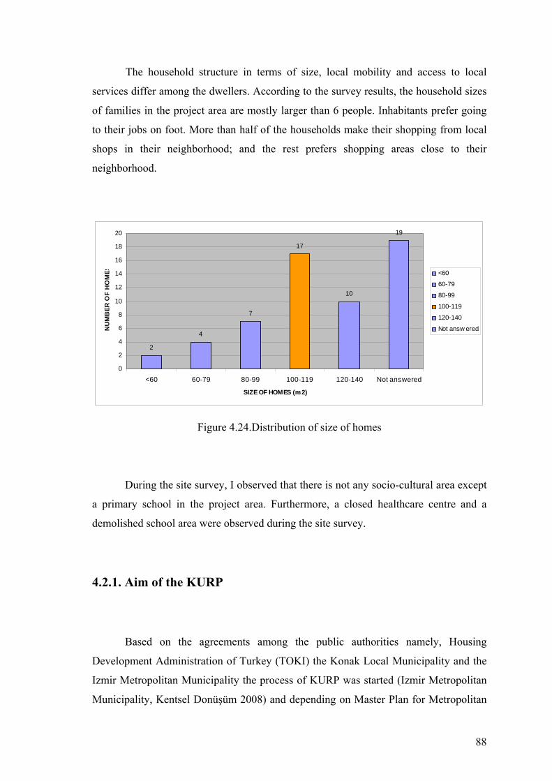
88
The household structure in terms of size, local mobility and access to local
services differ among the dwellers. According to the survey results, the household sizes
of families in the project area are mostly larger than 6 people. Inhabitants prefer going
to their jobs on foot. More than half of the households make their shopping from local
shops in their neighborhood; and the rest prefers shopping areas close to their
neighborhood.
2
4
7
17
10
19
0
2
4
6
8
10
12
14
16
18
20
<60 60-79 80-99 100-119 120-140 Not answered
SIZE OF HOMES (m2)
NU
MB
ER O
F H
OM
ES <60
60-79
80-99
100-119
120-140
Not answ ered
Figure 4.24.Distribution of size of homes
During the site survey, I observed that there is not any socio-cultural area except
a primary school in the project area. Furthermore, a closed healthcare centre and a
demolished school area were observed during the site survey.
4.2.1. Aim of the KURP
Based on the agreements among the public authorities namely, Housing
Development Administration of Turkey (TOKI) the Konak Local Municipality and the
Izmir Metropolitan Municipality the process of KURP was started (Izmir Metropolitan
Municipality, Kentsel Donüşüm 2008) and depending on Master Plan for Metropolitan
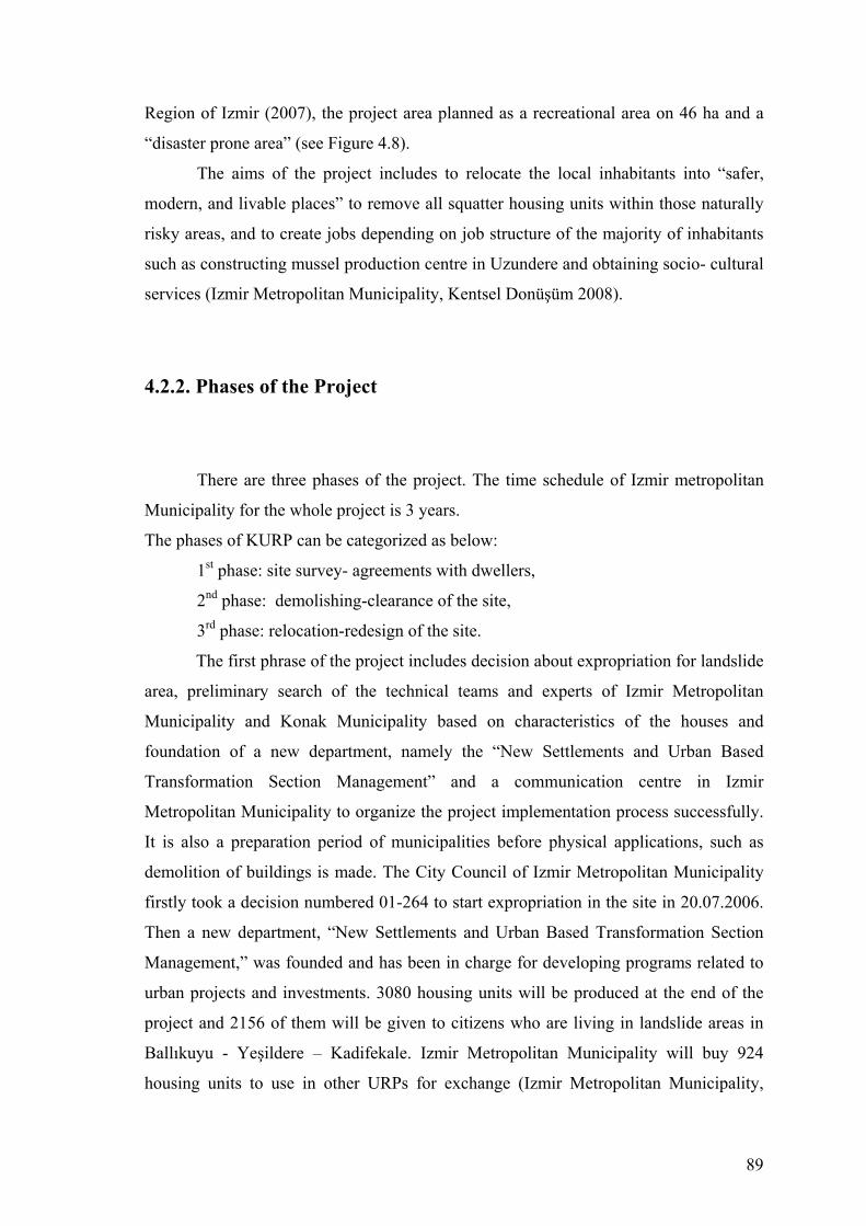
89
Region of Izmir (2007), the project area planned as a recreational area on 46 ha and a
“disaster prone area” (see Figure 4.8).
The aims of the project includes to relocate the local inhabitants into “safer,
modern, and livable places” to remove all squatter housing units within those naturally
risky areas, and to create jobs depending on job structure of the majority of inhabitants
such as constructing mussel production centre in Uzundere and obtaining socio- cultural
services (Izmir Metropolitan Municipality, Kentsel Donüşüm 2008).
4.2.2. Phases of the Project
There are three phases of the project. The time schedule of Izmir metropolitan
Municipality for the whole project is 3 years.
The phases of KURP can be categorized as below:
1st phase: site survey- agreements with dwellers,
2nd phase: demolishing-clearance of the site,
3rd phase: relocation-redesign of the site.
The first phrase of the project includes decision about expropriation for landslide
area, preliminary search of the technical teams and experts of Izmir Metropolitan
Municipality and Konak Municipality based on characteristics of the houses and
foundation of a new department, namely the “New Settlements and Urban Based
Transformation Section Management” and a communication centre in Izmir
Metropolitan Municipality to organize the project implementation process successfully.
It is also a preparation period of municipalities before physical applications, such as
demolition of buildings is made. The City Council of Izmir Metropolitan Municipality
firstly took a decision numbered 01-264 to start expropriation in the site in 20.07.2006.
Then a new department, “New Settlements and Urban Based Transformation Section
Management,” was founded and has been in charge for developing programs related to
urban projects and investments. 3080 housing units will be produced at the end of the
project and 2156 of them will be given to citizens who are living in landslide areas in
Ballıkuyu - Yeşildere – Kadifekale. Izmir Metropolitan Municipality will buy 924
housing units to use in other URPs for exchange (Izmir Metropolitan Municipality,
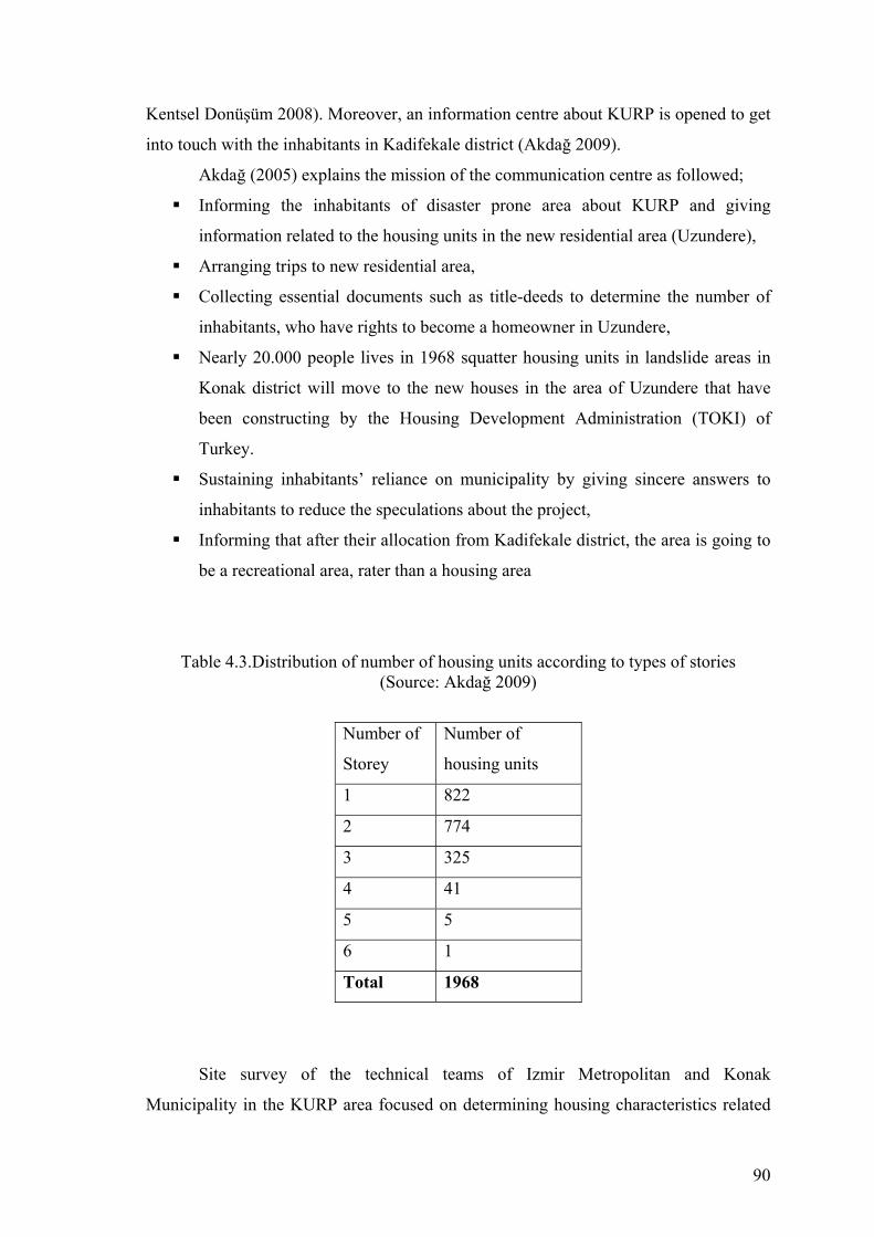
90
Kentsel Donüşüm 2008). Moreover, an information centre about KURP is opened to get
into touch with the inhabitants in Kadifekale district (Akdağ 2009).
Akdağ (2005) explains the mission of the communication centre as followed;
Informing the inhabitants of disaster prone area about KURP and giving
information related to the housing units in the new residential area (Uzundere),
Arranging trips to new residential area,
Collecting essential documents such as title-deeds to determine the number of
inhabitants, who have rights to become a homeowner in Uzundere,
Nearly 20.000 people lives in 1968 squatter housing units in landslide areas in
Konak district will move to the new houses in the area of Uzundere that have
been constructing by the Housing Development Administration (TOKI) of
Turkey.
Sustaining inhabitants’ reliance on municipality by giving sincere answers to
inhabitants to reduce the speculations about the project,
Informing that after their allocation from Kadifekale district, the area is going to
be a recreational area, rater than a housing area
Table 4.3.Distribution of number of housing units according to types of stories (Source: Akdağ 2009)
Number of
Storey
Number of
housing units
1 822
2 774
3 325
4 41
5 5
6 1
Total 1968
Site survey of the technical teams of Izmir Metropolitan and Konak
Municipality in the KURP area focused on determining housing characteristics related
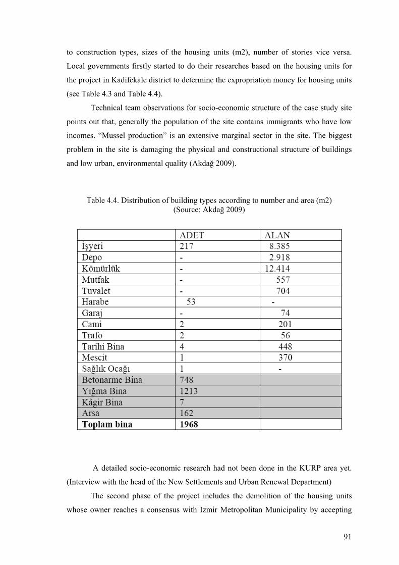
91
to construction types, sizes of the housing units (m2), number of stories vice versa.
Local governments firstly started to do their researches based on the housing units for
the project in Kadifekale district to determine the expropriation money for housing units
(see Table 4.3 and Table 4.4).
Technical team observations for socio-economic structure of the case study site
points out that, generally the population of the site contains immigrants who have low
incomes. “Mussel production” is an extensive marginal sector in the site. The biggest
problem in the site is damaging the physical and constructional structure of buildings
and low urban, environmental quality (Akdağ 2009).
Table 4.4. Distribution of building types according to number and area (m2)
(Source: Akdağ 2009)
A detailed socio-economic research had not been done in the KURP area yet.
(Interview with the head of the New Settlements and Urban Renewal Department)
The second phase of the project includes the demolition of the housing units
whose owner reaches a consensus with Izmir Metropolitan Municipality by accepting
92
the expropriation money. In parallel with this implementation, the construction of mass
housing buildings in the new residential area has just started. The third phase of the
project includes the relocation of homeowners from KURP area to Uzundere site and
the design of the landslide area as a recreational area.
Today, only the first phase of the project concluded. The second phase of the
project is continuing. Because some inhabitants cannot have cme to an agreement with
Izmir Metropolitan Municipality based on the level of expropriation money and they
apply to law courts. According to head of (New Settlements and Urban Renewal
Department), they have achieved at coming to an agreement rate with 70-80 % of
inhabitants at the project site. He also expressed that the project is an expropriation
project.
4.2.3. Institutional Partners of the Project
The partners of KURP are the Housing Development Administration of Turkey
(TOKI), Konak Municipality and also Izmir Metropolitan Municipality. Their roles and
responsibilities in project are as followed:
1- TOKI – Project developer
2- Konak Municipality and Izmir Metropolitan Municipality- Decision Makers-
project managers
A protocol was signed between TOKI, Izmir Metropolitan Municipality and
Konak Municipality to apply the KURP. TOKI is the developer of the project and
property owner of the new residential area; Uzundere. Konak Municipality involved in
the protocol because the Kadifekale district (KURP area) locates under the
administrative boundaries /responsibity of Konak Municipality and Izmir Metropolitan
Municipality a institutional partner of the KURP as project manager obtains financial
resources for the project.
93
4.2.3.1. The Housing Development Administration of Turkey (TOKI)
TOKI was established under the Office of Prime Minister in 1984. The aim of
TOKI is sustaining the housing needs of Turkey, producing mass housing units
especially for low and middle income groups, developing programs and investing
capital for this purposes.
At KURP, TOKI is the project operator. It has collaboration with 5 construction
firms (Akdağ 2009).
4.2.3.2. Konak Municipality and Izmir Metropolitan Municipality
Especially, before the local elections in 2004, the practices and discussions of
the urban projects are placed as the main part of the public discourses via media.
Increasing land costs in the city center and the competition among the local
authorizes have increased popularity of URPs. These projects also became a prestige
factor for local authorities. Therefore, local governments of Izmir also have prepared
plans and have developed strategies to apply urban projects such as KURP since 2005.
Konak Municipality and Izmir Metropolitan Municipality were also the
dominant decision makers and project managers at KURP. A communication
department was founded under Izmir Metropolitan Municipality to give information to
the dwellers about the project. Meeting were arranged to sustain consensus with
dwellers (Akdağ 2009).
4.2.4. Relocation Area (Uzundere)
In the scope of the KURP, a new residential area was planned in Uzundere
district to relocate the inhabitants of KURP area. The new residential area is located
closer to the Aydın-Çeşme highway. Moreover, “Olympic Village”, “Uzundere Urban
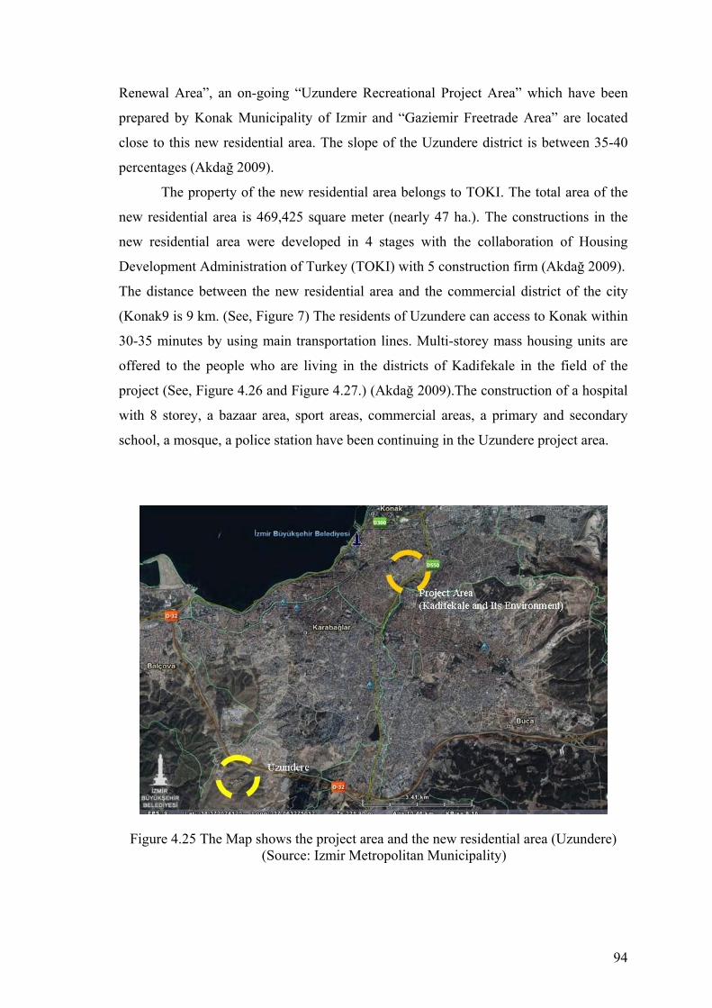
94
Renewal Area”, an on-going “Uzundere Recreational Project Area” which have been
prepared by Konak Municipality of Izmir and “Gaziemir Freetrade Area” are located
close to this new residential area. The slope of the Uzundere district is between 35-40
percentages (Akdağ 2009).
The property of the new residential area belongs to TOKI. The total area of the
new residential area is 469,425 square meter (nearly 47 ha.). The constructions in the
new residential area were developed in 4 stages with the collaboration of Housing
Development Administration of Turkey (TOKI) with 5 construction firm (Akdağ 2009).
The distance between the new residential area and the commercial district of the city
(Konak9 is 9 km. (See, Figure 7) The residents of Uzundere can access to Konak within
30-35 minutes by using main transportation lines. Multi-storey mass housing units are
offered to the people who are living in the districts of Kadifekale in the field of the
project (See, Figure 4.26 and Figure 4.27.) (Akdağ 2009).The construction of a hospital
with 8 storey, a bazaar area, sport areas, commercial areas, a primary and secondary
school, a mosque, a police station have been continuing in the Uzundere project area.
Figure 4.25 The Map shows the project area and the new residential area (Uzundere) (Source: Izmir Metropolitan Municipality)
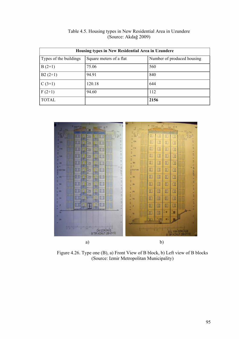
95
Table 4.5. Housing types in New Residential Area in Uzundere (Source: Akdağ 2009)
Housing types in New Residential Area in Uzundere
Types of the buildings Square meters of a flat Number of produced housing
B (2+1) 75.06 560
B2 (2+1) 94.91 840
C (3+1) 120.18 644
F (2+1) 94.60 112
TOTAL 2156
a) b)
Figure 4.26. Type one (B), a) Front View of B block, b) Left view of B blocks (Source: Izmir Metropolitan Municipality)
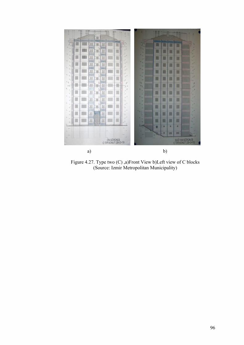
96
a) b)
Figure 4.27. Type two (C) ,a)Front View b)Left view of C blocks (Source: Izmir Metropolitan Municipality)
97
CHAPTER 5
EVALUATION OF THE KURP
This chapter evaluates whether KURP is a good urban renewal project, based on
the set of criteria developed in the Chapter Three. The set of criteria about good URPs
has two groups: one of them is about the planning outcomes (physical, economic, social
and ecological) and the other one is about the planning processes. While evaluating
KURP according to this set of criteria, I use the data that I gathered with my interviews
with municipal authorities and headmen in the project area, as well as the results of the
questionnaire with a group of households in KURP area.
5.1. Evaluation of the Planning Outcomes and Planning Process of the KURP
This part details the objectives under two main topics. These are planning
outcome and planning process criteria in the set of criteria table. Table 5.1 shows my
evaluation in relatişon to the KURP according to the determined final set of criteria
which was developed from scholarly books, articles, working papers, the related
International Charters, the European Union (EU) Guidance on Urban Rehabilitation
(2004), the graduate thesis in the Turkish universities. The meanings of the symbols in
Table 5.1 are as followed (+), means that the criteria were implemented/done in the
KURP, (-) suggests the opposite meaning of (+). However, ( ) points out that the
criteria was approved partially, not enough to be determined as (+). Moreover, (*)
explains that the criteria can not be applied for KURP; NA (non -applicable).
My evaluation of the KURP in respect to the set of criteria (see Table 5.1)
results in twenty-nine items that are relevant to KURP. Twenty two of them relate to the
planning outcomes and the rest relates to the planning process. Totally, KURP sustains
eight criteria which were “done” that means that these criteria were applied in the scope
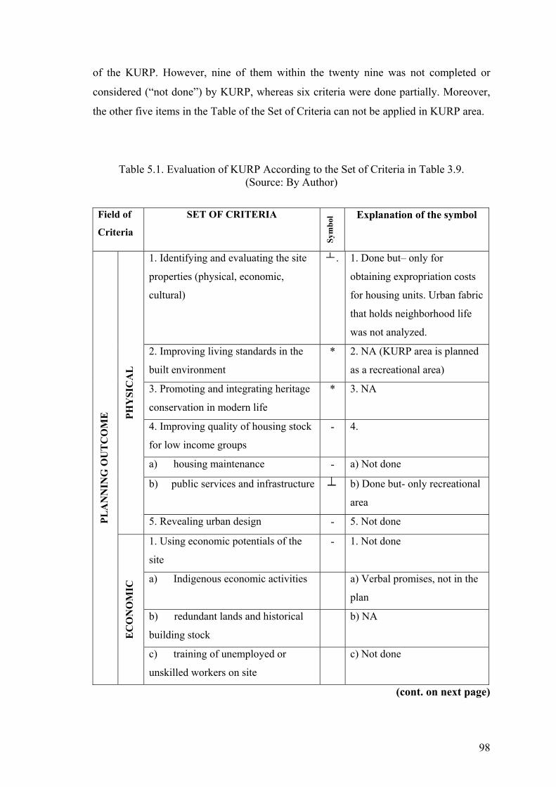
98
of the KURP. However, nine of them within the twenty nine was not completed or
considered (“not done”) by KURP, whereas six criteria were done partially. Moreover,
the other five items in the Table of the Set of Criteria can not be applied in KURP area.
Table 5.1. Evaluation of KURP According to the Set of Criteria in Table 3.9. (Source: By Author)
Field of
Criteria
SET OF CRITERIA
Sym
bol Explanation of the symbol
1. Identifying and evaluating the site
properties (physical, economic,
cultural)
. 1. Done but– only for
obtaining expropriation costs
for housing units. Urban fabric
that holds neighborhood life
was not analyzed.
2. Improving living standards in the
built environment
* 2. NA (KURP area is planned
as a recreational area)
3. Promoting and integrating heritage
conservation in modern life
* 3. NA
4. Improving quality of housing stock
for low income groups
- 4.
a) housing maintenance - a) Not done
b) public services and infrastructure b) Done but- only recreational
area
PHY
SIC
AL
5. Revealing urban design - 5. Not done
1. Using economic potentials of the
site
- 1. Not done
a) Indigenous economic activities a) Verbal promises, not in the
plan
b) redundant lands and historical
building stock
b) NA
PLA
NN
ING
OU
TC
OM
E
EC
ON
OM
IC
c) training of unemployed or
unskilled workers on site
c) Not done
(cont. on next page)
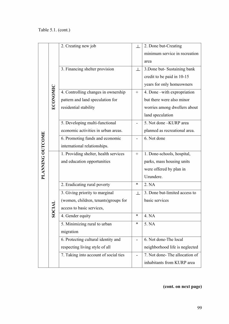
99
Table 5.1. (cont.)
2. Creating new job 2. Done but-Creating
minimum service in recreation
area
3. Financing shelter provision 3.Done but- Sustaining bank
credit to be paid in 10-15
years for only homeowners
4. Controlling changes in ownership
pattern and land speculation for
residential stability
+ 4. Done –with expropriation
but there were also minor
worries among dwellers about
land speculation
5. Developing multi-functional
economic activities in urban areas.
- 5. Not done –KURP area
planned as recreational area.
EC
ON
OM
IC
6. Promoting funds and economic
international relationships.
- 6. Not done
1. Providing shelter, health services
and education opportunities
+ 1. Done-schools, hospital,
parks, mass housing units
were offered by plan in
Uzundere.
2. Eradicating rural poverty * 2. NA
3. Giving priority to marginal
(women, children, tenants)groups for
access to basic services,
3. Done but-limited access to
basic services
4. Gender equity * 4. NA
5. Minimizing rural to urban
migration
* 5. NA
6. Protecting cultural identity and
respecting living style of all
- 6. Not done-The local
neighborhood life is neglected
PLA
NN
ING
OU
TC
OM
E
SOC
IAL
7. Taking into account of social ties - 7. Not done- The allocation of
inhabitants from KURP area
(cont. on next page)
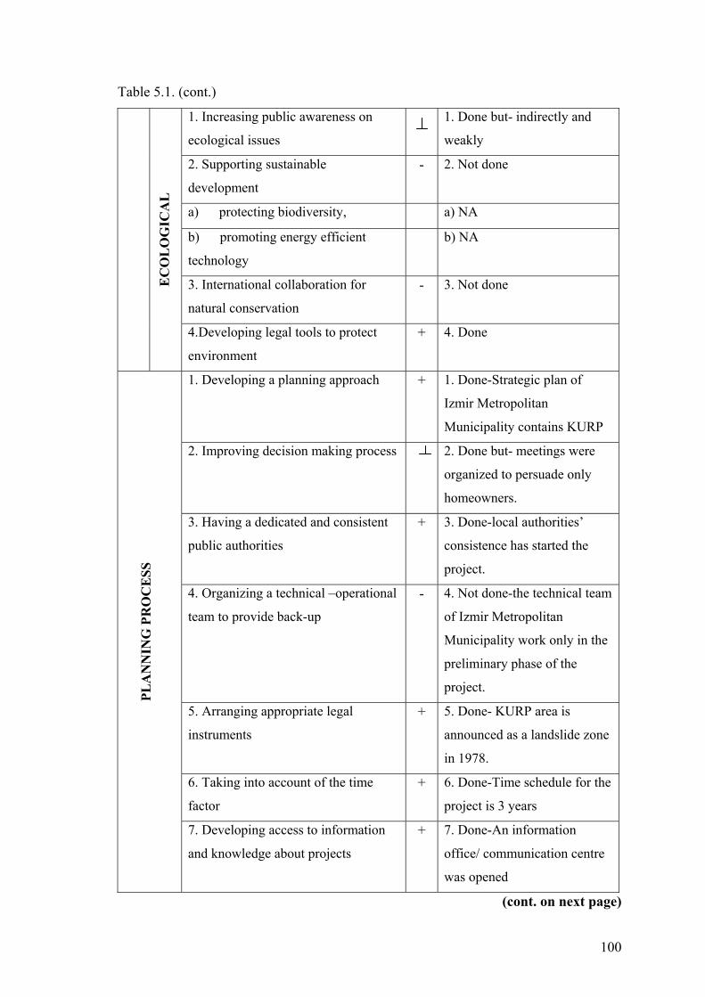
100
Table 5.1. (cont.)
1. Increasing public awareness on
ecological issues
1. Done but- indirectly and
weakly
2. Supporting sustainable
development
- 2. Not done
a) protecting biodiversity, a) NA
b) promoting energy efficient
technology
b) NA
3. International collaboration for
natural conservation
- 3. Not done
EC
OL
OG
ICA
L
4.Developing legal tools to protect
environment
+ 4. Done
1. Developing a planning approach + 1. Done-Strategic plan of
Izmir Metropolitan
Municipality contains KURP
2. Improving decision making process 2. Done but- meetings were
organized to persuade only
homeowners.
3. Having a dedicated and consistent
public authorities
+ 3. Done-local authorities’
consistence has started the
project.
4. Organizing a technical –operational
team to provide back-up
- 4. Not done-the technical team
of Izmir Metropolitan
Municipality work only in the
preliminary phase of the
project.
5. Arranging appropriate legal
instruments
+ 5. Done- KURP area is
announced as a landslide zone
in 1978.
6. Taking into account of the time
factor
+ 6. Done-Time schedule for the
project is 3 years
PLA
NN
ING
PR
OC
ESS
7. Developing access to information
and knowledge about projects
+ 7. Done-An information
office/ communication centre
was opened
(cont. on next page)
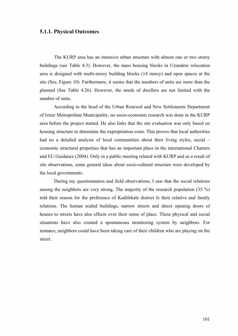
101
5.1.1. Physical Outcomes
The KURP area has an intensive urban structure with almost one or two storey
buildings (see Table 4.3). However, the mass housing blocks in Uzundere relocation
area is designed with multi-storey building blocks (14 storey) and open spaces at the
site (See, Figure 10). Furthermore, it seems that the numbers of units are more than the
planned (See Table 4.26). However, the needs of dwellers are not limited with the
number of units.
According to the head of the Urban Renewal and New Settlements Department
of Izmir Metropolitan Municipality, no socio-economic research was done in the KURP
area before the project started. He also links that the site evaluation was only based on
housing structure to determine the expropriation costs. This proves that local authorities
had no a detailed analysis of local communities about their living styles, social –
economic structural properties that has an important place in the international Charters
and EU Guidance (2004). Only in a public meeting related with KURP and as a result of
site observations, some general ideas about socio-cultural structure were developed by
the local governments.
During my questionnaires and field observations, I saw that the social relations
among the neighbors are very strong. The majority of the research population (35 %)
told their reason for the preference of Kadifekale district Is their relative and family
relations. The human scaled buildings, narrow streets and direct opening doors of
houses to streets have also effects over their sense of place. These physical and social
situations have also created a spontaneous monitoring system by neighbors. For
instance, neighbors could have been taking care of their children who are playing on the
street.
102
5.1.2. Economic Outcomes
KUPR area is a part of Kadifekale district that owns specific economic
properties. First of all, the mussel production is the important economic activity with
hand made productions. This factor also identifies an important clue.
The site plan of relocation area, Uzundere, determines single uses in the site terms of
economic activities such as; shopping centres. Meanwhile, the mayor of Izmir
Metropolitan Municipality has declared that a mussel production centre will be founded
in the site of Uzundere (Web 2). However, the site plan does not offer any land which
gives decisions related with mussel production area and the mussel production centre.
Such kind of workplace has not been constructed in Uzundere district yet.
During the project process, the expropriation of houses has taken an important
place. Persuading and compromising with the inhabitants of KUPR area is aimed by the
local government. Besides, expropriation of money for each household unit is obtained
with the condition that the local authorities will give building subsidies for dwellers
whose expropriation money is not sufficient to purchase a house in Uzundere or who
can not get bank credits for 10 or 15 years credit terms.
The headmen of the Imariye neighborhood says that; “We don’t approve this
project because the local government has developed the project without considering the
ideas of dwellers. The dwellers have some problems especially related with the level of
determined low expropriation money which is about 6.000 -10.000 TL. This money
isn’t enough to buy a house in new residential area (Uzundere) or anywhere in Izmir.
Therefore, installment plan has been offered to the dwellers while paying it back in 15
years. Most of the people who live in here are the street peddlers that can not afford for
paying these costs.”
Moreover, the local governments’ plan for subsidizing the dwellers does not
consider tenants and local storeowners. The questionnaires results said that dwellers of
the KURP area met with the Izmir Chamber of Commerce and mayor of the Izmir
Metropolitan Municipality but nothing has changed”
According to the Head of the Department of Urban Renewal and New
Settlements local government reach consensus with more than 50 % of dwellers in the
KURP area. Dwellers have no alternative approach except these two choices: accepting
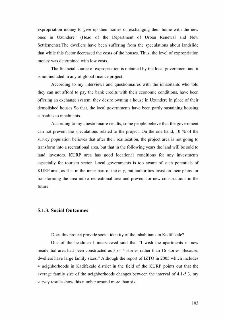
103
expropriation money to give up their homes or exchanging their home with the new
ones in Uzundere” (Head of the Department of Urban Renewal and New
Settlements).The dwellers have been suffering from the speculations about landslide
that while this factor decreased the costs of the houses. Thus, the level of expropriation
money was determined with low costs.
The financial source of expropriation is obtained by the local government and it
is not included in any of global finance project.
According to my interviews and questionnaires with the inhabitants who told
they can not afford to pay the bank credits with their economic conditions, have been
offering an exchange system, they desire owning a house in Uzundere in place of their
demolished houses So that, the local governments have been partly sustaining housing
subsidies to inhabitants.
According to my questionnaire results, some people believe that the government
can not prevent the speculations related to the project. On the one hand, 10 % of the
survey population believes that after their reallocation, the project area is not going to
transform into a recreational area, but that in the following years the land will be sold to
land investors. KURP area has good locational conditions for any investments
especially for tourism sector. Local governments is too aware of such potentials of
KURP area, as it is in the inner part of the city, but authorities insist on their plans for
transforming the area into a recreational area and prevent for new constructions in the
future.
5.1.3. Social Outcomes
Does this project provide social identity of the inhabitants in Kadifekale?
One of the headmen I interviewed said that “I wish the apartments in new
residential area had been constructed as 3 or 4 stories rather than 16 stories. Because,
dwellers have large family sizes.” Although the report of IZTO in 2005 which includes
4 neighborhoods in Kadifekale district in the field of the KURP points out that the
average family size of the neighborhoods changes between the interval of 4.1-5.3, my
survey results show this number around more than six.
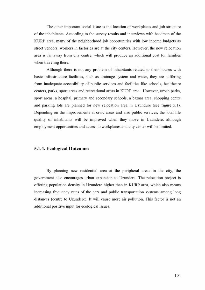
104
The other important social issue is the location of workplaces and job structure
of the inhabitants. According to the survey results and interviews with headmen of the
KURP area, many of the neighborhood job opportunities with low income budgets as
street vendors, workers in factories are at the city centers. However, the new relocation
area is far away from city centre, which will produce an additional cost for families
when traveling there.
Although there is not any problem of inhabitants related to their houses with
basic infrastructure facilities, such as drainage system and water, they are suffering
from inadequate accessibility of public services and facilities like schools, healthcare
centers, parks, sport areas and recreational areas in KURP area. However, urban parks,
sport areas, a hospital, primary and secondary schools, a bazaar area, shopping centre
and parking lots are planned for new relocation area in Uzundure (see figure 5.1).
Depending on the improvements at civic areas and also public services, the total life
quality of inhabitants will be improved when they move in Uzundere, although
employment opportunities and access to workplaces and city center will be limited.
5.1.4. Ecological Outcomes
By planning new residential area at the peripheral areas in the city, the
government also encourages urban expansion to Uzundere. The relocation project is
offering population density in Uzundere higher than in KURP area, which also means
increasing frequency rates of the cars and public transportation systems among long
distances (centre to Uzundere). It will cause more air pollution. This factor is not an
additional positive input for ecological issues.
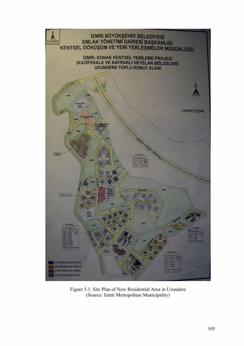
105
Figure 5.1. Site Plan of New Residential Area in Uzundere (Source: Izmir Metropolitan Municipality)
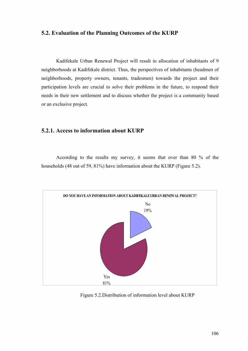
106
5.2. Evaluation of the Planning Outcomes of the KURP
Kadifekale Urban Renewal Project will result in allocation of inhabitants of 9
neighborhoods at Kadifekale district. Thus, the perspectives of inhabitants (headmen of
neighborhoods, property owners, tenants, tradesmen) towards the project and their
participation levels are crucial to solve their problems in the future, to respond their
needs in their new settlement and to discuss whether the project is a community based
or an exclusive project.
5.2.1. Access to information about KURP
According to the results my survey, it seems that over than 80 % of the
households (48 out of 59, 81%) have information about the KURP (Figure 5.2).
DO YOU HAVE AN INFORMATION ABOUT KADIFEKALE URBAN RENEWAL PROJECT?
Yes81%
No19%
Figure 5.2.Distribution of information level about KURP
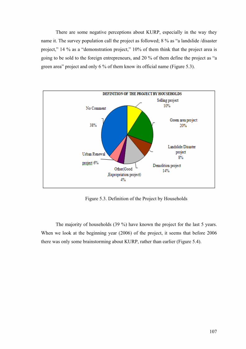
107
There are some negative perceptions about KURP, especially in the way they
name it. The survey population call the project as followed; 8 % as “a landslide /disaster
project,” 14 % as a “demonstration project,” 10% of them think that the project area is
going to be sold to the foreign entrepreneurs, and 20 % of them define the project as “a
green area” project and only 6 % of them know its official name (Figure 5.3).
Figure 5.3. Definition of the Project by Households
The majority of households (39 %) have known the project for the last 5 years.
When we look at the beginning year (2006) of the project, it seems that before 2006
there was only some brainstorming about KURP, rather than earlier (Figure 5.4).
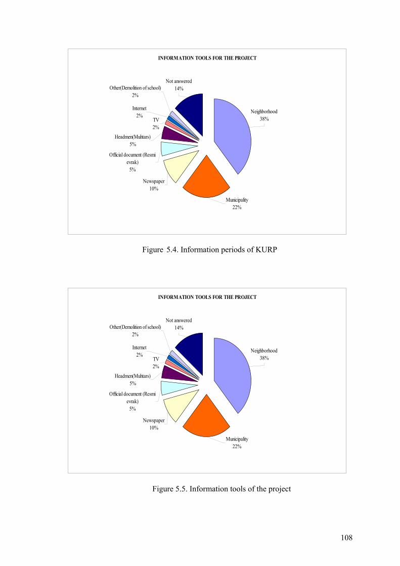
108
INFORMATION TOOLS FOR THE PROJECT
Neighborhood38%
Not answered14%
TV2%
Internet2%
Other(Demolition of school)2%
Headmen(Muhtars) 5%
Official document (Resmi evrak)
5%
Newspaper10%
Municipality22%
Figure 5.4. Information periods of KURP
INFORMATION TOOLS FOR THE PROJECT
Neighborhood38%
Not answered14%
TV2%
Internet2%
Other(Demolition of school)2%
Headmen(Muhtars) 5%
Official document (Resmi evrak)
5%
Newspaper10%
Municipality22%
Figure 5.5. Information tools of the project
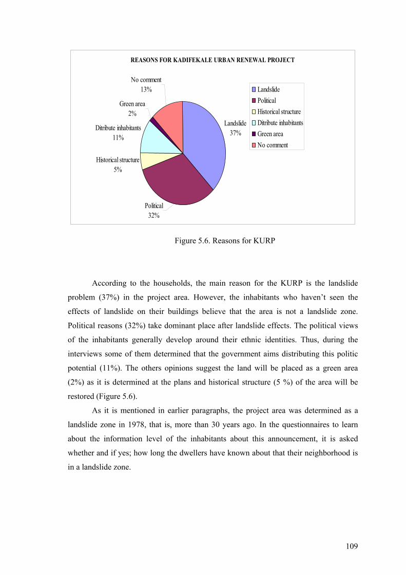
109
REASONS FOR KADIFEKALE URBAN RENEWAL PROJECT
Landslide37%
Historical structure5%
Ditribute inhabitants11%
Green area2%
No comment13%
Political32%
LandslidePoliticalHistorical structureDitribute inhabitantsGreen areaNo comment
Figure 5.6. Reasons for KURP
According to the households, the main reason for the KURP is the landslide
problem (37%) in the project area. However, the inhabitants who haven’t seen the
effects of landslide on their buildings believe that the area is not a landslide zone.
Political reasons (32%) take dominant place after landslide effects. The political views
of the inhabitants generally develop around their ethnic identities. Thus, during the
interviews some of them determined that the government aims distributing this politic
potential (11%). The others opinions suggest the land will be placed as a green area
(2%) as it is determined at the plans and historical structure (5 %) of the area will be
restored (Figure 5.6).
As it is mentioned in earlier paragraphs, the project area was determined as a
landslide zone in 1978, that is, more than 30 years ago. In the questionnaires to learn
about the information level of the inhabitants about this announcement, it is asked
whether and if yes; how long the dwellers have known about that their neighborhood is
in a landslide zone.

110
LANDSLIDE INFO TIME- SCALE
Short term years (1_5)37%
Mid-term years (6_20)24%
Long term years (>20)19%
Not answered20%
Figure 5.7. Landslide information periods
The result of the research shows that, 19 % of the survey population has known
that the area is a landslide zone for more than 20 years and 24 % of them are has known
this time period as between 5 and 20 years. To sum up, nearly half of the population
settle down the landslide area while considering all the risks with landslide zone (Figure
5.7.)
The landslide effects have been occurred in the project area within various ways.
The apparent one is observable with the splits and cracks at the walls of the buildings.
Invisible effects of landslide can be lived by the living in that environment. The Figure
5.8 gives some information about the majority of the survey population (39 %) whom
define the most effective impact as physical detoriation at the buildings with lack of
infrastructure. They said that the municipalities’ inadequate precautions increased the
landslide effects on housing stock.
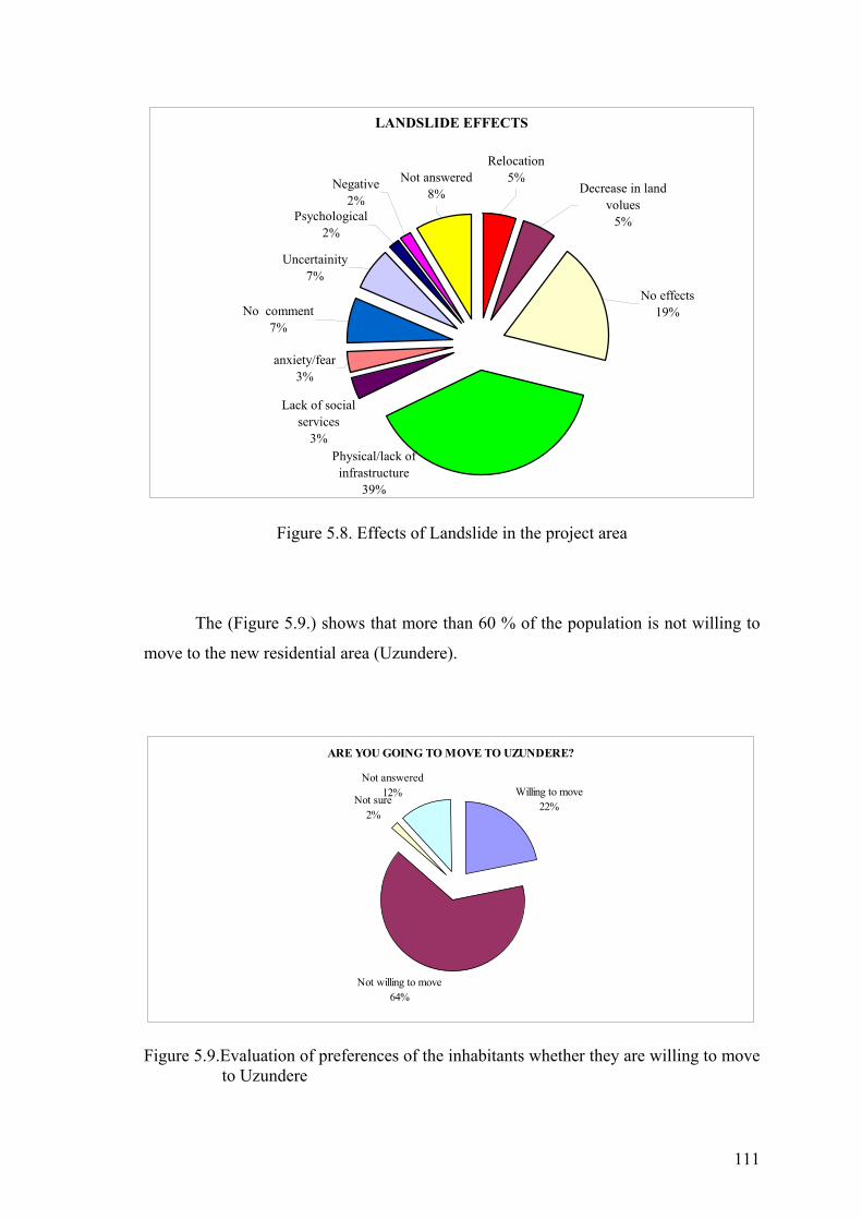
111
LANDSLIDE EFFECTS
Relocation5%
No effects19%
Decrease in land volues
5%Psychological2%
Negative2%
Not answered8%
Uncertainity7%
Physical/lack of infrastructure
39%
Lack of social services
3%
anxiety/fear3%
No comment7%
Figure 5.8. Effects of Landslide in the project area
The (Figure 5.9.) shows that more than 60 % of the population is not willing to
move to the new residential area (Uzundere).
ARE YOU GOING TO MOVE TO UZUNDERE?
Willing to move22%
Not willing to move64%
Not sure2%
Not answered12%
Figure 5.9.Evaluation of preferences of the inhabitants whether they are willing to move to Uzundere
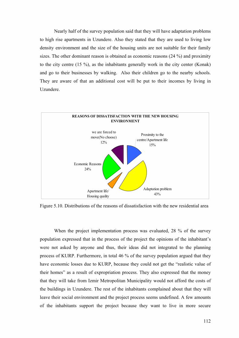
112
Nearly half of the survey population said that they will have adaptation problems
to high rise apartments in Uzundere. Also they stated that they are used to living low
density environment and the size of the housing units are not suitable for their family
sizes. The other dominant reason is obtained as economic reasons (24 %) and proximity
to the city centre (15 %), as the inhabitants generally work in the city center (Konak)
and go to their businesses by walking. Also their children go to the nearby schools.
They are aware of that an additional cost will be put to their incomes by living in
Uzundere.
REASONS OF DISSATISFACTION WITH THE NEW HOUSING ENVIRONMENT
Adaptation problem43%
Apartment life/ Housing quality
6%
Economic Reasons24%
we are forced to move(No choose)
12%
Proximity to the centre/Apartment life
15%
Figure 5.10. Distributions of the reasons of dissatisfaction with the new residential area
When the project implementation process was evaluated, 28 % of the survey
population expressed that in the process of the project the opinions of the inhabitant’s
were not asked by anyone and thus, their ideas did not integrated to the planning
process of KURP. Furthermore, in total 46 % of the survey population argued that they
have economic losses due to KURP, because they could not get the “realistic value of
their homes” as a result of expropriation process. They also expressed that the money
that they will take from Izmir Metropolitan Municipality would not afford the costs of
the buildings in Uzundere. The rest of the inhabitants complained about that they will
leave their social environment and the project process seems undefined. A few amounts
of the inhabitants support the project because they want to live in more secure
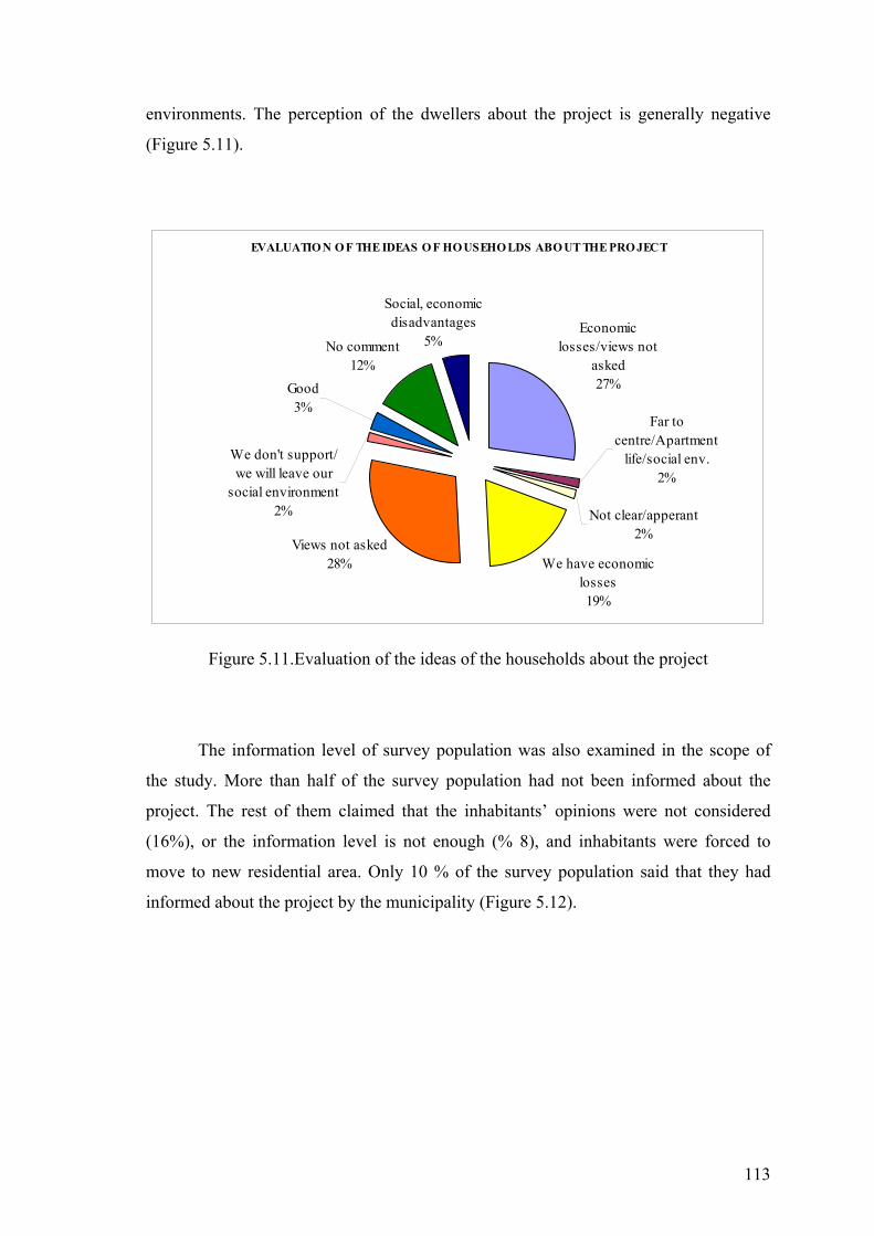
113
environments. The perception of the dwellers about the project is generally negative
(Figure 5.11).
EVALUATIO N O F THE IDEAS O F HO USEHO LDS ABO UT THE PRO JECT
Economic losses/views not
asked27%
We have economic losses19%
Views not asked28%
No comment12%
Social, economic disadvantages
5%
Good3%
We don't support/ we will leave our
social environment2%
Far to centre/Apartment
life/social env.2%
Not clear/apperant2%
Figure 5.11.Evaluation of the ideas of the households about the project
The information level of survey population was also examined in the scope of
the study. More than half of the survey population had not been informed about the
project. The rest of them claimed that the inhabitants’ opinions were not considered
(16%), or the information level is not enough (% 8), and inhabitants were forced to
move to new residential area. Only 10 % of the survey population said that they had
informed about the project by the municipality (Figure 5.12).
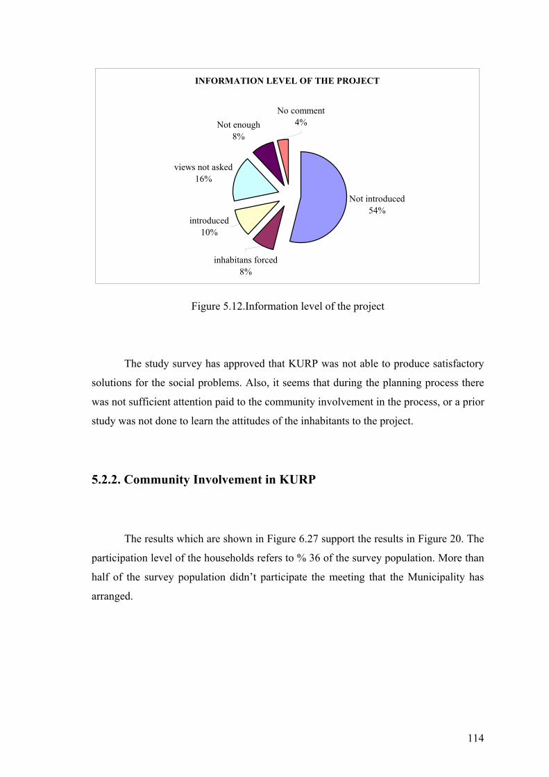
114
INFORMATION LEVEL OF THE PROJECT
Not introduced54%
views not asked16%
Not enough8%
introduced10%
inhabitans forced8%
No comment4%
Figure 5.12.Information level of the project
The study survey has approved that KURP was not able to produce satisfactory
solutions for the social problems. Also, it seems that during the planning process there
was not sufficient attention paid to the community involvement in the process, or a prior
study was not done to learn the attitudes of the inhabitants to the project.
5.2.2. Community Involvement in KURP
The results which are shown in Figure 6.27 support the results in Figure 20. The
participation level of the households refers to % 36 of the survey population. More than
half of the survey population didn’t participate the meeting that the Municipality has
arranged.
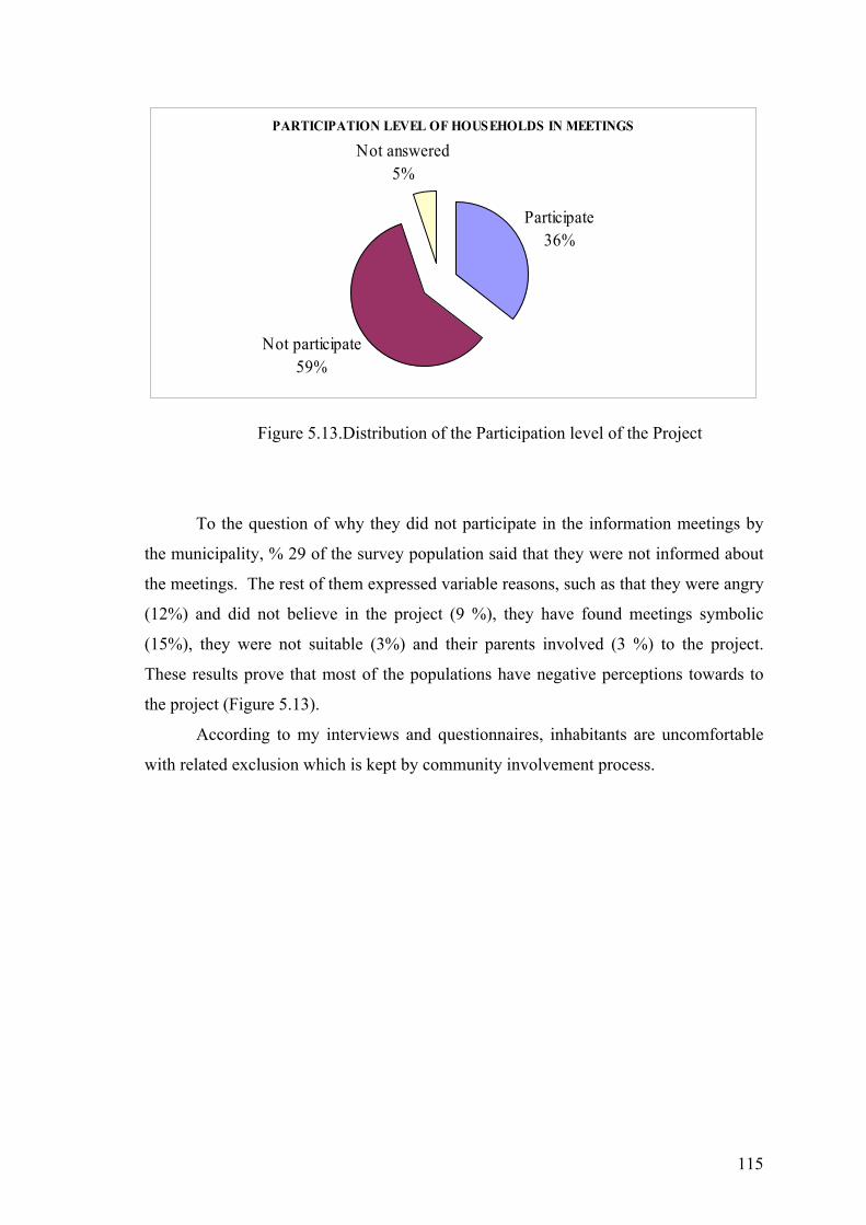
115
PARTICIPATION LEVEL OF HOUSEHOLDS IN MEETINGS
Participate36%
Not participate59%
Not answered5%
Figure 5.13.Distribution of the Participation level of the Project
To the question of why they did not participate in the information meetings by
the municipality, % 29 of the survey population said that they were not informed about
the meetings. The rest of them expressed variable reasons, such as that they were angry
(12%) and did not believe in the project (9 %), they have found meetings symbolic
(15%), they were not suitable (3%) and their parents involved (3 %) to the project.
These results prove that most of the populations have negative perceptions towards to
the project (Figure 5.13).
According to my interviews and questionnaires, inhabitants are uncomfortable
with related exclusion which is kept by community involvement process.
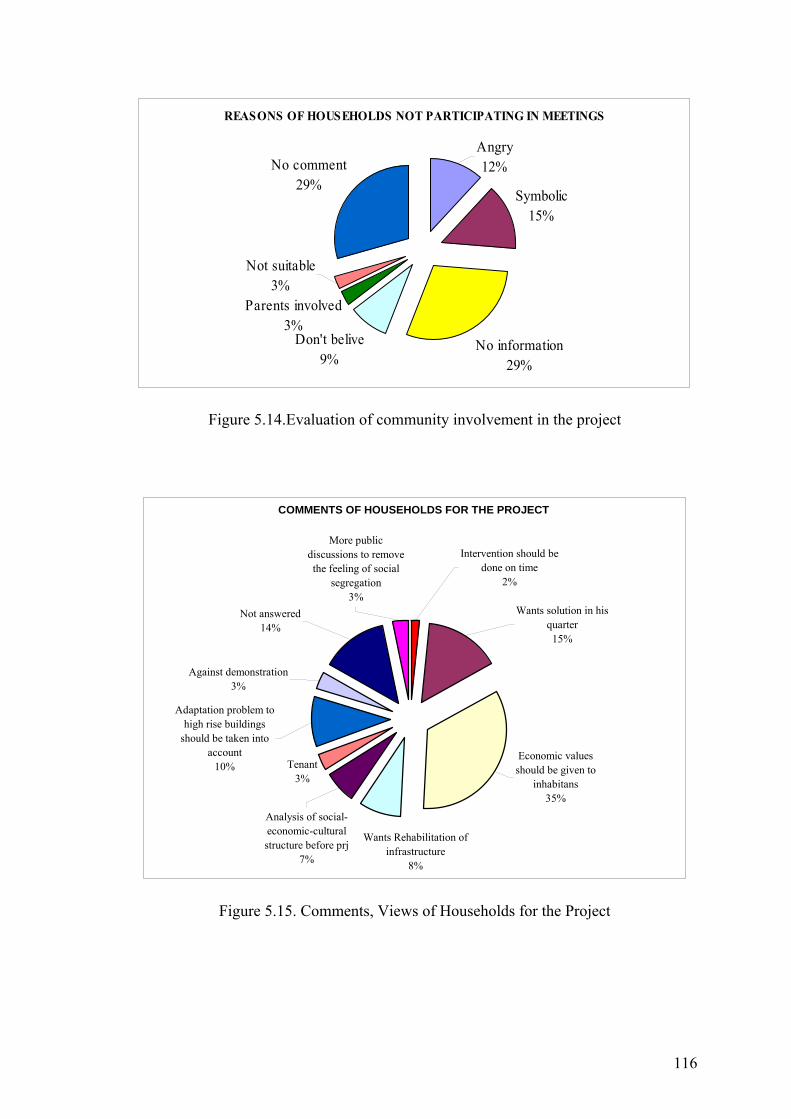
116
REASONS OF HOUSEHOLDS NOT PARTICIPATING IN MEETINGS
Symbolic15%
No information29%
Don't belive9%
Parents involved3%
No comment29%
Angry12%
Not suitable3%
Figure 5.14.Evaluation of community involvement in the project
COMMENTS OF HOUSEHOLDS FOR THE PROJECT
Tenant3%
Wants Rehabilitation of infrastructure
8%
Analysis of social-economic-cultural structure before prj
7%
Adaptation problem to high rise buildings
should be taken into account
10%
Against demonstration3%
More public discussions to remove the feeling of social
segregation3%
Not answered14%
Intervention should be done on time
2%
Wants solution in his quarter15%
Economic values should be given to
inhabitans35%
Figure 5.15. Comments, Views of Households for the Project
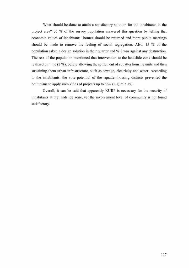
117
What should be done to attain a satisfactory solution for the inhabitants in the
project area? 35 % of the survey population answered this question by telling that
economic values of inhabitants’ homes should be returned and more public meetings
should be made to remove the feeling of social segregation. Also, 15 % of the
population asked a design solution in their quarter and % 8 was against any destruction.
The rest of the population mentioned that intervention to the landslide zone should be
realized on time (2 %), before allowing the settlement of squatter housing units and then
sustaining them urban infrastructure, such as sewage, electricity and water. According
to the inhabitants, the vote potential of the squatter housing districts prevented the
politicians to apply such kinds of projects up to now (Figure 5.15).
Overall, it can be said that apparently KURP is necessary for the security of
inhabitants at the landslide zone, yet the involvement level of community is not found
satisfactory.
118
CHAPTER 6
CONCLUSION
The thesis aimed at developing a set of criteria to evaluate URPs that take
crucial place in public discussions for the last two decades. Moreover, the thesis
evaluate factors that cause in URP and also URP strategies developed in the historical
trajectory of USA-Europe from industrial period and of Turkey, from Republican period
to present.
Kadifekale Urban Renewal Project (KURP) is the case of the thesis. It is an
ongoing URP in the city of Izmir. KURP develops on two different urban areas. The
first area is the Kadifekale district that has existing building stock in landslide zone. The
second area is the relocation area in Uzundere. KURP includes various URP strategies,
For instance, it has urban clearance that is implemented in the second phase of the
project. Also, turning a residential area into a recreational area is an urban
transformation strategy which completely changes the urban structure of KURP area.
Moreover, releasing the natural hazard risk on inhabitants in the KURP area is an urban
rehabilitation strategy. The local government allocates inhabitants from KURP area and
relocates them in new residential area in Uzundere. Finally, as a result of the agreement
between local authorities and the Housing Development and Administration of Turkey
(TOKI), mass housing units were constructed in Uzundere on the vacant urban area that
refers to an urban development project. To sum up, various URP strategies, such as
urban renewal that contains (clearance, relocation), rehabilitation, redevelopment and
urban transformation are parts of KURP
This thesis has developed a set of criteria for “good” URPs based on my review
of effective international charters (Agenda 21 (1992), Habitat II (1996) and New Athens
Charter (2003)), EU Guidance on Urban Rehabilitation (2004), the scholarly literature
(Roberts 2000, Akkar 2006, Lang 2005)) and the graduate theses in Turkish universities
(Duzcu 2006, Doyduk 2008 and Özden 2002). The main field of criteria contains
planning outcome (physical, economic, social, and environmental) and planning process
outcome.
119
I evaluated whether KURP is a good URP, I used all the criteria defined within
this set of criteria listed in Table 3.9. For the criteria of physical outcomes, 3 out of 5
items are applicable for the KURP project (See, Table 5.1 in Chapter 5). and two
criteria (about improving quality of housing stock for low income groups and revealing
urban design in the KURP) were not applied in the scope of KURP. Although the local
authorities had analysis about physical urban structure of the site, this analyze is limited
with the examination of number of housing units and their structure to obtain the level
of expropriation money.
The application level of economic criteria is much more than the criteria for
physical outcomes. Six criteria were detailed for KURP in the Table 5.1. Half of them
are not done in the scope of KURP, whereas only two out of six were done partially.
These are creating new job potential by using offered recreational area potential and
financing shelter by providing bank credit to be paid in 10 and 15 years.
Among the criteria about social outcomes, only the basic services and shelter
were sustained. However, majority of the criteria about ecological outcomes are not
applicable for KURP.
The local government has an effort to sustain community involvement in the
planning process of KURP. Although the solutions mostly support that the criteria for
planning process are much more successfully applied than from each group of criteria
for planning outcomes, the results of the questionnaires and interviews suggest the
opposites. For instance, the inhabitants criticize that the meetings that were arranged by
Izmir Metropolitan Municipality were not enough for effective community
involvement.
As a result of the assessment of KURP according to the developed set of criteria,
KURP is not a good urban project. The suggestions of the thesis focus on that the
interventions of URPs in the built environment today not only resulted in physical
changes. The physical changes in the built environment have been affecting all social,
economic and environmental dimensions in the built environment. So while
implementing URPs in the physical built environment the social ties, cultural identities,
economic structure of the project area should be also considered.
While developing URPs in the built environment, governments should consider
ideally all criteria for both planning outcomes and also planning processes to have good
urban projects. As for KURP, inhabitants should be relocated in the housing stocks
nearer to their neighborhoods. Local authorities should take into account of the social
120
ties and increase community involvement levels to remove the misperceptions
especially about KURP area and to decrease restless among inhabitant towards KURP.
Although the local authorities have some efforts, such as sustaining community
involvement in KURP, transforming a landslide area into a recreational area, creating
secure environment, the results of the criteria revealed that the government neglected
especially the social ties, economic and environmental issues.
121
REFERENCES
Akdağ, C. 2009. Dönüşüm Sürecinde Kentler, Afetler ve Kentsel Projeler. TMMOB İzmir Kent Sempozyumu: 757–766.
Akkar, Z. M. 2006. Kentsel Dönüşüm Üzerine Batı’daki Kavramlar, Tanımlar, Süreçler ve Türkiye. Planlama 2006/2(36): 29–39.
Aksoylu, S. 2003. A Critical Outlook to the Planning Practices of Turkey from the Beginning of Republican Period. Hawaii International Conference on Social Sciences.
Altınörs Ç. A. and Yörük, N. 2006. İzmir Onur Mahallesi Örneğinde Farklı Söylemler ve Taraflar Açısından Kentsel Dönüşümün İki Yüzü. Planlama 2006/3: 79–95.
Altınçekiç, F. 1987. İzmir’de Planlama Kavramı, Kentsel Gelişme Dinamikleri ve Sonuçları Üzerine bir Araştırma in the Department of City and Regional Planning, D.E.Ü, Izmir.
Anderson, H. S. 2004. Konut Alanlarında Bozulma ve Konut Alanları Yenileme Stratejilerinde Avrupa ve Amerika Deneyimleri. Istanbul International Urban Regeneration Symposium, Workshop of Küçükçekmece District: 151–162.
Ataöv, A. and Osmay S. 2007. Türkiye’de Kentsel Dönüşüme Yöntemsel bir Yaklaşım. METU JFA 2007/2,(24:2): 57–82.
Atay, Çınar. 1998. Osmanlı’dan Cumhuriyet’e İzmir Planları. Ankara: Yaşar Eğitim ve Kültür Vakfı Yayınları.
Balsas, Carlos J. L. 2007. City Centre Revitalization in Portugal: A Study of Lisbon and Porto. Journal of Urban Design 12(2): 231–259.
Bayram. A. M. 2006. Kentsel Dönüşüm Tartışmaları-I. TMMOB Bülten 40: 7–12
Bluepoint. 2009. http://bluepoint.gen.tr/izmir/new/01.jpg (accessed July 20, 2009).
122
Bluepoint. 2009. http://bluepoint.gen.tr/izmir/c29.jpg (accessed July 20, 2009).
Broudehoux A. M. 1994. Neighborhood Regeneration in Beijing: An Overview of Projects Implemented in the Inner City Since 1990. Master Thesis, School of Architecture McGill University Montreal.
Boyer, M.C. 1990. The Rise of Planning Mentality in Dreaming the Rational City The Myth of City Planning .Cambirage, MA: MIT Press.
Cagla H. and Inam S. 2008. A Study on the Urban Transformation Project Format Done By the Leadership of the Local Government in Turkey. Integrating the Generations FIG Working Week, Stockholm, Sweeden.
Choay, F. 1989. The Modern City: Planning in the 19th Century. London: Studio Vista.
Çetin, H. 2002. Liberalizmin Tarihsel Kökenleri. C.Ü. İktisadi ve İdari Bilimler Dergisi 3 (1): 79–96.
Doratli, N. 2005. Revitalizing Historic Urban Quarters: A Model for Determining the Most Relevant Strategic Approach. European Planning Studies 13 (5): 749–772.
Doyduk, U. 2008. An Urban Renewal story in Ankara Metropolitan Area: Case study Cevizlidere. Graduate Thesis, Ankara: METU.
Duzcu, S. 2006. The Assesment Criteria Of Urban Regeneration Projects: The Case of the Fener Balat Districts in İstanbul. Graduate Thesis, Ankara: METU.
Dündar, Ö. 2001. Models of Urban Transformation Informal Housing in Ankara. Cities 18 (6): 391–401.
Eğilmez, B. 2009. İzmir’de Kentsel Dönüşüm ve Seçim. http://www.planlama.org/.../izmir-de-kentsel-donusum-ve-secim-d.-burcu-
egilmez.html (accessed June 16, 2009).
Erkip, F.2000. Global Transformations Versus Local Dynamics in İstanbul, Planning in a Fragmented Metropolis, Cities 17 (5): 371–377.
123
European Union 2004. EU Guidance on Urban Rehabilitation. Council of Europe Publishing: 7–146.
Fischler R. Strategy and History in Proffessional Practice: Planning as World Making, in Spatial Practices., London New Delhi: Thousand Oaks- Sage Publications.
Gelişim Koleji. 2008. Bir kentsel dönüşüm projesinin Profili: Kadifekale Örneği. www.gelisim.k12.tr/GelisimImages/gazete/sosyolojiproje2008.doc (accessed
September4, 2008).
Gotham K. F. 2001. A City without Slums: Urban Renewal, Public Housing, and Downtown Revitalization. in Kansas City Missouri. American Journal of Economics and Sociology 60 (1): 285–316.
Hall, P. 2002. Planning for Cities and City Regions from 1945 to 2000 in Urban and Regional Planning, 4th edition: 27–55.
Hamer, D. 2000. Learning from the Past: Historic Districts and the New Urbanism in the United States: 107–122
Harvard Law Review, 1969. Family Relocation in Urban Renewal. 82 (4): 864–907.
Harvey, D. 1990.“Fordism in The condition of Postmodernity.” Blackwell, Oxford: 125- 141.
Harvey, D. 1981. The Urban Process under Capitalism: A Framework for Analysis in Urbanization and Urban Planning in Capitalist Societies. M. Dear and A.J. Scott, London- New York: Methuen: 105- 113.
IHA 2009. http:// www.iha.com.tr/haber/secim2009/Detay.aspx?nid=1101 (accessed, September 10, 2008)
Kaya, N. 2002. Analysis of the Interaction between Theory and Practice in Urban Planning: Understanding Izmir Experience. Doctoral Dissertation, Izmir: I.Y.T.E.
Kazgan, Gülten. 1999. Tanzimattan XXI. Yüzyıla Türkiye Ekonomisi: I. Küreselleşmeden, II. Küreselleşmeye. Altın Kitaplar Yayını.
124
Karayiğit, A. 2005. Report: Kadifekale's socio-economic profile and problems. İzmir Chamber of Commerce.
Keleş, R. 2003. Urban Regeneration in İstanbul. Draft paper to be presented to Priority Action Program, Regional Activity Center: 1–30.
Keleş, Ruşen. 2004. Kentleşme Politikası. Ankara: Imge Yayını.
Kleinbach, R. 1999. Sustainable Development and Neo-Liberalism. University Conference in The American University in Kyrgyzstan.
Knox P. L. 2001. The Restless Urban Landscape: Economic and Sociocultural Change and the Transformation of Metropolitan Washington, DC. Annals of the Association of American Geographer. 81(2): 181–209.
Kocamemi G. N. 1999. Kentsel Dönüşüm Süreci, Kazlıçeşme Örneği. Graduate Thesis, Mimar Sinan Güzel Sanatlar Üniversitesi, İstanbul.
Koç, H. 2001. Cumhuriyet Döneminde Izmir’de Sosyal Konut ve Toplu Konut Uygulamaları. DEÜ Mim-Fak. Yay Izmir.
Köroğlu Armatlı B. and Ercoşkun Yalçıner, Ö. 2006. Urban Transformation: A Case Study on 7 Çukurambar, Ankara. G.U. Journal of Science 19(3): 173–183.
Kurtuluş, H. 2006. Kentsel Dönüşüme Modern Kent Mitinin Çöküşü Çerçevesinden Bakmak. Planlama 2006/2(36): 7- 13.
Kutluca A. K. and Özdemir, S. 2006. Landslide, Earthquake & Flood Hazard Risks of Izmir Metropolitan City, A Case: Altindag Landslide Areas. World Academy of Science, Engineering and Technology. 24: 163–168.
Lang, T. 2005. Insights in British Debate About Urban Decline and Urban Regeneration. Working Paper, Erkner, Leibniz-Institute for Regional Development and Structural Planning, Germany.
Li, M. 2003. Urban Regeneration through Public space: A Case study in squares in Dalian, China. Graduate Thesis in Master of Arts in Geography, Canada: University of Waterloo.
125
Liggett, H. 1995. City Sights/ Sites of Memories and Dreams,in Spatial Practices, edited by H. Liggett and D. C. Perry, Thousand Oaks- Sage Publications, London
New Delhi: 243–255.
Official Website of Konak Municipality. 2009. http://www.konak.bel.tr (accessed September 6, 2009).
Official Website of Izmir Metropolitan Municipality. 2008. http://www.izmir.bel.tr/orgSemaDetail.asp?birimID=81&oID (accessed Agust 31, 2008)
Official Website of Izmir Metropolitan Municipality, Projeler. 2008. http:// www.izmir.bel.tr/projelerb.asp?pID=56&psID=0 (accessed Agust 31, 2008)
Official Website of the Turkish Statistical Institute. 2008. http://www.die.gov.tr/nufus_sayimi/2000Nufus.pdf (accessed June 3, 2008).
Official Website of Izmir Metropolitan Municipality, Kentsel Donüşüm. 2008. http://www.izmir.bel.tr/kentseldonusum/index.html (accessed Agust 31, 2008)
O'Loughlin, J. and Munski, D. C. 1979. Housing Rehabilitation in the Inner City: A Comparison of Two Neighborhoods in New Orleans. Economic Geography 55(1): 52–70.
Özdemir, S. and Eğercioglu, Y. 2007. Changing Dynamics of Urban Transformation Process in Turkey: Izmir and Ankara Cases. Joint Congress of the European Regional Science Association (47th Congress), Paris.
sadapt.inapg.inra.fr/ersa2007/papers_number.php?paper=26 (accessed Agust 11, 2007).
Özden P. P. and Kubat A. S. 2003. Türkiye’de Şehir Yenilemenin Uygulanabilirliği Üzerine Düşünceler. itüdergisi/a, Mimarlık, Planlama, Tasarım. 2(1): 77–88.
Özden P:P. 2002. Yasal ve Yönetsel Çerçevesiyle Şehir Yenileme Planlaması ve Uygulaması: Türkiye Örneği. Doctoral Dissertation, İstanbul: İstanbul Teknik Üniversitesi.
Roberts, P. 2000. The Evolution, Definition and Purpose of Urban Regeneration, in Urban Regeneration, edited by P. Roberts and H. Skyes, Sage Publications: 9–36.
126
Roberts, P. and Sykes, H. eds. 2000. Urban Regeneration: A Handbook. London: Sage Publications.
Report of World Urban Forum, 2006. Vancouver, Canada.
Sekmen, S. 2007. Kentsel Dönüsüm Üzerine Bir Model Önerisi: İzmir – Ferahlı Mahallesi Örnegi. Master Thesis, Izmir: D.E.Ü.
Soja, E. W. 2000. Metropolis in Crisis in, Post Metropolis, Critical Studies of Cities and Regions. Blackwell Publishing: 95–143.
Sökmen, P. 2003. Kentsel dönüşüm için Kaynak Yaratıcı Sürdürülebilir Bir Planlama Çerçevesi. Kentsel Dönüşüm Sempozyumu: 47–51.
Şahin, S. Z. 2006. Kentsel Dönüşümün Kentsel Planlamadan Bağımsızlaştırılması/ Ayrılması Sürecinde Ankara. Planlama 2006/2(36): 111–121.
Tekeli, İ. 2003. Kentleri Dönüşüm Mekânı Olarak Düşünmek. Kentsel Dönüşüm Sempozyumu, YTÜ, İstanbul: 2–7.
The European Council of Town Planners, 2003. Vision for Cities in the 21stCentury, the New Charter of Athens. Lisbon.
Uzun, C. N. 2006. Yeni Yasal Düzenlemeler ve Kentsel Dönüşüme Etkileri. Planlama 2006/2(36): 49–53.
Uzun, N. 2005. Ankara’da Konut Alanlarının Dönüşümü: Kentsel Dönüşüm Projeleri in Özcan Altaban’a Armağan, Cumhuriyetin Ankarası. Ankara: ODTÜ Yayıncılık.
UNESCO International Seminar, 2007. Balanced Urban Revitalization for Social Cohesion and Heritage Conservation. Tsinghua University.
United Nations, 1992. Report of the United Nations Conference on Environment and Development, Rio Declaration on Environment and Development. Rio de Janeiro.
United Nations, 1996. Report on the Habitat II The Second United Nations Conference on Human Settlements. İstanbul.
127
Weaver, R. C. 1963. Current Trends in Urban Renewal. Land Economics 39 (4): 325–341.
Wikipedia (The Free Encyclopedia). 2008. http:// tr.wikipedia.org/wiki/Kadifekale (accessed March 19, 2008).
wowTurkey. 2009. http://wowturkey.com/t.php?p=/tr140/senayy_Slayt4.jpg (accessed June 10, 2009).
Yazar, K. H. 2006. Sürdürülebilir Kentsel Gelişme Çerçevesinde Orta Ölçekli Kentlere Dönük Kent Planlama Yöntem Önerisi. Doctoral Dissertation, Ankara: Ankara Üniversitesi.
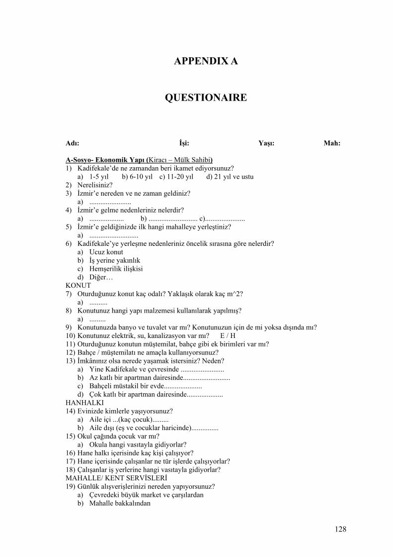
128
APPENDIX A
QUESTIONAIRE
Adı: İşi: Yaşı: Mah: A-Sosyo- Ekonomik Yapı (Kiracı – Mülk Sahibi) 1) Kadifekale’de ne zamandan beri ikamet ediyorsunuz?
a) 1-5 yıl b) 6-10 yıl c) 11-20 yıl d) 21 yıl ve ustu 2) Nerelisiniz? 3) İzmir’e nereden ve ne zaman geldiniz?
a) ....................... 4) İzmir’e gelme nedenleriniz nelerdir?
a) ................... b) ........................... c)...................... 5) İzmir’e geldiğinizde ilk hangi mahalleye yerleştiniz?
a) ........................... 6) Kadifekale’ye yerleşme nedenleriniz öncelik sırasına göre nelerdir?
a) Ucuz konut b) İş yerine yakınlık c) Hemşerilik ilişkisi d) Diğer…
KONUT 7) Oturduğunuz konut kaç odalı? Yaklaşık olarak kaç m^2?
a) .......... 8) Konutunuz hangi yapı malzemesi kullanılarak yapılmış?
a) ......... 9) Konutunuzda banyo ve tuvalet var mı? Konutunuzun için de mi yoksa dışında mı? 10) Konutunuz elektrik, su, kanalizasyon var mı? E / H 11) Oturduğunuz konutun müştemilat, bahçe gibi ek birimleri var mı? 12) Bahçe / müştemilatı ne amaçla kullanıyorsunuz? 13) İmkânınız olsa nerede yaşamak istersiniz? Neden?
a) Yine Kadifekale ve çevresinde ........................ b) Az katlı bir apartman dairesinde.......................... c) Bahçeli müstakil bir evde..................... d) Çok katlı bir apartman dairesinde....................
HANHALKI 14) Evinizde kimlerle yaşıyorsunuz?
a) Aile içi ...(kaç çocuk)......... b) Aile dışı (eş ve cocuklar haricinde)...............
15) Okul çağında çocuk var mı? a) Okula hangi vasıtayla gidiyorlar?
16) Hane halkı içerisinde kaç kişi çalışıyor? 17) Hane içerisinde çalışanlar ne tür işlerde çalışıyorlar? 18) Çalışanlar iş yerlerine hangi vasıtayla gidiyorlar? MAHALLE/ KENT SERVİSLERİ 19) Günlük alışverişlerinizi nereden yapıyorsunuz?
a) Çevredeki büyük market ve çarşılardan b) Mahalle bakkalından
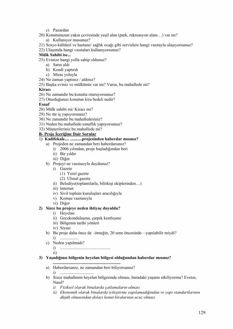
129
c) Pazardan 20) Konutunuzun yakın çevresinde yeşil alan (park, rekreasyon alanı…) var mı?
a) Kullanıyor musunuz? 21) Sosyo-kültürel ve hastane/ sağlık ocağı gibi servislere hangi vasıtayla ulaşıyorsunuz? 22) Ulaşımda hangi vasıtaları kullanıyorsunuz? Mülk Sahibi ise... 23) Evinize hangi yolla sahip oldunuz?
a) Satın aldı b) Kendi yaptırdı c) Miras yoluyla
24) Ne zaman yaptınız / aldınız? 25) Başka eviniz ve mülkünüz var mı? Varsa, bu mahallede mi? Kiracı 26) Ne zamandır bu konutta oturuyorsunuz? 27) Oturduğunuz konutun kira bedeli nedir? Esnaf 28) Mülk sahibi mi/ Kiracı mı? 29) Ne tür iş yapıyorsunuz? 30) Ne zamandır bu mahalledesiniz? 31) Neden bu mahallede esnaflık yapıyorsunuz? 32) Müşterileriniz bu mahallede mi? B- Proje İçeriğine Dair Sorular 1) Kadifekale.... ...........projesinden haberdar mısınız?
a) Projeden ne zamandan beri haberdarsınız? i) 2006 yılından, proje başladığından beri ii) Bir yıldır iii) Diğer
b) Projeyi ne vasıtasıyla duydunuz? i) Gazete
(1) Yerel gazete (2) Ulusal gazete
ii) Belediye(toplantılarla, bilirkişi ekiplerinden…) iii) Internet iv) Sivil toplum kuruluşları aracılığıyla v) Komşu vasıtasıyla vi) Diğer
2) Sizce bu projeye neden ihtiyaç duyuldu? i) Heyelan ii) Gecekondulaşma, çarpık kentleşme iii) Bölgenin tarihi yönleri iv) Siyasi
b) Bu proje daha önce de –örneğin, 20 sene öncesinde—yapılabilir miydi? i) .................
c) Neden yapılmadı? i) ............................................... ii)
3) Yaşadığınız bölgenin heyelan bölgesi olduğundan haberdar mısınız? ...............................................................
a) Haberdarsanız, ne zamandan beri biliyorsunuz? i) ...............................
b) Sizce mahallenin heyelan bölgesinde olması, buradaki yaşamı etkiliyormu? Evetse, Nasıl? i) Fiziksel olarak binalarda çatlamaların olması ii) Ekonomik olarak binalarda iyileştirme yapılamadığından ve yapı standartlarının
düşük olmasından dolayı konut kiralarının ucuz olması
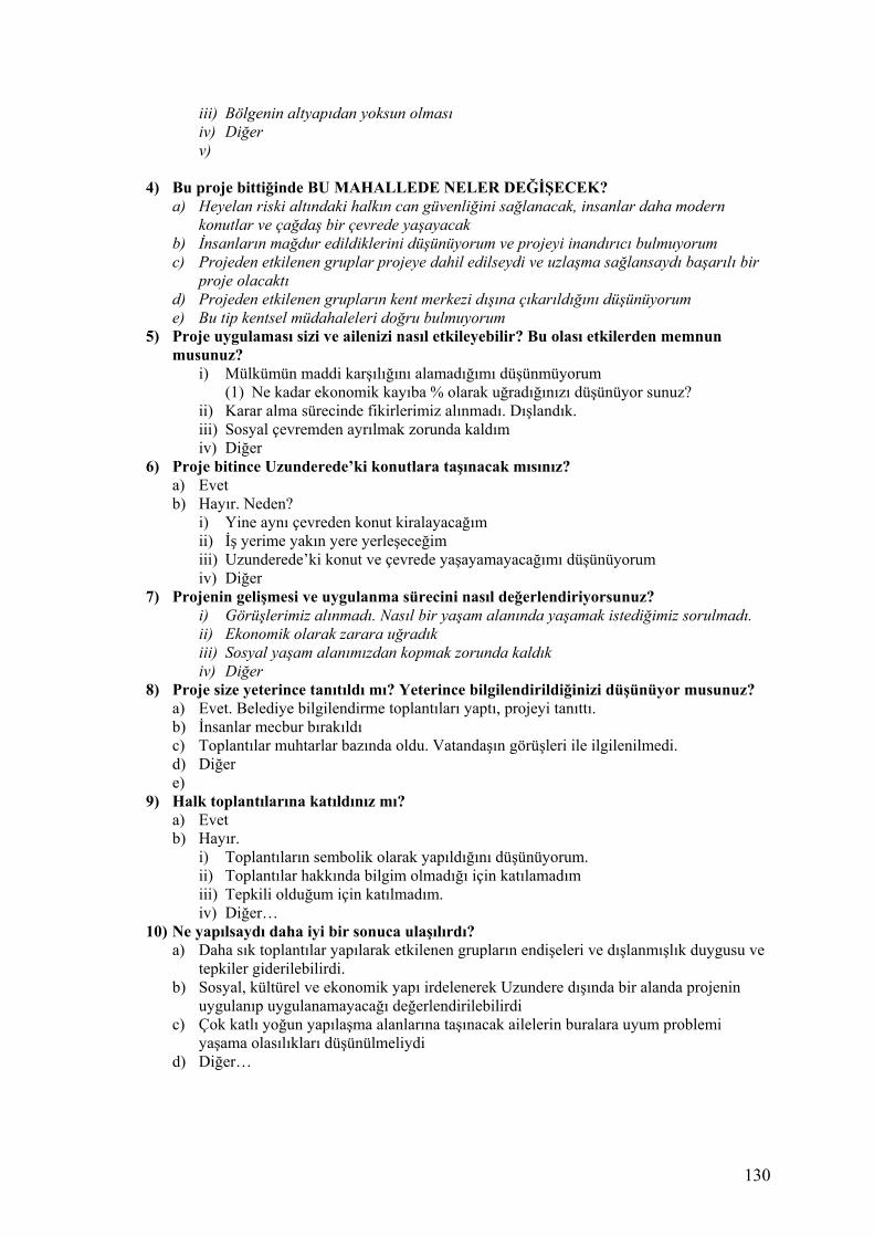
130
iii) Bölgenin altyapıdan yoksun olması iv) Diğer v)
4) Bu proje bittiğinde BU MAHALLEDE NELER DEĞİŞECEK?
a) Heyelan riski altındaki halkın can güvenliğini sağlanacak, insanlar daha modern konutlar ve çağdaş bir çevrede yaşayacak
b) İnsanların mağdur edildiklerini düşünüyorum ve projeyi inandırıcı bulmuyorum c) Projeden etkilenen gruplar projeye dahil edilseydi ve uzlaşma sağlansaydı başarılı bir
proje olacaktı d) Projeden etkilenen grupların kent merkezi dışına çıkarıldığını düşünüyorum e) Bu tip kentsel müdahaleleri doğru bulmuyorum
5) Proje uygulaması sizi ve ailenizi nasıl etkileyebilir? Bu olası etkilerden memnun musunuz?
i) Mülkümün maddi karşılığını alamadığımı düşünmüyorum (1) Ne kadar ekonomik kayıba % olarak uğradığınızı düşünüyor sunuz?
ii) Karar alma sürecinde fikirlerimiz alınmadı. Dışlandık. iii) Sosyal çevremden ayrılmak zorunda kaldım iv) Diğer
6) Proje bitince Uzunderede’ki konutlara taşınacak mısınız? a) Evet b) Hayır. Neden?
i) Yine aynı çevreden konut kiralayacağım ii) İş yerime yakın yere yerleşeceğim iii) Uzunderede’ki konut ve çevrede yaşayamayacağımı düşünüyorum iv) Diğer
7) Projenin gelişmesi ve uygulanma sürecini nasıl değerlendiriyorsunuz? i) Görüşlerimiz alınmadı. Nasıl bir yaşam alanında yaşamak istediğimiz sorulmadı. ii) Ekonomik olarak zarara uğradık iii) Sosyal yaşam alanımızdan kopmak zorunda kaldık iv) Diğer
8) Proje size yeterince tanıtıldı mı? Yeterince bilgilendirildiğinizi düşünüyor musunuz? a) Evet. Belediye bilgilendirme toplantıları yaptı, projeyi tanıttı. b) İnsanlar mecbur bırakıldı c) Toplantılar muhtarlar bazında oldu. Vatandaşın görüşleri ile ilgilenilmedi. d) Diğer e)
9) Halk toplantılarına katıldınız mı? a) Evet b) Hayır.
i) Toplantıların sembolik olarak yapıldığını düşünüyorum. ii) Toplantılar hakkında bilgim olmadığı için katılamadım iii) Tepkili olduğum için katılmadım. iv) Diğer…
10) Ne yapılsaydı daha iyi bir sonuca ulaşılırdı? a) Daha sık toplantılar yapılarak etkilenen grupların endişeleri ve dışlanmışlık duygusu ve
tepkiler giderilebilirdi. b) Sosyal, kültürel ve ekonomik yapı irdelenerek Uzundere dışında bir alanda projenin
uygulanıp uygulanamayacağı değerlendirilebilirdi c) Çok katlı yoğun yapılaşma alanlarına taşınacak ailelerin buralara uyum problemi
yaşama olasılıkları düşünülmeliydi d) Diğer…