Embed Size (px)
Citation preview
---------------------------------------------------------------------------------------------------------- 1. Conservation International Indonesia, 2. Graduate Program in Biology, University of Indonesia, 3.
Primate Working Group of Cambridge University.
CRITICAL ENDANGERED PRIMATES AS FLAGSHIP SPECIES
TO REDUCE DEFORESTATION: LESSON LEARNED FROM
CONSERVING ORANGUTAN IN NORTH SUMATRA, INDONESIA
Jatna Supriatna 1,2
, Erwin A Perbatakusuma1 ,Rondang Siregar
2,3, Dhany Sitaprasasti
2, Abu
Hanifah Lubis1, Abdulhamid Damanik
1, Hermawan Wijayanto
1, Bonie Dewantara
1
Introduction
Sumatra is the fifth largest island in the world with 1,800 kilometers long and 400
kilometers wide. As little as four decades ago, the island of Sumatra was almost completely
covered by tropical forests. The island contains an extraordinary wealth of natural resources and
habitat diversity includes 14 primate species with 8 endemics. Some has been categorized as
critical endangered, Sumatran orangutan, and 6 more species are endangered includes 4 species
distributed in the small island of Mentawai (Supriatna 2001).
Historically, the Sumatran orangutan was distributed over the entire island of Sumatra,
but its range has now been restricted to the Northern part of the island, and it has now been
confirmed that orang-utans inhabit the majority of the areas south of Lake Toba where they were
previously thought not to exist. It is estimated that Sumatra has about 7.500 orangutans,
distributed over 21 forest blocks. Of these, only three forest blocks contain over 1.000 orang-
utans, and are found in the Leuser Ecosystem, one of the largest tracts of forest in the volatile
northern part of the island. There are 13 identified orang-utan populations on the island, of which
probably only 3 contain more than 500 individuals, with 7 estimated to contain 250 or more
individuals. Six of the seven are believed to be losing 10-15% of their habitat each year to
logging, and it is expected that these populations will rapidly decline. Where populations are
smaller, such as in West Batang Toru, and the estimated rate of habitat loss is relatively low (2%
annually), numbers may persist longer than other populations if current conditions do not change
(WWF, 2007). But, a recent study shows that orang-utan in Batang Toru forest block is
potentially under serious threats (Sitaparasti 2007, Perbatakusuma, et al 2006; Perbatakusuma, et
al, 2007, Perbatakusuma, et al, 2008).
---------------------------------------------------------------------------------------------------------- 1. Conservation International Indonesia, 2. Graduate Program in Biology, University of Indonesia, 3.
Primate Working Group of Cambridge University.
The Sumatran orang-utan (Pongo abelii) is listed as critically endangered by the 2004
IUCN Red List of Threatened Species. The orang-utan is very vulnerable to extinction, due to
large-scale habitat destruction and hunting for the pet trade (Rijksen and Meijaard, 1999), and
also a long mean inter-birth interval (Galdikas and Wood, 1990). In fact, the orang-utan lives at
fairly low densities (0-7 individuals/km2 in Sumatera (van Schaik et al., 1995), and requires large
home ranges that represent large forest blocks (Singleton and van Schaik, 2001); they are mainly
restricted to lowland forest areas (Rijksen and Meijaard, 1999). PHVA results in 2004 estimated
that there are 7.501 remaining orangutans in Sumatra, indicating that they are at immediate risk of
extinction.
The habitat of Sumatran orangutan has been decreased rapidly due to habitat conversion
to commercial and subsistence agriculture, logging, open pit mining, forest fires, infrastructure
development, local encroachment and many others. Sumatran forests are considered to be at the
highest rate of conversion in the world (Collins et al., 1990), causing the loss of orangutan‘s
habitat. Surveys on density estimation and ecological factors are needed to identify suitable
habitat for orangutan (van Schaik et al., 1995). Tree availability, as sources of food and nesting
sites for orangutan, has become the most influential factor on the density of orangutan (van
Schaik et al., 2001; Ancrenaz et al., 2004). In 2005 researchers predicted that all undisturbed
lowland forests of Sumatera will have vanished (Jepson et al., 2001). Forest degradation rate has
reached 20% of the total forest area in Sumatra each year (Rijksen and Meijaard, 1999). The
Sumatran orangutan is very sensitive to disturbance caused by logging and hunting activities. As
a result, the orangutan will have little chance to survive in fragmented or converted forests.
Threat of extinction of orangutan in the north Sumatra forest can be reduced by efforts to
conserve the remaining habitat and population. Long-term and continuous research as well as
population monitoring, are needed to develop more thorough knowledge that is crucial in
developing measures for orangutan and habitat conservation. Building forest corridors that
connect fragmented habitat will also enlarge the orangutan home range in search for food.
Community participation in the conservation of orangutan and its habitat will eventually become
important in developing comprehensive efforts for orangutan conservation. In the end this new
population will have a chance to live longer and to survive. In order to reverse further
deforestation in Sumatra, we have used a multi-layer approach which is basically combined
methods of socio-economic and conservation biology techniques. These techniques include:
investigate biodiversity sensitive land-use planning, develop sustainable economic alternatives,
develop or revise conservation strategy in the provinces and districts, stakeholders mapping,
tenure and access rights, and reviews on policy and regulations on wildlife at local governments.
---------------------------------------------------------------------------------------------------------- 1. Conservation International Indonesia, 2. Graduate Program in Biology, University of Indonesia, 3.
Primate Working Group of Cambridge University.
Conservation strategies included improved protection of orangutan habitat and support
communities and partners to develop sustainable economic alternatives in Batang Toru.
The outcome of this approach is the inclusion of orangutans and other wildlife into the
local government decision making processes toward better management of natural resources.
Two pilot project have been developed in the area of Mentawai and Northern Sumatra. The aim is
to assess the appropriateness of different approaches in developing conservation programs at the
local situation. This pilot is expected to be cost-effectively, but it should be scaled up for larger
landscape unit and provide leverage and demonstration program policy in the future. The strategy
to conserve this flagship species, orangutan, and their habitat has in some instance placed very
well in the strategic planning at local governments but sometimes hampered by political and
financial supports by donors and stakeholders.
1. Current orangutan habitat and population in the North Sumatra: Batang Toru Forest
1.1. State of the orangutan habitat
The Batang Toru Forest consisted two forest block is called West and East Batang Toru
or Sarulla Forest Range. The Batang Toru Forest is located in North Sumatra Province south of
the second world largest lake of Lake Toba. Roads separate West Batang from the East Sarulla
area, in which orangutans also are found. Geographically, the Batang Toru Forest is located at 980
50‘ - 99018‘ East Longitude and 1
0 26‘ - 1
0 56‘ North Latitude. This landscape are predicted to
have suitable habitat for orangutans in the southern part population of North Sumatra Province
(Rijksen and Meijaard, 1999 ; Wich et al., 2003 ; Djojoasmoro et al., 2004).
Orangutan habitat in Batang Toru Forest is also important water catchments area that
encompasses four regencies: North Tapanuli, Central Tapanuli, Sibolga and South Tapanuli.
Primary rain forest dominates the vegetation cover, which grows on steep hillsides with more
than a 60-degree slope and mountainous area with highest peat at Mt. Lubuk Raya (1.856 meter
above sea level). The region is mountainous and the results of historic volcanic activity called
Toba Super Volcano and the formation of geology is Volcanic Toba Tuff as the dominant
geology rock type. Soil type is dominated by Podsolic Red-Yellow and Aluvial (Perbatakusuma,
et al, 2008)
The Batang Toru Forest Block holds at least six principal habitat types including moss
forest (above 600 meter), hill side moist forest (dominant between 200 m -600 m), lowland, cliffs
and talus slopes, secondary forest, and riparian forest. Forest landscape of Batang Toru has
234,399 ha which included four districts Tapanuli Utara (North Tapanuli), Sibolga, Tapanuli
Tengah (Middle Tapanuli), and Tapanuli Selatan (South Tapanuli). Based on satellite imagery
---------------------------------------------------------------------------------------------------------- 1. Conservation International Indonesia, 2. Graduate Program in Biology, University of Indonesia, 3.
Primate Working Group of Cambridge University.
classification that was analyzed by Conservation International Indonesia, primary forest cover in
2000 was 148.000 ha with infrastructure undeveloped in frontier areas. The area includes of mix
of official forest status and land use classifications such as nature reserve, protection forest and
production forest. The forest area is covered by five big watershed: Batang Toru with 92.121 ha
wide, Aek Kolang 42.663 ha, Watershed Bila, Barumun,and Batang Gadis (Perbatakusuma, et al,
2008)
This various habitat type in Batang Toru Forest is a suitable habitat for many endangered
wildlife species since it provides food/prey resources, nest sites, forest space for seasonal and
arboreal and terrestrial movement and protection from predator. The forest areas within Batang
Toru Forest also have a high scientific value and are important to be protected, because it is
though to be a biogeography transition area between the convergence point of southern and
northern Toba Lake biogeographic assemblages, where distributions of species such as orangutan,
mitered leaf-monkeys (Presbytis melalophos), Malayan tapir (Tapirus indicus), Sumatran serow
(Capricornis sumatraensis sumatraensis) and Raflessia gadutensis overlap. This situation is of
course thought to have big consequences for the value and uniqueness of its biodiversity. The
Batang Toru Forest Block will provide effective management for an area of a globally
biodiversity significance, and was defined one of the remaining a Key Biodiversity Area in
Sumatra Island based on the CI‘s Conservation Outcomes Definition Process. (Perbatakusuma, et
al, 2007).
Recent survey by Conservation International in 2006 and other institution revealed that
the Batang Toru and adjacent areas are home to a rich variety of the Sumatran species,
particularly mammals, birds and plants, which are globally threatened. Sixty-seven species of
mammals, two hundred eighty-seven of birds and one hundred ten of herpetofauna have been
recorded in the area. Of this total number of mammals species, twenty species are protected under
Indonesian law and twelve are globally threatened. Among these are Sumatran Orangutan (Pongo
abelli), Sumatran tiger (Panthera tigris sumatrae), serow (Capricornis sumatrensis), Malayan
tapir (Tapirus indicus), Malayan sun bear (Helarctos malayanus), slow loris (Nycticebus
coucang), Golden Cat (Pardofelis marmomata). The survey also discovered rich avifauna
diversity in the region, including rare as well as threatened species. Of this total number of bird
species fifty-one species are protected under Indonesian law and sixty-one are globally
threatened, such as Sunda Blue Flycatcher (Cyornis caerulatus), Wallace's Hawk-eagle
(Spizaetus nanus), Blackcrowned (Pitta venusta). Initial data from the Batang Toru suggest that
it holds some of the highest levels of vascular plant biodiversity, with 688 different species. Of
this total number of plant species, 138 species of orangutan food resources, 8 species globally
---------------------------------------------------------------------------------------------------------- 1. Conservation International Indonesia, 2. Graduate Program in Biology, University of Indonesia, 3.
Primate Working Group of Cambridge University.
threatened, including Nepenthes sumatrana (Miq.), the largest flower in the world Rafflesia
gadutensis Meijer,Becc and the tallest flower in world Amorphophalus baccari and
Amorphophalus gigas (Perbatakusuma, et al, 2008).
The results of the vegetation study on inventory of trees with DBH 10 cm and greater in
primary forest in Aek Silemes and Aek Game-game areas showed, that Batang Toru Forest
Block is rich in plant biodiversity with 332 plant species in 161 genus and 70 families. A total
number of tree species is relatively higher compared to other natural forests in and outside
Sumatra. The Batang Toru forest is richer in tree species than other natural forests in North
Sumatra and outside Sumatra, but poorer than those in Borneo and the Malay Peninsula. the tree
density is higher than that in Ketambe and Batang Gadis National Park, Tesso Nilo National Park
and Rimbo Panti Nature Reserve (Sumatra), Bukit Lagong and Sungai Menyala (the Malay
Peninsula), and Ladan and Belalong (Brunei), but lower than those in Malinau and Sebulu (East
Kalimantan), Gunung Mulu (Sarawak) and Andulau (Brunei). The study reveals that each tree
species in Batang Toru Forest has low tree density per-species, only 1-10 individual per-hectare
and non cluster distribution (≤ 20%). The ecological consequence is that Batang Toru forest is
highly susceptible to wildlife species losses due to selective timber exploitation and forest
conversion to various economic purposes. (Perbatakusuma, et al, 2006, 2008)
Orangutan landscape in Batang Toru Forest also contributes to mitigation climate change.
Based CI‘s research on the ground survey, the sum of biomass in trees (DBH ≥ 2 cm), ground
vegetation, and necromass, revealed the averages of carbon content from secondary forest as
77.72 ton C/ha. This is equivalent to 280,2 CO2 ton per-hectare.Primary forest in Batang Toru
obtains _305,73 ton C per-hectare, equivalent to 101,3 ton CO2 per-hectares. According to the
imagery classification process, Batang Toru area has secondary forest 20,747.26 hectares. This
means that Batang Toru Forest Block has stored 1,612,477 ton Carbon or 5,813,382 tons
equivalent CO2. The imagery process also determined that Batang Toru area has 135,476.090
hectares in primary forest, creating a carbon content in primary forest in the Batang Toru Forest
of 4,149,105 ton Carbon and or 137,006,970 ton equivalent CO2. Assuming that average
deforestation in Batang Toru Forest from 1990-2007 totaled about 142 ha per year. Assuming that
the driving factors of deforestation are linear and no conservation incentives occur to avoid
deforestation, the Batang Toru Forest area will lose an estimated 700 - 1600 hectares of forest
cover by 2015. This is equivalent with 707,910–1,618,080 ton CO2 and will contribute
significantly to increasing global climate change (Perbatakusuma, et al 2008).
3. Orangutan population and habitat conservation effort
---------------------------------------------------------------------------------------------------------- 1. Conservation International Indonesia, 2. Graduate Program in Biology, University of Indonesia, 3.
Primate Working Group of Cambridge University.
There are two conservation strategies was implemented to conserving orangutan population in
Batang Toru Forest Block. E.g catalyze improved protection of orangutan habitat and support
communities and partners to develop sustainable economic alternatives in Batang Toru. Here
described orangutan conservation effort according to the strategies as follows
3.1. Catalyze improved protection of orangutan habitat
Two key elements in managing wildlife populations are: (1) having accurate information on
species distribution and habitat requirements and (2) having support for and capacity within local
stakeholders to use this information to formulate and apply appropriate conservation
interventions. All of the activities are designed to promote capacity building of local partners by
sharing data and engaging in participatory process that allow for ‗learning by doing‘. The
following are the activities implemented to map orangutan distribution and habitat and to
formulate a strategy to improve orangutan population and its habitat protection.
3.1.1. Orangutan Population and Distribution
Rijksen and Meijaard (1999) concluded that orangutans may still occur further to the
south on Sumatra than previously assumed (Wilson and Wilson, 1973; Rijksen, 1978). We now
know that there is a southern population in West Batang Toru, in the Sibolga – Tarutung –
Padangsidempuan area of Northern Sumatra, and it has been suggested that this population may
be genetically distinct from its northern relatives (Wich and Geurts, 2001).
Orangutan density varies with elevation and habitat availability (Delgado and van Schaik,
2000). According to Buij et al. (2002), even though there is forest clearance in Sumatra, there are
still some areas assumed to be suitable for orangutan habitat in the future. Forests of Batang Toru,
especially the lowland and mixed forests, have been highly fragmented due to logging, road
opening, and land-use change for agriculture. Because of this, the density of orangutans in Batang
Toru Watershed tends to increase in line with increase in elevation. With decreasing number of
fruit trees and other sources of food in lowland forest, the orangutan will move to higher
elevations in search of suitable habitat and sources of food.
Identifying species population and distribution is a very useful way to establish the
priority on conservation management unit, especially for the species under the critically
endangered criteria such as Sumatran orangutan. Critically Endangered criteria refer to a 50%
probability of extinction in five years. Deforestation rate and high population decline are believed
---------------------------------------------------------------------------------------------------------- 1. Conservation International Indonesia, 2. Graduate Program in Biology, University of Indonesia, 3.
Primate Working Group of Cambridge University.
as major causes of species extinction. Habitat loss and degradation also increased the
vulnerability of orangutan to poaching. Estimation on orangutan population density will help
design the conservation efforts for Batang Toru watershed forest (known as Batang Toru forest
block).
A population survey of the orang-utans at Batang Toru watershed in North Sumatera,
Indonesia was conducted over a period of 10 month from November 2005 to September 2006
(Sitaprasasti 2007). Through three extensive and broad surveys in 16 locations with total 40.6 km
transect length (varies between 750-1,500 meter above sea level), also regular monthly
monitoring in existing transects in five model sites (Lobu Pining, Sibulan-bulan, Sipetang,
Sitandiang and Uluala) throughout three regencies, it was estimated that the orangutan density
was between 0.2-0.82 individual/km2 distributed in a landscape unit of 74.886 ha, which is known
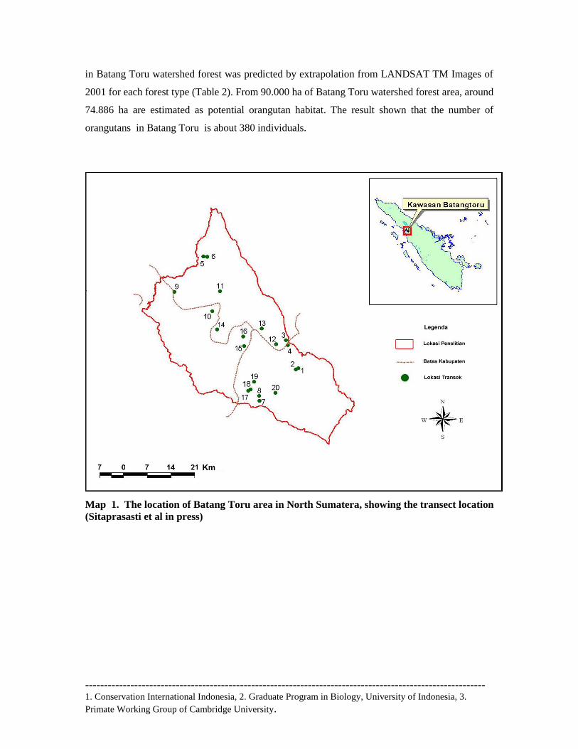
as a potential orangutan habitat over the total area of 90,000 ha (Figure 1). The nest count and
line transect methods were used in determining population density, and the verification of
orangutan presence was done through nest sightings, direct sightings and vocalizations (Figures 2
and 3). Survey result showed population densities were found to be higher in the old, moist
secondary forest (0.82 individuals/km2) compared to those in the mixed forest (0.26
individuals/km2). Habitat disturbance caused by forest conversion is believed to reduce the
orangutan density within mixed and lowland forests. Habitat disturbance caused by land
conversion seemed to affect the orangutan density within mixed and lowland forests Orangutan
density in West Batang Toru forest is lower in comparison with the other forest area in North
Sumatera, for instance in Aceh with density >6 individuals/km2 (van Schaik et al., 1995). The
orangutan distribution pattern is highly affected by food resources availability, altitude, river shed
and human economic activities in the habitat of orangutan.
Further research and long-term monitoring of the population at Batang Toru, is necessary
to ensure the long-term survival of this critically-endangered species. Surveys were conducted in
20 different sites with a total length of transect 40.6 km. The number of nests found along the
transect was 287 nests. For each site, the density of orangutans varied from 0.1–1.3
individual/km2. This is low compared to those in other forests in Sumatera, such as lowland forest
of Aceh, which can reach more than 6 individuals/km2 (van Schaik et al., 1995; Singleton, 200).
This value will probably increase during the fruit season and decrease during fruit-scarce season
(Singleton, 2000). If each survey site is categorized according to forest type (Table 1), the highest
density value (0.82 individual/km2) was found in the hill forest category at elevations of 900 to
1200 m, and the lowest density (0.26 individual/km2) was found in mixed forest. Orangutan
densities tend to increase in relation to the increase of elevation. The entire orangutan population
---------------------------------------------------------------------------------------------------------- 1. Conservation International Indonesia, 2. Graduate Program in Biology, University of Indonesia, 3.
Primate Working Group of Cambridge University.
in Batang Toru watershed forest was predicted by extrapolation from LANDSAT TM Images of
2001 for each forest type (Table 2). From 90.000 ha of Batang Toru watershed forest area, around
74.886 ha are estimated as potential orangutan habitat. The result shown that the number of
orangutans in Batang Toru is about 380 individuals.
Map 1. The location of Batang Toru area in North Sumatera, showing the transect location
(Sitaprasasti et al in press)
---------------------------------------------------------------------------------------------------------- 1. Conservation International Indonesia, 2. Graduate Program in Biology, University of Indonesia, 3.
Primate Working Group of Cambridge University.
Table 1. Forest type and density of orangutans (DOH) used in Batang Toru population
estimate.
Forest type L (km) Σ nest t (days) DOH
(ind/km2) D
lcl-D
ucl
Lowland (100-400 m) 3.3 21 206.1 0.47 0.16-0.51
Mixed (400-700 m) 6.0 23 215.8 0.26 0.20-0.72
Hillside, secondary
(700-900 m) 20.2 139 188.7 0.60 0.47-0.72
Hillside, moist secondary (900-
1200 m) 11.1 103 187.4 0.82 0.64-1.03
Note: Lower and upper 95 % confidence limits indicated by “lcl” and “ucl”
L=transect length, t=total days, DOH=orangutan density
Table 2. Orangutan population estimates for each forest type in Batang Toru
Forest type Total area
(km2)
% of total
area
Density
estimate
(ind/km2)
Population
estimate
Lowland (100-400 m) 184.81 24.68 0.47 94
Mixed (400-700 m) 213.37 28.50 0.26 55
Hillside, secondary
(700-900 m) 247.06 32.99 0.60 146
Hillside, moist secondary (900-
1200 m) 103.62 13.83 0.82 85
Forest conversion into agricultural purposes is identified to be the main cause of the
decrease of orangutan natural habitat in West Batang Toru forest. Moreover, human population
pressures (Nias community in Uluala) in some parts of the forest, road construction (connecting
Aek Nabara to Sipirok) contributed the damaged of the forest and eventually become the real
threats for the existence of orangutan in West Batang Toru forest. Nests, indicated the orangutan
presence, and were found in secondary forests bordered with human plantation. Nest and direct
sighting were mostly found within the forest area with a good vegetation condition, although
some part of the area are fragmented and converted into plantation.
Trees for the orangutan are their home, where they built nest, and food sources, also they
spent more than 50% of their activities up in trees. This condition indicates that the rates of land
conversion (forest to non-forest area) are significantly high, and yet population of orangutan can
still be found. Orangutan research during this period has shown that the orangutan existence (nest
---------------------------------------------------------------------------------------------------------- 1. Conservation International Indonesia, 2. Graduate Program in Biology, University of Indonesia, 3.
Primate Working Group of Cambridge University.
finding and direct sighting) usually in the elevation above 900 m. This result was slightly
different from research that was conducted by Van Schaik & Azwar (1991), which indicated the
distribution of orangutan usually occurs in lowland forest (Sitaparasti, 2007). Furthermore, there
are more individual orangutan found in Southern part of the Batang Toru forest, supported by the
qualitative observation that shown more food availabilities than in central and northern part of the
area.
3.1.2 Threats to orangutan population and habitats
Loss of natural habitat, habitat fragmentation and poaching are the most significant
factors contributing to the reduction of orangutan populations in the Batang Toru area. Although
investigation in orangutan hunting and poaching has not obtained any direct evidence of such
activities, even though some people claimed that they poached the orangutans for meat. Root
causes of key threats were analyzed to prepare a threat reduction plan. CI has conducted a
thorough threats analysis for the Batang Toru area and engaged decision makers in the three
district governments covering the West Batang Toru area, local NGOS, and affected communities
in a participatory process to develop a plan to manage threats. This included developing
indicators of success, identifying responsible parties to carry out threat reduction actions, with
accurate estimates of the costs and a timetable for executing the plan. This activity also built the
capacity of local government to carry out these kinds of analytical and planning activities.
Threats on orangutan population in Batang Toru forest were determined using a GIS
analysis which resulted in a prognostic map of future orangutan habitat loss patterns in Batang
Toru and surrounding areas. This analysis could help identify the relative vulnerability of
different habitats to degradation and human activity.
A total of 6.34 km2 of forest was cleared between 1990-2000 in Batang Toru area
equivalent to an average deforestation rate of 0.05% per year. Previous studies showed that total
forest loss across Sumatra region was 25%, representing over 5 million hectares, from nearly 20.6
million ha in 1990 to approximately 15.5 ha in 2000 (WCS, CI, MoF, 2007). During the period of
1990-2000, the probability of an area being cleared of forest was found to be significantly and
negatively related to elevation, slope, distance to plantation areas, distance to transmigration) and
distance to logging concession.
---------------------------------------------------------------------------------------------------------- 1. Conservation International Indonesia, 2. Graduate Program in Biology, University of Indonesia, 3.
Primate Working Group of Cambridge University.
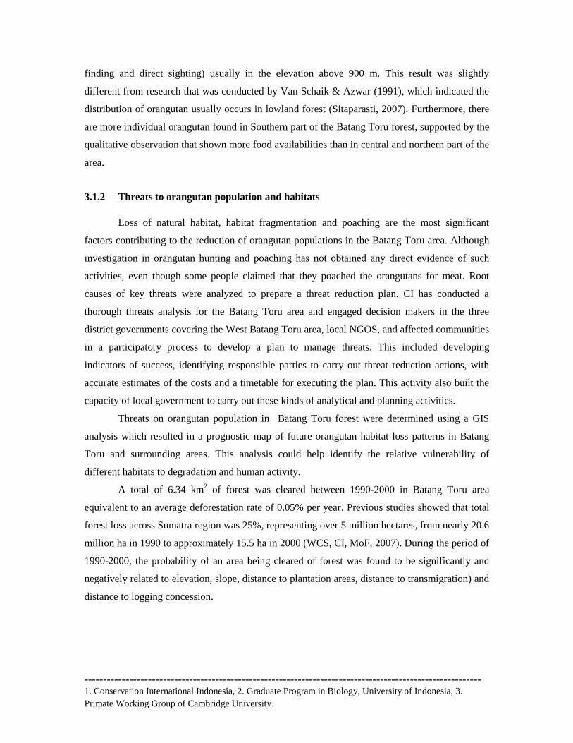
Map 2. Map of deforestation from 1990-2000 for around Batang Toru area (subset from Sumatra
deforestation map 1990-2000 (Perbatakusuma, et al, 2007)
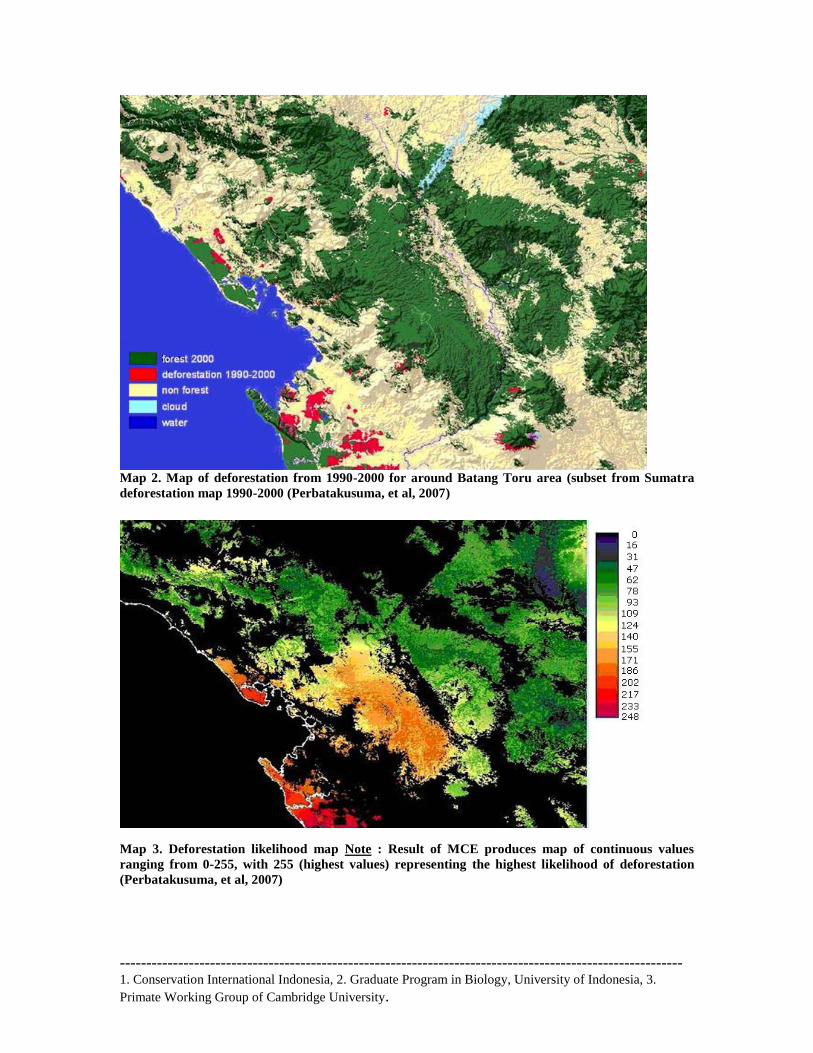
Map 3. Deforestation likelihood map Note : Result of MCE produces map of continuous values
ranging from 0-255, with 255 (highest values) representing the highest likelihood of deforestation
(Perbatakusuma, et al, 2007)
---------------------------------------------------------------------------------------------------------- 1. Conservation International Indonesia, 2. Graduate Program in Biology, University of Indonesia, 3.
Primate Working Group of Cambridge University.
The result of this process is a map of continuous values representing a composite index of
suitability (or likelihood) for deforestation (Map 2 ). The analysis indicated that most of all
forests in the Batang Toru area were facing high deforestation threat, so that the orangutan
population in this area has been as well under high pressure. In addition, this prediction can occur
in the future since the area is surrounded by provincial and regency level roads, new settlements
are continued to appear upward penetrating the forest. Disturbance to orangutan habitat made by
human in the area through forest conversion to agriculture and plantation areas, either legal or
illegal and logging and mining activities have occurred as well (Map 3). Therefore, monitoring
forest conversion to agricultural land and modeling future threats for the network of protected
areas are very important to the maintenance of the orangutan populations.
3.1.2. Orangutan habitat under deforestation threats through forest cover change detection.
The GIS analysis described above has produced the likelihood of deforestation that
threatening the orangutan population. These information were shared with district government
officials and communities close to areas of high deforestation as part of a long-term effort to build
their capacity to use this information as they adapt and refine their conservation activities.
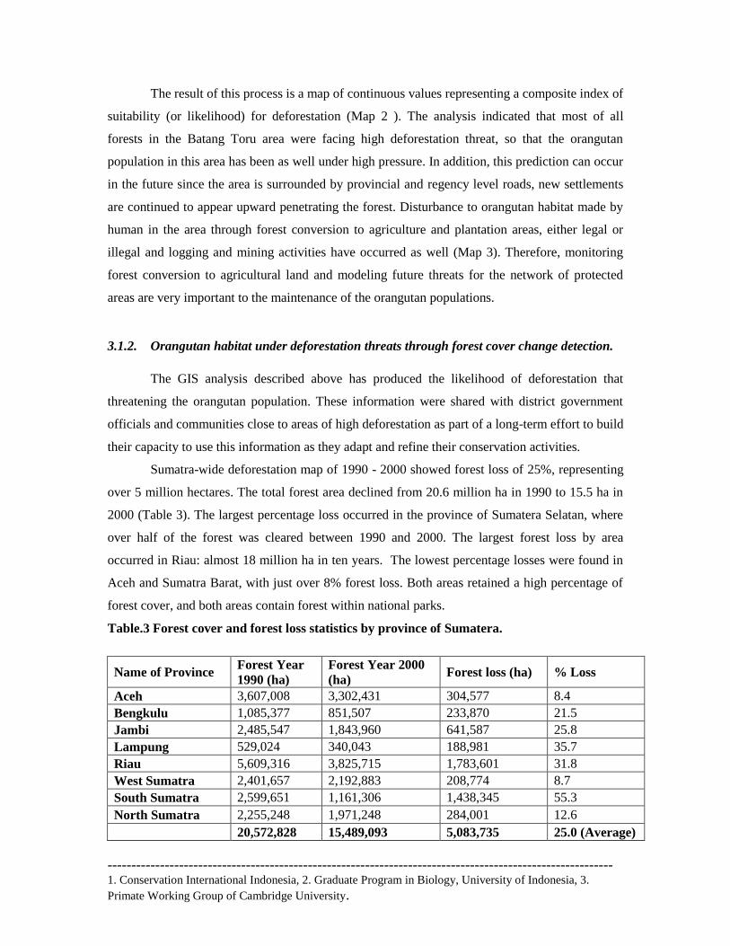
Sumatra-wide deforestation map of 1990 - 2000 showed forest loss of 25%, representing
over 5 million hectares. The total forest area declined from 20.6 million ha in 1990 to 15.5 ha in
2000 (Table 3). The largest percentage loss occurred in the province of Sumatera Selatan, where
over half of the forest was cleared between 1990 and 2000. The largest forest loss by area
occurred in Riau: almost 18 million ha in ten years. The lowest percentage losses were found in
Aceh and Sumatra Barat, with just over 8% forest loss. Both areas retained a high percentage of
forest cover, and both areas contain forest within national parks.
Table.3 Forest cover and forest loss statistics by province of Sumatera.
Name of Province Forest Year
1990 (ha)
Forest Year 2000
(ha) Forest loss (ha) % Loss
Aceh 3,607,008 3,302,431 304,577 8.4
Bengkulu 1,085,377 851,507 233,870 21.5
Jambi 2,485,547 1,843,960 641,587 25.8
Lampung 529,024 340,043 188,981 35.7
Riau 5,609,316 3,825,715 1,783,601 31.8
West Sumatra 2,401,657 2,192,883 208,774 8.7
South Sumatra 2,599,651 1,161,306 1,438,345 55.3
North Sumatra 2,255,248 1,971,248 284,001 12.6
20,572,828 15,489,093 5,083,735 25.0 (Average)
---------------------------------------------------------------------------------------------------------- 1. Conservation International Indonesia, 2. Graduate Program in Biology, University of Indonesia, 3.
Primate Working Group of Cambridge University.
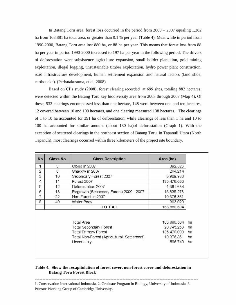
In Batang Toru area, forest loss occurred in the period from 2000 – 2007 equaling 1,382
ha from 168,881 ha total area, or greater than 0.1 % per year (Table 4). Meanwhile in period from
1990‐2000, Batang Toru area lost 880 ha, or 88 ha per year. This means that forest loss from 88
ha per year in period 1990-2000 increased to 197 ha per year in the following period. The drivers
of deforestation were subsistence agriculture expansion, small holder plantation, gold mining
exploitation, illegal logging, unsustainable timber exploitation, hydro power plant construction,
road infrastructure development, human settlement expansion and natural factors (land slide,
earthquake). (Perbatakusuma, et al, 2008)
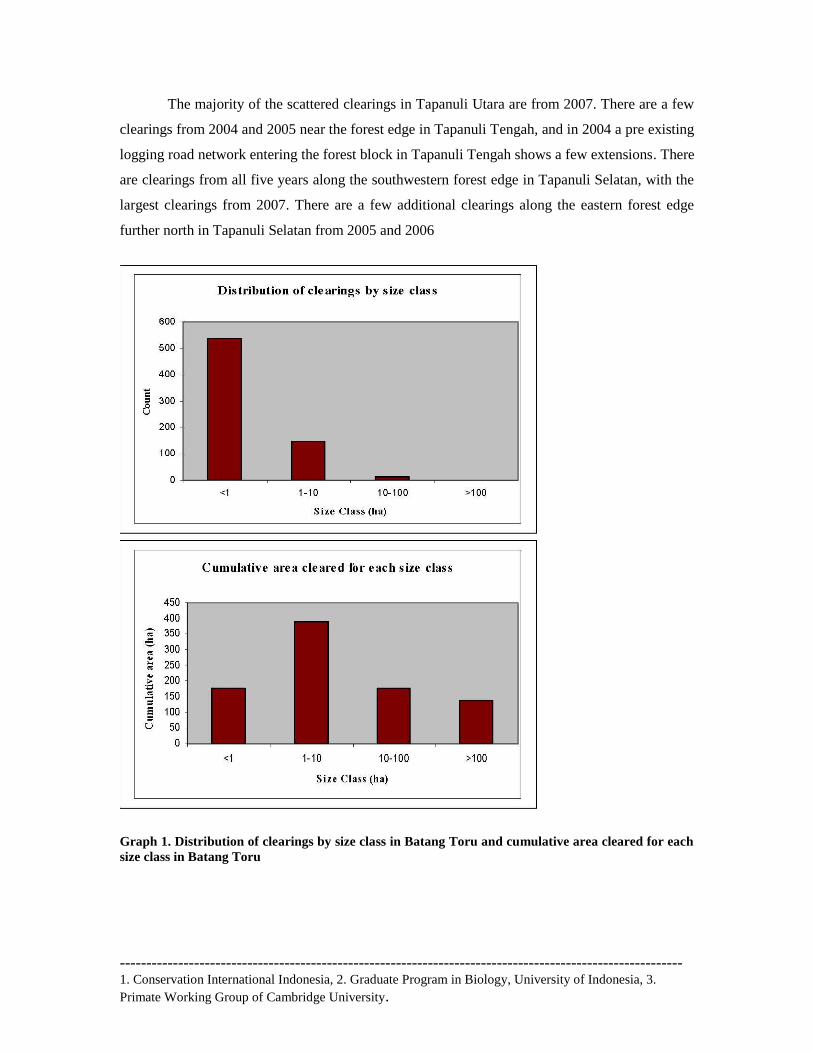
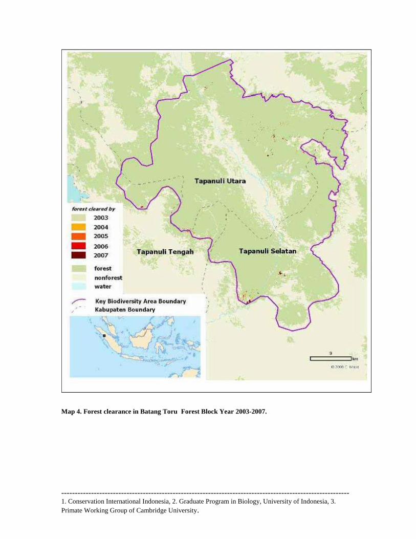
Based on CI‘s study (2008), forest clearing recorded at 699 sites, totaling 882 hectares,
were detected within the Batang Toru key biodiversity area from 2003 through 2007 (Map 4). Of
these, 532 clearings encompassed less than one hectare, 148 were between one and ten hectares,
12 covered between 10 and 100 hectares, and one clearing measured 138 hectares. The clearings
of 1 to 10 ha accounted for 391 ha of deforestation, while clearings of less than 1 ha and 10 to
100 ha accounted for similar amount (about 180 ha)of deforestation (Graph 1). With the
exception of scattered clearings in the northeast section of Batang Toru, in Tapanuli Utara (North
Tapanuli), most clearings occurred within three kilometers of the project site boundary.
Table 4. Show the recapitulation of forest cover, non-forest cover and deforestation in
Batang Toru Forest Block
---------------------------------------------------------------------------------------------------------- 1. Conservation International Indonesia, 2. Graduate Program in Biology, University of Indonesia, 3.
Primate Working Group of Cambridge University.
The majority of the scattered clearings in Tapanuli Utara are from 2007. There are a few
clearings from 2004 and 2005 near the forest edge in Tapanuli Tengah, and in 2004 a pre existing
logging road network entering the forest block in Tapanuli Tengah shows a few extensions. There
are clearings from all five years along the southwestern forest edge in Tapanuli Selatan, with the
largest clearings from 2007. There are a few additional clearings along the eastern forest edge
further north in Tapanuli Selatan from 2005 and 2006
Graph 1. Distribution of clearings by size class in Batang Toru and cumulative area cleared for each
size class in Batang Toru
---------------------------------------------------------------------------------------------------------- 1. Conservation International Indonesia, 2. Graduate Program in Biology, University of Indonesia, 3.
Primate Working Group of Cambridge University.
Map 4. Forest clearance in Batang Toru Forest Block Year 2003-2007.
---------------------------------------------------------------------------------------------------------- 1. Conservation International Indonesia, 2. Graduate Program in Biology, University of Indonesia, 3.
Primate Working Group of Cambridge University.
Logging is a very serious threat throughout Sumatra. A June 2000 report by the Ministry of
Forestry officially stated an opinion that had been prevalent for some time: "Illegal logging has
come to constitute a well-organized criminal enterprise with strong backing and a network that is
so extensive, well-established and strong that it is bold enough to resist, threaten, and in fact
physically tyrannize forestry law enforcement authorities. Illegal cutting occurs in concession
areas, unallocated forest areas, expired concessions, state forestry concessions, areas of forest
slated for conversion, and in conservation areas and protected forests.
Illegal logging is increasing in conservation areas, since these areas have better timber
potential than production areas. The actors in illegal logging are: (a) laborers from communities
in the forest areas and also many who are brought there from other areas; (b) Investors, including
traders, concession holders, or holders of legal timber cutting permits (IPK), and buyers of illegal
timber from processing industries; and (c) government officials (both civilian and military), law
enforcement personnel, and certain legislators (Dephut, 2000)
The latest forest-cover maps published by the Ministry of Forestry and Agriculture show
that at least 1.7 million hectares of forested areas were destroyed annually from 1985 to 1997,
significantly more than earlier conservative estimates of 0.6 million to 1.3 million hectares per
year and one of the highest rates of forest destruction in the world (Woldbank, 2001). The world
Bank prediction in 2001, it shows that the lowland peneplain forest of Sumatra will disapper in
2005, while the wetland in 2010.
Loss of natural habitat and poaching are the most significant factors contributing to the
reduction of orangutan populations in the West Batang Toru area (Singleton et al., 2004). Root
causes of key threats must be fully analyzed to prepare a threat abatement plan. With local and
provincial government, We have conducted a thorough threats analysis for the Batang Toru area,
and develop a plan to manage threats, including developing indicators of success, identifying
responsible parties to carry out threat abatement actions, with accurate estimates of the costs and
a timetable for executing the plan. This activity will include building the capacity of local
government to carry out these kinds of analytic and planning activities.
The result of overlaying maps of forest status shows that there are considerable threats to
orangutan habitat. Large numbers exist in non-conservation forest, such as limited production
forest, converted forest, and community forest. The existence of orangutan in the study area is so
close to, or even within, timber concessions, mining areas, plantation and human settlement. This
would suggest that human-orangutan conflict is likely to occur in search for these natural
---------------------------------------------------------------------------------------------------------- 1. Conservation International Indonesia, 2. Graduate Program in Biology, University of Indonesia, 3.
Primate Working Group of Cambridge University.
resources. It was regularly observed that orangutan frequently disturbed the local people‘s
plantation for fruits and other food items.
On the other hand, forest clearance has come closer to the habitat of orangutan, which
would eventually increase the opportunity of wildlife hunting, including orangutan. Forest
clearance has certainly become the primary threat to the existence of orangutan and its habitat in
Batang Toru Watershed. Fragmented forest causing a limited movement of the orangutan and
inducing local extinction needs to be considered. Orangutan and its habitat conservation efforts
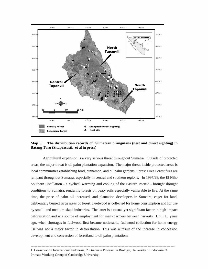
urgently need to be addressed in order to stop the population decline See. Map 5
Mapping and measuring the nearest human settlement (village or sub-village) and road to
orangutan sightings were conducted in this research as a parameter to determine potential threat
to orangutan habitat. The distance of the nearest orangutan habitat to the main road is only 1.6
km, and to the nearest sub-village is also 1.6 km. Since the home range of orangutan is about
2.500 ha (25 km2) for individual male and 850 ha (8,5 km2) for individual female (Singleton and
van Schaik, 2001), the nearest sub-village is predicted to be within the orangutan home range
area. Thus, this confirms the very existence of actual threat to the orangutan population in this
study area. The conflict between human and orangutan is then inevitable. In such a conflict, the
orangutan will always be defeated. Hunting of orangutan and other wildlife will keep increasing
if access to their habitat is available (Sugardjito and van Schaik, 1991).
The existence of orangutan population in Batang Toru Watershed and its potential threats
are highlighted, but long-term research is still needed to monitor the most recent orangutan
distribution, more accurate of population size and degree of habitat destruction. The forest area of
Batang Toru Watershed should be managed sustainably to ensure the survival of the orangutan.
Habitat restoration and promoting the local community involvement in forest conservation should
be considered as a strategy for conservation of orangutan and its habitat.
Threats from extractive industries are expanding rapidly, i.e. mining, oil and gas, oil palm,
logging etc.. One factor that has contributed to ecosystem degradation, such as from mining
threats is the presidential decree issued by former President Suharto giving mining activities
priority over all other land uses, then recently from President Megawati Sukarnoputri who gave
13 mining companies right for mining at the protected forest. Indonesia experienced a mining
boom in the 1990s, bringing unprecedented prosperity to a small segment of the population.
Agricultural and agroforestry expansion is a very serious threat throughout Sumatra. Outside of
protected areas, the major threat is oil palm plantation expansion. The major threat inside
protected areas is local communities establishing food, cinnamon, and oil palm gardens.
---------------------------------------------------------------------------------------------------------- 1. Conservation International Indonesia, 2. Graduate Program in Biology, University of Indonesia, 3.
Primate Working Group of Cambridge University.
Map 5. . The distrubution records of Sumatran orangutans (nest and direct sighting) in
Batang Toru (Sitaprasasti, et al in press)
Agricultural expansion is a very serious threat throughout Sumatra. Outside of protected
areas, the major threat is oil palm plantation expansion. The major threat inside protected areas is
local communities establishing food, cinnamon, and oil palm gardens. Forest Fires Forest fires are
rampant throughout Sumatra, especially in central and southern regions. In 1997/98, the El Niño
Southern Oscillation - a cyclical warming and cooling of the Eastern Pacific - brought drought
conditions to Sumatra, rendering forests on peaty soils especially vulnerable to fire. At the same
time, the price of palm oil increased, and plantation developers in Sumatra, eager for land,
deliberately burned large areas of forest. Fuelwood is collected for home consumption and for use
by small- and medium-sized industries. The latter is a casual yet significant factor in high-impact
deforestation and is a source of employment for many farmers between harvests. Until 10 years
ago, when shortages in fuelwood first became noticeable, fuelwood collection for home energy
use was not a major factor in deforestation. This was a result of the increase in concession
development and conversion of forestland to oil palm plantations
---------------------------------------------------------------------------------------------------------- 1. Conservation International Indonesia, 2. Graduate Program in Biology, University of Indonesia, 3.
Primate Working Group of Cambridge University.
3.1.4 Policy strategic and law enforcement intervention for orangutan protection
Therefore, to sustain a viable number of individual orangutans for population survival,
improved protection is essential. However, first, there will be an assessment and a development
of the most strategic interventions or cost-effective investment or mechanisms to address the
problems as identified. With extensive local law enforcement input, there will be an analysis on
the weaknesses in the enforcement system, and development of a least-cost investment strategy to
address them. The enforcement escalation efforts would be focused solely on assisting in
protecting and maintaining orangutan habitats and supporting anti-poaching measures.
Accurate information concerning the ‗players‘ who influence the existing habitat and
orangutan population, including persons acting ‗behind the scenes‘ is a key entry point in
resolving enforcement problems. Potential constraints/misperceptions among stakeholders,
especially enforcement agencies, can be avoided from the beginning by socializing efforts and
obtaining political and technical support. All possible local or traditional enforcement systems to
use traditional knowledge to protect the orangutan and its habitat were assessed. Further, a series
of consultative meetings were undertaken with enforcement agencies and stakeholders in each
district, aiming at collecting information regarding capacity, resources, infrastructure, skills, and
knowledge of each institution, and strengths also weaknesses of enforcement agencies.
In accordance to the Indonesian Criminal Justice System, the enforcement chain for
conservation and forestry crimes is the responsibility of forest rangers, Forest Civil Investigators
(=PPNS), the police, attorneys, and the court. Poor performance by any one of these parties will
reduce the effectiveness or performance of law enforcement. Under this activity, the enforcement
performance was assessed using quantitative and qualitative data for existing crimes. Data are
used in calculating the probabilities of each step in the enforcement chain and the overall value of
the enforcement disincentive presented by the government enforcement system. A number of
tasks were accomplished, namely: (a) Dissemination of the analysis results (b) Building up
consensus critical for improvement and securing results; (c) Development of a strategy with
stakeholders, including identifying key interventions and partners; and (d) An in-house training
for law enforcement personnel and NGOs involved in enforcement work.
A series of consultative meetings were regularly undertaken, when CI proposed
recommendation on law enforcement relevant to orangutan protection in the three districts and at
the province level. The consultations successfully gained support from these agencies for law
enforcement activities. With these stakeholders, CI drafted the intervention strategy to protect
---------------------------------------------------------------------------------------------------------- 1. Conservation International Indonesia, 2. Graduate Program in Biology, University of Indonesia, 3.
Primate Working Group of Cambridge University.
orangutans and their habitats in Batang Toru Forest Block through increased and improved law
enforcement. All the enforcement agencies that participated in the consultations expressed
respective official commitment to support CI‘s efforts on protection of the orangutan and its
habitat. For the first time ever, these agencies also endorsed specific action plans to combat
threats against orangutans. Finally, with CI‘s facilitation, the enforcement agencies endorsed the
concept and organization structure of Community Participatory Monitoring Unit (CPM) or to be
specific sometimes it called as Orangutan Protection Unit (OPU) in selected villages.
The intervention developed under a close collaboration with the Office of the Species
Protection and Nature Conservation Unit (BKSDA Sumut II) responsible for patrolling all
protected forests in DAS Batang Toru. The establishment of Community Participatory
Monitoring Unit (CPM) or Orangutan Protection Unit (OPU) – both combined into CPM-OPU
has been the main intervention supported by the BKSDA Sumut II. A decree on the CPM-OPU
establishment, outlining the roles and responsibilities of the officers/members within the contexts
of local, provincial and national laws, has also been issued through SK No. 3875/IV-K3/KKH.
Members of the CPM-OPU are individuals selected from local communities and forest rangers
Old growth forests in Indonesia, on which orangutans depend, have declined by more
than 80% in the last 25 years. Deforestation has caused orangutan numbers to plummet in the
region‘s exhaustively logged areas, as demonstrated by broad surveys throughout the species‘
entire range (Rijksen and Meijaard, 1999).
Human invasion of orangutan habitat has also become one of several important factors
affecting the existence of orangutans. Human activities are considered as the main cause of forest
fragmentation and the loss of orangutan natural habitat (Meffe and Caroll, 1994). Fragmentation
will affect the dispersal of orangutan in the Batang Toru watershed, hence their home range will
be limited, and, furthermore it will cause isolation of orangutan sub-populations and competition
for habitat. Habitat isolation caused by forest fragmentation will speed eventually up local
extinction and formation of metapopulations (Monaghan et al., 2001). Limited home range and
isolation of population will reduce the population size and ability to survive (Cowlishaw and
Dunbar, 2000).
Then, efforts to conserve orangutan also must succeed at the community level and will
be the ultimate measure of effectiveness. Therefore, we have worked with stakeholders at local
level to build the community-level conservation program,including ; facilitating to establish
community-based conservation agreement and community-led taks force for orangutan habitat
protection, establish inter-village institution for conserving Batang Toru Forest Block, and build
community conservation learning and information center
---------------------------------------------------------------------------------------------------------- 1. Conservation International Indonesia, 2. Graduate Program in Biology, University of Indonesia, 3.
Primate Working Group of Cambridge University.
Conservation efforts will be successful only if people support them, now and well into the future.
This support must be public and broad-based to withstand the inevitable periodic efforts by parts
of society to divert resources or support for natural resource management efforts to other
priorities. Alliances of civil society, communities, the private sector, and government are a
powerful tool to create this support. Creating alliances will require building awareness and
creating incentives for people to support conservation efforts. These alliances will be most
effective if members actively participate in developing and implementing such conservation
efforts. Fostering this participation will require helping the relevant decision-making and
resource management agencies develop mechanisms to seek public input and active support.
Then, we have worked with key stakeholders, such as local non government
organization, local government, community based organization and private sector at local level
to build the multi stake holder conservation program, including fostering efforts to establish new
conservation areas in production forest for more suitable orangutan habitat (grand forest park,
protection forest) , including building the capacity to manage them effectively; facilitating multi
stakeholder efforts to establish participatory conservation sensitive regional spatial planning
processes at district and provincial level, assisting to establish multi-stakeholder collaborative
management institution and multi-stakeholder legitimate conservation action plan, assist local
government to establish research center and ecotourism center and facilitating alternative
sustainable financial mechanism for long-term orangutan conservation in Batang Toru Forest.
This effort need long term processes through multi stake holder meeting. We recorded eight times
a big meeting events to this effort.
3.2 Support communities and partners to develop sustainable economic alternatives
There are many economic incentives for community members in Batang Toru to cut
down the forest and hunt orangutans. If we are going to preserve the orangutans and their habitat
in this area, we need to create positive incentives to counter the negative incentives. We worked
with community members and other local partners to develop new ways for them to earn income
without destroying the forest or the orangutans. In order to do this, we need to: (1) gain in-depth
knowledge of the livelihood systems and to identify potential incentives to motivate the local
people towards conservation-oriented activities, including macro-economic drivers; (2)
understand which high-quality habitats are critically threatened and create sustainable land use
matrices to connect the core habitats across the landscape; (3) develop diverse sustainable
livelihood opportunities rooted in local knowledge and resources; (4) assist communities, local
---------------------------------------------------------------------------------------------------------- 1. Conservation International Indonesia, 2. Graduate Program in Biology, University of Indonesia, 3.
Primate Working Group of Cambridge University.
government and park managers to develop spatial planning strategies that best meet all parties‘
objectives.
3.2.1 Develop local support for conservation-based income alternatives.
The Batang Toru watershed includes part of three different districts - North Tapanuli,
Central Tapanuli, and South Tapanuli. The three districts have similar history, demographic,
livelihood and economic characteristics. All three have large rural-based populations with
population densities varying from 126/km2 in Central Tapanuli, to 69/km
2 in North Tapanuli, to
54/km2 in South Tapanuli. The population is dominated by the indigenous Batak Toba, Batak
Pesisir, Batak Angkola-Mandailang ethnic groups with some communities of Javanese or Nias.
The watershed covers approximately 100,000 ha, includes 251 villages with a human population
of 133,971 in 27,906 households.
Natural forest and agroforests are the primary land cover. Elevations range from 200 m to
1500 m, with slopes of 30° to 60°. The local communities have a long history of sustainable
forest resource management through a gradient of landuse intensities ranging from mixed tree
gardens where species composition is largely controlled by farmers and management is
intermediate, to natural forests where impact from human intervention is light with small
quantities of products harvested. In between are various types to agroforests (forest farming
systems) where human management favors plant species that provide useful/valuable products
but management remains extension rather than intensive. Mixed tree garden and agroforest
systems are collectively referred to as upland agroforestry systems.
Land ownership various from 1 to 2 hectares/family. Agriculture is dominated by irrigated
rice production and upland agroforestry systems, which include: (1) rubber agroforestry (jungle
rubber) systems; (2) durian agroforestry systems; (3) rubber monoculture systems; (4)
homegarden systems; (5) fruit-cacao systems; (6) pinang-cacao agroforestry systems; (7)
cinnamon monoculture systems; (8) upland rice-banana-cassava-cacao systems, and (9) coffee
monoculture systems. Key products of these systems include rice (Oryza sativa), rubber (Hevea
brasiliensis), cacao (Theobroma cacao), coffee (Coffee arbica and C. robusta), kemenyan (Styrax
benzoin), aren (Arenga pinnata), durian (Durio zibethinus), petai (Parkia speciosa), candlenut
(Aleurites moluccana), salak (Salacca zalacca), and banana (Musa sp). Other fruits, medicinal
crops and timber are also produced in these systems. Rice, medicinal crops and timbers are
primarily produced for home use. Rubber, cacao and kemenyan are exclusively market crops.
Other crops are both consumed in the home and marketed. None of the agroforestry systems are
intensely because farmers lack access to high quality germplasm, technical support,
infrastructure, and market information.
Initial consultative meetings were held with approximately 500 local stakeholders
representing 50 villages aimed at evaluating and selecting priority villages where the project pilot
would be implemented. Five villages were selected for that purpose, namely: Sibulan-bulan (of
---------------------------------------------------------------------------------------------------------- 1. Conservation International Indonesia, 2. Graduate Program in Biology, University of Indonesia, 3.
Primate Working Group of Cambridge University.
North Tapanuli District), Hutagurgur (of Central Tapanuli District), Sitandiang, Wek I and Aek
Nabara (of South Tapanuli District). The project‘s livelihood-conservation strategies and model
sites were implemented in those five focal villages.
Supporting the improvement of local agroforestry system was undertaken in those
villages, where cacao and rubber have been the main plantations that provide income to the local
communities. A series of trainings in sustainable farming practices and nursery development were
provided to the local communities, under a close collaboration with CI-Indonesia and its local
NGO partners. Altogether, there were over 1,300 farmers involved in 13 sessions of trainings and
supervision held in those focal villages. This expectedly made 600 hectares of farmer agroforestry
systems under improved management, where 120 farmers (22.5% women) were actively involved
in all project activities. In addition, there were five nurseries established, where 25,000 rubber
seedlings were produced, although the seedlings were not all utilized by the farmers as yet. In
turn, this would expectedly make 10,000 ha of natural forests benefiting from improved natural
resource management.
A Rapid Land Tenure Assessment (RATA) was conducted to explore conflicting claims
among the stakeholders, linked to property rights and legal terms. The study also focused on
historical land tenure, landuse and land access and recognized community‘s traditional role in
natural resource conservation. It also intended to provide policy options to avoid/resolve landuse
conflict. The biggest potential for landuse conflict is the proposal to develop a national park in
Batang Toru based on the forest gazettement. Some of the Batang Toru Area was gazetted as state
forest land in the 1920s, however no further gazettement has been conducted, despite government
claim that most of the Batang Toru Area is state forest land. Legally, the unfinished gazettement
process leaves the land open to claims by local communities. Furthermore, the designation of the
state forest zone in North Sumatra, based on Ministry Decree No. 44/2006 and 201/2006, has not
been accepted locally because some of the area was already allocated to local governments for
development or infrastructure. Local government resistance has been recorded in North Tapanuli
and Central Tapanuli.
In contrary to the government claim, communities have legal claim to the forest in Batang
Toru have been legalized recognized by the National Land Agency. Approximately, 17,391 ha of
land in the proposed national park is registered as customary land. However, spatial analysis
indicates that about 32,573 ha are actually under traditional landuse (classified as agroforests).
These overlapping land claims strongly indicate that conflict may result if the national park is
---------------------------------------------------------------------------------------------------------- 1. Conservation International Indonesia, 2. Graduate Program in Biology, University of Indonesia, 3.
Primate Working Group of Cambridge University.
established with transparency and opportunity for communities to voice their claims. The study
concludes that the Batang Toru Area should be fully gazetted so that the area is clear of
overlapping landuse claims. All stakeholders‘ views and interests should be considered during the
gazettement and national park development processes – particularly those of the local
communities
3.2.2 Facilitation of village conservation agreement and livelihood improvement supports
Prior to implementing activities at village levels aimed at achieving common consensus
to the conservation of natural forest and its biodiversity, strategic issue and objectives were
initially assessed using a participatory appraisal methodology. The local strategic issue was
identified as the preservation of water source due to the fact that the local people significantly
rely on water supply for their own agriculture, mainly paddy fields. And to maintain such an
important water supply, the forests surrounding the village need to be conserved. The strategic
objectives were therefore: (a) to foster the need for village agreement on the conservation of
forest resources; and (b) to support the development or improvement of village livelihood through
appropriate facilitation.
The activities were undertaken in four villages, namely Sibulan-bulan and Sitandiang
villages from North Tapanuli District, and the villages of Aek Nabara and Uluala from the South
Tapanuli District. Main activities undertaken to achieve those objectives in each village were: (a)
encouraging the villagers‘ awareness on the importance of water sources through presentation of
film on natural resources and environment; (b) developing village mapping and appraisal using
PRA methodology aimed at prioritizing livelihood aspects to be addressed; (c) provision of
trainings in producing growth stimulant for crops, bio-pesticide and compost; (d) rehabilitation of
water irrigation; (e) generating village conservation agreement based on activity b above; (f)
provision of village library as a media for education improvement.
For the local people, film presentation has always been the most effective way to convey
messages on nature conservation, with which the people could learn the importance of water
sources for their own livelihood. However, most appropriate films could only be available in
foreign language, namely English, which is surely difficult to comprehend without subtitles. The
most effective film – as suggested by the local people themselves – would be an animated or
cartoon film about wildlife conservation, about which has always been neglected by national film
industry.
Village appraisal and mapping resulted in a number of livelihood priorities specific to
respective villages that were recommended to be addressed. It was only the provision of trainings
in producing growth stimulant for crops, bio-pesticide and compost, and the rehabilitation of
water irrigation that could be provided for those villages during the project implementation. In
addition, as one of priorities being acquired by Aek Nabara village, a village library was
---------------------------------------------------------------------------------------------------------- 1. Conservation International Indonesia, 2. Graduate Program in Biology, University of Indonesia, 3.
Primate Working Group of Cambridge University.
developed as the main media for people education in the village. Another important conclusion
was to generate village conservation agreement, with which the local people in respective villages
would consent to the committed arrangement for conserving the village natural resources.
The approach adopted by Conservation International and ICRAF was to worked with
communities and local government agencies to develop community conservation-livelihood
strategies that provide frameworks for: (i) recognizing communities traditional role in conserving
natural resources; (ii) recognizing which local agricultural/forest livelihood systems are
compatible with environmental conservation; and (iii) strengthening communities/other
stakeholders understanding/commitment to conservation as an approach to protect the
environmental services (biodiversity, watersheds and carbon stocks). Strategies also
identified/facilitated technical and marketing services/improvements to enable communities to
enhance the productivity/profitability of their agroforestry livelihood systems. All five focal
villages developed conservation-livelihood strategies that included recognition of priority crops, a
prioritization of technical training and relevant follow-up activities, and commitment to
conservation. Three of the communities Sibulanbulan, Aek Nabara and Sitandiang. Have
developed strategy working documents called livelihood-conservation strategy agreements.
Agreements consist of introduction, background, goal, objectives, plans to achieve objectives,
roles and responsibilities of the stakeholders, terms of the agreement, activities, and monitoring
plan. Additional clauses can be included as necessary. Agreements are intend to be transparent,
equitable, realistic and flexible.
3.2.3 Develop Model Simulation of Durian-Rubber Agroforestry System.
The Conservation International and ICRAF Team conducted simulation study the SeXI-FS
(Spatially Explicit Individual-based Forest Simulator) model to predict the dynamic growth and
yield of durian-rubber agroforestry systems in the Batang Toru area. Rubber was selected because
it is the main smallholder crop in Batang Toru. Durian was selected because it is favored by
farmers, has a high and lucrative market demand, and also can sustain orangutan populations by
providing both food and habitat. The data used in the model was based on biophysical and farmer
surveys that determined the relationship between durian fruit production and tree structure. Four
durian-rubber compositions were compared, durian as 7%, 17%, 33% and 50% of a 1 ha
agroforestry system. Other parameters were: durian production starts at 15 years and fruits are
harvested every 2 years; rubber production starts after its diameter is 15 cm; the price for durian
is Rp 3000/fruit and for dry rubber latex price Rp 6000/kg.
Model results show that increases in the durian component increased overall income of the
system, although not at a statistically significant level. Changes in the species composition have
little impact on the overall income from rubber-durian agroforest, when prices of both
commodities are constant. However, the prices of both durian and rubber commonly fluctuate.
Farmers constantly alter their management practices, and even the components of their
agroforestry systems, based their expectation of future prices. Mixed agroforestry systems
---------------------------------------------------------------------------------------------------------- 1. Conservation International Indonesia, 2. Graduate Program in Biology, University of Indonesia, 3.
Primate Working Group of Cambridge University.
provide farmers greater flexibility to respond to dynamic market forces and price fluctuations.
The model results support the development of multiple species agroforestry systems.
3.2.4 Implement the strategy for promoting sustainable economic activities.
To assist focal villages implement/achieve their livelihood-conservation strategies, the
Conservation International and ICRAF team, conducted a number of trainings and expert
consultations with several theme, such as Agroforestry Product Marketing, Rubber Seedling
Production & Management, Conservation-Livelihood Strategy Development, Vegetable
Production and Marketing, Rubber Management and Tapping, Cacao Management and
Production,Tree System Management, Smallholder Livestock Production, Rubber Grafting ,
Rubber Pest & Disease Management, Cacao Production & Post-Harvest Management, Sugar
Palm Production & Processing and Conservation-Livelihood Strategy Development
Most of these activities were held in each of the five focal villages or the activity was held in
a centralized location with two or more farmer groups attending. Exceptions include
conservation-livelihood strategy development with was focused in the three communities
mentioned previously; sugar palm production and processing which was held in Aek Nabara and
Sitandiang; and vegetable production and marketing which occured in Aek Nabara, WEK I and
Sibulan-bulan. On average about 100 farmers and other stakeholders attended each of the
activities, so told number of direct beneficiaries from these activities is approximately 1300
peoples. The training activities were interrelated and mutually support to maximize capacity
enhancement and development of sound sustainable economic alternative activities.
Impacts from these technical capacity building activities have been realized. Based on
experience and observations at the site a 10-15% increase in rubber and cacao production is
estimated in communities that have adapted improved management of those crops. Additionally,
a total of 25,000 rubber seedlings have been produced in focal villages. This is enough to
establish approximately 80 hectares of smallholder rubber agroforestry systems. Experience at
similar sites indicate that under smallholder management conditions clonal rubber seedlings will
start to produce latex 5-6 years after establishment and yield a minimum of 100% more latex
annually than local rubber germplasm, which do not produce latex until 10-15 years after
establishment.
---------------------------------------------------------------------------------------------------------- 1. Conservation International Indonesia, 2. Graduate Program in Biology, University of Indonesia, 3.
Primate Working Group of Cambridge University.
3.3. Public awareness and dissemination on orangutan in North Sumatra
We believes that public awareness of the key environmental services (e.g., watershed,
erosion control) that forests provide will be a key component in stopping or slowing illegal
logging and, ultimately, in conserving orangutans. It is clear that without efforts to reduce
fragmentation and link orangutan populations, continued habitat loss and losses to poaching will
soon drive this species close to extinction. To counteract this threat, local communities must
recognize the importance of the species and the forests in which they live, and efforts must be
made to reduce further loss of habitat through cessation of logging and/or habitat restoration, and
through providing alternative livelihood opportunities for local communities.
To reach the broadest audiences possible with the orangutan conservation and ecosystem
services message, we has used a number of methods, including a radio talk show series discussing
orangutan conservation and other related topics, and radio spots or Public Service
Announcements on orangutan conservation and related issues in Sumatra. Information also has
been disseminated in printed form, including fact sheets, posters, displays, PowerPoint
presentations, and several editions of Buletin Dakwah (sermon sheets) to promote, from the
perspectives of both Islam and Christianity, the importance of protecting orangutan and nature.
All of our awareness activities were preceded by an awareness needs assessment for the general
public (including refugees) and key decision makers.
For the past 2 years, we have been operating the Sibolangit Interpretive Center, about an
hour‘s drive from Medan, in partnership with Regional Natural Resources Conservation
Agency. The Center uses the Sumatran orangutan as a ‗flagship‘ species to increase public
awareness concerning natural resource management and biodiversity conservation. The Center,
situated on the main road between Medan and Lake Toba, targets public awareness and
conservation education in the communities surrounding the area, which is near the Gunung
Leuser National Park. The Center staff is supported by volunteers from surrounding
communities, all of whom have undergone intensive training in nature interpretation.
To reach audiences that otherwise might not otherwise have the opportunity to learn
about orangutan conservation, we also operate an Orangutan Mobile Education Unit that takes
the conservation message beyond Sibolangit‘s gates to remote areas, including refugee villages.
This project was begun in 2001 with USAID funding, and has continued with funding from the
---------------------------------------------------------------------------------------------------------- 1. Conservation International Indonesia, 2. Graduate Program in Biology, University of Indonesia, 3.
Primate Working Group of Cambridge University.
Critical Ecosystem Partnership Fund (CEPF). Additional funding has just been secured from a
private donor, which will allow the Mobile Unit to expand its area of work to West Batang Toru
in FY 05. The Unit travels to remote villages and camps out for 3-4 days, with regular return
visits periodically throughout the year. During the visit, the the team conducts informal learning
sessions ranging from school visits and puppet shows to interactive games and daytime forest
walks. This Unit has been warmly received by local communities and has been very effective in
raising awareness among target audiences. To-date, the Mobile Unit has reached villages and
refugee camps in regencies in North Sumatra, with hundreds of people attending each session,
particularly a popular evening ―orangutan film series‖. The Mobile Education Unit is an integral
part of our conservation education work in North Sumatra, and also has an important entry point
to reach local decision makers.
In Batang Toru context, surveys were conducted in three villages, namely Sibulan-bulan,
Sitandiang and Aek Nabara, with a total respondents of 98 peoples. In general, it was found that
the local people perceived the natural forests as the main life supporting system for their own
livelihood where they are obliged to maintain the natural forest ecosystem. This is the most
crucial finding that deserves more consideration in any attempt to develop any sustainable
management of the natural forests in the area. A fraction of local people regarded that the forests
have been either the sources for timber or non-timber. Such a divided opinion might have
stemmed from the facts that the forests have always been exploited for both timber and non-
timber products, although rattan collection has been long abandoned by the local people for it has
been rarely found in the forests. However, there were a small fraction of local people regarded the
forests as the only available land for their agricultural expansion. This might need a thorough
consideration for this could become an alarming threat in the future when agriculture is developed
as such that ignores the need for sustainable agriculture. At the same time, another small fraction
of local people considered the forests as the ‗protector‘ for natural disaster. This is also another
good point to account since it can be utilized as the entry point for community outreach activities
in the future.
The assessment also showed that the local people comprehended the fact that orangutan has
been protected by National Laws, and therefore any attempt to poach and hunt orangutan has
been legally forbidden. At the same time, the local people showed minimal understanding about
the importance of a national park as the area for both developing community livelihood and
conserving biodiversity. The local people expressed their anxiety on the issue of national park
establishment in Batang Toru. This is a common sense when they do not have appropriate
understanding on the national park issue.
---------------------------------------------------------------------------------------------------------- 1. Conservation International Indonesia, 2. Graduate Program in Biology, University of Indonesia, 3.
Primate Working Group of Cambridge University.
4. Constraints, Lesson Learnt and Prospects
Overall, the CI‘s orangutan conservation project has been successfully implemented in
Batang Toru Forest Block, of which the results could become the valuable foundation for further
developing any kind of management plan for the forested areas in Batang Toru Forest. However,
reservation should be made and considered in order for any nature conservation programme to
succeed in the area. Here are constraints and lessons learnt from the project implementation, and
the prospects for successful conservation of biodiversity in the areas in the future, described
according to the themes as follows.
4.1 Community-level successes
It is indeed true that efforts to conserve biodiversity must succeed at the community level
and will be the genuine measure of effectiveness. During the project implementation, however, a
number of constraints were found in developing a common commitment to conserve biodiversity
(e.g., orangutan) and the forests as the habitat for many biodiversity species. Conflict of interests
within the policy makers in the region of Northern Sumatra on forest utilization seemed to be the
main obstacle for further developing nature conservation measures. Batang Toru Forest Block is
not an uninhabited and undeveloped watershed area. It comprises legally designated areas with
various functions and uses such as settlements, agricultural lands, mining concessions, logging
concessions, hydrological electricity power plant, town expansions, and reserved for other land
conversion purposes. These are the sources of such conflicting interests that emerge both at the
governmental level and the community level.
Within the local communities, especially new immigrants from Nias, agricultural
expansion seemed to be the only way of improving their livelihood. Meanwhile, the need for
livelihood improvement seems to be the main constraint across the communities in the areas of
West Batang Toru. In any consultative meeting with the village communities, it has always been
the main inquiry for developing sustainable economic development at village level that is capable
of incorporating orangutan conservation. Lack of economic options seemed urgent to deal with
prior to endorsing any system of nature conservation management. And yet, there are potentials to
diversify economic generating activities at the local levels.
Along the course of project implementation, it proved that a micro-spatial planning (i.e.,
spatial planning at village level developed using a participatory approach) has been a better way
---------------------------------------------------------------------------------------------------------- 1. Conservation International Indonesia, 2. Graduate Program in Biology, University of Indonesia, 3.
Primate Working Group of Cambridge University.
to augment the local people perception and willingness to promote sustainable development
principles. In this way, the local people would have been able to express their needs and to find
better ways to fill their own needs, provided that the local government would supervise and
facilitate their articulation. In this way, the integration of nature conservation into economic
development can be engaged in achieving the sustainable development from village to district
levels.
It would then be favourable to all parties when the village development could be based
upon participatory micro-spatial planning, which is later accommodated by the local government
as the basis for developing a district spatial planning. Only then, the success of nature
conservation at community levels can be achieved.
4.2. Building alliances to foster support for orangutan conservation
Alliances of civil society, communities, the private sector, and government are indeed a
powerful tool to create this support. However, it proved difficult to build any alliance when the
stakeholders did not have the same perception on orangutan conservation. Awareness building in
fact was not as easy as it was expected in the communities with a variety of interests and
livelihood problems. Creating incentives for people to support conservation efforts is just as
problematical as the others when there was limited option for leveraging sustainable funding.
Diversifying livelihood income at the local level is surely the superlative option to provide
incentives to the people, but this will require a comprehensive approach involving all levels of
stakeholders, i.e. the availability of private sectors supporting market for new income generating
initiative, the willingness of local governments to facilitate any new initiative in alternative
activities at the community level, and the readiness of local community themselves in developing
new income generating alternatives. Along the course of project implementation, there has been
little support to develop such alternatives, except at the very end of project period there was
found a possibility to collaborate with a private company, with which such a feasibility is going
to be explored (by the mid of December 2007).
Co-management of protected forests will need a gazetted area to be managed and yet the
creation on a national park for Batang Toru forest block is so problematical that impossible to
deal with during the period of project implementation. As an alternative the project has proposed
a creation of a Batang Toru Conservation Collaborative Forum where all relevant stakeholders
could be allianced and could actively participate in developing and implementing conservation
plans for the area. Such a forum is also expected to help the relevant decision-making and
resource management agencies develop mechanisms to seek public input and active support.
---------------------------------------------------------------------------------------------------------- 1. Conservation International Indonesia, 2. Graduate Program in Biology, University of Indonesia, 3.
Primate Working Group of Cambridge University.
4.3. Integrating conservation and and monitoring into planning
The most siginificant constraint for developing any measure of biodiversity conservation
(not only orangutan, but also other wildlife species) in the Tapanuli region has been the lack of
integration of biodiversity conservation into the regional spatial planning. Apart from providing
the relevant government agencies at both provincial and district levels with updated data from the
fields, the project could only recommend to incorporate the need for biodiversity conservation in
their respective spatial planning. At the same time, indeed the spatial planning at both provincial
and district levels has been in processes of revision, where the provided data could be utilized,
although their use is much more questionable since the process of spatial planning development
involves a consultant company with less participatory mechanism for the local people.
In order to show the importance of participatory process in developing a spatial planning,
the project has started developing a model of village spatial planning that incoporate the needs for
local livelihhod development and biodiversity conservation. This would provide the local
governments with the more appropriate model of spatial planning development while promoting
good-governance processes. This village model will be completed by the end of December 2007.
And it is expected that the local governments would adopt the processes accordingly in the future.
5. Conclussions
The needs for biodiversity conservation action in Sumatra are arguably some of the most
urgent on the planet. However, the needs are too complex, varied, and widespread for any one
organization or donor to tackle successfully. The need to have an integrated program which can
serve as a catalyst encouraging and fostering alliances at the district level and below that can
effectively address these needs in the short term while setting up mechanisms to maintain these
efforts over the long term
Illegal logging, forest conversion for agriculture include oil palm plantation, road
construction, and wildlife trade are rampant, while there have been many integrated
conservation and development programs launched in Indonesia since the 1980s, only a few have
shown promise in enhancing conservation. However, successful models for improving the
economic condition of communities near protected areas while enhancing conservation should be
replicated in Sumatra. Overall, awareness of the benefits of, and necessity for, biodiversity
conservation is low in key sectors in Sumatra.
---------------------------------------------------------------------------------------------------------- 1. Conservation International Indonesia, 2. Graduate Program in Biology, University of Indonesia, 3.
Primate Working Group of Cambridge University.
One of the most uncertain aspects of Indonesia‘s ongoing decentralization process is the
extent to which the country‘s provinces and districts will be allowed to manage and benefit from
their local natural resources. By necessity, the shift to sustainable resource management demands
a much larger role for provincial and district stakeholders. It also requires that these stakeholders
are well informed about resource management issues, including biodiversity conservation and the
potential results of not acting to change current practices.
Highlights of success for the CI‘s conservation projectin Batang Toru Forest Block are
summarized below:
1. Law enforcement institutions, including the police and army regional offices, regional
courts and attorneys, have officially committed to supporting the orangutan protection in
West Batang Toru, and developed detailed action plans for law enforcement activities.
2. The Community Participatory Monitoring Unit for Orangutan Protection consisting of the
local people and forest rangers has been established to continue patrolling the forest and
existing orangutan transects.
3. All key stakeholders (i.e., communities, all district governments, national government,
private sectors) concurred to establish a network (in a form of Batang Totu Collaborative
Management Forum) that would promote the sustainability of existing natural resources of
Batang Toru for the benefits of both the local people and wildlife in the areas.
4. A series of consultative meetings, there has been a notion from the three districts (North
Tapanuli, Central Tapanuli and South Tapanuli) about the needs for incorporating nature
(e.g., orangutan) conservation into their respective spatial planning. The government of
South Tapanuli District has allocate the district annual budget (i.e., APBD) for initiating
such a process for the fiscal year 2008 and 2010 for establish research station and
ecotourism center.
6. The government of South Tapanuli District has also submitted an inquiry to the Ministry of
Forestry about the possibility of establishing a locally-designed and managed protected
area named Grand Forest Park area under a collaboration with CI-Indonesia.
7. The project has facilitated the local communities in fulfilling a number of needs at village
levels. Rehabilitation of irrigation system has been done in two villages, rubber nurseries
have been developed in five villages, trainings in sustainable agriculture practices were
provided to the farmers in two villages, a village library functioning as a village
information center was established in one village, and a curriculum model incorporating
the orangutan conservation was participatorily developed with a local school in one village.
---------------------------------------------------------------------------------------------------------- 1. Conservation International Indonesia, 2. Graduate Program in Biology, University of Indonesia, 3.
Primate Working Group of Cambridge University.
8. Promoting a regional biodiversity sensitive spatial planning based on sustainable
development principles would be one of crucial tasks in the future, where economic
development could go hand in hand with nature conservation and social development.
Sustainable livelihood development (i.e. diversifying economic options to the local people)
also seems crucial to be addressed if nature conservation to succeed at community levels.
9. Not only is Batang Toru a home for orangutan but it is also foraging area for other
threatened wildlife species such as Sumatran tiger, Malayan tapir and Malayan bear.
Therefore, West Batang Toru deserves an appropriate management, which can be
incorporated into the regional spatial plan. However, at a landscape or rather ecosystem
scale, this area is connected to the area of Aek Sarulla at the western side, including the
two nature reserves (Dolok Sibual-buali and Dolok Sipirok) at the southern side. This
would demand thorough consideration in incorporating these areas into such a
management. In turn, this will require an ecosystem approach as the basis for further
developing nature and biodiversity conservation based upon sustainable development
principles.
10. Last but not least, it is also vital to explore the linkages between cultural practices,
livelihood options, ecosystem and biodiversity. Since Batang Toru area encompasses three
districts land-marked with dramatic contrasts in terrain, histories, cultures and religious
beliefs, an incredible diversity in ecological landscape will help human communities
evolve an equally diverse mosaic of traditions and cultural practices, rooted in the
knowledge of biodiversity wealth. Therefore, each eco-region will have its particular set of
livelihood practices.
6. Acknowledgement
This work would not have been possible without the funding support of USAID Cooperative
Agreement #497-A-00-05-00036-00 (DEVELOPMENT OF COLLABORATIVE
ORANGUTAN HABITAT PROTECTION IN BATANG TORU WATERSHED, NORTH
SUMATERA) and unlimited assistance from independent survey team and field assistant. This
paper benefited from the comments of anonymous reviewers.
References
Ancrenaz, M., Goossens, M., Gimenez, O., Sawang, A., Ancrenasz, I.L., 2004. Determinant of
ape distribution and population size using ground and aerial surveys: a case study with
orangutans in lower Kinabatangan, Sabah, Malaysia. Animal Conservation 7, 375—385.
---------------------------------------------------------------------------------------------------------- 1. Conservation International Indonesia, 2. Graduate Program in Biology, University of Indonesia, 3.
Primate Working Group of Cambridge University.
Buckland, S.T., Anderson, D.R., Burnham, K.P., Laake, J.L., 1993. Distance Sampling:
Estimating Abundance of Biological Populations. Chapman and Hill, London.
Buij, R., Wich, S.A., Lubis, A.H., Sterck, E.H.M., 2002. Seasonal movements of the Sumatran
orangutan (Pongo pygmaeus abelii) and consequences for conservation. Biological
conservation 107, 83—87.
Buij, R., Singleton, I., Krakauer, E., van Schaik, C.P., 2003. Rapid assessment of orangutan
density, Biological Conservation 119, 103—113.
Collins, N.M., Sayer, J.A., Whitmore, T.C., 1990. The Conservation Atlas of Tropical Forests:
Asia and the Pasicfic. Macmillan Press, London.
Cowlishaw, G., Dunbar, R., 2000. Primate Conservation Biology. The University of Chicago
Press, Chicago and London, pp. 191—192.
Delgado, R.A., van Schaik, C.P., 2000. The behavioural ecology and conservation of the
orangutan, Pongo pygmaeus: A tale of two islands. Evolutionary Anthropology 9, 201—218.
Djojoasmoro, R., B.M.F. Galdikas, C.N. Simanjuntak & T. Wibowo. 2004. Orangutan
distribution in North Sumatra. Survey Report for Orangutan PHVA Workshop, Jakarta,
Indonesia.
Galdikas, B.M.F., Wood, J.W., 1990. Birth spacing patterns in humans and apes. American
Journal of Physical Anthropology 83, 185—191.
Jepson, P., Jarvie, J.K., MacKinnon, Monk, K.A., 2001. The end for Indonesia's lowland forests.
Science 292, 859—861.
Meffe, G.K., Carroll, R., 1994. Principles of Conservation Biology. Sinauer Associates,
Sunderland, MA, pp. 269—271.
Monaghan, M.T., Spaak. P., Robinson, C.T., Ward, J.V., 2001. Genetic differentiation of Baetis
alpinus Pictet (Ephemeroptera:Baetidae) in fragmened alpine stream. Journal Heridity 86,
395—403.
Perbatakusuma, EA, Supriatna, J, Siregar, R,.S.E, Wurjanto, D, Sihombing, L, and Sitaparasti, D .
2006. Mainstreaming Biodiversity Conservation and Life Support System Policies in
Natural Forest in Batang Toru Water Cachment Area North Sumatra Province. Policy
Technical Report. Conservation International Indonesia and Department of Forestry. Pandan.
Perbatakusuma EA, Siregar R.S.E and Adhikerana, A. 2007 Development of Collaborative
Orangutan Habitat Protection in Batang Toru Watershed, North Sumatra, Technical Report.
Under USAID Cooperative Agreement #497-A-00-05-00036-00 Conservation International
Indonesia. Medan
---------------------------------------------------------------------------------------------------------- 1. Conservation International Indonesia, 2. Graduate Program in Biology, University of Indonesia, 3.
Primate Working Group of Cambridge University.
Perbatakusuma, E.A, Dewantara, B, Wijayanto, I, Kemp, N, Damanik, A, Tamura, Y, Natori, Y
Hibi, Y, Samsoedin, I, Heriyanto, N.M and Onrizal .2008. A Feasibility Assessment for
Calculating Carbon Stock in The Batang Toru Forest Ecosystem for REDD Opportunity.
Research Report to Japan Bank for International Development Conservation International,
Jakarta, Indonesia.
Rijksen, H.D., Meijaard, E., 1999. Our Vanishing Relative: Status of Wild Orangutan at the
Twentieth Century. Kluwer Academic Publisher, Dordrecth, Netherlands.
Singleton, I. 2000. Ranging behaviour and seasonal movements of Sumatran orangutan (Pongo
pygmaeus abelii) in swamp forests. International Journal of Primatology 22, 877—911.
Singleton, I., van Schaik, C.P., 2001. Orangutan home range size and its determinats in a
Sumatran swamp forest. International Journal of Primatology 22, 877—911.
Sitaparasti, D., 2008. Population and distribution of the Sumatran Orangutan (Pongo abelii
Lesson, 1827) in Batang Toru Watershed, North Sumatera. Master thesis, Departemen of
Conservation Biology, Faculty of Mathematic and Life Science, University of Indonesia.
Thomas, L., Laake, J.L., Strindberg, S., Marques, F.F.C., Borchers, D.L., Buckland, S.T.,
Anderson, D.R., Burnham, K.P., Hedley, S.L., Pollard & J.H. 2001. Distance 4.0 Beta 3.
Research Unit for Wildlife Population Assessment. University of St.Andrews, UK.
Tilson, R., Seal, U.S., Soemarna, K., Ramono, W., Sumardja, E., Poniran, S., van Schaik, C.P.,
Leighton, M., Rijksen, H.D., Eudey, A., 1993. Orangutan population and habitat viability
analysis report. Orangutan population and habitat viability analysis workshop, Medan, North
Sumatera, Indonesia.
van Schaik, C.P., Azwar, 1991. Orangutan densities in different forest types in the Gunung
Leuser National Park (Sumatera), as determined by nest count. In: Report ro PHPA, LIPI, and
L.S.B. Leakey Foundation, Durham, NC, USA.
van Schaik, C.P., Priatna, D., Priatna, A., 1995. Population estimates and habitat preferences of
orangutans based on line transects of nests. In: The neglected Ape. R.D. Nadler, B.M.F.
Galdikas, L.K. Sheeran, N.Rosen (Eds.). Plenum Press, New York, pp. 129—147.
van Schaik, C.P., van Hoff , J.A.R.A.M., 1996. Toward and understanding of the orangutan's
social system. In: McGrew, W.C., Marchant, L.F., Nishida, T. (Eds.), Great Ape Societies.
Cambridge University Press, Cambridge.
van Schaik, C.P., Monk , K., Robertson, J.M.Y., 2001. Dramatic decline in orangutan numbers in
the Leuser Ecosystem, Northern Sumatra. Oryx 35, 14—25.
Wich, S.A., Singleton, I., Utami-Atmoko, S.S., Geurts, M.L., Rijksen, H.D., van Schaik, C.P.,
2003. The status of Sumatran Orangutan Pongo abelii: an update. Oryx 37, 49—54.
---------------------------------------------------------------------------------------------------------- 1. Conservation International Indonesia, 2. Graduate Program in Biology, University of Indonesia, 3.
Primate Working Group of Cambridge University.
Wich, S.A., Singleton, I, 2004. Sumatran Orangutan Distribution. Orangutan PHVA Workshop,
January 15-18, Jakarta.
World Wildlife Fund. 2007. Current Population and Distribution of Orangutan. Downloaded
from:http://panda.org/about_wwf/what_we_do/species/about_species/species_factsheets/grea
t_apes/orangutans/sumatran_orangutan/sumorangutan_population_distribution/index.cfm