Embed Size (px)
Citation preview
1
Cross-Border Troubles? Interstate River Conflicts and Intrastate Violence
Sara McLaughlin Mitchell Department of Political Science
University of Iowa 341 Schaeffer Hall
Iowa City, IA 52242 319-335-2471
[email protected] Abstract: I examine the relationship between interstate river conflicts and intrastate violence such
as riots, strikes, demonstrations, and civil wars. I focus my analysis on three regions: the Western
Hemisphere, Western Europe, and the Middle East. I argue that interstate disagreements over
cross-border river basins increase the potential for intrastate conflict by creating unequal access
to water resources, displacing populations due to damming and diversion projects, and increasing
demands for freshwater as population growth occurs. I find that states that experience more
interstate conflicts over shared river basins are at a higher risk for multiple forms of intrastate
conflict, raising the risk of internal conflict by as much as 800%. I also find that as the salience
of contested river basins increase, states experience higher risks for internal conflict. Water
quantity issues tend to be the strongest factor increasing domestic conflict, while navigational,
water quality, and irrigation issues have little influence on civil conflict. States with
international rivers that have shared dams see a reduction in the risk for armed conflict.
Cooperation between countries over shared water resources can have positive spillover effects
for internal security as well, although the construction of dams has been conflict inducing in
some places.
2
In the 1980s and 1990s, many scholars and prognosticators warned of impending water wars
between countries. In 1984, John Cooley argued that “the constant struggle for the waters of the
Jordan, Litani, Orontes, Yarmuk, and other life-giving Middle East rivers…was a principal cause
of the 1967 Arab-Israeli war and could help spark a new all-out conflict” (p. 3). He viewed the
Israeli occupation of Lebanon at the time as a potential spark for future regional conflict,
especially over the Litani River. In 1991, Joyce Starr described the potential for increased
military frictions over the Jordan River basin, while identifying additional challenges in the Nile,
and Tigris-Euphrates river basins. Thomas Homer-Dixon (1994) elaborated on the linkages
between environmental scarcities and violent conflict within and between states, including
conflict over water rights in the West Bank (see also Lowi 1993). However, empirical analyses
of interactions between countries over shared river basins reveals much more cooperation than
conflict (Wolf 1998). Regions with greater water scarcity (e.g. the Middle East) experience
more militarized disputes than water abundant regions (e.g. North America), but conflicts tend to
remain less severe than disputes involving land borders (Hensel, Mitchell, and Sowers 2006).
Large-N analyses of shared rivers and militarized conflicts produce disparate findings as well
(e.g. Toset et al 2000; Brochmann and Gleditsch 2012). While states experience some conflicts
over shared river resources, they tend to engage in cooperation more frequently to resolve issues
involving water quantity, water quality, and navigation rights.
Perhaps the effects of interstate water conflicts are more localized. Many of Homer-
Dixon’s (1994) case studies focus on the tensions that can arise between groups inside the state
as a result of unequal access to important resources like fresh water. Recent studies have linked
the drought and river conflicts in the Tigris-Euphrates river basins between Turkey, Iraq, and
Syria to the outbreak of civil conflict in Syria in 2011 (Beck 2014). Damming projects by

3
Turkey had reduced water supplies in Syria and the 2006-2011 droughts displaced close to a
million citizens, forcing them into nearby cities. The massive influx of people into urban areas
put stress on food and water supplies, generating grievances by citizens living in these areas,
such as Dara’a (where the uprising began in March 2011), which led to protests and subsequent
crackdowns by Bashar al-Assad’s regime (Beck, 2014: 2-5). While these types of relationships
between water resources and civil conflict can be identified in individual cases, they are not often
studied in large N studies. Civil war scholars have considered the relationship between climate
change and civil wars, using measures such as average rainfall and migration due to climate
displacement (Barnett and Adger 2007; Reuveny 2007; Hendrix and Glaser 2007; Burke et al
2008; Buhaug 2010; Hendrix and Salehyan 2012). Yet these studies emphasize climate
conditions within a country without considering the regional context of water rights.
In this paper, I integrate these approaches by examining the relationship between
interstate river conflicts and intrastate violence such as riots, strikes, and armed conflict. I focus
my analysis on three regions: the Western Hemisphere, Western Europe, and the Middle East. I
find that states that experience more interstate conflicts over shared river basins are at a higher
risk for multiple forms of intrastate conflict. I also find that as the salience or importance of the
contested river basins increases, states experience higher risks for internal conflict. Water
quantity issues tend to be the strongest factor increasing domestic conflict, while navigational,
water quality, and irrigation issues have little influence on civil conflict. States with international
rivers that have shared dams see a reduction in the risk for armed conflict, although several case
studies of the negative consequences of damming projects may give us some pause in building
dams as a cooperative solution. My findings do suggestion that cooperation between countries
over shared water resources can have positive spillover effects for internal security as well.

4
The paper is organized as follows. First, I summarize research linking water resources
and civil conflict. I also describe cases that have been identified in the literature as examples of
this relationship. Second, I describe the importance of focusing on the transnational effects of
interstate water conflicts. Many states’ rivers flow through other countries, putting them at risk
for diminished water supplies or water quality, especially if the country is located downstream in
a river basin. Externalities created by interstate water conflicts can spillover into domestic
politics; states that face a more insecure regional water environment also face more threats to
their regime internally. Third, I describe the data and research design employed to evaluate the
relationship between interstate river conflicts and intrastate violence. I then present the empirical
results. I conclude by describing the policy implications of my findings and I discuss avenues for
future analyses. I show that we must consider the transnational nature of environmental resources
when considering the potential influence they have on domestic conflict.
Water Resources and Civil Conflicts
There is a surprising gap between studies of interstate river basins and civil wars. Scholars who
analyze river basins tend to focus on interstate conflicts between states in the basin, while civil
war scholars tend to focus on resources inside the state, ignoring the transnational nature of many
fresh-water supplies. In this section, I summarize work in each of these traditions and then
discuss productive ways to integrate ideas from these literatures.
Conflicts over international river basins are viewed as part of a broader class of issues
involving resource conflicts (Klare 2002, 2012). Shared rivers can be contested as traditional
border disputes, such as the Sino-Soviet border dispute in the late 1960’s involving the Ussuri
River and ownership of Chenpao Island (Gleditsch et al 2006, 365). Conflicts can also arise

5
because rivers flow from upstream states (e.g. Sudan) to downstream states (e.g. Egypt) and the
use of water resources upstream can have negative effects on other states in the river basin.
Many river conflicts involve water quantity issues, where states upstream use more water than is
viewed as fair by downstream states. Jordan has contested the amount of water Israel uses
upstream in the Jordan River basin (Lowi 1993). Kyrgyzstan and Tajikistan, both located in
upstream areas of the Amu Darya and the Syr Darya rivers, have used significant quantities of
water for hydropower facilities to supplement their deficient energy supplies, creating conflict
with downstream states Uzbekistan and Kazakhstan (Dinar 2009).
Other cross-border river conflicts stem from water quality issues such as pollution by
businesses or farmers upstream. Pollution in the Rhine River primarily from chemical and
mining plants in Switzerland, Germany, and France created water quality problems for the
Netherlands downstream (Haftendorn 2000: 55). Rivers can also involve navigational issues,
where states seek access to transport goods through rivers that flow through other states. Costa
Rica and Nicaragua, for example, had a conflict over navigational rights on the San Juan River, a
case that was ultimately resolved by the International Court of Justice. Freshwater is more likely
to become an important security issue when there is significant scarcity of the resource, when
states depend on other states for water supplies, when relative power in a river basin is
asymmetric, and when there are few alternative sources of water (Gleick 1993: 84-85).
Upstream/downstream dyadic configurations in river basins also face higher risks for conflicts
than other types of river configurations such as sideways or mixed river relationships
(Brochmann and Gleditsch 2012).1
1 In mixed relationships, states are both upstream and downstream on the same river or the river forms the border. In sideways relationships, two states share the same basin but no water flows from one state to another.

6
When examining the relationship between shared rivers and interstate conflict using
large-N statistical analyses, the findings are mixed. Some studies find that shared river basins
increase the risk of dyadic militarized disputes (e.g. Toset et al 2000), while other studies find
that these results are weakened once controls for land contiguity are included (Brochmann and
Gleditsch 2012). Other scholars emphasize variation in the salience of the contested river issues,
with highly salient river claims in water scarce regions like the Middle East being more prone to
militarized conflict than river issues in water abundant regions like North America (Hensel,
Mitchell, and Sowers 2006). Yet even when studies find evidence of lower levels of militarized
conflict, there are very few instances of interstate wars or severe militarized disputes. Aaron
Wolf and his colleagues have categorized conflict and cooperation events for over 260
international rivers. They find evidence of much more frequent cooperation over rivers than
conflict, including the signing of several thousand river treaties (Wolf 1998; Hamner and Wolf
1998). These findings are somewhat surprising in light of several detailed case studies that
discuss conflict and tensions among states in several river basins including the Jordan (Lowi
1993), the Nile (Swain 1997), the Tigris-Euphrates (Daoudy 2009), and the Ganges (Crow and
Singh 2000). As I will describe later, the case study literature points to causal mechanisms that
portend for greater risks to states’ internal security than necessarily leading states down a path to
interstate war.
Research on civil wars has examined the relationship between natural resources, such as
oil, diamonds, and fisheries, on the onset and duration of civil conflicts (Fearon and Laitin 2003
Lujala, Gleditsch, and Gilmore 2005; Buhaug, Gates, and Lujala 2009; Ross 2004a, 2004b;
Theisen 2008; Hendrix and Glaser 2011; Mitchell and Thies 2012). This literature tends to
emphasize resources located within a state, with little consideration of resources that are shared

7
by multiple countries and how the transnational nature of some natural resources might influence
the chances for civil conflict. Le Billon (2001) identifies characteristics of resources that can
influence the chances for conflict such as lootability, geographical location (proximate or distant
from capital city), and resource concentration (point vs. diffuse). Competition over proximate,
point resources such as oil refineries can lead to center-seeking civil wars or coups (e.g. Angola,
Chad), while competition over diffuse resources can lead to secessionist conflicts (e.g. Sudan) or
areas of warlordism (e.g. Afghanistan, Columbia). The resources that le Billon focuses on are
generally those whose production is controlled by private firms or the state (e.g. oil, natural gas,
coffee, copper, cobalt, gold, phosphate). Water resources, on the other hand, are typically
controlled by the government. Rivers are part of a state’s sovereign territory and governments
must negotiate with other states when such resources originate outside their own territory. Civil
war studies that have looked at water resources often frame them in terms of climate change,
focusing on such measures as annual rainfall (Theisen, Holtermann, and Buhaug 2011),
deviations from normal rainfall levels (Hendrix and Salehyan 2012), freshwater resources per
capita2 (Hendrix and Glaser 2007), and water scarcity (Raleigh and Urdal 2007). These internal
water resource measures fail to capture their transnational qualities.
Civil war scholars have considered some transnational factors that influence the prospects
for conflict, such as support from diasporas (Collier and Hoeffler 2004), the existence of rebel
sanctuaries across state borders (Salehyan 2007), the disruptive effects of refugee flows
(Salehyan and Gleditsch 2006), verbal condemnation of the ruling regime (Thyne 2007), and the
diffusion of civil conflict across space (Gleditsch 2007). Yet the internal security implications of
cross-border river troubles have been largely unexplored in the quantitative literature.
2 Hendrix and Glaser (2007) find that higher levels of freshwater resources per capita increase the risks of civil conflict in Sub-Saharan Africa from 1981-2002.
8
Interstate River Conflicts and Intrastate Violence
How do interstate diplomatic conflicts over shared river basins increase the risks for intrastate
conflict for states in the river basin? The case study literature on river basins and environmental
conflict provides some clues for thinking about this relationship. Only 3% of global water is
fresh water and water supplies vary greatly across geographic areas (Feldman 2012). Water is
essential for human consumption, agriculture, and industrial production. Increases in global
population have increased demands for agricultural production and hence water and energy
demands (Feldman 2012, 31). Agricultural production is resulting in large scale migration of
people in some areas, which is putting greater pressure on water resources in large cities.
Furthermore, water demands are growing at twice the rate of the world’s population (Feldman
2012, 5) and climate changes are projected to aggravate water shortage in water-scarce regions,
such as the Middle East and North Africa. Critchley and Terriff (1993:332) discuss the security
implications of these changes: “Intensifying population growth, agricultural production, and
economic development will place ever more pressure on current water supplies in the coming
years, increasing the prospects for conflict and violence.” Freshwater demand is growing around
the world and international rivers provide a large supply of such water resources.
Yet the lack of severe interstate conflict over river basins suggests that countries might
find ways to manage these increasing water demands and tightening water supplies
cooperatively. We must then ask how diplomatic conflicts over international water supplies
could increase conflict between groups inside a state or between groups and the central
government. Case studies of specific river basins (Homer-Dixon 1994; Klare 2002) suggest
several possible causal mechanisms between river conflicts and civil wars including unequal
access to water resources, displacement due to dams, and increases in population leading to

9
higher demands for fresh water. Homer-Dixon (1994, 31) argues that decreases in the quality and
quantity of renewable resources, when combined with population growth and unequal resource
access, lead to decreased economic productivity and migration or expulsion of particular
populations. These processes weaken the state and increase the chances for ethnic conflicts,
coups, or deprivation conflicts.
First, if countries depend on international rivers for part of their domestic water supply,
then conflict with other states in the basin could alter the amount of water available for citizens,
farmers, and business owners. Syria and Iraq, both downstream states on the Tigris and
Euphrates Rivers, face problems from the expansion of damming projects in Turkey3 because the
two states obtain 85 to nearly 100% of their renewable water supply from the rivers (Klare 2002,
175). Problems are very likely to arise if diminished water supplies as a result of conflict with
other states on the river basin (e.g. through damming upstream) result in unequal access to water
resources or land rights near river areas. These problems are particular acute if access to water-
based resources are linked to specific ethnic groups. Consider the case of the Senegal River
which experienced severe droughts in the 1970s (Homer-Dixon 1994, 12). Dams were
constructed in Mali and near the mouth of the Senegal River between Senegal and Mauritania.
“Anticipation of the new dams sharply increased land values along the river in areas where high-
intensity agriculture would be feasible. The elite in Mauritania…then rewrote legislation
governing land ownership, effectively abrogating the rights of black Africans to continue
farming, herding, and fishing along the Mauritanian riverbank (Homer-Dixon 1994, 12).” One
sees similar dynamics in the Jordan River basin where the Israeli government has restricted water
use in the West Bank, allowing Israeli settlers much greater access to water supplies than
3 The project is known in Turkey as the Southeast Anatolian Project or Guneydogu Anadolu Projesi (GAP), with original plans to build 22 high dams, 19 hydroelectric power stations, and various irrigation projects (Klare 2002, 178).

10
Palestinians, with Palestinians paying as much as six times more for water than Israeli settlers
(Lowi 1993, 127). When access to water supplies is unequal and when access cuts across ethnic
or racial groups, intrastate conflict is more likely to occur.
Second, restricting water supplies upstream or altering the course of the water flow
through diversion projects can result in the displacement of populations downstream. Those
individuals displaced are more likely to have stronger grievances against the downstream
government. In recent years, the Egyptian government has issued strong threats against the
Ethiopian regime in response to the construction of the Renaissance dam on the Blue Nile at the
border with Sudan. Ethiopia began to change the course of the river, a move that will have
implications for downstream Egypt’s future water supplies, with 98% of its freshwater coming
from the Nile.4 Significant changes to Egypt’s water supply would increase the potential for
Egyptians to be displaced from farming and other activities downstream and increase their
grievances against the government. Changes to upstream water supplies via damming can be
particularly acute in river basins that depend on flooding for farming and fishery stocks, as seen
in the Senegal River’s loss of farming and fish as a result of constructions of the Manantali and
Diama dams (Richter et al 2010). Conflict among states on the Syr Darya and Amu Darya rivers
stems from downstream states’ needs for water for agricultural irrigation, with diminished
supplies occurring due to dams upstream utilized to generate power in the winter months (Dinar
2009). Various damming projects by Turkey, Iraq, and Syria in the Tigris and Euphrates Rivers
have brought the countries close to militarized conflict (Klare 2002, chapter 7). Some of these
dams have significant potential to displace downstream populations. For example, current
construction of the Ilisu Dam and Hydroelectric Power Plan, part of the GAP project in Turkey,
4 See http://www.rappler.com/world/31553-egypt-ethiopia-conflict-over-nile-waters-flares
11
could displace over 78,000 thousand people, mainly ethnic Kurds.5 Due to the multi-year
drought that began in the late 1990s in the Aral Sea river basin, over 200,000 citizens of
Uzbekistan were displaced from their homes due to lack of water supplies from upstream states
on the Syr Darya and Amu Darya rivers (Glantz 2005). Governments downstream can face
unrest from local populations that are displaced due to damming or diversion projects upstream
and these problems are exacerbated if the affected populations are specific ethnic groups, such as
Kurds in Syria or Iraq or black Africans in Mauritania.
Third, population growth puts pressures on governments to increase water supplies for
consumption, agriculture, and industry. Larger populations require more land devoted to
agricultural production, which can result in migration of citizens to larger cities. Water problems
(both quantity and quality) can emerge in rural and urban locations. In rural sites, larger swathes
of land devoted to farming require larger supplies of freshwater. In urban areas, massive influxes
of new people overload the cities’ water supply systems and create greater pollution through
increased runoff and flooding of developed areas (Feldman 2012, 37). Governments may engage
in damming projects to protect their own water supplies, but this can also generate domestic
conflict. India, for example, built the Tehri Dam on the Bhagirathi River, a tribute of the Ganges
River, which displaced over 100,000 citizens downstream (Feldman 2012, 36). This resulted in
water-grabbing conflicts between neighboring citizens of villages along the river basin (conflicts
between groups) and law suits and other grievances against the Indian government (conflicts
with the central government).
The importance of water resources in many civil conflicts is apparent when we consider
the actions of rebels and governments once the conflicts are underway. Governments target food
5 This damming project lost international funding due to the political pressures brought to bear by Iraq and Syria (Daoudy 2009).

12
and water supplies of citizens in particular villages or areas to force displacement of threatening
groups. For example, state attacks on food and water in 2003 and 2004 by the Sudanese
government were designed to displace Black Africans from Darfur (Hagan and Kaiser 2011).
Rebels and governments also seek to take control of important dams or to destroy dams
controlled by the other side. In the Syrian civil war, for example, opposition forces captured the
Tishrin dam near Aleppo in November 2012 and the Taqba dam near Raqqah three months later
(Beck 2014: 5). The Syrian government responded by launching air strikes on the Tabqa dam,
which generated concerns about potential flooding in the rebel controlled areas. These patterns
are similar to other attacks on resources during civil wars, such as rebels sabotaging oil pipelines
or burning timber.
I have shown that cross-border river conflicts can increase the risks for civil conflict
through multiple causal mechanisms. To evaluate this general relationship, my first hypothesis is
that states who are involved in one or more interstate diplomatic conflicts involving cross-border
rivers face a higher risk for intrastate violence. As the number of river conflicts increases, the
risks for civil conflict should rise as well. Governments face greater security threats in situations
where they depend on major water supplies that flow from other states and the larger the number
of water related conflicts, the greater the number of negative externalities (e.g. population
displacement, ethnic conflict) that governments face in these scenarios. While not tested in this
paper, I also expect downstream states to face more acute internal security threats when dealing
with resource conflicts over international rivers. These states have less control over water
quantity and quality and are forced to deal with the negative effects of diminished and lower
quality water supplies for their citizens.

13
My second hypothesis is that international river conflicts of higher importance to the
countries involved will also put states at higher risk for intrastate violence. Rivers that flow
through state’s homeland territories will be more important than rivers that flow through colonial
or other areas. Rivers that are used extensively for many resources (e.g. fishing) and for
agricultural and energy production have the potential to generate more internal conflict. When
countries depend more heavily on international rivers for water supplies, governments face
higher risks for domestic conflict precisely because the potential for water-based grievances are
more acute as the quantity and quality of water from international river basins diminishes.
Finally, I hypothesize that water quantity issues will have more severe security
implications for governments than water quality or navigational issues. Excessive water quantity
usage by upstream states by extraction, damming, and diversion projects can result in significant
displacement of downstream populations along the river. The Syrian civil war is a good example,
where the supply of water from the Tigris-Euphrates basin had declined for many years due to
damming projects upstream; water supplies were further depleted during the period of severe
drought. While water quality issues can also be problematic, downstream states can pay
upstream users to engage in better practices, something that occurred in the Rhine River when
the Netherlands invested to improve pollution practices by upstream businesses. Water quantity
issues generally arise in water scarce regions like the Middle East and states are already using
water at a rate beyond the natural replenishment of freshwater supplies. In these cases, states are
more likely to experience domestic unrest because their dependence on water supplies outside
state borders will put their regime at greater risk for water-based grievances.
Exploring the causal mechanisms between interstate river conflicts and intrastate conflict
is a long term goal of this project. While we have some case studies that provide empirical

14
evidence of this linkage, we do not have a good understanding about whether these cases
generalize to the broader population of river conflicts. This paper provides a first-cut for
empirical analysis, looking at how interstate river claims influence various forms of domestic
conflict. Future analyses will explore the mechanisms more carefully involving
upstream/downstream distinctions and the connection between water issues and ethnic conflict.
Research Design
I begin this section by describing the datasets used to capture intrastate violence and then I
describe the data for interstate conflicts over rivers and the control variables. All of the
dependent variables are transformed to dummy variables where a value of one indicates at least
one instance of a particular type of intrastate conflict (e.g. riots) in a given year and zero
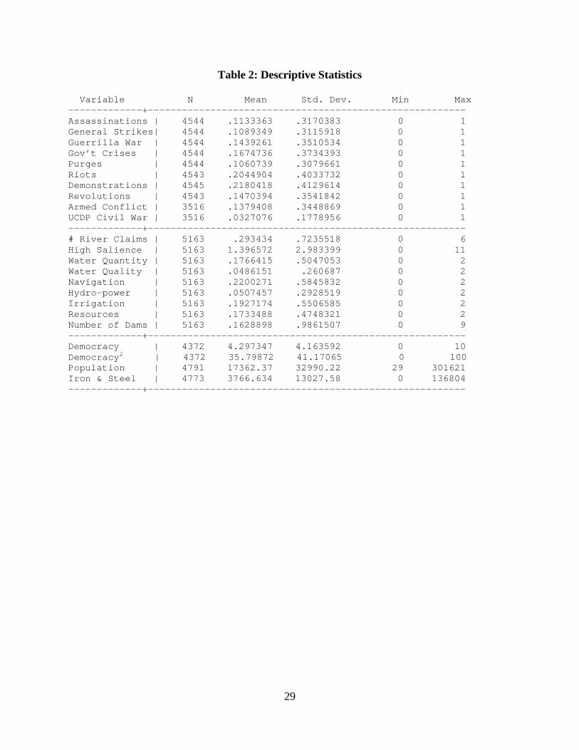
otherwise. See Table 2 for descriptive statistics for all variables.
Dependent Variables: Intrastate Conflict
The data on intrastate violence are taken from Arthur Banks’ Cross-National Time-Series
Data Archive (2011) and the UCDP/PRIO Armed Conflict Dataset.6 Banks’ dataset records
counts of intrastate violence in eight major forms based on newspaper reports (primarily from the
New York Times): assassinations, general strikes, guerrilla warfare, major government crises,
purges, riots, and anti-government demonstrations.7 Demonstrations and riots are the most
6 The 2011 Banks dataset was purchased by the Department of Political Science at the University of Iowa. I use Version 4-2012 of the UCDP/PRIO dataset covering the years 1946-2011, available at http://www.pcr.uu.se/research/ucdp/datasets/onset_of_intrastate_armed_conflict/. 7 This information comes from the codebook for the Banks dataset, p. 11. Assassinations involve “any politically motivated murder…of a high government official or politician”. General strikes involve “1,000 or more…workers…aimed at national government policies or authority.” Guerrilla warfare is “any armed activity, sabotage, or bombings carried out by independent bands or citizens or irregular forces and aimed at overthrow of the… regime”. Major government crises are situations “that threaten(s) to bring the downfall of the present regime”. Purges involve “any systematic elimination by jailing or execution of political opposition within the ranks of the regime or the opposition”. Riots are “violent demonstration(s) or clash(es) of more than 100 citizens involving the use of physical force”. Revolutions include “any illegal or forced change in the top government elite…or any
15
frequent forms of violence, while purges are the least frequent. I estimate separate logit models
for each form of violence (in a dichotomous format) to see how interstate river conflicts
influence different types of domestic conflict. I also include two measures from the
UCDP/PRIO Armed Conflict dataset: 1) a dummy variable for incidences of intrastate conflict
(in any years with active conflict and more than 25 battle deaths) and 2) a dummy variable to
capture years in which conflict passes the 1,000 battle death civil war threshold. Armed conflict
occurs in 13.8% of the state-years, while civil war occurs in 3.3% of the cases.
Independent Variables: Interstate River Claims
Many studies linking shared rivers and interstate conflict tend to code for the presence or
absence of a shared river basin in a pair of states (a dyad) and then determine if sharing a river
basin increases the risk of interstate militarized conflict or cooperation. The problem with this
approach is that it is hard to disentangle the influence of shared river basins from land contiguity,
given the high amount of overlap (Brochmann and Gleditsch 2010). A different approach is
taken by the Issue Correlates of War (ICOW) Project (Hensel, Mitchell, Sowers, and Thyne
2008). The ICOW project identifies contentious issue claims based on explicit evidence of
diplomatic contention involving official representatives of two or more states over a given issue.
In this approach, some pairs of states sharing an interstate river have diplomatic conflicts over
the basin, while other pairs of states do not. The focus on issue claims also allows for variation
in conflict management; some river claims involve militarized disputes while others do not.
The ICOW project has collected data on three distinct contentious issues: territorial
claims, maritime claims, and river claims. Given my theoretical focus, I include only river claims
data in my analysis, which covers the years 1900-2001. The ICOW Project has made available
successful or unsuccessful armed rebellion whose aim is independence from the central government”. Anti-government demonstrations involve peaceful gatherings of at least 100 people in opposition to government policy or authority.

16
data for river claims in three regions: the Americas (North, Central, and South America and the
Caribbean), the Middle East, and Western Europe. The ICOW Project looks for explicit
contention between official representatives over the use or abuse of such rivers.
A river claim involves explicit contention between two or more states over the usage of an international river. Official representatives of the government of at least one state must make explicit demands over the quality or quantity of river water reaching their state through the territory of another state or over navigation rights on the river. Examples include demands to change policies -- or to enact new policies -- over the quantity of water flowing across the border (typically related to dams, irrigation, or other diversion projects), the quality of this water (typically related to pollution by industrial, agricultural, or human waste, or to excessive salination or sedimentation because of upstream activities), or the right to navigate along the river (typically for purposes of commerce or travel). (Hensel 2013: 2).
A list of all ICOW river claims for the three regions is presented in Table 1 (taken from Hensel,
Mitchell, and Sowers 2006: 399-401). There are 28 dyadic river claims in the Western
Hemisphere, 47 in the Middle East, and 7 in Western Europe.
The ICOW data is organized by claim-dyad-year and allows for the same pair of states to
have more than one river claim at the same point in time. For example, Israel and Jordan have
three ongoing river claims in 1989 involving the Jordan River, the Yarmuk River, and the East
Ghor Canal. For this project, I am interested in analyzing the risk of intrastate violence and thus I
utilize the state-year as my unit of analysis. As noted above, the data on intrastate violence are
taken from Arthur Banks’ Cross-National Time-Series Data Archive (2011). While the CNTS
data covers all states from 1815-2010, I included only those countries in regions covered by the
ICOW dataset. This includes countries with Correlates of War country codes 2-199 (Western
Hemisphere), 200-265 (Western Europe), and 600-699 (Middle East). There are a total of 5,163
state year observations in these regions from 1900-2001 (the temporal span of the ICOW data).
Given that the same pair of states can have more than one river claim in the same year, I need to
aggregate the data in a way that allows for integration with the state-year dataset.

17
I generate a state-year dataset recording any instance where the state in question (e.g.
Israel) was involved as a challenger or a target state in an ICOW river claim.8 I then count the
total number of ongoing river claims for each country each year. Israel, for example, had no river
claims in some years (e.g. 1948-1950) and as many as six river claims in other years (1964-
1966). When considering all state-year cases (N=5,163), 80.57% of the cases have no interstate
river claims, 13.11% have one river claim, 4.22% have two river claims, while the remaining
cases have three to six river claims (2.09%). I expect higher values for the number of river
claims to increase the likelihood of intrastate violence.
ICOW also records the salience of the contested river based on six indicators (Hensel,
Mitchell, and Sowers 2006: 403): “(1) river location in the state’s homeland territory rather than
in colonial or dependent territory, (2) navigational value of the river, (3) level of population
served by the river, (4) the presence of a fishing or other resource extraction industry on the
river, (5) hydroelectric power generation along the river, and (6) irrigational value of the river.
Each factor contributes one score per state to the overall salience index, producing a dyadic
measure that ranges from zero (lowest salience) to twelve (highest salience).” River claims
involving higher salience levels are more likely to result in militarized conflict between the
riparian states (Hensel 2001; Hensel, Mitchell, and Sowers 2006). In the state-year dataset, I
record the highest river claim salience score for a state if it is involved in two or more river
claims in the same year. In the three cases mentioned above involving Israel in 1989, the salience
scores range from 4 (East Ghor Canal) to 5 (Yarmuk River) to 6 (Jordan River). Thus the state-
year observation for the salience score comes from the Jordan River case in this instance. The
highest salience variable values range from 4 to 11 in my dataset. States not involved in river
8 The challenger is the state that is challenging the status quo on the issue, while the target is the state that is defending the status quo on the issue. Future analyses may explore these differences, as citizens may be more likely to rally behind leaders to defend existing claims.

18
claims (80.57% of the observations) receive a zero on this variable. My expectation is that higher
salience river claims will be more likely to result in civil conflict.
I also include several measures of the characteristics of river claims from the ICOW
data in my analyses to discern which features of river conflicts are most likely to spill over into
domestic conflict. This includes whether the river claim involves the following issues: water
quantity, water quality, navigational rights, hydro-electric power generation, irrigation, and
whether the river is used for resource extraction (e.g. fishing). Each of these variables can take
on the values of 0 (no issue involved), 1 (potential future issue in the river basin), or 2 (current
issue in the river basin). Navigation and irrigation are the most common issues involved in river
claims, while water quality and hydro-electric power are the least common issues. I also control
for the number of dams on the river which ranges from 0 to 9 in this dataset.
Independent Variables: Controls
To capture other factors that influence the potential for intrastate violence, I include three
variables that are prominent in the civil war literature. First, I include a state’s total population
as recorded by the Correlates of War Project’s National Material Capabilities dataset.9 Second, I
include a state’s iron and steel production using the same dataset. This measure is positively
correlated with GDP per capita and has better temporal coverage.10 Third, I include a measure
for a state’s democracy score (0-10) from the Polity IV project. I also include democracy squared
to capture the higher chances for civil conflict in the middle of the polity scale (Hegre et al
9 I use version 4.0 which is available at www.correlatesofwar.org. In separate analyses (not shown), I also use the natural logged population value in models and the results are similar to what is presented herein. 10 I also estimated models using the energy consumption measure from the COW dataset and the results (not shown) are similar to those presented herein. More observations are lost due to missing data on this alternative measure. While some historical sources for GDP data exist, they do not include the Middle East region, an important region in this particular analysis.
19
2001).11 States with larger populations should be at higher risk for intrastate conflict, while states
with high levels of iron and steel production should have lower conflict risks.
Empirical Results
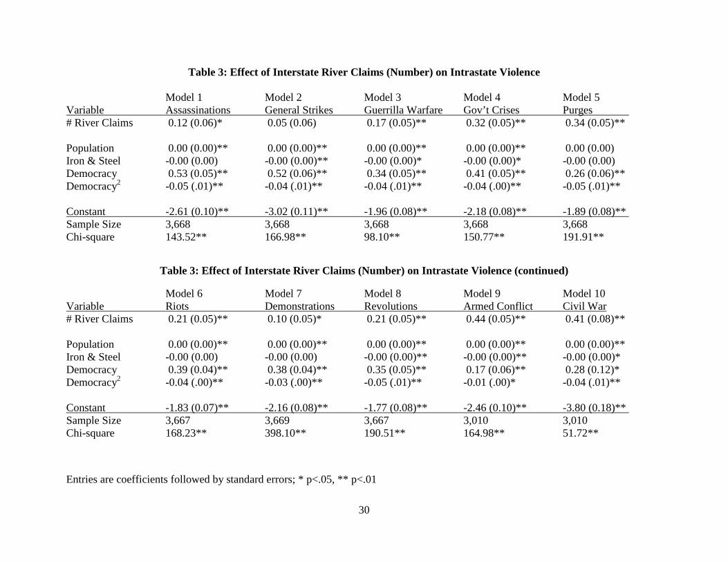
I begin by analyzing the influence of the number of interstate river claims on the potential for
various forms of intrastate violence. Countries with more frequent diplomatic issues over shared
river resources face higher risks for domestic unrest because these issues can lead to forced
migration, they can generate grievances among certain segments of the population, and they can
increase populations in particular areas demanding more water. We see in Table 3 that states
with higher numbers of interstate river claims experience a significantly higher risk for
assassinations (Model 1), guerrilla warfare (Model 3), government crises (Model 4), purges
(Model 5), riots (Model 6), demonstrations (Model 7), revolutions (Model 8), armed conflicts
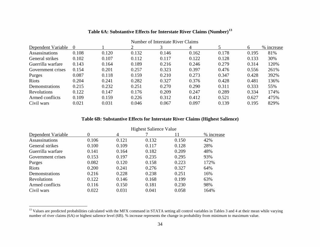
(25 or more deaths, Model 9), and civil wars (1000 or more deaths, Model 10). Table 6A shows
the substantive effects of the number of river claims on the probability of each form of intrastate
conflict, holding all other variables at their mean values. We can see that regional water
diplomatic conflicts significantly raise the risk of intrastate conflict. Having a single claim over
an interstate river (moving from 0 to 1) raises the probability of intrastate conflict by 5% (general
strikes) to 48% (civil wars). Armed conflicts are 46% more likely, purges are 36% more likely,
and government crises are 31% more likely when states experience just a single river interstate
conflict. Countries who are embroiled in many simultaneous river claims, like Israel and Jordan,
face even higher risks for intrastate violence. Raising the number of river claims from zero to six
(maximum) increases the chances for civil wars by 829%, the chances for armed conflicts by
11 I prefer to use the democracy scale rather than the polity scale which subtracts one ordinal scale (autocracy) from another (democracy). However, the results (not shown) are similar using an aggregated polity score.
20
475%, the chances for purges by 329%, and the chances for government crises by 261%. In
short, regional water issues often create internal security problems for the countries involved.
In Table 4, I consider the highest issue salience value among any ongoing interstate river
claims. Higher salience values reflect contested river basins that have more importance to the
states involved due to important resources in the river, the navigational value of the river, and its
importance for irrigation, fishing, or hydroelectric power. The results in Table 4 suggest that
states with more salient river claims experience a significantly higher risk for assassinations
(Model 1), guerrilla warfare (Model 3), government crises (Model 4), purges (Model 5), riots
(Model 6), revolutions (Model 8), armed conflicts (Model 9), and civil wars (Model 10). In
Table 6B, I report the predicted probabilities changing the highest salience score from 0
(minimum) to 4 to 7 to 11 (maximum). The most salient river claims raise the chances for
purges by 172%, civil wars by 164%, armed conflicts by 98%, and government crises by 93%.
This reflects the important water quantity, quality, resource, and navigational issues at stake in
the most salient river claims.
In Table 5, I include several measures that capture the specific characteristics of interstate
river claims. The characteristic that has the most consistent, positive effect on intrastate conflict
is water quantity. Interstate river claims involving actual or potential water quantity issues
increase the chances for assassinations (Model 1), general strikes (Model 2), government crises
(Model 4), purges (Model 5), riots (Model 6), demonstrations (Model 7), revolutions (Model 8),
and incidences of armed conflict (Model 9). Water quality is related only to riots (Model 6) and
changes signs across the various models. Navigational issues increase the risks for government
crises (Model 4), revolutions (Model 8), and armed conflict (Model 9). Hydroelectric power is
not significantly related to any indicators from the Banks’ dataset, but is positively and
21
significantly related to armed conflict and civil wars using the UCDP/PRIO data (Models 9 and
10). The same is true for irrigation issues, which have significant and negative effects only for
the UCDP/PRIO variables. Whether a state extracts resources from the river has no effect on
intrastate violence. The number of dams significantly reduces the chances for armed conflict
(Model 9) and civil wars (Model 10). This represents one possible scenario for reducing states’
internal security risks in the context of regional water disputes. Yet the conflict inducing findings
for hydroelectric power suggest that not all damming strategies may be equally effective.12
As noted earlier, states in the Tigris-Euphrates river basins have experienced interstate
conflict involving cross-border river resources. Syria and Turkey were involved in militarized
interstate disputes in 1965, 1987, and 1989, and 1996-1998, with more recent conflict involving
Turkish support for Syrian opposition groups. Syrian forces shot down a Turkish jet in June 2012
and Turkey increased its military capabilities along the Syrian border (Beck 2014: 7). Yet even
in the midst of this situation, the two countries continued their cooperative effort to build the
Orontes dam. While the level of interstate violence has been moderate, both countries have
experienced significant amounts of civil violence since experience diplomatic disputes over their
shared rivers from the 1960’s forward. Syria witnessed 8 assassinations, 1 general strike, 15
government crises, 15 purges, 11 riots, 8 demonstrations, 16 revolutions, 5 armed conflicts, and
one civil war year. Turkey has even higher levels of civil conflict, with 36 assassinations, 1
general strike, 31 government crises, 10 purges, 56 riots, 39 demonstrations, 24 revolutions, 27
armed conflicts, and 8 civil war years. While both states witnessed some violence prior to the
onset of diplomatic river claims, they both experienced higher levels of violence in the era of
cross-border river conflicts. Water resources are clearly not the only issues at stake in intrastate
12 I am currently working to update the dam dataset using the World Register of Dams. This will allow me to provide a more accurate value for the number of dams along particular rivers and distinguish dams by their features such as size, water flow, and electricity generated.

22
conflicts, but scarcity of water supplies, especially those originating from transnational sources,
can increase the risks of violence significantly.
Conclusion
This paper explores the relationship between interstate conflicts over rivers and intrastate
violence. Using data from the Issue Correlates of War (ICOW) project on river claims, I examine
if states that are involved in interstate river claims have higher chances for domestic conflict
such as civil wars, riots, revolutions, and strikes. Empirical analyses of three regions (Western
Hemisphere, Western Europe, and the Middle East) show a strong relationship between interstate
diplomatic conflicts over shared rivers and domestic conflict. States with a larger number of
conflicts over shared river basins also face more internal security threats. As the salience of the
contested river(s) increases to states in the basin, this also increases the risks for any basin state
to experience more internal violence. Conflicts over water quantity tend to have the largest effect
on the likelihood of intrastate violence, while interstate cooperation over rivers (e.g. through
dams) can have positive spillover effects and reduce the likelihood of intrastate violence. The
paper shows that there are strong transnational effects of interstate water conflicts. Thus perhaps
the predictions about water wars were accurate, but focused in the wrong arena. Interstate
conflicts over rivers may create greater risks for civil wars than for interstate wars involving
states in the river basin.
Future analyses will explore the causal mechanisms linking river basin conflicts and
intrastate violence more carefully. In particular, I will explore whether the relationship is
stronger for downstream states, more acute for countries that depend more heavily on external
water supplies, and more problematic for countries where particular ethnic groups are displaced.

23
References
Barnett, Jon and W. Neil Adger. 2007. “Climate Change, Human Security, and Violent Conflict.” Political Geography 26: 639-655.
Brochmann, Marit and Nils Petter Gleditsch. 2012. “Shared Rivers and Conflict: A Reconsideration.” Political Geography 31(8): 519-527.
Buhaug, Halvard. 2010. “Climate Not to Blame for African Civil Wars.” Proceedings of the National Academy of Sciences in the United States of America 107(88): 16477-16482. Buhaug, Halvard, Scott Gates, and Päivi Lujala. 2009. “Geography, Rebel Capability, and the Duration of Civil Conflict.” Journal of Conflict Resolution 53(4): 544-569. Burke M.B., E. Miguel, S. Satyanath, J.A. Dykema, and D.B. Lobell. 2009. “Warming Increases the Risk of Civil War in Africa. Proceedings of the National Academy of Sciences in the United States of America 106: 20670–20674. Collier, Paul and Hoeffler, Anke 2004. “Greed and Grievance in Civil War.” Oxford Economic Papers. 56: 563-595. Cooley, John K. 1984. “The War Over Water.” Foreign Policy 54 (Spring): 3-26. Critchley, W. Harriet and Terry Terriff. 1993. “Environment and Security.” In Security Studies
for the 1990’s, eds. Richard Shultz, Roy Godson, and Ted Greenwood. Washington D.C.: Brassey’s.
Crow, Ben and Nirvikar Singh. 2000. “Impediments and Innovations in International Rivers: The Waters of South Asia.” World Development 28(11): 1907-1925. Daoudy, Marwa. 2009. “Asymmetric Power: Negotiating Water in the Euphrates and Tigris.”
International Negotiation 1492): 361-391. Dinar, Shlomi. 2009. “Power Asymmetry and Negotiation in International River Basins.”
International Negotiation 14: 329-360. Fearon, James D. and David Laitin. 2003. “Ethnicity, Insurgency, and Civil War.” American
Political Science Review 97(1): 75-90. Feldman, David Lewis. 2012. Water. Cambridge, UK: Polity. Glantz, Michael H. 2005. “Water, Climate, and Development Issues in the Amu Darya Basin.”
Mitigation and Adaptation Strategies for Global Change. 10(1): 23–50. Gleditsch, Nils Petter, Kathryn Furlong, Håvard Hegre, Bethany Lacina, and Taylor Owen. 2006. “Conflicts over Shared Rivers: Resource Scarcity or Fuzzy Boundaries?” Political Geography 25(4): 361-382. Gleditsch, Kristian Skrede. 2007. “Transnational Dimensions of Civil War.” Journal of Peace Research 44(3): 293-309. Gleick, Peter H. 1993. “Water and Conflict: Fresh Water Resources and International Security.”
International Security 18(1): 79-112. Haftendorn, Helga. 2000. “Water and International Conflict.” Third World Quarterly 21(1):
51-68. Hagan, John and Joshua Kaiser. 2011. “The Displaced and Dispossessed of Darfur: Explaining
the Sources of a Continuing State-led Genocide.” The British Journal of Sociology 62(1): 1-25.
Hamner, Jesse H. and Aaron T. Wolf. 1998. “Patterns in International Water Resource Treaties: The Transboundary Freshwater Dispute Database.” Colorado Journal of International Environmental Law and Policy 9: 157-177.
24
Hegre, Havard, Tanja Ellingsen, Scott Gates, and Nils Petter Gleditsch. 2001. Towards a Democratic Civil Peace? Democracy, Political Change, and Civil War, 1816-1992.” American Political Science Review 95(1): 33-48. Hendrix, Cullen S. and Sarah M. Glaser. 2007. “Trends and Triggers: Climate, Climate Change and Civil Conflict in Sub-Saharan Africa.” Political Geography 26: 695-715. Hendrix, Cullen S. and Sarah M. Glaser. 2011. “Civil Conflict and World Fisheries, 1952–2004.”
Journal of Peace Research 48(4): 481-495. Hendrix, Cullen S. and Idean Salehyan. 2012. “Climate Change, Rainfall, and Social Conflict in Africa.” Journal of Peace Research 49(1): 35-50. Hensel, Paul R. 2001. “Contentious Issues and World Politics: Territorial Claims in the
Americas, 1816-1996.” International Studies Quarterly 45(1): 81-109. Hensel, Paul R. 2013. “Codebook for River Claims Data: Issue Correlates of War (ICOW)
Project.” Available at < http://www.paulhensel.org/icow.html>. Hensel, Paul R. Sara McLaughlin Mitchell, and Thomas E. Sowers II. 2006. “Conflict
Management of Riparian Disputes: A Regional Comparison of Dispute Resolution.” Political Geography 25(4): 383-411.
Hensel, Paul R., Sara McLaughlin Mitchell, Thomas E. Sowers II, and Clayton L. Thyne. 2008. “Bones of Contention: Comparing Territorial, Maritime, and River Issues.” Journal of Conflict Resolution 52(1): 117-143.
Homer-Dixon, Thomas. 1994. “Environmental Scarcity and Violent Conflict: Evidence from Cases.” International Security 19(1): 5-40.
Klare, Michael T. 2002. Resource Wars: The New Landscape of Global Conflict. New York, NY: Henry Holt and Company.
Klare, Michael T. 2012. The Race for What’s Left: The Global Scramble for the World’s Last Resources. New York, NY: Picador. Le Billon, Philippe. 2001. “The Political Ecology of War: Natural Resources and Armed
Conflicts.” Political Geography 20: 561-584. Lowi, Miriam R. 1993. “Bridging the Divide: Transboundary Resource Disputes and the Case of West Bank Water.” International Security 18(1): 113-138. Lujala, Päivi. 2009. “Deadly Combat over Natural Resources: Gems, Petroleum, Drugs, and
the Severity of Armed Civil Conflict.” Journal of Conflict Resolution 53(1): 50-71. Lujala, Paiva, Nils Petter Gleditsch, and Elisabeth Gilmore. 2005. “A Diamond Curse? Civil War and a Lootable Resource.” Journal of Conflict Resolution 49(4):538-562. Mitchell, Sara McLaughlin and Cameron G. Thies. 2012. “Resource Curse in Reverse: How
Civil Wars Influence Natural Resource Production.” International Interactions 38(2): 218-242.
Raleigh, Clionadh and Hendrik Urdal. 2007. “Climate Change, Environmental Degradation and Armed Conflict.” Political Geography 26: 674-694. Reuveny, Rafael. 2007. “Climate Change-Induced Migration and Violent Conflict.” Political Geography 26: 656-673. Richter, B.D., S. Postel, C. Revenga, T. Scudder, B. Lehner, A. Churchill, and M. Chow. 2010.
“Lost in Development’s Shadow: The Downstream Human Consequences of Dams.” Water Alternatives 3(2): 14-42.
Ross, Michael L. 2004a. “How Do Natural Resources Influence Civil War? Evidence from Thirteen Cases.” International Organization 58(1): 35-67.

25
Ross, Michael. 2004b. “What Do We Know About Natural Resources and Civil War?” Journal of Peace Research 41(3): 337-356. Salehyan, Idean. 2007. “Transnational Rebels: Neighboring States as Sanctuary for Rebel Groups.” World Politics 59(2): 217-242. Salehyan, Idean and Kristian Skrede Gleditsch. 2006. “Refugees and the Spread of Civil War.” International Organization 60: 335-366. Starr, Joyce R. 1991. “Water Wars.” Foreign Policy 82 (Spring, 1991): 17-36. Swain, Ashok. 1997. “Ethiopia, the Sudan, and Egypt: The Nile River Dispute.” The Journal of Modern African Studies 35(4): 675-694. Theisen, Ole Magnus. 2008. “Blood and Soil? Resource Scarcity and Internal Armed Conflict
Revisited.” Journal of Peace Research 45(6): 801-818. Theisen, Ole Magnus, Helge Holtermann and Halvard Buhaug. 2011–12. “Climate Wars?
Assessing the Claim that Drought Breeds Conflict.” International Security 36(3): 79–106. Thyne, Clayton L. 2007. “Cheap Signals with Costly Consequences: The Effect of Interstate Relations on Civil War, 1945-1999.” Journal of Conflict Resolution. 50(6): 937-961. Toset, Hans Petter Wollebaek, Nils Petter Gleditsch, and Håvard Hegre. 2000. “Shared Rivers
and Interstate Conflict.” Political Geography 19: 971-996. Wolf, Aaron. 1998. “Conflict and Cooperation along International Waterways.” Water Policy
1(2): 251-265.

26
Table 1: ICOW River Claims, 1816-2001 Primary (Secondary) River and Claim Description Challenger - Target Dates North America St. Lawrence River (Niagara) Chicago Diversion Canada - USA 1925 - 1932 Milk River (St. Mary's) St. Mary's Diversion UK (Canada) - USA 1902 - 1909 Milk River Diversion USA - UK (Canada) 1904 - 1909 Red River (Souris) Garrison Diversion Canada - USA 1973 - 1986 Canada - USA 1999 - Red River (Souris-Sheyenne) Devil's Lake Diversion Canada - USA 1997 - Souris River Rafferty-Alameda Dam Canada - USA 1989 - 1992 Columbia River (Kootenay-Frasier) Libby Dam Canada - USA 1951 - 1961 Skagit River High Ross Dam Canada - USA 1972 - 1984 Taku River Tulsequah Chief Mine USA - Canada 1998 - Colorado River Alamo Canal Mexico - USA 1901 - 1904 Colorado Apportionment Mexico - USA 1905 - 1944 Wellton-Mohawk Salinity Mexico - USA 1961 - 1973 All-American Canal Sealing Mexico - USA 1989 - 1999 Río Grande Upper Rio Grande Mexico - USA 1900 - 1906 Lower Rio Grande USA - Mexico 1924 - 1944 Mexican Water Release USA - Mexico 2000 - Central America and Caribbean San Juan River San Juan Navigation Costa Rica - Nicaragua 1982 - South America Napo River Petroecuador Oil Spill Peru - Ecuador 1992 - 1992 Iguazú River Segredo Reservoir Argentina - Brazil 1998 - 1998 Paraná River Itaipú Dam Argentina - Brazil 1972 - 1979 Yacyreta Dam Paraguay - Argentina 1973 - 1979

27
Paraguay River Río Paraguay Navigation Paraguay - Argentina 1941 - 1967 Pilcomayo River Lower Pilcomayo Diversion Paraguay - Argentina 1980 - 1983 Uruguay River (La Plata) Uruguay River Border Argentina - Uruguay 1900 - 1973 Mauri River Mauri Irrigation Project Bolivia - Chile 1921 - 1922 Lauca River Lauca Diversion Bolivia - Chile 1939 - 1978 Silala River Silala Fees (Ductec) Chile - Bolivia 1999 - Western Europe Meuse River Albert Canal Netherlands - Belgium 1930 - 1937 Rhine River German Hydroelectric Plan Switzerland - Germany 1918 - 1918 Grand Canal d’Alsace Switzerland- France 1919 - 1922 Alsace Salt Releases Netherlands - France 1979 - 1982 Scheldt River Scheldt/Wielingen Navigation Belgium - Netherlands 1919 - 1932 Segre River (Ariege-Carol) Lake Lanoux Diversion Spain - France 1917 - 1967 Duero - Tejo - Guadiana Rivers National Hydrological Plan Portugal - Spain 1993 - 2000 Middle East Jordan River Lake Huleh Diversion Syria - Israel 1951 - 1951 Jordan - Israel 1951 - 1953 DMZ Diversion Syria - Israel 1953 - 1954 National Water Carrier Lebanon - Israel 1956 - 1966 Syria - Israel 1956 - 1958 UAR (Syria) - Israel 1959 - 1961 Syria - Israel 1961 - 1966 Jordan - Israel 1956 - 1966 Sewage Dumping Jordan - Israel 1989 - 1989 West Bank Allocation Jordan - Israel 1989 - 1989 Hasbani-Baniyas (Jordan) Jordan Headwaters Diversion Israel - Lebanon 1964 - 1966 Israel - Syria 1964 - 1966 Israel - Jordan 1964 - 1966 Hasbani River (Jordan) Wazzani Pipe Israel - Lebanon 2001 - 2001

28
Yarmuk River (Jordan) Bunger Plan Israel - Syria 1953 - 1956 Israel - Jordan 1953 - 1956 Unity Dam Israel - Syria 1987 - 1998 Israel - Jordan 1987 - 1998 East Ghor Canal (Yarmuk/Jordan) East Ghor Canal Israel - Jordan 1969 - 1969 Jordan - Israel 1976 - 1994 Israel - Jordan 1999 - 1999 Yarmuk River Yarmuk Diversions Jordan - Syria 1987 - 1987 Jordan - Syria 1992 - 1998 Golan Heights Dam Syria - Israel 1997 - 1998 Jordan - Israel 1997 - 1998 Mafraq Spill Syria - Jordan 2000 - 2000 Euphrates River Absolute Sovereignty Syria - Turkey 1964 - Keban Dam Syria - Turkey 1964 - 1966 Tabqa (Thawrah) Dam Iraq - Syria 1975 - 1975 Lake Assad Syria - Turkey 1983 - 1983 Ataturk Dam Syria - Turkey 1984 - 1990 Iraq - Turkey 1990 - 1990 Karakaya Dam Syria - Turkey 1986 - 1986 Iraqi Allocation Iraq - Syria 1988 - 1990 Birecik Dam Iraq - Turkey 1993 - Syria - Turkey 1995 - Tigris/Euphrates Rivers Iraqi Allocation Iraq - Turkey 1988 - Tigris River Ilisu Dam Iraq - Turkey 1999 - Shatt al-Arab Thalweg & Navigation Iran - UK (Iraq) 1921 - 1932 Iran - Iraq 1932 - 1937 Iran - Iraq 1953 - 1954 Iraq - Iran 1958 - 1975 Iran - Iraq 1959 - 1975 Iraq - Iran 1979 - 1990 Orontes River Syrian Dam Plan Turkey - Syria 1956 - 1958 Turkey - UAR (Syria) 1958 - 1961 Turkey - Syria 1961 -
29
Table 2: Descriptive Statistics
Variable N Mean Std. Dev. Min Max -------------+-------------------------------------------------------- Assassinations | 4544 .1133363 .3170383 0 1 General Strikes| 4544 .1089349 .3115918 0 1 Guerrilla War | 4544 .1439261 .3510534 0 1 Gov’t Crises | 4544 .1674736 .3734393 0 1 Purges | 4544 .1060739 .3079661 0 1 Riots | 4543 .2044904 .4033732 0 1 Demonstrations | 4545 .2180418 .4129614 0 1 Revolutions | 4543 .1470394 .3541842 0 1 Armed Conflict | 3516 .1379408 .3448869 0 1 UCDP Civil War | 3516 .0327076 .1778956 0 1 -------------+-------------------------------------------------------- # River Claims | 5163 .293434 .7235518 0 6 High Salience | 5163 1.396572 2.983399 0 11 Water Quantity | 5163 .1766415 .5047053 0 2 Water Quality | 5163 .0486151 .260687 0 2 Navigation | 5163 .2200271 .5845832 0 2 Hydro-power | 5163 .0507457 .2928519 0 2 Irrigation | 5163 .1927174 .5506585 0 2 Resources | 5163 .1733488 .4748321 0 2 Number of Dams | 5163 .1628898 .9861507 0 9 -------------+-------------------------------------------------------- Democracy | 4372 4.297347 4.163592 0 10 Democracy2 | 4372 35.79872 41.17065 0 100 Population | 4791 17362.37 32990.22 29 301621 Iron & Steel | 4773 3766.634 13027.58 0 136804 -------------+--------------------------------------------------------
30
Table 3: Effect of Interstate River Claims (Number) on Intrastate Violence
Model 1 Model 2 Model 3 Model 4 Model 5 Variable Assassinations General Strikes Guerrilla Warfare Gov’t Crises Purges # River Claims 0.12 (0.06)* 0.05 (0.06) 0.17 (0.05)** 0.32 (0.05)** 0.34 (0.05)** Population 0.00 (0.00)** 0.00 (0.00)** 0.00 (0.00)** 0.00 (0.00)** 0.00 (0.00) Iron & Steel -0.00 (0.00) -0.00 (0.00)** -0.00 (0.00)* -0.00 (0.00)* -0.00 (0.00) Democracy 0.53 (0.05)** 0.52 (0.06)** 0.34 (0.05)** 0.41 (0.05)** 0.26 (0.06)** Democracy2 -0.05 (.01)** -0.04 (.01)** -0.04 (.01)** -0.04 (.00)** -0.05 (.01)** Constant -2.61 (0.10)** -3.02 (0.11)** -1.96 (0.08)** -2.18 (0.08)** -1.89 (0.08)** Sample Size 3,668 3,668 3,668 3,668 3,668 Chi-square 143.52** 166.98** 98.10** 150.77** 191.91**
Table 3: Effect of Interstate River Claims (Number) on Intrastate Violence (continued) Model 6 Model 7 Model 8 Model 9 Model 10 Variable Riots Demonstrations Revolutions Armed Conflict Civil War # River Claims 0.21 (0.05)** 0.10 (0.05)* 0.21 (0.05)** 0.44 (0.05)** 0.41 (0.08)** Population 0.00 (0.00)** 0.00 (0.00)** 0.00 (0.00)** 0.00 (0.00)** 0.00 (0.00)** Iron & Steel -0.00 (0.00) -0.00 (0.00) -0.00 (0.00)** -0.00 (0.00)** -0.00 (0.00)* Democracy 0.39 (0.04)** 0.38 (0.04)** 0.35 (0.05)** 0.17 (0.06)** 0.28 (0.12)* Democracy2 -0.04 (.00)** -0.03 (.00)** -0.05 (.01)** -0.01 (.00)* -0.04 (.01)** Constant -1.83 (0.07)** -2.16 (0.08)** -1.77 (0.08)** -2.46 (0.10)** -3.80 (0.18)** Sample Size 3,667 3,669 3,667 3,010 3,010 Chi-square 168.23** 398.10** 190.51** 164.98** 51.72** Entries are coefficients followed by standard errors; * p<.05, ** p<.01

31
Table 4: Effect of Interstate River Claims (Highest Salience) on Intrastate Violence
Model 1 Model 2 Model 3 Model 4 Model 5 Variable Assassinations General Strikes Guerrilla Warfare Gov’t Crises Purges Highest Salience 0.04 (0.02)* 0.03 (0.02) 0.04 (0.01)** 0.08 (0.01)** 0.11 (0.01)** Population 0.00 (0.00)** 0.00 (0.00)** 0.00 (0.00)** 0.00 (0.00) 0.00 (0.00) Iron & Steel -0.00 (0.00) -0.00 (0.00)** -0.00 (0.00)** -0.00 (0.00)* -0.00 (0.00) Democracy 0.52 (0.05)** 0.52 (0.06)** 0.33 (0.05)** 0.40 (0.05)** 0.23 (0.06)** Democracy2 -0.05 (.01)** -0.04 (.01)** -0.04 (.01)** -0.03 (.00)** -0.04 (.01)** Constant -2.62 (0.10)** -3.04 (0.12)** -1.97 (0.08)** -2.18 (0.08)** -1.92 (0.08)** Sample Size 3,668 3,668 3,668 3,668 3,668 Chi-square 145.16** 168.99** 97.49** 141.90** 203.42**
Table 4: Effect of Interstate River Claims (Highest Salience) on Intrastate Violence (continued) Model 6 Model 7 Model 8 Model 9 Model 10 Variable Riots Demonstrations Revolutions Armed Conflict Civil War Highest Salience 0.06 (0.01)** 0.02 (0.01) 0.05 (0.01)** 0.07 (0.02)** 0.09 (0.03)** Population 0.00 (0.00)** 0.00 (0.00)** 0.00 (0.00)** 0.00 (0.00)** 0.00 (0.00)** Iron & Steel -0.00 (0.00) -0.00 (0.00) -0.00 (0.00)** -0.00 (0.00)** -0.00 (0.00)* Democracy 0.37 (0.04)** 0.38 (0.04)** 0.34 (0.05)** 0.15 (0.06)** 0.26 (0.11)* Democracy2 -0.04 (.00)** -0.03 (.00)** -0.04 (.01)** -0.01 (.00)* -0.03 (.01)** Constant -1.85 (0.07)** -2.16 (0.08)** -1.77 (0.08)** -2.38 (0.10)** -3.74 (0.18)** Sample Size 3,667 3,669 3,667 3,010 3,010 Chi-square 171.54** 396.06** 189.04** 117.21** 41.43** Entries are coefficients followed by standard errors; * p<.05, ** p<.01

32
Table 5: Effect of Interstate River Claims Characteristics on Intrastate Violence
Model 1 Model 2 Model 3 Model 4 Model 5 Variable Assassinations General Strikes Guerrilla Warfare Gov’t Crises Purges Water Quantity 0.28 (0.11)* 0.38 (0.11)** 0.15 (0.10) 0.55 (0.09)** 0.53 (0.11)** Water Quality -0.29 (0.20) 0.18 (0.19) 0.03 (0.17) 0.19 (0.16) -0.02 (0.18) Navigational Issues 0.03 (0.18) 0.20 (0.17) 0.09 (0.15) 0.30 (0.14)* 0.08 (0.18) Hydroelectric Power -0.01 (0.28) -0.33 (0.35) 0.37 (0.27) -0.47 (0.29) -0.63 (0.35) Irrigation Issues 0.19 (0.15) 0.08 (0.15) -0.12 (0.13) 0.08 (0.12) 0.23 (0.15) Resources Extracted -0.10 (0.26) -0.31 (0.24) 0.19 (0.22) -0.26 (0.19) 0.18 (0.27) Number of Dams -0.06 (0.09) -0.26 (0.14) -0.11 (0.09) -0.17 (0.10) -0.15 (0.13) Population 0.00 (0.00)** 0.00 (0.00)** 0.00 (0.00)** 0.00 (0.00) 0.00 (0.00) Iron & Steel -0.00 (0.00) -0.00 (0.00)* -0.00 (0.00)* -0.00 (0.00) -0.00 (0.00) Democracy 0.52 (0.05)** 0.52 (0.06)** 0.34 (0.05)** 0.41 (0.05)** 0.22 (0.06)** Democracy2 -0.05 (.01)** -0.04 (.01)** -0.04 (.01)** -0.03 (.00)** -0.04 (.01)** Constant -2.61 (0.10)** -3.08 (0.12)** -1.97 (0.08)** -2.20 (0.09)** -1.92 (0.08)** Sample Size 3,668 3,668 3,668 3,668 3,668 Chi-square 156.67** 199.21** 101.19** 181.36** 203.42** Entries are coefficients followed by standard errors; * p<.05, ** p<.01

33
Table 5: Effect of Interstate River Claims Characteristics on Intrastate Violence (continued) Model 6 Model 7 Model 8 Model 9 Model 10 Variable Riots Demonstrations Revolutions Armed Conflict Civil War Water Quantity 0.48 (0.09)** 0.38 (0.10)** 0.34 (0.11)** 0.50 (0.12)** 0.11 (0.30) Water Quality 0.40 (0.14)** 0.05 (0.15) -0.19 (0.19) -0.47 (0.23)* -0.94 (0.69) Navigational Issues 0.18 (0.13) 0.18 (0.13) 0.38 (0.15)* 0.74 (0.15)** 0.51 (0.30) Hydroelectric Power -1.06 (0.27)** -0.37 (0.26) -0.05 (0.30) 1.41 (0.36)** 2.73 (0.73)** Irrigation Issues 0.20 (0.11) 0.04 (0.12) 0.01 (0.15) -0.74 (0.20)** -1.15 (0.44)** Resources Extracted -0.25 (0.19) -0.32 (0.19) -0.36 (0.26) -0.38 (0.25) 0.26 (0.55) Number of Dams -0.01 (0.08) -0.09 (0.08) 0.04 (0.11) -0.28 (0.12)* -0.55 (0.26)* Population 0.00 (0.00)** 0.00 (0.00)** 0.00 (0.00)** 0.00 (0.00)** 0.00 (0.00)* Iron & Steel -0.00 (0.00) -0.00 (0.00) -0.00 (0.00)** -0.00 (0.00)** -0.00 (0.00) Democracy 0.38 (0.04)** 0.38 (0.05)** 0.36 (0.05)** 0.19 (0.06)** 0.35 (0.12)** Democracy2 -0.04 (.00)** -0.03 (.00)** -0.05 (.01)** -0.02 (.01)* -0.04 (.01)** Constant -1.85 (0.07)** -2.18 (0.08)** -1.79 (0.08)** -2.40 (0.10)** -3.66 (0.18)** Sample Size 3,667 3,669 3,667 3,010 3,010 Chi-square 234.56** 425.36** 198.78** 172.13** 73.78** Entries are coefficients followed by standard errors; * p<.05, ** p<.01
34
Table 6A: Substantive Effects for Interstate River Claims (Number)13 Number of Interstate River Claims Dependent Variable 0 1 2 3 4 5 6 % increase Assassinations 0.108 0.120 0.132 0.146 0.162 0.178 0.195 81% General strikes 0.102 0.107 0.112 0.117 0.122 0.128 0.133 30% Guerrilla warfare 0.143 0.164 0.189 0.216 0.246 0.279 0.314 120% Government crises 0.154 0.201 0.257 0.323 0.397 0.476 0.556 261% Purges 0.087 0.118 0.159 0.210 0.273 0.347 0.428 392% Riots 0.204 0.241 0.282 0.327 0.376 0.428 0.481 136% Demonstrations 0.215 0.232 0.251 0.270 0.290 0.311 0.333 55% Revolutions 0.122 0.147 0.176 0.209 0.247 0.289 0.334 174% Armed conflicts 0.109 0.159 0.226 0.312 0.412 0.521 0.627 475% Civil wars 0.021 0.031 0.046 0.067 0.097 0.139 0.195 829%
Table 6B: Substantive Effects for Interstate River Claims (Highest Salience) Highest Salience Value Dependent Variable 0 4 7 11 % increase Assassinations 0.106 0.121 0.132 0.150 42% General strikes 0.100 0.109 0.117 0.128 28% Guerrilla warfare 0.141 0.164 0.182 0.209 48% Government crises 0.153 0.197 0.235 0.295 93% Purges 0.082 0.120 0.158 0.223 172% Riots 0.200 0.241 0.276 0.327 64% Demonstrations 0.216 0.228 0.238 0.251 16% Revolutions 0.122 0.146 0.168 0.199 63% Armed conflicts 0.116 0.150 0.181 0.230 98% Civil wars 0.022 0.031 0.041 0.058 164%
13 Values are predicted probabilities calculated with the MFX command in STATA setting all control variables in Tables 3 and 4 at their mean while varying number of river claims (6A) or highest salience level (6B). % increase represents the change in probability from minimum to maximum value.