Embed Size (px)
Citation preview
1
CROSS RIVER STATE COMMUNITY AND SOCIAL DEVELOPMENT AGENCY
ENVIRONMENTAL AND SOCIAL IMPACT
ASSESSMENT (ESIA) FOR BEMI BRIDGE PROJECT IN OKWANGWO DIVISION OF CROSS RIVER NATIONAL
PARK
FINAL REPORT
FEBRUARY 2014
E4455 V2 P
ublic
Dis
clos
ure
Aut
horiz
edP
ublic
Dis
clos
ure
Aut
horiz
edP
ublic
Dis
clos
ure
Aut
horiz
edP
ublic
Dis
clos
ure
Aut
horiz
edP
ublic
Dis
clos
ure
Aut
horiz
edP
ublic
Dis
clos
ure
Aut
horiz
edP
ublic
Dis
clos
ure
Aut
horiz
edP
ublic
Dis
clos
ure
Aut
horiz
ed
2
Contents 1 ABBREVIATIONS ....................................................................................................................... 5
EXECUTIVE SUMMARY ..................................................................................................................... 6
CHAPTER ONE: INTRODUCTION ............................................................................................. 10
1.1 Background .................................................................................................................... 10
1.2 Aim of the ESIA .............................................................................................................. 11
1.3 Objective of the ESIA ..................................................................................................... 11
1.4 Scope of Work ............................................................................................................... 11
1.5 Technical Approach and Methodology ......................................................................... 12
1.5.1 Pre-Project Planning Meeting with Project Proponent .......................................... 12
1.5.2 Data collection and literature review .................................................................... 12
1.5.3 Stakeholder and Public Consultation ..................................................................... 13
1.5.4 Data Collection, Sampling and Field Methods ....................................................... 13
1.5.5 Socio-economic Studies ......................................................................................... 14
1.6 The ESIA Structure ......................................................................................................... 15
CHAPTER TWO: POLICY, LEGAL & ADMINISTRATIVE FRAMEWORK ........................................... 16
2.1 Introduction ................................................................................................................... 16
2.2 Administrative Framework ............................................................................................ 16
2.2.1 Environmental Impact Assessment Act 1992 ........................................................ 17
CHAPTER THREE: PROJECT DESCRIPTION AND ANALYSIS OF ALTERNATIVES ............................. 23
3.1 Project Description ........................................................................................................ 23
3.2 Overview of the Okwangwo Park .................................................................................. 23
3.3 Measurement Attributes of the Bemi River Bridge ....................................................... 24
3.4 Analysis of Project Alternatives ..................................................................................... 25
3.4.1 No Project Option .................................................................................................. 26
3.4.2 Embark on Bridge Construction Option ................................................................. 26
CHAPTER FOUR: DESCRIPTION OF THE PROJECT AREA AND BASELINE DATA ......................... 27
4.1 General Description of Study Area ................................................................................ 27
4.2 Environmental & Social Baseline Data .......................................................................... 28
4.3 Socio-economic Survey of the Project Area .................................................................. 35
CHAPTER FIVE: POTENTIAL IMPACTS AND MITIGATION MEASURES ........................................... 41
3
5.1 Introduction ................................................................................................................... 41
5.2 Impact Identification and Evaluation ............................................................................ 41
5.3 Associated and Potential Impacts of the Project .......................................................... 43
5.3.1 The Project Positive Impacts .................................................................................. 43
5.3.2 The Project Negative Impacts ................................................................................ 44
5.4 Mitigation Measures ..................................................................................................... 47
CHAPTER SIX: ENVIRONMENTAL AND SOCIAL MANAGEMENT PLAN ........................................... 50
6.1 Overview ........................................................................................................................ 50
6.2 Scope of the ESMP ......................................................................................................... 50
CHAPTER SEVEN: IMPLEMENTATION PROGRAMME AND ARRANGEMENT ............................. 57
7.1 Implementation Programmes ....................................................................................... 57
7.1.1`Environmental Monitoring And Auditing ..................................................................... 57
7.2 Reporting Procedure ..................................................................................................... 57
7.2.1 Complaints Register and Environmental Incidents ................................................ 57
7.2.2 Record keeping ...................................................................................................... 58
7.3 Implementation /Institutional Arrangement ................................................................ 58
7.4 Disclosure ...................................................................................................................... 60
7.5 Implementation Schedule ................................................................................................... 60
2 CHAPTER EIGHT PUBLIC CONSULTATIONS ............................................................................ 62
8.1 Introduction ................................................................................................................... 62
8.3 Stakeholder Identification and Engagement Strategy............................................... 62
8.4 Approach and Method for Consultation ....................................................................... 62
8.5 Major points and outcome of consultation with the Stakeholders .............................. 63
8.5.1 Public Consultation with Okwangwo, Okwa 1 and Okwa 11 communities ........... 63
8.5.2 Consultation with Cross River National Park ......................................................... 64
8.5.3 Consultation with Wildlife Conservation Society (WCS) ........................................ 65
3 REFERENCES .......................................................................................................................... 67
ANNEXES ........................................................................................................................................ 70
Annex 1: Public Consultation Attendance Record ................................................................ 70
Annex 2: Contact Of Other Stakeholders Met ........................................................................... 72
Annex 3: Terms of Reference .................................................................................................... 72
4
Annex 4: Inter-Agencies Approval Letters and Correspondences ............................................. 74
Table of Table
TABLE 4.1: Summary of Soil Physico–Chemical Properties....................................................... 32
TABLE 4.2: Summary of Soil Heavy Metals .................................................................................. 32
TABLE 4.3: Land Tenure System of the enclave communities .................................................. 36
Table 5.1: Consequence Severity, Likelihood Ranking & Risk Matrix Tables .......................... 42
Table 5.2: Adverse Impacts of the Bemi Bridge ............................................................................ 45
Table 5.3: Mitigation Measures ........................................................................................................ 47
Table 6.1 Detail ESMP for Bemi Bridge ..................................................................................... 51
Table 6.2 Monitoring Plan ............................................................................................................. 53
Table 7.1: Implementation Schedule ............................................................................................... 61
Table of Figures
Figure 2.1: Nigerian EIA Process Flow Chart .............................................................................. 17
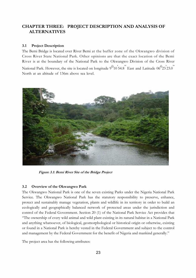
Figure 3.1: Bemi River Site of the Bridge Project ......................................................................... 23
Figure 3.2: A view of the Bemi Bridge showing height restriction bars ............................... 25
Figure 4.1: Map of Cross River State in Nigeria showing the Project Site ................................ 27
Figure 4.2: Geology of Okwangwo .................................................................................................. 29
Figure 4.3: Topography of the Study Area ...................................................................................... 30
Figure 4.4: The Hydrology/ Drainage of the Project Area .......................................................... 31
Figure 4.5: Educational Attainment of Respondents .................................................................. 37
Figure 4.6: Trend in Income distribution in the project area ...................................................... 38
Figure 4.7: Prevalence of Diseases/Common Sicknesses ............................................................ 39
Figure 4.8: Front View of the non-functioning Okwangwo health centre ................................. 40
5
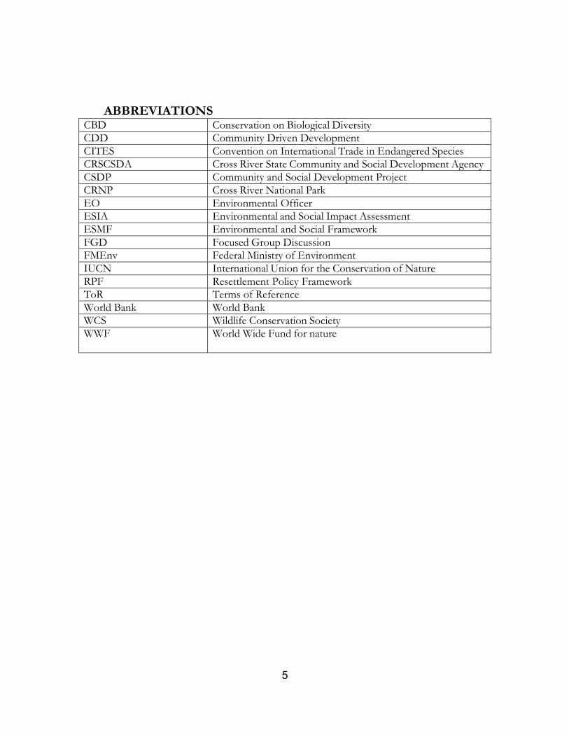
1 ABBREVIATIONS CBD Conservation on Biological Diversity
CDD Community Driven Development
CITES Convention on International Trade in Endangered Species
CRSCSDA Cross River State Community and Social Development Agency
CSDP Community and Social Development Project
CRNP Cross River National Park
EO Environmental Officer
ESIA Environmental and Social Impact Assessment
ESMF Environmental and Social Framework
FGD Focused Group Discussion
FMEnv Federal Ministry of Environment
IUCN International Union for the Conservation of Nature
RPF Resettlement Policy Framework
ToR Terms of Reference
World Bank World Bank
WCS Wildlife Conservation Society
WWF World Wide Fund for nature
6
EXECUTIVE SUMMARY
Background
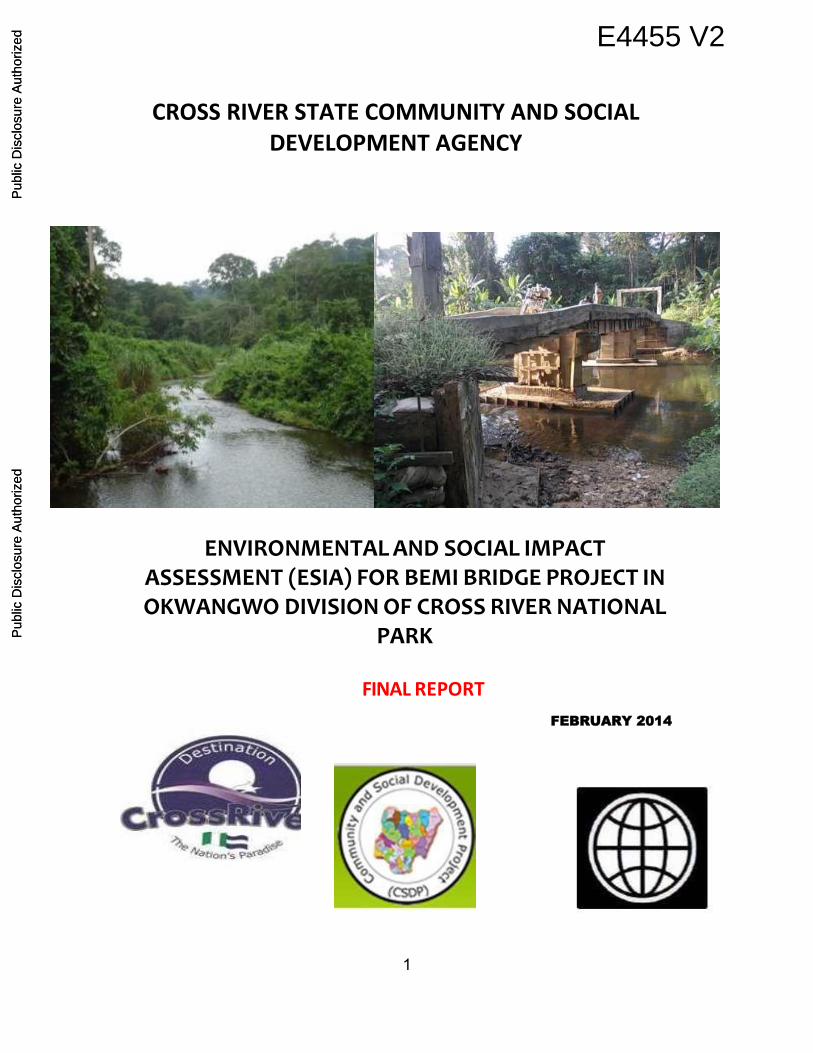
The Cross River State Community and Social Development Agency (CR-CSDA) is
embarking on the construction of a bridge across Bemi River in Okwangwo Community,
Boki LGA in Cross River State. The Bemi bridge is the result-oriented outcome of
deliberations between the Okwangwo Community and CR-SCSDA, Ministry of
Environment, Forestry Commission and the Cross River National Park for which approval
was duly received. The construction of the Bemi Bridge over the Bemi River is directly
based on the community’s requirement for a priority project in the area aligned with
Okwangwo community-driven development plan aimed at fostering the accessibility of the
people to social and & infrastructural services.
CR-CSDA is an implementing agency for the State under the World Bank Funded
Community and Social Development Project (CSDP) in Nigeria. The CSDP development
objective is to sustainably increase access of poor people to social and natural resource
infrastructure services.
Aim of the ESIA study
The aim of the ESIA study is to assess the environmental and social impacts of the Bemi
Bridge on the sensitive ecological National Park site and to establish the impact of the
Bridge on rural community socio-economic development of the area. The ESIA will
establish modalities for environmental and social sustainability of the project taking into
consideration Nigerian extant laws and the World Bank Operational Policies.
Objectives of the ESIA study
To conduct an Environmental and Social Assessment of the Bemi Bridge Project in
order to identify and assess the environmental and social impacts of the bridge on
the National Park conservation vis a viz impacts on wildlife, endangered species of
flora and fauna and rural enclaves in the area.
Assess the impact of the bridge project on women and vulnerable group
To ascertain through engagement and participation the views and concerns of all
stakeholders on the impacts of the Bridge project
Establish and benchmark the existing state of the environment and identify sensitive
components of the existing environment within the project area and area of
influence.
To collect baseline socio-economic data of the project community
7
Assist project proponent by identifying those aspects of location, construction and
operations, which may cause adverse environmental, social, health and economic
effects, including strong focus on land issues - ownership, tenure, conflict;
Recommend measures to avoid and mitigate identified adverse impacts
Identify existing and expected environmental regulations that will affect the
development and advise on standards and targets;
Prepare cost effective ESMP including budget for mitigating of impacts and a
detailed monitoring plan
Legal and Legislative Framework
The preparation of this ESIA was guided by the World Bank operational policies, the
Nigeria extant laws on environmental protection including EIA Act 1992, the Forestry Act
1958, Water Resources Act 1993 and Land Use Act 1978. International laws and
conventions on biodiversity and conservation which Nigeria is signatory were also consulted.
Description of the Bemi Bridge Location in Okwangwo
The Bemi Bridge location has the following attributes:
located over River Bemi within the buffer zone of the Okwangwo Division of the
Cross River National Park on longitude 9010’54.8” East and Latitude 06023’23.0”
North at an altitude of 136m above sea level
The Okwangwo Division has an area of about 920 km2 at an altitude of 150 -
1,700m above sea level.
The climate is seasonal-tropical, having two distinctive seasons: the dry and the rainy
seasons. Rainfall ranges between 2,500m to 4,500mm per annum (Obot, 1996).
The terrain is undulating and steeply sloping in some areas, reaching a height of
between 150 to 1700m above the sea level.
The park area is drained by many rivers such as Bemi, Oyi, Anyibiar, Kanton,
Matche and Anyukwo rivers among others.
The soil in the area is derived from deep weathering of the basement complex
system.
The soils are classified as sandy-loamy and clayey-loamy depending on the stage of
pedogenic development (Soil survey staff, 1992, 1998, Fitzpatrick, 1980).
The vegetation is evergreen tropical rain forest with divers trees species reaching the
height of 40 to 45m and as well as species of mammals, reptiles and birds.
Three settlements are located within the core of the National Park and they include
Okwangwo with a population of 1,990 person; Okwa1 with a population of 868
persons while Okwa 11 has a population of 1551 persons (National population
Commission, 1991 projected to 2013).
8
Public and Stakeholder Consultation
Primary stakeholders identified were the Okwangwo and Okwa communities, the Ministry of
Environment, Cross River National Park, Forestry Commission and Wildlife Conservation
Society. All these groups were duly consulted and engaged in robust discussions in the
identification of their perceptions, concerns and solutions to adverse impacts of the project.
Women and youths in the project communities fully participated in the public consultation
processes. Letters of clearance/permit were obtained from relevant stakeholder agencies as
show of support for the project.
The outcome of the consultations in addition to field and laboratory data analysis gave rise
to impact identification and mitigations.
Impacts of the Bemi Bridge construction
The impacts of the project range from positive to negative impacts. It was not inconceivable
that creating an access way in a forest reserved area would be associated with potential
negative impacts such as poaching, hunting, logging, land encroachment, and loss of flora
and fauna. However, these impacts are reversible and subject to management control
through the Environmental and Social Management Plan hereby developed for this project.
Positive impacts of the project are overwhelming and includes but not limited to the
following:
Improved community access to movement to farm and neighboring villages across
the Bemi River
Incentive to increased farming and income
Increased capacity of the Cross River National Park to enforce Park conservation laws
Temporal employment of locals during Bridge construction
A panacea to the plight of women and children who are worse vulnerable to the risk
of water level rise at Bemi River in rainy seasons
Access provided by the construction of the bridge will enhance park protection activities viz-a-viz increase patrols and conservation education activities to the enclave communities
Mitigation Measures
Some of the mitigation measures identified to address the adverse impacts of the project
include:
Conservation enlightenment/education to the rural enclave
9
Cooperation and partnership with community leaders to identify and punish those
who would go against the conservation laws
Demarcation of the forest farming area from the preserved area
Construction of more number of ranger posts to improve patrol and monitoring
Constructing of railing on both lengths of the bridge to avert risk of fall
Redesigning of the piers footing of the bridge from rectangular slab to triangular and/or
burying the footing under the water bed to avoid siltation
Environmental and Social Management Plan (ESMP)
ESMP was developed to address the adverse impacts of the project by factoring them into
project plan and design with a view to detailing mitigation measures, cost of mitigation and
monitoring, and responsibilities for implementation and monitoring. Costing for this ESMP
is to the sum of Four Million, Six Hundred and Fifty Thousand Naira (N4,650,000);
made up of:
Implementation of mitigation measures N2,600,000
Monitoring & Conservation Enlightenment/Education N2,050,000
Training : ( There is capacity in CRSCSDA and CRNP) -
Capacity Need
Assessment of capacity for implementing the ESMP shows that CRSCSDA and CRNP
being the main implementing agencies have capacity to implement the ESMP. However, a
sensitization programme/education is required for the community members on nature
conservation
Disclosure
This ESIA was prepared in line with the guidelines of the ESMF of CSDP which is in
adherence to the disclosure policies of the World Bank and the Federal Ministry of
Environment. It was equally prepared in consultation with stakeholder agencies such as
Ministry of Environment, Forestry Commission, Cross River National Park Wildlife
Conservative Society and the enclave communities of project area of influence.
Therefore, all reasonable efforts must be made in accordance with the law to
disclose/display the ESIA report in strategic accessible places to the stakeholders for their
accessibility and comments. It should also be disclosed at the Ministry of Environment and
at the World Bank infoshop.
10
CHAPTER ONE: INTRODUCTION
1.1 Background
The Cross River State Community and Social Development Agency (CR-CSDA) is
embarking on the construction of a bridge across Bemi River in Okwangwo Community,
Boki LGA in Cross River State aimed at easing access of people from the enclave
communities of Okwangwo, Okwa 1 and Okwa 2 to markets and opportunities that exist
outside their area.
The Bemi bridge is the result-oriented outcome of deliberations between the Okwangwo
Community and CR-SCSDA, Ministry of Environment, Forestry Commission and the
Cross River National Park for which approval was duly received. The construction of the
Bemi Bridge over the Bemi River is directly based on the community’s requirement for a
priority project in the area aligned with Okwangwo community-driven development plan
aimed at fostering the accessibility of the people to social and & infrastructural services.
CR-CSDA is an implementing agency for the State under the World Bank Funded
Community and Social Development Project (CSDP) in Nigeria. The CSDP development
objective is to sustainably increase access of poor people to social and natural resource
infrastructure services. Therefore, the CSDP supports (i) the empowerment of communities
to develop, implement and monitor micro social infrastructure projects including natural
resource management interventions (ii) strengthen the skills and capacity of LGA and
sectoral public agencies to support communities and build a partnership between them. The
CSDP in Nigeria has three components. These are Community-Driven Investment
Component, LGA/Sectoral Ministries Capacity and Partnership Building Component, and
Coordination and Program Support Component. The first two components are managed at
the State level by State Agencies (CSDAs) while the third component is managed by a
Federal Project Support Unit (FPSU), supervised by the Federal Ministry of Finance.
The activities of the CSDP micro driven projects triggered World Bank Operational Policy
4.01 (Environmental Assessment) and Operational Policy 4.12 (Involuntary Resettlement).
Based on this, CSDP had prepared and disclosed in Nigeria and at World Bank info shop in
fulfillment of the World Bank requirement for project appraisal two safeguards frameworks:
Environmental and Social Management Framework (ESMF) and Resettlement Policy
Framework (RPF) respectively. These framework documents were prepared and disclosed
when the sub-projects and locations were not known. The ESMF aimed at providing
guideline to project sponsors on the generic nature of environmental and social impacts,
management plans, and indicative cost of mitigation and responsibilities so as to effectively
plan and manage environmental and social concerns potential in the project. The objective
of the RPF was to set out the resettlement and compensation principles, organizational
arrangements and design criteria to be applied to meet the needs of the people who may be
affected by the project, when project activities are identified.
11
Now that this sub-project (Bridge) has been identified and location known the appropriate
instrument for site specific environmental and social study is the Environmental and Social
Impact Assessment (ESIA).
1.2 Aim of the ESIA
The aim of the ESIA study is to assess the environmental and social impacts of the Bemi
Bridge on the sensitive ecological National Park site and to establish the impact of the
Bridge on rural community socio-economic development of the area. The ESIA will
establish modalities for environmental and social sustainability of the project taking into
consideration Nigerian extant laws and the World Bank Operational Policies.
1.3 Objective of the ESIA
The specific objectives of the proposed studies are:
To conduct an Environmental and Social Assessment of the Bemi Bridge Project in
order to identify and assess the environmental and social impacts of the bridge on
the National Park conservation vis a viz impacts on wildlife, endangered species of
flora and fauna and rural enclaves in the area.
Assess the impact of the bridge project on women and vulnerable group
To ascertain through engagement and participation the views and concerns of all
stakeholders on the impacts of the Bridge project
Establish and benchmark the existing state of the environment and identify sensitive
components of the existing environment within the project area and area of
influence.
To collect baseline socio-economic data of the project community
Assist project proponent by identifying those aspects of location, construction and
operations, which may cause adverse environmental, social, health and economic
effects, including strong focus on land issues - ownership, tenure, conflict;
Recommend measures to avoid and mitigate identified adverse impacts
Identify existing and expected environmental regulations that will affect the
development and advise on standards and targets;
Prepare cost effective ESMP including budget for mitigating of impacts and a
detailed monitoring plan
1.4 Scope of Work
The Consultant is required to carry out the following:
Project description – provide information about location of project, process
description, design basis, measurements, pre-construction activities and construction
activities as well as the vegetation, climate, soil, topography and geological base of
the site.
12
Identify existing and expected environmental regulations that will affect the
development,
Identify the existing and/or potential environmental impacts of the sub-project and
all activities capable of interacting with the environment (dredging, drilling,
excavation, etc) and a projection of their impacts in the short and long term bases
Carry out a detailed social survey (baseline) of the adjoining communities and
develop a detailed socio-economic assessment as part of the ESIA that identifies
social impacts and provides mitigation measures
Assess the impact of the bridge project on women and vulnerable group
Access the nature of land use, land holding right and the right of women to land use
and decision making in the community
Describe alternatives examined in the course of developing the project and
justification for choice of alternative chosen taking into consideration sitting and
design, sensitivity of project on flora and fauna conservation, social development and
Park management operations
Undertake public consultation that will engender the participation and concerns of
all stakeholders in the project area
Provide mitigation measures to adverse impacts, and develop an Environmental and
Social Management Plan (ESMP) for the project including cost for implementing the
ESMP
Identify capacity need/availability to manage the identified mitigation and
monitoring plans
1.5 Technical Approach and Methodology
The ESIA approach and methodology were consistent with the World Bank ESIA guideline
and EIA regulation process of Nigeria which encapsulate in literature review, initial
environmental evaluation, screening, scoping, stakeholder consultation, impact identification,
analysis and projection, mitigation measures and development of environmental and social
management plan.
Specifically the following approach and methods were followed in the ESIA study:
1.5.1 Pre-Project Planning Meeting with Project Proponent
Following the contract negotiation a meeting was held between the consultant and the CR-
CSDA. This meeting discussed the preliminary elements of the study, deliverables and
timelines, and the outcome was the harmonization of the ESIA ToR expectations, the
identification of primary and secondary stakeholders and the collection of relevant materials.
1.5.2 Data collection and literature review
This entailed the collection of relevant materials from CR-CSDA, Cross River National Park,
World Bank, Ministry of Environment and Wild life Conservation Society. The documents
13
reviewed included the EIA extant laws of Nigeria, the ESIA draft report for Bemi Bridge
earlier prepared by the CR-CSDA, ESIA of the Cross River State Northern Town Project
under the NUWSRP, the ESMP of the Construction of Alternative Bridge 2 in Emene
Enugu State, the ESMF report and RPF for CSDP in Nigeria.
1.5.3 Stakeholder and Public Consultation
The stakeholders identified and consulted include the enclave communities of Okwangwo,
Okwa 1 and Okwa 11, the Cross River National Park, the Forestry Commission and the
Wildlife Conservation Society and the Ministry of Environment.
1.5.4 Data Collection, Sampling and Field Methods
Soil Sample Collection
Soil samples were collected from the bank of River Bemi and from the adjoining forest land
within 1km radius of the project site. Samples were collected using a manual soil auger.
Surface soil samples were collected within a soil depth of 0-15cm; while sub-soil samples
were collected within a soil depth of 15-30cm. Samples for physico-chemical analysis were
collected into coded plastic bags after being wrapped in aluminium foil. Soil samples were
placed into containers made of high UV (Ultra Violet) resistant material. A total of 5 soil
samples were collected including topsoil and sub-soil.
Surface Water Sample Collection
Water samples were collected using sterile 100ml bijou bottles (made of high UV resistant
material). Fast changing physico-chemical parameters such as Temperature, pH, DO,
Conductivity and TDS were measured in-situ using an in-situ water analyzer. Samples for
heavy metals and BTEX studies were preserved with nitric acid (HNO3). Hanna HI 991300
PH/EC/TDS Meter was used for water sample analysis (In-situ).
Air Quality and Noise Sample Collection
Air samples were collected using a Testo 350 XL while Noise levels were measured using a
Testo 815 Noise meter. Measurements were taken at the Bemi bridge location.
Fauna Studies
The animal life studies concentrated on the identification of the species of existing domestic
and wild animal life in the study areas. A systematic random sampling approach was adopted
to select on-site domestic animals and these were physically examined.
Two methods were adopted to assess the fauna resources of the area;
An Extensive literature search was conducted on the fauna and conservation activities of the
locations to obtain background information.
14
Field observations and oral guided interviews were conducted on the forestry Commission
and residents within and around the project area (domestic and wild).
Vegetation Studies
Vegetation studies were carried out in order to understand the existing nature of the
vegetation and crops, including the species composition, diversity and population of plant
species as well as pathology.
Other parameters such as abundance, height and diversity were also appropriately assessed.
1.5.5 Socio-economic Studies
The following broad aspects were undertaken:
Description and review of the existing baseline socio-economic variables and
conditions in the project area,
cultural organization,
demographic categorization,
gender composition and rights,
vulnerability study and
Consultation with stakeholders.
The methods used in the above socio-economic aspects are as follows:
A. Participatory Rural Appraisal
PRA methodologies and techniques were used to generate relevant data on natural resource
context and use systems, socio-economic attributes and cultural practices as well as health
care and forest land use patterns, tenure and cropping system, wildlife resources, income and
occupational structures, harvesting and community perception of the bridge. The methods
adopted included:
(i) Focused Group Discussion (FGD): This methodology was used alongside with checklist which
serves as a guide. The FGD captured different groups in the community such as the Elites;
Chiefs and Elders; Women group; the Youths and other sub-groups including Farmers,
Hunters and NTFP collectors. The method was used to elicit information on nature of
economic activities carried out by the different groups, health issues and diseases, health
facilities among others. Also, issues bordering on perception of the people on the benefits of
the bridge were also elicited.
(ii) Participatory Mapping: This was used mainly to demarcate community land uses, resource
area map, hunting grounds and boundary.
15
(iii) Transect walk: The walk across the area was to assess the level of impact in the study area,
farming systems, crop types.
(iv) Key Informant Interview: This was carried out to elicit useful information on beliefs and
taboos of the community, policies, and confirm other information from other groups.
(v) Direct field inventory and measurements: This was to generate biophysical baseline information
on vegetation, species composition, soil characteristics, resources, farming systems, cropping
pattern, health facilities etc.
B Socio-Economic Survey
The adoption of this survey was for collection of data on land use activities, socioeconomic
conditions, demographic characteristics, settlement and settlement pattern, Identification of
existing Income distribution, Educational and social structure.
(i) Questionnaire Survey: The socio economic and health impacts assessment was carried out
using structured questionnaire. The research adopted the survey design where 100 copies of
questionnaire were drawn and administered to 100 randomly selected respondents in the
three enclave communities. The questionnaire was both open and close-ended in nature as
to get objective and free opinions from the respondents.
1.6 The ESIA Structure
The ESIA Structure and Content is highlighted below
Chapter 1: Introduction
Chapter 2: Legal and Administrative Framework
Chapter 3: Project Description and Analysis of Alternatives
Chapter 4: Description of the Project Area and Baseline Studies
Chapter 5: Potential Impacts and Mitigation Plan
Chapter 6: Environmental and Social Management Plan
Chapter 8: Public Consultation
References
Annexes
16
CHAPTER TWO: POLICY, LEGAL & ADMINISTRATIVE FRAMEWORK
2.1 Introduction
This chapter seeks to provide an overview of Nigerian national environmental legislations
and policies linking these with other institutional framework policies, and identifying World
Bank safeguards policies that are triggered by this project. Uncovering these legislations will
help the proponent to demonstrate commitment to the tenets and principles of the
applicable policies and legislations, and will also serve as a basis in monitoring and auditing
of compliance of the project to regulatory standards.
2.2 Administrative Framework
In Nigeria, the power of regulation of all environmental matters is vested in the Federal
Ministry of Environment (FMENV), hitherto, the now defunct Federal Environmental
Protection Agency (FEPA) which was set up by Act 88, of 1988).
The act establishing the Ministry places on it the responsibility of ensuring that all
development and industry activity, operations and emissions are within the limits prescribed
in the National Guidelines and Standards, and comply with relevant regulations for
environmental pollution management in Nigeria as may be released by the Ministry.
In Part III of the Act 88, the State Governments are encouraged to set up “their own State
Environmental Protection Agencies (SEPAs) for the purpose of maintaining good
environmental quality in the area of related pollutants under their control.” Pursuant to this,
the Cross River State Environmental Protection Agency Law was established in 1996.
The SEPAs are charged with the responsibility of providing decent, orderly and reasonable
conducive environment for habitable society, as contained in the assignments of Ministerial
responsibilities. Inter alia, the SEPAs are empowered to give direction to all issues concerning
the environment, monitor and control pollution and the disposal of solid, gaseous and liquid
wastes generated by various facilities in the states.
Some of the functions of the SEPAs include:
Liaising with the Federal Ministry of Environment, FMENV to achieve a healthy or
better management of the environment via development of National Policy on
Environment
Responsibility for monitoring waste management standards,
Responsibility for general environmental matters in the State, and
17
Monitoring the implementation of EIA studies and other environmental studies for
all development projects in the State.
Largely, the federal legislation serves as the benchmark in the execution of standards in the
states. Notably, the Federal Ministry of Environment provides EIA guideline and
procedures. It has the overarching responsibility of approving EIA project proposals, report
reviewing, public disclosure and certification.
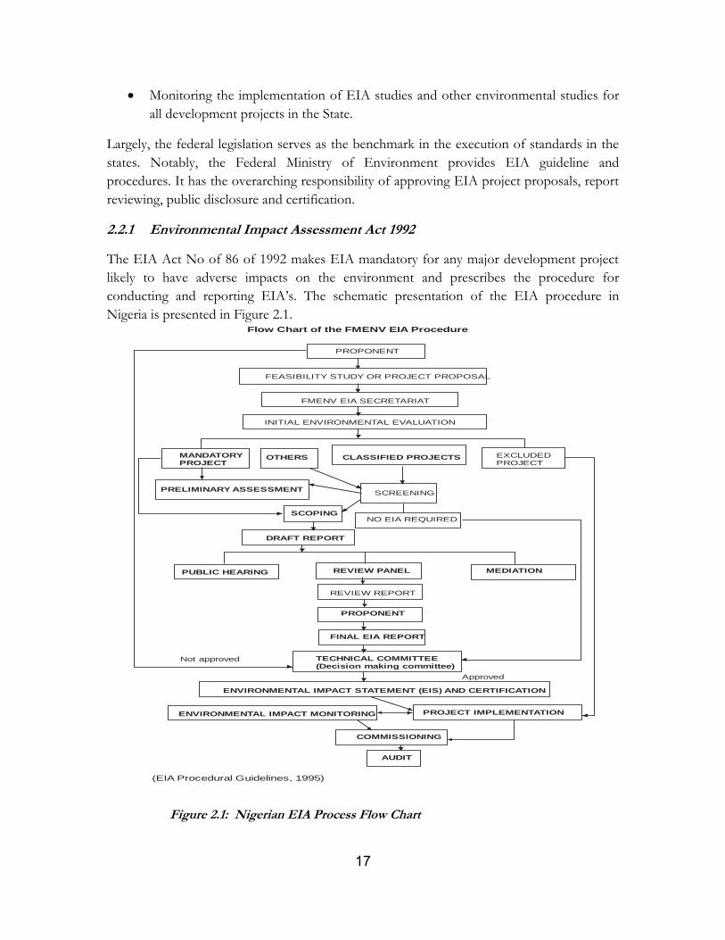
2.2.1 Environmental Impact Assessment Act 1992
The EIA Act No of 86 of 1992 makes EIA mandatory for any major development project
likely to have adverse impacts on the environment and prescribes the procedure for
conducting and reporting EIA’s. The schematic presentation of the EIA procedure in
Nigeria is presented in Figure 2.1.
Figure 2.1: Nigerian EIA Process Flow Chart
PROPONENT
FEASIBILITY STUDY OR PROJECT PROPOSAL
FMENV EIA SECRETARIAT
INITIAL ENVIRONMENTAL EVALUATION
MANDATORY PROJECT
OTHERS CLASSIFIED PROJECTS EXCLUDED PROJECT
PRELIMINARY ASSESSMENT
SCOPING
SCREENING
NO EIA REQUIRED
DRAFT REPORT
PUBLIC HEARING REVIEW PANEL MEDIATION
REVIEW REPORT
PROPONENT
FINAL EIA REPORT
TECHNICAL COMMITTEE(Decision making committee)
ENVIRONMENTAL IMPACT STATEMENT (EIS) AND CERTIFICATION
ENVIRONMENTAL IMPACT MONITORING PROJECT IMPLEMENTATION
COMMISSIONING
AUDIT
Flow Chart of the FMENV EIA Procedure
(EIA Procedural Guidelines, 1995)
Not approved
Approved
18
2.2.2 Forestry Act 1958
This Act of 1958 provides for the preservation of forests and the setting up of forest
reserves. It is an offense, punishable with up to 6 months imprisonment, to cut down trees
over 2ft in girth or to set fire to the forest except under special circumstances.
2.2.3 Water Resources Act 1993, No.101 This act is to promote the optimum planning, development and use of Nigeria’s water resources and other matters connected therewith. The right to the use and control of all surface and groundwater and of any watercourse affecting more than one State as described in the Schedule to this Act, together with the bed and banks thereof, are by virtue of this Act and without further assurance vested in the Government of the Federation for the purposes of:
promoting the optimum planning, development and use of Nigeria's waterresources;
ensuring the co-ordination of such activities as are likely to influence the quality, quantity,
distribution, use and management of water;
ensuring the application of appropriate standards and techniques for the investigation, use, control,
protection, management and administration of water resources; and,
facilitating technical assistance and rehabilitation for water supplies.
2.2.4 Land Use Act of 1978
The land-use Act of 1978 states that “…It is also in the public interest that the rights of all
Nigerians to use and enjoy land in Nigeria and the natural fruits thereof in sufficient quality
to enable them to provide for the sustenance of themselves and their families should be
assured, protected and preserved’. This implies that acts that could result in the pollution of
the land, air, and waters of Nigeria negates this decree, and is therefore unacceptable.
Furthermore, the Land Use Act of 1978 (modified in 1990) remains the primary legal means
to acquire land in the country. The Act vests all land comprised in the territory of each state
of the Federation in the Governor of the state and requires that such land shall be held in
trust and administered for the use and common benefit of all Nigerians in accordance with
the provisions of this Act.
According to the Act, administration of land area is divided into urban land, which will be
directly under the control and management of the Governor of each State; and non-urban
land, which will be under the control and management of the Local Government. State
Governors are given the right to grant statutory rights of occupancy to any person or any
purpose; and the Local Government will have the right to grant customary rights of
occupancy to any person or organization for agricultural, residential and other purposes.
2.2.5 International Laws and Conventions
United Nations Convention on Biological Diversity
19
This convention was signed into law during the Rio Earth Summit in 1992. The convention
places general obligations on countries to observe sustainable use and equitably share the
plants and animals of the earth.
United Nations Convention on Climate Change
The convention on the climate change was signed in 1992 during the Rio Earth summit but
put into force in 1994. The convention calls on developed countries and economies in
transition to limit her emissions of the green house gases which cause global warming,
although it does not impose mandatory emissions on developing countries.
Convention to Regulate International Trade in Endangered Species of Fauna
and Flora
This convention was signed into law in 1973 during the Washington summit and restricts the
trade of fauna and flora species termed as endangered organisms.
Convention on Conservation of Migratory species of Wild Animals
The Convention on Migratory Species is a Multilateral Environmental Agreement (MEA),
signed in 1983. The central objective of the treaty under the aegis of the United Nations
Environment Programme (UNEP) is largely to foster close cooperation on the conservation
of migratory species between the countries through which these animals travel on their
annual journeys. Among the species that do so and that are listed on the Convention’s
Appendices are many marine mammals, fish and seabirds. In addition, the treaty promotes
addressing adverse anthropogenic impacts on migratory species in close liaison with
numerous international bodies concerned with the conservation and use of marine and
arctic migratory species; and control the impact of man-made noise pollution on marine
species through the application of appropriate mitigative measures to prevent impacts in
areas known or suspected to be important habitat to sensitive species. The construction
of the Bemi Bridge project is claimed by antagonists of the bridge to contravene this treaty
to which Nigeria is a signatory. Protagonists opting for infrastructural development reject
that claim and do not consider that the bridge construction violated any provision of the
convention.
The Universal Declaration of Human Right 1948
The General Assembly of the United Nations adopted and proclaimed the Universal
Declaration of Human Rights which finds application in Nigeria through the African
Charter on Human and Peoples' Rights (Ratification and Enforcement) Act Chapter A9
(Chapter 10 LFN 1990) (No 2 of 1983) of Laws of the Federation of Nigeria 1990 wherein
everyone has the right to a standard of living adequate for the health and well-being of
20
himself and of his family, including food, clothing, housing and medical care and
necessary social services, and the right to security in the event of unemployment, sickness,
disability, widowhood, old age or other lack of livelihood in circumstances beyond his
control. This is viewed by some as basis for protecting the well-being of individuals and
vulnerable groups in any environment.
2.2.6 World Bank’s environmental and social guidelines
The World Bank's environmental and social safeguard policies are a cornerstone of its
support to sustainable poverty reduction. The objective of these policies is to prevent and
mitigate undue harm to people and their environment in the development process. These
policies provide guidelines for bank and borrower staff in the identification, preparation, and
implementation of programs and projects.
The effectiveness and development impact of projects and programs supported by the Bank
has substantially increased as a result of attention to these policies.
Safeguard policies have often provided a platform for the participation of stakeholders in
project design, and have been an important instrument for building ownership among local
populations.
The Bank requires environmental assessment (EA) and Social Assessment of projects
proposed for Bank financing to help ensure that they are both socially and environmentally
sound and sustainable, and thus to improve decision making.
The Bank has twelve safeguards policies and these are:
OP 4.00 Use of Country Systems
OP 4.01 Environmental Assessment;
OP 4.04 Natural Habitats;
OP 4.36 Forests;
OP 4.09 Pest Management;
OP 4.11 Physical Cultural Resources
OP 4.37 Safety of Dams;
OP 4.12 Involuntary Resettlement;
OP 7.50 Projects on International Waterways;
OP 7.60 Projects in Disputed Areas, and
Access to Information Policy
Aside the Use of Country System and Access to Information Policies, other World Bank
operational policies triggered by the Bemi Bridge Project are discussed as follows:
21
a) OP4.01: Environmental Assessment
Environmental Assessment to the likely potential effects of any project is a legislative
requirement. Hence, this safeguard is triggered as the Environmental and Social Impact
Assessment of the Bemi Bridge will serve the purpose of evaluating the potential outcome
that is applicable within the ecologically sensitive environment of the Cross River National
Park.
b) OP 4:04 Natural Habitats
This Safeguard Policy is concerned with ensuring the protection, maintenance and
rehabilitation of natural habitats. It provides that the Bank will not support projects that
involve the significant conversion or degradation of critical natural habitats. OP 4:04 is
applicable to the Bemi Bridge, Okwangwo as the project region is under the protective
status of the National Park Act which provide for maintaining the natural habitats of the
environment.
c) OP 4:36 Forests
This Safeguard Policy with the sustainable use of forests and the protection of the local
and global environmental role of forests. OP 4:36 is applicable to the Bemi project as
natural forests occur in the target areas of the bridge project.
Nigeria EA Guidelines and World Bank EA Guidelines
The Environmental Impact Assessment Act No. 86 of 1992 requires that development
projects be screened for their potential impact. Based on the screening, a full, partial, or no
Environmental impact assessment may be required. Guidelines issued in 1995 direct the
screening process.
According to these guidelines,
Category I projects will require a full Environmental Impact Assessment (EIA).
Category II projects may require only a partial EIA, which will focus on mitigation and
Environmental planning measures, unless the project is located near an environmentally
sensitive area--in which case a full EIA is required.
Category III projects are considered to have “essentially beneficial impacts” on the
environment, for which the Federal Ministry of the Environment will prepare an
Environmental Impact Statement.
22
With regard to environmental assessment, the Bank has also categorized projects based on
the type of EA required, namely:
Category A - projects are those whose impacts are sensitive, diverse, unprecedented, felt
beyond the immediate project environment and are potentially irreversible over the long
term. Such projects require full EA.
Category B - projects involve site specific and immediate project environment interactions,
do not significantly affect human populations, do not significantly alter natural systems and
resources, do not consume much natural resources (e.g., ground water) and have adverse
impacts that are not sensitive, diverse, unprecedented and are mostly reversible. Category B
projects will require partial EA, and environmental and social action plans.
Category C - Projects are mostly benign and are likely to have minimal or no adverse
environmental impacts. Beyond screening, no further EA action is required for a Category C
project, although some may require environmental and social action plans.
Category FI - A proposed project is classified as Category FI if it involves investment of
Bank funds through a financial intermediary, in subprojects that may result in adverse
environmental impacts.
This World Bank categorization ( A, B, & C) corresponds in principle with the Nigeria EIA
requirements of Category I, II and III, which in actual practice is done with regard to the
level of impacts associated with a given project. Notably, the World Bank EA operational
procedures and the Nigeria EIA guideline/requirements are similar in the objectives of good
practice as both agree in the following:
Early consideration of environmental and social issues (starting at the screening
stage);
Identification and early consultation with stakeholders;
Prevention of adverse impacts through the consideration of feasible alternatives; and
Incorporation of mitigation measures into planning and (engineering) design.
Although both regulatory positions are similar, in the event of divergence between the two,
the World Bank safeguard policy shall take precedence over Nigeria EA laws, guidelines and
or standards.
23
CHAPTER THREE: PROJECT DESCRIPTION AND ANALYSIS OF ALTERNATIVES
3.1 Project Description
The Bemi Bridge is located over River Bemi at the buffer zone of the Okwangwo division of
Cross River State National Park. Other opinions are that the exact location of the Bemi
River is at the boundary of the National Park to the Okwangwo Division of the Cross River
National Park. However, the site is located on longitude 9010
’54.8
” East and Latitude 06
023
’23.0
”
North at an altitude of 136m above sea level.
Figure 3.1: Bemi River Site of the Bridge Project
3.2 Overview of the Okwangwo Park
The Okwangwo National Park is one of the seven existing Parks under the Nigeria National Park
Service. The Okwangwo National Park has the statutory responsibility to preserve, enhance,
protect and sustainably manage vegetation, plants and wildlife in its territory in order to build an
ecologically and geographically balanced network of protected areas under the jurisdiction and
control of the Federal Government. Section 20 (1) of the National Park Service Act provides that
“The ownership of every wild animal and wild plant existing in its natural habitat in a National Park
and anything whatsoever, of biological, geomorphological or historical origin or otherwise, existing
or found in a National Park is hereby vested in the Federal Government and subject to the control
and management by the Federal Government for the benefit of Nigeria and mankind generally.”
The project area has the following attributes:
24
Seasonal-tropical climate, having two distinctive seasons: the dry and the rainy seasons
Rainfall ranges between 2,500m to 4,500mm per annum.
Drained by many rivers such as Bemi, Oyi, Anyibiar, Kanton, Matche and Anyukwo rivers
among others.
The soils are classified as sandy-loamy and clayey-loamy
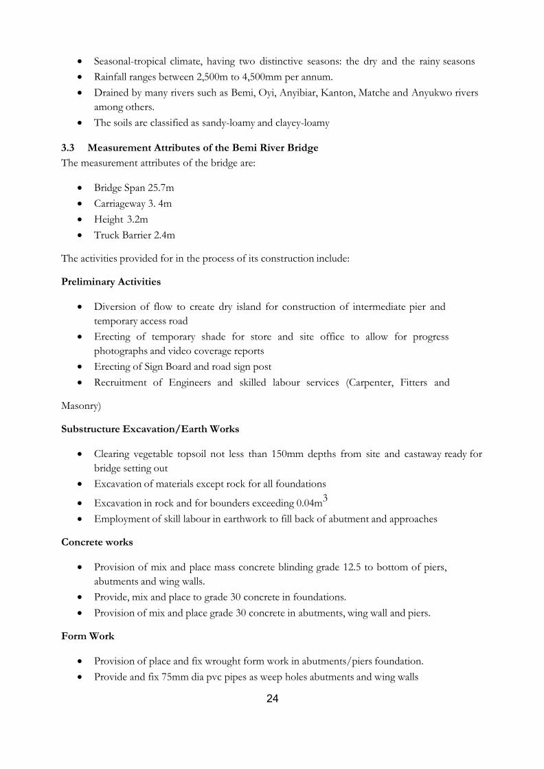
3.3 Measurement Attributes of the Bemi River Bridge
The measurement attributes of the bridge are:
Bridge Span 25.7m
Carriageway 3. 4m
Height 3.2m
Truck Barrier 2.4m
The activities provided for in the process of its construction include:
Preliminary Activities
Diversion of flow to create dry island for construction of intermediate pier and
temporary access road
Erecting of temporary shade for store and site office to allow for progress
photographs and video coverage reports
Erecting of Sign Board and road sign post
Recruitment of Engineers and skilled labour services (Carpenter, Fitters and
Masonry)
Substructure Excavation/Earth Works
Clearing vegetable topsoil not less than 150mm depths from site and castaway ready for
bridge setting out
Excavation of materials except rock for all foundations
Excavation in rock and for bounders exceeding 0.04m3
Employment of skill labour in earthwork to fill back of abutment and approaches
Concrete works
Provision of mix and place mass concrete blinding grade 12.5 to bottom of piers,
abutments and wing walls.
Provide, mix and place to grade 30 concrete in foundations.
Provision of mix and place grade 30 concrete in abutments, wing wall and piers.
Form Work
Provision of place and fix wrought form work in abutments/piers foundation.
Provide and fix 75mm dia pvc pipes as weep holes abutments and wing walls
25
Reinforcement
Provide, place and fix high tensile steel reinforcement in foundations
Provide, place and fix mild steel / high tensile steel reinforcements to abutments /wing
walls and piers
Beam and deck Concrete works
Provide and place grade
Provide and place grade 35 concrete in beams and deck/transit slabs.
Form Work
Provide and fix wrought form work to beams and transit slabs and deck
Reinforcement
Provide and fix high yield tensile and mild steel reinforcement to Beams and deck
Direction of river channel
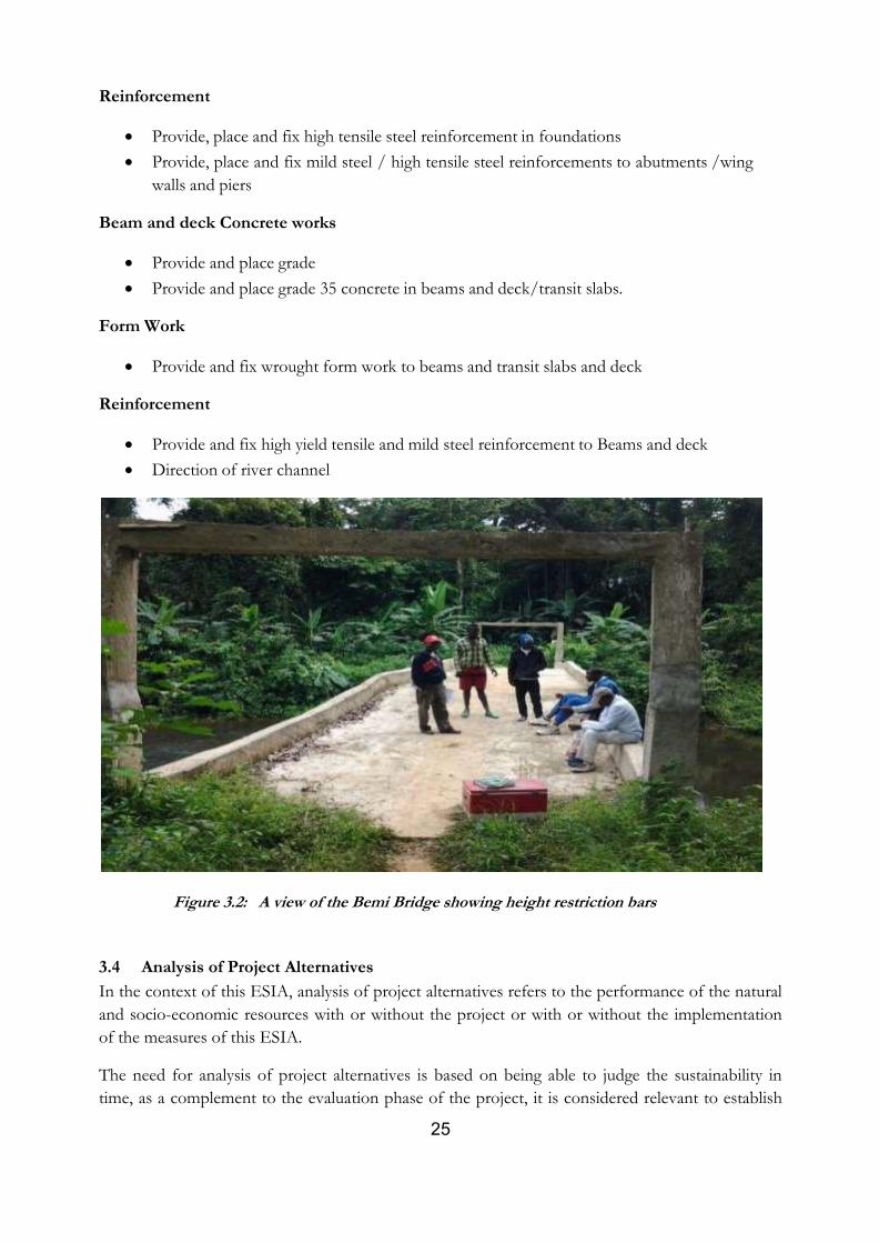
Figure 3.2: A view of the Bemi Bridge showing height restriction bars
3.4 Analysis of Project Alternatives
In the context of this ESIA, analysis of project alternatives refers to the performance of the natural
and socio-economic resources with or without the project or with or without the implementation
of the measures of this ESIA.
The need for analysis of project alternatives is based on being able to judge the sustainability in
time, as a complement to the evaluation phase of the project, it is considered relevant to establish

26
the behavior of the environment into the future. For this purpose, the following project alternatives
were examined:
3.4.1 No Project Option
The no project option implies that the proposed project is not desirable. This option is justified on
the ground that the objective which the Park supports may be eroded by the construction of the
bridge which is likely to enhance access in and out of the site. It is also argued that similar bridges
constructed on the edge of Cross River National Park at Bashu and Ekonganaku witnessed an
upsurge in illegal logging inside the park as soon as they were completed. Information regarding the
implementation of the ESMP at those sites is however not provided. It also reasoned that, the
measures to mitigate the negative impacts to be caused by the bridge construction may not be
implemented due to paucity of funds, and therefore, the most reasonable thing is not to embark on
construction of the bridge.
However, choosing the no project option will mean a loss of preliminary investments made by the
project proponents on the project. More importantly, it will entail ignoring the earnest request of
the enclave villagers who are vulnerable to risk of loss of lives, loss of economic goods and limited
access to livelihood improvement due to restricted access to movement caused by the Bemi bridge.
This option therefore, is against the human right to livelihood of the enclave communities. It is also
a retardation to the national and global policies that supports poverty reduction and welfare.
3.4.2 Embark on Bridge Construction Option
This option means going ahead to construct the bridge at Okwango National Park. It is supported
by the argument that conservation of nature can and should go side by side with human
development. Argument of livelihood improvement, better healthcare and market accessibility and
improved economic and social opportunities for the people of the enclave communities are some
of the reasons that strongly support this option. Also, since monitoring and enforcement of anti
poaching and hunting activities have been difficult to contain as a result of patrol constraint caused
by inaccessibility, it is only instructive that National Park operation of forest and wildlife
conservation will be optimized with access provided by the construction of the Bemi Bridge. It is
also reasoned that National Parks in many parts of the world have co-existed with tolerance for
human rights of the natives as supported by the bridge constructions at Korup National Park South
West Cameroon, Whanganui National Park New Zealand and Lake District National Park North
West England Amongst others.
This option in view of the holistic view and comparism of the supporting reasons is more feasible
and reasonable. It is therefore, necessary to go ahead with the Bemi Bridge construction.
27
CHAPTER FOUR: DESCRIPTION OF THE PROJECT AREA AND BASELINE DATA
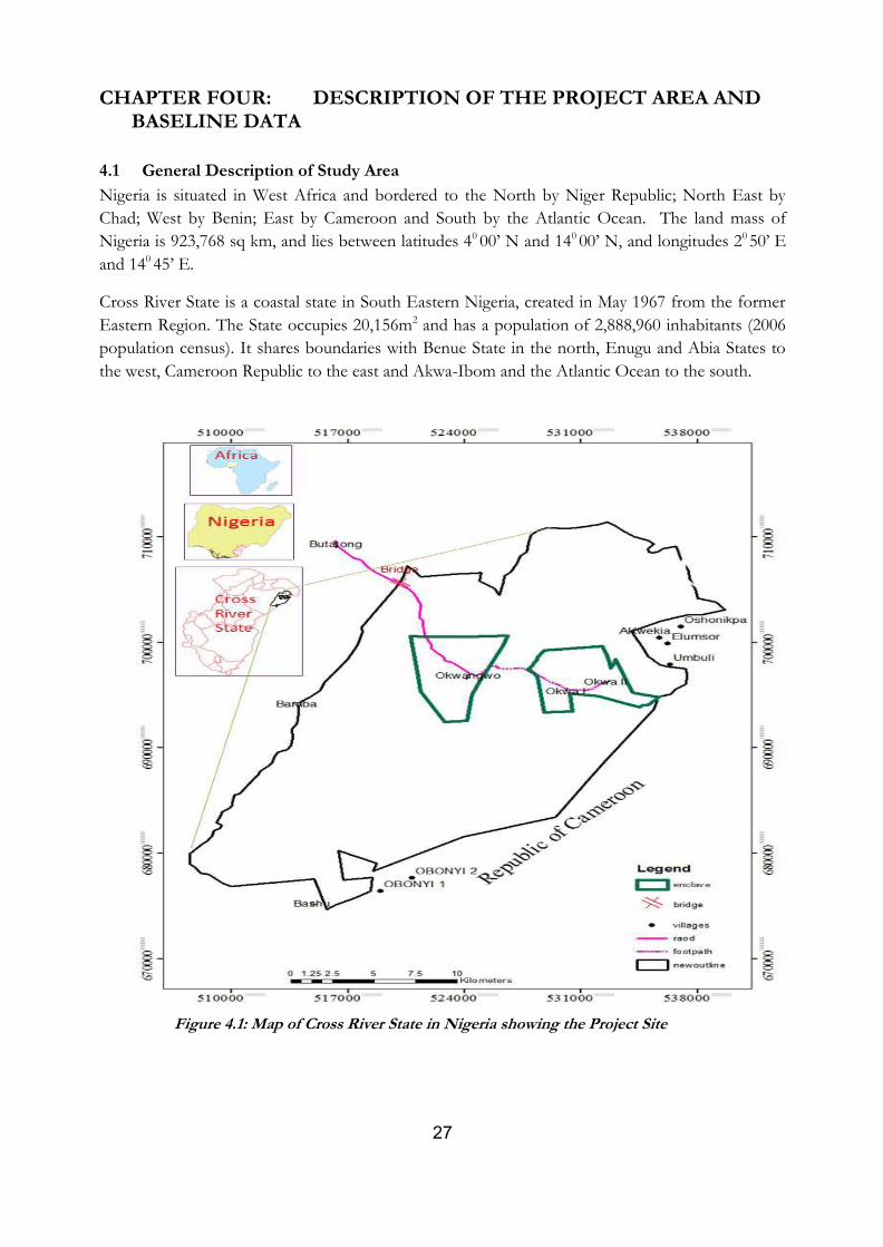
4.1 General Description of Study Area
Nigeria is situated in West Africa and bordered to the North by Niger Republic; North East by
Chad; West by Benin; East by Cameroon and South by the Atlantic Ocean. The land mass of
Nigeria is 923,768 sq km, and lies between latitudes 40 00’ N and 140 00’ N, and longitudes 20 50’ E
and 140 45’ E.
Cross River State is a coastal state in South Eastern Nigeria, created in May 1967 from the former
Eastern Region. The State occupies 20,156m2 and has a population of 2,888,960 inhabitants (2006
population census). It shares boundaries with Benue State in the north, Enugu and Abia States to
the west, Cameroon Republic to the east and Akwa-Ibom and the Atlantic Ocean to the south.
Figure 4.1: Map of Cross River State in Nigeria showing the Project Site
28
4.2 Environmental & Social Baseline Data
Population of Cross River State
Cross River State has a total population of 2,888,966 million persons (2006 population census)
made up of 1,492,565 million males and 1,421,021 million females spread across the 18 local
government areas
Resources
Cross River State is one of the most richly endowed agricultural lands in Nigeria. Forestry accounts
for about 22.4 percent of the total land areas. The state also has great potential for marine fisheries
and freshwater aquaculture as well as metallic minerals.
Environmental Issues
As in most part of Southern Nigeria, the major environmental problems are soil degradation, urban
air and water pollution, and rapid urbanization.
Climate
The climate of the project area is tropical, having two distinctive seasons: the dry and the rainy
seasons. The rainy season which last longer begins in May and ends in November. The dominant
wind system during the rainy season is the south west air mass. Over the region, rainfall is not
evenly distributed, being heaviest in the mountainous northeastern parts which receive up-to
4,500mm per annum (Obot, 1996). Towards the southwest, rainfall amount reduces to 2,500mm
per annum. The length of the dry season varies also in the same manner, from 3 to 4 months in
the northeast to 4 to 5 months in the southwest. Ambient temperatures are high 18° - 32° C at
lower altitudes. At higher altitudes around Obudu plateau, temperatures are lower, with 14° -
16° C daily maxima recorded on Obudu highlands and the Obudu Cattle Ranch (Obot, 1996).
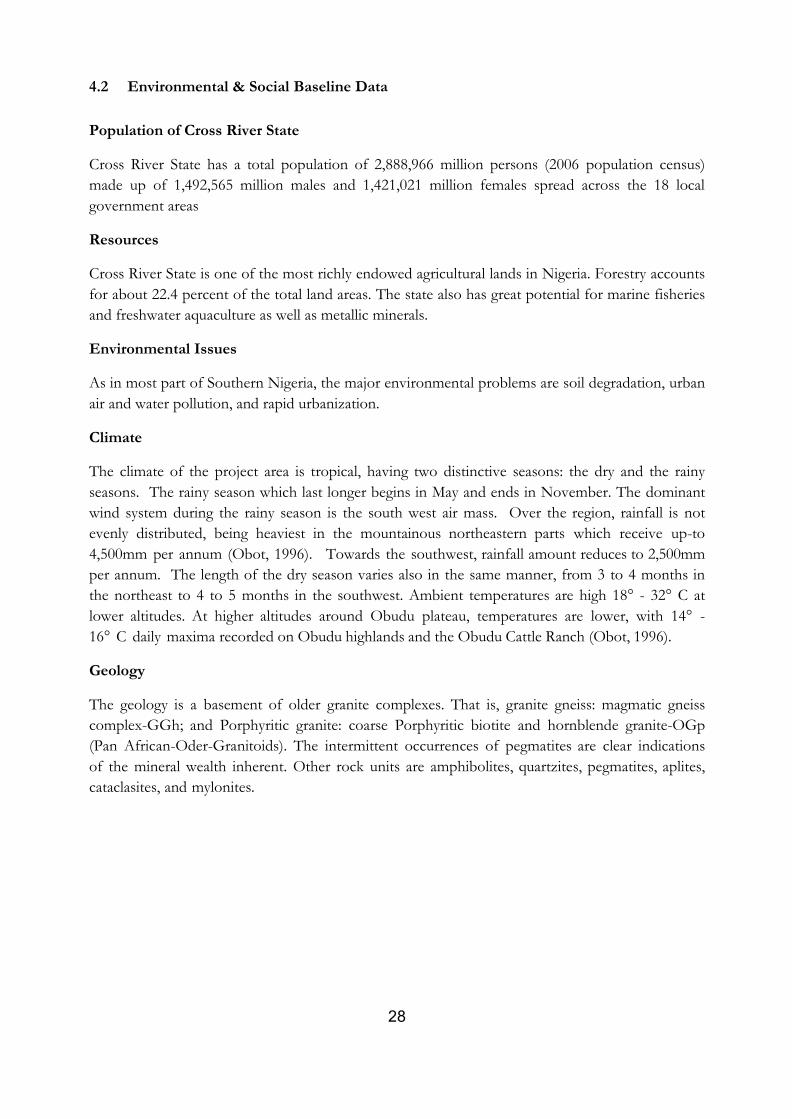
Geology
The geology is a basement of older granite complexes. That is, granite gneiss: magmatic gneiss
complex-GGh; and Porphyritic granite: coarse Porphyritic biotite and hornblende granite-OGp
(Pan African-Oder-Granitoids). The intermittent occurrences of pegmatites are clear indications
of the mineral wealth inherent. Other rock units are amphibolites, quartzites, pegmatites, aplites,
cataclasites, and mylonites.
29
Figure 4.2: Geology of Okwangwo
Source: Adapted from Geology and Mineral Resource Map of Cross River State (Nigeria
Geological Survey Agency, 2006)
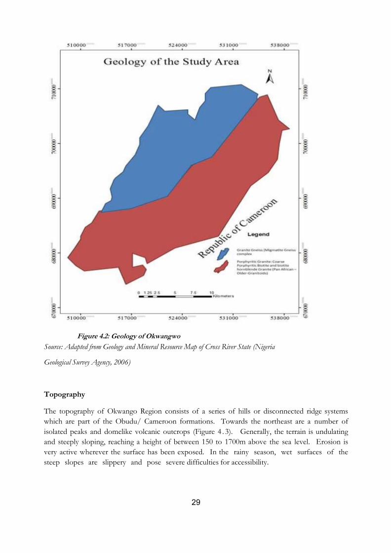
Topography
The topography of Okwango Region consists of a series of hills or disconnected ridge systems
which are part of the Obudu/ Cameroon formations. Towards the northeast are a number of
isolated peaks and domelike volcanic outcrops (Figure 4 . 3). Generally, the terrain is undulating
and steeply sloping, reaching a height of between 150 to 1700m above the sea level. Erosion is
very active wherever the surface has been exposed. In the rainy season, wet surfaces of the
steep slopes are slippery and pose severe difficulties for accessibility.
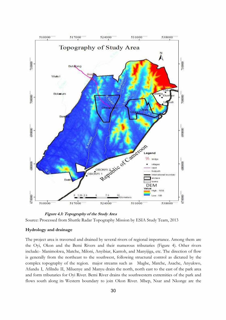
30
Figure 4.3: Topography of the Study Area
Source: Processed from Shuttle Radar Topography Mission by ESIA Study Team, 2013
Hydrology and drainage
The project area is traversed and drained by several rivers of regional importance. Among them are
the Oyi, Okon and the Bemi Rivers and their numerous tributaries (Figure 4). Other rivers
include:- Manimokwa, Matche, Miloni, Anyibiar, Kantoh, and Manyijiga, etc. The direction of flow
is generally from the northeast to the southwest, following structural control as dictated by the
complex topography of the region. major streams such as Magbe, Matche, Asache, Anyukwo,
Afundu I, Afilndu II, Miluenye and Manyu drain the north, north east to the east of the park area
and form tributaries for Oyi River. Bemi River drains the southwestern extremities of the park and
flows south along its Western boundary to join Okon River. Mbep, Nsar and Nkonge are the
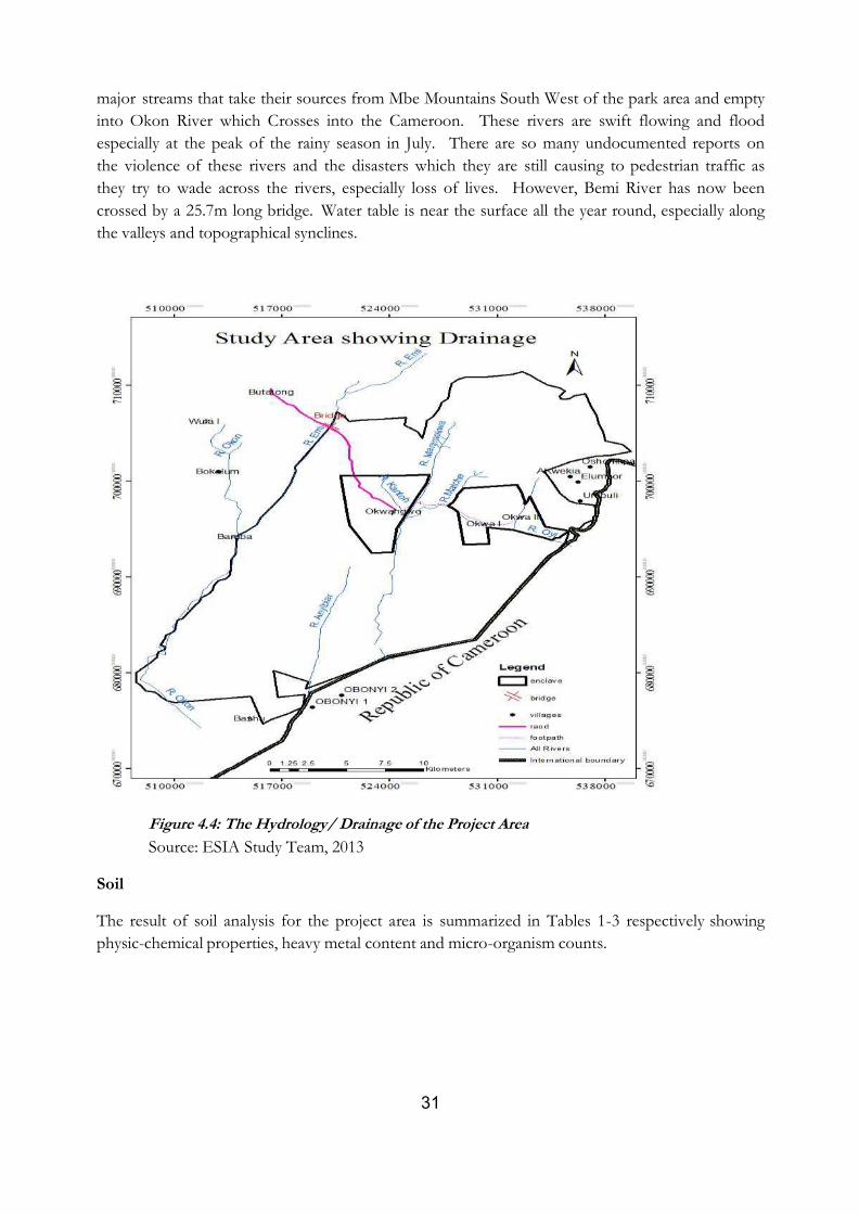
31
major streams that take their sources from Mbe Mountains South West of the park area and empty
into Okon River which Crosses into the Cameroon. These rivers are swift flowing and flood
especially at the peak of the rainy season in July. There are so many undocumented reports on
the violence of these rivers and the disasters which they are still causing to pedestrian traffic as
they try to wade across the rivers, especially loss of lives. However, Bemi River has now been
crossed by a 25.7m long bridge. Water table is near the surface all the year round, especially along
the valleys and topographical synclines.
Figure 4.4: The Hydrology/ Drainage of the Project Area
Source: ESIA Study Team, 2013
Soil
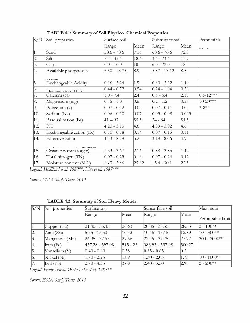
The result of soil analysis for the project area is summarized in Tables 1-3 respectively showing
physic-chemical properties, heavy metal content and micro-organism counts.
32
TABLE 4.1: Summary of Soil Physico–Chemical Properties
S/N Soil properties Surface soil Subsurface soil Permissible
Limit Range Mean Range Mean
1 Sand 58.6 - 78.6 71.6 68.6 - 76.6 72.3
2. Silt 7.4 - 35.4 18.4 3.4 - 23.4 15.7
3. Clay 6.0 - 16.0 10 6.0 - 22.0 12
4. Available phosphorus
(AVP)
6.50 - 13.75 8.9 5.87 - 13.12 8.5
5. Exchangeable Acidity 0.16 - 2.24 1.5 0.40 - 2.32 1.49
6. Hypogen ion (H+
) 0.44 - 0.72 0.54 0.24 - 1.04 0.59
7. Calcium (ca) 1.0 - 7.4 2.4 0.8 - 5.4 2.17 0.6-12***
8. Magnesium (mg) 0.45 - 1.0 0.6 0.2 - 1.2 0.53 10-20***
9. Potassium (k) 0.07 - 0.12 0.09 0.07 - 0.11 0.09 3-8**
10. Sadium (Na) 0.06 - 0.10 0.07 0.05 - 0.08 0.065
11. Base salination (Bs) 41 – 93 55.5 34 - 84 51.5
12. PH 4.23 - 5.13 4.6 4.39 - 5.02 4.6
13. Exchangeable cation (Ec) 0.10 - 0.18 0.14 0.07 - 0.15 0.11
14. Effective cation
exchange capacity (ECEC)
4.13 - 8.78 5.2 3.18 - 8.06 4.9
15. Organic carbon (org.c) 1.33 - 2.67 2.16 0.88 - 2.85 1.42
16. Total nitrogen (TN) 0.07 - 0.23 0.16 0.07 - 0.24 0.42
17. Moisture content (M.C) 16.3 - 29.6 25.82 15.4 - 30.1 22.5
Legend: Holllland et al, 1989**; Line et al, 1987***
Source: ESIA Study Team, 2013
TABLE 4.2: Summary of Soil Heavy Metals
S/N Soil properties Surface soil Subsurface soil Maximum
Permissible limit Range Mean Range Mean
1 Copper (Cu) 21.40 - 36.45 26.63 20.85 - 36.35 28.33 2 - 100**
2. Zinc (Zn) 5.75 - 15.50 10.42 10.45 - 15.15 12.89 10 - 300**
3. Manganese (Mn) 26.95 - 37.65 29.56 22.45 - 37.75 27.77 200 - 2000**
4. Iron (Fe) 457.28 - 597.98 545 - 23 386.93 - 597.98 500.27
5. Vanadium (V) 0.40 - 0.80 0.58 0.35 - 0.65 0.5
6. Nickel (Ni) 1.70 - 2.25 1.89 1.30 - 2.05 1.75 10 - 1000**
7. Led (Pb) 2.70 - 4.35 3.68 2.40 - 3.30 2.98 2 - 200**
Legend: Brady &weit, 1996; Bohn et al, 1985**
Source: ESIA Study Team, 2013
33
The soil physical properties indicate that soils in the project area are sandy-loam and clayey-loam at
the surface and subsurface respectively. Soil particle size distribution (Sand silt and clay) was
observed as follows: sand content ranged between 58.6%-78.6% with a mean of 71.6% at the
surface soil while the subsurface soil ranged between 68.6%-
76.6% with a mean of 72.3%. Silt on the other hand ranged between 7.4%-35.4% and a mean of
18.4% at the surface and ranged between 3.4%-23.4% and mean of 15.7% at the subsurface while
clay ranged between 6.0% - 16.0% and mean of 10% at the surface and also ranged between 6%-
22% and mean value of 12% at the subsurface layer of the soil.
With respect to soil stability, properties and vegetation growth, the major useful soil chemical
properties include; Soil organic carbon which is a major soil component that is a principal content
of organic matter. Hence carbon according to Schnitzal (1982) is very important and it is a major
source of C02 and atmospheric C02. Organic carbon is made up of the cells of microorganisms,
plants and animals residues at various stages of decomposition. Therefore plants and animals need
carbon for their growth and production. Hence, the level of organic carbon in the area varied in
the area at both surface and subsurface soils. Organic Carbon (Org.C) ranged between 1.33%-
2.67% with mean of 2.16% at the surface layer of the soil while the subsurface range was
between 0.88% with a surface mean of 1.42%.
Moreover, available phosphorus (Av.P) is very important to plant growth, protein synthesis and
promotion tissue development both plant and animal based on these, the soils Av.P were seen to
occur within the range of 6.50mg/kg – 13.75mg/kg and mean of 8.9 mg/kg at the surface soil and
range of 5.87mg/kg -13.12mg/kg and mean of 8.5 mg/kg at the subsurface layer of the soil.
Exchangeable bases also relates to soils ability to sustain plant growth, ration nutrients and buffer
acid deposition of requester toxic heavy metals. The exchangeable bases were within the permissible
limits. By implication the soil within the project area is fertile and stable, hence able to support
vegetation growth. This condition enables the availability of litter droppings, facilitate soil moisture
retention and increase in soil biota.
Soil Micro Organisms Count
The soil microorganisms that are hydro carbon utilizing play significant role in carbon storage in
soil. This bacteria and fungi make use of these substances for their growth and development, thus,
facilitate the storage of carbon in the soil. This bacterial and fungal growth alongside the densities
in the soil indicates the availability rate of hydrocarbon compounds that may support plant
growth. Therefore, the more the number of these organisms in the soil, the lower the hydrocarbon
content of that particular soil.
Consequent upon these, the soils of Okwangwo within the Bemi Rivers Bridge and the control
point which were labeled as Okwangwo 1-4 (surface soils) and Okwangwo 1-4 (subsurface),
34
Okwangwo 5-6 (surface soils of the control points) and Okwangwo 5-6 (sub-surface soils of the
control point), had high content of variable total aerobic heterotrophic bacteria and fungi (THB
and THF) and hydrocarbon utilizing bacteria and fungi in the sampled soils.
Vegetation and Wildlife
An important feature of the vegetation of Okwango Division is an Ecotone of unbroken and little
disturbed forest within the heights of 150m to 170m, a situation that is very rare in the African
Continent (Hills, 1981). Obot et al., (2011) classified the vegetation of the area into five habitat
types as follows:
Lowland Ridge Forest (300-500m): Towards the north of Okwango division, finger- like ridges
protrude into the lowland forest. Lophira alata, Canarium schweinfurthii, Terminalia superb,
Nauclea diderichii and Poga oleos. Flora under the family Caesalpinaceae are better represented in
the ridge forest and species include: Berlinia bracteosa, Afzelia bipidensis, Microberlinia bisulcata
and Erythrophloem ivorensis.
Mid-elevation Forest (500m-800m): The tree flora is dominated by the presence of Vitex doniana
and V. Ferruginea, Montane Forest (800-1,500m). characterised by extremely low and often
disjoint canopy, large numbers of trees, The dominant woody species in the
montaneforest are syzygium guineense, Xylopia staudtii, macaranga occidentalis, santiria trimera,
Harungana madagascariensis, Bridelia micrantha, Antonatha cladantha, Bridelia grandis, sapium
cornutum, polyscias fulva and Venonia confert.High-altitude grassland. The transition zone
between the montane forest and the grassland is comprised of large herbs and woody
shrubs such as Brilliantasia lamium and Dicaetanthera Africana. Pterdium aquilinum is
also a common component of this transition zone including the spectacular Lobelia
columnaris.
The natural vegetation of the project area is the evergreen tropical rain forest which is very rich in
floristic composition. However from place to place, the vegetation depicts an interplay of the
influences of topographic edaphic, climatic, biotic and human factors. The project area being a
buffer zone has patches of clearings for farmland which interrupt the continuity of the rain
forest and tend to savannize their immediate surroundings. Typical trees in the project area reach
height of 40 to 45m. The hills are typically rich in epiphytes and lianes and have species peculiar
to those which are not found in the lowland forest.
The wildlife found in the project areas is diverse. It includes primate and non-human primate
species, aquatic and avian species. The precise populations of these wildlife species have not been
estimated. But it is believed that some of them are already facing threats of extinction and so, need
be protected. The following wildlife species have been identified in the project area: gorilla (Gorilla
gorilla), chimpanzee (pan troglodytes), drill (Mandrillus leucophaeus), putty-nose guenon (cercopitheus
nictitans), mona guenon (ceropitheus mona), red-eared guenon (ceropathecus crythrotis) Preuss’s guenon
35
(ceropithecus preussi), needle-clawed galago (Euoticus elegantulus) and patas monkey (Erythrocebus patas).
The crowned guenon (ceropithecus pogonias) may already be extinct. The hills of Okwango and Okwa
are said to have a relatively large population of forest elephants, some of which cause damage to the
farmlands and even attack people. The buffalo, monkeys and baboons, the porcupine, cain rat and
various species of snakes are also found in the region. It is an aviary and as many as 80 species of
birds have been reported to have been seen there. The region is also rich in aquatic life such as
crocodiles and several species of fish, including the catfish, mudfish and tilapia. It was reported that
hippopotamus was once seen swimming upstream from the Cross River into Oji River.
4.3 Socio-economic Survey of the Project Area
Population of the Enclave Communities
Okwango has a rural population of about1990 persons Okwa I 868 Okwa II 1551persons
respectively.. Immigrant population is negligible (consisting of people from Cameroon, Igbos,
Yorubas, Akwa Ibom, Hausas and Ghana). About 60% of the population is under the age of twenty-
five (25) and more than 70% of this is under the age of twenty (20). Average household
population is between 3 to 16 persons. Polygamy is the dorminant family structure. The language of
Okwangwo people is Boki and their Ethnic group is Ekoi while the Okwa people speak Anyang
Historically, the Okwangwo people first settled at Ajanpiesor, about 2km away from their present
location. They migrated to Achata which is a kilometer from the present Okwangwo before the
final settlement in their present location. On the other hand, the Okwa people migrated from
Takamanda in Cameroon. They first arrived at Mache and Muo before they separated into Okwa 1
and 2. The people of Okwango and Okwa practice Christianity and African Traditional Religion
(ATR).
Social organization
There is a hierarchical social organization structure. At the apex is the Council of chiefs, chaired by
the high chief, supported by several other chiefs (one chief is appointed from every extended
family). Next in the hierarchy is the Village Council, headed by an elected chairman. The village
council observes trends of events; social, economic and legislative in the village and beyond and
makes recommendations to the Council of Chiefs for approval. Other social groups include the
women, the youths, the elites and the hunters associations. It is particularly of note that the women
participate in major community decisions and are not discriminated against in leadership role, farm
holding rights and other socio-economic involvements. During this ESIA consultation women fully
participated and sat together in the means of men during the forum. This constitutes the judiciary,
the executive and the administrative organs of the village community. The various groups have
their designated responsibilities and work in cooperation for the peaceful existence of their
community. The specific responsibilities of the different groups include.
36
The Chief council constitutes the elders and they are the custodians of the law and
tradition.
The youth council enforces the law. For instance, the monitor the forest and activities
of people in the communities to ensure compliance with the community laws.
The women groups are in charge of welfare and also settle disputes.
The elite group comprises of retired personnels from various vocations of life. The function
of the body was advising the community on the decision making, mediate between
the community and external bodies.
The General Assembly is in charge of law. The CBOs such as Okwangwo forest
conscience organization enlightens the community on forest management, organizes
workshops and seminars, partner with National park to address prevailing problems that
affect the enclave communities, identity tourism potentials in the area and facilitates and help
researchers in the area
Vigilante group arrest offenders such as poachers and loggers and assist the National
Park in monitoring the forest.
Settlement and Housing
Three major enclave communities namely Okwangwo village, Okwa 1 and Okwa 11 exist within
the region. The enclave is characterized by nucleonic rural settlement pattern. The residential
housing pattern is amorphous with mud walls and select zinc and thatch roofs indicating more
temporary than permanent structures. Spatial
Tenure System
Acquisition of farmlands is largely through direct clearing of virgin forest with 60% of farm
families acquiring land through that mode. The next is via inheritance accounting for 30% of the
mode of land acquisition (Table 4.3).
TABLE 4.3: Land Tenure System of the enclave communities
Source: Field Survey by ESIA Study Team, 2013
Economy
The enclave people of Okwangwo and Okwa depend largely on Farming and forest eco system.
Different cropping arrangement engaged by the people include mixed crop carried out by 32%
S/N Tenure system Percentage
1. Inheritance 30%
2. First to clear virgin forest 60%
3. Leasehold 10%
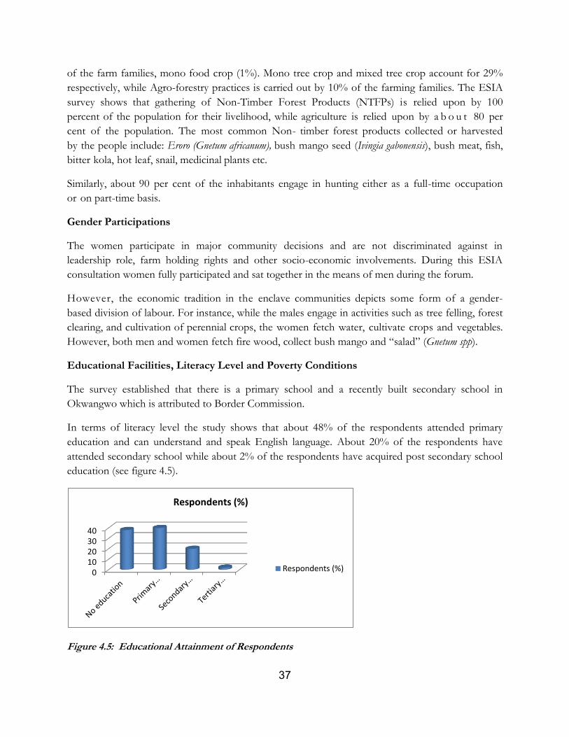
37
of the farm families, mono food crop (1%). Mono tree crop and mixed tree crop account for 29%
respectively, while Agro-forestry practices is carried out by 10% of the farming families. The ESIA
survey shows that gathering of Non-Timber Forest Products (NTFPs) is relied upon by 100
percent of the population for their livelihood, while agriculture is relied upon by a b o u t 80 per
cent of the population. The most common Non- timber forest products collected or harvested
by the people include: Eroro (Gnetum africanum), bush mango seed (Ivingia gabonensis), bush meat, fish,
bitter kola, hot leaf, snail, medicinal plants etc.
Similarly, about 90 per cent of the inhabitants engage in hunting either as a full-time occupation
or on part-time basis.
Gender Participations
The women participate in major community decisions and are not discriminated against in
leadership role, farm holding rights and other socio-economic involvements. During this ESIA
consultation women fully participated and sat together in the means of men during the forum.
However, the economic tradition in the enclave communities depicts some form of a gender-
based division of labour. For instance, while the males engage in activities such as tree felling, forest
clearing, and cultivation of perennial crops, the women fetch water, cultivate crops and vegetables.
However, both men and women fetch fire wood, collect bush mango and “salad” (Gnetum spp).
Educational Facilities, Literacy Level and Poverty Conditions
The survey established that there is a primary school and a recently built secondary school in
Okwangwo which is attributed to Border Commission.
In terms of literacy level the study shows that about 48% of the respondents attended primary
education and can understand and speak English language. About 20% of the respondents have
attended secondary school while about 2% of the respondents have acquired post secondary school
education (see figure 4.5).
Figure 4.5: Educational Attainment of Respondents
010203040
Respondents (%)
Respondents (%)
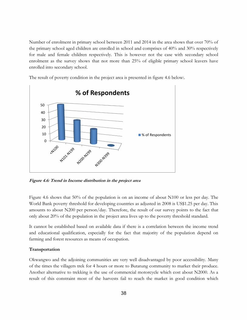
38
Number of enrolment in primary school between 2011 and 2014 in the area shows that over 70% of
the primary school aged children are enrolled in school and comprises of 40% and 30% respectively
for male and female children respectively. This is however not the case with secondary school
enrolment as the survey shows that not more than 25% of eligible primary school leavers have
enrolled into secondary school.
The result of poverty condition in the project area is presented in figure 4.6 below:.
Figure 4.6: Trend in Income distribution in the project area
Figure 4.6 shows that 50% of the population is on an income of about N100 or less per day. The
World Bank poverty threshold for developing countries as adjusted in 2008 is US$1.25 per day. This
amounts to about N200 per person/day. Therefore, the result of our survey points to the fact that
only about 20% of the population in the project area lives up to the poverty threshold standard.
It cannot be established based on available data if there is a correlation between the income trend
and educational qualification, especially for the fact that majority of the population depend on
farming and forest resources as means of occupation.
Transportation
Okwangwo and the adjoining communities are very well disadvantaged by poor accessibility. Many
of the times the villagers trek for 4 hours or more to Butatung community to market their produce.
Another alternative to trekking is the use of commercial motorcycle which cost about N2000. As a
result of this constraint most of the harvests fail to reach the market in good condition which
0
10
20
30
40
50
% of Respondents
% of Respondents
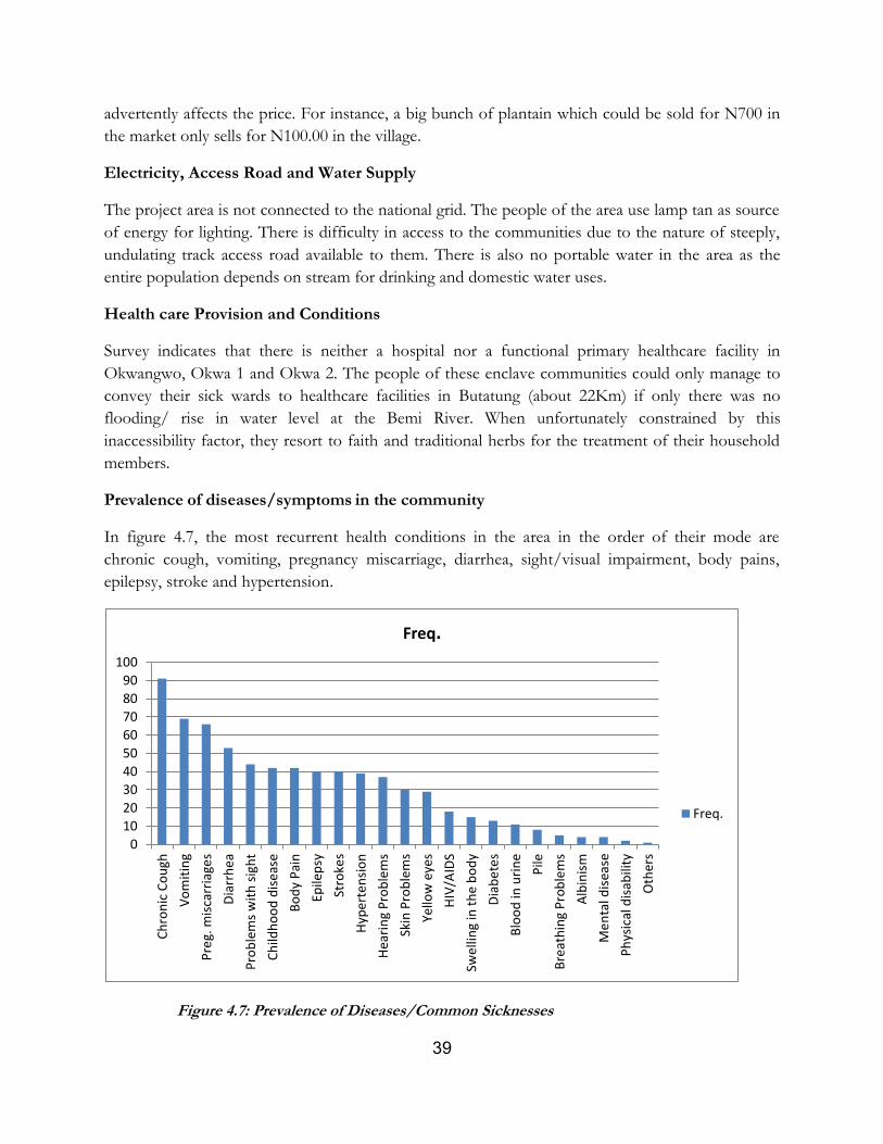
39
advertently affects the price. For instance, a big bunch of plantain which could be sold for N700 in
the market only sells for N100.00 in the village.
Electricity, Access Road and Water Supply
The project area is not connected to the national grid. The people of the area use lamp tan as source
of energy for lighting. There is difficulty in access to the communities due to the nature of steeply,
undulating track access road available to them. There is also no portable water in the area as the
entire population depends on stream for drinking and domestic water uses.
Health care Provision and Conditions
Survey indicates that there is neither a hospital nor a functional primary healthcare facility in
Okwangwo, Okwa 1 and Okwa 2. The people of these enclave communities could only manage to
convey their sick wards to healthcare facilities in Butatung (about 22Km) if only there was no
flooding/ rise in water level at the Bemi River. When unfortunately constrained by this
inaccessibility factor, they resort to faith and traditional herbs for the treatment of their household
members.
Prevalence of diseases/symptoms in the community
In figure 4.7, the most recurrent health conditions in the area in the order of their mode are
chronic cough, vomiting, pregnancy miscarriage, diarrhea, sight/visual impairment, body pains,
epilepsy, stroke and hypertension.
Figure 4.7: Prevalence of Diseases/Common Sicknesses
0
10
20
30
40
50
60
70
80
90
100
Ch
ron
ic C
ou
gh
Vo
mit
ing
Pre
g. m
isca
rria
ges
Dia
rrh
ea
Pro
ble
ms
wit
h s
igh
t
Ch
ildh
oo
d d
ise
ase
Bo
dy
Pai
n
Epile
psy
Stro
kes
Hyp
ert
ensi
on
Hea
rin
g P
rob
lem
s
Skin
Pro
ble
ms
Yello
w e
yes
HIV
/AID
S
Swel
ling
in t
he
bo
dy
Dia
be
tes
Blo
od
in u
rin
e
Pile
Bre
ath
ing
Pro
ble
ms
Alb
inis
m
Me
nta
l dis
ease
Ph
ysic
al d
isab
ility
Oth
ers
Freq.
Freq.
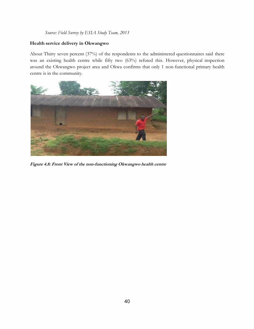
40
Source: Field Survey by ESIA Study Team, 2013
Health service delivery in Okwangwo
About Thirty seven percent (37%) of the respondents to the administered questionnaires said there
was an existing health centre while fifty two (63%) refuted this. However, physical inspection
around the Okwangwo project area and Okwa confirms that only 1 non-functional primary health
centre is in the community.
Figure 4.8: Front View of the non-functioning Okwangwo health centre
41
CHAPTER FIVE: POTENTIAL IMPACTS AND MITIGATION MEASURES
5.1 Introduction
This Section contains a summary of the impacts envisaged resulting from the project as a result of
the interaction between the project components, the environmental elements and human behavior
as a response to the availability of the bridge. The method of impact identified and evaluated is also
given in this Section.
5.2 Impact Identification and Evaluation
The identification and management of impacts associated with project activities were based on a risk
management and involves:
• Identification of project activities and post construction operations that may interact with
the project environment.
• Implementing controls to reduce risk of impacts.
• Monitoring the effectiveness of controls.
The key project activities of the proposed development were identified. The pathways (or events)
that may cause impacts to the environment were determined, and their associated potential impacts
listed. The risk of the impacts occurring was analysed by determining the consequence severity of
the impacts and the likelihood of consequences being realized. The severity of the consequences was
determined using a Consequence Severity Table and the likelihood of an impact resulting from a
pathway was determined with a Likelihood Ranking Table and then the level of risk was determined
using a Risk Matrix (Table 5.1).
To prevent or minimize the impacts, controls were placed on the pathways in this order of priority:
• Elimination of the activity.
• Substitution with a lower risk activity.
• Engineering solutions to reduce the impact of the event.
• Implementation of administrative procedures to control the activity.
• Clean up or remediation measures to mitigate impacts after an event.
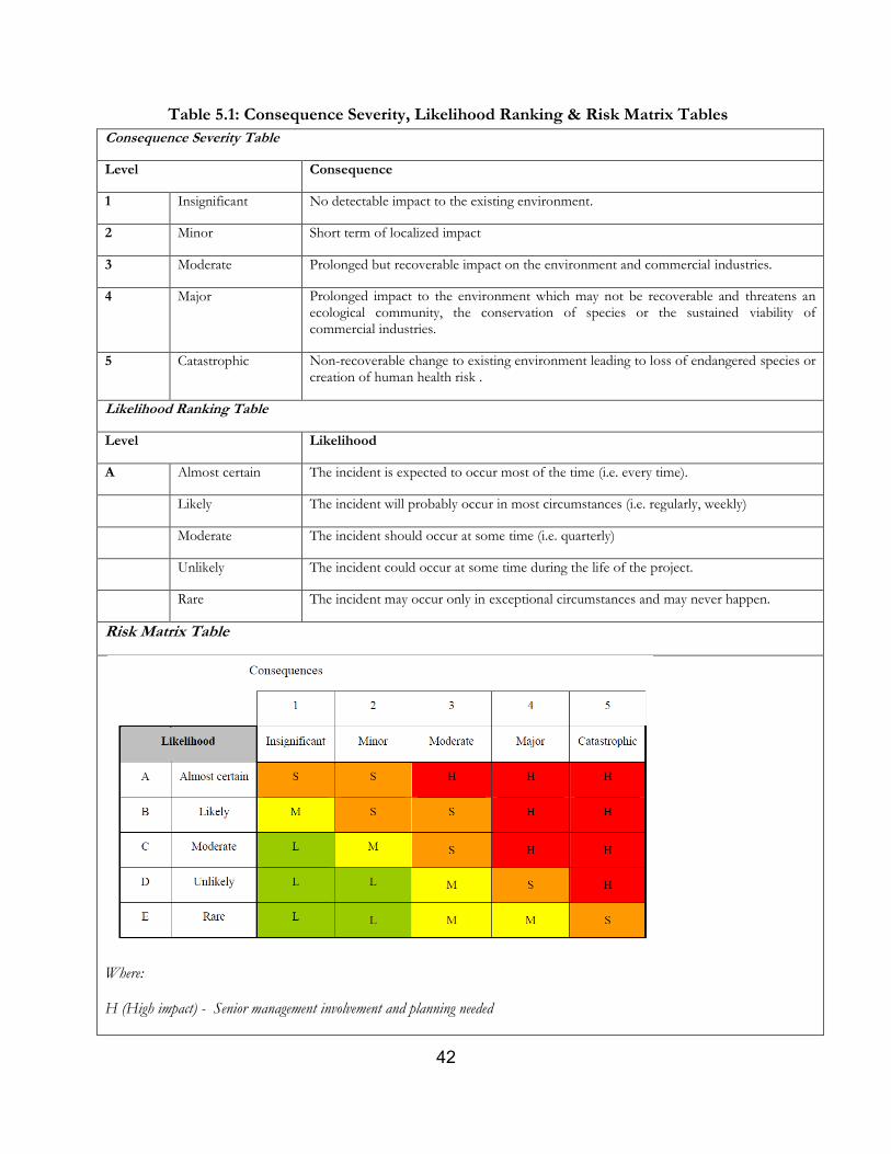
42
Table 5.1: Consequence Severity, Likelihood Ranking & Risk Matrix Tables
Consequence Severity Table
Level Consequence
1 Insignificant No detectable impact to the existing environment.
2 Minor Short term of localized impact
3 Moderate Prolonged but recoverable impact on the environment and commercial industries.
4 Major Prolonged impact to the environment which may not be recoverable and threatens an ecological community, the conservation of species or the sustained viability of commercial industries.
5 Catastrophic Non-recoverable change to existing environment leading to loss of endangered species or creation of human health risk .
Likelihood Ranking Table
Level Likelihood
A Almost certain The incident is expected to occur most of the time (i.e. every time).
Likely The incident will probably occur in most circumstances (i.e. regularly, weekly)
Moderate The incident should occur at some time (i.e. quarterly)
Unlikely The incident could occur at some time during the life of the project.
Rare The incident may occur only in exceptional circumstances and may never happen.
Risk Matrix Table
Where:
H (High impact) - Senior management involvement and planning needed
43
S (Significant impact) - Senior management attention needed and careful planning and implementation.
M (Moderate) - Impact Management responsibility must be specified.
L (Low impact) - Manage by routine procedures.
5.3 Associated and Potential Impacts of the Project
5.3.1 The Project Positive Impacts
The project is envisaged to have a range of positive impacts to the enclave communities and the
Park operation. Specifically, the broad positive impacts of the project include:
Pre-Construction Phase Positive Impacts
Interaction of stakeholders including enclave villagers, Park authorities and World Bank among others could create a window of opportunity for identification of future developmental projects and partnership.
Data collection resulting from project development could be useful to stakeholder data need and references for future applications
Consultations and engagement of stakeholders (enclave villagers and Park/Wildlife authorities) will be useful in identification of areas of cooperation’s and responsibilities for improved Park conservation
Construction Phase Positive Impacts
Employment of locals during Bridge construction
Interface between locals and workers would result to increased sales of agricultural crops by farmers during the period of construction
Post Construction/Operation Phase Positive Impacts
Improved community access to movement to farm and neighboring villages across the Bemi River
The construction of the bridge will reduce the pains of women carrying heavy loads of plantain, bush mango and banana, on head over great distances of about 22 km.
Access provided by the construction of the bridge will enhance park protection activities viz-a-viz increase patrols and conservation education activities to the enclave communities.
Efficiency in forest/biodiversity conservation resulting from improved access to patrol, arrest and enforcement of laws
Incentive to increased farming and income due to access to market
Access provided by the construction of the bridge will reduce the risk of loss of life and goods usually associated with difficulty of movement across the Bemi River during the rainy season.
Prevention of loss of items and properties of villagers in attempts to cross stream at high flood.
Improved access to schools and educational opportunities for children is envisaged as a result of the bridge which provides access for government/teachers movement to the concerned villages
44
5.3.2 The Project Negative Impacts
Albeit the project development shows a lot of significant positive impact as shown above, it is not
without some negative impacts. These impacts were identified through methodologies earlier stated
including stakeholder consultations. These include impacts on wildlife and forest conservation,
surface water quality and flow, soil and air quality. Table 5.2 identifies clearly these adverse impacts
at each project phase including environmental aspects and receptors:
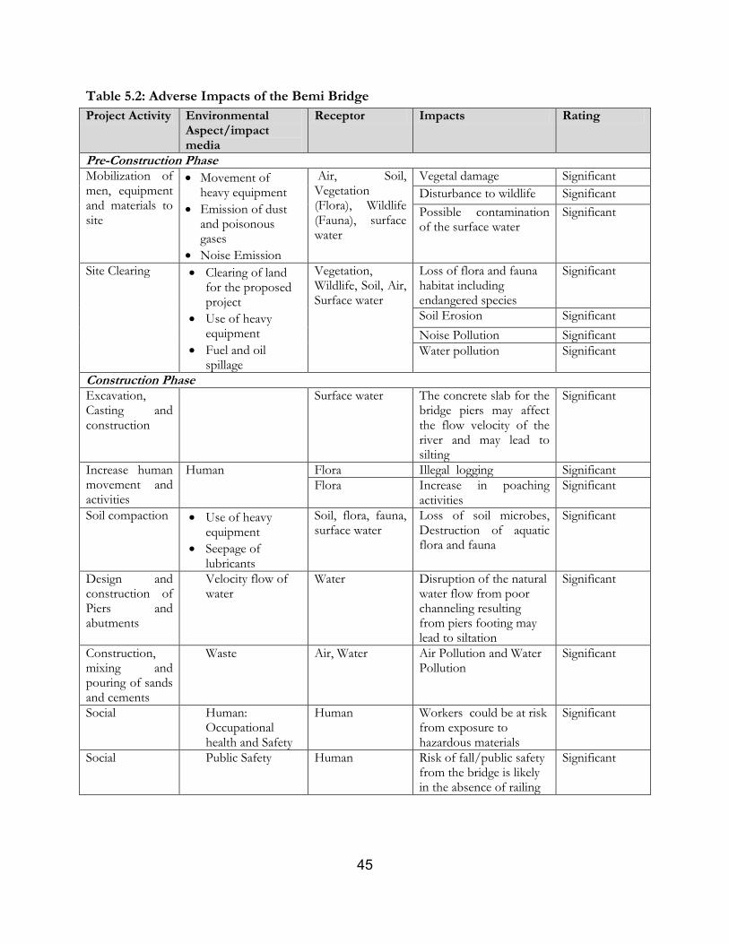
45
Table 5.2: Adverse Impacts of the Bemi Bridge
Project Activity Environmental Aspect/impact media
Receptor Impacts Rating
Pre-Construction Phase
Mobilization of men, equipment and materials to site
Movement of heavy equipment
Emission of dust and poisonous gases
Noise Emission
Air, Soil, Vegetation (Flora), Wildlife (Fauna), surface water
Vegetal damage Significant
Disturbance to wildlife Significant
Possible contamination of the surface water
Significant
Site Clearing Clearing of land for the proposed project
Use of heavy equipment
Fuel and oil spillage
Vegetation, Wildlife, Soil, Air, Surface water
Loss of flora and fauna habitat including endangered species
Significant
Soil Erosion Significant
Noise Pollution Significant
Water pollution Significant
Construction Phase
Excavation, Casting and construction
Surface water The concrete slab for the bridge piers may affect the flow velocity of the river and may lead to silting
Significant
Increase human movement and activities
Human Flora Illegal logging Significant
Flora Increase in poaching activities
Significant
Soil compaction Use of heavy equipment
Seepage of lubricants
Soil, flora, fauna, surface water
Loss of soil microbes, Destruction of aquatic flora and fauna
Significant
Design and construction of Piers and abutments
Velocity flow of water
Water Disruption of the natural water flow from poor channeling resulting from piers footing may lead to siltation
Significant
Construction, mixing and pouring of sands and cements
Waste Air, Water Air Pollution and Water Pollution
Significant
Social Human: Occupational health and Safety
Human Workers could be at risk from exposure to hazardous materials
Significant
Social Public Safety Human Risk of fall/public safety from the bridge is likely in the absence of railing
Significant
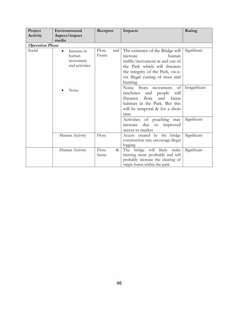
46
Project Activity
Environmental Aspect/impact media
Receptor Impacts Rating
Operation Phase
Social Increase in human movement and activities
Noise
Flora and Fauna
The existence of the Bridge will increase human traffic/movement in and out of the Park which will threaten the integrity of the Park, vis-a-viz illegal cutting of trees and hunting
Significant
Noise from movement of machines and people will threaten flora and fauna habitats in the Park. But this will be temporal & for a short time
Insignificant
Activities of poaching may increase due to improved access to market
Significant
Human Activity Flora Access created by the bridge construction may encourage illegal logging
Significant
Human Activity Flora & fauna
The bridge will likely make farming more profitable and will probably increase the clearing of virgin forest within the park
Significant
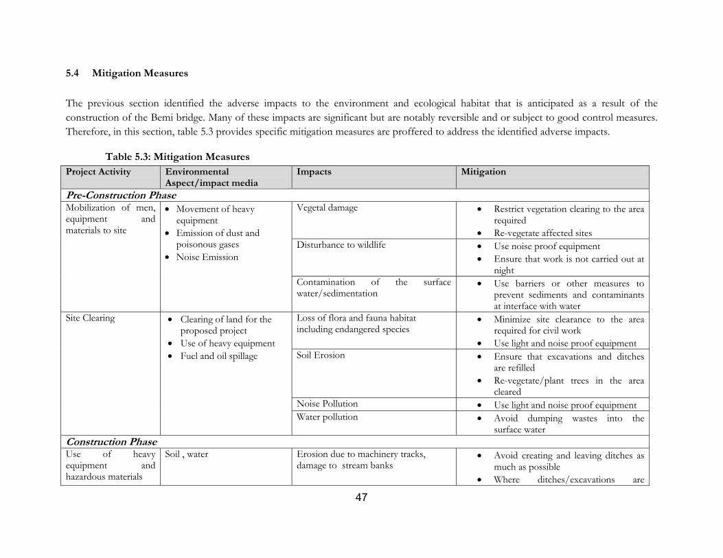
47
5.4 Mitigation Measures
The previous section identified the adverse impacts to the environment and ecological habitat that is anticipated as a result of the
construction of the Bemi bridge. Many of these impacts are significant but are notably reversible and or subject to good control measures.
Therefore, in this section, table 5.3 provides specific mitigation measures are proffered to address the identified adverse impacts.
Table 5.3: Mitigation Measures
Project Activity Environmental Aspect/impact media
Impacts Mitigation
Pre-Construction Phase
Mobilization of men, equipment and materials to site
Movement of heavy equipment
Emission of dust and poisonous gases
Noise Emission
Vegetal damage Restrict vegetation clearing to the area required
Re-vegetate affected sites
Disturbance to wildlife Use noise proof equipment
Ensure that work is not carried out at night
Contamination of the surface water/sedimentation
Use barriers or other measures to prevent sediments and contaminants at interface with water
Site Clearing Clearing of land for the proposed project
Use of heavy equipment
Fuel and oil spillage
Loss of flora and fauna habitat including endangered species
Minimize site clearance to the area required for civil work
Use light and noise proof equipment
Soil Erosion Ensure that excavations and ditches are refilled
Re-vegetate/plant trees in the area cleared
Noise Pollution Use light and noise proof equipment
Water pollution Avoid dumping wastes into the surface water
Construction Phase
Use of heavy equipment and hazardous materials
Soil , water Erosion due to machinery tracks, damage to stream banks
Avoid creating and leaving ditches as much as possible
Where ditches/excavations are
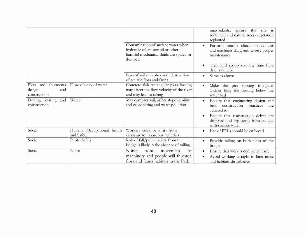
48
unavoidable, ensure the site is reclaimed and natural trees/vegetation replanted
Contamination of surface water when hydraulic oil, motor oil or other harmful mechanical fluids are spilled or dumped
Perform routine check on vehicles and machines daily, and ensure proper maintenance
Treat and scoop soil any time fluid drip is noticed
Loss of soil microbes and destruction of aquatic flora and fauna
Same as above
Piers and abutments design and construction
Flow velocity of water Concrete slab rectangular piers footing may affect the flow velocity of the river and may lead to silting
Make the pier footing triangular and/or bury the footing below the water bed
Drilling, casting and construction
Water May compact soil, affect slope stability and cause silting and water pollution
Ensure that engineering design and best construction practices are adhered to
Ensure that construction debris are disposed and kept away from contact with surface water
Social Human: Occupational health and Safety
Workers could be at risk from exposure to hazardous materials
Use of PPEs should be enforced
Social Public Safety Risk of fall/public safety from the bridge is likely in the absence of railing
Provide railing on both sides of the bridge
Social Noise Noise from movement of machinery and people will threaten flora and fauna habitats in the Park
Ensure that work is completed early
Avoid working at night to limit noise and habitats disturbance
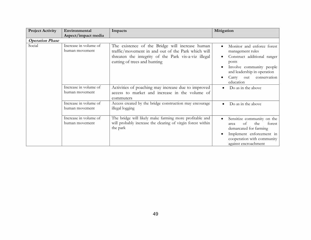
49
Project Activity Environmental Aspect/impact media
Impacts Mitigation
Operation Phase
Social Increase in volume of human movement
The existence of the Bridge will increase human traffic/movement in and out of the Park which will threaten the integrity of the Park vis-a-viz illegal cutting of trees and hunting
Monitor and enforce forest management rules
Construct additional ranger posts
Involve community people and leadership in operation
Carry out conservation education
Increase in volume of human movement
Activities of poaching may increase due to improved access to market and increase in the volume of commuters
Do as in the above
Increase in volume of human movement
Access created by the bridge construction may encourage illegal logging
Do as in the above
Increase in volume of human movement
The bridge will likely make farming more profitable and will probably increase the clearing of virgin forest within the park
Sensitize community on the area of the forest demarcated for farming
Implement enforcement in cooperation with community against encroachment
50
CHAPTER SIX: ENVIRONMENTAL AND SOCIAL MANAGEMENT PLAN
6.1 Overview
The essence of this ESMP is to bring all identified impacts and mitigation measures into a working
plan and to provide resources (costing) and arrangement/responsibilities for successful
implementation. It must be noted that key consideration of this ESMP is the need for project staff
to be conversant with project impacts, mitigation measures and responsibilities of stakeholders in
carrying out mitigations and monitoring measures.
Based on this assumption, the ESMP is required to be mainstreamed into the contract document
and should be a factor for consideration in procurement during evaluation of contractors, for better
tracking and enforcement of implementation adherence since most responsibilities for
implementation of safeguards during pre-construction and construction phases depend upon the
contractor.
6.2 Scope of the ESMP
Implementation responsibility and Monitoring
The purpose of responsibility sharing is to aid accountability, and to ensuring that responsibilities are
given to the agencies or individuals with capacity and jurisdiction to handle them. Likewise,
monitoring is necessary in order to determine achievement of objective of ESMP, milestones,
challenges and areas of deviations from the initial plans that need to be modified.
Monitoring indicators and Methods for Monitoring
Monitoring indicators are important for systematic tracking of progress of safeguard implementation
in a project. It helps the EO/PMU to assess the performance of its safeguard operation which is
important in evaluating the sustainability or otherwise of the sub-project. Also, identifying clearly the
method for monitoring is important for successful monitoring.
ESMP Budget/Costing
The success of every ESMP depends largely on funding provision which is a subject for early
planning. Costing for this ESMP is to the sum of Four Million, Six Hundred and Fifty
Thousand Naira (N4,650,000); made up of:
Implementation of mitigation measures N2,600,000
Monitoring & Conservation Enlightenment/Education N2,050,000
Training : ( There is capacity in CRSCSDA and CRNP) -
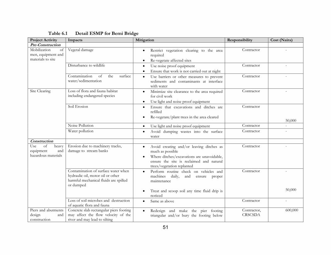
51
Table 6.1 Detail ESMP for Bemi Bridge
Project Activity Impacts Mitigation Responsibility Cost (Naira)
Pre-Construction
Mobilization of men, equipment and materials to site
Vegetal damage Restrict vegetation clearing to the area required
Re-vegetate affected sites
Contractor -
Disturbance to wildlife Use noise proof equipment
Ensure that work is not carried out at night
Contractor -
Contamination of the surface water/sedimentation
Use barriers or other measures to prevent sediments and contaminants at interface with water
Contractor -
Site Clearing Loss of flora and fauna habitat including endangered species
Minimize site clearance to the area required for civil work
Use light and noise proof equipment
Contractor -
Soil Erosion Ensure that excavations and ditches are refilled
Re-vegetate/plant trees in the area cleared
Contractor 50,000
Noise Pollution Use light and noise proof equipment Contractor -
Water pollution Avoid dumping wastes into the surface water
Contractor -
Construction
Use of heavy equipment and hazardous materials
Erosion due to machinery tracks, damage to stream banks
Avoid creating and/or leaving ditches as much as possible
Where ditches/excavations are unavoidable, ensure the site is reclaimed and natural trees/vegetation replanted
Contractor -
Contamination of surface water when hydraulic oil, motor oil or other harmful mechanical fluids are spilled or dumped
Perform routine check on vehicles and machines daily, and ensure proper maintenance
Treat and scoop soil any time fluid drip is noticed
Contractor - 50,000
Loss of soil microbes and destruction of aquatic flora and fauna
Same as above Contractor -
Piers and abutments design and construction
Concrete slab rectangular piers footing may affect the flow velocity of the river and may lead to silting
Redesign and make the pier footing triangular and/or bury the footing below
Contractor, CRSCSDA
600,000
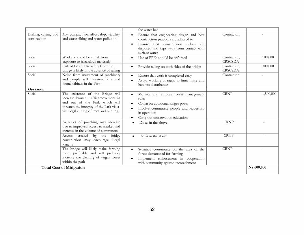
52
the water bed
Drilling, casting and construction
May compact soil, affect slope stability and cause silting and water pollution
Ensure that engineering design and best construction practices are adhered to
Ensure that construction debris are disposed and kept away from contact with surface water
Contractor,
-
Social Workers could be at risk from exposure to hazardous materials
Use of PPEs should be enforced Contractor, CRSCSDA
100,000
Social Risk of fall/public safety from the bridge is likely in the absence of railing
Provide railing on both sides of the bridge Contractor, CRSCSDA
300,000
Social Noise from movement of machinery and people will threaten flora and fauna habitats in the Park
Ensure that work is completed early
Avoid working at night to limit noise and habitats disturbance
Contractor -
Operation
Social The existence of the Bridge will increase human traffic/movement in and out of the Park which will threaten the integrity of the Park vis-a-viz illegal cutting of trees and hunting
Monitor and enforce forest management rules
Construct additional ranger posts
Involve community people and leadership in operation
Carry out conservation education
CRNP 1,500,000
Activities of poaching may increase due to improved access to market and increase in the volume of commuters
Do as in the above CRNP -
Access created by the bridge construction may encourage illegal logging
Do as in the above CRNP -
The bridge will likely make farming more profitable and will probably increase the clearing of virgin forest within the park
Sensitize community on the area of the forest demarcated for farming
Implement enforcement in cooperation with community against encroachment
CRNP -
Total Cost of Mitigation N2,600,000
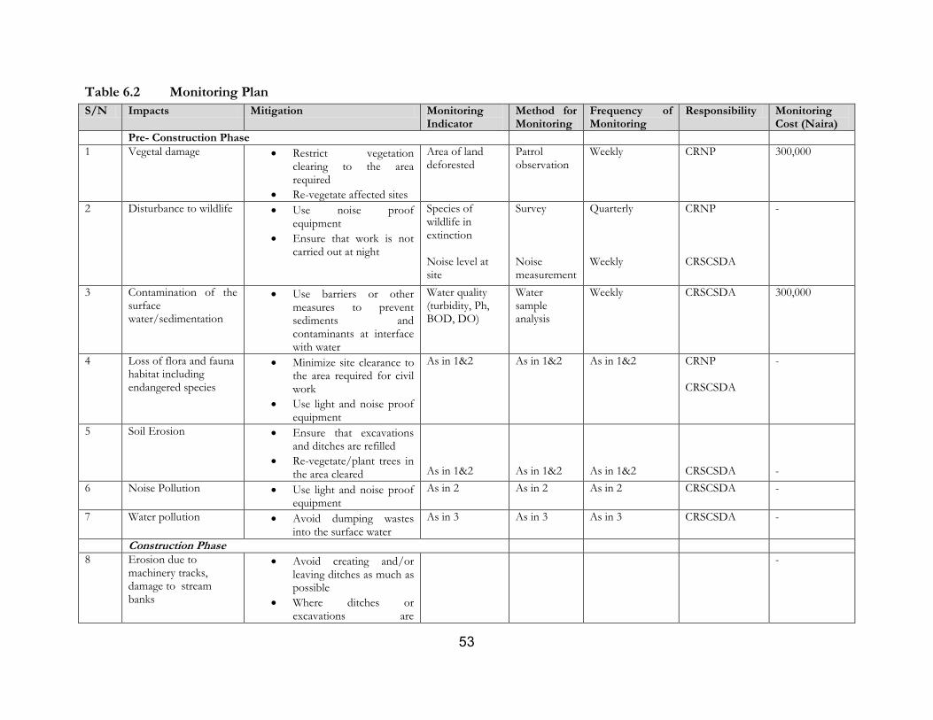
53
Table 6.2 Monitoring Plan
S/N Impacts Mitigation Monitoring Indicator
Method for Monitoring
Frequency of Monitoring
Responsibility Monitoring Cost (Naira)
Pre- Construction Phase
1 Vegetal damage Restrict vegetation clearing to the area required
Re-vegetate affected sites
Area of land deforested
Patrol observation
Weekly CRNP 300,000
2 Disturbance to wildlife Use noise proof equipment
Ensure that work is not carried out at night
Species of wildlife in extinction Noise level at site
Survey Noise measurement
Quarterly Weekly
CRNP
CRSCSDA
-
3 Contamination of the surface water/sedimentation
Use barriers or other measures to prevent sediments and contaminants at interface with water
Water quality (turbidity, Ph, BOD, DO)
Water sample analysis
Weekly CRSCSDA 300,000
4 Loss of flora and fauna habitat including endangered species
Minimize site clearance to the area required for civil work
Use light and noise proof equipment
As in 1&2 As in 1&2 As in 1&2 CRNP
CRSCSDA
-
5 Soil Erosion Ensure that excavations and ditches are refilled
Re-vegetate/plant trees in the area cleared
As in 1&2
As in 1&2
As in 1&2
CRSCSDA
-
6 Noise Pollution Use light and noise proof equipment
As in 2 As in 2 As in 2 CRSCSDA -
7 Water pollution Avoid dumping wastes into the surface water
As in 3 As in 3 As in 3 CRSCSDA -
Construction Phase
8 Erosion due to machinery tracks, damage to stream banks
Avoid creating and/or leaving ditches as much as possible
Where ditches or excavations are
-
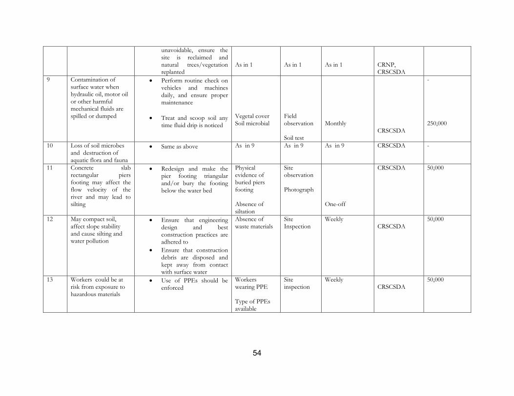
54
unavoidable, ensure the site is reclaimed and natural trees/vegetation replanted
As in 1
As in 1
As in 1
CRNP, CRSCSDA
9 Contamination of surface water when hydraulic oil, motor oil or other harmful mechanical fluids are spilled or dumped
Perform routine check on vehicles and machines daily, and ensure proper maintenance
Treat and scoop soil any time fluid drip is noticed
Vegetal cover Soil microbial
Field observation Soil test
Monthly
CRSCSDA
-
250,000
10 Loss of soil microbes and destruction of aquatic flora and fauna
Same as above As in 9 As in 9 As in 9 CRSCSDA -
11 Concrete slab rectangular piers footing may affect the flow velocity of the river and may lead to silting
Redesign and make the pier footing triangular and/or bury the footing below the water bed
Physical evidence of buried piers footing Absence of siltation
Site observation Photograph
One-off
CRSCSDA 50,000
12 May compact soil, affect slope stability and cause silting and water pollution
Ensure that engineering design and best construction practices are adhered to
Ensure that construction debris are disposed and kept away from contact with surface water
Absence of waste materials
Site Inspection
Weekly CRSCSDA
50,000
13 Workers could be at risk from exposure to hazardous materials
Use of PPEs should be enforced
Workers wearing PPE Type of PPEs available
Site inspection
Weekly CRSCSDA
50,000
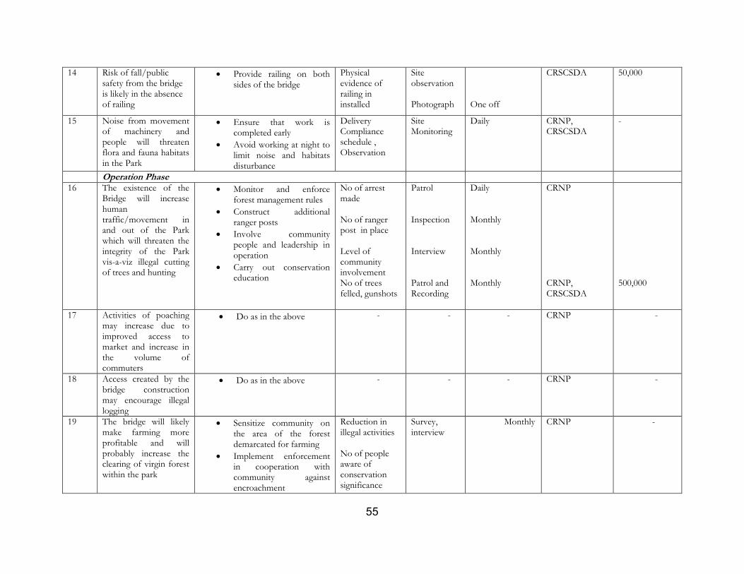
55
14 Risk of fall/public safety from the bridge is likely in the absence of railing
Provide railing on both sides of the bridge
Physical evidence of railing in installed
Site observation Photograph
One off
CRSCSDA 50,000
15 Noise from movement of machinery and people will threaten flora and fauna habitats in the Park
Ensure that work is completed early
Avoid working at night to limit noise and habitats disturbance
Delivery Compliance schedule , Observation
Site Monitoring
Daily CRNP, CRSCSDA
-
Operation Phase
16 The existence of the Bridge will increase human traffic/movement in and out of the Park which will threaten the integrity of the Park vis-a-viz illegal cutting of trees and hunting
Monitor and enforce forest management rules
Construct additional ranger posts
Involve community people and leadership in operation
Carry out conservation education
No of arrest made No of ranger post in place Level of community involvement No of trees felled, gunshots
Patrol Inspection Interview Patrol and Recording
Daily Monthly Monthly Monthly
CRNP CRNP, CRSCSDA
500,000
17 Activities of poaching may increase due to improved access to market and increase in the volume of commuters
Do as in the above - - - CRNP -
18 Access created by the bridge construction may encourage illegal logging
Do as in the above - - - CRNP -
19 The bridge will likely make farming more profitable and will probably increase the clearing of virgin forest within the park
Sensitize community on the area of the forest demarcated for farming
Implement enforcement in cooperation with community against encroachment
Reduction in illegal activities No of people aware of conservation significance
Survey, interview
Monthly CRNP -
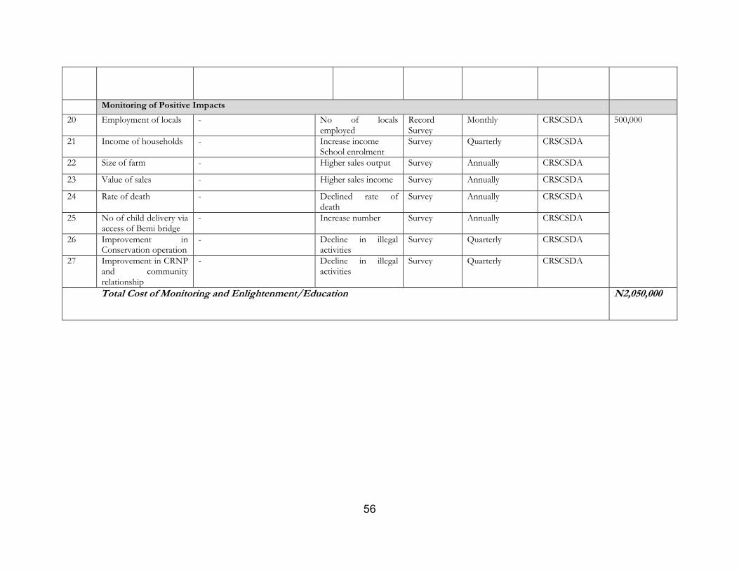
56
Monitoring of Positive Impacts
20 Employment of locals - No of locals employed
Record Survey
Monthly CRSCSDA 500,000
21 Income of households - Increase income School enrolment
Survey Quarterly CRSCSDA
22 Size of farm - Higher sales output Survey Annually CRSCSDA
23 Value of sales - Higher sales income Survey Annually CRSCSDA
24 Rate of death - Declined rate of death
Survey Annually CRSCSDA
25 No of child delivery via access of Bemi bridge
- Increase number Survey Annually CRSCSDA
26 Improvement in Conservation operation
- Decline in illegal activities
Survey Quarterly CRSCSDA
27 Improvement in CRNP and community relationship
- Decline in illegal activities
Survey Quarterly CRSCSDA
Total Cost of Monitoring and Enlightenment/Education N2,050,000
57
CHAPTER SEVEN: IMPLEMENTATION PROGRAMME AND ARRANGEMENT
7.1 Implementation Programmes
Some of the management programmes that must be part of the ESMP are highlighted below:
7.1.1`Environmental Monitoring and Auditing
In order to effectively and efficiently implement this ESMP, a system for monitoring and auditing has
been built into the overall management plan. Monitoring and auditing assist in the examination of
management, employee knowledge, programme responsibilities, records & effectiveness
Specifically, these help to:
Improve environmental and social management practices;
Check the efficiency and quality of the environmental management processes;
Establish the scientific reliability and credibility of the ESMP for the project and,
Provide the opportunity to report the results on safeguards and impacts and proposed mitigation
measures implementation.
The Environmental monitoring activities shall be based on direct or indirect indicators of emissions,
effluents, and resource use applicable to the project. Monitoring frequency shall be sufficient to provide
representative data for the parameter being monitored. Monitoring shall be conducted by trained
individuals who can carry out the monitoring and record-keeping effectively using properly calibrated
and maintained equipment.
Monitoring data shall be analyzed and reviewed at regular intervals and compared with the operating
standards so that any necessary corrective actions can be taken. As part of monitoring programme,
visual inspections and quality monitoring for light attenuation will be conducted daily, for instance.
7.2 Reporting Procedure
The nature of issues to report and manner of reporting are outlined below:
7.2.1 Complaints Register and Environmental Incidents
Any environmental or social incidents shall be documented. The report shall be transmitted to the
relevant authority by the Management, where necessary/applicable. The reporting shall be with a view to
taking appropriate mitigation measures.
All complaints received will be investigated and a response (even if pending further investigation) is to
be given to the complainant within 5 days.
The following information must be provided:
Time, date and nature of the incident/report;
Type of communication (e.g. telephone, personal meeting);
Name, house location and contact telephone number of person making the complaint.
58
Details of response and investigation undertaken as a result of the incident/complaint;
Name of person undertaking investigation of the incident/complaint;
Corrective action taken as a result of the incident/complaint.
7.2.2 Record keeping
Good records are the paper trail that will prove that this ESMP is working as intended. Keeping records
of inspection of maintenance programme, waste management, etc will be useful to demonstrate that the
ESMP is being complied with or not. The type of records from the various management and
monitoring programmes may include:
completed forms, checklists and maintenance logs
identified problems and corrective actions undertaken
monitoring data / results
7.3 Implementation /Institutional Arrangement
The resources required for implementing the ESMP are basically personnel and finance. The key
stakeholders in this ESMP implementation are the project engineers, contractor, Cross River State
National Park and the World Bank.
The project team shall ensure that implementation process complies with all relevant policies and
procedures of both the World Bank and Nigeria.
The environmental/social officer attached to the CRSCSDA and the monitoring and evaluation
Manager/officer will be responsible for the implementation of the ESMP in close collaboration with the
Cross River National Park.
The monitoring and evaluation (M& E) officer at the CRSCSDA will be responsible for the
implementation of the environmental monitoring and the ESMP. He/she is also to ensure that the
contractors adhere to the General Environmental Management Conditions for Construction contracts.
His/her responsibilities shall include:
Coordination, liaison with and monitoring of the contractors;
Compilation and preparation of periodic environmental reports for submission to the World Bank;
Review of EIA reports from consultants in collaboration with EPAD and FME
Data Management; and
Sub-project Inspections
World Bank
The World Bank performs the following role;
Ensure that its Safeguard Policies are complied with.
Responsible for the final review and clearance of the ESIA,
59
Ensures that environmental safeguards are taken care of during World Bank supervision mission.
Cross River State National Park (CRNP)
Ensures full implementation of her Park conservation policies
Liaises with CRSCSDA and community leaderhip for effective coordination and results
Ensures clear demarcation of forest conservation area from agricultural cultivation area,
sensitizes community on the demarcation
Responsible for all monitoring that affects its operation
Cross River State Community and Social Development Agency
Ensure that there are sufficient resources (time, money and people) to manage the implementation of the ESMP,
Ensure the coordination and involvement of the inter-agencies and stakeholders in the implementation of the ESMP
Ensure bid documents include actions to address adverse impacts resulting from construction work,
Ensure that the ESMP reflects any changes during the construction process that may have a significant environmental or social impact,
Liason with CRNP in organizing and implementing nature conservation enlightenment/education to the Okwangwo community
Environmental Officer /Monitoring and Evaluation Officer/Manager
Ensure that there are sufficient resources (time, money and people) to supervise the environmental issues of the works.
Ensure that any changes during construction process that may have significant environmental or social impact are communicated to the EPAD in time and advice on actions to be taken and costs involved.
Ensure that the State Ministry of Environment is sufficiently informed on monitoring results.
Contractor
Ensure that there are sufficient resources (time, money and people) to manage the environmental issues of the works.
Be responsible for ensuring that all site staff, including sub-contractors and sub-contracted activities will comply with the projects ESMP.
Ensure that any changes during the construction process that may have a significant environmental and social impact are communicated to the Supervising Engineer in time and manage them accordingly.
Ensure that the Environmental Supervising Engineer is sufficiently informed on contractor’s monitoring results.
Ensures that PPEs is provided to staff, and that staff are educated on their use
Ensures that safety rules/OHSE for construction workers are fully complied with. Okwangwo/Okwa Community Leadership
60
Ensures support with the CRNP to punish community members who would illegally encroach the forest land, poach, log or hunt in the protected area
Complains to the relevant authority (CRSCSDA/CRNP) on any observation or concern with respect to the bridge project
7.4 Disclosure
This ESIA was prepared in line with the guidelines of the ESMF of CSDP which is in adherence to the
disclosure policies of the World Bank and the Federal Ministry of Environment. It was equally prepared
in consultation with stakeholder agencies such as Ministry of Environment, Forestry Commission, Cross
River National Park Wildlife Conservative Society and the enclave communities of project area of
influence.
Therefore, all reasonable efforts must be made in accordance with the law to disclose/display the ESIA
report in strategic accessible places to the stakeholders for their accessibility and comments. It should
also be disclosed at the Ministry of Environment and at the World Bank infoshop.
7.5 Implementation Schedule
The following are the major issues to feature in the implementation of the ESMP of this ESIA with
detail schedule provided in Table 7.1
Preparation and submission of the Action plan;
Nominating Environmental Management Representative;
Finalizing site(s) and layout plan(s) for construction of temporary yards incorporating
environmental requirements;
Preparation and submission of construction schedule;
Implementation of mitigation and enhancement measures;
Monitoring and reporting on ESMP implementation
Environmental auditing
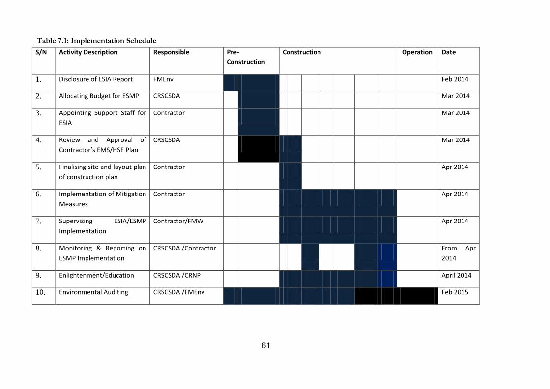
61
Table 7.1: Implementation Schedule
S/N Activity Description Responsible Pre-
Construction
Construction Operation Date
1. Disclosure of ESIA Report FMEnv Feb 2014
2. Allocating Budget for ESMP CRSCSDA Mar 2014
3. Appointing Support Staff for
ESIA
Contractor Mar 2014
4. Review and Approval of
Contractor’s EMS/HSE Plan
CRSCSDA Mar 2014
5. Finalising site and layout plan
of construction plan
Contractor Apr 2014
6. Implementation of Mitigation
Measures
Contractor Apr 2014
7. Supervising ESIA/ESMP
Implementation
Contractor/FMW Apr 2014
8. Monitoring & Reporting on
ESMP Implementation
CRSCSDA /Contractor From Apr
2014
9. Enlightenment/Education CRSCSDA /CRNP April 2014
10. Environmental Auditing CRSCSDA /FMEnv Feb 2015
62
2 CHAPTER EIGHT PUBLIC CONSULTATIONS
8.1 Introduction
Public consultation is pivotal for sustainable project development and attracts a lot of emphases in all
projects funded by World Bank. To this end, public and stakeholder consultation was accorded priority
from inception and will continue to be a driven tool all through the project cycle.
8.2 Objective of the Stakeholder Consultation
To inform the stakeholders about the aim and objectives of the sub-project
To involve stakeholders early in the project to be part of the design and planning of the project
To elicit the inputs and concerns of the different stakeholders and mainstream their inputs into
planning template
To ensure that through meaningful engagement, encumbrances are eliminated for sustainable
project actualization
8.3 Stakeholder Identification and Engagement Strategy
Following the review of the ESIA ToR and other relevant documents, the Consultant had an initial
project delivery meeting with the management of CR-CSDA. This meeting featured amongst other
things the identification of the project stakeholders and mechanism for consulting/engaging them.
The primary stakeholders are:
The enclave communities (Okwangwo, Okwa 1 and Okwa 11)
Women and children in the project community
The Cross River National Park
Wildlife Conservation Society and,
The Forestry Commission
These categories of stakeholders are seen as primary stakeholders because they will be directly impacted
by the benefit or otherwise of the Bemi Bridge construction. Secondary stakeholders are those involved
in funding, and or have responsibilities for implementation and monitoring other than the groups earlier
identified. Under this are:
World Bank
CR-CSDA and,
Ministry of Environment
8.4 Approach and Method for Consultation
The CR-CSDA was instrumental for accompanying the consultant to the various stakeholders and in
scheduling meeting dates with them. Accordingly, the stakeholders were given the right of choice of
meeting venue. Based on this, focal group discussion with the CR-National Park was held at Azara
Hotel in Calabar, while the meetings with other stakeholders held in their respective offices/community.
The traditional method for community consultation in the rural area of project influence was explored.
This involved a meeting with the Chairmen of the 3 enclave communities, explaining the aim and
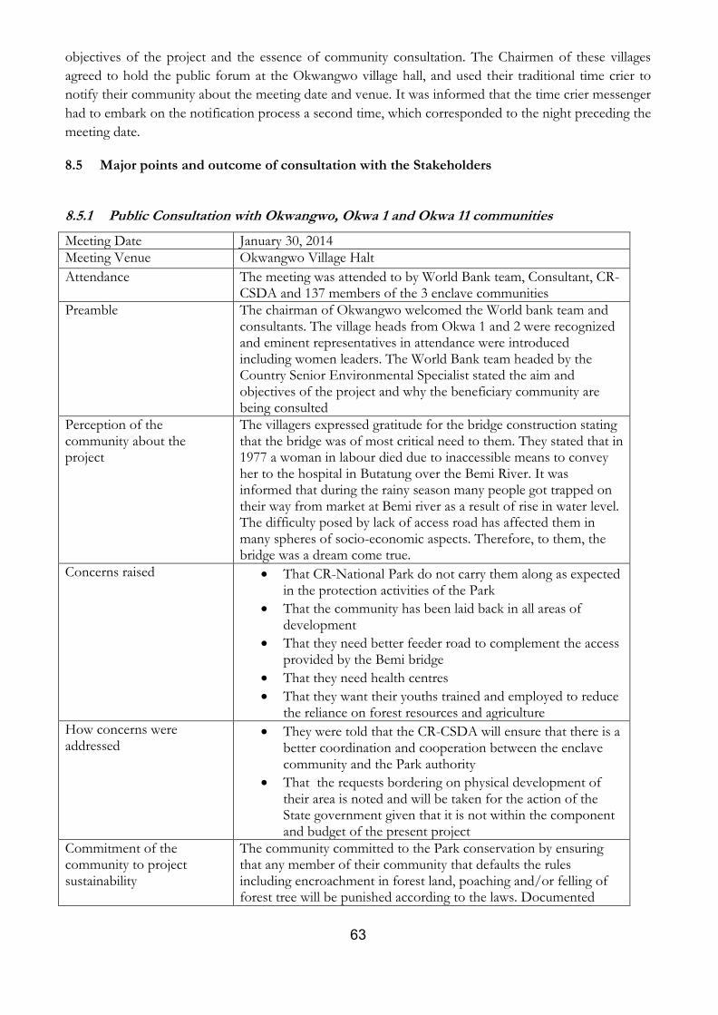
63
objectives of the project and the essence of community consultation. The Chairmen of these villages
agreed to hold the public forum at the Okwangwo village hall, and used their traditional time crier to
notify their community about the meeting date and venue. It was informed that the time crier messenger
had to embark on the notification process a second time, which corresponded to the night preceding the
meeting date.
8.5 Major points and outcome of consultation with the Stakeholders
8.5.1 Public Consultation with Okwangwo, Okwa 1 and Okwa 11 communities
Meeting Date January 30, 2014
Meeting Venue Okwangwo Village Halt
Attendance The meeting was attended to by World Bank team, Consultant, CR-CSDA and 137 members of the 3 enclave communities
Preamble The chairman of Okwangwo welcomed the World bank team and consultants. The village heads from Okwa 1 and 2 were recognized and eminent representatives in attendance were introduced including women leaders. The World Bank team headed by the Country Senior Environmental Specialist stated the aim and objectives of the project and why the beneficiary community are being consulted
Perception of the community about the project
The villagers expressed gratitude for the bridge construction stating that the bridge was of most critical need to them. They stated that in 1977 a woman in labour died due to inaccessible means to convey her to the hospital in Butatung over the Bemi River. It was informed that during the rainy season many people got trapped on their way from market at Bemi river as a result of rise in water level. The difficulty posed by lack of access road has affected them in many spheres of socio-economic aspects. Therefore, to them, the bridge was a dream come true.
Concerns raised That CR-National Park do not carry them along as expected in the protection activities of the Park
That the community has been laid back in all areas of development
That they need better feeder road to complement the access provided by the Bemi bridge
That they need health centres
That they want their youths trained and employed to reduce the reliance on forest resources and agriculture
How concerns were addressed
They were told that the CR-CSDA will ensure that there is a better coordination and cooperation between the enclave community and the Park authority
That the requests bordering on physical development of their area is noted and will be taken for the action of the State government given that it is not within the component and budget of the present project
Commitment of the community to project sustainability
The community committed to the Park conservation by ensuring that any member of their community that defaults the rules including encroachment in forest land, poaching and/or felling of forest tree will be punished according to the laws. Documented
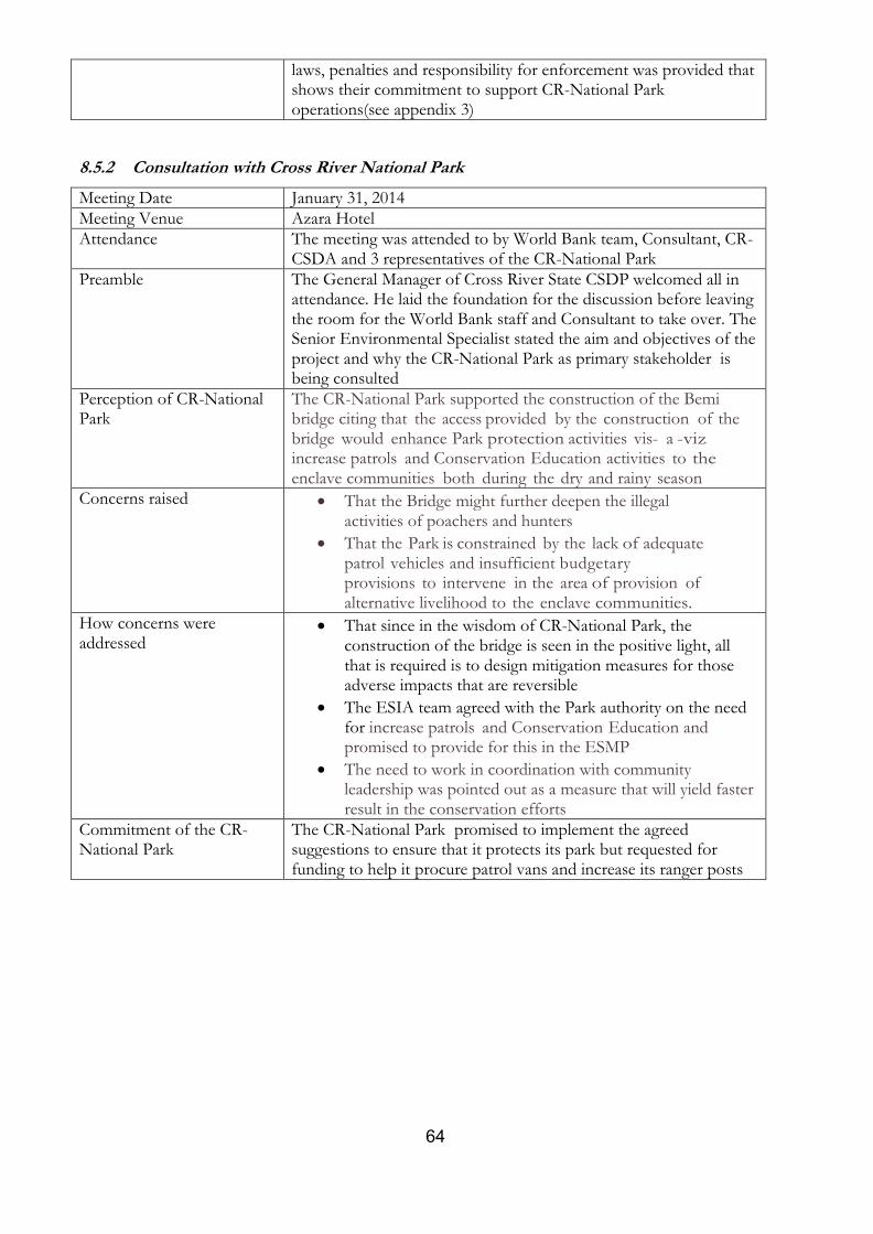
64
laws, penalties and responsibility for enforcement was provided that shows their commitment to support CR-National Park operations(see appendix 3)
8.5.2 Consultation with Cross River National Park
Meeting Date January 31, 2014
Meeting Venue Azara Hotel
Attendance The meeting was attended to by World Bank team, Consultant, CR-CSDA and 3 representatives of the CR-National Park
Preamble The General Manager of Cross River State CSDP welcomed all in attendance. He laid the foundation for the discussion before leaving the room for the World Bank staff and Consultant to take over. The Senior Environmental Specialist stated the aim and objectives of the project and why the CR-National Park as primary stakeholder is being consulted
Perception of CR-National Park
The CR-National Park supported the construction of the Bemi bridge citing that the access provided by the construction of the bridge would enhance Park protection activities vis- a -viz. increase patrols and Conservation Education activities to the enclave communities both during the dry and rainy season
Concerns raised That the Bridge might further deepen the illegal activities of poachers and hunters
That the Park is constrained by the lack of adequate patrol vehicles and insufficient budgetary provisions to intervene in the area of provision of alternative livelihood to the enclave communities.
How concerns were addressed
That since in the wisdom of CR-National Park, the construction of the bridge is seen in the positive light, all that is required is to design mitigation measures for those adverse impacts that are reversible
The ESIA team agreed with the Park authority on the need for increase patrols and Conservation Education and promised to provide for this in the ESMP
The need to work in coordination with community leadership was pointed out as a measure that will yield faster result in the conservation efforts
Commitment of the CR-National Park
The CR-National Park promised to implement the agreed suggestions to ensure that it protects its park but requested for funding to help it procure patrol vans and increase its ranger posts
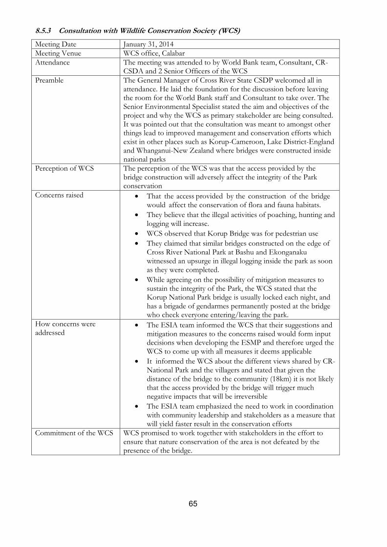
65
8.5.3 Consultation with Wildlife Conservation Society (WCS)
Meeting Date January 31, 2014
Meeting Venue WCS office, Calabar
Attendance The meeting was attended to by World Bank team, Consultant, CR-CSDA and 2 Senior Officers of the WCS
Preamble The General Manager of Cross River State CSDP welcomed all in attendance. He laid the foundation for the discussion before leaving the room for the World Bank staff and Consultant to take over. The Senior Environmental Specialist stated the aim and objectives of the project and why the WCS as primary stakeholder are being consulted. It was pointed out that the consultation was meant to amongst other things lead to improved management and conservation efforts which exist in other places such as Korup-Cameroon, Lake District-England and Whanganui-New Zealand where bridges were constructed inside national parks
Perception of WCS The perception of the WCS was that the access provided by the bridge construction will adversely affect the integrity of the Park conservation
Concerns raised That the access provided by the construction of the bridge would affect the conservation of flora and fauna habitats.
They believe that the illegal activities of poaching, hunting and logging will increase.
WCS observed that Korup Bridge was for pedestrian use
They claimed that similar bridges constructed on the edge of Cross River National Park at Bashu and Ekonganaku witnessed an upsurge in illegal logging inside the park as soon as they were completed.
While agreeing on the possibility of mitigation measures to sustain the integrity of the Park, the WCS stated that the Korup National Park bridge is usually locked each night, and has a brigade of gendarmes permanently posted at the bridge who check everyone entering/leaving the park.
How concerns were addressed
The ESIA team informed the WCS that their suggestions and mitigation measures to the concerns raised would form input decisions when developing the ESMP and therefore urged the WCS to come up with all measures it deems applicable
It informed the WCS about the different views shared by CR-National Park and the villagers and stated that given the distance of the bridge to the community (18km) it is not likely that the access provided by the bridge will trigger much negative impacts that will be irreversible
The ESIA team emphasized the need to work in coordination with community leadership and stakeholders as a measure that will yield faster result in the conservation efforts
Commitment of the WCS WCS promised to work together with stakeholders in the effort to ensure that nature conservation of the area is not defeated by the presence of the bridge.
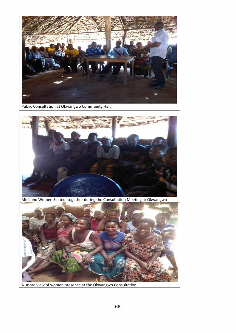
66
Public Consultation at Okwangwo Community Halt
Men and Women Seated together during the Consultation Meeting at Okwangwo
A more view of women presence at the Okwangwo Consultation
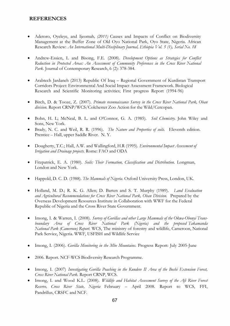
67
3 REFERENCES
Adetoro, Oyeleye, and Ijeomah, (2011) Causes and Impacts of Conflict on Biodiversity Management at the Buffer Zone of Old Oyo National Park, Oyo State, Nigeria. African Research Review: An International Multi-Disciplinary Journal, Ethiopia Vol. 5 (1), Serial No. 18
Andrew-Essien, L and Bisong, F.E. (2008). Development Options as Strategies for Conflict Reduction in Protected Areas: An Assessment of Community Preferences in the Cross River National Park. Journal of Contemporary Research, 6 (2): 378-384.
Arabtech Jardaneh (2013) Republic Of Iraq – Regional Government of Kurdistan Transport Corridors Project: Environmental And Social Impact Assessment Framework. Biological Research and Scientific Monitoring activities; First progress Report (1994-96)
Birch, D. & Tooze, Z. (2007). Primate reconnaissance Survey in the Cross River National Park, Oban division. Report CRNP/WCS/Colchester Zoo Action for the Wild/Cercopan.
Bohn, H. L; McNeal, B. L. and O’Connor, G. A. (1985). Soil Chemistry. John Wiley and Sons, New York.
Brady, N. C. and Weil, R. R. (1996). The Nature and Properties of soils. Eleventh edition. Prentice – Hall, upper Saddle River. N. Y.
Dougherty, T.C.; Hall, A.W. and Wallingford, H.R (1995). Environmental Impact Assessment of Irrigation and Drainage projects. Rome: FAO and ODA
Fitzpatrick, E. A. (1980). Soils: Their Formation, Classification and Distribution. Longman, London and New York.
Happold, D. C. D. (1988). The Mammals of Nigeria. Oxford University Press, London, UK.
Holland, M. D.; R. K. G. Allen; D. Barten and S. T. Murphy (1989). Land Evaluation and Agricultural Recommendations for Cross River National Park, Oban Division. Prepared by the Overseas Development Resources Institute in Collaboration with WWF for the Federal Republic of Nigeria and the Cross River State Government.
Imong, I. & Warren, I. (2008). Survey of Gorillas and other Large Mammals of the Okwa-Obonyi Trans-boundary Area of Cross River National Park (Nigeria) and the proposed Takamanda National Park (Cameroon) Report. WCS, The ministry of forestry and wildlife, Cameroon, National Park Service, Nigeria. WWF, USFISH and Wildlife Service
Imong, I. (2006). Gorilla Monitoring in the Mbe Mountains. Progress Report: July 2005-June
2006. Report. NCF-WCS Biodiversity Research Programme.
Imong, I. (2007) Investigating Gorilla Poaching in the Kundeve II Area of the Boshi Extension Forest, Cross River National Park. Report CRNP, WCS.
Imong, I. and Wood K.L. (2008). Wildlife and Habitat Assessment Survey of the Afi River Forest
Reserve, Cross River State, Nigeria February – April 2008. Report to WCS, FFI,
Pandrillus, CRSFC and NCF.
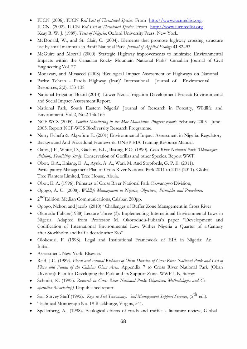
68
IUCN (2006). IUCN Red List of Threatened Species. From http://www.iucnredlist.org.
IUCN. (2002). IUCN Red List of Threatened Species. From http://www.iucnredlist.org
Keay R. W. J. (1989). Trees of Nigeria. Oxford University Press, New York.
McDonald, W., and St. Clair, C. (2004). Elements that promote highway crossing structure
use by small mammals in Banff National Park. Journal of Applied Ecology 41:82–93.
McGuire and Morrall (2000) ‘Strategic Highway improvements to minimize Environmental
Impacts within the Canadian Rocky Mountain National Parks’ Canadian Journal of Civil
Engineering Vol. 27
Monavari, and Mirsaeed (2008) ‘Ecological Impact Assessment of Highways on National
Parks: Tehran - Pardis Highway (Iran)’ International Journal of Enviromental
Resources, 2(2): 133-138
National Irrigation Board (2013). Lower Nzoia Irrigation Development Project: Environmental
and Social Impact Assessment Report.
National Park, South Eastern Nigeria’ Journal of Research in Forestry, Wildlife and
Environment, Vol 2, No.2 156-163
NCF-WCS (2005). Gorilla Monitoring in the Mbe Mountains. Progress report: February 2005 - June
2005. Report NCF-WCS Biodiversity Research Programme.
Nerry Echefu & Akpofure E. (2001) Environmental Impact Assessment in Nigeria: Regulatory
Background And Procedural Framework. UNEP EIA Training Resource Manual.
Oates, J.F., White, D., Gadsby, E.L., Bisong, P.O. (1990). Cross River National Park (Okwangwo
division), Feasibility Study. Conservation of Gorillas and other Species. Report WWF.
Obot, E.A., Eniang, E. A., Ayuk, A. A., Wari, M. And Stopfords, G. P. E. (2011).
Participatory Management Plan of Cross River National Park 2011 to 2015 (2011). Global
Tree Planters Limited, Tree House, Abuja.
Obot, E. A. (1996). Primates of Cross River National Park Okwangwo Division,
Ogogo, A. U. (2008). Wildlife Management in Nigeria, Objectives, Principles and Procedures.
2nd
Edition. Median Communications, Calabar. 280pp.
Ogogo, Nchor, and Jacob (2010) ‘ Challenges of Buffer Zone Management in Cross River
Okorodu-Fubara(1988) Lecture Three (3): Implementing International Environmental Laws in
Nigeria. Adapted from Professor M. Okorodudu-Fubara’s paper “Development and
Codification of International Environmental Law: Wither Nigeria a Quarter of a Century
after Stockholm and half a decade after Rio”
Olokesusi, F. (1998). Legal and Institutional Framework of EIA in Nigeria: An
Initial
Assessment. New York: Elsevier.
Reid, J.C. (1989). Floral and Faunal Richness of Oban Division of Cross River National Park and List of
Flora and Fauna of the Calabar Oban Area. Appendix 7 to Cross River National Park (Oban
Division): Plan for Developing the Park and its Support Zone. WWF-UK, Surrey
Schmitt, K. (1995). Research in Cross River National Park: Objectives, Methodologies and Co-
operation (Workshop). Unpublished report.
Soil Survey Staff (1992). Keys to Soil Taxonomy. Soil Management Support Services, (5th
ed.).
Technical Monograph No. 19 Blackburge, Virgins, 541.
Spellerberg, A., (1998). Ecological effects of roads and traffic: a literature review, Global
69
Ecology and Biogeography Letters; Blackwell Science Ltd., 7, 317-333.
Taylor, B., and Goldingay, R. 2009. Can road-crossing structures improve population viability
of an urban gliding mammal? Ecology and Society 14(2): 13.
Tsunokawa, K. and Hoban, C (1997) (Eds.). Roads and the Environment: A handbook.
Washington: The world Bank.
Vos, C., and Chardon, J. (1998). Effects of habitat fragmentation and road density on the
distribution pattern of the moor frog Rana arvalis. Journal of Applied Ecology 35:44–
56.
Wallis, J. A. (1989). Environmental Assessment of Investment projects and Programmes:
Scope and processes. Washington D.C: Economic development Institute (EDI) of the World
Bank .
Webb, G. C. And Webb J. E. (1957). A Guide to West African Mammals. Ibadan University
Press. 40pp.
World Bank (1999), Safeguard Policies: Operational/Bank Policy 4.01
World Bank (1998), Pollution Prevention and Abatement Handbook
WWF (1990). Cross River National Park Okwangwo Division, Plan for Developing the Park
and it Support Zone. Panda House, United Kingdom.
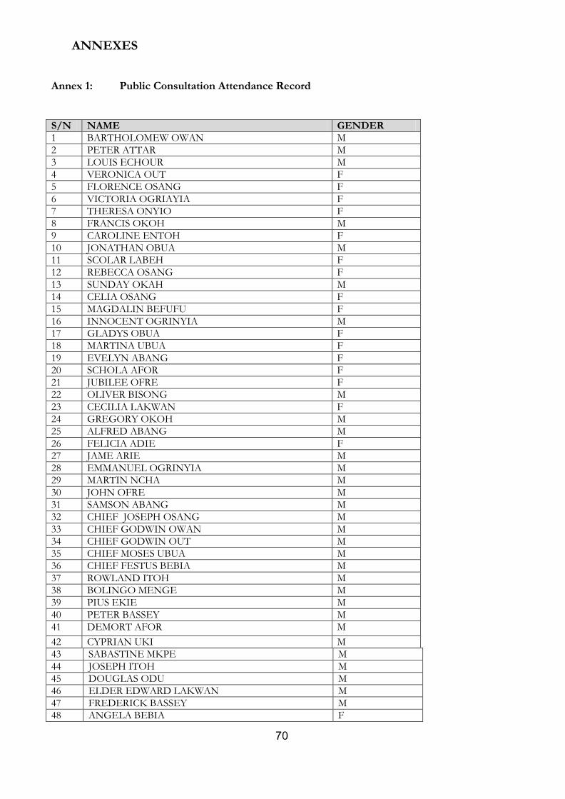
70
ANNEXES
Annex 1: Public Consultation Attendance Record
S/N NAME GENDER
1 BARTHOLOMEW OWAN M
2 PETER ATTAR M
3 LOUIS ECHOUR M
4 VERONICA OUT F
5 FLORENCE OSANG F
6 VICTORIA OGRIAYIA F
7 THERESA ONYIO F
8 FRANCIS OKOH M
9 CAROLINE ENTOH F
10 JONATHAN OBUA M
11 SCOLAR LABEH F
12 REBECCA OSANG F
13 SUNDAY OKAH M
14 CELIA OSANG F
15 MAGDALIN BEFUFU F
16 INNOCENT OGRINYIA M
17 GLADYS OBUA F
18 MARTINA UBUA F
19 EVELYN ABANG F
20 SCHOLA AFOR F
21 JUBILEE OFRE F
22 OLIVER BISONG M
23 CECILIA LAKWAN F
24 GREGORY OKOH M
25 ALFRED ABANG M
26 FELICIA ADIE F
27 JAME ARIE M
28 EMMANUEL OGRINYIA M
29 MARTIN NCHA M
30 JOHN OFRE M
31 SAMSON ABANG M
32 CHIEF JOSEPH OSANG M
33 CHIEF GODWIN OWAN M
34 CHIEF GODWIN OUT M
35 CHIEF MOSES UBUA M
36 CHIEF FESTUS BEBIA M
37 ROWLAND ITOH M
38 BOLINGO MENGE M
39 PIUS EKIE M
40 PETER BASSEY M
41 DEMORT AFOR M
42 CYPRIAN UKI M
43 SABASTINE MKPE M
44 JOSEPH ITOH M
45 DOUGLAS ODU M
46 ELDER EDWARD LAKWAN M
47 FREDERICK BASSEY M
48 ANGELA BEBIA F
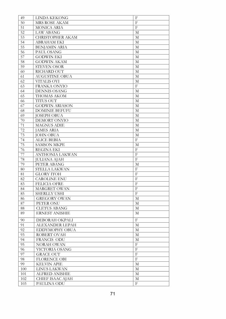
71
49 LINDA KEKONG F
50 MRS ROSE AKAM F
51 MONICA ARIA F
52 LAW ABANG M
53 CHRISTOPHER AKAM M
54 ABRAHAM EKI M
55 BENJAMIN ARIA M
56 PAUL OSANG M
57 GODWIN EKI M
58 GODWIN AKAM M
59 STEVEN OSOR M
60 RICHARD OUT M
61 AUGUSTINE OBUA M
62 VITALIS OYI M
63 FRANKA ONYIO F
64 DENNIS OSANG M
65 THOMAS AKOM M
66 TITUS OUT M
67 GODWIN ARIASON M
68 DOMINIE BEFUFU M
69 JOSEPH OBUA M
70 DEMORT ONYIO M
71 MAGNUS ADIE M
72 JAMES ARIA M
73 JOHN OBUA M
74 ALICE BEBIA F
75 SAMSON MKPE M
76 REGINA EKI F
77 ANTHONIA LAKWAN F
78 JULIANA AJAH F
79 PETER ABANG M
80 STELLA LAKWAN F
81 GLORY ITOH F
82 CAROLINE ENU F
83 FELICIA OFRE F
84 MARGRET OWAN F
85 SHERLLY USHI F
86 GREGORY OWAN M
87 PETER ONU M
88 CLETUS ABANG M
89 ERNEST ANISHIE M
90 DEBORAH OKPALI F
91 ALEXANDER LEPAH M
92 EDDYMOPHY OBUA M
93 ROBERT OVAH M
94 FRANCIS ODU M
95 NORAH OWAN F
96 VICTORIA OSANG F
97 GRACE OUT F
98 FLORENCE OBI F
99 KELVIN APIE M
100 LINUS LAKWAN M
101 ALFRED ANISHIE M
102 CHIEF ISAAC AJAH M
103 PAULINA ODU F
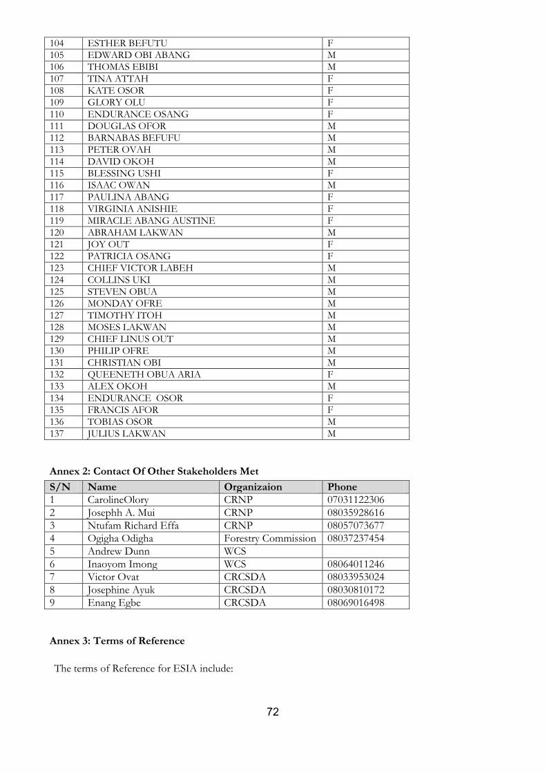
72
104 ESTHER BEFUTU F
105 EDWARD OBI ABANG M
106 THOMAS EBIBI M
107 TINA ATTAH F
108 KATE OSOR F
109 GLORY OLU F
110 ENDURANCE OSANG F
111 DOUGLAS OFOR M
112 BARNABAS BEFUFU M
113 PETER OVAH M
114 DAVID OKOH M
115 BLESSING USHI F
116 ISAAC OWAN M
117 PAULINA ABANG F
118 VIRGINIA ANISHIE F
119 MIRACLE ABANG AUSTINE F
120 ABRAHAM LAKWAN M
121 JOY OUT F
122 PATRICIA OSANG F
123 CHIEF VICTOR LABEH M
124 COLLINS UKI M
125 STEVEN OBUA M
126 MONDAY OFRE M
127 TIMOTHY ITOH M
128 MOSES LAKWAN M
129 CHIEF LINUS OUT M
130 PHILIP OFRE M
131 CHRISTIAN OBI M
132 QUEENETH OBUA ARIA F
133 ALEX OKOH M
134 ENDURANCE OSOR F
135 FRANCIS AFOR F
136 TOBIAS OSOR M
137 JULIUS LAKWAN M
Annex 2: Contact Of Other Stakeholders Met
S/N Name Organizaion Phone
1 CarolineOlory CRNP 07031122306
2 Josephh A. Mui CRNP 08035928616
3 Ntufam Richard Effa CRNP 08057073677
4 Ogigha Odigha Forestry Commission 08037237454
5 Andrew Dunn WCS
6 Inaoyom Imong WCS 08064011246
7 Victor Ovat CRCSDA 08033953024
8 Josephine Ayuk CRCSDA 08030810172
9 Enang Egbe CRCSDA 08069016498
Annex 3: Terms of Reference
The terms of Reference for ESIA include:
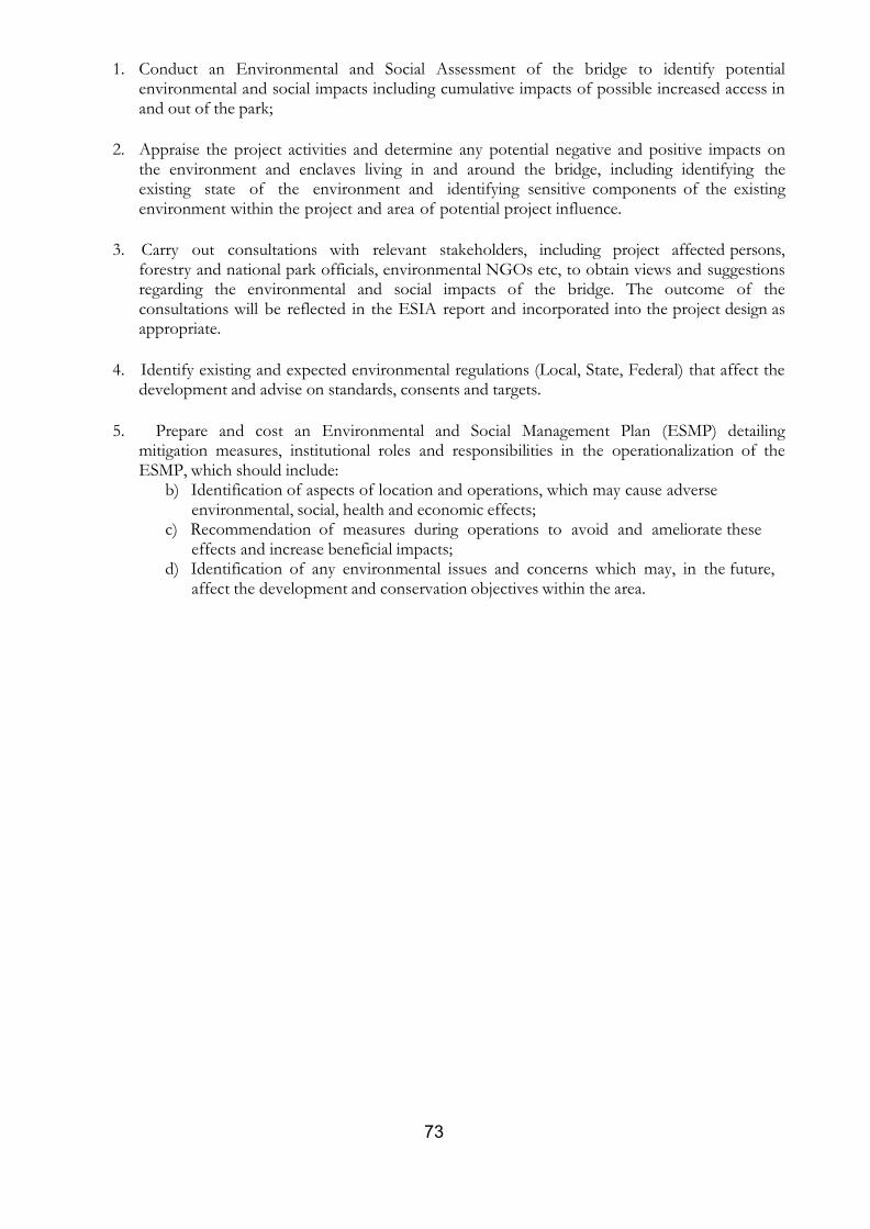
73
1. Conduct an Environmental and Social Assessment of the bridge to identify potential environmental and social impacts including cumulative impacts of possible increased access in and out of the park;
2. Appraise the project activities and determine any potential negative and positive impacts on
the environment and enclaves living in and around the bridge, including identifying the existing state of the environment and identifying sensitive components of the existing environment within the project and area of potential project influence.
3. Carry out consultations with relevant stakeholders, including project affected persons,
forestry and national park officials, environmental NGOs etc, to obtain views and suggestions regarding the environmental and social impacts of the bridge. The outcome of the consultations will be reflected in the ESIA report and incorporated into the project design as appropriate.
4. Identify existing and expected environmental regulations (Local, State, Federal) that affect the
development and advise on standards, consents and targets.
5. Prepare and cost an Environmental and Social Management Plan (ESMP) detailing
mitigation measures, institutional roles and responsibilities in the operationalization of the ESMP, which should include:
b) Identification of aspects of location and operations, which may cause adverse environmental, social, health and economic effects;
c) Recommendation of measures during operations to avoid and ameliorate these effects and increase beneficial impacts;
d) Identification of any environmental issues and concerns which may, in the future, affect the development and conservation objectives within the area.
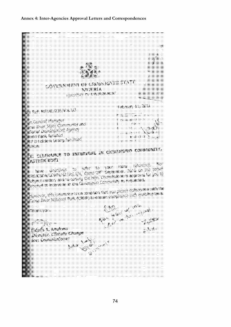
74
Annex 4: Inter-Agencies Approval Letters and Correspondences
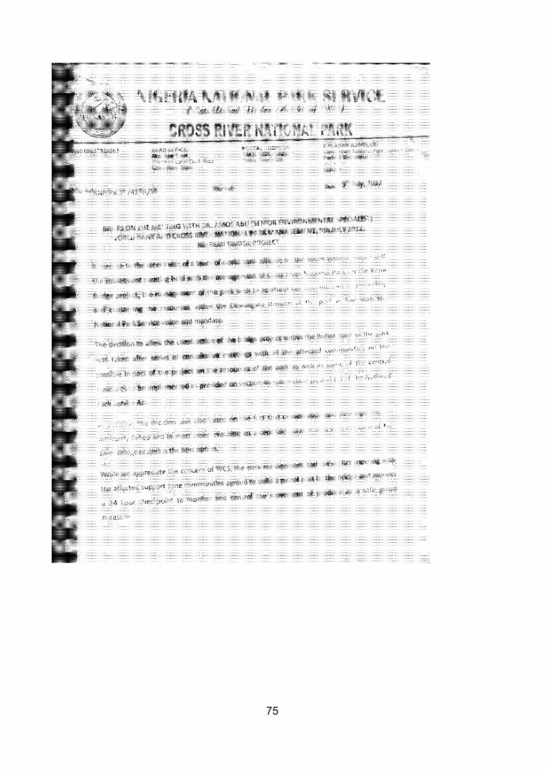
75
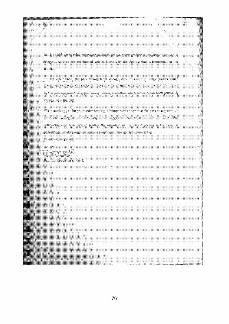
76
77
NIGERIA NATIONAL PAR SER
VICE (cgCUndetv sll.a 4 6 4 1 999)
CROSS RIVER NATIONAL PARK
CALABAR ADDRESS:
Tel:08037929263 HEAD OFFICE: Akamkpa Town Akamkpa Local Govt. Area
POSTAL ADDCREISbS: Cross River National Park Contact Office, P.M.B. 1028, a a ar , .
Cross R"
ver St 1 Federal :Secretanat
Cross River State
1 2nd Floor
Calabar
Our Ref:
CRNP/PROT/41/111/556
Your Ref:
sa.-5c_p..Y-\
&-'ik .A J-:f};s"
Date: 3rd February, 2014
The General Manager,
-,. "''"" · . t 61'2!1tf
78
t
Cross River State Community and Social Development Agency
Ndidem Usang Road, I
Calabar
Cross River State. t
RE: CONSTRUCTION OF THE BRIDGE ACROSS SEMI RIVER IN
OKWANGWO RANGE OF THE CROSS RIVER
NATIONAL PARK
Sequel to the meeting of 315
January, 2014 between the management of
CRNP,CRS Community and Social Development Agency and the World Bank
Consultants at Axari Hotel, Calabar,I am directed to forward a summary/
statistics of Park Management operations within the Okwangwo Division from
2009- 2013 (Table 1).
The request by the World Bank consultants was to support and buttress Park
Management's position that the access provided by the construction of the
bridge would enhance Park protection activities vis- a -viz. increase patrols
and Conservation Education activities to the enclave communities both during
the dry and rainy season.
It is however important to point out here that although patrol and Conservation
Education activities to the Okwangwo axis of the Park has improved, the Park is
constrained by the lack of adequate patrol vehicles and insufficient budgetary
provisions to intervene in the area of provision of alternative livelihood to the
enclave communities.
We therefore solicit for support/assistance from NGO's and donor agencies in
these areas to enable the Park Management effectively protect the Park and
set up mitigating measures against any perceived adverse impact of the
bridge on the conservation of the Park.
Thank you.
· v$· Joseph .A. Ntui
For: Conservator of Park

79
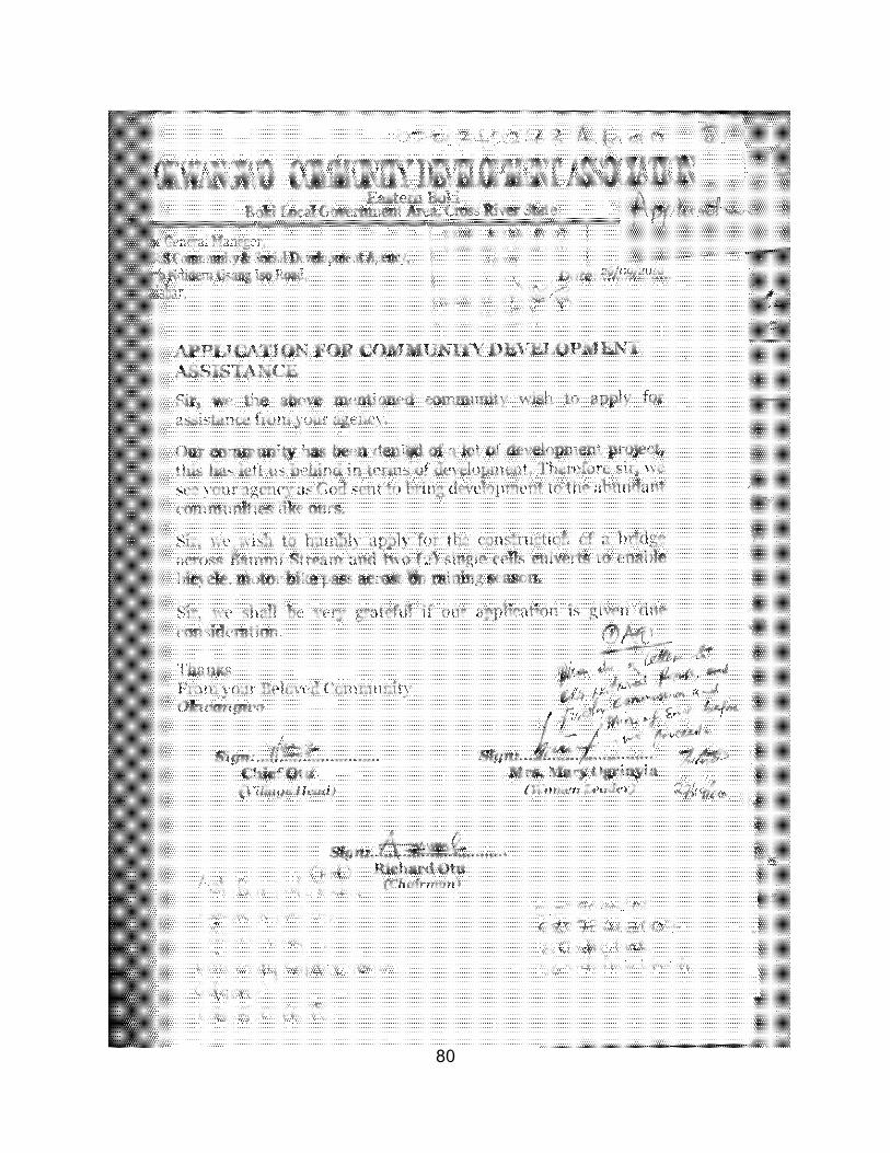
80
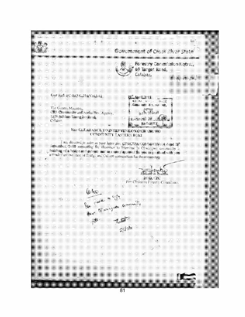
81
82