Embed Size (px)
Citation preview

ATTACHMENT N: USFWS EA for Compatibility Determination
1. Environmental Assessment for the Grant County State Aid Highway 10 Safety Improvements Project at USFWS Resources (DRAFT, February 2021) Initial draft sent to USFWS, October 15, 2020. Comments not yet received. Applicable comments from USFWS and FHWA on Grant County CSAH 10 Evaluation of Alternatives Against SEE Impact Categories and Selection of a Preferred Alternative Memorandum (December 10, 2020) (see Attachment C.5), have been applied to draft.

Attachment N: Environmental Assessment for the Grant County State Aid Highway 10 Safety Improvements Project at USFWS Resources (DRAFT, February 2021)
Environmental Assessment
for the
Grant County State Aid Highway 10 Safety Improvements Project At USFWS Resources
Prepared by:
Fergus Falls Wetland Management District 18965 County Highway 82
Fergus Falls, MN 56537
For:
Region 3 U.S. Fish and Wildlife Service
Bloomington, Minnesota
February 2021
USFWS Grant Co CSAH 10 Environmental Assessment Page 1 of 25 February 2021

TABLE OF CONTENTS
Page #
I. Introduction...................................................................................................... 4
II. Purpose and Need............................................................................................... 4
A. Purpose ........................................................................................................ 4
B. Need ........................................................................................................... 4
III. Decisions to Be Made ....................................................................................... 5
IV. Background................................................................................................... 5
V. Alternatives ...................................................................................................... 6
A. Alternatives Carried Forward for Detailed Analysis ..................................................... 6
1. No Build Alternative ....................................................................................... 6
2. Alternative 1, Proposed Project Alternative ........................................................... 7
a) Alternative 1 CSAH 10 Highway Improvements................................................. 7
b) Proposed Exchange of Interests with Implementation of Alternative 1 .................... 8
B. Other Location or Design Alternatives Considered but Rejected...................................... 9
1. Location Alternatives Not Considered for Detailed Analysis ......................................... 9
2. Design Alternatives Considered but Rejected.........................................................12
VI. Affected Environment.................................................................................... 13
A. USFWS Managed Resources ................................................................................13
1. Bellevue WPA..............................................................................................13
2. USFWS Wetland Easements ..............................................................................14
3. Non-USFWS Land Uses ....................................................................................14
B. Biological Environment .....................................................................................14
1. Habitat/Vegetation: Grasslands and Wetlands .......................................................14
2. Wildlife Species ...........................................................................................15
3. Listed, Proposed and Candidate Species ..............................................................15
C. Cultural Resources ..........................................................................................16
D. Local Socio-Economic Conditions .........................................................................16
VII. Environmental Consequences........................................................................... 16
A. Alternative 1 (Proposed Action)...........................................................................16
1. Impacts to Bellevue WPA ................................................................................16
2. Impacts to USFWS Wetland Conservation Easements ................................................19
3. Impacts to Biological Environment .....................................................................19
4. Cultural Resource Impacts ...............................................................................21
5. Local Socio-Economic Impacts ..........................................................................22
6. Environmental Justice....................................................................................22
USFWS Grant Co CSAH 10 Environmental Assessment Page 2 of 25 February 2021

7. Cumulative Impacts.......................................................................................23
8. Public Safety Impacts ....................................................................................23
B. No Build Alternative (No Action)..........................................................................23
1. USFWS Resources – Bellevue WPA and Wetland Easements .........................................23
2. Biological Environment...................................................................................23
3. Listed, Proposed and Candidate Species ..............................................................24
4. Cultural Resources ........................................................................................24
5. Local Socio-Economic Impacts ..........................................................................24
6. Environmental Justice....................................................................................24
7. Cumulative Impacts.......................................................................................24
8. Public Safety...............................................................................................24
VIII. Consultation with USFWS ................................................................................ 24
IX. Summary of Environmental Consequences by Alternative ........................................ 25
FIGURES Figure 1: Project Location Map Figure 2: USFWS Resources Figure 3: Proposed Bellevue WPA Exchange of Interests Between USFWS and Grant County Figure 4: CSAH 10 Location Alternatives Considered Figure 5: Bellevue WPA Impacts Figure 6: Impacted Wetland Easements Figure 7: Wetland Easement Permanent and Temporary Impacts
USFWS Grant Co CSAH 10 Environmental Assessment Page 3 of 25 February 2021

I. Introduction
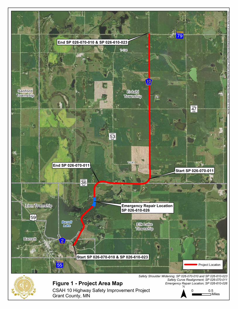
This Environmental Assessment (EA) evaluates the effects the proposed Grant County Minnesota’s County State Aid Highway (CSAH) 10 Highway Safety Improvement Project would have on U.S. Fish and Wildlife Service (USFWS) resources within the project area, including Bellevue Waterfowl Production Area (WPA) and six parcels with wetland conservation easements. The project area is shown on Figure 1; USFWS resources within the project area are shown on Figure 2.
This document complies with the National Environmental Policy Act (NEPA) in accordance with Council on Environmental Quality regulations (40 CFR 1500-1509) and Department of the Interior (43 CFR 46; 516 DM 8) and U.S. Fish and Wildlife Service (550 FW 3) regulations and policies. NEPA requires examination of the effects of proposed actions on the natural and human environment.
This EA is written as an attachment to the EA that Grant County is preparing to document overall project impacts consistent with requirements of the Federal Highway Administration (FHWA) and the Minnesota Department of Transportation (MnDOT), hereafter referred to as the FHWA EA. This EA documents impacts specific to resources under the jurisdiction of the USFWS. To reduce the overall volume of this document, this EA references applicable sections of the FHWA EA.
II. Purpose and Need
A. Purpose
The purpose of this project is to address safety issues on CSAH 10, which has crash rates that are higher than the critical crash rates. The project will also address a portion of CSAH 10 that was damaged by flooding as well as address pavement condition.
B. Need
The primary need for this project is to address CSAH 10 safety issues, including documented crashes. The project will also address the following secondary needs: 1) repair a portion of CSAH 10, approximately 0.3 miles south of CR 36, that was damaged by flooding in March 2019; 2) replace pavement that is in fair condition; and 3) maintain existing mobility functions of CSAH 10 as the primary regional route between Perham and Morris, MN and the local north-south route between CSAH 2 and TH 79.
The types of crashes that occur along this corridor (see FHWA EA Section III) indicate that there are some geometric design elements on CSAH 10 that contribute to crashes, including the sharp horizontal curve at the west junction of CSAH 10 and CR 36 at the northwest corner of the Bellevue WPA.
USFWS Grant Co CSAH 10 Environmental Assessment Page 4 of 25 February 2021

Shoulders on CSAH 10 are two feet wide (compared to the standard of four feet wide). Narrow shoulders limit the area available for drivers to correct when departing the road. The effect of this is more pronounced where the highway passes through wooded areas, or curves (horizontal or vertical). Curves and wooded areas are prevalent in the southern half of the corridor. These conditions contribute to poor stopping sight distances.
III. Decisions to Be Made
Based on the facts presented herein, the USFWS Region 3 Refuge Chief will decide whether this EA (in conjunction with the overall CSAH 10 project EA) is adequate to support a Finding of No Significant Impact (FONSI) or if the project is a major Federal Action having major significant effects on the environment, requiring an Environmental Impact Statement (EIS).
The FHWA has determined that the Bellevue WPA and USFWS wetland conservation easements are Section 4(f) resources under the Transportation Act of 1966. The FHWA has approved Grant County’s request to issue a notice of intent to make a determination that the proposed CSAH 10 project would result in a de minimis level of impact to both the Bellevue WPA and wetland conservation easements (215X and 269X-3) under Section 4(f). UFSWS, as the Official with Jurisdiction (OWJ) over these Section 4(f) resources, will need to determine whether or not to provide final concurrence to FHWA on the de minimis determination.
IV. Background
Wetland Management Districts (WMDs) are guided by the mission and goals of the National Wildlife Refuge System (NWRS).1 The mission of the NWRS2 is:
“... to administer a national network of lands and waters for the conservation, management and, where appropriate, restoration of the fish, wildlife, and plant resources and their habitats within the United States for the benefit of present and future generations of Americans”
The project area is located in the Fergus Falls WMD, which is one of 38 WMDs located within the United States. The vision statement for WMDs located in Minnesota is:
“The Districts will emphasize waterfowl production and ensure the preservation of habitat for migratory birds, threatened and endangered native species, and resident wildlife. The Districts will provide opportunities for the public to hunt, fish, observe and photograph wildlife and increase public understanding and appreciation of the Northern Tallgrass Prairie Ecosystem.”
1 Relevant guidance includes the NWRS Administration Act of 1966, as amended by the NWRS Improvement Act
of 1997, Refuge Recreation Act of 1962, and selected portions of the Code of Federal Regulations and Fish and
Wildlife Service Manual. 2 As outlined by the NWRS Administration Act (NWRSAA) and amended by the National Wildlife Refuge System
Improvement Act (16 U.S.C. 668dd et seq.).
USFWS Grant Co CSAH 10 Environmental Assessment Page 5 of 25 February 2021

The Fergus Falls WMD has nearly 7,000 separate tracts, most of which are fewer than 1,000 acres. These tracts of land are preserved to restore and protect nesting and breeding wetland habitat for waterfowl. The Fergus Falls WMD identifies these goals in their Comprehensive Conservation Plan:
1. Wildlife – preserve and maintain diversity and increase abundance of waterfowl.
2. Habitat – restore native prairie and maintain vigor. 3. Acquisition – identify the highest priority acres to be acquired. 4. Monitoring – collect baseline data. 5. Endangered Species/Unique Communities – preserve, enhance, and restore
rare native northern tallgrass prairie, flora, and fauna. 6. Public Use/Environmental Education – provide opportunities for the public
to use WPAs. 7. Preparation of WPA Development Plans – create GIS WPA development plans
for each unit. 8. Provide Maintenance – adequate staff and equipment to maintain units. 9. Ensure annual capital development funds can meet necessary development
of new WPA lands.
V. Alternatives
This section documents the alternatives considered in detail within this EA, as well as alternatives that were considered but removed from further consideration.
A. Alternatives Carried Forward for Detailed Analysis
The memo titled “Grant County CSAH 10 Project Alternatives Carried Forward into Detailed Analysis Memorandum” and the associated addendum (located in Attachment C of the FHWA EA) provide a detailed assessment of project location alternatives against project purpose and need evaluation criteria. The analysis documented in this memo resulted in Alternative 1, also referred to as the proposed project alternative, being the sole build alternative to move forward for detailed review. Because of this, only Alternative 1 and the No Build Alternative will be addressed in this EA. Both of these alternatives are described below.
1. No Build Alternative
Under the No Build Alternative, no improvements would be made to CSAH 10. The No Build Alternative would not address the primary safety needs or the secondary needs of addressing the part of CSAH 10 that has been damaged by flooding, or poor pavement conditions. Existing characteristics of CSAH 10 that contribute to the high critical crash and severity rates on CSAH 10 include:
• Horizontal curves with high superelevation
• Three vertical curves (with grades greater than six percent)
USFWS Grant Co CSAH 10 Environmental Assessment Page 6 of 25 February 2021

• Visual traps created by the horizontal and vertical curves
• Narrow (2-foot wide) shoulders along the entire corridor between CSAH 2 and TH 79
• 1:3 inslopes
It is expected that corridor and intersection crash rates would continue to be higher than critical crash rates. The number of crashes on the segment are expected to remain high (currently 3.08 per million vehicle miles of travel). Issues within the emergency repair area would remain under the No Build Alternative, including:
• The existing 36-inch culvert pipe that does not accommodate hydraulic demand and contributes to frequent flooding would remain in place.
• Approximately 50 feet of weak, compressible swamp-deposited soils would continue to contribute to pavement deterioration after flood waters recede, decreasing the road’s lifespan.
Finally, the fair pavement condition on the corridor would not be addressed under the No Build Alternative. CSAH 10 from CSAH 2 to TH 79 was originally constructed in 1956. An overlay was completed in 1975, and most recently in 1995. A seal coat was applied in 1996. Since then, no improvements have been completed. Pavement is rated as fair for ride quality.
2. Alternative 1, Proposed Project Alternative
a) Alternative 1 CSAH 10 Highway Improvements
This project would keep CSAH 10 primarily on the existing alignment from CSAH 2 to TH 79. Approximately 3.75 miles of CSAH 10 (from CSAH 2 to township T-141) would be reconstructed. Slight alignment adjustments within this segment would flatten curves and create 90-degree intersections with intersecting roadways. The remainder of the corridor from T-141 to TH 79 (3.55 miles) would be rehabilitated.
CSAH 10 would remain a rural, two-lane highway. The reconstructed portion of the CSAH 10 proposed action (Alternative 1) would:
• Flatten two sharp curves on CSAH 10 at the east and west junctions with CR 36;
• Lower the superelevation rate;
• Address poor soils identified at five locations;
• Replace existing 2-foot gravel shoulder along CSAH 10 between CSAH 2 and T-141 (225th Street) with 7-foot shoulders (5 feet paved and 2 feet gravel);
• Replace existing 1:3 inslopes from CSAH 2 to T-141 with 1:4 inslopes
• Add an 8-foot-wide shared use path along the west side of CSAH 10 from CSAH 2 and continuing along Barrett Lake for 1.25 miles.
USFWS Grant Co CSAH 10 Environmental Assessment Page 7 of 25 February 2021

Within the emergency repair area Alternative 1 would:
• Replace the existing 36-inch culvert pipe with a 6-foot by 5-foot reinforced concrete box culvert.
• Soils along an approximately 1,300-foot-long section of CSAH 10 on either side of the culvert area would be surcharged. Fill required to achieve the proposed grade (which is higher than the existing embankment) would be left in place. Excess fill would be removed.
b) Proposed Exchange of Interests with Implementation of Alternative 1
An exchange of interests between Grant County and the USFWS has been proposed both to accommodate the CSAH 10 project and as mitigation to impacts Alternative 1 would have on USFWS resources (Bellevue WPA and two wetland conservation easements). USFWS has indicated to Grant County that they wish to handle any required exchange with the county in one transaction. USFWS also indicated that it would be acceptable to apply mitigation achieved at the Bellevue WPA towards impacts at the wetland conservation easements.
Complete details of the proposed exchange of interests are included in Attachment E of the FHWA EA. A summary of the exchange is provided below and shown on Figure 3.
• Grant County would acquire 2.5 acres of the WPA from the USFWS, located in the northwest corner of the parcel. This section is now separated from the main body of the WPA by the CSAH 10 alignment; it is further bisected by CR 36 which creates two relatively small units of land.
• Along the north side of the WPA, Grant County would vacate, level and reseed the existing CSAH 10 alignment and roadway easement that USFWS has provided to Grant County. Land under a portion of the CSAH 10 alignment is within the existing WPA boundaries.
• Grant County would purchase land on the north edge of the existing WPA boundary and existing CSAH 10. Once CSAH 10 is realigned, this area would be located south of the new CSAH 10. Grant County would transfer approximately 2.8 acres of land in this area over to the USFWS to become part of Bellevue WPA.
• The exchange of interests between Grant County and the USFWS includes habitat interests, right of way easement interests, wetland easement interests, and fee title interests. The USFWS will include Grant County's leveling of the road grade, reseeding and other restoration costs in the valuation of the exchange of interests. Grant County will donate any restoration costs that exceed the valuation of the exchange of interests.
USFWS Grant Co CSAH 10 Environmental Assessment Page 8 of 25 February 2021

B. Other Location or Design Alternatives Considered but Rejected
This section discusses CSAH 10 location and design alternatives that were considered and dismissed after evaluation. Complete evaluation screening information is included in Attachment C of the FHWA EA.
1. Location Alternatives Not Considered for Detailed Analysis
Several location alternatives were considered during project development. These alternatives are shown on Figure 4. Complete details of the alternatives analysis are included in the FHWA EA, Section IV and Attachment C. Reasons these location alternatives were dismissed from detailed analysis are provided below:
a) Alternative 2: This alternative would meet all measures of the project purpose and need. However, this alternative was not carried forward for detailed analysis because of multiple other project impacts, described below:
• Would not address safety issues on portions of former CSAH 10
• Some existing land uses would have less direct access to CSAH 10
• Potential removal of portions of existing roadway (separate from this project) could affect access to the local transportation network for some local land uses
• If all existing roadways were to remain in place, existing safety problems could be perpetuated and additional maintenance would be required to keep the roadways open
• Would result in an increase of impervious surface and associated highway runoff
• Would bisect multiple agricultural fields
• Would require temporary easements and acquisition of new right of way consistent with roadway construction on a new alignment, including from agricultural lands.
b) Alternative 3a: This alternative would meet all measures of the project purpose and need. However, this alternative was not carried forward for detailed analysis because of multiple other project impacts, described below:
• Would not address safety issues on portions of former CSAH 10
• Some existing land uses would have less direct access to CSAH 10
• Potential removal of portions of existing roadway (separate from this project) could affect access to the local transportation network for some local land uses
USFWS Grant Co CSAH 10 Environmental Assessment Page 9 of 25 February 2021

• If all existing roadways were to remain in place, existing safety problems could be perpetuated and additional maintenance would be required to keep the roadways open
• Would result in an increase of impervious surface and associated highway runoff
• Would bisect multiple agricultural fields
• Would require temporary easements and acquisition of new right of way consistent with roadway construction on a new alignment, including from agricultural lands.
c) Alternative 3b: This alternative would meet all measures of the project purpose and need. However, this alternative was not carried forward for detailed analysis because of multiple other project impacts, described below:
• Would not address safety issues on portions of former CSAH 10
• Some existing land uses would have less direct access to CSAH 10
• Potential removal of portions of existing roadway (separate from this project) could affect access to the local transportation network for some local land uses
• If all existing roadways were to remain in place, existing safety problems could be perpetuated and additional maintenance would be required to keep the roadways open
• Would result in an increase of impervious surface and associated highway runoff
• Would bisect multiple agricultural fields
• Would require temporary easements and acquisition of new right of way consistent with roadway construction on a new alignment, including from agricultural lands.
d) Alternative 4: This alternative would meet all measures of the project purpose and need. However, this alternative was not carried forward for detailed analysis because of multiple other project impacts, described below:
• Would not address safety issues on portions of former CSAH 10
• Some existing land uses would have less direct access to CSAH 10
• Potential removal of portions of existing roadway (separate from this project) could affect access to the local transportation network for some local land uses
• If all existing roadways were to remain in place, existing safety problems could be perpetuated and additional maintenance would be required to keep the roadways open
• Would result in an increase of impervious surface and associated highway runoff
USFWS Grant Co CSAH 10 Environmental Assessment Page 10 of 25 February 2021
• Would bisect multiple agricultural fields
• Would require temporary easements and acquisition of new right of way consistent with roadway construction on a new alignment, including from agricultural lands.
e) Alternative 5a: This alternative would not meet the following measures of the project purpose and need, and was not carried forward for detailed analysis:
• Addressing safety—The CSAH 10 intersection with CR 21 is expected to have a crash rate above the critical crash rate.
• Maintaining regional travel patterns—The existing north-south continuity between TH 59/TH 55 and I-94 via a regional roadway would be removed.
• Maintaining local travel patterns—A local north-south connection between CSAH 2 and TH 79 would not be maintained.
This alternative would result in multiple other project impacts:
• Would not address safety issues on portions of former CSAH 10
• Some existing land uses would have less direct access to CSAH 10
• Potential removal of portions of existing roadway (separate from this project) could affect access to the local transportation network for some local land uses
• If all existing roadways were to remain in place, existing safety problems could be perpetuated and additional maintenance would be required to keep the roadways open
• Would result in an increase of impervious surface and associated highway runoff
• Would bisect multiple agricultural fields
• Would require temporary easements and acquisition of new right of way consistent with roadway construction on a new alignment, including from agricultural lands.
f) Alternative 5b: This alternative would not meet the following measures of the project purpose and need, and was not carried forward for detailed analysis:
• Addressing safety—The CSAH 10 intersection with CR 21 is expected to have a crash rate above the critical crash rate.
• Maintaining regional travel patterns—The existing north-south continuity between TH 59/TH 55 and I-94 via a regional roadway would be removed.
• Maintaining local travel patterns—A local north-south connection between CSAH 2 and TH 79 would not be maintained.
USFWS Grant Co CSAH 10 Environmental Assessment Page 11 of 25 February 2021

This alternative would result in multiple other project impacts:
• Would not address safety issues on portions of former CSAH 10
• Some existing land uses would have less direct access to CSAH 10
• Potential removal of portions of existing roadway (separate from this project) could affect access to the local transportation network for some local land uses
• If all existing roadways were to remain in place, existing safety problems could be perpetuated and additional maintenance would be required to keep the roadways open
• Would result in an increase of impervious surface and associated highway runoff
• Would bisect multiple agricultural fields
• Would require temporary easements and acquisition of new right of way consistent with roadway construction on a new alignment, including from agricultural lands.
2. Design Alternatives Considered but Rejected
The design alternatives considered but ultimately dismissed for implementation on the CSAH 10 project are discussed in detail in Section IV of the FHWA EA. Design alternatives applicable to the portions of CSAH 10 adjacent to USFWS resources are provided below.
a) Cross-section - The only cross section alternative considered was a two-lane rural section. This section would be adequate given the existing and future traffic volumes anticipated for CSAH 10. Turn lanes on curve intersections were considered but rejected given the low traffic volumes.
b) Reclaimed Asphalt - Under the reclamation alternative, the existing CSAH 10 pavement would be reclaimed and used as aggregate during construction where possible within the portion of CSAH 10 that would be reconstructed (from CSAH 2 to T-141). With the exception of the No Build Alternative, all build alternatives require portions of CSAH 10 to be realigned from its existing alignment. Therefore, pavement reclamation would not be a viable option on any new alignment and was rejected.
c) Bituminous vs. concrete - Both bituminous and concrete road surfaces were considered. The CSAH 10 road surface would be constructed with bituminous rather than concrete for economic reasons and because existing and future traffic volumes do not necessitate a concrete section. For these reasons, the concrete road surface alternative was rejected.
USFWS Grant Co CSAH 10 Environmental Assessment Page 12 of 25 February 2021

VI. Affected Environment
This section documents the existing conditions of the project corridor in the vicinity of USFWS resources.
A. USFWS Managed Resources
The CSAH 10 project is in the Prairie Pothole Region of North America, an area where prairie wetlands and tallgrass prairie form a transition zone to the northern hardwood forest. Wetlands and native prairies in this region have been dramatically reduced mainly due to cropland conversion. Historically, this region contained roughly 83 pothole wetlands per square mile. More than 80% of wetlands and 99% of native prairies have been lost.
The region remains a critical waterfowl production and migration area providing the highest waterfowl nesting density in Minnesota. More than 50% of ducks hatched in North America are produced in the Prairie Pothole Region. The two most abundant species, the Mallard and Blue-winged Teal, require tracts containing both grassland and wetlands. Redheads, an additional high priority resource in the district, are associated with type 4 and 5 wetlands and access to deep water.
The mission of the Fergus Falls WMD (managed by the USFWS) is to conserve, protect and enhance fish and wildlife in their habitats. The Fergus Fall WMD contains over 200 Waterfowl Production Areas (WPAs), including the Bellevue WPA which is located in the project area. The WMD also manages over 1,100 wetland easements. Six parcels with wetland easements are located within the project area. These USFWS resources are shown on Figure 2 and described below.
1. Bellevue WPA
The Bellevue WPA is a 76.6-acre parcel within the project area. CSAH 10 borders the western and northern edges of the WPA parcel. The northwestern corner or the WPA is divided by CSAH 10 and CR 36, resulting in a small portion of land that is not contiguous with the rest of the WPA. Approximately 3,900 linear feet of CSAH 10 are adjacent to the WPA. Grant County holds an easement from USFWS for the portion of CSAH 10 that passes through the WPA.
The three main objectives of the Bellevue WPA include: A) waterfowl production and maintenance; B) preservation and promotion of native plant and animal species diversity; C) consumptive and non-consumptive wildlife and wild land oriented public use. Additional species that may use habitat found at Bellevue WPA include resident wildlife, native grassland birds, shorebirds and invertebrates. Functions and available activities at the WPA include hunting, fishing, education, photography, trapping, hiking, bird-
USFWS Grant Co CSAH 10 Environmental Assessment Page 13 of 25 February 2021

watching, berry picking, and other non-motorized and non-commercial outdoor recreation.
2. USFWS Wetland Easements
There are six parcels with wetland conservation easements within the project area (see Figure 2). The parcels are owned by multiple private owners. The USFWS holds limited-interest easements on the small wetlands or pothole areas on these parcels. The easements provide the USFWS with a limited set of rights to the wetlands (not uplands). Specifically, the wetlands cannot be drained, filled, leveled, or burned. CSAH 10 is adjacent to approximately 1,300 linear feet of wetland easements within the project area.
3. Non-USFWS Land Uses
The area surrounding CSAH 10 is predominantly used for agricultural purposes, with dispersed pothole wetlands. Two farmsteads are located across CSAH 10 from Bellevue WPA. The land around the easements are also used for row crops or pasture. The small city of Barrett is located at the south end of the project. Most of the land to the south and north of Barrett Lake is residential.
B. Biological Environment
1. Habitat/Vegetation: Grasslands and Wetlands
The predominant pre-settlement vegetation in this region was prairie pothole. Organic material and mineral rich prairie soils contribute to fertile soils. Due to this rich soil, 90% of the historic wetlands in the prairie pothole portions of Minnesota were drained for agriculture or development.
Bellevue WPA includes an approximately 28-acre marsh that is classified as type 5 wetland, a priority resource of concern according to the Fergus Falls WMD’s Habitat Management Plan. This WPA also includes roughly 46 acres of upland primarily composed of planted native grassland and some forested habitat. Planted native grasses at Bellevue WPA are also considered a high priority habitat by the district.
Wetland easement tracts 269x and 215x contain type 4 deep marsh wetland. An unnamed stream flows through the wetlands at easements 269x and 215x and connects to Barrett Lake to the southwest.
Both wetlands and native grasses are vital to effective waterfowl and wildlife management and production. Wetlands are critical to waterfowl production. Many species of waterfowl, marsh, and water birds are attracted to the pothole wetlands for breeding and migratory stop over sites. Many species rely on native grasses for breeding habitat.
USFWS Grant Co CSAH 10 Environmental Assessment Page 14 of 25 February 2021

The Minnesota Department of Natural Resources (MnDNR) has identified Barrett Lake a lake of High Biological Significance based on its amphibian population.
2. Wildlife Species
The Bellevue WPA and surrounding prairie pothole region provide habitats for and attract an abundance of wildlife species. At least 290 bird species have been observed and 170 of these nest within the Fergus Falls WMD. This includes more than 50 documented pairs of bald eagles. The Fergus Falls WMD also contains at least 40 species of mammals and 25 species of reptiles and amphibians.
3. Listed, Proposed and Candidate Species
The MnDNR Natural Heritage Information System (NHIS) database was reviewed for rare species that may be affected by this project (Attachment G of the FHWA EA). Two state species of special concern were identified as rare species that may be adversely affected by the proposed project. These are described below:
• Lark Sparrow (Chondestes grammacus) - Lark sparrows are a state-listed bird species of special concern that have been documented in the vicinity of the project. They are found in open grassland areas with scattered trees and shrubs, similar to the habitat available at Bellevue WPA. Lark sparrows build their nests on the ground, in shrubs or small trees.
• Purple Martin (Progne subis) - Purple martins are a state-listed bird species of concern that have been documented in the vicinity of the project. These colony nesters typically nest near water to be near the insect food source. In rural areas, the birds tend to nest in cavities such as woodpecker holes.
MnDOT’s Office of Environmental Stewardship (OES) also reviewed the project's potential effect on federally listed species and obtained FWS concurrence for the determination. One federally listed species may occur in the project's County. The federally listed species is described below; additional information is included in Attachment G of the FHWA EA:
• Northern long-eared bat (Myotis septentrionalis) - The northern long-eared bat is a federally threatened species which may occur in Grant County. The occurrence of northern long-eared bat maternity roosts within the project area is unknown. In the summer, the species is often associated with forested habitats, especially around wetlands. Summer roosts are believed to include separate day and night roosts. Day roosts may be under loose tree bark. The sexes tend to roost separately, with
USFWS Grant Co CSAH 10 Environmental Assessment Page 15 of 25 February 2021

females forming small maternity colonies in relatively warm sites to bear and rear their offspring in June and July.
C. Cultural Resources
MnDOT’s Cultural Resources Unit (CRU) led archaeological surveys (Phase I and Phase II) for the project.3 The CRU consulted with the Minnesota Indian Affairs Council (MIAC) and the Office of the State Archaeologist (OSA) on behalf of Grant County. USFWS requested, and FWHA agreed that FHWA serve as the lead agency for Section 106 review. More detailed cultural resource information for the project area is provided in Section VI.C and Attachment F of the FHWA EA.
MnDOT CRU determined that none of the historic properties located within the project area are eligible for or listed in the NRHP. Also, CRU determined that there are numerous archaeological sites located within the project area, and that five of these sites are eligible for listing in the NRHP. SHPO concurred with MnDOT CRU’s findings. None of these sites are located within either the Bellevue WPA or USFWS wetland easements.
D. Local Socio-Economic Conditions
The project corridor is part of the primary route between Morris and Perham, MN, both of which are regional employment and service centers that are not directly connected by major state or US highways. CSAH 10 is part of the most direct route between these cities, which are located roughly 82 miles apart. CSAH 10 is a major collector route that serves as the local north-south connection between Barrett and communities to the north, including Erdahl and Ashby. As noted in the land uses section of the FHWA EA, the project area includes several farming operations. These operations rely on CSAH 10 to transport materials and crops.
VII. Environmental Consequences
The following section summarizes environmental consequences that the CSAH 10 project would have at the Bellevue WPA and the USFWS easements. Additional project-wide details about each alternative are included in the FHWA EA.
A. Alternative 1 (Proposed Action)
1. Impacts to Bellevue WPA
The Bellevue WPA will be impacted by construction of the CSAH 10 project (see Figure 5).
3 FHWA delegated responsibilities for compliance with Section 106 of the National Historic Preservation Act (54
USC 300101 et. seq.) and its implementing regulations at 36 CFR 800 to MnDOT CRU per the terms of a 2015
Section 106 Programmatic Agreement regarding Federal-Aid Highway Program Projects in Minnesota.
USFWS Grant Co CSAH 10 Environmental Assessment Page 16 of 25 February 2021

a) Permanent Impacts - The proposed project is not anticipated to negatively affect the functions of or activities that take place within the WPA. Realigning a portion of CSAH 10 to the north would provide USFWS with the opportunity to restore and expand the central marsh and adjacent uplands to the north (Figure 5), which would ultimately improve the function of the Bellevue WPA.
Part of the impact will result from a proposed exchange of interests between Grant County and USFWS (described above and shown on Figures 4 and 5). Outcomes of the proposed exchange include:
• Approximately 2.5 acres of land in the northwest corner of the existing Bellevue WPA boundaries will be acquired by Grant County from the USFWS. Grant County will turn over 2.8 acres along the northern edge of the existing WPA and CSAH 10 to the USFWS.
o One acre of existing WPA that is are now occupied by CSAH 10 (under a road easement USFWS has provided to Grant County) will be vacated by the County. This area will be permanently impacted by the obliteration of existing CSAH 10 and removal of fill. Part of this area is within the existing WPA boundaries and part is just to the north. The roadbed within the wetland area will be excavated to match the existing bottom surface elevation of the wetland. All disturbed areas will be restored with native seed mixes determined by USFWS.
• Once the CSAH 10 project is complete, the area will be ready for the USFWS to restore wetland and upland. The USFWS would have the opportunity to restore and expand the central marsh within the WPA by up to 1.4 acres by reconnecting the central marsh to a wetland north of the existing road as well as to restore adjacent uplands. USFWS habitat interests will also be consolidated by divesting of small, irregular fee title parcels with limited resource value.
• Overall, the WPA will gain approximately 0.2 acres of land. One acre of roadway will be removed from the WPA. Approximately 0.9 acres of wetland, not included in road easement, will be removed from the WPA. A large portion of this wetland in the northwest corner of the existing WPA boundaries will remain wetland, however it will be owned by Grant County rather than USFWS.
The net result of the proposed exchange of interests is consistent with Fergus Falls WMD’s purpose & goals of protecting natural lands and acquiring lands contribute to prime waterfowl habitat and larger WPA block sizes.
The parking lot located in the southwest corner of the intersection at CSAH 10 and CR 53 would be impacted during construction. Access to and parking for the WPA will be provided throughout project
USFWS Grant Co CSAH 10 Environmental Assessment Page 17 of 25 February 2021

construction, though it may be temporarily relocated (e.g., parking for the WPA may be shifted to the other side of the road during some portion of the construction project). Grant County will coordinate with USFWS regarding parking details for Bellevue WPA during construction.
Because the USFWS process to complete the exchange of interests between USFWS and Grant County may not be complete by the time Grant County plans to begin construction, Grant County may need to request a special use permit from USFWS to authorize construction to move forward while the exchange of interests/realty process is occurring. The county will continue to coordinate with USFWS on the potential need for the special use permit.
b) Temporary Impacts - Portions of the WPA adjacent to CSAH 10 would be affected during construction. These are shown on Figure 5 and described below:
• Approximately 0.9 acres along the far west edge of the WPA will be temporarily impacted during construction. This area—to the west of the existing CSAH 10 alignment—is within existing CSAH 10 right of way and also within the existing easement provided to Grant County from USFWS. It will be used to stage grading activities for widening the new CSAH 10 alignment.
• On the north side of the WPA, approximately 0.23 acres of the Section 4(f) property will be required for construction of the project. This includes the surface area of the WPA necessary for staging during construction.
Table 1 shows changes to the Bellevue WPA resulting from the proposed exchange of interests as well as temporary and permanent project impacts.
Table 1: Bellevue WPA Impacts
Acres
Resource Acreage 76.6
Permanent Impacts 2.4
Temporary Impacts 1.13
Resource after Construction 76.8
Difference (After-Before) +0.2
c) Mitigation - Impacts to the USFWS resources will be mitigated by the exchange of interests described above that would transfer land and habitat interests from Grant County to USFWS. Vegetation within the WPA that is disturbed during construction would be fully restored to
USFWS Grant Co CSAH 10 Environmental Assessment Page 18 of 25 February 2021

conditions equal to or greater than pre-project conditions. Best management practices would be implemented to avoid impacts to water quality, vegetation, and wildlife in the area. Grant County would continue to coordinate with USFWS to determine plantings for uplands and shallow areas. Access would be maintained to the portions of the WPA that will be unaffected by construction activities.
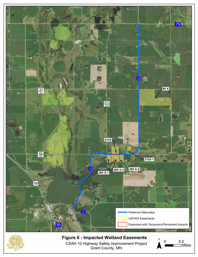
2. Impacts to USFWS Wetland Conservation Easements
The project would have permanent and/or temporary impacts to two of the wetland easements, shown on Figure 6. The project would result in 0.39 acres of permanent impact to easement Grant 269x-3. It would also result in these temporary impacts: 0.03 acres to 215x and 0.08 acres to 269x-3 (Figure 7). These temporary impacts are due to surcharge fill that will be placed to consolidate soils to allow for placement of a box culvert to convey water on either side of the roadway. Surcharge fill will be removed during final grading after the placement of the box culvert. A USFWS Special Use Permit will be issued to authorize temporary impacts with full and complete restoration of habitat interests upon completion of the project.
3. Impacts to Biological Environment
Biological impacts under this alternative will include the displacement of some mammal, bird, reptile and pollinator species within the expanded right of way. The duration of any project can vary. Work may occur during the nesting season but the size of the disturbed area on FWS land will be minimal and most disturbance is occurring within wetland, which will not impact the special concern species. Upland disturbance will likely occur during the removal of the roadbed and subsequent restoration of the area. The quality of the habitat in the disturbed area may be diminished for up to 3 years following the project until native vegetation becomes established. Created wetland areas under the existing roadbed will become immediately available for wildlife habitat.
a) Habitat/Vegetation Impacts – Grasslands and Wetlands in the WPA Both grasslands and wetlands within the Bellevue WPA will be impacted by project construction and the proposed exchange of interests. Impacts to any disturbed upland vegetation may occur from construction and will be short term in nature. The existing CSAH 10 roadbed will be removed on the north side of the WPA. After the CSAH 10 project is completed, USFWS will be able to restore and expand wetlands and uplands on the north edge of the WPA. This will ultimately enhance the available habitat.
Table 2 summarizes the land cover within the Bellevue WPA before and after the proposed exchange of interests and construction of the CSAH 10 project. Where noted, some values in the after construction column
USFWS Grant Co CSAH 10 Environmental Assessment Page 19 of 25 February 2021

reflect conditions after USFWS’s restoration and expansion of WPA wetlands and uplands has been completed.
Table 2: Bellevue WPA Existing and Post-Construction Land Cover Acreages
Land Cover Type Existing WPA Land Cover,
Acres
WPA Land After
Construction, Acres
Change, Acres
Central Marsh Wetland 28.0 29.4* 1.4
Upland 45.9 46.6* 0.7
Other Wetland in Road Easement (Not Central Marsh) 0.9 0 -0.9
Road 1.8 0.8 -1.0
TOTAL: 76.6 76.8 0.2 *Approximate acreages after USFWS completes the projects the agency plans to initiate after Grant County finishes the CSAH 10 project. Wetland and upland restoration and expansion are not part of the County’s CSAH 10 project.
The project would result in 0.15 acres of permanent wetland impacts along the west side of the WPA within the existing right of way. Temporary wetland impacts (0.44 acres) will also occur at the north side of the WPA during the removal of the existing CSAH 10 roadbed. The County will be required to go through the Wetland Conservation Act (WCA) and USACE Section 404 permitting processes for wetland impacts. Mitigation will be required for any wetlands that may be affected by this project. Wetland impacts will also occur at FWS easements 269x (0.55 acres permanent, 0.12 acres temporary) and at 215x (0.09 acres permanent, 0.11 acres temporary). The proposed project alternative will permanently impact a total of approximately 4.55 acres of wetland project wide.
b) Wetland Impacts at USFWS Easements Table 3 summarizes details of the USFWS easements within the project area (also see Figure 7).
USFWS Grant Co CSAH 10 Environmental Assessment Page 20 of 25 February 2021

Table 3: USFWS Wetland Conservation Easements Details and Impacts
Easement Identifier 215x 215x-1 269x-1 269x-2 269x-3 90x
Parcel Size (acres) 39.91 19.98 19.45 18.35 37.26 239.70
Wetland Size (acres) 9.0 5.0 2.0 2.0 1.5 48.0
Wetlands Impacted? (Yes/No) Yes No No No Yes No
If Impacted, Permanent Wetland Impact (acres)* [permanent fill]
0.00 -- -- -- 0.39 --
If Impacted, Temporary Easement (acres)** [temporary fill]
0.03 -- -- -- 0.08 --
Land within new right of way 0.01 0.05 * Permanent wetland impacts require 1:1 mitigation. ** Temporary impacts require a special use permit from USFWS authorizing scope of the impact and a restoration plan.
c) Impacts to Listed, Proposed and Candidate Species A Section 7(a)(2) of the Endangered Species Act of 1973 review was completed for the FHWA EA document. The proposed project is within the range of the Northern long-eared bat (Myotis septentrionalis), a federally-listed threatened species. The proposed project would remove approximately 6.62 acres of trees. These trees may act as habitat for the northern long-eared bat. There are no documented northern long-eared bat hibernacula and/or roost trees within the project area, however, bats may still be present.
Proposed activities are not anticipated to result in incidental take and/or significant modification or degradation to suitable habitat based on tree clearing timing. Therefore, MnDOT, on behalf of FHWA, has determined that the proposed action may affect, but is not likely to adversely affect the northern long-eared bat. Attachment G of the FHWA EA includes a letter from MnDOT OES for federally-listed species and concurrence from USFWS as well as required and recommended project components for avoiding and minimizing impacts. This letter states that tree removal will not take place during a period when the species would be present in the area (April 1-September 30).
Project activities on USFWS lands are not anticipated to result in a net loss of the habitat types for species noted above. Any necessary disturbance of grassland areas, as well as tree and shrub removal will be avoided from May 15th through August 15th to avoid disturbing birds during prime nesting season. Tree and shrub clearing should also occur outside of the northern long-eared bat active season (April 1–September 30).
4. Cultural Resource Impacts
No NRHP eligible archaeological sites were found to be located on any of
USFWS Grant Co CSAH 10 Environmental Assessment Page 21 of 25 February 2021

the USFWS resources within the CSAH 10 project area. MnDOT CRU and Grant County have developed a Construction Monitoring and Unexpected Discovery Plan for the CSAH 10 Reconstruction Project. This plan was developed to ensure compliance with applicable state and federal laws. Qualified archaeological and tribal consultants will monitor specified construction activities including grading and subsurface excavations within areas denoted in construction plans.
MnDOT CRU is also leading development of a Memorandum of Agreement (MOA) regarding the agreed upon adverse effects. The signed MOA will be included in the Finding of No Significant Impact (FONSI) that will be completed after the review and public comment period for this EA has ended.
5. Local Socio-Economic Impacts
As described in Section 6.D, the project corridor is part of the primary route between Morris and Perham, MN, both of which are regional employment and service centers.
6. Environmental Justice
The purpose of Executive Order 12898 is to identify, address, and avoid disproportionately high and adverse human health or environmental effects on minority and low-income populations. An Environmental Justice analysis for the CSAH 10 corridor is included as Attachment M of the FHWA EA.
The project is located along an existing alignment and primarily within existing right of way. Most of the negative impacts associated with the project other than the right of way will be temporary in nature during the project. Right of way acquisition was minimized to the extent practicable and federal right of way procedures regarding acquisition will be followed.
The Environmental Protection Agency (EPA) identifies possible Environmental Justice populations as areas with minority populations or people living below the poverty level greater than ten percentage points higher than the county average or that have total minority and poverty population greater than 50 percent of the total geographic unit. Census Tract 701 Block Group 2 has slightly greater minority and poverty populations compared to the county as a whole. However, these percentages are only slightly greater than the county average. It is unlikely that there is a concentration of minority or low-income individuals within the project area.
After review of project area data and discussions with local officials, it was determined that the total minority and poverty populations within the project area are comparable to these population levels within Grant
USFWS Grant Co CSAH 10 Environmental Assessment Page 22 of 25 February 2021

County. Any differences within the project area are slight compared to the county averages of minority and low-income populations. Direct and indirect impacts were considered. There are no direct physical impacts for any of the populations. There are also no relocations required for this project. Because of this, and because of the nature of the project, there are no Environmental Justice concerns on this project.
7. Cumulative Impacts
Potential long-term cumulative impacts may occur to the right of way area that is granted under this alternative. Those impacts under this alternative are not entirely known. The portion of the right of way that is adjacent to the road surface will have short term impacts during the construction period and potentially during the next three years until the seeded prairie establishes. This alternative strives to maintain diverse habitat conditions along and in the right of way outside of the roadway surface. No impacts to cultural resources or to listed, proposed, or candidate species due to activities associated with this alternative were determined.
8. Public Safety Impacts
Alternative 1 will address the safety issues described in the project need section. These efforts are anticipated to result in safer conditions for the travelling public, including lower crash rates. In the vicinity of the Bellevue WPA and five wetland easements, this includes: 1) flattening the two sharp curves on CSAH 10 at the east and west junctions with CR 36; 2) reconstructing existing 2-foot gravel shoulders with 7-foot shoulders (5 feet paved and 2 feet gravel; and 3) replacing existing 1:3 inslopes with 1:4 inslopes.
B. No Build Alternative (No Action)
1. USFWS Resources – Bellevue WPA and Wetland Easements
No right of way expansion to CSAH 10 would occur under the no build alternative. Additionally, the proposed exchange of interests between Grant County and USFWS would not occur and USFWS not be able to expand and restore wetlands and uplands on the north edge of the Bellevue WPA. USFWS would continue to apply current habitat management techniques in this area of the WPA. With no right of way expansion, there would be no wetland impacts within either Bellevue WPA or any of the USFWS wetland easements.
2. Biological Environment
There would be no change to the biological environment under the no build alternative. Under this alternative, USFWS would not have the opportunity to expand or restore the northern edge of the Bellevue WPA meaning that
USFWS Grant Co CSAH 10 Environmental Assessment Page 23 of 25 February 2021
there would be a lost opportunity to increase the size of the main tract of the WPA and the major feature – the central marsh.
3. Listed, Proposed and Candidate Species
There would be no effect to listed, proposed or candidate species.
4. Cultural Resources
No cultural resources would be affected under this alternative.
5. Local Socio-Economic Impacts
With no action, existing CSAH 10 which is part of the primary route between the regional employment and service centers of Morris and Perham, MN, would continue to experience poor pavement conditions and closures due to flooding (to the south of Bellevue WPA). These conditions have the potential to slow and/or detour traffic in the event of road closures due to flooding.
6. Environmental Justice
Public use would continue at present levels and there would be no increased opportunity to commute using this route.
7. Cumulative Impacts
Cumulative impacts under this alternative are not known. However, no impacts to cultural resources or to listed, proposed or candidate species due to activities associated with this alternative are anticipated.
8. Public Safety
It is expected that corridor and intersection crash rates would continue to be higher than critical crash rates. The number of crashes on the segment are expected to remain high (currently 3.08 per million vehicle miles of travel).
The fair pavement condition on the corridor would not be addressed under the No Build Alternative. CSAH 10 from CSAH 2 to TH 79 was originally constructed in 1956. An overlay was completed in 1975, and most recently in 1995. A seal coat was applied in 1996. Since then, no improvements have been completed. Pavement is rated as fair for ride quality.
VIII. Consultation with USFWS
Grant County and USFWS have been coordinating on the CSAH 10 project since 2018. A list of meetings and phone calls held during project development is included in Attachment E of the FHWA EA.
USFWS Grant Co CSAH 10 Environmental Assessment Page 24 of 25 February 2021

IX. Summary of Environmental Consequences by Alternative
Table 4 provides a summary of environmental consequences by alternative.
Table 4: Summary of Environmental Consequences by Alternative
Alternative 1 Proposed Action No Build Alternative (No Action)
USFWS Resources
Bellevue WPA Change to WPA boundaries with proposed exchange of interests. Removes CSAH 10 through northwest corner and along north side of WPA.
No change from current condition is expected.
Wetland Easements Temporary impacts to 2 easements; permanent impacts to one easement.
No change from current condition is expected.
Biological Environment
Habitat/Vegetation – Grasslands and Wetlands in WPA
Opportunity for USFWS to restore and expand wetlands and uplands with proposed exchange of interests.
No change from current condition is expected.
Listed, Proposed and Candidate Species
Removal of potential habitat for protected species. Vegetation removal will be limited to non-breeding times.
No change from current condition is expected.
Other
Cultural Resources No change from current condition is expected.
No change from current condition is expected.
Environmental Justice
No change from current conditions is expected.
No change from current conditions is expected.
Cumulative Impacts
Potential long-term cumulative impacts may occur to the ROW area that is granted under this alternative since a portion of the ROW will become road surface. Those impacts under this alternative are not entirely known.
No major long or short-term cumulative impacts anticipated.
Public Safety The reconstruction of short curves and expanded road shoulders will provide safer conditions for the public.
Safety conditions will remain the same, including narrow shoulders and a curves that do pose safety issues to the travelling public.
USFWS Grant Co CSAH 10 Environmental Assessment Page 25 of 25 February 2021
GiWX
Elk LakeTownship
ErdahlTownship
Lien Township
SanfordTownship
Barrett
Project Location
0 0.5Miles¯
Figure 1 - Project Area MapCSAH 10 Highway Safety Improvement ProjectGrant County, MN
Docum
ent Path: K
:\012355-000\GIS
\Maps\EA M
aps\Figure3_Project Area Map.m
xd Date Saved: 7/27/2020 12:19:36 PM
Start SP 026-070-010 & SP 026-610-023
End SP 026-070-010 & SP 026-610-023
Emergency Repair LocationSP 026-610-026
End SP 026-070-011Start SP 026-070-011
Sz
S±
T-141
T-134
S̈
GaWX
Safety Shoulder Widening; SP 026-070-010 and SP 026-610-023Safety Curve Realignment; SP 026-070-011
Emergency Repair Location; SP 026-610-026
?ëA@
)r
?ØA@
BarrettLake

GiWX
GaWX
GiWX
Sz
S±
?ëA@
?ØA@
)r
T-141
140th Ave
Bellevue WPA
90 X
215X
269 X-3
215X-1
269 X-1269 X-2
Figure 2 - USFWS ResourcesCSAH 10 Highway Safety Improvement Project
Grant County, MN ¯ 0 0.5Miles
S̈
GiWX
T-141
Bellevue WPA
215X
269 X-3
215X-1
269 X-1 269 X-2
Inset of Project Between East and West Curves
Alt. 1 (Proposed Action)
Waterfowl Production Areas
USFWS Easements

GiWX
Sz
S±
Figure 3 - Proposed Bellevue WPA Exchange ofInterests Between USFWS and Grant County
CSAH 10 Highway Safety Improvement ProjectGrant County, MN ¯ 0 400Feet
CSAH 10 Perferred Alternative AlignmentExisting WPA ParcelWPA to County (Part of Existing WPA Parcel)
County to WPA (Will be Future WPA Parcel)New WPA Parcel After Land Exchange With County
2.8 ac
2.5 ac

GiWX
GaWX
GiWX
Sz
S±
?ëA@
?ØA@
)r
BarrettLake
S̈
GuWX
Barrett
Erdahl TownshipSanford Township
Lien Township
Figure 4 - CSAH 10 Location Alternatives ConsideredCSAH 10 Highway Safety Improvement Project Grant County, MN ¯ 0 0.5
Miles
T-141
140th Ave
Project Alternative AlignmentsCommon to All Alternatives
Alternative 2
Alternative 3A
Alternative 3B
Common to Alternatives 3 & 4
Alternative 4
Alternative 5B
Alternative 5A
Alternative 1, Proposed Action

! ! ! ! ! ! ! ! ! ! ! ! ! ! ! ! ! ! ! ! ! ! ! ! ! ! ! ! ! ! ! ! ! ! ! ! ! ! ! ! ! ! ! ! ! ! ! ! ! ! ! ! ! ! ! ! ! ! !
! ! ! ! ! ! ! ! ! ! ! ! ! ! ! ! ! ! ! ! ! ! ! ! ! ! ! ! ! ! ! ! ! ! ! ! ! ! ! ! ! ! ! ! ! ! ! ! ! ! ! ! ! ! ! ! ! ! !
! ! ! ! ! ! ! ! ! ! ! ! ! ! ! ! ! ! ! ! ! ! ! ! ! ! ! ! ! ! ! ! ! ! ! ! ! ! ! ! ! ! ! ! ! ! ! ! ! ! ! ! ! ! ! ! ! ! !
GiWX
Sz
S±
Figure 5 - Bellevue WPA ImpactsCSAH 10 Highway Safety Improvement Project
Grant County, MN ¯ 0 400Feet
CSAH 10 Perferred Alternative Alignment! ! !
! ! ! Permanent ImpactsTemporary Construction ImpactWPA to County (Part of Existing WPA Parcel)
County to WPA (Will be New WPA Parcel)New WPA Parcel After Land Exchange With County
0.9 ac
0.23 ac
2.4 ac
AcresTotal Temporary Impacts 1.13Total Permanent Impacts 2.4
! ! ! ! ! ! ! ! ! ! ! ! ! ! ! ! ! ! ! ! ! ! ! ! ! ! ! ! ! ! ! ! ! ! ! ! ! ! ! ! ! ! ! ! ! ! ! ! ! ! ! ! ! ! ! ! ! ! !
! ! !
GiWX
GaWX
GiWX
Sz
S±
?ëA@
?ØA@
)r
T-141
140th Ave
90 X
215X
269 X-3
215X-1
269 X-1269 X-2
Figure 6 - Impacted Wetland EasementsCSAH 10 Highway Safety Improvement Project
Grant County, MN ¯ 0 0.5Miles
S̈
Preferred AlternativeUSFWS EasementsEasement with Temporary/Permanent Impacts

269 X-2269 X-1 269 X-3
215X
S̈
0.03 acre
0.08 acre
0.39 acre
CSAH 10 Highway Safety Improvement ProjectGrant County, MN
Figure 7 - Wetland Easement Permanent and Temporary Impacts
¯ 0 400Feet
Construction LimitTemporary Construction LimitPermanent ImpactTemporary ImpactEasement with Temporary/Permanent ImpactsPreferred AlternativeUSFWS Easements
Total Impacts (acres)Temporary Easement 0.11Permanent Impact 0.39
Wetland Impacts Due to Construction