Embed Size (px)
Citation preview
Page 1 FNR-2011-00116
Page 2 FNR-2011-00116
Page 3 FNR-2011-00116
Page 4 FNR-2011-00116
Page 5 FNR-2011-00116
Page 6 FNR-2011-00116
Page 7 FNR-2011-00116
Page 8 FNR-2011-00116
Page 9 FNR-2011-00116
Page 10 FNR-2011-00116
Page 11 FNR-2011-00116
Page 12 FNR-2011-00116
Page 13 FNR-2011-00116
Page 14 FNR-2011-00116
Page 15 FNR-2011-00116
Page 16 FNR-2011-00116
Page 17 FNR-2011-00116
Page 18 FNR-2011-00116
Page 19 FNR-2011-00116
Page 20 FNR-2011-00116
Page 21 FNR-2011-00116
Page 22 FNR-2011-00116
Page 23 FNR-2011-00116

Page 24 FNR-2011-00116
Page 25 FNR-2011-00116
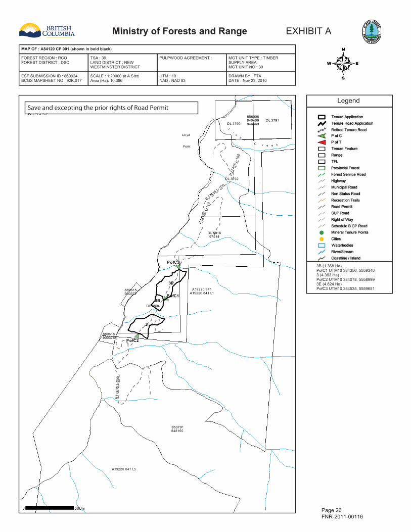
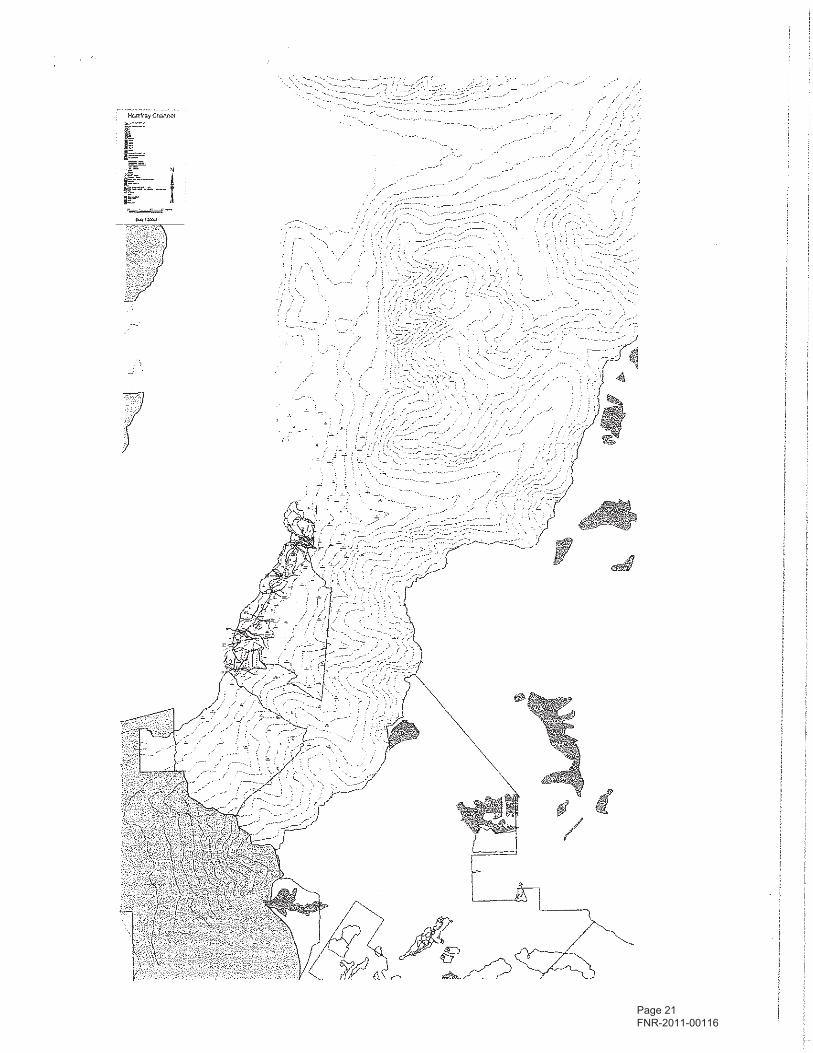
Ministry of Forests and Range EXHIBIT A
MAP OF : A84120 CP 001 (shown in bold black)
FOREST REGION : RCOFOREST DISTRICT : DSC
TSA : 39LAND DISTRICT : NEWWESTMINSTER DISTRICT
PULPWOOD AGREEMENT : MGT UNIT TYPE : TIMBERSUPPLY AREAMGT UNIT NO : 39
ESF SUBMISSION ID : 860924BCGS MAPSHEET NO : 92K.017
SCALE : 1:20000 at A SizeArea (Ha): 10.386
UTM : 10NAD : NAD 83
DRAWN BY : FTADATE : Nov 23, 2010
Legend
3B (1.368 Ha)PofC1 UTM10 384356, 55593403 (4.393 Ha)PofC2 UTM10 384078, 55589993E (4.624 Ha)PofC3 UTM10 384535, 5559651
Page 26 FNR-2011-00116
Save and excepting the prior rights of Road Permit R17435
Page 27 FNR-2011-00116

Page 28 FNR-2011-00116

Page 29 FNR-2011-00116
Page 30 FNR-2011-00116
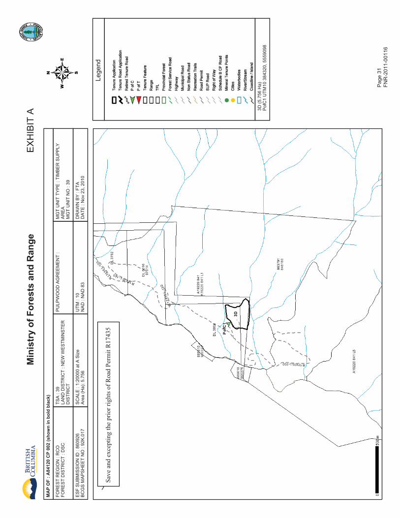
MinistryofForestsandRange
EXHIBITA
MAPOF:A84120CP002(showninboldblack)
FORESTREGION:RCO
FORESTDISTRICT:DSC
TSA:39
LANDDISTRICT:NEWWESTMINSTER
DISTRICT
PULPWOODAGREEMENT:
MGTUNITTYPE:TIMBERSUPPLY
AREA
MGTUNITNO:39
ESFSUBMISSIONID:860926
BCGSMAPSHEETNO:92K.017
SCALE
:1:20000atASize
Area(Ha):5.756
UTM
:10
NAD:NAD83
DRAWNBY:FTA
DATE
:Nov23,2010
Legend
3D(5.756Ha)
PofC1UTM10384320,5559098
Pag
e 31
FN
R-2
011-
0011
6
SaveandexceptingthepriorrightsofRoadPermitR17435

Page 32 FNR-2011-00116

Page 33 FNR-2011-00116

Page 34 FNR-2011-00116
Page 35 FNR-2011-00116
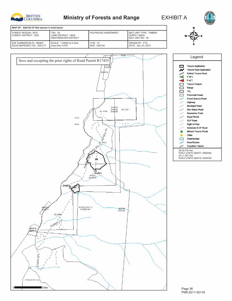
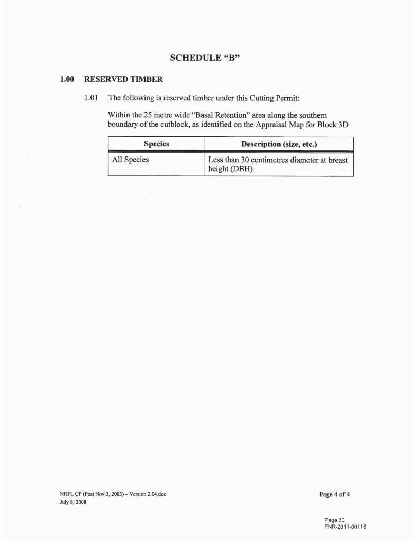
Ministry of Forests and Range EXHIBIT A
MAP OF : A84120 CP 003 (shown in bold black)
FOREST REGION : RCOFOREST DISTRICT : DSC
TSA : 39LAND DISTRICT : NEWWESTMINSTER DISTRICT
PULPWOOD AGREEMENT : MGT UNIT TYPE : TIMBERSUPPLY AREAMGT UNIT NO : 39
ESF SUBMISSION ID : 860841BCGS MAPSHEET NO : 92K.017
SCALE : 1:20000 at A SizeArea (Ha): 9.574
UTM : 10NAD : NAD 83
DRAWN BY : FTADATE : Nov 23, 2010
Legend
2B (8.016 Ha)PofC1 UTM10 384977, 55600933C (1.557 Ha)PofC2 UTM10 384519, 5559756
Page 36 FNR-2011-00116
Save and excepting the prior rights of Road Permit R17435

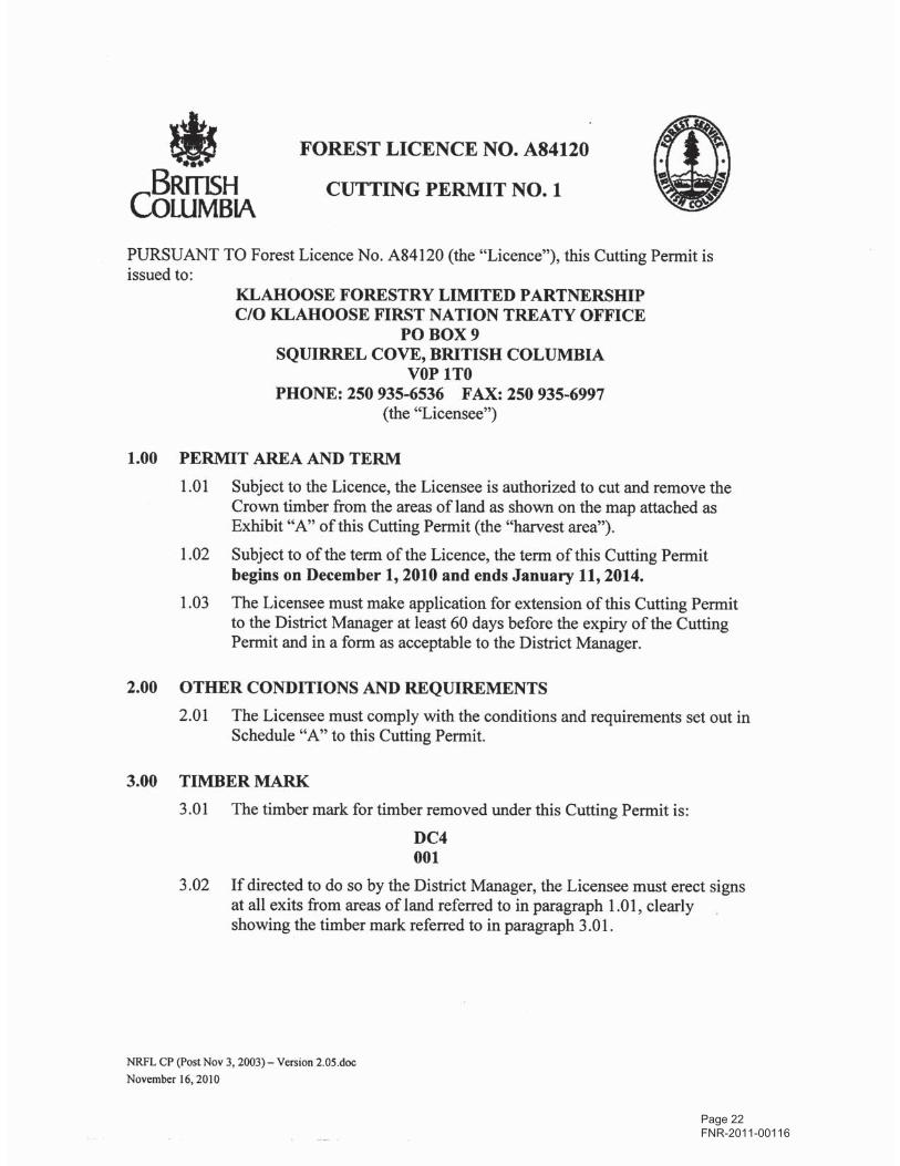
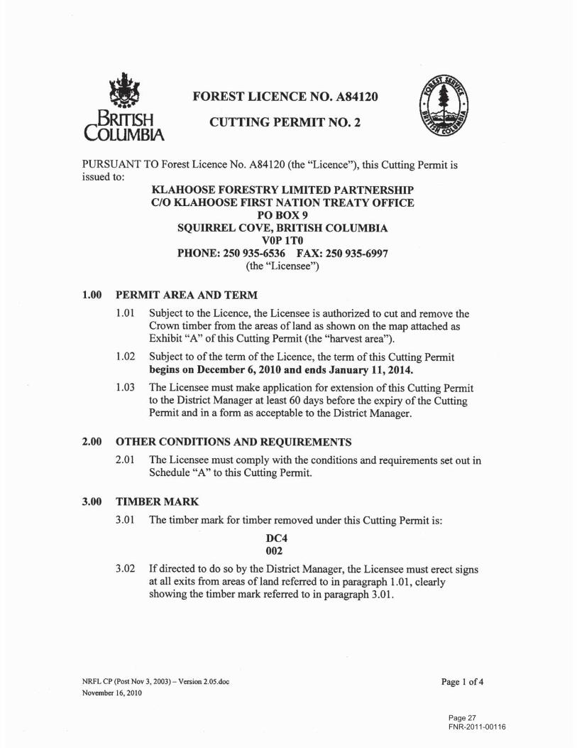
•BRITISHCOLUMBIAPURSUANT TO Forest Licence No. A84120 (the "Licence"), this Cutting Permit isissued to:
KLAHOOSE FORESTRY LIMITED PARTNERSHIPC/O KLAHOOSE FIRST NATION TREATY OFFICE
PO BOX 9SQUIRREL COVE, BRITISH COLUMBIA
VOP ITOPHONE: 250 935-6536 FAX: 250 935-6997
(the "Licensee")
1.00 PERMIT AREA AND TERM1.01 Subject to the Licence, the Licensee is authorized to cut and remove the
Crown timber from the areas of land as shown on the map attached asExhibit "A" of this Cutting Permit (the "harvest area").
1.02 Subject to of the term of the Licence, the term of this Cutting Permitbegins on December 8, 2010 and ends January 11,2014.
1.03 The Licensee must make application for extension of this Cutting Permitto the District Manager at least 60 days before the expiry of the CuttingPermit and in a form as acceptable to the District Manager.
2.00 OTHER CONDITIONS AND REQUIREMENTS2.01 The Licensee must comply with the conditions and requirements set out in
Schedule "A" to this Cutting Permit.
3.00 TIMBER MARK3.01 The timber mark for timber removed under this Cutting Permit is:
DC4004
3.02 If directed to do so by the District Manager, the Licensee must erect signsat all exits from areas ofland referred to in paragraph 1.01, clearlyshowing the timber mark referred to in paragraph 3.01.
NRFL CP (Post Nov 3, 2003) - Version 2.05.doc
November 16,2010
Page 37 FNR-2011-00116

4.00 SCALE-BASED STUMPAGE4.01 For the purpose of determining the amount of stumpage payable in respect
of timber removed from the harvest area, the volume or quantity of timberremoved will be determined using information provided in a scale of thetimber.
4.02 The Licensee must ensure that:
(a) all timber removed from the harvest area is scaled, and
(b) the scale of the timber is conducted properly in accordance withthe requirements of the Forest Act and the regulations made underthat Act.
5.00 ROADS5.01 Subject to the Licence and the forestry legislation, the Licensee may use,
construct, maintain or deactivate roads on the area covered by this CuttingPermit.
6.00 TIMBER HARVEST ANDWASTE ASSESSMENT6.01 The timber described in Schedule "B" is specified as reserved timber and
the Licensee must not fell standing timber, and must not buck or removefelled or dead and down timber, as the case may be, of the species anddescription set out in Schedule "B".
7.00 MISCELLANEOUS7.01 The Schedules and Exhibit "A" map(s) are deemed to be part of this
Cutting Permit.
7.02 As provided in the Licence, this Cutting Permit is deemed to be part of theLicence.
7.03 The Licence will govern the interpretation of this Cutting Permit.
7.04 The Licensee must notify the District Manager in writing in a formacceptable to the District Manager, when primary logging is complete andagain when removal is complete.
Brian A. Hawrys, R.P.F.District ManagerSunshine Coast Forest District
NRFL CP (post Nov 3, 2003) - Version 2.04.docJuly 8, 2008
Page 38 FNR-2011-00116

1.01 The Licensee must not erect or operate a sawmill or wood processing planton an area ofland referred to in paragraph 1.01 of this Cutting Permit.
1.02 The Licensee must not allow the manufacture of special forest products onthe area of land described in paragraph 1.01 of this Cutting Permit.
1.03 The Licensee may fell trees outside of the cutblock boundary(s) identifiedon the attached map as Exhibit "A", for the purposes of tree felling toeliminate a safety hazard, if the person conducting tree felling or riggingtail hold/anchor trees determines that the tree is a dangerous tree accordingto Workers' Compensation Board regulations and it is within 80 metresbeyond the cutting authority area.
1.04 The Licensee must not buck or utilize a tree felled under paragraph 1.03without the consent of the District Manager.
1.05 If consent is granted under paragraph 1.04, felled dangerous tree(s) shallbe subject to the Waste Assessment Policy 13.6 found in the Ministry ofForest and Range Policy Manual Volume 1 Chapter 13.
NRFL CP (Post Nov 3, 2003) - Version 2.04.docJuly 8, 2008
Page 39 FNR-2011-00116

NRFL CP (Post Nov 3,2003) - Version 2.04.doc
July 8, 2008
Page 40 FNR-2011-00116
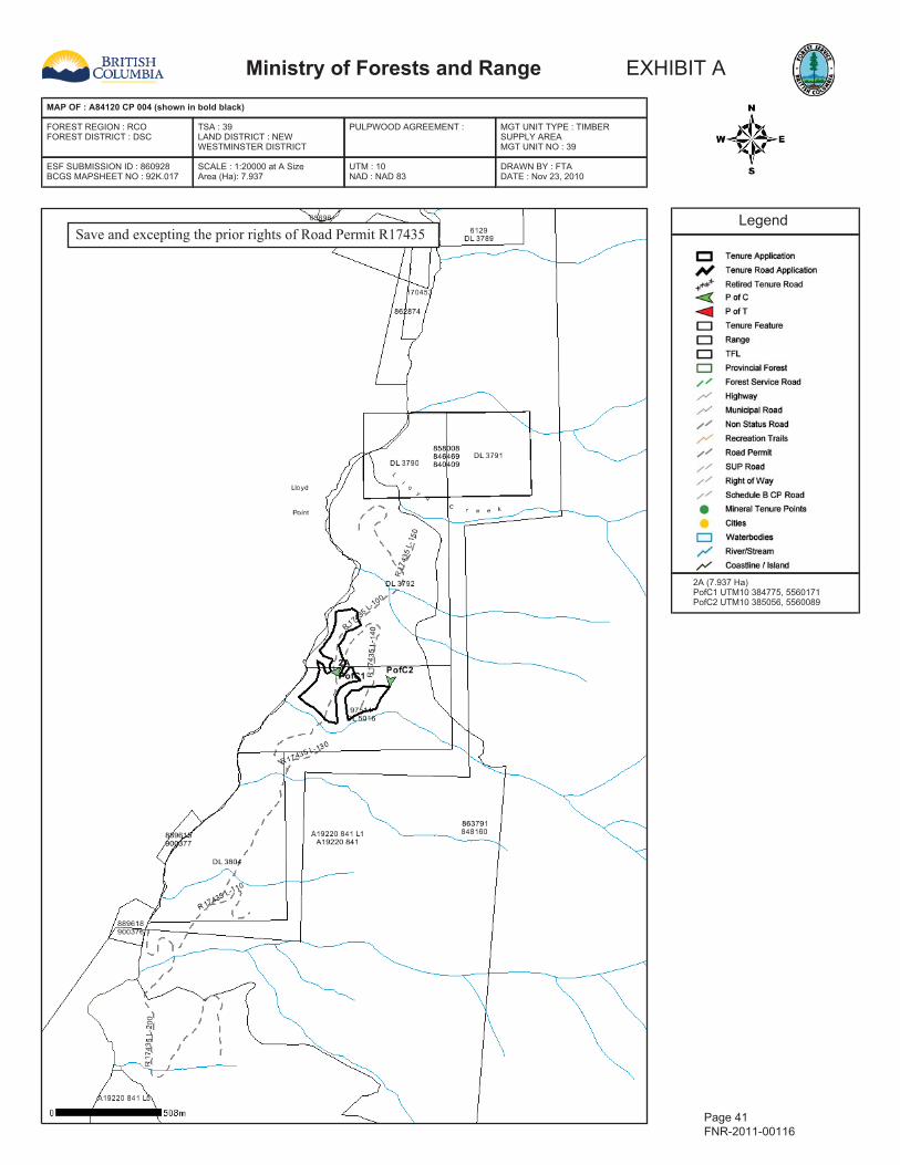
Ministry of Forests and Range EXHIBIT A
MAP OF : A84120 CP 004 (shown in bold black)
FOREST REGION : RCOFOREST DISTRICT : DSC
TSA : 39LAND DISTRICT : NEWWESTMINSTER DISTRICT
PULPWOOD AGREEMENT : MGT UNIT TYPE : TIMBERSUPPLY AREAMGT UNIT NO : 39
ESF SUBMISSION ID : 860928BCGS MAPSHEET NO : 92K.017
SCALE : 1:20000 at A SizeArea (Ha): 7.937
UTM : 10NAD : NAD 83
DRAWN BY : FTADATE : Nov 23, 2010
Legend
2A (7.937 Ha)PofC1 UTM10 384775, 5560171PofC2 UTM10 385056, 5560089
Page 41 FNR-2011-00116
Save and excepting the prior rights of Road Permit R17435

Page 42 FNR-2011-00116

Page 43 FNR-2011-00116

Page 44 FNR-2011-00116

Page 45 FNR-2011-00116
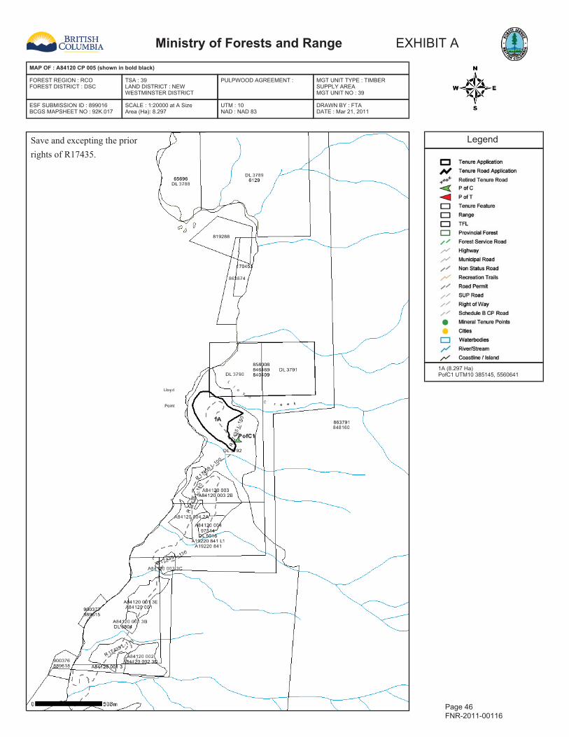
Ministry of Forests and Range EXHIBIT A
MAP OF : A84120 CP 005 (shown in bold black)
FOREST REGION : RCOFOREST DISTRICT : DSC
TSA : 39LAND DISTRICT : NEWWESTMINSTER DISTRICT
PULPWOOD AGREEMENT : MGT UNIT TYPE : TIMBERSUPPLY AREAMGT UNIT NO : 39
ESF SUBMISSION ID : 899016BCGS MAPSHEET NO : 92K.017
SCALE : 1:20000 at A SizeArea (Ha): 8.297
UTM : 10NAD : NAD 83
DRAWN BY : FTADATE : Mar 21, 2011
Legend
1A (8.297 Ha)PofC1 UTM10 385145, 5560641
Page 46 FNR-2011-00116
Save and excepting the priorrights of R17435.

Page 47 FNR-2011-00116
Page 48 FNR-2011-00116
Page 49 FNR-2011-00116

Page 50 FNR-2011-00116
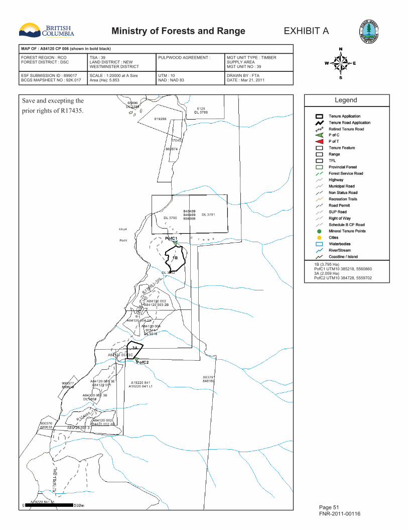
Ministry of Forests and Range EXHIBIT A
MAP OF : A84120 CP 006 (shown in bold black)
FOREST REGION : RCOFOREST DISTRICT : DSC
TSA : 39LAND DISTRICT : NEWWESTMINSTER DISTRICT
PULPWOOD AGREEMENT : MGT UNIT TYPE : TIMBERSUPPLY AREAMGT UNIT NO : 39
ESF SUBMISSION ID : 899017BCGS MAPSHEET NO : 92K.017
SCALE : 1:20000 at A SizeArea (Ha): 5.853
UTM : 10NAD : NAD 83
DRAWN BY : FTADATE : Mar 21, 2011
Legend
1B (3.795 Ha)PofC1 UTM10 385218, 55608603A (2.059 Ha)PofC2 UTM10 384728, 5559702
Page 51 FNR-2011-00116
Save and excepting theprior rights of R17435.


![FNR Characterization Package Workbook SP-017 Building Roof. · SP-017 Pkg FormsRev01 Page 3 of 19 6/25/2007 Rev 0 1. Package Log No: FNR-SP-017 I Survey Area: 7 ] Survey Units: 7-1](https://img.pdfslide.net/doc/110x75/61256ff3fccf0f0b3138b5bd/fnr-characterization-package-workbook-sp-017-building-roof-sp-017-pkg-formsrev01.jpg)