1
ð" ðb ð" ðb ð" ðJ ð" ðb ð" ðb ð" ðb ð" ðb ð" ðb ð" ðJ ð" ðb ð" ðJ ð" ðb ð" ðJ ð" ðb ð" ðb ð" ðb ð" ðb ð" ðJ ð" ðJ ð" ðb ð" ðJ ð" ðJ ð" ðb ð" ðb ð" ðJ ð" ðb ð" ðb ð" ðb ð" ðb ð" ðJ ð" ðJ ð" ðJ ð" ðb ð" ðb ð" ðJ ð" ðb ð" ðb ð" ðb ð" ðJ ð" ðJ ð" ðb ð" ðb ð" ðb ð" ðb ð" ðJ ð" ðb ð" ðJ ð" ðb ð" ðb ð" ðJ ð" ðJ ð" ðJ ð" ðb ð" ðJ ð" ðb ð" ðb ð" ðJ ð" ðb ð" ðb ð" ðb ð" ðJ ð" ðJ ð" ðJ ð" ðb " ð" ðb ð" ðb ð" ðJ ð" ðb ð" ðJ ð" ðb ð" ðb ð" ðJ ð" ðb " J ð" ðJ ð" ðb ð" ðb ð" ðb ð" ðJ ð" ðb ð" ðb ð" ðJ ð" ðb ð" ðJ ð" ðb ð" ðb ð" ðJ ð" ðJ " ð= " ð= " ð= " ð= " ð= " ð= " ð= " ð= " ) " ) " ) " ) " ) " ) " ) " ) " ) " ) " ) " ) " ) " ) " ) " ) " ) " ) " ) " ) " ) " ) " ) " ) " ) " ) " ) " ) " ) " ) " ) " ) " ) " ) " ) " ) " ) " ) " ) " ) " ) " ) " ) " ) " ) " ) " ) " ) " ) " ) " ) " ) " ) " ) " ) " ) " ) " ) " ) " ) " ) " ) " ) " ) " ) " )" ) " ) " ) " ) " ) " ) " ) " ) " ) " ) " ) " ) " ) " ) " ) " ) " ) " ) " ) " ) " ) " ) " ) " ) " ) " ) " ) " ) " ) " ) " ) " ) " ) " ) " ) " ) " ) " ) " ) " ) " ) " ) " ) " ) " ) " ) " ) " ) " ) " ) " ) " ) " ) " ) " ) " ) " ) " ) " ) " ) MEDITERRANEAN SEA Nahal Gerar Source: Esri, DigitalGlobe, GeoEye, i-cubed, USDA, USGS, AEX, Getmapping, Aerogrid, IGN, IGP, swisstopo, and the GIS User Community 34°27'0"E 34°27'0"E 34°26'0"E 34°26'0"E 34°25'0"E 34°25'0"E 34°24'0"E 34°24'0"E 34°23'0"E 34°23'0"E 34°22'0"E 34°22'0"E 34°21'0"E 34°21'0"E 31°28'0"N 31°28'0"N 31°27'0"N 31°27'0"N 31°26'0"N 31°26'0"N 31°25'0"N 31°25'0"N 31°24'0"N 31°24'0"N ! I Satellite Data (1): Pleiades Imagery Dates: 12 July 2014 Resolution: 50 cm Copyright: CNES 2014, Distribution Airbus Defence and Space Source: Airbus Defence and Space Satellite Data (2): Pleiades Imagery Date: 06 July 2014 Copyright: CNES 2014, Distribution Airbus Defence and Space Source: Airbus Defence and Space Road Data : OSM, ESRI Other Data: USGS, UNCS, NGA Analysis : UNITAR / UNOSAT Production: UNITAR / UNOSAT Analysis conducted with ArcGIS v10.2 Coordinate System: WGS 1984 UTM Zone 36N Projection: Transverse Mercator Datum: WGS 1984 Units: Meter The depiction and use of boundaries, geographic names and related data shown here are not warranted to be error-free nor do they imply official endorsement or acceptance by the United Nations. UNOSAT is a program of the United Nations Institute for Training and Research (UNITAR), providing satellite imagery and related geographic information, research and analysis to UN humanitarian and development agencies and their implementing partners. This work by UNITAR/UNOSAT is licensed under a Creative Commons Attribution-NonCommercial- ShareAlike 3.0 Unported License. Contact Information: [email protected] 24/7 Hotline: +41 76 487 4998 www.unitar.org/unosat This map illustrates satellite-detected damage and destruction in areas of Nuseirat, Al Burayj, Al Ruwaydah, Nahal Qatif and Al Musadar in Gaza due to ongoing violence in the area. Using a satellite image collected 12 July 2014 by the Pleiades satellite, and compared with a pre-crisis Pleiades image collected 6 July 2014, UNOSAT analysis has identified 41 destroyed structures, 13 severely damaged structures, and 29 moderately damaged structures. In addition, 45 craters in agricultural and non-urbanized areas are also visible as of 12 July 2014. Further analysis will be done as additional imagery is collected. This is a preliminary analysis and has not yet been validated in the field. Please send ground feedback to UNITAR/UNOSAT. ! ! " Complex Emergency Khan Yunis Rafah Southern District Shamal Sina (north Sinai) EGYPT GAZA STRIP ISRAEL Production Date: 21/07/2014 Version 1.0 Activation Number: CE20140715PSE Analysis with Pleiades Data Acquired 6 July and 12 July 2014 0 300 600 900 1,200 1,500 150 Meters LEGEND Map Extent F Map Scale for A3: 1:35,000 INSET: Pre-Crisis, 6 July 2014 INSET: Destroyed Structures, 12 July 2014 Destroyed Building Destroyed Building Moderately Damaged Building Primary Road 1949 Armistice Line See Inset For Close Up View Destroyed Structure Severely Damaged Structure Moderately Damaged Structure City / Town ! ( " ) Crater / Impact " ) " ) " ) " ð= ð" ðJ ð" ðb Hospital School Mosque Secondary Road Damage Level Count Destroyed Structures 41 Severely Damaged Structures 13 Moderately Damaged Structures 29 Total Damaged Structures 83 Impact Craters on Field 45

Damage Assessment In Central Gaza Strip – Occupied Palestinian Territory – 12 July 2014

Embed Size (px)

DESCRIPTION

Damage Assessment In Central Gaza Strip – Occupied Palestinian Territory – 12 July 2014

Citation preview

"

"

"

"

"

"

"

"

"

")

")")

")

")

")

")

")

")

")

")

")

")

")

")

")")")

")

")

")

")

")")

")

")

")

")

")

")")

")")

")

")

")

")")

")

")

")

")")

")

")

")")

")")

")")")

")")

")

")

")

")

")

")")

")

")")

")

")")")

")")")")")")")")

")

")

")")

")")")")")")")

")")

")

")

")

")

")

")")

")")

")

")")")

")

")

")

")

")

")

")

")

")")

")")

")")")")

")

")

")

")")

")

")")

MEDITERRANEANSEA

N a h a lG e r a r

Source: Esri, DigitalGlobe, GeoEye, i-cubed, USDA, USGS, AEX, Getmapping, Aerogrid, IGN, IGP, swisstopo, and the GIS UserCommunity

34°27'0"E

34°27'0"E

34°26'0"E

34°26'0"E

34°25'0"E

34°25'0"E

34°24'0"E

34°24'0"E

34°23'0"E

34°23'0"E

34°22'0"E

34°22'0"E

34°21'0"E

34°21'0"E

31°2

8'0"N

31°2

8'0"N

31°2

7'0"N

31°2

7'0"N

31°2

6'0"N

31°2

6'0"N

31°2

5'0"N

31°2

5'0"N

31°2

4'0"N

31°2

4'0"N

!ISatellite Data (1): PleiadesImagery Dates: 12 July 2014Resolution: 50 cmCopyright: CNES 2014, Distribution Airbus Defence andSpaceSource: Airbus Defence and SpaceSatellite Data (2): PleiadesImagery Date: 06 July 2014Copyright: CNES 2014, Distribution Airbus Defence andSpaceSource: Airbus Defence and SpaceRoad Data : OSM, ESRIOther Data: USGS, UNCS, NGAAnalysis : UNITAR / UNOSATProduction: UNITAR / UNOSATAnalysis conducted with ArcGIS v10.2Coordinate System: WGS 1984 UTM Zone 36NProjection: Transverse MercatorDatum: WGS 1984Units: MeterThe depiction and use of boundaries, geographicnames and related data shown here are not warrantedto be error-free nor do they imply official endorsementor acceptance by the United Nations. UNOSAT is aprogram of the United Nations Institute for Training andResearch (UNITAR), providing satellite imagery andrelated geographic information, research and analysisto UN humanitarian and development agencies andtheir implementing partners.This work by UNITAR/UNOSAT is licensed under aCreative Commons Attribution-NonCommercial-ShareAlike 3.0 Unported License.

Contact Information: [email protected]/7 Hotl ine: +41 76 487 4998

www.unitar.org/unosat

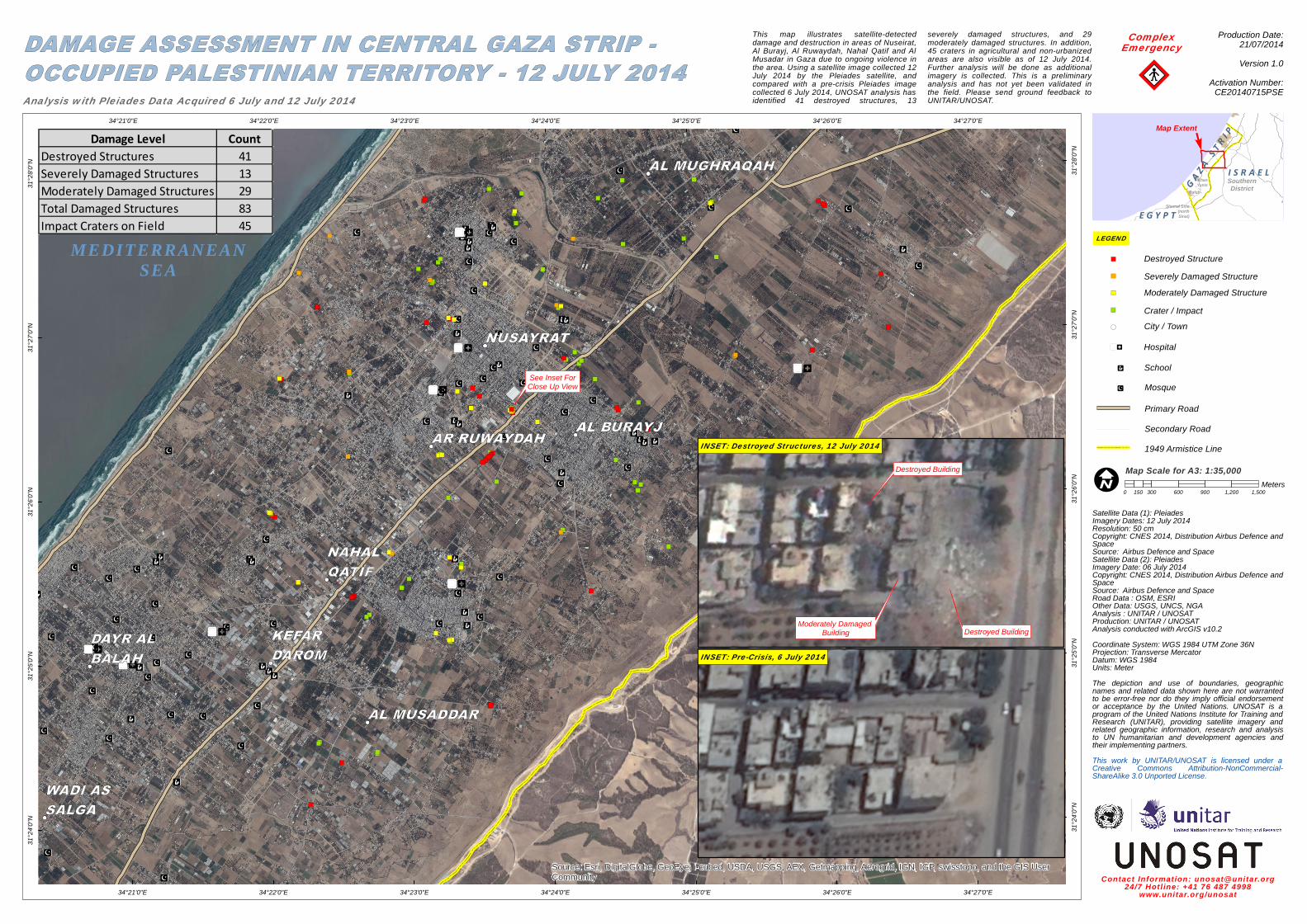
This map illustrates satellite-detecteddamage and destruction in areas of Nuseirat,Al Burayj, Al Ruwaydah, Nahal Qatif and AlMusadar in Gaza due to ongoing violence inthe area. Using a satellite image collected 12July 2014 by the Pleiades satellite, andcompared with a pre-crisis Pleiades imagecollected 6 July 2014, UNOSAT analysis hasidentified 41 destroyed structures, 13

severely damaged structures, and 29moderately damaged structures. In addition,45 craters in agricultural and non-urbanizedareas are also visible as of 12 July 2014.Further analysis will be done as additionalimagery is collected. This is a preliminaryanalysis and has not yet been validated inthe field. Please send ground feedback toUNITAR/UNOSAT.

!!"

ComplexEmergency

KhanYunis

Rafah

SouthernDistrict

Shamal Sina(northSinai)E G Y P T

G A Z A S T R I P

I S R A E L

Production Date:21/07/2014Version 1.0

Activation Number:CE20140715PSEAnalysis with Pleiades Data Acquired 6 July and 12 July 2014

0 300 600 900 1,200 1,500150Meters

LEGEND

Map Extent F

Map Scale for A3: 1:35,000

INSET: Pre-Crisis, 6 July 2014

INSET: Destroyed Structures, 12 July 2014

Destroyed Building

Destroyed Building

Moderately Damaged Building

Primary Road

1949 Armistice Line

See Inset ForClose Up View

Destroyed StructureSeverely Damaged StructureModerately Damaged Structure

City / Town!(

") Crater / Impact")

")

")

"

HospitalSchoolMosque

Secondary Road

Damage Level CountDestroyed Structures 41Severely Damaged Structures 13Moderately Damaged Structures 29Total Damaged Structures 83Impact Craters on Field 45