Embed Size (px)
Citation preview
14-016
CR (3)
7 R
DATA COLLECTION SURVEY FOR
DISASTER RESILIENT URBAN PLANNING IN
TURKEY
FINAL REPORT
MAY 2014
JAPAN INTERNATIONAL COOPERATION AGENCY
ORIENTAL CONSULTANTS CO., LTD.
NIKKEN SEKKEI LTD.
INTERNATIONAL TOTAL ENGINEERING CORPORATION
DATA COLLECTION SURVEY FOR
DISASTER RESILIENT URBAN PLANNING IN
TURKEY
FINAL REPORT
MAY 2014
JAPAN INTERNATIONAL COOPERATION AGENCY
ORIENTAL CONSULTANTS CO., LTD.
NIKKEN SEKKEI LTD.
INTERNATIONAL TOTAL ENGINEERING CORPORATION
i
Table of Contents
Contents List of Figures & Tables Location Map Abbreviations
1. SURVEY BACKGROUND ................................................................................................................ 1-1 1.1. SURVEY BACKGROUND ............................................................................................................................... 1-1 1.2. SURVEY OBJECTIVES .................................................................................................................................. 1-1 1.3. SURVEY SCHEDULE .................................................................................................................................... 1-2
1.3.1. Survey Schedule ............................................................................................................................. 1-2 1.3.2. Implementing Agencies ................................................................................................................. 1-2
1.4. SURVEY METHODOLOGY............................................................................................................................. 1-2 2. CURRENT STATE OF THE DISASTER PREVENTION SECTOR IN TURKEY ........................................... 2-1
2.1. AFAD ..................................................................................................................................................... 2-1 2.1.1. Creation of AFAD............................................................................................................................ 2-1 2.1.2. Revision of the AFAD Law .............................................................................................................. 2-3
2.2. NATIONAL DISASTER MANAGEMENT STRATEGY .............................................................................................. 2-5 2.2.1. National Development Plan ........................................................................................................... 2-5 2.2.2. The Structure of Turkey’s National Disaster Prevention Plan ........................................................ 2-5 2.2.3. Turkey Disaster Response Plan (TAMP) ......................................................................................... 2-5 2.2.4. AFAD Strategic Plan ....................................................................................................................... 2-9 2.2.5. NATIONAL EARTHQUAKE STRATEGY AND ACTION PLAN 2012-2023 .......................................... 2-11 2.2.6. Challenges for Turkey’s National Plan and Strategy .................................................................... 2-12
3. APPROACH TO DISASTER RESILIENT URBAN PLANNING IN TURKEY .............................................. 3-1 3.1. DISASTER RISK MANAGEMENT .................................................................................................................... 3-1
3.1.1. Review of the Current Situation in Turkey ..................................................................................... 3-1 3.1.2. Disaster Risk Management in Japan .............................................................................................. 3-6
3.2. PROPOSAL FOR RESILIENT URBAN PLANNING IN TURKEY ................................................................................ 3-17 3.2.1. Basic Concept ............................................................................................................................... 3-17 3.2.2. Proposed Network of Disaster Management Complexes for Turkey .......................................... 3-18 3.2.3. Proposed Concept of Disaster Management Complexes for Turkey ........................................... 3-19
3.3. PROPOSED FACILITIES FOR A DISASTER MANAGEMENT COMPLEX IN TURKEY ...................................................... 3-24 3.3.1. Disaster and Emergency Management Center ............................................................................ 3-24 3.3.2. Human Resource Development for Disaster Prevention ............................................................. 3-30 3.3.3. Disaster Education Facilities ........................................................................................................ 3-34 3.3.4. Disaster Research and Development Center ............................................................................... 3-36 3.3.5. Information-Communication Technology for Disaster Prevention .............................................. 3-41
4. CASE STUDY IN BURSA PROVINCE ................................................................................................ 4-1 4.1. MAJOR RISKS OF DISASTER IN BURSA ............................................................................................................ 4-1
4.1.1. General Background Information .................................................................................................. 4-1 4.1.2. Structure of the City of Bursa ........................................................................................................ 4-8
ii
4.1.3. Expected Disaster Risks and Damages ......................................................................................... 4-11 4.2. PROPOSAL FOR IMPROVING BURSA’S RESILIENCY TO NATURAL DISASTERS ......................................................... 4-19
4.2.1. Current Status and Needs of Bursa City ...................................................................................... 4-19 4.2.2. Proposed Improvements for Disaster Prevention and Disaster Mitigation in the Bursa
Province ....................................................................................................................................... 4-23 4.2.3. Significance and Necessity of the Deployment of DMC in Bursa Province .................................. 4-27 4.2.4. Approach to Resilient Urban Planning in Bursa Province ............................................................ 4-30
4.3. PROPOSAL FOR RESILIENT URBAN PLANNING FOR THE CITY OF BURSA ............................................................... 4-31 4.3.1. Characteristics and Issues in the city of Bursa ............................................................................. 4-31 4.3.2. Suggestions for Making City of Bursa Resilient to Disasters ........................................................ 4-32 4.3.3. Suggestion for Developing the Regional Level DMC (Component A) .......................................... 4-35 4.3.4. Suggestion for Developing the District Level DMC (Level l) in Osmangazi District
(Component B) ............................................................................................................................ 4-38 4.3.5. District Level DMC (Level I) in Yıldırım District (Component C) ................................................... 4-43 4.3.6. Suggestion for a Coastal DMC (Gemlik) (Component D) ............................................................. 4-45 4.3.7. Proposal for Emergency Road Network (Component E) ............................................................. 4-47 4.3.8. Improvement of urban area on steep slopes(Component F)................................................. 4-54 4.3.9. Proposal for supply chain improvement of industrial parks........................................................ 4-61
4.4. PROPOSED DISASTER HEALTHCARE SERVICES IN BURSA .................................................................................. 4-65 4.4.1. The present state of disaster healthcare services ....................................................................... 4-65 4.4.2. Proposed Disaster Healthcare Services ....................................................................................... 4-84 4.4.3. Proposal for disaster base hospitals ............................................................................................ 4-98 4.4.4. Proposed Disaster Base Hospitals in Bursa (Components A & C) .............................................. 4-118
4.5. PROPOSAL FOR OTHER FACILITIES FOR DISASTER PREVENTION ....................................................................... 4-128 4.5.1. Disaster and Emergency Management Center .......................................................................... 4-128 4.5.2. Education Facility ....................................................................................................................... 4-133 4.5.3. Disaster Prevention Park ........................................................................................................... 4-142 4.5.4. Waste Incineration Plant ........................................................................................................... 4-144
5. STUDY ON POSSIBILITY TO INTRODUCE JAPANESE ADVANCED TECHNOLOGY RELATED TO DRM ........ 5-1 5.1. PROSPECTIVE JAPANESE TECHNOLOGY TO BE INTRODUCED TO TURKEY ................................................................ 5-1 5.2. STUDY ON SEISMIC ISOLATION ................................................................................................................... 5-13
5.2.1. Need for Seismic Isolation Technology in Turkey ........................................................................ 5-13 5.2.2. Status of Seismically Isolated Buildings in Turkey ....................................................................... 5-14 5.2.3. Introducing the Japanese Seismic Isolation Technology ............................................................. 5-18
5.3. INFORMATION COMMUNICATION TECHNOLOGY ............................................................................................ 5-27 5.3.1. Relevant Japanese ICT Products .................................................................................................. 5-27 5.3.2. Introduction of Japanese ICTs ..................................................................................................... 5-32
6. PROJECT PROPOSALS FOR DISASTER RESILIENT URBAN PLANNING ............................................... 6-1 6.1. LONG LIST OF PROPOSED PROJECTS .............................................................................................................. 6-1 6.2. SELECTION OF PRIORITY PROJECTS .............................................................................................................. 6-13 6.3. PRIORITY NATIONWIDE PROJECTS ............................................................................................................... 6-15 6.4. PRIORITY PROJECTS FOR THE CASE STUDY OF BURSA ...................................................................................... 6-25 6.5. IMPLEMENTATION BODY OF PROPOSED PROJECTS ......................................................................................... 6-29

6.6. CHALLENGES REGARDING PROJECT IMPLEMENTATION ................................................................................... 6-30 6.7. ROUGHLY ESTIMATED COST FOR PROJECT IMPLEMENTATION .......................................................................... 6-33
6.7.1. Disaster & Emergency Management Center................................................................................ 6-33 6.7.2. Disaster Base Hospital .................................................................................................................. 6-38 6.7.3. Approximate cost estimate of other DMC facilities ..................................................................... 6-44
iii
List of Figures and Tables
Figure 1.3.1 Overall Survey Schedule .................................................................................................... 1-2 Figure 1.4.1 Survey Methodology .......................................................................................................... 1-3 Figure 2.1.1 Organizational Structure of AFAD ...................................................................................... 2-1 Figure 2.1.2 Locations of Search and Rescue Teams (11 teams) ........................................................... 2-2 Figure 2.1.3 Bursa AFAD Organization Chart ......................................................................................... 2-3 Figure 2.2.1 The roles of coordination and command agencies ............................................................ 2-6 Figure 2.2.2 National Disaster Response Organization.......................................................................... 2-7 Figure 2.2.3 National and Local Response Management System .......................................................... 2-8 Figure 2.2.4 Provincial Disaster Management Organization ................................................................. 2-8 Figure 3.1.1 Active Faults in Turkey ....................................................................................................... 3-1 Figure 3.1.2 Seismic Hazard Map for Turkey ......................................................................................... 3-2 Figure 3.1.3 Locations of Past Floods in Turkey ..................................................................................... 3-2 Figure 3.1.4 Population Distribution in Turkey’s 81 Provinces .............................................................. 3-4 Figure 3.1.5 Conceptual Roles of a DMC when a Disaster Occurs ....................................................... 3-11 Figure 3.1.6 Role of DMCs Outside or Within Disaster Area ............................................................... 3-16 Figure 3.2.1 Concept of Disaster Risk Management (Ultimate Goal) .................................................. 3-17 Figure 3.2.2 Proposed Levels of Disaster Management Complexes .................................................... 3-18 Figure 3.2.3 Proposed Conceptual Distribution of Regional Level DMC ............................................. 3-19 Figure 3.2.4 Roles of DMC.................................................................................................................... 3-20 Figure 3.2.5 Conceptual Image of DMC ............................................................................................... 3-21 Figure 3.3.1 Central AFAD Facilities, including the spherical emergency operation center ................ 3-25 Figure 3.3.2 Istanbul Emergency Operation Center (Hasdal) .............................................................. 3-26 Figure 3.3.3 Disaster and Emergency Management Center in Bursa Province ................................... 3-27 Figure 3.3.4 Tachikawa Wide-Area Disaster Management Base Sub-facility for Disaster
Management Headquarters ............................................................................................ 3-27 Figure 3.3.5 Tokyo Metropolitan Disaster Prevention Center ............................................................. 3-28 Figure 3.3.6 Ariake no Oka Core Wide-Area Disaster Prevention base ............................................... 3-28 Figure 3.3.7 Proposed Disaster and Emergency Operation Centre Coordination ............................... 3-29 Figure 3.3.8 Lecture Hall and Collapsed Building Mock-Up at AFADEM ............................................. 3-31 Figure 3.3.9 AFAD Bursa Training Facility ............................................................................................ 3-32 Figure 3.3.10 Izmir Fire Department Training Facility ........................................................................... 3-32 Figure 3.3.11 Kocaeli University Firefighting Training ........................................................................... 3-33 Figure 3.3.12 AFAD Logistic Zones ......................................................................................................... 3-34 Figure 3.3.13 Hands-on Training Examples ............................................................................................ 3-34 Figure 3.3.14 Disaster Prevention Experience-Learning Facility in Yildrim, Bursa Province ................. 3-35 Figure 3.3.15 Classification of disaster prevention, information and communication fields ................ 3-51 Figure 4.1.1 Location of Bursa and Distribution of its Main Industries ................................................. 4-2 Figure 4.1.2 Topography of Bursa Province ........................................................................................... 4-2 Figure 4.1.3 Ground Solidity in Bursa Province ..................................................................................... 4-3 Figure 4.1.4 Fault Lines in Bursa Province ............................................................................................. 4-4 Figure 4.1.5 Locations of Seismic Observation Stations in Bursa .......................................................... 4-6 Figure 4.1.6 Seismicity and Focal Depth of Active Faults ...................................................................... 4-7 Figure 4.1.7 Population Density Distribution in Bursa Province ............................................................ 4-8 Figure 4.1.8 House Density Distribution in Bursa Province ................................................................... 4-9 Figure 4.1.9 Wide Area Road Network ................................................................................................ 4-10 Figure 4.1.10 Bursa Metropolitan Road Master Plan ............................................................................ 4-10 Figure 4.1.11 Doganci Dam and Nilufer Dam ........................................................................................ 4-11 Figure 4.1.12 Seismic Hazard Map of Bursa .......................................................................................... 4-12
iv
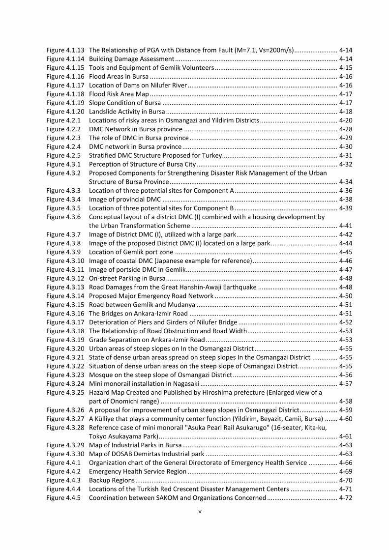
Figure 4.1.13 The Relationship of PGA with Distance from Fault (M=7.1, Vs=200m/s) ........................ 4-14 Figure 4.1.14 Building Damage Assessment .......................................................................................... 4-14 Figure 4.1.15 Tools and Equipment of Gemlik Volunteers .................................................................... 4-15 Figure 4.1.16 Flood Areas in Bursa ........................................................................................................ 4-16 Figure 4.1.17 Location of Dams on Nilufer River ................................................................................... 4-16 Figure 4.1.18 Flood Risk Area Map ........................................................................................................ 4-17 Figure 4.1.19 Slope Condition of Bursa ................................................................................................. 4-17 Figure 4.1.20 Landslide Activity in Bursa ............................................................................................... 4-18 Figure 4.2.1 Locations of risky areas in Osmangazi and Yildirim Districts ........................................... 4-20 Figure 4.2.2 DMC Network in Bursa province ..................................................................................... 4-28 Figure 4.2.3 The role of DMC in Bursa province .................................................................................. 4-29 Figure 4.2.4 DMC network in Bursa province ...................................................................................... 4-30 Figure 4.2.5 Stratified DMC Structure Proposed for Turkey................................................................ 4-31 Figure 4.3.1 Perception of Structure of Bursa City .............................................................................. 4-32 Figure 4.3.2 Proposed Components for Strengthening Disaster Risk Management of the Urban
Structure of Bursa Province ............................................................................................. 4-34 Figure 4.3.3 Location of three potential sites for Component A ......................................................... 4-36 Figure 4.3.4 Image of provincial DMC ................................................................................................. 4-38 Figure 4.3.5 Location of three potential sites for Component B ......................................................... 4-39 Figure 4.3.6 Conceptual layout of a district DMC (I) combined with a housing development by
the Urban Transformation Scheme ................................................................................. 4-41 Figure 4.3.7 Image of District DMC (I), utilized with a large park ........................................................ 4-42 Figure 4.3.8 Image of the proposed District DMC (I) located on a large park ..................................... 4-44 Figure 4.3.9 Location of Gemlik port zone .......................................................................................... 4-45 Figure 4.3.10 Image of coastal DMC (Japanese example for reference) ............................................... 4-46 Figure 4.3.11 Image of portside DMC in Gemlik .................................................................................... 4-47 Figure 4.3.12 On-street Parking in Bursa ............................................................................................... 4-48 Figure 4.3.13 Road Damages from the Great Hanshin-Awaji Earthquake ............................................ 4-48 Figure 4.3.14 Proposed Major Emergency Road Network .................................................................... 4-50 Figure 4.3.15 Road between Gemlik and Mudanya .............................................................................. 4-51 Figure 4.3.16 The Bridges on Ankara-Izmir Road .................................................................................. 4-51 Figure 4.3.17 Deterioration of Piers and Girders of Nilufer Bridge ....................................................... 4-52 Figure 4.3.18 The Relationship of Road Obstruction and Road Width .................................................. 4-53 Figure 4.3.19 Grade Separation on Ankara-Izmir Road ......................................................................... 4-53 Figure 4.3.20 Urban areas of steep slopes on In the Osmangazi District .............................................. 4-55 Figure 4.3.21 State of dense urban areas spread on steep slopes In the Osmangazi District .............. 4-55 Figure 4.3.22 Situation of dense urban areas on the steep slope of Osmangazi District ...................... 4-55 Figure 4.3.23 Mosque on the steep slope of Osmangazi District .......................................................... 4-56 Figure 4.3.24 Mini monorail installation in Nagasaki ............................................................................ 4-57 Figure 4.3.25 Hazard Map Created and Published by Hiroshima prefecture (Enlarged view of a
part of Onomichi range) .................................................................................................. 4-58 Figure 4.3.26 A proposal for improvement of urban steep slopes in Osmangazi District ..................... 4-59 Figure 4.3.27 A Külliye that plays a community center function (Yildirim, Beyazit, Camii, Bursa) ....... 4-60 Figure 4.3.28 Reference case of mini monorail "Asuka Pearl Rail Asukarugo" (16-seater, Kita-ku,
Tokyo Asukayama Park) ................................................................................................... 4-61 Figure 4.3.29 Map of Industrial Parks in Bursa ...................................................................................... 4-63 Figure 4.3.30 Map of DOSAB Demirtas Industrial park ......................................................................... 4-63 Figure 4.4.1 Organization chart of the General Directorate of Emergency Health Service ................ 4-66 Figure 4.4.2 Emergency Health Service Region ................................................................................... 4-69 Figure 4.4.3 Backup Regions ................................................................................................................ 4-70 Figure 4.4.4 Locations of the Turkish Red Crescent Disaster Management Centers .......................... 4-71 Figure 4.4.5 Coordination between SAKOM and Organizations Concerned ....................................... 4-72
v
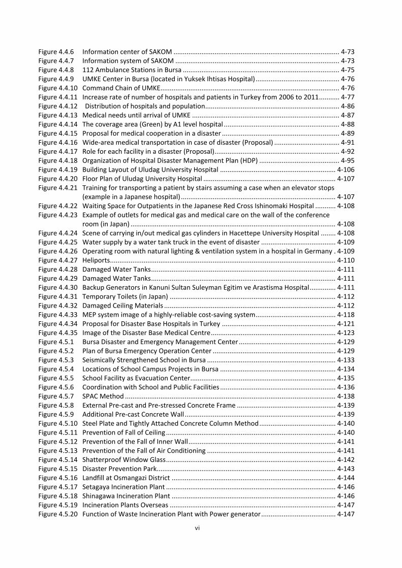
Figure 4.4.6 Information center of SAKOM ......................................................................................... 4-73 Figure 4.4.7 Information system of SAKOM ........................................................................................ 4-73 Figure 4.4.8 112 Ambulance Stations in Bursa .................................................................................... 4-75 Figure 4.4.9 UMKE Center in Bursa (located in Yuksek Ihtisas Hospital) ............................................. 4-76 Figure 4.4.10 Command Chain of UMKE................................................................................................ 4-76 Figure 4.4.11 Increase rate of number of hospitals and patients in Turkey from 2006 to 2011 ........... 4-77 Figure 4.4.12 Distribution of hospitals and population ........................................................................ 4-86 Figure 4.4.13 Medical needs until arrival of UMKE ............................................................................... 4-87 Figure 4.4.14 The coverage area (Green) by A1 level hospital .............................................................. 4-88 Figure 4.4.15 Proposal for medical cooperation in a disaster ............................................................... 4-89 Figure 4.4.16 Wide-area medical transportation in case of disaster (Proposal) ................................... 4-91 Figure 4.4.17 Role for each facility in a disaster (Proposal) ................................................................... 4-92 Figure 4.4.18 Organization of Hospital Disaster Management Plan (HDP) ........................................... 4-95 Figure 4.4.19 Building Layout of Uludag University Hospital .............................................................. 4-106 Figure 4.4.20 Floor Plan of Uludag University Hospital ....................................................................... 4-107 Figure 4.4.21 Training for transporting a patient by stairs assuming a case when an elevator stops
(example in a Japanese hospital) ................................................................................... 4-107 Figure 4.4.22 Waiting Space for Outpatients in the Japanese Red Cross Ishinomaki Hospital ........... 4-108 Figure 4.4.23 Example of outlets for medical gas and medical care on the wall of the conference
room (in Japan) .............................................................................................................. 4-108 Figure 4.4.24 Scene of carrying in/out medical gas cylinders in Hacettepe University Hospital ........ 4-108 Figure 4.4.25 Water supply by a water tank truck in the event of disaster ........................................ 4-109 Figure 4.4.26 Operating room with natural lighting & ventilation system in a hospital in Germany . 4-109 Figure 4.4.27 Heliports ......................................................................................................................... 4-110 Figure 4.4.28 Damaged Water Tanks ................................................................................................... 4-111 Figure 4.4.29 Damaged Water Tanks ................................................................................................... 4-111 Figure 4.4.30 Backup Generators in Kanuni Sultan Suleyman Egitim ve Arastisma Hospital .............. 4-111 Figure 4.4.31 Temporary Toilets (in Japan) ......................................................................................... 4-112 Figure 4.4.32 Damaged Ceiling Materials ............................................................................................ 4-112 Figure 4.4.33 MEP system image of a highly-reliable cost-saving system ........................................... 4-118 Figure 4.4.34 Proposal for Disaster Base Hospitals in Turkey ............................................................. 4-121 Figure 4.4.35 Image of the Disaster Base Medical Centre ................................................................... 4-123 Figure 4.5.1 Bursa Disaster and Emergency Management Center .................................................... 4-129 Figure 4.5.2 Plan of Bursa Emergency Operation Center .................................................................. 4-129 Figure 4.5.3 Seismically Strengthened School in Bursa ..................................................................... 4-133 Figure 4.5.4 Locations of School Campus Projects in Bursa .............................................................. 4-134 Figure 4.5.5 School Facility as Evacuation Center .............................................................................. 4-135 Figure 4.5.6 Coordination with School and Public Facilities .............................................................. 4-136 Figure 4.5.7 SPAC Method ................................................................................................................. 4-138 Figure 4.5.8 External Pre-cast and Pre-stressed Concrete Frame ..................................................... 4-139 Figure 4.5.9 Additional Pre-cast Concrete Wall ................................................................................. 4-139 Figure 4.5.10 Steel Plate and Tightly Attached Concrete Column Method ......................................... 4-140 Figure 4.5.11 Prevention of Fall of Ceiling ........................................................................................... 4-140 Figure 4.5.12 Prevention of the Fall of Inner Wall ............................................................................... 4-141 Figure 4.5.13 Prevention of the Fall of Air Conditioning ..................................................................... 4-141 Figure 4.5.14 Shatterproof Window Glass ........................................................................................... 4-142 Figure 4.5.15 Disaster Prevention Park................................................................................................ 4-143 Figure 4.5.16 Landfill at Osmangazi District ........................................................................................ 4-144 Figure 4.5.17 Setagaya Incineration Plant ........................................................................................... 4-146 Figure 4.5.18 Shinagawa Incineration Plant ........................................................................................ 4-146 Figure 4.5.19 Incineration Plants Overseas ......................................................................................... 4-147 Figure 4.5.20 Function of Waste Incineration Plant with Power generator ........................................ 4-147
vi
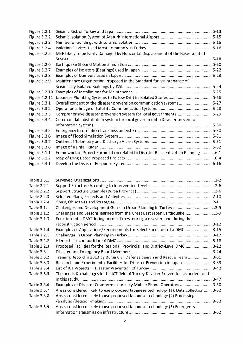
Figure 5.2.1 Seismic Risk of Turkey and Japan .................................................................................... 5-13 Figure 5.2.2 Seismic Isolation System of Ataturk International Airport .............................................. 5-15 Figure 5.2.3 Number of buildings with seismic isolation ..................................................................... 5-15 Figure 5.2.4 Isolation Devices Used Most Commonly in Turkey ......................................................... 5-16 Figure 5.2.5 MEP Likely to be Easily Damaged by Horizontal Displacement of the Base-isolated
Stories .............................................................................................................................. 5-18 Figure 5.2.6 Earthquake Ground Motion Simulation .......................................................................... 5-20 Figure 5.2.7 Examples of Isolators (Bearings) used in Japan ............................................................... 5-22 Figure 5.2.8 Examples of Dampers used in Japan ............................................................................... 5-23 Figure 5.2.9 Maintenance Organization Proposed in the Standard for Maintenance of
Seismically Isolated Buildings by JSSI ............................................................................... 5-24 Figure 5.2.10 Examples of Installations for Maintenance ..................................................................... 5-25 Figure 5.2.11 Japanese Plumbing Systems to Follow Drift in Isolated Stories ...................................... 5-26 Figure 5.3.1 Overall concept of the disaster prevention communication systems ............................. 5-27 Figure 5.3.2 Operational Image of Satellite Communication Systems ................................................ 5-28 Figure 5.3.3 Comprehensive disaster prevention system for local governments ............................... 5-29 Figure 5.3.4 Common data distribution system for local governments (Disaster prevention
information system) ........................................................................................................ 5-30 Figure 5.3.5 Emergency Information transmission system ................................................................. 5-30 Figure 5.3.6 Image of Flood Simulation System .................................................................................. 5-31 Figure 5.3.7 Outline of Telemetry and Discharge Alarm Systems ....................................................... 5-31 Figure 5.3.8 Image of Rainfall Radar .................................................................................................... 5-32 Figure 6.1.1 Framework of Project Formulation related to Disaster Resilient Urban Planning .............6-1 Figure 6.1.2 Map of Long Listed Proposed Projects ...............................................................................6-4 Figure 6.3.1 Develop the Disaster Response System........................................................................... 6-16 Table 1.3.1 Surveyed Organizations ......................................................................................................1-2 Table 2.2.1 Support Structure According to Intervention Level ............................................................2-6 Table 2.2.2 Support Structure Example (Bursa Province) .....................................................................2-6 Table 2.2.3 Selected Plans, Projects and Activities ............................................................................ 2-10 Table 2.2.4 Goals, Objectives and Strategies ..................................................................................... 2-11 Table 3.1.1 Challenges and Development Goals in Urban Planning in Turkey .....................................3-5 Table 3.1.2 Challenges and Lessons learned from the Great East Japan Earthquake ...........................3-9 Table 3.1.3 Functions of a DMC during normal times, during a disaster, and during the
reconstruction period ...................................................................................................... 3-12 Table 3.1.4 Examples of Applications/Requirements for Select Functions of a DMC ........................ 3-15 Table 3.2.1 Challenges in Urban Planning in Turkey .......................................................................... 3-17 Table 3.2.2 Hierarchical composition of DMC .................................................................................... 3-18 Table 3.2.3 Proposed Facilities for the Regional, Provincial, and District-Level DMC ........................ 3-22 Table 3.3.1 Disaster and Emergency Board Members ....................................................................... 3-24 Table 3.3.2 Training Record in 2013 by Bursa Civil Defense Search and Rescue Team ..................... 3-31 Table 3.3.3 Research and Experimental Facilities for Disaster Prevention in Japan .......................... 3-39 Table 3.3.4 List of ICT Projects in Disaster Prevention of Turkey ....................................................... 3-42 Table 3.3.5 The needs & challenges in the ICT field of Turkey Disaster Prevention as understood
in this study ...................................................................................................................... 3-47 Table 3.3.6 Examples of Disaster Countermeasures by Mobile Phone Operators ............................ 3-50 Table 3.3.7 Areas considered likely to use proposed Japanese technology (1). Data collection ....... 3-52 Table 3.3.8 Areas considered likely to use proposed Japanese technology (2) Processing
/analysis /decision-making .............................................................................................. 3-52 Table 3.3.9 Areas considered likely to use proposed Japanese technology (3) Emergency
information transmission infrastructure ......................................................................... 3-52
vii
Table 3.3.10 Areas considered likely to use proposed Japanese technology (4) Utilization of emergency information ................................................................................................... 3-53
Table 4.1.1 Historical Record of Earthquakes in Bursa ......................................................................... 4-5 Table 4.1.2 Historical Record of Tsunami that possibly affected Bursa Province ................................ 4-6 Table 4.2.1 Needs and Challenges in improving Bursa’s Resiliency ................................................... 4-27 Table 4.3.1 Comparison of potential sites for Component A ............................................................. 4-37 Table 4.3.2 Comparison of potential sites for Component B ............................................................. 4-40 Table 4.3.3 Industrial parks in Bursa .................................................................................................. 4-62 Table 4.4.1 UMKE members ............................................................................................................... 4-76 Table 4.4.2 Changes in the number of hospitals (2006-2011) ........................................................... 4-77 Table 4.4.3 Changes in number of hospitals, beds and patients (2006-2011) ................................... 4-78 Table 4.4.4 Number of health care workers per 1,000 inhabitants in major OECD countries
(2002-2011) ...................................................................................................................... 4-79 Table 4.4.5 Operation status of four national hospitals ..................................................................... 4-81 Table 4.4.6 Birth rate in Bursa ............................................................................................................ 4-82 Table 4.4.7 Number of patients of MoH hospitals in Bursa ............................................................... 4-83 Table 4.4.8 Number of deaths by diseases ......................................................................................... 4-83 Table 4.4.9 Facility situation in the Great East Japan Earthquake ..................................................... 4-86 Table 4.4.10 Healthcare needs in disaster ........................................................................................... 4-87 Table 4.4.11 Function and roles of core disaster base medical centers and regional disaster base
medical centers ................................................................................................................ 4-90 Table 4.4.12 Desirable features of Disaster Base Hospitals ................................................................. 4-94 Table 4.4.13 Anti-disaster facilities included/not included in PPP hospitals ....................................... 4-94 Table 4.4.14 Results of Hospital Building Assessment in Turkey (Architectural Plan) ......................... 4-98 Table 4.4.15 Result of Assessment (Structure) ................................................................................... 4-113 Table 4.4.16 MEP system assessment of hospitals in Turkey ............................................................. 4-114 Table 4.4.17 Investigation of Sevket Yilmaz Research and Education Hospital ................................. 4-116 Table 4.4.18 MEP requirements for disaster base hospitals in Japan ................................................ 4-116 Table 4.4.19 Proposed MEP requirements for a disaster base hospital ............................................ 4-118 Table 4.4.20 Improvements in the healthcare sector after the recent great earthquakes in Japan
and Turkey ..................................................................................................................... 4-120 Table 4.4.21 Comparison of disaster healthcare in Japan and Turkey, and proposals ...................... 4-120 Table 4.4.22 Medical Staff and facilities for Disaster Base Hospital 1................................................ 4-122 Table 4.4.23 Disaster measures for the facilities for Cekirge hospital ............................................... 4-123 Table 4.4.24 Proposed hospital size for Cekirge Hospital (Component A) ......................................... 4-124 Table 4.4.25 Facility plan: standards to be developed ....................................................................... 4-124 Table 4.4.26 Medical Staff and facilities for Disaster Base Hospital 2................................................ 4-126 Table 4.4.27 Disaster measures for facilities for Sevket hospital ....................................................... 4-127 Table 4.4.28 Proposed hospital size for Sevket Hospital (Component C) .......................................... 4-127 Table 4.4.29 Facility plan: standards to be developed ....................................................................... 4-128 Table 4.5.1 Investigation on existing facilities (AFAD Istanbul emergency operation center) ......... 4-131 Table 4.5.2 MEP requirements for disaster and emergency management center in Japan ............ 4-131 Table 4.5.3 Proposed MEP requirements for disaster and emergency management centers ........ 4-132 Table 4.5.4 Number of Schools by Construction Year in Bursa ........................................................ 4-138 Table 4.5.5 Definition of Disaster Prevention Park Level ................................................................. 4-142 Table 5.3.1 Advantages of Japanese products ................................................................................... 5-29 Table 5.3.2 Examples of Japanese Knowledge, Experiences, and Technologies regarding
Disaster Prevention Information Transmission ............................................................... 5-32 Table 6.1.1 Proposed Projects Long List ............................................................................................... 6-5 Table 6.2.1 Criteria for Shortlisted Project ......................................................................................... 6-13 Table 6.3.1 Proposed projects with high effectiveness ...................................................................... 6-19 Table 6.3.2 Outline of the Project Components (1) (facilities) ........................................................... 6-20
viii
Table 6.3.3 Outline of the Project Components (2) (Disaster Information System) .......................... 6-21 Table 6.3.4 Summary of Priority Nationwide Project ......................................................................... 6-22 Table 6.3.5 Summary of Proposed “Nationwide” Project Packages .................................................. 6-24 Table 6.4.1 Proposed projects with high effectiveness & efficiency .................................................. 6-26 Table 6.4.2 Outline of the proposed projects .................................................................................... 6-26 Table 6.4.3 Summary of Priority Projects ( Bursa) ............................................................................. 6-28 Table 6.5.1 Priority projects and responsible authorities .................................................................. 6-29 Table 6.7.1 Cost per unit area of selected Public Buildings in (TL/ m2) 2014 .................................... 6-34 Table 6.7.2 Comparison of the combined costs of major construction materials (Unit: Yen) ........... 6-36 Table 6.7.3 Comparison of the labor cost (Unit: Yen) ........................................................................ 6-36 Table 6.7.4 Estimated Construction Unit Cost of Disaster & Emergency Management Center ........ 6-37 Table 6.7.5 Inflation and average consumer prices in Turkey ........................................................... 6-38 Table 6.7.6 Details of the Model Hospital .......................................................................................... 6-38 Table 6.7.7 Public Building cost per unit area (extract) (TL/ m2) ver. 2014 ....................................... 6-39 Table 6.7.8 Comparison of Hospital construction cost in Turkey and Japan ..................................... 6-39 Table 6.7.9 Setting of construction unit cost of Disaster Base Hospital ............................................ 6-41 Table 6.7.10 Estimated costs for Medical Equipment (per 100 beds) ................................................. 6-42 Table 6.7.11 Details of Çekirge Hospital (model) ................................................................................. 6-43 Table 6.7.12 Example of main medical equipment classified by deprtment ....................................... 6-43 Table 6.7.13 Estimated costs of DMC facilities .................................................................................... 6-46
ix
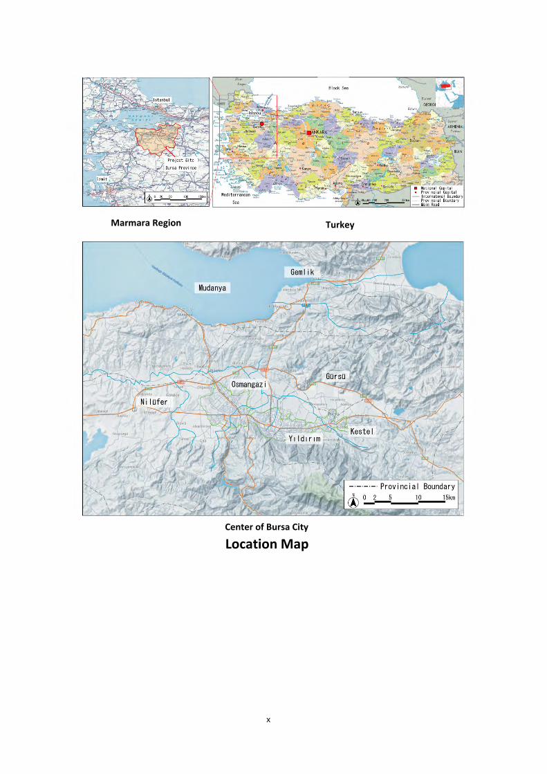
Location Map
Marmara Region Turkey
Center of Bursa City
x
Abbreviations AFAD Disaster and Emergency Management Center
AFADEM Disaster and Emergency Training Center
AFOM Disaster Coordination Center, Red Crescent
AKOM Disaster Coordination Center
ASCE American Society of Civil Engineers
BAYM Regional Disaster Management Directorate
BBB Bursa Metropolitan Municipality
BCP Business Continuity Plan
BPT Brownian Passage Time
BUSKI The Bursa Water Supply and Sewerage Administration
CASBEE Comprehensive Assessment System for Built Environment Efficiency
CBRN Chemical Biological Radiological Nuclear
CCU Coronary Care Unit
CSSD Central Sterile Supply Department
CT Computed Tomography
DEMP AFAD (Disaster and Emergency Management Center)
DMC Disaster Management Complex
DMI General Directorate of State Meteorological Service, Ministry of Forestry and Water Affairs
DOSAB Demirtas Organize Industrial Zone Organization of Businessmen and Industrialists
DMAT Disaster Medical Assistant Team
DRM Disaster Risk Management
DSI State Hydraulic Works
EEW Earthquake Early Warning
EMIS Emergency Medical Information System
EQAS Earthquake Quick Alarm System
FREQL Fast Response Equipment against Quake Load
HF High Frequency
GDCD General Directorate of Civil Defense
GDDA General Directorate of Disaster Affairs
GDP Gross Domestic Products
GHI General Healthcare Insurance
GIS Geographical Information System
xi
GONAF A Deep Geophysical Observatory at North Anatolian Fault
GPRS General Packet Radio Service
GVA Gross Value Added
HCU High Care Unit
HDP Hospital Disaster Plan
HQ Head Quarters
ICT Information Communication Technology
ICU Intensive Care Unit
IT Information Technology
ITU Istanbul Technical University
JCI Joint Commission International
JICA Japan International Cooperation Agency
JST JICA Study Team
KENTGES Integrated Urban Development Strategy and Action Plan 2010-2023
LED Light Emitting Diode
LGWAN Local Government Wide Area Network
METU Middle East Technical University
MOD Ministry of Development
MOEU Ministry of Environmental and Urbanization
MOH Ministry of Health
MOLSS Ministry of Labour and Social Security
MONE Ministry of National Education
MOSIT Ministry of Science, Industry and Technology
MOTMAC Ministry of Transport, Maritime Affairs and Communications
MOI Ministry of Interior
MOENR Ministry of Energy and Natural Resource
MOFAL Ministry of Food Agriculture and Livestock
MOFSP Ministry of Family and Social Policy
MOF Ministry of Finance
MOYS Ministry of Youth and Sports
MRI Magnetic Resonance Imaging
MTA Mining Exploration Institute
NATO North Atlantic Treaty Organization
NGO Non-Governmental Organization
xii
NICU Neonatal Intensive Care Unit
ODA Official Development Assistance
PACS Picture Archiving and Communication System
PET Positron Emission Tomography
PPP Public Private Partnership
SAKOM Health Disaster Coordination Center
SCU Staging Care Unit
SEGE Socio-Economic Development Ranking Survey of Provinces and Regions
SGK Social Security Institution
SMS Short Message Service
SSB Single Sideband
SSK Social Insurance Institution
TAMP Turkey Disaster Response Plan
TCIP Turkish Catastrophic Insurance Pool
TEMAD General Directorate of Emergency Management of Turkey
TL Turkish Lira
TTS Telegraphic Transfer Selling
TOKI Mass Housing Administration
UEDAS Uludag Electricity Distribution Company
UMKE NMRT: National Medical Rescue Team
USGS United States Geological Survey
VHF Very High Frequency
VSAT Very Small Aperture Terminal
WHO World Health Organization
YAYS Local Disaster Management Chieftaincies
*****
xiii
1. Survey Background 1.1. Survey Background
The Anatolia peninsula, which covers a large part of the Republic of Turkey (hereinafter referred to simply as Turkey), is a seismically active region due to its location at the boundary of the Eurasian plate in the north and the African and Arabian plates in the south. Earthquakes of magnitude 7.6 and 7.2 occurred in 1999, the Kocaeli earthquake and the Düzce earthquake respectively, only 12 years before the 2011 Van Province earthquake of magnitude 7.1. These large earthquakes claimed many victims. In addition to the frequency of earthquakes, the vulnerability to disasters is growing because of the rapidly developed urban area fueled by the remarkable economic development in recent years in Turkey.
Turkey is a seismically-active country with a long history of seismic countermeasures. Disaster risk management was established in the “Tenth National Development Plan (2007-2013)”. Hazard mapping and seismic retrofit of buildings and infrastructure are underway in accordance with the “National Earthquake Strategy and Action Plan 2012-2023” published by the Prime Ministry Disaster & Emergency Management Presidency (AFAD) in April 2012. In addition, demolition and redevelopment/rebuilding of vulnerable buildings have been underway since October 2012.
In the event of a disaster, the Bursa Province, located on the opposite bank of the Sea of Marmara from Istanbul, is expected to perform supplementary economic and administrative functions. The Japanese International Collaboration Agency (JICA) has provided much technical assistance, such as the “Project of Earthquake and Tsunami Disaster Mitigation in the Marmara Region and Disaster Education in Turkey”, “School-based Disaster Education Project”, and “Capacity Development toward Effective Disaster Risk Management”, in order to achieve “Resilient Urban Development” promoted by the United Nations Office for Disaster Risk Reduction (UNISDR).
Because of the increasing number of disasters in many regions and countries around the world such as Turkey, the UNISDR recommends an increase in the risk governance capacity and an improved commitment to cross-sectoral risk management to reduce disaster risk.
The key to effective disaster risk reduction is to engage actors and coordinate measures at all levels: central government, local government, private sector and individual citizens. Disaster prevention measures included in urban planning maximize the effectiveness of investments. This Data Collection Survey report (report) examines supporting nationwide programs for disaster prevention sectors, in line with AFAD’s focus on nationwide projects related to disaster resilient urban planning. Additionally, this report provides guidance for medium- and long-term disaster resilient urban planning at a regional level through a case study of the Bursa region. This report supports the effort for cooperation of Japan and Turkey on disaster prevention, as stated by the Vice Prime Minister of Turkey and the Ministry of Land, Infrastructure, Transport and Tourism of Japan during the Turkish Prime Minister’s visit to Japan in January 2014.
1.2. Survey Objectives The purpose of this Data Collection Survey (Survey) is to propose a resilient urban planning concept for Bursa province. This report includes a list of projects proposed to implement this concept, and for high priority projects, this report includes a description of the projects and associated estimated costs.
1-1
The concept and projects are proposed based on current expertise and technology in Japan and Turkey, as well as past experience of projects conducted under the oversight of JICA.
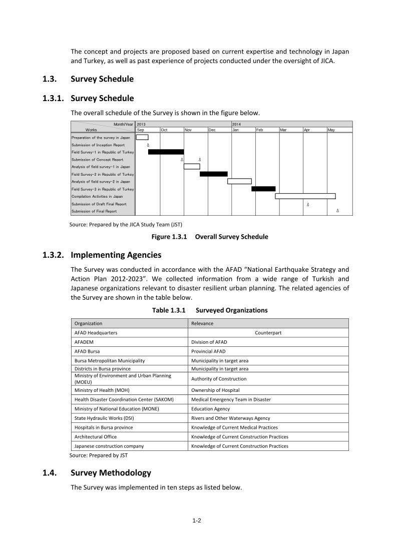
1.3. Survey Schedule
1.3.1. Survey Schedule The overall schedule of the Survey is shown in the figure below.
Month/YearWorks
Analysis of field survey-1 in Japan
Submission of Concept Report
Dec Jan Feb
Submission of Inception Report
Field Survey-1 in Republic of Turkey
Submission of Final Report
May2014
Field Survey-2 in Republic of Turkey
Submission of Draft Final Report
Field Survey-3 in Republic of Turkey
Compilation Activities in Japan
Analysis of field survey-2 in Japan
Mar Apr2013
Preparation of the survey in Japan
Sep Oct Nov
Source: Prepared by the JICA Study Team (JST)
Figure 1.3.1 Overall Survey Schedule
1.3.2. Implementing Agencies The Survey was conducted in accordance with the AFAD “National Earthquake Strategy and Action Plan 2012-2023”. We collected information from a wide range of Turkish and Japanese organizations relevant to disaster resilient urban planning. The related agencies of the Survey are shown in the table below.
Table 1.3.1 Surveyed Organizations
Organization Relevance
AFAD Headquarters Counterpart
AFADEM Division of AFAD
AFAD Bursa Provincial AFAD
Bursa Metropolitan Municipality Municipality in target area Districts in Bursa province Municipality in target area Ministry of Environment and Urban Planning (MOEU) Authority of Construction
Ministry of Health (MOH) Ownership of Hospital
Health Disaster Coordination Center (SAKOM) Medical Emergency Team in Disaster
Ministry of National Education (MONE) Education Agency
State Hydraulic Works (DSI) Rivers and Other Waterways Agency
Hospitals in Bursa province Knowledge of Current Medical Practices
Architectural Office Knowledge of Current Construction Practices
Japanese construction company Knowledge of Current Construction Practices
Source: Prepared by JST
1.4. Survey Methodology The Survey was implemented in ten steps as listed below.
1-2
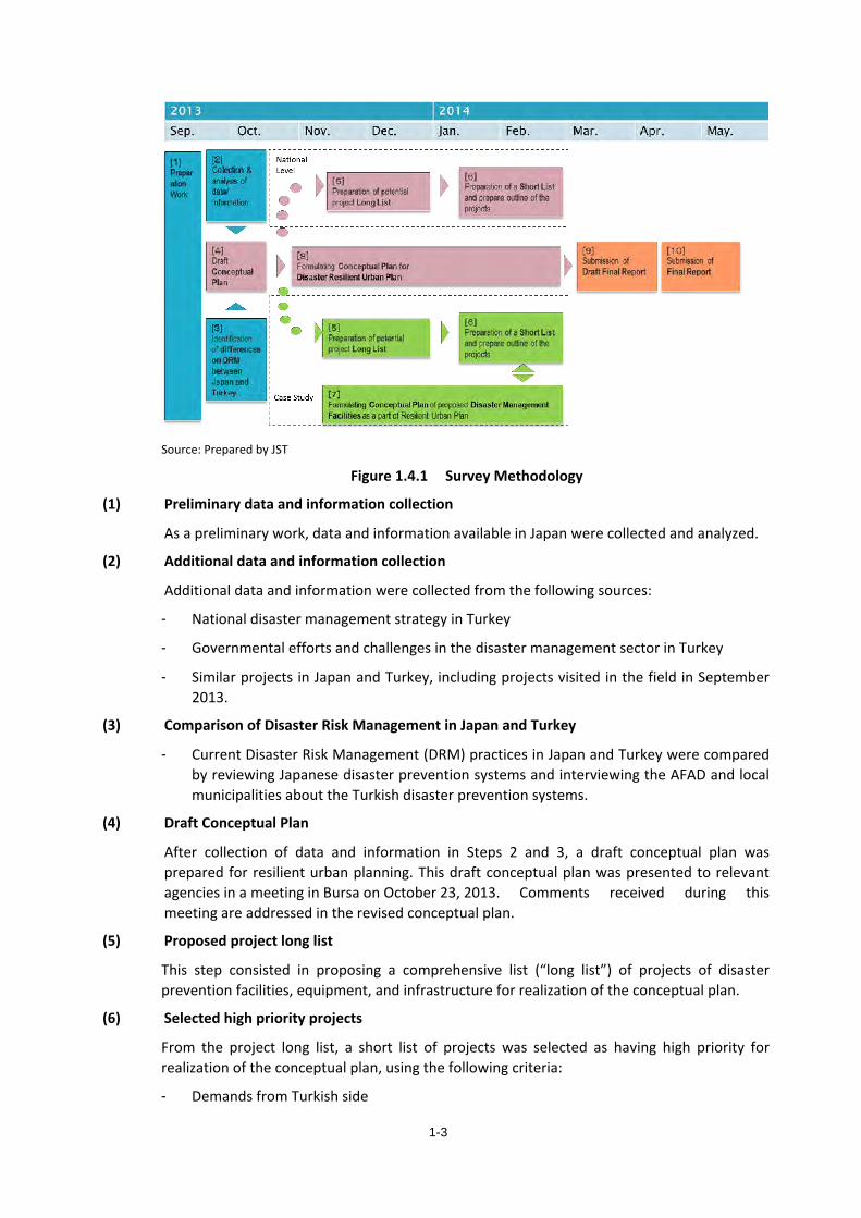
Source: Prepared by JST
Figure 1.4.1 Survey Methodology
(1) Preliminary data and information collection
As a preliminary work, data and information available in Japan were collected and analyzed.
(2) Additional data and information collection
Additional data and information were collected from the following sources:
- National disaster management strategy in Turkey
- Governmental efforts and challenges in the disaster management sector in Turkey
- Similar projects in Japan and Turkey, including projects visited in the field in September 2013.
(3) Comparison of Disaster Risk Management in Japan and Turkey
- Current Disaster Risk Management (DRM) practices in Japan and Turkey were compared by reviewing Japanese disaster prevention systems and interviewing the AFAD and local municipalities about the Turkish disaster prevention systems.
(4) Draft Conceptual Plan
After collection of data and information in Steps 2 and 3, a draft conceptual plan was prepared for resilient urban planning. This draft conceptual plan was presented to relevant agencies in a meeting in Bursa on October 23, 2013. Comments received during this meeting are addressed in the revised conceptual plan.
(5) Proposed project long list
This step consisted in proposing a comprehensive list (“long list”) of projects of disaster prevention facilities, equipment, and infrastructure for realization of the conceptual plan.
(6) Selected high priority projects
From the project long list, a short list of projects was selected as having high priority for realization of the conceptual plan, using the following criteria:
- Demands from Turkish side
1-3
(7) Proposed National Conceptual Plan for Disaster Resilient Urban Planning
This step proposed a national level conceptual plan for disaster resilient urban planning.
(8) Proposed Disaster Management Complex
Finally, alternative scenarios of the Disaster Management Complex (DMC) were proposed for implementation of the draft conceptual plan, and the example of Bursa is presented as a case study
(9) Submission of Draft Final Report
(10) Submission of Final Report
1-4
2. Current State of the Disaster Prevention Sector in Turkey 2.1. AFAD
2.1.1. Creation of AFAD Turkey has gone through many earthquakes and has revised its laws after each recent major earthquake. The 1999 Kocaeli earthquake hitting the Marmara region is the most important disaster experienced by Turkey in modern times. This earthquake led to the establishment of the General Directorate of Emergency Management of Turkey (TEMAD) in 2000 to support the General Directorate of Disaster Affairs (GDDA) and the General Directorate of Civil Defense (GDCD), established in 1965 and 1958 respectively.
Law no. 5902 on the “Organization and Duties of the Disaster and Emergency Management Presidency”, often referred to as the Establishment Law of AFAD, was adopted in May 2009. The three general directorates (TEMAD, GDDA, and GDCD) were abolished and the Disaster and Emergency Management Presidency “AFAD” was established, along with associated provincial disaster and emergency directorates.
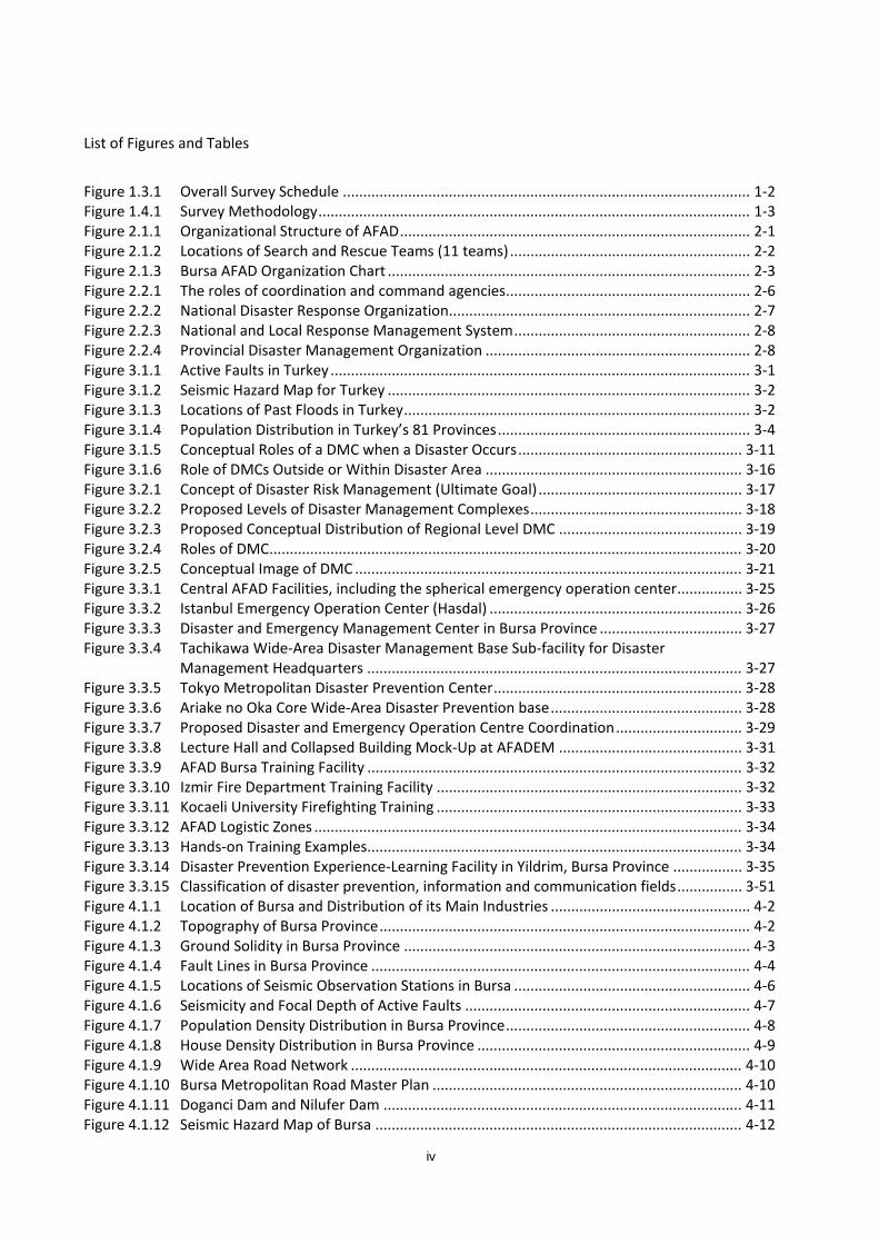
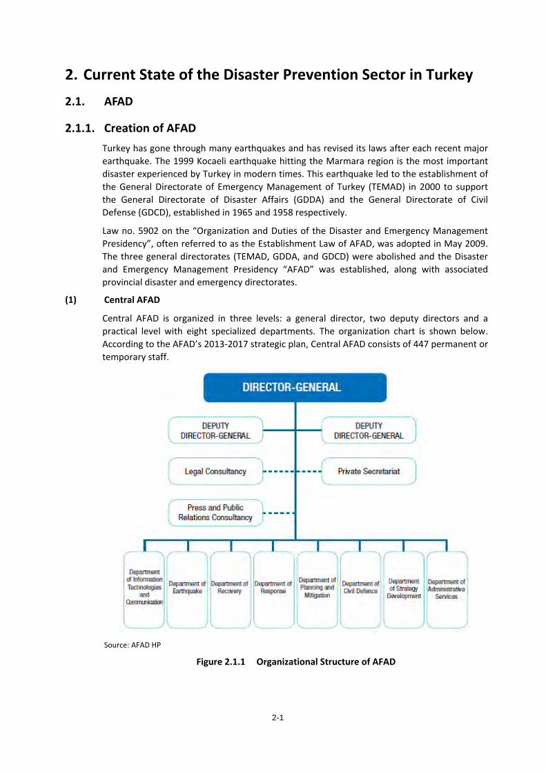
(1) Central AFAD
Central AFAD is organized in three levels: a general director, two deputy directors and a practical level with eight specialized departments. The organization chart is shown below. According to the AFAD’s 2013-2017 strategic plan, Central AFAD consists of 447 permanent or temporary staff.
Source: AFAD HP
Figure 2.1.1 Organizational Structure of AFAD
2-1
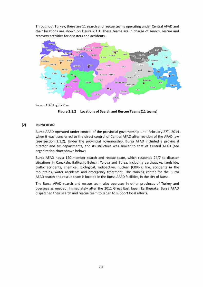
Throughout Turkey, there are 11 search and rescue teams operating under Central AFAD and their locations are shown on Figure 2.1.1. These teams are in charge of search, rescue and recovery activities for disasters and accidents.
Source: AFAD Logistic Zone
Figure 2.1.2 Locations of Search and Rescue Teams (11 teams)
(2) Bursa AFAD
Bursa AFAD operated under control of the provincial governorship until February 27th, 2014 when it was transferred to the direct control of Central AFAD after revision of the AFAD law (see section 2.1.2). Under the provincial governorship, Bursa AFAD included a provincial director and six departments, and its structure was similar to that of Central AFAD (see organization chart shown below)
Bursa AFAD has a 120-member search and rescue team, which responds 24/7 to disaster situations in Canakale, Balikesir, Belecir, Yalova and Bursa, including earthquake, landslide, traffic accidents, chemical, biological, radioactive, nuclear (CBRN), fire, accidents in the mountains, water accidents and emergency treatment. The training center for the Bursa AFAD search and rescue team is located in the Bursa AFAD facilities, in the city of Bursa.
The Bursa AFAD search and rescue team also operates in other provinces of Turkey and overseas as needed. Immediately after the 2011 Great East Japan Earthquake, Bursa AFAD dispatched their search and rescue team to Japan to support local efforts.
2-2
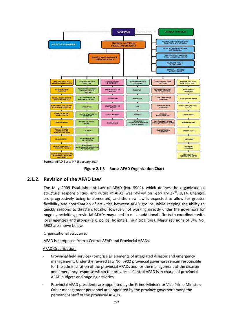
Source: AFAD Bursa HP (February 2014)
Figure 2.1.3 Bursa AFAD Organization Chart
2.1.2. Revision of the AFAD Law The May 2009 Establishment Law of AFAD (No. 5902), which defines the organizational structure, responsibilities, and duties of AFAD was revised on February 27th, 2014. Changes are progressively being implemented, and the new law is expected to allow for greater flexibility and coordination of activities between AFAD groups, while keeping the ability to quickly respond to disasters locally. However, not working directly under the governors for ongoing activities, provincial AFADs may need to make additional efforts to coordinate with local agencies and groups (e.g. police, hospitals, municipalities). Major revisions of Law No. 5902 are shown below.
Organizational Structure:
AFAD is composed from a Central AFAD and Provincial AFADs.
AFAD Organization:
- Provincial field services comprise all elements of integrated disaster and emergency management. Under the revised Law No. 5902 provincial governors remain responsible for the administration of the provincial AFADs and for the management of the disaster and emergency response within the provinces. Central AFAD is in charge of provincial AFAD budgets and ongoing activities.
- Provincial AFAD presidents are appointed by the Prime Minister or Vice Prime Minister. Other management personnel are appointed by the province governor among the permanent staff of the provincial AFADs.
2-3
- Budget of provincial AFADs is distributed from the Central AFAD budget.
- Any legal actions related to the works and operations of the provincial AFADs are transferred to the province governorship.
- Duties of each provincial AFAD are as follows:
To identify disaster and emergency hazards and risks in the province, to implement related disaster and emergency prevention activities
To establish, apply, and ensure the application of provincial plans for disaster and emergency risk reduction, response and enhancement in cooperation and coordination with local governments and state institutions and organizations
To manage provincial disaster and emergency management centers, to ensure uninterrupted and safe communication
To evaluate or ensure the evaluation of losses and damages resulting from disaster and emergency situations
To conduct or ensure the execution of training activities regarding disaster and emergency
To carry out the accreditation and certification of nongovernmental organizations
To set up and manage warehouses for food, equipment, and tools to be used to meet sheltering, nutrition, and healthcare needs of the public and equipment needs for the necessary search and rescue teams in disaster and emergency situations
To carry out military tasks specified in the related legislation including mobilization, war preparedness activities, and civil defense services
To coordinate risk reduction, prevention, and response activities with other agencies and institutions
To conduct secretarial activities for the provincial disaster and emergency coordination committees
To implement activities for the determination, identification and purification of CBRN substances and other technological substances, to ensure cooperation and coordination among related agencies and institutions
To implement annual working programs designated by the Presidency, to prepare and submit for the approval of the Presidency annual activity reports
To prepare the annual budget proposal for Central AFAD’s review and approval
To conduct other tasks given by the Presidency and the provincial governor
Search and rescue teams may be established under provincial AFADs at the provinces specified by Central AFAD, so long as the number of search and rescue teams does not exceed twenty.
Seismic Activity Monitoring and Data Publication
Universities, local governments and all agencies and institutes which monitor seismic activity are required to provide monitoring data to AFAD, which in turn, combines and publically releases basic data such as magnitude and intensity of recorded earthquakes.
2-4
2.2. National Disaster Management Strategy
2.2.1. National Development Plan The “Tenth National Development Plan (2007-2013)” suggests that disaster risk management is an important improvement to be included in each sector. Urban planning needs to meet social and economic needs and achieve disaster risk mitigation.
The fundamental objective of the Tenth National Development Plan is to consider disaster risks and damages in the processes of macroeconomic, sectoral and special planning; increase the public awareness and the resilience against the disaster and create safe and disaster resilient settlements.
Implementing mechanisms regarding the disaster risks mitigation will be strengthened; the priority will be the reinforcement of the communal buildings such as hospitals, schools and dormitories which have a special importance in disaster preparedness and post disaster response and the critical infrastructure like energy, transportation, water and communication.
To fight the disasters more effectively, a disaster information management system will be established for fast, safe and effective data exchange between the public institutions and organizations, and the telecommunication infrastructure will be strengthened to maintain the effective and smooth communication.
We can understand from the above, Turkey is working on disaster prevention at the national level.
2.2.2. The Structure of Turkey’s National Disaster Prevention Plan There are three national disaster prevention plans in the beginning of AFAD’s Turkey Disaster Management Strategy Paper (Turkey Disaster Mitigation Plan, Turkey Disaster Response Plan, Turkey Disaster Recovery Plan). Currently, only the Turkey Disaster Response Plan (TAMP) has been finalized by AFAD to manage the response to various disasters which may occur in Turkey. In the Turkey Disaster Management Strategy Paper, the organization’s basic rules, priority, operation standards, and managemental structure in order to achieve the medium to long term goals are defined, whereas in the disaster plans, the role, responsibility, and duty of the actual working unit are defined. For more details on TAMP, please refer to 2.2.3 below.
2.2.3. Turkey Disaster Response Plan (TAMP) TAMP specifies the division of ministries and facilities roles, relationships between national and local governments and the action policies of ministries and facilities in a disaster.
(1) Emergency Intervention Level
Intervention levels are divided into four groups based on the disaster’s scale, which are shown in the table below. S1 level is ‘Sufficient local resources’, S2 level is ‘Support provinces, supplements are needed’ S3 level is ‘National support is needed’, S4 level is ‘International support is needed’. Examples of support structures are shown in the table below.
2-5
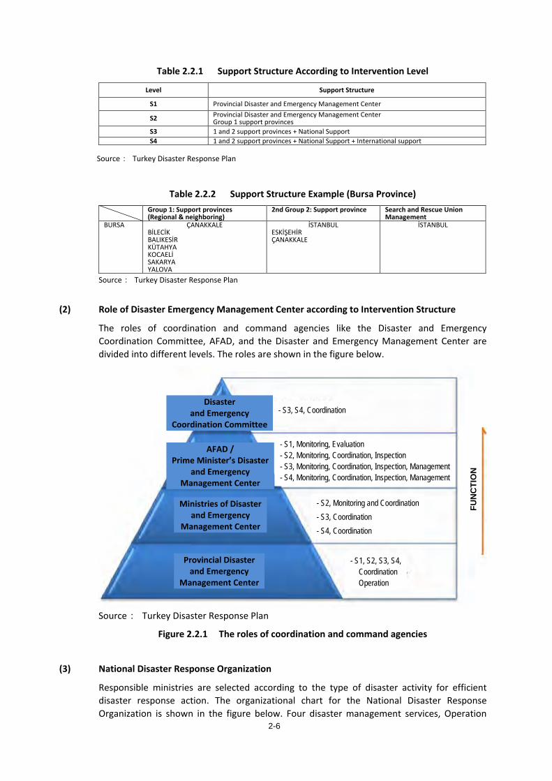
Table 2.2.1 Support Structure According to Intervention Level
Level Support Structure
S1 Provincial Disaster and Emergency Management Center
S2 Provincial Disaster and Emergency Management Center Group 1 support provinces
S3 1 and 2 support provinces + National Support S4 1 and 2 support provinces + National Support + International support
Source: Turkey Disaster Response Plan
Table 2.2.2 Support Structure Example (Bursa Province) Group 1: Support provinces
(Regional & neighboring) 2nd Group 2: Support province Search and Rescue Union
Management BURSA ÇANAKKALE
BİLECİK BALIKESİR KÜTAHYA KOCAELİ SAKARYA YALOVA
İSTANBUL ESKİŞEHİR ÇANAKKALE
İSTANBUL
Source: Turkey Disaster Response Plan
(2) Role of Disaster Emergency Management Center according to Intervention Structure
The roles of coordination and command agencies like the Disaster and Emergency Coordination Committee, AFAD, and the Disaster and Emergency Management Center are divided into different levels. The roles are shown in the figure below.
Source: Turkey Disaster Response Plan
Figure 2.2.1 The roles of coordination and command agencies
(3) National Disaster Response Organization
Responsible ministries are selected according to the type of disaster activity for efficient disaster response action. The organizational chart for the National Disaster Response Organization is shown in the figure below. Four disaster management services, Operation
FUN
CTI
ON
- S3, S4, Coordination
- S1, Monitoring, Evaluation - S2, Monitoring, Coordination, Inspection - S3, Monitoring, Coordination, Inspection, Management - S4, Monitoring, Coordination, Inspection, Management
- S2, Monitoring and Coordination - S3, Coordination - S4, Coordination
- S1, S2, S3, S4, Coordination Operation
Ministries of Disaster and Emergency
Management Center
Provincial Disaster and Emergency
Management Center
Disaster and Emergency
Coordination Committee
AFAD / Prime Minister’s Disaster
and Emergency Management Center
2-6
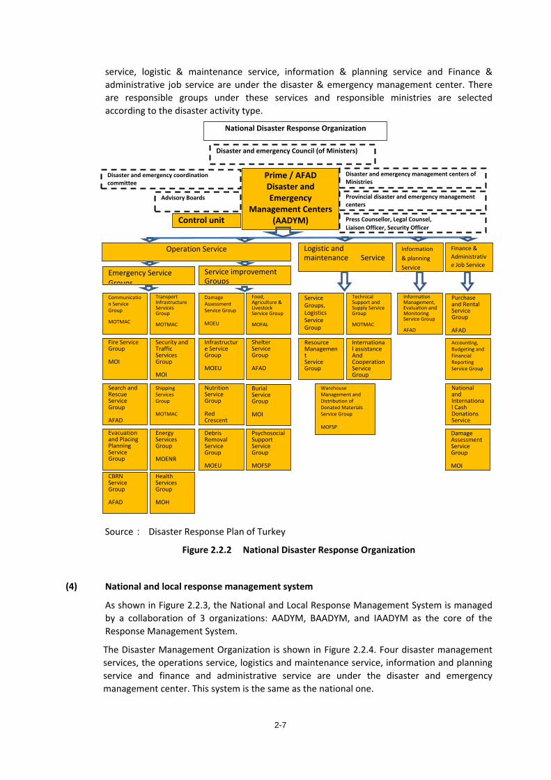
service, logistic & maintenance service, information & planning service and Finance & administrative job service are under the disaster & emergency management center. There are responsible groups under these services and responsible ministries are selected according to the disaster activity type.
Source: Disaster Response Plan of Turkey
Figure 2.2.2 National Disaster Response Organization
(4) National and local response management system
As shown in Figure 2.2.3, the National and Local Response Management System is managed by a collaboration of 3 organizations: AADYM, BAADYM, and IAADYM as the core of the Response Management System.
The Disaster Management Organization is shown in Figure 2.2.4. Four disaster management services, the operations service, logistics and maintenance service, information and planning service and finance and administrative service are under the disaster and emergency management center. This system is the same as the national one.
National Disaster Response Organization
Disaster and emergency Council (of Ministers)
Disaster and emergency coordination committee
Advisory Boards
Disaster and emergency management centers of Ministries
Provincial disaster and emergency management centers
Press Counsellor, Legal Counsel, Liaison Officer, Security Officer
Control unit
Prime / AFAD Disaster and Emergency
Management Centers (AADYM)
Operation Service
Emergency Service Groups
Service improvement Groups
Logistic and maintenance Service
Information & planning Service
Finance & Administrative Job Service
Communication Service Group MOTMAC
Technical Support and Supply Service Group MOTMAC
Information Management, Evaluation and Monitoring Service Group AFAD
Purchase and Rental Service Group AFAD
Food, Agriculture & Livestock Service Group MOFAL
Transport Infrastructure Services Group MOTMAC
Service Groups, Logistics Service Group
Damage Assessment Service Group MOEU
Fire Service Group MOI
International assistance And Cooperation Service Group
Accounting, Budgeting and Financial Reporting Service Group
Shelter Service Group AFAD
Security and Traffic Services Group MOI
Resource Management Service Group
Infrastructure Service Group MOEU
Search and Rescue Service Group AFAD
National and International Cash Donations Service
Burial Service Group MOI
Shipping Services Group MOTMAC
Warehouse Management and Distribution of Donated Materials Service Group MOFSP
Nutrition Service Group Red Crescent
Evacuation and Placing Planning Service Group
Damage Assessment Service Group MOI
Psychosocial Support Service Group MOFSP
Energy Services Group MOENR
Debris Removal Service Group MOEU
CBRN Service Group AFAD
Health Services Group MOH
2-7

Source: Disaster Response Plan of Turkey
Figure 2.2.3 National and Local Response Management System
Source: Disaster Response Plan of Turkey
Figure 2.2.4 Provincial Disaster Management Organization
Organization of local disaster response
Republic Disaster and emergency Management Center
Provincial disaster and emergency coordination committee
AFAD groups of service coordinators Press Counsellor, Legal Counsel, Liaison Officer, Security Officer
Provincial Disaster and Emergency
Management Centers (VALI)
Operation Service
Emergency Service Groups Service improvement Groups
Logistic and maintenance Service
Information & planning Service
Finance & Administrative
Communication Service Group
Technical Support and Supply Service Group
Information Management, Evaluation and Monitoring S i G
Purchase and Rental Service Group
Food, Agriculture & Livestock Service Group
Transport Infrastructure Services Group
Service Groups, Logistics Service Group
Damage Assessment Service Group
Fire Service Group
Warehouse Management and Distribution of Donations
Accounting, Budgeting and Financial Reporting
Shelter Service Group
Security and Traffic Services Group
Resource Management Service Group
Infrastructure Service Group
Search and Rescue Service Group
National and International Cash Donations Service Group
Psychosocial Support Service Group
Shipping Services Group
Nutrition Service Group
Evacuation and Placing Planning Service Group
Damage Assessment Service Group
Burial service group
Energy Services Group
Debris Removal Service Group
CBRN Service Group
Health Services Group
National Level
Coordination teams
Other
Team 1
Ministry AADYM Main solution partner Service group Responsible
Logistics coordination
Support coordination Team 2 Team 3
Field support teams
Support, coordination and management
High Commission
Support function Support function
REPUBLIC of TURKEY Prime Minister’s Office
AADYM
Service group Coordinators
AFAD Coordination Committee
Civil Society organizations
Coordination teams
Field support personnel
Red Crescent Nutrition services grouped main solution partner Solution Partner of other support services
Deputygovernor and team
GARD-Youth and Sports Ministry
local level - Preparation services group manager
(assistant to the governor's team is a set of support)
- AFAD field support staff (assistant to the governor's team is a set of support)
- At the national level of services - Field support staff (service is distributed
according to the status in the group) - Skilled-Unskilled workers (ISKUR) (distributed according to its ability to
serve the group) - GARD-Ministry of Youth and Sports (distributed according to its ability to
serve the group) - Team of volunteers (distributed according to its ability to
serve the group)
Provincial disaster and emergency management centers
VALI deputy coordinator of-service (Operations knowledge and planning, logistics and maintenance, finance and administrative services) - Groups in Service managers - Provincial disaster coordinating body Place AFAD (secretariat)
operations team manager
Secretariat services group
logistics teams and team manager
Coordination committee
.................... service group Supportive Provinces
1. Group Support Provinces 2. Group Support Provinces
High Council (HSYK) Judge and prosecutors
Ministry of Interior Civilian authority
Operations Team 1
service group
Operations Team 2 Logistics Team 1
Logistics Team 2
Sub-teams Sub-teams Sub-teams Sub-teams
Sub-teams
Sub-teams
Support of workers Turkish business organization
2-8
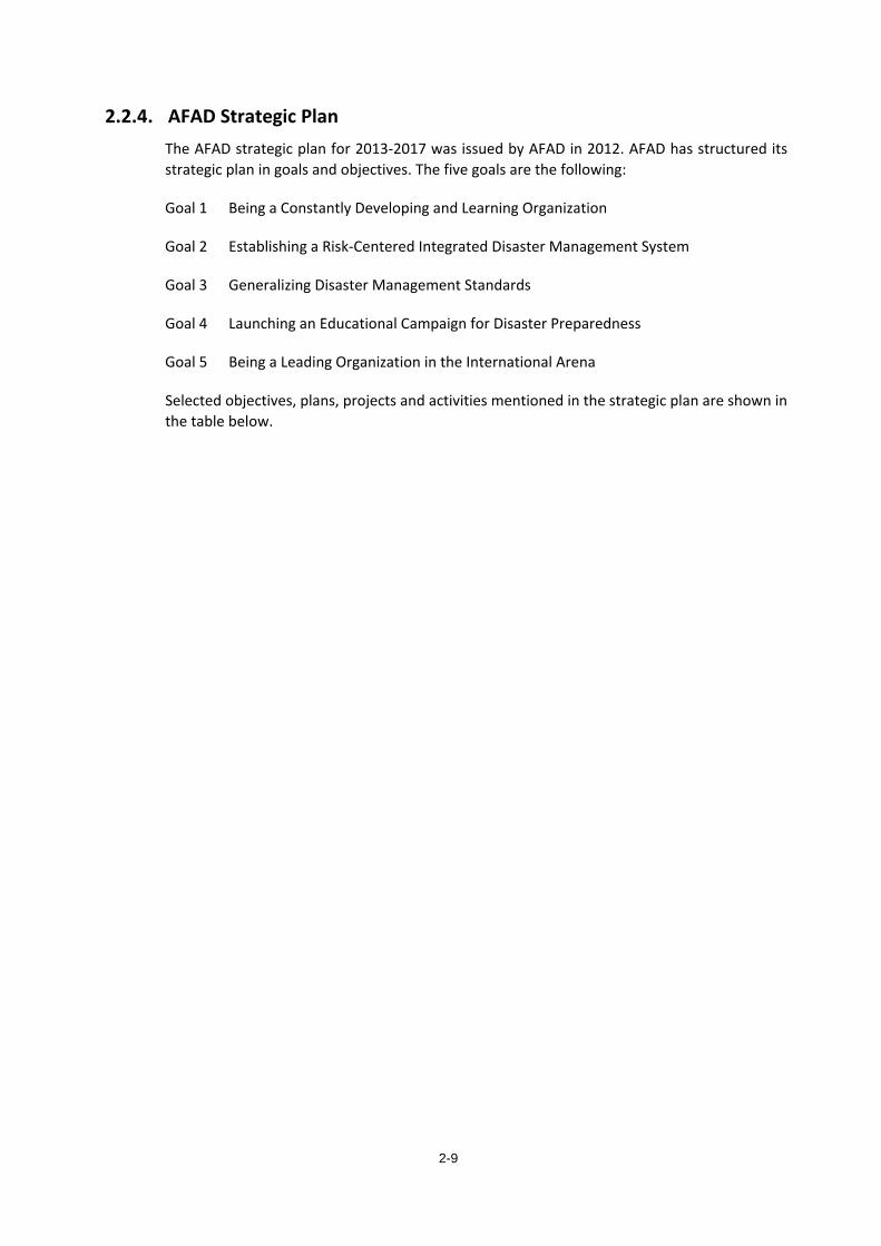
2.2.4. AFAD Strategic Plan The AFAD strategic plan for 2013-2017 was issued by AFAD in 2012. AFAD has structured its strategic plan in goals and objectives. The five goals are the following:
Goal 1 Being a Constantly Developing and Learning Organization
Goal 2 Establishing a Risk-Centered Integrated Disaster Management System
Goal 3 Generalizing Disaster Management Standards
Goal 4 Launching an Educational Campaign for Disaster Preparedness
Goal 5 Being a Leading Organization in the International Arena
Selected objectives, plans, projects and activities mentioned in the strategic plan are shown in the table below.
2-9
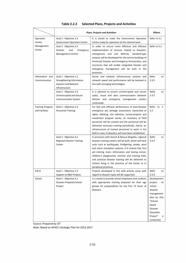
Table 2.2.3 Selected Plans, Projects and Activities
Plans, Projects and Activities Efforts
Operation Center, Management Center
Goal 2 - Objective 2.3 Government Operation Centre
It is aimed to make the Government Operation Centre ready for operation at the national level.
Refer to 3.1
Goal 2 - Objective 2.3 Disaster and Emergency Management Centers
In order to ensure more effective and efficient implementation of services related to disasters, emergencies and civil defense, standard-type projects will be developed for the service buildings of Provincial Disaster and Emergency Directorates, and structures that will enable integrated disaster and emergency management will be built in the provinces.
Refer to 3.1.
Information and Communication
Goal 1 - Objective 1.2 Strengthening Information Systems and Network Infrastructure
Server and network infrastructure systems and network speed and performance will be boosted in line with emerging technologies.
Refer to 3.3.5
Goal 2 - Objective 2.6 Uninterrupted and Secure Communication System
It is planned to ensure uninterrupted and secure audio, visual and data communication between disaster and emergency management centers nationwide.
Refer to 3.3.5
Training Program and Facilities
Goal 2 - Objective 2.4 Personnel Training
For fast and efficient performance of post-disaster emergency aid, damage assessment, ownership of rights, debiting, site selection, survey-projects and investment program works, an inventory of field personnel will be created and the personnel will be delivered necessary training periodically. Hence, an infrastructure of trained personnel to work in the field in cases of disasters will have been established.
Refer to 3. 3.2
Goal 4 - Objective 4.2 Regional Disaster Training Center
In provinces with Search & Rescue Brigades, regional disaster training centers will be built, which will have units such as earthquake, firefighting, smoke, wind and storm simulation systems, 5-D cinema hall, first aid training room, information and testing corner, children’s playgrounds, seminar and training halls, and practical disaster training will be delivered to citizens living in the province of the center or in peripheral provinces.
Refer to 3.3.3
R & D Goal 1 - Objective 1.4 Support to R&D Projects
Projects developed in line with priority areas with regard to disaster types will be supported.
Refer to 3.3.4
School Goal 4 - Objective 4.1 Disaster-Prepared School Project
It is aimed to provide school employees and students with appropriate training prepared for their age groups for preparedness for the first 72 hours of disasters.
Development project of school disaster management plan by JICA “School-based Disaster Education Project” is conducted.
Source: Prepared by JST Note: Based on AFAD’s Strategic Plan for 2013-2017
2-10
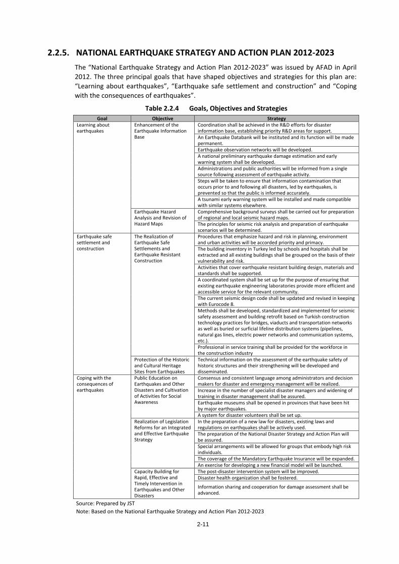
2.2.5. NATIONAL EARTHQUAKE STRATEGY AND ACTION PLAN 2012-2023 The “National Earthquake Strategy and Action Plan 2012-2023” was issued by AFAD in April 2012. The three principal goals that have shaped objectives and strategies for this plan are: “Learning about earthquakes”, “Earthquake safe settlement and construction” and “Coping with the consequences of earthquakes”.
Table 2.2.4 Goals, Objectives and Strategies Goal Objective Strategy
Learning about earthquakes
Enhancement of the Earthquake Information Base
Coordination shall be achieved in the R&D efforts for disaster information base, establishing priority R&D areas for support. An Earthquake Databank will be instituted and its function will be made permanent. Earthquake observation networks will be developed. A national preliminary earthquake damage estimation and early warning system shall be developed. Administrations and public authorities will be informed from a single source following assessment of earthquake activity. Steps will be taken to ensure that information contamination that occurs prior to and following all disasters, led by earthquakes, is prevented so that the public is informed accurately. A tsunami early warning system will be installed and made compatible with similar systems elsewhere.
Earthquake Hazard Analysis and Revision of Hazard Maps
Comprehensive background surveys shall be carried out for preparation of regional and local seismic hazard maps. The principles for seismic risk analysis and preparation of earthquake scenarios will be determined.
Earthquake safe settlement and construction
The Realization of Earthquake Safe Settlements and Earthquake Resistant Construction
Procedures that emphasize hazard and risk in planning, environment and urban activities will be accorded priority and primacy. The building inventory in Turkey led by schools and hospitals shall be extracted and all existing buildings shall be grouped on the basis of their vulnerability and risk. Activities that cover earthquake resistant building design, materials and standards shall be supported. A coordinated system shall be set up for the purpose of ensuring that existing earthquake engineering laboratories provide more efficient and accessible service for the relevant community. The current seismic design code shall be updated and revised in keeping with Eurocode 8. Methods shall be developed, standardized and implemented for seismic safety assessment and building retrofit based on Turkish construction technology practices for bridges, viaducts and transportation networks as well as buried or surficial lifeline distribution systems (pipelines, natural gas lines, electric power networks and communication systems, etc.). Professional in service training shall be provided for the workforce in the construction industry
Protection of the Historic and Cultural Heritage Sites from Earthquakes
Technical information on the assessment of the earthquake safety of historic structures and their strengthening will be developed and disseminated.
Coping with the consequences of earthquakes
Public Education on Earthquakes and Other Disasters and Cultivation of Activities for Social Awareness
Consensus and consistent language among administrators and decision makers for disaster and emergency management will be realized. Increase in the number of specialist disaster managers and widening of training in disaster management shall be assured. Earthquake museums shall be opened in provinces that have been hit by major earthquakes. A system for disaster volunteers shall be set up.
Realization of Legislation Reforms for an Integrated and Effective Earthquake Strategy
In the preparation of a new law for disasters, existing laws and regulations on earthquakes shall be actively used. The preparation of the National Disaster Strategy and Action Plan will be assured. Special arrangements will be allowed for groups that embody high risk individuals. The coverage of the Mandatory Earthquake Insurance will be expanded. An exercise for developing a new financial model will be launched.
Capacity Building for Rapid, Effective and Timely Intervention in Earthquakes and Other Disasters
The post-disaster intervention system will be improved. Disaster health organization shall be fostered.
Information sharing and cooperation for damage assessment shall be advanced.
Source: Prepared by JST Note: Based on the National Earthquake Strategy and Action Plan 2012-2023
2-11
2.2.6. Challenges for Turkey’s National Plan and Strategy As mentioned in 2.2.2, some of the plans in Turkey’s national disaster prevention plans are still being formulated in the Turkey Disaster Management Strategy Paper, while some others are already being carried out such as TAMP and Strategic Plan 2013-2017.
Although all these plans seem to have covered various fields comprehensively, there are still challenges as explained below.
- Since the disaster prevention plans are being developed without conducting a detailed analysis in Turkey, some of the plans are considered not very effective. Instead, risk analysis should be carried out at an early stage.
- Although the Turkey Disaster Management Strategy Paper which is supposed to present the most important and comprehensive national disaster prevention plans of Turkey is not finalized, the individual strategy (on a prefectural level) have been formulated. Thus, it might be necessary to reflect the result of the aforementioned risk analysis and to re-examine the current draft plan to finalize the Turkey Disaster Management Strategy Paper in the future.
- On the one hand, Turkey focuses on disaster response while on the other, plans for mitigation and rehabilitation have not been developed yet, resulting in a lack of actions taken on the disaster mitigation and recovery aspects. Therefore, it is a challenge to create both plans at an early stage In order to realize a resilient urban development.
Specifically regarding planning based on risk analysis, Turkey can benefit from the on-going technical cooperation project of JICA “Capacity Development toward Effective Disaster Risk Management.”
2-12
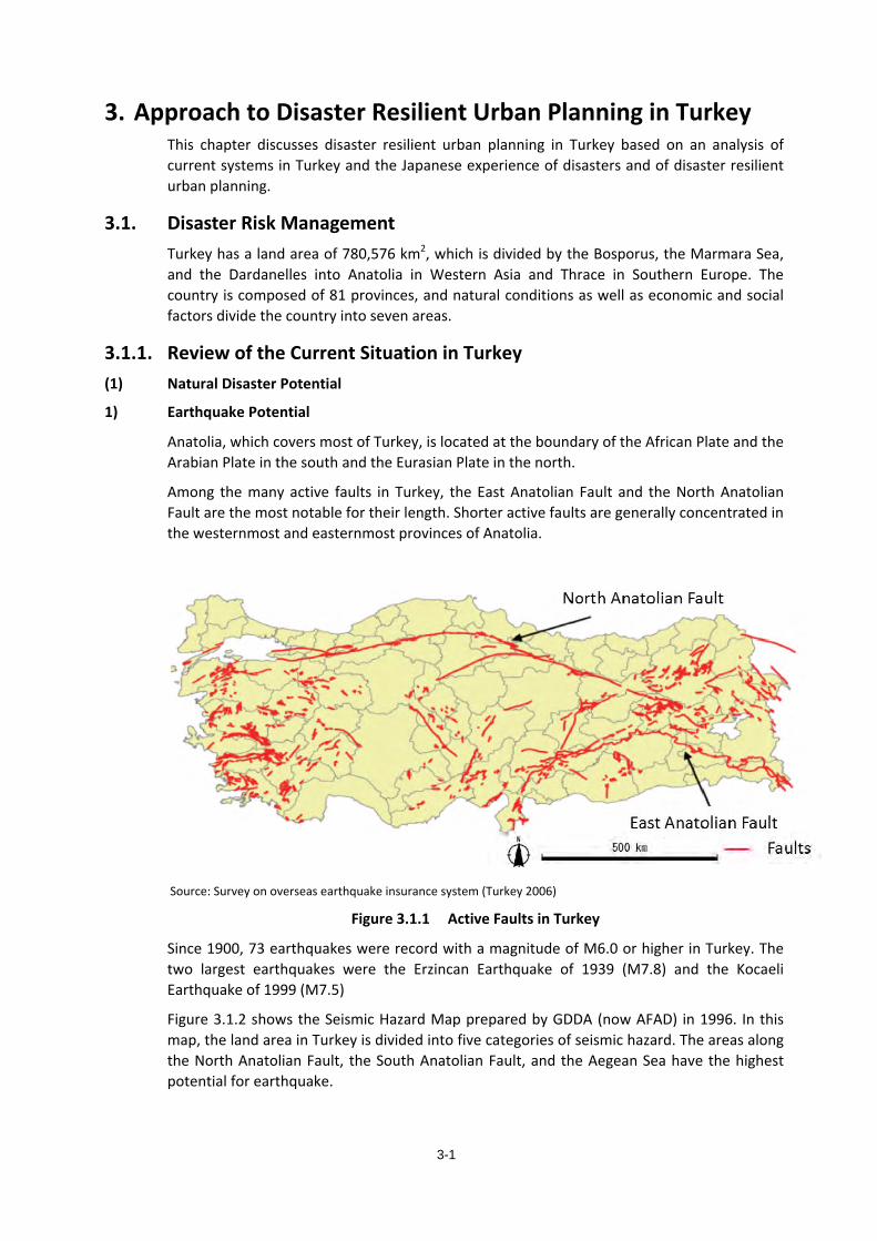
3-1
3. Approach to Disaster Resilient Urban Planning in Turkey This chapter discusses disaster resilient urban planning in Turkey based on an analysis of current systems in Turkey and the Japanese experience of disasters and of disaster resilient urban planning.
3.1. Disaster Risk Management Turkey has a land area of 780,576 km2, which is divided by the Bosporus, the Marmara Sea, and the Dardanelles into Anatolia in Western Asia and Thrace in Southern Europe. The country is composed of 81 provinces, and natural conditions as well as economic and social factors divide the country into seven areas.
3.1.1. Review of the Current Situation in Turkey (1) Natural Disaster Potential
1) Earthquake Potential
Anatolia, which covers most of Turkey, is located at the boundary of the African Plate and the Arabian Plate in the south and the Eurasian Plate in the north.
Among the many active faults in Turkey, the East Anatolian Fault and the North Anatolian Fault are the most notable for their length. Shorter active faults are generally concentrated in the westernmost and easternmost provinces of Anatolia.
Source: Survey on overseas earthquake insurance system (Turkey 2006)
Figure 3.1.1 Active Faults in Turkey
Since 1900, 73 earthquakes were record with a magnitude of M6.0 or higher in Turkey. The two largest earthquakes were the Erzincan Earthquake of 1939 (M7.8) and the Kocaeli Earthquake of 1999 (M7.5)
Figure 3.1.2 shows the Seismic Hazard Map prepared by GDDA (now AFAD) in 1996. In this map, the land area in Turkey is divided into five categories of seismic hazard. The areas along the North Anatolian Fault, the South Anatolian Fault, and the Aegean Sea have the highest potential for earthquake.
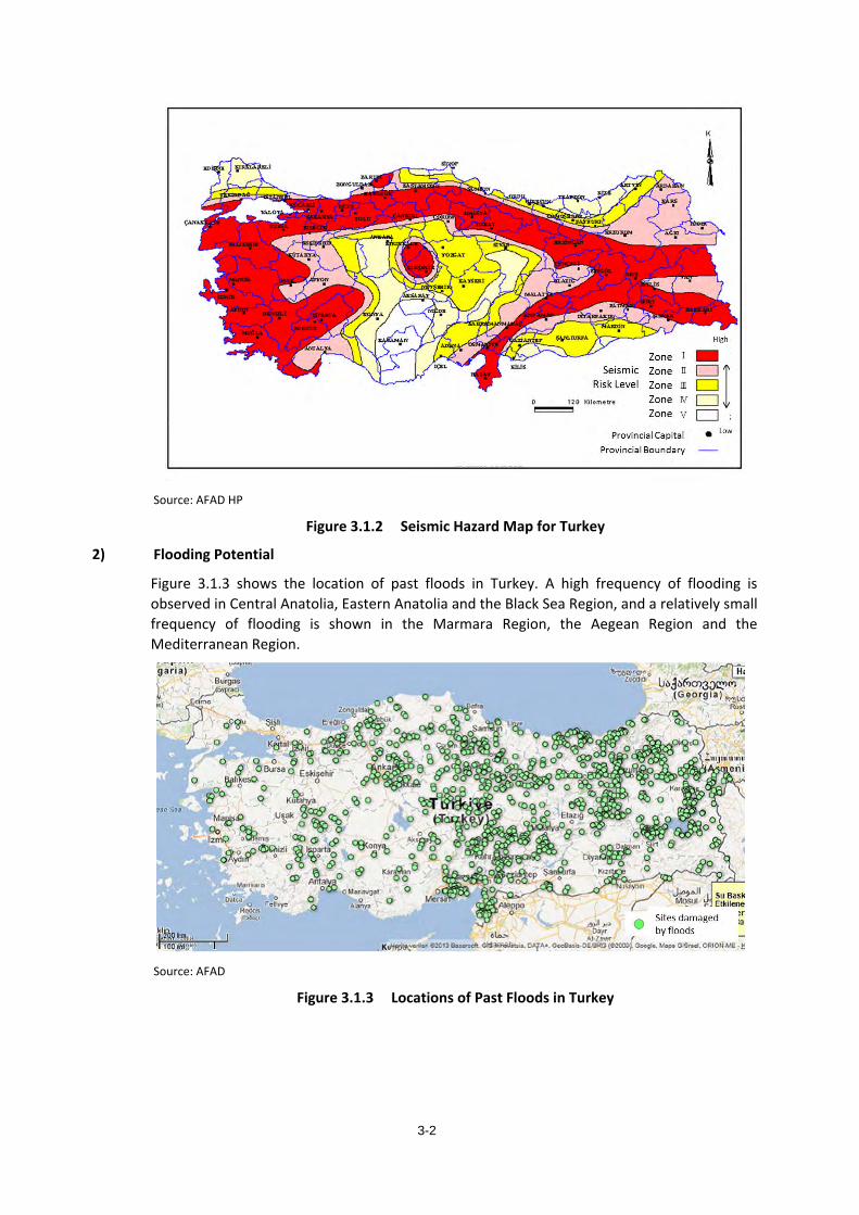
3-2
Source: AFAD HP
Figure 3.1.2 Seismic Hazard Map for Turkey
2) Flooding Potential
Figure 3.1.3 shows the location of past floods in Turkey. A high frequency of flooding is observed in Central Anatolia, Eastern Anatolia and the Black Sea Region, and a relatively small frequency of flooding is shown in the Marmara Region, the Aegean Region and the Mediterranean Region.
Source: AFAD
Figure 3.1.3 Locations of Past Floods in Turkey
3-3
3) Other Natural Disasters
The following table summarizes the risks from other natural disasters.
Type of Disaster Potential Area
Tsunami Five tsunamis have been recorded since 1900, one of which was caused by the 1999 Kocaeli Earthquake. The other four tsunamis were caused by earthquakes in the Black Sea.
Landslide Landslides are common along the coastal area of the Black Sea and in mountainous areas of Eastern Anatolia.
Rockfall Rockfalls occur over the entire country, although they are concentrated in the mountainous areas of central Anatolia.
Avalanche Avalanches are typically limited to eastern Anatolia and some parts of the Black Sea area.
Volcanic Eruption
Very few volcanic eruptions have occurred in recent years and no statistics on volcanic activities were identified.
(2) Distribution of Population and Metropolises
In 2013 the population in Turkey was approximately 76.5 million. Due to the tendency for the urban populations to steadily increase over time, there are significant differences between population sizes in metropolitan areas, and rural areas.
Also in 2013, 20 of the 81 provinces had over one million inhabitants, and together these 20 provinces accounted for 66% of the total national population. The province with the largest population in 2013 was Istanbul with approximately 14 million people. After Istanbul, the second largest population was in Ankara with 5.1 million, Izmir was third with 4.1 million, Bursa was fourth with 2.7 million, and Antalya was fifth with 2.2 million. Of these top five most populated provinces, the top four are concentrated in the northwest of the country. As a comparison, the two provinces with the least inhabitants are Tunceli with 86,000 inhabitants, and Bayburt with 75,000 inhabitants. There are fewer inhabitants in Tunceli and Bayburt than in most districts of the larger provinces.
Economic activities are concentrated in the largest cities and the five most populated provinces contribute 55.5% of the country’s GVA. This has caused a difference in the development and status of the social infrastructure.
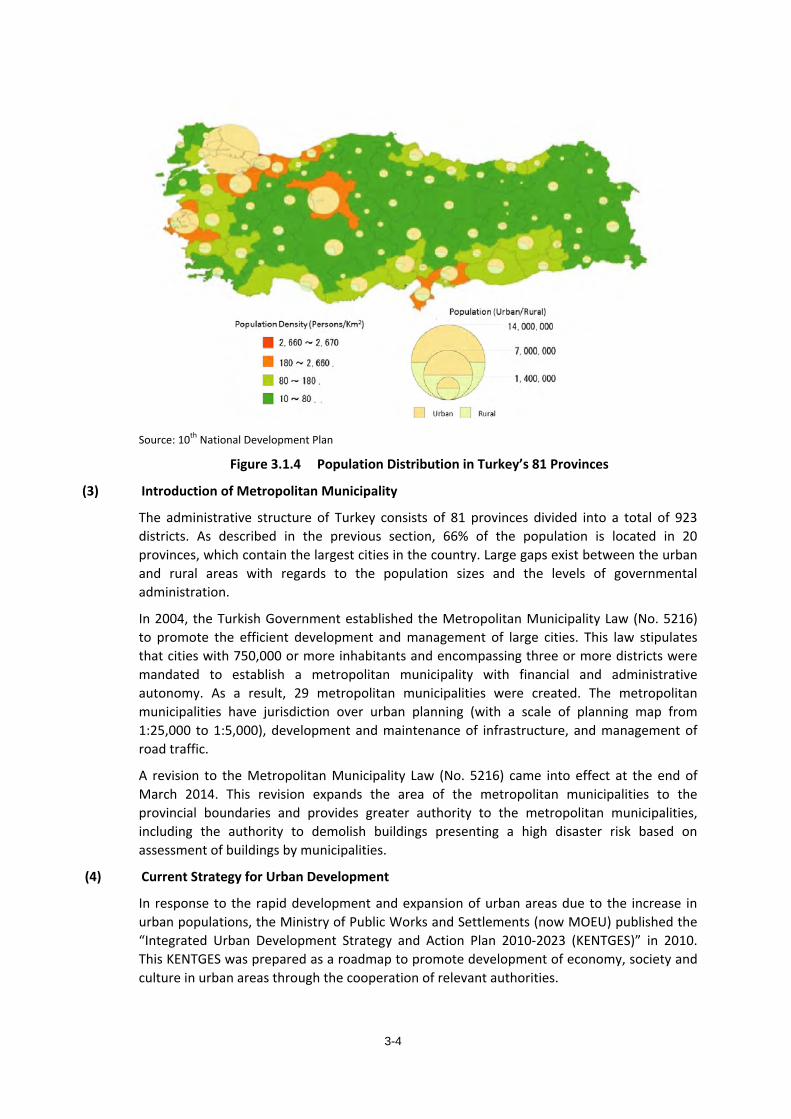
3-4
Source: 10th National Development Plan
Figure 3.1.4 Population Distribution in Turkey’s 81 Provinces
(3) Introduction of Metropolitan Municipality
The administrative structure of Turkey consists of 81 provinces divided into a total of 923 districts. As described in the previous section, 66% of the population is located in 20 provinces, which contain the largest cities in the country. Large gaps exist between the urban and rural areas with regards to the population sizes and the levels of governmental administration.
In 2004, the Turkish Government established the Metropolitan Municipality Law (No. 5216) to promote the efficient development and management of large cities. This law stipulates that cities with 750,000 or more inhabitants and encompassing three or more districts were mandated to establish a metropolitan municipality with financial and administrative autonomy. As a result, 29 metropolitan municipalities were created. The metropolitan municipalities have jurisdiction over urban planning (with a scale of planning map from 1:25,000 to 1:5,000), development and maintenance of infrastructure, and management of road traffic.
A revision to the Metropolitan Municipality Law (No. 5216) came into effect at the end of March 2014. This revision expands the area of the metropolitan municipalities to the provincial boundaries and provides greater authority to the metropolitan municipalities, including the authority to demolish buildings presenting a high disaster risk based on assessment of buildings by municipalities.
(4) Current Strategy for Urban Development
In response to the rapid development and expansion of urban areas due to the increase in urban populations, the Ministry of Public Works and Settlements (now MOEU) published the “Integrated Urban Development Strategy and Action Plan 2010-2023 (KENTGES)” in 2010. This KENTGES was prepared as a roadmap to promote development of economy, society and culture in urban areas through the cooperation of relevant authorities.
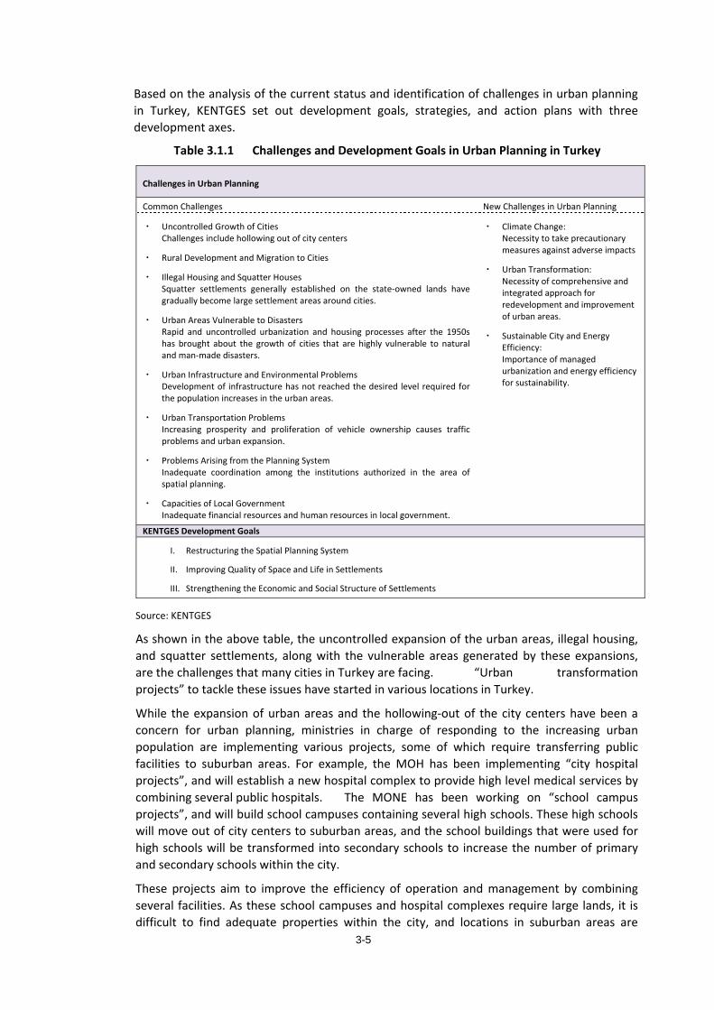
3-5
Based on the analysis of the current status and identification of challenges in urban planning in Turkey, KENTGES set out development goals, strategies, and action plans with three development axes.
Table 3.1.1 Challenges and Development Goals in Urban Planning in Turkey
Challenges in Urban Planning
Common Challenges New Challenges in Urban Planning
・ Uncontrolled Growth of Cities Challenges include hollowing out of city centers
・ Rural Development and Migration to Cities
・ Illegal Housing and Squatter Houses Squatter settlements generally established on the state-owned lands have gradually become large settlement areas around cities.
・ Urban Areas Vulnerable to Disasters Rapid and uncontrolled urbanization and housing processes after the 1950s has brought about the growth of cities that are highly vulnerable to natural and man-made disasters.
・ Urban Infrastructure and Environmental Problems Development of infrastructure has not reached the desired level required for the population increases in the urban areas.
・ Urban Transportation Problems Increasing prosperity and proliferation of vehicle ownership causes traffic problems and urban expansion.
・ Problems Arising from the Planning System Inadequate coordination among the institutions authorized in the area of spatial planning.
・ Capacities of Local Government Inadequate financial resources and human resources in local government.
・ Climate Change: Necessity to take precautionary measures against adverse impacts
・ Urban Transformation: Necessity of comprehensive and integrated approach for redevelopment and improvement of urban areas.
・ Sustainable City and Energy Efficiency: Importance of managed urbanization and energy efficiency for sustainability.
KENTGES Development Goals
I. Restructuring the Spatial Planning System
II. Improving Quality of Space and Life in Settlements
III. Strengthening the Economic and Social Structure of Settlements
Source: KENTGES
As shown in the above table, the uncontrolled expansion of the urban areas, illegal housing, and squatter settlements, along with the vulnerable areas generated by these expansions, are the challenges that many cities in Turkey are facing. “Urban transformation projects” to tackle these issues have started in various locations in Turkey.
While the expansion of urban areas and the hollowing-out of the city centers have been a concern for urban planning, ministries in charge of responding to the increasing urban population are implementing various projects, some of which require transferring public facilities to suburban areas. For example, the MOH has been implementing “city hospital projects”, and will establish a new hospital complex to provide high level medical services by combining several public hospitals. The MONE has been working on “school campus projects”, and will build school campuses containing several high schools. These high schools will move out of city centers to suburban areas, and the school buildings that were used for high schools will be transformed into secondary schools to increase the number of primary and secondary schools within the city.
These projects aim to improve the efficiency of operation and management by combining several facilities. As these school campuses and hospital complexes require large lands, it is difficult to find adequate properties within the city, and locations in suburban areas are
3-6
selected. There is a concern that these suburban facilities will lead to increased traffic, the expansion of urban areas, and the hollowing-out of city centers.
(5) Promotion of the Urban Transformation
The improvement of vulnerable areas, including illegal buildings and squatter settlements, has become a major focus in Turkey, and led to the “Urban Transformation Law (Law No. 6306)” approved and put into force in 2012. The MOEU is responsible for implementing this law, which aims to promote the redevelopment of areas at a high risk for disasters, the improvement of the environment of urban areas, and the prevention of the “hollowing out” of city centers.
1) Goals of this law are the following:
- To build a healthy and safe nation by the redevelopment of high-risk areas and removing high-risk buildings
- To avoid the loss of life and property due to earthquakes through removal of high-risk buildings
In addition, urban transformation through the application of this Urban Transformation Law is planned to be implemented in accordance with the following principles:
- In principle, to ensure the safety of lives buildings diagnosed as high risk buildings based on scientific techniques, should be demolished.
- Owners agreeing to demolish their high risk buildings will be offered support in financing, finding replacement houses and offices, issuing of property ownership certificates, etc.
- Implementation will be left to the initiative of the owner; the government will not intervene, in principle, other than to provide the support mentioned above.
- Agreement by two thirds of all building owners within the target area is required before implementation of building removals.
- To facilitate the implementation, local government and TOKI (Mass Housing Administration) will be the executing authorities.
Through the application of this Urban Transformation Law, efforts to improve vulnerable urban areas due to illegal buildings and squatter housing have begun by local governments such as municipalities.
To implement this Urban Transformation Law, the Department of Infrastructure and Urban Transformation (IUT) was established under MOEU in April 2013. Furthermore, provincial level IUT units under the direct control of MOEU were also established in major provinces.
3.1.2. Disaster Risk Management in Japan (1) Lessons learned from the last two disasters
In the past two decades, Japan experienced two catastrophic disasters: the Great Hanshin Earthquake in January 1995 and the Great East Japan Earthquake in March 2011. Learning from these experiences, Japan has strengthened its disaster risk management in recent years.
Major lessons learned from the Great Hanshin Awaji Earthquake include the following:
- The need for a revision of standards for earthquake-resistant structures based on the fact that many buildings were damaged or collapsed,
- The need for having a strategic center for disaster management when a disaster occurs,
3-7
based on the fact that administrative functions did not work, the transportation network was cut off, and relief supplies could not be distributed smoothly,
- The importance of coordinating self-help, community assistance, and public assistance during the reconstruction period.
On the other hand, during the Great East Japan Earthquake, less damage and few collapses of building structures happened as a result of efforts conducted after the Great Hanshin Awaji Earthquake. However, massive damage was caused by the impact of a compounded disaster. As a result, the importance of the following points was recognized for promoting an urban development in which people can live safe and worry-free lives protected against disasters of extreme severity.
Lessons learned from the Great East Japan Earthquake include the following:
- The importance of town-building with disaster prevention in mind. - Urban development that takes into consideration various compound disasters - Urban development to enhance the local ability to prevent disasters through the
cooperation between multiple organizations at each stage of development
(2) Disaster Risk Management Strategy in Japan
Through experiencing disasters of extreme severity, such as the Great Hanshin Earthquake and the Great East Japan Earthquake, Japan is aiming to build a disaster resistant and resilient society by developing and taking risk mitigation measures at every stage (phase) of any field (sector) in a comprehensive, synthetic, and continual manner, assuming that disasters of various scales will occur.
A disaster-resilient society can be rephrased as a society that will not suffer irreversible damage, can minimize damage, and can quickly recover from a disaster.
1
Urban planning is the main tool to effectively shape a disaster-resilient society, as it integrates facilities, networks, and communities.
In Japan, national land development efforts should incorporate disaster risk management, which can be summarized in the following three perspectives:
1) Disaster Risk Mitigation
Bases on the experiences gained from serious disasters, the main goal of disaster mitigation is to ensure the sustainability and continuity of people’s lives and business activities after a disaster, which is accomplished by limiting the effects of a disaster through:
- Improvement of the public preparedness for disaster through strengthening disaster prevention education and preparation activities such as preparation of hazard map, etc.
- Retrofitting existing high risk infrastructure and buildings based on the identification of vulnerable areas, in order to reduce damage to peoples’ lives and industrial activities when compound disasters occur.
1 JICA Research Report “Mainstreaming of Disaster Prevention”, March 2013

3-8
- Planning infrastructures and systems that will function during and after a disaster, i.e. infrastructures and systems that ought to remain intact after a disaster, including: urban infrastructure (roads, ports, energy supply plants, railways, evacuation spaces, etc.), institutional organizations (government and private sector), medical services, and corporate activities
2) Compact Cities
At the city level, a shift from a scattered-function urban structure to a concentrated-function urban structure (a compact city) has become a global trend for sustainable development, for its increased economic advantages, respect for the environment, and social benefits including safety and worry-free communities.
When creating a vision of a future town toward a concentrated-function urban structure, efforts to re-build a community and to re-structure towns and urban areas with the following considerations have become more and more important in Japan:
- Concentrating critical urban functions in places of low disaster risk level.
- Establishment of a city center with a high concentration of traffic nodes with the TOD concept.
- Enhancing the safety of areas where critical functions are concentrated
3) Environmentally Friendly Energy Management
In the Great East Japan Earthquake, the ensuing nuclear power plant accident caused a shortage of electricity, alerting the public to the weakness of the current electricity supply system. Energy management for Disaster Risk Management includes:
- Reducing electricity usage through energy saving,
- Ensuring reliable emergency power supplies at the local community scale during a disaster,
- Complementing the mainstream electricity generation system with a system of readily available energy sources within a community, such as solar power, and
Coordinating planning and operation of energy supply and demand systems among the relevant stakeholders. Japan focuses on establishing “smart communities” into a comprehensive and cross-sectional plan against disasters at the national, regional, provincial, district, city and town levels to allow for effective coordination and response in times of disasters.
(3) Lessons related to Urban Planning learned from the Great East Japan Earthquake
The table below presents major challenges and lessons learned for urban planning, based on the Great East Japan Earthquake.
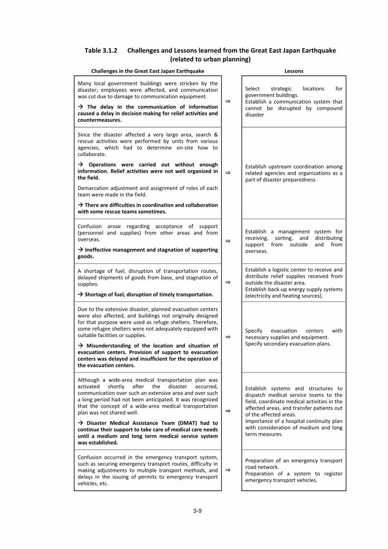
3-9
Table 3.1.2 Challenges and Lessons learned from the Great East Japan Earthquake (related to urban planning)
Challenges in the Great East Japan Earthquake Lessons
Many local government buildings were stricken by the disaster; employees were affected, and communication was cut due to damage to communication equipment.
The delay in the communication of information caused a delay in decision making for relief activities and countermeasures.
⇒
Select strategic locations for government buildings. Establish a communication system that cannot be disrupted by compound disaster
Since the disaster affected a very large area, search & rescue activities were performed by units from various agencies, which had to determine on-site how to collaborate.
Operations were carried out without enough information. Relief activities were not well organized in the field.
Demarcation adjustment and assignment of roles of each team were made in the field.
There are difficulties in coordination and collaboration with some rescue teams sometimes.
⇒ Establish upstream coordination among related agencies and organizations as a part of disaster preparedness
Confusion arose regarding acceptance of support (personnel and supplies) from other areas and from overseas.
Ineffective management and stagnation of supporting goods.
⇒
Establish a management system for receiving, sorting, and distributing support from outside and from overseas.
A shortage of fuel, disruption of transportation routes, delayed shipments of goods from base, and stagnation of supplies.
Shortage of fuel, disruption of timely transportation.
⇒
Establish a logistic center to receive and distribute relief supplies received from outside the disaster area. Establish back-up energy supply systems (electricity and heating sources).
Due to the extensive disaster, planned evacuation centers were also affected, and buildings not originally designed for that purpose were used as refuge shelters. Therefore, some refugee shelters were not adequately equipped with suitable facilities or supplies.
Misunderstanding of the location and situation of evacuation centers. Provision of support to evacuation centers was delayed and insufficient for the operation of the evacuation centers.
⇒ Specify evacuation centers with necessary supplies and equipment. Specify secondary evacuation plans.
Although a wide-area medical transportation plan was activated shortly after the disaster occurred, communication over such an extensive area and over such a long period had not been anticipated. It was recognized that the concept of a wide-area medical transportation plan was not shared well.
Disaster Medical Assistance Team (DMAT) had to continue their support to take care of medical care needs until a medium and long term medical service system was established.
⇒
Establish systems and structures to dispatch medical service teams to the field, coordinate medical activities in the affected areas, and transfer patients out of the affected areas. Importance of a hospital continuity plan with consideration of medium and long term measures.
Confusion occurred in the emergency transport system, such as securing emergency transport routes, difficulty in making adjustments to multiple transport methods, and delays in the issuing of permits to emergency transport vehicles, etc.
⇒
Preparation of an emergency transport road network. Preparation of a system to register emergency transport vehicles.
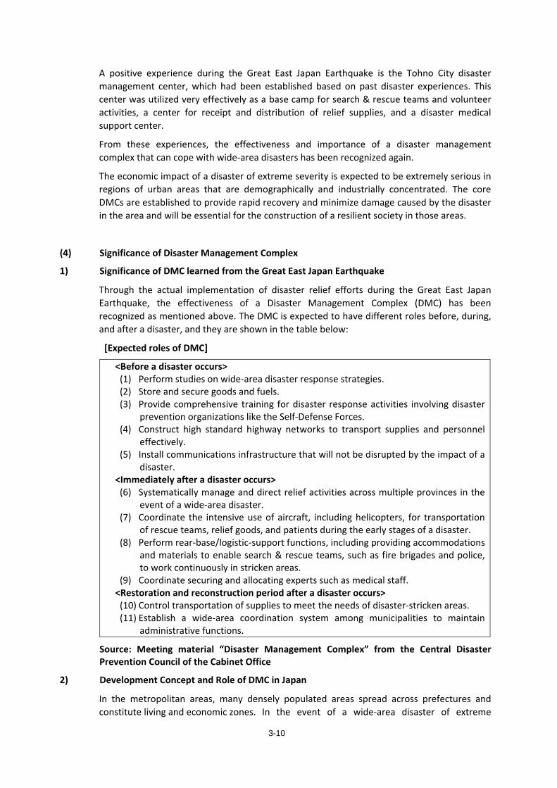
3-10
A positive experience during the Great East Japan Earthquake is the Tohno City disaster management center, which had been established based on past disaster experiences. This center was utilized very effectively as a base camp for search & rescue teams and volunteer activities, a center for receipt and distribution of relief supplies, and a disaster medical support center.
From these experiences, the effectiveness and importance of a disaster management complex that can cope with wide-area disasters has been recognized again.
The economic impact of a disaster of extreme severity is expected to be extremely serious in regions of urban areas that are demographically and industrially concentrated. The core DMCs are established to provide rapid recovery and minimize damage caused by the disaster in the area and will be essential for the construction of a resilient society in those areas.
(4) Significance of Disaster Management Complex
1) Significance of DMC learned from the Great East Japan Earthquake
Through the actual implementation of disaster relief efforts during the Great East Japan Earthquake, the effectiveness of a Disaster Management Complex (DMC) has been recognized as mentioned above. The DMC is expected to have different roles before, during, and after a disaster, and they are shown in the table below:
[Expected roles of DMC]
<Before a disaster occurs> (1) Perform studies on wide-area disaster response strategies. (2) Store and secure goods and fuels. (3) Provide comprehensive training for disaster response activities involving disaster
prevention organizations like the Self-Defense Forces. (4) Construct high standard highway networks to transport supplies and personnel
effectively. (5) Install communications infrastructure that will not be disrupted by the impact of a
disaster. <Immediately after a disaster occurs> (6) Systematically manage and direct relief activities across multiple provinces in the
event of a wide-area disaster. (7) Coordinate the intensive use of aircraft, including helicopters, for transportation
of rescue teams, relief goods, and patients during the early stages of a disaster. (8) Perform rear-base/logistic-support functions, including providing accommodations
and materials to enable search & rescue teams, such as fire brigades and police, to work continuously in stricken areas.
(9) Coordinate securing and allocating experts such as medical staff. <Restoration and reconstruction period after a disaster occurs> (10) Control transportation of supplies to meet the needs of disaster-stricken areas. (11) Establish a wide-area coordination system among municipalities to maintain
administrative functions.
Source: Meeting material “Disaster Management Complex” from the Central Disaster Prevention Council of the Cabinet Office
2) Development Concept and Role of DMC in Japan
In the metropolitan areas, many densely populated areas spread across prefectures and constitute living and economic zones. In the event of a wide-area disaster of extreme
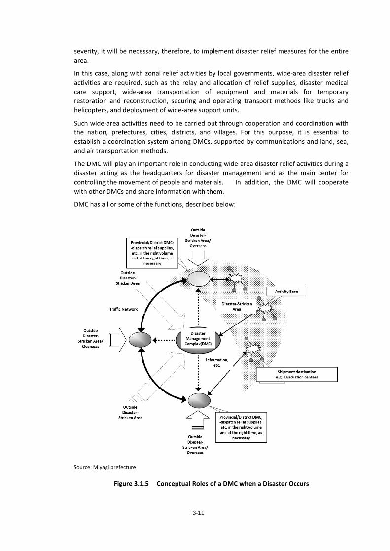
3-11
severity, it will be necessary, therefore, to implement disaster relief measures for the entire area.
In this case, along with zonal relief activities by local governments, wide-area disaster relief activities are required, such as the relay and allocation of relief supplies, disaster medical care support, wide-area transportation of equipment and materials for temporary restoration and reconstruction, securing and operating transport methods like trucks and helicopters, and deployment of wide-area support units.
Such wide-area activities need to be carried out through cooperation and coordination with the nation, prefectures, cities, districts, and villages. For this purpose, it is essential to establish a coordination system among DMCs, supported by communications and land, sea, and air transportation methods.
The DMC will play an important role in conducting wide-area disaster relief activities during a disaster acting as the headquarters for disaster management and as the main center for controlling the movement of people and materials. In addition, the DMC will cooperate with other DMCs and share information with them.
DMC has all or some of the functions, described below:
Source: Miyagi prefecture
Figure 3.1.5 Conceptual Roles of a DMC when a Disaster Occurs
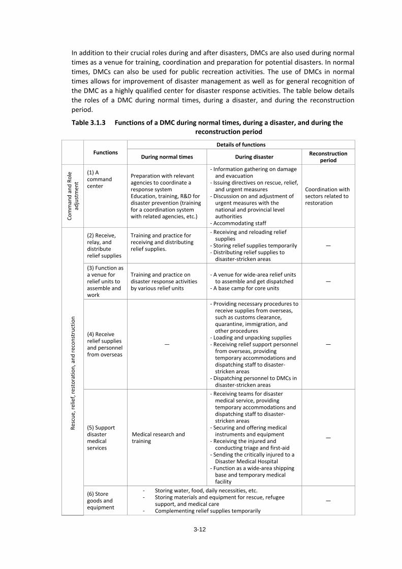
3-12
In addition to their crucial roles during and after disasters, DMCs are also used during normal times as a venue for training, coordination and preparation for potential disasters. In normal times, DMCs can also be used for public recreation activities. The use of DMCs in normal times allows for improvement of disaster management as well as for general recognition of the DMC as a highly qualified center for disaster response activities. The table below details the roles of a DMC during normal times, during a disaster, and during the reconstruction period.
Table 3.1.3 Functions of a DMC during normal times, during a disaster, and during the reconstruction period
Functions Details of functions
During normal times During disaster Reconstruction period
Com
man
d an
d Ro
le
adju
stm
ent
(1) A command center
Preparation with relevant agencies to coordinate a response system Education, training, R&D for disaster prevention (training for a coordination system with related agencies, etc.)
- Information gathering on damage and evacuation
- Issuing directives on rescue, relief, and urgent measures
- Discussion on and adjustment of urgent measures with the national and provincial level authorities
- Accommodating staff
Coordination with sectors related to restoration
Resc
ue, r
elie
f, re
stor
atio
n, a
nd re
cons
truc
tion
(2) Receive, relay, and distribute relief supplies
Training and practice for receiving and distributing relief supplies.
- Receiving and reloading relief supplies
- Storing relief supplies temporarily - Distributing relief supplies to
disaster-stricken areas
―
(3) Function as a venue for relief units to assemble and work
Training and practice on disaster response activities by various relief units
- A venue for wide-area relief units to assemble and get dispatched
- A base camp for core units ―
(4) Receive relief supplies and personnel from overseas
―
- Providing necessary procedures to receive supplies from overseas, such as customs clearance, quarantine, immigration, and other procedures
- Loading and unpacking supplies - Receiving relief support personnel
from overseas, providing temporary accommodations and dispatching staff to disaster-stricken areas
- Dispatching personnel to DMCs in disaster-stricken areas
―
(5) Support disaster medical services
Medical research and training
- Receiving teams for disaster medical service, providing temporary accommodations and dispatching staff to disaster-stricken areas
- Securing and offering medical instruments and equipment
- Receiving the injured and conducting triage and first-aid
- Sending the critically injured to a Disaster Medical Hospital
- Function as a wide-area shipping base and temporary medical facility
―
(6) Store goods and equipment
- Storing water, food, daily necessities, etc.- Storing materials and equipment for rescue, refugee
support, and medical care - Complementing relief supplies temporarily
―
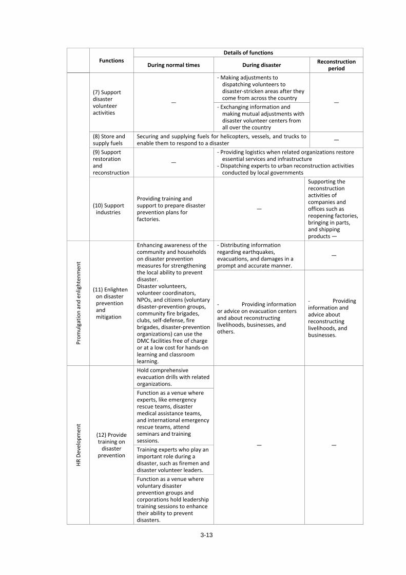
3-13
Functions Details of functions
During normal times During disaster Reconstruction period
(7) Support disaster volunteer activities
―
- Making adjustments to dispatching volunteers to disaster-stricken areas after they come from across the country
― - Exchanging information and
making mutual adjustments with disaster volunteer centers from all over the country
(8) Store and supply fuels
Securing and supplying fuels for helicopters, vessels, and trucks to enable them to respond to a disaster ―
(9) Support restoration and reconstruction
―
- Providing logistics when related organizations restore essential services and infrastructure
- Dispatching experts to urban reconstruction activities conducted by local governments
(10) Support industries
Providing training and support to prepare disaster prevention plans for factories.
―
Supporting the reconstruction activities of companies and offices such as reopening factories, bringing in parts, and shipping products ―
Prom
ulga
tion
and
enlig
hten
men
t
(11) Enlighten on disaster prevention and mitigation
Enhancing awareness of the community and households on disaster prevention measures for strengthening the local ability to prevent disaster. Disaster volunteers, volunteer coordinators, NPOs, and citizens (voluntary disaster-prevention groups, community fire brigades, clubs, self-defense, fire brigades, disaster-prevention organizations) can use the DMC facilities free of charge or at a low cost for hands-on learning and classroom learning.
- Distributing information regarding earthquakes, evacuations, and damages in a prompt and accurate manner.
―
- Providing information or advice on evacuation centers and about reconstructing livelihoods, businesses, and others.
- Providing information and advice about reconstructing livelihoods, and businesses.
HR D
evel
opm
ent
(12) Provide training on
disaster prevention
Hold comprehensive evacuation drills with related organizations.
― ―
Function as a venue where experts, like emergency rescue teams, disaster medical assistance teams, and international emergency rescue teams, attend seminars and training sessions. Training experts who play an important role during a disaster, such as firemen and disaster volunteer leaders.Function as a venue where voluntary disaster prevention groups and corporations hold leadership training sessions to enhance their ability to prevent disasters.
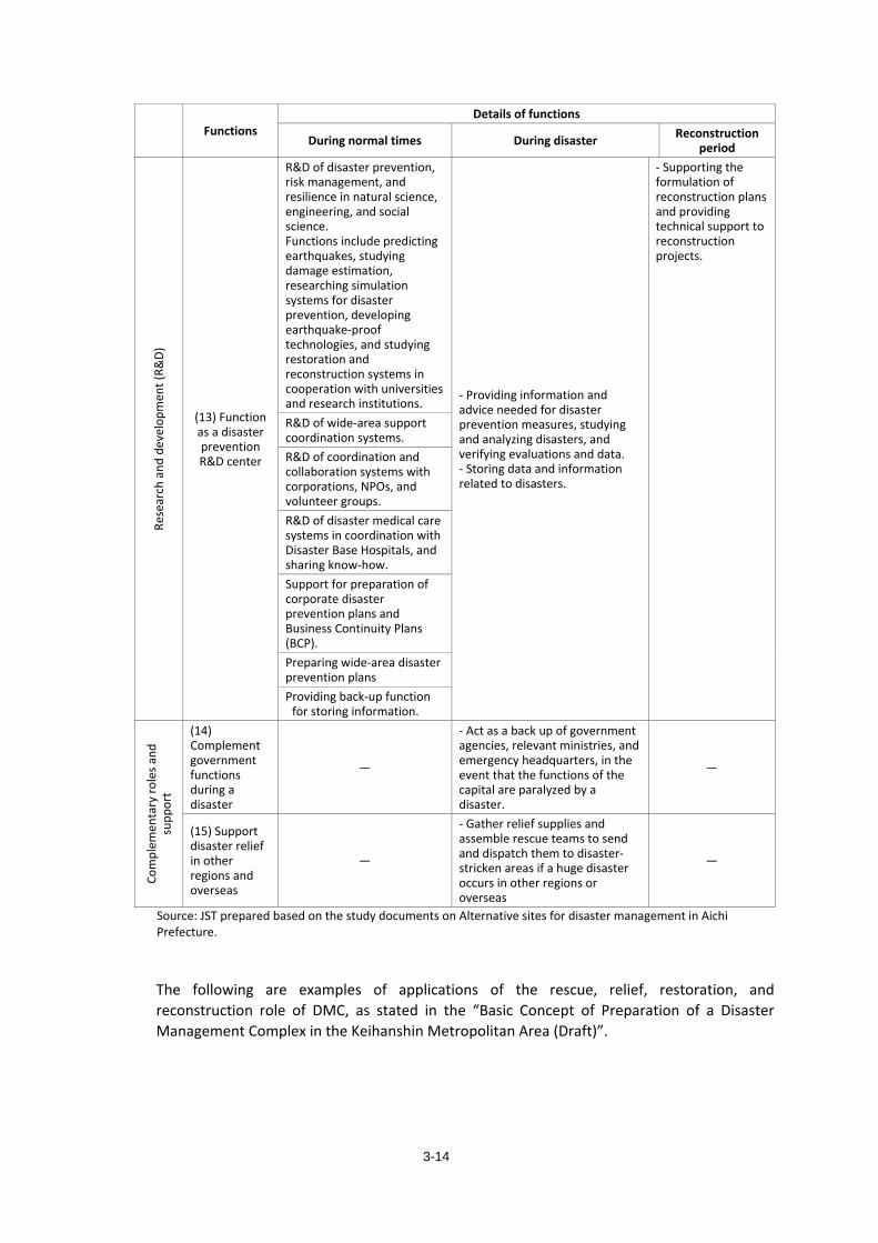
3-14
Functions Details of functions
During normal times During disaster Reconstruction period
Rese
arch
and
dev
elop
men
t (R&
D)
(13) Function as a disaster prevention R&D center
R&D of disaster prevention, risk management, and resilience in natural science, engineering, and social science. Functions include predicting earthquakes, studying damage estimation, researching simulation systems for disaster prevention, developing earthquake-proof technologies, and studying restoration and reconstruction systems in cooperation with universities and research institutions.
- Providing information and advice needed for disaster prevention measures, studying and analyzing disasters, and verifying evaluations and data. - Storing data and information related to disasters.
- Supporting the formulation of reconstruction plans and providing technical support to reconstruction projects.
R&D of wide-area support coordination systems.R&D of coordination and collaboration systems with corporations, NPOs, and volunteer groups.R&D of disaster medical care systems in coordination with Disaster Base Hospitals, and sharing know-how.Support for preparation of corporate disaster prevention plans and Business Continuity Plans (BCP). Preparing wide-area disaster prevention plansProviding back-up function
for storing information.
Com
plem
enta
ry ro
les a
nd
supp
ort
(14) Complement government functions during a disaster
―
- Act as a back up of government agencies, relevant ministries, and emergency headquarters, in the event that the functions of the capital are paralyzed by a disaster.
―
(15) Support disaster relief in other regions and overseas
―
- Gather relief supplies and assemble rescue teams to send and dispatch them to disaster-stricken areas if a huge disaster occurs in other regions or overseas
―
Source: JST prepared based on the study documents on Alternative sites for disaster management in Aichi Prefecture.
The following are examples of applications of the rescue, relief, restoration, and reconstruction role of DMC, as stated in the “Basic Concept of Preparation of a Disaster Management Complex in the Keihanshin Metropolitan Area (Draft)”.
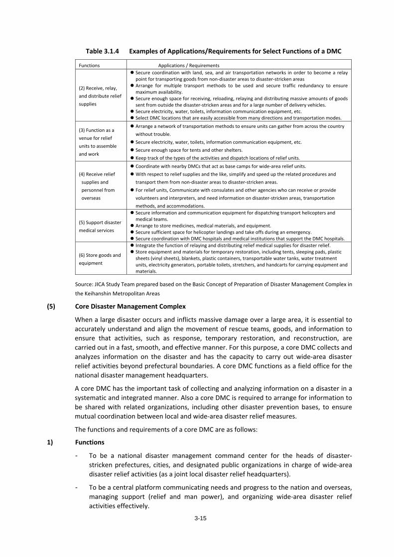
3-15
Table 3.1.4 Examples of Applications/Requirements for Select Functions of a DMC
Functions Applications / Requirements
(2) Receive, relay, and distribute relief supplies
Secure coordination with land, sea, and air transportation networks in order to become a relay point for transporting goods from non-disaster areas to disaster-stricken areas
Arrange for multiple transport methods to be used and secure traffic redundancy to ensure maximum availability.
Secure enough space for receiving, reloading, relaying and distributing massive amounts of goods sent from outside the disaster-stricken areas and for a large number of delivery vehicles.
Secure electricity, water, toilets, information communication equipment, etc. Select DMC locations that are easily accessible from many directions and transportation modes.
(3) Function as a venue for relief units to assemble and work
Arrange a network of transportation methods to ensure units can gather from across the country without trouble.
Secure electricity, water, toilets, information communication equipment, etc. Secure enough space for tents and other shelters. Keep track of the types of the activities and dispatch locations of relief units.
(4) Receive relief supplies and personnel from overseas
Coordinate with nearby DMCs that act as base camps for wide-area relief units. With respect to relief supplies and the like, simplify and speed up the related procedures and
transport them from non-disaster areas to disaster-stricken areas. For relief units, Communicate with consulates and other agencies who can receive or provide
volunteers and interpreters, and need information on disaster-stricken areas, transportation methods, and accommodations.
(5) Support disaster medical services
Secure information and communication equipment for dispatching transport helicopters and medical teams.
Arrange to store medicines, medical materials, and equipment. Secure sufficient space for helicopter landings and take offs during an emergency. Secure coordination with DMC hospitals and medical institutions that support the DMC hospitals.
(6) Store goods and equipment
Integrate the function of relaying and distributing relief medical supplies for disaster relief. Store equipment and materials for temporary restoration, including tents, sleeping pads, plastic
sheets (vinyl sheets), blankets, plastic containers, transportable water tanks, water treatment units, electricity generators, portable toilets, stretchers, and handcarts for carrying equipment and materials.
Source: JICA Study Team prepared based on the Basic Concept of Preparation of Disaster Management Complex in the Keihanshin Metropolitan Areas
(5) Core Disaster Management Complex
When a large disaster occurs and inflicts massive damage over a large area, it is essential to accurately understand and align the movement of rescue teams, goods, and information to ensure that activities, such as response, temporary restoration, and reconstruction, are carried out in a fast, smooth, and effective manner. For this purpose, a core DMC collects and analyzes information on the disaster and has the capacity to carry out wide-area disaster relief activities beyond prefectural boundaries. A core DMC functions as a field office for the national disaster management headquarters.
A core DMC has the important task of collecting and analyzing information on a disaster in a systematic and integrated manner. Also a core DMC is required to arrange for information to be shared with related organizations, including other disaster prevention bases, to ensure mutual coordination between local and wide-area disaster relief measures.
The functions and requirements of a core DMC are as follows:
1) Functions
- To be a national disaster management command center for the heads of disaster-stricken prefectures, cities, and designated public organizations in charge of wide-area disaster relief activities (as a joint local disaster relief headquarters).
- To be a central platform communicating needs and progress to the nation and overseas, managing support (relief and man power), and organizing wide-area disaster relief activities effectively.
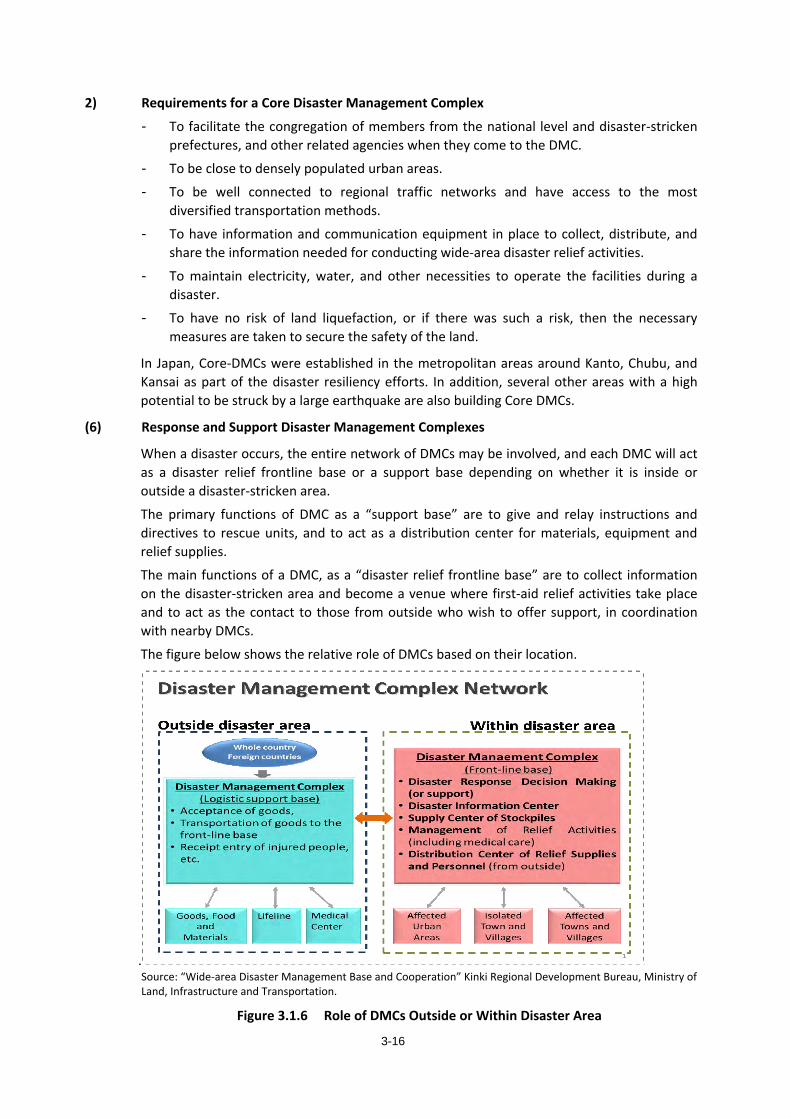
3-16
2) Requirements for a Core Disaster Management Complex
- To facilitate the congregation of members from the national level and disaster-stricken prefectures, and other related agencies when they come to the DMC.
- To be close to densely populated urban areas.
- To be well connected to regional traffic networks and have access to the most diversified transportation methods.
- To have information and communication equipment in place to collect, distribute, and share the information needed for conducting wide-area disaster relief activities.
- To maintain electricity, water, and other necessities to operate the facilities during a disaster.
- To have no risk of land liquefaction, or if there was such a risk, then the necessary measures are taken to secure the safety of the land.
In Japan, Core-DMCs were established in the metropolitan areas around Kanto, Chubu, and Kansai as part of the disaster resiliency efforts. In addition, several other areas with a high potential to be struck by a large earthquake are also building Core DMCs.
(6) Response and Support Disaster Management Complexes
When a disaster occurs, the entire network of DMCs may be involved, and each DMC will act as a disaster relief frontline base or a support base depending on whether it is inside or outside a disaster-stricken area.
The primary functions of DMC as a “support base” are to give and relay instructions and directives to rescue units, and to act as a distribution center for materials, equipment and relief supplies.
The main functions of a DMC, as a “disaster relief frontline base” are to collect information on the disaster-stricken area and become a venue where first-aid relief activities take place and to act as the contact to those from outside who wish to offer support, in coordination with nearby DMCs.
The figure below shows the relative role of DMCs based on their location.
. Source: “Wide-area Disaster Management Base and Cooperation” Kinki Regional Development Bureau, Ministry of Land, Infrastructure and Transportation.
Figure 3.1.6 Role of DMCs Outside or Within Disaster Area
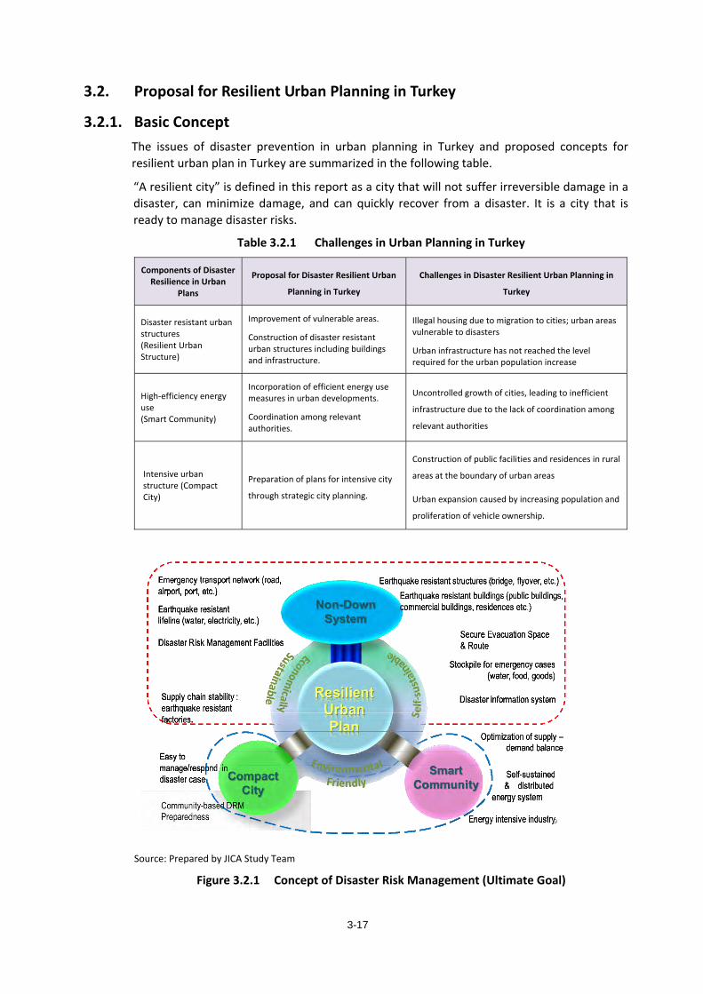
3-17
3.2. Proposal for Resilient Urban Planning in Turkey
3.2.1. Basic Concept The issues of disaster prevention in urban planning in Turkey and proposed concepts for resilient urban plan in Turkey are summarized in the following table.
“A resilient city” is defined in this report as a city that will not suffer irreversible damage in a disaster, can minimize damage, and can quickly recover from a disaster. It is a city that is ready to manage disaster risks.
Table 3.2.1 Challenges in Urban Planning in Turkey
Components of Disaster Resilience in Urban
Plans
Proposal for Disaster Resilient Urban
Planning in Turkey
Challenges in Disaster Resilient Urban Planning in
Turkey
Disaster resistant urban structures (Resilient Urban Structure)
Improvement of vulnerable areas.
Construction of disaster resistant urban structures including buildings and infrastructure.
Illegal housing due to migration to cities; urban areas vulnerable to disasters
Urban infrastructure has not reached the level required for the urban population increase
High-efficiency energy use (Smart Community)
Incorporation of efficient energy use measures in urban developments.
Coordination among relevant authorities.
Uncontrolled growth of cities, leading to inefficient
infrastructure due to the lack of coordination among
relevant authorities
Intensive urban structure (Compact City)
Preparation of plans for intensive city
through strategic city planning.
Construction of public facilities and residences in rural
areas at the boundary of urban areas
Urban expansion caused by increasing population and
proliferation of vehicle ownership.
Source: Prepared by JICA Study Team
Figure 3.2.1 Concept of Disaster Risk Management (Ultimate Goal)
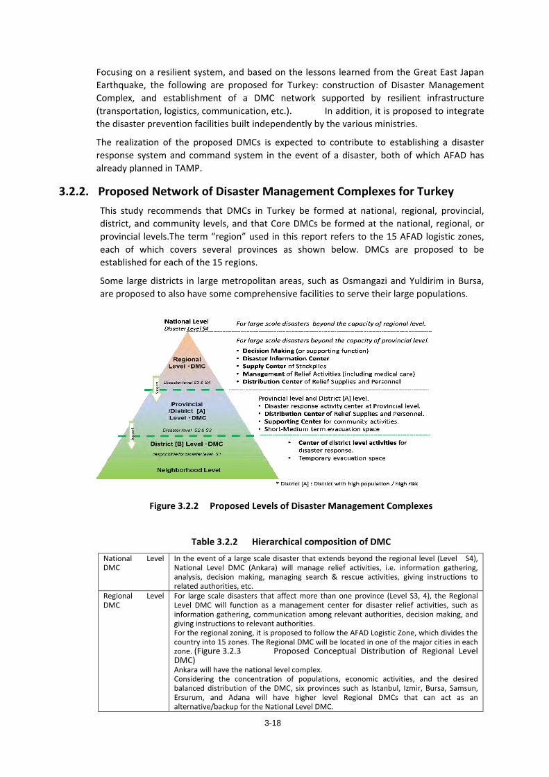
3-18
Focusing on a resilient system, and based on the lessons learned from the Great East Japan Earthquake, the following are proposed for Turkey: construction of Disaster Management Complex, and establishment of a DMC network supported by resilient infrastructure (transportation, logistics, communication, etc.). In addition, it is proposed to integrate the disaster prevention facilities built independently by the various ministries.
The realization of the proposed DMCs is expected to contribute to establishing a disaster response system and command system in the event of a disaster, both of which AFAD has already planned in TAMP.
3.2.2. Proposed Network of Disaster Management Complexes for Turkey This study recommends that DMCs in Turkey be formed at national, regional, provincial, district, and community levels, and that Core DMCs be formed at the national, regional, or provincial levels.The term “region” used in this report refers to the 15 AFAD logistic zones, each of which covers several provinces as shown below. DMCs are proposed to be established for each of the 15 regions.
Some large districts in large metropolitan areas, such as Osmangazi and Yuldirim in Bursa, are proposed to also have some comprehensive facilities to serve their large populations.
Figure 3.2.2 Proposed Levels of Disaster Management Complexes
Table 3.2.2 Hierarchical composition of DMC National Level DMC
In the event of a large scale disaster that extends beyond the regional level (Level S4), National Level DMC (Ankara) will manage relief activities, i.e. information gathering, analysis, decision making, managing search & rescue activities, giving instructions to related authorities, etc.
Regional Level DMC
For large scale disasters that affect more than one province (Level S3, 4), the Regional Level DMC will function as a management center for disaster relief activities, such as information gathering, communication among relevant authorities, decision making, and giving instructions to relevant authorities. For the regional zoning, it is proposed to follow the AFAD Logistic Zone, which divides the country into 15 zones. The Regional DMC will be located in one of the major cities in each zone. (Figure 3.2.3 Proposed Conceptual Distribution of Regional Level DMC) Ankara will have the national level complex. Considering the concentration of populations, economic activities, and the desired balanced distribution of the DMC, six provinces such as Istanbul, Izmir, Bursa, Samsun, Ersurum, and Adana will have higher level Regional DMCs that can act as an alternative/backup for the National Level DMC.
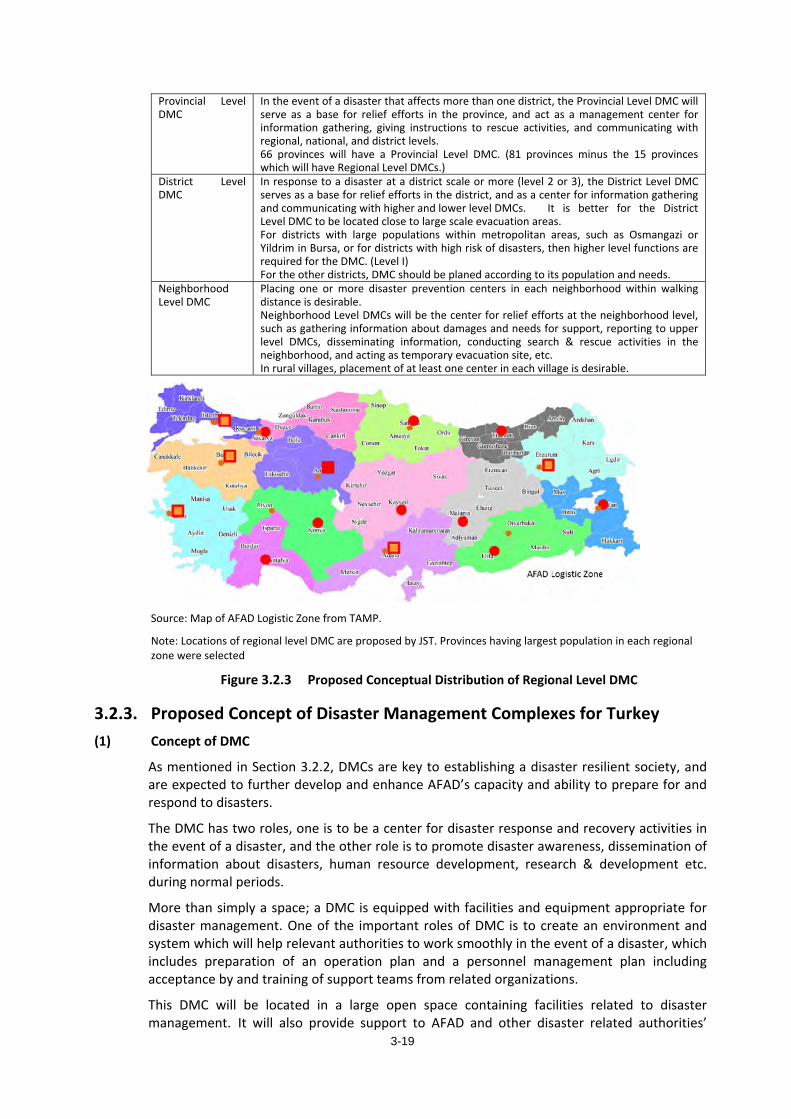
3-19
Provincial Level DMC
In the event of a disaster that affects more than one district, the Provincial Level DMC will serve as a base for relief efforts in the province, and act as a management center for information gathering, giving instructions to rescue activities, and communicating with regional, national, and district levels. 66 provinces will have a Provincial Level DMC. (81 provinces minus the 15 provinces which will have Regional Level DMCs.)
District Level DMC
In response to a disaster at a district scale or more (level 2 or 3), the District Level DMC serves as a base for relief efforts in the district, and as a center for information gathering and communicating with higher and lower level DMCs. It is better for the District Level DMC to be located close to large scale evacuation areas. For districts with large populations within metropolitan areas, such as Osmangazi or Yildrim in Bursa, or for districts with high risk of disasters, then higher level functions are required for the DMC. (Level I) For the other districts, DMC should be planed according to its population and needs.
Neighborhood Level DMC
Placing one or more disaster prevention centers in each neighborhood within walking distance is desirable. Neighborhood Level DMCs will be the center for relief efforts at the neighborhood level, such as gathering information about damages and needs for support, reporting to upper level DMCs, disseminating information, conducting search & rescue activities in the neighborhood, and acting as temporary evacuation site, etc. In rural villages, placement of at least one center in each village is desirable.
Source: Map of AFAD Logistic Zone from TAMP.
Note: Locations of regional level DMC are proposed by JST. Provinces having largest population in each regional zone were selected
Figure 3.2.3 Proposed Conceptual Distribution of Regional Level DMC
3.2.3. Proposed Concept of Disaster Management Complexes for Turkey (1) Concept of DMC
As mentioned in Section 3.2.2, DMCs are key to establishing a disaster resilient society, and are expected to further develop and enhance AFAD’s capacity and ability to prepare for and respond to disasters.
The DMC has two roles, one is to be a center for disaster response and recovery activities in the event of a disaster, and the other role is to promote disaster awareness, dissemination of information about disasters, human resource development, research & development etc. during normal periods.
More than simply a space; a DMC is equipped with facilities and equipment appropriate for disaster management. One of the important roles of DMC is to create an environment and system which will help relevant authorities to work smoothly in the event of a disaster, which includes preparation of an operation plan and a personnel management plan including acceptance by and training of support teams from related organizations.
This DMC will be located in a large open space containing facilities related to disaster management. It will also provide support to AFAD and other disaster related authorities’
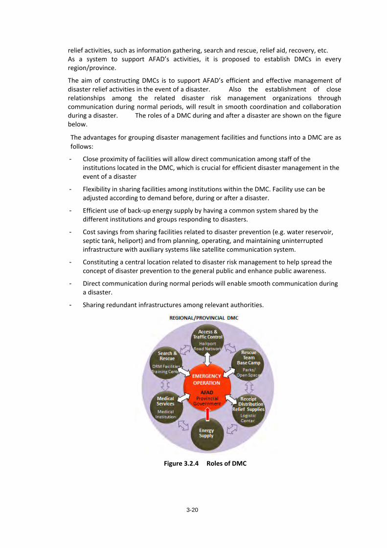
3-20
relief activities, such as information gathering, search and rescue, relief aid, recovery, etc. As a system to support AFAD’s activities, it is proposed to establish DMCs in every region/province.
The aim of constructing DMCs is to support AFAD’s efficient and effective management of disaster relief activities in the event of a disaster. Also the establishment of close relationships among the related disaster risk management organizations through communication during normal periods, will result in smooth coordination and collaboration during a disaster. The roles of a DMC during and after a disaster are shown on the figure below.
The advantages for grouping disaster management facilities and functions into a DMC are as follows:
- Close proximity of facilities will allow direct communication among staff of the institutions located in the DMC, which is crucial for efficient disaster management in the event of a disaster
- Flexibility in sharing facilities among institutions within the DMC. Facility use can be adjusted according to demand before, during or after a disaster.
- Efficient use of back-up energy supply by having a common system shared by the different institutions and groups responding to disasters.
- Cost savings from sharing facilities related to disaster prevention (e.g. water reservoir, septic tank, heliport) and from planning, operating, and maintaining uninterrupted infrastructure with auxiliary systems like satellite communication system.
- Constituting a central location related to disaster risk management to help spread the concept of disaster prevention to the general public and enhance public awareness.
- Direct communication during normal periods will enable smooth communication during a disaster.
- Sharing redundant infrastructures among relevant authorities.
Figure 3.2.4 Roles of DMC
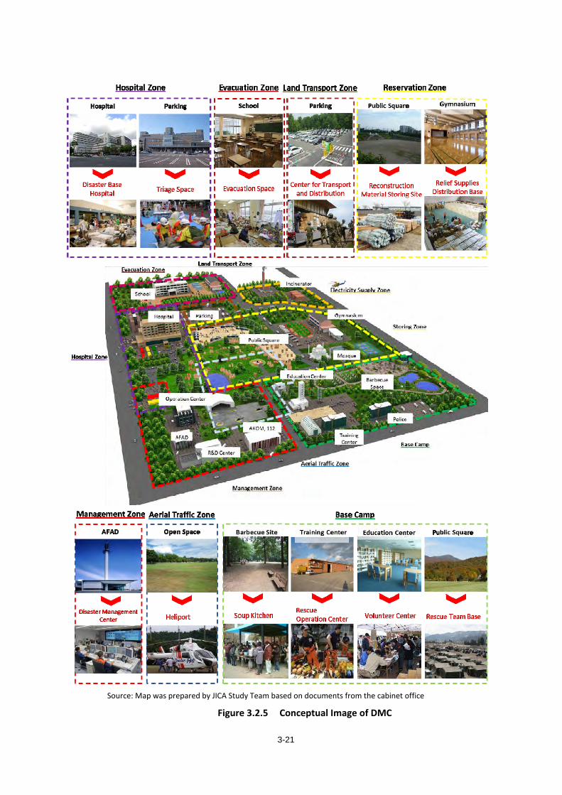
3-21
Source: Map was prepared by JICA Study Team based on documents from the cabinet office
Figure 3.2.5 Conceptual Image of DMC
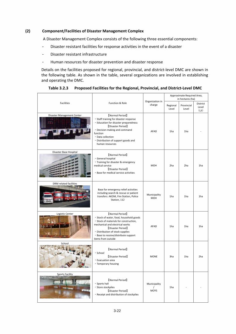
3-22
(2) Component/Facilities of Disaster Management Complex
A Disaster Management Complex consists of the following three essential components:
- Disaster resistant facilities for response activities in the event of a disaster
- Disaster resistant infrastructure
- Human resources for disaster prevention and disaster response
Details on the facilities proposed for regional, provincial, and district-level DMC are shown in the following table. As shown in the table, several organizations are involved in establishing and operating the DMC.
Table 3.2.3 Proposed Facilities for the Regional, Provincial, and District-Level DMC
Facilities Function & Role Organization in charge
Approximate Required Area, in hectares (ha)
Regional Level
Provincial Level
District Level(I,II)
Disaster Management Center
【Normal Period】 ・Staff training for disaster response ・Education for disaster preparedness
【Disaster Period】 ・Decision making and command function ・Data collection ・Distribution of support goods and
human resources
AFAD 1ha 1ha -
Disaster Base Hospital
【Normal Period】 ・General hospital ・Training for disaster & emergency medical service
【Disaster Period】 ・Base for medical service activities
MOH 2ha 2ha 1ha
DRM related facilities
Base for emergency relief activities including search & rescue or patient transfers: AKOM, Fire Station, Police
Station, 112
Municipality MOH 1ha 1ha 1ha
Logistic Center
【Normal Period】 ・Stock of water, food, household goods ・Stock of materials for construction, mechanical and electrical works
【Disaster Period】 ・Distribution of stock supplies ・Base to receive/distribute support items from outside
AFAD 1ha 1ha 1ha
School
【Normal Period】 ・School
【Disaster Period】 ・Evacuation area ・Temporary housing
MONE 3ha 1ha 2ha
Sports Facility
【Normal Period】 ・Sports hall ・Store stockpiles
【Disaster Period】 ・Receipt and distribution of stockpiles
Municipality /
MOYS 1ha - -
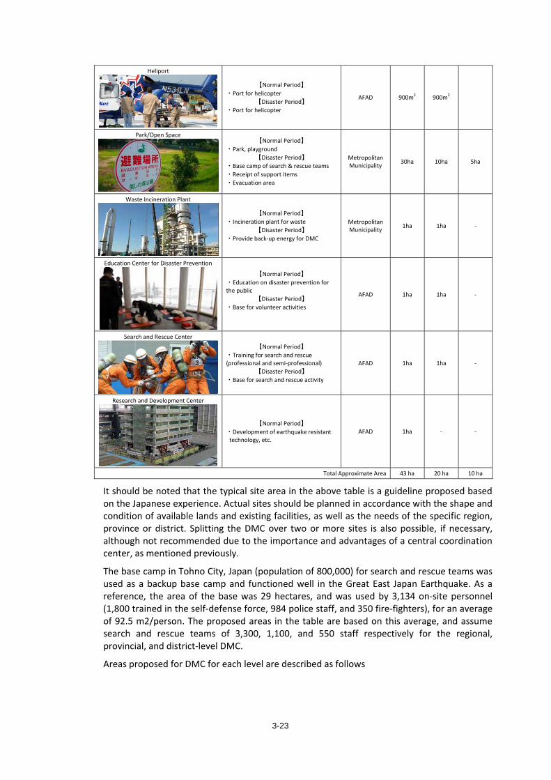
3-23
Heliport
【Normal Period】 ・Port for helicopter
【Disaster Period】 ・Port for helicopter
AFAD 900m2 900m2
Park/Open Space
【Normal Period】 ・Park, playground
【Disaster Period】 ・Base camp of search & rescue teams ・Receipt of support items ・Evacuation area
Metropolitan Municipality 30ha 10ha 5ha
Waste Incineration Plant
【Normal Period】 ・Incineration plant for waste
【Disaster Period】 ・Provide back-up energy for DMC
Metropolitan Municipality 1ha 1ha -
Education Center for Disaster Prevention
【Normal Period】 ・Education on disaster prevention for the public
【Disaster Period】 ・Base for volunteer activities
AFAD 1ha 1ha -
Search and Rescue Center
【Normal Period】 ・Training for search and rescue (professional and semi-professional)
【Disaster Period】 ・Base for search and rescue activity
AFAD 1ha 1ha -
Research and Development Center
【Normal Period】 ・Development of earthquake resistant
technology, etc. AFAD 1ha - -
Total Approximate Area 43 ha 20 ha 10 ha
It should be noted that the typical site area in the above table is a guideline proposed based on the Japanese experience. Actual sites should be planned in accordance with the shape and condition of available lands and existing facilities, as well as the needs of the specific region, province or district. Splitting the DMC over two or more sites is also possible, if necessary, although not recommended due to the importance and advantages of a central coordination center, as mentioned previously.
The base camp in Tohno City, Japan (population of 800,000) for search and rescue teams was used as a backup base camp and functioned well in the Great East Japan Earthquake. As a reference, the area of the base was 29 hectares, and was used by 3,134 on-site personnel (1,800 trained in the self-defense force, 984 police staff, and 350 fire-fighters), for an average of 92.5 m2/person. The proposed areas in the table are based on this average, and assume search and rescue teams of 3,300, 1,100, and 550 staff respectively for the regional, provincial, and district-level DMC.
Areas proposed for DMC for each level are described as follows
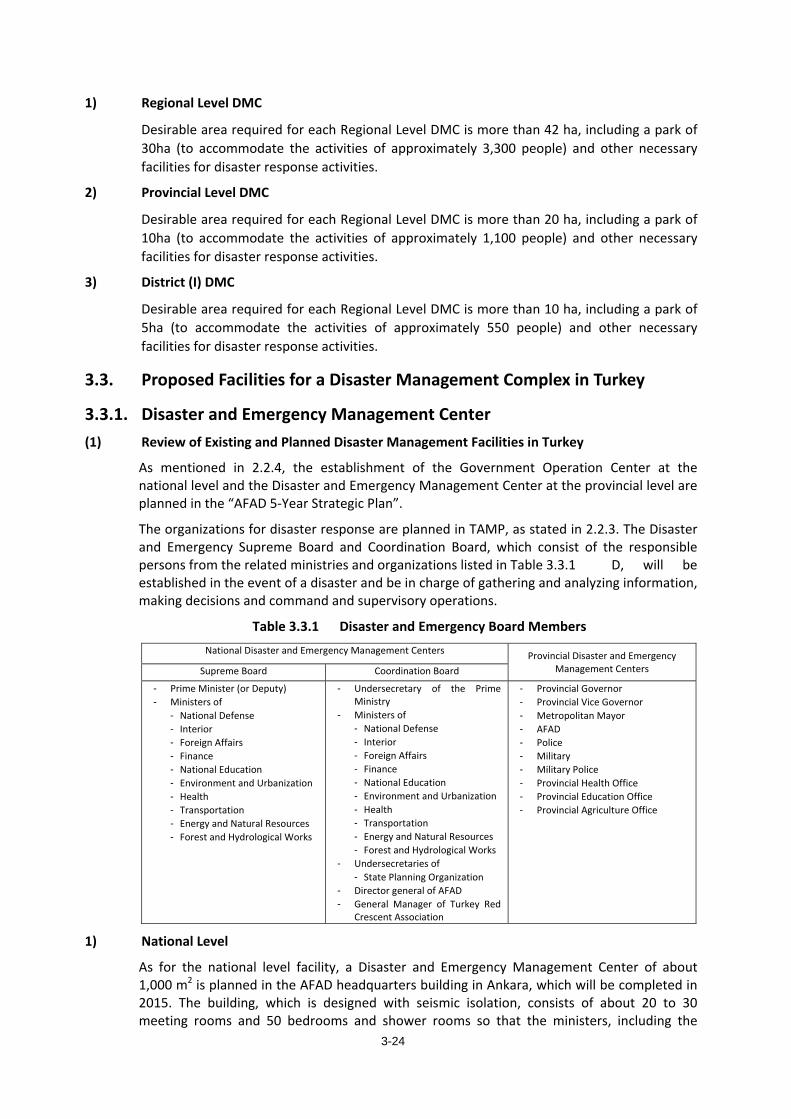
3-24
1) Regional Level DMC
Desirable area required for each Regional Level DMC is more than 42 ha, including a park of 30ha (to accommodate the activities of approximately 3,300 people) and other necessary facilities for disaster response activities.
2) Provincial Level DMC
Desirable area required for each Regional Level DMC is more than 20 ha, including a park of 10ha (to accommodate the activities of approximately 1,100 people) and other necessary facilities for disaster response activities.
3) District (I) DMC
Desirable area required for each Regional Level DMC is more than 10 ha, including a park of 5ha (to accommodate the activities of approximately 550 people) and other necessary facilities for disaster response activities.
3.3. Proposed Facilities for a Disaster Management Complex in Turkey
3.3.1. Disaster and Emergency Management Center (1) Review of Existing and Planned Disaster Management Facilities in Turkey
As mentioned in 2.2.4, the establishment of the Government Operation Center at the national level and the Disaster and Emergency Management Center at the provincial level are planned in the “AFAD 5-Year Strategic Plan”.
The organizations for disaster response are planned in TAMP, as stated in 2.2.3. The Disaster and Emergency Supreme Board and Coordination Board, which consist of the responsible persons from the related ministries and organizations listed in Table 3.3.1 D, will be established in the event of a disaster and be in charge of gathering and analyzing information, making decisions and command and supervisory operations.
Table 3.3.1 Disaster and Emergency Board Members National Disaster and Emergency Management Centers Provincial Disaster and Emergency
Management Centers Supreme Board Coordination Board
- Prime Minister (or Deputy) - Ministers of
- National Defense - Interior - Foreign Affairs - Finance - National Education - Environment and Urbanization - Health - Transportation - Energy and Natural Resources - Forest and Hydrological Works
- Undersecretary of the Prime Ministry
- Ministers of - National Defense - Interior - Foreign Affairs - Finance - National Education - Environment and Urbanization - Health - Transportation - Energy and Natural Resources - Forest and Hydrological Works
- Undersecretaries of - State Planning Organization
- Director general of AFAD - General Manager of Turkey Red
Crescent Association
- Provincial Governor - Provincial Vice Governor - Metropolitan Mayor - AFAD - Police - Military - Military Police - Provincial Health Office - Provincial Education Office - Provincial Agriculture Office
1) National Level
As for the national level facility, a Disaster and Emergency Management Center of about 1,000 m2 is planned in the AFAD headquarters building in Ankara, which will be completed in 2015. The building, which is designed with seismic isolation, consists of about 20 to 30 meeting rooms and 50 bedrooms and shower rooms so that the ministers, including the
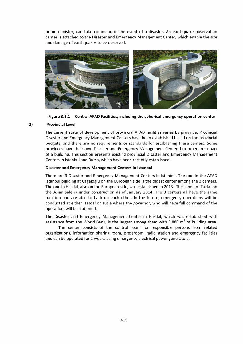
3-25
prime minister, can take command in the event of a disaster. An earthquake observation center is attached to the Disaster and Emergency Management Center, which enable the size and damage of earthquakes to be observed.
Figure 3.3.1 Central AFAD Facilities, including the spherical emergency operation center
2) Provincial Level
The current state of development of provincial AFAD facilities varies by province. Provincial Disaster and Emergency Management Centers have been established based on the provincial budgets, and there are no requirements or standards for establishing these centers. Some provinces have their own Disaster and Emergency Management Center, but others rent part of a building. This section presents existing provincial Disaster and Emergency Management Centers in Istanbul and Bursa, which have been recently established.
Disaster and Emergency Management Centers in Istanbul
There are 3 Disaster and Emergency Management Centers in Istanbul. The one in the AFAD Istanbul building at Cağaloğlu on the European side is the oldest center among the 3 centers. The one in Hasdal, also on the European side, was established in 2013. The one in Tuzla on the Asian side is under construction as of January 2014. The 3 centers all have the same function and are able to back up each other. In the future, emergency operations will be conducted at either Hasdal or Tuzla where the governor, who will have full command of the operation, will be stationed.
The Disaster and Emergency Management Center in Hasdal, which was established with assistance from the World Bank, is the largest among them with 3,880 m2 of building area. The center consists of the control room for responsible persons from related organizations, information sharing room, pressroom, radio station and emergency facilities and can be operated for 2 weeks using emergency electrical power generators.
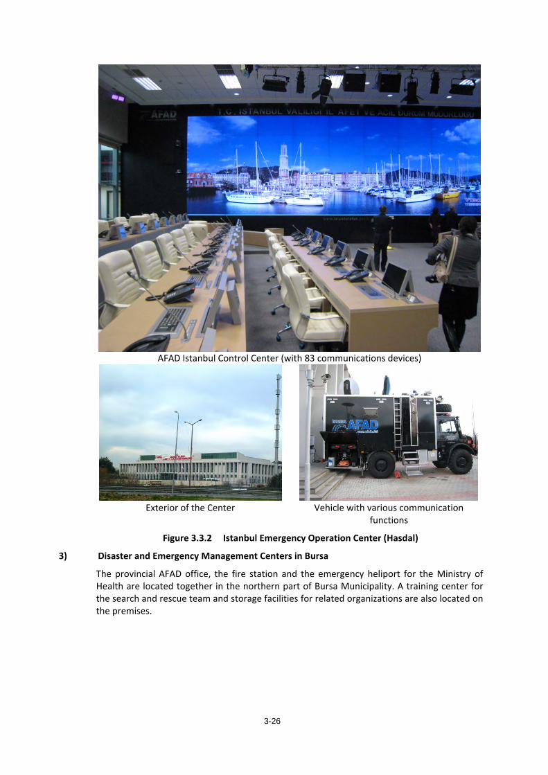
3-26
AFAD Istanbul Control Center (with 83 communications devices)
Exterior of the Center Vehicle with various communication functions
Figure 3.3.2 Istanbul Emergency Operation Center (Hasdal)
3) Disaster and Emergency Management Centers in Bursa
The provincial AFAD office, the fire station and the emergency heliport for the Ministry of Health are located together in the northern part of Bursa Municipality. A training center for the search and rescue team and storage facilities for related organizations are also located on the premises.
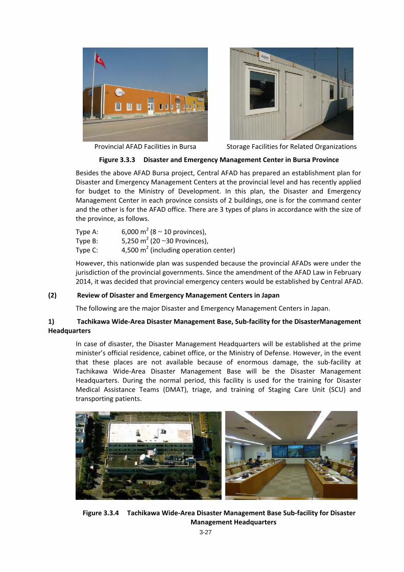
3-27
Provincial AFAD Facilities in Bursa Storage Facilities for Related Organizations
Figure 3.3.3 Disaster and Emergency Management Center in Bursa Province
Besides the above AFAD Bursa project, Central AFAD has prepared an establishment plan for Disaster and Emergency Management Centers at the provincial level and has recently applied for budget to the Ministry of Development. In this plan, the Disaster and Emergency Management Center in each province consists of 2 buildings, one is for the command center and the other is for the AFAD office. There are 3 types of plans in accordance with the size of the province, as follows.
Type A: 6,000 m2 (8 ~ 10 provinces), Type B: 5,250 m2 (20 ~30 Provinces), Type C: 4,500 m2 (including operation center)
However, this nationwide plan was suspended because the provincial AFADs were under the jurisdiction of the provincial governments. Since the amendment of the AFAD Law in February 2014, it was decided that provincial emergency centers would be established by Central AFAD.
(2) Review of Disaster and Emergency Management Centers in Japan
The following are the major Disaster and Emergency Management Centers in Japan.
1) Tachikawa Wide-Area Disaster Management Base, Sub-facility for the DisasterManagement Headquarters
In case of disaster, the Disaster Management Headquarters will be established at the prime minister’s official residence, cabinet office, or the Ministry of Defense. However, in the event that these places are not available because of enormous damage, the sub-facility at Tachikawa Wide-Area Disaster Management Base will be the Disaster Management Headquarters. During the normal period, this facility is used for the training for Disaster Medical Assistance Teams (DMAT), triage, and training of Staging Care Unit (SCU) and transporting patients.
Figure 3.3.4 Tachikawa Wide-Area Disaster Management Base Sub-facility for Disaster Management Headquarters
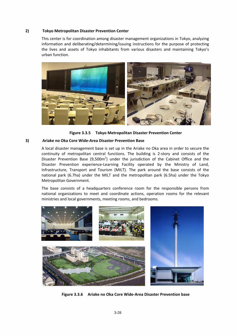
3-28
2) Tokyo Metropolitan Disaster Prevention Center
This center is for coordination among disaster management organizations in Tokyo, analyzing information and deliberating/determining/issuing instructions for the purpose of protecting the lives and assets of Tokyo inhabitants from various disasters and maintaining Tokyo’s urban function.
Figure 3.3.5 Tokyo Metropolitan Disaster Prevention Center
3) Ariake no Oka Core Wide-Area Disaster Prevention Base
A local disaster management base is set up in the Ariake no Oka area in order to secure the continuity of metropolitan central functions. The building is 2-story and consists of the Disaster Prevention Base (9,500m2) under the jurisdiction of the Cabinet Office and the Disaster Prevention experience-Learning Facility operated by the Ministry of Land, Infrastructure, Transport and Tourism (MILT). The park around the base consists of the national park (6.7ha) under the MILT and the metropolitan park (6.5ha) under the Tokyo Metropolitan Government.
The base consists of a headquarters conference room for the responsible persons from national organizations to meet and coordinate actions, operation rooms for the relevant ministries and local governments, meeting rooms, and bedrooms.
Figure 3.3.6 Ariake no Oka Core Wide-Area Disaster Prevention base
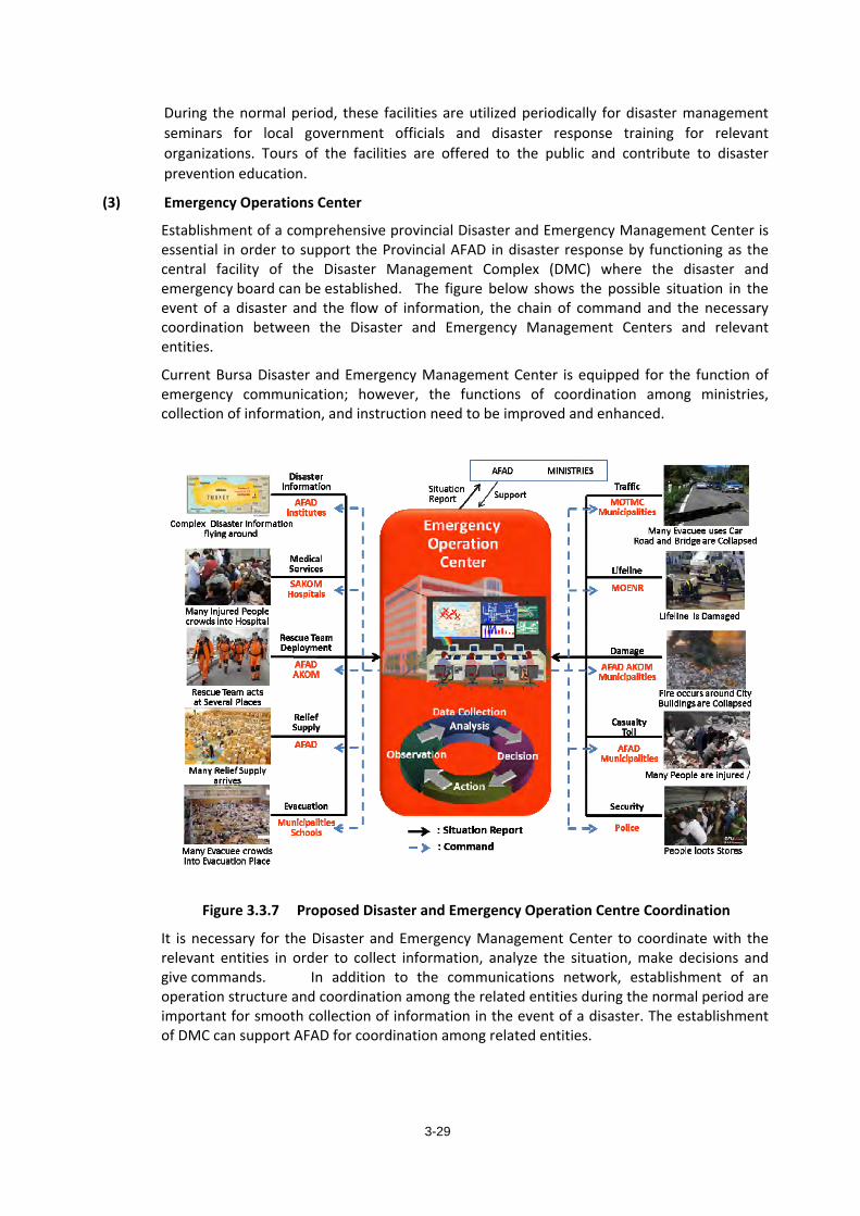
3-29
During the normal period, these facilities are utilized periodically for disaster management seminars for local government officials and disaster response training for relevant organizations. Tours of the facilities are offered to the public and contribute to disaster prevention education.
(3) Emergency Operations Center
Establishment of a comprehensive provincial Disaster and Emergency Management Center is essential in order to support the Provincial AFAD in disaster response by functioning as the central facility of the Disaster Management Complex (DMC) where the disaster and emergency board can be established. The figure below shows the possible situation in the event of a disaster and the flow of information, the chain of command and the necessary coordination between the Disaster and Emergency Management Centers and relevant entities.
Current Bursa Disaster and Emergency Management Center is equipped for the function of emergency communication; however, the functions of coordination among ministries, collection of information, and instruction need to be improved and enhanced.
Figure 3.3.7 Proposed Disaster and Emergency Operation Centre Coordination
It is necessary for the Disaster and Emergency Management Center to coordinate with the relevant entities in order to collect information, analyze the situation, make decisions and give commands. In addition to the communications network, establishment of an operation structure and coordination among the related entities during the normal period are important for smooth collection of information in the event of a disaster. The establishment of DMC can support AFAD for coordination among related entities.
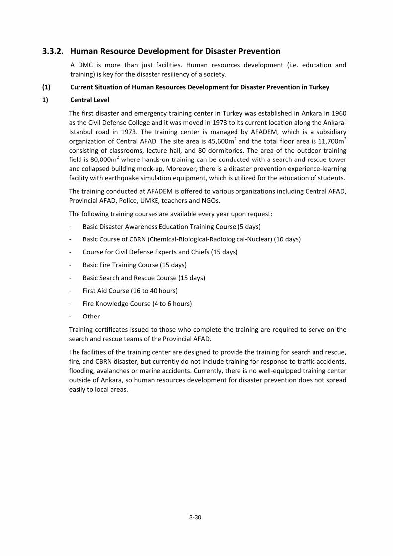
3-30
3.3.2. Human Resource Development for Disaster Prevention A DMC is more than just facilities. Human resources development (i.e. education and training) is key for the disaster resiliency of a society.
(1) Current Situation of Human Resources Development for Disaster Prevention in Turkey
1) Central Level
The first disaster and emergency training center in Turkey was established in Ankara in 1960 as the Civil Defense College and it was moved in 1973 to its current location along the Ankara-Istanbul road in 1973. The training center is managed by AFADEM, which is a subsidiary organization of Central AFAD. The site area is 45,600m2 and the total floor area is 11,700m2 consisting of classrooms, lecture hall, and 80 dormitories. The area of the outdoor training field is 80,000m2 where hands-on training can be conducted with a search and rescue tower and collapsed building mock-up. Moreover, there is a disaster prevention experience-learning facility with earthquake simulation equipment, which is utilized for the education of students.
The training conducted at AFADEM is offered to various organizations including Central AFAD, Provincial AFAD, Police, UMKE, teachers and NGOs.
The following training courses are available every year upon request:
- Basic Disaster Awareness Education Training Course (5 days)
- Basic Course of CBRN (Chemical-Biological-Radiological-Nuclear) (10 days)
- Course for Civil Defense Experts and Chiefs (15 days)
- Basic Fire Training Course (15 days)
- Basic Search and Rescue Course (15 days)
- First Aid Course (16 to 40 hours)
- Fire Knowledge Course (4 to 6 hours)
- Other
Training certificates issued to those who complete the training are required to serve on the search and rescue teams of the Provincial AFAD.
The facilities of the training center are designed to provide the training for search and rescue, fire, and CBRN disaster, but currently do not include training for response to traffic accidents, flooding, avalanches or marine accidents. Currently, there is no well-equipped training center outside of Ankara, so human resources development for disaster prevention does not spread easily to local areas.
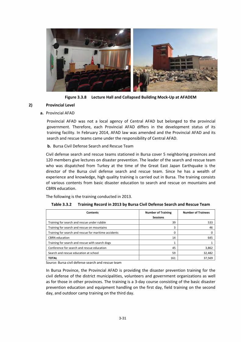
3-31
Figure 3.3.8 Lecture Hall and Collapsed Building Mock-Up at AFADEM
2) Provincial Level
a. Provincial AFAD
Provincial AFAD was not a local agency of Central AFAD but belonged to the provincial government. Therefore, each Provincial AFAD differs in the development status of its training facility. In February 2014, AFAD law was amended and the Provincial AFAD and its search and rescue teams came under the responsibility of Central AFAD.
b. Bursa Civil Defense Search and Rescue Team
Civil defense search and rescue teams stationed in Bursa cover 5 neighboring provinces and 120 members give lectures on disaster prevention. The leader of the search and rescue team who was dispatched from Turkey at the time of the Great East Japan Earthquake is the director of the Bursa civil defense search and rescue team. Since he has a wealth of experience and knowledge, high quality training is carried out in Bursa. The training consists of various contents from basic disaster education to search and rescue on mountains and CBRN education.
The following is the training conducted in 2013.
Table 3.3.2 Training Record in 2013 by Bursa Civil Defense Search and Rescue Team
Contents Number of Training Sessions
Number of Trainees
Training for search and rescue under rubble 39 533Training for search and rescue on mountains 3 46Training for search and rescue for maritime accidents 0 0CBRN education 14 645Training for search and rescue with search dogs 1 1Conference for search and rescue education 45 3,862Search and rescue education at school 59 32,482TOTAL 161 37,569
Source: Bursa civil defense search and rescue team
In Bursa Province, the Provincial AFAD is providing the disaster prevention training for the civil defense of the district municipalities, volunteers and government organizations as well as for those in other provinces. The training is a 3-day course consisting of the basic disaster prevention education and equipment handling on the first day, field training on the second day, and outdoor camp training on the third day.
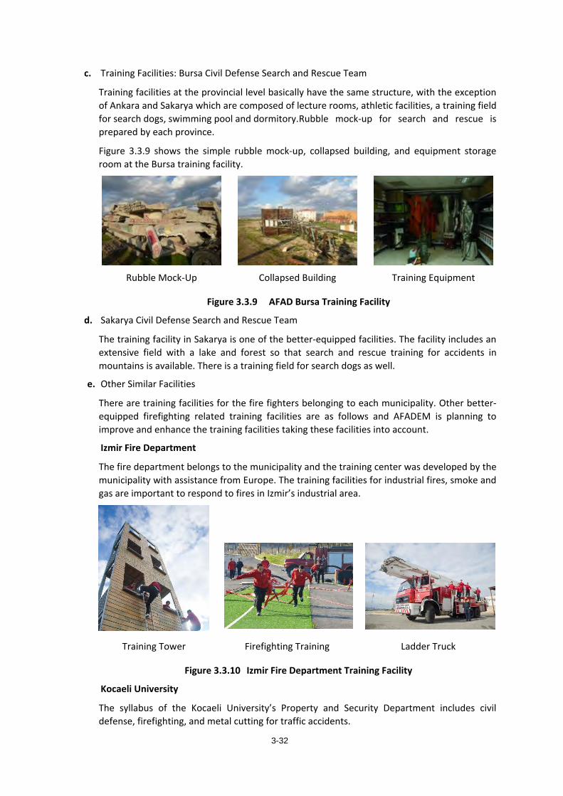
3-32
c. Training Facilities: Bursa Civil Defense Search and Rescue Team
Training facilities at the provincial level basically have the same structure, with the exception of Ankara and Sakarya which are composed of lecture rooms, athletic facilities, a training field for search dogs, swimming pool and dormitory. Rubble mock-up for search and rescue is prepared by each province.
Figure 3.3.9 shows the simple rubble mock-up, collapsed building, and equipment storage room at the Bursa training facility.
Rubble Mock-Up Collapsed Building Training Equipment
Figure 3.3.9 AFAD Bursa Training Facility
d. Sakarya Civil Defense Search and Rescue Team
The training facility in Sakarya is one of the better-equipped facilities. The facility includes an extensive field with a lake and forest so that search and rescue training for accidents in mountains is available. There is a training field for search dogs as well.
e. Other Similar Facilities
There are training facilities for the fire fighters belonging to each municipality. Other better-equipped firefighting related training facilities are as follows and AFADEM is planning to improve and enhance the training facilities taking these facilities into account.
Izmir Fire Department
The fire department belongs to the municipality and the training center was developed by the municipality with assistance from Europe. The training facilities for industrial fires, smoke and gas are important to respond to fires in Izmir’s industrial area.
Training Tower Firefighting Training Ladder Truck
Figure 3.3.10 Izmir Fire Department Training Facility
Kocaeli University
The syllabus of the Kocaeli University’s Property and Security Department includes civil defense, firefighting, and metal cutting for traffic accidents.
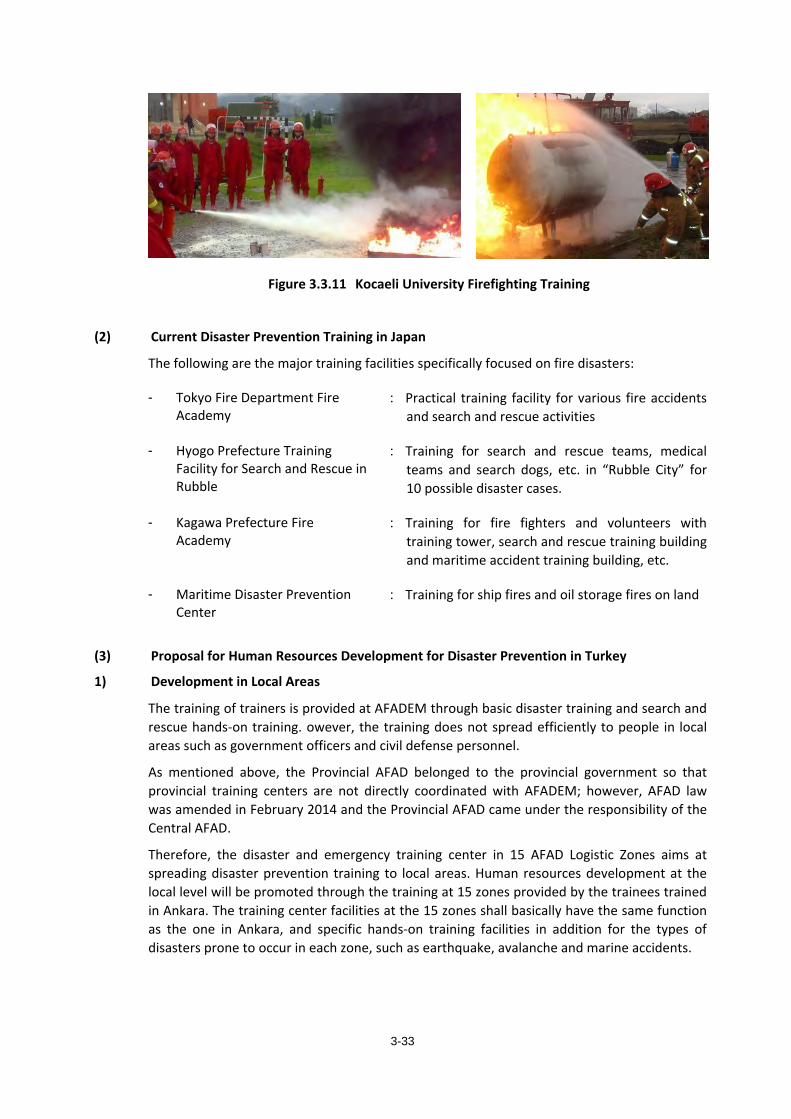
3-33
Figure 3.3.11 Kocaeli University Firefighting Training
(2) Current Disaster Prevention Training in Japan
The following are the major training facilities specifically focused on fire disasters:
- Tokyo Fire Department Fire Academy
: Practical training facility for various fire accidents and search and rescue activities
- Hyogo Prefecture Training Facility for Search and Rescue in Rubble
: Training for search and rescue teams, medical teams and search dogs, etc. in “Rubble City” for 10 possible disaster cases.
- Kagawa Prefecture Fire Academy
: Training for fire fighters and volunteers with training tower, search and rescue training building and maritime accident training building, etc.
- Maritime Disaster Prevention Center
: Training for ship fires and oil storage fires on land
(3) Proposal for Human Resources Development for Disaster Prevention in Turkey
1) Development in Local Areas
The training of trainers is provided at AFADEM through basic disaster training and search and rescue hands-on training. owever, the training does not spread efficiently to people in local areas such as government officers and civil defense personnel.
As mentioned above, the Provincial AFAD belonged to the provincial government so that provincial training centers are not directly coordinated with AFADEM; however, AFAD law was amended in February 2014 and the Provincial AFAD came under the responsibility of the Central AFAD.
Therefore, the disaster and emergency training center in 15 AFAD Logistic Zones aims at spreading disaster prevention training to local areas. Human resources development at the local level will be promoted through the training at 15 zones provided by the trainees trained in Ankara. The training center facilities at the 15 zones shall basically have the same function as the one in Ankara, and specific hands-on training facilities in addition for the types of disasters prone to occur in each zone, such as earthquake, avalanche and marine accidents.
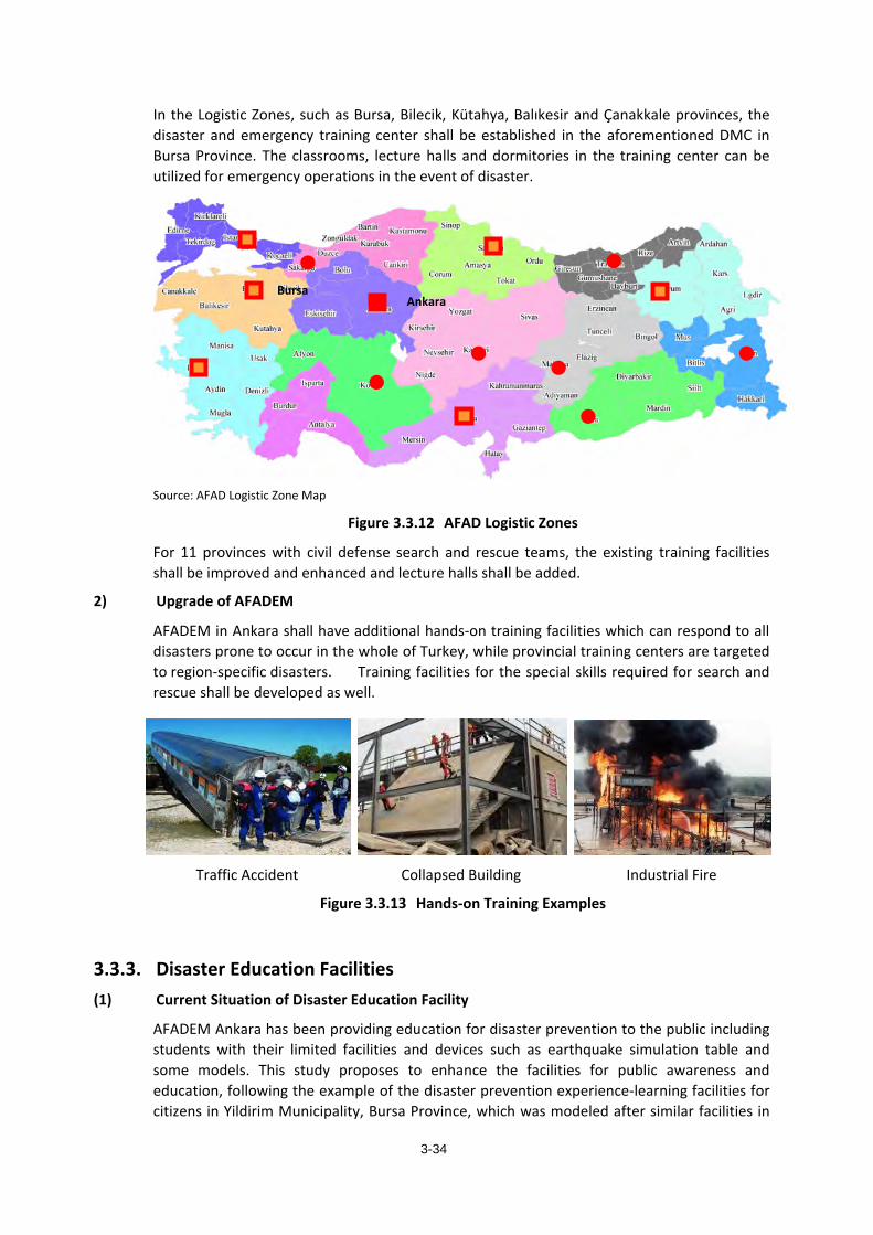
3-34
In the Logistic Zones, such as Bursa, Bilecik, Kütahya, Balıkesir and Çanakkale provinces, the disaster and emergency training center shall be established in the aforementioned DMC in Bursa Province. The classrooms, lecture halls and dormitories in the training center can be utilized for emergency operations in the event of disaster.
Source: AFAD Logistic Zone Map
Figure 3.3.12 AFAD Logistic Zones
For 11 provinces with civil defense search and rescue teams, the existing training facilities shall be improved and enhanced and lecture halls shall be added.
2) Upgrade of AFADEM
AFADEM in Ankara shall have additional hands-on training facilities which can respond to all disasters prone to occur in the whole of Turkey, while provincial training centers are targeted to region-specific disasters. Training facilities for the special skills required for search and rescue shall be developed as well.
Traffic Accident Collapsed Building Industrial Fire
Figure 3.3.13 Hands-on Training Examples
3.3.3. Disaster Education Facilities (1) Current Situation of Disaster Education Facility
AFADEM Ankara has been providing education for disaster prevention to the public including students with their limited facilities and devices such as earthquake simulation table and some models. This study proposes to enhance the facilities for public awareness and education, following the example of the disaster prevention experience-learning facilities for citizens in Yildirim Municipality, Bursa Province, which was modeled after similar facilities in
Bursa Ankara
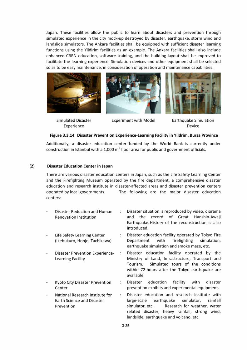
3-35
Japan. These facilities allow the public to learn about disasters and prevention through simulated experience in the city mock-up destroyed by disaster, earthquake, storm wind and landslide simulators. The Ankara facilities shall be equipped with sufficient disaster learning functions using the Yildirim facilities as an example. The Ankara facilities shall also include enhanced CBRN education, software training, and the building layout shall be improved to facilitate the learning experience. Simulation devices and other equipment shall be selected so as to be easy maintenance, in consideration of operation and maintenance capabilities.
Simulated Disaster Experience
Experiment with Model Earthquake Simulation Device
Figure 3.3.14 Disaster Prevention Experience-Learning Facility in Yildrim, Bursa Province
Additionally, a disaster education center funded by the World Bank is currently under construction in Istanbul with a 1,000 m2 floor area for public and government officials.
(2) Disaster Education Center in Japan
There are various disaster education centers in Japan, such as the Life Safety Learning Center and the Firefighting Museum operated by the fire department, a comprehensive disaster education and research institute in disaster-affected areas and disaster prevention centers operated by local governments. The following are the major disaster education centers:
- Disaster Reduction and Human
Renovation Institution : Disaster situation is reproduced by video, diorama
and the record of Great Hanshin-Awaji Earthquake. History of the reconstruction is also introduced.
- Life Safety Learning Center (Ikebukuro, Honjo, Tachikawa)
: Disaster education facility operated by Tokyo Fire Department with firefighting simulation, earthquake simulation and smoke maze, etc.
- Disaster Prevention Experience-Learning Facility
: Disaster education facility operated by the Ministry of Land, Infrastructure, Transport and Tourism. Simulated tours of the conditions within 72-hours after the Tokyo earthquake are available.
- Kyoto City Disaster Prevention Center
: Disaster education facility with disaster prevention exhibits and experimental equipment.
- National Research Institute for Earth Science and Disaster Prevention
: Disaster education and research institute with large-scale earthquake simulator, rainfall simulator, etc. Research for weather, water related disaster, heavy rainfall, strong wind, landslide, earthquake and volcano, etc.
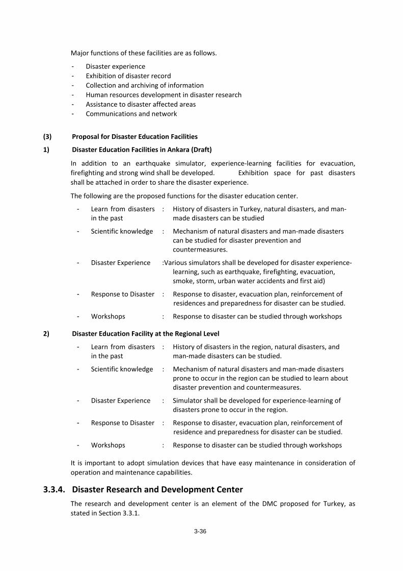
3-36
Major functions of these facilities are as follows.
- Disaster experience - Exhibition of disaster record - Collection and archiving of information - Human resources development in disaster research - Assistance to disaster affected areas - Communications and network
(3) Proposal for Disaster Education Facilities
1) Disaster Education Facilities in Ankara (Draft)
In addition to an earthquake simulator, experience-learning facilities for evacuation, firefighting and strong wind shall be developed. Exhibition space for past disasters shall be attached in order to share the disaster experience.
The following are the proposed functions for the disaster education center.
- Learn from disasters in the past
: History of disasters in Turkey, natural disasters, and man-made disasters can be studied
- Scientific knowledge : Mechanism of natural disasters and man-made disasters can be studied for disaster prevention and countermeasures.
- Disaster Experience :Various simulators shall be developed for disaster experience-learning, such as earthquake, firefighting, evacuation, smoke, storm, urban water accidents and first aid)
- Response to Disaster : Response to disaster, evacuation plan, reinforcement of residences and preparedness for disaster can be studied.
- Workshops : Response to disaster can be studied through workshops
2) Disaster Education Facility at the Regional Level
- Learn from disasters in the past
: History of disasters in the region, natural disasters, and man-made disasters can be studied.
- Scientific knowledge : Mechanism of natural disasters and man-made disasters prone to occur in the region can be studied to learn about disaster prevention and countermeasures.
- Disaster Experience : Simulator shall be developed for experience-learning of disasters prone to occur in the region.
- Response to Disaster : Response to disaster, evacuation plan, reinforcement of residence and preparedness for disaster can be studied.
- Workshops : Response to disaster can be studied through workshops
It is important to adopt simulation devices that have easy maintenance in consideration of operation and maintenance capabilities.
3.3.4. Disaster Research and Development Center The research and development center is an element of the DMC proposed for Turkey, as stated in Section 3.3.1.
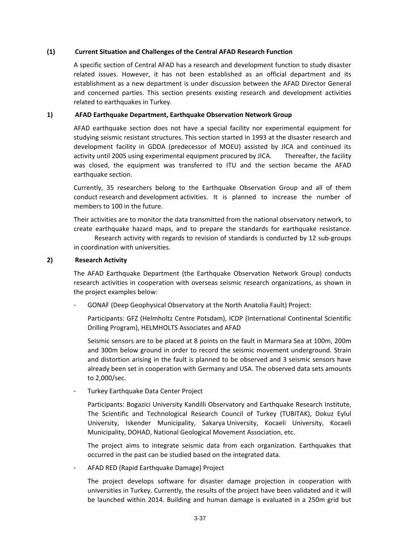
3-37
(1) Current Situation and Challenges of the Central AFAD Research Function
A specific section of Central AFAD has a research and development function to study disaster related issues. However, it has not been established as an official department and its establishment as a new department is under discussion between the AFAD Director General and concerned parties. This section presents existing research and development activities related to earthquakes in Turkey.
1) AFAD Earthquake Department, Earthquake Observation Network Group
AFAD earthquake section does not have a special facility nor experimental equipment for studying seismic resistant structures. This section started in 1993 at the disaster research and development facility in GDDA (predecessor of MOEU) assisted by JICA and continued its activity until 2005 using experimental equipment procured by JICA. Thereafter, the facility was closed, the equipment was transferred to ITU and the section became the AFAD earthquake section.
Currently, 35 researchers belong to the Earthquake Observation Group and all of them conduct research and development activities. It is planned to increase the number of members to 100 in the future.
Their activities are to monitor the data transmitted from the national observatory network, to create earthquake hazard maps, and to prepare the standards for earthquake resistance. Research activity with regards to revision of standards is conducted by 12 sub-groups in coordination with universities.
2) Research Activity
The AFAD Earthquake Department (the Earthquake Observation Network Group) conducts research activities in cooperation with overseas seismic research organizations, as shown in the project examples below:
- GONAF (Deep Geophysical Observatory at the North Anatolia Fault) Project:
Participants: GFZ (Helmholtz Centre Potsdam), ICDP (International Continental Scientific Drilling Program), HELMHOLTS Associates and AFAD
Seismic sensors are to be placed at 8 points on the fault in Marmara Sea at 100m, 200m and 300m below ground in order to record the seismic movement underground. Strain and distortion arising in the fault is planned to be observed and 3 seismic sensors have already been set in cooperation with Germany and USA. The observed data sets amounts to 2,000/sec.
- Turkey Earthquake Data Center Project
Participants: Bogazici University Kandilli Observatory and Earthquake Research Institute, The Scientific and Technological Research Council of Turkey (TUBITAK), Dokuz Eylul University, Iskender Municipality, Sakarya University, Kocaeli University, Kocaeli Municipality, DOHAD, National Geological Movement Association, etc.
The project aims to integrate seismic data from each organization. Earthquakes that occurred in the past can be studied based on the integrated data.
- AFAD RED (Rapid Earthquake Damage) Project
The project develops software for disaster damage projection in cooperation with universities in Turkey. Currently, the results of the project have been validated and it will be launched within 2014. Building and human damage is evaluated in a 250m grid but
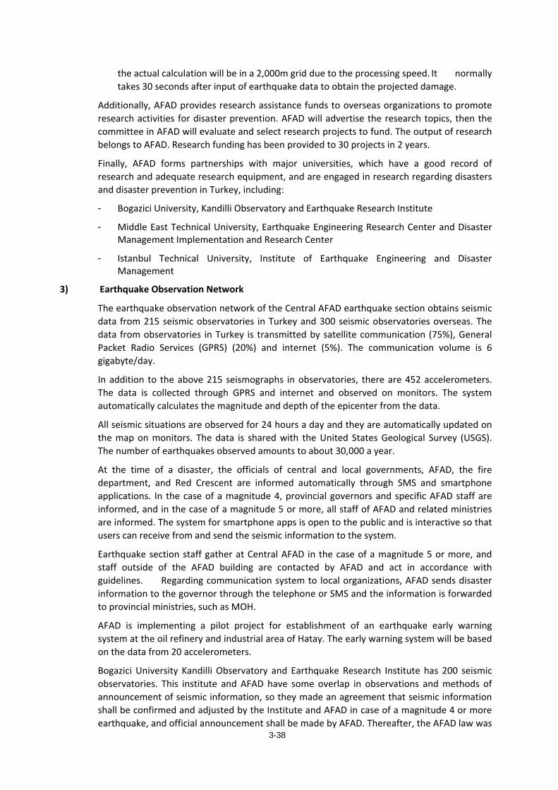
3-38
the actual calculation will be in a 2,000m grid due to the processing speed. It normally takes 30 seconds after input of earthquake data to obtain the projected damage.
Additionally, AFAD provides research assistance funds to overseas organizations to promote research activities for disaster prevention. AFAD will advertise the research topics, then the committee in AFAD will evaluate and select research projects to fund. The output of research belongs to AFAD. Research funding has been provided to 30 projects in 2 years.
Finally, AFAD forms partnerships with major universities, which have a good record of research and adequate research equipment, and are engaged in research regarding disasters and disaster prevention in Turkey, including:
- Bogazici University, Kandilli Observatory and Earthquake Research Institute
- Middle East Technical University, Earthquake Engineering Research Center and Disaster Management Implementation and Research Center
- Istanbul Technical University, Institute of Earthquake Engineering and Disaster Management
3) Earthquake Observation Network
The earthquake observation network of the Central AFAD earthquake section obtains seismic data from 215 seismic observatories in Turkey and 300 seismic observatories overseas. The data from observatories in Turkey is transmitted by satellite communication (75%), General Packet Radio Services (GPRS) (20%) and internet (5%). The communication volume is 6 gigabyte/day.
In addition to the above 215 seismographs in observatories, there are 452 accelerometers. The data is collected through GPRS and internet and observed on monitors. The system automatically calculates the magnitude and depth of the epicenter from the data.
All seismic situations are observed for 24 hours a day and they are automatically updated on the map on monitors. The data is shared with the United States Geological Survey (USGS). The number of earthquakes observed amounts to about 30,000 a year.
At the time of a disaster, the officials of central and local governments, AFAD, the fire department, and Red Crescent are informed automatically through SMS and smartphone applications. In the case of a magnitude 4, provincial governors and specific AFAD staff are informed, and in the case of a magnitude 5 or more, all staff of AFAD and related ministries are informed. The system for smartphone apps is open to the public and is interactive so that users can receive from and send the seismic information to the system.
Earthquake section staff gather at Central AFAD in the case of a magnitude 5 or more, and staff outside of the AFAD building are contacted by AFAD and act in accordance with guidelines. Regarding communication system to local organizations, AFAD sends disaster information to the governor through the telephone or SMS and the information is forwarded to provincial ministries, such as MOH.
AFAD is implementing a pilot project for establishment of an earthquake early warning system at the oil refinery and industrial area of Hatay. The early warning system will be based on the data from 20 accelerometers.
Bogazici University Kandilli Observatory and Earthquake Research Institute has 200 seismic observatories. This institute and AFAD have some overlap in observations and methods of announcement of seismic information, so they made an agreement that seismic information shall be confirmed and adjusted by the Institute and AFAD in case of a magnitude 4 or more earthquake, and official announcement shall be made by AFAD. Thereafter, the AFAD law was
3-39
amended in February 2014 and stipulates that all seismic data from universities and institutes shall be sent to AFAD and only AFAD is able to make official announcements regarding disasters.
AFAD and Kandilli Institute have approximately 650 and 200 seismic observatories respectively, and AFAD plans to increase the number of its observatories to 1,000 within 5 years.
(2) Research and Experimental Facilities for Disaster Prevention in Japan
The following are the research and experimental facilities classified by sector in Japan. Large-sized facilities are owned by government agencies, such as the Ministry of Land, Infrastructure and Transport, and are also utilized by universities.
Table 3.3.3 Research and Experimental Facilities for Disaster Prevention in Japan Sector Facility/Organization/Description Image
Eart
hqua
ke
Engi
neer
ing
Stru
ctur
al
Engi
neer
ing
E-Defense National Research Institute for Earth Science and Disaster Prevention Three dimensional shake table for full-scale buildings (middle-rise building or 2 houses). Detailed process of tremor, damage and collapse can be observed. Max. load: 1200tonf Table size: 20m × 15m Acceleration: X ±0.92G, Y ±0.92G, Z ±1.53G (1200tf loaded)
Large-scale testing facility Port and Airport Research Institute Loading test equipment for large-scale port structure Reaction floor: 15m × 16.5m Reaction wall (2 side): 7m height
Static and pseudo-dynamic test facility Public Works Research Institute Facility to observe the deformation characteristics of structural members with constant dynamic load. Actuator can be set up at any place on the wall. Pit: 20m × 15m × 5m (depth)
Three-Dimensional Large-Scale Shaking Table Public Works Research Institute Study and research on seismic resistance of structure and ground by reproducing vibration at the time of earthquake. Max. load: 300tonf Table size: 8m × 8m Acceleration: X ±0.8G, Y ±0.8G, Z ±0.5G (300tf loaded)
3-40
Coas
tal a
nd R
iver
En
gine
erin
g
Win
d an
d Fl
ood
Wide-deep Hybrid Wave Flume Port and Airport Research Institute Integrated experimental facility to clarify the mechanism of destruction of bank protection facilities with a large-scale experimental pool, which can recreate accurately the damage of long-period swells. Pool: 10m × 50m
Tsun
ami
Large Geotechnical and Hydro-dynamic Centrifuge(LGHC) Port and Airport Research Institute Facility to recreate the damage of complex disasters with earthquake and tsunami Effective Radius: 3.5m
Rive
r
Large Hydro Geo Flume Port and Airport Research Institute Large-scale experimental flume to create the world’s largest wind wave of 3.5m and tsunami of 2.5m. Simulation of the destruction process of structures and ground movement is possible. Size: 184m (length), 3.5m (width), 12m (depth), sand layer of 4m (depth)
105m Wave Channel Port and Airport Research Institute Experimental wave facility for coastal structures such as seawalls. Flume: 105.0m (length), 3.0m (width), 2.5m (depth) Wave: 80cm (max.), frequency: 0.5~10sec
Dam
Dam Hydraulics Laboratory Public Works Research Institute Facility to clarify and measure the complex flow of discharge Floor area: 80m × 45m
Fire
Fig
htin
g
Fire
Large fire test building National Research Institute of Fire and Disaster Indoor experimental facility for large-scale fire simulation
Extin
gui
shin
g
Fire extinguishing research building National Research Institute of Fire and Disaster Indoor facility for fire simulation with flue gas treatment and large blower.
Burn
ing
Combustion test building National Research Institute of Fire and Disaster Facility for fire simulation in underground and special spaces.
Fire
Pro
tect
ion
Residential fire research building National Research Institute of Fire and Disaster Facility for research on fire sensors, smoke flow, evacuation and investigation of causes of fires.
Radio-wave anechoic chamber National Research Institute of Fire and Disaster Facility to confirm if electronic devices such as fire detectors function in case of strong electromagnetic interference.
3-41
(3) Proposal for the Central AFAD Research and Development Center
Based on the above, the Central AFAD research and development center shall be established in Ankara in cooperation with other universities and institutes to consolidate disaster information. The center shall promote disaster research based on consolidated information, prepare policies for disaster risk management, and enhance disaster education and training. The following 3 functions are essential:
1) Disaster information archive:
All information related to disaster collected by each university and institute shall be consolidated and optimized for disaster risk management policy making and disaster response. The current AFAD Databank Project needs to be improved for this function.
2) Research for Disaster Management Policy Making:
Research on practical disaster prevention activities useful for AFAD and local government shall be conducted, including involvement of community groups, roles of local government and effective collaboration system with local government, research activities related to collecting disaster data, analysis, and damage estimation which are suitable for Turkey. It will help to reinforce AFAD’s disaster prevention and response activities, at both national and provincial levels.
3) Research Laboratory:
The AFAD research and development center shall have a research laboratory and equipment to be utilized by universities to promote and support disaster prevention research. Earthquake engineering experiments are currently being conducted at university institutes; however, the cost of purchase and maintenance of equipment is prohibitive for some universities. The main existing shaking tables in Turkey for research on seismic resistant structures are as follows:
- Bogazici University, Kandilli Observatory and Earthquake Research Institute
- Single-axis shaking table: Table size 3m × 3m, Maximum test load 10t - Triple-axis shaking table: Table size 0.7m x 0.7m, Maximum test load 100Kg
- Middle East Technical University, Earthquake Engineering Research Center
- Installation of a shaking table (5m x 5m, made in the USA) was planned, but not realized due to associated maintenance requirements.
- Istanbul Technical University, Institute of Earthquake Engineering and Disaster Management
- Equipment procured by JICA in 1993 is operational. - New shaking table will be operational soon.
- Single-axis shaking table: Table size 3m × 3m, Maximum test load 10t
3.3.5. Information-Communication Technology for Disaster Prevention (1) Current status in Turkey
In accordance with the Turkey Disaster Response Plan (TAMP) and the National Earthquake Strategy and Action Plan 2012-2023 (NESAP), the major execution plan regarding Turkey’s Information-Communication Technology for Disaster Prevention (hereinafter referred to as ICT) is covered in the medium-term action plan of AFAD’s Strategic Plan 2013-2017.
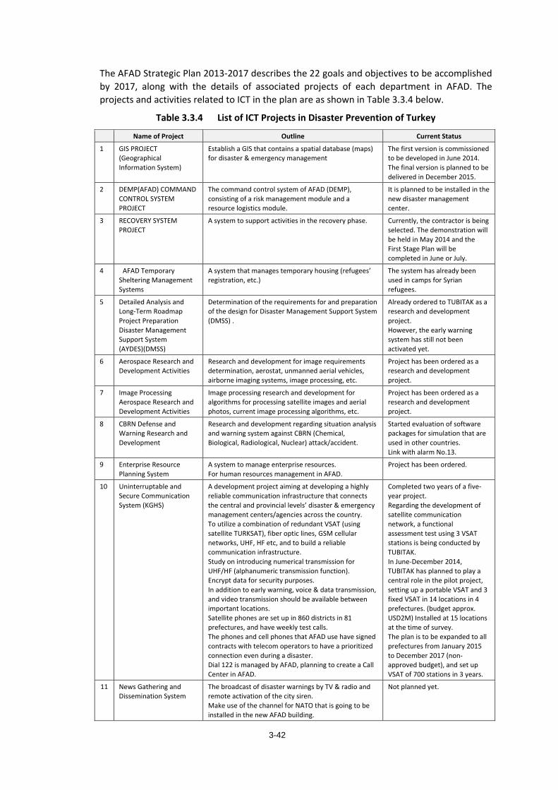
3-42
The AFAD Strategic Plan 2013-2017 describes the 22 goals and objectives to be accomplished by 2017, along with the details of associated projects of each department in AFAD. The projects and activities related to ICT in the plan are as shown in Table 3.3.4 below.
Table 3.3.4 List of ICT Projects in Disaster Prevention of Turkey
Name of Project Outline Current Status
1 GIS PROJECT (Geographical Information System)
Establish a GIS that contains a spatial database (maps) for disaster & emergency management
The first version is commissioned to be developed in June 2014. The final version is planned to be delivered in December 2015.
2 DEMP(AFAD) COMMAND CONTROL SYSTEM PROJECT
The command control system of AFAD (DEMP), consisting of a risk management module and a resource logistics module.
It is planned to be installed in the new disaster management center.
3 RECOVERY SYSTEM PROJECT
A system to support activities in the recovery phase. Currently, the contractor is being selected. The demonstration will be held in May 2014 and the First Stage Plan will be completed in June or July.
4 AFAD Temporary Sheltering Management Systems
A system that manages temporary housing (refugees’ registration, etc.)
The system has already been used in camps for Syrian refugees.
5 Detailed Analysis and Long-Term Roadmap Project Preparation Disaster Management Support System (AYDES)(DMSS)
Determination of the requirements for and preparation of the design for Disaster Management Support System (DMSS) .
Already ordered to TUBITAK as a research and development project. However, the early warning system has still not been activated yet.
6 Aerospace Research and Development Activities
Research and development for image requirements determination, aerostat, unmanned aerial vehicles, airborne imaging systems, image processing, etc.
Project has been ordered as a research and development project.
7 Image Processing Aerospace Research and Development Activities
Image processing research and development for algorithms for processing satellite images and aerial photos, current image processing algorithms, etc.
Project has been ordered as a research and development project.
8 CBRN Defense and Warning Research and Development
Research and development regarding situation analysis and warning system against CBRN (Chemical, Biological, Radiological, Nuclear) attack/accident.
Started evaluation of software packages for simulation that are used in other countries. Link with alarm No.13.
9 Enterprise Resource Planning System
A system to manage enterprise resources. For human resources management in AFAD.
Project has been ordered.
10 Uninterruptable and Secure Communication System (KGHS)
A development project aiming at developing a highly reliable communication infrastructure that connects the central and provincial levels’ disaster & emergency management centers/agencies across the country. To utilize a combination of redundant VSAT (using satellite TURKSAT), fiber optic lines, GSM cellular networks, UHF, HF etc, and to build a reliable communication infrastructure. Study on introducing numerical transmission for UHF/HF (alphanumeric transmission function). Encrypt data for security purposes. In addition to early warning, voice & data transmission, and video transmission should be available between important locations. Satellite phones are set up in 860 districts in 81 prefectures, and have weekly test calls. The phones and cell phones that AFAD use have signed contracts with telecom operators to have a prioritized connection even during a disaster. Dial 122 is managed by AFAD, planning to create a Call Center in AFAD.
Completed two years of a five-year project. Regarding the development of satellite communication network, a functional assessment test using 3 VSAT stations is being conducted by TUBITAK. In June-December 2014, TUBITAK has planned to play a central role in the pilot project, setting up a portable VSAT and 3 fixed VSAT in 14 locations in 4 prefectures. (budget approx. USD2M) Installed at 15 locations at the time of survey. The plan is to be expanded to all prefectures from January 2015 to December 2017 (non-approved budget), and set up VSAT of 700 stations in 3 years.
11 News Gathering and Dissemination System
The broadcast of disaster warnings by TV & radio and remote activation of the city siren. Make use of the channel for NATO that is going to be installed in the new AFAD building.
Not planned yet.
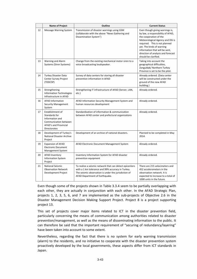
3-43
Name of Project Outline Current Status
12 Message Warning System Transmission of disaster warnings using GSM (collaborate with the above “News Gathering and Dissemination System”)
Even though giving warnings is, by law, a responsibility of AFAD, the cooperation of the Meteorological Agency and DSI is required. This is not planned yet. The kinds of warning information that will be sent, direction of analysis and forecast should be clarified.
13 Warning and Alarm Systems (Siren Systems)
Change from the existing mechanical motor siren to a voice broadcasting loudspeaker.
Taking into account the geographical difficulties, Zonguldak/ Northern Turkey Province is set to be the pilot.
14 Turkey Disaster Data Center Survey Project (TDDCSP)
Survey of data centers for storing all disaster prevention information in AFAD
Already ordered. (Data center will be constructed under the ground of the new AFAD building.)
15 Strengthening Information Technologies Infrastructure in AFAD
Strengthening IT infrastructure of AFAD (Server, LAN, etc.)
Already ordered.
16 AFAD Information Security Management System
AFAD Information Security Management System and human resources development
Already ordered.
17 Establishment of Standards for Information and Communication between AFAD’s and Provincial Directorates
Standardization of information & communication between AFAD center and prefectural organizations
Already ordered.
18 Development of Turkey’s National Disaster Archive Project
Development of an archive of national disasters. Planned to be completed in May 2014.
19 Expansion of AFAD Electronic Document Management System
AFAD Electronic Document Management System Already ordered.
20 AFAD Inventory Information System Project
Inventory Information System for AFAD disaster prevention equipment
Already ordered.
21 National Seismic Observation Network Development Project
To realize a seismic network that can detect epicenters with a 1 km tolerance and 99% accuracy in Turkey. The seismic observation is under the jurisdiction of AFAD Department of Earthquake.
There are 215 velocimeters and 452 accelerometers in the observation network. It is expected to increase to a total of 1000 units in the future.
Even though some of the projects shown in Table 3.3.4 seem to be partially overlapping with each other, they are actually in conjunction with each other. In the AFAD Strategic Plan, projects 1, 2, 3, 5, 6, and 7 are implemented as the sub-projects of Objective 2.6 in the Disaster Management Decision Making Support Project. Project 8 is a project supporting project 13.
This set of projects cover major items related to ICT in the disaster prevention field, particularly concerning the means of communication among authorities related to disaster prevention/management, as well as the means of disseminating information to the public. It can therefore be said that the important requirement of “securing of redundancy/layering” have been taken into account to some extent.
Nevertheless, regarding the fact that there is no system for early warning transmission (alarm) to the residents, and no initiative to cooperate with the disaster prevention system proactively developed by the local governments, these aspects differ from ICT standards in Japan.
3-44
The amended AFAD Law stipulates that management of early warnings for all disasters is under the jurisdiction of AFAD, so in the future, information regarding weather, rivers etc. which are under the responsibility of other authorities, will also be collected and necessary information will be disseminated by AFAD. However, since there are already some available monitoring and early warning systems in each institution, it is necessary to consider a cooperation system with the related organizations. Weather related issues are under the jurisdiction of the General Directorate of State Meteorological Service, Ministry of Forestry and Water Affairs (DMI). Management and monitoring of rivers are under the jurisdiction of the General Directorate of State Hydraulic Works and the Ministry of Forestry and Water Affairs (DSI).
It is believed that the current status and issues related to ICT in disaster risk management in Turkey can be grasped in general by understanding the progress and challenges of the abovementioned projects.
(2) Technical Challenges on Information-Communication Technology for Disaster Prevention in Turkey
The progress and issues related to each project above are shown in Table 3.3.5. For example, project 10 “Uninterrupted and Secure Communication System (KGHS)”, which is currently in Phase 3 (function test by TUBITAK, conducted at 2 stations of VSAT) and which was completed as planned by the end of 2013, is considered to have good progress so far.
The early warning system, however, has not progressed since some points, such as agencies in charge and methods of information transmission, have not been defined among relevant authorities. Regarding the current situation of the early warning system, it can be inferred that it is not implemented yet since the coordination system with relevant authorities such as the meteorological office and DSI has not been sorted out.
Some projects are still in the preparation stage, seeking appropriate methodology and technology, and showing interest in Japanese technology and technical support from Japan. Challenges faced in the use of ICT in disaster prevention are summarized Table 3.3.5 as a base to study possible support from the Japanese side.
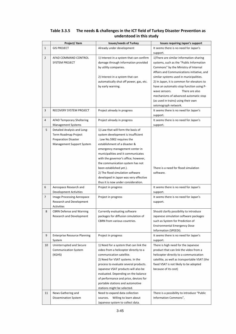
3-45
Table 3.3.5 The needs & challenges in the ICT field of Turkey Disaster Prevention as understood in this study
Project/ Item Issues/needs of Turkey Issues requiring Japan’s support1 GIS PROJECT Already under development It seems there is no need for Japan’s
support. 2 AFAD COMMAND CONTROL
SYSTEM PROJECT 1) Interest in a system that can confirm damage through information provided by utility companies. 2) Interest in a system that can automatically shut off power, gas, etc. by early warning.
1)There are similar information-sharing systems, such as the “Public Information Commons” by the Ministry of Internal Affairs and Communications initiative, and similar systems used in municipalities. 2) In Japan, it is common for elevators to have an automatic-stop function using P-wave sensors. There are also mechanisms of advanced automatic stop (as used in trains) using their own seismograph network.
3 RECOVERY SYSTEM PROJECT
Project already in progress It seems there is no need for Japan’s support.
4 AFAD Temporary Sheltering Management Systems
Project already in progress It seems there is no need for Japan’s support.
5 Detailed Analysis and Long-Term Roadmap Project Preparation Disaster Management Support System
1) Law that will form the basis of system development is insufficient . Law No.5902 requires the establishment of a disaster & emergency management center in municipalities and it communicates with the governor’s office; however, the communication system has not been established yet.). 2) The flood simulation software developed in Japan was very effective thus it is now under consideration.
There is a need for flood simulation software.
6 Aerospace Research and Development Activities
Project in progress It seems there is no need for Japan’s support.
7 Image Processing Aerospace Research and Development Activities
Project in progress It seems there is no need for Japan’s support.
8 CBRN Defense and Warning Research and Development
Currently evaluating software packages for diffusion simulation of CBRN from various countries.
Should clarify possibility to introduce Japanese simulation software packages such as System for Prediction of Environmental Emergency Dose Information (SPEEDI).
9 Enterprise Resource Planning System
Project in progress It seems there is no need for Japan’s support.
10 Uninterrupted and Secure Communication System
(KGHS)
1) Need for a system that can link the video from a helicopter directly to a communication satellite. 2) Need for VSAT systems. In the process to evaluate several products. Japanese VSAT products will also be evaluated. Depending on the balance of performance and price, devices for portable stations and automotive stations might be selected.
There is high need for the Japanese product that can link the video from a helicopter directly to a communication satellite, as well as transportable VSAT (the fixed VSAT is not likely to be adopted because of its cost)
11 News Gathering and Dissemination System
Need to expand data collection sources. Willing to learn about Japanese system to collect data.
There is a possibility to introduce “Public Information Commons”,
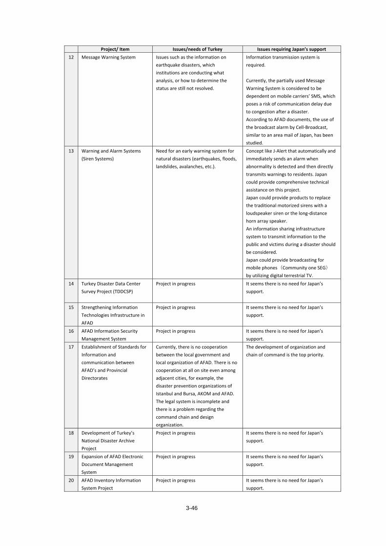
3-46
Project/ Item Issues/needs of Turkey Issues requiring Japan’s support12 Message Warning System Issues such as the information on
earthquake disasters, which institutions are conducting what analysis, or how to determine the status are still not resolved.
Information transmission system is required. Currently, the partially used Message Warning System is considered to be dependent on mobile carriers’ SMS, which poses a risk of communication delay due to congestion after a disaster. According to AFAD documents, the use of the broadcast alarm by Cell-Broadcast, similar to an area mail of Japan, has been studied.
13 Warning and Alarm Systems (Siren Systems)
Need for an early warning system for natural disasters (earthquakes, floods, landslides, avalanches, etc.).
Concept like J-Alert that automatically and immediately sends an alarm when abnormality is detected and then directly transmits warnings to residents. Japan could provide comprehensive technical assistance on this project. Japan could provide products to replace the traditional motorized sirens with a loudspeaker siren or the long-distance horn array speaker. An information sharing infrastructure system to transmit information to the public and victims during a disaster should be considered. Japan could provide broadcasting for mobile phones(Community one SEG) by utilizing digital terrestrial TV.
14 Turkey Disaster Data Center Survey Project (TDDCSP)
Project in progress It seems there is no need for Japan’s support.
15 Strengthening Information Technologies Infrastructure in AFAD
Project in progress It seems there is no need for Japan’s support.
16 AFAD Information Security Management System
Project in progress It seems there is no need for Japan’s support.
17 Establishment of Standards for Information and communication between AFAD’s and Provincial Directorates
Currently, there is no cooperation between the local government and local organization of AFAD. There is no cooperation at all on site even among adjacent cities, for example, the disaster prevention organizations of Istanbul and Bursa, AKOM and AFAD. The legal system is incomplete and there is a problem regarding the command chain and design organization.
The development of organization and chain of command is the top priority.
18 Development of Turkey’s National Disaster Archive Project
Project in progress It seems there is no need for Japan’s support.
19 Expansion of AFAD Electronic Document Management System
Project in progress It seems there is no need for Japan’s support.
20 AFAD Inventory Information System Project
Project in progress It seems there is no need for Japan’s support.
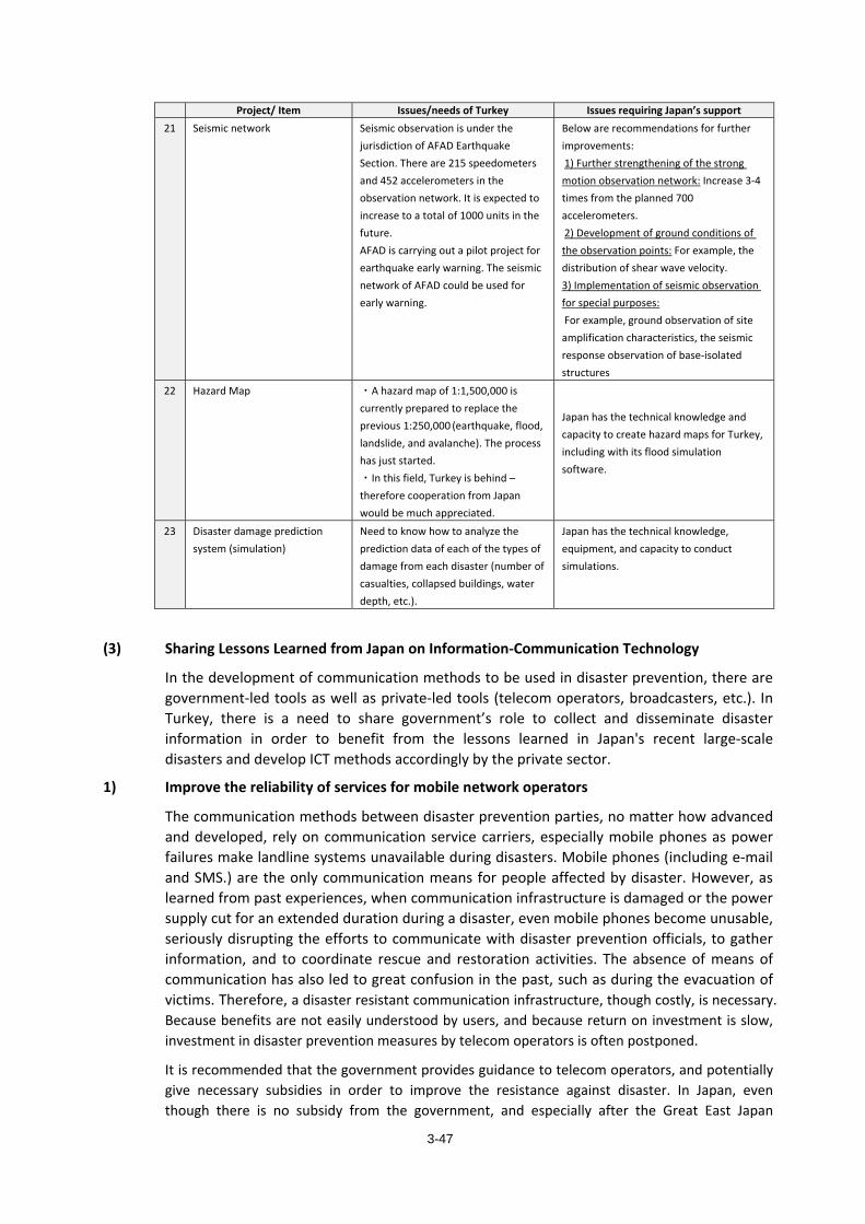
3-47
Project/ Item Issues/needs of Turkey Issues requiring Japan’s support21 Seismic network
Seismic observation is under the jurisdiction of AFAD Earthquake Section. There are 215 speedometers and 452 accelerometers in the observation network. It is expected to increase to a total of 1000 units in the future. AFAD is carrying out a pilot project for earthquake early warning. The seismic network of AFAD could be used for early warning.
Below are recommendations for further improvements: 1) Further strengthening of the strong motion observation network: Increase 3-4 times from the planned 700 accelerometers. 2) Development of ground conditions of the observation points: For example, the distribution of shear wave velocity. 3) Implementation of seismic observation for special purposes: For example, ground observation of site amplification characteristics, the seismic response observation of base-isolated structures
22 Hazard Map ・A hazard map of 1:1,500,000 is currently prepared to replace the previous 1:250,000 (earthquake, flood, landslide, and avalanche). The process has just started. ・In this field, Turkey is behind – therefore cooperation from Japan would be much appreciated.
Japan has the technical knowledge and capacity to create hazard maps for Turkey, including with its flood simulation software.
23 Disaster damage prediction system (simulation)
Need to know how to analyze the prediction data of each of the types of damage from each disaster (number of casualties, collapsed buildings, water depth, etc.).
Japan has the technical knowledge, equipment, and capacity to conduct simulations.
(3) Sharing Lessons Learned from Japan on Information-Communication Technology
In the development of communication methods to be used in disaster prevention, there are government-led tools as well as private-led tools (telecom operators, broadcasters, etc.). In Turkey, there is a need to share government’s role to collect and disseminate disaster information in order to benefit from the lessons learned in Japan's recent large-scale disasters and develop ICT methods accordingly by the private sector.
1) Improve the reliability of services for mobile network operators
The communication methods between disaster prevention parties, no matter how advanced and developed, rely on communication service carriers, especially mobile phones as power failures make landline systems unavailable during disasters. Mobile phones (including e-mail and SMS.) are the only communication means for people affected by disaster. However, as learned from past experiences, when communication infrastructure is damaged or the power supply cut for an extended duration during a disaster, even mobile phones become unusable, seriously disrupting the efforts to communicate with disaster prevention officials, to gather information, and to coordinate rescue and restoration activities. The absence of means of communication has also led to great confusion in the past, such as during the evacuation of victims. Therefore, a disaster resistant communication infrastructure, though costly, is necessary. Because benefits are not easily understood by users, and because return on investment is slow, investment in disaster prevention measures by telecom operators is often postponed.
It is recommended that the government provides guidance to telecom operators, and potentially give necessary subsidies in order to improve the resistance against disaster. In Japan, even though there is no subsidy from the government, and especially after the Great East Japan
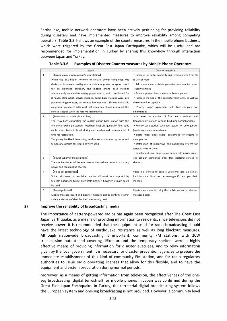
3-48
Earthquake, mobile network operators have been actively petitioning for providing reliability during disasters and have implemented measures to improve reliability among competing operators. Table 3.3.6 shows an example of the countermeasures in the mobile phone business, which were triggered by the Great East Japan Earthquake, which will be useful and are recommended for implementation in Turkey by sharing this know-how through interaction between Japan and Turkey.
Table 3.3.6 Examples of Disaster Countermeasures by Mobile Phone Operators Lesson Counter-measure
1 【Power loss of mobile phone’s base station】
When the distribution network of electric power companies was
destroyed by a major earthquake, a wide area power outage occurred
for an extended duration, the mobile phone base stations
automatically switched to battery power source, which only lasted for
8 hours, after which service stopped. Some base stations were also
powered by generators, but reserve fuel was not sufficient and traffic
congestion prevented additional fuel procurement, and as a result the
service stopped when the reserve fuel finished.
・Increase the battery capacity and retention time from 8h
to 24h or more
・Add more spare portable generators and mobile power
supply vehicles
・Equip important base stations with solar panels
・Increase the size of the generator fuel tanks, as well as
the reserve fuel capacity.
・ Priority supply agreement with fuel company for
emergencies
2 【Disruption of mobile phone‘s line】
The relay lines connecting the mobile phone base station with the
telephone exchange stations (backhaul line) are generally fiber-optic
cable, which tends to break during earthquakes and requires a lot of
time for restoration.
Temporary backhaul lines using satellite communication systems and
temporary satellite base stations were used.
・ Increase the number of fixed earth stations and
transportable stations in stand-by during normal periods.
・Review base station coverage system for emergencies
(apply large scale zone scheme)
・ Spare “fiber optic cable” equipment for repairs in
emergencies.
・ Installation of microwave communication system for
temporary trunk circuit.
・Supplement small base station (femto cell) service area.
3 【Power supply of mobile phone】
The mobile phones of the evacuees at the shelters ran out of battery
power and could not be charged.
The cellular companies offer free charging service in
shelters.
4 【Voice call congestion】
Voice calls were not available due to call restrictions imposed by
telecom operators during large-scale disaster; however, e-mails could
be used.
Voice mail service to send a voice message via e-mail.
Recipients can listen to the messages if they open their
mailbox.)
5 【Message board】
Mobile message board and disaster message dial to confirm victims’
safety and safety of their families’ was heavily used.
Create awareness for using the mobile version of disaster
message board.
2) Improve the reliability of broadcasting media
The importance of battery-powered radios has again been recognized after The Great East Japan Earthquake, as a means of providing information to residents, since televisions did not receive power. It is recommended that the equipment used for radio broadcasting should have the latest technology of earthquake resistance as well as long blackout measures. Although nationwide broadcasting is important, community FM stations, with 20W transmission output and covering 15km around the temporary shelters were a highly effective means of providing information for disaster evacuees, and to relay information given by the local government. It is necessary for disaster prevention agencies to prepare the immediate establishment of this kind of community FM station, and for radio regulatory authorities to issue radio operating licenses that allow for this flexibly, and to have the equipment and system preparation during normal periods.
Moreover, as a means of getting information from television, the effectiveness of the one-seg broadcasting (digital terrestrial) for mobile phones in Japan was confirmed during the Great East Japan Earthquake. In Turkey, the terrestrial digital broadcasting system follows the European system and one-seg broadcasting is not provided. However, a community level
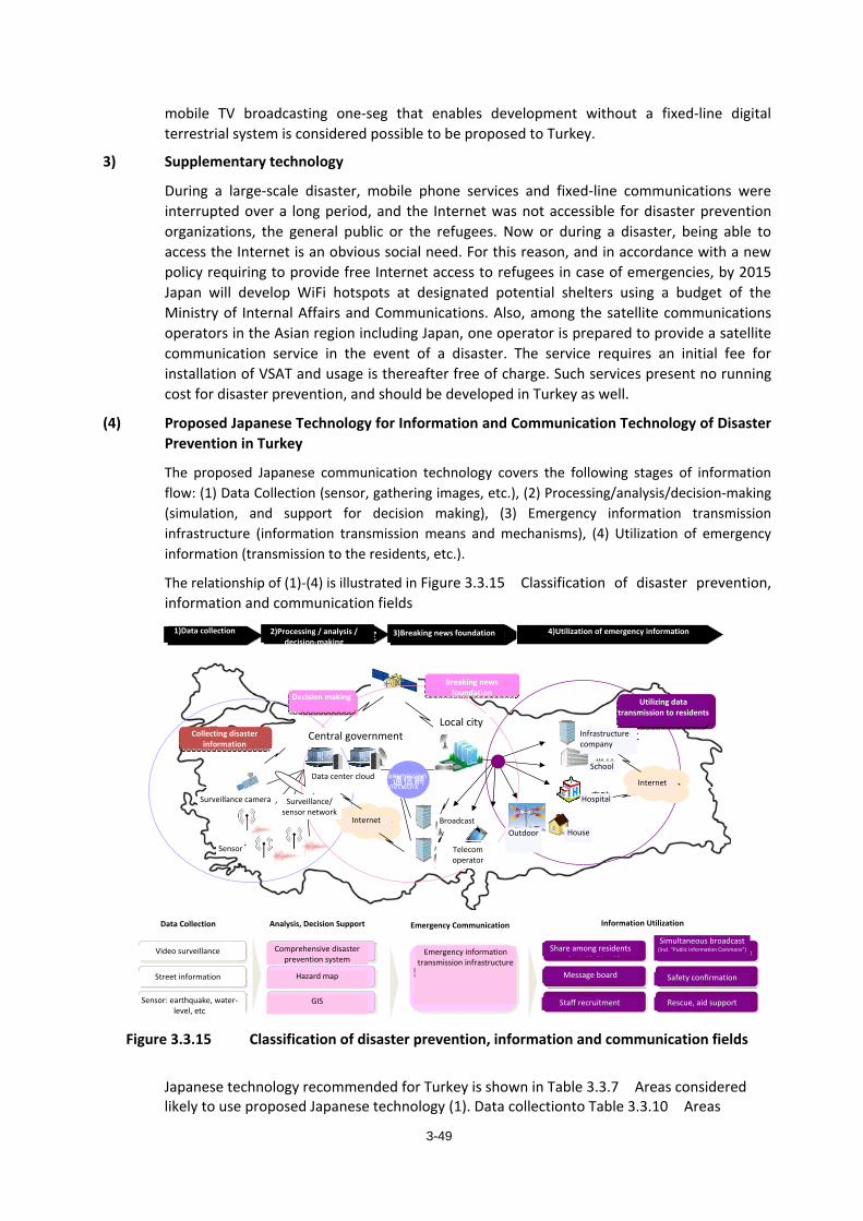
3-49
mobile TV broadcasting one-seg that enables development without a fixed-line digital terrestrial system is considered possible to be proposed to Turkey.
3) Supplementary technology
During a large-scale disaster, mobile phone services and fixed-line communications were interrupted over a long period, and the Internet was not accessible for disaster prevention organizations, the general public or the refugees. Now or during a disaster, being able to access the Internet is an obvious social need. For this reason, and in accordance with a new policy requiring to provide free Internet access to refugees in case of emergencies, by 2015 Japan will develop WiFi hotspots at designated potential shelters using a budget of the Ministry of Internal Affairs and Communications. Also, among the satellite communications operators in the Asian region including Japan, one operator is prepared to provide a satellite communication service in the event of a disaster. The service requires an initial fee for installation of VSAT and usage is thereafter free of charge. Such services present no running cost for disaster prevention, and should be developed in Turkey as well.
(4) Proposed Japanese Technology for Information and Communication Technology of Disaster Prevention in Turkey
The proposed Japanese communication technology covers the following stages of information flow: (1) Data Collection (sensor, gathering images, etc.), (2) Processing/analysis/decision-making (simulation, and support for decision making), (3) Emergency information transmission infrastructure (information transmission means and mechanisms), (4) Utilization of emergency information (transmission to the residents, etc.).
The relationship of (1)-(4) is illustrated in Figure 3.3.15 Classification of disaster prevention, information and communication fields
総合防災システム
ハザードマップ
映像監視
GIS
分析、意思決定支援情報収集
住民間共有
災害伝言板
職員参集 救援・救助支援
一斉同報(公共コモンズ含む)
道路情報
センサ地震河川等
情報の利活用
安否確認
③緊急速報の伝達基盤 ④緊急情報の利活用
中央政府地方都市
センサ
監視カメラ等 監視・センサネットワーク
学校
病院
放送家庭
屋外
住民への情報伝達利活用
緊急速報の基盤
災害情報の収集
インターネット
通信網
通信会社
インターネット
インフラ会社
データセンタ・クラウド
緊急速報・防災通信の伝達基盤
緊急通信伝達
②処理・分析・意思決定①情報収集
意思決定
Figure 3.3.15 Classification of disaster prevention, information and communication fields
Japanese technology recommended for Turkey is shown in Table 3.3.7 Areas considered likely to use proposed Japanese technology (1). Data collectionto Table 3.3.10 Areas
Data Collection Analysis, Decision Support Emergency Communication Information Utilization
Hazard map
Comprehensive disaster prevention system
Video surveillance
Street information
Sensor: earthquake, water-level, etc
GIS
Emergency information transmission infrastructure
Share among residents
Message board
Staff recruitment
Simultaneous broadcast(incl. “Public Information Commons”)
Safety confirmation
Rescue, aid support
Internet
Internet
Data center cloud
Surveillance camera
Sensor
Surveillance/ sensor network
Central governmentLocal city
Transmission network
Broadcast
Telecom operator
School
Hospital
House
Infrastructure company
Outdoor
Collecting disaster information
Decision making
Breaking news foundation
Utilizing data transmission to residents
1)Data collection 2)Processing / analysis / decision-making
3)Breaking news foundation 4)Utilization of emergency information
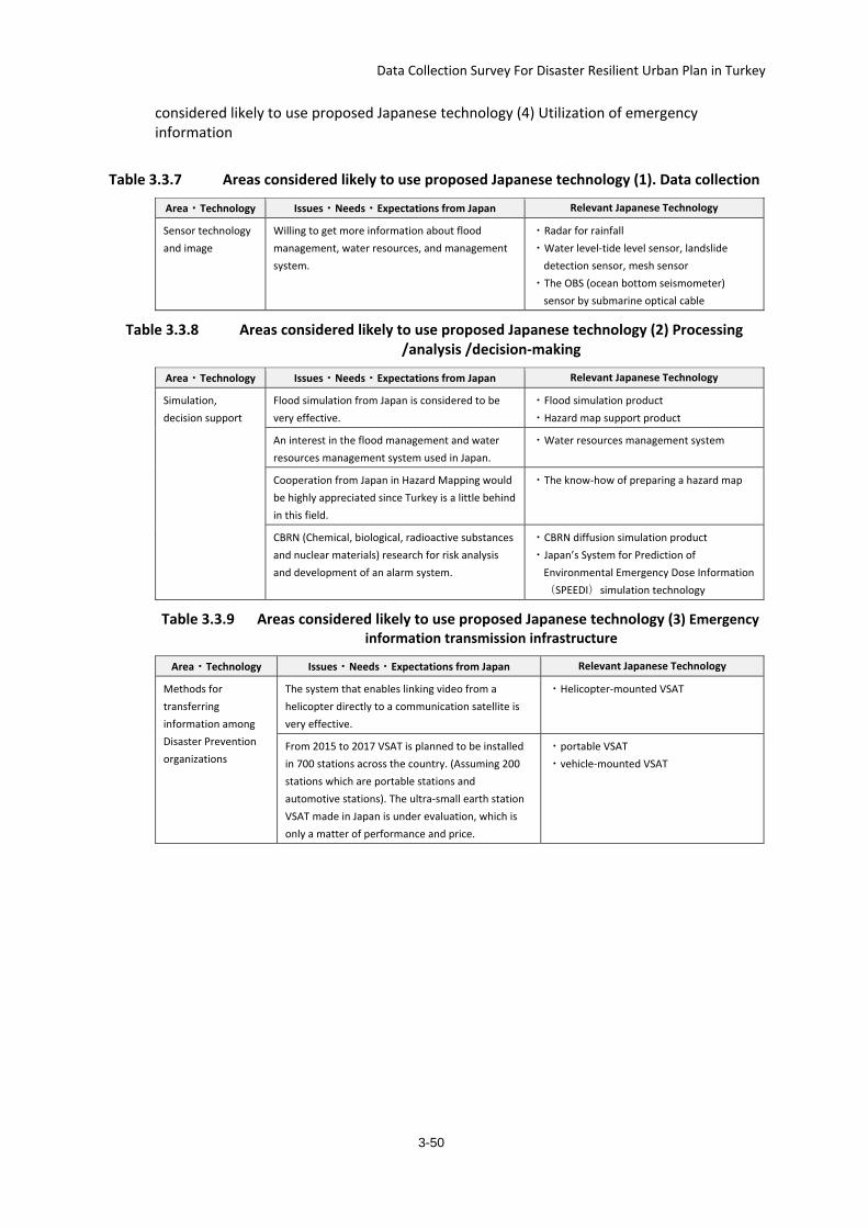
Data Collection Survey For Disaster Resilient Urban Plan in Turkey
3-50
considered likely to use proposed Japanese technology (4) Utilization of emergency information
Table 3.3.7 Areas considered likely to use proposed Japanese technology (1). Data collection
Area・Technology Issues・Needs・Expectations from Japan Relevant Japanese Technology
Sensor technology and image
Willing to get more information about flood management, water resources, and management system.
・Radar for rainfall ・Water level-tide level sensor, landslide
detection sensor, mesh sensor ・The OBS (ocean bottom seismometer)
sensor by submarine optical cable
Table 3.3.8 Areas considered likely to use proposed Japanese technology (2) Processing /analysis /decision-making
Area・Technology Issues・Needs・Expectations from Japan Relevant Japanese Technology
Simulation, decision support
Flood simulation from Japan is considered to be very effective.
・Flood simulation product ・Hazard map support product
An interest in the flood management and water resources management system used in Japan.
・Water resources management system
Cooperation from Japan in Hazard Mapping would be highly appreciated since Turkey is a little behind in this field.
・The know-how of preparing a hazard map
CBRN (Chemical, biological, radioactive substances and nuclear materials) research for risk analysis and development of an alarm system.
・CBRN diffusion simulation product ・Japan’s System for Prediction of
Environmental Emergency Dose Information(SPEEDI)simulation technology
Table 3.3.9 Areas considered likely to use proposed Japanese technology (3) Emergency information transmission infrastructure
Area・Technology Issues・Needs・Expectations from Japan Relevant Japanese Technology
Methods for transferring information among Disaster Prevention organizations
The system that enables linking video from a helicopter directly to a communication satellite is very effective.
・Helicopter-mounted VSAT
From 2015 to 2017 VSAT is planned to be installed in 700 stations across the country. (Assuming 200 stations which are portable stations and automotive stations). The ultra-small earth station VSAT made in Japan is under evaluation, which is only a matter of performance and price.
・portable VSAT ・vehicle-mounted VSAT
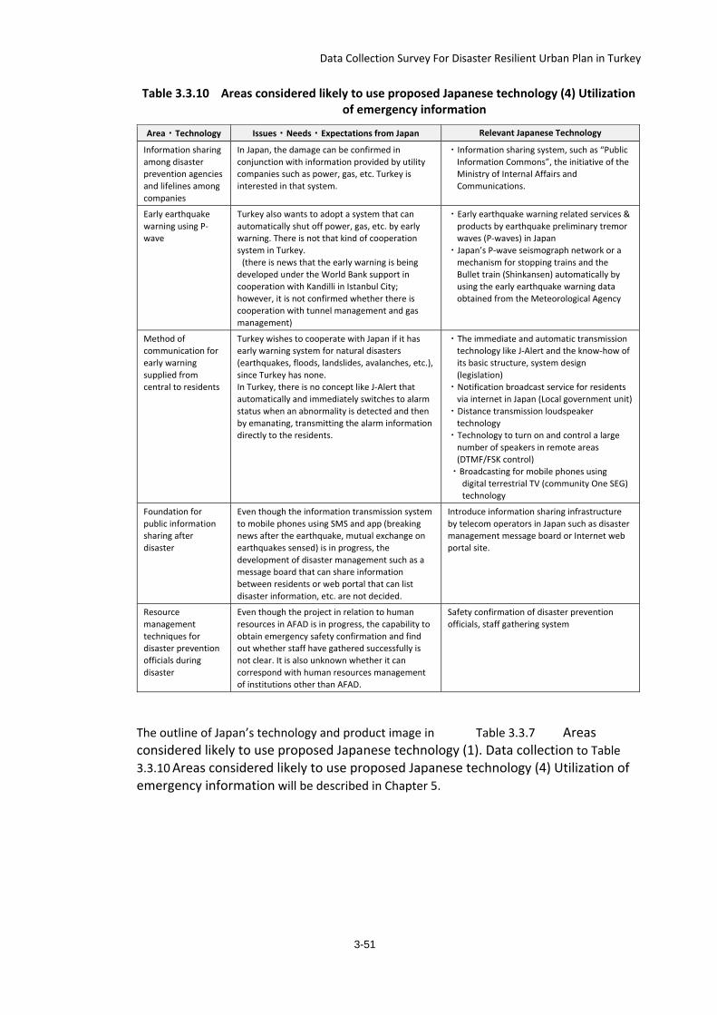
Data Collection Survey For Disaster Resilient Urban Plan in Turkey
3-51
Table 3.3.10 Areas considered likely to use proposed Japanese technology (4) Utilization of emergency information
Area・Technology Issues・Needs・Expectations from Japan Relevant Japanese Technology
Information sharing among disaster prevention agencies and lifelines among companies
In Japan, the damage can be confirmed in conjunction with information provided by utility companies such as power, gas, etc. Turkey is interested in that system.
・Information sharing system, such as “Public Information Commons”, the initiative of the Ministry of Internal Affairs and Communications.
Early earthquake warning using P-wave
Turkey also wants to adopt a system that can automatically shut off power, gas, etc. by early warning. There is not that kind of cooperation system in Turkey. (there is news that the early warning is being developed under the World Bank support in cooperation with Kandilli in Istanbul City; however, it is not confirmed whether there is cooperation with tunnel management and gas management)
・Early earthquake warning related services & products by earthquake preliminary tremor waves (P-waves) in Japan
・Japan’s P-wave seismograph network or a mechanism for stopping trains and the Bullet train (Shinkansen) automatically by using the early earthquake warning data obtained from the Meteorological Agency
Method of communication for early warning supplied from central to residents
Turkey wishes to cooperate with Japan if it has early warning system for natural disasters (earthquakes, floods, landslides, avalanches, etc.), since Turkey has none. In Turkey, there is no concept like J-Alert that automatically and immediately switches to alarm status when an abnormality is detected and then by emanating, transmitting the alarm information directly to the residents.
・The immediate and automatic transmission technology like J-Alert and the know-how of its basic structure, system design (legislation)
・Notification broadcast service for residents via internet in Japan (Local government unit)
・Distance transmission loudspeaker technology
・Technology to turn on and control a large number of speakers in remote areas (DTMF/FSK control)
・Broadcasting for mobile phones using digital terrestrial TV (community One SEG) technology
Foundation for public information sharing after disaster
Even though the information transmission system to mobile phones using SMS and app (breaking news after the earthquake, mutual exchange on earthquakes sensed) is in progress, the development of disaster management such as a message board that can share information between residents or web portal that can list disaster information, etc. are not decided.
Introduce information sharing infrastructure by telecom operators in Japan such as disaster management message board or Internet web portal site.
Resource management techniques for disaster prevention officials during disaster
Even though the project in relation to human resources in AFAD is in progress, the capability to obtain emergency safety confirmation and find out whether staff have gathered successfully is not clear. It is also unknown whether it can correspond with human resources management of institutions other than AFAD.
Safety confirmation of disaster prevention officials, staff gathering system
The outline of Japan’s technology and product image in Table 3.3.7 Areas considered likely to use proposed Japanese technology (1). Data collection to Table 3.3.10 Areas considered likely to use proposed Japanese technology (4) Utilization of emergency information will be described in Chapter 5.
Data Collection Survey For Disaster Resilient Urban Plan in Turkey
4. Case Study in Bursa Province The case study for disaster risk management and resilient urban planning in Bursa is described in this Chapter.
4.1. Major Risks of Disaster in Bursa Bursa is located in the South Marmara region, in northwestern Turkey, has an area of 10,819 km² and a population of 2.688 million as of 2012. The major risks of disaster in Bursa are as follows.
(1) There are several active faults in Bursa, and Bursa is located in the zone 1 of the Earthquake Risk Map in Turkey (Figure 3.1.1). Two earthquakes, M7.1 and M6.7, occurred in 1855 close to Bursa city. The events were considered having a return period of 180-200 years and, therefore, there is a high possibility of the occurrence in the near future.
(2) Bursa City has the 4th largest population in Turkey. As a result of the rapid population growth and growth of industrial activities in recent years, there are high-density residential and industry-residential mixed areas with vulnerable buildings constructed without obtaining construction permits.
(3) Since Bursa is a historical city, historical cityscapes are seen in the old town area. Although the historical city was built on solid ground, many buildings were built before the current building code or without permission, particularly on the mountain side, and are likely to collapse or suffer significant damage in the event of an earthquake. Also there are areas with no access route for emergency vehicles.
(4) Bursa is a major center for the thriving automobile industry in Turkey, and is also famous for its textile and food processing industries. Currently 13 large industrial zones are located in Bursa Province. In case of a large earthquake, possible secondary disasters may occur due to chemical factories and oil-related facilities. Damage to the industries and transportation network may also cause a big impact on the supply chain and consequently on Turkey’s economy.
(5) There are a number of active faults in the vicinity of Bursa. According to the Natural Disaster Insurance Institution (TCIP) of Turkey, the probability of an earthquake larger than M7.0 within a radius of 50 km around Istanbul is about 50% for the period up to 2030. The event may directly affect Bursa, which would not be able to provide its full support to Istanbul for disaster response and recovery.
(6) In addition to earthquakes, Bursa also faces the risks of floods and landslides. Multi-hazards and compound hazards should be taken into consideration. The flood hazard in Bursa province is due to the limited volume capacity and shape of the rivers and to the presence of dams, which if they collapsed, would cause flooding in Bursa province. There is a high risk of landslide in Inegol district.
As a result, there is an urgent need for seismic strengthening of buildings, establishment of disaster mitigation facilities, and formulation of a disaster management plan for disaster mitigation.
4.1.1. General Background Information Bursa is located across from Istanbul on the Marmara Sea. Bursa is the 4th largest province in Turkey by both population and industry production. With the revision of Law No. 5216 in March 2014, the boundary of Bursa Municipality was expanded to the boundary of the
4-1
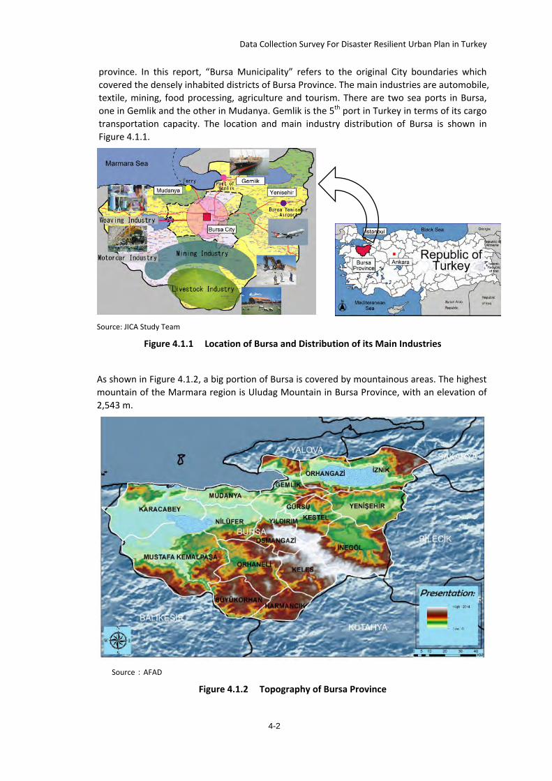
Data Collection Survey For Disaster Resilient Urban Plan in Turkey
province. In this report, “Bursa Municipality” refers to the original City boundaries which covered the densely inhabited districts of Bursa Province. The main industries are automobile, textile, mining, food processing, agriculture and tourism. There are two sea ports in Bursa, one in Gemlik and the other in Mudanya. Gemlik is the 5th port in Turkey in terms of its cargo transportation capacity. The location and main industry distribution of Bursa is shown in Figure 4.1.1.
Source: JICA Study Team
Figure 4.1.1 Location of Bursa and Distribution of its Main Industries
As shown in Figure 4.1.2, a big portion of Bursa is covered by mountainous areas. The highest mountain of the Marmara region is Uludag Mountain in Bursa Province, with an elevation of 2,543 m.
Source:AFAD
Figure 4.1.2 Topography of Bursa Province
4-2
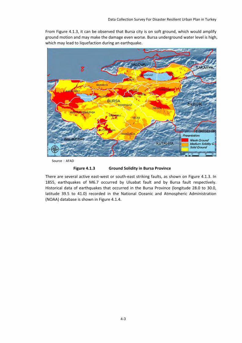
Data Collection Survey For Disaster Resilient Urban Plan in Turkey
From Figure 4.1.3, it can be observed that Bursa city is on soft ground, which would amplify ground motion and may make the damage even worse. Bursa underground water level is high, which may lead to liquefaction during an earthquake.
Source:AFAD
Figure 4.1.3 Ground Solidity in Bursa Province
There are several active east-west or south-east striking faults, as shown on Figure 4.1.3. In 1855, earthquakes of M6.7 occurred by Uluabat fault and by Bursa fault respectively. Historical data of earthquakes that occurred in the Bursa Province (longitude 28.0 to 30.0, latitude 39.5 to 41.0) recorded in the National Oceanic and Atmospheric Administration (NOAA) database is shown in Figure 4.1.4.
4-3
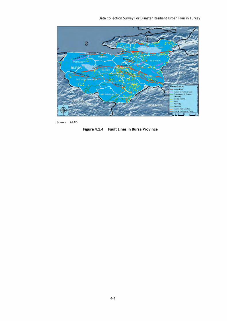
Data Collection Survey For Disaster Resilient Urban Plan in Turkey
Source:AFAD
Figure 4.1.4 Fault Lines in Bursa Province
4-4
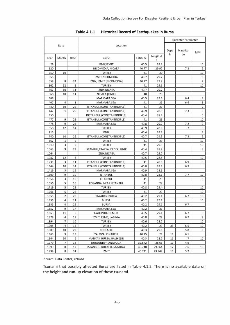
Data Collection Survey For Disaster Resilient Urban Plan in Turkey
Table 4.1.1 Historical Record of Earthquakes in Bursa
Date Location
Epicenter Parameter
Depth
Magnitude MMI
Year Month Date Name Latitude Longitude
29 IZNIK,IZMIT 40.5 28.9 10 120 NICOMEDIA, NICAEA 40.77 29.92 7.2 9 350 10 TURKEY 41 30 10 355 IZMIT,NICOMEDIA 40.7 29.7 9 358 8 24 IZNIK, IZMIT [NICOMEDIA] 40.77 29.9 7 362 12 2 TURKEY 41 29.5 10 367 10 11 IZNIK,NICAEA 40.7 29.7 368 10 11 NICAEA [IZNIK] 40 29 368 MARMARA SEA 40.5 29.6 6.4 8 407 4 1 MARMARA SEA 41 29 6.6 8 440 10 26 ISTANBUL (CONSTANTINOPLE) 41 29 7 447 1 26 ISTANBUL (CONSTANTINOPLE) 40.9 28.5 7.3 9 450 INSTANBUL (CONSTANTINOPLE) 40.4 28.4 5 477 9 25 ISTANBUL (CONSTANTINOPLE) 41 29 10 478 9 25 MARMARA SEA 40.8 29.2 7.2 9 558 12 14 TURKEY 40.9 28.8 7 9 715 IZNIK 40.4 28.9 9 740 10 26 ISTANBUL (CONSTANTINOPLE) 40.7 29.3 7.3 9 867 1 9 TURKEY 41 29 10
1010 3 9 TURKEY 41 29.5 10 1063 9 23 ISTANBUL,TRAKYA, ERDEK, IZNIK 40.4 28.9 8 1064 IZNIK,NICAEA 40.7 29.7 1082 12 6 TURKEY 40.5 28.5 10 1231 3 11 ISTANBUL (CONSTANTINOPLE) 41 28.6 6.9 8 1344 10 14 ISTANBUL (CONSTANTINOPLE) 40.8 28.8 6.9 1419 3 15 MARMARA SEA 40.9 28.9 1509 9 10 ISTANBUL 40.8 28.1 7.7 10 1556 3 10 ISTANBUL 41 29 5 1556 5 10 ROSANNA; NEAR ISTANBUL 41 29 1719 5 25 TURKEY 40.8 29.4 10 1766 5 22 TURKEY 41 29 10 1855 2 28 TAYABAS, BURSA 40.2 29.1 6.7 10 1855 4 11 BURSA 40.2 29.1 10 1855 4 29 BURSA 40.2 29.1 6.7 1857 9 17 MARMARA SEA 40.2 29 1863 11 6 GALLIPOLI, GEMLIK 40.5 29.1 6.7 9 1878 4 19 IZMIT, ESME, LABINIA 40.8 29 6.7 9 1894 7 10 TURKEY 40.6 28.7 10 1905 4 15 TURKEY 40.2 29 33 6.5 10 1909 10 29 KOGLACIK 40.3 29.6 5.8 8 1963 9 18 YALOVA: CINARCIK 40.75 29 19 6.1 1964 10 6 MANYAS, BURSA, BALIKESIR 40.3 28.2 15 7 10 1979 7 18 DURSUNBEY, ANATOLIA 39.672 28.66 10 4.9 1999 8 17 ISTANBUL, KOCAELI, SAKARYA 40.748 29.864 17 7.6 10 1999 8 31 IZMIT 40.711 29.949 10 5.2
Source: Data Center, =NOAA
Tsunami that possibly affected Bursa are listed in Table 4.1.2. There is no available data on the height and run-up elevation of these tsunami.
4-5
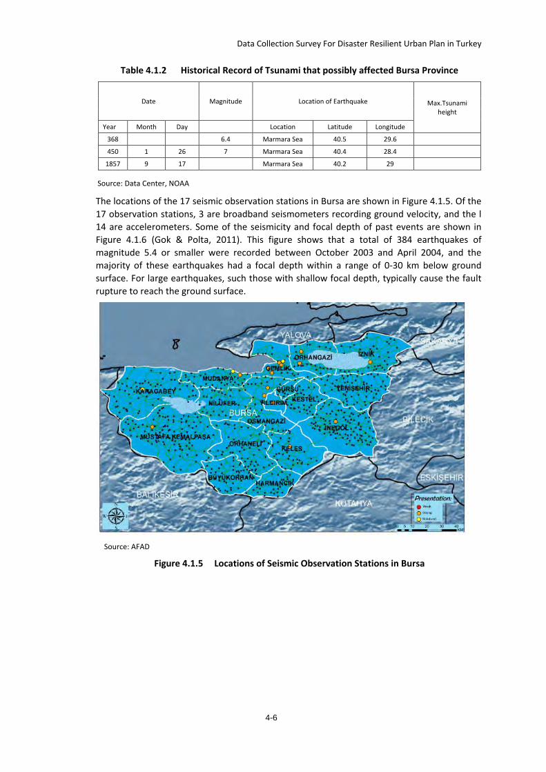
Data Collection Survey For Disaster Resilient Urban Plan in Turkey
Table 4.1.2 Historical Record of Tsunami that possibly affected Bursa Province
Date Magnitude Location of Earthquake Max.Tsunami height
Year Month Day Location Latitude Longitude
368 6.4 Marmara Sea 40.5 29.6
450 1 26 7 Marmara Sea 40.4 28.4
1857 9 17 Marmara Sea 40.2 29
Source: Data Center, NOAA
The locations of the 17 seismic observation stations in Bursa are shown in Figure 4.1.5. Of the 17 observation stations, 3 are broadband seismometers recording ground velocity, and the l 14 are accelerometers. Some of the seismicity and focal depth of past events are shown in Figure 4.1.6 (Gok & Polta, 2011). This figure shows that a total of 384 earthquakes of magnitude 5.4 or smaller were recorded between October 2003 and April 2004, and the majority of these earthquakes had a focal depth within a range of 0-30 km below ground surface. For large earthquakes, such those with shallow focal depth, typically cause the fault rupture to reach the ground surface.
Source: AFAD
Figure 4.1.5 Locations of Seismic Observation Stations in Bursa
4-6
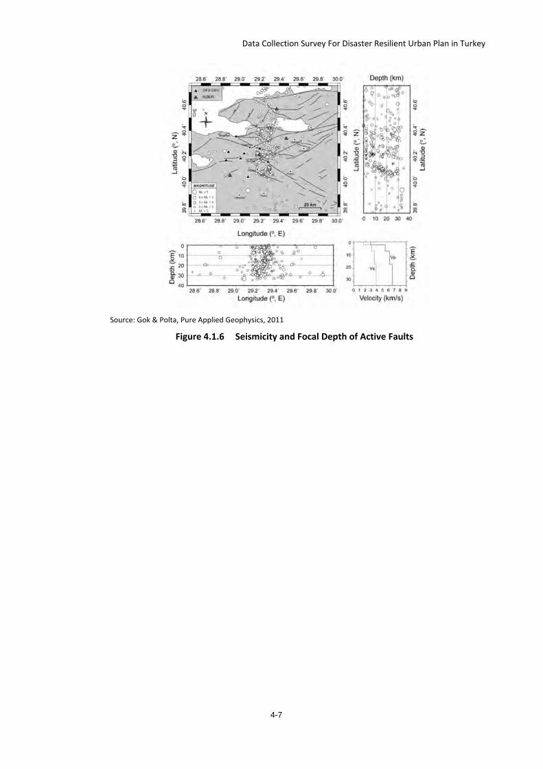
Data Collection Survey For Disaster Resilient Urban Plan in Turkey
Source: Gok & Polta, Pure Applied Geophysics, 2011
Figure 4.1.6 Seismicity and Focal Depth of Active Faults
4-7
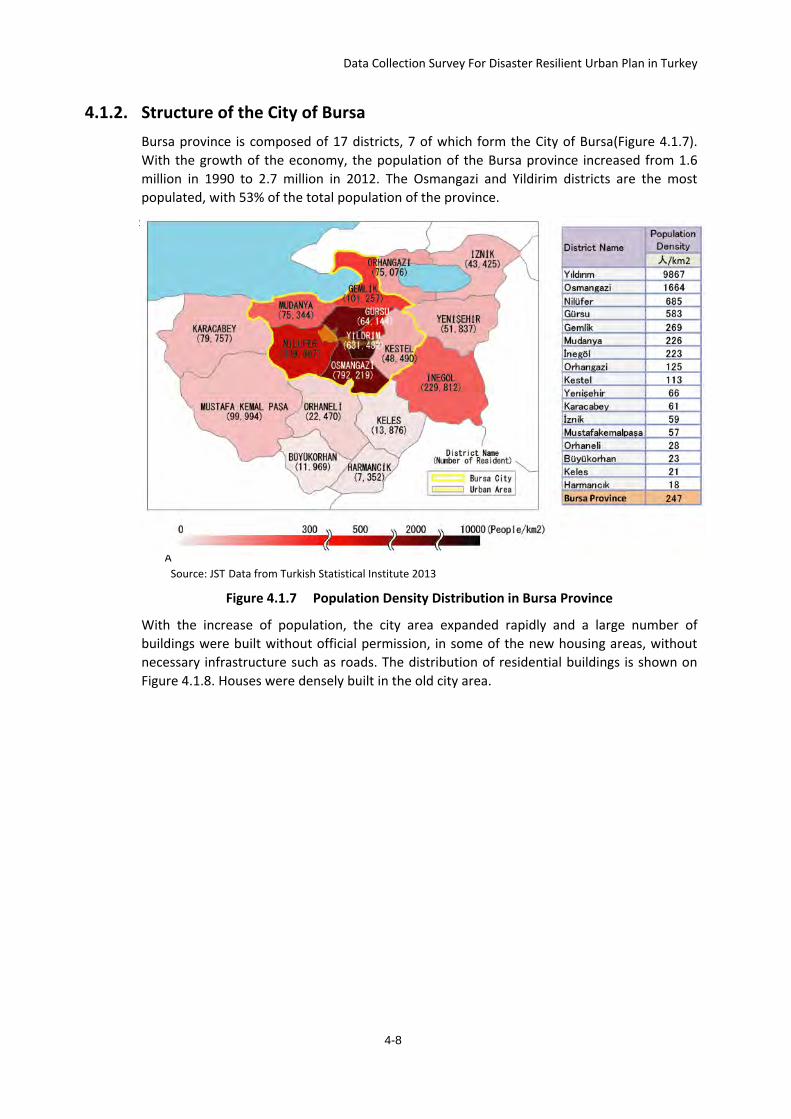
Data Collection Survey For Disaster Resilient Urban Plan in Turkey
4.1.2. Structure of the City of Bursa Bursa province is composed of 17 districts, 7 of which form the City of Bursa(Figure 4.1.7). With the growth of the economy, the population of the Bursa province increased from 1.6 million in 1990 to 2.7 million in 2012. The Osmangazi and Yildirim districts are the most populated, with 53% of the total population of the province.
Source: JICSource: JIA Source: JST Data from Turkish Statistical Institute 2013
Figure 4.1.7 Population Density Distribution in Bursa Province
With the increase of population, the city area expanded rapidly and a large number of buildings were built without official permission, in some of the new housing areas, without necessary infrastructure such as roads. The distribution of residential buildings is shown on Figure 4.1.8. Houses were densely built in the old city area.
4-8
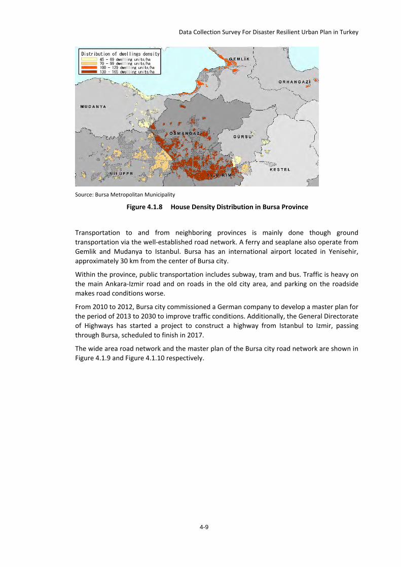
Data Collection Survey For Disaster Resilient Urban Plan in Turkey
Source: Bursa Metropolitan Municipality
Figure 4.1.8 House Density Distribution in Bursa Province
Transportation to and from neighboring provinces is mainly done though ground transportation via the well-established road network. A ferry and seaplane also operate from Gemlik and Mudanya to Istanbul. Bursa has an international airport located in Yenisehir, approximately 30 km from the center of Bursa city.
Within the province, public transportation includes subway, tram and bus. Traffic is heavy on the main Ankara-Izmir road and on roads in the old city area, and parking on the roadside makes road conditions worse.
From 2010 to 2012, Bursa city commissioned a German company to develop a master plan for the period of 2013 to 2030 to improve traffic conditions. Additionally, the General Directorate of Highways has started a project to construct a highway from Istanbul to Izmir, passing through Bursa, scheduled to finish in 2017.
The wide area road network and the master plan of the Bursa city road network are shown in Figure 4.1.9 and Figure 4.1.10 respectively.
4-9
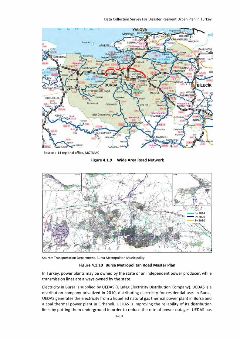
Data Collection Survey For Disaster Resilient Urban Plan in Turkey
Source:14 regional office, MOTMAC
Figure 4.1.9 Wide Area Road Network
Source: Transportation Department, Bursa Metropolitan Municipality
Figure 4.1.10 Bursa Metropolitan Road Master Plan
In Turkey, power plants may be owned by the state or an independent power producer, while transmission lines are always owned by the state.
Electricity in Bursa is supplied by UEDAS (Uludag Electricity Distribution Company). UEDAS is a distribution company privatized in 2010, distributing electricity for residential use. In Bursa, UEDAS generates the electricity from a liquefied natural gas thermal power plant in Bursa and a coal thermal power plant in Orhaneli. UEDAS is improving the reliability of its distribution lines by putting them underground in order to reduce the rate of power outages. UEDAS has
By 2014 By 2020 By 2030
4-10
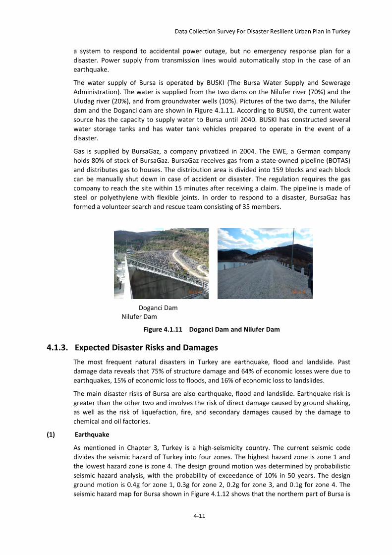
Data Collection Survey For Disaster Resilient Urban Plan in Turkey
a system to respond to accidental power outage, but no emergency response plan for a disaster. Power supply from transmission lines would automatically stop in the case of an earthquake.
The water supply of Bursa is operated by BUSKI (The Bursa Water Supply and Sewerage Administration). The water is supplied from the two dams on the Nilufer river (70%) and the Uludag river (20%), and from groundwater wells (10%). Pictures of the two dams, the Nilufer dam and the Doganci dam are shown in Figure 4.1.11. According to BUSKI, the current water source has the capacity to supply water to Bursa until 2040. BUSKI has constructed several water storage tanks and has water tank vehicles prepared to operate in the event of a disaster.
Gas is supplied by BursaGaz, a company privatized in 2004. The EWE, a German company holds 80% of stock of BursaGaz. BursaGaz receives gas from a state-owned pipeline (BOTAS) and distributes gas to houses. The distribution area is divided into 159 blocks and each block can be manually shut down in case of accident or disaster. The regulation requires the gas company to reach the site within 15 minutes after receiving a claim. The pipeline is made of steel or polyethylene with flexible joints. In order to respond to a disaster, BursaGaz has formed a volunteer search and rescue team consisting of 35 members.
Doganci Dam
Nilufer Dam
Figure 4.1.11 Doganci Dam and Nilufer Dam
4.1.3. Expected Disaster Risks and Damages The most frequent natural disasters in Turkey are earthquake, flood and landslide. Past damage data reveals that 75% of structure damage and 64% of economic losses were due to earthquakes, 15% of economic loss to floods, and 16% of economic loss to landslides.
The main disaster risks of Bursa are also earthquake, flood and landslide. Earthquake risk is greater than the other two and involves the risk of direct damage caused by ground shaking, as well as the risk of liquefaction, fire, and secondary damages caused by the damage to chemical and oil factories.
(1) Earthquake
As mentioned in Chapter 3, Turkey is a high-seismicity country. The current seismic code divides the seismic hazard of Turkey into four zones. The highest hazard zone is zone 1 and the lowest hazard zone is zone 4. The design ground motion was determined by probabilistic seismic hazard analysis, with the probability of exceedance of 10% in 50 years. The design ground motion is 0.4g for zone 1, 0.3g for zone 2, 0.2g for zone 3, and 0.1g for zone 4. The seismic hazard map for Bursa shown in Figure 4.1.12 shows that the northern part of Bursa is
4-11
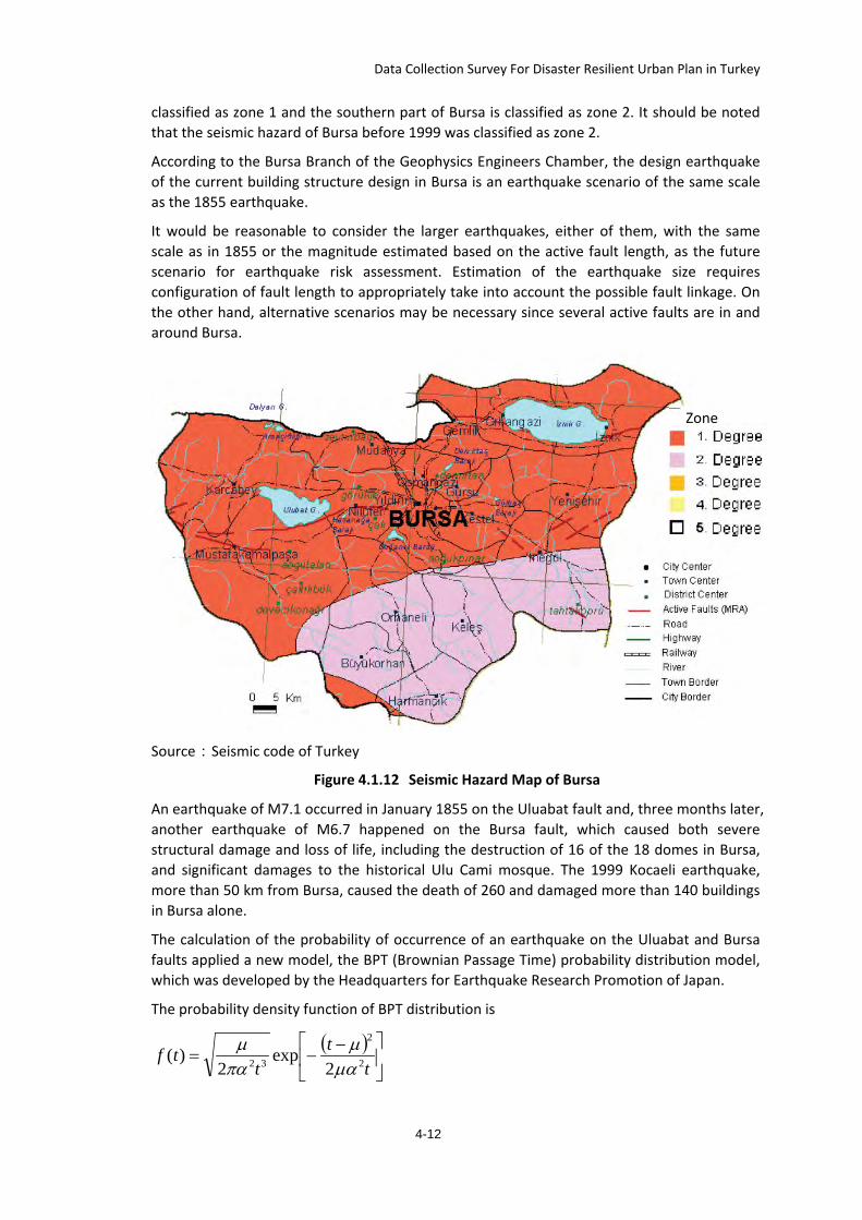
Data Collection Survey For Disaster Resilient Urban Plan in Turkey
classified as zone 1 and the southern part of Bursa is classified as zone 2. It should be noted that the seismic hazard of Bursa before 1999 was classified as zone 2.
According to the Bursa Branch of the Geophysics Engineers Chamber, the design earthquake of the current building structure design in Bursa is an earthquake scenario of the same scale as the 1855 earthquake.
It would be reasonable to consider the larger earthquakes, either of them, with the same scale as in 1855 or the magnitude estimated based on the active fault length, as the future scenario for earthquake risk assessment. Estimation of the earthquake size requires configuration of fault length to appropriately take into account the possible fault linkage. On the other hand, alternative scenarios may be necessary since several active faults are in and around Bursa.
Source:Seismic code of Turkey
Figure 4.1.12 Seismic Hazard Map of Bursa
An earthquake of M7.1 occurred in January 1855 on the Uluabat fault and, three months later, another earthquake of M6.7 happened on the Bursa fault, which caused both severe structural damage and loss of life, including the destruction of 16 of the 18 domes in Bursa, and significant damages to the historical Ulu Cami mosque. The 1999 Kocaeli earthquake, more than 50 km from Bursa, caused the death of 260 and damaged more than 140 buildings in Bursa alone.
The calculation of the probability of occurrence of an earthquake on the Uluabat and Bursa faults applied a new model, the BPT (Brownian Passage Time) probability distribution model, which was developed by the Headquarters for Earthquake Research Promotion of Japan.
The probability density function of BPT distribution is
( )
−−=
tt
ttf 2
2
32 2exp
2)(
µαµ
παµ
Zone
4-12
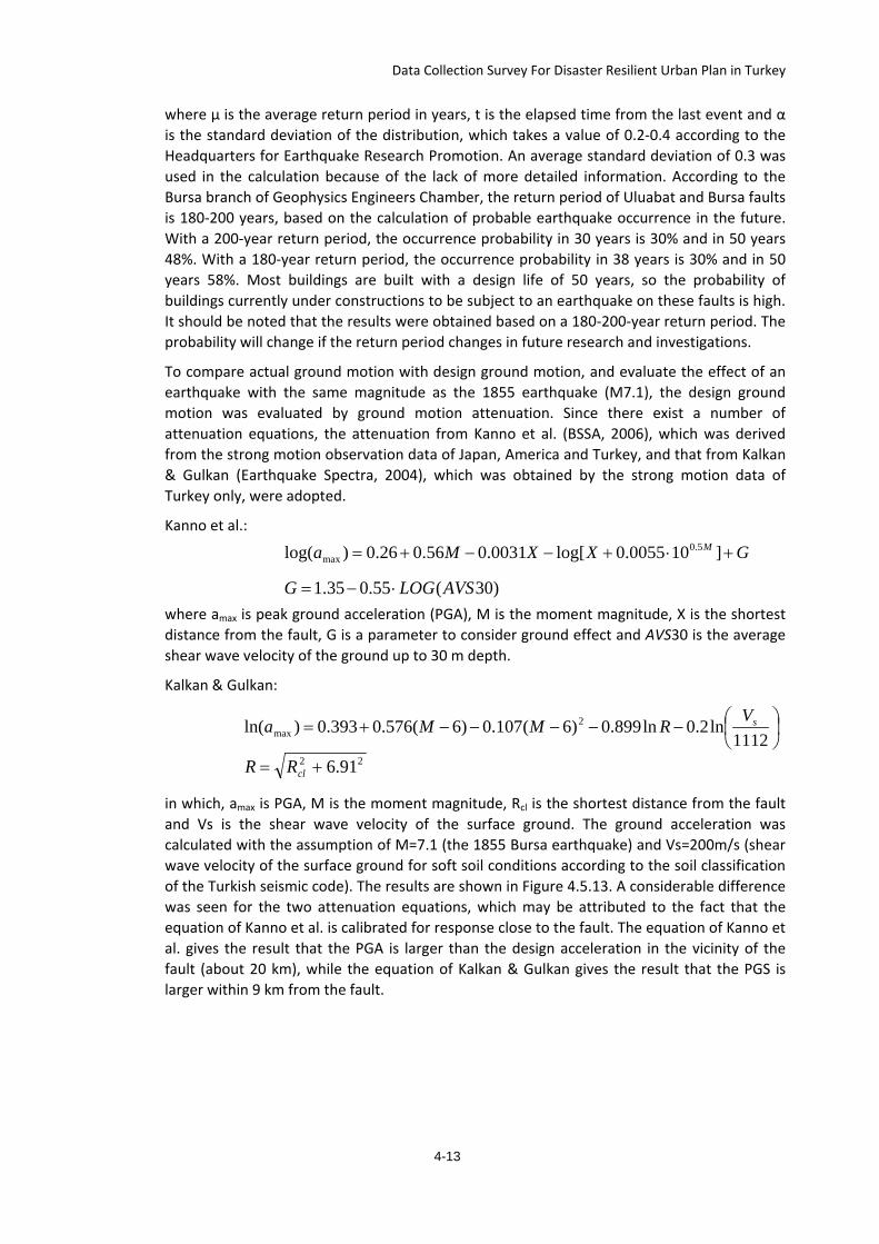
Data Collection Survey For Disaster Resilient Urban Plan in Turkey
where μ is the average return period in years, t is the elapsed time from the last event and α is the standard deviation of the distribution, which takes a value of 0.2-0.4 according to the Headquarters for Earthquake Research Promotion. An average standard deviation of 0.3 was used in the calculation because of the lack of more detailed information. According to the Bursa branch of Geophysics Engineers Chamber, the return period of Uluabat and Bursa faults is 180-200 years, based on the calculation of probable earthquake occurrence in the future. With a 200-year return period, the occurrence probability in 30 years is 30% and in 50 years 48%. With a 180-year return period, the occurrence probability in 38 years is 30% and in 50 years 58%. Most buildings are built with a design life of 50 years, so the probability of buildings currently under constructions to be subject to an earthquake on these faults is high. It should be noted that the results were obtained based on a 180-200-year return period. The probability will change if the return period changes in future research and investigations.
To compare actual ground motion with design ground motion, and evaluate the effect of an earthquake with the same magnitude as the 1855 earthquake (M7.1), the design ground motion was evaluated by ground motion attenuation. Since there exist a number of attenuation equations, the attenuation from Kanno et al. (BSSA, 2006), which was derived from the strong motion observation data of Japan, America and Turkey, and that from Kalkan & Gulkan (Earthquake Spectra, 2004), which was obtained by the strong motion data of Turkey only, were adopted.
Kanno et al.:
where amax is peak ground acceleration (PGA), M is the moment magnitude, X is the shortest distance from the fault, G is a parameter to consider ground effect and AVS30 is the average shear wave velocity of the ground up to 30 m depth.
Kalkan & Gulkan:
in which, amax is PGA, M is the moment magnitude, Rcl is the shortest distance from the fault and Vs is the shear wave velocity of the surface ground. The ground acceleration was calculated with the assumption of M=7.1 (the 1855 Bursa earthquake) and Vs=200m/s (shear wave velocity of the surface ground for soft soil conditions according to the soil classification of the Turkish seismic code). The results are shown in Figure 4.5.13. A considerable difference was seen for the two attenuation equations, which may be attributed to the fact that the equation of Kanno et al. is calibrated for response close to the fault. The equation of Kanno et al. gives the result that the PGA is larger than the design acceleration in the vicinity of the fault (about 20 km), while the equation of Kalkan & Gulkan gives the result that the PGS is larger within 9 km from the fault.
GXXMa M +⋅+−−+= ]100055.0log[0031.056.026.0)log( 5.0max
)30(55.035.1 AVSLOGG ⋅−=
−−−−−+=1112
ln2.0ln899.0)6(107.0)6(576.0393.0)ln( 2max
sVRMMa
22 91.6+= clRR
4-13
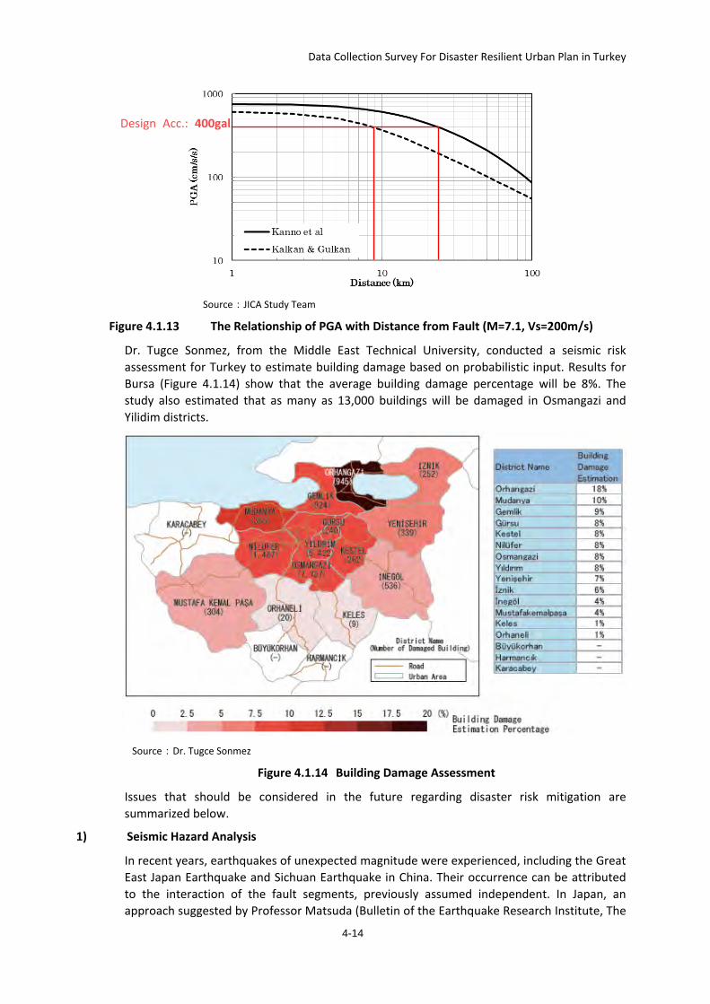
Data Collection Survey For Disaster Resilient Urban Plan in Turkey
Source:JICA Study Team
Figure 4.1.13 The Relationship of PGA with Distance from Fault (M=7.1, Vs=200m/s)
Dr. Tugce Sonmez, from the Middle East Technical University, conducted a seismic risk assessment for Turkey to estimate building damage based on probabilistic input. Results for Bursa (Figure 4.1.14) show that the average building damage percentage will be 8%. The study also estimated that as many as 13,000 buildings will be damaged in Osmangazi and Yilidim districts.
Source:Dr. Tugce Sonmez
Figure 4.1.14 Building Damage Assessment
Issues that should be considered in the future regarding disaster risk mitigation are summarized below.
1) Seismic Hazard Analysis
In recent years, earthquakes of unexpected magnitude were experienced, including the Great East Japan Earthquake and Sichuan Earthquake in China. Their occurrence can be attributed to the interaction of the fault segments, previously assumed independent. In Japan, an approach suggested by Professor Matsuda (Bulletin of the Earthquake Research Institute, The
Design Acc.: 400gal
4-14
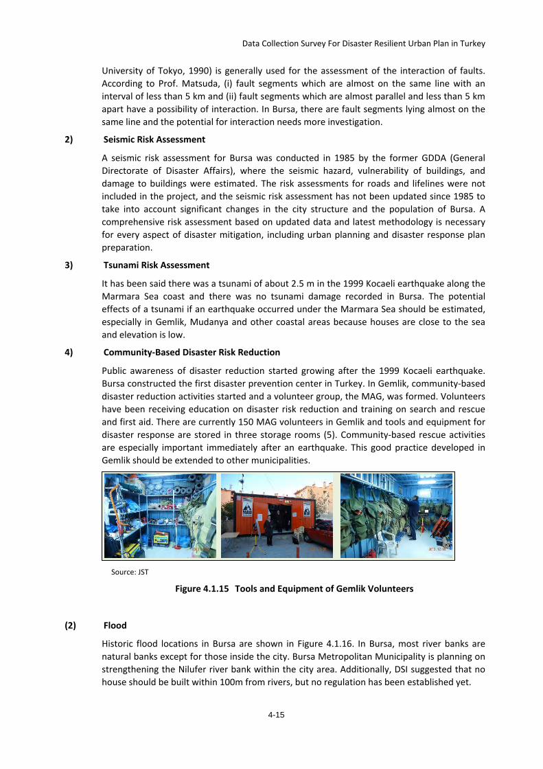
Data Collection Survey For Disaster Resilient Urban Plan in Turkey
University of Tokyo, 1990) is generally used for the assessment of the interaction of faults. According to Prof. Matsuda, (i) fault segments which are almost on the same line with an interval of less than 5 km and (ii) fault segments which are almost parallel and less than 5 km apart have a possibility of interaction. In Bursa, there are fault segments lying almost on the same line and the potential for interaction needs more investigation.
2) Seismic Risk Assessment
A seismic risk assessment for Bursa was conducted in 1985 by the former GDDA (General Directorate of Disaster Affairs), where the seismic hazard, vulnerability of buildings, and damage to buildings were estimated. The risk assessments for roads and lifelines were not included in the project, and the seismic risk assessment has not been updated since 1985 to take into account significant changes in the city structure and the population of Bursa. A comprehensive risk assessment based on updated data and latest methodology is necessary for every aspect of disaster mitigation, including urban planning and disaster response plan preparation.
3) Tsunami Risk Assessment
It has been said there was a tsunami of about 2.5 m in the 1999 Kocaeli earthquake along the Marmara Sea coast and there was no tsunami damage recorded in Bursa. The potential effects of a tsunami if an earthquake occurred under the Marmara Sea should be estimated, especially in Gemlik, Mudanya and other coastal areas because houses are close to the sea and elevation is low.
4) Community-Based Disaster Risk Reduction
Public awareness of disaster reduction started growing after the 1999 Kocaeli earthquake. Bursa constructed the first disaster prevention center in Turkey. In Gemlik, community-based disaster reduction activities started and a volunteer group, the MAG, was formed. Volunteers have been receiving education on disaster risk reduction and training on search and rescue and first aid. There are currently 150 MAG volunteers in Gemlik and tools and equipment for disaster response are stored in three storage rooms (5). Community-based rescue activities are especially important immediately after an earthquake. This good practice developed in Gemlik should be extended to other municipalities.
Source: JST
Figure 4.1.15 Tools and Equipment of Gemlik Volunteers
(2) Flood
Historic flood locations in Bursa are shown in Figure 4.1.16. In Bursa, most river banks are natural banks except for those inside the city. Bursa Metropolitan Municipality is planning on strengthening the Nilufer river bank within the city area. Additionally, DSI suggested that no house should be built within 100m from rivers, but no regulation has been established yet.
4-15
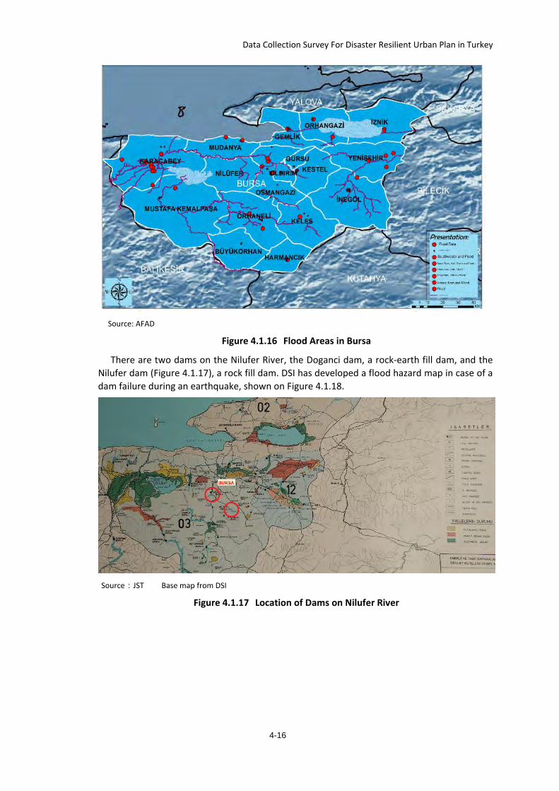
Data Collection Survey For Disaster Resilient Urban Plan in Turkey
Source: AFAD
Figure 4.1.16 Flood Areas in Bursa
There are two dams on the Nilufer River, the Doganci dam, a rock-earth fill dam, and the Nilufer dam (Figure 4.1.17), a rock fill dam. DSI has developed a flood hazard map in case of a dam failure during an earthquake, shown on Figure 4.1.18.
Source:JST Base map from DSI
Figure 4.1.17 Location of Dams on Nilufer River
4-16
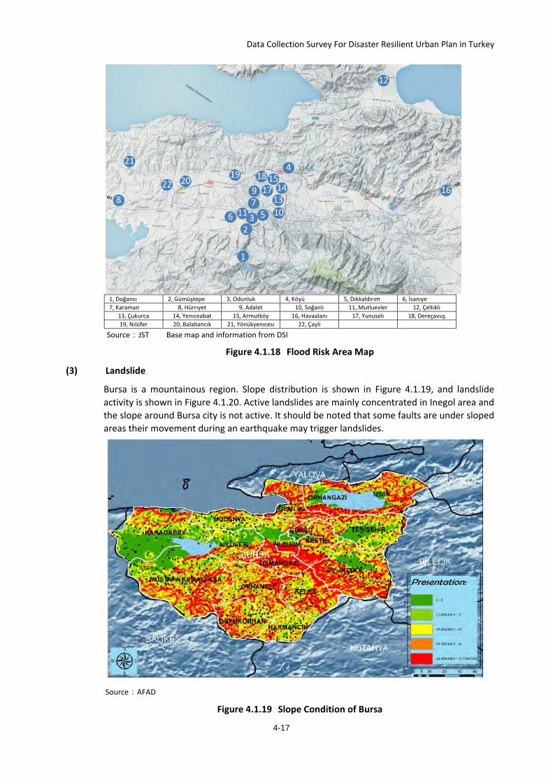
Data Collection Survey For Disaster Resilient Urban Plan in Turkey
1, Doğancı 2, Gümüştepe 3, Odunluk 4, Köyü 5, Dıkkaldırım 6, İsanıye 7, Karaman 8, Hürrıyet 9, Adalet 10, Soğanlı 11, Mutluevler 12, Çeltıklı
13, Çukurca 14, Yenıceabat 15, Armutköy 16, Havaalanı 17, Yunuselı 18, Dereçavuş 19, Nılüfer 20, Balabancık 21, Yönükyenıcesı 22, Çaylı
Source:JST Base map and information from DSI
Figure 4.1.18 Flood Risk Area Map
(3) Landslide
Bursa is a mountainous region. Slope distribution is shown in Figure 4.1.19, and landslide activity is shown in Figure 4.1.20. Active landslides are mainly concentrated in Inegol area and the slope around Bursa city is not active. It should be noted that some faults are under sloped areas their movement during an earthquake may trigger landslides.
Source:AFAD
Figure 4.1.19 Slope Condition of Bursa
4-17
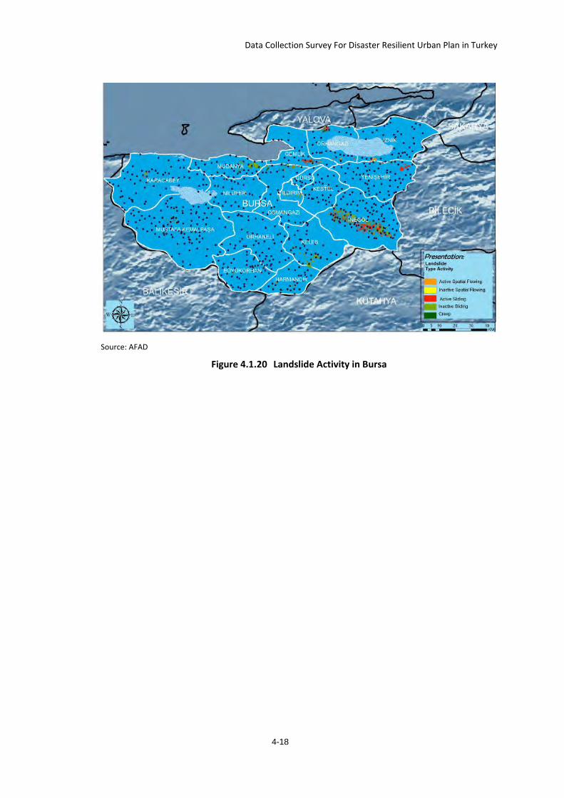
Data Collection Survey For Disaster Resilient Urban Plan in Turkey
Source: AFAD
Figure 4.1.20 Landslide Activity in Bursa
4-18


![Climate and Disaster Resilient Cities Through Sensative Urban Governance - Consolidated Reply [Solution Exchange]-2012](https://img.pdfslide.net/doc/110x75/55cf8fde550346703ba0b88e/climate-and-disaster-resilient-cities-through-sensative-urban-governance-.jpg)