Embed Size (px)
Citation preview
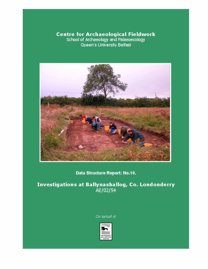
Data Structure Report: Ballynashallog, County Londonderry
John Ó Néill, Ruth Logue and Dr. Rick Schulting.
(Grid Reference J54745384)
(CAF DSR 010)
(Licence No. AE/02/54)
(SMR No. LDY 14A:010 and LDY14A:011)
Centre for Archaeological Fieldwork, QUB Data Structure Report: AE/02/71 Ballynashallog, County Londonderry
_____________________________________________________________________
1
Contents Page List of Figures 2 List of Plates 2 Summary 3 Introduction 4 General Background Reason for Excavation and Research Objectives Archiving Credits and Acknowledgements Geophysical and Topographic Survey 12
Geophysical Survey Topographic Survey
Excavation 14 Methodology Account of the excavations Trench 1 Trench 2 Trench 3 Trench 4 Trench 5 Trench 6 Trench 7 Trench 8 Trench 9 Trench 10 Trench 11 Analysis undertaken during the excavations Artefactual Dating
Discussion 22 Recommendations for further work 23
Introduction Programme of post-excavation analysis Analysis of the Environmental Samples Further Excavation
Bibliography 24 Appendix One: Context List 25 Appendix Two: Harris Matrices 39 Appendix Three: Photographic Record 49 Appendix Four: Field Drawing Register 51 Appendix Five: Small Finds Register 52 Appendix Six: Sample Register 63
Centre for Archaeological Fieldwork, QUB Data Structure Report: AE/02/71 Ballynashallog, County Londonderry
_____________________________________________________________________
2
List of Figures:
Page
Figure 1. Springfield Road location map 6 Figure 2: Location map to show the archaeological sites
surrounding Springfield Road 7 Figure 3. Springfield Road excavation trenches. 8 Figure 4. Springfield Road contour survey 9 Figure 5. Springfield Road excavation trenches overlain
upon geophysical survey. 10 Figure 6. Springfield Road additional geophysical survey. 11 Figure 7. Plan of Trench 6. 18 Figure 8. Plan of Trench 10 19
List of Plates
Plate 1. View of Trench One after excavation. 20 Plate 2. View of the Trench Four, after excavation. 20 Plate 3. View of Trench Six, after excavation. 21 Plate 4. View of degraded schist boulders in Trench Ten, after excavation. 21
Centre for Archaeological Fieldwork, QUB Data Structure Report: AE/02/71 Ballynashallog, County Londonderry
_____________________________________________________________________
3
1. Summary
1.1 The site of the Ballynashallog investigations adjoins the new Thornhill College, at the junction
of Springfield Road and Cuilmore Road north-west of Derry City. Previously, substantial
evidence of Neolithic occupation was uncovered on the adjacent site during construction of
the college (Logue 2000). The proposed development of the location of two cropmark
enclosures (recorded in the SMR as LDY14A:010 and LDY14A:011) prompted further
investigation in 2002.
1.2 The excavations were undertaken by the Centre for Archaeological Fieldwork at Queens
University Belfast, with students taking a taught excavations module from the School of
Archaeology and Palaeoecology in attendance. An initial weeks excavation included the
assistance of pupils from St Oliver Plunkett, Strathfoyle, and Maydown Primary Schools. The
excavations were directed by Dr. Rick Schulting and John Ó Néill under licence number
AE/02/54.
1.3 Following a geophysical survey, topographic survey and excavation were undertaken at the
site in July and August 2002 with the aims of ascertaining the character of the site and
recording any archaeological remains which would be removed during development.
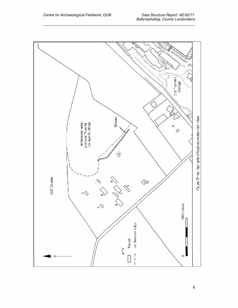
1.3 A total of eleven test trenches were opened on the site, across the location of the cropmarked
features and anomalies identified during the geophysical survey. The trenches ranged in size
from 5 m by 10 m to 10 m by 20 m.
1.4 Little evidence of archaeological activity was identified during the excavations. A small
number of sherds of prehistoric pottery and lithics were recovered from topsoil features in
Trench 6, while knapping debris was recovered, seemingly in situ, in Trench 10 and an
extension to Trench 10, denoted as Trench 10A.
1.5 On the basis of the 2002 fieldwork, it is clear that the activity identified in the previous
excavations did not substantially extend into the area under investigation. The evidence
recovered from the 2002 excavations should be seen in its context, adjoining a major
Neolithic settlement. On this basis, it is recommended that a programme of post-excavation
analysis be undertaken to meaningfully publish the results of the excavation as a short paper
and bring the project to completion.
Centre for Archaeological Fieldwork, QUB Data Structure Report: AE/02/71 Ballynashallog, County Londonderry
_____________________________________________________________________
4
2. Introduction
2.1 General
2.1.1 The following report details the preliminary results of the topographic survey, and
archaeological excavation at Ballynashallog, undertaken by the Centre for Archaeological
Fieldwork, School of Archaeology and Palaeoecology at Queen’s University Belfast in July
and August 2002. This programme of work was undertaken on behalf of the Environment and
Heritage Service, DOE NI, who funded the survey and excavations.
2.2 Background
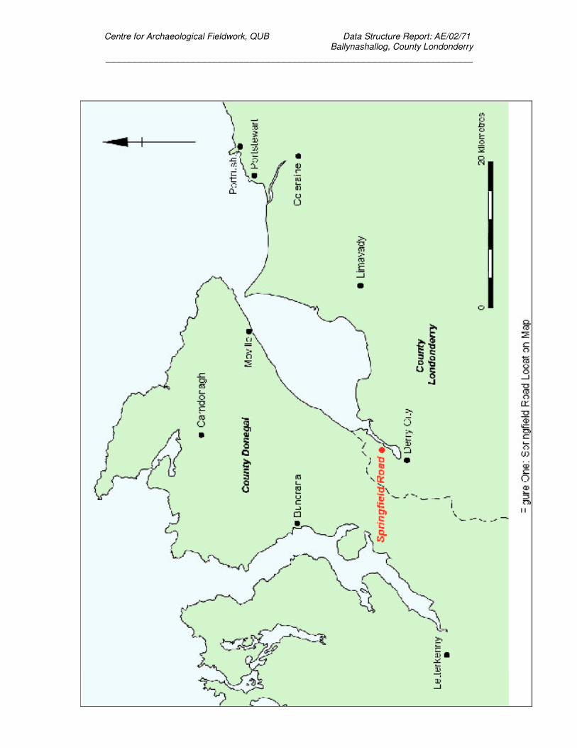
2.2.1 The site is located at Springfield Road, Ballynashallog (BNS 02), approximately 5 km north-
east of Derry, on a low terrace above the River Foyle (see figure 1 and figure 2). The
National Grid Reference for the site is C45722127, and the two relevant SMR numbers are
LDY 14A:010 and LDY 14A:011 (aerial photographpy cropmark sites). It is the scheduled
spot for the building of a playing field for the new Thornhill College Grammar School, and is
near the site of the previous Thornhill investigations (Logue 2000)
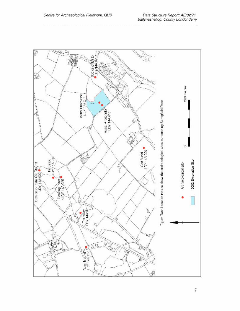
2.2.2 Previously, archaeological investigation of the site was necessitated by the construction of a
new grammar school where both a flint scatter (LDY 14A:23) and a pair of cropmark
enclosures (LDY 14A:012 LDY 14A:013) had been identified previously. The excavation
produced evidence of a palisaded enclosure, structures and substantial occupation debris
largely dating to the Neolithic (Logue 2000). This area lies some 400 m to the east of 2002
excavations.
2.3 Reason for Excavation and Research Objectives
2.3.1 The potential of the SMR sites LDY14A:010 and LDY 14A:011 was identified on the basis of
the aerial photographic survey and the proximity to the 2000 excavations. As the area of the
cropmarks was to be developed as playing fields for the new school, a preliminary
programme of geophysical survey by GeoQuest was followed by the opening of trenches
across the cropmarks and anomalies identified in the geophysical survey.
2.3.2 The preliminary objective of the investigations was to locate and identify the date and nature
of any archaeological materials present on site. As development would potentially lead to the
destruction of such materials, preservation would be sought by means of a full record of the
controlled excavation of any archaeological features and objects, if deemed appropriate by
Environment and Heritage Service: Built Heritage.
Centre for Archaeological Fieldwork, QUB Data Structure Report: AE/02/71 Ballynashallog, County Londonderry
_____________________________________________________________________
5
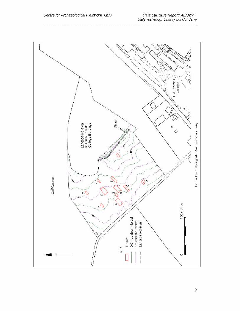
2.3.3 In the course of the investigations eleven test trenches were opened across the site (see
figure 3) and a full topographic survey was undertaken (see figure 4). The results of the
investigations are outlined below.
2.4 Archiving
2.4.1 A copy of this report has been deposited with the Environment and Heritage Service, DOE NI.
All site records and finds are temporarily archived within the School of Archaeology and
Palaeoecology, Queen’s University Belfast. Site records, including context sheets, plans and
photographic archive, small finds and samples, as retained by the School of Archaeology and
Palaeoecology, are listed in the Appendices at the end of this report.
2.5 Credits and Acknowledgements
2.5.1 The excavations were directed by John Ó Néill and Rick Schulting and supervised by Ruth
Logue. The excavation team consisted of the School of Archaeology and Palaeoecology
students undertaking the taught excavations module in 2002. The topographic survey of the
site was undertaken by Keith Adams assisted by members of the excavation team. Colm
Donnelly supervised the primary school student who participated in the initial weeks
excavation.
2.5.2 The illustrations and images included in this report were produced by Keith Adams, Bronagh
Murray, Ruth Logue, John Ó Néill and Rick Schulting.
Centre for Archaeological Fieldwork, QUB Data Structure Report: AE/02/71 Ballynashallog, County Londonderry
_____________________________________________________________________
6
Centre for Archaeological Fieldwork, QUB Data Structure Report: AE/02/71 Ballynashallog, County Londonderry
_____________________________________________________________________
7
Centre for Archaeological Fieldwork, QUB Data Structure Report: AE/02/71 Ballynashallog, County Londonderry
_____________________________________________________________________
8
Centre for Archaeological Fieldwork, QUB Data Structure Report: AE/02/71 Ballynashallog, County Londonderry
_____________________________________________________________________
9
Centre for Archaeological Fieldwork, QUB Data Structure Report: AE/02/71 Ballynashallog, County Londonderry
_____________________________________________________________________
10
Centre for Archaeological Fieldwork, QUB Data Structure Report: AE/02/71 Ballynashallog, County Londonderry
_____________________________________________________________________
11
Centre for Archaeological Fieldwork, QUB Data Structure Report: AE/02/71 Ballynashallog, County Londonderry
_____________________________________________________________________
12
3. Geophysical and Topographic Survey
Keith Adams and John Ó Néill
3.1 Geophysical Survey
3.1.1 The following text is drawn from a report prepared by GeoQuest Associates for Environment
and Heritage Service: Built Heritage and lodged in the Sites and Monuments Record.
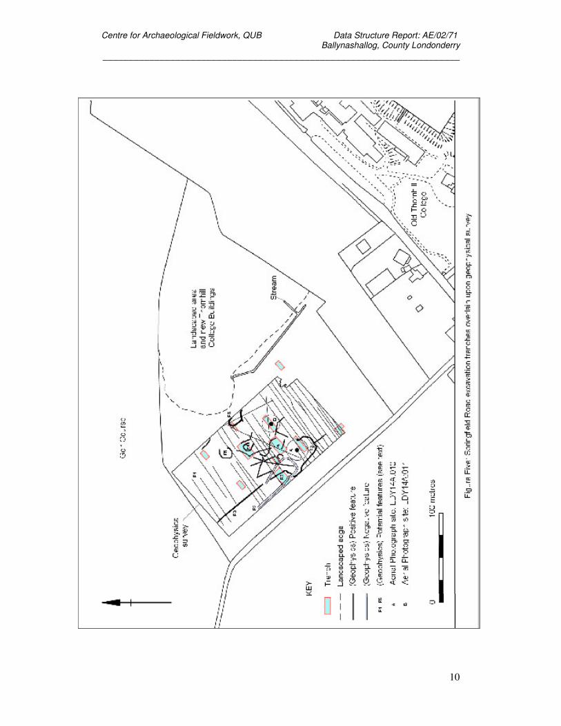
3.1.2 On 3 and 4 September 2001 a geophysical survey was carried out on the field where the
Springfield Road site was located using a Geoscan FM36 fluxgate gradiometer (see figure 5
for the results of this survey). The aim of the survey was to provide more detailed sub-soil
characterisation of possible archaeological features which had been seen as cropmarks in
aerial photographs, LDY 14A:010 and 011. The survey was carried out on behalf of the
Environment and Heritage Service, DOE NI, by GeoQuest Associates.
3.1.3 In 1997 a geophysical survey of a similar area had been carried out by Archaeological
Development Services using a Geoscan RM15 soil resistance meter to measure soil moisture
variation. The evidence from this survey suggested that both aerial features were present in
the form of ditched enclosures surrounding a central mound or stony area. Traces of other
archaeological or geological features were also found to be present in the study area.
3.1.4 The dominant feature to appear in the GeoQuest geophysical images were a set of north-east
to south-west orientated positive magnetic lineations, these appearing as dark lines, which
were thought to represent ceramic land drains. Other positive magnetic lineations crossing
the site in varying orientations were also thought to represent land drains. The frequence with
which these drains occurred in the images hindered the extraction of archaeological features
from the geophysical data, therefore anomalies interpreted as ditches could just be modern
drainage ditches.
3.1.5 The report concluded that the data images contained a large number of linear magnetic
anomalies whose presence complicated the archaeological interpretation, but most of which
related to land drains. Evidence seemed to suggest that the area contained several soil filled
ditches of archaeological interest, but that the conjunction of two or more of these features
could account for the appearance of cropmark feature 14A:010. Cropmark feature 14A:011
was not found to be directly related to any specific geophysical anomaly.
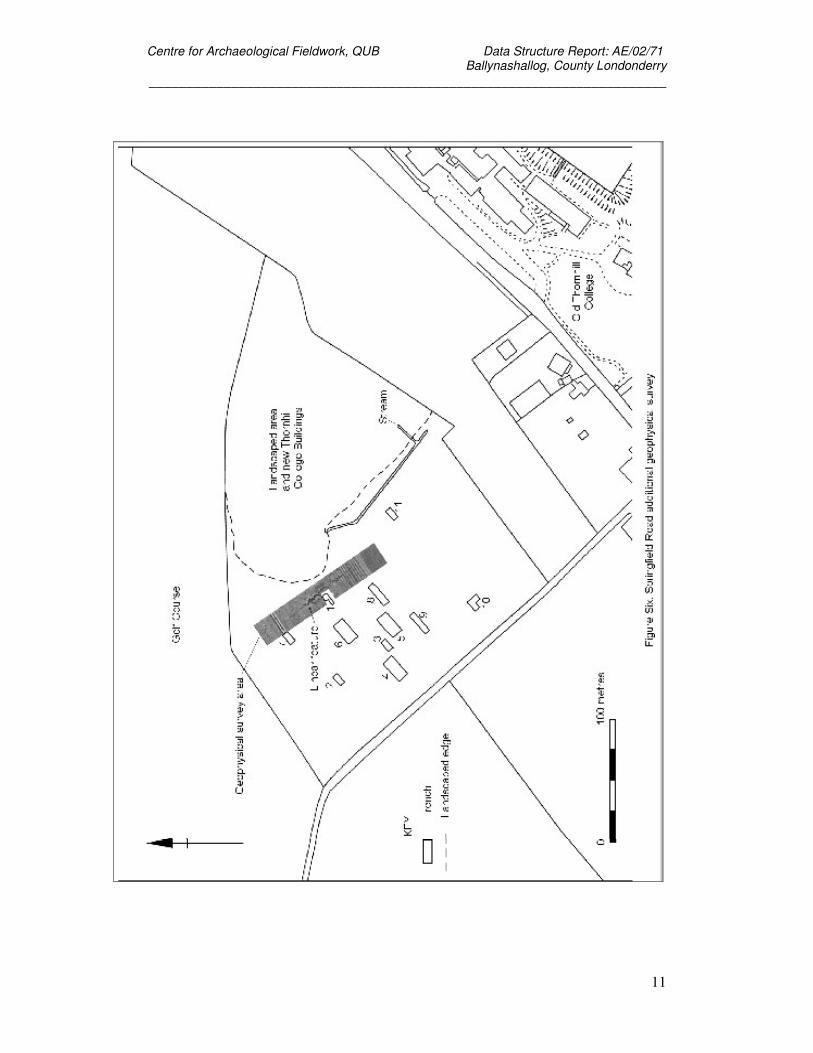
3.1.6 Barrie Hartwell of the School of Archaeology and Palaeoecology carried out a further survey
of the same area in 2002 (see figure 6 for the results of this survey). This replicated enough of
Centre for Archaeological Fieldwork, QUB Data Structure Report: AE/02/71 Ballynashallog, County Londonderry
_____________________________________________________________________
13
the results of the GeoQuest survey to facilitate tying the previous survey into the topographic
survey grid established on site in 2002.
3.2 Topographic Survey
3.2.1 The detailed topographic survey of the area around the site was undertaken concurrently with
the excavation. The survey was conducted using a TCR705 Leica Total Station. The
topographic survey was tied into the Irish National Grid.
3.2.2 The survey data was transferred and processed using Leica LISCAD6.0 software. Additional
processing of the survey data was undertaken using Surfer 8.0 software.
3.2.3 The results of the topographic survey are illustrated as a detailed contour survey showing the
location of the excavation trenches (see figure 4). The survey did not reveal any landscape
features of archaeological significance.
Centre for Archaeological Fieldwork, QUB Data Structure Report: AE/02/71 Ballynashallog, County Londonderry
_____________________________________________________________________
14
4. Excavation
4.1 Methodology
4.1.1 Excavation was undertaken by opening eleven test trenches across various geophysical
anomalies and cropmark features. Trenches 1, 2 and 3 were opened by manual excavation of
the topsoil deposits, while the remainder had their topsoil and sod removed by machine
before being cleaned up manually. The extension to Trench 10 was also opened by manual
excavation of the topsoil and sod. The layout of the trenches is shown in figures 3, 4 and 5
relative to the topographic and geophysical surveys.
4.1.2 On removal of the topsoil deposit from the trenches, any variations in the underlying soil
deposits were cleaned up by trowel and then recorded. Individual features were
photographed both prior to, and following, excavation and included in a series of overall plans
(Scale 1:20) of the site which were prepared throughout the course of the excavation. Section
drawings (Scale 1:20) were undertaken of the exposed archaeological deposits within the
drainage ditch (for details of site photography see Appendix Three and for field illustrations
see Appendix Four). In addition to the photography and illustration, the principal site records
consisted of context sheets augmented by separate registers of small finds (Appendix Five)
and samples (Appendix Six).
4.2 Account of the Excavation.
4.2.1 While the vast majority of the excavation trenches did not produce features of archaeological
interest, Harris Matrices are included for each trench in Appendix Two. The following sections
provide an account of the excavation of each trench.
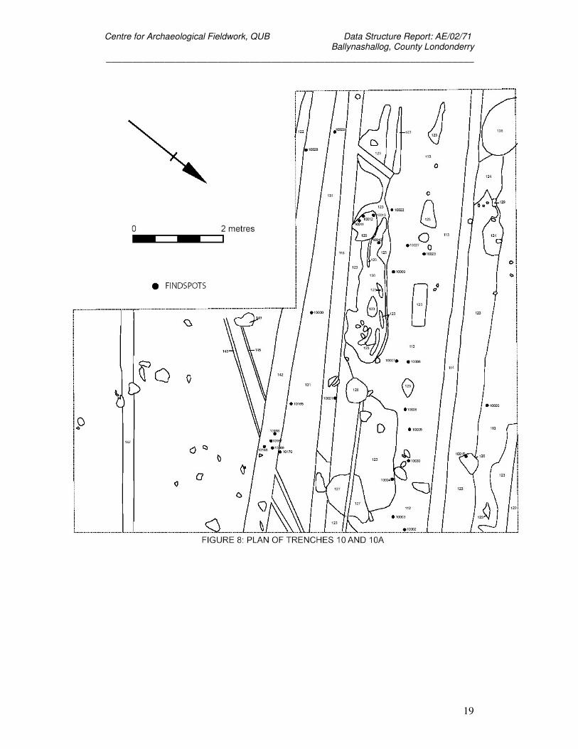
4.3 Trench 1.
4.3.1 Trench 1 measured 2 m by 6 m and was extended with the addition of a further 5 m by 5m
(see Plate 1). It was laid out over geophysical anomaly F6. A series of land drains and plough
marks were encountered on removal of the topsoil, which was present to a depth of 0.28 m.
Some struck flint and modern finds were recovered from this trench. No features of
archaeological interest were noted.
4.4 Trench 2.
4.4.1 Trench 2 measured 5 m by 10 m. It was original opened to investigate geophysical anomaly
Centre for Archaeological Fieldwork, QUB Data Structure Report: AE/02/71 Ballynashallog, County Londonderry
_____________________________________________________________________
15
F7. A number of plough lines and land drains were encountered on removal of the topsoil,
which was present to a depth of 0.28 m. No features of archaeological interest were noted.
4.5 Trench 3.
4.5.1 Trench 3 measured 5 m by 10 m. It was laid out over geophysical anomaly F9. A series of
land drains and plough marks were encountered on removal of the topsoil, which was present
to a depth of 0.22 m. Some struck flint and modern finds were recovered from this trench. No
features of archaeological interest were noted.
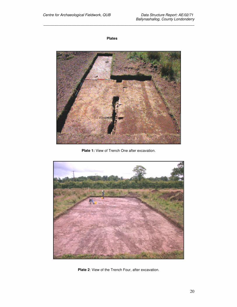
4.6 Trench 4.
4.6.1 Trench 4 measured 10 m by 10 m (see Plate 2). It was laid out over geophysical anomalies
F2 and F3. A series of land drains and plough marks were encountered on removal of the
topsoil, which was present to a depth of 0.15 m. Some struck flint, struck quartz and modern
finds were recovered from this trench. No features of archaeological interest were noted.
4.7 Trench 5.
4.7.1 Trench 5 measured 5 m by 10 m. It was laid out over geophysical anomaly F10 and the
location of a feature visible, previously, as a cropmark. A land drain was encountered on
removal of the topsoil, which was present to a depth of 0.29 m. No features of archaeological
interest were noted.
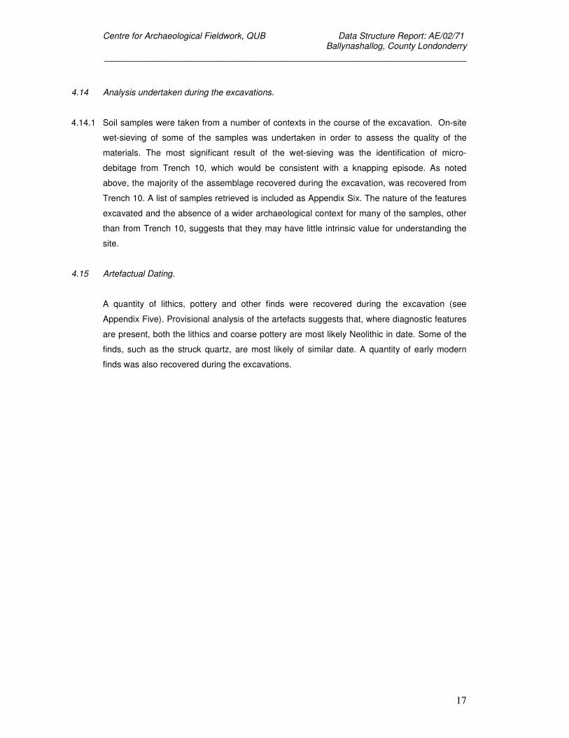
4.8 Trench 6.
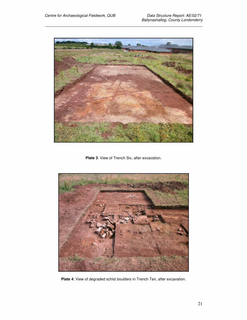
4.8.1 Trench 6 measured 10 m by 20 m (see Plate 3). It was laid out over geophysical anomaly F4.
A series of land drains and plough marks were encountered on removal of the topsoil, which
was present to a depth of 0.24 m (see figure 7). Some Neolithic pottery, struck flint and
modern finds were recovered from this trench. No features of archaeological interest were
noted.
4.9 Trench 7.
4.9.1 Trench 7 measured 5 m by 10 m. It was laid out over geophysical anomaly F7. A series of
land drains and plough marks were encountered on removal of the topsoil, which was present
to a depth of 0.24 m. No features of archaeological interest were noted.
Centre for Archaeological Fieldwork, QUB Data Structure Report: AE/02/71 Ballynashallog, County Londonderry
_____________________________________________________________________
16
4.10 Trench 8.
4.10.1 Trench 8 measured 5 m by 20 m. It was laid out over a feature previously visible as a
cropmark. A series of land drains was encountered on removal of the topsoil, which was
present to a depth of 0.25 m. No features of archaeological interest were noted.
4.11 Trench 9.
4.11.1 Trench 9 measured 5 m by 20 m. It was laid out over a feature previously visible as a
cropmark. A series of land drains was encountered on removal of the topsoil, which was
present to a depth of 0.25 m. No features of archaeological interest were noted.
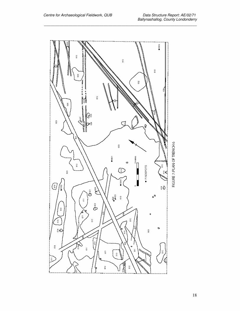
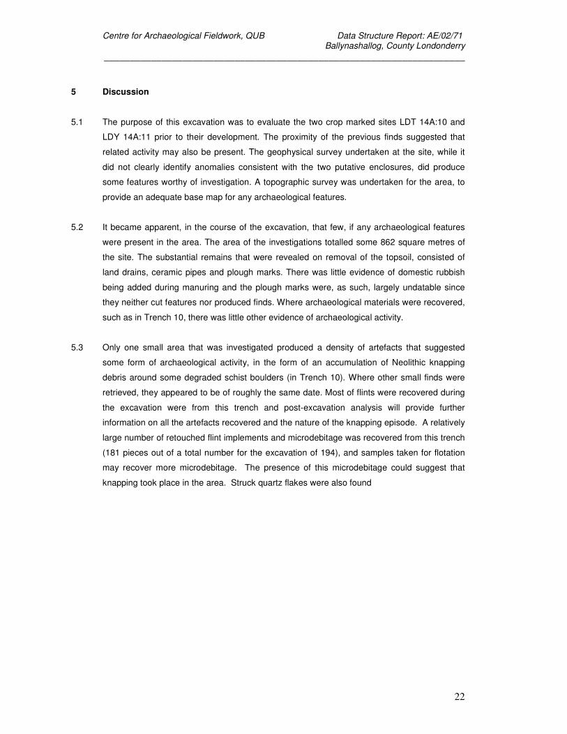
4.12 Trench 10.
4.12.1 Trench 10 measured 5 m by 10 m and was extended with the addition of a further 5 m by 5 m
trench at its south-eastern corner (see figure 8). It was laid out at the point where the site was
closest to a flint scatter recorded for the opposite side of Springfield Road (Ian Leitch
pers.comm.). A series of land drains was encountered on removal of the topsoil, which was
present to a depth of 0.23 m. Finds from the topsoil included a hammerstone, flints flakes,
retouched flint tools, worked quartz and some modern finds.
A deposit of soil (C134) had formed around some degraded schist boulders towards one end
of the trench (see Plate 4). This soil contained a quantity of knapping debris, scrapers and
worked quartz. This sealed a layer of charcoal rich soil (F135) measuring 3 m by 1 m and up
50 mm in depth. Finds from Trench 10 accounted for 181 of the pieces of the 194 struck flints
recovered during the excavations. Micro-debitage was also recovered from Trench 10, along
with a piece of chert and a piece of rock crystal. Unfortunately a clay pipe bowl (find number
10265) from C135 suggests that, while stratigraphically the earliest deposit in the trench, that
it too is contaminated.
There was no evidence to suggest that the schist boulders had been intentionally disturbed
prior to the excavation and the implication of the materials recovered from Trench 10
suggested a knapping episode of limited duration had taken place at the site.
4.13 Trench 11.
4.13.1 Trench 11 measured 5 m by 10 m. A land drain was encountered on removal of the topsoil,
which was present to a depth of 0.25 m. No features of archaeological interest were noted.
Centre for Archaeological Fieldwork, QUB Data Structure Report: AE/02/71 Ballynashallog, County Londonderry
_____________________________________________________________________
17
4.14 Analysis undertaken during the excavations.
4.14.1 Soil samples were taken from a number of contexts in the course of the excavation. On-site
wet-sieving of some of the samples was undertaken in order to assess the quality of the
materials. The most significant result of the wet-sieving was the identification of micro-
debitage from Trench 10, which would be consistent with a knapping episode. As noted
above, the majority of the assemblage recovered during the excavation, was recovered from
Trench 10. A list of samples retrieved is included as Appendix Six. The nature of the features
excavated and the absence of a wider archaeological context for many of the samples, other
than from Trench 10, suggests that they may have little intrinsic value for understanding the
site.
4.15 Artefactual Dating.
A quantity of lithics, pottery and other finds were recovered during the excavation (see
Appendix Five). Provisional analysis of the artefacts suggests that, where diagnostic features
are present, both the lithics and coarse pottery are most likely Neolithic in date. Some of the
finds, such as the struck quartz, are most likely of similar date. A quantity of early modern
finds was also recovered during the excavations.
Centre for Archaeological Fieldwork, QUB Data Structure Report: AE/02/71 Ballynashallog, County Londonderry
_____________________________________________________________________
18
Centre for Archaeological Fieldwork, QUB Data Structure Report: AE/02/71 Ballynashallog, County Londonderry
_____________________________________________________________________
19
Centre for Archaeological Fieldwork, QUB Data Structure Report: AE/02/71 Ballynashallog, County Londonderry
_____________________________________________________________________
20
Plates
Plate 1: View of Trench One after excavation.
Plate 2: View of the Trench Four, after excavation.
Centre for Archaeological Fieldwork, QUB Data Structure Report: AE/02/71 Ballynashallog, County Londonderry
_____________________________________________________________________
21
Plate 3: View of Trench Six, after excavation.
Plate 4: View of degraded schist boulders in Trench Ten, after excavation.
Centre for Archaeological Fieldwork, QUB Data Structure Report: AE/02/71 Ballynashallog, County Londonderry
_____________________________________________________________________
22
5 Discussion
5.1 The purpose of this excavation was to evaluate the two crop marked sites LDT 14A:10 and
LDY 14A:11 prior to their development. The proximity of the previous finds suggested that
related activity may also be present. The geophysical survey undertaken at the site, while it
did not clearly identify anomalies consistent with the two putative enclosures, did produce
some features worthy of investigation. A topographic survey was undertaken for the area, to
provide an adequate base map for any archaeological features.
5.2 It became apparent, in the course of the excavation, that few, if any archaeological features
were present in the area. The area of the investigations totalled some 862 square metres of
the site. The substantial remains that were revealed on removal of the topsoil, consisted of
land drains, ceramic pipes and plough marks. There was little evidence of domestic rubbish
being added during manuring and the plough marks were, as such, largely undatable since
they neither cut features nor produced finds. Where archaeological materials were recovered,
such as in Trench 10, there was little other evidence of archaeological activity.
5.3 Only one small area that was investigated produced a density of artefacts that suggested
some form of archaeological activity, in the form of an accumulation of Neolithic knapping
debris around some degraded schist boulders (in Trench 10). Where other small finds were
retrieved, they appeared to be of roughly the same date. Most of flints were recovered during
the excavation were from this trench and post-excavation analysis will provide further
information on all the artefacts recovered and the nature of the knapping episode. A relatively
large number of retouched flint implements and microdebitage was recovered from this trench
(181 pieces out of a total number for the excavation of 194), and samples taken for flotation
may recover more microdebitage. The presence of this microdebitage could suggest that
knapping took place in the area. Struck quartz flakes were also found
Centre for Archaeological Fieldwork, QUB Data Structure Report: AE/02/71 Ballynashallog, County Londonderry
_____________________________________________________________________
23
6 Recommendations for Further Work
6.1 Introduction
6.1.1 One principal recommendation for further work on the Ballynashallog project is made below. It
is proposed that a programme of post-excavation analysis, including dating, of material
recovered during the 2002 excavations should be undertaken. Completion of the post-
excavation programme is required to meaningfully publish the excavation and successfully
bring the project to completion.
6.2 Programme of post-excavation analysis of materials recovered during the 2002 excavations.
6.2.1 Analysis of some of the materials recovered during the 2002 season would need to be
undertaken to bring the current project to publication. This would include the lithic assemblage
and the small assemblage of sherds of prehistoric pottery. Further processing of soil samples
would be required for Trench 10, to identify any further pieces of microdebitage. This may
also provide a sample of charcoal to be dated.
6.2.2 The lithic assemblage comprises struck flint, chert and quartz, mainly from Trenches 3, 5, 6,
8, 9 and 10. Another possible fragment of rock crystal was also recovered. Some micro-
debitage was recovered from topsoil in Trench 10 during the processing of soil sample on
site.
6.2.3 The pottery assemblage comprises a small number of sherds from Trench 6.
6.2.4 The presence of a clay pipe fragment (find number 10265) from the earliest context in Trench
10, precludes dating the material due to its prior contamination.
Centre for Archaeological Fieldwork, QUB Data Structure Report: AE/02/71 Ballynashallog, County Londonderry
_____________________________________________________________________
24
7. Bibliography
Archaeological Development Services 1997 Ballynashallog, Co. Derry, Geophysical Survey.
Report to the Environment and Heritage Service, DOE NI.
GeoQuest Associates 2001 Geophysical Survey Of A Site At Springfield Road,
Ballynashallog, Co. Derry. Report prepared for the Environment and Heritage
Service, DOE NI.
Logue, P 2000 Excavations at Thornhill. Report prepared for the Environment and Heritage
Service, DOE NI.
McSparran, C 1998 Excavations at Enagh, Co Derry. Report prepared for the Environment
and Heritage Service, DOE NI.
Centre for Archaeological Fieldwork, QUB Data Structure Report: AE/02/71 Ballynashallog, County Londonderry
_____________________________________________________________________
25
Appendix One: Context list
The contexts listed below by trench. Information not included in the text in sections 4.3 to
4.13, is provided, since in many cases the features were not deemed to be of archaeological
significance.
Trench 1
100
Turf layer, approximately 140 mm deep. Brown 7.5YR 4/3, friable silty clay loam, with 0.1%
subangular quartz. Above (101). Finds: flint, modern pottery, quartz, slate, glass, brick, metal,
miscellaneous stone, slag.
101
Topsoil layer, between 100 and 280 mm thick. Medium brown 7.5YR 4/3 silty clay loam. Was
friable, but compact when moist, with 0.1% subangular/subrounded quartz. Below turf layer
and above transitional layer. Finds: flint artefacts, post-medieval and modern pottery including
blackware, slate, glass, brick, metal, clay pipe, quartz, one item of miscellany/slag.
102
Transitional layer below topsoil. Medium brown 7.5YR 4/3 and 50 mm thick. Silty clay loam
which was friable but compact when wet, and contained 0.1% subangular quartz. Finds:
modern pottery, quartz, glass and metal.
103
A layer of dark reddish brown 2.5YR 3/3 friable, below (102). Measuring 4500 mm x 1000
mm, with a minimum thickness of 100 mm which got deeper towards the eastern baulk.
Contained 0.5% angular ferric nodules (<2cm); this layer could be iron pan due to soil
leaching.
104
Cut of a linear feature running southwest - northeast across extension of trench, measuring
2500 mm x 230 mm, depth 300 mm. In places along the edge of the cut the top fill (105)
underlied the natural layer. This feature was found to be a stone lined drainage ditch, stone
lining was (106). Parallel to cut (107). Uncertain relationship with (105A) – they transect each
other.
105
Top fill of drain (104), above (106). Medium brown 7.5YR 4/3 friable silty clay loam with 0.1%
subangular/subrounded quartz. Finds: modern pottery, quartz, a miscellaneous stone.
105A
Possible cut of drainage feature, therefore not excavated. Measuring 5600 mm x 200 mm.
Uncertain as to its relationship with (104) – they transect each other. Filled by (105B).
105B
Centre for Archaeological Fieldwork, QUB Data Structure Report: AE/02/71 Ballynashallog, County Londonderry
_____________________________________________________________________
26
Fill of (105A). Medium brown 7.5YR 4/3 friable silty clay loam, with 0.1% subangular and
subrounded quartz.
106
Stones lining base of modern drainage ditch (104), below (105). One piece of modern pottery
found among stones.
107
Cut of a shallow linear feature running southwest – northeast from southwest baulk of trench
extension for 1800 mm as visible (running into baulk), 290 mm wide. Thought to be a
drainage cut, filled by (108), parallel to (104).
108
Fill of drain cut (107). Brown 7.5YR 4/3 friable silty clay loam.
108A
Number given to ploughlines running through Trench 1, of various lengths and widths.
Medium brown 7.5YR 4/3 friable silty clay loam.
109
Natural/susbsoil, dominant hue 2.5Y 5/4 light olive brown, patches of 10YR 5/6 yellowish
brown. Friable silty clay loam, (containing 2% subangular/subrounded quartz). Of
indeterminate depth.
Trench 2
200
Turf layer above topsoil, approximately 180 mm deep, brown 7.5YR 4/3 silty clay loam.
Finds: modern pottery, quartz, slate, glass, brick and clay pipe.
201
Topsoil layer below (200) and above (202), 100 mm deep. Brown 7.5YR 4/3 friable loam.
Finds: modern pottery, quartz, slate, glass, brick, clay pipe and flint.
202
Transitional layer between topsoil and natural, 25 mm deep. Brown 10YR 6/2 friable clay
loam: 0.5% subangular grit <5mm. Finds: modern pottery, quartz, slate, glass, brick, metal,
clay pipe, and a miscellaneous stone.
203
This layer is the natural subsoil, a light olive grey 10Y 6/2 compact silty clay loam.
204
This cut was not excavated as it was a modern drainage ditch, possible stone lined, possibly
ceramic. It ran the entire length of the trench and was 300 mm wide, depth unknown as it was
not excavated. Filled by (205).
205
Fill of (204). Dark brown 10YR 3/3 friable clay loam.
Centre for Archaeological Fieldwork, QUB Data Structure Report: AE/02/71 Ballynashallog, County Londonderry
_____________________________________________________________________
27
206
Cut running length of trench, 300 mm wide, probable stone lined drainage ditch therefore not
excavated. Filled by (207), cuts (216).
207
Fill of (206). Dark brown 10YR 3/3 friable clay loam.
208
Twenty-five plough lines running northwest to southeast across the width of the trench, about
6cm wide. Cuts (214) and some appear to cut (204) and (206) but unsure. Unclear
stratigraphy with other plough lines (210), (212), (219). Filled by (209). Not excavated.
209
Fill of (208). Dark brown 10YR 3/3 friable clay loam with 0.1% subrounded stone grit <5mm.
210
Plough lines running northeast to southwest across trench for about 2000 mm, 60 mm wide.
Filled by (211). Uncertain as to the stratigraphical relationship with (208), (212), (218), (219).
Not excavated.
211
Fill of plough lines (210). Dark brown 10YR 3/3 friable clay loam, with 0.1% subrounded stone
grit.
212
Plough lines running roughly northeast to southwest across eastern end of trench for up to
3000 mm, 60 mm wide. Filled by (213), uncertain as to the stratigraphical relationship with
(208), (210), (221). Not excavated.
213
Fill of (212). Dark brown 10YR 3/3 friable clay loam, with 0.1% subrounded stone grit.
214
Layer measuring 1450 mm x 1100 mm. Dark brown 10YR 3/3 friable clay loam, with 0.1%
pieces of subrounded stone/grit. Cut by (208). Not excavated, thought not to be of
archaeological interest, probably soil collected in uneven natural. Same as (215), (216), (217),
(218); as there were all these patches of the same soil found in this trench it would suggest
that they are contemporary with each other and could possibly have been a layer at one
stage.
215
Layer measuring 450 mm x 400 mm, see (214). This layer was later excavated and a modern
ceramic pipe was found.
216
Layer measuring 840 mm x 840 mm. See (214). Cut by (206).
217
Layer measuring 900 mm x 650 mm. See (214).
218
Centre for Archaeological Fieldwork, QUB Data Structure Report: AE/02/71 Ballynashallog, County Londonderry
_____________________________________________________________________
28
Layer measuring 1400 mm x 1000 mm. See (214).
219
Plough lines running roughly northeast to southwest; length varies, width is 60 mm. Filled by
(220), uncertain relationship with (208), (216), (210). Not excavated.
220
Fill of (219). Dark brown 10YR 3/3 friable clay loam.
221
Drainage ditch running northwest to southeast across width of trench, 300 mm wide. Filled by
(222). Not excavated.
222
Fill of (221). Dark brown 10YR 3/3 friable clay loam.
Trench 3
300
Turf layer above (301), 120 mm thick. Finds: modern pottery, quartz, slate, glass, metal, slag,
clay pipe.
301
Topsoil layer above (302), 80 mm thick. Finds: modern pottery, quartz, slate, glass, brick,
metal, one piece of flint.
302
Transitional layer below (301) and above natural, 20 mm thick. Finds: modern pottery, quartz,
slate, glass, brick, metal and a piece of chert.
Trench 4
400
Turf layer, above (401), 150 mm thick.
401
Topsoil layer, below (400), above (402), 100 mm thick.
402
Transitional layer between (401) and natural, 15 mm thick. Finds: modern pottery, quartz,
glass, brick, metal, a miscellaneous stone, two pieces of flint (one worked, one not), and a
quartz flake scatter.
403
Natural. Olive 5Y 5/4 tenacious sandy clay with 0.1% subangular quartz pebbles (<20 mm).
Below (402). Of indeterminate depth.
404
Centre for Archaeological Fieldwork, QUB Data Structure Report: AE/02/71 Ballynashallog, County Londonderry
_____________________________________________________________________
29
Layer measuring 6500 mm x 2100 mm. Brownish black 7.5YR 3/2 friable silty clay loam, with
<0.1% angular quartz. Decided not to be of archaeological interest. Finds: modern pottery and
quartz.
405
Fill of plough lines (408). Brown 7.5YR 4/3 friable silty loam.
406
Layers not of archaeological interest. Remnants of (402) in undulating subsoil found in
patches across the trench. A possible hammer stone was found in (406).
407
Layer measuring 700 mm x 400 mm, of dark reddish brown 10R 3/3 friable silty clay loam.
Thought to be ironpan caused by leaching.
408
Number given to plough line and drainage cuts in Trench 4. 408 plough lines are filled by
(405) and drainage cuts by (409). Plough lines are 60 mm wide, drainage cuts 250 mm wide.
409
Fill of drainage cuts (408). Brown 7.5YR 4/3 friable silty loam.
410
A fill of brown 7.5YR 4/3 friable silty loam but with a high charcoal content: 1300 mm long and
900 mm wide. Fill of (412). Possibly fill around undulating subsoil therefore not of
archaeological interest. Finds: modern pottery, quartz, metal and quartz fused.
411
Layer measuring 2500 mm x 1900 mm, depth 300 mm. Brownish black 10YR 3/2 friable silty
clay loam. High charcoal content, 5%. Possible feature? Finds: modern pottery, quartz and
glass.
412
Cut measuring 1300 mm x 900 mm, depth 100 mm. Filled by (410).
413
Cut measuring 600 mm x 450 mm, depth 200 mm. Possible posthole? Filled by (414).
414
Fill of (413), dark brown 10YR 4/3 friable silty clay loam. Fill of (413). Finds: quartz.
Trench 5
500
Turf layer above (501), 160 mm thick.
501
Topsoil layer, below (500) and above (502), 130 mm thick.
502
Centre for Archaeological Fieldwork, QUB Data Structure Report: AE/02/71 Ballynashallog, County Londonderry
_____________________________________________________________________
30
Transitional layer, below (501) and above natural, 20 mm thick. Finds: modern pottery, quartz,
slate, glass, brick, clay pipe, miscellaneous stone, miscellaneous stone/fossil?
503
Cut, extends whole length/width of trench and under baulk on both sides, 325 mm wide, 370
mm deep. Drainage cut. Filled by (505).
504
Either the natural or the ceramic drainage pipe ??
505
Fill, dark brown silty clay mottled with olive clay. Contained 0.5% subangular fragments of
rock <15 mm. Fill of (503).
Trench 6
600
Turf layer, above (601), 160 mm thick.
601
Topsoil layer, between (600) and (602), 80 mm thick.
602
Transitional layer between (601) and natural, 15 mm thick. Finds: prehistoric and modern
pottery, quartz, slate, glass, brick, metal, clay pipe and both struck and natural flint.
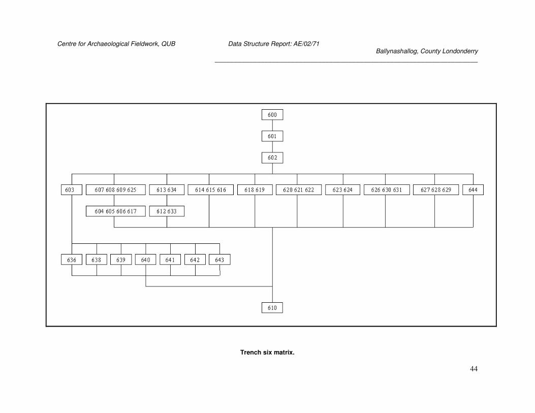
603
Layer, irregularly shaped, 10000 mm wide and at least 15000 mm long (runs under baulk).
Very dark brown 7.5YR 2/3 friable silt. Contained fragments of shale and quartz. Cut by (604)
and (606). Above (635), (636), and (644). Finds: modern pottery, quartz, glass, brick, metal, a
plastic button, slag, miscellaneous stone and worked flint.
604
Modern drain cut measuring 10000 mm x 300 mm. Cuts (603), (605), (606), (618), (620) filled
by (607).
605
Modern drain cut measuring 8600 mm x 250 mm. Cut by (604), intersects with (606) – unclear
which cuts which, filled by (608).
606
Modern drain cut measuring 7000 mm x 300 mm. Cut by (604), intersects with (605), cuts
(603), filled by (609).
607
Fill of drain cut (604). Olive yellow 5Y 6/3 compact sandy clay loam.
608
Fill of drain cut (605). Dark reddish brown 5YR 3/2 silty loam. Same as (609) and (625).
Finds: quartz.
Centre for Archaeological Fieldwork, QUB Data Structure Report: AE/02/71 Ballynashallog, County Londonderry
_____________________________________________________________________
31
609
Fill of drain cut (606). Dark reddish brown 5YR 3/2 silty loam. Same as (608) and (625).
610
Natural, of indeterminate depth. Olive yellow 5Y 6/3 compact sandy clay loam.
611
Natural – patches of this scattered throughout (610), most likely to be a result of iron
oxidation. Strong brown 7.5YR 5/8 moderately cohesive silty clay loam. Of indeterminate
depth.
612
Cuts of modern plough lines. Filled by (613)
613
Fill of modern plough lines. Fill of (612).
614
Fill measuring 250 mm x 250 mm. Dark brown 7.5YR 3/2 friable silty loam containing small
pebbles. Same as (615) and (616).
615
Area of fill measuring 800 mm x 800 mm. See (614).
616
Area of fill measuring 1300 mm x 600 mm. See (614).
617
Drainage cut filled by (625), measuring 2800 mm x 250 mm. Uncertain as to relationship with
(603).
618
Fill measuring 1200 mm x 400 mm, dark brown 7.5YR 3/2 clay loam. Cut by (604).
619
Fill measuring 200 mm x 200 mm before running under baulk. Dark brown 7.5YR 3/2 silty
loam.
620
Fill measuring 400 mm x 240 mm. Dark brown 7.5YR 3/2 silty loam. Same as (621) and
(622). Cut by (604).
621
Fill measuring 260 mm x 200 mm. Same as (620) and (622).
622
Fill measuring 260 mm x 200 mm. Same as (620) and (621).
623
Fill measuring 80 mm x 80 mm. Same as (620) but with charcoal flecks.
624
Fill measuring 60 mm x 30 mm. Same as (623).
Centre for Archaeological Fieldwork, QUB Data Structure Report: AE/02/71 Ballynashallog, County Londonderry
_____________________________________________________________________
32
625
Dark reddish brown 5YR 3/2 friable silt. Fill of drainage cut (617), same as (608) and (609).
626
Fill measuring 1500 mm x 650 mm. Very dark brown 7.5YR 2/3 friable silt with 0.1% quartz
<15mm, same as (630), (631).
627
Fill measuring 470 mm x 300 mm. Very dark brown 7.5YR 2/3, same as (628), (629), (632).
Uncertain relationship with (633).
628
Fill measuring 200 mm x 150 mm. Same as (627), (629), (632).
629
Fill measuring 400 mm x 200 mm. Same as (627), (628), (632).
630
Fill measuring 800 mm x 790 mm. Same as (626), (631). Uncertain relationship with (633).
631
Fill measuring 350 mm x 350 mm. Same as (626), (630).
632
Fill measuring 1600 mm x 1500 mm. Same as (627), (628), (629). Uncertain as to relationship
with (633).
633
Plough lines, filled by (634). Uncertain as to relationship with (627), (630), (632).
634
Fill of (633). Very dark brown 7.5YR 2/3 friable silt.
635
Iron pan. Below (603), above (644). – Plan O
636
Charcoal. Below (603). – Plan O
637
Layer measuring 460 mm x 440 mm. Yellowish brown light 10YR 5/3 friable sandy clay.
Possibly a natural pocket.
638
On Plan O as white ash layer measuring 470 mm x 200 mm. Light greyish 10YR 7/1 loose
fine sand.
639
No context sheet. Sand. – Plan O. Modern.
640
Cut – on Plan O. Modern.
641
Cut – on plan O. Modern.
Centre for Archaeological Fieldwork, QUB Data Structure Report: AE/02/71 Ballynashallog, County Londonderry
_____________________________________________________________________
33
642
Cut - on plan O. Modern.
643
Fill – on plan O. Modern.
644
Layer 400 mm long. Dark greyish brown 10YR 3/3 tenacious clay. Below (635) and (603).
Above (637).
Trench 7
700
Turf layer, above (701).
701
Topsoil layer, below (700) and above (702).
702
Transitional layer below (701) and above natural. Dark reddish brown 5YR 3/2 friable loam.
703
Light olive brown 2.5Y 5/4 with 0.2% angular schist. Natural patches of orange staining
possibly caused by iron pan. Cut by (706), below (708), (709), (711).
704
Cuts of two modern drainage ditches, excavated. Filled by (705).
705
Dark reddish brown 5YR 3/3 friable silty loam with 0.1% angular quartz. Fill of (704).
706
Modern plough line cut, measuring 1500 mm x 60 mm, depth unknown as was not excavated.
Filled by (707), cuts (703) and (718).
707
Dark reddish brown 5YR 3/3 friable silty loam with 0.1% sub-angular quartz. Fill of (706).
708
Layers of very dark brown 10YR 2/2 friable silt, measuring from 200 mm x 200 mm to 4750
mm x 300 mm (and 400 mm deep where excavated), patches throughout trench. Above (703)
and (719), uncertain relationship with (715). Finds: modern pottery, quartz, glass, brick and
flint.
709
Three patches of a layer of dark reddish brown 5YR 3/2 friable silt loam with 0.1% sub-
angular quartz. Length undeterminable as all 3 run under baulks (up to 3.15 m measurable),
depth unknown as features not excavated. Above (703), cut by (716), similar colour to (710).
710
Centre for Archaeological Fieldwork, QUB Data Structure Report: AE/02/71 Ballynashallog, County Londonderry
_____________________________________________________________________
34
Layer measuring 3000 mm x 700 mm, depth unknown as feature was not excavated. Dark
reddish brown 5YR 2/2 friable silt with 0.1% angular quartz. Cut by (715), layer of similar
colour to (709). Uncertain relationships with (708), (711).
711
Layer measuring 3100 mm x 400 mm, depth unknown as layer not excavated. Dark brown
10YR 2/4 friable silt with 0.1% angular quartz. Above (703) and (719). Uncertain relationships
with (710), (715).
712
Pale yellow 2.5Y 7/4 friable clay with 0.1% angular quartz. Fill of (714), above (719).
713
Layer measuring 6200 mm x 800 mm, 90 mm deep. Very dark brown 10YR 2/2 friable silty
clay loam, with 0.1% angular quartz and 0.2% charcoal. Red patches visible, possibly iron
oxidation; and a patch of ashy soil. Overlies (719).
714
Cut of drainage feature measuring 2700 mm x 300 mm, 260 mm deep. Filled by (712), cuts
(718).
715
Layer measuring 900 mm x 300 mm, 140 mm deep. Dark brown 10YR 3/3 with 0.1% sub-
angular quartz. Above (719), uncertain relationship with (708) and (711).
716
Cut of stone lined drainage ditch measuring 10000 mm x 500 mm, 250 mm deep. Filled by
(717), cuts (709).
717
Fill of (716). Dark brown 10YR 2/2 friable silt with 0.1% sub-angular quartz. Above (719) and
(720).
718
Subsoil layer measuring 20000 mm x 3500 mm. Medium dark brown 10YR 5/4 silty loam.
Above (719).
719
Layer of olive grey sand 5Y 4/2. 4000 mm long and 200 mm deep, width unknown. Below
(708), (711), (712), (713), (715), (717) and (718).
720
Layer of stones at base of drain (716), below (717).
Trench 8
800
Turf layer, above (801), 280 mm thick. Brown 7.5YR 4/3 friable silty clay loam.
Centre for Archaeological Fieldwork, QUB Data Structure Report: AE/02/71 Ballynashallog, County Londonderry
_____________________________________________________________________
35
801
Topsoil layer, between (800) and (802), 50 mm thick. Medium brown 7.YR 4/3 friable silty clay
loam.
802
Transitional layer between (801) and natural/features. Finds: Modern pottery, quartz, glass,
metal, clay pipe.
803
Layer of dominant hue light olive brown 2.5Y 5/4 with patches of yellowish brown 10YR 5/6.
Friable silty clay loam with 2% subangular/subrounded quartz. This was a natural layer with
ferric rock and patches of iron staining; dispersed patches occur elsewhere – colour is reddish
brown 5YR 4/8.
Trench 9
No context sheets for Trench 9 Nothing of archaeological interest was noted in this trench.
Trench 10
110
Turf layer, above (11), 100 mm thick.
111
Topsoil layer between (110) and (112), 120 mm thick. Finds: struck flint, a possible hammer
stone and clay pipe.
112
Transitional layer between (111) and natural/features; 20 mm thick. Above (133) and contains
(132). Finds: modern pottery, quartz and worked quartz, slate, glass, brick, iron, flint –
worked, unworked and burnt, burnt bone fragments, clay pipe, possible hammer stone.
113
Two layers extending length of trench, up to 2400 mm wide. Dark reddish brown 5YR 3/2
friable silty clay loam. Cut by (114), above (139) and (123) natural. Finds: struck flint and
worked quartz.
114
Cut of drainage ditch measuring 9820 mm x 250 mm, depth unknown as unexcavated. Filled
by (115), cuts (113) and (124).
115
Bright brown 7.5YR 5/8 mottled with dark reddish brown 5YR 3/2 fill, friable silty clay loam,
with 0.1% grit. Fill of (114), same as (131).
116
Centre for Archaeological Fieldwork, QUB Data Structure Report: AE/02/71 Ballynashallog, County Londonderry
_____________________________________________________________________
36
Drainage cut measuring 9900 mm x 250 mm. Filled by (117), uncertain relationship with
(131).
117
Dull reddish brown 5YR 4/4 friable silty loam, slightly gritty. Fill of (116).
118
Probable drainage cut measuring 5800m x 500 mm. Filled by (119). Uncertain relationship
with (131). This cut continues as (141) in Trench 10A.
119
Dull reddish brown 5YR 4/4 friable silty loam fill with 0.1% grit. Fill of (118), fill continues as
(142) in Trench 10A.
120
Probable drainage cut, only visible for 2860 mm x 280 mm. Filled by (121).
121
Dull reddish brown 5YR 4/4 friable silty loam, slightly gritty. Fill of (120).
122
Layer measuring 3000 mm x 220 mm, dark reddish brown 5YR 3/2 friable silty clay loam with
small pieces of grit (0.1%).
123
Natural layer, dark grey yellow 2.5Y 5/2 compact silty clay with 0.1% grit.
124
Irregularly shaped layer measuring 2240 mm x 600 mm. Greenish grey 10GY 6/1 loose sandy
clay, with 2% charcoal. Same as (125), contains/cut by (129), cut by (114).
125
Same as (124) although measures 630 mm x 560 mm. Finds: 3 pieces of struck flint (10011,
10012, 10013).
126
Layer measuring 450 mm x 400 mm. Patch of black colouration with 20% charcoal pieces and
black staining mottled with natural (123). Same as (127), (128), (129). Finds: a piece of
worked flint (10015).
127
Layer measuring 1100 mm x 800 mm. Same as (126), (128), (129). Cut by plough line
(unnumbered).
128
Layer measuring 500 mm x 500 mm. Same as (126), (127), (129).
129
Layer measuring 200 mm x 100 mm. Same as (126), (127), (128). Within/cuts (124).
130
Layer measuring 3300 mm x 900 mm. Dark reddish brown 10R 3/3 friable sandy clay loam.
Contains 2% charcoal; patches of natural (123) showing through. Finds: flint flake (10010).
Centre for Archaeological Fieldwork, QUB Data Structure Report: AE/02/71 Ballynashallog, County Londonderry
_____________________________________________________________________
37
131
Layer measuring 10000 mm x 300 mm. Bright brown 7.5YR 5/8 mottled with dark reddish
brown 5YR 3/2, friable silty clay loam, with 0.1% grit. It is the fill between two drainage cuts,
and could possibly be a drainage cut itself – uncertain relationship between it and cuts (116)
and (118). Finds: Flint (10029).
132
Olive/Dull yellow orange 10YR 6/3 compact silty clay fill. Patches of redeposited natural within
(112). Above (133).
133
Mottled fill: yellowish brown 10YR 5/6 and dull yellow 2.5Y 6/3 silty clay. Contained large
stones (up to 360 mm long). It is probably natural stained by surrounding stones. Below (112)
and therefore (132), above (150). Finds: worked and unworked flint, worked and unworked
quartz.
134
Layer of mottled light grey 10YR 8/1 and dark brown 10YR 3/3. Layer was 30 to 70 mm deep.
Above (135). Finds: struck flint, worked and unworked quartz.
135
Charcoal layer measuring 3000 mm x 1000 mm, 5 to 25 mm deep. Mixed charcoal stained
black and black 7.5YR 2/1. Above (134). Finds: a flint flake, struck quartz, clay pipe.
136 – cancelled
137
Olive brown 2.5Y 4/3 friable clay loam. Fill of (138), below (139).
138
Cut 1490 mm x 1000 mm; 250 mm deep after removal of (112). Possible pit cut. Filled by
(113), (137) and (139).
139
Greyish brown 7.5YR 4/2 friable silty loam. A fill of (138), below (113) and above (137).
Finds: struck flint.
140 – cancelled
Trench 10A (extension to Trench 10)
110
Same as in Trench 10.
111
Same as in Trench 10. Finds: modern pottery, quartz, slate, glass, brick, metal, flint.
112
Centre for Archaeological Fieldwork, QUB Data Structure Report: AE/02/71 Ballynashallog, County Londonderry
_____________________________________________________________________
38
Same as in Trench 10. Finds: modern pottery, quartz and worked quartz, quartz and rock
crystal(10157), slate, glass, brick, metal, clay pipe, flint – worked, unworked, heat shattered,
burnt; chert, burnt bone fragment.
141
Continuation of Cut (118) in Trench 10, measuring 5000 mm x 500 mm. Filled by (142),
uncertain relationship with (143) and (145).
142
Continuation of Fill (119) in Trench 10. Fill of (141).
143
Cut of plough line, filled by (144).
144
Fill of (143).
145
Cut of plough line, filled by (146), cut by (149).
146
Fill of (145).
147
Cut of drainage feature, filled by (148).
148
Fill of (147).
149
Layer of charcoal measuring 480 mm x 280 mm. Cuts (145).
150
Fill of yellowish brown 2.5Y 5/3 mottled with yellowish brown 10YR 5/6 compact silty clay
loam. Below (133).
Trench 11
1100
Turf layer, above (1101).
1101
Topsoil layer, below (1101) and above (1102).
1102
Transitional layer between (1101) and natural. Finds: modern pottery, quartz, slate, glass,
brick, clay pipe, flint.
Centre for Archaeological Fieldwork, QUB Data Structure Report: AE/02/71 Ballynashallog, County Londonderry
_____________________________________________________________________
39
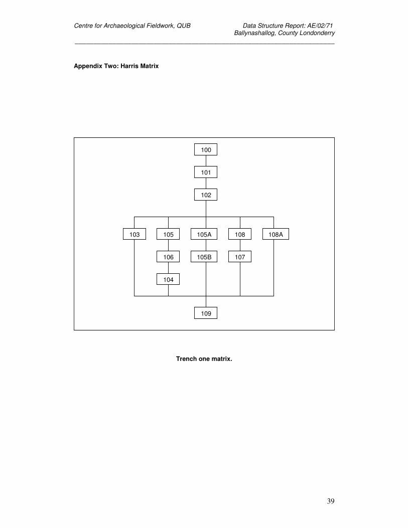
Appendix Two: Harris Matrix
Trench one matrix.
100
101
102
105A
105B
108 108A
107
105
106
104
103
109
Centre for Archaeological Fieldwork, QUB Data Structure Report: AE/02/71 Ballynashallog, County Londonderry
_____________________________________________________________________
40
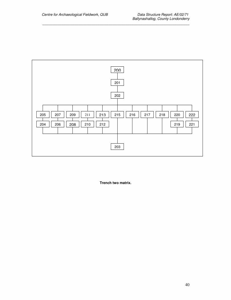
Trench two matrix.
200
201
202
215 216 217 218 220 213 211 209 207 205 222
204 206 208 210 212 219 221
203
Centre for Archaeological Fieldwork, QUB Data Structure Report: AE/02/71 Ballynashallog, County Londonderry
_____________________________________________________________________
41
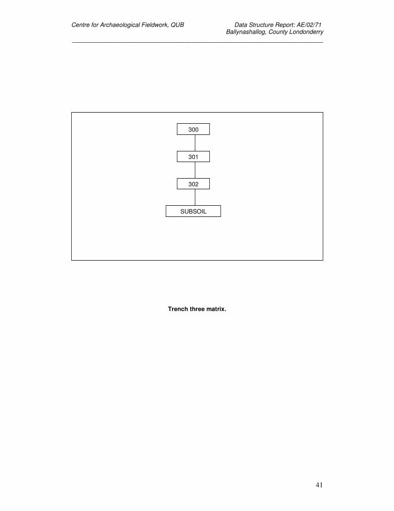
Trench three matrix.
300
301
302
SUBSOIL
Centre for Archaeological Fieldwork, QUB Data Structure Report: AE/02/71 Ballynashallog, County Londonderry
_____________________________________________________________________
42
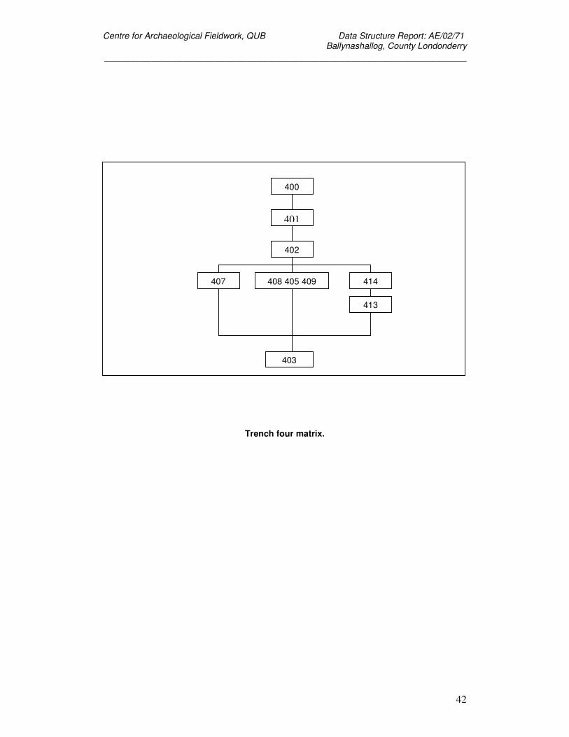
Trench four matrix.
400
401
402
408 405 409 407 414
413
403
Centre for Archaeological Fieldwork, QUB Data Structure Report: AE/02/71 Ballynashallog, County Londonderry
_____________________________________________________________________
43
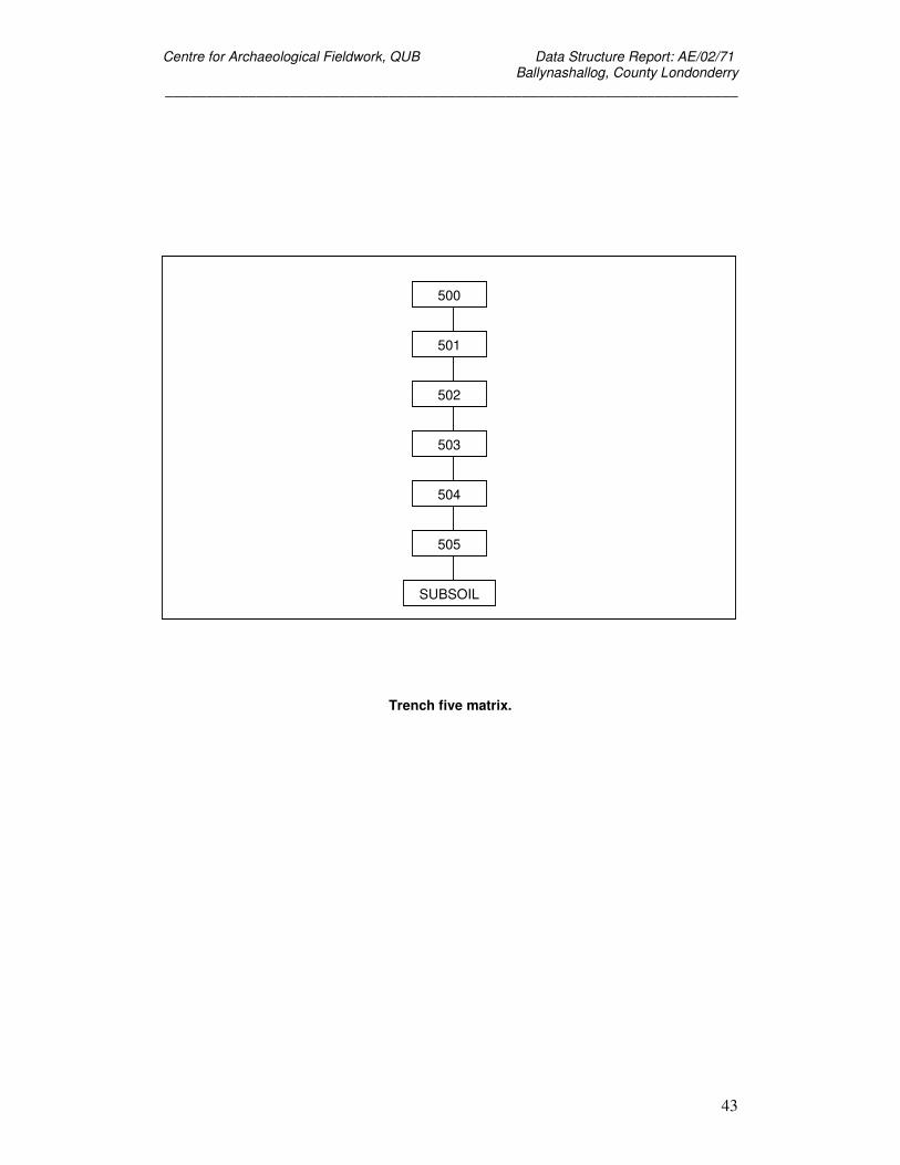
Trench five matrix.
500
501
502
503
504
505
SUBSOIL
Centre for Archaeological Fieldwork, QUB Data Structure Report: AE/02/71 Ballynashallog, County Londonderry
_____________________________________________________________________
44
Trench six matrix.
Centre for Archaeological Fieldwork, QUB Data Structure Report: AE/02/71 Ballynashallog, County Londonderry
_____________________________________________________________________
45
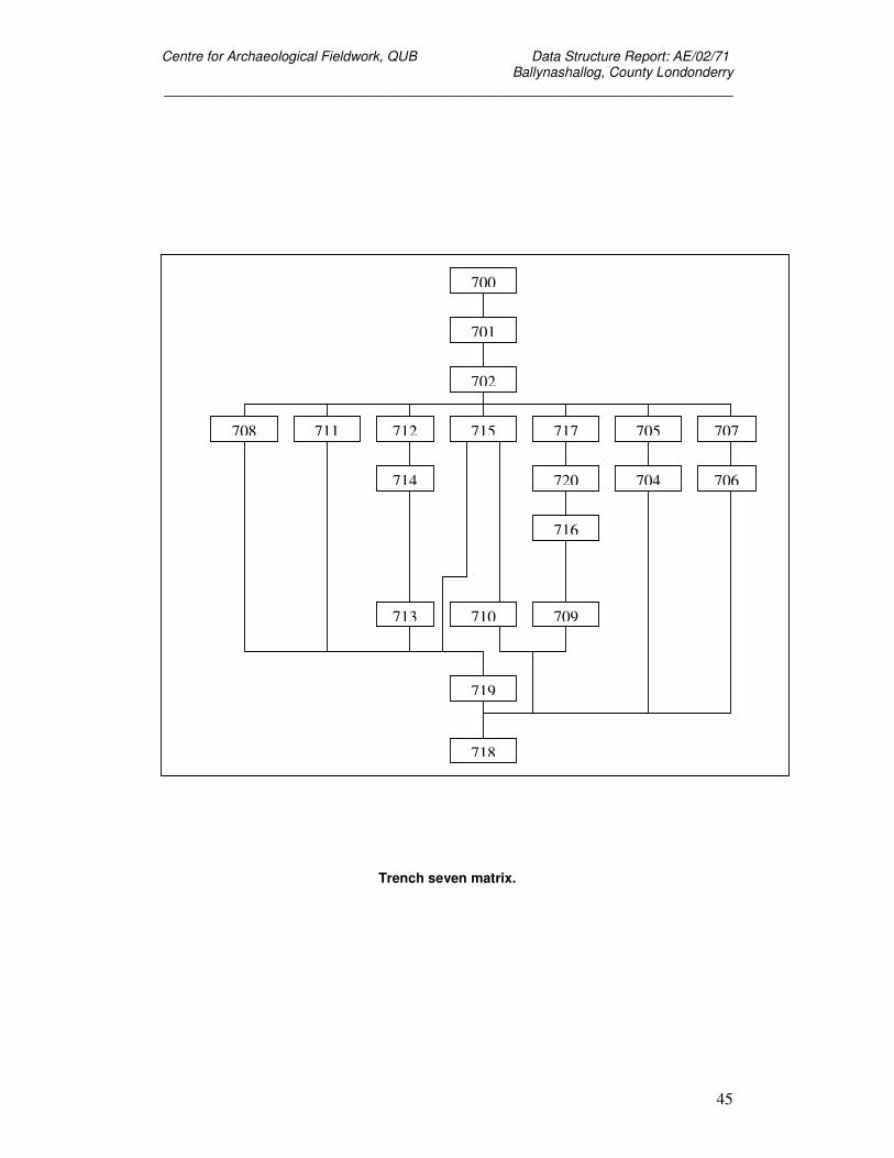
Trench seven matrix.
700
701
702
708 715 705 707 711 717 712
714 720
716
713 709 710
704 706
719
718
Centre for Archaeological Fieldwork, QUB Data Structure Report: AE/02/71 Ballynashallog, County Londonderry
_____________________________________________________________________
46
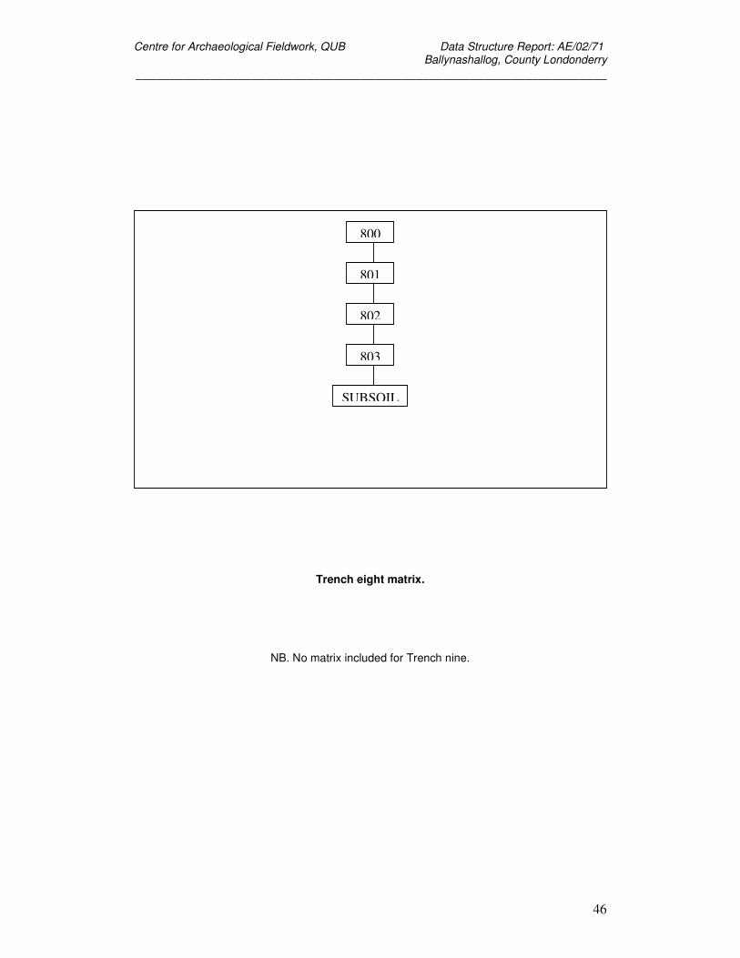
Trench eight matrix.
NB. No matrix included for Trench nine.
800
801
802
803
SUBSOIL
Centre for Archaeological Fieldwork, QUB Data Structure Report: AE/02/71 Ballynashallog, County Londonderry
_____________________________________________________________________
47
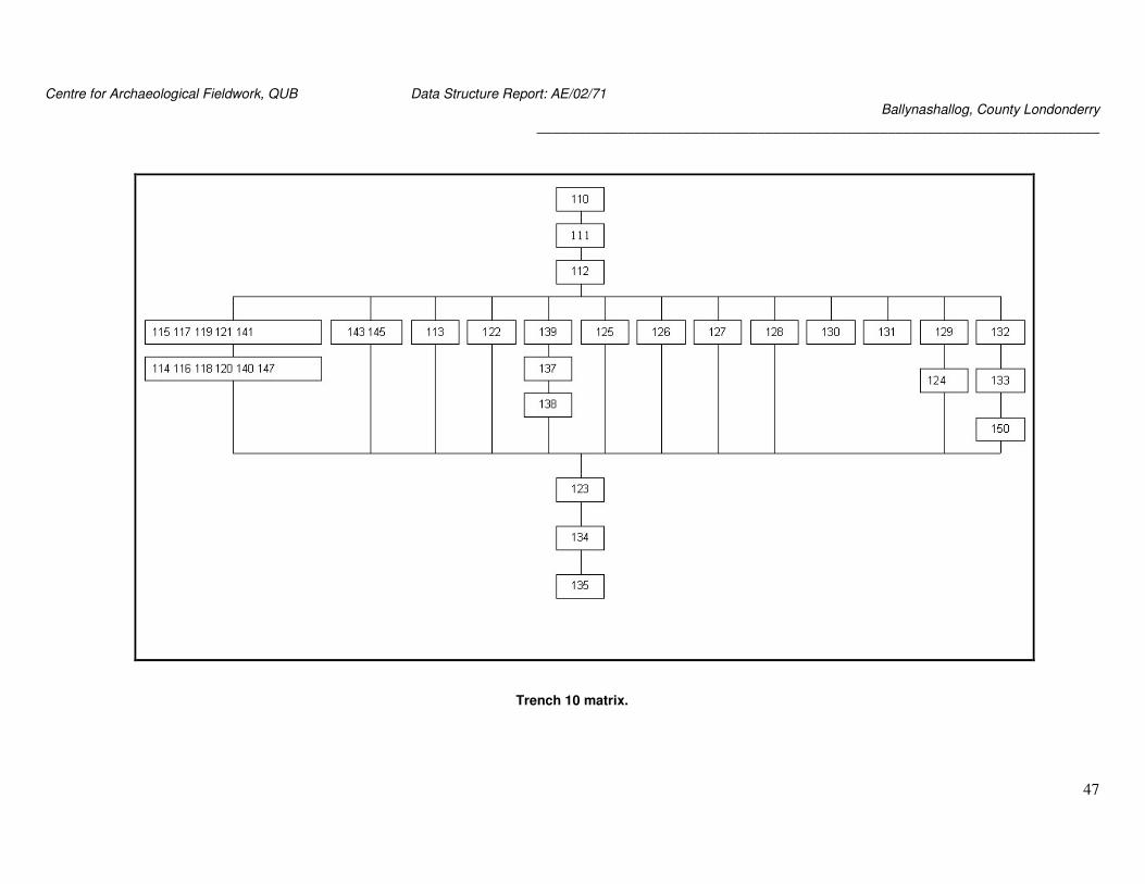
Trench 10 matrix.
Centre for Archaeological Fieldwork, QUB Data Structure Report: AE/02/71 Ballynashallog, County Londonderry
_____________________________________________________________________
48
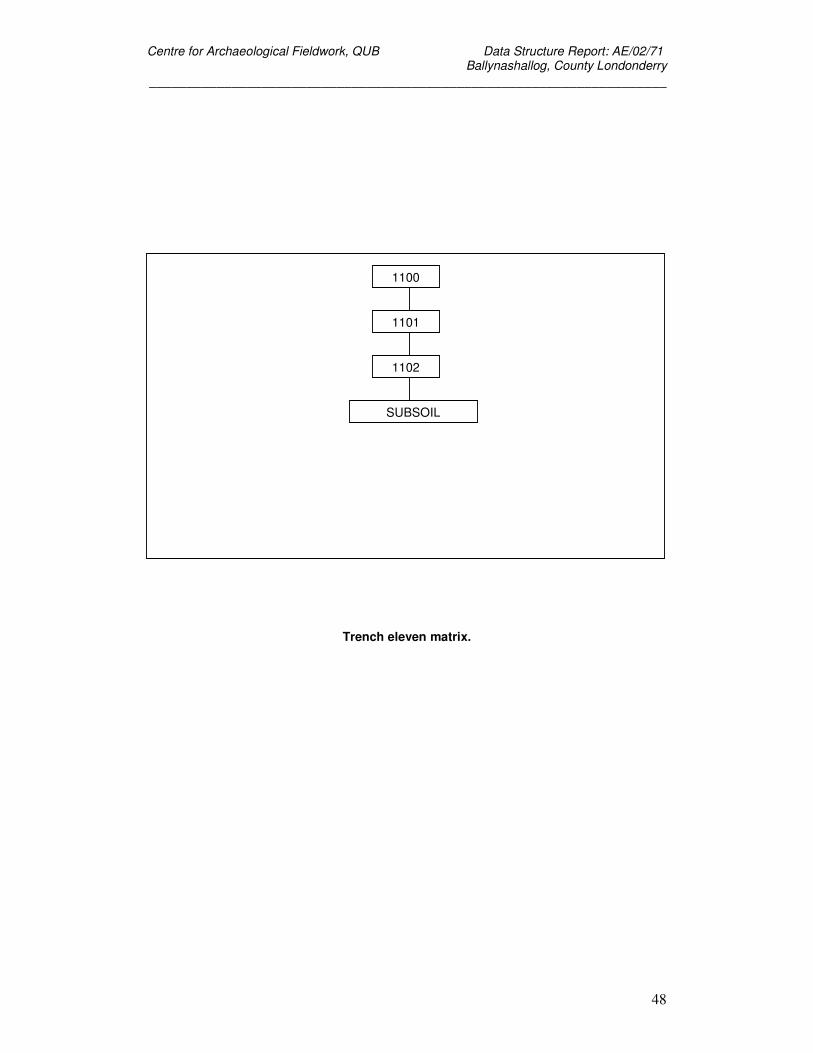
Trench eleven matrix.
1100
1101
1102
SUBSOIL
Centre for Archaeological Fieldwork, QUB Data Structure Report: AE/02/71 Ballynashallog, County Londonderry
_____________________________________________________________________
49
Appendix Three: Photographic Record
Digital Images (duplicate copies in colour slide, colour print and monochrome)
Number Description 1 Trench One, C106 2 Trench One, C106 3 Trench One, drain 4 Trench One, C106 5 Trench One, C106 6 Trench One, C106 7 Trench One, drain 8 Trench One, drain 9 Trench Four, C402 10 Trench Four, C402 11 Trench Four, C406 12 Trench Four, C408 13 Trench Four, drain 14 Trench Four, pit? 15 Trench Four, C402 16 Trench Four, C406 17 Trench Four, C406 18 Trench Four, 409 19 Trench Four, drain and pit 20 Trench Four, drain and pit 21 Trench Four (general shot) 22 Trench Four (general shot) 23 Trench Five, C502 24 Trench Five, C502 25 Trench Six, C602 26 Trench Six, ceramic drain 27 Trench Six, drain 28 Trench Six, C602 29 Trench Six, C602 30 Trench Six being planned 31 Trench Six, root 32 Trench Six, root 33 Trench Six, root 34 Trench Seven, C702 35 Trench Seven cut feature 36 Trench Seven, section 37 Trench Seven, general shot 38 Trench Seven, general shot 39 Trench Seven, general shot 40 Trench Seven, section 41 Trench Seven, general shot 42 Trench Eight, C802
Centre for Archaeological Fieldwork, QUB Data Structure Report: AE/02/71 Ballynashallog, County Londonderry
_____________________________________________________________________
50
43 Trench Eight, C802 44 Trench Eight, C802 45 Trench Eight, C802 46 Trench Eight, C802 47 Trench Nine, C901 48 Trench Nine, C902 49 Trench Ten, C111 50 Trench Ten, C112 51 Trench Ten, C112 52 Trench Ten, C112 53 Trench Ten, C112 54 Trench Ten, C112 55 Trench Ten, C135 56 Trench Ten, C135 57 Trench Ten, C135 58 Trench Ten, charcoal concentration 59 Trench Ten, charcoal concentration 60 Trench Ten, charcoal concentration 61 Trench Ten, charcoal concentration 62 Trench Ten, charcoal concentration 63 Trench Ten, C112 64 Trench Ten, general shot 65 Trench Ten, general shot 66 Trench Ten, general shot 67 Trench Ten, schist boulders 68 Trench Ten, schist boulders 69 Trench Ten, C112 70 Trench Ten, C112 71 Trench Eleven, general shot 72 Trench Eleven, general shot 73 Trench Eleven, general shot
Centre for Archaeological Fieldwork, QUB Data Structure Report: AE/02/71 Ballynashallog, County Londonderry
_____________________________________________________________________
51
Appendix Four: Field Drawing Register.
Drawing Description Type Scale Date A Tr 1 - Western end Plan 01:20 28.06.02 B Tr 1 - Western end Plan 01:20 28.06.02 C Tr 1 - Western end Plan 01:20 28.06.02 D Tr 1 - Eastern end Plan 01:20 01.07.02 E1 Tr 1 - West facing Section 01:05 02.07.02 E2 Tr 1 - East facing Section 01:05 02.07.02 E3 Tr 1 - Cut 104 Plan 01:05 02.07.02 F Tr 4 - South half Plan 01:20 02.07.02 G Tr 4 - North half Plan 01:20 02.07.02 H Tr 6 - South half Plan 01:20 03.07.02 I Tr 1 - Eastern end Plan 01:20 04.07.02 J Tr 6 - North half Plan 01:20 04.07.02 K Tr 2 Plan 01:20 05.07.02 L1 Tr 4 - Northeast facing Section 01:10 05.07.02 L2 Tr 4 - Northwest facing Section 01:10 08.07.02 L3 Tr 4 - Section 01:10 09.07.02 M Tr 4 - Northeast facing Section 01:10 16.07.02 N Tr 6 - Southeast facing Section 01:10 O Tr 6 - Grids D4.D5,D6 Plan 01:20 08.07.02 P Tr 10 Plan 01:20 Q Tr 7 Plan 01:20 16.07.02 R Tr 7 - Southwest facing Section 01:10 22.07.02 S Tr 10A Plan 01:20 25.07.02 T Tr 10 - Stone setting Plan 01:10 29.07.02 U Tr 10 - Southwest facing Section 01:10 30.07.02 V Tr 10 - Northeast facing Section 01:10 31.07.02 W1 Tr 10 - Grids D8,D9,D10, Northwest facing Section 01:10 31.07.02 W2 Tr 10 - Grid D8, Northeast facing Section 01:10 31.07.02 W3 Tr 10 - Grid D8, Southwest facing Section 01:10 31.07.02
Centre for Archaeological Fieldwork, QUB Data Structure Report: AE/02/71 Ballynashallog, County Londonderry
_____________________________________________________________________
52
Appendix Five: Small Finds Register
Find No. Material Object Trench Context Comments 1000 flint scraper 1 101 1001 flint 1 100 unworked, 3 pieces
1002 flint knife piece 1 101 1003 quartz 1 102 1004 ceramic sherds 1 101 modern 1005 stone misc 1 100 2 pieces 1006 brick 1 100 1007 glass 1 100 1008 slate 1 101 1009 misc stone/slag 1 101
1010 glass 1 101 1011 brick 1 101 1012 ceramic sherds 1 100 modern 1013 metal 1 101 1014 quartz 1 101 1015 slate 1 100 1016 glass 1 102 1017 metal 1 102 1018 ceramic sherds 1 102 modern 1019 metal 1 100 1020 quartz 1 100 1021 ceramic sherd 1 105 modern 1022 stone misc 1 105 1023 quartz 1 105 1024 ceramic sherd 1 106 modern 1025 slag 1 100 1026 ceramic sherds fieldwalking modern
1027 ceramic sherds fieldwalking modern, terracotta
1028 glass fieldwalking
1029 ceramic clay pipe fieldwalking 1 bowl & 2 stem pieces
1030 glass bead fieldwalking
1031 flint flake fieldwalking
1032 flint scraper fieldwalking hollow scraper
1033 flint fieldwalking
1034 flint fieldwalking
Centre for Archaeological Fieldwork, QUB Data Structure Report: AE/02/71 Ballynashallog, County Londonderry
_____________________________________________________________________
53
1035 flint fieldwalking
1036 flint fieldwalking
1037 quartz fieldwalking worked?
1038 flint River Foyle bank
water rolled
1039 ceramic River Foyle bank
2000 ceramic clay pipe 2 201 bowl & stem piece
2001 glass/glaze? 2 202 2002 ceramic clay pipe 2 202 stem x 5 pieces
2003 ceramic clay pipe 2 200 bowl piece 2004 flint 2 201 2 pieces 2005 ceramic sherds 2 201 modern 2006 ceramic sherds 2 202 modern 2007 glass 2 202 2008 slate 2 200 2009 brick 2 202 2010 glass 2 201 2011 glass 2 200 2012 brick/ceramic 2 201 2013 brick 2 200 2014 metal 2 202 2015 quartz 2 201 2016 slate 2 201 2017 slate 2 202 2018 quartz 2 202 2019 unused find number
2020 ceramic sherds 2 200 modern 2021 quartz 2 200 3000 flint 3 301 3001 chert 3 302 3002 ceramic sherds 3 301 modern 3003 brick 3 301 3004 glass 3 301 3005 quartz 3 301 3006 slate 3 302 3007 brick 3 302 3008 ceramic clay pipe 3 300 piece of bowl
3009 ceramic sherds 3 302 modern 3010 metal 3 300 3011 glass 3 300 3012 slate 3 300
Centre for Archaeological Fieldwork, QUB Data Structure Report: AE/02/71 Ballynashallog, County Londonderry
_____________________________________________________________________
54
3013 metal 3 301 3014 slag 3 300 3015 slate 3 301 3016 ceramic sherds 3 300 modern 3017 glass 3 302 3018 metal 3 302 3019 quartz 3 302 3020 quartz 3 300 4000 flint 4 402 4001 stone misc 4 402 4002 quartz flakes 4 402 flake scatter
4003 ceramic sherds 4 402 modern 4004 brick 4 402 4005 metal 4 402 4006 glass 4 402 4007 quartz 4 402 4008 flint 4 402 unworked 4009 stone hammer stone? 4 406 4010 quartz 4 411 4011 quartz 4 410 4012 glass 4 411 4013 quartz & metal 4 410 fused together
4014 ceramic sherd 4 411 modern Find No. Material Object Trench Context Comments 4015 ceramic sherds 4 410 modern 4016 quartz 4 410 4017 quartz 4 411 4018 quartz 4 404 4019 ceramic sherds 4 404 modern 4020 quartz 4 404 4021 quartz 4 404 4022 stone hammer stone? 4 402 4023 quartz 4 413 5000 quartz 5 502 5001 glass 5 502 5002 brick 5 502 5003 stone misc 5 502 5004 ceramic sherds 5 502 modern 5005 ceramic clay pipe 5 502 1piece bowl, 3 pieces
stem
5006 slate 5 502 5007 stone misc/fossil? 5 502 6000 ceramic sherds 6 602 prehistoric, 4 pieces
6001 ceramic sherd 6 602 prehistoric, 1 piece
6002 flint flake 6 602
Centre for Archaeological Fieldwork, QUB Data Structure Report: AE/02/71 Ballynashallog, County Londonderry
_____________________________________________________________________
55
6003 flint retouched flake 6 602 6004 flint 6 602 unworked, 3 pieces
6005 slate 6 602 6006 ceramic sherds 6 602 modern 6007 glass 6 602 6008 quartz 6 602 6009 brick 6 602 6010 ceramic clay pipe 6 602 piece of bowl
6011 metal 6 602 6012 flint 6 603 worked 6013 glass 6 603 6014 ceramic sherds 6 603 modern 6015 brick 6 603 6016 slag/misc stone 6 603 2 pieces
6017 metal 6 603 6018 quartz 6 603 6019 stone misc 6 603 6020 metal 6 603 6021 quartz 6 603 6022 glass 6 603 6023 ceramic sherds 6 603 modern 6024 ceramic sherds 6 603 modern 6025 quartz 6 603 6026 quartz 6 603 6027 ceramic sherds 6 603 modern 6028 brick 6 603 6029 quartz 6 603 6030 quartz 6 603 6031 slate 6 603 6032 quartz 6 603 6033 ceramic sherds 6 603 modern 6034 plastic button? 6 603 6035 quartz 6 603 6036 ceramic sherds 6 603 modern 6037 quartz 6 608 6038 slag 6 603 7000 quartz 7 702 7001 ceramic sherds 7 702 modern 7002 metal 7 702 7003 glass 7 702 7004 ceramic clay pipe 7 702 piece of stem
7005 quartz 7 708 7006 ceramic sherds 7 708 modern 7007 glass 7 708 7008 brick 7 708 7009 flint 7 708 3 pieces
Centre for Archaeological Fieldwork, QUB Data Structure Report: AE/02/71 Ballynashallog, County Londonderry
_____________________________________________________________________
56
7010 quartz 7 715 8000 quartz 8 802 8001 ceramic clay pipe 8 802 bowl 8002 ceramic sherds 8 802 modern 8003 glass 8 802 8004 metal 8 802 10000 quartz 10 112 worked 10001 flint flake 10 112 10002 flint point 10 112 10003 flint flake 10 112 10004 flint 10 112 worked 10005 flint flake 10 112 10006 flint flake 10 112 10007 flint flake 10 112 10008 flint flake 10 112 10009 quartz 10 112 worked 10010 flint flake 10 112 10011 flint projectile point 10 112 10012 flint flake 10 112 10013 flint 10 112 worked 10014 flint flake 10 112 found in dry sieve
10015 flint 10 112 worked 10016 flint flake 10 112 found in dry sieve
10017 flint 10 112 worked 10018 flint flakes 10 112 10019 flint flake 10 112 10020 flint flake 10 112 10021 flint flake 10 112 10022 flint flake 10 112 10023 flint 10 112 10024 quartz 10 112 10025 quartz 10 112 10026 bone 10 112 burnt, fragment
10027 flint 10 112 10028 flint flake 10 112 10029 flint 10 112 10030 flint flake 10 112 10031 flint flake 10A 112 10032 quartz knife? 10A 112 10033 flint flake 10A 112 10034 flint flake 10A 112 10035 flint flake 10A 112 10036 flint flake 10A 112 10037 flint flake 10A 112 10038 flint projectile point 10A 112 10039 ceramic clay pipe 10A 111 broken bowl
Centre for Archaeological Fieldwork, QUB Data Structure Report: AE/02/71 Ballynashallog, County Londonderry
_____________________________________________________________________
57
10040 flint 10A 112 10041 flint flake 10A 112 10042 flint flake 10 112 10043 flint flake 10 111 10044 flint flake 10 111 10045 stone hammer stone? 10 111 10046 ceramic clay pipe 10 111 piece of bowl
10047 flint flake 10 112 10048 flint flake 10 112 10049 flint flake 10 112 10050 flint flake 10 112 10051 flint flake 10 112 10052 flint flake 10 112 10053 flint flake 10 112 10054 flint flake 10 112 10055 flint flake 10 112 10056 flint 10 112 unworked 10057 flint 10 112 10058 flint flake 10 112 10059 flint flake 10 112 10060 flint 10 112 unworked 10061 flint 10A 111 10062 flint 10A 111 10063 flint 10A 111 10064 flint 10A 111 unworked, 2 pieces
10065 quartz 10A 111 10066 ceramic sherds 10A 111 modern 10067 brick 10A 111 10068 slate 10A 111 10069 metal 10A 111 10070 glass 10A 111 10071 quartz 10 134 worked, 2 pieces
10072 quartz 10 134 worked, 1 piece
10073 flint flake 10 134 10074 flint flake 10 134 10075 flint flake 10 134 10076 flint scraper 10 133 10077 flint 10 133 10078 flint flake 10 112 10079 bone 10 110/111/112 burnt, fragment
10080 flint flake 10 112 10081 flint flake 10A 112 10082 quartz 10 133 worked 10083 flint flake 10 112 10084 flint flake 10 112
Centre for Archaeological Fieldwork, QUB Data Structure Report: AE/02/71 Ballynashallog, County Londonderry
_____________________________________________________________________
58
10085 quartz flake 10 112 10086 flint flake 10 112 10087 ceramic sherds 10 112 modern 10088 brick 10 112 10089 glass 10 112 10090 slate 10 112 10091 quartz 10 112 10092 quartz 10 112 10093 quartz 10 112 10094 quartz 10 112 10095 quartz 10 112 10096 quartz 10 112 10097 quartz 10 112 10098 quartz 10 112 10099 quartz 10 112 10100 quartz 10 112 10101 quartz 10 112 10102 quartz 10 112 10103 quartz 10 112 10104 quartz 10 112 10105 quartz 10 112 10106 quartz 10 112 10107 quartz 10 112 10108 quartz 10 112 10109 quartz 10 112 10110 quartz 10 112 10111 quartz 10 112 10112 quartz 10 112 10113 quartz 10 112 10114 quartz 10 112 10115 quartz 10 112 10116 quartz 10 112 10117 quartz 10 112 10118 quartz 10 112 10119 quartz 10A 112 10120 quartz 10A 112 10121 quartz 10A 112 10122 quartz 10A 112 10123 quartz 10A 112 10124 quartz 10A 112 10125 quartz 10A 112 10126 quartz 10A 112 10127 quartz 10A 112 10128 quartz 10A 112 10129 quartz 10A 112 10130 quartz 10A 112 10131 quartz 10A 112 10132 quartz 10A 112 10133 quartz 10A 112 10134 quartz 10A 112
Centre for Archaeological Fieldwork, QUB Data Structure Report: AE/02/71 Ballynashallog, County Londonderry
_____________________________________________________________________
59
10135 quartz 10A 112 10136 quartz 10A 112 10137 ceramic sherds 10A 112 modern 10138 glass 10A 112 10139 ceramic clay pipe 10A 112 2 pieces stem, 1 piece
bowl
10140 brick 10A 112 10141 flint 10A 112 burnt 10142 flint 10A 112 unworked 10143 flint flake 10A 112 10144 flint flake 10A 112 10145 flint flake 10A 112 10146 flint flake 10A 112 10147 flint flake 10A 112 10148 flint flake 10A 112 10149 flint flake 10A 112 10150 flint flake 10A 112 10151 flint flake 10A 112 10152 flint flake 10A 112 10153 flint 10A 112 unworked 10154 flint flake 10A 112 10155 flint 10A 112 heat shattered
10156 metal 10A 112 10157 quartz & rock
crystal? 10A 112
10158 flint flake 10A 112 10159 ? 10A 112 10160 flint scraper 10 134 10161 flint scraper 10 134 double hollow scraper
10162 flint flake 10 134 retouched 10163 flint flake 10 134 10164 flint flake 10 134 10165 chert 10A 112 10166 flint flake 10A 112 10167 flint flake 10A 112 10168 flint flake 10A 112 10169 flint flake 10A 112 10170 flint flake 10A 112 10171 flint scraper 10 112 10172 flint scraper 10 112 10173 flint flake 10 112 retouched 10174 quartz 10 135 worked 10175 metal - iron 10 112 10176 flint flake 10 112 10177 flint flake 10 112 10178 flint flake 10 112 10179 flint flake 10 112
Centre for Archaeological Fieldwork, QUB Data Structure Report: AE/02/71 Ballynashallog, County Londonderry
_____________________________________________________________________
60
10180 flint flake 10 112 10181 flint flake 10 112 10182 flint flake 10 112 10183 flint flake 10 112 10184 flint flake 10 135 10185 quartz flakes 10 135 3 pieces 10186 quartz 10 112 10187 quartz flake 10 112 10188 quartz 10A 112 10189 quartz 10 134 10190 flint flake 10 133 10191 flint flake 10 133 10192 flint flake 10 112 10193 quartz 10 112 10194 quartz 10 133 10195 quartz 10 112 10196 quartz 10 112 10197 flint flake 10 139 10198 flint flake 10 139 10199 flint flake 10A 112 10200 bone 10A 112 burnt, fragment
10201 flint flake 10A 112 10202 flint flake 10A 112 10203 quartz 10A 112 10204 flint flake 10A 112 10205 flint flake 10A 112 10206 flint flake 10A 112 10207 flint flake 10 112 10208 flint flake 10 112 10209 bone 10 112 burnt, fragments
10210 flint flake 10 112 10211 flint flake 10 112 10212 flint flake 10 112 10213 flint flake 10 112 10214 flint flake 10 112 10215 flint 10 112 burnt 10216 flint flake 10 112 burnt 10217 flint flake 10 112 10218 flint flake 10 112 10219 flint 10 112 unworked 10220 flint flake 10 112 10221 quartz 10 112 worked 10222 flint flake 10 112 10223 flint flake 10 112 10224 flint flake 10 112 10225 flint flake 10 112 10226 flint flake 10 112 10227 quartz 10 112 worked
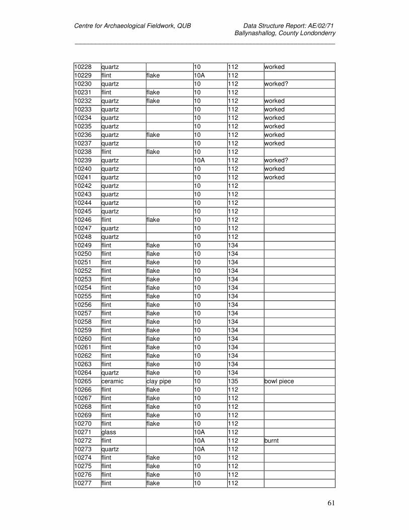
Centre for Archaeological Fieldwork, QUB Data Structure Report: AE/02/71 Ballynashallog, County Londonderry
_____________________________________________________________________
61
10228 quartz 10 112 worked 10229 flint flake 10A 112 10230 quartz 10 112 worked? 10231 flint flake 10 112 10232 quartz flake 10 112 worked 10233 quartz 10 112 worked 10234 quartz 10 112 worked 10235 quartz 10 112 worked 10236 quartz flake 10 112 worked 10237 quartz 10 112 worked 10238 flint flake 10 112 10239 quartz 10A 112 worked? 10240 quartz 10 112 worked 10241 quartz 10 112 worked 10242 quartz 10 112 10243 quartz 10 112 10244 quartz 10 112 10245 quartz 10 112 10246 flint flake 10 112 10247 quartz 10 112 10248 quartz 10 112 10249 flint flake 10 134 10250 flint flake 10 134 10251 flint flake 10 134 10252 flint flake 10 134 10253 flint flake 10 134 10254 flint flake 10 134 10255 flint flake 10 134 10256 flint flake 10 134 10257 flint flake 10 134 10258 flint flake 10 134 10259 flint flake 10 134 10260 flint flake 10 134 10261 flint flake 10 134 10262 flint flake 10 134 10263 flint flake 10 134 10264 quartz flake 10 134 10265 ceramic clay pipe 10 135 bowl piece 10266 flint flake 10 112 10267 flint flake 10 112 10268 flint flake 10 112 10269 flint flake 10 112 10270 flint flake 10 112 10271 glass 10A 112 10272 flint 10A 112 burnt 10273 quartz 10A 112 10274 flint flake 10 112 10275 flint flake 10 112 10276 flint flake 10 112 10277 flint flake 10 112
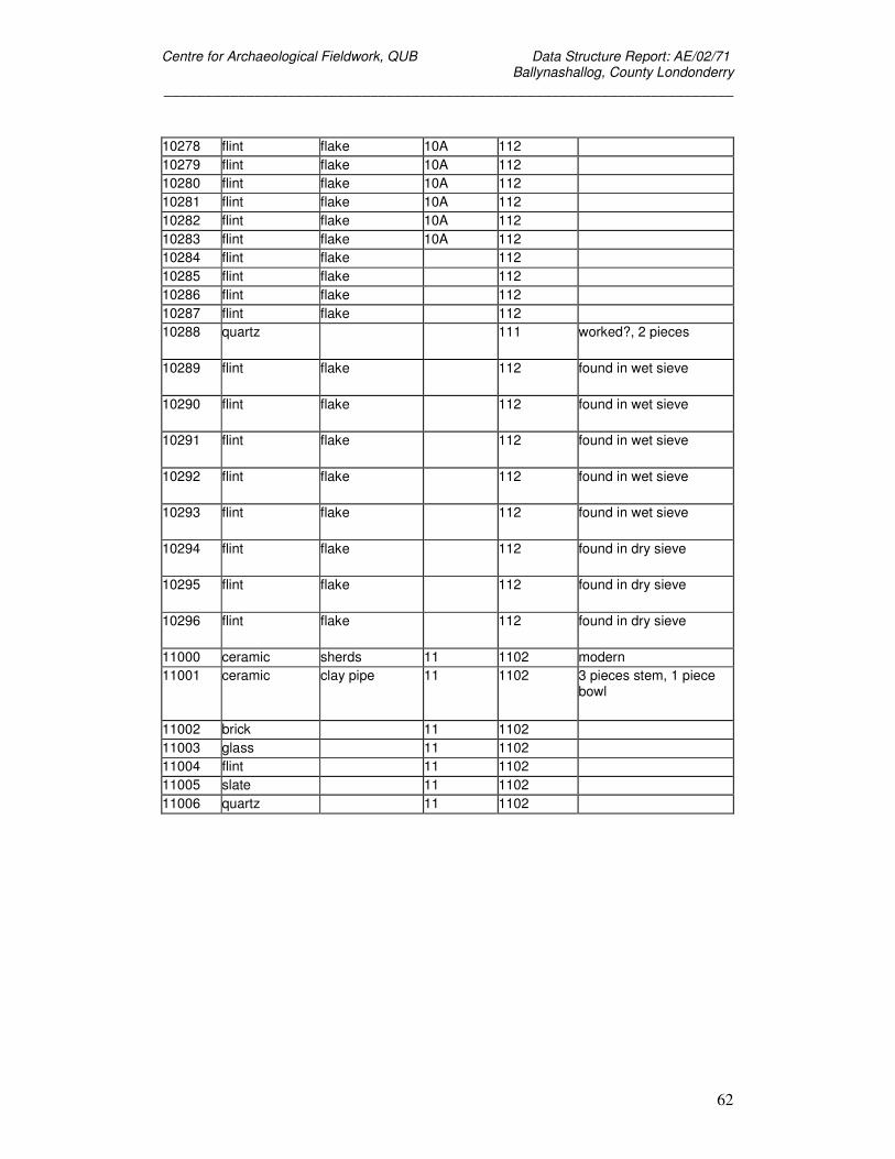
Centre for Archaeological Fieldwork, QUB Data Structure Report: AE/02/71 Ballynashallog, County Londonderry
_____________________________________________________________________
62
10278 flint flake 10A 112 10279 flint flake 10A 112 10280 flint flake 10A 112 10281 flint flake 10A 112 10282 flint flake 10A 112 10283 flint flake 10A 112 10284 flint flake 112 10285 flint flake 112 10286 flint flake 112 10287 flint flake 112 10288 quartz 111 worked?, 2 pieces
10289 flint flake 112 found in wet sieve
10290 flint flake 112 found in wet sieve
10291 flint flake 112 found in wet sieve
10292 flint flake 112 found in wet sieve
10293 flint flake 112 found in wet sieve
10294 flint flake 112 found in dry sieve
10295 flint flake 112 found in dry sieve
10296 flint flake 112 found in dry sieve
11000 ceramic sherds 11 1102 modern 11001 ceramic clay pipe 11 1102 3 pieces stem, 1 piece
bowl
11002 brick 11 1102 11003 glass 11 1102 11004 flint 11 1102 11005 slate 11 1102 11006 quartz 11 1102
Centre for Archaeological Fieldwork, QUB Data Structure Report: AE/02/71 Ballynashallog, County Londonderry
_____________________________________________________________________
63
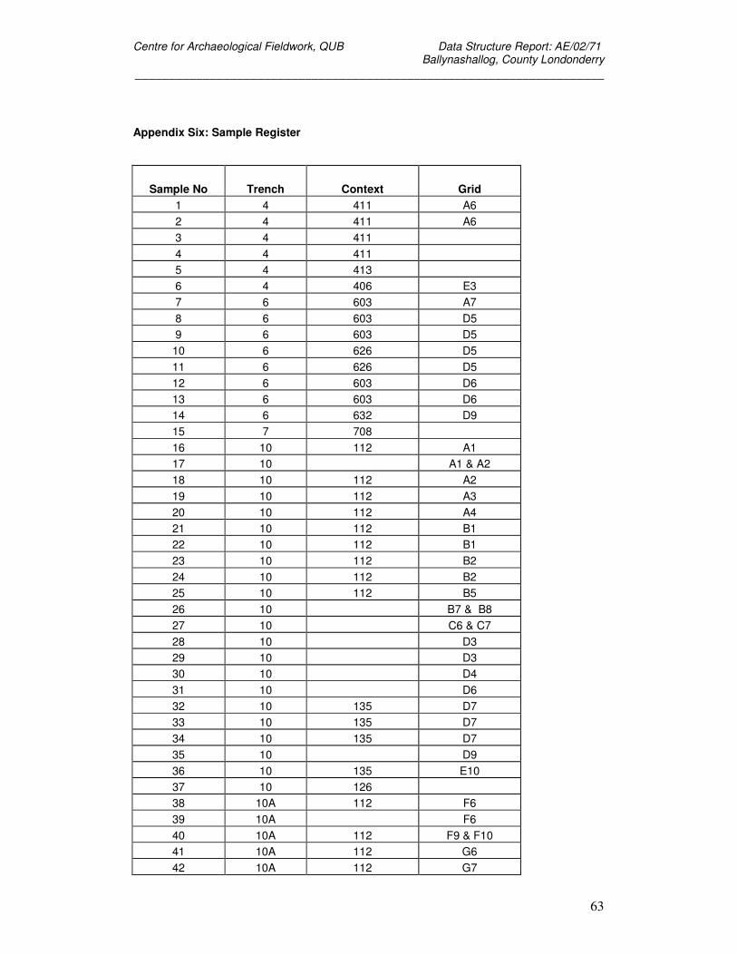
Appendix Six: Sample Register
Sample No Trench Context Grid 1 4 411 A6 2 4 411 A6 3 4 411 4 4 411 5 4 413 6 4 406 E3 7 6 603 A7 8 6 603 D5 9 6 603 D5 10 6 626 D5 11 6 626 D5 12 6 603 D6 13 6 603 D6 14 6 632 D9 15 7 708 16 10 112 A1 17 10 A1 & A2 18 10 112 A2 19 10 112 A3 20 10 112 A4 21 10 112 B1 22 10 112 B1 23 10 112 B2 24 10 112 B2 25 10 112 B5 26 10 B7 & B8 27 10 C6 & C7 28 10 D3 29 10 D3 30 10 D4 31 10 D6 32 10 135 D7 33 10 135 D7 34 10 135 D7 35 10 D9 36 10 135 E10 37 10 126 38 10A 112 F6 39 10A F6 40 10A 112 F9 & F10 41 10A 112 G6 42 10A 112 G7
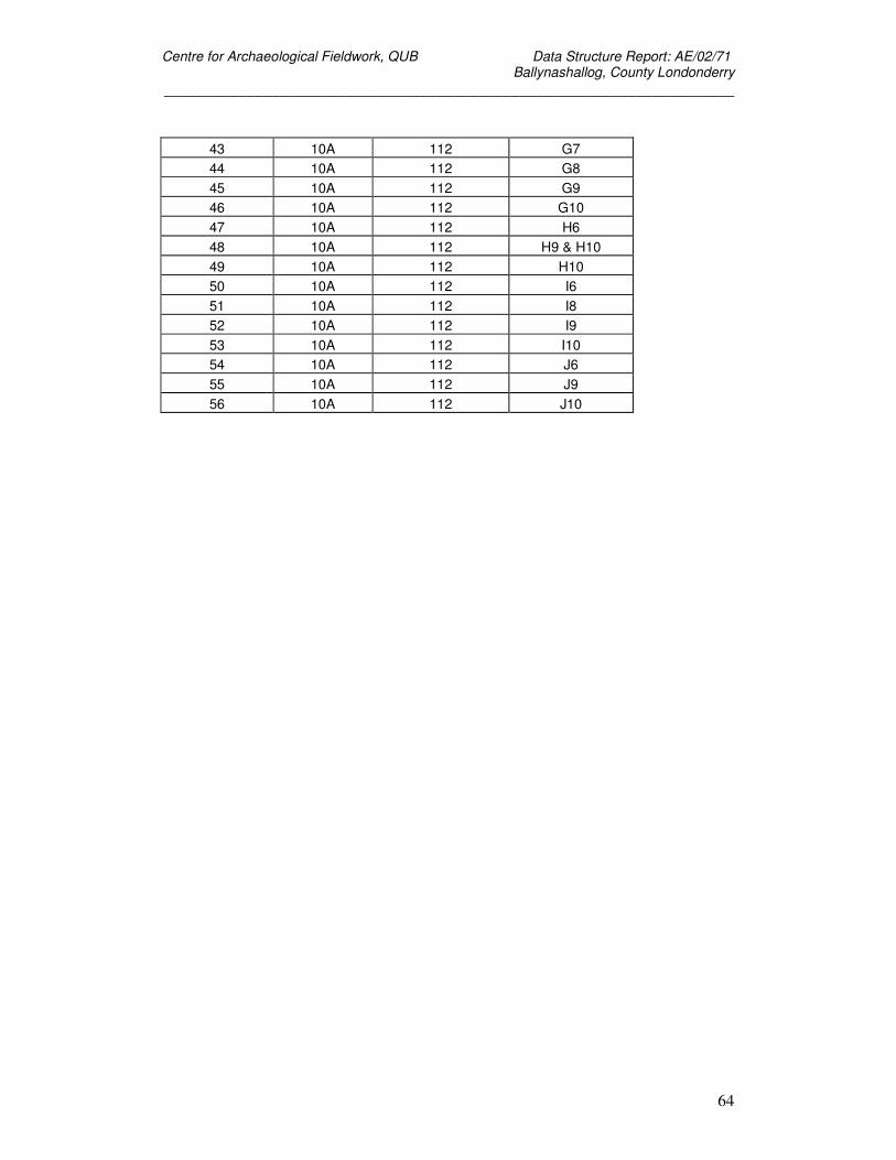
Centre for Archaeological Fieldwork, QUB Data Structure Report: AE/02/71 Ballynashallog, County Londonderry
_____________________________________________________________________
64
43 10A 112 G7 44 10A 112 G8 45 10A 112 G9 46 10A 112 G10 47 10A 112 H6 48 10A 112 H9 & H10 49 10A 112 H10 50 10A 112 I6 51 10A 112 I8 52 10A 112 I9 53 10A 112 I10 54 10A 112 J6 55 10A 112 J9 56 10A 112 J10