Embed Size (px)
Citation preview
SkylineGlobe
Advanced Capabilities
Version 6.1
Datasheet
w w w . S k y l i n e G l o b e . c o m
SkylineGlobe Advanced Capabilities
Datasheet
2
Table of Contents Overview .................................................................................................................................................. 3
Extended Feature Layer Support and Editing ................................................................................................. 4
Import and Editing of Raster Layers ............................................................................................................. 5
Publishing Project Kits ................................................................................................................................ 7
Advanced Objects ...................................................................................................................................... 8
API Development ...................................................................................................................................... 12
TerraCatalog ............................................................................................................................................ 14
Sharing Information .................................................................................................................................. 14
System Requirements................................................................................................................................ 15
SkylineGlobe Advanced Capabilities
Datasheet
3
Overview
The SkylineGlobe 3D Web Application is a powerful application made available in the SkylineGlobe Web
Package for navigation, viewing, analysis and editing of high resolution 3D landscapes created with the
SkylineGlobe products. Website users can overlay the terrain with basic objects, imagery layers and feature layers
(in .fly, .shp, or .kml/.kmz formats), as well as analyze the terrain using a powerful set of measurement and
terrain analysis tools.
Extended capabilities are automatically available to users with TerraExplorer Plus and TerraExplorer Pro
installed on their system. TerraExplorer Plus users can import feature and raster layers from a variety of sources,
including the TerraCatalog database, while Pro users can further enhance the photo-realism of their 3D view by
also adding advanced objects like buildings, dynamic objects, video, and terrain modification objects.
Additional features available to TerraExplorer Plus users include:
Extended feature layer support.
Import and editing of raster layers.
Interactive drawing tools to overlay and edit all 2D and 3D objects.
Access to TerraCatalog, a catalog database that helps you access, manage and organize your raster,
feature, projects and other geographic assets.
Additional features available to TerraExplorer Pro users include all Plus features and the following:
Feature layer editing.
Tool for publishing project kits.
Interactive drawing tools to overlay and edit advanced objects (Building, Video on Terrain, Terrain
Modification, Hole on Terrain and Dynamic Objects).
Ability to bind your project to TerraCatalog so that all project layers are automatically saved and updated
in the catalog.
SkylineGlobe Advanced Capabilities
Datasheet
4
Extended Feature Layer Support and Editing
TerraExplorer Plus and Pro users can load all feature layers in supported formats, (e.g. Esri shapefiles, Microsoft
Access, DXF, DGN, MapInfo) and from supported servers (e.g. WFS, TerraCatalog, Skyline Feature Server,
ArcSDE, Oracle). Layer level operations can then be performed using the layer’s property sheet
Pro users can also perform advanced feature layer editing.
The Attribute Table enables you to search the layer attribute database files and display the results in the 3D
Window. You can use this table to fine-tune the information that is displayed on the terrain or to create a new
project layer or file based on the filtered layer. The original layer is not modified.
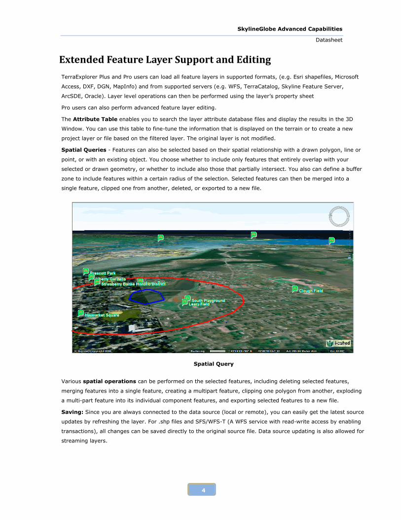
Spatial Queries - Features can also be selected based on their spatial relationship with a drawn polygon, line or
point, or with an existing object. You choose whether to include only features that entirely overlap with your
selected or drawn geometry, or whether to include also those that partially intersect. You also can define a buffer
zone to include features within a certain radius of the selection. Selected features can then be merged into a
single feature, clipped one from another, deleted, or exported to a new file.
Spatial Query
Various spatial operations can be performed on the selected features, including deleting selected features,
merging features into a single feature, creating a multipart feature, clipping one polygon from another, exploding
a multi-part feature into its individual component features, and exporting selected features to a new file.
Saving: Since you are always connected to the data source (local or remote), you can easily get the latest source
updates by refreshing the layer. For .shp files and SFS/WFS-T (A WFS service with read-write access by enabling
transactions), all changes can be saved directly to the original source file. Data source updating is also allowed for
streaming layers.
SkylineGlobe Advanced Capabilities
Datasheet
5
Import and Editing of Raster Layers
TerraExplorer Plus and Pro users can overlay the terrain with imagery layers containing geo-referenced, satellite
or aerial images and replace the elevation data of the terrain database with geo-referenced elevation raster.
Raster layers can be loaded in supported formats (e.g., .jpg, .ecw, .img, .bmp) and from supported servers (e.g.
WMS, Oracle Spatial, TerraGate, ArcSDE). Raster layer properties can then be set in the layer’s property sheet.
Imported data, of unlimited size and resolution, is automatically morphed with the terrain imagery.
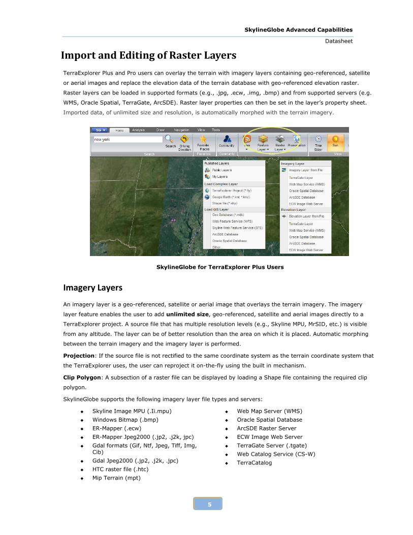
SkylineGlobe for TerraExplorer Plus Users
Imagery Layers
An imagery layer is a geo-referenced, satellite or aerial image that overlays the terrain imagery. The imagery
layer feature enables the user to add unlimited size, geo-referenced, satellite and aerial images directly to a
TerraExplorer project. A source file that has multiple resolution levels (e.g., Skyline MPU, MrSID, etc.) is visible
from any altitude. The layer can be of better resolution than the area on which it is placed. Automatic morphing
between the terrain imagery and the imagery layer is performed.
Projection: If the source file is not rectified to the same coordinate system as the terrain coordinate system that
the TerraExplorer uses, the user can reproject it on-the-fly using the built in mechanism.
Clip Polygon: A subsection of a raster file can be displayed by loading a Shape file containing the required clip
polygon.
SkylineGlobe supports the following imagery layer file types and servers:
Skyline Image MPU (.Ii.mpu)
Windows Bitmap (.bmp)
ER-Mapper (.ecw)
ER-Mapper Jpeg2000 (.jp2, .j2k, jpc)
Gdal formats (Gif, Ntf, Jpeg, Tiff, Img, Cib)
Gdal Jpeg2000 (.jp2, .j2k, .jpc)
HTC raster file (.htc)
Mip Terrain (mpt)
Web Map Server (WMS)
Oracle Spatial Database
ArcSDE Raster Server
ECW Image Web Server
TerraGate Server (.tgate)
Web Catalog Service (CS-W)
TerraCatalog
SkylineGlobe Advanced Capabilities
Datasheet
6
Image MPU (.li.mpu)
MrSid (.sid)
Erdas Imagine (.img)
NGA formats (.CIB, .CADRG, .ADRG,)
Tile Text file (.tlt)
Projection Text file (.prj)
Tiff Format (.tif)
Local Skyline terrain database (.MPT)
Elevation Layers
An elevation layer is a geo-referenced elevation raster that replaces the elevation data of the terrain database.
The elevation layer feature enables the user to add unlimited size, geo-referenced elevation data directly to a
TerraExplorer project. The file can be of better resolution than the area on which it is placed. Automatic morphing
between the terrain imagery and the imagery layer is performed. A source file that has multiple resolution levels
(e.g., Skyline MPU, WMS etc.) is visible from higher altitudes.
Projection: If the source file is not rectified to the same coordinate system as the terrain coordinate system that
the TerraExplorer uses, the user can reproject it on-the-fly using the built in mechanism.
SkylineGlobe supports the following elevation layer file types and servers:
Window Bitmap (.bmp)
ER-Mapper (.ecw)
Gdal formats (Tiff, Img, Arc/Info Binary Grid, USGS SDTSDem, USGS ASCii Dem, Dted)
Erdas Imagine (.img)
Mip Terrain (.mpt)
Elevation MPU (.Ei.mpu)
NGA DTED (DMED)
No Stream formats (Bitmap, Jpeg, Gif)
Tiff (.tif)
TiLe Text file (.tlt)
Projection Text file (.prj)
Skyline TerraGate Server
Web Map Server (WMS)
Oracle Spatial Database
ArcSDE Raster Server
ECW Image Web Server
Web Catalog Service (CS-W)
SkylineGlobe Advanced Capabilities
Datasheet
7
Publishing Project Kits
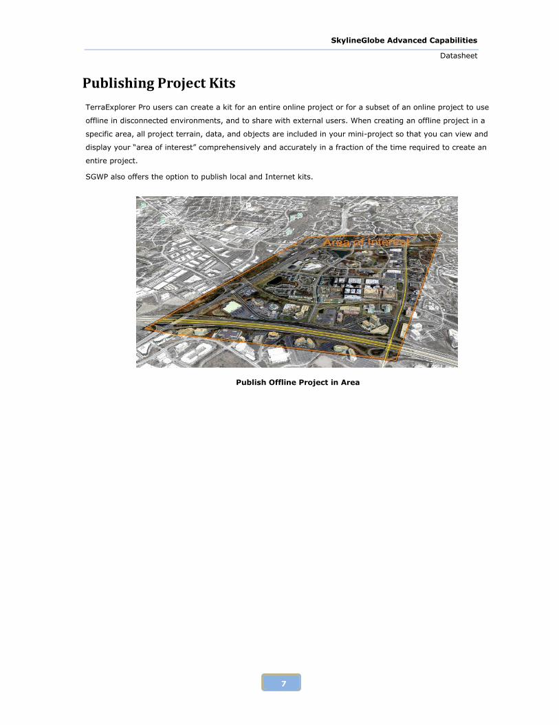
TerraExplorer Pro users can create a kit for an entire online project or for a subset of an online project to use
offline in disconnected environments, and to share with external users. When creating an offline project in a
specific area, all project terrain, data, and objects are included in your mini-project so that you can view and
display your “area of interest” comprehensively and accurately in a fraction of the time required to create an
entire project.
SGWP also offers the option to publish local and Internet kits.
Publish Offline Project in Area
SkylineGlobe Advanced Capabilities
Datasheet
8
Advanced Objects
TerraExplorer Plus and Pro users can create complex 3D visualizations by adding to their project:
2D Objects - Text Labels, Image Labels, Polylines, Polygons, Rectangles, Regular Polygons, 2D Arrows,
Circles, Ellipses, Arcs
3D Objects – Buildings, 3D Polygons, Boxes, Cylinders, Spheres, Cones, Pyramids, 3D Arrows.
After creating objects, the user can edit single or multiple objects’ parameters using the properties sheet, edit
objects directly in the 3D window, and copy /move/delete objects in the 3D window. The objects are organized in
the Project Tree.
TerraExplorer Pro users can further enhance the photo-realism of their 3D view by adding:
3D models - Load pre-prepared models, such as buildings and billboards, and place them anywhere on the
terrain. Models can be loaded in a variety of formats, including Collada, Direct X, 3DS, OpenFlight, and
then optimized by conversion to XPL2 to improve overall model display performance as well as download
rate.
Building objects - Add 3D buildings to the project by manually defining the geometry of the building
rooftop and stretching it above the basic terrain, or by importing the rooftop geometry from external
feature layers.
Dynamic objects – Easily add movement to 3D objects. The object’s route is set by manually placing
waypoints in the 3D Window.
Terrain objects – Modify the elevation values of the terrain or cut a hole in the terrain based on a
polygon’s shape and elevation.
Video file on the terrain - Play a video file either on a selected area of the terrain (Video On Terrain), or
on a floating billboard.
Point cloud models - Add a pre-processed point cloud model at any point in the 3D terrain. These models
are created from a list of points in a 3D area that are collected by various 3D scanners. You can also add a
pre-processed point cloud model set. These sets are created from lists of points in a 3D area that are
collected by various 3D scanners, and GPS route reading of the collecting instrument’s movement while
scanning the data.
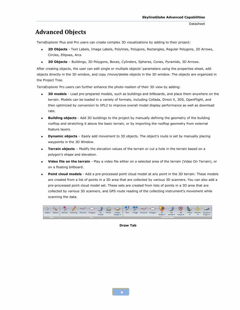
Draw Tab
SkylineGlobe Advanced Capabilities
Datasheet
9
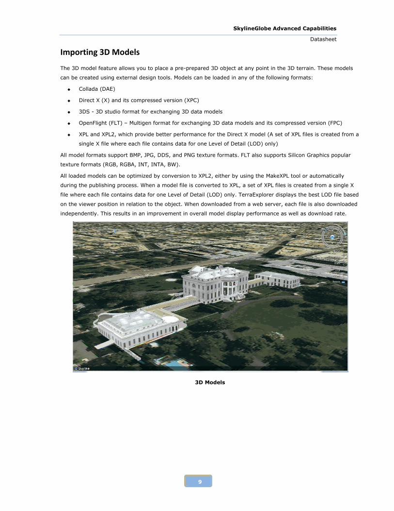
Importing 3D Models
The 3D model feature allows you to place a pre-prepared 3D object at any point in the 3D terrain. These models
can be created using external design tools. Models can be loaded in any of the following formats:
Collada (DAE)
Direct X (X) and its compressed version (XPC)
3DS - 3D studio format for exchanging 3D data models
OpenFlight (FLT) – Multigen format for exchanging 3D data models and its compressed version (FPC)
XPL and XPL2, which provide better performance for the Direct X model (A set of XPL files is created from a
single X file where each file contains data for one Level of Detail (LOD) only)
All model formats support BMP, JPG, DDS, and PNG texture formats. FLT also supports Silicon Graphics popular
texture formats (RGB, RGBA, INT, INTA, BW).
All loaded models can be optimized by conversion to XPL2, either by using the MakeXPL tool or automatically
during the publishing process. When a model file is converted to XPL, a set of XPL files is created from a single X
file where each file contains data for one Level of Detail (LOD) only. TerraExplorer displays the best LOD file based
on the viewer position in relation to the object. When downloaded from a web server, each file is also downloaded
independently. This results in an improvement in overall model display performance as well as download rate.
3D Models
SkylineGlobe Advanced Capabilities
Datasheet
10
Building Objects
The Building feature allows you to add 3D models to the project by manually defining the geometry of the building
rooftop and stretching it above the basic terrain, or by importing the rooftop geometry from external feature
layers. You can define the shape of the roof as a flat surface, or as an angular surface. After defining the building
geometry, you can assign fill color and texture from external files, or apply texture from the terrain to the roof
and side walls.
Dynamic Objects
Easily add movement to 3D objects. In addition to the featured set of ground and air vehicles, Pro and Plus users
can upload any 3D model file. The object’s route is set by manually placing waypoints in the 3D View.
There are two types of dynamic objects:
Ground Vehicle: Get pitch and roll angles according to the terrain surface under the object while it
moves.
Air Vehicle: Get pitch and roll angles according to the altitude differences between the waypoints,
regardless of the terrain surface.
Terrain Objects
The user can add objects that affect the terrain model, either modifying the terrain or creating holes in the terrain.
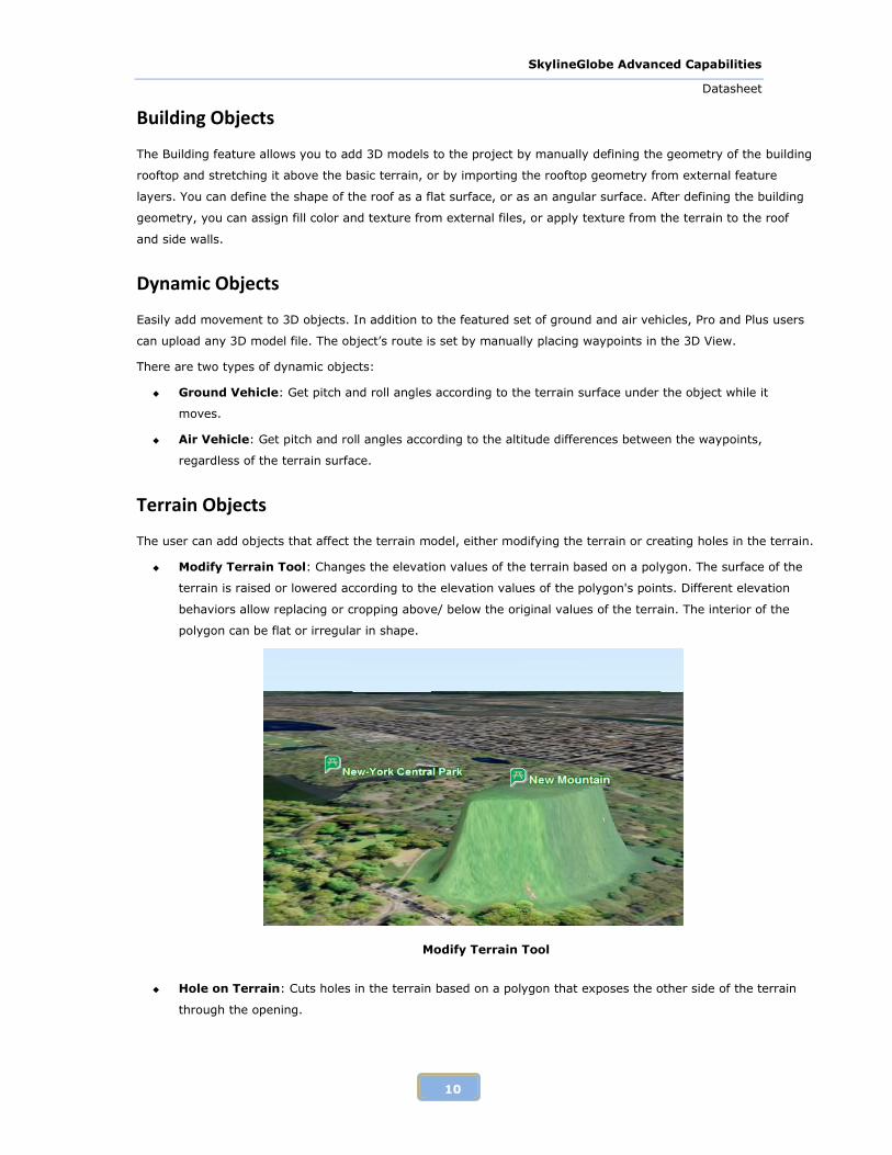
Modify Terrain Tool: Changes the elevation values of the terrain based on a polygon. The surface of the
terrain is raised or lowered according to the elevation values of the polygon's points. Different elevation
behaviors allow replacing or cropping above/ below the original values of the terrain. The interior of the
polygon can be flat or irregular in shape.
Modify Terrain Tool
Hole on Terrain: Cuts holes in the terrain based on a polygon that exposes the other side of the terrain
through the opening.
SkylineGlobe Advanced Capabilities
Datasheet
11
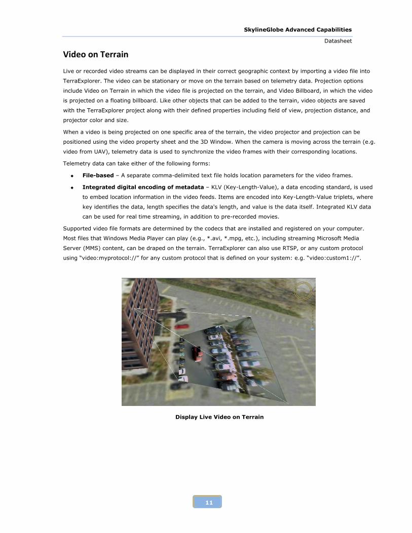
Video on Terrain
Live or recorded video streams can be displayed in their correct geographic context by importing a video file into
TerraExplorer. The video can be stationary or move on the terrain based on telemetry data. Projection options
include Video on Terrain in which the video file is projected on the terrain, and Video Billboard, in which the video
is projected on a floating billboard. Like other objects that can be added to the terrain, video objects are saved
with the TerraExplorer project along with their defined properties including field of view, projection distance, and
projector color and size.
When a video is being projected on one specific area of the terrain, the video projector and projection can be
positioned using the video property sheet and the 3D Window. When the camera is moving across the terrain (e.g.
video from UAV), telemetry data is used to synchronize the video frames with their corresponding locations.
Telemetry data can take either of the following forms:
File-based – A separate comma-delimited text file holds location parameters for the video frames.
Integrated digital encoding of metadata – KLV (Key-Length-Value), a data encoding standard, is used
to embed location information in the video feeds. Items are encoded into Key-Length-Value triplets, where
key identifies the data, length specifies the data's length, and value is the data itself. Integrated KLV data
can be used for real time streaming, in addition to pre-recorded movies.
Supported video file formats are determined by the codecs that are installed and registered on your computer.
Most files that Windows Media Player can play (e.g., *.avi, *.mpg, etc.), including streaming Microsoft Media
Server (MMS) content, can be draped on the terrain. TerraExplorer can also use RTSP, or any custom protocol
using “video:myprotocol://” for any custom protocol that is defined on your system: e.g. “video:custom1://”.
Display Live Video on Terrain
SkylineGlobe Advanced Capabilities
Datasheet
12
Point Cloud Models
The Point Cloud model allows you to add a pre-processed point cloud model at any point in the 3D terrain. These
models are created from a list of points in a 3D area that are collected by various 3D scanners. The import Point
Cloud feature supports Skyline’s proprietary Point Cloud files (CPT).
The Import Linear Point Cloud Set allows you to add a pre-processed point cloud model set. These sets are
created from lists of points in a 3D area that are collected by various 3D scanners, and GPS route reading of the
collecting instrument’s movement while scanning the data.
Timespans
Timespans can be set for groups and objects, limiting the display of the object or group on the terrain to the
specified start and end time values integrated in the object or group’s property sheet. The project’s time and date
are adjusted using the time slider.
API Development
SkylineGlobe Application Programming Interface (SGAPI)
Extend your application by developing your own JavaScript or HTML tools, which use the SkylineGlobe Application
Programming Interface (SGAPI). The SkylineGlobe Application Programming Interface (SGAPI) provides the
properties and methods to create tools to execute and manage SkylineGlobe tools and panels (e.g. Favorites,
Project Tree, Results, and Search).
SGFramework is the entry point to all SkylineGlobe classes. Through this class you can customize the different
components of your web application as well as access all the properties and methods of the TerraExplorer v61 API.
The following classes are properties of the SGFramework class:
Favorites - Provides methods for adding and removing any object or location to/from the SkylineGlobe
Favorites panel.
GlobalEvents - Controls the triggering of events and the association of functions with specific events.
ProjectTree - Provides a method for managing the Project Tree in the SkylineGlobe Web Package.
ReferrerDetails - Returns information about the CWA the user is currently connected to.
Results - Provides methods for managing the Results panel of the SkylineGlobe Web Package.
Ribbon - Exposes control over the ribbon.
Search - Provides a method for executing a search tool on the SkylineGlobe Web Package.
SGWorld61 - Exposes all the properties and methods of the TerraExplorer v61 API.

SkylineGlobe Advanced Capabilities
Datasheet
13
TerraExplorer API
The TerraExplorer Application Programming Interface (API) provides a powerful way for integrating SkylineGlobe
and custom applications. It also provides a way to create extensions that can access external information sources
such as databases or geospatial files.
The following main issues are addressed by the TerraExplorer API:
Navigating in the 3D world.
Project management (e.g. creating extensions to add support for additional file and database formats).
Feature and raster layers (e.g. editing of feature layers)
Object management (e.g. real-time movement of objects for command and control applications or addition
of custom-made objects).
Terrain analysis (e.g. advanced terrain queries such as terrain profile).
Event notifications.
In addition, TerraExplorer's API allows a variety of other operations such as controlling the content of the
containers, querying the terrain for height information, taking snapshots, controlling the mouse and more.
ISGWorld61 is the main entry point to most TerraExplorer interfaces. Through this interface you can manage your
application and 3D content and handle events.
The following interfaces are properties of the ISGWorld61 interface:
IProject61 (.Project) – Open the project, manage its properties and save the project.
INavigate61 (.Navigate) – Navigate in the 3D world by setting the camera position and produce complex
movements such as FlyTo and Zoom in and out.
IProjectTree61 (.ProjectTree) - Provides complete access to the TerraExplorer Project Tree. It allows the
creation of groups and queries on objects in the tree.
ICreator61 (.Creator) – Create and delete all layers, objects, positions, geometry, colors, and
presentations.
IAnalysis61 (.Analysis) – Perform terrain analysis operations
ITerrain61 (.Terrain) – Exposes information, such as the MPT file name that is being used, and additional
information about the MPT coordinate system, and height information.
IWindow61 (.Window) – Allow the user to query the 3D world according to points on the screen, create
and manage popup windows, create snapshots and manage user interface elements such as on screen
layers and controls.
ICommand61 (.Command) – Enable activation of TerraExplorer user interface operations such as turning
on and off the underground mode or start manual object editing.
ICoordServices61 (.CoordServices) – Coordinate system related features. It allows you to define a
coordinate system for your input coordinates, and have TerraExplorer convert them to the coordinate
system of the current terrain database.
Events – Listen to TerraExplorer events using the AttachEvent method.
See http://www.skylinesoft.com/skylineglobe/corporate/developer/default.aspx? for an API reference guide.
SkylineGlobe Advanced Capabilities
Datasheet
14
TerraCatalog
TerraCatalog is a catalog database that helps you access, manage and organize your raster, feature, projects and
other geographic assets, so that you can:
Manage your geographic data.
Catalog raster, feature, and project information.
Maintain detailed information including type, dimension, dates, tags, metadata, and custom data.
Search and find the standard geographical data you require for a project, using various text and
geographic properties.
Work collaboratively, contributing all updates to a common repository.
Automatically scan and catalog entire folders.
Store connections to various data sources.
Publish selective parts of your catalog to Web Catalog Service (CS-W).
TerraCatalog’s data sources can be located on a local disk, on the network, on Oracle or on an SQL Server.
Two modes are available for working with TerraCatalog within SkylineGlobe:
Connect to Catalog (only) - Catalog layers can be loaded into your project.
Bind to Catalog - Every source or project loaded to your project and all modifications to the project are
automatically updated in the catalog every time the project is saved. This functionality is only available to
users with a TerraExplorer Pro license.
Sharing Information
SkylineGlobe enables you to freely share the unique 3D worlds you create with all or specific users in your
organization, by publishing projects and project data on a SkylineGlobe server. You choose precisely what content
to share and with whom to share it. Those individuals can then view that content with the free SkylineGlobe web
application. Collaborate on a project with other Skyline users using the Community tool to chat, jointly annotate
the terrain, and synchronize flight.
SkylineGlobe Advanced Capabilities
Datasheet
15
System Requirements
Operating System
Windows® XP / Vista / 7.
System Memory
1GB of RAM (4 GB or more recommended).
Video Card
128MB of video memory (512 MB or more recommended). Pixel and vertex shader v3.0 is required for
dynamic water effects, animated cloud map, and sky texture.
Processor
Pentium IV or equivalent.
Internet Connection (for web applications)
Broadband connection (recommended).
Browser
Microsoft Internet Explorer 7 or higher.
Copyright © 2012 Skyline Software Systems Inc. All rights reserved.
Printed in the United States of America.
Skyline, It’s your world, the Skyline logo, TerraExplorer, TerraExplorer Pro, TerraExplorer Plus, TerraDeveloper,
TerraBuilder, TerraGate, SFS, and the TerraExplorer logo are trademarks of Skyline Software Systems Inc.
Microsoft, Windows, and the Windows logo are trademarks, or registered trademarks of Microsoft Corporation in
the United States and/or other countries.
All other trademarks are the property of their respective holders.
Trademark names are used editorially, to the benefit of the trademark owner, with no intent to infringe on the
trademark.
Protected by U. S. Patents 6111583, 6433792, 6496189, 6704017, 7551172. Other patents pending.
Technical support: [email protected]
General information: [email protected]
Contact Skyline on the Internet at: http://www.skylinesoft.com