Embed Size (px)
DESCRIPTION
Sample pages from our hill walking guidebook to the North York Moors National Park, featuring a free route around Clay Bank and the Wainstones.
Citation preview
DAY W
ALKS IN THE NO
RTH YORK M
OO
RS
designed & published by Vertebrate Publishing
Day Walks in the North York Moors features 20 circular routes, between 5 and 13.7 miles (8km and 22km) in length, suitable for hill walkers of all abilities.
The routes are split into three areas – The Cleveland Hills, Central Moors and Coastal Walks – and include walks to the most historic and beautiful areas of the Moors, including Lord Stones, Wainstones and Clay Bank, Rievaulx Abbey, Blakey Ridge and Farndale, the Hole of Horcum, and the stunning coastline at Robin Hood’s Bay and Ravenscar.
Written by a Moors local, each route features:» Ordnance Survey 1:25,000 maps» easy-to-follow directions » details of distance & navigation» refreshment stops and local information
463G
VG
08/
11
9 781906 148324 >
ISBN 9781906148324
PRICE: £12.95
Written by Tony Harker
Written by Tony Harker
20 circular routes in North Yorkshire
463g Day Walks in NYM COVER.indd 1 30/08/2011 12:36

Written by Tony Harker
Photography by Adam Long
463g Day Walks in NYM INSIDE.indd 2 26/08/2011 11:00
20 circular routes in North Yorkshire
Written by Tony Harker
Photography by Adam Long
463g Day Walks in NYM INSIDE.indd 3 26/08/2011 11:00
Copyright © 2011 Vertebrate Graphics Ltd and Tony Harker
Published by Vertebrate Publishing
All rights reserved. No part of this work covered by the copyright hereon may be reproduced or used in any form or by any means – graphic, electronic, or mechanised, including photocopying, recording, taping, or information storage and retrieval systems – without the written permission of the publisher.
ISBN 978-1-906148-32-4
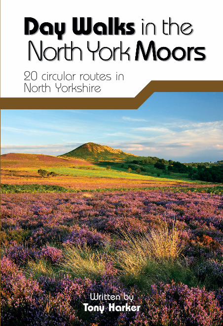
Cover photo: Hawnby Hill. Back cover photo: Robin Hood’s Bay.
Photography by Adam Long unless otherwise credited.
All maps reproduced by permission of Ordnance Survey on behalf of The Controller of Her Majesty’s Stationery Office. © Crown Copyright. 100025218
Design and production by Nathan Ryder. www.v-graphics.co.uk
Printed in China.
20 circular routes in North Yorkshire
Every effort has been made to achieve accuracy of information in this guidebook. The authors, publishers and copyright owners can take no responsibility for: loss or injury (including fatal) to persons; loss or damage to property or equipment; trespass, irresponsible behaviour or any other mishap that may be suffered as a result of following the route descriptions or advice offered in this guidebook. The inclusion of a track or path as part of a route, or otherwise recommended, in this guidebook does not guarantee that the track or path will remain a Right of Way. If conflict with landowners arises we advise that you act politely and leave by the shortest route available. If the matter needs to be taken further then please take it up with the relevant authority.
463g Day Walks in NYM INSIDE.indd 4 26/08/2011 11:00
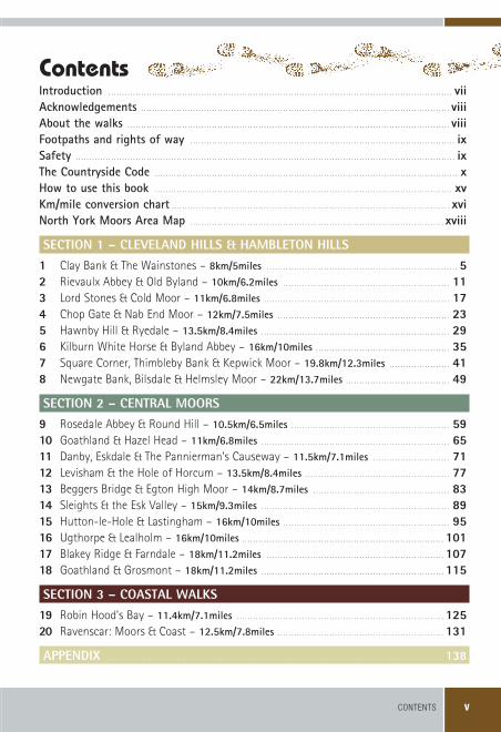
CONTENTS v
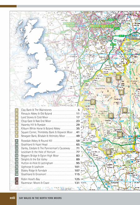
Introduction� . . . . . . . . . . . . . . . . . . . . . . . . . . . . . . . . . . . . . . . . . . . . . . . . . . . . . . . . . . . . . . . . . . . . . . . . . . . . . . . . . . . . . . . . . . . . . . . . . . . . . . . . . . . . . . . . . . . . . . . . . . . . . . . .viiAcknowledgements� . . . . . . . . . . . . . . . . . . . . . . . . . . . . . . . . . . . . . . . . . . . . . . . . . . . . . . . . . . . . . . . . . . . . . . . . . . . . . . . . . . . . . . . . . . . . . . . . . . . . . . . . . . . . . . . . . .viiiAbout�the�walks� . . . . . . . . . . . . . . . . . . . . . . . . . . . . . . . . . . . . . . . . . . . . . . . . . . . . . . . . . . . . . . . . . . . . . . . . . . . . . . . . . . . . . . . . . . . . . . . . . . . . . . . . . . . . . . . . . . . . . . .viiiFootpaths�and�rights�of�way� . . . . . . . . . . . . . . . . . . . . . . . . . . . . . . . . . . . . . . . . . . . . . . . . . . . . . . . . . . . . . . . . . . . . . . . . . . . . . . . . . . . . . . . . . . . . . . . . . . .ixSafety� . . . . . . . . . . . . . . . . . . . . . . . . . . . . . . . . . . . . . . . . . . . . . . . . . . . . . . . . . . . . . . . . . . . . . . . . . . . . . . . . . . . . . . . . . . . . . . . . . . . . . . . . . . . . . . . . . . . . . . . . . . . . . . . . . . . . . . . . . . . .ixThe�Countryside�Code� . . . . . . . . . . . . . . . . . . . . . . . . . . . . . . . . . . . . . . . . . . . . . . . . . . . . . . . . . . . . . . . . . . . . . . . . . . . . . . . . . . . . . . . . . . . . . . . . . . . . . . . . . . . . . . . . .xHow�to�use�this�book� . . . . . . . . . . . . . . . . . . . . . . . . . . . . . . . . . . . . . . . . . . . . . . . . . . . . . . . . . . . . . . . . . . . . . . . . . . . . . . . . . . . . . . . . . . . . . . . . . . . . . . . . . . . . . . .xvKm/mile�conversion�chart� . . . . . . . . . . . . . . . . . . . . . . . . . . . . . . . . . . . . . . . . . . . . . . . . . . . . . . . . . . . . . . . . . . . . . . . . . . . . . . . . . . . . . . . . . . . . . . . . . . . . . . .xviNorth�York�Moors�Area�Map� . . . . . . . . . . . . . . . . . . . . . . . . . . . . . . . . . . . . . . . . . . . . . . . . . . . . . . . . . . . . . . . . . . . . . . . . . . . . . . . . . . . . . . . . . . . . . . .xviii
section 1 – cleveland hills & hambleton hills1 . Clay Bank & The Wainstones –�8km/5miles . . . . . . . . . . . . . . . . . . . . . . . . . . . . . . . . . . . . . . . . . . . . . . . . . . . . . . . . . . . . . . . . . . . . . . . . .52 . Rievaulx Abbey & Old Byland –�10km/6.2miles . . . . . . . . . . . . . . . . . . . . . . . . . . . . . . . . . . . . . . . . . . . . . . . . . . . . . . . . . . . . . . . .113 . Lord Stones & Cold Moor –�11km/6.8miles . . . . . . . . . . . . . . . . . . . . . . . . . . . . . . . . . . . . . . . . . . . . . . . . . . . . . . . . . . . . . . . . . . . . . .174 . Chop Gate & Nab End Moor –�12km/7.5miles . . . . . . . . . . . . . . . . . . . . . . . . . . . . . . . . . . . . . . . . . . . . . . . . . . . . . . . . . . . . . . . . .235 . Hawnby Hill & Ryedale –�13.5km/8.4miles . . . . . . . . . . . . . . . . . . . . . . . . . . . . . . . . . . . . . . . . . . . . . . . . . . . . . . . . . . . . . . . . . . . . . . .296 . Kilburn White Horse & Byland Abbey –�16km/10miles . . . . . . . . . . . . . . . . . . . . . . . . . . . . . . . . . . . . . . . . . . . . . . . . . . .357 . Square Corner, Thimbleby Bank & Kepwick Moor –�19.8km/12.3miles . . . . . . . . . . . . . . . . . . . . . . . . . . . . . . . . . . . . . . . . . . . . . . .418 . Newgate Bank, Bilsdale & Helmsley Moor –�22km/13.7miles . . . . . . . . . . . . . . . . . . . . . . . . . . . . . . . . . . . . . . . .49
section 2 – central moors9 . Rosedale Abbey & Round Hill –�10.5km/6.5miles . . . . . . . . . . . . . . . . . . . . . . . . . . . . . . . . . . . . . . . . . . . . . . . . . . . . . . . . . . . .5910 . Goathland & Hazel Head –�11km/6.8miles . . . . . . . . . . . . . . . . . . . . . . . . . . . . . . . . . . . . . . . . . . . . . . . . . . . . . . . . . . . . . . . . . . . . . . .6511 . Danby, Eskdale & The Pannierman’s Causeway –�11.5km/7.1miles . . . . . . . . . . . . . . . . . . . . . . . . . . . . . . .7112 . Levisham & the Hole of Horcum –�13.5km/8.4miles . . . . . . . . . . . . . . . . . . . . . . . . . . . . . . . . . . . . . . . . . . . . . . . . . . . . . . .7713 . Beggers Bridge & Egton High Moor –�14km/8.7miles . . . . . . . . . . . . . . . . . . . . . . . . . . . . . . . . . . . . . . . . . . . . . . . . . . . . .8314 . Sleights & the Esk Valley –�15km/9.3miles . . . . . . . . . . . . . . . . . . . . . . . . . . . . . . . . . . . . . . . . . . . . . . . . . . . . . . . . . . . . . . . . . . . . . . .8915 . Hutton-le-Hole & Lastingham –�16km/10miles . . . . . . . . . . . . . . . . . . . . . . . . . . . . . . . . . . . . . . . . . . . . . . . . . . . . . . . . . . . . . . .9516 . Ugthorpe & Lealholm –�16km/10miles . . . . . . . . . . . . . . . . . . . . . . . . . . . . . . . . . . . . . . . . . . . . . . . . . . . . . . . . . . . . . . . . . . . . . . . . . . . .10117 . Blakey Ridge & Farndale –�18km/11.2miles . . . . . . . . . . . . . . . . . . . . . . . . . . . . . . . . . . . . . . . . . . . . . . . . . . . . . . . . . . . . . . . . . . . .10718 . Goathland & Grosmont –�18km/11.2miles . . . . . . . . . . . . . . . . . . . . . . . . . . . . . . . . . . . . . . . . . . . . . . . . . . . . . . . . . . . . . . . . . . . . .115
section 3 – coastal walks19 . Robin Hood’s Bay –�11.4km/7.1miles . . . . . . . . . . . . . . . . . . . . . . . . . . . . . . . . . . . . . . . . . . . . . . . . . . . . . . . . . . . . . . . . . . . . . . . . . . . . . . . . . . . . . . . . . . . . . . . . . . . . . . . . . . . . . . . . . . . . . . . . . . . . . . . . . . . . . . . . . . . . . . . . . . . . . . . . . .12520 . Ravenscar: Moors & Coast –�12.5km/7.8miles . . . . . . . . . . . . . . . . . . . . . . . . . . . . . . . . . . . . . . . . . . . . . . . . . . . . . . . . . . . . . . .131
aPPendiX . . . . . . . . . . . . . . . . . . . . . . . . . . . . . . . . . . . . . . . . . . . . . . . . . . . . . . . . . . . . . . . . . . . . . . . . . . . . . . . . . . . . . . . . . . . . . . . . . . . . . . . . . . . . . . . . . . . . . . . . . . . . . . .138
Contents
463g Day Walks in NYM INSIDE.indd 5 26/08/2011 11:00
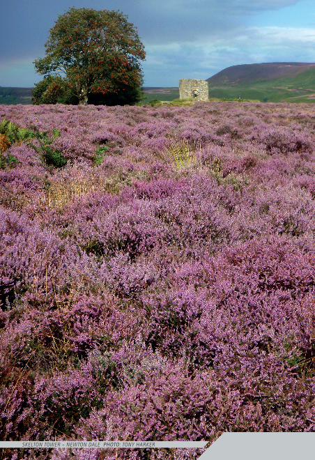
skelton tower – newton dale Photo: tony Harker
463g Day Walks in NYM INSIDE.indd 6 26/08/2011 11:00
INTRODUCTION vii
IntroductionThe�North�York�Moors�National�Park�Authority�describes�the�North�York�Moors�as�a�‘very�special�place.’�It�may�one�of�the�smallest�National�Parks�in�the�UK�but�it�offers��a�network�of�paths�and�tracks�packed�unlike�those�in�any�other�Park�into�high�moorland�plateaus�and�deep�green�valleys.�Here�the�visitor�will�find�England’s�largest�expanse��of�continuous�heather�moorland,�stretching�from�the�Vale�of�York�in�the�west�to��the�stunning�heritage�coastline�in�the�east.�
The valleys cut predominantly north to south, with high and steep upland ridges running in between. To the north the Esk Valley bisects the park from Battersby in the west to the east coast at Whitby. Along this valley runs the Esk Valley railway; an umbilical cord bringing in tourists from Teesside, and serving those who live and work on the moors, stopping at places such as Castleton, Danby and Lealholm.
The Moors are at their most colourful during August and September, the tops smothered in a purple carpet as the heather blossoms in the late summer sun and the valley sides draped with rich green bracken and wild patches of bilberries. The Moors are steeped in mystic history too, a rich history which has left its mark with burial mounds, trods, stone crosses, abbeys and castles. More recently the workings of the industrial revolution are evident, particularly in Rosedale where the remains of ironstone mining are scattered around the valley.
My relationship with the Moors goes back to my teenage years where I learned navigational skills and developed my love for this fantastic wilderness ‘playground.’ Many paths were poorly marked – if at all – and I spent many hours ‘heather bashing,’ which in those days I didn’t consider a hardship at all! In recent years the signage has improved dramatically and many paths have become well worn, making navigation for the less experienced just that little bit easier.
Many guides have been made available both in hard format and increasingly on the internet but there are still many places on the moors frequented only by inquisitive and determined explorers. Due to the availability of transport, more TV programmes promoting the ‘great outdoors’ and the increasing popularity of walking and mountain biking, the number of people visiting the moors is on the increase. Yet there are still places on the moors where the walker can find solitude and unspoilt paradise.
This guidebook will lead you to some of those places, where you can take a rest with only the sound of the wind carrying the haunting and evocative call of the curlew across the moor.
Tony Harker
463g Day Walks in NYM INSIDE.indd 7 26/08/2011 11:00
day walks in the north york moorsxviii
1
2
3
4
5
6
8
7
Clay Bank & The Wainstones . . . . . . . . . . . . . . . . . . . . . . . . . . . . . . . . . . . . . . . . . . . . . . . . . . . . . . . . . . . . . . . . . . . . . . . . . . . . . . . . . . . . . . . . . . . . . . . .5Rievaulx Abbey & Old Byland . . . . . . . . . . . . . . . . . . . . . . . . . . . . . . . . . . . . . . . . . . . . . . . . . . . . . . . . . . . . . . . . . . . . . . . . . . . . . . . . . . . . . . .11Lord Stones & Cold Moor . . . . . . . . . . . . . . . . . . . . . . . . . . . . . . . . . . . . . . . . . . . . . . . . . . . . . . . . . . . . . . . . . . . . . . . . . . . . . . . . . . . . . . . . . . . . . . . . . . . . .17Chop Gate & Nab End Moor . . . . . . . . . . . . . . . . . . . . . . . . . . . . . . . . . . . . . . . . . . . . . . . . . . . . . . . . . . . . . . . . . . . . . . . . . . . . . . . . . . . . . . . . . . .23Hawnby Hill & Ryedale . . . . . . . . . . . . . . . . . . . . . . . . . . . . . . . . . . . . . . . . . . . . . . . . . . . . . . . . . . . . . . . . . . . . . . . . . . . . . . . . . . . . . . . . . . . . . . . . . . . . . . . . . . . . . . .29Kilburn White Horse & Byland Abbey . . . . . . . . . . . . . . . . . . . . . . . . . . . . . . . . . . . . . . . . . . . . . . . . . . . . . . . . .35Square Corner, Thimbleby Bank & Kepwick Moor . . . . . . . . . . .41Newgate Bank, Bilsdale & Helmsley Moor . . . . . . . . . . . . . . . . . . . . . . . . . . . . . . . . . . . . . . .49
Rosedale Abbey & Round Hill . . . . . . . . . . . . . . . . . . . . . . . . . . . . . . . . . . . . . . . . . . . . . . . . . . . . . . . . . . . . . . . . . . . . . . . . . . . . . . . . . . . . . . .59Goathland & Hazel Head . . . . . . . . . . . . . . . . . . . . . . . . . . . . . . . . . . . . . . . . . . . . . . . . . . . . . . . . . . . . . . . . . . . . . . . . . . . . . . . . . . . . . . . . . . . . . . . . . . . . . . . .65Danby, Eskdale & The Pannierman’s Causeway . . . . . . . . . . . . . . . . . . .71Levisham & the Hole of Horcum . . . . . . . . . . . . . . . . . . . . . . . . . . . . . . . . . . . . . . . . . . . . . . . . . . . . . . . . . . . . . . . . . . . . . . . . . . .77Beggers Bridge & Egton High Moor . . . . . . . . . . . . . . . . . . . . . . . . . . . . . . . . . . . . . . . . . . . . . . . . . . . . . . . . . . . . . . .83Sleights & the Esk Valley . . . . . . . . . . . . . . . . . . . . . . . . . . . . . . . . . . . . . . . . . . . . . . . . . . . . . . . . . . . . . . . . . . . . . . . . . . . . . . . . . . . . . . . . . . . . . . . . . . . . . . . . .89Hutton-le-Hole & Lastingham . . . . . . . . . . . . . . . . . . . . . . . . . . . . . . . . . . . . . . . . . . . . . . . . . . . . . . . . . . . . . . . . . . . . . . . . . . . . . . . . . . .95Ugthorpe & Lealholm . . . . . . . . . . . . . . . . . . . . . . . . . . . . . . . . . . . . . . . . . . . . . . . . . . . . . . . . . . . . . . . . . . . . . . . . . . . . . . . . . . . . . . . . . . . . . . . . . . . . . . . . . . . . . . .101Blakey Ridge & Farndale . . . . . . . . . . . . . . . . . . . . . . . . . . . . . . . . . . . . . . . . . . . . . . . . . . . . . . . . . . . . . . . . . . . . . . . . . . . . . . . . . . . . . . . . . . . . . . . . . . .107Goathland & Grosmont . . . . . . . . . . . . . . . . . . . . . . . . . . . . . . . . . . . . . . . . . . . . . . . . . . . . . . . . . . . . . . . . . . . . . . . . . . . . . . . . . . . . . . . . . . . . . . . . . . . . . . .115
Robin Hood’s Bay . . . . . . . . . . . . . . . . . . . . . . . . . . . . . . . . . . . . . . . . . . . . . . . . . . . . . . . . . . . . . . . . . . . . . . . . . . . . . . . . . . . . . . . . . . . . . . . . . . . . . . . . . . . . . . . . . . . . . . . . . . . . .125Ravenscar: Moors & Coast . . . . . . . . . . . . . . . . . . . . . . . . . . . . . . . . . . . . . . . . . . . . . . . . . . . . . . . . . . . . . . . . . . . . . . . . . . . . . . . . . . . . . . . . . . .131
1
2
3
4
5
6
7
9
10
11
12
13
14
15
16
17
18
19
20
8
463g Day Walks in NYM INSIDE.indd 18 26/08/2011 11:00
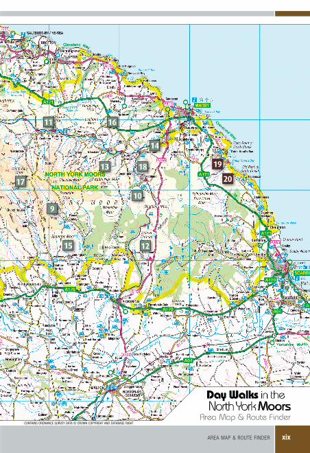
aREa map & ROUTE fINDER xix
Area Map & Route Finder
9
10
11
12
13
14
15
16
17
18 19
20
CONTAINS ORDNANCE SURVEY DATA © CROWN COPYRIGHT AND DATABASE RIGHT
463g Day Walks in NYM INSIDE.indd 19 26/08/2011 11:00
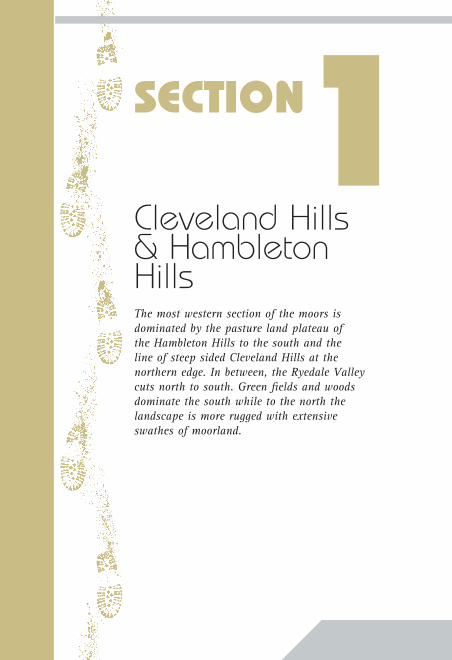
Cleveland Hills & Hambleton HillsThe most western section of the moors is dominated by the pasture land plateau of the Hambleton Hills to the south and the line of steep sided Cleveland Hills at the northern edge. In between, the Ryedale Valley cuts north to south. Green fields and woods dominate the south while to the north the landscape is more rugged with extensive swathes of moorland.
SECTION1
463g Day Walks in NYM INSIDE.indd 20 26/08/2011 11:00
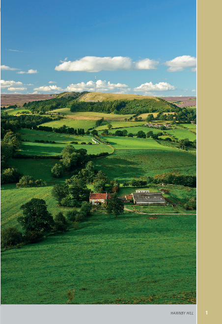
1HawnBy Hill
463g Day Walks in NYM INSIDE.indd 1 26/08/2011 11:00
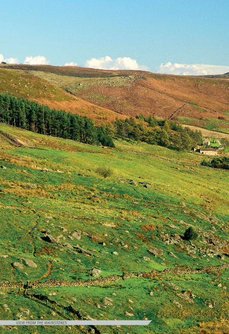
View From tHe wainstones
463g Day Walks in NYM INSIDE.indd 2 26/08/2011 11:00
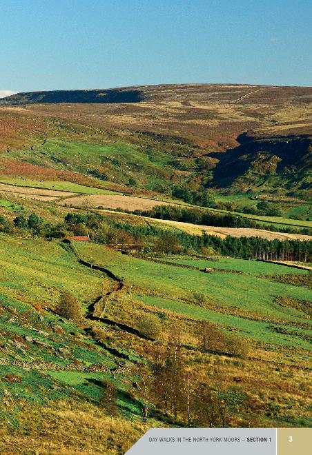
Day walkS IN THE NORTH yORk mOORS – section 1 3
463g Day Walks in NYM INSIDE.indd 3 26/08/2011 11:00
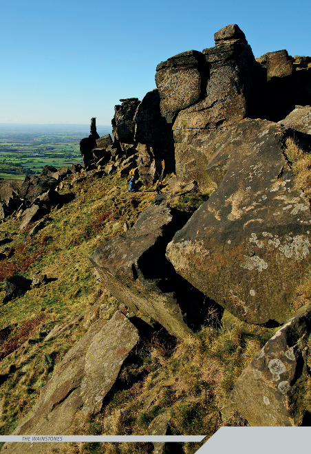
tHe wainstones
463g Day Walks in NYM INSIDE.indd 4 26/08/2011 11:00
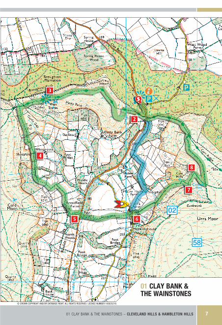
StartClay�Bank�car�park.�NZ�572035.
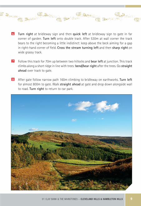
The WalkThe Wainstones, protruding from the west-ern slopes of Hasty Bank, may not be as prominent as Roseberry Topping but on the Cleveland Hills they are a landmark that always attracts the eye when approached from the Tees Valley. The ‘Steeple’ and the ‘Needle’ stand prominent like two sentries guarding over the Cleveland Hills. The Wainstones provide a fascinating place to linger and explore on a warm day and watch the nimble athletes picking their way up the many climbing routes these crags have to offer.
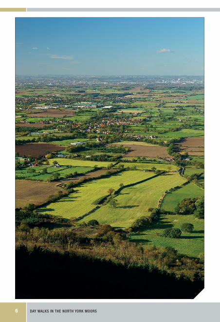
We start the walk picking up the well-laid path alongside the forest, crossing the stile for the hardest climb of the day – 110m up the eastern slopes of Hasty Bank. We divert to take advantage of the southern protru-sion offering a superb view down Bilsdale Edge and extensive views of the Tees Valley and across the Cleveland Hills and beyond to the Pennines. A steep drop between
rocks leads down the ridge below the Wainstones and across the valley towards Cold Moor. Before the path turns steep we turn left through the bracken, crossing a shallow valley and joining the farm track past Whingraves.
After crossing the road we edge along a stream and climb to the small hamlet of Urra. From here the bridleway leads us bizarrely across a back garden – watch out for the washing – and then to a good track where we get a view of our second climb which (thankfully) looks harder than it is. The scenery here is a little more rugged as we reach the earthworks that provide the way to the end of Carr Ridge. Before we start the descent we ponder over classic views across to Hasty Bank. The descent is rocky and steep in parts, becoming easier on the lower slopes to the road and car park.
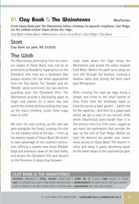
01 Clay Bank & The Wainstones 8km/5miles
Circle�Hasty�Bank�past�The�Wainstones�before�climbing�its�opposite�neighbour,�Carr�Ridge,�via�the�seldom-visited�slopes�below�the�ridge.Clay Bank » Hasty Bank » Wainstones » Urra » Urra Moor » Carr Ridge » Clay Bank
01 Clay baNk & THE waINSTONES – cleVeland hills & hamBleton hills 5
CLAy BAnk & THe WAinsTonesDisTAnCe: 8KM/5MILES » ToTAL AsCenT: 380M/1,246FT » sTArT Gr: NZ 572035 » Time: ALLOW 2.5 HOURS mAP: OS ExPLORER OL26 NORTH YORK MOORS WESTERN AREA » refresHmenTs: THE BUCK INN AT CHOP GATE; NEAREST CAFéS IN STOKESLEY, OR LORD STONES CAFé AT CARLTON BANK » nAViGATion: EASY AND WELL MARKED.
463g Day Walks in NYM INSIDE.indd 5 26/08/2011 11:00
day walks in the north york moors6
463g Day Walks in NYM INSIDE.indd 6 26/08/2011 11:00
01 clay bank & the wainstones
01 Clay baNk & THE waINSTONES – cleVeland hills & hamBleton hills 7
© CROWN COPYRIGHT AND/OR DATABASE RIGHT. ALL RIGHTS RESERVED. LICENCE NUMBER 100025218.
02
58
463g Day Walks in NYM INSIDE.indd 7 26/08/2011 11:00
day walks in the north york moors8
Turn�left briefly out of the car park onto the road for 230m. Turn�right onto the stepped path signposted cleveland way.
2 After 160m turn�left at the stile, climbing the eastern slope of Hasty Bank. 170m after the stile turn�left onto a paved path. Follow this path for 90m ignoring the gully on the left and continue to the southern tip of the prominent edge. Follow the path around the edge and turn�right at a small path junction leading to the main paved track on Hasty Bank.
3 At the Wainstones drop to the right on a path between rocks. Follow path into a dip keeping straight�ahead at the gate. 30m from the gate turn�left at the signpost to chop Gate. Keep straight�ahead at the next stile to a broken wall. From the wall keep�left above reed beds and contour around to a wall at the far side of the stream lead-ing to wall and stile. Turn�immediately�right over stile and continue straight�ahead over the next stile leading to a farm track above Whingroves.
4 The track leads to a gate and forest. Follow the track past a waymarker, bending down to a stream and crossing sharp�left to a gate and stile. Keep straight�ahead over a field aiming for a stone pillar in the centre of the field and then to a double gate. From the gate keep straight�ahead on a firm farm track to a track junction. At track junc-tion continue straight�ahead for 20m to a fence corner with waymarkers. Pass farm and cross to gate leading to shallow valley. Follow path through to road.
5 ��Turn�right at the road for 10m and then left at the bridleway sign. Go down steps to bridge and keep straight�ahead alongside fence. After 180m path leads into field and gate. Head for fence corner on left. From fence corner walk straight�ahead across field to stile at top of hill. Keep between farm buildings to road, turning�left on road for 20m.
Optional�Route�(alternative�finish): Follow road around bend and then turn�right at footpath sign. Follow waymarkers over fields above Mount House Farm. Cross stile to drop steeply into valley. 140m after stream crossing turn�right at sign post. Climb hill alongside forest turning�left at top. Follow track beside wall down to track. Turn�right at track leading to road and car park.
Directions – Clay Bank & The Wainstones
463g Day Walks in NYM INSIDE.indd 8 26/08/2011 11:00
01 Clay baNk & THE waINSTONES – cleVeland hills & hamBleton hills 9
6 ��Turn� right at bridleway sign and then quick� left at bridleway sign to gate in far corner of garden. Turn� left onto double track. After 530m at wall corner the track bears to the right becoming a little indistinct: keep above the beck aiming for a gap in right-hand corner of field. Cross�the�stream�turning�left and then sharp�right on wide grassy track.
7 Follow this track for 70m up between two hillocks and bear�left at junction. This track climbs along a short ridge in line with trees: bend/bear�right after the trees. Go straight�ahead over track to gate.
8 After gate follow narrow path 160m climbing to bridleway on earthworks. Turn�left for almost 800m to gate. Walk straight�ahead at gate and drop down alongside wall to road. Turn�right to return to car park.
463g Day Walks in NYM INSIDE.indd 9 26/08/2011 11:00