Embed Size (px)
Citation preview
Putting From the Rough February 2015 Structured Decision Making Workshop
Putting from the Rough: Ecological and Social Restoration of a Former Golf Course
A Case Study from the Structured Decision Making Workshop
Course Dates February 9 – 13, 2015
Course Location: National Conservation Training Center, Shepherdstown, WV
Authors: Eric Dunton1, Lionel Grant
1, Steven Kahl
1, Daniel Kashian
2, Maggie O’Connel
3, Lisa
Williams4, Patricia Williams
5,
Coaches: Greg Breese6, Jennie Hoffman
7, and Dave Smith
8
Decision Problem
In May 2014, the U.S. Fish and Wildlife Service (USFWS), Shiawassee National Wildlife
Refuge received the former 135-acre Germania Town and Country Club as donation from The
Nature Conservancy (TNC). TNC purchased the property (which fell into foreclosure in 2010)
with support from The Dow Chemical Company. The Refuge seeks to develop a restoration plan
which maximizes ecological and social objectives utilizing Natural Resources Damage
Assessment (NRDA) funds. In 1998, a co-trustee group consisting of the USFWS, the State of
Michigan, and the Saginaw Chippewa Tribe negotiated a settlement for natural resources
damages with the General Motors Corporation and the Cities of Bay City and Saginaw. The
settlement provides for substantial cleanup of river contamination and for protection and
restoration of fish and wildlife habitats in the Saginaw River and Bay. Specifically, NRDA
funds are available for restoration plan development and implementation under the Green Point
Environmental Learning Center (GPELC) projects and elements section of the settlement and
restoration. The decision makers for the project are Shiawassee NWR Refuge Manager,
Ecological Services, and the co-trustee group.
1 U.S. Fish and Wildlife Service, Shiawassee National Wildlife Refuge, Saginaw, MI, USA [email protected],
[email protected], [email protected] 2 Wayne State University, Detroit, MI, USA [email protected]
3 U.S. Fish and Wildlife Service, Region 3 Regional Office, Bloomington, MN, USA [email protected]
4 U.S. Fish and Wildlife Service, East Lansing Field Office, East Lansing, MI, USA [email protected]
5 Friends of Shiawassee National Wildlife Refuge, Saginaw, MI, USA [email protected]
6 U.S. Fish and Wildlife Service, Delaware Bay Estuary Project, Smyrna, DE, USA [email protected]
7 Adaptation Insight, Poulsbo, WA, USA [email protected]
8 U.S. Geological Survey, Leetown Science Center, Kearneysville, WV, USA [email protected]
Putting From the Rough February 2015 Structured Decision Making Workshop
Background
Legal, regulatory, and political context
There is approximately $614,000 available in NRDA funds available for this restoration project.
The group seeks to write a restoration plan for the GPELC area, including the former Germania
golf course, that guides restoration activities to maximize the ecological and social objectives of
the project and complies with both NRDA and National Environmental Policy Act (NEPA)
guidelines. The group looks to implement restoration goals in part based on a recently
completed hydrogeomorphic (HGM) evaluation completed for Shiawassee NWR. The project
area lies within the City of Saginaw and includes the 135 acres of the former golf course, 60
acres in the Hickey tract, and the 80 acre parcel owned by the City of Saginaw and managed by
the Service that includes the building that houses the learning center classroom and offices. The
restoration of the former golf course within the GPELC area not only provides a unique
opportunity to restore 135-acres of habitat within an urban area, but also the opportunity to
connect urban residences with the National Wildlife Refuge System (NWRS) through the
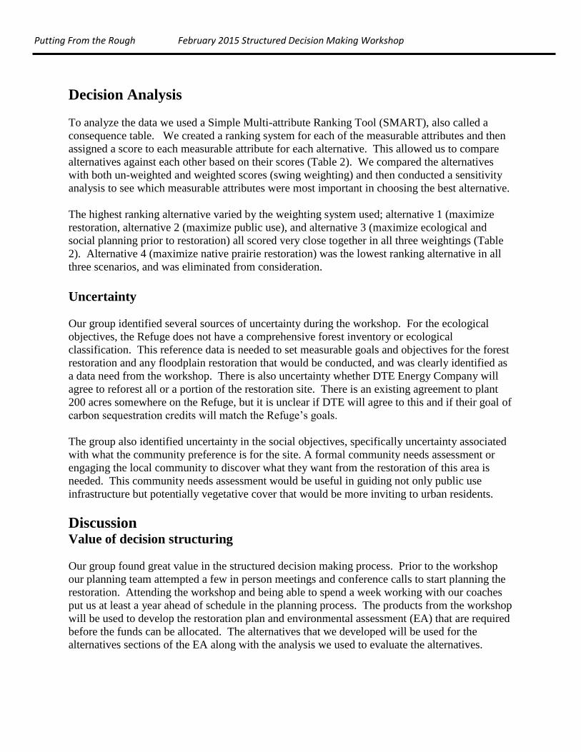
existing network of trails and ponds present (Fig. 1). In addition, there is a separate NRDA on-
going with the Dow Chemical Company (Dow) that includes the Tittabawassee River and its
floodplain.
Ecological context
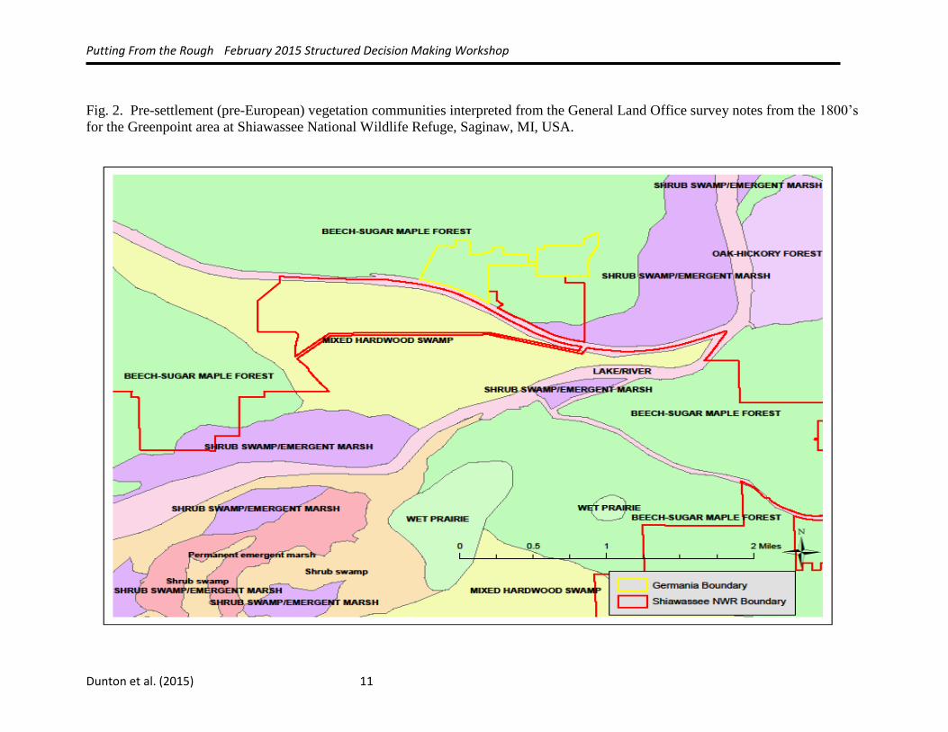
Vegetation communities present in Michigan during the pre-settlement (i.e., pre-European
settlement) are available for the entire State of Michigan and are based on interpretation of
General Land Office surveys from the early-1800s. This data provides geospatial information on
the types and distribution of general habitats historically present in the Shiawassee flats region in
the pre-settlement period (Albert and Comer 2008 and Comer et al. 1995). These GLO-based
maps indicate that the Shiawassee flats region contained a central core of shrub swamp-emergent
marsh surrounded by diverse black ash, and mixed hardwood swamp forest (Heitmeyer et al.
2013). According to the interpreted GLO notes the Greenpoint area consisted mostly of beech
sugar maple forest (Fig. 2). Beech sugar maple forests are a transitional forest types from true
floodplains to uplands (Barnes and Wagner 1981, Dickman and Leefers 2004, Kost et al. 2010).
Although, the interpreted GLO notes indicate Beech sugar maple forest based on information
collected during a HGM evaluation indicate the area, particularly the areas closer (i.e., lower
elevation) to the Tittabawassee River consisted of mixed hardwood swamp. The HGM process
looks at the historical distribution of major vegetation communities/habitat types in the
Shiawassee flats region in relationship to geomorphic surface, soils, topography, and
hydrological regime to produce a matrix of habitat/cover types and a map of the potential
distribution of cover types (Heitmeyer et al. 2013).
If we assume some of this area was more of a floodplain forest or mixed hardwood swamp these
forest types can best be characterized by Michigan Natural Features Inventory (MNFI)
descriptions of natural communities (e.g., floodplain forest and southern hardwood swamp).
Floodplain forest is a bottomland deciduous forest subject to periodic over-the-bank flooding
with cycles of erosion and deposition (Kost et al. 2010). Floodplain forest vegetation varies and
changes along a gradient of flooding frequency and duration but in general the major tree species
include; silver maple (Acer saccharinum), green ash (Fraxinus pennsylvanica), and American
Putting From the Rough February 2015 Structured Decision Making Workshop
elm (Ulmus americana; Kost et al. 2010). Southern hardwood swamp is similar to floodplain
forest in that they occupy shallow depressions or are situated along high-order streams (Kost et
al. 2010). The canopy is typically dominated by silver maple (Acer saccharinum), red maple
(Acer rubrum), green ash (Fraxinus pennsylvanica), and black ash (Fraxinus nigra; Kost et al.
2010).
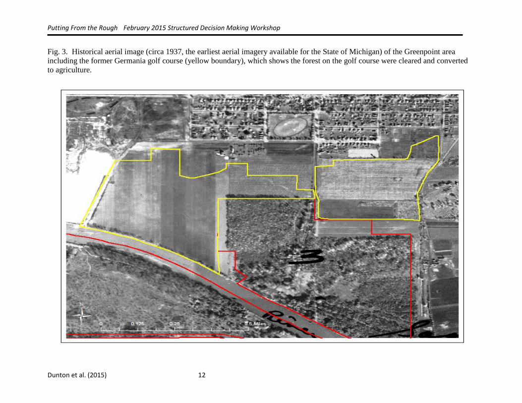
Although we have fairly good information on pre-settlement conditions the former golf course
site has been highly altered, undoubtedly affecting the function and structure of any pre-
settlement vegetative community we try to establish. Prior to the establishment as a golf course
the entire Germania tract was logged, cleared, and converted to agriculture (Fig. 3). We believe
there still remains a network of sub-surface tiles which influence the hydrology of the site. The
majority of the Germania tract of land consists of non-native turf grasses and ornamental trees
and shrubs. The shoreline along the Tittabawassee River on the Germania tract has been
“hardened” by placing impervious material such as concrete and rock. Invasive species such as
common buckthorn (Rhamnus cathartica), garlic mustard (Alliaria petiolata), and a variety of
other non-native invasive species have become well established in all three tracts of the GPELC
area. Furthermore, one of the dominant overstory trees at GPELC is green ash, which is mostly
dead or dying from emerald ash borer (Agrilus planipennis; a non-native Asian beetle that feeds
on ash species).
Decision Structure
Decision Problem Our group framed the problem based on ecological and social objectives that meet the mission of the
USFWS National Wildlife Refuge System and Shiawassee NWR while fulfilling the obligations of the
NRDA agreement. Our problem statement was to determine how to best restore floodplain habitat
and provide public use on GPELC area using settlement funds over the next 20 years while
minimizing constraints for future actions.
Constraints
Prior to setting objectives we identified several constraints which were used throughout the
workshop in objective setting and developing alternatives. These constraints included:
1. Funding – We have approximately $614,000 available in NRDA funds for this project
that are to be used to restore, replace, or acquire the equivalent of the natural resources
that were injured by the release of hazardous substances. Of the funds available, NRDA
guidelines suggest that approximately 10 – 20% can be used for planning activities, 10 –
15% can be used for improving public use of natural resources(e.g., trails, kiosks,
interpretive signs), and the remaining funds are to be used for direct implementation,
monitoring and maintenance of habitat restoration to benefit natural resources. The
NRDA funds are not associated with a fiscal year and are in an interest bearing account.
2. Contaminants – There is an ongoing NRDA for releases of hazardous substances from
Dow’s plant site in Midland, Michigan. Hazardous substances, including dioxins, were
released into the Tittabawassee River and are now present in the river and its floodplain.
The Michigan Department of Community Health has issued consumption advisories for
fish from the river and wild game harvested from the floodplain (MDCH 2015, 2008).
Putting From the Rough February 2015 Structured Decision Making Workshop
a. In the southeast corner of the 80 acre GPELC tract, investigations have identified
an area with relative high concentrations of dioxins along the Tittabawassee
River. Dow may be required to remove soil there in the future and in the
meantime no public use activities should be planned for this area that would
increase soil exposure.
b. The State of Michigan has issued advisories about moving soil within the 100-
year floodplain of the Tittabawassee River in order to minimize or eliminate soil
displacement and increased exposure to or erosion of contaminated soils (MDEQ
et al., undated). Nearly all of the GPELC area is within the 100 year floodplain.
c. Any dirt moving or shoreline engineering along the Tittabawassee River would
likely require additional soil testing, disposal at a licensed landfill, and
contingency funding in case additional contaminants are discovered.
3. Refuge resources (i.e., refuge funds/budget and refuge staff time) – We wanted to
explicitly recognize the fact that the actions we take toward restoring this site will require
long term maintenance and oversight. Therefore we added a constraint that actions that
would require a large investment in refuge staff time or funding would not be considered
unless those costs could be covered with the available NRDA funds.
4. DTE Energy Company - Shiawassee NWR has an agreement with DTE Energy Company
to provide 200 acres on the refuge for DTE to plant trees in which they will earn carbon
sequestration credits. For the portions of the restoration sites that we plan to reforest we
plan to explore using this agreement to purchase and plant the trees. This would allow us
to maximize the NRDA funding for other aspects of the restoration but we further
communication between the refuge and DTE needs to occur to ensure the restoration
goals and agreement are compatible for this site.
5. Restoration actions will not inhibit future actions – During our planning process we
recognized a need to write a Visitors Services plan for the GPELC area. In addition, any
decisions made now will not inhibit any future actions or implementation of future plans
(e.g., don’t build new trails right along Tittabawassee River because this may prevent
shoreline softening at a later time).
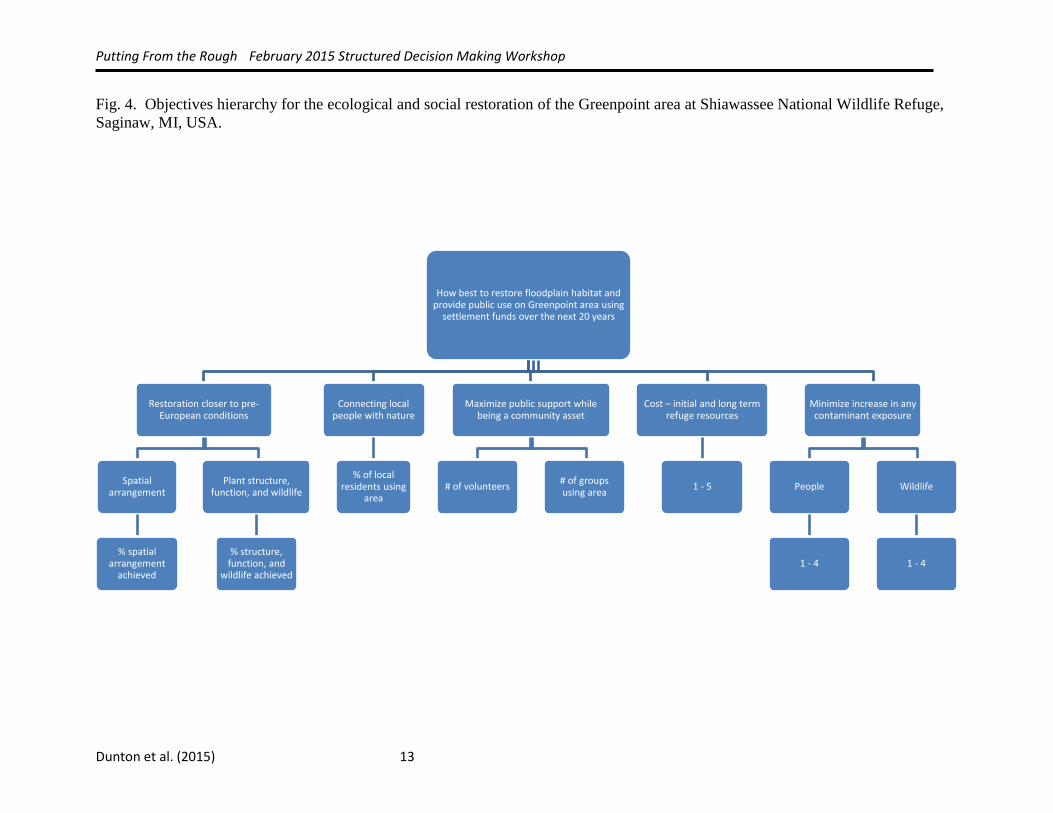
Objectives
Fundamental objectives were set by the group and reflected ecological and social goals of the
project. We developed an objectives hierarchy based on the problem statement (how best to
restore floodplain habitat and provide public use on Greenpoint area using settlement funds over
the next 20 years while minimizing constraints for future actions) and included the following
fundamental objectives; (1) restoration closer to pre-European conditions, (2) connecting local
people with nature, (3) maximizing public support while being a community asset, (4) costs
(initial and long-term refuge resources), and (5) minimize any increase in contaminant exposure
(Fig. 4). We developed two means objectives for one of the fundamental objectives (restoration
closer to Pre-European conditions): Having the correct spatial arrangement of habitat types on
the landscape (e.g., % of forested habitat versus % another landcover type) and having habitat
types that are structurally and functionally able to support wildlife communities similar to what
was historically present. Once the objectives were set we created measurable attributes to
measure the success of achieving that objective (Fig. 4).
Putting From the Rough February 2015 Structured Decision Making Workshop
Alternative actions
We developed alternatives by first identifying a list of actions that could be undertaken and
grouping these actions into themes such as “reforestation” or “public use”. By structuring the
many actions under themes it was easier to develop a short list of alternatives that both spanned
the range of what could be done and were strategically aligned with our objectives from the vast
number of alternatives that potentially could have been developed for the restoration project
(Table 1). We created alternatives by selecting strategies from the different themed lists to create
alternatives with varying focus on the objectives (portfolio approach). This approach was very
useful since we could develop numerous alternatives that varied widely or alternatives that were
similar. We began developing these alternatives by starting with two alternatives that varied
widely (i.e., an alternative that maximized restoration and an alternative that maximized native
prairie planting). We used difference in vegetation cover as the extremes since the amount of
funds that can be spent on public use and infrastructure are capped at approximately 20%.
Alternative 1 – Maximize Restoration (focus on ecological restoration that will be guided by
forest inventory and ecological classification work, public use focuses on establishing a trail
system on the Germania tract that would connect to existing trails on Greenpoint tract creating a
new linked trail system for the GPELC area).
Actions:
1. Tree planting across entire golf course, if possible funded through DTE.
2. Invasive species treatment across entire GPELC area.
3. Forest inventory and ecological classification which will be used as reference
information to guide reforestation work.
4. Build new trails on Germania.
5. Remove existing asphalt golf cart trails.
6. Demolition and removal of existing buildings on Germania.
7. Hire a seasonal land management technician to take lead on invasive species and land
management activities on the entire Greenpoint area.
Alternative 2 – Maximize Public Use (focus on public use and use by the local community at
the expense of habitat restoration recognizing the potential value of outreach and education can
have long term outcomes that may outweigh the reduced use by wildlife)
Actions:
1. Tree planting on west side of Maple Street on Germania, if possible funded through
DTE.
2. Native prairie planting on east side of Maple Street on Germania.
3. Invasive species treatment, entire GPELC area.
4. Forest inventory and ecological classification on the refuge which will be used as
reference information to guide reforestation work.
5. Build new trails on Germania.
6. Remove existing asphalt golf cart trails.
7. Demolition and removal of existing buildings.
8. Install new signs and kiosks.
Putting From the Rough February 2015 Structured Decision Making Workshop
9. Connect new trails to existing trails at the rest of GPELC.
10. Create new access points to the area specifically targeting increasing accessibility to
local school and local residents.
11. Restore wetland at “Big Pond” (existing pond located on Germania, east of Maple
Street).
12. Hire a seasonal land management technician to take lead on invasive species and land
management activities on the entire Greenpoint area.
Alternative 3 – Maximize Ecological and Social Planning Prior to Restoration (focus
pre-restoration planning efforts to guide ecological restoration and public use goals by
conducting a community needs assessment to better understand how the local community
would and wants to use the GPELC area).
Actions:
1. Tree planting on west side of Maple Street, if possible funded through DTE.
2. Invasive species treatment, across entire GPELC area Forest inventory and ecological
classification on the refuge which will be used as reference information to guide
reforestation work.
3. Conduct a community needs assessment to inform what local community wants to see
from restoration and how they would use the area. This information will guide
development of social restoration goals.
4. Hire a landscape architect or partner with landscape architecture program at a local
University to design area east of Maple Street informed by the community needs
assessment as an area that will be inviting to the general public.
5. Build new trails on Germania.
6. Remove existing asphalt golf cart trails.
7. Demolition and removal of existing buildings.
8. Connect new trails to existing trails at the rest of GPELC.
9. Other habitat work and contingency.
Alternative 4 – Maximize Native Prairie Planting (focus on establishment of native prairie on
the Germania tract for grassland dependent species by providing a large block of native prairie,
public use focuses on establishing a trail system on the Germania tract that would connect to
existing trails on Greenpoint tract creating a new linked trail system for the GPELC area)
Actions:
1. Plant native prairie plants across entire Germania golf course
2. Invasive species treatment, across entire GPELC area.
3. Hire a landscape architect or partner with landscape architecture program at a local
University to design area east of Maple Street informed by the community needs
assessment as an area that will be inviting to the general public
4. Build new trails on Germania
5. Remove existing asphalt golf cart trails.
6. Demolition and removal of existing buildings.
7. Connect new trails to existing trails at the rest of GPELC.
8. Other habitat work and contingency that
Putting From the Rough February 2015 Structured Decision Making Workshop
Decision Analysis
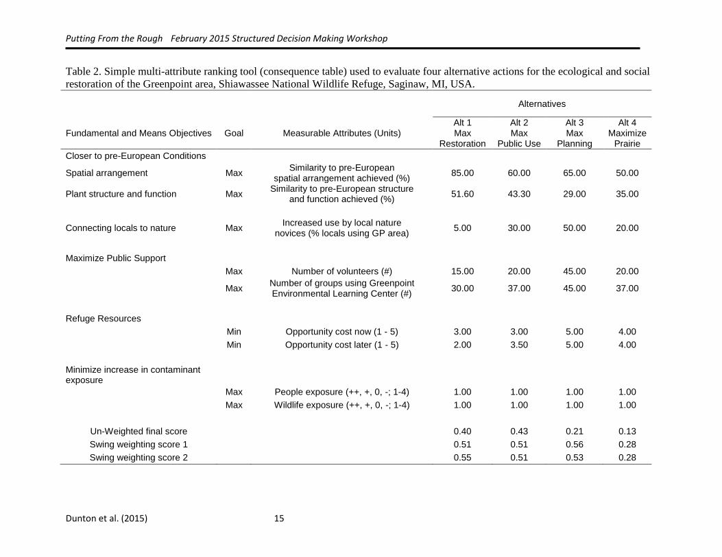
To analyze the data we used a Simple Multi-attribute Ranking Tool (SMART), also called a
consequence table. We created a ranking system for each of the measurable attributes and then
assigned a score to each measurable attribute for each alternative. This allowed us to compare
alternatives against each other based on their scores (Table 2). We compared the alternatives
with both un-weighted and weighted scores (swing weighting) and then conducted a sensitivity
analysis to see which measurable attributes were most important in choosing the best alternative.
The highest ranking alternative varied by the weighting system used; alternative 1 (maximize
restoration, alternative 2 (maximize public use), and alternative 3 (maximize ecological and
social planning prior to restoration) all scored very close together in all three weightings (Table
2). Alternative 4 (maximize native prairie restoration) was the lowest ranking alternative in all
three scenarios, and was eliminated from consideration.
Uncertainty
Our group identified several sources of uncertainty during the workshop. For the ecological
objectives, the Refuge does not have a comprehensive forest inventory or ecological
classification. This reference data is needed to set measurable goals and objectives for the forest
restoration and any floodplain restoration that would be conducted, and was clearly identified as
a data need from the workshop. There is also uncertainty whether DTE Energy Company will
agree to reforest all or a portion of the restoration site. There is an existing agreement to plant
200 acres somewhere on the Refuge, but it is unclear if DTE will agree to this and if their goal of
carbon sequestration credits will match the Refuge’s goals.
The group also identified uncertainty in the social objectives, specifically uncertainty associated
with what the community preference is for the site. A formal community needs assessment or
engaging the local community to discover what they want from the restoration of this area is
needed. This community needs assessment would be useful in guiding not only public use
infrastructure but potentially vegetative cover that would be more inviting to urban residents.
Discussion
Value of decision structuring
Our group found great value in the structured decision making process. Prior to the workshop
our planning team attempted a few in person meetings and conference calls to start planning the
restoration. Attending the workshop and being able to spend a week working with our coaches
put us at least a year ahead of schedule in the planning process. The products from the workshop
will be used to develop the restoration plan and environmental assessment (EA) that are required
before the funds can be allocated. The alternatives that we developed will be used for the
alternatives sections of the EA along with the analysis we used to evaluate the alternatives.
Putting From the Rough February 2015 Structured Decision Making Workshop
Further development required
We need to further refine our cost estimates for the different alternatives. Alternatives one, two,
and three all had similar rankings; this was due in part to the precision of the cost estimates we
used for evaluating the alternatives (e.g., professional judgment was primarily used to estimate
costs for all the actions). In addition, we need to further refine and revisit the alternatives that we
developed. There were assumptions that went into the current alternatives (e.g., using DTE
Energy Company to purchase and plant trees); if the assumptions are not viable then we need to
refine them.
Recommendations and Next Steps
The next steps for this project include writing the restoration plan and Environmental
Assessment. The group will further refine cost estimates and alternatives. There were two major
data gaps identified during the workshop; forest inventory and ecological classification, and a
community needs assessment. Both of these will be critical steps needed to further refine
alternatives and set realistic and measureable goals and objectives for the project.
Since the NRDA funding available for this project is not associated with a fiscal year we decided
that this project should take a phased approach. The first phase consists of design and planning,
followed by a phased implementation strategy and then a monitoring and evaluation phase which
won’t be developed until the restoration design is complete. With a limited budget we will
probably not have funds to develop a full monitoring plan of all the actions that will be
implemented we will seek additional funds to assist in the development of this monitoring plan.
Literature Cited
Albert, D.A. and P.J. Comer. 2008. Atlas of Early Michigan’s forests, grasslands, and wetlands:
an interpretation of the 1816-1856 General Land Office surveys. Michigan State
University Press, Lansing, MI.
Barnes, B.V. and W. Wagner. 1981. Michigan trees: a guide to the trees of the Great Lakes
region. University of Michigan Press, Ann Arbor, MI.
Comer, P.J., D.A. Albert, H.A. Wells, B.L. Hart, J.B. Raab, D.L. Price, D.M. Kashian, R.A.
Corner, and D.W. Schuen. 1995. Vegetation circa 1800 of Michigan. Michigan’s
Native Landscape: As Interpreted from the General Land Office Surveys 1816-1856.
Michigan Natural Features Inventory. Lansing, MI. 78 pp.
Dickman, D.I. and L.A. Leefers. 2004. The forests of Michigan. University of Michigan Press,
Ann Arbor, MI.
Hammond J.S, Keeney R.L, Raiffa H. 1999. Smart Choices: A Practical Guide to Making
Better Life Decisions. Broadway Books, New York.
Putting From the Rough February 2015 Structured Decision Making Workshop
Heitmeyer, M. E., C. M. Aloia, E. M. Dunton, B.J. Newman, and J.D. Eash. 2013.
Hydrogeomorphic evaluation of ecosystem restoration and management options for
Shiawassee National Wildlife Refuge. Prepared for U. S. Fish and Wildlife Service,
Region 3. Greenbrier Wetland Services Report 13- 07, Blue Heron Conservation Design
and Printing LLC, Bloomfield, MO.
Kost, M.A., D.A. Albert, J.G. Cohen, B.S. Slaughter, R.K. Schillo, C.R. Weber and K.A.
Chapman. 2007 (updated in 2010). Natural communities of Michigan: classification and
description. Michigan Natural Features Inventory. Prepared for Michigan Department of
Natural Resources Wildlife Division and Forest, Mineral, and Fire Management Division.
Lansing, MI.
Michigan Department of Community Health. 2015. Eat Safe Fish Guides. Available at
http://www.michigan.gov/mdch/0,1607,7-132-54783_54784_54785_58671-255931--
,00.html.
Michigan Department of Community Health. 2008. Wild Game Advisories for the
Tittabawassee and Saginaw River Flood Plains. Available at
http://www.michigan.gov/documents/mdch/2008_Wild_Game_Advisory_234703_7.pdf.
Michigan Department of Environmental Quality, Michigan Department of Community Health,
and Michigan Department of Agriculture. Undated. Soil Movement Advisory for
Private, Public, and Commercial Projects, Tittabawassee River Furan and Dioxin Flood
Plain Soil and Sediment Contamination, Midland and Saginaw Counties. Available at
http://www.michigan.gov/documents/deq/deq-whm-hwp-dow-TR-Advisory-dioxin-
Color-Final_251808_7.pdf.
Putting From the Rough February 2015 Structured Decision Making Workshop
Dunton et al. (2015) 10
Fig. 1. Location of Germania golf course and Greenpoint environmental learning center at Shiawassee National Wildlife Refuge,
Saginaw, MI, USA.
Putting From the Rough February 2015 Structured Decision Making Workshop
Dunton et al. (2015) 11
Fig. 2. Pre-settlement (pre-European) vegetation communities interpreted from the General Land Office survey notes from the 1800’s
for the Greenpoint area at Shiawassee National Wildlife Refuge, Saginaw, MI, USA.
Putting From the Rough February 2015 Structured Decision Making Workshop
Dunton et al. (2015) 12
Fig. 3. Historical aerial image (circa 1937, the earliest aerial imagery available for the State of Michigan) of the Greenpoint area
including the former Germania golf course (yellow boundary), which shows the forest on the golf course were cleared and converted
to agriculture.
Putting From the Rough February 2015 Structured Decision Making Workshop
Dunton et al. (2015) 13
Fig. 4. Objectives hierarchy for the ecological and social restoration of the Greenpoint area at Shiawassee National Wildlife Refuge,
Saginaw, MI, USA.
How best to restore floodplain habitat and provide public use on Greenpoint area using
settlement funds over the next 20 years
Restoration closer to pre-European conditions
Spatial arrangement
% spatial arrangement
achieved
Plant structure, function, and wildlife
% structure, function, and
wildlife achieved
Connecting local people with nature
% of local residents using
area
Maximize public support while being a community asset
# of volunteers # of groups using area
Cost – initial and long term refuge resources
1 - 5
Minimize increase in any contaminant exposure
People
1 - 4
Wildlife
1 - 4
Putting From the Rough February 2015 Structured Decision Making Workshop
Dunton et al. (2015) 14
Table 1. Themes and actions used to develop alternatives for the ecological and social restoration of the Greenpoint area at
Shiawassee National Wildlife Refuge, Saginaw, MI, USA.
Themes
Reforestation current
conditions
Reforestation
systems approach Habitat Diversity Public Use Public Use Infrastructure
Act
ion
s
Tree planting Soil testing Prairie planting Volunteer programs Path to school
Irrigation Tile breaking Oxbow
reconnection Interpretation Loan golf carts
Invasive species
control Grading
Wild rice
restoration
Create city bus stop at
Greenpoint Build observation tower
Soil testing Hydrologic analysis Prescribed grazing Partner with Saginaw
children's zoo Build fishing pier on “Big Pond”
Tile breaking Shoreline softening Prescribed fire Public service
announcements
Reconfigure trails to connect
Germania and Greenpoint
Herbivory control Mowing Hire a marketing firm Canoe/kayak launch
Forest
inventory and
ecological
classification
Community needs
assessment
Abandon Greenpoint ELC (build
new learning center)
Hire seasonal
bio-tech Staff into community Build covered shelter
Enhance youth fishing
program Move Maple and Gabriel roads
Deer hunt Archery area
Loan recreational equipment Community gardens
Fish stocking on pond at
Germania Signage/kiosk on and off site
Status quo
Contaminant test and
contingency
Tittabawassee river fishing pier
Improve access for public (trail
heads)
Bike rakes
Putting From the Rough February 2015 Structured Decision Making Workshop
Dunton et al. (2015) 15
Table 2. Simple multi-attribute ranking tool (consequence table) used to evaluate four alternative actions for the ecological and social
restoration of the Greenpoint area, Shiawassee National Wildlife Refuge, Saginaw, MI, USA.
Alternatives
Fundamental and Means Objectives Goal Measurable Attributes (Units) Alt 1 Max
Restoration
Alt 2 Max
Public Use
Alt 3 Max
Planning
Alt 4 Maximize
Prairie
Closer to pre-European Conditions
Spatial arrangement
Max Similarity to pre-European
spatial arrangement achieved (%) 85.00 60.00 65.00 50.00
Plant structure and function
Max Similarity to pre-European structure
and function achieved (%) 51.60 43.30 29.00 35.00
Connecting locals to nature
Max Increased use by local nature
novices (% locals using GP area) 5.00 30.00 50.00 20.00
Maximize Public Support
Max Number of volunteers (#) 15.00 20.00 45.00 20.00
Max Number of groups using Greenpoint Environmental Learning Center (#)
30.00 37.00 45.00 37.00
Refuge Resources
Min Opportunity cost now (1 - 5) 3.00 3.00 5.00 4.00
Min Opportunity cost later (1 - 5) 2.00 3.50 5.00 4.00
Minimize increase in contaminant exposure
Max People exposure (++, +, 0, -; 1-4) 1.00 1.00 1.00 1.00
Max Wildlife exposure (++, +, 0, -; 1-4) 1.00 1.00 1.00 1.00
Un-Weighted final score
0.40 0.43 0.21 0.13
Swing weighting score 1
0.51 0.51 0.56 0.28
Swing weighting score 2 0.55 0.51 0.53 0.28

Putting From the Rough February 2015 Structured Decision Making Workshop
Dunton et al. (2015) 16