Embed Size (px)
Citation preview
U.S. Department of CommerceCarlos M. Gutierrez, S e c r e t a r y
National Oceanic and Atmospheric AdministrationVice Admiral Conrad C. Lautenbacher, Jr., USN (Ret.), Undersecretary of Commerce for Oceans and Atmosphere and NOAA Administrator
National Ocean ServiceJohn H. Dunnigan, A s s i s t a n t Ad m i n i s t ra t o r f o r O ce a n S e r v i ces a n d C o a s t a l Zo n e M a n a g e m e n t
Demographic Baseline Report of U.S. Territories and Counties Adjacent to Coral Reef Habitats
This document was compiled for NOAA’s Coral Reef Conservation Program by the Special Projects office of NOAA’s National Ocean Service.
Suggested citationCrossett, K.M., C.G. Clement, S.O. Rohmann. 2008. Demographic Baseline Report of U.S. Territories and Counties Adjacent to Coral Reef Habitats. Silver Spring, MD: NOAA, National Ocean Service, Special Projects. 65 pp.
Cover photoKaneohe Bay, City and County of Honolulu, HawaiiCredit: C. Fletcher, Coastal Geology Group, University of Hawaii
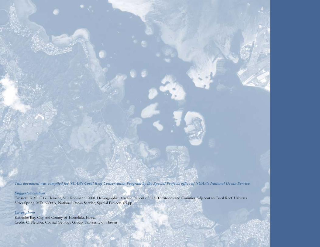
TABLE OF CONTENTS
Introduction.............................................5Threats......................................................6National Summary..................................10Guam........................................................16Commonwealth of the Northern Mariana Islands..................22American Samoa.....................................28Hawaii.......................................................34Southeast Florida and the Florida Keys..........................................40U.S. Virgin Islands ..................................46Puerto Rico..............................................52Methods....................................................60End Notes................................................61Acknowledgments...................................62References.................................................62
Demographic Baseline Report ofU.S. Territories and Counties
Adjacent to Coral Reef Habitats
June, 2008
National Oceanic and Atmospheric AdministrationU.S. Department of Commerce
Kristen M. CrossettChristopher G. Clement
Steven O. Rohmann
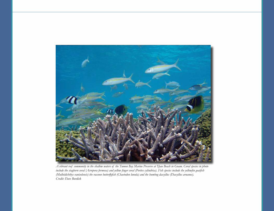
A vibrant reef community in the shallow waters of the Tumon Bay Marine Preserve at Ypao Beach in Guam. Coral species in photo include the staghorn coral (Acropora formosa) and yellow finger coral (Porites cylindrica). Fish species include the yellowfin goatfish (Mulloidichthys vanicolensis) the raccoon butterflyfish (Chaetodon lunula) and the humbug dascyllus (Dascyllus aruanus).Credit: Dave Burdick
5
Coral reef habitats found in U.S. waters less than 18 meters deep are estimated to cover over 36,813 square kilometers, an area larger than Maryland, while those in water less than 180 meters deep are estimated to cover over 143,059 square kilometers, an area larger than New York (29). The Nation’s coral reef habitats have major economic value, are a natural resource that comprise tremendous biodiversity, and are known to enhance the world’s fisheries, tourism, maritime and cultural heritage, and protect coastlines from storm damage (24). For example, reef-related tourism and recreation activities generated an estimated $6.2 billion in income and supported over 250,000 full and part-time jobs in southeast Florida in 2001 (22). Further, tourist activities associated with coral reefs generate an estimated $364 million in added value to Hawaii’s economy each year (9).
U.S. coral reef habitats (and those worldwide) are, however, generally in decline and suffer from the consequences of a growing human population. Coastal development and pollution, tourism and recreation, overfishing, climate change, and marine debris—to name only a few—all contribute to coral reef ecosystem degradation (47). Consider, for example, that in southern Florida, residents spent over 14 million person-days doing activities involving coral reefs during a one year period from June 2000 to May 2001 (22). Understanding how coral reef habitats respond to the consequences of a local population and its growth is necessary for planning conservation strategies and ultimately increasing the biodiversity, resistance, and resiliency of coral reef habitats, all of which are essential attributes in combating anthropogenic stressors (23). In general, collecting information on a local population’s (or stakeholders’) characteristics is important to understanding how they are affected by resource management, how important a resource is to a community, and how to tailor a management strategy to stakeholder needs and backgrounds. Characteristics that are typically collected and analyzed to help understand a population include age, race, number of households, household economics, education, and residency status (6, 7).
To understand the populations that depend upon and impact valuable coral reef habitat, managers of U.S. Coral Reef Jurisdictions have recognized the need to collect socioeconomic data for communities near these areas.
To help meet this need, this report summarizes demographic baseline data for U.S. jurisdictions and counties adjacent to coral reef habitats, including those found in:
American Samoa • Guam •Commonwealth of the Northern Mariana Islands •
Hawaii • U.S. Virgin Islands • Puerto Rico •Southeast Florida and the Florida Keys
This report compiles and synthesizes information from existing sources focusing on recent demographic, economic, and population projection variables of each area’s resident population. Statistics and maps showing the extent of coral habitats in relation to these populations is also presented. Although tourism is not a focus of this report, statistics on visitor information are also presented for each jurisdiction. There are many other socioeconomic factors—including recreational activities, governance, local culture, and human health—that affect the use and condition of coral habitats. However, summarizing information on these topics is beyond the scope of this report. For further information on these topics, refer to the following reports listed in the references: Hatziolos, M., 2006; Pomeroy, R.S. et al., 2004; and Dani, A. (ed.), 2003.
This report was produced in conjunction with the International Year of the Reef 2008 and is intended to complement the recently released report titled State of the Coral Reef Ecosystems of the United States and Pacific Freely Associated States: 2008. The goal of this report is to provide consistently derived comparable demographic and economic baseline information for all U.S. Coral Reef Jurisdictions that coral managers, local officials, media, and the public can draw upon for planning and management purposes.
A Note About the DataTremendous differences in residential population and geographic area exist among the jurisdictional study locations. As a result, it is difficult to present demographic data and maps consistently across chapters in a meaningful way. The information presented in each jurisdictional chapter should not be compared to other chapters at these varying levels of population and geography. Rather, the information is intended to provide a baseline from which to compare future population and demographic data for each study area.
Introduction

6
Threats
Tourism and recreation are by far the fastest-growing sector of coastal economies. Coral reefs, in particular, have a major economic value. In the Florida Keys alone, over three million tourists visit the area and purchase about $1.2 billion in services annually. Recreational activities on U.S. coral reefs include snorkeling, scuba diving, boating, and fishing. The intensity of each activity varies widely from region to region, but can be considerable in some areas. In southeast Florida, residents and visitors spent 28 million person-days fishing and nearly 5 million person-days snorkeling and scuba diving during June 2000 through May 2001. Divers and snorkelers can have a significant negative impact on coral reefs in terms of physical damage and a reduction in their aesthetic appeal. Increasing tourism will also have an overall effect on coastal development and population.
Sediment, fertilizers and other nutrients, herbicides, pesticides, and sewage are the most significant forms of pollution threatening U.S. coral ecosystems. For example, sediment that settles out of the water can smother corals and cover up habitat needed for coral recruitment. Also, turbidity in the water column reduces light availability for coral growth. Nutrient pollution may promote increased algal and bacterial growth, cause sea grasses and corals to die, and may effect fish reproduction and growth. Other pollutants, such as heavy metals and oil, are also harmful. The impacts of coastal pollution may make coral ecosystems more susceptible to other stressors, such as climate change and disease.
Human activities in the coastal zone are known to have a number of negative impacts, both direct and indirect, on the natural environment, including on coral reef ecosystems. The health of coral reefs is also influenced by natural factors such as disease and tropical storms. The ability of coral ecosystems to cope with and recover from these natural factors may be curtailed, however, by the effects of human activities. The following list of coral reef ecosystem threats and descriptions are excerpts and summarized material from the threats chapter in the report, State of the Coral Reef Ecosystems of the United States and Pacific Freely Associated States: 2005 (47). This report is online at http://ccma.nos.noaa.gov/ecosystems/coralreef/coral_report_2005/.
For decades people have been moving to coastal areas, and more than 50% of the U.S. population now live in coastal counties. This has increased coastal development including housing, road, and other infrastructure construction. The associated increased runoff from streets and buildings has led to greater volumes of polluted water entering near-shore coastal ecosystems. Additionally, increases have occurred in recreational and commercial use of coastal resources, particularly affecting fisheries. Increased dredging for marina facilities, ship access and navigation, beach nourishment, and building materials has also increased the amount of pollution impacting coral habitats.
Threats to Coral Reef Ecosystems
Coastal Population Growth and Development
•Tourism and Recreation
•Coastal Pollution
•Effects of Fishing and Overfishing
•Ships, Boats, and Groundings
•Marine Debris
•Oil and Gas Exploration
•Cable-laying Operations
•Security Training Activities
•Aquatic Invasive Species
•Climate Change and Coral Bleaching
•Diseases
•Tropical Storms
•Trade in Coral and Live Reef Species
Coastal Population Growth and Development
Tourism and Recreation
Coastal Pollution

7
Marine debris adversely impacts marine life through the destruction of essential habitat, entanglement, and ingestion by marine organisms and sea birds. The most notable impacts of marine debris on coral reef ecosystems come from derelict fishing gear, including nets, fishing line, and traps. Synthetic nets and fishing line, in use since the 1950s, can persist in the ocean for decades and can be transported for thousands of kilometers by ocean currents and wind. Lost fishing gear comprised of conglomerates of netting and fishing line rolls across reef habitats, crushing corals, dislodging sessile organisms, snagging on corals and trapping fish, marine mammals, and sea turtles.
Whether from chronic or episodic oil spills or from activities related to the exploration, production, or transport of energy resources, oil can impact reefs through physical breakage, sedimentation and smothering, toxic contamination by heavy metals, and by inhibition of growth and recruitment. Once introduced, oil tends to persist in sheltered tropical coastal environments and clean-up following a spill is often extremely difficult. The use of dispersants is often discouraged in shallow-water areas because they cause the oil to sink to the bottom, where it comes into contact with sensitive reef habitats. Oil spill recovery in shallow-water reef ecosystems can take decades.
Coral habitats are highly diverse and support important commercial and recreational fisheries. In many areas, they also support essential subsistence fisheries, a valuable marine aquarium industry, and provide specimens for the biotechnology and pharmaceutical industries. Impacts of fishing include: (1) excessive harvesting of fish, invertebrates, and algae for food and the aquarium trade; (2) near total loss of single species or groups of species (3) by-catch of non-target species; and (4) damage to habitat caused by fishing techniques, fishing gear, and anchoring of fishing vessels. For example, in Biscayne Bay, Florida, a long-term reef fish monitoring program found that 77% of 35 individual species are overfished. In Hawaii, long-term catch rates suggest that stocks of near-shore fishes declined by nearly 80% between 1900 and the mid-1980s. In Puerto Rico and the U.S. Virgin Islands, the Nassau grouper fishery collapsed in the 1980s due to overexploitation.
Boats that run aground, sink, or carelessly drag anchors in coral habitats can be very destructive, and the impact often continues well beyond the initial injury. Over 2,100 grounding accidents in near-shore waters are reported to the U.S. Coast Guard annually, with about 440 vessels sinking each year. Reefs may stay in a damaged condition for long periods of time due to the slow recovery rate and fragmentation of coral organisms that are essential to reef structure and function. When fuel, chemical or cargo spills occur, additional damage ensues.
Effects of Fishing and Overfishing
Ships, Boats, and Groundings
Marine Debris
Oil and Gas Exploration
Marine debris (net) removal in Kaneohe Bay on Oahu.Credit: NOAA Pacific Islands Fisheries Science Center Coral Reef Ecosystem Division’s Marine Debris Team.
Coastal development, old and new, in Puerto Rico.Credit: NOAA Office of Ocean and Coastal Resource Management.

8
Aquatic invasive species are organisms that are introduced into new ecosystems and result in harmful ecological, economic, and human health impacts. Invasive species are generally second only to habitat destruction in causing declines in biodiversity, and are thought to impact nearly half of the species currently listed as threatened or endangered under the Federal Endangered Species Act. Shallow-water coral reef habitat are particularly vulnerable to the introduction of invasive species from ships, aquaculture, releases by aquarium hobbyists, and marine debris.
Climate change refers to any change in climate over time, whether due to natural variability or human activity. Between 1900 and 1999, both the mean near-surface air temperature over land and the mean sea surface temperature increased. Most of the observed warming over the last 50 years can be linked to increased concentrations of greenhouse gases, such as carbon dioxide and methane, in the atmosphere. Higher carbon dioxide concentrations have been linked to decreased growth rates of corals. Reduced growth rates may impede a reef ’s ability to keep pace with rising sea levels or recover from natural disruptions such as hurricanes and volcanoes. Additionally, elevated sea surface water temperatures cause corals to bleach due to the loss of helpful alga from coral tissues. Although corals can recover from brief bleaching episodes, if water temperatures get too warm and remain high for extended periods, corals will bleach and then die.
There has been a rapid increase in the need for submarine cables, particularly fiber-optic cables, to support the telecommunications industry. Cable-laying operations and the movement of unsecured cables have been found to disrupt and destabilize benthic structures. The impact of laying a cable on benthic habitats depends on the location of landing points, the route chosen, and the installation process.
U.S. military installations near coral reefs include operations in Hawaii, Johnston Atoll, Wake Atoll, Kwajelein Atoll, Guam, the Commonwealth of the Northern Mariana Islands, Florida, Puerto Rico, and the U.S. Virgin Islands. Military bases and associated activities include simulated war exercises, training, and operational procedures (e.g., construction, dredging, sewage discharge). These activities have the potential for adverse ecological impacts on coral reefs, such as excessive noise, explosives and munitions disposal, oil and fuel spillage, wreckage and debris, breakage of reef structure, and non-native species introductions from ship bilge water or aircraft cargo. U.S. military services, with some exceptions, generally avoid coral reef areas in their normal operations.
Cable-laying Operations
Security Training Activities
Aquatic Invasive Species
Climate Change and Coral BleachingThe invasive Gorilla ogo seaweed grows on reefs in Hawaii where it forms thick intertwining mats that can overgrow and kill coral.Credit: Christy Martin, Hawaii Coordinating Group on Alien Pest Species
Coastal landfill in Culebra, Puerto Rico.Credit: NOAA Office of Ocean and Coastal Resource Management

9
Since the mid-1980s, there has been an increase in the occurrence of diseases affecting marine plants and animals. For example, an unknown waterborne pathogen killed 90-95% of spiny sea urchins throughout the Caribbean in 1982-1983. That same decade, a fungus infected sea grasses in southern Florida, causing severe declines, and white-band disease virtually wiped out two species of coral on shallow western Atlantic reefs. The ability of corals and other organisms to ward off infection may be compromised by climate change, nutrient pollution, sedimentation, and other impacts. Their vulnerability is increased because many warm-water corals grow slowly and live within a narrow range of light, temperature, dissolved oxygen, and salinity conditions.
The extent of coral ecosystem damage from tropical storms is influenced by reef physical structure and biologic composition, and the path, strength, and duration of a storm. Storms can generate high storm surges, heavy rainfall, and very strong winds, causing physical and water quality-related damage to coral reefs. Coral habitats that are less affected by changes in salinity due to heavy rain or sediment from terrestrial runoff generally weather storms better. Although direct wave damage from storms occurs in the shallow (0-20 meter) depth range, corals in deeper water can be damaged by pieces of coral and other objects that tumble down from shallower waters. Further, broken or crushed corals reduce the suitable habitat for fish and other organisms that live on the reef. The damage
Diseases
Tropical Storms
also reduces their food supply and increases their exposure to predators.
Many coral reef species are harvested domestically and internationally to supply a growing demand for seafood, aquarium pets, live fish food, construction materials, jewelry, pharmaceuticals, traditional medicines, and other products. Harvesting at unsustainable levels may lead to reductions in the abundance and size of important species, shifts in species composition, and, in some cases, population explosions of other organisms. Some of the techniques used to collect reef organisms, such as cyanide poisoning of fishes and breakage of coral colonies, are also very destructive.
Illegally caught conch shown with can for size reference, Caja Muertos, Puerto Rico, 2007. Credit: Eileen Alicea, NOAA National Ocean Service, International Programs Office
Trade in Coral and Live Reef Species
The 2005 Caribbean bleaching event affected St. Croix, USVI as well as most of the Caribbean. Bleaching is caused by periods of higher than normal sea temperatures which cause coral to expel symbiotic algae, giving them a striking white coloration.Credit: NOAA CCMA Biogeography Team
10
259 persons per square kilometer by 2015, and to 319 persons per square kilometer by 2030 (35, 49).
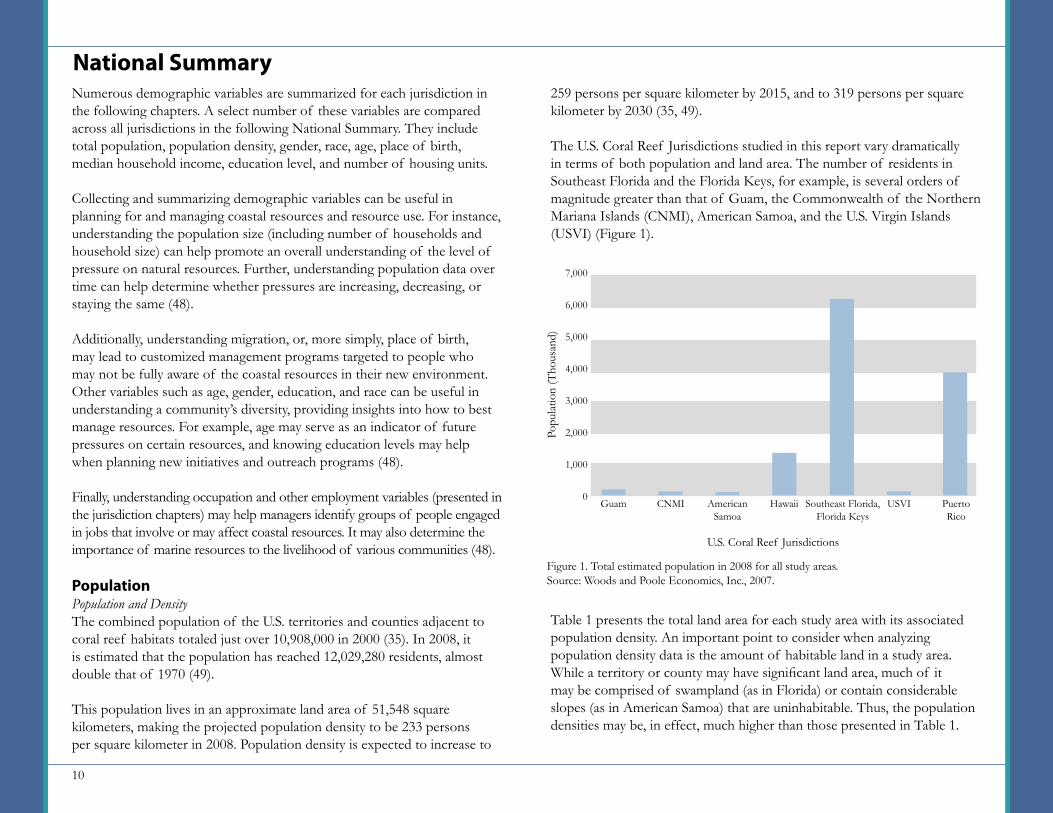
The U.S. Coral Reef Jurisdictions studied in this report vary dramatically in terms of both population and land area. The number of residents in Southeast Florida and the Florida Keys, for example, is several orders of magnitude greater than that of Guam, the Commonwealth of the Northern Mariana Islands (CNMI), American Samoa, and the U.S. Virgin Islands (USVI) (Figure 1).
Table 1 presents the total land area for each study area with its associated population density. An important point to consider when analyzing population density data is the amount of habitable land in a study area. While a territory or county may have significant land area, much of it may be comprised of swampland (as in Florida) or contain considerable slopes (as in American Samoa) that are uninhabitable. Thus, the population densities may be, in effect, much higher than those presented in Table 1.
National SummaryNumerous demographic variables are summarized for each jurisdiction in the following chapters. A select number of these variables are compared across all jurisdictions in the following National Summary. They include total population, population density, gender, race, age, place of birth, median household income, education level, and number of housing units.
Collecting and summarizing demographic variables can be useful in planning for and managing coastal resources and resource use. For instance, understanding the population size (including number of households and household size) can help promote an overall understanding of the level of pressure on natural resources. Further, understanding population data over time can help determine whether pressures are increasing, decreasing, or staying the same (48).
Additionally, understanding migration, or, more simply, place of birth, may lead to customized management programs targeted to people who may not be fully aware of the coastal resources in their new environment. Other variables such as age, gender, education, and race can be useful in understanding a community’s diversity, providing insights into how to best manage resources. For example, age may serve as an indicator of future pressures on certain resources, and knowing education levels may help when planning new initiatives and outreach programs (48).
Finally, understanding occupation and other employment variables (presented in the jurisdiction chapters) may help managers identify groups of people engaged in jobs that involve or may affect coastal resources. It may also determine the importance of marine resources to the livelihood of various communities (48).
PopulationPopulation and DensityThe combined population of the U.S. territories and counties adjacent to coral reef habitats totaled just over 10,908,000 in 2000 (35). In 2008, it is estimated that the population has reached 12,029,280 residents, almost double that of 1970 (49).
This population lives in an approximate land area of 51,548 square kilometers, making the projected population density to be 233 persons per square kilometer in 2008. Population density is expected to increase to
7,000
6,000
5,000
4,000
3,000
2,000
1,000
0
Popu
latio
n (T
hous
and)
U.S. Coral Reef Jurisdictions
Guam American Samoa
CNMI
Figure 1. Total estimated population in 2008 for all study areas.Source: Woods and Poole Economics, Inc., 2007.
Hawaii USVISoutheast Florida, Florida Keys
Puerto Rico

11
GenderIn four of the U.S. Coral Reef Jurisdictions in 2000, Southeast Florida and the Florida Keys, Puerto Rico, USVI, and CNMI, the female population is greater than the male population (Figure 2). The greatest difference is seen in the CNMI, where women comprise 54% of the population and men 46%. In the jurisdictions where men outnumber women, Guam and American Samoa, the difference is only by 2%. Hawaii is the only jurisdiction with approximately the same number of males and females. The U.S. average is 51% females and 49% males (35).
Population and Adjacent Coral Reef HabitatThe exact distribution and extent of U.S. shallow-water coral reef habitats is not currently known or completely mapped. However, comprehensive estimates of the potential distribution and extent of shallow-water coral reef habitat in tropical and subtropical U.S. waters have been completed. These estimates are based on analysis of 18-meter and 180-meter depth curves, which are used as surrogates for potential coral habitat distribution (29). Table 2 presents the area of potential coral reef habitat within the 18-meter depth curve compared to the number of residents in the adjacent U.S. territory or county. Table 3 presents this same data for the 180-meter depth curve. In both instances, Guam has the greatest number of residents per square kilometer of potential coral habitat. 60
50
40
30
20
10
0
Perc
ent
Males Females
Guam American Samoa
CNMI Hawaii USVISoutheast Florida, Florida Keys
Puerto Rico
U.S. Coral Reef Jurisdictions
Figure 2. Percent of males and females that comprise the jurisdiction populations.Source: U.S. Census Bureau, 2000.
GuamCNMIAmerican SamoaHawaiiSoutheast Florida and the Florida KeysUSVIPuerto Rico
32430535480
261162435
Land Area (sq km)
2008 Population Density(persons per sq km)
Table 1. Approximate land area and corresponding population density in 2008.Source: Woods and Poole Economics, Inc., 2007; Rohmann et al., 2005.
543310188
16,63324,050
6899,135
GuamCNMIAmerican SamoaHawaiiSoutheast Florida and the Florida KeysUSVIPuerto Rico
1,9281,0961,5421,085
204325
1,725
Area Inside 18 Meter Depth Curve
(sq km)
Persons Per Sq Km of Potential
Coral Reef Habitat in 2008
Table 2. Area of potential coral reef habitat within the 18-meter depth curve and number of residents in the adjacent U.S. territory or county in 2008.Source: Woods and Poole Economics, Inc., 2007; Rohmann et al., 2005.
918643
1,22130,801
3442,302
Table 3. Area of potential coral reef habitat within the 180-meter depth curve and number of residents in the adjacent U.S. territory or county in 2008.Source: Woods and Poole Economics, Inc., 2007; Rohmann et al., 2005.
GuamCNMIAmerican Samoa (Tutuila only)HawaiiSoutheast Florida and the Florida KeysUSVIPuerto Rico
8672831852015654
721
Area Inside 180 Meter Depth Curve
(sq km)
203333353
6,596113,092
2,0655,506
Persons Per Sq Km of Potential
Coral Reef Habitat in 2008
12
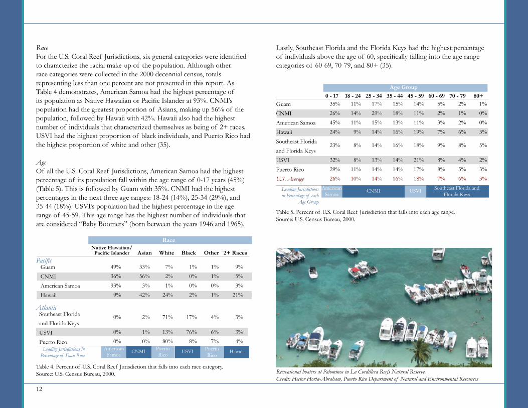
Lastly, Southeast Florida and the Florida Keys had the highest percentage of individuals above the age of 60, specifically falling into the age range categories of 60-69, 70-79, and 80+ (35).
RaceFor the U.S. Coral Reef Jurisdictions, six general categories were identified to characterize the racial make-up of the population. Although other race categories were collected in the 2000 decennial census, totals representing less than one percent are not presented in this report. As Table 4 demonstrates, American Samoa had the highest percentage of its population as Native Hawaiian or Pacific Islander at 93%. CNMI’s population had the greatest proportion of Asians, making up 56% of the population, followed by Hawaii with 42%. Hawaii also had the highest number of individuals that characterized themselves as being of 2+ races. USVI had the highest proportion of black individuals, and Puerto Rico had the highest proportion of white and other (35).
AgeOf all the U.S. Coral Reef Jurisdictions, American Samoa had the highest percentage of its population fall within the age range of 0-17 years (45%) (Table 5). This is followed by Guam with 35%. CNMI had the highest percentages in the next three age ranges: 18-24 (14%), 25-34 (29%), and 35-44 (18%). USVI’s population had the highest percentage in the age range of 45-59. This age range has the highest number of individuals that are considered “Baby Boomers” (born between the years 1946 and 1965).
GuamCNMIAmerican SamoaHawaiiSoutheast Floridaand Florida KeysUSVIPuerto RicoU.S. Average
15%18%13%16%
14%14%16%
1%0%0%3%
2%3%3%
2%1%2%6%
4%5%6%
5%2%3%7%
8%8%7%
14%11%11%19%
21%17%18%
35%26%45%24%
32%29%26%
11%14%11%9%
8%11%10%
17%29%15%14%
13%14%14%
0 - 17 18 - 24 25 - 34 35 - 44 45 - 59 60 - 69 70 - 79 80+
American Samoa
CNMI USVI Southeast Florida andFlorida Keys
Leading Jurisdictions in Percentage of each
Age Group
16% 5%8%9%18%23% 8% 14%
Table 5. Percent of U.S. Coral Reef Jurisdiction that falls into each age range.Source: U.S. Census Bureau, 2000.
Age Group
GuamCNMIAmerican SamoaHawaii
1%0%0%2%
9%5%3%
21%
1%1%0%1%
49%36%93%9%
33%56%3%
42%
7%2%1%
24%
Native Hawaiian/ Pacific Islander Asian White Black Other 2+ Races
Leading Jurisdictions in Percentage of Each Race
Table 4. Percent of U.S. Coral Reef Jurisdiction that falls into each race category.Source: U.S. Census Bureau, 2000.
Race
Southeast Floridaand Florida KeysUSVIPuerto Rico
13%80%
3%4%
6%7%
76%8%
0%0%
1%0%
71% 3%4%17%0% 2%
Pacific
Atlantic
American Samoa
CNMI Puerto Rico
USVI Puerto Rico
Hawaii
Recreational boaters at Palominos in La Cordillera Reefs Natural Reserve.Credit: Hector Horta-Abraham, Puerto Rico Department of Natural and Environmental Resources
13
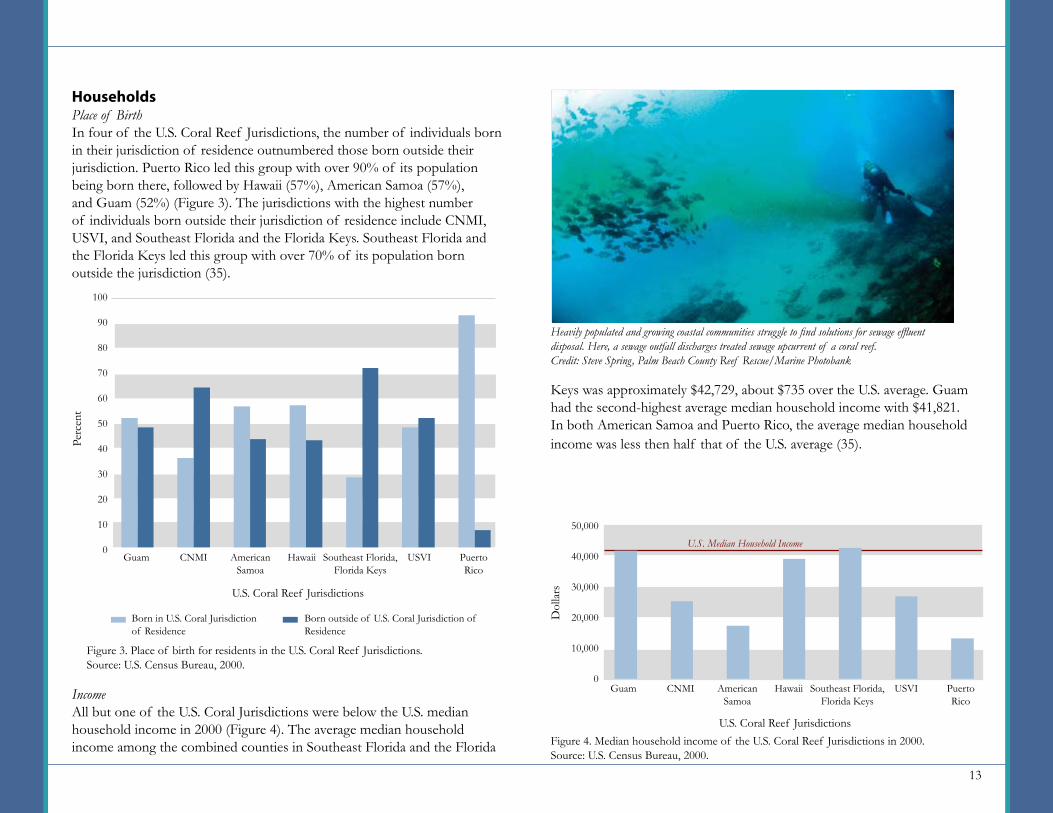
HouseholdsPlace of BirthIn four of the U.S. Coral Reef Jurisdictions, the number of individuals born in their jurisdiction of residence outnumbered those born outside their jurisdiction. Puerto Rico led this group with over 90% of its population being born there, followed by Hawaii (57%), American Samoa (57%), and Guam (52%) (Figure 3). The jurisdictions with the highest number of individuals born outside their jurisdiction of residence include CNMI, USVI, and Southeast Florida and the Florida Keys. Southeast Florida and the Florida Keys led this group with over 70% of its population born outside the jurisdiction (35).
IncomeAll but one of the U.S. Coral Jurisdictions were below the U.S. median household income in 2000 (Figure 4). The average median household income among the combined counties in Southeast Florida and the Florida
Keys was approximately $42,729, about $735 over the U.S. average. Guam had the second-highest average median household income with $41,821. In both American Samoa and Puerto Rico, the average median household income was less then half that of the U.S. average (35).
Heavily populated and growing coastal communities struggle to find solutions for sewage effluent disposal. Here, a sewage outfall discharges treated sewage upcurrent of a coral reef.Credit: Steve Spring, Palm Beach County Reef Rescue/Marine Photobank
100
90
80
70
60
50
40
30
20
10
0
Perc
ent
Born in U.S. Coral Jurisdiction of Residence
Born outside of U.S. Coral Jurisdiction of Residence
Guam American Samoa
CNMI Hawaii USVISoutheast Florida, Florida Keys
Puerto Rico
U.S. Coral Reef Jurisdictions
Figure 3. Place of birth for residents in the U.S. Coral Reef Jurisdictions.Source: U.S. Census Bureau, 2000.
Figure 4. Median household income of the U.S. Coral Reef Jurisdictions in 2000.Source: U.S. Census Bureau, 2000.
50,000
40,000
30,000
20,000
10,000
0
Dol
lars
U.S. Coral Reef Jurisdictions
Guam American Samoa
CNMI Hawaii USVISoutheast Florida, Florida Keys
Puerto Rico
U.S. Median Household Income
14
EducationTable 6 presents information for the highest level of education completed by adult residents of the U.S. Coral Reef Jurisdictions. Puerto Rico had the highest percentage without a high school diploma (40%). The USVI followed closely with 39%. American Samoa had the highest proportion of those having received a high school diploma. Hawaii had the highest proportion of those with some college or an associate’s degree, as well as a bachelor’s degree or higher (35).
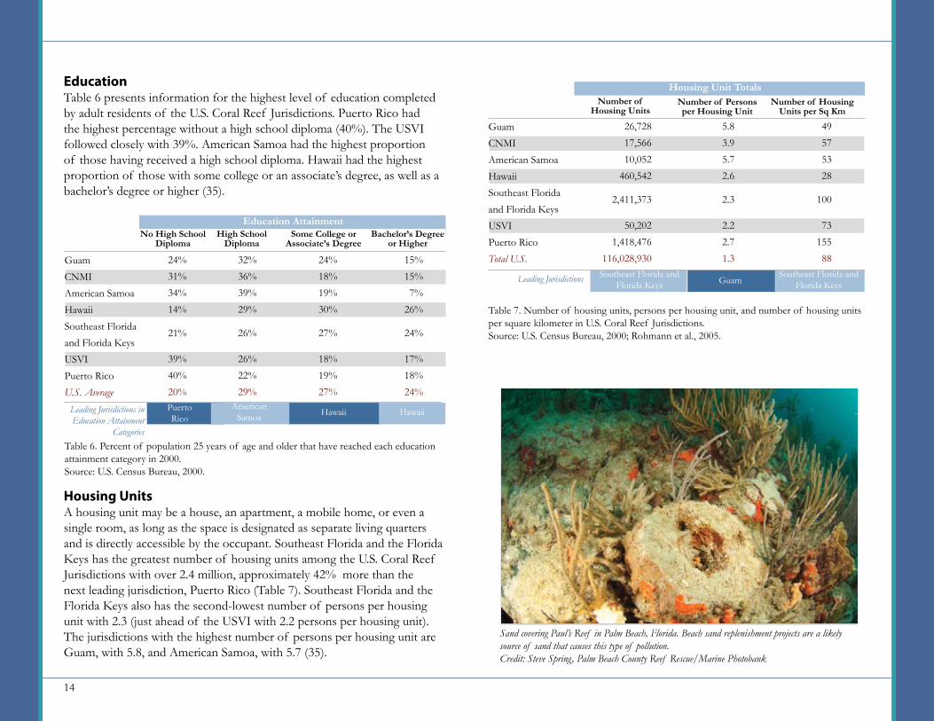
Housing UnitsA housing unit may be a house, an apartment, a mobile home, or even a single room, as long as the space is designated as separate living quarters and is directly accessible by the occupant. Southeast Florida and the Florida Keys has the greatest number of housing units among the U.S. Coral Reef Jurisdictions with over 2.4 million, approximately 42% more than the next leading jurisdiction, Puerto Rico (Table 7). Southeast Florida and the Florida Keys also has the second-lowest number of persons per housing unit with 2.3 (just ahead of the USVI with 2.2 persons per housing unit). The jurisdictions with the highest number of persons per housing unit are Guam, with 5.8, and American Samoa, with 5.7 (35).
GuamCNMIAmerican SamoaHawaiiSoutheast Floridaand Florida KeysUSVIPuerto RicoTotal U.S.
49575328
7315588
26,72817,56610,052
460,542
50,2021,418,476
116,028,930
5.83.95.72.6
2.22.71.3
Number of Housing Units
Number of Persons per Housing Unit
Number of Housing Units per Sq Km
Leading Jurisdictions
1002,411,373 2.3
Table 7. Number of housing units, persons per housing unit, and number of housing units per square kilometer in U.S. Coral Reef Jurisdictions.Source: U.S. Census Bureau, 2000; Rohmann et al., 2005.
Housing Unit Totals
GuamSoutheast Florida and
Florida KeysSoutheast Florida and
Florida Keys
GuamCNMIAmerican SamoaHawaiiSoutheast Floridaand Florida KeysUSVIPuerto RicoU.S. Average
24%31%34%14%
39%40%20%
No High School Diploma
High School Diploma
Some College or Associate’s Degree
Leading Jurisdictions in Education Attainment
Categories
15%15%7%
26%
17%18%24%
24%21%
Table 6. Percent of population 25 years of age and older that have reached each education attainment category in 2000.Source: U.S. Census Bureau, 2000.
Education AttainmentBachelor’s Degree
or Higher
24%18%19%30%
18%19%27%
27%
32%36%39%29%
26%22%29%
26%
HawaiiPuertoRico
American Samoa Hawaii
Sand covering Paul’s Reef in Palm Beach, Florida. Beach sand replenishment projects are a likely source of sand that causes this type of pollution.Credit: Steve Spring, Palm Beach County Reef Rescue/Marine Photobank
15
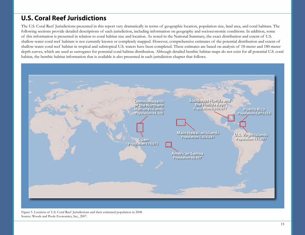
U.S. Coral Reef JurisdictionsThe U.S. Coral Reef Jurisdictions presented in this report vary dramatically in terms of geographic location, population size, land area, and coral habitats. The following sections provide detailed descriptions of each jurisdiction, including information on geography and socioeconomic conditions. In addition, some of this information is presented in relation to coral habitat size and location. As noted in the National Summary, the exact distribution and extent of U.S. shallow-water coral reef habitats is not currently known or completely mapped. However, comprehensive estimates of the potential distribution and extent of shallow-water coral reef habitat in tropical and subtropical U.S. waters have been completed. These estimates are based on analysis of 18-meter and 180-meter depth curves, which are used as surrogates for potential coral habitat distribution. Although detailed benthic habitat maps do not exist for all potential U.S. coral habitat, the benthic habitat information that is available is also presented in each jurisdiction chapter that follows.
Figure 5. Location of U.S. Coral Reef Jurisdictions and their estimated population in 2008.Source: Woods and Poole Economics, Inc., 2007.
American SamoaPopulation 66,447
GuamPopulation 176,075
Commonwealth of the Northern Mariana IslandsPopulation 94,360
Main Hawaiian IslandsPopulation 1,324,581
Southeast Florida and the Florida Keys
Population 6,283,671
U.S. Virgin IslandsPopulation 111,991
Puerto RicoPopulation 3,972,155
16
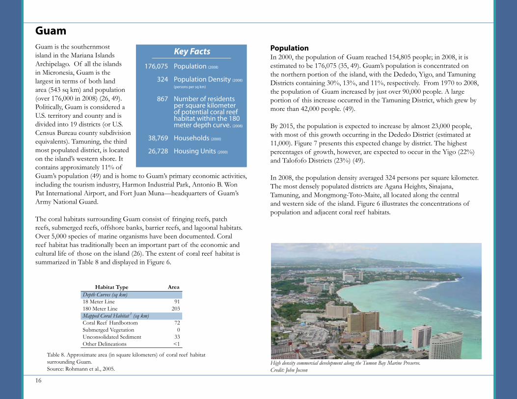
Guam is the southernmost island in the Mariana Islands Archipelago. Of all the islands in Micronesia, Guam is the largest in terms of both land area (543 sq km) and population (over 176,000 in 2008) (26, 49). Politically, Guam is considered a U.S. territory and county and is divided into 19 districts (or U.S. Census Bureau county subdivision equivalents). Tamuning, the third most populated district, is located on the island’s western shore. It contains approximately 11% of Guam’s population (49) and is home to Guam’s primary economic activities, including the tourism industry, Harmon Industrial Park, Antonio B. Won Pat International Airport, and Fort Juan Muna—headquarters of Guam’s Army National Guard.
The coral habitats surrounding Guam consist of fringing reefs, patch reefs, submerged reefs, offshore banks, barrier reefs, and lagoonal habitats. Over 5,000 species of marine organisms have been documented. Coral reef habitat has traditionally been an important part of the economic and cultural life of those on the island (26). The extent of coral reef habitat is summarized in Table 8 and displayed in Figure 6.
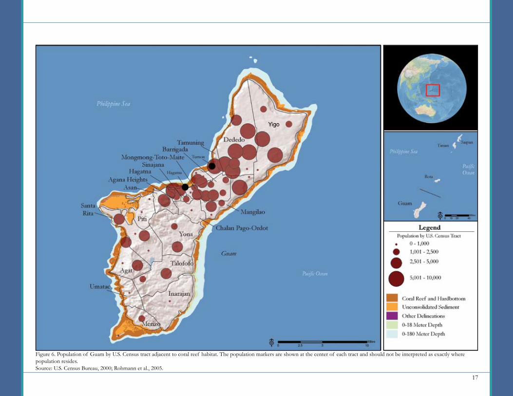
GuamPopulationIn 2000, the population of Guam reached 154,805 people; in 2008, it is estimated to be 176,075 (35, 49). Guam’s population is concentrated on the northern portion of the island, with the Dededo, Yigo, and Tamuning Districts containing 30%, 13%, and 11%, respectively. From 1970 to 2008, the population of Guam increased by just over 90,000 people. A large portion of this increase occurred in the Tamuning District, which grew by more than 42,000 people. (49).
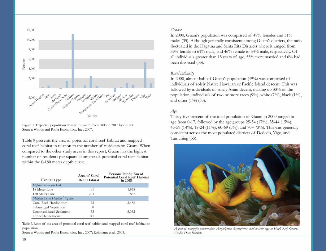
By 2015, the population is expected to increase by almost 23,000 people, with most of this growth occurring in the Dededo District (estimated at 11,000). Figure 7 presents this expected change by district. The highest percentages of growth, however, are expected to occur in the Yigo (22%) and Talofofo Districts (23%) (49).
In 2008, the population density averaged 324 persons per square kilometer. The most densely populated districts are Agana Heights, Sinajana, Tamuning, and Mongmong-Toto-Maite, all located along the central and western side of the island. Figure 6 illustrates the concentrations of population and adjacent coral reef habitats.
Table 8. Approximate area (in square kilometers) of coral reef habitat surrounding Guam. Source: Rohmann et al., 2005.
Depth Curves (sq km)18 Meter Line180 Meter LineMapped Coral Habitat 1 (sq km)Coral Reef HardbottomSubmerged VegetationUnconsolidated SedimentOther Delineations
91203
720
33<1
Habitat Type Area
High density commercial development along the Tumon Bay Marine Preserve.Credit: John Jocson
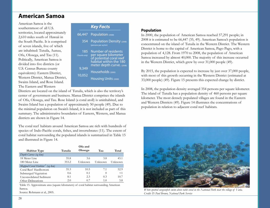
Key Facts
Population (2008)
Population Density (2008)
(persons per sq km)
Number of residents per square kilometer of potential coral reef habitat within the 180 meter depth curve. (2008)
Households (2000)
Housing Units (2000)
176,075
324
867
38,769
26,728
17
Figure 6. Population of Guam by U.S. Census tract adjacent to coral reef habitat. The population markers are shown at the center of each tract and should not be interpreted as exactly where population resides.Source: U.S. Census Bureau, 2000; Rohmann et al., 2005.
18
Table 9 presents the area of potential coral reef habitat and mapped coral reef habitat in relation to the number of residents on Guam. When compared to the other study areas in this report, Guam has the highest number of residents per square kilometer of potential coral reef habitat within the 0-180 meter depth curve.
GenderIn 2000, Guam’s population was comprised of 49% females and 51% males (35). Although generally consistent among Guam’s districts, the ratio fluctuated in the Hagatna and Santa Rita Districts where it ranged from 39% female to 61% male, and 46% female to 54% male, respectively. Of all individuals greater than 15 years of age, 55% were married and 6% had been divorced (35).
Race/EthnicityIn 2000, almost half of Guam’s population (49%) was comprised of individuals of solely Native Hawaiian or Pacific Island descent. This was followed by individuals of solely Asian decent, making up 33% of the population, individuals of two or more races (9%), white (7%), black (1%), and other (1%) (35).
AgeThirty-five percent of the total population of Guam in 2000 ranged in age from 0-17, followed by the age groups 25-34 (17%), 35-44 (15%), 45-59 (14%), 18-24 (11%), 60-69 (5%), and 70+ (3%). This was generally consistent across the most populated districts of Dededo, Yigo, and Tamuning (35).
Agana H
eights
Yona
Talofofo
Sinaja
na
Santa R
itaPiti
Mongmong-T
oto-Maite
Merizo
Mangilao
Inarajan
Hagatna (A
gana)
Dededo
Chalan Pago
-Ordot
Barriga
daAsanAgat Yigo
Umatac
Tamuning
12,000
10,000
8,000
6,000
4,000
2,000
0
-2,000
Pers
ons
District
Figure 7. Expected population change in Guam from 2008 to 2015 by district.Source: Woods and Poole Economics, Inc., 2007.
A pair of orangefin anemonefish, Amphiprion chrysopterus, tend to their eggs at Hap’s Reef, Guam.Credit: Dave Burdick
Depth Curves (sq km)18 Meter Line180 Meter LineMapped Coral Habitat 1 (sq km)Coral Reef HardbottomSubmerged VegetationUnconsolidated SedimentOther Delineations
91203
720
33<1
Habitat TypeArea of Coral Reef Habitat
Persons Per Sq Km of Potential Coral Reef Habitat
in 2008
1,928867
2,456...
5,352...
Table 9. Ratio of the area of potential coral reef habitat and mapped coral reef habitat to population.Source: Woods and Poole Economics, Inc., 2007; Rohmann et al., 2005.
19
HouseholdsIn 2000, the total number of households in Guam was 38,769. Eighty-three percent were family households. The size of family households was somewhat evenly distributed; with two-, three-, and four-person households ranging from 16-18% of the total, and five-, six-, and seven-person households ranging from 8-13% of the total. The district with the fewest number of family households was Tamuning, where they made up 68% of the household total. Most non-family households (79%) contained only one person (35).
LanguageThe primary language spoken in the home in Guam is distributed among several languages. The Chamorro language, spoken in 32% of homes is the native language of Guam. Table 10 shows this distribution (35).
Place of BirthOf the total population, 52% were born in Guam, 21% were born in the neighboring Philippines, and 12% were born in the United States. The remaining population was born in the U.S. island areas and the Federated States of Micronesia. The districts with the highest percentage of Guam born individuals are the Umatac District (91%), Inarajan District (86%) and Merizo District (86%), all of which are located on the southernmost portion of island (35).
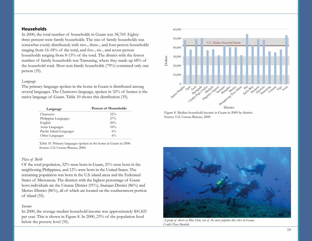
IncomeIn 2000, the average median household income was approximately $41,821 per year. This is shown in Figure 8. In 2000, 23% of the population lived below the poverty level (35).
ChamorroPhilippine LanguagesEnglishAsian LanguagesPacific Island LanguagesOther Languages
32%27%20%10%6%6%
Language Percent of Households
Table 10. Primary languages spoken in the home in Guam in 2000.Source: U.S. Census Bureau, 2000.
Figure 8. Median household income in Guam in 2000 by district.Source: U.S. Census Bureau, 2000.
Agana H
eights
Yona
Talofofo
Sinaja
na
Santa R
itaPiti
Mongmong-T
oto-Maite
Merizo
Mangilao
Inarajan
Hagatna (A
gana)
Dededo
Chalan Pago
-Ordot
Barriga
daAsanAgat Yigo
Umatac
Tamuning
60,000
50,000
40,000
30,000
20,000
10,000
0
Dol
lars
U.S. Median Household Income
District
A group of divers at Blue Hole, one of the more popular dive sites on Guam.Credit: Dave Burdick
20
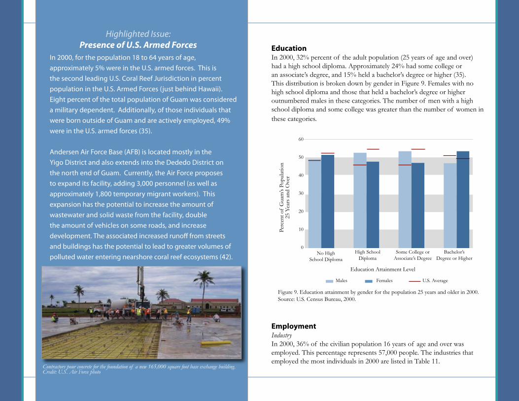
EducationIn 2000, 32% percent of the adult population (25 years of age and over) had a high school diploma. Approximately 24% had some college or an associate’s degree, and 15% held a bachelor’s degree or higher (35). This distribution is broken down by gender in Figure 9. Females with no high school diploma and those that held a bachelor’s degree or higher outnumbered males in these categories. The number of men with a high school diploma and some college was greater than the number of women in these categories.
EmploymentIndustryIn 2000, 36% of the civilian population 16 years of age and over was employed. This percentage represents 57,000 people. The industries that employed the most individuals in 2000 are listed in Table 11.
Highlighted Issue: Presence of U.S. Armed Forces
Figure 9. Education attainment by gender for the population 25 years and older in 2000.Source: U.S. Census Bureau, 2000.
No HighSchool Diploma
Education Attainment Level
High SchoolDiploma
Some College or Associate’s Degree
Bachelor’s Degree or Higher
60
50
40
30
20
10
0
Perc
ent o
f G
uam
’s Po
pula
tion
25 Y
ears
and
Ove
rU.S. AverageMales Females
In 2000, for the population 18 to 64 years of age, approximately 5% were in the U.S. armed forces. This is the second leading U.S. Coral Reef Jurisdiction in percent population in the U.S. Armed Forces (just behind Hawaii). Eight percent of the total population of Guam was considered a military dependent. Additionally, of those individuals that were born outside of Guam and are actively employed, 49% were in the U.S. armed forces (35).
Andersen Air Force Base (AFB) is located mostly in the Yigo District and also extends into the Dededo District on the north end of Guam. Currently, the Air Force proposes to expand its facility, adding 3,000 personnel (as well as approximately 1,800 temporary migrant workers). This expansion has the potential to increase the amount of wastewater and solid waste from the facility, double the amount of vehicles on some roads, and increase development. The associated increased runoff from streets and buildings has the potential to lead to greater volumes of polluted water entering nearshore coral reef ecosystems (42).
Contractors pour concrete for the foundation of a new 165,000 square foot base exchange building.Credit: U.S. Air Force photo

21
Commute to WorkFor the civilian population over 16 years of age, 83% worked outside their place of residence. The primary means of transportation to work was by carpooling in a private vehicle (70%) and driving alone in a private vehicle (23%). These were followed by walking (2%), other means of transportation (2%), public transportation (1%), and working at home (1%) (35).
Housing and DevelopmentHousing UnitsThere were a total of 26,728 housing units in Guam in 2000. Of the total housing units, 36% were owner occupied, 43% were renter occupied, and 20% were reported as vacant (35).
Plumbing FacilitiesIn 2000, just under 7% of the housing units in Guam lacked complete plumbing facilities (35).
Source of WaterIn 2000, over 99% of the 26,728 total housing units were connected to public water systems. Wells, catchment tanks, and other water sources made up less than 1% of the total water supply (35).
Sewage DisposalIn 2000, over 76% of housing units had public sewer connections. Most of the remaining homes (21%) were on septic tank or cesspool systems, while about 2% were reported as using “other means” of sewage disposal (35).
Building Permits 2
Between 2000 and 2005, an average of 886 building permits were issued per year for new structures. Of those, an average of 290 per year were for residential construction (8).
TourismFrom 2000 to 2005, an average of 1,133,593 tourists per year (excluding same-day visitors) visited Guam. Over 93% of them came from Asia, East and Southeast/Oceania (34).
Arts; entertainment; recreation; accommodation and food servicesEducational; health and social services Retail Trade Public Administration Construction Transportation, Warehouse and UtilitiesProfessional; scientific; management; administrative and waste management servicesFinance; insurance; real estate and rental and leasing Other ServicesWholesale Trade Information Manufacturing Agriculture; forestry; fishing and hunting; and mining
Table 11. Percent of the population 16 years of age and over employed by industry in Guam in 2000.Source: U.S. Census Bureau, 2000.
Industry Percent Employed181513111087543321
A snorkeling guide observes his clients while standing atop a colony of yellow finger coral, Porites cylindrica, in the Tumon Bay Marine Preserve.Credit: Dave Burdick
22
The U.S. Commonwealth of the Northern Mariana Islands (CNMI) comprises 14 islands and is part of the Mariana Islands Archipelago. The populated islands of Rota, Saipan, and Tinian are located in the southern portion of the archipelago and represent three of the four municipalities (U.S. Census Bureau county equivalents) found within CNMI. The fourth municipality, the Northern Islands Municipality, has a minimal population (less than 10 persons in 2008) (49). Thus it is not included as part of this summary. Rota, the southernmost island of CNMI and least populated of the three municipalities being examined, is approximately 76 kilometers north of Guam. Rota has an emerging tourism industry and increasing development. Saipan, the largest (122 square kilometers) and most populated (approximately 85,267 people in 2008) island is driven economically by tourism and manufacturing. Tinian, located approximately 8 kilometers across the Saipan channel from Saipan, has approximately two thirds of its land area leased to the U.S. military. San Jose is the primary community found on Tinian and is an agricultural community (49).
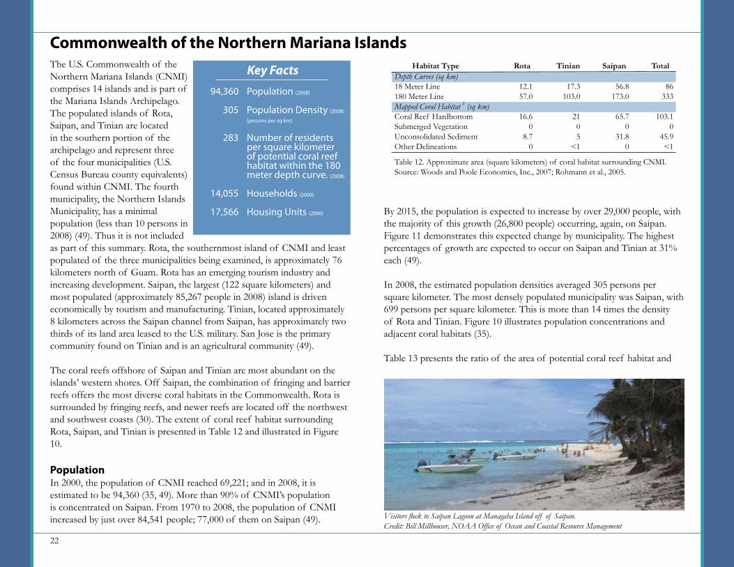
The coral reefs offshore of Saipan and Tinian are most abundant on the islands’ western shores. Off Saipan, the combination of fringing and barrier reefs offers the most diverse coral habitats in the Commonwealth. Rota is surrounded by fringing reefs, and newer reefs are located off the northwest and southwest coasts (30). The extent of coral reef habitat surrounding Rota, Saipan, and Tinian is presented in Table 12 and illustrated in Figure 10.
PopulationIn 2000, the population of CNMI reached 69,221; and in 2008, it is estimated to be 94,360 (35, 49). More than 90% of CNMI’s population is concentrated on Saipan. From 1970 to 2008, the population of CNMI increased by just over 84,541 people; 77,000 of them on Saipan (49).
Commonwealth of the Northern Mariana Islands
By 2015, the population is expected to increase by over 29,000 people, with the majority of this growth (26,800 people) occurring, again, on Saipan. Figure 11 demonstrates this expected change by municipality. The highest percentages of growth are expected to occur on Saipan and Tinian at 31% each (49).
In 2008, the estimated population densities averaged 305 persons per square kilometer. The most densely populated municipality was Saipan, with 699 persons per square kilometer. This is more than 14 times the density of Rota and Tinian. Figure 10 illustrates population concentrations and adjacent coral habitats (35).
Table 13 presents the ratio of the area of potential coral reef habitat and
Table 12. Approximate area (square kilometers) of coral habitat surrounding CNMI. Source: Woods and Poole Economics, Inc., 2007; Rohmann et al., 2005.
Depth Curves (sq km)18 Meter Line180 Meter LineMapped Coral Habitat 1 (sq km)Coral Reef HardbottomSubmerged VegetationUnconsolidated SedimentOther Delineations
12.157.0
16.60
8.70
Habitat Type Rota Tinian Saipan Total
17.3103.0
2105
<1
56.8173.0
65.70
31.80
86333
103.10
45.9<1
Visitors flock to Saipan Lagoon at Managaha Island off of Saipan.Credit: Bill Millhouser, NOAA Office of Ocean and Coastal Resource Management
Key Facts
Population (2008)
Population Density (2008)
(persons per sq km)
Number of residents per square kilometer of potential coral reef habitat within the 180 meter depth curve. (2008)
Households (2000)
Housing Units (2000)
94,360
305
283
14,055
17,566

23
Figure 10. Population of the Commonwealth of the Northern Mariana Islands by U.S. Census blockgroup adjacent to coral reef habitat. The population markers are shown at the center of each blockgroup and should not be interpreted as exactly where population resides.Source: U.S. Census Bureau, 2000; Rohmann et al., 2005.
24
HouseholdsIn 2000, the total number of households in CNMI was 14,055. Sixty-seven percent were family households. The size of family households was somewhat evenly distributed, with two-, three-, four-, five-, and seven-person households ranging from 16-20% of the total; and six-person households making up 11% of the total. Most non-family households (58%) contained only one person (35).
LanguageThe primary languages spoken in the home in CNMI were Philippine languages (32%), other languages (31%), and Chamorro (30%). English was the primary language in 7% of households (35).
mapped coral reef habitat to the number of residents on CNMI. When compared to the other study areas in this report, CNMI has the third-highest number of residents per square kilometer of coral reef habitat within the 0-180 meter depth curve (behind Guam and Puerto Rico).
GenderIn 2000, CNMI’s population was comprised of 54% females and 46% males. This ratio fluctuated among the municipalities. On Rota, for example, the ratio was 45% female and 55% male. Of all individuals greater than 15 years of age, 54% were married and only 2% had ever been divorced (35).
Race/EthnicityIn 2000, over half of CNMI’s population (56%) was comprised of individuals of solely Asian descent. This was followed by individuals of solely Native Hawaiian or Other Pacific Islander descent, making up 36% of the population, individuals of two or more races (5%), white (2%), and other (1%) (35).
AgeTwenty-nine percent of the total population of CNMI in 2000 ranged in age from 25-34, followed by the age groups 0-17 (26%), 35-44 (18%), 18-24 (14%), 45-59(11%), 60-69 (2%), 70-79 (1%) (35).
30,000
25,000
20,000
15,000
10,000
5,000
0
Pers
ons
Municipality
Figure 11. Expected population change in CNMI from 2008 to 2015 by municipality.Source: Woods and Poole Economics, Inc., 2007.
Rota Tinian Saipan
Depth Curves (sq km)18 Meter Line180 Meter LineMapped Coral Habitat 1 (sq km)Coral Reef HardbottomSubmerged VegetationUnconsolidated SedimentOther Delineations
Habitat Type
Persons Per Sq Km of Potential Coral Reef
Habitat in 2008
1,096283
915…
2,056…
Table 13. Ratio of the area of potential coral reef habitat and mapped coral reef habitat to population on CNMI.Source: Woods and Poole Economics, Inc., 2007; Rohmann et al., 2005.
Area of Coral Reef Habitat in CNMI
86333
103.10
46<1
Traditional fishing and recreation are competing uses in Siapan Lagoon on the West coast of Saipan.Credit: Bill Millhouser, NOAA Office of Ocean and Coastal Resource Management

25
Place of BirthOf the total population, 36% were born in CNMI, 30% were born in other parts of Asia (excluding the Philippines), and 23% were born in the Philippines. The remaining population was born in other areas (5%), the United States (3%), and the Federated States of Micronesia (3%) (35).
IncomeIn 2000, the median household income in CNMI was approximately $25,264 per year (35). Median household income by municipality is shown in Figure 12. That same year, 46% of the population lived at or below the poverty level (35).
EducationIn 2000, 36% of the adult population (25 years of age and over) had a high school diploma. Approximately 18% had some college or an associate’s degree, and 15% held a bachelor’s degree or higher. The distribution is broken down by gender in Figure 13. In all education attainment categories, men outnumber women. Women outnumber men among those with no high school diploma (35).
Figure 12. Median household income in CNMI in 2000 by municipality.Source: U.S. Census Bureau, 2000.
50,000
40,000
30,000
20,000
10,000
0
Dol
lars
U.S. Median Household Income
Municipality
Rota Tinian Saipan
Uninformed or careless divers can damage coral simply by touching it with fins or fingers, or by fanning sedi-ment over live coral on the ocean floor.Credit: Bill Millhouser, NOAA Office of Ocean and Coastal Resource Management
Figure 13. Education attainment by gender for the population aged 25 years and over in 2000.Source: U.S. Census Bureau, 2000.
No HighSchool Diploma
Education Attainment Level
High SchoolDiploma
Some College or Associate’s Degree
Bachelor’s Degree or Higher
70
60
50
40
30
20
10
0
Perc
ent o
f C
NM
I’s P
opul
atio
n 25
Yea
rs a
nd O
ver
U.S. AverageMales Females
26
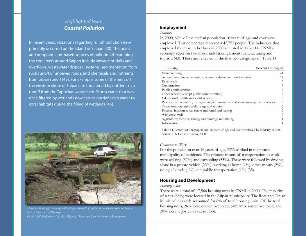
EmploymentIndustryIn 2000, 62% of the civilian population 16 years of age and over were employed. This percentage represents 42,753 people. The industries that employed the most individuals in 2000 are listed in Table 14. CNMI’s economy relies on two major industries, garment manufacturing and tourism (43). These are reflected in the first two categories of Table 14.
Commute to WorkFor the population over 16 years of age, 99% worked in their same municipality of residence. The primary means of transportation to work were walking (37%) and carpooling (33%). These were followed by driving alone in a private vehicle (23%), working at home (4%), other means (2%), riding a bicycle (1%), and public transportation (1%) (35).
Housing and DevelopmentHousing UnitsThere were a total of 17,566 housing units in CNMI in 2000. The majority of units (88%) were located in the Saipan Municipality. The Rota and Tinian Municipalities each accounted for 6% of total housing units. Of the total housing units, 26% were owner occupied, 54% were renter occupied, and 20% were reported as vacant (35).
In recent years, violations regarding runoff pollution have primarily occurred on the island of Saipan (30). The point and nonpoint land-based sources of pollution threatening the coral reefs around Saipan include sewage outfalls and overflows, wastewater disposal systems, sedimentation from rural runoff of unpaved roads, and chemicals and nutrients from urban runoff (45). For example, some of the reefs off the western shore of Saipan are threatened by nutrient-rich runoff from the Tapochau watershed. Storm water that was once filtered by wetlands now carries nutrient-rich water to coral habitats due to the filling of wetlands (45).
Highlighted Issue: Coastal Pollution
ManufacturingArts; entertainment; recreation; accommodation and food servicesRetail tradeConstructionPublic administrationOther services (except public administration)Educational; health and social servicesProfessional; scientific; management; administrative and waste management servicesTransportation and warehousing; and utilitiesFinance; insurance; real estate and rental and leasingWholesale tradeAgriculture; forestry; fishing and hunting; and miningInformation
Table 14. Percent of the population 16 years of age and over employed by industry in 2000.Source: U.S. Census Bureau, 2000.
Industry Percent Employed411477665532211
Storm water runoff can carry with it large amounts of sediment, as shown above on Saipan, that in turn can smother reefs. Credit: Bill Millhouser, NOAA Office of Ocean and Coastal Resource Management
27
Plumbing FacilitiesIn 2000, 17% of the housing units lacked complete plumbing facilities (35).
Source of WaterIn 2000, over 96% of housing units were connected to public water systems. Of those, 20% were a combination of public and catchment. Wells, catchment tanks, and other water sources made up less than 4% of the total water sources (35).
Sewage DisposalIn 2000, nearly half of the 17,566 housing units were on public sewer connections. Most of the remaining homes (43%) were on septic tank or cesspool systems, while about 8% were reported as using “other means” of sewage disposal (35).
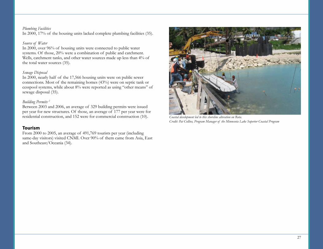
Building Permits 2
Between 2003 and 2006, an average of 329 building permits were issued per year for new structures. Of those, an average of 177 per year were for residential construction, and 152 were for commercial construction (10).
TourismFrom 2000 to 2005, an average of 491,769 tourists per year (including same-day visitors) visited CNMI. Over 90% of them came from Asia, East and Southeast/Oceania (34).
Coastal development led to this shoreline alteration on Rota.Credit: Pat Collins, Program Manager of the Minnesota Lake Superior Coastal Program
28
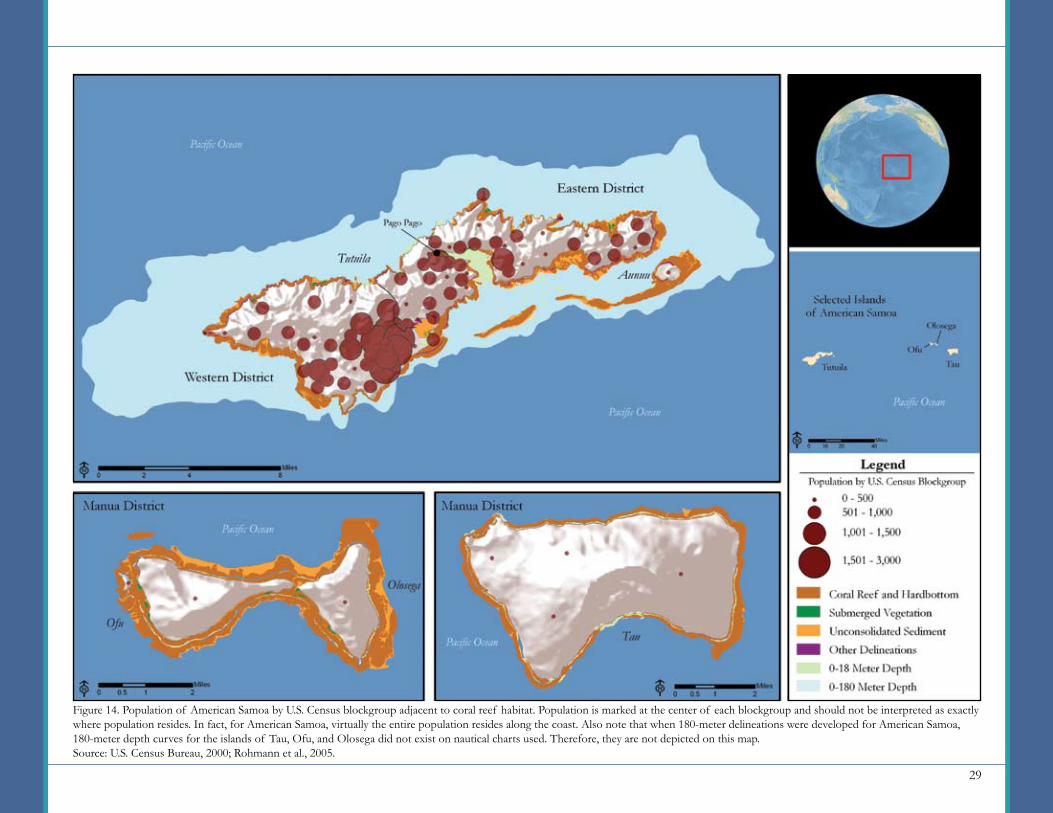
American Samoa is the southernmost of all U.S. territories, located approximately 2,610 miles south of Hawaii in the South Pacific. It is comprised of seven islands, five of which are inhabited: Tutuila, Aunuu, Ofu, Olosega, and Tau (11). Politically, American Samoa is divided into five districts (or U.S. Census Bureau county equivalents): Eastern District, Western District, Manua District, Swains Island, and Rose Island. The Eastern and Western Districts are located on the island of Tutuila, which is also the territory’s center of government and business. Manua District comprises the islands of Ofu, Olosega, and Tau. Rose Island (a coral atoll) is uninhabited, and Swains Island has a population of approximately 50 people (49). Due to the minimal population on Swain’s Island, it is not included as part of this summary. The administrative boundaries of Eastern, Western, and Manua districts are shown in Figure 14.
The coral reef habitats around American Samoa are rich with hundreds of species of Indo-Pacific corals, fishes, and invertebrates (11). The extent of coral habitat surrounding the populated islands is summarized in Table 15 and illustrated in Figure 14.
American Samoa
PopulationIn 2000, the population of American Samoa reached 57,291 people; in 2008 it is estimated to be 66,447 (35, 49). American Samoa’s population is concentrated on the island of Tutuila in the Western District. The Western District is home to the capital of American Samoa, Pago Pago, with a population of 4,128. From 1970 to 2008, the population of American Samoa increased by almost 40,000. The majority of this increase occurred in the Western District, which grew by over 31,000 people (49).
By 2015, the population is expected to increase by just over 37,000 people, with most of this growth occurring in the Western District (estimated at 33,000 people) (49). Figure 15 presents this expected change by district.
In 2008, the population density averaged 354 persons per square kilometer. The island of Tutuila has a population density of 460 persons per square kilometer. The most densely populated villages are found in the Eastern and Western Districts (49). Figure 14 illustrates the concentrations of population in relation to adjacent coral reef habitats.
Table 15. Approximate area (square kilometers) of coral habitat surrounding American Samoa.Source: Rohmann et al., 2005.
Depth Curves (sq km)18 Meter Line180 Meter LineMapped Coral Habitat 1 (sq km)Coral Reef HardbottomSubmerged VegetationUnconsolidated SedimentOther Delineations
35.8353.2
35.30.68.12.0
Habitat Type TutuilaOfu and Olosega Tau Total
3.6Unknown
10.50.12.30.7
3.8Unknown
7.10
0.31.0
43.1Unknown
52.9<1
10.73.8
White-spotted surgeonfish swim above table coral in the National Park near the village of Vatia.Credit: D. Paul Brown, National Park Service
Key Facts
Population (2008)
Population Density (2008)
(persons per sq km)
Number of residents per square kilometer of potential coral reef habitat within the 180 meter depth curve. (2008)
Households (2000)
Housing Units (2000)
66,447
354
185 (Tutuila only)
9,349
10,052
29
Figure 14. Population of American Samoa by U.S. Census blockgroup adjacent to coral reef habitat. Population is marked at the center of each blockgroup and should not be interpreted as exactly where population resides. In fact, for American Samoa, virtually the entire population resides along the coast. Also note that when 180-meter delineations were developed for American Samoa, 180-meter depth curves for the islands of Tau, Ofu, and Olosega did not exist on nautical charts used. Therefore, they are not depicted on this map.Source: U.S. Census Bureau, 2000; Rohmann et al., 2005.

30
has the third-lowest number of residents per square kilometer of potential coral reef habitat adjacent to the 0-180 meter depth curve.
GenderIn 2000, American Samoa’s population was 49% females and 51% males (35). Although this ratio did not fluctuate beyond a percent or two among districts, it fluctuated among villages, where it ranged from 56% female to 44% male in Luma Village in the Manua District and 14% female to 86% male in Anua Village in the Eastern District. Of all individuals greater than 15 years of age, 57% were currently married and less than 5% had been divorced (35).
Race/EthnicityIn 2000, the American Samoan population was comprised primarily of individuals of solely Native Hawaiian or Pacific Island descent, who made up approximately 93% of the population. Most of the remaining population (i.e. Asian, white, black, other, and 2 or more races) were found in the Western District (35).
Table 16 presents the ratio of the area of potential coral reef habitat and mapped coral reef habitat to the number of residents on American Samoa. When compared to the other study areas in this report, the island of Tutuila
Beach in front of hotel in Pago Pago.Credit: Nicole Haynes-Bell, NOAA Coral Reef Conservation Program
Depth Curves (sq km)18 Meter Line180 Meter Line (Tutuila only)Mapped Coral Habitat 1 (sq km)Coral Reef HardbottomSubmerged VegetationUnconsolidated SedimentOther Delineations
43.1353.2
52.9<1
10.73.8
Habitat Type
Persons Per Sq Km of Coral Reef
Habitat in 2008
1,542185
1,256…
6,22417,638
Table 16. Ratio of the area of potential coral reef habitat and mapped coral reef habitat to population in American Samoa.Source: Woods and Poole Economics, Inc., 2007; Rohmann et al., 2005.
Area of Coral Reef Habitat in American
Samoa
40,000
35,000
30,000
25,000
20,000
15,000
10,000
5,000
0
-5,000
Pers
ons
DistrictFigure 15. Expected population change in American Samoa from 2008 to 2015 by district.Source: Woods and Poole Economics, Inc., 2007.
Eastern Western Manua
31
AgeForty-five percent of the total population of American Samoa in 2000 ranged in age from 0-18, followed by the age groups 25-34 (15%), 35-44 (13%), 18-24 (11%), 45-49 (11%), 60-70 (3%), and 70+ (<2%). This was generally consistent across the Western, Eastern, and Manua Districts (35).
HouseholdsIn 2000, the number of households in American Samoa was 9,349. Ninety-three percent were family households; of these, 40% contained seven or more persons. This trend was generally true for the top 10 most populated villages across districts. Most of the non-family households contained only two people (35)
LanguageThe primary language spoken in the home was Samoan (90%), followed by other languages (8%) and English (2%) (35).
Place of BirthOf the total population, 57% were born in American Samoa, 31% were born in neighboring Samoa, and 6% were born in the United States. The remaining population was born in Tonga, other Pacific Islands, and Asia. The villages having the highest percentage of American Samoa-born individuals were Leusoalii (91%) and Sili (90%) in the Manua District (35).
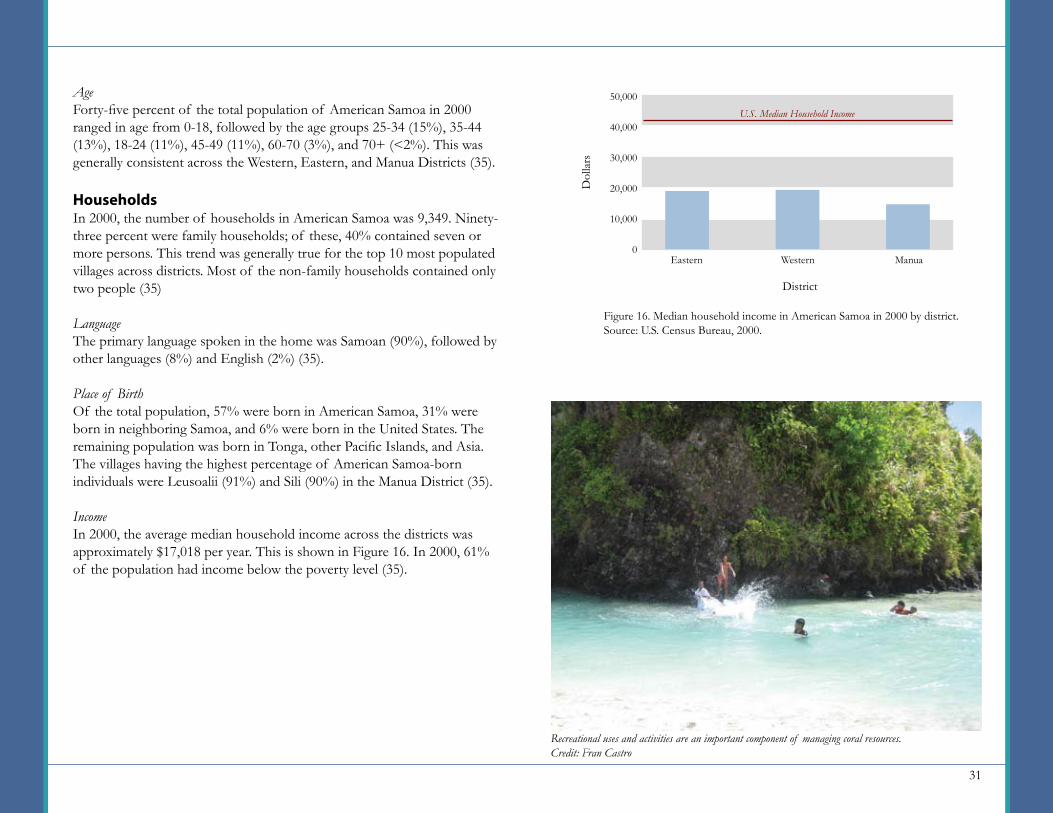
IncomeIn 2000, the average median household income across the districts was approximately $17,018 per year. This is shown in Figure 16. In 2000, 61% of the population had income below the poverty level (35).
Figure 16. Median household income in American Samoa in 2000 by district.Source: U.S. Census Bureau, 2000.
50,000
40,000
30,000
20,000
10,000
0
Dol
lars
U.S. Median Household Income
District
Eastern Western Manua
Recreational uses and activities are an important component of managing coral resources.Credit: Fran Castro
32
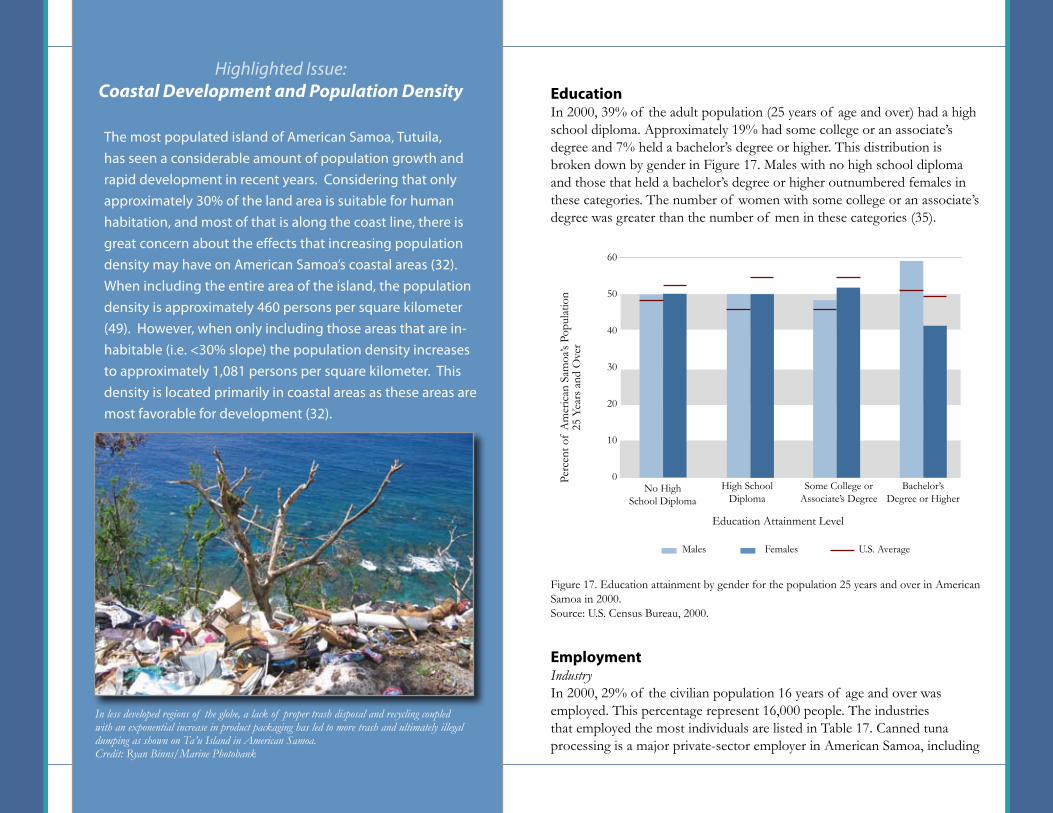
The most populated island of American Samoa, Tutuila, has seen a considerable amount of population growth and rapid development in recent years. Considering that only approximately 30% of the land area is suitable for human habitation, and most of that is along the coast line, there is great concern about the effects that increasing population density may have on American Samoa’s coastal areas (32). When including the entire area of the island, the population density is approximately 460 persons per square kilometer (49). However, when only including those areas that are in-habitable (i.e. <30% slope) the population density increases to approximately 1,081 persons per square kilometer. This density is located primarily in coastal areas as these areas are most favorable for development (32).
Highlighted Issue: Coastal Development and Population Density Education
In 2000, 39% of the adult population (25 years of age and over) had a high school diploma. Approximately 19% had some college or an associate’s degree and 7% held a bachelor’s degree or higher. This distribution is broken down by gender in Figure 17. Males with no high school diploma and those that held a bachelor’s degree or higher outnumbered females in these categories. The number of women with some college or an associate’s degree was greater than the number of men in these categories (35).
EmploymentIndustryIn 2000, 29% of the civilian population 16 years of age and over was employed. This percentage represent 16,000 people. The industries that employed the most individuals are listed in Table 17. Canned tuna processing is a major private-sector employer in American Samoa, including
Figure 17. Education attainment by gender for the population 25 years and over in American Samoa in 2000.Source: U.S. Census Bureau, 2000.
No HighSchool Diploma
Education Attainment Level
High SchoolDiploma
Some College or Associate’s Degree
Bachelor’s Degree or Higher
60
50
40
30
20
10
0Perc
ent o
f A
mer
ican
Sam
oa’s
Popu
latio
n 25
Yea
rs a
nd O
ver
U.S. AverageMales Females
In less developed regions of the globe, a lack of proper trash disposal and recycling coupled with an exponential increase in product packaging has led to more trash and ultimately illegal dumping as shown on Ta’u Island in American Samoa.Credit: Ryan Binns/Marine Photobank
33
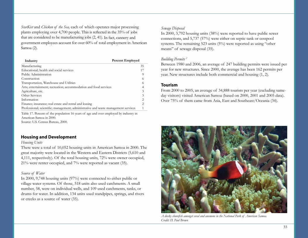
StarKist and Chicken of the Sea, each of which operates major processing plants employing over 4,700 people. This is reflected in the 35% of jobs that are considered to be manufacturing jobs (2, 41). In fact, cannery and government employees account for over 60% of total employment in American Samoa (2).
Housing and DevelopmentHousing UnitsThere were a total of 10,052 housing units in American Samoa in 2000. The great majority were located in the Western and Eastern Districts (5,610 and 4,111, respectively). Of the total housing units, 72% were owner occupied, 21% were renter occupied, and 7% were reported as vacant (35).
Source of WaterIn 2000, 9,748 housing units (97%) were connected to either public or village water systems. Of those, 518 units also used catchments. A small number, 58, were on individual wells, and 109 used catchments, tanks, or drums for water. In addition, 134 units used standpipes, springs, and rivers or creeks as a source of water (35).
ManufacturingEducational; health and social servicesPublic AdministrationConstructionTransportation, Warehouse and UtilitiesArts; entertainment; recreation; accommodation and food servicesAgriculture, etc.Other ServicesInformationFinance; insurance; real estate and rental and leasingProfessional; scientific; management; administrative and waste management servicesTable 17. Percent of the population 16 years of age and over employed by industry in American Samoa in 2000.Source: U.S. Census Bureau, 2000.
Industry Percent Employed3517966433221
Sewage DisposalIn 2000, 3,792 housing units (38%) were reported to have public sewer connections, and 5,737 (57%) were either on septic tank or cesspool systems. The remaining 523 units (5%) were reported as using “other means” of sewage disposal (35).
Building Permits 2
Between 1980 and 2006, an average of 247 building permits were issued per year for new structures. Since 2000, the average has been 162 permits per year. New structures include both commercial and housing (1, 2).
TourismFrom 2000 to 2005, an average of 34,888 tourists per year (excluding same-day visitors) visited American Samoa (based on 2000, 2001 and 2005 data). Over 75% of them came from Asia, East and Southeast/Oceania (34).
A dusky clownfish amongst coral and anemone in the National Park of American Samoa.Credit: D. Paul Brown
34
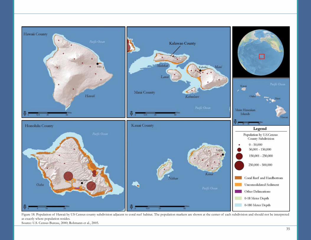
The Hawaiian Island Archipelago consists of both the Main Hawaiian Islands and the Northwest Hawaiian Islands. Due to the minimal population of the Northwest Hawaiian Islands, they are not included as part of this summary. The Main Hawaiian Islands are comprised of eight islands that are divided into five counties (see Figure 18).The county of Kauai (Niihau and Kauai Islands) is the northwestern most county of the mainland Hawaiian Islands with an estimated population of 65,483 in 2008 (49). The largest city in Kauai County is Kapaa, located on the western side of Kauai Island. Honolulu County (Oahu Island) is home to the city of Honolulu, the state capital and economic center. Maui County (Molokai, Lanai, Kahoolawe, and Maui Islands) contains the second-largest island in the Main Hawaiian Island chain, Maui (1,883 square kilometers). Its largest city, Kahului, is located on the north side of the island. Kalawao County, located on the Island of Molokai, had a resident population of approximately 147 in 2008. Due to its minimal population, it is combined with Maui County for the purposes of this report. Hawaii County is the largest county by land area (10,432 square kilometers) and has the second-largest county population behind Honolulu. Its largest city, Hilo, is located on the northeast side of the island.
The reefs that surround the Main Hawaiian Islands occur relatively close to the shore and consist of non-structural reef communities. Barrier reefs occur in Kaneohe Bay on Oahu and on the south shore of Molokai. Due to their isolation and geological young age, although considered unique, the coral reefs adjacent to Hawaii are considered less diverse and generally less productive than other reefs (17). The extent of coral reef habitat surrounding the Main Hawaiian Islands is presented in Table 18 and in Figure 18.
Hawaii
PopulationIn 2000, the population of the state of Hawaii reached 1,211,537 people; in 2008, it is estimated to be 1,324,581 (35, 49). The majority of the population (70%) lives in Honolulu County. Since 1970, the state population has increased by over 548,000 people. Although Honolulu County accounted for most of this growth, Maui County showed the fastest growth rate, increasing by 213% (49).
By 2015, the state’s population is expected to grow by 127,000 people, with over half of this growth occurring in Honolulu County (estimated at 69,000 people) (49). Figure 19 presents this projected change by county. In 2008, the population density of the entire state was estimated to be 80 persons per square kilometer. The most densely populated county was Honolulu
Table 18. Approximate area (in square kilometers) of coral reef habitat surrounding Hawaii. Source: Rohmann et al., 2005.
Depth Curves (sq km)18 Meter Line180 Meter LineMapped Coral Habitat 1 (sq km)Coral Reef HardbottomSubmerged VegetationUnconsolidated SedimentOther Delineations
193.21,053.2
105.70
25.30.3
Habitat Type Hawaii Maui Honolulu Total
395.83,764.4
274.00
188.72.5
371.4943.9
291.10
116.34.8
1,221.26,595.6
939.80
403.68.0
Kauai
260.8834.1
269.00
73.30.4
Development and sediment plume in Maunalua Bay, Oahu.Credit: Malama Maunalua (local NGO)
Key Facts
Population (2008)
Population Density (2008)
(persons per sq km)
Number of residents per square kilometer of potential coral reef habitat within the 180 meter depth curve. (2008)
Households (2000)
Housing Units (2000)
1,324,581
80
201
403,240
460,542
35
Figure 18. Population of Hawaii by US Census county subdivision adjacent to coral reef habitat. The population markers are shown at the center of each subdivision and should not be interpreted as exactly where population resides.Source: U.S. Census Bureau, 2000; Rohmann et al., 2005.
Kalawao County
36
County, with 599 persons per square kilometer. Most of the population resides in the city of Honolulu on the southwestern shore of Oahu. The second-most densely populated county was Maui, with 49 persons per square kilometer (49). Figure 18 illustrates the concentrations of population in relation to adjacent coral reef habitat.
Table 19 presents the ratio of the area of potential coral reef habitat and mapped coral reef habitat to the number of residents on Hawaii.
GenderIn 2000, Hawaii’s population was 50% females and 50% males. This ratio was consistent across all of Hawaii’s counties. Of all individuals 15 years of age and older, 55% were married, 30% had never been married, and 9% had been divorced (35).
Race/EthnicityIn 2000, the population of Hawaii was 42% Asian, 24% white, 21% of two or more races, 9% Native Hawaiian and other Pacific Islander, 2% black or
African American, and 1% other. The percentage of Native Hawaiian and other Pacific Islander ranged from 9% to 11% across counties (35).
AgeTwenty-four percent of Hawaii’s population in 2000 ranged in age from 0-17, followed by age groups 45-59 (19%), 35-44 (16%), 25-34 (14%), 18-24 (9%), 60-69 (7%), 70-79 (6%), and 80+ (3%). These ratios were generally consistent among all counties in Hawaii (35).
70,000
60,000
50,000
40,000
30,000
20,000
10,000
0
Pers
ons
County
Figure 19. Expected population change in Hawaii from 2008 to 2015 by county.Source: Woods and Poole Economics, Inc., 2007.
Hawaii Maui Honolulu Kauai
Yellow Tangs are a popular species collected from reefs for sale in the marine aquarium industry. Reef fish collection is an issue of concern in Hawaii and many other coral jurisdictions.Credit: ©Ziggy Livnat, For the Sea Productions
Depth Curves (sq km)18 Meter Line180 Meter LineMapped Coral Habitat 1 (sq km)Coral Reef HardbottomSubmerged VegetationUnconsolidated SedimentOther Delineations
Habitat Type
Persons Per Sq Km of Potential Coral Reef
Habitat in 2008
Table 19. Ratio of the area of potential coral reef habitat and mapped coral reef habitat to population in Hawaii.Source: Woods and Poole Economics, Inc., 2007; Rohmann et al., 2005.
1,221.26,595.6
939.80
403.68.0
Area of Coral Reef Habitat in Hawaii
1,085201
1,4090
3,282165,573
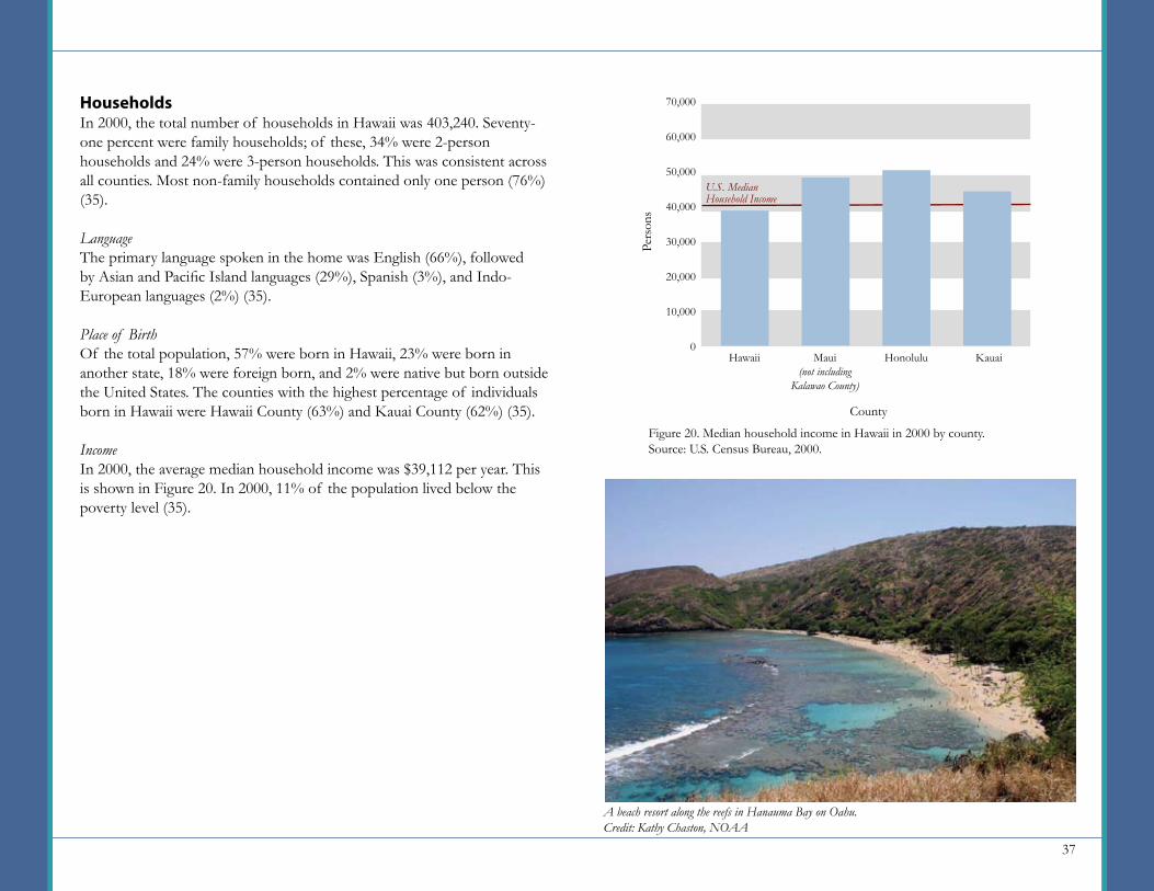
37
HouseholdsIn 2000, the total number of households in Hawaii was 403,240. Seventy-one percent were family households; of these, 34% were 2-person households and 24% were 3-person households. This was consistent across all counties. Most non-family households contained only one person (76%) (35).
LanguageThe primary language spoken in the home was English (66%), followed by Asian and Pacific Island languages (29%), Spanish (3%), and Indo-European languages (2%) (35).
Place of BirthOf the total population, 57% were born in Hawaii, 23% were born in another state, 18% were foreign born, and 2% were native but born outside the United States. The counties with the highest percentage of individuals born in Hawaii were Hawaii County (63%) and Kauai County (62%) (35).
IncomeIn 2000, the average median household income was $39,112 per year. This is shown in Figure 20. In 2000, 11% of the population lived below the poverty level (35).
70,000
60,000
50,000
40,000
30,000
20,000
10,000
0
Pers
ons
County
Figure 20. Median household income in Hawaii in 2000 by county.Source: U.S. Census Bureau, 2000.
Hawaii Maui(not including
Kalawao County)
Honolulu Kauai
U.S. Median Household Income
A beach resort along the reefs in Hanauma Bay on Oahu.Credit: Kathy Chaston, NOAA
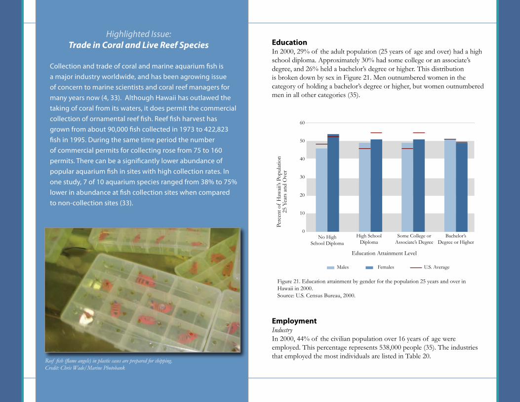
38
EducationIn 2000, 29% of the adult population (25 years of age and over) had a high school diploma. Approximately 30% had some college or an associate’s degree, and 26% held a bachelor’s degree or higher. This distribution is broken down by sex in Figure 21. Men outnumbered women in the category of holding a bachelor’s degree or higher, but women outnumbered men in all other categories (35).
EmploymentIndustryIn 2000, 44% of the civilian population over 16 years of age were employed. This percentage represents 538,000 people (35). The industries that employed the most individuals are listed in Table 20.
Collection and trade of coral and marine aquarium fish is a major industry worldwide, and has been agrowing issue of concern to marine scientists and coral reef managers for many years now (4, 33). Although Hawaii has outlawed the taking of coral from its waters, it does permit the commercial collection of ornamental reef fish. Reef fish harvest has grown from about 90,000 fish collected in 1973 to 422,823 fish in 1995. During the same time period the number of commercial permits for collecting rose from 75 to 160 permits. There can be a significantly lower abundance of popular aquarium fish in sites with high collection rates. In one study, 7 of 10 aquarium species ranged from 38% to 75% lower in abundance at fish collection sites when compared to non-collection sites (33).
Highlighted Issue: Trade in Coral and Live Reef Species
Figure 21. Education attainment by gender for the population 25 years and over in Hawaii in 2000.Source: U.S. Census Bureau, 2000.
No HighSchool Diploma
Education Attainment Level
High SchoolDiploma
Some College or Associate’s Degree
Bachelor’s Degree or Higher
60
50
40
30
20
10
0
Perc
ent o
f H
awai
i’s P
opul
atio
n 25
Yea
rs a
nd O
ver
U.S. AverageMales Females
Reef fish (flame angels) in plastic cases are prepared for shipping.Credit: Chris Wade/Marine Photobank
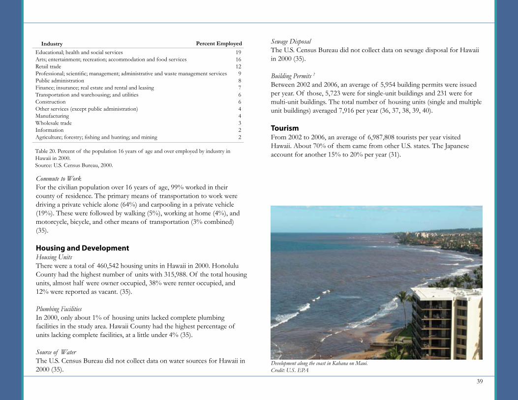
39
Commute to WorkFor the civilian population over 16 years of age, 99% worked in their county of residence. The primary means of transportation to work were driving a private vehicle alone (64%) and carpooling in a private vehicle (19%). These were followed by walking (5%), working at home (4%), and motorcycle, bicycle, and other means of transportation (3% combined) (35).
Housing and DevelopmentHousing UnitsThere were a total of 460,542 housing units in Hawaii in 2000. Honolulu County had the highest number of units with 315,988. Of the total housing units, almost half were owner occupied, 38% were renter occupied, and 12% were reported as vacant. (35).
Plumbing FacilitiesIn 2000, only about 1% of housing units lacked complete plumbing facilities in the study area. Hawaii County had the highest percentage of units lacking complete facilities, at a little under 4% (35).
Source of WaterThe U.S. Census Bureau did not collect data on water sources for Hawaii in 2000 (35).
Sewage DisposalThe U.S. Census Bureau did not collect data on sewage disposal for Hawaii in 2000 (35).
Building Permits 2
Between 2002 and 2006, an average of 5,954 building permits were issued per year. Of those, 5,723 were for single-unit buildings and 231 were for multi-unit buildings. The total number of housing units (single and multiple unit buildings) averaged 7,916 per year (36, 37, 38, 39, 40).
TourismFrom 2002 to 2006, an average of 6,987,808 tourists per year visited Hawaii. About 70% of them came from other U.S. states. The Japanese account for another 15% to 20% per year (31).
Development along the coast in Kahana on Maui.Credit: U.S. EPA
Educational; health and social servicesArts; entertainment; recreation; accommodation and food servicesRetail tradeProfessional; scientific; management; administrative and waste management servicesPublic administrationFinance; insurance; real estate and rental and leasingTransportation and warehousing; and utilitiesConstructionOther services (except public administration)ManufacturingWholesale tradeInformationAgriculture; forestry; fishing and hunting; and mining
Table 20. Percent of the population 16 years of age and over employed by industry in Hawaii in 2000.Source: U.S. Census Bureau, 2000.
Industry Percent Employed1916129876644322
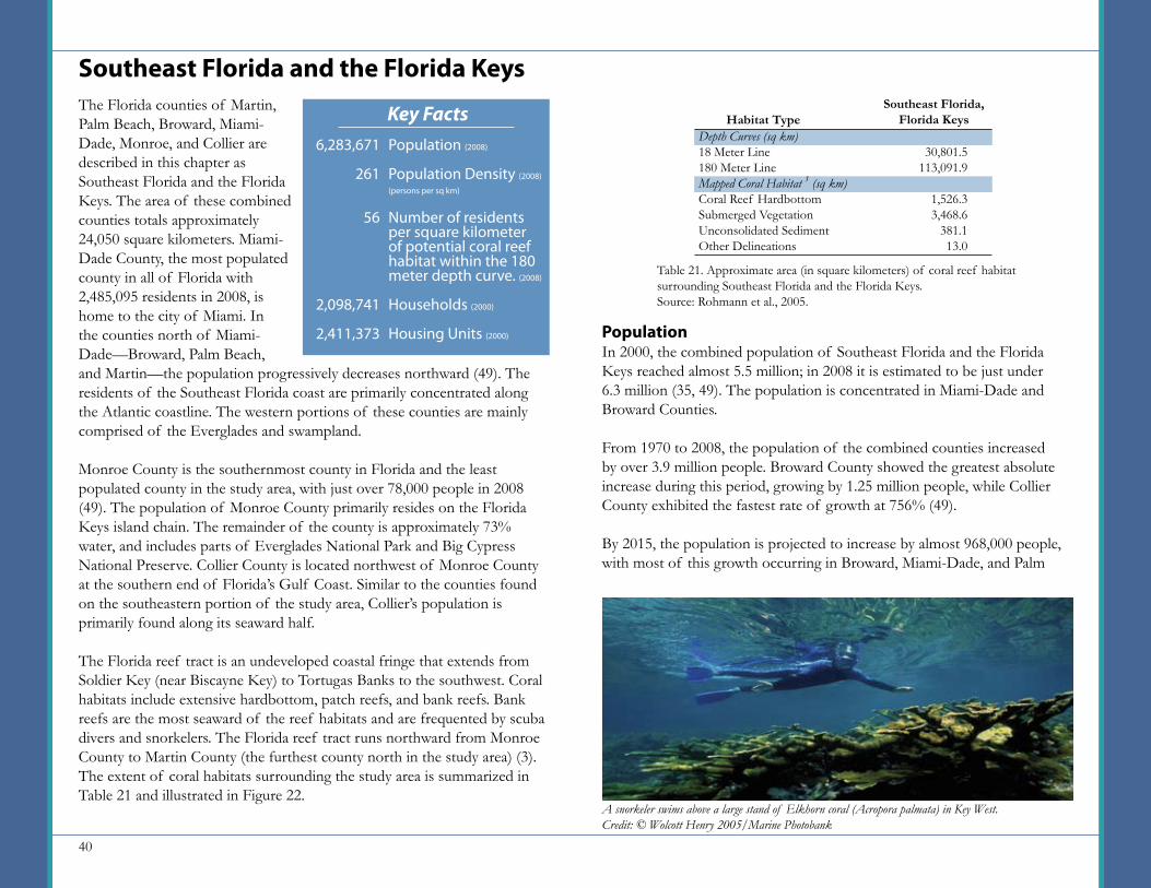
40
The Florida counties of Martin, Palm Beach, Broward, Miami-Dade, Monroe, and Collier are described in this chapter as Southeast Florida and the Florida Keys. The area of these combined counties totals approximately 24,050 square kilometers. Miami-Dade County, the most populated county in all of Florida with 2,485,095 residents in 2008, is home to the city of Miami. In the counties north of Miami-Dade—Broward, Palm Beach, and Martin—the population progressively decreases northward (49). The residents of the Southeast Florida coast are primarily concentrated along the Atlantic coastline. The western portions of these counties are mainly comprised of the Everglades and swampland.
Monroe County is the southernmost county in Florida and the least populated county in the study area, with just over 78,000 people in 2008 (49). The population of Monroe County primarily resides on the Florida Keys island chain. The remainder of the county is approximately 73% water, and includes parts of Everglades National Park and Big Cypress National Preserve. Collier County is located northwest of Monroe County at the southern end of Florida’s Gulf Coast. Similar to the counties found on the southeastern portion of the study area, Collier’s population is primarily found along its seaward half.
The Florida reef tract is an undeveloped coastal fringe that extends from Soldier Key (near Biscayne Key) to Tortugas Banks to the southwest. Coral habitats include extensive hardbottom, patch reefs, and bank reefs. Bank reefs are the most seaward of the reef habitats and are frequented by scuba divers and snorkelers. The Florida reef tract runs northward from Monroe County to Martin County (the furthest county north in the study area) (3). The extent of coral habitats surrounding the study area is summarized in Table 21 and illustrated in Figure 22.
Southeast Florida and the Florida Keys
PopulationIn 2000, the combined population of Southeast Florida and the Florida Keys reached almost 5.5 million; in 2008 it is estimated to be just under 6.3 million (35, 49). The population is concentrated in Miami-Dade and Broward Counties.
From 1970 to 2008, the population of the combined counties increased by over 3.9 million people. Broward County showed the greatest absolute increase during this period, growing by 1.25 million people, while Collier County exhibited the fastest rate of growth at 756% (49).
By 2015, the population is projected to increase by almost 968,000 people, with most of this growth occurring in Broward, Miami-Dade, and Palm
Table 21. Approximate area (in square kilometers) of coral reef habitat surrounding Southeast Florida and the Florida Keys. Source: Rohmann et al., 2005.
Depth Curves (sq km)18 Meter Line180 Meter LineMapped Coral Habitat 1 (sq km)Coral Reef HardbottomSubmerged VegetationUnconsolidated SedimentOther Delineations
30,801.5113,091.9
1,526.33,468.6
381.113.0
Habitat TypeSoutheast Florida,
Florida Keys
A snorkeler swims above a large stand of Elkhorn coral (Acropora palmata) in Key West.Credit: © Wolcott Henry 2005/Marine Photobank
Key FactsPopulation (2008)
Population Density (2008)
(persons per sq km)
Number of residents per square kilometer of potential coral reef habitat within the 180 meter depth curve. (2008)
Households (2000)
Housing Units (2000)
6,283,671
261
56
2,098,741
2,411,373
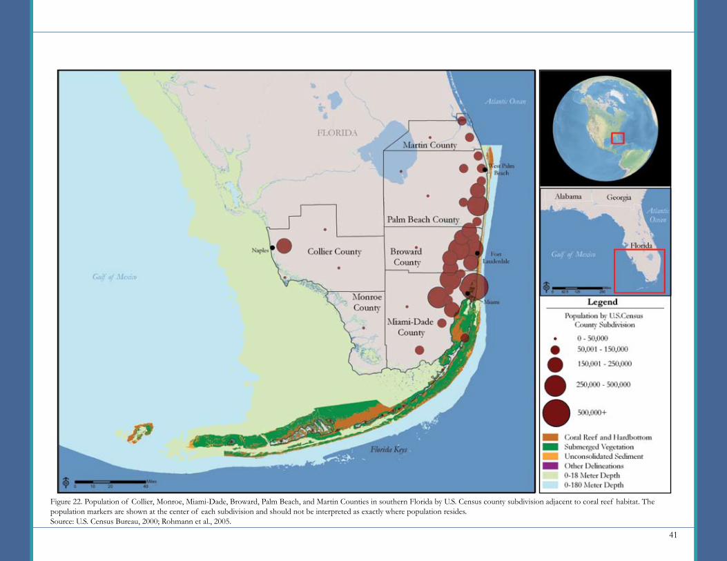
41
Figure 22. Population of Collier, Monroe, Miami-Dade, Broward, Palm Beach, and Martin Counties in southern Florida by U.S. Census county subdivision adjacent to coral reef habitat. The population markers are shown at the center of each subdivision and should not be interpreted as exactly where population resides. Source: U.S. Census Bureau, 2000; Rohmann et al., 2005.
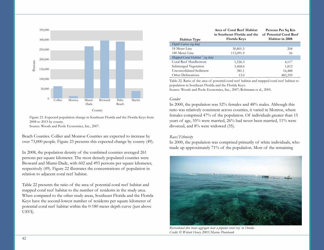
42
GenderIn 2000, the population was 52% females and 48% males. Although this ratio was relatively consistent across counties, it varied in Monroe, where females comprised 47% of the population. Of individuals greater than 15 years of age, 55% were married, 26% had never been married, 11% were divorced, and 8% were widowed (35).
Race/EthnicityIn 2000, the population was comprised primarily of white individuals, who made up approximately 71% of the population. Most of the remaining
Beach Counties. Collier and Monroe Counties are expected to increase by over 73,000 people. Figure 23 presents this expected change by county (49).
In 2008, the population density of the combined counties averaged 261 persons per square kilometer. The most densely populated counties were Broward and Miami-Dade, with 602 and 493 persons per square kilometer, respectively (49). Figure 22 illustrates the concentrations of population in relation to adjacent coral reef habitat.
Table 22 presents the ratio of the area of potential coral reef habitat and mapped coral reef habitat to the number of residents in the study area. When compared to the other study areas, Southeast Florida and the Florida Keys have the second-lowest number of residents per square kilometer of potential coral reef habitat within the 0-180 meter depth curve (just above USVI).
Recreational dive boats aggregate near a popular coral reef in Florida.Credit: © Wolcott Henry 2005/Marine Photobank
Depth Curves (sq km)18 Meter Line180 Meter LineMapped Coral Habitat 1 (sq km)Coral Reef HardbottomSubmerged VegetationUnconsolidated SedimentOther Delineations
Habitat Type
Persons Per Sq Km of Potential Coral Reef
Habitat in 2008
Table 22. Ratio of the area of potential coral reef habitat and mapped coral reef habitat to population in Southeast Florida and the Florida Keys.Source: Woods and Poole Economics, Inc., 2007; Rohmann et al., 2005.
Area of Coral Reef Habitat in Southeast Florida and the
Florida Keys
30,801.5113,091.9
1,526.33,468.6
381.113.0
20456
4,1171,812
16,488483,359
350,000
300,000
250,000
200,000
150,000
100,000
50,000
0
Pers
ons
County
Figure 23. Expected population change in Southeast Florida and the Florida Keys from 2008 to 2015 by county.Source: Woods and Poole Economics, Inc., 2007.
Collier Monroe Broward MartinMiami-Dade
PalmBeach
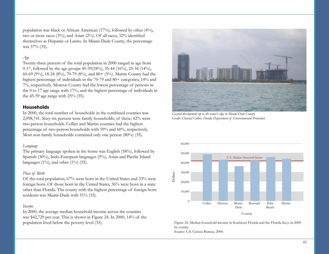
43
population was black or African American (17%), followed by other (4%), two or more races (3%), and Asian (2%). Of all races, 32% identified themselves as Hispanic or Latino. In Miami-Dade County, the percentage was 57% (35).
AgeTwenty-three percent of the total population in 2000 ranged in age from 0-17, followed by the age groups 45-59(18%), 35-44 (16%), 25-34 (14%), 60-69 (9%), 18-24 (8%), 70-79 (8%), and 80+ (5%). Martin County had the highest percentage of individuals in the 70-79 and 80+ categories, 14% and 7%, respectively. Monroe County had the lowest percentage of persons in the 0 to 17 age range with 17%, and the highest percentage of individuals in the 45-59 age range with 25% (35).
HouseholdsIn 2000, the total number of households in the combined counties was 2,098,741. Sixty-six percent were family households; of these; 42% were two-person households. Collier and Martin counties had the highest percentage of two-person households with 59% and 60%, respectively. Most non-family households contained only one person (80%) (35).
LanguageThe primary language spoken in the home was English (58%), followed by Spanish (30%), Indo-European languages (9%), Asian and Pacific Island languages (1%), and other (1%) (35).
Place of BirthOf the total population, 67% were born in the United States and 33% were foreign born. Of those born in the United States, 36% were born in a state other than Florida. The county with the highest percentage of foreign-born residents was Miami-Dade with 51% (35).
IncomeIn 2000, the average median household income across the counties was $42,729 per year. This is shown in Figure 24. In 2000, 14% of the population lived below the poverty level (35). Figure 24. Median household income in Southeast Florida and the Florida Keys in 2000
by county.Source: U.S. Census Bureau, 2000.
60,000
50,000
40,000
30,000
20,000
10,000
0
Dol
lars
County
Collier Monroe Broward MartinMiami-Dade
PalmBeach
Coastal development up to the water’s edge in Miami-Dade County.Credit: Chantal Collier, Florida Department of Environmental Protection
U.S. Median Household Income
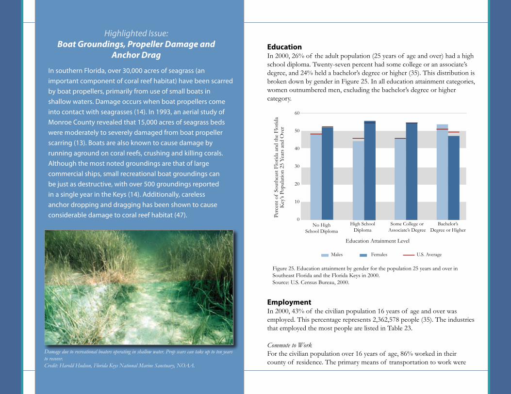
44
In southern Florida, over 30,000 acres of seagrass (an important component of coral reef habitat) have been scarred by boat propellers, primarily from use of small boats in shallow waters. Damage occurs when boat propellers come into contact with seagrasses (14). In 1993, an aerial study of Monroe County revealed that 15,000 acres of seagrass beds were moderately to severely damaged from boat propeller scarring (13). Boats are also known to cause damage by running aground on coral reefs, crushing and killing corals. Although the most noted groundings are that of large commercial ships, small recreational boat groundings can be just as destructive, with over 500 groundings reported in a single year in the Keys (14). Additionally, careless anchor dropping and dragging has been shown to cause considerable damage to coral reef habitat (47).
Highlighted Issue: Boat Groundings, Propeller Damage and
Anchor DragEducationIn 2000, 26% of the adult population (25 years of age and over) had a high school diploma. Twenty-seven percent had some college or an associate’s degree, and 24% held a bachelor’s degree or higher (35). This distribution is broken down by gender in Figure 25. In all education attainment categories, women outnumbered men, excluding the bachelor’s degree or higher category.
EmploymentIn 2000, 43% of the civilian population 16 years of age and over was employed. This percentage represents 2,362,578 people (35). The industries that employed the most people are listed in Table 23.
Commute to WorkFor the civilian population over 16 years of age, 86% worked in their county of residence. The primary means of transportation to work were
Figure 25. Education attainment by gender for the population 25 years and over in Southeast Florida and the Florida Keys in 2000.Source: U.S. Census Bureau, 2000.
No HighSchool Diploma
Education Attainment Level
High SchoolDiploma
Some College or Associate’s Degree
Bachelor’s Degree or Higher
60
50
40
30
20
10
0Perc
ent o
f So
uthe
ast F
lorid
a an
d th
e Fl
orid
a K
ey’s
Popu
latio
n 25
Yea
rs a
nd O
ver
U.S. AverageMales Females
Damage due to recreational boaters operating in shallow water. Prop scars can take up to ten years to recover.Credit: Harold Hudson, Florida Keys National Marine Sanctuary, NOAA.
45
driving alone in a private vehicle (77%) and carpooling in a private vehicle (13%). These were followed by public transportation (3%), working at home (3%), walking (2%), bicycle (1%), and other means (1%) (35).
Housing and DevelopmentHousing UnitsThere were a total of 2,411,373 housing units in Southeast Florida and the Florida Keys in 2000. Miami-Dade, Broward, and Palm Beach Counties contained the majority of housing units (35%, 31%, and 23%, respectively). Of the total housing units, 58% were owner occupied, almost 29% were renter occupied, and 13% were reported as vacant (35).
Plumbing FacilitiesIn 2000, less than one percent of housing units lacked complete plumbing facilities in the study area (35).
Source of WaterThe U.S. Census Bureau did not collect data on water sources for Florida in 2000 (35).
Sewage DisposalThe U.S. Census Bureau did not collect data on sewage disposal for Florida in 2000 (35).
Building Permits 2
Between 2002 and 2006, an average of 28,077 building permits were issued for residential construction per year. Of those, 26,644 were for single-unit buildings and 1,433 were for multi-unit buildings. The total number of housing units averaged 49,487 per year (36, 37, 38, 39, 40).
TourismApproximately 30,573,992 tourists visited the study area from June 2000 through May 2001 (includes 2003 day trips for Martin County alone; does not include data for Collier County). Data for other years was not readily available. Miami-Dade County had the largest number of visitors at 12,613,645, followed by Broward County at 9,403,006 (19, 20).
Boating is among the most popular activities in the Florida Keys.Credit: Florida Keys National Marine Sanctuary, NOAA
Industry Percent EmployedEducational; health and social servicesRetail tradeProfessional; scientific; management; administrative and waste management servicesArts; entertainment; recreation; accommodation and food servicesFinance; insurance; real estate and rental and leasingConstructionManufacturingTransportation and warehousing; and utilitiesOther services (except public administration)Wholesale tradePublic administrationInformationAgriculture; forestry; fishing and hunting; and mining
Table 23. Percent of the population 16 years of age and over that are employed by industry in Southeast Florida and the Florida Keys in 2000.Source: U.S. Census Bureau, 2000.
18131210987665431

46
The U.S. Virgin Islands (USVI) is comprised of three large islands—St. John, St. Thomas, and St. Croix—and several small islands, all of which are part of the Virgin Islands Archipelago. Politically, the USVI is divided into three counties, St. John, St. Thomas, and St. Croix (Figure 18). St. Croix, the largest (approximately 215 square kilometers) and most populated island supports large industries such as tourism and oil refining. St. Thomas is the territory’s capital and home to the port of Charlotte Amalie. St. John is located approximately four miles east of St. Thomas and is accessible only by boat (as it has no airport). Most of the land on St. John is parkland and undeveloped. Tourism is the largest industry in both St. Thomas and St. John Counties.
The coral reefs found offshore of St. Thomas and St. John are distributed patchily around the islands and are described as fringing and patch formations. A developed barrier reef system surrounds St. Croix on its eastern and southern shores. Further offshore, bank reefs and patch reefs can be found at greater depths (21). The extent of coral reef habitat surrounding USVI is summarized in Table 24 and illustrated in Figure 26.
U.S. Virgin IslandsPopulationIn 2000, the population of the USVI reached 108,612 people; in 2008 it is estimated to be just under 112,000 (35, 49). St. Croix County contains 49% of the population, St. Thomas County 47%, and St. John County 4%. From 1970 to 2008, the entire USVI population increased by over 48,000 people, or 77%. St. Thomas County showed the greatest absolute increase, growing by over 23,200 people, and St. John County showed the fastest rate of growth at 171% (49).
By 2015, the population is projected to increase by over 3,000 people, with St. John growing by 11% percent and St. Croix and St. Thomas Counties growing by 2% each. Figure 27 presents this expected change by county (49).
In 2008, the population density was estimated to be 162 persons per square kilometer. The most densely populated county was St. Thomas with approximately 650 persons per square kilometer. The most populated city in the USVI, Charlotte Amalie, is located on the southwestern side of St. Thomas. The second most densely populated county was St. Croix with a density of 98 persons per square kilometer (49). Figure 26 illustrates the concentrations of population in relation to adjacent coral reef habitats.
Table 24. Approximate area (in square kilometers) of coral reef habitat surrounding the USVI. Source: Rohmann et al., 2005.
Depth Curves (sq km)18 Meter Line180 Meter LineMapped Coral Habitat 1 (sq km)Coral Reef HardbottomSubmerged VegetationUnconsolidated SedimentOther Delineations
226.3373.7
233.972.512.44.2
Habitat Type St. CroixSt. Thomas,
St. John Total
117.81,691.7
64.788.0
11.403.0
344.12,065.5
298.6160.523.87.2
A beach on St. John Island.Credit: Dana Wusinich-Mendez, NOAA Office of Ocean and Coastal Resource Management
Key Facts
Population (2008)
Population Density (2008)
(persons per sq km)
Number of residents per square kilometer of potential coral reef habitat within the 180 meter depth curve. (2008)
Households (2000)
Housing Units (2000)
111,991
162
54
40,648
50,202
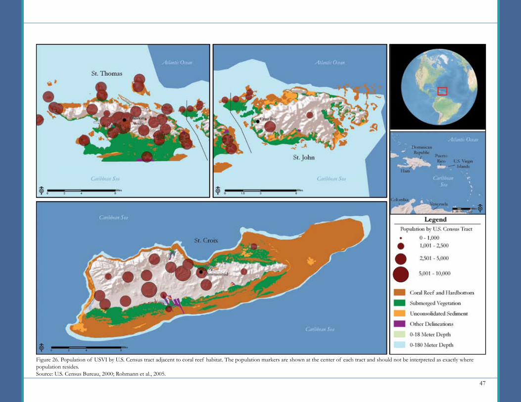
47
Figure 26. Population of USVI by U.S. Census tract adjacent to coral reef habitat. The population markers are shown at the center of each tract and should not be interpreted as exactly where population resides.Source: U.S. Census Bureau, 2000; Rohmann et al., 2005.
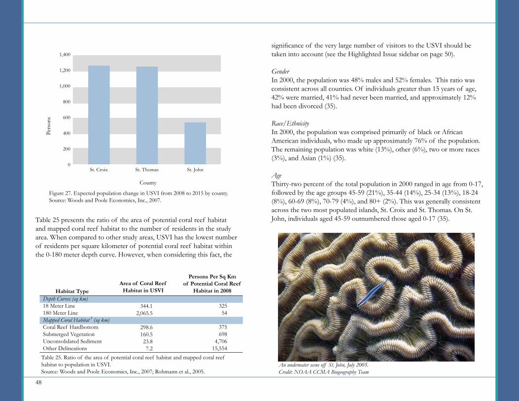
48
Table 25 presents the ratio of the area of potential coral reef habitat and mapped coral reef habitat to the number of residents in the study area. When compared to other study areas, USVI has the lowest number of residents per square kilometer of potential coral reef habitat within the 0-180 meter depth curve. However, when considering this fact, the
significance of the very large number of visitors to the USVI should be taken into account (see the Highlighted Issue sidebar on page 50).
GenderIn 2000, the population was 48% males and 52% females. This ratio was consistent across all counties. Of individuals greater than 15 years of age, 42% were married, 41% had never been married, and approximately 12% had been divorced (35).
Race/EthnicityIn 2000, the population was comprised primarily of black or African American individuals, who made up approximately 76% of the population. The remaining population was white (13%), other (6%), two or more races (3%), and Asian (1%) (35).
AgeThirty-two percent of the total population in 2000 ranged in age from 0-17, followed by the age groups 45-59 (21%), 35-44 (14%), 25-34 (13%), 18-24 (8%), 60-69 (8%), 70-79 (4%), and 80+ (2%). This was generally consistent across the two most populated islands, St. Croix and St. Thomas. On St. John, individuals aged 45-59 outnumbered those aged 0-17 (35).
1,400
1,200
1,000
800
600
400
200
0
Pers
ons
County
Figure 27. Expected population change in USVI from 2008 to 2015 by county.Source: Woods and Poole Economics, Inc., 2007.
St. Croix St. Thomas St. John
Depth Curves (sq km)18 Meter Line180 Meter LineMapped Coral Habitat 1 (sq km)Coral Reef HardbottomSubmerged VegetationUnconsolidated SedimentOther Delineations
Habitat TypeArea of Coral Reef
Habitat in USVI
Persons Per Sq Km of Potential Coral Reef
Habitat in 2008
Table 25. Ratio of the area of potential coral reef habitat and mapped coral reef habitat to population in USVI.Source: Woods and Poole Economics, Inc., 2007; Rohmann et al., 2005.
344.12,065.5
298.6160.523.87.2
32554
375698
4,70615,554
An underwater scene off St. John, July 2005.Credit: NOAA CCMA Biogeography Team
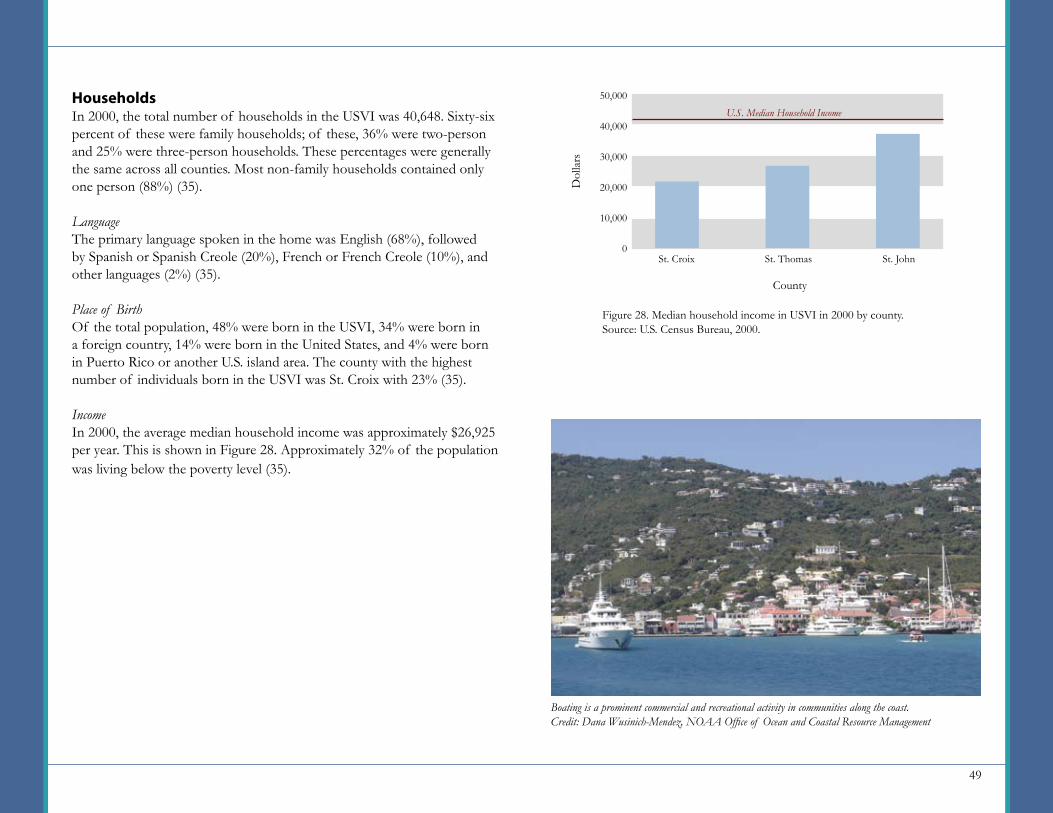
49
HouseholdsIn 2000, the total number of households in the USVI was 40,648. Sixty-six percent of these were family households; of these, 36% were two-person and 25% were three-person households. These percentages were generally the same across all counties. Most non-family households contained only one person (88%) (35).
LanguageThe primary language spoken in the home was English (68%), followed by Spanish or Spanish Creole (20%), French or French Creole (10%), and other languages (2%) (35).
Place of BirthOf the total population, 48% were born in the USVI, 34% were born in a foreign country, 14% were born in the United States, and 4% were born in Puerto Rico or another U.S. island area. The county with the highest number of individuals born in the USVI was St. Croix with 23% (35).
IncomeIn 2000, the average median household income was approximately $26,925 per year. This is shown in Figure 28. Approximately 32% of the population was living below the poverty level (35).
Figure 28. Median household income in USVI in 2000 by county.Source: U.S. Census Bureau, 2000.
50,000
40,000
30,000
20,000
10,000
0
Dol
lars
U.S. Median Household Income
County
St. Croix St. Thomas St. John
Boating is a prominent commercial and recreational activity in communities along the coast.Credit: Dana Wusinich-Mendez, NOAA Office of Ocean and Coastal Resource Management

50
Tourism and recreation can include numerous activities directly affecting coral reef habitat such as snorkeling, scuba diving, boating, fishing, and collecting reef species. Resorts, marinas, and cruise ship operations may indirectly affect coral reef habitat due to increases in oil spills, sedimentation, sewage discharge, nutrient pollution and other effects (46).
The USVI are a popular tourist destination, having an average of over 600,000 land visitors per year from 2000 to 2005, plus in the same time period an average of almost two million cruise ship passenger arrivals per year (34, 44). Additionally, the number of tourist arrivals to St. Thomas and St. John quadrupled between 1970 and 2000 (21). Although St. Thomas and St. John represent some of the best examples to demonstrate a negative impact from tourism on the marine environment, it is extremely difficult to attribute this decline in environmental quality to a specific tourist activity (46).
Highlighted Issue: Tourism and Recreation Education
In 2000, 26% of the adult population (25 years of age and over) had a high school diploma. Approximately 18% had some college or an associate’s degree and 17% held a bachelor’s degree or higher. This distribution is broken down by gender in Figure 29. In all education attainment categories, females outnumbered males excluding those that have not received a high school diploma (35).
EmploymentIn 2000, 43% of the civilian population 16 years of age and over were employed. This percentage represents 46,000 people (35). The industries that employed the most people are listed in Table 26.
Commute to WorkFor the civilian population 16 years of age, 51% worked on the island of St. Thomas, 42% on St. Croix, and 6% on St. John. The primary means of transportation to work were driving alone in a private vehicle (54%)
Figure 29. Education attainment by gender for the population 25 years and over in USVI in 2000.Source: U.S. Census Bureau, 2000.
No HighSchool Diploma
Education Attainment Level
High SchoolDiploma
Some College or Associate’s Degree
Bachelor’s Degree or Higher
60
50
40
30
20
10
0
Perc
ent o
f U
SVI’s
Pop
ulat
ion
25 Y
ears
and
Ove
r
U.S. AverageMales Females
Cruise ships at the Crown Bay Cruise Ship Port in St. Thomas.Credit: Don Hebert, U.S. Virgin Islands Port Authority
51
and carpooling in a private vehicle (24%). These were followed by public transportation (11%), walking (6%), working at home (2%), and other means of transportation (2%) (35).
Housing and DevelopmentHousing UnitsThere were a total of 50,202 housing units in the USVI in 2000. Of the total housing units, 37% were owner occupied, 44% were renter occupied, and 18% were reported as vacant. St. John County contained the fewest units (5% of the total), while St. Croix and St. Thomas each accounted for about half of the remaining 95% (35).
Plumbing FacilitiesIn 2000, only about 5% of the housing units lacked complete plumbing facilities (35).
Source of WaterIn 2000, the use of cisterns, tanks, or drums accounted for 52% of the total water source for housing units. Of the total housing units, 46% were connected either to a public water system or to a public water system with cistern supplementation. About 2% of housing units used public standpipes or other unspecified means of water source (35).
Arts; entertainment; recreation; accommodation and food servicesEducational; health and social servicesRetail tradePublic administrationConstructionTransportation and warehousing; and utilitiesProfessional; scientific; management; administrative and waste management servicesManufacturingOther services (except public administration)Finance; insurance; real estate and rental and leasingInformationWholesale tradeAgriculture; forestry; fishing and hunting; and mining
Table 26. Percent of the population 16 years of age and over employed by industry in USVI in 2000.Source: U.S. Census Bureau, 2000.
Industry Percent Employed161414111177655221
Sewage DisposalIn 2000, just fewer than 52% of housing units had public sewer connections, while 45% were on septic tank or cesspool systems. Just under 4% of units were reported as using other means of sewage disposal. St. John County had the lowest total number of septic tanks/cesspools among the three counties, but it also had the highest percentage (78%) of units on septic tanks/cesspools (35).
Building Permits 2
Data for building permits was not readily available for the USVI.
TourismFrom 2000 to 2005, an average of 604,593 tourists per year (excluding same-day visitors) visited the USVI. Most of the visitors (89%) were from the Americas (34). Furthermore, during this same time period there was an average of 1,916,233 cruise ship passenger arrivals per year (44).
St. Croix reef scene, USVI.Credit: NOAA CCMA Biogeography Team

52
The Commonwealth of Puerto Rico is located on the smallest island by area (9,135 square kilometers) of the Greater Antilles, situated west of the U.S. Virgin Islands and east of the Dominican Republic. Puerto Rico is comprised of one main island and several smaller ones, including Vieques, Culebra, Mona, Desecheo, and Caja de Muertos. Politically, Puerto Rico is divided into 78 municipios (U.S. Census Bureau county equivalents) (see Figure 34 for municipio boundaries). The most populated municipios are San Juan and Bayamon in the north and Carolina in the east. The city of San Juan is the capital of the Commonwealth, the financial capital, and home to a major port and a considerable tourism industry.
The north, east, and southwestern coastlines of Puerto Rico contain fringing, patch and shelf-edge reef formations. Along the south side of the island, reefs tend to surround the small islands off the coast. Fringe reefs are most common, and shelf-edge reefs are the best developed (15). The extent of coral reef habitat surrounding Puerto Rico is summarized in Table 27 and illustrated in Figure 30.
Puerto RicoPopulationIn 2000, the population of Puerto Rico reached 3,808,610 people; in 2008, it is estimated to be 3,972,155 (35, 49). From 1970 to 2008, the population increased by over 1,248,006 people. The municipios showing the greatest population increases were Bayamon, Carolina, and Toa Alta, all of which surround San Juan Municipio. San Juan Municipio actually saw a decrease in population during this time period, dropping by over 38,000 people. The greatest rate of growth was seen in Florida and Canovanas Municipios, growing by 8,858% and 5,923% respectively (49). Both Florida and Canovanas became municipios in 1970 and 1971, respectively, with newly defined borders and populations residing within these borders.
By 2015, the population is expected to grow by 167,722 people. Toa Alta Municipio, located directly west of Bayamon, is expected to show the greatest increase, with approximately 20,000 more people. San Juan Municipio is expected once again to decline in population (8,500 people) (49). Figure 31 presents this expected change by municipio.
In 2008, the overall population density was estimated to be 435 persons per square kilometer. The most densely populated municipio was San Juan with 3,448 persons per square kilometer. The second-most densely populated municipio was Catano with a density of 2,017 persons per square kilometer (49). Catano is located across Bahia de San Juan from San Juan. Figure 30 shows population centers in relation to adjacent coral reef habitats.
Table 27. Approximate area (in square kilometers) of coral reef habitat surrounding Puerto Rico. Source: Rohmann et al., 2005.
Depth Curves (sq km)18 Meter Line180 Meter LineMapped Coral Habitat 1 (sq km)Coral Reef HardbottomSubmerged VegetationUnconsolidated SedimentOther Delineations
2,3025,505.9
757.0721.548.972.7
Habitat Type Area (Sq Km)
Aerial view of San Juan.Credit: NOAA Office of Ocean and Coastal Resource Management
Key Facts
Population (2008)
Population Density (2008)
(persons per sq km)
Number of residents per square kilometer of potential coral reef habitat within the 180 meter depth curve. (2008)
Households (2000)
Housing Units (2000)
3,972,155
435
721
1,261,325
1,418,476
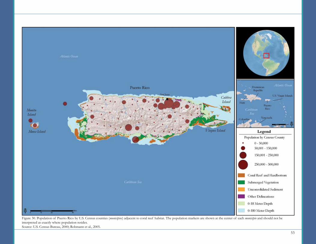
53
Figure 30. Population of Puerto Rico by U.S. Census counties (municipios) adjacent to coral reef habitat. The population markers are shown at the center of each municipio and should not be interpreted as exactly where population resides.Source: U.S. Census Bureau, 2000; Rohmann et al., 2005.
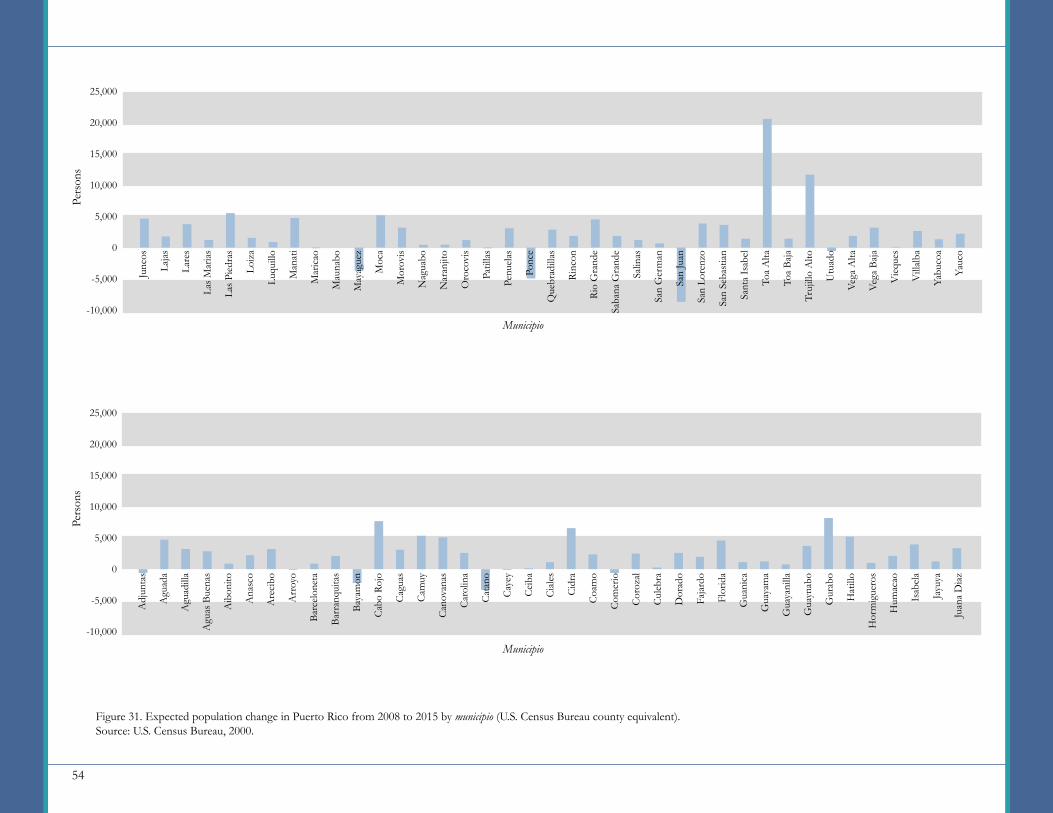
54
25,000
20,000
15,000
10,000
5,000
0
-5,000
-10,000
Pers
ons
Municipio
Figure 31. Expected population change in Puerto Rico from 2008 to 2015 by municipio (U.S. Census Bureau county equivalent).Source: U.S. Census Bureau, 2000.
25,000
20,000
15,000
10,000
5,000
0
-5,000
-10,000
Pers
ons
Municipio
Adj
unta
s
Agu
ada
Agu
adill
a
Agu
as B
uena
s
Aib
onito
Ana
sco
Are
cibo
Arr
oyo
Barc
elon
eta
Barr
anqu
itas
Baya
mon
Cab
o Ro
jo
Cag
uas
Cam
uy
Can
ovan
as
Car
olin
a
Cat
ano
Cay
ey
Cei
ba
Cia
les
Cid
ra
Coa
mo
Com
erio
Cor
ozal
Cul
ebra
Dor
ado
Faja
rdo
Flor
ida
Gua
nica
Gua
yam
a
Gua
yani
lla
Gua
ynab
o
Gur
abo
Hat
illo
Hor
mig
uero
s
Hum
acao
Isab
ela
Jayu
ya
Juan
a D
iaz
Junc
os
Laja
s
Lare
s
Las M
aria
s
Las P
iedr
as
Loiz
a
Luqu
illo
Man
ati
Mar
icao
Mau
nabo
May
ague
z
Moc
a
Mor
ovis
Nag
uabo
Nar
anjit
o
Oro
covi
s
Patil
las
Penu
elas
Ponc
e
Que
brad
illas
Rinc
on
Rio
Gra
nde
Saba
na G
rand
e
Salin
as
San
Ger
man
San
Juan
San
Lore
nzo
San
Seba
stia
n
Sant
a Is
abel
Toa
Alta
Toa
Baja
Truj
illo
Alto
Utu
ado
Vega
Alta
Vega
Baj
a
Vie
ques
Vill
alba
Yabu
coa
Yauc
o
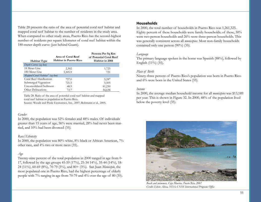
55
HouseholdsIn 2000, the total number of households in Puerto Rico was 1,261,325. Eighty percent of these households were family households; of these, 30% were two-person households and 26% were three-person households. This was generally consistent across all municipios. Most non-family households contained only one person (90%) (35).
LanguageThe primary language spoken in the home was Spanish (88%), followed by English (11%) (35).
Place of BirthNinety-three percent of Puerto Rico’s population was born in Puerto Rico and 6% were born in the United States (35).
IncomeIn 2000, the average median household income for all municipios was $13,189 per year. This is shown in Figure 32. In 2000, 48% of the population lived below the poverty level (35).
Table 28 presents the ratio of the area of potential coral reef habitat and mapped coral reef habitat to the number of residents in the study area. When compared to other study areas, Puerto Rico has the second-highest number of residents per square kilometer of coral reef habitat within the 180-meter depth curve (just behind Guam).
GenderIn 2000, the population was 52% females and 48% males. Of individuals greater than 15 years of age, 56% were married, 28% had never been mar-ried, and 10% had been divorced (35).
Race/EthnicityIn 2000, the population was 80% white, 8% black or African American, 7% other race, and 4% two or more races (35).
AgeTwenty-nine percent of the total population in 2000 ranged in age from 0-17, followed by the age groups 45-59 (17%), 25-34 14%), 35-44 (14%), 18-24 (11%), 60-69 (8%), 70-79 (5%), and 80+ (3%). San Juan Municipio, the most populated one in Puerto Rico, had the highest percentage of elderly people with 7% ranging in age from 70-79 and 4% over the age of 80 (35).
Beach and swimmers, Caja Muertos, Puerto Rico, 2007Credit: Eileen Alicea, NOAA NOS International Programs Office
Depth Curves (sq km)18 Meter Line180 Meter LineMapped Coral Habitat 1 (sq km)Coral Reef HardbottomSubmerged VegetationUnconsolidated SedimentOther Delineations
Habitat Type
Persons Per Sq Km of Potential Coral Reef
Habitat in 2008
Table 28. Ratio of the area of potential coral reef habitat and mapped coral reef habitat to population in Puerto Rico.Source: Woods and Poole Economics, Inc., 2007; Rohmann et al., 2005.
2,3025,505.9
757.0721.548.972.7
1,725721
5,2475,505
81,23054,638
Area of Coral Reef Habitat in Puerto Rico
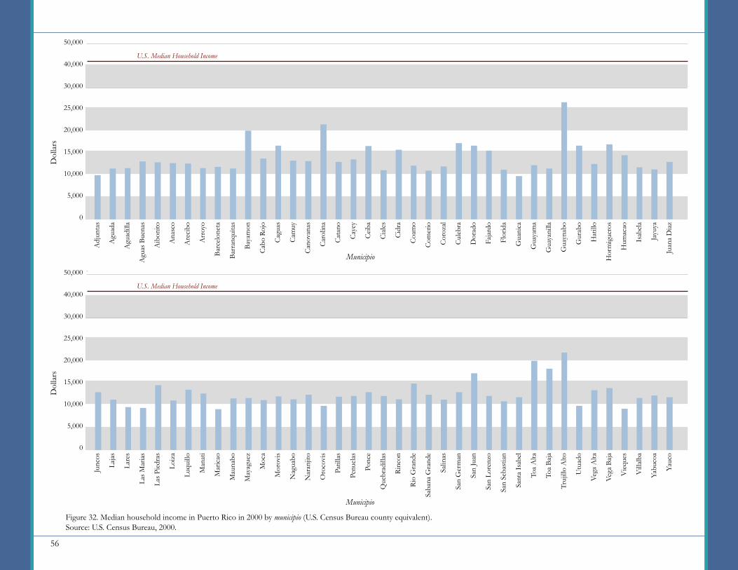
56
50,000
40,000
30,000
25,000
20,000
15,000
10,000
5,000
0
U.S. Median Household Income
50,000
40,000
30,000
25,000
20,000
15,000
10,000
5,000
0
Dol
lars
Figure 32. Median household income in Puerto Rico in 2000 by municipio (U.S. Census Bureau county equivalent).Source: U.S. Census Bureau, 2000.
Adj
unta
s
Agu
ada
Agu
adill
a
Agu
as B
uena
s
Aib
onito
Ana
sco
Are
cibo
Arr
oyo
Barc
elon
eta
Barr
anqu
itas
Baya
mon
Cab
o Ro
jo
Cag
uas
Cam
uy
Can
ovan
as
Car
olin
a
Cat
ano
Cay
ey
Cei
ba
Cia
les
Cid
ra
Coa
mo
Com
erio
Cor
ozal
Cul
ebra
Dor
ado
Faja
rdo
Flor
ida
Gua
nica
Gua
yam
a
Gua
yani
lla
Gua
ynab
o
Gur
abo
Hat
illo
Hor
mig
uero
s
Hum
acao
Isab
ela
Jayu
ya
Juan
a D
iaz
Municipio
Junc
os
Laja
s
Lare
s
Las M
aria
s
Las P
iedr
as
Loiz
a
Luqu
illo
Man
ati
Mar
icao
Mau
nabo
May
ague
z
Moc
a
Mor
ovis
Nag
uabo
Nar
anjit
o
Oro
covi
s
Patil
las
Penu
elas
Ponc
e
Que
brad
illas
Rinc
on
Rio
Gra
nde
Saba
na G
rand
e
Salin
as
San
Ger
man
San
Juan
San
Lore
nzo
San
Seba
stia
n
Sant
a Is
abel
Toa
Alta
Toa
Baja
Truj
illo
Alto
Utu
ado
Vega
Alta
Vega
Baj
a
Vie
ques
Vill
alba
Yabu
coa
Yauc
o
Dol
lars
Municipio
U.S. Median Household Income

57
EducationIn 2000, 22% of the adult population (25 years of age or over) had a high school diploma. Approximately 19% had some college or held an associate’s degree and 18% held a bachelor’s degree or higher (35). This distribution is broken down by gender in Figure 33.
EmploymentIndustryIn 2000, 24% of the civilian population 16 years of age and over were employed. This percentage represents almost 931,000 people (35). The industries that employed the most people are listed in Table 29.
Commute to WorkFor the civilian population over 16 years of age, 52% worked in their county of residence. The primary means of transportation to work were driving alone in a private vehicle (69%) and carpooling in a private vehicle (18%). These were followed by public transportation (5%), walking (4%), other means (2%), and working at home (2%) (35).
Figure 33. Education attainment by gender for the population 25 years and over in Puerto Rico in 2000.Source: U.S. Census Bureau, 2000.
No HighSchool Diploma
Education Attainment Level
High SchoolDiploma
Some College or Associate’s Degree
Bachelor’s Degree or Higher
60
50
40
30
20
10
0Perc
ent o
f Pu
erto
Ric
o’s P
opul
atio
n 25
Yea
rs a
nd O
ver
U.S. AverageMales Females
Housing and DevelopmentHousing UnitsThere were a total of 1,418,476 housing units in Puerto Rico in 2000. Of the total housing units, just under 65% were owner occupied, 24% were renter occupied, and 11% were reported as vacant (35).
Educational; health and social servicesManufacturingRetail tradePublic administrationConstructionProfessional; scientific; management; administrative and waste management servicesArts; entertainment; recreation; accommodation and food servicesOther services (except public administration)Finance; insurance; real estate and rental and leasingWholesale tradeTransportation and warehousing; and utilitiesInformationAgriculture; forestry; fishing and hunting; and mining
Table 29. Percent of the population 16 years of age and over employed by industry in Puerto Rico in 2000.Source: U.S. Census Bureau, 2000.
Industry Percent Employed19131211977554422
A resort coastline on Puerto Rico.Credit: Kris Wall, NOAA

58
In Puerto Rico, reef fish catches have decreased considerably during the last 20 years indicating classic signs of overfishing: reduced total landings, declining catch per unit effort, shifts to smaller fish, and recruitment failures. In 2003, almost 220,000 recreational anglers made over 1.1 million fishing trips in the waters of Puerto Rico. The recreational fishing occurred on the shoreline, from private boats and from charter trips. Within the eight year period from 1995 and 2002, commercial fishers caught 1.6 million tons of fish per year. Reef fish and invertebrates, including conch and lobster were the primary target of fishers (87%). Reef fish catches have declined during the last 20 years indicating classic signs of overfishing such as reduced total landings, declining catch per unit effort, shifts to smaller fish, and recruitment failures (for example, commercial fish landings fell by 69% between 1979 and 1990) (28).
Highlighted Issue: Fishing and Overfishing Plumbing Facilities
In 2000, only about 6% of the housing units lacked complete plumbing facilities (35).
Source of WaterThe U. S. Census Bureau did not collect data on water sources for Puerto Rico in 2000 (35).
Sewage DisposalThe U. S. Census Bureau did not collect data on sewage disposal for Puerto Rico in 2000 (35).
Building PermitsBetween 2000 and 2007, an average of 6,594 building permits were issued per year for new residential construction. An average of 939 permits were issued per year for commercial construction (27).
TourismBetween 2000 and 2005, an average of 3,407,483 visitors per year (exclud-ing same-day visitors) visited Puerto Rico. Three quarters of the visitors were from the Americas (34).
A fishing net caught on coral at low tide.Credit: Eileen Alicea, NOAA National Ocean Service, International Programs Office
Development along the coast in 2005.Credit: NOAA Office of Ocean and Coastal Resource Management

59
Puerto Rico Municipios
1. Adjuntas 14. Camuy 27. Fajardo 40. Juncos 53. Naguabo 66. San Lorenzo2. Aguada 15. Canóvanas 28. Florida 41. Lajas 54. Naranjito 67. San Sebastián3. Aguadilla 16. Carolina 29. Guánica 42. Lares 55. Orocovis 68. Santa Isabel4. Aguas Buenas 17. Cataño 30. Guayama 43. Las Marías 56. Patillas 69. Toa Alta5. Aibonito 18. Cayey 31. Guayanilla 44. Las Piedras 57. Peñuelas 70. Toa Baja6. Añasco 19. Ceiba 32. Guaynabo 45. Loíza 58. Ponce 71. Trujillo Alto7. Arecibo 20. Ciales 33. Gurabo 46. Luquillo 59. Quebradillas 72. Utuado8. Arroyo 21. Cidra 34. Hatillo 47. Manatí 60. Rincón 73. Vega Alta9. Barceloneta 22. Coamo 35. Hormigueros 48. Maricao 61. Río Grande 74. Vega Baja
10. Barranquitas 23. Comerío 36. Humacao 49. Maunabo 62. Sabana Grande 75. Vieques11. Bayamón 24. Corozal 37. Isabela 50. Mayagüez 63. Salinas 76. Villalba12. Cabo Rojo 25. Culebra 38. Jayuya 51. Moca 64. San Germán 77. Yabucoa13. Caguas 26. Dorado 39. Juana Díaz 52. Morovis 65. San Juan 78. Yauco
Figure 34. Location of Puerto Rico municipios (Census Bureau statistical county equivalents).
60
MethodsDataTwo primary sources of population and demographic data were used to compile this report: U.S. Census Bureau and Woods and Poole Economics, Inc. Data synthesized from the U.S. Census Bureau 2000 decennial census that were common among all study areas include the following variables: population (as displayed on the maps), gender, age, race/ethnicity, households, language, birthplace, median household income, school enrollment, educational attainment, employment, industry, place of work, means of transportation to work, housing units, plumbing facilities, and sewage disposal. U.S. Census Bureau variables such as source of water and building permit data were not available for all study areas and thus, were presented only in certain chapters. If the data were not available, it is stated in that chapter.
Population projection data was obtained from Woods and Poole Economics, Inc. for the years 2008 to 2015. Making estimates of future data is not an exact science. The methods that Woods and Poole Economics, Inc., employ to make population projections are based on analysis of historical data. Consequently, limitations are inherent to the data and projections should not be interpreted as future predictions. Woods and Poole Economics, Inc. (2007) notes that economic and demographic events may result in outcomes different from the projections, and that limitations may result from making projections for small geographic areas.
GeographyAs stated in the National Summary, the differences in geographic scale among the study areas made it challenging to present data and maps consistently across chapters. For instance, Guam is considered a county, and in order to understand where the population resides on the island, it was necessary to present data by county subdivision (or district). For Southeast Florida and the Florida Keys, however, presenting county-level data was appropriate for the geographic scale and large population. Further, the maps for each study area present the total population data at differing scales (Table 30). As a result, data presented in each chapter are not intended to be compared to other chapters at these varying geographic levels. Rather, the data are intended to provide a baseline of information from which to compare future population and demographic data for each study area.
Guam U.S. Territory U.S. County EquivalentCNMI U.S. TerritoryAmerican Samoa U.S. TerritoryHawaii U.S. StateSoutheast Florida and the Florida Keys Portion of U.S. State Six U.S. CountiesUSVI U.S. TerritoryPuerto Rico U.S. Territory
U.S. Coral Jurisdiction
Geographic Levels Discussed
in ReportCounty, County Subdivision
Territory, County
Territory, County,VillageState, County
Portion of State, County
Territory, County
Territory, County
Geographic Levels Population is
Presented on MapsCensus Tracts
Census Blockgroups
Census Blockgroups
County Subdivision
County Subdivision
Census Tracts
Municipio (county equivalent)
Table 30. Varying levels of geographies used to present population and other demographic data in this report.
61
End Notes1Mapped Coral HabitatCoral Reef and Hardbottom - This category is defined as hardened substrate of unspecified relief formed by the deposition of calcium carbonate by reef-building corals and other organisms, or existing as exposed bedrock or volcanic rock. Examples of habitats include: spur and groove; individual or aggregated patch reefs; pavement; and pavement with sand channels.
Submerged Vegetation - This category is defined as various types of continuously submerged rooted vegetation that is densely, patchily, or sparsely distributed on the sea floor. The vegetation includes various species of sea grass (e.g., Thalassia testudinum, Halophila decipiens; Syringodium filiforme, or Halodule wrightii); various species of macroalgae (e.g., Caulerpa spp., Laurencia spp., Halimeda spp., or Dictyota spp.); encrusting/coralline algae (e.g., Porolithon gardineri); or various species of turf algae (e.g., Sargassum spp., Dictyota spp., Cladophora spp., or Caulerpa spp.).
Unconsolidated Sediment - This category is defined as coarse sediment (i.e., sand) typically found in areas exposed to currents or wave energy, or fine sediment (i.e., mud) often associated with river discharge or the buildup of organic material in areas sheltered from high-energy waves and currents.
Other Delineations - This category is defined as other types of artificial man-made area or habitat, such as submerged wrecks, large piers, submerged portions of rip-rap jetties, and the shoreline of islands created from dredge spoil, land, or unknown features that cannot be identified due to water turbidity, cloud cover, water depth, or other interference.
2Building Permit DataData on building permits was available only through disparate data sources, including the U.S. Census Bureau, statistical yearbooks, agency Web sites and personal communications. Therefore, building permit data are not easily comparable across jurisdictions, but are included within each jurisdiction for reference.
Guam - The Guam Statistical Yearbook provides building permit data for several categories, including new residential construction permits from 2000 to 2005.
CNMI - The CNMI Economic Indicators report provides total number of permits issued per year for residential and commercial construction. It does not distinguish between permits for brand-new and permits for alterations. The data covered the years 2003 to 2006.
American Samoa - The American Samoa Statistical Yearbook reports on numbers of permits issued for new structures. New structures are defined as including any new building, Samoan guest fale, or fale and shack. The data covered the years 1980 to 2006.
Puerto Rico - Data on new commercial and residential construction for the years 2000 to 2007 were obtained from the Puerto Rico Rules and Permitting Administration through personal communications.
Hawaii, Southeast Florida and the Florida Keys - The U.S. Census Bureau building permit data for Florida and Hawaii report numbers for single-unit housing, two-unit housing, three- and four-unit housing, and five-or-more-unit housing structures. For purposes of this report, data for two or more units were aggregated to the “multi-unit” category. The reporting period was 2002 to 2006.
According to the Census Bureau, statistics on housing units authorized by building permits include housing units issued in local permit-issuing jurisdictions by a building or zoning permit. Construction is undertaken for all but a very small percentage of housing units authorized by building permits, but there may be months-long delays in the actual start of construction. Building permit statistics should not be directly interpreted as “housing starts.” For more information on building permit data, see the Census Bureau new residential construction Web page at: http://www.census.gov/const/www/newresconstdoc.html.
USVI - Data was not readily available.
62
References1. American Samoa Department of Commerce. 2005. American Samoa Statistical Yearbook 2005. Available from: http://www.asdoc.info/DOC_Stats/yrbks.htm (accessed November 13, 2007).
2. American Samoa Department of Commerce. 2006. American Samoa Statistical Yearbook 2006. Available from: http://www.asdoc.info/fnl06yrbkhome.pdf (accessed November 13, 2007).
3. Andrews, K., L. Nall, C. Jeffrey, and S. Pittman (eds.). 2005. The State of Coral Reef Ecosystems of Florida. pp. 150-200. In: J. Waddell (ed.), The State of Coral Reef Ecosystems of the United States and Pacific Freely Associated States: 2005. NOAA Technical Memorandum NOS NCCOS 11. NOAA/NCCOS Center for Coastal Monitoring and Assessment, Biogeography Team. Silver Spring, MD: 522 pp.
4. Bruckner, A. 2000. New Threat to Coral Reefs: Trade in Coral Organisms. Issues in Science and Technology. Available from: http://www.nmfs.noaa.gov/habitat/ead/ReadingRoom/tradecoralreefspecies.pdf (accessed March 10, 2008).
5. Bruckner, A., K. Buja, L. Fairey, K. Gleason, M. Harmon, S. Heron, T. Hourigan, C. Jeffrey, J. Kellner, R. Kelty, B. Leeworthy, G. Liu, S. Pittman, A. Shapiro, A. Strong, J. Waddell, and P. Wiley. 2005. Threats and Stressors to U.S. Coral Reef Ecosystems. pp. 12-44. In: J. Waddell (ed.), The State of Coral Reef Ecosystems of the United States and Pacific Freely Associated States: 2005. NOAA Technical Memorandum NOS NCCOS 11. NOAA/NCCOS Center for Coastal Monitoring and Assessment, Biogeography Team. Silver Spring, MD: 522 pp.
6. Bunce, L.., P. Townsley, R. Pomeroy, and R. Pollnac. 2000. Socioeconomic Manual for Coral Reef Management. Australian Institute of Marine Science. Townsville, Queensland, Australia: 264 pp.
7. Bunce, L. and B. Pomeroy. 2003. Socioeconomic Monitoring Guidelines for Coastal Managers in Southeast Asia. World Commission on Protected Areas and Australian Institute of Marine Science. 82 pp.
8. Bureau of Statistics and Plans, Office of the Governor, Guam. 2005.
AcknowledgmentsThe authors would like to thank the following jurisdictional reviewers, for their invaluable comments and suggestions: Chantal Collier, Kathleen Herrmann, Lelei Peau, Aaida Rosario and Romina King.
We would also like to acknowledge our many NOAA colleagues who made valuable contributions. Thanks especially to Christy Loper, Tim Goodspeed, Tom Culliton, Ruth Kelty, and Arielle Levine for overall guidance and thorough reviews, David Bylsma for QA/QC and GIS support, Robb Wright for GIS support, John Hayes for GIS processing, Gini Kennedy for front and back cover design, Lauren Chhay for photo support, and Pam Rubin and Chris David for editorial reviews.

63
Guam Statistical Yearbook, 2005. Available from: http://bsp.guam.gov/PIP/2005_Guam_Statistical_Yearbook.R4.pdf (accessed February 15, 2008).
9. Cesar, H.S.J. and P.J.H. van Beukering. 2004. Economic valuation of the coral reefs of Hawaii. Pacific Science 58(31): 231-242.
10. Commonwealth of the Northern Mariana Islands, Department of Commerce. 2006. CNMI Economic Indicators-4th Quarter Issue. Available from: http://www.commerce.gov.mp/new/PDF/central_statistic/EI/EI%202006.4.pdf (accessed February 15, 2008).
11. Craig, P., G. DiDonato, D. Fenner, and C. Hawkins. 2005. The State of Coral Reef Ecosystems of American Samoa. pp. 312-337. In: J. Waddell (ed.), The State of Coral Reef Ecosystems of the United States and Pacific Freely Associated States: 2005. NOAA Technical Memorandum NOS NCCOS 11. NOAA/NCCOS Center for Coastal Monitoring and Assessment, Biogeography Team. Silver Spring, MD: 522 pp.
12. Dani, A. (ed.). 2003. Social Analysis Sourcebook: Incorporating Social Dimensions into Bank-supported Projects. The World Bank Social Development Department. Washington, DC.
13. Florida Keys National Marine Sanctuary, National Ocean Service, NOAA. 2003. Team O.C.E.A.N. Ocean Conservation Education Action Network. Available from: http://floridakeys.noaa.gov/edu/ocean.html (accessed March 10, 2008).
14. Florida Museum of Natural History. 2008. Florida Keys: Threats. Available from: http://www.flmnh.ufl.edu/fish/southflorida/coral/threatskeys.html#boating (accessed March 10, 2008).
15. García-Sais, J. (Reni), R. Appeldoorn, A. Bruckner, C. Caldow, J.D. Christensen, C. Lilyestrom, M.E. Monaco, J. Sabater, E. Williams, and E. Diaz. 2005. The State of Coral Reef Ecosystems of the Commonwealth of Puerto Rico. pp. 91-134. In: J. Waddell (ed.), The State of Coral Reef Ecosystems of the United States and Pacific Freely Associated States: 2005. NOAA Technical Memorandum NOS NCCOS 11. NOAA/NCCOS
Center for Coastal Monitoring and Assessment, Biogeography Team. Silver Spring, MD: 522 pp.
16. Hatziolos, M. (ed). 2006. Measuring Coral Reef Ecosystem Health: Integration of Societal Dimensions. The World Bank. Washington, DC.
17. Hawaii Coral Reef Network. 2005. Overview of Ecology of Coral Reefs in Hawaii. Available from: http://www.coralreefnetwork.com/reefs/ecology/default.htm (accessed March 4, 2008).
18. Hawaii Department of Business, Economic Development and Tourism (DBEDT). 2002. State of Hawaii Data Book 2002: A Statistical Abstract. DBEDT, Research and Economic Analysis Division. Statistics and Data Support Branch. Honolulu, HI.
19. Hazen and Sawyer, Environmental Engineers and Scientists. 2003. Socioeconomic Study of Reefs in Southeast Florida. Available from: http://marineeconomics.noaa.gov/Reefs/PDF’s/Document.pdf (accessed April 9, 2008).
20. Hazen and Sawyer, Environmental Engineers and Scientists. 2004. Socioeconomic Study of Reefs in Martin County, Florida, 2003. Available from: http://marineeconomics.noaa.gov/Reefs/MartinCounty2004.pdf (accessed April 9, 2008).
21. Jeffrey, C.F.G., U. Anlauf, J. Beets, S. Caseau, W. Coles, A.M. Friedlander, S. Herzlieb, Z. Hillis-Starr, M. Kendall, V. Mayor, J. Miller, R. Nemeth, C. Rogers, and W. Toller. 2005. The State of Coral Reef Ecosystems of the U.S. Virgin Islands. pp. 45-90. In: J. Waddell (ed.), The State of Coral Reef Ecosystems of the United States and Pacific Freely Associated States: 2005. NOAA Technical Memorandum NOS NCCOS 11. NOAA/NCCOS Center for Coastal Monitoring and Assessment, Biogeography Team. Silver Spring, MD: 522 pp.
22. Johns, G.M., V.R. Leeworthy, F.W. Bell, and M.A. Bonn. 2001. Socioeconomic Study of Reefs in Southeast Florida, Final Report. Broward County Environmental Protection Department, Technical Report 01-10. Available from: http://www.broward.org/dni01200.htm.
64
23. Knowlton, N. and J.B.C. Jackson. 2008. Shifting baselines, local impacts, and global change on coral reefs. PLoS Biol 6(31): e54. doi:10.1371/journal. pbio.0060054
24. National Centers for Coastal Ocean Science, National Ocean Service, NOAA. 2007. Coral Reef Ecosystems. Available from: http://coastalscience.noaa.gov/ecosystems/coralreef/welcome.html (accessed March 20, 2008).
25. Pomeroy, R.S., J.E. Parks, and L.M. Watson. 2004. How is Your MPA Doing? A Guidebook of Natural and Social Indicators for Evaluating Marine Protected Area Management Effectiveness. IUCN, Gland, Switzerland and Cambridge, UK.
26. Porter, V., T. Leberer, M. Gawel, J. Gutierrez, D. Burdick, V. Torres, and E. Lujan. 2005. The State of Coral Reef Ecosystems of Guam. pp. 442-487. In: J. Waddell (ed.), The State of Coral Reef Ecosystems of the United States and Pacific Freely Associated States: 2005. NOAA Technical Memorandum NOS NCCOS 11. NOAA/NCCOS Center for Coastal Monitoring and Assessment, Biogeography Team. Silver Spring, MD: 522 pp.
27. Puerto Rico Rules and Permitting Administration. 2008. Personal communications.
28. Puglise, K.A. and R. Kelty (eds.). 2007. NOAA Coral Reef Ecosystem Research Plan for Fiscal Years 2007 to 2011. NOAA Technical Memorandum CRCP 1. NOAA Coral Reef Conservation Program. Silver Spring, MD: 128 pp.
29. Rohmann, S.O., J.J. Hayes, R.C. Newhall, M.E. Monaco, and R.W. Grigg. 2005. The area of potential shallow-water tropical and subtropical coral ecosystems in the United States. Coral Reefs 24(3): 370-383.
30. Starmer, J. (ed.). 2005. The State of Coral Reef Ecosystems of the Commonwealth of the Northern Mariana Islands. pp. 399-441. In: J. Waddell (ed.), The State of Coral Reef Ecosystems of the United States and Pacific Freely Associated States: 2005. NOAA Technical Memorandum
NOS NCCOS 11. NOAA/NCCOS Center for Coastal Monitoring and Assessment, Biogeography Team. Silver Spring, MD: 522 pp.
31. State of Hawaii, Department of Business, Economic Development & Tourism. 2008. Monthly Visitor Statistics. Available from: http://hawaii.gov/dbedt/info/visitor-stats/tourism (accessed April 9, 2008).
32. The Coral Reef Advisory Group. 2007. Land-Based Sources of Pollution. Available from: http://doc.asg.as/CRAG/Land-based.htm (accessed March 10, 2008).
33. Tissot, B. and L. Hallacher. 2003. Effects of aquarium collectors on coral reef fishes in Kona. Conservation Biology 17(6): 1759-1768.
34. United Nations Statistics Division. 2007. Tourist arrivals by region of origin (UNWTO/SYB51). Available from: http://unstats.un.org/unsd/cdb/cdb_series_xrxx.asp?series_code=28310 (accessed April 9, 2008).
35. U.S. Census Bureau. 2000. Census 2000 Summary File 1. Available from: http://factfinder.census.gov/home/saff/main.html?_lang=en (accessed February 14, 2008).
36. ___. 2003. 2002 Residential Construction Data Files. Manufacturing and Construction Division, Residential Construction Branch, U.S. Census Bureau. Washington, DC.
37. ___. 2004. 2003 Residential Construction Data Files. Manufacturing and Construction Division, Residential Construction Branch, U.S. Census Bureau. Washington, DC.
38. ___. 2005. 2004 Residential Construction Data Files. Manufacturing and Construction Division, Residential Construction Branch, U.S. Census Bureau. Washington, DC.
39. ___. 2006. 2005 Residential Construction Data Files. Manufacturing and Construction Division, Residential Construction Branch, U.S. Census Bureau. Washington, DC.
65
40. ___. 2007. 2006 Residential Construction Data Files. Manufacturing and Construction Division, Residential Construction Branch, U.S. Census Bureau. Washington, DC.
41. U.S. Department of Labor. 2008. Impact of Increased Minimum Wages on the Economies of American Samoa and the Commonwealth of the Northern Mariana Islands. Available from: http://www.doi.gov/oia/pdf/ascnmi.pdf (accessed March 12, 2008).
42. U.S. Environmental Protection Agency, Region IX. 2006. Draft Environmental Impact Statement (DEIS), Establishment and Operation of an Intelligence, Surveillance, Reconnaissance (ISR), and Strike Capability, Anderson Air Force Base, Guam (CEQ # 20060173). Available from: http://www.epa.gov/region09/nepa/letters/andersen-afb-deis.pdf (accessed April 3, 2008).
43. U.S. Government Accountability Office. 2007. Testimony before the Subcommittee on Insular Affairs, Committee on Natural Resources, U.S. House of Representatives. Commonwealth of the Northern Mariana Islands: Serious Economic, Fiscal, and Accountability Challenges. Available from: http://www.gao.gov/new.items/d07746t.pdf (accessed March 12, 2008).
44. U.S. Virgin Islands Bureau of Economic Research. 2006. U.S. Virgin Islands Annual Tourism Indicators. Available from: http://www.usviber.org/TOUR06.pdf (accessed June 13, 2008).
45. van Beukering, P., K. Gallop, W. Haider, M. Longland, J. Sablan, B. Beardmore, E. Wolfs, Y. Liu, K. van der Leeuw, S. di Prima, E. Massey, H. Cesar, G.O. Garces, and Z. Hausfather. 2006. How Much are Saipan’s Coral Reefs Worth? Available from: http://www.deq.gov.mp/artdoc/Sec12art81ID185.pdf (accessed March 10, 2008).
46. van’t Hof, T. 2001. Tourism Impacts on Coral Reefs, Increasing Awareness in the Tourism Sector. Available from: http://www.cep.unep.org/programmes/spaw/icran/tourism%201.PDF (accessed April 4, 2008).
47. Waddell, J.E. (ed.). 2005. The State of Coral Reef Ecosystems of the
United States and Pacific Freely Associated States: 2005. NOAA Technical Memorandum NOS NCCOS 11. NOAA/NCCOS Center for Coastal Monitoring and Assessment, Biogeography Team. Silver Spring, MD: 522 pp.
48. Wongbusarakum, S., et. al. 2008 (in press). SEM-Pasifika Guidelines for Socioeconomic Monitoring in the Pacific Region.
49. Woods and Poole Economics, Inc. 2007. Complete Economic and Demographic Data Source (CEDDS). Washington, DC.


U.S. Department of CommerceCarlos M. Gutierrez, S e c r e t a r y
National Oceanic and Atmospheric AdministrationVice Admiral Conrad C. Lautenbacher, Jr., USN (Ret.), Undersecretary of Commerce for Oceans and Atmosphere and NOAA Administrator
National Ocean ServiceJohn H. Dunnigan, A s s i s t a n t Ad m i n i s t ra t o r f o r O ce a n S e r v i ces a n d C o a s t a l Zo n e M a n a g e m e n t