Embed Size (px)
Citation preview
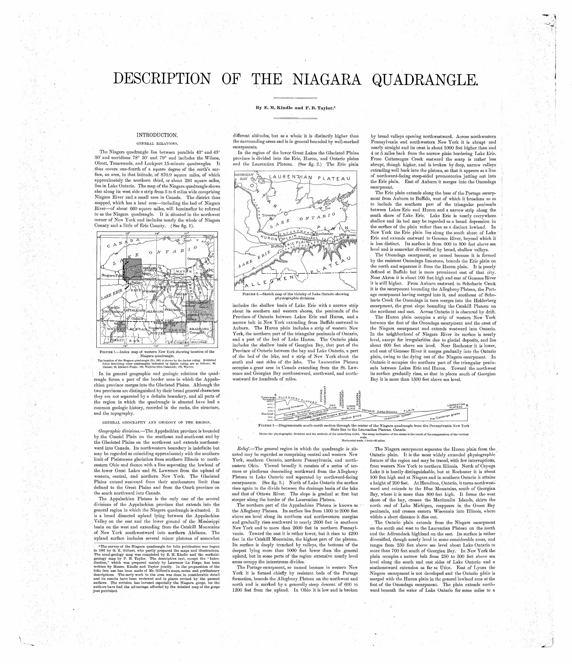
DESCRIPTION OF THE NIAGARA QUADRANGLE.
By E. M. Kindle and F. B. Taylor.a
INTRODUCTION.GENERAL RELATIONS.
The Niagara quadrangle lies between parallels 43° and 43° 30' and meridians 78° 30' and 79° and includes the Wilson, Olcott, Tonawanda, and Lockport 15-minute quadrangles. It thus covers one-fourth of a square degree of the earth's sur face, an area, in that latitude, of 870.9 square miles, of which approximately the northern third, or about 293 square miles, lies in Lake Ontario. The map of the Niagara quadrangle shows also along its west side a strip from 3 to 6 miles wide comprising Niagara River and a small area in Canada. The district thus mapped, which has a land area including the bed of Niagara River of about 660 square miles, will hereinafter be referred to as the Niagara quadrangle. It is' situated in the northwest corner of New York-and includes nearly the whole of Niagara
«/ O
County and a little of Erie County. (See fig. 1).
FIGURE 1. Index map of western New York showing location of the Niagara quadrangle.
The location of the Niagara quadrangle (No. 190) is shown by the darker ruling. Published folios describing other quadrangles, indicated by lighter ruling, are as follows: 93, Gaines; 93, Elkland-Tioga; 169, Watkins Glen-Catatonk; 172, Warren.
In its general geographic and geologic relations the quad rangle forms a part of the border zone in which the Appala chian province merges into the Glaciated Plains. Although the two provinces are distinguished by their broad general characters they are not separated by a definite boundary, and all parts of the region in which the quadrangle is situated have had a common geologic history, recorded in the rocks, the structure, and the topography.
GENERAL GEOGRAPHY AND GEOLOGY OF THE REGION.
Geographic divisions. The Appalachian province is bounded by the Coastal Plain on the southeast and southwest and by the Glaciated Plains on the northwest and extends northeast ward into Canada. Its northwestern boundary is indefinite but may be regarded as coinciding approximately with the southern limit of Pleistocene glaciation from southern Illinois to north eastern Ohio and thence with a line separating the lowland of the lower Great Lakes and St. Lawrence from the upland of western, central, and northern New York. The Glaciated Plains extend westward from their southeastern limit thus defined to the Great Plains and from the Ozark province on the south northward into Canada.
The Appalachian Plateau is the only one of the several divisions of the Appalachian province that extends into the
, general region in which the Niagara quadrangle is situated. It is a broad dissected upland lying between the Appalachian.Valley on the east and the lower ground of the Mississippi basin on the west and extending from the Catskill Mountains of New York southwestward into northern Alabama. The upland surface includes several minor plateaus of somewhat
a The survey of the Niagara quadrangle for folio publication was begun in 1897 by Gf. K. Gilbert, who partly prepared the maps and illustrations. The areal-geology map was completed by E. M. Kindle and the surflcial- geology map by P. B. Taylor. The descriptive text, except the "Intro duction," which was prepared mainly by Laurence' La Forge, has been written by Messrs. Kindle and Taylor jointly. In the preparation of the folio free use has been made of Mr. Gilbert's maps, notes, and preliminary descriptions. The early work in the area was done in considerable detail and its results have been reviewed and in places revised by the present authors. The revision has covered especially the Niagara gorge, for the authors have had the advantage afforded by the detailed map of the gorge just published, -
different altitudes, but as a whole it is distinctly higher than the surrounding areas and is in general bounded by well-marked escarpments. i
In the region of the lower Great Lakes the Glaciated Plains province is divided into the Erie, Huron, and Ontario plains and the Laurentian Plateau. (See fig. 2.) The Erie plain
FIGURE 2. Sketch map of the vicinity of Lake Ontario showing physiographic divisions.
includes the shallow basin of Lake Erie with a narrow strip about its southern and western shores, the peninsula of the Province of Ontario between Lakes Erie and Huron, and a narrow belt in New York extending from Buffalo eastward to Auburn. The Huron plain includes a strip of western New York, the northern part of the triangular peninsula of Ontario, and a part of the bed of Lake Huron. The Ontario plain includes the shallow basin of Georgian Bay, that part of the Province of Ontario between the bay and Lake Ontario, a part of the bed of the lake, and a strip of New York about the south and east sides of the lake. The Laurentian Plateau occupies a great area in Canada extending from the St. Law rence and Georgian Bay northeastward, northward, and north westward for hundreds of miles.
by broad valleys opening northwestward. Across northwestern Pennsylvania and southwestern New York it is abrupt and nearly straight and its crest is about 1000 feet higher than, and 4 or 5 miles back from the narrow plain bordering Lake Erie. From Cattaraugus Creek eastward the scarp is rather less abrupt, though higher, and is broken by deep, narrow valleys extending well back into the plateau, so that it appears as a line of northward-facing steep-sided promontories jutting out into the Erie plain. East of Auburn it merges into the Onondaga escarpment.
The Erie plain extends along the base of the Portage escarp ment from Auburn to Buffalo, west of which it broadens so as to include the southern part of the triangular peninsula between Lakes Erie and Huron and a narrow strip along the south shore of Lake Erie. Lake Erie is nearly everywhere shallow and its bed may be regarded as a broad depression in the surface of the plain rather than as a distinct lowland. In New York the Erie plain lies along the south shore of' Lake Erie and extends eastward to Genesee River, beyond which it is less distinct. Its surface is from 600 to 800 feet above sea level and is somewhat diversified by broad, shallow valleys.
The Onondaga escarpment, so named because it is formed by the resistant Onondaga limestone, bounds the Erie plain on the north and separates it from the Huron plain. It is poorly defined at Buffalo but is more prominent east of that city. Near Akron it is about 100 feet high and east of Genesee River it is still higher. From Auburn eastward to Schoharie Creek it is the escarpment bounding the Allegheny Plateau, the Port age escarpment having merged into it, and southeast of Scho harie Creek the Onondaga in turn merges into the Helderberg escarpment, the great slope bounding the Catskill Plateau on the northeast and east. Across Ontario it is obscured by drift.
The Huron plain occupies a strip of western New York between the foot of the Onondaga escarpment and the crest of the Niagara escarpment and extends westward into Ontario. In the neighborhood, of Niagara River its surface is nearly level, except for irregularities due to glacial deposits, and lies about 600 feet above sea level. Near Rochester it is lower, and east of Genesee River it merges gradually into the Ontario plain, owing to the dying out of the Niagara escarpment. In Ontario it occupies the northern part of the triangular penin sula between Lakes Erie and Huron. Toward the northwest its surface gradually rises, so that in places south of Georgian Bay it is more than 1500 feet above sea level.
-g^lARIO LakoQnt* fu-<^_- ^>^- -^T a £rou? ^^ed'^a S__^.
FIGURE 3. Diagrammatic south-north section through the center of the Niagara quadrangle from the Pennsylvania-New YorkState line to the Laurentian Plateau, Canada.
Shows the physiographic divisions and the attitude of the underlying rocks. The steep inclination of the strata is the result of the exaggeration of the vertical.scale.
Horizontal scale, 1 inch=30 miles.
Relief. The general region in which the quadrangle is sit uated may be regarded as comprising central and western New York, southern. Ontario, northern Pennsylvania, and north eastern Ohio. Viewed broadly it consists of a series of ter races or platforms descending northward from the Allegheny Plateau to Lake Ontario and separated by northward-facing escarpments. (See fig. 3.) North of Lake Ontario the surface rises again to the divide between the drainage basin of the lake and that of Ottawa River. The slope is gradual at first but steeper along the border of the Laurentian Plateau.
The northern part of the Appalachian Plateau is known as the Allegheny Plateau. Its surface lies from 1500 to 2000 feet above sea level along its northern and northwestern margins and gradually rises southward to nearly 2600 feet in southern New York and to more than 2600 feet in northern Pennsyl vania. Toward the east it is rather lower, but it rises to 4200 feet in the Catskill Mountains, the highest part of the plateau. Its surface is deeply trenched by valleys, the bottoms of the deepest lying more than 1000 feet lower than the general upland, but in some parts of the region extensive nearly level areas occupy the interstream divides.
The Portage escarpment, so named because in western New York it is formed chiefly by resistant beds of the Portage formation, bounds the Allegheny Plateau on the northwest and north and is marked by a generally steep descent of 600 to 1200 feet from the upland. In Ohio it is low and is broken
The Niagara escarpment separates the Huron plain from the Ontario plain. It is the most widely extended physiographic feature of the region and may be traced, with few interruptions, from western New York to northern Illinois. North of Cayuga Lake it is hardly distinguishable, but at Rochester it is about 100 feet high and at Niagara and in southern Ontario it attains a height of 200 feet. At Hamilton, Ontario, it turns northwest ward and extends to the Blue Mountains, south of Georgian Bay, where it is more than 800 feet high. It forms the west shore of the bay, crosses the Manitoulin Islands, skirts the north end of Lake Michigan, reappears in the Green Bay peninsula, and crosses eastern Wisconsin into Illinois, where within a short distance it dies out.
The Ontario plain extends from the Niagara escarpment on the south arid west to the Laurentian Plateau on the north and the Adirondack highland on the east. Its surface is rather diversified, though nearly level in some considerable areas, and ranges from 250 feet above sea level about Lake Ontario to more than 700 feet south of Georgian Bay. In New York the plain occupies a narrow belt from 250 to 500 feet above sea level along the south and east sides of Lake Ontario and a southeastward extension as far as Utica. East of Lyons the Niagara escarpment is not developed and the Ontario plain is merged with the Huron plain in the general lowland area at the foot of the Onondaga escarpment. The plain extends north ward beneath the water of Lake Ontario for some milee to a
oorly defined escarpment, beyond which is a valley forming the deeper part of the lake basin, several hundred feet below sea level. North of the lake the surface rises gradually to the border of the Laurentian Plateau, which occupies a little of the northern margin of the region.
Drainage. The streams of much the greater part of the region belong to the St. Lawrence drainage system, and the larger ones flow directly into Lake Erie or Lake Ontario. Nearly all of the Ontario plain is drained into Lake Ontario, but a few streams in its northwestern part flow to Georgian Bay, and its extreme southeast corner is drained into Hudson River through the Mohawk. All of the Erie and Huron plains is drained into Lake Erie except the area east of Buffalo, which is drained in part to Niagara River and in part to,Lake Ontario, and the northwestern margin, which is drained into Lake Huron.
The northern and northwestern margins of the Allegheny Plateau are drained into Lakes Erie and Ontario, chiefly by short streams heading at the crest of the Portage escarpment and flowing down the slope to the Erie plain. Other streams rise some distance back from the rim of the plateau and flow out across the escarpment in deep, narrow valleys. The most notable of these is Genesee River, which rises in northern Pennsylvania on one of the highest parts of the plateau and cuts through the escarpment in Portage Gorge, descending over several falls. Cayuga and Seneca lakes and most of the other Finger Lakes also occupy valleys extending some dis tance back into the plateau, and deep gorges and high falls are abundant near their heads. In northeastern Ohio, where the plateau is lower and the escarpment is less pronounced, several small rivers rise on the upland and flow into Lake Erie through rather open valleys in the scarp.
Nearly the whole of the Allegheny Plateau, however, is drained southwestward into the Ohio or southeastward into the Susquehanna and Delaware, and except in the Finger Lake region, in the Genesee Valley, and in Ohio the divide between the streams flowing to the Great Lakes and those flowing southward is practically at the crest of the Portage escarpment. So close is the coincidence in places that Bear Lake, in Chau- tauqua County, New York, although it lies on the Allegheny Plateau and its water flows to the Gulf of Mexico, is.but 5 miles from Lake Erie, and the ultimate sources of the Susque hanna, which flows to Chesapeake Bay, are but 6 or 8 miles from the Mohawk.
Stratigraphy and structure. The consolidated rocks of the Ontario, Huron, and Erie plains and the Allegheny Plateau, except a few small igneous dikes, are wholly sedimentary and of Paleozoic age,: ranging from Ordovician to early Car boniferous. The Laurentian Plateau, with its extension south eastward into the Adirondacks, is occupied by a complex of both igneous and sedimentary rocks, chiefly of pre-Cambrian age and more or less metamorphosed. -, Undoubtedly they or similar ancient rocks extend everywhere beneath the region and form a floor upon which the younger strata lie. The stratified rocks form a great series having a general southward and southwestward dip from the area of ancient rocks, whose surface presumably slopes in the same direction beneath the overlying beds. The oldest formations outcrop about the border of the Laurentian Plateau, and successively younger formations adjoin them in rudely concentric belts. In western New York and north of Lake Ontario the beds have a general east-west trend and a southerly dip. West of the lake they trend northwestward and dip southwestward, whereas along the south side of Lake Erie their strike is southwest and their dip southeast.
There is a close agreement between the relief of the region and the surface distribution of the formations, the more resis tant beds capping escarpments and steep slopes and thus giving rise to platforms, the surfaces of which, together with the lower slopes of the escarpments, are occupied by less resistant beds. The greater, part of the Ontario plain, including nearly all of it north and east of Lake Ontario and also the part beneath the water of Georgian Bay, is occupied by Lower Ordovician strata, chiefly limestone. So far as is known such strata also form more than half the bed of Lake Ontario. The remainder of the plain, comprising the bed of the southern portion of the lake and a strip extending along the south side of the lake and thence northwestward to Georgian Bay, is formed by late Ordovician limestones and early Silurian sandstone and .shale.
The Niagara escarpment is capped throughout by limestone of the Niagara group, of middle Silurian age, and the Huron plain, with its extension northwestward to Lake Huron, is occupied by late Silurian shales and sandstones. No beds of Lower Devonian age are exposed in the region. The Onon- daga escarpment is formed by the Onondaga limestone, of Middle Devonian age. Other Middle Devonian shales and limestone occupy the Erie plain, the greater part of the penin sula of Lake Ontario, and most of the bed of Lake Erie.
The Portage escarpment and the greater part of the Alle gheny Plateau within the region are formed by sandstones and sandy shales of late Devonian age, having a total thickness of
3000 feet or more. The highest parts of the plateau, along the southern border of New York and in northern Pennsylvania, are occupied by beds of Carboniferous age, particularly a mas sive conglomerate that caps the highest hills.
In most of the region the strata lie in a comparatively undisturbed attitude, except for small faults and purely local wrinkles. Their general dip is southward or southwestward, is slight, and is fairly uniform. In northern Pennsylvania the strata of the Allegheny Plateau are broadly warped and lie in hardly distinguishable syncliries and anticlines having a general northeast-southwest trend. These gentle folds are parallel to the stronger folds in the eastern part of the Appalachian province and some of them can be traced south- westward into areas where they are more pronounced. A few extend northeastward from Pennsylvania into New York but die out within short distances. The general structure of the region is therefore monoclinal, the beds dipping south or southwest, opposite to the general slope of the surface.
History. -Little is known of the history of the region in pre-Cambrian time, but at the beginning of the Paleozoic era it was apparently a land area occupied by rocks of various sorts, which had been reduced by erosion to a nearly even surface. The land was gradually submerged beneath the waters of a shallow epicontinental sea, known as the interior Paleozoic sea, which occupied a great part of the eastern United States. The southeast shore of the sea was for some time not far from the position of the present east side of the Appalachian Valley, and the northeast shore was approximately along the present southern margin of the Laurentian Plateau. On account of changes in the relative level of sea and land neither shore ever remained long in one place, but gradually migrated back and forth, sometimes over a considerable space. Hence the shape and size of the sea, as well as its connections with other bodies of water, were constantly changing, and at times'bodies of salt water were surrounded by land, as was probably the case dur ing the Salina epoch.
During the greater part of the Paleozoic era the region lay beneath the water of the sea and was covered by successive sheets of detritus pebbles, sand, clay, and calcareous mud which were washed in by streams from the neighboring land and spread over the sea bottom. At times beds of limestone, of iron ore, as in the Clinton formation, or of rock salt, as in the Salina formation, were deposited by chemical precipitation from the water. The sea teemed with life, at first chiefly with invertebrate animals. In some beds the remains of various forms of invertebrates having calcareous shells are preserved in numbers so great that they form an appreciable part of the bulk of the rock. Later in the era fishes appeared and plant life, both terrestrial and marine, flourished.
Owing to migrations of the shores and to alternations between marine and terrestrial conditions in much of the region no section is known in which there was continuous deposition and which displays a complete sequence of strata. Everywhere deposition was interrupted at one time or another, and some deposits that had been recently formed were removed by erosion. When deposition was resumed the beds then laid down were spread unconformably over those beneath, lying across their beveled edges or extending beyond their limits and overlapping still older beds. Such unconformities are found in several parts of the region, notably beneath the Onondaga limestone.
In the early, part of the Cambrian period the region appears not to have been occupied by the sea, but in later Cambrian time most of it was probably submerged. Deposition was nearly continuous throughout the Ordovician and Silurian periods, though it was 1 here and there interrupted for brief intervals. During much of early Devonian time most of the region was land, but deposition went on for a time in part of it, the bulk of the strata then deposited being removed soon afterward. In the middle and later parts of the Devonian period deposition was practically continuous, but by the close of the period the sea was much shallower and smaller than it had been previously and practically all the region under dis cussion had emerged. During the Mississippian epoch erosion was going on upon the newly emerged land, which probably lay near sea level, as the reduction of the surface appears to have been slight. Early in the Pennsylvanian epoch a rather small area in southern New York and northern Pennsylvania was submerged sufficiently to receive a thick deposit of gravel and intercalated beds of carbonaceous mud full of plant remains. The sea then withdrew altogether from the region and has not since returned to any part of it except the basin of Lake Ontario.
About the end of the Carboniferous period the whole Appa lachian province finally emerged from the sea and was greatly elevated. The uplift was accompanied by extensive deforma tion of the rocks along the southeast side of the Appalachian Plateau and the region still farther east, the strata being closely folded and more or less faulted. The gentle folding of the strata in northern Pennsylvania was effected at the same time. The uplift of the land and the deformation of. the strata pro duced a great mountain system in the eastern half of the Appa lachian province and probably gave the surface of the remainder,
especially in the region under discussion, a northwestward slope from a considerable altitude at the base of the newly formed mountains to relatively low ground in the region of the lakes.
Thus at the beginning of the Mesozoic era the region was above sea level and undergoing erosion, and it has been in that condition nearly ever since. The surface doubtless originally sloped northwestward and northward and was drained by streams flowing in those directions. The reduction of the surface was several times interrupted by renewed uplift of the land, probably accompanied by some tilting or warping, with consequent changes in the courses of the streams. At least once, however, early in the era, and possibly several times, ero sion continued so long without interruption that the whole surface, even that of the mountainous region in the southeast, was reduced to a nearly featureless plain a peneplain lying but little above sea level. The uplift next following, probably at the close of the Jurassic period, was accompanied by sub sidence of the region now forming the Atlantic Coastal Plain, bringing the shore of the Atlantic in as far as the present " fall line," and by warping of the peneplain so that the southeastern part acquired a slope toward the Atlantic. Streams flowing in that direction thus had an advantage that enabled them to extend headward and to push back northwestward from the present southeastern margin of the plateau the divide between them selves and the northwestward-flowing streams.
The uplift was considerable and the streams were revived and began deepening their valleys and again reducing the general surface. In time practically all the region north of the Portage escarpment and west of the Adirondacks was reduced to a new peneplain, the remnants of which are represented by the Erie plain. Another uplift again accelerated the rate of erosion and part of the region was reduced below the level of the Erie plain. It seems probable that during the Tertiary period most of the streams draining the northern part of the Allegheny Plateau still flowed northward or northwestward into what are now the basins of Lakes Erie and Ontario, but the course of the main streams to which they were tributary is in doubt.
During the Pleistocene epoch several great ice sheets in turn invaded the northern United States from the Canadian plains, on the coast reaching as far south as New York City and along the Mississippi extending into southern Illinois. That there were at least four such ice invasions in the Mississippi basin in Pleistocene time is well established. In the region under discussion there is considerable evidence of at least two inva sions, but by far the greater part of the glacial deposits belong to the last or Wisconsin glacial stage. The ice spread from the Labrador peninsula and extended across New York, cov ering all except a small area in its southwestern part. In the region of Lake Ontario it moved southwestward, as is shown by the scratches on the rocks. It advanced across the region, incorporating in its lower part much of the loose surficial mate rial and plucking out masses of solid rock, carrying within it and dragging along at its base quantities of bowlders, sand, and clay, grinding down the rock surface over which it moved, and filling up hollows. When it melted away it left the sur face nearly everywhere covered with accumulations of trans ported waste, the glacial drift.
The most striking effect of the ice invasion upon the geog raphy of the region was the modification of drainage systems. Some valleys were filled, others were deepened or broadened, and northward-flowing streams were dammed by ice or glacial deposits and forced to seek new outlets southward. Divides were shifted, in places for long distances, and the direction of many streams was permanently reversed. Many large and small lakes were formed through the modification of valleys by glaciation, and it is not improbable that at least some of the Great Lakes themselves originated in that manner. Many of the streams which were forced to seek new courses cut deep gorges, with waterfalls at the heads, and thus were formed the numerous gorges and cataracts of western and central New York, Niagara among the'number. Some of the gorges and falls were later abandoned, the streams being diverted elsewhere.
Near the close of the Pleistocene epoch, when the ice had melted out of the region, the land was so much depressed that part of it was below sea level and Lake Ontario was a sea, con nected with the ocean by the Gulf of St. Lawrence, which then extended that far west. At that time quantities of sand and gravel were carried into the main valleys by the streams and the bedrock surface was in places buried several hundred feet. More recent uplift has driven the sea out of the region, Lake Ontario again becoming fresh in consequence, and has set the streams at work clearing out their valleys again, but the task is still only partly accomplished.
Relation of culture to geology.-^-The close relation of human activities in a given area to its geology and physiography is well displayed in the region under discussion. The distribu tion of the population and the industries of the inhabitants are both controlled in large measure by geologic or physiographic factors, but the physiographic control of trade routes is even more striking. The region is crossed by the main route of trainc between the Mississippi basin arid the Atlantic seaboard,
which traverses the Erie and Huron plains and the Mohawk and Hudson valleys and the location of which is therefore determined wholly by physiographic conditions.
The Great Lakes and the St. Lawrence, furnishing a deep waterway penetrating the very heart of the continent, would appear to be the natural eastern outlet for the products of the great interior plains. Three factors, however, combine to inter fere with such use of the waterway. In the first place, although the upper four lakes lie at nearly the same altitude, Lake Ontario lies more than 300 feet lower, and the greater part of the descent is where Niagara River plunges over the Niagara escarpment with a vertical fall of 160 feet. This interruption in the waterway makes necessary the construction of expensive canals to connect Lake Erie and Lake Ontario. In the second place, the St. Lawrence reaches the Atlantic at a point so far north that it is available as an outlet during only a part of the year, being closed by ice throughout the winter. In the third place, the most densely settled part of the Atlantic sea board, which is the market for a large part of the products of the interior, extends from the Merrimac to the Potomac and lies so far south that the St. Lawrence route is too roundabout a way of reaching it from the interior. Hence traffic between the interior and the markets of the coast necessarily seeks a more southern, more direct, and more economical route from the Great Lakes to the sea.
The highlands of the Appalachian province extend from northern New England to northern Georgia and Alabama and interpose a serious barrier to traffic between the interior and the coast except along one line that of the Mohawk and Hudson valleys. The Hudson is at sea level as far inland as the mouth of the Mohawk, and the valley of that river in turn forms a deep pass separating the Adirondack highland from the Allegheny Plateau. An easy route for traffic is thus formed, nowhere more than 450 feet above sea level, connecting the Hudson Valley with the lake plains. From the head of the Mohawk Valley the Ontario plain extends westward to the eastern margin of the Huron plain, which in turn rises gently westward to the level of Lake Erie at Buffalo. Along the natural pathway thus available the greater part of the Erie Canal, connecting Lake Erie with tidewater in the Hudson, has been constructed. It also affords such ease of land transporta tion that of the five lines of railroad connecting New York with Buffalo, two follow the Hudson and Mohawk valleys and the Huron and Erie plains all the way and the other three, although they cross the Appalachian highlands, emerge upon the Erie plain through deep notches in the Portage escarpment and continue westward upon that plain to Buffalo.
A number of cities and large towns are situated along the natural trade route, but they owe their growth in part to the great development of water power where main streams descend the escarpments, as at Rochester and Niagara Falls. Even out side of the cities and towns the Erie and Huron plains and the strip of the Ontario lowland south of Lake Ontario are densely settled, for the additional reasons that the rocks of those areas give rise to a rich soil and that the climate is favorable to fruit raising. These advantages, with the ready access to large markets, have made it a prosperous agricultural belt.
The Portage escarpment, on the other hand, is formed largely by rocks that give rise to a stony and rather infertile soil, and owing to this fact, as well as to its rough surface and the diffi culty of travel, the escarpment is nearly everywhere thinly settled, except in the deep notches occupied by the Finger Lakes. The disadvantages of the district are partly offset by its scenic attractions, particularly in the Finger Lake region, which is famous for its glens and waterfalls. The Allegheny Plateau also has a rugged surface and is rather below the average in fertility, being consequently in general rather thinly settled, though more densely so than the Portage escarpment. Parts of the plateau, however, are rich in mineral resources and in forests, and in some areas, especially in the larger valleys, the population is fairly dense.
TOPOGRAPHY.
BELIEF.
General character. The land area of the Niagara quadrangle is almost equally divided between the Ontario plain and the Huron plain, as the Niagara escarpment, which separates them, crosses the area in a general east-west direction near its middle. The Onondaga escarpment crosses the southeastern part of the area and its extreme southeast corner lies upon the Erie plain. The altitude of the surface of the quadrangle ranges from 246 feet above sea level along the shore of Lake Ontario to 800 feet just north of the southeast corner. Except for the two escarpments the surface has but slight relief. The Huron plain is a nearly level area above which rise a few low, irreg ular ridges, chiefly of glacial materials, and upon which the streams meander in channels but little lower than the general surface. The Ontario plain is also 'nearly even but slopes noticeably toward Lake Ontario.
Onondaga escarpment. The Onondaga escarpment crosses the southeastern part of the quadrangle south of Arkon, only
Niagara.
2 miles of its length being within the area. It is from 80 to 100 feet high and from half a mile to nearly a mile wide andO «/
is rather steeper and more pronounced near the top of the slope, whiqh is furrowed by several shallow ravines. The sur face of the small area of the Erie plain bounded by the scarp and occupying the southeast corner of the quadrangle is fairly flat and ranges from 770 to 800 feet above sea level.
Huron plain. Rather more than half the land area of the quadrangle is occupied by the Huron plain. The central part of the plain, extending from Wolcottsville westward past Tonawanda and including Grand Island, is nearly flat and slopes gently westward from an altitude of 600 feet or more at the east side of the quadrangle to 570 feet along Niagara River. At its northern margin, along the crest of the Niagara escarpment, the surface of the plain lies from 600 to 620 feet above sea level, and in the southeastern part of the quadrangle it rises gradually to an altitude of 700 feet along the base of the Onondaga escarpment and is somewhat broken by shal low valleys and low ridges. The evenness of the greater part of the surface of the plain is broken here and there by low, narrow, irregular ridges, from one-fourth mile to nearly 2 miles in length, rising 20 to 50 feet above the general surface and having a northeast-southwest trend. The same trend is dis cernible in the minor irregularities of much of the surface, especially north of Tonawanda and on Grand Island, and is well shown by the courses of the smaller streams in that part of the area. West of Lockport a long, narrow, irregular ridge, roughly parallel to the Niagara escarpment, lies along the northern margin of the plain, above which it rises 20 to 40 feet, reaching an altitude of 660 feet at one or two points near Pekin. East of Lockport the surface is more or less irregular, several low ridges having a general east-west trend rising, in a small hill about 2 miles east of Dysinger, to 680 feet above sea level.
Across the plain Niagara River flows in a general north erly direction. Southwest of Tonawanda and at Eagle Park on Grand Island its banks are 30 feet or so high, but through out nearly the whole of its course above the falls the banks are low and the river flows practically on the plain and has neither a flood plain nor a perceptible valley other than its channel. At the falls, however, it plunges into a deep, narrow gorge, which is described farther on.
Niagara escarpment. The Niagara escarpment extends nearly due east from Lewiston to Lockport and thence some what north of east to the margin of the quadrangle. It is rather sinuous, the crest in particular being irregular, espe cially from Pekin eastward. The altitude of the crest is fairly even across the quadrangle and is from 600 to 620 feet above sea level throughout, but as the surface of the Ontario plain is lower at the western side of the quadrangle than at the east ern side the height of the escarpment is greatest at Lewiston, where it is 250 feet, and diminishes eastward to 200 feet or less east of Gasport. The breadth of the scarp and consequently the steepness of the slope also differ from place to place. It is boldest and steepest about 3 miles east of Lewiston, where it rises about 240 feet in a. quarter of a mile. From that point eastward the escarpment is nearly everywhere double, each of the two minor scarps having about the same height and steep ness. The terrace that separates them lies from 520 to. 540 feet above sea level and is more than a mile wide in some places, although in others it is not developed and the two lesser scarps merge into one. East of Gasport only the upper
1 scarp is present. It is as a rule not more than 100 feet high, the intermediate bench and the lower scarp being merged in an irregular slope about 2 miles broad.', Besides the great gorge of Niagara River three short gorges notch the escarpment in the quadrangle, two of them now occupied by streams that rise on the Huron plain 2 or 3 miles back from the scarp. The largest is The Gulf, northwest of Lockport, .which is 2 miles long, 40 feet deep at its head, and 160 feet deep at its mouth and which throughout most of its length is not more than a quarter of a mile broad from crest to crest of its walls. Another smaller gorge, about 100 feet deep, in the city of Lockport, is used by the Erie Canal for descending from the Huron plain to the intermediate terrace of the Niagara escarpment. At the north side of the city this gorge turns westward and joins The Gulf near its mouth. A small gorge a mile or so long and about 80 feet deep makes .a break in the upper of the two minor escarpments south of Gasport. In addition to the larger gorges small ravines inter rupt the crest of the escarpment in several places.
A great gulf or embayment in the escarpment near St. David, Ontario, at the west side of the quadrangle, 3 miles west of Queenston, is about 200 feet deep and is of impor tance in connection with the geologic history of Niagara River and Falls. Its origin, as well as that of the gorges at Lock- port and Gasport, will be explained under the heading "Geo logic history."
Ontario plain. The Ontario plain occupies all of the quadrangle between the Niagara escarpment and Lake Ontario and extends northward for some distance beneath the lake. Its surface has a general northwestward and northward slope
from an altitude of 360 feet above sea level along the base of the Niagara escarpment near Lewiston and 440 feet northeast of Gasport to 260 feet along the lake shore west of Olcott and 280 to 300 feet east of that place. The shore is nearly every where lined with low bluffs, from 15 to 60 feet high. Except for the beach ridge and gorges described below, the surface is fairly uniform, though diversified by the broad, shallow valleys of the minor streams. The minor irregularities of relief, like those of the Huron plain, show a general tendency to a north east-southwest trend, indicated chiefly by the courses of the streams, most of which flow northeastward.
The bed of Lake Ontario for a number or miles out from the southern shore is virtually a part of the Ontario plain. Toward the middle of the lake it slopes northward more abruptly and forms a part of the southern slope of the great valley occupied by the deeper portion of the lake. Near the northeast comer of the quadrangle the water is 540 feet deep and the bottom lies nearly 300 feet below sea level. At the west side of the quadrangle, off the mouth of Niagara River, is a submerged terrace known as Niagara Bar. It lies from 25 to 50 feet below the surface and a part of its front, 5 miles out from shore, descends 200 feet in less than half a mile, forming a submerged escarpment. This steep slope extends for only a few miles, however, and the subaqueous slope both on the east and on the west is more gradual.
Along the inner margin of the Ontario plain in some places close to the base of the Niagara escarpment, in others more than 4 miles north of it runs a low but well-marked, rather sinuous ridge which rises 10 to 30 feet above the general surface. It extends in a general westerly direction from Johnson Creek, at the east side of the quadrangle, to Ridge Road, whence it trends south westward to Wrights Corners. It is not well developed across the valley of Eighteenmile Creek but reappears near Warrens Corner and extends westward past Dickersonville to the base of the escarpment east of Lewiston. Near Cambria it is double for a few miles. It is cut through at several places by ravines occupied by small streams, especially west of Eight eenmile Creek, but east of the valley of that stream it is cut, within the quadrangle, only by the ravine of Johnson Creek. Although low and in places inconspicuous, the ridge is an important feature of the topography of the quadrangle, as it is traversed throughout by a main highway along which the country is everywhere thickly settled. This ridge is also important geologically, for, as is explained under the heading " Geologic history," it is a beach ridge formed by a predecessor of Lake Ontario.
The larger streams flowing into the lake descend for the last few miles of their courses through narrow gorges 10 to 30 feet deep. Eighteenmile Creek for 4 miles above its mouth flows through a gorge 70 feet deep and one-eighth of a mile wide, with precipitous walls in several places. The broad, shallow gorge of Niagara River across the Ontario plain is described in a paragraph under the next heading.
Niagara gorge. The gorge of Niagara River begins at the brink of the Horseshoe Falls and extends in a zigzag course to the escarpment at Lewiston, a distance of 7 miles as the river flows. It crosses a nearly level plain and the altitude of its brink ranges only from 515 to 585 feet above sea level, but as the gorge descends northward the depth from its top to the river increases from 160 feet at the falls to 340 feet at the escarp ment, and as the river is in places nearly 200 feet deep the whole depth of the gorge ranges from 390 feet just below the falls to 490 feet at the, escarpment. As its width from rim to rim is but 725 feet at the narrowest place and is nowhere more than 1900 feet the gorge is in reality a small canyon. Its walls are very steep, their upper parts being nearly everywhere vertical cliffs, but in most places their bases are steep slopes strewn with talus. The gorge is illustrated in Plates VI to XVII.
Throughout its length the gorge occupies a part of the bottom of a shallow valley from a quarter of a mile to a mile, wide. This valley, which begins at the head of the rapids above the falls, represents the valley of the river when it flowed across the surface of the plain before the gorge was formed. It is cut mainly in the surficial deposits that cover most of the plain. Its banks are generally not more than 15 to 40 feet high and are now rather obscure. West of the Horseshoe Falls, however, it is cut into rather high ground and is faced by a bluff 130 feet high, the base of which is separated from the brink of the gorge by a narrow shelf, a part of the old valley bottom. The bluff decreases in height northward and at Hub- bard Point merges into the west wall of the gorge. At several other places the bluffs of the old valley are intersected by the walls of the gorge, and at most such places a few feet of sur ficial material forms the upper part of the gorge wall above the rock rim.
The gorge is divisible topographically into four sections. The uppermost, sometimes called the Upper Great gorge, is nearly straight and extends from the Horseshoe Falls almost to the railroad bridges, a distance of 2^ miles. Its top width is. nowhere less than 1000 feet and opposite the center of the American Falls is 1700 feet. The walls range in height from 160 feet at the west side of the Horseshoe Falls to 250 feet

near the lower end of the section and everywhere have a verti cal cliff in their upper part and a steep slope below. At the west end of Goat Island, at the head of the gorge, the slope is very steep and practically the whole of the lower 150 feet is a vertical rock wall, which is capped with 50 feet of surficial material. The river is 192 feet deep in one place just west of Goat Island, hence the bottom of the gorge is there nearly 400 feet lower than the eastern rim. No streams enter this upper section of the gorge from the sides except the east branch of the river itself, forming the American Falls.
The next section, a little more than a mile long, curves northwestward from the railroad bridges to The Whirlpool. It is on the whole the narrowest part of the gorge, its top width being only 800 feet for half a mile below the bridges. Throughout that distance the eastern wall is a vertical cliff of rock over 200 feet high with a very narrow sloping shelf at its base. Midway of the section, at Eddy Basin, the gorge widens, and at The Whirlpool it reaches its maximum top width of 1900 feet and is 290 feet deep to the water and over 400 feet to the bed of the stream. The small hanging valleys of a few short streams enter this section of the gorge. from the southwest, making notches about 30 feet deep in the rim. The deep ravine of Bowman Creek, extending back about half a mile from the brink and cut down at its mouth practically to the river level, enters The Whirlpool from the northwest. Like the main gorge it has small tributary hanging valleys on its southwest side.
The third section of the gorge extends northeastward 2 miles from The Whirlpool to the bend opposite Niagara University. Its top width increases from 900 feet at the outlet of The Whirlpool to 1800 feet at Niagara Glen and then decreases to 1500 feet at the bend. The depth to the water increases with the slope of the stream, ranging from 260 feet at the outlet of The Whirlpool, to 330 feet at the bend. A little below The Whirlpool the water is 100 feet deep, but farther downstream it is shallower, and the whole depth of the gorge is nearly uniform throughout the section, ranging from 360 to 400 feet. Near the lower end of the section the valley of Bloody Run enters the gorge from the south in a small alcove called Devils Hole.
The most striking feature of the third section is at Niagara Glen, where a promontory of the western wall reduces the width of the bottom of the gorge to about half that above and below, although the top width is greater than elsewhere except at The Whirlpool. The top of the promontory is a shelf called Wintergreen Flats, which ranges in width from 300 to 500 feet and lies 15 to 25 feet below the western rim of the gorge. Its southward slope to the river is steep and fairly uniform. Its northeastward slope is abrupt near the top, the flat being bounded on that side by a cliff 50 feet high, below which the slope is less steep into a cove 500 feet across and 200 feet deep which opens northeastward upon Foster Flats, a broad, gently sloping shelf about 30 feet above the water. The cove is separated from the main gorge by a rough, rocky spur descending northeastward from the corner of Wintergreen Flats. The slopes of the spur, the cove, and part of Foster Flats are strewn with huge angular blocks of limestone of the kind forming the rim of the gorge wall. The origin of the features displayed at Niagara Glen is an important part of the history of the development of the gorge and is treated under the heading " Geologic history."
The fourth section, 1-f- miles long, extends a little west of north from the bend at Niagara University to Lewiston. It has a fairly uniform width from rim to rim of about 1200 feet. Near the lower end the walls rise 340 feet above the river, which is 150 feet deep in one place, and the gorge is practi cally a canyon 1200 feet across and almost 500 feet deep. Several small alcoves in the eastern rim are formed by tribu tary streams, especially Fish Creek, which enters the gorge just within its mouth in a shallow hanging valley above a small alcove that descends the slope. About midway of the western wall Smeaton Creek enters in a notch called Smeaton Ravine, which is 80 feet deep and is cut back 500 feet from the rim. Its origin and that of Devils Hole, in the third sec tion, are discussed under the heading "Geologic history."
^ Although not ordinarily regarded as a part of the Niagara gorge the valley of the river across the Ontario plain from the foot of the escarpment to the lake is in reality a prolonga tion of the gorge and may be regarded as a fifth section. It is a little more than 7 miles long and has an average width of 2000 feet. The height of the banks above the water ranges from 30 feet at the mouth of the river to 125 feet at Lewiston, and the river is from 40 to 150 feet deep, being deepest at Lewiston, near the mouth of the main gorge.
DEAINAGE.
General character. The whole of the quadrangle is drained into Lake Ontario, either directly or through Niagara River, which flows from south to north along the west side of the quadrangle and empties into the lake near Youngstown. Two general characteristics of the streams of the area should be men tioned. One is the general tendency, especially of the smaller
streams, to northeast or southwest courses. It is particularly noticeable in the small streams on Grand Island, north of Tonawanda, and in the northeastern part of the quadrangle. As explained under "Geologic history," this alignment of the streams is due chiefly to the trend of the minor irregularities of relief, resulting from the glaciation of the region.
The other general characteristic of the streams, at least of the main streams, is the occurrence of rather deep slack-water reaches in their lower portions. This is displayed by streams entering Niagara RiVer above the Falls, particularly Ellicott, Tonawanda, and Cayuga creeks on the New York side and Welland River on the Canadian side. The builders, of the Erie Canal took advantage of this feature of Tonawanda Creek, utilizing the channel of the creek from Tonawanda to Pendle- ton. The larger streams entering Lake Ontario, particularly Twelvemile and Eighteenmile creeks, as well as Niagara River, also have deep slack-water stretches near their mouths. Eight eenmile Creek is 13 to 15 feet deep a mile above its mouth and Twelvemile Creek is 13 to 18 feet deep for 2 miles from its mouth. The cause of this condition, technically known as drowning, is explained under the heading "Geologic history."
Niagara River. Whether considered with regard to its importance in the drainage system of the Great Lakes, to its value as a source of power, to the scenic attractiveness of its falls, rapids, and gorge, or to its complicated and fascinating geologic history, Niagara River is one of the most important and interesting streams in America. Its scenic beauty is illus trated in Plates I to V. As the outlet of Lake Erie it carries the discharge of the upper four Great Lakes except the parts artificially diverted through the Erie, Welland, and Chicago drainage canals and it descends 326 feet between Lake Erie and Lake Ontario. Where it flows out of Lake Erie its sur face is 572 feet above sea level and it is in places 40 to 50 feet deep and has a swift, even current. At Black Rock Rapids its depth is reduced to 20 feet or less and its fall is somewhat accelerated. A little more than 4 miles from the lake the river divides about Grand Island and thus enters the Niagara quad rangle as two streams.
The western branch, about half a mile broad, flows almost directly north to Navy Island, about which it divides and is then joined by the eastern branch. The latter stream flows at first northeastward with a breadth of about one-third of a mile. At Tonawanda it turns northward and then northwestward and becomes somewhat wider. Opposite La Salle it flows nearly due west and is from 3000 to 4000 feet broad. At Tonawanda it is joined by Ellicott and Tonawanda creeks from the east, and at La Salle by Cayuga Creek from the north.
The depth of both branches is irregular but averages perhaps 20 feet. At Navy Island the two unite and the river is there 1^- miles broad but shallow, being less than 15 feet deep nearly everywhere, though soundings of 20 to 30 feet are recorded in one or two places. Welland River, also called Chippawa Creek, enters from the southwest at Chippawa, At the head of the rapids the breadth of the river is decreased to 4100 feet and the depth to less than 3 feet nearly all the way across, except near the Canadian shore, where the depth is in places 9 or 10 feet. From Lake Erie to the first cascade at the head of the rapids the river surface descends 14 feet, and it is worthy of note that above the rapids the river bottom is in many places lower than the rock rim that marks the head of the rapids.
At the first cascade the river, there flowing west-northwest, is divided by Goat Island into two unequal branches, which reunite in the gorge below the falls, the west end of Goat Island forming part of the wall of the upper end of the gorge. The northern or American branch, at first but 400 to 500 feet broad, widens to 1000 feet at the crest of the American Falls, where it plunges over the side of the gorge. Its channel is broken by several small islands, and one at the brink, named Luna Island, divides the American Falls into two parts, about 800 and 100 feet wide, the smaller one being commonly known as Luna Falls. The descent from the head of the rapids to the crest of the "falls is 46 feet and the stream, though shallow, is very turbulent. The average depth is probably not more than
, '18 inches and it is estimated that not more than 5 per cent of the total discharge of the river passes over the American Falls, The height of the falls above the level of the river below is 167 feet, but the falls do not plunge directly into the river, drop ping only 100 feet or so to a talus of great limestone blocks heaped irregularly against the base of the cliff and extending outward 200 feet or more. The falling water dashes upon the rocks and runs off into the river through innumerable channels between them.
The main stream, which flows south of Goat Island, decreases in width from 3200 feet at the head of the rapids to 1100 feet between the walls of the gorge at the brink of the Horseshoe Falls, where it flows a little east of north. Several small islands lie close to the south shore of Goat Island just below the head of the rapids and numerous rocks project here and there above the surface of the water, especially on the broad shelf of rock extending southwestward from Goat Island, Except in the main channels, which are believed to be 15 to 20 feet deep, the water is shallow, particularly on the rock
shelf just mentioned, on a corresponding shelf at the brink of the fall on the Canadian side, and in the middle of the stream below Gull Island. The descent from the cascade at the head of the rapids to the brink of the falls on the east side of the gorge is 52 feet. Owing to the northwestward slope of the rock floor of the rapids the brink of the falls is a little higher on the Goat Island side than on the Canadian side and is* several feet higher still at the apex of the "horseshoe."
, The shape of the Horseshoe Falls is rather irregular and not easily described, but it is well shown on the large-scale map of the Niagara gorge. The outline is convex upstream and the deep reentrant at the apex of the curve was in 1912 about 800 feet farther upstream than a straight line joining the ends of the falls. The height ranges from 158 feet at the Goat Island shore to 165 feet or more at the apex of the curve and varies with the height of the water in the gorge below. Except for a few hundred feet west from Goat Island, where there is a talus of limestone blocks like that at the base of the American Falls, the water plunges directly into the great pool at the head of the gorge, the surface of which is a mass of foam in con tinual turmoil for some distance from the foot of the falls.
In the upper section of the gorge the river is deep, soundings of 150 to 190 feet having been made in a number of places. It is supposed that the depth of the pool at the base of the Horseshoe Falls is greater than the height of the falls and the greatest depth found, 192 feet, is only a few hundred feet from the foot of the falls. Below the disturbed stretch close to the falls the river flows smoothly but swiftly through the upper gorge, descending about 15 feet in the 2 miles and ranging in width from 500 to 1300 feet. Just above the Cantilever Bridge the stream narrows and averages 360 feet in width for about three-fourths of a mile. This part of the river, called the Whirlpool Rapids, is rather shallow and very turbulent, with great waves standing here and there along the axis of the cur^ rent, and presents a most impressive spectacle. The descent from the bridges to The Whirlpool is about 35 feet and the velocity of the current is estimated at 22 miles an hour.
Just above The Whirlpool the channel widens several hun dred feet and the velocity of the stream is somewhat checked, but it is increased again at the entrance to The Whirlpool and the water rushes past the outlet to the farther side of the pool, where it makes a complete circuit to the left and, diving beneath the incoming current, comes up again at the outlet. Through this narrow gateway in the rocks, Only 400 feet across, it pours in a swelling torrent several feet higher in the center of the stream than along the banks. The Whirlpool is about 1300 feet in diameter and its central portion is a great eddy in which float ing objects have been carried around for weeks. The greatest depth found by soundings in The Whirlpool is 126 feet.
The width of the stream in the third section of the gorge is 600 to 800 feet in the upper and lower parts, but at Niagara Glen it is in one place only 300 feet. This part of the river also is shallow, swift, and turbulent and is called the Foster or Devils Hole Rapids. In the fourth section of the gorge the stream ranges in width from 400 to 800 feet and increases in depth to 150 feet in places, and its velocity and turbulence gradually die away to comparative placidity. From The Whirlpool to Lewiston, where the river emerges through the Niagara escarpment, it descends about 40 feet. At Lewiston the river increases in width to 2000 feet, and it maintains this average width to Lake Ontario. The depth of that part of the stream is from 40 to 80 feet, but a deep hole at Lewiston gave a sounding of 183 feet. It is worthy of note that the river bed is below the level of Lake Ontario throughout the length of the gorge- even at the foot of the falls except in the Whirl pool Rapids.
Drainage of the Huron plain. All of the Huron plain that lies within the quadrangle except a few small areas just back of the brink of the Niagara escarpment is drained by tributaries of Niagara River. The largest is Tonawanda Creek, which enters the quadrangle from the east and flows across the area in a general westerly but much meandering course to the river at Tonawanda. In its course across the quadrangle it descends about 40 feet, but it is so crooked that its current is sluggish, and the stretch below Pendleton is a fairly deep slack- water reach used as a part of the Erie Canal. It receives the waters of Bull and Mud creeks from the north and of Ransom, Beeman, and Ledge creeks from the south and drains most of the plain within the quadrangle. Just above its mouth at Tonawanda it is joined by Ellicott Creek, a large stream that enters the quadrangle at the middle of the south side.
Cayuga and Gill creeks, northwest of Tonawanda, flow south- westward to the river above the falls. Bloody Run, a short stream rising in the northern part of the city of Niagara .Falls, N. Y., descends the wall of the gorge in Devils Hole, and just south of Lewiston Fish Creek, which flows for several miles along the margin of the plain a little back from the crest of the scarp, enters the gorge through a small alcove in its eastern wall. Grand Island is drained by a few short streams, espe cially Gun and Spicer creeks.
On the Canadian side the principal stream draining the Huron plain is Welland River (called also Chippawa Creek),

which enters the river, from the southwest a little above the head of the rapids. Several short streams flow into the gorge, particularly at The Whirlpool, where the deep ravine of Bow man Creek is a prominent feature. On the plain a little south of Queenston Smeaton Creek flows down the western wall of the gorge in an alcove called Smeaton Ravine.
Drainage of the Ontario plain. All of the Ontario plain within the quadrangle is drained by streams flowing directly to the lake, of which the chief are Fourmile, Sixmile, Twelve- mile, and Eighteenmile creeks. Johnson and Golden Hill creeks drain the northeastern part of the area but leave it before reaching the lake. The tendency of many of the streams to a northeasterly course and the drowning of their lower portions have already been described.
Most of the larger streams rise on the slope or near the base of the Niagara escarpment, but the sources of Johnson Creek and of the East Branch of Twelvemile Creek are on the Huron plain just back from its crest. The East Branch of Eighteen- mile Creek drains several square miles of the Huron plain east of Lockport and descends the escarpment through the small gulf at Gasport. It continues northeastward to the beach ridge east of Hartland, but instead of breaching the ridge, as Johnson Creek does, it turns abruptly, flows westward and south westward a number of miles, and joins the main stream north of Lockport. Another tributary of Eighteenmile Creek rises on the plain southwest of Lockport and flows down the escarpment in a rocky gorge called The Gulf, which lies just west of the city.
CULTURE.
The Niagara quadrangle is situated in one of the most densely settled regions of North America and probably in few parts of the country is the population more uniformly distributed. The population of the New York portion of the quadrangle in 1910, as estimated from the results of the census of that year, was 103,000, of which approximately 70 per cent was urban and 30 per cent rural. The land area of the quadrangle in New York is approximately 600 square miles, and the total density of its population in 1910 was 172 to the square mile, a high rate for an area containing no large city.
There are four cities and five incorporated villages in the quadrangle, the total urban population being about 72,500, leaving 30,500 for the rural population. Much of this is in small villages, but, as may be seen by inspecting the topo graphic map, no differentiation is possible in this quadrangle between small villages and strictly rural districts. The area of the quadrangle exclusive of the cities is about 570 square miles, and the density of the rural population is 54 to the square mile, which is greater than that of most of the States of the Union, even if their urban population is included. This figure is exceeded in some parts of the quadrangle. The town of Newfane contains about 64 persons to the square mile, practically altogether a rural population and pretty evenly distributed throughout the town.
The largest city in the quadrangle is Niagara Falls, N. Y., which in 1910 had a population of 30,445. The other cities are Lockport (17,970), North Tonawanda (11,955), Niagara Falls, Ontario (9,248), and Tonawanda (8,290). Akron, which lies only partly in the quadrangle, Lewiston, La Salle, Wilson, and Youngstown are incorporated villages, and many smaller villages are scattered about the area.
The chief occupation of the residents in the quadrangle is agriculture. The level portions of the Huron plain are generally cultivated, the principal crops being grain and hay, with considerable garden produce. The Ontario plain is a fruit-raising belt, as the fertile soil and the ameliorating influ ence of the lake upon the climate are especially favorable for the cultivation of orchard fruits, and nearly the whole of the land is used for that purpose. There is comparatively little timber in the quadrangle and no lumbering as a local industry.
The cities are important manufacturing centers. At Niagara Falls the development of power from the falls has led to the establishment of a number of industries employing special electrical processes and to considerable general manufacturing. Lockport also is a manufacturing center, largely on account of the power developed there. North Tonawanda and Tona wanda are great centers of lumber manufacture, the lumber being brought by water from points on the upper lakes. As these towns are practically at the beginning of the Erie Canal they are centers of commerce, and Lockport, the market town for most of the area, owes much of its growth to its situation on the canal at the point where it descends the escarpment through a series of locks. Olcott is a well-known summer resort and Akron carries on a small amount of manufacturing. Fishing is a notable local industry in some of the towns along the lake shore.
The quadrangle is penetrated by a number of railroads. Three lines of the New York Central system cross it from east to west, and other branches connect Tonawanda with Niagara Falls, Lockport, and Buffalo. The West Shore Railroad crosses the southeast corner of the quadrangle, a branch of the Erie Railroad extends down the river to the falls, and branches
Niagara.
of the Michigan Central and Grand Trunk systems extend westward into Canada. Electric railroads connect the towns along the river as far as Youngstown, near its mouth, and others extend from North Tonawanda to Lockport and from Lockport eastward and northward. An electric road follows the Canadian side of the Niagara from Chippawa to Queenston, running along the west brink of the gorge from one end to the other, and another line descends the east side of the upper gorge and follows the water's edge to Lewiston. The views of the falls, the gorge, and the rapids afforded by these two routes give them high rank among the impressive scenic railway lines of the world.
All parts of the quadrangle are reached by public highways, a number of which are excellent, though others are only fair. Macadamized roads connect the cities with one another and with some of the large towns, and a brick-paved highway is being constructed between Lewiston and Youngstown. The Ridge Road, the highway that follows the crest of the beach ridge from Lewiston to Rochester, is one of the best-known roads of the country and is so thickly settled as to have the appearance of a village street throughout a great part of its length.
The Erie Canal enters the south side of the quadrangle, following the east bank of Niagara River from Buffalo to Tona wanda, where much of the traffic of the canal begins. It uti lizes Tonawanda Creek from Tonawanda to Pendleton, where it turns northward to follow a shallow depression in the plain as far as Lockport. At Lockport it descends the upper part of the Niagara escarpment through a small gulf in the northeast ern part of the city, making a descent of 60 feet through two double locks. From Lockport the canal continues to the east ern margin of the quadrangle along the intermediate terrace of the escarpment.
Several steamer lines run down Niagara River from Buffalo to points in the quadrangle as far as Chippawa. Considerable freight traffic is carried on as far down as Tonawanda, and a few freight boats go down to Chippawa and to Port Day, just above the head of the rapids on the American side. Steamer lines cross the lake between Lewiston and Toronto and between Olcott and Toronto. Probably no other boat trip in the world is like that of the Maid of the Mist on Niagara River in the pool below the falls. The little steamer makes trips from landings just below the American Falls on the east side and directly opposite on the west side up the river to a point as close to the foot of the Horseshoe Falls as it is safe to navi gate. The number of tourists who avail themselves of this opportunity of seeing what is probably the most impressive view of the great cataract is so great that two boats of the same name are now employed in making the trips.
DESCRIPTIVE GEOLOGY.STRATIGRAPHY.
GENERAL OUTLINE.
The exposed rocks of the Niagara quadrangle are wholly of sedimentary origin and range in age from Ordovician (?) to Quaternary. They fall into two general classes indurated stratified rocks of Ordovician (?) to Devonian age and uncon- solidated surficial deposits of Quaternary age. The uncon- solidated deposits form a blanket of relatively slight thick ness over the surface of nearly the whole of the quadrangle. The hard rocks underlie the surficial deposits everywhere and outcrop in Niagara gorge and in the smaller gorges, in the escarpments, and in a few other places, and have been exposed in many quarries and other excavations.
The total thickness of Paleozoic strata exposed in the quad rangle is about 1100 feet. The beds consist of sandstone, shale, limestone, dolomite, and gypsum, and comprise portions of the Silurian and Devonian systems and possibly of the Ordovician. Their sequence, thickness, and general character are shown graphically in the columnar section (fig. 5), and the several formations are described in detail in the following pages.
Only the uppermost part, if any, of the Ordovician system is exposed at the surface in the Niagara quadrangle. It is represented by the Queenston shale, which is regarded by some geologists as of Silurian age and is therefore not definitely assigned to either system in this folio. The Silurian system is represented by formations belonging to the Medina, Niagara, and Cayuga groups, but some other Silurian formations that are found elsewhere, especially the upper part of the Cayuga group, do not occur on the quadrangle. All the Lower Devo nian is likewise absent and the Onondaga limestone, of Middle Devonian age the youngest Paleozoic formation in the quad rangle rests unconformably upon the eroded surface of the Silurian beds. Here and there in hollows of the irregular sur face beneath the Onondaga lie thin deposits of sand that are thought to represent the Oriskany sandstone.
The rocks exposed at the surface in the quadrangle are under lain by a considerable thickness of Ordovician and presumably also of Cambrian strata, which rest upon a floor of pre-Cambrian crystalline rocks. The general character of these beds is known from examinations made in areas farther north, where they
outcrop. In the Niagara quadrangle the underlying beds have been identified in a general way by means of borings sunk to depths of more than 2000 feet. All the strata thus penetrated are believed to be of Ordovician age. Their general character, sequence, and approximate thickness are shown graphically in the columnar section of rocks not exposed at the surface (fig. 4).
Formation name.
Queenston shale.
Oswego sandstone.
Lorraine and Utica shales.
Trenton and Black River lime stones.
Beekmantown (?) limestone.
Thick ness in feet.
720
110
Colum nar
section.Character of rocks.
Red argillaceous shales.
and sandy
Sandstone.
Dark shale.
Limestone.
Limestone.
FIGURE 4. Columnar section of rocks encountered in drilling wells in the Niagara quadrangle but not exposed at the surface.
Scale: 1 inch=500 feet.
The surficial materials comprise Pleistocene glacial and lacustrine deposits and Recent alluvium. They were formed under widely different conditions and occur in different parts of the area, and although their general order of deposition has been ascertained they do not form a continuous sequence of superposed beds and can not well be represented in a columnar section. They are described in detail farther on in this text.
OKDOVICIAN OR SILUEJAN KOCKS.
MEDINA GROUP (LOWER PART).
QUEENSTON SHALE.
Definition. The Queenston shale is named from Queenston, Ontario, near which it is well exposed in the banks of Niagara River. It consists of red and green shale and green or gray sandstone. Its total thickness in the quadrangle, as revealed in deep well borings, is 1200 feet, but only the uppermost 300 feet is exposed at the surface of the quadrangle, the outcrop of the remainder being covered by Lake Ontario.
The formation was included in the Medina sandstone as originally defined and was formerly mapped with it as the red Medina, but later the two (the red and the white Medina) were separated on lithologic grounds and given distinct names. The upper limit of the Queenston shale is fixed at the bottom of the white sandstone (Whirlpool) which is the basal member of the Albion sandstone. Its base is not exposed in western New York.
Distribution and occurrence. In the Niagara quadrangle the formation occupies practically the whole of the Ontario plain, extending from the base of the Niagara escarpment to the shore of Lake Ontario and northward for some distance beneath the lake. It is well exposed in both banks of Niagara River from Lewiston and Queenston to the lake, in the gorge of Eighteenmile Creek, in the beds of some of the streams flow ing to the lake, and here and there along the lake shore, especially east of Keg Creek. Nearly everywhere else it is covered by drift.
Character. The formation consists characteristically of bright cherry-red shale, marked by perfectly regular lamina tion and entire absence of cross-bedding, with numerous inter calated beds of green shale 1 to 2 inches thick. The upper part of the formation is almost wholly shale, but in the lower part the shale is interbedded with thin layers of gray or green ish sandstone, 1 to 8 inches thick. The sandstone beds, some of which are ripple marked, are exposed in the outcrops along or near the shore of Lake Ontario.
The shale is friable and breaks down rapidly under atmos pheric weathering, forming a talus of small fragments at the base of each outcrop. Where exposed in considerable thick ness it is discolored in zones an inch or so thick along bedding planes and joint cracks. The ultimate product of weathering is a rather sticky red clay.
6
Fossils. The formation appears to be entirely barren of fossils in the Niagara quadrangle, as careful search at a number of exposures has failed to revealed any. The absence of fos sils is characteristic of red sediments in several other formations of Paleozoic age and appears to bear some relation to the color. It is said that in the area northwest of the Niagara quadrangle the formation contains intercalated beds, the nearest few in number but those farther northwest more abundant, which bear fossils of Richmond age.
', Age and correlation. If, as has been reported, beds con taining Richmond fossils are intercalated in the Queenston shale in Ontario its Richmond age may be .regarded as estab lished. On stratigraphic grounds, also, the Queenston shale appears to be the equivalent of at least a part of the Richmond elsewhere, although no Richmond fauna has been found in New York. The systemic position of the Richmond is, how ever, a matter of doubt, hence in this folio the Queenston shale is not definitely assigned to either the Ordovician or the Silurian system.
SILURIAN SYSTEM.
MEDINA GROUP (TIPPER PART).
ALBION SANDSTONE.
Definition. The Albion sandstone is named from its occur rence at Albion, in Orleans County, N. Y., where it is quarried. It consists of white, gray, and red sandstone, with some red shale, its maximum thickness in the Niagara quad rangle being 135 feet, as recorded in a deep well at Akron. At its outcrop in Lewiston its thickness is about 100 feet.
The formation is the upper part of the Medina sandstone as first defined and formerly mapped. The Albion sandstone and the Queenston shale together constitute the Medina group as mapped in this folio. The white sandstone at the base and the thin gray sandstone at the top of the formation are called the Whirlpool sandstone member and the Thorold sandstone member, respectively.
Distribution and occurrence. The formation outcrops in a narrow belt at or near the base of the Niagara escarpment and forms an irregularly scalloped terrace extending across the quadrangle. East of Lockport the terrace is broader than it is west of that city and is more or less masked by drift. The rock is quarried at several places near Lewiston, Lockport, and Gasport, but the formation is best exposed in the walls of the lower section of the Niagara gorge, where its full thickness is displayed. The base of the formation passes below water level at The Whirlpool and the top disappears at about the foot of the falls. The best exposure is along the cut of the Lewiston branch of the New York Central & Hudson River Railroad near the mouth of the gorge.
Character. The formation consists of white, gray, and red dish sandstone interbedded with more or less gray and red shale. The following typical section exposed along the New York Central Railroad cut in the Niagara gorge illustrates the character and diversity of the beds.
Feet. 35*
620
Section of Albion sandstone and adjacent formations near lower end ofNiagara gorge.
Clinton formation:Limestone, gray, coarse grained _______________.Clay shale, bluish gray _____ __ __________
Albion sandstone:Sandstone, gray, massive, somewhat cross-bedded
(Thorold sandstone member, the "gray band")_____Sandstone, red and gray mottled, cross-bedded
throughout but seen only on weathered faces _______Sandstone, red, thin-bedded, and shale.__________Sandstone, gray, thick bedded, at south merging into
bed of immense concretionary masses and 210 feet farther south into shale _________________ 4
Shale, reddish, and thin-bedded sandstone ___ ___ 18 Sandstone, gray, thin bedded, somewhat calcareous,
with bryozoans and brachiopods near base______ 5Shale, bluish gray, argillaceous or sandy __ _ ___ 19 Sandstone, white, cross-bedded (Whirlpool sandstone
member)___._________________..___________ 22Queenston shale: Shale, red, with thin beds of green shale
2 to 8 feet apart, as a rule not persistent_______ _ _ _ 115
The basal bed of the formation, the Whirlpool sandstone member, marks an abrupt change from clay shale to coarse white sandstone. It is well exposed in the old quarries east of the bridge at Lewiston. Though white in the main, it is here and there specked by minute black or greenish grains of an iron-bearing mineral that on oxidation forms small brown spots. As compared with most sandstones the rock contains very little mica. It is nearly everywhere cross-bedded, and where it forms the surface, as in a small area east of the bridge at Lewiston, the oblique planes of cross-bedding have been opened by frost.
In the quarries north of Lockport a bed at or near the same horizon as the Whirlpool sandstone member displays in mar- velous perfection innumerable wave and ripple marks of the sort for which the Medina group has long been famous. These and other structural features of the rock have been studied by G. K. Gilbert." Some of the cross-bedding so characteristic of the rock appears to be the result of deposition while a rippled surface was being maintained on the ocean bottom.
a Geol. Soc. America Bull., vol. 10, pp. 135-140, 1899.
The cross-bedding is in some places so delicate as to be seen clearly only where the sandstone has been subjected to long weathering, as, for example, just below the Thorold mem ber in the section in the Niagara gorge given above, in which the oblique lamination is well shown on weathered faces of the rock but is scarcely noticeable on a freshly fractured surface.
Numbers of single valves of Lingula cuneata that occur on the surfaces of slabs from certain layers of the sandstone are oriented in parallel lines, all the beaks pointing in precisely the same direction and a little,ridge of stony matter sloping away from each. This alignment of the shells and the detached groupings of sheets of magnetite sand in layers no thicker than paper afford conclusive evidence of vigorous current action. The direction of the current may be determined, because the ridges of sand were accumulated in the lee of the shells and the current must have flowed in the direction in which the beaks of the shells are pointing. In the Lockport quarries this direc tion is northwest.
Here and there the bedding of the sandstone shows irregular ities that are much larger than the ripple marks and cross- bedding which are so abundant. They consist of broad ridges and troughs in the bedding planes, from 10 to 30 feet wide and from 6 inches to 3 feet deep or high. They are seen in the old quarries near Lewiston and on the north side of Eighteenmile Creek at Lockport. One exposure on the New York Central Railroad south of Lewiston is illustrated in Plate XXI, and
Associated with these species are the remnants of a tubelike burrow composed of small fragments of Lingula, which was evidently occupied by a species of marine worm.
Still higher in the formation, 8 or 10 feet below the top, the peculiar plantlike fossil Arthrophycus harlani, which is prob ably related to the sponges, appears in abundance. It is com mon at this horizon throughout a wide area in New York but has not been found in the lower part of the formation. A few fossils are present in the Thorold sandstone member, the upper most bed of the formation. Among them are a species of Rhipidomella and some undeterminable bryozoans.
Although the Albion sandstone contains a sparse fauna the greater part of the formation appears to be entirely barren of fossils. The Whirlpool sandstone member, from which no fossils have been obtained, was formed of nearly pure white sand. This and several other beds of the formation afford plain evidence of deposition under the influence of wave and current action, and it seems nearly certain that the surface layers of the fine sand, agitated by waves and currents, must have been constantly shifting during their deposition. If, as is believed, the beds were deposited in comparatively shallow water at no great distance from shore, they constituted a good example of what zoologists call a "drift sand zone," in which conditions are regarded as unfavorable to the existence of marine molluscan life. The drifting sands that seem to have characterized considerable areas of the sea bottom near the
System.
§Devon
9j3
55
Silurian or Ordovician.
P.
1
Cayuga.
Medina.
Formation.
Onondaga limestone.
Cobleskill dolomite.
Salina formation.
Lockport dolomite.
Clinton formation.
Albion sandstone.
Queenston shale.
TnS" Columnar (feet*. section'
j--- | , r-.
100
5 ^LIJ ,cLi , - l .- i:4TJL
I"P135
|
Member.
/
Bertie limestone, 35 feet.
Gasport limestone, 6-10 feet.
Eochester shale, 60 feet./Irondequoit limestone, 15 feet.
"Wolcott limestone, 10± feet. Sodus shale, 5 feetThorold sandstone, 5 feet.
Whirlpool sandstone, 20 feet.
Character of rocks.
Light-gray thin-bedded nonmagnesian limestone.
Magnesian limestone.Lead-gray to drab magnesian limestone with cement beds at top.
Gray magnesian shale with thin layers of dolomite and gypsum.
Gray to chocolate-colored dolomite.
Light-gray crinoidal limestone, generally nonmagnesian. Drab magnesian limestone, shaly at base.Olive-colored or bluish argillaceous shale.Light-gray nonmagnesian coarse-textured limestone. Gray magnesian limestone. Greenish olive-colored shale.Hard gray sandstone.
Alternating red and gray shale and sandstone.
Coarse white sandstone.
Bed argillaceous and sandy shale.
FIGURE 5. Columnar section of rocks exposed in the Niagara quadrangle.Scale: 1 inch=200 feet.
another at Lewiston in Plate XXII. They were regarded by Gilbert as giant ripple marks formed below the water surface, but other observers have considered them as analogous to similar ridges and depressions seen on some beaches of the present day.
The section along the New York Central Railroad in the Niagara gorge affords an excellent example of the lateral pass ing of a 4-foot bed of sandstone into shale. In an intermediate zone about 210 feet wide between the pure sandstone portion of the bed and its shaly extension concretions of large size and irregular form occupy most of the thickness of the bed. As arule, however, the lateral transition from sandstone to shale or\ ' from shale to sandstone' is only partial and is in reality duelargely to the pinching out of a bed of shale between two beds of sandstone, which then appear as one, as is shown in a cut on the railroad near the Lackawanna quarry northwest of Pekin. The irregularity in the sedimentation shown in Plate XX may have been caused by marine channeling or scour.
Fossils. Fossils are extremely scarce at most horizons in the Albion sandstone and none have been found in its lower beds. In certain beds in the light-colored sandstone quarried north of Lockport Lingula cuneata occurs in abundance, and some of the shaly red sandstone layers a few feet higher in the same quarries contain numerous fossils. These beds, which are about 25 feet below the top of the formation, have furnished the following species:
coast during the greater part of Albion time appear to afford an explanation of the scarcity of fossils in parts of the forma tion and of their total absence from other beds.
NIAGARA GKOUP.
CLINTON FORMATION.
Helopora fragilis. Phsenopora explanata. Lingula oblata. Lingula cuneata. Whitfieldella oblata. Camarotcechia sp. Modiolopsis? orthonota. Modiolopsis ? priinigenius.
Ctenodonta sp. Pterinea cf. emacerata. Pleurotomaria ? pervetusta. Pleurotomaria? littOrea. Holopea ? conoidea. Bucanella trilobata. Oncoceras gibbosum. Orthoceras imiltiseptum.
Definition. The Clinton formation is named from Clinton, Oneida County, N. Y., where it is typically developed. In western New York it comprises shale members at the base and the top, with limestone between. Its thickness in the Niagara quadrangle is 90 feet. Together with the overlying Lockport dolomite it constitutes the Niagara group..
Distribution and occurrence. The formation outcrops in a narrow band extending across the quadrangle along the slope of the Niagara escarpment. The limestone members in the middle of the formation determine the intermediate terrace along the stretches where the escarpment is double, the lower shale member occupying the slope of the lower minor scarp and the upper shale member forming the slope of the upper minor scarp. The rocks are exposed at. a number of places, especially in the "gulfs" that form notches in the escarpment and in the ravines of streams descending the slope. East of Lockport the outcrop is more or less covered by drift.
The formation- is well exposed throughout the length of the Niagara gorge, where it forms a considerable part of the walls. The gorge has to a great extent been excavated in the upper shale member, and the limestone members in the middle of the formation make a narrow minor terrace near the bottom at several places.
Subdivisions. The Clinton formation, as herein defined, comprises four members, represented in the columnar section (fig. 5) and well illustrated in Plate XVI. At the base is the

7
Sodus shale member, a sandy shale with a maximum thick ness of 6 feet. It is overlain by the Wolcott limestone mem ber, a dolomitic limestone 6 to 10 feet thick, which is in turn overlain by the Irondequoit limestone member, a coarsely crystalline limestone 10 to 15 feet thick. At the top is the Rochester shale member,* an argillaceous shale having a thick ness in the Niagara quadrangle of 60 feet. The three lower members constituted the Clinton formation as originally defined and mapped in western New York, the Rochester shale having formerly been called the Niagara shale and mapped with the present Lockport dolomite as the Niagara shale and limestone. Of these members the Rochester is the only one mapped, the others being too thin to be shown on the scale used in this folio.
Character. The Sodus shale member consists of greenish to bluish-gray shale 2^ to 6 feet thick. In the section in The Gulf, west of Lockport, it is made up of green sandy shale and shaly sandstone and is 30 inches thick, and at Niagara River it is an argillaceous shale 66 inches thick. In the Genesee River section at Rochester the member is 24 feet thick and is overlain by a 14-inch bed of iron ore, which is not found in the Niagara quadrangle.
The Wolcott limestone member consists of dark-gray fine even-grained dolomitic limestone, 6 to 10 feet thick, containing very few fossils. In physical, chemical, and faunal characters it differs widely from the overlying Irondequoit limestone member, but there is no trace in the Niagara quadrangle of the Williamson shale member, which separates the two in the Genesee River section. The Wolcott member is well exposed along the New York Central Railroad in the Niagara gorge section and also where the wagon road descends the Niagara escarpment 2 miles west of Lockport.
The Irondequoit limestone member consists of light-gray coarsely crystalline limestone, 10 to 15 feet thick, containing numerous pink crinoid stems. Its highly fossiliferous char acter distinguishes it at sight from the underlying Wolcott member. Other characteristic features are slender vertical columns and zigzag fracture lines, many of which cross the surface of the strata, marking the position of the stylolitic structures. The columns range in length from a fraction of an inch to several inches. Some of the limestone strata are ripple marked, as in the bed of Johnson Creek, where two limestone beds show broad ripple marks 18 to 30 inches wide with crests 2 to 4 inches high. Similar ripple marks are dis played in the quarry in the Clinton formation at Gasport. They indicate that the limestone was deposited in a sea of moderate depth.
The Irondequoit member is characterized by the occurrence of reef structures. These are represented by irregularly bedded dome-shaped noncrystalline masses of limestone, which are sharply differentiated from the inclosing limestone, being wholly different in composition and texture and generally much harder. They range in width from 6 to 35 feet and reach a maximum height of 10 feet. Some are confined to the limestone and others extend up into the Rochester shale. That they are not ordinary concretions is indicated by the marked contrast between the fauna found in them and that of the adjacent limestone, as cephalopods and trilobites are abundant in the noncrystalline masses and are rare in the surrounding rock. Trilobites and some other large creatures appear to have frequented pockets or certain parts of the reef. Ringueberg noted the local abundance of fragments of trilobites, and Sari has pointed out that weathered surfaces show that the masses were composed largely of bryozoans, which appear to have flour ished in widely separated colonies. The resulting reefs grew more rapidly than the adjacent sediments were accumulated and furnished a feeding ground for various free-swimming and detached species which congregated in large numbers and with their remains added to the growth of the reefs. More than 100 species have been recorded from the reefs, among the most abundant being the small brachiopod Whitfieldella nitida and the trilobite Illcenus ioxus. Nearly a dozen reefs, one of which is shown in Plate XXIII, are exposed along the Niagara gorge and below Lewiston Heights. A typical example may be seen 2 miles south of Lewiston, at' the third watchman's hut on the New York Central Railroad. A few have been noted between Lewiston and Lockport and there are several in the bed of the creek at Gasport.
The Rochester shale member consists of soft bluish-gray argillaceous shale. Its lower part is almost free from lime stone beds, but its upper part is characterized by the occur rence of thin layers of limestone from 1 to 3 inches thick. In the Niagara quadrangle the member is about 60 feet thick. Like most of the other formations of the quadrangle it thickens toward the east, and at the type locality at Rochester it is 85 feet thickl The lithologic change from the Irondequoit mem ber to the Rochester member is abrupt. Tne close relation of the two is indicated, however, by the fact that .the fauna of the.
"The use of the term Clinton to include Rochester shale is not accept able to Mr, Kindle, because in his opinion the occurrence of guide Clinton graptolites in the upper part of the type section at Clinton, N. Y., excludes the 'Rochester, shale frbm the Clinton as originlally defined by Vanuxein. EDITOR.
Niagara.
reefs in the Irondequoit member is more closely related to that of the Rochester member than to that of the inclosing lime stone. The Rochester shale member is overlain by the lower beds of the Lockport dolomite, into which it passes somewhat gradually, indicating* conformable relations.
Fossils. The only fossils found in the Sodus shale member in the Niagara quadrangle are Anoplotheca hemispherica and Anoplotheca plicatula. The very meager fauna of the Wolcott limestone member includes among its more common species Anoplotheca plicatula, Atrypa quadricostata, and Atrypa con- gesta. A striking feature of the fauna in the Niagara quad rangle is its total lack, so far as known, of Pentamerus oblongus, which occurs in great abundance in the Wolcott member in the Rochester section, where it is indeed the only conspicuous fos sil in the bed. The fauna of the Irondequoit limestone mem ber appears to include a much smaller number of species than that of the inclosed reef structures. Among the common spe cies are Atrypa reticularis, Stropheodonta profunda, Rhyncho- nella robusta, Camarotoechia acinus, /Spirifer radiatus, and Whitfieldella intermedia.
Fossils are abundant in the lower part of the Rochester shale member, several species of crinoids being among the most abun dant and characteristic forms. Higher up the fossils are chiefly Bryozoa. The upper beds contain a comparatively meager fauna and near the top fossils are scarce. The Rochester fur nishes by far the best collecting ground for fossils in the region. The fossils are admirably preserved and the number of species represented is probably greater than in any other member or formation in the section. Most of the fossils of Hall's Niagara group illustrated in volume 2 of the Paleontology of New York were collected from this member in the vicinity of Lock- port. The richness of the fauna is shown by the fact that 80 species of Bryozoa alone have been recognized by Bassler. The following list includes the species more commonly found. -
Enterolasma caliculus. Favosites pyriformis. Favosites constrictus. Favosites parasiticus. Cladopora seriata. Striatopora flexuosa. Dictyonema retiforme. Fenestella elegans. Semicosciniuni tenuiceps. Polypora incepta. Diploclema sparsum. Cerainopora imbricata. Cerainopora incrustans. Chilotrypa ostiolata. Batostornella granulifera. Bythopora spinulosa. Trematopora tuberculosa. Trematopora striata. Callopora elegantula. Eucalyptocrinus coelatus. Callocystites jewetti. Caryocrinus ornatus. Thy sail ocrinus liliiformis. Lyriocrinus dactylus. Ichthyocrinus laevis. Lecanocrinus macropetalus. Stephanocrinus angulatus. Stephanocrihus gemmiformis. Cornulites bellistriatus. Pholidops squainiformis. Dictyonella corallifera. Strophonella striata. Dalmanella elegantula. Rhipidomella hybrida. Orthis flabellites.
Orthostrophia fasciata. Plectambonites transversalis. Leptsena rhornboidalis. Schuchertella subplanus. Scenidium pyramidale. Anastrophia brevirostris. Anastrophia interplicata. Rhynchotreta cuneata var.
americana. Spirifer sulcata. Spirifer crispus. Spirifer niagarensis. Spirifer radiatus. Whitfieldella nitida. "Whitfieldella nitida var. oblata. Atrypa reticularis. Atrypa nodostriata. Camarotoechia neglecta. Camarotoechia obtusiplicata. Rhynchonella bidentata. Homeospira apriniformis. Trematospira camura. Pterinea emacerata. Leiopteria subplana. Lyriopecten orbiculatus. Platyceras niagarensis. Platyceras angulatum. Diaphorostoma niagarense. Orthoceras annulatum. Conularia niagarensis. Calymene niagarensis. Illsenus ioxus. Dalmanites limulurus. Homalonotus delphinocephalus. Lichas boltoni.
Correlation. The section of the Clinton formation in the Niagara quadrangle contrasts sharply with the type section in the east-central part of the State in both lithologic and faunal character. It is probable that the type locality is in the area of maximum sedimentation, where the sediments were almost wholly detaital, whereas such deposition failed to extend to the Niagara region during a part of Clinton time and as a result the place of part of the shale is taken by limestone. The shale members are notably thinner in the Niagara section than in the Rochester section, 70 miles to the east. Thus the Sodus member, which is 24 feet thick at Rochester, is only 5^ feet thick in the Niagara gorge. The Williamson shale member, which is also 24 feet thick at Rochester and lies between the Wolcott and Irondequoit members, is absent from the Niagara gorge section. The two limestone members, however, have the same distinctive peculiarities in the two sections. With the exception of the differences noted above and the absence of the bed of iron ore found in the Genesee River section, the section in the Niagara gorge closely resembles that at Rochester and the same nomenclature is applicable to the subdivisions of each. Inasmuch as many species characteristic of the Rochester shale are found in the upper part of the Clinton formation at Clin ton, the Rochester shale is regarded by the United States Geo-
' : "' <& 5 * ! ' ' V .
logical Survey as the equivalent of these upper beds at Clinton and therefore as a member of the Clinton formation.
LOCKPORT; DOLOMITE.
Definition. The Lockport dolomite is named from Lock- port, where the formation is well exposed along the Erie Canal. It consists chiefly of dark-gray to chocolate-colored dolomite having a total thickness in the quadrangle of about 150 feet.
Together with the underlying Rochester shale member it was formerly mapped as the Niagara shale and limestone. With the underlying Clinton formation it makes up the Niagara group of this region.
Distribution and occurrence. The formation occupies an east- west belt, 5 to 7 miles wide, extending across the quadrangle south of the Niagara escarpment, of which it nearly every where forms the crest. In view of the size of its areas, its . control of land forms, and its economic value, this is the most important limestone in the quadrangle.
It is exposed almost continuously at the brow of the Niagara escarpment from Niagara River to Lockport and is particularly well shown in the two "gulfs" at Lockport. East of Gasport only about half the length of the scarp in the quadrangle is capped by limestone; in other places the top of the scarp is shale and the northern edge of the limestone is from a quarter to half a mile back from the brink. This remarkable fact is probably due to the removal of the limestone from most of the crest by glacial erosion.
South of the escarpment the limestone is nearly everywhere covered by glacial drift except in the Niagara gorge, where all but the uppermost beds are exceptionally well exposed. It forms the rocky brink of the gorge throughout much of its length and is the rock over which the water falls. The highest beds of the formation appear to be covered in the quadrangle, and its total thickness is therefore estimated from the best data obtainable. Well records are inadequate for determining the exact line of separation between the Lockport and the overly ing Salina formation, but so far as can be judged the thickness of the beds above the highest layers exposed near the falls is 25 or 30 feet, making the total thickness of the formation 150 . feet, as stated above.
Character. The lowest beds of the formation consist of 6 to 8 feet of drab to bluish-gray fine-grained limestone, containing a large percentage of both magnesia and aluminous material and probably fit for making a natural cement of fair grade. Although hard and close-grained it weathers rapidly on exposed surfaces into small, irregularly shaped fragments and, like the shale beneath it, tends to retreat more rapidly than the overly ing limestone, which in consequence overhangs it slightly in cliffs. In many places the transition from the shale below is gradual; in others large calcareous concretions at the base of the limestone extend downward into the shale, making the contact irregular.
The basal beds are overlain by light-gray to white coarse grained semicrystalline pure limestone, full of fragments of crinoid stems. This constitutes the Gasport limestone member, named from Gasport, where it is well exposed. The abundant crinoid plates and stems and the other fossils give it a distinctly different appearance from the beds above and below, which are only sparingly fossiliferous. In the literature of the region this bed has been variously called the Lower Niagara limestone," the Lockport Encrinal marble, and the Crinoidal limestone. Its average thickness is 9 feet, but in places it is more than 20 feet thick. It outcrops in a narrow belt along the brow of the escarpment and is shown on the geologic map by a special color. About the head of The Gulf, northwest of Lockport, it is only thinly covered with glacial drift over an area of about 200 acres, thus affording favorable conditions for quarrying.
The contact between the Gasport limestone and the beds beneath is sharp, without iiitergradation. It is exposed at Fish Creek on the east side of the Niagara gorge a little south of Lewiston, and on the west side of The Gulf near its head at Lockport. It is also well shown in the canal above the locks at Lockport, where about 4 feet of the underlying beds appear above water level and at a little distance look like fine-grained sandstone. The contact is displayed for several hundred yards continuously along the canal. It is slightly irregular, but there appears to be no stratigraphic break between the two limestones.
At Lockport the Gasport member is nearly pure nonmag- nesian limestone, whereas the beds both below and above it are highly magnesian. At the quarries 2^ miles east of Lockport the member is slightly magnesian, but its physical features are the same as in the quarries in The Gulf, fragments of crinoid stems making up nearly half of the rock. Westward from Lockport the limestone becomes gradually more magriesiaru Dolomization, where it has occurred, appears to have proceeded either from the top downward or from the base upward. The' section on the Canadian side at Niagara Falls shows 7 feet of hard gray subcrystalline crinoidal limestone, sharply differen tiated from the saccharoidal dolomite above and the 9 feet of argillaceous limestone below, and clearly the equivalent of the Gasport limestone member at Lockport, although it is dolomitic throughout.
On the American side of the gorge the bed is well exposed along the footpath to the river just south of the railroad bridges, where it has its usual crinoidal character but is 20 feet or more thick and is wholly dolomitic. Both there and farther south along the Niagara Gorge Railroad it contains large lenticular masses that are ! entirely' different ,in texture and appearance
8
from the inclosing rock, although both are magnesian lime stones. The lenses are amorphous and contain neither crinoid stems nor any trace of bedding. They are lighter in color than the inclosing rock and on weathering crumble to fine buff- colored powder. They are of irregular outline and differ con siderably in size, the larger ones having a diameter of 18 to 20 feet and a height of 8 to 10 feet. It is believed that they represent reefs of bryozoans.
The part of the Lockport dolomite overlying the Gasport limestone member differs widely from that member in physical texture and chemical composition. Where typically developed it is dark-gray to chocolate-colored saccharoidal dolomite con taining small cavities, some of which are partly filled with masses of white gypsum or are lined with crystals of gypsum and dogtooth spar. On the Canadian side at Niagara Falls, where 50 feet or more of the beds are accessible for study .along the roadway to the foot of the falls, the rock is hard dark-gray saccharoidal dolomite containing numerous geode cavities. Along the Erie Canal just southwest of Lockport is an extensive lateral exposure of the same beds, where the gray to buff dolomite, 25 feet thick, grades in places into argillace ous or sandy phases. The beds are bluish gray and have hard surfaces when fresh but weather on exposure to a mass of shaly fragments.
A total thickness of about 120 feet of the formation is exposed at Niagara Falls and in the islands and rapids above the falls. The middle and upper beds exposed there consist of hard brownish-gray or chocolate-colored saccharoidal dolomite with numerous paper-like partings of black carbonaceous matter. On fresh fracture the rock has a fetid or petroleum-like odor. Numerous geodes were revealed in the excavations of the Ontario Power Co. The cavities generally contain snow-white gypsum, selenite, dolomite, or more rarely calcite crystals. Some of the various combinations include pinkish dolomite, silvery selenite, and amber crystals of calcite, making specimens of great beauty. Among the less common minerals are anhy drite, sphalerite, galenite, celestite, fluorite, pyrite, chalcopyrite, malachite, and siderite.
Some of the highest beds of the formation have been made accessible through excavations for the Erie Canal. Though the beds are normally covered by glacial drift their charac ter may be studied in the extensive rock dump at the canal excavations 1^ miles north of Pendleton. The rock is massive dolomite with numerous gypsum-filled cavities and scattered stylolites. Small specimens of galenite are*also found.
Beds that appear to be the highest strata of the formation yet observed in the quadrangle were exposed by the canal excavations three-fourths of a mile north of Pendleton. The rock is thin-beBded black or steel-gray dolomite that gives off a strong odor of petroleum on fresh fracture. Some beds include numerous thin partings of black shale, and many contain large concretions, which, on long exposure to the air, weather in con centric shells like the coats of an onion. Some of them have a nucleus differing in texture and structure from the surrounding layers. Some of the beds show slightly curving layers of dark limestone covered by closely placed depressions or dimples a quarter to half an inch deep. A thin film of black carbona ceous matter seems everywhere to separate the strata character ized by these curious depressions. Another type of marking on some of the curved surfaces of the dark limestone closely resembles and doubtless is ripple marking. Both of these features are shown in Plate XXV. Whether the dimple-like markings were formed during the deposition of the strata or are due to some secondary agency akin to those which produce stylolites can not be definitely stated.
The upper part of the formation exhibits some other unique features at an old quarry 1^ miles east of Niagara Falls, N. Y., where the rock is thin bedded and several strata, 2 to 3 inches thick, curve sharply downward at intervals of 3 or 4 feet. The resulting series of broadly curved plates gives the effect in cross section of a row of mammoth inverted saucers. (See PI. XXIV.) The downward curve in successive strata is in the same vertical line, so that adjacent plates fit into each other.
Fossils. Fossils are in general extremely scarce in the Lock- port dolomite. Those that have been found are of much inter est, however, as they show the presence of three distinct faunal elements. The indigenous or normal Lockport fauna, derived from the Rochester fauna, which preceded it in the region, appears to have its maximum development in the beds overly ing the Gasport limestone, which are exposed along the canal near Lockport. Another is the crinoid fauna of the Gasport limestone member. A third fauna, prominent in some sections higher in the formation, is the Guelph fauna, an assemblage which is of very different type from either of the other two and which had its maximum development in a more westerly portion of the Silurian sea, in which both the Guelph and the indigenous Lockport faunas appear to have lived contempo raneously.
The normal fauna of the Lockport dolomite is much more common in the argillaceous facies than in the more nearly pure dolomite. In the latter rock fossils are comparatively scarce with the exception of corals. In the lower beds of the forma
tion the fauna in its essential features is the same as that of the Rochester shale, from which it is derived. In the section exposed near the head of The Gulf, west of Lockport, the lowest beds show markings resembling worm trails, but have yielded no other organic remains.
Associated with the crinoidal fragments that form so large a part of the Gasport member ;are several crinoid heads. Ringue- berg has described the following species from this bed:
Callicrinus acarithinus. Deltacrinus cohtractus. Dendroerinus (?) nodobrachiatus.
Thysanocrinus lockportensis. Ichthyocrinus conoideus. Eucalyptocrinus tuberculatus.
The invading fauna characteristic of the upper part of the formation is the Guelph fauna, which was described originally from specimens collected at Guelph, Ontario. Two or more incursions of this fauna extended into the province of the Lock- port fauna as far as Rochester. Van Ingen collected from the Lockport dolomite at Goat Island the following species, which represent essentially the western or Guelph fauna:
Stromatopora sp. Halysites sp.Favosites sp. (diffusely branch
ing form). Spirifer crispus.
Trematospira sp. (common inthe Guelph of Iowa).
Cceloeaulus macrospira. Pterinea subplana.
In an old quarry 1J- miles northeast of Stony Island, above Niagara Falls, N. Y., the Guelph fauna is represented in a highly fossiliferous layer, 3 to 4 inches thick, near the top of the quarry ledge. The following species were obtained at this locality:
Favosites niagarensis. Coelocaulus sp.
Orthoceras cf. trusitum. Phragmoceras parvum.
In the highest beds of the Lockport dolomite exposed by the canal excavations north of Pendleton a species of Leperditia and one of Buthotrepis occur in great abundance in certain strata. A branching species of Favosites and one or two species of lamellibranchs were also found in these higher beds.
CATTJGA GROUP.
SALINA FORMATION.
Definition. The Salina formation is named from the town of Salina, Onondaga County, N. Y., in which it is typically developed. It consists of gray magnesian shale, beds of dolo mite and gypsum, and, at the top, limestone containing beds of natural cement rock. The Salina and the overlying Cobles- kill dolomite constitute the Cayuga group as developed in western New York. The thickness of the formation in the Niagara quadrangle is 440 feet.
The Salina formation was originally called the Onondaga salt group, but the name Onondaga had previously been applied to a formation of Middle Devonian age and its use for the salt-bearing rocks was soon discontinued in favor of the shorter name Salina. In the region extending from Genesee River eastward the Salina comprises four members the Pitts- ford shale member at the base, the Vernon and Camillus shale members, and the Bertie limestone member at the top. In the Niagara quadrangle only the Bertie limestone member is cer tainly identified and mapped, the lower part of the formation consisting of a mass of shale, dolomite, and gypsum not defi nitely divisible into members.
Distribution and occurrence. The formation occupies all that part of the quadrangle, except the extreme southeast corner, south of a line drawn a mile south of Niagara Falls, through La Salle, a mile north of Pendleton, and through Wolcottsville. Throughout most of the area it is covered by surficial deposits, but it outcrops in the bank of Niagara River near Edgewater on Grand Island, and has been exposed in quarries in several places. Much of the knowledge of the formation in the Niagara quadrangle has been obtained from the records of deep wells.
Character. The bulk of the formation consists of inter- bedded bluish-gray shale and argillaceous magnesian limestone, with more or less gypsum. Apparently the lowest beds of the 'formation exposed in the quadrangle are to be seen in the southwest bank of Niagara River 200 yards below the boat landing at Edgewater, on Grand Island. The bed of the river is in black shale, which is overlain by 18 inches of green shale containing nodules of gypsum, and that in turn by 5 feet of soft, friable light-colored gypseous shale.
In a well at Getzville, 6 miles east of Tonawanda, 45 feet of "red sand" and of white sand and shale were reported at a horizon not far from the base of the Salina. In a deep well at the Cummings cement works near Akron the lower 240 feet of the Salina was found to be bluish-gray shale with some inter- bedded dolomite, overlain by 25 feet of white gypsum and gray dolomite and shale. The 130 feet next above consisted chiefly of argillaceous bluish-gray magnesian limestone.
Beds of the character just described make up the lower 400 feet or so of the formation. The upper 30 to 35 feet is gray to buff limestone containing less magnesia and argillaceous material than the underlying beds and constituting the Bertie limestone member. The transition from the beds beneath is gradual and the base of the member is not sharply marked. The upper 5 to 8 feet of the Bertie member has the composi
tion of a natural cement rock and the beds have been exten sively quarried for cement making. The following section exposed at and below the falls of Murder Creek at Falkirk, just east of the southeast corner of the quadrangle, illustrates the character and relations of the beds:
Section of top of Salina formation and overlying beds exposed along Murder Creek near Falkirk.
Onondaga limestone: Feet. Limestone, hard, light gray, nonmagnesian, in thin
layers ___________________.._______ 8Limestone, dark gray, nonmagnesian, with some argil
laceous material_____________________ 3Cobleskill dolomite: Dolomite, light gray or buffish (roof of
tunnel in cement quarry) _____________________ 5Salina formation:
Dolomite, dark lead-gray (cement rock) __________ 6Limestone, gray to buff, thick bedded__________ 25Shale, blue-gray, magnesian, and thin-bedded limestone
(to foot of big fall below cement mill).. __ __ __ __ 25
The 31 feet of limestone and cement rock at the top of the Salina formation constitute the Bertie member. The outcrop of the. Bertie member in the quadrangle is confined to a nar row belt only 2 miles long crossing the southeast corner and lying at the base of the Onondaga escarpment.
Beds of gypsum occur in the Salina formation throughout the area occupied by it in New York. Gypsum has been mined or quarried at many places in the region east of the Niagara quadrangle but not within the quadrangle. Beds 01 rock salt also occur in the formation in other parts of the State, but they appear to be entirely lacking in the Niagara area. Deep borings have revealed extensive salt deposits in the Salina from 15 to 35 miles south of the quadrangle, where owing to the southward dip, it lies far beneath the surface, and the salt belt has been outlined as far east as Morrisville, in Madison County. The salt belt lies wholly south of latitude 43°, whereas most of the area of outcrop of the formation lies north of that latitude, hence salt beds are generally absent from the outcropping part of the formation. A possible explanation of this absence is given under the heading " Geo logic history."
Fossils. So far as is known the part of the formation below the Bertie limestone member contains no fossils in the Niagara quadrangle. The cement-rock beds of the Bertie member are extensively exposed in the quarries of the Buffalo Cement Co. a few miles south of the quadrangle. From these beds a rich eurypterid fauna has been obtained, including the following species:
Eurypterus lacustris. Eurypterus remipes. Eurypterus giganteus. Eurypterus pustulosus, Eurypterus robustus. Eurypterus pachycheirus. Eurypterus dekayi. Eusarcus grandis. Eusarcus scorpionis.
Dolichopterus macrocheirus. Pterygotus acuticaudatus. Pterygotus bilobus. Pterygotus buffaloensis. Pterygotus cumniingsi. Pterygotus rnacrophthalums. Pterygotus quadricaudatus. Pterygotus globicaudatus. Pterygotus cobbi.
The fossils which the Bertie member contains, in addition to the Eurypteridse, are few. They comprise a Lingula, four or five species of Orbiculoidea, Leperditia scalaris, Ceratiocaris acuminata, and one or two species of marine alga3.
COBLBSKILL DOLOMITE.
Character and distribution. A bed of highly magnesian limestone known locally as the "bullhead" rock overlies the Bertie limestone member in the Niagara quadrangle. In the section near Falkirk it is 5 feet thick. It was at first regarded as part of the Onondaga limestone and was later referred to the Manlius limestone, but Hartnagel has since shown it to be the probable equivalent of the Cobleskill of eastern New York, which is named from its typical occurrence at Cobleskill, in Schoharie County.
The area! distribution of the Cobleskill dolomite in the Niagara quadrangle is essentially the same as that of the Bertie limestone member of the Salina, as it outcrops only in a narrow belt in the extreme southeast corner. In this quadran gle it is a magnesian limestone of drab or ash-gray color. It is generally somewhat porous as the result of the dissolving out of calcite crystals and of small corals. In. places it has a brec- ciated appearance on weathered surfaces.
Fossils. The following species of fossils are found in the bed:
Nematophytum crassum. Favosites sp. Orthothetes interstriatus
thothetes hydraulicus). Whitfleldella sulcata. Whitfleldella nucleolata.
(Or-
Whitfieldella cf. Isevis. Spirifer eriensis. Rhynchonella sp. Loxonema 1? Pleurotomavia ? Trochoceras gebhardi.
DEVONIAN SYSTEM.
ONONDAGA LIMESTONE.
r Name and distribution. The Onondaga limestone is named from Onondaga County, N. Y., where it is typically developed. It was formerly known under the names Upper Helderberg limestone and Corniferous limestone. In western New York it is 160 feet thick, but only its lower part is exposed in the Niagara quadrangle, occupying about 2 square miles of the extreme southeast corner.

9
Character. The rock is free from magnesia.and the greater part of the formation consists of nearly pure calcium carbonate. Its color ranges from light gray to bluish gray. Where the formation rests in depressions in the surface of the Cobleskill dolomite there is in places a few inches of dark shale at its base. In the section in the quarry of the Newman Cement Co. at Falkirk the basal shale is 6 inches thick and is crowded with fossils. Thin partings of greenish shale, as a rule marly or calcareous, a quarter of an inch to an inch thick, here and there separate the thicker beds of limestone. Most sections of the formation contain one or more zones of thin chert layers and concretions. Most of the chert is black, though some of it is gray, and.it does not appear to occur at any definite horizon in the formation. In the section near Falkirk a 6-foot bed of limestone containing black chert occurs 5 feet above the base of the formation.
Relations. The formation lies unconformably on the eroded and irregular surface of the Cobleskill dolomite. At several places in and near Buffalo the unconformity is well displayed. Small caverns were formed here and there in the surface of the Cobleskill during the time of erosion in the early part of the Devonian period. These are filled with sand considered by J. M. Clarke to represent the Oriskany. At other places, as near Akron, the contact of the Onondaga with the underlying rock is marked by a few inches of blue clay or dark shale. The following section just north of the works of the Newman Cement Co. at Akron shows the character of the contact.
Section of Onondaga limestone and underlying strata near Akron.
Onondaga limestone: . Ft. in.Limestone and black chert ___________._.__ 6Limestone, gray, coralline..___:_:_________________ 4-5Shale, dark, coffee-colored, calcareous.____. ____ 2Shale, dark, with corals _______._______________ 4Shale, bluish gray, much like clay, containing lime
stone pebbles_________________;_ ______..___________ 1Cobleskill dolomite: Limestone, drab, magnesian.____ 4-6
Fossils. The formation contains a rich marine fauna, corals being particularly abundant. In places the corals form reefs, which are especially numerous in the basal beds. Some of the more common species found in the formation in the Niagara quadrangle are the following:
Favosites canadensis. Favosites emmonsi. Chonetes arcnata. Atrypa reticularis. Stropheodonta concava. Stropheodonta inequistriata. Stropheodonta patersoni. Stropheodonta ampla. Leptsena rhomboidalis. Rhipidomella cleobis.
Spirifer acuminatus. Spirifer macra. Spirifer grieri. Spirifer macrothyris. Spirifer disparalis. Spirifer varicosa. Spirifer divaricata. Phacops cristata var. pipa. Odontocephalus selenurus.
QUATEKNABY SYSTEM.
The deposits of Quaternary age belong almost wholly to the Pleistocene series and include glacial drift and associated lacus trine deposits. They cover nearly the whole surface of the quadrangle, the bedrock being exposed in only a comparatively small area. The glacial drift occupies approximately four-fifths and the lacustrine deposits one-fifth of the surface.
The glacial deposits consist of till in various forms, chiefly of Wisconsin age, although they include a little pre-Wisconsin till, and of stratified drift in the form of kames, eskers, and sheets of outwash sand and gravel. The lacustrine deposits were laid down on the bottoms and about the shores of lakes held back by the ice at many places during the retreat of the ice front across the quadrangle. With these deposits are associated gravels that were laid down in the channels of streams running into the lakes.
The deposits of Recent age consist of alluvial sand and gravel along the courses of a few streams and of alluvial silt and muck in a few swampy areas. They are of minor impor tance and only a few large ones are shown on the surficial- geology map.
PLEISTOCENE SERIES.
PRE-WISCONSIN DRIFT.
Drift underlying and apparently older than the Wisconsin drift has been found in a few places in the quadrangle. Nearly all the exposures, including the best ones, were in quarry strip- pings or temporary excavations and none of them showed the old drift to the best advantage! Compared with undoubted pre-Wisconsin till found in other parts of the area of the Wis consin drift, especially in New York, Ontario, and Michigan, these deposits appear to be of the same character, but no evi dence has yet been found which affords a means of determining their precise age. It seems certain that they are older than Wisconsin, but nothing more definite can be said.
One of the best exposures was in the strippings at the west end of the quarry 2 miles northwest of Pekin, where, in the summer of 1911, the Wisconsin till was seen to be underlain by 6 or 7 feet of hard reddish till with more than the usual quantity of stones and-containing near the bottom two or three layers of fine sand cemented into a solid mass. There was no zone of old soil at the locality nor any highly oxidized joints or decayed stones. Exposures of indurated till believed to be of pre-Wisconsin age were found at two or three places in the
Niagara.
banks of Niagara River below Lewiston and on the shore of Lake Ontario. Dredges working on the enlargement of the Erie Canal 3 to 4 miles east of Lockport brought up hard till that appeared to be of pre-Wisconsin age. A small exposure in the bank of Murder Creek about 2 miles north of Akron has the appearance of the older till. Some of the borings for gas near Getzville pen'etrated " hard pan" which answers the description of the pre-Wisconsin till seen at the other places. At none of these places is the older till displayed to good advantage.
The best exposures of this older drift found in the quadran gle are on the Canadian side of the river, in the quarry at Queenston, and in Queen Victoria Park at Niagara Falls. In the summer of 1911 a part of the rock surface in the quarry was covered by about a foot of hard till containing thin sheets of ferruginous gravel and overlain by 8 to 10 feet of softer, much lighter colored till. One of the winding, strongly glaci ated troughs in the limestone contained at its south end 6 to 8 feet of the hard material with an intercalated bed of fine gravel and sand in the same hardened condition. The hardening of this material is quite different from that of the cemented gravels seen in many deposits of Wisconsin age, being not so pro nounced but more thoroughly diffused, penetrating the finest clay and sand as well as the gravel. This is not true of the Wisconsin drift.
In laying its conduits the Ontario Power Co. made an excavation more than 4000 feet long in the floor of the old river bed above the Horseshoe Falls, part of it being in rock, part in. till of Wisconsin or doubtful age, and part in reddish clay or till that was unusually compact and hard and contained a larger percentage of stones and bowlders than is generally found in the Wisconsin till in this area. In the summer of 1911, in the excavation made for the new surge basin of the Ontario Power Co. at the base of the bluff about 100 yards north of the entrance to the elevator, steel piling driven into the base of the bluff on the west side encountered, beneath the Wisconsin till, 10 feet of till so hard that it bent and twisted the piling. The whole depth of the hard till was exposed to view at the surge basin, where it rests upon the rock, but a little farther south 14 feet of it was penetrated without reach ing rock. The deposit lies nearly 100 feet below the general surface of the overlying drift and is the best exposure of the older till in the quadrangle.
In a deep boring made in the filling of the buried Whirlpool- St. David gorge J. W. Spencer encountered a series of beds which he interprets as glacial and interglacial beds older than Wisconsin and which he correlates with the Toronto formation.
WISCONSIN STAGE,
GLACIAL DEPOSITS.
General Till Sheet.
The greater part of the surface of the quadrangle is occupied by till or bowlder clay of Wisconsin age. The till sheet also underlies the lake sediments nearly everywhere, and practically the whole surface was originally covered by it. Its general effect was to reduce the relief and make the surface smoother, but its partial adaptation to the rock surface upon which it was deposited left it in places with low, irregular undulations show ing no particular form or arrangement except where it had been been fashioned into drumlins or into elongated till ridges.
Ground moraine. In a belt 3 to 5 miles wide extending from Lockport to Niagara River and lying south of the escarp ment the ground moraine is most characteristic and has under gone less modification than elsewhere. It is also well displayed east and wes,t of Lockport in the area between the escarpment and the Iroquois beach, on the southern part of Grand Island, and in smaller areas south of Lockport, south and east of Gas- port, and west of Akron. In other parts of the quadrangle, especially in the large area north of the Iroquois beach, it has been extensively modified by submergence, the clay, sand, and gravel having been washed out and the larger stones and bowlders having been concentrated upon the surface. The ground moraine in the quadrangle is rather thin, its maximum thickness being 50 feet and its average thickness 10 to 15 feet.
Drumlins and drumloid forms. Under certain conditions the till sheet, instead of being left in the form of a layer, either flat or fitted roughly to the inequalities of the rock surface, was molded beneath the ice into smooth rounded hills or knolls called drumlins. The ground plan of a drumlin is more or less oval or elongate and is typically symmetrical, or nearly so, with reference to its longer axis, which invariably accords in direction with that of the ice movement. Well-developed drumlins add much to the beauty of the landscape. They are not marginal forms but are distinctly subglacial.
On the surficial-geology map 15 drumlins have been shown, six or seven of which are fairly typical, though rather small and low. The rest are more or less irregular in form, not perfect drumlins, but imperfect forms usually classed as drum- loids. They show all sorts of irregularities and imperfections as compared with the perfect type. Most of them are rudely clustered. There are five near Dysinger, six near Raymond. six in Pendleton, ten near St. Johnsburg, Bergholtz, and La
Salle, two near North Tonawanda, and four in Ontario west of Grand Island. Besides these there appear to be seven buried under the Barre moraine east of Lockport and a number are probably partly buried under the Niagara Falls moraine north west of Akron. In the groups west of the Erie Canal a rough tendency to alignment is noticeable; one line lies east and another west of the electric railroad southwest of Pendleton Center. Dolds Hill is in another line extending across to Grand Island, and those west of Bergholtz are in line with those on the Canadian side. The clusters at Raymond and Dysinger are arranged more nearly in transverse series. All the drumlins and drumloids have nearly the same trend S. 50°-60° W. All except the four in Ontario and the buried ones near Akron and east of Lockport lie between the Niagara Falls and Barre moraines. The axes of the drumlins on Grand Island and near Tonawanda are normal to the course of the Niagara Falls moraine, but the axes of those near Raymond and Dysinger are nearly parallel to the Barre moraine.
The most perfect drumlins in the quadrangle are in the southwestern part of the town of Pendleton. The best-devel oped one lies about halfway between Hoffman and Pendleton Center, half a mile east of the electric railroad. It is 35 to 40 feet high, very even and symmetrical, and of the elongated slender type, being about 1.5 miles long and 0.2 mile wide at its base, the ratio of its axes being about 8 to 1. Its longer axis trends S. 53° W. Several other drumlins in Pendleton, Lock- port, and Royalton are nearly as well formed. Perhaps the most conspicuous drumloid is Dolds Hill, 2^ miles east of La Salle. It is about a mile long and has the same general trend as those near Pendleton but is of irregular form. Seen from the side it presents two humps, the northern one of which is the higher and stands 55 to 60 feet above the plain. The northern part of the hill is about one-third of a mile wide at its base. Aside from the examples just described, most of the drumlins are low and small. Some of the smallest are the most symmetrically formed. None of them are so elongated as the larger ones and few are over 10 or 15 feet high. The clus ter around Raymond is more nearly of the oval type.
Elongated till ridges. The lower part of the Ontario plain has a slightly ribbed or corrugated surface due to ice sculptur ing of a peculiar kind, different from anything known else where. Where not covered by later deposits the whole area north of the Newfane beach has such an appearance, strikingly shown on the surficial-geology map. The ridges have many characteristics of drumlins but are, nevertheless, so exceptional in some respects that they can hardly be classed as drumlins. They are, in fact, extremely elongated till ridges, whose appar- rent relation to giant flutings in the surface of the bedrock, first described by G. K. Gilbert, is not characteristic of drumlins.
In general, the ridges trend northeast and southwest across the plain. In the eastern part of the quadrangle their direc tion is about S. 68° W., but near the meridian of North Wilson the direction of all the ridges changes to about S. 56° W. Most of the ridges more than 2 or 3 miles long are not straight but are slightly curved. The three ridges next west of Wilson are the most nearly straight and the one which passes through Wilson is the longest continuous ridge in the quadrangle, being about 13 miles long. The ends of some of the ridges lap past each other, but as a rule the separate ridges stand end to end along the same line. The first two ridges west of Wilson, three west of South Wilson, and two or three northeast of Lewiston are narrow. Others, as those 3 miles southwest and 2 miles south of Wilson, have swollen or widened parts midway of their length. One, a mile and a half south of North Wilson, has a blunt point projecting on its north side near its north end, as if a ridge from the northeast here- merged into the side of one with more south erly trend, and this is on the meridian where the trend of the ridges changes. Besides the bending on the meridian of North Wilson, the most marked curvature was found in a ridge east of Ransomville, which shows convexity toward the southeast instead of the northwest.
The ridges are composed of pebbly till containing only a few bowlders. They range in height from 10 feet or less to 15 or 20 feet in the highest parts. Toward their ends they fade out gradually. Few of them are more than a quarter of a mile wide, generally between a quarter and an eighth, but the expanded parts mentioned are half a mile wide.
The ridges are separated by troughs ranging in width from a quarter of a mile to 1^ miles, but on account of the swerving of adjacent ridges the distance between them is rather irregular.
East of North Wilson the ridges are nearly parallel with the lake shore, but west of that place their courses run obliquely across the plain. Near Niagara River they seem to fade out, and only two or three uncertain fragments were found on the Canadian side of the river.
In his studies in this quadrangle some years ago Mr. Gilbert found a remarkable correspondence between the elongated till ridges and ridges in the surface of Queenston shale beneath them. The surface of the shale seems to be worn into forms like giant flutings trending parallel to the till ridges, and in the few places where the relations could be determined from well records it was found -that, the till ridges rest on the shale ridges.
10
Moraine-like knolls and fosses associated with the escarp ments. Along the base of the Onondaga escarpment southwest of Akron are knolls of till which show almost as great relief as some of the moraines of the quadrangle. It is thought, however, that this knolly strip is not a moraine in the ordinary sense but has been accumulated and shaped in consequence of the presence of the escarpment and of the relation of the moving ice to that obstacle. The knolls are best developed where the ice met the escarpment at an acute angle, and in most such places a peculiar trench or fosse separates the till deposit from the face of the escarpment. The best example of such a trench lies 2 to 3 miles west of Clarence, a little south of the quadrangle, and is more than a mile long and about 10 feet deep near its head or east end and 25 to 30 feet deep a quarter of a mile to the west.
Where the ice advanced against the face of the escarpment it tended to build up an apron of till against the base of the slope, reaching up in places 100 feet or more as a sloping approach from the plain to the scarp. An apron of this sort is fairly apparent along the base of the Niagara escarpment from Lewis- ton to Dickersonville but is better developed west of Queenston, on the Canadian side. It ordinarily covers up the lower rock ledges, and the shore cliff of the Iroquois beach between the places named is cut in it.
As a rule this apron is continuous up to the exposed rocky strata in the face of the cliff. The fosse appears to have been produced by a modification of the usual ice movement by which the basal ice, instead of rising directly over the escarpment, was deflected to one side by the cliff. Such deflection probably operated to prevent deposition of drift at the base of the cliff and possibly even to cause scouring of the trough to some extent. A fosse appears to have been produced only where the advancing ice met the escarpment at an acute angle.
There is no well-developed fosse near Akron, but the one west of Clarence is a typical example. Fosses are common along the base of the Niagara escarpment east of Gasport and along the base of the upper bench at some places between Pekin and Model City. There is also a fosse 1^ miles west of Queens- ton. East of Gasport the ridged or knolly strip of till associated with the fosse is much less conspicuous. At the first well-devel oped fosse, a mile east of Gasport, the Albion moraine stands so close to the escarpment that it might be regarded as forming the north bank of the fosse, but farther east the moraine departs more and more widely from the escarpment, its front slope being nearly a mile away.
Moraines.
General character. Portions of four terminal moraines, representing as many substages during the retreat of the Wis consin ice sheet, lie within the quadrangle. They have a general east-west trend and two of them extend across the quadrangle and beyond its limits on both sides. They are nowhere especially prominent, and here and there they are weak and inconspicuous or even completely interrupted. In some places they are complex, being made up of several nearly parallel ridges; in others they are involved with kame deposits and sheets of outwash gravel and sand. They were deposited at the margin of the ice during its retreat but at times when it remained approximately stationary or perhaps readvanced slightly. Each of the moraines in the quadrangle was formed at a time when lake water lay against the edge of the ice, and they are water-laid in the sense that, although deposited from the ice, they were deposited in or at the edge of bodies of water.
Frank Leverett has traced and named a number of moraines in the region east and south of the quadrangle. Two of those in the region on the east (Barre and Albion) extend into the quadrangle (see fig. 7) and as Leverett's names have been found to be applicable they have been used in this folio. The other two moraines in the quadrangle have not yet been iden tified with any of Leverett's moraines, and new names have been given to them.
Fragmentary deposits of apparently morainic character are found in a few places between the more definite moraines, but they are so indistinct and their relations are so uncertain that they have not been named as moraines.
Niagara Falls moraine. The Niagara Falls moraine extends across the southern part of the quadrangle in a broad curve that is convex toward the south. It enters the east side 2 to 4 miles north of Akron, extends a little south of west through the town of Clarence, and in the town of Amherst lies only partly within the quadrangle. Southeast of Tonawanda it lies outside of the quadrangle for about 3 miles, but it reenters south of Tonawanda and runs west-northwest across Grand Island to Chippawa and Niagara Falls, Ontario, where it turns westward at the Lundys Lane monument. It is named from its occur rence at Niagara Falls, Ontario.
In its relief and physical characters the Niagara Falls moraine fdiffers considerably at different places. It is generally three- fourths of a mile to a mile wide. The altitude of its crest above sea level ranges from 580 feet southeast of Chippawa, Ontario, to 670 feet north of Akron and nearly 700 feet at
the knoll at the Lundys Lane monument. In places it is 25 to 30 feet above the general surface, but in its weaker parts its relief is barely perceptible. In Clarence and Newstead the moraine is split into two fairly distinct lines between which are smaller, less distinct,' and shorter ridges. The southern line is the main ridge, is well defined, and is half to three- quarters of a mile wide, and its higher knolls stand 30 to 50 feet above the plain. In Clarence, 2 miles north of the main ridge, another one parallel with it extends continuously for about 4 miles. North and northwest of Akron the moraine assumes forms strongly suggestive of drumlins. Five or six of the knolls show this form and their longer axes are about parallel with those of the typical drumlins a few miles to the north and northwest. It seems not improbable that the mate rial of this rather weak moraine was here superposed upon a cluster of drumlins or drumloids. In the vicinity of Clarence Center the two strands of the moraine are united by irregular knolls, but their dual character is even more pronounced west ward to a point south of Tonawanda, where they appear to unite. From Tonawanda to Chippawa, Ontario, the moraine is extremely faint. Across Grand Island and south of Tona wanda it is not a distinct ridge with a southward or front slope but is banked against the northward face of the relatively high till plain which forms the central part of Grand Island and the region to the southeast. At Chippawa it resumes its ridgelike form and is well defined close to Niagara Falls and westward to the Welland Canal. A portion of this moraine is repre sented on the large-scale topographic map of the gorge, which shows clearly that Niagara River has cut deep embayments into the rear slope of the moraine, reaching beyond the crest into the front or westward slope. The form of the moraine as a ridge is more clearly shown on this map, in which the contour interval is only 10 feet.
Morainic knolls in Pendleton. In the town of Pendleton there are three or four knolls that appear to be morainic. They are 10 to 20 feet high and stand in the midst of the flat plain. They trend east and west, or diagonally across the axes of the best-developed drumlins of the region. They extend, however, for only 4 miles and nothing was found either east or west of them that could be interpreted as a morainic deposit. In other parts of the plain some knolls of similar character have been found to be composed of rock thinly veneered with till and these may be of that sort, but no evidence of rock cores was found.
Barre moraine. The Barre moraine, so named by Leverett from the town of Barre, east of the quadrangle, was traced to Lockport by him. The main ridge of the moraine enters the quadrangle east of Royalton and extends westward through that place to Lockport. East of the city it is a well-defined ridge, but in the northern part of the city it is only faintly developed. West of The Gulf it resumes its full strength and continues as a prominent ridge to Niagara River, where it rests on the brow of the escarpment south of Lewiston. In places it stands close to the edge of the escarpment, but it is generally a quarter to half a mile back.
A peculiarity of the moraine is its narrowness. In only two or three places is it more than a quarter of a mile wide at its base. A few of the higher knolls rise 50 to 60 feet above the plain, but the relief of the moraine is generally not over 20 to 25 feet. Its altitude ranges between 600 and 660 feet above sea level but averages 625 to 650 feet, and within those limits of variation its crest is substantially horizontal.
East of Lockport the moraine is split into four well-defined subsidiary ridges, which are nearly parallel and remarkably straight and even. The northernmost ridge is the strongest and highest. The others decrease in strength toward the south, the southernmost one, which passes through Dysinger, being rather faint. The southern two unite about a mile east of Dysinger and the single ridge thus formed extends to the east and appears to die out. In this area are seven small buried drumlins or drumloids which form the highest knolls and lie with their axes at an angle of 45° with the ridges. At Lock- port the three subsidiary ridges south of the main ridge come to an end on the east bank of the channel leading to The Gulf. Nothing indicating a continuation of the ridges farther west was found, in New York or in Canada.
Nearly all the way from Lockport to Hamilton, Ontario, the moraine lies close to the edge of the escarpment and the alti tude of its crest is remarkably uniform.
Albion moraine. The Albion moraine, named from Albion, east of the quadrangle, was traced into the quadrangle by Lev erett and Gilbert. It enters the east side of the quadrangle just south of the Erie Canal and continues as a low, smooth till ridge between the canal and the Niagara escarpment to and beyond Gasport, but toward the west it fades out gradually and is com pletely covered by the extensive sand and gravel deposits 3 miles west of Gasport. The morainic knolls in the cemetery in the northern part of Lockport probably belong to this moraine, but no other deposits certainly identified with it were seen in this quadrangle. In Ontario a few knolls 1^ miles west of Queenston and a few others farther west probably belong to it. It is 40 to 50 feet high in its stronger parts but is narrow and
sharply defined. Most of it has a remarkably smooth, even, horizontal crest.
Morainic knolls in Newfane. In the southeastern part of the town of Newfane is a prominent ridge of stony till extend ing more than 2 miles northeast from Wrights Corners. It is about one-third of a mile wide and at its southwest end is sufficiently high and irregular in its relief to suggest a moraine. The heavy gravel ridge of the Iroquois beach lies close against its north and west sides and gives the impression that the till ridge may have have extended some distance east and west beyond its present limits and that it has been removed by the powerful shore erosion of Lake Iroquois.
A knoll 2 miles southwest of Wrights Corners, in front of and a little below the Iroquois beach, is so stony as to suggest a morainic origin. Another very stony fragment 2 miles farther west may belong to the same formation. At Warrens Corner and extending more than a mile to the east is an irreg ular till ridge which rises slightly above the Iroquois beach. The shore line lies along its north side in the form of a low cliff. Another small fragment of till ridge about 4 miles farther west probably belongs to this moraine.
Nothing further is known of this moraine either to the east or west. It lies so close to the Iroquois level that in places it has probably been destroyed by the lake.
Carlton moraine. No moraine other than those previously described has been identified with certainty in this quadrangle, but there is one in the Ridgeway and Oak Orchard quad rangles, on the east, which probably is represented by deposits in this area. A well-defined moraine was found about a mile southeast of Troutburg, within a mile or two of the shore of Lake Ontario and was traced westward through the village of Carlton, from which village it is named, in a course approx imately parallel to the lake shore, nearly to the eastern boun dary of the Niagara quadrangle. Between Troutburg and Carlton it stands 20 to 30 feet above the country south of it. West of Carlton it gradually fades out, losing its front relief and being recognizable mainly by certain characteristics of its rear slope.
The average crest line of this moraine, like that of the others already described, is horizontal. Although the moraine fades out at the east side of the quadrangle and is not certainly trace able into this area, it may be inferred that the ice front which built the moraine farther east was continuous and rested for some time along the westward extension of the same line. This line lies a little above the 300-foot contour and along it are two or three places in the quadrangle where certain faint features suggest either morainic or glacio-fluvial deposition associated with a stationary ice front. About a mile southeast of Olcott is a low knoll with some bowlders and many small stones and a sandy clay subsoil. It does not appear to belong to any of the elongated till ridges of that region and may be a washed- down fragment of the Carlton moraine. The same may be said of some small knolls of stony till north of Coomer station and a small curved kamelike gravelly ridge associated with the larger knoll. In the vicinity of Olcott an extensive gravel deposit is in all probability outwash from the ice front at the time the Carlton moraine was formed or, perhaps, at a slightly later time, when the ice front stood a little farther north. Certain gravel ridges 2 miles east of Youngstown and some low stony knolls to the south indicate a halting ice front. Another small deposit of the same sort occurs at Niagara- on-the-Lake.
Kames.
Gravelly kame deposits are associated with the several moraines in many places in the quadrangle. Those associated with the different ridges of the Niagara Falls moraine, in the southeast ern part of the quadrangle, are small, but larger ones form con spicuous knolls west of Niagara River. The most prominent is the knoll on which are the monument and the church at Lundys Lane. The knoll is formed partly of kame and partly of moraine material and is the highest point of land in that vicinity. Cross-bedded gravels were formerly well dis played in the pit in the north base of the knoll, back of the old observatory. Thin gravels of low relief, not in the form of kames, extend northward somewhat discontinuously to low karnes at Stamford and at the cemetery a mile southeast of Stamford. Beyond these the gravel sheet continues northward to kames in the next or Barre moraine. All these gravel deposits north of Lundys Lane were formed by one large stream issuing from the ice sheet to the north. All except the large kame and outwash deposit north of Stamford were laid down while the Niagara Falls moraine was being formed or during the time of the retreat of the ice front that immediately followed the deposition of that moraine.
A number of small kame deposits are associated with the branches of the Barre moraine east of Lockport two lying east of Dysinger, one southeast of Royalton, one at McNalls, and another 2 miles to the west. They appear to be associated with drainage channels that caused well-marked irregularities in the morainic deposition, and they form the highest points on the morainic ridges. All have been excavated for road ballast
11so that their composition is well displayed. Certain small iso lated gravel knolls show more typical kame forms than the deposits associated with the moraine ridges. A little cluster of five such gravel mounds lies 2 miles north of Royalton. All are small, but they have the form of typical kames.
One of the largest kames in the quadrangle is at the west edge of the out wash deposit at the mouth of the Whirpool-St. David buried gorge. It is a prominent knoll, rising almost 700 feet above sea level, or nearly 50 feet above the plain a mile south of it. It stands in the line of the Barre moraine and is composed entirely of gravel. Extensive excavations made by the Grand Trunk Railway on the east and north sides of the hill and in the outwash deposit east of it show fine exam ples of bedded and cross-bedded gravel layers, dipping mainly to the east and south. The gravels in both deposits are deep. The kame appears to be related to the stream that produced the outwash, and this stream deposited the train of gravels that extends southward to the kame at Lundys Lane.
The largest kame area in the quadrangle and the only exten sive deposit of the sort begins about 1^ miles east of Lockport and extends east-northeastward more than 3 miles. It is at the west end of the ridge of the Albion moraine and was probably deposited at the time of the formation of the ridge. Most of the kame gravel is banked against the slope of the Niagara escarpment and lies lower than the crest, but some of it lies on top of the scarp. The western part is composed of gravel to a depth of at least 100 feet, as shown by excavations, and is char acteristically cross-bedded. The lower part extends northeast ward across the Erie Canal and ends about half a mile north west of Orangeport. The part north of the canal is composed largely of fine sand, but includes some laminated silty and clayey layers. On the southwest the finer material merges grad ually into the gravel. Two or three isolated knolls of sandy gravel resting on the brow of the escapment east of the main area and two or three detached masses north of it appear to belong to the same deposit. Altogether, this area covers a space of about 3 square miles. It has the typical knob and basin topography of large kame areas, and is probably the roughest piece of ground in the quadrangle except the escarp ments and gorge walls. The Erie Canal is excavated through the lower part of it for a distance of nearly 2 miles, and along much of this line the deposit is somewhat sandy. South of the canal its hummocky surface rises rather steeply 140 feet or more to the top of the escarpment and extends a short distance south from the edge. The kame deposits at the cemeteries in the northwestern part of Lockport appear to belong to the same time of deposition and are associated with morainic knolls which are probabl}7 also associated with the Albion moraine.
A few small gravelly knolls are scattered over the northern part of the quadrangle. Some appear to be isolated and not connected with any moraine, but most of them are on or near the line of the Carlton moraine and are probably more or less closely related to the position of the ice front at the time that moraine was deposited. They include the small .hills east of Appleton, 1 mile southeast of Burt, and at Burt. The larger kame north of Hartland is not directly associated with any moraine. The low but well-defined gravel deposit 2 miles north of Hartland appears to be a washed-down kame related probably to the same stream that made the kames east of Lockport.
Eskers.
A small esker 2^ miles southeast of Royalton (incorrectly represented on the surficial-geology map as a kame) stands slightly forward from the front line of the Barre moraine. It is more than half a mile long and about 15 feet high and bends from a southerly to a southwesterly course. Its position suggests that it was formed when the ice margin stood at or near the position of the Niagara Falls moraine, but it was probably formed in the early part of the halt during which the Barre moraine was deposited.
Three gravelly ridges 2 miles east of Youngstown are dis tinctly of the esker type, but they appear to have been con siderably modified by the wash of shallow waters over them, for their side slopes are more gentle than those of typical eskers. They are 15 to 25 feet high and are conspicuous objects on the flat plain. The southernmost one is about a mile long and has a short spur projecting southwestward from its north end. Beyond a short break another ridge continues in the same line for about half a mile to the north and also has a spur project ing southwestward. Just east of and parallel to it is another gravel ridge, or esker, and east of that is a lower, wider knoll of fine sand, not of esker type. Although there is no definite proof that these eskers were formed at the time of the deposi tion of the Carlton moraine, such a relation seems probable.
Outwash Deposits.
An outwash deposit of fine, somewhat clayey sand, associated with the Niagara Falls moraine, covers about a square mile south of the knoll at Lundys Lane. It was laid down in lake water by the same stream that deposited several of the gravel formations farther north. Part of it is shown on the map of the Niagara gorge.
Besides a small patch of fine sandy outwash in the southern edge of Lockport, the only notable outwash deposit associated with the Barre moraine is one near St. David station on the Grand Trunk Railway. The deposit is at the head of the embayment formed in the escarpment by the mouth of the Whirlpool-St. David buried gorge. The gravel lies mainly west of the railroad and the outwash east of it is all fine sand. The deposit is associated with the large kame that stands west of the track. From the edge of the escarpment, here composed wholly of drift, the outwash deposits slope gently to the south and east, as they were spread out over the plain, but the descent northward from their head is very steep and is characterized by many ravines and spurs. The ravines resemble those formed by streams, but there is no evidence of stream action except in their lower parts, where springs appear, for the deposit is very porous, allowing the water that falls on the surface to sink quickly. Moreover, the ravines show a slight ridging around their sides at the top and are highest just at the edge, indicat ing that they are not due mainly to stream erosion but are original, forms produced by ice contact and upward movement, the ice slowly rising while the sand and gravel of the outwash were being shed from its melting edge and surface. In the ravines on the east side of the embayment the fine sand appears to be in places 150 to 200 feet deep. The eastern portion of this deposit is shown on the map of the Niagara gorge.
The largest outwash deposit in the quadrangle is a gravel bed 1 to 2 miles wide extending along the lake shore between points about 3 miles west and 5 miles east of Olcott. The deposits of fine sand west of Olcott and near the mouth of Keg Creek probably cover a part of the outwash. A part has also probably been cut away by the present lake. The upper limit of the gravel along its south side is a little less than 320 feet above sea level, and its lower limit along the lake front is at an altitude of about 280 feet. In thickness the deposit ranges from 1 to 10 feet. The material shows a well-marked grada tion in coarseness, the coarsest part being about a mile south and southeast of Olcott. Toward the east and the west from that place the material gradually becomes finer, merging into fine gravel or coarse sand. It is of that character along the bluff facing the lake.about a quarter of a mile west of Olcott and in the sand pit back of the Olcott schoolhouse. For some distance east of Olcott it is coarser. In a general way the deposit appears to be limited to a somewhat definite upper level, as if by a shore line or a former water surface. In fact, n the p ast it has sometimes been regarded as a beach, but neither the deposit itself nor the surface forms associated with it appear to support such a view. Some of its features suggest that it may be a modified delta of Eighteenmile Creek or of the greatly augmented predecessor of that stream, the Lockport branch of the ancient Niagara River. The surface slope of the deposit and also the gradation of the material from coarse to fine away from the locality where the creek now passes through it suggest such a origin, but the valley and gorge of Eighteen- mile Creek below Corwin appear to show no indication of earlier occupancy by a stream of larger volume, nor is there a scoured channel on any other line leading northward from Lockport.
On the other hand, the theory that the deposit is outwash from the front of the ice sheet, its deposition beginning possi bly at the time of the Carlton moraine and probably continuing to a time when the ice front stood a little farther north, seems to account for its chief characteristics. Although there are some difficulties in explaining the deposit as outwash directly from the ice, they seem less than those encountered in endeavoring to explain it as a delta, and the idea that it is a beach seems to be entirely unwarranted. The gravels show evidence of sub mergence since they were laid down, for they contain a small amount of infiltrated clay, just enough to render the gravelly soil noticeably stiffer than is characteristic of delta deposits which have not been submerged.
At points 1 and 2 miles south of Niagara-on-the-Lake coarse, solidly cemented gravel occurs in the bank of the river 30 to 50 feet below the top. This gravel was at one time regarded as a buried beach, but it seems more probable that it is of glacial origin. A small surface deposit of gravel just south of Youngstown is probably outwash deposited at the time of the Carlton moraine.
LACUSTRINE DEPOSITS.
General Features.
Glacial lake waters followed the retreating front of the Wis- consin ice sheet and covered the lower ground as fast as the ice withdrew. The oscillation of the ice front complicated the relations considerably by opening and closing outlets and thus repeatedly changing the position and altitude of the shore lines. The deposits of three Pleistocene lakes are preserved in the quadrangle Lake Lundy, Lake Tonawanda, and Lake Iro- quois. Lake Lundy filled the southern part of Lake Huron and the whole of Lake Erie and at its last stage overspread the Nigaara peninsula in Ontario and the whole of the Niagara quadrangle, the final position of the ice barrier being some where near the present shore of Lake Ontario. Lake Tona
wanda filled the Tonawanda Valley and Oak Orchard Swamp and extended for more than 50 miles eastward from Chippawa and Niagara Falls. Lake Iroquois filled the basin of Lake Ontario but never included any part of the other great lake basins.
Clay and silt were deposited in the lake waters only in favorable localities. Large areas of the lake bottoms received no such deposits, and only the deeper parts and the hollows were covered. A small area in the southern portion of the Niagara quadrangle was probably freed of ice temporarily dur ing the stages marked by the existence of the glacial lakes Arkona, Wayne, and Warren, but after each of these stages the ice readvanced and covered the entire quadrangle. Clay and silt may have been deposited in part of those lakes that lay within the quadrangle, but they were overridden by the read- vancing- ice and do not now form parts of the visible surface. The relation of the earlier lakes to those whose shores are still traceable in the quadrangle is given briefly under the head ing "Geologic history."
Deposits of Glacial Lake Lundy.
Beaches. During the existence of glacial Lake Lundy the level of the lake fell 85 or 90 feet, as is shown by faintly marked shore lines. The first or highest shore line of the lake (known as the Grassmere beach in southeastern Michigan) is very weak and has been recognized at only a few places in the region and nowhere within the Niagara quadrangle. To judge from its elevation elsewhere this beach might be expected to occur near Akron at an altitude of 785 to 790 feet, but it was not found in the small area which rises above this altitude. Gravel at about 785 feet at a cemetery half a mile south of the boundary probably belongs to it. The highest shore line in the quadrangle is a beach lying along the base of the escarp ment southwest of Akron. It is so faint as to be barely trace able, being only a thin capping of gravel and sand on the tops of the drift knolls. At Akron it is from 705 to 710 feet above sea level. Its faintness may be due to narrowness of the body of water, as would have been the condition if the ice front stood at the Niagara Falls moraine when the beach was being made. It is the same as the Dana beach of H. L. Fairchild farther east in New York and the Elkton beach of A. C. Lane in southeastern Michigan. It was not certainly identified else where in the quadrangle. Beaches nearly as high occur on the hill at Lundys Lane and on the kame 4 miles to the north but they are isolated fragments and their identity with the beaches on the mainland is not established. A small fragment of gravelly beach at an altitude of about 665 feet and a faint shore cliff at about 650 feet run along the north side and around the west end of a hill 1 mile east of Clarence Center.
The most prominent beaches of Lake Lundy in the quad rangle are near Pekin and Sanborn. At each of those places there is a fairly well marked pebbly beach ridge 2 to 3 feet high and 100 to 200 feet wide. That on the hill half a mile south of Pekin is the stronger and is a crescentic summit bar with its convex side toward the northwest. The bar 1 mile northwest of Sanborn lies along the edge of a rock ledge facing southwestward. Most of it is fainter than the one near Pekin, but part of it is so bulky as to suggest that there may have been a kame or other deposit of glacial gravel at that locality which supplied much of the material. The beach south of Pekin lies 663 feet above sea level and that northwest of San born 655 feet.
Several fragments of the Lake Lundy shore lie on the Canadian side of Niagara River. The best defined one is similar to the ridge south of Pekin and extends southeastward from Drummonds Hill nearly to the edge of the high bluff at Falls View. From the vicinity of Drummonds Hill it forms a summit bar on the crest of the Niagara Falls moraine and lies about 678 feet above sea level. It fades out a little north west of the reservoir near the bluff. The map of the Niagara gorge does not include the hill, but it shows most of the beach between the hill and the reservoir. This shore line divides and runs in fainter form around the hill on which stands the monument commemorating the battle of Lundys Lane. North of the hill a weak but fairly well formed shore ridge of fine gravel and sand was traced about 2 miles west and prob ably extends farther; to the east it enters the area shown on the map of the gorge as a faint shore cliff and extends nearly to the bluff. Its altitude is 648 feet above sea level. North of the hill a fainter beach was seen in places but is 10 or 15 feet lower. On the low kames at and southwest of Stamford gravelly beaches, well defined but not conspicuous, were found in several places. The strongest one runs northward past the schoolhouse in the southern part of Stamford and' hooks around to the west at its north end. Two of the Lake Lundy shore lines were found on the large kame west of St.^ David station on the Grand Trunk Railway at elevations of 671 and 665 feet. Both are very faint.
The gravels of the delta of Murder Creek, which emptied into Lake Lundy at Akron, lie in well-defined ridges, much more prominent than any of the ordinary beach ridges of the lake, but the, ridges are confined to the delta itself, not being
Niagara
12
traceable beyond its limits in either direction. They are finely formed, especially on the west side of the creek. They range in altitude from the beach at 705 to 710 feet above sea level down to about 665 feet, the strongest ones lying between 665 and 685 feet. . The ridges and the delta in general are com posed of gravel and coarse sand and show in a remarkable way the effect of an abundant supply of beach-making material.
Although that part of the Lundy beach which passes through Akron is clearly on the mainland shore of Lake Lundy, it has not been traced continuously in either direction from that place and so stands at present as a detached frag ment and the other parts observed in or near the quadrangle are still smaller fragments. Inasmuch as there are in some places several strands of this beach below the highest, all of them very faint except on certain deltas, it does not seem pos sible in the present state of knowledge to draw safe conclusions regarding the identification of the isolated fragments with those on the mainland. Whether the well-marked beach ridge south of Pekin belongs with the faint beach at Akron or with one of the other strands that are so strong at lower levels on the Akron delta it is not possible at present to state; and the same is true of the other fragments seen. On this account it is difficult to make use of the Lundy beach in discussing the laud deformation that has affected the region.
Deltas. The first delta to be formed in the quadrangle was in glacial Lake Lundy at Akron. It was begun in the stage of the lake marked by the beach at Akron, which is 705 to 710 feet above sea level, and its growth continued while the lake fell at a relatively rapid rate about 45 feet. The delta is com posed mainly of gravel and covers about a square mile. Its gravelly character is due mainly to the high gradient at which the stream entered the lake, for Murder Creek descends from high ground southeast of Akron in a deep ravine now passing through the village. The lower part of the delta east of the creek is more sandy and not distinctly ridged. North of the delta the creek passes through a narrow cut in the Niagara Falls moraine, north of which is another delta deposit of fine sand at an altitude of 640 feet. This belongs to a late, lower stage of Lake Lundy.
Clay. At one time or another Lake Lundy covered the whole area of the quadrangle, except about 1 square mile south of Akron. As soon as the ice withdrew from the Tonawanda basin, the deposition of pebbleless clay began in its deeper parts and in some of the hollows of its shallower parts. The deposit is 5 to 10 feet thick as reported in well borings in the main valley but is thin among the morainic ridges east of Lock port. Fresh excavations on the Erie Canal half a mile north of Pendleton disclosed 8 feet of silt with 5 feet of lake clay above the water. This clay is purplish red and of the finest texture, but the laminaa are obscure. At several other points along the canal between Tonawanda and Lockport lake clay was brought up by dredges and showed lamina. The lake clay between Pendleton and Tonawanda is under 8 to 10 feet of silt and probably underlies this whole area of silt from Rapids, on Tonawanda Creek, to North Tonawanda and nearly to Niag ara Falls. The canal was deepened to a total depth of 12 feet and the bottom material brought up was generally a reddish pebbly till, but a mile east of Martinsville and half a mile southwest of Pendleton the bottom was on a bed of gravel and bowlders, upon which the lake clay rested directly.
The lake clay lies considerably higher in the eastern part of the quadrangle than in the western part. Just east of Niagara Falls its upper limit is approximately at an elevation of 585 feel, at the eastern boundary it is near 605 feet, and among the moraines east of Lockport some of it extends up to 625 feet. Small patches of lake clay wrere found in other places, as at the brickyards east of Devils Hole and in Niagara Falls, N. Y.
Deposits of Lake Tonawanda.
Beaches and shore lines. After the ice receded and the water of Lake Lundy fell the broad valley of Tonawanda Creek became a shallow lake, which may be called Lake Tonawanda. During its first stage it had five outlets, three of which are in this quadrangle. (See fig. 10.) The shore lines of Lake Tona wanda are surprisingly clear and definite in certain places, but in most of the quadrangle they are so weak that continuous tracing was not attempted. The lake stood at two or three stages at which it made shore lines. Part of the Tonawanda beach is shown on the map of the Niagara gorge and lies in the city of Niagara Falls, N. Y. It occurs also at Chippawa, on the Cana dian side. Within the area shown on the gorge map the shore line is not a gravelly beach but a low wave-cut shore cliff.
The principal abandoned distributary connected with the Lewiston branch of the early Niagara River had its head in the eastern part of Suspension Bridge, 1500 to 2000 feet south east, of the New York Central Railroad yards. Two lines of the Tonawanda beach turn into the head of this old channel. One comes from the east, along Ontario Street, and the other from the south. Both lines are readily traceable through the city and although no beach deposits occur along them, there is a well-marked change of slope and a noticeable concentration of stones and bowlders on the flats below the low cliff. In the
southern part of the city, about 200 yards south of the inter section of Niagara Street and Portage Road, the shore line turns at a sharp angle and runs northwest and west through the city to Third Street north of Niagara Street, where it turns north and approaches the cliff of the Niagara gorge. In the older part of the city the shore line is not easily traced, on account of buildings, street grading, and other improvements. At the south edge of the city, west of the Shredded Wheat Biscuit factory, there was an island in the lake. Its shore line has been cut away on its south side by the modern river but is faintly marked at the east and west ends.
This shore line is well defined also on the Canadian side. It runs southward along the base of the higher ground, beginning on the shore about a quarter of a mile east of the Dufferin Islands. In Chippawa it passes just east of the two churches and turns toward the southwest. East of Welland River it is very faint but was traced for about half a mile. At the head of the old channel in Suspension Bridge this shore line lies about 592 feet above sea level. Southward it declines percep tibly to about 582 feet in Chippawa. It thus shows a north ward rise of 10 feet in about 4 miles, or about 2^- feet to the mile.
On the north side of the valley, about 2J miles east of Sus pension Bridge, a shore cliff of about the same character extends along the southeast slope of the higher ground 2 miles north of the river for a mile east from the city limits. The beach is well developed on Dolds Hill, 2 miles east of La Salle. Besides the wave-cut cliff along the east side a short stretch of faint sandy beach marks its level at the sag between the two humps of the hill and at the windmill a quarter of a mile to the northeast. Its altitude here is 593 feet. A small, low drumlin 1^ miles southeast of Dolds Hill has a gravelly beach- like top, but whether the gravel is really a beach deposit or is due to the oscillation of shallow waters over it is not clear. This deposit is about 15 feet lower than the beach on Dolds Hill.
The low shore cliff is plain on several of the drumlins around Pendleton Center, especially on one 2 miles east of Beach Ridge. At the head of the old spillway 2 or 3 miles southwest of Lock- port it is well marked on the west side of the entrance, the bowldery flat below the faint cliff being well developed. Its altitude there is nearly 610 feet. Although no cliff was observed near the head of the Gasport spillway, 1 mile south of McNalls, the presence of the spillway and the altitude and general appearance of its head establish the approximate level of the lake at that place. A faint cliff shows also on the drum lins at Raymond and at 615 feet above sea level north of Wol- cottsville.
On the south side of the basin faint sand ridges occur on Grand Island near the corner 2 miles north of Inland. Two faint shore lines run south of east from the bank of Niagara River 1 mile southwest of Tonawanda. For 2 miles they are very inconspicuous, but near the Erie Railroad they are stronger. The upper one passes out of the quadrangle just west of the Erie Railroad and thence runs eastward. For 3|- miles it is about half a mile south of the boundary and is a thin gravelly or sandy belt, in places on the top of a low bluff. It reenters the quadrangle half a mile east of the Lehigh Val ley Railroad and extends to Ellicott Creek. Beyond, toward the northeast, it appears to be represented by sand ridges. In its continuation past Swormville and East Amherst this shore line is more clearly defined than any other shore line of this lake. Near these places it is a ridged belt of fine sand 2 to 3 miles wide and has been considerably modified in places by the wind. It covers a vertical interval of 12 to 15 feet. Farther east the sandy belt is narrow7 and ill defined to Beeman Creek, but beyond that it is stronger to Sand Hill and widens north eastward. From Swormville eastward it lies 600 to 610 feet above sea level.,
The most perfectly formed beach ridge of Lake Tonawanda begins southeast of Tonawanda a quarter of a mile east of the Erie Railroad and half a mile north of the southern boundary of the quadrangle. It runs southeast and east along the boundary to the Lehigh Valley Railroad and, although com posed of fine sand, to that point is not modified by wind action. For about half a mile it lies a few yards south of the boundary line. Farther east are some dunes, but from Ellicott Creek to Getzville the beach is represented by three well-defined ridges. On the town-line road west of the Lehigh Valley Railroad and south of the boundary line the altitude of this ridge is 576 feet and that of the shore line half a mile farther south 584 feet above sea level.
Extending northeastward from a point near Hunts Corners and passing a little south of Swifts Mills is a slight steepening at the base of the morainic knolls which resembles a faint shore cliff. Its altitude at Swifts Mills is about 620 feet. It is not clear whether this mark belongs to a low stage of Lake Lundy or to a high stage of Lake Tonawanda.
Deltas and off-shore sand. A well-defined gravelly delta was built by the east branch of Niagara River where it entered Lake Tonawanda. The greater part of the city of North Tonawanda stands upon this deposit, which is composed in large part
of fairly coarse gravel and covers about a square mile. In a number of excavations it is shown to have a maximum depth of 6 to 8 feet, but it grows thinner toward its edge in the north ern and eastern parts of the city.
Along the south side of Lake Tonawanda were formed depos its of fine sand of considerable extent, which are recognizable south of Getzville, around East Amherst and Swormville, around Sand Hill, and north of Swifts Mills. They contain little or no gravel and were derived in small part from the south shore of the shallow lake, but they are largely of the nature of deltas. The deposit south of Getzville is related to Ellicott Creek, that near East Amherst and Swormville appears to belong to Got and Ransome creeks, and those near Sand Hill and Swifts Mills are related to Murder Creek. Perhaps some idea may be gained of the proportion of sand gathered by wave action from the lake bottom, compared with that contributed by the streams, by noting the large quantity of delta sand forming the ridges east and southwest of Getzville and the small amount northwest of Hunts Corners, nearly all of which was probably derived from the lake bottom.
Clay and silt. In the Tonawanda basin an extensive bed of silt and clay overlies the clay previously deposited in Lake Lundy. The silt predominates, but thin sheets of clay are interbedded with it. The deposit covers all the lower part of the basin and extends from a point half a mile west of the mouth of Gill Creek in the city of Niagara Falls, N. Y., about to the old oxbow on Tonawanda Creek 2 miles southeast of Rapids. The borders of the silt are fairly well defined in most of the area but are less clear toward the east, where it thins grad ually. On a line running north through Martinsville the silt bed is nearly 5 miles wide, and elsewhere it averages 2 to 3 miles. Sections showing the silt to some depth were seen in places along Tonawanda Creek, in new excavations on the Erie Canal, and in excavations in Martinsville, La Salle, and Niag ara Falls. In Martinsville a ditch showed 4 or 5 feet of strat ified yellowish fine sand and white silt with some reddish layers of clay at the bottom. In La Salle a ditch showed alternating layers of yellow silt and gray clay to a depth of at least 5 feet. The clay occurs in greater quantity at this place and a brickyard was formerly in operation there. At the east boundary of the city of Niagara Falls an excavation for the new settling basin of the waterworks afforded a good view of the silts in a section about 8 feet deep, and there were small openings 3 or 4 feet deeper. The beds are in thin Iamina3, the whitish silt alternating with greenish clay and in some parts with fine yellowish sand. The silt bed is underlain by 18 to 20 feet of the clays of Lake Lundy. Only on the flanks of drumlins and within the limits of the city of Niagara Falls was the silt found resting on till or rock.
Deposits of .Glacial Lake Iroquois.
After the waters of Lake Lundy fell the glacial waters of the Lake Erie basin became separated from those of the Lake Ontario basin, and the new lake thus formed in the latter basin is known as glacial Lake Iroquois. It was held back by an ice barrier which spanned the St. Lawrence Valley, and its outlet was at Rome, N. Y., through the Mohawk Valley to a marine estuary in the valley of the Hudson. The history of the waters of the Lake Ontario basin has not been fully worked out, but it is certain that the surface of Lake Iroquois stood considerably lower at first than when it made the s;reat Iroquois beach. (See fig. 10.) At some time during its early history there was a differential uplift of the land at the north east by which the outlet of the lake was raised, its waters were backed up on its western shores and the first beach was submerged.
Newfane beach. Fragmentary remains of a beach lower than the Iroquois beach were found in the eastern two-thirds of the quadrangle. Beginning a mile southwest of South Wilson this shore line extends in broken form eastward and northeast ward to the east side of the quadrangle, but no certain evi dence of it was seen toward the west. It attains its best development in the eastern part of the town of Newfane and may be called the Newfane or early Iroquois beach. Its washed-down and broken appearance and the stiffening of its' sands by infiltrated clay seem to afford evidence of submer gence and modification after this beach was made. In the eastern part of Newfane the beach is a prominent ridge of fine gravel extending from south to north for 2^ miles. .Begin ning about a mile north of the Ridge Road, it runs northward and curves around in a double hook to the east at its north end. It stands about 4 feet above the ground behind it, but its front slope is somewhat higher. There are smaller frag ments both above and below it at its south end. It runs like a parapet along the western edge of the flat plain of the town of Hartland and faces to the west and north over lower ground. This ridge was less modified by submergence than any of the other fragments of the beach, but it shows considerable change and has lower relief and more gentle side slopes than would be expected in an unmodified beach ridge of such magnitude and in such a situation. The top of the ridge is about 370 feet above sea level. Farther east, along the north line of

13
Hartland, are four or five small fragmentary gravel ridges and a few sandy patches. One of the gravelly fragments is a mile north of North Hartland. The others are near the east boun dary about 3 miles southeast of Barker. Between the frag ments there appears to be no definite evidence of the former existence of beach deposits except that the surface is more stony and bowldery than elsewhere.
Three fragments in the southwestern part of Newfane are more gravelly. The southernmost one is more than a mile long and extends southward into Lockport. The fragments are irregularly arranged and appear to have no connection with one another.
One of the best-preserved fragments runs northeastward from the corner 1 mile south of East Wilson. It is a well- formed low ridge composed of coarse gravel. Another ridge, which is more sandy than the one just described, begins a mile east of East Wilson and runs westward about 3 miles. Another, standing at a slightly lower level, begins half a mile east of South Wilson, runs westward for nearly 2 miles, and then turns sharply to the south. It may be noted that the most conspicuous fragments of the beach, both at South Wilson and east of Newfane, are on low salients of the land facing northwestward, and that the strongest parts of the Iroquois beach at a higher level stand in similar positions.
Nothing certainly representing the beach was found west of the hooked spit 1 mile west of South Wilson. It seems rather strange that the beach should be so completely destroyed over wide intervals, but its preservation or destruction must have depended on many factors, such as its position with reference to waves and currents and its composition. No certain evi dence of an Iroquois level lower than the Newfane beach was seen in the Niagara quadrangle.
Iroquois beach. The Iroquois beach is one of the best- known and best-developed old shore lines in the Great Lakes region. Although not so prominent as the Nipissing and Algonquin beaches of the upper lakes, it is, nevertheless, well defined and records one of the important stages of the glacial and lake history. Because of its prominent topographic relief its position and course across the quadrangle are described under the heading "Topography."
From the eastern boundary of the quadrangle to a point a mile southwest of Dickersonville the shore line is a conspicuous gravelly and sandy ridge through the whole distance except for 2 or 3 miles north of Lockport. From the point west of Dick ersonville the beach ridge gives place to a shore cliff that con tinues to the east edge of the village of Lewiston. Thence a well-defined spit runs westward through the village to the bank of Niagara River, with a hook turning southward near the river and a longer one turning southward through the village, as is well shown on the map of the Niagara gorge. On the Canadian side the shore is marked by a cliff extending from the south edge of Queenston westward past St. David. Along most of this cliff the wave cutting was done close to the base of the escarpment. Elsewhere in the quadrangle the beach touches the base of the escarpment for only about half a mile at a place about 3 miles east of Lewiston, but from Lewiston to the creek west of Dickersonville the shore line is nowhere more than half a mile out from the escarpment. For about 2 miles eastward from a point west of Warrens Corner the beach ridge gives place to a low shore cliff cut in the north side of a morainic ridge. A small fragment of moraine a mile southeast of North Ridge is also wave-cut on its north side.
From the east edge of the quadrangle the ridge extends nearly due west to the village of Ridge Road without a break, except where Johnson Creek passes through it. In this part it is well developed, but it attains its greatest height in the stretch extending southwestward from Ridge Road past Wrights Corners, south of which it culminates in a short, high spit. Farther southwest a less conspicuous portion of the beach is carried upon a bowldery morainic ridge, but around the head of the old bay the beach is still fainter and more broken. On the west side of the old bay a low but well-formed gravel ridge extends along the road west of Eighteenmile Creek. North of this is a great spit built southward from the east end of the morainal ridge east of Warrens Corner. From Warrens Cor ner the beach ridge extends nearly due west to North Ridge, beyond which it turns abruptly and runs south for more than a mile, joining the earlier line that extends on to the west and southwest past Dickersonville.
The beach ridge varies considerably in its height above both the lake bottom and the ground back of it. Generally its crest is 15 to 20 feet above the old lake floor 150 to 200 yards out from shore, but for 2 miles east and 1 mile or more west and south of the village of Ridge Road and for 2 or-3 miles west of Warrens Corner its front slope (toward the lake) is less steep. At the ends of the spits on the east and west sides of the old bay at Lockport its top is nearly 40 feet above the adjacent streams. The front descent from the spit at Lewiston is abrupt in the eastern part of the village, amounting to about 15 feet; from its outer end, near Niagara River, its descent is much more gradual. The northward descent from the moraine frag ment east of Warrens Corner is very gradual in fact, the
Niagara.
slopes from the base of the shore cliffs are generally more gradual than those in front of the beach ridges. The back slope (away from the lake) of the ridge is generally short and steep but differs considerably according to the relation of the ridge to the features of the land behind it. North of Wrights Corners it rests against the front of a morainal deposit and has only a very slight depression behind it, and westward from Warrens Corner to the end of the ridge the back slope is generally less than 10 feet. At Ridge Road and eastward to the bend of Eighteenmile Creek the back slope is unusually high and steep, being 18 to 20 feet in 50 yards, and the relative height is increased to 25 feet or more for nearly 2 miles east of Hartland, where the creek flows close along the rear of the ridge. For a mile east of Johnson Creek the slope is also higher and steeper than the average. The back slope is high and steep in the eastern part of Lewiston but is slight toward Niagara River.
In general the beach ridge in the eastern half of the quad rangle is higher and more heavily built than in the western half. From the east edge of the quadrangle to Wrights Cor ners its top width is generally 300 to 500 feet, affording room enough for a broad highway with houses and small garden plots on each side. The spits north of Lockport are still wider, being compounded of several ridges laid up together. West of Warrens Corner the ridge is generally not so wide. In Lewis- ton, however, it is higher and wider.
The beach is composed of sandy gravel. The pebbles are well rounded and a large proportion of them are hard dark-red sandstone (Oswego?). In the eastern half of the quadrangle, especially in the gravel pits between Wrights Corners and Ridge Road and in the spit on the west side of the old bay, the percentage of coarse gravel and pebbles 2 to 3 inches in diameter is larger than elsewhere. West of Warrens Corner the gravel is finer and the percentage of sand is greater. The spit in Lewiston is composed of rather coarse gravel where it leaves the shore cliff, but its material is perceptibly finer toward Niagara River.
In three or four places gravel bars extend in different directions from that of the main front ridge. They are fairly prominent, though not equal to the main beach, and their position with respect to that beach shows clearly that they were formed first. One of them about 3 miles long passes a mile south of North Ridge and forms the .normal eastward continuation of the ridge from Dickersonville. The northern or main ridge springs from it at a point about 2 miles west of Warrens Corner. Another short fragment southwest of North Ridge runs half a mile eastward into the space inclosed by the other two ridges and is entirely out of harmony with them. This spur seems to show the presence of some obstructing feature, possibly a morainic knoll, which stood some distance to the west and from which it was thrown eastward as a spit. Another light back ridge 2 miles long runs eastward a mile south of Ridge Road and curves around to the southeast. West of Johnson Creek four or five light ridges run a quarter to half a mile southeast from the main ridge. They project like spits and suggest an earlier position for the main shore line, running probably about a mile north of Hartland.
There is also a faint record of a stage of Lake Iroquois pre ceding the stage of the back ridges just described, for along the south side of the East Branch of Eighteenmile Creek from the bend east of Hartland to the bend south of Wrights Cor ners there is a low, faint shore cliff cut by wave action, and south of the village of Johnson Creek is another fragment of ,the same kind. This faint shore line was made earlier than either of the beach ridges in.front of it, but the ridges appeared soon after its formation and protected it from further attack.
As a result of the rise of the lake level from the Newfane D'each to the Iroquois beach the whole surface of the country between them shows strong evidence of submergence and modi fication. The surface is nearly all stony or sandy and in cer tain parts is covered with many bowlders. What may be called the surf-wasted or severely wave-washed belt along the front of the Iroquois beach is more or less bowldery or stony across the whole width of the quadrangle. This belt begins at the base of the beach ridge or of the shore cliff and extends out half a mile or more to the flatter part of the old lake bottom, its width depending mainly on the slope of the land. It is commonly half a mile to a mile wide, but in Hartland it extends 3 or 4 miles north of the beach.
The crest of .the Iroquois beach ridge lies at Lewiston 375 feet above sea level and at the eastern boundary of the quad rangle 411 feet, making a rise of 36 feet in 28 miles in a direc tion N. 80° E. The variations of altitude and deformation of this beach are discussed under the heading "Geologic history."
Spits. The larger gravel pits just north of the landing at Lew iston show one of the most remarkable sections of Pleistocene gravel to be seen in the region. The beds are of clean gravel and include some coarse layers consisting of large pebbles with no filling between them. Fine and coarse layers alternate in sharply defined beds. Some of the stones are 8 to 12 inches in diameter. Most of the material is well rounded, but some of the larger stones are not, their edges and angles retaining some
prominence. The gravel is bedded, the beds dipping steeply southeastward, in some places nearly south, in others nearly east, and there is almost no evidence of ordinary cross-bedding. Only in one or two places has even the slightest discordance of bedding been observed. The most remarkable aspect of the deposit is the depth of the gravel and the depth to which the inclined beds go without break or change. At times the exposure has shown individual beds running to a depth of 40 feet and the bottom was not then exposed. A considerable part of the gravel is cemented into a hard con glomerate. The deposit appears to be thickest at the pits, but it extends northward along the bank of the river for half a mile or more, thinning out in that direction. On the surface the beds give no evidence of their presence except that the ground is stony and sandy; their surface is merely a part of the surf- worn plain lying in front of the Iroquois beach. A similar bed of gravel occurs on the Canadian side and extends to a depth of about 20 feet near the house of John Kerr, but there are no fresh excavations to show the structure. The ridge of the Iroquois beach or spit that runs west through the village of Lewiston comes to the bank of the river at the gravel pits and unconformably overlies the coarse, steeply inclined beds. The beach is composed of fine gravel or coarse sand, entirely unlike the material of the inclined beds.
Some of the characteristics of the coarse gravel suggested at first that it may be a bar of the initial Lewiston torrent, but excavations have gone on more rapidly in the last five years and the new exposures, coupled with the finding of the bones of a mastodon at a depth of 18 to 20 feet in the gravel, seem to show that it is of Iroquois age. Gravel was drifted along shore from the east and was built into a large spit that pushed out into the deep water of Niagara River and at its west end hooked around to the south. The inclined beds shown in the pits appear to have been built off the south end of the hook or on the rear side of a subaqueous bar. The work was done mainly soon after the level of Lake Iroquois was raised from the Newfane level and probably in part during the transition, the spit dur ing that time migrating up the slope. As the shore line was cut farther into the land the upper part of the older gravel was cut off.
Deltas. Two rather large deltas of the same age as the New- fane beach occur within the quadrangle. The larger one, which shows more clearly modification by submergence, lies in the Iroquois embayment north of Lockport. It covers an area of about 5 square miles and at the present time shows little that suggests a delta. It is chiefly a stony plain, being covered with many bowlders and cobbles but carrying no great quantity of gravel. The coarse materials are simply the residue of the delta, the finer parts of which were loosened by storm waves and swept away during the later submergence. The gravel was carried up to the Iroquois beach ridge. A similar deposit thought to be the residue of another delta of the Newfane stage of the lake, extends about 2 miles north of Lewiston. Many of the stones which formerly covered it have been removed, so that neither the stony surface nor the limits of the old delta are clearly marked.
Clay. Fine pebbleless lake clays partly fill the shallow troughs between the elongated till ridges in the district between Olcott and Youngstown and cover a part of the plain bordering the lake shore. They are whitish or light gray and in some places contain a small proportion of silt but no sand or coarser materials. The clay does not cover the crests of the elongated till ridges but is confined to the troughs. Its altitude ranges from about 260 feet at the lake shore to 330 feet in some of the troughs 3 miles northeast of Lewiston.
Silt and sand. The small silt plain southeast of Wrights Corners covers scarcely more than a square mile but is well defined.
Besides the coarser sands associated with the Newfane and Iroquois beach ridges there are several areas of fine sand on the bottom of Lake Iroquois. The principal deposits are around Ransomville, near Olcott, east and west of Somerset, and east of Barker. All are made up of fine yellowish sand, more or less modified by the wind and for that Teason are of irregular depth from a few inches to 15 feet. A few of the wind-blown knolls and ridges seem large enough to be called dunes, but for the greater part the surface has merely irregular inequalities. '
Most of the deposits of fine sand in the quadrangle appear to be lake-bottom sands, but those near Newfane stand in such relation to streams and shore lines as to suggest that they may be in part delta deposits. The large sand area east of Newfane extends about 5 miles from southwest to northeast and is nearly 2 miles wide. It lies on the slope just below the Newfane beach and appears to be the lakeward or outer part of the New- fane delta north of Lockport, more or less modified by wave action during the higher stage of Lake Iroquois and by wind.
GRAVEL DEPOSITS IN LAKE SPILLWAYS.
Gravel bars of initial torrents. The first streams that flowed from Lake Tonawanda over the escarpment when the waters of Lake Lundy fell and early Lake Iroquois was formed scoured
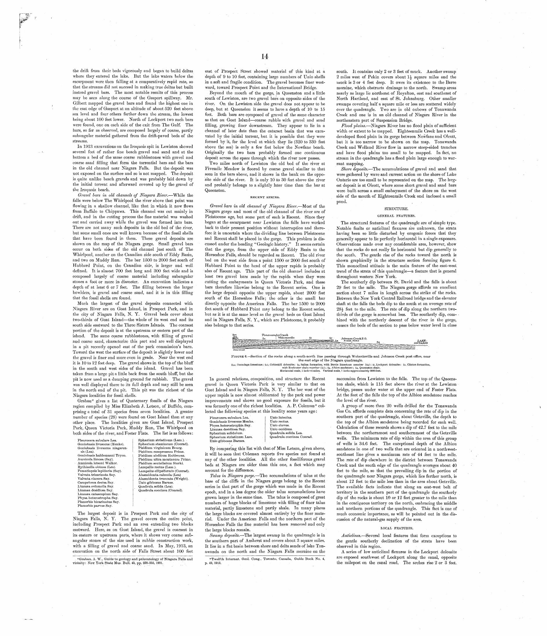
14
the drift from their beds vigorously and began to build deltas where they entered the lake. But the lake waters below the escarpment were then falling at a comparatively rapid rate, so that the streams did not succeed in making true deltas but built instead gravel bars. The most notable results of this process may be seen along the course of the Gasport spillway. Mr. Gilbert mapped the gravel bars and found the highest one in the east edge of Gasport at an altitude of about 520 feet above sea level and four others farther down the stream, the lowest being about 100 feet lower. North of Lockport two such bars were found, one on each side of the exit from The Gulf. The bars, so far as observed, are composed largely of coarse, partly subangular material gathered from the drift-paved beds of the streams.
In 1913 excavations on the Iroquois spit in Lewiston showed several feet of rather fine beach gravel and sand and at the bottom a bed of the same coarse rubblestones with gravel and coarse sand filling that form the torrential bars and the bars in the old channel near Niagara Falls. But the deposit was not exposed on the surface and so is not mapped. The deposit is quite unlike beach gravels and was probably laid down by the initial torrent and afterward covered up by the gravel of the Iroquois beach.
Gravel bars in old channels of Niagara River. While the falls were below The Whirlpool the river above that point was flowing in a shallow channel, like that in which it now flows from Buffalo to Chippawa. This channel was cut mainly in drift, and in the cutting process the fine material was washed out and carried away while the gravel was formed into bars. There are not many such deposits in the old bed of the river, but some small ones are well known because of the fossil shells that have been found in them. These gravel deposits are shown on the map of the Niagara gorge. Small gravel bars occur on both sides of the old channel just south of The Whirlpool, another on the Canadian side south of Eddy Basin, and two on Muddy Run. The bar 1500 to 2000 feet south of Hubbard Point, on the Canadian side, is larger and well defined. It is almost 700 feet long and 300 feet wide and is composed largely of coarse material including subangular stones a foot or more in diameter. An excavation indicates a depth of at least 6 or 7 feet. The filling between the larger bowlders, is gravel and coarse sand, and it is in this filling that the fossil shells are found.
Much the largest of the gravel deposits connected with Niagara River are on Goat Island, in Prospect Park, and in the city of Niagara Falls, N. Y. Gravel beds cover about two-thirds of Goat Island the whole of its west end and its south side eastward to the Three Sisters Islands. The coarsest portion of the deposit is at the upstream or eastern part of the island. The same coarse rubblestones, with filling of gravel and coarse sand, characterize this part and are well displayed in a pit recently opened east of the park commission's barn. Toward the west the surface of the deposit is slightly lower and the gravel is finer and more even in grade. Near the west end it is 10 to 12 feet deep. The gravel shows in the top of the bluff in the south and west sides of the island. Gravel has been taken from a large pit a little back from the south bluff, but the pit is now used as a dumping ground for rubbish. The gravel was well displayed there to its full depth and may still be seen in the north end of the pit. This pit was the richest of the Niagara localities for fossil shells.
Grabau a gives a list of Quaternary fossils of the Niagara region compiled by Miss Elizabeth J. Letson, of Buffalo, com prising a total of 31 species from seven localities. A greater number of species (28) were found on Goat Island than at any other place. The localities given are Goat Island, Prospect Park, Queen Victoria Park, Muddy Run, The Whirlpool on both sides of the river, and Foster Flats. The list is as follows:
Sphaerium striatinum (Lam.). Sphserium stamineum (Conrad). Pisidium virginicum Bourg. Pisidium compressum Prime. Pisidium abditum Haldeaian. Pisidium ultra montanmu Prime. Pisidium scutellatum Sterki. Lampsilis rectus (Lam.). Lampsilis ellipsiformis (Conrad). Alasmidonta calceola (Lea) Alasmidonta truncata (Wright). Unio gibbosus Barnes. Quadrula solida (Lea). Quadrula coccinea (Conrad).
Pleurocera subulare Lea. Groniobasis livescens (Menke). Goniobasis livescens niagaren-
sis (Lea).Groniobasis haldemanni Tryon. Amnicola limosa (Say). Amnicola letsoni Walker. Bythinella obtusa (Lea). Pomatiopsis lapidaria (Say). Valvata tricarinata Say. Valvata cincera Say. Campeloma decisa Say. Limnsea columella Say. Limnsea desidiosa Say. Limnaea catascopiurn Say. Physa heterostropha Say. Planorbis bicarinatus Say. Planorbis parvus Say.
The largest deposit is in Prospect Park and the city of Niagara Falls, N. Y. The gravel covers the entire point, including Prospect Park and an area extending two blocks eastward. Here, as on Goat Island, the gravel is coarsest in its eastern or upstream parts, where it shows very coarse sufj- angular stones of the size used in rubble construction work, with a filling of gravel and coarse sand. In May, 1913, an excavation on the north side of Falls Street about 100 feet
"Grabau, A. W., Guide to geology and paleontology of Niagara Falls and vicinity: New York State }kfus. Bull. 45, pp, 238-252, 1901.
east of Prospect Street showed material of this kind at a depth of 9 to 10 feet, containing large numbers of Unio shells in a soft and fragile condition. The gravel becomes finer west ward, toward Prospect Point and the International Bridge.
Beyond the mouth of the gorge, in Queenston and a little south of Lewiston, are two gravel bars on opposite sides of the river. On the Lewiston side the gravel does not appear to be deep, but at Queenston it seems to have a depth of 10 to 15 feet. Both bars are composed of gravel of the same character as that on Goat Island coarse rubble with gravel and sand filling, growing finer downstream. They appear to lie in a channel of later date than the cataract basin that was exca vated by the initial torrent, but it is possible that they were formed by it, for the level at which they lie (320 to 330 feet above the sea) is only a few feet below the Newfane beach. Originally the two bars probably formed one continuous deposit across the space through which the river now passes.
Two miles north of Lewiston the old bed of the river at Fivemile Meadow is floored by coarse gravel similar to that seen in the bars above, and it shows in the bank on the oppo site side of the river. It is only 10 to 30 feet above the river and probably belongs to a slightly later time than the bar at Queenston.
RECENT SERIES.
Gravel bars in old channel of Niagara River. Most of the Niagara gorge and most of the old channel of the river are of Pleistocene age, but some part of each is Recent. Since they began at the escarpment near Lewiston the falls have worked back to their present position without interruption and there fore it is uncertain where the dividing line between Pleistocene and Recent shall be placed in the gorge. This problem is dis cussed under the heading "Geologic history." It seems certain that the gorge, from the upper side of Eddy Basin to the Horseshoe Falls, should be regarded as Recent. The old river bed on the west side from a point 1500 or 2000 feet south of Hubbard Point to the head of the upper rapids is probably also of Recent age. This part of the old channel includes at least two gravel bars made by the rapids when they were cutting the embayments in Queen Victoria Park, and these bars therefore likewise belong to the Recent series. One is the large deposit opposite the upper rapids, about 2000 feet south of the Horseshoe Falls; the other is the small bar directly opposite the American Falls. The bar 1500 to 2000 feet south of Hubbard Point may belong to the Recent series, but as it is at the same level as the gravel beds on Goat Island and in Niagara Falls, N. Y., which are Pleistocene, it probably also belongs to that series.
Tonawanda- CreekSs ! "Wblcottsvflle 51 Sr
south. It contains only 2 or 3 feet of muck. Another swamp 2 miles west of Pekin covers about 1^ square miles and the muck is 3 or 4 feet deep. It owes its existence to the Barre moraine, which obstructs drainage to the north. Swamp areas nearly as large lie northeast of Royalton, east and southeast of North Hartland, and east of St. Johnsburg. Other smaller swamps covering half a square mile or less are scattered widely over the quadrangle. Two are in old oxbows of Tonawanda Creek and one is in an old channel of Niagara River in the northeastern part of Suspension Bridge.
Flood plains. Niagara River has no flood plain of sufficient width or extent to be mapped. Eighteenmile Creek has a well- developed flood plain in its gorge between Newfane and Olcott, but it is too narrow to be shown on the map. Tonawanda Creek and Welland River flow in narrow steep-sided trenches and have flood plains too small to be mapped. In fact, no stream in the quadrangle has a flood plain large enough to war rant mapping.
Shore deposits. The accumulations of gravel and sand that were gathered by wave and current action on the shore of Lake Ontario are too small to be represented on the map. The larg est deposit is at Olcott, where some short gravel and sand bars were built across a small embayment of the shore on the west side of the mouth of Eighteenmile Creek and inclosed a small pond. ,
STRUCTURE.
GENERAL FEATUKES.
The structural features of the quadrangle are of simple type. Notable faults or anticlinal flexures are unknown, the strata having been so little disturbed by orogenic forces that they generally appear to lie perfectly horizontal in a single exposure. Observations made over any considerable area, however, show that the rocks do not really lie horizontal but dip generally to the south. The gentle rise of the rocks toward the north is shown graphically in the structure section forming figure 6. This monoclinal attitude is the main feature of the east-west trend of the strata of this quadrangle a feature that is general throughout western New York.
The southerly dip between St. David and the falls is about 29 feet to the mile. The Niagara gorge affords an excellent section about 7 miles in length across the strike of the rocks. Between the New York Central Railroad bridge and the elevator shaft at the falls the beds dip to the south at an average rate of 28^ feet to the mile. The rate of dip along the northern two- thirds of the gorge is somewhat less. The southerly dip, com bined with the northerly descent of the liver in the gorge, causes the beds of the section to pass below water level in close
Johnson CreekP.O.RIDGE,ROAD
Sea. level
FIGURE 6. Section of the rocks along a south-north line passing through Wolcottsville and Johnson Creek post office, nearthe east edge of the Niagara quadrangle.
Don, Onondaga limestone; Sck, Cobleskill dolomite; Ss, Salina formation, with Bertie limestone member (Sb); SI, Lockport dolomite; Sc, Clinton formation,with Rochester shale member (Sr); Sa, Albion sandstone; Sq, Queenston shale.
Horizontal scale, 1 inch=4 miles. Vertical scale, 1 inch=approximately 2000 feet.
In general relations, composition, and structure the Recent gravel in Queen Victoria Park is very similar to that on Goat Island and in Niagara Falls, N. Y. The bar west of the upper rapids is now almost obliterated by the park and power improvements and shows no good exposure for fossils, but it was formerly one of the richest localities. A. P. Coleman 01 col lected the following species at this locality some years ago:
Pleurocera subulara Lea. Groniobasis livescens Menke. Physa hefcerostrophla Say. Limnsea desidiosa Say. Sphserium solidulum. Sphgerium striatinum Lam. Unio gibbosus Barnes.
Unio luteolus. Unio rectus. Unio clavus. Unio occidens. Quadrula solida Lea. Quadrula coccinea Conrad.
By comparing this list with that of Miss Letson, given above, it will be seen that Coleman reports five species not found at any of the other localities. All the other fossiliferous gravel beds at Niagara are older than this one, a fact which may account for the difference.
Talus in Niagara gorge. The accumulations of talus at the base of the cliffs in the Niagara gorge belong to the Recent series in that part of the gorge which was made in the Recent epoch, and in a less degree the older talus accumulations have grown larger in the same time. The talus is composed of great numbers of huge blocks of limestone with filling of finer talus material, partly limestone and partly shale. In many places the large blocks are covered almost entirely by the finer mate rial. Under the American Falls and the northern part of the Horseshoe Falls the fine material has been removed and only the large blocks remain.
Swamp deposits. The largest swamp in the quadrangle is in the southern part of Amherst and covers about 3 square miles. It lies in a flat basin between shore and delta sands of lake Ton awanda on the north and the Niagara Falls moraine on the
"Twelfth Internat. Geol. Gong., Toronto, Canada, Guide Book No. 4, p. 42, 1913,
succession from Lewiston to the falls. The top of the Queens- ton shale, which is 115 feet above the river at the Lewiston bridge, passes under water at the upper end of Foster Flats. At the foot of the falls the top of the Albion sandstone reaches the level of the river.
A group of more than 20 wells drilled for the Tonawanda Gas Co. affords complete data concerning the rate of dip in the southern part of the quadrangle, about Getzville, the depth to the top of the Albion sandstone being recorded for each well. Calculation of these records shows a dip of 42.7 feet to the mile between the northernmost and southernmost of the Getzville wells. The minimum rate of dip within the area of this group of wells is 34.6 feet. The exceptional depth of the Albion sandstone in one of two wells that are oriented in a northwest- southeast line gives a maximum rate of 44 feet to the mile. The rate of dip elsewhere in the district between Tonawanda Creek and the south edge of the quadrangle averages about 40 feet to the mile, so that the prevailing dip in the portion of the quadrangle near Niagara gorge, which lies farther north, is about 12 feet to, the mile less than in the area about Getzville. The available facts indicate that along an east-west belt of territory in the southern part of the quadrangle the southerly dip of the rocks is about 10 or 12 feet greater to the mile than in the contiguous territory on the north, embracing the middle and northern portions of the quadrangle. This fact is one of much economic importance, as will be pointed out in the dis cussion of the natural-gas supply of the area.
LOCAL FEATUKES.
Anticlines. Several local features that form exceptions to the gentle southerly declination of the strata have been observed in this region.
A series of low anticlinal flexures in the Lockport dolomite are exposed southwest of Lockport along the canal, opposite the milepost on the canal road, The arches rise 2 or 3 feet,
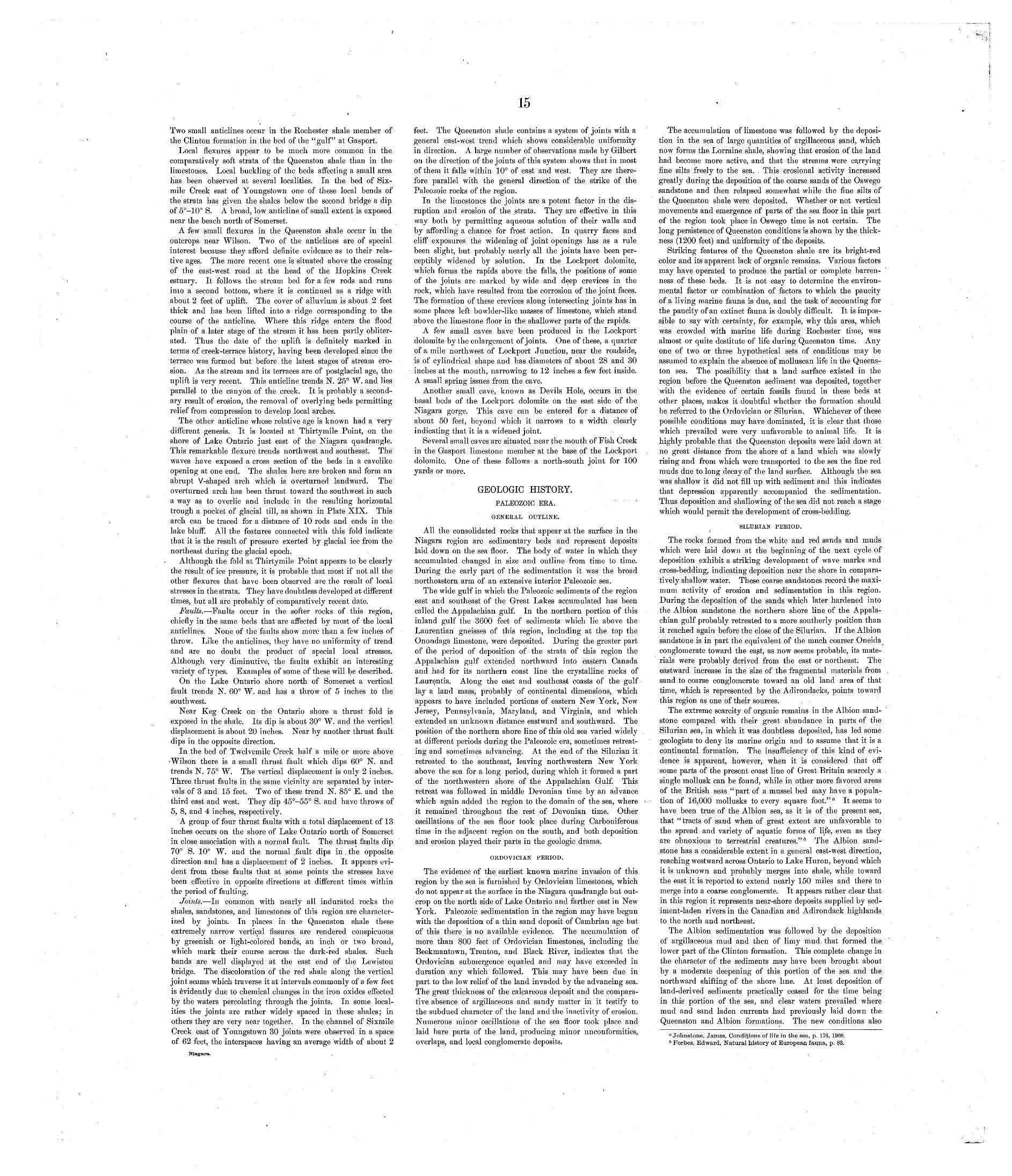
15
Two small anticlines occur in the Rochester shale member of the Clinton formation in the bed of the "gulf" at Gasport.
Local flexures appear to be much more common in the comparatively soft strata of the Queenston shale than in the limestones. Local buckling of the beds affecting a small area has been observed at several localities. In the bed of Six- mile Creek east of Youngstown one of these local bends of the strata has given the shales below the second bridge a dip of 5°-10° S. A broad, low anticline of small extent is exposed near the beach north of Somerset.
A few small flexures in the Queenston shale occur in the outcrops near Wilson. Two of the anticlines are of special interest because they afford definite evidence as to their rela tive ages. The more recent one is situated: above the crossing of the east-west road at the head of the Hopkins Creek estuary. It follows the stream bed for'a few rods and runs inio a second bottom, where it is continued as a ridge with about 2 feet of uplift. The cover of alluvium is about 2 feet thick and has been lifted into a ridge corresponding to the course of the anticline. Where this ridge enters the flood plain of a later stage of the stream it has been partly obliter ated. Thus the date of the uplift is definitely marked in terms of creek-terrace history, having been developed since the terrace was formed but before the latest stages of stream ero sion. As the stream and its terraces are of postglacial age, the uplift is very recent. This anticline trends N. 25° W. and lies parallel to the canyon of the creek. It is probably a second ary result of erosion, the removal of overlying beds permitting relief from compression to develop local arches.
The other anticline whose relative age is known had a very different genesis. It is located at Thirtymile Point, on the shore of Lake Ontario just east of the Niagara quadrangle. This remarkable flexure trends northwest and southeast. The waves have exposed a cross section of the beds in a cavelike opening at one end. The shales here are broken and form an abrupt V-shaped arch which is overturned landward. The overturned arch has been thrust toward the southwest in such a way as to overlie and include in the resulting horizontal trough a pocket of glacial till, as shown in Plate XIX. This arch can be traced for a distance of 10 rods and ends in the lake bluff. All the features connected with this fold indicate that it is the result of pressure exerted by glacial ice from the northeast during the glacial epoch.
Although the fold at Thirtymile Point appears to be clearly the result of ice pressure, it is probable that most if not all the other flexures that have been observed are the result of local stresses in the strata. They have doubtless developed at different times, but all are probably of comparatively recent date.
Faults. Faults occur in the softer rocks of this region, chiefly in the same beds that are affected by most of the local anticlines. None of the faults show more than a few inches of throw. Like the anticlines, they have no uniformity of trend and are no doubt the product of special local stresses. Although very diminutive, the faults exhibit an interesting variety of types. Examples of some of these will be described.
On the Lake Ontario shore north of Somerset a vertical fault trends N. 60° W. and has a throw of 5 inches to the southwest.
Near Keg Creek on the Ontario shore a thrust fold is exposed in the shale. Its dip is about 30° W. and the vertical displacement is about 20 inches. Near by another thrust fault dips in the opposite direction.
In the bed of Twelvemile Creek half a mile or more above Wilson there is a small thrust fault which dips 60° N. and trends N. 75° W. The vertical displacement is only 2 inches. Three thrust faults in the same vicinity are separated by inter vals of 3 and 15 feet. Two of these trend N. 85° E. and the third east and west. They dip 45°-55° S. and have throws of 5, 8, and 4 inches, respectively.
A group of four thrust faults with a total displacement of 13 inches occurs on the shore of Lake Ontario north of Somerset in close association with a normal fault. The thrust faults dip 70° S. 10° W. and the normal fault dips in. the opposite direction and has a displacement of 2 inches. It appears evi dent from these faults that at some points the stresses have been effective in opposite directions at different times within the period of faulting.
Joints. In common with nearly all indurated rocks the shales, sandstones, and limestones of this region are character ized by joints. In places in the Queenston shale these extremely narrow vertical fissures are rendered conspicuous by greenish or light-colored bands, an inch or two broad, which mark their course across the dark-red shales. Such bands are well displayed at the east end of the Lewiston bridge. The discoloration of the red shale along the vertical joint seams which traverse it at intervals commonly of a few feet is evidently due to chemical changes in the iron oxides effected by the waters percolating through the joints. In some local ities the joints are rather widely spaced in these shales; in others they are very near together. In the channel of Sixmile Creek east of Youngstown 30 joints were observed in a space of 62 feet, the interspaces having an average width of about 2
Niagara.
feet. The Queenston shale contains a system of joints with a general east-west trend which shows considerable uniformity in direction. A large number of observations made by Gilbert on the direction of the joints of this system shows that in most of them it falls within 10° of east and west. They are there fore parallel with the general direction of the strike of the Paleozoic rocks of the region.
In the limestones the joints are a potent factor in the dis ruption and erosion of the .strata. They are effective in this way both by permitting aqueous solution of their walls and by affording a chance for frost action. In quarry faces and cliff exposures the widening of joint openings has as a rule been slight, but probably nearly all the joints have been per ceptibly widened by solution. In the Lockport dolomite, which forms the rapids above the falls, the positions of some of the joints are marked by wide and deep crevices in the rock, which have resulted from the corrosion of the joint faces. The formation of these crevices along intersecting joints has in some places left bowlder-like masses of limestone, which stand above the limestone floor in the shallower parts of the rapids.
A few small caves have been produced in the Lockport dolomite by the enlargement of joints. One of these, a quarter of a mile northwest of Lockport Junction, near the roadside, is of cylindrical shape and has diameters of about 28 and 30 inches at the mouth, narrowing to 12 inches a few feet inside. A small spring issues from the cave.
Another small cave, known as Devils Hole, occurs in the basal beds of the Lockport dolomite on the east side of the Niagara gorge. This cave can be entered for a distance of about 50 feet, beyond which it narrows to a width clearly indicating that it is a widened joint.
Several small caves are situated near the mouth of Fish Creek in the Gasport limestone member at the base of the Lockport dolomite. One of these follows a north-south joint for 100 yards or more.
GEOLOGIC HISTORY.PALEOZOIC ERA. """"
GENERAL OUTLINE.
All the consolidated rocks that appear at the surface in the Niagara region are sedimentary beds and represent deposits laid down on the sea floor. The body of water in which they accumulated changed in size and outline from time to time. During the early part of the sedimentation it was the broad northeastern arm of an extensive interior Paleozoic sea.
The wide gulf in which the Paleozoic sediments of the region east and southeast of the Great Lakes accumulated has been called the Appalachian gulf. In the northern portion of this inland gulf the 3600 feet of sediments which lie above the Laurentian gneisses of this region, including at the top the Onondaga limestone, were deposited. During the greater part of the period of deposition of the strata of this region the Appalachian gulf extended northward into eastern Canada and had for its northern coast line the crystalline rocks of Laure.ntia. Along the east and southeast coasts of the gulf lay a land mass, probably of continental dimensions, which appears to have included portions of eastern New York, New Jersey, Pennsylvania, Maryland, and Virginia, and which extended an unknown distance eastward and southward. The position of the northern shore line of this old sea varied widely at different periods during the Paleozoic era, sometimes retreat ing and sometimes advancing. At the end of the Silurian it retreated to the southeast, leaving northwestern New York above the sea for a long period, during which it formed a part of tlie northwestern shore of the Appalachian Gulf. This retreat was followed in middle Devonian time by an advance which again added the region to the domain of the sea, where it remained throughout the rest of Devonian time. Other oscillations of the sea floor took place during Carboniferous time in the adjacent region on the south, and both deposition and erosion played their parts in the geologic drama.
ORDOVICIAN PERIOD.
The evidence of the earliest known marine invasion of this region by the sea is furnished by Ordovician limestones, which do not appear at the surface in the Niagara quadrangle but out crop on the north side of Lake Ontario and farther east in New York. Paleozoic sedimentation in the region may have begun with the deposition of a thin sand deposit of Cambrian age but of this there is no available evidence. The accumulation of more than $00 feet of Ordovician limestones, including the Beekmantown, Trenton, and Black River, indicates that the Ordovician submergence equaled and may have exceeded in duration any which followed. This may have been due in part to the low relief of the land invaded by the advancing sea. The great thickness of the calcareous deposit and the compara tive absence of argillaceous and sandy matter in it testify to the subdued character of the land and the inactivity of erosion. Numerous minor oscillations of the sea floor took place and laid bare parts of the land, producing minor unconformities, overlaps, and local conglomerate deposits.
The accumulation of limestone was followed by the deposi tion in the sea of large quantities of argillaceous sand, which now forms the Lorraine shale, showing that erosion of the land had become more active, and that the streams were carrying fine silts freely to the sea. This erosional activity increased greatly during the deposition of the coarse sands of the Oswego sandstone and then relapsed somewhat while the fine silts of the Queenston shale were deposited. Whether or not vertical movements and emergence of parts of the sea floor in this part of the region took place in Oswego time is not certain. The long persistence of Queenston conditions is shown by the thick ness (1200 feet) and uniformity of the deposits.
Striking features of the Queenston shale are its bright-red color and its apparent lack of organic remains. Various factors may have operated to produce the partial or complete barren ness of these beds. It is not easy to determine the environ mental factor or combination of factors to which the paucity of a living marine fauna is due, and the task of accounting for the paucity of an extinct fauna is doubly difficult. It is impos sible to say with certainty, for example, why this area, which was crowded with marine life during Rochester time, was almost or quite destitute of life during Queenston time. Any one of two or three hypothetical sets of conditions may be assumed to explain the absence of molluscan life in the Queens- ton sea. The possibility that a land surface existed in the region before the Queenston sediment was deposited, together with the evidence of certain fossils found in these beds at other places, makes it doubtful whether the formation should be referred to the Ordovician or Silurian. Whichever of these possible conditions may have dominated, it is clear that those which prevailed were very unfavorable to animal life. It is highly probable that the Queenston deposits were laid down at no great distance from the shore of a land which was slowly rising and from which were transported to the sea the fine red muds due to long decay of the land surface. Although the sea was shallow it did not fill up with sediment and this indicates that depression apparently accompanied the sedimentation. Thus deposition and shallowing of the sea did not reach a stage which would permit the development of cross-bedding.
SILURIAN PERIOD.
The rocks formed from the white and red sands and muds which were laid down at the beginning of the next cycle of deposition exhibit a striking development of wave marks and cross-bedding, indicating deposition near the shore in compara tively shallow water. These coarse sandstones record the maxi mum activity of erosion and sedimentation in this region. During the deposition of the sands which later hardened into the Albion sandstone the northern shore line of the Appala chian gulf probably retreated to a more southerly position than it reached again before the close of the Silurian. If the Albion sandstone is in part the equivalent of the much coarser Oneida conglomerate toward the east, as now seems probable, its mate rials were probably derived from the east or northeast. The eastward increase in the size of the fragmental materials from sand to coarse conglomerate toward an old land area of that time, which is represented by the Adirondacks, points toward this region as one of their sources.
The extreme scarcity of organic remains in the Albion sand stone compared with their great abundance in parts of the Silurian sea, in which it was doubtless deposited, has led some geologists to deny its marine origin and to assume that it is a continental formation. The insufficiency of this kind of evi dence is apparent, however, when it is considered that off some parts of the present coast line of Great Britain scarcely a single mollusk can be found, while in other more favored areas of the British seas " part of a mussel bed may have a popula tion of 16,000 mollusks to every square foot." a It seems to have been true of the Albion sea, as it is of the present sea, that "tracts of sand when of great extent are unfavorable to the spread and variety of aquatic forms of life, even as they are obnoxious to terrestrial creatures." 5 The Albion sand stone has a considerable extent in a general east-west direction, reaching westward across Ontario to Lake Huron, beyond which it is unknown and probably merges into shale, while toward the east it is reported to extend nearly 150 miles and there to merge into a coarse conglomerate. It appears rather clear that in this region it represents near-shore deposits supplied by sed iment-laden rivers in the Canadian and Adirondack highlands to the north and northeast.
The Albion sedimentation was followed by the deposition of argillaceous mud and then of limy mud. that formed the lower part of the Clinton formation. This complete change in the character of the sediments may have been brought about by a moderate deepening of this portion of the sea and the northward shifting of the shore line. At least deposition of land-derived sediments practically ceased for the time being in this portion of the sea, and clear waters prevailed where mud and sand laden currents had previously laid down the Queenston and Albion formations. The new conditions also
a Johnstone, James, Conditions of life in the sea, p. 176, 1908. b Forbes, Edward, Natural history of European fauna, p, 83.
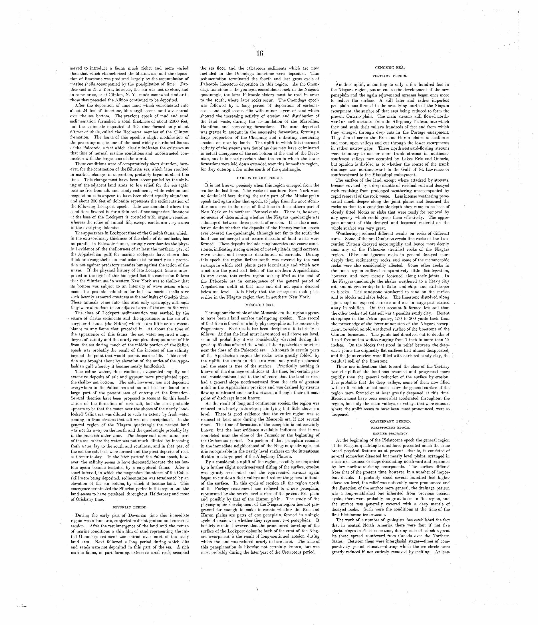
16
served to introduce a fauna much richer and more varied than that which characterized the Medina sea, and the deposi tion of limestone was produced largely by the accumulation of marine shells accompanied by the precipitation of lime. Far ther east in New York, however, the sea was not so clear, and in some areas, as at Clinton, N. Y., muds somewhat similar to those that preceded the Albion continued to be deposited.
After the deposition of lime mud which consolidated into about 24 feet of limestone, blue argillaceous mud was spread over the sea bottom. The previous epoch of mud and sand sedimentation furnished a total thickness of about 2000 feet, but the sediments deposited at this time formed only about 60 feet of shale, called the Rochester member of the Clinton formation. The fauna of this epoch, a slight modification of the preceding one, is one of the most widely distributed faunas of the Paleozoic, a fact which clearly indicates the existence at that time of normal marine conditions and unobstructed con nection with the larger seas of the world.
These conditions were of comparatively short duration, how ever, for the contraction of the Silurian sea, which later resulted in marked changes in deposition, probably began at about this time. This change must have been accompanied by the sink ing of the adjacent land areas to low relief, for the sea again became free from silt and sandy sediments, while calcium and magnesium salts appear to have been about equally abundant, and about 200 feet of dolomite represents the sedimentation of the following Lockport epoch. Life was abundant where the conditions favored it, for a thin bed of nonmagnesian limestone at the base of the Lockport is crowded with organic remains, whereas the relics of animal life, except corals, are very scarce in the overlying dolomite.
The appearance in Lockport time of the Guelph fauna, which, in the extraordinary thickness of the shells of its mollusks, has no parallel in Paleozoic faunas, strongly corroborates the phys ical evidence of the shallowness of at least the northern part of the Appalachian gulf, for marine zoologists have shown that thick or strong shells on mollusks exist primarily as a protec tion not against predatory enemies but against the action of the waves. If the physical history of late Lockport time is inter preted in the light of this biological fact the conclusion follows that the Silurian sea in western New York was so shallow that its bottom was subject to an intensity of wave action which made it a possible habitation for but few marine shells save such heavily armored creatures as the mollusks of Guelph time. These animals came into this area only sparingly, although they were abundant in an adjacent area of the sea to the west.
The close of Lockport sedimentation was marked by the return of clastic sediments and the appearance in the sea of a eurypterid fauna (the Salina) which bears little or no resem blance to any fauna that preceded it. At about the time of the appearance of this fauna the sea water acquired a high degree of salinity and the nearly complete disappearance of life from the sea during much of the middle portion of the Salina epoch was probably the result of the increase of the salinity beyond the point that would permit marine life. This condi tion was brought about by elevation of the outlet of the Appa lachian gulf whereby it became nearly landlocked.
The saline waters, thus confined, evaporated rapidly and extensive deposits of salt and gypsum were precipitated upon the shallow sea bottom. The salt, however, was not deposited everywhere in the Salina sea and no salt beds are found in a large part of the present area of outcrop of the formation. Several theories have been proposed to account for this locali zation of the formation of rock salt, but the most probable appears to be that the water near the shores of the nearly land locked Salina sea was diluted to such an extent by fresh water coming in from streams that salt was|not precipitated. In the general region of the Niagara quadrangle the nearest land was not far away on the north and the quadrangle probably lay in the brackish-water zone. The deeper and more saline part of the sea, where the water was not much diluted by incoming fresh water, lay to the south and southeast, and in that part of the sea the salt beds were formed and the great deposits of rock salt occur to-day. In the later part of the Salina epoch, how ever, the salinity seems to have decreased,!because the sea bot tom again became tenanted by a eurypterid fauna, After a short interval, in which the magnesian limestones of the Coble- skill were being deposited, sedimentation was terminated by an elevation of the sea bottom, by which it became land. This emergence terminated the Silurian period in this region and the land seems to have persisted throughout Helderberg and most of Oriskany time.
DEVONIAN PERIOD.
During the early part of Devonian time this immediate region was a land area, subjected to disintegration and subaerial erosion. After the resubmergence of the land and the return of marine conditions a thin film of sand representing the ini tial Onondaga sediment was spread over most of the early land area. Next followed a long period during which silts and sands were not deposited in this part of the sea. A rich marine fauna, in part forming extensive coral reefs, occupied
the sea floor, and the calcareous sediments which are now included in the Onondaga limestone were deposited. This sedimentation terminated' the fourth and last great cycle of Paleozoic limestone deposition in this region. As the Onon daga limestone is the youngest consolidated rock in the Niagara quadrangle, the later Paleozoic history must be read in areas to the south, where later rocks occur. The Onondaga epoch was followed by a long period of deposition of carbona ceous and argillaceous silts with minor layers of sand which showed the increasing activity of erosion and distribution of the land waste, during the accumulation of the Marcellus, Hamilton, and succeeding formations. The sand deposited was greater in amount in the successive formations, forming a large proportion of the Chemung and indicating increasing erosion on near-by lands. The uplift to which this increased activity of the streams was doubtless due may have culminated in actual emergence of the sea bottom at the end of the Devo nian, but it is nearly certain that the sea in which the lower formations were laid down extended over this immediate region, for they outcrop a few miles south of the quadrangle.
CARBONIFEROUS PERIOD.
It is not known precisely when this region emerged from the sea for the last time. The rocks of southern New York were no doubt laid bare during the early part of the Mississippian epoch and again after that epoch, to judge from the unconform ities now seen in the rocks of that time in the southern part of New York or in northern Pennsylvania. There is, however, no means of determining whether the Niagara quadrangle was submerged between these periods of erosion. It is also a mat ter of doubt whether the deposits of the Pennsylvanian epoch ever covered the quadrangle, although not far to the south the land was submerged and coarse deposits of land waste were formed. These deposits include conglomerates and coarse sand stones, indicating strong erosion of near-by lands, rapid currents, wave action, and irregular distribution of currents. During this epoch the region farther south was covered by the vast swamps in which coal plants grew luxuriantly and which now constitute the great coal fields of the northern Appalachians. In any event, this entire region was uplifted at the end of the Paleozoic era in consequence of the general period of Appalachian uplift at that time and did not again descend below sea level. It is likely that the emergence took place earlier in the Niagara region than in southern New York.
MESOZOIC ERA.
Throughout the whole of the Mesozoic era the region appears to have been a land surface undergoing erosion. The record of that time is therefore wholly physiographic and is necessarily fragmentary. So far as it has been deciphered it is briefly as follows: At first the land must have stood well above sea level, as in all probability it was considerably elevated during the great uplift that affected the whole of the Appalachian province near the close of the Paleozoic era. Although in certain parts of the Appalachian region the rocks were greatly folded by the uplift, the strata in this area were not greatly deformed and the same is true of the surface. Practically nothing is known of the drainage conditions at the time, but certain gen eral considerations lead to the inference that the land surface had a general slope northwestward from the axis of greatest uplift in the Appalachian province and was drained by streams flowing northward and northwestward, although their ultimate point of discharge is not known.
As the result of long and continuous erosion the region was reduced to a nearly featureless plain lying but little above sea level. There is good evidence that the entire region was so reduced at least once during the Mesozoic era, if not several times. The time of formation of the peneplain is not certainly known, but the best evidence available indicates that it was completed near the close of the Jurassic or the beginning of the Cretaceous period. No portion of that peneplain remains in the immediate neighborhood of the Niagara quadrangle, but it is recognizable in the nearly level surfaces on the interstream divides in a large part of the Allegheny Plateau.
By a considerable uplift of the region, possibly accompanied by a further slight northwestward tilting of the surface, erosion was greatly accelerated and the rejuvenated streams again began to cut down their valleys and reduce the general altitude of the surface. In this cycle of erosion all the region north of the Portage escarpment was reduced to a new peneplain, represented by the nearly level surface of the present Erie plain and possibly by that of the Huron plain. The study of the physiographic development of the Niagara region has not pro gressed far enough to make it certain whether the Erie and Huron plains are parts of one peneplain, formed in a single cycle of erosion, or whether they represent two peneplains. It is fairly certain, however, that the pronounced beveling of the surface of the Lockport dolomite back of the crest of the Niag ara escarpment is the result of long-continued erosion during which the land was reduced nearly to base level. The time of this peneplanation is likewise not certainly known, but was most probably during the later 'part of the Cretaceous period.
CENOZOIC ERA.
TERTIARY PERIOD.
Another uplift, amounting to only a few hundred feet in the Niagara region, put an end to the development of the new peneplain and the again rejuvenated streams began once more to reduce the surface. A still later and rather imperfect peneplain was formed in the area lying north of the Niagara escarpment, the surface of that area being reduced to form the present Ontario plain. The main streams still flowed north ward or northwestward from the Allegheny Plateau, into which they had sunk their valleys hundreds of feet and from which they emerged through deep cuts in the Portage escarpment. They flowed across the Erie and Huron plains in shallower and more open valleys and cut through the lower escarpments in rather narrow gaps. These northwestward-flowing streams were tributary to one or more trunk streams in northeast- southwest valleys now occupied by Lakes Erie and Ontario, but opinion is divided as to whether the course of the trunk drainage was northeastward to the Gulf of St. Lawrence or south west ward to the Mississippi embay ment.
The surface of the land, except where attacked by streams, became covered by a deep mantle of residual soil and decayed rock resulting from prolonged weathering unaccompanied by rapid removal of the rock waste. Less intense weathering pene trated much deeper along the joint planes and loosened the rocks so that to a considerable depth they came to be beds of closely fitted blocks or slabs that were ready for removal by any agency which could grasp them effectively. The aggre gate amount of this decayed and loosened material on the whole surface was very great.
Weathering produced different results on rocks of different sorts. Some of the pre-Cambrian crystalline rocks of the Lau- rentian Plateau decayed more rapidly and hence more deeply than any of the Paleozoic stratified rocks of the Niagara region. Dikes and igneous rocks in general decayed more deeply than sedimentary rocks, and some of the metamorphic rocks were also considerably affected, Some other rocks in the same region suffered comparatively little disintegration, however, and were merely loosened along their joints. In the Niagara quadrangle the shales weathered to a heavy clay soil and at greater depths to flakes and chips and still deeper to blocks. The sandstone weathered to sand on the surface and to blocks and slabs below. The limestone dissolved along joints and on exposed surfaces and was in large part carried away in solution. On that account it formed less soil than the other rocks and that soil was a peculiar sandy clay. Recent strip pings in the Pekin quarry, 150 to 200 yards back from the former edge of the lower minor step of the Niagara escarp ment, revealed an old weathered surface of the limestone of the Clinton formation. The joints had dissolved out to depths of 1 to 4 feet and to widths ranging from 1 inch to more than 12 inches. On the blocks that stood in relief between the deep ened joints the originally flat surfaces had almost disappeared, and the joint crevices were filled with dark-red sandy clay, the residual soil of the limestone.
There are indications that toward the close of the Tertiary period uplift of the land was resumed and progressed more rapidly than the general reduction of the surface by erosion. It is probable that the deep valleys, some of them now filled with drift, which are cut much below the general surface of the region were formed or at least greatly deepened at this time. Erosion must have been somewhat accelerated throughout the region, but only the main valleys, or valleys that were situated where the uplift seems to have- been most pronounced, were so deepened.
QUATERNARY PERIOD.
PLEISTOCENE EPOCH.
EARLIER GLACTATION.
At the beginning of the Pleistocene epoch the general region of the Niagara quadrangle must have presented much the same broad physical features as at present that is, it consisted of several somewhat dissected but nearly level plains, arranged in a series of terraces or steps descending northward and separated by low northward-facing escarpments. The surface differed from that of the present time, however, in a number of impor tant details. It probably stood several hundred feet higher above sea level, the relief was noticeably more pronounced and the dissection of the surface more general, the drainage pattern was a long-established one inherited from previous erosion cycles, there were probably no great lakes in the region, and the surface was generally covered with a deep mantle of decayed rocks. Such were the conditions at the time of the first Pleistocene ice invasion.
The work of a number of geologists has established the fact that in central North America there were four if not five glacial stages in Pleistocene time, during each of which a great ice sheet spread southward from Canada over the Northern States. Between them were interglacial stages times of com paratively genial climate during which the ice sheets were greatly reduced if not entirely removed by melting. At least
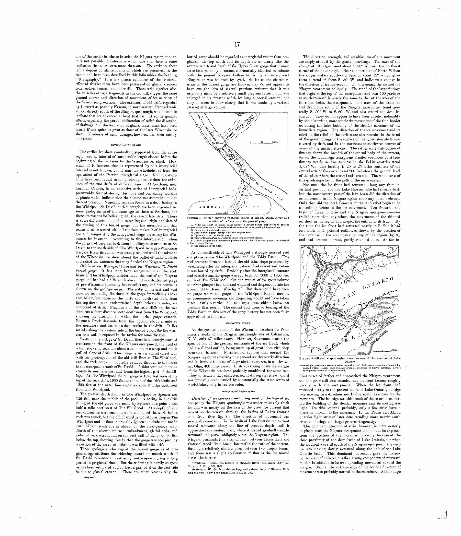
one of the earlier ice sheets invaded the Niagara region, though it is not possible to determine which one and there is some indication that there were more than one. The early ice sheet left a deposit of till, remnants of which are preserved in the region and have been described in this folio under the heading "Stratigraphy." In a few places evidences of the erosional effect of this ice mass have been preserved on glacially scored rock surfaces beneath the older till. These stria3 together with the varieties of rock fragments in the old till, suggest the same general source and direction of movement of ice as those of the Wisconsin glaciation. The existence of old drift, regarded by Leverett as possibly Kansan, in northwestern Pennsylvania almost directly south of the Niagara quadrangle would seem to indicate that ice advanced at least that far. If so, its general effects, especially the partial obliteration of relief, the diversion of drainage, and the formation of glacial lakes, must have been nearly if not quite as great as those of the later Wisconsin ice sheet. Evidence of such changes, however, has been mostly obliterated.
INTERGLACIAL STAGE.
The earlier ice sheet eventually disappeared from the entire region and an interval of considerable length elapsed before the beginning of the invasion by the Wisconsin ice sheet. How much of Pleistocene time is represented by this interglacial interval is not known, but it must have included at least the equivalent of the Peorian interglacial stage. No indications of it have been found in the quadrangle other than the exist ence of the two drifts of different ages. At Scarboro, near Toronto, Canada, is an extensive series of interglacial beds, presumably formed during this time and containing remains of plants which indicate that the climate was somewhat milder than at present. Vegetable remains found in a deep boring in the Whirlpool-St. David buried gorgeh ave been regarded by some geologists as of the same age as those at Scarboro, but there are reasons for believing that they are of later date. There is some difference of opinion regarding the origin and date of the cutting of this buried gorge, but the interpretation that seems most in accord with all the facts makes it of interglacial age and assigns it to the interglacial stage preceding the Wis consin ice invasion. According to this interpretation, when the gorge had been cut back from the Niagara escarpment at St. David to the south side of The Whirlpool by a pre-Wisconsin Niagara Eiver its volume was greatly reduced until the advance of the Wisconsin ice sheet closed the outlet of Lake Ontario and raised the waters so that they flooded the Niagara region.
Origin of the Whirlpool basin and the Whirlpool-St. David buried gorge. It has long been recognized that the rock basin of The Whirlpool is older than the rest of the Niagara gorge and has had a different history. It is a drift-filled gorge of pre-Wisconsin (probably interglacial) age, and its course is shown on the geologic maps. The walls on its east and west sides are rock cliffs, like those in the gorge immediately above and below, but those on the north and northwest sides, from the top down to an undetermined depth below the water, are composed of drift. Fragments of the rock cliffs on the two sides run a short distance north-northwest from The Whirlpool, showing the direction in which the buried gorge extends. Bowman Creek descends from the upland about a mile to the northwest and has cut a deep ravine in the drift. It lies mainly along the western side of the buried gorge, for the west ern rock wall is exposed in the ravine for some distance.
South of the village of St. David there is a strongly marked reentrant in the front of the Niagara escarpment, the head of which shows no rock for about a mile but is a steep and much gullied slope of drift. This place is in an almost direct line with the prolongation of the old cliff lines at The Whirlpool, and the rock gorge undoubtedly extends through to the break in the escarpment south of St. David. A faint terminal moraine crosses its northern part and forms the highest part of the fill ing. At The Whirlpool the old gorge is 1875 feet wide at the top of the rock cliffs, 1950 feet at the top of the drift bluffs, and 1200 feet at the water line, and it extends 2 miles northwest from The Whirlpool.
The greatest depth found in The Whirlpool by Spencer was 126 feet, near the middle of the pool. A boring in the drift filling of the old gorge was made by Spencer at a point about half a mile northwest of The Whirlpool. At a depth, of 269 feet difficulties were encountered that stopped the work before rock was struck, but the old channel is probably as deep as The Whirlpool and its floor is probably Queenston shale and not in part Albion sandstone as shown on the areal-geology map. North of the electric railroad embankment, glacial striaB and polished rock were found on the west wall of the gorge 90 feet below the top, showing clearly that the gorge was occupied by a portion of the ice sheet before it was filled with drift.
Those geologists who regard the buried gorge- as of pre glacial age attribute the widening toward its mouth south of St. David to subaerial weathering and erosion during a long period in preglacial time. But the widening is hardly so great as has been estimated and at least a part of it on the west side is due to glacial erosion. There are other reasons why the
17
buried gorge should be regarded as interglacial rather than pre glacial. Its top width and its depth are so nearly like the average width and depth of the Upper Great gorge that it must have been made by a cataract substantially identical in volume with the present Niagara Falls that is, by an interglacial Niagara, as was believed by Lyell. So far as the character istics of the. buried gorge are known, they do not appear to bear out ( the idea of several previous writers" that it was originally made by a relatively small preglacial stream and was enlarged to its present width by long subaerial erosion, but they do seem to show clearly that it was made by a vertical cataract of large volume.
FIGURE 7. Sketch showing probable course of old St. David River and relation of its features to the present gorge.
A. Width and depth of buried gorge indicate a stream having proportions of present Niagara River, presumably the outlet of the same four lakes, suggesting interglacial age.
B. Upper end of wide buried gorge.C. Narrow buried gorge, enlarged later by Niagara River.D. Upper end of narrow buried gorge.E. Flow of Niagara Falls decreased to 15 per cent of present volume:F. Flow of Niagara Falls increased to present volume. End of narrow gorge later enlarged
by large-volume Niagara.G. Old col in limestone ridge.
At the south side of The Whirlpool a strongly marked reef sharply separates The Whirlpool and the Eddy Basin. This reef seems to form the base of the old talus slope produced by weathering after the interglacial cataract had ceased and before it was buried by drift. Probably after the interglacial cataract had ceased a smaller gorge was cut back for 1000 to 1200 feet south of The Whirlpool. On the return of its great volume the river plunged into this and widened and deepened it into the present Eddy Basin. (See fig. 7.) But there could have been no gorge where the gorge of the Whirlpool Rapids now is, or pronounced widening and deepening would not have taken place. Only a vertical fall making a great caldron below can produce this result. The critical and decisive bearing of the Eddy Basin on this part of the gorge history has not been fully appreciated in the past.
WISCONSIN STAGE.
At the greatest extent of the Wisconsin ice sheet its front directly south of the Niagara quadrangle was at Salamanca, N. Y., only 67 miles away. However, Salamanca marks the apex of one of the greatest reentrants of the ice front, which had a scalloped outline, being made up of great lobes with deep reentrants between. Furthermore, the ice that crossed the Niagara region was moving in a general southwesterly direction and its front at the time of its greatest extent was in southwest ern Ohio, 400 miles away. In its advancing phase the margin of the Wisconsin ice sheet probably manifested the same ten dency to oscillate that characterized it during its retreat, and it was probably accompanied by substantially the same series of glacial lakes, only in reverse order.
Occupancy of Kegion by Ice.
Direction of ice movement.- During most of the time of ice occupancy the Niagara quadrangle was under relatively thick ice and was nearly on the axis of the great ice current that moved southwestward through the basins of Lakes Ontario and Erie. (See fig. 8.) The direction of movement was practically constant. In the basin of Lake Ontario the current moved westward along the line of greatest depth until it^ approached the western part, where it turned gradually south- westward and passed obliquely across the Niagara region. The Niagara peninsula (the strip of land between Lakes Erie and Ontario) stood like a broad, low reef in the path of the current, forming a relatively shallow place between two deeper basins, and there was a slight acceleration of flow as the ice moved across the barrier.
"Pohlman, Julius, Life history of Niagara River: Aui. Assoc. Adv. Sci. Proc., vol 82, p., 202, 1884.
Grabau, A. W., Guide to the geology and paleontology of Niagara Palls and vicinity: New York State Mus. Bull. 45, 1901.
The direction, strength, and steadfastness of the movement are amply attested by the glacial markings. The axes of the elongated till ridges trend about S. 68° W. near the northeast corner of the quadrangle. Near the meridian of North Wilson the ridges make a southward bend of about 12°, which gives them a trend of about S. 56° W. and indicates a change in the direction of ice movement. On this course the ice met the Niagara escarpment obliquely. The trend of the large flutings that begin at the top of the escarpment and run 100 yards or so southwestward is nearly the same as that of the axes of the till ridges below the escarpment. The axes of the drumlins and drumloids south of the Niagara escarpment trend gen erally S. 50° W. to S. 60° W. and also record the deep ice current. They do not appear to have been affected noticeably by the discordant, more southerly movement of the thin border ice during the later building of the slender moraines of the immediate region. The direction of the ice movement and its effect on the relief of the surface are also recorded in the trend of the great flutings in the surface of the Queenston shale now covered by drift, and in the northeast or southwest courses of many of the smaller streams. The rather wide distribution of flutings shows the breadth of the central body of the current, for on the Onondaga escarpment 2 miles southwest of Akron flutings nearly as fine as those in the Pekin quarries trend S. 68° W. The locality is 20 to 25 miles southeast of the central axis of the current and 200 feet above the general level of the plain where the central axis crosses. The whole area of this quadrangle lay in the path of the main current.
Not until the ice front had retreated a long way from its farthest position and the Lake Erie ice lobe had shrunk back into the northeastern part of the lake basin did the direction of ice movement in the Niagara region show any notable change. Only then did the local elements of the land relief begin to be controlling factors in the ice movement. Two features the basin of Lake Ontario and the Niagara escarpment con trolled, more than any others, the movements of the thinned ice sheet in the region and shaped the outline of its front. By the time the ice front had retreated nearly to Buffalo it had lost much of its pointed outline, as shown by the position of the moraines in the accompanying map of the region (fig. 8), and had become a broad, gently rounded lobe. As the ice
FIGURE 8. Sketch map showing moraines around the west end of LakeOntario.
Dense stipple pattern represents moraines formed on land ; light pattern, moraines deposited in ponded water. Dashed lines indicate probable extension of known moraines. Arrows show general direction of ice movement.
front retreated farther and approached the Niagara escarpment the lobe grew still .less rounded and its front became roughly parallel with the escarpment. When the ice front had retreated nearly to the present shore of Lake Ontario, its edge was moving in a direction nearly due south, as shown by the moraines. The ice edge was thin south of the escarpment dur ing the building of the slender moraines and its scoring was light. On this account, probably, only a few striae have a direction normal to the moraines. In the Pekin and Akron quarries light striae of later date trending more nearly south cross the flutings and larger grooves diagonally.
The dominant direction of striaB, however, is more westerly in places near the Niagara escarpment than might be expected from the position of the moraines, probably because of the close proximity of the deep basin of Lake Ontario, for when the ice front was still south of the Niagara escarpment the deep ice was moving slowly westward along the axis of the Lake Ontario basin. This dominant movement gave the narrow border strip of thin ice a rather strong component of westward motion in addition to its own spreading movement toward the margin. Still, at the extreme edge of the ice the direction of movement was probably normal to the moraines. At this stage
Niagara.
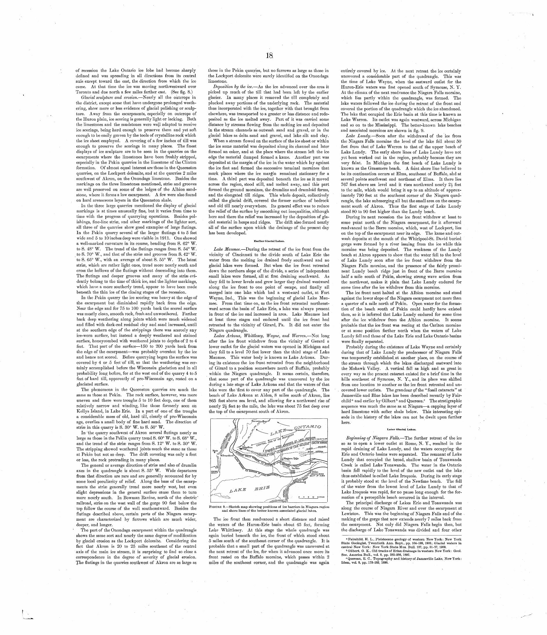
18
of recession the Lake Ontario ice lobe had become sharply defined and was spreading in all directions from its central axis except, toward the east, the direction from which the ice came. At that time the ice was moving northwestward over Toronto and due north a few miles farther east. (See fig. 8.)
Glacial sculpture and erosion. Nearly all the outcrops in the district, except some that have undergone prolonged weath ering, show more or less evidence of glacial polishing or sculp ture. Away from the escarpments, especially on outcrops of the Huron plain, ice scoring is generally light or lacking. Both the limestones and the sandstones were well adapted to receive ice scorings, being hard enough to preserve them and yet soft enoxigh to be easily graven by the tools of crystalline rock which the ice sheet employed. A covering of a few inches of till was enough to preserve the scorings in many places. The finest displays of ice sculpture are to be seen in the quarries on the escarpments where the limestones have been freshly stripped, especially in the Pekin quarries in the limestone of the Clinton formation. Of almost equal interest are those in the Queenston quarries, on the Lockport dolomite, and at the quarries 2 miles southwest of Akron, on the Onondaga limestone. Besides the markings on the three limestones mentioned, striaB and grooves are well preserved on some of the ledges of the Albion sand stone, where it forms a low escarpment. A few were also found on hard arenaceous layers in the Queenston shale.
In the three large quarries mentioned the display of glacial markings is at times unusually fine, but it varies from time to time with the progress of quarrying operations. Besides pol- ishings, fine-line striae, and other markings of the lighter sort, all three of the quarries show good examples of large flutings. In the Pekin quarry several of the larger flutings 4 to 5 feet wide and 5 to 10 inches deep were visible in 1911. One showed a well-marked curvature in its course, bending from S. 62° W. to S. 48° W. The trend of the flutings ranges from S. 54° W. to S. 70° W., and that of the striaB and grooves from S. 42° W. to S. 65° W., with an average of about S. 55° W. The latest striae, which are rather light ones, trend more nearly south and cross the hollows of the flutings without descending into them. The flutings and deeper grooves and many of the striae evi dently belong to the time of thick ice, and the lighter markings, which have a more southerly trend, appear to have been made beneath the thin ice of the closing stages of the recession.
In the Pekin quarry the ice scoring was heavy at the edge of the escarpment but diminished rapidly back from the edge. Near the edge and for 75 to 100 yards back the scored surface was mostly clean, smooth rock, fresh and unweathered. Farther back deep weathering along joints which were much widened and filled with dark-red residual clay and sand increased, until at the southern edge of the strippings there was scarcely any ice-worn surface, but instead a deeply weathered and stained surface, honeycombed with weathered joints to depths of 2 to 4 feet. That part of the surface 150 to 200 yards back from the edge of the escarpment was probably overshot by the ice and hence not scored. Before quarrying began the surface was covered by 4 or 5 feet of till, so that the weathering was cer tainly accomplished before the Wisconsin glaciation and in all probability long before, for at the west end of the quarry 4 to 5 feet of hard till, apparently of pre-Wisconsin age, rested on a glaciated surface.
The phenomena in the Queenston quarries are much the same as those at Pekin. The rock surface, however, was more uneven and there were troughs 5 to 10 feet deep, one of them relatively narrow and winding, like those formerly seen on Kellys Island, in Lake Erie. In a part of one of the troughs a considerable mass of old, hard till, clearly of pre-Wisconsin age, overlies a small body of fine hard sand. The direction of striae in this quarry is S. 30° W. to S. 50° W.
In the quarry southwest of Akron several flutings nearly as large as those in the Pekin quarry trend S. 60° W. to S. 68° W., and the trend of the striaB ranges from S. 12° W. to S. 30° W. The stripping showed weathered joints much the same as those at Pekin but not so deep. The drift covering was only a foot or less, the rock protruding in many places.
The general or average direction of striae and also of drumlin axes in the quadrangle is about S. 55° W. Wide departures from that direction are rare and are generally accounted for by some local peculiarity of relief. Along the base of the escarp ments the stria? generally trend more nearly west, but even slight depressions in the general surface cause them to turn more nearly south. In Bowman Ravine, north of the electric* railroad, striae on the west wall of the gorge 90 feet below the top follow the course of the wall southeastward. Besides the flutings described above, certain parts of the Niagara escarp ment are characterized by furrows which are much wider, deeper, and longer.
The part of the Onondaga escarpment within the quadrangle shows the same sort and nearly the same degree of modification by glacial erosion as the Lockport dolomite. Considering the fact that Akron is 20 to 25 miles southeast of the central axis of the main ice stream, it is surprising to find so close a correspondence in the degree of severity of glacial erosion. The flutings in the quarries southwest of Akron are as large as
those in the Pekin quarries, but no furrows as large as those in the Lockport dolomite were surely identified on the Onondaga limestone.
Deposition by the ice. As the ice advanced over the area it picked up much of the till that had been left by the earlier glacier. In many places it removed the till completely and plucked away portions of the underlying rock. The material thus incorporated with the ice, together with that brought from elsewhere, was transported to a greater or less distance and rede- posited as the ice melted away. Part of it was carried some distance by streams flowing from the melting ice and deposited in the stream channels as outwash sand and gravel, or in the glacial lakes as delta sand and gravel, and lake silt and clay.
When a stream flowed on the surface of the ice sheet or within the ice some material was deposited along its channel and later formed an esker, and at the place where the stream left the ice edge the material dumped formed a kame. Another part was deposited at the margin of the ice in the water which lay against the ice foot and formed the successive terminal moraines that mark places where the ice margin remained stationary for a time. A third part was deposited beneath the ice as it moved across the region, stood still, and melted away, and this part formed the ground moraines, the drumlins and drumloid forms, and the elongated till ridges. This whole deposit, collectively called the glacial drift, covered the former surface of bedrock and old till nearly everywhere. Its general effect was to reduce the relief of the surface by smoothing out inequalities, although here and there the relief was increased by the deposition of gla cial material in heaps and ridges. The drift also formed nearly all of the surface upon which the drainage of the present day has been developed.
Earlier Glacial Lakes.
Lake Maumee. During the retreat of the ice front from the vicinity of Cincinnati to the divide south of Lake Erie the water from the melting ice drained freely southward and no glacial lakes were formed. But when the ice front retreated down the northern slope of the divide, a series of independent small lakes were formed, all at first draining southward. As they fell to lower levels and grew larger they drained westward along the ice front to one point of escape, and finally all merged into one lake which had a westward outlet, at Fort Wayne, Ind. w This was the beginning of glacial Lake Mau mee. From that time on, as the ice front retreated northeast ward across the basin of Lake Erie, a lake was always present in front of the ice and increased in area. Lake Maumee had at least three stages and endured until the ice front had retreated to the vicinity of Girard, Pa. It did not enter the Niagara quadrangle.
Lakes Arkona, Whittlesey, Wayne, and Warren. Not long after the ice front withdrew from the vicinity of Gerard a lower outlet for the glacial waters was opened in Michigan and they fell to a level 70 feet lower than the third stage of Lake Maumee. This water body is known as Lake Arkona. Dur ing its existence the ice front retreated from the neighborhood of Girard to a position somewhere north of Buffalo, probably within the Niagara quadrangle. It seems certain, therefore, that some part of the quadrangle was uncovered by the ice during a late stage of Lake Arkona and that the waters of that lake were the' first to cover any part of the quadrangle. The beach of Lake Arkona at Alden, 8 miles south of Akron, lies 865 feet above sea level, and allowing for a northward rise of nearly 2^ feet to the mile, the lake was about 75 feet deep over the top of the escarpment south of Akron.
FIGURE 9. Sketch map showing positions of ice barriers in Niagara region and shore lines of the better-known associated glacial lakes.
The ice front then read van ced a short distance and raised the waters of the Huron-Erie basin about 45 feet, forming Lake Whittlesey. At this stage the whole quadrangle was again buried beneath the ice, the front of which stood about 5 miles south of the southeast corner of the quadrangle. It is probable that a small part of the quadrangle was uncovered at the next retreat of the fee, for when it advanced once more its front rested on the Buffalo moraine, which passes within 2 miles of the southeast corner, and the quadrangle was again
entirely covered by ice. At the next retreat the ice certainly uncovered a considerable part of the quadrangle. This was the time of Lake Wayne, when the eastward outlet for the Huron-Erie waters was first opened south of Syracuse, N. Y. At the climax of the next readvance the Niagara Falls moraine, which lies partly within the quadrangle, was formed. The lake waters followed the ice during the retreat of the front and covered the portion of the q-uadrangle which the ice abandoned. The lake that occupied the Erie basin at this time is known as Lake Warren. Its outlet was again westward, across Michigan and so on to the Mississippi. The better-known lake beaches and associated moraines are shown in fig. 9.
Lake Lundy. Soon after the withdrawal of the ice from the Niagara Falls moraine the level of the lake fell about 50 feet from that of Lake Warren to that of the upper beach of Lake Lundy. The early shore lines of Lake Lundy have not yet been worked out in the region, probably because they are very faint. In Michigan the first beach of Lake Lundy is known as the Grassmere beach. A faint shore line-believed to be its continuation occurs at Elma, southeast of Buffalo; and at several points southwest and northeast of Elma. It there lies 767 feet above sea level and it rises northward nearly 2.^ feet to the mile, which would bring it up to an altitude of approx imately 790 feet at the southeast corner of the Niagara quad rangle, the lake submerging all but the small area on the escarp ment south of Akron. Thus the first stage of Lake Lundy stood 80 to 90 feet higher than the Lundy beach.
During its next recession the ice front withdrew at least to some point north of the Niagara escarpment, for it afterward readvanced to the Barre moraine, which, west of Lockport, lies on the top of the escarpment near its edge. The kame and out- wash deposits at the mouth of the Whirlpool-St. David buried gorge were formed by a river issuing from the ice while this moraine was being deposited. The weakness of the Lundy beach at Akron appears to show that the water fell to the level of Lake Lundy soon after the ice front withdrew from the Niagara Falls moraine, and the presence of the fairly promi nent Lundy beach ridge just in front of the Barre moraine half a mile south of Pekin, showing strong wave action from the northwest, makes it plain that Lake Lundy endured for some time after the ice withdrew from this moraine.
The ice front next halted at the Albion moraine and stood against the lower slope of the Niagara escarpment not more than a quarter of a mile north of Pekin. Open water for the forma tion of the beach pouth of Pekin could hardly have existed then, so it is inferred that Lake Lundy endured for some time after the ice withdrew from the Albion moraine. It seems probable that the ice front was resting at the Carlton moraine or at some position farther north when the waters of Lake Lundy fell and those of the Lake Erie and Lake Ontario basins were finally separated.
Probably during the existence of Lake Wayne and certainly during that of Lake Lundy the predecessor of Niagara Falls was temporarily established, at another place, on the course of the stream through which the lakes discharged eastward into the Mohawk Valley. A vertical fall as high and as great in every way as the present cataract existed for a brief time in the hills southeast of Syracuse, N. Y., and its place was shifted from one location to another as the ice front retreated and un covered lower outlets. The grandeur pf the "fossil cataracts" at Jarnesville and Blue lakes has been described recently by Fair- child a and earlier by Gilbert & and Quereau. 6 The stratigraphic sequence was much the same as at Niagara a capping layer of hard limestone with softer shale below. This interesting epi sode in the history of the lakes can not be dwelt upon further here.
Later Glacial Lakes.
Beginning of Niagara Falls. The further retreat of the ice so as to open a lower outlet at Rome, N. Y., resulted in the rapid draining of Lake Lundy, and the waters occupying the Erie and Ontario basins were separated. The remnant of Lake Lundy that occupied the broad, shallow basin of Tonawanda Creek is called Lake Tonawanda. The water in the Ontario basin fell rapidly to the level of the new outlet and the lake thus established is called Lake Iroquois. During its early stage it probably stood at the level of the Newfane beach. The fall of the water from the lowest level of Lake Lundy to that of Lake Iroquois was rapid, for no pause long enough for the for mation of a perceptible beach occurred in the interval.
The principal discharge of Lakes Erie and Tonawanda was along the course of Niagara River and over the escarpment at Lewiston. This was the beginning of Niagara Falls and of the making of the gorge that now extends nearly 7 miles back from the escarpment. Not only did Niagara Falls begin then, but the discharge of Lake Tonawanda was divided and four other
"Fairchild, H. L., Pleistocene geology of western New York: New York State Geologist, Twentieth Ann. Kept., pp. 104-139, 1902; Glacial waters in central New York: New York State Mus. Bull. 127, pp. 31-37, 1909.
6 Gilbert, Or. K.. Old tracks of Erian drainage in western New York: Geol. Soc. America Bull., vol. 8, pp. 285-286, 1897.
°Quereau, E. C., Topography and history of Jamesville Lake, New York: Idem, vol. 9, pp. 173-182, 1898.
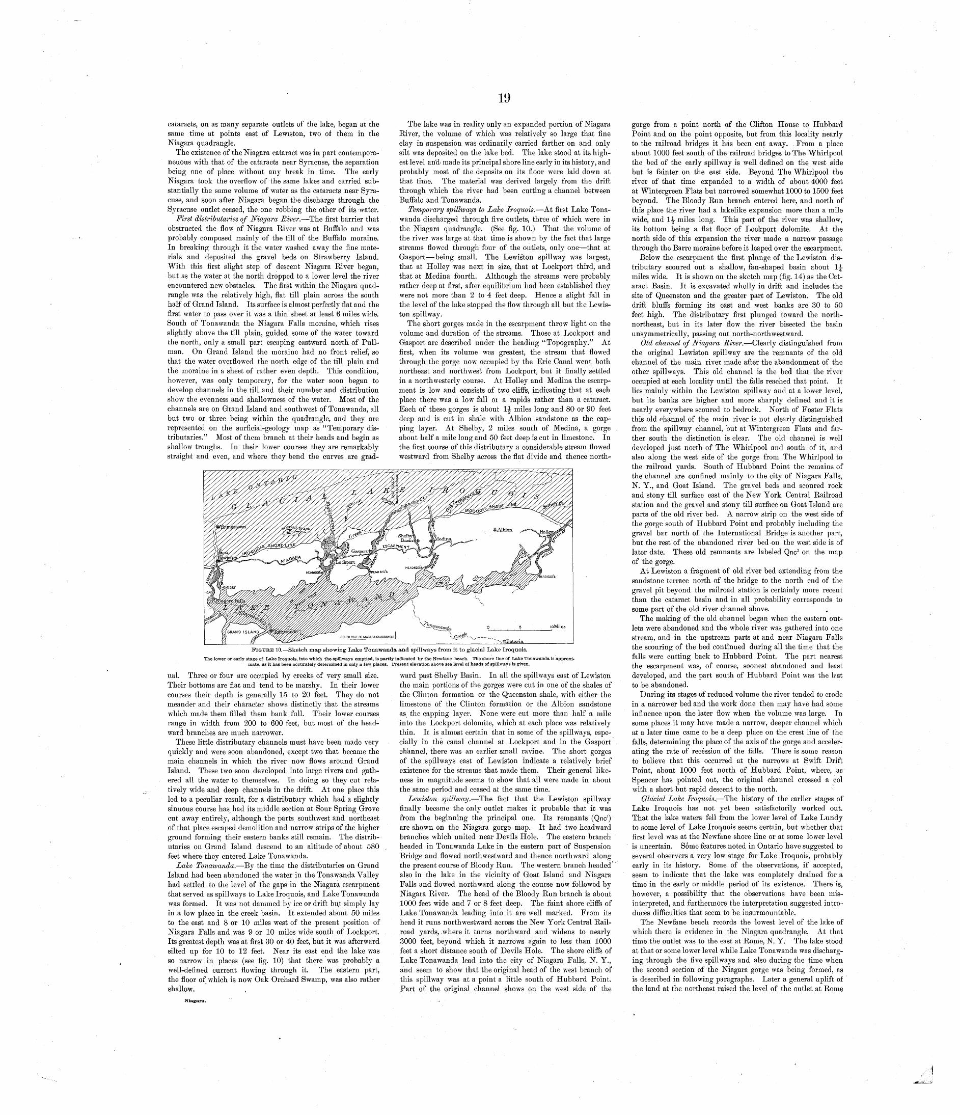
cataracts, on as many separate outlets of the lake, began at the same time at points east of Lewiston, two of them in the Niagara quadrangle.
The existence of the Niagara cataract was in part contempora- neuous with that of the cataracts near Syracuse, the separation being one of place without any break in time. The early Niagara took the overflow of the same lakes and carried sub stantially the same volume of water as the cataracts near Syra cuse, and soon after Niagara began the discharge through the Syracuse outlet ceased, the one robbing the other of its water.
First distributaries of Niagara River. The first barrier that obstructed the flow of Niagara River was at Buffalo and was probably composed mainly of the till of the Buffalo moraine. In breaking through it the water washed away the fine mate rials and deposited the gravel beds on Strawberry Island. With this first slight step of descent Niagara River began, but as the water at the north dropped to a lower level the river encountered new obstacles. The first within the Niagara quad rangle was the relatively high, flat till plain across the south half of Grand Island. Its surface is almost perfectly flat and the first water to pass over it was a thin sheet at least 6 miles wide. South of Tonawanda the Niagara Falls moraine, which rises slightly above the till plain, guided some of the water toward the north, only a small part escaping eastward north of Pull man. On Grand Island the moraine had no front relief, so that the water overflowed the north edge of the till plain and the moraine in a sheet of rather even depth. This condition, however, was only temporary, for the water soon began to develop channels in the till and their number and distribution show the evenness and s.hallowness of the water. Most of the channels are on Grand Island and southwest of Tonawanda, all but two or three being within the quadrangle, and they are represented on the surficial-geology map as "Temporary dis tributaries." Most of them branch at their heads and begin as shallow troughs. In their lower courses they are remarkably straight and even, and where they bend the curves are grad-
The lake was in reality only an expanded portion of Niagara River, the volume of which was relatively so large that fine clay in suspension was ordinarily carried farther on and only silt was deposited on the lake bed. The lake stood at its high est level and made its principal shore line early in its history, and probably most of the deposits on its floor were laid down at that time. The material was derived largely from the drift through which the river had been cutting a channel between Buffalo and Tonawanda.
Temporary spillways to Lake Iroquois. At first Lake Tona wanda discharged through five outlets, three of which were in the Niagara quadrangle. (See fig. 10.) That the volume of the river was large at that time is shown by the fact that large streams flowed through four of the outlets, only one that at Gasport being small. The Lewiston spillway was largest, that at Holley was next in size, that at Lockport third, and that at Medina fourth. Although the streams were probably rather deep at first, after equilibrium had been established they were not more than 2 to 4 feet deep. Hence a slight fall in the level of the lake stopped the flow through all but the Lewis- ton spillway.
The short gorges made in the escarpment throw light on the volume and duration of the streams. Those at Lockport and Gasport are described under the heading "Topography." At first, when its volume was greatest, the stream that flowed through the gorge now occupied by the Erie Canal went both northeast and northwest from Lockport, but it finally settled in a northwesterly course. At Holley and Medina the escarp ment is low and consists of two cliffs, indicating that at each place there was a low fall or a rapids rather than a cataract. Each of these gorges is about 1-J miles long and 80 or 90 feet deep and is cut in shale with Albion sandstone as the cap ping layer. At Shelby, 2 miles south of Medina, a gorge about half a mile long and 50 feet deep is cut in limestone. In the first course of this distributary a considerable stream flowed westward from Shelby across the flat divide and thence north-
FIGURE 10. Sketch map showing Lake Tonawanda and spillways from it to glacial Lake Iroquois.The lower or early stage of Lake Iroquois, into which the spillways emptied, is partly indicated by the Newfane beach. The shore line of Lake Tonawanda is approxi
mate, as it has been accurately determined in only a few places. Present elevation above sea level of heads of spillways is given.
ual. Three or four are occupied by creeks of very small size. Their bottoms are flat and tend to be marshy. In their lower courses their depth is generally 15 to 20 feet. They do not meander and their character shows distinctly that the streams which made them filled them bank full. Their lower courses range in width from 200 to 600 feet, but most of the head- ward branches are much narrower.
These little distributary channels must have been made very quickly and were soon abandoned, except two that became the main channels in which the river now flows around Grand Island. These two soon developed into large rivers and gath ered all the water to themselves. In doing so they cut rela tively wide and deep channels in the drift. At one place this led to a peculiar result, for a distributary which had a slightly sinuous course has had its middle section at Sour Spring Grove cut away entirely, although the parts southwest and northeast of that place escaped demolition and narrow strips of the higher ground forming their eastern banks still remain. The distrib utaries on Grand Island descend to an altitude of about 580 feet where they entered Lake Tonawanda.
Lake Tonawanda. By the time the distributaries on Grand Island had been abandoned the water in the Tonawanda Valley had settled to the level of the gaps in the Niagara escarpment that served as spillways to Lake Iroquois, and Lake Tonawanda was formed. It was not dammed by ice or drift bu,t simply lay in a low place in the creek basin. It extended about 50 miles to the east and 8 or 10 miles west of the present position of Niagara Falls and was 9 or 10 miles wide south of Lockport. Its greatest depth was at first 30 or 40 feet, but it was afterward silted up for 10 to 12 feet. Near its east end the lake was so narrow in places (see fig. 10) that there was probably a well-defined current flowing through it. The eastern part, the floor of which is now Oak Orchard Swamp, was also rather shallow.
Niagara.
ward past Shelby Basin. In all the spillways east of Lewiston the main portions of the gorges were cut in one of the shales of the Clinton formation or the Queenston shale, with either the limestone of the Clinton formation or the Albion sandstone as the capping layer. None were cut more than half a mile into the Lockport dolomite, which at each place was relatively thin. It is almost certain that in some of the spillways, espe cially in the canal channel at Lockport and in the Gasport channel, there was an earlier small ravine. The short gorges of the spillways east of Lewiston indicate a relatively brief existence for the streams that made them. Their general like ness in magnitude seems to show that all were made in about the same period and ceased at the same time.
Lewiston spillway. The fact that the Lewiston spillway finally became the only outlet makes it probable that it was from the beginning the principal one. Its remnants (Qnc! ) are shown on the Niagara gorge map. It had two headward branches which united near Devils Hole. The eastern branch headed in Tonawanda Lake in the eastern part of Suspension Bridge and flowed northwestward and thence northward along the present course of Bloody Run. The western branch headed' also in the lake in the vicinity of Goat Island and Niagara Falls and flowed northward along the course now followed by Niagara River. The head of the Bloody Run branch is about 1000 feet wide and 7 or 8 feet deep. The faint shore cliffs of Lake Tonawanda leading into it are well marked. From its head it runs northwestward across the New York Central Rail road yards, where it turns northward and widens to nearly 3000 feet, beyond which it narrows again to less than 1000 feet a short distance south of Devils Hole. The shore cliffs of Lake Tonawanda lead into the city of Niagara Falls, N. Y., and seem to show that the original head of the west branch of this spillway was at a point a little south of Hubbard Point. Part of the original channel shows on the west side of the
gorge from a point north of the Clifton House to Hubbard Point and on the point opposite, but from this locality nearly to the railroad bridges it has been cut away. From a place about 1000 feet south of the railroad bridges to The Whirlpool the bed of the early spillway is well defined on the west side but is fainter on the east, side. Beyond The Whirlpool the river of that time expanded to a width of about 4000 feet at Wintergreen Flats but narrowed somewhat 1000 to 1500 feet beyond. The Bloody Run branch entered here, and north of this place the river had a lakelike expansion more than a mile wide, and 1^ miles long. This part of the river was shallow, its bottom being a flat floor of Lockport dolomite. At the north side of this expansion the river made a narrow passage through the Barre moraine before it leaped over the escarpment.
Below the escarpment the first plunge of the Lewiston dis tributary scoured out a shallow, fan-shaped basin about 1^ miles wide. It is shown on the sketch map (fig. 14) as the Cat aract Basin. It is excavated wholly in drift and includes the site of Queenston and the greater part of Lewiston. The old drift bluffs forming its east and west banks are 30 to 50 feet high. The distributary first plunged toward the north- northeast, but in its later flow the river bisected the basin unsymmetrically, passing out north-northwestward.
Old channel of Niagara River. Clearly distinguished from the original Lewiston spillway are the remnants of the old channel of the main river made after the abandonment of the other spillways. This old channel is the bed that the river occupied at each locality until the falls reached that point. It lies mainly within the Lewiston spillway and at a lower level, but its banks are higher and more sharply defined and it is nearly everywhere scoured to bedrock. North of Foster Flats this old channel of the main river is not clearly distinguished from the spillway channel, but at Wintergreen Flats and far ther south the distinction is clear. The old channel is well developed just north of The Whirlpool and south of it, and also along the west side of the gorge from The Whirlpool to the railroad yards. South of Hubbard Point the remains of the channel are confined mainly to the city of Niagara Falls, N. Y., and Goat Island. The gravel beds and scoured rock and stony till surface east of the New York Central Railroad station and the gravel and stony till surface on Goat Island are parts of the old river bed. A narrow strip on the west side of the gorge south of Hubbard Point and probably including the gravel bar north of the International Bridge is another part, but the rest of the abandoned river bed on the west side is of later date. These old remnants are labeled Qnc2 on the map of the gorge.
At Lewiston a fragment of old river bed extending from the sandstone terrace north of the bridge to the north end of the gravel pit beyond the railroad station is certainly more recent than the cataract basin and in all probability corresponds to some part of the old river channel above.
The making of the old channel began when the eastern out lets were abandoned and the whole river was gathered into one stream, and in the upstream parts at and near Niagara Falls the scouring of the bed continued during all the time that the falls were cutting back to Hubbard Point. The part nearest the escarpment was, of course, soonest abandoned and least developed, and the part south of Hubbard Point was the last to be abandoned.
During its stages of reduced volume the river tended to erode in a narrower bed and the work done then may have had some influence upon the later flow when the volume was large. In some places it may have made a narrow, deeper channel which at a later time came to be a deep place on the crest line of the falls, determining the place of the axis of the gorge and acceler ating the rate of recession of the falls. There is some reason to believe that this occurred at the narrows at Swift Drift Point, about 1000 feet north of Hubbard Point, where, as Spencer has pointed out, the original channel crossed a col with a short but rapid descent to the north.
Glacial Lake Iroquois.^ The history of the earlier stages of Lake Iroquois has not yet been satisfactorily worked out. That the lake waters fell from the lower level of Lake Lundy to some level of Lake Iroquois seems certain, but whether that first level was at the Newfane shore line or at some lower level is uncertain. Some features noted in Ontario have suggested to several observers a very low stage for Lake Iroquois, probably early in its history. Some of the observations, if accepted, seem to indicate that the lake was completely drained for a time in the early or middle period of its existence. There is, however, a possibility that the observations have been mis interpreted, and furthermore the interpretation suggested intro duces difficulties that seem to be insurmountable.
The Newfane beach records the lowest level of the lake of which there is evidence in the Niagara quadrangle. At that time the outlet was to the east at Rome, N. Y. The lake stood at that or some lower level while Lake Tonawanda was discharg ing through the five spillways and also during the time when the second section of the Niagara gorge was being formed, as is described in following paragraphs. Later a general uplift of the land at the northeast raised the level of the outlet at Rome
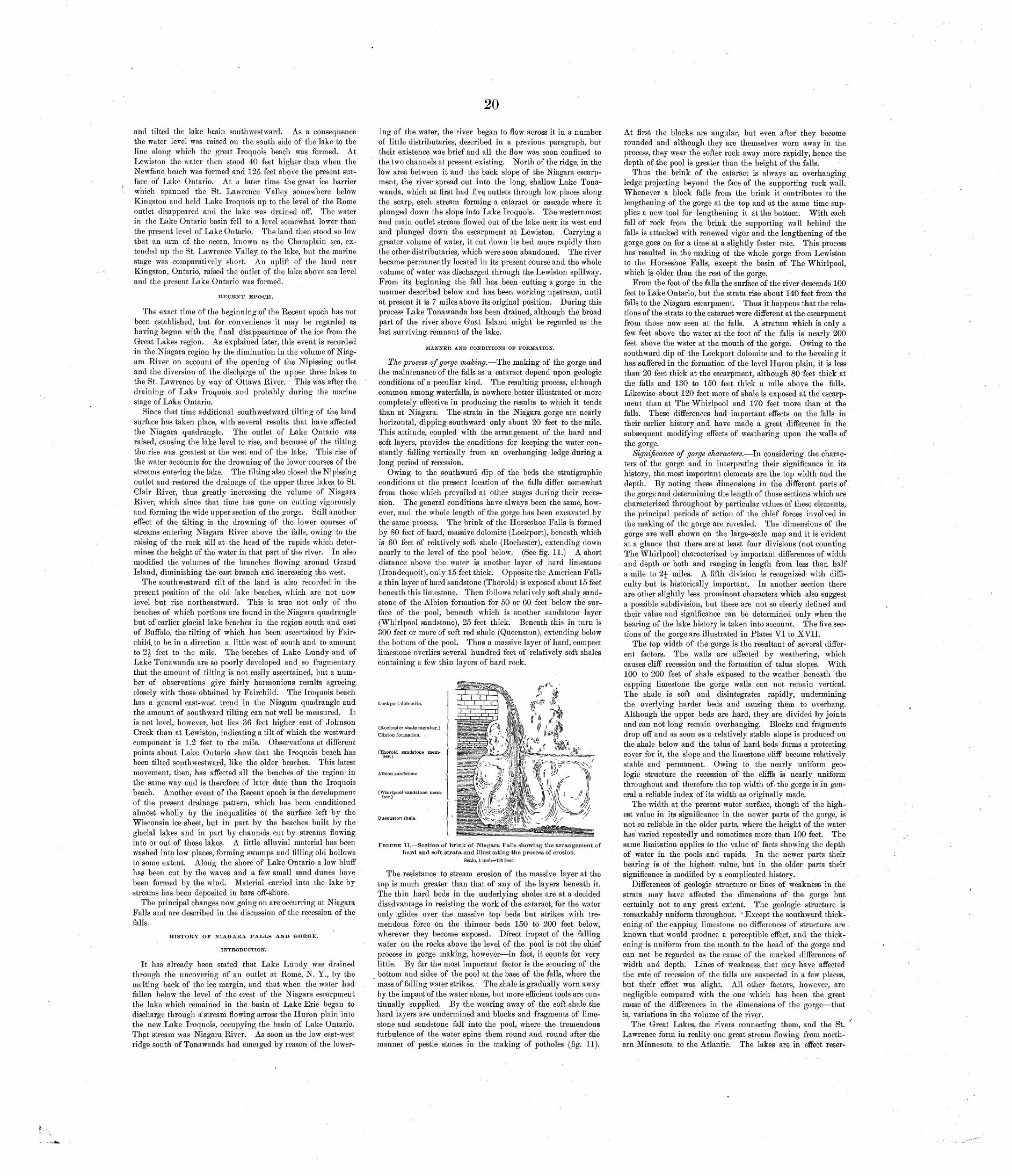
20
and tilted the lake basin south westward. As a consequence the water level was raised on the south side of the lake to the line along which the great Iroquois beach was formed. At Lewiston the water then stood 40 feet higher than when the Newfane beach was formed and 125 feet above the present sur face of Lake Ontario. At a later time the great ice barrier which spanned the St. Lawrence Valley somewhere below Kingston and held Lake Iroquois up to the level of the Home outlet disappeared and the lake was drained off. The water in the Lake Ontario basin fell to a level somewhat lower than the present level of Lake Ontario. The land then stood so low that an arm of the ocean, known as the Champlain sea, ex tended up the St. Lawrence Valley to the lake, but the marine stage was comparatively short. An uplift of the land near Kingston, Ontario, raised the outlet of the lake above sea level and the present Lake Ontario was formed.
RECENT EPOCH.
The exact time of the beginning of the Recent epoch has not been established, but for convenience it may be regarded as having begun with the final disappearance of the ice from the Great Lakes region. As explained later, this event is recorded in the Niagara region by the diminution in the volume of Niag ara River on account of the opening of the Nipissing outlet and the diversion of the discharge of the upper three lakes to the St. Lawrence by way of Ottawa River. This was after the draining of Lake Iroquois and probably during the marine stage of Lake Ontario.
Since that time additional southwestward tilting of the land surface has taken place, with several results that have affected the Niagara quadrangle. The outlet of Lake Ontario was raised, causing the lake level to rise, and because of the tilting the rise was greatest at the west end of the lake. This rise of the water accounts for the drowning of the lower courses of the streams entering the lake. The tilting also closed the Nipissing outlet and restored the drainage of the upper three lakes to St. Clair River, thus greatly increasing the volume of Niagara River, which since that time has gone on cutting vigorously and forming the wide upper section of the gorge. Still another effect of the tilting is the drowning of the lower courses of streams entering Niagara River above the falls, owing to the raising of the rock sill at the head of the rapids which deter mines the height of the water in that part of the river. In also modified the volumes of the branches flowing around Grand Island, diminishing the east branch and increasing the west.
The southwestward tilt of the land is also recorded in the present position of the old lake beaches, which are not now level but rise northeastward. This is true not only of the beaches of which portions are found in the Niagara quadrangle but of earlier glacial lake beaches in the region south and east of Buffalo, the tilting of which has been ascertained by Fair- child, to be in a direction a little west of south and to amount to 2^ feet to the mile. The beaches of Lake Lundy and of Lake Tonawanda are so poorly developed and so fragmentary that the amount of tilting is not easily ascertained, but a num ber of observations give fairly harmonious results agreeing closely with those obtained by Fairchild. The Iroquois beach has a general east-west trend in the Niagara, quadrangle and the amount of southward tilting can not well be measured. It is not level, however, but lies 36 feet higher east of Johnson Creek than at Lewiston, indicating a tilt of which the westward component is 1.2 feet to the mile. Observations at different points about Lake Ontario show that the Iroquois beach has been tilted southwestward, like the older beaches. This latest movement, then, has affected all the beaches of the region - in the same way and is therefore of later date than the Iroquois beach. Another event of the Recent epoch is the development of the present drainage pattern, which has been conditioned almost wholly by the inequalities of the surface left by the Wisconsin ice sheet, but in part by the beaches built by the glacial lakes and in part by channels cut by streams flowing into or out of those lakes. A little alluvial material has been washed into low places, forming swamps and filling old hollows to some extent. Along the shore of Lake Ontario a low bluff has been cut by the waves and a few small sand dunes have been formed by the wind. Material carried into the lake by streams has been deposited in bars off-shore.
The principal changes now going on are occurring at Niagara Falls and are described in the discussion of the recession of the falls.
HISTORY OF NIAGARA FALI^S AND GORGE.
INTRODUCTION.
It has already been stated that Lake Lundy was drained through the uncovering of an outlet at Rome, N. Y., by the melting back of the ice margin, and that when the water had fallen below the level of the crest of the Niagara escarpment the lake which remained in the basin of Lake Erie began to discharge through a stream flowing across the Huron plain into the new Lake Iroquois, occupying the basin of Lake Ontario. That stream was Niagara River. As soon as the low east-west ridge south of Tonawanda had emerged by reason of the lower
ing of the water, the river began to flow across it in a number of little distributaries, described in a previous paragraph, but their existence was brief and all the flow was soon confined to the two channels at present existing. North of the ridge, in the low area between it and the back slope of the Niagara escarp ment, the river spread out into the long, shallow Lake Tona wanda, which at first had five, outlets through low. places along the scarp, each stream forming a cataract or cascade where it plunged down the slope into Lake Iroquois. The westernmost and main outlet stream flowed out of the lake near its west end and plunged down the escarpment at Lewiston. Carrying a greater volume of water, it cut down its bed more rapidly than the other distributaries, which were soon abandoned. The river became permanently located in its present course and the whole volume of water was discharged through the Lewiston spillway. From its beginning the fall has been cutting a gorge in the manner described below and has been working upstream, until at present it is 7 miles above its original position. During this process Lake Tonawanda has been drained, although the broad part of the river above Goat Island might be regarded as the last surviving remnant of the lake.
MANNER AND CONDITIONS OF FORMATION.
The process of gorge making. The making of the gorge and the maintenance of the falls as a cataract depend upon geologic conditions of a peculiar kind. The resulting process, although common among waterfalls, is nowhere better illustrated or more completely effective in producing the results to which it tends than at Niagara. The strata in the Niagara gorge are nearly horizontal, dipping southward only about 20 feet to the mile. This attitude, coupled with the arrangement of the hard and soft layers, provides the conditions for keeping the water con stantly falling vertically from an overhanging ledge during a long period of recession.
Owing to the southward dip of the beds the stratigraphic conditions at the present location of the falls differ somewhat from those which prevailed at other stages during their reces sion. The general conditions have always been the same, how ever, and the whole length of the gorge has been excavated by the same process. The brink of the Horseshoe Falls is formed by 80 feet of hard, massive dolomite (Lockport), beneath which is 60 feet of relatively soft shale (Rochester), extending down nearly to the level of the pool below. (See fig. 11.) A short distance above the water is another layer of hard limestone (Irondequoit), only 15 feet thick. Opposite the American Falls a thin layer of hard sandstone (Thorold) is exposed about 15 feet beneath this limestone. Then follows relatively soft shaly sand stone of the Albion formation for 50 or 60 feet below the sur face of the pool, beneath which is another sandstone layer (Whirlpool sandstone), 25 feet thick. Beneath this in turn is 300 feet or more of soft red shale (Queenston), extending below the bottom of the pool. Thus a massive layer of hard, compact limestone overlies several hundred feet of relatively soft shales containing a few thin layers of hard rock.
Lockport dolomite.
(Rochester shale member.) Clinton formation. \
(Thorold sandstone mem ber.)
Albion sandstone.
(Whirlpool sandstone mem ber.)
Queenston shale.
J___LI.I I .'
:
i ra &« ' * - «
A\¥ AFIGURE 11. Section of brink of Niagara Falls showing the arrangement of
hard and soft strata and illustrating the process of erosion.Scale, 1 inch=185 feet.
The resistance to stream erosion of the massive layer at the top is much greater than that of any of the layers beneath it. The thin hard beds in the underlying shales are at a decided disadvantage in resisting the work of the cataract, for the water only glides over the massive top beds but strikes with tre mendous force on the thinner beds 150 to 200 feet below, wherever they become exposed. Direct impact of the falling water on the rocks above the level of the pool is not the chief process in gorge making, however in fact, it counts for very little. By far the most important factor is the scouring of the bottom and sides of the pool at the base of the falls, where the mass of falling water strikes. The shale is gradually worn away by the impact of the water alone, but more efficient tools are con tinually supplied. By the wearing away of the soft shale the hard layers are undermined and blocks and fragments of lime stone and sandstone fall into the pool, where the tremendous turbulence of the water spins them round and round after the manner of pestle stones in the making of potholes (fig. 11).
At first the blocks are angular, but even after they become rounded and although they are themselves worn away in the process, they wear the softer rock away more rapidly, hence the depth of the pool is greater than the height of the falls.
Thus the brink of the cataract is always an overhanging ledge projecting beyond the face of the supporting rock wall. Whenever a block falls from the brink it contributes to the lengthening of the gorge at the top and at the same time sup plies a new tool for lengthening it at the bottom. With each fall of rock from the brink the supporting wall behind the falls is attacked with renewed vigor and the lengthening of the gorge goes on for a time at a slightly faster rate. This process has resulted in the making of the whole gorge from Lewiston to the Horseshoe Falls, except the basin of The Whirlpool, which is older than the rest of the gorge.
From the foot of the falls the surface of the river descends 100 feet to Lake Ontario, but the strata rise about 140 feet from the falls to the Niagara escarpment. Thus it happens that the rela tions of the strata to the cataract were different at the escarpment from those now seen at the falls. A stratum which is only a few feet above the water at the foot of the falls is nearly 200 feet above the water at the mouth of the gorge. Owing to the southward dip of the Lockport dolomite and to the beveling it has suffered in the formation of the level Huron plain, it is less than 20 feet thick at the escarpment, although 80 feet thick.at the falls and 130 to 150 feet thick a mile above the falls. Likewise about 120 feet more of shale is exposed at the escarp ment than at The Whirlpool and 170 feet more than at the falls. These differences had important effects on the falls in their earlier history and have made a great difference in the subsequent modifying effects of weathering upon the walls of the gorge.
Significance of gorge characters. In considering the charac ters of the gorge and in interpreting their significance in its history, the most important elements are the top width and the depth. By noting these dimensions in the different parts of the gorge and determining the length of those sections which are characterized throughout by particular values of these elements, the principal periods of action of the chief forces involved in the making of the gorge are revealed. The dimensions of the gorge are well shown on the large-scale map and it is evident at a glance that there are at least four divisions (not counting The Whirlpool) characterized by important differences of width and depth or both and ranging in length from less than half a mile to 2^ miles. A fifth division is recognized with diffi culty but is historically important. In another section there are other slightly less prominent characters which also suggest a possible subdivision, but these are not so clearly defined and their value and significance can be determined only when the bearing of the lake history is taken into account. The five sec tions of the gorge are illustrated in Plates VI to XVII.
The top width of the gorge is the resultant of several differ ent factors. The walls are affected by weathering, which causes cliff recession and the formation of talus slopes. With 100 to 200 feet of shale exposed to the weather beneath the capping limestone the gorge walls can not remain vertical. The shale is soft and disintegrates rapidly, undermining the overlying harder beds and causing them to overhang. Although the upper beds are hard, they are divided by joints and can not long remain overhanging.. Blocks and fragments drop off and as soon as a relatively stable slope is produced on the shale below and the talus of hard beds forms a protecting cover for it, the slope and the limestone cliff become relatively stable and permanent. Owing to the nearly uniform geo logic structure the recession of the cliffs is nearly uniform throughout and therefore the top width of- the gorge is in gen eral a reliable index of its width as originally made.
The width at the present water surface, though of the high est value in its significance in the newer parts of the gorge, is not so reliable in the older parts, where the height of the water has varied repeatedly and sometimes more than 100 feet. The same limitation applies to the value of facts showing the depth of water in the pools and rapids. In the newer parts their bearing is of the highest value, but in the older parts their significance is modified by a complicated history.
Differences of geologic structure or lines of weakness in the strata may have affected the dimensions of the gorge but certainly not to any great extent. The geologic structure is remarkably uniform throughout. ' Except the southward thick ening of the capping limestone no differences of structure are known that would produce a perceptible effect, and the thick ening is uniform from the mouth to the head of the gorge and can not be regarded as the cause of the marked differences of width and depth. Lines of weakness that may have affected the rate of recession of the falls are suspected in a few places, but their effect was slight. All other factors, however, are negligible compared with the one which has been the great cause of the differences in the dimensions of the gorge that is, variations in the volume of the river.
The Great Lakes, the rivers connecting them, and the St. Lawrence form in reality one great stream flowing from north ern Minnesota to the Atlantic. The lakes are in effect reser-
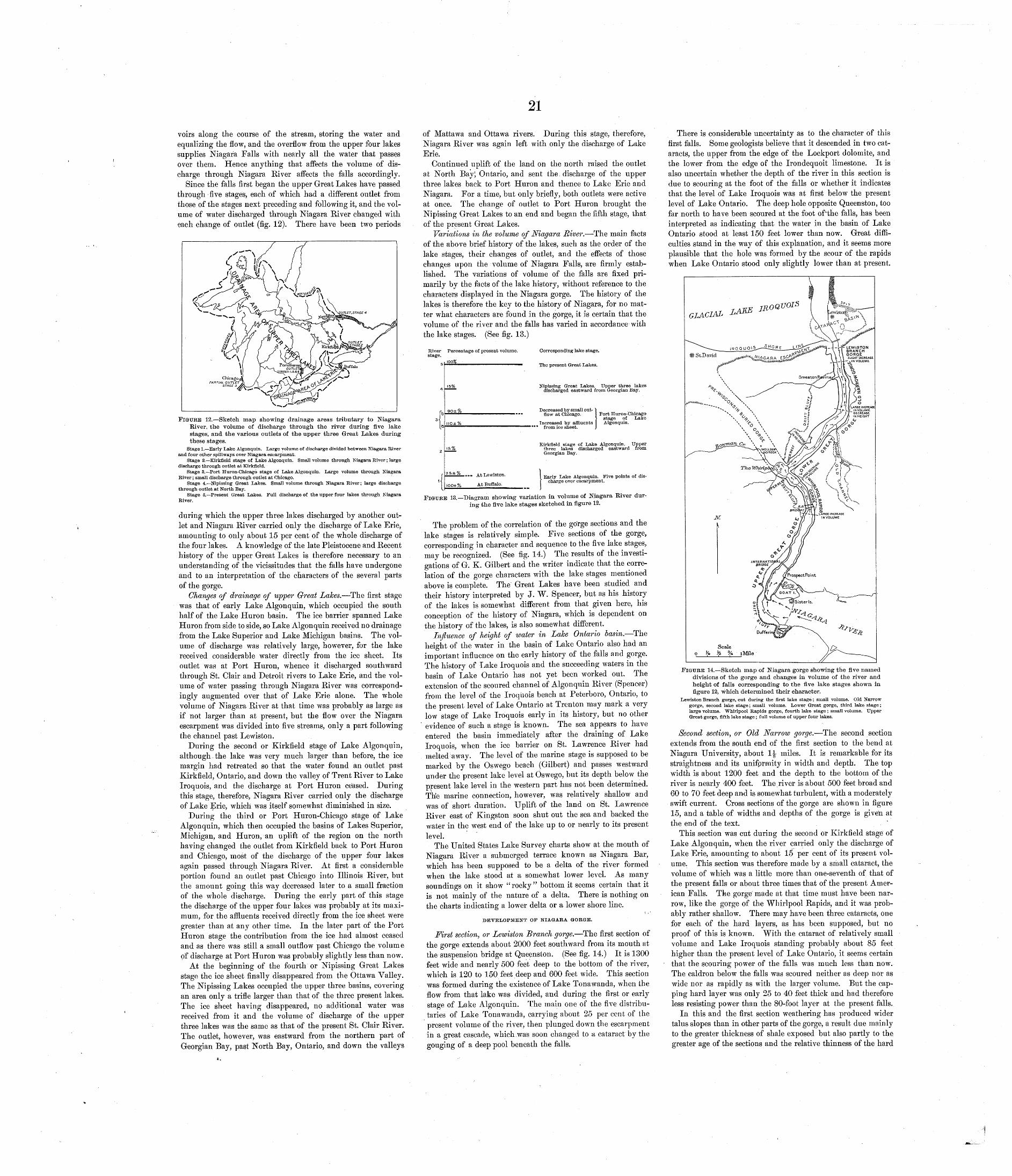
voirs along the course of the stream, storing the water and equalizing the flow, and the overflow from the upper four lakes supplies Niagara Falls with nearly all the water that passes over them. Hence anything that affects the volume of dis charge through Niagara River affects the falls accordingly.
Since the falls first began the upper Great Lakes have passed through five stages, each of which had a different outlet from those of the stages next preceding and following it, and the vol ume of water discharged through Niagara River changed with each change of outlet (fig. 12). There have been two periods
dricagoPARTIAL OUTL£
FIGURE 12. Sketch map showing drainage areas tributary to Niagara River, the volume of discharge through the river during five lake stages, and the various outlets of the upper three Great Lakes during these stages.
Stage 1. Early Lake Algonquin. Large volume of discharge divided between Niagara River and four other spillways over Niagara escarpment.
Stage 2. Kirkfield stage of Lake Algonquin. Small volume through Niagara River; large discharge through outlet at Kirkfield.
Stage 3. Port Huron-Chicago stage of Lake Algonquin. Large volume through Niagara River; small discharge through outlet at Chicago.
Stage 4. Nipissing Great Lakes. Small volume through Niagara River; large discharge through outlet at North Bay.
Stage 5. Present Great Lakes. Full discharge of the upper four lakes through Niagara River.
during which the upper three lakes discharged by another out let and Niagara River carried only the discharge of Lake Erie, amounting to only about 15 per cent of the whole discharge of the four lakes. A knowledge of the late Pleistocene and Recent history of the upper Great Lakes is therefore necessary to an understanding of the vicissitudes that the falls have undergone and to an interpretation of the characters of the several parts of the gorge.
Changes of drainage of upper Great Lakes. The first stage was that of early Lake Algonquin, which occupied the south half of the Lake Huron basin. The ice barrier spanned Lake Huron from side to side, so Lake Algonquin received no drainage from the Lake Superior and Lake Michigan basins. The vol ume of discharge was relatively large, however, for the lake received considerable water directly from the ice sheet. Its outlet was at Port Huron, whence it discharged southward through St. Glair and Detroit rivers to Lake Erie, and the vol ume of water passing through Niagara River was correspond ingly augmented over that of Lake Erie alone. The whole volume of Niagara River at that time was probably as large as if not larger than at present, but the flow over the Niagara escarpment was divided into five streams, only a part following the channel past Lewiston.
During the second or Kirkfield stage of Lake Algonquin, although the lake was very much larger than before, the ice margin had retreated so that the water found an outlet past Kirkfield, Ontario, and down the valley of Trent River to Lake Iroquois, and the discharge at Port Huron ceased. During this stage, therefore, Niagara River carried only the discharge of Lake Erie, which was itself somewhat diminished in size.
During the third or Port Huron-Chicago stage of Lake Algonquin, which then occupied the basins of Lakes Superior, Michigan, and Huron, an uplift of the region on the north having changed the outlet from Kirkfield back to Port Huron and Chicago, most of the discharge of the upper four lakes again passed through Niagara River. At first a considerable portion found an outlet past Chicago into Illinois River, but the amount going this way decreased later to a small fraction of the whole discharge. During the early part of this stage the discharge of the upper four lakes was probably at its maxi mum, for the affluents received directly from the ice sheet were greater than at any other time. In the later part of the Port Huron stage the contribution from the ice had almost ceased and as there was still a small outflow past Chicago the volume of discharge at Port Huron was probably slightly less than now.
At the beginning of the fourth or Nipissing Great Lakes stage the ice sheet finally disappeared from the Ottawa Valley. The Nipissing Lakes occupied the upper three basins, covering an area only a trifle larger than that of the three present lakes. The ice sheet having disappeared, no additional water was received from it and the volume of discharge of the upper three lakes was the same as that of the present St. Glair River. The outlet, however, was eastward from the northern part of Georgian Bay, past North Bay, Ontario, and down the valleys
of Mattawa and Ottawa rivers. During this stage, therefore, Niagara River was again left with only the discharge of Lake Erie.
Continued uplift of the land on the north raised the outlet at North Bay; Ontario, and sent the discharge of the upper three lakes back to Port Huron and thence to Lake Erie and Niagara. For a time, but only briefly, both outlets were active at once. The change of outlet to Port Huron brought the Nipissing Great Lakes to an end and began the fifth stage, that of the present Great Lakes.
Variations in the volume of Niagara River. The main facts of the above brief history of the lakes, such as the order of the lake stages, their changes of outlet, and the effects of those changes upon the volume of Niagara Falls, are firmly estab lished. The variations of volume of the falls are fixed pri marily by the facts of the lake history, without reference to the characters displayed in the Niagara gorge. The history of the lakes is therefore the key to the history of Niagara, for no mat ter what characters are found in the gorge, it is certain that the volume of the river and the falls has varied in accordance with the lake stages. (See fig. 13.)
River Percentage of present volume.
4
[b1 la
2
'1
15%
90±°/o
\\0±%
J5j%
Z5± % At Lewiston.
ioo±% At Buffalo.
Corresponding lake stage.
The present Great Lakes.
Nipissing Great Lakes. Upper three lakes discharged eastward from Georgian Bay.
Decreased by small out-1 flow at Chicago. Port Huron-Chicago
> stage of Lake Increased by affluents Algonquin.
1 from ice sheet. I
Kirk field stage of Lake Algonquin. Upper three lakes discharged eastward from Georgian Bay.
Early Lake Algonquin. Five points of dis charge over escarpment.
FIGURE 13. Diagram showing variation in volume of Niagara River dur ing the five lake stages sketched in figure 12.
The problem of the correlation of the gorge sections and the lake stages is relatively simple. Five sections of the gorge, corresponding in character and sequence to the five lake stages, may be recognized. (See fig. 14.) The results of the investi gations of G. K. Gilbert and the writer indicate that the corre lation of the gorge characters with the lake stages mentioned above is complete. The Great Lakes have been studied and their history interpreted by J. W. Spencer, but as his history of the lakes is somewhat different from that given here, his conception of the history of Niagara, which is dependent on the history of the lakes, is also somewhat different.
Influence of height of water in Lake Ontario basin. The height of the water in the basin of Lake Ontario also had an important influence on the early history of the falls and gorge. The history of Lake Iroquois and the succeeding waters in the basin of Lake Ontario has not yet been worked out. The extension of the scoured channel of Algonquin River (Spencer) from the level of the Iroquois beach at Peterboro, Ontario, to the present level of Lake Ontario at Trenton may mark a very low stage of Lake Iroquois early in its history, but no other evidence of such a stage is known. The sea appears to have entered the basin immediately after the draining of Lake Iroquois, when the ice barrier on St. Lawrence River had melted away. The level of the marine stage is supposed to be marked by the Oswego beach (Gilbert) and passes westward under the present lake level at Oswego, but its depth below the present lake level in the western part has not been determined. The marine connection, however, was relatively shallow and was of short duration. Uplift of the land on St. Lawrence River east of Kingston soon shut out the sea and backed the water in the west end of the lake up to or nearly to its presentlevel.
The United States Lake Survey charts show at the mouth of Niagara River a submerged terrace known as Niagara Bar, which has been supposed to be a delta of the river formed when the lake stood at a somewhat lower level. As many soundings on it show "rocky" bottom it seems certain that it is not mainly of the nature of a delta. There is nothing onthe charts indicating a lower delta or a lower shore line.
\, DEVELOPMENT OF NIAGARA GORGE.
First section, or Lewiston Branch gorge. The first section of the gorge extends about 2000 feet southward from its mouth at the suspension bridge at Queenston. (See fig. 14.) It is 1300 feet wide and nearly 500 feet deep to the bottom of the river, which is 120 to 150 feet deep and 600 feet wide. This section was formed during the existence of Lake Tonawanda, when the flow from that lake was divided, and during the first or early stage of Lake Algonquin. The main one of the five distribu taries of Lake Tonawanda, carrying about 25 per cent of the present volume of the river, then plunged down the escarpment in a great cascade, which .was soon changed to a cataract by the gouging of a deep pool beneath the falls.
There is considerable uncertainty as to the character of this first falls. Some geologists believe that it descended in two cat aracts, the upper from the edge of the Lockport dolomite, and the lower from the edge of the Irondequoit limestone. It is also uncertain whether the depth of the river in this section is due to scouring at the foot of the falls or whether it indicates that the level of Lake Iroquois was at first below the present level of Lake Ontario. The deep hole opposite Queenston, too far north to have been scoured at the foot of'the falls, has been interpreted as indicating that the water in the basin of Lake Ontario stood at least 150 feet lower than now. Great diffi culties stand in the way of this explanation, and it seems more plausible that the hole was formed by the scour of the rapids when Lake Ontario stood only slightly lower than at present.
FIGURE 14. Sketch map of Niagara gorge showing the five named divisions of the gorge and changes in volume of the river and height of falls corresponding to the five lake stages shown in figure 12, which determined their character.
Lewiston Branch gorge, cut during the first lake stage; small volume. Old Narrow gorge, second lake stage; small volume. Lower Great, gorge, third lake stage; large volume. Whirlpool Rapids gorge, fourth lake stage; small volume. Upper Great gorge, fifth lake stage; full volume of upper four lakes.
Second section, or Old Narrow gorge. The second section extends from the south end of the first section to the bend at Niagara University, about 1|- miles. It is remarkable for its straightness and its unifprmity in width and depth. The top width is about 1200 feet and the depth to the bottom of the river is nearly 400 feet. The river is about 500 feet broad and 60 to 70 feet deep and is somewhat turbulent, with a moderately swift current. Cross sections of the gorge are shown in figure 15, and a table of widths and depths of the gorge is given at the end of the text.
This section was cut during the second or Kirkfield stage of Lake Algonquin, when the river carried only the discharge of Lake Erie, amounting to about 15 per cent of its present vol ume. This section was therefore made by a small cataract, the volume of which was a little more than one-seventh of that of the present falls or about three times that of the present Amer ican Falls. The gorge made at that time must have been nar row, like the gorge of the Whirlpool Rapids, and it was prob ably rather shallow. There may have been three cataracts, one for each of the hard layers, as has been supposed, but no proof of this is known. With the cataract of relatively small volume and Lake Iroquois standing probably about 85 feet higher than the present level of Lake Ontario, it seems certain that the scouring power of the falls was much less than now. The caldron below the falls was scoured neither as deep nor as wide nor as rapidly as with the larger volume. But the cap ping hard layer was only 25 to 40 feet thick and had therefore less resisting power than the 80-foot layer at the present falls.
In this and the first section weathering has produced wider talus slopes than in other parts of the gorge, a result due mainly to the greater thickness of shale exposed but also partly to the greater age of the sections and the relative thinness of the hard
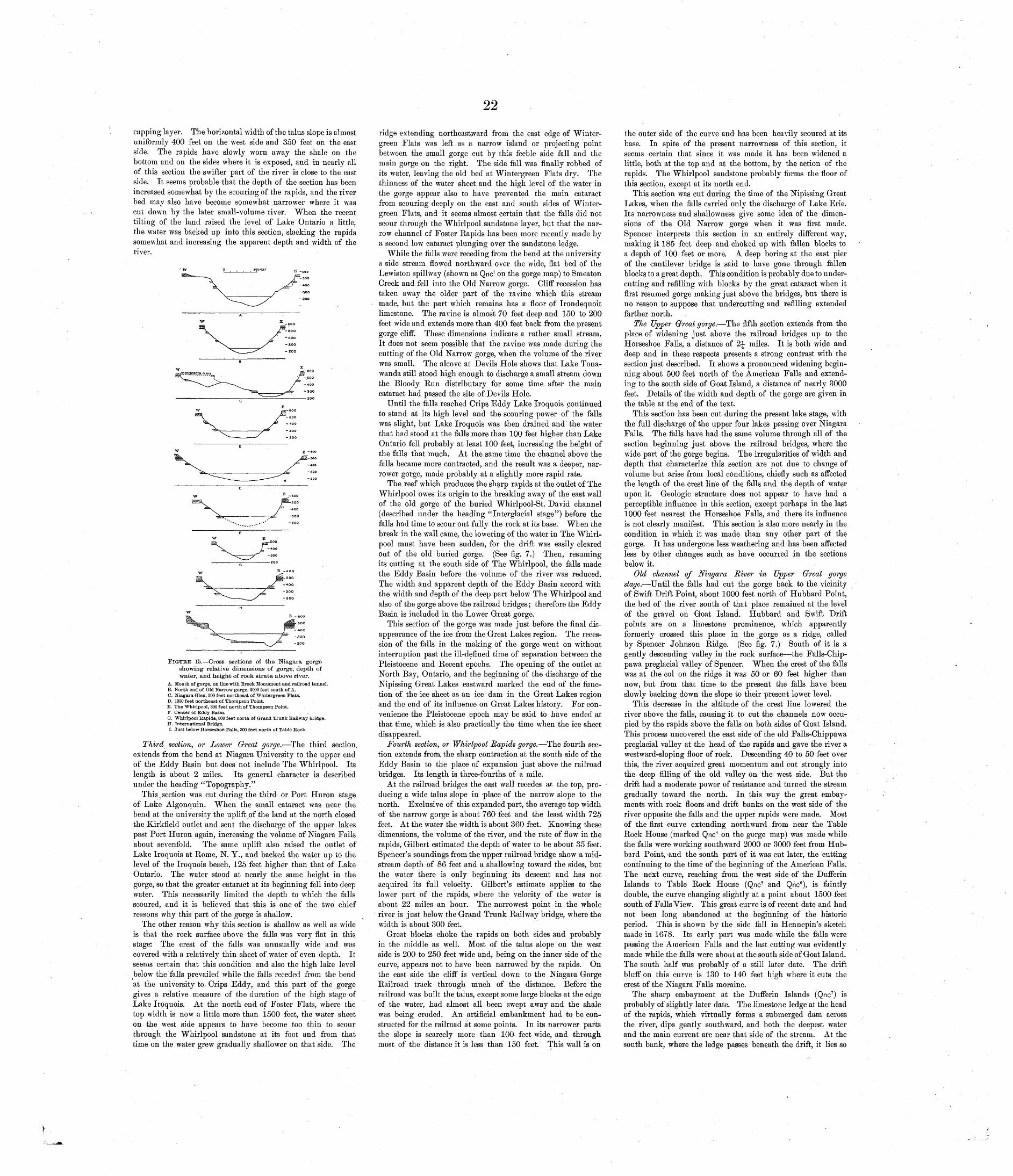
22
capping layer. The horizontal width of the talus slope is almost uniformly 400 feet on the west side and 350 feet on the east side. The rapids have slowly worn away the shale on the bottom and on the sides where it is exposed, and in nearly all of this section the swifter part of the river is close to the east side. It seems probable that the depth of the section has been increased somewhat by the scouring of the rapids, and the river bed may also have become somewhat narrower where it was cut down by the later small-volume river. When the recent tilting of the land raised the level of Lake Ontario a little, the water was backed up into this section, slacking the rapids somewhat and increasing the apparent depth and width of theriver.
300
-aoo
FIGURE 15. Cross sections of the Niagara gorge showing relative dimensions of gorge, depth of water, and height of rock strata above river.
A. Mouth of gorge, on line with. Brock Monument and railroad tunnel. B. North end of Old Narrow gorge, 2000 feet south of A. C. Niagara Glen, 800 feet northeast of Wintergreen Flats. D. 1000 feet northeast of Thompson Point. B. The Whirlpool, 300 feet north of Thompson Point. F. Center of Eddy Basin.G. Whirlpool Rapids, 300 feet north of Grand Trunk Railway bridge. H. International Bridge. I. Just below Horseshoe Falls, 300 feet north of Table Rock.
Third section, or Lower Great gorge. The third section, extends from the bend at Niagara University to the upper end of the Eddy Basin but does not include The Whirlpool. Its length is about 2 miles. Its general character is described under the heading "Topography."
This section was cut during the third or Port Huron stage of Lake Algonquin. When the small cataract was near the bend at the university the uplift pf the land at the north closed the Kirkfield outlet and sent the discharge of the upper lakes past Port Huron again, increasing the volume of Niagara Falls about sevenfold. The same uplift also raised the outlet of Lake Iroquois at Rome, N. Y., and backed the water up to the level of the Iroquois beach, 125 feet higher than that of Lake Ontario. The water stood at nearly the same height in the gorge, so that the greater cataract at its beginning fell into deep water. This necessarily limited the depth to which the falls scoured, and it is believed that this is one of the two chief reasons why this part of the gorge is shallow.
The other reason why this section is shallow as well as wide is that the rock surface above the falls was very flat in this stage: The crest of the falls was unusually wide and was covered with a relatively thin sheet of water of even depth. It seems certain that this condition and also the high lake level below the falls prevailed while the falls receded from the bend at the university to Crips Eddy, and this part of the gorge gives a relative measure of the duration of the high stage of Lake Iroquois. At the north end of Foster Flats, where the top width is now a little more than 1500 feet, the water sheet on the west side appears to have become too thin to scour through the Whirlpool sandstone at its foot and from that time on the water grew gradually shallower on that side. The
ridge extending northeastward from the east edge of Winter- green Flats was left as a narrow island or projecting point between the small gorge cut by this feeble side fall and the main gorge on the right. The side fall was finally robbed of its water, leaving the old bed at Wintergreen Flats dry. The thinness of the water sheet and the high level of the water in the gorge appear also to have prevented the main cataract from scouring deeply on the east and south sides of Winter- green Flats, and it seems almost certain that the falls did not scour through the Whirlpool sandstone layer, but that the nar row channel of Foster Rapids has been more recently made by a second low cataract plunging over the sandstone ledge.
While the falls were receding from the bend at the university a side stream flowed northward over the wide, flat bed of the Lewiston spillway (shown as Qnc1 on the gorge map) to Smeaton Creek and fell into the Old Narrow gorge. Cliff recession has taken away the older part of the ravine which this stream made, but the part which remains has a floor of Irondequoit limestone. The ravine is almost 70 feet deep and 150 to 200 feet wide and extends more than 400 feet back from the present gorge cliff. These dimensions indicate a rather small stream. It does not seem possible that the ravine was made during the cutting of the Old Narrow gorge, when the volume of the river was small. The alcove at Devils Hole shows that Lake Tona- wanda still stood high enough to discharge a small stream down the Bloody Run distributary for some time after the main cataract had passed the site of Devils Hole.
Until the falls reached Crips Eddy Lake Iroquois continued to stand at its high level and the scouring power of the falls was slight, but Lake Iroquois was then drained and the water that had stood at the falls more than 100 feet higher than Lake Ontario fell probably at least 100 feet, increasing the height of the falls that much. At the same time the channel above the falls became more contracted, and the result was a deeper, nar rower gorge, made probably at a slightly more rapid rate.
The reef which produces the sharp rapids at the outlet of The Whirlpool owes its origin to the breaking away of the east wall of the old gorge of the buried Whirlpool-St. David channel (described under the heading "Iriterglaeial stage") before the falls had time to scour out fully the rock at its base. When the break in the wall came, the lowering of the water in The Whirl pool must have been sudden, for the drift was easily cleared out of the old buried gorge. (See fig. 7.) Then, resuming its cutting at the south side of The Whirlpool, the falls made the Eddy Basin before the volume of the river was reduced. The width and apparent depth of the Eddy Basin accord with the width and depth of the deep part below The Whirlpool and also of the gorge above the railroad bridges; therefore the Eddy Basin is included in the Lower Great gorge.
This section of the gorge was made just before the final dis appearance of the ice from the Great Lakes region. The reces sion of the falls in the making of the gorge went on without interruption past the ill-defined time of separation between the Pleistocene and Recent epochs. The opening of the outlet at North Bay, Ontario, and the beginning of the discharge of the Nipissing Great Lakes eastward marked the end of the func tion of the ice sheet as an ice dam in the Great Lakes region and the end of its influence on Great Lakes history. For con venience the Pleistocene epoch may be said. to have ended at that time, which is also practically the time when the ice sheet disappeared.
Fourth section, or Whirlpool Rapids gorge. The fourth sec tion extends from, the sharp contraction at the south side of the Eddy Basin to the place of expansion just above the railroad bridges. Its length is three-fourths of a mile.
At the railroad bridges the east wall recedes at the top, pro ducing a wide talus slope in place of the narrow slope to the north. Exclusive of this expanded part, the average top width of the narrow gorge is about 760 feet and the least width 725 feet. At the water the width is about 360 feet. Knowing these dimensions, the volume of the river, and the rate of flow in the rapids, Gilbert estimated the depth of water to be about 35 feet. Spencer's soundings from the upper railroad bridge show a mid stream depth of 86 feet and a shallowing toward the sides, but the water there is only beginning its descent and has not acquired its full velocity. Gilbert's estimate applies to the lower part of the rapids, where the velocity of the water is about 22 miles an hour. The narrowest point in the whole river is just below the Grand Trunk Railway bridge, where the width is about 300 feet.
Great blocks choke the rapids on both sides and probably in the middle as well. Most of the talus slope on the west side is 200 to 250 feet wide and, being on the inner side of the curve, appears not to have been narrowed by the rapids. On the east side the cliff is vertical down to the Niagara Gorge Railroad track through much of the distance. Before the railroad was built the talus, except some large blocks at the edge of the water, had almost all been swept away and the shale was being eroded. An artificial embankment had to be con structed for the railroad at some points. In its narrower parts the slope is scarcely more than 100 feet wide, and through most of the distance it is less than 150 feet. This wall is on
the outer side of the curve and has been heavily scoured at its base. In spite of the present narrowness of this section, it seems certain that since it was made it has been widened a little, both at the top and at the bottom, by the action of the rapids. The Whirlpool sandstone probably forms the floor of this section, except at its north end.
This section was cut during the time of the Nipissing Great Lakes, when the falls carried only the discharge of Lake Erie. Its narrowness and shallowness give some idea of the dimen sions of the Old Narrow gorge when it was first made. Spencer interprets this section in an entirely different way, making it 185 feet deep and choked up with fallen blocks to a depth of 100 feet or more. A deep boring at the east pier of the cantilever bridge is said to have gone through fallen blocks to a great depth. This condition is probably due to under cutting and refilling with blocks by the great cataract when it first resumed gorge making just above the bridges, but there is no reason to suppose that undercutting and refilling extended farther north.
The Upper Great gorge. The fifth section extends from the place of widening just above the railroad bridges up to the Horseshoe Falls, a distance of 2J miles. It is both wide and deep and in these respects presents a strong contrast with the section just described. It shows a pronounced widening begin ning about 500 feet north of the American Falls and extend ing to the south side of Goat Island, a distance of nearly 3000 feet. Details of the width and depth of the gorge are given in the table at the end of the text.
This section has been cut during the present lake stage, with the full discharge of the upper four lakes passing over Niagara Falls. The falls have had the same volume through all of the section beginning just above the railroad bridges, where the wide part of the gorge begins. The irregularities of width and depth that characterize this section are not due to change of volume but arise from local conditions, chiefly such as affected the length of the crest line of the falls and the depth of water upon it. Geologic structure does not appear to have had a perceptible influence in this section, except perhaps in the last 1000 feet nearest the Horseshoe Falls, and there its influence is not clearly manifest. This section is also more nearly in the condition in which it was made than any other part of the gorge. It has undergone less weathering and has been affected less by other changes such as have occurred in the sections below it.
Old channel of Niagara River in Upper Great gorge stage. Until the falls had cut the gorge back to the vicinity of Swift Drift Point, about 1000 feet north of Hubbard Point, the bed of the river south of that place remained at the level of the gravel on Goat Island. Hubbard and Swift Drift points are on a limestone prominence, which apparently formerly crossed this place in the gorge as a ridge, called by Spencer Johnson Ridge. (See fig. 7.) South of it is a gently descending valley in the rock surface the Falls-Chip- pawa preglacial valley of Spencer. When the crest of the falls was at the col on the ridge it was 50 or 60 feet higher than now, but from that time to the present the falls have been slowly backing down the slope to their present lower level.
This decrease in the altitude of the crest line lowered the river above the falls, causing it to cut the channels now occu pied by the rapids above the falls on both sides of Goat Island. This process uncovered the east side of the old Falls-Chippawa preglacial valley at the head of the rapids and gave the river a westward-sloping floor of rock. Descending 40 to 50 feet over this, the river acquired great momentum and cut strongly into the deep filling of the old valley on the west side. But the drift had a moderate power of resistance and turned the stream gradually toward the north. In this way the great embay- ments with rock floors and drift hanks on the west side of the river opposite the falls and the upper rapids were made. Most of the first curve extending northward from near the Table Rock House (marked Qnc4 on the gorge map) was made while the falls were working southward 2000 or 3000 feet from Hub bard Point, and the south pa*rt of it was cut later, the cutting continuing to the time of the beginning of the American Falls. The rie^xt curve, reaching from the west side of the Dufferin Islands to Table Rock House (Qnc5 and Qnc6), is faintly double, the curve changing slightly at a point about 1500 feet south of Falls View. This great curve is of recent date and had not been long abandoned at the beginning of the historic period. This is shown by the side fall in Hennepin's sketch made in 1678. Its early part was made while the falls were passing the American Falls and the last cutting was evidently made while the falls were about at the south side of Goat Island. The south half was probably of a still later date. The drift bluff on this curve is 130 to 140 feet high where it cuts the crest of the Niagara Falls moraine.
The sharp embayment at the Dufferin Islands (Qnc7 ) is probably of slightly later date. The limestone ledge at the head of the rapids, which virtually forms a submerged dam across the river, dips gently southward, and both the deepest water and the main current are near that side of the stream. At the south bank, where the ledge passes beneath the drift, it lies so

23
low that the water worked southward around it and cut deeply into the drift, returning to the main channel below the cascades, at the west side of the islands.
Formation of the upper rapids. As just stated, the upper rapids flow westward down the east side of the old Falls- Chippawa valley. This fact and the newness of the rapids are proved by the lack of erosion in the stream bed and bank. The ledges of the cascades pass under the drift on both sides of the river and on both sides of Goat Island on continuations of nearly the same lines that they follow in the rapids. They have therefore not been eroded or cut back appreciably by the river.
A large area of the river southwest of the apex of the Horse shoe Falls is shallow. It includes Gull Island and some other bare ledges and many visible rocks. Around this area the deep river divides into two currents, the heavier one passing south of the shallows and reaching the crest line of the falls west of the apex. The other deep current passes around the north side and reaches the falls at and a little north of the apex. A heavy current crosses the cascades about one-third of the way out from the south shore and divides around the shallows. It seems certain that if the natural course of development is not interrupted the shallows will before long become an island with the main fall west and south of it and a lesser fall north of it, and ultimately the American Falls will be robbed of its water and will go dry. The main fall and the later extension of the gorge will probably keep near the Canadian shore along the line of the deeper water. By the time the falls have cut back to the cascades they will be 40 or 50 feet higher than now. The drift bank on the Canadian shore is likely to be slowly cut away unless it is protected.
KIAGARA FALLS.
Recession of the Horseshoe Falls. Of the two great falls at Niagara the Horseshoe Falls is the main cataract. According to the United States Lake Survey's recent measurements" this fall carries 95.17 per cent of the entire volume of the river, leaving the American Falls only 4.83 per cent.
June, 1913) many rocks are seen in this part. On the west side the water is shallow, but it deepens gradually along the crest toward the apex.
The estimates of the depth of the deepest water on the crest of the Horsesh6e Falls range from 25 feet down to 10 feet. The latter figure is the estimate of the engineers in their recent work for the International Waterways Commission, but it seems certain that this estimate is too low, for if the American Falls, with 3.5 feet of water on its crest line, has accomplished almost nothing in gorge making while the Horseshoe Falls has made the gorge from the American Falls to its present position it seems impossible that a depth of 10 feet would make so great a difference in the scouring power of the water. The depth on the crest of the Horseshoe Falls is probably nearer 20 or 25 feet than 10 feet.
Several instrumental surveys were made between 1842 and 1911, to determine the precise configuration of the crest lines of the two cataracts. The first was begun by E. L. Blackwell, under the direction of James Hall, and was finished in 1842. A series of monuments were established by this survey for the use of future investigators. The second survey was made by the United States Lake Survey in 1875, under the direction of Maj. C. B. Comstock, the field work being done by F. M. Tower; the third in 1886 for the United States Geological Survey by R. S. Woodward; the fourth in 1890 by A. S. Kibbe, under the direction of John Bogart, State engineer of New York; and the fifth by the United States Geological Survey and the State engineer of New York, the field work being done by W. Carvel Hall in 1905. Surveys were also made in 1906 by the United States Lake Survey and by J. W. Spencer. The latest survey was made by the International Waterways Commission in 1911. On the accompanying outline map of the crest lines (fig. 16) only one later line, that of 1911, has been added to the map prepared by Mr. Gilbert.
Availing himself of the results of the first five surveys men tioned, Mr. Gilbert made a careful study of the rate of recession of the falls and presented his conclusions in a report published in 1907.a Although it is manifest that the gorge is lengthened
Surveyed in 1842 by State of New York » » 1875 by Lake Survey ?! » 1886 by U.S.Geological Survey " " IS9O by State of New York -> " » I9O5 by U.S.G.S. and State of N.Y. > > '» 19 11 by Internat. Waterways Com
(Horseshoe Falls on[y)
Scale O IOO 2OO 300 4OO 500 60Ofeet
FIGURE 16. Outline map of the crest line of Niagara Falls showing the recession of the brink during various intervals since 1842.
Before the improvements for Queen Victoria Park were made the total length of the crest line of the Horseshoe Falls was 2950 feet. The improvements cut off 415 feet on the west side, where the water sheet was shallow and broken. In 1842 and 1875 the crest line was a fairly open curve, remotely resem bling a rather pointed and unsymmetrical horseshoe. (See fig. 16.) There was no sharp angle in the central part, but there was a recess forming a nearly right angle at the east side. From this angle as it was in 1875 there developed between that time and 1886 an acute, narrow recess (shown in Plate IV) extend ing eastward 200 feet. Since 1886, however, the apex of this angle has apparently undergone no further recession. Nearly all the subsequent change of the crest line has occurred along the south side west of the apex.
This fall is 158 feet high, the greater part of the water fall ing by a sheer plunge from an overhanging cliff. At the pres ent time the deepest water falls over the crest 200 to 600 feet west of the apex, but a deep stream also enters at and north of the apex. Since 1886 that part of the water which falls at and near the apex has appeared to strike a ledge estimated to be about 40 feet below the top, and from this the water rebounds as white spray before continuing its descent. This ledge has grown wider from north to south in recent years as the apex of the falls has widened. The water sheet is thin and broken from Goat Island to a point some distance south of Terrapin Rock, and there is no deep water within 200 or 300 feet north of the apex. Even at high stages of the river (as in May and
"Preservation of Niagara Falls, International Waterways Commission: Senate Doc. No. 105, Sixty-second Gong., 1st sess., p. 13, 1911.
Niagara
as fast as the most rapidly eroded point on the crest recedes, the difficulty of determining just where that point is at different times 'and of making proper allowances for its change of place on the crest is so great that Mr. Gilbert determined the average rate of recession by taking a certain length, say 400 or 500 feet, of the central part of the crest line as a datum line for his com putation. The mean rate of recession on this line is regarded as the true mean rate for the cataract. This method gives the same result in the end as a computation reckoning from the apex of the falls and avoids some of the difficulties of the other method. For the early position of the crest line Mr. Gilbert used two authorities, Hall's survey of 1842 and a camera lucida drawing made by Basil Hall in 1827. Using Hall's survey of 1842 and the survey of 1905, Mr. Gilbert found the rate of recession to be 5.3 feet a year. Basil Hall's drawing was made from Forsyth's Inn, 'on the bluff west of the Horseshoe Falls. Mr. Gilbert had a photograph taken in 1895 from a scaffold erected on the same spot. By comparing Basil Hall's sketch with the photograph made in 1895, Mr. Gilbert found that the rate of recession was 4.2 feet a year. Thus, according as he gave authority to the map of 1842 or the camera lucida sketch of 1827, Mr. Gilbert found the annual rate to be 5.3 or 4.2 feet, but giving the greater weight to the map and preferring a whole number to avoid the implication of high precision, he chose 5 feet as the probable annual rate of recession. J. W. Spencer, employing a slightly different method, found the rate for the period between 1842 and 1905 to be 4.2 feet a year.
"Gilbert, GK K., Kate of recession of Niagara Falls: TJ. S. Geol. Survey Bull. 306.
The crest line of the survey of 1911 shows the recession at the most rapidly receding point since 1905 to be more than 8 feet a year, but the mean rate by Mr. Gilbert's method is less than' 5 feet a year. There seems little doubt that 4.5 feet a year is nearly the true rate of recession since 1842, and there is reason for believing that it was about the same for the 100 to 150 years preceding 1842. It is thought, however, that during a long period before that time the rate was much slower. The reason for this opinion will be given after considering the rate of recession of the American Falls.
Recession of the American Falls. Most of the surveys of the falls have included a determination of the crest line of the American Falls, but in the survey of 1911 that determination was omitted and the survey by the United States Lake Survey in 1906 is therefore the latest of that fall. Attempts have been made to compute its rate of recession, but with one exception the differences between the sucessive crest lines are so slight that it seems doubtful whether they are greater than the prob able range of error. Indeed, the map on which the several lines are plotted seems to indicate errors of that magnitude in certain places where a later line projects farther out than an earlier one. Hall's map of 1842 shows a great salient at the north side of the American Falls that projects about 100 feet beyond the line shown by all the later surveys. Here, again, Mr. Gilbert made effective use of a camera lucida sketch which Basil Hall made of this fall in 1827 and showed conclusively that the large salient shown on Hall's map is an error.
Using the crest line of Hall's map, Spencer calculated the rate of recession to be 0.6 foot a year. After making the cor rection on Hall's map Gilbert calculated that the rate was prob ably as small as 0.2 foot a year. But even that rate may be much too large. The deepest water passing over the American Falls is only 3.5 feet deep and the average is less than 1.5 feet.
The crest line is nearly 1000 feet long and is an almost even continuation of the cliff line on either side of it, as may be seen in Plate III. In fact the deepest water on this fall passes over the ledge near Prospect Point, a part of which protrudes slightly beyond the general cliff line. The fall is nearly 168 feet high, but the wafer strikes upon great blocks and bowlders which rest in part upon limestone ledges of the Clinton formation. The blocks are simply the coarser materials of the talus. In all the time that it has existed probably 600 to 800 years the fall has not been able to remove the blocks or to make a measurable beginning of a gorge. It has removed the fine material of the talus and has probably steepened the base of the cliff somewhat but has done little more. In short, it is doubtful whether the crest line of the American Falls has receded more than may be fairly ascribed to normal cliff reces sion due to weathering. If the slight reentrant in the central part of the crest line is due to recession produced by the fall it must be a very old feature, for the water sheet is now thinner there than north of it. Moreover, the crest lines as mapped by the several surveys are more nearly in agreement in this reentrant than in most other places and the reentrant is no greater than many others along the cliff where no side fall ever existed.
Age of the falls. In 1841 Lyell estimated the age of the falls to be 35,000 years. The surveys made since then afford some basis for calculation, but the results of the several attempts that have been made differ considerably. In 1894 Spencer calculated the total duration of the falls to be 32,200 years, but in a later report (1907) he makes it 39,000 years.
There is little evidence that geologic structure or lines of weakness in the rocks have caused important variations in the rate of recession, but there is much reason to believe that the most marked example of this influence has passed recently. The sudden sharp recess that appeared in the crest line between 1875 and 1886 seems explicable in no other way, and there are some facts that point to a similar occurrence 50 to 100 years before. The dimensions of the gorge show that such events have been of rare occurrence.
Inasmuch as the geologic conditions have been remarkably uniform, the most important factor which has affected the rate of gorge making is the variation in the volume of the river. The sections of the gorge cut during the small-volume or Lake Erie stages have been made more slowly than the sections cut when the volume of the falls was large.
The next most important factor is the depth of the water sheet on the crest line of the falls. The marked contrast in the gorge-making power of the two cataracts shows the impor tance of this factor. The American Falls seems to lack power to make a gorge at a measurable rate, but if its 1000 feet of crest line were shortened to 100 feet, the same volume of water would probably pass over the crest with a depth of 15 to 20 feet and this fall would then have some efficiency in scouring out a caldron at its base.
It is the same with the Horseshoe Falls. When the condi tions of the river bed at and just above the crest have caused a short crest line with deep water upon it, the falls have scoured more effectively and hence more rapidly, and when the crest line was long and. the water sheet thin the falls scoured less deeply and hence undermined the overhanging crest ledge more slowly. On this account it seems certain that the falls
24
made the wide part of the gorge opposite the American Falls and Goat Island at a considerably slower rate than the nar rower part recently made or than the narrower parts farther north. Of course, where the capping limestone was thicker, as at Hubbard Point, the strength of the crest ledge was greater and recession tended to be slower. But this was offset by the greater height of the falls at that time. The river in the west side of the gorge opposite the American Falls and Goat Island is relatively shallow. The crest line was wide when this part was being made, and the water sheet relatively thin. At Carters Cove, nearly opposite Prospect Point, the sheet was too thin to cut through the upper bed of the Albion sandstone. Yet, although it must have worked back some what slowly, that part of the fall was not left behind, as the side fall was at Wintergreen Flats. The deeper water toward the east side of the crest was shallower than it had been north of the American Falls, where four soundings show the great depth of 186 feet. It was so shallow that the shallower west ern part at Carters Cove kept pace with the recession. Fur ther analysis, with these facts in mind, makes the rate for the cutting of the wide part of the gorge at the falls and also above Niagara University considerably slower than the rate deter mined from the surveys.
By taking account of this factor and the changes of volume caused by the changes of outlet of the upper three lakes, more accurate estimates of the time consumed in the making of the gorge may be made. These estimates show that the time required for cutting the Upper Great gorge was between 3000 and 3500 years and for cutting the Lower Great gorge prob ably 2500 to 3000 years. The same considerations apply to the small-volume sections with regard to the influence of the depth of the water sheet on the crest, but the variations of this factor in the making of the two Lake Erie sections and the first section can not now be determined. Spencer makes the rate of recession with the volume of Lake Erie alone 0.42 foot a year, or one-tenth of the large-volume rate. This rate seems a fair approximation, for the falls in the small-volume sections had about three times the volume of the American Falls and the water was probably more concentrated on the crest line.
If we take maximum rates of recession throughout, the mak ing of the gorge may have taken 20,000 years; with slower rates it may have taken 30,000 to 35,000 years. It is not believed that more precise estimates can have any greater value, for such estimates would seem to represent a degree of accuracy which is really impossible with the data that are now available. Estimates ranging from 7000 to 12,000 years are evidently too low, and those ranging from 50,000 to 100,000 years are too high.
ECONOMIC GEOLOGY.
The natural resources of economic value occurring within the quadrangle include limestone, sandstone, shale, natural gas, clay, gravel, sand, mineral waters, and water power. The most important of these are the water and the limestone.
LIMESTONE.
Four distinct limestones in this quadrangle are quarried for commercial use the Clinton, Gasport, Bertie, and Onondaga. The lower two of these limestones outcrop across the entire width of the area mapped, extending from Niagara River at Lewiston through Lockport and Medina and eastward far beyond the quadrangle. The two higher limestones, the Bertie and Onondaga, are found only in the extreme southeast corner of the quadrangle, near Akron.
Steel flux. The most recent as well as the most extensive use to which the limestone of this region has been put is its employment as a flux in the manufacture of steel. Only non- magnesian limestone of a high degree of purity has been quarried in this region for this purpose. But two of the lime stones found here the Onondaga and the Clinton are of proper chemical composition for use as a steel flux. A third limestone, the Gasport, is sufficiently free from magnesia over a small area in the vicinity of Lockport to comply with the present local requirements for flux. In other districts magne- sian limestone and dolomite are successfully used for iron and steel flux.
The only limestone that has thus far been utilized for this purpose within the area mapped is in the Clinton formation. The Clinton forms a broad, flat terrace on the north slope of the ^Niagara escarpment along much of its extent between Lockport and Lewiston. Where the drift cover is light, as it is in many places,"this limestone can be cheaply quarried near the escarpment. A short distance south of the escarpment the southerly dip of the beds carries this limestone too far below the surface for profitable quarrying. The Lackawanna Steel Co. has recently opened an extensive quarry in the Clinton formation 1^ miles northwest of Pekin. The lime stone that is quarried is used in the plant near Buffalo.
Cement. The limestones of this region include beds suitable for making both natural and Portland cement. Both ,the upper Clinton and the Onondaga limestones, owing to their chemical purity, are available for use in making Portland
cement. The presence, however, of an excellent natural cement rock in the Bertie limestone member has encouraged the manufacture of natural cement instead of Portland cement. The Bertie limestone occurs in the Niagara quadrangle over a small a,rea southwest of Akron. The manufacture of natural cement was begun at Falkirk in 1839, and has been carried on almost continuously by two or more companies up to a recent date. Immense quantities of this cement were used in constructing the Erie Canal and the New York City aqueduct.
The greater uniformity in the composition and consequently in the quality of Portland or artificially mixed cement as com pared with that of natural cement has in recent years caused a decreased demand for natural cement, and this has resulted in the closing of the factory at Falkirk.
The beds that have the proper composition for natural cement are about 7 feet thick. They were worked from hori zontal drifts which leave a rock roof. The cement rock after mining is burned and then finely ground, when it is ready for use as a hydraulic cement.
Lime. The Onondaga limestone furnishes an excellent grade of quicklime and has long been utilized for making lime at a number of points along its line of outcrop between Falkirk and Williamsville. The nonmagnesian limestone near the base of the Lockport dolomite (Gasport limestone member) has also been used for lime in the vicinity of Lockport and near the Niagara gorge.
Building stone. The Gasport limestone member of the Lockport dolomite has furnished considerable building stone, nearly all of which has been used locally. Much of it has been used in foundations, but several buildings in Lockport have been constructed from it entirely. It is used also for window sills, trimmings, and like stone work. This stone is attractive and durable and fully meets the local demand for structural material of this class. Two quarries supply most of this stone that is now being used. One is about 2J- miles east of Lockport; the other is at the head of The Gulf, west of Lockport. The detailed description of the beds is given under the heading "Stratigraphy" in the description of the formation.
Near Queenston, on the Canadian side, excellent dimension stone is being quarried from the Lockport dolomite in consid erable quantities. This stone is used in high-class construction work. Large rough blocks of it form the parapet at the Horse shoe Falls and the fence along the north line of Queen Victoria Park. It is used as finished and carved stone in elaborate architectural designs in the beautiful power house of the Elec trical Development Co. at the side of the rapids above the falls on the Canadian side. It is employed to some extent in building work of high quality in Buffalo, Toronto, and other cities.
Broken stone. One of the important limestone products of the quadrangle is crushed or broken stone in sizes that are suitable for road dressing, railroad ballast, and concrete. The hard cherty layers of the Onondaga limestone furnish rock that is excellent for this purpose and of no value for any other. The manufacture of crushed stone therefore sometimes supplements the preparation of other kinds of stone, rock that is worthless for lime, cement, or building stone being thus utilized. The Onondaga limestone is quarried extensively southwest of Akron by the West Shore Railroad, mainly for railway ballast and to some extent for road ballast, and a little is used for building stone.
SANDSTONE.
All the sandstone quarried in this region comes from the Albion sandstone. This formation was once known as the Medina or white Medina and now forms part of the Medina group. Quarries have been opened in this formation at many points along its line of outcrop in the Niagara escarpment, from the gorge to the eastern margin of the quadrangle. Some of these quarries were first operated nearly a century ago. Old buildings constructed of this rock are seen in all the towns along the escarpment. Flagstone was shipped from the Whit- more quarry at Lockport to Rochester as early as 1831. It was used still earlier in the construction of the Erie Canal. This sandstone was used formerly in glass furnaces as well as for flagstones and for various architectural purposes. At present it is used chiefly in making paving blocks, dimension stone, and broken stone for road metal and concrete. For concrete this broken sandstone is generally preferred to broken limestone or flint because it is slightly porous and makes a closer union with cement. Other features of this stone are noted in the description of the Albion sandstone. The quarry face and blocks of the stone in the quarry at Lockport may be seen in Plate XVIII.
The only quarry now in continuous operation is situated north of Lockport, where a rock crusher having a capacity of 300 cubic yards of crushed rock a day is in operation. The cross-bedded and ripple-marked stone is utilized by crushing; the more even grained stone is used for paving blocks and dimension stone. A nearly white sandstone that forms the lowest bed of the Albion, near Lewiston, was formerly quarried rather extensively. Other quarries that have furnished this stone are located northeast of Gasport and on both sides of Eighteenmile Creek near Lockport.
GRAVEL AND SAND.
Gravel for use as railroad ballast, road metal, and concrete and building material is obtained from beach gravel and gla cial and channel deposits in many places in the quadrangle. The largest supplies are obtained from the old Iroquois spit gravels at Lewiston, from the Iroquois beach ridge at Wrights Corners, from the large kame area east of Lockport, and from the kaines throughout the quadrangle, and on the Canadian side from the outwash near St. David station on the Grand Trunk Railway. Sand is obtained at many places, generally the same places as the gravel. The finer wind-blown sand is not much used at present.
CLAY.
The clay in the quadrangle is used in making brick but has not yet been put to other uses. There are brickyards at Ton- awanda, La Salle, Lockport, near Niagara University, and at Niagara Falls, Ontario. Those at Tonawanda and La Salle are in the clayey silt of Lake Tonawanda and the till beneath; the one south of Niagara University is in lake clay; and those at Lock- port and on the Canadian side are in till nearly free of stones.
GYPSUM.
A bed of excellent gypsum 4J to 5 feet thick is mined by two companies 1^ and 2J miles northeast of Akron. A test boring made at Akron, about 50 feet deep, is reported to have found gypsum. This bed occurs in the Salina formation about 200 feet below the base of the Onondaga limestone. Although extensively quarried less than a mile east of the Niagara quad rangle, the gypsum bed has not been recognized within the quadrangle. If present in the area it is confined to its south eastern part. The horizon of this bed lies 60 to 85 feet below the surface along the West Shore Railroad southeast of Akron. Thin layers of gypsum, some of which may be of commercial value, have been encountered at other horizons in gas wells. In one of the wells at Buffalo three different beds of white gypsum, ranging in thickness from 3 to 12 feet, were struck within 100 feet of the surface.
PEAT.
Peat in sufficient quantity to suggest its use as fuel occurs in only two places in the quadrangle. An attempt made four or five years ago to manufacture fuel briquets at a place south west of Pekin did not prove profitable. Another deposit about as large as the one near Pekin is in the southeastern part of Amherst, but it has not been developed. In neither of these localities is the quantity of peat large, its average thickness being 2 to 3 feet.
MINERAL WATER.
Some borings that produced no gas yielded valuable mineral water, mainly of the salt and chalybeate varieties. The water from one of these wells at Akron has medicinal properties that have led to the founding of a sanitarium for the treatment of bowel and liver troubles. An analysis of this water is as follows:
Analysis of mineral water from well at Akron, in grains per gallon.
Hydrogen sulphide (H a S) ---______________ Trace.Ferrous sulphide (FeS) (?) .__.._.___.___._____ ________ 1.57Calcium sulphate (CaSO4)-_..___ __________.________ . 36.46Calcium chloride (CaCls ) _____.___'__._________________ 813.33Magnesium chloride (MgCl 2 ) _._________________________ 802.54Sodium chloride (NaCl) ______.___.____ .._____________ 7632.00Potassium chloride (KCl)__-------.______.___. ____ Trace.
Analysis furnished by C. H. Laraby, secretary of the Sanitarium Co. Analysis made by Herbert M. Hill, city chemist of Buffalo, N. T.
A small spring of sulphur-bearing water issues from the lower layer of Lockport dolomite a mile north of McNalls. A well in the Queenston shale east of Lewiston yields salt water. A bored well at Pendleton Center, about 100 feet deep, yielded a dark-colored chalybeate water, which flowed in a small stream for two or three years, but the flow has now ceased.
NATURAL GAS.
Natural gas is produced in commercial quantities in the quadrangle only in an area near the southern border. The first gas well drilled in Erie County was sunk at Getzville in 1858 or 1859. It continued to produce for more than 30 years. It was one of a group of wells in the area immediately north of Getzville from which gas was piped for many years to Tona wanda. Most if not all of these older wells have ceased to be productive. The wells that are now producing gas comprise a group of 20 or more, southwest of Getzville and east of Tona wanda, which have furnished a moderate flow for some years. The best of these wells 'had an initial pressure of about 200 pounds. Their product is turned into a line which carries gas to 'Tonawanda from more productive fields south of Akron and is said to constitute a fifth to a quarter of the supply received in Tonawanda. The Getzville gas occurs at depths ranging from 475 to 560 feet, usually in beds which represent the Albion sandstone of the Medina group. In a few wells some gas is found in the ; shales and limestones above the Medina.
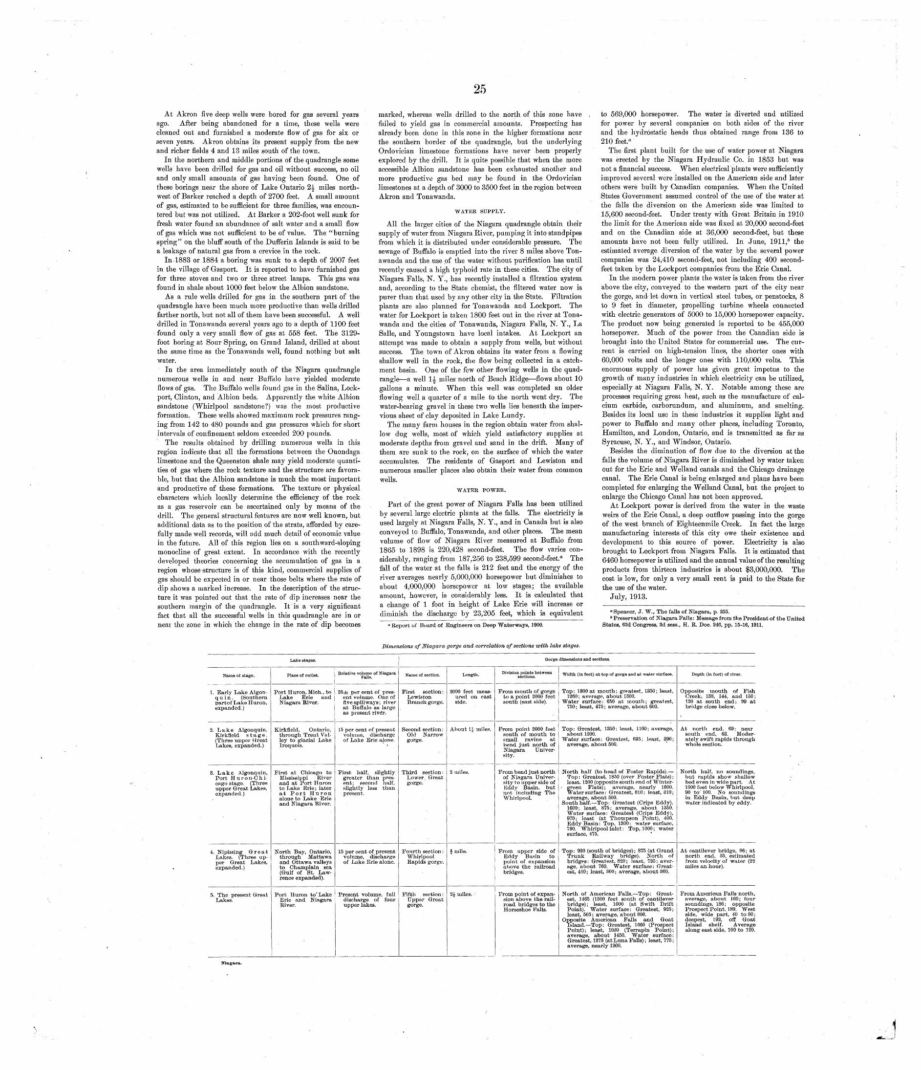
25
At Akron five deep wells were bored for gas several years ago. After being abandoned for a time, these wells were cleaned out and furnished a moderate flow of gas for six or seven years. Akron obtains its present supply from the new and richer fields 4 and 13 miles south of the town.
In the northern and middle portions of the quadrangle some wells have been drilled for gas and oil without success, no oil and only small amounts of gas having been found. One of these borings near the shore of Lake Ontario 2^ miles north west of Barker reached a depth of 2700 feet. A small amount of gas, estimated to be sufficient for three families, was encoun tered but was not utilized. At Barker a 202-foot well sunk for fresh water found an abundance of salt water and a small flow of gas which was not sufficient to be of value. The "burning spring" on the bluff south of the Dufferin Islands is said to be a leakage of natural gas from a crevice in the rock.
In-1883 or 1884 a boring was sunk to a depth of 2007 feet in the village of Gasport. It is reported to have furnished gas for three stoves and two or three street lamps. This gas was found in shale about 1000 feet below the Albion sandstone.
As a rule wells drilled for gas in the southern part of the quadrangle have been much more productive than wells drilled farther north, but not all of them have been successful. A well drilled in Tonawanda several years ago to a depth of 1100 feet found only a very small flow of gas at 558 feet. The 3129- foot boring at Sour Spring, on Grand Island, drilled at about the same time as the Tonawanda well, found nothing but salt water.
In the area immediately south of the Niagara quadrangle numerous wells in and near Buffalo have yielded moderate flows of gas. The Buffalo wells found gas in the Salina, Lock- port, Clinton, and Albion beds. Apparently the white Albion sandstone (Whirlpool sandstone?) was the most productive formation. These wells showed maximum rock pressures rang ing from 142 to 480 pounds and gas pressures which for short intervals of confinement seldom exceeded 200 pounds.
The results obtained by drilling numerous wells in this region indicate that all the formations between the Onondaga limestone and the Queenston shale may yield moderate quanti ties of gas where the rock texture and the structure are favora ble, but that the Albion sandstone is much the most important and productive of these formations. The texture or physical characters which locally determine the efficiency of the rock as a gas reservoir can be ascertained only by means of the drill. The general structural features are now well known, but additional data as to the position of the strata, afforded by care fully made well records, will add much detail of economic value in the future. All of this region lies on a southward-sloping monocline of great extent. In accordance with the recently developed theories concerning the accumulation of gas in a region whose ̂ structure is of this kind, commercial supplies of gas should be expected in or near those belts where the rate of dip shows a marked increase. In the description of the struc ture it was pointed out that the rate of dip increases near the southern margin of the quadrangle. It'is a very significant fact that all the successful wells in this quadrangle are in or near the zone in which the change in the rate of dip becomes
marked, whereas wells drilled to the north of this zone have failed to yield gas in commercial amounts. Prpspecting has already been done in this zone in the higher formations near the southern border of the quadrangle, but the underlying Ordovician limestone formations have never been properly explored by the drill. It is quite possible that when the more accessible Albion sandstone has been exhausted another and more productive gas bed may be found in the Ordovician limestones at a depth of 3000 to 3500 feet in the region between Akron and Tonawanda.
WATER SUPPLY.
All the larger cities of the Niagara quadrangle obtain their supply of water from Niagara River, pumping it into standpipes from which it is distributed under considerable pressure. The sewage of Buffalo is emptied into the river 8 miles above Ton awanda and the use of the water without purification has until recently caused a high typhoid rate in these cities. The city of Niagara Falls, N. Y., has recently installed a filtration system and, according to the State chemist, the filtered water now is purer than that used by any other city in the State. Filtration plants are also planned for Tonawanda and Lockport. The water for Lockport is taken 1800 feet out in the river at Tona wanda and the cities of Tonawanda, Niagara Falls, N. Y., La Salle, and Youngstown have local intakes. At Lockport an attempt was made to obtain a supply from wells, but without success. The town of Akron obtains its water from a flowing shallow well in the rock, the flow being collected in a catch ment basin. One of the few other flowing wells in the quad rangle a well 1-J- miles north of Beach Ridge flows about 10 gallons a minute. When this well was completed an older flowing well a quarter of a mile to the north went dry. The water-bearing gravel in these two wells lies beneath the imper vious sheet of clay deposited in Lake Lundy.
The many farm houses in the region obtain water from shal low dug wells, most of which yield satisfactory supplies at moderate depths from gravel and sand in the drift. Many of them are sunk to the rock, on the surface of which the water accumulates. The residents of Gasport and Lewiston and numerous smaller places also obtain their water from common wells.
WATEK POWER.
Part of the great power of Niagara Falls has been utilized by several large electric plants at the falls. The electricity is used largely at Niagara Falls, N. Y., and in Canada but is also conveyed to Buffalo, Tonawanda, and other places. The mean volume of flow of Niagara River measured at Buffalo from 1865 to 1898 is 220,428 second-feet. The flow varies con siderably, ranging from 187,256 to 238,599 second-feet.a The fall of the water at the falls is 212 feet and the energy of the river averages nearly 5,000,000 horsepower but diminishes to about 4,000,000 horsepower at low stages; the available amount, however, is considerably less. It is calculated that a change of 1 foot in height of Lake Erie will increase or diminish the discharge by 23,205 feet, which is equivalent
0 Report of Board of Engineers on Deep "Waterways, 1900.
to 569,000 horsepower. The water is diverted and utilized for power by several companies on both sides of the river and the hydrostatic heads thus obtained range from 136 to 210 feet."
The first plant built for the use of water power at Niagara was erected by the Niagara Hydraulic Co. in 1853 but was not a financial success. When electrical plants were sufficiently improved several were installed on the American side and later others were built by Canadian companies. When the United States Government assumed control of the use of the water at the falls the diversion on the American side was limited to 15,600 second-feet. Under treaty with Great Britain in 1910 the limit for the American side was fixed at 20,000 second-feet and on the Canadian side at 36,000 second-feet, but these amounts have not been fully utilized. In June, 1911,6 the estimated average diversion of the water by the several power companies was 24,410 second-feet, not including 400 second- feet taken by the Lockport companies from the Erie Canal.
In the modern power plants the water is taken from the river above the city, conveyed to the western part of the city near the gorge, and let down in vertical steel tubes, or penstocks, 8 to 9 feet in diameter, propelling turbine wheels connected with electric generators of 5000 to 15,000 horsepower capacity. The product now being generated is reported to be 455,000 horsepower. Much of the power from the Canadian side is brought into the United States for commercial use. The cur rent is carried on high-tension lines, the shorter ones with 60,000 volts and the longer ones with 110,000 volts. This enormous supply of power has given great impetus to the growth of many industries in which electricity can be utilized, especially at Niagara Falls, N. Y. Notable among these are processes requiring great heat, such as the manufacture of cal cium carbide, carborundum, and aluminum, and smelting. Besides its local use in these industries it supplies light and power to Buffalo and many other places, including Toronto, Hamilton, and London, Ontario, and is transmitted as far as Syracuse, N. Y., and Windsor, Ontario.
Besides the diminution of flow due to the diversion at the falls the volume of Niagara River is diminished by water taken out for the Erie and Welland canals and the Chicago drainage canal. The Erie Canal is being enlarged and plans have been completed for enlarging the Welland Canal, but the project to enlarge the Chicago Canal has not been approved.
At Lockport power is derived from the water in the waste weirs of the Erie Canal, a deep outflow passing into the gorge of the west branch of Eighteenmile Creek. In fact the large manufacturing interests of this city owe their existence and development to this source of power. Electricity is also brought to Lockport from Niagara Falls. It is estimated that 6460 horsepower is utilized and the annual value of the resulting products from thirteen industries is about $3,000,000. The cost is low, for only a very small rent is paid to the State for the use of the water.
July, 1913.
"Spencer, J. W., The falls of Niagara, p. 255.6 Preservation of Niagara Falls: Message from the President of the United
States, 62d Congress, 3d sess., H. R. Doc. 246, pp. 15-16, 1911.
Dimensions of Niagara gorge and correlation of sections with lake stages.
Lake stages. Gorge dimensions and sections.
Name of stage.
1. Early Lake Algon- q u i n . (Southern partof Lake Huron, expanded.)
2. Lake Algonquin, Kirkfleld stage. (Three upper (Treat Lakes, expanded.)
3. Lake Algonquin, Port H u r o n-C h i- cago stage. (Three upper Great Lakes, expanded.)
4. Nipissing Great Lakes. (Three up per Grreat Lakes, expanded.)
5. The present Great Lakes.
Place of outlet.
Port Huron, Midi., to Lake Erie and Niagara River.
Kirkfleld, Ontario, through Trent Val ley to glacial Lake Iroquois.
First at Chicago to Mississippi River and at Port Huron to Lake Erie ; later at Port Huron alone to Lake Erie and Niagara River.
North Bay, Ontario, through Mattawa and Ottawa valleys to Champlain sea (Gulf of St. Law rence expanded).
Port Huron to' Lake Erie and Niagara River.
Relative volume of Niagara Falls.
25± per cent of pres ent volume. One of five spillways; river at Buffalo as large as present rive'r.
15 per cent of present volume, discharge of Lake Erie a|one.
First half, slightly greater than pres ent; second half, slightly less than present.
15 per cent of present volume, discharge of Lake Erie alone.
Present volume, full discharge of four upper lakes.
Name of section.
First section : Lewiston Branch gorge.
Second section: Old Narrow gorge.
Third section : Lower, Great gorge.
Fourth section : Whirlpool Rapids gorge.
Fifth section : Upper Great gorge.
Length.
2000 feet meas ured on east side.
About 1£ miles.
2 miles.
f mile.
2J milesv
Division points between sections.
From mouth of gorge to a point 2000 feet south (east side).
Prom point 2000 feet south of mouth to small ravine at bend just north of Niagara Univer sity.
From bend just north of Niagara Univer sity to upper side of Eddy Basin, but not including The Whirlpool.
From upper side of Eddy Basin to point of expansion above the railroad bridges.
From point of expan sion above the rail road bridges to the Horseshoe Falls.
Width (in feet) at top of gorge and at water surface.
Top: 1300 at mouth; greatest, 1350; least, 1260; average, about 1300.
Water surface: 650 at mouth; greatest, 750; least, 475; average, about 600.
Top: Greatest, 1350; least, 1100; average, about 1200.
Water surface: Greatest, 635; least, 390; average, about 500.
North half (to head of Foster Rapids). Top: Greatest, 1850 (over Foster Flats) ; least, 1200 (opposite south end of Winter-
- green Flats); average, nearly 1600. Water surf ace : Greatest, 810; least, 310; average, about 500.
South half. Top: Greatest (Crips Eddy), 1600; least, 875; average, about 1350. Water surface: Greatest (Crips Eddy), 970; least (at Thompson Point), 400. Eddy Basin: Top, 1300; water surface, 790. Whirlpool inlet : Top, 1000 ; water surface, 475.
Top: 920 (south of bridges); 875 (at Grand Trunk Railway bridge). North of bridges: Greatest, 820; least, 725; aver age, about 760. Water surface : Great est, 440 ; least, 300 ; average, about 360.
North of American Falls. Top: Great est, 1465 (1500 feet south of cantilever bridge); least, 1000 (at Swift Drift Point). Water surface: Greatest, 925; least, 505 ; average, about 800.
Opposite American Falls and Goat Island. Top: Greatest, 1660 (Prospect Point); least, 1030 (Terrapin Point); average, about 1450. Water surface: Greatest, 1275 (at Luna Falls) ; least, 775 ; average, nearly 1200.
Depth (in feet) of river.
Opposite mouth of Fish Creeki 138, 144, and 150; 120 at south end; 99 at bridge close below.
At north end, 69: near south end, 63. Moder ately swift rapids through whole section.
North half, no soundings, but rapids show shallow bed even in wide part. At 1000 feet below Whirlpool, 90 to' 100. No soundings in Eddy Basin, but deep water indicated by eddy.
At cantilever bridge, 86; at north end, 35, estimated from velocity of water (22 miles an hour).
From American Falls north, average, about 160; four soundings, 186; opposite Prospect Point, 189. West side, wide part, 40 to 80 ; deepest, 192, off Goat Island shelf. Average along east side, 100 to 120.
Niagara.
26
BIBLIOGRAPHY.The following partial bibliography includes the principal
books and articles treating of the geology of the Niagara region or of related subjects. In order to avoid the necessity of numer ous footnote references in the body of the folio the titles of most of the papers made use of by the authors have been assembled in this list, together with those of a few not treating of the geology of the Niagara region but referred to in the discussion of the problems presented by the region.
CHAMBERLTN, T. C., and SALISBURY, R. D., Geology, vol. 8, 1906. CLARKE, J. M., The Oriskany fauna of Becraft Mountain, Columbia County,
N. Y.: New York State Mus. Mem., vol. 3, p. 98, 1900. CLARKE, J. M., and RUEBEMANN, Rudolf, Guelph faunas in the State of
New York: New York State Mus. Mem. 5, 1903. COLEMAN, A. P., Glacial and interglacial beds near Toronto:,Jour. Geol-
ogy, vol. 9, p. 285, 1901. The Iroquois beach in Ontario: Geol. Soc. America Bull, vol. 15,
p. 347, 1904.DAVIS, W. M., Physical geography, 1898. FAIRCHILD, H. L., Glacial Lakes Newberry, Warren, and Dana in central
New York: Am. Jour. Sci., 4th ser., vol. 7, p. 249, 1899. Glacial waters in the Lake Erie basin: New York State Mus. Bull.
106, 1907. - Glacial waters in central New York: New York State Mus. Bull. 127,
1909. Pleistocene geology of New York State: Geol. Soc. America Bull.,
vol. 24, p. 133, 1913. GILBERT, G. K., Old shore lines in the Ontario basin: Canadian Inst. Proc.,
3d ser., voL 6, p. 2, 1888. The history of the Niagara River: Com. State Reservation at Niagara
Sixth Rept., p. 61, 1890. Niagara Falls and their history: Nat. Geog. Soc. Mon., vol. 1, No. 7,
p. 203, 1895. Old tracks of Brian drainage in western New York: Geol. Soc. Amer
ica Bull., vol. 8, p. 285, 1897.- Recent earth movements in the Great Lakes region: U. S. Geol. Sur
vey Eighteenth Ann. Rept., pt. 2, p. 601, 1898- B0 wider pavement at Wilson, N. Y.: Jour. Geology, vol. 6, p. 771,
. 1898.- Glacial sculpture in western New York: Geol. Soc. America Bull., vol.
10, p 121, 1899. - Dislocation at Thirtymile Point, N. Y.: Geol. Soc. America Bull.,
vol. 10, p. 131, 1899.- ' : Ripple marks and cross-bedding: Geol. Soc. America Bull., vol. 10,
pp. 135-140, 1899.Rate of recession of Niagara Falls: U. S. Geol. Survey Bull. 306, 1907.
GRABAU, A. W., Guide to geology and paleontology of Niagara Falls and vicinity: New York State Mus. Bull. 45, 1901.
Recent contributions to the problem of Niagara: New York Acad. Sei. Annals, vol. U,- p. 139, 1902.
A revised classification of the North American Siluric system: Sci ence, new ser., vol. 27, p. 622, 1908.
Physical and faunal evolution of North America during Ordovicic, Siluric, and early Devonic time: Jour. Geology, vol. 17, No. 3, p. 209, 1909.
GRABAU, A. W., and SHIMER, H. W., North American index fossils, 1910.HALL, BASIL, Forty etchings, from Sketches made with the camera lucida
in North America in 1827 and 1'828, 1829.HALL, JAMES, Geology of New York, Report on the fourth district, 1843. Niagara Falls, their physical changes and the geology and topog
raphy of the surrounding country: Boston Jour. Nat. Hist., vol. 4, p. 106, 1844.
On the relations of the Niagara and Lower Helderberg formations,and their geographical distribution in the United States and Canada:Am. Assoc. Adv. Sci. Proc., vol. 22, pt. 2, p. 321, 1874.
HARTNAGEL, C. A., Preliminary observations on the Cobleskill limestone ofNew York: New York State Mus. Bull. 69, p. 1109, 1903.
INTERNATIONAL WATERWAYS COMMISSION, Report of: Senate Doc. No. 105,Sixty-second Congress, 1st sess.
JOHNSTONE, JAMES, Conditions of life in the sea, 1908. KINDLE, E. M., The unconformity at the base of the Onondaga limestone
in New York and its equivalent west of Buffalo: Jour. Geology, vol.21, No. 4, p. 301, 1913.
LANE, A. C., Geological report on Huron County, Mich.: Michigan Geol.Survey, vol. 7, pt. 2,1900.
LEVERETT, FRANK, On the correlation of New York moraines with raisedbeaches of Lake Erie: Am. Jour. Sci., 3d ser., vol. 1, p. 13, 1895.
Glacial formations and drainage features of the Erie and Ohio basins: U. S. Geol. Survey Mon., vol. 41, 1902,
LEVERETT, FRANK, and RUSSELL, I. C., Geology of the Ann Arbor quad rangle: U. S. Geol. Survey Geol. Atlas, folio 155, 1908.
LEVERETT, FRANK, and TAYLOR, F. B., The glacial and postglacial lakes of the Great Lakes region: Smithsonian Inst. Ann. Rept. for 1912, 1913.
The Pleistocene of Indiana and Michigan: U. S. Geol. Survey Mon.,vol. 53. (In preparation.)
LYELL, CHARLES, A memoir on the recession of the Falls of Niagara: Geol.Soc. London Proc., vol. 3, p. 595, 1838-1842.
On the ridges, elevated beaches, inland cliffs, and bowlder formation of the Canadian Lakes and valley of the £t. Lawrence: Am. Jour. Sci., 1st ser., vol. 46, p. 314, 1844.
Travels in North America, 1841-42, with geological observations on
SPENCER, J. W. W., Terraces and beaches about Lake Ontario: Am. Jour. Sci., 3d ser., vol. 24, p. 409, 1882.
The St. Lawrence basin and the Great Lakes: Am. Assoc. Adv. Sci. Proc., vol. 37, p. 197, 1889.
The Iroquois beach; a chapter in the geological history of Lake Ontario: Roy. Soc. Canada Trans., vol. 7, sec. 4, p. 121, 1890.
- The deformation of Iroquois beach and the birth of Lake Ontario: Am. Jour. Sci., 3d ser., vol. 40, p. 443, 1890.
Deformation of the Lundy beach and birth of Lake Erie: Am. Jour. Sci., 3d ser., vol. 47, p. 207, 1894.
The duration of Niagara Falls: Am. Jour. Sci., 3d ser., vol. 48, p. 455, 1894.
The geological survey of the Great Lakes: Am. Assoc. Adv. Sci. Proc., vol. 43, p. 237,1895.
Another episode in the history of Niagara Falls: Am. Jour. Sci., 4th ser., vol. 6, p. 439, 1898.
The Falls of Niagara, their evolution, etc.: Canada Geol. Survey, 1907.
Recession of the Niagara Falls: British Assoc. Adv. Sci., Rept. 77th meeting, p. 572, 1908.
Spoliation of the Falls of Niagara: Pop. Sdi. Monthly, vol. 78, No; 4, p. 289, 1908.
Relative work of the two falls of Niagara: Geol. Soc. America Bull., vol. 21, p. 441, 1910.
Interruption in the flow of the Falls of Niagara in February, 1909: Geol. Soc. America Bull., vol. 21, p. 447, 1910.
Relationship of Niagara River to the glacial period: Geol. Soc. Amer ica Bull., vol. 21, p. 433, 1910.
The duration of Niagara Falls and the history of the Great Lakes,1895.
TAYLOR, F. B., Origin of the gorge of the Whirlpool Rapids at Niagara:Geol. Soc. America Bull., vol. 9, p. 59, 1898.
Relation of Lake Whittlesey to the Arkona beaches: Michigan Acad. Sci. Seventh Rept., p. 29, 1905.
A review of the Great Lakes history, with special reference to the deformation of the ancient water planes: Science, new ser», vol. 27, p. 725, 1908.
Study of ice-sheet erosion and deposition in the region of the Great Lakes: Geol. Soc. America Bull., vol. 22, No. 4, p. 727, 1911.
The moraine systems of southwestern Ontario: Canadian Inst. Trans., Toronto, 1913.
See also Leverett, Frank, and Taylor, F. B.
GOB WIN-AUSTEN, R. A. C., Natural history of European seas.
the United States, Canada, and Nova Scotia, 1845. POHLMAN, JULIUS, The life history of the Niagara River: Am. Assoc. Adv.
Sci. Proc., vol. 32, p. 202, 1883. " The Niagara gorge: Am. Assoc. Adv. Sci: Proc , vol. 35, p. 221, 1887. The life history of Niagara: Am. Inst. Min. Eng. Trans., vol. 17,
p. 322, 1889. RINQUEBERG, E. N. S., The Niagara shales of western New York: Am.
Geologist, vol. 1, p. 264, 1888.
UPHAM, WARREN, Origin and age of the Laurentian lakes and of Niagara Falls: Am. Geologist, vol. 18, p. 169, 1896.
Niagara gorge and St. David's channel: Geol. Soc. America Bull,, vol. 9, p. 101, 1898.
The past and future of Niagara Falls: Com. State Reservation at Niagara Nineteenth Ann. Rept., p. 229, 1902.
Geological history of the Great Lakes and Niagara Falls: Internat.Quarterly, vol. 11, p. 248, 1905.
WILSON, A. W. G., Shore-line studies on Lakes Soc. America Bull., vol. 19, p. 471, 1908.
Ontario and Erie: Geol.


![TENTATIVE TRACT MAP NO. 18952 UNINCORPORATED AREA OF ... · quadrangle (United States Geological Survey [USGS] 1967, photorevised 1988) (Figure 1). The project parcels have been severely](https://img.pdfslide.net/doc/110x75/5fcf4d5c1929ef49f019c1ca/tentative-tract-map-no-18952-unincorporated-area-of-quadrangle-united-states.jpg)