Embed Size (px)
Citation preview
Design and Implementation of Geographic Information System
on Tourism Guide Using Web-Based Google Maps
Agus-Sudarma1, Nyoman-Piarsa2 and Wira-Buana3
1 Department of Information Technology, Udayana University
Bali, 80361, Indonesia
2 Department of Information Technology, Udayana University
Bali, 80361, Indonesia
3 Department of Information Technology, Udayana University
Bali, 80361, Indonesia
Abstract Tourism is one of the world appeal to come to the State of
Indonesia, especially Bali. The government was aware of the
potential of the tourism so that the government continues to
campaign to introduce tourism in Bali to the public. But the
promotion which is done by government is still using
conventional method. That promotion is promoted by distributing
brochures, pamphlet, billboards, etc. The weakness of that
method is the tourists cannot access information in real time.
Therefore, it need a system that contains information on tourism
as a tour guide for travelers who want to visit to Bali so that the
information obtained about the tourist attractions are complete.
This system will be able to help travelers to determine their
location and tourist destination. In addition, this system can also
be accessed anywhere with an Internet connection. Sources of
data in this system is informant, event or activity, and the
document or archive. While the research methods used are as
follows : literature review, interviews, and collect the necessary
data. Implementation of system will be created use the PHP
programming language, while the DBMS used is My SQL.
Keywords: Tourism, Google Maps, Google Maps API.
1. Introduction
There are many advantages increase in gained by the state
from tourism activities, such as: national income and
foreign exchange, a lot of available jobs, and cultural
preservation can work together to build Bali. Therefore,
the government continues to engage in many activities that
support the promotion of tourism.
The way to support and promote tourism activities is to
introduce tourism products directly to tourists, both
domestic and foreign tourists. Promotion may be in a form
of tourism product info, history, location, maps,
accommodation information, transportation, etc.
Nevertheless the promotion is still done traditionally. So to
solve this problem, this paper will be design geographic
information system on tourism guide using a web-based
google maps. Moreover, Bali is a tourist destination of the
world, therefore geographic information system on tourism
guide using a web-based google maps system is needed to
support the tourism activities.
2. Methodology
This section, will explain about the methodology used in
research that’s titled Design and Implementation of
Geographic Information System on Tourism Guide Using
Web-Based Google Maps.
2.1 Collaborative GIS
The development of GIS dates back to 60’s, with the
apparition of GIS as computational tools for capturing,
managing and transforming data of spatial references to be
used in planning and decision-taking processes. Other
work that followed after these, was trying to provide a
support for the integration between groups of people and
for the decision-taking based on geo-referential data,
studying also the impact of them on its users. The
development of these systems continued and took
advantages of the Internet era, in which the Web maps has
a fundamental situation. [4]
IJCSI International Journal of Computer Science Issues, Vol. 10, Issue 1, No 2, January 2013 ISSN (Print): 1694-0784 | ISSN (Online): 1694-0814 www.IJCSI.org 478
Copyright (c) 2013 International Journal of Computer Science Issues. All Rights Reserved.
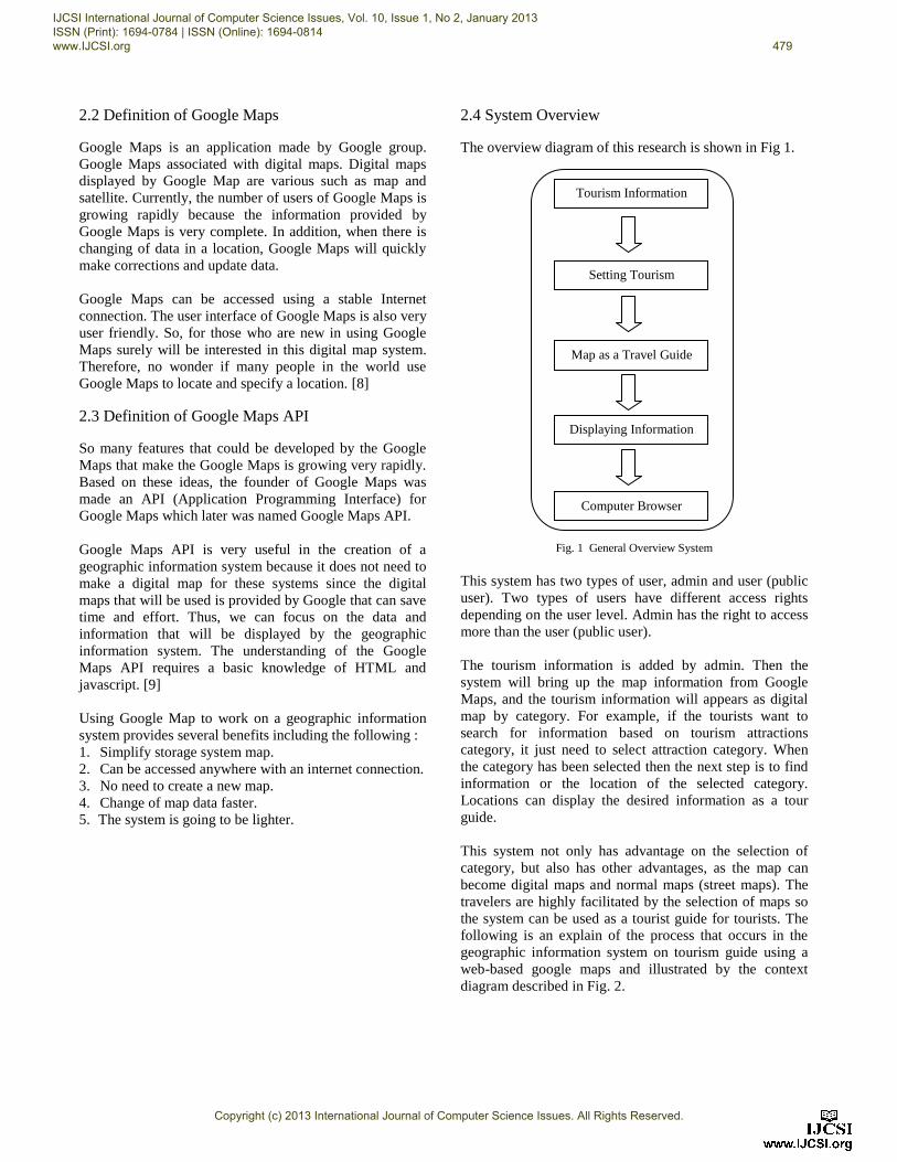
2.2 Definition of Google Maps
Google Maps is an application made by Google group.
Google Maps associated with digital maps. Digital maps
displayed by Google Map are various such as map and
satellite. Currently, the number of users of Google Maps is
growing rapidly because the information provided by
Google Maps is very complete. In addition, when there is
changing of data in a location, Google Maps will quickly
make corrections and update data.
Google Maps can be accessed using a stable Internet
connection. The user interface of Google Maps is also very
user friendly. So, for those who are new in using Google
Maps surely will be interested in this digital map system.
Therefore, no wonder if many people in the world use
Google Maps to locate and specify a location. [8]
2.3 Definition of Google Maps API
So many features that could be developed by the Google
Maps that make the Google Maps is growing very rapidly.
Based on these ideas, the founder of Google Maps was
made an API (Application Programming Interface) for
Google Maps which later was named Google Maps API.
Google Maps API is very useful in the creation of a
geographic information system because it does not need to
make a digital map for these systems since the digital
maps that will be used is provided by Google that can save
time and effort. Thus, we can focus on the data and
information that will be displayed by the geographic
information system. The understanding of the Google
Maps API requires a basic knowledge of HTML and
javascript. [9]
Using Google Map to work on a geographic information
system provides several benefits including the following :
1. Simplify storage system map.
2. Can be accessed anywhere with an internet connection.
3. No need to create a new map.
4. Change of map data faster.
5. The system is going to be lighter.
2.4 System Overview
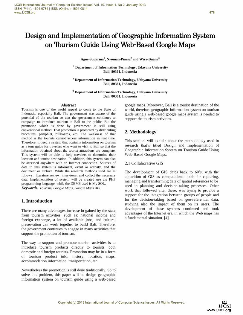
The overview diagram of this research is shown in Fig 1.
Fig. 1 General Overview System
This system has two types of user, admin and user (public
user). Two types of users have different access rights
depending on the user level. Admin has the right to access
more than the user (public user).
The tourism information is added by admin. Then the
system will bring up the map information from Google
Maps, and the tourism information will appears as digital
map by category. For example, if the tourists want to
search for information based on tourism attractions
category, it just need to select attraction category. When
the category has been selected then the next step is to find
information or the location of the selected category.
Locations can display the desired information as a tour
guide.
This system not only has advantage on the selection of
category, but also has other advantages, as the map can
become digital maps and normal maps (street maps). The
travelers are highly facilitated by the selection of maps so
the system can be used as a tourist guide for tourists. The
following is an explain of the process that occurs in the
geographic information system on tourism guide using a
web-based google maps and illustrated by the context
diagram described in Fig. 2.
Setting Tourism
Information
Tourism Information
Map as a Travel Guide
Displaying Information
Computer Browser
IJCSI International Journal of Computer Science Issues, Vol. 10, Issue 1, No 2, January 2013 ISSN (Print): 1694-0784 | ISSN (Online): 1694-0814 www.IJCSI.org 479
Copyright (c) 2013 International Journal of Computer Science Issues. All Rights Reserved.
0
GIS Tourism Guide
Admin
User
Data object, data category, data user, data banner, data news, data regency, data polling, data module,
data gallery, data category object
Data object, data category, data user, data banner, data news, data regency, data polling, data module, data gallery,
data category object
See data object, information data object, see gallery, see news
Data object, data news, data gallery, data banner
Fig. 2 Context Diagram
In Fig. 3 will be explain about the business processes that
occur in the geographic information system on tourism
guide using a web-based google maps.
Business process is demonstrated through entities called
data flow diagrams. Entities on data flow diagram level 0
is login, view object, view news, create object, and
management master data.
Username, password
Confirmatiion
D1 Data object
1
Login
Admin
2
View Object
5
Management Master Data
4
Create Object
View object, view gallery, search
User
Data object, data gallery
Data user
Check authority
D1 Data object
D3 Data category object
D2 Data regency
D1 Data object
D4 Data category
D2 Data regency
D5 Data news
D6 Data gallery
D7 Data user
D6 Data gallery
Data gallery
D3 Data category object
D2 Data regency
D7 Data user
D4 Data category
D2 Data regency
Data object
3
View News
View news, banner polling, search
Data news, data polling,data banner
Check authority
Data news, data polling, data banner
D5 Data news
D9 Data banner
D8 Data polling
D8 Data polling
D7 Data user
D9 Data banner
D3 Data category object
D4 Data category
Fig. 3 Data Flow Diagram Level 0
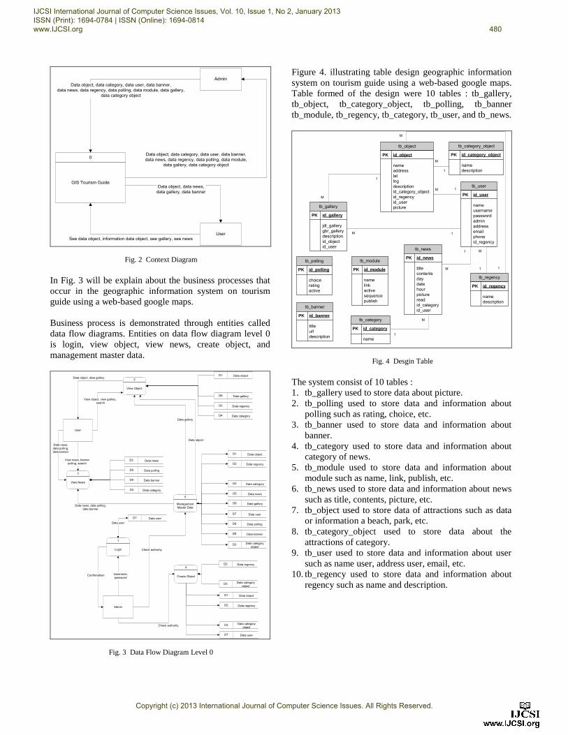
Figure 4. illustrating table design geographic information
system on tourism guide using a web-based google maps.
Table formed of the design were 10 tables : tb_gallery,
tb_object, tb_category_object, tb_polling, tb_banner
tb_module, tb_regency, tb_category, tb_user, and tb_news.
1
M
M
M
M 1
1
1
1
1
M
M
M
1
tb_user
PK id_user
name username password admin address email phone id_regency
1
M
tb_object
PK id_object
name address lat lng description id_category_object id_regency id_user picturetb_gallery
PK id_gallery
jdl_gallery gbr_gallery description id_object id_user
tb_regency
PK id_regency
name description
tb_category_object
PK id_category_object
name description
tb_category
PK id_category
name
tb_banner
PK id_banner
title url description
tb_polling
PK id_polling
choice rating active
tb_module
PK id_module
name link active sequence publish
tb_news
PK id_news
title contents day date hour picture read id_category id_user
Fig. 4 Desgin Table
The system consist of 10 tables :
1. tb_gallery used to store data about picture.
2. tb_polling used to store data and information about
polling such as rating, choice, etc.
3. tb_banner used to store data and information about
banner.
4. tb_category used to store data and information about
category of news.
5. tb_module used to store data and information about
module such as name, link, publish, etc.
6. tb_news used to store data and information about news
such as title, contents, picture, etc.
7. tb_object used to store data of attractions such as data
or information a beach, park, etc.
8. tb_category_object used to store data about the
attractions of category.
9. tb_user used to store data and information about user
such as name user, address user, email, etc.
10. tb_regency used to store data and information about
regency such as name and description.
IJCSI International Journal of Computer Science Issues, Vol. 10, Issue 1, No 2, January 2013 ISSN (Print): 1694-0784 | ISSN (Online): 1694-0814 www.IJCSI.org 480
Copyright (c) 2013 International Journal of Computer Science Issues. All Rights Reserved.
The degree of relation indicates the maximum number of
entities that can be filled with other entities in the entity set.
The degree of relationship that occur in sets of entities on
the system :
1. tb_category with tb_news
The degree of relation that occurs between tb_category
and tb_news is 1: M (one to many) because a category
can have a lot of news.
2. tb_object with tb_gallery
The degree of relation that occurs between tb_object
and tb_gallery is 1: M (one to many) because a object
can have a lot of gallery.
3. tb_regency with tb_object
The degree of relation that occurs between tb_regency
and tb_object is 1: M (one to many) because regency
can have a lot of object.
4. tb_category_object with tb_object
The degree of relation that occurs between
tb_category_object and t_object is 1: M (one to many)
as a category_object can have many object.
5. tb_user with tb_object
The degree of relation that occurs between tb_user and
tb_object is 1: M (one to many) because user can send
or have a lot of object.
6. tb_regency with tb_user
The degree of relation that occurs between tb_regency
and tb_user is 1: M (one to many) because regency can
have a lot of user.
7. tb_user with tb_gallery
The degree of relation that occurs between tb_user and
tb_gallery is 1: M (one to many) because user can have
or send a lot of gallery.
8. tb_user with tb_news
The degree of relation that occurs between tb_user and
tb_news is 1: M (one to many) because user can have
or send a lot of news.
3. Experiments and Results
Once the system design is completed, the next will be the
trial process. This step holds an important role in
programming. It lets the programmer do trial and error
fixing before it launched officially for the viewers.
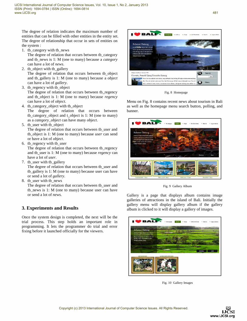
Fig. 8 Homepage
Menu on Fig. 8 contains recent news about tourism in Bali
as well as the homepage menu search button, polling, and
banner.
Fig. 9 Gallery Album
Gallery is a page that displays album contains image
galleries of attractions in the island of Bali. Initially the
gallery menu will display gallery album if the gallery
album is clicked to it will display a gallery of images.
Fig. 10 Gallery Images
IJCSI International Journal of Computer Science Issues, Vol. 10, Issue 1, No 2, January 2013 ISSN (Print): 1694-0784 | ISSN (Online): 1694-0814 www.IJCSI.org 481
Copyright (c) 2013 International Journal of Computer Science Issues. All Rights Reserved.
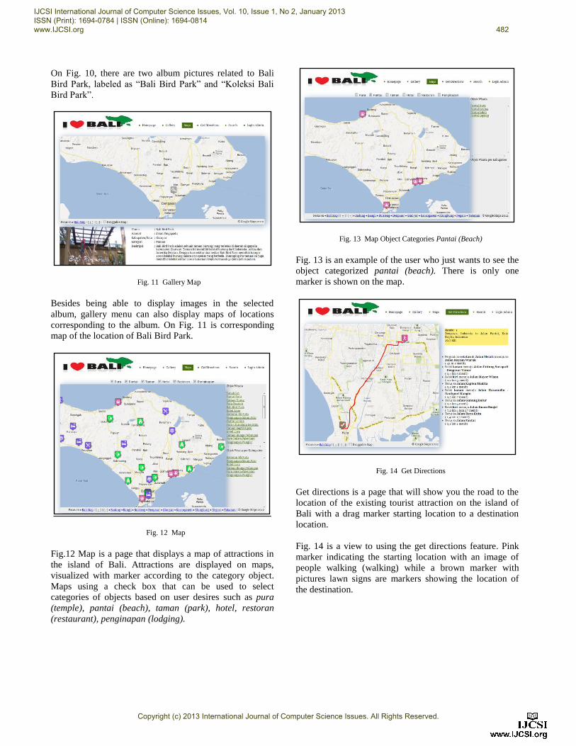
On Fig. 10, there are two album pictures related to Bali
Bird Park, labeled as “Bali Bird Park” and “Koleksi Bali
Bird Park”.
Fig. 11 Gallery Map
Besides being able to display images in the selected
album, gallery menu can also display maps of locations
corresponding to the album. On Fig. 11 is corresponding
map of the location of Bali Bird Park.
Fig. 12 Map
Fig.12 Map is a page that displays a map of attractions in
the island of Bali. Attractions are displayed on maps,
visualized with marker according to the category object.
Maps using a check box that can be used to select
categories of objects based on user desires such as pura
(temple), pantai (beach), taman (park), hotel, restoran
(restaurant), penginapan (lodging).
Fig. 13 Map Object Categories Pantai (Beach)
Fig. 13 is an example of the user who just wants to see the
object categorized pantai (beach). There is only one
marker is shown on the map.
Fig. 14 Get Directions
Get directions is a page that will show you the road to the
location of the existing tourist attraction on the island of
Bali with a drag marker starting location to a destination
location.
Fig. 14 is a view to using the get directions feature. Pink
marker indicating the starting location with an image of
people walking (walking) while a brown marker with
pictures lawn signs are markers showing the location of
the destination.
IJCSI International Journal of Computer Science Issues, Vol. 10, Issue 1, No 2, January 2013 ISSN (Print): 1694-0784 | ISSN (Online): 1694-0814 www.IJCSI.org 482
Copyright (c) 2013 International Journal of Computer Science Issues. All Rights Reserved.
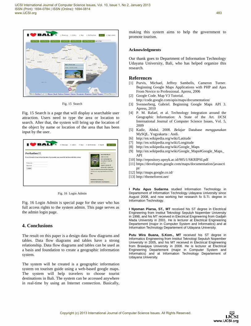
Fig. 15 Search
Fig. 15 Search is a page that will display a searchable user
attraction. Users need to type the area or location to
search. After that, the system will bring up the location of
the object by name or location of the area that has been
input by the user.
Fig. 16 Login Admin
Fig. 16 Login Admin is special page for the user who has
full access rights to the system admin. This page serves as
the admin login page.
4. Conclusions
The result on this paper is a design data flow diagrams and
tables. Data flow diagrams and tables have a strong
relationship. Data flow diagrams and tables can be used as
a basis and foundation to create a geographic information
system.
The system will be created is a geographic information
system on tourism guide using a web-based google maps.
The system will help travelers to choose tourist
destinations in Bali. The system can be accessed anywhere
in real-time by using an Internet connection. Basically,
making this system aims to help the government to
promote tourism.
Acknowledgments
Our thank goes to Department of Information Technology
Udayana University, Bali, who has helped organize this
research.
References [1] Purvis, Michael, Jeffrey Sambells, Cameron Turner.
Beginning Google Maps Applications with PHP and Ajax
From Novice to Professional. Apress, 2006
[2] Google Code. Map V3 Tutorial.
http://code.google.com/apis/maps/documentation/
[3] Svennerberg, Gabriel. Beginning Google Maps API 3.
Apress, 2010
[4] P. M. Rafael, et al. Technology Integration around the
Geographic Information: A State of the Art. IJCSI
International Journal of Computer Science Issues, Vol. 5,
2009
[5] Kadir, Abdul. 2008. Belajar Database menggunakan
MySQL. Yogyakarta : Andi.
[6] http://en.wikipedia.org/wiki/Latitude
[7] http://en.wikipedia.org/wiki/Longitude
[8] http://en.wikipedia.org/wiki/Google_Maps
[9] http://en.wikipedia.org/wiki/Google_Maps#Google_Maps_
API
[10] http://repository.upnyk.ac.id/905/1/SKRIPSI.pdf
[11] https://developers.google.com/maps/documentation/javascri
pt/
[12] http://maps.google.co.id/
[13] http://themeforest.net/
I Putu Agus Sudarma studied Information Technology in Departement of Information Technology Udayana University since August 2008, and now working her research fo S.Ti. degree in Information Technology.
I Nyoman Piarsa, ST., MT received his ST degree in Electrical Engineering from Institut Teknologi Sepuluh Nopember University in 1998, and his MT received in Electrical Engineering from Gadjah Mada University in 2001. He is lecturer at Electrical Engineering Departement (major in Computer System and Informatics) and at Information Technology Departement of Udayana University. Putu Wira Buana, S.Kom., MT received his ST degree in Informatics Engineering from Institut Teknologi Sepuluh Nopember University in 2005, and his MT received in Electrical Engineering from Brawijaya University in 2008. He is lecturer at Electrical Engineering Departement (major in Computer System and Informatics) and at Information Technology Departement of Udayana University.
IJCSI International Journal of Computer Science Issues, Vol. 10, Issue 1, No 2, January 2013 ISSN (Print): 1694-0784 | ISSN (Online): 1694-0814 www.IJCSI.org 483
Copyright (c) 2013 International Journal of Computer Science Issues. All Rights Reserved.