Embed Size (px)
Citation preview
Detection of Heavy Detection of Heavy PrecipitationPrecipitation
OHD’s Research and Development in Radar OHD’s Research and Development in Radar and Multisensor Applicationsand Multisensor Applications
David KitzmillerDavid KitzmillerHydrologic Science and Modeling BranchHydrologic Science and Modeling Branch
Hydrology LaboratoryHydrology LaboratoryOffice of Hydrologic DevelopmentOffice of Hydrologic Development
February 1, 2006February 1, 2006

TopicsTopics
Potential for improving detection of heavy Potential for improving detection of heavy rainfall through use of radar mosaicsrainfall through use of radar mosaics
Implications of spatial resolution impacts Implications of spatial resolution impacts on radar-rain gauge correlationon radar-rain gauge correlation
Probabilistic radar rainfall estimates and Probabilistic radar rainfall estimates and potential applications in Flash Flood potential applications in Flash Flood Monitoring and PredictionMonitoring and Prediction
Quantitative nowcasts of rainfallQuantitative nowcasts of rainfall

Hydrometeorology GroupHydrometeorology Group
Feng DingFeng Ding Richard FultonRichard Fulton Shucai GuanShucai Guan David KitzmillerDavid Kitzmiller Chandra KondraguntaChandra Kondragunta Dennis MillerDennis Miller Kiran ShresthaKiran Shrestha

Collaborating PartnersCollaborating Partners
University of Iowa Department of Civil and University of Iowa Department of Civil and Environmental Engineering (Krajewski, Environmental Engineering (Krajewski, Ciach, Villarini)Ciach, Villarini)
National Severe Storms LaboratoryNational Severe Storms Laboratory WISHWISH RRADRRAD
Princeton University Department of Civil and Princeton University Department of Civil and Environmental Engineering (Jim Smith)Environmental Engineering (Jim Smith)
RS Information Systems, Inc. (McLean VA)RS Information Systems, Inc. (McLean VA)

Acronyms…Acronyms… DHR: Digital Hybrid Reflectivity (also DHR: Digital Hybrid Reflectivity (also
precipitation accumulations from DHR)precipitation accumulations from DHR) DPA: Digital Precipitation Array (one-hour radar DPA: Digital Precipitation Array (one-hour radar
rainfall accumulations)rainfall accumulations) FFG: Flash Flood Guidance (amount of rainfall FFG: Flash Flood Guidance (amount of rainfall
required to cause small streams to flood)required to cause small streams to flood) FFMP: Flash Flood Monitoring and Prediction FFMP: Flash Flood Monitoring and Prediction
System (Part of SCAN in AWIPS)System (Part of SCAN in AWIPS) Z-R: Reflectivity-to-rainrate model used to Z-R: Reflectivity-to-rainrate model used to
estimate rainfall from radar measurementsestimate rainfall from radar measurements Bias: ( Bias: ( Gauge Rainfall) / ( Gauge Rainfall) / ( Radar Rainfall) for Radar Rainfall) for
many collocated individual 1-h estimatesmany collocated individual 1-h estimates
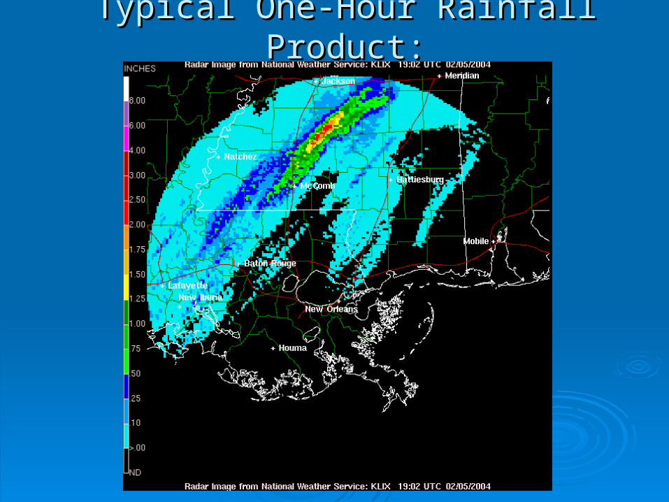
Typical One-Hour Rainfall Product:Typical One-Hour Rainfall Product:

Radar-to-Raingauge Comparisons Are Often Discouraging…Radar-to-Raingauge Comparisons Are Often Discouraging…

Range Influence on Radar DetectionRange Influence on Radar Detectionof Rainfallof Rainfall
Detection efficiency decreases with rangeDetection efficiency decreases with range Radar detects hydrometeor distribution Radar detects hydrometeor distribution
that is different from that at surfacethat is different from that at surface Horizontal advection of precipitation Horizontal advection of precipitation
affects apparent radar-gauge agreementaffects apparent radar-gauge agreement Pointing accuracy of radarPointing accuracy of radar Location errors for gaugesLocation errors for gauges
Most of these errors are magnifiedMost of these errors are magnified at longer rangesat longer ranges

Height Field Radar Coverage Field
AWIPS Multisensor Precipitation Estimator Mosaicking Technique

Detection of Heavy RainDetection of Heavy Rain4-km Mosaic 4-km Mosaic vs.vs. 1-km Single-Site Estimates 1-km Single-Site Estimates
Created a set of matching estimates:Created a set of matching estimates: Rain gaugeRain gauge Single-radar (based on Digital Hybrid Reflectivity products used Single-radar (based on Digital Hybrid Reflectivity products used
in FFMP)in FFMP) Multisensor Precipitation Estimator mosaicMultisensor Precipitation Estimator mosaic
Sites:Sites: KPBZ (Pittsburgh)KPBZ (Pittsburgh) KLWX (Sterling)KLWX (Sterling) KFCX (Blacksburg)KFCX (Blacksburg)
2004 Warm season, 7 rain events2004 Warm season, 7 rain events Result: mosaic field has higher correlation with gauge Result: mosaic field has higher correlation with gauge
estimates than does single-radarestimates than does single-radar
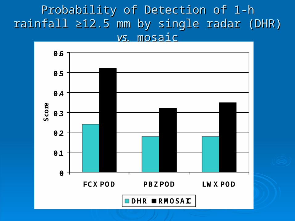
Probability of Detection of 1-h rainfall Probability of Detection of 1-h rainfall ≥≥12.5 mm by 12.5 mm by single radar (DHR) single radar (DHR) vs.vs. mosaic mosaic
0
0.1
0.2
0.3
0.4
0.5
0.6
FCX POD PBZ POD LWX POD
Sco
re
DHR RMOSAIC
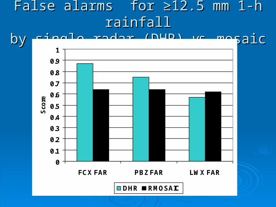
False alarms for ≥False alarms for ≥12.5 mm 1-h rainfall12.5 mm 1-h rainfallby single radar (DHR) by single radar (DHR) vs.vs. mosaic mosaic
0
0.1
0.2
0.3
0.4
0.5
0.6
0.7
0.8
0.9
1
FCX FAR PBZ FAR LWX FAR
Sco
re
DHR RMOSAIC

Correlation Between Radar Estimates andCorrelation Between Radar Estimates and1-h, 12.5-mm Rainfall Events1-h, 12.5-mm Rainfall Events
0
0.05
0.1
0.15
0.2
0.25
0.3
0.35
0.4
0.45
0.5
FCX PBZ LWX
Lin
ea
r C
orr
ela
tio
n
DHR RMOSAIC

Effects of Spatial Smoothing onEffects of Spatial Smoothing onRadar Rainfall EstimatesRadar Rainfall Estimates
We found that some degree of spatial We found that some degree of spatial smoothing generally improves radar-rain smoothing generally improves radar-rain gauge correlationsgauge correlations
There are several potential sources of There are several potential sources of radar/gauge location disagreement:radar/gauge location disagreement: Pointing accuracy of radarPointing accuracy of radar Horizontal advection of raindropsHorizontal advection of raindrops

Raindrops detected at 60 nm range are about 1 nm above ground (assuming level surface)
Terminal velocity of large drops ~ 20 knots
Travel time to ground ~ 3 minutes
If mean wind is 20 knots, raindrops cantravel 1 nm horizontally, or two WSR-88D range gates
Homogeneity of rainfall field mitigates advection effects,but advection might play large role in poor radar/gauge correlations in light, spotty rain

Effects of Spatial Smoothing of Radar Effects of Spatial Smoothing of Radar Estimates on Radar/Gauge CorrelationEstimates on Radar/Gauge Correlation
0
0.1
0.2
0.3
0.4
0.5
0.6
0.7
Correlation (Warm) Correlation (Cool)
Lin
ea
r C
orr
ela
tio
n
DHR Smoothed
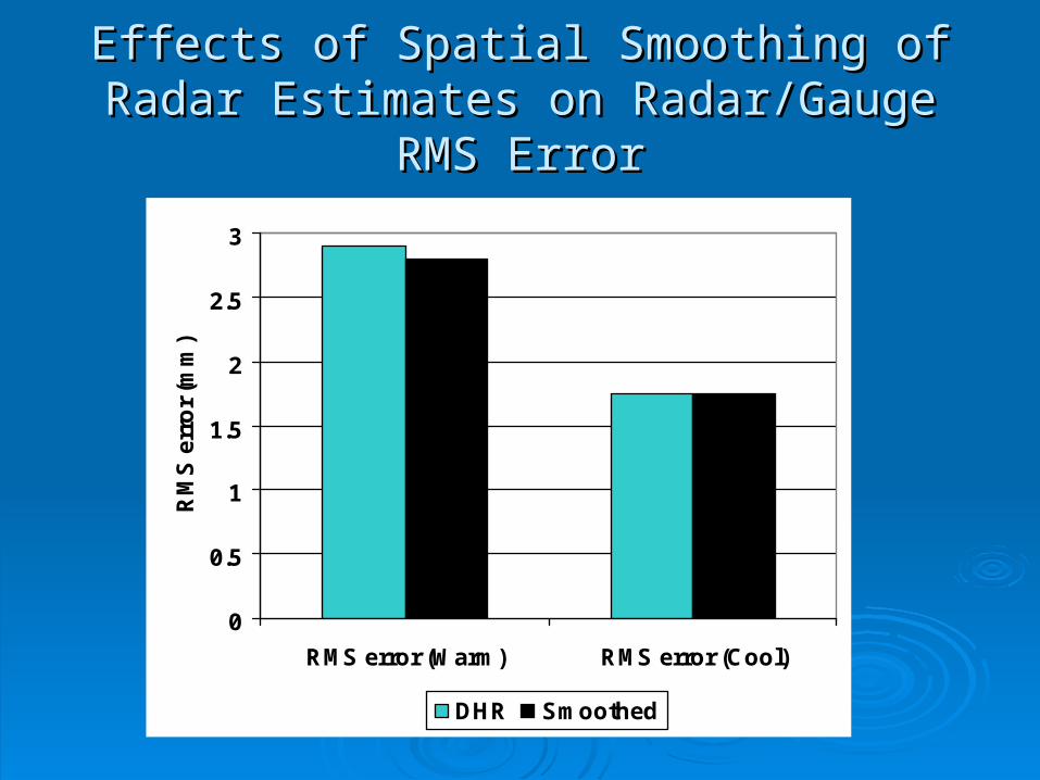
Effects of Spatial Smoothing of Radar Effects of Spatial Smoothing of Radar Estimates on Radar/Gauge RMS ErrorEstimates on Radar/Gauge RMS Error
0
0.5
1
1.5
2
2.5
3
RMS error (Warm) RMS error (Cool)
RM
S e
rro
r (m
m)
DHR Smoothed

Effects of Spatial Smoothing On Effects of Spatial Smoothing On Areal Rainfall EstimatesAreal Rainfall Estimates
Quality of areal rainfall estimates based on 1km x Quality of areal rainfall estimates based on 1km x 11 DHR products and 4km x 4km DPA assessed DHR products and 4km x 4km DPA assessed by comparing with collections of rain gauges in by comparing with collections of rain gauges in ARS Oklahoma micronetARS Oklahoma micronet
Quality of DHR-based and DPA-based areal Quality of DHR-based and DPA-based areal estimates is nearly identicalestimates is nearly identical
The issue warrants further investigation for The issue warrants further investigation for confirmationconfirmation
What horizontal resolution is optimum for FFMP?What horizontal resolution is optimum for FFMP?

Probabilistic Relationships Between Probabilistic Relationships Between Radar and Rain Gauge EstimatesRadar and Rain Gauge Estimates
Most common forms of bias correction are Most common forms of bias correction are based on long-term collections of 1-h based on long-term collections of 1-h radar/gauge paired observationsradar/gauge paired observations
Actual bias between radar estimates Actual bias between radar estimates based on Z-R and rain gauges depends based on Z-R and rain gauges depends on magnitude of the rainfall rateon magnitude of the rainfall rate
A common method of selecting radar A common method of selecting radar rainfall alert thresholds (fraction of critical rainfall alert thresholds (fraction of critical ground truth value) is not statistically ground truth value) is not statistically reliablereliable

Flash Flood GuidanceFlash Flood Guidance
An estimate of the rainfall required to An estimate of the rainfall required to cause small headwater streams to reach cause small headwater streams to reach bankfullbankfull
Commonly expressed as 1-h, 3-h, 6-h Commonly expressed as 1-h, 3-h, 6-h amountsamounts
Routinely produced by River Forecast Routinely produced by River Forecast Centers based on soil type, antecedent Centers based on soil type, antecedent rainfallrainfall

1-Hour FFG from MARFC, OHRFC1-Hour FFG from MARFC, OHRFC

Common Operational StrategyCommon Operational Strategy
Take action when radar rainfall estimate is Take action when radar rainfall estimate is 80% of FFG value80% of FFG value Closer examination of basin rainfall historyCloser examination of basin rainfall history Call for spotter reportsCall for spotter reports
However, threat of actual rainfall However, threat of actual rainfall exceeding FFG is strongly dependent on exceeding FFG is strongly dependent on the radar estimate itselfthe radar estimate itself
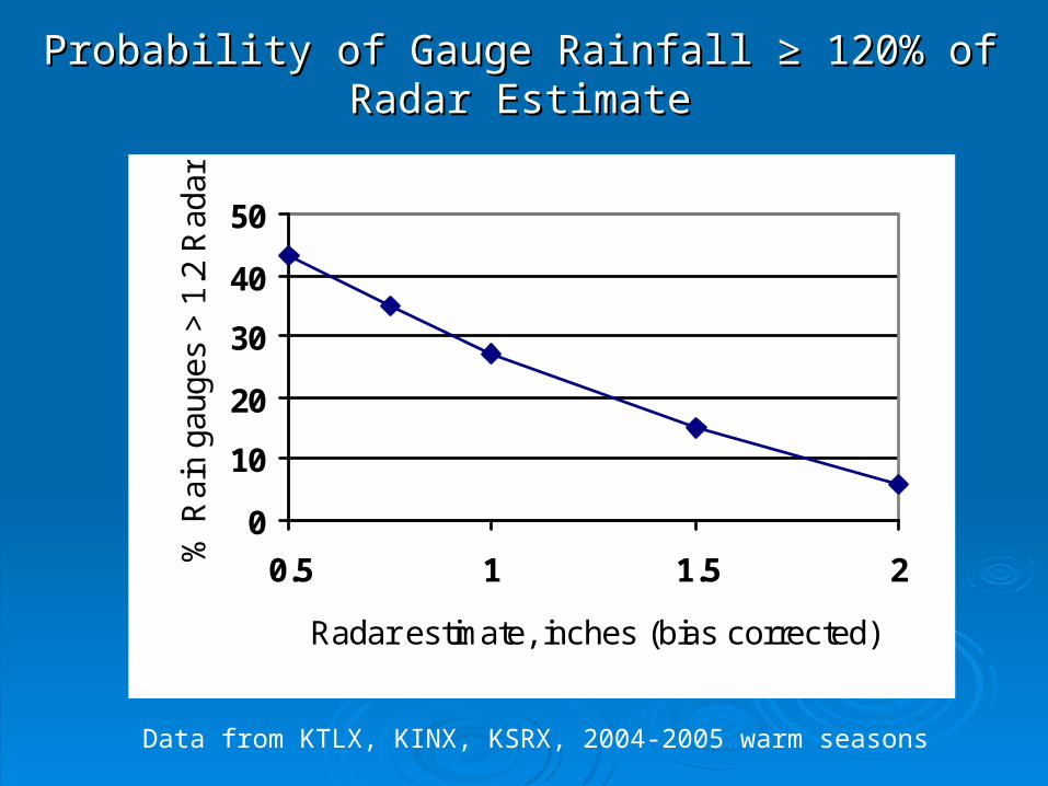
Probability of Gauge Rainfall Probability of Gauge Rainfall ≥ 120% of Radar ≥ 120% of Radar EstimateEstimate
0
10
20
30
40
50
0.5 1 1.5 2
Radar estimate, inches (bias corrected)
% R
ain
gaug
es >
1.2
Rad
ar
Data from KTLX, KINX, KSRX, 2004-2005 warm seasons
Probability of Gauge Rainfall ≥ 120% of Radar Estimate
Probability of exceeding a given Probability of exceeding a given gauge/radar ratio decreases with radar gauge/radar ratio decreases with radar rainraterainrate
For a radar estimate of 0.4 inch, there is a For a radar estimate of 0.4 inch, there is a 45% chance that rainfall will exceed 0.5 45% chance that rainfall will exceed 0.5 inchinch
For a radar estimate of 1.5 inches, there is For a radar estimate of 1.5 inches, there is only a 15% chance that rainfall will exceed only a 15% chance that rainfall will exceed 1.8 inches1.8 inches

Probabilistic Relationships Between Probabilistic Relationships Between Radar and Rain Gauge EstimatesRadar and Rain Gauge Estimates
Work carried out at University of Iowa Work carried out at University of Iowa (Krajewski, Ciach, Villarini) shows that (Krajewski, Ciach, Villarini) shows that radar rainfall errors can be modeled with a radar rainfall errors can be modeled with a set of power-law functionsset of power-law functions
Results confirmed on a larger data sample Results confirmed on a larger data sample by OHDby OHD
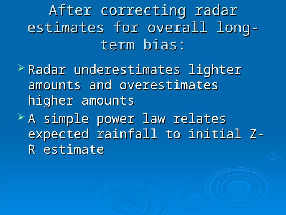
After correcting radar estimates for After correcting radar estimates for overall long-term bias:overall long-term bias:
Radar underestimates lighter amounts and Radar underestimates lighter amounts and overestimates higher amountsoverestimates higher amounts
A simple power law relates expected A simple power law relates expected rainfall to initial Z-R estimaterainfall to initial Z-R estimate
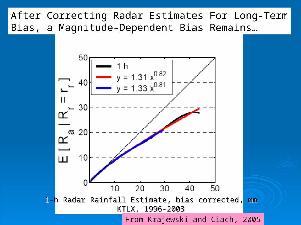
1-h Radar Rainfall Estimate, bias corrected, mm1-h Radar Rainfall Estimate, bias corrected, mmKTLX, 1996-2003KTLX, 1996-2003
From Krajewski and Ciach, 2005
After Correcting Radar Estimates For Long-TermBias, a Magnitude-Dependent Bias Remains…
From Krajewski and Ciach, 2005
1-h Radar Rainfall Estimate, bias corrected, mmKTLX, 1996-2003
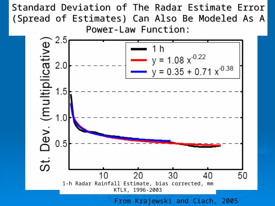
Standard Deviation of The Radar Estimate ErrorStandard Deviation of The Radar Estimate Error(Spread of Estimates) Can Also Be Modeled As A(Spread of Estimates) Can Also Be Modeled As A
Power-Law Function:Power-Law Function:
After correcting radar estimates for After correcting radar estimates for overall long-term bias:overall long-term bias:
Rainrate-dependent bias is approximated by a Rainrate-dependent bias is approximated by a power-law curvepower-law curve
Standard deviation of multiplicative error is also Standard deviation of multiplicative error is also a power-law curvea power-law curve
Distribution of multiplicative errors for any given Distribution of multiplicative errors for any given radar estimate is approximately normalradar estimate is approximately normal
Formulation of probability of rainfall exceeding a Formulation of probability of rainfall exceeding a critical value:critical value:

B is long-term gauge/radar biasa,b are parameters of bias power law;c,d,e are parameters of standard deviation power law;RR is initial radar estimate;THRES is FFG or other critical rain amount
Formulation of Probability of Rainfall (RR)Exceeding a Critical Value THRES

Application of Probabilistic QPE:Application of Probabilistic QPE:
Power-law parameters are determined Power-law parameters are determined from extended gauge/radar samplefrom extended gauge/radar sample
Parameters have seasonal and site Parameters have seasonal and site dependencedependence
Probability equation could be incorporated Probability equation could be incorporated as new option in FFMPas new option in FFMP

Multisensor Precipitation Multisensor Precipitation Nowcaster (MPN)Nowcaster (MPN)
Extrapolative forecast model for 0-1 hour rainfall Extrapolative forecast model for 0-1 hour rainfall amountsamounts
Based on mosaicked radar and/or radar/gauge Based on mosaicked radar and/or radar/gauge rainrate fieldrainrate field
Produces forecasts of 1-h, 3-h, 6-h rainfall Produces forecasts of 1-h, 3-h, 6-h rainfall amounts ending 1 hour in the futureamounts ending 1 hour in the future
Advantages over operational SCAN 0-1 hour Advantages over operational SCAN 0-1 hour extrapolative algorithm:extrapolative algorithm: Radar mosaic input, rather than single radarRadar mosaic input, rather than single radar Incorporates real-time radar/gauge bias informationIncorporates real-time radar/gauge bias information
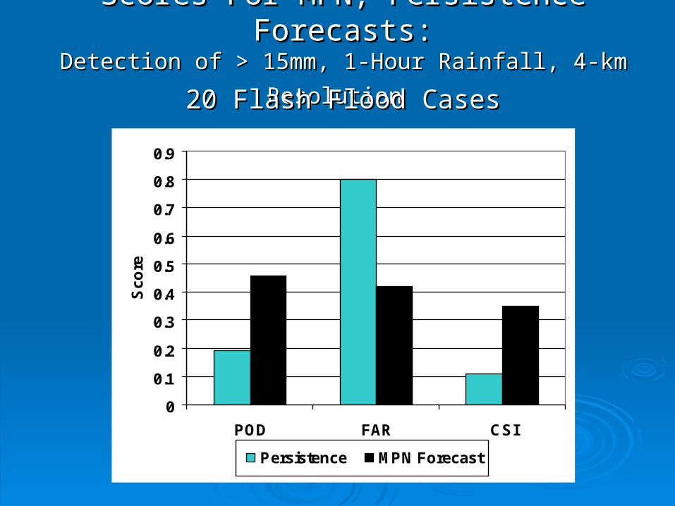
Scores For MPN, Persistence Forecasts:Scores For MPN, Persistence Forecasts:Detection of > 15mm, 1-Hour Rainfall, 4-km ResolutionDetection of > 15mm, 1-Hour Rainfall, 4-km Resolution
0
0.1
0.2
0.3
0.4
0.5
0.6
0.7
0.8
0.9
POD FAR CSI
Sc
ore
Persistence MPN Forecast
20 Flash Flood Cases20 Flash Flood Cases

Potential ApplicationsPotential Applicationsof MPNof MPN
Direct application in FFMPDirect application in FFMP Precipitation output serves as input to Precipitation output serves as input to
hydrologic models (distributed, Site hydrologic models (distributed, Site Specific)Specific)
Reed et al. reporting results using MPN Reed et al. reporting results using MPN output in distributed hydrologic modeling output in distributed hydrologic modeling at AMS Hydrology Conference this weekat AMS Hydrology Conference this week
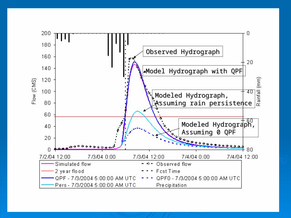
Observed HydrographObserved Hydrograph
Model Hydrograph with QPFModel Hydrograph with QPF
Modeled Hydrograph,Modeled Hydrograph,Assuming 0 QPFAssuming 0 QPF
Modeled Hydrograph,Modeled Hydrograph,Assuming rain persistenceAssuming rain persistence

SummarySummary In many parts of the U.S. the radar network is In many parts of the U.S. the radar network is
dense enough that mosaics of rainfall estimates dense enough that mosaics of rainfall estimates could provide significantly better detection of could provide significantly better detection of rainfall than single-radar estimatesrainfall than single-radar estimates
Use of prior knowledge of error statistics, Use of prior knowledge of error statistics, through a probabilistic model, could simplify through a probabilistic model, could simplify warning decisions.warning decisions.
Quantitative nowcasts of rainfall can improve Quantitative nowcasts of rainfall can improve forecasting of flood events through application in forecasting of flood events through application in either FFG or physical hydrologic modelseither FFG or physical hydrologic models
The optimum degree of spatial smoothing for The optimum degree of spatial smoothing for radar rainfall estimates needs further radar rainfall estimates needs further investigationinvestigation
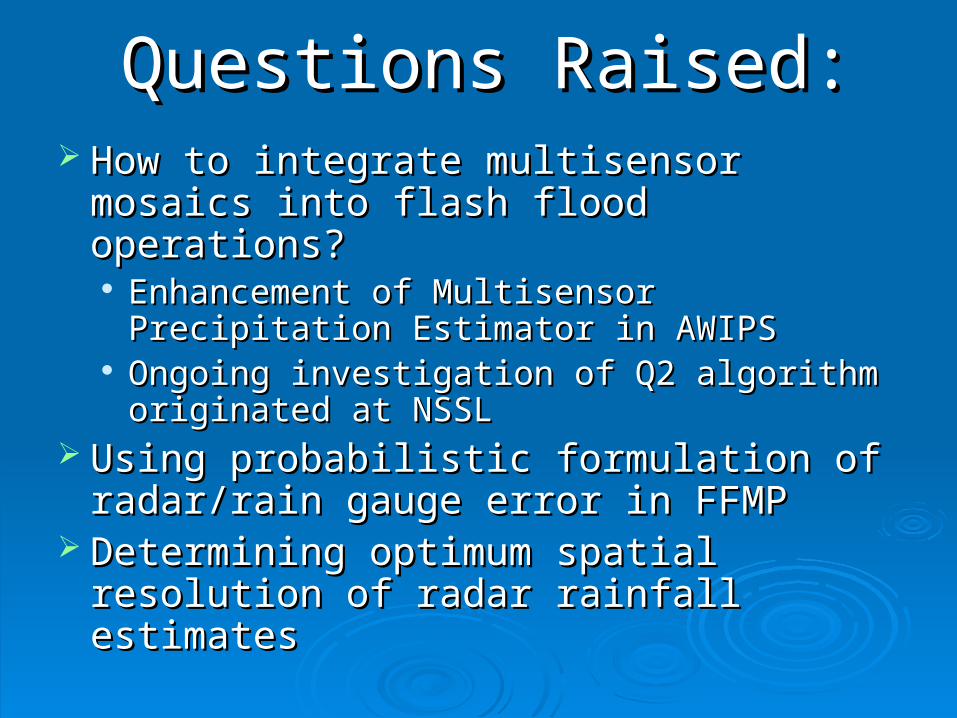
Questions Raised:Questions Raised: How to integrate multisensor mosaics into How to integrate multisensor mosaics into
flash flood operations?flash flood operations? Enhancement of Multisensor Precipitation Enhancement of Multisensor Precipitation
Estimator in AWIPSEstimator in AWIPS Ongoing investigation of Q2 algorithm Ongoing investigation of Q2 algorithm
originated at NSSLoriginated at NSSL Using probabilistic formulation of Using probabilistic formulation of
radar/rain gauge error in FFMPradar/rain gauge error in FFMP Determining optimum spatial resolution of Determining optimum spatial resolution of
radar rainfall estimatesradar rainfall estimates
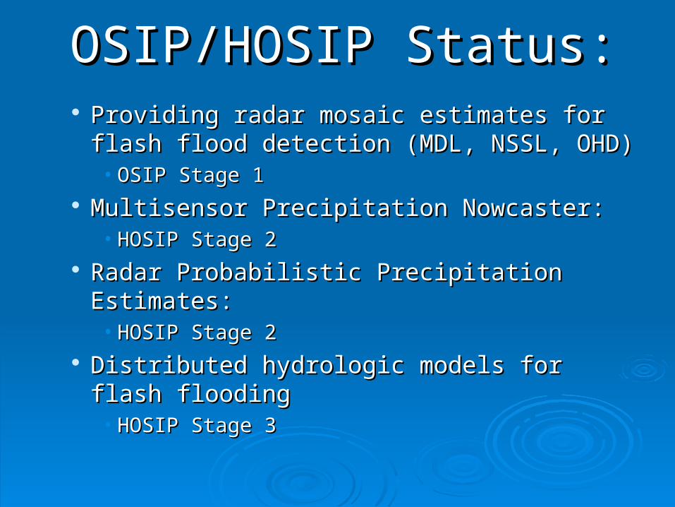
OSIP/HOSIP Status:OSIP/HOSIP Status: Providing radar mosaic estimates for flash Providing radar mosaic estimates for flash
flood detection (MDL, NSSL, OHD)flood detection (MDL, NSSL, OHD)• OSIP Stage 1OSIP Stage 1
Multisensor Precipitation Nowcaster:Multisensor Precipitation Nowcaster:• HOSIP Stage 2HOSIP Stage 2
Radar Probabilistic Precipitation Estimates:Radar Probabilistic Precipitation Estimates:• HOSIP Stage 2HOSIP Stage 2
Distributed hydrologic models for flash Distributed hydrologic models for flash floodingflooding• HOSIP Stage 3HOSIP Stage 3
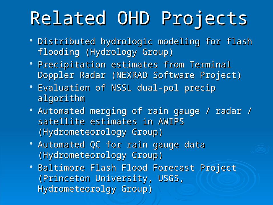
Related OHD ProjectsRelated OHD Projects Distributed hydrologic modeling for flash flooding Distributed hydrologic modeling for flash flooding
(Hydrology Group)(Hydrology Group) Precipitation estimates from Terminal Doppler Radar Precipitation estimates from Terminal Doppler Radar
(NEXRAD Software Project)(NEXRAD Software Project) Evaluation of NSSL dual-pol precip algorithmEvaluation of NSSL dual-pol precip algorithm Automated merging of rain gauge / radar / satellite Automated merging of rain gauge / radar / satellite
estimates in AWIPS (Hydrometeorology Group)estimates in AWIPS (Hydrometeorology Group) Automated QC for rain gauge data Automated QC for rain gauge data
(Hydrometeorology Group)(Hydrometeorology Group) Baltimore Flash Flood Forecast Project (Princeton Baltimore Flash Flood Forecast Project (Princeton
University, USGS, Hydrometeorolgy Group)University, USGS, Hydrometeorolgy Group)

Questions?Questions?

3-Hour FFG from MARFC, OHRFC3-Hour FFG from MARFC, OHRFC

0
50
100
150
200
250
7/2/04 12:00 7/3/04 0:00 7/3/04 12:00 7/4/04 0:00 7/4/04 12:00
Date
Flo
w (
CM
S)
0
20
40
60
80
Rai
nfal
l (m
m)
Simulated flow Observed flow 2 year floodFcst Time QPF - 7/3/2004 6 UTC QPF0 - 7/3/2004 6 UTCPers - 7/3/2004 6 UTC Precipitation

Gauge/MFB radar bias
0
0.2
0.4
0.6
0.8
1
0 0.2 0.4 0.6 0.8 1
DPA (MFB adjusted), inch
Gag
e, i
nch
KTLX KLWX KFFC
Expected 1-Hour Rain Gauge ValueAs Function of Radar Estimate
Radar estimatesadjusted for bias(gauge/radar):
KTLX bias: 0.7KLWX bias: 1.07KFFC bias: 0.93
May-Sep 2004