Embed Size (px)
Citation preview

Development of a coupled soil erosion and large-scale hydrology modeling system
Dazhi Mao, Keith A. Cherkauer
Ag. & Biological EngineeringPurdue University
Dennis C. Flanagan
NSERL

Outline
Introduction Concerns in coupling processes Coupling scheme Preliminary single cell analysis Development afterwards Current status

Introduction
Soil erosion by water is a major concern for resource management
Frozen soil modifies surface runoff generation and erodibility of the soil
Large-scale hydrology model to represent the impact of frozen soil on erosion at management scale

Introduction (continued) Macro-scale hydrologic model
The Variable Infiltration Capacity (VIC) model • Mosaic-type representation of soil
and vegetation• Infiltration curve to control spatial
variability in soil moisture and infiltration
• Improved representation of cold season processes
Erosion modelsUSLE, RUSLE, MUSLE• Based on field-scale
observations • Lumped approach
The WEPP model • Continuous process-based
model • Capable of estimating spatial
and temporal distribution of soil loss

Coupling possibilities The VIC model improved representation of cold season
processes (Cherkauer and Lettenmaier, 1999) The stand-alone WEPP-Hillslope Erosion (WEPP-HE)
code (Flanagan et al. 2005) provide basis for coupling with hydrology model Predicts soil loss for single storm event Needs only soil texture, slope profile, adjusted daily erodibility and
friction factors, and hydrologic pass files
Use basic erosion algorithms from the WEPP model to represent soil erosion in the VIC model

WEPPVIC
0
0.2
0.4
0.6
0.8
1
1.2
0 0.16 0.21 0.27 0.34 0.42 0.53 0.66 0.84 1.16 4.09
Time
Inte
nsi
ty
0
0.02
0.04
0.06
0.08
0.1
0.12
0.14
0.16
1 3 5 7 9 11 13 15 17 19 21 23
Hour
Rai
nfa
ll d
epth
Concerns Different scales
Spatial scales
Temporal scales
Different parameters WEPP
Soil texture, management options, slope profile, erodibility, friction factors, rainfall intensity, duration, peak runoff, etc.
VIC Soil parameters,
vegetation type, precipitation depth, runoff depth
WEPP disaggregated rainfall intensity
VIC sub-daily rainfall depth
field scale large scale

Approach
Downscale VIC model I/O to run WEPP-HE code
Represent topographic variability Statistical/stochastic presentation of output from
WEPP-HE in a VIC grid cell

Conceptual coupling scheme
VIC model output
Hydrologic pass file
VIC model soil
Soil texture
WEPP integrated algorithms
Adjustment parameters
DEM processing
Slope profile
WEPP-HE code
Annual soil Erosion
Soil erosion probability in VIC cell
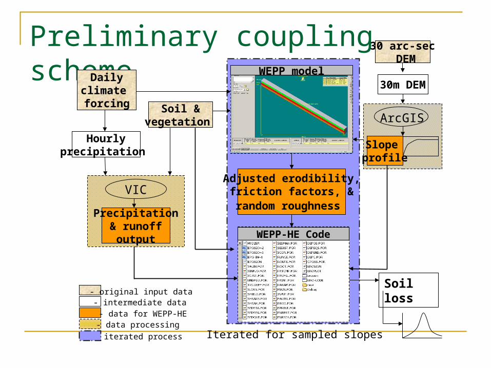
Preliminary coupling scheme
- iterated process
30 arc-sec DEM
Soil loss
- original input data
- data processingIterated for sampled slopes
- data for WEPP-HE - intermediate data
Dailyclimate forcing
Hourlyprecipitation
30m DEM
Slope profile
Soil &vegetation
Adjusted erodibility, friction factors, & random roughness
WEPP-HE Code
WEPP model
ArcGIS
Precipitation& runoff output
VIC

Preliminary single cell test
wat30arc_DEM
Value
High : 471
Low : 271
Minnesota
Watonwan watershed30 arc-second DEM
Selected VIC grid cellat 1/8 degree
wat30arc_DEM
Value
High : 471
Low : 271
Agricultural land use (corn, no-till) Nearest station climate file 30m DEM Random sample 25 slopes (spatial analyst) for single cell test evaluation

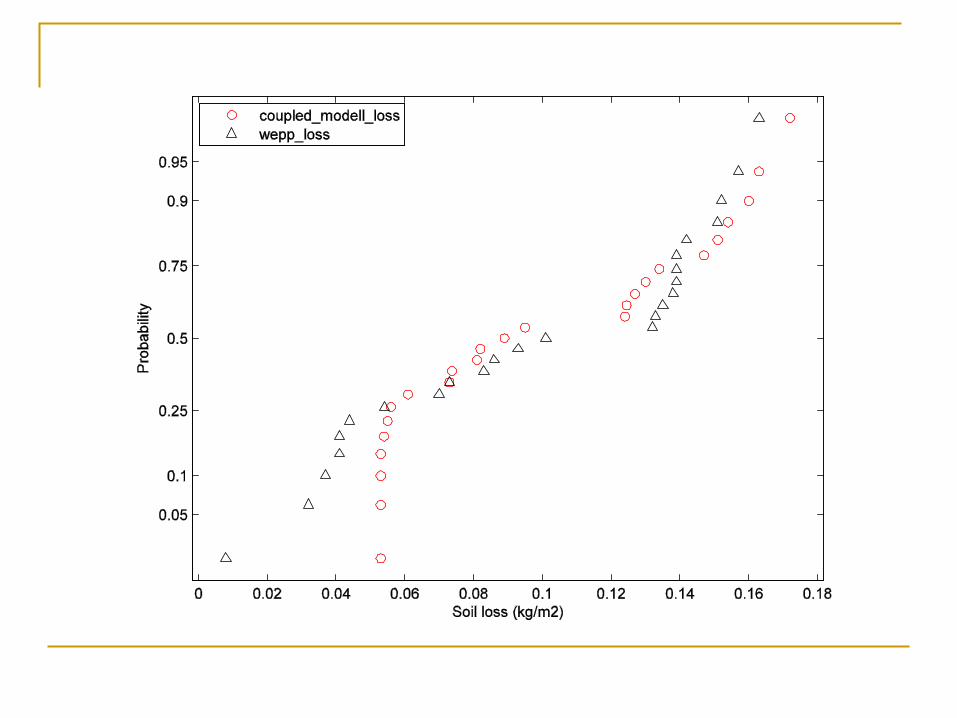
Preliminary results

Preliminary results
Complex data extraction and processing steps
Coupled model under-predict soil loss and sediment yield due to under-
estimation of hydrology parameters Difference in rainfall disaggregation
WEPP-breakpoint VIC-uniformly distributed by hours of
duration
Soil loss (kg/m2) Sediment Yield (t/ha)WEPP model 0.14 1.481Coupled model 0.054 0.576

Adjustments needed
Break down precipitation (daily-subdaily) using WEPP code
Extract soil erodibility adjustment code from WEPP model to remove the intermediate process
Reinvestigate and solidify slope profile rescale method
Develop soil loss probability distribution Application in larger study area/multiple cells

Adjusted coupling scheme
- iterated process
30 arc-sec DEM
Soil loss
- original input data
- data processingIterated for sampled slopes
- data for WEPP-HE - intermediate data
Hourly precipitation
30m slope
Slope profile
Soil &vegetation
WEPP-HE Code
Extracted WEPP modelSource code
Generate adjustment parameters
ArcGIS
Precipitation& runoff output
VIC
WEPP disaggregated precipitation CLIGEN

Current development Rainfall disaggregation
Regrid study domain to create .PAR file for each VIC grid cell based on existing CLIGEN PAR stations (inverse distance)
Use CLIGEN to generate .CLI file for each cell Extract disaggregation code from WEPP source
code to generate daily disaggregated storm Integrate disaggregated rainfall into hourly
precipitation Hourly precipitation and daily TMIN, TMAX, and
WIND are used to create VIC climate forcing files

Current development Soil adjustment code
Extracted soil texture, friction, erodibility adjustment codes from WEPP source code
Compiled to form a new Fortran program that reads in VIC soil and climate input data and output adjustment variables for each day

Still need to work Slope profile rescale
Monofractal scaling method (Bowling et al, 2004) where fractal dimension is estimated using variogram technique (Zhang et al. 1999; Xu et al. 1993)
The VIC grid cell is divided into subregions (3x3 30arc) to maintain local fracal properties
The distribution of slope for the whole watershed fits a Laplace distribution
30arc-DEM 30m slope

Improved result
Soil loss (kg/m2) Sediment yield (t/ha)
Mean Std Mean Std
WEPP 0.1007 0.0424 1.0384 0.4248
Coupled model
0.0993 0.0479 0.9936 0.479
Average annual (1980-1990)

Still need to work
Rescale issue, validation Erosion estimation under different vegetation
cover/land-use Statistical analysis of results, distribution fit,
etc.

Thank you
Questions? Suggestions?


![Dazhi client introduction (updated)[1]](https://img.pdfslide.net/doc/110x75/54c050f64a795968308b4625/dazhi-client-introduction-updated1.jpg)
