Embed Size (px)
Citation preview
. This unit deals with • Weather and cl imate – spatial and temporal distribution of temperature ,pressure, winds and
rainfall; Indian monsoons: mechanism, onset and variability – spatial and temporal; climatic types • Natural vegetation – forest types and distribution; wild life conservation; biosphere reserves
• Soils – major types and their distribution, soil degradation and conservation DIFFERENCE BETWEEN WEATHER AND CLIMATE
momentary
2.Weather changes quickly, may be within a day
or week 2.climate changes imperceptibly
noted after 50 years or even more and may be
UNITY AND DIVERSITY INTHE MONSOON CLIMATE UNITY OF THE CLIMATE 1.The monsoon regime emphasizes the unity of India with the rest of southeast Asian region. 2.This view of broad unity of the monsoon type of climate should not, however, lead one to i gnore
its regional variations which differentiate the weather and climate of different regions of India.
3.The climate of Kerala and Tamil Nadu in the south are so different from that of Uttar Pradesh and Bihar in the north, and yet all of these have a monsoon type of climate. DIVERSITY OF CLIMATE The climate of India has many regional variations expressed in the pattern of
1.winds,2.temperature 3. rainfall, 4. rhythm of seasons 5.degree of wetness or dryness. TEMPERATURE VARIATION 1.While in the summer the mercury occasionally touches 55°C in the western Rajasthan, it drops
down to as low as minus 45°C in winter around Leh. 2.Churu in Rajasthan may record a temperature of 50°C or more on a June day while the mercury hardly touches 19°C in Tawang (Arunachal Pradesh)on the same day. 3.On a December night, temperature in Drass (Jammu and Kashmir) may drop down to minus 45°C
while Thiruvananthapuram or Chennai on the same night records 20°C or 22°C. 4.In Kerala and in the Andaman Islands, the difference between day and night temperatures may be
hardly seven or eight degree Celsius. But in the Thar desert, if the day temperature is around 50°C, at night, it may drop down considerably up to 15°-20°C. THE REGIONAL VARIATIONS IN PRECIPITATION. 1.While snowfall occurs in the Himalayas, it only rains over the rest of the country. 2.While Cherrapunji and Mawsynramin the Khasi Hills of Meghalaya receive rainfall over 1,080 cm in
a year, Jaisalmer in Rajasthan rarely gets more than 9 cm of rainfall during the same period. 3.Tura situated in the Garo Hills of Meghalaya may receive an amount of rainfall in a single day
which is equal to 10 years of rainfall at Jaisalmer. 4.While the annual precipitation is less than 10 cm in the northwest Himalayas and the western deserts, it exceeds 400 cm in Meghalaya. 5.The Ganga delta and the coastal plains of Orissa are hit by strong rain-bearing storms almost every third or fifth day in July and August while the Coromandal coast, a thousand km to the south, goes generally dry during these months. 6. Most parts of the country get rainfall during June-September, but on the coastal areas of Tamil
Nadu, it rains in the beginning of the winter season.
is the state of the
1.Weather atmosphere
1.climate refers to the average of the weather conditions over a longer period of time

FACTORS DETERMINING THE CLIMATE OF INDIA India‘s climate is controlled by a number of factors which can
be broadly divided into two groups — factors related to location and relief, and factors related to air pressure and
winds. Factors related to Location and Relief
Latitude : the Tropic of Cancer passes through the central part of India
in east-west direction. Thus, northern part of the India lies in sub-tropical and temperate zone and the part lying south of
the Tropic of Cancer falls in the tropical zone. The tropical zone being nearer to the equator, experiences
high temperatures throughout the year with small daily and annual range. Area north of the Tropic of Cancer being away from the
equator, experiences extreme climate with high daily and annual range of temperature. The Himalayan Mountains :
1.Himalayas in the north along with its extensions act as an
effective climatic divide. 2.The towering mountain chain provides an invincible shield
to protect the subcontinent from the cold northern winds. 3. The Himalayas also trap the monsoon winds, forcing them
to shed their moisture within the subcontinent. Distribution of Land and Water : As compared to the landmass, water heats up or cools down
slowly. This differential heating of land and sea creates different air pressure zones in different seasons in and
around the Indian subcontinent. Difference in air pressure causes reversal in the direction of monsoon winds. Distance from the Sea :With a long coastline, large coastal
areas have an equable climate. Areas in the interior of India are far away from the
moderating influence of the sea. Such areas have extremes of climate. That is why, the people of Mumbai and the
Konkan coast have hardly any idea of extremes of
temperature and the seasonal rhythm of weather. Altitude :As the altitude increases the temperature falls
down, that is why Himalayas experience cold climate and north Indian plains plain experience hot climate Relief :The physiography or relief of India also affects the
temperature, air pressure, direction and speed of wind and the amount and distribution of
rainfall. The windward sides of Western Ghats and Assam receive
high rainfall during June-September whereas the southern plateau remains dry due to its leeward situation along the
Western Ghats.
the across blow 8.
7.
6.
of whole the that result the with
in the To
These winds
favorable monsoon south-west
known as disturbances
differences understand
period
creating weather conditions
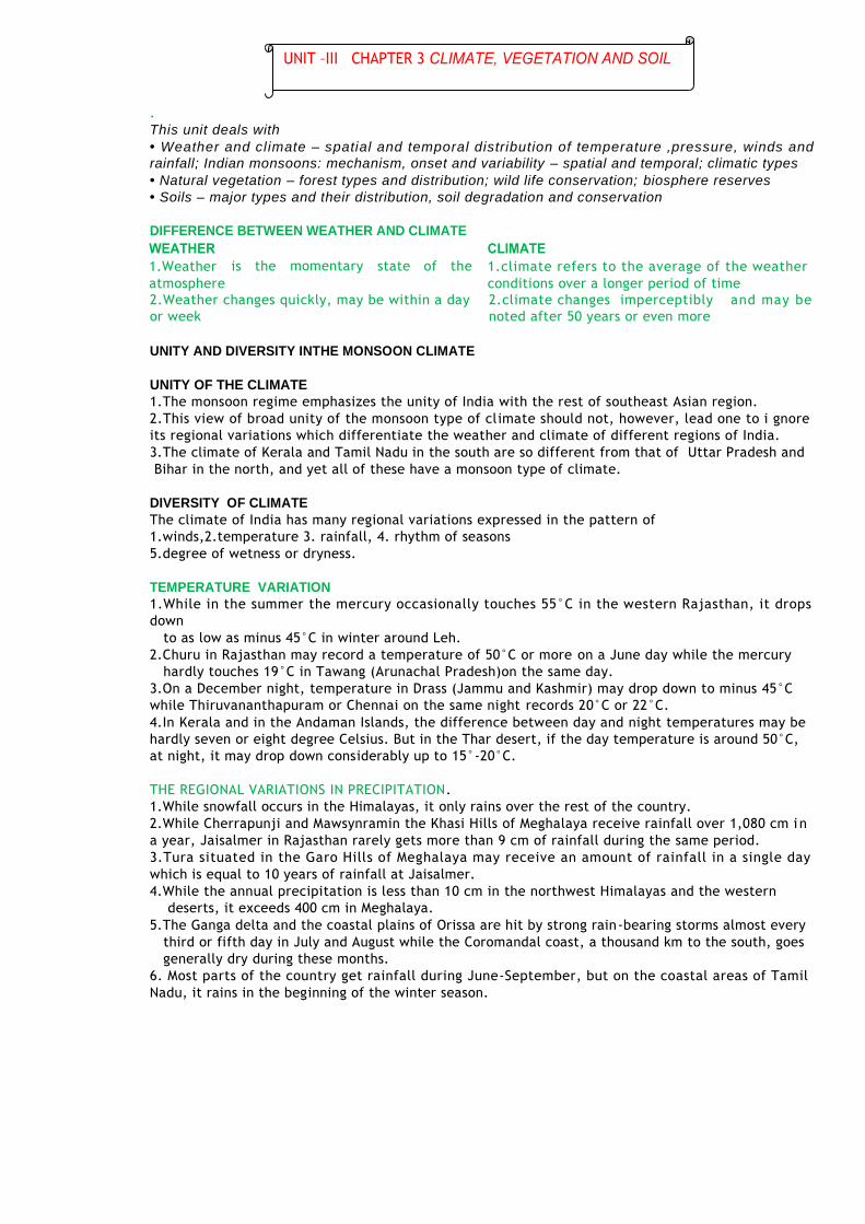
Factors Related to Air Pressure and Wind local
climates of India, we need to understand the mechanism of the following three factors: (i) Distribution of air pressure and winds on
the surface of the earth. (ii) Upper air circulation caused by factors
controlling global weather and the inflow of different air masses and jet streams. (iii) Inflow of western cyclones generally during the winter
season and tropical depressions during the
to
rainfall. The mechanism of these three factors can be understood with reference to winter
and summer seasons of the year separately. Mechanism of Weather in the Winter Season
Surface Pressure and Winds : 1. In winter months, a high pressure centre in
the region lying to the north of the Himalayas develops during winter. 2. This centre of high pressure gives rise to the
flow of air at the low level from the north towards the Indian subcontinent, south of the
mountain range. 3. The surface winds blowing out of the high
pressure centre over Central Asia reach Indian the form of a dry continental air mass. 4.The position of this contact zone is not,
however, stable. Occasionally, it may shift its position as East as the middle Ganga valley the
northwestern and northern India up to the middle Ganga valley comes under the influence
of dry northwestern winds. Jet Stream and Upper Air Circulation : 5.The pattern of air circulation discussed above is witnessed only at the lower level of the
atmosphere near the surface of the earth. Higher up in the lower troposphere, About three km above the surface of the
earth, a different pattern of air circulation is observed. The variations in the atmospheric
pressure closer to the surface of the earth have no role to play in the making of upper air
circulation. All of Western and Central Asia remain
under the influence of westerly winds along the altitude of 9-13 km from west to east. Asian
continent at latitudes north of the Himalayas roughly parallel to the Tibetan highlands. These
are known as jet streams. 9. Tibetan highlands act as a barrier in the path of these jet streams. As a result, jet streams
get bifurcated. Western Cyclonic Disturbance and TropicalCyclones 1. The western cyclonic disturbances which enter the Indian subcontinent from the west and the
northwest during the winter months,
into India,
low of zone
2. Originate over the Mediterranean Sea and are brought into India by the westerly jet stream. 3. Tropical cyclones originate over the Bay of Bengal and the Indian ocean. These tropical cyclones
have very high wind velocity and heavy rainfall and hit the Tamil Nadu, Andhra Pradesh and Orissa coast Mechanism of Weather in the Summer Season
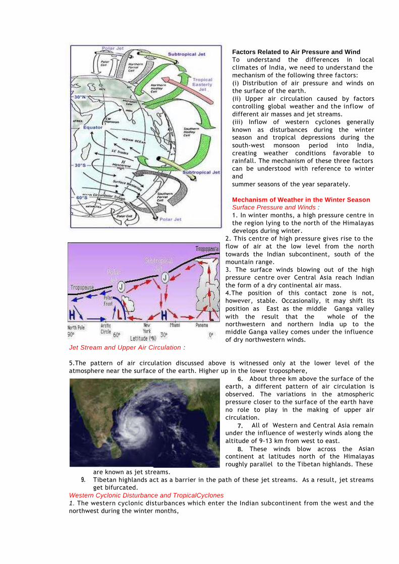
Surface Pressure and Winds 1.As the summersets in and the sun shifts northwards, 2. By the middle of July, the low pressure belt nearer the surface [termed as Inter Tropical
Convergence Zone (ITCZ)]shifts northwards, roughly parallel to the Himalayas between 20° N and 25° N. 3.By this time, the westerly jet stream withdraws from the Indian region.
4.It
pressure,
attracts inflow of winds from different directions. 5. The maritime tropical Air
mass (mT) from the southern
hemisphere, after crossing the equator, rushes to the
low pressure area in the
January ITC2 general
direction. westerly
6. It is this moist air current
which is popularly known as the southwest monsoon. Jet Streams and Upper Air
Circulation : 1.The pattern of pressure
mentioned above is formed only at the level of the troposphere. 2. An easterly jet stream flows over the southern part of the Peninsula in June, Inter Tropical Convergence Zone (ITCZ) The Inter Tropical Convergence Zone (ITCZ) is a low
pressure zone located at the equator where trade winds converge, and so, it is a zone where air tends to ascend. In July, the ITCZ is located around 20°N-25°N latitudes (over the Gangetic plain),
sometimes called the monsoon trough. This monsoon trough encourages the development of thermal low over north and northwest India. Due to the shift of ITCZ, the trade winds of the
southern hemisphere cross the equator between 40° and 60°E longitudes and start blowing from southwest to northeast due to the Coriolis force. It becomes southwest monsoon. In winter, the
ITCZ moves southward, and so the reversal of winds from northeast to south and southwest, takes place. They are called northeast monsoons. Easterly Jet Stream and Tropical Cyclones :The easterly jet stream steers the tropical depressions
into India. These depressions play a significant role in the distribution of monsoon rainfall over the Indian subcontinent. THE NATURE OF INDIAN MONSOON (i) The onset of the monsoon. (ii) Rain-bearing systems (e.g. tropical cyclones) and the relationship between their frequency and
distribution of monsoon rainfall. (iii) Break in the monsoon.
Onset of the Monsoon 1.the differential heating of land and sea during the summer months is the mechanism which sets
the stage for the monsoon winds to drift towards the subcontinent. 2.During April and May when the sun shines vertically over the Tropic of Cancer, the large landmass
in the north of Indian ocean gets intensely heated. 3. This causes the formation of an intense low pressure in the northwestern part of the
subcontinent. Since he pressure in the Indian Ocean in the south of the landmass is high as water gets heated.
slowly, the low pressure cell attracts the southeast trades across the Equator. 4. These conditions help in the northward shift in the position of the ITCZ.
generally is believed
that there is a cause and effect relationship between
the two. The ITCZ being a
south
and winds as
the (i)
and system The
distortion
circulation;
oceanic involves
Normal Conditions
W
W
5. The southwest monsoon may thus, be seen as a continuation of the southeast trades deflected
towards the Indian subcontinent after crossing the Equator.
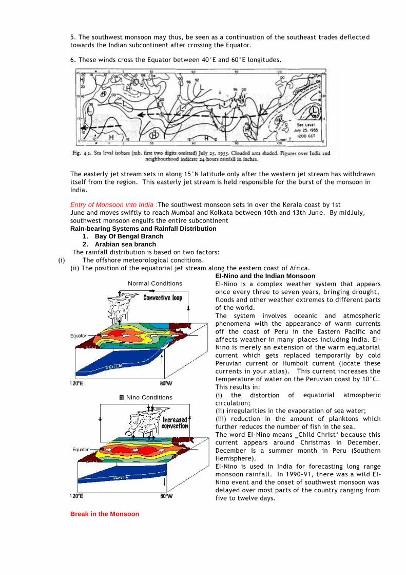
6. These winds cross the Equator between 40°E and 60°E longitudes.
The easterly jet stream sets in along 15°N latitude only after the western jet stream has withdrawn
itself from the region. This easterly jet stream is held responsible for the burst of the monsoon in India.
Entry of Monsoon into India :The southwest monsoon sets in over the Kerala coast by 1st June and moves swiftly to reach Mumbai and Kolkata between 10th and 13th June. By midJuly,
southwest monsoon engulfs the entire subcontinent Rain-bearing Systems and Rainfall Distribution
1. Bay Of Bengal Branch 2. Arabian sea branch The rainfall distribution is based on two factors: The offshore meteorological conditions. (ii) The position of the equatorial jet stream along the eastern coast of Africa.
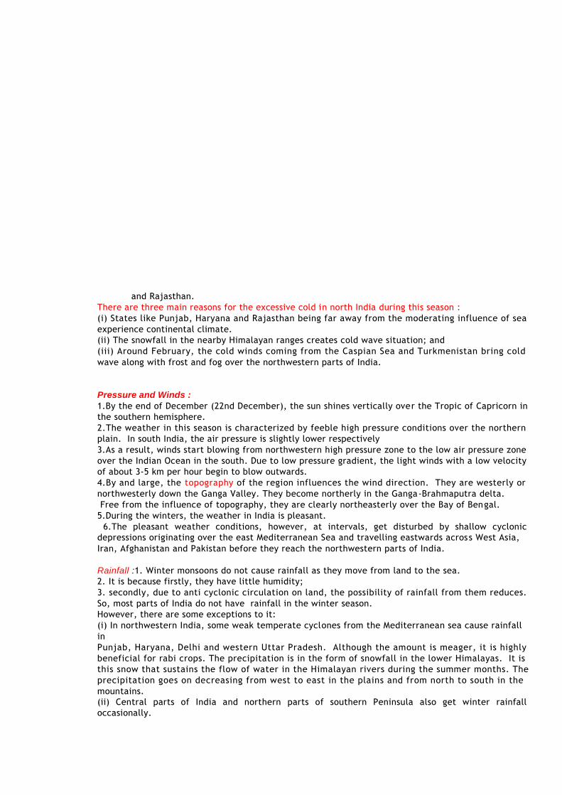
EI-Nino and the Indian Monsoon EI-Nino is a complex weather system that appears
once every three to seven years, bringing drought, floods and other weather extremes to different parts
of the world. atmospheric
phenomena with the appearance of warm currents off the coast of Peru in the Eastern Pacific and
affects weather in many places including India. EI- Nino is merely an extension of the warm equatorial
current which gets replaced temporarily by cold Peruvian current or Humbolt current (locate these
currents in your atlas). This current increases the temperature of water on the Peruvian coast by 10°C.
This results in:
Nino Conditions equatorial atmospheric
(ii) irregularities in the evaporation of sea water; (iii) reduction in the amount of planktons which
further reduces the number of fish in the sea. The word EI-Nino means ‗Child Christ‘ because this
current appears around Christmas in December. December is a summer month in Peru (Southern
Hemisphere). EI-Nino is used in India for forecasting long range
monsoon rainfall. In 1990-91, there was a wild EI- Nino event and the onset of southwest monsoon was
delayed over most parts of the country ranging from five to twelve days.
Break in the Monsoon
(i)
of
and Rajasthan. There are three main reasons for the excessive cold in north India during this season : (i) States like Punjab, Haryana and Rajasthan being far away from the moderating influence of sea
experience continental climate. (ii) The snowfall in the nearby Himalayan ranges creates cold wave situation; and (iii) Around February, the cold winds coming from the Caspian Sea and Turkmenistan bring cold
wave along with frost and fog over the northwestern parts of India. Pressure and Winds : 1.By the end of December (22nd December), the sun shines vertically over the Tropic of Capricorn in
the southern hemisphere. 2.The weather in this season is characterized by feeble high pressure conditions over the northern
plain. In south India, the air pressure is slightly lower respectively 3.As a result, winds start blowing from northwestern high pressure zone to the low air pressure zone
over the Indian Ocean in the south. Due to low pressure gradient, the light winds with a low velocity of about 3-5 km per hour begin to blow outwards. 4.By and large, the topography of the region influences the wind direction. They are westerly or
northwesterly down the Ganga Valley. They become northerly in the Ganga-Brahmaputra delta. Free from the influence of topography, they are clearly northeasterly over the Bay of Bengal.
5.During the winters, the weather in India is pleasant. 6.The pleasant weather conditions, however, at intervals, get disturbed by shallow cyclonic
depressions originating over the east Mediterranean Sea and travelling eastwards across West Asia, Iran, Afghanistan and Pakistan before they reach the northwestern parts of India. Rainfall :1. Winter monsoons do not cause rainfall as they move from land to the sea.
2. It is because firstly, they have little humidity; 3. secondly, due to anti cyclonic circulation on land, the possibility of rainfall from them reduces.
So, most parts of India do not have rainfall in the winter season. However, there are some exceptions to it: (i) In northwestern India, some weak temperate cyclones from the Mediterranean sea cause rainfall
in Punjab, Haryana, Delhi and western Uttar Pradesh. Although the amount is meager, it is highly
beneficial for rabi crops. The precipitation is in the form of snowfall in the lower Himalayas. It is this snow that sustains the flow of water in the Himalayan rivers during the summer months. The
precipitation goes on decreasing from west to east in the plains and from north to south in the
mountains. (ii) Central parts of India and northern parts of southern Peninsula also get winter rainfall
occasionally.

(iii) Arunachal Pradesh and Assam in the northeastern parts of India also have rains between 25 mm
and 50 mm during these winter months. (iv) During October and November, northeast monsoon while crossing over the Bay of Bengal, picks
up moisture and causes torrential rainfall over the Tamil Nadu coast, southern Andhra Pradesh, southeast Karnataka and south east Kerala. The Hot Weather Season
Temperature: 1.With the apparent northward movement of the sun towards the Tropic of Cancer in March,
temperatures start rising in north India. 2.April, May and June are the months of summer in north India. In most parts of India, temperatures
recorded are between 30°-32°C. 3. In March, the highest day temperature of about 38°C occurs in the Deccan Plateau while in April,
temperature ranging between 38°C and 43°C are found in Gujarat and Madhya Pradesh. 4. In May, the heat belt moves further north, and in the north-western part of India, temperatures
around 48°C are not uncommon 5. temperatures remain between 26°C and 32°C. Due to altitude, the temperatures in the hills of=
Western Ghats remain below 25°C. Pressure and Winds : 1.The summer months are a period of excessive heat and falling air pressure in the northern half of
the country. 2. Roughly, this elongated low pressure monsoon trough extends over the Thar desert in the north-
west to Patna and Chotanagpur plateau in the east-southeast 3.The location of the ITCZ attracts a surface circulation of the winds which are southwesterly on the
west coast as well as along the coast of West Bengal and Bangladesh. 4.They are easterly or southeasterly over north Bengal and Bihar. . 5.In the heart of the ITCZ in the northwest, the dry and hot winds known as ‗Loo‘, blow in the afternoon, and very often, they continue to well into midnight. 6. Dust storms in the evening are very common during May in Punjab, Haryana, Eastern Rajasthan
and Uttar Pradesh. 7. These temporary storms bring a welcome respite from the oppressing heat since they bring with
them light rains and a pleasant cool breeze. 8. Occasionally, the moisture-laden winds are attracted towards the periphery of the trough. 9. A sudden contact between dry and moist air masses gives rise to local storms of great intensity.
10. These local storms are associated with violent winds, torrential rains and even hailstorms. Some Famous Local Storms of Hot Weather Season (i) Mango Shower : Towards the end of summer, there are pre-monsoon showers which are a
common phenomena in Kerala and coastal areas of Karnataka. Locally, they are known as mango showers
since they help in the early ripening of mangoes. (ii) Blossom Shower : With this shower, coffee flowers blossom in Kerala and nearby areas. (iii) Nor Westers :These are dreaded evening thunderstorms in Bengal and Assam. Their notorious
nature can be understood from the local nomenclature of ‗Kalbaisakhi‘, a calamity of the month of Baisakh. (iv) These showers are useful for tea, jute and rice cultivation. In Assam, these storms are known as
―BardoliChheerha‖. (v) Loo : Hot, dry and oppressing winds blowing in the Northern plains from Punjab to Bihar with
higher intensity between Delhi and Patna. THE SOUTHWEST MONSOON SEASON 1.Due to high temperature there is lo to attract the trade winds of Southern Hemisphere coming
from the Indian Ocean. 2.These southeast trade winds cross the equator and enter the Bay of Bengal and the Arabian Sea,
3.After crossing the equator, they follow a southwesterly direction. That is why they are known as
southwest monsoons. 4.The rain in the southwest monsoon season begins rather abruptly. One result of the first rain is
that it brings down the temperature substantially. 5.This sudden onset of the moisture-laden winds associated with violent thunder and lightning, is
often termed as the ―break‖ or ―burst‖ of the monsoons.

The monsoon approaches the landmass
in two branches: (i) The Arabian Sea branch
(ii) The Bay of Bengal branch Monsoon Winds of the Arabian Sea The monsoon winds originating over the Arabian Sea further split into three branches: (i) Its one branch is obstructed by the Western Ghats. These winds climb the slopes of the Western
Ghats from900-1200 m. Soon, they become cool, and as a result, the windward side of the Sahyadris and Western Coastal Plain receive very heavy rainfall ranging between 250 cm and 400 cm. Afte r
crossing the Western Ghats, these winds descend and get heated up. (ii) Another branch of the Arabian sea monsoon strikes the coast north of Mumbai. Moving along the
Narmada and Tapi river valleys, these winds cause rainfall in extensive areas of central India. The Chotanagpur plateau gets 15 cm rainfall from this part of the branch. Thereafter, they enter the
Ganga plains and mingle with the Bay of Bengal branch. (iii) A third branch of this monsoon wind strikes the Saurashtra Peninsula and the Kachchh. It then
passes over west Rajasthan and along the Aravalis, causing only a scanty rainfall. In Punjab and Haryana, it too joins the Bay of Bengal branch. These two branches, reinforced by each other,
cause rains in the western Himalayas, Monsoon Winds of the Bay of Bengal 1.The Bay of Bengal branch strikes the coast of Myanmar and part of south east Bangladesh. But the
Arakan Hills along the coast of Myanmar deflect a big portion of this branch towards the Indian subcontinent. 2.The monsoon, therefore, enters West Bengal and Bangladesh from south and southeast instead of
from the south-westerly direction. From here, this branch splits into two under the influence of the Himalayas and the thermal low is northwest India. Its one branch moves westward along the Ganga
plains reaching as far as the Punjab plains. The other branch moves up the Brahmaputra valley in the north and the northeast, causing widespread rains. Its sub-branch strikes the Garo and Khasi hills
of Meghalaya. Mawsynram, located on the crest of Khasi hills, receives the highest average annual rainfall in the world. Here it is important to know why the Tamil Nadu coast remains dry during this season.
There are two factors responsible for it: (i) The Tamil Nadu coast is situated parallel to the Bay of Bengal branch of southwest monsoon.
(ii) It lies in the rain shadow area of the Arabian Sea branch of the south-west monsoon. Characteristics of Monsoonal Rainfall (i) Rainfall received from the southwest monsoons is seasonal in character, which occurs between
June and September. (ii) Monsoonal rainfall is largely governed by relief or topography. For instance the windward side of
the Western Ghats register a rainfall of over 250 cm. Again, the heavy rainfall in the north -eastern states can be attributed to their hill ranges and the Eastern Himalayas. (iii) The monsoon rainfall has a declining trend with increasing distance from the sea. Kolkata
receives 119 cm during the southwest monsoon period, Patna 105 cm, Allahabad 76 cm and Delhi 56 cm. (iv) The monsoon rains occur in wet spells of few days duration at a time. The wet spells are
interspersed with rainless, interval known as ‗breaks‘. These breaks in rainfall are related to the cyclonic depressions mainly formed at the head of the Bay of Bengal, and their crossing into the
mainland. Besides the frequency and intensity of these depressions, the passage followed by them
determines the spatial distribution of rainfall. (v) The summer rainfall comes in a heavy downpour leading to considerable run off and soil erosion.
(vi) Monsoons play a pivotal role in the agrarian economy of India because over three-fourths of the total rain in the country is received during the southwest monsoon season. (vii) Its spatial distribution is also uneven which ranges from 12 cm to more than 250 cm. (viii) The beginning of the rains sometimes is considerably delayed over the whole or a part of the
country.

of Areas
(viii)
Western Low Rainfall:
Odisha, covering Peninsula
A s \ 1 n a - K a r l i k
V a s a n l
M o n t h s M o n t h s
a G r i s l i m
The rains sometimes end considerably earlier than usual, causing great damage to
standing crops and making the sowing of winter crops difficult. Season of Retreating Monsoon 1.October and November are known for retreating monsoons. 2.By the end of September, the southwest monsoon becomes weak as the low pressure trough of 3.the Ganga plain starts moving southward in response to the southward march of the sun.
4.The monsoon retreats from the western Rajasthan by the first week of September. 5. It withdraws from Rajasthan, Gujarat, Western Ganga plain and the Central Highlands by the end
of the month. 6.By the beginning of October, the low pressure covers northern parts of the Bay of Bengal and by
early November, it moves over Karnataka and Tamil Nadu. 7.By the middle of December, the centre of low pressure is completely removed from the Peninsula.
8.The retreating southwest monsoon season is marked by clear skies and rise in temperature. 9.The land is still moist. Owing to the conditions of high temperature and humidity, the weather becomes rather oppressive. This is commonly known as the ‗October heat‘
10.Here, October and November are the rainiest months of the year. 11.The widespread rain in this season is associated with the passage of cyclonic depressions which
originate over the Andaman Sea and manage to cross the eastern coast of the southern Peninsula. TRADITIONAL INDIAN SEASONS
S e a s o n s ( A c c o r d i n g t o t h e ( A c c o r d i n g t o t h e
a V a r s h a S h a r a d
C h a i l r o - V a l s a k h J y a i s t h a - A s a d h S r a v a n a - B h a d r a M a r g a s h i r s a - P a u s a M a g h a - P h a l g u n
M a r c h - A p r i l M a y - J u n e J u l y - A u g u s t S e p t e m b e r - O c t o b e r N o v e m b e r - D e c e m b e r
J a n u a r y - F e b r u a r y
Distribution of Rainfall The average annual rainfall in India is
about125 cm, but it has great spatial variations Areas of High Rainfall : The highest rainfall
occurs along the west coast, on the Western Ghats, as well as in the sub-Himalayan areas
is the northeast and the hills of Meghalaya. Here the rainfall exceeds 200 cm. In some
parts of Khasi and Jaintia hills, the rainfall exceeds 1,000 cm. In the Brahmaputra
valley and the adjoining hills, the rainfall is less than 200 cm. Areas of Medium Rainfall : Rainfall between
100-200 cm is received in the southern parts of Gujarat, east Tamil Nadu, northeastern Jharkhand,
Bihar, eastern Madhya Pradesh, northern
Ganga plain along the sub-Himalayas and the Cachar Valley
and Manipur. Uttar
Pradesh, Delhi, Haryana, Punjab, Jammu and Kashmir, eastern Rajasthan, Gujarat
Plateau receive rainfall between 50-100 cm. Areas of Inadequate Rainfall: Parts of the Peninsula, especially in Andhra Pradesh, Karnataka and Maharashtra, Ladakh and most of western Rajasthan receive rainfall below 50 cm.
Snowfall is restricted to the Himalayan region. Identify the pattern of rainfall after consulting the rainfall map
a H c n i a n l a
I n d i a n C a l e n d a r ) I n d i a n C a l e n d a r )
S h i s h i r a
a a a
a
and Deccan
the on
92°f c
8 ° N
( I NDIA)
A ND A M A N & NC O B A R I S L A N D S
O C E A N
( A s )
7 2 ° E
I N D I AN
( I NDIA)
L AKS HAOW E E P
- 1 2 °
( A m w )
( B S h w)
( C w g )
(D f c )
western
northeastern
Here C.V. is the coefficient of variation.
1. The values of coefficient of variation show
the change from the mean values of rainfall.
2. The actual rainfall in some places deviates
from 20-50 per cent.
3. A variability of less than 25 per cent exists
Mo n s o on w i t h D r y
7 6
Mons o on T yp e w i t h1
_
°
,, Standard Deviation
S e as o n i n S u m m e r S h or t D r y S e as on
C.V. =
Variability of Rainfall
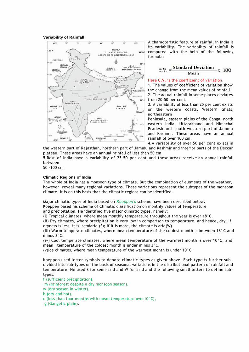
I N D I A
CLIMATIC REGIONS
ACCORDING TO KOEPPEN'S
A characteristic feature of rainfall in India is
its variability. The variability of rainfall is computed with the help of the following
formula:
C ol d H u mi d W i n t er
x 10
Mons o on T yp e w i t h
A ^ B A N G L A D l
( A w )
T r op ic a l S avan n ah T yp e
S t ep p e C l i m at e
coasts, Western
Peninsula, eastern plains of the Ganga, north
eastern India, Uttarakhand and Himachal
Pradesh and south-western part of Jammu
and Kashmir. These areas have an annual
rainfall of over 100 cm. 4.A variability of over 50 per cent exists in
the western part of Rajasthan, northern part of Jammu and Kashmir and interior parts of the Deccan
plateau. These areas have an annual rainfall of less than 50 cm. 5.Rest of India have a variability of 25-50 per cent and these areas receive an annual rainfall
between
50 -100 cm
Climatic Regions of India The whole of India has a monsoon type of climate. But the combination of elements of the weather,
however, reveal many regional variations. These variations represent the subtypes of the monsoon
climate. It is on this basis that the climatic regions can be identified.
Major climatic types of India based on Koeppen‘s scheme have been described below:
Koeppen based his scheme of Climatic classification on monthly values of temperature and precipitation. He identified five major climatic types, namely: (i) Tropical climates, where mean monthly temperature throughout the year is over 18°C. (ii) Dry climates, where precipitation is very low in comparison to temperature, and hence, dry. If
dryness is less, it is semiarid (S); if it is more, the climate is arid(W). (iii) Warm temperate climates, where mean temperature of the coldest month is between 18°C and
minus 3°C. (iv) Cool temperate climates, where mean temperature of the warmest month is over 10°C, and
mean temperature of the coldest month is under minus 3°C. (v)Ice climates, where mean temperature of the warmest month is under 10°C.
Koeppen used letter symbols to denote climatic types as given above. Each type is further sub -
divided into sub-types on the basis of seasonal variations in the distributional pattern of rainfall and temperature. He used S for semi-arid and W for arid and the following small letters to define sub-
types: f (sufficient precipitation), m (rainforest despite a dry monsoon season),
w (dry season in winter), h (dry and hot), c (less than four months with mean temperature over10°C),
g (Gangetic plain).
6S1 I
T
84 *
r so i s
P A K I S T A N
h 3 2 "
; P ol ar T yp e
SCHEME
3 6 " M
C i .
( B W h w ) H o! D es er t
( B S h w) C S t e p p e ^ * .
J
h 2 8 "
C H I N A
/ T I B E T )
3 2 ° ^
wi i h S h o d S u m m e r s
:
Dr y W int er
' V . * / B H U T A N
N
A R A B I A N
S E A
h 1 6 °
D
\ J~T«M=<rfC««» |
2 0 ° - 4
B A y O F
B E N G A L
Ghats,
0 Mean
Accordingly, India can be divided into eight climatic regions
Monsoons and the Economic Life in India (i) Monsoon is that axis around which revolves the entire agricultural cycle of India. It is because
about 64 percent people of India depend on agriculture for their livelihood and agriculture itself is based on southwest monsoon. (ii) Except Himalayas all the parts of the country have temperature above the threshold level to
grow the crops or plants throughout the year. (iii) Regional variations in monsoon climate help in growing various types of crops. (iv) Variability of rainfall brings droughts or floods every year in some parts of the country. (v) Agricultural prosperity of India depends very much on timely and adequately distributed rainfall.
If it fails, agriculture is adversely affected particularly in those regions where means of irrigation are Not developed. (vi) Sudden monsoon burst creates problem of soil erosion over large areas in India. (vii) Winter rainfall by temperate cyclones in north India is highly beneficial for rabi crops. (viii) Regional climatic variation in India is reflected in the vast variety of food, clothes and house
types. GLOBAL WARMING
Table 4.1 : Climatic Regions of India According to Koeppen'9
Type of Climate
short dry season Coromandel coast of Tamil Nadu
Most of the Peninsular plateaus, south of the Tropic of Cancer
Bwhw - Hot desert Cwg - Monsoon with dry winter
Dfc - Cold humid winter with
You know that change is the law of nature. Climate has also witnessed change in the past at the global as well as at local levels. It is changing
even now but the change is imperceptible. A number of geological evidences suggest that once upon a time,large part of the earth was under ice cover.

CHAPTER -5 NATURAL VEGETATION
Natural vegetation refers to a plant community that has been left undisturbed over a long time,
so as to allow its individual species to adjust themselves to climate and soil conditions as fully as possible. Himalayan heights are marked with temperate vegetation; the Western Ghats and the Andaman Nicobar Islands have tropical rain forests,
the deltaic regions have tropical forests and mangroves; the desert and semi desert areas of Rajasthan are known for cacti, a wide variety of bushes and
thorny vegetation. Depending upon the variations in the climate and the soil, the vegetation of India changes
from one region to another. On the basis of certain common features such as predominant vegetation type and
climatic regions, Indian forests can be divided into the following groups: TYPES OF FORESTS (i) Tropical Evergreen and Semi Evergreen forests
(ii) Tropical Deciduous forests (iii) Tropical Thorn forests
(iv) Montane forests (v) Littoral and Swamp forests. Tropical Evergreen and Semi Evergreen Forests 1.These forests are found in the western slope of the Western Ghats, hills of the northeastern region
and the Andaman and Nicobar Islands. 2.They are found in warm and humid areas with an annual precipitation of over 200 cm and mean
3.Tropical evergreen forests are well stratified, with layers closer to the ground and are
covered with shrubs and creepers, with short structured trees followed by tall variety of trees. 4. trees reach great heights up to 60 m or above. 5. There is no definite time for trees to shed their leaves, flowering and fruition.
As such these forests appear green all the year round. 6.Species found in these forests include rosewood, mahogony, aini, ebony, etc. SEMI EVERGREEN FOREST 1.The semi evergreen forests are found in the less rainy parts of these regions.
2.Such forests have a mixture of evergreen and moist deciduous trees. 3.The under growing climbers provide an evergreen character to these forests.
4.Main species are white cedar, hollock and kail. 5.The oak forests in Garhwal and Kumaon were replaced by pine (chirs) which was needed to lay
railway lines. 6. Forests were also cleared for introducing plantations of tea, rubber and coffee.

1.
Tropical Deciduous Forests
1.These are the most widespread forests in India.
2.They are also called the monsoon forests. 3.They spread over regions which receive rainfall
between 70-200 cm. 4.On the basis of the availability of water, these
forests are further divided into moist and dry deciduous. The Moist deciduous forests 1.They are mostly found in the regions which
record rainfall between 100-200 cm. 2.These forests are found in the northeastern
states along the foothills of Himalayas, eastern slopes of the Western Ghats and Odisha. 3. Teak, sal, shisham, hurra,mahua, amla, semul,
kusum, and sandalwood
etc. are the main species of these forests. Dry deciduous forest 1.covers vast areas of the country, 2. rainfall ranges between 70 -100 cm. 3.On the wetter margins, it has a transition to the moist deciduous, while on the drier margins to
thorn forests. 4.These forests are found in rainier areas of the Peninsula and the plains of Uttar Pradesh and Bihar.
5.park lands are found In the higher rainfall regions of the Peninsular plateau and the northern Indian plain, 6.As the dry season begins, the trees shed their leaves completely and the forest appears like a vast
grassland with naked trees all around. Tendu, palas, amaltas, bel, khair, axlewood, etc. are the common trees of these forests. In the western and southern part of Rajasthan, vegetation cover is very scanty due to low
rainfall and overgrazing. Tropical Thorn Forests 1.Tropical thorn forests occur in the areas which receive rainfall
less than 50 cm. 2.These consist of a variety of grasses and shrubs. 3.It includes semi-arid areas of south west Punjab,Haryana,
Rajasthan, Gujarat, Madhya Pradesh and Uttar Pradesh. 4.In these forests, plants remain leafless for most part of the year
and give an expression of scrub vegetation. 5.Important species found are babool, ber, and wild date palm,
khair, neem, khejri, palas, etc. 6.Tussocky grass grows upto a height of 2 m as the under growth.
Montane Forests 1.In mountainous areas, the decrease in temperature
with increasing altitude leads to a corresponding change in natural vegetation.
2.Mountain forests can be classified into two types, the
northern mountain forests and the southern mountain forests. 3.The Himalayan ranges show a succession of vegetation
from the tropical to the tundra, which change in with the altitude.
5. Deciduous forests are found in the foothills of
It is succeeded by the wet temperate type of
forests between an altitude of 1,000-2,000 m.
the Himalayas.

2.
3.
1.India has a rich variety of wetland habitats.
2.About 70 per cent of this comprises areas under paddy cultivation. 3.The total area of wetland is 3.9 million
hectares. 4.Two sites —Chilika Lake (Odisha) and Keoladeo
National Park (Bharatpur) are protected as water-fowl habitats under the Convention of
Wetlands of International Importance (Ramsar Convention).
The country‘s wetlands have been grouped into eight categories, viz. (i)the reservoirs of the Deccan Plateau in the
south together with the lagoons and other
In the higher hill ranges of northeastern India, hilly areas of West Bengal and Uttaranchal,
evergreen broad leaf trees such as oak and chestnut are predominant. Between 1,500-1,750 m, pine forests are also well-developed in this zone, with Chir Pine as a very useful
commercial tree. 8. Deodar, a highly valued endemic species grows mainly in the western part of the Himalayan
range. Deodar is a durable wood mainly used in construction activity. 9.Similarly, the chinar and the walnut, which sustain the famous Kashmir handicrafts, belong to this
zone. Blue pine and spruce appear at altitudes of 2,225-3,048 m. 10.At many places in this zone, temperate grasslands are also found. But in the higher
reaches there is a transition to Alpine forests and pastures. 11. Silver firs, junipers, pines, birch and rhododendrons, etc. occur between 3,000-4,000 m.
12.these pastures are used extensively for transhumance by tribes like the Gujjars, the Bakarwals, the Bhotiyas and the Gaddis. 13The southern slopes of the Himalayas carry a thicker vegetation cover because of relatively higher
precipitation than the drier north-facing slopes. At higher altitudes, mosses and lichens form part of the tundra vegetation. The southern mountain forests 1.Include the forests found in three distinct areas of Peninsular India viz; the Western Ghats, the
Vindhyas and the Nilgiris. 2.As they are closer to the tropics, and only 1,500 m above the sea level, vegetation is temp erate in
the higher regions, and subtropical on the lower regions of the Western Ghats, especially in Kerala, Tamil Nadu and Karnataka. 3.The temperate forests are called Sholas in the Nilgiris, Anaimalai and Palani hills. Some of the
other trees of this forest of economic significance include, magnolia, laurel, cinchona and wattle. 4.Such forests are also found in the Satpura and the Maikal ranges.
Littoral and Swamp Forests
wetlands of the southern west coast; (ii) the vast saline expanses of Rajasthan, Gujarat and the Gulf of Kachchh; (iii)freshwater lakes and reservoirs from Gujarat eastwards through Rajasthan (Keoladeo
National Park) and Madhya Pradesh; (iv) the delta wetlands and lagoons of India‘s east coast (Chilika Lake); (v) the freshwater
marshes of the Gangetic Plain; (v) the floodplains of the Brahmaputra; the marshes and swamps in the hills of northeast
India and the Himalayan foothills; (vi) the lakes and rivers of the montane region of Kashmir and Ladakh; and (vii) the mangrove forest and other wetlands of the island arcs of the Andaman and Nicobar
Islands. (viii)Mangroves grow along the coasts in the salt marshes, tidal creeks, mud flats and
estuaries.
Mangrove Forests 1. the mangrove forests spread over 6,740 sq. km which is 7 per cent of the world‘s mangrove
forests. 2. They are highly developed in the Andaman and Nicobar Islands and the Sunderbans of West
Bengal. 3.Other areas of significance are the Mahanadi, the Godavari and the Krishna deltas.
FOREST COVER IN INDIA 1.According to state records, the forest area covers 23.28 per cent of the total land area of the
country. 2.It is important to note that the forest area and the actual forest cover are not the same. 3.The forest area is the area notified and recorded as the forest land irrespective of the existence
of trees, while the actual forest cover is the area occupied by forests with canopy. 4.The former is based on the records of the State Revenue Department, while the latter is based o n
aerial photographs and satellite imageries. 5.According to India State of Forest Report 2011,the actual forest cover in India is only 21.05 per
cent. 6.Of the forest cover, the share of dense and open forests are 12.29 and 8.75 per cent respectively.
7.Both forest area and forest cover vary from state to state. 8.Lakshadweep has zero per cent forest area; Andaman and Nicobar Islands have 86.93 per cent.
Most of the states with less than 10 per cent of the forest area lie in the north and northwestern
part of the country. On the basis of the percentage of the actual forest cover, the states have been grouped intofour
regions: The Region Percentage
Cover of the Forest (i) The region of high concentration > 40 (ii) The region of medium concentration 20-40
(iii) The region of low concentration 10-20 (iv) The region of very low concentration < 10 Taking the data from Appendix IV, list the states under
the four regions of forest cover FOREST CONSERVATION 1.According to the new forest policy, the Government will emphasise sustainable forest
management in order to conserve and expand forest reserve on the one hand, and to meet the needs of local people on the other.
The forest policy aimed at : (i) bringing 33 per cent of the geographical areas under forest cover; (ii)maintaining environmental stability and to restore forests where ecological balance was
disturbed; (iii) conserving the natural heritage of the country, its biological diversity and genetic pool;
(iv) checks soil erosion, extension of the desert lands and reduction of floods and droughts; (iv) increasing the forest cover through social forestry and afforestation on degraded land; (v) increasing the productivity of forests to make timber, fuel, fodder and food available to rural
population dependent on forests, and encourage the substitution of wood; (vii) creating of a massive peoples movement involving women to encourage planting of trees, stop
felling of trees and thus, reduce pressure on the existing forest. Forests and Life Uses of forest (i) To a vast number of tribal people, the forest is a home, a livelihood, their very existence. (ii) It provides them food, fruits of all kinds, edible leaves, honey, nourishing roots and wild game.
(iii) It provides them with material to build their houses and items for practicing their arts. (iv) The importance of forests in tribal economy is well-known as they are the source of sustenance
and livelihood for tribal communities. (v) It is commonly believed that the tribal communities live in harmony with nature and protect
forests. (vi) Out of a total of 593 districts 188 have been identified as tribal districts. (vii)The tribal districts account for about 59.61 per cent of the total forest cove r of the country
whereas the geographical area of 188 tribal districts forms only 33.63 per cent of the total geographical area of the country.
Social Forestry Social forestry means the management and protection of forests and afforestation on barren
lands with the purpose of helping in the environmental, social and rural development. The National Commission on Agriculture (1976) has classified social forestry into three categories.
1.Urban forestry, 2.Rural forestry 3. Farm forestry. Urban forestry pertains to the raising and management of trees on public and privately owned lands
in and around urban centers such as green belts, parks, roadside avenues, industrial and commercial green belts, etc. Rural forestry lays emphasis on promotion of agro-forestry and community-forestry. Agro-forestry is the raising of trees and agriculture crops on the same land inclusive of the waste
patches.It combines forestry with agriculture, thus, altering the simultaneous production of food, fodder, fuel, timber and fruit. Community forestry involves the raising of trees on public or community land such as the village
pasture and temple land, roadside, canal bank, strips along railway lines, and schools etc. Community forestry programme aims at providing benefits to the community as a whole. Community
forestry provides a means under which the people of landless classes can associate themselves in tree raising and thus, get those benefits which otherwise are restricted for landowners.
Farm Forestry Farm forestry is a term applied to the process under which farmers grow trees for commercial and
non-commercial purposes on their farm lands. Forest departments of various states distribute seedlings of trees free of cost to small and medium
farmers. Several lands such as the margins of agricultural fields, grasslands and pastures, land
around homes and cow sheds may be used for raising trees under non-commercial farm forestry. WILDLIFE It is estimated that about 4-5 per cent of all known plant and animal species on the earth are found
in India. Some of the important reasons of the declining of wildlife are as follows: (i) Industrial and technological advancement brought about a rapid increase in the exploitation o f
forest resources. (ii) More and more lands were cleared for agriculture, human settlement, roads, mining, reservoirs,
etc. (iii) Pressure on forests mounted due to lopping for fodder and fuel wood and removal of small
timber by the local people. (iv) Grazing by domestic cattle caused an adverse effect on wildlife and its habitat. (v) Hunting was taken up as a sport by the elite and hundreds of wild animals were killed in a single
hunt. Now commercial poaching is rampant. (vi) Incidence of forest fire. WILDLIFE CONSERVATION IN INDIA In 1972, a comprehensive Wildlife Act was enacted, which provides the main legal
framework for conservation and protection of wildlife in India. The two main objectives of the Act are; 1.to provide protection to the endangered species listed in the schedule of the Act and 2.To provide legal support to the conservation areas of the country classified as National parks,
sanctuaries and closed areas. 3.This Act has been comprehensively amended in 1991, making punishments more stringent and has
also made provisions for the protection of specified plant species and conservation of endangered species of wild animals. 4.There are 102 National parks and 515 wildlife sanctuaries covering an area of 15.67 million
hectares in the country. 5.Wildlife conservation has a very large ambit with unbounded potential for the well -being of
humankind. However, this can be achieved only when every individual understands its significance
and contributes his bit. 6.For the purpose of effective conservation of flora and fauna, special steps have been initiated
by the Government of India in collaboration with UNESCO‘s ‗Man and Biosphere Programme‘.
7.Special schemes like Project Tiger (1973) and Project Elephant (1992) have been launched to conserve these species and their habitat in a sustainable manner.
8.Project Tiger has been implemented since1973.

The main objective of the scheme is 1.To ensure maintenance of viable population of tigers in India for scientific, aesthetic, cultural
and ecological values, 2.to preserve areas of biological importance as natural heritage for the benefit, education and
enjoyment of the people. 3.the Project Tiger was launched in nine tiger reserves, covering an area of 16,339 sq. km, which
has now increased to 27 tiger reserves, encompassing 37,761sq. km of tiger habitats distributed in 17 states. 4.The tiger population in the country has registered an increase from 1,411 in 2006 to 1,706 in 2010.
5.Project Elephant was launched in 1992 to assist states having free ranging population of wild elephants. 6.It was aimed at ensuring long term survival of identified viable population
Of elephants in their natural habitat. 7.The project is being implemented in 13 states. Apart from this, some other projects such as
Crocodile Breeding Project, Project Hangul and conservation of Himalayan Musk deer have also been launched by the Government of India. BIOSPHERE RESERVES A Biosphere Reserve is a unique and representative ecosystem of terrestrial and coastal areas which
are internationally recognized within the framework of UNESCO‘s Man and Biosphere (MAB) Programme. The Biosphere Reserve aims at achieving the three objectives as depicted.
There are 14 Biosphere Reserves in India Figure 5.8 : Objectives of a Biosphere Reserve
Table 5.1 : List of Biosphere Reserves 1. * Nilgiri2. * Nanda Devi 3. * Nokrek 5. * Sunderbans)7. Great Nicobar 8. * Similipal 9. Dibru-Saikhowa 10. Dihang Dibang 11. * Pachmarhi 12. Kanchenjunga 13. Agasthyamalai 14.
Achanakmar- 15. Kachchh 16. Cold Desert 17. Seshachalam 18. Panna Four Biosphere Reserves, namely (i) Nilgiri; (ii) Nanda Devi (iii) Sunderbans; and (iv) Gulf of Mannar
have been recognised by the UNESCO on World Network of Biosphere Reserves. Nilgiri Biosphere Reserve 1.the first of the fourteen biosphere reserves of India,
2.established in September 1986. 3. It embraces the sanctuary complex of Wyanad, Nagarhole, Bandipur and Mudumalai, the entire
forested hill slopes of Nilambur, the Upper Nilgiri plateau, Silent Valley and the Siruvani
hills. 4.The total area of the biosphere reserve is
around 5,520 sq. km. 5.The Nilgiri Biosphere Reserve possesses
different habitat types, un spoilt areas of
natural vegetation types with several dry
7.The largest south Indian population of
elephant, tiger, gaur, sambar and chital as well as a good number of endemic and
endangered plants are also found in this
reserve. 8.The habitat of a number of tribal groups
remarkable for their traditional modes of harmonious use of the environment are also
found here. 9.The average altitude of 250 m to 2,650 m. 10.About 80 per cent of the flowering plants reported from the Western Ghats occur in the Nilgiri
Biosphere Reserve.
scrubs, dry evergreen
deciduous, and and
moist semi
wet evergreen forests, evergreen sholas, grasslands and swamps. 6. It includes the largest known population
of two endangered animal species, namely the Nilgiri
macaque. Lion-tailed Tahr and the
Nanda Devi Biosphere Reserve 1.The Nanda Devi Biosphere Reserve situated in Uttaranchal includes parts of Chamoli, Almora,
Pithoragarh and Bageshwar districts. 2.The major forest types of the reserve are temperate. 3.A few important species are silver weed and orchids like latifolie and rhododendron. 4. The biosphere reserve has a rich fauna, for example the snow leopard, black bear , brown bear,
musk deer, snow cock, golden eagle and black eagle. 5.Major threats to the ecosystem are the collection of endangered plants for medicinal use, forest
fires and poaching. Sunderbans Biosphere Reserve 1.It is located in the swampy delta of the river Ganga in West Bengal.
2.It extends over a vast area of 9,630 sq. km 3.consists of mangrove forests, swamps and forested islands.
4.Sunderbans is the home of nearly 200 Royal Bengal tigers. 5.The tangled mass of roots of mangrove trees provide safe homes for a large number of species,
6.from fish to shrimp. More than 170 birds species are known to inhabit these mangrove forests. 7.the tigers at the park are good swimmers, and they hunt scarce preys such as chital deer, barking
deer, wild pig and even macaques. 8.In the Sunderbans, the mangrove forests are 148 characterized by Heritiera fomes, a species
valued for its timber. Gulf of Mannar Biosphere Reserve 1.The Gulf of Mannar Biosphere Reserve covers an area of 105,000 hectares on the southeast coast
of India. 2.It is one of the world‘s richest regions from a marine biodiversity perspective. 3.The biosphere reserve comprises 21 islands with estuaries, beaches, forests of the near shore
environment, sea grasses, coral reefs, salt marshes and mangroves. 4.Among the Gulf‘s 3,600 plant and animal species are the globally endangered e.g. sea cow
(Dugongdugon). 5.Besides six mangrove species, endemic to Peninsular India are also endangered
IMPORTANCE OF SOILS 1.provide support & nutrients to the plants 2.plants provide food and clothes are grown over the soils
3.Provide shelter to microorganisms 4.Supply nutrients to plants The major factors affecting the formation of soil are 1.relief, 2.parent material, 3.climate,
4.vegetation 5.life-forms and 6.time. 7. human activities Components of the soil 1.mineral particles, 2.humus, 3.water 4. air.
Structure of the soil If we dig a pit on land and look at the soil, we find that it consists of three layers which are called
horizons. ‗Horizon A‘ is the topmost zone, where organic materials have got incorporated with the mineral
matter, nutrients and water, which are necessary for the growth of plants. ‗Horizon B‘ is a transition zone between the ‗horizon A‘ and ‗horizon C‘, and contains matter
derived from below as well as from above. It has some organic matter in it, although the mineral matter is noticeably weathered. ‗Horizon C‘ is composed of the loose parent material. This layer is the first stage in the soil formation process and eventually forms the above two layers.
This arrangement of layers is known as the soil profile. Underneath these three horizons is the rock which is also known as the parent rock or the bedrock.
Soil, which is a complex and varied entity has always drawn the attention of the scientists. CLASSIFICATIONOF SOILS In ancient times, soils used to be classified into two main groups – Urvara and Usara, which were fertile and sterile, respectively. In the 16th centrury A.D., soils were classified on
the basis of their inherent characteristics and external features such as 1. texture, 2. colour, 3. slope of land and 4. moisture content in the soil. Based on texture, main soil types were identified as 1.sandy, 2.clayey, 3.silty and 4.loam, etc.
On the basis of colour, they were 1.red, 2.yellow, 3.black, etc. the ICAR has classified the Indian soils on the basis of their nature and character as per the United
States Department of Agriculture (USDA) Soil Taxonomy. (i)Inceptisols (ii) Entisols (iii) Alfisols (iv) Vertisols (v) Aridisols (vi) Ultisols (v iii) Others On the basis of genesis, colour, composition and location, the soils of Indiahave been classified into:
(i) Alluvial soils(ii) Black soils(iii) Red and Yellow soils(iv) Laterite soils(v) Arid soils (vi) Saline soils(vii) Peaty soils(viii) Forest soils. Alluvial Soils 1.Alluvial soils are widespread in the northern plains and the river valleys.
2.These soils cover about 40 per cent of the total area of the country. 3.They are depositional soils, transported and deposited by rivers and streams.
4.Through a narrow corridor in Rajasthan, they extend into the plains of Gujarat. 5.In the Peninsular region, they are bound in deltas of the east coast and in the river valleys.
6.They are generally rich in potash but poor in phosphorous. 7.In the Upper and Middle Ganga plain, two different types of alluvial soils have developed, viz.
Khadar and Bhangar. Khadar is the new alluvium and is deposited by floods annually, which enriches the soil by depositing fine silts. 8.Bhangar represents a system of older alluvium, deposited away from the flood plains.
9.Both the Khadar and Bhangar soils contain calcareous concretions (Kankars). These soils are more loamy and clayey in the lower and middle Ganga plain and the Brahamaputra
valley. 10.The sand content decreases from the west to east. 11.The colour of the alluvial soils varies from the light grey to ash grey. Its shades depend on the
depth of the deposition, the texture of the materials, and the time taken for attaining maturity .
Black Soil 1.Black soil covers most of the Deccan Plateau which includes parts of Maharashtra, Madhya
Pradesh, Gujarat, Andhra Pradesh and some parts of Tamil Nadu. 2. In the upper reaches of the Godavari and the Krishna, and the northwestern part of the Deccan
Plateau, the black soil is very deep. 4.These soils are also known as the ‗Regur Soil‘ or the ‗Black Cotton Soil‘.
5.The black soils are generally clayey, deep and impermeable. 6.They swell and become sticky when wet and shrink when dried. So, during
the dry season, these soil develop wide cracks. 7.Chemically, the black soils are rich in lime, iron, magnesia and alumina. 8.They also contain potash. But they lack in phosphorous, nitrogen and organic matter.
9.The colour of the soil ranges from deep black to grey. Red and Yellow Soil 1.Red soil develops on crystalline igneous rocks in areas of low rainfall in the eastern and
southern part of the Deccan Plateau. 2.Along the piedmont zone of the Western Ghat, long stretch of area is occupied by red loamy soil.
Yellow and red soils are also found in parts of Odisha and Chattisgarh and in the southern parts of the middle Ganga plain. 3.The soil develops a reddish colour due to a wide diffusion of iron in crystalline and metamorphic
rocks. 4.It looks yellow when it occurs in a hydrated form. 5.The fine-grained red and yellow soils are normally fertile, 6.whereas coarse-grained soils found in dry upland areas are poor in fertility.
7.They are generally poor in nitrogen, phosphorous and humus. Laterite Soil 1.Laterite has been derived from the Latin word ‗Later‘ which means brick.
2.The laterite soils develop in areas with high temperature and high rainfall. 3.These are the result of intense leaching due to tropical rains. 4.With rain, lime and silica are leached away, and soils rich in iron oxide and aluminum compound
are left behind. 5.Humus content of the soil is removed fast by bacteria that thrives well in high temperature.
6.These soils are poor in organic matter, nitrogen, phosphate and calcium, while iron oxide and potash are in excess. 7.Hence, laterites are not suitable for cultivation; however, application of manures and fertilizers
are required for making the soils fertile for cultivation. 8.Red laterite soils in Tamil Nadu, Andhra Pradesh and Kerala are more suitable for tree crops like
cashewnut. 9.Laterite soils are widely cut as bricks for use in house construction. These soils have mainly
developed in the higher areas of the Peninsular plateau. 10 The laterite soils are commonly found in Karnataka, Kerala, Tamil Nadu, Madhya Pradesh and the
hilly areas of Odisha and Assam. Arid Soils 1.Arid soils range from red to brown in colour. 2.They are generally sandy in structure and saline in nature. In some areas, the salt content is so high that common salt is obtained by evaporating the saline water. 3.Due to the dry climate, high temperature and accelerated evaporation, they lack moisture and
humus. 4.Nitrogen is insufficient and the phosphate content is normal. 5. Lower horizons of the soil are occupied by ‗kankar‘ layers because of the increasing calcium content downwards. 6. The ‗Kankar‘ layer formation in the bottom horizons restricts the infiltration of water, and as
such when irrigation is made available, the soil moisture is readily available for a sustainable plant growth. 7.Arid soils are characteristically developed in western Rajasthan, which exhibit characteristic arid topography. 8.These soils are poor and contain little humus and organic matter.

Saline Soils 1.They are also known as Usara soils.
2.Saline soils contain a larger proportion of sodium, potassium and magnesium, and thus, they are
infertile, and do not support any vegetative growth.
3.They have more salts, largely because of dry climate and poor drainage. They occur in arid and
semi-arid regions, and in waterlogged and swampy areas.
4. Their structure ranges from sandy to loamy.
5.They lack in nitrogen and calcium. Saline soils are more widespread in western Gujarat, deltas of
the eastern coast and in Sunderban areas of West Bengal.
6. In the Rann of Kuchchh, the Southwest Monsoon brings salt particles and deposits there as a crust.
Seawater intrusions in the deltas promote the occurrence of saline soils. In the areas of intensive
cultivation with excessive use of irrigation, especially in areas of green revolution, the fertile
alluvial soils are becoming saline.
7.Excessive irrigation with dry climatic conditions promotes capillary action, which results in the
deposition of salt on the top layer of the soil. In such areas, especially in Punjab and Haryana,
farmers are advised to add gypsum to solve the problem of salinity in the soil.
Peaty Soils 1.They are found in the areas of heavy rainfall and high humidity, where there is a good growth of
vegetation. 2.Thus, large quantity of dead organic matter accumulates in these areas, and this gives a rich
humus and organic content to the soil. 3.Organic matter in these soils may go even up to 40-50 per cent. These soils are normally heavy
and black in colour. 4.At many places, they are alkaline also. 5.It occurs widely in the northern part of Bihar, southern part of Uttaranchal and the coastal areas
of West Bengal, Orissa and Tamil Nadu. Forest Soils 1.Forest soils are formed in the forest areas where sufficient rainfall is available. 2.The soils vary in structure and texture depending on the mountain environment where they are
formed. 3.They are loamy and silty on valley sides and coarse-grained in the upper slopes. 4.In the snow-bound areas of the Himalayas, they experience denudation, and are acidic with low
humus content. 5.The soils found in the lower valleys are fertile. SOIL DEGRADATION 1. Soil degradation can be defined as the decline in soil fertility, when the nutritional status
declines and depth of the soil goes down due to erosion and misuse. 2.Soil degradation is the main factor leading to the depleting soil resource base in India. 3.The degree of soil degradation varies from place to place according to the topography, wind
velocity and amount of the rainfall. SOIL EROSION 1.The destruction of the soil cover is described as soil erosion. The soil forming processes and the
erosional processes of running water and wind go on simultaneously.
2. There is a balance between these two processes.
3.The rate of removal of fine particles from the surface is the same as the rate of addition of
particles to the soil layer. Human activities too are responsible for soil erosion to a great extent.
4.The human population increases, the demand on the land also increases.
5.Forest and other natural vegetation is removed for human settlement, for cultivation, for grazing
animals and for various other needs.
6.Wind and water are powerful agents of soil erosion because of their ability to remove soil and
transport it.
7.Wind erosion is significant in arid and semi-arid regions.

8 In regions with heavy rainfall and steep slopes, erosion by running water is more significant.
9.Water erosion which is more serious and occurs extensively in different parts of India, takes place
mainly in the form of sheet and gully erosion.
10 Sheet erosion takes place on level lands after a heavy shower and the soil removal is not easily
noticeable.
11.But it is harmful since it removes the finer and more fertile top soil. Gully erosion is common on
steep slopes.
12.Gullies deepen with rainfall, cut the agricultural lands into small fragments and make them unfit
for cultivation.
12.A region with a large number of deep gullies or ravines is called a badland topography. Ravines
are widespread, in the Chambal basin.
13.Besidesthis, they are also found in Tamil Nadu and West Bengal.
14The country is losing about 8,000 hectares of land to ravines every year.
15.Deforestation is one of the major causes of soil erosion.
16.Plants keep soils bound in locks of roots, and thus, prevent erosion. They also add humus
to the soil by shedding leaves and twigs.
Forests have been denuded practically in most parts of India but their effect on soil erosion are
more in hilly parts of the country. A fairly large area of arable land in the irrigated zones of India is becoming saline because of over
irrigation. The salt lodged in the lower profiles of the soil comes up to the surface and destroys its fertility.
Chemical fertilizers in the absence of organic manures are also harmful to the soil. Unless the soil gets enough humus, chemicals harden it and reduce its fertility in the long run. This problem is
common in all the command areas of the river valley projects, which were the First beneficiaries of the Green Revolution. According to estimates, about half of the total land of India is under some
degree of degradation. Every year, India loses millions of tons of soil and its nutrients to the agents of its degradation, which adversely affects our national productivity. So, it is imperative to initiate
immediate steps to reclaim and conserve soils. Soil Conservation
NEED FOR SOIL CONSERVATION
1. 2. 3. 4. 5. 6. 7.
Large scale soil erosion Excessive use of fertilizers Faulty methods of cultivation Deforestation Over use of land for cultivation. Overgrazing Shifting cultivation
1.controlled grazing 2.terraced farming 3. ban on shifting cultivation 4. contour bunding 5.Regulated forestry 6.cover cropping 7. mixed forming 8. crop rotation