Embed Size (px)
Citation preview
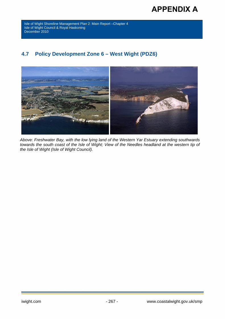
4.7 Policy Development Zone 6 – West Wight (PDZ6)
APPENDIX A
Above: Freshwater Bay, with the low lying land of the Western Yar Estuary extending southwardstowards the south coast of the Isle of Wight; View of the Needles headland at the western tip of the Isle of Wight (Isle of Wight Council).
i
Isle of Wight Shoreline Management Plan 2: Main Report –Chapter 4 Isle of Wight Council & Royal Haskoning December 2010
wight.com - 267 - www.coastalwight.gov.uk/smp

iwight.com - 268 - www.coastalwight.gov.uk/smp
iwight.com - 269 - www.coastalwight.gov.uk/smp
4.7 Policy Development Zone 6 – West Wight (PDZ6) Contents Page 4.7 Policy Development Zone 6 – West Wight (PDZ6) 267
1. Overview and Description 271 2. Baseline management scenarios 281 3. Discussion and detailed policy development 292 4. Management Area Statements 297
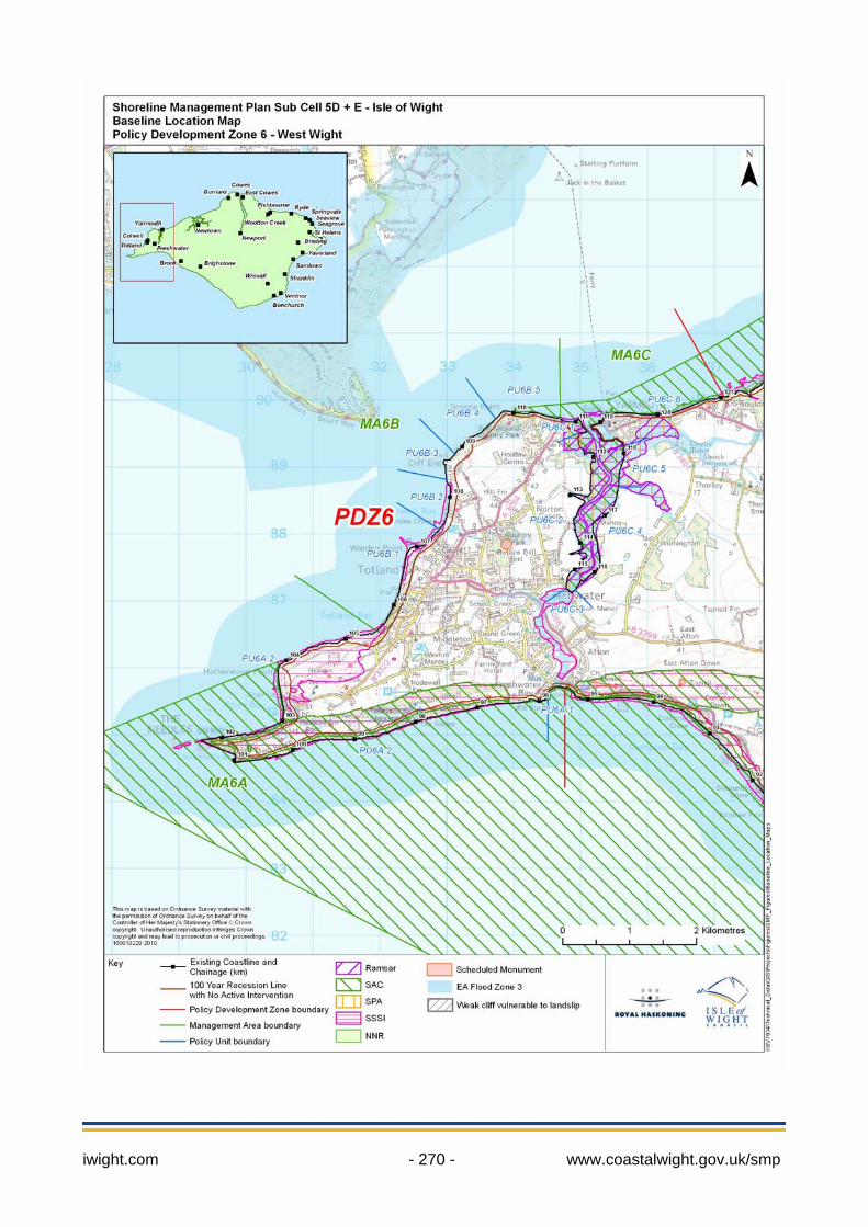
Key facts: Policy Development Zone 6: includes the communities of Freshwater, Alum Bay, Totland, Colwell, Yarmouth and Port la Salle. PDZ6 frontage = approximately 27km in length PDZ6 boundaries = From the eastern margin of Freshwater around the west Wight headland to include Yarmouth (to the eastern margin of Port la Salle). As listed in SMP2 Appendices: areas IW41 to IW51 Old policies from SMP1 in 1997, reviewed in this chapter: Unit Location Length Policy FRE 4 Freshwater Bay 697m Hold the existing defence line FRE 5 Freshwater Bay to the Needles 5607m Do nothing TOT 1 South Alum Bay 1269m Do nothing TOT 2 South-east Alum Bay to Totland West 2466m Do nothing TOT 3 West Totland to Colwell Chine 1871m Hold the existing defence line TOT 4 Colwell Chine to Fort Albert 1506m Retreat the existing defence line NEW1 Fort Albert to Fort Victoria 835m Do nothing NEW2 Fort Victoria to Norton Spit 1149m Hold the existing defence line NEW3 Yarmouth Harbour 2834m Hold the existing defence line NEW4 Royal Solent Yacht Club to the
Common, Yarmouth 320m Hold the existing defence line
NEW5 The Common, Yarmouth to Bouldnor 1390m Hold the existing defence line
iwight.com - 270 - www.coastalwight.gov.uk/smp
iwight.com - 271 - www.coastalwight.gov.uk/smp
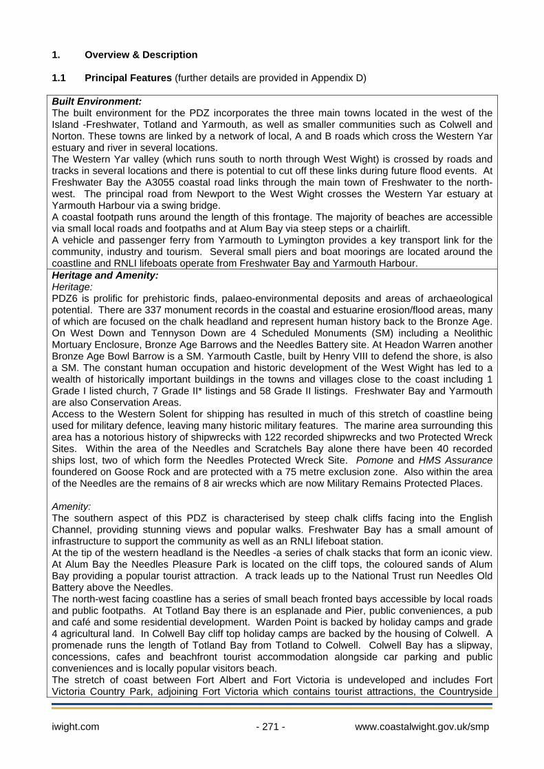
1. Overview & Description 1.1 Principal Features (further details are provided in Appendix D) Built Environment: The built environment for the PDZ incorporates the three main towns located in the west of the Island -Freshwater, Totland and Yarmouth, as well as smaller communities such as Colwell and Norton. These towns are linked by a network of local, A and B roads which cross the Western Yar estuary and river in several locations. The Western Yar valley (which runs south to north through West Wight) is crossed by roads and tracks in several locations and there is potential to cut off these links during future flood events. At Freshwater Bay the A3055 coastal road links through the main town of Freshwater to the north-west. The principal road from Newport to the West Wight crosses the Western Yar estuary at Yarmouth Harbour via a swing bridge. A coastal footpath runs around the length of this frontage. The majority of beaches are accessible via small local roads and footpaths and at Alum Bay via steep steps or a chairlift. A vehicle and passenger ferry from Yarmouth to Lymington provides a key transport link for the community, industry and tourism. Several small piers and boat moorings are located around the coastline and RNLI lifeboats operate from Freshwater Bay and Yarmouth Harbour. Heritage and Amenity: Heritage: PDZ6 is prolific for prehistoric finds, palaeo-environmental deposits and areas of archaeological potential. There are 337 monument records in the coastal and estuarine erosion/flood areas, many of which are focused on the chalk headland and represent human history back to the Bronze Age. On West Down and Tennyson Down are 4 Scheduled Monuments (SM) including a Neolithic Mortuary Enclosure, Bronze Age Barrows and the Needles Battery site. At Headon Warren another Bronze Age Bowl Barrow is a SM. Yarmouth Castle, built by Henry VIII to defend the shore, is also a SM. The constant human occupation and historic development of the West Wight has led to a wealth of historically important buildings in the towns and villages close to the coast including 1 Grade I listed church, 7 Grade II* listings and 58 Grade II listings. Freshwater Bay and Yarmouth are also Conservation Areas. Access to the Western Solent for shipping has resulted in much of this stretch of coastline being used for military defence, leaving many historic military features. The marine area surrounding this area has a notorious history of shipwrecks with 122 recorded shipwrecks and two Protected Wreck Sites. Within the area of the Needles and Scratchels Bay alone there have been 40 recorded ships lost, two of which form the Needles Protected Wreck Site. Pomone and HMS Assurance foundered on Goose Rock and are protected with a 75 metre exclusion zone. Also within the area of the Needles are the remains of 8 air wrecks which are now Military Remains Protected Places. Amenity: The southern aspect of this PDZ is characterised by steep chalk cliffs facing into the English Channel, providing stunning views and popular walks. Freshwater Bay has a small amount of infrastructure to support the community as well as an RNLI lifeboat station. At the tip of the western headland is the Needles -a series of chalk stacks that form an iconic view. At Alum Bay the Needles Pleasure Park is located on the cliff tops, the coloured sands of Alum Bay providing a popular tourist attraction. A track leads up to the National Trust run Needles Old Battery above the Needles. The north-west facing coastline has a series of small beach fronted bays accessible by local roads and public footpaths. At Totland Bay there is an esplanade and Pier, public conveniences, a pub and café and some residential development. Warden Point is backed by holiday camps and grade 4 agricultural land. In Colwell Bay cliff top holiday camps are backed by the housing of Colwell. A promenade runs the length of Totland Bay from Totland to Colwell. Colwell Bay has a slipway, concessions, cafes and beachfront tourist accommodation alongside car parking and public conveniences and is locally popular visitors beach. The stretch of coast between Fort Albert and Fort Victoria is undeveloped and includes Fort Victoria Country Park, adjoining Fort Victoria which contains tourist attractions, the Countryside
iwight.com - 272 - www.coastalwight.gov.uk/smp
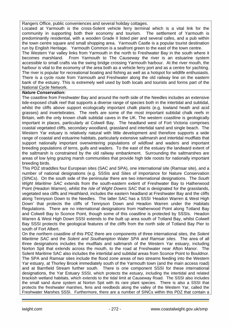
Rangers Office, public conveniences and several holiday cottages. Located at Yarmouth is the cross-Solent vehicle ferry terminal which is a vital link for the community in supporting both their economy and tourism. The settlement of Yarmouth is predominantly residential, with a wooden Grade II listed pier and several cafes, and a pub within the town centre square and small shopping area. Yarmouth Castle is a popular tourist destination run by English Heritage. Yarmouth Common is a seafront green to the east of the town centre. The Western Yar valley links from Yarmouth in the north to Freshwater Bay in the south where it becomes marshland. From Yarmouth to The Causeway the river is an estuarine system accessible to small crafts via the swing bridge crossing Yarmouth harbour. At the river mouth, the harbour is vital to the economy of the area both as a vehicle ferry port and as a centre for yachting. The river is popular for recreational boating and fishing as well as a hotspot for wildlife enthusiasts. There is a cycle route from Yarmouth and Freshwater along the old railway line on the eastern bank of the estuary. This is extremely well used by both locals and tourists and forms part of the National Cycle Network. Nature Conservation: The coastline from Freshwater Bay and around the north side of the Needles includes an extensive tide-exposed chalk reef that supports a diverse range of species both in the intertidal and subtidal, whilst the cliffs above support ecologically important chalk plants (e.g. lowland heath and acid grasses) and invertebrates. The reefs are some of the most important subtidal chalk reefs in Britain, with the only known chalk subtidal caves in the UK. The western coastline is geologically important in places, particularly at Colwell Bay. The headland west of Fort Victoria comprises coastal vegetated cliffs, secondary woodland, grassland and intertidal sand and single beach. The Western Yar estuary is relatively natural with little development and therefore supports a wide range of coastal and estuarine habitats, particularly extensive saltmarsh and intertidal mudflats that support nationally important overwintering populations of wildfowl and waders and important breeding populations of terns, gulls and waders. To the east of the estuary the landward extent of the saltmarsh is constrained by the old railway embankment. Surrounding the saltmarshes are areas of low lying grazing marsh communities that provide high tide roosts for nationally important breeding birds. This PDZ straddles four European sites (SAC and SPA), one international site (Ramsar site), and a number of national designations (e.g. SSSIs and Sites of Importance for Nature Conservation (SINCs). On the south side of the peninsular there are two international designations. The South Wight Maritime SAC extends from the south-eastern extent of Freshwater Bay to Hatherwood Point (Headon Warren), whilst the Isle of Wight Downs SAC that is designated for the grasslands, vegetated sea cliffs and Heathland, includes the eastern headland at Freshwater Bay and the cliffs along Tennyson Down to the Needles. The latter SAC has a SSSI ‘Headon Warren & West High Down’ that protects the cliffs of Tennyson Down and Headon Warren under the Habitats Regulations. There are no international designations from Hatherwood Point along Totland Bay and Colwell Bay to Sconce Point, though some of this coastline is protected by SSSIs. Headon Warren & West High Down SSSI extends to the built up area south of Totland Bay, whilst Colwell Bay SSSI protects the geological features of the cliffs from the north side of Totland Bay Pier to south of Fort Albert. On the northern coastline of this PDZ there are components of three international sites, the Solent Maritime SAC and the Solent and Southampton Water SPA and Ramsar sites. The area of all three designations includes the mudflats and saltmarsh of the Western Yar estuary, including Norton Spit that extends across the mouth, to the road at Freshwater near Afton Manor. The Solent Maritime SAC also includes the intertidal and subtidal areas from Sconce Point to Bouldnor. The SPA and Ramsar sites include the flood zone areas of two streams feeding into the Western Yar estuary, at Thorley Brook immediately south of the Yarmouth town (and the main access road) and at Barnfield Stream further south. There is one component SSSI for these international designations, the Yar Estuary SSSI, which protects the estuary, including the intertidal and related brackish wetland habitats, which extends to the tidal limit at Causeway Road. The SSSI also includes the small sand dune system at Norton Spit with its rare plant species. There is also a SSSI that protects the freshwater marshes, fens and reedbeds along the valley of the Western Yar, called the Freshwater Marshes SSSI. Furthermore, there are a number of SINCs within this PDZ that contain a
variety of species including National Biodiversity Action Plan (BAP) species; these are Freshwater Bay Cliffs SINC, Fort Victoria SINC and a number around the outside of the internationally designated Western Yar Estuary. 1.2 Key Values A key risk in this area is the loss or deterioration of West Wight residential communities as a result from erosion and flood impacts (specifically the tidal flood risk at Yarmouth and Freshwater). Key road links through Freshwater and Yarmouth are also at risk, as well as the ferry terminal at Yarmouth. The internationally important habitats of the Western Yar valley and the spectacular coastal scenery surrounding the Needles headland are key features of the area and are important to the tourism industry supporting West Wight communities. 1.3 Objectives Overarching objectives for PDZ6:
To sustain and adapt the important communities of West Wight to sea level rise, including the towns of Yarmouth, Freshwater and Totland.
To support adaptation of the towns and villages of West Wight to reduce flood and erosion risks. To address the risk of tidal breach of the Western Yar valley at Freshwater and access to West
Wight communities. To maintain access as a gateway to the Island at Yarmouth Harbour and support water use and
navigation in the area, taking account of the important water sports activities and vehicle ferry links to the Island’s transport system.
To support opportunity for adaptation supporting and enhancing the nature conservation value of the Western Yar and West Wight.
To sustain the built heritage, historic landscape and environment where practicable. To maintain the iconic landscapes as driven by the geological exposures.
1.4 Description
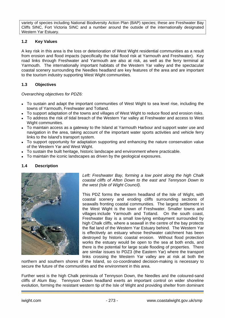
Left: Freshwater Bay, forming a low point along the high Chalk coastal cliffs of Afton Down to the east and Tennyson Down to the west (Isle of Wight Council). This PDZ forms the western headland of the Isle of Wight, with coastal scenery and eroding cliffs surrounding sections of seawalls fronting coastal communities. The largest settlement in the West Wight is the town of Freshwater. Smaller towns and villages include Yarmouth and Totland. On the south coast, Freshwater Bay is a small low-lying embayment surrounded by high Chalk cliffs, where a seawall in the centre of the bay protects the flat land of the Western Yar Estuary behind. The Western Yar is effectively an estuary whose freshwater catchment has been destroyed by historic coastal erosion. Without flood protection works the estuary would be open to the sea at both ends, and there is the potential for large scale flooding of properties. There are similar issues to PDZ3 (the Eastern Yar) where the transport links crossing the Western Yar valley are at risk at both the
northern and southern shores of the Island, so co-coordinated decision-making is necessary to secure the future of the communities and the environment in this area. Further west is the high Chalk peninsula of Tennyson Down, the Needles and the coloured-sand cliffs of Alum Bay. Tennyson Down headland exerts an important control on wider shoreline evolution, forming the resistant western tip of the Isle of Wight and providing shelter from dominant
iwight.com - 273 - www.coastalwight.gov.uk/smp
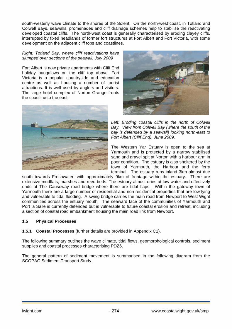
south-westerly wave climate to the shores of the Solent. On the north-west coast, in Totland and Colwell Bays, seawalls, promenades and cliff drainage schemes help to stabilise the reactivating developed coastal cliffs. The north-west coast is generally characterised by eroding clayey cliffs, interrupted by fixed headlands of former fort structures at Fort Albert and Fort Victoria, with some development on the adjacent cliff tops and coastlines. Right: Totland Bay, where cliff reactivations have slumped over sections of the seawall. July 2009 Fort Albert is now private apartments with Cliff End holiday bungalows on the cliff top above. Fort Victoria is a popular countryside and education centre as well as housing a number of tourist attractions. It is well used by anglers and visitors. The large hotel complex of Norton Grange fronts the coastline to the east.
Left: Eroding coastal cliffs in the north of Colwell Bay. View from Colwell Bay (where the south of the bay is defended by a seawall) looking north-east to Fort Albert (Cliff End), June 2009. The Western Yar Estuary is open to the sea at Yarmouth and is protected by a narrow stabilised sand and gravel spit at Norton with a harbour arm in poor condition. The estuary is also sheltered by the town of Yarmouth, the Harbour and the ferry terminal. The estuary runs inland 3km almost due
south towards Freshwater, with approximately 9km of frontage within the estuary. There are extensive mudflats, marshes and reed beds. The estuary almost dries at low water and effectively ends at The Causeway road bridge where there are tidal flaps. Within the gateway town of Yarmouth there are a large number of residential and non-residential properties that are low-lying and vulnerable to tidal flooding. A swing bridge carries the main road from Newport to West Wight communities across the estuary mouth. The seaward face of the communities of Yarmouth and Port la Salle is currently defended but is vulnerable to future coastal erosion and retreat, including a section of coastal road embankment housing the main road link from Newport. 1.5 Physical Processes 1.5.1 Coastal Processes (further details are provided in Appendix C1). The following summary outlines the wave climate, tidal flows, geomorphological controls, sediment supplies and coastal processes characterising PDZ6. The general pattern of sediment movement is summarised in the following diagram from the SCOPAC Sediment Transport Study.
iwight.com - 274 - www.coastalwight.gov.uk/smp

Sediment transport sources, pathways and sinks on the west coast, from SCOPAC Sediment Transport Study, 2004. The pocket beach of Freshwater Bay is surrounded by the Chalk cliffs of Afton Down and Tennyson Down and is composed of shingle and well-rounded and abraded flint cobbles, suggesting that the bay is a re-entrant trap receiving sediment from both east and west. The Needles headland is an important control affording shelter from dominant south-westerly waves to the north-west Isle of Wight coast. North of the Needles this coastline comprises the north facing valley side of the former Solent River that was cut-off by marine inundation some
iwight.com - 275 - www.coastalwight.gov.uk/smp
iwight.com - 276 - www.coastalwight.gov.uk/smp
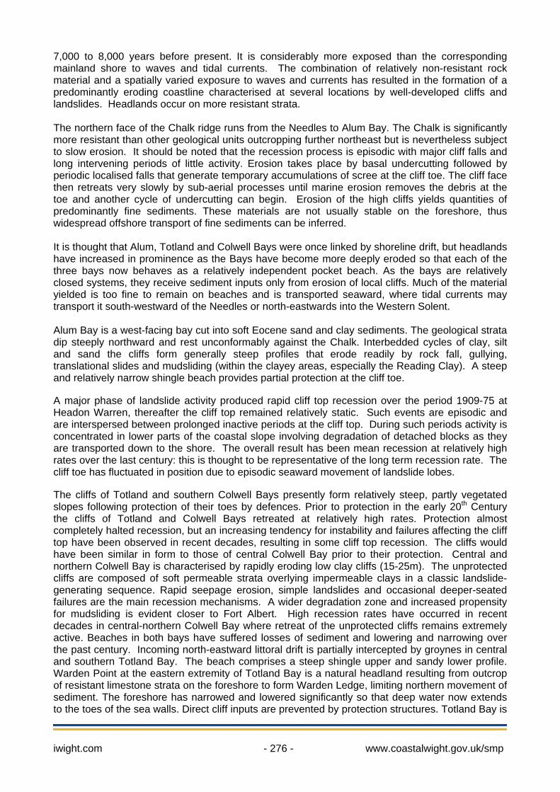
7,000 to 8,000 years before present. It is considerably more exposed than the corresponding mainland shore to waves and tidal currents. The combination of relatively non-resistant rock material and a spatially varied exposure to waves and currents has resulted in the formation of a predominantly eroding coastline characterised at several locations by well-developed cliffs and landslides. Headlands occur on more resistant strata. The northern face of the Chalk ridge runs from the Needles to Alum Bay. The Chalk is significantly more resistant than other geological units outcropping further northeast but is nevertheless subject to slow erosion. It should be noted that the recession process is episodic with major cliff falls and long intervening periods of little activity. Erosion takes place by basal undercutting followed by periodic localised falls that generate temporary accumulations of scree at the cliff toe. The cliff face then retreats very slowly by sub-aerial processes until marine erosion removes the debris at the toe and another cycle of undercutting can begin. Erosion of the high cliffs yields quantities of predominantly fine sediments. These materials are not usually stable on the foreshore, thus widespread offshore transport of fine sediments can be inferred. It is thought that Alum, Totland and Colwell Bays were once linked by shoreline drift, but headlands have increased in prominence as the Bays have become more deeply eroded so that each of the three bays now behaves as a relatively independent pocket beach. As the bays are relatively closed systems, they receive sediment inputs only from erosion of local cliffs. Much of the material yielded is too fine to remain on beaches and is transported seaward, where tidal currents may transport it south-westward of the Needles or north-eastwards into the Western Solent. Alum Bay is a west-facing bay cut into soft Eocene sand and clay sediments. The geological strata dip steeply northward and rest unconformably against the Chalk. Interbedded cycles of clay, silt and sand the cliffs form generally steep profiles that erode readily by rock fall, gullying, translational slides and mudsliding (within the clayey areas, especially the Reading Clay). A steep and relatively narrow shingle beach provides partial protection at the cliff toe. A major phase of landslide activity produced rapid cliff top recession over the period 1909-75 at Headon Warren, thereafter the cliff top remained relatively static. Such events are episodic and are interspersed between prolonged inactive periods at the cliff top. During such periods activity is concentrated in lower parts of the coastal slope involving degradation of detached blocks as they are transported down to the shore. The overall result has been mean recession at relatively high rates over the last century: this is thought to be representative of the long term recession rate. The cliff toe has fluctuated in position due to episodic seaward movement of landslide lobes. The cliffs of Totland and southern Colwell Bays presently form relatively steep, partly vegetated slopes following protection of their toes by defences. Prior to protection in the early 20th Century the cliffs of Totland and Colwell Bays retreated at relatively high rates. Protection almost completely halted recession, but an increasing tendency for instability and failures affecting the cliff top have been observed in recent decades, resulting in some cliff top recession. The cliffs would have been similar in form to those of central Colwell Bay prior to their protection. Central and northern Colwell Bay is characterised by rapidly eroding low clay cliffs (15-25m). The unprotected cliffs are composed of soft permeable strata overlying impermeable clays in a classic landslide-generating sequence. Rapid seepage erosion, simple landslides and occasional deeper-seated failures are the main recession mechanisms. A wider degradation zone and increased propensity for mudsliding is evident closer to Fort Albert. High recession rates have occurred in recent decades in central-northern Colwell Bay where retreat of the unprotected cliffs remains extremely active. Beaches in both bays have suffered losses of sediment and lowering and narrowing over the past century. Incoming north-eastward littoral drift is partially intercepted by groynes in central and southern Totland Bay. The beach comprises a steep shingle upper and sandy lower profile. Warden Point at the eastern extremity of Totland Bay is a natural headland resulting from outcrop of resistant limestone strata on the foreshore to form Warden Ledge, limiting northern movement of sediment. The foreshore has narrowed and lowered significantly so that deep water now extends to the toes of the sea walls. Direct cliff inputs are prevented by protection structures. Totland Bay is

iwight.com - 277 - www.coastalwight.gov.uk/smp
therefore virtually an enclosed system and dependent upon management interventions to maintain stability. Eroding soft rock cliffs and foreshore debris lobes are continuous from Fort Albert to Fort Victoria. The clayey materials of the cliffs degrade by mudsliding and simple translational slides, creating a shallow actively retreating coastal slope. Strong tidal currents are effective in removing clayey debris that accumulates at the cliff toe. The shore is drift-aligned with respect to dominant waves approaching from the west. Sconce Point was stabilised by the construction of Fort Victoria. An inactive or relict low coastal slope extends from Fort Victoria to Norton. Its beaches comprise a narrow strip of sand and gravel above a narrow muddy foreshore. The coastal slope is protected by defences so that the only historical trend has been for narrowing of the foreshore. The western entrance to the Western Yar Estuary is protected by a narrow eastward trending sand and gravel spit at Norton, stabilised and extended by a breakwater. The town of Yarmouth has been built upon a shorter counterpart spit on the low-lying eastern bank and the area provides protection from wave attack to the Western Yar outer estuary. The foreshore at Yarmouth has lowered and narrowed in front of seawall defences. Dredging of Yarmouth Harbour entrance has been undertaken for navigation purposes and in 2009 a trial seeking beneficial use moved the dredged shingle to the north of the breakwater in order to keep the sediment in the system and help to defend the breakwater structure. The low-lying valley of Thorley Brook runs parallel to the shore a few tens of metres inland of the shoreline to the immediate west of the town. The coastal areas of the Western Yar estuary are subject to rapid tidal currents and open sea waves which enter Hurst Narrows. Dominant ebb currents in the Western Solent cause seaward flushing of coarse bedloads and input of suspended sediments into the Western Yar estuary, most likely derived from clay cliff erosion in the immediate vicinity between Bouldnor and Newtown. Fluvial transport from the Western Yar catchment is negligible with predominantly marine clays having partially infilled the estuary. Unconstrained scenario: The ‘unconstrained’ scenario provides a vision of how the coast could evolve if not controlled by man-made structures such as coastal defences. This is a key step in understanding the ‘natural’ response of the coast.
The Western Yar valley is vulnerable to tidal inundation if the beach and seawall in Freshwater Bay is overtopped and breaches. It is uncertain whether a breach would seal naturally, or whether the Western Yar valley would flood such that the land to the west would become an island separated by tidal flows between the West Solent and Freshwater Bay. Without defences cliff recession of the Chalk headland will continue with the small quantities of flints eroded from the northern facing cliffs comprising the main inputs of fresh gravels to the Alum Bay beach. Although at Headon Warren the upper cliff has been relatively stable over recent decades, it will be subject to reactivation of landsliding in the longer-term due to coastal erosion and groundwater. This could potentially occur at some point within the next century, although the presence of a considerable volume of debris material from previous failures provides a degree of protection at the cliff toe. Within Totland and Colwell Bays the unprotected frontage would erode rapidly, although the enhanced sediment supply arising would only partly enhance beach volumes because most of the cliff materials are sand and clay and mechanisms exist for rapid removal seaward of these sediment grades. The cliffs between Fort Albert and Sconce Point would continue to recede through mudsliding, with the fresh material largely transported offshore in suspension. From Sconce Point to Norton continuing foreshore erosion may in the long term cut into the relict coastal slope eventually triggering formation of low eroding cliffs over 30 to 50 years. This process is likely to be slow due
iwight.com - 278 - www.coastalwight.gov.uk/smp
to the low wave energy. Norton Spit is depleted and would be likely over the forthcoming 30 years to become subject to landward migration such that it would increasingly recurve into the estuary and possibly breach. This process may be slowed by sediment inputs released from updrift as recession processes within cliffs re-activate. However, the spit could migrate and breach before this potential sediment supply becomes fully active. Any breach in the spit could allow greater wave penetration into the Western Yar estuary. The Yarmouth shoreline is likely to retreat at slow to moderate rates as the foreshore is narrow and provides limited protection. Immediately east of Yarmouth there is the possibility that shore erosion could cut through into the lowland valley of Thorley Brook to produce a small new tidal inlet. This could potentially link to the Western Yar estuary leaving the town of Yarmouth as an island at high tide.
1.5.2. Existing Defences The following description of coastal defences outlines the current condition and expected remaining effective life of the defences in the area, if no further maintenance is carried out. In addition to the following summary, individual defences are described in Appendix C2 -Defence Appraisal (areas IW41 to 51). At Freshwater Bay a seawall protects Freshwater and Afton Marsh. It is expected to fail towards the end of epoch 1 (up to 20 years). The groynes are in poor condition. During winter storms shingle is thrown up onto the promenade, and is removed periodically. From central Totland Bay around Warden Point to southern Colwell Bay there is a continuous seawall defence. Within Totland Bay from Totland Old Lifeboat House to the Waterfront restaurant the defences are frequency undermined and the groynes are in poor condition. Residual life of the seawalls along the frontage is often 15-25 years, but in central Totland Bay there are sections which are showing cracking and rapid deterioration which may fail in as little as 5 years. Rock armour groynes and some rock armour is present between Totland Pier and Warden Point and to the north in central Colwell Bay a field of timber groynes with rock stubs have now been rendered ineffective through cliff retreat. At Fort Albert (Cliff End) western frontage the remains of defences and more robust rock armour revetment are present. Fort Albert itself is protected by steel sheet piling, and concrete defences extend to Round Tower Point. The defences are likely to fail near end of epoch 1 without maintenance, although the steel sheet piling surrounding the Fort may provide protection throughout epoch 2 (up to 50 years). This section of defences is surrounded by adjacent eroding coast to the north and south. From Fort Victoria to Norton there is a patchwork of ageing defences and short groynes along the shoreline. At the southern limit, low timber breastwork will fail in 5-7 years, and moving north-eastwards around Sconce Point a series of continuous concrete and masonry seawalls will likely fail in the first epoch. Moving east a short undefended section is protected by a shingle ridge, giving way to deteriorated rockfilled gabions (lasting approx. 1-3 years), fronting the most vulnerable section of the adjacent local coastal access road and ground movement in the gentle slopes is affecting the road surface. A more robust seawall fronts Norton Grange, with a residual life of 15-25 years. To the west of Yarmouth harbour, Norton Spit is a natural feature which has been stabilised by timber breastwork and extended by a rock armour breakwater. Without maintenance, the stabilisation of the spit and breakwater are expected to fail in the first epoch. To the east of the harbour, around the western edges of the town of Yarmouth (from the Castle to Thorley Brook) a series of seawalls and revetments have residual lives of 15-25 years, with the exception of two
iwight.com - 279 - www.coastalwight.gov.uk/smp
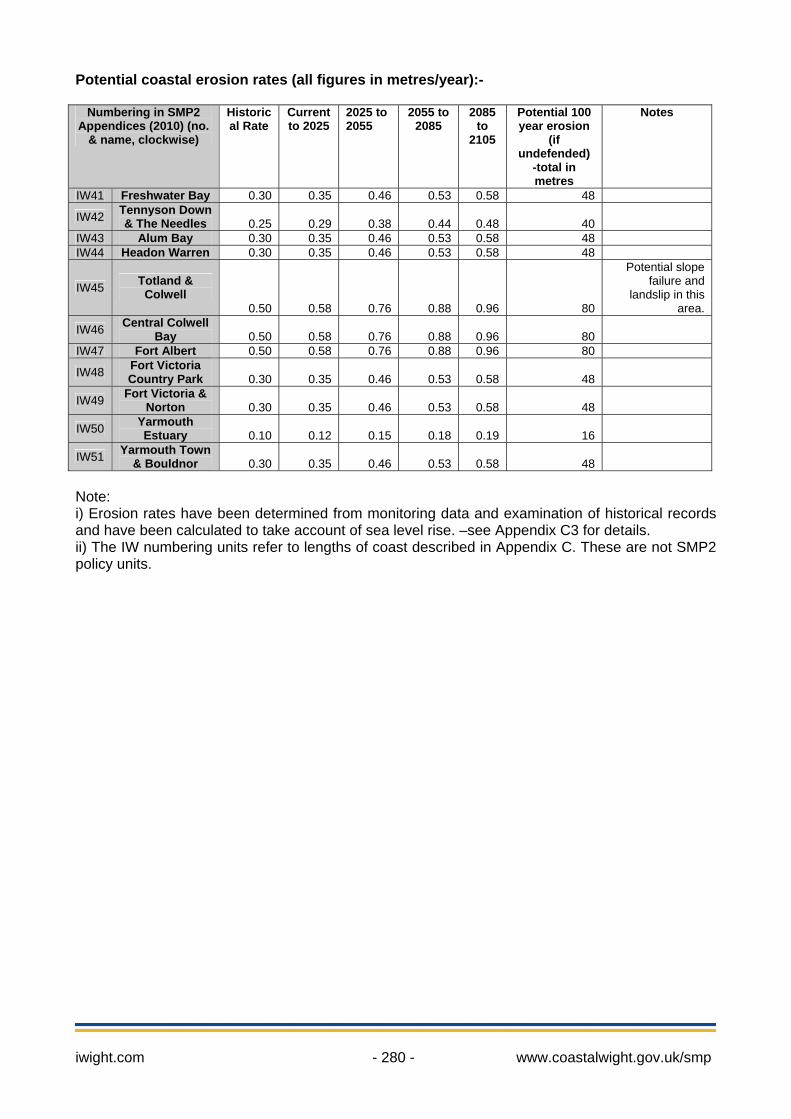
sections of steel sheet piling within the ferry terminal which are expected to last until the second and possibly into the third epoch. Within the Western Yar Estuary there are scattered short lengths of wall and embankments. The west banks of the Estuary are relatively undeveloped with some localised marine facilities and infrastructure. At the Freshwater causeway there are tidal flaps that mark the southern tidal limit. There is an embankment which cuts off Thorley Marshes that also acts as footpath and cycle track along the east side of the Western Yar Estuary. From Yarmouth Castle the defences are continuous until Port la Salle. There are localised land stability problems in this area that may be re-activated by deterioration of the sea-wall. From Yarmouth Common to Bouldnor the steel piled toe of the seawall is poor condition and suffering from extensive corrosion. The series of seawalls from Yarmouth to Bouldnor have residual lives (without any further maintenance) of 15-25 years. Some sections of recent wall and steel sheet piles are in better condition and will last into the second epoch. It is important to note that the central section (where the main road is supported on an embankment adjacent to the seawall) is in poor condition and could fail in 5-10 years. Along the Port la Salle frontage development is protected by combination of steel sheet-piling, rock armour, concrete wall and gabions. 1.5.3 Potential Baseline Erosion Rates The SMP reviewed a wide range of data to define the current and potential rates of coastal erosion and cliff retreat along the Isle of Wight coast using the best available information. Full details can be found in Appendix C3. Future erosion rates are predicted using Walkden & Dickson formula (2008) and allow for future sea level rise –the full methodology is explained in the Appendix. Predicted sea level rise rates of 4mm/yr (to 2025), 8.5mm/yr (to 2055), 12mm/yr (to 2085) then 15mm/yr (to 2105) have been used, in accordance with SMP national guidance by Defra. These rates equate to 7cm of sea level rise (above the 2009 baseline) by 2025, 32cm by 2055 and 98cm by 2105. The IW numbering units refer to lengths of coast for which future behaviour is described and mapped in Appendix C (based on SMP1 and Strategies). These are not SMP2 policy units which are developed in section 3 below. Potential total erosion over the next 100 years is shown, however it is important to note that this is an estimate that is based on an undefended coastline. Within Appendix C3, these erosion rates are only applied following the predicted failure date of each individual element of the defences within the unit; therefore the resulting erosion amounts shown in the Appendix C3 tables and maps (and used in the development of this SMP) will show smaller erosion totals than the overview provided below.
iwight.com - 280 - www.coastalwight.gov.uk/smp
Potential coastal erosion rates (all figures in metres/year):-
Numbering in SMP2 Appendices (2010) (no.
& name, clockwise)
Historical Rate
Current to 2025
2025 to 2055
2055 to 2085
2085 to
2105
Potential 100 year erosion
(if undefended)
-total in metres
Notes
IW41 Freshwater Bay 0.30 0.35 0.46 0.53 0.58 48
IW42 Tennyson Down & The Needles 0.25 0.29 0.38 0.44 0.48 40
IW43 Alum Bay 0.30 0.35 0.46 0.53 0.58 48 IW44 Headon Warren 0.30 0.35 0.46 0.53 0.58 48
IW45 Totland & Colwell
0.50 0.58 0.76 0.88 0.96 80
Potential slope failure and
landslip in this area.
IW46 Central Colwell Bay 0.50 0.58 0.76 0.88 0.96 80
IW47 Fort Albert 0.50 0.58 0.76 0.88 0.96 80
IW48 Fort Victoria Country Park 0.30 0.35 0.46 0.53 0.58 48
IW49 Fort Victoria & Norton 0.30 0.35 0.46 0.53 0.58 48
IW50 Yarmouth Estuary 0.10 0.12 0.15 0.18 0.19 16
IW51 Yarmouth Town & Bouldnor 0.30 0.35 0.46 0.53 0.58 48
Note: i) Erosion rates have been determined from monitoring data and examination of historical records and have been calculated to take account of sea level rise. –see Appendix C3 for details. ii) The IW numbering units refer to lengths of coast described in Appendix C. These are not SMP2 policy units.
iwight.com - 281 - www.coastalwight.gov.uk/smp
2. Baseline management scenarios 2.1 Present Management Present management of the shoreline is taken as the policy defined by SMP1, modified by subsequent strategies or studies. It should be noted that in the case of SMP1 the period over which the assessment was carried out was 50 years. SMP2 extends this to an assessment period of 100 years. The table below sets of the current shoreline management policies for Policy Development Zone 6. This SMP2 will assess all the available evidence and update these previous management policies. The key documents outlining the present management of the shoreline in this PDZ are:- Isle of Wight Shoreline Management Plan 1 (1997) The first Shoreline Management Plan (SMP1) for the Isle of Wight 's coast was published in 1997. It consists of two volumes.
• Volume 1 is the 'Data Collection and Objective Setting', which presents information on a range of topics including coastal processes, natural environment, etc.
• Volume 2 is the 'Management Strategy', which presents information for each Management Unit around the Island's coast and sets a management Policy for each unit.
Coastal Defence Strategy Studies, Isle of Wight: Whilst the Shoreline Management Plan provides the risk framework for management of the coast, Coastal Defence Strategy Studies provide a more detailed assessment of particular frontages in order to identify the most suitable type of coastal defence schemes that may be required to fulfil the agreed shoreline management policy and to plan a programme of future works. West Wight Coastal Defence Strategy Study The West Wight Coastal Defence Strategy Study is being prepared for this area and preliminary work undertaken to date will be updated and the Strategy completed following the publication of SMP2. Catchment Flood Management Plan: The Environment Agency has undertaken a programme of Catchment Flood Management Plans (CFMPs) for the major river catchments in the Southern Region. A CFMP is a large scale plan that covers an entire river catchment or group of catchments that identifies long-term, sustainable policies to manage flood risk within the catchment. These policies form the basis for development of Strategy Plans, covering all or part of the overall catchment area, which will identify in more detail appropriate flood defence measures. Whilst CFMPs principally address fluvial (river) flooding, SMPs address tidal (sea) flooding, alongside coastal erosion. The Isle of Wight Catchment Flood Management Plan (Summary Report) was published in December 2009.
• Western Yar, and catchment to the west of the river: Sub Area 1: Western Yar
“The issues in this sub-area: The key risk in this sub-area is from river flooding in Freshwater. The river channel of the Western Yar drains a small catchment which runs through Freshwater. The channel is restricted in places which can give rise to localised flash flooding. Nearer the coast, river flooding may be affected by high tide levels, which will get worse with the predicted future sea level rise. Only modest development is planned within the sub-area, however any new development could act as an additional source and/or receptor of flooding.”
iwight.com - 282 - www.coastalwight.gov.uk/smp
Policy Option 4 – areas of low, moderate or high flood risk where we are already managing the flood risk effectively but where we may need to take further actions to keep pace with climate change.
• Catchment to the east of the Western Yar: Sub Area 2: Newtown River and the Chines
“The issues in this sub-area: There is a relatively low risk of fluvial flooding. Surface water flooding occurs in some urban areas due to the capacity of drains being exceeded. Nearer the coast, river flooding may be affected by high tide levels, which will get worse with predicted future sea level rise. Only modest urban development is planned.”
Policy Option 2 – areas of low to moderate flood risk where we can generally reduce existing flood risk management actions.
Western Yar Estuary Management Plan The Western Yar Estuary Management Plan was written in 1998 and revised in 2004. It sets out key issues, policies and actions that aim to manage the Western Yar’s sensitive environment through partnership. The Plan was revised and updated through consultation with local people, organisations and authorities that sit on the Western Yar Estuary Management Committee. The key policy relevant to the SMP is as follows:
• Key Policy Area 2: Physical Processes. Aim: To allow the physical and other natural processes within the Western Yar to function with the minimum of human modification. Including: 2.2 The natural and physical processes within the Western Yar should continue with the
minimum of human modification. This should allow present and future activities and processes of the estuary to co-exist or restore more natural coastline or processes.
2.3 Protect, as appropriate, the urban and commercial development (people, property and businesses) in the core area and area of wider influence from erosion and flooding by the sea.
2.4 Maintain, as appropriate, the existing defences to protect people and property from flooding.
2.5 Hold the defence line by maintaining the level of coast protection afforded by the breakwater whilst minimising the adverse impacts to the natural processes of sediment transport, especially those which sustain sensitive habitats.
2.6 Any new built development that does not rely upon a coastal location should not be constructed in coastal areas. Development should also be avoided in areas that are at risk from either flooding or coastal erosion.
2.7 Any improvements to the level of coastal defences should take into consideration or, if possible, enhance the nature conservation.
iwight.com - 283 - www.coastalwight.gov.uk/smp
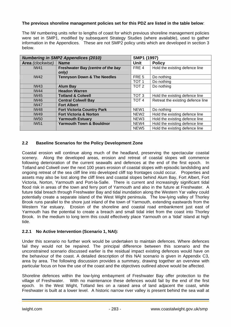
The previous shoreline management policies set for this PDZ are listed in the table below: The IW numbering units refer to lengths of coast for which previous shoreline management policies were set in SMP1, modified by subsequent Strategy Studies (where available), used to gather information in the Appendices. These are not SMP2 policy units which are developed in section 3 below. Numbering in SMP2 Appendices (2010) SMP1 (1997) Area (clockwise) Name Unit Policy
IW41 Freshwater Bay (centre of the bay only)
FRE 4 Hold the existing defence line
FRE 5 Do nothing IW42 Tennyson Down & The Needles TOT 1 Do nothing
IW43 Alum Bay IW44 Headon Warren
TOT 2
Do nothing
IW45 Totland & Colwell TOT 3 Hold the existing defence line IW46 Central Colwell Bay IW47 Fort Albert
TOT 4
Retreat the existing defence line
IW48 Fort Victoria Country Park NEW1 Do nothing IW49 Fort Victoria & Norton NEW2 Hold the existing defence line IW50 Yarmouth Estuary NEW3 Hold the existing defence line
NEW4 Hold the existing defence line IW51 Yarmouth Town & Bouldnor NEW5 Hold the existing defence line
2.2 Baseline Scenarios for the Policy Development Zone Coastal erosion will continue along much of the headland, preserving the spectacular coastal scenery. Along the developed areas, erosion and retreat of coastal slopes will commence following deterioration of the current seawalls and defences at the end of the first epoch. In Totland and Colwell over the next 100 years erosion of coastal slopes with episodic landsliding and ongoing retreat of the sea cliff line into developed cliff top frontages could occur. Properties and assets may also be lost along the cliff lines and coastal slopes behind Alum Bay, Fort Albert, Fort Victoria, Norton, Yarmouth and Port-la-Salle. There is current and increasingly significant tidal flood risk in areas of the town and ferry port of Yarmouth and also in the future at Freshwater. A future tidal breach through Freshwater Bay and tidal inundation along the Western Yar valley could potentially create a separate island of the West Wight peninsula. The low-lying valley of Thorley Brook runs parallel to the shore just inland of the town of Yarmouth, extending eastwards from the Western Yar estuary. Erosion of the shoreline and coastal road embankment just east of Yarmouth has the potential to create a breach and small tidal inlet from the coast into Thorley Brook. In the medium to long term this could effectively place Yarmouth on a ‘tidal’ island at high tide. 2.2.1 No Active Intervention (Scenario 1, NAI): Under this scenario no further work would be undertaken to maintain defences. Where defences fail they would not be repaired. The principal difference between this scenario and the unconstrained scenario discussed earlier is the residual impact existing defences would have on the behaviour of the coast. A detailed description of this NAI scenario is given in Appendix C3, area by area. The following discussion provides a summary, drawing together an overview with particular focus on how the use of the coast and the objectives outlined above would be affected. Shoreline defences within the low-lying embayment of Freshwater Bay offer protection to the village of Freshwater. With no maintenance these defences would fail by the end of the first epoch. In the West Wight, Totland lies on a raised area of land adjacent the coast, while Freshwater is built at a lower level. A historic narrow river valley is present behind the sea wall at
iwight.com - 284 - www.coastalwight.gov.uk/smp
Freshwater Bay. With no future works at this location, both the main A3055 road and the southern section of the Western Yar valley would be at risk of wave attack and tidal inundation. It is likely that the defence failure would lead to a permanent flood breach. To the north, the Western Yar Estuary runs inland south from Yarmouth towards Freshwater. The implications of the NAI policy in this location will be discussed later in this section, but the key risk to Freshwater is dependent on the southern limit of the estuary currently controlled at the Causeway. Under the NAI, with no further defence works the estuary could breach and be open to the sea at both ends, creating dynamic and unpredictable tidal conditions with potential for inundation of properties in the town of Freshwater. While some lengths of the defence could remain until the second epoch, the failure of one section would allow the area behind to become vulnerable to tidal inundation. During the second and third epoch this exposure would be come more frequent. The Local Development Framework (LDF) aspirations for the area include the appropriate expansion of the towns of Totland and Freshwater in the future (a Key Development Area), in order to support communities in West Wight. This is to be achieved through a strengthening of services and the public transport connection to Newport, with development to be encouraged on brownfield sites and tourism to be promoted. The potential tidal breach between Yarmouth and Freshwater is likely to divide the existing transport links between West Wight and the rest of the Island (both main roads at Freshwater and Yarmouth are threatened by erosion in epoch 2 (20-50 years) as well as tidal flooding). While this could be mitigated through infrastructure (i.e. bridges), this would take time and be at considerable cost to the Island. Therefore, the NAI scenario will have serious adverse consequences for the sustainability of West Wight; impacting important transport links and access with limited time given for adaptation to the change. Interrupting the transport links to West Wight would also adversely affect the ability of the iconic landscapes of West Wight headland to act as a draw supporting the local communities. Along the Tennyson Down coastline and the Needles there are no defences; but the Needles is a relatively resistant headland, which exerts an important control on the wider shoreline evolution of the Isle of Wight and Solent. Natural erosion processes would continue under the NAI scenario, providing some sediment to the littoral system. During the third epoch the retreat of the headland may create new ‘Needles’ stacks, and some of the previous stacks may erode and topple. This could leave a sequence of underwater hazards. Erosion will threaten the significant heritage interest of the headland, and including loss and/or damage to the Needles Battery Site (SM). NAI will allow features of conservation interest to evolve naturally. Erosion will continue to act upon the most important subtidal chalk reefs in Britain and the only known chalk subtidal caves in the UK, both of which are a features of the South Wight Maritime SAC. Natural evolution of the Isle of Wight Downs SAC features (grasslands, vegetated sea cliffs and heathland) will also continue, with no adverse effects on designated sites. The important iconic landscapes of the West Wight will be effectively maintained with erosion continuing under NAI, but infrastructure and access to them as a driver of the local economy would be compromised in the surrounding areas. In Alum Bay, cliff erosion would continue throughout the three epochs. These natural processes will maintain the exposure of the coloured sands forming the cliffs at Alum Bay, although significant proportions of the cliff top car park and some amusement park infrastructure will be lost causing the need for adaption (likely through retreat). Moving eastwards to Headon Warren, under the NAI scenario the undefended and natural section of coastline would continue to function in line with natural processes by slope reactivation and retreat caused by erosion and water in the ground, with no adverse effects on designated sites. From here the coastline curves northwards into Totland and Colwell Bays. Totland and southern Colwell Bays have heavily defended shorelines which help to provide stabilisation to the reactivating developed coastal cliffs. Under this scenario the majority of the defences would fail towards the end of the first epoch or the start of the second epoch and there will be a reversion to ‘natural’ cliff line retreat and cliff instability. This would help provide sediment input to the local
iwight.com - 285 - www.coastalwight.gov.uk/smp
beaches. In epoch 2 cliff recession will pose risks to cliff top development, particularly in the south of Totland Bay, at the limit of the coastal defences. During epoch 3 (50-100 years) continued erosion and water in the ground will cause complete activation of coastal slopes with episodic landsliding of the sea cliff line into developed cliff top frontages. This will impact on several businesses, cliff top properties, seafront amenities and access. Unlike other sections within this PDZ, the cliff retreat in this area, once reactivated, will continue back through developed areas into the centre of Totland. The central section of Colwell Bay is generally undefended and rapid coastal erosion and cliff retreat will continue under a NAI scenario. This will impact on the Colwell Bay SSSI features but maintain the important geological exposures from the north side of Totland Bay Pier to the south of Fort Albert. The defended section around Fort Albert is protected by a variety of coastal defences which would fail towards the end of the first epoch with no maintenance. Within the second epoch, erosion, simple landslides and occasional deeper-seated failures would occur, but the steel and concrete walls around the Fort itself are in good condition and could survive longer, possibly into the third epoch. At some point the coastal slope will increasingly revert to natural soft cliff with potential destabilisation at the cliff top. This would threaten both the residential use of the Fort and particularly local access. The areas of the cliff top properties near the margins of the unmaintained defences would be at risk towards the end of the second epoch and through the third epoch, dependent on the retreat of the top of the cliff as marine erosion undermines the toe of the slopes. Increased sediment supplies from the erosion and retreat of the cliffs will supplement local beaches. Continued erosion along the Fort Victoria Country Park area under NAI would supply sediment both to the beaches in this area and potentially to the frontages to the north-west. This would support beach use (although diminished due to potential loss of supporting coastal infrastructure) and the important nature conservation values of the area (namely vegetated cliffs, which form a feature of the Solent Maritime SAC, Solent and Southampton Water SPA and Ramsar sites). The defences from Fort Victoria to Norton would fail within the first epoch or soon in the second epoch and erosion will affect the local access road, several properties, holiday cottages and tourism businesses. The renewed erosion of this frontage may release shingle material into the system and could have a beneficial effect on Norton Spit to the east which provides some protection to Yarmouth Harbour and the Western Yar estuary entrance. Norton Spit has been stabilised and extended by a breakwater to provide shelter to the harbour and also provides a popular local amenity area. Without maintenance, under the NAI scenario, the stabilisation of the spit and breakwater would fail during the first epoch. The dunes, which are a designated feature of the Solent Maritime SAC, and beach forming Norton Spit are likely to migrate south and possibly breach. This process may be slowed by sediment inputs released from additional sediments into the system from cliff recession elsewhere. There is some scope for gain of intertidal habitats to the rear of the spit under NAI. Surrounding Yarmouth Harbour under the NAI scenario, there will be an increased frequency of tidal inundation and erosion as defences fail in the vicinity of the harbour mouth. Towards the end of the first epoch, the defences and sheltering structures protecting the mouth of the estuary are expected to fail, opening up the estuary behind to wave attack. This will expose a number of features of international designated sites (Solent Maritime SAC and the Solent and Southampton Water SPA and Ramsar sites) to increased marine inundation and erosion. Saline intrusion associated with sea level rise and increasingly frequent tidal flooding will result in change to coastal grazing marsh and saline lagoons. Although initially exposed to erosion, there is potential for habitat gain of saltmarsh and intertidal flats in restricted locations, though this is limited given the relatively steep slopes of the coastal margins and rising sea levels. Overall, however, NAI will see the estuarine system revert increasingly to its natural behaviour and evolution in epochs 2 and 3 with long term benefits for nature conservation.

iwight.com - 286 - www.coastalwight.gov.uk/smp
There is a potential impact on the tidal prism and dynamics of the whole Western Yar Estuary following the collapse of the breakwater and changes in the estuary entrance. Since this is a valley type estuary with relatively steeply sloping margins, saltmarsh within the estuary is likely to be sensitive to future climate change and sea-level rise unless vertical accretion can compensate. There remains significant uncertainty as to future estuary behaviour under this scenario, especially with the likelihood of tidal breach through to the Freshwater Bay coast resulting in inundation and changing the tidal regime through the valley. However, the point made is that there would be substantial changes to the area, with significant impacts on the behaviour of the estuary and on the use of the harbour and waterside supporting the town of Yarmouth. Significantly, the use of the harbour would be difficult without some form of intervention and control and the operation of the commercial harbour (ferry port) is reliant on hard defence structures which will largely fail in epoch 2 and undergo increasing inundation prior to this. The defences surrounding the road bridge would also fail and the main road link will also be inundated by tidal flooding from the estuary to the edge of the town. There is significant flood risk to the town of Yarmouth. Tidal flooding has already affected the harbourside and western edge of the town and flood risk will continually increase in future epochs under the NAI scenario. The topography of Yarmouth is relatively flat and western parts of the town are below 3m AOD. Flood risk in the town is complex with the tidal flood risk along the northern edge of the town, and a combination of tidal and fluvial risk from the estuary and tributaries to the south and west. Lanes between houses on the seafront provide possible access routes for flood waters to enter the town in the future. The current Environment Agency Flood Zones appear to completely encircle the town, presenting potentially serious problems relating to access/egress routes and emergency planning. In the event of the 1 in 200 year tidal event, the A3054 road would be flooded. Under the NAI scenario, Yarmouth could potentially face economic blight and cut off from the rest of the Island. The LDF has identified Yarmouth as an important settlement and gateway to the Island with future aspirations including appropriate expansion to support neighbouring communities. This is to be achieved through a strengthening of services and the public transport connection to Newport, encouraging development on brownfield sites, and promotion of tourism opportunities. The area adjacent to Yarmouth is designated and it is essential that the close proximity of the SAC, SPA and SSSI, and resulting impacts, be considered alongside issues of flood risk. NAI in Yarmouth and the surrounding area would not sustain or allow adaptation of the communities and local commercial interests. It would not maintain access to West Wight communities and, due to the change to saline conditions, would affect the existing nature conservation values of the area. Arguably the estuary landscape, though changed, would still be much valued. Access via the footpath and cycle route bordering the estuary would be affected. There would be damage to the historic character and landscape of Yarmouth, including loss of Yarmouth Castle. Along the developed coastal frontage from Yarmouth to Port la Salle the majority of the defences will deteriorate and fail during the first epoch; with initial breaches in the seawall leading to more widespread failure and commencement of erosion. In future epochs the NAI will result in the loss of seafront properties in both Yarmouth and Port la Salle, the amenity feature of Yarmouth Common and importantly a significant length of the A3054 road. The collapse of the seawalls and reversion to a natural low soft cliff would be a major change, but would not be detrimental to adjacent management units in terms of coastal processes. Just east of Yarmouth there is increasing potential during the second epoch for a breach through the foreshore and embankment enabling the creation of a small tidal inlet into Thorley Brook, which may offer nature conservation benefits. If a breach occurs, shoreline sediments could be transported by tidal currents generated at the new inlet and become flushed seaward. Loss of the A3054 road (which is the main link between West Wight and Newport) and also the coastal footpath link would result.
iwight.com - 287 - www.coastalwight.gov.uk/smp
The economic damages due to flooding and erosion are summarised in Table 1, at the end of this sub-section and a summary of impacts with respect to the overarching objectives are set out in Table 2, in comparison with the assessment made for the following With Present Management scenario. 2.2.2 With Present Management (Scenario 2, WPM): This scenario examines the consequences of continuing with current shoreline management practices and policies as defined in SMP1 including the maintenance of existing defences. The previous shoreline management policies for the PDZ are summarised in the table at the start of Section 2. Overall, if present management practices were continued, the approach of the management would be defined as the intent to:
Maintain and improve the standard of defence in Freshwater Bay. The coastline along the Tennyson Down and the Needles is left to function naturally. The defended stretches in Totland and Colwell Bays, at Fort Albert and Fort Victoria, with
present management continuing, would be maintained and replaced when necessary protecting the cliff top properties, with ongoing cliff retreat separating these sections.
From Norton Spit to Port la Salle defences would be maintained, including those surrounding Yarmouth and the Western Yar Estuary mouth.
With maintenance of the defences at Freshwater Bay at their current standard of protection, the present beach configuration would be maintained and flooding through to the Western Yar valley from the south would be prevented for all three epochs. However, the standard of defence would need to be heightened significantly to counter the risk of overtopping with rising sea levels and wave attack. From the second epoch the risk of tidal inundation from the north increases and erosion of the surrounding coastal cliffs will gradually outflank the defences. The impacts of continuing WPM along the western headlands of Tennyson Down, West High Down, the Needles, Alum Bay and Headon Warren would be similar those discussed in scenario 1 above. The important iconic landscapes of the West Wight will be effectively preserved with erosion continuing under the WPM scenario (as the cliffs will remain undefended), but access to these landscapes as a draw and driver of the local economy would be preserved by maintaining vulnerable transport links across the Western Yar valley if present management also continues there. Moving westwards, the defences along Totland Bay and southern Colwell Bay would be maintained and prevent widespread erosion and resulting activation of movement in the weak cliff line. This would secure the promenade, protecting seaside amenity and properties. Without upgrading, in the second epoch, overtopping of the seawall would become more frequent. The continued defence line will greatly reduce the frequency of landsliding events within the backing sea cliffs, but are unlikely to completely eliminate instability where high groundwater levels are also a factor. Periodic localised slumping and slope failures behind the seawall are therefore likely to occur. The fronting beaches will continue to narrow along defended frontages resulting in increasing exposure of defences to wave energy. It is likely that shoreline stability cannot be sustained at these locations without significantly improved defences in future epochs. At the southern end of the defences continued cliff retreat will place properties at risk in epochs 2 and 3. Outflanking of the seawall and defence line will occur to the north and south. At Fort Albert, defences would be maintained and replaced effectively preventing cliff toe erosion. This would maintain access and properties, but the coastal slope may still destabilise to a degree due to encroaching coastal slope retreat from the north and south and increased winter rainfall raising ground water levels. Moving eastwards, at Fort Victoria Country Park under WPM the coastal slopes will continue to erode providing valuable sediment to the local beaches. From Fort

iwight.com - 288 - www.coastalwight.gov.uk/smp
Victoria to Norton the defences would require significant maintenance and upgrading to prevent renewal of erosion right along the frontage. A narrow undefended gap in the centre of the unit could allow erosion to destabilise adjacent defences, although this may be minimised by the presence of the shingle beach. Small scale slope movement may damage the defences, but replacing the ageing structures would reduce this likelihood. WPM would maintain the access road to Fort Victoria and sustain the properties, tourism businesses and amenity use of the Fort Victoria area and Country Park. Under the WPM scenario defences around the Western Yar Estuary and surrounding coastline would be maintained and replaced. These structures will come under increased pressure with increased wave action and water depth but would maintain the present form and operation of the Estuary. Maintenance of the current defence levels would not reduce the present and increasing risk of flooding to Yarmouth town centre, where defence levels are already overtopped. There would be a need within the first epoch to investigate options to provide a higher standard of protection. During the second epoch the rising sea levels and tidal inundation may impact upon saltmarshes within the Estuary, with coastal squeeze resulting in loss of habitat of nature conservation importance. The seawall barrier at Freshwater Bay will continue to prevent tidal inundation of the Estuary from the south and maintain the operation of the Estuary in its current sheltered form. Considering the overarching objectives, this WPM scenario would support, to a large degree, the continued viability and economic activity of Yarmouth. The core of Yarmouth and the historic features would be defended. Maintenance of the current defence line will not be sufficient and significant upgrading will be required in a comprehensive scheme to defend against increasing sea level rise. In Yarmouth Harbour the various commercial activities would be supported but, with potential for increased siltation and the increasing flood risk along the Estuary, there would be a need for adaptation to the changing conditions. The WPM intent is also to maintain the existing natural habitats of the Western Yar Estuary (including coastal saltmarsh, intertidal mud and sandflats, saline lagoons, coastal grazing marsh), but in future epochs this will require increasing effort in areas like Thorley Brook. From Yarmouth to Port la Salle maintenance of the seawalls will prevent erosion and a marine breach through to Thorley Brook, maintaining properties and infrastructure, but the defences themselves would become increasingly exposed to wave action. Continuing the WPM scenario in PDZ6 will preserve the key settlements in the area and allow significant areas of natural change to occur, but will also result in several increasingly fragmented stretches of defences separated by lengths of rapidly retreating coastal cliffs.
iwight.com - 289 - www.coastalwight.gov.uk/smp
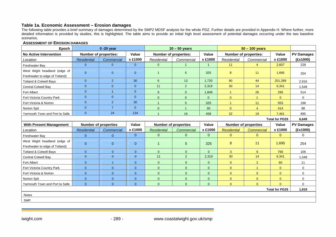
Table 1a. Economic Assessment – Erosion damages The following table provides a brief summary of damages determined by the SMP2 MDSF analysis for the whole PDZ. Further details are provided in Appendix H. Where further, more detailed information is provided by studies, this is highlighted. The table aims to provide an initial high level assessment of potential damages occurring under the two baseline scenarios. ASSESSMENT OF EROSION DAMAGES
Epoch 0 -20 year 20 – 50 years 50 – 100 years No Active Intervention Number of properties: Number of properties: Number of properties: Location Residential Commercial
Value x £1000 Residential Commercial
Value x £1000 Residential Commercial
Value x £1000
PV Damages (£x1000)
Freshwater Bay 0 0 0 0 1 1 11 4 2,607 228
West Wight headland (edge of Freshwater to edge of Totland)
0 0 0 1 5 325 8 11 1,695 254
Totland & Colwell Bays 0 2 30 6 13 1,720 90 44 201,289 2,916
Central Colwell Bay 0 0 0 11 2 2,319 30 14 6,341 1,548
Fort Albert 0 1 0 9 0 1,848 1 26 295 514
Fort Victoria Country Park 0 0 0 0 0 0 0 1 0 0
Fort Victoria & Norton 0 2 30 1 5 325 1 11 553 196
Norton Spit 0 7 0 0 1 30 0 4 414 98
Yarmouth Town and Port la Salle 0 24 134 1 16 458 32 19 7,461 895
Total for PDZ6 6,649
With Present Management Number of properties Number of properties Number of properties Location Residential Commercial
Value x £1000 Residential Commercial
Value x £1000 Residential Commercial
Value x £1000
PV Damages (£x1000)
Freshwater Bay 0 0 0 0 0 0 0 0 0 0
West Wight headland (edge of Freshwater to edge of Totland)
0 0 0 1 5 325 8 11 1,695 254
Totland & Colwell Bays 0 0 0 0 0 0 3 6 766 106
Central Colwell Bay 0 0 0 11 2 2,319 30 14 6,341 1,548
Fort Albert 0 1 0 0 0 0 0 2 60 11
Fort Victoria Country Park 0 0 0 0 0 0 0 1 0 0
Fort Victoria & Norton 0 0 0 0 0 0 0 0 0 0
Norton Spit 0 0 0 0 0 0 0 0 0 0
Yarmouth Town and Port la Salle 0 0 0 0 0 0 0 0 0 0
Total for PDZ6 1,919
Notes
SMP.
iwight.com - 290 - www.coastalwight.gov.uk/smp
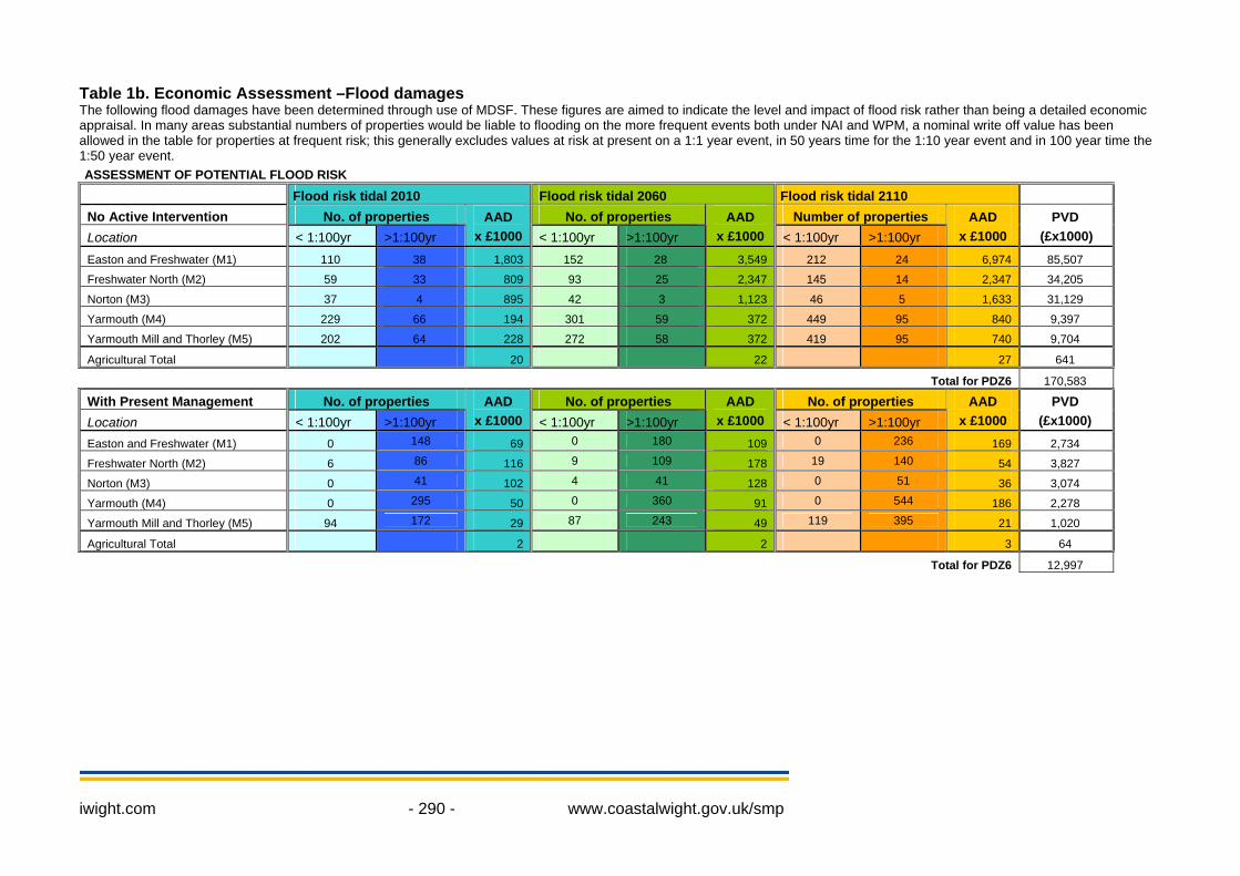
Table 1b. Economic Assessment –Flood damages The following flood damages have been determined through use of MDSF. These figures are aimed to indicate the level and impact of flood risk rather than being a detailed economic appraisal. In many areas substantial numbers of properties would be liable to flooding on the more frequent events both under NAI and WPM, a nominal write off value has been allowed in the table for properties at frequent risk; this generally excludes values at risk at present on a 1:1 year event, in 50 years time for the 1:10 year event and in 100 year time the 1:50 year event. ASSESSMENT OF POTENTIAL FLOOD RISK Flood risk tidal 2010 Flood risk tidal 2060 Flood risk tidal 2110 No Active Intervention No. of properties No. of properties Number of properties Location < 1:100yr >1:100yr
AAD x £1000 < 1:100yr >1:100yr
AAD x £1000 < 1:100yr >1:100yr
AAD x £1000
PVD (£x1000)
Easton and Freshwater (M1) 110 38 1,803 152 28 3,549 212 24 6,974 85,507
Freshwater North (M2) 59 33 809 93 25 2,347 145 14 2,347 34,205
Norton (M3) 37 4 895 42 3 1,123 46 5 1,633 31,129
Yarmouth (M4) 229 66 194 301 59 372 449 95 840 9,397
Yarmouth Mill and Thorley (M5) 202 64 228 272 58 372 419 95 740 9,704
Agricultural Total 20 22 27 641
Total for PDZ6 170,583
With Present Management No. of properties No. of properties No. of properties Location < 1:100yr >1:100yr
AAD x £1000 < 1:100yr >1:100yr
AAD x £1000 < 1:100yr >1:100yr
AAD x £1000
PVD (£x1000)
Easton and Freshwater (M1) 0 148 69 0 180 109 0 236 169 2,734
Freshwater North (M2) 6 86 116 9 109 178 19 140 54 3,827
Norton (M3) 0 41 102 4 41 128 0 51 36 3,074
Yarmouth (M4) 0 295 50 0 360 91 0 544 186 2,278
Yarmouth Mill and Thorley (M5) 94 172 29 87 243 49 119 395 21 1,020
Agricultural Total 2 2 3 64
Total for PDZ6 12,997
iwight.com - 291 - www.coastalwight.gov.uk/smp
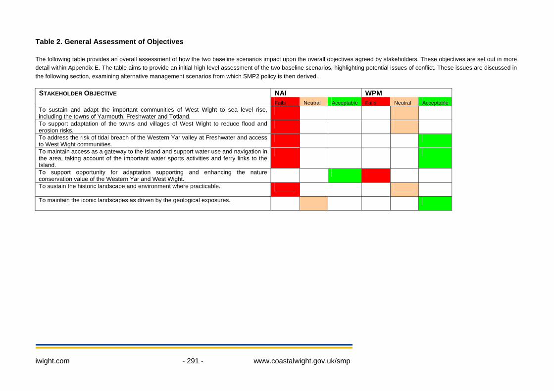
Table 2. General Assessment of Objectives The following table provides an overall assessment of how the two baseline scenarios impact upon the overall objectives agreed by stakeholders. These objectives are set out in more detail within Appendix E. The table aims to provide an initial high level assessment of the two baseline scenarios, highlighting potential issues of conflict. These issues are discussed in the following section, examining alternative management scenarios from which SMP2 policy is then derived.
NAI WPMSTAKEHOLDER OBJECTIVE Fails Neutral Acceptable Fails Neutral Acceptable
To sustain and adapt the important communities of West Wight to sea level rise, including the towns of Yarmouth, Freshwater and Totland.
To support adaptation of the towns and villages of West Wight to reduce flood and erosion risks.
To address the risk of tidal breach of the Western Yar valley at Freshwater and access to West Wight communities.
To maintain access as a gateway to the Island and support water use and navigation in the area, taking account of the important water sports activities and ferry links to the Island.
To support opportunity for adaptation supporting and enhancing the nature conservation value of the Western Yar and West Wight.
To sustain the historic landscape and environment where practicable.
To maintain the iconic landscapes as driven by the geological exposures.
iwight.com - 292 - www.coastalwight.gov.uk/smp
3. Discussion and detailed policy development The overriding factors affecting future shoreline management policy in this PDZ are threefold:-
• The high cliffs and natural environment of the Needles headland and surroundings, forming the southern half of the PDZ.
• The discontinuous defences from Totland to Norton which hold the coast at three minor headlands, with undefended bays in between.
• The significant flood risk to the town of Yarmouth and the potential for a tidal breach through into Western Yar valley from Freshwater.
The consequences of the NAI scenario outlined above would be serious for the communities and environment of the West Wight area. Under the WPM scenario, the communities are already experiencing flood and erosion risks, and therefore it would not fully deliver a sustainable future where reliance on defences could be reduced. Along the southern half of the PDZ from western Freshwater to southern Totland the NAI management intent is an acceptable and an important statement for the future of this shoreline. The high cliffs will continue to erode, allowing the landscape to evolve naturally, which is fundamental to the scenery and character of this area and of great importance for the Isle of Wight as a tourism destination. This will also enable the natural erosion and succession of habitats of nature conservation importance, such as the chalk reefs and sea caves. The Chalk cliffs of Tennyson Down and West High Down will continue to erode and retreat, but the scale of the peninsula is such that the headland will remain largely in its current form over the next 100 years, providing an important control point and shelter to the north-west Isle of Wight coastline. There will be loss of heritage features at the Needles Old Battery, but the exposed location at the tip of a peninsular surrounded by high cliffs means that shoreline defence would be unfeasible and undesirable in this location. There is no economic justification for an alternative management intent throughout this area and any alternative policy would have unacceptable adverse consequences for the natural environment, landscape, sediment supply and tourism. Continuing an uninterrupted policy of NAI right along this shoreline is therefore a clear recommendation of this SMP. The single exception to this policy is the short adjacent section of coast at the centre of Freshwater Bay. This area is discussed below, as it requires a coordinated policy with the rest of the Western Yar valley and estuary to the north. The central section of the PDZ from Totland to Norton is characterised by a mixture of defended and undefended coastlines protecting largely fragmented communities. The longest length of defence in the area is the seawall fronting the community of Totland, extending along the cliff foot of Totland Bay through to Colwell Bay. In the short to medium term, it is sensible to maintain the existing defences along this section to prevent landslipping of the coastal cliff, and hence the loss of cliff top properties and amenity use of the shoreline and promenade. In the longer term, the defences should be replaced to maintain the community and community facilities, where it is economic to do so, due to the risks of slope failure and retreat continuing back into the developed areas behind the coastal properties. The length of the defences should not be extended in Colwell Bay due to the geological and nature conservation interest of the cliffs and to avoid creating an additional burden of maintenance for future generations. It is important to note that erosion and cliff retreat will continue to both the north and south of this ‘Hold the Line’ policy, and design of future defences should take appropriate account of these transitions. In central Colwell Bay, cliff retreat will result in the loss of part of the Holiday Park near Brambles Chine. In the south of Totland Bay, cliff top retreat is expected to affect several properties along cliff road in the second or third epoch, and may sever the local access road. This area may require further examination at Strategy level to determine if local actions can reduce this rate of retreat and to confirm the management of the boundary from the defended to undefended coast at this point. It should also be noted that the cliffs behind Totland Bay are weak and vulnerable to localised slope failures, which should be considered when planning maintenance or replacement of the fronting defence
iwight.com - 293 - www.coastalwight.gov.uk/smp
line which acts to stabilise the coastal slope from onset of erosion. The intent of shoreline management in this area is therefore to continue present management techniques whilst economic to do so, but not to extend the defence line significantly or alter the character of the area. The cliffs of central Colwell Bay and Fort Victoria Country Park are undefended and actively retreating, with Fort Albert forming a fixed control point separating them. It is proposed that maintenance works along this section of defence could secure the future of this small community into epoch 2. The management intent at Fort Albert would be to maintain the existing structures in the short and medium term, providing the essential time for coastal adaption by the community. However, in the long term, the intent is to gradually remove the influence of management allowing the coast to gradually return to its natural form, reducing the offset to the adjacent eroding shorelines. Fort Albert will therefore continue to provide a degree of control and shelter to the adjacent eroding shorelines and assist in maintaining the navigation channel of the western Solent. Further east, Fort Victoria has assisted in preserving the low-lying shore alignment of Sconce Point and marks the final change in coastal orientation (within this PDZ) to the west, entering the more sheltered Solent. The shoreline of wooded coastal slopes south-west of Fort Victoria will continue to erode under and there is no justification for extending the defences in this area. To the east, the 800m area of coastline from Fort Victoria to Norton is a patchwork of deteriorating defences, and the NAI scenario will result in loss of several properties, the shingle beach and road access to the properties and businesses at Fort Victoria. The seawall fronting the Norton Grange Hotel is likely to endure into epoch 2 with no active management and hold the alignment of the coast approaching the entrance of the Western Yar Estuary. Continuing ‘With Present Management’ in this area will preserve the business amenity use of the frontage and access to several properties, but the direct economic justification for maintaining defences is limited and would require upgrading of several structures in the short to medium term. In common with the areas to the south, the intent of management in this area is to allow maintenance of existing defence structures for the benefit of the local communities, whilst allowing time for adaptation and minimising the future reliance on defences. A policy of ‘hold the line’ in epoch 1 will allow maintenance of the existing defences whist practical to do so, then moving to an intent of ‘no active intervention’ (but not precluding private maintenance) while the standard of protection of the defences gradually declines. Under the proposed management intent the Fort itself may endure over the longer term, dependent on resistance or undermining of the structure as the coast retreats, but the loss of part of the access road into the site and surrounding buildings may occur in the short to medium term if existing defences are not maintained beyond the first epoch. Realigning road access to the Fort Victoria site and adjacent properties should also be considered, to minimise the impact of NAI on the area. At Norton Spit, Yarmouth and eastwards to Port la Salle, the character of the coastline is dominated by the mouth of the Western Yar Estuary and adjacent tributary of Thorley Brook. Tidal flood risk presents the main challenge to the future of this significant and historic community. To not undertake management in this area is unacceptable due to the large number of properties at risk in Yarmouth, the scale of damage to the character of the town and historic features, and the impact on key transport links. However, continuing the current management regime at this location is not sufficient to secure the future of the community, as the defence structures will need to be redesigned to protect against the current and future tidal flood risk under a hold the line policy. At Yarmouth, the grassed amenity areas and car parks at the south-west of the town provide potential space to create raised defences, although doing so in a manner that is sufficiently in-keeping with the character of the town and not detrimental to the functioning of the area would be essential to an effective scheme. It is recommended that of the current defences and embankments around the town of Yarmouth and the Western Yar Estuary, only those are maintained where there is a clearly justified reason and effective method based on the overwhelming scale of the flood and erosion risk. Adjoining the coast, the low-lying tributary of Thorley Brook backs the properties of Yarmouth town and the coastal road. It is part of the Ramsar site and there is some future tidal flood risk, largely

iwight.com - 294 - www.coastalwight.gov.uk/smp
to the gardens of properties adjoining the floodplain. The future management of the constraining embankment immediately south of Yarmouth Mill needs to be carefully considered with regard to habitat management alongside addressing flood risk to the southern margin of Yarmouth. Moving back to the coastal defence line along the seafront, erosion under the NAI scenario could result in a tidal breach through from the coast into Thorley Brook (near Thorley Copse) in epoch 2 or 3. Based on current information, an HTL policy is recommended for this shoreline for all three epochs, due to the importance of maintaining the road link, sustaining an effective community at Yarmouth and Bouldnor and sustaining the communities of West Wight who are also reliant on this road link. However, further work at Strategy level could examine the potential implications of the alternative approach of creating a managed tidal breach through the road in future epochs, maintaining the road on a bridge. The impacts of this proposal on the habitats and nature conservation interest of Thorley Brook, on tidal flood risk for surrounding properties, on tidal interactions with the main channel of the Western Yar Estuary and on coastal processes and sediment transfers along the adjacent shorelines would need to be carefully assessed. At Port la Salle (at the eastern margin of the PDZ) a small residential community is at risk of shoreline erosion under the NAI scenario when existing defences fail towards the end of epoch 1. Maintenance of the current defences through continuing the present management of ‘Hold the Line’ will sustain the future of this settlement, with the recognition that there can be no extension of the current defence line to the east into the unspoilt and natural character of the Bouldnor coastline (PDZ7). Another key feature of the area, and a parallel key driver of policy, is the natural environment and nature conservation interest of the Western Yar Estuary. Significant infrastructure controls the outer 200m of the estuary mouth, but tidal flow through the area is unconstrained and upstream of Yarmouth the estuary is largely natural in character. The international importance of this area for nature conservation interest justifies a widespread policy of No Active Intervention within the estuary, with minor exceptions at ‘The Causeway’ and the shoreline along Thorley Brook and Barnfields Stream. At the Causeway the management intent is to hold the line through the continued future maintenance and improvement of the road bridge and masonry walls to address the tidal flood risk to Freshwater and the functioning of Afton Marsh. At Thorley Brook and Barnfields stream the intent is to manage the existing defence embankment and sluices during the first epoch to allow time for habitat adaption, but then gradually remove the influence of management to allow tidal inundation of the inlets. This should be a planned change, and consider the implications of the restoration of natural behaviour on adjacent properties, infrastructure and nature conservation interest. The intention is to maintain the adjacent main coastal road link (at the narrow section from Yarmouth Common to the Thorley Road junction) whilst tidal inundation of Thorley Brook behind occurs more frequently. The cycle track along the eastern bank of the estuary will also need to adapt through a bridge or link dependent on the design of any future increase in tidal flow through the embankment, or accept periodic tidal inundation of the route, which could be considered in its design.
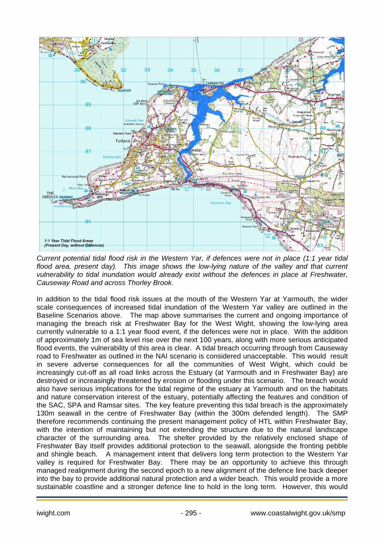
Current potential tidal flood risk in the Western Yar, if defences were not in place (1:1 year tidal flood area, present day). This image shows the low-lying nature of the valley and that current vulnerability to tidal inundation would already exist without the defences in place at Freshwater, Causeway Road and across Thorley Brook. In addition to the tidal flood risk issues at the mouth of the Western Yar at Yarmouth, the wider scale consequences of increased tidal inundation of the Western Yar valley are outlined in the Baseline Scenarios above. The map above summarises the current and ongoing importance of managing the breach risk at Freshwater Bay for the West Wight, showing the low-lying area currently vulnerable to a 1:1 year flood event, if the defences were not in place. With the addition of approximately 1m of sea level rise over the next 100 years, along with more serious anticipated flood events, the vulnerability of this area is clear. A tidal breach occurring through from Causeway road to Freshwater as outlined in the NAI scenario is considered unacceptable. This would result in severe adverse consequences for all the communities of West Wight, which could be increasingly cut-off as all road links across the Estuary (at Yarmouth and in Freshwater Bay) are destroyed or increasingly threatened by erosion or flooding under this scenario. The breach would also have serious implications for the tidal regime of the estuary at Yarmouth and on the habitats and nature conservation interest of the estuary, potentially affecting the features and condition of the SAC, SPA and Ramsar sites. The key feature preventing this tidal breach is the approximately 130m seawall in the centre of Freshwater Bay (within the 300m defended length). The SMP therefore recommends continuing the present management policy of HTL within Freshwater Bay, with the intention of maintaining but not extending the structure due to the natural landscape character of the surrounding area. The shelter provided by the relatively enclosed shape of Freshwater Bay itself provides additional protection to the seawall, alongside the fronting pebble and shingle beach. A management intent that delivers long term protection to the Western Yar valley is required for Freshwater Bay. There may be an opportunity to achieve this through managed realignment during the second epoch to a new alignment of the defence line back deeper into the bay to provide additional natural protection and a wider beach. This would provide a more sustainable coastline and a stronger defence line to hold in the long term. However, this would
iwight.com - 295 - www.coastalwight.gov.uk/smp

iwight.com - 296 - www.coastalwight.gov.uk/smp
have significant consequences for main road links and junctions, properties and also habitats in the area that would need to be addressed to generate space for the realignment and it is likely to be more economical to hold the line in the current location. The width of the current defences and road provides opportunity to redesign the defences to support or enhance the protection of the fronting beach. The general intent of management in PDZ6 is to sustain the important communities of Yarmouth, Freshwater and Totland by minimising flood risk and maintaining transport links across the Western Yar Estuary. The majority of the coastline and estuary within the PDZ will be left to erode and evolve naturally, preserving the character and natural environment of the area. Elsewhere, the intention is to reduce the management of fragmented lengths of hard defences in the medium to long term. Policy Development Zone 6 may be sensibly divided into three general management areas, described below.
iwight.com - 297 - www.coastalwight.gov.uk/smp
PDZ6 Management Area Statements
• Freshwater and the Tennyson Down headland (including Alum Bay and Headon Warren) (MA 6A) includes two policy units.
• Totland to Norton (MA 6B) includes five policy units • Yarmouth town and the Western Yar Estuary (MA 6C) includes six policy units
Within these areas a summary of policy is provided below. Management Areas statements are provided in the following sheets, with maps showing each area.
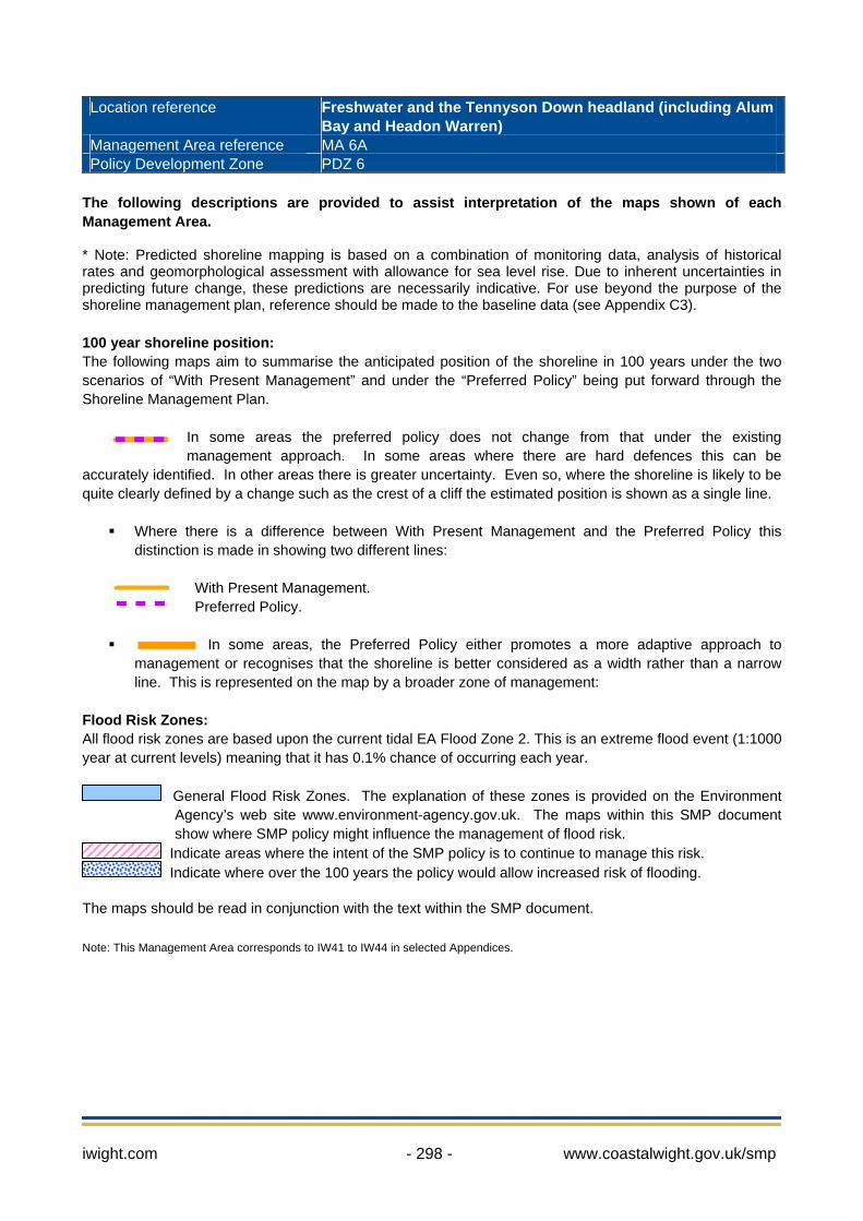
Location reference Freshwater and the Tennyson Down headland (including Alum
Bay and Headon Warren) Management Area reference MA 6A Policy Development Zone PDZ 6
The following descriptions are provided to assist interpretation of the maps shown of each Management Area. * Note: Predicted shoreline mapping is based on a combination of monitoring data, analysis of historical rates and geomorphological assessment with allowance for sea level rise. Due to inherent uncertainties in predicting future change, these predictions are necessarily indicative. For use beyond the purpose of the shoreline management plan, reference should be made to the baseline data (see Appendix C3). 100 year shoreline position: The following maps aim to summarise the anticipated position of the shoreline in 100 years under the two scenarios of “With Present Management” and under the “Preferred Policy” being put forward through the Shoreline Management Plan.
In some areas the preferred policy does not change from that under the existing management approach. In some areas where there are hard defences this can be
accurately identified. In other areas there is greater uncertainty. Even so, where the shoreline is likely to be quite clearly defined by a change such as the crest of a cliff the estimated position is shown as a single line.
Where there is a difference between With Present Management and the Preferred Policy this distinction is made in showing two different lines:
With Present Management. Preferred Policy.
In some areas, the Preferred Policy either promotes a more adaptive approach to management or recognises that the shoreline is better considered as a width rather than a narrow line. This is represented on the map by a broader zone of management:
Flood Risk Zones: All flood risk zones are based upon the current tidal EA Flood Zone 2. This is an extreme flood event (1:1000 year at current levels) meaning that it has 0.1% chance of occurring each year.
General Flood Risk Zones. The explanation of these zones is provided on the Environment Agency’s web site www.environment-agency.gov.uk. The maps within this SMP document show where SMP policy might influence the management of flood risk.
Indicate areas where the intent of the SMP policy is to continue to manage this risk. Indicate where over the 100 years the policy would allow increased risk of flooding.
The maps should be read in conjunction with the text within the SMP document. Note: This Management Area corresponds to IW41 to IW44 in selected Appendices.
iwight.com - 298 - www.coastalwight.gov.uk/smp
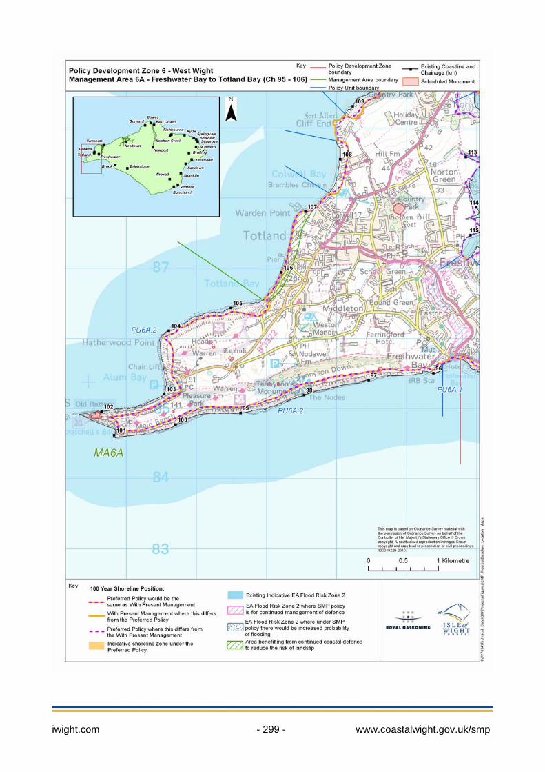
iwight.com - 299 - www.coastalwight.gov.uk/smp
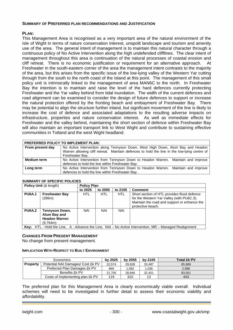
iwight.com - 300 - www.coastalwight.gov.uk/smp
SUMMARY OF PREFERRED PLAN RECOMMENDATIONS AND JUSTIFICATION PLAN: This Management Area is recognised as a very important area of the natural environment of the Isle of Wight in terms of nature conservation interest, unspoilt landscape and tourism and amenity use of the area. The general intent of management is to maintain this natural character through a continuous policy of No Active Intervention along the high undefended clifflines. The clear intent of management throughout this area is continuation of the natural processes of coastal erosion and cliff retreat. There is no economic justification or requirement for an alternative approach. At Freshwater in the south-eastern corner of the area the management intent contrasts to the majority of the area, but this arises from the specific issue of the low-lying valley of the Western Yar cutting through from the south to the north coast of the Island at this point. The management of this small policy unit is intrinsically linked to the management of area MAN6C to the north. In Freshwater Bay the intention is to maintain and raise the level of the hard defences currently protecting Freshwater and the Yar valley behind from tidal inundation. The width of the current defences and road alignment can be examined to consider the design of future defences to support or increase the natural protection offered by the fronting beach and embayment of Freshwater Bay. There may be potential to align the structure further inland, but significant movement of the line is likely to increase the cost of defence and associated adaptations to the resulting adverse impacts on infrastructure, properties and nature conservation interest. As well as immediate effects for Freshwater and the valley behind, maintaining the short section of defence within Freshwater Bay will also maintain an important transport link to West Wight and contribute to sustaining effective communities in Totland and the west Wight headland.
PREFERRED POLICY TO IMPLEMENT PLAN: From present day No Active Intervention along Tennyson Down, West High Down, Alum Bay and Headon
Warren allowing cliff retreat. Maintain defences to hold the line in the low-lying centre of Freshwater Bay.
Medium term No Active Intervention from Tennyson Down to Headon Warren. Maintain and improve defences to hold the line within Freshwater Bay.
Long term No Active Intervention from Tennyson Down to Headon Warren. Maintain and improve defences to hold the line within Freshwater Bay.
SUMMARY OF SPECIFIC POLICIES
Policy Plan Policy Unit (& length) to 2025 to 2055 to 2105 Comment
PU6A.1 Freshwater Bay (286m)
HTL HTL HTL Short section of HTL provides flood defence for the Western Yar Valley (with PU6C.3). Maintain the road and support or enhance the protective beach.
PU6A.2 Tennyson Down, Alum Bay and Headon Warren (9,764m)
NAI NAI NAI
Key: HTL - Hold the Line, A - Advance the Line, NAI – No Active Intervention, MR – Managed Realignment CHANGES FROM PRESENT MANAGEMENT No change from present management. IMPLICATION WITH RESPECT TO BUILT ENVIRONMENT
Economics by 2025 by 2055 by 2105 Total £k PV
Potential NAI Damages/ Cost £k PV 22,574 29,928 33,487 85,989 Preferred Plan Damages £k PV 869 1,082 1,036 2,988
Benefits £k PV 21,705 28,846 32,451 83,001
Property
Costs of Implementing plan £k PV 119 310 13 443
The preferred plan for this Management Area is clearly economically viable overall. Individual schemes will need to be investigated in further detail to assess their economic viability and affordability.
Location reference Totland to Norton Management Area reference MA 6B Policy Development Zone PDZ 6
The following descriptions are provided to assist interpretation of the maps shown of each Management Area. * Note: Predicted shoreline mapping is based on a combination of monitoring data, analysis of historical rates and geomorphological assessment with allowance for sea level rise. Due to inherent uncertainties in predicting future change, these predictions are necessarily indicative. For use beyond the purpose of the shoreline management plan, reference should be made to the baseline data (see Appendix C3). 100 year shoreline position: The following maps aim to summarise the anticipated position of the shoreline in 100 years under the two scenarios of “With Present Management” and under the “Preferred Policy” being put forward through the Shoreline Management Plan.
In some areas the preferred policy does not change from that under the existing management approach. In some areas where there are hard defences this can be
accurately identified. In other areas there is greater uncertainty. Even so, where the shoreline is likely to be quite clearly defined by a change such as the crest of a cliff the estimated position is shown as a single line.
Where there is a difference between With Present Management and the Preferred Policy this distinction is made in showing two different lines:
With Present Management. Preferred Policy.
In some areas, the Preferred Policy either promotes a more adaptive approach to management or recognises that the shoreline is better considered as a width rather than a narrow line. This is represented on the map by a broader zone of management:
Flood Risk Zones: All flood risk zones are based upon the current tidal EA Flood Zone 2. This is an extreme flood event (1:1000 year at current levels) meaning that it has 0.1% chance of occurring each year.
General Flood Risk Zones. The explanation of these zones is provided on the Environment Agency’s web site www.environment-agency.gov.uk. The maps within this SMP document show where SMP policy might influence the management of flood risk.
Indicate areas where the intent of the SMP policy is to continue to manage this risk. Indicate where over the 100 years the policy would allow increased risk of flooding.
The maps should be read in conjunction with the text within the SMP document. Note: This Management Area corresponds to IW45 to IW49 in selected Appendices.
iwight.com - 301 - www.coastalwight.gov.uk/smp
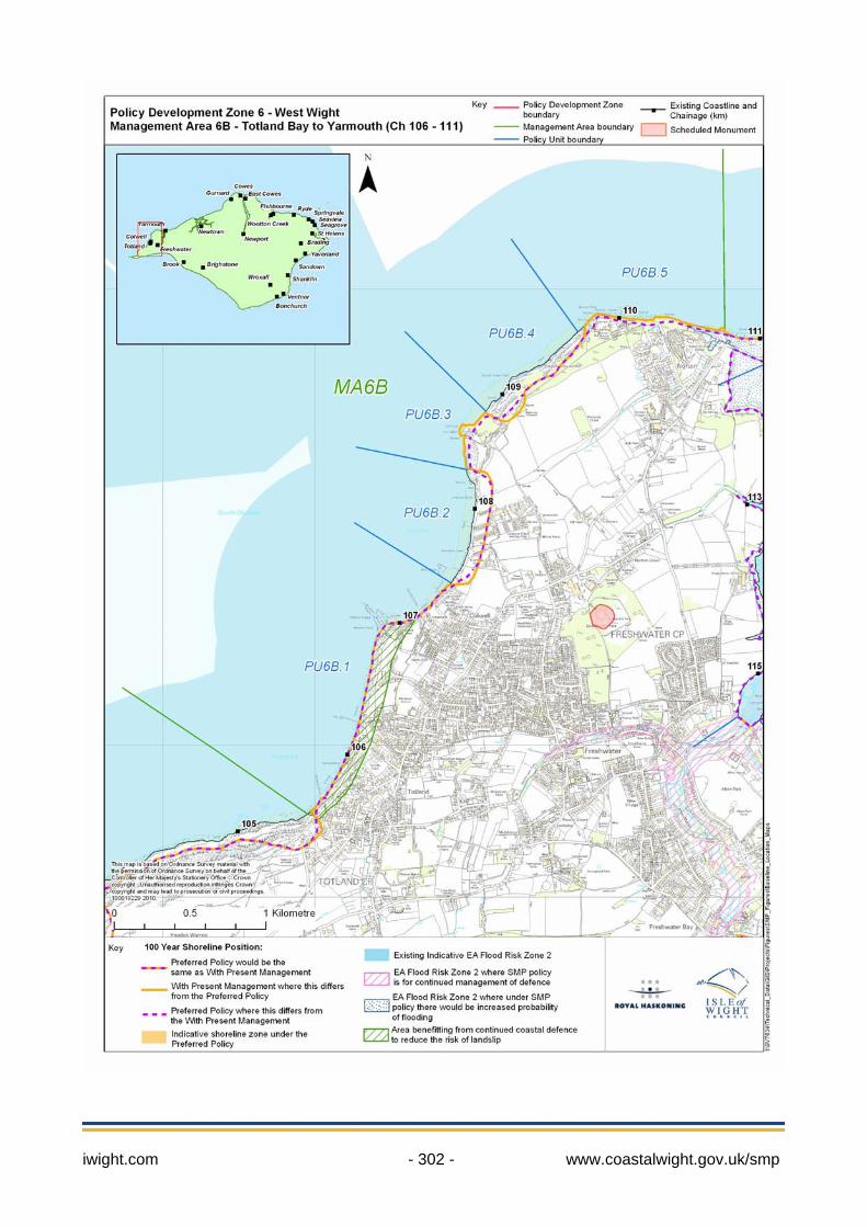
iwight.com - 302 - www.coastalwight.gov.uk/smp
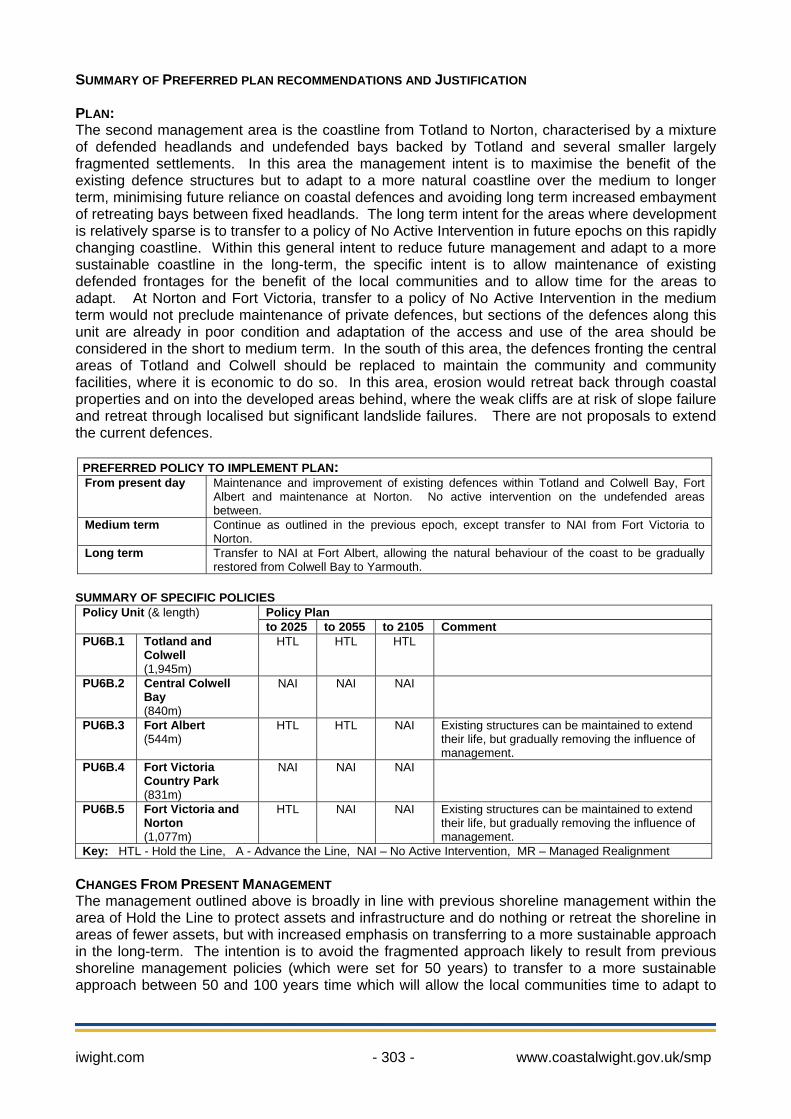
iwight.com - 303 - www.coastalwight.gov.uk/smp
SUMMARY OF PREFERRED PLAN RECOMMENDATIONS AND JUSTIFICATION PLAN: The second management area is the coastline from Totland to Norton, characterised by a mixture of defended headlands and undefended bays backed by Totland and several smaller largely fragmented settlements. In this area the management intent is to maximise the benefit of the existing defence structures but to adapt to a more natural coastline over the medium to longer term, minimising future reliance on coastal defences and avoiding long term increased embayment of retreating bays between fixed headlands. The long term intent for the areas where development is relatively sparse is to transfer to a policy of No Active Intervention in future epochs on this rapidly changing coastline. Within this general intent to reduce future management and adapt to a more sustainable coastline in the long-term, the specific intent is to allow maintenance of existing defended frontages for the benefit of the local communities and to allow time for the areas to adapt. At Norton and Fort Victoria, transfer to a policy of No Active Intervention in the medium term would not preclude maintenance of private defences, but sections of the defences along this unit are already in poor condition and adaptation of the access and use of the area should be considered in the short to medium term. In the south of this area, the defences fronting the central areas of Totland and Colwell should be replaced to maintain the community and community facilities, where it is economic to do so. In this area, erosion would retreat back through coastal properties and on into the developed areas behind, where the weak cliffs are at risk of slope failure and retreat through localised but significant landslide failures. There are not proposals to extend the current defences.
PREFERRED POLICY TO IMPLEMENT PLAN: From present day Maintenance and improvement of existing defences within Totland and Colwell Bay, Fort
Albert and maintenance at Norton. No active intervention on the undefended areas between.
Medium term Continue as outlined in the previous epoch, except transfer to NAI from Fort Victoria to Norton.
Long term Transfer to NAI at Fort Albert, allowing the natural behaviour of the coast to be gradually restored from Colwell Bay to Yarmouth.
SUMMARY OF SPECIFIC POLICIES
Policy Plan Policy Unit (& length) to 2025 to 2055 to 2105 Comment
PU6B.1 Totland and Colwell (1,945m)
HTL HTL HTL
PU6B.2 Central Colwell Bay (840m)
NAI NAI NAI
PU6B.3 Fort Albert (544m)
HTL HTL NAI Existing structures can be maintained to extend their life, but gradually removing the influence of management.
PU6B.4 Fort Victoria Country Park (831m)
NAI NAI NAI
PU6B.5 Fort Victoria and Norton (1,077m)
HTL NAI NAI Existing structures can be maintained to extend their life, but gradually removing the influence of management.
Key: HTL - Hold the Line, A - Advance the Line, NAI – No Active Intervention, MR – Managed Realignment CHANGES FROM PRESENT MANAGEMENT The management outlined above is broadly in line with previous shoreline management within the area of Hold the Line to protect assets and infrastructure and do nothing or retreat the shoreline in areas of fewer assets, but with increased emphasis on transferring to a more sustainable approach in the long-term. The intention is to avoid the fragmented approach likely to result from previous shoreline management policies (which were set for 50 years) to transfer to a more sustainable approach between 50 and 100 years time which will allow the local communities time to adapt to
iwight.com - 304 - www.coastalwight.gov.uk/smp
co-exist with a more natural coastline, whilst making best use of existing defences that are currently relied upon. IMPLICATION WITH RESPECT TO BUILT ENVIRONMENT
Economics by 2025 by 2055 by 2105 Total £k PV
Potential NAI Damages/ Cost £k PV 5,654 7,538 7,546 21,338 Preferred Plan Damages £k PV 639 6,387 5,365 12,391
Benefits £k PV 5,015 1,151 2,181 8,947
Property
Costs of Implementing plan £k PV 956 1,386 500 2,842
The preferred plan for this Management Area is economically viable overall. Individual schemes will need to be investigated in further detail to assess their economic viability and affordability.
Location reference Yarmouth and the Western Yar Estuary Management Area reference MA 6C Policy Development Zone PDZ 6
The following descriptions are provided to assist interpretation of the maps shown of each Management Area. * Note: Predicted shoreline mapping is based on a combination of monitoring data, analysis of historical rates and geomorphological assessment with allowance for sea level rise. Due to inherent uncertainties in predicting future change, these predictions are necessarily indicative. For use beyond the purpose of the shoreline management plan, reference should be made to the baseline data (see Appendix C3). 100 year shoreline position: The following maps aim to summarise the anticipated position of the shoreline in 100 years under the two scenarios of “With Present Management” and under the “Preferred Policy” being put forward through the Shoreline Management Plan.
In some areas the preferred policy does not change from that under the existing management approach. In some areas where there are hard defences this can be
accurately identified. In other areas there is greater uncertainty. Even so, where the shoreline is likely to be quite clearly defined by a change such as the crest of a cliff the estimated position is shown as a single line.
Where there is a difference between With Present Management and the Preferred Policy this distinction is made in showing two different lines:
With Present Management. Preferred Policy.
In some areas, the Preferred Policy either promotes a more adaptive approach to management or recognises that the shoreline is better considered as a width rather than a narrow line. This is represented on the map by a broader zone of management:
Flood Risk Zones: All flood risk zones are based upon the current tidal EA Flood Zone 2. This is an extreme flood event (1:1000 year at current levels) meaning that it has 0.1% chance of occurring each year.
General Flood Risk Zones. The explanation of these zones is provided on the Environment Agency’s web site www.environment-agency.gov.uk. The maps within this SMP document show where SMP policy might influence the management of flood risk.
Indicate areas where the intent of the SMP policy is to continue to manage this risk. Indicate where over the 100 years the policy would allow increased risk of flooding.
The maps should be read in conjunction with the text within the SMP document. Note: This Management Area corresponds to IW50 & IW51 in selected Appendices.
iwight.com - 305 - www.coastalwight.gov.uk/smp
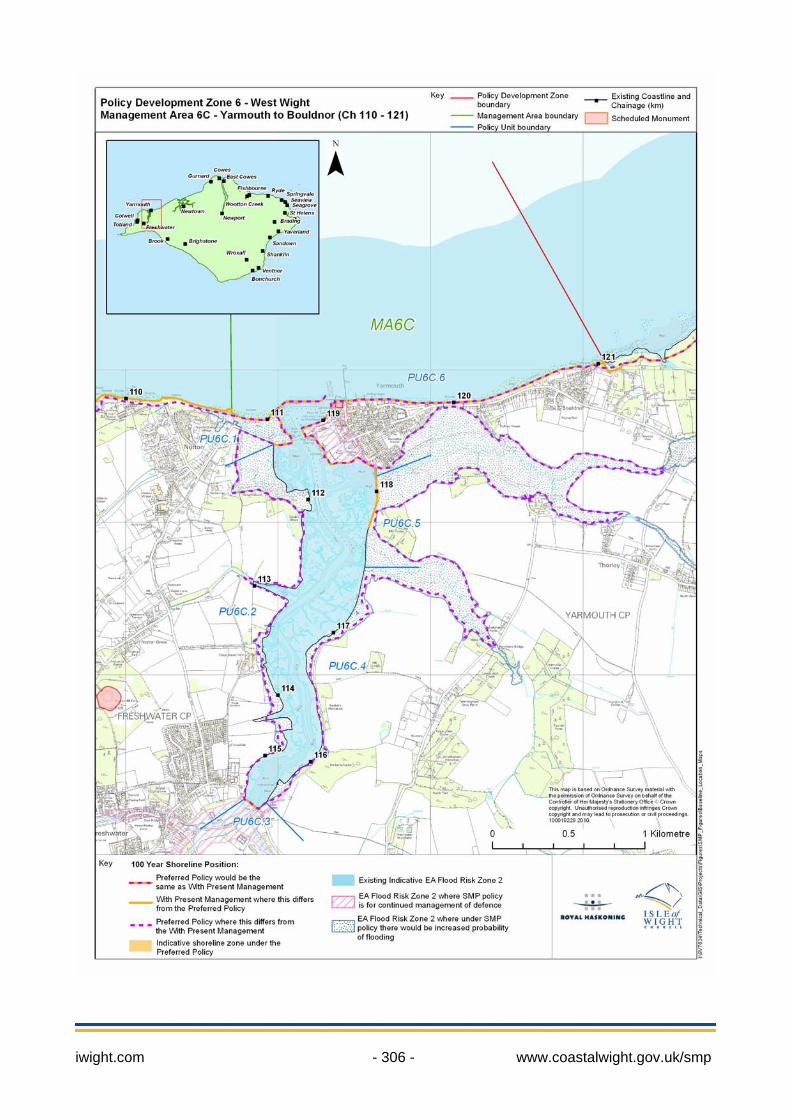
iwight.com - 306 - www.coastalwight.gov.uk/smp

iwight.com - 307 - www.coastalwight.gov.uk/smp
SUMMARY OF PREFERRED PLAN RECOMMENDATIONS AND JUSTIFICATION PLAN: This Management Area includes the coastline surrounding the town of Yarmouth and the adjoining Western Yar Estuary. The increasing potential interactions of the Western Yar and Thorley Brook with the adjacent coastlines and the issues surrounding the town of Yarmouth and Yarmouth Harbour require a coordinated management approach. In this area the general management intent is to protect the important town of Yarmouth, the functioning of the harbour and maintain road access by bridge to west Wight and to adjacent communities, whilst allowing the majority of the estuary to adapt naturally to sea level rise. This will allow adaptation of the habitats and important nature conservation interests equally important to the character of the area. It is recommended that of the current defences and embankments around the town of Yarmouth and the Estuary, only those are maintained where there is a clearly justified reason and effective method based on the overwhelming scale of the flood and erosion risk. The intention is to maintain and improve the defences surrounding Yarmouth, including allowing maintenance of the defences sheltering the harbour and lining the ferry terminal, retaining these important assets of the local and wider community. Whilst the importance and vulnerability of this community is recognised and clearly stated in this SMP, it is recognised that issues remain to be addressed at Strategy level, including developing a proposal to raise the level of protection of public and private defences which is achievable and co-ordinated, economically robust and which also maintains or co-exists alongside the historic character and use of the town and the surrounding natural environment. To the west of Yarmouth, the preferred option is to hold the overall current defence line along the Harbour Breakwater and Norton Spit where structures are already in place, but the intention behind the policy is to protect the road and infrastructure, allow a functional harbour and provide shelter for the town, the detailed design and location of which can be developed in a future Strategy for the area. It is recognised that tidal inundation of the inlet between the spit and the road will continue to occur. To the east of Yarmouth, the intention is to maintain the position of the existing defence line from Yarmouth to Port la Salle, protecting properties and the key road link from Newport which provides access to Yarmouth and the west Wight. Within the Western Yar Estuary the intention is to reduce management and allow the estuary to adapt naturally to sea level rise through all three epochs, with some limited minor exceptions. The majority of the frontage is currently undefended, although a policy of No Active Intervention cannot preclude maintenance of existing short stretches of private defences on the western bank linked to local businesses and properties. At current southern tidal extent of the estuary the intention is to maintain and improve the short length of flood defence at the Causeway bridge to prevent tidal inundation of the properties and habitats upstream in Freshwater, and prevent tidal breach through from Freshwater Bay to Yarmouth. On the eastern bank of the estuary historic embankments and some defences protect the entrances to Thorley Brook and Barnfields Stream. The principal interest of these tributaries is their important nature conservation interest and there is clear potential to restore more natural behaviour and operation of these inlets. Therefore the intended management of this area is to maintain existing defence line across the mouth of the potential inlets in the first epoch (0-20 years), to allow time to plan for adaptation of habitats and importantly to assess and plan to reduce the consequences of restoring natural behaviour on adjacent properties and infrastructure. In the medium term (20-50 years) a policy of Managed Realignment will allow increasing tidal inundation of Thorley Brook and Barnfields stream, followed in the long term (50-200 years) by a policy of No Active Intervention, in line with the rest of the Estuary shoreline. As part of designing the Managed Realignment, particular attention will be paid to the risk of tidal flooding in the south-east part of Yarmouth (along the margin of the new floodplain that would gradually be flooded more frequently in the medium and long term), and that risk will be addressed and managed. It is recognised that short localised areas of defence may be required in the medium or long term surrounding the new tidal floodplain, to be examined in more detail at Strategy level. The intention would be to take localised action to address the flood risk where required. Restoring the natural evolution of Thorley Brook will have benefits for nature
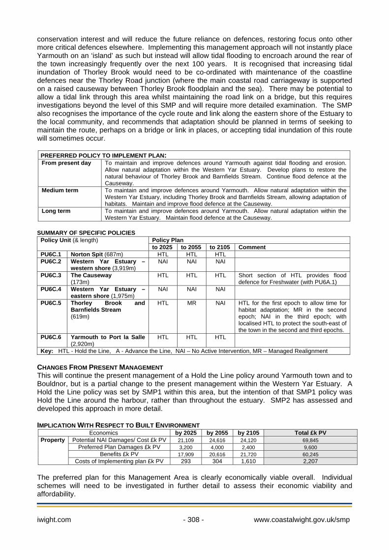
iwight.com - 308 - www.coastalwight.gov.uk/smp
conservation interest and will reduce the future reliance on defences, restoring focus onto other more critical defences elsewhere. Implementing this management approach will not instantly place Yarmouth on an ‘island’ as such but instead will allow tidal flooding to encroach around the rear of the town increasingly frequently over the next 100 years. It is recognised that increasing tidal inundation of Thorley Brook would need to be co-ordinated with maintenance of the coastline defences near the Thorley Road junction (where the main coastal road carriageway is supported on a raised causeway between Thorley Brook floodplain and the sea). There may be potential to allow a tidal link through this area whilst maintaining the road link on a bridge, but this requires investigations beyond the level of this SMP and will require more detailed examination. The SMP also recognises the importance of the cycle route and link along the eastern shore of the Estuary to the local community, and recommends that adaptation should be planned in terms of seeking to maintain the route, perhaps on a bridge or link in places, or accepting tidal inundation of this route will sometimes occur.
PREFERRED POLICY TO IMPLEMENT PLAN: From present day To maintain and improve defences around Yarmouth against tidal flooding and erosion.
Allow natural adaptation within the Western Yar Estuary. Develop plans to restore the natural behaviour of Thorley Brook and Barnfields Stream. Continue flood defence at the Causeway.
Medium term To maintain and improve defences around Yarmouth. Allow natural adaptation within the Western Yar Estuary, including Thorley Brook and Barnfields Stream, allowing adaptation of habitats. Maintain and improve flood defence at the Causeway.
Long term To maintain and improve defences around Yarmouth. Allow natural adaptation within the Western Yar Estuary. Maintain flood defence at the Causeway.
SUMMARY OF SPECIFIC POLICIES
Policy Plan Policy Unit (& length) to 2025 to 2055 to 2105 Comment
PU6C.1 Norton Spit (687m) HTL HTL HTL PU6C.2 Western Yar Estuary –
western shore (3,919m) NAI NAI NAI
PU6C.3 The Causeway (173m)
HTL HTL HTL Short section of HTL provides flood defence for Freshwater (with PU6A.1)
PU6C.4 Western Yar Estuary –eastern shore (1,975m)
NAI NAI NAI
PU6C.5 Thorley Brook and Barnfields Stream (619m)
HTL MR NAI HTL for the first epoch to allow time for habitat adaptation; MR in the second epoch; NAI in the third epoch; with localised HTL to protect the south-east of the town in the second and third epochs.
PU6C.6 Yarmouth to Port la Salle (2,920m)
HTL HTL HTL
Key: HTL - Hold the Line, A - Advance the Line, NAI – No Active Intervention, MR – Managed Realignment CHANGES FROM PRESENT MANAGEMENT This will continue the present management of a Hold the Line policy around Yarmouth town and to Bouldnor, but is a partial change to the present management within the Western Yar Estuary. A Hold the Line policy was set by SMP1 within this area, but the intention of that SMP1 policy was Hold the Line around the harbour, rather than throughout the estuary. SMP2 has assessed and developed this approach in more detail. IMPLICATION WITH RESPECT TO BUILT ENVIRONMENT
Economics by 2025 by 2055 by 2105 Total £k PV Potential NAI Damages/ Cost £k PV 21,109 24,616 24,120 69,845
Preferred Plan Damages £k PV 3,200 4,000 2,400 9,600 Benefits £k PV 17,909 20,616 21,720 60,245
Property
Costs of Implementing plan £k PV 293 304 1,610 2,207 The preferred plan for this Management Area is clearly economically viable overall. Individual schemes will need to be investigated in further detail to assess their economic viability and affordability.