Embed Size (px)
Citation preview

Dissington Garden VillageLandscape appraisal and green belt assessment
November 2016
Amec Foster Wheeler Environment & Infrastructure UK Limited
© Amec Foster Wheeler Environment & Infrastructure UK Limited2
November 2016
Report for Frances Wilkinson Northumberland County Council County Hall Morpeth Northumberland NE61 2EF.
Main contributors David Stokoe Neil Marlborough Jacqui Parkin
Issued by
..............................................
Approved by
..............................................
Amec Foster Wheeler Partnership HouseRegent Farm RoadGosforthNE3 3AF
Doc Reference39054 CGos003R
Copyright and non-disclosure noticeThe contents and layout of this report are subject to copyright owned by Amec Foster Wheeler (© Amec Foster Wheeler Environment & Infrastructure UK Limited 2015). save to the extent that copyright has been legally assigned by us to another party or is used by Amec Foster Wheeler under licence. To the extent that we own the copyright in this report, it may not be copied or used without our prior written agreement for any purpose other than the purpose indicated in this report. The methodology (if any) contained in this report is provided to you in confidence and must not be disclosed or copied to third parties without the prior written agreement of Amec Foster Wheeler. Disclosure of that information may constitute an actionable breach of confidence or may otherwise prejudice our commercial interests. Any third party who obtains access to this report by any means will, in any event, be subject to the Third Party Disclaimer set out below.
Third-party disclaimer Any disclosure of this report to a third party is subject to this disclaimer. The report was prepared by Amec Foster Wheeler at the instruction of, and for use by, our client named on the front of the report. It does not in any way constitute advice to any third party who is able to access it by any means. Amec Foster Wheeler excludes to the fullest extent lawfully permitted all liability whatsoever for any loss or damage howsoever arising from reliance on the contents of this report. We do not however exclude our liability (if any) for personal injury or death resulting from our negligence, for fraud or any other matter in relation to which we cannot legally exclude liability.
Management systemsThis document has been produced by Amec Foster Wheeler Environment & Infrastructure UK Limited in full compliance with the management systems, which have been certified to ISO 9001, ISO 14001 and OHSAS 18001 by LRQA.
Contents
1 Introduction 3
Introduction 3
Background 3
Objectives 3
2 Landscape Context 4
Landscape Character 4
3 Green Belt Assessment 6
Approach and methodology 6
4 Green Belt land parcel appraisal 8
Green Belt Parcel PD02 Police HQ 10
Green Belt Parcel PD16 Donkin House 12
Green Belt Parcel PD18 Coat Hill 14
Green Belt Parcel PD19 West House 16
Green Belt Parcel PD20 Coldcotes Moor 18
5 Landscape Analysis 22
6 Landscape Strategy 23
Design Principles 23
7 Landscape and Visual Impact Assessment 24
Landscape and Visual Impact Assessment (LVIA) 24
Photography illustrating representative range of viewpoints 26
8 Summary and Conclusions 28
Summary and conclusions 28
Addendum 29
Dissington Garden Village Boundary Analysis 29
References 30
0 0.5 1 1.5 2 km
Masterplan boundary
5km study area
408000 409000 410000 411000 412000 413000 414000 415000 416000 417000 418000 419000
5680
0056
9000
5700
0057
1000
5720
0057
3000
5740
0057
5000
5760
0057
7000
5780
00
Key
file:
H:\P
roje
cts\
3905
4 G
OS
Dis
sing
ton
Gar
den
Villa
ge\3
9054
-Gos
01.m
xd
1:40,000Scale at A3:
39054-Gos01.mxd robecOctober 2016
Dissington Garden VillageLandscape Appraisal andGreenbelt Assessment
Figure 1Site location
Based upon the Ordnance Survey Map with the permission of the Controller of Her Majesty's Stationery Office. © Crown Copyright. 100001776
© Amec Foster Wheeler Environment & Infrastructure UK Limited 3
November 2016
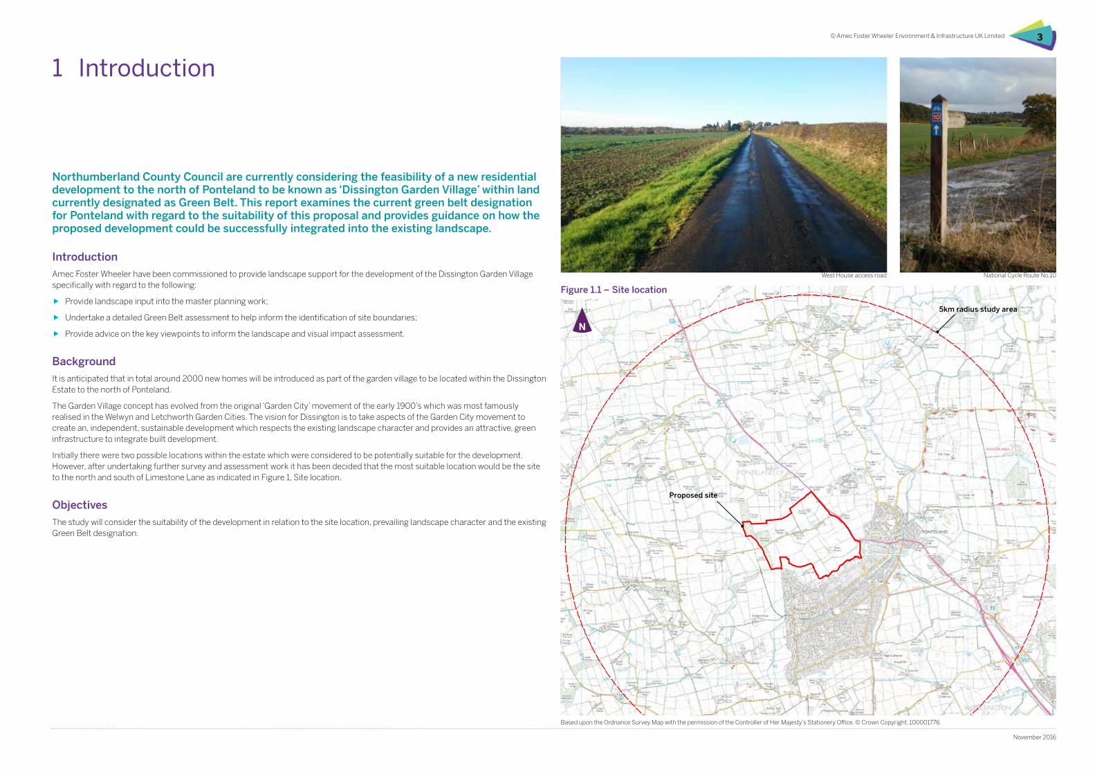
Northumberland County Council are currently considering the feasibility of a new residential development to the north of Ponteland to be known as ‘Dissington Garden Village’ within land currently designated as Green Belt. This report examines the current green belt designation for Ponteland with regard to the suitability of this proposal and provides guidance on how the proposed development could be successfully integrated into the existing landscape.
Introduction
Amec Foster Wheeler have been commissioned to provide landscape support for the development of the Dissington Garden Village specifically with regard to the following:
ff Provide landscape input into the master planning work;
ff Undertake a detailed Green Belt assessment to help inform the identification of site boundaries;
ff Provide advice on the key viewpoints to inform the landscape and visual impact assessment.
Background
It is anticipated that in total around 2000 new homes will be introduced as part of the garden village to be located within the Dissington Estate to the north of Ponteland.
The Garden Village concept has evolved from the original ‘Garden City’ movement of the early 1900’s which was most famously realised in the Welwyn and Letchworth Garden Cities. The vision for Dissington is to take aspects of the Garden City movement to create an, independent, sustainable development which respects the existing landscape character and provides an attractive, green infrastructure to integrate built development.
Initially there were two possible locations within the estate which were considered to be potentially suitable for the development. However, after undertaking further survey and assessment work it has been decided that the most suitable location would be the site to the north and south of Limestone Lane as indicated in Figure 1, Site location.
Objectives
The study will consider the suitability of the development in relation to the site location, prevailing landscape character and the existing Green Belt designation.
West House access road
1 Introduction
Figure 1.1 – Site location
National Cycle Route No.10
Proposed site
Based upon the Ordnance Survey Map with the permission of the Controller of Her Majesty’s Stationery Office. © Crown Copyright. 100001776.
5km radius study area
© Amec Foster Wheeler Environment & Infrastructure UK Limited4
November 2016
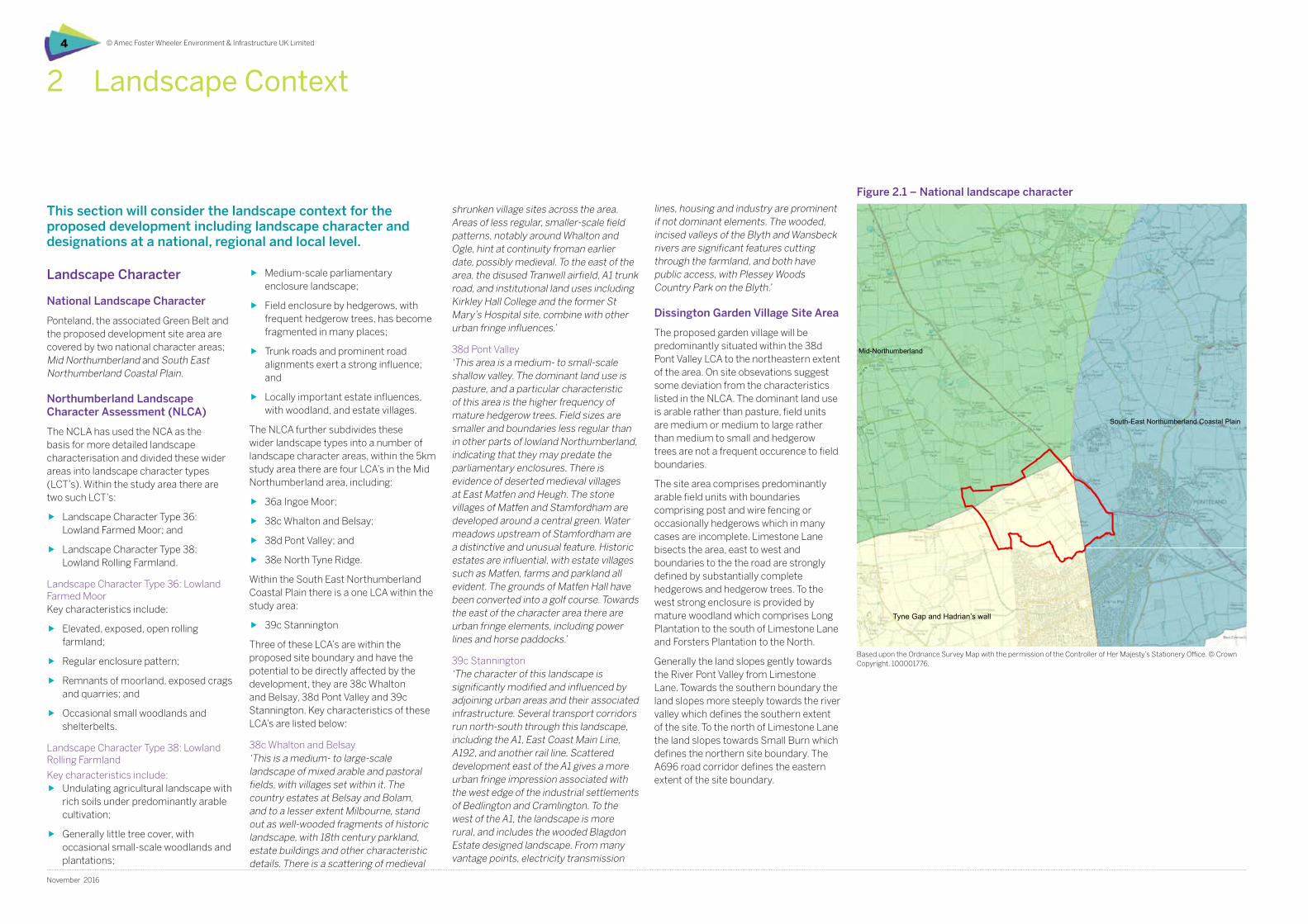
This section will consider the landscape context for the proposed development including landscape character and designations at a national, regional and local level.
2 Landscape Context
0 0.5 1 1.5 2 km
Masterplan boundary
Landscape Character Areas
36a - Ingoe Moor
38c - Whalton and Belsay
38d - Pont Valley
38e - North Tyne Ridge
39c - Stannington
Mid-Northumberland
Mid-Northumberland
South-East Northumberland Coastal Plain
Mid-Northumberland
Mid-Northumberland
408000 409000 410000 411000 412000 413000 414000 415000 416000 417000 418000 419000
5680
0056
9000
5700
0057
1000
5720
0057
3000
5740
0057
5000
5760
0057
7000
Key
file:
H:\P
roje
cts\
3905
4 G
OS
Dis
sing
ton
Gar
den
Villa
ge\3
9054
-Gos
09.m
xd
1:40,000Scale at A3:
39054-Gos09.mxd robecOctober 2016
Dissington Garden VillageLandscape Appraisal andGreenbelt Assessment
Figure 9National landscape character areas
Based upon the Ordnance Survey Map with the permission of the Controller of Her Majesty's Stationery Office. © Crown Copyright. 100001776
Landscape Character
National Landscape Character
Ponteland, the associated Green Belt and the proposed development site area are covered by two national character areas; Mid Northumberland and South East Northumberland Coastal Plain.
Northumberland Landscape Character Assessment (NLCA)
The NCLA has used the NCA as the basis for more detailed landscape characterisation and divided these wider areas into landscape character types (LCT’s). Within the study area there are two such LCT’s:
ff Landscape Character Type 36: Lowland Farmed Moor; and
ff Landscape Character Type 38: Lowland Rolling Farmland.
Landscape Character Type 36: Lowland Farmed MoorKey characteristics include:
ff Elevated, exposed, open rolling farmland;
ff Regular enclosure pattern;
ff Remnants of moorland, exposed crags and quarries; and
ff Occasional small woodlands and shelterbelts.
Landscape Character Type 38: Lowland Rolling Farmland
Key characteristics include:ff Undulating agricultural landscape with
rich soils under predominantly arable cultivation;
ff Generally little tree cover, with occasional small-scale woodlands and plantations;
ff Medium-scale parliamentary enclosure landscape;
ff Field enclosure by hedgerows, with frequent hedgerow trees, has become fragmented in many places;
ff Trunk roads and prominent road alignments exert a strong influence; and
ff Locally important estate influences, with woodland, and estate villages.
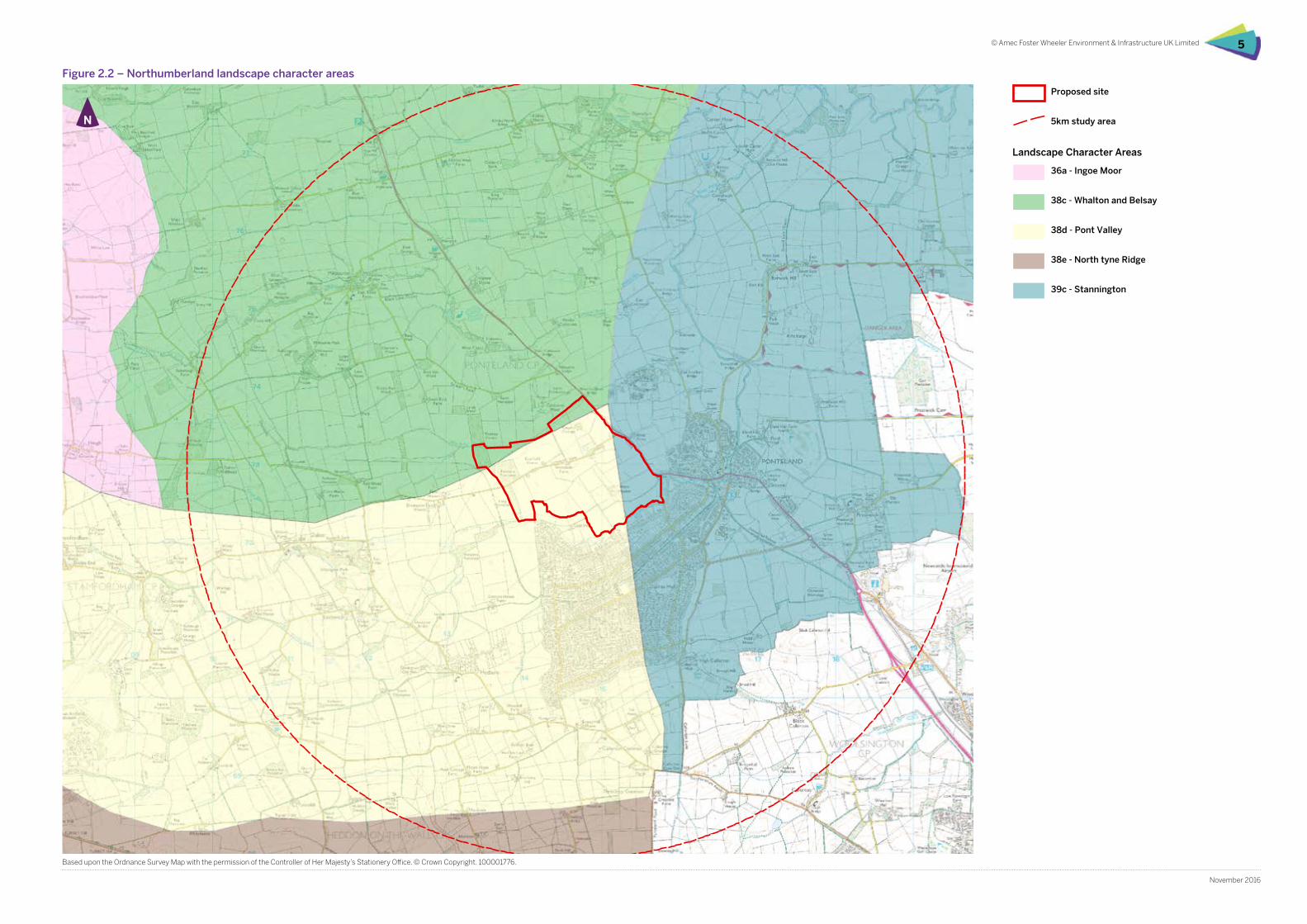
The NLCA further subdivides these wider landscape types into a number of landscape character areas, within the 5km study area there are four LCA’s in the Mid Northumberland area, including:
ff 36a Ingoe Moor;
ff 38c Whalton and Belsay;
ff 38d Pont Valley; and
ff 38e North Tyne Ridge.
Within the South East Northumberland Coastal Plain there is a one LCA within the study area:
ff 39c Stannington
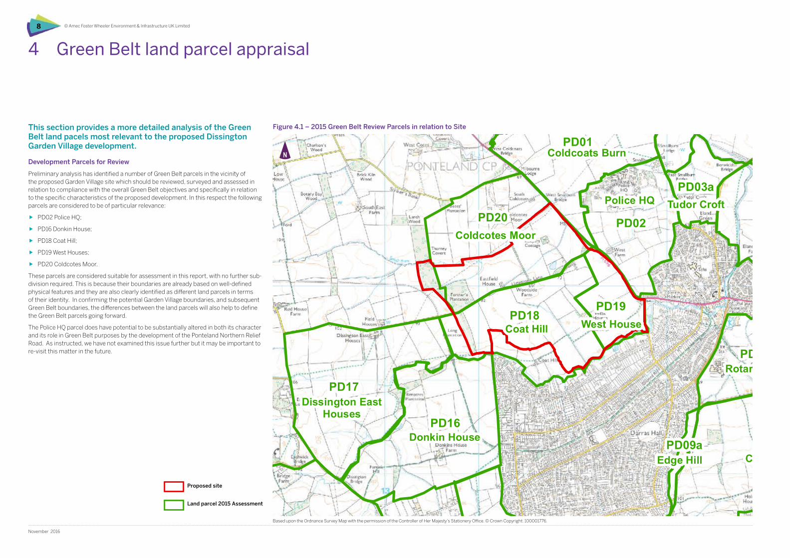
Three of these LCA’s are within the proposed site boundary and have the potential to be directly affected by the development, they are 38c Whalton and Belsay, 38d Pont Valley and 39c Stannington. Key characteristics of these LCA’s are listed below:
38c Whalton and Belsay‘This is a medium- to large-scale landscape of mixed arable and pastoral fields, with villages set within it. The country estates at Belsay and Bolam, and to a lesser extent Milbourne, stand out as well-wooded fragments of historic landscape, with 18th century parkland, estate buildings and other characteristic details. There is a scattering of medieval
shrunken village sites across the area. Areas of less regular, smaller-scale field patterns, notably around Whalton and Ogle, hint at continuity froman earlier date, possibly medieval. To the east of the area, the disused Tranwell airfield, A1 trunk road, and institutional land uses including Kirkley Hall College and the former St Mary’s Hospital site, combine with other urban fringe influences.’
38d Pont Valley‘This area is a medium- to small-scale shallow valley. The dominant land use is pasture, and a particular characteristic of this area is the higher frequency of mature hedgerow trees. Field sizes are smaller and boundaries less regular than in other parts of lowland Northumberland, indicating that they may predate the parliamentary enclosures. There is evidence of deserted medieval villages at East Matfen and Heugh. The stone villages of Matfen and Stamfordham are developed around a central green. Water meadows upstream of Stamfordham are a distinctive and unusual feature. Historic estates are influential, with estate villages such as Matfen, farms and parkland all evident. The grounds of Matfen Hall have been converted into a golf course. Towards the east of the character area there are urban fringe elements, including power lines and horse paddocks.’
39c Stannington‘The character of this landscape is significantly modified and influenced by adjoining urban areas and their associated infrastructure. Several transport corridors run north-south through this landscape, including the A1, East Coast Main Line, A192, and another rail line. Scattered development east of the A1 gives a more urban fringe impression associated with the west edge of the industrial settlements of Bedlington and Cramlington. To the west of the A1, the landscape is more rural, and includes the wooded Blagdon Estate designed landscape. From many vantage points, electricity transmission
lines, housing and industry are prominent if not dominant elements. The wooded, incised valleys of the Blyth and Wansbeck rivers are significant features cutting through the farmland, and both have public access, with Plessey Woods Country Park on the Blyth.’
Dissington Garden Village Site Area
The proposed garden village will be predominantly situated within the 38d Pont Valley LCA to the northeastern extent of the area. On site obsevations suggest some deviation from the characteristics listed in the NLCA. The dominant land use is arable rather than pasture, field units are medium or medium to large rather than medium to small and hedgerow trees are not a frequent occurence to field boundaries.
The site area comprises predominantly arable field units with boundaries comprising post and wire fencing or occasionally hedgerows which in many cases are incomplete. Limestone Lane bisects the area, east to west and boundaries to the the road are strongly defined by substantially complete hedgerows and hedgerow trees. To the west strong enclosure is provided by mature woodland which comprises Long Plantation to the south of Limestone Lane and Forsters Plantation to the North.
Generally the land slopes gently towards the River Pont Valley from Limestone Lane. Towards the southern boundary the land slopes more steeply towards the river valley which defines the southern extent of the site. To the north of Limestone Lane the land slopes towards Small Burn which defines the northern site boundary. The A696 road corridor defines the eastern extent of the site boundary.
Figure 2.1 – National landscape character
Based upon the Ordnance Survey Map with the permission of the Controller of Her Majesty’s Stationery Office. © Crown Copyright. 100001776.
Tyne Gap and Hadrian’s wall
0 0.5 1 1.5 2 km
Masterplan boundary
5km study area
Landscape Character Areas
36a - Ingoe Moor
38c - Whalton and Belsay
38d - Pont Valley
38e - North Tyne Ridge
39c - Stannington
408000 409000 410000 411000 412000 413000 414000 415000 416000 417000 418000 419000
5680
0056
9000
5700
0057
1000
5720
0057
3000
5740
0057
5000
5760
0057
7000
5780
00
Key
file:
H:\P
roje
cts\
3905
4 G
OS
Dis
sing
ton
Gar
den
Villa
ge\3
9054
-Gos
07.m
xd
1:40,000Scale at A3:
39054-Gos07.mxd robecOctober 2016
Dissington Garden VillageLandscape Appraisal andGreenbelt Assessment
Figure 8Landscape character areas
Based upon the Ordnance Survey Map with the permission of the Controller of Her Majesty's Stationery Office. © Crown Copyright. 100001776
© Amec Foster Wheeler Environment & Infrastructure UK Limited 5
November 2016
Figure 2.2 – Northumberland landscape character areas
Based upon the Ordnance Survey Map with the permission of the Controller of Her Majesty’s Stationery Office. © Crown Copyright. 100001776.
Proposed site
5km study area
36a - Ingoe Moor
38c - Whalton and Belsay
38d - Pont Valley
38e - North tyne Ridge
39c - Stannington
Landscape Character Areas
© Amec Foster Wheeler Environment & Infrastructure UK Limited6
November 2016
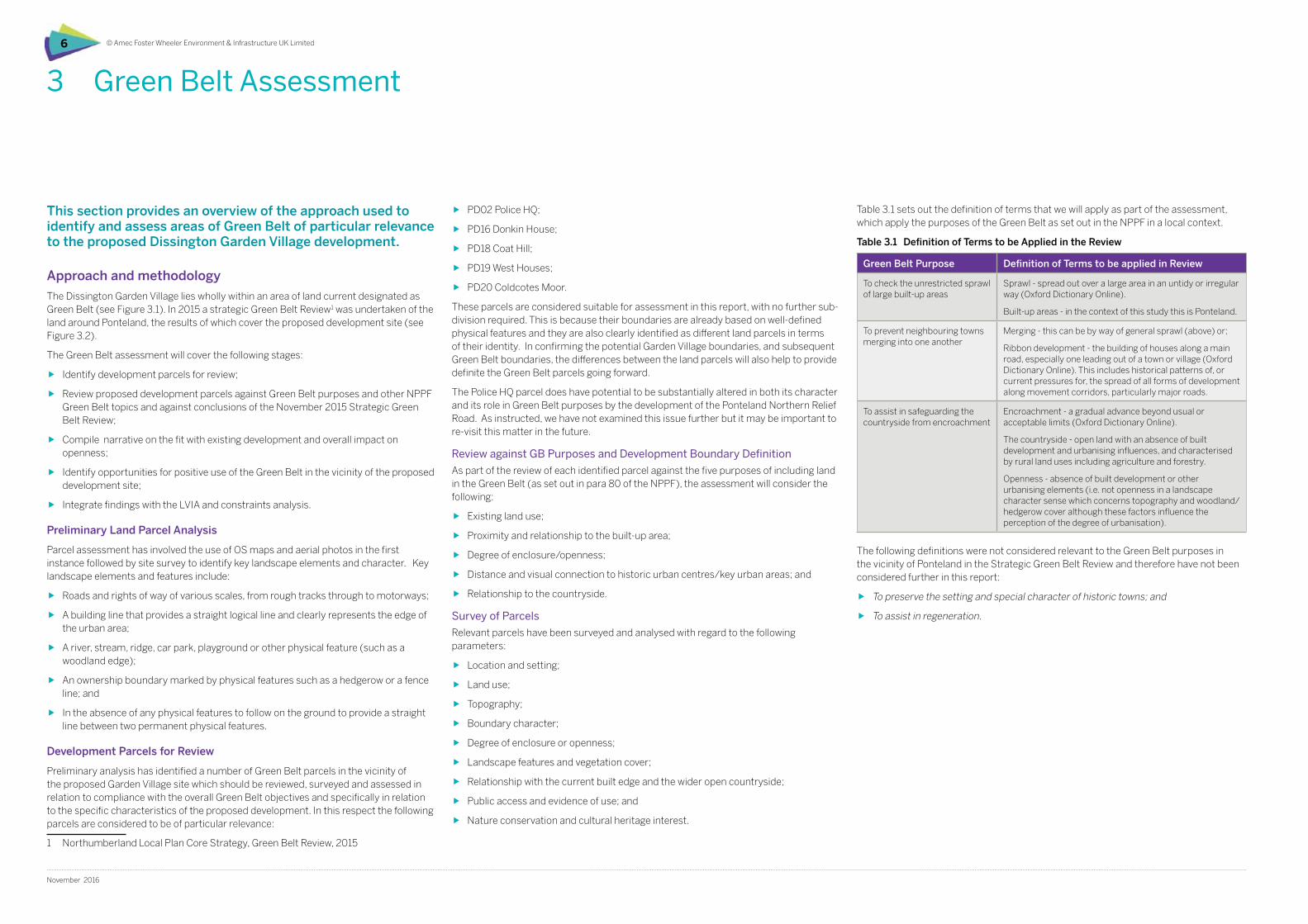
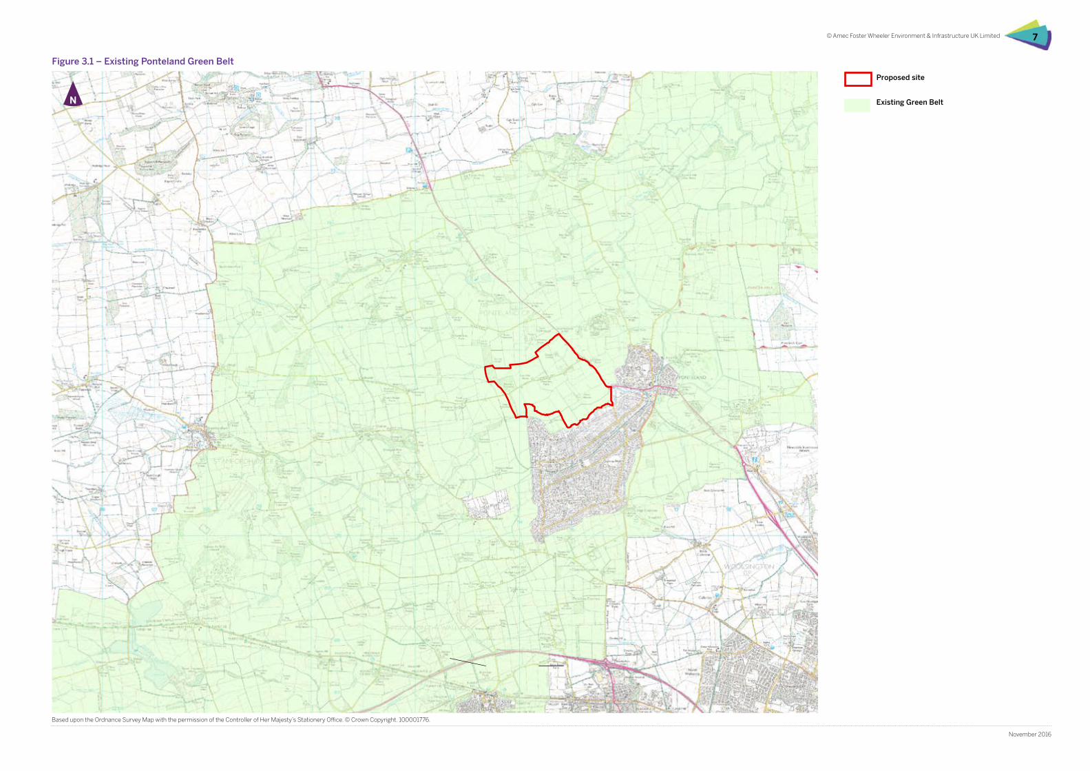
This section provides an overview of the approach used to identify and assess areas of Green Belt of particular relevance to the proposed Dissington Garden Village development.
Approach and methodology
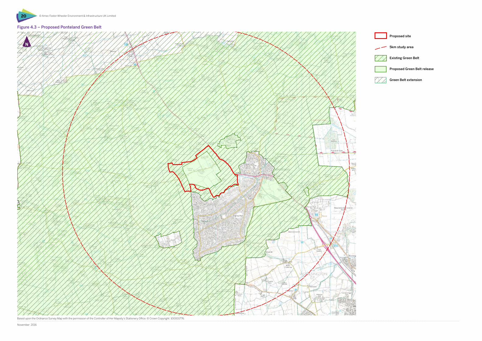
The Dissington Garden Village lies wholly within an area of land current designated as Green Belt (see Figure 3.1). In 2015 a strategic Green Belt Review1 was undertaken of the land around Ponteland, the results of which cover the proposed development site (see Figure 3.2).
The Green Belt assessment will cover the following stages:
ff Identify development parcels for review;
ff Review proposed development parcels against Green Belt purposes and other NPPF Green Belt topics and against conclusions of the November 2015 Strategic Green Belt Review;
ff Compile narrative on the fit with existing development and overall impact on openness;
ff Identify opportunities for positive use of the Green Belt in the vicinity of the proposed development site;
ff Integrate findings with the LVIA and constraints analysis.
Preliminary Land Parcel Analysis
Parcel assessment has involved the use of OS maps and aerial photos in the first instance followed by site survey to identify key landscape elements and character. Key landscape elements and features include:
ff Roads and rights of way of various scales, from rough tracks through to motorways;
ff A building line that provides a straight logical line and clearly represents the edge of the urban area;
ff A river, stream, ridge, car park, playground or other physical feature (such as a woodland edge);
ff An ownership boundary marked by physical features such as a hedgerow or a fence line; and
ff In the absence of any physical features to follow on the ground to provide a straight line between two permanent physical features.
Development Parcels for Review
Preliminary analysis has identified a number of Green Belt parcels in the vicinity of the proposed Garden Village site which should be reviewed, surveyed and assessed in relation to compliance with the overall Green Belt objectives and specifically in relation to the specific characteristics of the proposed development. In this respect the following parcels are considered to be of particular relevance:
1 Northumberland Local Plan Core Strategy, Green Belt Review, 2015
3 Green Belt Assessment
ff PD02 Police HQ;
ff PD16 Donkin House;
ff PD18 Coat Hill;
ff PD19 West Houses;
ff PD20 Coldcotes Moor.
These parcels are considered suitable for assessment in this report, with no further sub-division required. This is because their boundaries are already based on well-defined physical features and they are also clearly identified as different land parcels in terms of their identity. In confirming the potential Garden Village boundaries, and subsequent Green Belt boundaries, the differences between the land parcels will also help to provide definite the Green Belt parcels going forward.
The Police HQ parcel does have potential to be substantially altered in both its character and its role in Green Belt purposes by the development of the Ponteland Northern Relief Road. As instructed, we have not examined this issue further but it may be important to re-visit this matter in the future.
Review against GB Purposes and Development Boundary Definition
As part of the review of each identified parcel against the five purposes of including land in the Green Belt (as set out in para 80 of the NPPF), the assessment will consider the following:
ff Existing land use;
ff Proximity and relationship to the built-up area;
ff Degree of enclosure/openness;
ff Distance and visual connection to historic urban centres/key urban areas; and
ff Relationship to the countryside.
Survey of Parcels
Relevant parcels have been surveyed and analysed with regard to the following parameters:
ff Location and setting;
ff Land use;
ff Topography;
ff Boundary character;
ff Degree of enclosure or openness;
ff Landscape features and vegetation cover;
ff Relationship with the current built edge and the wider open countryside;
ff Public access and evidence of use; and
ff Nature conservation and cultural heritage interest.
The following definitions were not considered relevant to the Green Belt purposes in the vicinity of Ponteland in the Strategic Green Belt Review and therefore have not been considered further in this report:
ff To preserve the setting and special character of historic towns; and
ff To assist in regeneration.
Green Belt Purpose Definition of Terms to be applied in Review
To check the unrestricted sprawl of large built-up areas
Sprawl - spread out over a large area in an untidy or irregular way (Oxford Dictionary Online).
Built-up areas - in the context of this study this is Ponteland.
To prevent neighbouring towns merging into one another
Merging - this can be by way of general sprawl (above) or;
Ribbon development - the building of houses along a main road, especially one leading out of a town or village (Oxford Dictionary Online). This includes historical patterns of, or current pressures for, the spread of all forms of development along movement corridors, particularly major roads.
To assist in safeguarding the countryside from encroachment
Encroachment - a gradual advance beyond usual or acceptable limits (Oxford Dictionary Online).
The countryside - open land with an absence of built development and urbanising influences, and characterised by rural land uses including agriculture and forestry.
Openness - absence of built development or other urbanising elements (i.e. not openness in a landscape character sense which concerns topography and woodland/hedgerow cover although these factors influence the perception of the degree of urbanisation).
Table 3.1 sets out the definition of terms that we will apply as part of the assessment, which apply the purposes of the Green Belt as set out in the NPPF in a local context.
Table 3.1 Definition of Terms to be Applied in the Review
© Amec Foster Wheeler Environment & Infrastructure UK Limited 7
November 2016
0 0.5 1 1.5 2 km
Masterplan boundary
Existing Greenbelt
405000 406000 407000 408000 409000 410000 411000 412000 413000 414000 415000 416000 417000 418000 419000
5670
0056
8000
5690
0057
0000
5710
0057
2000
5730
0057
4000
5750
0057
6000
5770
0057
8000
5790
00
Key
file:
H:\P
roje
cts\
3905
4 G
OS
Dis
sing
ton
Gar
den
Villa
ge\3
9054
-Gos
10.m
xd
1:50,000Scale at A3:
39054-Gos10.mxd barkrOctober 2016
Dissington Garden VillageLandscape Appraisal andGreenbelt Assessment
Figure 2National landscape character areas
Based upon the Ordnance Survey Map with the permission of the Controller of Her Majesty's Stationery Office. © Crown Copyright. 100001776
Figure 3.1 – Existing Ponteland Green Belt
Based upon the Ordnance Survey Map with the permission of the Controller of Her Majesty’s Stationery Office. © Crown Copyright. 100001776.
Proposed site
Existing Green Belt
0 0.5 1 1.5 2 km
Masterplan boundary
5km study area
Land parcel (2015Assessment)
PD11
PD14
PD04
PD05
PD09b
PD17
PD16
PD12
PD07
PD20
PD13
PD01
PD18
SM02
PD02
PD03b
SM01
PD10
PD08
PD19
PD03a
PD06a
HWL01
PD06b
HWL04
PD09a
BY01
Heddon Birks
Eland Hall
South Dissington
Berwick Carr
Callerton Hall
PrestwickCoat Hill
Donkin House
Ecklindale
Coldcotes Moor
Heddon Steads
Police HQ
Coldcoats Burn
Dissington EastHouses
Birney Hall
Rotary Drive
Stamfordham South
Heddon Laws toEast of Medburn
Stamfordham East
West House
Tudor Croft
Clickemin
Dobbies GardenCentre
Heddon-on-the-Wall North East
Edge Hill
Heddon-on-the-Wall North West
408000 409000 410000 411000 412000 413000 414000 415000 416000 417000 418000 419000
5680
0056
9000
5700
0057
1000
5720
0057
3000
5740
0057
5000
5760
0057
7000
5780
00
Key
file:
H:\P
roje
cts\
3905
4 G
OS
Dis
sing
ton
Gar
den
Villa
ge\3
9054
-Gos
04.m
xd
1:40,000Scale at A3:
39054-Gos04.mxd robecOctober 2016
Dissington Garden VillageLandscape Appraisal andGreenbelt Assessment
Figure 5Greenbelt review with red lineboundary
Based upon the Ordnance Survey Map with the permission of the Controller of Her Majesty's Stationery Office. © Crown Copyright. 100001776
© Amec Foster Wheeler Environment & Infrastructure UK Limited8
November 2016
Figure 4.1 – 2015 Green Belt Review Parcels in relation to Site
Based upon the Ordnance Survey Map with the permission of the Controller of Her Majesty’s Stationery Office. © Crown Copyright. 100001776.
This section provides a more detailed analysis of the Green Belt land pacels most relevant to the proposed Dissington Garden Village development.
Development Parcels for Review
Preliminary analysis has identified a number of Green Belt parcels in the vicinity of the proposed Garden Village site which should be reviewed, surveyed and assessed in relation to compliance with the overall Green Belt objectives and specifically in relation to the specific characteristics of the proposed development. In this respect the following parcels are considered to be of particular relevance:
ff PD02 Police HQ;
ff PD16 Donkin House;
ff PD18 Coat Hill;
ff PD19 West Houses;
ff PD20 Coldcotes Moor.
These parcels are considered suitable for assessment in this report, with no further sub-division required. This is because their boundaries are already based on well-defined physical features and they are also clearly identified as different land parcels in terms of their identity. In confirming the potential Garden Village boundaries, and subsequent Green Belt boundaries, the differences between the land parcels will also help to define the Green Belt parcels going forward.
The Police HQ parcel does have potential to be substantially altered in both its character and its role in Green Belt purposes by the development of the Ponteland Northern Relief Road. As instructed, we have not examined this issue further but it may be important to re-visit this matter in the future.
4 Green Belt land parcel appraisal
Proposed site
Land parcel 2015 Assessment
0 0.5 1 1.5 2 km
Masterplan boundary
5km study area
Land parcel (2015Assessment)
Landscape Character Areas
36a - Ingoe Moor
38c - Whalton and Belsay
38d - Pont Valley
38e - North Tyne Ridge
39c - Stannington
PD11
PD14
PD04
PD05
PD09b
PD17
PD16
PD12
PD07
PD20
PD13
PD01
PD18
SM02
PD02
PD03b
SM01
PD10
PD08
PD19
PD03a
PD06a
HWL01
PD06b
HWL04
PD09a
BY01
Heddon Birks
Eland Hall
South Dissington
Berwick Carr
Callerton Hall
PrestwickCoat Hill
Donkin House
Ecklindale
Coldcotes Moor
Heddon Steads
Police HQ
Coldcoats Burn
Dissington EastHouses
Birney Hall
Rotary Drive
Stamfordham South
Heddon Laws toEast of Medburn
Stamfordham East
West House
Tudor Croft
Clickemin
Dobbies GardenCentre
Heddon-on-the-Wall North East
Edge Hill
Heddon-on-the-Wall North West
408000 409000 410000 411000 412000 413000 414000 415000 416000 417000 418000 419000
5680
0056
9000
5700
0057
1000
5720
0057
3000
5740
0057
5000
5760
0057
7000
5780
00
Key
file:
H:\P
roje
cts\
3905
4 G
OS
Dis
sing
ton
Gar
den
Villa
ge\3
9054
-Gos
06.m
xd
1:40,000Scale at A3:
39054-Gos06.mxd robecOctober 2016
Dissington Garden VillageLandscape Appraisal andGreenbelt Assessment
Figure 7Greenbelt review with landscapecharacter areas
Based upon the Ordnance Survey Map with the permission of the Controller of Her Majesty's Stationery Office. © Crown Copyright. 100001776
© Amec Foster Wheeler Environment & Infrastructure UK Limited 9
November 2016
Based upon the Ordnance Survey Map with the permission of the Controller of Her Majesty’s Stationery Office. © Crown Copyright. 100001776.
Figure 4.2 – Ponteland Green Belt Review in relation to Landscape Character
Proposed site
5km study area
Land parcel (2015 Assessment)
36a - Ingoe Moor
38c - Whalton and Belsay
38d - Pont Valley
38e - North tyne Ridge
39c - Stannington
Landscape Character Areas
0 0.5 1 1.5 2 km
Land parcel (2015Assessment)
PD11
PD14
PD04
PD05
PD09b
PD17
PD16
PD12
PD07
PD20
PD13
PD01
PD18
SM02
PD02
PD03b
SM01
PD10
PD08
PD19
PD03a
PD06a
HWL01
PD06b
HWL04
PD09a
BY01
Heddon Birks
Eland Hall
South Dissington
Berwick Carr
Callerton Hall
PrestwickCoat Hill
Donkin House
Ecklindale
Coldcotes Moor
Heddon Steads
Police HQ
Coldcoats Burn
Dissington EastHouses
Birney Hall
Rotary Drive
Stamfordham South
Heddon Laws toEast of Medburn
Stamfordham East
West House
Tudor Croft
Clickemin
Dobbies GardenCentre
Heddon-on-the-Wall North East
Edge Hill
Heddon-on-the-Wall North West
408000 409000 410000 411000 412000 413000 414000 415000 416000 417000 418000 419000
5680
0056
9000
5700
0057
1000
5720
0057
3000
5740
0057
5000
5760
0057
7000
5780
00
Key
file:
H:\P
roje
cts\
3905
4 G
OS
Dis
sing
ton
Gar
den
Villa
ge\3
9054
-Gos
05.m
xd
1:40,000Scale at A3:
39054-Gos05.mxd robecOctober 2016
Dissington Garden VillageLandscape Appraisal andGreenbelt Assessment
Figure 6Greenbelt review without red lineboundary
Based upon the Ordnance Survey Map with the permission of the Controller of Her Majesty's Stationery Office. © Crown Copyright. 100001776
River
Pon
t
NorthumbriaPolice HQ
© Amec Foster Wheeler Environment & Infrastructure UK Limited10
November 2016
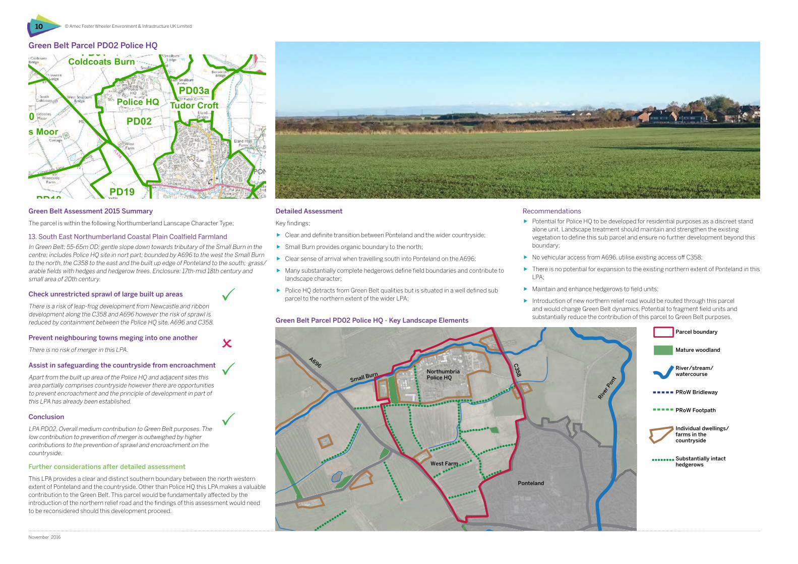
Green Belt Assessment 2015 Summary
The parcel is within the following Northumberland Lanscape Character Type;
13. South East Northumberland Coastal Plain Coalfield Farmland
In Green Belt; 55-65m OD; gentle slope down towards tributary of the Small Burn in the centre; includes Police HQ site in nort part; bounded by A696 to the west the Small Burn to the north, the C358 to the east and the built up edge of Ponteland to the south; grass/arable fields with hedges and hedgerow trees. Enclosure: 17th-mid 18th century and small area of 20th century.
Detailed Assessment
Key findings;
ff Clear and definite transition between Ponteland and the wider countryside;
ff Small Burn provides organic boundary to the north;
ff Clear sense of arrival when travelling south into Ponteland on the A696;
ff Many substantially complete hedgerows define field boundaries and contribute to landscape character;
ff Police HQ detracts from Green Belt qualities but is situated in a well defined sub parcel to the northern extent of the wider LPA;
Green Belt Parcel PD02 Police HQ
Recommendations
ff Potential for Police HQ to be developed for residential purposes as a discreet stand alone unit. Landscape treatment should maintain and strengthen the existing vegetation to define this sub parcel and ensure no further development beyond this boundary;
ff No vehicular access from A696, utilise existing access off C358;
ff There is no potential for expansion to the existing northern extent of Ponteland in this LPA;
ff Maintain and enhance hedgerows to field units;
ff Introduction of new northern relief road would be routed through this parcel and would change Green Belt dynamics. Potential to fragment field units and substantially reduce the contribution of this parcel to Green Belt purposes.Green Belt Parcel PD02 Police HQ - Key Landscape Elements
Check unrestricted sprawl of large built up areas
There is a risk of leap-frog development from Newcastle and ribbon development along the C358 and A696 however the risk of sprawl is reduced by containment between the Police HQ site, A696 and C358.
Prevent neighbouring towns meging into one another
There is no risk of merger in this LPA.
Assist in safeguarding the countryside from encroachment
Apart from the built up area of the Police HQ and adjacent sites this area partially comprises countryside however there are opportunities to prevent encroachment and the principle of development in part of this LPA has already been established.
Conclusion
LPA PD02, Overall medium contribution to Green Belt purposes. The low contribution to prevention of merger is outweighed by higher contributions to the prevention of sprawl and encroachment on the countryside.
Small Burn
A696
West Farm
Ponteland
Further considerations after detailed assessment
This LPA provides a clear and distinct southern boundary between the north western extent of Ponteland and the countryside. Other than Police HQ this LPA makes a valuable contribution to the Green Belt. This parcel would be fundamentally affected by the introduction of the northern relief road and the findings of this assessment would need to be reconsidered should this development proceed.
C3
58
Parcel boundary
Mature woodland
River/stream/watercourse
PRoW Bridleway
PRoW Footpath
Individual dwellings/farms in the countryside
Substantially intact hedgerows
© Amec Foster Wheeler Environment & Infrastructure UK Limited 11
November 2016
Green Belt Purpose / NPPF Assessment Criteria Assessment
1. To check the unrestricted sprawl of large built up areas
Would potential development represent an outward extension of the urban area, result in a physical connection between urban areas, or lead to the danger of a subsequent coalescence between such settlements?
If released from Green Belt could enduring long-term settlement boundaries be established?
Does the parcel sensibly round-off an existing built-up area to help create good built form?
This parcel includes the Police HQ which is being considered as a stand alone development. Other development would represent an outward extension of the urban area at the northern edge of Ponteland.
The introduction of the Northern Relief Road would bisect the parcel and affect Green Belt dynamics.
The edge of built development represents a clear distinct boundary and expansion of this development would not contribute to enhancement of built form.
2. To prevent neighbouring towns merging into one another
Would potential development in the parcel appear to result in the merging of towns or compromise the separation of towns physically?
Would potential development of the parcel be a significant step leading towards coalescence of two settlements?
There are no notable developments to the north of the parcel and as such does not contribute to prevention of merger. However, the development of the Police HQ and/or the residential development of the Police HQ plot would change this scenario. An open buffer would need to be maintained between Ponteland and the Police HQ to avoid merger of these settlements.
3. To assist in safeguarding the countryside from encroachment
Are there clear strong and robust boundaries to contain development and prevent encroachment in the long term? The Police HQ plot is fairly well defined by existing vegetation, trees and hedgerows and logically could become a disctreet stand alone sub unit within this parcel. The built form provides strong definition at the northern edge of Ponteland although this boundary should be reinforced with additional tree and hedgerow planting.
4. Overall Assessment of Contribution to Green Belt Purposes
In light of the assessment of individual purposes, what is the overall contribution of the parcel to the Green Belt, both individually and in a wider context?
Overall the parcel provides a strong contribution to the Green Belt particularly in relation to providing a clear and distinct boundary between urban form and the open countryside. This parcel includes the A696 entrance threshold to Ponteland where this clear distinction is evident.
5. Permanence of Green Belt (NPPF paragraphs 83 & 85)
Does the Green Belt boundary have long term permanence (defensible and durable) so that it is capable of enduring beyond the plan period?
Are the current boundaries logical?
Are there opportunities for the re-definition or ‘tidying-up’ of the boundary?
The potential developments in this parcel, including the Northern Relief Road and Police HQ developments, does introduce uncertainty about the future viability of this parcel.
The current boundaries are logical. The Police HQ itself is well defined and makes a logical stand alone unit. Future residential development should provide the opportunity to further strengthen boundaries for this sub-unit with appropriate planting and management of existing vegetation. The edge of Ponteland in this parcel currently provides a logical boundary but could be strengthend with hedge planting to fill hedgerow gaps and possibly pockets of woodland planting.
6. Sustainable patterns of development (NPPF paragraph 84)
Would potential development in this area help to promote sustainable patterns of development? Consider the specific consequences of channelling development towards urban areas inside the Green Belt boundary, towards towns and villages inset within the Green Belt or towards locations beyond the outer Green Belt boundary.
Developing Police HQ could be considered to be a ‘brownfield site’ within the wider Green Belt, therefore, development in this sub unit is considered sustainable and appropriate.
7. Opportunities for Public Access or to provide access
What is the degree of existing public access? Limited.
8. Opportunities for outdoor sport and recreation
Are there existing facilities, or there any relevant policies or proposals leading to opportunities in the parcel? Limited.
9. Enhancing landscapes and visual amenity Does the parcel form part of the setting of a sensitive landscape (historic or otherwise)? No.
10. Enhancing biodiversity Are there any national or local biodiversity designations within the parcel? No.
11. Improving derelict and damaged land Is there any derelict land in the parcel?
Is there any other potential for landscape enhancement?
No.
As per GBP 5. Strengthening the boundaries of the Police HQ sub unit and the northern edge of Ponteland with appropriate planting.
Table 4.1 Assessment Proforma - PD02 Police HQ
0 0.5 1 1.5 2 km
Land parcel (2015Assessment)
PD11
PD14
PD04
PD05
PD09b
PD17
PD16
PD12
PD07
PD20
PD13
PD01
PD18
SM02
PD02
PD03b
SM01
PD10
PD08
PD19
PD03a
PD06a
HWL01
PD06b
HWL04
PD09a
BY01
Heddon Birks
Eland Hall
South Dissington
Berwick Carr
Callerton Hall
PrestwickCoat Hill
Donkin House
Ecklindale
Coldcotes Moor
Heddon Steads
Police HQ
Coldcoats Burn
Dissington EastHouses
Birney Hall
Rotary Drive
Stamfordham South
Heddon Laws toEast of Medburn
Stamfordham East
West House
Tudor Croft
Clickemin
Dobbies GardenCentre
Heddon-on-the-Wall North East
Edge Hill
Heddon-on-the-Wall North West
408000 409000 410000 411000 412000 413000 414000 415000 416000 417000 418000 419000
5680
0056
9000
5700
0057
1000
5720
0057
3000
5740
0057
5000
5760
0057
7000
5780
00
Key
file:
H:\P
roje
cts\
3905
4 G
OS
Dis
sing
ton
Gar
den
Villa
ge\3
9054
-Gos
05.m
xd
1:40,000Scale at A3:
39054-Gos05.mxd robecOctober 2016
Dissington Garden VillageLandscape Appraisal andGreenbelt Assessment
Figure 6Greenbelt review without red lineboundary
Based upon the Ordnance Survey Map with the permission of the Controller of Her Majesty's Stationery Office. © Crown Copyright. 100001776
© Amec Foster Wheeler Environment & Infrastructure UK Limited12
November 2016
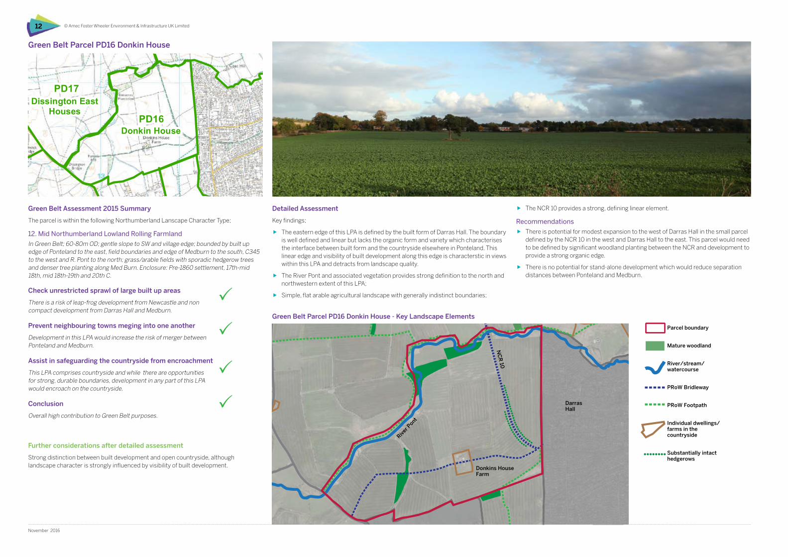
Green Belt Assessment 2015 Summary
The parcel is within the following Northumberland Lanscape Character Type;
12. Mid Northumberland Lowland Rolling Farmland
In Green Belt; 60-80m OD; gentle slope to SW and village edge; bounded by built up edge of Ponteland to the east, field boundaries and edge of Medburn to the south, C345 to the west and R. Pont to the north; grass/arable fields with sporadic hedgerow trees and denser tree planting along Med Burn. Enclosure: Pre-1860 settlement, 17th-mid 18th, mid 18th-19th and 20th C.
Detailed Assessment
Key findings;
ff The eastern edge of this LPA is defined by the built form of Darras Hall. The boundary is well defined and linear but lacks the organic form and variety which characterises the interface between built form and the countryside elsewhere in Ponteland. This linear edge and visibility of built development along this edge is characterstic in views within this LPA and detracts from landscape quality.
ff The River Pont and associated vegetation provides strong definition to the north and northwestern extent of this LPA;
ff Simple, flat arable agricultural landscape with generally indistinct boundaries;
Green Belt Parcel PD16 Donkin House
ff The NCR 10 provides a strong, defining linear element.
Recommendations
ff There is potential for modest expansion to the west of Darras Hall in the small parcel defined by the NCR 10 in the west and Darras Hall to the east. This parcel would need to be defined by significant woodland planting between the NCR and development to provide a strong organic edge.
ff There is no potential for stand-alone development which would reduce separation distances between Ponteland and Medburn.
Green Belt Parcel PD16 Donkin House - Key Landscape Elements
Check unrestricted sprawl of large built up areas
There is a risk of leap-frog development from Newcastle and non compact development from Darras Hall and Medburn.
Prevent neighbouring towns meging into one another
Development in this LPA would increase the risk of merger between Ponteland and Medburn.
Assist in safeguarding the countryside from encroachment
This LPA comprises countryside and while there are opportunities for strong, durable boundaries, development in any part of this LPA would encroach on the countryside.
Conclusion
Overall high contribution to Green Belt purposes.
Further considerations after detailed assessment
Strong distinction between built development and open countryside, although landscape character is strongly influenced by visibility of built development.
DarrasHall
Donkins HouseFarm
NC
R 10
River P
ont
Parcel boundary
Mature woodland
River/stream/watercourse
PRoW Bridleway
PRoW Footpath
Individual dwellings/farms in the countryside
Substantially intact hedgerows
© Amec Foster Wheeler Environment & Infrastructure UK Limited 13
November 2016
Green Belt Purpose / NPPF Assessment Criteria Assessment
1. To check the unrestricted sprawl of large built up areas
Would potential development represent an outward extension of the urban area, result in a physical connection between urban areas, or lead to the danger of a subsequent coalescence between such settlements?
If released from Green Belt could enduring long-term settlement boundaries be established?
Does the parcel sensibly round-off an existing built-up area to help create good built form?
Development within the southern sector of this parcel would lead to increased possibility of merger with Medburn but not with any large urban areas.
The NCR 10 on the former railway line provides a potential opportunity to create a strong boundary and redefine the settlement edge to the northwestern extent of Darras Hall.
Development in the area to the east of NCR 10 has the potential to provide a more logical pattern of built form to the north western extent of Ponteland.
2. To prevent neighbouring towns merging into one another
Would potential development in the parcel appear to result in the merging of towns or compromise the separation of towns physically?
Would potential development of the parcel be a significant step leading towards coalescence of two settlements?
No potential for the merger of towns but development in the southern sector of this parcel could lead to the danger of coalescence with Medburn.
3. To assist in safeguarding the countryside from encroachment
Are there clear strong and robust boundaries to contain development and prevent encroachment in the long term? The River Pont and NCR10 are strong logical boundaries. The interface between the built form of Darras Hall and the wider countryside is distinct but less robust.
4. Overall Assessment of Contribution to Green Belt Purposes
In light of the assessment of individual purposes, what is the overall contribution of the parcel to the Green Belt, both individually and in a wider context?
Parcel provides strong Green Belt contribution particularly in relation to prevention of coalescence with Medburn.
5. Permanence of Green Belt (NPPF paragraphs 83 & 85)
Does the Green Belt boundary have long term permanence (defensible and durable) so that it is capable of enduring beyond the plan period?
Are the current boundaries logical?
Are there opportunities for the re-definition or ‘tidying-up’ of the boundary?
The current boundaries to the south, west and north west are logical. Medburn village largely defines the southern boundary and the River Pont largely defines the the western and northwestern boundaries. The eastern boundary of the parcel is defined by the built form of Darras Hall which is a straight, linear feature at this point contrasting with the more organic boundary which defines the urban edge elsewhere in Ponteland. This factor is considered to detract from landscape quality in this parcel.
The opportunity exists to reconfigure this parcel to create a stronger and more organic boundary using the NCR 10 to define the north eastern extent of the unit. This boundary should be reinforced with woodland planting to provide a visual linkage with the existing plantations to the north
6. Sustainable patterns of development (NPPF paragraph 84)
Would potential development in this area help to promote sustainable patterns of development? Consider the specific consequences of channelling development towards urban areas inside the Green Belt boundary, towards towns and villages inset within the Green Belt or towards locations beyond the outer Green Belt boundary.
Limited development, bounded by the NCR10 would provide a sustainable extension to the existing Ponteland/Darras hall settlement. Further development would push the focus towards Medburn which has limited services.
7. Opportunities for Public Access or to provide access
What is the degree of existing public access? Strong PRoW network provides good access.
8. Opportunities for outdoor sport and recreation
Are there existing facilities, or there any relevant policies or proposals leading to opportunities in the parcel? NCR10 provides opportunities for cycling and links to the wider path network.
9. Enhancing landscapes and visual amenity Does the parcel form part of the setting of a sensitive landscape (historic or otherwise)? No.
10. Enhancing biodiversity Are there any national or local biodiversity designations within the parcel? No.
11. Improving derelict and damaged land Is there any derelict land in the parcel?
Is there any other potential for landscape enhancement?
No.
As per GBP 5.
Table 4.2 Assessment Proforma - PD16 Donkin House
0 0.5 1 1.5 2 km
Land parcel (2015Assessment)
PD11
PD14
PD04
PD05
PD09b
PD17
PD16
PD12
PD07
PD20
PD13
PD01
PD18
SM02
PD02
PD03b
SM01
PD10
PD08
PD19
PD03a
PD06a
HWL01
PD06b
HWL04
PD09a
BY01
Heddon Birks
Eland Hall
South Dissington
Berwick Carr
Callerton Hall
PrestwickCoat Hill
Donkin House
Ecklindale
Coldcotes Moor
Heddon Steads
Police HQ
Coldcoats Burn
Dissington EastHouses
Birney Hall
Rotary Drive
Stamfordham South
Heddon Laws toEast of Medburn
Stamfordham East
West House
Tudor Croft
Clickemin
Dobbies GardenCentre
Heddon-on-the-Wall North East
Edge Hill
Heddon-on-the-Wall North West
408000 409000 410000 411000 412000 413000 414000 415000 416000 417000 418000 419000
5680
0056
9000
5700
0057
1000
5720
0057
3000
5740
0057
5000
5760
0057
7000
5780
00
Key
file:
H:\P
roje
cts\
3905
4 G
OS
Dis
sing
ton
Gar
den
Villa
ge\3
9054
-Gos
05.m
xd
1:40,000Scale at A3:
39054-Gos05.mxd robecOctober 2016
Dissington Garden VillageLandscape Appraisal andGreenbelt Assessment
Figure 6Greenbelt review without red lineboundary
Based upon the Ordnance Survey Map with the permission of the Controller of Her Majesty's Stationery Office. © Crown Copyright. 100001776
© Amec Foster Wheeler Environment & Infrastructure UK Limited14
November 2016
Green Belt Assessment 2015 Summary
The parcel is within the following Lanscape character area;
12. Mid Northumberland Lowland Rolling Farmland
In Green Belt adjacent to village; 60-85m OD gentle slope to E and S to R.Pont on S edge; bounded by built up edge of Ponteland to southfield boundaries to west and east and C357 (Limestone Lane) to north; large grass/arable fields with no hedges but several coniferous plantations. Enclosure: 17th-mid 18th, mid 18th-19th and 20th C.
Detailed Assessment
Key findings;
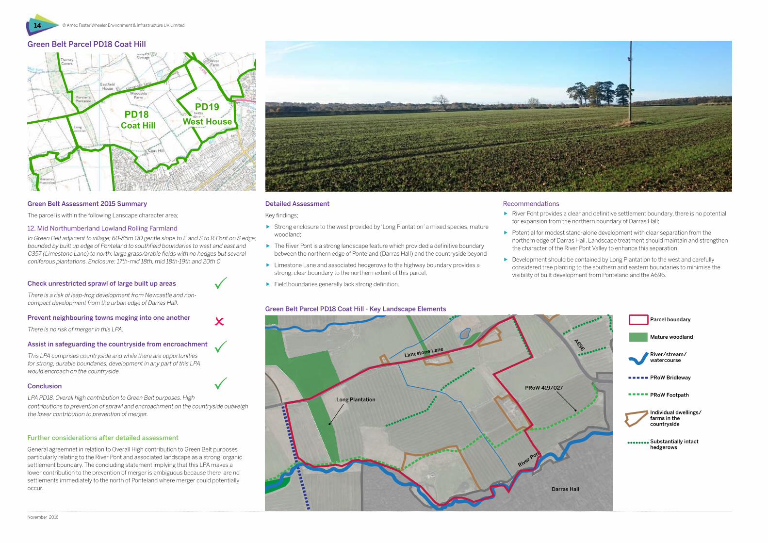
ff Strong enclosure to the west provided by ‘Long Plantation’ a mixed species, mature woodland;
ff The River Pont is a strong landscape feature which provided a definitive boundary between the northern edge of Ponteland (Darras Hall) and the countryside beyond
ff Limestone Lane and associated hedgerows to the highway boundary provides a strong, clear boundary to the northern extent of this parcel;
ff Field boundaries generally lack strong definition.
Green Belt Parcel PD18 Coat Hill
Recommendations
ff River Pont provides a clear and definitive settlement boundary, there is no potential for expansion from the northern boundary of Darras Hall;
ff Potential for modest stand-alone development with clear separation from the northern edge of Darras Hall. Landscape treatment should maintain and strengthen the character of the River Pont Valley to enhance this separation;
ff Development should be contained by Long Plantation to the west and carefully considered tree planting to the southern and eastern boundaries to minimise the visibility of built development from Ponteland and the A696.
Green Belt Parcel PD18 Coat Hill - Key Landscape Elements
Check unrestricted sprawl of large built up areas
There is a risk of leap-frog development from Newcastle and non-compact development from the urban edge of Darras Hall.
Prevent neighbouring towns meging into one another
There is no risk of merger in this LPA.
Assist in safeguarding the countryside from encroachment
This LPA comprises countryside and while there are opportunities for strong, durable boundaries, development in any part of this LPA would encroach on the countryside.
Conclusion
LPA PD18, Overall high contribution to Green Belt purposes. High
River Pont
Limestone Lane
A696
Long Plantation
PRoW 419/027
Darras Hall
contributions to prevention of sprawl and encroachment on the countryside outweigh the lower contribution to prevention of merger.
Further considerations after detailed assessment
General agreemnet in relation to Overall High contribution to Green Belt purposes particularly relating to the River Pont and associated landscape as a strong, organic settlement boundary. The concluding statement implying that this LPA makes a lower contribution to the prevention of merger is ambiguous because there are no settlements immediately to the north of Ponteland where merger could potentially occur.
Parcel boundary
Mature woodland
River/stream/watercourse
PRoW Bridleway
PRoW Footpath
Individual dwellings/farms in the countryside
Substantially intact hedgerows
© Amec Foster Wheeler Environment & Infrastructure UK Limited 15
November 2016
Green Belt Purpose / NPPF Assessment Criteria Assessment
1. To check the unrestricted sprawl of large built up areas
Would potential development represent an outward extension of the urban area, result in a physical connection between urban areas, or lead to the danger of a subsequent coalescence between such settlements?
If released from Green Belt could enduring long-term settlement boundaries be established?
Does the parcel sensibly round-off an existing built-up area to help create good built form?
No. There is no potential for physical connection or coalescence.
The existing northern settlement edge of Ponteland is reinforced by the River Pont and associated vegetation providing a distinct and appropriate settlement edge. Long term boundaries could be created for a stand alone development by strengthening existing boundaries such as hedgerows, woodland and highways.
The edge of built development represents a clear distinct boundary and expansion of this development would not contribute to enhancement of built form.
2. To prevent neighbouring towns merging into one another
Would potential development in the parcel appear to result in the merging of towns or compromise the separation of towns physically?
Would potential development of the parcel be a significant step leading towards coalescence of two settlements?
No, there are no notable developments to the north of the parcel and as such it does not contribute to prevention of merger and there is no potential for coalescence.
Providing development in the Police HQ plot does not extend beyond the present well defined boundaries of the Police HQ site there is no potential for development in the two parcels to coalesce.
3. To assist in safeguarding the countryside from encroachment
Are there clear strong and robust boundaries to contain development and prevent encroachment in the long term? Yes, the River Pont and existing urban edge defines a distinct settlement boundary.
4. Overall Assessment of Contribution to Green Belt Purposes
In light of the assessment of individual purposes, what is the overall contribution of the parcel to the Green Belt, both individually and in a wider context?
Overall he parcel provides a strong contribution to the Green Belt particularly in relation to providing a clear and distinct boundary at the River Pont.
5. Permanence of Green Belt (NPPF paragraphs 83 & 85)
Does the Green Belt boundary have long term permanence (defensible and durable) so that it is capable of enduring beyond the plan period?
Are the current boundaries logical?
Are there opportunities for the re-definition or ‘tidying-up’ of the boundary?
The southern boundary defined by the River Pont is logical and the northern boundary defined by Limestone Lane is also logical. The western boundary defined by the NCR 10 is more debatable and could be defined by Long Plantation which is a stronger visual element although it could be argued that the NCR10 is more permanent. The eastern boundary with PD19 West House is slightly arbitary and could be defined more rationally by linking individual dwellings/farms to provide boundary definition.
6. Sustainable patterns of development (NPPF paragraph 84)
Would potential development in this area help to promote sustainable patterns of development? Consider the specific consequences of channelling development towards urban areas inside the Green Belt boundary, towards towns and villages inset within the Green Belt or towards locations beyond the outer Green Belt boundary.
Development in this plot could create a stand alone development of a scale to provide appropriate local services whilst being close to the more substantial services of ponteland.
7. Opportunities for Public Access or to provide access
What is the degree of existing public access? A single PRoW provides reasonable access to the south of the parcel.
8. Opportunities for outdoor sport and recreation
Are there existing facilities, or there any relevant policies or proposals leading to opportunities in the parcel? Limited.
9. Enhancing landscapes and visual amenity Does the parcel form part of the setting of a sensitive landscape (historic or otherwise)? No.
10. Enhancing biodiversity Are there any national or local biodiversity designations within the parcel? No.
11. Improving derelict and damaged land Is there any derelict land in the parcel?
Is there any other potential for landscape enhancement?
No.
No.
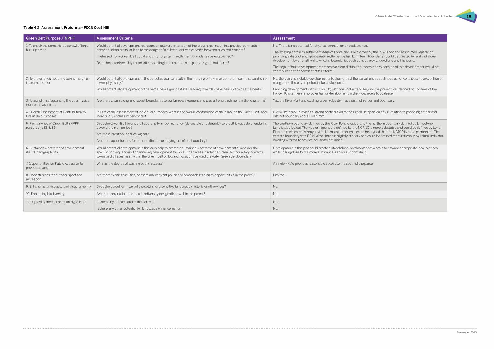
Table 4.3 Assessment Proforma - PD18 Coat Hill
0 0.5 1 1.5 2 km
Land parcel (2015Assessment)
PD11
PD14
PD04
PD05
PD09b
PD17
PD16
PD12
PD07
PD20
PD13
PD01
PD18
SM02
PD02
PD03b
SM01
PD10
PD08
PD19
PD03a
PD06a
HWL01
PD06b
HWL04
PD09a
BY01
Heddon Birks
Eland Hall
South Dissington
Berwick Carr
Callerton Hall
PrestwickCoat Hill
Donkin House
Ecklindale
Coldcotes Moor
Heddon Steads
Police HQ
Coldcoats Burn
Dissington EastHouses
Birney Hall
Rotary Drive
Stamfordham South
Heddon Laws toEast of Medburn
Stamfordham East
West House
Tudor Croft
Clickemin
Dobbies GardenCentre
Heddon-on-the-Wall North East
Edge Hill
Heddon-on-the-Wall North West
408000 409000 410000 411000 412000 413000 414000 415000 416000 417000 418000 419000
5680
0056
9000
5700
0057
1000
5720
0057
3000
5740
0057
5000
5760
0057
7000
5780
00
Key
file:
H:\P
roje
cts\
3905
4 G
OS
Dis
sing
ton
Gar
den
Villa
ge\3
9054
-Gos
05.m
xd
1:40,000Scale at A3:
39054-Gos05.mxd robecOctober 2016
Dissington Garden VillageLandscape Appraisal andGreenbelt Assessment
Figure 6Greenbelt review without red lineboundary
Based upon the Ordnance Survey Map with the permission of the Controller of Her Majesty's Stationery Office. © Crown Copyright. 100001776
© Amec Foster Wheeler Environment & Infrastructure UK Limited16
November 2016
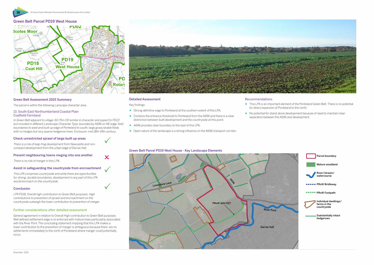
Green Belt Parcel PD19 West House
Green Belt Assessment 2015 Summary
The parcel is within the following Lanscape character area;
13. South East Northumberland Coastal Plain Coalfield Farmland
In Green Belt adjacent to village; 60-75m OD similar in character and aspect to PD22 but included in different Landscape Character Type; bounded by A696 on NE edge, field boundaries to west and built up edge of Ponteland to south; large grass/arable fields with no hedges but very sparse hedgerow trees. Enclosure: mid 18th-19th century.
Check unrestricted sprawl of large built up areas
There is a risk of leap-frog development from Newcastle and non-compact development from the urban edge of Darras Hall.
Prevent neighbouring towns meging into one another
There is no risk of merger in this LPA.
Assist in safeguarding the countryside from encroachment
This LPA comprises countryside and while there are opportunities for strong, durable boundaries, development in any part of this LPA would encroach on the countryside.
Conclusion
LPA PD18, Overall high contribution to Green Belt purposes. High contributions to prevention of sprawl and encroachment on the countryside outweigh the lower contribution to prevention of merger.
Further considerations after detailed assessment
General agreement in relation to Overall High contribution to Green Belt purposes. Well defined settlement edge is re-enforced with mature trees particularly associated with the River Pont. The concluding statement implying that this LPA makes a lower contribution to the prevention of merger is ambiguous because there are no settlements immediately to the north of Ponteland where merger could potentially occur.
Detailed Assessment
Key findings;
ff Strong definitive edge to Ponteland at the southern extent of this LPA;
ff Contains the entrance threshold to Ponteland from the A696 and there is a clear distinction between built development and the countryside at this point;
ff A696 provides clear boundary to the east of this LPA;
ff Open nature of the landscape is a strong influence on the A696 transport corridor.
Recommendations
ff This LPA is an important element of the Ponteland Green Belt. There is no potential for direct expansion of Ponteland to the north;
ff No potential for stand-alone development because of need to maintain clear separation between the A696 and development.
Green Belt Parcel PD19 West House - Key Landscape Elements
River Pont
Limestone Lane
A696
PRoW 419/027
Darras Hall
Parcel boundary
Mature woodland
River/stream/watercourse
PRoW Bridleway
PRoW Footpath
Individual dwellings/farms in the countryside
Substantially intact hedgerows
© Amec Foster Wheeler Environment & Infrastructure UK Limited 17
November 2016
Green Belt Purpose / NPPF Assessment Criteria Assessment
1. To check the unrestricted sprawl of large built up areas
Would potential development represent an outward extension of the urban area, result in a physical connection between urban areas, or lead to the danger of a subsequent coalescence between such settlements?
If released from Green Belt could enduring long-term settlement boundaries be established?
Does the parcel sensibly round-off an existing built-up area to help create good built form?
There are no concerns regarding physical connections with other urban areas or coalescence between settlements.
The edge of built development represents a clear distinct boundary and expansion of this development would not contribute to enhancement of built form.
2. To prevent neighbouring towns merging into one another
Would potential development in the parcel appear to result in the merging of towns or compromise the separation of towns physically?
Would potential development of the parcel be a significant step leading towards coalescence of two settlements?
There are no notable developments to the north of the parcel and as such does not contribute to prevention of merger.
3. To assist in safeguarding the countryside from encroachment
Are there clear strong and robust boundaries to contain development and prevent encroachment in the long term? The River Pont, A696 and Foxcovert Lane provide strong boundaries reinforced with mature trees or hedges to highway boundaries.
4. Overall Assessment of Contribution to Green Belt Purposes
In light of the assessment of individual purposes, what is the overall contribution of the parcel to the Green Belt, both individually and in a wider context?
Overall the parcel provides a strong contribution to the Green Belt particularly in relation to providing a clear and distinct boundary between urban form and the open countryside. This parcel includes the A696 entrance threshold to Ponteland where this clear distinction is evident.
5. Permanence of Green Belt (NPPF paragraphs 83 & 85)
Does the Green Belt boundary have long term permanence (defensible and durable) so that it is capable of enduring beyond the plan period?
Are the current boundaries logical?
Are there opportunities for the re-definition or ‘tidying-up’ of the boundary?
The current boundaries are generally logical other than the boundary with PD18 Coat Hill which would benefit from rationalisation. There is the opportunity to strengthen the southern boundary at Foxcovert Lane with hedgerow/ woodland planting.
6. Sustainable patterns of development (NPPF paragraph 84)
Would potential development in this area help to promote sustainable patterns of development? Consider the specific consequences of channelling development towards urban areas inside the Green Belt boundary, towards towns and villages inset within the Green Belt or towards locations beyond the outer Green Belt boundary.
It is considererd that built development in this parcel is not appropriate because of the role it plays in providing open countryside immediately beyond the urban edge of Ponteland at the entrance threshold of the A696.
7. Opportunities for Public Access or to provide access
What is the degree of existing public access? A single PRoW provides reasonable access to the south of the parcel.
8. Opportunities for outdoor sport and recreation
Are there existing facilities, or are there any relevant policies or proposals leading to opportunities in the parcel? Limited.
9. Enhancing landscapes and visual amenity Does the parcel form part of the setting of a sensitive landscape (historic or otherwise)? No.
10. Enhancing biodiversity Are there any national or local biodiversity designations within the parcel? No.
11. Improving derelict and damaged land Is there any derelict land in the parcel?
Is there any other potential for landscape enhancement?
No.
As per GBP 5.
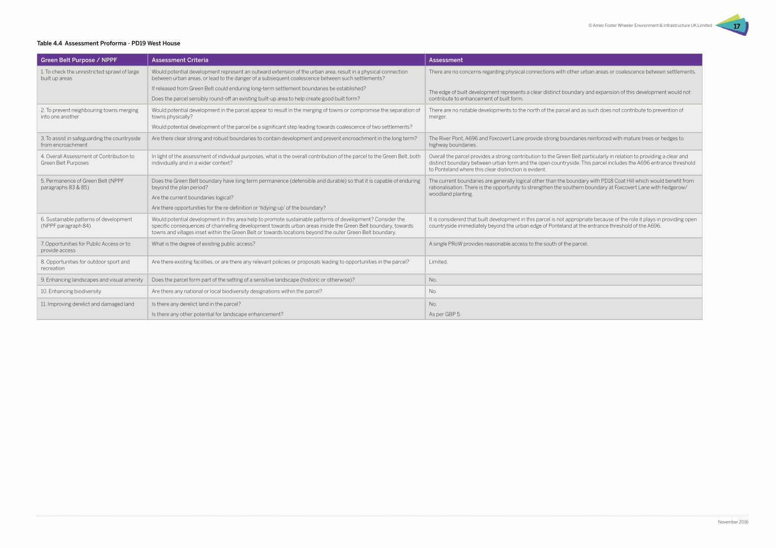
Table 4.4 Assessment Proforma - PD19 West House
0 0.5 1 1.5 2 km
Land parcel (2015Assessment)
PD11
PD14
PD04
PD05
PD09b
PD17
PD16
PD12
PD07
PD20
PD13
PD01
PD18
SM02
PD02
PD03b
SM01
PD10
PD08
PD19
PD03a
PD06a
HWL01
PD06b
HWL04
PD09a
BY01
Heddon Birks
Eland Hall
South Dissington
Berwick Carr
Callerton Hall
PrestwickCoat Hill
Donkin House
Ecklindale
Coldcotes Moor
Heddon Steads
Police HQ
Coldcoats Burn
Dissington EastHouses
Birney Hall
Rotary Drive
Stamfordham South
Heddon Laws toEast of Medburn
Stamfordham East
West House
Tudor Croft
Clickemin
Dobbies GardenCentre
Heddon-on-the-Wall North East
Edge Hill
Heddon-on-the-Wall North West
408000 409000 410000 411000 412000 413000 414000 415000 416000 417000 418000 419000
5680
0056
9000
5700
0057
1000
5720
0057
3000
5740
0057
5000
5760
0057
7000
5780
00
Key
file:
H:\P
roje
cts\
3905
4 G
OS
Dis
sing
ton
Gar
den
Villa
ge\3
9054
-Gos
05.m
xd
1:40,000Scale at A3:
39054-Gos05.mxd robecOctober 2016
Dissington Garden VillageLandscape Appraisal andGreenbelt Assessment
Figure 6Greenbelt review without red lineboundary
Based upon the Ordnance Survey Map with the permission of the Controller of Her Majesty's Stationery Office. © Crown Copyright. 100001776
© Amec Foster Wheeler Environment & Infrastructure UK Limited18
November 2016
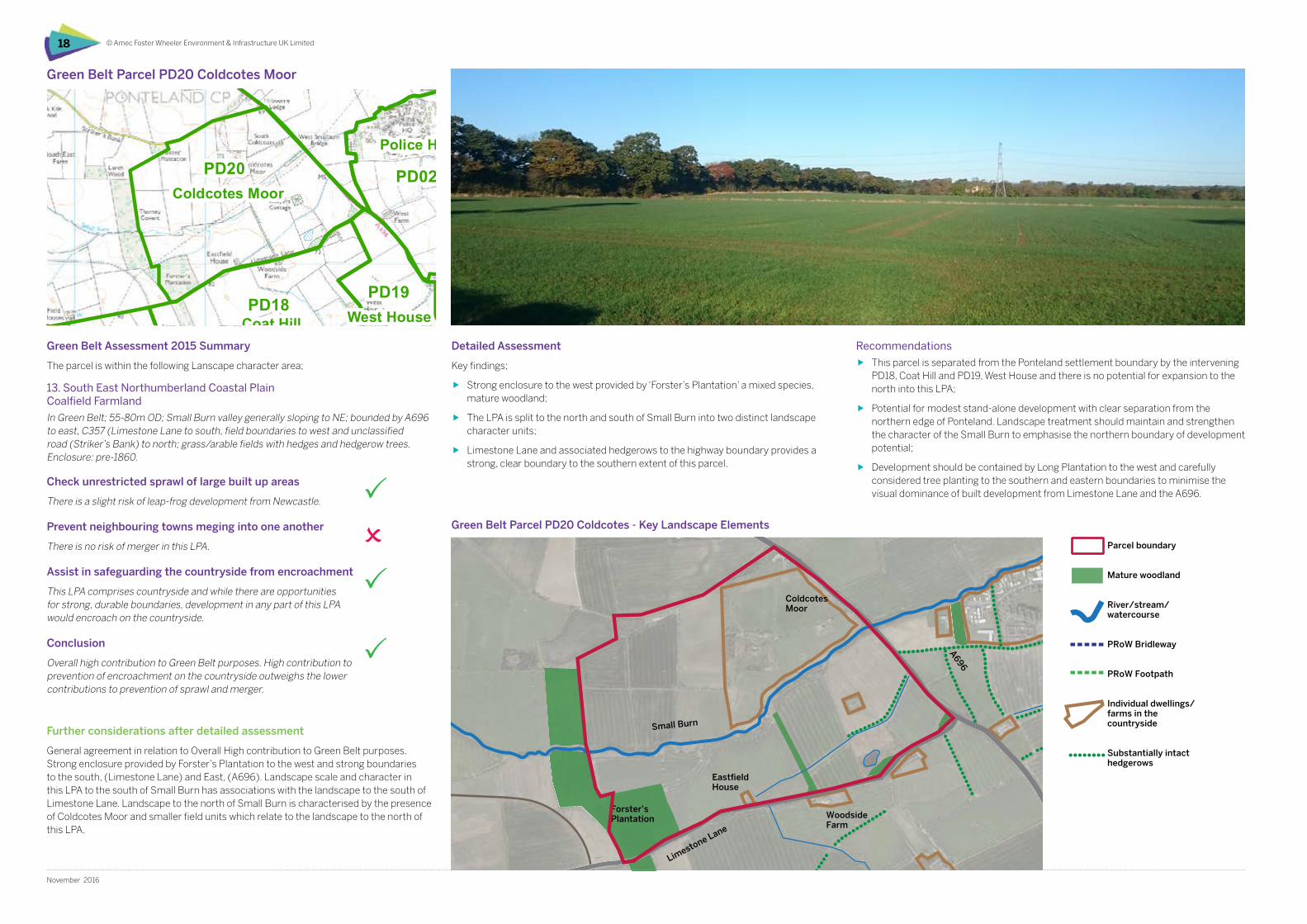
Detailed Assessment
Key findings;
ff Strong enclosure to the west provided by ‘Forster’s Plantation’ a mixed species, mature woodland;
ff The LPA is split to the north and south of Small Burn into two distinct landscape character units;
ff Limestone Lane and associated hedgerows to the highway boundary provides a strong, clear boundary to the southern extent of this parcel.
Green Belt Parcel PD20 Coldcotes Moor
Recommendations
ff This parcel is separated from the Ponteland settlement boundary by the intervening PD18, Coat Hill and PD19, West House and there is no potential for expansion to the north into this LPA;
ff Potential for modest stand-alone development with clear separation from the northern edge of Ponteland. Landscape treatment should maintain and strengthen the character of the Small Burn to emphasise the northern boundary of development potential;
ff Development should be contained by Long Plantation to the west and carefully considered tree planting to the southern and eastern boundaries to minimise the visual dominance of built development from Limestone Lane and the A696.
Green Belt Parcel PD20 Coldcotes - Key Landscape Elements
Green Belt Assessment 2015 Summary
The parcel is within the following Lanscape character area;
13. South East Northumberland Coastal Plain Coalfield Farmland
In Green Belt; 55-80m OD; Small Burn valley generally sloping to NE; bounded by A696 to east, C357 (Limestone Lane to south, field boundaries to west and unclassified road (Striker’s Bank) to north; grass/arable fields with hedges and hedgerow trees. Enclosure: pre-1860.
Check unrestricted sprawl of large built up areas
There is a slight risk of leap-frog development from Newcastle.
Prevent neighbouring towns meging into one another
There is no risk of merger in this LPA.
Assist in safeguarding the countryside from encroachment
This LPA comprises countryside and while there are opportunities for strong, durable boundaries, development in any part of this LPA would encroach on the countryside.
Conclusion
Overall high contribution to Green Belt purposes. High contribution to prevention of encroachment on the countryside outweighs the lower contributions to prevention of sprawl and merger.
Further considerations after detailed assessment
General agreement in relation to Overall High contribution to Green Belt purposes. Strong enclosure provided by Forster’s Plantation to the west and strong boundaries to the south, (Limestone Lane) and East, (A696). Landscape scale and character in this LPA to the south of Small Burn has associations with the landscape to the south of Limestone Lane. Landscape to the north of Small Burn is characterised by the presence of Coldcotes Moor and smaller field units which relate to the landscape to the north of this LPA.
Small Burn
Limestone Lane
A696
EastfieldHouse
Woodside Farm
Coldcotes Moor
Forster’s Plantation
Parcel boundary
Mature woodland
River/stream/watercourse
PRoW Bridleway
PRoW Footpath
Individual dwellings/farms in the countryside
Substantially intact hedgerows
© Amec Foster Wheeler Environment & Infrastructure UK Limited 19
November 2016
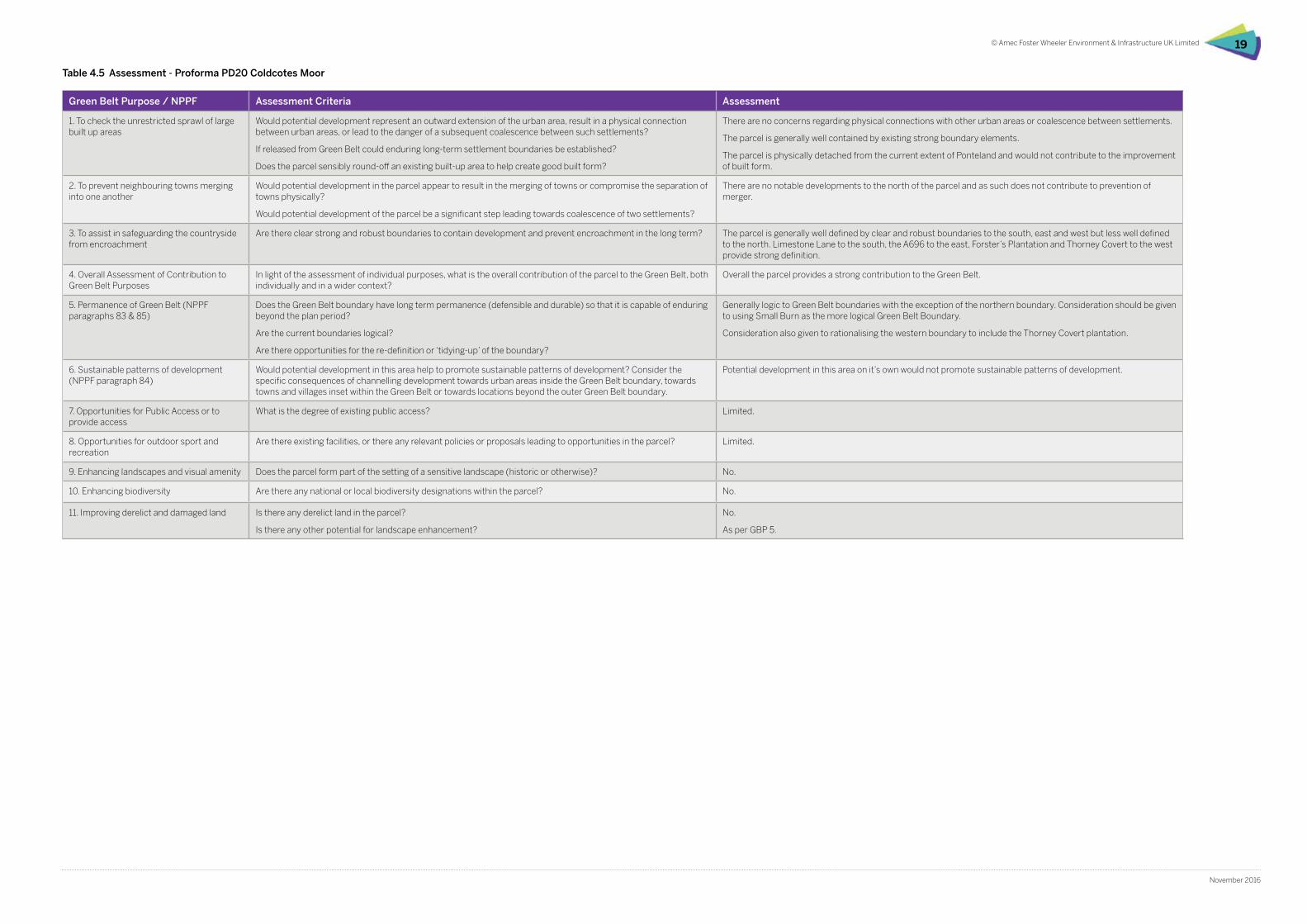
Green Belt Purpose / NPPF Assessment Criteria Assessment
1. To check the unrestricted sprawl of large built up areas
Would potential development represent an outward extension of the urban area, result in a physical connection between urban areas, or lead to the danger of a subsequent coalescence between such settlements?
If released from Green Belt could enduring long-term settlement boundaries be established?
Does the parcel sensibly round-off an existing built-up area to help create good built form?
There are no concerns regarding physical connections with other urban areas or coalescence between settlements.
The parcel is generally well contained by existing strong boundary elements.
The parcel is physically detached from the current extent of Ponteland and would not contribute to the improvement of built form.
2. To prevent neighbouring towns merging into one another
Would potential development in the parcel appear to result in the merging of towns or compromise the separation of towns physically?
Would potential development of the parcel be a significant step leading towards coalescence of two settlements?
There are no notable developments to the north of the parcel and as such does not contribute to prevention of merger.
3. To assist in safeguarding the countryside from encroachment
Are there clear strong and robust boundaries to contain development and prevent encroachment in the long term? The parcel is generally well defined by clear and robust boundaries to the south, east and west but less well defined to the north. Limestone Lane to the south, the A696 to the east, Forster’s Plantation and Thorney Covert to the west provide strong definition.
4. Overall Assessment of Contribution to Green Belt Purposes
In light of the assessment of individual purposes, what is the overall contribution of the parcel to the Green Belt, both individually and in a wider context?
Overall the parcel provides a strong contribution to the Green Belt.
5. Permanence of Green Belt (NPPF paragraphs 83 & 85)
Does the Green Belt boundary have long term permanence (defensible and durable) so that it is capable of enduring beyond the plan period?
Are the current boundaries logical?
Are there opportunities for the re-definition or ‘tidying-up’ of the boundary?
Generally logic to Green Belt boundaries with the exception of the northern boundary. Consideration should be given to using Small Burn as the more logical Green Belt Boundary.
Consideration also given to rationalising the western boundary to include the Thorney Covert plantation.
6. Sustainable patterns of development (NPPF paragraph 84)
Would potential development in this area help to promote sustainable patterns of development? Consider the specific consequences of channelling development towards urban areas inside the Green Belt boundary, towards towns and villages inset within the Green Belt or towards locations beyond the outer Green Belt boundary.
Potential development in this area on it’s own would not promote sustainable patterns of development.
7. Opportunities for Public Access or to provide access
What is the degree of existing public access? Limited.
8. Opportunities for outdoor sport and recreation
Are there existing facilities, or there any relevant policies or proposals leading to opportunities in the parcel? Limited.
9. Enhancing landscapes and visual amenity Does the parcel form part of the setting of a sensitive landscape (historic or otherwise)? No.
10. Enhancing biodiversity Are there any national or local biodiversity designations within the parcel? No.
11. Improving derelict and damaged land Is there any derelict land in the parcel?
Is there any other potential for landscape enhancement?
No.
As per GBP 5.
Table 4.5 Assessment - Proforma PD20 Coldcotes Moor
0 0.5 1 1.5 2 km
Masterplan boundary
5km study area
Emerging Greenbelt
Existing Greenbelt
408000 409000 410000 411000 412000 413000 414000 415000 416000 417000 418000 419000
5680
0056
9000
5700
0057
1000
5720
0057
3000
5740
0057
5000
5760
0057
7000
5780
00
Key
file:
H:\P
roje
cts\
3905
4 G
OS
Dis
sing
ton
Gar
den
Villa
ge\3
9054
-Gos
02.m
xd
1:40,000Scale at A3:
39054-Gos02.mxd robecOctober 2016
Dissington Garden VillageLandscape Appraisal andGreenbelt Assessment
Figure 3Existing and proposed Green Beltwith red line boundary
Based upon the Ordnance Survey Map with the permission of the Controller of Her Majesty's Stationery Office. © Crown Copyright. 100001776
© Amec Foster Wheeler Environment & Infrastructure UK Limited20
November 2016
Based upon the Ordnance Survey Map with the permission of the Controller of Her Majesty’s Stationery Office. © Crown Copyright. 100001776.
Figure 4.3 – Proposed Ponteland Green Belt
Proposed site
5km study area
Existing Green Belt
Proposed Green Belt release
Green Belt extension
0 0.5 1 1.5 2 km
Emerging Greenbelt
Existing Greenbelt
408000 409000 410000 411000 412000 413000 414000 415000 416000 417000 418000 419000
5680
0056
9000
5700
0057
1000
5720
0057
3000
5740
0057
5000
5760
0057
7000
5780
00
Key
file:
H:\P
roje
cts\
3905
4 G
OS
Dis
sing
ton
Gar
den
Villa
ge\3
9054
-Gos
03.m
xd
1:40,000Scale at A3:
39054-Gos03.mxd robecOctober 2016
Dissington Garden VillageLandscape Appraisal andGreenbelt Assessment
Figure 4Existing and proposed Green Beltwithout red line boundary
Based upon the Ordnance Survey Map with the permission of the Controller of Her Majesty's Stationery Office. © Crown Copyright. 100001776
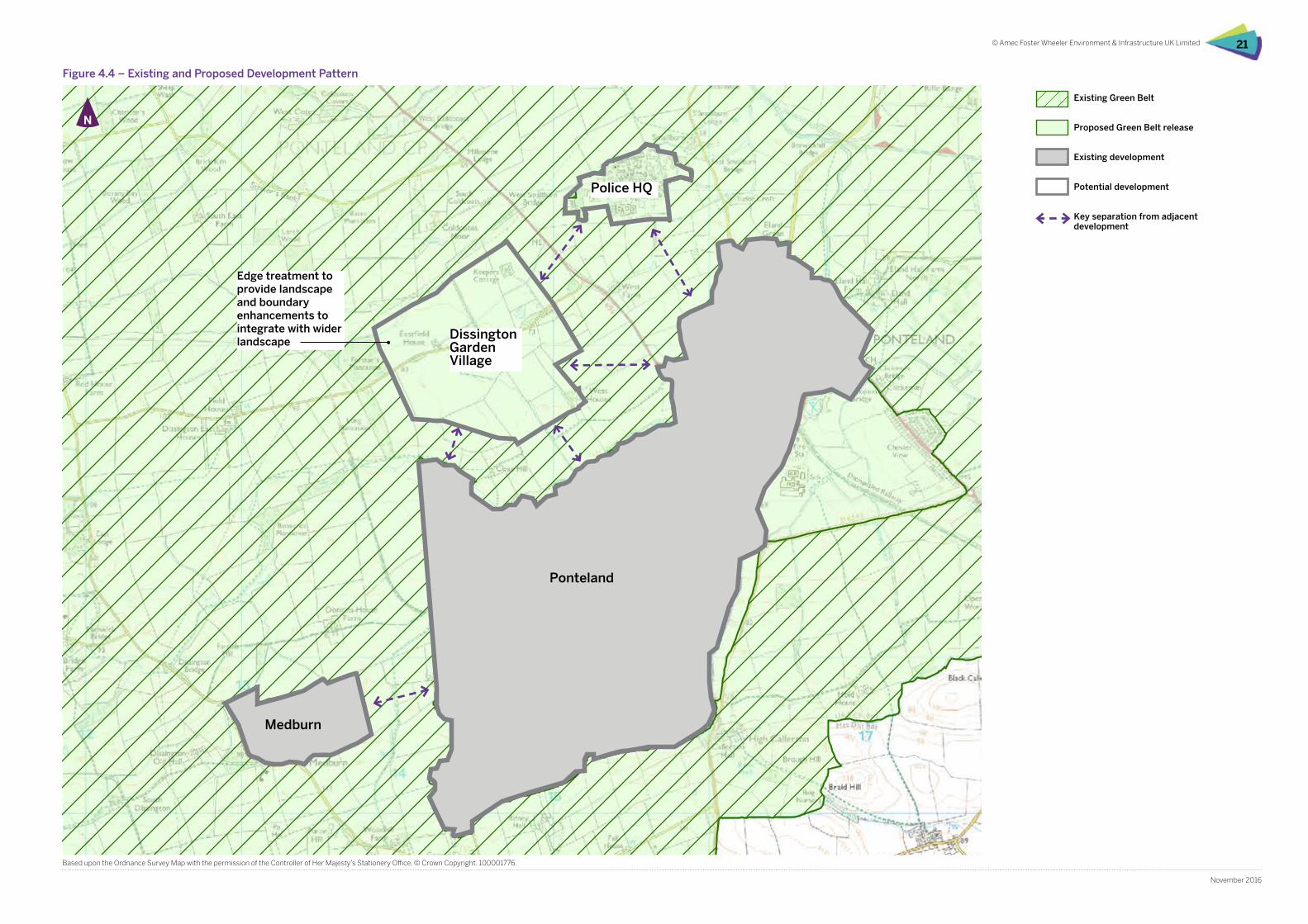
© Amec Foster Wheeler Environment & Infrastructure UK Limited 21
November 2016
Based upon the Ordnance Survey Map with the permission of the Controller of Her Majesty’s Stationery Office. © Crown Copyright. 100001776.
Figure 4.4 – Existing and Proposed Development Pattern
Ponteland
Medburn
Dissington Garden Village
Police HQ
Existing Green Belt
Proposed Green Belt release
Existing development
Potential development
Key separation from adjacent development
Edge treatment to provide landscape and boundary enhancements to integrate with wider landscape
0 0.5 1 1.5 2 km
Emerging Greenbelt
Existing Greenbelt
408000 409000 410000 411000 412000 413000 414000 415000 416000 417000 418000 419000
5680
0056
9000
5700
0057
1000
5720
0057
3000
5740
0057
5000
5760
0057
7000
5780
00
Key
file:
H:\P
roje
cts\
3905
4 G
OS
Dis
sing
ton
Gar
den
Villa
ge\3
9054
-Gos
03.m
xd
1:40,000Scale at A3:
39054-Gos03.mxd robecOctober 2016
Dissington Garden VillageLandscape Appraisal andGreenbelt Assessment
Figure 4Existing and proposed Green Beltwithout red line boundary
Based upon the Ordnance Survey Map with the permission of the Controller of Her Majesty's Stationery Office. © Crown Copyright. 100001776
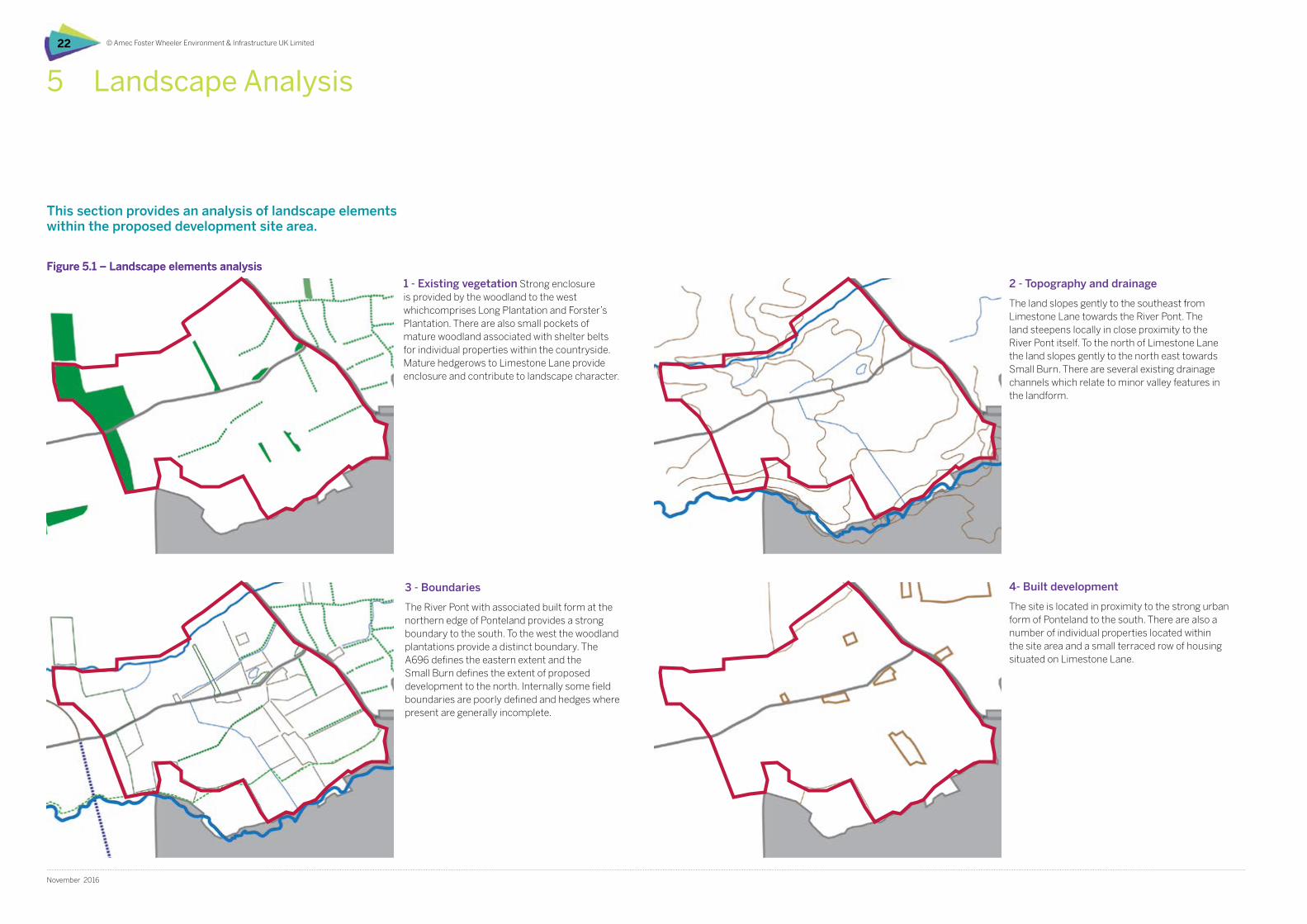
© Amec Foster Wheeler Environment & Infrastructure UK Limited22
November 2016
This section provides an analysis of landscape elements within the proposed development site area.
5 Landscape Analysis
Figure 5.1 – Landscape elements analysis
1 - Existing vegetation Strong enclosure is provided by the woodland to the west whichcomprises Long Plantation and Forster’s Plantation. There are also small pockets of mature woodland associated with shelter belts for individual properties within the countryside. Mature hedgerows to Limestone Lane provide enclosure and contribute to landscape character.
3 - Boundaries
The River Pont with associated built form at the northern edge of Ponteland provides a strong boundary to the south. To the west the woodland plantations provide a distinct boundary. The A696 defines the eastern extent and the Small Burn defines the extent of proposed development to the north. Internally some field boundaries are poorly defined and hedges where present are generally incomplete.
4- Built development
The site is located in proximity to the strong urban form of Ponteland to the south. There are also a number of individual properties located within the site area and a small terraced row of housing situated on Limestone Lane.
2 - Topography and drainage
The land slopes gently to the southeast from Limestone Lane towards the River Pont. The land steepens locally in close proximity to the River Pont itself. To the north of Limestone Lane the land slopes gently to the north east towards Small Burn. There are several existing drainage channels which relate to minor valley features in the landform.
Figure 5.1 – Landscape elements analysis
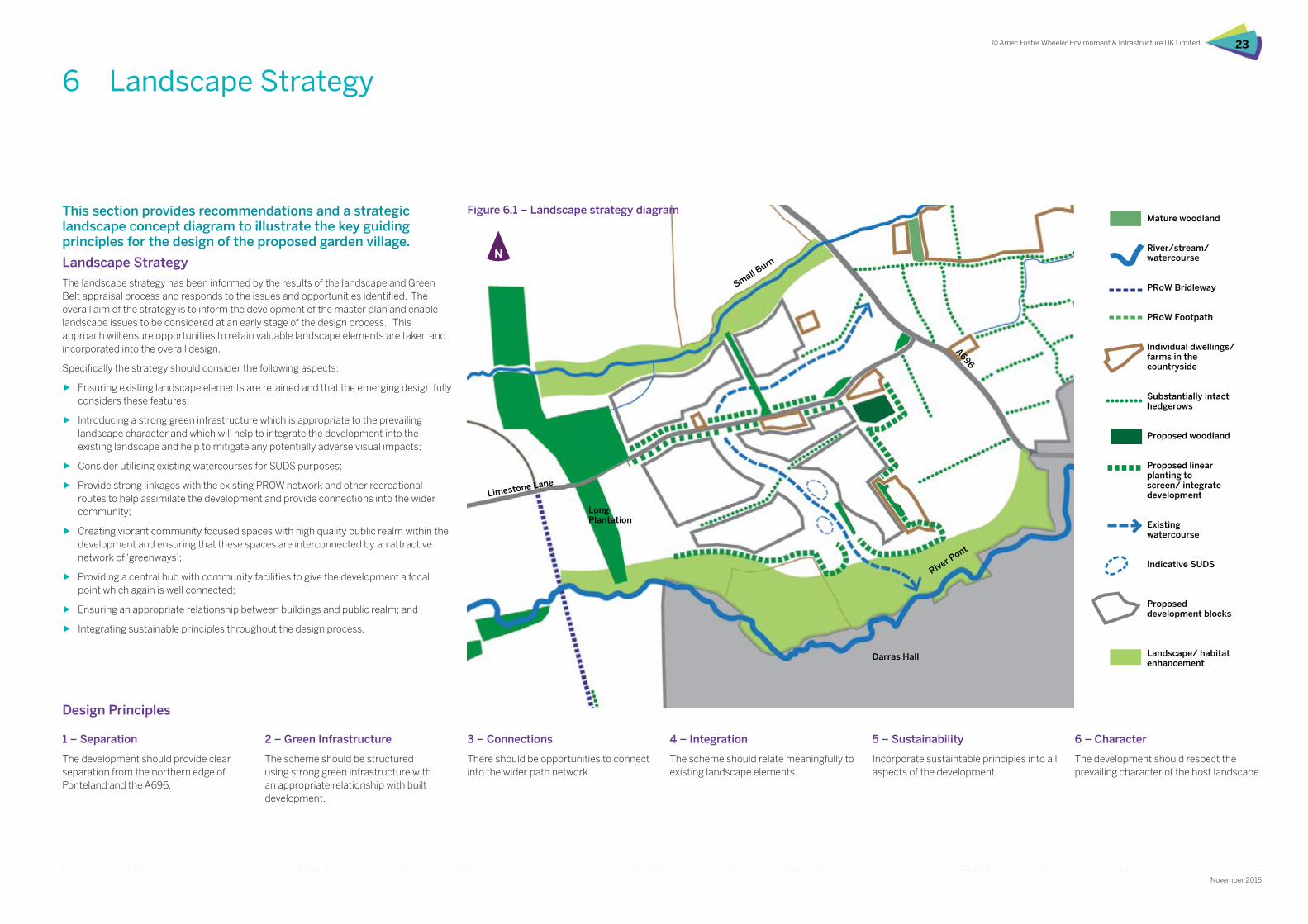
© Amec Foster Wheeler Environment & Infrastructure UK Limited 23
November 2016
This section provides recommendations and a strategic landscape concept diagram to illustrate the key guiding principles for the design of the proposed garden village.
6 Landscape Strategy
Landscape Strategy
The landscape strategy has been informed by the results of the landscape and Green Belt appraisal process and responds to the issues and opportunities identified. The overall aim of the strategy is to inform the development of the master plan and enable landscape issues to be considered at an early stage of the design process. This approach will ensure opportunities to retain valuable landscape elements are taken and incorporated into the overall design.
Specifically the strategy should consider the following aspects:
ff Ensuring existing landscape elements are retained and that the emerging design fully considers these features;
ff Introducing a strong green infrastructure which is appropriate to the prevailing landscape character and which will help to integrate the development into the existing landscape and help to mitigate any potentially adverse visual impacts;
ff Consider utilising existing watercourses for SUDS purposes;
ff Provide strong linkages with the existing PROW network and other recreational routes to help assimilate the development and provide connections into the wider community;
ff Creating vibrant community focused spaces with high quality public realm within the development and ensuring that these spaces are interconnected by an attractive network of ‘greenways’;
ff Providing a central hub with community facilities to give the development a focal point which again is well connected;
ff Ensuring an appropriate relationship between buildings and public realm; and
ff Integrating sustainable principles throughout the design process.
River Pont
Limestone Lane
A696
Long Plantation
Darras Hall
Mature woodland
River/stream/watercourse
PRoW Bridleway
PRoW Footpath
Individual dwellings/farms in the countryside
Substantially intact hedgerows
Proposed woodland
Proposed linear planting to screen/ integrate development
Existingwatercourse
Indicative SUDS
Proposed development blocks
Landscape/ habitat enhancement
Small Burn
Figure 6.1 – Landscape strategy diagram
1 – Separation
The development should provide clear separation from the northern edge of Ponteland and the A696.
2 – Green Infrastructure
The scheme should be structured using strong green infrastructure with an appropriate relationship with built development.
3 – Connections
There should be opportunities to connect into the wider path network.
4 – Integration
The scheme should relate meaningfully to existing landscape elements.
5 – Sustainability
Incorporate sustaintable principles into all aspects of the development.
6 – Character
The development should respect the prevailing character of the host landscape.
Design Principles
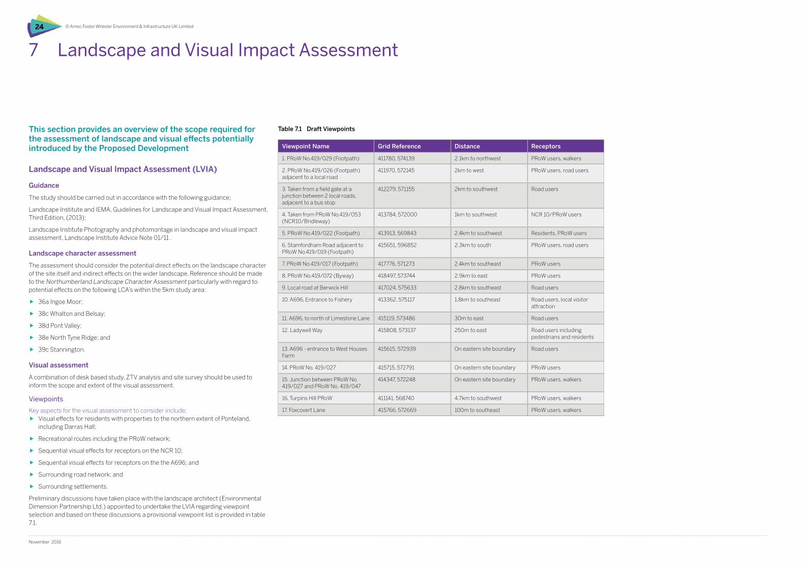
© Amec Foster Wheeler Environment & Infrastructure UK Limited24
November 2016
7 Landscape and Visual Impact Assessment
This section provides an overview of the scope required for the assessment of landscape and visual effects potentially introduced by the Proposed Development
Landscape and Visual Impact Assessment (LVIA)
Guidance
The study should be carried out in accordance with the following guidance;
Landscape Institute and IEMA, Guidelines for Landscape and Visual Impact Assessment, Third Edition, (2013);
Landscape Institute Photography and photomontage in landscape and visual impact assessment, Landscape Institute Advice Note 01/11 .
Landscape character assessment
The assessment should consider the potential direct effects on the landscape character of the site itself and indirect effects on the wider landscape. Reference should be made to the Northumberland Landscape Character Assessment particularly with regard to potential effects on the following LCA’s within the 5km study area:
ff 36a Ingoe Moor;
ff 38c Whalton and Belsay;
ff 38d Pont Valley;
ff 38e North Tyne Ridge; and
ff 39c Stannington.
Visual assessment
A combination of desk based study, ZTV analysis and site survey should be used to inform the scope and extent of the visual assessment.
Viewpoints
Key aspects for the visual assessment to consider include;ff Visual effects for residents with properties to the northern extent of Ponteland,
including Darras Hall;
ff Recreational routes including the PRoW network;
ff Sequential visual effects for receptors on the NCR 10;
ff Sequential visual effects for receptors on the the A696; and
ff Surrounding road network; and
ff Surrounding settlements.
Preliminary discussions have taken place with the landscape architect (Environmental Dimension Partnership Ltd.) appointed to undertake the LVIA regarding viewpoint selection and based on these discussions a provisional viewpoint list is provided in table 7.1.
Viewpoint Name Grid Reference Distance Receptors
1. PRoW No.419/029 (Footpath) 411780, 574139 2.1km to northwest PRoW users, walkers
2. PRoW No.419/026 (Footpath) adjacent to a local road
411970, 572145 2km to west PRoW users, road users
3. Taken from a field gate at a junction between 2 local roads, adjacent to a bus stop
412279, 571155 2km to southwest Road users
4. Taken from PRoW No.419/053 (NCR10/Bridleway)
413784, 572000 1km to southwest NCR 10/PRoW users
5. PRoW No.419/022 (Footpath) 413913, 569843 2.4km to southwest Residents, PRoW users
6. Stamfordham Road adjacent to PRoW No.419/019 (Footpath)
415651, 596852 2.3km to south PRoW users, road users
7. PRoW No.419/017 (Footpath) 417776, 571273 2.4km to southeast PRoW users
8. PRoW No.419/072 (Byway) 418497, 573744 2.9km to east PRoW users
9. Local road at Berwick Hill 417024, 575633 2.8km to southeast Road users
10. A696, Entrance to Fishery 413362, 575117 1.8km to southeast Road users, local visitor attraction
11. A696, to north of Limestone Lane 415119, 573486 30m to east Road users
12. Ladywell Way 415808, 573137 250m to east Road users including pedestrians and residents
13. A696 - entrance to West Houses Farm
415615, 572939 On eastern site boundary Road users
14. PRoW No. 419/027 415715, 572791 On eastern site boundary PRoW users
15. Junction between PRoW No. 419/027 and PRoW No. 419/047
414347, 572248 On eastern site boundary PRoW users, walkers
16. Turpins Hill PRoW 411141, 568740 4.7km to southwest PRoW users, walkers
17. Foxcovert Lane 415766, 572669 100m to southeast PRoW users, walkers
Table 7.1 Draft Viewpoints
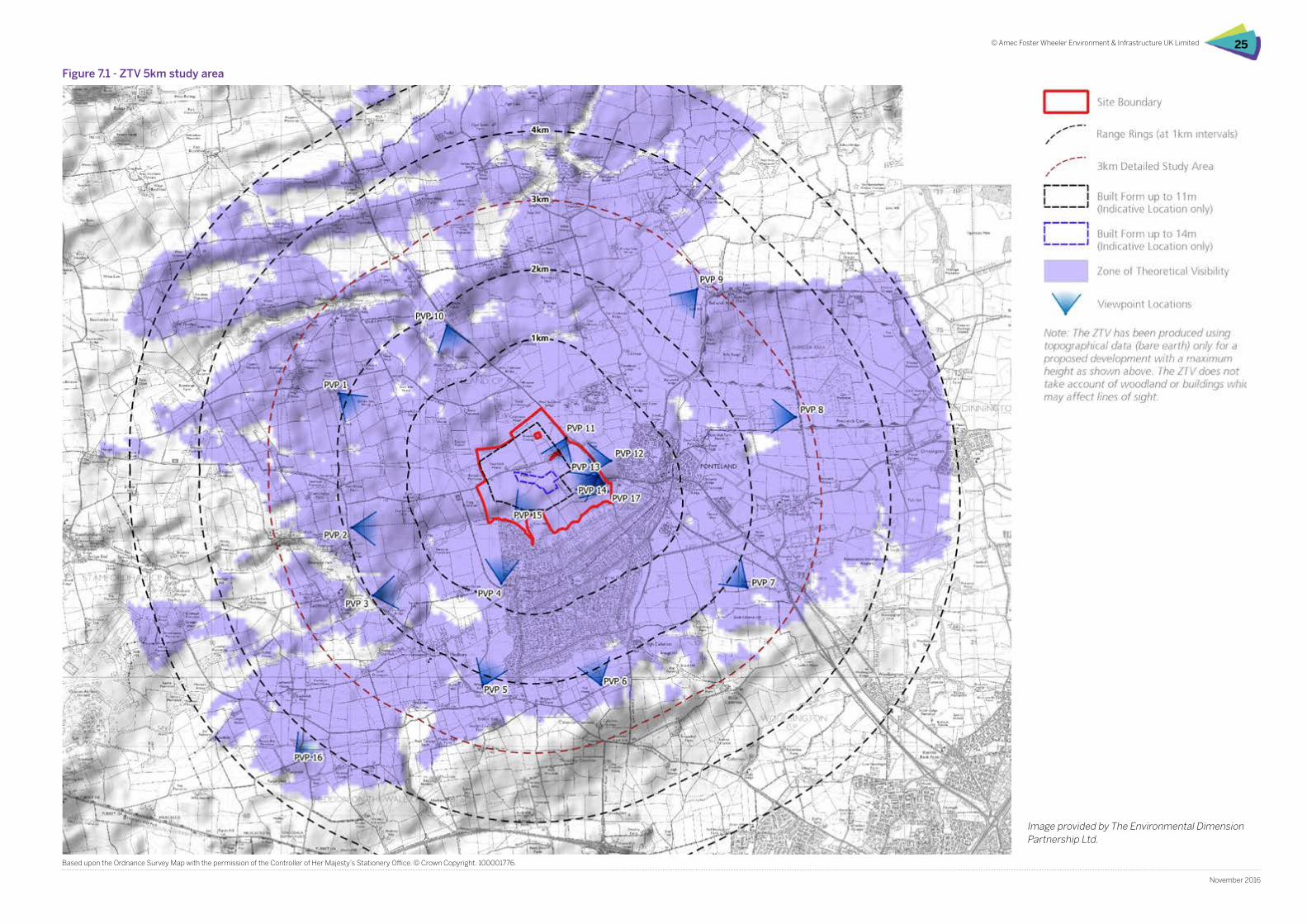
© Amec Foster Wheeler Environment & Infrastructure UK Limited 25
November 2016
Image provided by The Environmental Dimension Partnership Ltd.
Based upon the Ordnance Survey Map with the permission of the Controller of Her Majesty’s Stationery Office. © Crown Copyright. 100001776.
Figure 7.1 - ZTV 5km study area
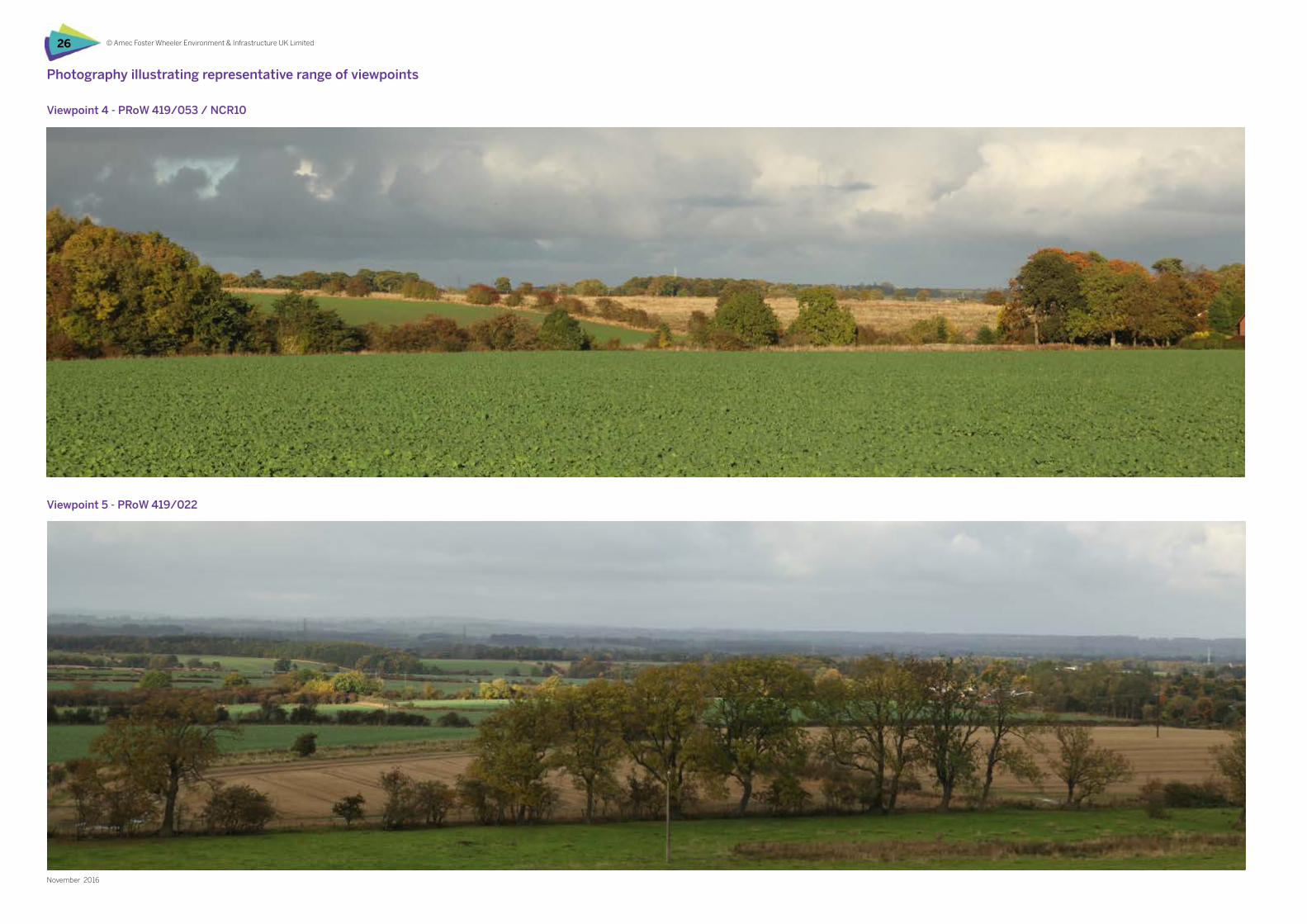
© Amec Foster Wheeler Environment & Infrastructure UK Limited26
November 2016
Photography illustrating representative range of viewpoints
Viewpoint 5 - PRoW 419/022
Viewpoint 4 - PRoW 419/053 / NCR10
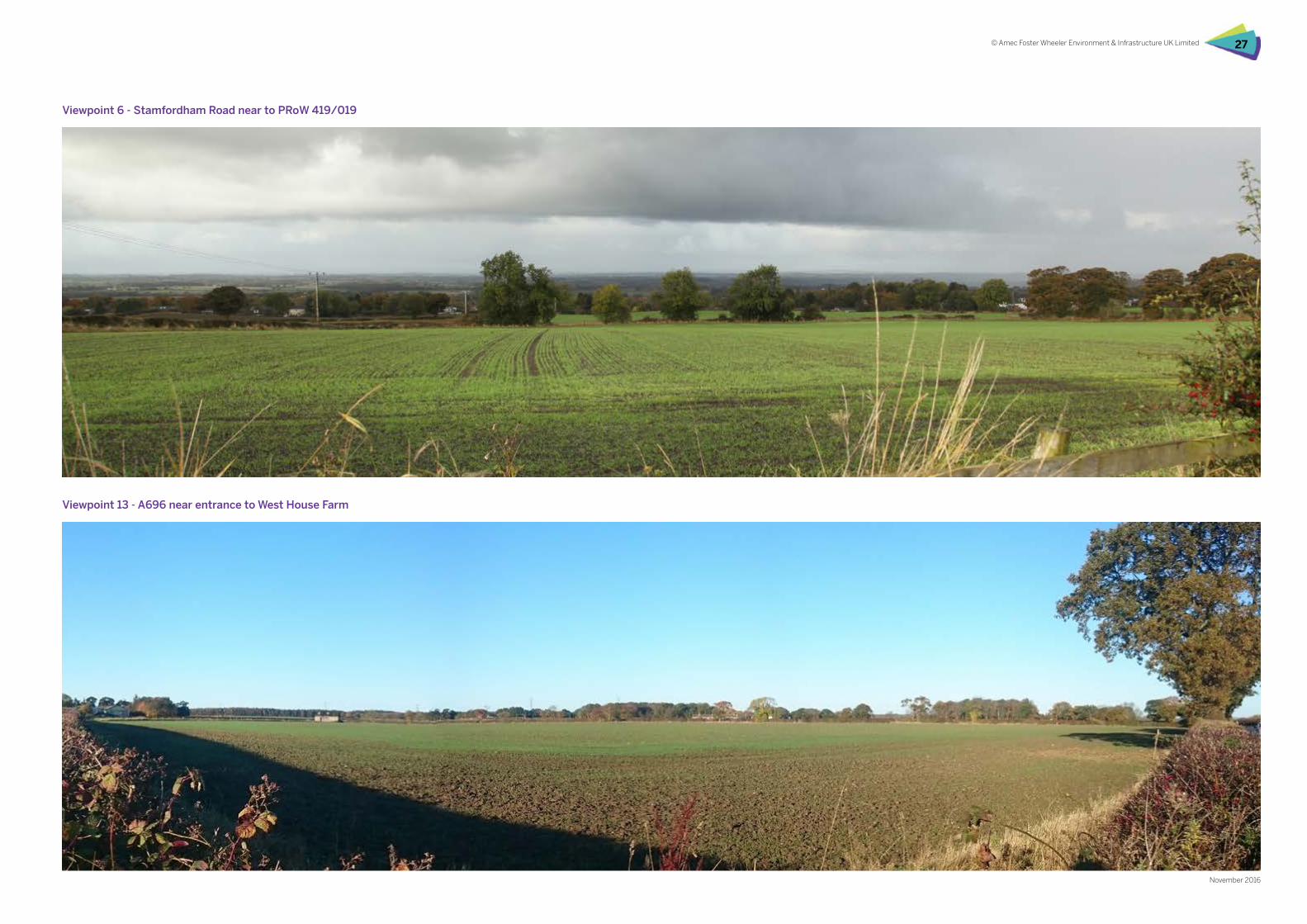
© Amec Foster Wheeler Environment & Infrastructure UK Limited 27
November 2016
Viewpoint 6 - Stamfordham Road near to PRoW 419/019
Viewpoint 13 - A696 near entrance to West House Farm
© Amec Foster Wheeler Environment & Infrastructure UK Limited28
November 2016
8 Summary and Conclusions
This section provides a summary of the potential for the proposed Dissington Garden Village to be located in land currently designated as part of the Ponteland Green Belt.
Summary and conclusions
Assessment of the landscape and Green Belt around the northern and western edges of Ponteland provides a clear steer for potential development opportunities when considered in the context of the Green Belt purposes relevant to this land as outlined below.
To check the unrestricted sprawl of large built up areas.
Within the existing Green Belt parcels there are some strong landscape features which provide potential for pockets of land to be identified which could be developed. These strong features would then restrict any further expansion of these development plots, meaning development potential is restricted. The holistic review of land to the north and west of Ponteland also means that the recommendations cover all possible development opportunities, rather than leaving some open for future consideration.
To prevent neighbouring towns merging into one another.
Within this land, there are two existing built up ‘settlements’ outside of Ponteland, the Police HQ site and Medburn. Both of these are set away from the built up form of Ponteland and clearly have a separate identity. Any development opportunities must not lead to the merger of Ponteland, the Police HQ site or Medburn.
To assist in safeguarding the countryside from encroachment.
With the exception of the Police HQ site which is already developed, any development opportunities would be in a countryside location and could be considered to be encroaching on the countryside. However, carefully located and restricted development, which has a design driven by green infrastructure and is sympathetic to a rural location and existing landscape character may not be inappropriate in this general location. Existing opportunities for recreation can be improved and rural Northumberland stretches for dozens of miles in northerly and westerly directions from Ponteland.
Development opportunities
Garden VillagesThe criteria for Garden Villages are that they must be a free-standing, discreet settlements of between 1,500 and 10,000 homes. These factors play well with the Green Belt assessment, where development opportunities must be located so they do not create any coalescence between Ponteland, the Police HQ site and Medburn. The potential pockets of land which could be formed using the strong landscape features also lead towards housing numbers at the lower end of the Garden Village criteria.
Brownfield landThe Police HQ site, as a previously developed piece of land, provides an opportunity for development on a brownfield land parcel where the countryside would not be encroached upon.
Improvement to landscapeLimited development to extend Ponteland to the west of Darras Hall could be achieved in a manner which improves the landscape character of this particular area. A softer settlement edge, which follows existing strong landforms, could be provided without merging with Medburn to the west.
From the above points, the following conclusions and recommendations can be made:
ff Extension of Ponteland to the north is restricted by the potential for merger with the Police HQ site and the strong boundary formed by the River Pont;
ff The Police HQ site could be developed as a stand-alone site as it is well contained by existing landscape features and there is a clear, open break between it and Ponteland;
ff The Police HQ Green Belt parcel (PD02) could therefore by split along the line of the Small Burn with the northern (Police HG
site) plot removed from the Green Belt and the southern plot remaining to prevent merger;
ff No development should take place in the West House Green Belt parcel (PD19) to maintain an entrance threshold on the A696, and to prevent the sprawl of Ponteland by extension of ribbon development along the A696.
ff The parcels, PD18 Coat Hill and PD20 Coldcotes Moor could accommodate development subject to sensitive design treatment to provide integration with existing landscape elements and character;
ff Clear separation should be maintained between any development in PD18 Coat Hill and the northern settlement edge of Ponteland. This could be achieved by strengthening the River Pont corridor as a landscape feature and defining Green Belt boundaries against this;
ff The Coldcotes Moor parcel could be split along the line of the Small Burn, with the northern plot remaining in the Green Belt;
ff Plantations to the west (Long Plantation, Forster’s Plantation, Thorney Covert) provide a strong boundary;
ff The A696, with a setback distance, provides a strong eastern boundary.
ff The parcel, PD16 Donkin House could accommodate a limited amount of development to improve the landscape character and rationalise existing built form on this western boundary of Darras Hall;
ff Development in this parcel must not lead to the merger of Ponteland with Medburn;
ff In the north east corner of this parcel, the route of NCR10 forms a potential boundary for an extension to Ponteland;
ff Woodland planting could be provided along the route of NCR10 to avoid an ‘urbanised’ development edge, provide a visual link with the existing plantations to the north and maintain an attractive recreational feature; This would also set development away from Medburn, and provide a strong boundary, restricting further development and the potential of merger.
ff The introduction of the changes to the Green Belt which these recommendations would bring about, would;
ff Be consistent with existing satellite development within the Green Belt such as Medburn and the Police Station HQ;
ff Provide strong Green Belt boundaries to restrict erosion of the Green Belt from future proposals;
ff Improve the landscape character to the west of Ponteland in relation to an important recreational route.
© Amec Foster Wheeler Environment & Infrastructure UK Limited 29
November 2016
Addendum
This section provides additional commentary at the request of Northumberland County Council relating to proposed edge and landscape treatments to the boundary of the proposed development site.
Dissington Garden Village Boundary Analysis
This section provides commentary on the possible landscape treatment for the green spaces and boundary definition to the edge of the proposed Dissington Garden Village which will help provide integration with the wider landscape.
The southern boundary provides the interface with the River Pont Valley landscape and the proposals here should seek to reinforce the character of the River Pont and associated valley as a distinctive landscape which provides clear separation between the existing northern edge of Darras Hall and the proposed development. The general approach should seek to provide informal, ‘naturalistic’ wetland enhancements using appropriate plant material and seed mixes; landscape character should be distinct from that of both Darras Hall and the proposed development to emphasise separation. There is the potential for wetland treatment to extend into the development itself by developing the existing drainage channel for SUDS purposes. A stronger native planting belt would be appropriate in close proximity to the southern extent of the built edge of the garden village primarily to provide screening from the south so that when vegetation is established built development is not a dominant visual element.
The western site boundary is well defined by woodland plantation and provides substantial visual enclosure. It may be appropriate to introduce a softer, more organic woodland edge to the eastern aspect of these plantations using a mix of native trees, shrubs and woodland glades or more open areas which could be linked by informal pathways.
Limestone Lane which bisects the development site is lined by mature hedgerows, hedgerow trees and is also punctuated by occasional copses or small areas of woodland. These elements together with the agricultural landscape beyond combine to produce an attractive and distinctive rural lane. The existing, established vegetation along the lane should be protected and enhanced where appropriate to maintain this rural character as far as possible. It is also considered appropriate to minimise visibility of built development by providing a set back from the highway boundary and additional tree planting.
To the north the character of the Small Burn and associated valley landscape should be strengthened through appropriate wetland enhancement and habitat creation. Built development should be setback and visually screened from this distinctive landscape so that it does unduly influence character or be visually intrusive.
The A696 provides a strong, distinct boundary to the east of the site. Generally existing vegetation at the highway boundary screens and filters views of the site from the highway and there is a perception of travelling through open countryside for road users in proximity to the site. To maintain this openness it will be necessary to introduce a considerable setback for proposed built development from the highway boundary. It is suggested that the eastern development boundary is related to existing stand-alone development such as West House and Collingwood Cottages on Limestone Lane and that a planting belt is introduced to the east of the proposed extent of built development to further strengthen this boundary and screen views from the A696.

© Amec Foster Wheeler Environment & Infrastructure UK Limited30
November 2016
References
Northumberland County Council, Northumberland Local Plan Core Strategy, Green Belt Review, (2015).
Northumberland County Council, Northumberland Local Plan Core Strategy, Green Belt Review Methodology, (December 2014).
Landscape Institute and IEMA, Guidelines for Landscape and Visual Impact Assessment, Third Edition, (2013).
Landscape Institute, Photography and photomontage in landscape and visual impact assessment, Landscape Institute Advice Note 01/11.
Land Use Consultants, Northumberland Landscape Character Assessment (2010).
Land Use Consultants, Northumberland Key Land Use Impact study;
Part A, Landscape Sensitivity at Settlement Edges (2010).