Embed Size (px)
Citation preview

1 | P a g e
Document Control Sheet
Document Number NRSC-RSAA-ERG-G&GD-SEP’ 12-TR-445
Title MANUAL FOR GEOMORPHOLOGY AND LINEAMENTMAPPING (WEB VERSION)
Type of Document Technical Report
Number of pages 28
Author(s) Geosciences Division
Reviewed by Head, Geosciences Division
Approved by DD (RSAA), NRSC
Abstract This manual highlights the use of satellite remote sensing techniquesfor geomorphological and lineament mapping. A three levelclassification system based on the origin of landforms was used increating geomorphology and lineament database on 1:50,000 scale. Atotal of 417 landforms under 11 genetic classes were mapped in thisproject. This manual (web version) also addresses uniformgeodatabase standard to be followed during the mapping stage. Adetailed description of the landforms is also provided in the projectmanual.
Controlled by Head, Geosciences Division
Distribution Unrestricted
Reproduction Rights This report and its contents are the property of National RemoteSensing Centre
PDF Creator - PDF4Free v3.0 http://www.pdf4free.com

2 | P a g e
National geomorphological and lineament mapping on 1:50,000 scaleusing Resourcesat-1 LISS-III data
(ISRO - GSI collaboration under Standing Committee on Geology)
INTRODUCTION
Geomorphology is defined as scientific study of landforms. Geo means ‘earth’,
Morpho means ‘form’ and Logy means ‘discourse’ or ‘science’. It is a branch of
Earth Science, which has grown after the advent of Aerial photographs and satellite
data. Geomorphology, along with information on soil, water and vegetation has become
one of the essential inputs in planning for various developmental activities. The scope of
geomorphology has further expanded with the landform maps widely used in various
fields of resource surveys, environmental analysis, hydrological studies, engineering
applications and geo-technical studies. As a result, experts in various fields such as
geoscience, pedology, hydrology, civil engineering, urban planning etc. have started
intuitively using landform maps for various applications in their respective fields. But
classification schemes of landforms used for resource surveys and other research
applications are derived based on the requirement of the specific activity for which it
would be used without giving much emphasis on the genesis of the landforms. Though,
Geological Survey of India (GSI) has prepared the geomorphological map on
1:2,000,000 scale, it is desirable to map the landform of the country on 1:50,000 scale
due to demands from various user communities.
Similarly, the significance of structural lineaments, which reveal the hidden architecture
of rock basement has been recognised only recently with the advancement in geologic
remote sensing. Lineament studies have found applications in various fields of earth
science such as global tectonic studies, delineation of litho-contacts and tectonic units,
analysis of deformation pattern, ground water and oil exploration, geo-technical and
geo-engineering applications and seismo-tectonic studies. Though, small-scale
lineament maps are available, their utility is limited to regional scale tectonic studies.
Also, with the advancement in digital image processing techniques, the satellite data in
PDF Creator - PDF4Free v3.0 http://www.pdf4free.com

3 | P a g e
conjunction with Digital Elevation Model (DEM) have great potential in lineament
detection and mapping. Therefore, there is a need for detailed lineament maps of the
entire country, which along with landform maps could form the basis for applications in
various fields of earth science.
This project is an outcome of the need projected in Standing Committee on Geology
Chaired by Secretary, Ministry of Mines and attended by the various geological
organizations like GSI, ONGC, NMDC, AMD, MECL etc. A pilot study was carried out
jointly by GSI and ISRO in some of the important geological provinces of India to
develop a National schema on landform classification. A National committee on the
schema deliberated on the results from the pilot study and finalised the
geomorphological classification system for national geomorphological mapping on
1:50,000 scale using satellite data. The accepted schema was used to carry out the
mapping, and after 6 months of the project initiation, the schema was revisited based on
suggestions received from various partner institutes as well as from GSI and ISRO
teams. The revised schema is listed in table-1.
Geomorphology classification schema
The new genesis-based classification system is conceived with three levels (Table 1).
Level-1 of the classification system consists of 11 genetic classes such as structural,
denudational, fluvial, coastal, aeolian, glacial, karst, volcanic, impact, laccustrine and
anthropogenic. Level-2 consists of 42 landforms (unique combination of levels 1 and 2),
identified based on morphostructure. For example, structurally originated landforms
were classified in level-2 as highly, moderately and less dissected hills and valleys, if it
is a hill or highly, moderately and less dissected plateaus, if it is flat land. Level-3 of the
geomorphic schema consists of 417 landforms (unique combination of levels 1, 2 and 3)
identified based on morphography. For example, under highly dissected hills and
valleys of structural origin, 21 landforms (e.g. hogback, cuesta, antiformal hill, ridge etc.)
were identified. The landforms such as cuesta, strike ridge and antiformal hill, where
geological structures played a crucial role in the landform development and the imprints
of primary structures (e.g. bedding) are still preserved, were classified into structural
PDF Creator - PDF4Free v3.0 http://www.pdf4free.com

4 | P a g e
category. Similarly, landforms such as channel bar, meander scar and oxbow lake
developed essentially due to the action of river, were classified into fluvial category.
Detailed description of the classification system with definition and illustration of
the landforms is available in the project manual.
The display is restricted to Level-2 (i.e. total 42 landforms) classification for un-
authenticated access through the portal. However, the original data with 417
landforms is available with NRSC and the same shall be provided to the users who
have undergone authorization process through Bhuvan.
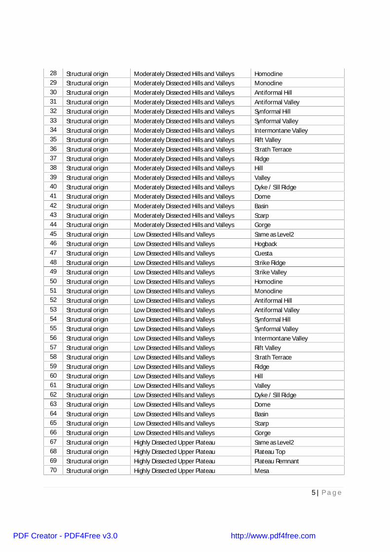
Table 1. Genesis-based three level geomorphological classification system.S.N Level-1 Level-2 Level-3
1 Structural origin Highly Dissected Hills and Valleys Same as Level22 Structural origin Highly Dissected Hills and Valleys Hogback3 Structural origin Highly Dissected Hills and Valleys Cuesta4 Structural origin Highly Dissected Hills and Valleys Strike Ridge5 Structural origin Highly Dissected Hills and Valleys Strike Valley6 Structural origin Highly Dissected Hills and Valleys Homocline7 Structural origin Highly Dissected Hills and Valleys Monocline8 Structural origin Highly Dissected Hills and Valleys Antiformal Hill9 Structural origin Highly Dissected Hills and Valleys Antiformal Valley
10 Structural origin Highly Dissected Hills and Valleys Synformal Hill11 Structural origin Highly Dissected Hills and Valleys Synformal Valley12 Structural origin Highly Dissected Hills and Valleys Intermontane Valley13 Structural origin Highly Dissected Hills and Valleys Rift Valley14 Structural origin Highly Dissected Hills and Valleys Strath Terrace15 Structural origin Highly Dissected Hills and Valleys Ridge16 Structural origin Highly Dissected Hills and Valleys Hill17 Structural origin Highly Dissected Hills and Valleys Valley18 Structural origin Highly Dissected Hills and Valleys Dyke / Sill Ridge19 Structural origin Highly Dissected Hills and Valleys Dome20 Structural origin Highly Dissected Hills and Valleys Basin21 Structural origin Highly Dissected Hills and Valleys Scarp22 Structural origin Highly Dissected Hills and Valleys Gorge23 Structural origin Moderately Dissected Hills and Valleys Same as Level224 Structural origin Moderately Dissected Hills and Valleys Hogback25 Structural origin Moderately Dissected Hills and Valleys Cuesta26 Structural origin Moderately Dissected Hills and Valleys Strike Ridge27 Structural origin Moderately Dissected Hills and Valleys Strike Valley
PDF Creator - PDF4Free v3.0 http://www.pdf4free.com
5 | P a g e
28 Structural origin Moderately Dissected Hills and Valleys Homocline29 Structural origin Moderately Dissected Hills and Valleys Monocline30 Structural origin Moderately Dissected Hills and Valleys Antiformal Hill31 Structural origin Moderately Dissected Hills and Valleys Antiformal Valley32 Structural origin Moderately Dissected Hills and Valleys Synformal Hill33 Structural origin Moderately Dissected Hills and Valleys Synformal Valley34 Structural origin Moderately Dissected Hills and Valleys Intermontane Valley35 Structural origin Moderately Dissected Hills and Valleys Rift Valley36 Structural origin Moderately Dissected Hills and Valleys Strath Terrace37 Structural origin Moderately Dissected Hills and Valleys Ridge38 Structural origin Moderately Dissected Hills and Valleys Hill39 Structural origin Moderately Dissected Hills and Valleys Valley40 Structural origin Moderately Dissected Hills and Valleys Dyke / Sill Ridge41 Structural origin Moderately Dissected Hills and Valleys Dome42 Structural origin Moderately Dissected Hills and Valleys Basin43 Structural origin Moderately Dissected Hills and Valleys Scarp44 Structural origin Moderately Dissected Hills and Valleys Gorge45 Structural origin Low Dissected Hills and Valleys Same as Level246 Structural origin Low Dissected Hills and Valleys Hogback47 Structural origin Low Dissected Hills and Valleys Cuesta48 Structural origin Low Dissected Hills and Valleys Strike Ridge49 Structural origin Low Dissected Hills and Valleys Strike Valley50 Structural origin Low Dissected Hills and Valleys Homocline51 Structural origin Low Dissected Hills and Valleys Monocline52 Structural origin Low Dissected Hills and Valleys Antiformal Hill53 Structural origin Low Dissected Hills and Valleys Antiformal Valley54 Structural origin Low Dissected Hills and Valleys Synformal Hill55 Structural origin Low Dissected Hills and Valleys Synformal Valley56 Structural origin Low Dissected Hills and Valleys Intermontane Valley57 Structural origin Low Dissected Hills and Valleys Rift Valley58 Structural origin Low Dissected Hills and Valleys Strath Terrace59 Structural origin Low Dissected Hills and Valleys Ridge60 Structural origin Low Dissected Hills and Valleys Hill61 Structural origin Low Dissected Hills and Valleys Valley62 Structural origin Low Dissected Hills and Valleys Dyke / Sill Ridge63 Structural origin Low Dissected Hills and Valleys Dome64 Structural origin Low Dissected Hills and Valleys Basin65 Structural origin Low Dissected Hills and Valleys Scarp66 Structural origin Low Dissected Hills and Valleys Gorge67 Structural origin Highly Dissected Upper Plateau Same as Level268 Structural origin Highly Dissected Upper Plateau Plateau Top69 Structural origin Highly Dissected Upper Plateau Plateau Remnant70 Structural origin Highly Dissected Upper Plateau Mesa
PDF Creator - PDF4Free v3.0 http://www.pdf4free.com

6 | P a g e
71 Structural origin Highly Dissected Upper Plateau Butte72 Structural origin Highly Dissected Upper Plateau Scarp73 Structural origin Highly Dissected Upper Plateau Valley74 Structural origin Highly Dissected Upper Plateau Bench75 Structural origin Highly Dissected Lower Plateau Same as Level276 Structural origin Highly Dissected Lower Plateau Plateau Top77 Structural origin Highly Dissected Lower Plateau Plateau Remnant78 Structural origin Highly Dissected Lower Plateau Mesa79 Structural origin Highly Dissected Lower Plateau Butte80 Structural origin Highly Dissected Lower Plateau Scarp81 Structural origin Highly Dissected Lower Plateau Valley82 Structural origin Highly Dissected Lower Plateau Bench83 Structural origin Moderately Dissected Upper Plateau Same as Level284 Structural origin Moderately Dissected Upper Plateau Plateau Top85 Structural origin Moderately Dissected Upper Plateau Plateau Remnant86 Structural origin Moderately Dissected Upper Plateau Mesa87 Structural origin Moderately Dissected Upper Plateau Butte88 Structural origin Moderately Dissected Upper Plateau Scarp89 Structural origin Moderately Dissected Upper Plateau Valley90 Structural origin Moderately Dissected Upper Plateau Bench91 Structural origin Moderately Dissected Lower Plateau Same as Level292 Structural origin Moderately Dissected Lower Plateau Plateau Top93 Structural origin Moderately Dissected Lower Plateau Plateau Remnant94 Structural origin Moderately Dissected Lower Plateau Mesa95 Structural origin Moderately Dissected Lower Plateau Butte96 Structural origin Moderately Dissected Lower Plateau Scarp97 Structural origin Moderately Dissected Lower Plateau Valley98 Structural origin Moderately Dissected Lower Plateau Bench99 Structural origin Low Dissected Upper Plateau Same as Level2100 Structural origin Low Dissected Upper Plateau Plateau Top101 Structural origin Low Dissected Upper Plateau Plateau Remnant102 Structural origin Low Dissected Upper Plateau Mesa103 Structural origin Low Dissected Upper Plateau Butte104 Structural origin Low Dissected Upper Plateau Scarp105 Structural origin Low Dissected Upper Plateau Valley106 Structural origin Low Dissected Upper Plateau Bench107 Structural origin Low Dissected Lower Plateau Same as Level2108 Structural origin Low Dissected Lower Plateau Plateau Top109 Structural origin Low Dissected Lower Plateau Plateau Remnant110 Structural origin Low Dissected Lower Plateau Mesa111 Structural origin Low Dissected Lower Plateau Butte112 Structural origin Low Dissected Lower Plateau Scarp113 Structural origin Low Dissected Lower Plateau Valley
PDF Creator - PDF4Free v3.0 http://www.pdf4free.com

7 | P a g e
114 Structural origin Low Dissected Lower Plateau Bench115 Denudational origin Highly Dissected Hills and Valleys Same as Level2116 Denudational origin Highly Dissected Hills and Valleys Residual Hill117 Denudational origin Highly Dissected Hills and Valleys Hill118 Denudational origin Highly Dissected Hills and Valleys Dome119 Denudational origin Highly Dissected Hills and Valleys Scarp120 Denudational origin Highly Dissected Hills and Valleys Valley121 Denudational origin Moderately Dissected Hills and Valleys Same as Level2122 Denudational origin Moderately Dissected Hills and Valleys Residual Hill123 Denudational origin Moderately Dissected Hills and Valleys Hill124 Denudational origin Moderately Dissected Hills and Valleys Dome125 Denudational origin Moderately Dissected Hills and Valleys Scarp126 Denudational origin Moderately Dissected Hills and Valleys Valley127 Denudational origin Low Dissected Hills and Valleys Same as Level2128 Denudational origin Low Dissected Hills and Valleys Residual Hill129 Denudational origin Low Dissected Hills and Valleys Hill130 Denudational origin Low Dissected Hills and Valleys Dome131 Denudational origin Low Dissected Hills and Valleys Scarp132 Denudational origin Low Dissected Hills and Valleys Valley133 Denudational origin Highly Dissected Upper Plateau Same as Level2134 Denudational origin Highly Dissected Upper Plateau Plateau Top135 Denudational origin Highly Dissected Upper Plateau Plateau Remnant136 Denudational origin Highly Dissected Upper Plateau Mesa137 Denudational origin Highly Dissected Upper Plateau Butte138 Denudational origin Highly Dissected Upper Plateau Scarp139 Denudational origin Highly Dissected Upper Plateau Valley140 Denudational origin Highly Dissected Upper Plateau Bench141 Denudational origin Highly Dissected Upper Plateau Residual Capping142 Denudational origin Highly Dissected Lower Plateau Same as Level2143 Denudational origin Highly Dissected Lower Plateau Plateau Top144 Denudational origin Highly Dissected Lower Plateau Plateau Remnant145 Denudational origin Highly Dissected Lower Plateau Mesa146 Denudational origin Highly Dissected Lower Plateau Butte147 Denudational origin Highly Dissected Lower Plateau Scarp148 Denudational origin Highly Dissected Lower Plateau Valley149 Denudational origin Highly Dissected Lower Plateau Bench150 Denudational origin Highly Dissected Lower Plateau Residual Capping151 Denudational origin Moderately Dissected Upper Plateau Same as Level2152 Denudational origin Moderately Dissected Upper Plateau Plateau Top153 Denudational origin Moderately Dissected Upper Plateau Plateau Remnant154 Denudational origin Moderately Dissected Upper Plateau Mesa155 Denudational origin Moderately Dissected Upper Plateau Butte156 Denudational origin Moderately Dissected Upper Plateau Scarp
PDF Creator - PDF4Free v3.0 http://www.pdf4free.com

8 | P a g e
157 Denudational origin Moderately Dissected Upper Plateau Valley158 Denudational origin Moderately Dissected Upper Plateau Bench159 Denudational origin Moderately Dissected Upper Plateau Residual Capping160 Denudational origin Moderately Dissected Lower Plateau Same as Level2161 Denudational origin Moderately Dissected Lower Plateau Plateau Top162 Denudational origin Moderately Dissected Lower Plateau Plateau Remnant163 Denudational origin Moderately Dissected Lower Plateau Mesa164 Denudational origin Moderately Dissected Lower Plateau Butte165 Denudational origin Moderately Dissected Lower Plateau Scarp166 Denudational origin Moderately Dissected Lower Plateau Valley167 Denudational origin Moderately Dissected Lower Plateau Bench168 Denudational origin Moderately Dissected Lower Plateau Residual Capping169 Denudational origin Low Dissected Upper Plateau Same as Level2170 Denudational origin Low Dissected Upper Plateau Plateau Top171 Denudational origin Low Dissected Upper Plateau Plateau Remnant172 Denudational origin Low Dissected Upper Plateau Mesa173 Denudational origin Low Dissected Upper Plateau Butte174 Denudational origin Low Dissected Upper Plateau Scarp175 Denudational origin Low Dissected Upper Plateau Valley176 Denudational origin Low Dissected Upper Plateau Bench177 Denudational origin Low Dissected Upper Plateau Residual Capping178 Denudational origin Low Dissected Lower Plateau Same as Level2179 Denudational origin Low Dissected Lower Plateau Plateau Top180 Denudational origin Low Dissected Lower Plateau Plateau Remnant181 Denudational origin Low Dissected Lower Plateau Mesa182 Denudational origin Low Dissected Lower Plateau Butte183 Denudational origin Low Dissected Lower Plateau Scarp184 Denudational origin Low Dissected Lower Plateau Valley185 Denudational origin Low Dissected Lower Plateau Bench186 Denudational origin Low Dissected Lower Plateau Residual Capping187 Denudational origin Piedmont Slope Same as Level2188 Denudational origin Piedmont Slope Colluvial Fan189 Denudational origin Piedmont Slope Talus / Scree190 Denudational origin Mass Wasting Products Same as Level2191 Denudational origin Mass Wasting Products Landslide192 Denudational origin Mass Wasting Products Talus / Scree193 Denudational origin Pediment-Pediplain Complex Same as Level2194 Denudational origin Pediment-Pediplain Complex Residual Mound195 Denudational origin Pediment-Pediplain Complex Inselberg196 Denudational origin Pediment-Pediplain Complex Monadnock197 Denudational origin Pediment-Pediplain Complex Bornhardt198 Denudational origin Pediment-Pediplain Complex Tor199 Denudational origin Pediment-Pediplain Complex Pediment
PDF Creator - PDF4Free v3.0 http://www.pdf4free.com

9 | P a g e
200Denudational origin Pediment-Pediplain Complex
Pediment-Corestone-TorComposite
201 Denudational origin Pediment-Pediplain Complex Pediplain202 Denudational origin Pediment-Pediplain Complex Rolling Plain203 Denudational origin Pediment-Pediplain Complex Wash Plain204 Denudational origin Pediment-Pediplain Complex Valley Fill205 Denudational origin Pediment-Pediplain Complex Gullied Land206 Denudational origin Pediment-Pediplain Complex Badland207 Denudational origin Pediment-Pediplain Complex Plain (Lateritic)208 Denudational origin Pediment-Pediplain Complex Upland (Lateritic)209 Fluvial origin Older Alluvial Plain Same as Level2210 Fluvial origin Older Alluvial Plain Palaeochannel211 Fluvial origin Older Alluvial Plain Abandoned Channel212 Fluvial origin Older Alluvial Plain Palaeolevee213 Fluvial origin Older Alluvial Plain Oxbow Lake214 Fluvial origin Older Alluvial Plain Cut-off Meander215 Fluvial origin Older Alluvial Plain Meander Scar216 Fluvial origin Older Alluvial Plain Terrace217 Fluvial origin Older Alluvial Plain Gullied Tract218 Fluvial origin Older Alluvial Plain Valley Fill219 Fluvial origin Older Alluvial Plain Ridge220 Fluvial origin Older Alluvial Plain Marsh221 Fluvial origin Younger Alluvial plain Same as Level2222 Fluvial origin Younger Alluvial plain Palaeochannel223 Fluvial origin Younger Alluvial plain Abandoned Channel224 Fluvial origin Younger Alluvial plain Natural Levee225 Fluvial origin Younger Alluvial plain Oxbow Lake226 Fluvial origin Younger Alluvial plain Cut-off Meander227 Fluvial origin Younger Alluvial plain Meander Scar228 Fluvial origin Younger Alluvial plain Terrace229 Fluvial origin Younger Alluvial plain Gullied Tract230 Fluvial origin Younger Alluvial plain Valley Fill231 Fluvial origin Younger Alluvial plain Ridge232 Fluvial origin Younger Alluvial plain Marsh233 Fluvial origin Older Flood plain Same as Level2234 Fluvial origin Older Flood plain Palaeochannel235 Fluvial origin Older Flood plain Abandoned Channel236 Fluvial origin Older Flood plain Palaeolevee237 Fluvial origin Older Flood plain Oxbow Lake238 Fluvial origin Older Flood plain Cut-off Meander239 Fluvial origin Older Flood plain Meander scar240 Fluvial origin Older Flood plain Terrace241 Fluvial origin Older Flood plain Point Bar242 Fluvial origin Older Flood plain Gullied Tract
PDF Creator - PDF4Free v3.0 http://www.pdf4free.com

10 | P a g e
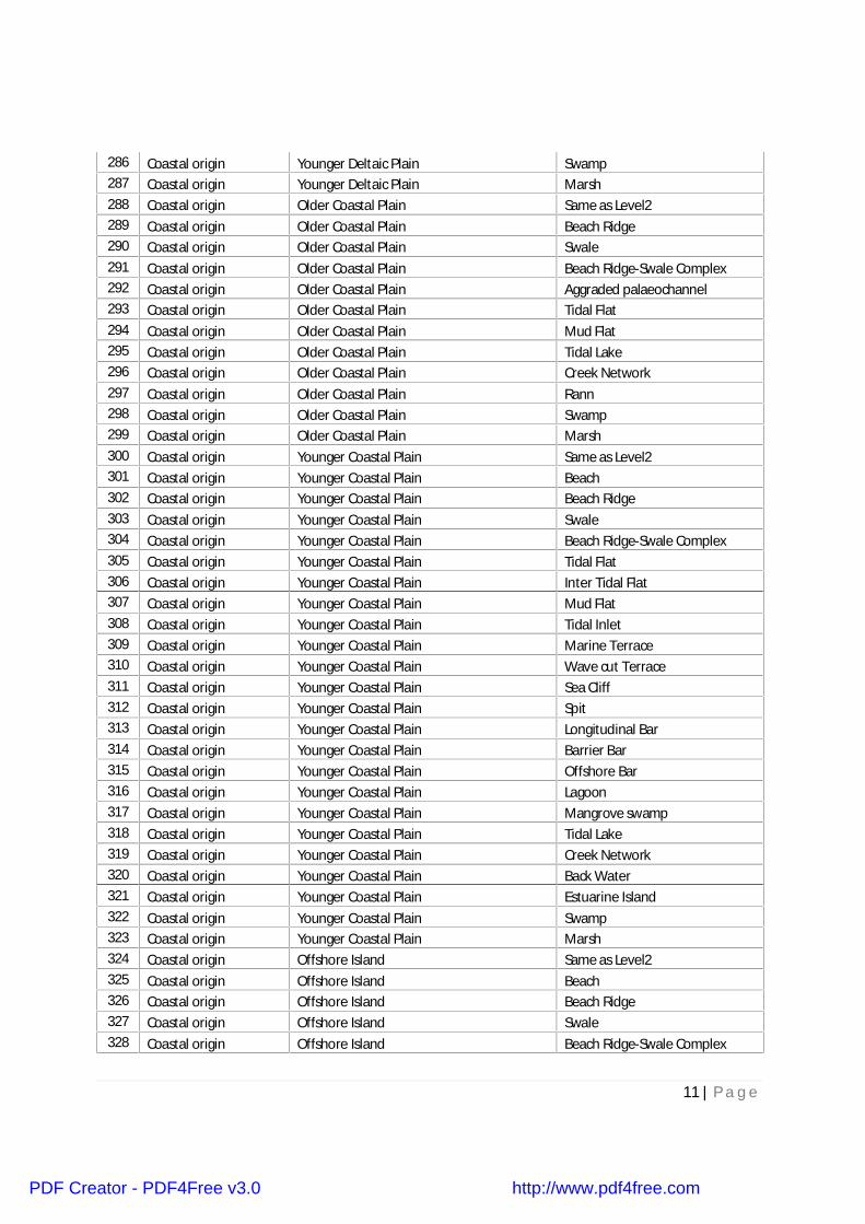
243 Fluvial origin Older Flood plain Valley Fill244 Fluvial origin Older Flood plain Ridge245 Fluvial origin Older Flood plain Marsh246 Fluvial origin Older Flood plain Back Swamp247 Fluvial origin Active Flood plain Same as Level2248 Fluvial origin Active Flood plain Palaeochannel249 Fluvial origin Active Flood plain Abandoned Channel250 Fluvial origin Active Flood plain Natural Levee251 Fluvial origin Active Flood plain Oxbow Lake252 Fluvial origin Active Flood plain Cut-off Meander253 Fluvial origin Active Flood plain Meander scar254 Fluvial origin Active Flood plain Crevasse Splay255 Fluvial origin Active Flood plain Point Bar256 Fluvial origin Active Flood plain Braid Bar257 Fluvial origin Active Flood plain Lateral Bar258 Fluvial origin Active Flood plain Channel Bar259 Fluvial origin Active Flood plain Channel Island260 Fluvial origin Active Flood plain Valley Fill261 Fluvial origin Active Flood plain Back Swamp262 Fluvial origin Active Flood plain Flood Basin263 Fluvial origin Piedmont Alluvial Plain Same as Level2264 Fluvial origin Piedmont Alluvial Plain Alluvial Fan265 Fluvial origin Piedmont Alluvial Plain Dissected Alluvial Fan266 Fluvial origin Piedmont Alluvial Plain Palaeochannel267 Fluvial origin Piedmont Alluvial Plain Abandoned Channel268 Fluvial origin Piedmont Alluvial Plain Oxbow Lake269 Fluvial origin Piedmont Alluvial Plain Cut-off Meander270 Fluvial origin Piedmont Alluvial Plain Meander scar271 Fluvial origin Piedmont Alluvial Plain Marsh272 Fluvial origin Piedmont Alluvial Plain Gullied Tract273 Fluvial origin Bajada Same as Level2274 Fluvial origin Bajada Alluvial Fan275 Fluvial origin Bajada Gullied Tract276 Coastal origin Older Deltaic Plain Same as Level2277 Coastal origin Older Deltaic Plain Palaeo Distributary
278 Coastal origin Older Deltaic PlainIntra-Meander belt shallowdepression
279 Coastal origin Older Deltaic Plain Aggraded palaeo channel280 Coastal origin Older Deltaic Plain Swamp281 Coastal origin Older Deltaic Plain Marsh282 Coastal origin Younger Deltaic Plain Same as Level2283 Coastal origin Younger Deltaic Plain Inter-distributary Marsh284 Coastal origin Younger Deltaic Plain Aggraded palaeo channel285 Coastal origin Younger Deltaic Plain Active Distributary
PDF Creator - PDF4Free v3.0 http://www.pdf4free.com
11 | P a g e
286 Coastal origin Younger Deltaic Plain Swamp287 Coastal origin Younger Deltaic Plain Marsh288 Coastal origin Older Coastal Plain Same as Level2289 Coastal origin Older Coastal Plain Beach Ridge290 Coastal origin Older Coastal Plain Swale291 Coastal origin Older Coastal Plain Beach Ridge-Swale Complex292 Coastal origin Older Coastal Plain Aggraded palaeochannel293 Coastal origin Older Coastal Plain Tidal Flat294 Coastal origin Older Coastal Plain Mud Flat295 Coastal origin Older Coastal Plain Tidal Lake296 Coastal origin Older Coastal Plain Creek Network297 Coastal origin Older Coastal Plain Rann298 Coastal origin Older Coastal Plain Swamp299 Coastal origin Older Coastal Plain Marsh300 Coastal origin Younger Coastal Plain Same as Level2301 Coastal origin Younger Coastal Plain Beach302 Coastal origin Younger Coastal Plain Beach Ridge303 Coastal origin Younger Coastal Plain Swale304 Coastal origin Younger Coastal Plain Beach Ridge-Swale Complex305 Coastal origin Younger Coastal Plain Tidal Flat306 Coastal origin Younger Coastal Plain Inter Tidal Flat307 Coastal origin Younger Coastal Plain Mud Flat308 Coastal origin Younger Coastal Plain Tidal Inlet309 Coastal origin Younger Coastal Plain Marine Terrace310 Coastal origin Younger Coastal Plain Wave cut Terrace311 Coastal origin Younger Coastal Plain Sea Cliff312 Coastal origin Younger Coastal Plain Spit313 Coastal origin Younger Coastal Plain Longitudinal Bar314 Coastal origin Younger Coastal Plain Barrier Bar315 Coastal origin Younger Coastal Plain Offshore Bar316 Coastal origin Younger Coastal Plain Lagoon317 Coastal origin Younger Coastal Plain Mangrove swamp318 Coastal origin Younger Coastal Plain Tidal Lake319 Coastal origin Younger Coastal Plain Creek Network320 Coastal origin Younger Coastal Plain Back Water321 Coastal origin Younger Coastal Plain Estuarine Island322 Coastal origin Younger Coastal Plain Swamp323 Coastal origin Younger Coastal Plain Marsh324 Coastal origin Offshore Island Same as Level2325 Coastal origin Offshore Island Beach326 Coastal origin Offshore Island Beach Ridge327 Coastal origin Offshore Island Swale328 Coastal origin Offshore Island Beach Ridge-Swale Complex
PDF Creator - PDF4Free v3.0 http://www.pdf4free.com

12 | P a g e
329 Coastal origin Offshore Island Tidal Flat330 Coastal origin Offshore Island Inter Tidal Flat331 Coastal origin Offshore Island Mud Flat332 Coastal origin Offshore Island Tidal Inlet333 Coastal origin Offshore Island Spit334 Coastal origin Offshore Island Longitudinal Bar335 Coastal origin Offshore Island Barrier Bar336 Coastal origin Offshore Island Offshore Bar337 Coastal origin Offshore Island Lagoon338 Coastal origin Offshore Island Mangrove Swamp339 Coastal origin Offshore Island Tidal Lake340 Coastal origin Offshore Island Back Water341 Coastal origin Offshore Island Swamp342 Coastal origin Offshore Island Marsh343 Coastal origin Coral Reef Same as Level2344 Coastal origin Coral Reef Fringing Reef345 Coastal origin Coral Reef Barrier Reef346 Coastal origin Coral Reef Atoll347 Coastal origin Sea-stacks Same as Level2348 Aeolian origin Aeolian Plain Same as Level2349 Aeolian origin Aeolian Plain Wadi350 Aeolian origin Aeolian Plain Sand Dune351 Aeolian origin Aeolian Plain Sand Sheet352 Aeolian origin Aeolian Plain Parabolic Dune353 Aeolian origin Aeolian Plain Linear Dune354 Aeolian origin Aeolian Plain Longitudinal Dune355 Aeolian origin Aeolian Plain Transverse Dune356 Aeolian origin Aeolian Plain Barchan357 Aeolian origin Aeolian Plain Seif Dune358 Aeolian origin Aeolian Plain Star Dune359 Aeolian origin Aeolian Plain Dune Complex360 Aeolian origin Aeolian Plain Interdunal Depression361 Aeolian origin Aeolian Plain Playa362 Aeolian origin Aeolian Plain Dissected Dune Complex363 Aeolian origin Aeolian Plain Desert Pavement364 Aeolian origin Aeolian Plain Deflation Plain365 Aeolian origin Aeolian Plain Hamada366 Aeolian origin Aeolian Plain Loess367 Aeolian origin Aeolian Plain Stabilised Dune368 Aeolian origin Aeolian Plain Ridge369 Glacial origin Glacial Terrain Same as Level2370 Glacial origin Glacial Terrain Outwash Plain371 Glacial origin Glacial Terrain Terminal Moraine
PDF Creator - PDF4Free v3.0 http://www.pdf4free.com

13 | P a g e
372 Glacial origin Glacial Terrain Lateral Moraine373 Glacial origin Glacial Terrain Medial Moraine374 Glacial origin Glacial Terrain Kame Terrace375 Glacial origin Glacial Terrain Esker376 Glacial origin Glacial Terrain Lake377 Glacial origin Glacial Terrain Ice Pavement378 Glacial origin Glacial Terrain Cirque379 Glacial origin Glacial Terrain Arete380 Glacial origin Glacial Terrain Hanging Valley381 Glacial origin Glacial Terrain Valley382 Glacial origin Glacial Terrain Valley Glacier383 Glacial origin Glacial Terrain Horn384 Glacial origin Glacial Terrain Nunatak385 Glacial origin Glacial Terrain Avalanche Chute386 Glacial origin Glacial Terrain Crevasse387 Glacial origin Snow Cover Same as Level2388 Karst Origin Karst Terrain Same as Level2389 Karst Origin Karst Terrain Sink Hole390 Karst Origin Karst Terrain Doline391 Karst Origin Karst Terrain Uvala392 Karst Origin Karst Terrain Lapies393 Volcanic Origin Volcanic Terrain Same as Level2394 Volcanic Origin Volcanic Terrain Crater395 Volcanic Origin Volcanic Terrain Volcanic cone396 Volcanic Origin Volcanic Terrain Shield Volcano397 Volcanic Origin Volcanic Terrain Strato Volcano398 Volcanic Origin Volcanic Terrain Lava flow399 Volcanic Origin Volcanic Terrain Lava Channel400 Impact Origin Impact Crater Same as Level2401 Impact Origin Impact Crater Crater Basin402 Lacustrine Origin Lacustrine Terrain Same as Level2403 Lacustrine Origin Lacustrine Terrain Plain404 Lacustrine Origin Lacustrine Terrain Lake Island405 Lacustrine Origin Lacustrine Terrain Swamp406 Lacustrine Origin Lacustrine Terrain Marsh407 Lacustrine Origin Lacustrine Terrain Delta408 Anthropogenic Origin Anthropogenic Terrain Same as Level2409 Anthropogenic Origin Anthropogenic Terrain Mine Dump410 Anthropogenic Origin Anthropogenic Terrain Active Quarry411 Anthropogenic Origin Anthropogenic Terrain Abandoned Quarry412 Anthropogenic Origin Anthropogenic Terrain Road cutting413 Anthropogenic Origin Anthropogenic Terrain Embankment414 Anthropogenic Origin Anthropogenic Terrain Dam and Reservoir
PDF Creator - PDF4Free v3.0 http://www.pdf4free.com

14 | P a g e
415 Anthropogenic Origin Anthropogenic Terrain Archaeological Excavation416 Anthropogenic Origin Anthropogenic Terrain Dike417 Anthropogenic Origin Anthropogenic Terrain Salt Pan
Lineament classification system
Lineaments from remote sensing data can be identified mainly based on their linear
nature, presence of moisture, alignment of vegetation, alignment of ponds, straight
stream segments, etc. All linear features are interpreted from the image. The cultural
features like road, railway line, high tension lines etc. are excluded during the
interpretation. However, interpretation of lineaments is done in conjunction with other
characteristic geomorphic criteria such as channel offset, bank erosion and down-
cutting of channel along lineament, warping and displacement of sediment layer, and
branching of river course, abrupt change of river course, presence of dry channel in an
active river course, channel rejuvenation and land subsidence, linear ridges, scarp
surface, linear alignment of water bodies and straight channel segments. The
lineaments were classified into two broad categories as listed below with the
subcategories. The geomorphic lineaments are essentially satellite based whereas the
structural lineaments are satellite based with conformity evidence from ground /
ancillary published data sets.
Classification of lineaments
A. Geomorphic lineaments
i. Scarp parallel
ii. Drainage parallel
iii. Ridge parallel
iv. Parallel to shoreline
v. Gorge / trench parallel
vi. Break-in slope
B. Structural lineaments
i. Fault,
ii. Joint/Fracture
PDF Creator - PDF4Free v3.0 http://www.pdf4free.com

15 | P a g e
iii. Shear Zone,
iv. Axial trace of fold,
v. Dyke
Magnitude of lineaments
All lineaments are also classified based on their length into the following two types.
A. Minor lineaments – Very small (magnitude) linear features frequently observed in the
image. They correspond to minor faults, fractures, joints and bedding traces in the rock.
Geomorphologically they are expressed as linear alignments of local depressions/
ponds and tonal changes in soil and vegetation. For quantification purpose, lineament
with length < 3 km is classified as a minor lineament. The length-based classification is
adopted from the RGNDWM project.
B. Major lineaments – Large linear features. Adjacent/coincides with regional
trends/structural features. It cuts across various geomorphic units both in time and
space. Lineament with length > 3 km is classified as a major lineament.
METHODOLOGY
The following input data have been used for carrying out the study.
• Resourcesat-1 LISS-III imagery for year 2005-06 belonging to all three major
cropping seasons of India (kharif, rabi and zaid).
• Survey of India topomaps on 1:50000 scale for reference.
• Ancillary data such as DEM, 1:50K geological maps, 1:250 K geological maps,
geospatial web portals (Bhuvan or GoogleEarth).
• Legacy data like NRIS & RGNDWM.
• Land use / land cover vector layer created using multi-temporal satellite data of
2005-06 for extracting only water bodies.
• Limited ground truth.
The following two figures explain the procedure that was followed to generate
geomorphology and lineament database.
PDF Creator - PDF4Free v3.0 http://www.pdf4free.com

16 | P a g e
(Methodology for generating geomorphology database)
(Methodology for generating lineament database)
PDF Creator - PDF4Free v3.0 http://www.pdf4free.com

17 | P a g e
Geodatabase creation
Geodatabase consists of vector data on various geomorphology categories. The
geomorphic units were captured in polygon feature, geomorphic / structural lineament in
line and field surveyed locations were noted as points with description of observed
inputs and two field captured photographs which describes the data content. These
databases were first checked for edge-matching across inter-district and inter-state
borders so that data gaps and overlaps are eliminated amongst the datasets of different
states. The feature classes are also matched across these borders to maintain the data
continuity and to facilitate generation of a seamless dataset for the entire country.
NNRMS spatial framework has been used to create the seamless data.
Quality Assurance Mechanism
A two-fold quality assurance mechanism involving in-process quality control by the
Internal Quality Checking (IQC) team members at Partner Institutions and external
quality audit by External Quality Checking (EQC) was adopted. Every sheet on 1:50,000
scale is checked. Each polygon is verified systematically with respect to imagery and
incase of ambiguity, ancillary databases were referred.
Database Organisation
All the databases are stored in state-wise. Each database consists of two feature
datasets (Project and FieldPro) and two tables (FieldPhoto1 and FieldPhoto2). The
“Project” feature dataset consist of two feature classes (Geom and Geological_Stru)
and FieldPro feature dataset consist of FieldData in the form of point information. The
Project Feature dataset is connected to topology layer facility to correct topological
anomaly like must not have gaps and overlaps for geomorphology layer and must not
have dangle for lineament layer.
SUGGESTED USE
The geomorphology and lineament maps should be used at broad level for the following
purposes:
• Mineral exploration studies
PDF Creator - PDF4Free v3.0 http://www.pdf4free.com
18 | P a g e
• Geo Hazards
• Geo-environmental studies
• Geo-engineering studies
• Ground water studies
• Seismotectonic studies
LIMITATIONS
Geomorphic boundaries are gradational in nature and hence may not be accurately
fixed on the ground.
DISCLAIMER
• Different geomorphology and lineament class accuracies are subjected to
availability of appropriate ancillary data during image interpretation, skill and
experience of the interpreter. Hence some of the boundaries may not be
accurate.
• The boundary of landforms may not match at a scale higher than 1:50,000.
• The spatial disposition of landform is as on the date of satellite data acquisition
(2005-2006).
• Data cannot be used for any legal purpose.
• The minimum mappable unit depicted in the maps are scale dependent and any
unit smaller than this mappable units are not mapped
• Maps should not be used for commercial purpose.
• User shall exercise reasonable skill, care and diligence while using the
information and will keep indemnified NRSC/ISRO in respect of any loss,
damage or claim howsoever arising out of use of this information.
User of this data/information will consult NRSC to commercially exploit / use the
intellectual property generated in the Projects.
PDF Creator - PDF4Free v3.0 http://www.pdf4free.com

19 | P a g e
ISRO - GSI External quality checking team and Partner institutionsA. Thematic mapping
S.No. States / UTs PartnerInstitution and Mapping teammembers
EQC team members
1 Andaman andNicobar Islands
GSI, KolkataShri D. ChakrabortyShri A.B. EkkaShri S. BardhanShri Kaushik Pramanik
ISRODr. A. JeyaramShri Arindam GuhaMrs. Swati Singh
GSIShri S. BardhanShri A.B. EkkaShri K.V.S. Sharma
2 Andhra Pradesh APSRAC, HyderabadShri Sanjay GuptaDr. S.V.P. Krishna BhagavanShri C.V.S. SandilyaShri G. GautamShri A. Mariya RajuShri G. Suresh BabuMs. B. SunandaShri G. Arun KumarShri N. Ramudu
ISRODr. K. Vinod KumarDr. John MathewDr. T. R. MarthaShri Priyom Roy
GSIShri V. SingarajuShri A. K. SharmaDr. L. P. SinghShri P. Balaji
APSRACShri C.V.S. Sandilya
3 ArunachalPradesh
ARSAC, ItanagarShri S. Deb
ISRODr. A. JeyaramShri Arindam GuhaMrs. Swati Singh
GSIShri S. BardhanShri A.B. EkkaShri K.V.S. Sharma
ARSACShri S. Deb
4 Assam JNU, New DelhiProf. Saumitra MukherjeeDr. S. Sastry
ISRODr. A. JeyaramShri Arindam GuhaMrs. Swati Singh
GSIShri S. BardhanShri A.B. EkkaShri K.V.S. SharmaShri Ajju MohananMrs. Anju Mohanan
JNUProf. Saumitra Mukherjee
PDF Creator - PDF4Free v3.0 http://www.pdf4free.com

20 | P a g e
5 Bihar C-DAC PuneShri Biju C.Dr. Pinak Ranade
ISRODr. A. JeyaramShri Arindam GuhaMrs. Swati Singh
GSIShri S. BardhanShri A.B. EkkaShri K.V.S. SharmaShri Ajju MohananMrs. Anju Mohanan
C-DACShri Biju C.
6 Chandigarh PRSAC, LudhianaDr. P. K. LittoriaShri Sashikant Sahoo
ISRODr. S. K. SrivastavProf. R.C. Lakhera (Retd.)Shri Ritwik Majumdar
GSIDr. S. NagShri A.C. PandeyDr. Deepali Kapoor
PRSCDr. P. K. Littoria
7 Chhattisgarh CCOST, RaipurDr. S. KarmakarMs. Sweta RathShri Y. K. DewanganMs. Shweta Kumari
ISRODr. A. K. JoshiDr. G. SreenivasanDr. T. R. Martha
GSISmt Kakoli DebShri K. K. NaikShri D. ChakrabortyShri Prem BabuShri Uday GhoshShri Murari Kesari
CCOSTDr. S. Karmakar
8 Dadra & NagarHaveli
MRSAC, NagpurShri Dilip KolteDr.Vivek KaleDr.Ajay Deshpande
ISRODr. A. K. JoshiDr. G. SreenivasanShri Arindam Guha
GSISmt Kakoli DebShri K. K. NaikShri Prem BabuShri A. U. Chaurasia
MRSACDr. Vivek Kale
PDF Creator - PDF4Free v3.0 http://www.pdf4free.com
21 | P a g e
9 Daman & Diu BISAG, GandhinagarMr. Khalid MehmoodMr. Jose Joy
ISRODr. B. K. BhadraShri K.Babu Govindharaj
GSISmt. Shipra ChowdhuryShri M.K. ShekhawatShri R.G.VermaSmt. Monika A. Tare
BISAGMr. Khalid Mehmood
10 Delhi HARSAC, HissarDr. Anup Kumar
ISRODr. S. K. SrivastavProf. R.C. Lakhera (Retd.)Shri Ritwik Majumdar
GSIDr. S. NagShri A.C. PandeyDr. Deepali Kapoor
HARSACDr. Anup Kumar
11 Goa NRSC, HyderabadDr. T. R. MarthaMs. Deepshikha Ghosh
ISRODr. K. Vinod KumarDr. T. R. Martha
GSIShri V. SingarajuDr. L. P. Singh
12 Gujarat BISAG, GandhinagarMr. Khalid Mehmood
ISRODr. B. K. BhadraShri K..Babu Govindharaj
GSIDr. J. V. NataniSmt. Shipra ChowdhuryShri M.K. ShekhawatShri R.G.VermaSmt. Monika A. Tare
BISAGMr. Khalid Mehmood
13 Haryana HARSAC, HissarDr. Anup Kumar
ISRODr. S. K. SrivastavProf. R.C. Lakhera (Retd.)Shri Ritwik Majumdar
GSIDr. S. NagShri A.C. PandeyDr. Deepali Kapoor
HARSACDr. Anup Kumar
PDF Creator - PDF4Free v3.0 http://www.pdf4free.com

22 | P a g e
14 HimachalPradesh
HPRSC, ShimlaDr. Rajendra S. Thapa
ISRODr. Rajat S. ChatterjeeProf. D. K. Jugaran (Retd.)Shri Ritwik Majumdar
GSIDr. S. NagShri A.C PandeyDr. Deepali Kapoor
HPRSCDr. Rajendra S. Thapa
15 Jammu &Kashmir
BITS, JaipurDr. M.P. Punia
ISRODr. Rajat S. ChatterjeeProf. D. K. Jugaran (Retd.)Shri Ritwik Majumdar
GSIDr. S. NagShri A.C PandeyDr. Deepali Kapoor
HPRSCDr. M.P. Punia
16 Jharkhand JSAC, RanchiMr. Najmul HodaMr. Nikhil Anurag ToppoMrs. Nutan
ISRODr. A. K. JoshiDr. G. SreenivasanShri Arindam Guha
GSISmt Kakoli DebShri A.B. EkkaShri. S, BardhanShri Ajju MohananMrs. Anju Mohanan
JSACMr. Najmul Hoda
17 Karnataka KSRSAC, BangaloreDr. V, SreedharaShri Arun KumarShri PramodaShri Rajesh
ISRODr. John MathewShri Babu GovindharajShri Priyom Roy
GSIShri V. SingarajuShri A. K. SharmaDr. L. P. SinghShri P. Balaji
KSRSACDr. Sreedhara
PDF Creator - PDF4Free v3.0 http://www.pdf4free.com

23 | P a g e
18 Kerala KSREC, ThiruvananthapuramShri P. Suresh
ISRODr. T. R. Martha
GSIShri V. SingarajuDr. L. P. Singh
KSRECShri P. Suresh
19 Lakhshadweep KSREC, ThiruvananthapuramShri P. Suresh
ISRODr. T. R. Martha
GSIShri V. SingarajuDr. L. P. Singh
KSRECShri P. Suresh
20 MadhyaPradesh
MPCOST, BhopalMr. Tasnim HabibDr. Anil KhareShri D. K. UmakShri Hari NatrajanMr. S. A. RazaDr. Alok PandeyShri Rajeev Kadam.Shri Sharad Allah.Shri Saurabh Shiva.Shri Tapan Khandelwal.Shri Pankaj Wankhade.Shri Ravendra singh.
ISRODr. A. K. JoshiDr. G. SreenivasanDr. T. R. Martha
GSIShri K. K. NaikShri D. ChakrabortySmt Kakoli DebShri Prem BabuShri Uday GhoshShri Murari Kesari
MPCOST, BhopalMr. Tasnim HabibDr. Anil Khare
21 Maharashtra MRSAC, NagpurShri. Dilip M. KolteDr. Vivek M. KaleShri. Sanjeev S. VermaDr. Ajay S. DeshpandeDr. Sanjay A. Patil
ISRODr. A. K. JoshiDr. G. SreenivasanShri Arindam Guha
GSISmt Kakoli DebShri K. K. NaikShri Prem BabuShri A. U. ChaurasiaShri Uday GhoshShri Murari Kesari
MRSAC1. Shri. Dilip M. Kolte2. Dr. Vivek M. Kale3. Shri. Sanjeev S. Verma4. Dr. Ajay S. Deshpande5. Dr. Sanjay A. Patil
PDF Creator - PDF4Free v3.0 http://www.pdf4free.com

24 | P a g e
22 Manipur Manipur Remote SensingApplications Centre (MRSAC),ImphalShri L. Ramananda SinghShri N. Gaganchand SinghSmt. Shamurembi Chanu
ISROShri K. Babu GovindharajDr. Somerjit Singh
GSIShri S. BardhanShri A.B. EkkaShri D. Chakraborty
MRSACShri L. Ramananda Singh
23 Meghalaya Presidency college, KolkataDr. Alokesh ChatterjeeMs. Shrestha DasMs. Keyur DeMs.Sneha
ISRODr. A. JeyaramShri Arindam GuhaMrs. Swati Singh
GSIShri S. BardhanShri A.B. EkkaShri D. ChakrabortyShri Ajju MohananMrs. Anju Mohanan
Presidency collegeDr. Alokesh Chatterjee
24 Mizoram Presidency college, KolkataDr. Alokesh ChatterjeeMrs. Madhurima SenMs. Shrestha DasMs. Keyur DeMs.Sneha
ISRODr. A. JeyaramShri Arindam GuhaMrs. Swati Singh
GSIShri S. BardhanShri A.B. EkkaShri D. Chakraborty
Presidency collegeDr. Alokesh Chatterjee
25 Nagaland Nagaland GIS and RemoteSensing Centre (NGISRSC),KohimaEr. M. KithanShri Samuel ThongShri Merenwapang
ISROShri K. Babu GovindharajDr. Somerjit Singh
GSIShri S. BardhanShri A.B. EkkaShri D. Chakraborty
NGISRSCEr. M. Kithan
26 Odisha ORSAC, BhubaneswarMr. A. K. MohapatraMr. Arun K. MohapatraMr. S. KanungoMr. Padmalochan SatpathyMrs. Shubhra Dash
ISRODr. A. JeyaramDr. T. R. MarthaMrs. Swati Singh
GSIShri D. K. ChoudhurySmt. S. Chatterjee
PDF Creator - PDF4Free v3.0 http://www.pdf4free.com

25 | P a g e
Shri S. BardhanShri Kaushik Pramanik
ORSACMr. A. K. Mohapatra
27 Puducherry IRS, Anna University, ChennaiMr. P. RadhakrishnamoorthyMr. ShankerMr. Das
ISRODr. K. Vinod KumarDr. John MathewShri Babu Govindharaj
GSIShri V. SingarajuDr. L. P. SinghShri P. Balaji
IRSMr. P. Radhakrishnamoorthy
28 Punjab PRSAC, LudhianaDr. P. K. LittoriaShri Sashikant Sahoo
ISRODr. S. K. SrivastavProf. R.C. Lakhera (Retd.)Shri Ritwik Majumdar
GSIDr. S. NagShri A.C. PandeyDr. Deepali Kapoor
PRSCDr. P. K. Littoria
29 Rajasthan CAZRI, JodhpurDr. Amol KarDr.P.C. MoharanaShri J. S. ChouhanShri R. S. RajpurohitMs. Chanchal Choudhury
SRSACDr. T. S. SharmaDr. N. K. KalraDr. Sushil DadhichMs. Alka Baghela
ISRODr. B. K. BhadraShri Ritwik Majumdar
GSIDr. J. V. NataniSmt. Shipra ChowdhuryShri M.K. ShekhawatShri R.G.VermaSmt. Monika A. TareSri. Sourav Khan
CAZRI, JodhpurDr. P.C. Moharana
SRSACDr. N. K. Kalra
30 Sikkim Presidency college, KolkataDr. Alokesh ChatterjeeMrs. Madhurima Sen
ISRODr. A. JeyaramShri Arindam GuhaMrs. Swati Singh
GSIShri S. BardhanShri A.B. EkkaShri D. Chakraborty
PDF Creator - PDF4Free v3.0 http://www.pdf4free.com
26 | P a g e
Presidency collegeDr. Alokesh Chatterjee
31 Tamil Nadu IRS, Anna University, ChennaiShri P. RadhakrishnamoorthyShri ShankerShri Amal DasMs. SelviShri Karthik
ISRODr. K. Vinod KumarDr. John MathewShri K. Babu Govindharaj
GSIShri V. SingarajuDr. L. P. SinghShri P. Balaji
IRSShri P. Radhakrishnamoorthy
32 Tripura Presidency college, KolkataDr. Alokesh ChatterjeeMrs. Madhurima Sen
ISRODr. A. JeyaramShri Arindam GuhaMs. Swati Singh
GSIShri S. BardhanShri A.B. EkkaShri D. ChakrabortyShri Ajju MohananMrs. Anju Mohanan
Presidency collegeDr. Alokesh Chatterjee
33 Uttar Pradesh RSAC - UP, LucknowDr. A. UniyalShri Ravi KumarShri Rajiv Srivastav
ISRODr. S. K. SrivastavProf. R.C. Lakhera (Retd.)Shri Ritwik Majumdar
GSIDr. S. NagShri A.C. PandeyDr. Deepali Kapoor
RSAC - UPDr. A. Uniyal
34 Uttarakhand USAC, Dehra DunDr. M. M.KimothiMs. Anubhuti UniyalShri Suresh BhatShri Devender Sharma
ISRODr. Rajat S. ChatterjeeProf. D. K. Jugaran (Retd.)Shri Ritwik Majumdar
GSIDr. S. NagShri A.C PandeyDr. Deepali Kapoor
USACDr. M. M.Kimothi
35 West Bengal RS Cell, Dept of S & T, Govt ofW.B., KolkataDr. Sanjoy NagSonam Yogal
ISRODr. A. JeyaramShri Arindam GuhaMrs. Swati Singh
PDF Creator - PDF4Free v3.0 http://www.pdf4free.com

27 | P a g e
Mrs. Sumana SahaDr. Anindita LahiriParimal DeDebi ChakrabortiMs. Monalisa Mitra
GSIShri S. BardhanShri A.B. EkkaShri K.V.S. SharmaShri Ajju YouhananMrs. Anju Mohanan
RS CellDr. Sanjoy Nag
B. Geodatabase schema design and software customisation
A software is designed and developed with components containing features such as
Geodatabase creation, Field data template, Help and Uninstall facility. The geodatabase
creation is a map template with customized toolsets to form a GIS data model. The
Field data template is a predefined excel template to ease the efforts of database
generation pertaining to field collected information. The Help component consists of
design part, implementation procedure of GIS data model and thematic data
interpretation with well explained examples. The uninstall facility to ease the removal of
software from the system. All these components are embedded to form a package.
1. Shri A. Lesslie, ISRO
2. Dr. M.V. Ravikumar, ISRO
CONTACT INFORMATION
Deputy Director,
Remote Sensing Applications Area,
National Remote Sensing Centre,
ISRO, Department of Space, Balanagar, Hyderabad – 500 037
Telephone: +91 40 2388 4101
Fax No. +91 40 2387 9583
Email: [email protected]
CITATION
Use of information should be cited as following:
GSI and NRSC (2012), National geomorphological and Lineament mapping on 1:50,000
scale, Natural Resources Census Project, National Remote Sensing Centre, ISRO,
Hyderabad.
PDF Creator - PDF4Free v3.0 http://www.pdf4free.com

28 | P a g e
ACKNOWLEDGEMENT
The project team duly acknowledges Chairman, ISRO, Secretary, Ministry of Mines,
Director General, GSI, Director, NRSC/ISRO, Director, EOS/ISRO, former deputy
directors (Remote sensing Application area), NRSC/ISRO, the pilot study teams,
schema finalisation team, retired officials from ISRO and GSI, and officials in the
Ministry of Mines, Members of Standing Committee on Geology, who have contributed
to this project.
BIBLIOGRAPHY
1. Encyclopedia of Geomorphology by A.S.Goudie
2. Encyclopedia of Geomorphology by Fairbridge
3. Physical Geology - Exploring the earth - James s. Monroe - Reed Wicander –
Fourth Edition- Published by Brooks/ Cole- 2001
4. The Dictionary of Physical Geography, Edited by David S.G.Thomas and Andrew
Goudie. Scientific and Technical Terms: Mc-Graw-Hill Dictionary
5. Coastal Geomorphology: an Introduction, Chichester, Bird, E.C.F. (2000)
Vaidyanadhan, R. Index to a set of sixty topographic maps - Illustrating specified
physiographic features from India. Council of Scientific and Industrial Research,
New Delhi and Andhra University Press, 22p. 1968.
6. Vaidyanadhan, R. (1973): Index to a set of seventy aerial stereo pairs –
Illustrating physiographic features from India. University Grants Commission and
Andhra University Press, 39p.
7. RSGIS-AA entity manual: Document no: NRSC/RS&GISAA/EM/QMS for
RS&GIS AA/ IO2/ROI/27102001.
8. Rao, D.P. (ed.) (1999), Remote Sensing of Earth Resources, second edition,
published by Association of Exploration Geophysicist (AEG), Hyderabad.
9. GSI and NRSC (2010), Manual for national geomorphological and lineament
mapping on 1:50,000 scale.
PDF Creator - PDF4Free v3.0 http://www.pdf4free.com