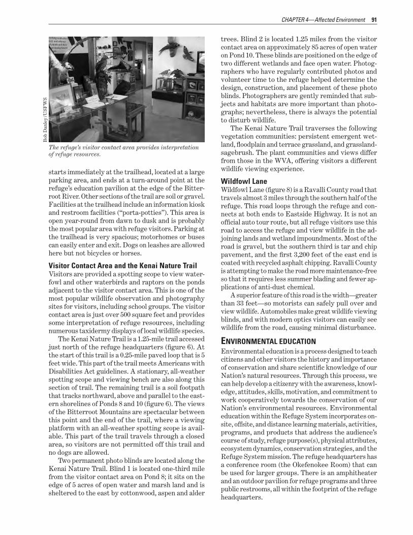
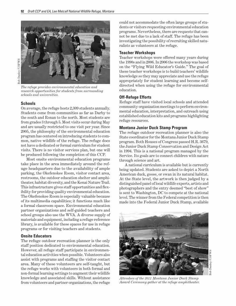
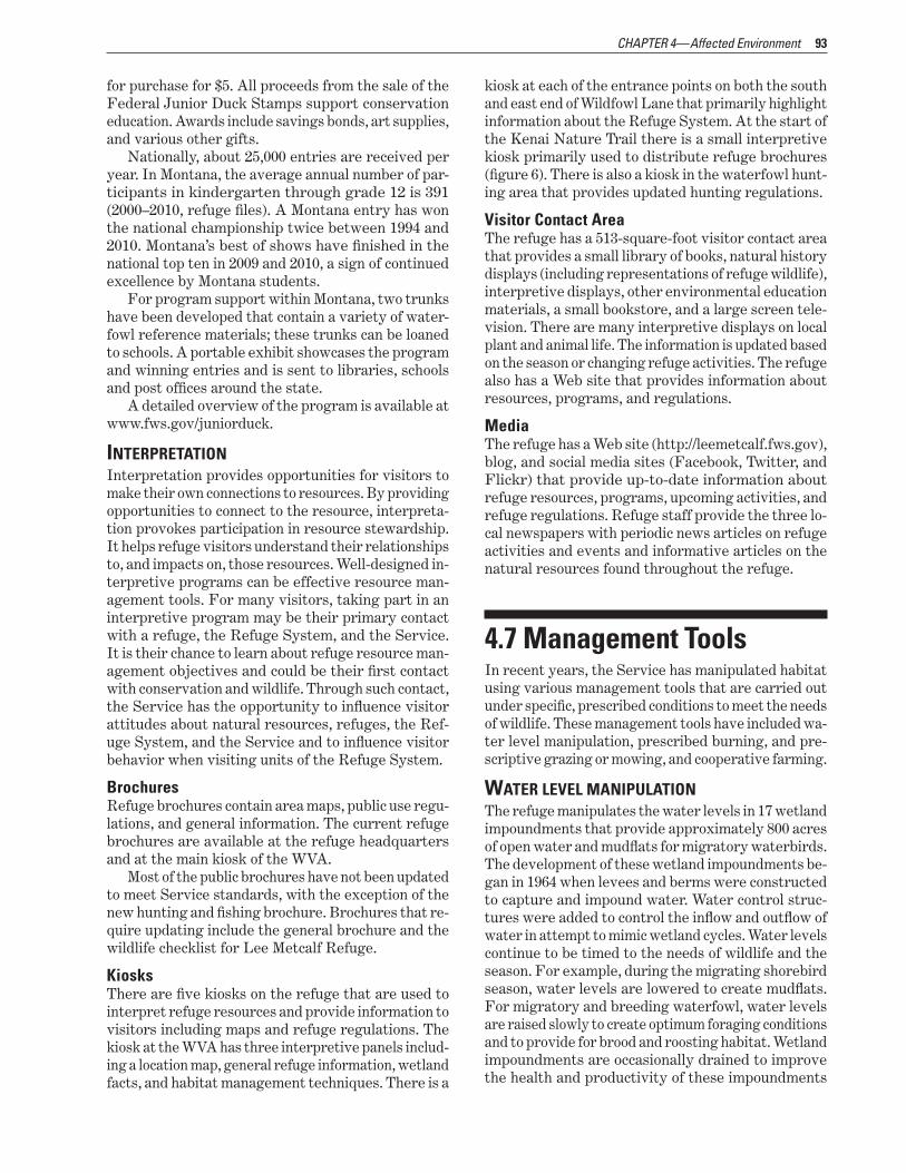
Embed Size (px)
Citation preview
Draft Comprehensive Conservation Plan and Environmental Assessment
Lee Metcalf National Wildlife Refuge Montana
March 2012
Prepared by
Lee Metcalf National Wildlife Refuge 4567 Wildfowl Lane
Stevensville Montana 59870 406 777 5552
US Fish and Wildlife Service Region 6 MountainndashPrairie Region
Division of Refuge Planning 134 Union Boulevard Suite 300
Lakewood Colorado 80228 303 236 8145
Summary VII
Abbreviations XIII
CHAPTER 1mdash Introduction 1 11 Purpose and Need for the Plan 2 12 North American Model of Wildlife Conservation 2 13 The US Fish and Wildlife Service and the Refuge System
US Fish and Wildlife Service 4 4
Service Activities in Montana 4 National Wildlife Refuge System
People and the Refuge System 5 5
13 National and Regional Mandates 6 14 Contributions to National and Regional Plans
Fulfilling the Promise Partners in Flight
North American Waterbird Conservation Plan
6 6 6 7
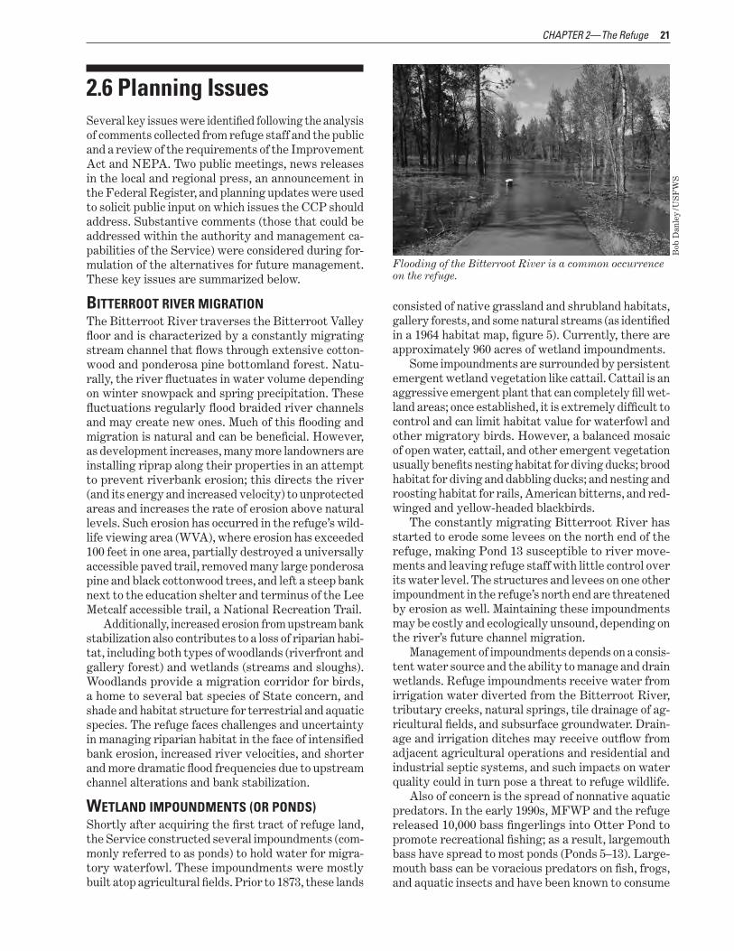
North American Waterfowl Management Plan Intermountain West Regional Shorebird Plan
State Comprehensive Fish and Wildlife Conservation Strategy
8 9 9
15 Strategic Habitat Conservation Climate Change
10 10
16 Planning Process Coordination with the Public
11 12
State Coordination 12 Tribal Coordination 14
Results of Scoping Selecting an Alternative
14 14
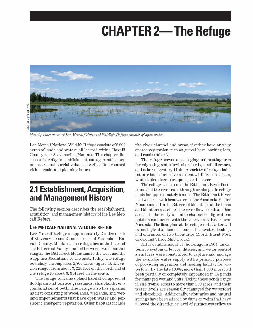
CHAPTER 2mdash The Refuge 15 21 Establishment Acquisition and Management History
Lee Metcalf National Wildlife Refuge Summary of Land Acquisition History
15 15 17
22 Purposes 17 23 Vision 19 24 Goals 19
Bitterroot River Floodplain and Associated Wildlife Wetland Impoundment Habitat and Associated Wildlife
Grassland and Shrubland Habitat and Associated Wildlife
19 19 19
Invasive and Nonnative Species Research
19 19
Cultural Resources 19 Visitor Services 19
Partnerships Operations and Facilities
20 20
Contents
IV
25 Special Values 20 26 Planning Issues 21
Bitterroot River Migration 21 Wetland Impoundments (or Ponds) 21 Upland Habitat and Associated Wildlife 23 Water 23 Invasive and Noxious Species 23 Research Inventory and Monitoring 24 Visitor Services 24 Staffing 24
CHAPTER 3mdash Alternatives and Environmental Consequences 25 31 Alternatives Development 25
Alternatives Considered but Eliminated 25 Elements Common to All Alternatives 25
32 Description of Alternatives 26 Alternative A (Current ManagementndashNo Action) 26 Alternative B (Proposed Action) 26 Alternative C 28
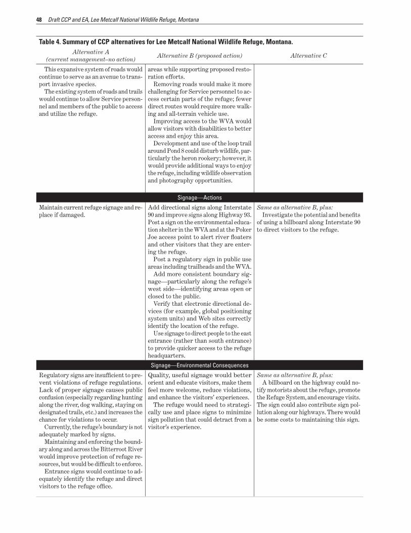
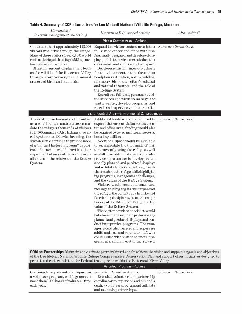
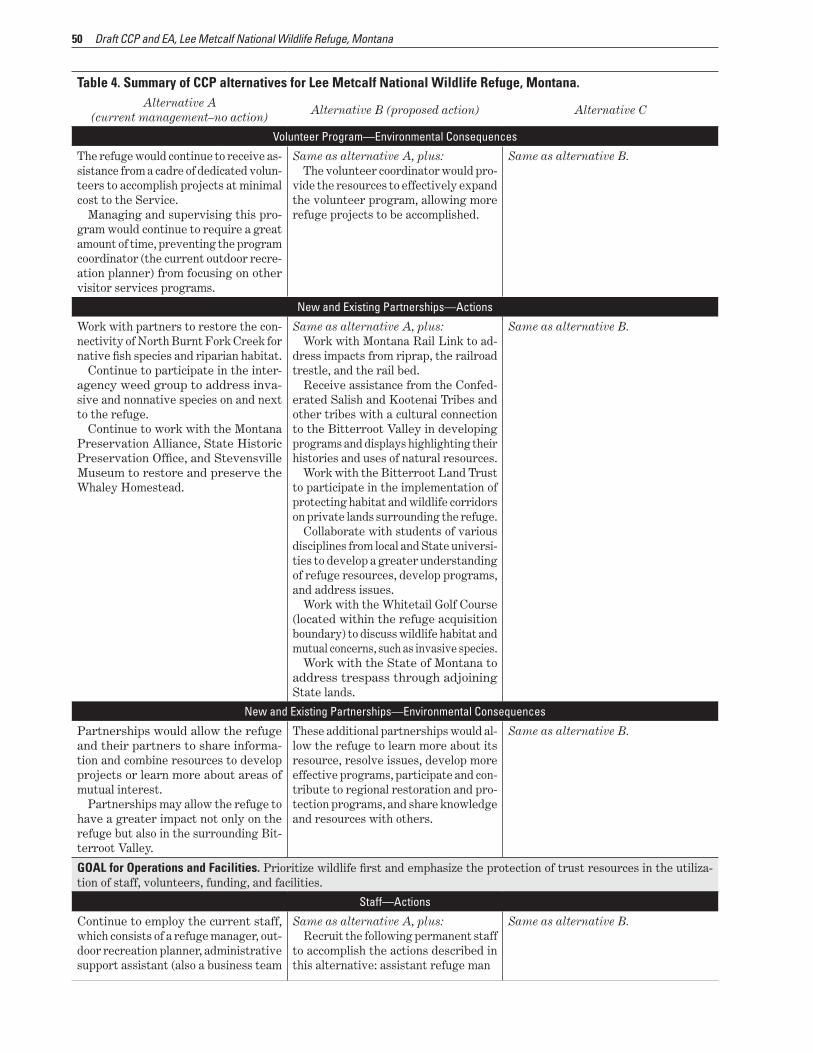
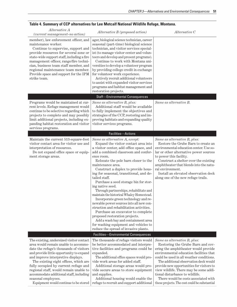
33 Summary of Environmental Consequences 28 Effects Common to All Alternatives 28
34 Detailed Descriptions of Alternatives and Consequences 29 Socioeconomics 29 Cumulative Impacts 29
CHAPTER 4mdash Affected Environment 53 41 Physical Environment 53
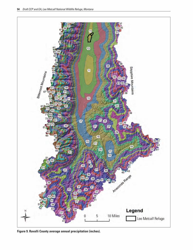
Climate and Hydrology 53 Climate Change 55 Physiography and Geology 58 Soils 59 Topography and Elevation 59 Water Rights 62 Hydrogeomorphic Changes 62 Air Quality 67
42 Biological Resources 67 Land Cover and Vegetation Communities 68 Habitat Modifications since Establishment 71 Changes to the Vegetation Communities 72 Changes to Fish and Wildlife Populations 73 Upland Habitat 75 Riparian Habitat 76 Wetland Impoundment Habitat 77 Remaining Refuge Acres 78 Invasive Species 78 Wildlife Diseases and Contaminants 78
43 State and Federally Listed Species 80 Species of Concern 80
44 Cultural Resources and History 83 Prehistoric Occupation 83 History of the Salish 84 Euro-American Settlement and Land Use Changes 84
Draft CCP and EA Lee Metcalf National Wildlife Refuge Montana
45 Special Management Areas 87 Wilderness Review 87 Important Bird Area 89
46 Visitor Services 89 Hunting and Fishing 89 Wildlife Observation and Photography 90 Environmental Education 91 Interpretation 93
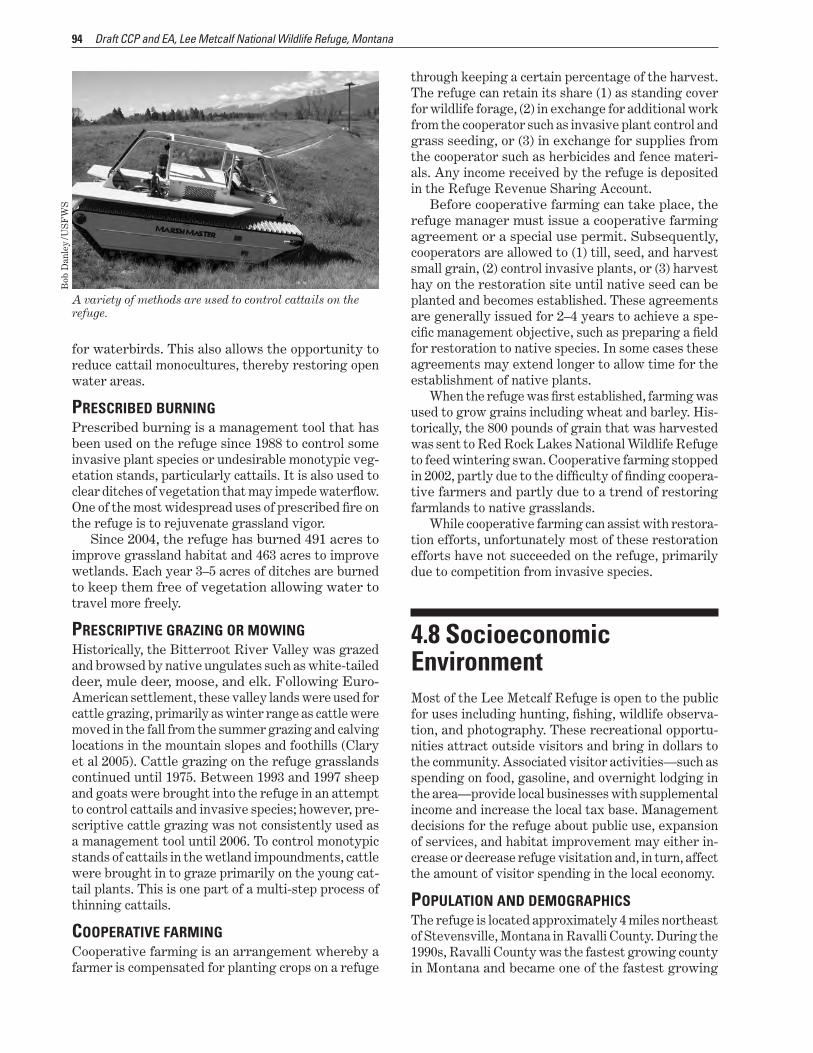
47 Management Tools 93 Water Level Manipulation 93 Prescribed Burning 94 Prescriptive Grazing or mowing 94 Cooperative Farming 94
48 Socioeconomic Environment 94 Population and Demographics 94 Employment 95 Public Use of the Refuge 95 Baseline Economic Activity 95 US Fish and Wildlife Service Employment 96 Visitor Spending 96
49 Partnerships 96 410 Operations 96
Staff 96 Facilities 97
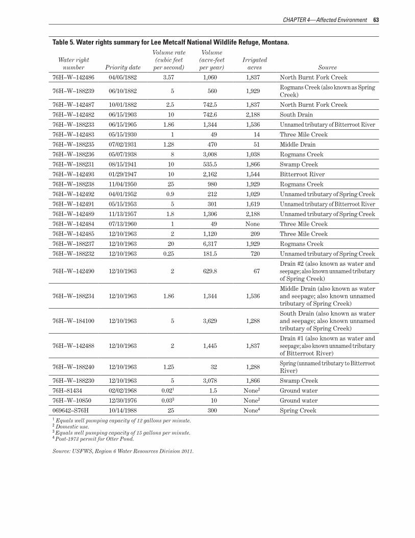
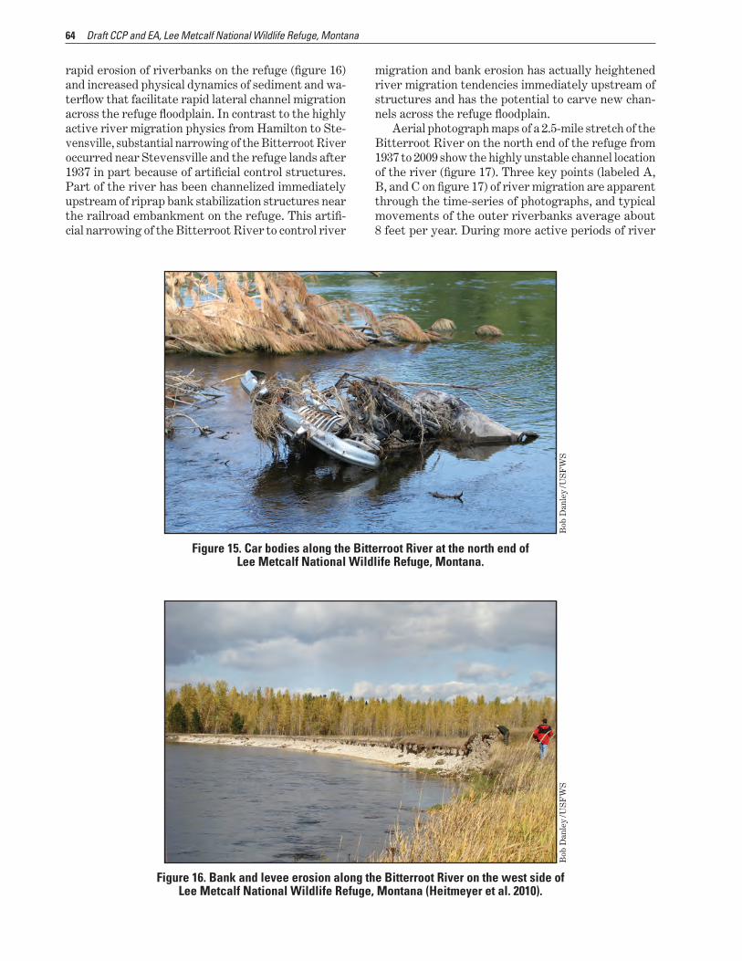
CHAPTER 5mdash Implementation of the Proposed Action (Draft CCP) 99 51 Summary of the Draft CCP 99
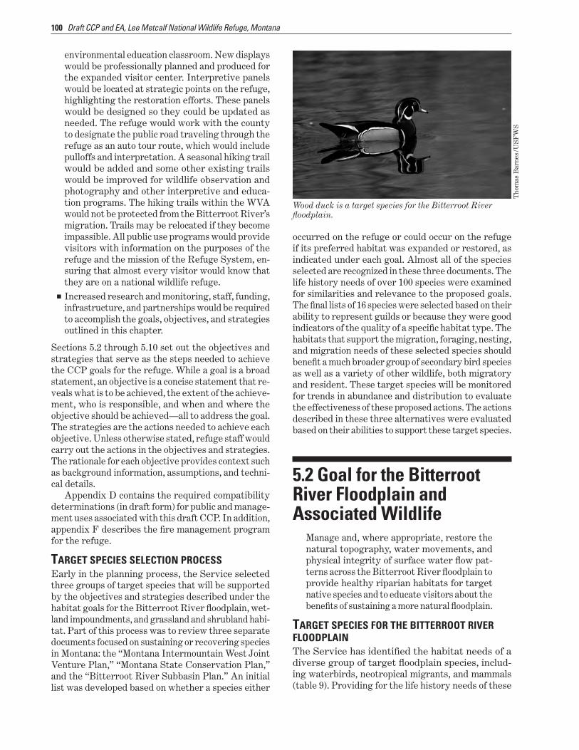
Target species Selection Process 100 52 Goal for the Bitterroot River Floodplain and Associated Wildlife 100
Target species for the Bitterroot River Floodplain 100 Floodplain Objective 1 102 Floodplain Objective 2 103 North Burnt Fork Creek Objective (Including Francois Slough) 104 Three Mile Creek Objective 105 Riverfront Forest Habitat Objective 106 Gallery Forest Habitat Objective 106
53 Goal for Wetland Impoundment Habitat and Associated Wildlife 108 Target Wetland Habitat Species 108 Wetland Impoundment Habitat Objective 1 108 Wetland Impoundment Habitat Objective 2 109 Gravel Pits Objective 110
54 Goal for Grassland and Shrubland Habitat and Associated Wildlife 111 Target Grassland and Shrubland Species 111 Grassland and Shrubland Habitat Objective 111
55 Goal for Invasive and Nonnative Species 113 New Invasive Species Objective 114 Established Invasive Species Objective 114
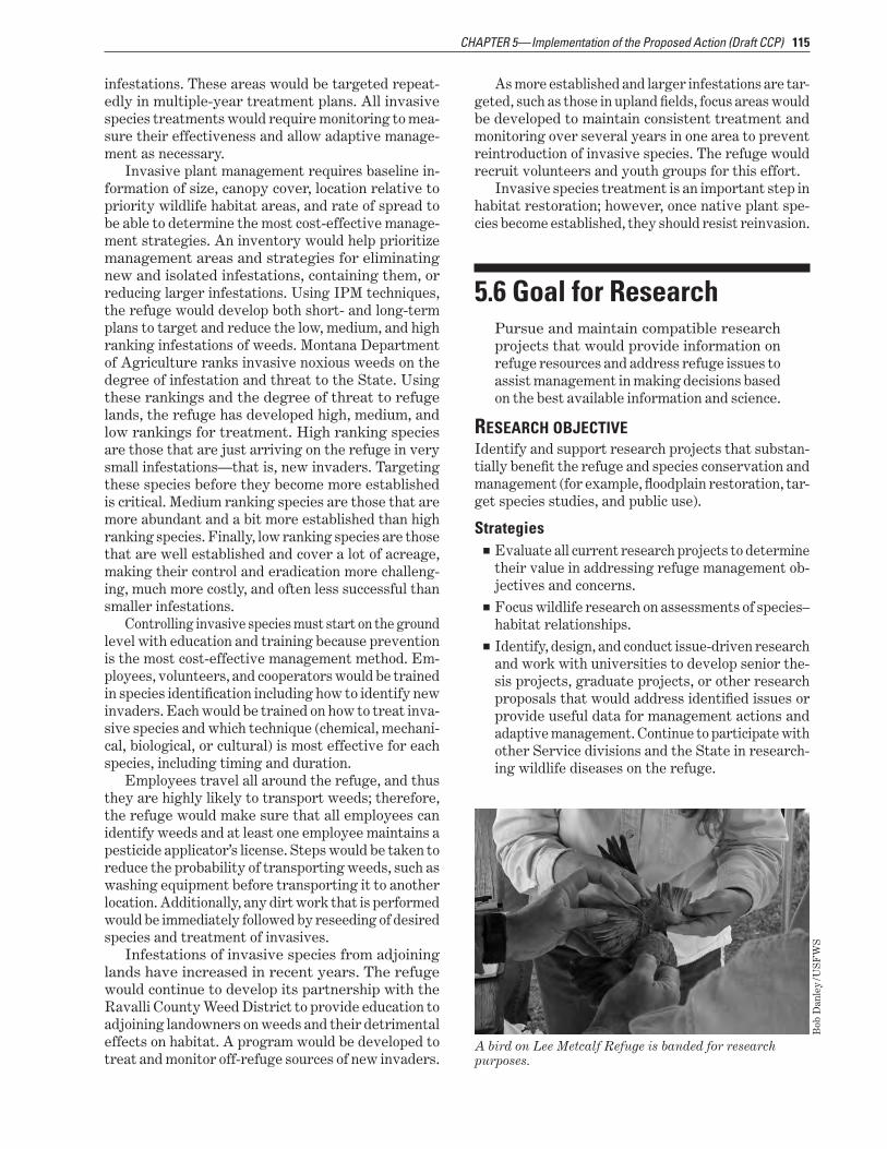
56 Goal for Research 115 Research Objective 115
57 Goal for Cultural Resources 116 Cultural Resources Objective 1 (Protection) 116 Cultural Resources Objective 2 (Interpretation) 117
V Contents
58 Goal for Visitor Services 118 Hunting Objective 118 Fishing Objective 1 119 Fishing Objective 2 119 Wildlife Observation and Photography Objective 120 Environmental Education Objective 121 Interpretation Objective 123 Signage Objective 124
59 Goal for Partnerships 125 Partnership Objective 125
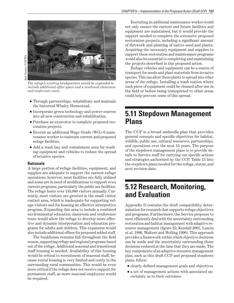
510 Goal for Operations and Facilities 125 Staff Objective 125 Facilities Equipment and Supplies Objective 126
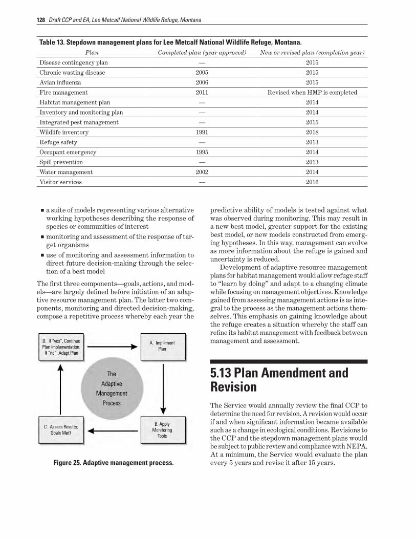
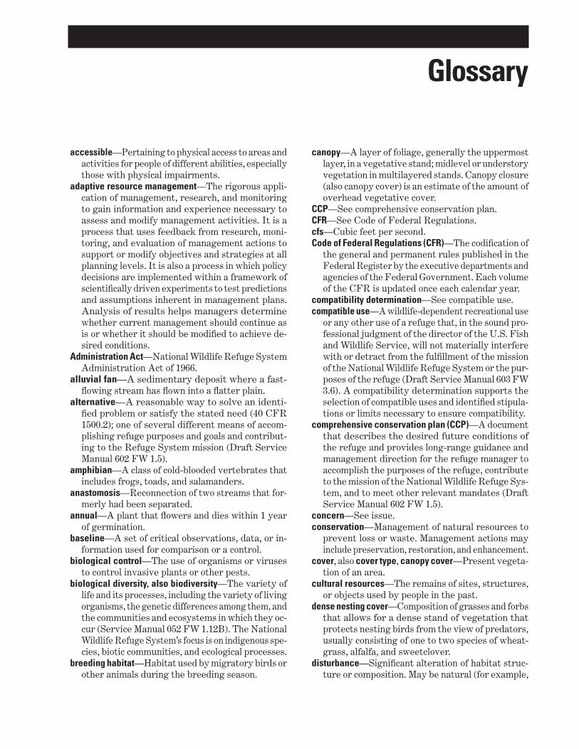
511 Stepdown Management Plans 127 512 Research Monitoring and Evaluation 127 513 Plan Amendment and Revision 128
Glossary 129
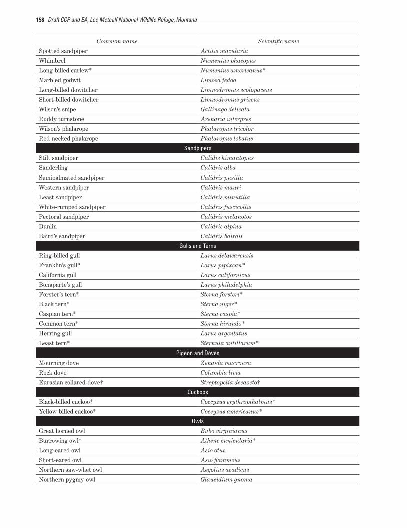
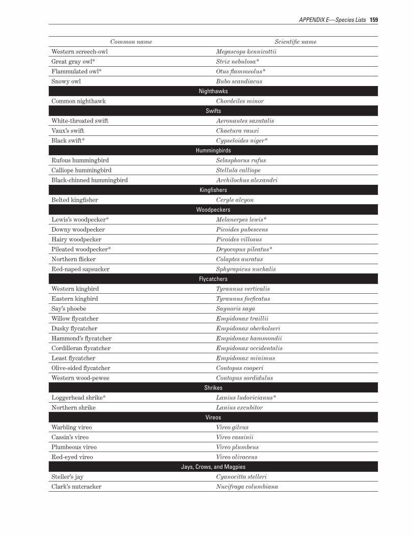
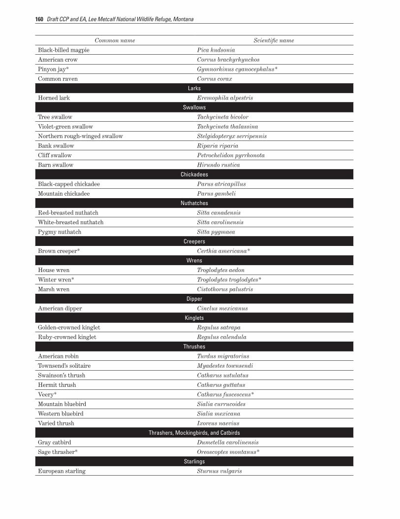
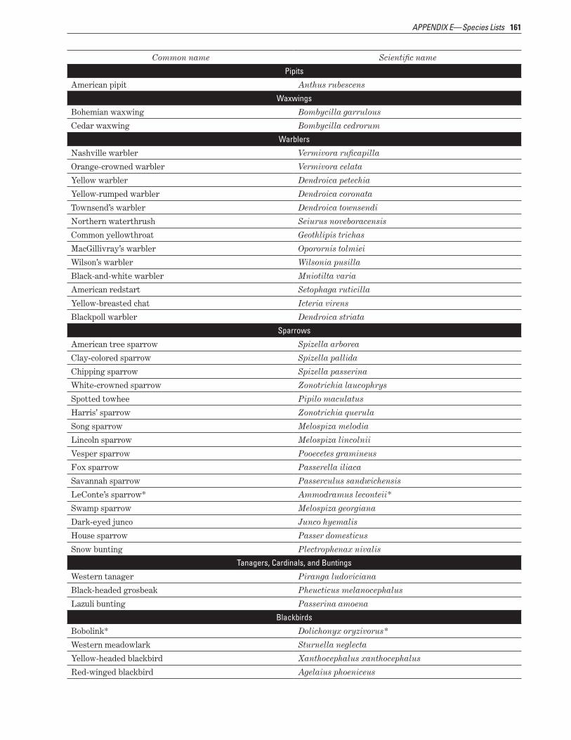
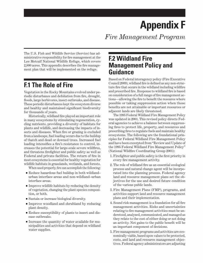
Appendixes Appendix AmdashKey Legislation and Policy 135 Appendix BmdashList of Preparers Consultation and Coordination 139 Appendix CmdashPublic Involvement 141 Appendix DmdashDraft Compatibility Determinations 143 Appendix EmdashSpecies Lists 155 Appendix FmdashFire Management Program 181
Bibliography 185
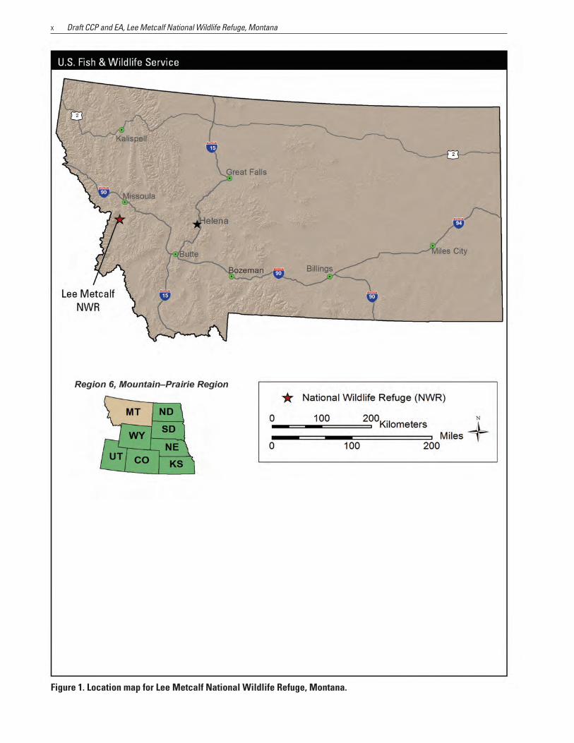
FIGURES 1 Location map for Lee Metcalf National Wildlife Refuge Montana x
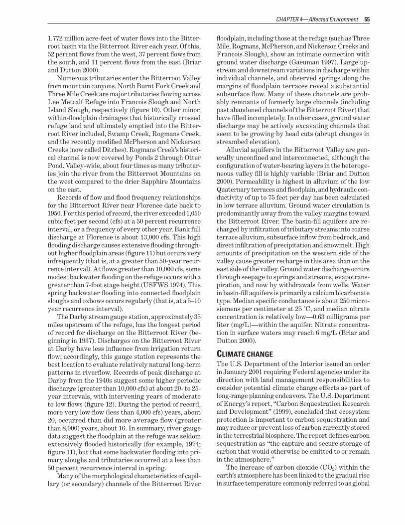
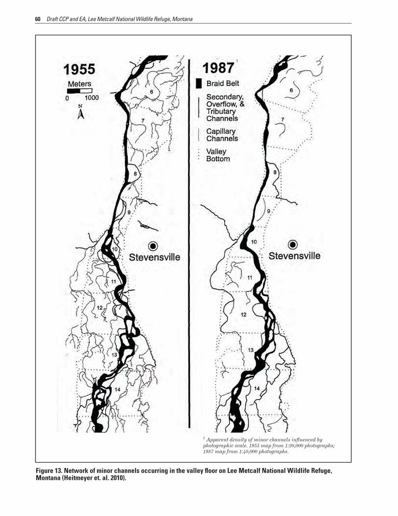
13 Network of minor channels occurring in the valley floor on Lee Metcalf National Wildlife Refuge Montana
16 Bank and levee erosion along the Bitterroot River on the west side of Lee Metcalf National Wildlife Refuge
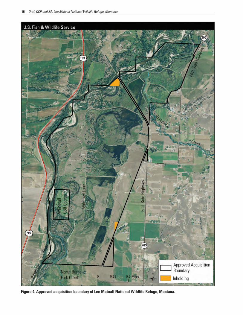
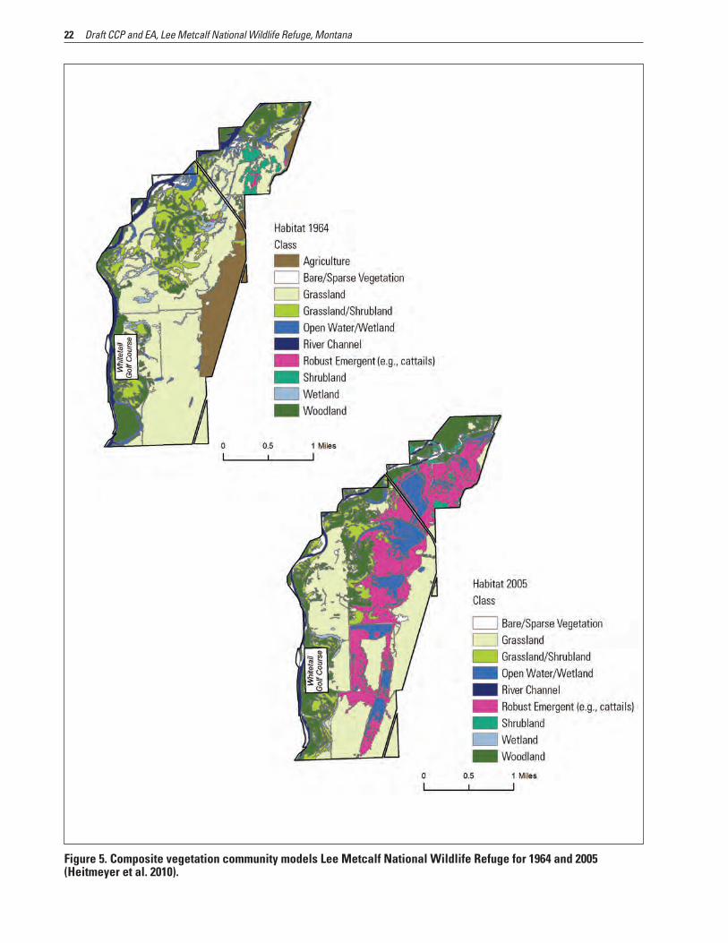
2 Area map for Lee Metcalf National Wildlife Refuge Montana 3 3 Process steps for comprehensive conservation planning and associated environmental analysis 11 4 Approved acquisition boundary of Lee Metcalf National Wildlife Refuge Montana 16 5 Composite vegetation community models Lee Metcalf National Wildlife Refuge for 1964 and 2005
(Heitmeyer et al 2010) 22 6 Public use map for Lee Metcalf National Wildlife Refuge Montana 41 7 Ponds and upland fields in Lee Metcalf National Wildlife Refuge Montana 43 8 Roads within Lee Metcalf National Wildlife Refuge Montana 47 9 Ravalli County average annual precipitation (inches) 54
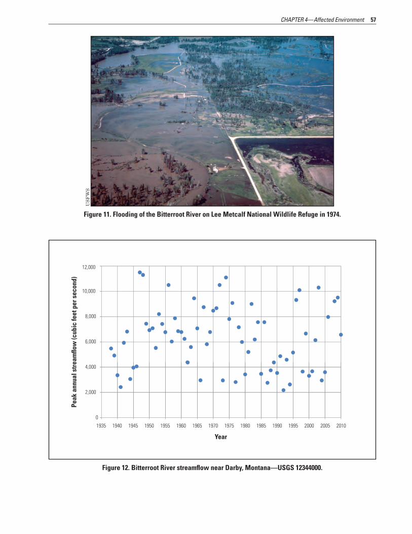
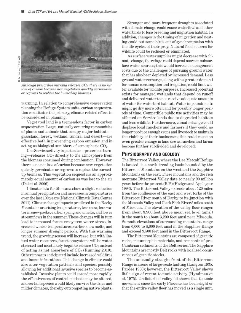
10 Channels and sloughs of the Bitterroot River in the 1940s (Heitmeyer et al 2010) 56 11 Flooding of the Bitterroot River on Lee Metcalf National Wildlife Refuge in 1974 57 12 Bitterroot River streamflow near Darby MontanamdashUSGS 12344000 57
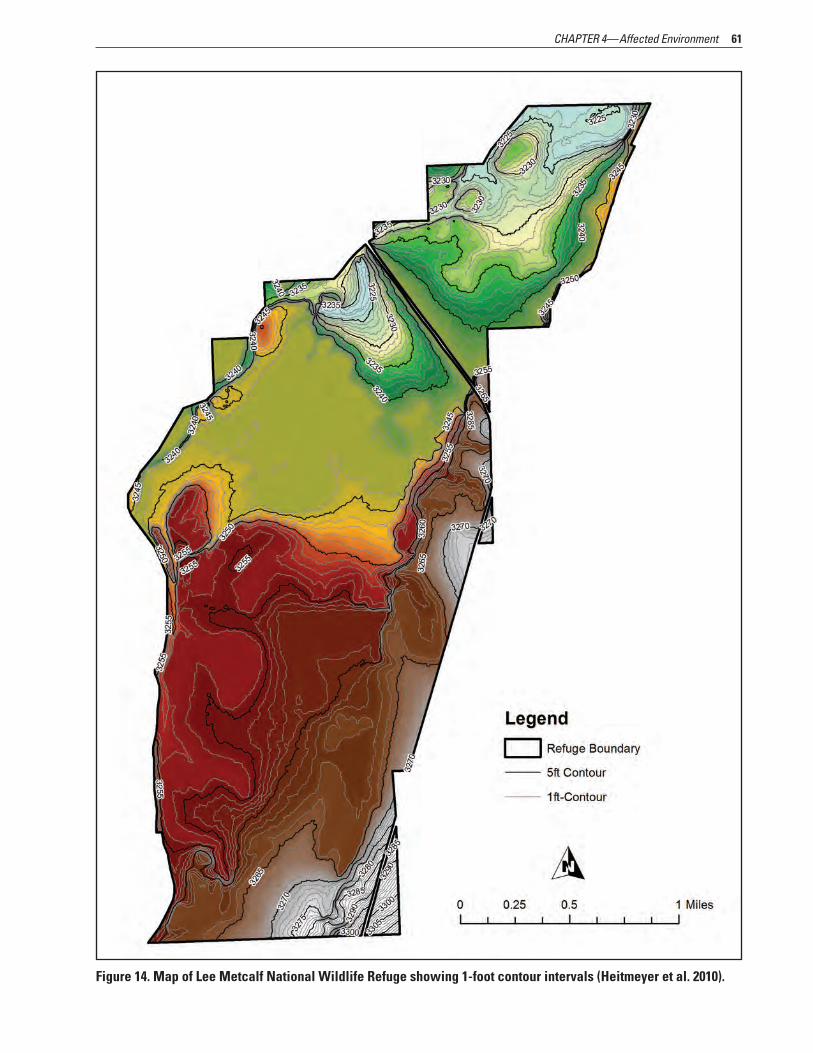
(Heitmeyer et al 2010) 60 14 Map of Lee Metcalf National Wildlife Refuge showing 1-foot contour intervals (Heitmeyer et al 2010) 61 15 Car bodies along the Bitterroot River at the north end of Lee Metcalf National Wildlife Refuge Montana 64
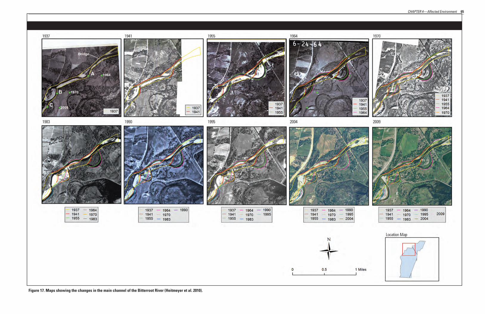
Montana (Heitmeyer et al 2010) 64 17 Maps showing the changes in the main channel of the Bitterroot River (Heitmeyer et al 2010) 65
VI Draft CCP and EA Lee Metcalf National Wildlife Refuge Montana
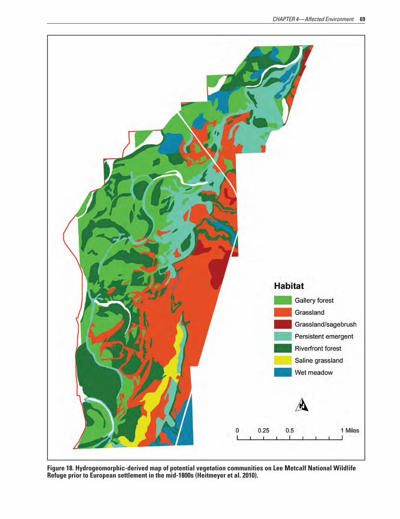
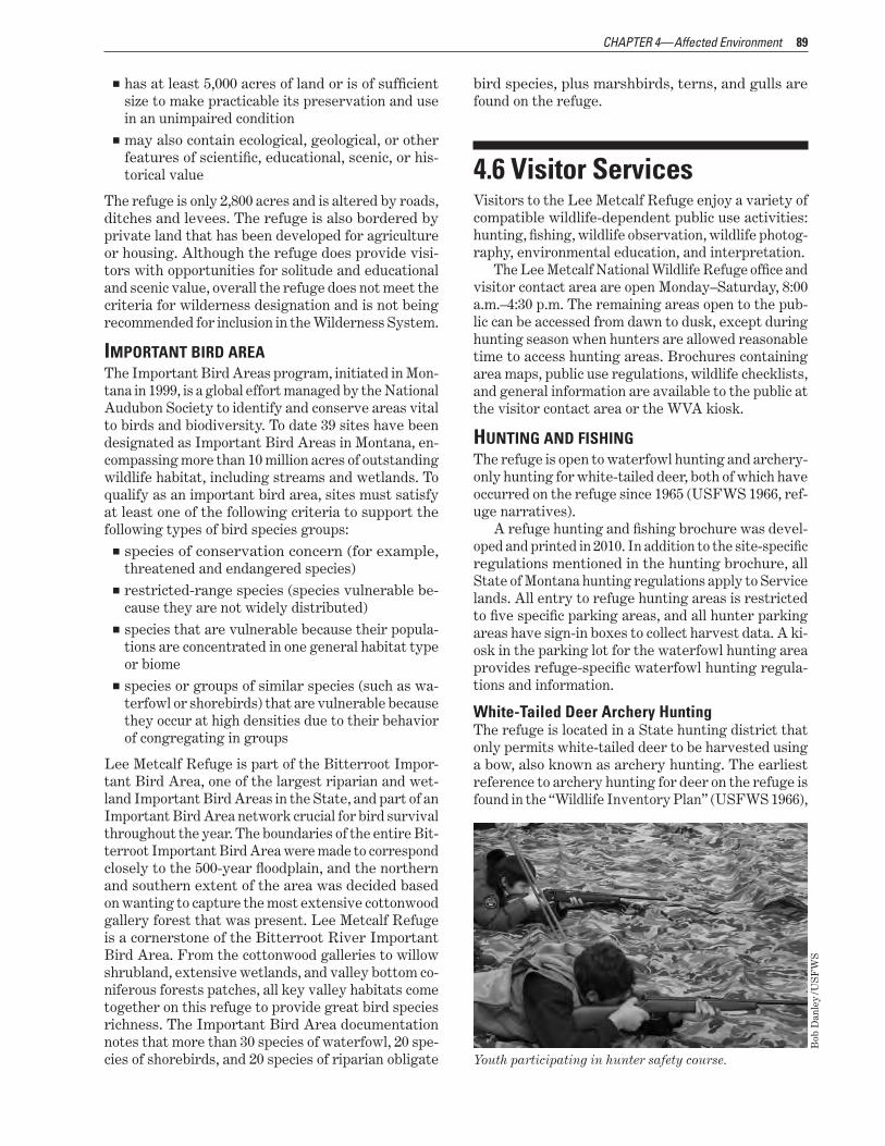
18 Hydrogeomorphic-derived map of potential vegetation communities on Lee Metcalf National Wildlife Refuge prior to European settlement in the mid-1800s (Heitmeyer et al 2010) 69
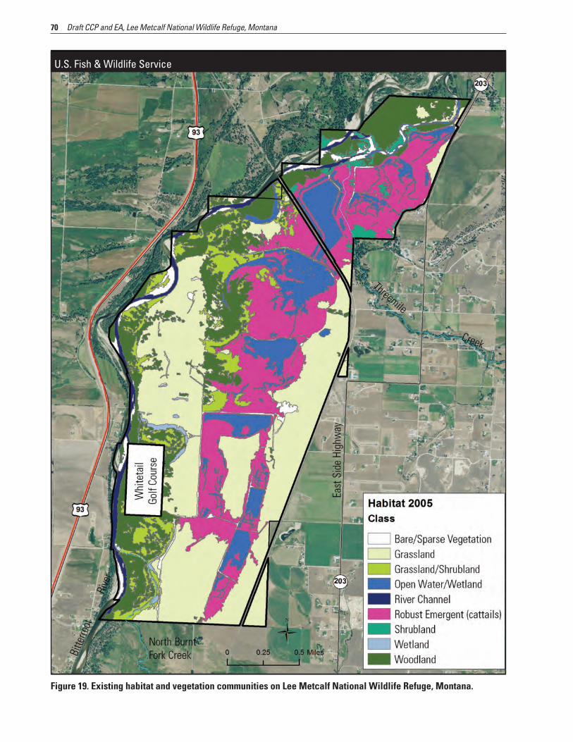
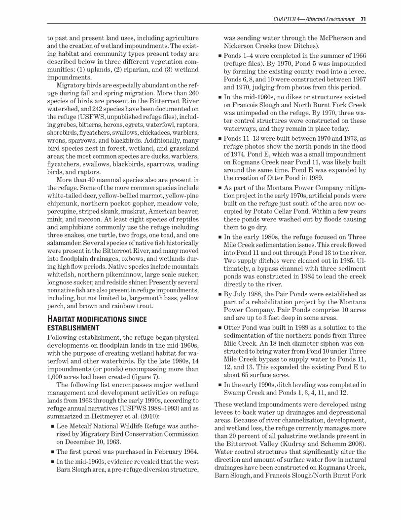
19 Existing habitat and vegetation communities on Lee Metcalf National Wildlife Refuge Montana 70 20 Field planted as dense nesting cover on Lee Metcalf National Wildlife Refuge Montana 73
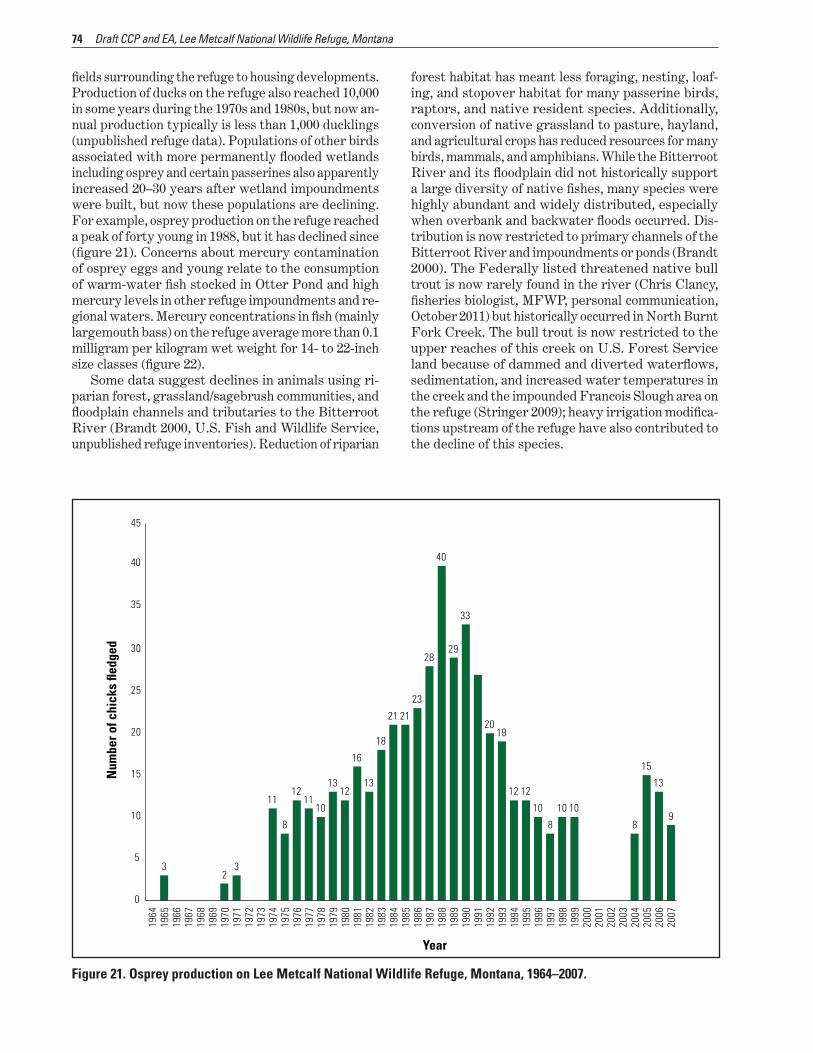
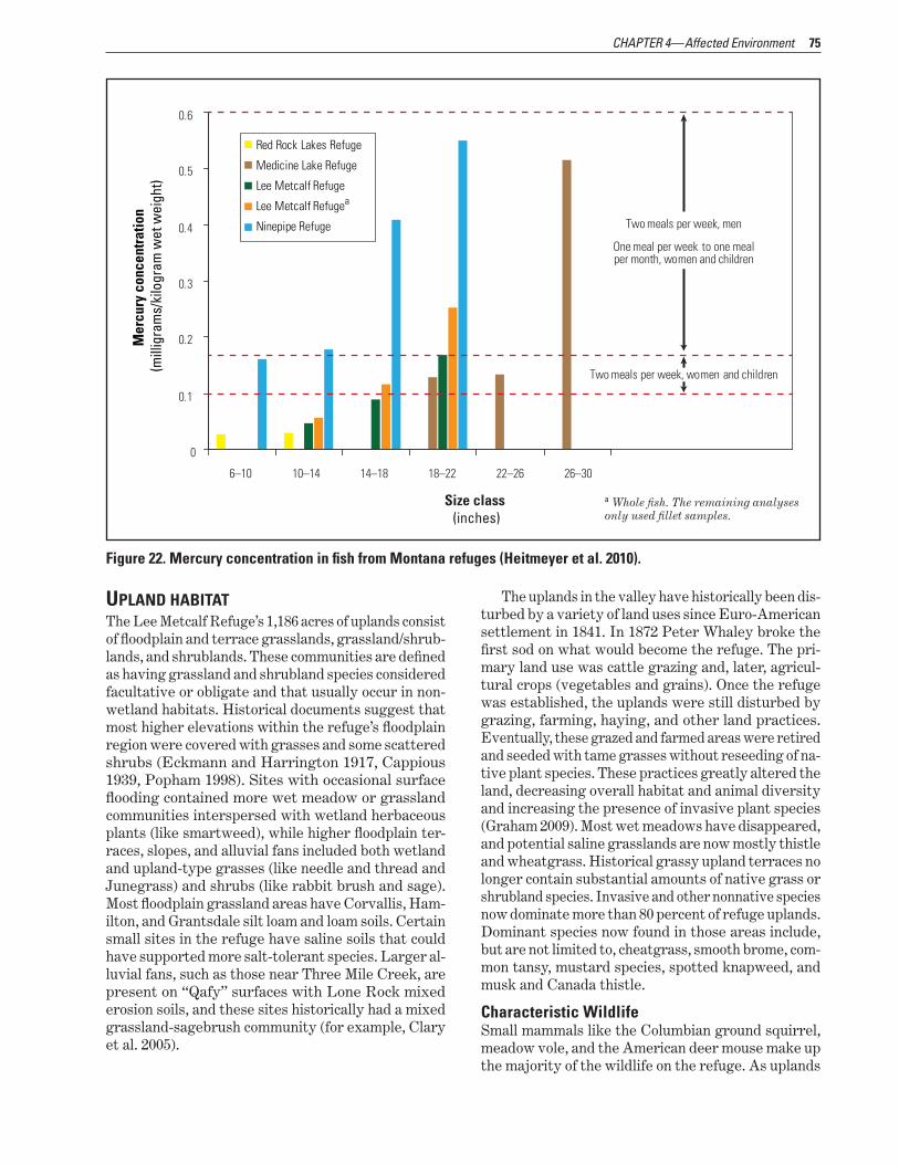
21 Osprey production on Lee Metcalf National Wildlife Refuge Montana 1964ndash2007 74 22 Mercury concentration in fish from Montana refuges (Heitmeyer et al 2010) 75
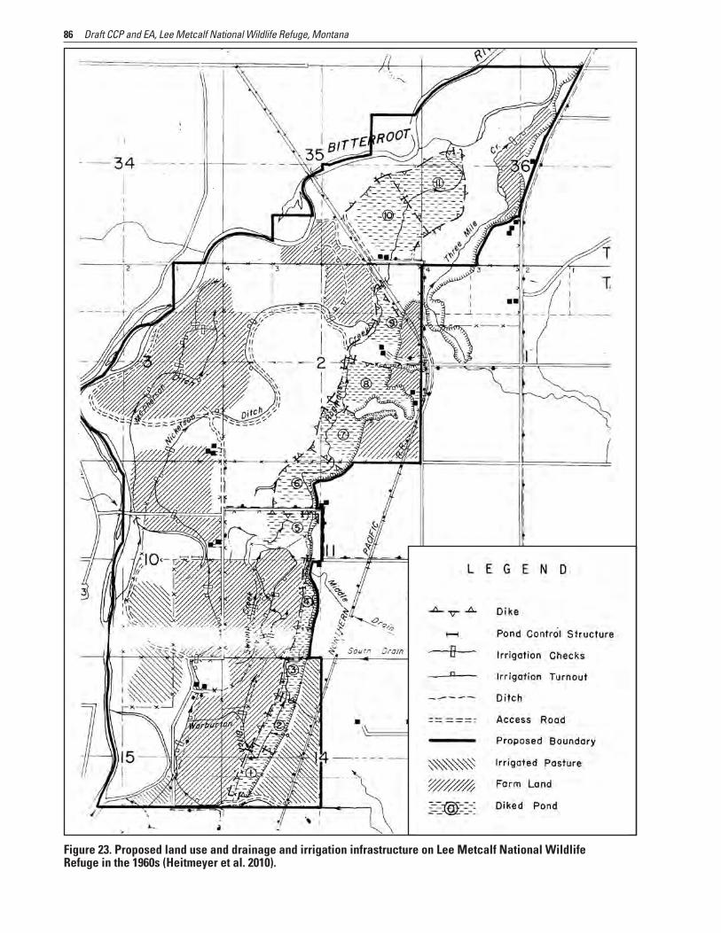
23 Proposed land use and drainage and irrigation infrastructure on Lee Metcalf National Wildlife Refuge in the 1960s (Heitmeyer et al 2010) 86
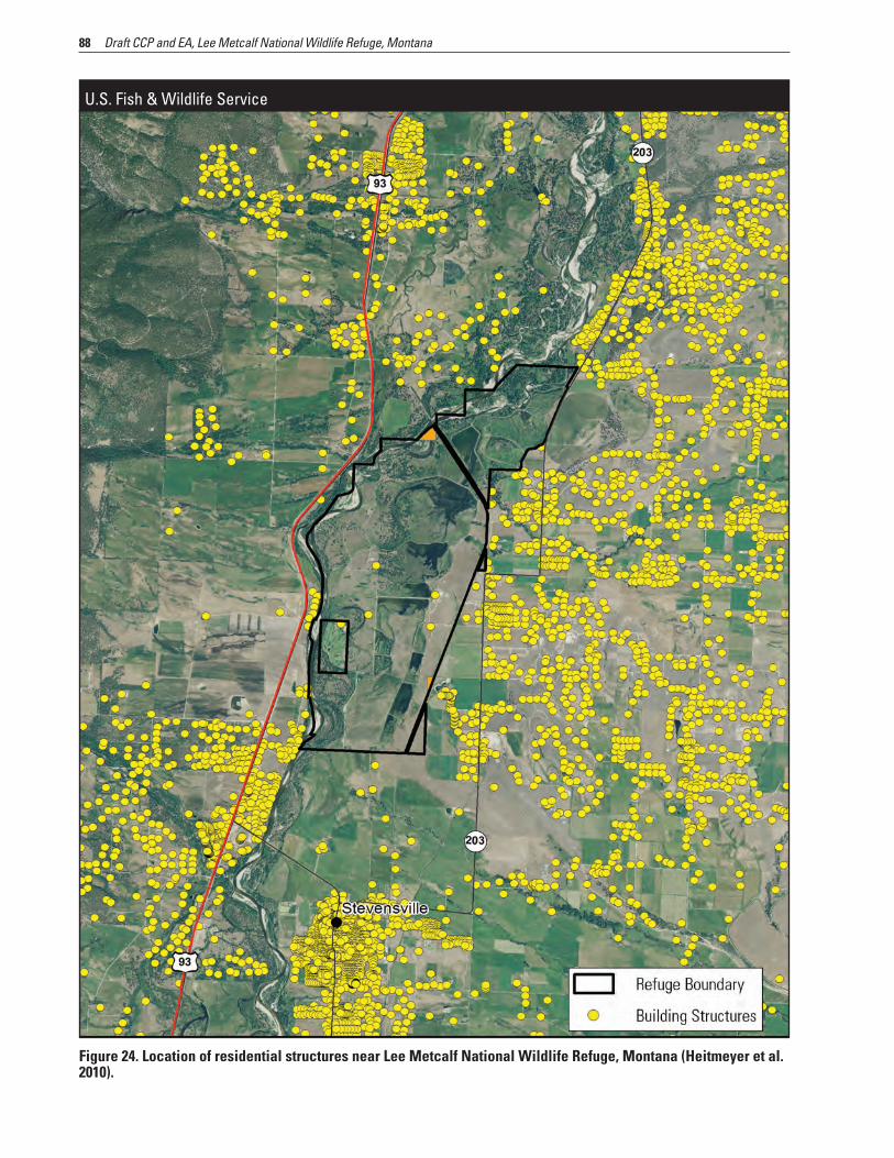
24 Location of residential structures near Lee Metcalf National Wildlife Refuge Montana (Heitmeyer et al 2010) 88 25 Adaptive management process 128
TABLES 1 Summary of the CCP planning process for Lee Metcalf National Wildlife Refuge Stevensville Montana 12
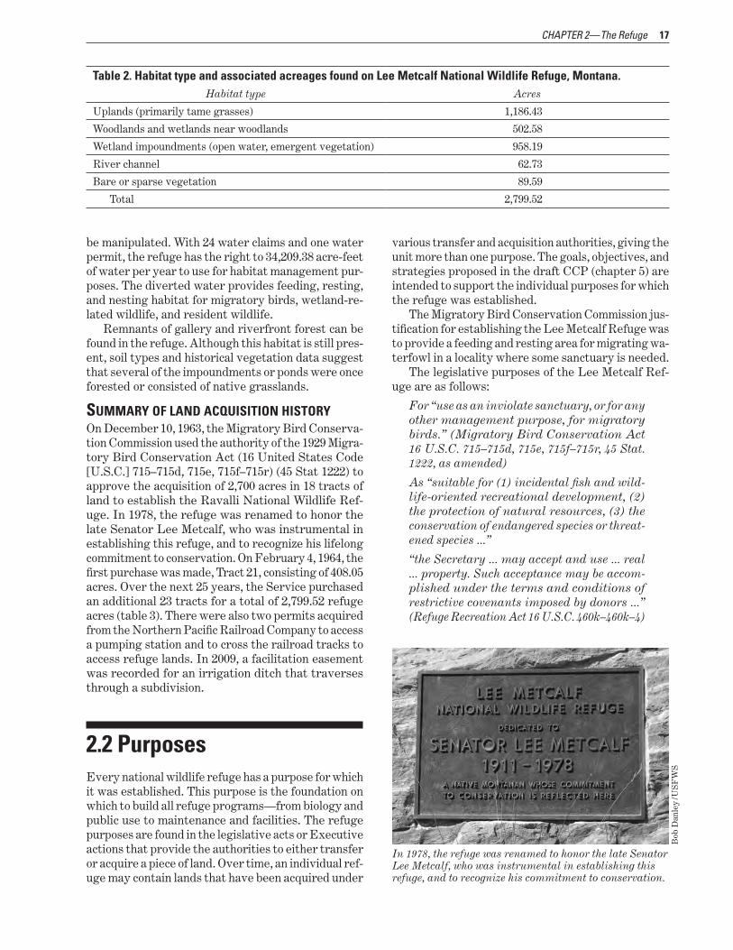
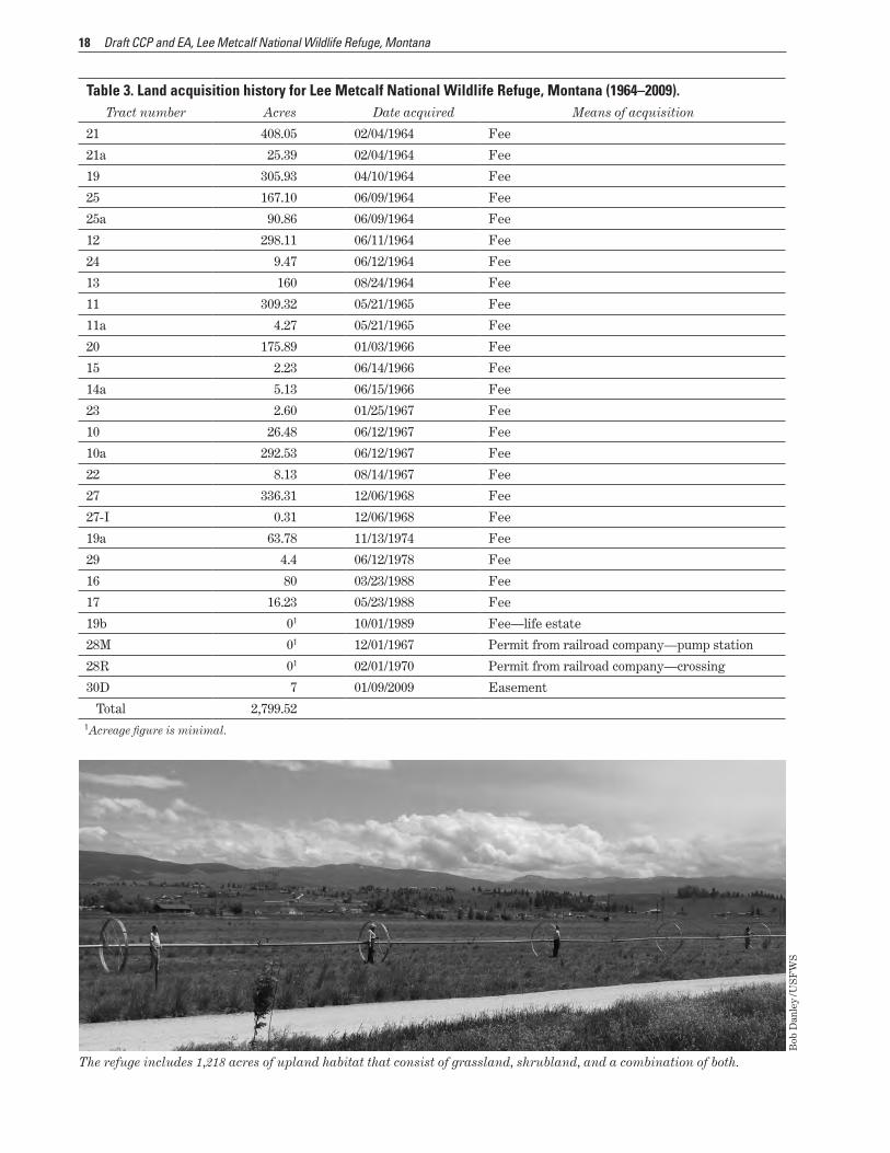
2 Habitat type and associated acreages found on Lee Metcalf National Wildlife Refuge Montana 17 3 Land acquisition history for Lee Metcalf National Wildlife Refuge Montana (1964ndash2009) 18
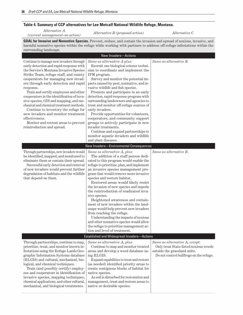
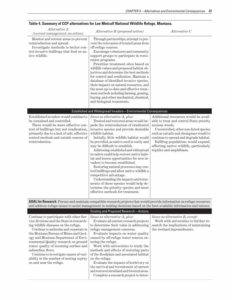
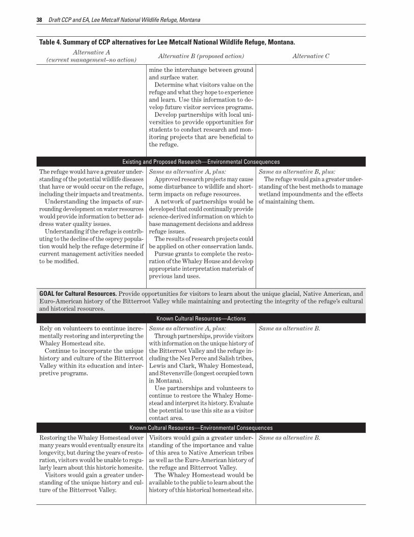
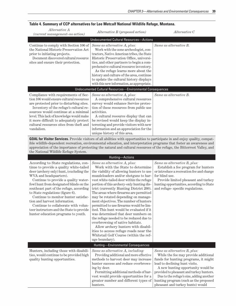
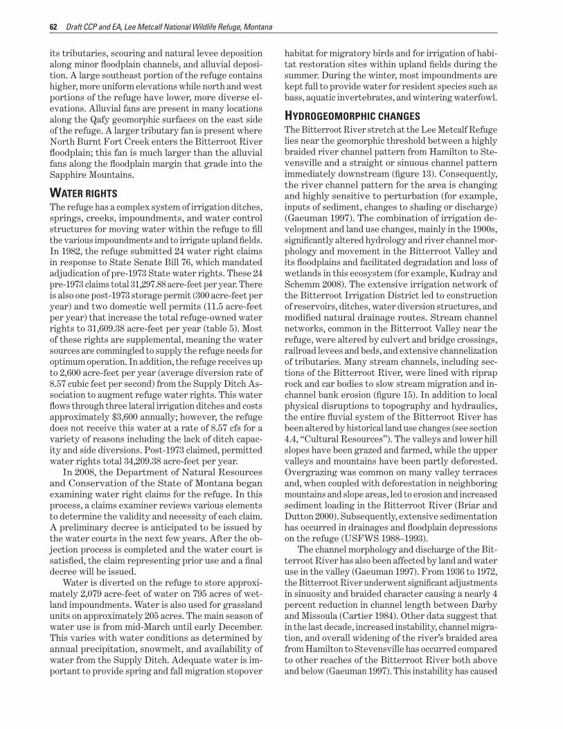
4 Summary of CCP alternatives for Lee Metcalf National Wildlife Refuge Montana 30 5 Water rights summary for Lee Metcalf National Wildlife Refuge Montana 63
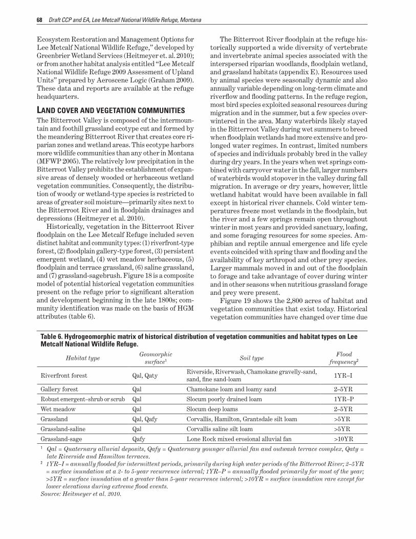
6 Hydrogeomorphic matrix of historical distribution of vegetation communities and habitat types on Lee Metcalf National Wildlife Refuge 68
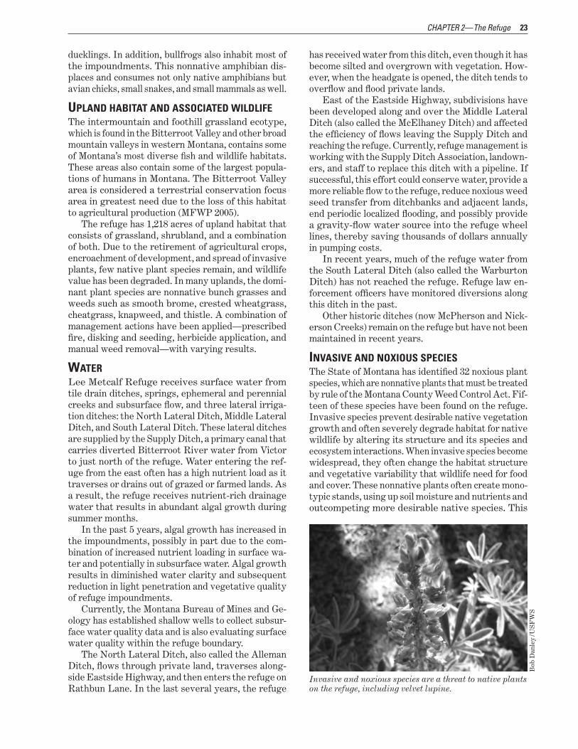
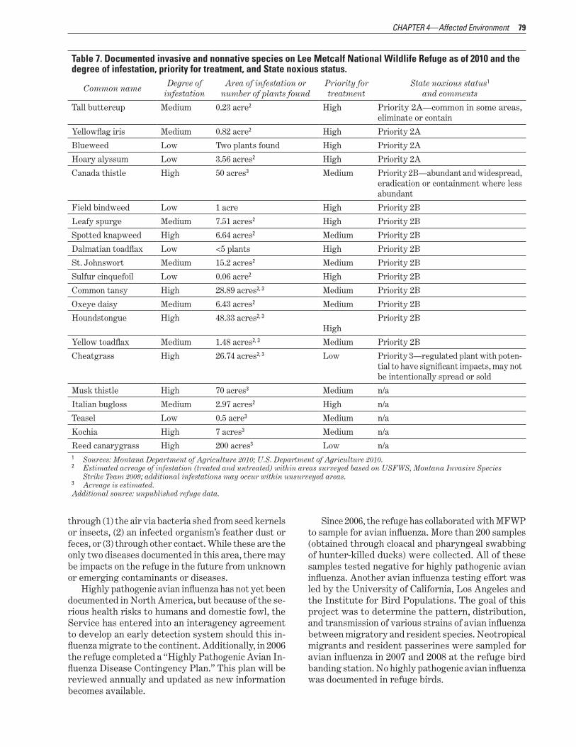
7 Documented invasive and nonnative species on Lee Metcalf National Wildlife Refuge as of 2010 and the degree of infestation priority for treatment and State noxious status 79
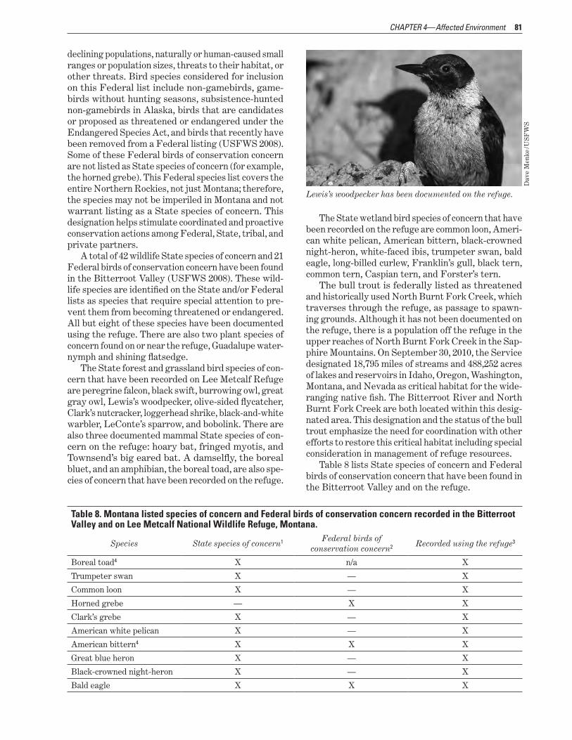
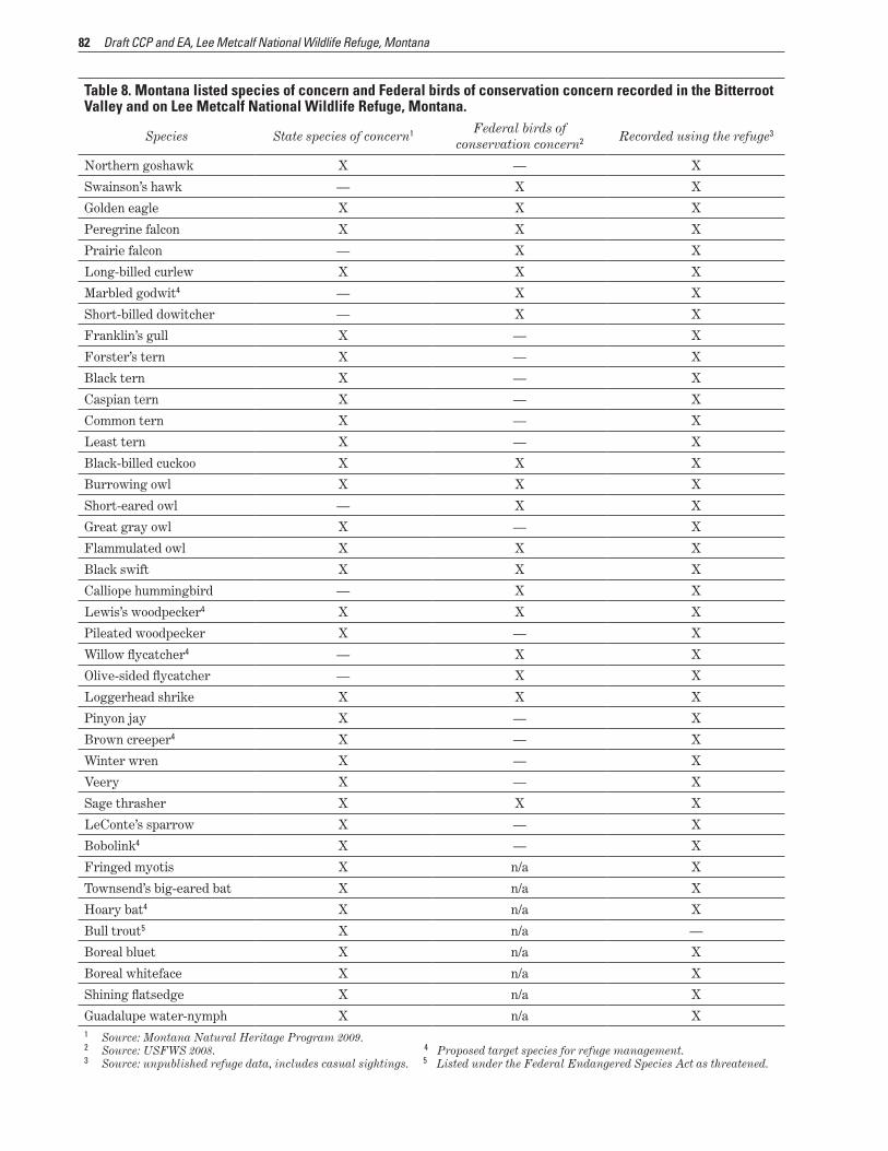
8 Montana listed species of concern and Federal birds of conservation concern recorded in the Bitterroot Valley and on Lee Metcalf National Wildlife Refuge Montana 81
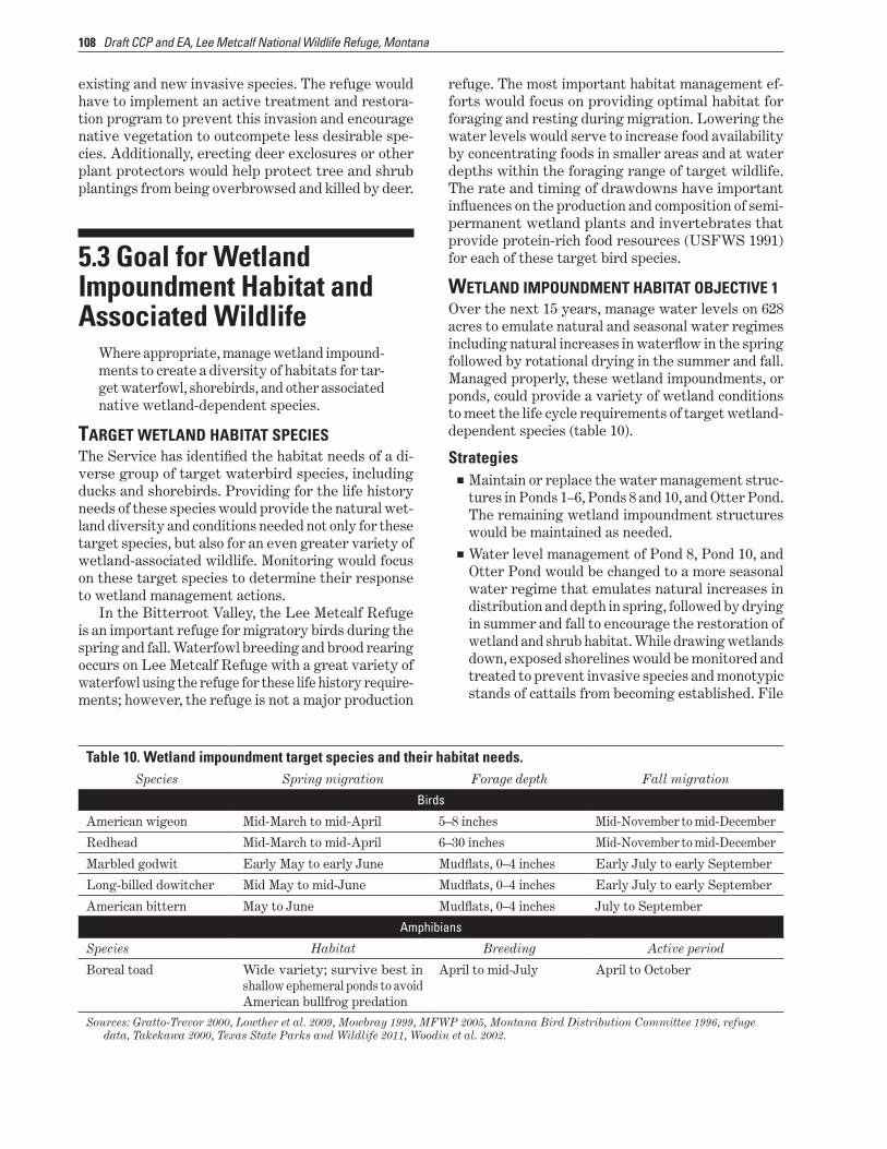
9 Target species for the Bitterroot floodplain and their habitat needs 101 10 Wetland impoundment target species and their habitat needs 108
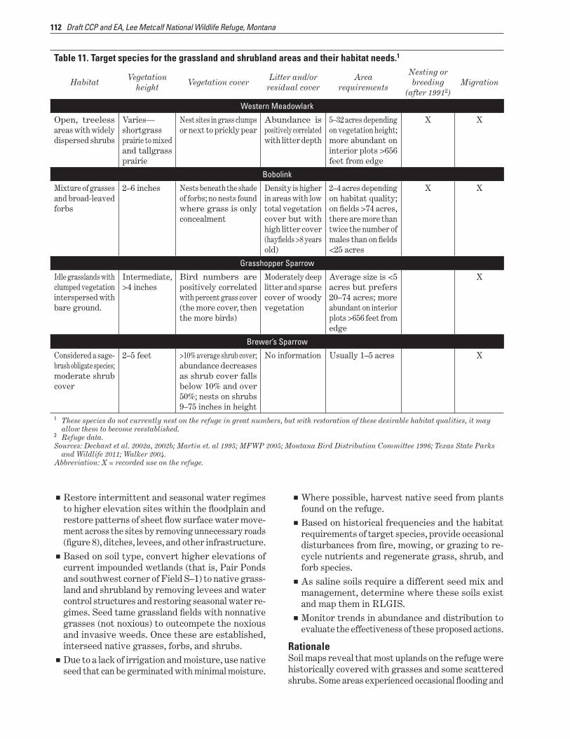
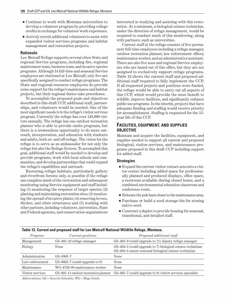
11 Target species for the grassland and shrubland areas and their habitat needs 112 12 Current and proposed staff for Lee Metcalf National Wildlife Refuge Montana 126
13 Stepdown management plans for Lee Metcalf National Wildlife Refuge Montana 128
Contents VII
Summary
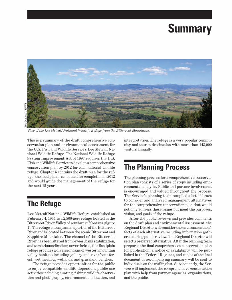
View of the Lee Metcalf National Wildlife Refuge from the Bitterroot Mountains
Bob
Dan
ley
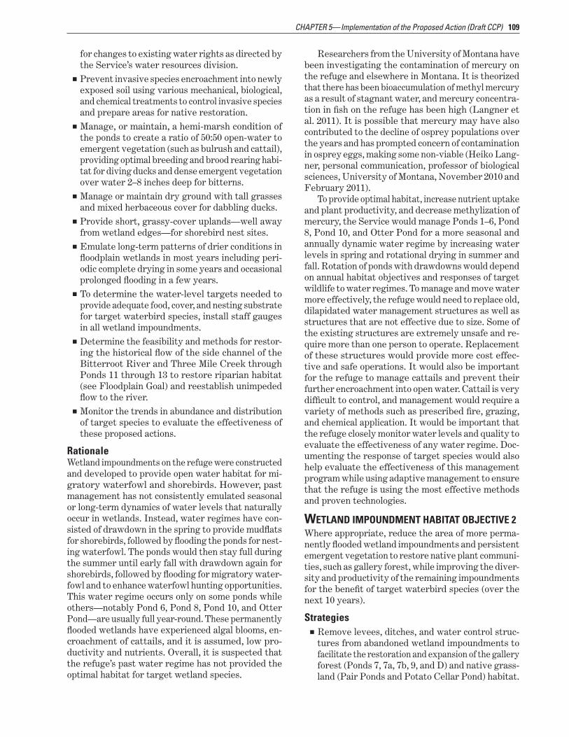
US
FW
S
This is a summary of the draft comprehensive conshyservation plan and environmental assessment for the US Fish and Wildlife Servicersquos Lee Metcalf Nashytional Wildlife Refuge The National Wildlife Refuge System Improvement Act of 1997 requires the US Fish and Wildlife Service to develop a comprehensive conservation plan by 2012 for each national wildlife refuge Chapter 5 contains the draft plan for the refshyuge the final plan is scheduled for completion in 2012 and would guide the management of the refuge for the next 15 years
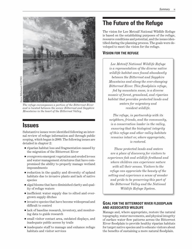
The Refuge Lee Metcalf National Wildlife Refuge established on February 4 1964 is a 2800-acre refuge located in the Bitterroot River Valley of southwest Montana (figure 1) The refuge encompasses a portion of the Bitterroot River and is located between the scenic Bitterroot and Sapphire Mountains The channel of the Bitterroot River has been altered from levees bank stabilization and some channelization nevertheless this floodplain refuge provides a diverse mosaic of western mountain valley habitats including gallery and riverfront forshyest wet meadow wetlands and grassland benches
The refuge provides opportunities for the public to enjoy compatible wildlife-dependent public use activities including hunting fishing wildlife observashytion and photography environmental education and
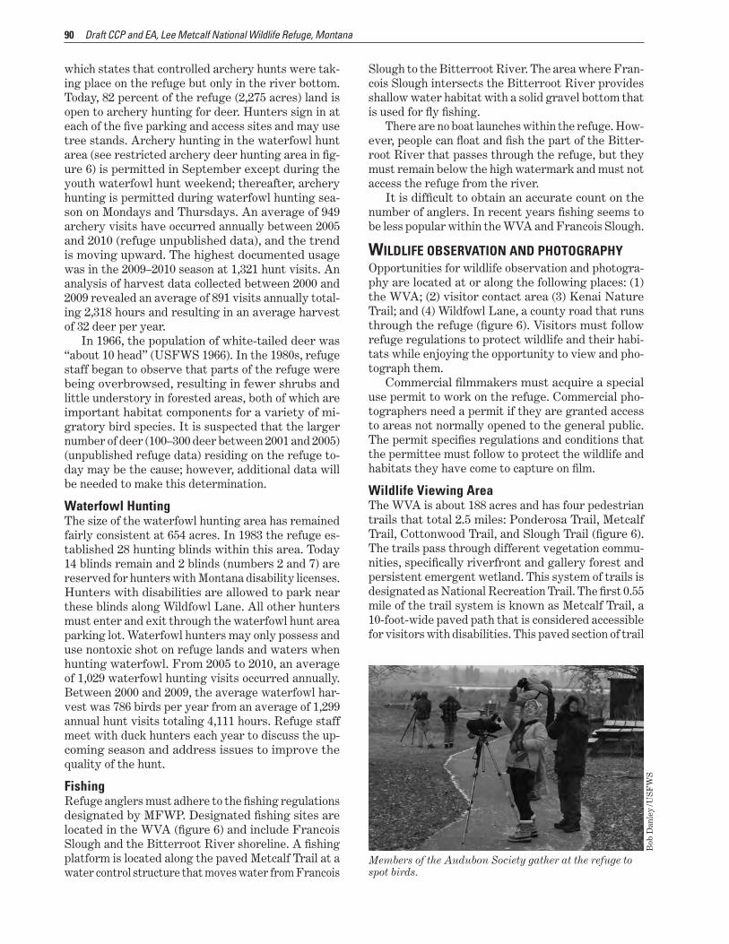
interpretation The refuge is a very popular commushynity and tourist destination with more than 143000 visitors annually
The Planning Process The planning process for a comprehensive conservashytion plan consists of a series of steps including envishyronmental analysis Public and partner involvement is encouraged and valued throughout the process The Servicersquos planning team compiled a list of issues to consider and analyzed management alternatives for the comprehensive conservation plan that would not only address these issues but meet the purposes vision and goals of the refuge
After the public reviews and provides comments on the draft plan and environmental assessment the Regional Director will consider the environmental efshyfects of each alternative including information gathshyered during public review The Regional Director will select a preferred alternative After the planning team prepares the final comprehensive conservation plan for publication a notice of availability will be pubshylished in the Federal Register and copies of the final document or accompanying summary will be sent to individuals on the mailing list Subsequently the Sershyvice will implement the comprehensive conservation plan with help from partner agencies organizations and the public
X Draft CCP and EA Lee Metcalf National Wildlife Refuge Montana
Figure 1 Location map for Lee Metcalf National Wildlife Refuge Montana
XI Summary
The refuge encompasses a portion of the Bitterroot River and is located between the scenic Bitterroot and Sapphire Mountains in the heart of the Bitterroot Valley
Ste
ve H
illeb
rand
US
FW
S
Issues Substantive issues were identified following an intershynal review of refuge information and through public scoping which began in 2009 The following issues are detailed in chapter 2
riparian habitat loss and fragmentation caused by the migration of the Bitterroot River
overgrown emergent vegetation and eroded levees and water management structures that have comshypromised the ability to properly manage wetland impoundments
reduction in the quality and diversity of upland habitats due to invasive plants and lack of native species
algal blooms that have diminished clarity and qualshyity of refuge waters
inefficient water supply due to silted and overshygrown supply ditches
invasive species that have become widespread and difficult to control
lack of baseline research inventory and monitorshying data to guide research
small visitor contact area outdated displays and inadequate public access by trails
inadequate staff to manage and enhance refuge habitats and visitor services
The Future of the Refuge The vision for Lee Metcalf National Wildlife Refuge is based on the establishing purposes of the refuge resource conditions and potential and the issues idenshytified during the planning process The goals were deshyveloped to meet the vision for the refuge
VISION FOR THE REFUGE
Lee Metcalf National Wildlife Refuge is a representation of the diverse native wildlife habitat once found abundantly
between the Bitterroot and Sapphire Mountains and along the ever-changing Bitterroot River This floodplain refuge
fed by mountain snow is a diverse mosaic of forest grassland and riparian habitat that provides protected lands and
waters for migratory and resident wildlife
The refuge in partnership with its neighbors friends and the community is a conservation leader in the valley ensuring that the biological integrity
of this refuge and other valley habitats remains intact or where appropriate
is restored
These protected lands and waters are a place of discovery for visitors to
experience fish and wildlife firsthand and where children can experience nature
with all their senses Visitors to the refuge can appreciate the beauty of the
setting and experience a sense of wonder and pride to be preserving this part of the Bitterroot Valley and the National
Wildlife Refuge System
GOAL FOR THE BITTERROOT RIVER FLOODPLAIN AND ASSOCIATED WILDLIFE Manage and where appropriate restore the natural topography water movements and physical integrity of surface water flow patterns across the Bitterroot River floodplain to provide healthy riparian habitats for target native species and to educate visitors about the benefits of sustaining a more natural floodplain
XII Draft CCP and EA Lee Metcalf National Wildlife Refuge Montana
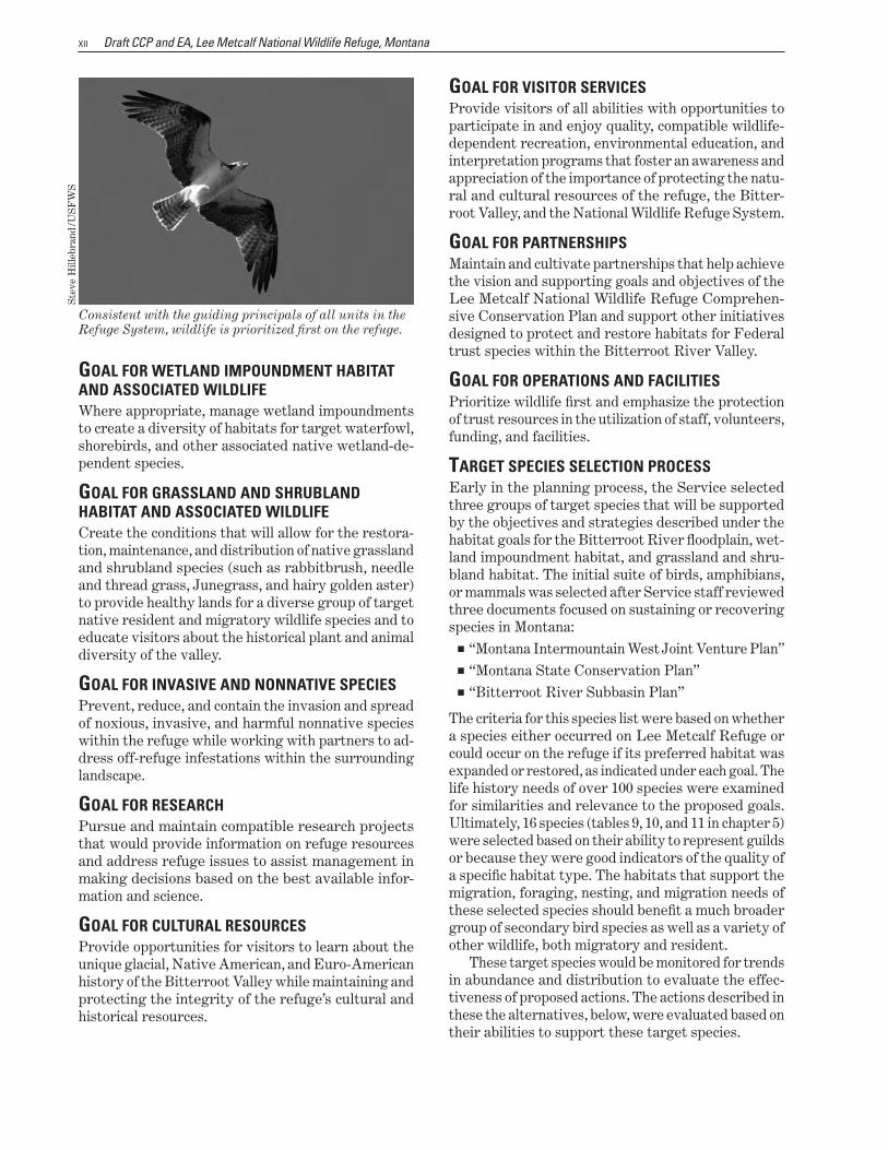
Consistent with the guiding principals of all units in the Refuge System wildlife is prioritized first on the refuge
Ste
ve H
illeb
rand
US
FW
S
GOAL FOR WETLAND IMPOUNDMENT HABIT AT AND ASSOCIATED WILDLIFE Where appropriate manage wetland impoundments to create a diversity of habitats for target waterfowl shorebirds and other associated native wetland-deshypendent species
GOAL FOR GRASSLAND AND SHRUBLAND HABITAT AND ASSOCIA TED WILDLIFE Create the conditions that will allow for the restorashytion maintenance and distribution of native grassland and shrubland species (such as rabbitbrush needle and thread grass Junegrass and hairy golden aster) to provide healthy lands for a diverse group of target native resident and migratory wildlife species and to educate visitors about the historical plant and animal diversity of the valley
GOAL FOR INV ASIVE AND NONNA TIVE SPECIES Prevent reduce and contain the invasion and spread of noxious invasive and harmful nonnative species within the refuge while working with partners to adshydress off-refuge infestations within the surrounding landscape
GOAL FOR RESEARCH Pursue and maintain compatible research projects that would provide information on refuge resources and address refuge issues to assist management in making decisions based on the best available inforshymation and science
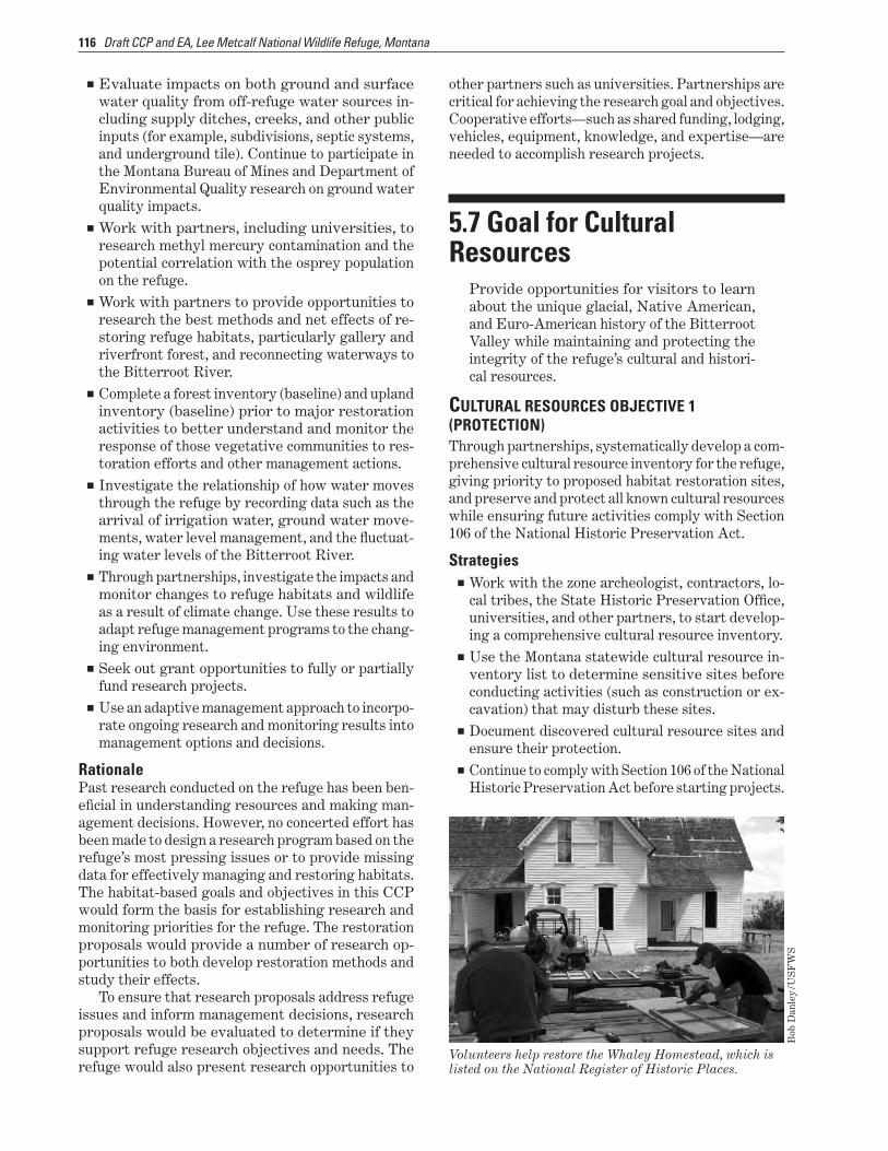
GOAL FOR CUL TURAL RESOURCES Provide opportunities for visitors to learn about the unique glacial Native American and Euro-American history of the Bitterroot Valley while maintaining and protecting the integrity of the refugersquos cultural and historical resources
GOAL FOR VISITOR SERVICES Provide visitors of all abilities with opportunities to participate in and enjoy quality compatible wildlife-dependent recreation environmental education and interpretation programs that foster an awareness and appreciation of the importance of protecting the natushyral and cultural resources of the refuge the Bitter-root Valley and the National Wildlife Refuge System
GOAL FOR P ARTNERSHIPS Maintain and cultivate partnerships that help achieve the vision and supporting goals and objectives of the Lee Metcalf National Wildlife Refuge Comprehenshysive Conservation Plan and support other initiatives designed to protect and restore habitats for Federal trust species within the Bitterroot River Valley
GOAL FOR OPERA TIONS AND F ACILITIES Prioritize wildlife first and emphasize the protection of trust resources in the utilization of staff volunteers funding and facilities
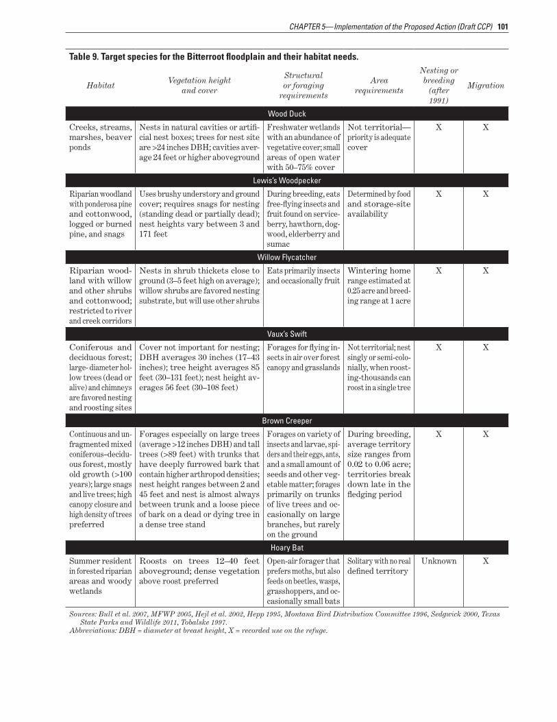
TARGET SPECIES SELECTION PROCESS Early in the planning process the Service selected three groups of target species that will be supported by the objectives and strategies described under the habitat goals for the Bitterroot River floodplain wetshyland impoundment habitat and grassland and shrushybland habitat The initial suite of birds amphibians or mammals was selected after Service staff reviewed three documents focused on sustaining or recovering species in Montana
ldquoMontana Intermountain West Joint Venture Planrdquo ldquoMontana State Conservation Planrdquo ldquoBitterroot River Subbasin Planrdquo
The criteria for this species list were based on whether a species either occurred on Lee Metcalf Refuge or could occur on the refuge if its preferred habitat was expanded or restored as indicated under each goal The life history needs of over 100 species were examined for similarities and relevance to the proposed goals Ultimately 16 species (tables 9 10 and 11 in chapter 5) were selected based on their ability to represent guilds or because they were good indicators of the quality of a specific habitat type The habitats that support the migration foraging nesting and migration needs of these selected species should benefit a much broader group of secondary bird species as well as a variety of other wildlife both migratory and resident
These target species would be monitored for trends in abundance and distribution to evaluate the effecshytiveness of proposed actions The actions described in these the alternatives below were evaluated based on their abilities to support these target species
Summary XIII
Alternatives The Service developed and analyzed three alternatives for managing habitats and public use at Lee Metcalf National Wildlife Refuge These alternatives and the consequences of implementing them are further deshyscribed in chapter 3
ALTERNATIVE AmdashCURRENT MANAGEMENT (NO ACTION) Alternative A is the no-action alternative which represents the current management of the refuge This alternative provides the baseline against which to compare the other alternatives It also fulfills the requirement in the National Environmental Policy Act that a no-action alternative be addressed in the analysis process
Under alternative A management activity currently conducted by the Service would remain the same The Service would continue to manage and monitor refuge habitats at current levels The Bitterroot River would continue to migrate through the refuge eroding some levees and trails Invasive species would be treated primarily with mechanical and chemical methods as resources become available Water supply and manshyagement structures would be inadequate to properly manage many of the wetland impoundments Cattail monocultures would be treated
The current staff of five would perform issue-driven research and monitor only long-term wildlife and vegetation changes Visitor services programs and facilities would be maintained or expanded as
resources become available Funding and staff levels would follow annual budget
allocations provided for refuge operashytions on Service lands
i
t
copy A
llan
F M
eyer
s
This alternative focuses on the exshypansion and restoration of native plant communities on the refuge ncluding grasslands shrublands
and gallery and riverfront forests Some areas that are currently part
of wetland impoundments would be restored to native communities including forest and shrubland A significant focus of restorashytion proposals would be conshytrolling invasive species and preventing further spread
Grasses and shrubs native to the uplands including the
alluvial fans (that is
ALTERNATIVE B (PROPOSED ACTION)
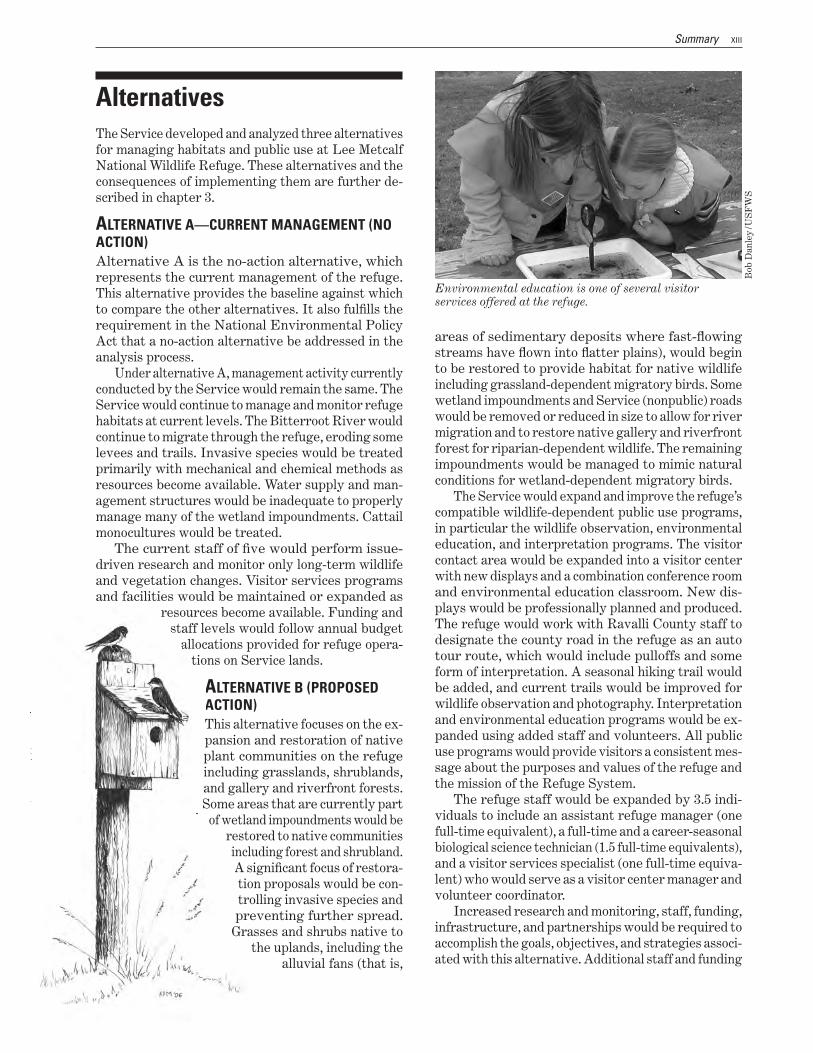
Environmental education is one of several visitor services offered at the refuge
Bob
Dan
ley
US
FW
S
areas of sedimentary deposits where fast-flowing streams have flown into flatter plains) would begin to be restored to provide habitat for native wildlife including grassland-dependent migratory birds Some wetland impoundments and Service (nonpublic) roads would be removed or reduced in size to allow for river migration and to restore native gallery and riverfront forest for riparian-dependent wildlife The remaining impoundments would be managed to mimic natural conditions for wetland-dependent migratory birds
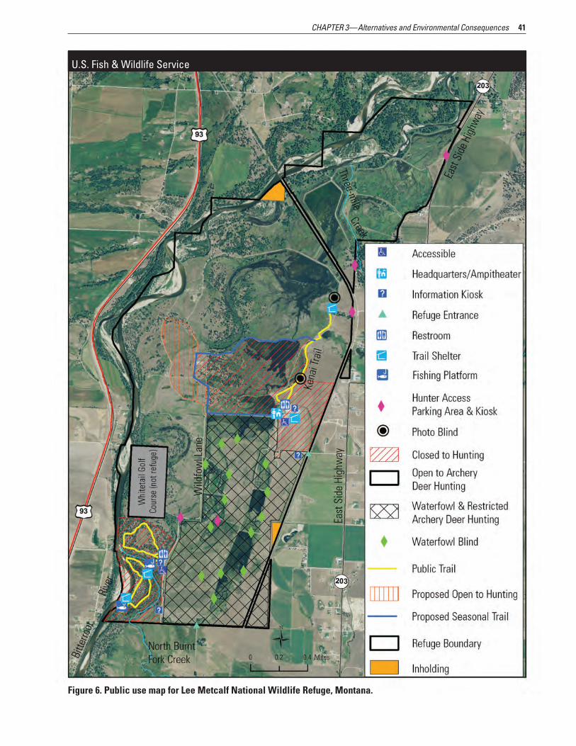
The Service would expand and improve the refugersquos compatible wildlife-dependent public use programs in particular the wildlife observation environmental education and interpretation programs The visitor contact area would be expanded into a visitor center with new displays and a combination conference room and environmental education classroom New disshyplays would be professionally planned and produced The refuge would work with Ravalli County staff to designate the county road in the refuge as an auto our route which would include pulloffs and some
form of interpretation A seasonal hiking trail would be added and current trails would be improved for wildlife observation and photography Interpretation and environmental education programs would be exshypanded using added staff and volunteers All public use programs would provide visitors a consistent messhysage about the purposes and values of the refuge and the mission of the Refuge System
The refuge staff would be expanded by 35 indishyviduals to include an assistant refuge manager (one full-time equivalent) a full-time and a career-seasonal biological science technician (15 full-time equivalents) and a visitor services specialist (one full-time equivashylent) who would serve as a visitor center manager and volunteer coordinator
Increased research and monitoring staff funding infrastructure and partnerships would be required to accomplish the goals objectives and strategies associshyated with this alternative Additional staff and funding
XIV Draft CCP and EA Lee Metcalf National Wildlife Refuge Montana
would be added depending on the regional priorities for those funds allocated to the Service for manageshyment of lands and waters within the Refuge System
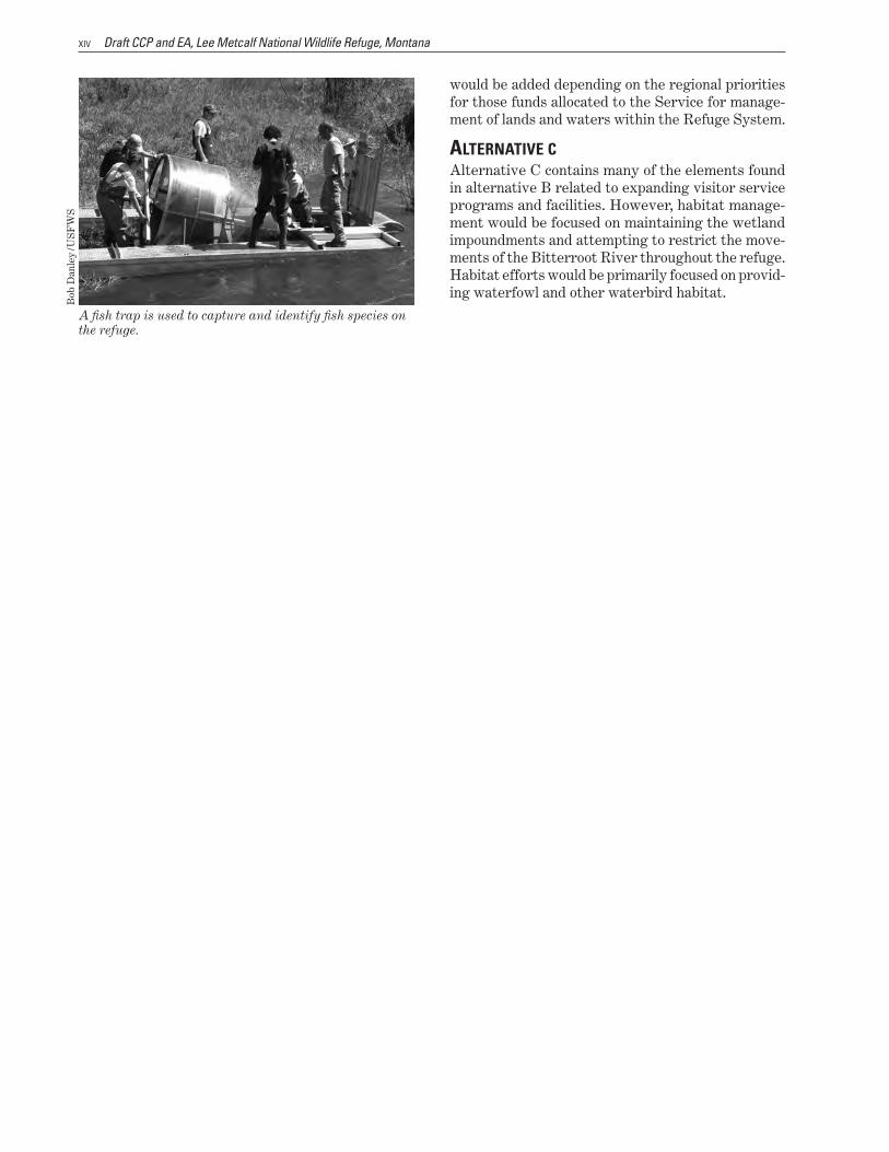
A fish trap is used to capture and identify fish species on the refuge
Bob
Dan
ley
US
FW
S
ALTERNATIVE C Alternative C contains many of the elements found in alternative B related to expanding visitor service programs and facilities However habitat manageshyment would be focused on maintaining the wetland impoundments and attempting to restrict the moveshyments of the Bitterroot River throughout the refuge Habitat efforts would be primarily focused on providshying waterfowl and other waterbird habitat
Abbreviations
AD Anno Domini or ldquoyear of our Lordrdquo Administration Act National Wildlife Refuge System Administration Act of 1966
amsl Above mean sea level BC before Christ BP before present CCP comprehensive conservation plan CFR Code of Federal Regulations cfs cubic feet per second CO2 carbon dioxide
CWD chronic wasting disease EA environmental assessment
FMP fire management plan FONSI Finding of No Significant Impact
GIS geographic information system GS General Schedule
HGM hydrogeomorphic Improvement Act National Wildlife Refuge System Improvement Act of 1997
IPM integrated pest management IWJV Intermountain West Joint Venture
MFWP Montana Fish Wildlife amp Parks mgL milligrams per liter
na not applicable NEPA National Environmental Policy Act of 1969 PM25 particulate matter less than 25 microns in size POD points of diversion
refuge Lee Metcalf National Wildlife Refuge Refuge System National Wildlife Refuge System
RLGIS Refuge Lands Geographic Information Systems database Service US Fish and Wildlife Service
SHPO State Historic Preservation Office USC United States Code
US United States USDA US Department of Agriculture
USFWS US Fish and Wildlife Service WG Wage Grade Schedule
WVA wildlife viewing area
Definitions of these and other terms are in the glossary located after chapter 5
CHAPTER 1mdash Introduction
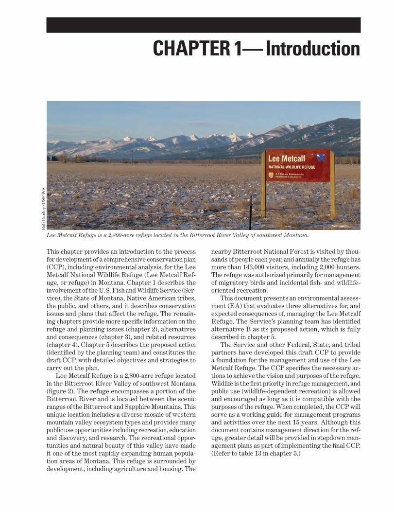
Lee Metcalf Refuge is a 2800-acre refuge located in the Bitterroot River Valley of southwest Montana
Bob
Dan
ley
US
FW
S
This chapter provides an introduction to the process for development of a comprehensive conservation plan (CCP) including environmental analysis for the Lee Metcalf National Wildlife Refuge (Lee Metcalf Refshyuge or refuge) in Montana Chapter 1 describes the involvement of the US Fish and Wildlife Service (Sershyvice) the State of Montana Native American tribes the public and others and it describes conservation issues and plans that affect the refuge The remainshying chapters provide more specific information on the refuge and planning issues (chapter 2) alternatives and consequences (chapter 3) and related resources (chapter 4) Chapter 5 describes the proposed action (identified by the planning team) and constitutes the draft CCP with detailed objectives and strategies to carry out the plan
Lee Metcalf Refuge is a 2800-acre refuge located in the Bitterroot River Valley of southwest Montana (figure 2) The refuge encompasses a portion of the Bitterroot River and is located between the scenic ranges of the Bitterroot and Sapphire Mountains This unique location includes a diverse mosaic of western mountain valley ecosystem types and provides many public use opportunities including recreation education and discovery and research The recreational opporshytunities and natural beauty of this valley have made it one of the most rapidly expanding human populashytion areas of Montana This refuge is surrounded by development including agriculture and housing The
nearby Bitterroot National Forest is visited by thoushysands of people each year and annually the refuge has more than 143000 visitors including 2000 hunters The refuge was authorized primarily for management of migratory birds and incidental fish- and wildlife-oriented recreation
This document presents an environmental assessshyment (EA) that evaluates three alternatives for and expected consequences of managing the Lee Metcalf Refuge The Servicersquos planning team has identified alternative B as its proposed action which is fully described in chapter 5
The Service and other Federal State and tribal partners have developed this draft CCP to provide a foundation for the management and use of the Lee Metcalf Refuge The CCP specifies the necessary acshytions to achieve the vision and purposes of the refuge Wildlife is the first priority in refuge management and public use (wildlife-dependent recreation) is allowed and encouraged as long as it is compatible with the purposes of the refuge When completed the CCP will serve as a working guide for management programs and activities over the next 15 years Although this document contains management direction for the refshyuge greater detail will be provided in stepdown manshyagement plans as part of implementing the final CCP (Refer to table 13 in chapter 5)
2 Draft CCP and EA Lee Metcalf National Wildlife Refuge Montana
11 Purpose and Need for the Plan The purpose of this draft CCP is to identify the role that the Lee Metcalf Refuge would play in supporting the mission of the National Wildlife Refuge System (Refuge System) and to provide long-term guidance for managing programs and activities The CCP is needed to
communicate with the public and other partners in efforts to carry out the mission of the Refuge System
provide a clear statement of direction for managshying the refuge
provide neighbors visitors and government offishycials with an understanding of the Servicersquos manshyagement actions on and around the refuge
ensure that the Servicersquos management actions are consistent with the mandates of the National Wildlife Refuge System Improvement Act of 1997 (Improvement Act)
ensure that management supports other Federal State and county plans as appropriate
provide a basis for development of budget requests for the refugersquos operation maintenance and capital improvement needs
Sustaining the Nationrsquos fish and wildlife resources is a task that can be accomplished only through the combined efforts of governments businesses and private citizens
12 North American Model of Wildlife Conservation Wildlife conservation in North America evolved to take on a form unique in the world in recent years it has come to be known as the North American Model of Wildlife Conservation (Geist et al 2001) The wildlife conservation movement arose out of the conflict beshytween market hunters and sport hunters in the mid- to late-nineteenth century Market hunting increased in response to the growth in urban population fueled by the Industrial Revolution Between 1820 and 1860 the percentage of Americans who lived in cities increased from 5 percent to 20 percent this fourfold increase is the greatest proportional increase in urban populashytion that ever occurred in the United States (Reiss 1995) The demand for meat and hidesmdashalong with feathers for the millinery trademdashled to exploitation of game animals by market hunters Along with the
increase in the urban population came a new breed of huntermdashone who hunted for the chase and the chalshylenge it provided These sport hunters valued game animals more when they were alive market hunters however placed value on dead animals they could bring to market The growing legion of sport hunters started a national movement that resulted in Federal and State governments taking responsibility for regushylating the take of wildlife
The keystone concept of the North American Model of Wildlife Conservation and the bedrock that allowed government to exercise control is the public trust doctrine (Geist and Organ 2004) With origins in Greek and Roman law the Magna Carta and the 1842 Martin v Waddell US Supreme Court decision the public trust doctrine as it applies to wildlife consershyvation is the principle that wildlife belongs to no one it is held in trust for all by government
The seven pillars of the North American Model of Wildlife Conservation follow
wildlife as a public trust resource elimination of markets for game allocation of wildlife by law wildlife only killed for a legitimate purpose wildlife considered an international resource science as the proper tool to discharge wildlife policy democracy of hunting
For more than 100 years these pillars have stood the test of time despite significant changes in approaches to wildlife conservation The original conservation moveshyment championed by Theodore Roosevelt George Bird Grinnell and others emphasized stemming wildlife population declines through implementing programs that restricted take and protected lands During the 1920s conservationists realized that more was needed and a committee including Aldo Leopold A Willis Robertson and other leading conservationists of the time authored the 1930 American Game Policy This policy called for a restoration program for habitats and populations based on scientific research and supshyported with stable equitable funding Within a decade many needs of this program were fulfilled through landmark legislation including the Duck Stamp Act to fund land acquisition for national wildlife refuges In addition the PittmanndashRobertson Wildlife Restorashytion Act shifted excise taxes imposed on firearms and ammunition to fund wildlife restoration through coopshyeration between the Service and State fish and wildlife agencies To use this money States were required to pass laws that prevented diversion of hunting license revenues to any purpose other than administration of the State fish and wildlife agency
In recent decades wildlife management has placed greater emphasis on overall wildlife diversity All wildshylife species have benefited from the North American
3 CHAPTER 1mdashIntroduction
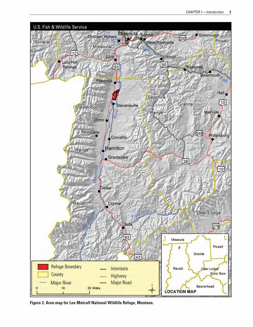
Figure 2 Area map for Lee Metcalf National Wildlife Refuge Montana
4 Draft CCP and EA Lee Metcalf National Wildlife Refuge Montana
Model of Wildlife Conservation pillars not just game animals The Refuge System has evolved along with the North American Model of Wildlife Conservationmdash it today provides refuge for virtually all species found in the United States and recreation for all Americans
It is a realization of the North American Model of Wildlife Conservation to provide for science-based management of international wildlife resources held in trust for all The importance of this system to American society can best be appreciated if we were to contemplate its loss Wildlife connects us to the herishytage of this country and our ancestors who built our society It connects us as well to the natural world of which we are a part but from which we have become so disconnected To lose this connection is to lose the basis of our humanity
13 The US Fish and Wildlife Service and the Refuge System
The Service is the principal Federal agency responsible for fish wildlife and plant conservation The Refuge System is one of the Servicersquos major programs
US FISH ANd WILdLIFE SERvICE
The mission of the US Fish and Wildlife Service working with others
is to conserve protect and enhance fish and wildlife and their habitats for the
continuing benefit of the American people
In the late 19th and early 20th centuries Americarsquos fish and wildlife resources were declining at an alarmshying rate largely due to unrestricted market hunting Concerned citizens scientists and hunting and angling groups joined together and generated the political will for the first significant conservation measures taken by the Federal Government These actions inshycluded the establishment of the Bureau of Fisheries in the 1870s and in 1900 passage of the first Federal
wildlife lawmdashthe Lacey Actmdashwhich prohibited inshyterstate transportation of wildlife taken in violation of State laws Beginning in 1903 President Theodore Roosevelt established more than 50 wildlife refuges across the Nation
Over the next three decades the United States ratified the Migratory Bird Treaty with Great Britain and Congress passed laws to protect migratory birds establish new refuges and create a funding source for refuge land acquisition In 1940 the U S Fish and Wildlife Service was created within the Department of the Interior and existing Federal wildlife functions including law enforcement fish management animal damage control and wildlife refuge management were combined into a single organization for the first time
Today the Service enforces Federal wildlife laws manages migratory bird populations restores nationshyally significant fisheries conserves and restores vital wildlife habitat protects and recovers endangered species and helps other governments with consershyvation efforts In addition the Service administers a Federal aid program that distributes hundreds of millions of dollars to States for fish and wildlife restoshyration boating access hunter education and related programs across the United States
SERvICE ACTIvITIES IN MoNT ANA
Service activities in Montana contribute to the Statersquos economy ecosystems and education programs The following list highlights the Servicersquos presence and activities in 2009
employed 220 people in Montana coordinated 446 volunteers who donated more
than 21780 hours to Service projects on refuge and district lands
managed two national fish hatcheries one fish and wildlife management assistance office six coordishynation areas one fish health center four ecologishycal services offices and one fish technology center
managed 23 national wildlife refuges encompassing 1217617 acres (129 percent of the State)
managed five wetland management districts 48026 acres of fee-title waterfowl production
areas 146816 acres under leases or easements
hosted 690173 annual visitors to Service-managed lands 96866 hunting visits 80370 fishing visits 506632 wildlife observation photography and
interpretation visits 6305 visits from students participating in enshy
vironmental education programs
5 CHAPTER 1mdashIntroduction
provided $96 million to Montana Fish Wildlife amp Parks (MFWP) for sport fish restoration and $174 million for wildlife restoration and hunter education
paid Montana counties $394799 under the Refuge Revenue Sharing Act (money used for schools roads and any other public purpose)
Additionally since 1988 the Servicersquos Partners for Fish and Wildlife Program has helped private landowners restore more than 31759 wetland acres 360826 upland acres and 1263 miles of river habitat as well as install 45 structures to open 502 river miles for fish passage
NATIoNAL WILdLIFE REFUgE SySTEM In 1903 President Theodore Roosevelt designated the 55-acre Pelican Island in Florida as the Nationrsquos first wildlife refuge for the protection of native nesting birds This was the first time the Federal Government set aside land for wildlife This small but significant designation was the beginning of the National Wildshylife Refuge System
One hundred years later the Refuge System has become the largest collection of lands in the world specifically managed for wildlife encompassing more than 150 million acres within 553 refuges and more than 3000 waterfowl production areas providing breeding and nesting habitat for migratory birds Today there is at least one refuge in every State as well as in Puerto Rico and the US Virgin Islands
The Improvement Act established a clear mission for the Refuge System
The mission of the National Wildlife Refuge System is to administer a
national network of lands and waters for the conservation management and
where appropriate restoration of the fish wildlife and plant resources and their
habitats within the United States for the benefit of present and future generations
of Americans
The Improvement Act states that each national wildshylife refuge (that is every unit of the Refuge System which includes wetland management districts) shall be managed to accomplish the following
Fulfill the mission of the Refuge System Fulfill the individual purposes of each refuge and
district Consider the needs of fish and wildlife first Fulfill the requirement of developing a CCP for
each unit of the Refuge System and fully involve the public in preparation of these plans
Maintain the biological integrity diversity and enshyvironmental health of the Refuge System
Recognize that wildlife-dependent recreation activishyties including hunting fishing wildlife observation photography environmental education and intershypretation are legitimate and priority public uses
Retain the authority of refuge managers to detershymine compatible public uses
In addition to the mission for the Refuge System the wildlife and habitat vision for each unit of the Refuge System maintains the following principles
Wildlife comes first Ecosystems biodiversity and wilderness are vital
concepts in refuge and district management Habitats must be healthy Growth of refuges and districts must be strategic The Refuge System serves as a model for habitat
management with broad participation from others
Following passage of the Improvement Act the Sershyvice immediately began to carry out the direction of the new legislation including preparation of CCPs for all national wildlife refuges and wetland management districts Consistent with the Improvement Act the Service prepares CCPs in conjunction with public inshyvolvement Each refuge and each district is required to complete its CCP within the 15-year schedule (by 2012)
PEoPLE ANd THE REFUgE SySTEM The Nationrsquos fish and wildlife heritage contributes to the quality of American lives and is an integral part of the countryrsquos greatness Wildlife and wild places have always given people special opportunities to have fun relax and appreciate the natural world
Whether through bird watching fishing hunting photography or other wildlife pursuits wildlife recreshyation contributes billions of dollars to local economies In particular money generated from the taxing of sporting arms and ammunition and of fishing equipshyment that is authorized by the PittmanndashRobertson and DingellndashJohnson Acts respectively has generated tens of billions of dollars Distributed by the Service this money has been used by States to increase wildlife and fish populations expand habitat and train hunters across the Nation Approximately 35 million people visited the Refuge System in 2006 mostly to observe fish and wildlife in their natural habitats (Caudill and Henderson 2006) Visitors are most often accommoshydated through nature trails auto tours interpretive programs and hunting and fishing opportunities Local communities that surround the refuges and wetland management districts derive significant economic benefits Economists report that Refuge System visishytors contribute more than $17 billion annually to local economies (Carver and Caudhill 2007)
6 Draft CCP and EA Lee Metcalf National Wildlife Refuge Montana
13 National and Regional Mandates Refuge System units are managed to achieve the mission and goals of the Refuge System along with the designated purpose of the refuges and districts (as described in establishing legislation Executive orders or other establishing documents) The key concepts and guidance for the Refuge System are in the National Wildlife Refuge System Administrashytion Act of 1966 as amended (16 USC 668ddndash668ee) (Administration Act) Title 50 of the Code of Federal Regulations (CFR) ldquoThe Fish and Wildlife Service Manualrdquo and the Improvement Act (an amendment of the Administration Act)
The Improvement Act amends the Administration Act by providing a unifying mission for the Refuge System a new process for determining compatible public uses on refuges and districts and a requireshyment that each refuge and district be managed under a CCP The Improvement Act states that wildlife conshyservation is the priority of Refuge System lands and that the Secretary of the Interior will make sure that the biological integrity diversity and environmental health of refuge lands are maintained Each refuge and district must be managed to fulfill the Refuge Systemrsquos mission and the specific purposes for which the unit was established The Improvement Act reshyquires the Service to monitor the status and trends of fish wildlife and plants in each national wildlife refuge and wetland management district
A detailed description of these and other laws and Executive orders that may affect the CCP or the Sershyvicersquos implementation of the CCP is in appendix A Service policies for planning and day-to-day manageshyment of refuges and districts are in the ldquoRefuge System Manualrdquo and ldquoThe Fish and Wildlife Service Manualrdquo
14 Contributions to National and Regional Plans Lee Metcalf Refuge contributes to the conservation efforts outlined in the various State and national plans described below
FULFILLINg THE PRoMISE A 1999 report ldquoFulfilling the Promise The National Wildlife Refuge Systemrdquo (USFWS 1999) is the culshymination of a yearlong process by teams of Service employees to evaluate the Refuge System nationwide This report was the focus of the first national Refuge System conference (in 1998) which was attended by
refuge managers other Service employees and repshyresentatives from leading conservation organizations
The report contains 42 recommendations packaged with three vision statements for wildlife and habitat people and leadershipmdashall three of these major topshyics are included in this CCP
PARTNERS IN FLIgHT The Partners in Flight program began in 1990 with the recognition of declining population levels of many migratory landbird species The challenge is to manage avian population growth while maintaining functional natural ecosystems in the face of human population growth To meet this challenge Partners in Flight worked to identify priorities for landbird species and habitat types Partners in Flight activities have reshysulted in 52 bird conservation plans covering the conshytinental United States Partners in Flight is a coopshyerative effort involving partnerships among Federal State and local government agencies philanthropic foundations professional organizations conservation groups industries the academic community and prishyvate individuals
The Partners in Flight program was initiated to provide for the long-term health of landbird life of this continent Its mission can be expressed in three related priorities helping species at risk keeping common birds common and forming voluntary partnerships benefiting birds habitat and people The three goals developed in support of this mission are as follows
Ensure an active scientifically-based conservation design process that identifies and develops solushytions to threats and risks to landbird populations
Create a coordinated network of conservation partshyners to implement the objectives of the landbird conservation plans at multiple scales
Secure sufficient commitment and resources to support vigorous implementation of landbird conshyservation objectives (Rich et al 2004)
Montana Partners in Flight considered 141 species for priority status It identified 14 high-priority species (priority I) in need of immediate conservation action 43 moderate-priority species with lesser threats but in need of better monitoring and conservation (priorshyity II) consideration and 51 species of local interest whose habitat needs may influence design and selection of conservation strategies (priority III) The highest priority species are common loon trumpeter swan harlequin duck greater sage-grouse piping plover mountain plover interior least tern flammulated owl burrowing owl black-backed woodpecker olive-sided flycatcher brown creeper Spraguersquos pipit and Bairdrsquos sparrow (Casey 2000)
The highest priority habitats in Montana are mixed grassland sagebrush steppe dry forest (ponderosa pine and Douglas-fir) riparian deciduous forest and
7CHAPTER 1mdashIntroduction
prairie pothole wetlands some of which occur on the refuge The primary objectives in each priority habishytat are to restore ecological processes necessary to provide suitable habitat for priority (target) species identify and protect those remaining blocks of habishytats that have undergone drastic declines and develop management prescriptions that can be applied at all geographic scales
To fully implement the goals of the international Partners in Flight plan a series of scientifically based landbird conservation plans with long-term strateshygies for bird conservation have been developed The geographical context of these plans is composed of 58 physiographic regions each defined by similar physical geographic features and wholly or partially contained within the continental United States and Alaska Lee Metcalf Refuge lies within the physioshygraphic area known as the Central Rocky Mountain Physiographic Region
Central Rocky Mountain Physiographic Region The Central Rocky Mountain Physiographic Region is a huge physiographic area extending from northshywest Wyoming to all of western Montana the northern two-thirds of Idaho large areas of eastern Oregon and Washington much of southeast British Columbia and a sliver of west Alberta It is an area of high mounshytains with elevations exceeding 10000 feet Glaciation has left broad flat valleys between mountain ranges
Elevation determines the dominant vegetation The highest areas are alpine tundra The subalpine zone is dominated by Engelmann spruce and subalpine fir with ponderosa pine and Douglas-fir in the montane zone below Stand-replacing fire can change forests in either of these zones to lodgepole pine or aspen Fire in higher-elevation coniferous forests of the central Rocky Mountains tends to be of high intensity and low frequency Grass and sagebrush occur under open pine forests that grade downslope into grasslands wetlands woodlands or shrub-steppe Approximately 28 species of birds have a higher population in the central Rocky Mountains than in any other physiographic area This is the highest such number in any physiographic area in the contiguous United States and it seems to repshyresent the huge size of the area and the vast amount of quality bird habitat that still exists
A huge percentage of the central Rocky Mountains in the United States are in public ownership mostly managed by the US Department of Agriculture (USDA) Forest Service Maintenance or restoration of healthy forest ecosystems on public and private industrial lands will be the most important factor in keeping the central Rocky Mountains a healthy ecoshysystem for so many forest birds
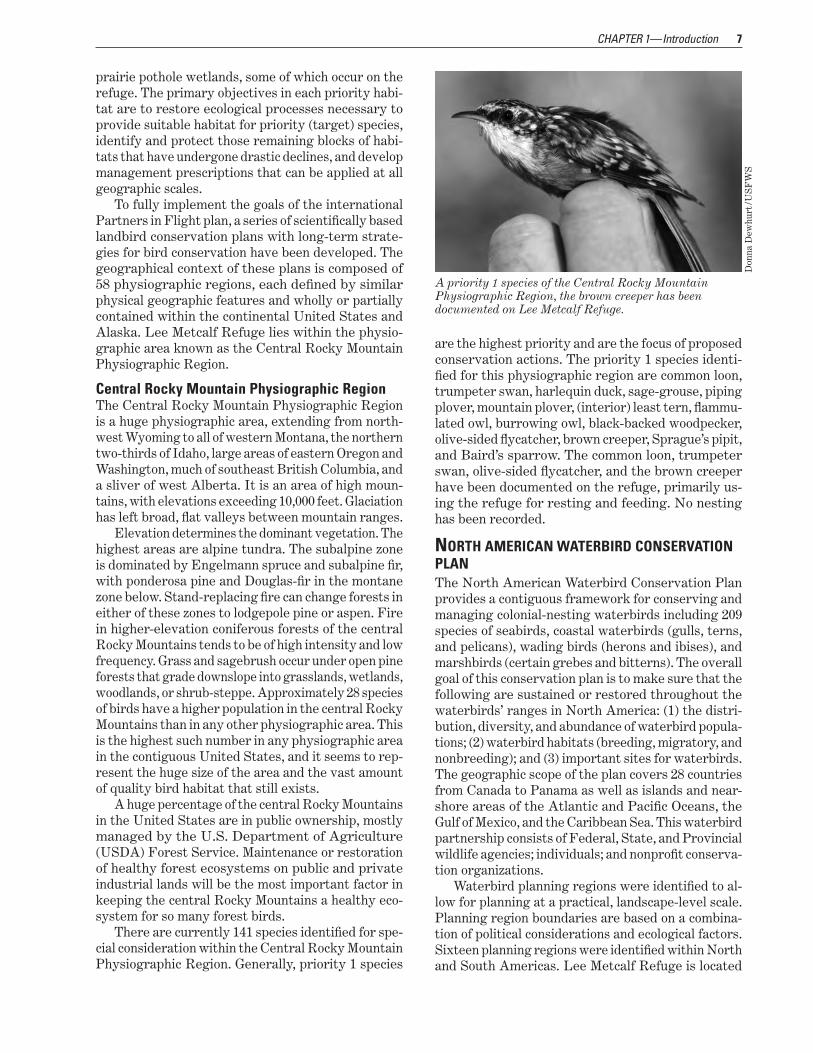
There are currently 141 species identified for speshycial consideration within the Central Rocky Mountain Physiographic Region Generally priority 1 species
A priority 1 species of the Central Rocky Mountain Physiographic Region the brown creeper has been documented on Lee Metcalf Refuge
Don
na D
ewhu
rt U
SF
WS
are the highest priority and are the focus of proposed conservation actions The priority 1 species identishyfied for this physiographic region are common loon trumpeter swan harlequin duck sage-grouse piping plover mountain plover (interior) least tern flammushylated owl burrowing owl black-backed woodpecker olive-sided flycatcher brown creeper Spraguersquos pipit and Bairdrsquos sparrow The common loon trumpeter swan olive-sided flycatcher and the brown creeper have been documented on the refuge primarily usshying the refuge for resting and feeding No nesting has been recorded
NoRTH AMERICAN WATERbIRd CoNSERvATIoN PLAN The North American Waterbird Conservation Plan provides a contiguous framework for conserving and managing colonial-nesting waterbirds including 209 species of seabirds coastal waterbirds (gulls terns and pelicans) wading birds (herons and ibises) and marshbirds (certain grebes and bitterns) The overall goal of this conservation plan is to make sure that the following are sustained or restored throughout the waterbirdsrsquo ranges in North America (1) the distrishybution diversity and abundance of waterbird populashytions (2) waterbird habitats (breeding migratory and nonbreeding) and (3) important sites for waterbirds The geographic scope of the plan covers 28 countries from Canada to Panama as well as islands and near-shore areas of the Atlantic and Pacific Oceans the Gulf of Mexico and the Caribbean Sea This waterbird partnership consists of Federal State and Provincial wildlife agencies individuals and nonprofit conservashytion organizations
Waterbird planning regions were identified to alshylow for planning at a practical landscape-level scale Planning region boundaries are based on a combinashytion of political considerations and ecological factors Sixteen planning regions were identified within North and South Americas Lee Metcalf Refuge is located
8 Draft CCP and EA Lee Metcalf National Wildlife Refuge Montana
within the Intermountain West Waterbird Consershyvation Region This is a vast inland area stretching from the Rocky Mountains on the east to the Sierra Nevada and Cascades on the west The Intermountain Westrsquos dispersed high-mountain lakes large terminal hypersaline lakes marshes playas rivers streams riparian zones and fresh and brackish wetlands host about 40 waterbird species including many or most of the worldrsquos California gulls eared grebes white-faced ibises and American white pelicans Eleven waterbirds are identified as species of high concern in one or more of the four Bird Conservation Regions within the planning area yellow rail Franklinrsquos gull black tern eared grebe western grebe Clarkrsquos grebe snowy egret American white pelican common loon American bittern and certain managed populations of the greater and lesser sandhill crane The Frankshylinrsquos gull black tern western grebe American white pelican bittern loon and sandhill crane have all been documented using the refuge primarily for resting and feeding However recent years have seen the sandhill cranes nesting with at least two to five sucshycessful nests per season
Waterbirds using this region are highly adaptshyable to constantly changing wetland conditions and depend on a regional-scale association of wetlands to meet habitat and forage requirements during stages of their annual life cycle The competing demands for water from agriculture development and recreation pose the greatest threats to regional waterbird popushylations Also contaminants such as mercury and dishychlorodiphenyltrichloroethane (known as DDT) and its breakdown products significantly threaten the regionrsquos waterbirds Because of the westrsquos feast-or-famine washyter regime the ldquoIntermountain West Joint Venture Conservation Planrdquo stresses the necessity of conservshying a network of high-quality wetland habitats with secure water sources to provide options for waterbirds during drought and flood cycles (Kushlan et al 2002)
NoRTH AMERICAN WATERFoWL MANAgEMENT PLAN Written in 1986 the ldquoNorth American Waterfowl Manshyagement Planrdquo envisioned a 15-year effort to achieve landscape conditions that could sustain waterfowl populations Specific plan objectives are to increase and restore duck populations to the average levels of the 1970smdash62 million breeding ducks and a fall flight of 100 million birds (USFWS and Canadian Wildlife Service 1986) The plan is innovative because of its international partnerships and its implementation at the local level Its success depends on the strength of the joint ventures which involve Federal State Provincial tribal and local governments businesses conservation organizations and individual citizens
Joint ventures are regional self-directed partnershyships that carry out science-based conservation through
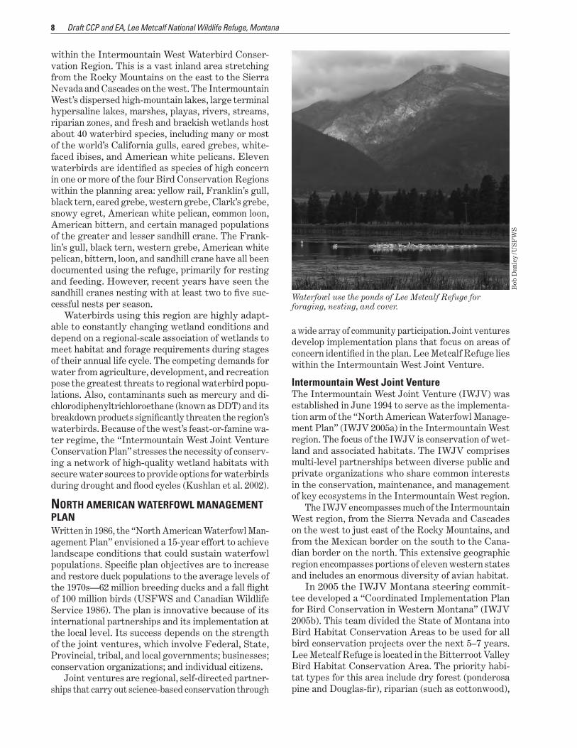
Waterfowl use the ponds of Lee Metcalf Refuge for foraging nesting and cover
Bob
Dan
ley
US
FW
S
a wide array of community participation Joint ventures develop implementation plans that focus on areas of concern identified in the plan Lee Metcalf Refuge lies within the Intermountain West Joint Venture
Intermountain West Joint venture The Intermountain West Joint Venture (IWJV) was established in June 1994 to serve as the implementashytion arm of the ldquoNorth American Waterfowl Manageshyment Planrdquo (IWJV 2005a) in the Intermountain West region The focus of the IWJV is conservation of wetshyland and associated habitats The IWJV comprises multi-level partnerships between diverse public and private organizations who share common interests in the conservation maintenance and management of key ecosystems in the Intermountain West region
The IWJV encompasses much of the Intermountain West region from the Sierra Nevada and Cascades on the west to just east of the Rocky Mountains and from the Mexican border on the south to the Canashydian border on the north This extensive geographic region encompasses portions of eleven western states and includes an enormous diversity of avian habitat
In 2005 the IWJV Montana steering commitshytee developed a ldquoCoordinated Implementation Plan for Bird Conservation in Western Montanardquo (IWJV 2005b) This team divided the State of Montana into Bird Habitat Conservation Areas to be used for all bird conservation projects over the next 5ndash7 years Lee Metcalf Refuge is located in the Bitterroot Valley Bird Habitat Conservation Area The priority habishytat types for this area include dry forest (ponderosa pine and Douglas-fir) riparian (such as cottonwood)
9 CHAPTER 1mdashIntroduction
wetland (reservoirs lakes and marshes) and burned forest (recent fires) The refuge has two of these high-priority habitat types the riparian and the wetland
INTERMoUNTAIN WEST REgIoNAL SHoREbIRd PLAN As noted above the Intermountain West is a huge reshygion stretching from Canada to Mexico and from the Rocky Mountains to the Sierras and Cascades The six Bird Conservation Regions of the Intermountain West include an array of habitats from saline sinks to alpine streams (Oring et al 2010) The refuge is located in the Northern Rocky Mountain Bird Conshyservation Region an area characterized by low lying desert flats surrounded by rugged boreal mountain ranges Stream and river valleys occur in the mounshytains along with many small wetlands and natural and constructed lakes Sewage lagoons near many urban areas also host numerous shorebirds The area is of some importance for breeding of several shorebird species and of modest importance to many species of transients Eleven species of shorebirds regularly breed in the Intermountain West and 23 additional species are annual migrants
The most important issue facing shorebird consershyvation in the Intermountain West is the very great human-driven competition for water Finding ample high quality fresh water will be the greatest challenge faced by future shorebird conservation interests
The ldquoIntermountain West Regional Shorebird Planrdquo recognizes the Lee Metcalf Refuge as one of 79 managed shorebird sites in the nation one of only 3 identified in Montana (Oring et al 2010)
STATE CoMPREHENSIvE FISH ANd WILdLIFE CoNSERvATIoN STRATEgy ldquoMontanarsquos Comprehensive Fish and Wildlife Consershyvation Strategyrdquo (MFWP 2005) is for all vertebrate species known to exist in Montana including both game and nongame species as well as some inverteshybrate species such as freshwater mussels and crayfish
Although game species are included in Montanarsquos conservation strategy the priority is those species and their habitats ldquoin greatest conservation needrdquomdashthat is focus areas community types and species that are significantly degraded declining federally listed or for which important distribution and occurrence inshyformation is lacking The conservation strategy uses five ecotypes to describe the broad areas of Montanarsquos landscape that have similar characteristics Lee Met-calf Refuge is located in the intermountainfoothill grassland ecotype The intermountainfoothill grassshyland ecotype is a mosaic of private and public land that extends from the glaciated Flathead River Valley to the north south to the Centennial Valley and east to the Little Belt Foothills where there remain some of Montanarsquos most diverse fish and wildlife habitats This western Montana ecotype harbors more wildlife
communities than any other in Montana It also harbors Montanarsquos largest human population concentration in and near the towns of Kalispell Missoula Helena and Bozeman The attraction for wildlife and people is western Montanarsquos broad lush and sweeping valshyleys cradled by the peaks of the Rocky Mountains The intermountainfoothill grasslands are cut and formed by meandering rivers that create core riparian zones and wetland areas that often include glacial lakes and potholes that attract nesting waterbirds Addressing the challenges that accompany the interface between human settlement and fish and wildlife and their habishytats will be critical to the conservation of these areas
Within each of the ecotypes tier 1 geographic focus areas (that is those in greatest need of conservation) were identified for all terrestrial and aquatic areas of the State Lee Metcalf Refuge is located within the BitterrootFrenchtown Valleys focus area which is dominated by views of the jagged peaks of the Bitshyterroot Range to the west and the lower Sapphire Mountains to the east The Bitterroot River bisects the valley floor north to Missoula The valley is arid flat or gently rolling landscapes between 2 and 15 miles wide While the valley supports many habitatsmdashfrom grassland and riparian to forest and sagebrushmdashmost of the area is now in subdivided for home sites intershyspersed with some agricultural production The rolling mountain foothills at the valley edges are important elk white-tailed deer and mule deer winter ranges In the valley bottoms the cottonwood riparian habishytats are some of the most productive wildlife habitats in the State and are home to a wide variety of birds mammals reptiles and amphibians Of the 16 tier 1 priority (target) species for this area 8 have been documented on the refuge boreal toad long-billed curlew black tern olive-sided flycatcher common loon trumpeter swan bald eagle and Townsendrsquos big-eared bat The target species for this area that have not been documented on the refuge are the Coeur drsquo Alene salamander northern leopard frog harlequin duck flammulated owl black-backed woodpecker northern bog lemming gray wolf and grizzly bear
The ldquoMontana Comprehensive Fish and Wildlife Conservation Strategyrdquo (MFWP 2005) outlines five conservation concerns and strategies for the Bitterroot Frenchtown Valleys focus area The key concerns are
habitat loss degradation and fragmentation esshypecially as a result of human population growth and development of transportation infrastructure
invasive and exotic plant and animal species range and forest management practices streamside residential development
All of these conservation concerns identified in this State plan for the BitterrootFrenchtown focus area are affecting the management and future protection of the Lee Metcalf Refuge
10 Draft CCP and EA Lee Metcalf National Wildlife Refuge Montana
15 Strategic Habitat Conservation In the face of escalating challenges such as land use conversion invasive species water scarcity and refshyuge issues that have been amplified by accelerating climate change the Service has evolved from its ecoshysystem approach of thinking about conservation to developing a broader vision
A cooperative effort by the Service and US Geoshylogical Survey culminated in a report by the National Ecological Assessment Team (USGS 2006) The report outlines a unifying adaptive resource management apshyproach for conservation at a landscape scale the entire range of a target species or a suite (or guild) of species This approach is strategic habitat conservationmdasha structured science-driven approach for making efshyficient transparent decisions about where and how to expend Service resources for species or groups of species that are limited by the amount or quality of habitat It is an adaptive management framework integrating planning design delivery and evaluation
Since 2006 the Service has taken significant steps to turn this vision into reality and has defined a frameshywork of 21 geographic areas Experts from the Service and US Geological Survey developed this framework through an aggregation of bird conservation regions Lee Metcalf Refuge lands and waters lie in geographic area 6mdashthe great northern This geographic area is unique in social values natural resources and manashygerial challenges The great northern geographic area includes one of the largest surface areas of all of the geographic areas in North America and spans more than 447000 square miles in the United States (57 percent) and Canada (43 percent) Ecologically this area represents one of the most relatively intact and functional ecosystems in the United States with dishyverse groups of species and important conservation and restoration opportunities Habitats support plant and animal species with cultural significance to mulshytiple Native American tribes and important societal and conservation value to the United States Canada and the world Cultural traditions are tied closely to the landrsquos natural resources as are contemporary ways of life such as ranching logging and recreational and subsistence hunting and fishing The Nationrsquos largshyest communities of free-roaming bison elk deer and other ungulates wolves and bears as well as diverse salmon and trout populations are hallmarks of the great northern geographic area
The Service is using this framework of geographic areas as the basis to locate the first generation of landshyscape conservation cooperatives These cooperatives are conservationndashscience partnerships between the Service and other Federal agencies States tribes
nongovernmental organizations universities and other entities Designed as fundamental units for planning and science the cooperatives have the capacity to help the Service carry out the elements of strategic habitat conservationmdashbiological planning conservashytion design and delivery and monitoring and research Coordinated planning and scientific information will strengthen the Servicersquos strategic response to accelshyerating climate change land use conversion invasive species water scarcity and a host of other challenges
CLIMATE CHANgE The Service expects that accelerating climate change will affect the Nationrsquos fish wildlife and plant resources in profound ways While many species will continue to thrive some may decline and in some instances go extinct Others will survive in the wild only through direct and continuous intervention by managers In 2010 the Service drafted a strategic plan to address climate change for the next 50 years entitled ldquoRising to the ChallengemdashStrategic Plan for Responding to Accelerating Climate Changerdquo (USFWS 2010) The strategic plan employs three key strategies adaptashytion mitigation and engagement In addition the plan acknowledges that no single organization or agency can address climate change without allying itself with others across the Nation and around the world (USshyFWS 2010) This draft plan is an integral part of the Department of the Interiorrsquos strategy for addressing climate change as expressed in Secretarial Order 3289 (September 14 2009)
The Service will use the following guiding prinshyciples from the draft strategic plan (USFWS 2010) in responding to climate change
priorities settingmdashcontinually evaluate priorities and approaches make difficult choices take calcushylated risks and adapt to climate change
partnershipmdashcommit to a new spirit of coordinashytion collaboration and interdependence with others
best sciencemdashreflect scientific excellence professhysionalism and integrity in all the Servicersquos work
landscape conservationmdashemphasize the consershyvation of habitats within sustainable landscapes applying the Servicersquos strategic habitat conservashytion framework
technical capacitymdashassemble and use state-of-theshyart technical capacity to meet the climate change challenge
global approachmdashbe a leader in national and intershynational efforts to meet the climate change challenge
Scientific information suggests that the great northern landscape has already undergone observable environshymental and ecological changes as a result of climate change trends Current patterns in climate change are expected to affect high-mountain ecotypes and
CHAPTER 1mdashIntroduction 11
lower-elevation snow-melt-dependent watersheds more acutely than it will affect some other geographic areas In consideration of anticipated climatic changes and the resulting potential ecological impacts the following 12 species are currently considered to be focal species for the great northern geographic area bull trout pacific lamprey salmon steelhead greater sage-grouse Lewisrsquos woodpecker trumpeter swans willow flycatcher Columbia spotted frog cutthroat trout subspecies Arctic grayling and wolverine Four of these focal species have been documented on Lee Metcalf Refuge Lewisrsquos woodpecker trumpeter swan willow flycatcher Columbia spotted frog and westslope cutthroat trout (in the Bitterroot River) To address the ongoing effects of climate change any proposed management changes must continue to adapt to a changing environment
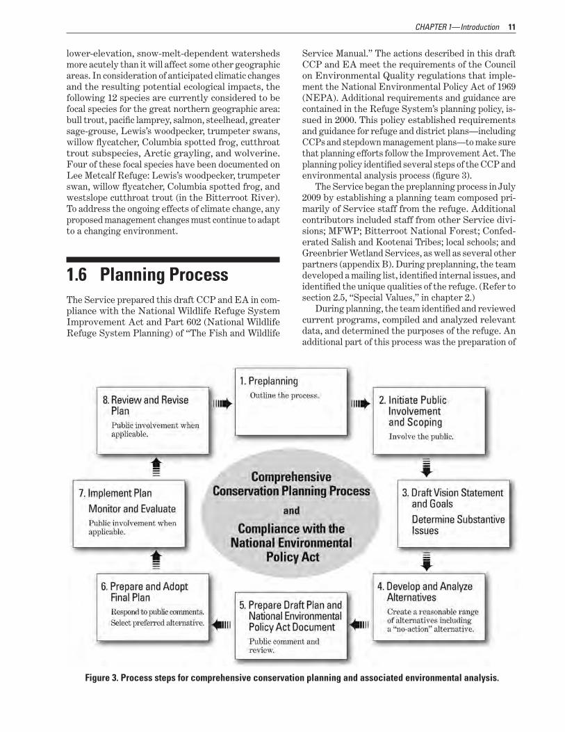
16 Planning Process The Service prepared this draft CCP and EA in comshypliance with the National Wildlife Refuge System Improvement Act and Part 602 (National Wildlife Refuge System Planning) of ldquoThe Fish and Wildlife
Service Manualrdquo The actions described in this draft CCP and EA meet the requirements of the Council on Environmental Quality regulations that impleshyment the National Environmental Policy Act of 1969 (NEPA) Additional requirements and guidance are contained in the Refuge Systemrsquos planning policy isshysued in 2000 This policy established requirements and guidance for refuge and district plansmdashincluding CCPs and stepdown management plansmdashto make sure that planning efforts follow the Improvement Act The planning policy identified several steps of the CCP and environmental analysis process (figure 3)
The Service began the preplanning process in July 2009 by establishing a planning team composed prishymarily of Service staff from the refuge Additional contributors included staff from other Service divishysions MFWP Bitterroot National Forest Confedshyerated Salish and Kootenai Tribes local schools and Greenbrier Wetland Services as well as several other partners (appendix B) During preplanning the team developed a mailing list identified internal issues and identified the unique qualities of the refuge (Refer to section 25 ldquoSpecial Valuesrdquo in chapter 2)
During planning the team identified and reviewed current programs compiled and analyzed relevant data and determined the purposes of the refuge An additional part of this process was the preparation of
Figure 3 Process steps for comprehensive conservation planning and associated environmental analysis
12 Draft CCP and EA Lee Metcalf National Wildlife Refuge Montana
a habitat analysis report by Greenbrier Wetland Sershyvices a company that focuses on wetland conservation and management Its report entitled ldquoAn Evaluation of Ecosystem Restoration and Management Options for Lee Metcalf National Wildlife Refugerdquo took more than 2 years to research and prepare and resulted in some sound recommendations for the restoration and future management of the refuge
Table 1 lists the specific steps in the planning process to date for the preparation of this draft CCP and EA
CooRdINATIoN WITH THE PUbLIC During preplanning a mailing list of more than 270 names was prepared that included private citizens loshycal regional and State government representatives and legislators other Federal agencies and interested organizations (appendix C)
A notice of intent was published in the Federal Register on September 30 2009 (volume 74 Number 188 pages 50235ndash50236) It informed the public that the planning process for the Lee Metcalf Refuge had begun and invited all to share their ideas issues and other comments within 30 days Additionally in Sepshytember 2009 the first planning update was sent to mailing list recipients it provided information on the history of the refuge an overview of the CCP process and invitations to two public scoping meetings The planning update included a form for providing written comments Emails were also accepted at the refugersquos email address leemetcalffwsgov
In addition to the update public scoping meetings were announced statewide in the media Two public meetings were held in the communities of Stevensville and Missoula Montana on September 29 and October 1 2009 respectively During these meetings a presenshytation was given detailing what a CCP is the purposes of the refuge and information on planning limitations primarily based on compatibility There were 12 atshytendees at both meetings including the field represhysentative for Senator Max Baucus All were invited to speak and comments were recorded In addition to
the comments submitted at these meetings 20 emails and letters were received during the scoping process
Many of the comments were related to the refugersquos very popular visitor services programs (the refuge reshyceives more than 143000 visitors each year who view wildlife hunt and participate in educational and intershypretive programs) Most individuals asked the refuge to consider expanding these programs particularly the staff-led programs along with associated trails and other visitor services facilities Other comments were related to invasive species While commending the refuge on controlling these invasive plants the public requested even more effort to reduce impacts on wildlife and neighboring landowners Other comshyments concerned buffering the refuge from extensive surrounding development addressing climate change impacts including ensuring adequate water supplies for management and offering access and additional interpretation of the historical Whaley Homestead
Public scoping concluded on November 13 2009 when the comment period closed This project complies with public involvement requirements of NEPA and the planning team incorporated public input throughshyout the planning process
STATE CooRdINATIoN At the start of the planning process the Servicersquos Regional Director (Region 6) sent a letter to MFWP inviting its staff to participate in the planning process State biologists and outdoor recreation specialists have since been involved in the planning process offering input on current and future biological and visitor sershyvices programs At the start of the process each office of Montanarsquos US congressional delegationmdashSenator Jon Tester Senator Max Baucus and Representative Dennis Rehbergmdashwere sent letters that notified them of the planning process and invited their comments Five Montana State senators and representatives and Governor Brian Schweitzer were sent similar letters
The State has been most concerned with the visishytor services programs and State staff participated in
Table 1 Summary of the CCP planning process for Lee Metcalf National Wildlife Refuge Stevensville Montana Date Event Outcome
July 13 2009 Kickoff meeting The planning team learned about the CCP process discussed the initial planning team list developed a mailing list planning schedule and the first draft of internal issues and qualities list and reviewed biological data needs
July 14 2009 Vision statement development The planning team developed a proposed vision statement for the draft CCP
August 11 2009 Public scoping planning The planning team discussed an effective outreach plan for public scoping
September 9 2009 Planning update mailing The first planning update was sent to mailing list recipients This update described the planning process and announced upcoming public scoping meetings
Table 1 Summary of the CCP planning process for Lee Metcalf National Wildlife Refuge Stevensville Montana Date Event Outcome
September 29 2009 Public scoping meeting Public attendees learned about the CCP process and discussed issues and ideas for future management
September 30 2009 Notice of intent publication A notice of intent to prepare the CCP was published in the Federal Register
October 1 2009 Public scoping meeting Public attendees learned about the CCP process and discussed issues and ideas for future management
November 17 2009 Visitor services workshop A panel of visitor services experts from State tribal and Federal agencies gathered to discuss and propose options for managing the refugersquos visitor services programs and facilities
January 26ndash27 2010 Review of draft habitat analysis report
Service staff reviewed the draft analysis and recommendations (prepared by Greenbrier Wetland Services) that described the proposed future ecological restoration and management of the refugersquos wetland and floodplain complex
January 27 2010 Review of draft grasslands restoration and management report
Service staff reviewed the draft analysis and recommendations (prepared by Aeroscene Land Logic) that described proposed future ecological restoration and management of the refugersquos grassland areas
March 3 2010 Goals workshop The planning team prepared draft goal statements in support of the proposed vision statement
April 7 2010 Alternatives development The planning team began developing and evaluating three alternatives for managing visitor services
April 20 2010 Target species determination The planning team determined CCP target species by reviewing State and national priorities species lists for the Service the State of Montana and the Bitterroot Valley
May 26ndash27 2010 Alternatives development and evaluation
The planning team began developing alternatives for biological programs and continued evaluating alternatives for managing visitor services
June 23ndash24 2010 Alternatives review and consequences development
The planning team reviewed the alternatives table and discussed environmental consequences
July 8 2010 Environmental consequences review
The planning team continued to review the alternatives table and discussed environmental consequences
July 20ndash22 2010 Alternatives and consequences workshop
An expanded team of partners from the Service and other Federal tribal and State agencies assembled to review three alternatives and determine the environmental consequences of each Alternative B was selected as the proposed action
November 16 2010 North Burnt Fork Creek meeting The planning team met with scientists from other Service divisions and State and Federal agencies to discuss options for reconnecting North Burnt Fork Creek to the Bitterroot River
November 17 2010 Objectives and strategies workshop
The planning team drafted objectives and strategies for the proposed action
January 13 2011 Map and figure review The planning team developed a list of needed maps and figures for draft CCP and EA
January 25 and February 2ndash3 2011
Proposed alternatives review Refuge staff met to review and revise the list of proposed alternatives
March 21ndash22 2011 Proposed action review The planning team reviewed the list of objectives strategies and rationale for the proposed action (chapter 5 of this draft CCP)
February 2011ndashSeptember 2011
Internal draft plan preparation The planning team prepared the draft CCP and EA including maps The document was edited and prepared for internal review
September 12ndash30 2011 Internal review of draft plan The draft CCP and EA was sent to a list of internal reviewers consisting of Service State tribal and other Federal staff Comments were collected and resulted in several modifications to this public draft
CHAPTER 1mdashIntroduction 13
14 Draft CCP and EA Lee Metcalf National Wildlife Refuge Montana
the planning meetings to discuss the proposed future management of these programs The State has been supportive of the planning process to date
TRIbAL CooRdINATIoN Early in the planning process the Servicersquos Regional Director (Region 6) sent a letter to tribes with poshytential cultural and historical connections to the area in which the refuge is located Tribes contacted were the Confederated Salish and Kootenai and Nez Perce tribal councils and culture committees A staff person and tribal member from the Confederated Salish and Kootenai Natural Resources Division offered her assisshytance in developing and reviewing the alternatives for the visitor services and cultural resources programs
RESULTS oF SCoPINg Comments collected from scoping meetings and corshyrespondence were used in the development of a final list of issues to be addressed in this draft CCP and EA The Service determined which alternatives could best address these issues The planning process enshysures that issues with the greatest effect on refuge resources and programs are resolved or prioritized over the life of the final CCP Identified issues along with a discussion of effects on resources are summashyrized in chapter 2 In addition the Service considered refuge management changes that were suggested by the public and other groups
SELECTINg AN ALTERNATIvE Following the public review and comment period for the draft CCP and EA the planning team will present this document along with a summary of all substantive public comments to the Servicersquos Regional Director (Region 6) The Regional Director will consider the environmental effects of all three alternatives includshying information gathered during public review If the analysis has not identified any significant issues that warrant an environmental impact statement or other additional analysis the Regional Director will select a preferred alternative The Regional Directorrsquos decision will be disclosed in a NEPA decision documentmdasha findshying of no significant impact or FONSImdashand included
in the final CCP Once approved the actions in the preferred alternatives will compose the final CCP
After the planning team prepares the final CCP for publication a notice of availability will be published in the Federal Register and copies of the final CCP and accompanying summary will be sent to individushyals on the mailing list Subsequently the Service will implement the CCP with help from partner agencies organizations and the public
The CCP will provide long-term guidance for manshyagement decisions support achievement of the goals objectives and strategies needed to accomplish the purposes of the Lee Metcalf Refuge and identify the Servicersquos best estimate of future needs The CCP will detail program planning levels that may be substanshytially above budget allocations and as such would be primarily for strategic planning purposes The CCP does not constitute a commitment for staff increases operation and maintenance increases or funding for future land acquisitions
copy A
llan
F M
eyer
s
CHAPTER 2mdash The Refuge
Nearly 1000 acres of Lee Metcalf National Wildlife Refuge consist of open water
Bob
Dan
ley
US
FW
S
Lee Metcalf National Wildlife Refuge consists of 2800 acres of lands and waters all located within Ravalli County near Stevensville Montana This chapter disshycusses the refugersquos establishment management history purposes and special values as well as its proposed vision goals and planning issues
21 Establishment Acquisition and Management History The following section describes the establishment acquisition and management history of the Lee Met-calf Refuge
LEE METCALf NATioNAL WiLdLifE REfugE Lee Metcalf Refuge is approximately 2 miles north of Stevensville and 25 miles south of Missoula in Rashyvalli County Montana The refuge lies in the heart of the Bitterroot Valley cradled between two mountain ranges the Bitterroot Mountains to the west and the Sapphire Mountains to the east Today the refuge boundary encompasses 2800 acres (figure 4) Elevashytion ranges from about 3 225 feet on the north end of the refuge to about 3 314 feet on the south
The refuge contains upland habitat composed of floodplain and terrace grasslands shrublands or a combination of both The refuge also has riparian habitat consisting of woodlands wetlands and wetshyland impoundments that have open water and pershysistent emergent vegetation Other habitats include
the river channel and areas of either bare or very sparse vegetation such as gravel bars parking lots and roads (table 2)
The refuge serves as a staging and nesting area for migrating waterfowl shorebirds sandhill cranes and other migratory birds A variety of refuge habishytats are home for native resident wildlife such as bats white-tailed deer porcupines and beaver
The refuge is located in the Bitterroot River floodshyplain and the river runs through or alongside refuge lands for approximately 5 miles The Bitterroot River has two forks with headwaters in the Anaconda-Pintler Mountains and in the Bitterroot Mountains at the Idaho and Montana stateline The river flows north and has areas of inherently unstable channel configurations until its confluence with the Clark Fork River near Missoula The floodplain at the refuge is characterized by multiple abandoned channels backwater flooding and entrances of two tributaries (North Burnt Fork Creek and Three Mile Creek)
After establishment of the refuge in 1964 an exshytensive system of levees ditches and water control structures were constructed to capture and manage the available water supply with a primary purpose of providing migration and nesting habitat for washyterfowl By the late 1980s more than 1000 acres had been partially or completely impounded in 14 ponds for managed wetland units Today these ponds range in size from 8 acres to more than 200 acres and their water levels are seasonally managed for waterfowl and shorebirds Additionally tributaries and natural springs have been altered by dams or weirs that have allowed the direction or level of surface waterflow to
16 Draft CCP and EA Lee Metcalf National Wildlife Refuge Montana
figure 4 Approved acquisition boundary of Lee Metcalf National Wildlife Refuge Montana
CHAPTER 2mdashThe Refuge 17
Table 2 Habitat type and associated acreages found on Lee Metcalf National Wildlife Refuge Montana Habitat type Acres
Uplands (primarily tame grasses) 118643
Woodlands and wetlands near woodlands 50258
Wetland impoundments (open water emergent vegetation) 95819
River channel 6273
Bare or sparse vegetation 8959
Total 279952
be manipulated With 24 water claims and one water permit the refuge has the right to 3420938 acre-feet of water per year to use for habitat management purshyposes The diverted water provides feeding resting and nesting habitat for migratory birds wetland-reshylated wildlife and resident wildlife
Remnants of gallery and riverfront forest can be found in the refuge Although this habitat is still presshyent soil types and historical vegetation data suggest that several of the impoundments or ponds were once forested or consisted of native grasslands
SuMMARy of LANd ACquiSiTioN HiSToRy On December 10 1963 the Migratory Bird Conservashytion Commission used the authority of the 1929 Migrashytory Bird Conservation Act (16 United States Code [USC] 715ndash715d 715e 715fndash715r) (45 Stat 1222) to approve the acquisition of 2700 acres in 18 tracts of land to establish the Ravalli National Wildlife Refshyuge In 1978 the refuge was renamed to honor the late Senator Lee Metcalf who was instrumental in establishing this refuge and to recognize his lifelong commitment to conservation On February 4 1964 the first purchase was made Tract 21 consisting of 40805 acres Over the next 25 years the Service purchased an additional 23 tracts for a total of 279952 refuge acres (table 3) There were also two permits acquired from the Northern Pacific Railroad Company to access a pumping station and to cross the railroad tracks to access refuge lands In 2009 a facilitation easement was recorded for an irrigation ditch that traverses through a subdivision
22 Purposes Every national wildlife refuge has a purpose for which it was established This purpose is the foundation on which to build all refuge programsmdashfrom biology and public use to maintenance and facilities The refuge purposes are found in the legislative acts or Executive actions that provide the authorities to either transfer or acquire a piece of land Over time an individual refshyuge may contain lands that have been acquired under
various transfer and acquisition authorities giving the unit more than one purpose The goals objectives and strategies proposed in the draft CCP (chapter 5) are intended to support the individual purposes for which the refuge was established
The Migratory Bird Conservation Commission jusshytification for establishing the Lee Metcalf Refuge was to provide a feeding and resting area for migrating washyterfowl in a locality where some sanctuary is needed
The legislative purposes of the Lee Metcalf Refshyuge are as follows
For ldquouse as an inviolate sanctuary or for any other management purpose for migratory birdsrdquo (Migratory Bird Conservation Act 16 USC 715ndash715d 715e 715fndash715r 45 Stat 1222 as amended)
As ldquosuitable for (1) incidental fish and wildshylife-oriented recreational development (2) the protection of natural resources (3) the conservation of endangered species or threatshyened species rdquo
ldquothe Secretary may accept and use real property Such acceptance may be accomshyplished under the terms and conditions of restrictive covenants imposed by donors rdquo (Refuge Recreation Act 16 USC 460kndash460kndash4)
In 1978 the refuge was renamed to honor the late Senator Lee Metcalf who was instrumental in establishing this refuge and to recognize his commitment to conservation
Bob
Dan
ley
US
FW
S
18 Draft CCP and EA Lee Metcalf National Wildlife Refuge Montana
Table 3 Land acquisition history for Lee Metcalf National Wildlife Refuge Montana (1964ndash2009) Tract number Acres Date acquired Means of acquisition
21 40805 02041964 Fee
21a 2539 02041964 Fee
19 30593 04101964 Fee
25 16710 06091964 Fee
25a 9086 06091964 Fee
12 29811 06111964 Fee
24 947 06121964 Fee
13 160 08241964 Fee
11 30932 05211965 Fee
11a 427 05211965 Fee
20 17589 01031966 Fee
15 223 06141966 Fee
14a 513 06151966 Fee
23 260 01251967 Fee
10 2648 06121967 Fee
10a 29253 06121967 Fee
22 813 08141967 Fee
27 33631 12061968 Fee
27-I 031 12061968 Fee
19a 6378 11131974 Fee
29 44 06121978 Fee
16 80 03231988 Fee
17 1623 05231988 Fee
19b 01 10011989 Feemdashlife estate
28M 01 12011967 Permit from railroad companymdashpump station
28R 01 02011970 Permit from railroad companymdashcrossing
30D 7 01092009 Easement
Total 279952 1Acreage figure is minimal
The refuge includes 1218 acres of upland habitat that consist of grassland shrubland and a combination of both
US
FW
S
Dan
ley
B
ob
CHAPTER 2mdashThe Refuge 19
23 Vision A vision is a concept including desired conditions for the future that describes the essence of what the Sershyvice is trying to accomplish The following vision for the Lee Metcalf Refuge is a future-oriented statement and is to be achieved through refuge management throughout the life of this CCP and beyond
Lee Metcalf National Wildlife Refuge is a representation of the diverse native wildlife habitat once found abundantly
between the Bitterroot and Sapphire Mountains and along the ever-changing Bitterroot River This floodplain refuge
fed by mountain snow is a diverse mosaic of forest grassland and riparian habitat that provides protected lands and waters
for migratory and resident wildlife
The refuge in partnership with its neighbors friends and the community is a conservation leader in the valley ensuring that the biological integrity
of this refuge and other valley habitats remains intact or where appropriate
is restored
These protected lands and waters are a place of discovery for visitors to
experience fish and wildlife firsthand and where children can experience nature
with all their senses Visitors to the refuge can appreciate the beauty of the
setting and experience a sense of wonder and pride to be preserving this part of the Bitterroot Valley and the National
Wildlife Refuge System
24 goals The Service developed eight goals for the refuge based on the Improvement Act the purposes of the refuge and information developed during project planning The goals direct efforts toward achieving the vision and purposes of the refuge and outline approaches for managing refuge resources
BiTTERRooT RiVER fLoodPLAiN ANd ASSoCiATEd WiLdLifE Manage and where appropriate restore the natural topography water movements and physical integrity of surface water flow patterns across the Bitterroot River floodplain to provide healthy riparian habitats for target native species and to educate visitors about the benefits of sustaining a more natural floodplain
WETLANd iMPouNdMENT HABiTAT ANd ASSoCiATEd WiLdLifE Where appropriate manage wetland impoundments to create a diversity of habitats for target waterfowl shorebirds and other associated native wetland-deshypendent species
gRASSLANd ANd SHRuBLANd HABiTAT ANd ASSoCiATEd WiLdLifE Create the conditions that will allow for the restorashytion maintenance and distribution of native grassland and shrubland species (such as rabbitbrush needle and thread grass Junegrass and hairy golden aster) to provide healthy lands for a diverse group of target native resident and migratory wildlife species and to educate visitors about the historical plant and animal diversity of the Bitterroot Valley
iNVASiVE ANd NoNNA TiVE SPECiES Prevent reduce and contain the invasion and spread of noxious invasive and harmful nonnative species within the refuge while working with partners to adshydress off-refuge infestations within the surrounding landscape
RESEARCH Pursue and maintain compatible research projects that would provide information on refuge resources and address refuge issues to assist management in making decisions based on the best available inforshymation and science
CuLTuRAL RESouRCES Provide opportunities for visitors to learn about the unique glacial Native American and Euro-American history of the Bitterroot Valley while maintaining and protecting the integrity of the refugersquos cultural and historical resources
ViSiToR SERViCES Provide visitors of all abilities with opportunities to participate in and enjoy quality compatible wildlife-dependent recreation environmental education and interpretation programs that foster an awareness and appreciation of the importance of protecting the natushyral and cultural resources of the refuge the Bitter-root Valley and the National Wildlife Refuge System
20 Draft CCP and EA Lee Metcalf National Wildlife Refuge Montana
PARTNERSHiPS Maintain and cultivate partnerships that help achieve the vision and supporting goals and objectives of the Lee Metcalf National Wildlife Refuge Comprehenshysive Conservation Plan and support other initiatives designed to protect and restore habitats for Federal trust species within the Bitterroot River Valley
oPERATioNS ANd f ACiLiTiES Prioritize wildlife first and emphasize the protection of trust resources in the utilization of staff volunteers funding and facilities
25 Special Values Early in the planning process the planning team and public identified the refugersquos unique qualities or special valuesmdashcharacteristics and features of the refuge that make it special valuable for wildlife and an integral part of the Refuge System It was important to idenshytify the special attributes of the refuge to recognize its value and to make sure that these attributes are conshyserved protected and enhanced through the planning process These special values can be unique biological values as well as simple values like providing a quiet place to see a variety of birds and enjoy nature The following list summarizes many of the qualities that make the refuge unique and valued
protects 2800 acres of diverse habitatsmdashriparian wetland and uplandmdashin a rapidly growing county
supports a healthy riparian corridor used by breedshying neotropical songbirds
contains gallery forest along the Bitterroot River provides a wildlife corridor that runs north to south
along the Bitterroot River and east to west from North Burnt Fork Creek to Kootenai Creek
contains the largest montane wetland complex in the Bitterroot Valley on which many migratory bird species are dependent for breeding and mishygration stopovers
provides resting habitat for trumpeter swans prishymarily during migration
provides habitat for a great blue heron rookery containing 12ndash18 nests
provides habitat for one bald eagle nest and forshyaging habitat for one additional nest less than 05 mile from the refuge
provides exceptional viewing opportunities for nesting osprey and maintains the longest running dataset for nesting osprey in Montana
lies within the Bitterroot River Important Bird Area as designated by the National Audubon Society
provides habitat for 242 bird species 40 mammal species and 11 species of reptiles and amphibians
contains 45 documented species of concern (38 birds 3 mammals 2 plants 1 aquatic insect and 1 amphibian) listed in Montana
provides habitat for moose black bear and (occashysionally) elk on the valley floor
includes designated critical habitat for endangered bull trout
includes a portion of the Bitterroot River which is considered a blue ribbon trout fishery
lies within the Bitterroot Valley the traditional homeland of the Salish Nez Perce and Pend drsquoOreilles native peoples
located a few miles from Stevensville the oldest continuous Euro-American settlement in Montana
contains the historic Whaley Homestead which was built in 1885 and is listed on the National Register of Historic Places
offers one of the few places to hunt waterfowl on public land in Ravalli County and the entire Bitshyterroot Valley
provides environmental education and research opportunities for more than 16000 area students of all ages (Missoula to Hamilton)
serves as a ldquowindowrdquo on the Refuge System for its 143000 annual visitors providing the public with a multitude of wildlife-dependent recreational acshytivities in a peaceful and beautiful setting
provides a visitor contact area staffed by volunshyteers and an outdoor amphitheater with vistas of refuge wetlands the heron rookery and the Bitshyterroot Mountains
provides universally accessible nature trails with views of multiple habitat types and opportunities to view a variety of wetland grassland and forshyest bird species
contains a 25-mile-long designated National Recshyreation Trail
contains portions of the Ice Age Trail Nez Perce Trail and the actual (not officially designated) Lewis and Clark Trail
collaborates with a wide variety of area organizashytions to carry out the refuge mission (that is land management visitor service historic restoration and research)
provides close-up wildlife viewing opportunities serves as a point of pride for area citizens provides research opportunities for dozens of wildshy
life and environmental researchers attracts dozens of volunteers who annually donate
8500 work hours
CHAPTER 2mdashThe Refuge 21
26 Planning issues Several key issues were identified following the analysis of comments collected from refuge staff and the public and a review of the requirements of the Improvement Act and NEPA Two public meetings news releases in the local and regional press an announcement in the Federal Register and planning updates were used to solicit public input on which issues the CCP should address Substantive comments (those that could be addressed within the authority and management cashypabilities of the Service) were considered during forshymulation of the alternatives for future management These key issues are summarized below
BiTTERRooT RiVER MigRATioN The Bitterroot River traverses the Bitterroot Valley floor and is characterized by a constantly migrating stream channel that flows through extensive cottonshywood and ponderosa pine bottomland forest Natushyrally the river fluctuates in water volume depending on winter snowpack and spring precipitation These fluctuations regularly flood braided river channels and may create new ones Much of this flooding and migration is natural and can be beneficial However as development increases many more landowners are installing riprap along their properties in an attempt to prevent riverbank erosion this directs the river (and its energy and increased velocity) to unprotected areas and increases the rate of erosion above natural levels Such erosion has occurred in the refugersquos wildshylife viewing area (WVA) where erosion has exceeded 100 feet in one area partially destroyed a universally accessible paved trail removed many large ponderosa pine and black cottonwood trees and left a steep bank next to the education shelter and terminus of the Lee Metcalf accessible trail a National Recreation Trail
Additionally increased erosion from upstream bank stabilization also contributes to a loss of riparian habishytat including both types of woodlands (riverfront and gallery forest) and wetlands (streams and sloughs) Woodlands provide a migration corridor for birds a home to several bat species of State concern and shade and habitat structure for terrestrial and aquatic species The refuge faces challenges and uncertainty in managing riparian habitat in the face of intensified bank erosion increased river velocities and shorter and more dramatic flood frequencies due to upstream channel alterations and bank stabilization
WETLANd iMPouNdMENTS (oR PoNdS) Shortly after acquiring the first tract of refuge land the Service constructed several impoundments (comshymonly referred to as ponds) to hold water for migrashytory waterfowl These impoundments were mostly built atop agricultural fields Prior to 1873 these lands
Flooding of the Bitterroot River is a common occurrence on the refuge
consisted of native grassland and shrubland habitats gallery forests and some natural streams (as identified in a 1964 habitat map figure 5) Currently there are approximately 960 acres of wetland impoundments
Some impoundments are surrounded by persistent emergent wetland vegetation like cattail Cattail is an aggressive emergent plant that can completely fill wetshyland areas once established it is extremely difficult to control and can limit habitat value for waterfowl and other migratory birds However a balanced mosaic of open water cattail and other emergent vegetation usually benefits nesting habitat for diving ducks brood habitat for diving and dabbling ducks and nesting and roosting habitat for rails American bitterns and red-winged and yellow-headed blackbirds
The constantly migrating Bitterroot River has started to erode some levees on the north end of the refuge making Pond 13 susceptible to river moveshyments and leaving refuge staff with little control over its water level The structures and levees on one other impoundment in the refugersquos north end are threatened by erosion as well Maintaining these impoundments may be costly and ecologically unsound depending on the riverrsquos future channel migration
Management of impoundments depends on a consisshytent water source and the ability to manage and drain wetlands Refuge impoundments receive water from irrigation water diverted from the Bitterroot River tributary creeks natural springs tile drainage of agshyricultural fields and subsurface groundwater Drainshyage and irrigation ditches may receive outflow from adjacent agricultural operations and residential and industrial septic systems and such impacts on water quality could in turn pose a threat to refuge wildlife
Also of concern is the spread of nonnative aquatic predators In the early 1990s MFWP and the refuge released 10000 bass fingerlings into Otter Pond to promote recreational fishing as a result largemouth bass have spread to most ponds (Ponds 5ndash13) Large-mouth bass can be voracious predators on fish frogs and aquatic insects and have been known to consume
Bob
Dan
ley
US
FW
S
22 Draft CCP and EA Lee Metcalf National Wildlife Refuge Montana
figure 5 Composite vegetation community models Lee Metcalf National Wildlife Refuge for 1964 and 2005 (Heitmeyer et al 2010)
CHAPTER 2mdashThe Refuge 23
ducklings In addition bullfrogs also inhabit most of the impoundments This nonnative amphibian disshyplaces and consumes not only native amphibians but avian chicks small snakes and small mammals as well
uPLANd HABiTAT ANd ASSoCiA TEd WiLdLifE The intermountain and foothill grassland ecotype which is found in the Bitterroot Valley and other broad mountain valleys in western Montana contains some of Montanarsquos most diverse fish and wildlife habitats These areas also contain some of the largest populashytions of humans in Montana The Bitterroot Valley area is considered a terrestrial conservation focus area in greatest need due to the loss of this habitat to agricultural production (MFWP 2005)
The refuge has 1218 acres of upland habitat that consists of grassland shrubland and a combination of both Due to the retirement of agricultural crops encroachment of development and spread of invasive plants few native plant species remain and wildlife value has been degraded In many uplands the domishynant plant species are nonnative bunch grasses and weeds such as smooth brome crested wheatgrass cheatgrass knapweed and thistle A combination of management actions have been appliedmdashprescribed fire disking and seeding herbicide application and manual weed removalmdashwith varying results
WATER Lee Metcalf Refuge receives surface water from tile drain ditches springs ephemeral and perennial creeks and subsurface flow and three lateral irrigashytion ditches the North Lateral Ditch Middle Lateral Ditch and South Lateral Ditch These lateral ditches are supplied by the Supply Ditch a primary canal that carries diverted Bitterroot River water from Victor to just north of the refuge Water entering the refshyuge from the east often has a high nutrient load as it traverses or drains out of grazed or farmed lands As a result the refuge receives nutrient-rich drainage water that results in abundant algal growth during summer months
In the past 5 years algal growth has increased in the impoundments possibly in part due to the comshybination of increased nutrient loading in surface washyter and potentially in subsurface water Algal growth results in diminished water clarity and subsequent reduction in light penetration and vegetative quality of refuge impoundments
Currently the Montana Bureau of Mines and Geshyology has established shallow wells to collect subsurshyface water quality data and is also evaluating surface water quality within the refuge boundary
The North Lateral Ditch also called the Alleman Ditch flows through private land traverses alongshyside Eastside Highway and then enters the refuge on Rathbun Lane In the last several years the refuge
has received water from this ditch even though it has become silted and overgrown with vegetation Howshyever when the headgate is opened the ditch tends to overflow and flood private lands
East of the Eastside Highway subdivisions have been developed along and over the Middle Lateral Ditch (also called the McElhaney Ditch) and affected the efficiency of flows leaving the Supply Ditch and reaching the refuge Currently refuge management is working with the Supply Ditch Association landownshyers and staff to replace this ditch with a pipeline If successful this effort could conserve water provide a more reliable flow to the refuge reduce noxious weed seed transfer from ditchbanks and adjacent lands end periodic localized flooding and possibly provide a gravity-flow water source into the refuge wheel lines thereby saving thousands of dollars annually in pumping costs
In recent years much of the refuge water from the South Lateral Ditch (also called the Warburton Ditch) has not reached the refuge Refuge law enshyforcement officers have monitored diversions along this ditch in the past
Other historic ditches (now McPherson and Nickshyerson Creeks) remain on the refuge but have not been maintained in recent years
iNVASiVE ANd NoxiouS SPECiES The State of Montana has identified 32 noxious plant species which are nonnative plants that must be treated by rule of the Montana County Weed Control Act Fifshyteen of these species have been found on the refuge Invasive species prevent desirable native vegetation growth and often severely degrade habitat for native wildlife by altering its structure and its species and ecosystem interactions When invasive species become widespread they often change the habitat structure and vegetative variability that wildlife need for food and cover These nonnative plants often create mono-typic stands using up soil moisture and nutrients and outcompeting more desirable native species This
Invasive and noxious species are a threat to native plantson the refuge including velvet lupine
US
FW
S
Dan
ley
B
ob
24 Draft CCP and EA Lee Metcalf National Wildlife Refuge Montana
change in plant species structure and diversity imshypacts habitat for migratory birds a group of species for which this refuge was established
Multiple factors have likely contributed to the noxious and invasive plant problem on the refuge Historically factors like soil type flood frequency toshypography availability of irrigation and dominant vegshyetation likely influenced how lands that now compose the refuge were used Much of this land was managed for agriculture including growing small grains and potatoes haying and grazing It is also evident that croplands were leveled and parts of the refuge may have been drained After refuge establishment much of the agricultural land was developed into wetland impoundments or managed for migratory waterfowl food resources Later gravel levees were developed to protect refuge facilities from periodic flooding from the Bitterroot River White-tailed deer move daily off the refuge and back from neighboring lands and poshytentially carry weed seeds in fur or scat All of these actionsmdashboth before and after refuge establishmentmdash disturbed the soil and created abundant opportunities for noxious and invasive plants to take root
Land uses in and around the refuge also likely contribute to the invasive species problem The Bitshyterroot River runs the length of the refuge and the water current as well as recreationists often transport seed from one area to another Montana Rail Link also traverses the width and length of the refuge and proshyvides additional opportunity for weeds to spread on disturbed ground Finally Wildfowl Lane a county road runs west north and east through the south half of the refuge providing abundant opportunities for noxious weed transport and establishment Land use surrounding the refuge (subdivisions irrigation laterals and tile drains uncontrolled weed infestations on adjacent lands Eastside Highway and Rathbun Lane) also contributes to the challenge of managing invasive species including treated areas on the refuge
RESEARCH iNVENToRy ANd MoNiToRiNg Over the years research inventory and monitoring of refuge resources have been sporadic and minimal In most cases research is proposed by another agency or a university not by refuge staff Consequently some management programs have not necessarily been designed from refuge-specific data or in response to critical refuge needs and issues This had led in part to some of the habitat management difficulties deshyscribed in this section
ViSiToR SERViCES Each year the refuge hosts more than 143000 visitors from all over the country and the world It is valued as a place to discover enjoy the beautiful scenery and be close to nature
The refuge has always done well to accommodate visitors by providing facilities and programs intended for education and enjoyment The refuge currently employs one outdoor recreation planner who manshyages and designs all programs Dedicated volunteers assist with these programs and help greet visitors at the refuge headquarters Nevertheless there is treshymendous potential for improvement namely through providing new programs tours offsite programs and interpretive displays and by expanding and improvshying current facilities particularly the visitor contact area Although the visitor contact area does allow for some interpretation it is small (about 500 square feet) and inadequate for conducting tours accommodating larger groups or housing displays that could better interpret refuge resources and programs The refuge is very popular with local schools and other groups accordingly there is a need for additional programs and an indoor classroom
Many visitors have asked for additional trails and opportunities to explore more of the refuge Requests were also made to afford all visitors the same access provided to refuge hunters The refuge currently has 209 miles of trails in the WVA some of which require improvement or relocation One of these trails in the WVA is slowly eroding as a result of the migrating Bitterroot River The Kenai Nature Trail located north of the refuge headquarters is also very popushylar with visitors but it is surrounded by a closed area that does not allow visitors to leave this narrow trail As part of the CCP development process the refuge will evaluate these trails and determine if improveshyments are needed or if accommodations can be made in other refuge areas
Hunting for waterfowl and white-tailed deer is very popular on the refuge The refuge is located in a State management unit that only permits archery hunting for big game The refuge suspects that the lack of reshygeneration in the understory of the forest is a direct result of overbrowsing by white-tailed deer Should this be the case the refuge may need to work with the State to find other methods to better disperse the deer or reduce the population on the refuge
STAffiNg Currently the refuge employs eight full-time employshyees (three of whom are zone or state-wide support employees who do not exclusively support refuge opshyerations) If the refuge is to accomplish the goals set forth in this CCP within the established timeframe adequate staffing and resources will be needed
CHAPTER 3mdash Alternatives and Environmental Consequences
Variegated meadowhawk is one of many dragonfly species found on Lee Metcalf Refuge
US
FW
S
Dan
ley
B
ob
The purpose of this chapter is to describe the manshyagement alternatives and associated environmental consequences considered for the Lee Metcalf National Wildlife Refuge Alternatives are different approaches to unit management that are designed to achieve the refuge purposes vision and goals the mission of the Refuge System and the mission of the US Fish and Wildlife Service Alternatives are developed to address the substantive issues concerns and problems idenshytified by the Service the public and other partners during public scoping and throughout the development of the draft CCP This chapter contains the following
summary of alternatives (sections 31 and 32) summary of environmental consequences (secshy
tion 33) detailed descriptions of alternatives and conseshy
quences (section 34)
31 Alternatives Development The planning team assessed the planning issues idenshytified in chapter 2 the existing biological conditions described in chapter 4 and external relationships afshyfecting the refuge This information contributed to the development of alternatives each of which presents a distinct approach for meeting long-term goals Each
alternative was evaluated on the basis of its approach to addressing planning issues and its expected success in meeting the vision and goals of the refuge and the Refuge System
Alternative A the no-action alternative describes the current ongoing management activities This altershynative might not meet all the CCP goals It is provided as a basis for comparison with the other alternatives
AlTERnATivEs ConsiDERED buT EliminATED There were no alternatives considered but eliminated from detailed study
ElEmEnTs Common To All AlTERnATivEs This section identifies the following key elements that will be included in the CCP regardless of the alternashytive selected
The Service would ensure that management of the refuge complies with all Federal laws administrashytive orders and policies that provide direction for managing units of the Refuge System Among these mandates are the Improvement Act the Endanshygered Species Act of 1973 the Clean Water Act of 1977 Executive Order 11990 (ldquoProtection of Wetshylandsrdquo) and Executive Order 11988 (ldquoFloodplain Managementrdquo) The implementation of alternatives described in this draft CCP and EA would not lead to a violation of these or other mandates
26 Draft CCP and EA Lee Metcalf National Wildlife Refuge Montana
Implementation of the management direction (goals objectives and strategies) would follow the refugersquos best management practices
Each alternative would attempt to control invasive species through an integrated pest management approach that includes biological chemical and mechanical treatment methods followed by restoshyration and prevention of reinvasion
Through its actions the Service would not knowingly negatively affect an adjacent landowner without a mutual agreement and adequate compensation
Each alternative would provide equal protection and management of cultural resources
The refuge staff and its contractors researchers and other consultants would acquire all applicable pershymits such as those for future construction activities
32 Description of Alternatives This section describes the alternatives considered by the planning team to achieve the proposed vision and goals and to address the issues These alternatives inshyclude not only the current management (alternative A) but also the Servicersquos proposed action (alternative B) which is incorporated into the draft CCP and further described in chapter 5 Table 4 in section 34 below provides a summary of the alternativesrsquo actions with associated consequences
These alternatives reflect options to address sigshynificant threats problems and issues raised not only by refuge staff but also public agencies private citishyzens other State tribal and Federal agencies and other interested organizations
AlTERnATivE A (CuRREnT mAnAgEmEnTndashno ACTion) Alternative A the no-action alternative represents the current management of the refuge This alternashytive provides the baseline against which to compare the other alternatives It also fulfills the NEPA reshyquirement that a no-action alternative be addressed in the analysis process
Under alternative A the Servicersquos management activities would remain the same The staff would perform issue-driven research and monitor only long-term vegetation changes Funding and staff levels would remain unchanged and programs would have the same direction emphasis and intensity as they do at present Key elements of alternative A follow
Habitat and wildlife management actions would continue at present levels unless funding or staffing levels changed Refuge habitat would continue to be
managed using existing water control structures grazing and prescribed fire Results of manageshyment actions may or may not be able to be analyzed because monitoring would continue to be limited due to current funding levels The refuge would continue to impound water in all refuge ponds
The Service would not take any actions to prohibit the migration of the Bitterroot River even for road and trail protection
The culvert at North Burnt Fork Creek in the WVA would be replaced by a bridge
Prescriptive fire prescriptive grazing and natushyral flooding would be used to enhance the existing riverfront and gallery forest plant communities Where appropriate cottonwood and ponderosa pine would continue to be planted to expand the gallery forest areas with a focus on sloughs and historical ditches
Unless eroded by the Bitterroot River the wetland impoundments would be retained however manshyagement capabilities would be limited The gravel pits would be retained and managed for boreal toad and Columbia spotted frog habitat
The Service would attempt to introduce more nashytive plant species into tame grassland areas
The Service would work with partners to map and treat invasive species and monitor treated areas to prevent reintroduction and spread
Refuge staff would continue to perform issue-driven scientific research
Wildlife-dependent compatible priority uses (huntshying fishing wildlife observation wildlife photograshyphy and interpretation) would continue at current levels Outreach and education programs would continue primarily onsite but there would be inshysufficient resources to update signs informational kiosks and brochures or to improve hiking trails and access roads
Five full-time staff persons would continue to be assigned to the refuge along with four zone or state-wide support staff who could assist with refuge programs
AlTERnATivE b (PRoPosED ACTion) This alternative constitutes the draft CCP (chapshyter 5) and focuses on the expansion and restoration of native plant communities on the refuge including grassland and shrubland gallery and riverfront forshyests and wetland impoundments A significant part of the restoration proposal includes the control of invasive species Grasses and shrubs native to the uplands (in the floodplains and on the alluvial fans or areas of sedimentary deposits where fast-flowing streams have flown into flatter plains) would be reshystored to provide habitat for native wildlife including
CHAPTER 3mdashAlternatives and Environmental Consequences 27
grassland-dependent migratory birds Before any restoration is conducted invasive species (including seedbeds) will be reduced primarily with prescribed burning and farming
Some wetland impoundments and Service (nonshypublic) roads would be removed to allow for river migration scouring which could help restore native gallery and riverfront forest for riparian-dependent wildlife Most of the remaining impoundments would be managed to mimic natural conditions for wetland-dependent migratory birds
The Service would expand and improve the refugersquos compatible wildlife-dependent public use programs particularly the wildlife observation environmental education and interpretation programs The visitor contact area would be expanded into a visitor center with new displays and an additional combination conshyference room and environmental education classroom New displays would be professionally planned and produced The refuge would work with Ravalli County staff to designate the county road traveling through the refuge as an interpreted auto tour route which would include pulloffs for wildlife viewing A seasonal hiking trail would be added around Pond 8 and curshyrent trails would be improved for wildlife observation and photography Interpretation and environmental education programs would be expanded using added staff and volunteers All public use programs would provide visitors with a consistent message about the purposes and values of the refuge and the mission of the Refuge System The refuge staff would be expanded by 35 individuals an assistant refuge manager two biological science technicians (one part-time) and a visitor services specialist
Increased research and monitoring efforts staff funding infrastructure and partnerships would be required to accomplish the goals outlined in chapter 2 and the objective and strategies outlined in chapter 5 Additional staff and funding would be dependent on the regional priorities for those funds allocated to the Service for management of lands and waters within the Refuge System Key elements of alternative B follow
Levees and ditches would be modified or created to reconnect floodplain habitats with the Bitter-root River thereby providing the opportunity for overbank and backwater flooding into and out of the floodplain These actions would facilitate the restoration of the natural braided migration patshyterns of the Bitterroot River across the refuge where possible
Water control structures and obstructions in tribshyutary and floodplain channels would be removed or modified to allow unimpeded flow from North Burnt Fork Creek and Three Mile Creek into the Bitterroot River North Burnt Fork Creek would be reconnected with historical channels and the Bitterroot River
Water control structures would be replaced in Ponds 1ndash6 Pond 8 and Pond 10 so that water reshygimes could be managed for a more seasonal annual dynamic that emulates natural increases in water distribution and depth in spring and gradual drying in summer and fall Complete drawdown of each pond would occur on a rotational basis
Levees ditches and water control structures would be removed to facilitate the restoration and expanshysion of the gallery forest habitat (Ponds 7 7a 7b 9 and D) and native grassland habitat (Pair Ponds and Potato Cellar Pond) while ensuring that restoration areas do not become new sites for invasive species
The pool height of Ponds 8 and 10 would be lowshyered to allow for the restoration of gallery forest to the west of these ponds
Once invasive species were well controlled on restoshyration sites (using primarily farming and prescribed fire) native plant communities would be restored based on geomorphology soils topography and hydrologic features
As appropriate vegetation would be removed from gravel pits to restore desirable boreal toad habishytat The presence or absence of Columbia spotted frogs (which may respond negatively to vegetation removal) would be monitored
Mechanical chemical and biological methods inshycluding prescribed fire would be used to convert introduced and tame grasses to native species where possible Prior to restoration these sites would be treated for invasive species
Through partnerships a program would be deshyveloped to treat and monitor off-refuge sources of early plant invaders
Plant communities would be inventoried and the responses of target species to restoration treatshyments would be monitored
Research projects that address refuge issues and support habitat and public use program objectives would be pursued and implemented
Work with the State to determine the viability of allowing hunters to use muzzleloaders andor shotguns to harvest white-tailed deer within this archery-only hunting district
Current visitor services and facilities would be mainshytained and expanded significantly Visitor services staff would be hired new programs highlighting refuge habitats wildlife cultural resources and restoration efforts would be created and a seashysonal walking trail around Pond 8 would be added
Refuge headquarters would be expanded to create a visitor center classroom and additional office space
Three and a half permanent full-time employees would be added to the current staff
28 Draft CCP and EA Lee Metcalf National Wildlife Refuge Montana
AlTERnATivE C Alternative C contains many of the elements found in alternative B related to expanding visitor service programs and facilities However habitat manageshyment would be focused on maintaining the wetland impoundments attempting to restrict the movements of the Bitterroot River throughout the refuge and providing waterfowl and other waterbird habitat Key elements of alternative C follow
To prevent river movement and natural overbank and backwater flooding the Service would take acshytion to repair and maintain eroded levees and dams
Water level management structures would be reshyplaced as needed to continue providing impounded wetland habitat Where possible the water manshyagement of impounded areas would be changed to seasonal water regimes and periodic dry conditions to improve wetland production
Limited pheasant and turkey hunting opportunishyties would be provided in compliance with refuge and State regulations The refuge would establish a fee program for using hunting blinds
Special fishing events would not be permitted in closed areas The refuge would participate in other fishing events offsite
Three and half permanent full-time employees would be added to the current staff the majority of whom would work on visitor services programs
33 summary of Environmental Consequences The Service assessed the potential environmental conshysequences of each alternative on the physical biological socioeconomic and cultural resources of the refuge
EffECTs Common To All AlTERnATivEs The management activities and programs of all altershynatives would to the extent possible and practicable avoid and minimize adverse effects on federally listed species The sections below describe other effects exshypected to be common to all alternatives
Environmental Justice In keeping with the spirit and intent of Executive Order 12898 (ldquoFederal Actions to Address Environshymental Justice in Minority Populations and Low Inshycome Populationsrdquo) no actions being considered in this draft CCP and EA would disproportionately place any adverse environmental economic social or health efshyfects on minority or low-income populations compared with the general public The Service is committed to ensuring that all members of the public have equal
access to the Nationrsquos fish and wildlife resources as well as equal access to information that would enable them to participate meaningfully in activities and policy shaping
Cultural Resources Each alternative would protect existing cultural reshysources and extend protection to newly discovered cultural resources Limited cultural resource surveys have been performed on the refuge additional surshyveys must precede new construction or excavation to fully satisfy provisions of NEPA and other applicable regulations concerning historical and archaeological resources Any potentially negative effect from trail or facility construction would require review by the MountainndashPrairie Regionrsquos archaeologist and consultation with the Montana State Historic Preservation Office
Climate Change The actions proposed in this draft CCP and EA would conserve or restore land and habitat thus retaining existing levels of carbon sequestration throughout the refuge This would contribute positively to efforts to mitigate human-induced global climate change The use of prescribed fire which releases carbon dioxide should result in no net loss of carbon because new vegetation would quickly replace the burned-up bioshymass Overall there should be little to no net change in carbon sequestered on the refuge from any of the management alternatives As it relates to global clishymate change documenting the long-term changes in vegetation species and hydrology is an important part of research and monitoring Invasive species may also become more prolific and widespread and more difficult to control in the wake of climate change Management adjustments may be necessary over time to adapt to climate change The refuge would continue to reduce its carbon footprint by using renewable energy (for example wind and solar energy) and green technoloshygies in the development of any new facilities
geology and soils All alternatives would positively affect soil formashytion processes on the refuge Some disturbance to surface soils and topography would occur at locations selected for
administrative maintenance and visitor facilities channel excavation and levee adjustment or removal mechanical removal and eradication of invasive
plant species restoration of native habitat
CHAPTER 3mdashAlternatives and Environmental Consequences 29
34 Detailed Descriptions of Alternatives and Consequences Management actions are prescribed in the alternatives as a means for achieving the vision and goals for the refuge while responding to issues raised by Service managers the public and governmental partners Beshycause management would differ for each alternative the environmental and social effects from implemenshytation would likely differ as well
Table 4 describes management direction and conshysequences of alternative A (current management) for comparison with alternatives B and C In most instances the proposed management alternatives outlined in alternatives B and C would differ from current management
In this table management actions and their conshysequences are organized first by major habitat types found on the refuge followed by the proposals for invasive species research cultural resources visitor services partnerships and operations and facilities Columns in the table contain management actions for each alternative followed by the estimated potential effects from carrying out the actions of an alternative
soCioEConomiCs This section analyzes the local economic impacts asshysociated with current management activities (altershynative A) and the change in management activities associated with the proposed action (alternative B) and alternative C
Alternative A (Current managementndashno Action) Alternative A the no-action alternative would not significantly change the refugersquos contribution to the local economy Visitation levels and visitor spending would likely increase only slightly and the refuge would continue to employ eight full-time employees (35 of which are zone or state-wide support employees who do not exclusively support refuge operations)
Alternative b (Proposed Action) Alternative B would increase the refugersquos contribushytion to the local economy Visitation under this altershynative is expected to increase due to expanded and more frequent visitor services programs and events new visitor center new trail and an interpreted auto tour route Employment would increase from eight to 115 full-time equivalent employees and many seasonal staff would be hired Of these 115 employees 8 would directly support refuge operations The remaining 35 positions would continue to be zone or state-wide supshyport employees Accordingly increases in visitor and employee spending in the local communities would be anticipated
Alternative C Alternative C would be the same as B
CumulATivE imP ACTs Cumulative impacts are the incremental effects of an alternativersquos actions when added to past present and reasonably foreseeable future actions Cumulashytive impacts can be the result of individually minor impacts that can become significant when added toshygether over time
Whenever the environmental analysis process deshytects possible significant impacts on habitat wildlife or the human environment mitigation measures must be put into place This requirement is mandated by the Council on Environmental Quality the agency that implements the National Environmental Quality Act
None of the activities proposed in this draft CCP and EA are expected nor intended to produce signifishycant levels of cumulative environmental impacts that would require mitigation measures Nevertheless the final CCP will contain the following measures to preshyclude significant environmental impacts from occurring
To protect federally listed species from intentional or unintended impacts activities would be not be planned where these species occur especially durshying periods such as nesting
All proposed activities would be regulated to lessen potential impacts on wildlife fish and plant species especially during sensitive reproductive cycles
Monitoring protocols would be established to deshytermine goal achievement levels and possible unshyforeseen impacts on resources This would allow for application of adaptive resource management to ensure wildlife and habitat resources as well as the human environment are conserved
Five years after its approval the final CCP could be revised to correct for unforeseen impacts that occurred during the first 5 years of plan implemenshytation Adaptive resources management would inshyform this revision
30 Draft CCP and EA Lee Metcalf National Wildlife Refuge Montana
Table 4 summary of CCP alternatives for lee metcalf national Wildlife Refuge montana Alternative A
Alternative B (proposed action) Alternative C(current managementndashno action)
goAl for bitterroot River floodplain and Associated Wildlife Manage and where appropriate restore the natural topogshyraphy water movements and physical integrity of surface water flow patterns across the Bitterroot River floodplain to provide healthy riparian habitats for target native species and to educate visitors about the benefits of sustaining a more natural floodplain
FloodplainmdashActions
Remove or modify existing levees that Same as alternative A plus Construct bioengineered channels stream-impede movement of the Bitterroot River Expand efforts to remove or modify banks or hardened banks on the river or allow them to further erode levees berms dams roads and ditches and repair and maintain eroded levees
Evaluate and modify refuge levees to to reconnect floodplain habitats with the artificial structures and dams that preshyallow for river movement while protectshy Bitterroot River thereby providing opshy vent natural overbank and backwater ing selected refuge roads portunity for overbank and backwater flooding and river movement
Do not inhibit tendencies for the Bitshy flooding into and out of the floodplain terroot River to move primary discharge Facilitate the restoration of the natural through the North Island Slough braided migration patterns of the Bitshy
Remove degraded government residence terroot River across the refuge where and allow natural flood events to occur possible
Allow the WVA to further erode as Transition Ponds 11 12 and 13mdashor the Bitterroot River migrates eastward portions of these poolsmdashto riparian and Educate visitors about this process gallery forest reestablishing backwater
channels on the Bitterroot River and creating flooded meadow and reduced wetland areas in nonchannel areas
Continue to allow Bitterroot River seasonal flows into and through North Island Slough
FloodplainmdashEnvironmental Consequences
As levees erode the floodplain would again become connected to the river Management capabilities of some wetshyland impoundments would be lost
The historical disconnection in fish passages would persist in North Burnt Fork Creek
Year-round access would be reduced as roads and levees are modified by eroshysion and natural flooding occurs
The Bitterroot River would flow more naturally within the refuge floodplain supporting the maintenance and restoshyration of riparian habitats
Some restoration of natural fish passhysages may occur
Brood habitat may decrease for washyterfowl but increase for neotropical mishygrants Cavity nesters would eventually benefit from restoration of gallery forest
As habitats are restored new opshyportunities for visitors to see and learn about wildlife and habitats native to the Bitterroot floodplain would be created
Wetland impoundments would be retained and managed for water bird habitat
Refuge staff would spend significant time and funds to maintain and restore wetland impoundment and road infrastrucshyture affected by natural river movements
Opportunities to restore the gallery forest and other native riparian habishytats in the natural floodplain would not be pursued
Creeks and TributariesmdashActions
Allow North Burnt Fork Creek to funcshytion as an unimpeded riparian stream
Continue to monitor the streamflow of North Burnt Fork Creek through Francois Slough to evaluate the qualshyity of fish passageways
Restore newly exposed banks to rishyparian habitat
To address the impeded channel of North Burnt Fork Creek and direct flow towards the northeast channel replace the culvert with a bridge
Same as alternative A plus Remove water control structures and
obstructions in tributary and floodplain channels to reconnect unimpeded flow from North Burnt Fork Creek and Three Mile Creek into the Bitterroot River
Reconnect the North Burnt Fork Creek with flow pathways through Francois Slough and into the Bitterroot River
Through partnerships attempt to reshystore river and stream connectivity off-refuge to reestablish fish passage
Connect North Burnt Fork Creek directly to the river bypassing Francois Slough
Table 4 summary of CCP alternatives for lee metcalf national Wildlife Refuge montana Alternative A
Alternative B (proposed action) Alternative C(current managementndashno action)
Creeks and TributariesmdashEnvironmental Consequences
Management capabilities of some wetshyland impoundments would be lost
Managed foraging habitat for water bird species would decrease
Native fish may regain access to secshytions of North Burnt Fork Creek
Cottonwood and willow would potenshytially be restored to the riverfront forest
Elevated water temperatures inshycreased sedimentation and unnatural amounts of persistent emergent habishytat may result
Water would move freely into the Bitshyterroot River to allow fish and other aquatic animals to use the North Burnt Fork Creek flowage corridor
Creek water temperatures would deshycrease and water and nutrient flow would improve potentially enhancing native cold-water species habitat
There may be a loss of fishing opportunities Breeding habitat for overwater nestshy
ing bird species would decrease but the expanded willows and cottonwood areas would provide additional habitat for migratory birds that prefer riparshyian woodlands
Removal of concrete structures on North Burnt Fork Creek could cause head cutting along the stream and eroshysion of stream sides
There would be increased backwater flooding for fish movement
There would be fewer obstructions to fish passage
There would be less water in Franshycois Slough for fishing and wildlife use
Topography and Flow PatternsmdashActions
Retain nesting islands level ditching and water level management structures unshyless they are eroded by flooding
Allow the river to naturally scour Ponds 12 and 13
Remove andor breach spoil material berms (from the level-ditching) and leshyvees along major drainages to systemshyatically restore natural topography and reconnect natural waterflow patterns and corridors where possible
Remove roads berms ditches and other structures that disrupt natural sheet flow of water into the floodplain
Plant native or desirable vegetation on restored sites to prevent invasive species encroachment
Construct hardened banks on the river and repair and maintain eroded levees artificial structures and dams that preshyvent natural overbank and backwater flooding and river movement
Topography and Flow PatternsmdashEnvironmental Consequences
Level ditching would continue to affect water movement
Unnatural topography would continue to create sedimentation traps and unshynatural plant communities that tie up nutrients and reduce productivitymdashulshytimately increasing monocultures and decreasing diversity
Allowing river movements through the north end of the refuge would aid the restoration of the riverfront forest but may initially create new areas for invasive species
Where possible natural waterflow patshyterns and corridors would be restored to promote natural plant communities
Exposed soil would be a potential site for invasive plant establishment
There would be a reduction of persistent emergent habitat within impoundments
The refuge would spend time and funds to maintain Ponds 11ndash13 however the river may still continue to erode porshytions of Ponds 12 and 13
Opportunities to maintain and restore the gallery forest and other native rishyparian habitats in the natural floodplain would be reduced
CHAPTER 3mdashAlternatives and Environmental Consequences 31
Table 4 summary of CCP alternatives for lee metcalf national Wildlife Refuge montana Alternative A
Alternative B (proposed action) Alternative C(current managementndashno action)
Reestablishment and Expansion of the Riverfront and Gallery Forest Plant CommunitiesmdashActions
Use prescriptive fire prescriptive grazshying and natural flooding to enhance the existing riverfront and gallery forest plant communities
Encourage the natural regeneration of the shrubland component of the galshylery forest (including hawthorn alder woodrsquos rose and dogwood)
Plant cottonwood and ponderosa pine to expand gallery forest areas focusing on areas with appropriate soils
Same as alternative A plus Lower maximum pool height of Ponds
8 and 10 to allow gallery forest restorashytion to the west of these impoundments
Restore distribution of plant comshymunities to appropriate sites based on hydrogeomorphic (HGM) documented geomorphology soils topography and hydrologic features
Reestablish riverfront forest along the margins of the Bitterroot River on newly deposited or scoured coarse mashyterial surfaces
Reestablish gallery forest communishyties on higher-elevation floodplain areas with sandy-loam soils on natural levees
and other floodplain ridges that have 2ndash5 year flood recurrence intervals
Manage for persistent emergent habishytats to the fringes of deeper depressions Slocum loam soils and more permanent water regimes
Sustain wet meadow communities on Slocum loam soils with 2ndash5 year flood frequencies
Restore native grassland in silt loam soils on higher floodplain elevations and on terraces
Agricultural crops would be grown to treat invasive species and prepare areas for restoration
Construct deer exclosures to protect newly planted areas and regeneration sites
Inventory plant communities and monishytor responses of forest target species to restoration treatments
Same as alternative A except Repair levees as they erode preventshy
ing natural flooding Use planting and prescribed fire for
any gallery forest restoration efforts
Reestablishment and Expansion of the Riverfront and Gallery Forest Plant CommunitiesmdashEnvironmental Consequences
Existing gallery and riverfront forest and associated shrubland would be exshypanded providing some additional habitat for migratory birds and other wildlife
Waterfowl would continue to be proshyvided natural food sources in managed wetland and upland units
Static emergent wetland habitat would continue to provide a persistent historishycal level of waterfowl production
Same as alternative A except Restoration would depend more on
natural ecological processes such as flooding and scouring
Riverfront forest would be restored on newly scoured areas Additional efshyforts to treat invasive species in these scoured areas would be needed
Gallery and riverfront forest would be expanded providing additional habitat for migratory birds including target species however some tree species may take the life of this CCP to reach sizes that are beneficial to some species such as Lewisrsquos woodpecker
Wetland species habitat would decrease Emergent vegetation would persist in
ponds and deeper old river channelsproviding habitat for native and nonnative aquatic species
Same as alternative A except There would be a continued loss of
both quantity and quality of riverfront and gallery forest habitats and wildlife that uses habitats
There would be a loss of natural regenshyeration from dry sites becoming drier and wet sites becoming wetter
Cattail populations would increase in impoundments causing a drop in biodiversity
Diversity and density of nonnative plants would increase due to a loss of nutrient and sediment movement across the floodplain
Wetland impoundment habitat would be retained but productivity would deshycrease due to a lack of nutrient regenshyeration and spread of cattails into open-water habitat
32 Draft CCP and EA Lee Metcalf National Wildlife Refuge Montana
CHAPTER 3mdashAlternatives and Environmental Consequences 33
Table 4 summary of CCP alternatives for lee metcalf national Wildlife Refuge montana Alternative A
Alternative B (proposed action) Alternative C(current managementndashno action)
Water birds would be provided desirshyable wet meadow habitat for nesting and foraging
Greater interspersion of open water and emergent habitats would provide better quality waterfowl brood and stopshyover habitat
Restored grassland areas would proshyvide habitat for grassland nesting birds insects rodents and amphibians and reptiles
Cattail monocultures would be reduced in Ponds 1ndash6 8 and 10 creating more interspersion of emergent and open-water habitat
goAl for Wetland impoundment Habitat and Associated Wildlife Where appropriate manage wetland impoundments to create a diversity of habitats for target waterfowl shorebirds and other associated native wetland-dependent species
Wetland ImpoundmentsmdashActions
Continue to maintain water level manshy Same as alternative A except Same as alternative A except agement structures to manipulate washy Replace water management structures Maintain all wetland impoundments and ter levels in Ponds 1ndash6 for water birds in Ponds 1ndash6 8 and 10 to manage water replace structures as needed to continue including shorebirds and waterfowl regimes for a more seasonal annually providing impounded wetland habitat
Allow Ponds 7 7a 7b 9 and D Potato dynamic water regime that emulates Where possible change the water manshyCellar Pond and Pair Ponds to remain natural increases in water distribution agement of impounded areas to seasonal dependent on irrigation water leaving and depth in spring followed by rotashy water regimes and periodic dry condishythem minimally managed tional drying in summer and fall tions to improve wetland production
Pond 8 Pond 10 and Otter Pond would While drawing down wetlands treat be periodically drained and monoculshy exposed shorelines to prevent invasive tures of cattails would be treated using species and monotypic stands of cattails prescribed fire and prescriptive grazshy from becoming established ing Once reflooded desirable emershy Remove levees ditches and water conshygent vegetation should be available for trol structures to facilitate the restorashywaterbirds tion and expansion of the gallery forest
habitat (around Ponds 7 7a 7b 9 and D) and native grassland habitat (around Pair Ponds and Potato Cellar Pond)
Emulate long-term patterns of drier conditions in floodplain wetlands in most years periodic complete drying in some years and occasional prolonged flooding every few years
Determine the feasibility and methods for restoring the natural flow of Three Mile Creek including sedimentation deshyposits through Ponds 11ndash13
Remove levees ditches and water control structures from all higher eleshyvation areas within the floodplain and on terraces
Maintain Ponds 8 and 10 at a lower elshyevation to allow for the reestablishment of gallery forest
34 Draft CCP and EA Lee Metcalf National Wildlife Refuge Montana
Table 4 summary of CCP alternatives for lee metcalf national Wildlife Refuge montana Alternative A
Alternative B (proposed action) Alternative C(current managementndashno action)
Wetland ImpoundmentsmdashEnvironmental Consequences
Impoundments that receive an infre- Same as alternative A except Additional marginal waterbird habitat quent water supply or do not hold wa- New opportunities would exist to re- would be provided at great expense The ter (for example Potato Cellar Pond) store the unique gallery forest and as- Bitterroot River could continue to erode would remain dry most years providing sociated shrublands repaired structures and levees particushyoccasional wetland habitat for wildlife Sedge wetland habitat and grassland larly in the north end of the refuge
The impoundments would provide areas would be restored Little opportunity would exist to re-some brood stopover wintering forag- Desirable wetland plants will be pro- store areas that were historically galshying and breeding pair habitat vided to waterfowl and other wetlandshy lery and shrubland forests
The impoundments may provide a dependent wildlife A greater bioaccumulation of mershygreater opportunity for the methaliza- Shrub and sedge wetland habitat would cury may result in these permanent tion and bioaccumulation of mercury be restored providing important habitat waterbodies
Cattails would be controlled in Pond for migratory birds and other wildlife 8 Pond 10 and Otter Pond providing Drying cycles would increase producshymore interspersion of open water and tivity and release nutrients through aershyemergent vegetation for wildlife obic decomposition
Eliminating permanent waterbodies could result in less bioaccumulation of mercury
There may be a decrease in fishing opportunities for largemouth bass at future fishing events
Waterfowl hunting may be affected next to ponds that would not be reflooded before the hunting season due to habishytat objectives
Gravel Pits (Ephemeral Wetlands)mdashActions
Retain gravel pits for boreal toad and Same as alternative A plus Same as alternative B Columbia spotted frog habitat As appropriate remove vegetation to
restore the desirable boreal toad habishytat Monitor impacts on Columbia spotshyted frogs
Do not harvest gravel from existing gravel pits except when necessary to restore boreal toad habitat Do not atshytempt to protect these gravel pits from the riverrsquos movements
Monitor the use of gravel pits by boshyreal toad and Columbia spotted frog and the effects of vegetation removal on imshyproving habitat
Gravel Pits (Ephemeral Wetlands)mdashEnvironmental Consequences
The gravel pits would continue to proshy Removal of vegetation may affect Coshy Same as alternative B vide egg laying habitat for the boreal lumbia spotted frogs that could also be toad and Columbia frog until the aquatic using these pits vegetation returns The results of the proposed manageshy
ment action would be monitored and adapted to verify that these techniques are providing habitat for both the boshyreal toads and Columbia spotted frogs
Certified weed-free gravel would be purshychased or retrieved from removed levees
Gravel pits would not be protected from the riverrsquos movements If these gravel pits are removed by the river this breeding habitat for boreal toads and Columbia spotted frogs would be lost
CHAPTER 3mdashAlternatives and Environmental Consequences 35
Table 4 summary of CCP alternatives for lee metcalf national Wildlife Refuge montana Alternative A
Alternative B (proposed action) Alternative C(current managementndashno action)
goAl for grassland and shrubland Habitat and Associated Wildlife Create the conditions that will allow for the restoration maintenance and distribution of native grassland and shrubland species (such as rabbitbrush needle and thread grass Junegrass and hairy golden aster) to provide healthy lands for a diverse group of target native resident and migratory wildlife species and to educate visitors about the historical plant and animal diversity of the valley
Native Vegetation RestorationmdashActions
Continue to implement and evaluate tested techniques for reducing cheatgrass
Continue to reseed and use prescribed burning grazing irrigation and invasive species treatments to introduce more nashytive species into tame grassland areas
Continue to restore former agriculshytural fields to native bunchgrasses to outcompete cheatgrass and other invashysive species
Same as alternative A plus Restore and expand grassland and
sagebrush communities on high terrace elevations and on alluvial fans where appropriate
Use farming to treat invasive species by continually farming specific areas unshytil the seedbed is reduced or the field would be chemically fallowed Restore these areas to native species found on that site Monitor these areas to detect reinvasion
Use mechanical chemical and bioshylogical methods including prescribed fire to systematically begin to remove introduced and tame grasses includshying dense nesting cover from locations where native grassland communities were present and restore native speshycies where possible
Convert higher elevations of current impounded wetlands (Pair Ponds southshywest corner of Field Sndash1) back to native grassland and shrubland habitat (based on soil type) by removing levees and washyter control structures and by restoring seasonal water regimes
Provide occasional disturbance through prescribed fire mowing or grazing to recycle nutrients and regenerate grass and forb species
Same as alternative A plus Manage all maintained and restored
levees for tame grasslands and treat to remove invasive plants
Native Vegetation RestorationmdashEnvironmental Consequences
Tame grasslands would eventually be reshy Same as alternative A plus Same as alternative A plus stored to native grasslands as resources Invasive species which have currently As levees are restored soil would be became available overtaken these sites would be reduced exposed providing new seedbeds for inshy
These restored native grassland arshy which would provide a greater opportushy vasive species Treating these areas and eas would provide diverse productive nity for the restoration of native species reseeding them to tame grassland would habitat for grassland-dependent wildlife Converting dense nesting cover and not provide the most diverse habitat but
Initially a loss of structure and a poshy tame grasses to native grassland comshy it would suppress establishment of new tential for the additional spread of inshy munities would result in a reduction in invasive species areas and provide some vasive species would occur as areas are nest density of upland nesting waterfowl cover for wildlife being restored upland gamebirds and upland nesting
songbirds until native species are fully established
Restoration of native grasses and shrubs would require intensive management and it may be difficult to maintain nashytive communities at this scale with such fragmentation of habitats surrounding the refuge
36 Draft CCP and EA Lee Metcalf National Wildlife Refuge Montana
Table 4 summary of CCP alternatives for lee metcalf national Wildlife Refuge montana Alternative A
Alternative B (proposed action) Alternative C(current managementndashno action)
goAl for invasive and nonnative species Prevent reduce and contain the invasion and spread of noxious invasive and harmful nonnative species within the refuge while working with partners to address off-refuge infestations within the surrounding landscape
New InvadersmdashActions
Continue to manage new invaders through early detection and rapid response with the Servicersquos Montana Invasive Species Strike Team refuge staff and county cooperators for managing new invadshyers through early detection and rapid response
Train and certify employees and other cooperators in the identification of invashysive species GIS and mapping and meshychanical and chemical treatment methods
Continue to inventory the refuge for new invaders and monitor treatment effectiveness
Monitor and retreat areas to prevent reintroduction and spread
Same as alternative A plus Recruit one biological science technishy
cian to coordinate and implement the IPM program
Survey and monitor the potential imshypacts caused by pest nonnative and inshyvasive wildlife and fish species
Promote and participate in an early detection rapid response program with surrounding landowners and agencies to treat and monitor off-refuge sources of early invaders
Provide opportunities for volunteers cooperators and community support groups to actively participate in new invader treatments
Continue and expand partnerships to monitor aquatic invaders and wildlife and plant diseases
Same as alternative B
New InvadersmdashEnvironmental Consequences
Through partnerships new invaders would be identified mapped and monitored to eliminate them or contain their spread
Successful early detection and removal of new invaders would prevent further degradation of habitats and the wildlife that depend on them
Same as alternative A plus The addition of a staff person dedishy
cated to this program would enable the refuge to prioritize plan and implement an invasive species management proshygram that would remove more invasive species and restore habitat
Restored areas would likely resist the invasion of new species and impede the reintroduction of eradicated invashysive species
Heightened awareness and containshyment of new invaders within the landshyscape would help prevent new invaders from reaching the refuge
Understanding the impacts of noxious and other nonnative species would allow the refuge to prioritize management acshytion and level of treatment
Same as alternative B
Established and Widespread InvadersmdashActions
Through partnerships continue to map Same as alternative A plus Same as alternative A except prioritize treat and monitor known in- Continue to map and monitor treated Only treat State-listed noxious weeds festations using the Refuge Lands Geoshy areas and develop a weed database us- outside the grassland units graphic Information Systems database ing RLGIS Do not control bullfrogs on the refuge (RLGIS) and cultural mechanical bio- Expand capabilities to treat and restore logical and chemical techniques (as needed) identified priority areas to
Train (and possibly certify) employ- create contiguous blocks of habitat for ees and cooperators in identification of native species invasive species mapping techniques As soil is disturbed for restoration and chemical applications and other cultural management treat and restore areas to mechanical and biological treatments native or desirable species
CHAPTER 3mdashAlternatives and Environmental Consequences 37
Table 4 summary of CCP alternatives for lee metcalf national Wildlife Refuge montana Alternative A
Alternative B (proposed action) Alternative C(current managementndashno action)
Monitor and retreat areas to prevent Through partnerships attempt to pre-reintroduction and spread vent the reinvasion of treated areas from
Investigate methods to better conshy off-refuge sources trol invasive bullfrogs that feed on na- Encourage volunteers and community tive wildlife support groups to participate in restoshy
ration programs Prioritize treatment sites based on
wildlife values and proposed habitat obshyjectives and determine the best methods for control and eradication Maintain a database of identified invasive species their impacts on natural resources and the most up-to-date and effective treatshyment methods including farming grazing haying and other mechanical chemical and biological treatments
Established and Widespread InvadersmdashEnvironmental Consequences
Established invaders would continue to Same as alternative A plus Additional resources would be avail-be contained and controlled Treated and restored areas would imshy able to treat and control State priority
There would be more effective conshy pede the reintroduction of eradicated noxious weeds trol of bullfrogs but not eradication invasive species and provide desirable Uncontrolled other non-listed species primarily due to a lack of safe effective wildlife habitat such as cattails and cheatgrass would to control methods and outside sources of Initially little wildlife habitat would continue to spread and degrade habitat reintroduction be provided as native seed is costly and Bullfrog populations would expand
may be difficult to establish affecting native wildlife particularly Addressing established and widespread reptiles and amphibians
invaders could help restore native habishytat and lessen opportunities for new inshyvaders to become established
Restoring natural processes may conshytrol bullfrogs and allow native wildlife a competitive advantage
Understanding the impacts and treatshyments of these species would help deshytermine the priority species and most effective methods for treatment
goAl for Research Pursue and maintain compatible research projects that would provide information on refuge resources and address refuge issues to assist management in making decisions based on the best available information and science
Existing and Proposed ResearchmdashActions
Continue to participate with other Sershy Same as alternative A plus Same as alternative B except vice divisions and the State in researchshy Evaluate all current research projects Work with universities to further reshying wildlife diseases on the refuge to determine their value in addressing search the implications of maintaining
Continue to authorize and cooperate in refuge management concerns the wetland impoundments the Montana Bureau of Mines and Geolshy Evaluate impacts on water quality ogy and Montana Department of Envishy caused by off-refuge water sources enshyronmental Quality research on ground tering the refuge water quality of incoming surface and Work with universities to study the subsurface flows methods and effects of restoring parts
Continue to investigate causes of varishy of the floodplain and associated habitat ability in the number of nesting osprey on the refuge on and near the refuge Evaluate the impacts of herbivory on
the survival and recruitment of current and restored shrubland and forested areas
Complete a research project to deter-
38 Draft CCP and EA Lee Metcalf National Wildlife Refuge Montana
Table 4 summary of CCP alternatives for lee metcalf national Wildlife Refuge montana Alternative A
Alternative B (proposed action) Alternative C(current managementndashno action)
mine the interchange between ground and surface water
Determine what visitors value on the refuge and what they hope to experience and learn Use this information to deshyvelop future visitor services programs
Develop partnerships with local unishyversities to provide opportunities for students to conduct research and monshyitoring projects that are beneficial to the refuge
Existing and Proposed ResearchmdashEnvironmental Consequences
The refuge would have a greater under- Same as alternative A plus Same as alternative B plus standing of the potential wildlife diseases Approved research projects may cause The refuge would gain a greater under-that have or would occur on the refuge some disturbance to wildlife and short- standing of the best methods to manage including their impacts and treatments term impacts on refuge resources wetland impoundments and the effects
Understanding the impacts of sur- A network of partnerships would be of maintaining them rounding development on water resources developed that could continually provide would provide information to better ad- science-derived information on which to dress water quality issues base management decisions and address
Understanding if the refuge is contribshy refuge issues uting to the decline of the osprey popula- The results of research projects could tion would help the refuge determine if be applied on other conservation lands current management activities needed Pursue grants to complete the restoshyto be modified ration of the Whaley House and develop
appropriate interpretation materials of previous land uses
goAl for Cultural Resources Provide opportunities for visitors to learn about the unique glacial Native American and Euro-American history of the Bitterroot Valley while maintaining and protecting the integrity of the refugersquos cultural and historical resources
Known Cultural ResourcesmdashActions
Rely on volunteers to continue increshy Same as alternative A plus Same as alternative B mentally restoring and interpreting the Through partnerships provide visitors Whaley Homestead site with information on the unique history of
Continue to incorporate the unique the Bitterroot Valley and the refuge inshyhistory and culture of the Bitterroot cluding the Nez Perce and Salish tribes Valley within its education and intershy Lewis and Clark Whaley Homestead pretive programs and Stevensville (longest occupied town
in Montana) Use partnerships and volunteers to
continue to restore the Whaley Homeshystead and interpret its history Evaluate the potential to use this site as a visitor contact area
Known Cultural ResourcesmdashEnvironmental Consequences
Restoring the Whaley Homestead over Visitors would gain a greater undershy Same as alternative B many years would eventually ensure its standing of the importance and value longevity but during the years of restoshy of this area to Native American tribes ration visitors would be unable to regushy as well as the Euro-American history of larly learn about this historic homesite the refuge and Bitterroot Valley
Visitors would gain a greater undershy The Whaley Homestead would be standing of the unique history and culshy available to the public to learn about the ture of the Bitterroot Valley history of this historical homestead site
CHAPTER 3mdashAlternatives and Environmental Consequences 39
Table 4 summary of CCP alternatives for lee metcalf national Wildlife Refuge montana Alternative A
Alternative B (proposed action) Alternative C(current managementndashno action)
Undocumented Cultural ResourcesmdashActions
Continue to comply with Section 106 of Same as alternative A plus Same as alternative B the National Historic Preservation Act Work with the zone archeologist conshyprior to initiating projects tractors Native American tribes the State
Document discovered cultural resource Historic Preservation Office universishysites and ensure their protection ties and other partners to begin a comshy
prehensive cultural resource inventory As the refuge learns more about the
history and culture of the area continue to update the cultural history displays with this new information as appropriate
Undocumented Cultural ResourcesmdashEnvironmental Consequences
Compliance with requirements of Secshytion 106 would ensure cultural resources are protected prior to disturbing sites
Inventory of the refugersquos cultural reshysources would continue at a minimal level This lack of knowledge would make it more difficult to adequately protect cultural resources sites from theft and vandalism
Same as alternative A plus A comprehensive cultural resources
survey would enhance Service protecshytion of these resources from public use activities
A cultural resource display that can be revised would keep the display inshyteresting and provide visitors with new information and an appreciation for the unique history of this area
Same as alternative B
goAl for visitor services Provide visitors of all abilities with opportunities to participate in and enjoy quality compatshyible wildlife-dependent recreation environmental education and interpretation programs that foster an awareness and appreciation of the importance of protecting the natural and cultural resources of the refuge the Bitterroot Valley and the National Wildlife Refuge System
HuntingmdashActions
According to State regulations conshy Same as alternative A plus Same as alternative B plus tinue to provide a quality white-tailed Work with the State to determine Establish a fee program for hunters deer (archery only) hunt (excluding the the viability of allowing hunters to use or introduce a recreation fee and charge WVA and headquarters) muzzleloaders andor shotguns to harshy for blind use
Continue to provide a quality watershy vest white-tailed deer within the refuge Provide limited pheasant and turkey fowl hunt from designated blinds on the portion of this archery-only hunting disshy hunting opportunities according to State southeast part of the refuge according trict (currently Hunting District 260) and refuge- specific regulations to State regulations (figure 6) The areas where firearms are permitted
Continue to monitor hunter satisfacshy may be rotated depending on manageshytion and harvest information ment objectives The number of hunters
Continue to collaborate with volunshy permitted to use firearms would be limshyteer instructors and the State to provide ited This hunt would be evaluated if it hunter education programs to youth was determined that deer numbers on
the refuge needed to be reduced due to overbrowsing of native habitats
Allow archery hunters with disabilshyities to access refuge roads near the Whitetail Golf Course (within the refshyuge boundary)
HuntingmdashEnvironmental Consequences
Hunters including those with disabilishy Same as alternative A including Same as alternative B plus ties would continue to be provided high Providing additional and more effective While the fee may provide additional quality hunting opportunities methods to harvest deer may increase
hunter success and reduce overbrowsshying by deer
Permitting additional methods of harshyvest would provide opportunities for a greater number and different types of hunters
funds for hunting programs it might lead to declining hunt visits
A new hunting opportunity would be provided to pheasant and turkey hunters
Due to the refugersquos size adding another hunting program (such as the proposed pheasant and turkey hunts) would
40 Draft CCP and EA Lee Metcalf National Wildlife Refuge Montana
Table 4 summary of CCP alternatives for lee metcalf national Wildlife Refuge montana Alternative A
Alternative B (proposed action) Alternative C(current managementndashno action)
There would be some risk associated with using modern weapons Additional safety precautions such as requiring the use of hunter orange would alleshyviate some of this risk Limitations on hunting hours and locations would also be used to reduce risk and disturbance to other refuge users
The potential for dispersed or deshycreased deer numbers may allow more vegetation in the gallery forest to reshycover and survive to provide habitat for migratory birds
Additional signage and maps would be needed to provide information on locashytions regulations and safety
There would be additional short- term wildlife disturbance due to additional hunting activities
most likely negatively affect the quality of other hunting programs and wildlife observation opportunities and further disturb non-target wildlife
FishingmdashActions
Allow fishing only in the WVA (includshying the Bitterroot River) according to State regulations
Maintain the accessible fishing platshyform in the WVA (figure 6)
Do not allow boats anywhere on the refuge
If compatible continue to provide opportunities for cooperators to host a youth and a universally accessible fishshying clinic each year The Service would continue to cooperate with MFWP which would transfer caught largemouth bass to other State nonnative fishing waters
Same as alternative A plus Work with partners to restore Francois
Slough and North Burnt Fork Creek to enhance this waterway for native cold water species
Same as alternative B except Prohibit special fishing events in closed
areas The refuge would participate in other fishing events offsite
Provide limited and seasonal fishing to the public in Pond 8
FishingmdashEnvironmental Consequences
Fishing would continue to be permitshyted in designated areas on the refuge
Youth would continue to be provided this opportunity to successfully catch fish and be encouraged to appreciate the sport of fishing
Fishing events may disturb wildlife but the disturbance would be limited to the one or two day special event
Children would not only be taught fishing techniques but they may come to appreciate and even want to further explore the natural environment that surrounds them
Focusing the event on capturing large-mouth bass would give the Service an opportunity to teach the students about the impacts of nonnative fish
Allowing youth and accessible fishing events would continue to cause some dis
Same as alternative A except Stream restoration projects would
support initiatives to restore a native cold-water fishery
Same as alternative B except This would still promote the enjoyment
of fishing Nevertheless students would not be afforded the opportunity to fish on the refuge and learn about refuge reshysources as part of associated programs
Allowing the public to fish Pond 8 would provide an additional fishing opshyportunity on the refuge but it may reshyduce bass numbers and would disturb the wildlife that uses this pond
CHAPTER 3mdashAlternatives and Environmental Consequences 41
US Fish amp Wildlife Service
figure 6 Public use map for lee metcalf national Wildlife Refuge montana
42 Draft CCP and EA Lee Metcalf National Wildlife Refuge Montana
Table 4 summary of CCP alternatives for lee metcalf national Wildlife Refuge montana Alternative A
Alternative B (proposed action) Alternative C(current managementndashno action)
turbance to wildlife and may provide an incentive to maintain a nonnative fishery
Transferring bass to other nonnative fisheries in the State may decrease opshyportunities in the short term for easily catchable bass for fishing events
Transferring bass to State waters encourages anglers to use those areas rather than the more sensitive and ofshyten imperiled fish habitats in the State such as those that contain threatened cold-water species like bull trout
Wildlife ObservationmdashActions
Continue to maintain and manage the WVA and associated facilities
Allow the continued erosion of the trail along the Bitterroot River (within the WVA) by the riverrsquos movement
Continue to allow visitors to move off the established trail in the WVA creat-ing multiple trails throughout
Continue to maintain the three groups of refuge walking trails three viewing platforms and associated facilities
Same as alternative A except Work with the county to develop Wild-
fowl Lanemdashthe county road that travshyels through the refuge (figure 6)mdashinto an auto tour route with accompanying interpretation
To reduce disturbance to waterfowl and provide a more stable trail move portions of the Kenai Nature Trail (figshyure 6) to the existing two-track main-tenance road and upgrade the road to that trail Visitors would continue to be prohibited from moving off trail into the adjacent closed areas
Develop a walking trail around Pond 8 (figure 6) This trail may only be opened seasonally to protect waterfowl and other waterbirds using ponds 8 and 10 (figure 7) and nesting migratory birds using the gallery forest west of these ponds The trail may be opened in the winter when migratory birds are no longer usshying these ponds
Update current wildlife list to meet Service standards
Same as alternative B except The portion of the paved wildlife view-
ing trail that is eroding would be reloshycated within the WVA
The Kenai Nature Trail would be closed past the loop turnoff but visitors could use the road below the trail to return to the trailhead
Wildlife ObservationmdashEnvironmental Consequences
Visitors would continue to be provided Additional wildlife observation opporshy Relocating the WVA trail would retain opportunities to view wildlife on the refshy tunities would be provided a wildlife observation opportunity howshyuge excluding the eroded trail within Additional wildlife disturbance may ever it would be costly would affect adshythe WVA occur along newly established trails ditional habitat and may increase wildshy
Visitors would be advised to stay on An official auto tour route may lead to life disturbance This new trail could be trails lessening impacts on vegetation increased vehicle traffic but would add eroded in the future as the river continshyand the transporting of invasive species interpretive opportunities ues to move
Relocating the Kenai Nature Trail may Closing the Kenai Nature Trail past decrease disturbance to waterfowl while the loop turn off would prevent visitors adding a more level walking surface for from accessing a closed part of the refshya greater variety of visitors uge The opportunities to view wildlife
Development and use of the loop trail would be offset by the addition of the around Pond 8 could disturb wildlife loop section of this trail particularly the heron rookery seasonal restrictions could resolve this
CHAPTER 3mdashAlternatives and Environmental Consequences 43
US Fish amp Wildlife Service
figure 7 Ponds and upland fields in lee metcalf national Wildlife Refuge montana
44 Draft CCP and EA Lee Metcalf National Wildlife Refuge Montana
Table 4 summary of CCP alternatives for lee metcalf national Wildlife Refuge montana Alternative A
Alternative B (proposed action) Alternative C(current managementndashno action)
Wildlife PhotographymdashActions
Continue to maintain two stationary photography blinds (figure 6)
Evaluate requests for conducting comshymercial photography in closed areas on a case-by-case basis as well as any reshyquest to conduct commercial filming If determined appropriate and compatible specify conditions in the required speshycial use permit
Same as alternative A plus Provide two portable photo blinds for
use in areas currently open to the public Upgrade waterfowl hunting blind 2 to
provide a photo blind for photographers with disabilities
Through partnerships conduct an anshynual wildlife photography workshop
Same as alternative B
Wildlife PhotographymdashEnvironmental Consequences
Quality wildlife photography opportushynities would continue to be provided
Quality photographs of the refuge would provide the public with opporshytunities to appreciate refuge resources and wildlife
Wildlife may be disturbed particushylarly by photographers not using a blind
Same as alternative A plus Photographers including those with
disabilities would gain additional opporshytunities to enjoy and photograph wildshylife from blinds
Mobile photo blinds may provide more and unique opportunities to photograph wildlife but they may cause greater disshyturbance to wildlife than stationary blinds
Through the workshop photographers would improve their skills while learning how to minimize disturbance to wildlife
Same as alternative B
Environmental EducationmdashActions
Through partnerships continue to orgashynize and provide 15ndash20 on- and off-refshyuge annual and special events for adults and students
Continue to provide onsite environshymental education programs to more than 1000 students annually
Continue to allow teachers and stushydents to independently explore the refshyugersquos public areas
Continue to maintain develop and provide educational kits related to refshyuge resources and associated field supshyplies for teachers and students
Continue to serve as the State coordinashytor for the Junior Duck Stamp Program
Continue to collaborate with univershysities to provide outdoor classrooms that promote the refuge and the Refshyuge System
Same as alternative A plus If additional visitor services staff are
hired expand environmental education programs and activities on and off the refuge to at least 1500 adults and 4000 students
Recruit one environmental education specialist to work with local schools
Recruit a visitor services specialist to work with volunteers manage the visitor center and develop and present programs
Provide at least five offsite school preshysentations annually
Add a new classroom and associated supplies to the new visitor center for enshyvironmental education programs
Conduct annual teacher workshops to give teachers the tools to indepenshydently explore and teach students about the refuge
Create multimedia kits for teachers to provide background information to students before they participate in refshyuge programs
Organize or participate in an addishytional five annual environmental edushycation events
Develop an education kit and program that explains the history and value of the restoration efforts proposed under this alternative
Same as alternative B plus The refuge would sponsor an Elder-
hostel event annually for senior citizens
CHAPTER 3mdashAlternatives and Environmental Consequences 45
Table 4 summary of CCP alternatives for lee metcalf national Wildlife Refuge montana Alternative A
Alternative B (proposed action) Alternative C(current managementndashno action)
Expand the refugersquos online presence (social media blog and Web site) to inshyclude interactive educational opportunishyties and to help teachers plan field visits
Work with the State local schools unishyversities the Confederated Salish and Kootenai Tribes Nez Perce and other partners to create programs that highshylight not only the values of the refuge and the Bitterroot Valley but its history and culture
Environmental EducationmdashEnvironmental Consequences
Outreach would be conducted to the Same as alternative A plus Same as alternative B plus same local schools and communities to New visitor services staff would provide The annual program for elderly visitors develop an appreciation and awareness additional resources and opportunities would provide an opportunity to teach about the refuge and its resources to develop and provide quality environshy them about the value of refuge resources
Most school programs would continue mental education programs for students and the Refuge System to be onsite resulting in lost opportushy and adults This may result in greater This annual event would require additional nities to reach additional students who awareness and support for protecting resources and staff time to implement cannot travel to the refuge and restoring refuge resources and the
The lack of additional staff and proshy greater Bitterroot Valley ecosystem grams would result in lost opportunities An expanded self-study environmenshyto reach a broader audience to educate tal education program would allow more them about the value of and threats to students and teachers to independently refuge resources and the Refuge System learn about and appreciate the refuge
and the Refuge System Reaching more students while they are
developing their environmental ethics may result in a greater awareness and appreciation ofmdashand desire to protectmdash their surrounding natural resources
Visitors would gain a better connecshytion to the refuge through firsthand exshyperience and a heightened awareness of the unique history and culture of the Bitterroot Valley
Additional onsite programs and facilishyties may cause additional disturbance to wildlife and their habitats
InterpretationmdashActions
Continue to maintain five kiosks includshying three with interpretive panels
Continue to maintain and update inshyterpretive displays in the refuge visitor contact area
Update refuge brochures as needed
Same as alternative A plus Use volunteers to provide interpretive
programs on the history of the refuge the surrounding Bitterroot Valley the Whaley Homestead and other cultural resources and the value of the refuge and surrounding areas to Native Americans
Update interpretive panels to have a consistent appearance and highlight the history and restoration of floodshyplain habitats
Provide interpretive signs combined with brochures podcasts and other digital media to interpret the resources within the WVA the relocated Kenai Nature Trail new auto tour route and hiking trail around Pond 8
Same as alternative B except Interpretive panels and other intershy
pretive programs would focus more on wetland management rather than resshytoration of floodplain habitats
46 Draft CCP and EA Lee Metcalf National Wildlife Refuge Montana
Table 4 summary of CCP alternatives for lee metcalf national Wildlife Refuge montana Alternative A
Alternative B (proposed action) Alternative C(current managementndashno action)
Install panels at strategic locations that interpret the cultural resources of the refuge and the Bitterroot Valley including the importance of this area to Native Americans
Collaborate with Travelers Rest State Park to participate in events highlightshying the history of Lewis and Clark in the Bitterroot Valley
Create a pulloff and interpretive kiosk at north end parking lot used by hunters
Update all brochures to meet Service graphic standards
InterpretationmdashEnvironmental Consequences
Visitors would continue to be provided some interpretation of the refuge and its resources There would continue to be missed opportunities to reach a wider audience even off-refuge and interpret other public use areas such as walking trails
Same as alternative A plus New technology and increased accesshy
sibility would appeal to a broader audishyence both on and off the refuge
There would be a greater opportunity to reach additional visitors with a more integrated and multimedia program of interpreting refuge wildlife habitat manshyagement and floodplain restoration hisshytory culture and land use
Professionally designed exhibit spaces could provide a more consistent and efshyfective way of learning
Additional signage would need to be placed and used carefully so as not to detract from the visitors experience
Interpretive panels and other multimeshydia tools are costly and would take staff time and resources to develop
Same as alternative B except Interpretive programs would provide
a greater understanding of managing wetland impoundments
Roads and TrailsmdashActions
Maintain 181 miles of existing roads in-cluding 28 miles of public roads
Maintain 35 miles of existing walking trails (figure 6)
Eliminate 33 miles of the current Ser-vice-access road system (figure 8) The roads would be systematically eliminated or modified through a priority system dependent on the objectives of the proshyposed restoration program No public roads (namely Wildfowl Lane) would be eliminated
Improve access to the WVA by reshyplacing the gate with bollards that allow wheelchairs to pass through
Designate the publically accessible county road (Wildfowl Lane) as an auto tour route
Add a partially accessible loop walking trail around Pond 8 (figure 8)
Same as alternative B
Roads and TrailsmdashEnvironmental Consequences
Maintaining 181 miles of roads is costly and these roads fragment habitats and potentially impede sheet flow from the Bitterroot River and its tributaries
Eliminating unnecessary Service access roads would reduce maintenance costs Removing roads would reduce fragmenshytation and restore sheet flow to some
Same as alternative B
US Fish amp Wildlife Service
figure 8 Roads within lee metcalf national Wildlife Refuge montana including those service roads proposed for removal
CHAPTER 3mdashAlternatives and Environmental Consequences 47
48 Draft CCP and EA Lee Metcalf National Wildlife Refuge Montana
Table 4 summary of CCP alternatives for lee metcalf national Wildlife Refuge montana Alternative A
Alternative B (proposed action) Alternative C(current managementndashno action)
This expansive system of roads would areas while supporting proposed restoshycontinue to serve as an avenue to transshy ration efforts port invasive species Removing roads would make it more
The existing system of roads and trails challenging for Service personnel to acshywould continue to allow Service personshy cess certain parts of the refuge fewer nel and members of the public to access direct routes would require more walkshyand utilize the refuge ing and all-terrain vehicle use
Improving access to the WVA would allow visitors with disabilities to better access and enjoy this area
Development and use of the loop trail around Pond 8 could disturb wildlife parshyticularly the heron rookery however it would provide additional ways to enjoy the refuge including wildlife observation and photography opportunities
SignagemdashActions
Maintain current refuge signage and reshy Add directional signs along Interstate Same as alternative B plus place if damaged 90 and improve signs along Highway 93
Post a sign on the environmental educashytion shelter in the WVA and at the Poker Joe access point to alert river floaters and other visitors that they are entershying the refuge
Post a regulatory sign in public use areas including trailheads and the WVA
Add more consistent boundary sigshynagemdashparticularly along the refugersquos west sidemdashidentifying areas open or closed to the public
Verify that electronic directional deshyvices (for example global positioning system units) and Web sites correctly identify the location of the refuge
Use signage to direct people to the east entrance (rather than south entrance) to provide quicker access to the refuge headquarters
Investigate the potential and benefits of using a billboard along Interstate 90 to direct visitors to the refuge
SignagemdashEnvironmental Consequences
Regulatory signs are insufficient to preshyvent violations of refuge regulations Lack of proper signage causes public confusion (especially regarding hunting along the river dog walking staying on designated trails etc) and increases the chance for violations to occur
Currently the refugersquos boundary is not adequately marked by signs
Maintaining and enforcing the boundshyary along and across the Bitterroot River would improve protection of refuge reshysources but would be difficult to enforce
Entrance signs would continue to adshyequately identify the refuge and direct visitors to the refuge office
Quality useful signage would better orient and educate visitors make them feel more welcome reduce violations and enhance the visitorsrsquo experiences
The refuge would need to strategishycally use and place signs to minimize sign pollution that could detract from a visitorrsquos experience
Same as alternative B plus A billboard on the highway could noshy
tify motorists about the refuge promote the Refuge System and encourage visits The sign could also contribute sign polshylution along our highways There would be some costs to maintaining this sign
Table 4 summary of CCP alternatives for lee metcalf national Wildlife Refuge montana Alternative A
Alternative B (proposed action) Alternative C(current managementndashno action)
Visitor Contact AreamdashActions
Continue to host approximately 143000 Expand the visitor contact area into a Same as alternative B visitors who drive through the refuge full visitor center and office with proshyMany of these visitors (over 6000) would fessionally designed and developed disshycontinue to stop at the refugersquos 513-squareshy plays exhibits environmental education foot visitor contact area classrooms and additional office space
Maintain current displays that focus Develop a consistent interactive theme on the wildlife of the Bitterroot Valley for the visitor center that focuses on through interpretive signs and several floodplain restoration native wildlife preserved birds and mammals migratory birds the refugersquos cultural
and natural resources and the role of the Refuge System
Recruit one full-time permanent visishytor services specialist to manage the visitor center develop programs and recruit and supervise volunteer staff
Visitor Contact AreamdashEnvironmental Consequences
The existing undersized visitor contact Additional funds would be required to Same as alternative B area would remain unable to accommoshy expand the current visitor contact censhydate the refugersquos thousands of visitors ter and office area funding would also (143000 annually) Also lacking an overshy be required to cover maintenance costs riding theme and Service branding the including utilities station would continue to provide more Additional space would be available of a ldquonatural history museumrdquo experishy to accommodate the thousands of visishyence As such it would provide visitor tors currently using the refuge as well enjoyment but may not convey the overshy as staff The additional space would also all values of the refuge and the Refuge provide opportunities to develop professhySystem sionally planned and produced displays
and exhibits to more effectively teach visitors about the refuge while highlightshy
ing programs management challenges and the values of the Refuge System
Visitors would receive a consistent message that highlights the purposes of the refuge the benefits of a healthy and functioning floodplain system the unique history of the Bitterroot Valley and the value of the Refuge System
The visitor services specialist would help develop and maintain professionally planned and produced displays and conshyduct interpretive programs The manshyager would also recruit and supervise additional seasonal volunteer staff who could assist with visitor services proshygrams at a minimal cost to the Service
goAl for Partnerships Maintain and cultivate partnerships that help achieve the vision and supporting goals and objectives of the Lee Metcalf National Wildlife Refuge Comprehensive Conservation Plan and support other initiatives designed to protect and restore habitats for Federal trust species within the Bitterroot River Valley
Volunteer ProgrammdashActions
Continue to implement and supervise Same as alternative A plus Same as alternative B a volunteer program which generates Recruit a volunteer and partnership more than 8400 hours of volunteer time coordinator to supervise and expand a each year quality volunteer program and cultivate
and maintain partnerships
CHAPTER 3mdashAlternatives and Environmental Consequences 49
50 Draft CCP and EA Lee Metcalf National Wildlife Refuge Montana
Table 4 summary of CCP alternatives for lee metcalf national Wildlife Refuge montana Alternative A
Alternative B (proposed action) Alternative C(current managementndashno action)
Volunteer ProgrammdashEnvironmental Consequences
The refuge would continue to receive asshysistance from a cadre of dedicated volunshyteers to accomplish projects at minimal cost to the Service
Managing and supervising this proshygram would continue to require a great amount of time preventing the program coordinator (the current outdoor recreshyation planner) from focusing on other visitor services programs
Same as alternative A plus The volunteer coordinator would proshy
vide the resources to effectively expand the volunteer program allowing more refuge projects to be accomplished
Same as alternative B
New and Existing PartnershipsmdashActions
Work with partners to restore the conshynectivity of North Burnt Fork Creek for native fish species and riparian habitat
Continue to participate in the intershyagency weed group to address invashysive and nonnative species on and next to the refuge
Continue to work with the Montana Preservation Alliance State Historic Preservation Office and Stevensville Museum to restore and preserve the Whaley Homestead
Same as alternative A plus Work with Montana Rail Link to adshy
dress impacts from riprap the railroad trestle and the rail bed
Receive assistance from the Confedshyerated Salish and Kootenai Tribes and other tribes with a cultural connection to the Bitterroot Valley in developing programs and displays highlighting their histories and uses of natural resources
Work with the Bitterroot Land Trust to participate in the implementation of protecting habitat and wildlife corridors on private lands surrounding the refuge
Collaborate with students of various disciplines from local and State universishyties to develop a greater understanding of refuge resources develop programs and address issues
Work with the Whitetail Golf Course (located within the refuge acquisition boundary) to discuss wildlife habitat and mutual concerns such as invasive species
Work with the State of Montana to address trespass through adjoining State lands
Same as alternative B
New and Existing PartnershipsmdashEnvironmental Consequences
Partnerships would allow the refuge and their partners to share informashytion and combine resources to develop projects or learn more about areas of mutual interest
Partnerships may allow the refuge to have a greater impact not only on the refuge but also in the surrounding Bitshyterroot Valley
These additional partnerships would alshylow the refuge to learn more about its resource resolve issues develop more effective programs participate and conshytribute to regional restoration and proshytection programs and share knowledge and resources with others
Same as alternative B
goAl for operations and facilities Prioritize wildlife first and emphasize the protection of trust resources in the utilizashytion of staff volunteers funding and facilities
StaffmdashActions
Continue to employ the current staff Same as alternative A plus Same as alternative B which consists of a refuge manager outshy Recruit the following permanent staff door recreation planner administrative to accomplish the actions described in support assistant (also a business team this alternative assistant refuge man
CHAPTER 3mdashAlternatives and Environmental Consequences 51
Table 4 summary of CCP alternatives for lee metcalf national Wildlife Refuge montana Alternative A
Alternative B (proposed action) Alternative C(current managementndashno action)
member) law enforcement officer and maintenance worker
Continue to supervise support and provide resources for several zone or state-wide support staff including a fire management officer rangefire technishycian business team staff member and regional maintenance team member Provide space and support for the IPM strike team
ager biological science technician career seasonal (part-time) biological science technician and visitor services specialshyist (to manage visitor center and volunshyteers and develop and present programs)
Continue to work with Montana unishyversities to develop a volunteer program by providing college credit in exchange for volunteer work experience
Actively recruit additional volunteers to assist with expanded visitor services programs and habitat management and restoration projects
StaffmdashEnvironmental Consequences
Programs would be maintained at curshy Same as alternative B plus Same as alternative B rent levels Refuge management would Additional staff would be available continue to be selective regarding which to fully implement the objectives and projects to complete and may possibly strategies of the CCP restoring and imshylimit additional projects including exshy proving habitats and expanding quality panding habitat restoration and visitor visitor services programs services programs
FacilitiesmdashActions
Maintain the current 513-square-foot Same as alternative A except Same as alternative B plus visitor contact area for visitor use and Expand the visitor contact area into Restore the Grube Barn to create an interpretation of resources a visitor center add office space and environmental education center Use soshy
Do not expand office space or equipshy add a combined classroom and confershy lar or other alternative power sources ment storage areas ence room
Relocate the pole barn closer to the maintenance area
Construct a duplex to provide housshying for seasonal transitional and deshytailed staff
Purchase a seed storage bin for storshying native seed
Through partnerships rehabilitate and maintain the historical Whaley Homestead
Incorporate green technology and reshynewable power sources into all new conshystruction and rehabilitation activities
Purchase an excavator to complete proposed restoration projects
Add a wash bay and containment area for washing equipment and vehicles to reduce the spread of invasive plants
to power this facility Construct a shelter over the existing
amphitheater that blends into the natushyral environment
Install an elevated observation deck along one of the new refuge trails
FacilitiesmdashEnvironmental Consequences
The existing undersized visitor contact area would remain unable to accommoshydate the refugersquos thousands of visitors and provide little opportunity to expand and improve interpretive displays
The existing eight offices which are fully occupied by current refuge and regional staff would remain unable to accommodate additional staff including seasonal employees
Equipment would continue to be stored
The thousands of refuge visitors would be better accommodated and interpreshytive facilities and programs could be expanded
The additional office spaces would proshyvide work areas for added staff
Additional storage areas would proshyvide secure areas to store equipment and supplies
Additional housing would enable the refuge to recruit and support additional
Same as alternative B plus Restoring the Grube Barn and covshy
ering the amphitheater would provide environmental education facilities that could be used in all weather conditions
The additional observation deck would provide new opportunities for visitors to view wildlife There may be some addishytional disturbance to wildlife
There would be costs associated with these projects The cost could be substantial
52 Draft CCP and EA Lee Metcalf National Wildlife Refuge Montana
Table 4 summary of CCP alternatives for lee metcalf national Wildlife Refuge montana Alternative A
Alternative B (proposed action) Alternative C(current managementndashno action)
outside or in unsecured areas There seasonal staff including those from other for rehabilitating and maintaining the would continue to be insufficient stor- Service programs based at the refuge Grube Barn given the age and condishyage for equipment used by other Service Restoring the Whaley Homestead tion of this building programs based at this refuge would provide opportunities for intershy
preting part of the history of the Bitshyterroot Valley and refuge
Abbreviations HGM = hydrogeomorphic IPM = integrated pest management RLGIS = Refuge Lands Geographic Information System WVA = Wildlife Viewing Area MFWP = Montana Fish Wildlife amp Parks
CHAPTER 4mdash Affected Environment
Sagebrush buttercup is one of many plant species found on Lee Metcalf National Wildlife Refuge
Bob
Dan
ley
US
FW
S
This chapter describes the characteristics and reshysources of the Lee Metcalf National Wildlife Refuge in Montana as follows
physical environment (section 41) biological resources (section 42) State and federally listed species (section 43) cultural resources (section 44) special management areas (section 45) visitor services (section 46) management uses (section 47) socioeconomic environment (section 48) partnerships (section 49) operations (section 410)
41 Physical Environment The following sections describe aspects of the physical environments that may be affected by implementation of the CCP Physical characteristics include climate and hydrology climate change physiography and geograshyphy soils topography and elevation and air quality Unless otherwise noted the information in this section is from unpublished Service data or a hydrogeomorphic (HGM) report entitled ldquoAn Evaluation of Ecosystem
Restoration and Management Options for Lee Metcalf National Wildlife Refugerdquo which was developed by Greenbrier Wetland Services (Heitmeyer et al 2010)
ClimATE And HydRology The climate of the Bitterroot Valley is characterized by cool summers generally light precipitation little wind and relatively mild winters Annual precipitashytion averages about 13 inches but is variable related to position in the valley (figure 9) Precipitation increases with elevation along the valley margins and ranges from less than 13 inches in the Bitterroot Valley floor to nearly 60 inches near the Bitterroot Mountain sumshymits on the west side of the valley In contrast preshycipitation along the crest of the Sapphire Mountains on the eastern margin of the Valley is about 25ndash35 inches per year The growing season in the Valley avshyerages about 103 days on average the last freeze ocshycurs May 30 and the first frost occurs September 10 Spring is the wettest period of the year with about 25 percent of the annual precipitation falling in May and June (Heitmeyer et al 2010) Runoff in the Bitterroot River is highest in spring with about 55 percent of the riverrsquos discharge occurring in May and June folshylowing snowmelt and local rainfall (McMurtrey et al 1972) Natural flows in the Bitterroot River decline from spring peaks throughout the summer and remain relatively stable through winter On average about
54 Draft CCP and EA Lee Metcalf National Wildlife Refuge Montana
Figure 9 Ravalli County average annual precipitation (inches)
CHAPTER 4mdashAffected Environment 55
1772 million acre-feet of water flows into the Bitter-root basin via the Bitterroot River each year Of this 52 percent flows from the west 37 percent flows from the south and 11 percent flows from the east (Briar and Dutton 2000)
Numerous tributaries enter the Bitterroot Valley from mountain canyons North Burnt Fork Creek and Three Mile Creek are major tributaries flowing across Lee Metcalf Refuge into Francois Slough and North Island Slough respectively (figure 10) Other minor within-floodplain drainages that historically crossed refuge land and ultimately emptied into the Bitter-root River included Swamp Creek Rogmans Creek and the recently modified McPherson and Nickerson Creeks (now called Ditches) Rogmans Creekrsquos historishycal channel is now covered by Ponds 2 through Otter Pond Valley-wide about four times as many tributarshyies join the river from the Bitterroot Mountains on the west compared to the drier Sapphire Mountains on the east
Records of flow and flood frequency relationships for the Bitterroot River near Florence date back to 1950 For this period of record the river exceeded 1050 cubic feet per second (cfs) at a 50 percent recurrence interval or a frequency of every other year Bank full discharge at Florence is about 13000 cfs This high flooding discharge causes extensive flooding throughshyout higher floodplain areas (figure 11) but occurs very infrequently (that is at a greater than 50-year recurshyrence interval) At flows greater than 10000 cfs some modest backwater flooding on the refuge occurs with a greater than 7-foot stage height (USFWS 1974) This spring backwater flooding into connected floodplain sloughs and oxbows occurs regularly (that is at a 5ndash10 year recurrence interval)
The Darby stream gauge station approximately 35 miles upstream of the refuge has the longest period of record for discharge on the Bitterroot River (beshyginning in 1937) Discharges on the Bitterroot River at Darby have less influence from irrigation return flow accordingly this gauge station represents the best location to evaluate relatively natural long-term patterns in riverflow Records of peak discharge at Darby from the 1940s suggest some higher periodic discharge (greater than 10000 cfs) at about 20- to 25shyyear intervals with intervening years of moderate to low flows (figure 12) During the period of record more very low flow (less than 4000 cfs) years about 20 occurred than did more average flow (greater than 8000) years about 16 In summary river gauge data suggest the floodplain at the refuge was seldom extensively flooded historically (for example 1974 figure 11) but that some backwater flooding into prishymary sloughs and tributaries occurred at a less than 50 percent recurrence interval in spring
Many of the morphological characteristics of capilshylary (or secondary) channels of the Bitterroot River
floodplain including those at the refuge (such as Three Mile Rogmans McPherson and Nickerson Creeks and Francois Slough) show an intimate connection with ground water discharge (Gaeuman 1997) Large upshystream and downstream variations in discharge within individual channels and observed springs along the margins of floodplain terraces reveal a substantial subsurface flow Many of these channels are probshyably remnants of formerly large channels (including past abandoned channels of the Bitterroot River) that have filled incompletely In other cases ground water discharge may be actively excavating channels that seem to be growing by head cuts (abrupt changes in streambed elevation)
Alluvial aquifers in the Bitterroot Valley are genshyerally unconfined and interconnected although the configuration of water-bearing layers in the heterogeshyneous valley fill is highly variable (Briar and Dutton 2000) Permeability is highest in alluvium of the low Quaternary terraces and floodplain and hydraulic conshyductivity of up to 75 feet per day has been calculated in low terrace alluvium Ground water circulation is predominantly away from the valley margins toward the Bitterroot River The basin-fill aquifers are reshycharged by infiltration of tributary streams into coarse terrace alluvium subsurface inflow from bedrock and direct infiltration of precipitation and snowmelt High amounts of precipitation on the western side of the valley cause greater recharge in this area than on the east side of the valley Ground water discharge occurs through seepage to springs and streams evapotransshypiration and now by withdrawals from wells Water in basin-fill aquifers is primarily a calcium bicarbonate type Median specific conductance is about 250 micro-siemens per centimeter at 25 ˚C and median nitrate concentration is relatively lowmdash063 milligrams per liter (mgL)mdashwithin the aquifer Nitrate concentrashytion in surface waters may reach 6 mgL (Briar and Dutton 2000)
ClimATE CHAngE The US Department of the Interior issued an order in January 2001 requiring Federal agencies under its direction with land management responsibilities to consider potential climate change effects as part of long-range planning endeavors The US Department of Energyrsquos report ldquoCarbon Sequestration Research and Developmentrdquo (1999) concluded that ecosystem protection is important to carbon sequestration and may reduce or prevent loss of carbon currently stored in the terrestrial biosphere The report defines carbon sequestration as ldquothe capture and secure storage of carbon that would otherwise be emitted to or remain in the atmosphererdquo
The increase of carbon dioxide (CO2) within the earthrsquos atmosphere has been linked to the gradual rise in surface temperature commonly referred to as global
56 Draft CCP and EA Lee Metcalf National Wildlife Refuge Montana
Figure 10 Channels and sloughs of the Bitterroot River in the 1940s (Heitmeyer et al 2010)
CHAPTER 4mdashAffected Environment 57
ure 11 Flooding of the Bitterroot River on lee metcalf national Wildlife Refuge in 1974
US
FW
S
Fig
6000
8000
10000
12000
0
2000
4000
Year
Peak
ann
ual s
trea
mflo
w (c
ubic
feet
per
sec
ond)
1935 1940 1945 1950 1955 1960 1965 1970 1975 1980 1985 1990 1995 2000 2005 2010
Figure 12 Bitterroot River streamflow near darby montanamdashUSgS 12344000
58 Draft CCP and EA Lee Metcalf National Wildlife Refuge Montana
Although prescribed burning releases CO2 there is no net loss of carbon because new vegetation quickly germinates or regrows to replace the burned-up biomass
Bob
Dan
ley
US
FW
S
warming In relation to comprehensive conservation planning for Refuge System units carbon sequestrashytion constitutes the primary climate-related effect to be considered in planning
Vegetated land is a tremendous factor in carbon sequestration Large naturally occurring communities of plants and animals that occupy major habitatsmdash grassland forest wetland tundra and desertmdashare effective both in preventing carbon emission and in acting as biological scrubbers of atmospheric CO2
One Service activity in particularmdashprescribed burnshyingmdashreleases CO2 directly to the atmosphere from the biomass consumed during combustion However there is no net loss of carbon because new vegetation quickly germinates or regrows to replace the burned-up biomass This vegetation sequesters an approxishymately equal amount of carbon as was lost to the air (Dai et al 2006)
Climate data for Montana show a slight reduction in annual precipitation and increases in temperatures over the last 100 years (National Climatic Data Center 2011) Climate change impacts predicted in the Rocky Mountains are rising temperatures less snow less washyter in snowpacks earlier spring snowmelts and lower streamflows in the summer These changes will in turn lead to increased forest ecosystem water stress inshycreased winter temperatures earlier snowmelts and longer summer drought periods With this warming trend the growing season will increase but with limshyited water resources forest ecosystems will be water stressed and most likely begin to release CO2 instead of acting as net absorbers of CO2 (Running 2010) Other impacts anticipated include increased wildfires and insect infestations This change in climate could also alter vegetation patterns and species possibly allowing for additional invasive species to become esshytablished Invasive plants could spread more rapidly the effectiveness of control methods may be altered and certain species would likely survive the drier and milder climates thereby outcompeting native plants
Stronger and more frequent droughts associated with climate change could cause waterfowl and other waterbirds to lose breeding and migration habitat In addition changes in the timing of migration and nestshying could put some birds out of synchronization with the life cycles of their prey Natural food sources for wildlife could be reduced or eliminated
As surface water supplies might decrease with clishymate change the refuge could depend more on subsurshyface water sources this would increase management costs due to the challenges of pursuing ground water that has also been depleted by increased demand Less ground water recharge along with a greater demand for human consumption and irrigation could limit washyter available for wildlife purposes Increased potential exists for managed wetlands that depend on runoff and delivered water to not receive adequate amounts of water for waterbird habitat Water impoundments might go dry more often and for possibly longer perishyods of time Compatible public use activities may be affected on Service lands due to degraded habitats and less wildlife Furthermore climate change could displace local ranchers and farmers if they could no longer produce enough crops and livestock to maintain the viability of their businesses this could cause an even greater change in land use as ranches and farms become further subdivided and developed
PHySiogRAPHy And gEology The Bitterroot Valley where the Lee Metcalf Refuge is located is a north-trending basin bounded by the Bitterroot Mountains on the west and the Sapphire Mountains on the east These mountains and the rich montane Bitterroot Valley date to nearly 90 million years before the present (BP) (Hodges and Applegate 1993) The Bitterroot Valley extends about 120 miles from the confluence of the east and west forks of the Bitterroot River south of Darby to its junction with the Missoula Valley and Clark Fork River 5 miles south of Missoula The elevation of the valley floor ranges from about 3900 feet above mean sea level (amsl) in the south to about 3200 feet amsl near Missoula Summit elevations of surrounding mountains range from 6000 to 8000 feet amsl in the Sapphire Range and exceed 9500 feet amsl in the Bitterroot Range
The Bitterroot Mountains are composed of granitic rocks metamorphic materials and remnants of pre-Cambrian sediments of the Belt series The Sapphire Mountains are mostly Belt rocks with localized occurshyrences of granitic stocks
The unusually straight front of the Bitterroot Range is a zone of large-scale faulting (Langton 1935 Pardee 1950) however the Bitterroot Valley shows little sign of recent tectonic activity (Hyndman et al 1975) Undisturbed valley fill shows that tectonic movement since the early Pliocene has been slight or that the entire valley floor has moved as a single unit
CHAPTER 4mdashAffected Environment 59
The structural basin of the Bitterroot Valley has acshycumulated a considerable thickness of Tertiary sedishyments capped in most places by a layer of Quaternary materials Surficial geology evidence suggests Tertiary fill in the Bitterroot Valley may be up to 4000 feet thick in some locations (Lankston 1975) Sediment is coarse colluviums near the fronts of mountains with finer-grain alluvial fill deposits that interfinger with floodplain silts and clays Channel deposits of the anshycestral Bitterroot River lie beneath the valley center
Low terrace alluvium occurs as outwash or alluvial fans below the mouths of tributaries on both sides of the valley (Lonn and Sears 2001) Floodplain alluvium is mostly well-rounded gravel and sand with a minor amount of silt and clay derived from the edges of the neighboring terraces and fans Most of the refuge is mapped as Qal alluvial deposits of recently active chanshynels and floodplains These deposits are well-rounded and sorted gravel and sand with a minor amount of silt and clay Minor amounts of Qaty (younger alluvial outwash terrace and fan complex deposits from the late Pleistocene) occur next to the Bitterroot Valley alluvium on the north end of the refuge Materials in these terraces are well-rounded and sorted gravel of predominantly granitic gneissic and Belt sedimenshytary origin (Lonn and Sears 2001) Qafy surfaces exshytend along the Bitterroot Valley on both sides of the refuge These surfaces are younger (late Pleistocene) alluvial outwash terrace and fan complexes of well-rounded cobbles and boulders in a matrix of sand and gravel deposited in braided-stream environments that formed between and below the dissected remnants of older fans These surfaces appear to have been at least partly shaped by glacial Lake Missoula which reached an elevation of 4200 feet and covered the Bitterroot Valley near the refuge 15000ndash20000 years BP durshying the last glacial advance (Weber 1972)
The Bitterroot River has an inherently unstable hydraulic configuration and high channel instability particularly between the towns of Hamilton and Steshyvensville (Cartier 1984 Gaeuman 1997) The river reach immediately upstream from the refuge has a complex pattern that is characterized by numerous braided channels that spread over a wide area of the valley bottom The zone of non-vegetated gravels associated with this main braided channel system has widened and straightened since 1937 (Gaeuman 1997) In addishytion to this widening severe bank erosion is common but numerous cutoff chutes counteract some lateral bend displacement Together active river movements and a braided river channel pattern create low rivershybanks and natural levees that encourage chutes and other avenues of river overflow A complex network of minor channels occurs in the valley floor including the floodplain lands on the refuge (figure 13) These minor channels appear to flow from ground water discharge which promotes erosion at slope bases and
headwater retreat of small channel head cuts on the floodplain Channel fragmentation appears to be conshytrolled by irregularities in the respective elevation gradients of the valley
About 10ndash15 miles north of Stevensville the Bitshyterroot River channel is more confined compared to its highly braided form further south Despite limshyited changes in river shape north of Stevensville the river stretch along the refuge has maintained a highly dynamic instable channel form due to its geological topographic and hydraulic position The historical floodplain at the refuge was characterized by the folshylowing (1) multiple abandoned channels (for example Barn and Francois Sloughs) that were connected with the main river channel during high-flow events (2) small within-floodplain channels (for example Rogshymans and Swamp Creeks) that received water from ground water discharge and occasional overbank backshywater flooding during high-flow events (3) entry of two mountain- or terrace-derived major tributaries to the Bitterroot River (for example North Burnt Fork Creek and Three Mile Creek) (4) slightly higher elshyevation inter-drainage point bars natural levees and terraces and (5) alluvial fans (figure 10)
SoilS Nearly 25 soil types or groups currently identified by the US Department of Agriculture Soil Survey Geoshygraphic databases are present on or next to the Lee Metcalf Refuge The most extensive soils are RiverrunshyCurlew-Gash complex Ambrose creek sandy loams and Riverside-Tiechute-Curlew complexes Current soil maps of the refuge are constrained by numerous water impoundments where no soil type is identified and each impoundment area is simply identified as water Consequently soil surveys conducted prior to major floodplain developments and impoundment construction are more useful for understanding soil types These soil surveys can also be used to detershymine the historical distribution of plant communities
The combination of soils on the refuge is complex and highly interspersed and it reflects the numerous channel migration events across the floodplain It also reflects the introduction of mixed-erosion sediments from surrounding Quaternary and Tertiary terraces and alluvial deposition of Bitterroot Valley parent materials Most soils on the refuge are shallow with thin layers of silts and clays overlying deeper sands and gravels In many places sandy outcrops occur especially near the Bitterroot River
ToPogRAPHy And ElEvATion Elevations on the Lee Metcalf Refuge range from about 3230 feet on its north end to about 3260 feet on its south end at the river (figure 14) The topographic variation within the refuge is related to the historishycal channel migrations of the Bitterroot River and
1
1 Apparent density of minor channels influenced by photographic scale 1955 map from 120000 photographs 1987 map from 140000 photographs
Figure 13 network of minor channels occurring in the valley floor on lee metcalf national Wildlife Refuge montana (Heitmeyer et al 2010)
60 Draft CCP and EA Lee Metcalf National Wildlife Refuge Montana
CHAPTER 4mdashAffected Environment 61
Figure 14 map of lee metcalf national Wildlife Refuge showing 1-foot contour intervals (Heitmeyer et al 2010)
62 Draft CCP and EA Lee Metcalf National Wildlife Refuge Montana
its tributaries scouring and natural levee deposition along minor floodplain channels and alluvial deposishytion A large southeast portion of the refuge contains higher more uniform elevations while north and west portions of the refuge have lower more diverse elshyevations Alluvial fans are present in many locations along the Qafy geomorphic surfaces on the east side of the refuge A larger tributary fan is present where North Burnt Fort Creek enters the Bitterroot River floodplain this fan is much larger than the alluvial fans along the floodplain margin that grade into the Sapphire Mountains
WATER RigHTS The refuge has a complex system of irrigation ditches springs creeks impoundments and water control structures for moving water within the refuge to fill the various impoundments and to irrigate upland fields In 1982 the refuge submitted 24 water right claims in response to State Senate Bill 76 which mandated adjudication of pre-1973 State water rights These 24 pre-1973 claims total 3129788 acre-feet per year There is also one post-1973 storage permit (300 acre-feet per year) and two domestic well permits (115 acre-feet per year) that increase the total refuge-owned water rights to 3160938 acre-feet per year (table 5) Most of these rights are supplemental meaning the water sources are commingled to supply the refuge needs for optimum operation In addition the refuge receives up to 2600 acre-feet per year (average diversion rate of 857 cubic feet per second) from the Supply Ditch Asshysociation to augment refuge water rights This water flows through three lateral irrigation ditches and costs approximately $3600 annually however the refuge does not receive this water at a rate of 857 cfs for a variety of reasons including the lack of ditch capacshyity and side diversions Post-1973 claimed permitted water rights total 3420938 acre-feet per year
In 2008 the Department of Natural Resources and Conservation of the State of Montana began examining water right claims for the refuge In this process a claims examiner reviews various elements to determine the validity and necessity of each claim A preliminary decree is anticipated to be issued by the water courts in the next few years After the obshyjection process is completed and the water court is satisfied the claim representing prior use and a final decree will be issued
Water is diverted on the refuge to store approxishymately 2079 acre-feet of water on 795 acres of wetshyland impoundments Water is also used for grassland units on approximately 205 acres The main season of water use is from mid-March until early December This varies with water conditions as determined by annual precipitation snowmelt and availability of water from the Supply Ditch Adequate water is imshyportant to provide spring and fall migration stopover
habitat for migratory birds and for irrigation of habishytat restoration sites within upland fields during the summer During the winter most impoundments are kept full to provide water for resident species such as bass aquatic invertebrates and wintering waterfowl
HydRogEomoRPHiC CHAngES The Bitterroot River stretch at the Lee Metcalf Refuge lies near the geomorphic threshold between a highly braided river channel pattern from Hamilton to Steshyvensville and a straight or sinuous channel pattern immediately downstream (figure 13) Consequently the river channel pattern for the area is changing and highly sensitive to perturbation (for example inputs of sediment changes to shading or discharge) (Gaeuman 1997) The combination of irrigation deshyvelopment and land use changes mainly in the 1900s significantly altered hydrology and river channel morshyphology and movement in the Bitterroot Valley and its floodplains and facilitated degradation and loss of wetlands in this ecosystem (for example Kudray and Schemm 2008) The extensive irrigation network of the Bitterroot Irrigation District led to construction of reservoirs ditches water diversion structures and modified natural drainage routes Stream channel networks common in the Bitterroot Valley near the refuge were altered by culvert and bridge crossings railroad levees and beds and extensive channelization of tributaries Many stream channels including secshytions of the Bitterroot River were lined with riprap rock and car bodies to slow stream migration and in-channel bank erosion (figure 15) In addition to local physical disruptions to topography and hydraulics the entire fluvial system of the Bitterroot River has been altered by historical land use changes (see section 44 ldquoCultural Resourcesrdquo) The valleys and lower hill slopes have been grazed and farmed while the upper valleys and mountains have been partly deforested Overgrazing was common on many valley terraces and when coupled with deforestation in neighboring mountains and slope areas led to erosion and increased sediment loading in the Bitterroot River (Briar and Dutton 2000) Subsequently extensive sedimentation has occurred in drainages and floodplain depressions on the refuge (USFWS 1988ndash1993)
The channel morphology and discharge of the Bitshyterroot River has also been affected by land and water use in the valley (Gaeuman 1997) From 1936 to 1972 the Bitterroot River underwent significant adjustments in sinuosity and braided character causing a nearly 4 percent reduction in channel length between Darby and Missoula (Cartier 1984) Other data suggest that in the last decade increased instability channel migrashytion and overall widening of the riverrsquos braided area from Hamilton to Stevensville has occurred compared to other reaches of the Bitterroot River both above and below (Gaeuman 1997) This instability has caused
Table 5 Water rights summary for lee metcalf national Wildlife Refuge montana Volume rate
Water right (cubic feet number Priority date per second)
Volume (acre-feet per year)
Irrigated acres Source
76HndashWndash142486 04051882 357 1060 1837 North Burnt Fork Creek
76HndashWndash188239 06101882 5 560 1929 Rogmans Creek (also known as SpringCreek)
76HndashWndash142487 10011882 25 7425 1837 North Burnt Fork Creek
76HndashWndash142482 06151903 10 7426 2188 South Drain
76HndashWndash188233 06151905 186 1344 1536 Unnamed tributary of Bitterroot River
76HndashWndash142483 05151930 1 49 14 Three Mile Creek
76HndashWndash188235 07021931 128 470 51 Middle Drain
76HndashWndash188236 05071938 8 3008 1038 Rogmans Creek
76HndashWndash188231 08151941 10 5355 1866 Swamp Creek
76HndashWndash142493 01291947 10 2162 1544 Bitterroot River
76HndashWndash188238 11041950 25 980 1929 Rogmans Creek
76HndashWndash142492 04011952 09 212 1029 Unnamed tributary of Spring Creek
76HndashWndash142491 05151953 5 301 1619 Unnamed tributary of Bitterroot River
76HndashWndash142489 11131957 18 1306 2188 Unnamed tributary of Spring Creek
76HndashWndash142484 07131960 1 49 None Three Mile Creek
76HndashWndash142485 12101963 2 1120 209 Three Mile Creek
76HndashWndash188237 12101963 20 6317 1929 Rogmans Creek
76HndashWndash188232 12101963 025 1815 720 Unnamed tributary of Spring Creek
76HndashWndash142490 12101963 2 6298 67 Drain 2 (also known as water and seepage also known unnamed tributary of Spring Creek)
76HndashWndash188234 12101963 186 1344 1536 Middle Drain (also known as water and seepage also known unnamed tributary of Spring Creek)
76HndashWndash184100 12101963 5 3629 1288 South Drain (also known as water and seepage also known unnamed tributary of Spring Creek)
76HndashWndash142488 12101963 2 1445 1837 Drain 1 (also known as water and seepage also known unnamed tributary of Bitterroot River)
76HndashWndash188240 12101963 125 32 1288 Spring (unnamed tributary to BitterrootRiver)
76HndashWndash188230 12101963 5 3078 1866 Swamp Creek
76Hndash81434 02021968 0021 15 None2 Ground water
76HndashWndash10850 12301976 0033 10 None2 Ground water
069642ndashS76H 10141988 25 300 None4 Spring Creek 1 Equals well pumping capacity of 12 gallons per minute2 Domestic use 3 Equals well pumping capacity of 15 gallons per minute 4 Post-1973 permit for Otter Pond
Source USFWS Region 6 Water Resources Division 2011
CHAPTER 4mdashAffected Environment 63
64 Draft CCP and EA Lee Metcalf National Wildlife Refuge Montana
rapid erosion of riverbanks on the refuge (figure 16) and increased physical dynamics of sediment and washyterflow that facilitate rapid lateral channel migration across the refuge floodplain In contrast to the highly active river migration physics from Hamilton to Steshyvensville substantial narrowing of the Bitterroot River occurred near Stevensville and the refuge lands after 1937 in part because of artificial control structures Part of the river has been channelized immediately upstream of riprap bank stabilization structures near the railroad embankment on the refuge This artifishycial narrowing of the Bitterroot River to control river
migration and bank erosion has actually heightened river migration tendencies immediately upstream of structures and has the potential to carve new chanshynels across the refuge floodplain
Aerial photograph maps of a 25-mile stretch of the Bitterroot River on the north end of the refuge from 1937 to 2009 show the highly unstable channel location of the river (figure 17) Three key points (labeled A B and C on figure 17) of river migration are apparent through the time-series of photographs and typical movements of the outer riverbanks average about 8 feet per year During more active periods of river
Figure 15 Car bodies along the Bitterroot River at the north end of lee metcalf national Wildlife Refuge montana
Bob
Dan
ley
US
FW
SB
ob D
anle
y U
SF
WS
Figure 16 Bank and levee erosion along the Bitterroot River on the west side of lee metcalf national Wildlife Refuge montana (Heitmeyer et al 2010)
CHAPTER 4mdashAffected Environment 65
US Fish amp Wildlife Service
Figure 17 maps showing the changes in the main channel of the Bitterroot River (Heitmeyer et al 2010)
CHAPTER 4mdashAffected Environment 67
channel bank migration the rate of erosion is greater than 32 feet per year The 1955 photograph reveals that the river migrated significantly to the south and was deemed a threat to the existing railroad bed and trestle Subsequently actions were taken by the railshyroad company to stop river migration by placing car bodies (figure 15) along the riverbank to act as riprap and cut off the river which created an oxbow that is still present The most active area of river migration in 2009ndash2010 is at point C Between 2004 and 2009 the river migrated about 197 feet east or about 39 feet per year If this rate of river migration continues then the river may reach the refugersquos main road in about 15 years and effectively remove about 105 acres of current floodplain land
The Bitterroot River Irrigation Districtrsquos Main Supply Canal continues to transport water to most of the eastern benches in the Bitterroot Valley including those next to the refuge This canal facilitates a net transfer of about 75000 acre-feet per year of water from the west side of the valley to the eastern benches and terraces During summer irrigation withdrawshyals significantly reduce flow in the Bitterroot River and some of its tributaries Part of the diverted flow eventually drains back into the river system this irshyrigation return flow is about 280000 acre-feet per year in normal precipitation years This includes well water and other canals used for irrigation Average discharge of the Bitterroot River near Florence is 1540000 acre-feet per year and at this point there is about a 13 percent current loss of discharge from irrigation use other consumptive uses and evaposhytranspiration More than 10000 wells are now in the valley and the extraction of water from these wells coupled with irrigation diversion may be affecting ground water levels recharge to floodplain wetlands ground and surface water quality and the connections of branches (anastomosis) of the Bitterroot River (Briar and Dutton 2000)
AiR QUAliTy Air quality is a global concern The US Environshymental Protection Agency has lead responsibility for the quality of air in the United States through the 1990 Clean Air Act the agency sets limits on the amount of pollutants that can be discharged into the air More than 170 million tons of pollution is emitshyted annually into the air within the United States through either stationary sources (such as industrial and power plants) or mobile sources (such as automoshybiles airplanes trucks buses and trains) There are also natural sources of air pollution such as fires dust storms volcanic activity and other processes The US Environmental Protection Agency has identified six principal pollutants that are the focus of its national regulatory program carbon monoxide lead nitrogen dioxide ozone particulate matter and sulfur dioxide
Air quality problems in Montana are usually reshylated to urban areas and narrow mountain river valshyleys that are prone to temperature inversions These temperature inversions cause chemical and particushylate matter to become trapped in the air (Particulate matter is tiny liquid or solid particles in the air that can be breathed in through the lungs with the smaller particulates being more detrimental than larger parshyticles) These air pollutants have the greatest adverse effect on Montanarsquos air quality
Air quality in the Bitterroot Valley and Ravalli County is classified as either ldquoattainmentrdquo or ldquounshyclassifiable-expected attainmentrdquo with respect to the National and Montana Ambient Air Quality Standards for all regulated air pollutants The primary pollutant of concern in the Bitterroot Valley is particulate matshyter less than 25 microns in size (PM25) Ambient PM25
levels have been measured at several locations in the Bitterroot Valley over the past several years and conshytinue to be measured in the community of Hamilton approximately 20 miles south of the refuge Smoke from wood burning appliances (primarily residential heaters and woodstoves) forestry and agricultural prescribed burning practices and forest fires occasionally result in elevated PM25 levels in the Bitterroot Valley The Montana Department of Environmental Quality conshyducts an open burning smoke management program to mitigate impacts from forestry and agricultural burning Nevertheless Missoula experienced 16 days of Stage I Air Alerts in 2003 The Montana Departshyment of Environmental Quality evaluates monitored concentrations of PM25 during the winter months to address elevated PM25 levels primarily resulting from wood burning appliance emissions during periods of poor atmospheric dispersion (Hoby Rash Monitoring Section Supervisor Ambient Air Monitoring Monshytana Department of Environmental Quality email September 27 2010)
42 Biological Resources This section describes the biological resources that may be affected by CCP implementation It begins with a description of the refugersquos historical land cover and vegetation communities and it discusses changes to the refuge since its establishment Following this background the current vegetative habitat type deshyscriptions (upland riparian and wetland) and the asshysociated birds mammals amphibians reptiles and fishes are described The remainder of this section describes the invasive species wildlife diseases and contaminants found on the refuge
Unless otherwise noted the information in this section is from unpublished Service data a hydrogeoshymorphic (HGM) report entitled ldquoAn Evaluation of
68 Draft CCP and EA Lee Metcalf National Wildlife Refuge Montana
Ecosystem Restoration and Management Options for Lee Metcalf National Wildlife Refugerdquo developed by Greenbrier Wetland Services (Heitmeyer et al 2010) or from another habitat analysis entitled ldquoLee Metcalf National Wildlife Refuge 2009 Assessment of Upland Unitsrdquo prepared by Aeroscene Logic (Graham 2009) These data and reports are available at the refuge headquarters
lAnd CovER And vEgET ATion CommUniTiES The Bitterroot Valley is composed of the intermounshytain and foothill grassland ecotype cut and formed by the meandering Bitterroot River that creates core rishyparian zones and wetland areas This ecotype harbors more wildlife communities than any other in Montana (MFWP 2005) The relatively low precipitation in the Bitterroot Valley prohibits the establishment of expanshysive areas of densely wooded or herbaceous wetland vegetation communities Consequently the distribushytion of woody or wetland-type species is restricted to areas of greater soil moisturemdashprimarily sites next to the Bitterroot River and in floodplain drainages and depressions (Heitmeyer et al 2010)
Historically vegetation in the Bitterroot River floodplain on the Lee Metcalf Refuge included seven distinct habitat and community types (1) riverfront-type forest (2) floodplain gallery-type forest (3) persistent emergent wetland (4) wet meadow herbaceous (5) floodplain and terrace grassland (6) saline grassland and (7) grassland-sagebrush Figure 18 is a composite model of potential historical vegetation communities present on the refuge prior to significant alteration and development beginning in the late 1800s comshymunity identification was made on the basis of HGM attributes (table 6)
The Bitterroot River floodplain at the refuge hisshytorically supported a wide diversity of vertebrate and invertebrate animal species associated with the interspersed riparian woodlands floodplain wetland and grassland habitats (appendix E) Resources used by animal species were seasonally dynamic and also annually variable depending on long-term climate and riverflow and flooding patterns In the refuge region most bird species exploited seasonal resources during migration and in the summer but a few species overshywintered in the area Many waterbirds likely stayed in the Bitterroot Valley during wet summers to breed when floodplain wetlands had more extensive and proshylonged water regimes In contrast limited numbers of species and individuals probably bred in the valley during dry years In the years when wet springs comshybined with carryover water in the fall larger numbers of waterbirds would stopover in the valley during fall migration In average or dry years however little wetland habitat would have been available in fall except in historical river channels Cold winter temshyperatures freeze most wetlands in the floodplain but the river and a few springs remain open throughout winter in most years and provided sanctuary loafing and some foraging resources for some species Amshyphibian and reptile annual emergence and life cycle events coincided with spring thaw and flooding and the availability of key arthropod and other prey species Larger mammals moved in and out of the floodplain to forage and take advantage of cover during winter and in other seasons when nutritious grassland forage and prey were present
Figure 19 shows the 2800 acres of habitat and vegetation communities that exist today Historical vegetation communities have changed over time due
Table 6 Hydrogeomorphic matrix of historical distribution of vegetation communities and habitat types on lee metcalf national Wildlife Refuge
Geomorphic FloodHabitat type Soil type
surface1 frequency2
Riverside Riverwash Chamokane gravelly-sandRiverfront forest Qal Qaty 1YRndashI
sand fine sand-loam
Gallery forest Qal Chamokane loam and loamy sand 2ndash5YR
Robust emergentndashshrub or scrub Qal Slocum poorly drained loam 1YRndashP
Wet meadow Qal Slocum deep loams 2ndash5YR
Grassland Qal Qafy Corvallis Hamilton Grantsdale silt loam gt5YR
Grassland-saline Qal Corvallis saline silt loam gt5YR
Grassland-sage Qafy Lone Rock mixed erosional alluvial fan gt10YR 1 Qal = Quaternary alluvial deposits Qafy = Quaternary younger alluvial fan and outwash terrace complex Qaty =
late Riverside and Hamilton terraces 2 1YRndashI = annually flooded for intermittent periods primarily during high water periods of the Bitterroot River 2ndash5YR
= surface inundation at a 2- to 5-year recurrence interval 1YRndashP = annually flooded primarily for most of the year gt5YR = surface inundation at a greater than 5-year recurrence interval gt10YR = surface inundation rare except for lower elevations during extreme flood events
Source Heitmeyer et al 2010
CHAPTER 4mdashAffected Environment 69
Figure 18 Hydrogeomorphic-derived map of potential vegetation communities on lee metcalf national Wildlife Refuge prior to European settlement in the mid-1800s (Heitmeyer et al 2010)
US Fish amp Wildlife Service
Figure 19 Existing habitat and vegetation communities on lee metcalf national Wildlife Refuge montana
70 Draft CCP and EA Lee Metcalf National Wildlife Refuge Montana
CHAPTER 4mdashAffected Environment 71
to past and present land uses including agriculture and the creation of wetland impoundments The existshying habitat and community types present today are described below in three different vegetation comshymunities (1) uplands (2) riparian and (3) wetland impoundments
Migratory birds are especially abundant on the refshyuge during fall and spring migration More than 260 species of birds are present in the Bitterroot River watershed and 242 species have been documented on the refuge (USFWS unpublished refuge files) includshying grebes bitterns herons egrets waterfowl raptors shorebirds flycatchers swallows chickadees warblers wrens sparrows and blackbirds Additionally many bird species nest in forest wetland and grassland areas the most common species are ducks warblers flycatchers swallows blackbirds sparrows wading birds and raptors
More than 40 mammal species also are present in the refuge Some of the more common species include white-tailed deer yellow-bellied marmot yellow-pine chipmunk northern pocket gopher meadow vole porcupine striped skunk muskrat American beaver mink and raccoon At least eight species of reptiles and amphibians commonly use the refuge including three snakes one turtle two frogs one toad and one salamander Several species of native fish historically were present in the Bitterroot River and many moved into floodplain drainages oxbows and wetlands durshying high flow periods Native species include mountain whitefish northern pikeminnow large scale sucker longnose sucker and redside shiner Presently several nonnative fish are also present in refuge impoundments including but not limited to largemouth bass yellow perch and brown and rainbow trout
HABiTAT modiFiCA TionS SinCE ESTABliSHmEnT Following establishment the refuge began physical developments on floodplain lands in the mid-1960s with the purpose of creating wetland habitat for washyterfowl and other waterbirds By the late 1980s 14 impoundments (or ponds) encompassing more than 1000 acres had been created (figure 7)
The following list encompasses major wetland management and development activities on refuge lands from 1963 through the early 1990s according to refuge annual narratives (USFWS 1988ndash1993) and as summarized in Heitmeyer et al (2010)
Lee Metcalf National Wildlife Refuge was authoshyrized by Migratory Bird Conservation Commission on December 10 1963
The first parcel was purchased in February 1964 In the mid-1960s evidence revealed that the west
Barn Slough area a pre-refuge diversion structure
was sending water through the McPherson and Nickerson Creeks (now Ditches)
Ponds 1ndash4 were completed in the summer of 1966 (refuge files) By 1970 Pond 5 was impounded by forming the existing county road into a levee Ponds 6 8 and 10 were constructed between 1967 and 1970 judging from photos from this period
In the mid-1960s no dikes or structures existed on Francois Slough and North Burnt Fork Creek was unimpeded on the refuge By 1970 three washyter control structures were constructed on these waterways and they remain in place today
Ponds 11ndash13 were built between 1970 and 1973 as refuge photos show the north ponds in the flood of 1974 Pond E which was a small impoundment on Rogmans Creek near Pond 11 was likely built around the same time Pond E was expanded by the creation of Otter Pond in 1989
As part of the Montana Power Company mitigashytion project in the early 1970s artificial ponds were built on the refuge just south of the area now ocshycupied by Potato Cellar Pond Within a few years these ponds were washed out by floods causing them to go dry
In the early 1980s the refuge focused on Three Mile Creek sedimentation issues This creek flowed into Pond 11 and out through Pond 13 to the river Two supply ditches were cleaned out in 1985 Ulshytimately a bypass channel with three sediment ponds was constructed in 1984 to lead the creek directly to the river
By July 1988 the Pair Ponds were established as part of a rehabilitation project by the Montana Power Company Pair Ponds comprise 10 acres and are up to 3 feet deep in some areas
Otter Pond was built in 1989 as a solution to the sedimentation of the northern ponds from Three Mile Creek An 18-inch diameter siphon was conshystructed to bring water from Pond 10 under Three Mile Creek bypass to supply water to Ponds 11 12 and 13 This expanded the existing Pond E to about 65 surface acres
In the early 1990s ditch leveling was completed in Swamp Creek and Ponds 1 3 4 11 and 12
These wetland impoundments were developed using levees to back water up drainages and depressional areas Because of river channelization development and wetland loss the refuge currently manages more than 20 percent of all palustrine wetlands present in the Bitterroot Valley (Kudray and Schemm 2008) Water control structures that significantly alter the direction and amount of surface water flow in natural drainages have been constructed on Rogmans Creek Barn Slough and Francois SloughNorth Burnt Fork
72 Draft CCP and EA Lee Metcalf National Wildlife Refuge Montana
Creek Three Mile Creek was re-routed because of sedimentation in ponds Wetland impoundments have been managed by diverting irrigation and tile drain water (that is excess water drained from agricultural subsurfaces) flows in minor channels and tributaries and Three Mile Creek water into and through the impoundments
Water that enters or can be diverted to the refuge comes from multiple points of diversion (PODs) Certain sources such as the South Lateral Ditch and Middle Lateral Ditch supply private property in addition to the refuge Tile drain water also enters the refuge from open tile drains or ditches from surrounding private lands The refuge receives nutrient-rich water from these drains and during summer months this water has abundant algal growth Most water enters manshyaged wetland impoundments from the south end of the refuge and sequentially is routed via gravity flow through Ponds 1ndash13 However the variability of water sources often results in variable amounts and timing of available water for individual ponds For example water from the South Lateral Ditch can be moved by gravity flow into all refuge ponds whereas water from Rogmans Creek can only be used for Ponds 2ndash13 The Spring Creek POD (outlet of Pond 10) flows under the railroad tracks into Otter Pond and is then siphoned under Three Mile Creek to feed Ponds 11 12 and 13 Currently Three Mile Creek contains high sediment loading that when diverted into impoundments preshycipitates out Three Mile Creek is currently directed via a bypass channel to what is now North Island Slough
Since refuge establishment most wetland imshypoundments have been managed to promote watershyfowl production by holding water through summer or year-round and occasionally draining areas for vegetashytion management using tillage grazing and burning (USFWS 1988ndash1993) Otter Pond was stocked with warm-water fish in 1989 to provide both prey for nestshying osprey and limited public fishing opportunities Other wetland developments included construction of a siphon to move water level-ditching in Swamp Creek and Ponds 1 3 4 11 and 12 pool construction near Potato Cellar Pond and sediment removal in Three Mile Creek Ephemeral ponds also resulted from the excavation of gravel pits
Certain upland areas were converted to warm- or cool-season grasses for dense nesting cover for watershyfowl (figure 20) and two predator-exclusion fences were built around some fields and a levee From the 1960s through the early 1980s some higher elevation fields on the refuge were used for small grain production
In 1971 the refuge contracted the placement of riprap material along 1250 feet of the east bank of the Bitterroot River west of McPherson Ditch (USFWS 1988ndash1993) This riprap was subsequently eroded and moved by high riverflows by 1984 the riprap was gone and the bank at this location was moving eastward
Since the mid-1990s levees built along the Bitterroot River including the area where the riprap was placed in 1971 have eroded and been at least partly breached in places as the Bitterroot River attempts to move latshyerally (figure 17) Also the Bitterroot River appears to be moving more discharge through the North Isshyland Slough area immediately north of Otter Pond on the north side of the refuge These river movements could potentially affect the north Otter Pond levee cause water movement across other floodplain areas on the refuge and affect other structures roads and the railroad bed
More than 18 miles of roads are present on the refuge along with five buildings three trails two education shelters and an amphitheater Seven residences and several outbuildings have been removed over time
CHAngES To THE vEgET ATion CommUniTiES Collectively the many landscape and hydrological changes in the Bitterroot Valley since the presettleshyment period have dramatically altered the physical nature hydrology and vegetation communities of the Lee Metcalf Refuge Prior to Euro-American settleshyment the relatively dry climate of the valley and the traveling nature of the Bitterroot River created a heterogeneous mix of communities riverfront and gallery forest next to the Bitterroot River and floodshyplain drainages persistent emergent wetland commushynities along floodplain drainages and fluvial-created depressions wet meadow habitats and grassland and sagebrush communities on higher elevation terraces and alluvial fans (figure 18) This community matrix was maintained by
periodic overbank flooding of the Bitterroot River that inundated much of the floodplain for relatively short periods in spring
regular backwater flooding of the Bitterroot River up tributaries and floodplain secondary channels into floodplain wetland depressions
annual spring discharge of water from tributaries sheet flow across terraces and alluvial fans and seep and spring discharge from mountain slopes and terraces
frequent burning of the grasslands and shrublands (primarily by Native Americans) that may have led to frequent low-intensity fires in the adjacent ponderosa pine forest (Arno 1980) that when combined with grazing recycled nutrients and esshytablished germination and regeneration sites for specific plant species
Each of these primary ecological processes at the refshyuge has been systemically altered
Water diversions channel constriction and river channel modification have reduced overbank floodshying and restricted floodplain connectivity Fewer
CHAPTER 4mdashAffected Environment 73
Bob
Dan
ley
US
FW
S
Figure 20 Field planted as dense nesting cover on lee metcalf national Wildlife Refuge montana
extensive overbank events now occur but lateral movement and bank erosion of the Bitterroot River have been accelerated in this river stretch
The above changes some of which have occurred upstream of the refuge have restricted backwater flow from the Bitterroot River into its floodplain and tributaries and floodplain secondary channels have been ditched diverted dammed and impounded
Waterflow across the floodplain has been altered by extraction and diversion of water from drainages prior to reaching the floodplain Sheet flow across terraces and alluvial fans is almost completely elimshyinated and ground water aquifers and discharge from seeps and springs are changed usually by reduction from presettlement times
Wildfires have been eliminated or greatly reduced
In addition to changes in the primary ecological proshycesses of the Bitterroot Valley ecosystem on the refshyuge the local and regional landforms and vegetation communities have been negatively affected by many alterations to topography drainages clearing convershysion to various agricultural crops or livestock forage extensive grazing by cattle and sheep sedimentation expansion of nonnative plants and recent urban exshypansion Vegetation changes are documented in aerial photographs from the 1940s to the present (figures 5 and 10) Collectively the system now has
reduced areas of riverfront and gallery forest fewer wet meadows increased areas of persistent emergent and open-
water habitat increased areas of herbaceous wetland vegetation
fewer native grassland communities more agricultural and tame grass fields increased presence of invasive and exotic plant
species
Invasions of sulfur cinquefoil Dalmatian toadflax leafy spurge spotted knapweed Canada and musk thistle houndstongue St Johnswort and yellow flag iris are present in many areas on the refuge (Kudray and Schemm 2008 Lee Metcalf Refuge unpublished data) Of the 32 currently considered noxious weeds in Montana 15 species are present on the refuge (Refer to ldquoInvasive and Noxious Speciesrdquo under section 26 for more detail)
CHAngES To FiSH And WildliFE PoPUlA TionS The many ecological and community changes to the Lee Metcalf Refuge ecosystem have corresponding effects on fish and wildlife populations using the area Unfortunately few quantitative data are available on animal use of the area during historical times but corshyrelations of species occurrences with specific habitat types can indicate relative abundance for at least some groups Apparently waterbirds and other wetland asshysociated birds increased in number and seasonal ocshycurrence on the refuge at least during the 1970s and 1980s after wetland impoundments were built and managed for more prolonged water regimes during summer and fall Peak numbers of dabbling and diving ducks shorebirds and wading birds on the refuge colshylectively exceeded 20000 especially during spring and fall migrations in some years in the 1970s and 1980s now they seldom exceed 5000 (USFWS 1988ndash1993) One contributing factor may be the conversion of grain
74 Draft CCP and EA Lee Metcalf National Wildlife Refuge Montana
fields surrounding the refuge to housing developments Production of ducks on the refuge also reached 10000 in some years during the 1970s and 1980s but now anshynual production typically is less than 1000 ducklings (unpublished refuge data) Populations of other birds associated with more permanently flooded wetlands including osprey and certain passerines also apparently increased 20ndash30 years after wetland impoundments were built but now these populations are declining For example osprey production on the refuge reached a peak of forty young in 1988 but it has declined since (figure 21) Concerns about mercury contamination of osprey eggs and young relate to the consumption of warm-water fish stocked in Otter Pond and high mercury levels in other refuge impoundments and reshygional waters Mercury concentrations in fish (mainly largemouth bass) on the refuge average more than 01 milligram per kilogram wet weight for 14- to 22-inch size classes (figure 22)
Some data suggest declines in animals using rishyparian forest grasslandsagebrush communities and floodplain channels and tributaries to the Bitterroot River (Brandt 2000 US Fish and Wildlife Service unpublished refuge inventories) Reduction of riparian
forest habitat has meant less foraging nesting loafshying and stopover habitat for many passerine birds raptors and native resident species Additionally conversion of native grassland to pasture hayland and agricultural crops has reduced resources for many birds mammals and amphibians While the Bitterroot River and its floodplain did not historically support a large diversity of native fishes many species were highly abundant and widely distributed especially when overbank and backwater floods occurred Disshytribution is now restricted to primary channels of the Bitterroot River and impoundments or ponds (Brandt 2000) The Federally listed threatened native bull trout is now rarely found in the river (Chris Clancy fisheries biologist MFWP personal communication October 2011) but historically occurred in North Burnt Fork Creek The bull trout is now restricted to the upper reaches of this creek on US Forest Service land because of dammed and diverted waterflows sedimentation and increased water temperatures in the creek and the impounded Francois Slough area on the refuge (Stringer 2009) heavy irrigation modificashytions upstream of the refuge have also contributed to the decline of this species
45
Num
ber o
f chi
cks
fledg
ed
40
35
30
25
20
15
10
5
0
3 2
3
11
8
12 11
10
13 12
16
13
18
21 21
23
28
40
29
33
20 19
12 12
10
8
10 10
8
15
13
9
1964
1965
1966
1967
1968
1969
1970
1971
1972
1973
1974
1975
1976
1977
1978
1979
1980
1981
1982
1983
1984
1985
1986
1987
1988
1989
1990
1991
1992
1993
1994
1995
1996
1997
1998
1999
2000
2001
2002
2003
2004
2005
2006
2007
Year
Figure 21 osprey production on lee metcalf national Wildlife Refuge montana 1964ndash2007
CHAPTER 4mdashAffected Environment 75
0
01
02
03
04
05
06
6ndash10 10ndash14 14ndash18 18ndash22 22ndash26 26ndash30
Red Rock Lakes Refuge
Medicine Lake Refuge
Lee Metcalf Refuge
Lee Metcalf Refugea
Ninepipe Refuge
Mer
cury
con
cent
ratio
n(m
illig
ram
ski
logr
am w
et w
eigh
t)
Size class (inches)
Two meals per week men
One meal per week to one meal per month women and children
Two meals per week women and children
Figure 22 mercury concentration in fish from montana refuges (Heitmeyer et al 2010)
a Whole fish The remaining analyses only used fillet samples
UPlAnd HABiTAT The Lee Metcalf Refugersquos 1186 acres of uplands consist of floodplain and terrace grasslands grasslandshrubshylands and shrublands These communities are defined as having grassland and shrubland species considered facultative or obligate and that usually occur in non-wetland habitats Historical documents suggest that most higher elevations within the refugersquos floodplain region were covered with grasses and some scattered shrubs (Eckmann and Harrington 1917 Cappious 1939 Popham 1998) Sites with occasional surface flooding contained more wet meadow or grassland communities interspersed with wetland herbaceous plants (like smartweed) while higher floodplain tershyraces slopes and alluvial fans included both wetland and upland-type grasses (like needle and thread and Junegrass) and shrubs (like rabbit brush and sage) Most floodplain grassland areas have Corvallis Hamshyilton and Grantsdale silt loam and loam soils Certain small sites in the refuge have saline soils that could have supported more salt-tolerant species Larger alshyluvial fans such as those near Three Mile Creek are present on ldquoQafyrdquo surfaces with Lone Rock mixed erosion soils and these sites historically had a mixed grassland-sagebrush community (for example Clary et al 2005)
The uplands in the valley have historically been disshyturbed by a variety of land uses since Euro-American settlement in 1841 In 1872 Peter Whaley broke the first sod on what would become the refuge The prishymary land use was cattle grazing and later agriculshytural crops (vegetables and grains) Once the refuge was established the uplands were still disturbed by grazing farming haying and other land practices Eventually these grazed and farmed areas were retired and seeded with tame grasses without reseeding of nashytive plant species These practices greatly altered the land decreasing overall habitat and animal diversity and increasing the presence of invasive plant species (Graham 2009) Most wet meadows have disappeared and potential saline grasslands are now mostly thistle and wheatgrass Historical grassy upland terraces no longer contain substantial amounts of native grass or shrubland species Invasive and other nonnative species now dominate more than 80 percent of refuge uplands Dominant species now found in those areas include but are not limited to cheatgrass smooth brome comshymon tansy mustard species spotted knapweed and musk and Canada thistle
Characteristic Wildlife Small mammals like the Columbian ground squirrel meadow vole and the American deer mouse make up the majority of the wildlife on the refuge As uplands
76 Draft CCP and EA Lee Metcalf National Wildlife Refuge Montana
are dominated by invasive and other nonnative speshycies wildlife value is diminished and does not provide high-quality migratory bird habitat for nesting and cover from predators Due to the presence of these small mammals these areas do provide some feeding opportunities for great blue herons and raptors includshying red-tailed hawk rough-legged hawk American kestrel and prairie falcon Sandhill cranes have also been seen foraging in these fields
Other mammal species include the striped skunk and American badger Uplands also provide browsshying opportunities for white-tailed deer and support predators such as coyote and red fox Common reptile species include the terrestrial garter snake and the common garter snake
RiPARiAn HABiTAT The Bitterroot Valley is bisected by the Bitterroot River which originates in the Anaconda-Pintler Wilshyderness and the Bitterroot Mountains and flows north to empty into the Clark Fork River near Missoula Immediately alongside the river are riparian habishytats consisting of woodlands (riverfront and gallery forest) and wetlands
The Bitterroot River is characterized by constantly shifting stream channels through the riparian habitat This habitat provides some of the most productive wildlife habitat in the State and is a home to a wide variety of birds mammals reptiles and amphibians (MFWP 2005) According to the Bitterroot Audubon Society the Lee Metcalf Refuge is a cornerstone of the Bitterroot Important Bird Area it is the place where all key valley habitats come together and proshyvide bird species richness (Sherry Ritter Chair of the Important Bird Area Committee Bitterroot Audubon Society Montana email August 14 2010)
The riparian habitat also includes wetlands in low elevation oxbows depressions and tributary off-chanshynel areas that contain more permanent water regimes and support water-tolerant wetland vegetation species edged by persistent emergent species such as cattail Certain low elevation sites with extended water reshygimes may have been periodically created by beaver activity and then abandoned during dry periods (Kushydrey and Schemm 2008)
Riparian Woodlands (Riverfront and gallery Forests) The riparian woodlands of the refuge consist of 483 acres of riverfront and gallery forest Each community has different vegetation and succession requirements
Riverfront forest includes early successional speshycies such as black cottonwood and sandbar willow characterized by very little if any understory Woodrsquos rose fescue and wheatgrass species may be present This vegetation is present on newly deposited and scoured gravelly-sand sand and fine sandy-loams
near the active channel of the Bitterroot River and in sand outcrop sites next to floodplain drainages These sites have high water tables for most of the year and are inundated for short periods during high spring riverflows almost annually Regularly scoured soils provide bare soil sites for seed deposition and subseshyquent germination and growth of willow and cottonshywood (Cooper et al 1999)
The riverfront forest lies alongside the Bitterroot River running south to north within the boundary of the refuge In some places the riverfront forest ocshycupies both sides of the river in others the riverfront forest occupies only the eastern side primarily due to land clearing on the western side for other uses Upstream development and riprap efforts along the river have caused substantial erosion which has in turn resulted in the loss of riverfront forest in several areas in the refuge
Gallery forest is located mostly on the western porshytion of the refuge west of the river as well as east of the river between the riverfront forest and the wetshyland impoundments This habitat is more closely asshysociated with backwater and overbank flooding than with drier upland conditions Dominated by mature black cottonwood and ponderosa pine it is found on higher floodplain elevations with layers of Chamokane loams over underlying sands along natural levees and point bar terraces next to minor floodplain tributaries Indicator tree and shrubs species for gallery forest include ponderosa pine with black cottonwood along with an understory of large woody shrubs such as thin-leaved alder river hawthorn red osier dogwood and Woodrsquos rose There may also be mixed grasses such as bluebunch and fescue under and between trees and shrubs Historically gallery forests were flooded by occasional overbank or high backwater floods from the Bitterroot River and secondary floodplain channels When flooding did occur it was for short durations during spring Fire and grazing by native ungulates probably sustained the savanna nature of these sites and encouraged a mix of grass shrubs and overstory trees (Fischer and Bradley 1987)
Riparian Wetlands The wetland component of the refugersquos riparian habitat community is 20 acres of oxbows sloughs remnants of former gravel pits and creeksmdashspecifically Barn Slough Oxbow North Island Slough Francois Slough North Burnt Fork Creek and Three Mile Creek These wetlands are interspersed in the southern portion of the refuge with the exception of Three Mile Creek Oxbow and North Island Slough which are in the north A bypass was constructed in the early 1980s to channel Three Mile Creek directly to the Bitterroot River to end sediment buildup in the open-water imshypoundments Waterflow in some of these sloughs and creeks varies seasonally according to spring rainfall
CHAPTER 4mdashAffected Environment 77
upstream irrigation use and the upstream snowpack and the rate at which it melts
Barn Slough is fed by natural springs North Island Slough was created by the migration of the Bitterroot River and is now becoming a more established river channel Oxbow was the river channel in the mid-1950s but was closed at both ends when the river moved back north North Burnt Fork Creek and Three Mile Creek originate in the Sapphire Mountains and flow westward down the valley slope ending at the Bitshyterroot River on the refuge North Burnt Fork Creek feeds Francois Slough which then empties into the river Dominant vegetation in these riparian habitats consists of alder willow snowberry horsetail various sedges and rushes
Characteristic Wildlife Riverfront woodlands and wetlands provide imporshytant nesting foraging and stopover habitat for many birds These include neotropical songbirds such as least flycatcher yellow warbler Vauxrsquos swift and Lewisrsquos woodpecker and waterbirds such as common merganshyser and wood duck Riverfront forest is also important for nesting and perching sites for large raptors such as bald eagles and osprey There is at least one known eagle nest on the refuge and trees and numerous nesting platforms provide desirable nesting sites for osprey The most common reptiles are garter snakes Mammals that use the riverfront forest include the northern river otter white-tailed deer raccoon beashyver muskrat and the yellow-pine chipmunk
As the gallery forest is found upslope from the rivshyerfront corridor many of the same bird species found in the riverfront forestmdashincluding Lewisrsquos woodpecker Vauxrsquos swift and wood duckmdashare present in the galshylery forest along with the red-naped sapsucker and brown creeper These last two species rely on the mature trees found in the gallery forest for feeding and nesting Yellow warbler least flycatcher and MacshyGillivrayrsquos warbler feed and nest in the understory of the forest Some mammals include the red-squirrel raccoon white-tailed deer porcupine yellow-bellied marmot red fox and coyote There are eleven bat species found on the refuge (appendix E) all of which depend on the gallery forest for various stages of their life cycles Of these 11 species 3 of them are State species of concern including Townsendrsquos big-eared bat hoary bat and fringed myotis
Throughout the riparian woodlands are various wetland types including ephemeral pools sloughs and remnants of former gravel pits which provide breeding grounds for amphibians such as the long-toed salamander and the boreal toad a State species of concern Documented fish species include both native fish (pike minnow and longnose sucker) and nonnative fish (largemouth bass pumpkinseed and brook and brown trout) Native beavers and Columbia spotted
frogs and nonnative American bullfrogs also inhabit these wetlands
The Service designated North Burnt Fork Creek as critical habitat for bull trout in October 2010 Hisshytorically bull trout used North Burnt Fork Creek as a passageway to return to their spawning grounds in the headwaters in the Sapphire Mountains where populations are still viable This no longer occurs The refuge installed several structures along the refuge portion of the creek in an effort to create more pond-like habitat for waterfowl and warm-water fish (proshyviding more fishing opportunities in the public area) Off-refuge along the creek ditching and irrigation occurred on private land These actions resulted in a loss of stream habitat and fish passage for the fedshyerally listed bull trout (listed as threatened in 1994) Fish occupying the creek still consist of native species including minnows suckers and whitefish Nonnative species such as brown and brook trout and pumpkinshyseed also use the stream (unpublished refuge files Fish Trap Data 2009)
WETlAnd imPoUndmEnT HABiTAT Wetland habitat on the refuge other than that deshyscribed above consists of wetland impoundments and their surrounding areas Wetland impoundments were created throughout the refuge to provide wetland habitat for migratory birds particularly waterfowl Levees were constructed and water control structures were installed A number of impoundments were semi-permanently flooded constituting the largest area of open water in the Bitterroot Valley The refuge now manages many impoundments for migratory birds by seasonally drying them to increase their productivity Water to flood the impoundments is provided by natushyral springs tile drains creeks and irrigation ditches
The impoundments have areas of open water with mudflat edges and are surrounded and interspersed with submergent and emergent vegetation Submershygent flowering aquatic vegetation in many areas of the open water includes northern water milfoil hornwort and Richardson and Sago pondweed Emergent vegshyetation includes water smartweed cattail and varishyous species of rushes and sedges The combination of these and similar vegetative species is often referred to as persistentrobust emergent habitat and it proshyvides cover and nesting opportunities for American bitterns rails wrens blackbirds and waterfowl Howshyever if left unmanaged emergent vegetation such as cattail can grow into a monoculture and leave little edge outcompeting other emergent vegetation and reducing the amount of open water
Characteristic Wildlife The wetland impoundments and surrounding emershygent vegetation make up 958 acres of the refuge These impoundments provide stopover habitat for
78 Draft CCP and EA Lee Metcalf National Wildlife Refuge Montana
migrant waterbirds including waterfowl species such as mallard gadwall Northern pintail and shoveler cinnamon green-winged and blue-winged teal and wood redhead and ruddy duck Other waterbirds documented on these impoundments includes six speshycies of grebe American white pelican white-faced ibis and occasionally a great egret Both trumpeter and tundra swans stopover at the refuge and bitterns are sometimes seen hiding amongst the cattail When extensive mudflats are present migrant shorebirds such as least sandpiper semipalmated plover Amerishycan avocet black-necked stilt dowitcher and yellow-leg are seen feeding in these areas Double-crested cormorants can usually be found in the north ponds and have historically nested over water in dead trees Abundant yellow-headed and red-winged blackbirds can be found nesting in the summer among the catshytails along with marsh wren sora and Virginia rail
REmAining REFUgE ACRES Habitats that do not fall in the above categories inshyclude 63 acres of the Bitterroot River channel and 90 acres of bare or sparse vegetation that includes gravel bars parking lots roads and facilities
invASivE SPECiES Nonnative species are prolific on the refuge displacshying native plants and affecting more than 70 percent of refuge lands as a result of alterations to topograshyphy drainages clearing conversion to various agrishycultural crops or livestock forage extensive grazing by cattle and sheep and sedimentation pre- and post-establishment of the refuge Many of the species are transported to the refuge as ldquohitchhikersrdquo on vehicles pedestrians and animals Wildfowl Lane a county road that bisects the refuge is used by more than 143000 visitors annually in vehicles from all over the counshytry These factors have contributed to the introducshytion and distribution of invasive species as have the surrounding development landscape level invasive species in western Montana the vulnerable exposed soil on the refuge (from wetland habitat construction and prior agricultural uses) and the locations of the Bitterroot River the railroad bed Highway 93 and Eastside Highway
The State of Montana has 32 plant species on the Montana Noxious Weed List 15 of which are found on the refuge in various degrees of infestation During the past several years new invaders (hoary alyssum Dalmatian toadflax and blueweed) have been detected These species rank as high priority species for early detection and rapid response treatment Some species while not considered noxious by the State of Montana are considered undesirable and problematic by refuge staff these include musk thistle cheatgrass kochia reed canarygrass and teasel (table 7)
The refuge has a number of resources to respond to the invasive species problem The refuge provides office space and other support for one of the Servicersquos Montana Invasive Species Strike Teams This team works with refuges throughout the State including Lee Metcalf Refuge inventorying and treating new invaders and high priority invasive and nonnative plants Additionally a partnership with the Ravalli County Weed District has provided several crew memshybers wholly dedicated to treating more established noxious weeds An annual volunteer weed-pull event for the public occurs and youth groups like the Monshytana Conservation Corps Youth Conservation Corps and Selway-Bitterroot Foundation interns have also assisted in refuge treatment efforts In addition inshyvasive species spread and control is integrated into staff fieldwork
The main planning tool for treating invasives on the refuge is using integrated pest management (IPM) IPM is a structured and logical approach to managing weeds by using a combination of biological mechanishycal and chemical tools Past IPM efforts have included mapping treating and monitoring invasive species on the refuge Treatment methods for invasives vary with species daily weather conditions plant growth stage and time of year Methods used to treat invasives have included herbicide application prescribed fire biologishycal controls (including goats flower and root weevils and flower and root moths) hand pulling mowing and cultivating Along with prescribed burning and grazshying chemical applications of herbicides have signifishycantly aided efforts to control the spread of invasive plant species and possibly the elimination of invasives from specific areas on the refuge Chemical applicashytions are used on specific species and applied during the optimal plant stage of growth to increase the efshyfectiveness of the application All chemicals must be approved by the Service for use on refuges and the application of a specific chemical onsite must undergo a pesticide use proposal evaluation Approximately 400 acres per year are treated for invasive plants using chemical applications and mechanical means
WildliFE diSEASES And ConT AminAnTS Several wildlife diseases have the potential in the near future to spread to the refuge from western Montana and neighboring states Contaminants from surroundshying residential development historical mining activity and atmospheric deposition also pose a threat
Wildlife diseases Two common avian diseases have been documented near the refuge in very small numbers (less than 30 birds) aspergillosis and salmonellosis Often fatal asshypergillosis is caused by birds ingesting or inhaling toxic fungi in contaminated feeds Salmonellosis can also be fatal it is caused by Salmonella bacterium that spreads
Table 7 documented invasive and nonnative species on lee metcalf national Wildlife Refuge as of 2010 and the degree of infestation priority for treatment and State noxious status
Degree of Area of infestation or Priority for State noxious status1 Common name
infestation number of plants found treatment and comments
Tall buttercup Medium 023 acre2 High Priority 2Amdashcommon in some areas eliminate or contain
Yellowflag iris Medium 082 acre2 High Priority 2A
Blueweed Low Two plants found High Priority 2A
Hoary alyssum Low 356 acres2 High Priority 2A
Canada thistle High 50 acres3 Medium Priority 2Bmdashabundant and widespread eradication or containment where less abundant
Field bindweed Low 1 acre High Priority 2B
Leafy spurge Medium 751 acres2 High Priority 2B
Spotted knapweed High 664 acres2 Medium Priority 2B
Dalmatian toadflax Low lt5 plants High Priority 2B
St Johnswort Medium 152 acres2 Medium Priority 2B
Sulfur cinquefoil Low 006 acre2 High Priority 2B
Common tansy High 2889 acres2 3 Medium Priority 2B
Oxeye daisy Medium 643 acres2 Medium Priority 2B
Houndstongue High 4833 acres2 3
High Priority 2B
Yellow toadflax Medium 148 acres2 3 Medium Priority 2B
Cheatgrass High 2674 acres2 3 Low Priority 3mdashregulated plant with potenshytial to have significant impacts may not be intentionally spread or sold
Musk thistle High 70 acres3 Medium na
Italian bugloss Medium 297 acres2 High na
Teasel Low 05 acre3 Medium na
Kochia High 7 acres3 Medium na
Reed canarygrass High 200 acres3 Low na 1 Sources Montana Department of Agriculture 2010 US Department of Agriculture 20102 Estimated acreage of infestation (treated and untreated) within areas surveyed based on USFWS Montana Invasive Species
Strike Team 2009 additional infestations may occur within unsurveyed areas 3 Acreage is estimated Additional source unpublished refuge data
CHAPTER 4mdashAffected Environment 79
through (1) the air via bacteria shed from seed kernels or insects (2) an infected organismrsquos feather dust or feces or (3) through other contact While these are the only two diseases documented in this area there may be impacts on the refuge in the future from unknown or emerging contaminants or diseases
Highly pathogenic avian influenza has not yet been documented in North America but because of the seshyrious health risks to humans and domestic fowl the Service has entered into an interagency agreement to develop an early detection system should this inshyfluenza migrate to the continent Additionally in 2006 the refuge completed a ldquoHighly Pathogenic Avian Inshyfluenza Disease Contingency Planrdquo This plan will be reviewed annually and updated as new information becomes available
Since 2006 the refuge has collaborated with MFWP to sample for avian influenza More than 200 samples (obtained through cloacal and pharyngeal swabbing of hunter-killed ducks) were collected All of these samples tested negative for highly pathogenic avian influenza Another avian influenza testing effort was led by the University of California Los Angeles and the Institute for Bird Populations The goal of this project was to determine the pattern distribution and transmission of various strains of avian influenza between migratory and resident species Neotropical migrants and resident passerines were sampled for avian influenza in 2007 and 2008 at the refuge bird banding station No highly pathogenic avian influenza was documented in refuge birds
80 Draft CCP and EA Lee Metcalf National Wildlife Refuge Montana
Chronic wasting disease (CWD) is a transmissible spongiform encephalopathy that is found in deer and elk in North America Spongiform encephalopathy is a progressive neurodegenerative disorder that proshyduces changes in the brain and causes fatal chronic weight loss The main theory of a causative agent is the abnormality of a group of proteins called prions These prions infect the host and cause tissue damage in the brain resulting in a ldquosponge-likerdquo appearance CWD is contagious and can be transmitted directly between animals through nose-to-nose contact and indirectly through shedding of infectious prions into the environment that are later ingested by healthy animals (US Geological Survey National Wildlife Health Center 2007) All 48 contiguous states have some form of CWD surveillance in place and CWD has been found in Montana but only on deer game farms It is anticipated that CWD will appear in wild populations because it is documented in the neighborshying states of South Dakota and Wyoming The refuge completed a ldquoChronic Wasting Disease Surveillance and Contingency Planrdquo in 2005 Beginning in 2014 this plan will be reviewed annually and updated as new information becomes available
Contaminants Concerns about links between mining-related contamishynants in river sediment and their occurrence in nesting osprey prompted scientists to study the refuge and other areas throughout the Clark Fork River Basin (Langner et al 2011) The refuge participated in this 3-year research project conducted between 2006 and 2009 by the University of Montana The Bitterroot River was used as a control site including the stretch alongside the refuge The study tested mercury levels from several sources river sediments aquatic invershytebrates trout and blood and feathers from osprey chicks Osprey were chosen as subjects in this study as they are regarded as indicators of aquatic ecosysshytem health Chicks were sampled because virtually all of their biomass grew from consumption of local fish thus reflecting local environmental conditions
One of the discoveries made during this study was that osprey chicks within and downstream of the refshyuge had elevated mercury levels In the Lee Metcalf Refuge Bitterroot River reach the mercury concenshytration of the fine-grain sediment is relatively low nevertheless the blood analysis showed elevated methshyylmercury levels in refuge osprey chicks Methylmershycury is extremely toxic and it bioaccumulatesmdashthat is increases in toxicity as it moves up the food chain Methylation occurs when elemental mercury enters the water and is taken up by bacteria that convert it to methylmercury in anaerobic conditions (Langner et al 2011) Many of the sampled chicks from the refuge were in nests alongside wetland impoundments The wetland impoundments likely enhance methylation rates and mercury biomagnification within the aquatic
food web (Langner 2011) Static water levels can creshyate anaerobic conditions that promote methylation The resulting methylmercury is moved through the food chain eventually reaching osprey and other top predators such as otter This could be a cause of the 20-year decline in chicks fledged on the refuge from a peak of 40 in 1988 to 9 in 2007 (figure 21) Alternashytively osprey populations may also be responding to availability of snags and appropriate habitat following wetland impoundment creation and then the maturing of these habitats The study proposed that the source of this mercury is likely not from local mining but from atmospheric deposition (Langner et al 2011)
Other contaminant concerns on the refuge are pharmaceuticals and nutrients (which enter the refuge ground water from the many subdivisions adjacent to the refuge) acid rain and residual pesticides
43 State and Federally listed Species The Service has not documented any current candishydate or federally listed species under the Endangered Species Act using any lands or water within the Lee Metcalf Refuge Many of the species found within the refuge have been designated as species of concern by MFWP and the Montana Natural Heritage Program (Montana Natural Heritage Program 2009) or as birds of conservation concern by the Service (USFWS 2008)
SPECiES oF ConCERn According to the Montana Natural Heritage Proshygram species of concern are native animals breedshying in Montana that are considered to be at risk due to their declining population trends threats to their habitats or restricted distribution (Montana Natural Heritage Program 2009) The Service identifies birds of conservation concern as migratory and nonmigratory birds of the United States and its territories that have
Bull trout a threatened species are not found in refuge waters but once crossed the refuge to spawning grounds
Jim
Mog
en U
SF
WS
CHAPTER 4mdashAffected Environment 81
declining populations naturally or human-caused small ranges or population sizes threats to their habitat or other threats Bird species considered for inclusion on this Federal list include non-gamebirds game-birds without hunting seasons subsistence-hunted non-gamebirds in Alaska birds that are candidates or proposed as threatened or endangered under the Endangered Species Act and birds that recently have been removed from a Federal listing (USFWS 2008) Some of these Federal birds of conservation concern are not listed as State species of concern (for example the horned grebe) This Federal species list covers the entire Northern Rockies not just Montana therefore the species may not be imperiled in Montana and not warrant listing as a State species of concern This designation helps stimulate coordinated and proactive conservation actions among Federal State tribal and private partners
A total of 42 wildlife State species of concern and 21 Federal birds of conservation concern have been found in the Bitterroot Valley (USFWS 2008) These wildshylife species are identified on the State andor Federal lists as species that require special attention to preshyvent them from becoming threatened or endangered All but eight of these species have been documented using the refuge There are also two plant species of concern found on or near the refuge Guadalupe water-nymph and shining flatsedge
The State forest and grassland bird species of conshycern that have been recorded on Lee Metcalf Refuge are peregrine falcon black swift burrowing owl great gray owl Lewisrsquos woodpecker olive-sided flycatcher Clarkrsquos nutcracker loggerhead shrike black-and-white warbler LeContersquos sparrow and bobolink There are also three documented mammal State species of conshycern on the refuge hoary bat fringed myotis and Townsendrsquos big eared bat A damselfly the boreal bluet and an amphibian the boreal toad are also speshycies of concern that have been recorded on the refuge
Lewisrsquos woodpecker has been documented on the refuge
Dav
e M
enke
US
FW
S
The State wetland bird species of concern that have been recorded on the refuge are common loon Amerishycan white pelican American bittern black-crowned night-heron white-faced ibis trumpeter swan bald eagle long-billed curlew Franklinrsquos gull black tern common tern Caspian tern and Forsterrsquos tern
The bull trout is federally listed as threatened and historically used North Burnt Fork Creek which traverses through the refuge as passage to spawnshying grounds Although it has not been documented on the refuge there is a population off the refuge in the upper reaches of North Burnt Fork Creek in the Sapshyphire Mountains On September 30 2010 the Service designated 18795 miles of streams and 488252 acres of lakes and reservoirs in Idaho Oregon Washington Montana and Nevada as critical habitat for the wide-ranging native fish The Bitterroot River and North Burnt Fork Creek are both located within this desigshynated area This designation and the status of the bull trout emphasize the need for coordination with other efforts to restore this critical habitat including special consideration in management of refuge resources
Table 8 lists State species of concern and Federal birds of conservation concern that have been found in the Bitterroot Valley and on the refuge
Table 8 montana listed species of concern and Federal birds of conservation concern recorded in the Bitterroot valley and on lee metcalf national Wildlife Refuge montana
Federal birds ofSpecies State species of concern1 Recorded using the refuge3
conservation concern2
Boreal toad4 X na X
Trumpeter swan X mdash X
Common loon X mdash X
Horned grebe mdash X X
Clarkrsquos grebe X mdash X
American white pelican X mdash X
American bittern4 X X X
Great blue heron X mdash X
Black-crowned night-heron X mdash X
Bald eagle X X X
Table 8 montana listed species of concern and Federal birds of conservation concern recorded in the Bitterroot valley and on lee metcalf national Wildlife Refuge montana
Federal birds ofSpecies State species of concern1 Recorded using the refuge3
conservation concern2
Northern goshawk X mdash X
Swainsonrsquos hawk mdash X X
Golden eagle X X X
Peregrine falcon X X X
Prairie falcon mdash X X
Long-billed curlew X X X
Marbled godwit4 mdash X X
Short-billed dowitcher mdash X X
Franklinrsquos gull X mdash X
Forsterrsquos tern X mdash X
Black tern X mdash X
Caspian tern X mdash X
Common tern X mdash X
Least tern X mdash X
Black-billed cuckoo X X X
Burrowing owl X X X
Short-eared owl mdash X X
Great gray owl X mdash X
Flammulated owl X X X
Black swift X X X
Calliope hummingbird mdash X X
Lewisrsquos woodpecker4 X X X
Pileated woodpecker X mdash X
Willow flycatcher4 mdash X X
Olive-sided flycatcher mdash X X
Loggerhead shrike X X X
Pinyon jay X mdash X
Brown creeper4 X mdash X
Winter wren X mdash X
Veery X mdash X
Sage thrasher X X X
LeContersquos sparrow X mdash X
Bobolink4 X mdash X
Fringed myotis X na X
Townsendrsquos big-eared bat X na X
Hoary bat4 X na X
Bull trout5 X na mdash
Boreal bluet X na X
Boreal whiteface X na X
Shining flatsedge X na X
Guadalupe water-nymph X na X 1 Source Montana Natural Heritage Program 20092 Source USFWS 2008 4 Proposed target species for refuge management3 Source unpublished refuge data includes casual sightings 5 Listed under the Federal Endangered Species Act as threatened
82 Draft CCP and EA Lee Metcalf National Wildlife Refuge Montana
CHAPTER 4mdashAffected Environment 83
44 Cultural Resources and History The following section describes the cultural resources and history of the refuge and the Bitterroot Valley starting with the earliest documented occupation by Native Americans circa 12ndash15000 years before present (BP) It then discusses Euro-American settlement in the valley and changes to the arearsquos land uses includshying those within the refuge boundary
PREHiSToRiC oCCUP ATion The cultural sequence for prehistoric occupation in this area is split into three major subdivisions based on Malouf (1956) including Early Hunter (10000 to 6000 before Christ [BC]) Middle Period (6000 BC to Anno Domini [AD] 800) and Late Hunter (AD 800 to 1870)
Early Hunter Woodside (2008) examined oral histories and other documentation to propose the presence of Paleo-Indishyans in Oregon and Washington prior to the flooding of Glacial Lake Missoula Paleo-Indians or Paleoamerishycans is a classification term given to the first peoples who entered and subsequently inhabited the North American continent during the final glacial episodes of the late Pleistocene period Woodside examined the Native American oral history of tribes in Oregon and Washington that described the cataclysmic flooding of Glacial Lake Missoula and how the tribes survived this event dating about 15000 years ago Her research did cover other areas impacted by Glacial Lake Misshysoula including the refuge Ryan (1977) recovered two Cascade Points (projectiles) while performing archaeological research along the Clark Fork River west of Missoula These points are indicative of this period and definitive evidence of Paleo-Indian presshyence Ryan hypothesized that the Clark Fork Valley was an important corridor connecting the Columbian Plateau and the Northern Plains Ryan also found an abundance of sites containing prehistoric activity Alternately Ward (1973) found a small number of arshychaeological sites in the Bitterroot Valley many were pictographs only and not considered evidence of this period nor did they date to this period of time
middle Period Glacial Lake Missoula receded about 12000 BP acshycording to Alt (2001) Eventually native people ocshycupied the new valleys formed by this event Ward (1973) searched the Bitterroot Valley for middle preshyhistoric evidence of occupation She found 19 sites no older than 5000 BP None contained the traditional pottery roasting pits tipi rings battle pits rock piles or fishing gear associated with this time period Many
had pictographs which connect site occupation to the middle period Ward refers to other work including that done in 1951 by Carling Malouf and his University of Montana archaeology class who found jasper and flint chips at the mouth of the North Burnt Fork Creek (a small occupation site on the refuge) (Malouf 1952)
late Hunter Malouf (1952) notes that in AD 1730 the Shoshoni of Idaho gave horses to the Salish of this area This significantly changed the culture of the Salish people Malouf stated that the Salish have occupied western Montana for several centuries dating back at least AD 1700 He cites tribal myths of animals that occupied this area specifically coyote beaver otter jay and owl
Protohistoric and Early native Americans The protohistoric period is the period of time beshytween the arrival of horses and manufactured goods but before the arrival of Euro-American traders and explorers This time period lasted only about 70 years due to the arrival of the Lewis and Clark expedition in 1805 Malouf (1952) noted that these intermountain areas of western Montana were the last areas of the United States to be settled by whites Many traits of aboriginal times survived through this period without influence from Euro-American culture
When early Euro-American explorers arrived the area of western Montana was occupied primarily by three tribal groups the Flathead and Pend drsquoOreille (both considered Salish) and the Kutenai In 1855 Governor Isaac Stevens stated the tribal population in western Montana to be 2750 (Ryan 1977) In an unpublished University of Montana paper Malouf (1952) reconstructed economy and land use by these tribes in western Montana using ethnographical and historical data
All tribes were hunters and gatherers and as such they did not allow for the accumulation of surplus food and supplies However famines were rare Approxishymately 28 species of plants were the main sources of foods medicines cookware and housing The root of the bitterroot plant was a central dietary feature One of the best places to dig the root was a mere 3 miles north of the refuge boundary at the mouth of Eight Mile Creek Families could dig 50ndash70 pounds of bitter-root in late March or April Arrowleaf balsamroot an abundant plant in most elevations of western Montana was also extensively eaten Stems were typically peeled and eaten raw before flowering and later roots were harvested and cooked Ponderosa pine provided four forms of food inner bark sap between woody layers cone nuts and moss hanging from branches Narrow leaf willow a pioneer species on river gravel bars was used in the construction of sweat lodges and baskets for cooking (sealed with gum) Most of the common mammals present today in western Montana were hunted including white-tailed deer and mule deer
84 Draft CCP and EA Lee Metcalf National Wildlife Refuge Montana
Columbian ground squirrel which is still abundant in places on the refuge was also harvested Woodchuck Creek about 5 miles north of the refuge was a site where Salish regularly used dead fall traps to harvest marmots Most birds were not harvested except washyterfowl yet mallard eggs were particularly plentiful and popular Other gamebirds were not numerous Fishing was employed on bison hunts and by those left behind when these bison hunt parties were gone The place name for Missoula refers to the bull trout caught there
The vicinity of Stevensville was the center of social and economic life for the Salish Most tributaries in the Bitterroot Valley had one or more families inhabiting it The alluvial fan at the mouth of North Burnt Fork Creek (partially on refuge property) was also home for a considerable number of Salish families JoAnn BigCrane a Native American historian visited this part of the refuge in August 1990 (refuge annual narshyrative) and agreed that a seasonal encampment was here at one time North Burnt Fork Creek doubled as a highway of sorts for Native American travel to the Clark Fork Valley over the SapphireRock Creek divide This was the shortest route requiring only one night of camping
HiSToRy oF THE SAliSH The SalishndashPend drsquoOreille Culture Committee furshynished the following narrative for use on the Lee Metcalf Refuge Web site
The Bitterroot Mountain range is the backbone of the valley The Salish call the Bitterroot Mountains ldquoVCk Welk Welqeyrdquo which means ldquothe tops are redrdquo The life way of the Salish people is a cooperative dependent relationship with the land plants and animals
Salish is the name of a group of people conshysisting of several tribes and the language they spoke The Bitterroot Valley was the permanent home of their forefathers The Stevensville vicinity was their main winter camp
After the Hellgate Treaty of 1855 pressure increased for the removal of the Salish from the Bitterroot to the Jocko Valley on the Flathead Reservation In 1872 General James Garfield presented the three Salish Chiefs Charlo Arlee and Adolf with a second treaty which Charlo refused to sign Charlo remained in the Bitterroot for 20 more years until he and his band were escorted from the valley by Genshyeral Carrington in October 1891
The respect and love for the Bitterroot can be summed up in the words of Louise Vandershyburg a Salish elder
ldquoWhen we go home I think about our old people I walk lightly when I walk around The bones
of my Grandparents and their Grandparents are all around here We return to the Bitter-root each year on a Pilgramage to honor our connection with our homeland Also to ensure the preservation of our ancestorsrsquo graves and sacred sites In doing so we acknowledge the gifts left here by those who have gone on before us gifts of language songs dance spiritualshyity This way of life has been sustained for generations by our ancestorsrsquo prayersrdquo
EURo-AmERiCAn SETTlEmEnT And lAnd USE CHAngES The Bitterroot Valley was used by the first Euro-Amershyican explorers to the western United States including Lewis and Clark Following the Lewis and Clark exshypedition fur traders from the Hudsonrsquos Bay Company entered the Bitterroot Valley to secure furs from the Indians and establish forts and missions The oldest consistently occupied town in Montana was initially established at the present day site of Stevensville by Catholic missionaries in 1841 (Stevensville Historical Society 1971) At the request of four separate Indian delegations from the Salish tribe Father Pierre De Smet came to the valley from St Louis in the late 1830s De Smet and other priests were eventually joined by Father Anthony Ravalli in 1845 Named St Maryrsquos Mission this community kindled additional settlement in the region St Maryrsquos Mission was closed in 1850 and the community was renamed Fort Owen and then later Stevensville after Isaac Stevens the first Governor of the Montana territory
The primary early land use by settlers in the Bitshyterroot Valley was cattle grazing By 1841 extensive areas of the valley were grazed and used for winter range as cattle were moved from summer grazing and calving locations in mountain slopes and foothills back into the valley in the fall (Clary et al 2005)
In the mid-1850s the discovery of gold in western Montana fueled immigration to the State and a short flurry of gold exploration and mining occurred in the Bitterroot Valley Early workers in the gold camps subsisted on wild meat and the importation of produce meat and dairy products At this time some residents began growing vegetable crops to feed the miners and this demand stimulated the first agricultural developshyment in the Bitterroot Valley Subsequently the Bitter-root Valley became the ldquobreadbasketrdquo that nourished Montanarsquos genesis and Fort Owen was the nucleus of the first Euro-American settlement Gold exploration was short-lived in the Bitterroot region and by the 1870s the arearsquos economy was almost solely based on local agricultural crops and cattle production Ravalli County was created in 1893 and by 1914 extensive settlement had occurred in the region Timber harvest and grazing were the predominant economic uses of the area at that time (Clary et al 2005)
CHAPTER 4mdashAffected Environment 85
The dry climate of the Bitterroot Valley created annual variation in the availability of water to supshyport agricultural crops As early as 1842 priests at St Maryrsquos Mission successfully planted and irrigated crops of wheat potatoes and oats (Stevensville Hisshytorical Society 1971) and thus by appropriation the first water right in Montana was established A water right on the North Burnt Fork Creek was filed in 1852 by Major John Owen who used creek water to run a grist mill and sawmill
Two methods of water appropriation occur in Monshytana The firstmdashused by early settlers miners and mill operatorsmdashapplies the ldquorelation backrdquo rule of law meaning that the right is dated to the beginning of construction of a ditch or a means to use the water in a so-called ldquobeneficialrdquo way The second method inshyvolves posting a POD on a creek or other drainage and filing notices in the courthouse A stream inevitably becomes over-appropriated when many people and industries make demands on it Over-appropriation usually ends in ldquoquick frozenrdquo or ldquodecreedrdquo action and adjudication of a stream becomes necessary when rights are conflicting
In the early 1900s the Bitterroot Valley Irrigation Company (formerly the Dinsmore Irrigation and Deshyvelopment Company) began construction of a major irrigation system for the Bitterroot Valley (US Bushyreau of Reclamation 1939 1982 Stevensville Historical Society 1971) This system included water storage and conveyance facilities along the Bitterroot River and its tributaries as well as several reservoirs including Lake Como west of Darby and a diversion dam on Rock Creek In 1905 the existing dam at Lake Como was raised 50 feet and by the winter of 1906 17 miles of canals were built to convey Lake Como water northshyward in the Bitterroot Valley Eventually a channel was built from Lake Como to the Bitterroot River at which point it was reverse siphoned into a 24-foot-wide canal capable of carrying water 6 feet deep Water was then flumed across several small gulches across Sleeping Child Valley and around the foothills for 75 miles to the Eight Mile Creek east of Florence By 1909 56 miles of canal had been built northward to North Burnt Fork Creek Subsequently about 14000 acres of cropland were sold and irrigation water was delivered to the acreage The companyrsquos Main Supply Canal (known as the ldquoBig Ditchrdquo) was originally conshystructed to primarily deliver water to apple orchards The canal however was only able to supply about half an inch of water per acre which was barely enough to support fruit trees and only about half enough for other crops The land was bought by local farmers and then re-sold in promotional schemes to eastern families for mainly apple production Limited water and poor yields collapsed orchard production and by 1918 the Bitterroot Valley Irrigation Company went bankrupt
In 1920 a reorganized Bitterroot Irrigation Disshytrict was formed and it issued bonds to purchase water rights and to develop water storage and disshytribution works Drought conditions in the late 1920s and 1930s coupled with the Depression-era economics further exacerbated water problems in the valley and curtailed agricultural expansion in the region during this period (Cappious 1939 Stevensville Historical Society 1971) Following further financial difficulty in 1930 Congress authorized the Bureau of Reclamashytion to liquidate private indebtedness and rehabilishytate the Bitterroot Irrigation District (US Bureau of Reclamation 1939) Extensive rehabilitation to the districtrsquos Main Supply Canal and its distribution sysshytem was conducted from 1963 to 1967 Flood damage occurred in 1974 and extensive repairs were made on many structures Currently the Bitterroot Irrigashytion District provides water to about 16665 acres on the east side of the Bitterroot River (US Bureau of Reclamation 1982)
Today the Bitterroot Irrigation Districtrsquos Main Supply Canal runs 1 mile east of the Lee Metcalf Refshyuge however it does not supply water to the refuge Instead irrigation water is supplied by the Supply Ditch Association a private company formed in 1909 The associationrsquos Supply Ditch delivers Bitterroot River water to the refuge via three lateral ditches the North Lateral Ditch (also called the Alleman Ditch) the Middle Lateral Ditch (also called the McElhaney Ditch) and the South Lateral Ditch (also called the Warburton Ditch) (figure 23)
Most of the Bitterroot Valley was unfenced in the early era of settlement from 1850 to 1910 However in the early 1900s the ldquoapple boomersrdquo who bought land in the valley began fencing most of the area By the mid-1930s more than 50000 sheep and 30000 cattle were present in the Bitterroot Valley only about 22 percent of the valley was harvested cropland (Richey 1998) In the late 1940s and early 1950s generally wet conditions stimulated agricultural production in the Bitterroot Valley Large-scale cattle grazing and hayshying operations and some small grain farming were conducted in and near the Lee Metcalf Refuge Some native riparian forest and grassland in the Lee Met-calf Refuge region had been cut cleared andor conshyverted to alternate land uses by the mid-1900s Two of the larger minor floodplain channels Nickerson and McPherson Creeks (now called Ditches) were partly ditched in the early 1900s and some minor impoundshyment of low elevation depressions and drainages ocshycurred By the 1960s lands that became part of the refuge were controlled by about 13 landowners who heavily cropped and grazed the area Much of the site was irrigated crop and pastureland using the extenshysive ditch and irrigation diversion system constructed across the floodplain (figure 23) These impounded ponds probably were created as water sources for
86 Draft CCP and EA Lee Metcalf National Wildlife Refuge Montana
Figure 23 Proposed land use and drainage and irrigation infrastructure on lee metcalf national Wildlife Refuge in the 1960s (Heitmeyer et al 2010)
CHAPTER 4mdashAffected Environment 87
livestock Another developmentmdasha golf coursemdashwas established in 1933 within the southwest side of what became the refuge It still exists today
Many roads have been built in the Bitterroot Valley starting with a stage coach road in 1867 (Stevensville Historical Society 1971) This route eventually became Highway 93 Part of the main county road through the refuge follows the existing road shown on the 1873 plat map Other early roads in the area were constructed from 1870 to 1900 These roads skirted higher ground and avoided the river but eventually bridges were built across the Bitterroot River beginning in the late 1800s These bridges were often destroyed by high water levels and floods
The Bitterroot Branch of the Northern Pacific Railshyroad was constructed from Missoula to Grantsdale in 1889 and soon thereafter was extended to Darby This rail line was built primarily to transport timber from the slopes of the Bitterroot Mountains and sawmills that sprang up all along the west side of the valley Rail spurs connected mills and eventually logging and mills expanded to the east side of the valley Transporting lumber from the east side of the valley eventually led to the construction of rail bridge crossings over the Bitterroot River including the bridge and line at the northern boundary of the Lee Metcalf Refuge In the high waters of June 1943 this bridge collapsed under the weight of a train loaded with logs In 1927 and 1928 the railroad was relocated from south of Florence to the east side of the river
By the late 1970s farm sizes in the Bitterroot Valley increased greatly but agricultural economies prevented more extensive small grain farming in the valley and landowners began subdividing holdings for residential development (Richey 1998) By the early 1990s Ravalli County had the fastest growing popushylation and residential expansion in Montana expandshying from about 25000 residents in 1990 to more than 40000 in 2010 (US Census Bureau 2010) Today most Ravalli County residents live on the Bitterroot Valshyley floor within a few miles of the river Much of the increase in population occurred outside of established towns and became concentrated in areas where each dwelling or subdivision has its own well and septic system Several hundred residential structures now essentially surround Lee Metcalf Refuge (figure 24)
Whaley Homestead (national Register of Historic Places) The Whaley Homestead which was included as part of a major land acquisition by the refuge in 1988 is listed on the National Register of Historic Places
The Whaley Homestead was home to the family of Peter Whaley an Irish immigrant who came to Monshytana in the 1860s lured by gold strikes at Bannack and Alder Gulch Whaleyrsquos wife Hannah and their nine children shared his adventures including his service
as the first agent on the Flathead Reservation until the family settled on deserted land claimed in 1877 The house built circa 1885 survives as an outstanding example of vernacular frontier architecture Weathershyboard siding conceals a massive complicated under-structure of square-hewn logs
The Whaley family farmed and raised livestock until 1905 when they sold the property to a short-lived horse breeding operation At the height of the ldquoapple boomrdquo in 1909 the Bitterroot Valley Irrigation Company purchased the homestead planting the upshyper fields with McIntosh apple trees and gooseberry bushes for nursery stock
In 1921 new owners Fred and Anna Hagen returned the homestead to a self-sufficient farm raising corn potatoes hogs and dairy cows After more than 50 years of farming they sold the land to the refuge and their son Harold and his wife remained there until 1988 During the 1979 ceremony renaming the refuge in Senator Lee Metcalfrsquos honor Harold Hagen waxed philosophical of the agricultural practices on the famshyily farm that became refuge property ldquoI believe that we have attempted to mold the land to our ideas to what it should produce when the land should have shaped our ideas and dictated to us what it could best producerdquo (refuge files)
45 Special management Areas Areas with official designations are managed to retain the special features that led to their designation While not suitable for inclusion in the Wilderness System the Lee Metcalf Refuge has been identified as a significant part of the Bitterroot Valley Important Bird Area
WildERnESS REviEW A wilderness review is the process used for determinshying whether to recommend Service lands or waters to Congress for designation as wilderness The Service is required to conduct a wilderness review for each refuge as part of the CCP process Lands or waters that meet the minimum criteria for wilderness would be identified in a CCP and further evaluated to detershymine whether they merit recommendation for inclushysion in the Wilderness System To be designated as wilderness land must meet certain criteria as outlined in the Wilderness Act of 1964
generally appears to have been affected primarily by the forces of nature with the imprint of human work substantially unnoticeable
has outstanding opportunities for solitude or a primitive and unconfined type of recreation
88 Draft CCP and EA Lee Metcalf National Wildlife Refuge Montana
US Fish amp Wildlife Service
Figure 24 location of residential structures near lee metcalf national Wildlife Refuge montana (Heitmeyer et al 2010)
CHAPTER 4mdashAffected Environment 89
has at least 5000 acres of land or is of sufficient size to make practicable its preservation and use in an unimpaired condition
may also contain ecological geological or other features of scientific educational scenic or hisshytorical value
The refuge is only 2800 acres and is altered by roads ditches and levees The refuge is also bordered by private land that has been developed for agriculture or housing Although the refuge does provide visishytors with opportunities for solitude and educational and scenic value overall the refuge does not meet the criteria for wilderness designation and is not being recommended for inclusion in the Wilderness System
imPoRTAnT BiRd AREA The Important Bird Areas program initiated in Monshytana in 1999 is a global effort managed by the National Audubon Society to identify and conserve areas vital to birds and biodiversity To date 39 sites have been designated as Important Bird Areas in Montana enshycompassing more than 10 million acres of outstanding wildlife habitat including streams and wetlands To qualify as an important bird area sites must satisfy at least one of the following criteria to support the following types of bird species groups
species of conservation concern (for example threatened and endangered species)
restricted-range species (species vulnerable beshycause they are not widely distributed)
species that are vulnerable because their populashytions are concentrated in one general habitat type or biome
species or groups of similar species (such as washyterfowl or shorebirds) that are vulnerable because they occur at high densities due to their behavior of congregating in groups
Lee Metcalf Refuge is part of the Bitterroot Imporshytant Bird Area one of the largest riparian and wetshyland Important Bird Areas in the State and part of an Important Bird Area network crucial for bird survival throughout the year The boundaries of the entire Bitshyterroot Important Bird Area were made to correspond closely to the 500-year floodplain and the northern and southern extent of the area was decided based on wanting to capture the most extensive cottonwood gallery forest that was present Lee Metcalf Refuge is a cornerstone of the Bitterroot River Important Bird Area From the cottonwood galleries to willow shrubland extensive wetlands and valley bottom coshyniferous forests patches all key valley habitats come together on this refuge to provide great bird species richness The Important Bird Area documentation notes that more than 30 species of waterfowl 20 speshycies of shorebirds and 20 species of riparian obligate
bird species plus marshbirds terns and gulls are found on the refuge
46 visitor Services Visitors to the Lee Metcalf Refuge enjoy a variety of compatible wildlife-dependent public use activities hunting fishing wildlife observation wildlife photogshyraphy environmental education and interpretation
The Lee Metcalf National Wildlife Refuge office and visitor contact area are open MondayndashSaturday 800 amndash430 pm The remaining areas open to the pubshylic can be accessed from dawn to dusk except during hunting season when hunters are allowed reasonable time to access hunting areas Brochures containing area maps public use regulations wildlife checklists and general information are available to the public at the visitor contact area or the WVA kiosk
HUnTing And FiSHing The refuge is open to waterfowl hunting and archery-only hunting for white-tailed deer both of which have occurred on the refuge since 1965 (USFWS 1966 refshyuge narratives)
A refuge hunting and fishing brochure was develshyoped and printed in 2010 In addition to the site-specific regulations mentioned in the hunting brochure all State of Montana hunting regulations apply to Service lands All entry to refuge hunting areas is restricted to five specific parking areas and all hunter parking areas have sign-in boxes to collect harvest data A kishyosk in the parking lot for the waterfowl hunting area provides refuge-specific waterfowl hunting regulashytions and information
White-Tailed deer Archery Hunting The refuge is located in a State hunting district that only permits white-tailed deer to be harvested using a bow also known as archery hunting The earliest reference to archery hunting for deer on the refuge is found in the ldquoWildlife Inventory Planrdquo (USFWS 1966)
Youth participating in hunter safety course
Bob
Dan
ley
US
FW
S
90 Draft CCP and EA Lee Metcalf National Wildlife Refuge Montana
which states that controlled archery hunts were takshying place on the refuge but only in the river bottom Today 82 percent of the refuge (2275 acres) land is open to archery hunting for deer Hunters sign in at each of the five parking and access sites and may use tree stands Archery hunting in the waterfowl hunt area (see restricted archery deer hunting area in figshyure 6) is permitted in September except during the youth waterfowl hunt weekend thereafter archery hunting is permitted during waterfowl hunting seashyson on Mondays and Thursdays An average of 949 archery visits have occurred annually between 2005 and 2010 (refuge unpublished data) and the trend is moving upward The highest documented usage was in the 2009ndash2010 season at 1321 hunt visits An analysis of harvest data collected between 2000 and 2009 revealed an average of 891 visits annually totalshying 2318 hours and resulting in an average harvest of 32 deer per year
In 1966 the population of white-tailed deer was ldquoabout 10 headrdquo (USFWS 1966) In the 1980s refuge staff began to observe that parts of the refuge were being overbrowsed resulting in fewer shrubs and little understory in forested areas both of which are important habitat components for a variety of mishygratory bird species It is suspected that the larger number of deer (100ndash300 deer between 2001 and 2005) (unpublished refuge data) residing on the refuge toshyday may be the cause however additional data will be needed to make this determination
Waterfowl Hunting The size of the waterfowl hunting area has remained fairly consistent at 654 acres In 1983 the refuge esshytablished 28 hunting blinds within this area Today 14 blinds remain and 2 blinds (numbers 2 and 7) are reserved for hunters with Montana disability licenses Hunters with disabilities are allowed to park near these blinds along Wildfowl Lane All other hunters must enter and exit through the waterfowl hunt area parking lot Waterfowl hunters may only possess and use nontoxic shot on refuge lands and waters when hunting waterfowl From 2005 to 2010 an average of 1029 waterfowl hunting visits occurred annually Between 2000 and 2009 the average waterfowl harshyvest was 786 birds per year from an average of 1299 annual hunt visits totaling 4111 hours Refuge staff meet with duck hunters each year to discuss the upshycoming season and address issues to improve the quality of the hunt
Fishing Refuge anglers must adhere to the fishing regulations designated by MFWP Designated fishing sites are located in the WVA (figure 6) and include Francois Slough and the Bitterroot River shoreline A fishing platform is located along the paved Metcalf Trail at a water control structure that moves water from Francois
Slough to the Bitterroot River The area where Franshycois Slough intersects the Bitterroot River provides shallow water habitat with a solid gravel bottom that is used for fly fishing
There are no boat launches within the refuge Howshyever people can float and fish the part of the Bitter-root River that passes through the refuge but they must remain below the high watermark and must not access the refuge from the river
It is difficult to obtain an accurate count on the number of anglers In recent years fishing seems to be less popular within the WVA and Francois Slough
WildliFE oBSERv ATion And PHoTogRAPHy Opportunities for wildlife observation and photograshyphy are located at or along the following places (1) the WVA (2) visitor contact area (3) Kenai Nature Trail and (4) Wildfowl Lane a county road that runs through the refuge (figure 6) Visitors must follow refuge regulations to protect wildlife and their habishytats while enjoying the opportunity to view and phoshytograph them
Commercial filmmakers must acquire a special use permit to work on the refuge Commercial phoshytographers need a permit if they are granted access to areas not normally opened to the general public The permit specifies regulations and conditions that the permittee must follow to protect the wildlife and habitats they have come to capture on film
Wildlife viewing Area The WVA is about 188 acres and has four pedestrian trails that total 25 miles Ponderosa Trail Metcalf Trail Cottonwood Trail and Slough Trail (figure 6) The trails pass through different vegetation commushynities specifically riverfront and gallery forest and persistent emergent wetland This system of trails is designated as National Recreation Trail The first 055 mile of the trail system is known as Metcalf Trail a 10-foot-wide paved path that is considered accessible for visitors with disabilities This paved section of trail
Members of the Audubon Society gather at the refuge to spot birds
Bob
Dan
ley
US
FW
S
CHAPTER 4mdashAffected Environment 91
The refugersquos visitor contact area provides interpretation of refuge resources
Bob
Dan
ley
US
FW
S
starts immediately at the trailhead located at a large parking area and ends at a turn-around point at the refugersquos education pavilion at the edge of the Bitter-root River Other sections of the trail are soil or gravel Facilities at the trailhead include an information kiosk and restroom facilities (ldquoporta-pottiesrdquo) This area is open year-round from dawn to dusk and is probably the most popular area with refuge visitors Parking at the trailhead is very spacious motorhomes or buses can easily enter and exit Dogs on leashes are allowed here but not bicycles or horses
visitor Contact Area and the Kenai nature Trail Visitors are provided a spotting scope to view watershyfowl and other waterbirds and raptors on the ponds adjacent to the visitor contact area This is one of the most popular wildlife observation and photography sites for visitors including school groups The visitor contact area is just over 500 square feet and provides some interpretation of refuge resources including numerous taxidermy displays of local wildlife species
The Kenai Nature Trail is a 125-mile trail accessed just north of the refuge headquarters (figure 6) At the start of this trail is a 025-mile paved loop that is 5 feet wide This part of the trail meets Americans with Disabilities Act guidelines A stationary all-weather spotting scope and viewing bench are also along this section of trail The remaining trail is a soil footpath that tracks northward above and parallel to the eastshyern shorelines of Ponds 8 and 10 (figure 6) The views of the Bitterroot Mountains are spectacular between this point and the end of the trail where a viewing platform with an all-weather spotting scope is availshyable This part of the trail travels through a closed area so visitors are not permitted off this trail and no dogs are allowed
Two permanent photo blinds are located along the Kenai Nature Trail Blind 1 is located one-third mile from the visitor contact area on Pond 8 it sits on the edge of 5 acres of open water and marsh land and is sheltered to the east by cottonwood aspen and alder
trees Blind 2 is located 125 miles from the visitor contact area on approximately 85 acres of open water on Pond 10 These blinds are positioned on the edge of two different wetlands and face open water Photogshyraphers who have regularly contributed photos and volunteer time to the refuge helped determine the design construction and placement of these photo blinds Photographers are gently reminded that subshyjects and habitats are more important than photoshygraphs nevertheless there is always the potential to disturb wildlife
The Kenai Nature Trail traverses the following vegetation communities persistent emergent wetshyland floodplain and terrace grassland and grassland-sagebrush The plant communities and views differ from those in the WVA offering visitors a different wildlife viewing experience
Wildfowl lane Wildfowl Lane (figure 8) is a Ravalli County road that travels almost 3 miles through the southern half of the refuge This road loops through the refuge and conshynects at both ends to Eastside Highway It is not an official auto tour route but all refuge visitors use this road to access the refuge and view wildlife in the adshyjoining lands and wetland impoundments Most of the road is gravel but the southern third is tar and chip pavement and the first 3200 feet of the east end is coated with recycled asphalt chipping Ravalli County is attempting to make the road more maintenance-free so that it requires less summer blading and fewer apshyplications of anti-dust chemical
A superior feature of this road is the widthmdashgreater than 33 feetmdashso motorists can safely pull over and view wildlife Automobiles make great wildlife viewing blinds and with modern optics visitors can easily see wildlife from the road causing minimal disturbance
EnviRonmEnTAl EdUCATion Environmental education is a process designed to teach citizens and other visitors the history and importance of conservation and share scientific knowledge of our Nationrsquos natural resources Through this process we can help develop a citizenry with the awareness knowlshyedge attitudes skills motivation and commitment to work cooperatively towards the conservation of our Nationrsquos environmental resources Environmental education within the Refuge System incorporates on-site offsite and distance learning materials activities programs and products that address the audiencersquos course of study refuge purpose(s) physical attributes ecosystem dynamics conservation strategies and the Refuge System mission The refuge headquarters has a conference room (the Okefenokee Room) that can be used for larger groups There is an amphitheater and an outdoor pavilion for refuge programs and three public restrooms all within the footprint of the refuge headquarters
The refuge provides environmental education and research opportunities for students from surrounding schools and universities
Bob
Dan
ley
US
FW
S
92 Draft CCP and EA Lee Metcalf National Wildlife Refuge Montana
Schools On average the refuge hosts 2309 students annually Students come from communities as far as Darby to the south and Ronan to the north Most students are from grades 3 through 5 Most visits occur during May and are usually restricted to one visit per year Since 2005 the philosophy of the environmental education program has centered on introducing students to comshymon native wildlife of the refuge The refuge does not have a dedicated or formal curriculum for student visits There is no visitor services plan but one will be produced following the completion of this CCP
Most onsite environmental education programs take place in the area immediately around the refshyuge headquarters due to the availability of ample parking the Okefenokee Room visitor contact area restrooms the outdoor education shelter and amphishytheater habitat diversity and the Kenai Nature Trail This infrastructure gives staff opportunities and flexshyibility for providing quality environmental education The Okefenokee Room is especially valuable because of its multimedia capabilities it functions much like a formal classroom space Environmental education partner organizations and self-guided teachers and school groups also use the WVA A diverse supply of materials and equipment including a refuge reference library is available for these spaces for use in refuge programs or for visiting teachers and students
onsite Educators The refuge outdoor recreation planner is the only staff position dedicated to environmental education However all refuge staff participate in environmenshytal education activities when possible Volunteers also assist with programs and staffing the visitor contact area Many of these volunteers are self-taught but the refuge works with volunteers in both formal and non-formal learning settings to augment their wildlife knowledge and associated skills Without assistance from volunteers and partner organizations the refuge
could not accommodate the often large groups of stushydents or visitors requesting environmental education programs Nevertheless there are requests that canshynot be met due to a lack of staff The refuge has been investigating the possibility of recruiting skilled natushyralists as volunteers at the refuge
Teacher Workshops Teacher workshops were offered many years during the 1990s and in 2006 In 2006 the workshop was based on the ldquoFlying Wild Educatorrsquos Guiderdquo The goal of these teacher workshops is to build teachersrsquo wildlife knowledge so they may appreciate and use the refuge appropriately for student learning and become self-directed when using the refuge for environmental education
off-Refuge Efforts Refuge staff have visited local schools and attended community organization meetings to perform environshymental education interpretation and outreach using established education kits and programs highlighting refuge resources
montana Junior duck Stamp Program
Attendees of the 2011 Montana Junior Duck Stamp Award Ceremony gather at the refuge amphitheater
Bob
Dan
ley
US
FW
S
The refuge outdoor recreation planner is also the State coordinator for the Montana Junior Duck Stamp program Both Houses of Congress passed HR 3679 the Junior Duck Stamp Conservation and Design Act in 1994 This is a national program managed by the Service Its goals are to connect children with nature through science and art
A national curriculum is available but is currently being updated Students are asked to depict a North American duck goose or swan in its natural habitat At the State level the artwork is then judged by a distinguished panel of local wildlife experts artists and photographers and the entry deemed ldquobest of showrdquo is sent to Washington DC to compete at the national level The winner from the Federal competition is then made into the Federal Junior Duck Stamp available
CHAPTER 4mdashAffected Environment 93
for purchase for $5 All proceeds from the sale of the Federal Junior Duck Stamps support conservation education Awards include savings bonds art supplies and various other gifts
Nationally about 25000 entries are received per year In Montana the average annual number of parshyticipants in kindergarten through grade 12 is 391 (2000ndash2010 refuge files) A Montana entry has won the national championship twice between 1994 and 2010 Montanarsquos best of shows have finished in the national top ten in 2009 and 2010 a sign of continued excellence by Montana students
For program support within Montana two trunks have been developed that contain a variety of watershyfowl reference materials these trunks can be loaned to schools A portable exhibit showcases the program and winning entries and is sent to libraries schools and post offices around the state
A detailed overview of the program is available at wwwfwsgovjuniorduck
inTERPRETATion Interpretation provides opportunities for visitors to make their own connections to resources By providing opportunities to connect to the resource interpretashytion provokes participation in resource stewardship It helps refuge visitors understand their relationships to and impacts on those resources Well-designed inshyterpretive programs can be effective resource manshyagement tools For many visitors taking part in an interpretive program may be their primary contact with a refuge the Refuge System and the Service It is their chance to learn about refuge resource manshyagement objectives and could be their first contact with conservation and wildlife Through such contact the Service has the opportunity to influence visitor attitudes about natural resources refuges the Refshyuge System and the Service and to influence visitor behavior when visiting units of the Refuge System
Brochures Refuge brochures contain area maps public use regushylations and general information The current refuge brochures are available at the refuge headquarters and at the main kiosk of the WVA
Most of the public brochures have not been updated to meet Service standards with the exception of the new hunting and fishing brochure Brochures that reshyquire updating include the general brochure and the wildlife checklist for Lee Metcalf Refuge
Kiosks There are five kiosks on the refuge that are used to interpret refuge resources and provide information to visitors including maps and refuge regulations The kiosk at the WVA has three interpretive panels includshying a location map general refuge information wetland facts and habitat management techniques There is a
kiosk at each of the entrance points on both the south and east end of Wildfowl Lane that primarily highlight information about the Refuge System At the start of the Kenai Nature Trail there is a small interpretive kiosk primarily used to distribute refuge brochures (figure 6) There is also a kiosk in the waterfowl huntshying area that provides updated hunting regulations
visitor Contact Area The refuge has a 513-square-foot visitor contact area that provides a small library of books natural history displays (including representations of refuge wildlife) interpretive displays other environmental education materials a small bookstore and a large screen teleshyvision There are many interpretive displays on local plant and animal life The information is updated based on the season or changing refuge activities The refuge also has a Web site that provides information about resources programs and regulations
media The refuge has a Web site (httpleemetcalffwsgov) blog and social media sites (Facebook Twitter and Flickr) that provide up-to-date information about refuge resources programs upcoming activities and refuge regulations Refuge staff provide the three loshycal newspapers with periodic news articles on refuge activities and events and informative articles on the natural resources found throughout the refuge
47 management Tools In recent years the Service has manipulated habitat using various management tools that are carried out under specific prescribed conditions to meet the needs of wildlife These management tools have included washyter level manipulation prescribed burning and preshyscriptive grazing or mowing and cooperative farming
WATER lEvEl mAniPUlA Tion The refuge manipulates the water levels in 17 wetland impoundments that provide approximately 800 acres of open water and mudflats for migratory waterbirds The development of these wetland impoundments beshygan in 1964 when levees and berms were constructed to capture and impound water Water control strucshytures were added to control the inflow and outflow of water in attempt to mimic wetland cycles Water levels continue to be timed to the needs of wildlife and the season For example during the migrating shorebird season water levels are lowered to create mudflats For migratory and breeding waterfowl water levels are raised slowly to create optimum foraging conditions and to provide for brood and roosting habitat Wetland impoundments are occasionally drained to improve the health and productivity of these impoundments
A variety of methods are used to control cattails on the refuge
Bob
Dan
ley
US
FW
S
94 Draft CCP and EA Lee Metcalf National Wildlife Refuge Montana
for waterbirds This also allows the opportunity to reduce cattail monocultures thereby restoring open water areas
PRESCRiBEd BURning Prescribed burning is a management tool that has been used on the refuge since 1988 to control some invasive plant species or undesirable monotypic vegshyetation stands particularly cattails It is also used to clear ditches of vegetation that may impede waterflow One of the most widespread uses of prescribed fire on the refuge is to rejuvenate grassland vigor
Since 2004 the refuge has burned 491 acres to improve grassland habitat and 463 acres to improve wetlands Each year 3ndash5 acres of ditches are burned to keep them free of vegetation allowing water to travel more freely
PRESCRiPTivE gRAzing oR moWing Historically the Bitterroot River Valley was grazed and browsed by native ungulates such as white-tailed deer mule deer moose and elk Following Euro-American settlement these valley lands were used for cattle grazing primarily as winter range as cattle were moved in the fall from the summer grazing and calving locations in the mountain slopes and foothills (Clary et al 2005) Cattle grazing on the refuge grasslands continued until 1975 Between 1993 and 1997 sheep and goats were brought into the refuge in an attempt to control cattails and invasive species however preshyscriptive cattle grazing was not consistently used as a management tool until 2006 To control monotypic stands of cattails in the wetland impoundments cattle were brought in to graze primarily on the young catshytail plants This is one part of a multi-step process of thinning cattails
CooPERATivE FARming Cooperative farming is an arrangement whereby a farmer is compensated for planting crops on a refuge
through keeping a certain percentage of the harvest The refuge can retain its share (1) as standing cover for wildlife forage (2) in exchange for additional work from the cooperator such as invasive plant control and grass seeding or (3) in exchange for supplies from the cooperator such as herbicides and fence materishyals Any income received by the refuge is deposited in the Refuge Revenue Sharing Account
Before cooperative farming can take place the refuge manager must issue a cooperative farming agreement or a special use permit Subsequently cooperators are allowed to (1) till seed and harvest small grain (2) control invasive plants or (3) harvest hay on the restoration site until native seed can be planted and becomes established These agreements are generally issued for 2ndash4 years to achieve a speshycific management objective such as preparing a field for restoration to native species In some cases these agreements may extend longer to allow time for the establishment of native plants
When the refuge was first established farming was used to grow grains including wheat and barley Hisshytorically the 800 pounds of grain that was harvested was sent to Red Rock Lakes National Wildlife Refuge to feed wintering swan Cooperative farming stopped in 2002 partly due to the difficulty of finding cooperashytive farmers and partly due to a trend of restoring farmlands to native grasslands
While cooperative farming can assist with restorashytion efforts unfortunately most of these restoration efforts have not succeeded on the refuge primarily due to competition from invasive species
48 Socioeconomic Environment Most of the Lee Metcalf Refuge is open to the public for uses including hunting fishing wildlife observashytion and photography These recreational opportushynities attract outside visitors and bring in dollars to the community Associated visitor activitiesmdashsuch as spending on food gasoline and overnight lodging in the areamdashprovide local businesses with supplemental income and increase the local tax base Management decisions for the refuge about public use expansion of services and habitat improvement may either inshycrease or decrease refuge visitation and in turn affect the amount of visitor spending in the local economy
PoPUlATion And dEmogRAPHiCS The refuge is located approximately 4 miles northeast of Stevensville Montana in Ravalli County During the 1990s Ravalli County was the fastest growing county in Montana and became one of the fastest growing
CHAPTER 4mdashAffected Environment 95
counties in the entire United States as measured by percentage change in population For the period from 1990 to 2009 the countyrsquos population increased from 25010 to 40431mdashan increase of 62 percent A key factor in the character and change of the Bitshyterroot Area economy is the countyrsquos proximity to a mid-size regional center the city of Missoula which is located 25 miles to the north in Missoula County During the 1980s the county of Missoula grew from 76016 to 78687 an increase of only 35 percent Howshyever between 2000 and 2009 Missoula County grew by 134 percent
The communities of the Bitterroot Valley are located on a ldquopeninsulardquo of largely private lands occupying the valley floor and mountain foothills surrounded by a ldquoseardquo of public forest lands Within the boundaries of Ravalli County itself there are 1850 square miles of forest lands administered by the USDA Forest Service representing about 77 percent of the entire countyrsquos land base Beyond the perimeters of the county these forest lands and wilderness stretch for many miles The presence of these public forest lands has heavily influenced the settlement and economic development of the Bitterroot Valley and wood products manufacturshying has been a key component of the arearsquos economic base Historically the economic role of these forest lands has been primarily one of a supplier of raw mashyterial for lumber processing in the area However the role these lands play in the arearsquos development is changing The Bitterroot Valleyrsquos economy is now being increasingly shaped by rapid growth spurred by in-migration The amenities of this picturesque mountain valley with its surrounding forests appear to be the primary attraction for many of the valleyrsquos recent migrants Similar migration patterns are ocshycurring in non-metropolitan forest land areas like the Bitterroot Valley throughout the west
The recent rise in population in the Bitterroot Valshyley has not been evenly shared by various age groups within the population While Ravalli Countyrsquos populashytion as a whole grew by 43 percent between 1990 and 1999 the greatest growth occurred among persons in their mid-to-late 40s and 50s The population 45ndash54 years of age increased from 2994 persons to 6356mdasha 112 percent increase in less than a decade The populashytion of age group 55ndash64 increased by 71 percent The countyrsquos 65-and-older population increased by only 24 percent during this period and actually decreased as a percentage of the population between 1990 and 1999 The area may in fact be losing a disproportionshyate number of people 65 or older who move away from the area
The arearsquos population is racially non-diverse as is the population of the larger region Of Ravalli Countyrsquos 40431 residents in 2009 more than 97 percent were white The population of Hispanic or Latino origin is the largest racial minority group at 28 percent American
Indians who have a distinct cultural connection to this area make up only 09 percent of the population
EmPloymEnT The unemployment rate in Ravalli County in 2010 was 104 percent which is greater than Montanarsquos avershyage of 74 percent In 2009 the median family income was $45691 which is close to the rest of State but less than the national 2008 average of $52029
The fastest growing industries are administrative and support services followed closely by waste sershyvices arts entertainment and recreation
PUBliC USE oF THE REFUgE During 2010 166767 visits were recorded on the refshyuge Between 2005 and 2010 (the period after which the new refuge office and visitor contact area opened) annual visits averaged 142971 During this time peshyriod the maximum visitation was 177563 in 2005 and the minimum was 90000 in 2008 These numbers are based on mechanical counters strategically located at the WVA Wildfowl Lane and the Kenai Nature Trail These numbers do not account for the refuge visitors on the Bitterroot River or on refuge lands west of the Bitterroot River The average number of individuals who actually came into the visitor contact area durshying this same period was 6118 Visitors attending special events accounted for 1741 visitors annually These latter figures are recorded manually by refuge volunteers During hunting and fishing seasons from 2005ndash2010 the visitors participating in these activishyties accounted for 2 percent of all visits (Carver and Caudill 2007) It is assumed that the remaining visishytors were participating primarily in wildlife observashytion and photography activities along the county road and nature trails Most wildlife observers visit in the spring and summer when the greatest numbers of migratory birds inhabit the area
Camping and fires are not allowed on the refuge however the Bitterroot National Forest manages land throughout Ravalli County including campgrounds one of which is near Stevensville There is a motel located in the town of Stevensville a few in Hamilshyton and Lolo and dozens more in Missoula as well as several recreational vehicle campgrounds
BASElinE EConomiC ACTiviTy It is difficult to place a value on the worth of outdoor experiences or the importance of maintaining and preserving habitat vital to migratory birds and a vashyriety of resident wildlife species One way of defining a refugersquos value and the opportunity to experience wildlife-dependent recreation on the refuge may be to ask what the area would be like without the refuge (Carver and Caudill 2007) According to the latest ldquoBanking on Naturerdquo economic analysis (Carver and Caudill 2007) 13 percent of expenditures associated
96 Draft CCP and EA Lee Metcalf National Wildlife Refuge Montana
with a wildlife-dependent recreational visit to a refuge come from local residents thus 87 percent of revenue comes from outside area visitors These expenditures include purchases of food lodging transportation and other expenses In 2007 refuge visits generated approximately $1853 million in tax revenue at the local county State and Federal levels (Carver and Caudill 2007)
Public use is just one way that Lee Metcalf Refuge generates revenue and contributes to the economic engine of the local economy Other economic benefits include spending by the refuge spending by refuge emshyployees payment in lieu of taxes ($13439 in 2010) the economic value of the function of the refugersquos habitats and the increased value of lands next to the refuge
US FiSH And WildliFE SERviCE EmPloymEnT In 2010 Lee Metcalf Refuge was staffed by nine pershymanent employees and six seasonal employees Its payroll equaled approximately $601000 Based on the Bureau of Labor statistics approximately 79 percent of each employeersquos annual income is spent locally Usshying this figure refuge employees contribute nearly $475000 to the local economy
viSiToR SPEnding An average of 143000 visitors enjoy Lee Metcalf Refshyuge every year though wildlife observation photograshyphy hiking and environmental education (sometimes referred to as non-consumptive uses) On Lee Metcalf Refuge it is estimated that more than 97 percent of visitors participate in these activities The remainshying visitors participate in fishing and hunting (often referred to consumptive uses)
According to the 2007 ldquoBanking on Naturerdquo reshyport 87 percent of refuge visitors travel more than 30 miles to visit a refuge (Carver and Caudill 2007) This same report stated that 77 percent of these visishytors engage in non-consumptive activities Non-resshyident visitors tend to contribute more money to the local economy Based on refuge visitor numbers and the estimated percentage of non-resident visitors it is estimated that Lee Metcalf Refuge could possibly contribute as much as $15 million annually to the local economy from non-resident non-consumptive users and nearly $4 million from non-resident consumptive users Resident non-consumptive users spend an adshyditional $356000 while resident hunters and anglers spend approximately $140000
49 Partnerships Lee Metcalf Refuge has a history of fostering partshynerships that help accomplish the refuge mission and implement programs From 2005 to the present the
The Hollingsworth Wetland Project was a collaborative effort among the Service and numerous partner organizations
Bob
Dan
ley
US
FW
S
Service has entered into various projects and activishyties with more than 65 organizations including local and national conservation organizations private comshypanies and businesses other Federal agencies State agencies universities local schools and county and city governments The refuge also has a very active volunteer program that primarily assists visitor sershyvices programs The refuge could not begin to meet the needs of the thousands of refuge visitors without these volunteers
These partners have assisted in wildlife and habishytat management visitor services and recreational activities land protection law enforcement and comshymunity outreach Several of these relationships have developed into formalized partnerships with written agreements or memoranda of understanding while others remain more informal
410 operations Service operations consist of the staff facilities equipshyment and supplies needed to administer resource management and public use programs throughout the Lee Metcalf Refuge
STAFF Lee Metcalf Refuge provides supervision logistical support office space storage and supplies to multiple positions that serve a broader set of responsibilities than the mission of the refuge Current staff at the refuge consists of five permanent full-time employees including a refuge manager outdoor recreation planner law enforcement officer maintenance worker and an administrative support assistant There are also four permanent Service employees who are based out of this office but they are not assigned to exclusively support refuge programs These positions include
CHAPTER 4mdashAffected Environment 97
the district fire management officer fire technician regional maintenance team member and the Montana Invasive Species Strike Team leader These employees and their programs are supported partially or wholly by Lee Metcalf Refuge with logistics equipment and materials and most of these positions are supervised by the refuge manager The refuge does receive some assistance on refuge projects from these positions if they are not dedicated to other priority projects
Seasonal employees are often hired each year In addition to the above refuge positions the refuge uses its management funding to annually hire one to two seasonal workers including a biological technician and a maintenance assistant Additionally since 2009 the refuge has also hosted a Youth Conservation Corps Crew and leader In 2010 the refuge coordinated with Ravalli County Weed District to employ three 5-month seasonal employees to treat invasive species on the refuge
FACiliTiES Facilities are used to support habitat and wildlife manshyagement and wildlife-dependent public use activities for an estimated 143000 annual visitors The refugersquos buildings have been updated over the years yet much of the habitat management infrastructure such as irshyrigation components some wetland impoundment levees and water control structures are in disrepair
The refuge headquarters and visitor contact area were developed in 2004 from an existing maintenance garage The current maintenance shop a metal Butler building was constructed in 2000 and a cold storage equipment bay building was constructed in 2005 The refuge has a bunkhouse built in 2005 to provide housshying for seasonal workers The refuge historically had one refuge house but it was recently deemed unsafe for occupancy and in August 2010 it was removed
Most of the refuge wetland impoundments were constructed in the late 1960s through the early 1970s Roads and dikes associated with these wetlands were constructed at that time and many are in need of reshypair In addition to the visitor contact area visitor service facilities include the amphitheater education shelters and 5 miles of trails
The following is a list of most of the facilities found on the Lee Metcalf Refuge
headquarters and visitor contact area (4488 square feet)
maintenance shop (7200 square feet) cold storage building (3500 square feet) outdoor amphitheater (4000 square feet) and shelshy
ter (400 square feet) bunkhouse (2080 square feet) hazmat building (390 square feet) pole barn (3000 square feet) Grube Barn (3162 square feet) (poor condition) Whaley Homestead (1416 square feet) approximately 23 miles of dikesroads 22 large (greater than 2-foot diameter) water conshy
trol (stoplog) structures 10 small (less than 2-foot diameter) water control
(stoplog) structures 3 water delivery ditches totaling 6 miles plus 2
tile drain ditches 3 pumping stations for Fields Indash1 through Indash7 4 domestic wells 2 recreational vehicle pads with septic electrical
and water hookups 3 vehicle bridges 5 miles of walking trails 5 walking bridges 2 wooden photo blinds wildlife observation deck (Kenai Trail) 3 entrance signs 5 interpretive kiosks universally accessible fishing deck (168 square feet) 13 waterfowl hunt blinds (includes 2 blinds for
hunters with disabilities) 5 archery hunter parking lots
CHAPTER 5mdash Implementation of the Proposed Action (Draft CCP)
A young visitor participates in a refuge educational program
Bob
Dan
ley
US
FW
S
This chapter contains the specific objectives and stratshyegies that would be used to carry out the Servicersquos proposed action (alternative B) and reflects the draft CCP for the Lee Metcalf National Wildlife Refuge The Service recommends this as the alternative that could best achieve the refugersquos purposes vision and goals while helping to fulfill the Refuge System mission
If the Regional Director selects alternative B as the preferred alternative the objectives and strateshygies presented in this chapter would become the final plan to be carried out over the next 15 years In addishytion the stepdown management plans listed in table 13 (section 511 below) would provide implementation details for specific refuge programs
51 Summary of the Draft CCP The rest of this chapter contains the draft CCPmdashthe objectives and strategies for the refuge resources and programs as identified in alternative B the proposed action (Refer to sections 32 and 34 in chapter 3)
The focus of the draft CCP is to carry out science-based management of the habitat and wildlife associshyated with the refuge along with complementary visishytor services
The Service would use the best available science to determine the most effective methods for conserving
restoring and enhancing the habitats within the refuge including grassland and shrubland gallery and riverfront forests and wetland impoundments Providing these habitats for target migratory birds would achieve the purposes of this refuge A sigshynificant part of the restoration proposals would be to control invasive plant species where possible and prevent further spread Grasses and shrubs native to the uplands including the alluvial fans would be restored where appropriate to provide habitat for native wildlife including grassland-dependent migratory birds Some wetland imshypoundments would be removed or reduced in size to allow for river migration or provide restoration sites with an overall long-term goal to restore the gallery and riverfront forest for wildlife that are dependent on riparian areas Most of the remainshying impoundments would be managed to emulate natural conditions for wetland-dependent migrashytory birds The Service would provide information to the public on the process and purposes of restorshying some of these native habitats
The Service would expand and improve the refugersquos compatible wildlife-dependent public use programs in particular the wildlife observation environmenshytal education and interpretation programs The visitor contact area and associated headquarters would be expanded into a visitor center new ofshyfice space and a combination conference room and
100 Draft CCP and EA Lee Metcalf National Wildlife Refuge Montana
environmental education classroom New displays would be professionally planned and produced for the expanded visitor center Interpretive panels would be located at strategic points on the refuge highlighting the restoration efforts These panels would be designed so they could be updated as needed The refuge would work with the county to designate the public road traveling through the refuge as an auto tour route which would include pulloffs and interpretation A seasonal hiking trail would be added and some other existing trails would be improved for wildlife observation and photography and other interpretive and educashytion programs The hiking trails within the WVA would not be protected from the Bitterroot Riverrsquos migration Trails may be relocated if they become impassible All public use programs would provide visitors with information on the purposes of the refuge and the mission of the Refuge System enshysuring that almost every visitor would know that they are on a national wildlife refuge
Increased research and monitoring staff funding infrastructure and partnerships would be required to accomplish the goals objectives and strategies outlined in this chapter
Sections 52 through 510 set out the objectives and strategies that serve as the steps needed to achieve the CCP goals for the refuge While a goal is a broad statement an objective is a concise statement that reshyveals what is to be achieved the extent of the achieveshyment who is responsible and when and where the objective should be achievedmdashall to address the goal The strategies are the actions needed to achieve each objective Unless otherwise stated refuge staff would carry out the actions in the objectives and strategies The rationale for each objective provides context such as background information assumptions and technishycal details
Appendix D contains the required compatibility determinations (in draft form) for public and manageshyment uses associated with this draft CCP In addition appendix F describes the fire management program for the refuge
TARgET SPECIES SElECTIon PRoCESS Early in the planning process the Service selected three groups of target species that will be supported by the objectives and strategies described under the habitat goals for the Bitterroot River floodplain wetshyland impoundments and grassland and shrubland habishytat Part of this process was to review three separate documents focused on sustaining or recovering species in Montana the ldquoMontana Intermountain West Joint Venture Planrdquo ldquoMontana State Conservation Planrdquo and the ldquoBitterroot River Subbasin Planrdquo An initial list was developed based on whether a species either
Wood duck is a target species for the Bitterroot River floodplain
Tho
mas
Bar
nes
US
FW
S
occurred on the refuge or could occur on the refuge if its preferred habitat was expanded or restored as indicated under each goal Almost all of the species selected are recognized in these three documents The life history needs of over 100 species were examined for similarities and relevance to the proposed goals The final lists of 16 species were selected based on their ability to represent guilds or because they were good indicators of the quality of a specific habitat type The habitats that support the migration foraging nesting and migration needs of these selected species should benefit a much broader group of secondary bird species as well as a variety of other wildlife both migratory and resident These target species will be monitored for trends in abundance and distribution to evaluate the effectiveness of these proposed actions The actions described in these three alternatives were evaluated based on their abilities to support these target species
52 goal for the Bitterroot River Floodplain and Associated Wildlife
Manage and where appropriate restore the natural topography water movements and physical integrity of surface water flow patshyterns across the Bitterroot River floodplain to provide healthy riparian habitats for target native species and to educate visitors about the benefits of sustaining a more natural floodplain
TARgET SPECIES FoR THE BITTERRooT RIvER FlooDPlAIn The Service has identified the habitat needs of a diverse group of target floodplain species includshying waterbirds neotropical migrants and mammals (table 9) Providing for the life history needs of these
Table 9 Target species for the Bitterroot floodplain and their habitat needs Nesting or
StructuralVegetation height Area breeding
Habitat or foraging Migrationand cover requirements (after
requirements 1991)
Wood Duck
Creeks streams marshes beaver ponds
Nests in natural cavities or artifishycial nest boxes trees for nest site are gt24 inches DBH cavities avershyage 24 feet or higher aboveground
Freshwater wetlands with an abundance of vegetative cover small areas of open water with 50ndash75 cover
Not territorialmdash priority is adequate cover
X X
Lewisrsquos Woodpecker
Riparian woodland with ponderosa pine and cottonwood logged or burned pine and snags
Uses brushy understory and ground cover requires snags for nesting (standing dead or partially dead) nest heights vary between 3 and 171 feet
During breeding eats free-flying insects and fruit found on service-berry hawthorn dogshywood elderberry and sumac
Determined by food and storage-site availability
X X
Willow Flycatcher
Riparian woodshyland with willow and other shrubs and cottonwood restricted to river and creek corridors
Nests in shrub thickets close to ground (3ndash5 feet high on average) willow shrubs are favored nesting substrate but will use other shrubs
Eats primarily insects and occasionally fruit
Wintering home range estimated at 025 acre and breedshying range at 1 acre
X X
Vauxrsquos Swift
Coniferous and deciduous forest large- diameter holshylow trees (dead or alive) and chimneys are favored nesting and roosting sites
Cover not important for nesting DBH averages 30 inches (17ndash43 inches) tree height averages 85 feet (30ndash131 feet) nest height avshyerages 56 feet (30ndash108 feet)
Forages for flying inshysects in air over forest canopy and grasslands
Not territorial nest singly or semi-coloshynially when roostshying-thousands can roost in a single tree
X X
Brown Creeper
Continuous and unshyfragmented mixed coniferousndashdecidushyous forest mostly old growth (gt100 years) large snags and live trees high canopy closure and high density of trees preferred
Forages especially on large trees (average gt12 inches DBH) and tall trees (gt89 feet) with trunks that have deeply furrowed bark that contain higher arthropod densities nest height ranges between 2 and 45 feet and nest is almost always between trunk and a loose piece of bark on a dead or dying tree in a dense tree stand
Forages on variety of insects and larvae spishyders and their eggs ants and a small amount of seeds and other vegshyetable matter forages primarily on trunks of live trees and ocshycasionally on large branches but rarely on the ground
During breeding average territory size ranges from 002 to 006 acre territories break down late in the fledging period
X X
Hoary Bat
Summer resident in forested riparian areas and woody wetlands
Roosts on trees 12ndash40 feet aboveground dense vegetation above roost preferred
Open-air forager that prefers moths but also feeds on beetles wasps grasshoppers and ocshycasionally small bats
Solitary with no real defined territory
Unknown X
Sources Bull et al 2007 MFWP 2005 Hejl et al 2002 Hepp 1995 Montana Bird Distribution Committee 1996 Sedgwick 2000 Texas State Parks and Wildlife 2011 Tobalske 1997
Abbreviations DBH = diameter at breast height X = recorded use on the refuge
CHAPTER 5mdashImplementation of the Proposed Action (Draft CCP) 101
102 Draft CCP and EA Lee Metcalf National Wildlife Refuge Montana
species would provide the natural floodplain habitat diversity and conditions needed not only for these targeted species but also for a broad suite of other floodplain-associated wildlife Monitoring would focus on these target species to determine their response to floodplain management actions
FlooDPlAIn oBjECTIvE 1 Where channel migration of the Bitterroot River is occurring do not inhibit the river from establishing natural flow patterns during high flow events where appropriate to enhance existing riparian woodlands and provide suitable restoration sites for both gallery and riverfront forest vegetation that could provide breeding nesting feeding or migration habitat for target species (over the next 15 years)
Strategies Remove or do not replace hard points or riprap along
the channel banks of the Bitterroot River unless they protect non-Service property or structures
Work with engineers and hydrologists contractshying as necessary to determine and design overflow channels in the north part of the refuge (Ponds 11 12 and 13) and remove infrastructure to allow for river movements into these channels Revegetate exposed soils with gallery and riverfront forest species
Do not impede the fluctuations and movements of the Bitterroot River within the WVA Use intershypretation including signage and environmental education to inform visitors with information about the benefits of this process and the Servicersquos plans to relocate facilities and eroded trails as appropriate
In areas away from overflow channels and gallery and riverfront forest restoration continue to allow seasonal flows (including backwater flooding into Francois Slough) of the Bitterroot River into and through North Island and Francois Sloughs File for changes to existing water rights as directed by the Servicersquos water resources division
Allow and promote natural regeneration of native gallery and riverfront forests and plant native trees shrubs and grasses where appropriate
Monitor and treat new invaders within channels and on the newly exposed soils
Monitor the abundance and distribution of target species to determine the success of management techniques and use adaptive management to enshysure that the refuge is using the most effective methods and proven technologies
Rationale The combination of irrigation ditches and associated infrastructure (culverts water diversion structures) development (bridge crossings riprapping) and land
The erosion caused by meandering Bitterroot River adjacent to the wildlife viewing area
Bob
Dan
ley
US
FW
S
use changes has significantly altered the Bitterroot Riverrsquos channel form structure and movement within the Bitterroot Valley and its floodplain (Heitmeyer et al 2010) Notably existing river stabilization strucshytures on the refuge including frontline levees and riprap placed along the Bitterroot River in the 1950s altered the riverrsquos physical and hydraulic dynamics and character Ultimately these structures may be contributing to potential damage on other stretches or off-refuge lands along the river both upstream and downstream (Heitmeyer et al 2010)
In addition to the possible impacts caused by inshyfrastructure and land use the Bitterroot River has an inherently unstable hydraulic configuration and high channel instability in the stretch immediately upstream from and at the Lee Metcalf Refuge The river in this area is characterized by numerous braided channels that spread over a wide area of the Bitterroot Valley floodplain Many of these channels are evident on Lee Metcalf Refuge
Since the 1930s lateral migration of the Bitterroot River channel has apparently accelerated and the river is actively attempting to cross the floodplain at the refuge in new pathways including seasonally shifting primary discharge through the North Island Slough Lateral migration of the river has been discouraged to date by land interests along the rivermdashincluding those of the refugemdashto protect existing roads agrishycultural land and the railroad bed and trestle on the north end of the refuge Control of river migration has been attempted by channeling and armoring channel banks with riprap and other materials Eventually more channel stabilization would be needed to keep the Bitterroot River channel ldquoin placerdquo because hydraulic dynamics from future high-flow events would continue to destabilize the current river channel configuration and destroy or damage existing physical structures It is not only practical but preferable to balance the Bitterroot Riverrsquos natural fluctuations with restorashytion of native refuge conditions and land use interests
103 CHAPTER 5mdashImplementation of the Proposed Action (Draft CCP)
Riverbank erosion has occurred all along the refuge and several levees have been breached by the river This erosion has led to some loss of riparian habitats a community type that provides some of the most productive wildlife habitat in the State and is home to a wide variety of birds mammals reptiles and amphibians (MFWP 2005) Nevertheless this type of flooding and erosion enriches the soil and creates the conditions necessary for expanding and sustainshying riparian habitats across the refugersquos floodplain
The levees impounding Ponds 12 and 13 have been partially eroded by the Bitterroot Riverrsquos side chanshynel movements into the refuge through North Island Slough The best use of these areas would be to reshymove the structures and allow the river to flood and recede Current climate change models predict lower precipitation and lower river levels and these historic flooding events may rarely take place However if natural flow patterns were restoredmdasheven to some degreemdashthere would be opportunities to restore nashytive habitats such as riverfront and gallery forest providing areas for target bird species (table 9) As necessary the refuge would closely monitor and treat newly exposed soils as the river recedes Although necessary for cottonwood and willow regeneration newly exposed soil and channels could also create ideal conditions for the downstream movement and spread of existing and new invasive species An acshytive monitoring and treatment program would preshyvent this invasion and encourage native vegetation to outcompete less desirable species
Several trails in the WVA are also subject to eroshysion caused by the riverrsquos migration and flooding The riverbank alongside the Metcalf Trail has eroded at least 100 feet in since 2008 It would be impossible to prevent further movement of the river without significant cost and possible damage to other refuge resources The Service would evaluate relocating established trails if they were to become completely eroded and impassible New trail designs would only be considered if the new trail would not be eroded by the riverrsquos movements or impede river movements
FlooDPlAIn oBjECTIvE 2 Reconnect floodplain habitats with the Bitterroot River to allow natural overbank and backwater flooding into and out of the floodplain during high flow events to support and expand the health diversity and extent of the riparian woodlands that could provide breedshying nesting feeding or migration habitat for target species (table 9) (over the next 15 years)
Strategies Construct wide spillways in or remove artificial
levees roads and ditches that prohibit overbank and backwater flooding of the Bitterroot River and
disrupt natural sheet flow into the central floodshyplain of the refuge
Work with engineers and hydrologists contractshying as necessary to determine and design the best methods available to remove structures level ditching and islands that are impeding natural overbank and backwater flooding on the refuge including Ponds 11ndash13
Improve high water flow west of Ponds 6ndash10 into and through historical slough and swale channels by removing obstructions levees and dams in and across these drainages File for changes to existshying water rights as directed by the Servicersquos water resources division
Monitor and treat invasive species as necessary particularly on newly exposed soils
Monitor the abundance and distribution of target species to determine the success of management techniques and use adaptive management to ensure the refuge is using the most effective methods and proven technologies
Rationale The diversity and productivity of the Bitterroot River Valley at and near Lee Metcalf Refuge was created and sustained by a diverse floodplain surface that was seasonally inundated each spring from both flooding of the Bitterroot River and drainage or seepage from surrounding mountain slopes Occasional overbank and more regular backwater flooding from the river into its floodplain at the refuge historically helped create and sustain communities and basic ecological functions and values of the site These flooding processes on the refuge are now restricted by levees along the river levees and dams on constructed wetland impoundshyments roads the railroad bed and dams or other obshystructions on tributary channels
To restore the floodplain system at the Lee Met-calf Refuge restoring the capability of the Bitter-root River to overflow its banks and to back water up tributaries and into other floodplain channels is desirshyable The seasonal ldquopulsedrdquo flooding regime provided uninhibited movement of water nutrients sediments and animals between the river and the floodplain and supported life cycle events and needs of both plant and animal communities Periodic long-term floods are also important floodplain processes that help maintain community dynamics and productivity For example overbank flooding deposits silts and nutrishyents in floodplains that enhance soil development and productivity Overbank flooding also creates scouring and deposition surfaces critical for germination and regeneration of riparian woodland species especially cottonwood (Heitmeyer et al 2010) Backwater floodshying provides foraging habitat for pre-spawning native river fish and rearing habitat for larval and juvenile
104 Draft CCP and EA Lee Metcalf National Wildlife Refuge Montana
fishes Annual backwater flooding recharges water regimes in depressions and shallow floodplain wetshylands that serve as productive breeding habitat for amphibians reptiles waterbirds and certain mamshymals Subsequent drying of floodplains concentrates aquatic prey for fledgling waterbirds Collectively the body of scientific evidence suggests that restoring the hydrologic connectivity between the Bitterroot River and its floodplain at Lee Metcalf Refuge is desirable (Heitmeyer et al 2010)
The variations in topography and soil created a mosaic of elevations and site-specific hydrology that supported many vegetation and wildlife communities on the Lee Metcalf Refuge Unfortunately the topogshyraphy and flow of water across the floodplain has been altered initially from land conversion physical develshyopments and diversion of water for irrigation and then from construction of water-control infrastructure by the Service in an attempt to create more permanent wetland areas (ponds) for breeding waterfowl The physical developments on and around the refuge have been detrimental to sustaining the natural functions and processes that made this area so rich and diverse
Restoration of the physical and biological diversity and productivity of the refuge would require at least some restoration of natural topography especially reconnecting waterflow pathways or corridors in the floodplain Restoration of topography and waterflow pathways is important to allow water nutrients and animals to move through the system in more natural patterns Additionally restoring water pathways can improve both flooding and drainage capabilities to more closely emulate natural hydroperiods that sustained native plant communities (Heitmeyer et al 2010)
The Service would work with engineers and hyshydrologists to determine the location design and steps needed to effectively restore natural waterflow withshyout damaging other refuge resources or neighboring lands Some of the options include completely removshying levees breaching them or constructing a spillway to allow water to pass through a specific area
One of the areas proposed for restoration is the old residence site on the west-central side of the refuge This area has several levees that were created to form shallow water ponds These ponds were abandoned due to an inability to deliver water or because of flooding of the residence due to subsurface waterflows
There are many levees or berms that are not part of any impoundment The vegetation on these levees is often a combination of nonnative grasses and invashysive species Keeping these levees and berms could not only inhibit river movements but it may contribute to the spread of nonnative grasslands and invasive speshycies Removing these structures or placing spillways in them would allow natural backwater flooding and sheet flow to occur but monitoring backwater areas for invasives would be required Restored processes
would encourage maintenance and propagation of native habitats of the riverfront and gallery forest
Ponds 11ndash13 on the north side of the refuge are difficult to manage These impoundments have fallen into disrepair due to non-operational water control structures and more importantly erosion of the imshypoundment dikes and levees by the Bitterroot River Maintaining these ponds would be very costly and not very effective in providing habitat for a variety of target migratory floodplain species The refuge would work with an engineer and hydrologist to transition this areamdashwhich currently contains artificial islands level ditching cattail monoculturesmdashinto riparian woodlands persistent aquatic vegetation and uplands to benefit a variety of wildlife species Initial steps would be to survey topography and design sustainshyable side channels of the Bitterroot River Grading and revegetation would follow
It would be important that the refuge closely monishytor and treat newly exposed soils that would provide ideal conditions for the spread of existing and new inshyvasive species The refuge would have to implement an active treatment and restoration program to preshyvent this invasion and encourage native vegetation to outcompete less desirable species
noRTH BuRnT FoRk CREEk oBjECTIvE (InCluDIng FRAnCoIS SlougH) Within the refuge reconnect unimpeded flow from North Burnt Fork Creek with flow pathways into the Bitterroot River to reduce creek water temperashytures improve water and nutrient flow create habitat conditions conducive to native cold-water species and restore riparian woodland habitat that would support target species (within 8 years)
Strategies Based on historical channel information (photos
topographical features) reestablish the Burnt Fork Creek entrance into the Bitterroot River where it is sustainable and conducive for native salmonids
Work with an engineer and hydrologist to detershymine the best route for North Burnt Fork Creek to return to the river considering the requireshyments of bull trout Strategically remove water control structures and other obstructions in the tributary and floodplain channels to allow fish and other aquatic animals to use this riparian corridor
Through partnerships attempt to restore river and stream connectivity off the refuge to reestabshylish natural fish passage and flow pathways in the creek to its upper reaches
Monitor and treat invasive species particularly on newly exposed soils
Monitor the changes in water quality to determine the success of management techniques and use
105 CHAPTER 5mdashImplementation of the Proposed Action (Draft CCP)
adaptive management to ensure the refuge is using the most effective methods and proven technologies
Monitor the trends in abundance and distribution of target species to evaluate the effectiveness of these proposed actions
Rationale North Burnt Fork Creek is a mountain and terrace derived tributary to the Bitterroot River This stream channel has been altered both off and on the refuge through installation of culverts bridge crossings and artificial channels and from using the creek to transshyport water to wetland impoundments The refuge has installed water control structures to provide fishing opportunities and has impounded water for watershyfowl Undesirable species such as cattail and reed canarygrass formed monocultures along the stream crowding out and preventing the regeneration of nashytive riparian vegetation such as cottonwood willow and dogwood
Removal of water control structures in the WVA and other areas along the creek would deepen and narrow the streambed allowing the reconnection of natural streamflows to the Bitterroot River This re-connection would encourage riparian ecological proshycesses to become reestablished which may include beaver activity Additionally flooding and drainage capabilities would improve and more closely emulate natural hydrological regimes that sustained native plant communities
Newly exposed soil would provide optimal conditions for invasive species encroachment or monocultures of cattails The refuge would need to treat cattails and other undesirable vegetation including invasive speshycies using various techniques such as prescribed fire and other effective mechanical biological and chemishycal treatments These methods would also be used to prepare areas for native plant restoration as needed
To further encourage riparian habitat restorashytion the refuge would plant native vegetation such as willow and cottonwood on restored sites It would be important to monitor the streamrsquos response to the removal of structures and other management actions Monitoring water chemistry (temperature dissolved oxygen total dissolved solids) streamside vegetation and target species response would help to determine the success of management techniques
THREE MIlE CREEk oBjECTIvE Reestablish a channel to the Bitterroot River that mimics the historical flow pattern of Three Mile Creek to create habitat conditions supporting native cold-water species (cooler water temperature riffles deep pools) and the restoration of riparian habitat (within 12 years) This objective would complement the Bitshyterroot River side channel restoration proposed for Ponds 11ndash13
Strategies Develop contracts as necessary with engineers
and hydrologists to determine and design the best methods available to remove structures level ditching and islands Through partnerships atshytempt to restore river and stream connectivity off refuge to reestablish natural fish passages and flow pathways in the creek File for changes to existing water rights as directed by the Servicersquos water resources division
Plant and encourage native vegetation (for example cottonwood or willow) on restored sites to prevent invasive species encroachment as Ponds 11ndash13 (see Floodplain Objective 2) dry up and overbank and backwater flow patterns reestablish
Treat cattails and other undesirable vegetation using various techniques including disking preshyscribed fire chemical application and other effecshytive mechanical biological and chemical treatments to control invasive species and prepare areas for native restoration
Monitor the changes in water quality to determine the success of management techniques and use adapshytive management to ensure the refuge is using the most effective methods and proven technologies
Monitor the trends in abundance and distribution of target species to evaluate the effectiveness of these proposed actions
The Service is proposing to restore unimpeded flow from North Burnt Fork Creek and Three Mile Creek into the Bitterroot River
Bob
Dan
ley
US
FW
S
106 Draft CCP and EA Lee Metcalf National Wildlife Refuge Montana
Rationale Three Mile Creek is another mountain and terrace derived tributary to the Bitterroot River Much like North Burnt Fork Creek this stream channel has been altered both off and on the refuge by the instalshylation of culverts bridge crossings irrigation divershysions and artificial channels This creek contributes a high sediment and nutrient load to the Bitterroot River compared to other tributaries in the Bitterroot watershed (McDowell and Rokosch 2005) In 1984 three sediment catch pools were built just south of Pond 11 to prevent sediment from entering and filling in Pond 11 The pools were filled to capacshyity in only 1 year Then in 1989 as a solution to the sedimentation Otter Pond was built The refuge porshytion of Three Mile Creek was channeled into a bypass directly to the river Water from Otter Pond was then siphoned under Three Mile Creek to feed Ponds 11shy13 Undesirable species such as reed canarygrass formed monocultures along the stream crowding out and preventing establishment of native riparian vegshyetation such as shrubs and sedges
Currently the riverrsquos mainstem is directed northshyward (figure 7) just west of this confluence and the sediment from Three Mile Creek has created a willow-filled island and beaver ponds within what is now conshysidered part of North Island Slough Restoring Three Mile Creek to its historical channel would encourage riparian ecological processes to become reestablished Additionally overbank flooding capabilities would improve and more closely emulate natural hydrologishycal regimes that sustained native plant communities
Newly exposed soil would provide optimal condishytions for invasive species encroachment The refuge would need to treat cattails and other undesirable vegetation including invasive species using various techniques including prescribed fire and other effecshytive mechanical biological and chemical treatments These methods would also be used to prepare areas for native plant restoration
To further encourage riparian habitat restoration the refuge would plant native vegetation such as hawthorn and dogwood on restored sites It would be important to monitor the response of the stream to the removal of structures and other management acshytions Monitoring water chemistry (dissolved oxygen total dissolved solids and temperature) and stream-side vegetation would help to determine the success of management techniques and determine if another method would be more effective
RIvERFRonT FoREST HABITAT oBjECTIvE Restore regenerating and sustaining mechanisms for riverfront forest communities alongside the Bitter-root River that will provide nesting and migration habitat for target species such as willow flycatcher and Lewisrsquos woodpecker
Strategies Develop a riverfront forest inventory map and comshy
pare it with areas where riverfront forest occurred historically Use this information to determine the most effective and strategic areas for restoration
Remove levees berms and roads to allow for natural overbank and backwater flooding (see Floodplain Objective 2) These occasional flood events would scour surfaces deposit sands and create regenerashytion sites to restore and sustain riverfront forest vegetation including cottonwood along the marshygins of the Bitterroot River
Use prescribed fire and grazing during dry periods to sustain occurrence of grasses and forbs
Construct temporary deer exclosures as needed to protect newly planted tree areas and regenerashytion sites
Monitor and treat invasive species and promote and restore vegetation native to riverfront forest to provide quality habitat for target species
Monitor the abundance and distribution of target species to determine the success of management techniques and use adaptive management to enshysure the refuge is using the most effective methods and proven technologies
gAllERy FoREST HABITAT oBjECTIvE Restore regenerating and sustaining mechanisms for gallery forest communities on higher floodplain elevashytions (natural levees and benches) in areas with sandy-loam soils on natural levees and on other floodplain ridges that have 2- to 5-year flood occurrence intervals in order to sustain and expand nesting and migration habitat for target species such as Lewisrsquos woodpecker willow flycatcher and hoary bat
Strategies Develop a gallery forest inventory map to identify
its current extent and historical range particularly along the west side of Ponds 8 and 10 Use this information to determine the most effective and strategic areas for restoration
Change the water management of Ponds 8 and 10 to allow for expansion of gallery forest as appropriate on the west side of these impoundments Utilize prescribed fire grazing and chemical applications to manage cattail encroachment and sustain the occurrence of grasses and forbs
Allow for continued natural regeneration of the shrushybland component in the gallery forest (hawthorn alder woodrsquos rose and dogwood) while applying and evaluating proven techniques for promoting the shrubland component within the gallery forest
Construct deer exclosures to protect newly planted areas and regeneration sites as needed
107 CHAPTER 5mdashImplementation of the Proposed Action (Draft CCP)
To protect restoration sites monitor and treat inshyvasive species using prescribed fire chemical apshyplications and mechanical techniques
Seed grasses such as bluebunch wheatgrass and Idaho fescue under and between the trees and shrubs to reestablish ground cover and outcomshypete noxious and invasive plants
Survey and monitor the population and response of forest target species prior to and following enshyhancement and restoration treatments
Rationale for Riverfront and gallery Forest objectives Historically the Bitterroot River Valley which includes the Lee Metcalf Refuge supported a wide diversity of animal species associated with the interspersed riparian forest wetland and grassland habitats The riparian forest is made up of riverfront forest and galshylery forest (Heitmeyer et al 2010)
Riverfront forest includes early succession tree species such as black cottonwood and sandbar willow that are present on newly deposited and scoured gravshyelly-sand sand and fine sandy-loams near the active channel of the Bitterroot River and in sand-outcrop sites next to floodplain drainages These sites have high water tables for most of the year and are inunshydated for short periods during high spring river flows almost annually Regularly scoured soils provide bare soil sites for seed deposition and subsequent germinashytion and growth of willow and cottonwood (Cooper et al 1999 Heitmeyer et al 2010)
Gallery forest is dominated by cottonwood and ponderosa pine and is present on higher floodplain elevations along natural levees and point bar terraces adjacent to minor floodplain tributaries Gallery forest areas often have woody shrubs such as alder hawthorn dogwood and Woodrsquos rose in the understory and mixed grass species such as bluebunch wheatgrass and Idaho fescue under and between the trees and shrubs The gallery forests were flooded occasionally by overbank or backwater floods from the river and for short dushyrations in the spring (Burkhardt 1996 Fischer and Bradley 1987 Heitmeyer et al 2010)
Most wildlife species in these forests were seasonal visitors that used resources provided by spring and early summer pulses of water into the system Riparshyian woodlands in the Bitterroot Valley were sustained by fertile floodplain soils and seasonal inundation for generally short periods at about 2- to 5-year intervals Occasional disturbance mechanisms provided suitable substrates for regenerating tree species and shrubs Riparian woodlands in Montana generally are in poor condition if the shrub components are not present most commonly due to overgrazing (Heitmeyer et al 2010)
Collectively many landscape and hydrological changes in the Bitterroot Valley since Euro-American settlement have dramatically altered the physical
nature hydrology and vegetation communities of the refuge Prior to Euro-American settlement the relatively dry climate of the valley and the migration of the Bitterroot River created a diverse mix of comshymunities including riverfront and gallery forest next to the Bitterroot River and floodplain drainages
In response to the altered ecological processes there are now reduced areas of riverfront and galshylery forest Restoration and expansion of the riparian woodlands would be a long-term project that would surpass the life of this plan Ideally and over time using prescribed fire planting native plants (plugs of dominant tree species and shrubs) treating and controlling invasive species and restoring hydrologishycal regimes would allow for the restoration of these habitats to support target species
The refuge does not have a complete forest invenshytory map Developing this map would help the refuge determine the extent of this native forest and where it occurred historically in turn this would help deshytermine the most effective and strategic restoration areas However there are some areas that need imshymediate attention on the west side of the refuge along the river Removal of levees and roads would allow overbank and backwater flooding into historical forshyest areas This action would scour the surface of the soil and deposit fine sediments creating conditions to promote cottonwood regenerationmdasha main vegetative component of the riparian woodlands The refuge would implement prescriptive fire and grazing in forest arshyeas to allow scarifying of pine cones which promotes germination of ponderosa pine another component of riparian woodlands
Other focus areas would be Ponds 8 and 10 The HGM-derived map of vegetation prior to Euro-Amershyican settlement shows this area to be a mixture of galshylery and riverfront forest (figure 18) Creating these ponds reduced the amount of native forest habitat Past water level management has also created very large monocultures of cattails that have reduced the amount of open water available to the waterbirds these ponds were intended to support Returning gallery and riverfront forest to these historical sites would begin to restore a unique and important habitat to this part of the refuge and the Bitterroot Valley proshyviding new areas for identified forest target species The Service would draw down water in Ponds 8 and 10 as needed to allow for this expansion The ponds would still be managed for open water but the water table would be lowered and the amount of cattail surshyrounding these ponds would be reduced to allow for forest expansion Reducing cattail is most effective using a variety of methods including prescribed fire grazing and chemical applications
It would be important that the refuge closely monishytor and treat newly exposed soils This newly exposed soil would create ideal conditions for the spread of
108 Draft CCP and EA Lee Metcalf National Wildlife Refuge Montana
existing and new invasive species The refuge would have to implement an active treatment and restorashytion program to prevent this invasion and encourage native vegetation to outcompete less desirable speshycies Additionally erecting deer exclosures or other plant protectors would help protect tree and shrub plantings from being overbrowsed and killed by deer
53 goal for Wetland Impoundment Habitat and Associated Wildlife
Where appropriate manage wetland impoundshyments to create a diversity of habitats for tarshyget waterfowl shorebirds and other associated native wetland-dependent species
TARgET WETlAnD HABITAT SPECIES The Service has identified the habitat needs of a dishyverse group of target waterbird species including ducks and shorebirds Providing for the life history needs of these species would provide the natural wetshyland diversity and conditions needed not only for these target species but also for an even greater variety of wetland-associated wildlife Monitoring would focus on these target species to determine their response to wetland management actions
In the Bitterroot Valley the Lee Metcalf Refuge is an important refuge for migratory birds during the spring and fall Waterfowl breeding and brood rearing occurs on Lee Metcalf Refuge with a great variety of waterfowl using the refuge for these life history requireshyments however the refuge is not a major production
refuge The most important habitat management efshyforts would focus on providing optimal habitat for foraging and resting during migration Lowering the water levels would serve to increase food availability by concentrating foods in smaller areas and at water depths within the foraging range of target wildlife The rate and timing of drawdowns have important influences on the production and composition of semishypermanent wetland plants and invertebrates that provide protein-rich food resources (USFWS 1991) for each of these target bird species
WETlAnD IMPounDMEnT HABITAT oBjECTIvE 1 Over the next 15 years manage water levels on 628 acres to emulate natural and seasonal water regimes including natural increases in waterflow in the spring followed by rotational drying in the summer and fall Managed properly these wetland impoundments or ponds could provide a variety of wetland conditions to meet the life cycle requirements of target wetland-dependent species (table 10)
Strategies Maintain or replace the water management strucshy
tures in Ponds 1ndash6 Ponds 8 and 10 and Otter Pond The remaining wetland impoundment structures would be maintained as needed
Water level management of Pond 8 Pond 10 and Otter Pond would be changed to a more seasonal water regime that emulates natural increases in distribution and depth in spring followed by drying in summer and fall to encourage the restoration of wetland and shrub habitat While drawing wetlands down exposed shorelines would be monitored and treated to prevent invasive species and monotypic stands of cattails from becoming established File
Table 10 Wetland impoundment target species and their habitat needs Species Spring migration Forage depth Fall migration
Birds
American wigeon Mid-March to mid-April 5ndash8 inches Mid-November to mid-December
Redhead Mid-March to mid-April 6ndash30 inches Mid-November to mid-December
Marbled godwit Early May to early June Mudflats 0ndash4 inches Early July to early September
Long-billed dowitcher Mid May to mid-June Mudflats 0ndash4 inches Early July to early September
American bittern May to June Mudflats 0ndash4 inches July to September
Amphibians
Species Habitat Breeding Active period
Boreal toad Wide variety survive best in April to mid-July April to October shallow ephemeral ponds to avoid American bullfrog predation
Sources Gratto-Trevor 2000 Lowther et al 2009 Mowbray 1999 MFWP 2005 Montana Bird Distribution Committee 1996 refuge data Takekawa 2000 Texas State Parks and Wildlife 2011 Woodin et al 2002
109 CHAPTER 5mdashImplementation of the Proposed Action (Draft CCP)
for changes to existing water rights as directed by the Servicersquos water resources division
Prevent invasive species encroachment into newly exposed soil using various mechanical biological and chemical treatments to control invasive species and prepare areas for native restoration
Manage or maintain a hemi-marsh condition of the ponds to create a ratio of 5050 open-water to emergent vegetation (such as bulrush and cattail) providing optimal breeding and brood rearing habishytat for diving ducks and dense emergent vegetation over water 2ndash8 inches deep for bitterns
Manage or maintain dry ground with tall grasses and mixed herbaceous cover for dabbling ducks
Provide short grassy-cover uplandsmdashwell away from wetland edgesmdashfor shorebird nest sites
Emulate long-term patterns of drier conditions in floodplain wetlands in most years including perishyodic complete drying in some years and occasional prolonged flooding in a few years
To determine the water-level targets needed to provide adequate food cover and nesting substrate for target waterbird species install staff gauges in all wetland impoundments
Determine the feasibility and methods for restorshying the historical flow of the side channel of the Bitterroot River and Three Mile Creek through Ponds 11 through 13 to restore riparian habitat (see Floodplain Goal) and reestablish unimpeded flow to the river
Monitor the trends in abundance and distribution of target species to evaluate the effectiveness of these proposed actions
Rationale Wetland impoundments on the refuge were constructed and developed to provide open water habitat for mishygratory waterfowl and shorebirds However past management has not consistently emulated seasonal or long-term dynamics of water levels that naturally occur in wetlands Instead water regimes have conshysisted of drawdown in the spring to provide mudflats for shorebirds followed by flooding the ponds for nestshying waterfowl The ponds would then stay full during the summer until early fall with drawdown again for shorebirds followed by flooding for migratory watershyfowl and to enhance waterfowl hunting opportunities This water regime occurs only on some ponds while othersmdashnotably Pond 6 Pond 8 Pond 10 and Otter Pondmdashare usually full year-round These permanently flooded wetlands have experienced algal blooms enshycroachment of cattails and it is assumed low proshyductivity and nutrients Overall it is suspected that the refugersquos past water regime has not provided the optimal habitat for target wetland species
Researchers from the University of Montana have been investigating the contamination of mercury on the refuge and elsewhere in Montana It is theorized that there has been bioaccumulation of methyl mercury as a result of stagnant water and mercury concentrashytion in fish on the refuge has been high (Langner et al 2011) It is possible that mercury may have also contributed to the decline of osprey populations over the years and has prompted concern of contamination in osprey eggs making some non-viable (Heiko Langshyner personal communication professor of biological sciences University of Montana November 2010 and February 2011)
To provide optimal habitat increase nutrient uptake and plant productivity and decrease methylization of mercury the Service would manage Ponds 1ndash6 Pond 8 Pond 10 and Otter Pond for a more seasonal and annually dynamic water regime by increasing water levels in spring and rotational drying in summer and fall Rotation of ponds with drawdowns would depend on annual habitat objectives and responses of target wildlife to water regimes To manage and move water more effectively the refuge would need to replace old dilapidated water management structures as well as structures that are not effective due to size Some of the existing structures are extremely unsafe and reshyquire more than one person to operate Replacement of these structures would provide more cost effecshytive and safe operations It would also be important for the refuge to manage cattails and prevent their further encroachment into open water Cattail is very difficult to control and management would require a variety of methods such as prescribed fire grazing and chemical application It would be important that the refuge closely monitor water levels and quality to evaluate the effectiveness of any water regime Docshyumenting the response of target species would also help evaluate the effectiveness of this management program while using adaptive management to ensure that the refuge is using the most effective methods and proven technologies
WETlAnD IMPounDMEnT HABITAT oBjECTIvE 2 Where appropriate reduce the area of more permashynently flooded wetland impoundments and persistent emergent vegetation to restore native plant communishyties such as gallery forest while improving the divershysity and productivity of the remaining impoundments for the benefit of target waterbird species (over the next 10 years)
Strategies Remove levees ditches and water control strucshy
tures from abandoned wetland impoundments to facilitate the restoration and expansion of the gallery forest (Ponds 7 7a 7b 9 and D) and native grassshyland (Pair Ponds and Potato Cellar Pond) habitat
110 Draft CCP and EA Lee Metcalf National Wildlife Refuge Montana
Restoring and expanding gallery and riverfront forest would enhance habitat for species including brown creeper and hoary bat
Bob
Dan
ley
US
FW
S
Reduce Pond 8 Pond 10 and Otter Pond in size as appropriate to allow for the restoration of galshylery forest habitat File for changes to existing water rights as directed by the Servicersquos water resources division
Treat exposed shorelines to prevent invasive speshycies and monotypic stands of cattails from becomshying established prior to restoration Use a variety of management techniques such as prescribed fire chemical application livestock grazing and mechanical means
Monitor the trends in abundance and distribution of target species to evaluate the effectiveness of these proposed actions
Rationale Refuge lands around and within Ponds 8 and 10 were once a mixture of riverfront and gallery forest but today this habitat is much less extensive here and in the Bitterroot Valley Creating these ponds reduced the amount of forest habitat and created open water Over time these ponds have been covered by large areas of cattails which reduced the amount of open washyter available for waterbirds Managing these permashynently flooded ponds for open water is not the highest and best use of this habitat type due in part to a lack of nutrient cycling a reduction in early successional submergent vegetation and the spread of monotypic cattail stands These stands are difficult to control and provide minimal habitat for target wildlife species
The best use of this area is to restore and expand the gallery and riverfront forest in these historical sites thereby enhancing the habitat needed by native forest target species such as brown creeper and hoary bat The Service would draw down water in Ponds 8 and 10 and Otter Pond to allow for this expansion The ponds would still be managed for open water but the amount of cattail surrounding these ponds would be reduced to allow for forest expansion and restoration
Some of the most effective methods for reducing catshytails are prescribed fire grazing and chemical applicashytions it is important to use the right treatment at the right time to be effective and prevent further spread In addition to reducing the ponds in size the refuge would replace the water control structures on Ponds 8 and 10 to allow more effective productive water level management on the remaining wetland area
There are several old and abandoned ditches and levees throughout the refuge from former attempts to impound water These attempts have failed due to lack of water availability and the inability of the soil to hold water These levees ditches and water control structures would be removed to facilitate the restoshyration of gallery forest in Ponds 7 7a 9 and D and native uplands in Pair Ponds and Potato Cellar Pond
gRAvEl PITS oBjECTIvE Use the gravel pitsmdashcreated when gravel is harvested east of the Bitterroot Rivermdashto provide nursery habshyitat for amphibians such as the boreal toad a State species of concern and the Columbia spotted frog
Strategies Remove vegetation and soil from the artificial
gravel pits to restore the desired habitat condishytions for amphibians as appropriate If necessary harvest gravel October through March avoiding disturbance and displacement of any amphibians during breeding season
Manage these old gravel pits as ephemeral pools to discourage the American bullfrog an invasive predator of amphibians and other desirable nashytive species
Survey amphibian populations and monitor the reshysponse of amphibians to determine the success of management techniques Adapt management techshyniques to ensure the refuge is using the most effecshytive methods research and proven technologies
Rationale Since the 1990s boreal toads have been declining throughout the Rocky Mountains In Montana the species status is uncertain but it has been listed by the State as a species of concern There are relatively few known breeding populations
Throughout its life cycle the boreal toad utilizes a wide variety of habitats including streams wet meadshyows beaver pools marshes and lakes They prefer shallow areas and edges with mud bottoms These gravel pits have become shallow disturbed gravel ephemeral poolsmdashdesirable breeding habitat for these toads In 2001 researchers on the refuge found 20469 eggs from a single female in a refuge gravel pit This was the largest clutch ever reported for this species (Maxwell et al 2002)
111 CHAPTER 5mdashImplementation of the Proposed Action (Draft CCP)
It is suspected that breeding boreal toads are limshyited to just a few areas on the refuge like the gravel pits due to American bullfrog predation an invasive species that has been introduced throughout the westshyern United States Introduced in Montana sometime before 1968 the bullfrogs have been documented all along the Bitterroot River and extensively throughout the refuge This species is so widespread throughout the Bitterroot Valley it is almost impossible to control through treatments other than removing their desired habitat which affects native species Extremely tershyritorial they are voracious predators that feed on young birds fish snakes crayfish invertebrates and other amphibians This feeding behavior allows them to displace native species easily (Werner et al 2004) They have been implicated in extirpations of amphibshyians and declines in waterfowl production (State of Montana 2011) Any suitable pond habitats available for native amphibians are typically occupied solely by American bullfrogs
The American bullfrog is highly aquatic and spends much of its life in warmer permanent water As the gravel pits are fairly shallow and ephemeral in nature they experience dry periods This hydrology is not conshyducive to the life cycle of the American bullfrog The refuge would continue to manage these old gravel pits as ephemeral pools to discourage American bullfrogs This would serve to maintain if not promote boreal toad populations Columbia frogs have similar habitat needs as the boreal toad however they prefer emershygent and aquatic vegetation Removing too much of this vegetation for boreal toad larval habitat may imshypact the other native frogs that use these gravel pits
54 goal for grassland and Shrubland Habitat and Associated Wildlife
Create the conditions that will allow for the restoration maintenance and distribution of native grassland and shrubland species (such as rabbitbrush needle and thread grass Junegrass and hairy golden aster) to provide healthy lands for a diverse group of target native resident and migratory wildlife species and to educate visitors about the historical plant and animal diversity of the valley
TARgET gRASSlAnD AnD SHRuBlAnD SPECIES The Service has identified the habitat needs of a diverse group of target upland (grassland and shrubland) speshycies (table 11) Providing for the life history needs of these species would provide the natural upland divershysity and conditions needed not only for these targeted
The bobolink is a target species for the grassland and shrubland areas
Ste
ve M
aslo
wsk
i U
SF
WS
species but an even greater variety of upland-associshyated wildlife Monitoring would be focused on these target species to determine their response to upland management actions
gRASSlAnD AnD SHRuBlAnD HABIT AT oBjECTIvE
Reduce the presence of invasive species to facilitate the restoration maintenance and disshytribution of native grasslands and shrublands in higher floodplain elevations and terraces and on alluvial fans (over the next 10 years)
Strategies Use Service staff and equipmentmdashpossibly in
combination with cooperative farmingmdashto plant annual grain crops (including glyphosate-tolerant crops) to eliminate invasive species including the seedbed and to prepare an area for restoration to native plant species (over 5ndash10 years)
As appropriate keep some fields fallow using reshypeated disking or chemical applications to continushyally treat and reduce invasive species Some fields may also be planted to winter wheat to reduce eroshysion from wind and runoff
Use small tame grassland sites to determine the best methods to restore native plants and shrubs on the refuge both with and without irrigation
Continue to implement and evaluate tested techshyniques for reducing cheatgrass
Use fire grazing seeding and other proven techshyniques to facilitate the spread and distribution of remnant native species into areas surrounding exshyisting native grassland and shrubland sites
Systematically convert tame grassland areas to native species of grass forbs and shrubs using direct seeding irrigation (where possible) preshyscribed fire and other mechanical chemical and biological methods
Table 11 Target species for the grassland and shrubland areas and their habitat needs1
Nesting orVegetation Litter andor Area
Habitat Vegetation cover breeding Migrationheight residual cover requirements
(after 19912)
Western Meadowlark
Open treeless areas with widely dispersed shrubs
Variesmdash shortgrass prairie to mixed and tallgrass prairie
Nest sites in grass clumps or next to prickly pear
Abundance is positively correlated with litter depth
5ndash32 acres depending on vegetation height more abundant on interior plots gt656 feet from edge
X X
Bobolink
Mixture of grasses and broad-leaved forbs
2ndash6 inches Nests beneath the shade of forbs no nests found where grass is only concealment
Density is higher in areas with low total vegetation cover but with high litter cover (hayfields gt8 years old)
2ndash4 acres depending on habitat quality on fields gt74 acres there are more than twice the number of males than on fields lt25 acres
X X
Grasshopper Sparrow
Idle grasslands with clumped vegetation interspersed with bare ground
Intermediate gt4 inches
Bird numbers are positively correlated with percent grass cover (the more cover then the more birds)
Moderately deep litter and sparse cover of woody vegetation
Average size is lt5 acres but prefers 20ndash74 acres more abundant on interior plots gt656 feet from edge
X
Brewerrsquos Sparrow
Considered a sageshybrush obligate species moderate shrub cover
2ndash5 feet gt10 average shrub cover abundance decreases as shrub cover falls below 10 and over 50 nests on shrubs 9ndash75 inches in height
No information Usually 1ndash5 acres X
1 These species do not currently nest on the refuge in great numbers but with restoration of these desirable habitat qualities it may allow them to become reestablished
2 Refuge data Sources Dechant et al 2002a 2002b Martin et al 1995 MFWP 2005 Montana Bird Distribution Committee 1996 Texas State Parks
and Wildlife 2011 Walker 2004 Abbreviation X = recorded use on the refuge
112 Draft CCP and EA Lee Metcalf National Wildlife Refuge Montana
Restore intermittent and seasonal water regimes to higher elevation sites within the floodplain and restore patterns of sheet flow surface water moveshyment across the sites by removing unnecessary roads (figure 8) ditches levees and other infrastructure
Based on soil type convert higher elevations of current impounded wetlands (that is Pair Ponds and southwest corner of Field Sndash1) to native grassshyland and shrubland by removing levees and water control structures and restoring seasonal water reshygimes Seed tame grassland fields with nonnative grasses (not noxious) to outcompete the noxious and invasive weeds Once these are established interseed native grasses forbs and shrubs
Due to a lack of irrigation and moisture use native seed that can be germinated with minimal moisture
Where possible harvest native seed from plants found on the refuge
Based on historical frequencies and the habitat requirements of target species provide occasional disturbances from fire mowing or grazing to reshycycle nutrients and regenerate grass shrub and forb species
As saline soils require a different seed mix and management determine where these soils exist and map them in RLGIS
Monitor trends in abundance and distribution to evaluate the effectiveness of these proposed actions
Rationale Soil maps reveal that most uplands on the refuge were historically covered with grasses and some scattered shrubs Some areas experienced occasional flooding and
113 CHAPTER 5mdashImplementation of the Proposed Action (Draft CCP)
Service equipment would be used to plant annual grain crops to eliminate invasive species
Bob
Dan
ley
US
FW
S
had more wet grassland communities interspersed with herbaceous plants such as smartweed and sedges By contrast higher floodplain terraces slopes and alluvial fans included mixed wet and upland-type grasses and shrubs such as rabbit brush sage needle and thread and Junegrass (Heitmeyer et al 2010) These uplands were altered by farming and agricultural practices Very little if any native grassland and shrubland was intact when the refuge was established Some of these agricultural and tame grass fields are heavily infested with invasive species and provide minimal habitat value to upland wildlife such as grassland birds Since refuge establishment the uplands have continued to undergo various management techniques and there has been no long-term management approach due to a lack of management plans Since 1873 the soils in these uplands have been altered and disturbed by farming and agricultural practices they have also been affected by the change in system hydrology due to irrigation practices impoundments roads and levees (Graham 2009) While the refuge retired these tame grasslands and rested them for many years invasive plants such as spotted knapweed cheatgrass and Canada thistle have become widespread in these areas This has reshyduced the tame grasses that can provide some habitat value for grassland nesting birds
There are many challenges to restoring the upshylands Restoration would be costly and time consumshying To begin restoration the refuge would first focus on treating and eliminating invasive species and testshying restoration techniques in small patches of tame grassland sites Since many of these areas do not have irrigation it may be challenging to germinate some native grassland seed Many of the upland field soils receive no moisture or shade from the drying sun This has resulted in a hard soil cap that is almost imshypossible for native vegetation to take root in and seed successfully Grazing or disking may help to break up this soil cap to allow for seeding
Treatment and restoration would be accomplished through a variety of methods including chemical apshyplications (using the Servicersquos approved chemicals only) cropping for multiple years prior to seeding with natives mowing grazing prescribed fire and direct planting Effectively controlling invasive species may require using several of these methods (see section 55 ldquoGoal for Invasive and Nonnative Speciesrdquo)
To reduce the invasive weed seedbed formerly disked and farmed fields with considerable amounts of invasive species would be planted to small grains for several years Using herbicide-treatable seed and apshyplying herbicide would reduce the weed seedbed that has built up in these soils for years The small grain crops would also provide an interim wildlife food source for a number of migratory birds and resident wildlife Some fields would also be kept fallow and disked at strategic times when invasive plants begin to grow This farming would stimulate the weeds to grow and then they would be mowed and in some cases disked prior to seeding Winter wheat could be used on these fallow fields to reduce erosion from wind and runoff These fields would be disked again in the spring Once the resprouting of invasive plants is reduced (after 4ndash7 years) restoration to native plants would begin and soil disturbance would cease Upland Fields Indash1 through Indash7 could potentially be irrigated by a wheel line (figure 7) However the wheel line is expensive and time consuming to repair and operate The refuge would use irrigation where it would be beneficial for the transition from small grains to native grasslands Many of the former agricultural fields are dominated by cheatgrass and smooth brome Upland Fields Sndash1 and Sndash2 are subirrigated units with a high water table that keeps the soil somewhat moist These fields have more of a mixture of grasses but still have considerable invasive species Canada and musk thistle are rapidly invading these fields in the south part of the refuge
Other potential treatment and restoration sites include formerly impounded areas and proposed resshytoration sites where the Service would remove levees berms and water control structures by the old resishydence site Ponds 7 7a 9 and D and Pair Ponds (see section 53 ldquoGoal for Wetland Impoundment Habitat and Associated Wildliferdquo and figure 7)
55 goal for Invasive and nonnative Species
Prevent reduce and contain the invasion and spread of noxious invasive and harmful nonshynative species within the refuge while working with partners to address off-refuge infestations within the surrounding landscape
114 Draft CCP and EA Lee Metcalf National Wildlife Refuge Montana
nEW InvASIvE SPECIES oBjECTIvE Within 5 years establish a baseline inventory of all invasive plants including noxious weeds for the refuge to develop thresholds or triggers for management acshytions and priority management areas Prevent monitor and treat all new invaders or small infestations for early detection and rapid response (for example blueweed hoary alyssum and Dalmashytian toadflax) to prevent establishment and additional management burden for invasive species
Strategies Recruit one biological science technician to coorshy
dinate the IPM program Continue to map known locations of early invadshy
ers and continue to update the database as areas are treated
Train andor certify employees and cooperators (inshycluding the Servicersquos strike team) in invasive speshycies identification mapping techniques mechanical techniques (shovel hand pulling and netting) and chemical application
Prioritize treatment in those areas where restoshyration is occurring and in heavy public use areas
Through partnerships determine the presence of known and new harmful wildlife and insect species and treat them as needed Through partnerships develop a program to treat and monitor off-refuge sources of early invaders
Actively include volunteers cooperators and comshymunity support groups in new invader treatment and restoration programs
Develop a partnership with MFWP and Ravalli County to monitor aquatic invaders
Use geographic information system (GIS) technoloshygies to map treated sites and monitor and retreat areas to prevent reintroduction and spread
ESTABlISHED InvASIvE SPECIES oBjECTIvE Reduce infestations of Canada thistle spotted knapshyweed common tansy houndstongue reed canarygrass cheatgrass and musk thistle by at least 20ndash30 percent (measured by canopy cover) over 15 years Reduce infestations of tall buttercup yellowflag iris leafy spurge St Johnswort oxeye daisy yellow toadflax and common bugloss on the refuge by at least an avshyerage of 45ndash50 percent (measured by canopy cover) over 15 years
Strategies Using RLGIS continue to monitor invasive species
distribution and abundance and use this information to prioritize treatment monitor treatment sites for effectiveness and re-treat as needed
Train andor certify employees and cooperators (including the Servicersquos strike team) in invasive species identification mapping techniques meshychanical techniques (shovel hand pulling) and chemical application
Monitor and re-treat areas to reduce patch sizes and to prevent reintroduction
Continue to use partnerships to treat known inshyvasive species areas including off-refuge sources of invasive plants
Expand capabilities to treat and restore identified priority areas to create contiguous blocks of native habitat for native wildlife species
As soil is disturbed for restoration and management activities treat these areas for invasive plants and restore them to desirable or native species
Only purchase gravel for the refuge that is certishyfied weed-free
Review and update the IPM plan Through partnerships attempt to prevent the re-
invasion of treated areas from off-refuge sources Actively involve volunteers and community supshy
port groups in education and outreach to increase awareness and prevent establishment of invasives
Work cooperatively with the Whitetail Golf Course located within the refuge boundary to address invashysive species that can be transported to the refuge
Rationale for new and Established Invasive Species Due to changes in the refugersquos landscapemdashincluding conversion of native habitat to agriculture (prior to refuge establishment) and the advancing of nonnative species across the landscapemdashthe refuge is infested with at least 15 invasive plant species These invasive species are so widespread that the refuge is challenged in fulfilling its wildlife conservation mission with reshyspect to biological diversity and biological integrity
These invasive plants can displace native vegetation over large areas and form nearly monotypic stands in the absence of managementmdashaccordingly they threaten native biodiversity (Bedunah 1992 Hutchison 1992) The control or elimination of invasive plants on Sershyvice lands would comply with State and Federal laws for invasive and noxious species including all Service policies pertaining to chemical treatments
The treatment of weeds requires two different tacshytics The first Early Detection and Rapid Response focuses on treating new invaders to prevent establishshyment which would add to the existing management burden New invaders are species that are present in small infestations or which have recently been docushymented on the refuge and are not widespread or well documented The second tactic involves continual treatments to reduce the size of larger established
115 CHAPTER 5mdashImplementation of the Proposed Action (Draft CCP)
infestations These areas would be targeted repeatshyedly in multiple-year treatment plans All invasive species treatments would require monitoring to meashysure their effectiveness and allow adaptive manageshyment as necessary
Invasive plant management requires baseline inshyformation of size canopy cover location relative to priority wildlife habitat areas and rate of spread to be able to determine the most cost-effective manageshyment strategies An inventory would help prioritize management areas and strategies for eliminating new and isolated infestations containing them or reducing larger infestations Using IPM techniques the refuge would develop both short- and long-term plans to target and reduce the low medium and high ranking infestations of weeds Montana Department of Agriculture ranks invasive noxious weeds on the degree of infestation and threat to the State Using these rankings and the degree of threat to refuge lands the refuge has developed high medium and low rankings for treatment High ranking species are those that are just arriving on the refuge in very small infestationsmdashthat is new invaders Targeting these species before they become more established is critical Medium ranking species are those that are more abundant and a bit more established than high ranking species Finally low ranking species are those that are well established and cover a lot of acreage making their control and eradication more challengshying much more costly and often less successful than smaller infestations
Controlling invasive species must start on the ground level with education and training because prevention is the most cost-effective management method Emshyployees volunteers and cooperators would be trained in species identification including how to identify new invaders Each would be trained on how to treat invashysive species and which technique (chemical mechanishycal biological or cultural) is most effective for each species including timing and duration
Employees travel all around the refuge and thus they are highly likely to transport weeds therefore the refuge would make sure that all employees can identify weeds and at least one employee maintains a pesticide applicatorrsquos license Steps would be taken to reduce the probability of transporting weeds such as washing equipment before transporting it to another location Additionally any dirt work that is performed would be immediately followed by reseeding of desired species and treatment of invasives
Infestations of invasive species from adjoining lands have increased in recent years The refuge would continue to develop its partnership with the Ravalli County Weed District to provide education to adjoining landowners on weeds and their detrimental effects on habitat A program would be developed to treat and monitor off-refuge sources of new invaders
As more established and larger infestations are tarshygeted such as those in upland fields focus areas would be developed to maintain consistent treatment and monitoring over several years in one area to prevent reintroduction of invasive species The refuge would recruit volunteers and youth groups for this effort
Invasive species treatment is an important step in habitat restoration however once native plant speshycies become established they should resist reinvasion
56 goal for Research Pursue and maintain compatible research projects that would provide information on refuge resources and address refuge issues to assist management in making decisions based on the best available information and science
RESEARCH oBjECTIvE Identify and support research projects that substanshytially benefit the refuge and species conservation and management (for example floodplain restoration tarshyget species studies and public use)
Strategies Evaluate all current research projects to determine
their value in addressing refuge management obshyjectives and concerns
Focus wildlife research on assessments of speciesndash habitat relationships
Identify design and conduct issue-driven research and work with universities to develop senior theshysis projects graduate projects or other research proposals that would address identified issues or provide useful data for management actions and adaptive management Continue to participate with other Service divisions and the State in researchshying wildlife diseases on the refuge
A bird on Lee Metcalf Refuge is banded for research purposes
Bob
Dan
ley
US
FW
S
116 Draft CCP and EA Lee Metcalf National Wildlife Refuge Montana
Evaluate impacts on both ground and surface water quality from off-refuge water sources inshycluding supply ditches creeks and other public inputs (for example subdivisions septic systems and underground tile) Continue to participate in the Montana Bureau of Mines and Department of Environmental Quality research on ground water quality impacts
Work with partners including universities to research methyl mercury contamination and the potential correlation with the osprey population on the refuge
Work with partners to provide opportunities to research the best methods and net effects of reshystoring refuge habitats particularly gallery and riverfront forest and reconnecting waterways to the Bitterroot River
Complete a forest inventory (baseline) and upland inventory (baseline) prior to major restoration activities to better understand and monitor the response of those vegetative communities to resshytoration efforts and other management actions
Investigate the relationship of how water moves through the refuge by recording data such as the arrival of irrigation water ground water moveshyments water level management and the fluctuatshying water levels of the Bitterroot River
Through partnerships investigate the impacts and monitor changes to refuge habitats and wildlife as a result of climate change Use these results to adapt refuge management programs to the changshying environment
Seek out grant opportunities to fully or partially fund research projects
Use an adaptive management approach to incorposhyrate ongoing research and monitoring results into management options and decisions
Rationale Past research conducted on the refuge has been benshyeficial in understanding resources and making manshyagement decisions However no concerted effort has been made to design a research program based on the refugersquos most pressing issues or to provide missing data for effectively managing and restoring habitats The habitat-based goals and objectives in this CCP would form the basis for establishing research and monitoring priorities for the refuge The restoration proposals would provide a number of research opshyportunities to both develop restoration methods and study their effects
To ensure that research proposals address refuge issues and inform management decisions research proposals would be evaluated to determine if they support refuge research objectives and needs The refuge would also present research opportunities to
other partners such as universities Partnerships are critical for achieving the research goal and objectives Cooperative effortsmdashsuch as shared funding lodging vehicles equipment knowledge and expertisemdashare needed to accomplish research projects
57 goal for Cultural Resources
Provide opportunities for visitors to learn about the unique glacial Native American and Euro-American history of the Bitterroot Valley while maintaining and protecting the integrity of the refugersquos cultural and historishycal resources
CulTuRAl RESouRCES oBjECTIvE 1 (PRoTECTIon) Through partnerships systematically develop a comshyprehensive cultural resource inventory for the refuge giving priority to proposed habitat restoration sites and preserve and protect all known cultural resources while ensuring future activities comply with Section 106 of the National Historic Preservation Act
Strategies Work with the zone archeologist contractors loshy
cal tribes the State Historic Preservation Office universities and other partners to start developshying a comprehensive cultural resource inventory
Use the Montana statewide cultural resource inshyventory list to determine sensitive sites before conducting activities (such as construction or exshycavation) that may disturb these sites
Document discovered cultural resource sites and ensure their protection
Continue to comply with Section 106 of the National Historic Preservation Act before starting projects
Volunteers help restore the Whaley Homestead which is listed on the National Register of Historic Places
Bob
Dan
ley
US
FW
S
117 CHAPTER 5mdashImplementation of the Proposed Action (Draft CCP)
Collaborate with universities and anthropology stushydents looking for projects and inventory opportunities
Develop a partnership with the Native American studies program at the Salish Kootenai College to better understand the significance and cultural hisshytory of the refuge area to the Salish and other tribes
Rationale The Bitterroot Valley has a rich history and a dyshy
namic culture Ideally a comprehensive inventory would help better describe that history on the refuge and ensure the protection of cultural resources Howshyever these types of inventories are time consuming Throughout the life of this 15-year CCP refuge staff would work with partners and the regional archaeshyologist to begin documenting cultural sites focusing first on any areas proposed for restoration or other developments
Prior to Euro-American settlement the Salish people called this valley home for several centuries and literature shows that there were several Salish campsites on the refuge Within decades of the passage of Lewis and Clark through the Bitterroot Valley in 1805 and 1806 other Euro-Americans followed The first Euro-American settlers were fur traders who built a fort and later Jesuit priests who built a misshysion The area surrounding the mission became the oldest community in Montana what is now the town of Stevensville As more Euro-Americans settled in the valley the land and waters that had provided the Salish people with their traditional supplies and foods such as the bitterroot plant were converted to grazing and agriculture In 1891 the United States Governshyment relocated the Salish people to a reservation in the Jocko Valley Since that time almost all of their traditional sites for gathering native plants in the Bitshyterroot Valley have been developed
The arrival of Euro-American settlers forever changed the landscape and the uses of this valley from traditional harvesting of native plants and wildlife to intensive agriculture One of the earliest homesteads in the valley was the Whaley Homestead located on the refuge and listed on the National Register of Historic Places This homestead was established by Indian Agent Peter Whaley in 1885 and survives as an outstanding example of frontier architecture Weatherboard sidshying conceals a massive complicated understructure of square-hewn logs The Service would continue to weatherproof and seal this structure to prevent physishycal deterioration from climate and animals
Federal laws and policies mandate the identification and protection of cultural resources on Federal lands Section 106 of the National Historic Preservation Act requires Federal agencies to consider the effects on cultural resources before conducting any Federal acshytion Without a complete inventory the refugersquos idenshytification of all cultural resources is incomplete Until
the inventory is completed the staff would continue to work with the regional archaeologist and State Historic Preservation Office on a case-by-case basis to evaluate projects with the potential to cause impacts
CulTuRAl RESouRCES oBjECTIvE 2 (InTERPRETATIon) Through partnerships develop a multimedia educashytion and interpretation program that provides visitors with information about the unique history and culture of the Bitterroot Valley and the refuge Topics would include the Salish Pend drsquoOreille and Nez Perce tribes Lewis and Clark expedition Euro-American settleshyment and the Whaley Homestead These displays and programs would also highlight the effectsmdashboth positive and negativemdashof these peoples events and land uses on the resources and ecology of this area
Strategies Work with tribal State and other partners to creshy
ate professionally planned and produced displays at kiosks and at the expanded visitor center that interpret the unique culture and early history of the refuge and the Bitterroot River Valley includshying the traditional uses of native plants
Partner with volunteers and other interested orshyganizations to restore and interpret the Whaley Homestead site Once restored consider creating a visitor contact area and history displays includshying period furniture
Working with Salish Cultural Committee incorposhyrate traditional Native American place names and the history of place names in interpretive signage as appropriate
Work with refuge partners to determine what deshygree of interpretation and accompanying restorashytion is needed for the Whaley Homestead
Develop a set of education kits highlighting the unique history of the refuge and the Bitterroot Valley
The refuge would continue to identify and intershypret historical and nationally designated trails that pass through the refuge including the Nez Perce (National Historic Trail) and Ice Age (National Geologic Trail)
Rationale Cultural resources interpretation communicates imshyportant messages about the arearsquos history context and resources to diverse audiences A tremendous opportunity exists to work with partners including the Confederated Salish and Kootenai Tribes culture committee and other State and Federal agencies to develop a comprehensive interpretive program that adequately describes the significance and history of this valley and the refuge Thousands of Native Americans
118 Draft CCP and EA Lee Metcalf National Wildlife Refuge Montana
once lived throughout the valley although many of their traditional sites have been lost to development The refuge contained many of the resources that would have been needed to live and survive including the Bitterroot River and native plants however no known traditional sites have been identified on the refuge The refuge and the surrounding Bitterroot Valley also have a rich history of Euro-American settlement including the earliest town in Montana Stevensville
Several major historical and cultural sites occurred or occur on or within 5 miles of the refuge Salish camps Lewis and Clark National Historic Trail St Maryrsquos Misshysion Fort Owen Whaley Homestead and Nez Perce National Historic Trail The buildings of St Maryrsquos Mission Fort Owen and the Whaley Homestead are all on the National Registry for Historic Places Adshyditional signage and interpretation programs would need to be developed to interpret these sites
Very little interpretation of the Whaley Homestead has been completed because of its current condition The structure is not safe enough to allow visitors to regularly walk through the building despite the reshysources and time the refuge and other partners have dedicated to maintaining it A National Register of Historic Places sign does provide some history of the site The interior has been updated by the occupants over the years but does not match the period of the late 1800s To properly interpret this site while protecting the structure and visitors the refuge would need to determine what level of interpretation is appropriate and then work with partners to restore and interpret this historical homestead based on these guidelines To date many refuge partners have expressed enthushysiasm and willingness to help restore the site (in part by providing period furniture) Such efforts could ulshytimately allow visitors to enter this home and intershypret the history of early settlers Nevertheless these efforts would be costly and the Service must ensure that this historical structure remains protected
The overarching interpretive theme for the Whaley House would be land use and its effects on wildlife Topics would include hydrological changes agricultural practices grassland conversion lumber and forest ecology and native plant usage all of which have and would continue to affect refuge resources
58 goal for visitor Services Provide visitors of all abilities with opporshytunities to participate in and enjoy quality compatible wildlife-dependent recreation environmental education and interpretashytion programs that foster an awareness and appreciation of the importance of protecting
the natural and cultural resources of the refshyuge the Bitterroot Valley and the National Wildlife Refuge System
HunTIng oBjECTIvE Continue to provide and improve the quality of washyterfowl and deer hunting opportunities facilities and access points to provide for the safety and enjoyshyment of refuge hunters of all abilities and work with the State to determine if additional opportunities for hunting white-tailed deer hunting opportunities could be provided
Strategies Continue to provide a quality white-tailed deer
(archery only) hunt on designated lands according to State regulations Continue to provide a qualshyity waterfowl hunt from designated blinds on the southeast part of the refuge according to State regulations
Work with the State to determine the viability of allowing hunters to use muzzleloaders and shotshyguns to harvest white-tailed deer (depending on the deer population) within this archery-only hunting district (currently Hunting District 260) Consider rotating the areas where firearms are permitted depending on management objectives Limit the number of hunters permitted to use firearms
Continue to work with local hunters to rebuild prepare and maintain waterfowl hunting blinds Upgrade the current blinds that are available to hunters with disabilities
Allow archery hunters with disabilities to access refuge roads near the Whitetail Golf Course (within the refuge boundary)
Produce a large print version of the hunting and fishing brochure
Provide an annual ldquotear sheetrdquo outlining the speshycific refuge regulations for all hunting programs
Post a sign at the beginning of the Kenai Nature Trail to make trail users aware of their potential proximity to archery hunters
Provide spent-shell deposit sites near hunting areas Continue to monitor hunter satisfaction and harshy
vest information Manage submergent aquatic and upland vegetashy
tion within waterfowl hunt areas to improve the hunt quality
Enforce waterfowl hunt regulations including shoot times and access
Continue to collaborate with the State to provide hunter education programs to youth
Provide a limited number of waterfowl decoys for checkout from the refuge headquarters
119 CHAPTER 5mdashImplementation of the Proposed Action (Draft CCP)
Rationale White-tailed deer and waterfowl hunting were pershymitted soon after the refuge was established Today hunting is one of the most popular compatible wildlife-dependent activities offered on the refuge As practiced on Lee Metcalf Refuge hunting does not pose a threat to the wildlife populations and in some instances it is necessary for sound wildlife management The refuge works with the State to carefully regulate its hunting program and maintain equilibrium between populashytion levels and wildlife habitat
On the refuge there is a lack of regeneration of nashytive trees and shrubs which are important components for migratory bird habitat White-tailed deer browse heavily and may be the cause of this lack of regenerashytion and plant diversity Although the refuge is open to hunting it lies within Hunting District 260 an archery-only hunting area Archery hunting does remove some of these deer however the challenges associated with this type of hunting (for example animals must be in close range) affect the success rate of hunters Adding a limited firearm season during which shotguns and muzzleloaders could be used would provide opportushynities for non-archery hunters it may also improve harvest rates and better disperse the deer during the long archery season (currently over 4 months) The refuge would work with the State and collect data on white-tailed deer numbers to help determine the need for expanding this hunting opportunity
The refuge maintains 15 designated waterfowl hunting blinds two of which are reserved for hunters with disabilities The labor and cost associated with maintaining the blinds would continue to be offset by volunteer assistance particularly from waterfowl hunters
FISHIng oBjECTIvE 1 Following State and Federal regulations continue to provide opportunities for anglers of all abilities to fish within the WVA including the associated banks of the Bitterroot River and Francois Slough
Strategies Continue to permit fishing on Francois Slough afshy
ter the riparian habitat is restored Maintain the accessible fishing (and wildlife obsershy
vation) platform in the WVA Prohibit boats anywhere on the refuge (except
the Bitterroot River) No boats can be launched on the refuge
Prohibit boaters from accessing the refuge from the Bitterroot River
Continue to provide updated fishing regulations in a combined hunting and fishing brochure following Service graphic standards
Restore instream and riparian habitat on North Burnt Fork Creek to improve the quality of the creekrsquos cold-water fishery
Rationale Compatible and accessible recreational fishing opporshytunities are available at Francois Slough and the Bitshyterroot River both within the designated WVA The remainder of the refuge is closed to fishing except for special events
Most anglers come to the refuge not only to fish but also to appreciate the wildlife and beautiful scenery of the Bitterroot Valley Fishing like hunting can serve as the foundation for an individualrsquos appreciation of conservation efforts and environmental ethics Once people begin to appreciate and care about the wildlife they enjoy and experience firsthand they take this appreciation and awareness back to their own comshymunities and backyards
Currently some anglers use the fishing platform to access Francois Slough and its largely nonnative fishery The restoration proposed for Francois Slough (associated with North Burnt Fork Creek) would reshystore a natural stream that could improve the quality of the habitat for native fish The existing accessible fishing platform could still be used by anglers to acshycess this restored stream
Thousands of anglers and boaters float the Bitshyterroot River In many areas the refuge property includes the entire existing channel of the Bitterroot River along with the uplands west of the river Recent land surveys indicate that lands through and west of the Bitterroot River are part of the refuge The refshyuge would seek to open the areas west of the river for public uses including fishing
FISHIng oBjECTIvE 2 Provide an opportunity for children of all abilities to learn about the techniques and enjoyment of catchshying fish
Strategies Work with partners to host an annual accessible
fishing event and others if possible Consider holding these events within areas closed to public fishing (to increase fishing success) if they do not violate the policy requirements of appropriate use and compatibility or inhibit restoration efforts
As part of the environmental education program provide students at these events with educational materials on the impacts of nonnative fishmdashparshyticularly largemouth bass which dominates many refuge impoundments
As appropriate provide an opportunity for MFWP to transfer captured largemouth bass to existing State closed-basin warm-water fisheries
120 Draft CCP and EA Lee Metcalf National Wildlife Refuge Montana
At events deliver presentations on the refuge its purposes and resources and the values of the Refuge System
Rationale The Servicersquos wildlife recreation policy promotes the enjoyment and techniques of fishing particularly among children and their families The refuge has an opporshytunity to work with partners including the State to provide opportunities for students to learn about the enjoyment and proper methods and ethics for catchshying fish while fostering a desire to continue fishing on refuges and other State waters This initiative has an even broader purpose of teaching children about the outdoors so they may be able to appreciate it
The greatest opportunities to catch fish on the refshyugemdashparticularly largemouth bassmdashare in Ponds 8 and 10 These ponds are closed to all other public fishing so allowing any public events requires a compatibility determination (appendix D) Also since largemouth bass are not native to this area students would be proshyvided information on the impacts of nonnative fish on native species and their habitats The State would assist with this education and may be permitted to transfer these captured nonnative fish to other State warm-water fisheries These State waters already contain populations of largemouth bass The State uses these closed basin nonnative fisheries to take pressure off more sensitive fishing areas that may contain threatshyened cold-water species such as bull trout
WIlDlIFE oBSERv ATIon AnD PHoTogRAPHy oBjECTIvE Without impeding the migration of the Bitterroot River maintain and create additional facilities and programs for wildlife observation and photography for visitors of all abilities These additional opportunities would provide visitors with a new and exciting perspective that would enhance the visitorrsquos appreciation and conshynection to the wildlife and the habitats of the refuge and the Bitterroot Valley
Strategies for Wildlife observation Continue to maintain and manage the WVA howshy
ever do not add artificial structures to protect the WVArsquos trails and structures from the movements of the Bitterroot River Relocate threatened facilities and eroded trails to other areas as appropriate
Continue to maintain all walking trails not impacted by river movements and one viewing and fishing platform and associated facilities keeping two of these trails and the viewing platform accessible to visitors with disabilities (figure 6)
Improve the WVA entrance for wheelchair use replacing the gate with bollards that allow wheelshychairs to pass between
Continue to provide spotting scopes binoculars and bird books for wildlife observers at the exshypanded visitor center
Add signage to ensure that visitors remain on desshyignated trails
As appropriate relocate portions of the Kenai Nashyture Trail to the adjacent upper road to provide a more level walking surface and to reduce disturshybance to waterfowl and other waterbirds using the wetlands below the trail Upgrade the road to this trail Maintain the closed area immediately east of this trail
Add a seasonal walking trail around Pond 8 (figure 6) This trail would be opened seasonally as approshypriate to protect waterfowl and other waterbirds using this pond
Replace the stationary spotting scopes located along existing trails and add an additional spotting scope within the WVA
Treat invasive species along designated trails Add interpretation to new and existing trails inshy
cluding information on the wildlife species that visitors may encounter
Work with the county to develop Wildfowl Lanemdash the county road that travels through the refugemdashas an auto tour route with pulloffs and accompanying interpretation
Update and reprint the refugersquos current wildlife species list including a large print version that meets the Servicersquos graphic standards
Add recommendations for wildlife viewing etiquette to the general brochure and wildlife list
Consider installing a remote camera on a nest area this image could be streamed not only in the visishytor contact area but also on the refugersquos Web site
Provide wildlife observation information through the internet via the refugersquos homepage blog and social media sites
Strategies for Photography Continue to maintain two stationary photography
blinds Require a special use permit (approved by the
refuge manager) for commercial photography proposals that benefit the refuge and provide the photographer access or privileges not afforded to the general public Commercial photography proshyposals not benefitting the refuge or Refuge System would not be allowed
Require a special use permit (approved by the refshyuge manager) for commercial filming
All permitted commercial photography and film would be made available for Service use (excluding
121 CHAPTER 5mdashImplementation of the Proposed Action (Draft CCP)
that which is provided to other parties for comshymercial uses)
Through partnerships work with photographers to build the refugersquos photo library
Make two portable photo blinds available for use in areas currently open to the public
Through partnerships conduct an annual wildlife photography workshop highlighting how to photoshygraph wildlife while causing minimal disturbance
Upgrade waterfowl hunting Blind 2 to provide a photo blind for photographers with disabilities
Work with photography schools to build the refugersquos photo library and assist with the annual photograshyphy workshops while providing wildlife photograshyphy opportunities to their students
Rationale Most visitors to the refuge come to view and photoshygraph wildlife and the beautiful scenery of the Bitshyterroot Valley Wildlife observation has been found compatible on the refuge Wildlife observation often serves as the foundation for an individualrsquos environshymental ethics Once people begin to appreciate and care about the wildlife they enjoy and experience firsthand they take this appreciation and awareness back to their own communities and backyards
Currently most visitors view wildlife from Wildfowl Lane a county road that travels through the refuge However this is not an official tour route and offers no interpretation Working with the county to turn Wildshyfowl Lane into an auto tour route if appropriate may take some effort particularly for any improvements such as pulloffs and accompanying interpretation
The proposed trail around Pond 8 would be 125 miles in length and provide visitors with another opshyportunity to independently explore the refuge and view wildlife This trail would extend the Kenai Nashyture Trail westward using the Pond 8 dike road (near Potato Cellar Pond) it would then loop south travel just north of a former residence site and then conshynect to Wildfowl Lane (figure 6) This trail would be located close to an existing heron rookery and watershyfowl migration areas To protect these species the trail would be closed seasonally These and other proposed improvements to the photography and wildlife viewing areas within the refuge would enhance the visitorsrsquo experiences provide better opportunities for viewing and photographing wildlife and help foster their conshynection to the arearsquos unique habitat and wildlife This connection may result in a greater understanding and appreciation of the refuge and its resources including the wildlife species found within the Bitterroot River Valley By working with partners including commershycial photographers the refuge would continue to build a photo library that could be used in publications and education and outreach tools including interpretive
displays and the refugersquos Web site There is almost alshyways some disturbance to wildlife in areas open to the public particularly when visitors approach too closely or donrsquot follow refuge regulations (for example by traveling off designated trails or removing vegetation for a photo) To reduce these impacts visitors would be provided refuge-specific materials (brochures podshycasts and education programs) to facilitate wildlife friendly behaviors that minimize disturbance This would not only reduce the impacts on refuge wildlife and their habitats but improve the overall quality of opportunities for all visitors
EnvIRonMEnTAl EDuCATIon oBjECTIvE Continue and expand environmental education proshygrams and activities on and off the refuge for at least 1500 adults and 4000 students of all abilities These programs would focus on the values and importance of the natural historical and cultural resources of the refuge and the Bitterroot Valley including the refugersquos efforts to maintain enhance and restore native plant and wildlife communities on the refuge
Strategies Recruit a visitor services specialist to and develop
and present programs Develop programs and materials that could be
used year-round and encourage teachers and stushydents to explore the refuge beyond the popular spring season
Through partnerships continue to organize and provide at least 15 on- and off-refuge annual and special events for adults and students
Conduct teacher workshops annually to better orishyent and equip teachers to independently explore and learn about the refuge resources
Establish and widely publicize field trip planning procedures for teachers
Use current and new education kits to provide at least five offsite school presentations annually
The refugersquos amphitheater is a good venue for environmental education and visitor services events
Bob
Dan
ley
US
FW
S
122 Draft CCP and EA Lee Metcalf National Wildlife Refuge Montana
Continue to allow teachers and students to indeshypendently explore the refugersquos public use areas determining if any participants require special assistance due physical limitations Provide an orientation on where and how to best explore the refuge and provide teachers with background inshyformation prior to their arrival
Develop exploration backpacks that can be checked out and used by students these backpacks would include suggested projects species they would see along with some field supplies such as invertebrate sampling nets water testing kits and binoculars
Working with local teachers continue to maintain develop and provide multimedia educational kits related to refuge resources and make them availshyable to local teachers and students for use in onsite visits or in their classrooms
Develop an education program that focuses on clishymate change in the Bitterroot Valley
Work with local teachers to develop a refuge-specific curriculum that meets State standards
Develop an education kit that explains the history and value of the restoration efforts proposed under this alternative
Continue to serve as the coordinator for the State Junior Duck Stamp Program
Expand opportunities to collaborate with univershysities to provide outdoor classrooms for students wanting to learn about the refuge its management programs its current issues and the values of the Refuge System
Develop a partnership with local universities to provide opportunities for students to conduct reshysearch and monitoring projects that are beneficial to the refuge and provide an opportunity for stushydents work with refuge staff
Add a classroom and associated supplies to the expanded visitor center for environmental educashytion programs
Organize or participate in five additional annual enshyvironmental education events on and off the refuge
Pursue partnerships and grants to acquire additional resources for environmental education programs
Expand the refugersquos online presence (social media blog Web site) to include interactive educational opportunities and help teachers plan field visits
Provide training opportunities for added staff and volunteers to improve their capabilities and knowlshyedge in developing and presenting environmental education programs
Meeting Service graphic standards use both the refugersquos Web site and a tearsheet to list all the educational resources available through the refuge
Under the proposed alternative the refuge would continue to coordinate the State Junior Duck Stamp Program
Bob
Dan
ley
US
FW
S
and the Service and make this available to schools and other interested groups
Continue to collaborate with the State to provide hunter education training
Provide assistance to students interested in comshypleting school science projects related to the natural resources found on the refuge including mentoring and project development
Collaborate with the State universities the Salish Tribe and other entities to create focused activities (environmental education and other visitor uses) for environmental education and visitor service programming including special events
Participate in events sponsored by the Confedershyated Salish and Kootenai Tribe including the River Honoring event for students Provide information on refuge resources and the Bitterroot River Valshyley where the Salish Tribe had lived for centuries
Rationale Environmental education is a learning process that increases peoplersquos knowledge and awareness about the environment and associated challenges develops the necessary skills and expertise to address the challenges and fosters attitudes motivation and commitments to make informed decisions and take responsible action (United Nations Educational Scientific and Cultural Organization 1978) Through environmental educashytion the Service can help develop a citizenry with the awareness knowledge attitudes skills and drive to work cooperatively toward the conservation of envishyronmental resources Environmental education within the Refuge System incorporates onsite offsite and distance-learning materials activities programs and products These educational tools describe the refugersquos purposes physical attributes ecosystem dynamics and conservation strategies as well as the Refuge System mission They also provide some history and perspecshytive on this area prior to Euro-American settlement
123 CHAPTER 5mdashImplementation of the Proposed Action (Draft CCP)
including the native vegetation natural waterways and the unique culture and importance of this area to Native American people
Since todayrsquos children are tomorrowrsquos land stewshyards it is essential to help them become aware of the natural world and how they can protect and restore it Today most students learn about their natural world online through books or highly structured programs These methods do provide educational benefits but it is also effective simply to allow students to explore on their own Refuge programs must not be so rigid that children cannot learn by using their own imagishynations and senses
Environmental education is one of six wildlife-depenshydent recreational uses identified in the Improvement Act as a priority public use for the Refuge System and it has been emphasized and supported on Lee Metcalf Refuge for many years Given the refugersquos proximity to some of the more urban areas in Montana includshying Missoula there is a tremendous opportunity to do even more including promoting the refuge as a consershyvation learning center where adults and children can learn about refuge resources the unique history and importance of the Bitterroot Valley and the values of the Refuge System The refuge has focused most of its efforts on schools and groups that travel to the refuge but with additional staff greater opportunities would exist to travel offsite and reach a broader audience
Providing teacher workshops and materials for independently exploring the refuge would make even more teachers and students feel welcome while learnshying why the refuge is here how it benefits them and why it should be protected for future generations to enjoy and appreciate
InTERPRETATIon oBjECTIvE Improve maintain and create additional interpretive opportunities for the public that focus on refuge purshyposes the natural cultural and historical resources of the refuge and Bitterroot Valley and management programs and challenges including future habitat resshytoration projects These enhanced facilities and univershysally accessible programs would encourage visitors to independently explore and learn more about not only the values of this refuge but also about how they can be part of protecting and restoring native and producshytive habitats to this refuge the Bitterroot Valley and other lands within the Refuge System
Strategies Recruit a full-time permanent General Schedule
(GS)ndash7 (could be upgraded to 9) visitor services specialist to work with volunteers manage the visitor center and develop and present programs
Identify interpretive themes for the refuge and use them to develop professionally planned and produced interpretive panels and brochures these
themes would be used in future interpretive proshygrams to consistently highlight the most important and unique aspects of the refuge its history and purposes current management and challenges and proposed habitat restoration projects
Develop a theme and message for the visitor center that focuses on floodplain restoration wetland imshypoundment management native wildlife migratory birds the refugersquos cultural and natural resources and the role of the Refuge System
Update interpretive panels to provide a variety of information including rules and regulations the natural and cultural resources of the refuge and the Bitterroot Valley habitat restoration projects and the value of the Refuge System Design panels to have a consistent appearance and to allow refshyuge staff to easily update them with dynamic and timely information
Continue to maintain and update the current five kiosks including three with interpretive panels Locate an additional interpretive panel along the river trail within the WVA that explains the mishygration of the Bitterroot River
Ensure that all current and future refuge brochures meet Service graphic standards and provide upshyto-date information that is useful for interpretive programs and better orients visitors
Train volunteers to provide interpretive programs on the natural historical and cultural resources of the refuge and the Bitterroot Valley
Make online resources (podcasts Web site blog social media) available that interpret refuge reshysources along the public roads and trails
Restore native habitat around entrance areas and kiosks and provide identification and interpretashytion of this native vegetation
Provide interpretation along the Kenai Nature Trail within the WVA and along the auto tour route
Participate in events highlighting the history of the Lewis and Clark expedition in the Bitterroot Valley
Through partnerships develop a new refuge video highlighting the history and resources of the refuge
Construct a kiosk at the parking lot on the north end of the refuge used by refuge hunters that proshyvides regulations as well as information on refuge purposes and resources
Rationale Interpretation is the identification and communication of important messages about natural and cultural reshysources to diverse audiences Interpretation is designed to reveal relationships about the nature origin and purpose of a resource landscape or site in a way that forges connections between the interests of the audishyence and meanings inherent in the resource (National
124 Draft CCP and EA Lee Metcalf National Wildlife Refuge Montana
Association for Interpretation 2011) Interpretation is a resource management tool that can be designed to develop understanding and through understanding comes appreciation and through appreciation comes protection of our natural resources
Interpretation is one of six wildlife-dependent recshyreational uses identified in the Improvement Act as a priority public use for the Refuge System The refshyuge already contains some facilities and displays that interpret refuge resources provide regulations and orient visitors The refuge hosts over 143000 visitors annually and predicts that number would increase over the next 15 years Tremendous opportunity exists to further educate these and future visitors about the importance of maintaining restoring and enjoying the natural and cultural resources of the refuge and the Refuge System
SIgnAgE oBjECTIvE Maintain an effective network of signs that meet the Servicersquos standards and notify the public of refuge boundaries public use areas and closed areas by anshynually reposting replacing andor maintaining 20 percent of the refuge signs
Strategies Determine the opportunity to add directional
signage along Interstate 90 and improve it along Highway 93
Develop an entrance sign on or near the environshymental education shelter in the WVA to notify river floaters that they are entering the refuge
Add and maintain more consistent boundary sigshynagemdashparticularly along the west side of the refuge (and the river)mdashso the public is aware that they are entering the refuge
Ensure that electronic directional devices Web sites and other printed materials correctly identify the location and information for refuge
Ensure that signage has a similar appearance meets Service graphic standards and provides a consistent message or theme
Mark the west boundary of the refuge with sigshynage and open or maintain closure for public use
Post a sign at the beginning of the Kenai Nature Trail to make visitors aware of appropriate uses of the trail and their potential proximity to archery hunters
Establish the refugersquos primary point of entry as the east entrance which would be closest to the expanded visitor center a directional sign at the refuge boundary would include the distance to the visitor center and WVA
Develop an entrance sign for the northeast corner of the refuge within easy view of the East Side Highway
Place a directional sign at the east and south enshytrances identifying the distance to the visitor center
In areas open to public use such as the WVA exchange ldquounauthorized entryrdquo signs for ldquorefuge boundaryrdquo signs
Develop new panels for the two entrance kiosks including an orientation panel with regulations a Refuge System panel and a system for displaying changing information including current events
Develop new panels for the kiosk in the WVA to include an orientation panel a panel with a map and information about this part of the refuge and a system for displaying changing information
Develop a 2-foot by 3-foot orientation panel at refuge headquarters to provide information for after-hours visitors
Move the single-paneled kiosk from behind the visitor center out to the front of the building for after-hours visitors
Develop a sign that guides visitors to the WVA from the visitor center and provide a directional sign to the visitor center at the road where the Whitetail Golf Course begins
Work with the community of Stevensville to install interpretative and regulation signage at the Bitshyterroot River boat launch
Add a Service logo to the side of the headquarters building that faces the parking area
Update publications to show the same hours of opshyeration that are posted at the visitor center
Post the law enforcement officerrsquos phone numshyber at kiosks and instruct visitors to call 911 for emergencies
Rationale Overall the refuge boundaries are well signed and directional signage orients visitors However opporshytunities exist to improve boundary directional and informational signage for the refugersquos 143000 visishytors Maintaining and replacing these signs is time-consuming but critical for orienting visitors welcoming visitors protecting refuge habitats and preventing trespass The refuge is surrounded by private State and some USDA Forest Service land There are isshysues with trespassing that could be resolved with additional boundary signage and outreach Most tresshypass occurs on the western boundary particularly by boaters who leave their boats unaware that they are entering the refuge
125 CHAPTER 5mdashImplementation of the Proposed Action (Draft CCP)
59 goal for Partnerships Maintain and cultivate partnerships that help achieve the vision and supporting goals and objectives of the Lee Metcalf National Wildlife Refuge Comprehensive Conservation Plan and support other initiatives designed to protect and restore habitats for Federal trust species within the Bitterroot River Valley
PARTnERSHIP oBjECTIvE Foster a strong and effective working relationship with existing partners and new partners for the purshypose of protecting cultural and historical resources developing and providing visitor services programs and managing and restoring the refugersquos habitats for target species The refuge may participate in other partnerships that support refuge and Service initiashytives including providing additional habitat for Fedshyeral trust species within the Bitterroot River Valley
Strategies Continue to work with conservation organizashy
tions communities schools State and Federal agencies and tribes to collaborate on projects of mutual interest
Work with partners to restore the connectivity of North Burnt Fork Creek for native fish species and riparian habitat
Continue to participate in the interagency weed group to address invasive and nonnative species on and near the refuge
Expand efforts to recruit and support volunteers for the refugersquos visitor services and biological programs
Continue to work with partners to restore and preserve the Whaley Homestead
Work with universities to incorporate various disshyciplines into refuge programs to address issues concerning visitor services and refuge resources
Continue to participate in valley-wide efforts to protect habitat and wildlife corridors on private lands surrounding the refuge
Work with the Whitetail Golf Course located within the refuge boundary to address wildlife habitat and impacts on adjoining refuge lands and waters
Rationale Partnerships are vital to achieving the Servicersquos mission including the vision for Lee Metcalf Refuge Many of the refugersquos wildlife habitat and public use programs and habitat projects could not continue without the funding and support from refuge partners including volunteers
The Service must emphasize working cooperatively with others develop a more integrated approach to problem-solving and share resources to get the job done and make choices and find efficiencies in both reshysource and business management practices This focus reinvigorates the refugersquos current intergovernmental coordination efforts Numerous Federal State tribal and local agencies and private citizens could be conshysidered partners for the refuge However more could be done to inform and educate the partners about the refugersquos value and goals In the same vein the Service is willing to help other agencies with issues such as invasive plant control and specific wildlife conservashytion issues Much of this coordination could be accomshyplished through regular meetings and by developing personal relationships with individuals within other agencies and surrounding communities
510 goal for operations and Facilities
Prioritize wildlife first and emphasize the proshytection of trust resources in the utilization of staff volunteers funding and facilities
STAFF oBjECTIvE Recruit additional staff and volunteers needed to fully carry out the proposed actions in this draft CCP inshycluding actions concerning public use habitat manshyagement inventory and monitoring and research
Strategies Retain the current permanent full-time refuge posishy
tions refuge manager outdoor recreation planner law enforcement officer administrative assistant and maintenance worker
Continue to provide office space and support for zone and state-wide support staff including a fire management officer range (fire) technician busishyness team staff member regional maintenance team member and IPM strike team leader and team
Recruit a GSndash7 (could upgrade to 9) visitor services specialist to manage the visitor center develop and conduct programs and recruit and supervise volunteer staff
Recruit a GSndash9 (could upgrade to 11) deputy refshyuge manager
Recruit a GSndash5 (could upgrade to 7) biological scishyence technician
Recruit one GSndash5 career seasonal biological scishyence technician
126
Draft CCP and EA Lee Metcalf National Wildlife Refuge Montana
Continue to work with Montana universities to develop a volunteer program by providing college credits in exchange for volunteer work experience
Actively recruit additional volunteers to assist with expanded visitor services programs and habitat management and restoration projects
Rationale Lee Metcalf Refuge supports several other State and regional Service programs including fire regional maintenance team business team and invasive species programs Although 14 full-time and seasonal Service employees are stationed at Lee Metcalf only five are specifically assigned to conduct refuge programs The State and regional resource employees do provide some support for the refugersquos maintenance and habitat projects but their regional duties take precedence
To accomplish the proposed goals and objectives described in this draft CCP additional staff partnershyships and volunteers would be needed One of the most significant needs is in the refugersquos visitor services program Currently the refuge has over 143000 visishytors annually The refuge has one outdoor recreation planner who is able to provide onsite programs but there is a tremendous opportunity to do more outshyreach interpretation and education with students and adults both on- and off-refuge The vision for the refuge is to serve as an ambassador for not only the refuge but also the Refuge System To accomplish this goal additional staff would be needed to develop and provide programs work with local schools and comshymunities and develop partnerships that could expand the refugersquos capabilities and outreach
Restoring refuge habitats particularly gallery and riverfront forests only is possible if the refuge can complete much of the restoration and subsequent monitoring using Service equipment and staff includshying (1) monitoring the response of target species (2) planting and maintaining restoration sites (3) monitorshying the spread of invasive plants (4) removing levees ditches and other structures and (5) working with other partners including volunteers universities State and Federal agencies and conservation organizations
interested in studying and assisting with this restoshyration At a minimum a biological science technician under the direction of refuge management would be required to conduct much of this monitoring along with partners such as universities
Current staff at the refuge consists of five permashynent full-time employees including a refuge manager outdoor recreation planner law enforcement officer maintenance worker and an administrative assistant There are also five zone and regional Service employshyees who are based out of this office but they are not assigned to exclusively support refuge programs Table 12 shows the current staff and proposed adshyditional staff required to fully implement the CCP If all requested projects and positions were funded the refuge would be able to carry out all aspects of this CCP which would provide the most benefit to wildlife improve facilities and significantly enhance public use programs In the interim projects that have adequate funding and staffing would receive priority for accomplishment Staffing is requested for the 15shyyear life of this CCP
FACIlITIES EquIPMEnT AnD SuPPlIES oBjECTIvE Maintain and acquire the facilities equipment and supplies needed to support all current and proposed biological visitor services and maintenance proshygrams proposed in this draft CCP including support for added staff
Strategies Expand the current visitor contact area into a visishy
tor center including added space for professionshyally planned and produced displays office space a restroom available during closed hours and a combined environmental education classroom and conference room
Relocate the pole barn closer to the maintenance area Purchase or build a seed storage bin for storing
native seed Construct a duplex to provide housing for seasonal
transitional and detailed staff
Table 12 Current and proposed staff for lee Metcalf national Wildlife Refuge Montana Program Current positions Proposed additional staff
Management GSndash485ndash12 refuge manager GSndash485ndash9 (could upgrade to 11) deputy refuge manager
Biology None GSndash404ndash5 (could upgrade to 7) biological science technician GSndash404ndash5 career seasonal biological science technician
Administration GSndash0303ndash7 None
Law enforcement GSndash0025ndash7 (could upgrade to 9) None
Maintenance WGndash4749ndash08 maintenance worker None
Visitor services GSndash025ndash11 outdoor recreation planner GSndash025ndash7 (could upgrade to 9) visitor services specialist
Abbreviations GS = General Schedule WG = Wage Grade
127 CHAPTER 5mdashImplementation of the Proposed Action (Draft CCP)
The refugersquos existing headquarters would be expanded to include additional office space and a combined classroom and conference room
Bob
Dan
ley
US
FW
S
Through partnerships rehabilitate and maintain the historical Whaley Homestead
Incorporate green technology and power sources into all new construction and rehabilitation
Purchase an excavator to complete proposed resshytoration projects
Recruit an additional Wage Grade (WG)ndash6 mainshytenance worker to maintain current and proposed refuge facilities
Add a wash bay and containment area for washshying equipment and vehicles to reduce the spread of invasive species
Rationale A large portion of refuge facilities equipment and supplies are adequate to support the current refuge operations however most facilities are fully utilized and some are in need of modifications to support even current programs particularly the public use facilities The refuge hosts over 143000 visitors annually Curshyrently most visitors are greeted in the small visitor contact area which is inadequate for supporting refshyuge visitors and for housing an effective interpretive program Expanding this area to include a combined environmental education classroom and conference room would allow the refuge to develop more effecshytive and dynamic interpretation and education proshygrams for adults and children This expansion would also include additional offices for proposed added staff
The bunkhouse remains full throughout the field season supporting refuge and regional programs based out of the refuge Additional seasonal and transitional staff housing is needed Availability of this housing would be critical to recruitment of seasonal staff beshycause rental housing is very limited and costly in the surrounding rural communities This would be even more critical if the refuge does not receive support for permanent staff as more seasonal employees would be required
Recruiting an additional maintenance worker would not only ensure the current and future facilities and equipment are maintained but it would provide the support needed to complete the extensive proposed restoration projects including a significant amount of dirtwork and planting of native seed and plants Acquiring the necessary equipment and supplies to support these restoration and maintenance programs would also be essential to completing and maintaining the projects described in this proposed action
Refuge vehicles and equipment can be a source of transport for seeds and plant materials from invasive species This can allow these plants to spread into other areas of the refuge Installing a wash station where each piece of equipment could be cleaned after use in the field or before being transported to other areas could help prevent some of this spread
511 Stepdown Management Plans The CCP is a broad umbrella plan that provides general concepts and specific objectives for habitat wildlife public use cultural resources partnerships and operations over the next 15 years The purpose of the stepdown management plans is to provide deshytails to Service staff for carrying out specific actions and strategies authorized by the CCP Table 13 lists the stepdown plans needed for the refuge status and next revision date
512 Research Monitoring and Evaluation Appendix D contains the draft compatibility detershymination for research that supports refuge objectives and programs Furthermore the Service proposes to most efficiently deal with the uncertainty surrounding restoration and habitat management with adaptive reshysource management (figure 25 Kendall 2001 Lancia et al 1996 Walters and Holling 1990) This approach provides a framework within which objective decisions can be made and the uncertainty surrounding those decisions reduced at the time that they are made The key components of an adaptive resource management plan such as this draft CCP and proposed stepdown plans follow
clearly defined management goals and objectives a set of management actions with associated unshy
certainty as to their outcomes
128 Draft CCP and EA Lee Metcalf National Wildlife Refuge Montana
Table 13 Stepdown management plans for lee Metcalf national Wildlife Refuge Montana Plan Completed plan (year approved) New or revised plan (completion year)
Disease contingency plan mdash 2015
Chronic wasting disease 2005 2015
Avian influenza 2006 2015
Fire management 2011 Revised when HMP is completed
Habitat management plan mdash 2014
Inventory and monitoring plan mdash 2014
Integrated pest management mdash 2015
Wildlife inventory 1991 2018
Refuge safety mdash 2013
Occupant emergency 1995 2014
Spill prevention mdash 2013
Water management 2002 2014
Visitor services mdash 2016
a suite of models representing various alternative working hypotheses describing the response of species or communities of interest
monitoring and assessment of the response of tarshyget organisms
use of monitoring and assessment information to direct future decision-making through the selecshytion of a best model
The first three componentsmdashgoals actions and mod-elsmdashare largely defined before initiation of an adapshytive resource management plan The latter two comshyponents monitoring and directed decision-making compose a repetitive process whereby each year the
Figure 25 Adaptive management process
predictive ability of models is tested against what was observed during monitoring This may result in a new best model greater support for the existing best model or new models constructed from emergshying hypotheses In this way management can evolve as more information about the refuge is gained and uncertainty is reduced
Development of adaptive resource management plans for habitat management would allow refuge staff to ldquolearn by doingrdquo and adapt to a changing climate while focusing on management objectives Knowledge gained from assessing management actions is as inteshygral to the process as the management actions themshyselves This emphasis on gaining knowledge about the refuge creates a situation whereby the staff can refine its habitat management with feedback between management and assessment
513 Plan Amendment and Revision The Service would annually review the final CCP to determine the need for revision A revision would occur if and when significant information became available such as a change in ecological conditions Revisions to the CCP and the stepdown management plans would be subject to public review and compliance with NEPA At a minimum the Service would evaluate the plan every 5 years and revise it after 15 years
Glossary
accessiblemdashPertaining to physical access to areas and activities for people of different abilities especially those with physical impairments
adaptive resource managementmdashThe rigorous applishycation of management research and monitoring to gain information and experience necessary to assess and modify management activities It is a process that uses feedback from research monishytoring and evaluation of management actions to support or modify objectives and strategies at all planning levels It is also a process in which policy decisions are implemented within a framework of scientifically driven experiments to test predictions and assumptions inherent in management plans Analysis of results helps managers determine whether current management should continue as is or whether it should be modified to achieve deshysired conditions
Administration ActmdashNational Wildlife Refuge System Administration Act of 1966
alluvial fanmdashA sedimentary deposit where a fast-flowing stream has flown into a flatter plain
alternativemdashA reasonable way to solve an identishyfied problem or satisfy the stated need (40 CFR 15002) one of several different means of accomshyplishing refuge purposes and goals and contributshying to the Refuge System mission (Draft Service Manual 602 FW 15)
amphibianmdashA class of cold-blooded vertebrates that includes frogs toads and salamanders
anastomosismdashReconnection of two streams that forshymerly had been separated
annualmdashA plant that flowers and dies within 1 year of germination
baselinemdashA set of critical observations data or inshyformation used for comparison or a control
biological controlmdashThe use of organisms or viruses to control invasive plants or other pests
biological diversity also biodiversitymdashThe variety of life and its processes including the variety of living organisms the genetic differences among them and the communities and ecosystems in which they ocshycur (Service Manual 052 FW 112B) The National Wildlife Refuge Systemrsquos focus is on indigenous speshycies biotic communities and ecological processes
breeding habitatmdashHabitat used by migratory birds or other animals during the breeding season
canopymdashA layer of foliage generally the uppermost layer in a vegetative stand midlevel or understory vegetation in multilayered stands Canopy closure (also canopy cover) is an estimate of the amount of overhead vegetative cover
CCPmdashSee comprehensive conservation plan CFRmdashSee Code of Federal Regulations cfsmdashCubic feet per second Code of Federal Regulations (CFR)mdashThe codification of
the general and permanent rules published in the Federal Register by the executive departments and agencies of the Federal Government Each volume of the CFR is updated once each calendar year
compatibility determinationmdashSee compatible use compatible usemdashA wildlife-dependent recreational use
or any other use of a refuge that in the sound proshyfessional judgment of the director of the US Fish and Wildlife Service will not materially interfere with or detract from the fulfillment of the mission of the National Wildlife Refuge System or the purshyposes of the refuge (Draft Service Manual 603 FW 36) A compatibility determination supports the selection of compatible uses and identified stipulashytions or limits necessary to ensure compatibility
comprehensive conservation plan (CCP)mdashA document that describes the desired future conditions of the refuge and provides long-range guidance and management direction for the refuge manager to accomplish the purposes of the refuge contribute to the mission of the National Wildlife Refuge Sysshytem and to meet other relevant mandates (Draft Service Manual 602 FW 15)
concernmdashSee issue conservationmdashManagement of natural resources to
prevent loss or waste Management actions may include preservation restoration and enhancement
cover also cover type canopy covermdashPresent vegetashytion of an area
cultural resourcesmdashThe remains of sites structures or objects used by people in the past
dense nesting covermdashComposition of grasses and forbs that allows for a dense stand of vegetation that protects nesting birds from the view of predators usually consisting of one to two species of wheat-grass alfalfa and sweetclover
disturbancemdashSignificant alteration of habitat strucshyture or composition May be natural (for example
130 Draft CCP and EA Lee Metcalf National Wildlife Refuge Montana
fire) or human-caused events (for example timber harvest)
drawdownmdashThe act of manipulating water levels in an impoundment to allow for the natural drying-out cycle of a wetland
duck dabblingmdashDuck that mainly feeds on vegetable matter by upending on the water surface or by grazing and only rarely dives
duck divingmdashDuck that mainly feeds by diving through the water
EAmdashSee environmental assessment ecosystemmdashA dynamic and interrelating complex of
plant and animal communities and their associated nonliving environment a biological community together with its environment functioning as a unit For administrative purposes the US Fish and Wildlife Service has designated 53 ecosystems covering the United States and its possessions These ecosystems generally correspond with washytershed boundaries and their sizes and ecological complexity vary
ecotypemdashA subspecies or race that is especially adapted to a particular set of environmental conditions
EISmdashEnvironmental impact statement ElderhostelmdashA not-for-profit organization established
in 1975 that allows senior citizens to travel and take educational programs in the United States around the world
emergentmdashA plant rooted in shallow water and havshying most of the vegetative growth above water Examples include cattail and hardstem bulrush
endangered species FederalmdashA plant or animal speshycies listed under the Endangered Species Act of 1973 as amended that is in danger of extinction throughout all or a significant portion of its range
endangered species StatemdashA plant or animal species in danger of becoming extinct or extirpated in a particular State within the near future if factors contributing to its decline continue Populations of these species are at critically low levels or their habitats have been degraded or depleted to a sigshynificant degree
environmental assessment (EA)mdashA concise public docushyment prepared in compliance with the National Environmental Policy Act that briefly discusses the purpose and need for an action and alternatives to such action and provides sufficient evidence and analysis of impacts to determine whether to preshypare an environmental impact statement or finding of no significant impact (40 CFR 15089)
faunamdashAll the vertebrate and invertebrate animals of an area
Federal trust resourcemdashA trust is something managed by one entity for another who holds the ownership The Service holds in trust many natural resources for the people of the United States of America as a result of Federal acts and treaties Examples are
species listed under the Endangered Species Act migratory birds protected by international treashyties and native plant or wildlife species found on a national wildlife refuge
Federal trust speciesmdashAll species where the Federal Government has primary jurisdiction including federally endangered or threatened species mishygratory birds anadromous fish and certain mashyrine mammals
fee titlemdashAcquisition of most or all of the rights to a tract of land
Federal landmdashPublic land owned by the Federal Govshyernment including lands such as national forests national parks and national wildlife refuges
floramdashAll the plant species of an area forbmdashA broad-leaved herbaceous plant a seed-proshy
ducing annual biennial or perennial plant that does not develop persistent woody tissue but dies down at the end of the growing season
fragmentationmdashThe alteration of a large block of habitat that creates isolated patches of the origishynal habitat that are interspersed with a variety of other habitat types the process of reducing the size and connectivity of habitat patches making movement of individuals or genetic information between parcels difficult or impossible
FMPmdashFire management plan full-time equivalentmdashOne or more job positions with
tours of duty that when combined equate to one person employed for the standard government work-year
geographic information system (GIS)mdashA computer system capable of storing and manipulating spashytial data a set of computer hardware and software for analyzing and displaying spatially referenced features (such as points lines and polygons) with nongeographic attributes such as species and age
GISmdashSee geographic information system goalmdashDescriptive open-ended and often broad stateshy
ment of desired future conditions that conveys a purpose but does not define measurable units (Draft Service Manual 620 FW 15)
GSmdashGeneral Schedule (pay rate schedule for certain Federal positions)
habitatmdashSuite of existing environmental conditions required by an organism for survival and reproshyduction the place where an organism typically lives and grows
habitat type also vegetation type cover typemdashA land classification system based on the concept of disshytinct plant associations
head cutsmdashabrupt changes in streambed elevation hemi-marshmdashThe emergent phase of a seasonal or
semipermanent wetland where the ratio of open-water area to emergent vegetation cover is about 5050 and vegetation and open-water areas are highly interspersed
GLOSSARY 131
hydrogeomorphic methodology (HGM)mdashAn interdiscishyplinary science that focuses on the interaction and linkage of hydrologic processes with landforms or earth materials and the interaction of geomorphic processes with surface and subsurface water in temporal and spatial dimensions
hydroperiodmdashPeriod of time during which soils washyterbodies and sites are wet
impoundmentmdashA body of water created by collection and confinement within a series of levees or dikes creating separate management units although not always independent of one another
Improvement ActmdashSee National Wildlife Refuge Sysshytem Improvement Act of 1997
indigenousmdashOriginating or occurring naturally in a particular place
integrated pest management (IPM)mdashMethods of managshying undesirable species such as invasive plants inshycludes education prevention physical or mechanical methods of control biological control responsible chemical use and cultural methods
interseedmdashMechanical seeding of one or several plant species into existing stands of established vegetation
introduced speciesmdashA species present in an area due to intentional or unintentional escape release disshysemination or placement into an ecosystem as a result of human activity
invasive speciesmdashA species that is nonnative to the ecosystem under consideration and whose introshyduction causes or is likely to cause economic or environmental harm or harm to human health
inviolate sanctuarymdashPlace of refuge or protection where animals and birds may not be hunted
IPMmdashSee integrated pest management issuemdashAny unsettled matter that requires a manageshy
ment decision for example a Service initiative opshyportunity resource management problem a threat to the resources of the unit conflict in uses public concern or the presence of an undesirable resource condition (Draft Service Manual 602 FW 15)
level ditchingmdashDitches developed to improve water distribution provide open water for waterfowl furnish nesting islands and encourage aquatic vegshyetation for waterfowl and furbearers The material removed and piled along the ditch edge provides nesting and loafing sites for waterfowl The producshytion of waterfowl from level ditching is dependent upon the suitability of the wetland
management alternativemdashSee alternative management planmdashPlan that guides future land manshy
agement practices on a tract of land migrationmdashRegular extensive seasonal movements
of birds between their breeding regions and their wintering regions to pass usually periodically from one region or climate to another for feeding or breeding
migratory birdmdashBird species that follow a seasonal movement from their breeding grounds to their wintering grounds Waterfowl shorebirds raptors and songbirds are all migratory birds
missionmdashSuccinct statement of purpose andor reashyson for being
mitigationmdashMeasure designed to counteract an envishyronmental impact or to make an impact less severe
monitoringmdashThe process of collecting information to track changes of selected parameters over time
national wildlife refugemdashA designated area of land water or an interest in land or water within the National Wildlife Refuge System but does not inshyclude coordination areas a complete listing of all units of the Refuge System is in the current ldquoAnshynual Report of Lands Under Control of the US Fish and Wildlife Servicerdquo
National Wildlife Refuge System (Refuge System)mdash Various categories of areas administered by the Secretary of the Interior for the conservation of fish and wildlife including species threatened with extinction all lands waters and interests therein administered by the Secretary as wildlife refuges areas for the protection and conservation of fish and wildlife that are threatened with extinction wildlife ranges game ranges wildlife management areas and waterfowl production areas
National Wildlife Refuge System Improvement Act of 1997 (Improvement Act)mdashSets the mission and the administrative policy for all refuges in the Nashytional Wildlife Refuge System defines a unifying mission for the Refuge System establishes the legitimacy and appropriateness of the six priority public uses (hunting fishing wildlife observation wildlife photography environmental education and interpretation) establishes a formal process for determining appropriateness and compatibilshyity establish the responsibilities of the Secretary of the Interior for managing and protecting the Refuge System requires a comprehensive consershyvation plan for each refuge by the year 2012 This Act amended portions of the Refuge Recreation Act and National Wildlife Refuge System Adminshyistration Act of 1966
native speciesmdashA species that other than as a result of an introduction historically occurred or currently occurs in that ecosystem
neotropical migrantmdashA bird species that breeds north of the United States and Mexican border and winshyters primarily south of this border
nest successmdashThe chance that a nest will hatch at least one egg
nongovernmental organizationmdashAny group that is not composed of Federal State tribal county city town local or other governmental entities
North American Waterfowl Management PlanmdashThe North American Waterfowl Management Plan
132 Draft CCP and EA Lee Metcalf National Wildlife Refuge Montana
signed in 1986 recognizes that the recovery and perpetuation of waterfowl populations depends on restoring wetlands and associated ecosystems throughout the United States and Canada It esshytablished cooperative international efforts and joint ventures comprised of individuals corporashytions conservation organizations and local State Provincial and Federal agencies drawn together by common conservation objectives
noxious weedmdashAny plant or plant product that can directly or indirectly injure or cause damage to crops (including nursery stock or plant products) livestock poultry or other interests of agriculture irrigation navigation natural resources of the United States public health or the environment
objectivemdashAn objective is a concise target statement of what will be achieved how much will be achieved when and where it will be achieved and who is responsible for the work derived from goals and provides the basis for determining management strategies Objectives should be attainable and time-specific and should be stated quantitatively to the extent possible If objectives cannot be stated quantitatively they may be stated qualitatively (Draft Service Manual 602 FW 15)
obligatemdashNecessary for survival palustrinemdashRelating to a system of inland nontidal
wetlands characterized by the presence of trees shrubs and emergent vegetation (vegetation that is rooted below water but grows above the surshyface) Palustrine wetlands range from permanently saturated or flooded land to land that is wet only seasonally
Partners in Flight programmdashWestern Hemisphere proshygram designed to conserve Neotropical migratory birds and officially endorsed by numerous Federal and State agencies and nongovernmental organishyzations also known as the Neotropical Migratory Bird Conservation Program
partnershipmdashContract or agreement entered into by two or more individuals groups of individuals organizations or agencies in which each agrees to furnish a part of the capital or some in-kind service such as labor for a mutually beneficial enterprise
patchmdashAn area distinct from that around it an area distinguished from its surroundings by environshymental conditions
perennialmdashLasting or active through the year or through many years a plant species that has a life span of more than 2 years
planning teammdashTeam that prepares the comprehenshysive conservation plan Planning teams are intershydisciplinary in membership and function A team generally consists of a planning team leader refshyuge manager and staff biologist staff specialists or other representatives of Service programs
ecosystems or regional offices and State partner wildlife agencies as appropriate
planning team leadermdashTypically a professional planshyner or natural resource specialist knowledgeable of the requirements of National Environmental Policy Act and who has planning experience The planning team leader manages the refuge planning process and ensures compliance with applicable regulatory and policy requirements
planning unitmdashSingle refuge an ecologically or adshyministratively related refuge complex or distinct unit of a refuge The planning unit also may include lands currently outside refuge boundaries
plant communitymdashAn assemblage of plant species unique in its composition occurs in particular loshycations under particular influences a reflection or integration of the environmental influences on the site such as soil temperature elevation solar radiashytion slope aspect and rainfall denotes a general kind of climax plant community such as ponderosa pine or bunchgrass
preferred alternativemdashThe selected final alternative that becomes the final plan It can be the proposed action the no-action alternative another alternashytive or a combination of actions or alternatives discussed in the draft comprehensive conservashytion plan and National Environmental Policy Act document
prescribed firemdashThe skillful application of fire to natshyural fuels under conditions such as weather fuel moisture and soil moisture that allow confinement of the fire to a predetermined area and produces the intensity of heat and rate of spread to accomshyplish planned benefits to one or more objectives of habitat management wildlife management or hazard reduction
pristinemdashTypical of original conditions private landmdashLand that is owned by a private indishy
vidual a group of individuals or a nongovernmenshytal organization
private landownermdashAny individual group of individuals or nongovernmental organization that owns land
private organizationmdashAny nongovernmental organization priority public usemdashOne of six uses authorized by the
National Wildlife Refuge System Improvement Act of 1997 to have priority if found to be compatible with a refugersquos purposes This includes hunting fishing wildlife observation wildlife photography environmental education and interpretation
proposed actionmdashThe alternative proposed to best achieve the purpose vision and goals of a refuge (contributes to the National Wildlife Refuge Sysshytem mission addresses the significant issues and is consistent with principles of sound fish and wildshylife management)
publicmdashIndividuals organizations and groups officials of Federal State and local government agencies
GLOSSARY 133
Native American tribes and foreign nations It may include anyone outside the core planning team It includes those who may or may not have expressed an interest in Service issues and those who do or do not realize that Service decisions may affect them
public involvement or scopingmdashA process that offers affected and interested individuals and organizashytions an opportunity to become informed about and to express their opinions on Service actions and policies In the process these views are studied thoroughly and thoughtful consideration of pubshylic views is given in shaping decisions for refuge management
purpose of the refugemdashThe purpose of a refuge is specified in or derived from the law proclamation Executive order agreement public land order doshynation document or administrative memorandum establishing authorization or expanding a refuge refuge unit or refuge subunit (Draft Service Manshyual 602 FW 15)
raptormdashA carnivorous bird such as a hawk falcon or vulture that feeds wholly or chiefly on meat taken by hunting or on carrion (dead carcasses)
refuge purposemdashSee purpose of the refuge Refuge SystemmdashSee National Wildlife Refuge System refuge usemdashAny activity on a refuge except adminshy
istrative or law enforcement activity carried out by or under the direction of an authorized Service employee
resident species or wildlifemdashA species inhabiting a given locality throughout the year nonmigratory species
restmdashFree from biological mechanical or chemical manipulation in reference to refuge lands
restorationmdashManagement emphasis designed to move ecosystems to desired conditions and processes such as healthy upland habitats and aquatic systems
riparian corridormdashAn area or habitat that is transishytional from terrestrial to aquatic ecosystems includshying streams lakes wet areas and adjacent plant communities and their associated soils that have free water at or near the surface an area whose components are directly or indirectly attributed to the influence of water of or relating to a river speshycifically applied to ecology ldquoriparianrdquo describes the land immediately adjoining and directly influenced by streams For example riparian vegetation inshycludes all plant life growing on the land adjoining a stream and directly influenced by the stream
runoffmdashWater from rain melted snow or agricultural or landscape irrigation that flows over the land surface into a waterbody
scopingmdashThe process of obtaining information from the public for input into the planning process
sedimentmdashMaterial deposited by water wind and glaciers
ServicemdashSee US Fish and Wildlife Service
shelterbeltmdashSingle to multiple rows of trees and shrubs planted around cropland or buildings to block or slow down the wind
shorebirdmdashAny of a suborder (Charadrii) of birds such as a plover or snipe that frequent the seashyshore or mud flat areas
special use permitmdashA permit for special authorization from the refuge manager required for any refuge service facility privilege or product of the soil provided at refuge expense and not usually availshyable to the general public through authorizations in Title 50 CFR or other public regulations (Refuge Manual 5 RM 176)
species of concernmdashThose plant and animal species while not falling under the definition of special status species that are of management interest by virtue of being Federal trust species such as migratory birds important game species or sigshynificant keystone species species that have docushymented or apparent populations declines small or restricted populations or dependence on restricted or vulnerable habitats Species that (1) are docushymented or have apparent population declines (2) are small or restricted populations or (3) depend on restricted or vulnerable habitats
standmdashAny homogenous area of vegetation with more or less uniform soils landform and vegetation Typically used to refer to forested areas
stepdown management planmdashA plan that provides the details necessary to implement management stratshyegies identified in the comprehensive conservation plan (Draft Service Manual 602 FW 15)
strategymdashA specific action tool or technique or combishynation of actions tools and techniques used to meet unit objectives (Draft Service Manual 602 FW 15)
submergentmdashVascular or nonvascular hydrophyte either rooted or nonrooted that lies entirely beshyneath the water surface except for flowering parts in some species
temporalmdashOf or relating to time threatened species FederalmdashSpecies listed under
the Endangered Species Act of 1973 as amended that are likely to become endangered within the foreseeable future throughout all or a significant portion of their range
threatened species StatemdashA plant or animal species likely to become endangered in a particular State within the near future if factors contributing to population decline or habitat degradation or loss continue
tile drainagemdashIn agricultural a method of draining the soil subsurface to reduce moisture
trust resourcemdashSee Federal trust resource trust speciesmdashSee Federal trust species US Fish and Wildlife Service (Service or USFWS)mdashThe
principal Federal agency responsible for conservshying protecting and enhancing fish and wildlife
134 Draft CCP and EA Lee Metcalf National Wildlife Refuge Montana
and their habitats for the continuing benefit of the American people The Service manages the 93-million-acre National Wildlife Refuge System that comprises more than 530 national wildlife refuges and thousands of waterfowl production areas It also operates 65 national fish hatcheries and 78 ecological service field stations The agency enforces Federal wildlife laws manages migratory bird populations restores national significant fishshyeries conserves and restores wildlife habitat such as wetlands administers the Endangered Species Act and helps foreign governments with their conservation efforts It also oversees the Federal aid program that distributes millions of dollars in excise taxes on fishing and hunting equipment to State wildlife agencies
USFWSmdashSee US Fish and Wildlife Service US Geological SurveymdashA Federal agency whose misshy
sion is to provide reliable scientific information to describe and understand the earth minimize loss of life and property from natural disasters manage water biological energy and mineral resources and enhance and protect our quality of life
ungulatemdashA hoofed mammal vision statementmdashA concise statement of the desired
future condition of the planning unit based primarshyily on the National Wildlife Refuge System mission specific refuge purposes and other relevant manshydates (Draft Service Manual 602 FW 15)
wading birdsmdashBirds having long legs that enable them to wade in shallow water includes egrets great blue herons black-crowned night-herons and bitterns
waterbirdmdashBirds dependent upon aquatic habitats to complete portions of their life cycles (for example breeding)
waterfowlmdashA category of birds that includes ducks geese and swans
watershedmdashGeographic area within which water drains into a particular river stream or body of water A watershed includes both the land and the body of water into which the land drains
wetlandmdashLand transitional between terrestrial and aquatic systems where the water table is usually at or near the surface or the land is covered by shallow water
WGmdashWage Grade Schedule (pay rate schedule for certain Federal positions)
wildland firemdashA free-burning fire requiring a suppresshysion response all fire other than prescribed fire that occurs on wildlands (Service Manual 621 FW 17)
wildlife-dependent recreational usemdashUse of a refuge involving hunting fishing wildlife observation wildlife photography environmental education or interpretation The National Wildlife Refuge System Improvement Act of 1997 specifies that these are the six priority general public uses of the Refuge System
wildlife managementmdashPractice of manipulating wildshylife populations either directly through regulating the numbers ages and sex ratios harvested or inshydirectly by providing favorable habitat conditions and alleviating limiting factors
woodlandmdashOpen stands of trees with crowns not usushyally touching generally forming 25ndash60 percent cover
Appendix A Key Legislation and Policy
This appendix briefly describes the guidance for the National Wildlife Refuge System and other key legisshylation and policies that guide management of the Lee Metcalf National Wildlife Refuge
A1 National Wildlife Refuge System
The mission of the Refuge System is to adminshyister a national network of lands and waters for the conservation management and where appropriate restoration of the fish wildlife and plant resources and their habitats within the United States for the benefit of present and future generations of Americans
(National Wildlife Refuge System Improveshyment Act of 1997)
GoAlS To fulfill our statutory duty to achieve refuge
purpose(s) and further the Refuge System mission Conserve restore where appropriate and enhance
all species of fish wildlife and plants that are enshydangered or threatened with becoming endangered
Perpetuate migratory bird interjurisdictional fish and marine mammal populations
Conserve a diversity of fish wildlife and plants Conserve and restore where appropriate represhy
sentative ecosystems of the United States includshying the ecological processes characteristic of those ecosystems
To foster understanding and instill appreciation of fish wildlife and plants and their conservation by providing the public with safe high-quality and compatible wildlife-dependent public use Such use includes hunting fishing wildlife observation and photography and environmental education and interpretation
GuidiNG PRiNciPleS vThere are four guiding principles for management and general public use of the Refuge System established by Executive Order No 12996 (1996)
Public UsemdashThe Refuge System provides imporshytant opportunities for compatible wildlife-dependent recreational activities involving hunting fishing wildlife observation and photography and envishyronmental education and interpretation
HabitatmdashFish and wildlife will not prosper without high-quality habitat and without fish and wildlife traditional uses of refuges cannot be sustained The Refuge System will continue to conserve and enhance the quality and diversity of fish and wildshylife habitat within refuges
PartnershipsmdashAmericarsquos sportsmen and women were the first partners who insisted on protecting valuable wildlife habitat within wildlife refuges Conservation partnerships with other Federal agencies State agencies tribes organizations inshydustry and the general public can make significant contributions to the growth and management of the Refuge System
Public InvolvementmdashThe public should be given a full and open opportunity to participate in decishysions regarding acquisition and management of our national wildlife refuges
A2 legal and Policy Guidance Management actions on national wildlife refuges and wetland management districts are circumscribed by many mandates including laws and Executive orders Regulations that affect refuge and district manageshyment the most are listed below
American indian Religious Freedom Act (1978)mdashDishyrected agencies to consult with native traditional relishygious leaders to determine appropriate policy changes necessary to protect and preserve Native American religious cultural rights and practices
Americans with disabilities Act (1992)mdashProhibited discrimination in public accommodations and services
Antiquities Act (1906)mdashAuthorized the scientific inshyestigation of antiquities on Federal land and provides
penalties for unauthorized removal of objects taken or collected without a permit
136 Draft CCP and EA Lee Metcalf National Wildlife Refuge Montana
Archaeological and Historic Preservation Act (1974)mdash Directed the preservation of historic and archaeologishycal data in Federal construction projects
Archaeological Resources Protection Act (1979) as amendedmdashProtected materials of archaeological interest from unauthorized removal or destruction and requires Federal managers to develop plans and schedules to locate archaeological resources
Architectural Barriers Act (1968)mdashRequired federally owned leased or funded buildings and facilities to be accessible to persons with disabilities
clean Water Act (1977)mdashRequired consultation with the US Army Corps of Engineers (404 permits) for major wetland modifications
Section 404 (of the clean Water Act)mdashAuthorized the Secretary of the Army acting through the Chief of Engineers to issue permits after notice and opshyportunity for public hearing for discharge of dredged or fill material into navigable waters of the United States including wetlands at specified disposal sites Required selection of disposal sites be in accordance with guidelines developed by the Administrator of the Environmental Protection Agency in conjunction with the Secretary of the Army Stated that the Adshyministrator can prohibit or restrict use of any defined area as a disposal site whenever she or he determines after notice and opportunity for public hearings that discharge of such materials into such areas will have an unacceptable adverse effect on municipal water supplies shellfish beds fishery areas wildlife or recshyreational areas
dingellndashJohnson Act (1950)mdashAuthorized the Secreshytary of the Interior to provide financial assistance for State fish restoration and management plans and projshyects Financed by excise taxes paid by manufacturers of rods reels and other fishing tackle Known as the Federal Aid in Sport Fish Restoration Act
emergency Wetlands Resources Act (1986)mdashProshymoted wetland conservation for the public benefit to help fulfill international obligations in various migrashytory bird treaties and conventions Authorized the purchase of wetlands with Land and Water Consershyvation Fund monies
endangered Species Act (1973) as amendedmdashRequired all Federal agencies to carry out programs for the conservation of threatened and endangered species
environmental education Act of 1990mdashEstablished the Office of Environmental Education within the Environmental Protection Agency to develop and administer a Federal environmental education proshygram Responsibilities of the office include developing and supporting programs to improve understanding of the natural and developed environment and the
relationships between humans and their environment supporting the dissemination of educational materials developing and supporting training programs and enshyvironmental education seminars managing a Federal grant program and administering an environmental internship and fellowship program Required the ofshyfice to develop and support environmental programs in consultation with other Federal natural resource management agencies including the Service
executive order No 11644 use of off-road Vehicles on Public lands (1972)mdashProvided policy and proceshydures for regulating off-road vehicles
executive order No 11988 Floodplain Management (1977)mdashRequired Federal agencies to provide leadshyership and take action to reduce the risk of flood loss minimize the impact of floods on human safety and preserve the natural and beneficial values served by the floodplains Prevented Federal agencies from conshytributing to the ldquoadverse impacts associated with occushypancy and modification of floodplainsrdquo and the ldquodirect or indirect support of floodplain developmentrdquo In the course of fulfilling their respective authorities Federal agencies ldquoshall take action to reduce the risk of flood loss to minimize the impact of floods on human safety health and welfare and to restore and preserve the natural and beneficial values served by floodplainsrdquo
executive order No 11990 Protection of Wetlands (1977)mdashDirects Federal agencies to (1) minimize destruction loss or degradation of wetlands and (2) preserve and enhance the natural and beneficial valshyues of wetlands when a practical alternative exists
executive order No 12996 Management and General Public use of the National Wildlife Refuge System (1996)mdashDefined the mission purpose and priority public uses of the Refuge System presented four principles to guide management of the Refuge System
executive order No 13007 indian Sacred Sites (1996)mdash Directed Federal land management agencies to accomshymodate access to and ceremonial uses of Indian sacred sites by Indian religious practitioners avoid adversely affecting the physical integrity of such sacred sites and where appropriate maintain the confidentiality of sacred sites
executive order No 13443 Facilitation of Hunting Heritage and Wildlife conservation (2007)mdashDirected Federal agencies that have programs and activities that have a measurable effect on public land manageshyment outdoor recreation and wildlife management including the Department of the Interior and the Deshypartment of Agriculture to facilitate the expansion and enhancement of hunting opportunities and the management of game species and their habitat
APPENDIX Amdash Key Legislation and Policy 137
Federal Noxious Weed Act (1990)mdashRequired the use of integrated management systems to control or conshytain undesirable plant species and an interdisciplinshyary approach with the cooperation of other Federal and State agencies
Federal Records Act (1950)mdashRequired the preservashytion of evidence of the Governmentrsquos organization functions policies decisions operations and activishyties as well as basic historical and other information
Federal Water Pollution control Act of 1972mdashReshyquired any applicant for a Federal license or permit to conduct any activity that may result in a discharge into navigable waters to obtain a certification from the State in which the discharge originates or will originate or if appropriate from the interstate water pollution control agency having jurisdiction over navishygable waters at the point where the discharge origishynates or will originate that the discharge will comply with applicable effluent limitations and water quality standards Required that a certification obtained for construction of any facility must also pertain to subshysequent operation of the facility
Fish and Wildlife Act (1956)mdashDirected the Secretary of the Interior to develop the policies and procedures necessary for carrying out fish and wildlife laws and to research and report on fish and wildlife matters Established the US Fish and Wildlife Service within the Department of the Interior as well as the posishytions of Assistant Secretary for Fish and Wildlife and Director of the Service
Fish and Wildlife coordination Act (1958)mdashAllowed the US Fish and Wildlife Service to enter into agreeshyments with private landowners for wildlife manageshyment purposes Also required consultation with the US Fish and Wildlife Service and State fish and wildshylife agencies where the waters of any stream or other body of water are proposed or authorized permitted or licensed to be impounded diverted or otherwise controlled or modified by any agency under a Federal permit or license Consultation is to be undertaken for the purpose of preventing loss of and damage to wildlife resources
Fish and Wildlife improvement Act of 1978)mdashImproved the administration of fish and wildlife programs and amends several earlier laws including the Refuge Recreation Act the National Wildlife Refuge System Administration Act and the Fish and Wildlife Act of 1956 Authorized the Secretary to accept gifts and bequests of real and personal property on behalf of the United States Authorized the use of volunteers for Service projects and appropriations to carry out volunteer programs
Historic Sites Buildings and Antiquities Act (1935) known as the Historic Sites Act as amended (1965)mdashDeclared
a national policy to preserve historic sites and objects of national significance including those located at refuges and districts Provided procedures for desigshynation acquisition administration and protection of such sites and for designation of national historic and natural landmarks
Junior duck Stamp conservation and design Act (1994)mdashDirected the Secretary of the Interior to creshyate a junior duck stamp and to license and market the stamp and the stamp design The proceeds from these efforts are used to support conservation education awards and scholarships In 2000 Congress preauthoshyrized the Junior Duck Stamp Conservation and Design Program Act for another five years and expanded the conservation education program throughout the United States and its territories Since that time all 50 states the District of Columbia American Samoa and the US Virgin Islands have joined the program
land and Water conservation Fund Act of 1965mdashProshyvided money from leasing bonuses production royalshyties and rental revenues for offshore oil gas and sulshyphur extraction to the Bureau of Land Management the USDA Forest Service the US Fish and Wildlife Service and State and local agencies for purchase of lands for parks open space and outdoor recreation
Migratory Bird conservation Act (1929)mdashEstablished procedures for acquisition by purchase rental or gifts of areas approved by the Migratory Bird Conservashytion Commission
Migratory Bird Hunting and conservation Stamp Act (1934)mdashAuthorized the opening of part of a refuge to waterfowl hunting and requires each waterfowl hunter 16 years of age or older to possess a valid Federal hunting stamp Receipts from the sale of the stamp are deposited in a special Treasury account known as the Migratory Bird Conservation Fund and are not subject to appropriations
Migratory Bird Treaty Act (1918)mdashDesignated the proshytection of migratory birds as a Federal responsibility and enabled the setting of seasons and other regulashytions including the closing of areas Federal or non-Federal to the hunting of migratory birds
National environmental Policy Act (1969)mdashRequired all agencies including the Service to examine the environmental impacts of their actions incorporate environmental information and use public participashytion in the planning and implementation of all actions Required Federal agencies to integrate this act with other planning requirements and prepare approprishyate documents to facilitate better environmental deshycisionmaking (40 CFR 1500)
National Historic Preservation Act (1966) as amendedmdash Established policy that the Federal Government is to
138 Draft CCP and EA Lee Metcalf National Wildlife Refuge Montana
provide leadership in the preservation of the Nationrsquos prehistoric and historical resources
National Wildlife Refuge System Administration Act (1966)mdashDefined the National Wildlife Refuge System and authorized the Secretary of the Interior to permit any use of a refuge provided such use is compatible with the major purposes for which the refuge was established
National Wildlife Refuge System improvement Act of 1997mdashSet the mission and administrative policy for all refuges in the National Wildlife Refuge System Mandated comprehensive conservation planning for all units of the Refuge System (amendment to the Nashytional Wildlife Refuge System Administration Act)
National Wildlife Refuge System Volunteer and comshymunity Partnership enhancement Act of 1998mdashEncourshyaged the use of volunteers to help the Service in the management of refuges within the Refuge System Facilitated partnerships between the Refuge System and non-Federal entities to promote public awareness of the resources of the Refuge System and public parshyticipation in the conservation of those resources Enshycouraged donations and other contributions by persons and organizations to the Refuge System
Native American Graves Protection and Repatriation Act (1990)mdashRequired Federal agencies and museums to inventory determine ownership of and repatriate cultural items under their control or possession
North American Wetlands conservation Act (1989)mdash Provided for the conservation of North American wetland ecosystems waterfowl and other migratory birds fish and wildlife that depend on such habitats
PittmanndashRobertson Act (1937)mdashTaxed the purchase of ammunition and firearms and earmarks the proceeds to be distributed to the States for wildlife restoration Known as the Federal Aid in Wildlife Restoration Act or PndashR Act
Refuge Recreation Act (1962)mdashAllowed the use of refuges for recreation when such uses are compatible with the refugersquos primary purposes and when sufficient money is available to manage the uses
Refuge Revenue Sharing Act Section 401 (1935)mdashProshyvided for payments to counties in lieu of taxes using revenues derived from the sale of products from refuges
Refuge Trespass Act of June 28 1906mdashProvided the first Federal protection for wildlife at national wildlife refuges Made it unlawful to hunt trap capture willshyfully disturb or kill any bird or wild animal or take or destroy the eggs of any such birds on any lands of the United States set apart or reserved as refuges or breeding grounds for such birds or animals by any law proclamation or Executive order except under rules and regulations of the Secretary Protected Governshyment property on such lands
Rehabilitation Act (1973)mdashRequired programmatic accessibility in addition to physical accessibility for all facilities and programs funded by the Federal Govshyernment to ensure that any person can participate in any program
Transfer of certain Real Property for Wildlife consershyvation Purposes Act of 1948mdashProvided that upon deshytermination by the Administrator of the General Sershyvices Administration real property no longer needed by a Federal agency can be transferred without reshyimbursement to the Secretary of the Interior if the land has particular value for migratory birds or to a State agency for other wildlife conservation purposes
uS department of the interior order No 3226 (2001)mdash Directed bureaus and offices of the Department to analyze the potential effects on climate change when undertaking long-range planning setting priorities for scientific research and making major decisions about use of resources
Volunteer and community Partnership enhancement Act (1998)mdashEncouraged the use of volunteers to help in the management of refuges within the Refuge Sysshytem Facilitated partnerships between the Refuge System and non-Federal entities to promote public awareness of the resources of the Refuge System and public participation in the conservation of the resources and encouraged donations and other contributions
Wilderness Act of 1964mdashDirected the Secretary of the Interior within 10 years to review every roadless area of 5000 or more acres and every roadless island (regardless of size) within the Refuge System and National Park Service for inclusion in the National Wilderness Preservation System
Appendix B List of Preparers Consultation and Coordination
This document is the result of extensive collaborative and enthusiastic efforts by the members of the planning team shown below
Team member Position Work unit
Mike Artmann Wildlife biologist and GIS specialist US Fish and Wildlife Service Region 6 Division of Refuge Planning Lakewood Colorado
Bob Danley Outdoor recreation planner Lee Metcalf National Wildlife Refuge Stevensville Montana
Teresa Giffen Editor ICF International Sacramento California
Deborah Goslin Biological science technician Lee Metcalf National Wildlife Refuge Stevensville Montana
Erin Holmes Refuge manager Tualatin National Wildlife Refuge Sherwood Oregon (transferred April 2011)
Laura King Refuge program specialist (planning team leader)
US Fish and Wildlife Service Region 6 Division of Refuge Planning Lakewood Colorado
Tom Reed Refuge manager Lee Metcalf National Wildlife Refuge Stevensville Montana
Many organizations agencies and individuals provided invaluable assistance with the preparation of this CCP The Service acknowledges the efforts of the following individuals and groups toward the completion of the plan The diversity talent and knowledge contributed dramatically improved the vision and completeness of this document
Contributor Position Work unit
Neil Anderson Biologist Montana Fish Wildlife amp Parks Laboratory Bozeman Montana
Diane Borgreen Biological science technician US Fish and Wildlife Service Wildlife Health Office Bozeman Montana
Rob Brassfield Fisheries biologist USDA Forest Service Stevensville Montana
Dan Brewer Fish and wildlife biologist US Fish and Wildlife Service Ecological Service Missoula Montana
Chris Clancy Fisheries biologist USDA Forest Service Hamilton Montana
Rick Coleman Assistant regional director National Wildlife Refuge System
US Fish and Wildlife Service Region 6 Lakewood Colorado
Vivica Crowser Information and education manager Montana Fish Wildlife amp Parks Missoula Montana
Patti Fiedler Hydrologist US Fish and Wildlife Service Region 6 Lakewood Colorado
Sheri Fetherman Chief Division of Education and Visitor Services
US Fish and Wildlife Service Region 6 Lakewood Colorado
Sean Fields Wildlife biologist US Fish and Wildlife Service Habitat and Population Evaluation Team Great Falls Montana
Leigh Fredrickson Wetland ecologist and retired professor Wetland Management and Education Services Puxico Missouri
Lindy Garner Regional invasive species coordinator US Fish and Wildlife Service Region 6 Great Falls Montana
Todd Graham Biologist and owner Aeroscene Land Logic Bozeman Montana
Louis Hartjes Fire management officer Lee Metcalf National Wildlife Refuge Stevensville Montana
140 Draft CCP and EA Lee Metcalf National Wildlife Refuge Montana
Contributor Position Work unit
Shannon Heath Outdoor recreation planner US Fish and Wildlife Service Region 6 Helena Montana
Mickey Heitmeyer Wetland ecologist and owner Greenbrier Wetland Services Advance Missouri
Sandy Hutchcroft Information technology specialist US Fish and Wildlife Service Region 6 Lakewood Colorado
Brett Husong Facilitator Belt Collins West Boulder Colorado
Ladd Knotek Fisheries management biologist Montana Fish Wildlife amp Parks Missoula Montana
David Lucas Chief Division of Refuge Planning US Fish and Wildlife Service Region 6 Lakewood Colorado
Mimi Mather Facilitator and planner Belt Collins West Boulder Colorado
Pam Okland Teacher Lone Rock School Stevensville Montana
Dale Pfau Range and fire technician Lee Metcalf National Wildlife Refuge Stevensville Montana
Dean Rundle Refuge zone supervisor US Fish and Wildlife Service Region 6 Lakewood Colorado
Julie Schreck Conservation education specialist Bitterroot National Forest Hamilton Montana
Dean Vaughan Private lands biologist US Fish and Wildlife Service Partners for Fish and Wildlife Moiese Montana
George Wasser Teacher Stevensville Public Schools Stevensville Montana
Germaine White Information and education specialist Natural Resources Department Confederated Salish and Kootenai Tribes Pablo Montana
Appendix C Public Involvement
A notice of intent to prepare the draft comprehensive conservation plan (CCP) and environmental assessshyment (EA) was published in the Federal Register on September 30 2009 The Service compiled a mailing list of more than 270 names during preplanning The list included private citizens local regional and State government representatives and legislators other Federal agencies and interested organizations Public scoping was announced through news releases and a mailed planning update it provided information on the history of the refuge an overview of the CCP process and invitations to two public scoping meetings The planning update included a form for providing written comments Emails were also accepted at the refugersquos email address leemetcalffwsgov
Two public meetings were held in the communities of Stevensville and Missoula Montana on September 29 and October 1 2009 respectively There were 12 attendees primarily local citizens and staff from Senashytor Max Baucusrsquos local office Following a presentashytion about the refuge and an overview of the CCP and National Environmental Policy Act processes attendees were encouraged to ask questions and ofshyfer comments Verbal comments were recorded and each attendee was given a comment form to submit additional thoughts or questions in writing
All written comments were due November 13 2009 20 emails and letters were received in addition to the verbal comments recorded at the public scoping meeting All comments were shared with the planning team and considered throughout the planning process In addition to 200 private individuals the following organizations and agencies were given the opportushynity to provide comments about this planning process
C1 Federal Officials US Representative Dennis Rehberg Washington DC US Senator Jon Tester Washington DC US Senator Max Baucus Washington DC
C2 Federal Agencies Bitterroot National Forest USDA Forest Service
Hamilton Montana
Lewis and Clark National Trail National Park Sershyvice Omaha Nebraska
National Park Service Denver Colorado Northern Rocky Mountain Science Center Missoula
Montana USDA Forest Service Bitterroot National Forest
Stevensville Montana USDA Forest Service Regional Office and Lolo Nashy
tional Forest Missoula Montana
C3 Tribal Officials Confederated Salish and Kootenai Tribal Council
Pablo Montana Nez Perce Tribal Executive Council Lapwai Idaho
C4 State Officials Governor Brian Schweitzer Helena Montana Representative Ray Hawk Florence Montana Representative Gary MacLaren Victor Montana Representative Bob Lake Hamilton Montana Senator Rick Laible Darby Montana Senator Jim Shockley Victor Montana
C5 State Agencies Travelers Rest State Park Lolo Montana Montana Department of Environmental Quality Helshy
ena Montana Montana Fish Wildlife amp Parks Missoula Montana Montana Fish Wildlife amp Parks Hamilton Montana Montana Fish Wildlife amp Parks Helena Montana Montana Historical Society Helena Montana Montana State Historic Preservation Office Helena
Montana Ravalli County Extension Office Hamilton Montana Ravalli County Weed District Stevensville Montana
142 Draft CCP and EA Lee Metcalf National Wildlife Refuge Montana
C6 Local Government Mayor of Stevensville Stevensville Montana Ravalli County Commissioners Hamilton Montana
C7 Organizations American Bird Conservancy The Plains Virginia American Bird Conservancy Kalispell Montana American Legion Post 94 Stevensville Montana Audubon Society Helena Montana Audubon Society Hamilton Montana Audubon Society Missoula Montana Audubon Society Washington DC Bitterroot Water Forum Hamilton Montana Defenders of Wildlife Washington DC Ducks Unlimited Clancy Montana Ducks Unlimited Memphis Tennessee Family of Peter Whaley Missoula Montana Five Valleys Audubon Society Missoula Montana Friends of Lee Metcalf National Wildlife Refuge
Stevensville Montana Institute for Bird Populations Point Reyes Station
California Isaak Walton League Gaithersburg Maryland Missoula Convention amp Visitors Bureau Missoula
Montana Montana Conservation Science Institute Missoula
Montana Montana Natural Heritage Program Helena Montana Montana Natural Heritage Program Missoula Montana Montana Natural History Center Missoula Montana Montana Preservation Alliance Helena Montana National Trappers Association New Martinsville
West Virginia National Wildlife Federation Reston Virginia and
Helena Montana National Wildlife Refuge Association Washington DC The Nature Conservancy Helena Montana
Ravalli County Fish amp Wildlife Association Hamilshyton Montana
Ravenworks Ecology Stevensville Montana Sierra Club San Francisco California Stevensville Historical Museum Stevensville Montana Stevensville Main Street Association Stevensville
Montana The Teller Corvallis Montana Watershed Education Network Missoula Montana The Humane Society Washington DC The Wilderness Society Washington DC Trout Unlimited Missoula Montana The Wildlife Society Townsend Montana
C8 Universities and Schools Colorado State University Libraries Fort Collins
Colorado Northwestern University Evanston Illinois University of Montana Missoula Montana Stevensville Public Schools Stevensville Montana
C9 Media Billings Gazette Online Billings Montana The Billings Outpost Billings Montana Bitterroot Star Stevensville Montana Great Falls Tribune Great Falls Montana The Missoulian Missoula Montana Montana Public Radio Missoula Montana Ravalli Republic Hamilton Montana Stonydale Press Stevensville Montana Yellowstone Public Radio Billings Montana
C10 Individuals 200 private individuals
Appendix D Draft Compatibility Determinations
D1 Refuge Information Refuge NAme
Lee Metcalf National Wildlife Refuge
DAte estAblIsheD
February 4 1964
estAblIshINg AND AcquIsItIoN AuthoRItIes
Migratory Bird Conservation Act (16 United States Code [USC] 661ndash667e) Refuge Recreation Act (16 USC 460kndash1) State of Montana approval under provisions of Public
Law 87ndash383 (75 Stat 813)
Refuge PuRPoses
ldquofor use as an inviolate sanctuary or for any other management purpose for migratory birdsrdquo 16 USC 715d (Migratory Bird Conshyservation Act)
ldquosuitable for (1) incidental fish and wildlife-oriented recreational development (2) the protection of natural resources (3) the conshyservation of endangered species or threatened species rdquo 16 USC 460kndash1
ldquothe Secretary may accept and use real property Such acceptance may be accomshyplished under the terms and conditions of restrictive covenants imposed by donors rdquo 16 USC 460kndash2 (Refuge Recreation Act as amended (16 USC 460kndash460kndash4)
D2 National Wildlife Refuge system mission
The mission of the System is to administer a national network of lands and waters for the conservation management and where appropriate restoration of the fish wildlife and plant resources and their habitats within the United States for the benefit of present and future generations of Americans
D3 Description of uses The following uses are evaluated for compatibility within the Lee Metcalf National Wildlife Refuge
hunting fishing wildlife observation and noncommercial photography environmental education and interpretation commercial filming audio recording and still
photography cooperative farming and prescriptive grazing research and monitoring
huNtINg Hunting is one of six wildlife-dependent priority public uses specified in the Improvement Act Hunting occurs in two forms on the refuge waterfowl (by shotgun) and white-tailed deer (by bow) In addition to the site-specific regulations mentioned below State hunting regulations would apply to all Lee Metcalf Refuge lands open to hunting Hunters may only possess and use US Fish and Wildlife Service (Service)ndashapproved nontoxic shot shells on the refuge and vehicle travel and parking is restricted to public roads pulloffs and parking areas The refuge Web site and public use broshychures provide guidance on site-specific regulations The general hunting regulations are available from Montana Fish Wildlife amp Parks (MFWP)
Waterfowl hunting is restricted to the southeast part of the refuge This 628-acre area of the refuge enshycompasses five wetlands and is closed to the general public Waterfowl hunters access this area from one parking area According to 2005ndash2009 records fourshyteen blinds together accommodate an average of 965 visits per year Waterfowl hunting is conducted during the State hunting season which usually occurs from the first week of October through first week of Janushyary Waterfowl hunting is available on a first-come first-served basis except for opening weekend during which blinds are allocated by drawing
Archery hunters access 2275 acres of refuge lands from five archery hunting access parking areas Acshycording to 2005ndash2009 records archery hunting for white-tailed deer draws an average of 1030 visits anshynually and an average of 33 deer are harvested each
144
Draft CCP and EA Lee Metcalf National Wildlife Refuge Montana
year Deer hunting season starts in early September and ends the second week in January In addition to providing a compatible recreational activity deer hunting assists the refuge in managing overbrowsing of native habitats
The comprehensive conservation plan (CCP) for the Lee Metcalf National Wildlife Refuge proposes to continue the hunting uses described above
Availability of Resources Hunting would be adminshyistered by the refuge staff Currently refuge staff does not include a dedicated or collateral duty law enforcement officer or a refuge biologist to monitor deer populations It is anticipated that the refuge would rely on the zone law enforcement officer or staff from other refuges Also the regional inventorying and monitoring biologist would assist with analysis and trend monitoring
Infrastructure in place on the refuge includes the following
hunt information kiosk five parking area and check-in stations 14 waterfowl blinds (2 are universally accessible)
Anticipated Impacts of use The hunting program on Service lands would continue to provide hunters ample quality hunting opportunities without materishyally detracting from the mission and goals of the Nashytional Wildlife Refuge System (Refuge System) or from the establishing purposes of refuge lands Pubshylic use brochures and the refuge Web site would be kept up-to-date and made readily available to hunters Hunter success and satisfaction would continue to be monitored using the hunter registration kiosk sign-in sheet along with random contacts with hunters in the field and in the refuge office
The National Wildlife Refuge System Act of 1966 other laws and the Servicersquos policy permit hunting on a national wildlife refuge when it is compatible with the purposes for which the refuge was established and acquired Habitat that normally supports healthy wildlife populations produces harvestable surpluses that are a renewable resource As practiced on Lee Metcalf Refuge hunting does not pose a threat to the wildlife populations and in some instances is necesshysary for sound wildlife management However by its very nature hunting creates a disturbance to wildlife and directly affects the individual animal being hunted Nonetheless it is well recognized that this activity has given many people a deeper appreciation of wildlife and a better understanding of the importance of conshyserving their habitat which has ultimately contributed to the Refuge System mission Furthermore despite the potential impacts of hunting a goal of Lee Metcalf Refuge is to provide opportunities for quality wildlife-dependent recreation Hunting would be designed and
monitored to offer a safe and quality program and to keep adverse effects within acceptable limits
Although hunting directly affects the hunted anishymal and may indirectly disturb other animals limits on hunting access and harvest would ensure that populashytions do not fall to unsustainable levels Closed areas on the refuge provide sanctuary to migratory birds during the hunting season In some cases hunting can be used as a management tool to control elevated populations that are negatively affecting wildlife habishytat (for example through overbrowsing)
Additional impacts from hunting include conflicts with individuals participating in wildlife-dependent priority public uses such as wildlife observation and photography
Determination Hunting is a compatible use on Lee Metcalf Refuge
stipulations Necessary to ensure compatibility Visitors participating in hunting would be provided
the Servicersquos public use regulations including site-specific regulations and State hunting regulations
Hunters would continue to use approved nontoxic shot for waterfowl hunting
Vehicles would be restricted to county and desigshynated public roads and parking areas in the refuge
Signage and brochures would be used to provide hunters information on where and how to hunt on the refuge to ensure compliance with public use regulations
Justification A secondary goal of the Refuge System is to provide opportunities when found compatible for the public to develop an understanding and appreshyciation for wildlife Hunting is identified as a priority public use in the National Wildlife Refuge System Imshyprovement Act of 1997 (Improvement Act) and would help meet the above secondary goal with only minimal conflicts Hunting can instill in citizens of all ages a greater appreciation for wildlife and its habitat This appreciation may extend to the Refuge System other conservation agencies and to the individual personal land conservation ethic
Based on anticipated biological impacts described above and in the environmental assessment (EA) that accompanied the draft CCP for Lee Metcalf Refuge the Service has determined that hunting within the refuge would not interfere with the Servicersquos habitat goals and objectives or purposes for which the refuge was established Limiting access and monitoring the use would help limit any adverse effects
mandatory 15-year Reevaluation Date
RecReAtIoNAl fIshINg Recreational fishing is one of six wildlife-dependent priority public uses specified in the Improvement
APPENDIX DmdashDraft Compatibility Determinations 145
Act Fishing is allowed within the wildlife viewing area (WVA) (145 acres) specifically along Francois Slough and the Bitterroot River Fishing is available year-round though limited in winter and during spring flooding Fishing would be conducted in accordance with the rules and regulations set by the State of Montana Additional refuge-specific regulations are printed in the refuge fishing brochure
The draft CCP does not call for the implementashytion of any new fishing programs
Availability of Resources The refuge would continue to work with MFWP to conduct fish and creel surveys The regional inventorying and monitoring biologist would assist with analysis and trend monitoring The refuge would rely on the law enforcement officer stashytioned at the refuge and law enforcement staff from other refuges to enforce fishing regulations
Anticipated Impacts of use Fishing and other human activities cause disturbance to wildlife and trampling of vegetation along the bank of rivers and streams There would also be some mortality to those fish caught and then released Refuge-specific regulations would asshysist in managing anglers and minimizing disturbance
Determination Fishing is a compatible use at desigshynated fishing areas on Lee Metcalf Refuge
stipulations Necessary to ensure compatibility Visitors participating in fishing would follow the
Servicersquos public use regulations and State fishing regulations and limits Rules specific to the refuge are published in the refuge fishing brochure
Vehicles would be restricted to county and desigshynated public roads and parking areas
No boats may be used or launched at the WVA or anywhere else on the refuge with the exception of boats launched off- refuge that then travel through the refuge on the Bitterroot River Public fishing on the Bitterroot River by boat is restricted to below the high watermark and boats cannot be launched onto the river from refuge lands
Boats fishing equipment and all other personal property must be removed at the end of each day
Justification Fishing is a priority public use identified in the Improvement Act No long-term or significant adverse impacts of wildlife resources are expected from the primary or supporting uses Based on the biological effects addressed above and in the EA that accompanied the draft CCP for Lee Metcalf Refuge the Service has determined that fishing would not inshyterfere with the Servicersquos habitat goals and objectives or purposes for which the refuge was established
mandatory 15-year Reevaluation Date
WIlDlIfe obseRvAtIoN AND NoNcommeRcIAl PhotogRAPhy Wildlife observation and photography are two of six wildlife-dependent priority public uses identified in the Improvement Act Wildlife observation and phoshytography on the refuge are conducted at the following public use areas (1) the WVA (2) outside the visitor contact area (3) the Kenai Nature Trail and (4) Wildshyfowl Lane a county road that runs through the refuge
The WVA located in the southwest corner of the refuge has four trail segments that total 25 miles The area is open to off-trail hiking and observation The 055-mile accessible Metcalf Trail segment is 10 feet wide and paved and has three concrete benches The three other trail segments are soil or gravel and vary in width The gravel parking area is three-quarters of an acre large enough to accommodate recreational vehicles There is also a designated paved parking area for visitors with disabilities Additional facilishyties include an information kiosk porta-potties and an education shelter
At the visitor contact area visitors are provided a spotting scope to view waterfowl and other waterbirds and raptors on the adjacent ponds This is one of the most popular wildlife observation and photography sites for visitors including school groups
The Kenai Nature Trail is 125 miles long (figure 6) It starts at refuge headquarters and parallels the eastern edge of Ponds 6 8 and 10 The areas immeshydiately next to the trail are closed so visitors must remain on the trail The first quarter mile of this trail is asphalt and meets accessibility guidelines Five benches and one spotting scope are positioned along this paved section of trail The remaining trail is bare soil and is not considered accessible An additional four benches one overlook platform with spotting scope boardwalk two wooden bridges and two permanent photo blinds are located along this part of the Kenai Nature Trail
Two permanent photo blinds are located along the Kenai Nature Trail (figure 6) Blind 1 is located one-third mile from the visitor contact area on Pond 8 it sits within 55 acres of open water and marsh land and is sheltered to the east by cottonwood and alder trees Blind 2 is located one-third mile from the visishytor contact area on approximately 85 acres of open water on Pond 10
An ldquoLrdquo-shaped 28-mile section of Wildfowl Lane travels through the refuge on a south-central to east-central direction and has informally serves as the refshyuge auto tour route The southern and easternmost miles of the road are paved or covered with recycled asphalt The remaining road is gravel The road is widemdashat least 33 feet in widthmdashallowing motorists to pull over safely and observe wildlife
146 Draft CCP and EA Lee Metcalf National Wildlife Refuge Montana
Wildlife observation and photography would be conducted year-round at the WVA the visitor contact area Kenai Nature Trail and Wildfowl Lane
The CCP proposes to continue the above wildlife observation and noncommercial photography activishyties and add the following to improve opportunities for these uses
The refuge would work with the county to develop the 28 miles of Wildfowl Lane described above as an auto tour route with observation sites and accompanying interpretation
The existing footprint of the Kenai Nature Trail would be moved east in select areas by 10ndash30 yards to lessen disturbance to waterbirds using the slough portion of Pond 8
The Kenai Nature Trail would be extended westshyward using the Pond 8 dike road (near Potato Cellar Pond) it would then loop south travel just north of a former residence site and then connect to Wildshyfowl Lane (figure 6) This trail addition measures 125 miles in length The trail may be open seashysonally for public use The closure would provide refuge for migrating and nesting waterfowl and other waterbirds This spur to the Kenai Nature Trail would provide additional opportunities for wildlife viewing and photography environmental education and interpretation
Through partnerships the refuge would conduct an annual wildlife photography workshop highlightshying how to photograph wildlife while minimizing disturbance
Waterfowl hunting Blind 2 would be upgraded to provide a photo blind for photographers with disshyabilities At least two portable photo blinds would be purchased and available for visitor use
Availability of Resources Wildlife observation and photography would be administered by refuge staff The refuge would rely on the zone law enforcement ofshyficer and staff from other refuges for law enforcement Signage and law enforcement would be used to keep visitors from crossing into areas closed to public use
The porta-potties would be maintained twice a week and paved trails would be sealed periodically to maintain a smooth surface
The proposed extension of the Kenai Nature Trail may require the construction of a boardwalk in wet areas
Anticipated Impacts of use There would be temposhyrary disturbance to wildlife near the WVA and along trails This disturbance would be minimized through refuge regulations and education including brochures signage and staff- or volunteer-led wildlife walks that highlight the ethics of wildlife observation and photography
Determination Wildlife observation and photography are compatible uses on Lee Metcalf National Wildlife Refuge
stipulations Necessary to ensure compatibility Visitors participating in wildlife observation and
photography would be strongly encouraged to folshylow all public use regulations
All users of the Kenai Nature Trail would be reshyquired to stay on the trail
NonndashFish and Wildlife Service vehicles would be restricted to county and public access roads in the refuge
Viewing areas would be designed to minimize disshyturbance impacts on wildlife and all refuge resources while providing good opportunities to view wildlife in their natural environments
Visitors using permanent or portable observation and photography blinds would be provided with information on properly using these structures to minimize disturbance to wildlife habitats and other refuge visitors
Photography outside of public use sites is not allowed Dogs are allowed only on leashes and only on trails
in the WVA Bicycles horses and off-road vehicles are not alshy
lowed on the refuge
Justification Wildlife observation and photography is a wildlife-dependent priority public use No unacshyceptable long-term or significant adverse impacts on wildlife resources are expected from the primary or supporting uses
mandatory 15-year Reevaluation Date
eNvIRoNmeNtAl eDucAtIoN AND INteRPRetAtIoN Environmental education and interpretation are two of six wildlife-dependent priority public uses specified in the Improvement Act
Most environmental education programs would be conducted at sites near refuge headquarters (1) the visitor contact area (2) Okefenokee Room (3) outdoor education shelter (4) outdoor amphitheater and (5) Kenai Nature Trail The WVA would also be used for staff-led programs but even more so by self-directed environmental education partner organizations and school groups Environmental education can be both formal and informal and it can range from presentashytions to special events like festivals or fishing clinics However certain programming usually special events may involve additional refuge lands outside the headshyquarters area The refuge would continue to organize and provide at least 15 on- and off-refuge annual and special events for adults and students
APPENDIX DmdashDraft Compatibility Determinations 147
The refuge has hosted an average of 2300 students annually Students come from communities as far as Darby to the south (approximately 40 miles) and Ronan to the north (about 85 miles) Most students are from grades 3ndash5 Environmental education would be conshyducted year-round however most students visit the refuge in May and these visits are typically limited by the individual schools to one visit per year
Interpretation of the natural and cultural resources of the refuge and the Bitterroot Valley would be proshyvided year-round in the same designated environmental education and wildlife observation and photography areas Interpretation would be conducted through inshyterpretive panels revolving displays videos online materials brochures flyers handouts and booklets New displays would be professionally planned and produced
Interpretive panels and brochures would be mainshytained and updated to reflect changes in information or policy and to meet the Servicersquos graphic standards
The CCP proposes to continue environmental edshyucation and interpretation and add the following to improve these programs
The Service would expand the programs and opshyportunities for environmental education and intershypretation reaching additional students and visitors These programs would focus on the values and importance of the natural historical and cultural resources of the refuge and the Bitterroot Valley including the refugersquos efforts to maintain enhance and restore native plant and wildlife communities on the refuge
Partnerships would be developed with local unishyversities to provide opportunities for students to conduct research and monitoring projects that are beneficial to the refuge that help address manageshyment needs and that provide an opportunity for students to work on the refuge and with refuge staff
The Service would expand opportunities to colshylaborate with universities to provide outdoor classrooms for students interested in the refuge its management programs its current issues and the values of the Refuge System
A classroom and associated supplies would be added to the expanded visitor center for environmental education programs
The Service would continue to maintain and upshydate the current five kiosks including three with interpretive panels An additional interpretive panel would be located along the river trail within the WVA explaining the migration of the Bitter-root River
Interpretation would be provided along the Kenai Nature Trail within the WVA and along the auto tour route
On the north end of the refuge a kiosk would be constructed at a parking lot used by hunters it would provide regulations as well as information on refuge purposes and resources
Availability of Resources The refugersquos outdoor recreshyation planner and volunteers supplemented by other current Service staff would continue to develop and lead these programs Expanding current programs may require additional visitor services staff and volunteers
Funding for environmental education and intershypretation activities directional signs and brochures would be mainly supported by annual operation and maintenance money Funding from other sources such as grants regional project proposals challenge cost-share agreements and other temporary fundshying sources would also be sought and used as they became available
Anticipated Impacts of use The bulk of environmental education and interpretation would take place in the refuge headquarters area The use of the refuge for onsite activities by groups of teachers and students for environmental education or interpretation may imshypose a short-term low-level impact on the immediate and surrounding area Impacts may include trampling of vegetation and temporary disturbance to nearby wildlife species during the activities
Refuge brochures interpretive panels and other educational materials would continue to be updated as needed to meet Service requirements The Service would continue to promote a greater public understandshying and appreciation of the refuge resources programs and issues through interpretive outreach and envishyronmental educational programs Presentations both on and off Service lands would be provided to refuge visitors school groups and organizations allowing the Service to reach a broader audience Onsite presentashytions would be managed to minimize disturbance to wildlife habitat and cultural resources
Determination Environmental education and intershypretation are compatible uses on Lee Metcalf Refuge
stipulations Necessary to ensure compatibility On-site activities would be held where minimal impact on wildlife and habitats would occur The Service would review new environmental education and interpreshytation activities to ensure that these activities meet program and refuge management objectives and are compatible
Visitors participating in environmental education and interpretation programs would follow all Sershyvice regulations Compliance with regulations would be achieved through education signage and law enforcement and would minimize negative impacts on refuge habitat and wildlife
148
Draft CCP and EA Lee Metcalf National Wildlife Refuge Montana
Environmental education would be restricted to daylight hours
Environmental education may be limited to reduce disturbance to wildlife particularly during the nesting seasons The refuge manager would evaluate and if appropriate approve additional environmental education sites on the basis of potential impacts on wildlife Access should be restricted around active bird nests and during other sensitive life history phases of refuge resources
Educational activities would be commonly held in the Okefenokee Room outdoor education shelter outdoor amphitheater WVA and the Kenai Nashyture Trail On occasion and by special use permit only environmental education activities may ocshycur near dikes along Ponds 8 and 10 Grube Barn and management areas Indash4 and Indash5 A number of stipulations would cover special events The Bitterroot and Five Valleys Audubon
Societiesrsquo bird walk activities would be held on refuge-approved dates and times and located in public use areas
The Great Backyard Bird Count in mid-Febshyruarymdasha national ldquocitizen sciencerdquo event that promotes knowledge of native birdsmdashwould take place in areas open to the public Event activishyties must be approved by the refuge manager
Ground Hog Day February 2 would include information and activities that emphasize the natural history of mammals ecology habitat community processes and the Refuge System event activities must be approved by the refuge manager and the location of this event would be restricted to the area around the Grube Barn Other proposed locations would need to be apshyproved by the refuge manager
Montana Junior Duck Stamp Program activities (mid-April to early May) would take place at the outdoor amphitheater and education shelter The program would highlight the integration of science with the arts Event activities must be approved by the refuge manager
The Weed Pull in mid-May is a public event targeting the removal of noxious weeds which is compatible with refuge and management purposes Staff would work with partners employing environmental education curricushylum and outreach to educate visiting public on noxious weed identification and management Event locations must be approved by the refshyuge manager
For the Kidrsquos Fishing Clinic held in both June and September all fishing and environmental education stations would be positioned for the purpose of safety and minimizing resource
disturbance Activities would primarily be loshycated surrounding the Refuge Headquarters area but may occur with issuance of a special use permit in areas currently closed to public use Event locations and times must be approved by the refuge manager
The spring and summer Hunter Safety Courses would be held at the Okefenokee Room Kenai Nature Trail Grube Barn and parts of manageshyment units Indash4 and Indash5 with issuance of a speshycial use permit Activities would be planned to ensure safety and minimize wildlife and visitor disturbance Event activities and optional locashytions must be approved by the refuge manager
The Stevensville Audubon Christmas Bird Count is held in December or January every year Refuge staff escort Audubon volunteers counting and identifying all birds encountered on the refuge Most bird identification activishyties would be conducted from refuge roads and dikes minimizing wildlife disturbance event activities and locations must be approved by the refuge manager Unaccompanied individuals may not enter areas closed to the public without a Special Use Permit
Justification A secondary goal of the Refuge System is to provide opportunities when found compatible for the public to develop an understanding and apshypreciation for wildlife
Environmental education and interpretation can be used to help citizens of all ages build a land ethic and act responsibly in protecting wildlife and habitats which in turn can enrich a personrsquos life provide an incentive for outdoor activity with associated health benefits and potentially lessen the likelihood of that person violating laws protecting wildlife Additionshyally environmental education and interpretation are important tools for the refuge to provide visitors with an awareness of its purposes values and specific isshysues such as invasive species habitat management restoration of natural processes and migratory bird management These tools would provide visitors and students with a greater understanding of the mission and importance of the Refuge System to the Amerishycan people
Based on anticipated biological impacts described above and in the EA that accompanies the draft CCP for Lee Metcalf National Wildlife Refuge the Service determines that environmental education and intershypretation would not significantly detract from the Servicersquos implementation of wildlife habitat goals and objectives or with the purposes for which the refuge was established Managing areas used for conducting environmental education and interpretation monitorshying those areas and mitigating impacts would help minimize potential adverse effects
APPENDIX DmdashDraft Compatibility Determinations 149
mandatory 15-year Reevaluation Date
commeRcIAl fIlmINg AuDIo RecoRDINg AND stIll PhotogRAPhy Commercial filming is the digital or film capture of a visual image Commercial audio recording is the capshyture of sound Commercial still photography is the digital or film capture of a still image Each of these activities is conducted by a person business or other entity for a market audience for use in a documentary television program feature film advertisement or similar project It does not include news coverage or visitor use
Lee Metcalf Refuge provides opportunities for commercial filming and still photography of migratory birds and other wildlife Requests from commercial persons businesses or entities to conduct commercial activities would be evaluated on their merit in educatshying the public about the resources and purposes of the refuge and the Refuge System Any issued special use permit for filming or photography would designate the specific areas that may be accessed and the activities that are allowed (refer to ldquoStipulations Necessary to Ensure Compatibilityrdquo below)
In rare cases the Service may permit access to areas closed to the public The public benefit as determined by the refuge manager must outweigh the potential disturbance to wildlife resources
Availability of Resources Current staff would evalushyate requests for commercial photography filming or audio recording Administrative costs for reviewing applications the issuance of subsequent special use permits and staff time to monitor compliance may be offset by a fee
Anticipated Impacts of use Wildlife filmmakers and photographers tend to create the greatest disturbance of all wildlife observers (Dobb 1998 Klein 1993 Morshyton 1995) While observers frequently stop to view wildlife photographers are more likely to approach animals (Klein 1993) Even a slow approach by phoshytographers tends to have behavioral consequences on wildlife (Klein 1993) Photographers often remain close to wildlife for extended periods of time in an attempt to habituate the subject to their presence (Dobb 1998) Furthermore photographers with low-power lenses tend to get much closer to their subjects (Morton 1995) This usually results in increased disturbance to wildlife as well as habitat including the trampling of plants Handling of animals and disturbing vegetation (such as cutting plants and removing flowers) or culshytural artifacts is strictly prohibited on Service lands
Issuance of special use permits with strict guideshylines and monitoring by refuge staff for compliance may help minimize or avoid these impacts Permittees who do not follow the stipulations of their special use permits could have their permits revoked and further
applications for filming or photographing on refuge lands would be denied
Determination In rare circumstances commercial filming audio recording and still photography would be compatible uses on Lee Metcalf Refuge
stipulations Necessary to ensure compatibility Comshymercial filming or photography must (1) demonstrate a means to increase the publicrsquos knowledge appreciashytion and understanding of the purposes of Lee Metcalf National Wildlife Refuge the National Wildlife Refuge System or the wildlife resources that are managed on these lands Failure to fully demonstrate a measurable means to meet this criterion would likely result in a denial of the special use permit request
Any commercial filming and audio recording would require a special use permit that would (1) identify conditions that protect the refugersquos values purposes resources and public health and safety and (2) prevent unnecessary disruption of the publicrsquos use and enjoyshyment of the refuge Such conditions may be but are not limited to specifying road conditions when access would not be allowed establishing time limitations identifying routes of access limiting the number of participants and specifying the exact location particishypants are allowed These conditions would be identified to prevent excessive disturbance to wildlife damage to habitat or refuge infrastructure or conflicts with other visitor services or management activities
The special use permit would stipulate that imagshyery produced on refuge lands would be made available for use in environmental education and interpretation outreach internal documents or other suitable uses In addition any commercial products must include apshypropriate credits to the Lee Metcalf National Wildlife Refuge the National Wildlife Refuge System and the US Fish and Wildlife Service
Still photography requires a special use permit (with specific conditions as outlined above) if one or more of the following would occur
It takes place at locations where or at times when members of the public are not allowed
It uses models sets or props that are not part of the locationrsquos natural or cultural resources or adshyministrative facilities
The Service would incur additional administrative costs to monitor the activity
The Service would need to provide management and oversight to avoid impairment of the resources and values of the site limit resource damage or minishymize health and safety risks to the visiting public
The photographer intends to intentionally mashynipulate vegetation to create a shot (for example cutting vegetation to create a blind)
150 Draft CCP and EA Lee Metcalf National Wildlife Refuge Montana
To minimize the impact on Service lands and resources refuge staff would ensure that all commercial filmshymakers and commercial still photographers comply with policies rules and regulations The staff would monitor and assess the activities of all filmmakers audio recorders and still photographers
Justification Commercial filming audio recording and still photography are economic uses that if alshylowed must contribute to the achievement of the refuge purposes mission of the Refuge System or the mission of the Service Providing opportunities for these uses should result in an increased public awareness of the refugersquos ecological importance as well as advancing the publicrsquos knowledge and support for the Refuge System and the Service The stipulations outlined above and conditions imposed in the special use permits issued to commercial filmmakers audio recorders and still photographers would ensure that these wildlife-dependent activities occur with minimal adverse effects on resources or visitors
mandatory 10-year Reevaluation Date
cooPeRAtIve fARmINg AND PRescRIPtIve gRAzINg The Service has used cooperative farming and preshyscriptive livestock grazing in the past as a manageshyment tool to manage a variety of upland riparian and seasonal wetland habitats These tools would be used to meet habitat objectives control vegetative litter promote native plant production and diversity control the spread of invasive plant species and help convert disturbed grasslands back to native plant species Cooperative farming is usually done on a share basis where the Service and the cooperator each receive a share of the crop The Service would retain its share as standing cover for wildlife forage or in exchange for additional work from the cooperator such as invasive plant control grass seeding or provision of supplies such as herbicides and fence materials for habitat proshytection and improvement on the management unit Any income received by the Service would be deposited in the Refuge Revenue Sharing Account Cooperative farming would primarily be used to treat invasive speshycies by continually farming specific areas until seedbed is reduced Following this process these areas would be restored to native species found on that site The site would continue to be monitored for reinvasion
Grazing by livestock has been a preferred manageshyment tool because the effect on habitat is controllable and measurable Grazing may occur throughout the year as management needs dictate For wetland units the purpose of grazing would be to consume portions of emergent vegetation and to break root rhizomes with hoof action This would likely result in enhanced aerashytion of soils removing portions of monotypic emergent vegetation For upland units grazing would be used
to mimic the historical grazing patterns most likely employing short-duration intense grazing pressure with extended rest periods
Fencing and controlling livestock is the responshysibility of the cooperating rancher The Service proshyvides instruction and guidance within the special use permit for placement of fences water tanks and liveshystock supplements to ensure that sensitive habitats or refuge assets are protected A temporary electric fence is used in most grazing applications Current forage conditions habitat objectives and available water determine stocking rates in each grazing unit
The draft CCP proposes to continue using coopshyerative farming and prescriptive livestock grazing to meet habitat objectives Furthermore the draft CCP establishes goals and objectives for specific habitat types where these tools may be used In addition the Service has identified target wildlife species (for example grasshopper sparrow and marbled godwit) and their habitat requirements which has resulted in objectives that guide these programs to achieve the habitat needs of these target species The refuge would improve the monitoring and research programs for vegetation and wildlife to assess habitat and wildlife population responses to prescriptive livestock grazing
Availability of Resources Current refuge staff and funding resources are sufficient for the purposes of monitoring habitats and implementing research needs to understand the impacts of grazing on refuge habishytats One biological technician would be necessary to carry out the on-the-ground monitoring These proshygrams would continue to be conducted through special use permits or cooperative farming agreements which minimize the need for staff time and Service assets to complete work Permittees would be selected on their ability to accomplish refuge habitat goals and minimize expenditures of staff time and resources Fencing caring for and all animal husbandry tasks are the responsibility of the permittee The permittee is also responsible for keeping all animals within the management unit and preventing them from roamshying at large The Service provides direction on the placement of temporary fences water tanks liveshystock supplements loading and off-loading panels and chutes to ensure the protection of sensitive habitats and refuge resources
Anticipated Impacts of use The cooperative farming and prescriptive livestock-grazing program is used to meet habitat- and species-specific goals and objectives identified in the draft CCP This program is intended to maintain and enhance habitat conditions for the benefit of a wide variety of migratory birds and other wildlife that use the refuge
Some wildlife disturbance may occur during operashytion of noisy farming equipment and some animals may be temporarily displaced Wildlife would receive
APPENDIX DmdashDraft Compatibility Determinations 151
the short-term benefit of standing crops or stubble for food and shelter and the long-term benefit of havshying historical cropland or other poor-quality habitat converted to native grasses and shrubs Reducing the number of invasive species and the existing seedbed would support future restoration efforts
Some trampling of areas by livestock occurs around watering areas It is anticipated that grazing will conshytinue to be used to manage vegetative monocultures on a rotational basis Grazing as well as fire is known to increase the nutrient cycling of nitrogen and phosshyphorous (Hauer and Spencer 1998 McEachern et al 2000) Hoof action may break up the soil cap on upshyland fields allowing moisture to infiltrate the soil and allowing native plant seeds to become established However cattle grazing would also increase the risk of invasive plants becoming established Grazing in the spring could have adverse effects on grassland-bird nests due to trampling and loss of vegetation In addition the presence of livestock may disturb some wildlife species and some public users The long-term benefits of this habitat management tool should outshyweigh the short-term negative effects
Determination Cooperative farming and prescriptive grazing as habitat management tools are compatible uses on Lee Metcalf National Wildlife Refuge
stipulations Necessary to ensure compatibility To ensure consistency with management objectives the Service would require general and specific conditions for each cooperative farming and grazing permit
To minimize impacts on nesting birds and other wildlife the refuge manager would determine and incorporate any necessary timing constraints on the permitted activity into the cooperative farming agreeshyment or special use permit
The cooperative farming agreement or special use permit would specify the type of crop to be planted Farming permittees would be required to use Sershyvice-approved chemicals that are less detrimental to wildlife and the environment
Control and confinement of livestock are the reshysponsibility of the permittee but the Service would continue to determine where fences water tanks and livestock supplements (if necessary) are placed within the management unit Temporary electric fences are used to retain livestock within grazing cells as well as to protect sensitive habitat areas and refuge asshysets such as water control structures Cooperators would be required to remove fences at the end of the grazing season
When grazing fees are assessed they are based on the current-year US Department of Agriculture Statistics Board publication ldquoGrazing Fee Rates for Cattle by Selected States and Regionsrdquo Standard deshyductions for labor associated with the grazing permit may be included on the special use permit
The refuge would monitor vegetation and soils to assess if habitat requirements of target species are being met A minimum of one temporary biologishycal technician is necessary to monitor and document these activities
Justification Habitat management needs to occur to maintain and enhance habitat for migratory birds and other wildlife in this altered landscape When propshyerly managed and monitored cooperative farming and prescriptive livestock grazing can rejuvenate native grasses and help control the spread of some invasive plant species and some undesirable monoculture speshycies like cattail Prescriptive grazing is controlled and the results monitored (for example vegetation monishytoring) so that adjustments in the grazing program are made to meet habitat goals and objectives The cooperative farming program would be monitored to determine the effectiveness and necessary duration and frequency of farming needed to control and reshyduce invasive species
Using local cooperators to perform the work is a cost-effective method to accomplish habitat objecshytives The long-term benefits of habitat restoration and management far outweigh any short-term impacts caused by grazing
mandatory 10-year Reevaluation Date
ReseARch AND moNItoRINg Lee Metcalf Refuge receives approximately 8ndash12 requests each year to conduct scientific research or monitoring on Service lands Priority is given to studshyies that contribute to the enhancement protection preservation and management of the refugersquos native plant fish and wildlife populations and their habitats NonndashFish and Wildlife Service applicants must submit a proposal that outlines the following
objectives of the study justification for the study detailed methodology and schedule potential impacts on wildlife and habitat includshy
ing disturbance (short- and long-term) injury or mortality
description of measures the researcher would take to reduce disturbances or impacts
staff required and their qualifications and experience status of necessary permits such as scientific colshy
lection permits and endangered species permits costs to the Service including staff time requested
if any anticipated progress reports and endproducts such
as reports or publications
Refuge staff would review research and monitoring proposals on a case-by-case basis and issue special use
152 Draft CCP and EA Lee Metcalf National Wildlife Refuge Montana
permits if approved Criteria for evaluation include but are not limited to the following
Research and monitoring that contribute to specific refuge management issues would be given higher priority over other requests
Research and monitoring that would cause undue disturbance or would be intrusive would likely not be approved The degree and type of disturbance would be carefully weighed when evaluating a reshysearch request
Research projects that can answer the same quesshytions yet be conducted off-refuge are less likely to be approved
Evaluations would determine if effort has been made to minimize disturbance through study deshysign including adjusting location timing scope number of researchers study methods and numshyber of study sites
If staffing or logistics make it impossible for the refuge to monitor researcher activity this may be a reason to deny the request
The length of the project would be considered and agreed upon prior to approval Projects would be reviewed annually
Availability of Resources Current resources are minishymally adequate to administer research and monitoring efforts A full-time biological science technician would assist in monitoring research proposals and projects It is anticipated that approximately $4000 per year is required to administer and manage current research and monitoring projects Coordination with a Sershyvice inventorying and monitoring biologist would be necessary to administer large or long-term projects which generally require more in-depth evaluation of applications management of permits and oversight of projects The refuge would work with this biologist to identify research and monitoring needs and work with other Service staff universities and scientists to develop studies that would benefit the refuge and address the goals and objectives in the draft CCP
Anticipated Impacts of use Some degree of disturshybance is expected with research activities because most researchers enter areas and use Service roads that are closed to the public In addition some research requires collecting samples andor handling wildlife However the overall impact on wildlife and habitats is expected to be minimal with research studies when special use permits include conditions to minimize those impacts
Determination Research and monitoring are compatshyible uses on the Lee Metcalf Refuge
stipulations Needed to ensure compatibility Extremely sensitive wildlife habitats and species
are sufficiently protected from disturbance by limshyiting research activities in these areas
All refuge rules and regulations are followed unshyless otherwise exempted by refuge management
Refuge staff use the criteria for evaluating research and monitoring proposals as outlined above (ldquoDeshyscription of Userdquo) when determining whether to apshyprove a proposed project on the refuge If proposed research methods are evaluated and determined to have potential impacts on refuge wildlife or habishytat it must be demonstrated that the research is necessary for refuge resource conservation manshyagement All projects are reviewed annually
Measures to minimize potential impacts would need to be developed and included as part of the project and study design These measures with potential modifications andor additions would be listed as conditions on the special use permit
The length of the project would be considered and agreed on before approval
Projects would be reviewed annually and any modishyfications made as appropriate
Refuge staff would monitor research and monitorshying activities to ensure compliance with all condishytions of the special use permit At any time refuge staff may accompany the researchers to determine potential impacts Staff may determine that previshyously approved research and special use permits be terminated due to observed impacts
No unauthorized individuals may accompany the researcher without prior consent from the refuge
The special use permit is non-transferrable from one researcher to any other individual
The refuge manager would have the ability to cancel a special use permit if the researcher is out of comshypliance or to ensure wildlife and habitat protection
Justification The program as described is determined to be compatible Potential impacts of research activishyties on refuge resources would be minimized through restrictions included as part of the study design and research activities would be monitored by refuge staff Results of research projects would contribute to the understanding enhancement protection preservation and management of the refugersquos wildlife populations and their habitats
mandatory 10-year Reevaluation Date
APPENDIX DmdashDraft Compatibility Determinations 153
D4 signatures submItteD
Tom Reed Refuge Manager Date Lee Metcalf National Wildlife Refuge Stevensville Montana
RevIeWeD
Dean Rundle Refuge Supervisor Date US Fish and Wildlife Service Region 6 National Wildlife Refuge System Lakewood Colorado
APPRoveD
Richard A Coleman PhD Assistant Regional Director Date US Fish and Wildlife Service Region 6 National Wildlife Refuge System Lakewood Colorado
Appendix E Species Lists
This appendix contains the common and scientific names of animals and plants that have been recorded on Lee Metcalf National Wildlife Refuge or the surrounding Bitterroot Valley The bird and plant lists are from surveys annual narratives (USFWS 1988ndash1993) and the 2009 Lee Metcalf Refuge Bioblitz event held in 2010 Species of concern were determined from global Federal and State of Montana listings (Montana Natural Heritage Proshygram 2009)
ClAss AmphibiA Common name Scientific name
Frogs
American bullfrogdagger Rana catesbeianadagger
Columbia spotted frog Rana luteiventris
Toads and Salamanders
Boreal toad Bufo boreas
Long-toed salamander Ambystoma macrodactylum
ClAss REptiliA Common name Scientific name
Snakes
Common garter snake Thamnophis sirtalis
Terrestrial garter snake Thamnophis elegans
Rubber boa Charina bottae
Eastern racer Coluber constrictor
Western rattlesnake Crotalus viridis
Gopher snake Pituophis catenifer
Turtles
Painted turtle Chrysemys picta
ClAss AvEs
Common name Scientific name
Swans Geese and Ducks
Snow goose Chen caerulescens
Rossrsquos goose Chen rossii
Greater white-fronted goose Anser albifrons
Canada goose Branta canadensis
Trumpeter swan Cygnus buccinator
Tundra swan Cygnus columbianus
Wood duck Aix sponsa
Gadwall Anas strepara
American wigeon Anas americana
Eurasian wigeon Anas penelope
156 Draft CCP and EA Lee Metcalf National Wildlife Refuge Montana
Common name Scientific name
Mallard Anas platyrhynchos
Blue-winged teal Anas discors
Cinnamon teal Anas cyanoptera
Northern shoveler Anas clypeata
Northern pintail Anas acuta
Green-winged teal Anas crecca
Canvasback Aythya valisineria
Redhead Aythya Americana
Ring-necked duck Aythya collaris
Lesser scaup Aythya affinis
Greater scaup Aythya marila
Bufflehead Bucephala albeola
Common goldeneye Bucephala clangula
Barrowrsquos goldeneye Bucephala islandica
Hooded merganser Lophodytes cucullatus
Common merganser Mergus merganser
Red-breasted merganser Mergus serrator
Ruddy duck Oxyura jamaicensis
White-winged scoter Melanitta fusca
Long-tailed duck Clangula hyemalis
Surf scoter Melanitta perspicillata
Black scoter Melanitta nigra
Upland Gamebirds
Ring-necked pheasantdagger Phasianus colchicusdagger
Gray partridgedagger Perdix perdixdagger
Ruffed grouse Bonasa umbellusdagger
Wild turkeydagger Meleagris gallopavodagger
California quaildagger Callipepla californicadagger
Loons
Common loon Gavia immer
Grebes
Pied-billed grebe Podylimbus podiceps
Horned grebe Podiceps auritus
Red-necked grebe Podiceps grisegena
Eared grebe Podiceps nigricollis
Western grebe Aechmophorus occidentalis
Clarkrsquos grebe Aechmophorus clarkii
Pelicans
American white pelican Pelecanus erythrocephalus
Cormorants
Double-crested cormorant Phalacrocorax auritus
Herons
American bittern Botaurus lentiginosus
Great blue heron Ardea herodias
Great egret Ardea alba
APPENDIX EmdashSpecies Lists 157
Common name Scientific name
Snowy egret Egretta caerulea
Black-crowned night-heron Nycticorax nycticorax
Cattle egret Bubulcus ibis
Ibis
White-faced ibis Plegadis chihi
Vultures
Turkey vulture Cathartes aura
Hawks and Eagles
Osprey Pandion haliaetus
Bald eagle Haliaeetus leucocephalus
Northern harrier Circus cyaneus
Sharp-shinned hawk Accipiter striatus
Cooperrsquos hawk Accipiter cooperii
Northern goshawk Accipiter gentilis
Swainsonrsquos hawk Buteo swainsoni
Red-tailed hawk Buteo jamaicensis
Ferruginous hawk Buteo regalis
Rough-legged hawk Buteo lagopus
Golden eagle Aquila chrysaetos
White-tailed kite Elanus leucurus
Falcons
American kestrel Falco sparverius
Merlin Falco columbarius
Peregrine falcon Falco peregrinus
Prairie falcon Falco mexicanus
Gyrfalcon Falco rusticolus
Rails
Virginia rail Rallus limicola
Sora Porzana carolina
American coot Fulica americana
Cranes
Sandhill crane Grus canadensis
Plovers
Killdeer Charadrius vociferous
Semipalmated plover Charadrius semipalmatus
American golden plover Pluvialis dominica
Black-bellied plover Pluvialis squatarola
Avocets
American avocet Recurvirostra americana
Black-necked stilt Himantopus mexicanus
Sandpipers
Greater yellowlegs Tringa melanoleuca
Lesser yellowlegs Tringa flavipes
Solitary sandpiper Tringa solitaria
Willet Catoptrophorus semipalmatus
158 Draft CCP and EA Lee Metcalf National Wildlife Refuge Montana
Common name Scientific name
Spotted sandpiper Actitis macularia
Whimbrel Numenius phaeopus
Long-billed curlew Numenius americanus
Marbled godwit Limosa fedoa
Long-billed dowitcher Limnodromus scolopaceus
Short-billed dowitcher Limnodromus griseus
Wilsonrsquos snipe Gallinago delicata
Ruddy turnstone Arenaria interpres
Wilsonrsquos phalarope Phalaropus tricolor
Red-necked phalarope Phalaropus lobatus
Sandpipers
Stilt sandpiper Calidis himantopus
Sanderling Calidris alba
Semipalmated sandpiper Calidris pusilla
Western sandpiper Calidris mauri
Least sandpiper Calidris minutilla
White-rumped sandpiper Calidris fuscicollis
Pectoral sandpiper Calidris melanotos
Dunlin Calidris alpina
Bairdrsquos sandpiper Calidris bairdii
Gulls and Terns
Ring-billed gull Larus delawarensis
Franklinrsquos gull Larus pipixcan
California gull Larus californicus
Bonapartersquos gull Larus philadelphia
Forsterrsquos tern Sterna forsteri
Black tern Sterna niger
Caspian tern Sterna caspia
Common tern Sterna hirundo
Herring gull Larus argentatus
Least tern Sternula antillarum
Pigeon and Doves
Mourning dove Zenaida macroura
Rock dove Columbia livia
Eurasian collared-dovedagger Streptopelia decaoctodagger
Cuckoos
Black-billed cuckoo Coccyzus erythropthalmus
Yellow-billed cuckoo Coccyzus americanus
Owls
Great horned owl Bubo virginianus
Burrowing owl Athene cunicularia
Long-eared owl Asio otus
Short-eared owl Asio flammeus
Northern saw-whet owl Aegolius acadicus
Northern pygmy-owl Glaucidium gnoma
APPENDIX EmdashSpecies Lists 159
Common name Scientific name
Western screech-owl Megascops kennicottii
Great gray owl Strix nebulosa
Flammulated owl Otus flammeolus
Snowy owl Bubo scandiacus
Nighthawks
Common nighthawk Chordeiles minor
Swifts
White-throated swift Aeronautes saxatalis
Vauxrsquos swift Chaetura vauxi
Black swift Cypseloides niger
Hummingbirds
Rufous hummingbird Selasphorus rufus
Calliope hummingbird Stellula calliope
Black-chinned hummingbird Archilochus alexandri
Kingfishers
Belted kingfisher Ceryle alcyon
Woodpeckers
Lewisrsquos woodpecker Melanerpes lewis
Downy woodpecker Picoides pubescens
Hairy woodpecker Picoides villosus
Pileated woodpecker Dryocopus pileatus
Northern flicker Colaptes auratus
Red-naped sapsucker Sphyrapicus nuchalis
Flycatchers
Western kingbird Tyrannus verticalis
Eastern kingbird Tyrannus forficatus
Sayrsquos phoebe Saynoris saya
Willow flycatcher Empidonax traillii
Dusky flycatcher Empidonax oberholseri
Hammondrsquos flycatcher Empidonax hammondii
Cordilleran flycatcher Empidonax occidentalis
Least flycatcher Empidonax minimus
Olive-sided flycatcher Contopus cooperi
Western wood-pewee Contopus sordidulus
Shrikes
Loggerhead shrike Lanius ludovicianus
Northern shrike Lanius excubitor
Vireos
Warbling vireo Vireo gilvus
Cassinrsquos vireo Vireo cassinii
Plumbeous vireo Vireo plumbeus
Red-eyed vireo Vireo olivaceus
Jays Crows and Magpies
Stellerrsquos jay Cyanocitta stelleri
Clarkrsquos nutcracker Nucifraga columbiana
160 Draft CCP and EA Lee Metcalf National Wildlife Refuge Montana
Common name Scientific name
Black-billed magpie Pica hudsonia
American crow Corvus brachyrhynchos
Pinyon jay Gymnorhinus cyanocephalus
Common raven Corvus corax
Larks
Horned lark Eremophila alpestris
Swallows
Tree swallow Tachycineta bicolor
Violet-green swallow Tachycineta thalassina
Northern rough-winged swallow Stelgidopteryx serripennis
Bank swallow Riparia riparia
Cliff swallow Petrochelidon pyrrhonota
Barn swallow Hirundo rustica
Chickadees
Black-capped chickadee Parus atricapillus
Mountain chickadee Parus gambeli
Nuthatches
Red-breasted nuthatch Sitta canadensis
White-breasted nuthatch Sitta carolinensis
Pygmy nuthatch Sitta pygmaea
Creepers
Brown creeper Certhia americana
Wrens
House wren Troglodytes aedon
Winter wren Troglodytes troglodytes
Marsh wren Cistothorus palustris
Dipper
American dipper Cinclus mexicanus
Kinglets
Golden-crowned kinglet Regulus satrapa
Ruby-crowned kinglet Regulus calendula
Thrushes
American robin Turdus migratorius
Townsendrsquos solitaire Myadestes townsendi
Swainsonrsquos thrush Catharus ustulatus
Hermit thrush Catharus guttatus
Veery Catharus fuscescens
Mountain bluebird Sialia currucoides
Western bluebird Sialia mexicana
Varied thrush Ixoreus naevius
Thrashers Mockingbirds and Catbirds
Gray catbird Dumetella carolinensis
Sage thrasher Oreoscoptes montanus
Starlings
European starling Sturnus vulgaris
APPENDIX EmdashSpecies Lists 161
Common name Scientific name
Pipits
American pipit Anthus rubescens
Waxwings
Bohemian waxwing Bombycilla garrulous
Cedar waxwing Bombycilla cedrorum
Warblers
Nashville warbler Vermivora ruficapilla
Orange-crowned warbler Vermivora celata
Yellow warbler Dendroica petechia
Yellow-rumped warbler Dendroica coronata
Townsendrsquos warbler Dendroica townsendi
Northern waterthrush Seiurus noveboracensis
Common yellowthroat Geothlipis trichas
MacGillivrayrsquos warbler Oporornis tolmiei
Wilsonrsquos warbler Wilsonia pusilla
Black-and-white warbler Mniotilta varia
American redstart Setophaga ruticilla
Yellow-breasted chat Icteria virens
Blackpoll warbler Dendroica striata
Sparrows
American tree sparrow Spizella arborea
Clay-colored sparrow Spizella pallida
Chipping sparrow Spizella passerina
White-crowned sparrow Zonotrichia laucophrys
Spotted towhee Pipilo maculatus
Harrisrsquo sparrow Zonotrichia querula
Song sparrow Melospiza melodia
Lincoln sparrow Melospiza lincolnii
Vesper sparrow Pooecetes gramineus
Fox sparrow Passerella iliaca
Savannah sparrow Passerculus sandwichensis
LeContersquos sparrow Ammodramus leconteii
Swamp sparrow Melospiza georgiana
Dark-eyed junco Junco hyemalis
House sparrow Passer domesticus
Snow bunting Plectrophenax nivalis
Tanagers Cardinals and Buntings
Western tanager Piranga ludoviciana
Black-headed grosbeak Pheucticus melanocephalus
Lazuli bunting Passerina amoena
Blackbirds
Bobolink Dolichonyx oryzivorus
Western meadowlark Sturnella neglecta
Yellow-headed blackbird Xanthocephalus xanthocephalus
Red-winged blackbird Agelaius phoeniceus
162 Draft CCP and EA Lee Metcalf National Wildlife Refuge Montana
Common name Scientific name
Brewerrsquos blackbird Euphagus cyanocephalus
Brown-headed cowbird Molothrus ater
Bullockrsquos oriole Icterus bullockii
Common grackle Quiscalus quiscula
Rusty blackbird Euphagus carolinus
Finches
House finch Carpodacus mexicanus
Pine grosbeak Pinicola enucleator
Evening grosbeak Coccothraustes vespertinus
Common redpoll Carduelis flammea
Pine siskin Carduelis pinus
American goldfinch Carduelis tristis
Red crossbill Loxia curvirostra
ClAss mAmmAliA
Common name Scientific name
Shrews
Vagrant shrew Sorex vagrans
Common (masked) shrew Sorex cinereus
Yellow-pine chipmunk Tamias amoenus
Bats
California myotis Myotis californicus
Western small-footed myotis Myotis ciliolabrum
Western long-eared myotis Myotis evotis
Little brown bat Myotis lucifugus
Fringed myotis Myotis thysanodes
Long-legged myotis Myotis volans
Yuma myotis Myotis ymanensis
Townsends big-eared bat Corynorhinus townsendii
Hoary bat Lasiurus cinereus
Big brown bat Eptesicus fuscus
Silver-haired bat Lasionycteris noctivagans
Beavers
American beaver Castor canadensis
Porcupines
Common porcupine Erethizon dorsatum
Pocket Gophers
Northern pocket gopher Thomomys talpoides
Mice Voles and Rats
Deer mouse Peromyscus maniculatus
Meadow vole Microtus pennsylvanicus
Bushy-tailed woodrat Neotoma cinerea
Common muskrat Ondatra zibethicus
Squirrels
Red squirrel Tamiasciurus hudsonicus
APPENDIX EmdashSpecies Lists 163
Common name Scientific name
Columbian ground squirrel Spermophilus columbianus
Northern flying squirrel Glaucomys sabrinus
Eastern fox squirrel Sciurus niger
Yellow-bellied marmot Marmota flaviventris
Wolves Coyotes and Foxes
Red fox Vulpes vulpes
Coyote Canis latrans
Gray wolf Canis lupus
Cats
Bobcat Lynx rufus
Mountain lion Puma concolor
Skunks
Striped skunk Mephitis mephitis
Weasels
Short-tailed weasel Mustela erminea
Northern river otter Lontra canadensis
American badger Taxidea taxus
Mink Mustela vison
Raccoons
Raccoon Procyon lotor
Bears
Black bear Ursus americanus
Deer Moose and Elk
White-tailed deer Odocoileus virginianus
Moose Alces alces
Mule deer Odocoileus hemionus
Elk Cervus elaphus
ClAss OstEiChthyEs
Common name Scientific name
Fish
Largemouth bassdagger Micropterus salmoidesdagger
Pumpkinseeddagger Lepomis gibbosusdagger
Yellow perchdagger Perca flavescensdagger
Largescale sucker Catostomus macrocheilus
Longnose sucker Catostomus catostomus
Northern pikeminnow Ptychocheilus oregonensis
Redside shiner Richardsonius balteatus
Mountain whitefish Prosopium williamsoni
Rainbow troutdagger Oncorhynchus mykissdagger
Brown troutdagger Salmo truttadagger
Brook troutdagger Salvelinus fontinalisdagger
Bull trout Salvelinus confluentus
lAss pinOpsidA
Common name Scientific name
Pinaceae (Pine)
Rocky Mountain juniper Juniperus scopulorum
Lodgepole pine Pinus contorta
Ponderosa pine Pinus ponderosa v ponderosa
Douglas fir Pseudotsuga menziesii v glauca
ClAss mAgnOliOpsidA
Common name Scientific name
Aceraceae (Maple)
Rocky mountain maple Acer glabrum
Amaranthaceae Amaranth (Pigweed)
Tumbleweed Amaranthus albus
Prostrate pigweed Amaranthus graecizans
Powellrsquos amaranth Amaranthus powellii
Redroot amaranth Amaranthus retroflexus
Asclepiadaceae (Milkweed)
Showy milkweed Asclepias speciosa
Apocynaceae (Dogbane)
Spreading dogbane Apocynum androsaemifolium
Clasping leaved dogbane Apocynum sibiricum
Balsaminaceae (Touch-Me-Not)
Spurless jewelweed Impatiens ecalcarata
Berberidaceae (Barberry)
Oregon grape Berberis repens
Betulaceae (Birch)
Thin-leaved alder Alnus incana
River birch Betula occidentalis
Boraginaceae (Borage)
Slender cryptantha Cryptantha affinis
HoundstongueDagger Cynoglossum officinaleDagger
BlueweedDagger Echium vulgareDagger
Western stickseed Lappula redowskii
Corn gromwell Lithospermum arvense
Wayside gromwell Lithospermum ruderale
Field forget-me-not Myosotis arvensis
Small flowered forget-me-not Myosotis laxa
Blue forget-me-not Myosotis micrantha
Common forget-me-not Myosotis scorpioides
Early forget-me-not Myosotis verna
Italian buglossDagger Anchusa azurea millDagger
Scoulerrsquos popcorn-flower Plagiobothrys scouleri
Cactaceae (Cactus)
Brittle cholla Opuntia fragilis
164 Draft CCP and EA Lee Metcalf National Wildlife Refuge Montana
C
APPENDIX EmdashSpecies Lists 165
Common name Scientific name
Callitriche (Water-Starwort)
Northern water-starwort Callitriche hermaphroditica
Water-starwort Callitriche heterophylla
Pond water-starwort Campanula rotundifolia
Campanulaceae (Harebell)
Scotch harebell Campanula rotundifolia
Caprifoliaceae (Honeysuckle)
Blue elderberry Sambucus caerulea
Common snowberry Symphoricarpos albus
High-bush cranberry Viburnum opulus
Caryophyllaceae (Pink)
Blunt leaved sandwort Arenaria lateriflora
Thyme-leaved sandwort Arenaria serpyllifolia
Field chickweed Cerastium arvense
Nodding chickweed Cerastium nutans
Jagged chickweed Holosteum umbellatum
White champion Lychnis alba
Menziesrsquo silene Silene menziesii
Red sandspurry Spergularia rubra
Long leaved starwort Stellaria longifolia
Ceratophyllaceae (Hornwort)
Common hornwort Ceratophyllum demersum
Chenopodiaceae (Goosefoot)
Fat hen Atriplex patula v hastata
Lambs quarter Chenopodium album
Jerusalem oak Chenopodium botrys
Maple leaved goosefoot Chenopodium nybridum
Kochiared belvedereDagger Kochia scopariaDagger
Poverty weed Monolepis nuttalliana
Russian thistleDagger Salsola kaliDagger
Compositae (Asteraceae) (Sunflower)
Yarrow Achillea millefolium
False dandelion Agoseris glauca
Pearly everlasting Anaphalis margaritacea
Nuttals pussy-toes Antennaria parviflora
Rosy pussy-toes Antennaria microphylla
Umber pussy-toes Antennaria umbrinella
Common burdockDagger Arctium minusDagger
Meadow arnica Arnica chamissonis
Western absinthium Dagger Artemisia absinthiumDagger
Biennial sagewort Artemisia biennis
Northern sagewort Artemisia campestris v scouleriana
Tarragon Artemisia dracunculus
Fringed sagewort Artemisia frigida
Western mugwort Artemisia ludoviciana v latiloba
166 Draft CCP and EA Lee Metcalf National Wildlife Refuge Montana
Common name Scientific name
Prairie sage Artemisia ludoviciana v ludoviciana
Smooth aster Aster laevis
Few-flowered aster Aster modestus
White prairie aster Aster pansus
Beggar-ticks Bidens cernua
Musk thistleDagger Carduus nutansDagger
Spotted knapweedDagger Centaurea maculosaDagger
Oxeye daisyDagger Chrysanthemum leucanthemumDagger
Hairy golden aster Chrysopsis villosa
Rabbit-brush Chrysothamnus nauseosus
Canada thistleDagger Cirsium arvenseDagger
Wavy leaved thistle Cirsium undulatum
Bull thistle Cirsium vulgare
Horseweed Conyza canadensis
Cutleaf daisy Erigeron compositus
Spreading fleabane Erigeron divergens
Shaggy fleabane Erigeron pumilus
Showy fleabane Erigeron speciosis
Daisy fleabane Erigeron strigosus v strigosus
Field filago Filago arvensis
Blanket flower Gaillardia aristata
Lowland cudweed Gnaphalium palustre
Gumweed Grindelia squarrosa
Sunflower Helianthus annuus
Nuttals sunflower Helianthus nuttallii
Narrow-leaved hawkweed Hieracium umbellatum
Poverty weed Iva xanthifolia
Prickly lettuce Lactuca serriola
Pineapple weedDagger Matricaria matricarioidesDagger
Nodding microseris Microseris nutans
False-agroseris Microseris troximoides
Woolly groundsel Senecio canus
Groundsel Senecio indecorus
Tall butterweed Senecio serra
Canada goldenrod Solidago canadensis
Late goldenrod Solidago gigantea
Missouri goldenrod Solidago missouriensis
Western goldenrod Solidago occidentalis
Common sowthistle Sonchus oleraceus
Marsh sowthistleDagger Sonchus uliginosusDagger
Common tansyDagger Tanacetum vulgareDagger
Smooth dandelionDagger Taraxacum laevigatumDagger
Common dandelionDagger Taraxacum officinaleDagger
Goatsbeardwestern salsifyDagger Tragopogon dubiusDagger
Cocklebur Xanthium strumarium
APPENDIX EmdashSpecies Lists 167
Common name Scientific name
Convolvulaceae (Morning-Glory)
Field bindweedDagger Convolvulus arvensis
Cornaceae (Dogwood)
Red-osier dogwood Cornus stolonifera
Crassulaceae (Stonecrop)
Lanceleaf stonecrop Sedum lanceolatum
Cruciferae (Mustard)
Pale alyssum Alyssum alyssoides
Desert alyssum Alyssum desertorum
Holboellrsquos rockcress Arabis holboellii
Nuttallrsquos rockcress Arabis nuttallii
Wintercress Barbarea orthoceras
Hoary alyssumDagger Berteroa incanaDagger
Field mustard Brassica campestris
Black mustard Brassica nigra
Hairy false flax Camelina microcarpa
Shepherdrsquos purse Capsella bursa-pastoris
Little western bittercress Cardamine oligosperma
Pennsylvania bittercress Cardamine pensylvanica
Tansy mustard Descurainia sophia
Woods draba Draba nemorosa
Whitlow-grass Draba verna
Wormseed mustard Erysimum cheiranthoides
Damersquos rocket Hesperis matronalis
Field pepper grass Lepidium campestre
Common pepper grass Lepidium densiflorum
Clasping pepper grass Lepidium perfoliatum
Western yellowcress Rorippa curvisiliqua
Marsh yellowcress Rorippa islandica
Watercress Rorippa nasturtiumaquaticum v glabrata
Jim hill mustard Sisymbrium altissimum
Tumble mustard Sisymbrium loeselii
Fanweed Thlaspi arvense
Dipsacaceae (Teasel)
TeaselDagger Dipsacus sylvestrisDagger
Euphorbiaceae (Spurge)
Leafy spurgeDagger Euphorbia esulaDagger
Corrugate-seeded spurge Euphorbia glyptosperma
Thyme-leaf spurge Euphorbia serpyllifolia
Ericaceae (Heath)
White pyrola Pyrola elliptica
Pinedrops Pterospora andromeda
Geraniaceae (Geranium)
Cranes bill Erodium cicutarium
Bicknellrsquos geranium Geranium bicknelli
168 Draft CCP and EA Lee Metcalf National Wildlife Refuge Montana
Common name Scientific name
Small field geranium Geranium pusillum
Sticky geranium Geranium viscosissimum
Grossulariacea (Gooseberry)
Common current Ribes sativum
Missouri gooseberry Ribes setosum
Haloragaceae (Water-Milfoil)
Northern water milfoil Myriophyllum sibricum
Hippuridaceae (Mares-Tail)
Mares-tail Hippuris vulgaris
Hydrophyllaceae (Waterleaf)
Sand phacelia Phacelia linearis
Hypericaceae (St Johnswort)
Western St Johnswort Hypericum formosum v scouleri
Canada St Johnswort Hypericum majus
GoatweedSt JohnswortDagger Hypericum perforatumDagger
Labiatae (Mint)
Hemp nettle Galeopsis tetrahit
Water horehound Lycopus americanus
Rough bugleweed Lycopus asper
Northern bugleweed Lycopus uniflorus
Field mint Mentha arvensis
Wild bergamot Monarda fistulosa
Catnip Nepeta cataria
Purple dragonhead Physostegia parviflora
Self-heal Prunella vulgaris
Marsh skullcap Scutellaria galericulata
Hedge nettle Stachys palustris v pilosa
Leguminosae (Pea)
Canada milkvetch Astragalus canadensis v mortonii
Weedy milkvetch Astragalus miser
Wild licorice Glycyrrhiza lepidota
Velvet lupine Lupinus leucophyllus
Washington lupine Lupinus polyphyllus
Blue-bonnet Lupinus sericeus
Black medic Medicago lupulina
Alfalfa Medicago sativa
White sweet-clover Melilotus alba
Yellow sweet-clover Melilotus officinalis
Alsike clover Trifolium hybridum
Wooly clover Trifolium microcephalum
Red clover Trifolium pratense
White clover Trifolium repens
White-tip clover Trifolium variegatum
American vetch Vicia americana
Common vetch Vicia sativa
Slender vetch Vicia tetrasperma
Common name Scientific name
Hairy vetch Vicia villosa
Lentibulariaceae (Bladderwort)
Little bladderwort Utricularia minor
Common bladderwort Utricularia vulgaris
Loranthaceae (Mistletoe)
Dwarf mistletoe Arceuthobium sp
Malvaceae (Mallow)
Common mallow Malva neglecta
Cheese weed Malva parviflora
Moraceae (Mulberry)
Hops Humulus lupulus
Nymphaeaceae (Water Lily)
Indian pond lily Nuphar polysepalum
Onagraceae (Evening Primrose)
Enchanterrsquos nightshade Circaea alpina
Fireweed Epilobium angustifolium
Swamp willow-herb Epilobium palustre
Annual willow-herb Epilobium paniculatum
Shrubby willow-herb Epilobium suffruticosum
Watsonrsquos willow-herb Epilobium watsonii
Yellow evening primrose Oenothera strigosa
Oxalidaceae (Wood-Sorrel)
Yellow wood-sorrel Oxalis corniculata
Plantaginaceae (Plantain)
Ribgrass Plantago lanceolata
Common plantain Plantago major v major
Indian wheat Plantago patagonica
Polemoniaceae (Phlox)
Narrow-leaved collomia Collomia linearis
Scarlet gillia Gilia aggregata
Pink microsteris Microsteris gracilis
Annual polemonium Polemonium micranthum
Jacobrsquos ladder Polemonium pulcherrimum v calycinum
Polygonaceae (Buckwheat)
Umbrella plant Erigonum umbellatum v subalpinum
Knotweed Polygonum achoreum
Water smartweed Polygonum amphibium
Dooryard knotweed Polygonum aviculare
Water smartweed Polygonum coccineum
Ivy bindweed Polygonum convolvulus
Douglasrsquo knotweed Polygonum douglasii v douglasii
Marshpepper Polygonum hydropiper
Smartweed Polygonum hydropiperoides
Willow weed Polygonum lapathifolium
Spotted ladysthumb Polygonum persicaria
Dotted smartweed Polygonum punctatum
APPENDIX EmdashSpecies Lists 169
170 Draft CCP and EA Lee Metcalf National Wildlife Refuge Montana
Common name Scientific name
Red sorrel Rumex acetosella
Curly dock Rumex crispus
Seaside dock Rumex maritimus
Western dock Rumex occidentalis
Willow dock Rumex salicifolius
Portulacaceae (Purslane)
Narrow-leaved miners lettuce Montia linearis
Minerrsquos lettuce Montia perfoliata
Purslane Portulaca oleracea
Bitterroot Lewisia rediviva
Primulaceae (Primrose)
Fairy candelabra Androsace occidentalis
Woodland shooting star Dodecatheon pulchellum
Fringed loosestrife Lysimachia ciliata
Tufted loosestrife Lysimachia thrysiflora
Ranunculaceae (Buttercup)
Western clematis Clematis ligusticifolia
Sedge mousetail Myosurus aristatus
Kidney-leaved buttercup Ranunculus abortivus
Tall buttercupDagger Ranunculus acrisDagger
Water buttercup Ranunculus aquatilis v capillaceus
Shore buttercup Ranunculus cymbalaria
Yellow water buttercup Ranunculus flabellaris
Creeping buttercup Ranunculus flammula
Sagebrush buttercup Ranunculus glaberrimus v glaberrimus
Gmelins buttercup Ranunculus gmelinii v limosus
Long-beaked water-buttercup Ranunculus longirostris
Macouns buttercup Ranunculus macounii
Bristly buttercup Ranunculus pensylvanicus
Creeping buttercup Ranunculus repens
Celery-leaved buttercup Ranunculus sceleratus
Stiff-leaf water buttercup Ranunculus subriqidus
Little buttercup Ranunculus uncinatus v uncinatus
Tall meadowrue Thalictrum dasycarpum
Western meadowrue Thalictrum occidentale
Few-flowered meadowrue Thalictrum sparsiflorum
Rosaceae (Rose)
Serviceberry Amelanchier alnifolia
River hawthorn Crataegus douglasii
Woods strawberry Fragaria vesca
Blueleaf strawberry Fragaria virginiana
Large-leaved avens Geum macrophyllum
Water avens Geum rivale
Prairie smoke Geum triflorum
Silverweed Potentilla anserina
Common name Scientific name
Silvery cinquefoil Potentilla argentia
Biennial cinquefoil Potentilla biennis
Sticky cinquefoil Potentilla glandulosa
Elmerrsquos cinquefoil Potentilla gracilis v elmeri
Marsh cinquefoil Potentilla palustris
Sulfur cinquefoilDagger Potentilla rectaDagger
Bitter cherry Prunus emarginata
Chokecherry Prunus virginiana v melanocarpa
Woods rose Rosa woodsii
Red raspberry Rubus idaeus
Rubiaceae (Madder)
Cleavers Galium aparine
Thinleaf bedstraw Galium bifolium
Northern bedstraw Galium boreale
Small cleavers Galium trifidum
Salicaceae (Wwillow)
Lombardy poplar Populus nigra v italica
Quaking aspen Populus tremuloides
Black cottonwood Populus trichocarpa
Peach-leaf willow Salix amygdaloides
Bebb willow Salix bebbiana
Sandbar willow Salix exigua
Geyer willow Salix geyeriana
Whiplash willow Salix lasiandra
Mackenzie willow Salix rigida
Saxifragaceae (Saxifrage)
Smooth fringecup Lithophragma glabra
Small-flowered fringecup Lithophragma parviflora
Scrophulariaceae (Figwort)
Blue-eyed mary Collinsia parviflora
Common hedge-hyssop Gratiola neglacta
Dalmation toadflaxDagger Linaria dalmaticaDagger
Yellow toadflaxDagger Linaria vulgarisDagger
Monkey flower Mimulus guttatus v guttas
Musk plant Mimulus moschatus
Little penstemon Penstemon procerus
Common mullein Verbascum thapsus
American speedwell Veronica americana
Water speedwell Veronica anagallis-aquatica
Chain speedwell Veronica catenata
Purslane speedwell Veronica peregrina
Thyme-leaved speedwell Veronica serpyllifolia v serpyllifolia
Vernal speedwell Veronica verna
Solanaceae (Nightshade)
Henbane Hyoscyamus niger
APPENDIX EmdashSpecies Lists 171
172 Draft CCP and EA Lee Metcalf National Wildlife Refuge Montana
Common name Scientific name
Bittersweet nightshade Solanum dulcamara
Cut-leaved nightshade Solanum triflorum
Umbelliferae (Parsley)
Water hemlock Cicuta douglasii
Cow-parsnip Heracleum lanatum
Mountain sweet-cicely Osmorhiza chilensis
Wild parsnip Pastinaca sativa
Black snakeroot Sanicula marilandica
Water parsnip Sium suave
Urticaceae (Nettle)
Stinging nettle Urtica dioica spp Gracilis
Verbenaceae (Vervain)
Blue vervain Verbena hastata
Violaceae (Violet)
Early blue violet Viola adunca v bellidifolia
Marsh violet Viola palustris
Bog violet Viola nephrophylla
ClAss liliOpsidA
Common name Scientific name
Alismataceae (Water-Plantain)
America water-plantain Alisma plantago-aquatica v americanum
Narrowleaf water-plantain Alisma gramineum v angustissimum
Arumleaf arrowhead Sagittaria cuneata
Cyperaceae (Sedge)
Awned sedge Carex atherodes
Water sedge Carex aquatilis
Clustered sedge Carex arcta
Slenderbeaked sedge Carex anthrostachya
Golden sedge Carex aurea
Bebbrsquos sedge Carex bebii
Lesser panicled sedge Carex diandra
Douglasrsquo sedge Carex douglassii
Wooly sedge Carex languinosa
Slender sedge Carex lasiocarpa
Kellogrsquos sedge Carex lenticularis
Nebraska sedge Carex nebrascensis
Retrose sedge Carex retrosa
Sawbeaked sedge Carex stipata
Beaked sedge Carex utriculata (c Rostrata)
Inflated sedge Carex vesicaria
Fox sedge Carex vulpinoidea
Awned flatsedge Cyperus aristatus
Shining flatsedge Cyperus rivularis
Needle spike-rush Eleocharis acicularis
APPENDIX EmdashSpecies Lists 173
Common name Scientific name
Delicate spike-rush Eleocharis bella
Common spike-rush Eleocharis palustris
Hardstem bulrush Scirpus acutus
Small-fruited bulrush Scirpus microcarpus
Softstem bulrush Scirpus validus
Poaceae (Gramineae) (Grass)
Goat grass Aegilops cylindrica
Bearded wheatgrass Agropyron canium v andinum
Crested wheatgrass Agropyron cristatum
Thin spiked wheatgrass Agropyron dasystachyum
Intermediate wheatgrass Agropyron intermedium
Quack grass Agropyron repens
Western wheatgrass Agropyron smithii
Bluebunch wheatgrass Agropyron spicatum
Redtop Agropyron alba v alba
Tickle-grass Agropyron scabra
Shortawn foxtail Alopecurus aequalis
Meadow foxtail Alopecurus partensis
Common oats Avena sativa
Slough grass Beckmania syzigachne
Smooth brome-grass Bromus inermis spp inermus
Soft brome-grass Bromus mossi
CheatgrassDagger Bromus tectorumDagger
Bluejoint reedgrass Calamagrostis canadensis v canadensis
Slim reedgrass Calamagrostis neglecta
Brook grass Catabrosa aquatica
Woodreed Cina latifolia
Orchard grass Dactylis glomerata
Canada wildrye Elymus canadensis
Great basin wildrye Elymus cinereus
Stinkgrass Eragrostis cilienensis
Tall fescue Festuca arundinacea
Six weeks fescue Festuca octoflora
Northern mannagrass Glyceria borealis
Tall mannagrass Glyceria elata
American mannagrass Glyceria grandis
Fowl mannagrass Glyceria striata
Foxtail barley Hordeum jubatum
Junegrass Koeleria cristata
Perennial ryegrass Lolium perenne
Indian ricegrass Oryzopsis hymenoides
Common witchgrass Panicum capillare
Reed canarygrass Phalaris arundinacea
Common timothy Phleum pratense
Annual bluegrass Poa annua
174 Draft CCP and EA Lee Metcalf National Wildlife Refuge Montana
Common name Scientific name
Viviparous bluegrass Poa bulbosa
Canada bluegrass Poa compressa
Fowl bluegrass Poa palustris
Kentucky bluegrass Poa pratensis
Sandbergs bluegrass Poa sandbergii
Green bristlegrass Setaria viridis
Sand dropseed Sporobolis cryptandrus
Squirreltail Sitanion hystrix
Needle and thread Stipa comata
Green needlegrass Stipa viridula
Hydrocharitaceae (Frogrsquos Bit)
Canada waterweed Elodea canadensis
Nuttalls waterweed Elodea nuttallii
Iridaceae (Iris)
Yellow flag irisDagger Iris pseudacorusDagger
Blue-eyed grass Sisyrinchium angustifolium
Juncaceae (Rush)
Wire grass Juncus balticus
Toad rush Juncus bufonius
Soft rush Juncus effusus
Dagger-leaf rush Juncus ensifolius
Tuberous rush Juncus nodosus
Slender rush Juncus tenuis v tenuis
Torreyrsquos rush Juncus torrei
Smooth rush Luzula hitchcockii
Lemnaceae (Duckweed)
Water lentil Lemna minor
Star duckweed Lemna trisulca
Great duckweed Spirodela polyrhiza
Watermeal Wolffia punctata
Lilaceae (Lily)
Nodding onion Allium cernuum
Asparagus Asparagus officinalis
Wild hyacinth Brodiaea douglasii
Starry false solomonrsquos seal Smilacina stellata
Common death camas Zigadenus venenosus
Najadaceae (Water-Nymph)
Guadalupe water-nymph Najas guadalupensis
Potamogetonaceae (Pondweed)
Reddish pondweed Potamogeton alpinus
Large-leaved pondweed Potamogeton amplifolius
Berchtoldrsquos pondweed Potamogeton berchtoldii
Ribbon-leaved pondweed Potamogeton epihydrus
Slender-leaved pondweed Potamogeton filiformis
Illinois pondweed Potamogeton illinoensis
APPENDIX EmdashSpecies Lists 175
Common name Scientific name
Floating-leaved pondweed Potamogeton natans
Fennel-leaved pondweed Potamogeton pectinatus
Small pondweed Potamogeton pusillus
Richardsons pondweed Potamogeton richardsonii
Eel-grass pondweed Potamogeton zosteriformis
Sparganiaceae (Bur-Reed)
Narrow-leaved bur-reed Sparganium angustifolium
Simple stem bur-reed Sparganium emersum v multipedunculatum
Typhaceae (Cat-Tail)
Common cattail Typha latifolia
Zannichelliaceae (Horned Pondweed)
Horned pondweed Zannichellia palustris
ClAss FiliCOpsidA
Common name Scientific name
Polypodiaceae (Common Fern)
Brittle bladder-fern Cystopteris fragilis
Marsileaceae (Pepperwort)
Pepperwort Marsilea vestita
ClAss EquisEtOpsidA
Common name Scientific name
Equisetaceae (Horsetail)
Common horsetail Equisetum arvense
Water horsetail Equisetum fluviatile
Scouring rush Equisetum hyemale
Smooth scouring rush Equisetum laevigatum
Marsh horsetail Equisetum palustre
Shady horsetail Equisetum pratense
ClAss lyCOpOdiOpsidA
Common name Scientific name
Selaginellaceae (Clubmoss)
Compact clubmoss Selaginella densa v densa
ClAss mARChAntiOspidA
Common name Scientific name
Marchantiaceae
mdash Marcantia polymorphia
Ricciaceae
mdash Riccio carpus natans
176 Draft CCP and EA Lee Metcalf National Wildlife Refuge Montana
ClAss ChlOROphyCEAE
Common name Scientific name
Characeae (Green Algae)
mdash Nostoc ssp
mdash Hydrodictnon reticulatum
mdash Riccia fluitins
mdash Nitella spp
mdash Chara spp
mdash Tolypella spp
ClAss insECtA
Common name Scientific name
Butterflies
Two-tailed swallowtail Papilio multicaudata
Western tiger swallowtail Papilio rutulus
Pale swallowtail Papilio eurymedon
Western white Pontia occidentalis
Cabbage whitedagger Pieris rapaedagger
Beckers white Pontia beckerii
Checkered white Pontia protodice
Clouded sulphur Colias philodice
Sara orangetip Anthocharis sara
Orange sulfur Colias eurytheme
Ediths copper Lycaena editha
Purplish copper Lycaena helloides
Bronze copper Lycaena hyllus
Western pine elfin Callophrys eryphon
Gray hairstreak Strymon melinus
Melissa blue Lycaeides melissa
Spring azure Celastrina ladon
Arrowhead blue Glaucopsyche piasus
Great spangled fritillary Speyeria cybele
Silver-bordered fritillary Boloria selene
Mormon fritillary Spreyeria mormonia
Mylitta crescent Phyciodes mylitta
Northern crescent Phyciodes cocyta
Field crescent Phyciodes pratensis
Ediths checkerspot Euphydryas editha
Satyr anglewing Polygonia satyrus
Oreas anglewing Polyfonia oreas
Zephyr anglewing Polyfonia zephyrus
Mourning cloak Nymphalis antiopa
Milbertrsquos tortoiseshell Nymphalis milberti
California tortoiseshell Nymphalis californica
Red admiral Vanessa atalanta
West coast lady Vanessa annabella
APPENDIX EmdashSpecies Lists 177
Common name Scientific name
Painted lady Vanessa cardui
Lorquins admiral Limenitis lorquini
Viceroy Limenitis archippus
Common wood nymph Cercyonis pegala
Small wood nymph Cercyonis oetus
Common alpine Eregia eipsoodea
Common ringlet Coenonympha ampelos
Pecks skipper Polites peckius
Sandhill skipper Polites sabuleti
Long dash Polites mystic
Common branded skipper Hesperua comma
Woodland skipper Ochlodes sylvanoides
Arctic skipper Carterocephalus palaemon
Garita skipperling Oarisma garita
Roadside skipper Amblyscirtes vialis
Common sootywing Pholisora catullus
Common checkered skipper Pyrgus communis
Dragonflies and Damselflies
Spotted spreadwing Lestes congener
Emerald spreadwing Lestes dryas
Lyre-tipped spreadwing Lestes unguiculatus
Northern spreadwing Lestes disjunctus
Northern bluet Enallagma annexum
Boreal bluet Enallagma boreale
Marsh bluet Enallagma ebrium
Pacific forktail Ischnura cervula
Western forktail Ischnura perparva
Western red damsel Amphiagrion abbreviatum
Canada darner Aeshna canadensis
Lance-tipped darner Aeshna constricta
Paddle-tailed darner Aeshna palmata
Shadow darner Aeshna umbrosa
Common green darner Anax junius
Variable darner Aeschna interrupta
California darner Rhionaeschna californica
Pale snaketail Ophiogomphus severus
Sinuous snaketail Ophiogomphus occidentis
Common whitetail Plathemis lydia
Four-spotted skimmer Libellula quadrimaculata
Eight-spotted skimmer Libellula forensis
Twelve-spotted skimmer Libellula pulchella
Dot-tailed whiteface Leucorrhinia intacta
Hudsonian whiteface Leucorrhinia hudsonica
Variegated meadowhawk Sympetrum corruptum
White-faced meadowhawk Sympetrum obtrusum
Cherry-faced meadowhawk Sympetrum internum
178 Draft CCP and EA Lee Metcalf National Wildlife Refuge Montana
Common name Scientific name
Saffron-winged meadowhawk Sympetrum costiferum
Band-winged meadowhawk Sympetrum semicinctum
Striped meadowhawk Sympetrum pallipes
Black meadowhawk Sympetrum vicinum
Moths
Isabella tiger moth Pyrrharctia isabella
Carpenterworm moth Cossoidea spp
Big poplar sphinx Pachysphinx occidentalis
Large yellow underwing Noctua pronuba
One-eyed sphinx Smerinthus cerisyi
Polyphemus moth Antheraea polyphemus
Catocaline moth Catocala spp
Beetles
Blister beetle Epicauta spp
Tiger beetle Cincidela oregona
Leaf beetle Chrysomelidae latreille
Rifle beetle Optioservus quadrimaculatus
Beetle Troposternus latoralis
Tumbling flower beetle Mordellidae latreille
Carrion beetle Silphidae latreille
Ground beetle Pterostichus spp
Leaf beetle Systena spp
Predaceous diving beetle Platambus spp
Weevil Larinus spp
Weevil Rhinocyllus conicus
Flies
Caddisfly Parapsyche almota
Caddisfly Limnephelus spp
Caddisfly Hydropsyche californica
Mayfly Baetis tricaudatus
Mayfly Drunella coloradensis
Mayfly Ephemerella excrucians
Mayfly Siphlonurus occidentalis
Mayfly Callibaetis pictus
Mayfly Rhitrhogena robusta
Mayfly Ameletus similior
Mayfly Sweltsa spp
Mayfly Serratella tibialis
Mayfly Drunella doddsi
Stonefly Claassenia sabulosa
Stonefly Hesperoperla pacifica
Stonefly Kogotus modestus
Stonefly Isoperla spp
Stonefly Pteronarcella
Deerfly Chrysops spp
APPENDIX EmdashSpecies Lists 179
ClAss gAstROpOdA
Common name Scientific name
Snails and Slugs
Forest disc Discus whitneyi
Marsh pondsnail Stagnicola elodes
Mountain marshsnail Stagnicola montanensis
Coeur drsquoAlene Oregonian Cryptomastix mullani
Brown hive Euconolus fulvus
Garlic glass snaildagger Oxychilus alliarusdagger
Two-ridge rams-horn snail Helisoma anceps
Big-eared radixdagger Radix auriculariadagger
Mimic lymnaea snail Pseudosuccinea columella
Glossy pillar Cochilicopa lubrica
Grey fieldslugdagger Derocerus reticulatumdagger
Idaho forestsnail Allogona ptychophora
Lovely vallonia Vallonia pulchella
Meadow slugdagger Derocerus laevedagger
Quick gloss Zonitoides arboreus
Dusky ariondagger Arion subfuscusdagger
ClAss ARAChnidA
Common name Scientific name
Spiders
Western black widow Latrodectus hesperus
ClAss mAlACOstRACA
Common name Scientific name
Scuds
Scuddagger Hyalella aztecadagger
Species of concern dagger Nonnative animal species Dagger Invasive plant species
Appendix F Fire Management Program
The US Fish and Wildlife Service (Service) has adshyministrative responsibility for fire management at the Lee Metcalf National Wildlife Refuge which covers 2800 acres This appendix describes the fire manageshyment plan that will be implemented on the refuge
F1 The Role of Fire Vegetation in the Rocky Mountains evolved under peshyriodic disturbance and defoliation from fire drought floods large herbivores insect outbreaks and disease These periodic disturbances kept the ecosystem diverse and healthy and maintained significant biodiversity for thousands of years
Historically wildland fire played an important role in many ecosystems by stimulating regeneration cyshycling nutrients providing a diversity of habitats for plants and wildlife and decreasing the impacts of inshysects and diseases When fire or grazing is excluded from a landscape fuel loading occurs due to the buildup of thatch and dead or downed trees Increased fuel loading intensifies a firersquos resistance to control inshycreases the potential for large-scale severe wildfires and threatens firefighter and public safety as well as Federal and private facilities The return of fire in most ecosystems is essential for healthy vegetation for wildlife habitats in grasslands wetlands and forests
When used properly fire can accomplish the following Reduce hazardous fuel buildup in both wildlandndash
urban interface areas and non-wildlandndashurban interface areas
Improve wildlife habitats by reducing the density of vegetation changing the plant species composishytion or both
Sustain or increase biological diversity Improve woodland and shrubland by reducing
plant density Reduce susceptibility of plants to insect and disshy
ease outbreaks Increase the quantity of water available for mushy
nicipalities and activities that depend on wildland water supplies
F2 Wildland Fire Management Policy and Guidance Based on Federal interagency policy (Fire Executive Council 2009) wildland fire is defined as any non-strucshyture fire that occurs in the wildland including wildfire and prescribed fire Response to wildland fire is based on consideration of a full range of fire management acshytionsmdashallowing the fire to benefit the resource where possible or taking suppression action when those benefits are not attainable or important resources or adjacent lands are likely threatened
The 1995 Federal Wildland Fire Management Policy was updated in 2001 This revised policy directs Fedshyeral agencies to achieve a balance between suppressshying fires to protect life property and resources and prescribing fires to regulate fuels and maintain healthy ecosystems The following are the foundational prinshyciples for Federal Wildland Fire Management Policy and have been excerpted from ldquoReview and Update of the 1995 Federal Wildland Fire Management Policyrdquo (National Wildfire Coordinating Group 2001) 1 Firefighter and public safety is the first priority in
every fire management activity 2 The role of wildland fire as an essential ecological
process and natural change agent will be incorposhyrated into the planning process Federal agency land and resource management plans set the obshyjectives for the use and desired future condition of the various public lands
3 Fire Management Plans (FMP) programs and activities support land and resource management plans and their implementation
4 Sound risk management is a foundation for all fire management activities Risks and uncertainties relating to fire management activities must be unshyderstood analyzed communicated and managed as they relate to the cost of either doing or not doing an activity Net gains to the public benefit will be an important component of decisions
5 Fire management programs and activities are ecoshynomically viable based upon values to be protected costs and land and resource management objecshytives Federal agency administrators are adjusting
182 Draft CCP and EA Lee Metcalf National Wildlife Refuge Montana
and reorganizing programs to reduce costs and increase efficiencies As part of this process inshyvestments in fire management activities must be evaluated against other agency programs in order to effectively accomplish the overall mission set short- and long-term priorities and clarify manshyagement accountability
6 Fire Management Plans and activities are based upon the best available science Knowledge and exshyperience are developed among all federal wildland fire management agencies An active fire research program combined with interagency collaboration provides the means to make these tools available to all fire managers
7 Fire Management Plans and activities incorposhyrate public health and environmental quality considerations
8 Federal State tribal local interagency and intershynational coordination and cooperation are essential Increasing costs and smaller work forces require that public agencies pool their human resources to successfully deal with the ever-increasing and more complex fire management tasks Full collaboration among federal wildland fire management agencies and between the federal wildland fire management agencies and international State tribal and local governments and private entities result in a moshybile fire management work force available for the full range of public needs
9 Standardization of policies and procedures among federal wildland fire management agencies is an ongoing objective Consistency of plans and opshyerations provides the fundamental platform upon which federal wildland fire management agencies can cooperate integrate fire activities across agency boundaries and provide leadership for cooperashytion with State tribal and local fire management organizations
The standardization of policies and procedures among Federal agencies is an ongoing objective The fire management considerations guidance and direction should be addressed in the land use resource plans (for example the comprehensive conservation plan [CCP]) Fire management plans are stepdown processes from the land use plans and habitat plans they detail fire suppression fire use and fire management activities
F3 Management Direction Lee Metcalf National Wildlife Refuge will suppress human-caused fires and wildfires that threaten life and property Appropriate suppression actionsmdashwhether aggressive high intensity or low intensitymdashwill be based on preplanned analysis executed to minimize
costs and resource losses and consistent with land management objectives
Prescribed fire as well as manual and mechanical fuel treatments would be used in an ecosystem conshytext to protect both Federal and private property and for habitat management purposes Fuel reduction activities would be applied in collaboration with Fedshyeral State private and nongovernmental partners For wildlandndashurban interface treatments focal areas would be those with community wildfire protection plans and designated communities at risk The only community at risk near the refuge as identified in the Federal Register is the community of Stevensville Montana The State of Montana has developed a comshymunity wildfire protection plan for all communities in Ravalli County
All aspects of the fire management program will be conducted in a manner consistent with applicable laws Department of Interior and Service policies and guidshyance established at national regional and local levels Lee Metcalf National Wildlife Refuge will maintain a fire management plan to accomplish the fire manageshyment goals described below Wildland fire prescribed fire and manual and mechanical fuel treatments will be applied under selected weather and environmental conditions monitored using scientific techniques and refined using adaptive management
FiRe MAnAGeMenT GoAls Fire management goals are set at national regional and local levels
national Fire Management Goals The goals and strategies of the US Fish and Wildlife Service National Wildlife Refuge System Wildland Fire Management Program Strategic Plan are consistent with the following guidance
policies of the Department of the Interior and the Service
direction from the National Fire Plan the Presidentrsquos Healthy Forest Initiative 10-Year Comprehensive Strategy and Implemenshy
tation Plan guidelines of the National Wildfire Coordinating
Group initiatives of the Wildland Fire Leadership Council ldquoInteragency Standards for Fire and Aviation
Operationsrdquo
Regional Fire Management Goals Priorities stated in ldquoThe Region 6 Refuges Regional Priorities FY07ndash11rdquo are consistent with the vision statement for Region 6 ldquoto maintain and improve the biological integrity of the region ensure the ecologishycal condition of the regionrsquos public and private lands are better understood and endorse sustainable use
APPENDIX FmdashFire Management Program 183
of habitats that support native wildlife and peoplersquos livelihoodsrdquo
Refuge Fire Management Goals and objectives Fire management goals and objectives are used in the planning process to help management determine which responses and activities are necessary to achieve National Fire Plan and land management goals and objectives
The fire management goals and objectives for Lee Metcalf National Wildlife Refuge are as follows 1 Provide for firefighter and public safety 2 Suppress human-caused fires and wildfires that
threaten life and property 3 Reduce wildland fire risk to the community of Steshy
vensville and other public structures and private lands through hazardous fuels reduction treatments
4 Use wildland fire manual treatment methods and mechanical treatment methods to achieve habitat goals and objectives identified in this CCP using scientific techniques and adaptive resource manshyagement to monitor results
5 Protect important migratory bird habitats and natural resource values
6 All wildfires will receive a management response based on firefighter and public safety considerations resource and cultural values at risk and circumshystances unique to the incident while providing for cost-effective management
7 Prevent human-caused wildfires through public contact and education monitoring and hazard fushyels mitigation
8 Safely suppress all wildfires occurring within the refuge Maintain an initial attack success rate of 95 percent or higher on wildfires occurring on Service lands
9 Utilize Burned Area Emergency Response (BAER) or Burned Area Rehabilitation (BAR) funding as needed following wildfires
10 Implement and monitor a rotational prescribed burn program over the life of the plan that supports the fire dependent communities within the refuge
The refuge staff recognizes that fire can play an imshyportant role in habitat management With an approved Fire Management Plan the refuge staff may use wildshyland fire or prescribed fire in accordance with Fedshyeral State and local ordinances and laws to achieve hazardous fuels reduction and resource management objectives Strategies and tactics that consider pubshylic and firefighter safety as well as resource values at risk will be used Wildfire suppression prescribed fire methods manual and mechanical means timing and monitoring will be described in detail within the stepdown fire management plans for the refuge
On approval of this CCP the 2010 Fire Manageshyment Plan will be reviewed and updated as needed to meet the goals and objectives set forth by the CCP
F4 Fire Management organization Contacts and Cooperation Region 6 of the Service would establish a fire manshyagement organization to provide qualified technical oversight of fire management for the refuge Fire management staffing levels would be determined by established modeling systems and based on the fire management workload of a group of refuges and posshysibly that of interagency partners Workload is based on historical wildfire suppression activities as well as historical and planned fuel treatments Fire manageshyment activities would be conducted in a coordinated and collaborative manner through the ldquoMontana State Annual Operating Planrdquo and other agreements with Federal and non-Federal partners
Bibliography
Alt DB 2001 Glacial Lake Missoula and its humonshygous floods Missoula Montana Mountain Press Publishing Company 208 p
Arno S 1980 Forest fire history in the northern Rockshyies Journal of Forestry 78(8) 460ndash465
Bedunah DJ 1992 The complex ecology of weeds grazing and wildlife Western Wildlands 186ndash11
Brandt TM 2000 Fish diversity behavior and micro-habitat use in secondary channels of the Bitterroot River Montana [masterrsquos thesis] Missoula MT University of Montana
Briar DW Dutton DM 2000 Hydrogeology and aquifer sensitivity of the Bitterroot Valley Ravshyalli County Montana Helena MT US Geological Survey Water Resources Investigations Report 99-4219 114 p
Bull Evelyn L Collins Charles T 2007 Vauxrsquos swift (Chaetura vauxi) The Birds of North America Onshyline (A Poole editor) Ithaca NY Cornell Lab of Ornithology [Internet] lthttpbnabirdscornell edubnaspecies077doi102173bna077gt accessed January 3 2011
Burkhardt JW 1996 Herbivory in the Intermountain West an overview of evolutionary history historic cultural impacts and lessons from the past Idaho Forest Wildlife and Range Agricultural Experishyment Station Bulletin 58 University of Idaho Colshylege of Natural Resources Boise ID
Cappious SL 1939 A history of the Bitter Root Valshyley to 1914 [masterrsquos thesis] Seattle WA Univershysity of Washington [Pages unknown]
Cartier KDW 1984 Sediment channel morphology and streamflow characteristics of the Bitterroot River drainage basin southwestern Montana MS Thesis University of Montana Missoula [Pages unknown]
Carver Erin Caudill James 2007 Banking on nature 2006 the economic benefits to local communities of national wildlife refuge visitation Washington DC Division of Economics US Fish and Wildlife Service 371 p
Casey Daniel 2000 Partners in Flight draft bird conservation plan Montana Version 10 Kalispell Montana Montana Partners in Flight 288 p
Caudill James Henderson E 2006 Banking on nature 2006 the economic benefits to local communities of national wildlife refuge visitation Washington DC US Fish and Wildlife Service 373 p
Clary J Hastings PB OrsquoNeill J Winthrop R 2005 First roots the story of Stevensville Montanarsquos oldest community Stevensville MT Stoneydale Press Publishing Company 251 p
Cooper DJ Merritt DM Andersen DC Chimner RA 1999 Factors controlling the establishment of Fremont cottonwood seedlings on the Upper Green River Regulated Rivers Research and Manageshyment 15419ndash440
Dai X Boutton TW Hailemichael M [et al] 2006 Soil carbon and nitrogen storage in response to fire in a temperate mixed-grass savanna Journal of Environmental Quality 351620ndash8
Dechant JA Sondreal ML Johnson DH Igl LD Goldade CM Zimmerman AL Euliss BR 2002a Effects of management practices on grassshyland birds western meadowlark Jamestown ND Northern Prairie Wildlife Research Center 33 p
Dechant JA Sondreal ML Johnson DH Igl LD Goldade CM Nenneman MP and Euliss BR 2002b Effects of management practices on grassshyland birds grasshopper sparrow Jamestown ND Northern Prairie Wildlife Research Center 28 p
Dobb E 1998 Reality check the debate behind the lens Audubon JanuaryndashFebruary [Pages unknown]
Eckmann EC Harrington GL 1917 Soil survey of the Bitterroot River Valley area Montana Washshyington DC US Department of Agriculture Bushyreau of Soils 72 p
Fire Executive Council 2009 Guidance for implemenshytation of federal wildland fire management policy Washington DC US Department of Agriculture and US Department of the Interior 20 p lthttp wwwnifcgovpoliciespolicies_documentsguidance GIFWFMPpdfgt accessed January 2011
Fischer WC Bradley AF 1987 Fire ecology of westshyern Montana forest habitat types Ogden UT US Forest Service Intermountain Research Station US Department of Agriculture Forest Service General Technical Report INT-223 95 p
Gaeuman D 1997 Historical channel changes and processes of the central Bitterroot River Ravalli County Montana [masterrsquos thesis] Missoula MT University of Montana
Geist V Mahoney SP Organ JF 2001 Why hunting has defined the North American model of wildlife conservation In Transactions of the North Amerishycan Wildlife and Natural Resources Conference
186
Draft CCP and EA Lee Metcalf National Wildlife Refuge Montana
March 20 2001 Washington DC Washington DC Wildlife Management Institute 66175ndash85
Geist V Organ JF 2004 The public trust foundation of the North American model of wildlife conservashytion Northeast Wildlife 5849ndash56
Graham Todd 2009 Assessment of upland units Bozshyeman MT Aeroscene Land Logic 9ndash12
Gratto-Trevor Cheri L 2000 Marbled godwit (Lishymosa fedoa) The Birds of North America Online (A Poole editor) Ithaca Cornell Lab of Ornitholshyogy [Internet] lthttpbnabirdscornelledubna species492doi102173bna492gt accessed January 3 2011
Hauer FR Spencer CN 1998 Phosphorous and nishytrogen dynamics in streams associated with wildshyfiremdasha study of immediate and long-term effects International Journal of Wildland Fire 8183ndash98
Heitmeyer ME Artmann MJ Fredrickson LH 2010 An evaluation of ecosystem restoration and management options for Lee Metcalf National Wildshylife Refuge Prepared for US Fish and Wildlife Service Region 6 Denver CO Greenbrier Wetshyland Services Report 10-02 Bloomfield MO Blue Heron Conservation Design and Printing LLC
Hejl SJ Newlon KR Mcfadzen ME Yound JS Ghalambor CK 2002 Brown creeper (Cershythia Americana) The Birds of North America Online (A Poole editor) Ithaca NY Cornell Lab of Ornithology lthttpbnabirdscornelledubna species669doi102173bna669gt accessed Janushyary 3 2011
Hepp Gary R Bellrose Frank C 1995 Wood duck (Aix sponsa) The Birds of North America Onshyline (A Poole editor) Ithaca NY Cornell Lab of Ornithology lthttpbnabirdscornelledubna species169doi102173bna1169gt accessed Janushyary 3 2011
Hodges KV Applegate JD 1993 Age of Tertiary extension in the Bitterroot metamorphic core complex Montana and Idaho Geology 21161ndash164
Hutchinson M 1992 Vegetation management guideshylinemdashCanada thistle (Cirsium arvense [L] Scop) Natural Areas Journal 12160ndash1
Hyndman DW Talbot JL Chase RB 1975 Boulshyder batholithsmdasha result of emplacement of a block detached from the Idaho batholiths infrastructure Geology 3401ndash404
[IWJV] Intermountain West Joint Venture 2005a Coordinated implementation plan for bird consershyvation in western Montana [Place of publication unknown] Montana Steering Committee Intershymountain West Joint Venture 58 p
mdashmdashmdash 2005b Intermountain West Joint Venture coorshydinated bird conservation plan [Place of publication unknown] Intermountain West Joint Venture 94 p
Kendall WL 2001 Using models to facilitate complex decisions In Shenk TM Franklin AB editors
Modeling in natural resource managementmdashdevelshyopment interpretation and application Washingshyton DC Island Press 223 p
Klein ML 1993 Waterbird behavioral responses to human disturbances Wildlife Society Bulletin 2131ndash39
Kudray GM Schemm T 2008 Wetlands of the Bitshyterroot Valley change and ecological functions Prepared for the Montana Department of Environshymental Quality Agreement DEQ 206028 Helena MT Montana Natural Heritage Program
Kushlan James A Steinkamp Melanie J Parsons Katharine C [et al] 2002 Waterbird conservation for the Americasmdashthe North American waterbird conservation plan version 1 Washington DC Waterbird Conservation for the Americas 78 p
Lancia RA Braun CE Collopy MW [et al] 1996 ARM for the futuremdashadaptive resource manageshyment in the wildlife profession Wildlife Society Bulletin 24436ndash42
Langner HW Greene E Domenech R Staats MF 2011 Mercury and other mining-related contamishynants in ospreys along the Upper Clark Fork River Montana USA University of Montana Missoula MT Environmental Contamination and Toxicology November 25 2011 lthttpwwwspringerlinkcom contentm081860p378q2453fulltexthtmlgt accessed January 3 2011
Langton CM 1935 Geology of the northeastern part of the Idaho batholiths and adjacent region in Monshytana Journal of Geology 43 27ndash60
Lankston RW 1975 A geophysical investigation in the Bitterroot Valley western Montana [PhD dissertation] University of Montana Missoula [Pages unknown]
Lonn JD Sears JW 2001 Geologic map of the Bitshyterroot Valley Montana Butte MT Montana Bushyreau of Mines and Geology Open File Report 362
Lowther Peter Poole Alan F Gibbs JP Melvin S Reid FA 2009 American bittern (Botaurus lentiginosus) The Birds of North America Onshyline (A Poole editor) Ithaca NY Cornell Lab of Ornithology lthttpbnabirdscornelledubna species018doi102173bna018gt accessed Janushyary 3 2011
Malouf Carling I 1952 Economy and land use by the Indians of western Montana USA [Unpublished] Missoula MT University of Montana 63 p
mdashmdashmdash 1956 The cultural connections between the prehistoric inhabitants of the upper Missouri and Columbia River systems [PhD dissertation] New York NY Columbia University [Pages unknown]
Martin Stephen G Gavin Thomas A 1995 Boboshylink (Dolichonyx oryzivorus) The Birds of North America Online (A Poole editor) Ithaca NY Corshynell Lab of Ornithology lthttpbnabirdscornell
BIBLIOGRAPHY 187
edubnaspecies176doi102173bna176gt accessed January 3 2011
Maxwell Bryce A Nelson KJ Browder S 2002 Record clutch size and observance on breeding and development of the western toad (Bufo boreas) in Montana Northwestern Naturalist 8327ndash30
McDowell Will Rokosch Jim 2005 Ambrose-Threemile watershed project watershed assessment and recshyommendations for stream improvements Sandpoint ID Tri-State Water Quality Council 161p lthttp wwwtristatecouncilorgdocuments05ambrose_ assespdfgt accessed November 15 2011
McEachern P Prepas EE Gibson JJ Dinsmore P 2000The forest fire induced impacts on phosphorus nitrogen and chlorophyll a concentrations in boreal sub-arctic lakes of northern Alberta Can Journal of Fisheries and Aquatic Sciences 57 (Suppl 2)73ndash81
McMurtrey RG Konizeski RL Johnson MV Bartells JH 1972 Geology and water resources of the Bitterroot Valley southwestern Montana with a section on chemical quality of water by HA Swenson US Geological Survey Water Supply Paper 1889 80 p
Montana Bird Distribution Committee 1996 PD Skaarrsquos Montana bird distribution fifth edition Special Publication No 3 Helena MT Montana Natural Heritage Program 130 p
Montana Department of Agriculture 2010 Montana noxious weed list effective September 2010 lthttp agrmtgovweedpestpdfweedlist2010pdfgt acshycessed March 23 2011
[MFWP] Montana Fish Wildlife amp Parks 2005 The Montana Comprehensive Fish and Wildlife Conshyservation Strategy Helena MT Montana Fish Wildlife amp Parks 43ndash44 78158ndash159
Montana Natural Heritage Program 2009 [Species of concern] lthttpmtnhporgSpeciesOfConcerngt accessed May 12 2009
Morton JM 1995 Management of human disturshybance and its effects on waterfowl In Whitman WR Strange T Widjeskog L Whittemore R Kehoe P Roberts L editors Waterfowl habitat restoration enhancement and management in the Atlantic flyway 3rd edition Dover DE Environshymental Management Committee Atlantic Flyway Council Technical Section Delaware Division of Fish and Wildlife F59ndashF86
Mowbray Thomas 1999 American wigeon (Anas americana) The Birds of North America Onshyline (A Poole editor) Ithaca NY Cornell Lab of Ornithology lthttpbnabirdscornelledubna species401doi102173bna401gt accessed Janushyary 3 2011
National Association for Interpretation 2011 [Mission vision and core values] lthttpwwwinterpnetcom about_naimissionshtmlgt accessed March 9 2011
National Climatic Data Center 2011 Precipitation and temperature graphs 1900ndash2010 lthttpwww ncdcnoaagovtemp-and-preciptime-seriesgt acshycessed February 8 2011
National Wildfire Coordinating Group 2001 [Review and update of the 1995 Federal Wildland Fire Manshyagement Policy] httpwwwnwcggovbranches ppmfpcarchivesfire_policyhistoryindexhtm acshycessed January 13 2012
Oring Lewis W Neel Larry Oring Kay E 2010 US Shorebird Conservation Plan Version 10 Intermountain West Regional Shorebird Plan
Pardee JT 1950 Late Cenozoic black faulting in western Montana Geological Society of America Bulletin 61359ndash406
Popham C 1998 Early days in sagebrush country Missoula MT Pictoral Histories Publishing Comshypany 130 p
Reiss SA 1995 Sport in industrial America 1850ndash 1920 The American History Series Wheeling IL Harlan Davidson Inc 178 p
Rich TD Beardmore CJ Berlanga H Blancher PJ Bradstreet MSW Butcher GS Demarshyest DW Dunn EH Hunter WC Inigo-Elias EE Kennedy JA Martell AM Panjabi AO Pashley DN Rosenberg KV Rustay CM Wendt JS Will TC 2004 Partners in Flight North American landbird conservation plan Ithaca NY Cornell Laboratory of Ornithology Revised March 2005 85 p
Richey ED 1998 Subdividing Eden land use and change in the Bitterroot Valley 1930ndash1998 Misshysoula MT University of Montana 290 p
Running Steven W 2010 Impacts of climate change on forests of the northern Rocky Mountains Unishyversity of Montana College of Forestry and Conshyservation Montana Climate Office lthttpswww cfcumtedugt accessed February 8 2011
Ryan Michael Jerome 1977 An archaeological survey of the middle Clark Fork River valley Missoula to Superior Montana [masterrsquos thesis] Missoula MT University of Montana [Pages unknown]
Sedgwick James A 2000 Willow flycatcher (Empishydonax trailii) The Birds of North America Onshyline (A Poole editor) Ithaca NY Cornell Lab of Ornithology lthttpbnabirdscornelledubna species533doi102173bna533gt accessed Janushyary 3 2011
State of Montana 2011 [Montana field guides Amerishycan bullfrogmdashRana catesbeiana] lthttpfieldshyguidemtgovdetail_AAABH01070aspxgt accessed March 11 2011
Stevensville Historical Society 1971 Montana genshyesis Missoula MT Mountain Press Publishing Company 289 p
Stringer A 2009 Effect of constructed wetlands on water temperature in Lower Burnt Fork Creek
188 Draft CCP and EA Lee Metcalf National Wildlife Refuge Montana
implications for native trout populations and possible stream restoration Unpublished report to Sentishynel High School Missoula MT [Pages unknown]
Takekawa John Y Warnock Nils 2000 Long-billed dowitcher (Limnodromus scolopaceus) The Birds of North America Online (A Poole editor) Ithaca NY Cornell Lab of Ornithology lthttpbnabirds cornelledubnaspecies493doi102173bna493gt accessed January 3 2011
Texas State Parks and Wildlife 2011 [Hoary bat (Lasiurus cinereus)] lthttpwwwtpwdstate txushuntwildwildspecieshoarybatgt accessed February 14 2011
Tobalske Bret W 1997 Lewisrsquos woodpecker (Melshyanerpes lewis) The Birds of North America Onshyline (A Poole editor) Ithaca NY Cornell Lab of Ornithology lthttpbnabirdscornelledubna species284doi102173bna284gt Accessed Janushyary 3 2011
United Nations Educational Scientific and Cultural Organization 1978 Needs and priorities in Envishyronmental Education an International Survey Paris France [Pages unknown]
US Bureau of Reclamation 1939 Bitter Root Irrishygation District US Department of the Interior Bureau of Reclamation Hamilton MT
mdashmdashmdash 1982 Bitter Root Project Montana Ravalli County US Department of the Interior Pacific Northwest Region Bureau of Reclamation
US Census Bureau 2010 Census Bureau state and county quickfacts for Montana Data derived from 2010 population estimates lthttpwwwcensus govgt accessed April 4 2011
US Department of Agriculture 2010 [Montana State-listed noxious weeds] lthttpplantsusda govjavanoxiousrptType=Stateampstatefips=30gt accessed February 10 2011
US Department of Energy 1999 Carbon sequestrashytion research and development Springfield VA National Technical Information Service Office of Fossil Energy and the Office of Science lthttp wwwfossilenergygovprogramssequestration publications1999_rdreportgt accessed December 18 2010
[USGS] US Geological Survey 2006 Strategic habishytat conservation final report of the National Ecoshylogical Assessment Team [Place of publication unknown] US Department of the Interior US Geological Survey 45 p
[USGS] US Geological Survey National Wildlife Health Center 2007 [Chronic wasting disease fact sheet] lthttpwwwnwhcusgsgovdisease_inforshymationchronic_wasting_diseasegt accessed Febshyruary 10 2011
[USFWS] US Fish and Wildlife Service 1966 Wildshylife inventory plan Stevensville MT US Fish and Wildlife Service 22 p
mdashmdashmdash 1974 Flood Report Ravalli National Wildlife Refuge Stevensville MT [Pages unknown]
mdashmdashmdash 1988ndash1993 Lee Metcalf National Wildlife Refuge annual narratives Stevensville MT Lee Metcalf National Wildlife Refuge [On file at Lee Metcalf National Wildlife Refuge Stevensville MT]
mdashmdashmdash 1991 Waterfowl management handbookmdash section 1346 strategies for water manipulation in moist-soil systems Washington DC US Fish and Wildlife Service 8 p [On file at Lee Metcalf National Wildlife Refuge Stevensville MT]
mdashmdashmdash 1999 Fulfilling the promise Arlington VA US Department of the Interior Fish and Wildlife Service 94 p
mdashmdashmdash 2008 Birds of conservation concern 2008 Arshylington VA United States Department of Interior US Fish and Wildlife Service Division of Migrashytory Bird Management 85 p lthttpwwwfwsgov migratorybirdsgt accessed November 10 2010
mdashmdashmdash 2010 Rising to the challengemdashstrategic plan for responding to accelerating climate change Unshypublished report on file at Washington DC 28 p ltwwwfwsgovhomeclimatechangepdfCCDraftshyStratPlan92209pdfgt accessed July 27 2010
[USFWS] US Fish and Wildlife Service Montana Invasive Species Strike Team 2009 2009 Lee Metcalf NWR report Great Falls MT US Fish and Wildlife Service Montana Invasive Species Strike Team 76 p
[USFWS] US Fish and Wildlife Service Region 6 Water Resources Division 2011 Unpublished data [On file at the water resources division office in Lakewood CO]
[USFWS] US Fish and Wildlife Service Canadian Wildlife Service 1986 North American watershyfowl management plan-a strategy for cooperation Washington DC US Department of the Interior Gatineau Quebec Environment Canada 26 p
Walker B 2004 Effects of management practices on grassland birds Brewerrsquos sparrow Jamestown ND Northern Prairie Wildlife Research Center lthttpwwwnpwrcusgsgovresourceliteratrgrasshybirdbrspbrsphtmgt accessed December 22 2010
Walters CJ Holling CS 1990 Large-scale manageshyment experiments and learning by doing Ecology 712060ndash8
Ward Linda 1973 Prehistory of the Bitterroot Valshyley [masterrsquos thesis] Missoula MT University of Montana [Pages unknown]
Weber WM 1972 Correlation of Pleistocene glaciashytions in the Bitterroot Range Montana with flucshytuations of glacial Lake Missoula Montana Bureau of Mines and Geology Memoir 42 pp
Werner Kirwin J Maxwell Bryce A Hendricks Paul Flath Dennis L 2004 Amphibians and reptiles of Montana Missoula MT Montana Press Publishing Company 73ndash4 93ndash4 100ndash102
BIBLIOGRAPHY 189
Woodin Marc C Michot Thomas C 2002 Redhead (Aythya americana) The Birds of North America Online (A Poole editor) Ithaca NY Cornell Lab of Ornithology lthttpbnabirdscornelledubna species695doi102173bna695gt accessed Janushyary 3 2011
Woodside Gail J 2008 Comparing native oral history and scientific research to produce historical evidence of native occupation during and after the Missoula floods [senior thesis] Corvallis OR Oregon State University lthttphdlhandlenet19578746gt acshycessed September 27 2010

Summary VII
Abbreviations XIII
CHAPTER 1mdash Introduction 1 11 Purpose and Need for the Plan 2 12 North American Model of Wildlife Conservation 2 13 The US Fish and Wildlife Service and the Refuge System
US Fish and Wildlife Service 4 4
Service Activities in Montana 4 National Wildlife Refuge System
People and the Refuge System 5 5
13 National and Regional Mandates 6 14 Contributions to National and Regional Plans
Fulfilling the Promise Partners in Flight
North American Waterbird Conservation Plan
6 6 6 7
North American Waterfowl Management Plan Intermountain West Regional Shorebird Plan
State Comprehensive Fish and Wildlife Conservation Strategy
8 9 9
15 Strategic Habitat Conservation Climate Change
10 10
16 Planning Process Coordination with the Public
11 12
State Coordination 12 Tribal Coordination 14
Results of Scoping Selecting an Alternative
14 14
CHAPTER 2mdash The Refuge 15 21 Establishment Acquisition and Management History
Lee Metcalf National Wildlife Refuge Summary of Land Acquisition History
15 15 17
22 Purposes 17 23 Vision 19 24 Goals 19
Bitterroot River Floodplain and Associated Wildlife Wetland Impoundment Habitat and Associated Wildlife
Grassland and Shrubland Habitat and Associated Wildlife
19 19 19
Invasive and Nonnative Species Research
19 19
Cultural Resources 19 Visitor Services 19
Partnerships Operations and Facilities
20 20
Contents
IV
25 Special Values 20 26 Planning Issues 21
Bitterroot River Migration 21 Wetland Impoundments (or Ponds) 21 Upland Habitat and Associated Wildlife 23 Water 23 Invasive and Noxious Species 23 Research Inventory and Monitoring 24 Visitor Services 24 Staffing 24
CHAPTER 3mdash Alternatives and Environmental Consequences 25 31 Alternatives Development 25
Alternatives Considered but Eliminated 25 Elements Common to All Alternatives 25
32 Description of Alternatives 26 Alternative A (Current ManagementndashNo Action) 26 Alternative B (Proposed Action) 26 Alternative C 28
33 Summary of Environmental Consequences 28 Effects Common to All Alternatives 28
34 Detailed Descriptions of Alternatives and Consequences 29 Socioeconomics 29 Cumulative Impacts 29
CHAPTER 4mdash Affected Environment 53 41 Physical Environment 53
Climate and Hydrology 53 Climate Change 55 Physiography and Geology 58 Soils 59 Topography and Elevation 59 Water Rights 62 Hydrogeomorphic Changes 62 Air Quality 67
42 Biological Resources 67 Land Cover and Vegetation Communities 68 Habitat Modifications since Establishment 71 Changes to the Vegetation Communities 72 Changes to Fish and Wildlife Populations 73 Upland Habitat 75 Riparian Habitat 76 Wetland Impoundment Habitat 77 Remaining Refuge Acres 78 Invasive Species 78 Wildlife Diseases and Contaminants 78
43 State and Federally Listed Species 80 Species of Concern 80
44 Cultural Resources and History 83 Prehistoric Occupation 83 History of the Salish 84 Euro-American Settlement and Land Use Changes 84
Draft CCP and EA Lee Metcalf National Wildlife Refuge Montana
45 Special Management Areas 87 Wilderness Review 87 Important Bird Area 89
46 Visitor Services 89 Hunting and Fishing 89 Wildlife Observation and Photography 90 Environmental Education 91 Interpretation 93
47 Management Tools 93 Water Level Manipulation 93 Prescribed Burning 94 Prescriptive Grazing or mowing 94 Cooperative Farming 94
48 Socioeconomic Environment 94 Population and Demographics 94 Employment 95 Public Use of the Refuge 95 Baseline Economic Activity 95 US Fish and Wildlife Service Employment 96 Visitor Spending 96
49 Partnerships 96 410 Operations 96
Staff 96 Facilities 97
CHAPTER 5mdash Implementation of the Proposed Action (Draft CCP) 99 51 Summary of the Draft CCP 99
Target species Selection Process 100 52 Goal for the Bitterroot River Floodplain and Associated Wildlife 100
Target species for the Bitterroot River Floodplain 100 Floodplain Objective 1 102 Floodplain Objective 2 103 North Burnt Fork Creek Objective (Including Francois Slough) 104 Three Mile Creek Objective 105 Riverfront Forest Habitat Objective 106 Gallery Forest Habitat Objective 106
53 Goal for Wetland Impoundment Habitat and Associated Wildlife 108 Target Wetland Habitat Species 108 Wetland Impoundment Habitat Objective 1 108 Wetland Impoundment Habitat Objective 2 109 Gravel Pits Objective 110
54 Goal for Grassland and Shrubland Habitat and Associated Wildlife 111 Target Grassland and Shrubland Species 111 Grassland and Shrubland Habitat Objective 111
55 Goal for Invasive and Nonnative Species 113 New Invasive Species Objective 114 Established Invasive Species Objective 114
56 Goal for Research 115 Research Objective 115
57 Goal for Cultural Resources 116 Cultural Resources Objective 1 (Protection) 116 Cultural Resources Objective 2 (Interpretation) 117
V Contents
58 Goal for Visitor Services 118 Hunting Objective 118 Fishing Objective 1 119 Fishing Objective 2 119 Wildlife Observation and Photography Objective 120 Environmental Education Objective 121 Interpretation Objective 123 Signage Objective 124
59 Goal for Partnerships 125 Partnership Objective 125
510 Goal for Operations and Facilities 125 Staff Objective 125 Facilities Equipment and Supplies Objective 126
511 Stepdown Management Plans 127 512 Research Monitoring and Evaluation 127 513 Plan Amendment and Revision 128
Glossary 129
Appendixes Appendix AmdashKey Legislation and Policy 135 Appendix BmdashList of Preparers Consultation and Coordination 139 Appendix CmdashPublic Involvement 141 Appendix DmdashDraft Compatibility Determinations 143 Appendix EmdashSpecies Lists 155 Appendix FmdashFire Management Program 181
Bibliography 185
FIGURES 1 Location map for Lee Metcalf National Wildlife Refuge Montana x
13 Network of minor channels occurring in the valley floor on Lee Metcalf National Wildlife Refuge Montana
16 Bank and levee erosion along the Bitterroot River on the west side of Lee Metcalf National Wildlife Refuge
2 Area map for Lee Metcalf National Wildlife Refuge Montana 3 3 Process steps for comprehensive conservation planning and associated environmental analysis 11 4 Approved acquisition boundary of Lee Metcalf National Wildlife Refuge Montana 16 5 Composite vegetation community models Lee Metcalf National Wildlife Refuge for 1964 and 2005
(Heitmeyer et al 2010) 22 6 Public use map for Lee Metcalf National Wildlife Refuge Montana 41 7 Ponds and upland fields in Lee Metcalf National Wildlife Refuge Montana 43 8 Roads within Lee Metcalf National Wildlife Refuge Montana 47 9 Ravalli County average annual precipitation (inches) 54
10 Channels and sloughs of the Bitterroot River in the 1940s (Heitmeyer et al 2010) 56 11 Flooding of the Bitterroot River on Lee Metcalf National Wildlife Refuge in 1974 57 12 Bitterroot River streamflow near Darby MontanamdashUSGS 12344000 57
(Heitmeyer et al 2010) 60 14 Map of Lee Metcalf National Wildlife Refuge showing 1-foot contour intervals (Heitmeyer et al 2010) 61 15 Car bodies along the Bitterroot River at the north end of Lee Metcalf National Wildlife Refuge Montana 64
Montana (Heitmeyer et al 2010) 64 17 Maps showing the changes in the main channel of the Bitterroot River (Heitmeyer et al 2010) 65
VI Draft CCP and EA Lee Metcalf National Wildlife Refuge Montana
18 Hydrogeomorphic-derived map of potential vegetation communities on Lee Metcalf National Wildlife Refuge prior to European settlement in the mid-1800s (Heitmeyer et al 2010) 69
19 Existing habitat and vegetation communities on Lee Metcalf National Wildlife Refuge Montana 70 20 Field planted as dense nesting cover on Lee Metcalf National Wildlife Refuge Montana 73
21 Osprey production on Lee Metcalf National Wildlife Refuge Montana 1964ndash2007 74 22 Mercury concentration in fish from Montana refuges (Heitmeyer et al 2010) 75
23 Proposed land use and drainage and irrigation infrastructure on Lee Metcalf National Wildlife Refuge in the 1960s (Heitmeyer et al 2010) 86
24 Location of residential structures near Lee Metcalf National Wildlife Refuge Montana (Heitmeyer et al 2010) 88 25 Adaptive management process 128
TABLES 1 Summary of the CCP planning process for Lee Metcalf National Wildlife Refuge Stevensville Montana 12
2 Habitat type and associated acreages found on Lee Metcalf National Wildlife Refuge Montana 17 3 Land acquisition history for Lee Metcalf National Wildlife Refuge Montana (1964ndash2009) 18
4 Summary of CCP alternatives for Lee Metcalf National Wildlife Refuge Montana 30 5 Water rights summary for Lee Metcalf National Wildlife Refuge Montana 63
6 Hydrogeomorphic matrix of historical distribution of vegetation communities and habitat types on Lee Metcalf National Wildlife Refuge 68
7 Documented invasive and nonnative species on Lee Metcalf National Wildlife Refuge as of 2010 and the degree of infestation priority for treatment and State noxious status 79
8 Montana listed species of concern and Federal birds of conservation concern recorded in the Bitterroot Valley and on Lee Metcalf National Wildlife Refuge Montana 81
9 Target species for the Bitterroot floodplain and their habitat needs 101 10 Wetland impoundment target species and their habitat needs 108
11 Target species for the grassland and shrubland areas and their habitat needs 112 12 Current and proposed staff for Lee Metcalf National Wildlife Refuge Montana 126
13 Stepdown management plans for Lee Metcalf National Wildlife Refuge Montana 128
Contents VII
Summary
View of the Lee Metcalf National Wildlife Refuge from the Bitterroot Mountains
Bob
Dan
ley
US
FW
S
This is a summary of the draft comprehensive conshyservation plan and environmental assessment for the US Fish and Wildlife Servicersquos Lee Metcalf Nashytional Wildlife Refuge The National Wildlife Refuge System Improvement Act of 1997 requires the US Fish and Wildlife Service to develop a comprehensive conservation plan by 2012 for each national wildlife refuge Chapter 5 contains the draft plan for the refshyuge the final plan is scheduled for completion in 2012 and would guide the management of the refuge for the next 15 years
The Refuge Lee Metcalf National Wildlife Refuge established on February 4 1964 is a 2800-acre refuge located in the Bitterroot River Valley of southwest Montana (figure 1) The refuge encompasses a portion of the Bitterroot River and is located between the scenic Bitterroot and Sapphire Mountains The channel of the Bitterroot River has been altered from levees bank stabilization and some channelization nevertheless this floodplain refuge provides a diverse mosaic of western mountain valley habitats including gallery and riverfront forshyest wet meadow wetlands and grassland benches
The refuge provides opportunities for the public to enjoy compatible wildlife-dependent public use activities including hunting fishing wildlife observashytion and photography environmental education and
interpretation The refuge is a very popular commushynity and tourist destination with more than 143000 visitors annually
The Planning Process The planning process for a comprehensive conservashytion plan consists of a series of steps including envishyronmental analysis Public and partner involvement is encouraged and valued throughout the process The Servicersquos planning team compiled a list of issues to consider and analyzed management alternatives for the comprehensive conservation plan that would not only address these issues but meet the purposes vision and goals of the refuge
After the public reviews and provides comments on the draft plan and environmental assessment the Regional Director will consider the environmental efshyfects of each alternative including information gathshyered during public review The Regional Director will select a preferred alternative After the planning team prepares the final comprehensive conservation plan for publication a notice of availability will be pubshylished in the Federal Register and copies of the final document or accompanying summary will be sent to individuals on the mailing list Subsequently the Sershyvice will implement the comprehensive conservation plan with help from partner agencies organizations and the public
X Draft CCP and EA Lee Metcalf National Wildlife Refuge Montana
Figure 1 Location map for Lee Metcalf National Wildlife Refuge Montana
XI Summary
The refuge encompasses a portion of the Bitterroot River and is located between the scenic Bitterroot and Sapphire Mountains in the heart of the Bitterroot Valley
Ste
ve H
illeb
rand
US
FW
S
Issues Substantive issues were identified following an intershynal review of refuge information and through public scoping which began in 2009 The following issues are detailed in chapter 2
riparian habitat loss and fragmentation caused by the migration of the Bitterroot River
overgrown emergent vegetation and eroded levees and water management structures that have comshypromised the ability to properly manage wetland impoundments
reduction in the quality and diversity of upland habitats due to invasive plants and lack of native species
algal blooms that have diminished clarity and qualshyity of refuge waters
inefficient water supply due to silted and overshygrown supply ditches
invasive species that have become widespread and difficult to control
lack of baseline research inventory and monitorshying data to guide research
small visitor contact area outdated displays and inadequate public access by trails
inadequate staff to manage and enhance refuge habitats and visitor services
The Future of the Refuge The vision for Lee Metcalf National Wildlife Refuge is based on the establishing purposes of the refuge resource conditions and potential and the issues idenshytified during the planning process The goals were deshyveloped to meet the vision for the refuge
VISION FOR THE REFUGE
Lee Metcalf National Wildlife Refuge is a representation of the diverse native wildlife habitat once found abundantly
between the Bitterroot and Sapphire Mountains and along the ever-changing Bitterroot River This floodplain refuge
fed by mountain snow is a diverse mosaic of forest grassland and riparian habitat that provides protected lands and
waters for migratory and resident wildlife
The refuge in partnership with its neighbors friends and the community is a conservation leader in the valley ensuring that the biological integrity
of this refuge and other valley habitats remains intact or where appropriate
is restored
These protected lands and waters are a place of discovery for visitors to
experience fish and wildlife firsthand and where children can experience nature
with all their senses Visitors to the refuge can appreciate the beauty of the
setting and experience a sense of wonder and pride to be preserving this part of the Bitterroot Valley and the National
Wildlife Refuge System
GOAL FOR THE BITTERROOT RIVER FLOODPLAIN AND ASSOCIATED WILDLIFE Manage and where appropriate restore the natural topography water movements and physical integrity of surface water flow patterns across the Bitterroot River floodplain to provide healthy riparian habitats for target native species and to educate visitors about the benefits of sustaining a more natural floodplain
XII Draft CCP and EA Lee Metcalf National Wildlife Refuge Montana
Consistent with the guiding principals of all units in the Refuge System wildlife is prioritized first on the refuge
Ste
ve H
illeb
rand
US
FW
S
GOAL FOR WETLAND IMPOUNDMENT HABIT AT AND ASSOCIATED WILDLIFE Where appropriate manage wetland impoundments to create a diversity of habitats for target waterfowl shorebirds and other associated native wetland-deshypendent species
GOAL FOR GRASSLAND AND SHRUBLAND HABITAT AND ASSOCIA TED WILDLIFE Create the conditions that will allow for the restorashytion maintenance and distribution of native grassland and shrubland species (such as rabbitbrush needle and thread grass Junegrass and hairy golden aster) to provide healthy lands for a diverse group of target native resident and migratory wildlife species and to educate visitors about the historical plant and animal diversity of the valley
GOAL FOR INV ASIVE AND NONNA TIVE SPECIES Prevent reduce and contain the invasion and spread of noxious invasive and harmful nonnative species within the refuge while working with partners to adshydress off-refuge infestations within the surrounding landscape
GOAL FOR RESEARCH Pursue and maintain compatible research projects that would provide information on refuge resources and address refuge issues to assist management in making decisions based on the best available inforshymation and science
GOAL FOR CUL TURAL RESOURCES Provide opportunities for visitors to learn about the unique glacial Native American and Euro-American history of the Bitterroot Valley while maintaining and protecting the integrity of the refugersquos cultural and historical resources
GOAL FOR VISITOR SERVICES Provide visitors of all abilities with opportunities to participate in and enjoy quality compatible wildlife-dependent recreation environmental education and interpretation programs that foster an awareness and appreciation of the importance of protecting the natushyral and cultural resources of the refuge the Bitter-root Valley and the National Wildlife Refuge System
GOAL FOR P ARTNERSHIPS Maintain and cultivate partnerships that help achieve the vision and supporting goals and objectives of the Lee Metcalf National Wildlife Refuge Comprehenshysive Conservation Plan and support other initiatives designed to protect and restore habitats for Federal trust species within the Bitterroot River Valley
GOAL FOR OPERA TIONS AND F ACILITIES Prioritize wildlife first and emphasize the protection of trust resources in the utilization of staff volunteers funding and facilities
TARGET SPECIES SELECTION PROCESS Early in the planning process the Service selected three groups of target species that will be supported by the objectives and strategies described under the habitat goals for the Bitterroot River floodplain wetshyland impoundment habitat and grassland and shrushybland habitat The initial suite of birds amphibians or mammals was selected after Service staff reviewed three documents focused on sustaining or recovering species in Montana
ldquoMontana Intermountain West Joint Venture Planrdquo ldquoMontana State Conservation Planrdquo ldquoBitterroot River Subbasin Planrdquo
The criteria for this species list were based on whether a species either occurred on Lee Metcalf Refuge or could occur on the refuge if its preferred habitat was expanded or restored as indicated under each goal The life history needs of over 100 species were examined for similarities and relevance to the proposed goals Ultimately 16 species (tables 9 10 and 11 in chapter 5) were selected based on their ability to represent guilds or because they were good indicators of the quality of a specific habitat type The habitats that support the migration foraging nesting and migration needs of these selected species should benefit a much broader group of secondary bird species as well as a variety of other wildlife both migratory and resident
These target species would be monitored for trends in abundance and distribution to evaluate the effecshytiveness of proposed actions The actions described in these the alternatives below were evaluated based on their abilities to support these target species
Summary XIII
Alternatives The Service developed and analyzed three alternatives for managing habitats and public use at Lee Metcalf National Wildlife Refuge These alternatives and the consequences of implementing them are further deshyscribed in chapter 3
ALTERNATIVE AmdashCURRENT MANAGEMENT (NO ACTION) Alternative A is the no-action alternative which represents the current management of the refuge This alternative provides the baseline against which to compare the other alternatives It also fulfills the requirement in the National Environmental Policy Act that a no-action alternative be addressed in the analysis process
Under alternative A management activity currently conducted by the Service would remain the same The Service would continue to manage and monitor refuge habitats at current levels The Bitterroot River would continue to migrate through the refuge eroding some levees and trails Invasive species would be treated primarily with mechanical and chemical methods as resources become available Water supply and manshyagement structures would be inadequate to properly manage many of the wetland impoundments Cattail monocultures would be treated
The current staff of five would perform issue-driven research and monitor only long-term wildlife and vegetation changes Visitor services programs and facilities would be maintained or expanded as
resources become available Funding and staff levels would follow annual budget
allocations provided for refuge operashytions on Service lands
i
t
copy A
llan
F M
eyer
s
This alternative focuses on the exshypansion and restoration of native plant communities on the refuge ncluding grasslands shrublands
and gallery and riverfront forests Some areas that are currently part
of wetland impoundments would be restored to native communities including forest and shrubland A significant focus of restorashytion proposals would be conshytrolling invasive species and preventing further spread
Grasses and shrubs native to the uplands including the
alluvial fans (that is
ALTERNATIVE B (PROPOSED ACTION)
Environmental education is one of several visitor services offered at the refuge
Bob
Dan
ley
US
FW
S
areas of sedimentary deposits where fast-flowing streams have flown into flatter plains) would begin to be restored to provide habitat for native wildlife including grassland-dependent migratory birds Some wetland impoundments and Service (nonpublic) roads would be removed or reduced in size to allow for river migration and to restore native gallery and riverfront forest for riparian-dependent wildlife The remaining impoundments would be managed to mimic natural conditions for wetland-dependent migratory birds
The Service would expand and improve the refugersquos compatible wildlife-dependent public use programs in particular the wildlife observation environmental education and interpretation programs The visitor contact area would be expanded into a visitor center with new displays and a combination conference room and environmental education classroom New disshyplays would be professionally planned and produced The refuge would work with Ravalli County staff to designate the county road in the refuge as an auto our route which would include pulloffs and some
form of interpretation A seasonal hiking trail would be added and current trails would be improved for wildlife observation and photography Interpretation and environmental education programs would be exshypanded using added staff and volunteers All public use programs would provide visitors a consistent messhysage about the purposes and values of the refuge and the mission of the Refuge System
The refuge staff would be expanded by 35 indishyviduals to include an assistant refuge manager (one full-time equivalent) a full-time and a career-seasonal biological science technician (15 full-time equivalents) and a visitor services specialist (one full-time equivashylent) who would serve as a visitor center manager and volunteer coordinator
Increased research and monitoring staff funding infrastructure and partnerships would be required to accomplish the goals objectives and strategies associshyated with this alternative Additional staff and funding
XIV Draft CCP and EA Lee Metcalf National Wildlife Refuge Montana
would be added depending on the regional priorities for those funds allocated to the Service for manageshyment of lands and waters within the Refuge System
A fish trap is used to capture and identify fish species on the refuge
Bob
Dan
ley
US
FW
S
ALTERNATIVE C Alternative C contains many of the elements found in alternative B related to expanding visitor service programs and facilities However habitat manageshyment would be focused on maintaining the wetland impoundments and attempting to restrict the moveshyments of the Bitterroot River throughout the refuge Habitat efforts would be primarily focused on providshying waterfowl and other waterbird habitat
Abbreviations
AD Anno Domini or ldquoyear of our Lordrdquo Administration Act National Wildlife Refuge System Administration Act of 1966
amsl Above mean sea level BC before Christ BP before present CCP comprehensive conservation plan CFR Code of Federal Regulations cfs cubic feet per second CO2 carbon dioxide
CWD chronic wasting disease EA environmental assessment
FMP fire management plan FONSI Finding of No Significant Impact
GIS geographic information system GS General Schedule
HGM hydrogeomorphic Improvement Act National Wildlife Refuge System Improvement Act of 1997
IPM integrated pest management IWJV Intermountain West Joint Venture
MFWP Montana Fish Wildlife amp Parks mgL milligrams per liter
na not applicable NEPA National Environmental Policy Act of 1969 PM25 particulate matter less than 25 microns in size POD points of diversion
refuge Lee Metcalf National Wildlife Refuge Refuge System National Wildlife Refuge System
RLGIS Refuge Lands Geographic Information Systems database Service US Fish and Wildlife Service
SHPO State Historic Preservation Office USC United States Code
US United States USDA US Department of Agriculture
USFWS US Fish and Wildlife Service WG Wage Grade Schedule
WVA wildlife viewing area
Definitions of these and other terms are in the glossary located after chapter 5
CHAPTER 1mdash Introduction
Lee Metcalf Refuge is a 2800-acre refuge located in the Bitterroot River Valley of southwest Montana
Bob
Dan
ley
US
FW
S
This chapter provides an introduction to the process for development of a comprehensive conservation plan (CCP) including environmental analysis for the Lee Metcalf National Wildlife Refuge (Lee Metcalf Refshyuge or refuge) in Montana Chapter 1 describes the involvement of the US Fish and Wildlife Service (Sershyvice) the State of Montana Native American tribes the public and others and it describes conservation issues and plans that affect the refuge The remainshying chapters provide more specific information on the refuge and planning issues (chapter 2) alternatives and consequences (chapter 3) and related resources (chapter 4) Chapter 5 describes the proposed action (identified by the planning team) and constitutes the draft CCP with detailed objectives and strategies to carry out the plan
Lee Metcalf Refuge is a 2800-acre refuge located in the Bitterroot River Valley of southwest Montana (figure 2) The refuge encompasses a portion of the Bitterroot River and is located between the scenic ranges of the Bitterroot and Sapphire Mountains This unique location includes a diverse mosaic of western mountain valley ecosystem types and provides many public use opportunities including recreation education and discovery and research The recreational opporshytunities and natural beauty of this valley have made it one of the most rapidly expanding human populashytion areas of Montana This refuge is surrounded by development including agriculture and housing The
nearby Bitterroot National Forest is visited by thoushysands of people each year and annually the refuge has more than 143000 visitors including 2000 hunters The refuge was authorized primarily for management of migratory birds and incidental fish- and wildlife-oriented recreation
This document presents an environmental assessshyment (EA) that evaluates three alternatives for and expected consequences of managing the Lee Metcalf Refuge The Servicersquos planning team has identified alternative B as its proposed action which is fully described in chapter 5
The Service and other Federal State and tribal partners have developed this draft CCP to provide a foundation for the management and use of the Lee Metcalf Refuge The CCP specifies the necessary acshytions to achieve the vision and purposes of the refuge Wildlife is the first priority in refuge management and public use (wildlife-dependent recreation) is allowed and encouraged as long as it is compatible with the purposes of the refuge When completed the CCP will serve as a working guide for management programs and activities over the next 15 years Although this document contains management direction for the refshyuge greater detail will be provided in stepdown manshyagement plans as part of implementing the final CCP (Refer to table 13 in chapter 5)
2 Draft CCP and EA Lee Metcalf National Wildlife Refuge Montana
11 Purpose and Need for the Plan The purpose of this draft CCP is to identify the role that the Lee Metcalf Refuge would play in supporting the mission of the National Wildlife Refuge System (Refuge System) and to provide long-term guidance for managing programs and activities The CCP is needed to
communicate with the public and other partners in efforts to carry out the mission of the Refuge System
provide a clear statement of direction for managshying the refuge
provide neighbors visitors and government offishycials with an understanding of the Servicersquos manshyagement actions on and around the refuge
ensure that the Servicersquos management actions are consistent with the mandates of the National Wildlife Refuge System Improvement Act of 1997 (Improvement Act)
ensure that management supports other Federal State and county plans as appropriate
provide a basis for development of budget requests for the refugersquos operation maintenance and capital improvement needs
Sustaining the Nationrsquos fish and wildlife resources is a task that can be accomplished only through the combined efforts of governments businesses and private citizens
12 North American Model of Wildlife Conservation Wildlife conservation in North America evolved to take on a form unique in the world in recent years it has come to be known as the North American Model of Wildlife Conservation (Geist et al 2001) The wildlife conservation movement arose out of the conflict beshytween market hunters and sport hunters in the mid- to late-nineteenth century Market hunting increased in response to the growth in urban population fueled by the Industrial Revolution Between 1820 and 1860 the percentage of Americans who lived in cities increased from 5 percent to 20 percent this fourfold increase is the greatest proportional increase in urban populashytion that ever occurred in the United States (Reiss 1995) The demand for meat and hidesmdashalong with feathers for the millinery trademdashled to exploitation of game animals by market hunters Along with the
increase in the urban population came a new breed of huntermdashone who hunted for the chase and the chalshylenge it provided These sport hunters valued game animals more when they were alive market hunters however placed value on dead animals they could bring to market The growing legion of sport hunters started a national movement that resulted in Federal and State governments taking responsibility for regushylating the take of wildlife
The keystone concept of the North American Model of Wildlife Conservation and the bedrock that allowed government to exercise control is the public trust doctrine (Geist and Organ 2004) With origins in Greek and Roman law the Magna Carta and the 1842 Martin v Waddell US Supreme Court decision the public trust doctrine as it applies to wildlife consershyvation is the principle that wildlife belongs to no one it is held in trust for all by government
The seven pillars of the North American Model of Wildlife Conservation follow
wildlife as a public trust resource elimination of markets for game allocation of wildlife by law wildlife only killed for a legitimate purpose wildlife considered an international resource science as the proper tool to discharge wildlife policy democracy of hunting
For more than 100 years these pillars have stood the test of time despite significant changes in approaches to wildlife conservation The original conservation moveshyment championed by Theodore Roosevelt George Bird Grinnell and others emphasized stemming wildlife population declines through implementing programs that restricted take and protected lands During the 1920s conservationists realized that more was needed and a committee including Aldo Leopold A Willis Robertson and other leading conservationists of the time authored the 1930 American Game Policy This policy called for a restoration program for habitats and populations based on scientific research and supshyported with stable equitable funding Within a decade many needs of this program were fulfilled through landmark legislation including the Duck Stamp Act to fund land acquisition for national wildlife refuges In addition the PittmanndashRobertson Wildlife Restorashytion Act shifted excise taxes imposed on firearms and ammunition to fund wildlife restoration through coopshyeration between the Service and State fish and wildlife agencies To use this money States were required to pass laws that prevented diversion of hunting license revenues to any purpose other than administration of the State fish and wildlife agency
In recent decades wildlife management has placed greater emphasis on overall wildlife diversity All wildshylife species have benefited from the North American
3 CHAPTER 1mdashIntroduction
Figure 2 Area map for Lee Metcalf National Wildlife Refuge Montana
4 Draft CCP and EA Lee Metcalf National Wildlife Refuge Montana
Model of Wildlife Conservation pillars not just game animals The Refuge System has evolved along with the North American Model of Wildlife Conservationmdash it today provides refuge for virtually all species found in the United States and recreation for all Americans
It is a realization of the North American Model of Wildlife Conservation to provide for science-based management of international wildlife resources held in trust for all The importance of this system to American society can best be appreciated if we were to contemplate its loss Wildlife connects us to the herishytage of this country and our ancestors who built our society It connects us as well to the natural world of which we are a part but from which we have become so disconnected To lose this connection is to lose the basis of our humanity
13 The US Fish and Wildlife Service and the Refuge System
The Service is the principal Federal agency responsible for fish wildlife and plant conservation The Refuge System is one of the Servicersquos major programs
US FISH ANd WILdLIFE SERvICE
The mission of the US Fish and Wildlife Service working with others
is to conserve protect and enhance fish and wildlife and their habitats for the
continuing benefit of the American people
In the late 19th and early 20th centuries Americarsquos fish and wildlife resources were declining at an alarmshying rate largely due to unrestricted market hunting Concerned citizens scientists and hunting and angling groups joined together and generated the political will for the first significant conservation measures taken by the Federal Government These actions inshycluded the establishment of the Bureau of Fisheries in the 1870s and in 1900 passage of the first Federal
wildlife lawmdashthe Lacey Actmdashwhich prohibited inshyterstate transportation of wildlife taken in violation of State laws Beginning in 1903 President Theodore Roosevelt established more than 50 wildlife refuges across the Nation
Over the next three decades the United States ratified the Migratory Bird Treaty with Great Britain and Congress passed laws to protect migratory birds establish new refuges and create a funding source for refuge land acquisition In 1940 the U S Fish and Wildlife Service was created within the Department of the Interior and existing Federal wildlife functions including law enforcement fish management animal damage control and wildlife refuge management were combined into a single organization for the first time
Today the Service enforces Federal wildlife laws manages migratory bird populations restores nationshyally significant fisheries conserves and restores vital wildlife habitat protects and recovers endangered species and helps other governments with consershyvation efforts In addition the Service administers a Federal aid program that distributes hundreds of millions of dollars to States for fish and wildlife restoshyration boating access hunter education and related programs across the United States
SERvICE ACTIvITIES IN MoNT ANA
Service activities in Montana contribute to the Statersquos economy ecosystems and education programs The following list highlights the Servicersquos presence and activities in 2009
employed 220 people in Montana coordinated 446 volunteers who donated more
than 21780 hours to Service projects on refuge and district lands
managed two national fish hatcheries one fish and wildlife management assistance office six coordishynation areas one fish health center four ecologishycal services offices and one fish technology center
managed 23 national wildlife refuges encompassing 1217617 acres (129 percent of the State)
managed five wetland management districts 48026 acres of fee-title waterfowl production
areas 146816 acres under leases or easements
hosted 690173 annual visitors to Service-managed lands 96866 hunting visits 80370 fishing visits 506632 wildlife observation photography and
interpretation visits 6305 visits from students participating in enshy
vironmental education programs
5 CHAPTER 1mdashIntroduction
provided $96 million to Montana Fish Wildlife amp Parks (MFWP) for sport fish restoration and $174 million for wildlife restoration and hunter education
paid Montana counties $394799 under the Refuge Revenue Sharing Act (money used for schools roads and any other public purpose)
Additionally since 1988 the Servicersquos Partners for Fish and Wildlife Program has helped private landowners restore more than 31759 wetland acres 360826 upland acres and 1263 miles of river habitat as well as install 45 structures to open 502 river miles for fish passage
NATIoNAL WILdLIFE REFUgE SySTEM In 1903 President Theodore Roosevelt designated the 55-acre Pelican Island in Florida as the Nationrsquos first wildlife refuge for the protection of native nesting birds This was the first time the Federal Government set aside land for wildlife This small but significant designation was the beginning of the National Wildshylife Refuge System
One hundred years later the Refuge System has become the largest collection of lands in the world specifically managed for wildlife encompassing more than 150 million acres within 553 refuges and more than 3000 waterfowl production areas providing breeding and nesting habitat for migratory birds Today there is at least one refuge in every State as well as in Puerto Rico and the US Virgin Islands
The Improvement Act established a clear mission for the Refuge System
The mission of the National Wildlife Refuge System is to administer a
national network of lands and waters for the conservation management and
where appropriate restoration of the fish wildlife and plant resources and their
habitats within the United States for the benefit of present and future generations
of Americans
The Improvement Act states that each national wildshylife refuge (that is every unit of the Refuge System which includes wetland management districts) shall be managed to accomplish the following
Fulfill the mission of the Refuge System Fulfill the individual purposes of each refuge and
district Consider the needs of fish and wildlife first Fulfill the requirement of developing a CCP for
each unit of the Refuge System and fully involve the public in preparation of these plans
Maintain the biological integrity diversity and enshyvironmental health of the Refuge System
Recognize that wildlife-dependent recreation activishyties including hunting fishing wildlife observation photography environmental education and intershypretation are legitimate and priority public uses
Retain the authority of refuge managers to detershymine compatible public uses
In addition to the mission for the Refuge System the wildlife and habitat vision for each unit of the Refuge System maintains the following principles
Wildlife comes first Ecosystems biodiversity and wilderness are vital
concepts in refuge and district management Habitats must be healthy Growth of refuges and districts must be strategic The Refuge System serves as a model for habitat
management with broad participation from others
Following passage of the Improvement Act the Sershyvice immediately began to carry out the direction of the new legislation including preparation of CCPs for all national wildlife refuges and wetland management districts Consistent with the Improvement Act the Service prepares CCPs in conjunction with public inshyvolvement Each refuge and each district is required to complete its CCP within the 15-year schedule (by 2012)
PEoPLE ANd THE REFUgE SySTEM The Nationrsquos fish and wildlife heritage contributes to the quality of American lives and is an integral part of the countryrsquos greatness Wildlife and wild places have always given people special opportunities to have fun relax and appreciate the natural world
Whether through bird watching fishing hunting photography or other wildlife pursuits wildlife recreshyation contributes billions of dollars to local economies In particular money generated from the taxing of sporting arms and ammunition and of fishing equipshyment that is authorized by the PittmanndashRobertson and DingellndashJohnson Acts respectively has generated tens of billions of dollars Distributed by the Service this money has been used by States to increase wildlife and fish populations expand habitat and train hunters across the Nation Approximately 35 million people visited the Refuge System in 2006 mostly to observe fish and wildlife in their natural habitats (Caudill and Henderson 2006) Visitors are most often accommoshydated through nature trails auto tours interpretive programs and hunting and fishing opportunities Local communities that surround the refuges and wetland management districts derive significant economic benefits Economists report that Refuge System visishytors contribute more than $17 billion annually to local economies (Carver and Caudhill 2007)
6 Draft CCP and EA Lee Metcalf National Wildlife Refuge Montana
13 National and Regional Mandates Refuge System units are managed to achieve the mission and goals of the Refuge System along with the designated purpose of the refuges and districts (as described in establishing legislation Executive orders or other establishing documents) The key concepts and guidance for the Refuge System are in the National Wildlife Refuge System Administrashytion Act of 1966 as amended (16 USC 668ddndash668ee) (Administration Act) Title 50 of the Code of Federal Regulations (CFR) ldquoThe Fish and Wildlife Service Manualrdquo and the Improvement Act (an amendment of the Administration Act)
The Improvement Act amends the Administration Act by providing a unifying mission for the Refuge System a new process for determining compatible public uses on refuges and districts and a requireshyment that each refuge and district be managed under a CCP The Improvement Act states that wildlife conshyservation is the priority of Refuge System lands and that the Secretary of the Interior will make sure that the biological integrity diversity and environmental health of refuge lands are maintained Each refuge and district must be managed to fulfill the Refuge Systemrsquos mission and the specific purposes for which the unit was established The Improvement Act reshyquires the Service to monitor the status and trends of fish wildlife and plants in each national wildlife refuge and wetland management district
A detailed description of these and other laws and Executive orders that may affect the CCP or the Sershyvicersquos implementation of the CCP is in appendix A Service policies for planning and day-to-day manageshyment of refuges and districts are in the ldquoRefuge System Manualrdquo and ldquoThe Fish and Wildlife Service Manualrdquo
14 Contributions to National and Regional Plans Lee Metcalf Refuge contributes to the conservation efforts outlined in the various State and national plans described below
FULFILLINg THE PRoMISE A 1999 report ldquoFulfilling the Promise The National Wildlife Refuge Systemrdquo (USFWS 1999) is the culshymination of a yearlong process by teams of Service employees to evaluate the Refuge System nationwide This report was the focus of the first national Refuge System conference (in 1998) which was attended by
refuge managers other Service employees and repshyresentatives from leading conservation organizations
The report contains 42 recommendations packaged with three vision statements for wildlife and habitat people and leadershipmdashall three of these major topshyics are included in this CCP
PARTNERS IN FLIgHT The Partners in Flight program began in 1990 with the recognition of declining population levels of many migratory landbird species The challenge is to manage avian population growth while maintaining functional natural ecosystems in the face of human population growth To meet this challenge Partners in Flight worked to identify priorities for landbird species and habitat types Partners in Flight activities have reshysulted in 52 bird conservation plans covering the conshytinental United States Partners in Flight is a coopshyerative effort involving partnerships among Federal State and local government agencies philanthropic foundations professional organizations conservation groups industries the academic community and prishyvate individuals
The Partners in Flight program was initiated to provide for the long-term health of landbird life of this continent Its mission can be expressed in three related priorities helping species at risk keeping common birds common and forming voluntary partnerships benefiting birds habitat and people The three goals developed in support of this mission are as follows
Ensure an active scientifically-based conservation design process that identifies and develops solushytions to threats and risks to landbird populations
Create a coordinated network of conservation partshyners to implement the objectives of the landbird conservation plans at multiple scales
Secure sufficient commitment and resources to support vigorous implementation of landbird conshyservation objectives (Rich et al 2004)
Montana Partners in Flight considered 141 species for priority status It identified 14 high-priority species (priority I) in need of immediate conservation action 43 moderate-priority species with lesser threats but in need of better monitoring and conservation (priorshyity II) consideration and 51 species of local interest whose habitat needs may influence design and selection of conservation strategies (priority III) The highest priority species are common loon trumpeter swan harlequin duck greater sage-grouse piping plover mountain plover interior least tern flammulated owl burrowing owl black-backed woodpecker olive-sided flycatcher brown creeper Spraguersquos pipit and Bairdrsquos sparrow (Casey 2000)
The highest priority habitats in Montana are mixed grassland sagebrush steppe dry forest (ponderosa pine and Douglas-fir) riparian deciduous forest and
7CHAPTER 1mdashIntroduction
prairie pothole wetlands some of which occur on the refuge The primary objectives in each priority habishytat are to restore ecological processes necessary to provide suitable habitat for priority (target) species identify and protect those remaining blocks of habishytats that have undergone drastic declines and develop management prescriptions that can be applied at all geographic scales
To fully implement the goals of the international Partners in Flight plan a series of scientifically based landbird conservation plans with long-term strateshygies for bird conservation have been developed The geographical context of these plans is composed of 58 physiographic regions each defined by similar physical geographic features and wholly or partially contained within the continental United States and Alaska Lee Metcalf Refuge lies within the physioshygraphic area known as the Central Rocky Mountain Physiographic Region
Central Rocky Mountain Physiographic Region The Central Rocky Mountain Physiographic Region is a huge physiographic area extending from northshywest Wyoming to all of western Montana the northern two-thirds of Idaho large areas of eastern Oregon and Washington much of southeast British Columbia and a sliver of west Alberta It is an area of high mounshytains with elevations exceeding 10000 feet Glaciation has left broad flat valleys between mountain ranges
Elevation determines the dominant vegetation The highest areas are alpine tundra The subalpine zone is dominated by Engelmann spruce and subalpine fir with ponderosa pine and Douglas-fir in the montane zone below Stand-replacing fire can change forests in either of these zones to lodgepole pine or aspen Fire in higher-elevation coniferous forests of the central Rocky Mountains tends to be of high intensity and low frequency Grass and sagebrush occur under open pine forests that grade downslope into grasslands wetlands woodlands or shrub-steppe Approximately 28 species of birds have a higher population in the central Rocky Mountains than in any other physiographic area This is the highest such number in any physiographic area in the contiguous United States and it seems to repshyresent the huge size of the area and the vast amount of quality bird habitat that still exists
A huge percentage of the central Rocky Mountains in the United States are in public ownership mostly managed by the US Department of Agriculture (USDA) Forest Service Maintenance or restoration of healthy forest ecosystems on public and private industrial lands will be the most important factor in keeping the central Rocky Mountains a healthy ecoshysystem for so many forest birds
There are currently 141 species identified for speshycial consideration within the Central Rocky Mountain Physiographic Region Generally priority 1 species
A priority 1 species of the Central Rocky Mountain Physiographic Region the brown creeper has been documented on Lee Metcalf Refuge
Don
na D
ewhu
rt U
SF
WS
are the highest priority and are the focus of proposed conservation actions The priority 1 species identishyfied for this physiographic region are common loon trumpeter swan harlequin duck sage-grouse piping plover mountain plover (interior) least tern flammushylated owl burrowing owl black-backed woodpecker olive-sided flycatcher brown creeper Spraguersquos pipit and Bairdrsquos sparrow The common loon trumpeter swan olive-sided flycatcher and the brown creeper have been documented on the refuge primarily usshying the refuge for resting and feeding No nesting has been recorded
NoRTH AMERICAN WATERbIRd CoNSERvATIoN PLAN The North American Waterbird Conservation Plan provides a contiguous framework for conserving and managing colonial-nesting waterbirds including 209 species of seabirds coastal waterbirds (gulls terns and pelicans) wading birds (herons and ibises) and marshbirds (certain grebes and bitterns) The overall goal of this conservation plan is to make sure that the following are sustained or restored throughout the waterbirdsrsquo ranges in North America (1) the distrishybution diversity and abundance of waterbird populashytions (2) waterbird habitats (breeding migratory and nonbreeding) and (3) important sites for waterbirds The geographic scope of the plan covers 28 countries from Canada to Panama as well as islands and near-shore areas of the Atlantic and Pacific Oceans the Gulf of Mexico and the Caribbean Sea This waterbird partnership consists of Federal State and Provincial wildlife agencies individuals and nonprofit conservashytion organizations
Waterbird planning regions were identified to alshylow for planning at a practical landscape-level scale Planning region boundaries are based on a combinashytion of political considerations and ecological factors Sixteen planning regions were identified within North and South Americas Lee Metcalf Refuge is located
8 Draft CCP and EA Lee Metcalf National Wildlife Refuge Montana
within the Intermountain West Waterbird Consershyvation Region This is a vast inland area stretching from the Rocky Mountains on the east to the Sierra Nevada and Cascades on the west The Intermountain Westrsquos dispersed high-mountain lakes large terminal hypersaline lakes marshes playas rivers streams riparian zones and fresh and brackish wetlands host about 40 waterbird species including many or most of the worldrsquos California gulls eared grebes white-faced ibises and American white pelicans Eleven waterbirds are identified as species of high concern in one or more of the four Bird Conservation Regions within the planning area yellow rail Franklinrsquos gull black tern eared grebe western grebe Clarkrsquos grebe snowy egret American white pelican common loon American bittern and certain managed populations of the greater and lesser sandhill crane The Frankshylinrsquos gull black tern western grebe American white pelican bittern loon and sandhill crane have all been documented using the refuge primarily for resting and feeding However recent years have seen the sandhill cranes nesting with at least two to five sucshycessful nests per season
Waterbirds using this region are highly adaptshyable to constantly changing wetland conditions and depend on a regional-scale association of wetlands to meet habitat and forage requirements during stages of their annual life cycle The competing demands for water from agriculture development and recreation pose the greatest threats to regional waterbird popushylations Also contaminants such as mercury and dishychlorodiphenyltrichloroethane (known as DDT) and its breakdown products significantly threaten the regionrsquos waterbirds Because of the westrsquos feast-or-famine washyter regime the ldquoIntermountain West Joint Venture Conservation Planrdquo stresses the necessity of conservshying a network of high-quality wetland habitats with secure water sources to provide options for waterbirds during drought and flood cycles (Kushlan et al 2002)
NoRTH AMERICAN WATERFoWL MANAgEMENT PLAN Written in 1986 the ldquoNorth American Waterfowl Manshyagement Planrdquo envisioned a 15-year effort to achieve landscape conditions that could sustain waterfowl populations Specific plan objectives are to increase and restore duck populations to the average levels of the 1970smdash62 million breeding ducks and a fall flight of 100 million birds (USFWS and Canadian Wildlife Service 1986) The plan is innovative because of its international partnerships and its implementation at the local level Its success depends on the strength of the joint ventures which involve Federal State Provincial tribal and local governments businesses conservation organizations and individual citizens
Joint ventures are regional self-directed partnershyships that carry out science-based conservation through
Waterfowl use the ponds of Lee Metcalf Refuge for foraging nesting and cover
Bob
Dan
ley
US
FW
S
a wide array of community participation Joint ventures develop implementation plans that focus on areas of concern identified in the plan Lee Metcalf Refuge lies within the Intermountain West Joint Venture
Intermountain West Joint venture The Intermountain West Joint Venture (IWJV) was established in June 1994 to serve as the implementashytion arm of the ldquoNorth American Waterfowl Manageshyment Planrdquo (IWJV 2005a) in the Intermountain West region The focus of the IWJV is conservation of wetshyland and associated habitats The IWJV comprises multi-level partnerships between diverse public and private organizations who share common interests in the conservation maintenance and management of key ecosystems in the Intermountain West region
The IWJV encompasses much of the Intermountain West region from the Sierra Nevada and Cascades on the west to just east of the Rocky Mountains and from the Mexican border on the south to the Canashydian border on the north This extensive geographic region encompasses portions of eleven western states and includes an enormous diversity of avian habitat
In 2005 the IWJV Montana steering commitshytee developed a ldquoCoordinated Implementation Plan for Bird Conservation in Western Montanardquo (IWJV 2005b) This team divided the State of Montana into Bird Habitat Conservation Areas to be used for all bird conservation projects over the next 5ndash7 years Lee Metcalf Refuge is located in the Bitterroot Valley Bird Habitat Conservation Area The priority habishytat types for this area include dry forest (ponderosa pine and Douglas-fir) riparian (such as cottonwood)
9 CHAPTER 1mdashIntroduction
wetland (reservoirs lakes and marshes) and burned forest (recent fires) The refuge has two of these high-priority habitat types the riparian and the wetland
INTERMoUNTAIN WEST REgIoNAL SHoREbIRd PLAN As noted above the Intermountain West is a huge reshygion stretching from Canada to Mexico and from the Rocky Mountains to the Sierras and Cascades The six Bird Conservation Regions of the Intermountain West include an array of habitats from saline sinks to alpine streams (Oring et al 2010) The refuge is located in the Northern Rocky Mountain Bird Conshyservation Region an area characterized by low lying desert flats surrounded by rugged boreal mountain ranges Stream and river valleys occur in the mounshytains along with many small wetlands and natural and constructed lakes Sewage lagoons near many urban areas also host numerous shorebirds The area is of some importance for breeding of several shorebird species and of modest importance to many species of transients Eleven species of shorebirds regularly breed in the Intermountain West and 23 additional species are annual migrants
The most important issue facing shorebird consershyvation in the Intermountain West is the very great human-driven competition for water Finding ample high quality fresh water will be the greatest challenge faced by future shorebird conservation interests
The ldquoIntermountain West Regional Shorebird Planrdquo recognizes the Lee Metcalf Refuge as one of 79 managed shorebird sites in the nation one of only 3 identified in Montana (Oring et al 2010)
STATE CoMPREHENSIvE FISH ANd WILdLIFE CoNSERvATIoN STRATEgy ldquoMontanarsquos Comprehensive Fish and Wildlife Consershyvation Strategyrdquo (MFWP 2005) is for all vertebrate species known to exist in Montana including both game and nongame species as well as some inverteshybrate species such as freshwater mussels and crayfish
Although game species are included in Montanarsquos conservation strategy the priority is those species and their habitats ldquoin greatest conservation needrdquomdashthat is focus areas community types and species that are significantly degraded declining federally listed or for which important distribution and occurrence inshyformation is lacking The conservation strategy uses five ecotypes to describe the broad areas of Montanarsquos landscape that have similar characteristics Lee Met-calf Refuge is located in the intermountainfoothill grassland ecotype The intermountainfoothill grassshyland ecotype is a mosaic of private and public land that extends from the glaciated Flathead River Valley to the north south to the Centennial Valley and east to the Little Belt Foothills where there remain some of Montanarsquos most diverse fish and wildlife habitats This western Montana ecotype harbors more wildlife
communities than any other in Montana It also harbors Montanarsquos largest human population concentration in and near the towns of Kalispell Missoula Helena and Bozeman The attraction for wildlife and people is western Montanarsquos broad lush and sweeping valshyleys cradled by the peaks of the Rocky Mountains The intermountainfoothill grasslands are cut and formed by meandering rivers that create core riparian zones and wetland areas that often include glacial lakes and potholes that attract nesting waterbirds Addressing the challenges that accompany the interface between human settlement and fish and wildlife and their habishytats will be critical to the conservation of these areas
Within each of the ecotypes tier 1 geographic focus areas (that is those in greatest need of conservation) were identified for all terrestrial and aquatic areas of the State Lee Metcalf Refuge is located within the BitterrootFrenchtown Valleys focus area which is dominated by views of the jagged peaks of the Bitshyterroot Range to the west and the lower Sapphire Mountains to the east The Bitterroot River bisects the valley floor north to Missoula The valley is arid flat or gently rolling landscapes between 2 and 15 miles wide While the valley supports many habitatsmdashfrom grassland and riparian to forest and sagebrushmdashmost of the area is now in subdivided for home sites intershyspersed with some agricultural production The rolling mountain foothills at the valley edges are important elk white-tailed deer and mule deer winter ranges In the valley bottoms the cottonwood riparian habishytats are some of the most productive wildlife habitats in the State and are home to a wide variety of birds mammals reptiles and amphibians Of the 16 tier 1 priority (target) species for this area 8 have been documented on the refuge boreal toad long-billed curlew black tern olive-sided flycatcher common loon trumpeter swan bald eagle and Townsendrsquos big-eared bat The target species for this area that have not been documented on the refuge are the Coeur drsquo Alene salamander northern leopard frog harlequin duck flammulated owl black-backed woodpecker northern bog lemming gray wolf and grizzly bear
The ldquoMontana Comprehensive Fish and Wildlife Conservation Strategyrdquo (MFWP 2005) outlines five conservation concerns and strategies for the Bitterroot Frenchtown Valleys focus area The key concerns are
habitat loss degradation and fragmentation esshypecially as a result of human population growth and development of transportation infrastructure
invasive and exotic plant and animal species range and forest management practices streamside residential development
All of these conservation concerns identified in this State plan for the BitterrootFrenchtown focus area are affecting the management and future protection of the Lee Metcalf Refuge
10 Draft CCP and EA Lee Metcalf National Wildlife Refuge Montana
15 Strategic Habitat Conservation In the face of escalating challenges such as land use conversion invasive species water scarcity and refshyuge issues that have been amplified by accelerating climate change the Service has evolved from its ecoshysystem approach of thinking about conservation to developing a broader vision
A cooperative effort by the Service and US Geoshylogical Survey culminated in a report by the National Ecological Assessment Team (USGS 2006) The report outlines a unifying adaptive resource management apshyproach for conservation at a landscape scale the entire range of a target species or a suite (or guild) of species This approach is strategic habitat conservationmdasha structured science-driven approach for making efshyficient transparent decisions about where and how to expend Service resources for species or groups of species that are limited by the amount or quality of habitat It is an adaptive management framework integrating planning design delivery and evaluation
Since 2006 the Service has taken significant steps to turn this vision into reality and has defined a frameshywork of 21 geographic areas Experts from the Service and US Geological Survey developed this framework through an aggregation of bird conservation regions Lee Metcalf Refuge lands and waters lie in geographic area 6mdashthe great northern This geographic area is unique in social values natural resources and manashygerial challenges The great northern geographic area includes one of the largest surface areas of all of the geographic areas in North America and spans more than 447000 square miles in the United States (57 percent) and Canada (43 percent) Ecologically this area represents one of the most relatively intact and functional ecosystems in the United States with dishyverse groups of species and important conservation and restoration opportunities Habitats support plant and animal species with cultural significance to mulshytiple Native American tribes and important societal and conservation value to the United States Canada and the world Cultural traditions are tied closely to the landrsquos natural resources as are contemporary ways of life such as ranching logging and recreational and subsistence hunting and fishing The Nationrsquos largshyest communities of free-roaming bison elk deer and other ungulates wolves and bears as well as diverse salmon and trout populations are hallmarks of the great northern geographic area
The Service is using this framework of geographic areas as the basis to locate the first generation of landshyscape conservation cooperatives These cooperatives are conservationndashscience partnerships between the Service and other Federal agencies States tribes
nongovernmental organizations universities and other entities Designed as fundamental units for planning and science the cooperatives have the capacity to help the Service carry out the elements of strategic habitat conservationmdashbiological planning conservashytion design and delivery and monitoring and research Coordinated planning and scientific information will strengthen the Servicersquos strategic response to accelshyerating climate change land use conversion invasive species water scarcity and a host of other challenges
CLIMATE CHANgE The Service expects that accelerating climate change will affect the Nationrsquos fish wildlife and plant resources in profound ways While many species will continue to thrive some may decline and in some instances go extinct Others will survive in the wild only through direct and continuous intervention by managers In 2010 the Service drafted a strategic plan to address climate change for the next 50 years entitled ldquoRising to the ChallengemdashStrategic Plan for Responding to Accelerating Climate Changerdquo (USFWS 2010) The strategic plan employs three key strategies adaptashytion mitigation and engagement In addition the plan acknowledges that no single organization or agency can address climate change without allying itself with others across the Nation and around the world (USshyFWS 2010) This draft plan is an integral part of the Department of the Interiorrsquos strategy for addressing climate change as expressed in Secretarial Order 3289 (September 14 2009)
The Service will use the following guiding prinshyciples from the draft strategic plan (USFWS 2010) in responding to climate change
priorities settingmdashcontinually evaluate priorities and approaches make difficult choices take calcushylated risks and adapt to climate change
partnershipmdashcommit to a new spirit of coordinashytion collaboration and interdependence with others
best sciencemdashreflect scientific excellence professhysionalism and integrity in all the Servicersquos work
landscape conservationmdashemphasize the consershyvation of habitats within sustainable landscapes applying the Servicersquos strategic habitat conservashytion framework
technical capacitymdashassemble and use state-of-theshyart technical capacity to meet the climate change challenge
global approachmdashbe a leader in national and intershynational efforts to meet the climate change challenge
Scientific information suggests that the great northern landscape has already undergone observable environshymental and ecological changes as a result of climate change trends Current patterns in climate change are expected to affect high-mountain ecotypes and
CHAPTER 1mdashIntroduction 11
lower-elevation snow-melt-dependent watersheds more acutely than it will affect some other geographic areas In consideration of anticipated climatic changes and the resulting potential ecological impacts the following 12 species are currently considered to be focal species for the great northern geographic area bull trout pacific lamprey salmon steelhead greater sage-grouse Lewisrsquos woodpecker trumpeter swans willow flycatcher Columbia spotted frog cutthroat trout subspecies Arctic grayling and wolverine Four of these focal species have been documented on Lee Metcalf Refuge Lewisrsquos woodpecker trumpeter swan willow flycatcher Columbia spotted frog and westslope cutthroat trout (in the Bitterroot River) To address the ongoing effects of climate change any proposed management changes must continue to adapt to a changing environment
16 Planning Process The Service prepared this draft CCP and EA in comshypliance with the National Wildlife Refuge System Improvement Act and Part 602 (National Wildlife Refuge System Planning) of ldquoThe Fish and Wildlife
Service Manualrdquo The actions described in this draft CCP and EA meet the requirements of the Council on Environmental Quality regulations that impleshyment the National Environmental Policy Act of 1969 (NEPA) Additional requirements and guidance are contained in the Refuge Systemrsquos planning policy isshysued in 2000 This policy established requirements and guidance for refuge and district plansmdashincluding CCPs and stepdown management plansmdashto make sure that planning efforts follow the Improvement Act The planning policy identified several steps of the CCP and environmental analysis process (figure 3)
The Service began the preplanning process in July 2009 by establishing a planning team composed prishymarily of Service staff from the refuge Additional contributors included staff from other Service divishysions MFWP Bitterroot National Forest Confedshyerated Salish and Kootenai Tribes local schools and Greenbrier Wetland Services as well as several other partners (appendix B) During preplanning the team developed a mailing list identified internal issues and identified the unique qualities of the refuge (Refer to section 25 ldquoSpecial Valuesrdquo in chapter 2)
During planning the team identified and reviewed current programs compiled and analyzed relevant data and determined the purposes of the refuge An additional part of this process was the preparation of
Figure 3 Process steps for comprehensive conservation planning and associated environmental analysis
12 Draft CCP and EA Lee Metcalf National Wildlife Refuge Montana
a habitat analysis report by Greenbrier Wetland Sershyvices a company that focuses on wetland conservation and management Its report entitled ldquoAn Evaluation of Ecosystem Restoration and Management Options for Lee Metcalf National Wildlife Refugerdquo took more than 2 years to research and prepare and resulted in some sound recommendations for the restoration and future management of the refuge
Table 1 lists the specific steps in the planning process to date for the preparation of this draft CCP and EA
CooRdINATIoN WITH THE PUbLIC During preplanning a mailing list of more than 270 names was prepared that included private citizens loshycal regional and State government representatives and legislators other Federal agencies and interested organizations (appendix C)
A notice of intent was published in the Federal Register on September 30 2009 (volume 74 Number 188 pages 50235ndash50236) It informed the public that the planning process for the Lee Metcalf Refuge had begun and invited all to share their ideas issues and other comments within 30 days Additionally in Sepshytember 2009 the first planning update was sent to mailing list recipients it provided information on the history of the refuge an overview of the CCP process and invitations to two public scoping meetings The planning update included a form for providing written comments Emails were also accepted at the refugersquos email address leemetcalffwsgov
In addition to the update public scoping meetings were announced statewide in the media Two public meetings were held in the communities of Stevensville and Missoula Montana on September 29 and October 1 2009 respectively During these meetings a presenshytation was given detailing what a CCP is the purposes of the refuge and information on planning limitations primarily based on compatibility There were 12 atshytendees at both meetings including the field represhysentative for Senator Max Baucus All were invited to speak and comments were recorded In addition to
the comments submitted at these meetings 20 emails and letters were received during the scoping process
Many of the comments were related to the refugersquos very popular visitor services programs (the refuge reshyceives more than 143000 visitors each year who view wildlife hunt and participate in educational and intershypretive programs) Most individuals asked the refuge to consider expanding these programs particularly the staff-led programs along with associated trails and other visitor services facilities Other comments were related to invasive species While commending the refuge on controlling these invasive plants the public requested even more effort to reduce impacts on wildlife and neighboring landowners Other comshyments concerned buffering the refuge from extensive surrounding development addressing climate change impacts including ensuring adequate water supplies for management and offering access and additional interpretation of the historical Whaley Homestead
Public scoping concluded on November 13 2009 when the comment period closed This project complies with public involvement requirements of NEPA and the planning team incorporated public input throughshyout the planning process
STATE CooRdINATIoN At the start of the planning process the Servicersquos Regional Director (Region 6) sent a letter to MFWP inviting its staff to participate in the planning process State biologists and outdoor recreation specialists have since been involved in the planning process offering input on current and future biological and visitor sershyvices programs At the start of the process each office of Montanarsquos US congressional delegationmdashSenator Jon Tester Senator Max Baucus and Representative Dennis Rehbergmdashwere sent letters that notified them of the planning process and invited their comments Five Montana State senators and representatives and Governor Brian Schweitzer were sent similar letters
The State has been most concerned with the visishytor services programs and State staff participated in
Table 1 Summary of the CCP planning process for Lee Metcalf National Wildlife Refuge Stevensville Montana Date Event Outcome
July 13 2009 Kickoff meeting The planning team learned about the CCP process discussed the initial planning team list developed a mailing list planning schedule and the first draft of internal issues and qualities list and reviewed biological data needs
July 14 2009 Vision statement development The planning team developed a proposed vision statement for the draft CCP
August 11 2009 Public scoping planning The planning team discussed an effective outreach plan for public scoping
September 9 2009 Planning update mailing The first planning update was sent to mailing list recipients This update described the planning process and announced upcoming public scoping meetings
Table 1 Summary of the CCP planning process for Lee Metcalf National Wildlife Refuge Stevensville Montana Date Event Outcome
September 29 2009 Public scoping meeting Public attendees learned about the CCP process and discussed issues and ideas for future management
September 30 2009 Notice of intent publication A notice of intent to prepare the CCP was published in the Federal Register
October 1 2009 Public scoping meeting Public attendees learned about the CCP process and discussed issues and ideas for future management
November 17 2009 Visitor services workshop A panel of visitor services experts from State tribal and Federal agencies gathered to discuss and propose options for managing the refugersquos visitor services programs and facilities
January 26ndash27 2010 Review of draft habitat analysis report
Service staff reviewed the draft analysis and recommendations (prepared by Greenbrier Wetland Services) that described the proposed future ecological restoration and management of the refugersquos wetland and floodplain complex
January 27 2010 Review of draft grasslands restoration and management report
Service staff reviewed the draft analysis and recommendations (prepared by Aeroscene Land Logic) that described proposed future ecological restoration and management of the refugersquos grassland areas
March 3 2010 Goals workshop The planning team prepared draft goal statements in support of the proposed vision statement
April 7 2010 Alternatives development The planning team began developing and evaluating three alternatives for managing visitor services
April 20 2010 Target species determination The planning team determined CCP target species by reviewing State and national priorities species lists for the Service the State of Montana and the Bitterroot Valley
May 26ndash27 2010 Alternatives development and evaluation
The planning team began developing alternatives for biological programs and continued evaluating alternatives for managing visitor services
June 23ndash24 2010 Alternatives review and consequences development
The planning team reviewed the alternatives table and discussed environmental consequences
July 8 2010 Environmental consequences review
The planning team continued to review the alternatives table and discussed environmental consequences
July 20ndash22 2010 Alternatives and consequences workshop
An expanded team of partners from the Service and other Federal tribal and State agencies assembled to review three alternatives and determine the environmental consequences of each Alternative B was selected as the proposed action
November 16 2010 North Burnt Fork Creek meeting The planning team met with scientists from other Service divisions and State and Federal agencies to discuss options for reconnecting North Burnt Fork Creek to the Bitterroot River
November 17 2010 Objectives and strategies workshop
The planning team drafted objectives and strategies for the proposed action
January 13 2011 Map and figure review The planning team developed a list of needed maps and figures for draft CCP and EA
January 25 and February 2ndash3 2011
Proposed alternatives review Refuge staff met to review and revise the list of proposed alternatives
March 21ndash22 2011 Proposed action review The planning team reviewed the list of objectives strategies and rationale for the proposed action (chapter 5 of this draft CCP)
February 2011ndashSeptember 2011
Internal draft plan preparation The planning team prepared the draft CCP and EA including maps The document was edited and prepared for internal review
September 12ndash30 2011 Internal review of draft plan The draft CCP and EA was sent to a list of internal reviewers consisting of Service State tribal and other Federal staff Comments were collected and resulted in several modifications to this public draft
CHAPTER 1mdashIntroduction 13
14 Draft CCP and EA Lee Metcalf National Wildlife Refuge Montana
the planning meetings to discuss the proposed future management of these programs The State has been supportive of the planning process to date
TRIbAL CooRdINATIoN Early in the planning process the Servicersquos Regional Director (Region 6) sent a letter to tribes with poshytential cultural and historical connections to the area in which the refuge is located Tribes contacted were the Confederated Salish and Kootenai and Nez Perce tribal councils and culture committees A staff person and tribal member from the Confederated Salish and Kootenai Natural Resources Division offered her assisshytance in developing and reviewing the alternatives for the visitor services and cultural resources programs
RESULTS oF SCoPINg Comments collected from scoping meetings and corshyrespondence were used in the development of a final list of issues to be addressed in this draft CCP and EA The Service determined which alternatives could best address these issues The planning process enshysures that issues with the greatest effect on refuge resources and programs are resolved or prioritized over the life of the final CCP Identified issues along with a discussion of effects on resources are summashyrized in chapter 2 In addition the Service considered refuge management changes that were suggested by the public and other groups
SELECTINg AN ALTERNATIvE Following the public review and comment period for the draft CCP and EA the planning team will present this document along with a summary of all substantive public comments to the Servicersquos Regional Director (Region 6) The Regional Director will consider the environmental effects of all three alternatives includshying information gathered during public review If the analysis has not identified any significant issues that warrant an environmental impact statement or other additional analysis the Regional Director will select a preferred alternative The Regional Directorrsquos decision will be disclosed in a NEPA decision documentmdasha findshying of no significant impact or FONSImdashand included
in the final CCP Once approved the actions in the preferred alternatives will compose the final CCP
After the planning team prepares the final CCP for publication a notice of availability will be published in the Federal Register and copies of the final CCP and accompanying summary will be sent to individushyals on the mailing list Subsequently the Service will implement the CCP with help from partner agencies organizations and the public
The CCP will provide long-term guidance for manshyagement decisions support achievement of the goals objectives and strategies needed to accomplish the purposes of the Lee Metcalf Refuge and identify the Servicersquos best estimate of future needs The CCP will detail program planning levels that may be substanshytially above budget allocations and as such would be primarily for strategic planning purposes The CCP does not constitute a commitment for staff increases operation and maintenance increases or funding for future land acquisitions
copy A
llan
F M
eyer
s
CHAPTER 2mdash The Refuge
Nearly 1000 acres of Lee Metcalf National Wildlife Refuge consist of open water
Bob
Dan
ley
US
FW
S
Lee Metcalf National Wildlife Refuge consists of 2800 acres of lands and waters all located within Ravalli County near Stevensville Montana This chapter disshycusses the refugersquos establishment management history purposes and special values as well as its proposed vision goals and planning issues
21 Establishment Acquisition and Management History The following section describes the establishment acquisition and management history of the Lee Met-calf Refuge
LEE METCALf NATioNAL WiLdLifE REfugE Lee Metcalf Refuge is approximately 2 miles north of Stevensville and 25 miles south of Missoula in Rashyvalli County Montana The refuge lies in the heart of the Bitterroot Valley cradled between two mountain ranges the Bitterroot Mountains to the west and the Sapphire Mountains to the east Today the refuge boundary encompasses 2800 acres (figure 4) Elevashytion ranges from about 3 225 feet on the north end of the refuge to about 3 314 feet on the south
The refuge contains upland habitat composed of floodplain and terrace grasslands shrublands or a combination of both The refuge also has riparian habitat consisting of woodlands wetlands and wetshyland impoundments that have open water and pershysistent emergent vegetation Other habitats include
the river channel and areas of either bare or very sparse vegetation such as gravel bars parking lots and roads (table 2)
The refuge serves as a staging and nesting area for migrating waterfowl shorebirds sandhill cranes and other migratory birds A variety of refuge habishytats are home for native resident wildlife such as bats white-tailed deer porcupines and beaver
The refuge is located in the Bitterroot River floodshyplain and the river runs through or alongside refuge lands for approximately 5 miles The Bitterroot River has two forks with headwaters in the Anaconda-Pintler Mountains and in the Bitterroot Mountains at the Idaho and Montana stateline The river flows north and has areas of inherently unstable channel configurations until its confluence with the Clark Fork River near Missoula The floodplain at the refuge is characterized by multiple abandoned channels backwater flooding and entrances of two tributaries (North Burnt Fork Creek and Three Mile Creek)
After establishment of the refuge in 1964 an exshytensive system of levees ditches and water control structures were constructed to capture and manage the available water supply with a primary purpose of providing migration and nesting habitat for washyterfowl By the late 1980s more than 1000 acres had been partially or completely impounded in 14 ponds for managed wetland units Today these ponds range in size from 8 acres to more than 200 acres and their water levels are seasonally managed for waterfowl and shorebirds Additionally tributaries and natural springs have been altered by dams or weirs that have allowed the direction or level of surface waterflow to
16 Draft CCP and EA Lee Metcalf National Wildlife Refuge Montana
figure 4 Approved acquisition boundary of Lee Metcalf National Wildlife Refuge Montana
CHAPTER 2mdashThe Refuge 17
Table 2 Habitat type and associated acreages found on Lee Metcalf National Wildlife Refuge Montana Habitat type Acres
Uplands (primarily tame grasses) 118643
Woodlands and wetlands near woodlands 50258
Wetland impoundments (open water emergent vegetation) 95819
River channel 6273
Bare or sparse vegetation 8959
Total 279952
be manipulated With 24 water claims and one water permit the refuge has the right to 3420938 acre-feet of water per year to use for habitat management purshyposes The diverted water provides feeding resting and nesting habitat for migratory birds wetland-reshylated wildlife and resident wildlife
Remnants of gallery and riverfront forest can be found in the refuge Although this habitat is still presshyent soil types and historical vegetation data suggest that several of the impoundments or ponds were once forested or consisted of native grasslands
SuMMARy of LANd ACquiSiTioN HiSToRy On December 10 1963 the Migratory Bird Conservashytion Commission used the authority of the 1929 Migrashytory Bird Conservation Act (16 United States Code [USC] 715ndash715d 715e 715fndash715r) (45 Stat 1222) to approve the acquisition of 2700 acres in 18 tracts of land to establish the Ravalli National Wildlife Refshyuge In 1978 the refuge was renamed to honor the late Senator Lee Metcalf who was instrumental in establishing this refuge and to recognize his lifelong commitment to conservation On February 4 1964 the first purchase was made Tract 21 consisting of 40805 acres Over the next 25 years the Service purchased an additional 23 tracts for a total of 279952 refuge acres (table 3) There were also two permits acquired from the Northern Pacific Railroad Company to access a pumping station and to cross the railroad tracks to access refuge lands In 2009 a facilitation easement was recorded for an irrigation ditch that traverses through a subdivision
22 Purposes Every national wildlife refuge has a purpose for which it was established This purpose is the foundation on which to build all refuge programsmdashfrom biology and public use to maintenance and facilities The refuge purposes are found in the legislative acts or Executive actions that provide the authorities to either transfer or acquire a piece of land Over time an individual refshyuge may contain lands that have been acquired under
various transfer and acquisition authorities giving the unit more than one purpose The goals objectives and strategies proposed in the draft CCP (chapter 5) are intended to support the individual purposes for which the refuge was established
The Migratory Bird Conservation Commission jusshytification for establishing the Lee Metcalf Refuge was to provide a feeding and resting area for migrating washyterfowl in a locality where some sanctuary is needed
The legislative purposes of the Lee Metcalf Refshyuge are as follows
For ldquouse as an inviolate sanctuary or for any other management purpose for migratory birdsrdquo (Migratory Bird Conservation Act 16 USC 715ndash715d 715e 715fndash715r 45 Stat 1222 as amended)
As ldquosuitable for (1) incidental fish and wildshylife-oriented recreational development (2) the protection of natural resources (3) the conservation of endangered species or threatshyened species rdquo
ldquothe Secretary may accept and use real property Such acceptance may be accomshyplished under the terms and conditions of restrictive covenants imposed by donors rdquo (Refuge Recreation Act 16 USC 460kndash460kndash4)
In 1978 the refuge was renamed to honor the late Senator Lee Metcalf who was instrumental in establishing this refuge and to recognize his commitment to conservation
Bob
Dan
ley
US
FW
S
18 Draft CCP and EA Lee Metcalf National Wildlife Refuge Montana
Table 3 Land acquisition history for Lee Metcalf National Wildlife Refuge Montana (1964ndash2009) Tract number Acres Date acquired Means of acquisition
21 40805 02041964 Fee
21a 2539 02041964 Fee
19 30593 04101964 Fee
25 16710 06091964 Fee
25a 9086 06091964 Fee
12 29811 06111964 Fee
24 947 06121964 Fee
13 160 08241964 Fee
11 30932 05211965 Fee
11a 427 05211965 Fee
20 17589 01031966 Fee
15 223 06141966 Fee
14a 513 06151966 Fee
23 260 01251967 Fee
10 2648 06121967 Fee
10a 29253 06121967 Fee
22 813 08141967 Fee
27 33631 12061968 Fee
27-I 031 12061968 Fee
19a 6378 11131974 Fee
29 44 06121978 Fee
16 80 03231988 Fee
17 1623 05231988 Fee
19b 01 10011989 Feemdashlife estate
28M 01 12011967 Permit from railroad companymdashpump station
28R 01 02011970 Permit from railroad companymdashcrossing
30D 7 01092009 Easement
Total 279952 1Acreage figure is minimal
The refuge includes 1218 acres of upland habitat that consist of grassland shrubland and a combination of both
US
FW
S
Dan
ley
B
ob
CHAPTER 2mdashThe Refuge 19
23 Vision A vision is a concept including desired conditions for the future that describes the essence of what the Sershyvice is trying to accomplish The following vision for the Lee Metcalf Refuge is a future-oriented statement and is to be achieved through refuge management throughout the life of this CCP and beyond
Lee Metcalf National Wildlife Refuge is a representation of the diverse native wildlife habitat once found abundantly
between the Bitterroot and Sapphire Mountains and along the ever-changing Bitterroot River This floodplain refuge
fed by mountain snow is a diverse mosaic of forest grassland and riparian habitat that provides protected lands and waters
for migratory and resident wildlife
The refuge in partnership with its neighbors friends and the community is a conservation leader in the valley ensuring that the biological integrity
of this refuge and other valley habitats remains intact or where appropriate
is restored
These protected lands and waters are a place of discovery for visitors to
experience fish and wildlife firsthand and where children can experience nature
with all their senses Visitors to the refuge can appreciate the beauty of the
setting and experience a sense of wonder and pride to be preserving this part of the Bitterroot Valley and the National
Wildlife Refuge System
24 goals The Service developed eight goals for the refuge based on the Improvement Act the purposes of the refuge and information developed during project planning The goals direct efforts toward achieving the vision and purposes of the refuge and outline approaches for managing refuge resources
BiTTERRooT RiVER fLoodPLAiN ANd ASSoCiATEd WiLdLifE Manage and where appropriate restore the natural topography water movements and physical integrity of surface water flow patterns across the Bitterroot River floodplain to provide healthy riparian habitats for target native species and to educate visitors about the benefits of sustaining a more natural floodplain
WETLANd iMPouNdMENT HABiTAT ANd ASSoCiATEd WiLdLifE Where appropriate manage wetland impoundments to create a diversity of habitats for target waterfowl shorebirds and other associated native wetland-deshypendent species
gRASSLANd ANd SHRuBLANd HABiTAT ANd ASSoCiATEd WiLdLifE Create the conditions that will allow for the restorashytion maintenance and distribution of native grassland and shrubland species (such as rabbitbrush needle and thread grass Junegrass and hairy golden aster) to provide healthy lands for a diverse group of target native resident and migratory wildlife species and to educate visitors about the historical plant and animal diversity of the Bitterroot Valley
iNVASiVE ANd NoNNA TiVE SPECiES Prevent reduce and contain the invasion and spread of noxious invasive and harmful nonnative species within the refuge while working with partners to adshydress off-refuge infestations within the surrounding landscape
RESEARCH Pursue and maintain compatible research projects that would provide information on refuge resources and address refuge issues to assist management in making decisions based on the best available inforshymation and science
CuLTuRAL RESouRCES Provide opportunities for visitors to learn about the unique glacial Native American and Euro-American history of the Bitterroot Valley while maintaining and protecting the integrity of the refugersquos cultural and historical resources
ViSiToR SERViCES Provide visitors of all abilities with opportunities to participate in and enjoy quality compatible wildlife-dependent recreation environmental education and interpretation programs that foster an awareness and appreciation of the importance of protecting the natushyral and cultural resources of the refuge the Bitter-root Valley and the National Wildlife Refuge System
20 Draft CCP and EA Lee Metcalf National Wildlife Refuge Montana
PARTNERSHiPS Maintain and cultivate partnerships that help achieve the vision and supporting goals and objectives of the Lee Metcalf National Wildlife Refuge Comprehenshysive Conservation Plan and support other initiatives designed to protect and restore habitats for Federal trust species within the Bitterroot River Valley
oPERATioNS ANd f ACiLiTiES Prioritize wildlife first and emphasize the protection of trust resources in the utilization of staff volunteers funding and facilities
25 Special Values Early in the planning process the planning team and public identified the refugersquos unique qualities or special valuesmdashcharacteristics and features of the refuge that make it special valuable for wildlife and an integral part of the Refuge System It was important to idenshytify the special attributes of the refuge to recognize its value and to make sure that these attributes are conshyserved protected and enhanced through the planning process These special values can be unique biological values as well as simple values like providing a quiet place to see a variety of birds and enjoy nature The following list summarizes many of the qualities that make the refuge unique and valued
protects 2800 acres of diverse habitatsmdashriparian wetland and uplandmdashin a rapidly growing county
supports a healthy riparian corridor used by breedshying neotropical songbirds
contains gallery forest along the Bitterroot River provides a wildlife corridor that runs north to south
along the Bitterroot River and east to west from North Burnt Fork Creek to Kootenai Creek
contains the largest montane wetland complex in the Bitterroot Valley on which many migratory bird species are dependent for breeding and mishygration stopovers
provides resting habitat for trumpeter swans prishymarily during migration
provides habitat for a great blue heron rookery containing 12ndash18 nests
provides habitat for one bald eagle nest and forshyaging habitat for one additional nest less than 05 mile from the refuge
provides exceptional viewing opportunities for nesting osprey and maintains the longest running dataset for nesting osprey in Montana
lies within the Bitterroot River Important Bird Area as designated by the National Audubon Society
provides habitat for 242 bird species 40 mammal species and 11 species of reptiles and amphibians
contains 45 documented species of concern (38 birds 3 mammals 2 plants 1 aquatic insect and 1 amphibian) listed in Montana
provides habitat for moose black bear and (occashysionally) elk on the valley floor
includes designated critical habitat for endangered bull trout
includes a portion of the Bitterroot River which is considered a blue ribbon trout fishery
lies within the Bitterroot Valley the traditional homeland of the Salish Nez Perce and Pend drsquoOreilles native peoples
located a few miles from Stevensville the oldest continuous Euro-American settlement in Montana
contains the historic Whaley Homestead which was built in 1885 and is listed on the National Register of Historic Places
offers one of the few places to hunt waterfowl on public land in Ravalli County and the entire Bitshyterroot Valley
provides environmental education and research opportunities for more than 16000 area students of all ages (Missoula to Hamilton)
serves as a ldquowindowrdquo on the Refuge System for its 143000 annual visitors providing the public with a multitude of wildlife-dependent recreational acshytivities in a peaceful and beautiful setting
provides a visitor contact area staffed by volunshyteers and an outdoor amphitheater with vistas of refuge wetlands the heron rookery and the Bitshyterroot Mountains
provides universally accessible nature trails with views of multiple habitat types and opportunities to view a variety of wetland grassland and forshyest bird species
contains a 25-mile-long designated National Recshyreation Trail
contains portions of the Ice Age Trail Nez Perce Trail and the actual (not officially designated) Lewis and Clark Trail
collaborates with a wide variety of area organizashytions to carry out the refuge mission (that is land management visitor service historic restoration and research)
provides close-up wildlife viewing opportunities serves as a point of pride for area citizens provides research opportunities for dozens of wildshy
life and environmental researchers attracts dozens of volunteers who annually donate
8500 work hours
CHAPTER 2mdashThe Refuge 21
26 Planning issues Several key issues were identified following the analysis of comments collected from refuge staff and the public and a review of the requirements of the Improvement Act and NEPA Two public meetings news releases in the local and regional press an announcement in the Federal Register and planning updates were used to solicit public input on which issues the CCP should address Substantive comments (those that could be addressed within the authority and management cashypabilities of the Service) were considered during forshymulation of the alternatives for future management These key issues are summarized below
BiTTERRooT RiVER MigRATioN The Bitterroot River traverses the Bitterroot Valley floor and is characterized by a constantly migrating stream channel that flows through extensive cottonshywood and ponderosa pine bottomland forest Natushyrally the river fluctuates in water volume depending on winter snowpack and spring precipitation These fluctuations regularly flood braided river channels and may create new ones Much of this flooding and migration is natural and can be beneficial However as development increases many more landowners are installing riprap along their properties in an attempt to prevent riverbank erosion this directs the river (and its energy and increased velocity) to unprotected areas and increases the rate of erosion above natural levels Such erosion has occurred in the refugersquos wildshylife viewing area (WVA) where erosion has exceeded 100 feet in one area partially destroyed a universally accessible paved trail removed many large ponderosa pine and black cottonwood trees and left a steep bank next to the education shelter and terminus of the Lee Metcalf accessible trail a National Recreation Trail
Additionally increased erosion from upstream bank stabilization also contributes to a loss of riparian habishytat including both types of woodlands (riverfront and gallery forest) and wetlands (streams and sloughs) Woodlands provide a migration corridor for birds a home to several bat species of State concern and shade and habitat structure for terrestrial and aquatic species The refuge faces challenges and uncertainty in managing riparian habitat in the face of intensified bank erosion increased river velocities and shorter and more dramatic flood frequencies due to upstream channel alterations and bank stabilization
WETLANd iMPouNdMENTS (oR PoNdS) Shortly after acquiring the first tract of refuge land the Service constructed several impoundments (comshymonly referred to as ponds) to hold water for migrashytory waterfowl These impoundments were mostly built atop agricultural fields Prior to 1873 these lands
Flooding of the Bitterroot River is a common occurrence on the refuge
consisted of native grassland and shrubland habitats gallery forests and some natural streams (as identified in a 1964 habitat map figure 5) Currently there are approximately 960 acres of wetland impoundments
Some impoundments are surrounded by persistent emergent wetland vegetation like cattail Cattail is an aggressive emergent plant that can completely fill wetshyland areas once established it is extremely difficult to control and can limit habitat value for waterfowl and other migratory birds However a balanced mosaic of open water cattail and other emergent vegetation usually benefits nesting habitat for diving ducks brood habitat for diving and dabbling ducks and nesting and roosting habitat for rails American bitterns and red-winged and yellow-headed blackbirds
The constantly migrating Bitterroot River has started to erode some levees on the north end of the refuge making Pond 13 susceptible to river moveshyments and leaving refuge staff with little control over its water level The structures and levees on one other impoundment in the refugersquos north end are threatened by erosion as well Maintaining these impoundments may be costly and ecologically unsound depending on the riverrsquos future channel migration
Management of impoundments depends on a consisshytent water source and the ability to manage and drain wetlands Refuge impoundments receive water from irrigation water diverted from the Bitterroot River tributary creeks natural springs tile drainage of agshyricultural fields and subsurface groundwater Drainshyage and irrigation ditches may receive outflow from adjacent agricultural operations and residential and industrial septic systems and such impacts on water quality could in turn pose a threat to refuge wildlife
Also of concern is the spread of nonnative aquatic predators In the early 1990s MFWP and the refuge released 10000 bass fingerlings into Otter Pond to promote recreational fishing as a result largemouth bass have spread to most ponds (Ponds 5ndash13) Large-mouth bass can be voracious predators on fish frogs and aquatic insects and have been known to consume
Bob
Dan
ley
US
FW
S
22 Draft CCP and EA Lee Metcalf National Wildlife Refuge Montana
figure 5 Composite vegetation community models Lee Metcalf National Wildlife Refuge for 1964 and 2005 (Heitmeyer et al 2010)
CHAPTER 2mdashThe Refuge 23
ducklings In addition bullfrogs also inhabit most of the impoundments This nonnative amphibian disshyplaces and consumes not only native amphibians but avian chicks small snakes and small mammals as well
uPLANd HABiTAT ANd ASSoCiA TEd WiLdLifE The intermountain and foothill grassland ecotype which is found in the Bitterroot Valley and other broad mountain valleys in western Montana contains some of Montanarsquos most diverse fish and wildlife habitats These areas also contain some of the largest populashytions of humans in Montana The Bitterroot Valley area is considered a terrestrial conservation focus area in greatest need due to the loss of this habitat to agricultural production (MFWP 2005)
The refuge has 1218 acres of upland habitat that consists of grassland shrubland and a combination of both Due to the retirement of agricultural crops encroachment of development and spread of invasive plants few native plant species remain and wildlife value has been degraded In many uplands the domishynant plant species are nonnative bunch grasses and weeds such as smooth brome crested wheatgrass cheatgrass knapweed and thistle A combination of management actions have been appliedmdashprescribed fire disking and seeding herbicide application and manual weed removalmdashwith varying results
WATER Lee Metcalf Refuge receives surface water from tile drain ditches springs ephemeral and perennial creeks and subsurface flow and three lateral irrigashytion ditches the North Lateral Ditch Middle Lateral Ditch and South Lateral Ditch These lateral ditches are supplied by the Supply Ditch a primary canal that carries diverted Bitterroot River water from Victor to just north of the refuge Water entering the refshyuge from the east often has a high nutrient load as it traverses or drains out of grazed or farmed lands As a result the refuge receives nutrient-rich drainage water that results in abundant algal growth during summer months
In the past 5 years algal growth has increased in the impoundments possibly in part due to the comshybination of increased nutrient loading in surface washyter and potentially in subsurface water Algal growth results in diminished water clarity and subsequent reduction in light penetration and vegetative quality of refuge impoundments
Currently the Montana Bureau of Mines and Geshyology has established shallow wells to collect subsurshyface water quality data and is also evaluating surface water quality within the refuge boundary
The North Lateral Ditch also called the Alleman Ditch flows through private land traverses alongshyside Eastside Highway and then enters the refuge on Rathbun Lane In the last several years the refuge
has received water from this ditch even though it has become silted and overgrown with vegetation Howshyever when the headgate is opened the ditch tends to overflow and flood private lands
East of the Eastside Highway subdivisions have been developed along and over the Middle Lateral Ditch (also called the McElhaney Ditch) and affected the efficiency of flows leaving the Supply Ditch and reaching the refuge Currently refuge management is working with the Supply Ditch Association landownshyers and staff to replace this ditch with a pipeline If successful this effort could conserve water provide a more reliable flow to the refuge reduce noxious weed seed transfer from ditchbanks and adjacent lands end periodic localized flooding and possibly provide a gravity-flow water source into the refuge wheel lines thereby saving thousands of dollars annually in pumping costs
In recent years much of the refuge water from the South Lateral Ditch (also called the Warburton Ditch) has not reached the refuge Refuge law enshyforcement officers have monitored diversions along this ditch in the past
Other historic ditches (now McPherson and Nickshyerson Creeks) remain on the refuge but have not been maintained in recent years
iNVASiVE ANd NoxiouS SPECiES The State of Montana has identified 32 noxious plant species which are nonnative plants that must be treated by rule of the Montana County Weed Control Act Fifshyteen of these species have been found on the refuge Invasive species prevent desirable native vegetation growth and often severely degrade habitat for native wildlife by altering its structure and its species and ecosystem interactions When invasive species become widespread they often change the habitat structure and vegetative variability that wildlife need for food and cover These nonnative plants often create mono-typic stands using up soil moisture and nutrients and outcompeting more desirable native species This
Invasive and noxious species are a threat to native plantson the refuge including velvet lupine
US
FW
S
Dan
ley
B
ob
24 Draft CCP and EA Lee Metcalf National Wildlife Refuge Montana
change in plant species structure and diversity imshypacts habitat for migratory birds a group of species for which this refuge was established
Multiple factors have likely contributed to the noxious and invasive plant problem on the refuge Historically factors like soil type flood frequency toshypography availability of irrigation and dominant vegshyetation likely influenced how lands that now compose the refuge were used Much of this land was managed for agriculture including growing small grains and potatoes haying and grazing It is also evident that croplands were leveled and parts of the refuge may have been drained After refuge establishment much of the agricultural land was developed into wetland impoundments or managed for migratory waterfowl food resources Later gravel levees were developed to protect refuge facilities from periodic flooding from the Bitterroot River White-tailed deer move daily off the refuge and back from neighboring lands and poshytentially carry weed seeds in fur or scat All of these actionsmdashboth before and after refuge establishmentmdash disturbed the soil and created abundant opportunities for noxious and invasive plants to take root
Land uses in and around the refuge also likely contribute to the invasive species problem The Bitshyterroot River runs the length of the refuge and the water current as well as recreationists often transport seed from one area to another Montana Rail Link also traverses the width and length of the refuge and proshyvides additional opportunity for weeds to spread on disturbed ground Finally Wildfowl Lane a county road runs west north and east through the south half of the refuge providing abundant opportunities for noxious weed transport and establishment Land use surrounding the refuge (subdivisions irrigation laterals and tile drains uncontrolled weed infestations on adjacent lands Eastside Highway and Rathbun Lane) also contributes to the challenge of managing invasive species including treated areas on the refuge
RESEARCH iNVENToRy ANd MoNiToRiNg Over the years research inventory and monitoring of refuge resources have been sporadic and minimal In most cases research is proposed by another agency or a university not by refuge staff Consequently some management programs have not necessarily been designed from refuge-specific data or in response to critical refuge needs and issues This had led in part to some of the habitat management difficulties deshyscribed in this section
ViSiToR SERViCES Each year the refuge hosts more than 143000 visitors from all over the country and the world It is valued as a place to discover enjoy the beautiful scenery and be close to nature
The refuge has always done well to accommodate visitors by providing facilities and programs intended for education and enjoyment The refuge currently employs one outdoor recreation planner who manshyages and designs all programs Dedicated volunteers assist with these programs and help greet visitors at the refuge headquarters Nevertheless there is treshymendous potential for improvement namely through providing new programs tours offsite programs and interpretive displays and by expanding and improvshying current facilities particularly the visitor contact area Although the visitor contact area does allow for some interpretation it is small (about 500 square feet) and inadequate for conducting tours accommodating larger groups or housing displays that could better interpret refuge resources and programs The refuge is very popular with local schools and other groups accordingly there is a need for additional programs and an indoor classroom
Many visitors have asked for additional trails and opportunities to explore more of the refuge Requests were also made to afford all visitors the same access provided to refuge hunters The refuge currently has 209 miles of trails in the WVA some of which require improvement or relocation One of these trails in the WVA is slowly eroding as a result of the migrating Bitterroot River The Kenai Nature Trail located north of the refuge headquarters is also very popushylar with visitors but it is surrounded by a closed area that does not allow visitors to leave this narrow trail As part of the CCP development process the refuge will evaluate these trails and determine if improveshyments are needed or if accommodations can be made in other refuge areas
Hunting for waterfowl and white-tailed deer is very popular on the refuge The refuge is located in a State management unit that only permits archery hunting for big game The refuge suspects that the lack of reshygeneration in the understory of the forest is a direct result of overbrowsing by white-tailed deer Should this be the case the refuge may need to work with the State to find other methods to better disperse the deer or reduce the population on the refuge
STAffiNg Currently the refuge employs eight full-time employshyees (three of whom are zone or state-wide support employees who do not exclusively support refuge opshyerations) If the refuge is to accomplish the goals set forth in this CCP within the established timeframe adequate staffing and resources will be needed
CHAPTER 3mdash Alternatives and Environmental Consequences
Variegated meadowhawk is one of many dragonfly species found on Lee Metcalf Refuge
US
FW
S
Dan
ley
B
ob
The purpose of this chapter is to describe the manshyagement alternatives and associated environmental consequences considered for the Lee Metcalf National Wildlife Refuge Alternatives are different approaches to unit management that are designed to achieve the refuge purposes vision and goals the mission of the Refuge System and the mission of the US Fish and Wildlife Service Alternatives are developed to address the substantive issues concerns and problems idenshytified by the Service the public and other partners during public scoping and throughout the development of the draft CCP This chapter contains the following
summary of alternatives (sections 31 and 32) summary of environmental consequences (secshy
tion 33) detailed descriptions of alternatives and conseshy
quences (section 34)
31 Alternatives Development The planning team assessed the planning issues idenshytified in chapter 2 the existing biological conditions described in chapter 4 and external relationships afshyfecting the refuge This information contributed to the development of alternatives each of which presents a distinct approach for meeting long-term goals Each
alternative was evaluated on the basis of its approach to addressing planning issues and its expected success in meeting the vision and goals of the refuge and the Refuge System
Alternative A the no-action alternative describes the current ongoing management activities This altershynative might not meet all the CCP goals It is provided as a basis for comparison with the other alternatives
AlTERnATivEs ConsiDERED buT EliminATED There were no alternatives considered but eliminated from detailed study
ElEmEnTs Common To All AlTERnATivEs This section identifies the following key elements that will be included in the CCP regardless of the alternashytive selected
The Service would ensure that management of the refuge complies with all Federal laws administrashytive orders and policies that provide direction for managing units of the Refuge System Among these mandates are the Improvement Act the Endanshygered Species Act of 1973 the Clean Water Act of 1977 Executive Order 11990 (ldquoProtection of Wetshylandsrdquo) and Executive Order 11988 (ldquoFloodplain Managementrdquo) The implementation of alternatives described in this draft CCP and EA would not lead to a violation of these or other mandates
26 Draft CCP and EA Lee Metcalf National Wildlife Refuge Montana
Implementation of the management direction (goals objectives and strategies) would follow the refugersquos best management practices
Each alternative would attempt to control invasive species through an integrated pest management approach that includes biological chemical and mechanical treatment methods followed by restoshyration and prevention of reinvasion
Through its actions the Service would not knowingly negatively affect an adjacent landowner without a mutual agreement and adequate compensation
Each alternative would provide equal protection and management of cultural resources
The refuge staff and its contractors researchers and other consultants would acquire all applicable pershymits such as those for future construction activities
32 Description of Alternatives This section describes the alternatives considered by the planning team to achieve the proposed vision and goals and to address the issues These alternatives inshyclude not only the current management (alternative A) but also the Servicersquos proposed action (alternative B) which is incorporated into the draft CCP and further described in chapter 5 Table 4 in section 34 below provides a summary of the alternativesrsquo actions with associated consequences
These alternatives reflect options to address sigshynificant threats problems and issues raised not only by refuge staff but also public agencies private citishyzens other State tribal and Federal agencies and other interested organizations
AlTERnATivE A (CuRREnT mAnAgEmEnTndashno ACTion) Alternative A the no-action alternative represents the current management of the refuge This alternashytive provides the baseline against which to compare the other alternatives It also fulfills the NEPA reshyquirement that a no-action alternative be addressed in the analysis process
Under alternative A the Servicersquos management activities would remain the same The staff would perform issue-driven research and monitor only long-term vegetation changes Funding and staff levels would remain unchanged and programs would have the same direction emphasis and intensity as they do at present Key elements of alternative A follow
Habitat and wildlife management actions would continue at present levels unless funding or staffing levels changed Refuge habitat would continue to be
managed using existing water control structures grazing and prescribed fire Results of manageshyment actions may or may not be able to be analyzed because monitoring would continue to be limited due to current funding levels The refuge would continue to impound water in all refuge ponds
The Service would not take any actions to prohibit the migration of the Bitterroot River even for road and trail protection
The culvert at North Burnt Fork Creek in the WVA would be replaced by a bridge
Prescriptive fire prescriptive grazing and natushyral flooding would be used to enhance the existing riverfront and gallery forest plant communities Where appropriate cottonwood and ponderosa pine would continue to be planted to expand the gallery forest areas with a focus on sloughs and historical ditches
Unless eroded by the Bitterroot River the wetland impoundments would be retained however manshyagement capabilities would be limited The gravel pits would be retained and managed for boreal toad and Columbia spotted frog habitat
The Service would attempt to introduce more nashytive plant species into tame grassland areas
The Service would work with partners to map and treat invasive species and monitor treated areas to prevent reintroduction and spread
Refuge staff would continue to perform issue-driven scientific research
Wildlife-dependent compatible priority uses (huntshying fishing wildlife observation wildlife photograshyphy and interpretation) would continue at current levels Outreach and education programs would continue primarily onsite but there would be inshysufficient resources to update signs informational kiosks and brochures or to improve hiking trails and access roads
Five full-time staff persons would continue to be assigned to the refuge along with four zone or state-wide support staff who could assist with refuge programs
AlTERnATivE b (PRoPosED ACTion) This alternative constitutes the draft CCP (chapshyter 5) and focuses on the expansion and restoration of native plant communities on the refuge including grassland and shrubland gallery and riverfront forshyests and wetland impoundments A significant part of the restoration proposal includes the control of invasive species Grasses and shrubs native to the uplands (in the floodplains and on the alluvial fans or areas of sedimentary deposits where fast-flowing streams have flown into flatter plains) would be reshystored to provide habitat for native wildlife including
CHAPTER 3mdashAlternatives and Environmental Consequences 27
grassland-dependent migratory birds Before any restoration is conducted invasive species (including seedbeds) will be reduced primarily with prescribed burning and farming
Some wetland impoundments and Service (nonshypublic) roads would be removed to allow for river migration scouring which could help restore native gallery and riverfront forest for riparian-dependent wildlife Most of the remaining impoundments would be managed to mimic natural conditions for wetland-dependent migratory birds
The Service would expand and improve the refugersquos compatible wildlife-dependent public use programs particularly the wildlife observation environmental education and interpretation programs The visitor contact area would be expanded into a visitor center with new displays and an additional combination conshyference room and environmental education classroom New displays would be professionally planned and produced The refuge would work with Ravalli County staff to designate the county road traveling through the refuge as an interpreted auto tour route which would include pulloffs for wildlife viewing A seasonal hiking trail would be added around Pond 8 and curshyrent trails would be improved for wildlife observation and photography Interpretation and environmental education programs would be expanded using added staff and volunteers All public use programs would provide visitors with a consistent message about the purposes and values of the refuge and the mission of the Refuge System The refuge staff would be expanded by 35 individuals an assistant refuge manager two biological science technicians (one part-time) and a visitor services specialist
Increased research and monitoring efforts staff funding infrastructure and partnerships would be required to accomplish the goals outlined in chapter 2 and the objective and strategies outlined in chapter 5 Additional staff and funding would be dependent on the regional priorities for those funds allocated to the Service for management of lands and waters within the Refuge System Key elements of alternative B follow
Levees and ditches would be modified or created to reconnect floodplain habitats with the Bitter-root River thereby providing the opportunity for overbank and backwater flooding into and out of the floodplain These actions would facilitate the restoration of the natural braided migration patshyterns of the Bitterroot River across the refuge where possible
Water control structures and obstructions in tribshyutary and floodplain channels would be removed or modified to allow unimpeded flow from North Burnt Fork Creek and Three Mile Creek into the Bitterroot River North Burnt Fork Creek would be reconnected with historical channels and the Bitterroot River
Water control structures would be replaced in Ponds 1ndash6 Pond 8 and Pond 10 so that water reshygimes could be managed for a more seasonal annual dynamic that emulates natural increases in water distribution and depth in spring and gradual drying in summer and fall Complete drawdown of each pond would occur on a rotational basis
Levees ditches and water control structures would be removed to facilitate the restoration and expanshysion of the gallery forest habitat (Ponds 7 7a 7b 9 and D) and native grassland habitat (Pair Ponds and Potato Cellar Pond) while ensuring that restoration areas do not become new sites for invasive species
The pool height of Ponds 8 and 10 would be lowshyered to allow for the restoration of gallery forest to the west of these ponds
Once invasive species were well controlled on restoshyration sites (using primarily farming and prescribed fire) native plant communities would be restored based on geomorphology soils topography and hydrologic features
As appropriate vegetation would be removed from gravel pits to restore desirable boreal toad habishytat The presence or absence of Columbia spotted frogs (which may respond negatively to vegetation removal) would be monitored
Mechanical chemical and biological methods inshycluding prescribed fire would be used to convert introduced and tame grasses to native species where possible Prior to restoration these sites would be treated for invasive species
Through partnerships a program would be deshyveloped to treat and monitor off-refuge sources of early plant invaders
Plant communities would be inventoried and the responses of target species to restoration treatshyments would be monitored
Research projects that address refuge issues and support habitat and public use program objectives would be pursued and implemented
Work with the State to determine the viability of allowing hunters to use muzzleloaders andor shotguns to harvest white-tailed deer within this archery-only hunting district
Current visitor services and facilities would be mainshytained and expanded significantly Visitor services staff would be hired new programs highlighting refuge habitats wildlife cultural resources and restoration efforts would be created and a seashysonal walking trail around Pond 8 would be added
Refuge headquarters would be expanded to create a visitor center classroom and additional office space
Three and a half permanent full-time employees would be added to the current staff
28 Draft CCP and EA Lee Metcalf National Wildlife Refuge Montana
AlTERnATivE C Alternative C contains many of the elements found in alternative B related to expanding visitor service programs and facilities However habitat manageshyment would be focused on maintaining the wetland impoundments attempting to restrict the movements of the Bitterroot River throughout the refuge and providing waterfowl and other waterbird habitat Key elements of alternative C follow
To prevent river movement and natural overbank and backwater flooding the Service would take acshytion to repair and maintain eroded levees and dams
Water level management structures would be reshyplaced as needed to continue providing impounded wetland habitat Where possible the water manshyagement of impounded areas would be changed to seasonal water regimes and periodic dry conditions to improve wetland production
Limited pheasant and turkey hunting opportunishyties would be provided in compliance with refuge and State regulations The refuge would establish a fee program for using hunting blinds
Special fishing events would not be permitted in closed areas The refuge would participate in other fishing events offsite
Three and half permanent full-time employees would be added to the current staff the majority of whom would work on visitor services programs
33 summary of Environmental Consequences The Service assessed the potential environmental conshysequences of each alternative on the physical biological socioeconomic and cultural resources of the refuge
EffECTs Common To All AlTERnATivEs The management activities and programs of all altershynatives would to the extent possible and practicable avoid and minimize adverse effects on federally listed species The sections below describe other effects exshypected to be common to all alternatives
Environmental Justice In keeping with the spirit and intent of Executive Order 12898 (ldquoFederal Actions to Address Environshymental Justice in Minority Populations and Low Inshycome Populationsrdquo) no actions being considered in this draft CCP and EA would disproportionately place any adverse environmental economic social or health efshyfects on minority or low-income populations compared with the general public The Service is committed to ensuring that all members of the public have equal
access to the Nationrsquos fish and wildlife resources as well as equal access to information that would enable them to participate meaningfully in activities and policy shaping
Cultural Resources Each alternative would protect existing cultural reshysources and extend protection to newly discovered cultural resources Limited cultural resource surveys have been performed on the refuge additional surshyveys must precede new construction or excavation to fully satisfy provisions of NEPA and other applicable regulations concerning historical and archaeological resources Any potentially negative effect from trail or facility construction would require review by the MountainndashPrairie Regionrsquos archaeologist and consultation with the Montana State Historic Preservation Office
Climate Change The actions proposed in this draft CCP and EA would conserve or restore land and habitat thus retaining existing levels of carbon sequestration throughout the refuge This would contribute positively to efforts to mitigate human-induced global climate change The use of prescribed fire which releases carbon dioxide should result in no net loss of carbon because new vegetation would quickly replace the burned-up bioshymass Overall there should be little to no net change in carbon sequestered on the refuge from any of the management alternatives As it relates to global clishymate change documenting the long-term changes in vegetation species and hydrology is an important part of research and monitoring Invasive species may also become more prolific and widespread and more difficult to control in the wake of climate change Management adjustments may be necessary over time to adapt to climate change The refuge would continue to reduce its carbon footprint by using renewable energy (for example wind and solar energy) and green technoloshygies in the development of any new facilities
geology and soils All alternatives would positively affect soil formashytion processes on the refuge Some disturbance to surface soils and topography would occur at locations selected for
administrative maintenance and visitor facilities channel excavation and levee adjustment or removal mechanical removal and eradication of invasive
plant species restoration of native habitat
CHAPTER 3mdashAlternatives and Environmental Consequences 29
34 Detailed Descriptions of Alternatives and Consequences Management actions are prescribed in the alternatives as a means for achieving the vision and goals for the refuge while responding to issues raised by Service managers the public and governmental partners Beshycause management would differ for each alternative the environmental and social effects from implemenshytation would likely differ as well
Table 4 describes management direction and conshysequences of alternative A (current management) for comparison with alternatives B and C In most instances the proposed management alternatives outlined in alternatives B and C would differ from current management
In this table management actions and their conshysequences are organized first by major habitat types found on the refuge followed by the proposals for invasive species research cultural resources visitor services partnerships and operations and facilities Columns in the table contain management actions for each alternative followed by the estimated potential effects from carrying out the actions of an alternative
soCioEConomiCs This section analyzes the local economic impacts asshysociated with current management activities (altershynative A) and the change in management activities associated with the proposed action (alternative B) and alternative C
Alternative A (Current managementndashno Action) Alternative A the no-action alternative would not significantly change the refugersquos contribution to the local economy Visitation levels and visitor spending would likely increase only slightly and the refuge would continue to employ eight full-time employees (35 of which are zone or state-wide support employees who do not exclusively support refuge operations)
Alternative b (Proposed Action) Alternative B would increase the refugersquos contribushytion to the local economy Visitation under this altershynative is expected to increase due to expanded and more frequent visitor services programs and events new visitor center new trail and an interpreted auto tour route Employment would increase from eight to 115 full-time equivalent employees and many seasonal staff would be hired Of these 115 employees 8 would directly support refuge operations The remaining 35 positions would continue to be zone or state-wide supshyport employees Accordingly increases in visitor and employee spending in the local communities would be anticipated
Alternative C Alternative C would be the same as B
CumulATivE imP ACTs Cumulative impacts are the incremental effects of an alternativersquos actions when added to past present and reasonably foreseeable future actions Cumulashytive impacts can be the result of individually minor impacts that can become significant when added toshygether over time
Whenever the environmental analysis process deshytects possible significant impacts on habitat wildlife or the human environment mitigation measures must be put into place This requirement is mandated by the Council on Environmental Quality the agency that implements the National Environmental Quality Act
None of the activities proposed in this draft CCP and EA are expected nor intended to produce signifishycant levels of cumulative environmental impacts that would require mitigation measures Nevertheless the final CCP will contain the following measures to preshyclude significant environmental impacts from occurring
To protect federally listed species from intentional or unintended impacts activities would be not be planned where these species occur especially durshying periods such as nesting
All proposed activities would be regulated to lessen potential impacts on wildlife fish and plant species especially during sensitive reproductive cycles
Monitoring protocols would be established to deshytermine goal achievement levels and possible unshyforeseen impacts on resources This would allow for application of adaptive resource management to ensure wildlife and habitat resources as well as the human environment are conserved
Five years after its approval the final CCP could be revised to correct for unforeseen impacts that occurred during the first 5 years of plan implemenshytation Adaptive resources management would inshyform this revision
30 Draft CCP and EA Lee Metcalf National Wildlife Refuge Montana
Table 4 summary of CCP alternatives for lee metcalf national Wildlife Refuge montana Alternative A
Alternative B (proposed action) Alternative C(current managementndashno action)
goAl for bitterroot River floodplain and Associated Wildlife Manage and where appropriate restore the natural topogshyraphy water movements and physical integrity of surface water flow patterns across the Bitterroot River floodplain to provide healthy riparian habitats for target native species and to educate visitors about the benefits of sustaining a more natural floodplain
FloodplainmdashActions
Remove or modify existing levees that Same as alternative A plus Construct bioengineered channels stream-impede movement of the Bitterroot River Expand efforts to remove or modify banks or hardened banks on the river or allow them to further erode levees berms dams roads and ditches and repair and maintain eroded levees
Evaluate and modify refuge levees to to reconnect floodplain habitats with the artificial structures and dams that preshyallow for river movement while protectshy Bitterroot River thereby providing opshy vent natural overbank and backwater ing selected refuge roads portunity for overbank and backwater flooding and river movement
Do not inhibit tendencies for the Bitshy flooding into and out of the floodplain terroot River to move primary discharge Facilitate the restoration of the natural through the North Island Slough braided migration patterns of the Bitshy
Remove degraded government residence terroot River across the refuge where and allow natural flood events to occur possible
Allow the WVA to further erode as Transition Ponds 11 12 and 13mdashor the Bitterroot River migrates eastward portions of these poolsmdashto riparian and Educate visitors about this process gallery forest reestablishing backwater
channels on the Bitterroot River and creating flooded meadow and reduced wetland areas in nonchannel areas
Continue to allow Bitterroot River seasonal flows into and through North Island Slough
FloodplainmdashEnvironmental Consequences
As levees erode the floodplain would again become connected to the river Management capabilities of some wetshyland impoundments would be lost
The historical disconnection in fish passages would persist in North Burnt Fork Creek
Year-round access would be reduced as roads and levees are modified by eroshysion and natural flooding occurs
The Bitterroot River would flow more naturally within the refuge floodplain supporting the maintenance and restoshyration of riparian habitats
Some restoration of natural fish passhysages may occur
Brood habitat may decrease for washyterfowl but increase for neotropical mishygrants Cavity nesters would eventually benefit from restoration of gallery forest
As habitats are restored new opshyportunities for visitors to see and learn about wildlife and habitats native to the Bitterroot floodplain would be created
Wetland impoundments would be retained and managed for water bird habitat
Refuge staff would spend significant time and funds to maintain and restore wetland impoundment and road infrastrucshyture affected by natural river movements
Opportunities to restore the gallery forest and other native riparian habishytats in the natural floodplain would not be pursued
Creeks and TributariesmdashActions
Allow North Burnt Fork Creek to funcshytion as an unimpeded riparian stream
Continue to monitor the streamflow of North Burnt Fork Creek through Francois Slough to evaluate the qualshyity of fish passageways
Restore newly exposed banks to rishyparian habitat
To address the impeded channel of North Burnt Fork Creek and direct flow towards the northeast channel replace the culvert with a bridge
Same as alternative A plus Remove water control structures and
obstructions in tributary and floodplain channels to reconnect unimpeded flow from North Burnt Fork Creek and Three Mile Creek into the Bitterroot River
Reconnect the North Burnt Fork Creek with flow pathways through Francois Slough and into the Bitterroot River
Through partnerships attempt to reshystore river and stream connectivity off-refuge to reestablish fish passage
Connect North Burnt Fork Creek directly to the river bypassing Francois Slough
Table 4 summary of CCP alternatives for lee metcalf national Wildlife Refuge montana Alternative A
Alternative B (proposed action) Alternative C(current managementndashno action)
Creeks and TributariesmdashEnvironmental Consequences
Management capabilities of some wetshyland impoundments would be lost
Managed foraging habitat for water bird species would decrease
Native fish may regain access to secshytions of North Burnt Fork Creek
Cottonwood and willow would potenshytially be restored to the riverfront forest
Elevated water temperatures inshycreased sedimentation and unnatural amounts of persistent emergent habishytat may result
Water would move freely into the Bitshyterroot River to allow fish and other aquatic animals to use the North Burnt Fork Creek flowage corridor
Creek water temperatures would deshycrease and water and nutrient flow would improve potentially enhancing native cold-water species habitat
There may be a loss of fishing opportunities Breeding habitat for overwater nestshy
ing bird species would decrease but the expanded willows and cottonwood areas would provide additional habitat for migratory birds that prefer riparshyian woodlands
Removal of concrete structures on North Burnt Fork Creek could cause head cutting along the stream and eroshysion of stream sides
There would be increased backwater flooding for fish movement
There would be fewer obstructions to fish passage
There would be less water in Franshycois Slough for fishing and wildlife use
Topography and Flow PatternsmdashActions
Retain nesting islands level ditching and water level management structures unshyless they are eroded by flooding
Allow the river to naturally scour Ponds 12 and 13
Remove andor breach spoil material berms (from the level-ditching) and leshyvees along major drainages to systemshyatically restore natural topography and reconnect natural waterflow patterns and corridors where possible
Remove roads berms ditches and other structures that disrupt natural sheet flow of water into the floodplain
Plant native or desirable vegetation on restored sites to prevent invasive species encroachment
Construct hardened banks on the river and repair and maintain eroded levees artificial structures and dams that preshyvent natural overbank and backwater flooding and river movement
Topography and Flow PatternsmdashEnvironmental Consequences
Level ditching would continue to affect water movement
Unnatural topography would continue to create sedimentation traps and unshynatural plant communities that tie up nutrients and reduce productivitymdashulshytimately increasing monocultures and decreasing diversity
Allowing river movements through the north end of the refuge would aid the restoration of the riverfront forest but may initially create new areas for invasive species
Where possible natural waterflow patshyterns and corridors would be restored to promote natural plant communities
Exposed soil would be a potential site for invasive plant establishment
There would be a reduction of persistent emergent habitat within impoundments
The refuge would spend time and funds to maintain Ponds 11ndash13 however the river may still continue to erode porshytions of Ponds 12 and 13
Opportunities to maintain and restore the gallery forest and other native rishyparian habitats in the natural floodplain would be reduced
CHAPTER 3mdashAlternatives and Environmental Consequences 31
Table 4 summary of CCP alternatives for lee metcalf national Wildlife Refuge montana Alternative A
Alternative B (proposed action) Alternative C(current managementndashno action)
Reestablishment and Expansion of the Riverfront and Gallery Forest Plant CommunitiesmdashActions
Use prescriptive fire prescriptive grazshying and natural flooding to enhance the existing riverfront and gallery forest plant communities
Encourage the natural regeneration of the shrubland component of the galshylery forest (including hawthorn alder woodrsquos rose and dogwood)
Plant cottonwood and ponderosa pine to expand gallery forest areas focusing on areas with appropriate soils
Same as alternative A plus Lower maximum pool height of Ponds
8 and 10 to allow gallery forest restorashytion to the west of these impoundments
Restore distribution of plant comshymunities to appropriate sites based on hydrogeomorphic (HGM) documented geomorphology soils topography and hydrologic features
Reestablish riverfront forest along the margins of the Bitterroot River on newly deposited or scoured coarse mashyterial surfaces
Reestablish gallery forest communishyties on higher-elevation floodplain areas with sandy-loam soils on natural levees
and other floodplain ridges that have 2ndash5 year flood recurrence intervals
Manage for persistent emergent habishytats to the fringes of deeper depressions Slocum loam soils and more permanent water regimes
Sustain wet meadow communities on Slocum loam soils with 2ndash5 year flood frequencies
Restore native grassland in silt loam soils on higher floodplain elevations and on terraces
Agricultural crops would be grown to treat invasive species and prepare areas for restoration
Construct deer exclosures to protect newly planted areas and regeneration sites
Inventory plant communities and monishytor responses of forest target species to restoration treatments
Same as alternative A except Repair levees as they erode preventshy
ing natural flooding Use planting and prescribed fire for
any gallery forest restoration efforts
Reestablishment and Expansion of the Riverfront and Gallery Forest Plant CommunitiesmdashEnvironmental Consequences
Existing gallery and riverfront forest and associated shrubland would be exshypanded providing some additional habitat for migratory birds and other wildlife
Waterfowl would continue to be proshyvided natural food sources in managed wetland and upland units
Static emergent wetland habitat would continue to provide a persistent historishycal level of waterfowl production
Same as alternative A except Restoration would depend more on
natural ecological processes such as flooding and scouring
Riverfront forest would be restored on newly scoured areas Additional efshyforts to treat invasive species in these scoured areas would be needed
Gallery and riverfront forest would be expanded providing additional habitat for migratory birds including target species however some tree species may take the life of this CCP to reach sizes that are beneficial to some species such as Lewisrsquos woodpecker
Wetland species habitat would decrease Emergent vegetation would persist in
ponds and deeper old river channelsproviding habitat for native and nonnative aquatic species
Same as alternative A except There would be a continued loss of
both quantity and quality of riverfront and gallery forest habitats and wildlife that uses habitats
There would be a loss of natural regenshyeration from dry sites becoming drier and wet sites becoming wetter
Cattail populations would increase in impoundments causing a drop in biodiversity
Diversity and density of nonnative plants would increase due to a loss of nutrient and sediment movement across the floodplain
Wetland impoundment habitat would be retained but productivity would deshycrease due to a lack of nutrient regenshyeration and spread of cattails into open-water habitat
32 Draft CCP and EA Lee Metcalf National Wildlife Refuge Montana
CHAPTER 3mdashAlternatives and Environmental Consequences 33
Table 4 summary of CCP alternatives for lee metcalf national Wildlife Refuge montana Alternative A
Alternative B (proposed action) Alternative C(current managementndashno action)
Water birds would be provided desirshyable wet meadow habitat for nesting and foraging
Greater interspersion of open water and emergent habitats would provide better quality waterfowl brood and stopshyover habitat
Restored grassland areas would proshyvide habitat for grassland nesting birds insects rodents and amphibians and reptiles
Cattail monocultures would be reduced in Ponds 1ndash6 8 and 10 creating more interspersion of emergent and open-water habitat
goAl for Wetland impoundment Habitat and Associated Wildlife Where appropriate manage wetland impoundments to create a diversity of habitats for target waterfowl shorebirds and other associated native wetland-dependent species
Wetland ImpoundmentsmdashActions
Continue to maintain water level manshy Same as alternative A except Same as alternative A except agement structures to manipulate washy Replace water management structures Maintain all wetland impoundments and ter levels in Ponds 1ndash6 for water birds in Ponds 1ndash6 8 and 10 to manage water replace structures as needed to continue including shorebirds and waterfowl regimes for a more seasonal annually providing impounded wetland habitat
Allow Ponds 7 7a 7b 9 and D Potato dynamic water regime that emulates Where possible change the water manshyCellar Pond and Pair Ponds to remain natural increases in water distribution agement of impounded areas to seasonal dependent on irrigation water leaving and depth in spring followed by rotashy water regimes and periodic dry condishythem minimally managed tional drying in summer and fall tions to improve wetland production
Pond 8 Pond 10 and Otter Pond would While drawing down wetlands treat be periodically drained and monoculshy exposed shorelines to prevent invasive tures of cattails would be treated using species and monotypic stands of cattails prescribed fire and prescriptive grazshy from becoming established ing Once reflooded desirable emershy Remove levees ditches and water conshygent vegetation should be available for trol structures to facilitate the restorashywaterbirds tion and expansion of the gallery forest
habitat (around Ponds 7 7a 7b 9 and D) and native grassland habitat (around Pair Ponds and Potato Cellar Pond)
Emulate long-term patterns of drier conditions in floodplain wetlands in most years periodic complete drying in some years and occasional prolonged flooding every few years
Determine the feasibility and methods for restoring the natural flow of Three Mile Creek including sedimentation deshyposits through Ponds 11ndash13
Remove levees ditches and water control structures from all higher eleshyvation areas within the floodplain and on terraces
Maintain Ponds 8 and 10 at a lower elshyevation to allow for the reestablishment of gallery forest
34 Draft CCP and EA Lee Metcalf National Wildlife Refuge Montana
Table 4 summary of CCP alternatives for lee metcalf national Wildlife Refuge montana Alternative A
Alternative B (proposed action) Alternative C(current managementndashno action)
Wetland ImpoundmentsmdashEnvironmental Consequences
Impoundments that receive an infre- Same as alternative A except Additional marginal waterbird habitat quent water supply or do not hold wa- New opportunities would exist to re- would be provided at great expense The ter (for example Potato Cellar Pond) store the unique gallery forest and as- Bitterroot River could continue to erode would remain dry most years providing sociated shrublands repaired structures and levees particushyoccasional wetland habitat for wildlife Sedge wetland habitat and grassland larly in the north end of the refuge
The impoundments would provide areas would be restored Little opportunity would exist to re-some brood stopover wintering forag- Desirable wetland plants will be pro- store areas that were historically galshying and breeding pair habitat vided to waterfowl and other wetlandshy lery and shrubland forests
The impoundments may provide a dependent wildlife A greater bioaccumulation of mershygreater opportunity for the methaliza- Shrub and sedge wetland habitat would cury may result in these permanent tion and bioaccumulation of mercury be restored providing important habitat waterbodies
Cattails would be controlled in Pond for migratory birds and other wildlife 8 Pond 10 and Otter Pond providing Drying cycles would increase producshymore interspersion of open water and tivity and release nutrients through aershyemergent vegetation for wildlife obic decomposition
Eliminating permanent waterbodies could result in less bioaccumulation of mercury
There may be a decrease in fishing opportunities for largemouth bass at future fishing events
Waterfowl hunting may be affected next to ponds that would not be reflooded before the hunting season due to habishytat objectives
Gravel Pits (Ephemeral Wetlands)mdashActions
Retain gravel pits for boreal toad and Same as alternative A plus Same as alternative B Columbia spotted frog habitat As appropriate remove vegetation to
restore the desirable boreal toad habishytat Monitor impacts on Columbia spotshyted frogs
Do not harvest gravel from existing gravel pits except when necessary to restore boreal toad habitat Do not atshytempt to protect these gravel pits from the riverrsquos movements
Monitor the use of gravel pits by boshyreal toad and Columbia spotted frog and the effects of vegetation removal on imshyproving habitat
Gravel Pits (Ephemeral Wetlands)mdashEnvironmental Consequences
The gravel pits would continue to proshy Removal of vegetation may affect Coshy Same as alternative B vide egg laying habitat for the boreal lumbia spotted frogs that could also be toad and Columbia frog until the aquatic using these pits vegetation returns The results of the proposed manageshy
ment action would be monitored and adapted to verify that these techniques are providing habitat for both the boshyreal toads and Columbia spotted frogs
Certified weed-free gravel would be purshychased or retrieved from removed levees
Gravel pits would not be protected from the riverrsquos movements If these gravel pits are removed by the river this breeding habitat for boreal toads and Columbia spotted frogs would be lost
CHAPTER 3mdashAlternatives and Environmental Consequences 35
Table 4 summary of CCP alternatives for lee metcalf national Wildlife Refuge montana Alternative A
Alternative B (proposed action) Alternative C(current managementndashno action)
goAl for grassland and shrubland Habitat and Associated Wildlife Create the conditions that will allow for the restoration maintenance and distribution of native grassland and shrubland species (such as rabbitbrush needle and thread grass Junegrass and hairy golden aster) to provide healthy lands for a diverse group of target native resident and migratory wildlife species and to educate visitors about the historical plant and animal diversity of the valley
Native Vegetation RestorationmdashActions
Continue to implement and evaluate tested techniques for reducing cheatgrass
Continue to reseed and use prescribed burning grazing irrigation and invasive species treatments to introduce more nashytive species into tame grassland areas
Continue to restore former agriculshytural fields to native bunchgrasses to outcompete cheatgrass and other invashysive species
Same as alternative A plus Restore and expand grassland and
sagebrush communities on high terrace elevations and on alluvial fans where appropriate
Use farming to treat invasive species by continually farming specific areas unshytil the seedbed is reduced or the field would be chemically fallowed Restore these areas to native species found on that site Monitor these areas to detect reinvasion
Use mechanical chemical and bioshylogical methods including prescribed fire to systematically begin to remove introduced and tame grasses includshying dense nesting cover from locations where native grassland communities were present and restore native speshycies where possible
Convert higher elevations of current impounded wetlands (Pair Ponds southshywest corner of Field Sndash1) back to native grassland and shrubland habitat (based on soil type) by removing levees and washyter control structures and by restoring seasonal water regimes
Provide occasional disturbance through prescribed fire mowing or grazing to recycle nutrients and regenerate grass and forb species
Same as alternative A plus Manage all maintained and restored
levees for tame grasslands and treat to remove invasive plants
Native Vegetation RestorationmdashEnvironmental Consequences
Tame grasslands would eventually be reshy Same as alternative A plus Same as alternative A plus stored to native grasslands as resources Invasive species which have currently As levees are restored soil would be became available overtaken these sites would be reduced exposed providing new seedbeds for inshy
These restored native grassland arshy which would provide a greater opportushy vasive species Treating these areas and eas would provide diverse productive nity for the restoration of native species reseeding them to tame grassland would habitat for grassland-dependent wildlife Converting dense nesting cover and not provide the most diverse habitat but
Initially a loss of structure and a poshy tame grasses to native grassland comshy it would suppress establishment of new tential for the additional spread of inshy munities would result in a reduction in invasive species areas and provide some vasive species would occur as areas are nest density of upland nesting waterfowl cover for wildlife being restored upland gamebirds and upland nesting
songbirds until native species are fully established
Restoration of native grasses and shrubs would require intensive management and it may be difficult to maintain nashytive communities at this scale with such fragmentation of habitats surrounding the refuge
36 Draft CCP and EA Lee Metcalf National Wildlife Refuge Montana
Table 4 summary of CCP alternatives for lee metcalf national Wildlife Refuge montana Alternative A
Alternative B (proposed action) Alternative C(current managementndashno action)
goAl for invasive and nonnative species Prevent reduce and contain the invasion and spread of noxious invasive and harmful nonnative species within the refuge while working with partners to address off-refuge infestations within the surrounding landscape
New InvadersmdashActions
Continue to manage new invaders through early detection and rapid response with the Servicersquos Montana Invasive Species Strike Team refuge staff and county cooperators for managing new invadshyers through early detection and rapid response
Train and certify employees and other cooperators in the identification of invashysive species GIS and mapping and meshychanical and chemical treatment methods
Continue to inventory the refuge for new invaders and monitor treatment effectiveness
Monitor and retreat areas to prevent reintroduction and spread
Same as alternative A plus Recruit one biological science technishy
cian to coordinate and implement the IPM program
Survey and monitor the potential imshypacts caused by pest nonnative and inshyvasive wildlife and fish species
Promote and participate in an early detection rapid response program with surrounding landowners and agencies to treat and monitor off-refuge sources of early invaders
Provide opportunities for volunteers cooperators and community support groups to actively participate in new invader treatments
Continue and expand partnerships to monitor aquatic invaders and wildlife and plant diseases
Same as alternative B
New InvadersmdashEnvironmental Consequences
Through partnerships new invaders would be identified mapped and monitored to eliminate them or contain their spread
Successful early detection and removal of new invaders would prevent further degradation of habitats and the wildlife that depend on them
Same as alternative A plus The addition of a staff person dedishy
cated to this program would enable the refuge to prioritize plan and implement an invasive species management proshygram that would remove more invasive species and restore habitat
Restored areas would likely resist the invasion of new species and impede the reintroduction of eradicated invashysive species
Heightened awareness and containshyment of new invaders within the landshyscape would help prevent new invaders from reaching the refuge
Understanding the impacts of noxious and other nonnative species would allow the refuge to prioritize management acshytion and level of treatment
Same as alternative B
Established and Widespread InvadersmdashActions
Through partnerships continue to map Same as alternative A plus Same as alternative A except prioritize treat and monitor known in- Continue to map and monitor treated Only treat State-listed noxious weeds festations using the Refuge Lands Geoshy areas and develop a weed database us- outside the grassland units graphic Information Systems database ing RLGIS Do not control bullfrogs on the refuge (RLGIS) and cultural mechanical bio- Expand capabilities to treat and restore logical and chemical techniques (as needed) identified priority areas to
Train (and possibly certify) employ- create contiguous blocks of habitat for ees and cooperators in identification of native species invasive species mapping techniques As soil is disturbed for restoration and chemical applications and other cultural management treat and restore areas to mechanical and biological treatments native or desirable species
CHAPTER 3mdashAlternatives and Environmental Consequences 37
Table 4 summary of CCP alternatives for lee metcalf national Wildlife Refuge montana Alternative A
Alternative B (proposed action) Alternative C(current managementndashno action)
Monitor and retreat areas to prevent Through partnerships attempt to pre-reintroduction and spread vent the reinvasion of treated areas from
Investigate methods to better conshy off-refuge sources trol invasive bullfrogs that feed on na- Encourage volunteers and community tive wildlife support groups to participate in restoshy
ration programs Prioritize treatment sites based on
wildlife values and proposed habitat obshyjectives and determine the best methods for control and eradication Maintain a database of identified invasive species their impacts on natural resources and the most up-to-date and effective treatshyment methods including farming grazing haying and other mechanical chemical and biological treatments
Established and Widespread InvadersmdashEnvironmental Consequences
Established invaders would continue to Same as alternative A plus Additional resources would be avail-be contained and controlled Treated and restored areas would imshy able to treat and control State priority
There would be more effective conshy pede the reintroduction of eradicated noxious weeds trol of bullfrogs but not eradication invasive species and provide desirable Uncontrolled other non-listed species primarily due to a lack of safe effective wildlife habitat such as cattails and cheatgrass would to control methods and outside sources of Initially little wildlife habitat would continue to spread and degrade habitat reintroduction be provided as native seed is costly and Bullfrog populations would expand
may be difficult to establish affecting native wildlife particularly Addressing established and widespread reptiles and amphibians
invaders could help restore native habishytat and lessen opportunities for new inshyvaders to become established
Restoring natural processes may conshytrol bullfrogs and allow native wildlife a competitive advantage
Understanding the impacts and treatshyments of these species would help deshytermine the priority species and most effective methods for treatment
goAl for Research Pursue and maintain compatible research projects that would provide information on refuge resources and address refuge issues to assist management in making decisions based on the best available information and science
Existing and Proposed ResearchmdashActions
Continue to participate with other Sershy Same as alternative A plus Same as alternative B except vice divisions and the State in researchshy Evaluate all current research projects Work with universities to further reshying wildlife diseases on the refuge to determine their value in addressing search the implications of maintaining
Continue to authorize and cooperate in refuge management concerns the wetland impoundments the Montana Bureau of Mines and Geolshy Evaluate impacts on water quality ogy and Montana Department of Envishy caused by off-refuge water sources enshyronmental Quality research on ground tering the refuge water quality of incoming surface and Work with universities to study the subsurface flows methods and effects of restoring parts
Continue to investigate causes of varishy of the floodplain and associated habitat ability in the number of nesting osprey on the refuge on and near the refuge Evaluate the impacts of herbivory on
the survival and recruitment of current and restored shrubland and forested areas
Complete a research project to deter-
38 Draft CCP and EA Lee Metcalf National Wildlife Refuge Montana
Table 4 summary of CCP alternatives for lee metcalf national Wildlife Refuge montana Alternative A
Alternative B (proposed action) Alternative C(current managementndashno action)
mine the interchange between ground and surface water
Determine what visitors value on the refuge and what they hope to experience and learn Use this information to deshyvelop future visitor services programs
Develop partnerships with local unishyversities to provide opportunities for students to conduct research and monshyitoring projects that are beneficial to the refuge
Existing and Proposed ResearchmdashEnvironmental Consequences
The refuge would have a greater under- Same as alternative A plus Same as alternative B plus standing of the potential wildlife diseases Approved research projects may cause The refuge would gain a greater under-that have or would occur on the refuge some disturbance to wildlife and short- standing of the best methods to manage including their impacts and treatments term impacts on refuge resources wetland impoundments and the effects
Understanding the impacts of sur- A network of partnerships would be of maintaining them rounding development on water resources developed that could continually provide would provide information to better ad- science-derived information on which to dress water quality issues base management decisions and address
Understanding if the refuge is contribshy refuge issues uting to the decline of the osprey popula- The results of research projects could tion would help the refuge determine if be applied on other conservation lands current management activities needed Pursue grants to complete the restoshyto be modified ration of the Whaley House and develop
appropriate interpretation materials of previous land uses
goAl for Cultural Resources Provide opportunities for visitors to learn about the unique glacial Native American and Euro-American history of the Bitterroot Valley while maintaining and protecting the integrity of the refugersquos cultural and historical resources
Known Cultural ResourcesmdashActions
Rely on volunteers to continue increshy Same as alternative A plus Same as alternative B mentally restoring and interpreting the Through partnerships provide visitors Whaley Homestead site with information on the unique history of
Continue to incorporate the unique the Bitterroot Valley and the refuge inshyhistory and culture of the Bitterroot cluding the Nez Perce and Salish tribes Valley within its education and intershy Lewis and Clark Whaley Homestead pretive programs and Stevensville (longest occupied town
in Montana) Use partnerships and volunteers to
continue to restore the Whaley Homeshystead and interpret its history Evaluate the potential to use this site as a visitor contact area
Known Cultural ResourcesmdashEnvironmental Consequences
Restoring the Whaley Homestead over Visitors would gain a greater undershy Same as alternative B many years would eventually ensure its standing of the importance and value longevity but during the years of restoshy of this area to Native American tribes ration visitors would be unable to regushy as well as the Euro-American history of larly learn about this historic homesite the refuge and Bitterroot Valley
Visitors would gain a greater undershy The Whaley Homestead would be standing of the unique history and culshy available to the public to learn about the ture of the Bitterroot Valley history of this historical homestead site
CHAPTER 3mdashAlternatives and Environmental Consequences 39
Table 4 summary of CCP alternatives for lee metcalf national Wildlife Refuge montana Alternative A
Alternative B (proposed action) Alternative C(current managementndashno action)
Undocumented Cultural ResourcesmdashActions
Continue to comply with Section 106 of Same as alternative A plus Same as alternative B the National Historic Preservation Act Work with the zone archeologist conshyprior to initiating projects tractors Native American tribes the State
Document discovered cultural resource Historic Preservation Office universishysites and ensure their protection ties and other partners to begin a comshy
prehensive cultural resource inventory As the refuge learns more about the
history and culture of the area continue to update the cultural history displays with this new information as appropriate
Undocumented Cultural ResourcesmdashEnvironmental Consequences
Compliance with requirements of Secshytion 106 would ensure cultural resources are protected prior to disturbing sites
Inventory of the refugersquos cultural reshysources would continue at a minimal level This lack of knowledge would make it more difficult to adequately protect cultural resources sites from theft and vandalism
Same as alternative A plus A comprehensive cultural resources
survey would enhance Service protecshytion of these resources from public use activities
A cultural resource display that can be revised would keep the display inshyteresting and provide visitors with new information and an appreciation for the unique history of this area
Same as alternative B
goAl for visitor services Provide visitors of all abilities with opportunities to participate in and enjoy quality compatshyible wildlife-dependent recreation environmental education and interpretation programs that foster an awareness and appreciation of the importance of protecting the natural and cultural resources of the refuge the Bitterroot Valley and the National Wildlife Refuge System
HuntingmdashActions
According to State regulations conshy Same as alternative A plus Same as alternative B plus tinue to provide a quality white-tailed Work with the State to determine Establish a fee program for hunters deer (archery only) hunt (excluding the the viability of allowing hunters to use or introduce a recreation fee and charge WVA and headquarters) muzzleloaders andor shotguns to harshy for blind use
Continue to provide a quality watershy vest white-tailed deer within the refuge Provide limited pheasant and turkey fowl hunt from designated blinds on the portion of this archery-only hunting disshy hunting opportunities according to State southeast part of the refuge according trict (currently Hunting District 260) and refuge- specific regulations to State regulations (figure 6) The areas where firearms are permitted
Continue to monitor hunter satisfacshy may be rotated depending on manageshytion and harvest information ment objectives The number of hunters
Continue to collaborate with volunshy permitted to use firearms would be limshyteer instructors and the State to provide ited This hunt would be evaluated if it hunter education programs to youth was determined that deer numbers on
the refuge needed to be reduced due to overbrowsing of native habitats
Allow archery hunters with disabilshyities to access refuge roads near the Whitetail Golf Course (within the refshyuge boundary)
HuntingmdashEnvironmental Consequences
Hunters including those with disabilishy Same as alternative A including Same as alternative B plus ties would continue to be provided high Providing additional and more effective While the fee may provide additional quality hunting opportunities methods to harvest deer may increase
hunter success and reduce overbrowsshying by deer
Permitting additional methods of harshyvest would provide opportunities for a greater number and different types of hunters
funds for hunting programs it might lead to declining hunt visits
A new hunting opportunity would be provided to pheasant and turkey hunters
Due to the refugersquos size adding another hunting program (such as the proposed pheasant and turkey hunts) would
40 Draft CCP and EA Lee Metcalf National Wildlife Refuge Montana
Table 4 summary of CCP alternatives for lee metcalf national Wildlife Refuge montana Alternative A
Alternative B (proposed action) Alternative C(current managementndashno action)
There would be some risk associated with using modern weapons Additional safety precautions such as requiring the use of hunter orange would alleshyviate some of this risk Limitations on hunting hours and locations would also be used to reduce risk and disturbance to other refuge users
The potential for dispersed or deshycreased deer numbers may allow more vegetation in the gallery forest to reshycover and survive to provide habitat for migratory birds
Additional signage and maps would be needed to provide information on locashytions regulations and safety
There would be additional short- term wildlife disturbance due to additional hunting activities
most likely negatively affect the quality of other hunting programs and wildlife observation opportunities and further disturb non-target wildlife
FishingmdashActions
Allow fishing only in the WVA (includshying the Bitterroot River) according to State regulations
Maintain the accessible fishing platshyform in the WVA (figure 6)
Do not allow boats anywhere on the refuge
If compatible continue to provide opportunities for cooperators to host a youth and a universally accessible fishshying clinic each year The Service would continue to cooperate with MFWP which would transfer caught largemouth bass to other State nonnative fishing waters
Same as alternative A plus Work with partners to restore Francois
Slough and North Burnt Fork Creek to enhance this waterway for native cold water species
Same as alternative B except Prohibit special fishing events in closed
areas The refuge would participate in other fishing events offsite
Provide limited and seasonal fishing to the public in Pond 8
FishingmdashEnvironmental Consequences
Fishing would continue to be permitshyted in designated areas on the refuge
Youth would continue to be provided this opportunity to successfully catch fish and be encouraged to appreciate the sport of fishing
Fishing events may disturb wildlife but the disturbance would be limited to the one or two day special event
Children would not only be taught fishing techniques but they may come to appreciate and even want to further explore the natural environment that surrounds them
Focusing the event on capturing large-mouth bass would give the Service an opportunity to teach the students about the impacts of nonnative fish
Allowing youth and accessible fishing events would continue to cause some dis
Same as alternative A except Stream restoration projects would
support initiatives to restore a native cold-water fishery
Same as alternative B except This would still promote the enjoyment
of fishing Nevertheless students would not be afforded the opportunity to fish on the refuge and learn about refuge reshysources as part of associated programs
Allowing the public to fish Pond 8 would provide an additional fishing opshyportunity on the refuge but it may reshyduce bass numbers and would disturb the wildlife that uses this pond
CHAPTER 3mdashAlternatives and Environmental Consequences 41
US Fish amp Wildlife Service
figure 6 Public use map for lee metcalf national Wildlife Refuge montana
42 Draft CCP and EA Lee Metcalf National Wildlife Refuge Montana
Table 4 summary of CCP alternatives for lee metcalf national Wildlife Refuge montana Alternative A
Alternative B (proposed action) Alternative C(current managementndashno action)
turbance to wildlife and may provide an incentive to maintain a nonnative fishery
Transferring bass to other nonnative fisheries in the State may decrease opshyportunities in the short term for easily catchable bass for fishing events
Transferring bass to State waters encourages anglers to use those areas rather than the more sensitive and ofshyten imperiled fish habitats in the State such as those that contain threatened cold-water species like bull trout
Wildlife ObservationmdashActions
Continue to maintain and manage the WVA and associated facilities
Allow the continued erosion of the trail along the Bitterroot River (within the WVA) by the riverrsquos movement
Continue to allow visitors to move off the established trail in the WVA creat-ing multiple trails throughout
Continue to maintain the three groups of refuge walking trails three viewing platforms and associated facilities
Same as alternative A except Work with the county to develop Wild-
fowl Lanemdashthe county road that travshyels through the refuge (figure 6)mdashinto an auto tour route with accompanying interpretation
To reduce disturbance to waterfowl and provide a more stable trail move portions of the Kenai Nature Trail (figshyure 6) to the existing two-track main-tenance road and upgrade the road to that trail Visitors would continue to be prohibited from moving off trail into the adjacent closed areas
Develop a walking trail around Pond 8 (figure 6) This trail may only be opened seasonally to protect waterfowl and other waterbirds using ponds 8 and 10 (figure 7) and nesting migratory birds using the gallery forest west of these ponds The trail may be opened in the winter when migratory birds are no longer usshying these ponds
Update current wildlife list to meet Service standards
Same as alternative B except The portion of the paved wildlife view-
ing trail that is eroding would be reloshycated within the WVA
The Kenai Nature Trail would be closed past the loop turnoff but visitors could use the road below the trail to return to the trailhead
Wildlife ObservationmdashEnvironmental Consequences
Visitors would continue to be provided Additional wildlife observation opporshy Relocating the WVA trail would retain opportunities to view wildlife on the refshy tunities would be provided a wildlife observation opportunity howshyuge excluding the eroded trail within Additional wildlife disturbance may ever it would be costly would affect adshythe WVA occur along newly established trails ditional habitat and may increase wildshy
Visitors would be advised to stay on An official auto tour route may lead to life disturbance This new trail could be trails lessening impacts on vegetation increased vehicle traffic but would add eroded in the future as the river continshyand the transporting of invasive species interpretive opportunities ues to move
Relocating the Kenai Nature Trail may Closing the Kenai Nature Trail past decrease disturbance to waterfowl while the loop turn off would prevent visitors adding a more level walking surface for from accessing a closed part of the refshya greater variety of visitors uge The opportunities to view wildlife
Development and use of the loop trail would be offset by the addition of the around Pond 8 could disturb wildlife loop section of this trail particularly the heron rookery seasonal restrictions could resolve this
CHAPTER 3mdashAlternatives and Environmental Consequences 43
US Fish amp Wildlife Service
figure 7 Ponds and upland fields in lee metcalf national Wildlife Refuge montana
44 Draft CCP and EA Lee Metcalf National Wildlife Refuge Montana
Table 4 summary of CCP alternatives for lee metcalf national Wildlife Refuge montana Alternative A
Alternative B (proposed action) Alternative C(current managementndashno action)
Wildlife PhotographymdashActions
Continue to maintain two stationary photography blinds (figure 6)
Evaluate requests for conducting comshymercial photography in closed areas on a case-by-case basis as well as any reshyquest to conduct commercial filming If determined appropriate and compatible specify conditions in the required speshycial use permit
Same as alternative A plus Provide two portable photo blinds for
use in areas currently open to the public Upgrade waterfowl hunting blind 2 to
provide a photo blind for photographers with disabilities
Through partnerships conduct an anshynual wildlife photography workshop
Same as alternative B
Wildlife PhotographymdashEnvironmental Consequences
Quality wildlife photography opportushynities would continue to be provided
Quality photographs of the refuge would provide the public with opporshytunities to appreciate refuge resources and wildlife
Wildlife may be disturbed particushylarly by photographers not using a blind
Same as alternative A plus Photographers including those with
disabilities would gain additional opporshytunities to enjoy and photograph wildshylife from blinds
Mobile photo blinds may provide more and unique opportunities to photograph wildlife but they may cause greater disshyturbance to wildlife than stationary blinds
Through the workshop photographers would improve their skills while learning how to minimize disturbance to wildlife
Same as alternative B
Environmental EducationmdashActions
Through partnerships continue to orgashynize and provide 15ndash20 on- and off-refshyuge annual and special events for adults and students
Continue to provide onsite environshymental education programs to more than 1000 students annually
Continue to allow teachers and stushydents to independently explore the refshyugersquos public areas
Continue to maintain develop and provide educational kits related to refshyuge resources and associated field supshyplies for teachers and students
Continue to serve as the State coordinashytor for the Junior Duck Stamp Program
Continue to collaborate with univershysities to provide outdoor classrooms that promote the refuge and the Refshyuge System
Same as alternative A plus If additional visitor services staff are
hired expand environmental education programs and activities on and off the refuge to at least 1500 adults and 4000 students
Recruit one environmental education specialist to work with local schools
Recruit a visitor services specialist to work with volunteers manage the visitor center and develop and present programs
Provide at least five offsite school preshysentations annually
Add a new classroom and associated supplies to the new visitor center for enshyvironmental education programs
Conduct annual teacher workshops to give teachers the tools to indepenshydently explore and teach students about the refuge
Create multimedia kits for teachers to provide background information to students before they participate in refshyuge programs
Organize or participate in an addishytional five annual environmental edushycation events
Develop an education kit and program that explains the history and value of the restoration efforts proposed under this alternative
Same as alternative B plus The refuge would sponsor an Elder-
hostel event annually for senior citizens
CHAPTER 3mdashAlternatives and Environmental Consequences 45
Table 4 summary of CCP alternatives for lee metcalf national Wildlife Refuge montana Alternative A
Alternative B (proposed action) Alternative C(current managementndashno action)
Expand the refugersquos online presence (social media blog and Web site) to inshyclude interactive educational opportunishyties and to help teachers plan field visits
Work with the State local schools unishyversities the Confederated Salish and Kootenai Tribes Nez Perce and other partners to create programs that highshylight not only the values of the refuge and the Bitterroot Valley but its history and culture
Environmental EducationmdashEnvironmental Consequences
Outreach would be conducted to the Same as alternative A plus Same as alternative B plus same local schools and communities to New visitor services staff would provide The annual program for elderly visitors develop an appreciation and awareness additional resources and opportunities would provide an opportunity to teach about the refuge and its resources to develop and provide quality environshy them about the value of refuge resources
Most school programs would continue mental education programs for students and the Refuge System to be onsite resulting in lost opportushy and adults This may result in greater This annual event would require additional nities to reach additional students who awareness and support for protecting resources and staff time to implement cannot travel to the refuge and restoring refuge resources and the
The lack of additional staff and proshy greater Bitterroot Valley ecosystem grams would result in lost opportunities An expanded self-study environmenshyto reach a broader audience to educate tal education program would allow more them about the value of and threats to students and teachers to independently refuge resources and the Refuge System learn about and appreciate the refuge
and the Refuge System Reaching more students while they are
developing their environmental ethics may result in a greater awareness and appreciation ofmdashand desire to protectmdash their surrounding natural resources
Visitors would gain a better connecshytion to the refuge through firsthand exshyperience and a heightened awareness of the unique history and culture of the Bitterroot Valley
Additional onsite programs and facilishyties may cause additional disturbance to wildlife and their habitats
InterpretationmdashActions
Continue to maintain five kiosks includshying three with interpretive panels
Continue to maintain and update inshyterpretive displays in the refuge visitor contact area
Update refuge brochures as needed
Same as alternative A plus Use volunteers to provide interpretive
programs on the history of the refuge the surrounding Bitterroot Valley the Whaley Homestead and other cultural resources and the value of the refuge and surrounding areas to Native Americans
Update interpretive panels to have a consistent appearance and highlight the history and restoration of floodshyplain habitats
Provide interpretive signs combined with brochures podcasts and other digital media to interpret the resources within the WVA the relocated Kenai Nature Trail new auto tour route and hiking trail around Pond 8
Same as alternative B except Interpretive panels and other intershy
pretive programs would focus more on wetland management rather than resshytoration of floodplain habitats
46 Draft CCP and EA Lee Metcalf National Wildlife Refuge Montana
Table 4 summary of CCP alternatives for lee metcalf national Wildlife Refuge montana Alternative A
Alternative B (proposed action) Alternative C(current managementndashno action)
Install panels at strategic locations that interpret the cultural resources of the refuge and the Bitterroot Valley including the importance of this area to Native Americans
Collaborate with Travelers Rest State Park to participate in events highlightshying the history of Lewis and Clark in the Bitterroot Valley
Create a pulloff and interpretive kiosk at north end parking lot used by hunters
Update all brochures to meet Service graphic standards
InterpretationmdashEnvironmental Consequences
Visitors would continue to be provided some interpretation of the refuge and its resources There would continue to be missed opportunities to reach a wider audience even off-refuge and interpret other public use areas such as walking trails
Same as alternative A plus New technology and increased accesshy
sibility would appeal to a broader audishyence both on and off the refuge
There would be a greater opportunity to reach additional visitors with a more integrated and multimedia program of interpreting refuge wildlife habitat manshyagement and floodplain restoration hisshytory culture and land use
Professionally designed exhibit spaces could provide a more consistent and efshyfective way of learning
Additional signage would need to be placed and used carefully so as not to detract from the visitors experience
Interpretive panels and other multimeshydia tools are costly and would take staff time and resources to develop
Same as alternative B except Interpretive programs would provide
a greater understanding of managing wetland impoundments
Roads and TrailsmdashActions
Maintain 181 miles of existing roads in-cluding 28 miles of public roads
Maintain 35 miles of existing walking trails (figure 6)
Eliminate 33 miles of the current Ser-vice-access road system (figure 8) The roads would be systematically eliminated or modified through a priority system dependent on the objectives of the proshyposed restoration program No public roads (namely Wildfowl Lane) would be eliminated
Improve access to the WVA by reshyplacing the gate with bollards that allow wheelchairs to pass through
Designate the publically accessible county road (Wildfowl Lane) as an auto tour route
Add a partially accessible loop walking trail around Pond 8 (figure 8)
Same as alternative B
Roads and TrailsmdashEnvironmental Consequences
Maintaining 181 miles of roads is costly and these roads fragment habitats and potentially impede sheet flow from the Bitterroot River and its tributaries
Eliminating unnecessary Service access roads would reduce maintenance costs Removing roads would reduce fragmenshytation and restore sheet flow to some
Same as alternative B
US Fish amp Wildlife Service
figure 8 Roads within lee metcalf national Wildlife Refuge montana including those service roads proposed for removal
CHAPTER 3mdashAlternatives and Environmental Consequences 47
48 Draft CCP and EA Lee Metcalf National Wildlife Refuge Montana
Table 4 summary of CCP alternatives for lee metcalf national Wildlife Refuge montana Alternative A
Alternative B (proposed action) Alternative C(current managementndashno action)
This expansive system of roads would areas while supporting proposed restoshycontinue to serve as an avenue to transshy ration efforts port invasive species Removing roads would make it more
The existing system of roads and trails challenging for Service personnel to acshywould continue to allow Service personshy cess certain parts of the refuge fewer nel and members of the public to access direct routes would require more walkshyand utilize the refuge ing and all-terrain vehicle use
Improving access to the WVA would allow visitors with disabilities to better access and enjoy this area
Development and use of the loop trail around Pond 8 could disturb wildlife parshyticularly the heron rookery however it would provide additional ways to enjoy the refuge including wildlife observation and photography opportunities
SignagemdashActions
Maintain current refuge signage and reshy Add directional signs along Interstate Same as alternative B plus place if damaged 90 and improve signs along Highway 93
Post a sign on the environmental educashytion shelter in the WVA and at the Poker Joe access point to alert river floaters and other visitors that they are entershying the refuge
Post a regulatory sign in public use areas including trailheads and the WVA
Add more consistent boundary sigshynagemdashparticularly along the refugersquos west sidemdashidentifying areas open or closed to the public
Verify that electronic directional deshyvices (for example global positioning system units) and Web sites correctly identify the location of the refuge
Use signage to direct people to the east entrance (rather than south entrance) to provide quicker access to the refuge headquarters
Investigate the potential and benefits of using a billboard along Interstate 90 to direct visitors to the refuge
SignagemdashEnvironmental Consequences
Regulatory signs are insufficient to preshyvent violations of refuge regulations Lack of proper signage causes public confusion (especially regarding hunting along the river dog walking staying on designated trails etc) and increases the chance for violations to occur
Currently the refugersquos boundary is not adequately marked by signs
Maintaining and enforcing the boundshyary along and across the Bitterroot River would improve protection of refuge reshysources but would be difficult to enforce
Entrance signs would continue to adshyequately identify the refuge and direct visitors to the refuge office
Quality useful signage would better orient and educate visitors make them feel more welcome reduce violations and enhance the visitorsrsquo experiences
The refuge would need to strategishycally use and place signs to minimize sign pollution that could detract from a visitorrsquos experience
Same as alternative B plus A billboard on the highway could noshy
tify motorists about the refuge promote the Refuge System and encourage visits The sign could also contribute sign polshylution along our highways There would be some costs to maintaining this sign
Table 4 summary of CCP alternatives for lee metcalf national Wildlife Refuge montana Alternative A
Alternative B (proposed action) Alternative C(current managementndashno action)
Visitor Contact AreamdashActions
Continue to host approximately 143000 Expand the visitor contact area into a Same as alternative B visitors who drive through the refuge full visitor center and office with proshyMany of these visitors (over 6000) would fessionally designed and developed disshycontinue to stop at the refugersquos 513-squareshy plays exhibits environmental education foot visitor contact area classrooms and additional office space
Maintain current displays that focus Develop a consistent interactive theme on the wildlife of the Bitterroot Valley for the visitor center that focuses on through interpretive signs and several floodplain restoration native wildlife preserved birds and mammals migratory birds the refugersquos cultural
and natural resources and the role of the Refuge System
Recruit one full-time permanent visishytor services specialist to manage the visitor center develop programs and recruit and supervise volunteer staff
Visitor Contact AreamdashEnvironmental Consequences
The existing undersized visitor contact Additional funds would be required to Same as alternative B area would remain unable to accommoshy expand the current visitor contact censhydate the refugersquos thousands of visitors ter and office area funding would also (143000 annually) Also lacking an overshy be required to cover maintenance costs riding theme and Service branding the including utilities station would continue to provide more Additional space would be available of a ldquonatural history museumrdquo experishy to accommodate the thousands of visishyence As such it would provide visitor tors currently using the refuge as well enjoyment but may not convey the overshy as staff The additional space would also all values of the refuge and the Refuge provide opportunities to develop professhySystem sionally planned and produced displays
and exhibits to more effectively teach visitors about the refuge while highlightshy
ing programs management challenges and the values of the Refuge System
Visitors would receive a consistent message that highlights the purposes of the refuge the benefits of a healthy and functioning floodplain system the unique history of the Bitterroot Valley and the value of the Refuge System
The visitor services specialist would help develop and maintain professionally planned and produced displays and conshyduct interpretive programs The manshyager would also recruit and supervise additional seasonal volunteer staff who could assist with visitor services proshygrams at a minimal cost to the Service
goAl for Partnerships Maintain and cultivate partnerships that help achieve the vision and supporting goals and objectives of the Lee Metcalf National Wildlife Refuge Comprehensive Conservation Plan and support other initiatives designed to protect and restore habitats for Federal trust species within the Bitterroot River Valley
Volunteer ProgrammdashActions
Continue to implement and supervise Same as alternative A plus Same as alternative B a volunteer program which generates Recruit a volunteer and partnership more than 8400 hours of volunteer time coordinator to supervise and expand a each year quality volunteer program and cultivate
and maintain partnerships
CHAPTER 3mdashAlternatives and Environmental Consequences 49
50 Draft CCP and EA Lee Metcalf National Wildlife Refuge Montana
Table 4 summary of CCP alternatives for lee metcalf national Wildlife Refuge montana Alternative A
Alternative B (proposed action) Alternative C(current managementndashno action)
Volunteer ProgrammdashEnvironmental Consequences
The refuge would continue to receive asshysistance from a cadre of dedicated volunshyteers to accomplish projects at minimal cost to the Service
Managing and supervising this proshygram would continue to require a great amount of time preventing the program coordinator (the current outdoor recreshyation planner) from focusing on other visitor services programs
Same as alternative A plus The volunteer coordinator would proshy
vide the resources to effectively expand the volunteer program allowing more refuge projects to be accomplished
Same as alternative B
New and Existing PartnershipsmdashActions
Work with partners to restore the conshynectivity of North Burnt Fork Creek for native fish species and riparian habitat
Continue to participate in the intershyagency weed group to address invashysive and nonnative species on and next to the refuge
Continue to work with the Montana Preservation Alliance State Historic Preservation Office and Stevensville Museum to restore and preserve the Whaley Homestead
Same as alternative A plus Work with Montana Rail Link to adshy
dress impacts from riprap the railroad trestle and the rail bed
Receive assistance from the Confedshyerated Salish and Kootenai Tribes and other tribes with a cultural connection to the Bitterroot Valley in developing programs and displays highlighting their histories and uses of natural resources
Work with the Bitterroot Land Trust to participate in the implementation of protecting habitat and wildlife corridors on private lands surrounding the refuge
Collaborate with students of various disciplines from local and State universishyties to develop a greater understanding of refuge resources develop programs and address issues
Work with the Whitetail Golf Course (located within the refuge acquisition boundary) to discuss wildlife habitat and mutual concerns such as invasive species
Work with the State of Montana to address trespass through adjoining State lands
Same as alternative B
New and Existing PartnershipsmdashEnvironmental Consequences
Partnerships would allow the refuge and their partners to share informashytion and combine resources to develop projects or learn more about areas of mutual interest
Partnerships may allow the refuge to have a greater impact not only on the refuge but also in the surrounding Bitshyterroot Valley
These additional partnerships would alshylow the refuge to learn more about its resource resolve issues develop more effective programs participate and conshytribute to regional restoration and proshytection programs and share knowledge and resources with others
Same as alternative B
goAl for operations and facilities Prioritize wildlife first and emphasize the protection of trust resources in the utilizashytion of staff volunteers funding and facilities
StaffmdashActions
Continue to employ the current staff Same as alternative A plus Same as alternative B which consists of a refuge manager outshy Recruit the following permanent staff door recreation planner administrative to accomplish the actions described in support assistant (also a business team this alternative assistant refuge man
CHAPTER 3mdashAlternatives and Environmental Consequences 51
Table 4 summary of CCP alternatives for lee metcalf national Wildlife Refuge montana Alternative A
Alternative B (proposed action) Alternative C(current managementndashno action)
member) law enforcement officer and maintenance worker
Continue to supervise support and provide resources for several zone or state-wide support staff including a fire management officer rangefire technishycian business team staff member and regional maintenance team member Provide space and support for the IPM strike team
ager biological science technician career seasonal (part-time) biological science technician and visitor services specialshyist (to manage visitor center and volunshyteers and develop and present programs)
Continue to work with Montana unishyversities to develop a volunteer program by providing college credit in exchange for volunteer work experience
Actively recruit additional volunteers to assist with expanded visitor services programs and habitat management and restoration projects
StaffmdashEnvironmental Consequences
Programs would be maintained at curshy Same as alternative B plus Same as alternative B rent levels Refuge management would Additional staff would be available continue to be selective regarding which to fully implement the objectives and projects to complete and may possibly strategies of the CCP restoring and imshylimit additional projects including exshy proving habitats and expanding quality panding habitat restoration and visitor visitor services programs services programs
FacilitiesmdashActions
Maintain the current 513-square-foot Same as alternative A except Same as alternative B plus visitor contact area for visitor use and Expand the visitor contact area into Restore the Grube Barn to create an interpretation of resources a visitor center add office space and environmental education center Use soshy
Do not expand office space or equipshy add a combined classroom and confershy lar or other alternative power sources ment storage areas ence room
Relocate the pole barn closer to the maintenance area
Construct a duplex to provide housshying for seasonal transitional and deshytailed staff
Purchase a seed storage bin for storshying native seed
Through partnerships rehabilitate and maintain the historical Whaley Homestead
Incorporate green technology and reshynewable power sources into all new conshystruction and rehabilitation activities
Purchase an excavator to complete proposed restoration projects
Add a wash bay and containment area for washing equipment and vehicles to reduce the spread of invasive plants
to power this facility Construct a shelter over the existing
amphitheater that blends into the natushyral environment
Install an elevated observation deck along one of the new refuge trails
FacilitiesmdashEnvironmental Consequences
The existing undersized visitor contact area would remain unable to accommoshydate the refugersquos thousands of visitors and provide little opportunity to expand and improve interpretive displays
The existing eight offices which are fully occupied by current refuge and regional staff would remain unable to accommodate additional staff including seasonal employees
Equipment would continue to be stored
The thousands of refuge visitors would be better accommodated and interpreshytive facilities and programs could be expanded
The additional office spaces would proshyvide work areas for added staff
Additional storage areas would proshyvide secure areas to store equipment and supplies
Additional housing would enable the refuge to recruit and support additional
Same as alternative B plus Restoring the Grube Barn and covshy
ering the amphitheater would provide environmental education facilities that could be used in all weather conditions
The additional observation deck would provide new opportunities for visitors to view wildlife There may be some addishytional disturbance to wildlife
There would be costs associated with these projects The cost could be substantial
52 Draft CCP and EA Lee Metcalf National Wildlife Refuge Montana
Table 4 summary of CCP alternatives for lee metcalf national Wildlife Refuge montana Alternative A
Alternative B (proposed action) Alternative C(current managementndashno action)
outside or in unsecured areas There seasonal staff including those from other for rehabilitating and maintaining the would continue to be insufficient stor- Service programs based at the refuge Grube Barn given the age and condishyage for equipment used by other Service Restoring the Whaley Homestead tion of this building programs based at this refuge would provide opportunities for intershy
preting part of the history of the Bitshyterroot Valley and refuge
Abbreviations HGM = hydrogeomorphic IPM = integrated pest management RLGIS = Refuge Lands Geographic Information System WVA = Wildlife Viewing Area MFWP = Montana Fish Wildlife amp Parks
CHAPTER 4mdash Affected Environment
Sagebrush buttercup is one of many plant species found on Lee Metcalf National Wildlife Refuge
Bob
Dan
ley
US
FW
S
This chapter describes the characteristics and reshysources of the Lee Metcalf National Wildlife Refuge in Montana as follows
physical environment (section 41) biological resources (section 42) State and federally listed species (section 43) cultural resources (section 44) special management areas (section 45) visitor services (section 46) management uses (section 47) socioeconomic environment (section 48) partnerships (section 49) operations (section 410)
41 Physical Environment The following sections describe aspects of the physical environments that may be affected by implementation of the CCP Physical characteristics include climate and hydrology climate change physiography and geograshyphy soils topography and elevation and air quality Unless otherwise noted the information in this section is from unpublished Service data or a hydrogeomorphic (HGM) report entitled ldquoAn Evaluation of Ecosystem
Restoration and Management Options for Lee Metcalf National Wildlife Refugerdquo which was developed by Greenbrier Wetland Services (Heitmeyer et al 2010)
ClimATE And HydRology The climate of the Bitterroot Valley is characterized by cool summers generally light precipitation little wind and relatively mild winters Annual precipitashytion averages about 13 inches but is variable related to position in the valley (figure 9) Precipitation increases with elevation along the valley margins and ranges from less than 13 inches in the Bitterroot Valley floor to nearly 60 inches near the Bitterroot Mountain sumshymits on the west side of the valley In contrast preshycipitation along the crest of the Sapphire Mountains on the eastern margin of the Valley is about 25ndash35 inches per year The growing season in the Valley avshyerages about 103 days on average the last freeze ocshycurs May 30 and the first frost occurs September 10 Spring is the wettest period of the year with about 25 percent of the annual precipitation falling in May and June (Heitmeyer et al 2010) Runoff in the Bitterroot River is highest in spring with about 55 percent of the riverrsquos discharge occurring in May and June folshylowing snowmelt and local rainfall (McMurtrey et al 1972) Natural flows in the Bitterroot River decline from spring peaks throughout the summer and remain relatively stable through winter On average about
54 Draft CCP and EA Lee Metcalf National Wildlife Refuge Montana
Figure 9 Ravalli County average annual precipitation (inches)
CHAPTER 4mdashAffected Environment 55
1772 million acre-feet of water flows into the Bitter-root basin via the Bitterroot River each year Of this 52 percent flows from the west 37 percent flows from the south and 11 percent flows from the east (Briar and Dutton 2000)
Numerous tributaries enter the Bitterroot Valley from mountain canyons North Burnt Fork Creek and Three Mile Creek are major tributaries flowing across Lee Metcalf Refuge into Francois Slough and North Island Slough respectively (figure 10) Other minor within-floodplain drainages that historically crossed refuge land and ultimately emptied into the Bitter-root River included Swamp Creek Rogmans Creek and the recently modified McPherson and Nickerson Creeks (now called Ditches) Rogmans Creekrsquos historishycal channel is now covered by Ponds 2 through Otter Pond Valley-wide about four times as many tributarshyies join the river from the Bitterroot Mountains on the west compared to the drier Sapphire Mountains on the east
Records of flow and flood frequency relationships for the Bitterroot River near Florence date back to 1950 For this period of record the river exceeded 1050 cubic feet per second (cfs) at a 50 percent recurrence interval or a frequency of every other year Bank full discharge at Florence is about 13000 cfs This high flooding discharge causes extensive flooding throughshyout higher floodplain areas (figure 11) but occurs very infrequently (that is at a greater than 50-year recurshyrence interval) At flows greater than 10000 cfs some modest backwater flooding on the refuge occurs with a greater than 7-foot stage height (USFWS 1974) This spring backwater flooding into connected floodplain sloughs and oxbows occurs regularly (that is at a 5ndash10 year recurrence interval)
The Darby stream gauge station approximately 35 miles upstream of the refuge has the longest period of record for discharge on the Bitterroot River (beshyginning in 1937) Discharges on the Bitterroot River at Darby have less influence from irrigation return flow accordingly this gauge station represents the best location to evaluate relatively natural long-term patterns in riverflow Records of peak discharge at Darby from the 1940s suggest some higher periodic discharge (greater than 10000 cfs) at about 20- to 25shyyear intervals with intervening years of moderate to low flows (figure 12) During the period of record more very low flow (less than 4000 cfs) years about 20 occurred than did more average flow (greater than 8000) years about 16 In summary river gauge data suggest the floodplain at the refuge was seldom extensively flooded historically (for example 1974 figure 11) but that some backwater flooding into prishymary sloughs and tributaries occurred at a less than 50 percent recurrence interval in spring
Many of the morphological characteristics of capilshylary (or secondary) channels of the Bitterroot River
floodplain including those at the refuge (such as Three Mile Rogmans McPherson and Nickerson Creeks and Francois Slough) show an intimate connection with ground water discharge (Gaeuman 1997) Large upshystream and downstream variations in discharge within individual channels and observed springs along the margins of floodplain terraces reveal a substantial subsurface flow Many of these channels are probshyably remnants of formerly large channels (including past abandoned channels of the Bitterroot River) that have filled incompletely In other cases ground water discharge may be actively excavating channels that seem to be growing by head cuts (abrupt changes in streambed elevation)
Alluvial aquifers in the Bitterroot Valley are genshyerally unconfined and interconnected although the configuration of water-bearing layers in the heterogeshyneous valley fill is highly variable (Briar and Dutton 2000) Permeability is highest in alluvium of the low Quaternary terraces and floodplain and hydraulic conshyductivity of up to 75 feet per day has been calculated in low terrace alluvium Ground water circulation is predominantly away from the valley margins toward the Bitterroot River The basin-fill aquifers are reshycharged by infiltration of tributary streams into coarse terrace alluvium subsurface inflow from bedrock and direct infiltration of precipitation and snowmelt High amounts of precipitation on the western side of the valley cause greater recharge in this area than on the east side of the valley Ground water discharge occurs through seepage to springs and streams evapotransshypiration and now by withdrawals from wells Water in basin-fill aquifers is primarily a calcium bicarbonate type Median specific conductance is about 250 micro-siemens per centimeter at 25 ˚C and median nitrate concentration is relatively lowmdash063 milligrams per liter (mgL)mdashwithin the aquifer Nitrate concentrashytion in surface waters may reach 6 mgL (Briar and Dutton 2000)
ClimATE CHAngE The US Department of the Interior issued an order in January 2001 requiring Federal agencies under its direction with land management responsibilities to consider potential climate change effects as part of long-range planning endeavors The US Department of Energyrsquos report ldquoCarbon Sequestration Research and Developmentrdquo (1999) concluded that ecosystem protection is important to carbon sequestration and may reduce or prevent loss of carbon currently stored in the terrestrial biosphere The report defines carbon sequestration as ldquothe capture and secure storage of carbon that would otherwise be emitted to or remain in the atmosphererdquo
The increase of carbon dioxide (CO2) within the earthrsquos atmosphere has been linked to the gradual rise in surface temperature commonly referred to as global
56 Draft CCP and EA Lee Metcalf National Wildlife Refuge Montana
Figure 10 Channels and sloughs of the Bitterroot River in the 1940s (Heitmeyer et al 2010)
CHAPTER 4mdashAffected Environment 57
ure 11 Flooding of the Bitterroot River on lee metcalf national Wildlife Refuge in 1974
US
FW
S
Fig
6000
8000
10000
12000
0
2000
4000
Year
Peak
ann
ual s
trea
mflo
w (c
ubic
feet
per
sec
ond)
1935 1940 1945 1950 1955 1960 1965 1970 1975 1980 1985 1990 1995 2000 2005 2010
Figure 12 Bitterroot River streamflow near darby montanamdashUSgS 12344000
58 Draft CCP and EA Lee Metcalf National Wildlife Refuge Montana
Although prescribed burning releases CO2 there is no net loss of carbon because new vegetation quickly germinates or regrows to replace the burned-up biomass
Bob
Dan
ley
US
FW
S
warming In relation to comprehensive conservation planning for Refuge System units carbon sequestrashytion constitutes the primary climate-related effect to be considered in planning
Vegetated land is a tremendous factor in carbon sequestration Large naturally occurring communities of plants and animals that occupy major habitatsmdash grassland forest wetland tundra and desertmdashare effective both in preventing carbon emission and in acting as biological scrubbers of atmospheric CO2
One Service activity in particularmdashprescribed burnshyingmdashreleases CO2 directly to the atmosphere from the biomass consumed during combustion However there is no net loss of carbon because new vegetation quickly germinates or regrows to replace the burned-up biomass This vegetation sequesters an approxishymately equal amount of carbon as was lost to the air (Dai et al 2006)
Climate data for Montana show a slight reduction in annual precipitation and increases in temperatures over the last 100 years (National Climatic Data Center 2011) Climate change impacts predicted in the Rocky Mountains are rising temperatures less snow less washyter in snowpacks earlier spring snowmelts and lower streamflows in the summer These changes will in turn lead to increased forest ecosystem water stress inshycreased winter temperatures earlier snowmelts and longer summer drought periods With this warming trend the growing season will increase but with limshyited water resources forest ecosystems will be water stressed and most likely begin to release CO2 instead of acting as net absorbers of CO2 (Running 2010) Other impacts anticipated include increased wildfires and insect infestations This change in climate could also alter vegetation patterns and species possibly allowing for additional invasive species to become esshytablished Invasive plants could spread more rapidly the effectiveness of control methods may be altered and certain species would likely survive the drier and milder climates thereby outcompeting native plants
Stronger and more frequent droughts associated with climate change could cause waterfowl and other waterbirds to lose breeding and migration habitat In addition changes in the timing of migration and nestshying could put some birds out of synchronization with the life cycles of their prey Natural food sources for wildlife could be reduced or eliminated
As surface water supplies might decrease with clishymate change the refuge could depend more on subsurshyface water sources this would increase management costs due to the challenges of pursuing ground water that has also been depleted by increased demand Less ground water recharge along with a greater demand for human consumption and irrigation could limit washyter available for wildlife purposes Increased potential exists for managed wetlands that depend on runoff and delivered water to not receive adequate amounts of water for waterbird habitat Water impoundments might go dry more often and for possibly longer perishyods of time Compatible public use activities may be affected on Service lands due to degraded habitats and less wildlife Furthermore climate change could displace local ranchers and farmers if they could no longer produce enough crops and livestock to maintain the viability of their businesses this could cause an even greater change in land use as ranches and farms become further subdivided and developed
PHySiogRAPHy And gEology The Bitterroot Valley where the Lee Metcalf Refuge is located is a north-trending basin bounded by the Bitterroot Mountains on the west and the Sapphire Mountains on the east These mountains and the rich montane Bitterroot Valley date to nearly 90 million years before the present (BP) (Hodges and Applegate 1993) The Bitterroot Valley extends about 120 miles from the confluence of the east and west forks of the Bitterroot River south of Darby to its junction with the Missoula Valley and Clark Fork River 5 miles south of Missoula The elevation of the valley floor ranges from about 3900 feet above mean sea level (amsl) in the south to about 3200 feet amsl near Missoula Summit elevations of surrounding mountains range from 6000 to 8000 feet amsl in the Sapphire Range and exceed 9500 feet amsl in the Bitterroot Range
The Bitterroot Mountains are composed of granitic rocks metamorphic materials and remnants of pre-Cambrian sediments of the Belt series The Sapphire Mountains are mostly Belt rocks with localized occurshyrences of granitic stocks
The unusually straight front of the Bitterroot Range is a zone of large-scale faulting (Langton 1935 Pardee 1950) however the Bitterroot Valley shows little sign of recent tectonic activity (Hyndman et al 1975) Undisturbed valley fill shows that tectonic movement since the early Pliocene has been slight or that the entire valley floor has moved as a single unit
CHAPTER 4mdashAffected Environment 59
The structural basin of the Bitterroot Valley has acshycumulated a considerable thickness of Tertiary sedishyments capped in most places by a layer of Quaternary materials Surficial geology evidence suggests Tertiary fill in the Bitterroot Valley may be up to 4000 feet thick in some locations (Lankston 1975) Sediment is coarse colluviums near the fronts of mountains with finer-grain alluvial fill deposits that interfinger with floodplain silts and clays Channel deposits of the anshycestral Bitterroot River lie beneath the valley center
Low terrace alluvium occurs as outwash or alluvial fans below the mouths of tributaries on both sides of the valley (Lonn and Sears 2001) Floodplain alluvium is mostly well-rounded gravel and sand with a minor amount of silt and clay derived from the edges of the neighboring terraces and fans Most of the refuge is mapped as Qal alluvial deposits of recently active chanshynels and floodplains These deposits are well-rounded and sorted gravel and sand with a minor amount of silt and clay Minor amounts of Qaty (younger alluvial outwash terrace and fan complex deposits from the late Pleistocene) occur next to the Bitterroot Valley alluvium on the north end of the refuge Materials in these terraces are well-rounded and sorted gravel of predominantly granitic gneissic and Belt sedimenshytary origin (Lonn and Sears 2001) Qafy surfaces exshytend along the Bitterroot Valley on both sides of the refuge These surfaces are younger (late Pleistocene) alluvial outwash terrace and fan complexes of well-rounded cobbles and boulders in a matrix of sand and gravel deposited in braided-stream environments that formed between and below the dissected remnants of older fans These surfaces appear to have been at least partly shaped by glacial Lake Missoula which reached an elevation of 4200 feet and covered the Bitterroot Valley near the refuge 15000ndash20000 years BP durshying the last glacial advance (Weber 1972)
The Bitterroot River has an inherently unstable hydraulic configuration and high channel instability particularly between the towns of Hamilton and Steshyvensville (Cartier 1984 Gaeuman 1997) The river reach immediately upstream from the refuge has a complex pattern that is characterized by numerous braided channels that spread over a wide area of the valley bottom The zone of non-vegetated gravels associated with this main braided channel system has widened and straightened since 1937 (Gaeuman 1997) In addishytion to this widening severe bank erosion is common but numerous cutoff chutes counteract some lateral bend displacement Together active river movements and a braided river channel pattern create low rivershybanks and natural levees that encourage chutes and other avenues of river overflow A complex network of minor channels occurs in the valley floor including the floodplain lands on the refuge (figure 13) These minor channels appear to flow from ground water discharge which promotes erosion at slope bases and
headwater retreat of small channel head cuts on the floodplain Channel fragmentation appears to be conshytrolled by irregularities in the respective elevation gradients of the valley
About 10ndash15 miles north of Stevensville the Bitshyterroot River channel is more confined compared to its highly braided form further south Despite limshyited changes in river shape north of Stevensville the river stretch along the refuge has maintained a highly dynamic instable channel form due to its geological topographic and hydraulic position The historical floodplain at the refuge was characterized by the folshylowing (1) multiple abandoned channels (for example Barn and Francois Sloughs) that were connected with the main river channel during high-flow events (2) small within-floodplain channels (for example Rogshymans and Swamp Creeks) that received water from ground water discharge and occasional overbank backshywater flooding during high-flow events (3) entry of two mountain- or terrace-derived major tributaries to the Bitterroot River (for example North Burnt Fork Creek and Three Mile Creek) (4) slightly higher elshyevation inter-drainage point bars natural levees and terraces and (5) alluvial fans (figure 10)
SoilS Nearly 25 soil types or groups currently identified by the US Department of Agriculture Soil Survey Geoshygraphic databases are present on or next to the Lee Metcalf Refuge The most extensive soils are RiverrunshyCurlew-Gash complex Ambrose creek sandy loams and Riverside-Tiechute-Curlew complexes Current soil maps of the refuge are constrained by numerous water impoundments where no soil type is identified and each impoundment area is simply identified as water Consequently soil surveys conducted prior to major floodplain developments and impoundment construction are more useful for understanding soil types These soil surveys can also be used to detershymine the historical distribution of plant communities
The combination of soils on the refuge is complex and highly interspersed and it reflects the numerous channel migration events across the floodplain It also reflects the introduction of mixed-erosion sediments from surrounding Quaternary and Tertiary terraces and alluvial deposition of Bitterroot Valley parent materials Most soils on the refuge are shallow with thin layers of silts and clays overlying deeper sands and gravels In many places sandy outcrops occur especially near the Bitterroot River
ToPogRAPHy And ElEvATion Elevations on the Lee Metcalf Refuge range from about 3230 feet on its north end to about 3260 feet on its south end at the river (figure 14) The topographic variation within the refuge is related to the historishycal channel migrations of the Bitterroot River and
1
1 Apparent density of minor channels influenced by photographic scale 1955 map from 120000 photographs 1987 map from 140000 photographs
Figure 13 network of minor channels occurring in the valley floor on lee metcalf national Wildlife Refuge montana (Heitmeyer et al 2010)
60 Draft CCP and EA Lee Metcalf National Wildlife Refuge Montana
CHAPTER 4mdashAffected Environment 61
Figure 14 map of lee metcalf national Wildlife Refuge showing 1-foot contour intervals (Heitmeyer et al 2010)
62 Draft CCP and EA Lee Metcalf National Wildlife Refuge Montana
its tributaries scouring and natural levee deposition along minor floodplain channels and alluvial deposishytion A large southeast portion of the refuge contains higher more uniform elevations while north and west portions of the refuge have lower more diverse elshyevations Alluvial fans are present in many locations along the Qafy geomorphic surfaces on the east side of the refuge A larger tributary fan is present where North Burnt Fort Creek enters the Bitterroot River floodplain this fan is much larger than the alluvial fans along the floodplain margin that grade into the Sapphire Mountains
WATER RigHTS The refuge has a complex system of irrigation ditches springs creeks impoundments and water control structures for moving water within the refuge to fill the various impoundments and to irrigate upland fields In 1982 the refuge submitted 24 water right claims in response to State Senate Bill 76 which mandated adjudication of pre-1973 State water rights These 24 pre-1973 claims total 3129788 acre-feet per year There is also one post-1973 storage permit (300 acre-feet per year) and two domestic well permits (115 acre-feet per year) that increase the total refuge-owned water rights to 3160938 acre-feet per year (table 5) Most of these rights are supplemental meaning the water sources are commingled to supply the refuge needs for optimum operation In addition the refuge receives up to 2600 acre-feet per year (average diversion rate of 857 cubic feet per second) from the Supply Ditch Asshysociation to augment refuge water rights This water flows through three lateral irrigation ditches and costs approximately $3600 annually however the refuge does not receive this water at a rate of 857 cfs for a variety of reasons including the lack of ditch capacshyity and side diversions Post-1973 claimed permitted water rights total 3420938 acre-feet per year
In 2008 the Department of Natural Resources and Conservation of the State of Montana began examining water right claims for the refuge In this process a claims examiner reviews various elements to determine the validity and necessity of each claim A preliminary decree is anticipated to be issued by the water courts in the next few years After the obshyjection process is completed and the water court is satisfied the claim representing prior use and a final decree will be issued
Water is diverted on the refuge to store approxishymately 2079 acre-feet of water on 795 acres of wetshyland impoundments Water is also used for grassland units on approximately 205 acres The main season of water use is from mid-March until early December This varies with water conditions as determined by annual precipitation snowmelt and availability of water from the Supply Ditch Adequate water is imshyportant to provide spring and fall migration stopover
habitat for migratory birds and for irrigation of habishytat restoration sites within upland fields during the summer During the winter most impoundments are kept full to provide water for resident species such as bass aquatic invertebrates and wintering waterfowl
HydRogEomoRPHiC CHAngES The Bitterroot River stretch at the Lee Metcalf Refuge lies near the geomorphic threshold between a highly braided river channel pattern from Hamilton to Steshyvensville and a straight or sinuous channel pattern immediately downstream (figure 13) Consequently the river channel pattern for the area is changing and highly sensitive to perturbation (for example inputs of sediment changes to shading or discharge) (Gaeuman 1997) The combination of irrigation deshyvelopment and land use changes mainly in the 1900s significantly altered hydrology and river channel morshyphology and movement in the Bitterroot Valley and its floodplains and facilitated degradation and loss of wetlands in this ecosystem (for example Kudray and Schemm 2008) The extensive irrigation network of the Bitterroot Irrigation District led to construction of reservoirs ditches water diversion structures and modified natural drainage routes Stream channel networks common in the Bitterroot Valley near the refuge were altered by culvert and bridge crossings railroad levees and beds and extensive channelization of tributaries Many stream channels including secshytions of the Bitterroot River were lined with riprap rock and car bodies to slow stream migration and in-channel bank erosion (figure 15) In addition to local physical disruptions to topography and hydraulics the entire fluvial system of the Bitterroot River has been altered by historical land use changes (see section 44 ldquoCultural Resourcesrdquo) The valleys and lower hill slopes have been grazed and farmed while the upper valleys and mountains have been partly deforested Overgrazing was common on many valley terraces and when coupled with deforestation in neighboring mountains and slope areas led to erosion and increased sediment loading in the Bitterroot River (Briar and Dutton 2000) Subsequently extensive sedimentation has occurred in drainages and floodplain depressions on the refuge (USFWS 1988ndash1993)
The channel morphology and discharge of the Bitshyterroot River has also been affected by land and water use in the valley (Gaeuman 1997) From 1936 to 1972 the Bitterroot River underwent significant adjustments in sinuosity and braided character causing a nearly 4 percent reduction in channel length between Darby and Missoula (Cartier 1984) Other data suggest that in the last decade increased instability channel migrashytion and overall widening of the riverrsquos braided area from Hamilton to Stevensville has occurred compared to other reaches of the Bitterroot River both above and below (Gaeuman 1997) This instability has caused
Table 5 Water rights summary for lee metcalf national Wildlife Refuge montana Volume rate
Water right (cubic feet number Priority date per second)
Volume (acre-feet per year)
Irrigated acres Source
76HndashWndash142486 04051882 357 1060 1837 North Burnt Fork Creek
76HndashWndash188239 06101882 5 560 1929 Rogmans Creek (also known as SpringCreek)
76HndashWndash142487 10011882 25 7425 1837 North Burnt Fork Creek
76HndashWndash142482 06151903 10 7426 2188 South Drain
76HndashWndash188233 06151905 186 1344 1536 Unnamed tributary of Bitterroot River
76HndashWndash142483 05151930 1 49 14 Three Mile Creek
76HndashWndash188235 07021931 128 470 51 Middle Drain
76HndashWndash188236 05071938 8 3008 1038 Rogmans Creek
76HndashWndash188231 08151941 10 5355 1866 Swamp Creek
76HndashWndash142493 01291947 10 2162 1544 Bitterroot River
76HndashWndash188238 11041950 25 980 1929 Rogmans Creek
76HndashWndash142492 04011952 09 212 1029 Unnamed tributary of Spring Creek
76HndashWndash142491 05151953 5 301 1619 Unnamed tributary of Bitterroot River
76HndashWndash142489 11131957 18 1306 2188 Unnamed tributary of Spring Creek
76HndashWndash142484 07131960 1 49 None Three Mile Creek
76HndashWndash142485 12101963 2 1120 209 Three Mile Creek
76HndashWndash188237 12101963 20 6317 1929 Rogmans Creek
76HndashWndash188232 12101963 025 1815 720 Unnamed tributary of Spring Creek
76HndashWndash142490 12101963 2 6298 67 Drain 2 (also known as water and seepage also known unnamed tributary of Spring Creek)
76HndashWndash188234 12101963 186 1344 1536 Middle Drain (also known as water and seepage also known unnamed tributary of Spring Creek)
76HndashWndash184100 12101963 5 3629 1288 South Drain (also known as water and seepage also known unnamed tributary of Spring Creek)
76HndashWndash142488 12101963 2 1445 1837 Drain 1 (also known as water and seepage also known unnamed tributary of Bitterroot River)
76HndashWndash188240 12101963 125 32 1288 Spring (unnamed tributary to BitterrootRiver)
76HndashWndash188230 12101963 5 3078 1866 Swamp Creek
76Hndash81434 02021968 0021 15 None2 Ground water
76HndashWndash10850 12301976 0033 10 None2 Ground water
069642ndashS76H 10141988 25 300 None4 Spring Creek 1 Equals well pumping capacity of 12 gallons per minute2 Domestic use 3 Equals well pumping capacity of 15 gallons per minute 4 Post-1973 permit for Otter Pond
Source USFWS Region 6 Water Resources Division 2011
CHAPTER 4mdashAffected Environment 63
64 Draft CCP and EA Lee Metcalf National Wildlife Refuge Montana
rapid erosion of riverbanks on the refuge (figure 16) and increased physical dynamics of sediment and washyterflow that facilitate rapid lateral channel migration across the refuge floodplain In contrast to the highly active river migration physics from Hamilton to Steshyvensville substantial narrowing of the Bitterroot River occurred near Stevensville and the refuge lands after 1937 in part because of artificial control structures Part of the river has been channelized immediately upstream of riprap bank stabilization structures near the railroad embankment on the refuge This artifishycial narrowing of the Bitterroot River to control river
migration and bank erosion has actually heightened river migration tendencies immediately upstream of structures and has the potential to carve new chanshynels across the refuge floodplain
Aerial photograph maps of a 25-mile stretch of the Bitterroot River on the north end of the refuge from 1937 to 2009 show the highly unstable channel location of the river (figure 17) Three key points (labeled A B and C on figure 17) of river migration are apparent through the time-series of photographs and typical movements of the outer riverbanks average about 8 feet per year During more active periods of river
Figure 15 Car bodies along the Bitterroot River at the north end of lee metcalf national Wildlife Refuge montana
Bob
Dan
ley
US
FW
SB
ob D
anle
y U
SF
WS
Figure 16 Bank and levee erosion along the Bitterroot River on the west side of lee metcalf national Wildlife Refuge montana (Heitmeyer et al 2010)
CHAPTER 4mdashAffected Environment 65
US Fish amp Wildlife Service
Figure 17 maps showing the changes in the main channel of the Bitterroot River (Heitmeyer et al 2010)
CHAPTER 4mdashAffected Environment 67
channel bank migration the rate of erosion is greater than 32 feet per year The 1955 photograph reveals that the river migrated significantly to the south and was deemed a threat to the existing railroad bed and trestle Subsequently actions were taken by the railshyroad company to stop river migration by placing car bodies (figure 15) along the riverbank to act as riprap and cut off the river which created an oxbow that is still present The most active area of river migration in 2009ndash2010 is at point C Between 2004 and 2009 the river migrated about 197 feet east or about 39 feet per year If this rate of river migration continues then the river may reach the refugersquos main road in about 15 years and effectively remove about 105 acres of current floodplain land
The Bitterroot River Irrigation Districtrsquos Main Supply Canal continues to transport water to most of the eastern benches in the Bitterroot Valley including those next to the refuge This canal facilitates a net transfer of about 75000 acre-feet per year of water from the west side of the valley to the eastern benches and terraces During summer irrigation withdrawshyals significantly reduce flow in the Bitterroot River and some of its tributaries Part of the diverted flow eventually drains back into the river system this irshyrigation return flow is about 280000 acre-feet per year in normal precipitation years This includes well water and other canals used for irrigation Average discharge of the Bitterroot River near Florence is 1540000 acre-feet per year and at this point there is about a 13 percent current loss of discharge from irrigation use other consumptive uses and evaposhytranspiration More than 10000 wells are now in the valley and the extraction of water from these wells coupled with irrigation diversion may be affecting ground water levels recharge to floodplain wetlands ground and surface water quality and the connections of branches (anastomosis) of the Bitterroot River (Briar and Dutton 2000)
AiR QUAliTy Air quality is a global concern The US Environshymental Protection Agency has lead responsibility for the quality of air in the United States through the 1990 Clean Air Act the agency sets limits on the amount of pollutants that can be discharged into the air More than 170 million tons of pollution is emitshyted annually into the air within the United States through either stationary sources (such as industrial and power plants) or mobile sources (such as automoshybiles airplanes trucks buses and trains) There are also natural sources of air pollution such as fires dust storms volcanic activity and other processes The US Environmental Protection Agency has identified six principal pollutants that are the focus of its national regulatory program carbon monoxide lead nitrogen dioxide ozone particulate matter and sulfur dioxide
Air quality problems in Montana are usually reshylated to urban areas and narrow mountain river valshyleys that are prone to temperature inversions These temperature inversions cause chemical and particushylate matter to become trapped in the air (Particulate matter is tiny liquid or solid particles in the air that can be breathed in through the lungs with the smaller particulates being more detrimental than larger parshyticles) These air pollutants have the greatest adverse effect on Montanarsquos air quality
Air quality in the Bitterroot Valley and Ravalli County is classified as either ldquoattainmentrdquo or ldquounshyclassifiable-expected attainmentrdquo with respect to the National and Montana Ambient Air Quality Standards for all regulated air pollutants The primary pollutant of concern in the Bitterroot Valley is particulate matshyter less than 25 microns in size (PM25) Ambient PM25
levels have been measured at several locations in the Bitterroot Valley over the past several years and conshytinue to be measured in the community of Hamilton approximately 20 miles south of the refuge Smoke from wood burning appliances (primarily residential heaters and woodstoves) forestry and agricultural prescribed burning practices and forest fires occasionally result in elevated PM25 levels in the Bitterroot Valley The Montana Department of Environmental Quality conshyducts an open burning smoke management program to mitigate impacts from forestry and agricultural burning Nevertheless Missoula experienced 16 days of Stage I Air Alerts in 2003 The Montana Departshyment of Environmental Quality evaluates monitored concentrations of PM25 during the winter months to address elevated PM25 levels primarily resulting from wood burning appliance emissions during periods of poor atmospheric dispersion (Hoby Rash Monitoring Section Supervisor Ambient Air Monitoring Monshytana Department of Environmental Quality email September 27 2010)
42 Biological Resources This section describes the biological resources that may be affected by CCP implementation It begins with a description of the refugersquos historical land cover and vegetation communities and it discusses changes to the refuge since its establishment Following this background the current vegetative habitat type deshyscriptions (upland riparian and wetland) and the asshysociated birds mammals amphibians reptiles and fishes are described The remainder of this section describes the invasive species wildlife diseases and contaminants found on the refuge
Unless otherwise noted the information in this section is from unpublished Service data a hydrogeoshymorphic (HGM) report entitled ldquoAn Evaluation of
68 Draft CCP and EA Lee Metcalf National Wildlife Refuge Montana
Ecosystem Restoration and Management Options for Lee Metcalf National Wildlife Refugerdquo developed by Greenbrier Wetland Services (Heitmeyer et al 2010) or from another habitat analysis entitled ldquoLee Metcalf National Wildlife Refuge 2009 Assessment of Upland Unitsrdquo prepared by Aeroscene Logic (Graham 2009) These data and reports are available at the refuge headquarters
lAnd CovER And vEgET ATion CommUniTiES The Bitterroot Valley is composed of the intermounshytain and foothill grassland ecotype cut and formed by the meandering Bitterroot River that creates core rishyparian zones and wetland areas This ecotype harbors more wildlife communities than any other in Montana (MFWP 2005) The relatively low precipitation in the Bitterroot Valley prohibits the establishment of expanshysive areas of densely wooded or herbaceous wetland vegetation communities Consequently the distribushytion of woody or wetland-type species is restricted to areas of greater soil moisturemdashprimarily sites next to the Bitterroot River and in floodplain drainages and depressions (Heitmeyer et al 2010)
Historically vegetation in the Bitterroot River floodplain on the Lee Metcalf Refuge included seven distinct habitat and community types (1) riverfront-type forest (2) floodplain gallery-type forest (3) persistent emergent wetland (4) wet meadow herbaceous (5) floodplain and terrace grassland (6) saline grassland and (7) grassland-sagebrush Figure 18 is a composite model of potential historical vegetation communities present on the refuge prior to significant alteration and development beginning in the late 1800s comshymunity identification was made on the basis of HGM attributes (table 6)
The Bitterroot River floodplain at the refuge hisshytorically supported a wide diversity of vertebrate and invertebrate animal species associated with the interspersed riparian woodlands floodplain wetland and grassland habitats (appendix E) Resources used by animal species were seasonally dynamic and also annually variable depending on long-term climate and riverflow and flooding patterns In the refuge region most bird species exploited seasonal resources during migration and in the summer but a few species overshywintered in the area Many waterbirds likely stayed in the Bitterroot Valley during wet summers to breed when floodplain wetlands had more extensive and proshylonged water regimes In contrast limited numbers of species and individuals probably bred in the valley during dry years In the years when wet springs comshybined with carryover water in the fall larger numbers of waterbirds would stopover in the valley during fall migration In average or dry years however little wetland habitat would have been available in fall except in historical river channels Cold winter temshyperatures freeze most wetlands in the floodplain but the river and a few springs remain open throughout winter in most years and provided sanctuary loafing and some foraging resources for some species Amshyphibian and reptile annual emergence and life cycle events coincided with spring thaw and flooding and the availability of key arthropod and other prey species Larger mammals moved in and out of the floodplain to forage and take advantage of cover during winter and in other seasons when nutritious grassland forage and prey were present
Figure 19 shows the 2800 acres of habitat and vegetation communities that exist today Historical vegetation communities have changed over time due
Table 6 Hydrogeomorphic matrix of historical distribution of vegetation communities and habitat types on lee metcalf national Wildlife Refuge
Geomorphic FloodHabitat type Soil type
surface1 frequency2
Riverside Riverwash Chamokane gravelly-sandRiverfront forest Qal Qaty 1YRndashI
sand fine sand-loam
Gallery forest Qal Chamokane loam and loamy sand 2ndash5YR
Robust emergentndashshrub or scrub Qal Slocum poorly drained loam 1YRndashP
Wet meadow Qal Slocum deep loams 2ndash5YR
Grassland Qal Qafy Corvallis Hamilton Grantsdale silt loam gt5YR
Grassland-saline Qal Corvallis saline silt loam gt5YR
Grassland-sage Qafy Lone Rock mixed erosional alluvial fan gt10YR 1 Qal = Quaternary alluvial deposits Qafy = Quaternary younger alluvial fan and outwash terrace complex Qaty =
late Riverside and Hamilton terraces 2 1YRndashI = annually flooded for intermittent periods primarily during high water periods of the Bitterroot River 2ndash5YR
= surface inundation at a 2- to 5-year recurrence interval 1YRndashP = annually flooded primarily for most of the year gt5YR = surface inundation at a greater than 5-year recurrence interval gt10YR = surface inundation rare except for lower elevations during extreme flood events
Source Heitmeyer et al 2010
CHAPTER 4mdashAffected Environment 69
Figure 18 Hydrogeomorphic-derived map of potential vegetation communities on lee metcalf national Wildlife Refuge prior to European settlement in the mid-1800s (Heitmeyer et al 2010)
US Fish amp Wildlife Service
Figure 19 Existing habitat and vegetation communities on lee metcalf national Wildlife Refuge montana
70 Draft CCP and EA Lee Metcalf National Wildlife Refuge Montana
CHAPTER 4mdashAffected Environment 71
to past and present land uses including agriculture and the creation of wetland impoundments The existshying habitat and community types present today are described below in three different vegetation comshymunities (1) uplands (2) riparian and (3) wetland impoundments
Migratory birds are especially abundant on the refshyuge during fall and spring migration More than 260 species of birds are present in the Bitterroot River watershed and 242 species have been documented on the refuge (USFWS unpublished refuge files) includshying grebes bitterns herons egrets waterfowl raptors shorebirds flycatchers swallows chickadees warblers wrens sparrows and blackbirds Additionally many bird species nest in forest wetland and grassland areas the most common species are ducks warblers flycatchers swallows blackbirds sparrows wading birds and raptors
More than 40 mammal species also are present in the refuge Some of the more common species include white-tailed deer yellow-bellied marmot yellow-pine chipmunk northern pocket gopher meadow vole porcupine striped skunk muskrat American beaver mink and raccoon At least eight species of reptiles and amphibians commonly use the refuge including three snakes one turtle two frogs one toad and one salamander Several species of native fish historically were present in the Bitterroot River and many moved into floodplain drainages oxbows and wetlands durshying high flow periods Native species include mountain whitefish northern pikeminnow large scale sucker longnose sucker and redside shiner Presently several nonnative fish are also present in refuge impoundments including but not limited to largemouth bass yellow perch and brown and rainbow trout
HABiTAT modiFiCA TionS SinCE ESTABliSHmEnT Following establishment the refuge began physical developments on floodplain lands in the mid-1960s with the purpose of creating wetland habitat for washyterfowl and other waterbirds By the late 1980s 14 impoundments (or ponds) encompassing more than 1000 acres had been created (figure 7)
The following list encompasses major wetland management and development activities on refuge lands from 1963 through the early 1990s according to refuge annual narratives (USFWS 1988ndash1993) and as summarized in Heitmeyer et al (2010)
Lee Metcalf National Wildlife Refuge was authoshyrized by Migratory Bird Conservation Commission on December 10 1963
The first parcel was purchased in February 1964 In the mid-1960s evidence revealed that the west
Barn Slough area a pre-refuge diversion structure
was sending water through the McPherson and Nickerson Creeks (now Ditches)
Ponds 1ndash4 were completed in the summer of 1966 (refuge files) By 1970 Pond 5 was impounded by forming the existing county road into a levee Ponds 6 8 and 10 were constructed between 1967 and 1970 judging from photos from this period
In the mid-1960s no dikes or structures existed on Francois Slough and North Burnt Fork Creek was unimpeded on the refuge By 1970 three washyter control structures were constructed on these waterways and they remain in place today
Ponds 11ndash13 were built between 1970 and 1973 as refuge photos show the north ponds in the flood of 1974 Pond E which was a small impoundment on Rogmans Creek near Pond 11 was likely built around the same time Pond E was expanded by the creation of Otter Pond in 1989
As part of the Montana Power Company mitigashytion project in the early 1970s artificial ponds were built on the refuge just south of the area now ocshycupied by Potato Cellar Pond Within a few years these ponds were washed out by floods causing them to go dry
In the early 1980s the refuge focused on Three Mile Creek sedimentation issues This creek flowed into Pond 11 and out through Pond 13 to the river Two supply ditches were cleaned out in 1985 Ulshytimately a bypass channel with three sediment ponds was constructed in 1984 to lead the creek directly to the river
By July 1988 the Pair Ponds were established as part of a rehabilitation project by the Montana Power Company Pair Ponds comprise 10 acres and are up to 3 feet deep in some areas
Otter Pond was built in 1989 as a solution to the sedimentation of the northern ponds from Three Mile Creek An 18-inch diameter siphon was conshystructed to bring water from Pond 10 under Three Mile Creek bypass to supply water to Ponds 11 12 and 13 This expanded the existing Pond E to about 65 surface acres
In the early 1990s ditch leveling was completed in Swamp Creek and Ponds 1 3 4 11 and 12
These wetland impoundments were developed using levees to back water up drainages and depressional areas Because of river channelization development and wetland loss the refuge currently manages more than 20 percent of all palustrine wetlands present in the Bitterroot Valley (Kudray and Schemm 2008) Water control structures that significantly alter the direction and amount of surface water flow in natural drainages have been constructed on Rogmans Creek Barn Slough and Francois SloughNorth Burnt Fork
72 Draft CCP and EA Lee Metcalf National Wildlife Refuge Montana
Creek Three Mile Creek was re-routed because of sedimentation in ponds Wetland impoundments have been managed by diverting irrigation and tile drain water (that is excess water drained from agricultural subsurfaces) flows in minor channels and tributaries and Three Mile Creek water into and through the impoundments
Water that enters or can be diverted to the refuge comes from multiple points of diversion (PODs) Certain sources such as the South Lateral Ditch and Middle Lateral Ditch supply private property in addition to the refuge Tile drain water also enters the refuge from open tile drains or ditches from surrounding private lands The refuge receives nutrient-rich water from these drains and during summer months this water has abundant algal growth Most water enters manshyaged wetland impoundments from the south end of the refuge and sequentially is routed via gravity flow through Ponds 1ndash13 However the variability of water sources often results in variable amounts and timing of available water for individual ponds For example water from the South Lateral Ditch can be moved by gravity flow into all refuge ponds whereas water from Rogmans Creek can only be used for Ponds 2ndash13 The Spring Creek POD (outlet of Pond 10) flows under the railroad tracks into Otter Pond and is then siphoned under Three Mile Creek to feed Ponds 11 12 and 13 Currently Three Mile Creek contains high sediment loading that when diverted into impoundments preshycipitates out Three Mile Creek is currently directed via a bypass channel to what is now North Island Slough
Since refuge establishment most wetland imshypoundments have been managed to promote watershyfowl production by holding water through summer or year-round and occasionally draining areas for vegetashytion management using tillage grazing and burning (USFWS 1988ndash1993) Otter Pond was stocked with warm-water fish in 1989 to provide both prey for nestshying osprey and limited public fishing opportunities Other wetland developments included construction of a siphon to move water level-ditching in Swamp Creek and Ponds 1 3 4 11 and 12 pool construction near Potato Cellar Pond and sediment removal in Three Mile Creek Ephemeral ponds also resulted from the excavation of gravel pits
Certain upland areas were converted to warm- or cool-season grasses for dense nesting cover for watershyfowl (figure 20) and two predator-exclusion fences were built around some fields and a levee From the 1960s through the early 1980s some higher elevation fields on the refuge were used for small grain production
In 1971 the refuge contracted the placement of riprap material along 1250 feet of the east bank of the Bitterroot River west of McPherson Ditch (USFWS 1988ndash1993) This riprap was subsequently eroded and moved by high riverflows by 1984 the riprap was gone and the bank at this location was moving eastward
Since the mid-1990s levees built along the Bitterroot River including the area where the riprap was placed in 1971 have eroded and been at least partly breached in places as the Bitterroot River attempts to move latshyerally (figure 17) Also the Bitterroot River appears to be moving more discharge through the North Isshyland Slough area immediately north of Otter Pond on the north side of the refuge These river movements could potentially affect the north Otter Pond levee cause water movement across other floodplain areas on the refuge and affect other structures roads and the railroad bed
More than 18 miles of roads are present on the refuge along with five buildings three trails two education shelters and an amphitheater Seven residences and several outbuildings have been removed over time
CHAngES To THE vEgET ATion CommUniTiES Collectively the many landscape and hydrological changes in the Bitterroot Valley since the presettleshyment period have dramatically altered the physical nature hydrology and vegetation communities of the Lee Metcalf Refuge Prior to Euro-American settleshyment the relatively dry climate of the valley and the traveling nature of the Bitterroot River created a heterogeneous mix of communities riverfront and gallery forest next to the Bitterroot River and floodshyplain drainages persistent emergent wetland commushynities along floodplain drainages and fluvial-created depressions wet meadow habitats and grassland and sagebrush communities on higher elevation terraces and alluvial fans (figure 18) This community matrix was maintained by
periodic overbank flooding of the Bitterroot River that inundated much of the floodplain for relatively short periods in spring
regular backwater flooding of the Bitterroot River up tributaries and floodplain secondary channels into floodplain wetland depressions
annual spring discharge of water from tributaries sheet flow across terraces and alluvial fans and seep and spring discharge from mountain slopes and terraces
frequent burning of the grasslands and shrublands (primarily by Native Americans) that may have led to frequent low-intensity fires in the adjacent ponderosa pine forest (Arno 1980) that when combined with grazing recycled nutrients and esshytablished germination and regeneration sites for specific plant species
Each of these primary ecological processes at the refshyuge has been systemically altered
Water diversions channel constriction and river channel modification have reduced overbank floodshying and restricted floodplain connectivity Fewer
CHAPTER 4mdashAffected Environment 73
Bob
Dan
ley
US
FW
S
Figure 20 Field planted as dense nesting cover on lee metcalf national Wildlife Refuge montana
extensive overbank events now occur but lateral movement and bank erosion of the Bitterroot River have been accelerated in this river stretch
The above changes some of which have occurred upstream of the refuge have restricted backwater flow from the Bitterroot River into its floodplain and tributaries and floodplain secondary channels have been ditched diverted dammed and impounded
Waterflow across the floodplain has been altered by extraction and diversion of water from drainages prior to reaching the floodplain Sheet flow across terraces and alluvial fans is almost completely elimshyinated and ground water aquifers and discharge from seeps and springs are changed usually by reduction from presettlement times
Wildfires have been eliminated or greatly reduced
In addition to changes in the primary ecological proshycesses of the Bitterroot Valley ecosystem on the refshyuge the local and regional landforms and vegetation communities have been negatively affected by many alterations to topography drainages clearing convershysion to various agricultural crops or livestock forage extensive grazing by cattle and sheep sedimentation expansion of nonnative plants and recent urban exshypansion Vegetation changes are documented in aerial photographs from the 1940s to the present (figures 5 and 10) Collectively the system now has
reduced areas of riverfront and gallery forest fewer wet meadows increased areas of persistent emergent and open-
water habitat increased areas of herbaceous wetland vegetation
fewer native grassland communities more agricultural and tame grass fields increased presence of invasive and exotic plant
species
Invasions of sulfur cinquefoil Dalmatian toadflax leafy spurge spotted knapweed Canada and musk thistle houndstongue St Johnswort and yellow flag iris are present in many areas on the refuge (Kudray and Schemm 2008 Lee Metcalf Refuge unpublished data) Of the 32 currently considered noxious weeds in Montana 15 species are present on the refuge (Refer to ldquoInvasive and Noxious Speciesrdquo under section 26 for more detail)
CHAngES To FiSH And WildliFE PoPUlA TionS The many ecological and community changes to the Lee Metcalf Refuge ecosystem have corresponding effects on fish and wildlife populations using the area Unfortunately few quantitative data are available on animal use of the area during historical times but corshyrelations of species occurrences with specific habitat types can indicate relative abundance for at least some groups Apparently waterbirds and other wetland asshysociated birds increased in number and seasonal ocshycurrence on the refuge at least during the 1970s and 1980s after wetland impoundments were built and managed for more prolonged water regimes during summer and fall Peak numbers of dabbling and diving ducks shorebirds and wading birds on the refuge colshylectively exceeded 20000 especially during spring and fall migrations in some years in the 1970s and 1980s now they seldom exceed 5000 (USFWS 1988ndash1993) One contributing factor may be the conversion of grain
74 Draft CCP and EA Lee Metcalf National Wildlife Refuge Montana
fields surrounding the refuge to housing developments Production of ducks on the refuge also reached 10000 in some years during the 1970s and 1980s but now anshynual production typically is less than 1000 ducklings (unpublished refuge data) Populations of other birds associated with more permanently flooded wetlands including osprey and certain passerines also apparently increased 20ndash30 years after wetland impoundments were built but now these populations are declining For example osprey production on the refuge reached a peak of forty young in 1988 but it has declined since (figure 21) Concerns about mercury contamination of osprey eggs and young relate to the consumption of warm-water fish stocked in Otter Pond and high mercury levels in other refuge impoundments and reshygional waters Mercury concentrations in fish (mainly largemouth bass) on the refuge average more than 01 milligram per kilogram wet weight for 14- to 22-inch size classes (figure 22)
Some data suggest declines in animals using rishyparian forest grasslandsagebrush communities and floodplain channels and tributaries to the Bitterroot River (Brandt 2000 US Fish and Wildlife Service unpublished refuge inventories) Reduction of riparian
forest habitat has meant less foraging nesting loafshying and stopover habitat for many passerine birds raptors and native resident species Additionally conversion of native grassland to pasture hayland and agricultural crops has reduced resources for many birds mammals and amphibians While the Bitterroot River and its floodplain did not historically support a large diversity of native fishes many species were highly abundant and widely distributed especially when overbank and backwater floods occurred Disshytribution is now restricted to primary channels of the Bitterroot River and impoundments or ponds (Brandt 2000) The Federally listed threatened native bull trout is now rarely found in the river (Chris Clancy fisheries biologist MFWP personal communication October 2011) but historically occurred in North Burnt Fork Creek The bull trout is now restricted to the upper reaches of this creek on US Forest Service land because of dammed and diverted waterflows sedimentation and increased water temperatures in the creek and the impounded Francois Slough area on the refuge (Stringer 2009) heavy irrigation modificashytions upstream of the refuge have also contributed to the decline of this species
45
Num
ber o
f chi
cks
fledg
ed
40
35
30
25
20
15
10
5
0
3 2
3
11
8
12 11
10
13 12
16
13
18
21 21
23
28
40
29
33
20 19
12 12
10
8
10 10
8
15
13
9
1964
1965
1966
1967
1968
1969
1970
1971
1972
1973
1974
1975
1976
1977
1978
1979
1980
1981
1982
1983
1984
1985
1986
1987
1988
1989
1990
1991
1992
1993
1994
1995
1996
1997
1998
1999
2000
2001
2002
2003
2004
2005
2006
2007
Year
Figure 21 osprey production on lee metcalf national Wildlife Refuge montana 1964ndash2007
CHAPTER 4mdashAffected Environment 75
0
01
02
03
04
05
06
6ndash10 10ndash14 14ndash18 18ndash22 22ndash26 26ndash30
Red Rock Lakes Refuge
Medicine Lake Refuge
Lee Metcalf Refuge
Lee Metcalf Refugea
Ninepipe Refuge
Mer
cury
con
cent
ratio
n(m
illig
ram
ski
logr
am w
et w
eigh
t)
Size class (inches)
Two meals per week men
One meal per week to one meal per month women and children
Two meals per week women and children
Figure 22 mercury concentration in fish from montana refuges (Heitmeyer et al 2010)
a Whole fish The remaining analyses only used fillet samples
UPlAnd HABiTAT The Lee Metcalf Refugersquos 1186 acres of uplands consist of floodplain and terrace grasslands grasslandshrubshylands and shrublands These communities are defined as having grassland and shrubland species considered facultative or obligate and that usually occur in non-wetland habitats Historical documents suggest that most higher elevations within the refugersquos floodplain region were covered with grasses and some scattered shrubs (Eckmann and Harrington 1917 Cappious 1939 Popham 1998) Sites with occasional surface flooding contained more wet meadow or grassland communities interspersed with wetland herbaceous plants (like smartweed) while higher floodplain tershyraces slopes and alluvial fans included both wetland and upland-type grasses (like needle and thread and Junegrass) and shrubs (like rabbit brush and sage) Most floodplain grassland areas have Corvallis Hamshyilton and Grantsdale silt loam and loam soils Certain small sites in the refuge have saline soils that could have supported more salt-tolerant species Larger alshyluvial fans such as those near Three Mile Creek are present on ldquoQafyrdquo surfaces with Lone Rock mixed erosion soils and these sites historically had a mixed grassland-sagebrush community (for example Clary et al 2005)
The uplands in the valley have historically been disshyturbed by a variety of land uses since Euro-American settlement in 1841 In 1872 Peter Whaley broke the first sod on what would become the refuge The prishymary land use was cattle grazing and later agriculshytural crops (vegetables and grains) Once the refuge was established the uplands were still disturbed by grazing farming haying and other land practices Eventually these grazed and farmed areas were retired and seeded with tame grasses without reseeding of nashytive plant species These practices greatly altered the land decreasing overall habitat and animal diversity and increasing the presence of invasive plant species (Graham 2009) Most wet meadows have disappeared and potential saline grasslands are now mostly thistle and wheatgrass Historical grassy upland terraces no longer contain substantial amounts of native grass or shrubland species Invasive and other nonnative species now dominate more than 80 percent of refuge uplands Dominant species now found in those areas include but are not limited to cheatgrass smooth brome comshymon tansy mustard species spotted knapweed and musk and Canada thistle
Characteristic Wildlife Small mammals like the Columbian ground squirrel meadow vole and the American deer mouse make up the majority of the wildlife on the refuge As uplands
76 Draft CCP and EA Lee Metcalf National Wildlife Refuge Montana
are dominated by invasive and other nonnative speshycies wildlife value is diminished and does not provide high-quality migratory bird habitat for nesting and cover from predators Due to the presence of these small mammals these areas do provide some feeding opportunities for great blue herons and raptors includshying red-tailed hawk rough-legged hawk American kestrel and prairie falcon Sandhill cranes have also been seen foraging in these fields
Other mammal species include the striped skunk and American badger Uplands also provide browsshying opportunities for white-tailed deer and support predators such as coyote and red fox Common reptile species include the terrestrial garter snake and the common garter snake
RiPARiAn HABiTAT The Bitterroot Valley is bisected by the Bitterroot River which originates in the Anaconda-Pintler Wilshyderness and the Bitterroot Mountains and flows north to empty into the Clark Fork River near Missoula Immediately alongside the river are riparian habishytats consisting of woodlands (riverfront and gallery forest) and wetlands
The Bitterroot River is characterized by constantly shifting stream channels through the riparian habitat This habitat provides some of the most productive wildlife habitat in the State and is a home to a wide variety of birds mammals reptiles and amphibians (MFWP 2005) According to the Bitterroot Audubon Society the Lee Metcalf Refuge is a cornerstone of the Bitterroot Important Bird Area it is the place where all key valley habitats come together and proshyvide bird species richness (Sherry Ritter Chair of the Important Bird Area Committee Bitterroot Audubon Society Montana email August 14 2010)
The riparian habitat also includes wetlands in low elevation oxbows depressions and tributary off-chanshynel areas that contain more permanent water regimes and support water-tolerant wetland vegetation species edged by persistent emergent species such as cattail Certain low elevation sites with extended water reshygimes may have been periodically created by beaver activity and then abandoned during dry periods (Kushydrey and Schemm 2008)
Riparian Woodlands (Riverfront and gallery Forests) The riparian woodlands of the refuge consist of 483 acres of riverfront and gallery forest Each community has different vegetation and succession requirements
Riverfront forest includes early successional speshycies such as black cottonwood and sandbar willow characterized by very little if any understory Woodrsquos rose fescue and wheatgrass species may be present This vegetation is present on newly deposited and scoured gravelly-sand sand and fine sandy-loams
near the active channel of the Bitterroot River and in sand outcrop sites next to floodplain drainages These sites have high water tables for most of the year and are inundated for short periods during high spring riverflows almost annually Regularly scoured soils provide bare soil sites for seed deposition and subseshyquent germination and growth of willow and cottonshywood (Cooper et al 1999)
The riverfront forest lies alongside the Bitterroot River running south to north within the boundary of the refuge In some places the riverfront forest ocshycupies both sides of the river in others the riverfront forest occupies only the eastern side primarily due to land clearing on the western side for other uses Upstream development and riprap efforts along the river have caused substantial erosion which has in turn resulted in the loss of riverfront forest in several areas in the refuge
Gallery forest is located mostly on the western porshytion of the refuge west of the river as well as east of the river between the riverfront forest and the wetshyland impoundments This habitat is more closely asshysociated with backwater and overbank flooding than with drier upland conditions Dominated by mature black cottonwood and ponderosa pine it is found on higher floodplain elevations with layers of Chamokane loams over underlying sands along natural levees and point bar terraces next to minor floodplain tributaries Indicator tree and shrubs species for gallery forest include ponderosa pine with black cottonwood along with an understory of large woody shrubs such as thin-leaved alder river hawthorn red osier dogwood and Woodrsquos rose There may also be mixed grasses such as bluebunch and fescue under and between trees and shrubs Historically gallery forests were flooded by occasional overbank or high backwater floods from the Bitterroot River and secondary floodplain channels When flooding did occur it was for short durations during spring Fire and grazing by native ungulates probably sustained the savanna nature of these sites and encouraged a mix of grass shrubs and overstory trees (Fischer and Bradley 1987)
Riparian Wetlands The wetland component of the refugersquos riparian habitat community is 20 acres of oxbows sloughs remnants of former gravel pits and creeksmdashspecifically Barn Slough Oxbow North Island Slough Francois Slough North Burnt Fork Creek and Three Mile Creek These wetlands are interspersed in the southern portion of the refuge with the exception of Three Mile Creek Oxbow and North Island Slough which are in the north A bypass was constructed in the early 1980s to channel Three Mile Creek directly to the Bitterroot River to end sediment buildup in the open-water imshypoundments Waterflow in some of these sloughs and creeks varies seasonally according to spring rainfall
CHAPTER 4mdashAffected Environment 77
upstream irrigation use and the upstream snowpack and the rate at which it melts
Barn Slough is fed by natural springs North Island Slough was created by the migration of the Bitterroot River and is now becoming a more established river channel Oxbow was the river channel in the mid-1950s but was closed at both ends when the river moved back north North Burnt Fork Creek and Three Mile Creek originate in the Sapphire Mountains and flow westward down the valley slope ending at the Bitshyterroot River on the refuge North Burnt Fork Creek feeds Francois Slough which then empties into the river Dominant vegetation in these riparian habitats consists of alder willow snowberry horsetail various sedges and rushes
Characteristic Wildlife Riverfront woodlands and wetlands provide imporshytant nesting foraging and stopover habitat for many birds These include neotropical songbirds such as least flycatcher yellow warbler Vauxrsquos swift and Lewisrsquos woodpecker and waterbirds such as common merganshyser and wood duck Riverfront forest is also important for nesting and perching sites for large raptors such as bald eagles and osprey There is at least one known eagle nest on the refuge and trees and numerous nesting platforms provide desirable nesting sites for osprey The most common reptiles are garter snakes Mammals that use the riverfront forest include the northern river otter white-tailed deer raccoon beashyver muskrat and the yellow-pine chipmunk
As the gallery forest is found upslope from the rivshyerfront corridor many of the same bird species found in the riverfront forestmdashincluding Lewisrsquos woodpecker Vauxrsquos swift and wood duckmdashare present in the galshylery forest along with the red-naped sapsucker and brown creeper These last two species rely on the mature trees found in the gallery forest for feeding and nesting Yellow warbler least flycatcher and MacshyGillivrayrsquos warbler feed and nest in the understory of the forest Some mammals include the red-squirrel raccoon white-tailed deer porcupine yellow-bellied marmot red fox and coyote There are eleven bat species found on the refuge (appendix E) all of which depend on the gallery forest for various stages of their life cycles Of these 11 species 3 of them are State species of concern including Townsendrsquos big-eared bat hoary bat and fringed myotis
Throughout the riparian woodlands are various wetland types including ephemeral pools sloughs and remnants of former gravel pits which provide breeding grounds for amphibians such as the long-toed salamander and the boreal toad a State species of concern Documented fish species include both native fish (pike minnow and longnose sucker) and nonnative fish (largemouth bass pumpkinseed and brook and brown trout) Native beavers and Columbia spotted
frogs and nonnative American bullfrogs also inhabit these wetlands
The Service designated North Burnt Fork Creek as critical habitat for bull trout in October 2010 Hisshytorically bull trout used North Burnt Fork Creek as a passageway to return to their spawning grounds in the headwaters in the Sapphire Mountains where populations are still viable This no longer occurs The refuge installed several structures along the refuge portion of the creek in an effort to create more pond-like habitat for waterfowl and warm-water fish (proshyviding more fishing opportunities in the public area) Off-refuge along the creek ditching and irrigation occurred on private land These actions resulted in a loss of stream habitat and fish passage for the fedshyerally listed bull trout (listed as threatened in 1994) Fish occupying the creek still consist of native species including minnows suckers and whitefish Nonnative species such as brown and brook trout and pumpkinshyseed also use the stream (unpublished refuge files Fish Trap Data 2009)
WETlAnd imPoUndmEnT HABiTAT Wetland habitat on the refuge other than that deshyscribed above consists of wetland impoundments and their surrounding areas Wetland impoundments were created throughout the refuge to provide wetland habitat for migratory birds particularly waterfowl Levees were constructed and water control structures were installed A number of impoundments were semi-permanently flooded constituting the largest area of open water in the Bitterroot Valley The refuge now manages many impoundments for migratory birds by seasonally drying them to increase their productivity Water to flood the impoundments is provided by natushyral springs tile drains creeks and irrigation ditches
The impoundments have areas of open water with mudflat edges and are surrounded and interspersed with submergent and emergent vegetation Submershygent flowering aquatic vegetation in many areas of the open water includes northern water milfoil hornwort and Richardson and Sago pondweed Emergent vegshyetation includes water smartweed cattail and varishyous species of rushes and sedges The combination of these and similar vegetative species is often referred to as persistentrobust emergent habitat and it proshyvides cover and nesting opportunities for American bitterns rails wrens blackbirds and waterfowl Howshyever if left unmanaged emergent vegetation such as cattail can grow into a monoculture and leave little edge outcompeting other emergent vegetation and reducing the amount of open water
Characteristic Wildlife The wetland impoundments and surrounding emershygent vegetation make up 958 acres of the refuge These impoundments provide stopover habitat for
78 Draft CCP and EA Lee Metcalf National Wildlife Refuge Montana
migrant waterbirds including waterfowl species such as mallard gadwall Northern pintail and shoveler cinnamon green-winged and blue-winged teal and wood redhead and ruddy duck Other waterbirds documented on these impoundments includes six speshycies of grebe American white pelican white-faced ibis and occasionally a great egret Both trumpeter and tundra swans stopover at the refuge and bitterns are sometimes seen hiding amongst the cattail When extensive mudflats are present migrant shorebirds such as least sandpiper semipalmated plover Amerishycan avocet black-necked stilt dowitcher and yellow-leg are seen feeding in these areas Double-crested cormorants can usually be found in the north ponds and have historically nested over water in dead trees Abundant yellow-headed and red-winged blackbirds can be found nesting in the summer among the catshytails along with marsh wren sora and Virginia rail
REmAining REFUgE ACRES Habitats that do not fall in the above categories inshyclude 63 acres of the Bitterroot River channel and 90 acres of bare or sparse vegetation that includes gravel bars parking lots roads and facilities
invASivE SPECiES Nonnative species are prolific on the refuge displacshying native plants and affecting more than 70 percent of refuge lands as a result of alterations to topograshyphy drainages clearing conversion to various agrishycultural crops or livestock forage extensive grazing by cattle and sheep and sedimentation pre- and post-establishment of the refuge Many of the species are transported to the refuge as ldquohitchhikersrdquo on vehicles pedestrians and animals Wildfowl Lane a county road that bisects the refuge is used by more than 143000 visitors annually in vehicles from all over the counshytry These factors have contributed to the introducshytion and distribution of invasive species as have the surrounding development landscape level invasive species in western Montana the vulnerable exposed soil on the refuge (from wetland habitat construction and prior agricultural uses) and the locations of the Bitterroot River the railroad bed Highway 93 and Eastside Highway
The State of Montana has 32 plant species on the Montana Noxious Weed List 15 of which are found on the refuge in various degrees of infestation During the past several years new invaders (hoary alyssum Dalmatian toadflax and blueweed) have been detected These species rank as high priority species for early detection and rapid response treatment Some species while not considered noxious by the State of Montana are considered undesirable and problematic by refuge staff these include musk thistle cheatgrass kochia reed canarygrass and teasel (table 7)
The refuge has a number of resources to respond to the invasive species problem The refuge provides office space and other support for one of the Servicersquos Montana Invasive Species Strike Teams This team works with refuges throughout the State including Lee Metcalf Refuge inventorying and treating new invaders and high priority invasive and nonnative plants Additionally a partnership with the Ravalli County Weed District has provided several crew memshybers wholly dedicated to treating more established noxious weeds An annual volunteer weed-pull event for the public occurs and youth groups like the Monshytana Conservation Corps Youth Conservation Corps and Selway-Bitterroot Foundation interns have also assisted in refuge treatment efforts In addition inshyvasive species spread and control is integrated into staff fieldwork
The main planning tool for treating invasives on the refuge is using integrated pest management (IPM) IPM is a structured and logical approach to managing weeds by using a combination of biological mechanishycal and chemical tools Past IPM efforts have included mapping treating and monitoring invasive species on the refuge Treatment methods for invasives vary with species daily weather conditions plant growth stage and time of year Methods used to treat invasives have included herbicide application prescribed fire biologishycal controls (including goats flower and root weevils and flower and root moths) hand pulling mowing and cultivating Along with prescribed burning and grazshying chemical applications of herbicides have signifishycantly aided efforts to control the spread of invasive plant species and possibly the elimination of invasives from specific areas on the refuge Chemical applicashytions are used on specific species and applied during the optimal plant stage of growth to increase the efshyfectiveness of the application All chemicals must be approved by the Service for use on refuges and the application of a specific chemical onsite must undergo a pesticide use proposal evaluation Approximately 400 acres per year are treated for invasive plants using chemical applications and mechanical means
WildliFE diSEASES And ConT AminAnTS Several wildlife diseases have the potential in the near future to spread to the refuge from western Montana and neighboring states Contaminants from surroundshying residential development historical mining activity and atmospheric deposition also pose a threat
Wildlife diseases Two common avian diseases have been documented near the refuge in very small numbers (less than 30 birds) aspergillosis and salmonellosis Often fatal asshypergillosis is caused by birds ingesting or inhaling toxic fungi in contaminated feeds Salmonellosis can also be fatal it is caused by Salmonella bacterium that spreads
Table 7 documented invasive and nonnative species on lee metcalf national Wildlife Refuge as of 2010 and the degree of infestation priority for treatment and State noxious status
Degree of Area of infestation or Priority for State noxious status1 Common name
infestation number of plants found treatment and comments
Tall buttercup Medium 023 acre2 High Priority 2Amdashcommon in some areas eliminate or contain
Yellowflag iris Medium 082 acre2 High Priority 2A
Blueweed Low Two plants found High Priority 2A
Hoary alyssum Low 356 acres2 High Priority 2A
Canada thistle High 50 acres3 Medium Priority 2Bmdashabundant and widespread eradication or containment where less abundant
Field bindweed Low 1 acre High Priority 2B
Leafy spurge Medium 751 acres2 High Priority 2B
Spotted knapweed High 664 acres2 Medium Priority 2B
Dalmatian toadflax Low lt5 plants High Priority 2B
St Johnswort Medium 152 acres2 Medium Priority 2B
Sulfur cinquefoil Low 006 acre2 High Priority 2B
Common tansy High 2889 acres2 3 Medium Priority 2B
Oxeye daisy Medium 643 acres2 Medium Priority 2B
Houndstongue High 4833 acres2 3
High Priority 2B
Yellow toadflax Medium 148 acres2 3 Medium Priority 2B
Cheatgrass High 2674 acres2 3 Low Priority 3mdashregulated plant with potenshytial to have significant impacts may not be intentionally spread or sold
Musk thistle High 70 acres3 Medium na
Italian bugloss Medium 297 acres2 High na
Teasel Low 05 acre3 Medium na
Kochia High 7 acres3 Medium na
Reed canarygrass High 200 acres3 Low na 1 Sources Montana Department of Agriculture 2010 US Department of Agriculture 20102 Estimated acreage of infestation (treated and untreated) within areas surveyed based on USFWS Montana Invasive Species
Strike Team 2009 additional infestations may occur within unsurveyed areas 3 Acreage is estimated Additional source unpublished refuge data
CHAPTER 4mdashAffected Environment 79
through (1) the air via bacteria shed from seed kernels or insects (2) an infected organismrsquos feather dust or feces or (3) through other contact While these are the only two diseases documented in this area there may be impacts on the refuge in the future from unknown or emerging contaminants or diseases
Highly pathogenic avian influenza has not yet been documented in North America but because of the seshyrious health risks to humans and domestic fowl the Service has entered into an interagency agreement to develop an early detection system should this inshyfluenza migrate to the continent Additionally in 2006 the refuge completed a ldquoHighly Pathogenic Avian Inshyfluenza Disease Contingency Planrdquo This plan will be reviewed annually and updated as new information becomes available
Since 2006 the refuge has collaborated with MFWP to sample for avian influenza More than 200 samples (obtained through cloacal and pharyngeal swabbing of hunter-killed ducks) were collected All of these samples tested negative for highly pathogenic avian influenza Another avian influenza testing effort was led by the University of California Los Angeles and the Institute for Bird Populations The goal of this project was to determine the pattern distribution and transmission of various strains of avian influenza between migratory and resident species Neotropical migrants and resident passerines were sampled for avian influenza in 2007 and 2008 at the refuge bird banding station No highly pathogenic avian influenza was documented in refuge birds
80 Draft CCP and EA Lee Metcalf National Wildlife Refuge Montana
Chronic wasting disease (CWD) is a transmissible spongiform encephalopathy that is found in deer and elk in North America Spongiform encephalopathy is a progressive neurodegenerative disorder that proshyduces changes in the brain and causes fatal chronic weight loss The main theory of a causative agent is the abnormality of a group of proteins called prions These prions infect the host and cause tissue damage in the brain resulting in a ldquosponge-likerdquo appearance CWD is contagious and can be transmitted directly between animals through nose-to-nose contact and indirectly through shedding of infectious prions into the environment that are later ingested by healthy animals (US Geological Survey National Wildlife Health Center 2007) All 48 contiguous states have some form of CWD surveillance in place and CWD has been found in Montana but only on deer game farms It is anticipated that CWD will appear in wild populations because it is documented in the neighborshying states of South Dakota and Wyoming The refuge completed a ldquoChronic Wasting Disease Surveillance and Contingency Planrdquo in 2005 Beginning in 2014 this plan will be reviewed annually and updated as new information becomes available
Contaminants Concerns about links between mining-related contamishynants in river sediment and their occurrence in nesting osprey prompted scientists to study the refuge and other areas throughout the Clark Fork River Basin (Langner et al 2011) The refuge participated in this 3-year research project conducted between 2006 and 2009 by the University of Montana The Bitterroot River was used as a control site including the stretch alongside the refuge The study tested mercury levels from several sources river sediments aquatic invershytebrates trout and blood and feathers from osprey chicks Osprey were chosen as subjects in this study as they are regarded as indicators of aquatic ecosysshytem health Chicks were sampled because virtually all of their biomass grew from consumption of local fish thus reflecting local environmental conditions
One of the discoveries made during this study was that osprey chicks within and downstream of the refshyuge had elevated mercury levels In the Lee Metcalf Refuge Bitterroot River reach the mercury concenshytration of the fine-grain sediment is relatively low nevertheless the blood analysis showed elevated methshyylmercury levels in refuge osprey chicks Methylmershycury is extremely toxic and it bioaccumulatesmdashthat is increases in toxicity as it moves up the food chain Methylation occurs when elemental mercury enters the water and is taken up by bacteria that convert it to methylmercury in anaerobic conditions (Langner et al 2011) Many of the sampled chicks from the refuge were in nests alongside wetland impoundments The wetland impoundments likely enhance methylation rates and mercury biomagnification within the aquatic
food web (Langner 2011) Static water levels can creshyate anaerobic conditions that promote methylation The resulting methylmercury is moved through the food chain eventually reaching osprey and other top predators such as otter This could be a cause of the 20-year decline in chicks fledged on the refuge from a peak of 40 in 1988 to 9 in 2007 (figure 21) Alternashytively osprey populations may also be responding to availability of snags and appropriate habitat following wetland impoundment creation and then the maturing of these habitats The study proposed that the source of this mercury is likely not from local mining but from atmospheric deposition (Langner et al 2011)
Other contaminant concerns on the refuge are pharmaceuticals and nutrients (which enter the refuge ground water from the many subdivisions adjacent to the refuge) acid rain and residual pesticides
43 State and Federally listed Species The Service has not documented any current candishydate or federally listed species under the Endangered Species Act using any lands or water within the Lee Metcalf Refuge Many of the species found within the refuge have been designated as species of concern by MFWP and the Montana Natural Heritage Program (Montana Natural Heritage Program 2009) or as birds of conservation concern by the Service (USFWS 2008)
SPECiES oF ConCERn According to the Montana Natural Heritage Proshygram species of concern are native animals breedshying in Montana that are considered to be at risk due to their declining population trends threats to their habitats or restricted distribution (Montana Natural Heritage Program 2009) The Service identifies birds of conservation concern as migratory and nonmigratory birds of the United States and its territories that have
Bull trout a threatened species are not found in refuge waters but once crossed the refuge to spawning grounds
Jim
Mog
en U
SF
WS
CHAPTER 4mdashAffected Environment 81
declining populations naturally or human-caused small ranges or population sizes threats to their habitat or other threats Bird species considered for inclusion on this Federal list include non-gamebirds game-birds without hunting seasons subsistence-hunted non-gamebirds in Alaska birds that are candidates or proposed as threatened or endangered under the Endangered Species Act and birds that recently have been removed from a Federal listing (USFWS 2008) Some of these Federal birds of conservation concern are not listed as State species of concern (for example the horned grebe) This Federal species list covers the entire Northern Rockies not just Montana therefore the species may not be imperiled in Montana and not warrant listing as a State species of concern This designation helps stimulate coordinated and proactive conservation actions among Federal State tribal and private partners
A total of 42 wildlife State species of concern and 21 Federal birds of conservation concern have been found in the Bitterroot Valley (USFWS 2008) These wildshylife species are identified on the State andor Federal lists as species that require special attention to preshyvent them from becoming threatened or endangered All but eight of these species have been documented using the refuge There are also two plant species of concern found on or near the refuge Guadalupe water-nymph and shining flatsedge
The State forest and grassland bird species of conshycern that have been recorded on Lee Metcalf Refuge are peregrine falcon black swift burrowing owl great gray owl Lewisrsquos woodpecker olive-sided flycatcher Clarkrsquos nutcracker loggerhead shrike black-and-white warbler LeContersquos sparrow and bobolink There are also three documented mammal State species of conshycern on the refuge hoary bat fringed myotis and Townsendrsquos big eared bat A damselfly the boreal bluet and an amphibian the boreal toad are also speshycies of concern that have been recorded on the refuge
Lewisrsquos woodpecker has been documented on the refuge
Dav
e M
enke
US
FW
S
The State wetland bird species of concern that have been recorded on the refuge are common loon Amerishycan white pelican American bittern black-crowned night-heron white-faced ibis trumpeter swan bald eagle long-billed curlew Franklinrsquos gull black tern common tern Caspian tern and Forsterrsquos tern
The bull trout is federally listed as threatened and historically used North Burnt Fork Creek which traverses through the refuge as passage to spawnshying grounds Although it has not been documented on the refuge there is a population off the refuge in the upper reaches of North Burnt Fork Creek in the Sapshyphire Mountains On September 30 2010 the Service designated 18795 miles of streams and 488252 acres of lakes and reservoirs in Idaho Oregon Washington Montana and Nevada as critical habitat for the wide-ranging native fish The Bitterroot River and North Burnt Fork Creek are both located within this desigshynated area This designation and the status of the bull trout emphasize the need for coordination with other efforts to restore this critical habitat including special consideration in management of refuge resources
Table 8 lists State species of concern and Federal birds of conservation concern that have been found in the Bitterroot Valley and on the refuge
Table 8 montana listed species of concern and Federal birds of conservation concern recorded in the Bitterroot valley and on lee metcalf national Wildlife Refuge montana
Federal birds ofSpecies State species of concern1 Recorded using the refuge3
conservation concern2
Boreal toad4 X na X
Trumpeter swan X mdash X
Common loon X mdash X
Horned grebe mdash X X
Clarkrsquos grebe X mdash X
American white pelican X mdash X
American bittern4 X X X
Great blue heron X mdash X
Black-crowned night-heron X mdash X
Bald eagle X X X
Table 8 montana listed species of concern and Federal birds of conservation concern recorded in the Bitterroot valley and on lee metcalf national Wildlife Refuge montana
Federal birds ofSpecies State species of concern1 Recorded using the refuge3
conservation concern2
Northern goshawk X mdash X
Swainsonrsquos hawk mdash X X
Golden eagle X X X
Peregrine falcon X X X
Prairie falcon mdash X X
Long-billed curlew X X X
Marbled godwit4 mdash X X
Short-billed dowitcher mdash X X
Franklinrsquos gull X mdash X
Forsterrsquos tern X mdash X
Black tern X mdash X
Caspian tern X mdash X
Common tern X mdash X
Least tern X mdash X
Black-billed cuckoo X X X
Burrowing owl X X X
Short-eared owl mdash X X
Great gray owl X mdash X
Flammulated owl X X X
Black swift X X X
Calliope hummingbird mdash X X
Lewisrsquos woodpecker4 X X X
Pileated woodpecker X mdash X
Willow flycatcher4 mdash X X
Olive-sided flycatcher mdash X X
Loggerhead shrike X X X
Pinyon jay X mdash X
Brown creeper4 X mdash X
Winter wren X mdash X
Veery X mdash X
Sage thrasher X X X
LeContersquos sparrow X mdash X
Bobolink4 X mdash X
Fringed myotis X na X
Townsendrsquos big-eared bat X na X
Hoary bat4 X na X
Bull trout5 X na mdash
Boreal bluet X na X
Boreal whiteface X na X
Shining flatsedge X na X
Guadalupe water-nymph X na X 1 Source Montana Natural Heritage Program 20092 Source USFWS 2008 4 Proposed target species for refuge management3 Source unpublished refuge data includes casual sightings 5 Listed under the Federal Endangered Species Act as threatened
82 Draft CCP and EA Lee Metcalf National Wildlife Refuge Montana
CHAPTER 4mdashAffected Environment 83
44 Cultural Resources and History The following section describes the cultural resources and history of the refuge and the Bitterroot Valley starting with the earliest documented occupation by Native Americans circa 12ndash15000 years before present (BP) It then discusses Euro-American settlement in the valley and changes to the arearsquos land uses includshying those within the refuge boundary
PREHiSToRiC oCCUP ATion The cultural sequence for prehistoric occupation in this area is split into three major subdivisions based on Malouf (1956) including Early Hunter (10000 to 6000 before Christ [BC]) Middle Period (6000 BC to Anno Domini [AD] 800) and Late Hunter (AD 800 to 1870)
Early Hunter Woodside (2008) examined oral histories and other documentation to propose the presence of Paleo-Indishyans in Oregon and Washington prior to the flooding of Glacial Lake Missoula Paleo-Indians or Paleoamerishycans is a classification term given to the first peoples who entered and subsequently inhabited the North American continent during the final glacial episodes of the late Pleistocene period Woodside examined the Native American oral history of tribes in Oregon and Washington that described the cataclysmic flooding of Glacial Lake Missoula and how the tribes survived this event dating about 15000 years ago Her research did cover other areas impacted by Glacial Lake Misshysoula including the refuge Ryan (1977) recovered two Cascade Points (projectiles) while performing archaeological research along the Clark Fork River west of Missoula These points are indicative of this period and definitive evidence of Paleo-Indian presshyence Ryan hypothesized that the Clark Fork Valley was an important corridor connecting the Columbian Plateau and the Northern Plains Ryan also found an abundance of sites containing prehistoric activity Alternately Ward (1973) found a small number of arshychaeological sites in the Bitterroot Valley many were pictographs only and not considered evidence of this period nor did they date to this period of time
middle Period Glacial Lake Missoula receded about 12000 BP acshycording to Alt (2001) Eventually native people ocshycupied the new valleys formed by this event Ward (1973) searched the Bitterroot Valley for middle preshyhistoric evidence of occupation She found 19 sites no older than 5000 BP None contained the traditional pottery roasting pits tipi rings battle pits rock piles or fishing gear associated with this time period Many
had pictographs which connect site occupation to the middle period Ward refers to other work including that done in 1951 by Carling Malouf and his University of Montana archaeology class who found jasper and flint chips at the mouth of the North Burnt Fork Creek (a small occupation site on the refuge) (Malouf 1952)
late Hunter Malouf (1952) notes that in AD 1730 the Shoshoni of Idaho gave horses to the Salish of this area This significantly changed the culture of the Salish people Malouf stated that the Salish have occupied western Montana for several centuries dating back at least AD 1700 He cites tribal myths of animals that occupied this area specifically coyote beaver otter jay and owl
Protohistoric and Early native Americans The protohistoric period is the period of time beshytween the arrival of horses and manufactured goods but before the arrival of Euro-American traders and explorers This time period lasted only about 70 years due to the arrival of the Lewis and Clark expedition in 1805 Malouf (1952) noted that these intermountain areas of western Montana were the last areas of the United States to be settled by whites Many traits of aboriginal times survived through this period without influence from Euro-American culture
When early Euro-American explorers arrived the area of western Montana was occupied primarily by three tribal groups the Flathead and Pend drsquoOreille (both considered Salish) and the Kutenai In 1855 Governor Isaac Stevens stated the tribal population in western Montana to be 2750 (Ryan 1977) In an unpublished University of Montana paper Malouf (1952) reconstructed economy and land use by these tribes in western Montana using ethnographical and historical data
All tribes were hunters and gatherers and as such they did not allow for the accumulation of surplus food and supplies However famines were rare Approxishymately 28 species of plants were the main sources of foods medicines cookware and housing The root of the bitterroot plant was a central dietary feature One of the best places to dig the root was a mere 3 miles north of the refuge boundary at the mouth of Eight Mile Creek Families could dig 50ndash70 pounds of bitter-root in late March or April Arrowleaf balsamroot an abundant plant in most elevations of western Montana was also extensively eaten Stems were typically peeled and eaten raw before flowering and later roots were harvested and cooked Ponderosa pine provided four forms of food inner bark sap between woody layers cone nuts and moss hanging from branches Narrow leaf willow a pioneer species on river gravel bars was used in the construction of sweat lodges and baskets for cooking (sealed with gum) Most of the common mammals present today in western Montana were hunted including white-tailed deer and mule deer
84 Draft CCP and EA Lee Metcalf National Wildlife Refuge Montana
Columbian ground squirrel which is still abundant in places on the refuge was also harvested Woodchuck Creek about 5 miles north of the refuge was a site where Salish regularly used dead fall traps to harvest marmots Most birds were not harvested except washyterfowl yet mallard eggs were particularly plentiful and popular Other gamebirds were not numerous Fishing was employed on bison hunts and by those left behind when these bison hunt parties were gone The place name for Missoula refers to the bull trout caught there
The vicinity of Stevensville was the center of social and economic life for the Salish Most tributaries in the Bitterroot Valley had one or more families inhabiting it The alluvial fan at the mouth of North Burnt Fork Creek (partially on refuge property) was also home for a considerable number of Salish families JoAnn BigCrane a Native American historian visited this part of the refuge in August 1990 (refuge annual narshyrative) and agreed that a seasonal encampment was here at one time North Burnt Fork Creek doubled as a highway of sorts for Native American travel to the Clark Fork Valley over the SapphireRock Creek divide This was the shortest route requiring only one night of camping
HiSToRy oF THE SAliSH The SalishndashPend drsquoOreille Culture Committee furshynished the following narrative for use on the Lee Metcalf Refuge Web site
The Bitterroot Mountain range is the backbone of the valley The Salish call the Bitterroot Mountains ldquoVCk Welk Welqeyrdquo which means ldquothe tops are redrdquo The life way of the Salish people is a cooperative dependent relationship with the land plants and animals
Salish is the name of a group of people conshysisting of several tribes and the language they spoke The Bitterroot Valley was the permanent home of their forefathers The Stevensville vicinity was their main winter camp
After the Hellgate Treaty of 1855 pressure increased for the removal of the Salish from the Bitterroot to the Jocko Valley on the Flathead Reservation In 1872 General James Garfield presented the three Salish Chiefs Charlo Arlee and Adolf with a second treaty which Charlo refused to sign Charlo remained in the Bitterroot for 20 more years until he and his band were escorted from the valley by Genshyeral Carrington in October 1891
The respect and love for the Bitterroot can be summed up in the words of Louise Vandershyburg a Salish elder
ldquoWhen we go home I think about our old people I walk lightly when I walk around The bones
of my Grandparents and their Grandparents are all around here We return to the Bitter-root each year on a Pilgramage to honor our connection with our homeland Also to ensure the preservation of our ancestorsrsquo graves and sacred sites In doing so we acknowledge the gifts left here by those who have gone on before us gifts of language songs dance spiritualshyity This way of life has been sustained for generations by our ancestorsrsquo prayersrdquo
EURo-AmERiCAn SETTlEmEnT And lAnd USE CHAngES The Bitterroot Valley was used by the first Euro-Amershyican explorers to the western United States including Lewis and Clark Following the Lewis and Clark exshypedition fur traders from the Hudsonrsquos Bay Company entered the Bitterroot Valley to secure furs from the Indians and establish forts and missions The oldest consistently occupied town in Montana was initially established at the present day site of Stevensville by Catholic missionaries in 1841 (Stevensville Historical Society 1971) At the request of four separate Indian delegations from the Salish tribe Father Pierre De Smet came to the valley from St Louis in the late 1830s De Smet and other priests were eventually joined by Father Anthony Ravalli in 1845 Named St Maryrsquos Mission this community kindled additional settlement in the region St Maryrsquos Mission was closed in 1850 and the community was renamed Fort Owen and then later Stevensville after Isaac Stevens the first Governor of the Montana territory
The primary early land use by settlers in the Bitshyterroot Valley was cattle grazing By 1841 extensive areas of the valley were grazed and used for winter range as cattle were moved from summer grazing and calving locations in mountain slopes and foothills back into the valley in the fall (Clary et al 2005)
In the mid-1850s the discovery of gold in western Montana fueled immigration to the State and a short flurry of gold exploration and mining occurred in the Bitterroot Valley Early workers in the gold camps subsisted on wild meat and the importation of produce meat and dairy products At this time some residents began growing vegetable crops to feed the miners and this demand stimulated the first agricultural developshyment in the Bitterroot Valley Subsequently the Bitter-root Valley became the ldquobreadbasketrdquo that nourished Montanarsquos genesis and Fort Owen was the nucleus of the first Euro-American settlement Gold exploration was short-lived in the Bitterroot region and by the 1870s the arearsquos economy was almost solely based on local agricultural crops and cattle production Ravalli County was created in 1893 and by 1914 extensive settlement had occurred in the region Timber harvest and grazing were the predominant economic uses of the area at that time (Clary et al 2005)
CHAPTER 4mdashAffected Environment 85
The dry climate of the Bitterroot Valley created annual variation in the availability of water to supshyport agricultural crops As early as 1842 priests at St Maryrsquos Mission successfully planted and irrigated crops of wheat potatoes and oats (Stevensville Hisshytorical Society 1971) and thus by appropriation the first water right in Montana was established A water right on the North Burnt Fork Creek was filed in 1852 by Major John Owen who used creek water to run a grist mill and sawmill
Two methods of water appropriation occur in Monshytana The firstmdashused by early settlers miners and mill operatorsmdashapplies the ldquorelation backrdquo rule of law meaning that the right is dated to the beginning of construction of a ditch or a means to use the water in a so-called ldquobeneficialrdquo way The second method inshyvolves posting a POD on a creek or other drainage and filing notices in the courthouse A stream inevitably becomes over-appropriated when many people and industries make demands on it Over-appropriation usually ends in ldquoquick frozenrdquo or ldquodecreedrdquo action and adjudication of a stream becomes necessary when rights are conflicting
In the early 1900s the Bitterroot Valley Irrigation Company (formerly the Dinsmore Irrigation and Deshyvelopment Company) began construction of a major irrigation system for the Bitterroot Valley (US Bushyreau of Reclamation 1939 1982 Stevensville Historical Society 1971) This system included water storage and conveyance facilities along the Bitterroot River and its tributaries as well as several reservoirs including Lake Como west of Darby and a diversion dam on Rock Creek In 1905 the existing dam at Lake Como was raised 50 feet and by the winter of 1906 17 miles of canals were built to convey Lake Como water northshyward in the Bitterroot Valley Eventually a channel was built from Lake Como to the Bitterroot River at which point it was reverse siphoned into a 24-foot-wide canal capable of carrying water 6 feet deep Water was then flumed across several small gulches across Sleeping Child Valley and around the foothills for 75 miles to the Eight Mile Creek east of Florence By 1909 56 miles of canal had been built northward to North Burnt Fork Creek Subsequently about 14000 acres of cropland were sold and irrigation water was delivered to the acreage The companyrsquos Main Supply Canal (known as the ldquoBig Ditchrdquo) was originally conshystructed to primarily deliver water to apple orchards The canal however was only able to supply about half an inch of water per acre which was barely enough to support fruit trees and only about half enough for other crops The land was bought by local farmers and then re-sold in promotional schemes to eastern families for mainly apple production Limited water and poor yields collapsed orchard production and by 1918 the Bitterroot Valley Irrigation Company went bankrupt
In 1920 a reorganized Bitterroot Irrigation Disshytrict was formed and it issued bonds to purchase water rights and to develop water storage and disshytribution works Drought conditions in the late 1920s and 1930s coupled with the Depression-era economics further exacerbated water problems in the valley and curtailed agricultural expansion in the region during this period (Cappious 1939 Stevensville Historical Society 1971) Following further financial difficulty in 1930 Congress authorized the Bureau of Reclamashytion to liquidate private indebtedness and rehabilishytate the Bitterroot Irrigation District (US Bureau of Reclamation 1939) Extensive rehabilitation to the districtrsquos Main Supply Canal and its distribution sysshytem was conducted from 1963 to 1967 Flood damage occurred in 1974 and extensive repairs were made on many structures Currently the Bitterroot Irrigashytion District provides water to about 16665 acres on the east side of the Bitterroot River (US Bureau of Reclamation 1982)
Today the Bitterroot Irrigation Districtrsquos Main Supply Canal runs 1 mile east of the Lee Metcalf Refshyuge however it does not supply water to the refuge Instead irrigation water is supplied by the Supply Ditch Association a private company formed in 1909 The associationrsquos Supply Ditch delivers Bitterroot River water to the refuge via three lateral ditches the North Lateral Ditch (also called the Alleman Ditch) the Middle Lateral Ditch (also called the McElhaney Ditch) and the South Lateral Ditch (also called the Warburton Ditch) (figure 23)
Most of the Bitterroot Valley was unfenced in the early era of settlement from 1850 to 1910 However in the early 1900s the ldquoapple boomersrdquo who bought land in the valley began fencing most of the area By the mid-1930s more than 50000 sheep and 30000 cattle were present in the Bitterroot Valley only about 22 percent of the valley was harvested cropland (Richey 1998) In the late 1940s and early 1950s generally wet conditions stimulated agricultural production in the Bitterroot Valley Large-scale cattle grazing and hayshying operations and some small grain farming were conducted in and near the Lee Metcalf Refuge Some native riparian forest and grassland in the Lee Met-calf Refuge region had been cut cleared andor conshyverted to alternate land uses by the mid-1900s Two of the larger minor floodplain channels Nickerson and McPherson Creeks (now called Ditches) were partly ditched in the early 1900s and some minor impoundshyment of low elevation depressions and drainages ocshycurred By the 1960s lands that became part of the refuge were controlled by about 13 landowners who heavily cropped and grazed the area Much of the site was irrigated crop and pastureland using the extenshysive ditch and irrigation diversion system constructed across the floodplain (figure 23) These impounded ponds probably were created as water sources for
86 Draft CCP and EA Lee Metcalf National Wildlife Refuge Montana
Figure 23 Proposed land use and drainage and irrigation infrastructure on lee metcalf national Wildlife Refuge in the 1960s (Heitmeyer et al 2010)
CHAPTER 4mdashAffected Environment 87
livestock Another developmentmdasha golf coursemdashwas established in 1933 within the southwest side of what became the refuge It still exists today
Many roads have been built in the Bitterroot Valley starting with a stage coach road in 1867 (Stevensville Historical Society 1971) This route eventually became Highway 93 Part of the main county road through the refuge follows the existing road shown on the 1873 plat map Other early roads in the area were constructed from 1870 to 1900 These roads skirted higher ground and avoided the river but eventually bridges were built across the Bitterroot River beginning in the late 1800s These bridges were often destroyed by high water levels and floods
The Bitterroot Branch of the Northern Pacific Railshyroad was constructed from Missoula to Grantsdale in 1889 and soon thereafter was extended to Darby This rail line was built primarily to transport timber from the slopes of the Bitterroot Mountains and sawmills that sprang up all along the west side of the valley Rail spurs connected mills and eventually logging and mills expanded to the east side of the valley Transporting lumber from the east side of the valley eventually led to the construction of rail bridge crossings over the Bitterroot River including the bridge and line at the northern boundary of the Lee Metcalf Refuge In the high waters of June 1943 this bridge collapsed under the weight of a train loaded with logs In 1927 and 1928 the railroad was relocated from south of Florence to the east side of the river
By the late 1970s farm sizes in the Bitterroot Valley increased greatly but agricultural economies prevented more extensive small grain farming in the valley and landowners began subdividing holdings for residential development (Richey 1998) By the early 1990s Ravalli County had the fastest growing popushylation and residential expansion in Montana expandshying from about 25000 residents in 1990 to more than 40000 in 2010 (US Census Bureau 2010) Today most Ravalli County residents live on the Bitterroot Valshyley floor within a few miles of the river Much of the increase in population occurred outside of established towns and became concentrated in areas where each dwelling or subdivision has its own well and septic system Several hundred residential structures now essentially surround Lee Metcalf Refuge (figure 24)
Whaley Homestead (national Register of Historic Places) The Whaley Homestead which was included as part of a major land acquisition by the refuge in 1988 is listed on the National Register of Historic Places
The Whaley Homestead was home to the family of Peter Whaley an Irish immigrant who came to Monshytana in the 1860s lured by gold strikes at Bannack and Alder Gulch Whaleyrsquos wife Hannah and their nine children shared his adventures including his service
as the first agent on the Flathead Reservation until the family settled on deserted land claimed in 1877 The house built circa 1885 survives as an outstanding example of vernacular frontier architecture Weathershyboard siding conceals a massive complicated under-structure of square-hewn logs
The Whaley family farmed and raised livestock until 1905 when they sold the property to a short-lived horse breeding operation At the height of the ldquoapple boomrdquo in 1909 the Bitterroot Valley Irrigation Company purchased the homestead planting the upshyper fields with McIntosh apple trees and gooseberry bushes for nursery stock
In 1921 new owners Fred and Anna Hagen returned the homestead to a self-sufficient farm raising corn potatoes hogs and dairy cows After more than 50 years of farming they sold the land to the refuge and their son Harold and his wife remained there until 1988 During the 1979 ceremony renaming the refuge in Senator Lee Metcalfrsquos honor Harold Hagen waxed philosophical of the agricultural practices on the famshyily farm that became refuge property ldquoI believe that we have attempted to mold the land to our ideas to what it should produce when the land should have shaped our ideas and dictated to us what it could best producerdquo (refuge files)
45 Special management Areas Areas with official designations are managed to retain the special features that led to their designation While not suitable for inclusion in the Wilderness System the Lee Metcalf Refuge has been identified as a significant part of the Bitterroot Valley Important Bird Area
WildERnESS REviEW A wilderness review is the process used for determinshying whether to recommend Service lands or waters to Congress for designation as wilderness The Service is required to conduct a wilderness review for each refuge as part of the CCP process Lands or waters that meet the minimum criteria for wilderness would be identified in a CCP and further evaluated to detershymine whether they merit recommendation for inclushysion in the Wilderness System To be designated as wilderness land must meet certain criteria as outlined in the Wilderness Act of 1964
generally appears to have been affected primarily by the forces of nature with the imprint of human work substantially unnoticeable
has outstanding opportunities for solitude or a primitive and unconfined type of recreation
88 Draft CCP and EA Lee Metcalf National Wildlife Refuge Montana
US Fish amp Wildlife Service
Figure 24 location of residential structures near lee metcalf national Wildlife Refuge montana (Heitmeyer et al 2010)
CHAPTER 4mdashAffected Environment 89
has at least 5000 acres of land or is of sufficient size to make practicable its preservation and use in an unimpaired condition
may also contain ecological geological or other features of scientific educational scenic or hisshytorical value
The refuge is only 2800 acres and is altered by roads ditches and levees The refuge is also bordered by private land that has been developed for agriculture or housing Although the refuge does provide visishytors with opportunities for solitude and educational and scenic value overall the refuge does not meet the criteria for wilderness designation and is not being recommended for inclusion in the Wilderness System
imPoRTAnT BiRd AREA The Important Bird Areas program initiated in Monshytana in 1999 is a global effort managed by the National Audubon Society to identify and conserve areas vital to birds and biodiversity To date 39 sites have been designated as Important Bird Areas in Montana enshycompassing more than 10 million acres of outstanding wildlife habitat including streams and wetlands To qualify as an important bird area sites must satisfy at least one of the following criteria to support the following types of bird species groups
species of conservation concern (for example threatened and endangered species)
restricted-range species (species vulnerable beshycause they are not widely distributed)
species that are vulnerable because their populashytions are concentrated in one general habitat type or biome
species or groups of similar species (such as washyterfowl or shorebirds) that are vulnerable because they occur at high densities due to their behavior of congregating in groups
Lee Metcalf Refuge is part of the Bitterroot Imporshytant Bird Area one of the largest riparian and wetshyland Important Bird Areas in the State and part of an Important Bird Area network crucial for bird survival throughout the year The boundaries of the entire Bitshyterroot Important Bird Area were made to correspond closely to the 500-year floodplain and the northern and southern extent of the area was decided based on wanting to capture the most extensive cottonwood gallery forest that was present Lee Metcalf Refuge is a cornerstone of the Bitterroot River Important Bird Area From the cottonwood galleries to willow shrubland extensive wetlands and valley bottom coshyniferous forests patches all key valley habitats come together on this refuge to provide great bird species richness The Important Bird Area documentation notes that more than 30 species of waterfowl 20 speshycies of shorebirds and 20 species of riparian obligate
bird species plus marshbirds terns and gulls are found on the refuge
46 visitor Services Visitors to the Lee Metcalf Refuge enjoy a variety of compatible wildlife-dependent public use activities hunting fishing wildlife observation wildlife photogshyraphy environmental education and interpretation
The Lee Metcalf National Wildlife Refuge office and visitor contact area are open MondayndashSaturday 800 amndash430 pm The remaining areas open to the pubshylic can be accessed from dawn to dusk except during hunting season when hunters are allowed reasonable time to access hunting areas Brochures containing area maps public use regulations wildlife checklists and general information are available to the public at the visitor contact area or the WVA kiosk
HUnTing And FiSHing The refuge is open to waterfowl hunting and archery-only hunting for white-tailed deer both of which have occurred on the refuge since 1965 (USFWS 1966 refshyuge narratives)
A refuge hunting and fishing brochure was develshyoped and printed in 2010 In addition to the site-specific regulations mentioned in the hunting brochure all State of Montana hunting regulations apply to Service lands All entry to refuge hunting areas is restricted to five specific parking areas and all hunter parking areas have sign-in boxes to collect harvest data A kishyosk in the parking lot for the waterfowl hunting area provides refuge-specific waterfowl hunting regulashytions and information
White-Tailed deer Archery Hunting The refuge is located in a State hunting district that only permits white-tailed deer to be harvested using a bow also known as archery hunting The earliest reference to archery hunting for deer on the refuge is found in the ldquoWildlife Inventory Planrdquo (USFWS 1966)
Youth participating in hunter safety course
Bob
Dan
ley
US
FW
S
90 Draft CCP and EA Lee Metcalf National Wildlife Refuge Montana
which states that controlled archery hunts were takshying place on the refuge but only in the river bottom Today 82 percent of the refuge (2275 acres) land is open to archery hunting for deer Hunters sign in at each of the five parking and access sites and may use tree stands Archery hunting in the waterfowl hunt area (see restricted archery deer hunting area in figshyure 6) is permitted in September except during the youth waterfowl hunt weekend thereafter archery hunting is permitted during waterfowl hunting seashyson on Mondays and Thursdays An average of 949 archery visits have occurred annually between 2005 and 2010 (refuge unpublished data) and the trend is moving upward The highest documented usage was in the 2009ndash2010 season at 1321 hunt visits An analysis of harvest data collected between 2000 and 2009 revealed an average of 891 visits annually totalshying 2318 hours and resulting in an average harvest of 32 deer per year
In 1966 the population of white-tailed deer was ldquoabout 10 headrdquo (USFWS 1966) In the 1980s refuge staff began to observe that parts of the refuge were being overbrowsed resulting in fewer shrubs and little understory in forested areas both of which are important habitat components for a variety of mishygratory bird species It is suspected that the larger number of deer (100ndash300 deer between 2001 and 2005) (unpublished refuge data) residing on the refuge toshyday may be the cause however additional data will be needed to make this determination
Waterfowl Hunting The size of the waterfowl hunting area has remained fairly consistent at 654 acres In 1983 the refuge esshytablished 28 hunting blinds within this area Today 14 blinds remain and 2 blinds (numbers 2 and 7) are reserved for hunters with Montana disability licenses Hunters with disabilities are allowed to park near these blinds along Wildfowl Lane All other hunters must enter and exit through the waterfowl hunt area parking lot Waterfowl hunters may only possess and use nontoxic shot on refuge lands and waters when hunting waterfowl From 2005 to 2010 an average of 1029 waterfowl hunting visits occurred annually Between 2000 and 2009 the average waterfowl harshyvest was 786 birds per year from an average of 1299 annual hunt visits totaling 4111 hours Refuge staff meet with duck hunters each year to discuss the upshycoming season and address issues to improve the quality of the hunt
Fishing Refuge anglers must adhere to the fishing regulations designated by MFWP Designated fishing sites are located in the WVA (figure 6) and include Francois Slough and the Bitterroot River shoreline A fishing platform is located along the paved Metcalf Trail at a water control structure that moves water from Francois
Slough to the Bitterroot River The area where Franshycois Slough intersects the Bitterroot River provides shallow water habitat with a solid gravel bottom that is used for fly fishing
There are no boat launches within the refuge Howshyever people can float and fish the part of the Bitter-root River that passes through the refuge but they must remain below the high watermark and must not access the refuge from the river
It is difficult to obtain an accurate count on the number of anglers In recent years fishing seems to be less popular within the WVA and Francois Slough
WildliFE oBSERv ATion And PHoTogRAPHy Opportunities for wildlife observation and photograshyphy are located at or along the following places (1) the WVA (2) visitor contact area (3) Kenai Nature Trail and (4) Wildfowl Lane a county road that runs through the refuge (figure 6) Visitors must follow refuge regulations to protect wildlife and their habishytats while enjoying the opportunity to view and phoshytograph them
Commercial filmmakers must acquire a special use permit to work on the refuge Commercial phoshytographers need a permit if they are granted access to areas not normally opened to the general public The permit specifies regulations and conditions that the permittee must follow to protect the wildlife and habitats they have come to capture on film
Wildlife viewing Area The WVA is about 188 acres and has four pedestrian trails that total 25 miles Ponderosa Trail Metcalf Trail Cottonwood Trail and Slough Trail (figure 6) The trails pass through different vegetation commushynities specifically riverfront and gallery forest and persistent emergent wetland This system of trails is designated as National Recreation Trail The first 055 mile of the trail system is known as Metcalf Trail a 10-foot-wide paved path that is considered accessible for visitors with disabilities This paved section of trail
Members of the Audubon Society gather at the refuge to spot birds
Bob
Dan
ley
US
FW
S
CHAPTER 4mdashAffected Environment 91
The refugersquos visitor contact area provides interpretation of refuge resources
Bob
Dan
ley
US
FW
S
starts immediately at the trailhead located at a large parking area and ends at a turn-around point at the refugersquos education pavilion at the edge of the Bitter-root River Other sections of the trail are soil or gravel Facilities at the trailhead include an information kiosk and restroom facilities (ldquoporta-pottiesrdquo) This area is open year-round from dawn to dusk and is probably the most popular area with refuge visitors Parking at the trailhead is very spacious motorhomes or buses can easily enter and exit Dogs on leashes are allowed here but not bicycles or horses
visitor Contact Area and the Kenai nature Trail Visitors are provided a spotting scope to view watershyfowl and other waterbirds and raptors on the ponds adjacent to the visitor contact area This is one of the most popular wildlife observation and photography sites for visitors including school groups The visitor contact area is just over 500 square feet and provides some interpretation of refuge resources including numerous taxidermy displays of local wildlife species
The Kenai Nature Trail is a 125-mile trail accessed just north of the refuge headquarters (figure 6) At the start of this trail is a 025-mile paved loop that is 5 feet wide This part of the trail meets Americans with Disabilities Act guidelines A stationary all-weather spotting scope and viewing bench are also along this section of trail The remaining trail is a soil footpath that tracks northward above and parallel to the eastshyern shorelines of Ponds 8 and 10 (figure 6) The views of the Bitterroot Mountains are spectacular between this point and the end of the trail where a viewing platform with an all-weather spotting scope is availshyable This part of the trail travels through a closed area so visitors are not permitted off this trail and no dogs are allowed
Two permanent photo blinds are located along the Kenai Nature Trail Blind 1 is located one-third mile from the visitor contact area on Pond 8 it sits on the edge of 5 acres of open water and marsh land and is sheltered to the east by cottonwood aspen and alder
trees Blind 2 is located 125 miles from the visitor contact area on approximately 85 acres of open water on Pond 10 These blinds are positioned on the edge of two different wetlands and face open water Photogshyraphers who have regularly contributed photos and volunteer time to the refuge helped determine the design construction and placement of these photo blinds Photographers are gently reminded that subshyjects and habitats are more important than photoshygraphs nevertheless there is always the potential to disturb wildlife
The Kenai Nature Trail traverses the following vegetation communities persistent emergent wetshyland floodplain and terrace grassland and grassland-sagebrush The plant communities and views differ from those in the WVA offering visitors a different wildlife viewing experience
Wildfowl lane Wildfowl Lane (figure 8) is a Ravalli County road that travels almost 3 miles through the southern half of the refuge This road loops through the refuge and conshynects at both ends to Eastside Highway It is not an official auto tour route but all refuge visitors use this road to access the refuge and view wildlife in the adshyjoining lands and wetland impoundments Most of the road is gravel but the southern third is tar and chip pavement and the first 3200 feet of the east end is coated with recycled asphalt chipping Ravalli County is attempting to make the road more maintenance-free so that it requires less summer blading and fewer apshyplications of anti-dust chemical
A superior feature of this road is the widthmdashgreater than 33 feetmdashso motorists can safely pull over and view wildlife Automobiles make great wildlife viewing blinds and with modern optics visitors can easily see wildlife from the road causing minimal disturbance
EnviRonmEnTAl EdUCATion Environmental education is a process designed to teach citizens and other visitors the history and importance of conservation and share scientific knowledge of our Nationrsquos natural resources Through this process we can help develop a citizenry with the awareness knowlshyedge attitudes skills motivation and commitment to work cooperatively towards the conservation of our Nationrsquos environmental resources Environmental education within the Refuge System incorporates on-site offsite and distance learning materials activities programs and products that address the audiencersquos course of study refuge purpose(s) physical attributes ecosystem dynamics conservation strategies and the Refuge System mission The refuge headquarters has a conference room (the Okefenokee Room) that can be used for larger groups There is an amphitheater and an outdoor pavilion for refuge programs and three public restrooms all within the footprint of the refuge headquarters
The refuge provides environmental education and research opportunities for students from surrounding schools and universities
Bob
Dan
ley
US
FW
S
92 Draft CCP and EA Lee Metcalf National Wildlife Refuge Montana
Schools On average the refuge hosts 2309 students annually Students come from communities as far as Darby to the south and Ronan to the north Most students are from grades 3 through 5 Most visits occur during May and are usually restricted to one visit per year Since 2005 the philosophy of the environmental education program has centered on introducing students to comshymon native wildlife of the refuge The refuge does not have a dedicated or formal curriculum for student visits There is no visitor services plan but one will be produced following the completion of this CCP
Most onsite environmental education programs take place in the area immediately around the refshyuge headquarters due to the availability of ample parking the Okefenokee Room visitor contact area restrooms the outdoor education shelter and amphishytheater habitat diversity and the Kenai Nature Trail This infrastructure gives staff opportunities and flexshyibility for providing quality environmental education The Okefenokee Room is especially valuable because of its multimedia capabilities it functions much like a formal classroom space Environmental education partner organizations and self-guided teachers and school groups also use the WVA A diverse supply of materials and equipment including a refuge reference library is available for these spaces for use in refuge programs or for visiting teachers and students
onsite Educators The refuge outdoor recreation planner is the only staff position dedicated to environmental education However all refuge staff participate in environmenshytal education activities when possible Volunteers also assist with programs and staffing the visitor contact area Many of these volunteers are self-taught but the refuge works with volunteers in both formal and non-formal learning settings to augment their wildlife knowledge and associated skills Without assistance from volunteers and partner organizations the refuge
could not accommodate the often large groups of stushydents or visitors requesting environmental education programs Nevertheless there are requests that canshynot be met due to a lack of staff The refuge has been investigating the possibility of recruiting skilled natushyralists as volunteers at the refuge
Teacher Workshops Teacher workshops were offered many years during the 1990s and in 2006 In 2006 the workshop was based on the ldquoFlying Wild Educatorrsquos Guiderdquo The goal of these teacher workshops is to build teachersrsquo wildlife knowledge so they may appreciate and use the refuge appropriately for student learning and become self-directed when using the refuge for environmental education
off-Refuge Efforts Refuge staff have visited local schools and attended community organization meetings to perform environshymental education interpretation and outreach using established education kits and programs highlighting refuge resources
montana Junior duck Stamp Program
Attendees of the 2011 Montana Junior Duck Stamp Award Ceremony gather at the refuge amphitheater
Bob
Dan
ley
US
FW
S
The refuge outdoor recreation planner is also the State coordinator for the Montana Junior Duck Stamp program Both Houses of Congress passed HR 3679 the Junior Duck Stamp Conservation and Design Act in 1994 This is a national program managed by the Service Its goals are to connect children with nature through science and art
A national curriculum is available but is currently being updated Students are asked to depict a North American duck goose or swan in its natural habitat At the State level the artwork is then judged by a distinguished panel of local wildlife experts artists and photographers and the entry deemed ldquobest of showrdquo is sent to Washington DC to compete at the national level The winner from the Federal competition is then made into the Federal Junior Duck Stamp available
CHAPTER 4mdashAffected Environment 93
for purchase for $5 All proceeds from the sale of the Federal Junior Duck Stamps support conservation education Awards include savings bonds art supplies and various other gifts
Nationally about 25000 entries are received per year In Montana the average annual number of parshyticipants in kindergarten through grade 12 is 391 (2000ndash2010 refuge files) A Montana entry has won the national championship twice between 1994 and 2010 Montanarsquos best of shows have finished in the national top ten in 2009 and 2010 a sign of continued excellence by Montana students
For program support within Montana two trunks have been developed that contain a variety of watershyfowl reference materials these trunks can be loaned to schools A portable exhibit showcases the program and winning entries and is sent to libraries schools and post offices around the state
A detailed overview of the program is available at wwwfwsgovjuniorduck
inTERPRETATion Interpretation provides opportunities for visitors to make their own connections to resources By providing opportunities to connect to the resource interpretashytion provokes participation in resource stewardship It helps refuge visitors understand their relationships to and impacts on those resources Well-designed inshyterpretive programs can be effective resource manshyagement tools For many visitors taking part in an interpretive program may be their primary contact with a refuge the Refuge System and the Service It is their chance to learn about refuge resource manshyagement objectives and could be their first contact with conservation and wildlife Through such contact the Service has the opportunity to influence visitor attitudes about natural resources refuges the Refshyuge System and the Service and to influence visitor behavior when visiting units of the Refuge System
Brochures Refuge brochures contain area maps public use regushylations and general information The current refuge brochures are available at the refuge headquarters and at the main kiosk of the WVA
Most of the public brochures have not been updated to meet Service standards with the exception of the new hunting and fishing brochure Brochures that reshyquire updating include the general brochure and the wildlife checklist for Lee Metcalf Refuge
Kiosks There are five kiosks on the refuge that are used to interpret refuge resources and provide information to visitors including maps and refuge regulations The kiosk at the WVA has three interpretive panels includshying a location map general refuge information wetland facts and habitat management techniques There is a
kiosk at each of the entrance points on both the south and east end of Wildfowl Lane that primarily highlight information about the Refuge System At the start of the Kenai Nature Trail there is a small interpretive kiosk primarily used to distribute refuge brochures (figure 6) There is also a kiosk in the waterfowl huntshying area that provides updated hunting regulations
visitor Contact Area The refuge has a 513-square-foot visitor contact area that provides a small library of books natural history displays (including representations of refuge wildlife) interpretive displays other environmental education materials a small bookstore and a large screen teleshyvision There are many interpretive displays on local plant and animal life The information is updated based on the season or changing refuge activities The refuge also has a Web site that provides information about resources programs and regulations
media The refuge has a Web site (httpleemetcalffwsgov) blog and social media sites (Facebook Twitter and Flickr) that provide up-to-date information about refuge resources programs upcoming activities and refuge regulations Refuge staff provide the three loshycal newspapers with periodic news articles on refuge activities and events and informative articles on the natural resources found throughout the refuge
47 management Tools In recent years the Service has manipulated habitat using various management tools that are carried out under specific prescribed conditions to meet the needs of wildlife These management tools have included washyter level manipulation prescribed burning and preshyscriptive grazing or mowing and cooperative farming
WATER lEvEl mAniPUlA Tion The refuge manipulates the water levels in 17 wetland impoundments that provide approximately 800 acres of open water and mudflats for migratory waterbirds The development of these wetland impoundments beshygan in 1964 when levees and berms were constructed to capture and impound water Water control strucshytures were added to control the inflow and outflow of water in attempt to mimic wetland cycles Water levels continue to be timed to the needs of wildlife and the season For example during the migrating shorebird season water levels are lowered to create mudflats For migratory and breeding waterfowl water levels are raised slowly to create optimum foraging conditions and to provide for brood and roosting habitat Wetland impoundments are occasionally drained to improve the health and productivity of these impoundments
A variety of methods are used to control cattails on the refuge
Bob
Dan
ley
US
FW
S
94 Draft CCP and EA Lee Metcalf National Wildlife Refuge Montana
for waterbirds This also allows the opportunity to reduce cattail monocultures thereby restoring open water areas
PRESCRiBEd BURning Prescribed burning is a management tool that has been used on the refuge since 1988 to control some invasive plant species or undesirable monotypic vegshyetation stands particularly cattails It is also used to clear ditches of vegetation that may impede waterflow One of the most widespread uses of prescribed fire on the refuge is to rejuvenate grassland vigor
Since 2004 the refuge has burned 491 acres to improve grassland habitat and 463 acres to improve wetlands Each year 3ndash5 acres of ditches are burned to keep them free of vegetation allowing water to travel more freely
PRESCRiPTivE gRAzing oR moWing Historically the Bitterroot River Valley was grazed and browsed by native ungulates such as white-tailed deer mule deer moose and elk Following Euro-American settlement these valley lands were used for cattle grazing primarily as winter range as cattle were moved in the fall from the summer grazing and calving locations in the mountain slopes and foothills (Clary et al 2005) Cattle grazing on the refuge grasslands continued until 1975 Between 1993 and 1997 sheep and goats were brought into the refuge in an attempt to control cattails and invasive species however preshyscriptive cattle grazing was not consistently used as a management tool until 2006 To control monotypic stands of cattails in the wetland impoundments cattle were brought in to graze primarily on the young catshytail plants This is one part of a multi-step process of thinning cattails
CooPERATivE FARming Cooperative farming is an arrangement whereby a farmer is compensated for planting crops on a refuge
through keeping a certain percentage of the harvest The refuge can retain its share (1) as standing cover for wildlife forage (2) in exchange for additional work from the cooperator such as invasive plant control and grass seeding or (3) in exchange for supplies from the cooperator such as herbicides and fence materishyals Any income received by the refuge is deposited in the Refuge Revenue Sharing Account
Before cooperative farming can take place the refuge manager must issue a cooperative farming agreement or a special use permit Subsequently cooperators are allowed to (1) till seed and harvest small grain (2) control invasive plants or (3) harvest hay on the restoration site until native seed can be planted and becomes established These agreements are generally issued for 2ndash4 years to achieve a speshycific management objective such as preparing a field for restoration to native species In some cases these agreements may extend longer to allow time for the establishment of native plants
When the refuge was first established farming was used to grow grains including wheat and barley Hisshytorically the 800 pounds of grain that was harvested was sent to Red Rock Lakes National Wildlife Refuge to feed wintering swan Cooperative farming stopped in 2002 partly due to the difficulty of finding cooperashytive farmers and partly due to a trend of restoring farmlands to native grasslands
While cooperative farming can assist with restorashytion efforts unfortunately most of these restoration efforts have not succeeded on the refuge primarily due to competition from invasive species
48 Socioeconomic Environment Most of the Lee Metcalf Refuge is open to the public for uses including hunting fishing wildlife observashytion and photography These recreational opportushynities attract outside visitors and bring in dollars to the community Associated visitor activitiesmdashsuch as spending on food gasoline and overnight lodging in the areamdashprovide local businesses with supplemental income and increase the local tax base Management decisions for the refuge about public use expansion of services and habitat improvement may either inshycrease or decrease refuge visitation and in turn affect the amount of visitor spending in the local economy
PoPUlATion And dEmogRAPHiCS The refuge is located approximately 4 miles northeast of Stevensville Montana in Ravalli County During the 1990s Ravalli County was the fastest growing county in Montana and became one of the fastest growing
CHAPTER 4mdashAffected Environment 95
counties in the entire United States as measured by percentage change in population For the period from 1990 to 2009 the countyrsquos population increased from 25010 to 40431mdashan increase of 62 percent A key factor in the character and change of the Bitshyterroot Area economy is the countyrsquos proximity to a mid-size regional center the city of Missoula which is located 25 miles to the north in Missoula County During the 1980s the county of Missoula grew from 76016 to 78687 an increase of only 35 percent Howshyever between 2000 and 2009 Missoula County grew by 134 percent
The communities of the Bitterroot Valley are located on a ldquopeninsulardquo of largely private lands occupying the valley floor and mountain foothills surrounded by a ldquoseardquo of public forest lands Within the boundaries of Ravalli County itself there are 1850 square miles of forest lands administered by the USDA Forest Service representing about 77 percent of the entire countyrsquos land base Beyond the perimeters of the county these forest lands and wilderness stretch for many miles The presence of these public forest lands has heavily influenced the settlement and economic development of the Bitterroot Valley and wood products manufacturshying has been a key component of the arearsquos economic base Historically the economic role of these forest lands has been primarily one of a supplier of raw mashyterial for lumber processing in the area However the role these lands play in the arearsquos development is changing The Bitterroot Valleyrsquos economy is now being increasingly shaped by rapid growth spurred by in-migration The amenities of this picturesque mountain valley with its surrounding forests appear to be the primary attraction for many of the valleyrsquos recent migrants Similar migration patterns are ocshycurring in non-metropolitan forest land areas like the Bitterroot Valley throughout the west
The recent rise in population in the Bitterroot Valshyley has not been evenly shared by various age groups within the population While Ravalli Countyrsquos populashytion as a whole grew by 43 percent between 1990 and 1999 the greatest growth occurred among persons in their mid-to-late 40s and 50s The population 45ndash54 years of age increased from 2994 persons to 6356mdasha 112 percent increase in less than a decade The populashytion of age group 55ndash64 increased by 71 percent The countyrsquos 65-and-older population increased by only 24 percent during this period and actually decreased as a percentage of the population between 1990 and 1999 The area may in fact be losing a disproportionshyate number of people 65 or older who move away from the area
The arearsquos population is racially non-diverse as is the population of the larger region Of Ravalli Countyrsquos 40431 residents in 2009 more than 97 percent were white The population of Hispanic or Latino origin is the largest racial minority group at 28 percent American
Indians who have a distinct cultural connection to this area make up only 09 percent of the population
EmPloymEnT The unemployment rate in Ravalli County in 2010 was 104 percent which is greater than Montanarsquos avershyage of 74 percent In 2009 the median family income was $45691 which is close to the rest of State but less than the national 2008 average of $52029
The fastest growing industries are administrative and support services followed closely by waste sershyvices arts entertainment and recreation
PUBliC USE oF THE REFUgE During 2010 166767 visits were recorded on the refshyuge Between 2005 and 2010 (the period after which the new refuge office and visitor contact area opened) annual visits averaged 142971 During this time peshyriod the maximum visitation was 177563 in 2005 and the minimum was 90000 in 2008 These numbers are based on mechanical counters strategically located at the WVA Wildfowl Lane and the Kenai Nature Trail These numbers do not account for the refuge visitors on the Bitterroot River or on refuge lands west of the Bitterroot River The average number of individuals who actually came into the visitor contact area durshying this same period was 6118 Visitors attending special events accounted for 1741 visitors annually These latter figures are recorded manually by refuge volunteers During hunting and fishing seasons from 2005ndash2010 the visitors participating in these activishyties accounted for 2 percent of all visits (Carver and Caudill 2007) It is assumed that the remaining visishytors were participating primarily in wildlife observashytion and photography activities along the county road and nature trails Most wildlife observers visit in the spring and summer when the greatest numbers of migratory birds inhabit the area
Camping and fires are not allowed on the refuge however the Bitterroot National Forest manages land throughout Ravalli County including campgrounds one of which is near Stevensville There is a motel located in the town of Stevensville a few in Hamilshyton and Lolo and dozens more in Missoula as well as several recreational vehicle campgrounds
BASElinE EConomiC ACTiviTy It is difficult to place a value on the worth of outdoor experiences or the importance of maintaining and preserving habitat vital to migratory birds and a vashyriety of resident wildlife species One way of defining a refugersquos value and the opportunity to experience wildlife-dependent recreation on the refuge may be to ask what the area would be like without the refuge (Carver and Caudill 2007) According to the latest ldquoBanking on Naturerdquo economic analysis (Carver and Caudill 2007) 13 percent of expenditures associated
96 Draft CCP and EA Lee Metcalf National Wildlife Refuge Montana
with a wildlife-dependent recreational visit to a refuge come from local residents thus 87 percent of revenue comes from outside area visitors These expenditures include purchases of food lodging transportation and other expenses In 2007 refuge visits generated approximately $1853 million in tax revenue at the local county State and Federal levels (Carver and Caudill 2007)
Public use is just one way that Lee Metcalf Refuge generates revenue and contributes to the economic engine of the local economy Other economic benefits include spending by the refuge spending by refuge emshyployees payment in lieu of taxes ($13439 in 2010) the economic value of the function of the refugersquos habitats and the increased value of lands next to the refuge
US FiSH And WildliFE SERviCE EmPloymEnT In 2010 Lee Metcalf Refuge was staffed by nine pershymanent employees and six seasonal employees Its payroll equaled approximately $601000 Based on the Bureau of Labor statistics approximately 79 percent of each employeersquos annual income is spent locally Usshying this figure refuge employees contribute nearly $475000 to the local economy
viSiToR SPEnding An average of 143000 visitors enjoy Lee Metcalf Refshyuge every year though wildlife observation photograshyphy hiking and environmental education (sometimes referred to as non-consumptive uses) On Lee Metcalf Refuge it is estimated that more than 97 percent of visitors participate in these activities The remainshying visitors participate in fishing and hunting (often referred to consumptive uses)
According to the 2007 ldquoBanking on Naturerdquo reshyport 87 percent of refuge visitors travel more than 30 miles to visit a refuge (Carver and Caudill 2007) This same report stated that 77 percent of these visishytors engage in non-consumptive activities Non-resshyident visitors tend to contribute more money to the local economy Based on refuge visitor numbers and the estimated percentage of non-resident visitors it is estimated that Lee Metcalf Refuge could possibly contribute as much as $15 million annually to the local economy from non-resident non-consumptive users and nearly $4 million from non-resident consumptive users Resident non-consumptive users spend an adshyditional $356000 while resident hunters and anglers spend approximately $140000
49 Partnerships Lee Metcalf Refuge has a history of fostering partshynerships that help accomplish the refuge mission and implement programs From 2005 to the present the
The Hollingsworth Wetland Project was a collaborative effort among the Service and numerous partner organizations
Bob
Dan
ley
US
FW
S
Service has entered into various projects and activishyties with more than 65 organizations including local and national conservation organizations private comshypanies and businesses other Federal agencies State agencies universities local schools and county and city governments The refuge also has a very active volunteer program that primarily assists visitor sershyvices programs The refuge could not begin to meet the needs of the thousands of refuge visitors without these volunteers
These partners have assisted in wildlife and habishytat management visitor services and recreational activities land protection law enforcement and comshymunity outreach Several of these relationships have developed into formalized partnerships with written agreements or memoranda of understanding while others remain more informal
410 operations Service operations consist of the staff facilities equipshyment and supplies needed to administer resource management and public use programs throughout the Lee Metcalf Refuge
STAFF Lee Metcalf Refuge provides supervision logistical support office space storage and supplies to multiple positions that serve a broader set of responsibilities than the mission of the refuge Current staff at the refuge consists of five permanent full-time employees including a refuge manager outdoor recreation planner law enforcement officer maintenance worker and an administrative support assistant There are also four permanent Service employees who are based out of this office but they are not assigned to exclusively support refuge programs These positions include
CHAPTER 4mdashAffected Environment 97
the district fire management officer fire technician regional maintenance team member and the Montana Invasive Species Strike Team leader These employees and their programs are supported partially or wholly by Lee Metcalf Refuge with logistics equipment and materials and most of these positions are supervised by the refuge manager The refuge does receive some assistance on refuge projects from these positions if they are not dedicated to other priority projects
Seasonal employees are often hired each year In addition to the above refuge positions the refuge uses its management funding to annually hire one to two seasonal workers including a biological technician and a maintenance assistant Additionally since 2009 the refuge has also hosted a Youth Conservation Corps Crew and leader In 2010 the refuge coordinated with Ravalli County Weed District to employ three 5-month seasonal employees to treat invasive species on the refuge
FACiliTiES Facilities are used to support habitat and wildlife manshyagement and wildlife-dependent public use activities for an estimated 143000 annual visitors The refugersquos buildings have been updated over the years yet much of the habitat management infrastructure such as irshyrigation components some wetland impoundment levees and water control structures are in disrepair
The refuge headquarters and visitor contact area were developed in 2004 from an existing maintenance garage The current maintenance shop a metal Butler building was constructed in 2000 and a cold storage equipment bay building was constructed in 2005 The refuge has a bunkhouse built in 2005 to provide housshying for seasonal workers The refuge historically had one refuge house but it was recently deemed unsafe for occupancy and in August 2010 it was removed
Most of the refuge wetland impoundments were constructed in the late 1960s through the early 1970s Roads and dikes associated with these wetlands were constructed at that time and many are in need of reshypair In addition to the visitor contact area visitor service facilities include the amphitheater education shelters and 5 miles of trails
The following is a list of most of the facilities found on the Lee Metcalf Refuge
headquarters and visitor contact area (4488 square feet)
maintenance shop (7200 square feet) cold storage building (3500 square feet) outdoor amphitheater (4000 square feet) and shelshy
ter (400 square feet) bunkhouse (2080 square feet) hazmat building (390 square feet) pole barn (3000 square feet) Grube Barn (3162 square feet) (poor condition) Whaley Homestead (1416 square feet) approximately 23 miles of dikesroads 22 large (greater than 2-foot diameter) water conshy
trol (stoplog) structures 10 small (less than 2-foot diameter) water control
(stoplog) structures 3 water delivery ditches totaling 6 miles plus 2
tile drain ditches 3 pumping stations for Fields Indash1 through Indash7 4 domestic wells 2 recreational vehicle pads with septic electrical
and water hookups 3 vehicle bridges 5 miles of walking trails 5 walking bridges 2 wooden photo blinds wildlife observation deck (Kenai Trail) 3 entrance signs 5 interpretive kiosks universally accessible fishing deck (168 square feet) 13 waterfowl hunt blinds (includes 2 blinds for
hunters with disabilities) 5 archery hunter parking lots
CHAPTER 5mdash Implementation of the Proposed Action (Draft CCP)
A young visitor participates in a refuge educational program
Bob
Dan
ley
US
FW
S
This chapter contains the specific objectives and stratshyegies that would be used to carry out the Servicersquos proposed action (alternative B) and reflects the draft CCP for the Lee Metcalf National Wildlife Refuge The Service recommends this as the alternative that could best achieve the refugersquos purposes vision and goals while helping to fulfill the Refuge System mission
If the Regional Director selects alternative B as the preferred alternative the objectives and strateshygies presented in this chapter would become the final plan to be carried out over the next 15 years In addishytion the stepdown management plans listed in table 13 (section 511 below) would provide implementation details for specific refuge programs
51 Summary of the Draft CCP The rest of this chapter contains the draft CCPmdashthe objectives and strategies for the refuge resources and programs as identified in alternative B the proposed action (Refer to sections 32 and 34 in chapter 3)
The focus of the draft CCP is to carry out science-based management of the habitat and wildlife associshyated with the refuge along with complementary visishytor services
The Service would use the best available science to determine the most effective methods for conserving
restoring and enhancing the habitats within the refuge including grassland and shrubland gallery and riverfront forests and wetland impoundments Providing these habitats for target migratory birds would achieve the purposes of this refuge A sigshynificant part of the restoration proposals would be to control invasive plant species where possible and prevent further spread Grasses and shrubs native to the uplands including the alluvial fans would be restored where appropriate to provide habitat for native wildlife including grassland-dependent migratory birds Some wetland imshypoundments would be removed or reduced in size to allow for river migration or provide restoration sites with an overall long-term goal to restore the gallery and riverfront forest for wildlife that are dependent on riparian areas Most of the remainshying impoundments would be managed to emulate natural conditions for wetland-dependent migrashytory birds The Service would provide information to the public on the process and purposes of restorshying some of these native habitats
The Service would expand and improve the refugersquos compatible wildlife-dependent public use programs in particular the wildlife observation environmenshytal education and interpretation programs The visitor contact area and associated headquarters would be expanded into a visitor center new ofshyfice space and a combination conference room and
100 Draft CCP and EA Lee Metcalf National Wildlife Refuge Montana
environmental education classroom New displays would be professionally planned and produced for the expanded visitor center Interpretive panels would be located at strategic points on the refuge highlighting the restoration efforts These panels would be designed so they could be updated as needed The refuge would work with the county to designate the public road traveling through the refuge as an auto tour route which would include pulloffs and interpretation A seasonal hiking trail would be added and some other existing trails would be improved for wildlife observation and photography and other interpretive and educashytion programs The hiking trails within the WVA would not be protected from the Bitterroot Riverrsquos migration Trails may be relocated if they become impassible All public use programs would provide visitors with information on the purposes of the refuge and the mission of the Refuge System enshysuring that almost every visitor would know that they are on a national wildlife refuge
Increased research and monitoring staff funding infrastructure and partnerships would be required to accomplish the goals objectives and strategies outlined in this chapter
Sections 52 through 510 set out the objectives and strategies that serve as the steps needed to achieve the CCP goals for the refuge While a goal is a broad statement an objective is a concise statement that reshyveals what is to be achieved the extent of the achieveshyment who is responsible and when and where the objective should be achievedmdashall to address the goal The strategies are the actions needed to achieve each objective Unless otherwise stated refuge staff would carry out the actions in the objectives and strategies The rationale for each objective provides context such as background information assumptions and technishycal details
Appendix D contains the required compatibility determinations (in draft form) for public and manageshyment uses associated with this draft CCP In addition appendix F describes the fire management program for the refuge
TARgET SPECIES SElECTIon PRoCESS Early in the planning process the Service selected three groups of target species that will be supported by the objectives and strategies described under the habitat goals for the Bitterroot River floodplain wetshyland impoundments and grassland and shrubland habishytat Part of this process was to review three separate documents focused on sustaining or recovering species in Montana the ldquoMontana Intermountain West Joint Venture Planrdquo ldquoMontana State Conservation Planrdquo and the ldquoBitterroot River Subbasin Planrdquo An initial list was developed based on whether a species either
Wood duck is a target species for the Bitterroot River floodplain
Tho
mas
Bar
nes
US
FW
S
occurred on the refuge or could occur on the refuge if its preferred habitat was expanded or restored as indicated under each goal Almost all of the species selected are recognized in these three documents The life history needs of over 100 species were examined for similarities and relevance to the proposed goals The final lists of 16 species were selected based on their ability to represent guilds or because they were good indicators of the quality of a specific habitat type The habitats that support the migration foraging nesting and migration needs of these selected species should benefit a much broader group of secondary bird species as well as a variety of other wildlife both migratory and resident These target species will be monitored for trends in abundance and distribution to evaluate the effectiveness of these proposed actions The actions described in these three alternatives were evaluated based on their abilities to support these target species
52 goal for the Bitterroot River Floodplain and Associated Wildlife
Manage and where appropriate restore the natural topography water movements and physical integrity of surface water flow patshyterns across the Bitterroot River floodplain to provide healthy riparian habitats for target native species and to educate visitors about the benefits of sustaining a more natural floodplain
TARgET SPECIES FoR THE BITTERRooT RIvER FlooDPlAIn The Service has identified the habitat needs of a diverse group of target floodplain species includshying waterbirds neotropical migrants and mammals (table 9) Providing for the life history needs of these
Table 9 Target species for the Bitterroot floodplain and their habitat needs Nesting or
StructuralVegetation height Area breeding
Habitat or foraging Migrationand cover requirements (after
requirements 1991)
Wood Duck
Creeks streams marshes beaver ponds
Nests in natural cavities or artifishycial nest boxes trees for nest site are gt24 inches DBH cavities avershyage 24 feet or higher aboveground
Freshwater wetlands with an abundance of vegetative cover small areas of open water with 50ndash75 cover
Not territorialmdash priority is adequate cover
X X
Lewisrsquos Woodpecker
Riparian woodland with ponderosa pine and cottonwood logged or burned pine and snags
Uses brushy understory and ground cover requires snags for nesting (standing dead or partially dead) nest heights vary between 3 and 171 feet
During breeding eats free-flying insects and fruit found on service-berry hawthorn dogshywood elderberry and sumac
Determined by food and storage-site availability
X X
Willow Flycatcher
Riparian woodshyland with willow and other shrubs and cottonwood restricted to river and creek corridors
Nests in shrub thickets close to ground (3ndash5 feet high on average) willow shrubs are favored nesting substrate but will use other shrubs
Eats primarily insects and occasionally fruit
Wintering home range estimated at 025 acre and breedshying range at 1 acre
X X
Vauxrsquos Swift
Coniferous and deciduous forest large- diameter holshylow trees (dead or alive) and chimneys are favored nesting and roosting sites
Cover not important for nesting DBH averages 30 inches (17ndash43 inches) tree height averages 85 feet (30ndash131 feet) nest height avshyerages 56 feet (30ndash108 feet)
Forages for flying inshysects in air over forest canopy and grasslands
Not territorial nest singly or semi-coloshynially when roostshying-thousands can roost in a single tree
X X
Brown Creeper
Continuous and unshyfragmented mixed coniferousndashdecidushyous forest mostly old growth (gt100 years) large snags and live trees high canopy closure and high density of trees preferred
Forages especially on large trees (average gt12 inches DBH) and tall trees (gt89 feet) with trunks that have deeply furrowed bark that contain higher arthropod densities nest height ranges between 2 and 45 feet and nest is almost always between trunk and a loose piece of bark on a dead or dying tree in a dense tree stand
Forages on variety of insects and larvae spishyders and their eggs ants and a small amount of seeds and other vegshyetable matter forages primarily on trunks of live trees and ocshycasionally on large branches but rarely on the ground
During breeding average territory size ranges from 002 to 006 acre territories break down late in the fledging period
X X
Hoary Bat
Summer resident in forested riparian areas and woody wetlands
Roosts on trees 12ndash40 feet aboveground dense vegetation above roost preferred
Open-air forager that prefers moths but also feeds on beetles wasps grasshoppers and ocshycasionally small bats
Solitary with no real defined territory
Unknown X
Sources Bull et al 2007 MFWP 2005 Hejl et al 2002 Hepp 1995 Montana Bird Distribution Committee 1996 Sedgwick 2000 Texas State Parks and Wildlife 2011 Tobalske 1997
Abbreviations DBH = diameter at breast height X = recorded use on the refuge
CHAPTER 5mdashImplementation of the Proposed Action (Draft CCP) 101
102 Draft CCP and EA Lee Metcalf National Wildlife Refuge Montana
species would provide the natural floodplain habitat diversity and conditions needed not only for these targeted species but also for a broad suite of other floodplain-associated wildlife Monitoring would focus on these target species to determine their response to floodplain management actions
FlooDPlAIn oBjECTIvE 1 Where channel migration of the Bitterroot River is occurring do not inhibit the river from establishing natural flow patterns during high flow events where appropriate to enhance existing riparian woodlands and provide suitable restoration sites for both gallery and riverfront forest vegetation that could provide breeding nesting feeding or migration habitat for target species (over the next 15 years)
Strategies Remove or do not replace hard points or riprap along
the channel banks of the Bitterroot River unless they protect non-Service property or structures
Work with engineers and hydrologists contractshying as necessary to determine and design overflow channels in the north part of the refuge (Ponds 11 12 and 13) and remove infrastructure to allow for river movements into these channels Revegetate exposed soils with gallery and riverfront forest species
Do not impede the fluctuations and movements of the Bitterroot River within the WVA Use intershypretation including signage and environmental education to inform visitors with information about the benefits of this process and the Servicersquos plans to relocate facilities and eroded trails as appropriate
In areas away from overflow channels and gallery and riverfront forest restoration continue to allow seasonal flows (including backwater flooding into Francois Slough) of the Bitterroot River into and through North Island and Francois Sloughs File for changes to existing water rights as directed by the Servicersquos water resources division
Allow and promote natural regeneration of native gallery and riverfront forests and plant native trees shrubs and grasses where appropriate
Monitor and treat new invaders within channels and on the newly exposed soils
Monitor the abundance and distribution of target species to determine the success of management techniques and use adaptive management to enshysure that the refuge is using the most effective methods and proven technologies
Rationale The combination of irrigation ditches and associated infrastructure (culverts water diversion structures) development (bridge crossings riprapping) and land
The erosion caused by meandering Bitterroot River adjacent to the wildlife viewing area
Bob
Dan
ley
US
FW
S
use changes has significantly altered the Bitterroot Riverrsquos channel form structure and movement within the Bitterroot Valley and its floodplain (Heitmeyer et al 2010) Notably existing river stabilization strucshytures on the refuge including frontline levees and riprap placed along the Bitterroot River in the 1950s altered the riverrsquos physical and hydraulic dynamics and character Ultimately these structures may be contributing to potential damage on other stretches or off-refuge lands along the river both upstream and downstream (Heitmeyer et al 2010)
In addition to the possible impacts caused by inshyfrastructure and land use the Bitterroot River has an inherently unstable hydraulic configuration and high channel instability in the stretch immediately upstream from and at the Lee Metcalf Refuge The river in this area is characterized by numerous braided channels that spread over a wide area of the Bitterroot Valley floodplain Many of these channels are evident on Lee Metcalf Refuge
Since the 1930s lateral migration of the Bitterroot River channel has apparently accelerated and the river is actively attempting to cross the floodplain at the refuge in new pathways including seasonally shifting primary discharge through the North Island Slough Lateral migration of the river has been discouraged to date by land interests along the rivermdashincluding those of the refugemdashto protect existing roads agrishycultural land and the railroad bed and trestle on the north end of the refuge Control of river migration has been attempted by channeling and armoring channel banks with riprap and other materials Eventually more channel stabilization would be needed to keep the Bitterroot River channel ldquoin placerdquo because hydraulic dynamics from future high-flow events would continue to destabilize the current river channel configuration and destroy or damage existing physical structures It is not only practical but preferable to balance the Bitterroot Riverrsquos natural fluctuations with restorashytion of native refuge conditions and land use interests
103 CHAPTER 5mdashImplementation of the Proposed Action (Draft CCP)
Riverbank erosion has occurred all along the refuge and several levees have been breached by the river This erosion has led to some loss of riparian habitats a community type that provides some of the most productive wildlife habitat in the State and is home to a wide variety of birds mammals reptiles and amphibians (MFWP 2005) Nevertheless this type of flooding and erosion enriches the soil and creates the conditions necessary for expanding and sustainshying riparian habitats across the refugersquos floodplain
The levees impounding Ponds 12 and 13 have been partially eroded by the Bitterroot Riverrsquos side chanshynel movements into the refuge through North Island Slough The best use of these areas would be to reshymove the structures and allow the river to flood and recede Current climate change models predict lower precipitation and lower river levels and these historic flooding events may rarely take place However if natural flow patterns were restoredmdasheven to some degreemdashthere would be opportunities to restore nashytive habitats such as riverfront and gallery forest providing areas for target bird species (table 9) As necessary the refuge would closely monitor and treat newly exposed soils as the river recedes Although necessary for cottonwood and willow regeneration newly exposed soil and channels could also create ideal conditions for the downstream movement and spread of existing and new invasive species An acshytive monitoring and treatment program would preshyvent this invasion and encourage native vegetation to outcompete less desirable species
Several trails in the WVA are also subject to eroshysion caused by the riverrsquos migration and flooding The riverbank alongside the Metcalf Trail has eroded at least 100 feet in since 2008 It would be impossible to prevent further movement of the river without significant cost and possible damage to other refuge resources The Service would evaluate relocating established trails if they were to become completely eroded and impassible New trail designs would only be considered if the new trail would not be eroded by the riverrsquos movements or impede river movements
FlooDPlAIn oBjECTIvE 2 Reconnect floodplain habitats with the Bitterroot River to allow natural overbank and backwater flooding into and out of the floodplain during high flow events to support and expand the health diversity and extent of the riparian woodlands that could provide breedshying nesting feeding or migration habitat for target species (table 9) (over the next 15 years)
Strategies Construct wide spillways in or remove artificial
levees roads and ditches that prohibit overbank and backwater flooding of the Bitterroot River and
disrupt natural sheet flow into the central floodshyplain of the refuge
Work with engineers and hydrologists contractshying as necessary to determine and design the best methods available to remove structures level ditching and islands that are impeding natural overbank and backwater flooding on the refuge including Ponds 11ndash13
Improve high water flow west of Ponds 6ndash10 into and through historical slough and swale channels by removing obstructions levees and dams in and across these drainages File for changes to existshying water rights as directed by the Servicersquos water resources division
Monitor and treat invasive species as necessary particularly on newly exposed soils
Monitor the abundance and distribution of target species to determine the success of management techniques and use adaptive management to ensure the refuge is using the most effective methods and proven technologies
Rationale The diversity and productivity of the Bitterroot River Valley at and near Lee Metcalf Refuge was created and sustained by a diverse floodplain surface that was seasonally inundated each spring from both flooding of the Bitterroot River and drainage or seepage from surrounding mountain slopes Occasional overbank and more regular backwater flooding from the river into its floodplain at the refuge historically helped create and sustain communities and basic ecological functions and values of the site These flooding processes on the refuge are now restricted by levees along the river levees and dams on constructed wetland impoundshyments roads the railroad bed and dams or other obshystructions on tributary channels
To restore the floodplain system at the Lee Met-calf Refuge restoring the capability of the Bitter-root River to overflow its banks and to back water up tributaries and into other floodplain channels is desirshyable The seasonal ldquopulsedrdquo flooding regime provided uninhibited movement of water nutrients sediments and animals between the river and the floodplain and supported life cycle events and needs of both plant and animal communities Periodic long-term floods are also important floodplain processes that help maintain community dynamics and productivity For example overbank flooding deposits silts and nutrishyents in floodplains that enhance soil development and productivity Overbank flooding also creates scouring and deposition surfaces critical for germination and regeneration of riparian woodland species especially cottonwood (Heitmeyer et al 2010) Backwater floodshying provides foraging habitat for pre-spawning native river fish and rearing habitat for larval and juvenile
104 Draft CCP and EA Lee Metcalf National Wildlife Refuge Montana
fishes Annual backwater flooding recharges water regimes in depressions and shallow floodplain wetshylands that serve as productive breeding habitat for amphibians reptiles waterbirds and certain mamshymals Subsequent drying of floodplains concentrates aquatic prey for fledgling waterbirds Collectively the body of scientific evidence suggests that restoring the hydrologic connectivity between the Bitterroot River and its floodplain at Lee Metcalf Refuge is desirable (Heitmeyer et al 2010)
The variations in topography and soil created a mosaic of elevations and site-specific hydrology that supported many vegetation and wildlife communities on the Lee Metcalf Refuge Unfortunately the topogshyraphy and flow of water across the floodplain has been altered initially from land conversion physical develshyopments and diversion of water for irrigation and then from construction of water-control infrastructure by the Service in an attempt to create more permanent wetland areas (ponds) for breeding waterfowl The physical developments on and around the refuge have been detrimental to sustaining the natural functions and processes that made this area so rich and diverse
Restoration of the physical and biological diversity and productivity of the refuge would require at least some restoration of natural topography especially reconnecting waterflow pathways or corridors in the floodplain Restoration of topography and waterflow pathways is important to allow water nutrients and animals to move through the system in more natural patterns Additionally restoring water pathways can improve both flooding and drainage capabilities to more closely emulate natural hydroperiods that sustained native plant communities (Heitmeyer et al 2010)
The Service would work with engineers and hyshydrologists to determine the location design and steps needed to effectively restore natural waterflow withshyout damaging other refuge resources or neighboring lands Some of the options include completely removshying levees breaching them or constructing a spillway to allow water to pass through a specific area
One of the areas proposed for restoration is the old residence site on the west-central side of the refuge This area has several levees that were created to form shallow water ponds These ponds were abandoned due to an inability to deliver water or because of flooding of the residence due to subsurface waterflows
There are many levees or berms that are not part of any impoundment The vegetation on these levees is often a combination of nonnative grasses and invashysive species Keeping these levees and berms could not only inhibit river movements but it may contribute to the spread of nonnative grasslands and invasive speshycies Removing these structures or placing spillways in them would allow natural backwater flooding and sheet flow to occur but monitoring backwater areas for invasives would be required Restored processes
would encourage maintenance and propagation of native habitats of the riverfront and gallery forest
Ponds 11ndash13 on the north side of the refuge are difficult to manage These impoundments have fallen into disrepair due to non-operational water control structures and more importantly erosion of the imshypoundment dikes and levees by the Bitterroot River Maintaining these ponds would be very costly and not very effective in providing habitat for a variety of target migratory floodplain species The refuge would work with an engineer and hydrologist to transition this areamdashwhich currently contains artificial islands level ditching cattail monoculturesmdashinto riparian woodlands persistent aquatic vegetation and uplands to benefit a variety of wildlife species Initial steps would be to survey topography and design sustainshyable side channels of the Bitterroot River Grading and revegetation would follow
It would be important that the refuge closely monishytor and treat newly exposed soils that would provide ideal conditions for the spread of existing and new inshyvasive species The refuge would have to implement an active treatment and restoration program to preshyvent this invasion and encourage native vegetation to outcompete less desirable species
noRTH BuRnT FoRk CREEk oBjECTIvE (InCluDIng FRAnCoIS SlougH) Within the refuge reconnect unimpeded flow from North Burnt Fork Creek with flow pathways into the Bitterroot River to reduce creek water temperashytures improve water and nutrient flow create habitat conditions conducive to native cold-water species and restore riparian woodland habitat that would support target species (within 8 years)
Strategies Based on historical channel information (photos
topographical features) reestablish the Burnt Fork Creek entrance into the Bitterroot River where it is sustainable and conducive for native salmonids
Work with an engineer and hydrologist to detershymine the best route for North Burnt Fork Creek to return to the river considering the requireshyments of bull trout Strategically remove water control structures and other obstructions in the tributary and floodplain channels to allow fish and other aquatic animals to use this riparian corridor
Through partnerships attempt to restore river and stream connectivity off the refuge to reestabshylish natural fish passage and flow pathways in the creek to its upper reaches
Monitor and treat invasive species particularly on newly exposed soils
Monitor the changes in water quality to determine the success of management techniques and use
105 CHAPTER 5mdashImplementation of the Proposed Action (Draft CCP)
adaptive management to ensure the refuge is using the most effective methods and proven technologies
Monitor the trends in abundance and distribution of target species to evaluate the effectiveness of these proposed actions
Rationale North Burnt Fork Creek is a mountain and terrace derived tributary to the Bitterroot River This stream channel has been altered both off and on the refuge through installation of culverts bridge crossings and artificial channels and from using the creek to transshyport water to wetland impoundments The refuge has installed water control structures to provide fishing opportunities and has impounded water for watershyfowl Undesirable species such as cattail and reed canarygrass formed monocultures along the stream crowding out and preventing the regeneration of nashytive riparian vegetation such as cottonwood willow and dogwood
Removal of water control structures in the WVA and other areas along the creek would deepen and narrow the streambed allowing the reconnection of natural streamflows to the Bitterroot River This re-connection would encourage riparian ecological proshycesses to become reestablished which may include beaver activity Additionally flooding and drainage capabilities would improve and more closely emulate natural hydrological regimes that sustained native plant communities
Newly exposed soil would provide optimal conditions for invasive species encroachment or monocultures of cattails The refuge would need to treat cattails and other undesirable vegetation including invasive speshycies using various techniques such as prescribed fire and other effective mechanical biological and chemishycal treatments These methods would also be used to prepare areas for native plant restoration as needed
To further encourage riparian habitat restorashytion the refuge would plant native vegetation such as willow and cottonwood on restored sites It would be important to monitor the streamrsquos response to the removal of structures and other management actions Monitoring water chemistry (temperature dissolved oxygen total dissolved solids) streamside vegetation and target species response would help to determine the success of management techniques
THREE MIlE CREEk oBjECTIvE Reestablish a channel to the Bitterroot River that mimics the historical flow pattern of Three Mile Creek to create habitat conditions supporting native cold-water species (cooler water temperature riffles deep pools) and the restoration of riparian habitat (within 12 years) This objective would complement the Bitshyterroot River side channel restoration proposed for Ponds 11ndash13
Strategies Develop contracts as necessary with engineers
and hydrologists to determine and design the best methods available to remove structures level ditching and islands Through partnerships atshytempt to restore river and stream connectivity off refuge to reestablish natural fish passages and flow pathways in the creek File for changes to existing water rights as directed by the Servicersquos water resources division
Plant and encourage native vegetation (for example cottonwood or willow) on restored sites to prevent invasive species encroachment as Ponds 11ndash13 (see Floodplain Objective 2) dry up and overbank and backwater flow patterns reestablish
Treat cattails and other undesirable vegetation using various techniques including disking preshyscribed fire chemical application and other effecshytive mechanical biological and chemical treatments to control invasive species and prepare areas for native restoration
Monitor the changes in water quality to determine the success of management techniques and use adapshytive management to ensure the refuge is using the most effective methods and proven technologies
Monitor the trends in abundance and distribution of target species to evaluate the effectiveness of these proposed actions
The Service is proposing to restore unimpeded flow from North Burnt Fork Creek and Three Mile Creek into the Bitterroot River
Bob
Dan
ley
US
FW
S
106 Draft CCP and EA Lee Metcalf National Wildlife Refuge Montana
Rationale Three Mile Creek is another mountain and terrace derived tributary to the Bitterroot River Much like North Burnt Fork Creek this stream channel has been altered both off and on the refuge by the instalshylation of culverts bridge crossings irrigation divershysions and artificial channels This creek contributes a high sediment and nutrient load to the Bitterroot River compared to other tributaries in the Bitterroot watershed (McDowell and Rokosch 2005) In 1984 three sediment catch pools were built just south of Pond 11 to prevent sediment from entering and filling in Pond 11 The pools were filled to capacshyity in only 1 year Then in 1989 as a solution to the sedimentation Otter Pond was built The refuge porshytion of Three Mile Creek was channeled into a bypass directly to the river Water from Otter Pond was then siphoned under Three Mile Creek to feed Ponds 11shy13 Undesirable species such as reed canarygrass formed monocultures along the stream crowding out and preventing establishment of native riparian vegshyetation such as shrubs and sedges
Currently the riverrsquos mainstem is directed northshyward (figure 7) just west of this confluence and the sediment from Three Mile Creek has created a willow-filled island and beaver ponds within what is now conshysidered part of North Island Slough Restoring Three Mile Creek to its historical channel would encourage riparian ecological processes to become reestablished Additionally overbank flooding capabilities would improve and more closely emulate natural hydrologishycal regimes that sustained native plant communities
Newly exposed soil would provide optimal condishytions for invasive species encroachment The refuge would need to treat cattails and other undesirable vegetation including invasive species using various techniques including prescribed fire and other effecshytive mechanical biological and chemical treatments These methods would also be used to prepare areas for native plant restoration
To further encourage riparian habitat restoration the refuge would plant native vegetation such as hawthorn and dogwood on restored sites It would be important to monitor the response of the stream to the removal of structures and other management acshytions Monitoring water chemistry (dissolved oxygen total dissolved solids and temperature) and stream-side vegetation would help to determine the success of management techniques and determine if another method would be more effective
RIvERFRonT FoREST HABITAT oBjECTIvE Restore regenerating and sustaining mechanisms for riverfront forest communities alongside the Bitter-root River that will provide nesting and migration habitat for target species such as willow flycatcher and Lewisrsquos woodpecker
Strategies Develop a riverfront forest inventory map and comshy
pare it with areas where riverfront forest occurred historically Use this information to determine the most effective and strategic areas for restoration
Remove levees berms and roads to allow for natural overbank and backwater flooding (see Floodplain Objective 2) These occasional flood events would scour surfaces deposit sands and create regenerashytion sites to restore and sustain riverfront forest vegetation including cottonwood along the marshygins of the Bitterroot River
Use prescribed fire and grazing during dry periods to sustain occurrence of grasses and forbs
Construct temporary deer exclosures as needed to protect newly planted tree areas and regenerashytion sites
Monitor and treat invasive species and promote and restore vegetation native to riverfront forest to provide quality habitat for target species
Monitor the abundance and distribution of target species to determine the success of management techniques and use adaptive management to enshysure the refuge is using the most effective methods and proven technologies
gAllERy FoREST HABITAT oBjECTIvE Restore regenerating and sustaining mechanisms for gallery forest communities on higher floodplain elevashytions (natural levees and benches) in areas with sandy-loam soils on natural levees and on other floodplain ridges that have 2- to 5-year flood occurrence intervals in order to sustain and expand nesting and migration habitat for target species such as Lewisrsquos woodpecker willow flycatcher and hoary bat
Strategies Develop a gallery forest inventory map to identify
its current extent and historical range particularly along the west side of Ponds 8 and 10 Use this information to determine the most effective and strategic areas for restoration
Change the water management of Ponds 8 and 10 to allow for expansion of gallery forest as appropriate on the west side of these impoundments Utilize prescribed fire grazing and chemical applications to manage cattail encroachment and sustain the occurrence of grasses and forbs
Allow for continued natural regeneration of the shrushybland component in the gallery forest (hawthorn alder woodrsquos rose and dogwood) while applying and evaluating proven techniques for promoting the shrubland component within the gallery forest
Construct deer exclosures to protect newly planted areas and regeneration sites as needed
107 CHAPTER 5mdashImplementation of the Proposed Action (Draft CCP)
To protect restoration sites monitor and treat inshyvasive species using prescribed fire chemical apshyplications and mechanical techniques
Seed grasses such as bluebunch wheatgrass and Idaho fescue under and between the trees and shrubs to reestablish ground cover and outcomshypete noxious and invasive plants
Survey and monitor the population and response of forest target species prior to and following enshyhancement and restoration treatments
Rationale for Riverfront and gallery Forest objectives Historically the Bitterroot River Valley which includes the Lee Metcalf Refuge supported a wide diversity of animal species associated with the interspersed riparian forest wetland and grassland habitats The riparian forest is made up of riverfront forest and galshylery forest (Heitmeyer et al 2010)
Riverfront forest includes early succession tree species such as black cottonwood and sandbar willow that are present on newly deposited and scoured gravshyelly-sand sand and fine sandy-loams near the active channel of the Bitterroot River and in sand-outcrop sites next to floodplain drainages These sites have high water tables for most of the year and are inunshydated for short periods during high spring river flows almost annually Regularly scoured soils provide bare soil sites for seed deposition and subsequent germinashytion and growth of willow and cottonwood (Cooper et al 1999 Heitmeyer et al 2010)
Gallery forest is dominated by cottonwood and ponderosa pine and is present on higher floodplain elevations along natural levees and point bar terraces adjacent to minor floodplain tributaries Gallery forest areas often have woody shrubs such as alder hawthorn dogwood and Woodrsquos rose in the understory and mixed grass species such as bluebunch wheatgrass and Idaho fescue under and between the trees and shrubs The gallery forests were flooded occasionally by overbank or backwater floods from the river and for short dushyrations in the spring (Burkhardt 1996 Fischer and Bradley 1987 Heitmeyer et al 2010)
Most wildlife species in these forests were seasonal visitors that used resources provided by spring and early summer pulses of water into the system Riparshyian woodlands in the Bitterroot Valley were sustained by fertile floodplain soils and seasonal inundation for generally short periods at about 2- to 5-year intervals Occasional disturbance mechanisms provided suitable substrates for regenerating tree species and shrubs Riparian woodlands in Montana generally are in poor condition if the shrub components are not present most commonly due to overgrazing (Heitmeyer et al 2010)
Collectively many landscape and hydrological changes in the Bitterroot Valley since Euro-American settlement have dramatically altered the physical
nature hydrology and vegetation communities of the refuge Prior to Euro-American settlement the relatively dry climate of the valley and the migration of the Bitterroot River created a diverse mix of comshymunities including riverfront and gallery forest next to the Bitterroot River and floodplain drainages
In response to the altered ecological processes there are now reduced areas of riverfront and galshylery forest Restoration and expansion of the riparian woodlands would be a long-term project that would surpass the life of this plan Ideally and over time using prescribed fire planting native plants (plugs of dominant tree species and shrubs) treating and controlling invasive species and restoring hydrologishycal regimes would allow for the restoration of these habitats to support target species
The refuge does not have a complete forest invenshytory map Developing this map would help the refuge determine the extent of this native forest and where it occurred historically in turn this would help deshytermine the most effective and strategic restoration areas However there are some areas that need imshymediate attention on the west side of the refuge along the river Removal of levees and roads would allow overbank and backwater flooding into historical forshyest areas This action would scour the surface of the soil and deposit fine sediments creating conditions to promote cottonwood regenerationmdasha main vegetative component of the riparian woodlands The refuge would implement prescriptive fire and grazing in forest arshyeas to allow scarifying of pine cones which promotes germination of ponderosa pine another component of riparian woodlands
Other focus areas would be Ponds 8 and 10 The HGM-derived map of vegetation prior to Euro-Amershyican settlement shows this area to be a mixture of galshylery and riverfront forest (figure 18) Creating these ponds reduced the amount of native forest habitat Past water level management has also created very large monocultures of cattails that have reduced the amount of open water available to the waterbirds these ponds were intended to support Returning gallery and riverfront forest to these historical sites would begin to restore a unique and important habitat to this part of the refuge and the Bitterroot Valley proshyviding new areas for identified forest target species The Service would draw down water in Ponds 8 and 10 as needed to allow for this expansion The ponds would still be managed for open water but the water table would be lowered and the amount of cattail surshyrounding these ponds would be reduced to allow for forest expansion Reducing cattail is most effective using a variety of methods including prescribed fire grazing and chemical applications
It would be important that the refuge closely monishytor and treat newly exposed soils This newly exposed soil would create ideal conditions for the spread of
108 Draft CCP and EA Lee Metcalf National Wildlife Refuge Montana
existing and new invasive species The refuge would have to implement an active treatment and restorashytion program to prevent this invasion and encourage native vegetation to outcompete less desirable speshycies Additionally erecting deer exclosures or other plant protectors would help protect tree and shrub plantings from being overbrowsed and killed by deer
53 goal for Wetland Impoundment Habitat and Associated Wildlife
Where appropriate manage wetland impoundshyments to create a diversity of habitats for tarshyget waterfowl shorebirds and other associated native wetland-dependent species
TARgET WETlAnD HABITAT SPECIES The Service has identified the habitat needs of a dishyverse group of target waterbird species including ducks and shorebirds Providing for the life history needs of these species would provide the natural wetshyland diversity and conditions needed not only for these target species but also for an even greater variety of wetland-associated wildlife Monitoring would focus on these target species to determine their response to wetland management actions
In the Bitterroot Valley the Lee Metcalf Refuge is an important refuge for migratory birds during the spring and fall Waterfowl breeding and brood rearing occurs on Lee Metcalf Refuge with a great variety of waterfowl using the refuge for these life history requireshyments however the refuge is not a major production
refuge The most important habitat management efshyforts would focus on providing optimal habitat for foraging and resting during migration Lowering the water levels would serve to increase food availability by concentrating foods in smaller areas and at water depths within the foraging range of target wildlife The rate and timing of drawdowns have important influences on the production and composition of semishypermanent wetland plants and invertebrates that provide protein-rich food resources (USFWS 1991) for each of these target bird species
WETlAnD IMPounDMEnT HABITAT oBjECTIvE 1 Over the next 15 years manage water levels on 628 acres to emulate natural and seasonal water regimes including natural increases in waterflow in the spring followed by rotational drying in the summer and fall Managed properly these wetland impoundments or ponds could provide a variety of wetland conditions to meet the life cycle requirements of target wetland-dependent species (table 10)
Strategies Maintain or replace the water management strucshy
tures in Ponds 1ndash6 Ponds 8 and 10 and Otter Pond The remaining wetland impoundment structures would be maintained as needed
Water level management of Pond 8 Pond 10 and Otter Pond would be changed to a more seasonal water regime that emulates natural increases in distribution and depth in spring followed by drying in summer and fall to encourage the restoration of wetland and shrub habitat While drawing wetlands down exposed shorelines would be monitored and treated to prevent invasive species and monotypic stands of cattails from becoming established File
Table 10 Wetland impoundment target species and their habitat needs Species Spring migration Forage depth Fall migration
Birds
American wigeon Mid-March to mid-April 5ndash8 inches Mid-November to mid-December
Redhead Mid-March to mid-April 6ndash30 inches Mid-November to mid-December
Marbled godwit Early May to early June Mudflats 0ndash4 inches Early July to early September
Long-billed dowitcher Mid May to mid-June Mudflats 0ndash4 inches Early July to early September
American bittern May to June Mudflats 0ndash4 inches July to September
Amphibians
Species Habitat Breeding Active period
Boreal toad Wide variety survive best in April to mid-July April to October shallow ephemeral ponds to avoid American bullfrog predation
Sources Gratto-Trevor 2000 Lowther et al 2009 Mowbray 1999 MFWP 2005 Montana Bird Distribution Committee 1996 refuge data Takekawa 2000 Texas State Parks and Wildlife 2011 Woodin et al 2002
109 CHAPTER 5mdashImplementation of the Proposed Action (Draft CCP)
for changes to existing water rights as directed by the Servicersquos water resources division
Prevent invasive species encroachment into newly exposed soil using various mechanical biological and chemical treatments to control invasive species and prepare areas for native restoration
Manage or maintain a hemi-marsh condition of the ponds to create a ratio of 5050 open-water to emergent vegetation (such as bulrush and cattail) providing optimal breeding and brood rearing habishytat for diving ducks and dense emergent vegetation over water 2ndash8 inches deep for bitterns
Manage or maintain dry ground with tall grasses and mixed herbaceous cover for dabbling ducks
Provide short grassy-cover uplandsmdashwell away from wetland edgesmdashfor shorebird nest sites
Emulate long-term patterns of drier conditions in floodplain wetlands in most years including perishyodic complete drying in some years and occasional prolonged flooding in a few years
To determine the water-level targets needed to provide adequate food cover and nesting substrate for target waterbird species install staff gauges in all wetland impoundments
Determine the feasibility and methods for restorshying the historical flow of the side channel of the Bitterroot River and Three Mile Creek through Ponds 11 through 13 to restore riparian habitat (see Floodplain Goal) and reestablish unimpeded flow to the river
Monitor the trends in abundance and distribution of target species to evaluate the effectiveness of these proposed actions
Rationale Wetland impoundments on the refuge were constructed and developed to provide open water habitat for mishygratory waterfowl and shorebirds However past management has not consistently emulated seasonal or long-term dynamics of water levels that naturally occur in wetlands Instead water regimes have conshysisted of drawdown in the spring to provide mudflats for shorebirds followed by flooding the ponds for nestshying waterfowl The ponds would then stay full during the summer until early fall with drawdown again for shorebirds followed by flooding for migratory watershyfowl and to enhance waterfowl hunting opportunities This water regime occurs only on some ponds while othersmdashnotably Pond 6 Pond 8 Pond 10 and Otter Pondmdashare usually full year-round These permanently flooded wetlands have experienced algal blooms enshycroachment of cattails and it is assumed low proshyductivity and nutrients Overall it is suspected that the refugersquos past water regime has not provided the optimal habitat for target wetland species
Researchers from the University of Montana have been investigating the contamination of mercury on the refuge and elsewhere in Montana It is theorized that there has been bioaccumulation of methyl mercury as a result of stagnant water and mercury concentrashytion in fish on the refuge has been high (Langner et al 2011) It is possible that mercury may have also contributed to the decline of osprey populations over the years and has prompted concern of contamination in osprey eggs making some non-viable (Heiko Langshyner personal communication professor of biological sciences University of Montana November 2010 and February 2011)
To provide optimal habitat increase nutrient uptake and plant productivity and decrease methylization of mercury the Service would manage Ponds 1ndash6 Pond 8 Pond 10 and Otter Pond for a more seasonal and annually dynamic water regime by increasing water levels in spring and rotational drying in summer and fall Rotation of ponds with drawdowns would depend on annual habitat objectives and responses of target wildlife to water regimes To manage and move water more effectively the refuge would need to replace old dilapidated water management structures as well as structures that are not effective due to size Some of the existing structures are extremely unsafe and reshyquire more than one person to operate Replacement of these structures would provide more cost effecshytive and safe operations It would also be important for the refuge to manage cattails and prevent their further encroachment into open water Cattail is very difficult to control and management would require a variety of methods such as prescribed fire grazing and chemical application It would be important that the refuge closely monitor water levels and quality to evaluate the effectiveness of any water regime Docshyumenting the response of target species would also help evaluate the effectiveness of this management program while using adaptive management to ensure that the refuge is using the most effective methods and proven technologies
WETlAnD IMPounDMEnT HABITAT oBjECTIvE 2 Where appropriate reduce the area of more permashynently flooded wetland impoundments and persistent emergent vegetation to restore native plant communishyties such as gallery forest while improving the divershysity and productivity of the remaining impoundments for the benefit of target waterbird species (over the next 10 years)
Strategies Remove levees ditches and water control strucshy
tures from abandoned wetland impoundments to facilitate the restoration and expansion of the gallery forest (Ponds 7 7a 7b 9 and D) and native grassshyland (Pair Ponds and Potato Cellar Pond) habitat
110 Draft CCP and EA Lee Metcalf National Wildlife Refuge Montana
Restoring and expanding gallery and riverfront forest would enhance habitat for species including brown creeper and hoary bat
Bob
Dan
ley
US
FW
S
Reduce Pond 8 Pond 10 and Otter Pond in size as appropriate to allow for the restoration of galshylery forest habitat File for changes to existing water rights as directed by the Servicersquos water resources division
Treat exposed shorelines to prevent invasive speshycies and monotypic stands of cattails from becomshying established prior to restoration Use a variety of management techniques such as prescribed fire chemical application livestock grazing and mechanical means
Monitor the trends in abundance and distribution of target species to evaluate the effectiveness of these proposed actions
Rationale Refuge lands around and within Ponds 8 and 10 were once a mixture of riverfront and gallery forest but today this habitat is much less extensive here and in the Bitterroot Valley Creating these ponds reduced the amount of forest habitat and created open water Over time these ponds have been covered by large areas of cattails which reduced the amount of open washyter available for waterbirds Managing these permashynently flooded ponds for open water is not the highest and best use of this habitat type due in part to a lack of nutrient cycling a reduction in early successional submergent vegetation and the spread of monotypic cattail stands These stands are difficult to control and provide minimal habitat for target wildlife species
The best use of this area is to restore and expand the gallery and riverfront forest in these historical sites thereby enhancing the habitat needed by native forest target species such as brown creeper and hoary bat The Service would draw down water in Ponds 8 and 10 and Otter Pond to allow for this expansion The ponds would still be managed for open water but the amount of cattail surrounding these ponds would be reduced to allow for forest expansion and restoration
Some of the most effective methods for reducing catshytails are prescribed fire grazing and chemical applicashytions it is important to use the right treatment at the right time to be effective and prevent further spread In addition to reducing the ponds in size the refuge would replace the water control structures on Ponds 8 and 10 to allow more effective productive water level management on the remaining wetland area
There are several old and abandoned ditches and levees throughout the refuge from former attempts to impound water These attempts have failed due to lack of water availability and the inability of the soil to hold water These levees ditches and water control structures would be removed to facilitate the restoshyration of gallery forest in Ponds 7 7a 9 and D and native uplands in Pair Ponds and Potato Cellar Pond
gRAvEl PITS oBjECTIvE Use the gravel pitsmdashcreated when gravel is harvested east of the Bitterroot Rivermdashto provide nursery habshyitat for amphibians such as the boreal toad a State species of concern and the Columbia spotted frog
Strategies Remove vegetation and soil from the artificial
gravel pits to restore the desired habitat condishytions for amphibians as appropriate If necessary harvest gravel October through March avoiding disturbance and displacement of any amphibians during breeding season
Manage these old gravel pits as ephemeral pools to discourage the American bullfrog an invasive predator of amphibians and other desirable nashytive species
Survey amphibian populations and monitor the reshysponse of amphibians to determine the success of management techniques Adapt management techshyniques to ensure the refuge is using the most effecshytive methods research and proven technologies
Rationale Since the 1990s boreal toads have been declining throughout the Rocky Mountains In Montana the species status is uncertain but it has been listed by the State as a species of concern There are relatively few known breeding populations
Throughout its life cycle the boreal toad utilizes a wide variety of habitats including streams wet meadshyows beaver pools marshes and lakes They prefer shallow areas and edges with mud bottoms These gravel pits have become shallow disturbed gravel ephemeral poolsmdashdesirable breeding habitat for these toads In 2001 researchers on the refuge found 20469 eggs from a single female in a refuge gravel pit This was the largest clutch ever reported for this species (Maxwell et al 2002)
111 CHAPTER 5mdashImplementation of the Proposed Action (Draft CCP)
It is suspected that breeding boreal toads are limshyited to just a few areas on the refuge like the gravel pits due to American bullfrog predation an invasive species that has been introduced throughout the westshyern United States Introduced in Montana sometime before 1968 the bullfrogs have been documented all along the Bitterroot River and extensively throughout the refuge This species is so widespread throughout the Bitterroot Valley it is almost impossible to control through treatments other than removing their desired habitat which affects native species Extremely tershyritorial they are voracious predators that feed on young birds fish snakes crayfish invertebrates and other amphibians This feeding behavior allows them to displace native species easily (Werner et al 2004) They have been implicated in extirpations of amphibshyians and declines in waterfowl production (State of Montana 2011) Any suitable pond habitats available for native amphibians are typically occupied solely by American bullfrogs
The American bullfrog is highly aquatic and spends much of its life in warmer permanent water As the gravel pits are fairly shallow and ephemeral in nature they experience dry periods This hydrology is not conshyducive to the life cycle of the American bullfrog The refuge would continue to manage these old gravel pits as ephemeral pools to discourage American bullfrogs This would serve to maintain if not promote boreal toad populations Columbia frogs have similar habitat needs as the boreal toad however they prefer emershygent and aquatic vegetation Removing too much of this vegetation for boreal toad larval habitat may imshypact the other native frogs that use these gravel pits
54 goal for grassland and Shrubland Habitat and Associated Wildlife
Create the conditions that will allow for the restoration maintenance and distribution of native grassland and shrubland species (such as rabbitbrush needle and thread grass Junegrass and hairy golden aster) to provide healthy lands for a diverse group of target native resident and migratory wildlife species and to educate visitors about the historical plant and animal diversity of the valley
TARgET gRASSlAnD AnD SHRuBlAnD SPECIES The Service has identified the habitat needs of a diverse group of target upland (grassland and shrubland) speshycies (table 11) Providing for the life history needs of these species would provide the natural upland divershysity and conditions needed not only for these targeted
The bobolink is a target species for the grassland and shrubland areas
Ste
ve M
aslo
wsk
i U
SF
WS
species but an even greater variety of upland-associshyated wildlife Monitoring would be focused on these target species to determine their response to upland management actions
gRASSlAnD AnD SHRuBlAnD HABIT AT oBjECTIvE
Reduce the presence of invasive species to facilitate the restoration maintenance and disshytribution of native grasslands and shrublands in higher floodplain elevations and terraces and on alluvial fans (over the next 10 years)
Strategies Use Service staff and equipmentmdashpossibly in
combination with cooperative farmingmdashto plant annual grain crops (including glyphosate-tolerant crops) to eliminate invasive species including the seedbed and to prepare an area for restoration to native plant species (over 5ndash10 years)
As appropriate keep some fields fallow using reshypeated disking or chemical applications to continushyally treat and reduce invasive species Some fields may also be planted to winter wheat to reduce eroshysion from wind and runoff
Use small tame grassland sites to determine the best methods to restore native plants and shrubs on the refuge both with and without irrigation
Continue to implement and evaluate tested techshyniques for reducing cheatgrass
Use fire grazing seeding and other proven techshyniques to facilitate the spread and distribution of remnant native species into areas surrounding exshyisting native grassland and shrubland sites
Systematically convert tame grassland areas to native species of grass forbs and shrubs using direct seeding irrigation (where possible) preshyscribed fire and other mechanical chemical and biological methods
Table 11 Target species for the grassland and shrubland areas and their habitat needs1
Nesting orVegetation Litter andor Area
Habitat Vegetation cover breeding Migrationheight residual cover requirements
(after 19912)
Western Meadowlark
Open treeless areas with widely dispersed shrubs
Variesmdash shortgrass prairie to mixed and tallgrass prairie
Nest sites in grass clumps or next to prickly pear
Abundance is positively correlated with litter depth
5ndash32 acres depending on vegetation height more abundant on interior plots gt656 feet from edge
X X
Bobolink
Mixture of grasses and broad-leaved forbs
2ndash6 inches Nests beneath the shade of forbs no nests found where grass is only concealment
Density is higher in areas with low total vegetation cover but with high litter cover (hayfields gt8 years old)
2ndash4 acres depending on habitat quality on fields gt74 acres there are more than twice the number of males than on fields lt25 acres
X X
Grasshopper Sparrow
Idle grasslands with clumped vegetation interspersed with bare ground
Intermediate gt4 inches
Bird numbers are positively correlated with percent grass cover (the more cover then the more birds)
Moderately deep litter and sparse cover of woody vegetation
Average size is lt5 acres but prefers 20ndash74 acres more abundant on interior plots gt656 feet from edge
X
Brewerrsquos Sparrow
Considered a sageshybrush obligate species moderate shrub cover
2ndash5 feet gt10 average shrub cover abundance decreases as shrub cover falls below 10 and over 50 nests on shrubs 9ndash75 inches in height
No information Usually 1ndash5 acres X
1 These species do not currently nest on the refuge in great numbers but with restoration of these desirable habitat qualities it may allow them to become reestablished
2 Refuge data Sources Dechant et al 2002a 2002b Martin et al 1995 MFWP 2005 Montana Bird Distribution Committee 1996 Texas State Parks
and Wildlife 2011 Walker 2004 Abbreviation X = recorded use on the refuge
112 Draft CCP and EA Lee Metcalf National Wildlife Refuge Montana
Restore intermittent and seasonal water regimes to higher elevation sites within the floodplain and restore patterns of sheet flow surface water moveshyment across the sites by removing unnecessary roads (figure 8) ditches levees and other infrastructure
Based on soil type convert higher elevations of current impounded wetlands (that is Pair Ponds and southwest corner of Field Sndash1) to native grassshyland and shrubland by removing levees and water control structures and restoring seasonal water reshygimes Seed tame grassland fields with nonnative grasses (not noxious) to outcompete the noxious and invasive weeds Once these are established interseed native grasses forbs and shrubs
Due to a lack of irrigation and moisture use native seed that can be germinated with minimal moisture
Where possible harvest native seed from plants found on the refuge
Based on historical frequencies and the habitat requirements of target species provide occasional disturbances from fire mowing or grazing to reshycycle nutrients and regenerate grass shrub and forb species
As saline soils require a different seed mix and management determine where these soils exist and map them in RLGIS
Monitor trends in abundance and distribution to evaluate the effectiveness of these proposed actions
Rationale Soil maps reveal that most uplands on the refuge were historically covered with grasses and some scattered shrubs Some areas experienced occasional flooding and
113 CHAPTER 5mdashImplementation of the Proposed Action (Draft CCP)
Service equipment would be used to plant annual grain crops to eliminate invasive species
Bob
Dan
ley
US
FW
S
had more wet grassland communities interspersed with herbaceous plants such as smartweed and sedges By contrast higher floodplain terraces slopes and alluvial fans included mixed wet and upland-type grasses and shrubs such as rabbit brush sage needle and thread and Junegrass (Heitmeyer et al 2010) These uplands were altered by farming and agricultural practices Very little if any native grassland and shrubland was intact when the refuge was established Some of these agricultural and tame grass fields are heavily infested with invasive species and provide minimal habitat value to upland wildlife such as grassland birds Since refuge establishment the uplands have continued to undergo various management techniques and there has been no long-term management approach due to a lack of management plans Since 1873 the soils in these uplands have been altered and disturbed by farming and agricultural practices they have also been affected by the change in system hydrology due to irrigation practices impoundments roads and levees (Graham 2009) While the refuge retired these tame grasslands and rested them for many years invasive plants such as spotted knapweed cheatgrass and Canada thistle have become widespread in these areas This has reshyduced the tame grasses that can provide some habitat value for grassland nesting birds
There are many challenges to restoring the upshylands Restoration would be costly and time consumshying To begin restoration the refuge would first focus on treating and eliminating invasive species and testshying restoration techniques in small patches of tame grassland sites Since many of these areas do not have irrigation it may be challenging to germinate some native grassland seed Many of the upland field soils receive no moisture or shade from the drying sun This has resulted in a hard soil cap that is almost imshypossible for native vegetation to take root in and seed successfully Grazing or disking may help to break up this soil cap to allow for seeding
Treatment and restoration would be accomplished through a variety of methods including chemical apshyplications (using the Servicersquos approved chemicals only) cropping for multiple years prior to seeding with natives mowing grazing prescribed fire and direct planting Effectively controlling invasive species may require using several of these methods (see section 55 ldquoGoal for Invasive and Nonnative Speciesrdquo)
To reduce the invasive weed seedbed formerly disked and farmed fields with considerable amounts of invasive species would be planted to small grains for several years Using herbicide-treatable seed and apshyplying herbicide would reduce the weed seedbed that has built up in these soils for years The small grain crops would also provide an interim wildlife food source for a number of migratory birds and resident wildlife Some fields would also be kept fallow and disked at strategic times when invasive plants begin to grow This farming would stimulate the weeds to grow and then they would be mowed and in some cases disked prior to seeding Winter wheat could be used on these fallow fields to reduce erosion from wind and runoff These fields would be disked again in the spring Once the resprouting of invasive plants is reduced (after 4ndash7 years) restoration to native plants would begin and soil disturbance would cease Upland Fields Indash1 through Indash7 could potentially be irrigated by a wheel line (figure 7) However the wheel line is expensive and time consuming to repair and operate The refuge would use irrigation where it would be beneficial for the transition from small grains to native grasslands Many of the former agricultural fields are dominated by cheatgrass and smooth brome Upland Fields Sndash1 and Sndash2 are subirrigated units with a high water table that keeps the soil somewhat moist These fields have more of a mixture of grasses but still have considerable invasive species Canada and musk thistle are rapidly invading these fields in the south part of the refuge
Other potential treatment and restoration sites include formerly impounded areas and proposed resshytoration sites where the Service would remove levees berms and water control structures by the old resishydence site Ponds 7 7a 9 and D and Pair Ponds (see section 53 ldquoGoal for Wetland Impoundment Habitat and Associated Wildliferdquo and figure 7)
55 goal for Invasive and nonnative Species
Prevent reduce and contain the invasion and spread of noxious invasive and harmful nonshynative species within the refuge while working with partners to address off-refuge infestations within the surrounding landscape
114 Draft CCP and EA Lee Metcalf National Wildlife Refuge Montana
nEW InvASIvE SPECIES oBjECTIvE Within 5 years establish a baseline inventory of all invasive plants including noxious weeds for the refuge to develop thresholds or triggers for management acshytions and priority management areas Prevent monitor and treat all new invaders or small infestations for early detection and rapid response (for example blueweed hoary alyssum and Dalmashytian toadflax) to prevent establishment and additional management burden for invasive species
Strategies Recruit one biological science technician to coorshy
dinate the IPM program Continue to map known locations of early invadshy
ers and continue to update the database as areas are treated
Train andor certify employees and cooperators (inshycluding the Servicersquos strike team) in invasive speshycies identification mapping techniques mechanical techniques (shovel hand pulling and netting) and chemical application
Prioritize treatment in those areas where restoshyration is occurring and in heavy public use areas
Through partnerships determine the presence of known and new harmful wildlife and insect species and treat them as needed Through partnerships develop a program to treat and monitor off-refuge sources of early invaders
Actively include volunteers cooperators and comshymunity support groups in new invader treatment and restoration programs
Develop a partnership with MFWP and Ravalli County to monitor aquatic invaders
Use geographic information system (GIS) technoloshygies to map treated sites and monitor and retreat areas to prevent reintroduction and spread
ESTABlISHED InvASIvE SPECIES oBjECTIvE Reduce infestations of Canada thistle spotted knapshyweed common tansy houndstongue reed canarygrass cheatgrass and musk thistle by at least 20ndash30 percent (measured by canopy cover) over 15 years Reduce infestations of tall buttercup yellowflag iris leafy spurge St Johnswort oxeye daisy yellow toadflax and common bugloss on the refuge by at least an avshyerage of 45ndash50 percent (measured by canopy cover) over 15 years
Strategies Using RLGIS continue to monitor invasive species
distribution and abundance and use this information to prioritize treatment monitor treatment sites for effectiveness and re-treat as needed
Train andor certify employees and cooperators (including the Servicersquos strike team) in invasive species identification mapping techniques meshychanical techniques (shovel hand pulling) and chemical application
Monitor and re-treat areas to reduce patch sizes and to prevent reintroduction
Continue to use partnerships to treat known inshyvasive species areas including off-refuge sources of invasive plants
Expand capabilities to treat and restore identified priority areas to create contiguous blocks of native habitat for native wildlife species
As soil is disturbed for restoration and management activities treat these areas for invasive plants and restore them to desirable or native species
Only purchase gravel for the refuge that is certishyfied weed-free
Review and update the IPM plan Through partnerships attempt to prevent the re-
invasion of treated areas from off-refuge sources Actively involve volunteers and community supshy
port groups in education and outreach to increase awareness and prevent establishment of invasives
Work cooperatively with the Whitetail Golf Course located within the refuge boundary to address invashysive species that can be transported to the refuge
Rationale for new and Established Invasive Species Due to changes in the refugersquos landscapemdashincluding conversion of native habitat to agriculture (prior to refuge establishment) and the advancing of nonnative species across the landscapemdashthe refuge is infested with at least 15 invasive plant species These invasive species are so widespread that the refuge is challenged in fulfilling its wildlife conservation mission with reshyspect to biological diversity and biological integrity
These invasive plants can displace native vegetation over large areas and form nearly monotypic stands in the absence of managementmdashaccordingly they threaten native biodiversity (Bedunah 1992 Hutchison 1992) The control or elimination of invasive plants on Sershyvice lands would comply with State and Federal laws for invasive and noxious species including all Service policies pertaining to chemical treatments
The treatment of weeds requires two different tacshytics The first Early Detection and Rapid Response focuses on treating new invaders to prevent establishshyment which would add to the existing management burden New invaders are species that are present in small infestations or which have recently been docushymented on the refuge and are not widespread or well documented The second tactic involves continual treatments to reduce the size of larger established
115 CHAPTER 5mdashImplementation of the Proposed Action (Draft CCP)
infestations These areas would be targeted repeatshyedly in multiple-year treatment plans All invasive species treatments would require monitoring to meashysure their effectiveness and allow adaptive manageshyment as necessary
Invasive plant management requires baseline inshyformation of size canopy cover location relative to priority wildlife habitat areas and rate of spread to be able to determine the most cost-effective manageshyment strategies An inventory would help prioritize management areas and strategies for eliminating new and isolated infestations containing them or reducing larger infestations Using IPM techniques the refuge would develop both short- and long-term plans to target and reduce the low medium and high ranking infestations of weeds Montana Department of Agriculture ranks invasive noxious weeds on the degree of infestation and threat to the State Using these rankings and the degree of threat to refuge lands the refuge has developed high medium and low rankings for treatment High ranking species are those that are just arriving on the refuge in very small infestationsmdashthat is new invaders Targeting these species before they become more established is critical Medium ranking species are those that are more abundant and a bit more established than high ranking species Finally low ranking species are those that are well established and cover a lot of acreage making their control and eradication more challengshying much more costly and often less successful than smaller infestations
Controlling invasive species must start on the ground level with education and training because prevention is the most cost-effective management method Emshyployees volunteers and cooperators would be trained in species identification including how to identify new invaders Each would be trained on how to treat invashysive species and which technique (chemical mechanishycal biological or cultural) is most effective for each species including timing and duration
Employees travel all around the refuge and thus they are highly likely to transport weeds therefore the refuge would make sure that all employees can identify weeds and at least one employee maintains a pesticide applicatorrsquos license Steps would be taken to reduce the probability of transporting weeds such as washing equipment before transporting it to another location Additionally any dirt work that is performed would be immediately followed by reseeding of desired species and treatment of invasives
Infestations of invasive species from adjoining lands have increased in recent years The refuge would continue to develop its partnership with the Ravalli County Weed District to provide education to adjoining landowners on weeds and their detrimental effects on habitat A program would be developed to treat and monitor off-refuge sources of new invaders
As more established and larger infestations are tarshygeted such as those in upland fields focus areas would be developed to maintain consistent treatment and monitoring over several years in one area to prevent reintroduction of invasive species The refuge would recruit volunteers and youth groups for this effort
Invasive species treatment is an important step in habitat restoration however once native plant speshycies become established they should resist reinvasion
56 goal for Research Pursue and maintain compatible research projects that would provide information on refuge resources and address refuge issues to assist management in making decisions based on the best available information and science
RESEARCH oBjECTIvE Identify and support research projects that substanshytially benefit the refuge and species conservation and management (for example floodplain restoration tarshyget species studies and public use)
Strategies Evaluate all current research projects to determine
their value in addressing refuge management obshyjectives and concerns
Focus wildlife research on assessments of speciesndash habitat relationships
Identify design and conduct issue-driven research and work with universities to develop senior theshysis projects graduate projects or other research proposals that would address identified issues or provide useful data for management actions and adaptive management Continue to participate with other Service divisions and the State in researchshying wildlife diseases on the refuge
A bird on Lee Metcalf Refuge is banded for research purposes
Bob
Dan
ley
US
FW
S
116 Draft CCP and EA Lee Metcalf National Wildlife Refuge Montana
Evaluate impacts on both ground and surface water quality from off-refuge water sources inshycluding supply ditches creeks and other public inputs (for example subdivisions septic systems and underground tile) Continue to participate in the Montana Bureau of Mines and Department of Environmental Quality research on ground water quality impacts
Work with partners including universities to research methyl mercury contamination and the potential correlation with the osprey population on the refuge
Work with partners to provide opportunities to research the best methods and net effects of reshystoring refuge habitats particularly gallery and riverfront forest and reconnecting waterways to the Bitterroot River
Complete a forest inventory (baseline) and upland inventory (baseline) prior to major restoration activities to better understand and monitor the response of those vegetative communities to resshytoration efforts and other management actions
Investigate the relationship of how water moves through the refuge by recording data such as the arrival of irrigation water ground water moveshyments water level management and the fluctuatshying water levels of the Bitterroot River
Through partnerships investigate the impacts and monitor changes to refuge habitats and wildlife as a result of climate change Use these results to adapt refuge management programs to the changshying environment
Seek out grant opportunities to fully or partially fund research projects
Use an adaptive management approach to incorposhyrate ongoing research and monitoring results into management options and decisions
Rationale Past research conducted on the refuge has been benshyeficial in understanding resources and making manshyagement decisions However no concerted effort has been made to design a research program based on the refugersquos most pressing issues or to provide missing data for effectively managing and restoring habitats The habitat-based goals and objectives in this CCP would form the basis for establishing research and monitoring priorities for the refuge The restoration proposals would provide a number of research opshyportunities to both develop restoration methods and study their effects
To ensure that research proposals address refuge issues and inform management decisions research proposals would be evaluated to determine if they support refuge research objectives and needs The refuge would also present research opportunities to
other partners such as universities Partnerships are critical for achieving the research goal and objectives Cooperative effortsmdashsuch as shared funding lodging vehicles equipment knowledge and expertisemdashare needed to accomplish research projects
57 goal for Cultural Resources
Provide opportunities for visitors to learn about the unique glacial Native American and Euro-American history of the Bitterroot Valley while maintaining and protecting the integrity of the refugersquos cultural and historishycal resources
CulTuRAl RESouRCES oBjECTIvE 1 (PRoTECTIon) Through partnerships systematically develop a comshyprehensive cultural resource inventory for the refuge giving priority to proposed habitat restoration sites and preserve and protect all known cultural resources while ensuring future activities comply with Section 106 of the National Historic Preservation Act
Strategies Work with the zone archeologist contractors loshy
cal tribes the State Historic Preservation Office universities and other partners to start developshying a comprehensive cultural resource inventory
Use the Montana statewide cultural resource inshyventory list to determine sensitive sites before conducting activities (such as construction or exshycavation) that may disturb these sites
Document discovered cultural resource sites and ensure their protection
Continue to comply with Section 106 of the National Historic Preservation Act before starting projects
Volunteers help restore the Whaley Homestead which is listed on the National Register of Historic Places
Bob
Dan
ley
US
FW
S
117 CHAPTER 5mdashImplementation of the Proposed Action (Draft CCP)
Collaborate with universities and anthropology stushydents looking for projects and inventory opportunities
Develop a partnership with the Native American studies program at the Salish Kootenai College to better understand the significance and cultural hisshytory of the refuge area to the Salish and other tribes
Rationale The Bitterroot Valley has a rich history and a dyshy
namic culture Ideally a comprehensive inventory would help better describe that history on the refuge and ensure the protection of cultural resources Howshyever these types of inventories are time consuming Throughout the life of this 15-year CCP refuge staff would work with partners and the regional archaeshyologist to begin documenting cultural sites focusing first on any areas proposed for restoration or other developments
Prior to Euro-American settlement the Salish people called this valley home for several centuries and literature shows that there were several Salish campsites on the refuge Within decades of the passage of Lewis and Clark through the Bitterroot Valley in 1805 and 1806 other Euro-Americans followed The first Euro-American settlers were fur traders who built a fort and later Jesuit priests who built a misshysion The area surrounding the mission became the oldest community in Montana what is now the town of Stevensville As more Euro-Americans settled in the valley the land and waters that had provided the Salish people with their traditional supplies and foods such as the bitterroot plant were converted to grazing and agriculture In 1891 the United States Governshyment relocated the Salish people to a reservation in the Jocko Valley Since that time almost all of their traditional sites for gathering native plants in the Bitshyterroot Valley have been developed
The arrival of Euro-American settlers forever changed the landscape and the uses of this valley from traditional harvesting of native plants and wildlife to intensive agriculture One of the earliest homesteads in the valley was the Whaley Homestead located on the refuge and listed on the National Register of Historic Places This homestead was established by Indian Agent Peter Whaley in 1885 and survives as an outstanding example of frontier architecture Weatherboard sidshying conceals a massive complicated understructure of square-hewn logs The Service would continue to weatherproof and seal this structure to prevent physishycal deterioration from climate and animals
Federal laws and policies mandate the identification and protection of cultural resources on Federal lands Section 106 of the National Historic Preservation Act requires Federal agencies to consider the effects on cultural resources before conducting any Federal acshytion Without a complete inventory the refugersquos idenshytification of all cultural resources is incomplete Until
the inventory is completed the staff would continue to work with the regional archaeologist and State Historic Preservation Office on a case-by-case basis to evaluate projects with the potential to cause impacts
CulTuRAl RESouRCES oBjECTIvE 2 (InTERPRETATIon) Through partnerships develop a multimedia educashytion and interpretation program that provides visitors with information about the unique history and culture of the Bitterroot Valley and the refuge Topics would include the Salish Pend drsquoOreille and Nez Perce tribes Lewis and Clark expedition Euro-American settleshyment and the Whaley Homestead These displays and programs would also highlight the effectsmdashboth positive and negativemdashof these peoples events and land uses on the resources and ecology of this area
Strategies Work with tribal State and other partners to creshy
ate professionally planned and produced displays at kiosks and at the expanded visitor center that interpret the unique culture and early history of the refuge and the Bitterroot River Valley includshying the traditional uses of native plants
Partner with volunteers and other interested orshyganizations to restore and interpret the Whaley Homestead site Once restored consider creating a visitor contact area and history displays includshying period furniture
Working with Salish Cultural Committee incorposhyrate traditional Native American place names and the history of place names in interpretive signage as appropriate
Work with refuge partners to determine what deshygree of interpretation and accompanying restorashytion is needed for the Whaley Homestead
Develop a set of education kits highlighting the unique history of the refuge and the Bitterroot Valley
The refuge would continue to identify and intershypret historical and nationally designated trails that pass through the refuge including the Nez Perce (National Historic Trail) and Ice Age (National Geologic Trail)
Rationale Cultural resources interpretation communicates imshyportant messages about the arearsquos history context and resources to diverse audiences A tremendous opportunity exists to work with partners including the Confederated Salish and Kootenai Tribes culture committee and other State and Federal agencies to develop a comprehensive interpretive program that adequately describes the significance and history of this valley and the refuge Thousands of Native Americans
118 Draft CCP and EA Lee Metcalf National Wildlife Refuge Montana
once lived throughout the valley although many of their traditional sites have been lost to development The refuge contained many of the resources that would have been needed to live and survive including the Bitterroot River and native plants however no known traditional sites have been identified on the refuge The refuge and the surrounding Bitterroot Valley also have a rich history of Euro-American settlement including the earliest town in Montana Stevensville
Several major historical and cultural sites occurred or occur on or within 5 miles of the refuge Salish camps Lewis and Clark National Historic Trail St Maryrsquos Misshysion Fort Owen Whaley Homestead and Nez Perce National Historic Trail The buildings of St Maryrsquos Mission Fort Owen and the Whaley Homestead are all on the National Registry for Historic Places Adshyditional signage and interpretation programs would need to be developed to interpret these sites
Very little interpretation of the Whaley Homestead has been completed because of its current condition The structure is not safe enough to allow visitors to regularly walk through the building despite the reshysources and time the refuge and other partners have dedicated to maintaining it A National Register of Historic Places sign does provide some history of the site The interior has been updated by the occupants over the years but does not match the period of the late 1800s To properly interpret this site while protecting the structure and visitors the refuge would need to determine what level of interpretation is appropriate and then work with partners to restore and interpret this historical homestead based on these guidelines To date many refuge partners have expressed enthushysiasm and willingness to help restore the site (in part by providing period furniture) Such efforts could ulshytimately allow visitors to enter this home and intershypret the history of early settlers Nevertheless these efforts would be costly and the Service must ensure that this historical structure remains protected
The overarching interpretive theme for the Whaley House would be land use and its effects on wildlife Topics would include hydrological changes agricultural practices grassland conversion lumber and forest ecology and native plant usage all of which have and would continue to affect refuge resources
58 goal for visitor Services Provide visitors of all abilities with opporshytunities to participate in and enjoy quality compatible wildlife-dependent recreation environmental education and interpretashytion programs that foster an awareness and appreciation of the importance of protecting
the natural and cultural resources of the refshyuge the Bitterroot Valley and the National Wildlife Refuge System
HunTIng oBjECTIvE Continue to provide and improve the quality of washyterfowl and deer hunting opportunities facilities and access points to provide for the safety and enjoyshyment of refuge hunters of all abilities and work with the State to determine if additional opportunities for hunting white-tailed deer hunting opportunities could be provided
Strategies Continue to provide a quality white-tailed deer
(archery only) hunt on designated lands according to State regulations Continue to provide a qualshyity waterfowl hunt from designated blinds on the southeast part of the refuge according to State regulations
Work with the State to determine the viability of allowing hunters to use muzzleloaders and shotshyguns to harvest white-tailed deer (depending on the deer population) within this archery-only hunting district (currently Hunting District 260) Consider rotating the areas where firearms are permitted depending on management objectives Limit the number of hunters permitted to use firearms
Continue to work with local hunters to rebuild prepare and maintain waterfowl hunting blinds Upgrade the current blinds that are available to hunters with disabilities
Allow archery hunters with disabilities to access refuge roads near the Whitetail Golf Course (within the refuge boundary)
Produce a large print version of the hunting and fishing brochure
Provide an annual ldquotear sheetrdquo outlining the speshycific refuge regulations for all hunting programs
Post a sign at the beginning of the Kenai Nature Trail to make trail users aware of their potential proximity to archery hunters
Provide spent-shell deposit sites near hunting areas Continue to monitor hunter satisfaction and harshy
vest information Manage submergent aquatic and upland vegetashy
tion within waterfowl hunt areas to improve the hunt quality
Enforce waterfowl hunt regulations including shoot times and access
Continue to collaborate with the State to provide hunter education programs to youth
Provide a limited number of waterfowl decoys for checkout from the refuge headquarters
119 CHAPTER 5mdashImplementation of the Proposed Action (Draft CCP)
Rationale White-tailed deer and waterfowl hunting were pershymitted soon after the refuge was established Today hunting is one of the most popular compatible wildlife-dependent activities offered on the refuge As practiced on Lee Metcalf Refuge hunting does not pose a threat to the wildlife populations and in some instances it is necessary for sound wildlife management The refuge works with the State to carefully regulate its hunting program and maintain equilibrium between populashytion levels and wildlife habitat
On the refuge there is a lack of regeneration of nashytive trees and shrubs which are important components for migratory bird habitat White-tailed deer browse heavily and may be the cause of this lack of regenerashytion and plant diversity Although the refuge is open to hunting it lies within Hunting District 260 an archery-only hunting area Archery hunting does remove some of these deer however the challenges associated with this type of hunting (for example animals must be in close range) affect the success rate of hunters Adding a limited firearm season during which shotguns and muzzleloaders could be used would provide opportushynities for non-archery hunters it may also improve harvest rates and better disperse the deer during the long archery season (currently over 4 months) The refuge would work with the State and collect data on white-tailed deer numbers to help determine the need for expanding this hunting opportunity
The refuge maintains 15 designated waterfowl hunting blinds two of which are reserved for hunters with disabilities The labor and cost associated with maintaining the blinds would continue to be offset by volunteer assistance particularly from waterfowl hunters
FISHIng oBjECTIvE 1 Following State and Federal regulations continue to provide opportunities for anglers of all abilities to fish within the WVA including the associated banks of the Bitterroot River and Francois Slough
Strategies Continue to permit fishing on Francois Slough afshy
ter the riparian habitat is restored Maintain the accessible fishing (and wildlife obsershy
vation) platform in the WVA Prohibit boats anywhere on the refuge (except
the Bitterroot River) No boats can be launched on the refuge
Prohibit boaters from accessing the refuge from the Bitterroot River
Continue to provide updated fishing regulations in a combined hunting and fishing brochure following Service graphic standards
Restore instream and riparian habitat on North Burnt Fork Creek to improve the quality of the creekrsquos cold-water fishery
Rationale Compatible and accessible recreational fishing opporshytunities are available at Francois Slough and the Bitshyterroot River both within the designated WVA The remainder of the refuge is closed to fishing except for special events
Most anglers come to the refuge not only to fish but also to appreciate the wildlife and beautiful scenery of the Bitterroot Valley Fishing like hunting can serve as the foundation for an individualrsquos appreciation of conservation efforts and environmental ethics Once people begin to appreciate and care about the wildlife they enjoy and experience firsthand they take this appreciation and awareness back to their own comshymunities and backyards
Currently some anglers use the fishing platform to access Francois Slough and its largely nonnative fishery The restoration proposed for Francois Slough (associated with North Burnt Fork Creek) would reshystore a natural stream that could improve the quality of the habitat for native fish The existing accessible fishing platform could still be used by anglers to acshycess this restored stream
Thousands of anglers and boaters float the Bitshyterroot River In many areas the refuge property includes the entire existing channel of the Bitterroot River along with the uplands west of the river Recent land surveys indicate that lands through and west of the Bitterroot River are part of the refuge The refshyuge would seek to open the areas west of the river for public uses including fishing
FISHIng oBjECTIvE 2 Provide an opportunity for children of all abilities to learn about the techniques and enjoyment of catchshying fish
Strategies Work with partners to host an annual accessible
fishing event and others if possible Consider holding these events within areas closed to public fishing (to increase fishing success) if they do not violate the policy requirements of appropriate use and compatibility or inhibit restoration efforts
As part of the environmental education program provide students at these events with educational materials on the impacts of nonnative fishmdashparshyticularly largemouth bass which dominates many refuge impoundments
As appropriate provide an opportunity for MFWP to transfer captured largemouth bass to existing State closed-basin warm-water fisheries
120 Draft CCP and EA Lee Metcalf National Wildlife Refuge Montana
At events deliver presentations on the refuge its purposes and resources and the values of the Refuge System
Rationale The Servicersquos wildlife recreation policy promotes the enjoyment and techniques of fishing particularly among children and their families The refuge has an opporshytunity to work with partners including the State to provide opportunities for students to learn about the enjoyment and proper methods and ethics for catchshying fish while fostering a desire to continue fishing on refuges and other State waters This initiative has an even broader purpose of teaching children about the outdoors so they may be able to appreciate it
The greatest opportunities to catch fish on the refshyugemdashparticularly largemouth bassmdashare in Ponds 8 and 10 These ponds are closed to all other public fishing so allowing any public events requires a compatibility determination (appendix D) Also since largemouth bass are not native to this area students would be proshyvided information on the impacts of nonnative fish on native species and their habitats The State would assist with this education and may be permitted to transfer these captured nonnative fish to other State warm-water fisheries These State waters already contain populations of largemouth bass The State uses these closed basin nonnative fisheries to take pressure off more sensitive fishing areas that may contain threatshyened cold-water species such as bull trout
WIlDlIFE oBSERv ATIon AnD PHoTogRAPHy oBjECTIvE Without impeding the migration of the Bitterroot River maintain and create additional facilities and programs for wildlife observation and photography for visitors of all abilities These additional opportunities would provide visitors with a new and exciting perspective that would enhance the visitorrsquos appreciation and conshynection to the wildlife and the habitats of the refuge and the Bitterroot Valley
Strategies for Wildlife observation Continue to maintain and manage the WVA howshy
ever do not add artificial structures to protect the WVArsquos trails and structures from the movements of the Bitterroot River Relocate threatened facilities and eroded trails to other areas as appropriate
Continue to maintain all walking trails not impacted by river movements and one viewing and fishing platform and associated facilities keeping two of these trails and the viewing platform accessible to visitors with disabilities (figure 6)
Improve the WVA entrance for wheelchair use replacing the gate with bollards that allow wheelshychairs to pass between
Continue to provide spotting scopes binoculars and bird books for wildlife observers at the exshypanded visitor center
Add signage to ensure that visitors remain on desshyignated trails
As appropriate relocate portions of the Kenai Nashyture Trail to the adjacent upper road to provide a more level walking surface and to reduce disturshybance to waterfowl and other waterbirds using the wetlands below the trail Upgrade the road to this trail Maintain the closed area immediately east of this trail
Add a seasonal walking trail around Pond 8 (figure 6) This trail would be opened seasonally as approshypriate to protect waterfowl and other waterbirds using this pond
Replace the stationary spotting scopes located along existing trails and add an additional spotting scope within the WVA
Treat invasive species along designated trails Add interpretation to new and existing trails inshy
cluding information on the wildlife species that visitors may encounter
Work with the county to develop Wildfowl Lanemdash the county road that travels through the refugemdashas an auto tour route with pulloffs and accompanying interpretation
Update and reprint the refugersquos current wildlife species list including a large print version that meets the Servicersquos graphic standards
Add recommendations for wildlife viewing etiquette to the general brochure and wildlife list
Consider installing a remote camera on a nest area this image could be streamed not only in the visishytor contact area but also on the refugersquos Web site
Provide wildlife observation information through the internet via the refugersquos homepage blog and social media sites
Strategies for Photography Continue to maintain two stationary photography
blinds Require a special use permit (approved by the
refuge manager) for commercial photography proposals that benefit the refuge and provide the photographer access or privileges not afforded to the general public Commercial photography proshyposals not benefitting the refuge or Refuge System would not be allowed
Require a special use permit (approved by the refshyuge manager) for commercial filming
All permitted commercial photography and film would be made available for Service use (excluding
121 CHAPTER 5mdashImplementation of the Proposed Action (Draft CCP)
that which is provided to other parties for comshymercial uses)
Through partnerships work with photographers to build the refugersquos photo library
Make two portable photo blinds available for use in areas currently open to the public
Through partnerships conduct an annual wildlife photography workshop highlighting how to photoshygraph wildlife while causing minimal disturbance
Upgrade waterfowl hunting Blind 2 to provide a photo blind for photographers with disabilities
Work with photography schools to build the refugersquos photo library and assist with the annual photograshyphy workshops while providing wildlife photograshyphy opportunities to their students
Rationale Most visitors to the refuge come to view and photoshygraph wildlife and the beautiful scenery of the Bitshyterroot Valley Wildlife observation has been found compatible on the refuge Wildlife observation often serves as the foundation for an individualrsquos environshymental ethics Once people begin to appreciate and care about the wildlife they enjoy and experience firsthand they take this appreciation and awareness back to their own communities and backyards
Currently most visitors view wildlife from Wildfowl Lane a county road that travels through the refuge However this is not an official tour route and offers no interpretation Working with the county to turn Wildshyfowl Lane into an auto tour route if appropriate may take some effort particularly for any improvements such as pulloffs and accompanying interpretation
The proposed trail around Pond 8 would be 125 miles in length and provide visitors with another opshyportunity to independently explore the refuge and view wildlife This trail would extend the Kenai Nashyture Trail westward using the Pond 8 dike road (near Potato Cellar Pond) it would then loop south travel just north of a former residence site and then conshynect to Wildfowl Lane (figure 6) This trail would be located close to an existing heron rookery and watershyfowl migration areas To protect these species the trail would be closed seasonally These and other proposed improvements to the photography and wildlife viewing areas within the refuge would enhance the visitorsrsquo experiences provide better opportunities for viewing and photographing wildlife and help foster their conshynection to the arearsquos unique habitat and wildlife This connection may result in a greater understanding and appreciation of the refuge and its resources including the wildlife species found within the Bitterroot River Valley By working with partners including commershycial photographers the refuge would continue to build a photo library that could be used in publications and education and outreach tools including interpretive
displays and the refugersquos Web site There is almost alshyways some disturbance to wildlife in areas open to the public particularly when visitors approach too closely or donrsquot follow refuge regulations (for example by traveling off designated trails or removing vegetation for a photo) To reduce these impacts visitors would be provided refuge-specific materials (brochures podshycasts and education programs) to facilitate wildlife friendly behaviors that minimize disturbance This would not only reduce the impacts on refuge wildlife and their habitats but improve the overall quality of opportunities for all visitors
EnvIRonMEnTAl EDuCATIon oBjECTIvE Continue and expand environmental education proshygrams and activities on and off the refuge for at least 1500 adults and 4000 students of all abilities These programs would focus on the values and importance of the natural historical and cultural resources of the refuge and the Bitterroot Valley including the refugersquos efforts to maintain enhance and restore native plant and wildlife communities on the refuge
Strategies Recruit a visitor services specialist to and develop
and present programs Develop programs and materials that could be
used year-round and encourage teachers and stushydents to explore the refuge beyond the popular spring season
Through partnerships continue to organize and provide at least 15 on- and off-refuge annual and special events for adults and students
Conduct teacher workshops annually to better orishyent and equip teachers to independently explore and learn about the refuge resources
Establish and widely publicize field trip planning procedures for teachers
Use current and new education kits to provide at least five offsite school presentations annually
The refugersquos amphitheater is a good venue for environmental education and visitor services events
Bob
Dan
ley
US
FW
S
122 Draft CCP and EA Lee Metcalf National Wildlife Refuge Montana
Continue to allow teachers and students to indeshypendently explore the refugersquos public use areas determining if any participants require special assistance due physical limitations Provide an orientation on where and how to best explore the refuge and provide teachers with background inshyformation prior to their arrival
Develop exploration backpacks that can be checked out and used by students these backpacks would include suggested projects species they would see along with some field supplies such as invertebrate sampling nets water testing kits and binoculars
Working with local teachers continue to maintain develop and provide multimedia educational kits related to refuge resources and make them availshyable to local teachers and students for use in onsite visits or in their classrooms
Develop an education program that focuses on clishymate change in the Bitterroot Valley
Work with local teachers to develop a refuge-specific curriculum that meets State standards
Develop an education kit that explains the history and value of the restoration efforts proposed under this alternative
Continue to serve as the coordinator for the State Junior Duck Stamp Program
Expand opportunities to collaborate with univershysities to provide outdoor classrooms for students wanting to learn about the refuge its management programs its current issues and the values of the Refuge System
Develop a partnership with local universities to provide opportunities for students to conduct reshysearch and monitoring projects that are beneficial to the refuge and provide an opportunity for stushydents work with refuge staff
Add a classroom and associated supplies to the expanded visitor center for environmental educashytion programs
Organize or participate in five additional annual enshyvironmental education events on and off the refuge
Pursue partnerships and grants to acquire additional resources for environmental education programs
Expand the refugersquos online presence (social media blog Web site) to include interactive educational opportunities and help teachers plan field visits
Provide training opportunities for added staff and volunteers to improve their capabilities and knowlshyedge in developing and presenting environmental education programs
Meeting Service graphic standards use both the refugersquos Web site and a tearsheet to list all the educational resources available through the refuge
Under the proposed alternative the refuge would continue to coordinate the State Junior Duck Stamp Program
Bob
Dan
ley
US
FW
S
and the Service and make this available to schools and other interested groups
Continue to collaborate with the State to provide hunter education training
Provide assistance to students interested in comshypleting school science projects related to the natural resources found on the refuge including mentoring and project development
Collaborate with the State universities the Salish Tribe and other entities to create focused activities (environmental education and other visitor uses) for environmental education and visitor service programming including special events
Participate in events sponsored by the Confedershyated Salish and Kootenai Tribe including the River Honoring event for students Provide information on refuge resources and the Bitterroot River Valshyley where the Salish Tribe had lived for centuries
Rationale Environmental education is a learning process that increases peoplersquos knowledge and awareness about the environment and associated challenges develops the necessary skills and expertise to address the challenges and fosters attitudes motivation and commitments to make informed decisions and take responsible action (United Nations Educational Scientific and Cultural Organization 1978) Through environmental educashytion the Service can help develop a citizenry with the awareness knowledge attitudes skills and drive to work cooperatively toward the conservation of envishyronmental resources Environmental education within the Refuge System incorporates onsite offsite and distance-learning materials activities programs and products These educational tools describe the refugersquos purposes physical attributes ecosystem dynamics and conservation strategies as well as the Refuge System mission They also provide some history and perspecshytive on this area prior to Euro-American settlement
123 CHAPTER 5mdashImplementation of the Proposed Action (Draft CCP)
including the native vegetation natural waterways and the unique culture and importance of this area to Native American people
Since todayrsquos children are tomorrowrsquos land stewshyards it is essential to help them become aware of the natural world and how they can protect and restore it Today most students learn about their natural world online through books or highly structured programs These methods do provide educational benefits but it is also effective simply to allow students to explore on their own Refuge programs must not be so rigid that children cannot learn by using their own imagishynations and senses
Environmental education is one of six wildlife-depenshydent recreational uses identified in the Improvement Act as a priority public use for the Refuge System and it has been emphasized and supported on Lee Metcalf Refuge for many years Given the refugersquos proximity to some of the more urban areas in Montana includshying Missoula there is a tremendous opportunity to do even more including promoting the refuge as a consershyvation learning center where adults and children can learn about refuge resources the unique history and importance of the Bitterroot Valley and the values of the Refuge System The refuge has focused most of its efforts on schools and groups that travel to the refuge but with additional staff greater opportunities would exist to travel offsite and reach a broader audience
Providing teacher workshops and materials for independently exploring the refuge would make even more teachers and students feel welcome while learnshying why the refuge is here how it benefits them and why it should be protected for future generations to enjoy and appreciate
InTERPRETATIon oBjECTIvE Improve maintain and create additional interpretive opportunities for the public that focus on refuge purshyposes the natural cultural and historical resources of the refuge and Bitterroot Valley and management programs and challenges including future habitat resshytoration projects These enhanced facilities and univershysally accessible programs would encourage visitors to independently explore and learn more about not only the values of this refuge but also about how they can be part of protecting and restoring native and producshytive habitats to this refuge the Bitterroot Valley and other lands within the Refuge System
Strategies Recruit a full-time permanent General Schedule
(GS)ndash7 (could be upgraded to 9) visitor services specialist to work with volunteers manage the visitor center and develop and present programs
Identify interpretive themes for the refuge and use them to develop professionally planned and produced interpretive panels and brochures these
themes would be used in future interpretive proshygrams to consistently highlight the most important and unique aspects of the refuge its history and purposes current management and challenges and proposed habitat restoration projects
Develop a theme and message for the visitor center that focuses on floodplain restoration wetland imshypoundment management native wildlife migratory birds the refugersquos cultural and natural resources and the role of the Refuge System
Update interpretive panels to provide a variety of information including rules and regulations the natural and cultural resources of the refuge and the Bitterroot Valley habitat restoration projects and the value of the Refuge System Design panels to have a consistent appearance and to allow refshyuge staff to easily update them with dynamic and timely information
Continue to maintain and update the current five kiosks including three with interpretive panels Locate an additional interpretive panel along the river trail within the WVA that explains the mishygration of the Bitterroot River
Ensure that all current and future refuge brochures meet Service graphic standards and provide upshyto-date information that is useful for interpretive programs and better orients visitors
Train volunteers to provide interpretive programs on the natural historical and cultural resources of the refuge and the Bitterroot Valley
Make online resources (podcasts Web site blog social media) available that interpret refuge reshysources along the public roads and trails
Restore native habitat around entrance areas and kiosks and provide identification and interpretashytion of this native vegetation
Provide interpretation along the Kenai Nature Trail within the WVA and along the auto tour route
Participate in events highlighting the history of the Lewis and Clark expedition in the Bitterroot Valley
Through partnerships develop a new refuge video highlighting the history and resources of the refuge
Construct a kiosk at the parking lot on the north end of the refuge used by refuge hunters that proshyvides regulations as well as information on refuge purposes and resources
Rationale Interpretation is the identification and communication of important messages about natural and cultural reshysources to diverse audiences Interpretation is designed to reveal relationships about the nature origin and purpose of a resource landscape or site in a way that forges connections between the interests of the audishyence and meanings inherent in the resource (National
124 Draft CCP and EA Lee Metcalf National Wildlife Refuge Montana
Association for Interpretation 2011) Interpretation is a resource management tool that can be designed to develop understanding and through understanding comes appreciation and through appreciation comes protection of our natural resources
Interpretation is one of six wildlife-dependent recshyreational uses identified in the Improvement Act as a priority public use for the Refuge System The refshyuge already contains some facilities and displays that interpret refuge resources provide regulations and orient visitors The refuge hosts over 143000 visitors annually and predicts that number would increase over the next 15 years Tremendous opportunity exists to further educate these and future visitors about the importance of maintaining restoring and enjoying the natural and cultural resources of the refuge and the Refuge System
SIgnAgE oBjECTIvE Maintain an effective network of signs that meet the Servicersquos standards and notify the public of refuge boundaries public use areas and closed areas by anshynually reposting replacing andor maintaining 20 percent of the refuge signs
Strategies Determine the opportunity to add directional
signage along Interstate 90 and improve it along Highway 93
Develop an entrance sign on or near the environshymental education shelter in the WVA to notify river floaters that they are entering the refuge
Add and maintain more consistent boundary sigshynagemdashparticularly along the west side of the refuge (and the river)mdashso the public is aware that they are entering the refuge
Ensure that electronic directional devices Web sites and other printed materials correctly identify the location and information for refuge
Ensure that signage has a similar appearance meets Service graphic standards and provides a consistent message or theme
Mark the west boundary of the refuge with sigshynage and open or maintain closure for public use
Post a sign at the beginning of the Kenai Nature Trail to make visitors aware of appropriate uses of the trail and their potential proximity to archery hunters
Establish the refugersquos primary point of entry as the east entrance which would be closest to the expanded visitor center a directional sign at the refuge boundary would include the distance to the visitor center and WVA
Develop an entrance sign for the northeast corner of the refuge within easy view of the East Side Highway
Place a directional sign at the east and south enshytrances identifying the distance to the visitor center
In areas open to public use such as the WVA exchange ldquounauthorized entryrdquo signs for ldquorefuge boundaryrdquo signs
Develop new panels for the two entrance kiosks including an orientation panel with regulations a Refuge System panel and a system for displaying changing information including current events
Develop new panels for the kiosk in the WVA to include an orientation panel a panel with a map and information about this part of the refuge and a system for displaying changing information
Develop a 2-foot by 3-foot orientation panel at refuge headquarters to provide information for after-hours visitors
Move the single-paneled kiosk from behind the visitor center out to the front of the building for after-hours visitors
Develop a sign that guides visitors to the WVA from the visitor center and provide a directional sign to the visitor center at the road where the Whitetail Golf Course begins
Work with the community of Stevensville to install interpretative and regulation signage at the Bitshyterroot River boat launch
Add a Service logo to the side of the headquarters building that faces the parking area
Update publications to show the same hours of opshyeration that are posted at the visitor center
Post the law enforcement officerrsquos phone numshyber at kiosks and instruct visitors to call 911 for emergencies
Rationale Overall the refuge boundaries are well signed and directional signage orients visitors However opporshytunities exist to improve boundary directional and informational signage for the refugersquos 143000 visishytors Maintaining and replacing these signs is time-consuming but critical for orienting visitors welcoming visitors protecting refuge habitats and preventing trespass The refuge is surrounded by private State and some USDA Forest Service land There are isshysues with trespassing that could be resolved with additional boundary signage and outreach Most tresshypass occurs on the western boundary particularly by boaters who leave their boats unaware that they are entering the refuge
125 CHAPTER 5mdashImplementation of the Proposed Action (Draft CCP)
59 goal for Partnerships Maintain and cultivate partnerships that help achieve the vision and supporting goals and objectives of the Lee Metcalf National Wildlife Refuge Comprehensive Conservation Plan and support other initiatives designed to protect and restore habitats for Federal trust species within the Bitterroot River Valley
PARTnERSHIP oBjECTIvE Foster a strong and effective working relationship with existing partners and new partners for the purshypose of protecting cultural and historical resources developing and providing visitor services programs and managing and restoring the refugersquos habitats for target species The refuge may participate in other partnerships that support refuge and Service initiashytives including providing additional habitat for Fedshyeral trust species within the Bitterroot River Valley
Strategies Continue to work with conservation organizashy
tions communities schools State and Federal agencies and tribes to collaborate on projects of mutual interest
Work with partners to restore the connectivity of North Burnt Fork Creek for native fish species and riparian habitat
Continue to participate in the interagency weed group to address invasive and nonnative species on and near the refuge
Expand efforts to recruit and support volunteers for the refugersquos visitor services and biological programs
Continue to work with partners to restore and preserve the Whaley Homestead
Work with universities to incorporate various disshyciplines into refuge programs to address issues concerning visitor services and refuge resources
Continue to participate in valley-wide efforts to protect habitat and wildlife corridors on private lands surrounding the refuge
Work with the Whitetail Golf Course located within the refuge boundary to address wildlife habitat and impacts on adjoining refuge lands and waters
Rationale Partnerships are vital to achieving the Servicersquos mission including the vision for Lee Metcalf Refuge Many of the refugersquos wildlife habitat and public use programs and habitat projects could not continue without the funding and support from refuge partners including volunteers
The Service must emphasize working cooperatively with others develop a more integrated approach to problem-solving and share resources to get the job done and make choices and find efficiencies in both reshysource and business management practices This focus reinvigorates the refugersquos current intergovernmental coordination efforts Numerous Federal State tribal and local agencies and private citizens could be conshysidered partners for the refuge However more could be done to inform and educate the partners about the refugersquos value and goals In the same vein the Service is willing to help other agencies with issues such as invasive plant control and specific wildlife conservashytion issues Much of this coordination could be accomshyplished through regular meetings and by developing personal relationships with individuals within other agencies and surrounding communities
510 goal for operations and Facilities
Prioritize wildlife first and emphasize the proshytection of trust resources in the utilization of staff volunteers funding and facilities
STAFF oBjECTIvE Recruit additional staff and volunteers needed to fully carry out the proposed actions in this draft CCP inshycluding actions concerning public use habitat manshyagement inventory and monitoring and research
Strategies Retain the current permanent full-time refuge posishy
tions refuge manager outdoor recreation planner law enforcement officer administrative assistant and maintenance worker
Continue to provide office space and support for zone and state-wide support staff including a fire management officer range (fire) technician busishyness team staff member regional maintenance team member and IPM strike team leader and team
Recruit a GSndash7 (could upgrade to 9) visitor services specialist to manage the visitor center develop and conduct programs and recruit and supervise volunteer staff
Recruit a GSndash9 (could upgrade to 11) deputy refshyuge manager
Recruit a GSndash5 (could upgrade to 7) biological scishyence technician
Recruit one GSndash5 career seasonal biological scishyence technician
126
Draft CCP and EA Lee Metcalf National Wildlife Refuge Montana
Continue to work with Montana universities to develop a volunteer program by providing college credits in exchange for volunteer work experience
Actively recruit additional volunteers to assist with expanded visitor services programs and habitat management and restoration projects
Rationale Lee Metcalf Refuge supports several other State and regional Service programs including fire regional maintenance team business team and invasive species programs Although 14 full-time and seasonal Service employees are stationed at Lee Metcalf only five are specifically assigned to conduct refuge programs The State and regional resource employees do provide some support for the refugersquos maintenance and habitat projects but their regional duties take precedence
To accomplish the proposed goals and objectives described in this draft CCP additional staff partnershyships and volunteers would be needed One of the most significant needs is in the refugersquos visitor services program Currently the refuge has over 143000 visishytors annually The refuge has one outdoor recreation planner who is able to provide onsite programs but there is a tremendous opportunity to do more outshyreach interpretation and education with students and adults both on- and off-refuge The vision for the refuge is to serve as an ambassador for not only the refuge but also the Refuge System To accomplish this goal additional staff would be needed to develop and provide programs work with local schools and comshymunities and develop partnerships that could expand the refugersquos capabilities and outreach
Restoring refuge habitats particularly gallery and riverfront forests only is possible if the refuge can complete much of the restoration and subsequent monitoring using Service equipment and staff includshying (1) monitoring the response of target species (2) planting and maintaining restoration sites (3) monitorshying the spread of invasive plants (4) removing levees ditches and other structures and (5) working with other partners including volunteers universities State and Federal agencies and conservation organizations
interested in studying and assisting with this restoshyration At a minimum a biological science technician under the direction of refuge management would be required to conduct much of this monitoring along with partners such as universities
Current staff at the refuge consists of five permashynent full-time employees including a refuge manager outdoor recreation planner law enforcement officer maintenance worker and an administrative assistant There are also five zone and regional Service employshyees who are based out of this office but they are not assigned to exclusively support refuge programs Table 12 shows the current staff and proposed adshyditional staff required to fully implement the CCP If all requested projects and positions were funded the refuge would be able to carry out all aspects of this CCP which would provide the most benefit to wildlife improve facilities and significantly enhance public use programs In the interim projects that have adequate funding and staffing would receive priority for accomplishment Staffing is requested for the 15shyyear life of this CCP
FACIlITIES EquIPMEnT AnD SuPPlIES oBjECTIvE Maintain and acquire the facilities equipment and supplies needed to support all current and proposed biological visitor services and maintenance proshygrams proposed in this draft CCP including support for added staff
Strategies Expand the current visitor contact area into a visishy
tor center including added space for professionshyally planned and produced displays office space a restroom available during closed hours and a combined environmental education classroom and conference room
Relocate the pole barn closer to the maintenance area Purchase or build a seed storage bin for storing
native seed Construct a duplex to provide housing for seasonal
transitional and detailed staff
Table 12 Current and proposed staff for lee Metcalf national Wildlife Refuge Montana Program Current positions Proposed additional staff
Management GSndash485ndash12 refuge manager GSndash485ndash9 (could upgrade to 11) deputy refuge manager
Biology None GSndash404ndash5 (could upgrade to 7) biological science technician GSndash404ndash5 career seasonal biological science technician
Administration GSndash0303ndash7 None
Law enforcement GSndash0025ndash7 (could upgrade to 9) None
Maintenance WGndash4749ndash08 maintenance worker None
Visitor services GSndash025ndash11 outdoor recreation planner GSndash025ndash7 (could upgrade to 9) visitor services specialist
Abbreviations GS = General Schedule WG = Wage Grade
127 CHAPTER 5mdashImplementation of the Proposed Action (Draft CCP)
The refugersquos existing headquarters would be expanded to include additional office space and a combined classroom and conference room
Bob
Dan
ley
US
FW
S
Through partnerships rehabilitate and maintain the historical Whaley Homestead
Incorporate green technology and power sources into all new construction and rehabilitation
Purchase an excavator to complete proposed resshytoration projects
Recruit an additional Wage Grade (WG)ndash6 mainshytenance worker to maintain current and proposed refuge facilities
Add a wash bay and containment area for washshying equipment and vehicles to reduce the spread of invasive species
Rationale A large portion of refuge facilities equipment and supplies are adequate to support the current refuge operations however most facilities are fully utilized and some are in need of modifications to support even current programs particularly the public use facilities The refuge hosts over 143000 visitors annually Curshyrently most visitors are greeted in the small visitor contact area which is inadequate for supporting refshyuge visitors and for housing an effective interpretive program Expanding this area to include a combined environmental education classroom and conference room would allow the refuge to develop more effecshytive and dynamic interpretation and education proshygrams for adults and children This expansion would also include additional offices for proposed added staff
The bunkhouse remains full throughout the field season supporting refuge and regional programs based out of the refuge Additional seasonal and transitional staff housing is needed Availability of this housing would be critical to recruitment of seasonal staff beshycause rental housing is very limited and costly in the surrounding rural communities This would be even more critical if the refuge does not receive support for permanent staff as more seasonal employees would be required
Recruiting an additional maintenance worker would not only ensure the current and future facilities and equipment are maintained but it would provide the support needed to complete the extensive proposed restoration projects including a significant amount of dirtwork and planting of native seed and plants Acquiring the necessary equipment and supplies to support these restoration and maintenance programs would also be essential to completing and maintaining the projects described in this proposed action
Refuge vehicles and equipment can be a source of transport for seeds and plant materials from invasive species This can allow these plants to spread into other areas of the refuge Installing a wash station where each piece of equipment could be cleaned after use in the field or before being transported to other areas could help prevent some of this spread
511 Stepdown Management Plans The CCP is a broad umbrella plan that provides general concepts and specific objectives for habitat wildlife public use cultural resources partnerships and operations over the next 15 years The purpose of the stepdown management plans is to provide deshytails to Service staff for carrying out specific actions and strategies authorized by the CCP Table 13 lists the stepdown plans needed for the refuge status and next revision date
512 Research Monitoring and Evaluation Appendix D contains the draft compatibility detershymination for research that supports refuge objectives and programs Furthermore the Service proposes to most efficiently deal with the uncertainty surrounding restoration and habitat management with adaptive reshysource management (figure 25 Kendall 2001 Lancia et al 1996 Walters and Holling 1990) This approach provides a framework within which objective decisions can be made and the uncertainty surrounding those decisions reduced at the time that they are made The key components of an adaptive resource management plan such as this draft CCP and proposed stepdown plans follow
clearly defined management goals and objectives a set of management actions with associated unshy
certainty as to their outcomes
128 Draft CCP and EA Lee Metcalf National Wildlife Refuge Montana
Table 13 Stepdown management plans for lee Metcalf national Wildlife Refuge Montana Plan Completed plan (year approved) New or revised plan (completion year)
Disease contingency plan mdash 2015
Chronic wasting disease 2005 2015
Avian influenza 2006 2015
Fire management 2011 Revised when HMP is completed
Habitat management plan mdash 2014
Inventory and monitoring plan mdash 2014
Integrated pest management mdash 2015
Wildlife inventory 1991 2018
Refuge safety mdash 2013
Occupant emergency 1995 2014
Spill prevention mdash 2013
Water management 2002 2014
Visitor services mdash 2016
a suite of models representing various alternative working hypotheses describing the response of species or communities of interest
monitoring and assessment of the response of tarshyget organisms
use of monitoring and assessment information to direct future decision-making through the selecshytion of a best model
The first three componentsmdashgoals actions and mod-elsmdashare largely defined before initiation of an adapshytive resource management plan The latter two comshyponents monitoring and directed decision-making compose a repetitive process whereby each year the
Figure 25 Adaptive management process
predictive ability of models is tested against what was observed during monitoring This may result in a new best model greater support for the existing best model or new models constructed from emergshying hypotheses In this way management can evolve as more information about the refuge is gained and uncertainty is reduced
Development of adaptive resource management plans for habitat management would allow refuge staff to ldquolearn by doingrdquo and adapt to a changing climate while focusing on management objectives Knowledge gained from assessing management actions is as inteshygral to the process as the management actions themshyselves This emphasis on gaining knowledge about the refuge creates a situation whereby the staff can refine its habitat management with feedback between management and assessment
513 Plan Amendment and Revision The Service would annually review the final CCP to determine the need for revision A revision would occur if and when significant information became available such as a change in ecological conditions Revisions to the CCP and the stepdown management plans would be subject to public review and compliance with NEPA At a minimum the Service would evaluate the plan every 5 years and revise it after 15 years
Glossary
accessiblemdashPertaining to physical access to areas and activities for people of different abilities especially those with physical impairments
adaptive resource managementmdashThe rigorous applishycation of management research and monitoring to gain information and experience necessary to assess and modify management activities It is a process that uses feedback from research monishytoring and evaluation of management actions to support or modify objectives and strategies at all planning levels It is also a process in which policy decisions are implemented within a framework of scientifically driven experiments to test predictions and assumptions inherent in management plans Analysis of results helps managers determine whether current management should continue as is or whether it should be modified to achieve deshysired conditions
Administration ActmdashNational Wildlife Refuge System Administration Act of 1966
alluvial fanmdashA sedimentary deposit where a fast-flowing stream has flown into a flatter plain
alternativemdashA reasonable way to solve an identishyfied problem or satisfy the stated need (40 CFR 15002) one of several different means of accomshyplishing refuge purposes and goals and contributshying to the Refuge System mission (Draft Service Manual 602 FW 15)
amphibianmdashA class of cold-blooded vertebrates that includes frogs toads and salamanders
anastomosismdashReconnection of two streams that forshymerly had been separated
annualmdashA plant that flowers and dies within 1 year of germination
baselinemdashA set of critical observations data or inshyformation used for comparison or a control
biological controlmdashThe use of organisms or viruses to control invasive plants or other pests
biological diversity also biodiversitymdashThe variety of life and its processes including the variety of living organisms the genetic differences among them and the communities and ecosystems in which they ocshycur (Service Manual 052 FW 112B) The National Wildlife Refuge Systemrsquos focus is on indigenous speshycies biotic communities and ecological processes
breeding habitatmdashHabitat used by migratory birds or other animals during the breeding season
canopymdashA layer of foliage generally the uppermost layer in a vegetative stand midlevel or understory vegetation in multilayered stands Canopy closure (also canopy cover) is an estimate of the amount of overhead vegetative cover
CCPmdashSee comprehensive conservation plan CFRmdashSee Code of Federal Regulations cfsmdashCubic feet per second Code of Federal Regulations (CFR)mdashThe codification of
the general and permanent rules published in the Federal Register by the executive departments and agencies of the Federal Government Each volume of the CFR is updated once each calendar year
compatibility determinationmdashSee compatible use compatible usemdashA wildlife-dependent recreational use
or any other use of a refuge that in the sound proshyfessional judgment of the director of the US Fish and Wildlife Service will not materially interfere with or detract from the fulfillment of the mission of the National Wildlife Refuge System or the purshyposes of the refuge (Draft Service Manual 603 FW 36) A compatibility determination supports the selection of compatible uses and identified stipulashytions or limits necessary to ensure compatibility
comprehensive conservation plan (CCP)mdashA document that describes the desired future conditions of the refuge and provides long-range guidance and management direction for the refuge manager to accomplish the purposes of the refuge contribute to the mission of the National Wildlife Refuge Sysshytem and to meet other relevant mandates (Draft Service Manual 602 FW 15)
concernmdashSee issue conservationmdashManagement of natural resources to
prevent loss or waste Management actions may include preservation restoration and enhancement
cover also cover type canopy covermdashPresent vegetashytion of an area
cultural resourcesmdashThe remains of sites structures or objects used by people in the past
dense nesting covermdashComposition of grasses and forbs that allows for a dense stand of vegetation that protects nesting birds from the view of predators usually consisting of one to two species of wheat-grass alfalfa and sweetclover
disturbancemdashSignificant alteration of habitat strucshyture or composition May be natural (for example
130 Draft CCP and EA Lee Metcalf National Wildlife Refuge Montana
fire) or human-caused events (for example timber harvest)
drawdownmdashThe act of manipulating water levels in an impoundment to allow for the natural drying-out cycle of a wetland
duck dabblingmdashDuck that mainly feeds on vegetable matter by upending on the water surface or by grazing and only rarely dives
duck divingmdashDuck that mainly feeds by diving through the water
EAmdashSee environmental assessment ecosystemmdashA dynamic and interrelating complex of
plant and animal communities and their associated nonliving environment a biological community together with its environment functioning as a unit For administrative purposes the US Fish and Wildlife Service has designated 53 ecosystems covering the United States and its possessions These ecosystems generally correspond with washytershed boundaries and their sizes and ecological complexity vary
ecotypemdashA subspecies or race that is especially adapted to a particular set of environmental conditions
EISmdashEnvironmental impact statement ElderhostelmdashA not-for-profit organization established
in 1975 that allows senior citizens to travel and take educational programs in the United States around the world
emergentmdashA plant rooted in shallow water and havshying most of the vegetative growth above water Examples include cattail and hardstem bulrush
endangered species FederalmdashA plant or animal speshycies listed under the Endangered Species Act of 1973 as amended that is in danger of extinction throughout all or a significant portion of its range
endangered species StatemdashA plant or animal species in danger of becoming extinct or extirpated in a particular State within the near future if factors contributing to its decline continue Populations of these species are at critically low levels or their habitats have been degraded or depleted to a sigshynificant degree
environmental assessment (EA)mdashA concise public docushyment prepared in compliance with the National Environmental Policy Act that briefly discusses the purpose and need for an action and alternatives to such action and provides sufficient evidence and analysis of impacts to determine whether to preshypare an environmental impact statement or finding of no significant impact (40 CFR 15089)
faunamdashAll the vertebrate and invertebrate animals of an area
Federal trust resourcemdashA trust is something managed by one entity for another who holds the ownership The Service holds in trust many natural resources for the people of the United States of America as a result of Federal acts and treaties Examples are
species listed under the Endangered Species Act migratory birds protected by international treashyties and native plant or wildlife species found on a national wildlife refuge
Federal trust speciesmdashAll species where the Federal Government has primary jurisdiction including federally endangered or threatened species mishygratory birds anadromous fish and certain mashyrine mammals
fee titlemdashAcquisition of most or all of the rights to a tract of land
Federal landmdashPublic land owned by the Federal Govshyernment including lands such as national forests national parks and national wildlife refuges
floramdashAll the plant species of an area forbmdashA broad-leaved herbaceous plant a seed-proshy
ducing annual biennial or perennial plant that does not develop persistent woody tissue but dies down at the end of the growing season
fragmentationmdashThe alteration of a large block of habitat that creates isolated patches of the origishynal habitat that are interspersed with a variety of other habitat types the process of reducing the size and connectivity of habitat patches making movement of individuals or genetic information between parcels difficult or impossible
FMPmdashFire management plan full-time equivalentmdashOne or more job positions with
tours of duty that when combined equate to one person employed for the standard government work-year
geographic information system (GIS)mdashA computer system capable of storing and manipulating spashytial data a set of computer hardware and software for analyzing and displaying spatially referenced features (such as points lines and polygons) with nongeographic attributes such as species and age
GISmdashSee geographic information system goalmdashDescriptive open-ended and often broad stateshy
ment of desired future conditions that conveys a purpose but does not define measurable units (Draft Service Manual 620 FW 15)
GSmdashGeneral Schedule (pay rate schedule for certain Federal positions)
habitatmdashSuite of existing environmental conditions required by an organism for survival and reproshyduction the place where an organism typically lives and grows
habitat type also vegetation type cover typemdashA land classification system based on the concept of disshytinct plant associations
head cutsmdashabrupt changes in streambed elevation hemi-marshmdashThe emergent phase of a seasonal or
semipermanent wetland where the ratio of open-water area to emergent vegetation cover is about 5050 and vegetation and open-water areas are highly interspersed
GLOSSARY 131
hydrogeomorphic methodology (HGM)mdashAn interdiscishyplinary science that focuses on the interaction and linkage of hydrologic processes with landforms or earth materials and the interaction of geomorphic processes with surface and subsurface water in temporal and spatial dimensions
hydroperiodmdashPeriod of time during which soils washyterbodies and sites are wet
impoundmentmdashA body of water created by collection and confinement within a series of levees or dikes creating separate management units although not always independent of one another
Improvement ActmdashSee National Wildlife Refuge Sysshytem Improvement Act of 1997
indigenousmdashOriginating or occurring naturally in a particular place
integrated pest management (IPM)mdashMethods of managshying undesirable species such as invasive plants inshycludes education prevention physical or mechanical methods of control biological control responsible chemical use and cultural methods
interseedmdashMechanical seeding of one or several plant species into existing stands of established vegetation
introduced speciesmdashA species present in an area due to intentional or unintentional escape release disshysemination or placement into an ecosystem as a result of human activity
invasive speciesmdashA species that is nonnative to the ecosystem under consideration and whose introshyduction causes or is likely to cause economic or environmental harm or harm to human health
inviolate sanctuarymdashPlace of refuge or protection where animals and birds may not be hunted
IPMmdashSee integrated pest management issuemdashAny unsettled matter that requires a manageshy
ment decision for example a Service initiative opshyportunity resource management problem a threat to the resources of the unit conflict in uses public concern or the presence of an undesirable resource condition (Draft Service Manual 602 FW 15)
level ditchingmdashDitches developed to improve water distribution provide open water for waterfowl furnish nesting islands and encourage aquatic vegshyetation for waterfowl and furbearers The material removed and piled along the ditch edge provides nesting and loafing sites for waterfowl The producshytion of waterfowl from level ditching is dependent upon the suitability of the wetland
management alternativemdashSee alternative management planmdashPlan that guides future land manshy
agement practices on a tract of land migrationmdashRegular extensive seasonal movements
of birds between their breeding regions and their wintering regions to pass usually periodically from one region or climate to another for feeding or breeding
migratory birdmdashBird species that follow a seasonal movement from their breeding grounds to their wintering grounds Waterfowl shorebirds raptors and songbirds are all migratory birds
missionmdashSuccinct statement of purpose andor reashyson for being
mitigationmdashMeasure designed to counteract an envishyronmental impact or to make an impact less severe
monitoringmdashThe process of collecting information to track changes of selected parameters over time
national wildlife refugemdashA designated area of land water or an interest in land or water within the National Wildlife Refuge System but does not inshyclude coordination areas a complete listing of all units of the Refuge System is in the current ldquoAnshynual Report of Lands Under Control of the US Fish and Wildlife Servicerdquo
National Wildlife Refuge System (Refuge System)mdash Various categories of areas administered by the Secretary of the Interior for the conservation of fish and wildlife including species threatened with extinction all lands waters and interests therein administered by the Secretary as wildlife refuges areas for the protection and conservation of fish and wildlife that are threatened with extinction wildlife ranges game ranges wildlife management areas and waterfowl production areas
National Wildlife Refuge System Improvement Act of 1997 (Improvement Act)mdashSets the mission and the administrative policy for all refuges in the Nashytional Wildlife Refuge System defines a unifying mission for the Refuge System establishes the legitimacy and appropriateness of the six priority public uses (hunting fishing wildlife observation wildlife photography environmental education and interpretation) establishes a formal process for determining appropriateness and compatibilshyity establish the responsibilities of the Secretary of the Interior for managing and protecting the Refuge System requires a comprehensive consershyvation plan for each refuge by the year 2012 This Act amended portions of the Refuge Recreation Act and National Wildlife Refuge System Adminshyistration Act of 1966
native speciesmdashA species that other than as a result of an introduction historically occurred or currently occurs in that ecosystem
neotropical migrantmdashA bird species that breeds north of the United States and Mexican border and winshyters primarily south of this border
nest successmdashThe chance that a nest will hatch at least one egg
nongovernmental organizationmdashAny group that is not composed of Federal State tribal county city town local or other governmental entities
North American Waterfowl Management PlanmdashThe North American Waterfowl Management Plan
132 Draft CCP and EA Lee Metcalf National Wildlife Refuge Montana
signed in 1986 recognizes that the recovery and perpetuation of waterfowl populations depends on restoring wetlands and associated ecosystems throughout the United States and Canada It esshytablished cooperative international efforts and joint ventures comprised of individuals corporashytions conservation organizations and local State Provincial and Federal agencies drawn together by common conservation objectives
noxious weedmdashAny plant or plant product that can directly or indirectly injure or cause damage to crops (including nursery stock or plant products) livestock poultry or other interests of agriculture irrigation navigation natural resources of the United States public health or the environment
objectivemdashAn objective is a concise target statement of what will be achieved how much will be achieved when and where it will be achieved and who is responsible for the work derived from goals and provides the basis for determining management strategies Objectives should be attainable and time-specific and should be stated quantitatively to the extent possible If objectives cannot be stated quantitatively they may be stated qualitatively (Draft Service Manual 602 FW 15)
obligatemdashNecessary for survival palustrinemdashRelating to a system of inland nontidal
wetlands characterized by the presence of trees shrubs and emergent vegetation (vegetation that is rooted below water but grows above the surshyface) Palustrine wetlands range from permanently saturated or flooded land to land that is wet only seasonally
Partners in Flight programmdashWestern Hemisphere proshygram designed to conserve Neotropical migratory birds and officially endorsed by numerous Federal and State agencies and nongovernmental organishyzations also known as the Neotropical Migratory Bird Conservation Program
partnershipmdashContract or agreement entered into by two or more individuals groups of individuals organizations or agencies in which each agrees to furnish a part of the capital or some in-kind service such as labor for a mutually beneficial enterprise
patchmdashAn area distinct from that around it an area distinguished from its surroundings by environshymental conditions
perennialmdashLasting or active through the year or through many years a plant species that has a life span of more than 2 years
planning teammdashTeam that prepares the comprehenshysive conservation plan Planning teams are intershydisciplinary in membership and function A team generally consists of a planning team leader refshyuge manager and staff biologist staff specialists or other representatives of Service programs
ecosystems or regional offices and State partner wildlife agencies as appropriate
planning team leadermdashTypically a professional planshyner or natural resource specialist knowledgeable of the requirements of National Environmental Policy Act and who has planning experience The planning team leader manages the refuge planning process and ensures compliance with applicable regulatory and policy requirements
planning unitmdashSingle refuge an ecologically or adshyministratively related refuge complex or distinct unit of a refuge The planning unit also may include lands currently outside refuge boundaries
plant communitymdashAn assemblage of plant species unique in its composition occurs in particular loshycations under particular influences a reflection or integration of the environmental influences on the site such as soil temperature elevation solar radiashytion slope aspect and rainfall denotes a general kind of climax plant community such as ponderosa pine or bunchgrass
preferred alternativemdashThe selected final alternative that becomes the final plan It can be the proposed action the no-action alternative another alternashytive or a combination of actions or alternatives discussed in the draft comprehensive conservashytion plan and National Environmental Policy Act document
prescribed firemdashThe skillful application of fire to natshyural fuels under conditions such as weather fuel moisture and soil moisture that allow confinement of the fire to a predetermined area and produces the intensity of heat and rate of spread to accomshyplish planned benefits to one or more objectives of habitat management wildlife management or hazard reduction
pristinemdashTypical of original conditions private landmdashLand that is owned by a private indishy
vidual a group of individuals or a nongovernmenshytal organization
private landownermdashAny individual group of individuals or nongovernmental organization that owns land
private organizationmdashAny nongovernmental organization priority public usemdashOne of six uses authorized by the
National Wildlife Refuge System Improvement Act of 1997 to have priority if found to be compatible with a refugersquos purposes This includes hunting fishing wildlife observation wildlife photography environmental education and interpretation
proposed actionmdashThe alternative proposed to best achieve the purpose vision and goals of a refuge (contributes to the National Wildlife Refuge Sysshytem mission addresses the significant issues and is consistent with principles of sound fish and wildshylife management)
publicmdashIndividuals organizations and groups officials of Federal State and local government agencies
GLOSSARY 133
Native American tribes and foreign nations It may include anyone outside the core planning team It includes those who may or may not have expressed an interest in Service issues and those who do or do not realize that Service decisions may affect them
public involvement or scopingmdashA process that offers affected and interested individuals and organizashytions an opportunity to become informed about and to express their opinions on Service actions and policies In the process these views are studied thoroughly and thoughtful consideration of pubshylic views is given in shaping decisions for refuge management
purpose of the refugemdashThe purpose of a refuge is specified in or derived from the law proclamation Executive order agreement public land order doshynation document or administrative memorandum establishing authorization or expanding a refuge refuge unit or refuge subunit (Draft Service Manshyual 602 FW 15)
raptormdashA carnivorous bird such as a hawk falcon or vulture that feeds wholly or chiefly on meat taken by hunting or on carrion (dead carcasses)
refuge purposemdashSee purpose of the refuge Refuge SystemmdashSee National Wildlife Refuge System refuge usemdashAny activity on a refuge except adminshy
istrative or law enforcement activity carried out by or under the direction of an authorized Service employee
resident species or wildlifemdashA species inhabiting a given locality throughout the year nonmigratory species
restmdashFree from biological mechanical or chemical manipulation in reference to refuge lands
restorationmdashManagement emphasis designed to move ecosystems to desired conditions and processes such as healthy upland habitats and aquatic systems
riparian corridormdashAn area or habitat that is transishytional from terrestrial to aquatic ecosystems includshying streams lakes wet areas and adjacent plant communities and their associated soils that have free water at or near the surface an area whose components are directly or indirectly attributed to the influence of water of or relating to a river speshycifically applied to ecology ldquoriparianrdquo describes the land immediately adjoining and directly influenced by streams For example riparian vegetation inshycludes all plant life growing on the land adjoining a stream and directly influenced by the stream
runoffmdashWater from rain melted snow or agricultural or landscape irrigation that flows over the land surface into a waterbody
scopingmdashThe process of obtaining information from the public for input into the planning process
sedimentmdashMaterial deposited by water wind and glaciers
ServicemdashSee US Fish and Wildlife Service
shelterbeltmdashSingle to multiple rows of trees and shrubs planted around cropland or buildings to block or slow down the wind
shorebirdmdashAny of a suborder (Charadrii) of birds such as a plover or snipe that frequent the seashyshore or mud flat areas
special use permitmdashA permit for special authorization from the refuge manager required for any refuge service facility privilege or product of the soil provided at refuge expense and not usually availshyable to the general public through authorizations in Title 50 CFR or other public regulations (Refuge Manual 5 RM 176)
species of concernmdashThose plant and animal species while not falling under the definition of special status species that are of management interest by virtue of being Federal trust species such as migratory birds important game species or sigshynificant keystone species species that have docushymented or apparent populations declines small or restricted populations or dependence on restricted or vulnerable habitats Species that (1) are docushymented or have apparent population declines (2) are small or restricted populations or (3) depend on restricted or vulnerable habitats
standmdashAny homogenous area of vegetation with more or less uniform soils landform and vegetation Typically used to refer to forested areas
stepdown management planmdashA plan that provides the details necessary to implement management stratshyegies identified in the comprehensive conservation plan (Draft Service Manual 602 FW 15)
strategymdashA specific action tool or technique or combishynation of actions tools and techniques used to meet unit objectives (Draft Service Manual 602 FW 15)
submergentmdashVascular or nonvascular hydrophyte either rooted or nonrooted that lies entirely beshyneath the water surface except for flowering parts in some species
temporalmdashOf or relating to time threatened species FederalmdashSpecies listed under
the Endangered Species Act of 1973 as amended that are likely to become endangered within the foreseeable future throughout all or a significant portion of their range
threatened species StatemdashA plant or animal species likely to become endangered in a particular State within the near future if factors contributing to population decline or habitat degradation or loss continue
tile drainagemdashIn agricultural a method of draining the soil subsurface to reduce moisture
trust resourcemdashSee Federal trust resource trust speciesmdashSee Federal trust species US Fish and Wildlife Service (Service or USFWS)mdashThe
principal Federal agency responsible for conservshying protecting and enhancing fish and wildlife
134 Draft CCP and EA Lee Metcalf National Wildlife Refuge Montana
and their habitats for the continuing benefit of the American people The Service manages the 93-million-acre National Wildlife Refuge System that comprises more than 530 national wildlife refuges and thousands of waterfowl production areas It also operates 65 national fish hatcheries and 78 ecological service field stations The agency enforces Federal wildlife laws manages migratory bird populations restores national significant fishshyeries conserves and restores wildlife habitat such as wetlands administers the Endangered Species Act and helps foreign governments with their conservation efforts It also oversees the Federal aid program that distributes millions of dollars in excise taxes on fishing and hunting equipment to State wildlife agencies
USFWSmdashSee US Fish and Wildlife Service US Geological SurveymdashA Federal agency whose misshy
sion is to provide reliable scientific information to describe and understand the earth minimize loss of life and property from natural disasters manage water biological energy and mineral resources and enhance and protect our quality of life
ungulatemdashA hoofed mammal vision statementmdashA concise statement of the desired
future condition of the planning unit based primarshyily on the National Wildlife Refuge System mission specific refuge purposes and other relevant manshydates (Draft Service Manual 602 FW 15)
wading birdsmdashBirds having long legs that enable them to wade in shallow water includes egrets great blue herons black-crowned night-herons and bitterns
waterbirdmdashBirds dependent upon aquatic habitats to complete portions of their life cycles (for example breeding)
waterfowlmdashA category of birds that includes ducks geese and swans
watershedmdashGeographic area within which water drains into a particular river stream or body of water A watershed includes both the land and the body of water into which the land drains
wetlandmdashLand transitional between terrestrial and aquatic systems where the water table is usually at or near the surface or the land is covered by shallow water
WGmdashWage Grade Schedule (pay rate schedule for certain Federal positions)
wildland firemdashA free-burning fire requiring a suppresshysion response all fire other than prescribed fire that occurs on wildlands (Service Manual 621 FW 17)
wildlife-dependent recreational usemdashUse of a refuge involving hunting fishing wildlife observation wildlife photography environmental education or interpretation The National Wildlife Refuge System Improvement Act of 1997 specifies that these are the six priority general public uses of the Refuge System
wildlife managementmdashPractice of manipulating wildshylife populations either directly through regulating the numbers ages and sex ratios harvested or inshydirectly by providing favorable habitat conditions and alleviating limiting factors
woodlandmdashOpen stands of trees with crowns not usushyally touching generally forming 25ndash60 percent cover
Appendix A Key Legislation and Policy
This appendix briefly describes the guidance for the National Wildlife Refuge System and other key legisshylation and policies that guide management of the Lee Metcalf National Wildlife Refuge
A1 National Wildlife Refuge System
The mission of the Refuge System is to adminshyister a national network of lands and waters for the conservation management and where appropriate restoration of the fish wildlife and plant resources and their habitats within the United States for the benefit of present and future generations of Americans
(National Wildlife Refuge System Improveshyment Act of 1997)
GoAlS To fulfill our statutory duty to achieve refuge
purpose(s) and further the Refuge System mission Conserve restore where appropriate and enhance
all species of fish wildlife and plants that are enshydangered or threatened with becoming endangered
Perpetuate migratory bird interjurisdictional fish and marine mammal populations
Conserve a diversity of fish wildlife and plants Conserve and restore where appropriate represhy
sentative ecosystems of the United States includshying the ecological processes characteristic of those ecosystems
To foster understanding and instill appreciation of fish wildlife and plants and their conservation by providing the public with safe high-quality and compatible wildlife-dependent public use Such use includes hunting fishing wildlife observation and photography and environmental education and interpretation
GuidiNG PRiNciPleS vThere are four guiding principles for management and general public use of the Refuge System established by Executive Order No 12996 (1996)
Public UsemdashThe Refuge System provides imporshytant opportunities for compatible wildlife-dependent recreational activities involving hunting fishing wildlife observation and photography and envishyronmental education and interpretation
HabitatmdashFish and wildlife will not prosper without high-quality habitat and without fish and wildlife traditional uses of refuges cannot be sustained The Refuge System will continue to conserve and enhance the quality and diversity of fish and wildshylife habitat within refuges
PartnershipsmdashAmericarsquos sportsmen and women were the first partners who insisted on protecting valuable wildlife habitat within wildlife refuges Conservation partnerships with other Federal agencies State agencies tribes organizations inshydustry and the general public can make significant contributions to the growth and management of the Refuge System
Public InvolvementmdashThe public should be given a full and open opportunity to participate in decishysions regarding acquisition and management of our national wildlife refuges
A2 legal and Policy Guidance Management actions on national wildlife refuges and wetland management districts are circumscribed by many mandates including laws and Executive orders Regulations that affect refuge and district manageshyment the most are listed below
American indian Religious Freedom Act (1978)mdashDishyrected agencies to consult with native traditional relishygious leaders to determine appropriate policy changes necessary to protect and preserve Native American religious cultural rights and practices
Americans with disabilities Act (1992)mdashProhibited discrimination in public accommodations and services
Antiquities Act (1906)mdashAuthorized the scientific inshyestigation of antiquities on Federal land and provides
penalties for unauthorized removal of objects taken or collected without a permit
136 Draft CCP and EA Lee Metcalf National Wildlife Refuge Montana
Archaeological and Historic Preservation Act (1974)mdash Directed the preservation of historic and archaeologishycal data in Federal construction projects
Archaeological Resources Protection Act (1979) as amendedmdashProtected materials of archaeological interest from unauthorized removal or destruction and requires Federal managers to develop plans and schedules to locate archaeological resources
Architectural Barriers Act (1968)mdashRequired federally owned leased or funded buildings and facilities to be accessible to persons with disabilities
clean Water Act (1977)mdashRequired consultation with the US Army Corps of Engineers (404 permits) for major wetland modifications
Section 404 (of the clean Water Act)mdashAuthorized the Secretary of the Army acting through the Chief of Engineers to issue permits after notice and opshyportunity for public hearing for discharge of dredged or fill material into navigable waters of the United States including wetlands at specified disposal sites Required selection of disposal sites be in accordance with guidelines developed by the Administrator of the Environmental Protection Agency in conjunction with the Secretary of the Army Stated that the Adshyministrator can prohibit or restrict use of any defined area as a disposal site whenever she or he determines after notice and opportunity for public hearings that discharge of such materials into such areas will have an unacceptable adverse effect on municipal water supplies shellfish beds fishery areas wildlife or recshyreational areas
dingellndashJohnson Act (1950)mdashAuthorized the Secreshytary of the Interior to provide financial assistance for State fish restoration and management plans and projshyects Financed by excise taxes paid by manufacturers of rods reels and other fishing tackle Known as the Federal Aid in Sport Fish Restoration Act
emergency Wetlands Resources Act (1986)mdashProshymoted wetland conservation for the public benefit to help fulfill international obligations in various migrashytory bird treaties and conventions Authorized the purchase of wetlands with Land and Water Consershyvation Fund monies
endangered Species Act (1973) as amendedmdashRequired all Federal agencies to carry out programs for the conservation of threatened and endangered species
environmental education Act of 1990mdashEstablished the Office of Environmental Education within the Environmental Protection Agency to develop and administer a Federal environmental education proshygram Responsibilities of the office include developing and supporting programs to improve understanding of the natural and developed environment and the
relationships between humans and their environment supporting the dissemination of educational materials developing and supporting training programs and enshyvironmental education seminars managing a Federal grant program and administering an environmental internship and fellowship program Required the ofshyfice to develop and support environmental programs in consultation with other Federal natural resource management agencies including the Service
executive order No 11644 use of off-road Vehicles on Public lands (1972)mdashProvided policy and proceshydures for regulating off-road vehicles
executive order No 11988 Floodplain Management (1977)mdashRequired Federal agencies to provide leadshyership and take action to reduce the risk of flood loss minimize the impact of floods on human safety and preserve the natural and beneficial values served by the floodplains Prevented Federal agencies from conshytributing to the ldquoadverse impacts associated with occushypancy and modification of floodplainsrdquo and the ldquodirect or indirect support of floodplain developmentrdquo In the course of fulfilling their respective authorities Federal agencies ldquoshall take action to reduce the risk of flood loss to minimize the impact of floods on human safety health and welfare and to restore and preserve the natural and beneficial values served by floodplainsrdquo
executive order No 11990 Protection of Wetlands (1977)mdashDirects Federal agencies to (1) minimize destruction loss or degradation of wetlands and (2) preserve and enhance the natural and beneficial valshyues of wetlands when a practical alternative exists
executive order No 12996 Management and General Public use of the National Wildlife Refuge System (1996)mdashDefined the mission purpose and priority public uses of the Refuge System presented four principles to guide management of the Refuge System
executive order No 13007 indian Sacred Sites (1996)mdash Directed Federal land management agencies to accomshymodate access to and ceremonial uses of Indian sacred sites by Indian religious practitioners avoid adversely affecting the physical integrity of such sacred sites and where appropriate maintain the confidentiality of sacred sites
executive order No 13443 Facilitation of Hunting Heritage and Wildlife conservation (2007)mdashDirected Federal agencies that have programs and activities that have a measurable effect on public land manageshyment outdoor recreation and wildlife management including the Department of the Interior and the Deshypartment of Agriculture to facilitate the expansion and enhancement of hunting opportunities and the management of game species and their habitat
APPENDIX Amdash Key Legislation and Policy 137
Federal Noxious Weed Act (1990)mdashRequired the use of integrated management systems to control or conshytain undesirable plant species and an interdisciplinshyary approach with the cooperation of other Federal and State agencies
Federal Records Act (1950)mdashRequired the preservashytion of evidence of the Governmentrsquos organization functions policies decisions operations and activishyties as well as basic historical and other information
Federal Water Pollution control Act of 1972mdashReshyquired any applicant for a Federal license or permit to conduct any activity that may result in a discharge into navigable waters to obtain a certification from the State in which the discharge originates or will originate or if appropriate from the interstate water pollution control agency having jurisdiction over navishygable waters at the point where the discharge origishynates or will originate that the discharge will comply with applicable effluent limitations and water quality standards Required that a certification obtained for construction of any facility must also pertain to subshysequent operation of the facility
Fish and Wildlife Act (1956)mdashDirected the Secretary of the Interior to develop the policies and procedures necessary for carrying out fish and wildlife laws and to research and report on fish and wildlife matters Established the US Fish and Wildlife Service within the Department of the Interior as well as the posishytions of Assistant Secretary for Fish and Wildlife and Director of the Service
Fish and Wildlife coordination Act (1958)mdashAllowed the US Fish and Wildlife Service to enter into agreeshyments with private landowners for wildlife manageshyment purposes Also required consultation with the US Fish and Wildlife Service and State fish and wildshylife agencies where the waters of any stream or other body of water are proposed or authorized permitted or licensed to be impounded diverted or otherwise controlled or modified by any agency under a Federal permit or license Consultation is to be undertaken for the purpose of preventing loss of and damage to wildlife resources
Fish and Wildlife improvement Act of 1978)mdashImproved the administration of fish and wildlife programs and amends several earlier laws including the Refuge Recreation Act the National Wildlife Refuge System Administration Act and the Fish and Wildlife Act of 1956 Authorized the Secretary to accept gifts and bequests of real and personal property on behalf of the United States Authorized the use of volunteers for Service projects and appropriations to carry out volunteer programs
Historic Sites Buildings and Antiquities Act (1935) known as the Historic Sites Act as amended (1965)mdashDeclared
a national policy to preserve historic sites and objects of national significance including those located at refuges and districts Provided procedures for desigshynation acquisition administration and protection of such sites and for designation of national historic and natural landmarks
Junior duck Stamp conservation and design Act (1994)mdashDirected the Secretary of the Interior to creshyate a junior duck stamp and to license and market the stamp and the stamp design The proceeds from these efforts are used to support conservation education awards and scholarships In 2000 Congress preauthoshyrized the Junior Duck Stamp Conservation and Design Program Act for another five years and expanded the conservation education program throughout the United States and its territories Since that time all 50 states the District of Columbia American Samoa and the US Virgin Islands have joined the program
land and Water conservation Fund Act of 1965mdashProshyvided money from leasing bonuses production royalshyties and rental revenues for offshore oil gas and sulshyphur extraction to the Bureau of Land Management the USDA Forest Service the US Fish and Wildlife Service and State and local agencies for purchase of lands for parks open space and outdoor recreation
Migratory Bird conservation Act (1929)mdashEstablished procedures for acquisition by purchase rental or gifts of areas approved by the Migratory Bird Conservashytion Commission
Migratory Bird Hunting and conservation Stamp Act (1934)mdashAuthorized the opening of part of a refuge to waterfowl hunting and requires each waterfowl hunter 16 years of age or older to possess a valid Federal hunting stamp Receipts from the sale of the stamp are deposited in a special Treasury account known as the Migratory Bird Conservation Fund and are not subject to appropriations
Migratory Bird Treaty Act (1918)mdashDesignated the proshytection of migratory birds as a Federal responsibility and enabled the setting of seasons and other regulashytions including the closing of areas Federal or non-Federal to the hunting of migratory birds
National environmental Policy Act (1969)mdashRequired all agencies including the Service to examine the environmental impacts of their actions incorporate environmental information and use public participashytion in the planning and implementation of all actions Required Federal agencies to integrate this act with other planning requirements and prepare approprishyate documents to facilitate better environmental deshycisionmaking (40 CFR 1500)
National Historic Preservation Act (1966) as amendedmdash Established policy that the Federal Government is to
138 Draft CCP and EA Lee Metcalf National Wildlife Refuge Montana
provide leadership in the preservation of the Nationrsquos prehistoric and historical resources
National Wildlife Refuge System Administration Act (1966)mdashDefined the National Wildlife Refuge System and authorized the Secretary of the Interior to permit any use of a refuge provided such use is compatible with the major purposes for which the refuge was established
National Wildlife Refuge System improvement Act of 1997mdashSet the mission and administrative policy for all refuges in the National Wildlife Refuge System Mandated comprehensive conservation planning for all units of the Refuge System (amendment to the Nashytional Wildlife Refuge System Administration Act)
National Wildlife Refuge System Volunteer and comshymunity Partnership enhancement Act of 1998mdashEncourshyaged the use of volunteers to help the Service in the management of refuges within the Refuge System Facilitated partnerships between the Refuge System and non-Federal entities to promote public awareness of the resources of the Refuge System and public parshyticipation in the conservation of those resources Enshycouraged donations and other contributions by persons and organizations to the Refuge System
Native American Graves Protection and Repatriation Act (1990)mdashRequired Federal agencies and museums to inventory determine ownership of and repatriate cultural items under their control or possession
North American Wetlands conservation Act (1989)mdash Provided for the conservation of North American wetland ecosystems waterfowl and other migratory birds fish and wildlife that depend on such habitats
PittmanndashRobertson Act (1937)mdashTaxed the purchase of ammunition and firearms and earmarks the proceeds to be distributed to the States for wildlife restoration Known as the Federal Aid in Wildlife Restoration Act or PndashR Act
Refuge Recreation Act (1962)mdashAllowed the use of refuges for recreation when such uses are compatible with the refugersquos primary purposes and when sufficient money is available to manage the uses
Refuge Revenue Sharing Act Section 401 (1935)mdashProshyvided for payments to counties in lieu of taxes using revenues derived from the sale of products from refuges
Refuge Trespass Act of June 28 1906mdashProvided the first Federal protection for wildlife at national wildlife refuges Made it unlawful to hunt trap capture willshyfully disturb or kill any bird or wild animal or take or destroy the eggs of any such birds on any lands of the United States set apart or reserved as refuges or breeding grounds for such birds or animals by any law proclamation or Executive order except under rules and regulations of the Secretary Protected Governshyment property on such lands
Rehabilitation Act (1973)mdashRequired programmatic accessibility in addition to physical accessibility for all facilities and programs funded by the Federal Govshyernment to ensure that any person can participate in any program
Transfer of certain Real Property for Wildlife consershyvation Purposes Act of 1948mdashProvided that upon deshytermination by the Administrator of the General Sershyvices Administration real property no longer needed by a Federal agency can be transferred without reshyimbursement to the Secretary of the Interior if the land has particular value for migratory birds or to a State agency for other wildlife conservation purposes
uS department of the interior order No 3226 (2001)mdash Directed bureaus and offices of the Department to analyze the potential effects on climate change when undertaking long-range planning setting priorities for scientific research and making major decisions about use of resources
Volunteer and community Partnership enhancement Act (1998)mdashEncouraged the use of volunteers to help in the management of refuges within the Refuge Sysshytem Facilitated partnerships between the Refuge System and non-Federal entities to promote public awareness of the resources of the Refuge System and public participation in the conservation of the resources and encouraged donations and other contributions
Wilderness Act of 1964mdashDirected the Secretary of the Interior within 10 years to review every roadless area of 5000 or more acres and every roadless island (regardless of size) within the Refuge System and National Park Service for inclusion in the National Wilderness Preservation System
Appendix B List of Preparers Consultation and Coordination
This document is the result of extensive collaborative and enthusiastic efforts by the members of the planning team shown below
Team member Position Work unit
Mike Artmann Wildlife biologist and GIS specialist US Fish and Wildlife Service Region 6 Division of Refuge Planning Lakewood Colorado
Bob Danley Outdoor recreation planner Lee Metcalf National Wildlife Refuge Stevensville Montana
Teresa Giffen Editor ICF International Sacramento California
Deborah Goslin Biological science technician Lee Metcalf National Wildlife Refuge Stevensville Montana
Erin Holmes Refuge manager Tualatin National Wildlife Refuge Sherwood Oregon (transferred April 2011)
Laura King Refuge program specialist (planning team leader)
US Fish and Wildlife Service Region 6 Division of Refuge Planning Lakewood Colorado
Tom Reed Refuge manager Lee Metcalf National Wildlife Refuge Stevensville Montana
Many organizations agencies and individuals provided invaluable assistance with the preparation of this CCP The Service acknowledges the efforts of the following individuals and groups toward the completion of the plan The diversity talent and knowledge contributed dramatically improved the vision and completeness of this document
Contributor Position Work unit
Neil Anderson Biologist Montana Fish Wildlife amp Parks Laboratory Bozeman Montana
Diane Borgreen Biological science technician US Fish and Wildlife Service Wildlife Health Office Bozeman Montana
Rob Brassfield Fisheries biologist USDA Forest Service Stevensville Montana
Dan Brewer Fish and wildlife biologist US Fish and Wildlife Service Ecological Service Missoula Montana
Chris Clancy Fisheries biologist USDA Forest Service Hamilton Montana
Rick Coleman Assistant regional director National Wildlife Refuge System
US Fish and Wildlife Service Region 6 Lakewood Colorado
Vivica Crowser Information and education manager Montana Fish Wildlife amp Parks Missoula Montana
Patti Fiedler Hydrologist US Fish and Wildlife Service Region 6 Lakewood Colorado
Sheri Fetherman Chief Division of Education and Visitor Services
US Fish and Wildlife Service Region 6 Lakewood Colorado
Sean Fields Wildlife biologist US Fish and Wildlife Service Habitat and Population Evaluation Team Great Falls Montana
Leigh Fredrickson Wetland ecologist and retired professor Wetland Management and Education Services Puxico Missouri
Lindy Garner Regional invasive species coordinator US Fish and Wildlife Service Region 6 Great Falls Montana
Todd Graham Biologist and owner Aeroscene Land Logic Bozeman Montana
Louis Hartjes Fire management officer Lee Metcalf National Wildlife Refuge Stevensville Montana
140 Draft CCP and EA Lee Metcalf National Wildlife Refuge Montana
Contributor Position Work unit
Shannon Heath Outdoor recreation planner US Fish and Wildlife Service Region 6 Helena Montana
Mickey Heitmeyer Wetland ecologist and owner Greenbrier Wetland Services Advance Missouri
Sandy Hutchcroft Information technology specialist US Fish and Wildlife Service Region 6 Lakewood Colorado
Brett Husong Facilitator Belt Collins West Boulder Colorado
Ladd Knotek Fisheries management biologist Montana Fish Wildlife amp Parks Missoula Montana
David Lucas Chief Division of Refuge Planning US Fish and Wildlife Service Region 6 Lakewood Colorado
Mimi Mather Facilitator and planner Belt Collins West Boulder Colorado
Pam Okland Teacher Lone Rock School Stevensville Montana
Dale Pfau Range and fire technician Lee Metcalf National Wildlife Refuge Stevensville Montana
Dean Rundle Refuge zone supervisor US Fish and Wildlife Service Region 6 Lakewood Colorado
Julie Schreck Conservation education specialist Bitterroot National Forest Hamilton Montana
Dean Vaughan Private lands biologist US Fish and Wildlife Service Partners for Fish and Wildlife Moiese Montana
George Wasser Teacher Stevensville Public Schools Stevensville Montana
Germaine White Information and education specialist Natural Resources Department Confederated Salish and Kootenai Tribes Pablo Montana
Appendix C Public Involvement
A notice of intent to prepare the draft comprehensive conservation plan (CCP) and environmental assessshyment (EA) was published in the Federal Register on September 30 2009 The Service compiled a mailing list of more than 270 names during preplanning The list included private citizens local regional and State government representatives and legislators other Federal agencies and interested organizations Public scoping was announced through news releases and a mailed planning update it provided information on the history of the refuge an overview of the CCP process and invitations to two public scoping meetings The planning update included a form for providing written comments Emails were also accepted at the refugersquos email address leemetcalffwsgov
Two public meetings were held in the communities of Stevensville and Missoula Montana on September 29 and October 1 2009 respectively There were 12 attendees primarily local citizens and staff from Senashytor Max Baucusrsquos local office Following a presentashytion about the refuge and an overview of the CCP and National Environmental Policy Act processes attendees were encouraged to ask questions and ofshyfer comments Verbal comments were recorded and each attendee was given a comment form to submit additional thoughts or questions in writing
All written comments were due November 13 2009 20 emails and letters were received in addition to the verbal comments recorded at the public scoping meeting All comments were shared with the planning team and considered throughout the planning process In addition to 200 private individuals the following organizations and agencies were given the opportushynity to provide comments about this planning process
C1 Federal Officials US Representative Dennis Rehberg Washington DC US Senator Jon Tester Washington DC US Senator Max Baucus Washington DC
C2 Federal Agencies Bitterroot National Forest USDA Forest Service
Hamilton Montana
Lewis and Clark National Trail National Park Sershyvice Omaha Nebraska
National Park Service Denver Colorado Northern Rocky Mountain Science Center Missoula
Montana USDA Forest Service Bitterroot National Forest
Stevensville Montana USDA Forest Service Regional Office and Lolo Nashy
tional Forest Missoula Montana
C3 Tribal Officials Confederated Salish and Kootenai Tribal Council
Pablo Montana Nez Perce Tribal Executive Council Lapwai Idaho
C4 State Officials Governor Brian Schweitzer Helena Montana Representative Ray Hawk Florence Montana Representative Gary MacLaren Victor Montana Representative Bob Lake Hamilton Montana Senator Rick Laible Darby Montana Senator Jim Shockley Victor Montana
C5 State Agencies Travelers Rest State Park Lolo Montana Montana Department of Environmental Quality Helshy
ena Montana Montana Fish Wildlife amp Parks Missoula Montana Montana Fish Wildlife amp Parks Hamilton Montana Montana Fish Wildlife amp Parks Helena Montana Montana Historical Society Helena Montana Montana State Historic Preservation Office Helena
Montana Ravalli County Extension Office Hamilton Montana Ravalli County Weed District Stevensville Montana
142 Draft CCP and EA Lee Metcalf National Wildlife Refuge Montana
C6 Local Government Mayor of Stevensville Stevensville Montana Ravalli County Commissioners Hamilton Montana
C7 Organizations American Bird Conservancy The Plains Virginia American Bird Conservancy Kalispell Montana American Legion Post 94 Stevensville Montana Audubon Society Helena Montana Audubon Society Hamilton Montana Audubon Society Missoula Montana Audubon Society Washington DC Bitterroot Water Forum Hamilton Montana Defenders of Wildlife Washington DC Ducks Unlimited Clancy Montana Ducks Unlimited Memphis Tennessee Family of Peter Whaley Missoula Montana Five Valleys Audubon Society Missoula Montana Friends of Lee Metcalf National Wildlife Refuge
Stevensville Montana Institute for Bird Populations Point Reyes Station
California Isaak Walton League Gaithersburg Maryland Missoula Convention amp Visitors Bureau Missoula
Montana Montana Conservation Science Institute Missoula
Montana Montana Natural Heritage Program Helena Montana Montana Natural Heritage Program Missoula Montana Montana Natural History Center Missoula Montana Montana Preservation Alliance Helena Montana National Trappers Association New Martinsville
West Virginia National Wildlife Federation Reston Virginia and
Helena Montana National Wildlife Refuge Association Washington DC The Nature Conservancy Helena Montana
Ravalli County Fish amp Wildlife Association Hamilshyton Montana
Ravenworks Ecology Stevensville Montana Sierra Club San Francisco California Stevensville Historical Museum Stevensville Montana Stevensville Main Street Association Stevensville
Montana The Teller Corvallis Montana Watershed Education Network Missoula Montana The Humane Society Washington DC The Wilderness Society Washington DC Trout Unlimited Missoula Montana The Wildlife Society Townsend Montana
C8 Universities and Schools Colorado State University Libraries Fort Collins
Colorado Northwestern University Evanston Illinois University of Montana Missoula Montana Stevensville Public Schools Stevensville Montana
C9 Media Billings Gazette Online Billings Montana The Billings Outpost Billings Montana Bitterroot Star Stevensville Montana Great Falls Tribune Great Falls Montana The Missoulian Missoula Montana Montana Public Radio Missoula Montana Ravalli Republic Hamilton Montana Stonydale Press Stevensville Montana Yellowstone Public Radio Billings Montana
C10 Individuals 200 private individuals
Appendix D Draft Compatibility Determinations
D1 Refuge Information Refuge NAme
Lee Metcalf National Wildlife Refuge
DAte estAblIsheD
February 4 1964
estAblIshINg AND AcquIsItIoN AuthoRItIes
Migratory Bird Conservation Act (16 United States Code [USC] 661ndash667e) Refuge Recreation Act (16 USC 460kndash1) State of Montana approval under provisions of Public
Law 87ndash383 (75 Stat 813)
Refuge PuRPoses
ldquofor use as an inviolate sanctuary or for any other management purpose for migratory birdsrdquo 16 USC 715d (Migratory Bird Conshyservation Act)
ldquosuitable for (1) incidental fish and wildlife-oriented recreational development (2) the protection of natural resources (3) the conshyservation of endangered species or threatened species rdquo 16 USC 460kndash1
ldquothe Secretary may accept and use real property Such acceptance may be accomshyplished under the terms and conditions of restrictive covenants imposed by donors rdquo 16 USC 460kndash2 (Refuge Recreation Act as amended (16 USC 460kndash460kndash4)
D2 National Wildlife Refuge system mission
The mission of the System is to administer a national network of lands and waters for the conservation management and where appropriate restoration of the fish wildlife and plant resources and their habitats within the United States for the benefit of present and future generations of Americans
D3 Description of uses The following uses are evaluated for compatibility within the Lee Metcalf National Wildlife Refuge
hunting fishing wildlife observation and noncommercial photography environmental education and interpretation commercial filming audio recording and still
photography cooperative farming and prescriptive grazing research and monitoring
huNtINg Hunting is one of six wildlife-dependent priority public uses specified in the Improvement Act Hunting occurs in two forms on the refuge waterfowl (by shotgun) and white-tailed deer (by bow) In addition to the site-specific regulations mentioned below State hunting regulations would apply to all Lee Metcalf Refuge lands open to hunting Hunters may only possess and use US Fish and Wildlife Service (Service)ndashapproved nontoxic shot shells on the refuge and vehicle travel and parking is restricted to public roads pulloffs and parking areas The refuge Web site and public use broshychures provide guidance on site-specific regulations The general hunting regulations are available from Montana Fish Wildlife amp Parks (MFWP)
Waterfowl hunting is restricted to the southeast part of the refuge This 628-acre area of the refuge enshycompasses five wetlands and is closed to the general public Waterfowl hunters access this area from one parking area According to 2005ndash2009 records fourshyteen blinds together accommodate an average of 965 visits per year Waterfowl hunting is conducted during the State hunting season which usually occurs from the first week of October through first week of Janushyary Waterfowl hunting is available on a first-come first-served basis except for opening weekend during which blinds are allocated by drawing
Archery hunters access 2275 acres of refuge lands from five archery hunting access parking areas Acshycording to 2005ndash2009 records archery hunting for white-tailed deer draws an average of 1030 visits anshynually and an average of 33 deer are harvested each
144
Draft CCP and EA Lee Metcalf National Wildlife Refuge Montana
year Deer hunting season starts in early September and ends the second week in January In addition to providing a compatible recreational activity deer hunting assists the refuge in managing overbrowsing of native habitats
The comprehensive conservation plan (CCP) for the Lee Metcalf National Wildlife Refuge proposes to continue the hunting uses described above
Availability of Resources Hunting would be adminshyistered by the refuge staff Currently refuge staff does not include a dedicated or collateral duty law enforcement officer or a refuge biologist to monitor deer populations It is anticipated that the refuge would rely on the zone law enforcement officer or staff from other refuges Also the regional inventorying and monitoring biologist would assist with analysis and trend monitoring
Infrastructure in place on the refuge includes the following
hunt information kiosk five parking area and check-in stations 14 waterfowl blinds (2 are universally accessible)
Anticipated Impacts of use The hunting program on Service lands would continue to provide hunters ample quality hunting opportunities without materishyally detracting from the mission and goals of the Nashytional Wildlife Refuge System (Refuge System) or from the establishing purposes of refuge lands Pubshylic use brochures and the refuge Web site would be kept up-to-date and made readily available to hunters Hunter success and satisfaction would continue to be monitored using the hunter registration kiosk sign-in sheet along with random contacts with hunters in the field and in the refuge office
The National Wildlife Refuge System Act of 1966 other laws and the Servicersquos policy permit hunting on a national wildlife refuge when it is compatible with the purposes for which the refuge was established and acquired Habitat that normally supports healthy wildlife populations produces harvestable surpluses that are a renewable resource As practiced on Lee Metcalf Refuge hunting does not pose a threat to the wildlife populations and in some instances is necesshysary for sound wildlife management However by its very nature hunting creates a disturbance to wildlife and directly affects the individual animal being hunted Nonetheless it is well recognized that this activity has given many people a deeper appreciation of wildlife and a better understanding of the importance of conshyserving their habitat which has ultimately contributed to the Refuge System mission Furthermore despite the potential impacts of hunting a goal of Lee Metcalf Refuge is to provide opportunities for quality wildlife-dependent recreation Hunting would be designed and
monitored to offer a safe and quality program and to keep adverse effects within acceptable limits
Although hunting directly affects the hunted anishymal and may indirectly disturb other animals limits on hunting access and harvest would ensure that populashytions do not fall to unsustainable levels Closed areas on the refuge provide sanctuary to migratory birds during the hunting season In some cases hunting can be used as a management tool to control elevated populations that are negatively affecting wildlife habishytat (for example through overbrowsing)
Additional impacts from hunting include conflicts with individuals participating in wildlife-dependent priority public uses such as wildlife observation and photography
Determination Hunting is a compatible use on Lee Metcalf Refuge
stipulations Necessary to ensure compatibility Visitors participating in hunting would be provided
the Servicersquos public use regulations including site-specific regulations and State hunting regulations
Hunters would continue to use approved nontoxic shot for waterfowl hunting
Vehicles would be restricted to county and desigshynated public roads and parking areas in the refuge
Signage and brochures would be used to provide hunters information on where and how to hunt on the refuge to ensure compliance with public use regulations
Justification A secondary goal of the Refuge System is to provide opportunities when found compatible for the public to develop an understanding and appreshyciation for wildlife Hunting is identified as a priority public use in the National Wildlife Refuge System Imshyprovement Act of 1997 (Improvement Act) and would help meet the above secondary goal with only minimal conflicts Hunting can instill in citizens of all ages a greater appreciation for wildlife and its habitat This appreciation may extend to the Refuge System other conservation agencies and to the individual personal land conservation ethic
Based on anticipated biological impacts described above and in the environmental assessment (EA) that accompanied the draft CCP for Lee Metcalf Refuge the Service has determined that hunting within the refuge would not interfere with the Servicersquos habitat goals and objectives or purposes for which the refuge was established Limiting access and monitoring the use would help limit any adverse effects
mandatory 15-year Reevaluation Date
RecReAtIoNAl fIshINg Recreational fishing is one of six wildlife-dependent priority public uses specified in the Improvement
APPENDIX DmdashDraft Compatibility Determinations 145
Act Fishing is allowed within the wildlife viewing area (WVA) (145 acres) specifically along Francois Slough and the Bitterroot River Fishing is available year-round though limited in winter and during spring flooding Fishing would be conducted in accordance with the rules and regulations set by the State of Montana Additional refuge-specific regulations are printed in the refuge fishing brochure
The draft CCP does not call for the implementashytion of any new fishing programs
Availability of Resources The refuge would continue to work with MFWP to conduct fish and creel surveys The regional inventorying and monitoring biologist would assist with analysis and trend monitoring The refuge would rely on the law enforcement officer stashytioned at the refuge and law enforcement staff from other refuges to enforce fishing regulations
Anticipated Impacts of use Fishing and other human activities cause disturbance to wildlife and trampling of vegetation along the bank of rivers and streams There would also be some mortality to those fish caught and then released Refuge-specific regulations would asshysist in managing anglers and minimizing disturbance
Determination Fishing is a compatible use at desigshynated fishing areas on Lee Metcalf Refuge
stipulations Necessary to ensure compatibility Visitors participating in fishing would follow the
Servicersquos public use regulations and State fishing regulations and limits Rules specific to the refuge are published in the refuge fishing brochure
Vehicles would be restricted to county and desigshynated public roads and parking areas
No boats may be used or launched at the WVA or anywhere else on the refuge with the exception of boats launched off- refuge that then travel through the refuge on the Bitterroot River Public fishing on the Bitterroot River by boat is restricted to below the high watermark and boats cannot be launched onto the river from refuge lands
Boats fishing equipment and all other personal property must be removed at the end of each day
Justification Fishing is a priority public use identified in the Improvement Act No long-term or significant adverse impacts of wildlife resources are expected from the primary or supporting uses Based on the biological effects addressed above and in the EA that accompanied the draft CCP for Lee Metcalf Refuge the Service has determined that fishing would not inshyterfere with the Servicersquos habitat goals and objectives or purposes for which the refuge was established
mandatory 15-year Reevaluation Date
WIlDlIfe obseRvAtIoN AND NoNcommeRcIAl PhotogRAPhy Wildlife observation and photography are two of six wildlife-dependent priority public uses identified in the Improvement Act Wildlife observation and phoshytography on the refuge are conducted at the following public use areas (1) the WVA (2) outside the visitor contact area (3) the Kenai Nature Trail and (4) Wildshyfowl Lane a county road that runs through the refuge
The WVA located in the southwest corner of the refuge has four trail segments that total 25 miles The area is open to off-trail hiking and observation The 055-mile accessible Metcalf Trail segment is 10 feet wide and paved and has three concrete benches The three other trail segments are soil or gravel and vary in width The gravel parking area is three-quarters of an acre large enough to accommodate recreational vehicles There is also a designated paved parking area for visitors with disabilities Additional facilishyties include an information kiosk porta-potties and an education shelter
At the visitor contact area visitors are provided a spotting scope to view waterfowl and other waterbirds and raptors on the adjacent ponds This is one of the most popular wildlife observation and photography sites for visitors including school groups
The Kenai Nature Trail is 125 miles long (figure 6) It starts at refuge headquarters and parallels the eastern edge of Ponds 6 8 and 10 The areas immeshydiately next to the trail are closed so visitors must remain on the trail The first quarter mile of this trail is asphalt and meets accessibility guidelines Five benches and one spotting scope are positioned along this paved section of trail The remaining trail is bare soil and is not considered accessible An additional four benches one overlook platform with spotting scope boardwalk two wooden bridges and two permanent photo blinds are located along this part of the Kenai Nature Trail
Two permanent photo blinds are located along the Kenai Nature Trail (figure 6) Blind 1 is located one-third mile from the visitor contact area on Pond 8 it sits within 55 acres of open water and marsh land and is sheltered to the east by cottonwood and alder trees Blind 2 is located one-third mile from the visishytor contact area on approximately 85 acres of open water on Pond 10
An ldquoLrdquo-shaped 28-mile section of Wildfowl Lane travels through the refuge on a south-central to east-central direction and has informally serves as the refshyuge auto tour route The southern and easternmost miles of the road are paved or covered with recycled asphalt The remaining road is gravel The road is widemdashat least 33 feet in widthmdashallowing motorists to pull over safely and observe wildlife
146 Draft CCP and EA Lee Metcalf National Wildlife Refuge Montana
Wildlife observation and photography would be conducted year-round at the WVA the visitor contact area Kenai Nature Trail and Wildfowl Lane
The CCP proposes to continue the above wildlife observation and noncommercial photography activishyties and add the following to improve opportunities for these uses
The refuge would work with the county to develop the 28 miles of Wildfowl Lane described above as an auto tour route with observation sites and accompanying interpretation
The existing footprint of the Kenai Nature Trail would be moved east in select areas by 10ndash30 yards to lessen disturbance to waterbirds using the slough portion of Pond 8
The Kenai Nature Trail would be extended westshyward using the Pond 8 dike road (near Potato Cellar Pond) it would then loop south travel just north of a former residence site and then connect to Wildshyfowl Lane (figure 6) This trail addition measures 125 miles in length The trail may be open seashysonally for public use The closure would provide refuge for migrating and nesting waterfowl and other waterbirds This spur to the Kenai Nature Trail would provide additional opportunities for wildlife viewing and photography environmental education and interpretation
Through partnerships the refuge would conduct an annual wildlife photography workshop highlightshying how to photograph wildlife while minimizing disturbance
Waterfowl hunting Blind 2 would be upgraded to provide a photo blind for photographers with disshyabilities At least two portable photo blinds would be purchased and available for visitor use
Availability of Resources Wildlife observation and photography would be administered by refuge staff The refuge would rely on the zone law enforcement ofshyficer and staff from other refuges for law enforcement Signage and law enforcement would be used to keep visitors from crossing into areas closed to public use
The porta-potties would be maintained twice a week and paved trails would be sealed periodically to maintain a smooth surface
The proposed extension of the Kenai Nature Trail may require the construction of a boardwalk in wet areas
Anticipated Impacts of use There would be temposhyrary disturbance to wildlife near the WVA and along trails This disturbance would be minimized through refuge regulations and education including brochures signage and staff- or volunteer-led wildlife walks that highlight the ethics of wildlife observation and photography
Determination Wildlife observation and photography are compatible uses on Lee Metcalf National Wildlife Refuge
stipulations Necessary to ensure compatibility Visitors participating in wildlife observation and
photography would be strongly encouraged to folshylow all public use regulations
All users of the Kenai Nature Trail would be reshyquired to stay on the trail
NonndashFish and Wildlife Service vehicles would be restricted to county and public access roads in the refuge
Viewing areas would be designed to minimize disshyturbance impacts on wildlife and all refuge resources while providing good opportunities to view wildlife in their natural environments
Visitors using permanent or portable observation and photography blinds would be provided with information on properly using these structures to minimize disturbance to wildlife habitats and other refuge visitors
Photography outside of public use sites is not allowed Dogs are allowed only on leashes and only on trails
in the WVA Bicycles horses and off-road vehicles are not alshy
lowed on the refuge
Justification Wildlife observation and photography is a wildlife-dependent priority public use No unacshyceptable long-term or significant adverse impacts on wildlife resources are expected from the primary or supporting uses
mandatory 15-year Reevaluation Date
eNvIRoNmeNtAl eDucAtIoN AND INteRPRetAtIoN Environmental education and interpretation are two of six wildlife-dependent priority public uses specified in the Improvement Act
Most environmental education programs would be conducted at sites near refuge headquarters (1) the visitor contact area (2) Okefenokee Room (3) outdoor education shelter (4) outdoor amphitheater and (5) Kenai Nature Trail The WVA would also be used for staff-led programs but even more so by self-directed environmental education partner organizations and school groups Environmental education can be both formal and informal and it can range from presentashytions to special events like festivals or fishing clinics However certain programming usually special events may involve additional refuge lands outside the headshyquarters area The refuge would continue to organize and provide at least 15 on- and off-refuge annual and special events for adults and students
APPENDIX DmdashDraft Compatibility Determinations 147
The refuge has hosted an average of 2300 students annually Students come from communities as far as Darby to the south (approximately 40 miles) and Ronan to the north (about 85 miles) Most students are from grades 3ndash5 Environmental education would be conshyducted year-round however most students visit the refuge in May and these visits are typically limited by the individual schools to one visit per year
Interpretation of the natural and cultural resources of the refuge and the Bitterroot Valley would be proshyvided year-round in the same designated environmental education and wildlife observation and photography areas Interpretation would be conducted through inshyterpretive panels revolving displays videos online materials brochures flyers handouts and booklets New displays would be professionally planned and produced
Interpretive panels and brochures would be mainshytained and updated to reflect changes in information or policy and to meet the Servicersquos graphic standards
The CCP proposes to continue environmental edshyucation and interpretation and add the following to improve these programs
The Service would expand the programs and opshyportunities for environmental education and intershypretation reaching additional students and visitors These programs would focus on the values and importance of the natural historical and cultural resources of the refuge and the Bitterroot Valley including the refugersquos efforts to maintain enhance and restore native plant and wildlife communities on the refuge
Partnerships would be developed with local unishyversities to provide opportunities for students to conduct research and monitoring projects that are beneficial to the refuge that help address manageshyment needs and that provide an opportunity for students to work on the refuge and with refuge staff
The Service would expand opportunities to colshylaborate with universities to provide outdoor classrooms for students interested in the refuge its management programs its current issues and the values of the Refuge System
A classroom and associated supplies would be added to the expanded visitor center for environmental education programs
The Service would continue to maintain and upshydate the current five kiosks including three with interpretive panels An additional interpretive panel would be located along the river trail within the WVA explaining the migration of the Bitter-root River
Interpretation would be provided along the Kenai Nature Trail within the WVA and along the auto tour route
On the north end of the refuge a kiosk would be constructed at a parking lot used by hunters it would provide regulations as well as information on refuge purposes and resources
Availability of Resources The refugersquos outdoor recreshyation planner and volunteers supplemented by other current Service staff would continue to develop and lead these programs Expanding current programs may require additional visitor services staff and volunteers
Funding for environmental education and intershypretation activities directional signs and brochures would be mainly supported by annual operation and maintenance money Funding from other sources such as grants regional project proposals challenge cost-share agreements and other temporary fundshying sources would also be sought and used as they became available
Anticipated Impacts of use The bulk of environmental education and interpretation would take place in the refuge headquarters area The use of the refuge for onsite activities by groups of teachers and students for environmental education or interpretation may imshypose a short-term low-level impact on the immediate and surrounding area Impacts may include trampling of vegetation and temporary disturbance to nearby wildlife species during the activities
Refuge brochures interpretive panels and other educational materials would continue to be updated as needed to meet Service requirements The Service would continue to promote a greater public understandshying and appreciation of the refuge resources programs and issues through interpretive outreach and envishyronmental educational programs Presentations both on and off Service lands would be provided to refuge visitors school groups and organizations allowing the Service to reach a broader audience Onsite presentashytions would be managed to minimize disturbance to wildlife habitat and cultural resources
Determination Environmental education and intershypretation are compatible uses on Lee Metcalf Refuge
stipulations Necessary to ensure compatibility On-site activities would be held where minimal impact on wildlife and habitats would occur The Service would review new environmental education and interpreshytation activities to ensure that these activities meet program and refuge management objectives and are compatible
Visitors participating in environmental education and interpretation programs would follow all Sershyvice regulations Compliance with regulations would be achieved through education signage and law enforcement and would minimize negative impacts on refuge habitat and wildlife
148
Draft CCP and EA Lee Metcalf National Wildlife Refuge Montana
Environmental education would be restricted to daylight hours
Environmental education may be limited to reduce disturbance to wildlife particularly during the nesting seasons The refuge manager would evaluate and if appropriate approve additional environmental education sites on the basis of potential impacts on wildlife Access should be restricted around active bird nests and during other sensitive life history phases of refuge resources
Educational activities would be commonly held in the Okefenokee Room outdoor education shelter outdoor amphitheater WVA and the Kenai Nashyture Trail On occasion and by special use permit only environmental education activities may ocshycur near dikes along Ponds 8 and 10 Grube Barn and management areas Indash4 and Indash5 A number of stipulations would cover special events The Bitterroot and Five Valleys Audubon
Societiesrsquo bird walk activities would be held on refuge-approved dates and times and located in public use areas
The Great Backyard Bird Count in mid-Febshyruarymdasha national ldquocitizen sciencerdquo event that promotes knowledge of native birdsmdashwould take place in areas open to the public Event activishyties must be approved by the refuge manager
Ground Hog Day February 2 would include information and activities that emphasize the natural history of mammals ecology habitat community processes and the Refuge System event activities must be approved by the refuge manager and the location of this event would be restricted to the area around the Grube Barn Other proposed locations would need to be apshyproved by the refuge manager
Montana Junior Duck Stamp Program activities (mid-April to early May) would take place at the outdoor amphitheater and education shelter The program would highlight the integration of science with the arts Event activities must be approved by the refuge manager
The Weed Pull in mid-May is a public event targeting the removal of noxious weeds which is compatible with refuge and management purposes Staff would work with partners employing environmental education curricushylum and outreach to educate visiting public on noxious weed identification and management Event locations must be approved by the refshyuge manager
For the Kidrsquos Fishing Clinic held in both June and September all fishing and environmental education stations would be positioned for the purpose of safety and minimizing resource
disturbance Activities would primarily be loshycated surrounding the Refuge Headquarters area but may occur with issuance of a special use permit in areas currently closed to public use Event locations and times must be approved by the refuge manager
The spring and summer Hunter Safety Courses would be held at the Okefenokee Room Kenai Nature Trail Grube Barn and parts of manageshyment units Indash4 and Indash5 with issuance of a speshycial use permit Activities would be planned to ensure safety and minimize wildlife and visitor disturbance Event activities and optional locashytions must be approved by the refuge manager
The Stevensville Audubon Christmas Bird Count is held in December or January every year Refuge staff escort Audubon volunteers counting and identifying all birds encountered on the refuge Most bird identification activishyties would be conducted from refuge roads and dikes minimizing wildlife disturbance event activities and locations must be approved by the refuge manager Unaccompanied individuals may not enter areas closed to the public without a Special Use Permit
Justification A secondary goal of the Refuge System is to provide opportunities when found compatible for the public to develop an understanding and apshypreciation for wildlife
Environmental education and interpretation can be used to help citizens of all ages build a land ethic and act responsibly in protecting wildlife and habitats which in turn can enrich a personrsquos life provide an incentive for outdoor activity with associated health benefits and potentially lessen the likelihood of that person violating laws protecting wildlife Additionshyally environmental education and interpretation are important tools for the refuge to provide visitors with an awareness of its purposes values and specific isshysues such as invasive species habitat management restoration of natural processes and migratory bird management These tools would provide visitors and students with a greater understanding of the mission and importance of the Refuge System to the Amerishycan people
Based on anticipated biological impacts described above and in the EA that accompanies the draft CCP for Lee Metcalf National Wildlife Refuge the Service determines that environmental education and intershypretation would not significantly detract from the Servicersquos implementation of wildlife habitat goals and objectives or with the purposes for which the refuge was established Managing areas used for conducting environmental education and interpretation monitorshying those areas and mitigating impacts would help minimize potential adverse effects
APPENDIX DmdashDraft Compatibility Determinations 149
mandatory 15-year Reevaluation Date
commeRcIAl fIlmINg AuDIo RecoRDINg AND stIll PhotogRAPhy Commercial filming is the digital or film capture of a visual image Commercial audio recording is the capshyture of sound Commercial still photography is the digital or film capture of a still image Each of these activities is conducted by a person business or other entity for a market audience for use in a documentary television program feature film advertisement or similar project It does not include news coverage or visitor use
Lee Metcalf Refuge provides opportunities for commercial filming and still photography of migratory birds and other wildlife Requests from commercial persons businesses or entities to conduct commercial activities would be evaluated on their merit in educatshying the public about the resources and purposes of the refuge and the Refuge System Any issued special use permit for filming or photography would designate the specific areas that may be accessed and the activities that are allowed (refer to ldquoStipulations Necessary to Ensure Compatibilityrdquo below)
In rare cases the Service may permit access to areas closed to the public The public benefit as determined by the refuge manager must outweigh the potential disturbance to wildlife resources
Availability of Resources Current staff would evalushyate requests for commercial photography filming or audio recording Administrative costs for reviewing applications the issuance of subsequent special use permits and staff time to monitor compliance may be offset by a fee
Anticipated Impacts of use Wildlife filmmakers and photographers tend to create the greatest disturbance of all wildlife observers (Dobb 1998 Klein 1993 Morshyton 1995) While observers frequently stop to view wildlife photographers are more likely to approach animals (Klein 1993) Even a slow approach by phoshytographers tends to have behavioral consequences on wildlife (Klein 1993) Photographers often remain close to wildlife for extended periods of time in an attempt to habituate the subject to their presence (Dobb 1998) Furthermore photographers with low-power lenses tend to get much closer to their subjects (Morton 1995) This usually results in increased disturbance to wildlife as well as habitat including the trampling of plants Handling of animals and disturbing vegetation (such as cutting plants and removing flowers) or culshytural artifacts is strictly prohibited on Service lands
Issuance of special use permits with strict guideshylines and monitoring by refuge staff for compliance may help minimize or avoid these impacts Permittees who do not follow the stipulations of their special use permits could have their permits revoked and further
applications for filming or photographing on refuge lands would be denied
Determination In rare circumstances commercial filming audio recording and still photography would be compatible uses on Lee Metcalf Refuge
stipulations Necessary to ensure compatibility Comshymercial filming or photography must (1) demonstrate a means to increase the publicrsquos knowledge appreciashytion and understanding of the purposes of Lee Metcalf National Wildlife Refuge the National Wildlife Refuge System or the wildlife resources that are managed on these lands Failure to fully demonstrate a measurable means to meet this criterion would likely result in a denial of the special use permit request
Any commercial filming and audio recording would require a special use permit that would (1) identify conditions that protect the refugersquos values purposes resources and public health and safety and (2) prevent unnecessary disruption of the publicrsquos use and enjoyshyment of the refuge Such conditions may be but are not limited to specifying road conditions when access would not be allowed establishing time limitations identifying routes of access limiting the number of participants and specifying the exact location particishypants are allowed These conditions would be identified to prevent excessive disturbance to wildlife damage to habitat or refuge infrastructure or conflicts with other visitor services or management activities
The special use permit would stipulate that imagshyery produced on refuge lands would be made available for use in environmental education and interpretation outreach internal documents or other suitable uses In addition any commercial products must include apshypropriate credits to the Lee Metcalf National Wildlife Refuge the National Wildlife Refuge System and the US Fish and Wildlife Service
Still photography requires a special use permit (with specific conditions as outlined above) if one or more of the following would occur
It takes place at locations where or at times when members of the public are not allowed
It uses models sets or props that are not part of the locationrsquos natural or cultural resources or adshyministrative facilities
The Service would incur additional administrative costs to monitor the activity
The Service would need to provide management and oversight to avoid impairment of the resources and values of the site limit resource damage or minishymize health and safety risks to the visiting public
The photographer intends to intentionally mashynipulate vegetation to create a shot (for example cutting vegetation to create a blind)
150 Draft CCP and EA Lee Metcalf National Wildlife Refuge Montana
To minimize the impact on Service lands and resources refuge staff would ensure that all commercial filmshymakers and commercial still photographers comply with policies rules and regulations The staff would monitor and assess the activities of all filmmakers audio recorders and still photographers
Justification Commercial filming audio recording and still photography are economic uses that if alshylowed must contribute to the achievement of the refuge purposes mission of the Refuge System or the mission of the Service Providing opportunities for these uses should result in an increased public awareness of the refugersquos ecological importance as well as advancing the publicrsquos knowledge and support for the Refuge System and the Service The stipulations outlined above and conditions imposed in the special use permits issued to commercial filmmakers audio recorders and still photographers would ensure that these wildlife-dependent activities occur with minimal adverse effects on resources or visitors
mandatory 10-year Reevaluation Date
cooPeRAtIve fARmINg AND PRescRIPtIve gRAzINg The Service has used cooperative farming and preshyscriptive livestock grazing in the past as a manageshyment tool to manage a variety of upland riparian and seasonal wetland habitats These tools would be used to meet habitat objectives control vegetative litter promote native plant production and diversity control the spread of invasive plant species and help convert disturbed grasslands back to native plant species Cooperative farming is usually done on a share basis where the Service and the cooperator each receive a share of the crop The Service would retain its share as standing cover for wildlife forage or in exchange for additional work from the cooperator such as invasive plant control grass seeding or provision of supplies such as herbicides and fence materials for habitat proshytection and improvement on the management unit Any income received by the Service would be deposited in the Refuge Revenue Sharing Account Cooperative farming would primarily be used to treat invasive speshycies by continually farming specific areas until seedbed is reduced Following this process these areas would be restored to native species found on that site The site would continue to be monitored for reinvasion
Grazing by livestock has been a preferred manageshyment tool because the effect on habitat is controllable and measurable Grazing may occur throughout the year as management needs dictate For wetland units the purpose of grazing would be to consume portions of emergent vegetation and to break root rhizomes with hoof action This would likely result in enhanced aerashytion of soils removing portions of monotypic emergent vegetation For upland units grazing would be used
to mimic the historical grazing patterns most likely employing short-duration intense grazing pressure with extended rest periods
Fencing and controlling livestock is the responshysibility of the cooperating rancher The Service proshyvides instruction and guidance within the special use permit for placement of fences water tanks and liveshystock supplements to ensure that sensitive habitats or refuge assets are protected A temporary electric fence is used in most grazing applications Current forage conditions habitat objectives and available water determine stocking rates in each grazing unit
The draft CCP proposes to continue using coopshyerative farming and prescriptive livestock grazing to meet habitat objectives Furthermore the draft CCP establishes goals and objectives for specific habitat types where these tools may be used In addition the Service has identified target wildlife species (for example grasshopper sparrow and marbled godwit) and their habitat requirements which has resulted in objectives that guide these programs to achieve the habitat needs of these target species The refuge would improve the monitoring and research programs for vegetation and wildlife to assess habitat and wildlife population responses to prescriptive livestock grazing
Availability of Resources Current refuge staff and funding resources are sufficient for the purposes of monitoring habitats and implementing research needs to understand the impacts of grazing on refuge habishytats One biological technician would be necessary to carry out the on-the-ground monitoring These proshygrams would continue to be conducted through special use permits or cooperative farming agreements which minimize the need for staff time and Service assets to complete work Permittees would be selected on their ability to accomplish refuge habitat goals and minimize expenditures of staff time and resources Fencing caring for and all animal husbandry tasks are the responsibility of the permittee The permittee is also responsible for keeping all animals within the management unit and preventing them from roamshying at large The Service provides direction on the placement of temporary fences water tanks liveshystock supplements loading and off-loading panels and chutes to ensure the protection of sensitive habitats and refuge resources
Anticipated Impacts of use The cooperative farming and prescriptive livestock-grazing program is used to meet habitat- and species-specific goals and objectives identified in the draft CCP This program is intended to maintain and enhance habitat conditions for the benefit of a wide variety of migratory birds and other wildlife that use the refuge
Some wildlife disturbance may occur during operashytion of noisy farming equipment and some animals may be temporarily displaced Wildlife would receive
APPENDIX DmdashDraft Compatibility Determinations 151
the short-term benefit of standing crops or stubble for food and shelter and the long-term benefit of havshying historical cropland or other poor-quality habitat converted to native grasses and shrubs Reducing the number of invasive species and the existing seedbed would support future restoration efforts
Some trampling of areas by livestock occurs around watering areas It is anticipated that grazing will conshytinue to be used to manage vegetative monocultures on a rotational basis Grazing as well as fire is known to increase the nutrient cycling of nitrogen and phosshyphorous (Hauer and Spencer 1998 McEachern et al 2000) Hoof action may break up the soil cap on upshyland fields allowing moisture to infiltrate the soil and allowing native plant seeds to become established However cattle grazing would also increase the risk of invasive plants becoming established Grazing in the spring could have adverse effects on grassland-bird nests due to trampling and loss of vegetation In addition the presence of livestock may disturb some wildlife species and some public users The long-term benefits of this habitat management tool should outshyweigh the short-term negative effects
Determination Cooperative farming and prescriptive grazing as habitat management tools are compatible uses on Lee Metcalf National Wildlife Refuge
stipulations Necessary to ensure compatibility To ensure consistency with management objectives the Service would require general and specific conditions for each cooperative farming and grazing permit
To minimize impacts on nesting birds and other wildlife the refuge manager would determine and incorporate any necessary timing constraints on the permitted activity into the cooperative farming agreeshyment or special use permit
The cooperative farming agreement or special use permit would specify the type of crop to be planted Farming permittees would be required to use Sershyvice-approved chemicals that are less detrimental to wildlife and the environment
Control and confinement of livestock are the reshysponsibility of the permittee but the Service would continue to determine where fences water tanks and livestock supplements (if necessary) are placed within the management unit Temporary electric fences are used to retain livestock within grazing cells as well as to protect sensitive habitat areas and refuge asshysets such as water control structures Cooperators would be required to remove fences at the end of the grazing season
When grazing fees are assessed they are based on the current-year US Department of Agriculture Statistics Board publication ldquoGrazing Fee Rates for Cattle by Selected States and Regionsrdquo Standard deshyductions for labor associated with the grazing permit may be included on the special use permit
The refuge would monitor vegetation and soils to assess if habitat requirements of target species are being met A minimum of one temporary biologishycal technician is necessary to monitor and document these activities
Justification Habitat management needs to occur to maintain and enhance habitat for migratory birds and other wildlife in this altered landscape When propshyerly managed and monitored cooperative farming and prescriptive livestock grazing can rejuvenate native grasses and help control the spread of some invasive plant species and some undesirable monoculture speshycies like cattail Prescriptive grazing is controlled and the results monitored (for example vegetation monishytoring) so that adjustments in the grazing program are made to meet habitat goals and objectives The cooperative farming program would be monitored to determine the effectiveness and necessary duration and frequency of farming needed to control and reshyduce invasive species
Using local cooperators to perform the work is a cost-effective method to accomplish habitat objecshytives The long-term benefits of habitat restoration and management far outweigh any short-term impacts caused by grazing
mandatory 10-year Reevaluation Date
ReseARch AND moNItoRINg Lee Metcalf Refuge receives approximately 8ndash12 requests each year to conduct scientific research or monitoring on Service lands Priority is given to studshyies that contribute to the enhancement protection preservation and management of the refugersquos native plant fish and wildlife populations and their habitats NonndashFish and Wildlife Service applicants must submit a proposal that outlines the following
objectives of the study justification for the study detailed methodology and schedule potential impacts on wildlife and habitat includshy
ing disturbance (short- and long-term) injury or mortality
description of measures the researcher would take to reduce disturbances or impacts
staff required and their qualifications and experience status of necessary permits such as scientific colshy
lection permits and endangered species permits costs to the Service including staff time requested
if any anticipated progress reports and endproducts such
as reports or publications
Refuge staff would review research and monitoring proposals on a case-by-case basis and issue special use
152 Draft CCP and EA Lee Metcalf National Wildlife Refuge Montana
permits if approved Criteria for evaluation include but are not limited to the following
Research and monitoring that contribute to specific refuge management issues would be given higher priority over other requests
Research and monitoring that would cause undue disturbance or would be intrusive would likely not be approved The degree and type of disturbance would be carefully weighed when evaluating a reshysearch request
Research projects that can answer the same quesshytions yet be conducted off-refuge are less likely to be approved
Evaluations would determine if effort has been made to minimize disturbance through study deshysign including adjusting location timing scope number of researchers study methods and numshyber of study sites
If staffing or logistics make it impossible for the refuge to monitor researcher activity this may be a reason to deny the request
The length of the project would be considered and agreed upon prior to approval Projects would be reviewed annually
Availability of Resources Current resources are minishymally adequate to administer research and monitoring efforts A full-time biological science technician would assist in monitoring research proposals and projects It is anticipated that approximately $4000 per year is required to administer and manage current research and monitoring projects Coordination with a Sershyvice inventorying and monitoring biologist would be necessary to administer large or long-term projects which generally require more in-depth evaluation of applications management of permits and oversight of projects The refuge would work with this biologist to identify research and monitoring needs and work with other Service staff universities and scientists to develop studies that would benefit the refuge and address the goals and objectives in the draft CCP
Anticipated Impacts of use Some degree of disturshybance is expected with research activities because most researchers enter areas and use Service roads that are closed to the public In addition some research requires collecting samples andor handling wildlife However the overall impact on wildlife and habitats is expected to be minimal with research studies when special use permits include conditions to minimize those impacts
Determination Research and monitoring are compatshyible uses on the Lee Metcalf Refuge
stipulations Needed to ensure compatibility Extremely sensitive wildlife habitats and species
are sufficiently protected from disturbance by limshyiting research activities in these areas
All refuge rules and regulations are followed unshyless otherwise exempted by refuge management
Refuge staff use the criteria for evaluating research and monitoring proposals as outlined above (ldquoDeshyscription of Userdquo) when determining whether to apshyprove a proposed project on the refuge If proposed research methods are evaluated and determined to have potential impacts on refuge wildlife or habishytat it must be demonstrated that the research is necessary for refuge resource conservation manshyagement All projects are reviewed annually
Measures to minimize potential impacts would need to be developed and included as part of the project and study design These measures with potential modifications andor additions would be listed as conditions on the special use permit
The length of the project would be considered and agreed on before approval
Projects would be reviewed annually and any modishyfications made as appropriate
Refuge staff would monitor research and monitorshying activities to ensure compliance with all condishytions of the special use permit At any time refuge staff may accompany the researchers to determine potential impacts Staff may determine that previshyously approved research and special use permits be terminated due to observed impacts
No unauthorized individuals may accompany the researcher without prior consent from the refuge
The special use permit is non-transferrable from one researcher to any other individual
The refuge manager would have the ability to cancel a special use permit if the researcher is out of comshypliance or to ensure wildlife and habitat protection
Justification The program as described is determined to be compatible Potential impacts of research activishyties on refuge resources would be minimized through restrictions included as part of the study design and research activities would be monitored by refuge staff Results of research projects would contribute to the understanding enhancement protection preservation and management of the refugersquos wildlife populations and their habitats
mandatory 10-year Reevaluation Date
APPENDIX DmdashDraft Compatibility Determinations 153
D4 signatures submItteD
Tom Reed Refuge Manager Date Lee Metcalf National Wildlife Refuge Stevensville Montana
RevIeWeD
Dean Rundle Refuge Supervisor Date US Fish and Wildlife Service Region 6 National Wildlife Refuge System Lakewood Colorado
APPRoveD
Richard A Coleman PhD Assistant Regional Director Date US Fish and Wildlife Service Region 6 National Wildlife Refuge System Lakewood Colorado
Appendix E Species Lists
This appendix contains the common and scientific names of animals and plants that have been recorded on Lee Metcalf National Wildlife Refuge or the surrounding Bitterroot Valley The bird and plant lists are from surveys annual narratives (USFWS 1988ndash1993) and the 2009 Lee Metcalf Refuge Bioblitz event held in 2010 Species of concern were determined from global Federal and State of Montana listings (Montana Natural Heritage Proshygram 2009)
ClAss AmphibiA Common name Scientific name
Frogs
American bullfrogdagger Rana catesbeianadagger
Columbia spotted frog Rana luteiventris
Toads and Salamanders
Boreal toad Bufo boreas
Long-toed salamander Ambystoma macrodactylum
ClAss REptiliA Common name Scientific name
Snakes
Common garter snake Thamnophis sirtalis
Terrestrial garter snake Thamnophis elegans
Rubber boa Charina bottae
Eastern racer Coluber constrictor
Western rattlesnake Crotalus viridis
Gopher snake Pituophis catenifer
Turtles
Painted turtle Chrysemys picta
ClAss AvEs
Common name Scientific name
Swans Geese and Ducks
Snow goose Chen caerulescens
Rossrsquos goose Chen rossii
Greater white-fronted goose Anser albifrons
Canada goose Branta canadensis
Trumpeter swan Cygnus buccinator
Tundra swan Cygnus columbianus
Wood duck Aix sponsa
Gadwall Anas strepara
American wigeon Anas americana
Eurasian wigeon Anas penelope
156 Draft CCP and EA Lee Metcalf National Wildlife Refuge Montana
Common name Scientific name
Mallard Anas platyrhynchos
Blue-winged teal Anas discors
Cinnamon teal Anas cyanoptera
Northern shoveler Anas clypeata
Northern pintail Anas acuta
Green-winged teal Anas crecca
Canvasback Aythya valisineria
Redhead Aythya Americana
Ring-necked duck Aythya collaris
Lesser scaup Aythya affinis
Greater scaup Aythya marila
Bufflehead Bucephala albeola
Common goldeneye Bucephala clangula
Barrowrsquos goldeneye Bucephala islandica
Hooded merganser Lophodytes cucullatus
Common merganser Mergus merganser
Red-breasted merganser Mergus serrator
Ruddy duck Oxyura jamaicensis
White-winged scoter Melanitta fusca
Long-tailed duck Clangula hyemalis
Surf scoter Melanitta perspicillata
Black scoter Melanitta nigra
Upland Gamebirds
Ring-necked pheasantdagger Phasianus colchicusdagger
Gray partridgedagger Perdix perdixdagger
Ruffed grouse Bonasa umbellusdagger
Wild turkeydagger Meleagris gallopavodagger
California quaildagger Callipepla californicadagger
Loons
Common loon Gavia immer
Grebes
Pied-billed grebe Podylimbus podiceps
Horned grebe Podiceps auritus
Red-necked grebe Podiceps grisegena
Eared grebe Podiceps nigricollis
Western grebe Aechmophorus occidentalis
Clarkrsquos grebe Aechmophorus clarkii
Pelicans
American white pelican Pelecanus erythrocephalus
Cormorants
Double-crested cormorant Phalacrocorax auritus
Herons
American bittern Botaurus lentiginosus
Great blue heron Ardea herodias
Great egret Ardea alba
APPENDIX EmdashSpecies Lists 157
Common name Scientific name
Snowy egret Egretta caerulea
Black-crowned night-heron Nycticorax nycticorax
Cattle egret Bubulcus ibis
Ibis
White-faced ibis Plegadis chihi
Vultures
Turkey vulture Cathartes aura
Hawks and Eagles
Osprey Pandion haliaetus
Bald eagle Haliaeetus leucocephalus
Northern harrier Circus cyaneus
Sharp-shinned hawk Accipiter striatus
Cooperrsquos hawk Accipiter cooperii
Northern goshawk Accipiter gentilis
Swainsonrsquos hawk Buteo swainsoni
Red-tailed hawk Buteo jamaicensis
Ferruginous hawk Buteo regalis
Rough-legged hawk Buteo lagopus
Golden eagle Aquila chrysaetos
White-tailed kite Elanus leucurus
Falcons
American kestrel Falco sparverius
Merlin Falco columbarius
Peregrine falcon Falco peregrinus
Prairie falcon Falco mexicanus
Gyrfalcon Falco rusticolus
Rails
Virginia rail Rallus limicola
Sora Porzana carolina
American coot Fulica americana
Cranes
Sandhill crane Grus canadensis
Plovers
Killdeer Charadrius vociferous
Semipalmated plover Charadrius semipalmatus
American golden plover Pluvialis dominica
Black-bellied plover Pluvialis squatarola
Avocets
American avocet Recurvirostra americana
Black-necked stilt Himantopus mexicanus
Sandpipers
Greater yellowlegs Tringa melanoleuca
Lesser yellowlegs Tringa flavipes
Solitary sandpiper Tringa solitaria
Willet Catoptrophorus semipalmatus
158 Draft CCP and EA Lee Metcalf National Wildlife Refuge Montana
Common name Scientific name
Spotted sandpiper Actitis macularia
Whimbrel Numenius phaeopus
Long-billed curlew Numenius americanus
Marbled godwit Limosa fedoa
Long-billed dowitcher Limnodromus scolopaceus
Short-billed dowitcher Limnodromus griseus
Wilsonrsquos snipe Gallinago delicata
Ruddy turnstone Arenaria interpres
Wilsonrsquos phalarope Phalaropus tricolor
Red-necked phalarope Phalaropus lobatus
Sandpipers
Stilt sandpiper Calidis himantopus
Sanderling Calidris alba
Semipalmated sandpiper Calidris pusilla
Western sandpiper Calidris mauri
Least sandpiper Calidris minutilla
White-rumped sandpiper Calidris fuscicollis
Pectoral sandpiper Calidris melanotos
Dunlin Calidris alpina
Bairdrsquos sandpiper Calidris bairdii
Gulls and Terns
Ring-billed gull Larus delawarensis
Franklinrsquos gull Larus pipixcan
California gull Larus californicus
Bonapartersquos gull Larus philadelphia
Forsterrsquos tern Sterna forsteri
Black tern Sterna niger
Caspian tern Sterna caspia
Common tern Sterna hirundo
Herring gull Larus argentatus
Least tern Sternula antillarum
Pigeon and Doves
Mourning dove Zenaida macroura
Rock dove Columbia livia
Eurasian collared-dovedagger Streptopelia decaoctodagger
Cuckoos
Black-billed cuckoo Coccyzus erythropthalmus
Yellow-billed cuckoo Coccyzus americanus
Owls
Great horned owl Bubo virginianus
Burrowing owl Athene cunicularia
Long-eared owl Asio otus
Short-eared owl Asio flammeus
Northern saw-whet owl Aegolius acadicus
Northern pygmy-owl Glaucidium gnoma
APPENDIX EmdashSpecies Lists 159
Common name Scientific name
Western screech-owl Megascops kennicottii
Great gray owl Strix nebulosa
Flammulated owl Otus flammeolus
Snowy owl Bubo scandiacus
Nighthawks
Common nighthawk Chordeiles minor
Swifts
White-throated swift Aeronautes saxatalis
Vauxrsquos swift Chaetura vauxi
Black swift Cypseloides niger
Hummingbirds
Rufous hummingbird Selasphorus rufus
Calliope hummingbird Stellula calliope
Black-chinned hummingbird Archilochus alexandri
Kingfishers
Belted kingfisher Ceryle alcyon
Woodpeckers
Lewisrsquos woodpecker Melanerpes lewis
Downy woodpecker Picoides pubescens
Hairy woodpecker Picoides villosus
Pileated woodpecker Dryocopus pileatus
Northern flicker Colaptes auratus
Red-naped sapsucker Sphyrapicus nuchalis
Flycatchers
Western kingbird Tyrannus verticalis
Eastern kingbird Tyrannus forficatus
Sayrsquos phoebe Saynoris saya
Willow flycatcher Empidonax traillii
Dusky flycatcher Empidonax oberholseri
Hammondrsquos flycatcher Empidonax hammondii
Cordilleran flycatcher Empidonax occidentalis
Least flycatcher Empidonax minimus
Olive-sided flycatcher Contopus cooperi
Western wood-pewee Contopus sordidulus
Shrikes
Loggerhead shrike Lanius ludovicianus
Northern shrike Lanius excubitor
Vireos
Warbling vireo Vireo gilvus
Cassinrsquos vireo Vireo cassinii
Plumbeous vireo Vireo plumbeus
Red-eyed vireo Vireo olivaceus
Jays Crows and Magpies
Stellerrsquos jay Cyanocitta stelleri
Clarkrsquos nutcracker Nucifraga columbiana
160 Draft CCP and EA Lee Metcalf National Wildlife Refuge Montana
Common name Scientific name
Black-billed magpie Pica hudsonia
American crow Corvus brachyrhynchos
Pinyon jay Gymnorhinus cyanocephalus
Common raven Corvus corax
Larks
Horned lark Eremophila alpestris
Swallows
Tree swallow Tachycineta bicolor
Violet-green swallow Tachycineta thalassina
Northern rough-winged swallow Stelgidopteryx serripennis
Bank swallow Riparia riparia
Cliff swallow Petrochelidon pyrrhonota
Barn swallow Hirundo rustica
Chickadees
Black-capped chickadee Parus atricapillus
Mountain chickadee Parus gambeli
Nuthatches
Red-breasted nuthatch Sitta canadensis
White-breasted nuthatch Sitta carolinensis
Pygmy nuthatch Sitta pygmaea
Creepers
Brown creeper Certhia americana
Wrens
House wren Troglodytes aedon
Winter wren Troglodytes troglodytes
Marsh wren Cistothorus palustris
Dipper
American dipper Cinclus mexicanus
Kinglets
Golden-crowned kinglet Regulus satrapa
Ruby-crowned kinglet Regulus calendula
Thrushes
American robin Turdus migratorius
Townsendrsquos solitaire Myadestes townsendi
Swainsonrsquos thrush Catharus ustulatus
Hermit thrush Catharus guttatus
Veery Catharus fuscescens
Mountain bluebird Sialia currucoides
Western bluebird Sialia mexicana
Varied thrush Ixoreus naevius
Thrashers Mockingbirds and Catbirds
Gray catbird Dumetella carolinensis
Sage thrasher Oreoscoptes montanus
Starlings
European starling Sturnus vulgaris
APPENDIX EmdashSpecies Lists 161
Common name Scientific name
Pipits
American pipit Anthus rubescens
Waxwings
Bohemian waxwing Bombycilla garrulous
Cedar waxwing Bombycilla cedrorum
Warblers
Nashville warbler Vermivora ruficapilla
Orange-crowned warbler Vermivora celata
Yellow warbler Dendroica petechia
Yellow-rumped warbler Dendroica coronata
Townsendrsquos warbler Dendroica townsendi
Northern waterthrush Seiurus noveboracensis
Common yellowthroat Geothlipis trichas
MacGillivrayrsquos warbler Oporornis tolmiei
Wilsonrsquos warbler Wilsonia pusilla
Black-and-white warbler Mniotilta varia
American redstart Setophaga ruticilla
Yellow-breasted chat Icteria virens
Blackpoll warbler Dendroica striata
Sparrows
American tree sparrow Spizella arborea
Clay-colored sparrow Spizella pallida
Chipping sparrow Spizella passerina
White-crowned sparrow Zonotrichia laucophrys
Spotted towhee Pipilo maculatus
Harrisrsquo sparrow Zonotrichia querula
Song sparrow Melospiza melodia
Lincoln sparrow Melospiza lincolnii
Vesper sparrow Pooecetes gramineus
Fox sparrow Passerella iliaca
Savannah sparrow Passerculus sandwichensis
LeContersquos sparrow Ammodramus leconteii
Swamp sparrow Melospiza georgiana
Dark-eyed junco Junco hyemalis
House sparrow Passer domesticus
Snow bunting Plectrophenax nivalis
Tanagers Cardinals and Buntings
Western tanager Piranga ludoviciana
Black-headed grosbeak Pheucticus melanocephalus
Lazuli bunting Passerina amoena
Blackbirds
Bobolink Dolichonyx oryzivorus
Western meadowlark Sturnella neglecta
Yellow-headed blackbird Xanthocephalus xanthocephalus
Red-winged blackbird Agelaius phoeniceus
162 Draft CCP and EA Lee Metcalf National Wildlife Refuge Montana
Common name Scientific name
Brewerrsquos blackbird Euphagus cyanocephalus
Brown-headed cowbird Molothrus ater
Bullockrsquos oriole Icterus bullockii
Common grackle Quiscalus quiscula
Rusty blackbird Euphagus carolinus
Finches
House finch Carpodacus mexicanus
Pine grosbeak Pinicola enucleator
Evening grosbeak Coccothraustes vespertinus
Common redpoll Carduelis flammea
Pine siskin Carduelis pinus
American goldfinch Carduelis tristis
Red crossbill Loxia curvirostra
ClAss mAmmAliA
Common name Scientific name
Shrews
Vagrant shrew Sorex vagrans
Common (masked) shrew Sorex cinereus
Yellow-pine chipmunk Tamias amoenus
Bats
California myotis Myotis californicus
Western small-footed myotis Myotis ciliolabrum
Western long-eared myotis Myotis evotis
Little brown bat Myotis lucifugus
Fringed myotis Myotis thysanodes
Long-legged myotis Myotis volans
Yuma myotis Myotis ymanensis
Townsends big-eared bat Corynorhinus townsendii
Hoary bat Lasiurus cinereus
Big brown bat Eptesicus fuscus
Silver-haired bat Lasionycteris noctivagans
Beavers
American beaver Castor canadensis
Porcupines
Common porcupine Erethizon dorsatum
Pocket Gophers
Northern pocket gopher Thomomys talpoides
Mice Voles and Rats
Deer mouse Peromyscus maniculatus
Meadow vole Microtus pennsylvanicus
Bushy-tailed woodrat Neotoma cinerea
Common muskrat Ondatra zibethicus
Squirrels
Red squirrel Tamiasciurus hudsonicus
APPENDIX EmdashSpecies Lists 163
Common name Scientific name
Columbian ground squirrel Spermophilus columbianus
Northern flying squirrel Glaucomys sabrinus
Eastern fox squirrel Sciurus niger
Yellow-bellied marmot Marmota flaviventris
Wolves Coyotes and Foxes
Red fox Vulpes vulpes
Coyote Canis latrans
Gray wolf Canis lupus
Cats
Bobcat Lynx rufus
Mountain lion Puma concolor
Skunks
Striped skunk Mephitis mephitis
Weasels
Short-tailed weasel Mustela erminea
Northern river otter Lontra canadensis
American badger Taxidea taxus
Mink Mustela vison
Raccoons
Raccoon Procyon lotor
Bears
Black bear Ursus americanus
Deer Moose and Elk
White-tailed deer Odocoileus virginianus
Moose Alces alces
Mule deer Odocoileus hemionus
Elk Cervus elaphus
ClAss OstEiChthyEs
Common name Scientific name
Fish
Largemouth bassdagger Micropterus salmoidesdagger
Pumpkinseeddagger Lepomis gibbosusdagger
Yellow perchdagger Perca flavescensdagger
Largescale sucker Catostomus macrocheilus
Longnose sucker Catostomus catostomus
Northern pikeminnow Ptychocheilus oregonensis
Redside shiner Richardsonius balteatus
Mountain whitefish Prosopium williamsoni
Rainbow troutdagger Oncorhynchus mykissdagger
Brown troutdagger Salmo truttadagger
Brook troutdagger Salvelinus fontinalisdagger
Bull trout Salvelinus confluentus
lAss pinOpsidA
Common name Scientific name
Pinaceae (Pine)
Rocky Mountain juniper Juniperus scopulorum
Lodgepole pine Pinus contorta
Ponderosa pine Pinus ponderosa v ponderosa
Douglas fir Pseudotsuga menziesii v glauca
ClAss mAgnOliOpsidA
Common name Scientific name
Aceraceae (Maple)
Rocky mountain maple Acer glabrum
Amaranthaceae Amaranth (Pigweed)
Tumbleweed Amaranthus albus
Prostrate pigweed Amaranthus graecizans
Powellrsquos amaranth Amaranthus powellii
Redroot amaranth Amaranthus retroflexus
Asclepiadaceae (Milkweed)
Showy milkweed Asclepias speciosa
Apocynaceae (Dogbane)
Spreading dogbane Apocynum androsaemifolium
Clasping leaved dogbane Apocynum sibiricum
Balsaminaceae (Touch-Me-Not)
Spurless jewelweed Impatiens ecalcarata
Berberidaceae (Barberry)
Oregon grape Berberis repens
Betulaceae (Birch)
Thin-leaved alder Alnus incana
River birch Betula occidentalis
Boraginaceae (Borage)
Slender cryptantha Cryptantha affinis
HoundstongueDagger Cynoglossum officinaleDagger
BlueweedDagger Echium vulgareDagger
Western stickseed Lappula redowskii
Corn gromwell Lithospermum arvense
Wayside gromwell Lithospermum ruderale
Field forget-me-not Myosotis arvensis
Small flowered forget-me-not Myosotis laxa
Blue forget-me-not Myosotis micrantha
Common forget-me-not Myosotis scorpioides
Early forget-me-not Myosotis verna
Italian buglossDagger Anchusa azurea millDagger
Scoulerrsquos popcorn-flower Plagiobothrys scouleri
Cactaceae (Cactus)
Brittle cholla Opuntia fragilis
164 Draft CCP and EA Lee Metcalf National Wildlife Refuge Montana
C
APPENDIX EmdashSpecies Lists 165
Common name Scientific name
Callitriche (Water-Starwort)
Northern water-starwort Callitriche hermaphroditica
Water-starwort Callitriche heterophylla
Pond water-starwort Campanula rotundifolia
Campanulaceae (Harebell)
Scotch harebell Campanula rotundifolia
Caprifoliaceae (Honeysuckle)
Blue elderberry Sambucus caerulea
Common snowberry Symphoricarpos albus
High-bush cranberry Viburnum opulus
Caryophyllaceae (Pink)
Blunt leaved sandwort Arenaria lateriflora
Thyme-leaved sandwort Arenaria serpyllifolia
Field chickweed Cerastium arvense
Nodding chickweed Cerastium nutans
Jagged chickweed Holosteum umbellatum
White champion Lychnis alba
Menziesrsquo silene Silene menziesii
Red sandspurry Spergularia rubra
Long leaved starwort Stellaria longifolia
Ceratophyllaceae (Hornwort)
Common hornwort Ceratophyllum demersum
Chenopodiaceae (Goosefoot)
Fat hen Atriplex patula v hastata
Lambs quarter Chenopodium album
Jerusalem oak Chenopodium botrys
Maple leaved goosefoot Chenopodium nybridum
Kochiared belvedereDagger Kochia scopariaDagger
Poverty weed Monolepis nuttalliana
Russian thistleDagger Salsola kaliDagger
Compositae (Asteraceae) (Sunflower)
Yarrow Achillea millefolium
False dandelion Agoseris glauca
Pearly everlasting Anaphalis margaritacea
Nuttals pussy-toes Antennaria parviflora
Rosy pussy-toes Antennaria microphylla
Umber pussy-toes Antennaria umbrinella
Common burdockDagger Arctium minusDagger
Meadow arnica Arnica chamissonis
Western absinthium Dagger Artemisia absinthiumDagger
Biennial sagewort Artemisia biennis
Northern sagewort Artemisia campestris v scouleriana
Tarragon Artemisia dracunculus
Fringed sagewort Artemisia frigida
Western mugwort Artemisia ludoviciana v latiloba
166 Draft CCP and EA Lee Metcalf National Wildlife Refuge Montana
Common name Scientific name
Prairie sage Artemisia ludoviciana v ludoviciana
Smooth aster Aster laevis
Few-flowered aster Aster modestus
White prairie aster Aster pansus
Beggar-ticks Bidens cernua
Musk thistleDagger Carduus nutansDagger
Spotted knapweedDagger Centaurea maculosaDagger
Oxeye daisyDagger Chrysanthemum leucanthemumDagger
Hairy golden aster Chrysopsis villosa
Rabbit-brush Chrysothamnus nauseosus
Canada thistleDagger Cirsium arvenseDagger
Wavy leaved thistle Cirsium undulatum
Bull thistle Cirsium vulgare
Horseweed Conyza canadensis
Cutleaf daisy Erigeron compositus
Spreading fleabane Erigeron divergens
Shaggy fleabane Erigeron pumilus
Showy fleabane Erigeron speciosis
Daisy fleabane Erigeron strigosus v strigosus
Field filago Filago arvensis
Blanket flower Gaillardia aristata
Lowland cudweed Gnaphalium palustre
Gumweed Grindelia squarrosa
Sunflower Helianthus annuus
Nuttals sunflower Helianthus nuttallii
Narrow-leaved hawkweed Hieracium umbellatum
Poverty weed Iva xanthifolia
Prickly lettuce Lactuca serriola
Pineapple weedDagger Matricaria matricarioidesDagger
Nodding microseris Microseris nutans
False-agroseris Microseris troximoides
Woolly groundsel Senecio canus
Groundsel Senecio indecorus
Tall butterweed Senecio serra
Canada goldenrod Solidago canadensis
Late goldenrod Solidago gigantea
Missouri goldenrod Solidago missouriensis
Western goldenrod Solidago occidentalis
Common sowthistle Sonchus oleraceus
Marsh sowthistleDagger Sonchus uliginosusDagger
Common tansyDagger Tanacetum vulgareDagger
Smooth dandelionDagger Taraxacum laevigatumDagger
Common dandelionDagger Taraxacum officinaleDagger
Goatsbeardwestern salsifyDagger Tragopogon dubiusDagger
Cocklebur Xanthium strumarium
APPENDIX EmdashSpecies Lists 167
Common name Scientific name
Convolvulaceae (Morning-Glory)
Field bindweedDagger Convolvulus arvensis
Cornaceae (Dogwood)
Red-osier dogwood Cornus stolonifera
Crassulaceae (Stonecrop)
Lanceleaf stonecrop Sedum lanceolatum
Cruciferae (Mustard)
Pale alyssum Alyssum alyssoides
Desert alyssum Alyssum desertorum
Holboellrsquos rockcress Arabis holboellii
Nuttallrsquos rockcress Arabis nuttallii
Wintercress Barbarea orthoceras
Hoary alyssumDagger Berteroa incanaDagger
Field mustard Brassica campestris
Black mustard Brassica nigra
Hairy false flax Camelina microcarpa
Shepherdrsquos purse Capsella bursa-pastoris
Little western bittercress Cardamine oligosperma
Pennsylvania bittercress Cardamine pensylvanica
Tansy mustard Descurainia sophia
Woods draba Draba nemorosa
Whitlow-grass Draba verna
Wormseed mustard Erysimum cheiranthoides
Damersquos rocket Hesperis matronalis
Field pepper grass Lepidium campestre
Common pepper grass Lepidium densiflorum
Clasping pepper grass Lepidium perfoliatum
Western yellowcress Rorippa curvisiliqua
Marsh yellowcress Rorippa islandica
Watercress Rorippa nasturtiumaquaticum v glabrata
Jim hill mustard Sisymbrium altissimum
Tumble mustard Sisymbrium loeselii
Fanweed Thlaspi arvense
Dipsacaceae (Teasel)
TeaselDagger Dipsacus sylvestrisDagger
Euphorbiaceae (Spurge)
Leafy spurgeDagger Euphorbia esulaDagger
Corrugate-seeded spurge Euphorbia glyptosperma
Thyme-leaf spurge Euphorbia serpyllifolia
Ericaceae (Heath)
White pyrola Pyrola elliptica
Pinedrops Pterospora andromeda
Geraniaceae (Geranium)
Cranes bill Erodium cicutarium
Bicknellrsquos geranium Geranium bicknelli
168 Draft CCP and EA Lee Metcalf National Wildlife Refuge Montana
Common name Scientific name
Small field geranium Geranium pusillum
Sticky geranium Geranium viscosissimum
Grossulariacea (Gooseberry)
Common current Ribes sativum
Missouri gooseberry Ribes setosum
Haloragaceae (Water-Milfoil)
Northern water milfoil Myriophyllum sibricum
Hippuridaceae (Mares-Tail)
Mares-tail Hippuris vulgaris
Hydrophyllaceae (Waterleaf)
Sand phacelia Phacelia linearis
Hypericaceae (St Johnswort)
Western St Johnswort Hypericum formosum v scouleri
Canada St Johnswort Hypericum majus
GoatweedSt JohnswortDagger Hypericum perforatumDagger
Labiatae (Mint)
Hemp nettle Galeopsis tetrahit
Water horehound Lycopus americanus
Rough bugleweed Lycopus asper
Northern bugleweed Lycopus uniflorus
Field mint Mentha arvensis
Wild bergamot Monarda fistulosa
Catnip Nepeta cataria
Purple dragonhead Physostegia parviflora
Self-heal Prunella vulgaris
Marsh skullcap Scutellaria galericulata
Hedge nettle Stachys palustris v pilosa
Leguminosae (Pea)
Canada milkvetch Astragalus canadensis v mortonii
Weedy milkvetch Astragalus miser
Wild licorice Glycyrrhiza lepidota
Velvet lupine Lupinus leucophyllus
Washington lupine Lupinus polyphyllus
Blue-bonnet Lupinus sericeus
Black medic Medicago lupulina
Alfalfa Medicago sativa
White sweet-clover Melilotus alba
Yellow sweet-clover Melilotus officinalis
Alsike clover Trifolium hybridum
Wooly clover Trifolium microcephalum
Red clover Trifolium pratense
White clover Trifolium repens
White-tip clover Trifolium variegatum
American vetch Vicia americana
Common vetch Vicia sativa
Slender vetch Vicia tetrasperma
Common name Scientific name
Hairy vetch Vicia villosa
Lentibulariaceae (Bladderwort)
Little bladderwort Utricularia minor
Common bladderwort Utricularia vulgaris
Loranthaceae (Mistletoe)
Dwarf mistletoe Arceuthobium sp
Malvaceae (Mallow)
Common mallow Malva neglecta
Cheese weed Malva parviflora
Moraceae (Mulberry)
Hops Humulus lupulus
Nymphaeaceae (Water Lily)
Indian pond lily Nuphar polysepalum
Onagraceae (Evening Primrose)
Enchanterrsquos nightshade Circaea alpina
Fireweed Epilobium angustifolium
Swamp willow-herb Epilobium palustre
Annual willow-herb Epilobium paniculatum
Shrubby willow-herb Epilobium suffruticosum
Watsonrsquos willow-herb Epilobium watsonii
Yellow evening primrose Oenothera strigosa
Oxalidaceae (Wood-Sorrel)
Yellow wood-sorrel Oxalis corniculata
Plantaginaceae (Plantain)
Ribgrass Plantago lanceolata
Common plantain Plantago major v major
Indian wheat Plantago patagonica
Polemoniaceae (Phlox)
Narrow-leaved collomia Collomia linearis
Scarlet gillia Gilia aggregata
Pink microsteris Microsteris gracilis
Annual polemonium Polemonium micranthum
Jacobrsquos ladder Polemonium pulcherrimum v calycinum
Polygonaceae (Buckwheat)
Umbrella plant Erigonum umbellatum v subalpinum
Knotweed Polygonum achoreum
Water smartweed Polygonum amphibium
Dooryard knotweed Polygonum aviculare
Water smartweed Polygonum coccineum
Ivy bindweed Polygonum convolvulus
Douglasrsquo knotweed Polygonum douglasii v douglasii
Marshpepper Polygonum hydropiper
Smartweed Polygonum hydropiperoides
Willow weed Polygonum lapathifolium
Spotted ladysthumb Polygonum persicaria
Dotted smartweed Polygonum punctatum
APPENDIX EmdashSpecies Lists 169
170 Draft CCP and EA Lee Metcalf National Wildlife Refuge Montana
Common name Scientific name
Red sorrel Rumex acetosella
Curly dock Rumex crispus
Seaside dock Rumex maritimus
Western dock Rumex occidentalis
Willow dock Rumex salicifolius
Portulacaceae (Purslane)
Narrow-leaved miners lettuce Montia linearis
Minerrsquos lettuce Montia perfoliata
Purslane Portulaca oleracea
Bitterroot Lewisia rediviva
Primulaceae (Primrose)
Fairy candelabra Androsace occidentalis
Woodland shooting star Dodecatheon pulchellum
Fringed loosestrife Lysimachia ciliata
Tufted loosestrife Lysimachia thrysiflora
Ranunculaceae (Buttercup)
Western clematis Clematis ligusticifolia
Sedge mousetail Myosurus aristatus
Kidney-leaved buttercup Ranunculus abortivus
Tall buttercupDagger Ranunculus acrisDagger
Water buttercup Ranunculus aquatilis v capillaceus
Shore buttercup Ranunculus cymbalaria
Yellow water buttercup Ranunculus flabellaris
Creeping buttercup Ranunculus flammula
Sagebrush buttercup Ranunculus glaberrimus v glaberrimus
Gmelins buttercup Ranunculus gmelinii v limosus
Long-beaked water-buttercup Ranunculus longirostris
Macouns buttercup Ranunculus macounii
Bristly buttercup Ranunculus pensylvanicus
Creeping buttercup Ranunculus repens
Celery-leaved buttercup Ranunculus sceleratus
Stiff-leaf water buttercup Ranunculus subriqidus
Little buttercup Ranunculus uncinatus v uncinatus
Tall meadowrue Thalictrum dasycarpum
Western meadowrue Thalictrum occidentale
Few-flowered meadowrue Thalictrum sparsiflorum
Rosaceae (Rose)
Serviceberry Amelanchier alnifolia
River hawthorn Crataegus douglasii
Woods strawberry Fragaria vesca
Blueleaf strawberry Fragaria virginiana
Large-leaved avens Geum macrophyllum
Water avens Geum rivale
Prairie smoke Geum triflorum
Silverweed Potentilla anserina
Common name Scientific name
Silvery cinquefoil Potentilla argentia
Biennial cinquefoil Potentilla biennis
Sticky cinquefoil Potentilla glandulosa
Elmerrsquos cinquefoil Potentilla gracilis v elmeri
Marsh cinquefoil Potentilla palustris
Sulfur cinquefoilDagger Potentilla rectaDagger
Bitter cherry Prunus emarginata
Chokecherry Prunus virginiana v melanocarpa
Woods rose Rosa woodsii
Red raspberry Rubus idaeus
Rubiaceae (Madder)
Cleavers Galium aparine
Thinleaf bedstraw Galium bifolium
Northern bedstraw Galium boreale
Small cleavers Galium trifidum
Salicaceae (Wwillow)
Lombardy poplar Populus nigra v italica
Quaking aspen Populus tremuloides
Black cottonwood Populus trichocarpa
Peach-leaf willow Salix amygdaloides
Bebb willow Salix bebbiana
Sandbar willow Salix exigua
Geyer willow Salix geyeriana
Whiplash willow Salix lasiandra
Mackenzie willow Salix rigida
Saxifragaceae (Saxifrage)
Smooth fringecup Lithophragma glabra
Small-flowered fringecup Lithophragma parviflora
Scrophulariaceae (Figwort)
Blue-eyed mary Collinsia parviflora
Common hedge-hyssop Gratiola neglacta
Dalmation toadflaxDagger Linaria dalmaticaDagger
Yellow toadflaxDagger Linaria vulgarisDagger
Monkey flower Mimulus guttatus v guttas
Musk plant Mimulus moschatus
Little penstemon Penstemon procerus
Common mullein Verbascum thapsus
American speedwell Veronica americana
Water speedwell Veronica anagallis-aquatica
Chain speedwell Veronica catenata
Purslane speedwell Veronica peregrina
Thyme-leaved speedwell Veronica serpyllifolia v serpyllifolia
Vernal speedwell Veronica verna
Solanaceae (Nightshade)
Henbane Hyoscyamus niger
APPENDIX EmdashSpecies Lists 171
172 Draft CCP and EA Lee Metcalf National Wildlife Refuge Montana
Common name Scientific name
Bittersweet nightshade Solanum dulcamara
Cut-leaved nightshade Solanum triflorum
Umbelliferae (Parsley)
Water hemlock Cicuta douglasii
Cow-parsnip Heracleum lanatum
Mountain sweet-cicely Osmorhiza chilensis
Wild parsnip Pastinaca sativa
Black snakeroot Sanicula marilandica
Water parsnip Sium suave
Urticaceae (Nettle)
Stinging nettle Urtica dioica spp Gracilis
Verbenaceae (Vervain)
Blue vervain Verbena hastata
Violaceae (Violet)
Early blue violet Viola adunca v bellidifolia
Marsh violet Viola palustris
Bog violet Viola nephrophylla
ClAss liliOpsidA
Common name Scientific name
Alismataceae (Water-Plantain)
America water-plantain Alisma plantago-aquatica v americanum
Narrowleaf water-plantain Alisma gramineum v angustissimum
Arumleaf arrowhead Sagittaria cuneata
Cyperaceae (Sedge)
Awned sedge Carex atherodes
Water sedge Carex aquatilis
Clustered sedge Carex arcta
Slenderbeaked sedge Carex anthrostachya
Golden sedge Carex aurea
Bebbrsquos sedge Carex bebii
Lesser panicled sedge Carex diandra
Douglasrsquo sedge Carex douglassii
Wooly sedge Carex languinosa
Slender sedge Carex lasiocarpa
Kellogrsquos sedge Carex lenticularis
Nebraska sedge Carex nebrascensis
Retrose sedge Carex retrosa
Sawbeaked sedge Carex stipata
Beaked sedge Carex utriculata (c Rostrata)
Inflated sedge Carex vesicaria
Fox sedge Carex vulpinoidea
Awned flatsedge Cyperus aristatus
Shining flatsedge Cyperus rivularis
Needle spike-rush Eleocharis acicularis
APPENDIX EmdashSpecies Lists 173
Common name Scientific name
Delicate spike-rush Eleocharis bella
Common spike-rush Eleocharis palustris
Hardstem bulrush Scirpus acutus
Small-fruited bulrush Scirpus microcarpus
Softstem bulrush Scirpus validus
Poaceae (Gramineae) (Grass)
Goat grass Aegilops cylindrica
Bearded wheatgrass Agropyron canium v andinum
Crested wheatgrass Agropyron cristatum
Thin spiked wheatgrass Agropyron dasystachyum
Intermediate wheatgrass Agropyron intermedium
Quack grass Agropyron repens
Western wheatgrass Agropyron smithii
Bluebunch wheatgrass Agropyron spicatum
Redtop Agropyron alba v alba
Tickle-grass Agropyron scabra
Shortawn foxtail Alopecurus aequalis
Meadow foxtail Alopecurus partensis
Common oats Avena sativa
Slough grass Beckmania syzigachne
Smooth brome-grass Bromus inermis spp inermus
Soft brome-grass Bromus mossi
CheatgrassDagger Bromus tectorumDagger
Bluejoint reedgrass Calamagrostis canadensis v canadensis
Slim reedgrass Calamagrostis neglecta
Brook grass Catabrosa aquatica
Woodreed Cina latifolia
Orchard grass Dactylis glomerata
Canada wildrye Elymus canadensis
Great basin wildrye Elymus cinereus
Stinkgrass Eragrostis cilienensis
Tall fescue Festuca arundinacea
Six weeks fescue Festuca octoflora
Northern mannagrass Glyceria borealis
Tall mannagrass Glyceria elata
American mannagrass Glyceria grandis
Fowl mannagrass Glyceria striata
Foxtail barley Hordeum jubatum
Junegrass Koeleria cristata
Perennial ryegrass Lolium perenne
Indian ricegrass Oryzopsis hymenoides
Common witchgrass Panicum capillare
Reed canarygrass Phalaris arundinacea
Common timothy Phleum pratense
Annual bluegrass Poa annua
174 Draft CCP and EA Lee Metcalf National Wildlife Refuge Montana
Common name Scientific name
Viviparous bluegrass Poa bulbosa
Canada bluegrass Poa compressa
Fowl bluegrass Poa palustris
Kentucky bluegrass Poa pratensis
Sandbergs bluegrass Poa sandbergii
Green bristlegrass Setaria viridis
Sand dropseed Sporobolis cryptandrus
Squirreltail Sitanion hystrix
Needle and thread Stipa comata
Green needlegrass Stipa viridula
Hydrocharitaceae (Frogrsquos Bit)
Canada waterweed Elodea canadensis
Nuttalls waterweed Elodea nuttallii
Iridaceae (Iris)
Yellow flag irisDagger Iris pseudacorusDagger
Blue-eyed grass Sisyrinchium angustifolium
Juncaceae (Rush)
Wire grass Juncus balticus
Toad rush Juncus bufonius
Soft rush Juncus effusus
Dagger-leaf rush Juncus ensifolius
Tuberous rush Juncus nodosus
Slender rush Juncus tenuis v tenuis
Torreyrsquos rush Juncus torrei
Smooth rush Luzula hitchcockii
Lemnaceae (Duckweed)
Water lentil Lemna minor
Star duckweed Lemna trisulca
Great duckweed Spirodela polyrhiza
Watermeal Wolffia punctata
Lilaceae (Lily)
Nodding onion Allium cernuum
Asparagus Asparagus officinalis
Wild hyacinth Brodiaea douglasii
Starry false solomonrsquos seal Smilacina stellata
Common death camas Zigadenus venenosus
Najadaceae (Water-Nymph)
Guadalupe water-nymph Najas guadalupensis
Potamogetonaceae (Pondweed)
Reddish pondweed Potamogeton alpinus
Large-leaved pondweed Potamogeton amplifolius
Berchtoldrsquos pondweed Potamogeton berchtoldii
Ribbon-leaved pondweed Potamogeton epihydrus
Slender-leaved pondweed Potamogeton filiformis
Illinois pondweed Potamogeton illinoensis
APPENDIX EmdashSpecies Lists 175
Common name Scientific name
Floating-leaved pondweed Potamogeton natans
Fennel-leaved pondweed Potamogeton pectinatus
Small pondweed Potamogeton pusillus
Richardsons pondweed Potamogeton richardsonii
Eel-grass pondweed Potamogeton zosteriformis
Sparganiaceae (Bur-Reed)
Narrow-leaved bur-reed Sparganium angustifolium
Simple stem bur-reed Sparganium emersum v multipedunculatum
Typhaceae (Cat-Tail)
Common cattail Typha latifolia
Zannichelliaceae (Horned Pondweed)
Horned pondweed Zannichellia palustris
ClAss FiliCOpsidA
Common name Scientific name
Polypodiaceae (Common Fern)
Brittle bladder-fern Cystopteris fragilis
Marsileaceae (Pepperwort)
Pepperwort Marsilea vestita
ClAss EquisEtOpsidA
Common name Scientific name
Equisetaceae (Horsetail)
Common horsetail Equisetum arvense
Water horsetail Equisetum fluviatile
Scouring rush Equisetum hyemale
Smooth scouring rush Equisetum laevigatum
Marsh horsetail Equisetum palustre
Shady horsetail Equisetum pratense
ClAss lyCOpOdiOpsidA
Common name Scientific name
Selaginellaceae (Clubmoss)
Compact clubmoss Selaginella densa v densa
ClAss mARChAntiOspidA
Common name Scientific name
Marchantiaceae
mdash Marcantia polymorphia
Ricciaceae
mdash Riccio carpus natans
176 Draft CCP and EA Lee Metcalf National Wildlife Refuge Montana
ClAss ChlOROphyCEAE
Common name Scientific name
Characeae (Green Algae)
mdash Nostoc ssp
mdash Hydrodictnon reticulatum
mdash Riccia fluitins
mdash Nitella spp
mdash Chara spp
mdash Tolypella spp
ClAss insECtA
Common name Scientific name
Butterflies
Two-tailed swallowtail Papilio multicaudata
Western tiger swallowtail Papilio rutulus
Pale swallowtail Papilio eurymedon
Western white Pontia occidentalis
Cabbage whitedagger Pieris rapaedagger
Beckers white Pontia beckerii
Checkered white Pontia protodice
Clouded sulphur Colias philodice
Sara orangetip Anthocharis sara
Orange sulfur Colias eurytheme
Ediths copper Lycaena editha
Purplish copper Lycaena helloides
Bronze copper Lycaena hyllus
Western pine elfin Callophrys eryphon
Gray hairstreak Strymon melinus
Melissa blue Lycaeides melissa
Spring azure Celastrina ladon
Arrowhead blue Glaucopsyche piasus
Great spangled fritillary Speyeria cybele
Silver-bordered fritillary Boloria selene
Mormon fritillary Spreyeria mormonia
Mylitta crescent Phyciodes mylitta
Northern crescent Phyciodes cocyta
Field crescent Phyciodes pratensis
Ediths checkerspot Euphydryas editha
Satyr anglewing Polygonia satyrus
Oreas anglewing Polyfonia oreas
Zephyr anglewing Polyfonia zephyrus
Mourning cloak Nymphalis antiopa
Milbertrsquos tortoiseshell Nymphalis milberti
California tortoiseshell Nymphalis californica
Red admiral Vanessa atalanta
West coast lady Vanessa annabella
APPENDIX EmdashSpecies Lists 177
Common name Scientific name
Painted lady Vanessa cardui
Lorquins admiral Limenitis lorquini
Viceroy Limenitis archippus
Common wood nymph Cercyonis pegala
Small wood nymph Cercyonis oetus
Common alpine Eregia eipsoodea
Common ringlet Coenonympha ampelos
Pecks skipper Polites peckius
Sandhill skipper Polites sabuleti
Long dash Polites mystic
Common branded skipper Hesperua comma
Woodland skipper Ochlodes sylvanoides
Arctic skipper Carterocephalus palaemon
Garita skipperling Oarisma garita
Roadside skipper Amblyscirtes vialis
Common sootywing Pholisora catullus
Common checkered skipper Pyrgus communis
Dragonflies and Damselflies
Spotted spreadwing Lestes congener
Emerald spreadwing Lestes dryas
Lyre-tipped spreadwing Lestes unguiculatus
Northern spreadwing Lestes disjunctus
Northern bluet Enallagma annexum
Boreal bluet Enallagma boreale
Marsh bluet Enallagma ebrium
Pacific forktail Ischnura cervula
Western forktail Ischnura perparva
Western red damsel Amphiagrion abbreviatum
Canada darner Aeshna canadensis
Lance-tipped darner Aeshna constricta
Paddle-tailed darner Aeshna palmata
Shadow darner Aeshna umbrosa
Common green darner Anax junius
Variable darner Aeschna interrupta
California darner Rhionaeschna californica
Pale snaketail Ophiogomphus severus
Sinuous snaketail Ophiogomphus occidentis
Common whitetail Plathemis lydia
Four-spotted skimmer Libellula quadrimaculata
Eight-spotted skimmer Libellula forensis
Twelve-spotted skimmer Libellula pulchella
Dot-tailed whiteface Leucorrhinia intacta
Hudsonian whiteface Leucorrhinia hudsonica
Variegated meadowhawk Sympetrum corruptum
White-faced meadowhawk Sympetrum obtrusum
Cherry-faced meadowhawk Sympetrum internum
178 Draft CCP and EA Lee Metcalf National Wildlife Refuge Montana
Common name Scientific name
Saffron-winged meadowhawk Sympetrum costiferum
Band-winged meadowhawk Sympetrum semicinctum
Striped meadowhawk Sympetrum pallipes
Black meadowhawk Sympetrum vicinum
Moths
Isabella tiger moth Pyrrharctia isabella
Carpenterworm moth Cossoidea spp
Big poplar sphinx Pachysphinx occidentalis
Large yellow underwing Noctua pronuba
One-eyed sphinx Smerinthus cerisyi
Polyphemus moth Antheraea polyphemus
Catocaline moth Catocala spp
Beetles
Blister beetle Epicauta spp
Tiger beetle Cincidela oregona
Leaf beetle Chrysomelidae latreille
Rifle beetle Optioservus quadrimaculatus
Beetle Troposternus latoralis
Tumbling flower beetle Mordellidae latreille
Carrion beetle Silphidae latreille
Ground beetle Pterostichus spp
Leaf beetle Systena spp
Predaceous diving beetle Platambus spp
Weevil Larinus spp
Weevil Rhinocyllus conicus
Flies
Caddisfly Parapsyche almota
Caddisfly Limnephelus spp
Caddisfly Hydropsyche californica
Mayfly Baetis tricaudatus
Mayfly Drunella coloradensis
Mayfly Ephemerella excrucians
Mayfly Siphlonurus occidentalis
Mayfly Callibaetis pictus
Mayfly Rhitrhogena robusta
Mayfly Ameletus similior
Mayfly Sweltsa spp
Mayfly Serratella tibialis
Mayfly Drunella doddsi
Stonefly Claassenia sabulosa
Stonefly Hesperoperla pacifica
Stonefly Kogotus modestus
Stonefly Isoperla spp
Stonefly Pteronarcella
Deerfly Chrysops spp
APPENDIX EmdashSpecies Lists 179
ClAss gAstROpOdA
Common name Scientific name
Snails and Slugs
Forest disc Discus whitneyi
Marsh pondsnail Stagnicola elodes
Mountain marshsnail Stagnicola montanensis
Coeur drsquoAlene Oregonian Cryptomastix mullani
Brown hive Euconolus fulvus
Garlic glass snaildagger Oxychilus alliarusdagger
Two-ridge rams-horn snail Helisoma anceps
Big-eared radixdagger Radix auriculariadagger
Mimic lymnaea snail Pseudosuccinea columella
Glossy pillar Cochilicopa lubrica
Grey fieldslugdagger Derocerus reticulatumdagger
Idaho forestsnail Allogona ptychophora
Lovely vallonia Vallonia pulchella
Meadow slugdagger Derocerus laevedagger
Quick gloss Zonitoides arboreus
Dusky ariondagger Arion subfuscusdagger
ClAss ARAChnidA
Common name Scientific name
Spiders
Western black widow Latrodectus hesperus
ClAss mAlACOstRACA
Common name Scientific name
Scuds
Scuddagger Hyalella aztecadagger
Species of concern dagger Nonnative animal species Dagger Invasive plant species
Appendix F Fire Management Program
The US Fish and Wildlife Service (Service) has adshyministrative responsibility for fire management at the Lee Metcalf National Wildlife Refuge which covers 2800 acres This appendix describes the fire manageshyment plan that will be implemented on the refuge
F1 The Role of Fire Vegetation in the Rocky Mountains evolved under peshyriodic disturbance and defoliation from fire drought floods large herbivores insect outbreaks and disease These periodic disturbances kept the ecosystem diverse and healthy and maintained significant biodiversity for thousands of years
Historically wildland fire played an important role in many ecosystems by stimulating regeneration cyshycling nutrients providing a diversity of habitats for plants and wildlife and decreasing the impacts of inshysects and diseases When fire or grazing is excluded from a landscape fuel loading occurs due to the buildup of thatch and dead or downed trees Increased fuel loading intensifies a firersquos resistance to control inshycreases the potential for large-scale severe wildfires and threatens firefighter and public safety as well as Federal and private facilities The return of fire in most ecosystems is essential for healthy vegetation for wildlife habitats in grasslands wetlands and forests
When used properly fire can accomplish the following Reduce hazardous fuel buildup in both wildlandndash
urban interface areas and non-wildlandndashurban interface areas
Improve wildlife habitats by reducing the density of vegetation changing the plant species composishytion or both
Sustain or increase biological diversity Improve woodland and shrubland by reducing
plant density Reduce susceptibility of plants to insect and disshy
ease outbreaks Increase the quantity of water available for mushy
nicipalities and activities that depend on wildland water supplies
F2 Wildland Fire Management Policy and Guidance Based on Federal interagency policy (Fire Executive Council 2009) wildland fire is defined as any non-strucshyture fire that occurs in the wildland including wildfire and prescribed fire Response to wildland fire is based on consideration of a full range of fire management acshytionsmdashallowing the fire to benefit the resource where possible or taking suppression action when those benefits are not attainable or important resources or adjacent lands are likely threatened
The 1995 Federal Wildland Fire Management Policy was updated in 2001 This revised policy directs Fedshyeral agencies to achieve a balance between suppressshying fires to protect life property and resources and prescribing fires to regulate fuels and maintain healthy ecosystems The following are the foundational prinshyciples for Federal Wildland Fire Management Policy and have been excerpted from ldquoReview and Update of the 1995 Federal Wildland Fire Management Policyrdquo (National Wildfire Coordinating Group 2001) 1 Firefighter and public safety is the first priority in
every fire management activity 2 The role of wildland fire as an essential ecological
process and natural change agent will be incorposhyrated into the planning process Federal agency land and resource management plans set the obshyjectives for the use and desired future condition of the various public lands
3 Fire Management Plans (FMP) programs and activities support land and resource management plans and their implementation
4 Sound risk management is a foundation for all fire management activities Risks and uncertainties relating to fire management activities must be unshyderstood analyzed communicated and managed as they relate to the cost of either doing or not doing an activity Net gains to the public benefit will be an important component of decisions
5 Fire management programs and activities are ecoshynomically viable based upon values to be protected costs and land and resource management objecshytives Federal agency administrators are adjusting
182 Draft CCP and EA Lee Metcalf National Wildlife Refuge Montana
and reorganizing programs to reduce costs and increase efficiencies As part of this process inshyvestments in fire management activities must be evaluated against other agency programs in order to effectively accomplish the overall mission set short- and long-term priorities and clarify manshyagement accountability
6 Fire Management Plans and activities are based upon the best available science Knowledge and exshyperience are developed among all federal wildland fire management agencies An active fire research program combined with interagency collaboration provides the means to make these tools available to all fire managers
7 Fire Management Plans and activities incorposhyrate public health and environmental quality considerations
8 Federal State tribal local interagency and intershynational coordination and cooperation are essential Increasing costs and smaller work forces require that public agencies pool their human resources to successfully deal with the ever-increasing and more complex fire management tasks Full collaboration among federal wildland fire management agencies and between the federal wildland fire management agencies and international State tribal and local governments and private entities result in a moshybile fire management work force available for the full range of public needs
9 Standardization of policies and procedures among federal wildland fire management agencies is an ongoing objective Consistency of plans and opshyerations provides the fundamental platform upon which federal wildland fire management agencies can cooperate integrate fire activities across agency boundaries and provide leadership for cooperashytion with State tribal and local fire management organizations
The standardization of policies and procedures among Federal agencies is an ongoing objective The fire management considerations guidance and direction should be addressed in the land use resource plans (for example the comprehensive conservation plan [CCP]) Fire management plans are stepdown processes from the land use plans and habitat plans they detail fire suppression fire use and fire management activities
F3 Management Direction Lee Metcalf National Wildlife Refuge will suppress human-caused fires and wildfires that threaten life and property Appropriate suppression actionsmdashwhether aggressive high intensity or low intensitymdashwill be based on preplanned analysis executed to minimize
costs and resource losses and consistent with land management objectives
Prescribed fire as well as manual and mechanical fuel treatments would be used in an ecosystem conshytext to protect both Federal and private property and for habitat management purposes Fuel reduction activities would be applied in collaboration with Fedshyeral State private and nongovernmental partners For wildlandndashurban interface treatments focal areas would be those with community wildfire protection plans and designated communities at risk The only community at risk near the refuge as identified in the Federal Register is the community of Stevensville Montana The State of Montana has developed a comshymunity wildfire protection plan for all communities in Ravalli County
All aspects of the fire management program will be conducted in a manner consistent with applicable laws Department of Interior and Service policies and guidshyance established at national regional and local levels Lee Metcalf National Wildlife Refuge will maintain a fire management plan to accomplish the fire manageshyment goals described below Wildland fire prescribed fire and manual and mechanical fuel treatments will be applied under selected weather and environmental conditions monitored using scientific techniques and refined using adaptive management
FiRe MAnAGeMenT GoAls Fire management goals are set at national regional and local levels
national Fire Management Goals The goals and strategies of the US Fish and Wildlife Service National Wildlife Refuge System Wildland Fire Management Program Strategic Plan are consistent with the following guidance
policies of the Department of the Interior and the Service
direction from the National Fire Plan the Presidentrsquos Healthy Forest Initiative 10-Year Comprehensive Strategy and Implemenshy
tation Plan guidelines of the National Wildfire Coordinating
Group initiatives of the Wildland Fire Leadership Council ldquoInteragency Standards for Fire and Aviation
Operationsrdquo
Regional Fire Management Goals Priorities stated in ldquoThe Region 6 Refuges Regional Priorities FY07ndash11rdquo are consistent with the vision statement for Region 6 ldquoto maintain and improve the biological integrity of the region ensure the ecologishycal condition of the regionrsquos public and private lands are better understood and endorse sustainable use
APPENDIX FmdashFire Management Program 183
of habitats that support native wildlife and peoplersquos livelihoodsrdquo
Refuge Fire Management Goals and objectives Fire management goals and objectives are used in the planning process to help management determine which responses and activities are necessary to achieve National Fire Plan and land management goals and objectives
The fire management goals and objectives for Lee Metcalf National Wildlife Refuge are as follows 1 Provide for firefighter and public safety 2 Suppress human-caused fires and wildfires that
threaten life and property 3 Reduce wildland fire risk to the community of Steshy
vensville and other public structures and private lands through hazardous fuels reduction treatments
4 Use wildland fire manual treatment methods and mechanical treatment methods to achieve habitat goals and objectives identified in this CCP using scientific techniques and adaptive resource manshyagement to monitor results
5 Protect important migratory bird habitats and natural resource values
6 All wildfires will receive a management response based on firefighter and public safety considerations resource and cultural values at risk and circumshystances unique to the incident while providing for cost-effective management
7 Prevent human-caused wildfires through public contact and education monitoring and hazard fushyels mitigation
8 Safely suppress all wildfires occurring within the refuge Maintain an initial attack success rate of 95 percent or higher on wildfires occurring on Service lands
9 Utilize Burned Area Emergency Response (BAER) or Burned Area Rehabilitation (BAR) funding as needed following wildfires
10 Implement and monitor a rotational prescribed burn program over the life of the plan that supports the fire dependent communities within the refuge
The refuge staff recognizes that fire can play an imshyportant role in habitat management With an approved Fire Management Plan the refuge staff may use wildshyland fire or prescribed fire in accordance with Fedshyeral State and local ordinances and laws to achieve hazardous fuels reduction and resource management objectives Strategies and tactics that consider pubshylic and firefighter safety as well as resource values at risk will be used Wildfire suppression prescribed fire methods manual and mechanical means timing and monitoring will be described in detail within the stepdown fire management plans for the refuge
On approval of this CCP the 2010 Fire Manageshyment Plan will be reviewed and updated as needed to meet the goals and objectives set forth by the CCP
F4 Fire Management organization Contacts and Cooperation Region 6 of the Service would establish a fire manshyagement organization to provide qualified technical oversight of fire management for the refuge Fire management staffing levels would be determined by established modeling systems and based on the fire management workload of a group of refuges and posshysibly that of interagency partners Workload is based on historical wildfire suppression activities as well as historical and planned fuel treatments Fire manageshyment activities would be conducted in a coordinated and collaborative manner through the ldquoMontana State Annual Operating Planrdquo and other agreements with Federal and non-Federal partners
Bibliography
Alt DB 2001 Glacial Lake Missoula and its humonshygous floods Missoula Montana Mountain Press Publishing Company 208 p
Arno S 1980 Forest fire history in the northern Rockshyies Journal of Forestry 78(8) 460ndash465
Bedunah DJ 1992 The complex ecology of weeds grazing and wildlife Western Wildlands 186ndash11
Brandt TM 2000 Fish diversity behavior and micro-habitat use in secondary channels of the Bitterroot River Montana [masterrsquos thesis] Missoula MT University of Montana
Briar DW Dutton DM 2000 Hydrogeology and aquifer sensitivity of the Bitterroot Valley Ravshyalli County Montana Helena MT US Geological Survey Water Resources Investigations Report 99-4219 114 p
Bull Evelyn L Collins Charles T 2007 Vauxrsquos swift (Chaetura vauxi) The Birds of North America Onshyline (A Poole editor) Ithaca NY Cornell Lab of Ornithology [Internet] lthttpbnabirdscornell edubnaspecies077doi102173bna077gt accessed January 3 2011
Burkhardt JW 1996 Herbivory in the Intermountain West an overview of evolutionary history historic cultural impacts and lessons from the past Idaho Forest Wildlife and Range Agricultural Experishyment Station Bulletin 58 University of Idaho Colshylege of Natural Resources Boise ID
Cappious SL 1939 A history of the Bitter Root Valshyley to 1914 [masterrsquos thesis] Seattle WA Univershysity of Washington [Pages unknown]
Cartier KDW 1984 Sediment channel morphology and streamflow characteristics of the Bitterroot River drainage basin southwestern Montana MS Thesis University of Montana Missoula [Pages unknown]
Carver Erin Caudill James 2007 Banking on nature 2006 the economic benefits to local communities of national wildlife refuge visitation Washington DC Division of Economics US Fish and Wildlife Service 371 p
Casey Daniel 2000 Partners in Flight draft bird conservation plan Montana Version 10 Kalispell Montana Montana Partners in Flight 288 p
Caudill James Henderson E 2006 Banking on nature 2006 the economic benefits to local communities of national wildlife refuge visitation Washington DC US Fish and Wildlife Service 373 p
Clary J Hastings PB OrsquoNeill J Winthrop R 2005 First roots the story of Stevensville Montanarsquos oldest community Stevensville MT Stoneydale Press Publishing Company 251 p
Cooper DJ Merritt DM Andersen DC Chimner RA 1999 Factors controlling the establishment of Fremont cottonwood seedlings on the Upper Green River Regulated Rivers Research and Manageshyment 15419ndash440
Dai X Boutton TW Hailemichael M [et al] 2006 Soil carbon and nitrogen storage in response to fire in a temperate mixed-grass savanna Journal of Environmental Quality 351620ndash8
Dechant JA Sondreal ML Johnson DH Igl LD Goldade CM Zimmerman AL Euliss BR 2002a Effects of management practices on grassshyland birds western meadowlark Jamestown ND Northern Prairie Wildlife Research Center 33 p
Dechant JA Sondreal ML Johnson DH Igl LD Goldade CM Nenneman MP and Euliss BR 2002b Effects of management practices on grassshyland birds grasshopper sparrow Jamestown ND Northern Prairie Wildlife Research Center 28 p
Dobb E 1998 Reality check the debate behind the lens Audubon JanuaryndashFebruary [Pages unknown]
Eckmann EC Harrington GL 1917 Soil survey of the Bitterroot River Valley area Montana Washshyington DC US Department of Agriculture Bushyreau of Soils 72 p
Fire Executive Council 2009 Guidance for implemenshytation of federal wildland fire management policy Washington DC US Department of Agriculture and US Department of the Interior 20 p lthttp wwwnifcgovpoliciespolicies_documentsguidance GIFWFMPpdfgt accessed January 2011
Fischer WC Bradley AF 1987 Fire ecology of westshyern Montana forest habitat types Ogden UT US Forest Service Intermountain Research Station US Department of Agriculture Forest Service General Technical Report INT-223 95 p
Gaeuman D 1997 Historical channel changes and processes of the central Bitterroot River Ravalli County Montana [masterrsquos thesis] Missoula MT University of Montana
Geist V Mahoney SP Organ JF 2001 Why hunting has defined the North American model of wildlife conservation In Transactions of the North Amerishycan Wildlife and Natural Resources Conference
186
Draft CCP and EA Lee Metcalf National Wildlife Refuge Montana
March 20 2001 Washington DC Washington DC Wildlife Management Institute 66175ndash85
Geist V Organ JF 2004 The public trust foundation of the North American model of wildlife conservashytion Northeast Wildlife 5849ndash56
Graham Todd 2009 Assessment of upland units Bozshyeman MT Aeroscene Land Logic 9ndash12
Gratto-Trevor Cheri L 2000 Marbled godwit (Lishymosa fedoa) The Birds of North America Online (A Poole editor) Ithaca Cornell Lab of Ornitholshyogy [Internet] lthttpbnabirdscornelledubna species492doi102173bna492gt accessed January 3 2011
Hauer FR Spencer CN 1998 Phosphorous and nishytrogen dynamics in streams associated with wildshyfiremdasha study of immediate and long-term effects International Journal of Wildland Fire 8183ndash98
Heitmeyer ME Artmann MJ Fredrickson LH 2010 An evaluation of ecosystem restoration and management options for Lee Metcalf National Wildshylife Refuge Prepared for US Fish and Wildlife Service Region 6 Denver CO Greenbrier Wetshyland Services Report 10-02 Bloomfield MO Blue Heron Conservation Design and Printing LLC
Hejl SJ Newlon KR Mcfadzen ME Yound JS Ghalambor CK 2002 Brown creeper (Cershythia Americana) The Birds of North America Online (A Poole editor) Ithaca NY Cornell Lab of Ornithology lthttpbnabirdscornelledubna species669doi102173bna669gt accessed Janushyary 3 2011
Hepp Gary R Bellrose Frank C 1995 Wood duck (Aix sponsa) The Birds of North America Onshyline (A Poole editor) Ithaca NY Cornell Lab of Ornithology lthttpbnabirdscornelledubna species169doi102173bna1169gt accessed Janushyary 3 2011
Hodges KV Applegate JD 1993 Age of Tertiary extension in the Bitterroot metamorphic core complex Montana and Idaho Geology 21161ndash164
Hutchinson M 1992 Vegetation management guideshylinemdashCanada thistle (Cirsium arvense [L] Scop) Natural Areas Journal 12160ndash1
Hyndman DW Talbot JL Chase RB 1975 Boulshyder batholithsmdasha result of emplacement of a block detached from the Idaho batholiths infrastructure Geology 3401ndash404
[IWJV] Intermountain West Joint Venture 2005a Coordinated implementation plan for bird consershyvation in western Montana [Place of publication unknown] Montana Steering Committee Intershymountain West Joint Venture 58 p
mdashmdashmdash 2005b Intermountain West Joint Venture coorshydinated bird conservation plan [Place of publication unknown] Intermountain West Joint Venture 94 p
Kendall WL 2001 Using models to facilitate complex decisions In Shenk TM Franklin AB editors
Modeling in natural resource managementmdashdevelshyopment interpretation and application Washingshyton DC Island Press 223 p
Klein ML 1993 Waterbird behavioral responses to human disturbances Wildlife Society Bulletin 2131ndash39
Kudray GM Schemm T 2008 Wetlands of the Bitshyterroot Valley change and ecological functions Prepared for the Montana Department of Environshymental Quality Agreement DEQ 206028 Helena MT Montana Natural Heritage Program
Kushlan James A Steinkamp Melanie J Parsons Katharine C [et al] 2002 Waterbird conservation for the Americasmdashthe North American waterbird conservation plan version 1 Washington DC Waterbird Conservation for the Americas 78 p
Lancia RA Braun CE Collopy MW [et al] 1996 ARM for the futuremdashadaptive resource manageshyment in the wildlife profession Wildlife Society Bulletin 24436ndash42
Langner HW Greene E Domenech R Staats MF 2011 Mercury and other mining-related contamishynants in ospreys along the Upper Clark Fork River Montana USA University of Montana Missoula MT Environmental Contamination and Toxicology November 25 2011 lthttpwwwspringerlinkcom contentm081860p378q2453fulltexthtmlgt accessed January 3 2011
Langton CM 1935 Geology of the northeastern part of the Idaho batholiths and adjacent region in Monshytana Journal of Geology 43 27ndash60
Lankston RW 1975 A geophysical investigation in the Bitterroot Valley western Montana [PhD dissertation] University of Montana Missoula [Pages unknown]
Lonn JD Sears JW 2001 Geologic map of the Bitshyterroot Valley Montana Butte MT Montana Bushyreau of Mines and Geology Open File Report 362
Lowther Peter Poole Alan F Gibbs JP Melvin S Reid FA 2009 American bittern (Botaurus lentiginosus) The Birds of North America Onshyline (A Poole editor) Ithaca NY Cornell Lab of Ornithology lthttpbnabirdscornelledubna species018doi102173bna018gt accessed Janushyary 3 2011
Malouf Carling I 1952 Economy and land use by the Indians of western Montana USA [Unpublished] Missoula MT University of Montana 63 p
mdashmdashmdash 1956 The cultural connections between the prehistoric inhabitants of the upper Missouri and Columbia River systems [PhD dissertation] New York NY Columbia University [Pages unknown]
Martin Stephen G Gavin Thomas A 1995 Boboshylink (Dolichonyx oryzivorus) The Birds of North America Online (A Poole editor) Ithaca NY Corshynell Lab of Ornithology lthttpbnabirdscornell
BIBLIOGRAPHY 187
edubnaspecies176doi102173bna176gt accessed January 3 2011
Maxwell Bryce A Nelson KJ Browder S 2002 Record clutch size and observance on breeding and development of the western toad (Bufo boreas) in Montana Northwestern Naturalist 8327ndash30
McDowell Will Rokosch Jim 2005 Ambrose-Threemile watershed project watershed assessment and recshyommendations for stream improvements Sandpoint ID Tri-State Water Quality Council 161p lthttp wwwtristatecouncilorgdocuments05ambrose_ assespdfgt accessed November 15 2011
McEachern P Prepas EE Gibson JJ Dinsmore P 2000The forest fire induced impacts on phosphorus nitrogen and chlorophyll a concentrations in boreal sub-arctic lakes of northern Alberta Can Journal of Fisheries and Aquatic Sciences 57 (Suppl 2)73ndash81
McMurtrey RG Konizeski RL Johnson MV Bartells JH 1972 Geology and water resources of the Bitterroot Valley southwestern Montana with a section on chemical quality of water by HA Swenson US Geological Survey Water Supply Paper 1889 80 p
Montana Bird Distribution Committee 1996 PD Skaarrsquos Montana bird distribution fifth edition Special Publication No 3 Helena MT Montana Natural Heritage Program 130 p
Montana Department of Agriculture 2010 Montana noxious weed list effective September 2010 lthttp agrmtgovweedpestpdfweedlist2010pdfgt acshycessed March 23 2011
[MFWP] Montana Fish Wildlife amp Parks 2005 The Montana Comprehensive Fish and Wildlife Conshyservation Strategy Helena MT Montana Fish Wildlife amp Parks 43ndash44 78158ndash159
Montana Natural Heritage Program 2009 [Species of concern] lthttpmtnhporgSpeciesOfConcerngt accessed May 12 2009
Morton JM 1995 Management of human disturshybance and its effects on waterfowl In Whitman WR Strange T Widjeskog L Whittemore R Kehoe P Roberts L editors Waterfowl habitat restoration enhancement and management in the Atlantic flyway 3rd edition Dover DE Environshymental Management Committee Atlantic Flyway Council Technical Section Delaware Division of Fish and Wildlife F59ndashF86
Mowbray Thomas 1999 American wigeon (Anas americana) The Birds of North America Onshyline (A Poole editor) Ithaca NY Cornell Lab of Ornithology lthttpbnabirdscornelledubna species401doi102173bna401gt accessed Janushyary 3 2011
National Association for Interpretation 2011 [Mission vision and core values] lthttpwwwinterpnetcom about_naimissionshtmlgt accessed March 9 2011
National Climatic Data Center 2011 Precipitation and temperature graphs 1900ndash2010 lthttpwww ncdcnoaagovtemp-and-preciptime-seriesgt acshycessed February 8 2011
National Wildfire Coordinating Group 2001 [Review and update of the 1995 Federal Wildland Fire Manshyagement Policy] httpwwwnwcggovbranches ppmfpcarchivesfire_policyhistoryindexhtm acshycessed January 13 2012
Oring Lewis W Neel Larry Oring Kay E 2010 US Shorebird Conservation Plan Version 10 Intermountain West Regional Shorebird Plan
Pardee JT 1950 Late Cenozoic black faulting in western Montana Geological Society of America Bulletin 61359ndash406
Popham C 1998 Early days in sagebrush country Missoula MT Pictoral Histories Publishing Comshypany 130 p
Reiss SA 1995 Sport in industrial America 1850ndash 1920 The American History Series Wheeling IL Harlan Davidson Inc 178 p
Rich TD Beardmore CJ Berlanga H Blancher PJ Bradstreet MSW Butcher GS Demarshyest DW Dunn EH Hunter WC Inigo-Elias EE Kennedy JA Martell AM Panjabi AO Pashley DN Rosenberg KV Rustay CM Wendt JS Will TC 2004 Partners in Flight North American landbird conservation plan Ithaca NY Cornell Laboratory of Ornithology Revised March 2005 85 p
Richey ED 1998 Subdividing Eden land use and change in the Bitterroot Valley 1930ndash1998 Misshysoula MT University of Montana 290 p
Running Steven W 2010 Impacts of climate change on forests of the northern Rocky Mountains Unishyversity of Montana College of Forestry and Conshyservation Montana Climate Office lthttpswww cfcumtedugt accessed February 8 2011
Ryan Michael Jerome 1977 An archaeological survey of the middle Clark Fork River valley Missoula to Superior Montana [masterrsquos thesis] Missoula MT University of Montana [Pages unknown]
Sedgwick James A 2000 Willow flycatcher (Empishydonax trailii) The Birds of North America Onshyline (A Poole editor) Ithaca NY Cornell Lab of Ornithology lthttpbnabirdscornelledubna species533doi102173bna533gt accessed Janushyary 3 2011
State of Montana 2011 [Montana field guides Amerishycan bullfrogmdashRana catesbeiana] lthttpfieldshyguidemtgovdetail_AAABH01070aspxgt accessed March 11 2011
Stevensville Historical Society 1971 Montana genshyesis Missoula MT Mountain Press Publishing Company 289 p
Stringer A 2009 Effect of constructed wetlands on water temperature in Lower Burnt Fork Creek
188 Draft CCP and EA Lee Metcalf National Wildlife Refuge Montana
implications for native trout populations and possible stream restoration Unpublished report to Sentishynel High School Missoula MT [Pages unknown]
Takekawa John Y Warnock Nils 2000 Long-billed dowitcher (Limnodromus scolopaceus) The Birds of North America Online (A Poole editor) Ithaca NY Cornell Lab of Ornithology lthttpbnabirds cornelledubnaspecies493doi102173bna493gt accessed January 3 2011
Texas State Parks and Wildlife 2011 [Hoary bat (Lasiurus cinereus)] lthttpwwwtpwdstate txushuntwildwildspecieshoarybatgt accessed February 14 2011
Tobalske Bret W 1997 Lewisrsquos woodpecker (Melshyanerpes lewis) The Birds of North America Onshyline (A Poole editor) Ithaca NY Cornell Lab of Ornithology lthttpbnabirdscornelledubna species284doi102173bna284gt Accessed Janushyary 3 2011
United Nations Educational Scientific and Cultural Organization 1978 Needs and priorities in Envishyronmental Education an International Survey Paris France [Pages unknown]
US Bureau of Reclamation 1939 Bitter Root Irrishygation District US Department of the Interior Bureau of Reclamation Hamilton MT
mdashmdashmdash 1982 Bitter Root Project Montana Ravalli County US Department of the Interior Pacific Northwest Region Bureau of Reclamation
US Census Bureau 2010 Census Bureau state and county quickfacts for Montana Data derived from 2010 population estimates lthttpwwwcensus govgt accessed April 4 2011
US Department of Agriculture 2010 [Montana State-listed noxious weeds] lthttpplantsusda govjavanoxiousrptType=Stateampstatefips=30gt accessed February 10 2011
US Department of Energy 1999 Carbon sequestrashytion research and development Springfield VA National Technical Information Service Office of Fossil Energy and the Office of Science lthttp wwwfossilenergygovprogramssequestration publications1999_rdreportgt accessed December 18 2010
[USGS] US Geological Survey 2006 Strategic habishytat conservation final report of the National Ecoshylogical Assessment Team [Place of publication unknown] US Department of the Interior US Geological Survey 45 p
[USGS] US Geological Survey National Wildlife Health Center 2007 [Chronic wasting disease fact sheet] lthttpwwwnwhcusgsgovdisease_inforshymationchronic_wasting_diseasegt accessed Febshyruary 10 2011
[USFWS] US Fish and Wildlife Service 1966 Wildshylife inventory plan Stevensville MT US Fish and Wildlife Service 22 p
mdashmdashmdash 1974 Flood Report Ravalli National Wildlife Refuge Stevensville MT [Pages unknown]
mdashmdashmdash 1988ndash1993 Lee Metcalf National Wildlife Refuge annual narratives Stevensville MT Lee Metcalf National Wildlife Refuge [On file at Lee Metcalf National Wildlife Refuge Stevensville MT]
mdashmdashmdash 1991 Waterfowl management handbookmdash section 1346 strategies for water manipulation in moist-soil systems Washington DC US Fish and Wildlife Service 8 p [On file at Lee Metcalf National Wildlife Refuge Stevensville MT]
mdashmdashmdash 1999 Fulfilling the promise Arlington VA US Department of the Interior Fish and Wildlife Service 94 p
mdashmdashmdash 2008 Birds of conservation concern 2008 Arshylington VA United States Department of Interior US Fish and Wildlife Service Division of Migrashytory Bird Management 85 p lthttpwwwfwsgov migratorybirdsgt accessed November 10 2010
mdashmdashmdash 2010 Rising to the challengemdashstrategic plan for responding to accelerating climate change Unshypublished report on file at Washington DC 28 p ltwwwfwsgovhomeclimatechangepdfCCDraftshyStratPlan92209pdfgt accessed July 27 2010
[USFWS] US Fish and Wildlife Service Montana Invasive Species Strike Team 2009 2009 Lee Metcalf NWR report Great Falls MT US Fish and Wildlife Service Montana Invasive Species Strike Team 76 p
[USFWS] US Fish and Wildlife Service Region 6 Water Resources Division 2011 Unpublished data [On file at the water resources division office in Lakewood CO]
[USFWS] US Fish and Wildlife Service Canadian Wildlife Service 1986 North American watershyfowl management plan-a strategy for cooperation Washington DC US Department of the Interior Gatineau Quebec Environment Canada 26 p
Walker B 2004 Effects of management practices on grassland birds Brewerrsquos sparrow Jamestown ND Northern Prairie Wildlife Research Center lthttpwwwnpwrcusgsgovresourceliteratrgrasshybirdbrspbrsphtmgt accessed December 22 2010
Walters CJ Holling CS 1990 Large-scale manageshyment experiments and learning by doing Ecology 712060ndash8
Ward Linda 1973 Prehistory of the Bitterroot Valshyley [masterrsquos thesis] Missoula MT University of Montana [Pages unknown]
Weber WM 1972 Correlation of Pleistocene glaciashytions in the Bitterroot Range Montana with flucshytuations of glacial Lake Missoula Montana Bureau of Mines and Geology Memoir 42 pp
Werner Kirwin J Maxwell Bryce A Hendricks Paul Flath Dennis L 2004 Amphibians and reptiles of Montana Missoula MT Montana Press Publishing Company 73ndash4 93ndash4 100ndash102
BIBLIOGRAPHY 189
Woodin Marc C Michot Thomas C 2002 Redhead (Aythya americana) The Birds of North America Online (A Poole editor) Ithaca NY Cornell Lab of Ornithology lthttpbnabirdscornelledubna species695doi102173bna695gt accessed Janushyary 3 2011
Woodside Gail J 2008 Comparing native oral history and scientific research to produce historical evidence of native occupation during and after the Missoula floods [senior thesis] Corvallis OR Oregon State University lthttphdlhandlenet19578746gt acshycessed September 27 2010