Embed Size (px)
Citation preview
Baltic Marine Environment Protection Commission
HELCOM Monitoring and Assessment Strategy
This document is a part of the
2013 HELCOM Ministerial Declaration
and was adopted by the 2013 HELCOM Ministerial Meeting
Attachment 4 of the document was updated in 8.9.2017 following decisions made in STATE & CONSERVATION 6-2017 meeting
Page 2 of 36
HELCOM MONITORING AND ASSESSMENT STRATEGY
1. Introduction
1.1 The framework for HELCOM monitoring and assessment activities is set out in Articles 16, 17, 18 and 24 of the Helsinki Convention.
1.2 The Baltic Sea is a marine region where the need for cooperation and coordination between countries is perhaps greater than in any other European Sea region. This stems from the small size and narrow shape of the sub-basins of the sea. Territorial waters or exclusive economic zones of two to nine countries meet in each larger Baltic Sea sub-basin.
1.3 HELCOM as the regional organisation for the protection of the Baltic Sea marine environment first started coordinating monitoring and assessment activities in the 1970s. Monitoring of physical, chemical and biological variables of the open sea started in 1979, monitoring of radioactive substances in the Baltic Sea started in 1984.
1.4 The first assessment report on the effects of pollution on the marine environment was published in 1980 and since 1987 periodical assessment of the status of the marine environment followed approximately every five years. Pollution Load Compilations have been an integral part of HELCOM’s assessment system since 1987.
1.5 During the 2000s HELCOM’s assessment system evolved from occasional production of theme-wise reports and periodical assessments of the state of the Baltic Sea to a more coordinated and time-wise managed system with Baltic Sea Environment Fact Sheet reports (previously Indicator Fact Sheets), thematic assessments and holistic assessments of the ecosystem health. This streamlining was supported by the adoption of HELCOM Data and Information Strategy in 2004 and HELCOM Monitoring and Assessment Strategy in 2005.
1.6 The adoption of the HELCOM Baltic Sea Action Plan (BSAP) in 2007 put into practice the Ecosystem Approach to the management of human activities, emphasized the need to monitor and assess the change in the marine environment and progress towards the vision, goals and objectives on the state of the environment. The Declaration of the HELCOM 2010 Ministerial Meeting, further stressed the need to assess human pressures as well as the resulting impacts on the marine environment as a basis for identifying priority actions.
1.7 The 2010 HELCOM Ministerial Meeting decided to further develop the role of HELCOM as the main regional driving force of the implementation of the ecosystem approach to the management of human activities. It also decided to establish, for those HELCOM Contracting States being also EU-Member States, HELCOM as the coordinating platform for the regional implementation of the EU Marine Strategy Framework Directive (MSFD) in the Baltic Sea. To this end HELCOM 33/2012 established the HELCOM Group for implementation of the Ecosystem Approach (HELCOM GEAR) responsible for the regional coordination of the implementation of the BSAP and MSFD.
1.8 HELCOM has agreed (HELCOM Ministerial Declaration 2010) that the common understanding of the good environmental status of the Baltic Sea should be based on the agreed visions, goals and ecological objectives, and jointly developed quantitative targets and associated indicators as initiated with the HELCOM Baltic Sea Action Plan and the relevant EU Directives and that the shared scientific understanding and the quantification of the good environmental status should be used in policy making at the international, regional and national levels, in order to ensure that adequate decisions and necessary measures pursuing the good environmental status of the Baltic Sea are taken.
1.9 The HELCOM Moscow 2010 Ministerial Meeting decided that the already initiated revision of the HELCOM monitoring programmes be finalized by 2013 and that it results in cost-effective joint monitoring, which fully supports the indicator-based assessment approach and monitoring
Page 3 of 36
of the implementation of the HELCOM Baltic Sea Action Plan, and is in line with other international monitoring and reporting requirements.
1.10 This HELCOM Monitoring and Assessment Strategy consists of the main text of the Strategy and four Attachments which are an integral part of the Strategy. The attachments describe the HELCOM Joint Coordinated Monitoring System (Attachment 1), HELCOM Data and Information Strategy (Attachment 2), HELCOM Assessment System (Attachment 3) and HELCOM Subdivisions of the Baltic Sea (Attachment 4).
1.11 The HELCOM 2005 Monitoring and Assessment Strategy has been revised:
to support regionally coordinated activities of the HELCOM Contracting Parties in respect of monitoring and assessment in implementing the BSAP and for those CPs being also EU member states the requirements of the EU MSFD,
to adjust the cooperation on monitoring to the latest technical and scientific developments,
to enlarge and strengthen the monitoring component of the Strategy, and
to provide a hierarchy of possible sub-divisions of the Baltic Sea that should be used in monitoring and assessment purposes.
1.12 The general principles of the Strategy will be translated into concrete specifications and requirements through the revision of the HELCOM monitoring programmes, guidelines and manuals starting in 2013. This will follow European processes such as the MSFD CIS for those Contracting Parties that are also EU member states.
2. Objectives
2.1 The overall objectives of the HELCOM Monitoring and Assessment Strategy are:
a) to lay out a system which enables showing how visions, goals and objectives set for the Baltic Sea marine environment are being met;
b) to plan a system that enables linking the quality of the environment to its management;
c) to facilitate the implementation of the ecosystem approach covering the whole Baltic Sea, including coastal and open waters;
d) to enable the provision of data and information that links pressures on land, from the atmosphere, in coastal areas and at sea to their impacts on the marine environment;
e) to describe the system for coordination of monitoring activities for Baltic Sea specific issues of concern;
f) to set out the structure and time frame for the production of region-specific assessments such as comprehensive thematic and holistic assessments and more concise and more timely indicator reports and other assessment products;
g) to create a system which enables raising also general public awareness of the Baltic Sea and HELCOM actions.
h) to design a system for producing targeted assessment products for region-specific management purposes by also making use of data and information produced by Contracting Parties for other fora1.
1Inter alia EU Directives (Marine Strategy Framework Directive, Water Framework Directive,
Urban Wastewater Treatment Directive, Nitrates Directive, Habitats Directive, Birds Directive, Dangerous Substances Directive, IPPC Directive,), EEA, IAEA, ICES, OECD, UNEP.
Page 4 of 36
2.2 The HELCOM Monitoring and Assessment Strategy focuses on objectives and strategies for monitoring and assessment of the whole Baltic Sea area in such a way as to bring added value to corresponding national and other international activities and to allow the production of environmental assessments covering the whole Baltic Sea.
2.3. The Strategy sets out how to provide monitoring and assessment information that can be used both for national and HELCOM purposes. It is designed to also enable production of data and information that can be used to fulfil other international requirements, in particular by those Contracting Parties that are also EU Member States in relation to:
MSFD,
WFD,
Habitats and Birds Directives,
the EU Strategy for the Baltic Sea Region (EUSBSR), and
EU Integrated Maritime Policy.
2.4 The Strategy also aims to support ecosystem-based Maritime Spatial Planning (MSP) in the Baltic Sea through enabling high-quality spatial data and assessment information for MSP purposes.
2.5 The Strategy also facilitates collaboration with other organizations in the field of environmental monitoring and assessment, e.g. the International Council for the Exploration of the Sea (ICES), the European Environment Agency (EEA), the Barcelona Convention, OSPAR and Black Sea Commission, the Arctic Monitoring and Assessment Programme (AMAP) and the European Air Pollution Monitoring Programme (EMEP) and UNEP Regular Process for Global Reporting and Assessment of the State of the Marine Environment, including Socio-economic Aspects.
3. Common principles
3.1 The HELCOM Monitoring and Assessment Strategy is based on common principles, such as:
a) data and information is gathered through joint monitoring activities, as described in the Joint Coordinated Monitoring System (Attachment 1) and shared in a manner
which creates a compatible, shared regional pool of data utilisable by each Contracting Party as described in the HELCOM Data and Information Strategy (Attachment 2);
b) collection of data is based on agreed standards, guidelines and procedures to ensure comparability across the Baltic Sea Region;
c) it is recommended that sampling should be carried out using certified methods and analyses of the samples are carried out by laboratories that adhere to quality assurance procedures according to EN ISO/IEC 17025 (General requirements for the competence of testing and calibration laboratories), or ISO 9001 (Quality management systems – Requirements) or by laboratories performing close to these standards);
d) the data pool allows the production of indicator reports and assessment products which encompass the whole Baltic Sea as described in HELCOM Assessment Strategy (Attachment 3);
e) for the purposes of regional monitoring and assessments, the Baltic Sea can be sub-divided into sub-basins as depicted in HELCOM sub-divisions of the Baltic Sea (Attachment 4) and different hierarchical sub-division levels can be used depending
on the needs: 1) the whole Baltic Sea, 2) dividing of the Baltic Sea into 17 sub-basins, 3) further dividing each of the 17 sub-basins into coastal areas (extending to 1 NM seaward from the baseline) and off-shore area (waters beyond 1 NM seaward from the
Page 5 of 36
baseline) and 4) further dividing the coastal areas into water bodies or types according to the WFD. Other sub-divisions can be agreed and used provided they remain within the boundaries and use the nomenclature of the described hierarchical system. The scale of sub-division to be chosen may differ depending on the monitoring and assessment purpose.
f) to maximise their use for national purposes, regional monitoring and assessment results are also presented in formats (e.g. point/station maps) that allow displaying them within national boundaries (EEZ, 12 nm) and showing hot spots. Such presentations are in addition to (sub)regional scale approaches as described in paragraph e) and take into account evolving national needs e.g. under the MSFD (such as grid-based approaches);
g) each Contracting Party is primarily responsible for monitoring of their catchments, territorial waters and exclusive economic zones and coordinated monitoring brings added value to the national monitoring;
h) the Baltic-wide data collection and joint assessment of the pressures and the resulting environmental state is designed and carried out so that they fit to and can be used for corresponding national obligations;
i) joint coordinated monitoring provides the necessary data for regular assessment of the state of the Baltic Sea and of human pressures and their impacts affecting the state, and enables evaluations of the extent to which measures are being effective, and enable the consideration of a need for action and evaluation of the degree of implementation of jointly agreed measures;
j) HELCOM Monitoring and Assessment is carried out in six-year monitoring and assessment cycles which are further specified by HELCOM GEAR.
3.2 The validity of this Strategy should be reviewed once in every six-year cycle and it should
be updated and revised as necessary.
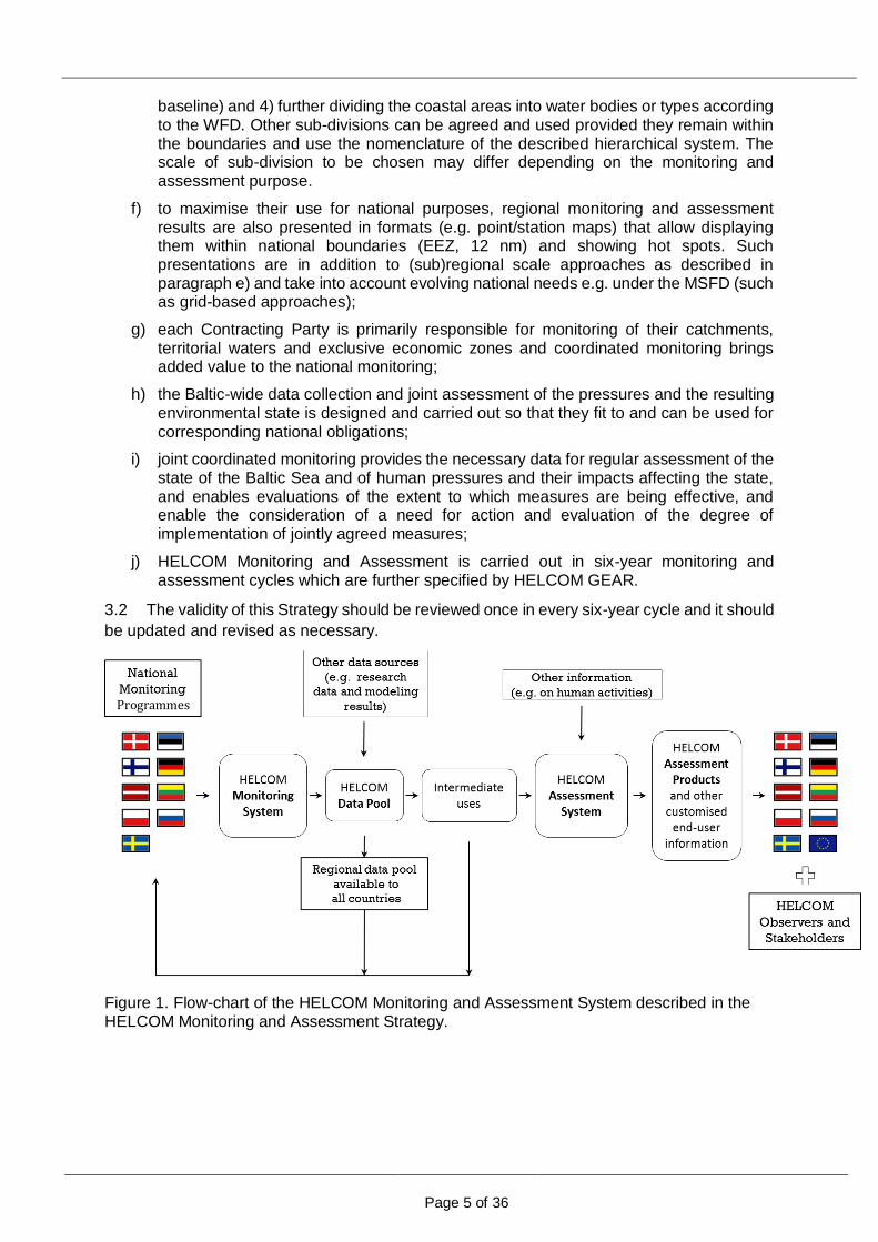
Figure 1. Flow-chart of the HELCOM Monitoring and Assessment System described in the HELCOM Monitoring and Assessment Strategy.
Programmes
Page 6 of 36
4. National commitments, added-value and synergy
4.1 This HELCOM Strategy sets out the basis for how the HELCOM Contracting States commit themselves to design and carry out their national monitoring programmes and work together to produce and update joint assessments.
4.2 HELCOM joint coordinated monitoring and preparation of the various assessment products require that the Contracting Parties allocate adequate resources and commit to agreed schedules of activities.
4.3 Contracting States ensure that needed resources are available nationally, e.g., ships, laboratories, personnel, data management and analysis capacities and expertise, and make national commitments to implement this Strategy.
4.4 The national monitoring is coordinated within and between Contracting States in order to use resources in an efficient way. Shared monitoring stations and activities, information and data are steps towards this direction.
4.5 The aim is to use limited resources as efficiently as possible and to seek the added-value from HELCOM coordination and collaboration as a return to the Contracting Parties.
4.6 HELCOM offers a platform for the Contracting Parties to jointly plan and coordinate monitoring and assessment activities and to share resources to increase cost-efficiency and quality of data and assessment products as well as to fine-tune and optimise the activities to match national and international needs and obligations.
5. HELCOM Joint Coordinated Monitoring and Data and Information Strategy
5.1 The HELCOM Joint Coordinated Monitoring system described in Attachment 1 provides
added value to the HELCOM Contracting Parties by creating a capability that is greater than the sum of national monitoring activities.
5.2 The system is to deliver data to:
a. identify relevant activities and quantify intensities and distribution of the anthropogenic pressures affecting the marine environment;
b. identify and quantify their impacts on the Baltic Sea ecosystem, and to distinguish between changes occurring due to anthropogenic and natural causes;
c. identify and quantify the changes in the environmental state as a result of regulatory actions;
d. act on emerging issues which have detrimental effects to the marine environment.
5.3 In the Baltic Sea, regional coordination of national monitoring activities brings added value. For a coherent approach, such monitoring can be arranged in thematic programmes that include:
-a well-defined purpose of monitoring, including the questions to be answered and the hypothesis to be tested;
-parameters to be measured, including supporting parameters required for assessment (e.g. for normalisation, explanation and validation);
-the temporal and spatial resolution of the sampling strategy, including the use of complementary observation technology and modelling;
-agreed methodologies and tools for sampling and analysis and combining data from different sources;
-agreed assessment methods and tools;
-agreed quality assurance procedures;

Page 7 of 36
-arrangements for data management (storing, handling, reporting, access, exchange).
5.4 The HELCOM monitoring system provides a Baltic-wide pool of data, which the Contracting Parties can use to enhance and improve their national programmes and assessment products.
5.5 The HELCOM Data and Information Strategy (Attachment 2) provides the principles for
data management and access to the data held in the regional data pool as a result of joint coordinated monitoring and other data compilation activities.
6. HELCOM Assessment System
6.1 HELCOM Assessment System is described in Attachment 3 of this Strategy.
6.2 Assessment is both a process and its product. As a process, it is the procedure with agreed methodologies and tools to evaluate collected data and information. As a product, it is the synthesised, policy-relevant presentation of the findings of the assessment process.
6.3 Assessments take place at different levels, ranging from data on the measured parameter and indicator to thematic (e.g. BSAP segment, MSFD descriptors, WFD quality elements) and holistic assessments, involving increasingly complex assessment and aggregation procedures.
6.4 This Strategy promotes an operational assessment system, which yields regularly updated products, such as Core Indicator Reports describing the distance to the targets and descriptive Fact Sheets, leading to thematic assessments and regional holistic assessments that cover the whole Baltic Sea area.
6.5 The HELCOM assessment system will also cover socio-economic information needed for holistic assessments.
6.6 HELCOM’s overall objectives for assessments are:
a) Where objectives, targets and possible baselines set by HELCOM or other policies for the protection and conservation of the marine environment are equal or comparable, HELCOM assessments should address them in a compatible way;
b) Different assessments for different policy needs, covering (parts of) a sea region, should be consistent for that region;
c) Assessments should be scientifically sound and aimed at the broadest level of acceptability, so that they can be used by other organizations;
d) Information on the marine environment should, to the fullest extent possible, be shared to facilitate the production of assessments following what has been laid out in the HELCOM Data and Information Strategy;
e) Joint ownership of the assessment process and products is a prerequisite for their national acceptance in all Contracting Parties. Assessment processes and products need to be designed in a manner, which allows also their use by the Contracting Parties in fulfilling their national assessment obligations (including at smaller scales than the regional level).
7. Relations between HELCOM work and marine research activities
7.1 There should be continuous communication between research and the HELCOM monitoring and assessment work. Research agencies and institutes of Contracting Parties and observer organizations with research interests, that are not a regular part of HELCOM work, have an acknowledged role in this dialogue.
7.2 There is the need for marine research to study further inter alia:

Page 8 of 36
a) the basic processes and functional relationships in the marine environment, taking into account differences in temporal and spatial scales;
b) the causes of long-term changes identified with monitoring;
c) linking activities within the catchment area to impacts in the marine environment;
d) the impact mechanisms between human activities, anthropogenic pressures and impacts on the ecosystem, including synergistic, cumulative and antagonistic impacts;
e) the climate driven changes to physical, chemical and biological features and the vulnerability of marine ecosystems and their interaction with human pressures;
f) socio-economics related to, and pressures acting on, the marine environment in order to improve the cost effectiveness of policies and measures, to provide valuations of benefits such as ecosystem services of the Baltic Sea and to estimate costs for degradation;
g) development of analytical methods and assessment tools,
h) encourage scientific co-operation for development and testing of new monitoring techniques, methods, sensors and devices and their integration with traditional ship-based data.
7.3 Optimization of monitoring system requires up-to-date scientific data and knowledge to be used in redesigning and adapting observation activities.
7.4 Integration of monitoring and research has potential for synergy gains. Contracting Parties will promote full use of available and emerging observation platforms to allow, when combined with adept planning and financing, reaching the required spatial coverage and temporal resolution of observations in a cost-efficient way.
8. Quality Assurance
8.1 Robust quality assurance (QA) and quality control (QC), involving the use of international quality standards, are required to increase the reliability and comparability of data and confidence in assessments. Accreditation is recommended.
8.2 Environmental information is the product of chains of activities from programme design, execution and evaluation to assessment and reporting. Each activity needs to meet certain quality requirements. Thus, quality assurance requirements have to be set for each one of these activities.
8.3 The acquisition of reliable and comparable data is an essential component of any monitoring system to provide a sound basis for effective management. To obtain such data, the whole process (sampling, analysis methods and database) must proceed under a well-established QA programme. The quality assurance programme should ensure that the data are fit for the purpose, e.g. that they satisfy the detection limits and levels of accuracy compatible with the objectives of the monitoring programme.
8.4 HELCOM’s monitoring activities are based on commonly agreed and updated methodologies and procedures described in guidelines (e.g. HELCOM COMBINE Manual) and international and European standards where quality assurance constitutes an elementary part. The Contracting States are committed to follow these commonly adopted guidelines, standards, protocols, etc.
8.5 It is recommended that sampling should be carried out using certified methods and analyses of the samples are carried out by laboratories with introduced quality assurance procedures according to EN ISO/IEC 17025 (General requirements for the competence of testing and calibration laboratories) or ISO 9001 (Quality management systems - Requirements) or by laboratories performing close to these standards.
8.6 All institutes/laboratories submitting data to HELCOM databases should participate in regular national and international intercalibration exercises and proficiency testing schemes
Page 9 of 36
arranged e.g. by national authorities and/or under QUASIMEME, ICES, or HELCOM. If certified reference materials are available, these should be used by all participating institutes or laboratories. The laboratories should ensure that performance criteria (uncertainty of measurement, limit of quantification) meet the requirements of the monitoring (e.g. assessment criteria).
9. Data handling and sharing
9.1 The Data and Information Strategy of the Helsinki Commission is in Attachment 2.
9.2 In its Data and Information activities HELCOM enshrines basic principles such as:
a) ‘collect data once and use them for many purposes’, b) ‘data should be interoperable, accessible and free of restrictions on use’ and c) ‘data should be quality assured by the provider, quality controlled and quality flagged’.
9.3 HELCOM contracting parties should collect, manage and use data in line with their national and the international legislation.
9.4 Free and timely access to monitoring data is a prerequisite for an operational cooperative monitoring system, using harmonized standards and practices following the Aarhus Convention and recommendations and guidelines and standards reflected in the INSPIRE directive.
9.5 The HELCOM data consists of national contributions of the Contracting Parties and provides the Baltic-wide pool of data, which the Contracting Parties can freely use in their assessment products.
9.6 Contracting Parties should make available to the common data pool relevant data collected by research projects with the aim to support HELCOM or EU Directives implementation activities.
9.7 In order to gain synergy and efficiency, the HELCOM data activities should be harmonized with other international organizations and the European Union systems to the fullest extent possible.
9.8 Necessary quality-control and validation procedures have to be implemented and available HELCOM monitoring data have to have quality flags.
9.9 HELCOM data are handled by the HELCOM Secretariat or by external data centres, mainly thematic data centres, working in cooperation with national data providers and in contractual agreement with HELCOM.
9.10 All HELCOM assessment products are freely accessible and made available on the HELCOM website.
Attachment 1
Page 10 of 36
Attachment 1
HELCOM Joint Coordinated Monitoring System
1. Principles
1.1 By high degree of coordination, cooperation, sharing and harmonisation Contracting Parties aim at a system where data is produced once and used many times. Mutual benefit is one of the driving forces of HELCOM joint monitoring system.
1.2 HELCOM joint monitoring is scientifically sound. It is also cost-efficient, dynamic, adaptive, operational and pragmatic.
1.3 The HELCOM Joint Monitoring System is also balanced and functional and leads to a higher degree of harmonization and increased quality of data and ensures optimizing and rationalizing of monitoring activities in the Baltic Sea region.
1.4 Monitoring activities are coordinated between the countries and, where possible, shared within the region. This is achieved through using:
a) increased joint initiatives such as surveys, campaigns, cruises and shared stations, b) use of remote sensing and autonomous measuring devices to complement ship cruise
data and thereby enhanced data coverage and shared data products, c) use of modelling to combine data and produce optimised data layers, d) sharing of infrastructure, and e) quality gains from specialization of countries and national institutes.
1.5 While recognizing the conservative nature of monitoring, this framework enhances and enables efficient adaptation of monitoring and observation activities to technological development.
1.6 The joint monitoring system supports an adaptive process which is fit for this purpose and helps Contracting Parties to jointly maximize the potential of their marine observation, sampling and surveying programmes.
1.7 The system is fully coordinated with corresponding data collection activities carried out by other organisations, such as EMEP, ICES and BOOS. For those Contracting Parties being also EU Member States these activities support the implementation of data and information collection frameworks at European level (e.g. EMODNET, GMES, SeaDataNet, WISE-Marine) as well as relevant EU directives such as the MSFD and WFD, as well as the EU Data Collection Framework.
1.8 The joint monitoring system also supports Contracting Parties’ capacity to identify emerging environmental challenges.
1.9 The joint monitoring system enables the channelling of information collected outside the environmental sector to the HELCOM data and assessment products. Integrating data into a regional data pool and assessment products from other monitoring and observation activities such as fisheries surveys, Automatic Identification System (AIS) for vessel traffic, Vessel Monitoring System (VMS) for fishing vessels and compliance monitoring related to licensing of companies’ operations is a vital part of the system.
1.10 Contracting Parties are primarily responsible for organising the monitoring for the on-going assessment of their catchments, territorial waters and exclusive economic zones. Coordination between the countries is a prerequisite for comparable data and assessments and for region-wide assessment products. In addition, there are clear cost-efficiency and improved quality benefits that can be achieved by pooling the efforts.
1.11 In order to have a sustainable marine data infrastructure the Contracting Parties ensure financial support to the process of collection, assembly, processing and dissemination of data.

Attachment 1
Page 11 of 36
1.12 HELCOM provides the platform for
a) deciding which observations are needed to be made, b) how to make the observations, c) which platforms and methods to apply, d) deciding where and when to make the observations and by whom, e) choosing which data products to create, f) agreeing which external data to be integrated to the common regional pool and
assessment products, g) arranging financial support for collecting, assembling, processing and dissemination of
data with the objective to have a sustainable marine data infrastructure, and for h) applying for additional funding for developing and implementing the joint monitoring
activities laid out in this Strategy.
1.13 Good governance of the joint monitoring system requires HELCOM to dedicate a specific HELCOM subsidiary body for the implementation of this Strategy.
2. Focus of monitoring
2.1 HELCOM monitoring focuses on parameters, which are indicative of the state of the environment, the prevailing anthropogenic pressures and their impacts, the progress towards objectives and targets, and the effectiveness of measures. HELCOM monitoring is carried out in such a way that an assessment with adequate confidence and precision is achieved.
2.2 The requirement for HELCOM monitoring arises from the BSAP and the MSFD and can be induced from the commonly agreed and Baltic-Sea-wide applicable set of HELCOM core indicators. The regional joint coordinated monitoring programme is hence primarily serving, in an integrated manner, the methodological elements laid out by these core indicators.
2.3 The set of parameters monitored enables the production of regional assessment products described in Attachment 3 HELCOM assessment system.
2.4 The monitoring system consists of manageable components to enable assessment of a) biological diversity: population trends, distribution and condition of species and
changes in quality and quantity of habitats and biotopes, b) trends in arrival, quantities and impacts of non-indigenous species, c) trends in populations of all commercially exploited fish and shellfish and their age and
size structure, d) marine food webs, and to the extent that they are known, their occurrence at normal
abundance and diversity, and levels capable of ensuring the long-term abundance of the species and the retention of their full reproductive capacity,
e) human-induced eutrophication and its effects such as losses in biodiversity, ecosystem degradation, harmful algae blooms and oxygen deficiency in bottom waters,
f) sea-floor integrity, including benthic ecosystems, g) concentrations and biological effects of contaminants, including radioactive
substances, and h) quantities and properties of marine litter and levels of underwater noise.
2.5 In addition, the monitoring system enables assessing: a) physical loss of, or damage to, habitats, e.g. through smothering, sealing, siltation,
abrasion and selective extraction of living and non-living resources, b) inputs of heavy metals and synthetic hazardous substances, c) inputs of radioactive substances, d) inputs of nitrogen and phosphorus as well as organic matter, e) introduction of energy, including underwater noise, f) alteration of hydrological and hydrographical conditions through human activities,
including a change in salinity and temperature, as well as acidification,
Attachment 1
Page 12 of 36
g) introductions of non-indigenous species, h) introduction of microbial pathogens, i) introduction of marine litter, and j) selective extraction of species, including incidental non-target catches (e.g. by
commercial and recreational fishing.)
2.6 The monitoring system is structured along themes/thematic programmes (e.g. biodiversity, hydromorphology, eutrophication, hazardous substances, litter, noise, non-indigenous species, physical loss and/or damage) in such a way that its structure meets national needs for easy reference and facilitates reporting obligations in particular those of the HELCOM EU member states that report under the MSFD.
3. Distribution of monitoring activities
3.1 The joint monitoring system covers the entire marine area of the Baltic Sea responding to the needs of the HELCOM BSAP and EU MSFD which both require a Baltic Sea-wide coordinated approach.
3.2 The use of sub-divisions of the Baltic Sea may be jointly agreed for the needs of a particular monitoring programme according to one of the hierarchical levels of the HELCOM sub-division (Attachment 4).
3.3 The set of parameters to be monitored can differ between sub-divisions depending on the natural conditions such as distribution of species as well as intensity and extent of pressures and impacts and monitoring purposes.
3.4 Cooperation and coordination of monitoring efforts are needed especially for the open sea areas in order to acquire representative data, covering the whole Baltic Sea and the spatial and temporal variability of the ecosystem.
3.5 For sampling in the open sea using research vessels, there is potential for cost-efficiency gains by temporal sharing of monitoring activities between the countries and, if possible, between thematic programmes. The countries bordering a sub-basin should coordinate their monitoring cruises and make arrangements for e.g. taking turns in sampling certain areas or sharing responsibilities of monitoring of certain parameters with the idea that monitoring methods are harmonised and all data will end up in a common pool and can be used by all. Effectively this means that each country will have available not only its own data but also data produced by eight other countries. See Attachment 2 for HELCOM Data and Information
Strategy.
3.6 Sampling is designed to take into account temporal and spatial scales of management in addition to the spatial and temporal variability of the marine environment. Furthermore, assessment needs may drive the timing of sampling campaigns.
3.7 Spatial and temporal frequency of sampling can differ between sub-regions, and they can be related to the environmental state and pressures with the least intensive monitoring in cases where good environmental status has been reached and is to be maintained, with little foreseen risk of degradation. A common approach to differentiate monitoring efforts should be developed depending on:
- the intensity and extent of pressures and environmental problems with areas with environmental problems requiring more intensified monitoring,
- the risk of failing to achieve or maintain good environmental status, and
- the purpose of monitoring (in relation to good environmental status; environmental targets; characteristics, pressures and impacts; acute events; knowledge gaps and investigations).
3.8 Monitoring of emissions of pollutants on land is organised by the Contracting Parties. Monitoring of emissions supports modelling of emissions and depositions by EMEP with which
Attachment 1
Page 13 of 36
HELCOM cooperates with regard to emissions and depositions of nutrients and hazardous substances.
3.9 National authorities responsible for different sectors introducing pressures on the environment cooperate to provide HELCOM with data on those pressures and human activities driving them. In the long run, HELCOM aims to establish data streams on human pressures which enable regular updating of pressure overviews (e.g. Baltic Sea Pressure and Impact Indices) and socio-economic analyses.
4. Regional coordination and cooperation
4.1 Contracting Parties plan and implement their monitoring activities so that the activities form a complementary, mutually supportive and cost-effective monitoring system.
4.2 HELCOM provides the platform for coordination and cooperation and necessary bodies and expert groups are secured for coordination and cooperation.
5. High quality and cost-efficiency as the main drivers of joint monitoring
5.1 It is recommended that sampling should be carried out using certified methods and analyses of the samples are carried out by laboratories with introduced quality assurance procedures according to EN ISO/IEC 17025 (General requirements for the competence of testing and calibration laboratories) or ISO 9001 (Quality management systems - Requirements) or by laboratories performing close to these standards.
5.2 Sharing of responsibilities has potential to yield higher quality and economic gains with lower input of resources. Currently, all countries run their own monitoring programmes and produce data for national needs as well as joint assessments. This system is still too much of a patchwork with a certain level of harmonisation through e.g. HELCOM sampling and analytical guidelines and training in HELCOM expert groups. This distributed and detached system makes it necessary for all countries to maintain costly monitoring infrastructure and personnel in order to cover all issues.
5.3 There is potential to increase efficiency and harmonisation through:
a) joint surveys, cruises and campaigns: they enable full cooperation in practice, harmonization of practices, efficient exchange of knowledge and best practices as well as full use of monitoring infrastructure,
b) increasing automatisation of monitoring and running the programmes or devices cooperatively, and
c) increasing thematic specialisation: increased thematic specialization of the Contracting Parties or their institutes could increase cost-efficiency.
5.4 Potential for increased specialisation applies to biological, chemical and biochemical laboratory analyses. Special laboratory equipment and training of staff is usually required. For example:
a) Increased use of specialised laboratories for e.g. analyses of hazardous substances could be useful and help ensure high quality.
b) Analysis of biological samples could be carried out in specialised laboratories where both cost-efficiency and quality are the greatest.
5.5 There are also opportunities for lowering costs and increasing the quality of results by increasing specialisation cost-optimising the division of responsibilities within and between the countries in a transparent manner. Specialisation can lead to higher cost-efficiency through more efficient use of infrastructure and personnel, larger size and throughput of the analytical units. Cost-optimising the division of responsibilities within and between the countries could

Attachment 1
Page 14 of 36
benefit from the differences in the costs of laboratory analytics between the countries which opens for opportunities for countries with higher costs.
6. Using autonomous and other new observation techniques
6.1 Remote sensing and autonomous measuring devices already in use in environmental monitoring and operational oceanography, such as ferry-boxes, buoys, passive samplers, fixed platforms, and coastal radars are efficient means to increase spatial and temporal coverage of observations.
6.2 Automated measuring devices, sensors and other equipment are costly and usually need regular maintenance. Sharing of investments, maintenance and data is the way to increase cost-efficiency and reliability of the measurements. There is also a clear advantage to share the platforms between institutes responsible for meteorological, oceanographic and environmental observations.
6.3 Data collected by the already operational unattended systems, such as the Alg@line ferry-box network, could be used more efficiently by national institutes for the monitoring of their territorial and EEZ waters by increasing joint planning of sampling, sharing of laboratory analysis and the data exchange.
6.4 Joint production of remote sensing images and assessment products should be agreed and responsibilities should be divided between the partners, including delivery of ground truth data.
6.5 Observations made by the public, accompanied by appropriate QA procedures, could be used for HELCOM monitoring purposes.
7. Use of models
7.1 Mathematical models should be used to combine data from various sources to produce combined new data layers, to make hind casts to complement data sets and to produce scenarios e.g. to forecast effects of management actions. In addition, models could be used to spatially and temporally aggregate data.
8. Reducing uncertainty in informing policy making
8.1 Effective observation networks and optimised data collection will enhance data coverage and hence make assessments more robust. This can contribute to strengthening the knowledge basis for agreeing on measures to improve the state of the marine environment in the Baltic Sea region. The more robust knowledge basis has potential to increase certainty and cost-effectiveness of the measures.
8.2 To improve the understanding of climate change and enable assessment of the ability of the marine environment to cope, adapt to or recover from the effects of climate change, there is a need to maintain and acquire data and knowledge of climate risks in the Baltic Sea region and in the marine environment and to increase data collection that serves this purpose.
9. Maintenance of long-term data sets
9.1 Systematic, harmonised and continuous monitoring, which produces long-term data sets, is needed to better understand systemic changes and to project the future of the marine environment. HELCOM monitoring should be configured also to detect climate change and its impacts on the Baltic Sea marine ecosystem. Therefore, sites with relevant long-term data
Attachment 1
Page 15 of 36
records will be sustained, whilst accommodating improved data collection techniques where appropriate. National long-term data series should be integrated to this region-wide framework.
Attachment 2
Page 16 of 36
Attachment 2
HELCOM Data and Information Strategy
1. Principles
1.1 The HELCOM data and information activities should make possible reliable assessment as described in the HELCOM Assessment system. The HELCOM data and information activities should facilitate access of the general public to environmental information and this is done e.g. by making spatial data and information available in the HELCOM Map and Data Service on the HELCOM web page.
1.2 In order to avoid duplication of reporting by the HELCOM Contracting Parties the HELCOM data activities should be compatible with those of other international organizations such as ICES and data activities of the European Union, to the fullest extent possible.
1.3 Basic activities in the HELCOM data and information management system should include:
a) using agreed formats and up-to-date tools for data exchange;
b) implementing relevant quality control and validation procedures
c) making data and information available using harmonized standards and practices, following the Aarhus Convention and recommendations and guidelines and standards reflected in the INSPIRE directive,
d) presenting data and information in suitable ways for indicator reports as well as thematic and holistic assessments to support policy formulation and decision-making.
2. Collection of data
2.1 HELCOM data and information system rely on data derived from publicly funded monitoring programmes by the Contracting Parties but the Contracting Parties may also report data collected by private bodies, e.g. compliance monitoring related to environmental permitting.
2.2 HELCOM follows and influences relevant international marine-related monitoring and assessment programmes and data sharing and management initiatives at regional, European, and global levels and aims to avoid any duplication of data reporting and collection e.g. by facilitating the use of shared environmental information systems.
2.3 HELCOM contributes with its data and information system to availability of high-quality spatial information relevant to Maritime Spatial Planning on status of the marine environment, pressures and human activities.
3. Data handling
3.1 The HELCOM data will be handled by data centre(s), preferably thematic data centres, working in cooperation with national data providers and on contractual agreement with HELCOM. The data centres will be responsible for ensuring that
a) adequate data exchange formats, data handling and access procedures are prepared and updated, as necessary,
b) relevant quality control and validation procedures are in place including quality flagging of data,
c) adequate inventories and compilations are prepared of the data sets, and
d) HELCOM data product requirements are met.
Attachment 2
Page 17 of 36
3.2 The role of national institutions as data providers, and capacity building at the national level should be given a priority attention.
4. Access to data and information
4.1 All HELCOM monitoring data should be openly accessible online via web services or downloading functionality using common standards and ensuring that relevant quality control and validation procedures are implemented.
4.2 Access to data contained in working documents presented to HELCOM or its subsidiary bodies can be restricted.

Attachment 3
Page 18 of 36
Attachment 3
HELCOM Assessment System
1. System
1.1 Data from the joint monitoring programmes as well as the indicator reports and thematic assessments form a continuous chain towards holistic assessments. Modelling and scientific reports play an important complementary role in explaining and linking pressures, state and impacts and providing guidance for future responses. Scientific research is an additional important source of information for defining newly emerging concerns.
1.2 Generation of data through monitoring is the basis of HELCOM’s monitoring and assessment pyramid (Figure). The data is processed through various assessment steps from indicators to specific and holistic assessments and information is increasingly integrated towards the top of the pyramid.
1.3 The HELCOM assessment system operates in six-year cycles that are synchronized with other international requirements. During the assessment cycles Core Indicator reports and Baltic Sea Environment Fact Sheets are updated regularly, leading to periodically produced thematic reports and eventually holistic assessments. Thematic assessments cover the themes of the BSAP (biodiversity, eutrophication, hazardous substances and maritime activities) but also other themes as required also by relevant policies. Pollution Load Compilations, assessments of radionuclides, and assessments of the threat status of Baltic Sea species and biotopes/habitats and the related Species and Biotopes Information Sheets are also regularly updated. The assessment information will be forwarded to decision-makers (ranging from individual consumers to high level policy makers) to provide knowledge basis for taking action.
1.4 To link monitoring and data to assessments it is important:
to agree and document rules for aggregating data in the various assessment contexts
to set out assessment procedures transparently at all relevant levels, from parameters and indicators to themes and holistic assessments. E.g. parameters and indicators should be assigned assessment criteria/thresholds/targets and assessment processes for easy reference.
2. Main themes
2.1 HELCOM assessments, as well as the supporting monitoring, should be targeted at identified environmental concerns in the policy areas where HELCOM continues to act, especially eutrophication, hazardous substances (including artificial radionuclides), change of biodiversity (including fish) and habitat degradation, and problems arising from shipping and other uses at the land/water boundary and of the marine space (e.g. construction). In addition, the holistic assessments will provide overviews of anthropogenic pressures and human activities acting as drivers of those pressures and this information will support a socio-economic analysis. HELCOM will continue to act on newly emerging issues with detrimental effects to the marine environment.
HELCOM’s monitoring and assessment pyramid linking monitoring and data to holistic assessment
Attachment 3
Page 19 of 36
3. Features
3.1 The assessments build on data produced within the HELCOM monitoring programmes and additional data, e.g. research data, provided by the Contracting Parties as well as data made available by other organisations e.g. on human activities or pressures.
3.2 HELCOM assessments should be timely, scientifically sound, reliable, and approved in consensus. The assessments should employ the ecosystem approach including anthropogenic pressures, and their effects on the marine environment including cumulative and synergetic effects. They build on the HELCOM set of core indicators which are commonly agreed as Baltic-Sea-wide assessment cornerstones addressing all important single elements of state, pressures and impacts.
3.3 In addition to assessments of environmental status and pressures, HELCOM compliance reporting such as the Baltic Sea Action Plan Index of Actions is adding information on activities and programmes of measures to improve or maintain the quality of the Baltic Sea environment. HELCOM should seek to gain synergy between reporting on the status of implementation of Baltic Sea Action Plan, Ministerial Declarations, HELCOM Recommendations and other international reporting requirements (such as the MSFD) and link their results to HELCOM’s status/impact assessments.
3.4 While HELCOM assessments should be Baltic specific, the information content as well as their timing should be harmonized with other reporting requirements, especially those obliging presentation of information for the Baltic Sea e.g. at the European level.
3.5 HELCOM assessments should be designed to support not only Baltic-wide analysis but to support also assessment requirements of the Contracting Parties at smaller scales.
3.6 HELCOM should strive to develop interactive web-based services to support assessment procedures.
4. Assessment products
4.1 HELCOM’s assessment products consist of:
a) HELCOM Core Indicator reports which address all central assessment elements
required by the BSAP, allowing classification of the environmental state into status classes, and facilitating the implementation of the MSFD for those Contracting Parties that are also EU members;
b) Baltic Sea Environment Fact Sheets which are updated regularly to provide timely
information on how the HELCOM objectives are met;
c) Thematic assessment products which cover various topical themes, e.g., inputs (e.g. Pollution Load Compilations), eutrophication, hazardous substances (including radioactive substances) and biodiversity are to be produced periodically. In addition, varying themes such as assessment of climate change in the Baltic Sea region and assessment of ecological coherence of the network of marine protected areas may be produced as necessary. Assessments of the threat status of Baltic Sea species and biotopes/habitats should also be regularly updated and be complemented by Biotopes Information Sheets on the threatened species and biotopes/habitats. The reports should consist of a technical/scientific (science for management) section, including assessment of confidence, a policy implications section, as well as a future outlook section.
d) Holistic assessments, which cover the status of the Baltic Sea, pressure and resulting
impacts and effects including cumulative and synergetic effects, socio-economic aspects and link science and management as well as provide a basis for formulation of supplementary national and regional policies and measures.
Attachment 3
Page 20 of 36
4.2 Data from coordinated monitoring programmes as well as Core Indicator reports complemented by Baltic Sea Environmental Fact Sheet information as well as thematic assessment products form a continuous chain towards holistic assessments where modelling and scientific reports play an important complementary role in explaining and linking pressures, state and impacts and providing guidance for future responses.
4.3 Assessment procedures will be well documented to allow their coherent use for regional and national purposes.
4.4 All HELCOM assessment products are made freely accessible on the internet and prints will be reproduced of some of them.
5. Core indicators and Baltic Sea Environmental Fact Sheets
5.1 Core indicators, Baltic Sea Environment Fact sheets and Species and Biotopes Information Sheets provide information on the status of the environment and information that is needed to evaluate the severity of environmental problems and distance from environmental targets, objectives, goals and vision. The HELCOM set of core indicators simplifies a complex reality by condensing information of analysed data collected in monitoring programmes. The Core Indicator reports are linked to the Ecological Objectives (EcoOs) – i.e. the indicators show how the targets and EcoOs are met.
5.2 HELCOM Core Indicators and Baltic Sea Environment Fact Sheets should be primarily based on variables in the HELCOM monitoring programmes. Each indicator by itself tells something about the one issue it represents but virtually nothing about larger features or the system as a whole. When the indicators are integrated they can show the conditions and trends of the system e.g. human pressures and impacts on major components or themes (e.g. eutrophication, biodiversity, impacts of hazardous substances of the ecosystem).
5.3 Core Indicators are linked to anthropogenic pressures and provide a measure of the distance from a target level. The target level reflects the boundary of good environmental status. Core Indicators with targets are designed to be applicable for integrated thematic and holistic assessments.
5.4 Descriptive Baltic Sea Environment Fact Sheets describe the development of a variable related to an environmental issue and provide crucial supportive and background information that can also be utilised for compiling assessment reports.
5.5 Species and Biotopes Information Sheets address those species and biotopes/habitats of the Baltic Sea that have been evaluated as being under a risk of extinction in HELCOM red list assessments.
5.6 Core indicator reports and fact and information sheets will be published on the HELCOM website. HELCOM assessment products will make use of the information presented in these.
5.7 The structure of the HELCOM Baltic Sea Environment Fact Sheets follows the fact sheet structure of EEA in principle.
5.8 The Core Indicator reports and Baltic Sea Environment Fact Sheets are updated regularly by the responsible institutions.
5.9 The scientific-technical content of the Core Indicator reports and Fact Sheets is reviewed and adopted by HELCOM MONAS supported by other HELCOM groups. HELCOM HABITAT is responsible for the content of the Species and Biotopes Information Sheets.
5.10 A list of responsible institutes and data centres providing Core Indicator reports and Baltic Sea Environment Fact Sheets should be kept up to date by and at the HELCOM Secretariat and scrutinised by HELCOM MONAS on a regular basis.
Attachment 3
Page 21 of 36
6. Thematic assessment reports
6.1 Thematic assessment reports assessing how HELCOM strategic goals are met are produced periodically within the six-year assessment cycle addressing primary themes of eutrophication, hazardous substances and biodiversity but also varying other themes especially informing Ministerial Meetings and the public (e.g. BSAP implementation, climate change, protected areas). The thematic reports are scheduled taking into account corresponding reporting under other international fora, such as reporting under EC/EU directives and as guided by HELCOM GEAR.
6.2 The thematic reports should consist of three main sections: “Science for management”, “Policy implications” and “Future outlook”.
6.3 The thematic reports assessing HELCOM’s strategic goals are Core Indicator driven and they provide status classifications for the Baltic Sea for the themes at hand. In addition, the reports provide compilations of information on the level and trends in anthropogenic pressures that act on the assessed theme. The assessments also utilise information provided by relevant Baltic Sea Environment Fact Sheets and use necessary information and data collected and reported under other fora as well as provided by the scientific community.
6.4 Production of thematic assessment reports requires close cooperation of Contracting Parties within HELCOM subsidiary bodies and cooperation between the different HELCOM subsidiary bodies.
6.5 In addition to pressure and state assessments, HELCOM compliance reporting is adding information on the success and effectiveness of measures to improve or maintain the status of the Baltic Sea. HELCOM should seek to gain synergy between reporting on the status of implementation of strategies and HELCOM Recommendations and other international reporting requirements and link their results in HELCOM environmental assessments.
7. Holistic assessments
7.1 Holistic assessments of ecosystem health are produced periodically every six years and the assessment cycle is synchronised with other international assessments and reporting obligations so as to support the development of initial assessments under the MSFD by those Contracting Parties that are also EU member states.
7.2 Holistic assessments evaluate how the HELCOM vision with strategic goals and ecological objectives has been met, link environmental changes to pressures and provide advice for subsequent decision making. In addition, the holistic assessments contain information on socio-economic aspects related to the use of the Baltic Sea ecosystem.
7.3 The holistic assessments will cover all possible aspects of the BSAP, and MSFD for those Contracting Parties that are also EU Member States, including marine litter and noise, and especially various features of biodiversity. They will build on the core indicator information and all possible other information that is relevant to assess the pressures, impacts and status, including the socio-economic analysis. The holistic assessments should also assess the risk of not reaching the objectives and targets related to achieving and maintaining the good environmental status.
7.4 Holistic assessments should be produced using standard methodology to allow for comparison between the assessments over time. Integrative assessment tools such as HOLAS for state indicators and Baltic Sea Pressure and Impact Indices will be used.
7.5 Production of a holistic assessment requires close cooperation, of Contracting Parties, observer organizations and the scientific community as well as cooperation across HELCOM bodies.
Attachment 4
Page 22 of 36
Attachment 4
HELCOM sub-divisions of the Baltic Sea (UPDATED 2018 versions as agreed in STATE & CONSERVATION 6-2017 (outcome)
The Baltic Sea is sub-divided for regional monitoring and assessment purposes. The sub-dividing is to be done coherently, following commonly agreed sub-divisions and nomenclature. This section of the Strategy provides four possible hierarchical scales for sub-division.
The four possible hierarchical scales for sub-dividing the Baltic Sea for monitoring and assessment purposes are:
1) HELCOM Marine area 2018. No division: the whole Baltic Sea encompassing the entire HELCOM area,
2) HELCOM Subbasins 2018. Division of the Baltic Sea into 17 sub-basins (Figure 1 and
Table 1),
3) HELCOM Subbasins with coastal and offshore division 2018. Division of the Baltic
Sea into 17 sub-basins and further division into coastal and off-shore areas (Figure 1 and Table 2),
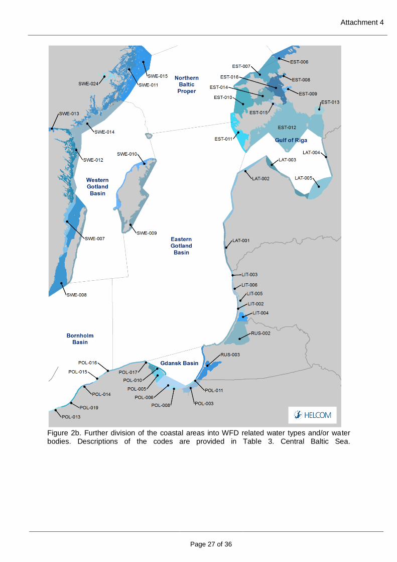
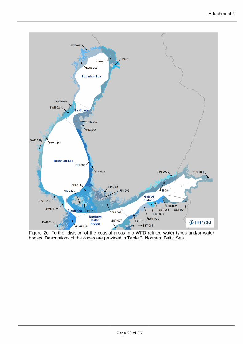
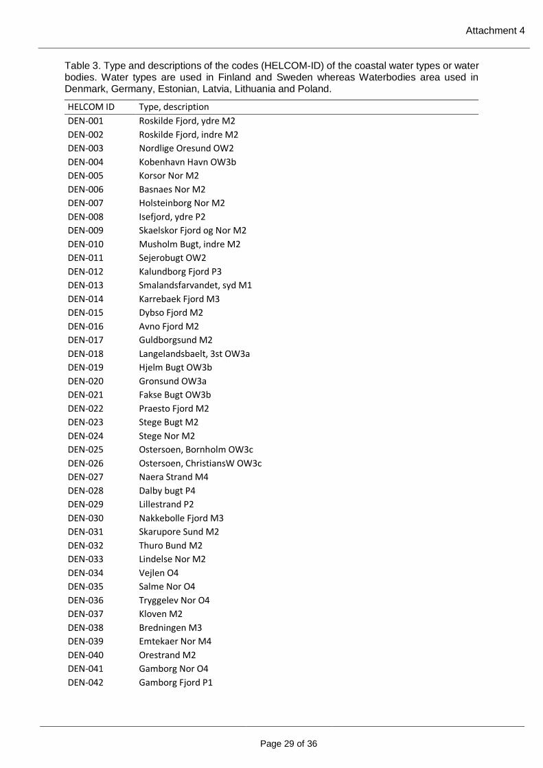
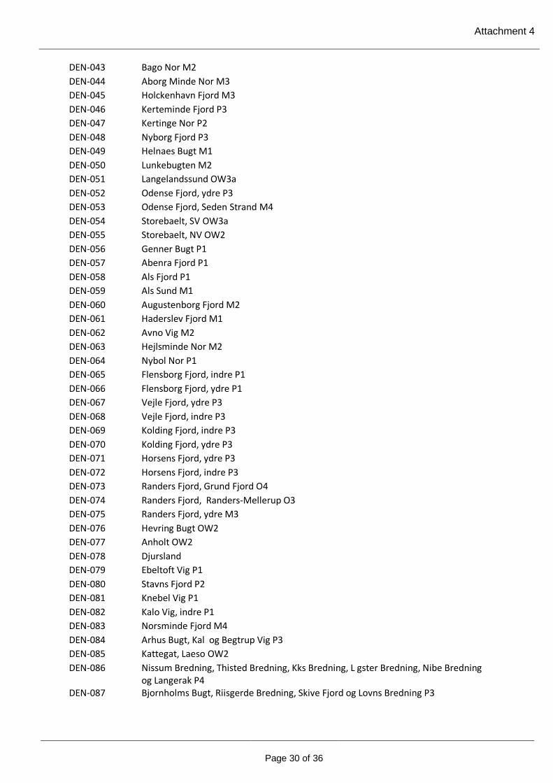
4) HELCOM Subbasins with coastal WFD water types of water bodies 2018. Division of the Baltic Sea into 17 sub-basins and further division into coastal and off-shore areas and division of the coastal areas by WFD water types or water bodies (Figure 2a-c and table 3).
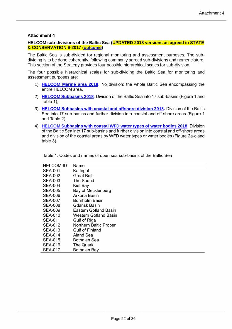
Table 1. Codes and names of open sea sub-basins of the Baltic Sea
HELCOM-ID Name
SEA-001 Kattegat SEA-002 Great Belt SEA-003 The Sound SEA-004 Kiel Bay SEA-005 Bay of Mecklenburg SEA-006 Arkona Basin SEA-007 Bornholm Basin SEA-008 Gdansk Basin SEA-009 Eastern Gotland Basin SEA-010 Western Gotland Basin SEA-011 Gulf of Riga SEA-012 Northern Baltic Proper SEA-013 Gulf of Finland SEA-014 Åland Sea SEA-015 Bothnian Sea SEA-016 The Quark SEA-017 Bothnian Bay

Attachment 4
Page 23 of 36
Figure 1. Map of the Baltic Sea presenting the HELCOM sub-division into 17 open sea sub-basins and 40 coastal areas. The names of the open sea sub-basin and coastal areas are provided in Tables 1 and 2, respectively.
Attachment 4
Page 24 of 36
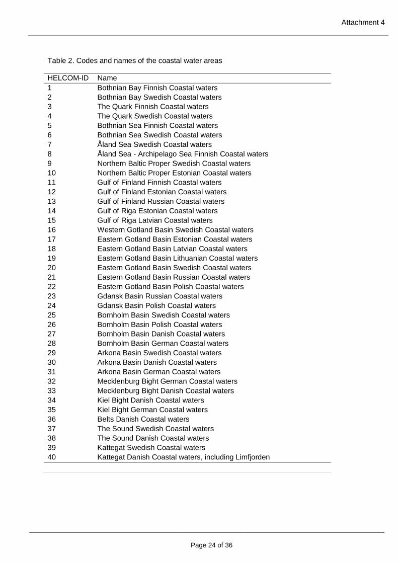
Table 2. Codes and names of the coastal water areas
HELCOM-ID Name
1 Bothnian Bay Finnish Coastal waters
2 Bothnian Bay Swedish Coastal waters
3 The Quark Finnish Coastal waters
4 The Quark Swedish Coastal waters
5 Bothnian Sea Finnish Coastal waters
6 Bothnian Sea Swedish Coastal waters
7 Åland Sea Swedish Coastal waters
8 Åland Sea - Archipelago Sea Finnish Coastal waters
9 Northern Baltic Proper Swedish Coastal waters
10 Northern Baltic Proper Estonian Coastal waters
11 Gulf of Finland Finnish Coastal waters
12 Gulf of Finland Estonian Coastal waters
13 Gulf of Finland Russian Coastal waters
14 Gulf of Riga Estonian Coastal waters
15 Gulf of Riga Latvian Coastal waters
16 Western Gotland Basin Swedish Coastal waters
17 Eastern Gotland Basin Estonian Coastal waters
18 Eastern Gotland Basin Latvian Coastal waters
19 Eastern Gotland Basin Lithuanian Coastal waters
20 Eastern Gotland Basin Swedish Coastal waters
21 Eastern Gotland Basin Russian Coastal waters
22 Eastern Gotland Basin Polish Coastal waters
23 Gdansk Basin Russian Coastal waters
24 Gdansk Basin Polish Coastal waters
25 Bornholm Basin Swedish Coastal waters
26 Bornholm Basin Polish Coastal waters
27 Bornholm Basin Danish Coastal waters
28 Bornholm Basin German Coastal waters
29 Arkona Basin Swedish Coastal waters
30 Arkona Basin Danish Coastal waters
31 Arkona Basin German Coastal waters
32 Mecklenburg Bight German Coastal waters
33 Mecklenburg Bight Danish Coastal waters
34 Kiel Bight Danish Coastal waters
35 Kiel Bight German Coastal waters
36 Belts Danish Coastal waters
37 The Sound Swedish Coastal waters
38 The Sound Danish Coastal waters
39 Kattegat Swedish Coastal waters
40 Kattegat Danish Coastal waters, including Limfjorden
Attachment 4
Page 25 of 36
The scale of sub-division to be chosen may differ depending on the purpose, e.g. monitoring and assessment of mobile marine mammals such as grey seals may require the whole Baltic Sea scale while assessment of eutrophication indicators may be most relevant at the sub-basin scale in the open sea combined with water body or type level in the coastal zone.
The scale to be used should be chosen among the four possible HELCOM scales and jointly agreed.
Other sub-divisions can be agreed and used provided they use the agreed boundaries and remain within the boundaries and use the nomenclature of the described hierarchical system.
To maximise their use for national purposes, regional monitoring and assessment results should be presented in addition in formats (e.g. point/station maps) that allow displaying them within national boundaries (EEZ, including e.g. 12 nm) and showing hot spots. Such presentations take into account evolving national needs e.g. under the MSFD (such as grid-based approaches).
Names of the Baltic Sea sub-basins, coastal areas per sub-basin and coastal water types and water bodies as presented in this section of the Strategy also serves as the common nomenclature of the different sub-areas of the Baltic Sea.
The sub-divisions as well as the names are updated as needs arise.
The maps can be visualized in the HELCOM Map Service and downloaded from the HELCOM metadata catalogue.
Attachment 4
Page 26 of 36
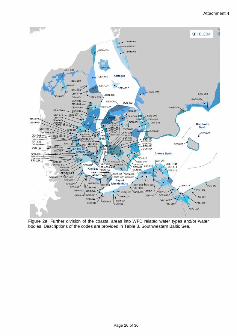
Figure 2a. Further division of the coastal areas into WFD related water types and/or water bodies. Descriptions of the codes are provided in Table 3. Southwestern Baltic Sea.
Attachment 4
Page 27 of 36
Figure 2b. Further division of the coastal areas into WFD related water types and/or water bodies. Descriptions of the codes are provided in Table 3. Central Baltic Sea.
Attachment 4
Page 28 of 36
Figure 2c. Further division of the coastal areas into WFD related water types and/or water bodies. Descriptions of the codes are provided in Table 3. Northern Baltic Sea.
Attachment 4
Page 29 of 36
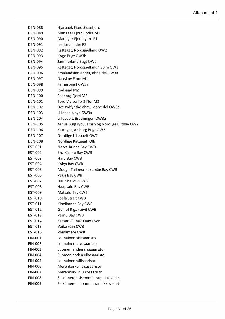
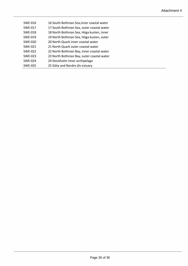
Table 3. Type and descriptions of the codes (HELCOM-ID) of the coastal water types or water bodies. Water types are used in Finland and Sweden whereas Waterbodies area used in Denmark, Germany, Estonian, Latvia, Lithuania and Poland.
HELCOM ID Type, description
DEN-001 Roskilde Fjord, ydre M2
DEN-002 Roskilde Fjord, indre M2
DEN-003 Nordlige Oresund OW2
DEN-004 Kobenhavn Havn OW3b
DEN-005 Korsor Nor M2
DEN-006 Basnaes Nor M2
DEN-007 Holsteinborg Nor M2
DEN-008 Isefjord, ydre P2
DEN-009 Skaelskor Fjord og Nor M2
DEN-010 Musholm Bugt, indre M2
DEN-011 Sejerobugt OW2
DEN-012 Kalundborg Fjord P3
DEN-013 Smalandsfarvandet, syd M1
DEN-014 Karrebaek Fjord M3
DEN-015 Dybso Fjord M2
DEN-016 Avno Fjord M2
DEN-017 Guldborgsund M2
DEN-018 Langelandsbaelt, 3st OW3a
DEN-019 Hjelm Bugt OW3b
DEN-020 Gronsund OW3a
DEN-021 Fakse Bugt OW3b
DEN-022 Praesto Fjord M2
DEN-023 Stege Bugt M2
DEN-024 Stege Nor M2
DEN-025 Ostersoen, Bornholm OW3c
DEN-026 Ostersoen, ChristiansW OW3c
DEN-027 Naera Strand M4
DEN-028 Dalby bugt P4
DEN-029 Lillestrand P2
DEN-030 Nakkebolle Fjord M3
DEN-031 Skarupore Sund M2
DEN-032 Thuro Bund M2
DEN-033 Lindelse Nor M2
DEN-034 Vejlen O4
DEN-035 Salme Nor O4
DEN-036 Tryggelev Nor O4
DEN-037 Kloven M2
DEN-038 Bredningen M3
DEN-039 Emtekaer Nor M4
DEN-040 Orestrand M2
DEN-041 Gamborg Nor O4
DEN-042 Gamborg Fjord P1
Attachment 4
Page 30 of 36
DEN-043 Bago Nor M2
DEN-044 Aborg Minde Nor M3
DEN-045 Holckenhavn Fjord M3
DEN-046 Kerteminde Fjord P3
DEN-047 Kertinge Nor P2
DEN-048 Nyborg Fjord P3
DEN-049 Helnaes Bugt M1
DEN-050 Lunkebugten M2
DEN-051 Langelandssund OW3a
DEN-052 Odense Fjord, ydre P3
DEN-053 Odense Fjord, Seden Strand M4
DEN-054 Storebaelt, SV OW3a
DEN-055 Storebaelt, NV OW2
DEN-056 Genner Bugt P1
DEN-057 Abenra Fjord P1
DEN-058 Als Fjord P1
DEN-059 Als Sund M1
DEN-060 Augustenborg Fjord M2
DEN-061 Haderslev Fjord M1
DEN-062 Avno Vig M2
DEN-063 Hejlsminde Nor M2
DEN-064 Nybol Nor P1
DEN-065 Flensborg Fjord, indre P1
DEN-066 Flensborg Fjord, ydre P1
DEN-067 Vejle Fjord, ydre P3
DEN-068 Vejle Fjord, indre P3
DEN-069 Kolding Fjord, indre P3
DEN-070 Kolding Fjord, ydre P3
DEN-071 Horsens Fjord, ydre P3
DEN-072 Horsens Fjord, indre P3
DEN-073 Randers Fjord, Grund Fjord O4
DEN-074 Randers Fjord, Randers-Mellerup O3
DEN-075 Randers Fjord, ydre M3
DEN-076 Hevring Bugt OW2
DEN-077 Anholt OW2
DEN-078 Djursland
DEN-079 Ebeltoft Vig P1
DEN-080 Stavns Fjord P2
DEN-081 Knebel Vig P1
DEN-082 Kalo Vig, indre P1
DEN-083 Norsminde Fjord M4
DEN-084 Arhus Bugt, Kal og Begtrup Vig P3
DEN-085 Kattegat, Laeso OW2
DEN-086 Nissum Bredning, Thisted Bredning, Kks Bredning, L gster Bredning, Nibe Bredning og Langerak P4
DEN-087 Bjornholms Bugt, Riisgerde Bredning, Skive Fjord og Lovns Bredning P3
Attachment 4
Page 31 of 36
DEN-088 Hjarbaek Fjord Slusefjord
DEN-089 Mariager Fjord, indre M1
DEN-090 Mariager Fjord, ydre P1
DEN-091 Isefjord, indre P2
DEN-092 Kattegat, Nordsjaelland OW2
DEN-093 Koge Bugt OW3b
DEN-094 Jammerland Bugt OW2
DEN-095 Kattegat, Nordsjaelland >20 m OW1
DEN-096 Smalandsfarvandet, abne del OW3a
DEN-097 Nakskov Fjord M1
DEN-098 Femerbaelt OW3a
DEN-099 Rodsand M2
DEN-100 Faaborg Fjord M2
DEN-101 Toro Vig og Tor2 Nor M2
DEN-102 Det sydfynske ohav, obne del OW3a
DEN-103 Lillebaelt, syd OW3a
DEN-104 Lillebaelt, Bredningen OW3a
DEN-105 Arhus Bugt syd, Samsn og Nordlige B,lthav OW2
DEN-106 Kattegat, Aalborg Bugt OW2
DEN-107 Nordlige Lillebaelt OW2
DEN-108 Nordlige Kattegat, Olb
EST-001 Narva-Kunda Bay CWB
EST-002 Eru-Käsmu Bay CWB
EST-003 Hara Bay CWB
EST-004 Kolga Bay CWB
EST-005 Muuga-Tallinna-Kakumäe Bay CWB
EST-006 Pakri Bay CWB
EST-007 Hiiu Shallow CWB
EST-008 Haapsalu Bay CWB
EST-009 Matsalu Bay CWB
EST-010 Soela Strait CWB
EST-011 Kihelkonna Bay CWB
EST-012 Gulf of Riga (Liivi) CWB
EST-013 Pärnu Bay CWB
EST-014 Kassari-Õunaku Bay CWB
EST-015 Väike väin CWB
EST-016 Väinamere CWB
FIN-001 Lounainen sisäsaaristo
FIN-002 Lounainen ulkosaaristo
FIN-003 Suomenlahden sisäsaaristo
FIN-004 Suomenlahden ulkosaaristo
FIN-005 Lounainen välisaaristo
FIN-006 Merenkurkun sisäsaaristo
FIN-007 Merenkurkun ulkosaaristo
FIN-008 Selkämeren sisemmät rannikkovedet
FIN-009 Selkämeren ulommat rannikkovedet

Attachment 4
Page 32 of 36
FIN-010 Perämeren sisemmät rannikkovedet
FIN-011 Perämeren ulommat rannikkovedet
FIN-012 Åland innerskärgård
FIN-013 Åland mellanskärgård
FIN-014 Åland ytterskärgård
GER-001 mesohaline inner coastal waters, Wismarbucht, Suedteil
GER-002 mesohaline inner coastal waters, Wismarbucht, Nordteil
GER-003 mesohaline inner coastal waters, Wismarbucht, Salzhaff
GER-004 mesohaline open coastal waters, Suedliche Mecklenburger Bucht/ Travemuende bis Warnemünde
GER-005 mesohaline inner coastal waters, Unterwarnow
GER-006 mesohaline open coastal waters, Suedliche Mecklenburger Bucht/ Warnemünde bis Darss
GER-007 oligohaline inner coastal waters, Ribnitzer See / Saaler Bodden
GER-008 oligohaline inner coastal waters, Koppelstrom / Bodstedter Bodden
GER-009 mesohaline inner coastal waters, Barther Bodden, Grabow
GER-010 mesohaline open coastal waters, Prerowbucht/ Darsser Ort bis Dornbusch
GER-011 mesohaline inner coastal waters, Westruegensche Bodden
GER-012 mesohaline inner coastal waters, Strelasund
GER-013 mesohaline inner coastal waters, Greifswalder Bodden
GER-014 mesohaline inner coastal waters, Kleiner Jasmunder Bodden
GER-015 mesohaline open coastal waters, Nord- und Ostruegensche Gewaesser
GER-016 oligohaline inner coastal waters, Peenestrom
GER-017 oligohaline inner coastal waters, Achterwasser
GER-018 mesohaline open coastal waters, Pommersche Bucht, Nordteil
GER-019 mesohaline open coastal waters, Pommersche Bucht, Südteil
GER-020 oligohaline inner coastal waters, Kleines Haff
GER-021 mesohaline inner coastal waters, Flensburg Innenfoerde
GER-022 mesohaline open coastal waters, Geltinger Bucht
GER-023 meso- to polyhaline open coastal waters, seasonally stratified, Flensburger Aussenfoerde
GER-024 mesohaline open coastal waters, Aussenschlei
GER-025 mesohaline inner coastal waters, Schleimuende
GER-026 mesohaline inner coastal waters, Mittlere Schlei
GER-027 mesohaline inner coastal waters, Innere Schlei
GER-028 mesohaline open coastal waters, Eckerfoerder Bucht, Rand
GER-029 meso- to polyhaline open coastal waters, seasonally stratified, Eckerfoerderbucht, Tiefe
GER-030 mesohaline open coastal waters, Buelk
GER-031 meso- to polyhaline open coastal waters, seasonally stratified, Kieler Aussenfoerde
GER-032 mesohaline inner coastal waters, Kieler Innenfoerde
GER-033 mesohaline open coastal waters, Probstei
GER-034 mesohaline open coastal waters, Putlos
GER-035 meso- to polyhaline open coastal waters, seasonally stratified, Hohwachter Bucht
GER-036 mesohaline open coastal waters, Fehmarnsund

Attachment 4
Page 33 of 36
GER-037 mesohaline inner coastal waters, Orther Bucht
GER-038 mesohaline open coastal waters, Fehmarnbelt
GER-039 meso- to polyhaline open coastal waters, seasonally stratified, Fehmarn Sund Ost
GER-040 mesohaline open coastal waters, Groemitz
GER-041 mesohaline open coastal waters, Neustaedter Bucht
GER-042 mesohaline inner coastal waters, Travemuende
GER-043 mesohaline inner coastal waters, Poetenitzer Wiek
GER-044 mesohaline inner coastal waters, Untere Trave
GER-111 mesohaline inner coastal waters, Nordruegensche Bodden
LAT-001 South-eastern exposed stony coast, waterbody A
LAT-002 South-eastern exposed sandy coast, waterbody B
LAT-003 Gulf of Riga sandy coast, waterbodies C&E
LAT-004 Gulf of Riga stony coast, waterbodies D&F
LAT-005 Gulf of Riga transitional waters
LIT-001 Heavily modified waterbody. Klaipeda Strait
LIT-002 Coastal waters. Southern coastal sandy coast
LIT-003 Coastal waters. Nothern coastal stony coast
LIT-004 Transitional waters. Central part of the lagoon
LIT-005 Transitional waters. Nothern part of the lagoon
LIT-006 Transitional waters. Plume of the lagoon
POL-001 PL TW I WB 9 very sheltered, fully mixed, substratum: silt/sandy silt/silty sand; ice cover >90 days, water rwesidence time 52 days
POL-002 PL TW I WB 8 very sheltered, fully mixed, substratum: silt/sandy silt/silty sand; ice cover >90 days, water rwesidence time 52 days
POL-003 PL TW I WB 1 very sheltered, fully mixed, substratum: silt/sandy silt/silty sand; ice cover >90 days, water rwesidence time 52 days
POL-004 PL TW II WB 2 very sheltered, fully mixed, substratum: lagoonal fine snd medium grained sand/silty sand; residence time 138 day, ice cover >90 days
POL-005 PL TW III WB 3 partly protected, partly stratified, substratum: medium grained sand/pebbles/marine silty sand; ice-incidental
POL-006 PL TW IV WB 4 partly stratified, moderately exposed, substratum: sand/silt; ice - incidental
POL-007 PL TW V WB 6 river mouth, partly stratified, partly sheltered, substratum: medium grained sand/silty sand
POL-008 PL TW V WB 5 river mouth, partly stratified, partly sheltered, substratum: medium grained sand/silty sand
POL-009 PL TW V WB 7 river mouth, partly stratified, partly sheltered, substratum: medium grained sand/silty sand
POL-010 PL CWI WB2 coastal waters, moderately exposed, fully mixed, substratum:sand/fine sand
POL-011 PL CWI WB1 coastal waters, moderately exposed, fully mixed, substratum:sand/fine sand
POL-012 PL CWI WB3 coastal waters, moderately exposed, fully mixed, substratum:sand/fine sand
POL-013 PL CW II WB 8 central Polish coast, coastal waters, exposed, fully mixed, substratum: sand/pebbles/gravel

Attachment 4
Page 34 of 36
POL-014 PL CW II WB 6W central Polish coast, coastal waters, exposed, fully mixed, substratum: sand/pebbles/gravel
POL-015 PL CW II WB 6E central Polish coast, coastal waters, exposed, fully mixed, substratum: sand/pebbles/gravel
POL-016 PL CWII WB5 central Polish coast, coastal waters, exposed, fully mixed, substratum: sand/pebbles/gravel
POL-017 PL CWII WB4 central Polish coast, coastal waters, exposed, fully mixed, substratum: sand/pebbles/gravel
POL-018 PL CW III WB 9 central Polish coast, coastal waters, exposed, fully mixed, substratum: sand/pebbles/gravel
POL-019 PL CW III WB 7 central Polish coast, coastal waters, exposed, fully mixed, substratum: sand/pebbles/gravel
RUS-001 HOLAS Eastern Gulf of Finland
RUS-002 HOLAS Russian coast of Baltic Proper
RUS-003 HOLAS Russian coast of Gulf of Gdansk
SEA-001 Opensea Kattegat
SEA-002 Opensea Great Belt
SEA-003 Opensea The Sound
SEA-004 Opensea Kiel Bay
SEA-005 Opensea Bay of Mecklenburg
SEA-006 Opensea Arkona Basin
SEA-007 Opensea Bornholm Basin
SEA-008 Opensea Gulf of Gdansk
SEA-009 Opensea Eastern Gotland Basin
SEA-010 Opensea Western Gotland Basin
SEA-011 Opensea Gulf of Riga
SEA-012 Opensea Northern Baltic Proper
SEA-013 Opensea Gulf of Finland
SEA-014 Opensea Åland Sea
SEA-015 Opensea Bothnian Sea
SEA-016 Opensea The Quark
SEA-017 Opensea Bothnian Bay
SWE-001 1s West Coast inner coastal water
SWE-003 4 West Coast outer coastal water, Kattegat
SWE-004 5 South Halland and north Öresund coastal water
SWE-005 6 Öresund coastal water
SWE-006 7 Skåne coastal water
SWE-007 8 Blekinge archipelago and Kalmarsund, inner
SWE-008 9 Blekinge archipelago and Kalmarsund, outer
SWE-009 10 Öland and Gotland coastal water
SWE-010 11 Gotland north-west coastal water
SWE-011 12n Östergötland and Stockholm archipelago
SWE-012 12s Östergötland and Stockholm archipelago
SWE-013 13 Östergötland inner coastal water
SWE-014 14 Östergötland outer coastal water
SWE-015 15 Stockholm archipelago, outer coastal water
Attachment 4
Page 35 of 36
SWE-016 16 South Bothnian Sea,inner coastal water
SWE-017 17 South Bothnian Sea, outer coastal water
SWE-018 18 North Bothnian Sea, Höga kusten, inner
SWE-019 19 North Bothnian Sea, Höga kusten, outer
SWE-020 20 North Quark inner coastal water
SWE-021 21 North Quark outer coastal water
SWE-022 22 North Bothnian Bay, inner coastal water
SWE-023 23 North Bothnian Bay, outer coastal water
SWE-024 24 Stockholm inner archipelago
SWE-025 25 Göta and Nordre älv estuary
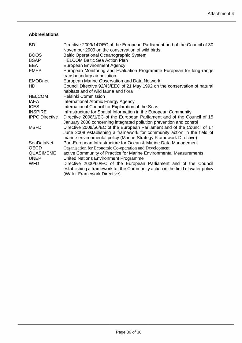
Attachment 4
Page 36 of 36
Abbreviations
BD Directive 2009/147/EC of the European Parliament and of the Council of 30
November 2009 on the conservation of wild birds BOOS Baltic Operational Oceanographic System BSAP HELCOM Baltic Sea Action Plan EEA European Environment Agency EMEP European Monitoring and Evaluation Programme European for long-range
transboundary air pollution EMODnet European Marine Observation and Data Network HD Council Directive 92/43/EEC of 21 May 1992 on the conservation of natural
habitats and of wild fauna and flora HELCOM Helsinki Commission IAEA International Atomic Energy Agency ICES International Council for Exploration of the Seas INSPIRE Infrastructure for Spatial Information in the European Community IPPC Directive Directive 2008/1/EC of the European Parliament and of the Council of 15
January 2008 concerning integrated pollution prevention and control MSFD Directive 2008/56/EC of the European Parliament and of the Council of 17
June 2008 establishing a framework for community action in the field of marine environmental policy (Marine Strategy Framework Directive)
SeaDataNet Pan-European Infrastructure for Ocean & Marine Data Management OECD Organisation for Economic Co-operation and Development QUASIMEME active Community of Practice for Marine Environmental Measurements UNEP United Nations Environment Programme WFD Directive 2000/60/EC of the European Parliament and of the Council
establishing a framework for the Community action in the field of water policy (Water Framework Directive)