Embed Size (px)
Citation preview

DRAFT PLANNING PROPOSAL – 117 DARKES FOREST ROAD,
DARKES FOREST
To amend Wollongong LEP 2009 to permit cider processing facility and associated uses
DRAFT PLANNING PROPOSAL TO PERMIT REUSE OF
FORMER DARKES FOREST MINE SITE FOR CIDER
PROCESSING FACLITY AND ASSOCIATED USES
LOCAL GOVERNMENT AREA: Wollongong City Council
NAME OF DRAFT LEP: Former Darkes Forest Mine site - Proposed agricultural produce
industry (fruit crushing, fermenting and bottling facility) and associated uses
ADDRESS OF LAND: Lot 86 DP 752054, 117 Darkes Forest Road, Darkes Forest

LOT 86 DP 752054, 117 DARKES FOREST ROAD, DARKES FOREST Draft Planning
Proposal
Adopted by Council: 8 May 2017 P a g e | 2 Ref: Z16/282231
Draft Planning Proposal - Table of Contents
Part 1 – Statement of intended outcomes ......................................................................................... 3
Part 2 – Location and Background .................................................................................................... 3
Part 3 – Proposed amendments to planning controls ........................................................................ 7
Part 4 – Justification ....................................................................................................................... 19
Section A – Need for the Planning Proposal ................................................................................ 19
Section B – Relationship to strategic planning framework ........................................................... 21
Section C – Environmental, social and economic impact ............................................................. 24
Section D – State and Commonwealth interests.......................................................................... 26
Part 5 – Mapping ............................................................................................................................ 31
Part 6 – Community Consultation ................................................................................................... 33
Part 7 – Projected Timeline ............................................................................................................. 33
Table A - Checklist of State Environmental Planning Policies ...................................................... 35
Table B - Checklist of Section 117 Ministerial Directions ............................................................. 38
LOT 86 DP 752054, 117 DARKES FOREST ROAD, DARKES FOREST Draft Planning
Proposal
Adopted by Council: 8 May 2017 P a g e | 3 Ref: Z16/282231
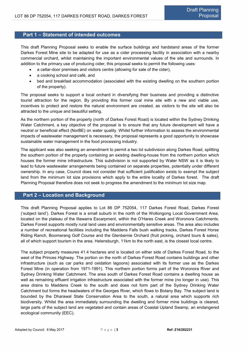
Part 1 – Statement of intended outcomes
This draft Planning Proposal seeks to enable the surface buildings and hardstand areas of the former
Darkes Forest Mine site to be adapted for use as a cider processing facility in association with a nearby
commercial orchard, whilst maintaining the important environmental values of the site and surrounds. In
addition to the primary use of producing cider, this proposal seeks to permit the following uses:
a cellar-door premises and visitors centre (allowing for sale of the cider),
a cooking school and café, and
bed and breakfast accommodation (associated with the existing dwelling on the southern portion
of the property).
The proposal seeks to support a local orchard in diversifying their business and providing a distinctive
tourist attraction for the region. By providing this former coal mine site with a new and viable use,
incentives to protect and restore the natural environment are created, as visitors to the site will also be
attracted to the unique and beautiful setting.
As the northern portion of the property (north of Darkes Forest Road) is located within the Sydney Drinking
Water Catchment, a key objective of the proposal is to ensure that any future development will have a
neutral or beneficial effect (NorBE) on water quality. Whilst further information to assess the environmental
impacts of wastewater management is necessary, the proposal represents a good opportunity to showcase
sustainable water management in the food processing industry.
The applicant was also seeking an amendment to permit a two lot subdivision along Darkes Road, splitting
the southern portion of the property containing an existing dwelling-house from the northern portion which
houses the former mine infrastructure. This subdivision is not supported by Water NSW as it is likely to
lead to future wastewater arrangements being contained on separate properties, potentially under different
ownership. In any case, Council does not consider that sufficient justification exists to exempt the subject
land from the minimum lot size provisions which apply to the entire locality of Darkes forest. The draft
Planning Proposal therefore does not seek to progress the amendment to the minimum lot size map.
Part 2 – Location and Background
This draft Planning Proposal applies to Lot 86 DP 752054, 117 Darkes Forest Road, Darkes Forest
(‘subject land’). Darkes Forest is a small suburb in the north of the Wollongong Local Government Area,
located on the plateau of the Illawarra Escarpment, within the O’Hares Creek and Woronora Catchments.
Darkes Forest supports mostly rural land uses and environmentally sensitive areas. The area also includes
a number of recreational facilities including the Maddens Falls bush walking tracks, Darkes Forest Horse
Riding Ranch, Boomerang Golf Course and the Glenbernie Orchard (fruit picking, orchard tours & sales),
all of which support tourism in the area. Helensburgh, 11km to the north east, is the closest local centre.
The subject property measures 41.4 hectares and is located on either side of Darkes Forest Road, to the
west of the Princes Highway. The portion on the north of Darkes Forest Road contains buildings and other
infrastructure (such as car parks and oxidation lagoons) associated with its former use as the Darkes
Forest Mine (in operation from 1971-1991). This northern portion forms part of the Woronora River and
Sydney Drinking Water Catchment. The area south of Darkes Forest Road contains a dwelling house as
well as remaining effluent irrigation infrastructure associated with the former mine (no longer in use). This
area drains to Maddens Creek to the south and does not form part of the Sydney Drinking Water
Catchment but forms the headwaters of the Georges River, which flows to Botany Bay. The subject land is
bounded by the Dharawal State Conservation Area to the south, a natural area which supports rich
biodiversity. Whilst the area immediately surrounding the dwelling and former mine buildings is cleared,
large parts of the subject land are vegetated and contain areas of Coastal Upland Swamp, an endangered
ecological community (EEC).

LOT 86 DP 752054, 117 DARKES FOREST ROAD, DARKES FOREST Draft Planning
Proposal
Adopted by Council: 8 May 2017 P a g e | 4 Ref: Z16/282231
Location Map
Figure 1: Location Map showing Lot 86 DP 752054, 117 Darkes Forest Road, Darkes Forest (subject land) in
relation to the Glenbernie Orchard to the west, Sydney Water drinking catchment, and the Dharawal Nature
Reserve to the south.

LOT 86 DP 752054, 117 DARKES FOREST ROAD, DARKES FOREST Draft Planning
Proposal
Adopted by Council: 8 May 2017 P a g e | 5 Ref: Z16/282231
Figure 2: Aerial photograph (2017) - the northern portion of the subject land which is occupied by the former
mine facilities.
Figure 3: Aerial photograph (2017) - the southern portion of the subject land which is occupied by a dwelling.

LOT 86 DP 752054, 117 DARKES FOREST ROAD, DARKES FOREST Draft Planning
Proposal
Adopted by Council: 8 May 2017 P a g e | 6 Ref: Z16/282231
Historical photographs
In 1971 a new mine was created at Darkes Forest to mine the western lease area of the Coalcliff Mine. The
mine development included sinking an access shaft, large administration and bathhouse buildings, access
lift, ventilation shaft and wastewater systems (oxidation lagoons and effluent irrigation areas). Below are
some historical photographs of the mine during operation.
Source: http://www.illawarra-heritage-trail.com.au/index.php/sites/jetty-mine-csa-composite/jetty-mine
Darkes Forest Mine site 1979 – Source: Illawarra Images, Wollongong City Library:
http://mylibrary.wollongong.nsw.gov.au/cgi-bin/spydus.exe/FULL/PIC/BIBENQ/2198685/17579783,1

LOT 86 DP 752054, 117 DARKES FOREST ROAD, DARKES FOREST Draft Planning
Proposal
Adopted by Council: 8 May 2017 P a g e | 7 Ref: Z16/282231
Currently, there are limited incentives to manage the former mine site and vandalism is evident.
Unauthorised clearing and importation of fill was carried out in a number of locations across the subject land in
2005. Wollongong City Council and the Sydney Catchment Authority (SCA) investigated the matter. The SCA
issued a clean-up notice under the Protection of the Environment Operations Act 1997 in October 2006 with
requirements to remove fill and submit a Revegetation Management Plan. Council issued an Order in June
2006 under the Environmental Planning and Assessment Act 1979 requiring works to assist natural
regeneration of the site and maintenance until 2011.
In accordance with the SCA and Council’s requirements, a Vegetation Restoration Plan was prepared and a
qualified bush regeneration company was engaged to carry out the works. Council and the SCA subsequently
carried out maintenance inspections and Council closed the Order in 2011.
The dwelling was approved in 2006, under former planning controls (Wollongong Local Environmental Plan
No.38), with modifications to the method of wastewater treatment and internal layout approved in 2010.
Part 3 – Proposed amendments to planning controls
The subject site is currently zoned E2 Environmental Conservation under Wollongong LEP 2009 which
greatly restricts options for reusing the former mine buildings.
The current landowners of the subject land also own the nearby Glenbernie Orchard (located 1.3km to the
west) which produces apples, stone fruit and a variety of products such as honey, jams, oil and juice.
Alcoholic and non-alcoholic cider from apples grown on the orchard is currently produced in stages at three
different locations: crushing at Thirlmere (30km west of the site), fermenting at Sutton Forest (70km south-
west of the site) and bottling at Prestons in Western Sydney (35km north of the site). To increase efficiency
and produce the cider locally, it is proposed to retrofit the existing mine building to allow for production of
cider in one central nearby location.
It is proposed to amend Schedule 1 Additional Permitted Uses of Wollongong LEP 2009 to include:
agricultural produce industry (fruit crushing, fermenting and bottling facility);
information and education facility (visitor centre);
industrial retail outlet (or cellar door premises); and
food and drink premises (café and ancillary cooking school).
as additional permitted uses (with consent) for the subject land.
It is also proposed to rezone parts of the subject land surrounding the existing mine buildings, carpark and
dwelling from E2 Environmental Conservation to E3 Environmental Management to better reflect the
current and proposed future land uses over parts of the property (refer to Part 5 for maps).
The E2 Environmental Conservation Zone will be retained over Endangered Ecological Communities
(EECs) and other ecologically sensitive vegetation to ensure the highest level of protection.
Currently there are no height restrictions which apply to the subject land, given the limited amount of
development that can occur in an E2 zone. It is proposed to place a height restriction of 9 metres over the
areas proposed to be rezoned E3 Environmental Management.
The proposal will not change the minimum lot size for subdivision applying to the subject land which is 40
hectares.

LOT 86 DP 752054, 117 DARKES FOREST ROAD, DARKES FOREST Draft Planning
Proposal
Adopted by Council: 8 May 2017 P a g e | 8 Ref: Z16/282231
This proposal will allow the last apple farm in Wollongong to diversify their offerings and remain viable by
enabling them to produce boutique cider close to their orchard. Should this Planning Proposal be
approved, a development application supported by environmental studies would be necessary to carry out
these uses and any associated works.
Schedule 1 Additional Permitted Uses
A cider processing facility is not a definition found in Wollongong LEP 2009, however could legally be
defined as an agricultural produce industry. Wollongong LEP 2009 states that an:
agricultural produce industry means a building or place used for the handling, treating, processing or packing, for
commercial purposes, of produce from agriculture (including dairy products, seeds, fruit, vegetables or other plant material),
and includes wineries, flour mills, cotton seed oil plants, cotton gins, feed mills, cheese and butter factories, and juicing or
canning plants, but does not include a livestock processing industry.
Note.
Agricultural produce industries are a type of rural industry—see the definition of that term in this Dictionary.
Agricultural produce industries are only permitted in rural zones (RU1 Primary Production and RU2 Rural
Landscape) and in order to maintain environmental protection objectives across the subject land it is not
recommended to rezone the land for rural purposes. Including agricultural produce industries as a
permissible use in environmental zones is also not recommended, as Wollongong contains a wide variety
of environmentally sensitive and natural areas which are unlikely to be able to sustainably support rural
industry.
To allow for the cider processing facility it is proposed to amend Schedule 1 Additional Permitted Uses of
Wollongong LEP 2009 to include agricultural produce industries as a site specific permissible use on the
subject land.
In addition, uses that are ancillary to the primary use (that are not considered additional [separate/stand-
alone] uses) are permitted where the primary use is existing and lawful – for example the infrastructure
associated with wastewater treatment and disposal from a cider processing plant would be considered
ancillary to the primary use of producing cider.
To allow for some flexibility in utilising the former mine site and to support nearby local food producers, it is
also proposed to include food and drink premises, information and education facilities and industrial retail
outlet as additional permitted uses for the subject land to permit a café/cookery school, visitors centre and
a cellar door.
There is no definition of a cooking school in Wollongong LEP 2009. A cooking school does not meet the
standard definitions of ‘educational establishment’ or ‘school’ or ‘industrial training facility’ (refer to land use
definitions below). It is considered that a cooking school which would utlise the commcercial kitchen within
the café would be an ancillary use to the café.
It is considered that a large restaurant is probably not appropriate for the subject land given its location and
environmental values; however a small café to support the other uses may be able to operate within site
constraints. In addition, some microbreweries offer tastings, food and drinks in a bar-like setting, which
may offer an alternative associated use with the cider processing facility. The land use definition of ‘food
and drink premises’ would allow for a range of these potential uses which could sustainably support the
proposed tourist attraction.

LOT 86 DP 752054, 117 DARKES FOREST ROAD, DARKES FOREST Draft Planning
Proposal
Adopted by Council: 8 May 2017 P a g e | 9 Ref: Z16/282231
The water and wastewater requirements of a café will need to be assessed prior to public exhibition,
should the proposal proceed through the Gateway. Further analysis of environmental impact and
management measures would also take place at the development application stage.
food and drink premises means premises that are used for the preparation and retail sale of food or drink (or both) for
immediate consumption on or off the premises, and includes any of the following:
(a) a restaurant or cafe,
(b) take away food and drink premises,
(c) a pub,
(d) a small bar.
Note. Food and drink premises are a type of retail premises—see the definition of that term in this Dictionary.
The following land use definitions are not considered to fit the proposed cooking school:
educational establishment means a building or place used for education (including teaching), being:
(a) a school, or
(b) a tertiary institution, including a university or a TAFE establishment, that provides formal education and is constituted by or under an Act.
school means a government school or non-government school within the meaning of the Education Act 1990.
Note. Schools are a type of educational establishment—see the definition of that term in this Dictionary.
industrial training facility means a building or place used in connection with vocational training in an activity (such as forklift or truck driving, welding or carpentry) that is associated with an industry, rural industry, extractive industry or mining, but does not include an educational establishment, business premises or retail premises.
The proposed visitors centre would be defined as an information and education facility:
information and education facility means a building or place used for providing information or education to visitors, and
the exhibition or display of items, and includes an art gallery, museum, library, visitor information centre and the like.
Presently, the definition of cellar door premises is very specific to the wine industry and industrial retail
outlet is considered a better definition for the proposal:
cellar door premises means a building or place that is used to sell wine by retail and that is situated on land on which there is a commercial vineyard, and where most of the wine offered for sale is produced in a winery situated on that land or is produced predominantly from grapes grown in the surrounding area.
Note. Cellar door premises are a type of retail premises—see the definition of that term in this Dictionary.
industrial retail outlet means a building or place that:
(a) is used in conjunction with an industry or rural industry, and
(b) is situated on the land on which the industry or rural industry is located, and
(c) is used for the display or sale (whether by retail or wholesale) of only those goods that have been manufactured on the land on which the industry or rural industry is located,
but does not include a warehouse or distribution centre.
Note.

LOT 86 DP 752054, 117 DARKES FOREST ROAD, DARKES FOREST Draft Planning
Proposal
Adopted by Council: 8 May 2017 P a g e | 10 Ref: Z16/282231
See clause 5.4 for controls relating to the retail floor area of an industrial retail outlet.
Schedule 1 Additional Permitted Uses provides for site-specific controls where proposals have strategic
merit but cannot otherwise be accommodated in the standard Land Use Tables. This proposal is
considered a special case as it relates to disturbed land which contains viable (and relatively modern)
infrastructure that could be adapted for a compatible use on a large parcel of land which is mostly
characterised ecological values. There are currently no practicable permissible uses for the former mine
surface buildings and carpark. This is evidenced by the number of development application refusals listed
in the development application summary provided in Table 1 below. Approved uses for the southern
portion of the site are associated with the dwelling house.
Table 1: Development History 117 Darkes Forest Road
Application Description/Comment Status
DA 1977/277 Cycle shelter shed extension [associated with Darkes Forest Mine] Approved 23/12/1977
BA 1978/1344 Brick Store [associated with Darkes Forest Mine] Approved 6/11/1978
DA 1981/809 Alterations to the treatment and disposal works for bathhouse effluent at Darkes Forest mine
Approved 16/10/1981
DA 2006/346 Site rehabilitation of old mine shaft area, provision of services and roads, construction of a plant training area and provision for itinerant worker’s accommodation. Refused based on inconsistency with Wollongong Local Environmental Plan 1990, adverse impacts on environment with respect to water quality, vegetation removal, drinking water catchment and local character and streetscape, and set undesirable precedent.
Refused 21/06/2006
DA 2006/450 Single storey dwelling house
Approved 7/10/06, CC approved 4/08/2010
DA 2006/450/B Single storey dwelling-house - modification to internal layout, change of septic system and roof colour change
Approved 14/03/2011 CC Approved 11/03/2011
MP 2007/103 The proposal involved the drilling of approximately 20 exploratory wells to a depth of 50m below the base of the Illawarra Coal Measures to determine the gas potential in un-mined coal seams.
15 coal seam gas exploration boreholes approved by State Government under Part 3A.
MP 2007/103/A Modification - proposed extra gas exploration borehole AI19 off Darkes Forest Road - revised Environmental Assessment dated December 2010.
Approved by State Government under Part 3A
MP 2007/103/B Apex Energy Gas Exploration Project Modification 2 – Extension of Time. Application to extend the expiry date of the approval, “from three years from the commencement of drilling the first borehole”.
Refused by PAC of NSW under delegation.
DA 2008/601 Change of use from mine facility to camping area and amenities, landscaping and addition of decking to existing building. Characterisation: “leisure area”, which was permissible in 7(a) zone. Refused based on inconsistency with WLEP 1990, Drinking Water Catchments REP No.1 and insufficient information for stormwater management; wastewater management; impact of tree removal; potential site contamination; on-site waste management; and, traffic and parking arrangements.
Refused 9/11/2009
DA 1589/2009 Two (2) lot subdivision Refused: Proposed development is inconsistent with the Draft Wollongong Local Environmental Plan 2009- minimum lot size 39.99ha
Refused 5/5/10
PL 2011/16 Recreation land use - recreation facility (outdoor) - camping area with cricket nets Withdrawn, incompatible with current land use zone.
Withdrawn 21/04/2011
DA 2015/51 Residential - construction of outdoor entertainment area and associated landscaping works
Approved 18/03/2015

LOT 86 DP 752054, 117 DARKES FOREST ROAD, DARKES FOREST Draft Planning
Proposal
Adopted by Council: 8 May 2017 P a g e | 11 Ref: Z16/282231
PC 2016/770 Residential - construction of outdoor entertainment area and associated landscaping works
Approved 26/04/2016
Land Use Zones
Rezoning of parts of the site is also proposed, in order to reflect the proposed reuse of the existing
buildings and car park area associated with the former mine on the northern portion of the subject land,
and the existing approved dwelling on the southern portion. As the maps in Part 4 illustrate, an E2
Environmental Conservation zoning will be retained over most of the subject land, reflecting its significant
environmental and drinking water catchment values. An E3 Environmental Management Zone will be
applied over the significantly disturbed and altered areas that are proposed to be used for cider processing
and associated uses and the existing dwelling area. The Land Use Tables of both these zones are
reproduced below, allowing for comparison of objectives and permissible uses.
Dwelling houses are permitted in the E3 Zone only when the requirements of Clause 4.2A Erection of
dwelling houses on land in certain rural and environmental protection zones in Wollongong LEP 2009 are
satisfied. To satisfy Clause 4.2A, a new dwelling would need to be located on a lot as large as the specified
minimum lot size, in this case 40 hectares. The site measures 40 hectares but already houses one
dwelling. No change to the minimum lot size for subdivision is proposed.
Secondary dwellings (granny flats) are permitted in the E3 zone with consent but are restricted to 67% of
the size of the primary dwelling, in this case approximately 162.81 m2. Secondary dwellings (granny flats)
are not permitted to be subdivided into a separate lot from the primary dwelling unless both lots will meet
the minimum lot size for subdivision (in this case 40 hectares so subdivision would not be possible). Any
future secondary dwelling application would need development consent and would need to consider
wastewater treatment arrangements as well as other environmental constraints such as bushfire
protection.
The rezoning of the area surrounding the existing dwelling will also permit (subject to development
assessment) bed and breakfast accommodation as defined in Wollongong LEP 2009:
bed and breakfast accommodation means an existing dwelling in which temporary or short-term accommodation is provided on a commercial basis by the permanent residents of the dwelling and where:
(a) meals are provided for guests only, and
(b) cooking facilities for the preparation of meals are not provided within guests’ rooms, and
(c) dormitory-style accommodation is not provided.
Note. See clause 5.4 for controls relating to the number of bedrooms for bed and breakfast accommodation. Bed and breakfast accommodation is a type
of tourist and visitor accommodation—see the definition of that term in this Dictionary.
The retention of an environmental zoning across the site will ensure that any future development
application would need to have regard for the environmental values of the site and would need to protect,
maintain and/or improve the environmental outcomes on the site. Potential environmental impacts of the
proposal are discussed further in Part 3 of this document.
Table 2: Comparison of E2 and E3 zones
Zone Objectives Permitted without consent
Permitted with consent Prohibited
E2 Environmental Conservation
• To protect, manage and restore areas of high ecological, scientific, cultural or
Nil Environmental facilities; Environment protection works;
Business premises; Hotel or motel

LOT 86 DP 752054, 117 DARKES FOREST ROAD, DARKES FOREST Draft Planning
Proposal
Adopted by Council: 8 May 2017 P a g e | 12 Ref: Z16/282231
aesthetic values. • To prevent development that could destroy, damage or otherwise have an adverse effect on those values. • To retain and enhance the visual and scenic qualities of the Illawarra Escarpment. • To maintain the quality of the water supply for Sydney and the Illawarra by protecting land forming part of the Sydney drinking water catchment (within the meaning of State Environmental Planning Policy (Sydney Drinking Water Catchment) 2011) to enable the management and appropriate use of the land by Water NSW.
Extensive agriculture; Recreation areas
accommodation; Industries; Multi dwelling housing; Recreation facilities (major); Residential flat buildings; Restricted premises; Retail premises; Seniors housing; Service stations; Warehouse or distribution centres; Any other development not specified in item 2 or 3
E3 Environmental Management
• To protect, manage and restore areas with special ecological, scientific, cultural or aesthetic values. • To provide for a limited range of
development that does not have an adverse effect on those values.
Home occupations
Animal boarding or training establishments; Bed and breakfast accommodation; Building identification signs; Business identification signs; Community facilities; Dwelling houses; Environmental facilities; Environmental protection works; Extensive agriculture; Farm buildings; Farm stay accommodation; Forestry; Home-based child care; Recreation areas; Roads; Secondary dwellings
Industries; Multi dwelling housing; Residential flat buildings; Retail premises; Seniors housing; Service stations; Warehouse or distribution centres; Any other development not specified in item 2 or 3
Height Restrictions
Land in the E2 Environmental Conservation zone does not include a height restriction as buildings are not
permitted (unless they are ancillary to one of the few permissible land uses in the zone). As this proposal
includes application of an E3 zoning to parts of the subject land, the ‘Height of Buildings Map – Sheet
BOB_019 will require amendment to include lot 86.
This will place a 9 metre height limit over areas proposed to be rezoned to E3 Environmental Management
and ensure any future buildings or building modifications do not have unacceptable visual impacts.
Minimum Lot Size for Subdivision
Subdivision of the site is currently prohibited as the minimum lot size for subdivision is 40 hectares. The
proposal does not support changing this minimum lot size to allow for subdivision as this could create an
additional dwelling entitlement for the property, and additional dwellings on the subject land are not
supported. Additional dwellings could have adverse environmental impacts especially in relation to clearing
for bushfire protection (standards being stricter for residential and tourist uses than commercial/industrial
uses) and waste water treatment and disposal. Water NSW does not support the proposed bed and
breakfast accommodation (an intensified residential use) without further detail being provided as to
wastewater treatment and disposal. Similarly, allowing subdivision via a Schedule 1 amendment is not
proposed.
Maps and Site Photographs
The following zoning map from Wollongong LEP 2009 and Location map illustrate the current zoning and
local area context of the subject land.

LOT 86 DP 752054, 117 DARKES FOREST ROAD, DARKES FOREST Draft Planning
Proposal
Adopted by Council: 8 May 2017 P a g e | 13 Ref: Z16/282231
Figure 4: Wollongong LEP 2009 Zoning Map Sheet LZN_008 (Current Zoning)

LOT 86 DP 752054, 117 DARKES FOREST ROAD, DARKES FOREST Draft Planning
Proposal
Adopted by Council: 8 May 2017 P a g e | 14 Ref: Z16/282231
Site Photographs
The following photographs were taken on a site visit 5 December 2016.
1. Darkes Forest Road
2. Potential O’Hares Shale Forest near Darkes Forest Road

LOT 86 DP 752054, 117 DARKES FOREST ROAD, DARKES FOREST Draft Planning
Proposal
Adopted by Council: 8 May 2017 P a g e | 15 Ref: Z16/282231
3. Access road to northern portion of the subject land (former mine facilities).
4. Former administration building and shower block
LOT 86 DP 752054, 117 DARKES FOREST ROAD, DARKES FOREST Draft Planning
Proposal
Adopted by Council: 8 May 2017 P a g e | 16 Ref: Z16/282231
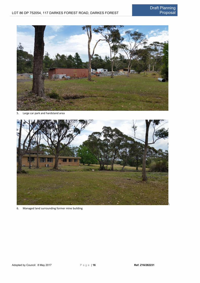
5. Large car park and hardstand area
\
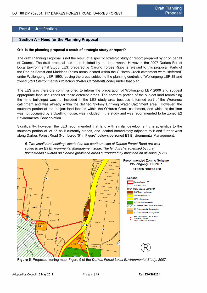
6. Managed land surrounding former mine building

LOT 86 DP 752054, 117 DARKES FOREST ROAD, DARKES FOREST Draft Planning
Proposal
Adopted by Council: 8 May 2017 P a g e | 17 Ref: Z16/282231
7. Former effluent lagoons
8. South of Darkes Forest Road – Access trail (south of dwelling)

LOT 86 DP 752054, 117 DARKES FOREST ROAD, DARKES FOREST Draft Planning
Proposal
Adopted by Council: 8 May 2017 P a g e | 18 Ref: Z16/282231
9. Previous effluent disposal area – Coastal Upland Swamp (Banskia Thicket)
10. Coastal Upland Swamp EEC
LOT 86 DP 752054, 117 DARKES FOREST ROAD, DARKES FOREST Draft Planning
Proposal
Adopted by Council: 8 May 2017 P a g e | 19 Ref: Z16/282231
Part 4 – Justification
Section A – Need for the Planning Proposal
Q1: Is the planning proposal a result of strategic study or report?
The draft Planning Proposal is not the result of a specific strategic study or report prepared by or on behalf
of Council. The draft proposal has been initiated by the landowner. However, the 2007 Darkes Forest
Local Environmental Study (LES) prepared by Cardno Forbes Rigby is relevant to this proposal. Parts of
the Darkes Forest and Maddens Plains areas located within the O’Hares Creek catchment were “deferred”
under Wollongong LEP 1990, leaving the areas subject to the planning controls of Wollongong LEP 38 and
zoned (7(c) Environmental Protection (Water Catchment) Zone) under that plan.
The LES was therefore commissioned to inform the preparation of Wollongong LEP 2009 and suggest
appropriate land use zones for those deferred areas. The northern portion of the subject land (containing
the mine buildings) was not included in the LES study area because it formed part of the Woronora
catchment and was already within the defined Sydney Drinking Water Catchment area. However, the
southern portion of the subject land located within the O’Hares Creek catchment, and which at the time
was not occupied by a dwelling house, was included in the study and was recommended to be zoned E2
Environmental Conservation.
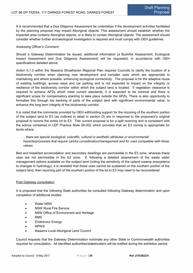
Significantly, however, the LES recommended that land with similar development characteristics to the
southern portion of lot 86 as it currently stands, and located immediately adjacent to it and further west
along Darkes Forest Road (Numbered ‘5’ in Figure* below), be zoned E3 Environmental Management:
5. Two small rural holdings located on the southern side of Darkes Forest Road are well
suited to an E3 Environmental Management zone. The land is characterised by rural
homesteads situated on cleared grassland areas surrounded by bushland on all sides (p.21).
Figure 5: Proposed zoning map, Figure 9 of the Darkes Forest Local Environmental Study, 2007.

LOT 86 DP 752054, 117 DARKES FOREST ROAD, DARKES FOREST Draft Planning
Proposal
Adopted by Council: 8 May 2017 P a g e | 20 Ref: Z16/282231
The current planning proposal to apply a split E2/E3 environmental zoning to the subject land would be
consistent with this recommendation.
Q2: Is the planning proposal the best means of achieving the objectives or intended outcomes, or
is there a better way?
This proposal is complex because there are a number of uses proposed and the former mine site is located
within an environmentally sensitive area. To achieve the strategic outcomes of the draft Planning Proposal,
being to permit the existing mine buildings to be reused and support an existing local business in producing
boutique cider in a sustainable manner, a number of options were considered:
An RU2 Rural Landscape Zone
There are no zones in the Wollongong LEP 2009 land use table which contain all of the uses proposed for
the reuse of the mine surface buildings, so irrespective of the zoning chosen a Schedule 1 amendment
would be required to facilitate the proposal. A non-environmental conservation zoning such as RU2 Rural
Landscape Zone would allow an agricultural produce industry however it would not be appropriate in this
case due to location of the subject land on the Hawkesbury sandstone plateau and the resulting sensitive
hydrological characteristics and biodiversity values of the landscape.
Adding the proposed new uses to the E3 Land Use Table in Wollongong LEP 2009 and rezoning the
subject land or parts of it to E3
Inclusion of four new permissible uses to the E3 land use table would constitute a broad scale change to
environmental conservation planning controls across the LGA and would weaken the legislative protection
currently afforded to E3 zoned land. It would raise the expectations of landowners in terms of the types of
uses their environmentally significant land can realistically be put to. This option is not supported.
The preferred option – Additional permitted uses through a Schedule 1 amendment and partial
Rezoning to E3
This option involves the amendment of Schedule 1 Additional Permitted Uses of Wollongong LEP 2009 to
permit:
agricultural produce industry (fruit crushing, fermenting and bottling);
industrial retail outlet;
information and education facilities; and
food and drink premises (café with ancillary cooking school)
as additional permitted uses for the subject land. This option also includes the rezoning of parts of the
subject land to E3 Environmental Management and the retention of the E2 Environmental Conservation
zone across the majority portions of the lot containing the highest conservation values.
A partial rezoning and Schedule 1 amendment would be consistent with the development and zoning
pattern along Darkes Forest Road and the findings of the Darkes Forest LES 2007, whereby areas being
utilised for rural purposes (e.g. the orchard) are zoned E3 and bushland areas are zoned E2. In addition, it
is considered to provide an appropriate balance between protecting the environmental values of the
subject land and the catchments within which it is located whilst allowing for some limited development in
previously disturbed areas. Further information will be required to assess the environmental impacts and
adequacy of management systems designed for the proposal however; the use of the existing
infrastructure for the purposes of producing cider (associated with a nearby orchard) has strategic merit
and could offer a number of economic and social benefits, including new local employment opportunities, a
boost to a local food producer, and a new tourist destination in the Illawarra.
This is the option adopted by Wollongong City Council on 8 May 2017. A copy of the Council report
accompanies this Planning Proposal.

LOT 86 DP 752054, 117 DARKES FOREST ROAD, DARKES FOREST Draft Planning
Proposal
Adopted by Council: 8 May 2017 P a g e | 21 Ref: Z16/282231
Ideally, this option would include a change to the standard definition of ‘cellar door premises’ to include
cider production in addition to winemaking. This change would require the Department of Planning to
change the standard definition of ‘cellar door premises’ in clause 1.4 of the Standard Instrument—Principal
Local Environmental Plan. If this change to the Standard Instrument occurred, the addition of ‘industrial
retail outlet’ to the Schedule 1 amendment would be substituted with ‘cellar door premises’.
A schedule 1 amendment is considered to be best planning mechanism to achieve the strategic planning
outcomes of this proposal for the following reasons:
An environmental zoning is considered to be the most appropriate zoning for the subject land,
however it would not be appropriate to increase the range of permissible uses generally in the E3
zone as this would expand the potential uses of all E3 zoned land, thereby weakening the ability to
limit development impacts on environmentally and culturally sensitive land;
The subject land is unique and warrants site specific planning controls because it:
- contains both extensive existing infrastructure with a high potential for adaptive reuse within a
largely cleared pocket, and significant conservation values within its boundaries;
- is strategically located in very close proximity (1.3km) to the primary producer of the apples
that will be used to make the cider, thus supporting the viability of complimentary local
industries and helping them to operate with small environmental footprints (reduced ‘food
miles’) whilst at the same time supporting a diverse and robust local economy.
The partial rezoning of the subject land from E2 to E3 is necessary to allow the proposed
additional uses to be consistent with zone objectives. If the land was to remain E2, the zone
objectives would render the proposed uses inconsistent with the LEP, notwithstanding the
proposed Schedule 1 amendments.
The proposal has the potential to support an outcome where conservation objectives and income
generating uses can occur within the one allotment. That said, additional studies relating to the
management of potential environmental impacts from the proposal, particularly wastewater treatment and
disposal, will be very important in determining the development’s feasibility due to its potential to impact on
the Coastal Upland Swamp EEC. Retention of an environmental zoning will highlight this constraint and
ensure development options do not adversely impact on the natural environment or drinking water quality.
Section B – Relationship to strategic planning framework
Q3: Is the planning proposal consistent with the objectives and actions of the applicable regional
or sub-regional strategy?
The proposal is consistent with the Illawarra Shoalhaven Regional Plan 2015. In particular, the proposal is
consistent with the following principles:
Identify and protect land with high environmental value and recognise cultural heritage values;
support the sustainable use of land and water resources and build resilience to natural hazards
and climate change;
support a strong, resilient and diversified economy that will enable the community to respond to
environmental, economic and social challenges.
Under Goal 1 A prosperous Illawarra Shoalhaven, tourism is noted as a priority growth sector, with
“sustainable use of national parks...agricultural lands...promote trails and activity experiences such as
nature and eco based, food and wine (including agri-tourism)” encouraged (p.26). The proposal can be
considered agri-tourism given its association with the Glenbernie Orchard and could add to the tourism

LOT 86 DP 752054, 117 DARKES FOREST ROAD, DARKES FOREST Draft Planning
Proposal
Adopted by Council: 8 May 2017 P a g e | 22 Ref: Z16/282231
offerings in the area, including nature-based National Park experiences. The proposal is also consistent
with Direction 1.4: Support new and expanded industrial activity by providing well-located and serviced
supplies of industrial land close to Sydney and Wollongong. The proposal represents a small-scale rural
industry unlike the traditional metal manufacturing type industries that are common in Wollongong and is
consistent with the aim to diversify the economy. The proposed cider processing plant is well-located close
to the apple orchard and the markets of Wollongong and Sydney.
The proposal is also consistent with Goal 4: A region that makes appropriate use of agricultural and
resource lands. The proposal will assist in offering additional business opportunities for the existing local
family–owned Glenbernie Orchard, consistent with Direction 4.1 Protect regionally important agricultural
lands as an asset to food and fibre production. The proposal will however need to demonstrate its ability to
meet Direction 4.3 Manage and protect the Sydney Drinking Water Catchment.
As the subject land is located within a mapped regionally significant biodiversity corridor, Goal 5: A region
that protects and enhances the natural environment is relevant to the proposal. The goal lists a number of
relevant actions including:
Action 5.1.1 Avoid, minimise and mitigate the impact of development on significant environmental
assets; and
Action 5.1.3 Protect the region’s biodiversity corridors in local planning controls.
The proposed split E2/E3 Environmental Conservation zoning in Wollongong LEP 2009 would be
consistent with the need to protect the integrity of this biodiversity corridor. The potential for the proposed
uses to impact upon the functioning of the corridor primarily relates to the clearance of vegetation.
However because the proposal is based on the reuse of existing infrastructure and a cleared managed
area already surrounds the carpark and former mine surface buildings that would house the cider
processing facility, the need for further vegetation clearance is predicted to be minimal. If bushfire safety
assessments and other studies identify that significant vegetation clearance will be required, then the new
Biodiversity Assessment Methodology (BAM) would need to be applied to determine offsetting
requirements in accordance with the Biodiversity Conservation Act 2016.
As stated previously, at development assessment stage, the intensity of the use of the subject land can be
limited to ensure that impacts remain neutral or beneficial, both in terms of water quality, biodiversity and
biodiversity corridor functioning. Based on the relationship between the existing Glenbernie Orchard and
the subject land in terms of ownership and proposed uses, there is also likely to be some commercial
flexibility, if necessary, in terms of the uses which take place on the subject land, and those, such as sales
of cider, that could potentially continue to take place at the ‘Apple Shack’.
Q4: Is the Planning Proposal consistent with a Council’s local strategy or other local
strategic document?
Council’s community strategic plan is Wollongong 2022, and the proposal is consistent with the following
objectives:
Community Goal 1: We value and protect our natural environment
- The natural environment is protected an enhanced;
- Wollongong’s ecological footprint is reduced;
- Community awareness and appreciation of heritage is increased; and
- Local food production and community food initiatives are supported.
Community Goal 2: We have an innovative and sustainable economy
- Local employment opportunities are increased within a strong local economy;

LOT 86 DP 752054, 117 DARKES FOREST ROAD, DARKES FOREST Draft Planning
Proposal
Adopted by Council: 8 May 2017 P a g e | 23 Ref: Z16/282231
- The region’s industry base is diversified;
- The profile of Wollongong as the regional city of the Illawarra is expanded and improved;
and
- New industries and green technologies are established and flourish.
This proposal supports the diversification of the region’s resource base, local employment opportunities
and the production of food locally, all key components for achieving sustainable settlements. There is
significant potential for the attraction to boost tourism in our region and also operate as an interpretive
centre for visitors to understand the mining heritage of Wollongong. Further, the potential for the entire
process of apple cider production to take place within a 1.4km radius, including the possible use of waste
products from the cider processing to irrigate/fertilise the orchard would certainly reduce the ecological
footprint of the commercial operation, provided that water quality and hydrological parameters can be
consistently met.
Q5: Is the planning proposal consistent with applicable State Environmental Planning
Policies?
A systematic assessment of the consistency of the proposal with applicable SEPPs is provided in Table A.
The proposal has been assessed against applicable SEPPs (and deemed SEPPs) and found to be
consistent in all cases, apart from SEPP Sydney Drinking Water Catchment 2011 and Greater Metropolitan
Regional Environmental Plan No.2 – Georges River Catchment. Further information is required to be
submitted by the proponent to enable a full assessment of consistency with these two SEPPs.
Q6: Is the planning proposal consistent with applicable Ministerial Directions (s.117
directions)?
A systematic assessment of the consistency of the proposal with applicable s.117 Directions is provided in
Table B. The proposal has been assessed as being consistent with all applicable Ministerial Directions,
with the exception of Ministerial Direction 2.1 which is discussed below, and Ministerial Directions 4.4
(Planning for Bushfire Protection) and 5.2 (Sydney Drinking Water Catchments), which require additional
information in order for a conclusive assessment to be carried out.
2.1 Environment Protection Zone
In compliance with clause 2.1(4) of this Direction, this planning proposal includes provisions that facilitate
the protection and conservation of environmentally sensitive areas by maintaining an Environmental
Protection zone to the subject land and utilising split E2/E3 zoning rather than applying an E3 zoning to
entire lot. The proposal is however technically inconsistent with subclause (5) because the environmental
protection standards (as reflected in the zone objectives and list of permissible uses in the E3 zone) are
not as high as those applying to the E2 zone. This inconsistency is considered to be of minor significance
because:
the objectives of the E2 and E3 zone have in common the objective “to protect, manage and
restore areas with special ecological, scientific, cultural or aesthetic values”;
the ‘lower’ zoning only applies to those parts of the subject land that are characterised by existing
access ways, historic cleared areas and that contain existing built structures (former mine surface
buildings, carpark and dwelling); and
in spatial terms, that part of the subject land that would be zoned E3 would comprises less than
one quarter of the subject land.

LOT 86 DP 752054, 117 DARKES FOREST ROAD, DARKES FOREST Draft Planning
Proposal
Adopted by Council: 8 May 2017 P a g e | 24 Ref: Z16/282231
The proposal is for a split rezoning and is consistent with the advice contained in LEP Practice Note 09-
002 which provides that “where council wishes to acknowledge different land capabilities on a single
allotment, council may consider applying more than one zone across the land. For example, this approach
may be considered appropriate over an allotment to distinguish between areas of environmental value and
areas for agricultural purposes”. It further provides that an E3 zoning is appropriate for lands where:
..there are special ecological, scientific, cultural or aesthetic attributes or environmental
hazards/processes that require careful consideration/management and for uses compatible with these
values.
Bed and breakfasts and secondary dwellings are permissible in the E3 zone, whereas these uses are not
permissible in the E2 zone. If, following a detailed assessment of the waste water management options
available on the subject land (noting the sensitivity of the upland swamp ecosystems to changes in
hydrology), it is revealed that these uses cannot be sustained on the subject land in addition to the cider
processing facility and associated uses, then rezoning part of the southern portion of the lot containing the
dwelling to E3 may need to be reconsidered.
Section C – Environmental, social and economic impact
Q7: Is there any likelihood that critical habitat or threatened species, populations or
ecological communities, or their habitats, will be adversely affected as a result of the
proposal?
An ecological assessment of the subject land is yet to be carried out and would be required prior to any
public exhibition of the proposal, should Gateway approval be granted. Council’s mapping system shows
areas of Coastal Upland Swamp (an Endangered Ecological Community (EEC)) are located within the
subject land, and the presence of this community was confirmed as occurring on both the southern and
northern portion of the subject land during a site inspection by Council officers. These ecosystems are
highly sensitive to changes in the hydrological regime of the landscape and to changes in water quality.
Threatened species such as the Glossy Black Cockatoo and Pultanea aristataea have also been recorded
on the subject land (BES, Vegetation Restoration Plan, 2006).
As the proposed development would be housed within the existing former Darkes Forest Mine surface
buildings and utilise the existing carpark, there is predicted to be no net changes to the area covered by
impervious surfaces on the subject land and so the volume of stormwater generated is unlikely to be
altered. Similarly, vegetation removal is predicted to be very limited. However, a bushfire risk assessment
and the impact of the management of generated waste water streams would need to be thoroughly
assessed prior to the public exhibition of the proposal.
Q8: Are there any likely environmental effects as a result of the planning proposal and
how are they proposed to be managed?
The potential for environmental effects from proposed uses of the subject land primarily relates to waste
water management. This is both in terms of water quality and the altering of hydrological processes which
is identified as a key threat to the Coastal upland swamp EEC. The potential impacts of the proposed uses
in terms of vegetation clearance is predicted to be minimal on the basis that no new structures are
proposed and all existing buildings are already surrounded by a cleared area which would minimise the
need for clearing to achieve the required asset protection zones.

LOT 86 DP 752054, 117 DARKES FOREST ROAD, DARKES FOREST Draft Planning
Proposal
Adopted by Council: 8 May 2017 P a g e | 25 Ref: Z16/282231
Overall, it is considered that facilitating a viable income generating use for parts of the subject land will
encourage investment in environmental conservation as this is complimentary to the visitor experience to
the area, increase surveillance of the subject land and reduce the potential for the subject land be used for
illegal purposes which have the potential to impact negatively on the natural environment.
A report dated 6 May 2016 detailing a preliminary assessment of stormwater quality was undertaken by
Cardno to determine whether or not the proposal was likely to be able to achieve the required NorBE
standard for water quality in accordance with the Sydney Drinking Water Catchment SEPP 2011. This
report concluded that the proposal can achieve NorBE if there is no increase to the existing
development/hardstand area footprint.
A draft report dated 5 May 2016 outlining a preliminary assessment of potable water and wastewater was
also submitted by Cardno in support of the proposal. It is noted that this assessment on both potable water
demand and waste water generation was based on the following uses:
Cider production & Sales;
Visitors Centre (estimated 60 visitors per week on average); and
Cooking classes (estimated 40 people per week on average).
No café use was included in the assessment and this omission will need to be rectified in subsequent
studies.
Potable Water
The assessment concluded that rainwater collection and treatment prior to use was the most feasible
option for potable water supply to the facility. It considered that a groundwater bore may also be a
potential option pending further investigations.
Waste Water
At this preliminary stage, Cardno recommend that sanitary and process wastewater be managed and
treated in two separate streams. The process wastewater would ideally be used to irrigate the orchard
some 1.4km away, while the treated sanitary wastewater is proposed to be disposed of using irrigation
areas on the southern portion of the lot. Stored wastewater could be taken off-site by truck during periods
of prolonged rainfall.
It is noted that although irrigation areas on the southern portion of the lot were used when the former
Darkes Forest mine was in operation, further ecological investigations would be required to determine
whether such a practice would now be suitable given current knowledge of the sensitivity of Coastal upland
swamps, now listed as an EEC under the Biodiversity Conservation Act 2016. The Cardno reports do not
refer to these swamps or the fact that the land drains into the Dharawal Nature Reserve.
Further, a NorBE assessment for the irrigation area within the Glenbernie orchard would be required given
that this orchard is located within the Woronora Special Catchment Area.
The future studies into water use and wastewater management will also need to include a Strategic Land
and Water Capability Assessment in accordance with Ministerial Direction 5.2(4)(b) and (c).
Assessment of Contamination Risk
Given the former use of the subject land as part of the Darkes Forest mine and subsequent unauthorised
clearing and land filling, a Stage 1 contamination assessment to determine whether any remediation of the
land is required would also need to be carried out following Gateway determination.
Bushfire Constraints Assessment Report

LOT 86 DP 752054, 117 DARKES FOREST ROAD, DARKES FOREST Draft Planning
Proposal
Adopted by Council: 8 May 2017 P a g e | 26 Ref: Z16/282231
A thorough assessment of the bushfire constraints on the subject land would be required following a
Gateway determination.
Q9: Has the planning proposal adequately addressed any social and economic effects?
The abandoned building of the former Darkes Forest mine is not heritage listed and in any event, the
adaptive reuse of the building would offer far greater support for the preservation of any heritage value in
the buildings, than leaving the building derelict. Interpretation of the former uses of the building would offer
visitors to the site yet another experience of potential interest.
No Aboriginal cultural heritage sites have been identified within the subject land; however there are
recorded sites within a few hundred metres of the planning proposal area. Lack of records across the site
may be a product of no archaeological surveys having been conducted, rather than an actual absence of
sites. An Aboriginal cultural heritage assessment is not required to be conducted at the rezoning stage,
however, it would be required if ground disturbance works were proposed as part of subsequent
development of the subject land.
Based on the uses currently being proposed for the subject land, all of which would occur within existing
structures, there is no disturbance to the landscape predicted. This may change once greater detail
regarding wastewater management emerges following a favourable Gateway determination. In this case
the proponent would be required to conduct a due diligence assessment to establish whether the impact
area contains known Aboriginal objects, or is likely to contain Aboriginal objects. The assessment would
need to consider whether further archaeological investigation is required and comply with OEH guidelines.
An assessment of traffic impacts would be required following a favourable Gateway determination.
The proposal is not likely to have any implications for community infrastructure and its social and economic
impact is predicted to be positive as the proposal will generate a site for local employment within a
boutique development which does not detract from any existing retail centres.
Section D – State and Commonwealth interests
Q10: Is there adequate public infrastructure for the planning proposal?
The subject land is not serviced by mains water supply or reticulated sewerage and this, combined with the
environmental sensitivity of the subject land presents one of the most significant constraints to
development of the subject land.
The proposal is likely to increase traffic use of Darkes Forest road, but to levels lower than those
experienced when the subject land was being used as part of the Darkes Forest mine. Any upgrades to
the public road likely to be required will be identified as part of the traffic assessment.
Q11: What are the views of State and Commonwealth public authorities consulted in
accordance with the Gateway determination?
Pre Gateway consultation
To assist with Council’s initial assessment, the following agencies were consulted:

LOT 86 DP 752054, 117 DARKES FOREST ROAD, DARKES FOREST Draft Planning
Proposal
Adopted by Council: 8 May 2017 P a g e | 27 Ref: Z16/282231
Water NSW
The northern portion of the site (north of Darkes Forest Road) drains to the Woronora River and is located
in the Sydney Drinking Water catchment. State Environmental Planning Policy (Sydney Drinking Water
Catchment) 2011 and Section 117 Direction 5.2 require that changes to planning policy must ensure that
any new development will have a NorBE on water quality in the catchment.
In its letter of 29 November 2016, Water NSW noted that the applicant’s current NorBE assessment deals
only with storm water runoff and does not consider the whole water cycle, including wastewater generated
from the cider processing facility and sewage from the associated uses.
Water NSW advised that based on the current information and a desktop analysis, it has no objections to
the proposed rezoning, stating that ‘it would be in accordance with the existing land use pattern along
Darkes Forest Road’. Water NSW also support the amendment of Schedule 1 of WLEP 2009 to include
‘agricultural produce industry’ (cider processing) as a permissible use.
Water NSW did not support the bed and breakfast component as ‘ancillary to the agricultural produce
industry’ because additional information is required considering the implications for wastewater treatment
and effluent disposal. Water NSW states that should Council support permitting bed and breakfast
accommodation that a NorBE assessment is required and an onsite system would need to cater for the
maximum predicted load or the existing system would need to be augmented to these standards.
Water NSW also opposes the applicant’s proposal to subdivide the property along Darkes Forest Road.
This is because the proposal currently states that water treatment will occur on the northern portion of the
site (in the Sydney Drinking Water Catchment) but be disposed of (via irrigation) on the southern portion of
the site as occurred when the mine was in operation. However, should the property be subdivided and sold
separately, the wastewater treatment and effluent disposal would be contained on two separate titles under
two different owners rendering wastewater management potentially untenable.
Water NSW also opposes a ‘pump out’ effluent disposal system.
Although Water NSW initially opposed the option of reusing wastewater to irrigate the nearby apple
orchard, this position was clarified in correspondence dated 16 December 2016 where it was stated that,
with the appropriate safeguards, and if process wastewater (waste water from cider processing) was kept
separate from sanitary wastewater (effluent from bathrooms, kitchen and laundry) and treated separately,
use of process wastewater for irrigation on the remote orchard could potentially be supported.
Assessing Officer’s Comment
Should a Gateway Determination be issued, additional information will be required, including a NorBE
assessment that considers storm water and wastewater from the following uses: cider processing facility,
visitors centre and cellar door sales premises, café and cooking school and bed and breakfast
accommodation. This information will be forwarded to Water NSW for comment as part of the public
exhibition stage.
It is also noted that the disposal of wastewater on the southern portion requires further investigation to
determine its suitability in regards to the potential impacts on Coastal upland swamp EEC.
Rural Fire Service
The majority of the site is mapped as bushfire prone land. The NSW RFS noted that limited detail is
available at this stage and that a bushfire assessment has not been carried out. Nonetheless, the RFS has
no objection to the proposal subject to the following being considered:
Any proposed bed and breakfast accommodation is defined as a ‘Special Fire Protection Purpose
(SFPP)’ under section 100B of the Rural Fires Act 1997. This means that a Bush Fire Safety Authority

LOT 86 DP 752054, 117 DARKES FOREST ROAD, DARKES FOREST Draft Planning
Proposal
Adopted by Council: 8 May 2017 P a g e | 28 Ref: Z16/282231
issued by the RFS would be required to be obtained at Development Application (DA) stage for any
tourist accommodation component. In issuing an Authority, the RFS needs to be satisfied that
appropriate bush fire protection measures would be in place, including necessary asset protection
zones (APZs), water supply for firefighting purposes, and satisfactory access and emergency
evacuation plans.
The provision of necessary APZs may require the removal of substantial amounts of vegetation. Given
the current and proposed environmental zonings and that ‘bushfire and tree removal’ has been cited
as a reason for refusal of a previous application, this may be a problematic issue.
Assessing Officer’s Comment
The applicant has stated that tree removal would be minimal to establish an APZ and that this should be
assessed at DA stage.
However, this conclusion does not take into account a potential secondary dwelling which would become
permissible under an E3 zoning. Further, as a Bushfire Hazard Assessment has not been undertaken to
support the planning proposal, it is unknown what APZs and other bush fire management measures would
be required for the proposed uses, and how much, if any, vegetation removal will be necessary. As such,
the potential environmental impacts cannot accurately be quantified at this stage.
It is recommended that should a Gateway Determination be issued, a Bushfire Hazard Assessment Report
be required to be submitted, detailing the extent of the hazard and required APZs and other bushfire
management measures. This report would be forwarded to the NSW Rural Fire Service for comment as
part of the public exhibition period.
NSW Office of Environment and Heritage
The NSW Office of Environment and Heritage (OEH) did not raise any major objection to the proposal
overall, however recommend that further information be submitted following the issue of a Gateway
Determination, including a detailed bushfire assessment and ecological impact assessment.
Zoning amendments: OEH had no major issue with the northern portion of the site (containing former
mine buildings) being rezoned to E3 Environmental Management. However it recommends that Council be
satisfied with the proposed rezoning on the southern side from E2 Environmental Conservation to E3
Environmental Management. In particular Council should consider Section 5.1.3 of the Illawarra
Shoalhaven Regional Plan 2015 and S117 Direction 2.1 Environment Protection Zones and the
accompanying LEP Practice Note (PN09-002).
OEH noted that the site is mapped as part of a biodiversity corridor under the Illawarra Shoalhaven
Regional Plan 2015. The actions outlined in this Plan for land within biodiversity corridors is aimed at
protecting their values in local planning controls. In particular regard should be given to Action 5.1.3 which
recommends investigating ‘opportunities to improve the functioning of resilience of corridors in strategic
planning’.
A key component of the ecological impact assessment should include an assessment of any impact
associated with the management and disposal of onsite wastewater and sewer. This is of particular
importance given the presence of Coastal Upland Swamp, an important EEC.
OEH also noted that whilst no Aboriginal cultural heritage sites have been identified on the subject site,
there are recorded sites nearby, and that the lack of records relating to the subject site result from a lack of
archaeological investigation (rather than the actual absence of sites). OEH note that an Aboriginal Cultural
Heritage Assessment is not required at the rezoning stage, but would be required should subsequent
development (facilitated by the planning amendments) disturb the ground.
LOT 86 DP 752054, 117 DARKES FOREST ROAD, DARKES FOREST Draft Planning
Proposal
Adopted by Council: 8 May 2017 P a g e | 29 Ref: Z16/282231
It is recommended that a Due Diligence Assessment be undertaken if the development activities facilitated
by the planning proposal may impact Aboriginal objects. This assessment should establish whether the
impacted area contains Aboriginal objects, or is likely to contain Aboriginal objects. The assessment should
consider whether further archaeological investigation is required and must comply with OEH guidelines.
Assessing Officer’s Comment
Should a Gateway Determination be issued, additional information (a Bushfire Assessment, Ecological
Impact Assessment and Due Diligence Assessment) will be requested, in accordance with OEH
specifications detailed above.
Action 5.1.3 within the Illawarra Shoalhaven Regional Plan requires Councils to clarify the location of a
biodiversity corridor when planning new development and consider uses which are appropriate to
maintaining and where possible, enhancing ecological connectivity. The proposal is for the adaptive reuse
of existing buildings, access ways and car parking and is not expected to impact on the integrity or
resilience of the biodiversity corridor within which the subject land is located. If vegetation clearance is
required to achieve APZs which meet current standards, it is expected to be minimal and there is
significant scope for compensatory planting to take place outside the APZs. There is also opportunity to
formalise this through bio banking of parts of the subject land with significant environmental value, to
enhance the long term integrity of the biodiversity corridor.
It is noted that the comments provided by OEH withholding support for the rezoning of the southern portion
of the subject land to E3 (as outlined in detail in section D) are in response to the proponent’s original
proposal to rezone the entire lot to E3. This current proposal is for a split rezoning and is consistent with
the advice contained in LEP Practice Note 09-002 which provides that an E3 zoning is appropriate for
lands where:
.. there are special ecological, scientific, cultural or aesthetic attributes or environmental
hazards/processes that require careful consideration/management and for uses compatible with these
values.
Bed and breakfast accomodation and secondary dwellings are permissible in the E3 zone, whereas these
uses are not permissible in the E2 zone. If, following a detailed assessment of the waste water
management options available on the subject land (noting the sensitivity of the upland swamp ecosystems
to changes in hydrology), it is revealed that these uses cannot be sustained on the southern portion of the
subject land, then rezoning part of the southern portion of the lot to E3 may need to be reconsidered.
Post Gateway consultation
It is proposed that the following State authorities be consulted following Gateway determination and upon
completion of additional studies:
Water NSW
NSW Rural Fire Service
NSW Office of Environment and Heritage
RMS
Endeavour Energy
NPWS
Illawarra Local Aboriginal Land Council
Council requests that the Gateway Determination nominate any other State or Commonwealth authorities
required for consultation. All identified authorities/stakeholders will be notified during the exhibition period.

LOT 86 DP 752054, 117 DARKES FOREST ROAD, DARKES FOREST Draft Planning
Proposal
Adopted by Council: 8 May 2017 P a g e | 30 Ref: Z16/282231
Conclusion
The area occupied by the surface facilities and carpark of the former mine is different to surrounding areas
zoned E2 Environmental Conservation, and a retrofit of the existing buildings for the purposes described is
expected to have limited environmental impact. The extent to which vegetation removal will be required to
achieve adequate bush fire safety standards is yet to be determined, however given that a cleared area
around the buildings already exists, the amount of clearing likely to be required is predicted to be small.
Further, it is anticipated that the intensity of the proposed uses on the subject land can be tailored to
ensure that wastewater treatment and disposal arrangements can achieve a NorBE water quality outcome.
It is proposed that the uses would be small-scale and co-located, for example the visitors centre will be part
of the cellar door and could also include a café component. Should the planning proposal be adopted, the
proposed uses will require separate approval as part of a DA process.
By providing for viable uses to be established, incentives are provided to continue to maintain and
rehabilitate the site as the natural environment is a significant attraction for tourists to northern Illawarra.

LOT 86 DP 752054, 117 DARKES FOREST ROAD, DARKES FOREST Draft Planning
Proposal
Adopted by Council: 8 May 2017 P a g e | 31 Ref: Z16/282231
Part 5 – Mapping
Changes are proposed to the following maps in Wollongong LEP 2009:
Land Zoning Map sheet LZN_19
1. Amend the Land Zoning Map - Sheet LZN_19 applying to Lot 86 DP 752054 to show a split zoning of
the land from all E2 to E2 and E3.

LOT 86 DP 752054, 117 DARKES FOREST ROAD, DARKES FOREST Draft Planning
Proposal
Adopted by Council: 8 May 2017 P a g e | 32 Ref: Z16/282231
Height of Buildings Map sheet HOB_19
2. Amend Height of Buildings Map - Sheet HOB_19 applying to Lot 86 DP 752054 to apply 9m height
restriction.

LOT 86 DP 752054, 117 DARKES FOREST ROAD, DARKES FOREST Draft Planning
Proposal
Adopted by Council: 8 May 2017 P a g e | 33 Ref: Z16/282231
Part 6 – Community Consultation
If the Planning proposal is supported, Council requests that the planning proposal be exhibited for a period
of 28 days and include:
Hard copies at Council’s Administration building and relevant Libraries;
Electronic copy on Council’s website;
Notification letters to surrounding and nearby property owners;
Notification letter to Destination Wollongong; and
Notification letters to relevant State agencies and other authorities nominated by the NSW
Department of Planning and Infrastructure including:
- Water NSW
- NSW Rural Fire Service
- NSW Office of Environment and Heritage
- Illawarra Aboriginal Land Council
- RMS
- Endeavour Energy
- NPWS
Part 7 – Projected Timeline
A primary goal of the plan making process is to reduce the overall time taken to produce LEPs. This
timeline tentatively sets out expected timelines for major steps in the process. These timeframes are
subject to change and are to be used as a guide only. The Minister may consider taking action to finalise
the LEP if timeframes approved for the completion of the Planning Proposal are significantly or
unreasonably delayed.
Action Estimated Timeframe Responsibility
1 Anticipated date of Gateway Determination June 2017 Department of
Planning and
Infrastructure
2 Anticipated completion of required technical
studies
August 2017 Proponent/Consultants
3 Government agency consultation September 2017 Agencies
4 Public exhibition period September 2017 Council
5 Date of Public Hearing (if applicable) - Council
6 Consideration of submissions October 2017 Council
7 Assessment of proposal post-exhibition October 2017 Council
8 Report to Council December 2017 Council
9 Final maps and Planning Proposal
prepared
January 2017 Council
10 Submission to Department for finalisation of
LEP
January 2017 Council
11 Anticipated date RPA will make the LEP February 2017 Council (if under
delegation)
LOT 86 DP 752054, 117 DARKES FOREST ROAD, DARKES FOREST Draft Planning
Proposal
Adopted by Council: 8 May 2017 P a g e | 34 Ref: Z16/282231
12 Anticipated date Council will forward final
Planning Proposal to DOP&I for notification
February 2017 Council
13 Anticipated date LEP will be notified February 2017 Parliamentary Counsel
and DoP&I

LOT 86 DP 752054, 117 DARKES FOREST ROAD, DARKES FOREST Draft Planning
Proposal
Adopted by Council: 8 May 2017 P a g e | 35 Ref: Z16/282231
Table A - Checklist of State Environmental Planning Policies
State Environmental Planning Policy Compliance Comment
SEPP No. 1 Development Standards N/A N/A - no variations to
development standards sought
SEPP No. 14 Coastal Wetlands N/A N/A – site note mapped as
containing Coastal Wetlands
SEPP No. 19 Bushland in Urban Areas Does not apply to
Wollongong
N/A
SEPP No. 21 Caravan Parks N/A Not proposed.
SEPP No. 26 Littoral Rainforests N/A No littoral rainforests identified
by the policy in the Wollongong
LGA
SEPP No. 30 Intensive Agriculture N/A Not proposed.
SEPP No. 33 Hazardous and Offensive
Development
N/A Cider processing facility is not
considered a potentially
hazardous or offensive industry
– whilst some chemicals will be
used for cleaning the facility will
produce cider for human
consumption
SEPP No. 36 Manufactured Home Estates N/A Not proposed.
SEPP No. 44 Koala Habitat Protection Applies –
Proposal is not
inconsistent with
this SEPP
Koalas are mapped as
potentially occurring in the
locality in Council’s mapping
system. Site may support limited
Koala habitat. The draft proposal
will retain an environmental
zoning, consistent with the
requirements of this SEPP.
SEPP No. 47 Moore Park Showground Does not apply to
Wollongong
N/A
SEPP No. 50 Canal Estate Development N/A Not proposed.
SEPP No. 52 Farm Dams and Other Works in
Land and Water Management
Plan Areas
Does not apply to
Wollongong
N/A
SEPP No. 55 Remediation of Land Applies - Proposal
is not inconsistent
with this SEPP
A contamination assessment will
be required prior to exhibition.
SEPP No. 62 Sustainable Aquaculture N/A N/A – Aquaculture is not
proposed
SEPP No. 64 Advertising and Signage N/A N/A – Signage is not proposed.
Any future signage associated
with the new uses would require
development consent.
SEPP No. 65 Design quality of residential
apartment development
N/A N/A – Proposal does not relate
to residential flat development
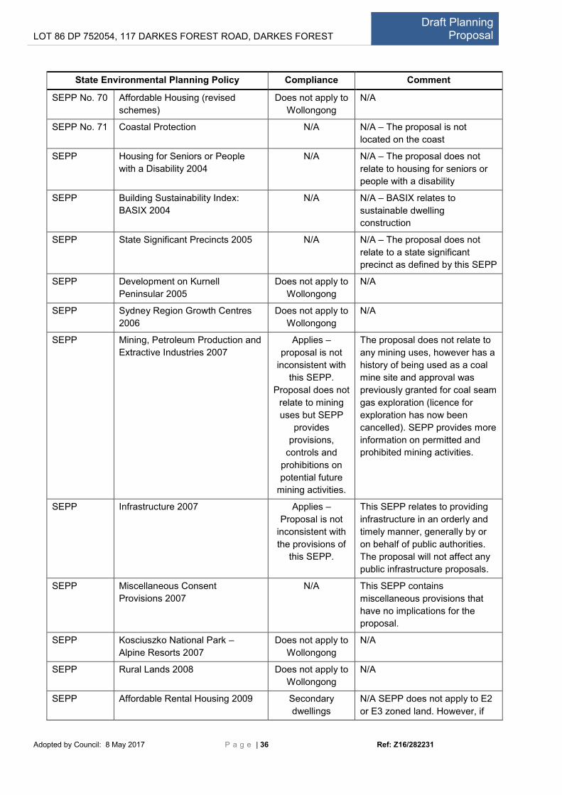
LOT 86 DP 752054, 117 DARKES FOREST ROAD, DARKES FOREST Draft Planning
Proposal
Adopted by Council: 8 May 2017 P a g e | 36 Ref: Z16/282231
State Environmental Planning Policy Compliance Comment
SEPP No. 70 Affordable Housing (revised
schemes)
Does not apply to
Wollongong
N/A
SEPP No. 71 Coastal Protection N/A N/A – The proposal is not
located on the coast
SEPP Housing for Seniors or People
with a Disability 2004
N/A N/A – The proposal does not
relate to housing for seniors or
people with a disability
SEPP Building Sustainability Index:
BASIX 2004
N/A N/A – BASIX relates to
sustainable dwelling
construction
SEPP State Significant Precincts 2005 N/A N/A – The proposal does not
relate to a state significant
precinct as defined by this SEPP
SEPP Development on Kurnell
Peninsular 2005
Does not apply to
Wollongong
N/A
SEPP Sydney Region Growth Centres
2006
Does not apply to
Wollongong
N/A
SEPP Mining, Petroleum Production and
Extractive Industries 2007
Applies –
proposal is not
inconsistent with
this SEPP.
Proposal does not
relate to mining
uses but SEPP
provides
provisions,
controls and
prohibitions on
potential future
mining activities.
The proposal does not relate to
any mining uses, however has a
history of being used as a coal
mine site and approval was
previously granted for coal seam
gas exploration (licence for
exploration has now been
cancelled). SEPP provides more
information on permitted and
prohibited mining activities.
SEPP Infrastructure 2007 Applies –
Proposal is not
inconsistent with
the provisions of
this SEPP.
This SEPP relates to providing
infrastructure in an orderly and
timely manner, generally by or
on behalf of public authorities.
The proposal will not affect any
public infrastructure proposals.
SEPP Miscellaneous Consent
Provisions 2007
N/A This SEPP contains
miscellaneous provisions that
have no implications for the
proposal.
SEPP Kosciuszko National Park –
Alpine Resorts 2007
Does not apply to
Wollongong
N/A
SEPP Rural Lands 2008 Does not apply to
Wollongong
N/A
SEPP Affordable Rental Housing 2009 Secondary
dwellings
N/A SEPP does not apply to E2
or E3 zoned land. However, if

LOT 86 DP 752054, 117 DARKES FOREST ROAD, DARKES FOREST Draft Planning
Proposal
Adopted by Council: 8 May 2017 P a g e | 37 Ref: Z16/282231
State Environmental Planning Policy Compliance Comment
E3 zoning is applied to the
portion of the lot containing the
dwelling, a secondary dwelling
would be permissible under
WLEP.
SEPP Western Sydney Employment
Lands 2009
Does not apply to
Wollongong
N/A
SEPP Exempt and Complying
Development Codes 2008
N/A N/A – the proposal will not
permit any exempt or complying
development as it is located
within environmental zones.
SEPP Western Sydney Parklands 2009 Does not apply to
Wollongong
SEPP Penrith Lakes Scheme 1989 Does not apply to
Wollongong
N/A
SEPP State and Regional Development
2011
N/A N/A – The proposal does not
relate to any state or regionally
significant development as
defined by this SEPP.
SEPP Sydney Drinking Water
Catchment 2011
Applies – Further
information is
necessary to
ascertain impacts
on catchment
The proposal relates to land in
the Sydney Drinking Water
Catchment. Further information
is required regarding wastewater
treatment and disposal to
ascertain impacts on the
catchment.
SEPP Three Ports 2013 N/A N/A – The proposal does not
relate to Port lands.
SEPP Urban Renewal 2010 N/A N/A The proposal does not
relate to urban renewal
precincts.
SEPP Integration and Repeals N/A N/A – This SEPP details policies
repealed in 2016
Deemed SEPPS( former Regional Plans)
Greater
Metropolitan
REP No.2
Georges River catchment Applies – Further
information is
necessary to
ascertain impacts
on Georges River
Catchment
The proposal relates to land in
the Georges River Water
Catchment. Further information
is required regarding wastewater
treatment and disposal to
ascertain impacts on the
catchment.

LOT 86 DP 752054, 117 DARKES FOREST ROAD, DARKES FOREST Draft Planning
Proposal
Adopted by Council: 8 May 2017 P a g e | 38 Ref: Z16/282231
Table B - Checklist of Section 117 Ministerial Directions
Ministerial Direction Comment
1. Employment and Resources
1.1 Business and Industrial Zones N/A – Proposal does not relate to business or industrial zone
changes
1.2 Rural Zones N/A – Proposal does not relate to any rural zoning changes
1.3 Mining, Petroleum Production
and Extractive Industries
Consistent – the site was formerly used as a coal mine. An
application for extension of time for gas exploration under Part
3A was refused by the State Government on 10/7/2013. The
proposal will utilise existing infrastructure within the existing
development footprint and is not expected to unduly
compromise any future mining activities.
1.4 Oyster Aquaculture N/A – not proposed
1.5 Rural Lands N/A – Rural Lands SEPP does not apply to Wollongong
2. Environment and Heritage
2.1 Environment Protection Zone The proposal is to apply an E3 zoning to strategically located
pockets within the E2 zoned land to allow for compatible uses
within existing development footprints. Any development
occurring within the proposed E3 pockets will need to
demonstrate its ability to meet stringent environmental
protection standards relating to water quality, EECs and
biodiversity in general, at the DA stage.
2.2 Coastal Protection N/A – The proposal is not located in the coastal zone.
2.3 Heritage Conservation Consistent – no known items, objects or places. Before any
site disturbance is permitted, a due diligence assessment will
be undertaken.
2.4 Recreation Vehicle Areas N/A –not proposed
2.5 Application of E2 and E3 Zones and
Environmental Overlays in Far North
Coast LEPs
N/A to Wollongong
3. Housing, Infrastructure and Urban Development
3.1 Residential Zones N/A – The proposal does not relate to residential zones.
3.2 Caravan Parks and
Manufactured Home Estates
N/A – not proposed
3.3 Home Occupations Consistent – no change proposed.
3.4 Integrating Land Use and
Transport
N/A – the proposal does not relate to urban development.
3.5 Development Near Licensed
Aerodromes
N/A – the proposal is not located near a licensed aerodrome.
3.6 Shooting Ranges N/A – The proposal does not impact planning provisions
relating to shooting ranges.
4. Hazard and Risk
4.1 Acid Sulfate Soils N/A – The site does not contain Acid Sulfate Soils.

LOT 86 DP 752054, 117 DARKES FOREST ROAD, DARKES FOREST Draft Planning
Proposal
Adopted by Council: 8 May 2017 P a g e | 39 Ref: Z16/282231
4.2 Mine Subsidence and Unstable
Land
N/A – The land is not part of the mine subsistence district or
mapped as unstable.
4.3 Flood Prone Land Consistent – The site is notated as flood-affected but is located
in the upper catchment and the proposal will not significantly
increase flood-related risks.
4.4 Planning for Bushfire Protection Further assessment and consultation with the Rural Fire
Service is required should a Gateway Determination be issued.
5. Regional Planning
5.1 Implementation of Regional
Strategies
Consistent – The proposal is consistent with the Illawarra-
Shoalhaven Regional Plan in that it will support tourism - a
priority growth sector. Further studies will be completed to
ensure that the proposal protects the Sydney Drinking Water
Catchment and the ecological values of the subject land.
5.2 Sydney Drinking Water
Catchments
Further information is required to assess the impact on water
quality and capability in the drinking water catchment as a
result of the proposal.
5.3 Farmland of State and Regional
Significance on the NSW Far North
Coast
N/A to Wollongong
5.4 Commercial and Retail
Development along the Pacific Highway,
North Coast
N/A to Wollongong
5.8 Second Sydney Airport:
Badgerys Creek
N/A to Wollongong
5.9 North West Rail Link Corridor
Strategy
N/A to Wollongong
5.10 Implementation of Regional Plans Consistent – The proposal is consistent with the Illawarra
Shoalhaven Regional Plan.
6. Local Plan Making
6.1 Approval and Referral
Requirements
Consistent – The proposal does not relate to designated
development and does not contain additional concurrence
provisions.
6.2 Reserving Land for Public
Purposes
N/A – The proposal does relate to any public land
6.3 Site Specific Provisions Consistent – the proposal contains site specific provisions but
does not impose any additional development standards or
requirements than otherwise specified in WLEP 2009, thereby
complying with cl.4(c).
7. Metropolitan Planning
7.1 Implementation of A Plan for
Growing Sydney
N/A to Wollongong
7.2 Implementation of Greater
Macarthur Land Release Investigation
N/A to Wollongong
7.3 Parramatta Road Corridor
Urban Transformation Strategy
N/A to Wollongong

LOT 86 DP 752054, 117 DARKES FOREST ROAD, DARKES FOREST Draft Planning
Proposal
Adopted by Council: 8 May 2017 P a g e | 40 Ref: Z16/282231