Embed Size (px)
Citation preview
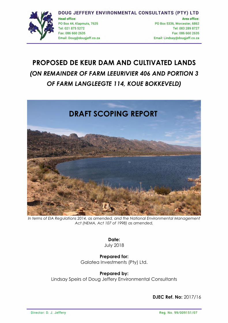
PROPOSED DE KEUR DAM AND CULTIVATED LANDS
(ON REMAINDER OF FARM LEEURIVIER 406 AND PORTION 3
OF FARM LANGLEEGTE 114, KOUE BOKKEVELD)
In terms of EIA Regulations 2014, as amended, and the National Environmental Management
Act (NEMA, Act 107 of 1998) as amended,
Date:
July 2018
Prepared for:
Galatea Investments (Pty) Ltd.
Prepared by:
Lindsay Speirs of Doug Jeffery Environmental Consultants
DJEC Ref. No: 2017/16
DRAFT SCOPING REPORT
1 DRAFT SCOPING REPORT
Doug Jeffery Environmental Consultants (Pty) Ltd. De Keur Dam and Cultivation Lands. July 2018 Reference Number: 2017/16
PROJECT DETAILS
TITLE: Proposed De Keur Dam and Cultivated Lands PROCESS: Full Scoping/EIA Process REPORT: Scoping Report, including Plan of Study for EIA REPORT DATE: May 2018 APPLICANT: K2017 4142 42 (South Africa) Pty Ltd. APPOINTED EAP: Doug Jeffery Environmental Consultants DJEC REF: 2017/16 DEA&DP PRE-APP REF: 16/3/3/6/7/1/B5/2/1051/18 REPORT COMPILED BY: Lindsay Speirs REPORT REVIEWED BY: Doug Jeffery
Doug Jeffery Environmental Consultants (Pty) Ltd.
PO Box 44, Klapmuts, 7625 Tel: 021 875 5271 Fax: 086 660 2635
Report compiled by Lindsay Speirs
BA, BA (Hons) and MA [Stellenbosch]. Lindsay has over 13 years of experience in undertaking Environmental Assessments.
The curriculum vitae of the EAP and an oath undertaken by the EAP are attached as Appendix 1.
Report reviewed by Doug Jeffery BSc; BSc (Hons); MSc [UCT]. Professional Natural Scientist registered with SACNASP (159/90); certified Environmental Practitioner with EAPSA; and member of IAIA. Doug has over 30 years of
experience in undertaking Environmental Assessments.
2 DRAFT SCOPING REPORT
Doug Jeffery Environmental Consultants (Pty) Ltd. De Keur Dam and Cultivation Lands. July 2018 Reference Number: 2017/16
EXECUTIVE SUMMARY
INTRODUCTION This application relates to the proposed clearing of natural vegetation for the purposes of cultivation, a new farm dam, and a new pipeline. The proposed activities are located on Remainder of Farm Leeurivier 406 and Portion 3 of Farm Langleegte 114 in the Koue Bokkeveld. Doug Jeffery Environmental Consultants (DJEC) has been appointed by K2017 4142 42 (South Africa) Pty
Ltd, hereafter referred to as the Applicant, as the independent Environmental Assessment Practitioner EAP, to facilitate the Scoping/Environmental Impact Assessment Process required in terms of the National Environmental Management Act (NEMA, Act 107 of 1998) for this application. The properties in question are owned by De Keur Landgoed (Pty) Ltd. PROPOSAL DAM A new dam is proposed on the Farm Leeurivier in order to increase the volume of water allocated to the farm, by 1 million m³. The proposed dam is located within the Wolwe River tributary, approximately 850m downstream of the existing Leeurivier Dam. The proposed dam would have a wall height of 21m, a capacity of 1 000 000m³ and a Full Supply Level (FSL) surface area of 20 hectares. The dam will have an uncontrolled open channel spillway on the right flank. It is estimated to be excavated 3 m deep and the bottom to be 20 m wide and side slopes 1V:1.5H, lined with rip-rap protection. Outlet works is proposed to consist of a 450 OD HDPE PE100 PN6 pipe encased in reinforced concrete, with a scour and outlet valve at the downstream end and a floating sieve inlet on the upstream end (sizes to be confirmed during detail design). The dam will also consist of monitoring instruments like water level gauges on upstream face and settlement beacons on crest at 100 m intervals. PROPOSED LANDS FOR CULTIVATION The intention is to increase the agricultural production on the farm by clearing additional lands for cultivation purposes. Six areas measuring 77ha in total were investigated for potential clearing of which only 22ha (i.e. Areas 5 and 6) were deemed suitable from an ecological perspective. Roughly 6ha of Area 5 consists of old farmed lands, the remaining is natural vegetation. PROPOSED PIPELINE A new pipeline is proposed which will enable water to be pumped from the dam to higher lying cultivated lands on the farm. The pipeline will have a length of 2.4km and will for most of its route follow existing farm roads. The pipeline will pass through a wetland area at one point.
3 DRAFT SCOPING REPORT
Doug Jeffery Environmental Consultants (Pty) Ltd. De Keur Dam and Cultivation Lands. July 2018 Reference Number: 2017/16
SITE DESCRIPTION The Leeurivier Farm is located within the Koue-Bokkeveld region, north of Ceres. The farm produces onions, nectarines, pears, plums and peaches. The two primary rivers which drain the Koue Bokkeveld are the Groot and the Riet Rivers. These are major tributaries of the Doring River, a tributary of the Olifants River. There is an existing dam on the farm that is currently used for irrigation purposes. The freshwater features at the site consist of the Leeu River, Wolwe River, the Lang River and a number of drainage lines. There are three primary vegetation types found in the study area - Cederberg Sandstone Fynbos (Vunerable), Kouebokkeveld Shale Fynbos (Vunerable) and Kouebokkeveld Alluvium Fynbos (Endangered). ENVIRONMENTAL REQUIREMENTS The National Environmental Management Act (107 of 1998) as amended, and the Environmental Impact Assessment Regulations (2014) as amended, govern the process of applying for environmental authorisation for certain developments. Lists of activities which require environmental authorisation are published in three listing notices (GNR 324, 325, and 327 of April 2017). Provision in the EIA Regulations is made for two forms of assessment: Basic Assessment and Scoping and EIA. The EIA regulations specify that:
• Activities identified in Listing Notice 1 (GNR 327 of 2017I requires Basic Assessment • Activities identified in Listing Notice 2 (GNR 325 of 2017) are subject to a Scoping and EIA • Activities identified in Listing Notice 3 (GNR 324 of 2017) requires Basic Assessment
Where activities have been identified in Listing Notice 2, Scoping and EIA must be undertaken. This application will follow a Scoping/EIA Process. The listed activities associated with the proposed development are listed below. Listing Notice 1: 19: The infilling or depositing of any material of more than 10 cubic metres into, or the dredging, excavation, removal or moving of soil, sand, shells, shell grit, pebbles or rock of more than 10 cubic metres from a watercourse; but excluding where such infilling, depositing , dredging, excavation, removal or moving – (a) will occur behind a development setback; (b) is for maintenance purposes undertaken in accordance with a maintenance management plan; (c) falls within the ambit of activity 21 in this Notice, in which case that activity applies; (d) occurs within existing ports or harbours that will not increase the development footprint of the port or
harbour; or (e) where such development is related to the development of a port or harbour, in which case activity 26 in
Listing Notice 2 of 2014 applies.
4 DRAFT SCOPING REPORT
Doug Jeffery Environmental Consultants (Pty) Ltd. De Keur Dam and Cultivation Lands. July 2018 Reference Number: 2017/16
Listing Notice 2: 15: The clearance of an area of 20 hectares or more of indigenous vegetation, excluding where such clearance of indigenous vegetation is required for-
(i) the undertaking of a linear activity; or (ii) maintenance purposes undertaken in accordance with a maintenance management plan.
16: The development of a dam where the highest part of the dam wall, as measured from the outside toe of the wall to the highest part of the wall, is 5 metres or higher or where the high water mark of the dam covers an area of 10 hectares or more.
SINCE ACTIVITY 15 AND 16 OF LISTING NOTICE 2 IS TRIGGERED, A SCOPING/EIA PROCESS WILL BE FOLLOWED.
PUBLIC PARTICIPATION PROCESS Tasks to be undertaken in the Scoping Phase
Scoping Phase Interested and Affected Parties (I&APs) have been identified throughout the process. Initial identification of I&APs include immediate landowners, ward councillor, farmers association, local and district municipalities and relevant state departments and organs of state. Notification letters will be posted to all identified I&APs informing them of the proposal, the opportunity to comment and the availability of the Scoping Report. The applicant will be requested to place A3 notices at ‘gathering points’ on the relevant farms in order to notify occupiers of the site, i.e. farm workers. Neighbouring landowners will be requested to inform all those residing on their farms of the application and the opportunity to comment. A site notice measuring 60cmX42cm will be set up at the entrance to the farm. An advertisement will be placed in the Witzenberg Herald. A copy of the Scoping Report will be lodged at the local library and on our company website. Copies of the report will be delivered to relevant State Departments and Organs of State. Their comment will be requested in terms of 24O of NEMA. All comments received during this commenting period will be included in the Final Scoping Report before submission to DEA&DP. A Comments and Response Table will also be included – this table summarises the comments received and each comment is responded to. Tasks to be undertaken in the EIA Phase
EIA Phase Receive approval for the Scoping Report and the Plan of Study for EIA. Compile Draft Environmental Impact Report (EIR) for public comment based on specialist information.
5 DRAFT SCOPING REPORT
Doug Jeffery Environmental Consultants (Pty) Ltd. De Keur Dam and Cultivation Lands. July 2018 Reference Number: 2017/16
Submit copies of the Draft EIR to DEA&DP and relevant State Departments and Organs of State and notify them of the commenting period (in terms of Section 24O of NEMA). Notify Registered I&APs of the opportunity to comment on the EIR. Make the EIR available for a 60-day commenting period. Receive comments on the EIR. Preparation of a EIR for submission to DEA&DP including proof of the Public Participation Process, comments received and our responses to these comments. SPECIALIST STUDIES The following specialist studies were undertaken:
Botanical Assessment Freshwater Assessment Soil Survey Environmental Management Programme (EMP)
CONCLUSION This scoping exercise is currently being undertaken to present concept proposals to the public and potential Interested & Affected Parties (I&APs) and to identify environmental issues and concerns raised as a result of the proposed layout alternatives to date. This will allow I&APs, authorities, the project team, as well as specialists to provide input and raise issues and concerns, based on specialist studies undertaken. The four target site areas were analysed and assessed from a freshwater and botanical perspective. In addition, this Scoping Report summarises the process to date, reports on the findings of relevant studies.
6 DRAFT SCOPING REPORT
Doug Jeffery Environmental Consultants (Pty) Ltd. De Keur Dam and Cultivation Lands. July 2018 Reference Number: 2017/16
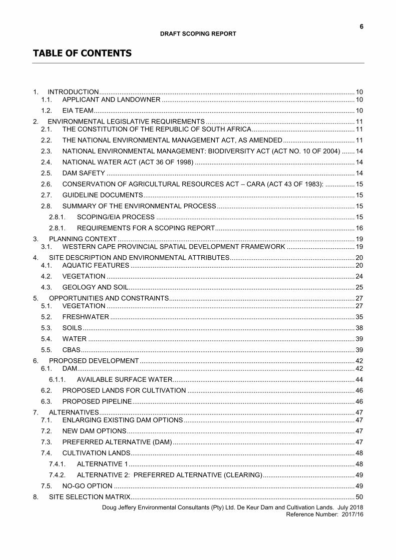
TABLE OF CONTENTS
1. INTRODUCTION ........................................................................................................................................... 10
1.1. APPLICANT AND LANDOWNER ......................................................................................................... 10 1.2. EIA TEAM .............................................................................................................................................. 10
2. ENVIRONMENTAL LEGISLATIVE REQUIREMENTS ................................................................................. 11 2.1. THE CONSTITUTION OF THE REPUBLIC OF SOUTH AFRICA ........................................................ 11 2.2. THE NATIONAL ENVIRONMENTAL MANAGEMENT ACT, AS AMENDED ....................................... 11 2.3. NATIONAL ENVIRONMENTAL MANAGEMENT: BIODIVERSITY ACT (ACT NO. 10 OF 2004) ....... 14 2.4. NATIONAL WATER ACT (ACT 36 OF 1998) ....................................................................................... 14 2.5. DAM SAFETY ....................................................................................................................................... 14 2.6. CONSERVATION OF AGRICULTURAL RESOURCES ACT – CARA (ACT 43 OF 1983): ................ 15 2.7. GUIDELINE DOCUMENTS ................................................................................................................... 15 2.8. SUMMARY OF THE ENVIRONMENTAL PROCESS ........................................................................... 15
2.8.1. SCOPING/EIA PROCESS ............................................................................................................ 15 2.8.1. REQUIREMENTS FOR A SCOPING REPORT............................................................................ 16
3. PLANNING CONTEXT ................................................................................................................................. 19 3.1. WESTERN CAPE PROVINCIAL SPATIAL DEVELOPMENT FRAMEWORK ..................................... 19
4. SITE DESCRIPTION AND ENVIRONMENTAL ATTRIBUTES .................................................................... 20 4.1. AQUATIC FEATURES .......................................................................................................................... 20 4.2. VEGETATION ....................................................................................................................................... 24 4.3. GEOLOGY AND SOIL........................................................................................................................... 25
5. OPPORTUNITIES AND CONSTRAINTS ..................................................................................................... 27 5.1. VEGETATION ....................................................................................................................................... 27 5.2. FRESHWATER ..................................................................................................................................... 35 5.3. SOILS .................................................................................................................................................... 38 5.4. WATER ................................................................................................................................................. 39 5.5. CBAS ..................................................................................................................................................... 39
6. PROPOSED DEVELOPMENT ..................................................................................................................... 42 6.1. DAM....................................................................................................................................................... 42
6.1.1. AVAILABLE SURFACE WATER ................................................................................................... 44 6.2. PROPOSED LANDS FOR CULTIVATION ........................................................................................... 46 6.3. PROPOSED PIPELINE ......................................................................................................................... 46
7. ALTERNATIVES ........................................................................................................................................... 47 7.1. ENLARGING EXISTING DAM OPTIONS ............................................................................................. 47 7.2. NEW DAM OPTIONS ............................................................................................................................ 47
7.3. PREFERRED ALTERNATIVE (DAM) ................................................................................................... 47 7.4. CULTIVATION LANDS.......................................................................................................................... 48
7.4.1. ALTERNATIVE 1 ........................................................................................................................... 48 7.4.2. ALTERNATIVE 2: PREFERRED ALTERNATIVE (CLEARING) .................................................. 49
7.5. NO-GO OPTION ................................................................................................................................... 49 8. SITE SELECTION MATRIX.......................................................................................................................... 50
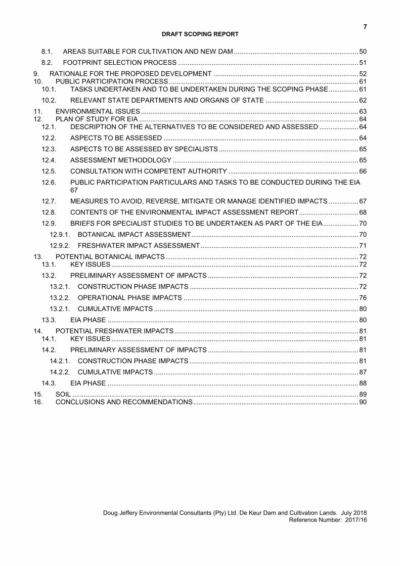
7 DRAFT SCOPING REPORT
Doug Jeffery Environmental Consultants (Pty) Ltd. De Keur Dam and Cultivation Lands. July 2018 Reference Number: 2017/16
8.1. AREAS SUITABLE FOR CULTIVATION AND NEW DAM ................................................................... 50 8.2. FOOTPRINT SELECTION PROCESS ................................................................................................. 51
9. RATIONALE FOR THE PROPOSED DEVELOPMENT .............................................................................. 52 10. PUBLIC PARTICIPATION PROCESS ...................................................................................................... 61
10.1. TASKS UNDERTAKEN AND TO BE UNDERTAKEN DURING THE SCOPING PHASE ................ 61 10.2. RELEVANT STATE DEPARTMENTS AND ORGANS OF STATE .................................................. 62
11. ENVIRONMENTAL ISSUES ..................................................................................................................... 63 12. PLAN OF STUDY FOR EIA ...................................................................................................................... 64
12.1. DESCRIPTION OF THE ALTERNATIVES TO BE CONSIDERED AND ASSESSED ..................... 64 12.2. ASPECTS TO BE ASSESSED ......................................................................................................... 64 12.3. ASPECTS TO BE ASSESSED BY SPECIALISTS ........................................................................... 65 12.4. ASSESSMENT METHODOLOGY .................................................................................................... 65 12.5. CONSULTATION WITH COMPETENT AUTHORITY ...................................................................... 66 12.6. PUBLIC PARTICIPATION PARTICULARS AND TASKS TO BE CONDUCTED DURING THE EIA 67 12.7. MEASURES TO AVOID, REVERSE, MITIGATE OR MANAGE IDENTIFIED IMPACTS ................ 67 12.8. CONTENTS OF THE ENVIRONMENTAL IMPACT ASSESSMENT REPORT ................................ 68 12.9. BRIEFS FOR SPECIALIST STUDIES TO BE UNDERTAKEN AS PART OF THE EIA ................... 70
12.9.1. BOTANICAL IMPACT ASSESSMENT .......................................................................................... 70 12.9.2. FRESHWATER IMPACT ASSESSMENT ..................................................................................... 71
13. POTENTIAL BOTANICAL IMPACTS ........................................................................................................ 72 13.1. KEY ISSUES ..................................................................................................................................... 72 13.2. PRELIMINARY ASSESSMENT OF IMPACTS ................................................................................. 72
13.2.1. CONSTRUCTION PHASE IMPACTS ........................................................................................... 72 13.2.2. OPERATIONAL PHASE IMPACTS .............................................................................................. 76 13.2.1. CUMULATIVE IMPACTS .............................................................................................................. 80
13.3. EIA PHASE ....................................................................................................................................... 80 14. POTENTIAL FRESHWATER IMPACTS ................................................................................................... 81
14.1. KEY ISSUES ..................................................................................................................................... 81 14.2. PRELIMINARY ASSESSMENT OF IMPACTS ................................................................................. 81
14.2.1. CONSTRUCTION PHASE IMPACTS ........................................................................................... 81 14.2.2. CUMULATIVE IMPACTS .............................................................................................................. 87
14.3. EIA PHASE ....................................................................................................................................... 88 15. SOIL .......................................................................................................................................................... 89 16. CONCLUSIONS AND RECOMMENDATIONS ......................................................................................... 90
8 DRAFT SCOPING REPORT
Doug Jeffery Environmental Consultants (Pty) Ltd. De Keur Dam and Cultivation Lands. July 2018 Reference Number: 2017/16
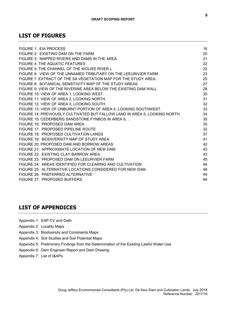
LIST OF FIGURES
FIGURE 1: EIA PROCESS 16 FIGURE 2: EXISTING DAM ON THE FARM 20 FIGURE 3: MAPPED RIVERS AND DAMS IN THE AREA 21 FIGURE 4: THE AQUATIC FEATURES 22 FIGURE 5: THE CHANNEL OF THE WOLWE RIVER L 22 FIGURE 6: VIEW OF THE UNNAMED TRIBUTARY ON THE LEEURIVIER FARM 23 FIGURE 7: EXTRACT OF THE SA VEGETATION MAP FOR THE STUDY AREA. 25 FIGURE 8: BOTANICAL SENSITIVITY MAP OF THE STUDY AREAS. 27 FIGURE 9: VIEW OF THE RIVERINE AREA BELOW THE EXISTING DAM WALL 28 FIGURE 10: VIEW OF AREA 1, LOOKING WEST. 30 FIGURE 11: VIEW OF AREA 2, LOOKING NORTH. 31 FIGURE 12: VIEW OF AREA 3, LOOKING SOUTH. 32 FIGURE 13: VIEW OF UNBURNT PORTION OF AREA 4, LOOKING SOUTHWEST. 33 FIGURE 14: PREVIOUSLY CULTIVATED BUT FALLOW LAND IN AREA 5, LOOKING NORTH. 34 FIGURE 15: CEDERBERG SANDSTONE FYNBOS IN AREA 6. . 35 FIGURE 16: PROPOSED DAM AREA 35 FIGURE 17: PROPOSED PIPELINE ROUTE 32 FIGURE 18: PROPOSED CULTIVATION LANDS 37 FIGURE 19: BIODIVERSITY MAP OF STUDY AREA 41 FIGURE 20: PROPOSED DAM AND BORROW AREAS 42 FIGURE 21: APPROXIMATE LOCATION OF NEW DAM. 43 FIGURE 22: EXISTING CLAY BARROW AREA. 43 FIGURE 23: PROPOSED DAM ON LEEURVIER FARM 45 FIGURE 24: AREAS IDENTIFIED FOR CLEARING AND CULTIVATION 46 FIGURE 25: ALTERNATIVE LOCATIONS CONSIDERED FOR NEW DAM. 48 FIGURE 26: PREFERRED ALTERNATIVE 49 FIGURE 27: PROPOSED BUFFERS 84
LIST OF APPENDICES
Appendix 1: EAP CV and Oath Appendix 2: Locality Maps Appendix 3: Biodiversity and Constraints Maps Appendix 4: Soil Studies and Soil Potential Maps Appendix 5: Preliminary Findings from the Determination of the Existing Lawful Water Use Appendix 6: Dam Engineer Report and Dam Drawing Appendix 7: List of I&APs
9 DRAFT SCOPING REPORT
Doug Jeffery Environmental Consultants (Pty) Ltd. De Keur Dam and Cultivation Lands. July 2018 Reference Number: 2017/16
GLOSSARY
CARA Conservation of Agricultural Resources Act CBA Critical Biodiversity Area CoCT City of Cape Town CML Coastal Management Line DEA&DP Department of Environmental Affairs and Development Planning DJEC Doug Jeffery Environmental Consultants DWS Department of Water and Sanitation EIA Environmental Impact Assessment EIR Environmental Impact Report EMPr Environmental Management Programme EWR Environmental Water Requirement FSL Full Supply Level GN Government Notice I&APs Interested and Affected Parties IEM Integrated Environmental Management LMA Local Municipal Area NEMA National Environmental Management Act NEMBA National Environmental Management: Biodiversity Act NFEPA National Freshwater Ecosystem Priority Area NHRA National Heritage Resources Act NWA National Water Act PPP Public Participation Process OEMP Operational Environmental Management Plan OESA Other Ecological Support Area SAHRA South African Heritage Resources Agency
10 DRAFT SCOPING REPORT
Doug Jeffery Environmental Consultants (Pty) Ltd. De Keur Dam and Cultivation Lands. July 2018 Reference Number: 2017/16
1. INTRODUCTION
This application relates to the proposed clearing of natural vegetation for the purposes of cultivation, a new farm dam, and a new pipeline. The site is located in the northern Koue Bokkeveld, about 70km north of Ceres (refer to Appendix 2 for Locality Maps). The closest urban development is located approximately 18km to the south, at Op-die-Berg and Citrusdal is located approximately 43km to the northwest of the site. 6 areas were investigated for potential clearing and cultivation, a total of 77ha. However, of the 6 areas, only 2 areas are considered suitable from a botanical perspective, measuring approximately 22ha in total of which 15.75ha consists of natural vegetation. The proposed dam development footprint is roughly 20ha in extent. The properties involved include Remainder of Farm Leeurivier 406 (C01900000000040600000), Portion 3 of Langleegte 114 (C01900000000011400003), Wolwerivier 115 (C01900000000011500000) and Portion 7 of Langerivier 120 (C01900000000012000007). The total extent of the four properties is 2748ha. The proposed dam, pipeline and the two areas identified for cultivation are located on Remainder of Farm Leeurivier 406 and Portion 3 of Farm Langleegte 114.
1.1. APPLICANT AND LANDOWNER
Doug Jeffery Environmental Consultants (DJEC) has been appointed by K2017 4142 42 (South Africa) Pty
Ltd, hereafter referred to as the Applicant, as the independent Environmental Assessment Practitioner EAP, to facilitate the Scoping/Environmental Impact Assessment Process required in terms of the National Environmental Management Act (NEMA, Act 107 of 1998) for this application. The properties in question are owned by De Keur Landgoed (Pty) Ltd. There has been no particular brief given to the Environmental Assessment Practioner (EAP) by the proponent to undertake this study. However, the scope of the study has been determined with reference to the requirements of the relevant legislation, namely the NEMA EIA Regulations, 2014 (as amended). 1.2. EIA TEAM
Specialist Field Name Organisation Project Manager/Water Use License Gerhard Nel Agrifusion
Environmental Assessment Practioner
Lindsay Speirs and Doug Jeffery
Doug Jeffery Environmental Consultants
Botanist Nick Helme Nick Helme Botanical Surveys
Freshwater Ecologist Toni Belcher BlueScience
Dam Engineer DJ Hagen Ingerop
Soil Scientist R.H. van der Merwe; L.P. Reynolds
Fruitful Crop Advice
11 DRAFT SCOPING REPORT
Doug Jeffery Environmental Consultants (Pty) Ltd. De Keur Dam and Cultivation Lands. July 2018 Reference Number: 2017/16
2. ENVIRONMENTAL LEGISLATIVE REQUIREMENTS
The legislation that is relevant to this study is briefly outlined below. These environmental requirements are not intended to be definitive or exhaustive but serve to highlight key environmental legislation and responsibilities only.
There are a number of Acts which form part of a suite of legislation called Specific Environmental Management Acts (SEMAs) that fall under the National Environmental Management Act, as amended. The following SEMAs are also relevant to this application and will regulate the proposed development:
The National Environmental Management: Biodiversity Act, 2004 (Act No. 10 of 2004) (NEMBA) National Water Act (Act 36 of 1998) (NWA) The National Heritage Resources Act (Act 25 of 1999) (NHRA)
2.1. THE CONSTITUTION OF THE REPUBLIC OF SOUTH AFRICA The Constitution of the Republic of South Africa states that everyone has a right: (a) To an environment that is not harmful to their health or well-being; and (b) To have the environment protected, for the benefit of present and future generations, through reasonable legislative and other measures that –
(i) prevent pollution and ecological degradation; (ii) promote conservation; and (iii) secure ecologically sustainable development and use of natural resources while promoting justifiable economic and social development.
2.2. THE NATIONAL ENVIRONMENTAL MANAGEMENT ACT, AS AMENDED The National Environmental Management Act, 1998 (Act No. 107 of 1998) (NEMA) makes provision for the identification and assessment of activities that are potentially detrimental to the environment and which require authorisation from the relevant authorities based on the findings of an environmental assessment. NEMA is a national act, which is enforced by the Department of Environmental Affairs (DEA). These powers are often delegated to the Department of Environmental Affairs and Development Planning (DEA&DP) in the Western Cape. The National Environmental Management Act (107 of 1998) as amended, and the Environmental Impact Assessment Regulations (2014) as amended, govern the process of applying for environmental authorisation for certain developments. Lists of activities which require environmental authorisation are published in three listing notices (GNR 324, 325, and 327 of April 2017). Provision in the EIA Regulations is made for two forms of assessment: Basic Assessment and Scoping and EIA. The EIA regulations specify that:
• Activities identified in Listing Notice 1 (GNR 327 of 2017I requires Basic Assessment • Activities identified in Listing Notice 2 (GNR 325 of 2017) are subject to a Scoping and EIA • Activities identified in Listing Notice 3 (GNR 324 of 2017) requires Basic Assessment
12 DRAFT SCOPING REPORT
Doug Jeffery Environmental Consultants (Pty) Ltd. De Keur Dam and Cultivation Lands. July 2018 Reference Number: 2017/16
Where activities have been identified in Listing Notice 2, Scoping and EIA must be undertaken. This application will follow a Scoping/EIA Process. The listed activities associated with the proposed development are listed below. Listing Notice 1: 19: The infilling or depositing of any material of more than 10 cubic metres into, or the dredging, excavation, removal or moving of soil, sand, shells, shell grit, pebbles or rock of more than 10 cubic metres from a watercourse; but excluding where such infilling, depositing , dredging, excavation, removal or moving – (a) will occur behind a development setback; (b) is for maintenance purposes undertaken in accordance with a maintenance management plan; (c) falls within the ambit of activity 21 in this Notice, in which case that activity applies; (d) occurs within existing ports or harbours that will not increase the development footprint of the port or harbour; or (e) where such development is related to the development of a port or harbour, in which case activity 26 in Listing Notice 2
of 2014 applies.
More than 10 cubes of material will be moved within the river on site in order to construct the proposed dam. In addition, the water pipeline from the dam to the new cultivated lands will cross a small stream on site.
Listing Notice 2: 15: The clearance of an area of 20 hectares or more of indigenous vegetation, excluding where such clearance of indigenous vegetation is required for-
i. the undertaking of a linear activity; or ii. maintenance purposes undertaken in accordance with a maintenance management plan.
Approximately 16ha of natural vegetation will be cleared for cultivation purposes and an additional 13ha of land will be cleared for the purpose of the new dam.
16: The development of a dam where the highest part of the dam wall, as measured from the outside toe of the wall to the highest part of the wall, is 5 metres or higher or where the high water mark of the dam covers an area of 10 hectares or more.
The new dam will be an instream dam with a wall height of more than 5m and the area of the dam will be more than 10ha in area.
SINCE ACTIVITY 15 AND 16 OF LISTING NOTICE 2 IS TRIGGERED, A SCOPING/EIA PROCESS WILL BE FOLLOWED. The purpose of Section 23 of NEMA is to promote the application of appropriate environmental management tools in order to ensure the integrated environmental management of activities. The general objectives were taken into account by doing the following:
13 DRAFT SCOPING REPORT
Doug Jeffery Environmental Consultants (Pty) Ltd. De Keur Dam and Cultivation Lands. July 2018 Reference Number: 2017/16
A Botanist was appointed to assess the significance of the vegetation on the site and the impact of clearing
the vegetation for cultivation purposes and for the proposed dam. A Freshwater Specialist was appointed to assess the impact the proposed dam will have on the
watercourses within the region, the impact of the proposed water pipe through the stream on the farm and the impact of clearing vegetation for cultivation purposes on any aquatic systems on the property.
All significant impacts on the environment and the community was considered and discussed in this application. Where impacts could not be avoided, mitigation measures have been proposed to reduce the impact to acceptable limits. It is the opinion of the EAP that all impacts are within acceptable limits.
An Environmental Management Programme will be compiled to ensure are clearing and construction is done according to best environmental management practices.
A public participation process (PPP) will be undertaken as per the EIA Regulations 2014, as amended and DEA&DP’s Guidelines on PPP which allows sufficient opportunity for public consultation. An advertisement will be placed in a newspaper, informing members of the public of the application and available information. Details on how members of the public can register as interested and affected parties (I&APs) or comment on the application will be included. Other stakeholders (ward councillor, local authorities, adjacent landowners, organs of state, state departments, etc.) have been identified and will be notified of the process. A site notice will also be placed on site.
Section 2 of the NEMA provides principles of environmental management to serve as a framework for environmental management implementation and decision making. The main and applicable principles of environmental management as set out in Section 2 of NEMA emphasize the following:
Environmental management placing people and their needs at the forefront of its concern, and serve
their physical, physiological, developmental, cultural and social interests equitably. I&APs and Stakeholders will be allowed the opportunity to consider and submit comment, thereby ensuring that all people’s needs, rights and concerns will be addressed through this process.
Development must be socially, environmentally and economically sustainable The proposed development will contribute to the economic viability of the farming area, agricultural produce will increase, current jobs will be secured and additional employment opportunities will be created for the local community. This will all contribute to the on-going sustainability of the farming operation.
Interests, needs and values of interested and affected parties. This process provides potential interested & affected parties (I&APs) and other key stakeholders with sufficient opportunity for review, comment and input in the process.
Access of information.
Registered I&APs are all provided with the available documentation contained in this report.
Costs of remedying pollution and environmental degradation The applicant appointed a team of specialists to assess any impacts caused by the development and to propose mitigation measures to avoid any significant negative impacts and to identify areas that should be avoided at all costs.
14 DRAFT SCOPING REPORT
Doug Jeffery Environmental Consultants (Pty) Ltd. De Keur Dam and Cultivation Lands. July 2018 Reference Number: 2017/16
Sensitive, vulnerable, highly dynamic or stressed ecosystems.
The Botanist and the Freshwater Specialist will assess any potential impacts that may be caused by the proposal and have proposed measures to mitigate negative impacts where they cannot be avoided. In addition, a Soil Study has been done.
Negative Impacts on the environment and people’s environmental rights must be anticipated and prevented, and where they cannot be prevented are minimized and remedied.
The proposed development will entail the removal of natural vegetation, which cannot be avoided.
2.3. NATIONAL ENVIRONMENTAL MANAGEMENT: BIODIVERSITY ACT (ACT NO. 10 OF 2004) Chapter 4 of NEMBA deals with threatened and protected ecosystems and species and related threatened processes and restricted activities. The need to protect listed ecosystems is addressed (Section 54). Section 73 deals with Duty of Care relating to invasive species, while Section 76(2) calls for development of invasive species monitoring, control and eradication plans by all organs of state in all spheres of government, as part of environmental management plans required in terms of Section 11 of NEMA.
2.4. NATIONAL WATER ACT (ACT 36 OF 1998) The fundamental objective of the National Water Act (Act 36 of 1998) is to ensure the protection of the aquatic ecosystems of South Africa’s water resources. The NWA includes provisions requiring that a water use license be issued by the Department of Water & Sanitation (DWS) before a landowner engages in any activity defined as a water use in terms of the NWA. The following water use activities may trigger relevant sections of the NWA:
diverting or impeding flow in a water course (Section 21 c); and changing the bed, banks, course or characteristics of a water course (Section 21 i) taking of water from a resource (Section 21 a) storing of water (Section 21 b)
In terms of the Agreement for the One Environmental System (section 50A of the NEMA and sections 41 (5) and 163 A of the NWA) the process for a Water Use License Application (WULA) and EIA must be aligned and integrated with respect to the fixed synchronised timeframes, as prescribed in the EIA Regulations 2014, as amended and the 2017 WULA Regulations (GN R. 267 of 24 March 2017). The EIA process will therefore take cognisance of this and will be carried out accordingly. The Water Use Application Report will be included in the Environmental Impact Report (EIR).
2.5. DAM SAFETY A Dam Safety process will commence with the application for registration and classification of the new dam. According to the Dam Engineer, the design and application for a Licence to construct will follow when the other authorisation processes are further advanced.
15 DRAFT SCOPING REPORT
Doug Jeffery Environmental Consultants (Pty) Ltd. De Keur Dam and Cultivation Lands. July 2018 Reference Number: 2017/16
2.6. CONSERVATION OF AGRICULTURAL RESOURCES ACT – CARA (ACT 43 OF 1983):
This Act is enacted by Department of Agriculture to conserve agricultural resources through:
Maintaining production potential of the land Combating & preventing erosion Preventing the weakening/destruction of water sources Protecting vegetation Combating weeds & invader plants
A permit is required when cultivating virgin soil. This must be applied for at least 3 months prior to cultivation.
2.7. GUIDELINE DOCUMENTS There are a number of guideline documents and conservation plans that must inform the work of both the environmental practitioner and the various specialists. The principles contained in these documents will be incorporated into the various aspects of the study. Here is a list of some of the DEA&DP’s EIA Guideline and Information Document Series relevant to this application:
Guidelines for EIA Requirements Guidelines for Public Participation Guideline on Alternatives Guideline on Need and Desirability Guideline for Involving Biodiversity Specialists in EIA Processes GUIDELINE FOR ENVIRONMENTAL MANAGEMENT PLANS
DEA&DP’S CIRCULAR EADP 0028/2014: ONE ENVIRONMENTAL MANAGEMENT SYSTEM
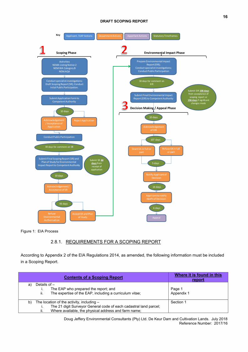
2.8. SUMMARY OF THE ENVIRONMENTAL PROCESS
2.8.1. SCOPING/EIA PROCESS
Refer to Figure 1 for a summary of the EIA Process to be followed for a Scoping/EIA Process.
16 DRAFT SCOPING REPORT
Doug Jeffery Environmental Consultants (Pty) Ltd. De Keur Dam and Cultivation Lands. July 2018 Reference Number: 2017/16
Figure 1: EIA Process
2.8.1. REQUIREMENTS FOR A SCOPING REPORT According to Appendix 2 of the EIA Regulations 2014, as amended, the following information must be included in a Scoping Report.
Contents of a Scoping Report Where it is found in this report
a) Details of – i. The EAP who prepared the report; and ii. The expertise of the EAP, including a curriculum vitae;
Page 1 Appendix 1
b) The location of the activity, including – i. The 21 digit Surveyor General code of each cadastral land parcel; ii. Where available, the physical address and farm name;
Section 1
Key
Scoping Phase Environmental Impact Phase
Decision Making / Appeal Phase
ActivitiesNEMA Listing Notice 2NEM:WA Category B
NEM:AQA
Submit Application Form to Competent Authority
Acknowledgement / Acceptance of
Application
Conduct Public Participation
Reject Application
Submit Final Scoping Report (SR) and Plan of Study for Environmental
Impact Report to Competent Authority
RefuseEnvironmental Authorisation
Accept SR and Planof Study
Prepare Environmental Impact Report (EIR);
Conduct specialist investigations;Conduct Public Participation
Submit Final Environmental Impact Report (EIR) to Competent Authority
Acknowledgement / Acceptance of SR
43 days
Acknowledgement of EIR
10 days
Grant EA in full or part
Refuse EA in full or part
Notify Applicant of Decision
5 days
Applicant to notify I&APs of Decision
Appeal
14 days
Submit SR 44 days from
receipt of application
Submit EIR 106 days from acceptance of
scoping report or 156 days if signficant
changes made
10 days
107 days
6 days
Conduct specialist investigations;Draft Scoping Report (SR); Conduct
Inital Public Participation.
10 days
30 days for comment on SR
30 days for comment on EIR
Department ActionsApplicant / EAP Actions Appellant Actions Statutory Timeframes
17 DRAFT SCOPING REPORT
Doug Jeffery Environmental Consultants (Pty) Ltd. De Keur Dam and Cultivation Lands. July 2018 Reference Number: 2017/16
iii. Where the required information in items (i) and (ii) is not available, the coordinates of the boundary of the property or properties;
c) A plan which locates the proposed activity or activities applied for at an appropriate scale, or, if it is –
i. A linear activity, a description and coordinates of the corridor in which the proposed activity or activities is to be undertaken; or
ii. On land where the property has not been defined, the coordinates within which the activity is to be undertaken;
Appendix 3; Figures 16 -18, Figure 24, Figure 26.
d) A description of the scope of the proposed activity, including – i. All listed and specified activities triggered; ii. A description of the activities to be undertaken, including associated
structures and infrastructure
Section 2.2 Section 6
e) A description of the policy and legislative context within which the development is proposed including an identification of all legislation, policies, plans, guidelines, spatial tools, municipal development planning frameworks and instruments that are applicable to this activity and are to be considered in the assessment process;
Section 3
f) A motivation for the need and desirability for the proposed development including the need and desirability of the activity in the context of the preferred location;
Section 9
g) full description of the process followed to reach the proposed preferred activity, site and location of development footprint within the site, including –
i. details of all the alternatives considered; ii. details of the public participation process undertaken in terms of
regulation 41 of the Regulations, including copies of the supporting documents and inputs;
iii. a summary of the issues raised by interest and affected parties, and an indication of the manner in which the issues were incorporated, or the reasons for not including them;
iv. the environmental attributes associated with the alternatives focusing on the geographical, physical, biological, social, economic, heritage and cultural aspects;
v. the impacts and risks which have informed the identification of each alternative, including the nature, significance, consequence, extent, duration and probability of such identified impacts, including the degree to which these impacts- aa) can be reversed; bb) may cause irreplaceable loss of resources; and cc) can be avoided, managed or mitigated;
vi. the methodology used in identifying and ranking the nature, significance, consequences, extent, duration and probability of potential environmental impacts and risks associated with the alternatives;
vii. positive and negative impacts that the proposed activity and alternatives will have on the environment and on the community that may be affected focusing on the geographical, physical, biological, social, economic, heritage and cultural aspects;
viii. the possible mitigation measures that could be applied and level of residual risk;
ix. the outcome of the site selection matrix; x. if no alternatives, including alternative locations for the activity were
investigated, the motivation for not considering such and xi. a concluding statement indicating the preferred alternatives, including
preferred location of the activity;
Section 7 Section 10 (Proof to be included in the Statutory Scoping Report) Section 11 Section 4 Sections 13 and 14 Section 12.4 Sections 13 and 14 Sections 13 and 14 Section 8 and Appendix 3 Section 7 Section 7.4.2
H) a plan of study for undertaking the environmental impact assessment process to be undertaken, including –
i. a description of the alternatives to be considered and assessed within the preferred site, including the option of not proceeding with the activity;
Section 12
18 DRAFT SCOPING REPORT
Doug Jeffery Environmental Consultants (Pty) Ltd. De Keur Dam and Cultivation Lands. July 2018 Reference Number: 2017/16
ii. a description of the aspects to assessed as part of the environmental impact assessment process;
iii. aspects to be assessed by specialists; iv. a description of the proposed method of assessing the environmental
aspects, including aspects to be assessed by specialists; v. a description of the proposed method of assessing duration and
significance; vi. an indication of the stages at which the competent authority will be
consulted vii. particulars of the public participation process that will be conducted
during the environmental impact assessment process; and viii. a description of the tasks that will be undertaken as part of the
environmental impact assessment process; ix. identify suitable measures to avoid, reverse, mitigate or manage
identified impacts and to determine the extent of the residual risks that need to be managed and monitored
i) an undertaking under oath or affirmation by the EAP in relation to – i. the correctness of the information provided in the report; ii. the inclusion of comments and inputs from stakeholders and
interested and affected parties; and iii. any information provided by the EAP to interested and affected
parties and any responses by the EAP to comments or inputs made by interested or affected parties;
Appendix 1
j) an undertaking under oath or affirmation by the EAP in relation to the level of agreement between the EAP and interested and affected parties on the plan of study for undertaking the environmental impact assessment
Section 12
k) where applicable, any specific information required by the competent authority; and
N/A
l) any other matter required in terms of section 24(4)(a) and (b) of the Act.
N/A
The purpose of this Scoping Report is to describe the environment to be affected, the proposed project, to present the site constraints identified by the various specialists during their initial site assessments, identify the potential impacts and provide a Plan of Study for the Impact Assessment Phase of this development. This scoping report is made available to all relevant stakeholders for comment.
19 DRAFT SCOPING REPORT
Doug Jeffery Environmental Consultants (Pty) Ltd. De Keur Dam and Cultivation Lands. July 2018 Reference Number: 2017/16
3. PLANNING CONTEXT
The proposed property is zoned Agriculture and the proposed activity is therefore permitted in terms of the land use rights of the property. No planning applications are therefore required in terms of rezoning or consent use.
3.1. WESTERN CAPE PROVINCIAL SPATIAL DEVELOPMENT FRAMEWORK
The proposed development is consistent with the Western Cape PSDF. The Western Cape PSDF recognizes agriculture as the basis of the Western Cape rural economy, creating 11% of all jobs within the province and contributing 6% to the GGP (Gross Geographic Product). At a provincial level, one of the strategic objectives of the PSDF is to protect biodiversity and agricultural resources. The PSDF aims to achieve this objective by consolidating agricultural landscapes and preventing their fragmentation, by protecting agriculture as a dominant land-use in rural landscapes, by maintaining viable agricultural units and by encouraging sustainable farming practices. The PSDF further aims to conserve and strengthen the sense of place of the Western Cape’s important natural, cultural and productive landscapes. The Western Cape PSDF Rural Land Use Planning & Management Guidelines further indicate that two of the key objectives for Agriculture within the province are:
To protect agriculture as a dominant land use in rural areas To improve the economic viability of farmland through intensification, diversification and value adding.
At a district level, the PSDF indicates that controlled development needs to be encouraged in the Cape Winelands District. The proposed development entails the clearing of land for cultivation purposes and the development of a new farm dam for irrigation purposes, on land zoned for Agriculture. The proposed development will improve the economic value and viability of the farm, and will contribute to the economic development and agricultural character of the area. The proposed development is therefore aligned with the objectives of the PSDF and does not compromise any of the objectives of the PSDF.
20 DRAFT SCOPING REPORT
Doug Jeffery Environmental Consultants (Pty) Ltd. De Keur Dam and Cultivation Lands. July 2018 Reference Number: 2017/16
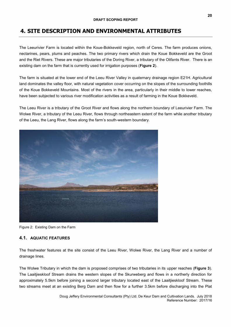
4. SITE DESCRIPTION AND ENVIRONMENTAL ATTRIBUTES
The Leeurivier Farm is located within the Koue-Bokkeveld region, north of Ceres. The farm produces onions, nectarines, pears, plums and peaches. The two primary rivers which drain the Koue Bokkeveld are the Groot and the Riet Rivers. These are major tributaries of the Doring River, a tributary of the Olifants River. There is an existing dam on the farm that is currently used for irrigation purposes (Figure 2). The farm is situated at the lower end of the Leeu River Valley in quaternary drainage region E21H. Agricultural land dominates the valley floor, with natural vegetation cover occurring on the slopes of the surrounding foothills of the Koue Bokkeveld Mountains. Most of the rivers in the area, particularly in their middle to lower reaches, have been subjected to various river modification activities as a result of farming in the Koue Bokkeveld. The Leeu River is a tributary of the Groot River and flows along the northern boundary of Leeurivier Farm. The Wolwe River, a tributary of the Leeu River, flows through northeastern extent of the farm while another tributary of the Leeu, the Lang River, flows along the farm’s south-western boundary.
Figure 2: Existing Dam on the Farm
4.1. AQUATIC FEATURES The freshwater features at the site consist of the Leeu River, Wolwe River, the Lang River and a number of drainage lines. The Wolwe Tributary in which the dam is proposed comprises of two tributaries in its upper reaches (Figure 3). The Laaitjieskloof Stream drains the western slopes of the Skurweberg and flows in a northerly direction for approximately 5.5km before joining a second larger tributary located east of the Laaitjieskloof Stream. These two streams meet at an existing Berg Dam and then flow for a further 3.5km before discharging into the Plat
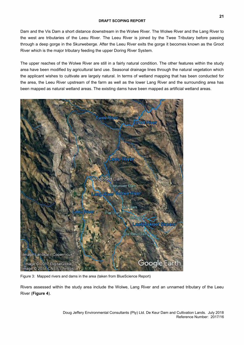
21 DRAFT SCOPING REPORT
Doug Jeffery Environmental Consultants (Pty) Ltd. De Keur Dam and Cultivation Lands. July 2018 Reference Number: 2017/16
Dam and the Vis Dam a short distance downstream in the Wolwe River. The Wolwe River and the Lang River to the west are tributaries of the Leeu River. The Leeu River is joined by the Twee Tributary before passing through a deep gorge in the Skurweberge. After the Leeu River exits the gorge it becomes known as the Groot River which is the major tributary feeding the upper Doring River System. The upper reaches of the Wolwe River are still in a fairly natural condition. The other features within the study area have been modified by agricultural land use. Seasonal drainage lines through the natural vegetation which the applicant wishes to cultivate are largely natural. In terms of wetland mapping that has been conducted for the area, the Leeu River upstream of the farm as well as the lower Lang River and the surrounding area has been mapped as natural wetland areas. The existing dams have been mapped as artificial wetland areas.
Figure 3: Mapped rivers and dams in the area (taken from BlueScience Report) Rivers assessed within the study area include the Wolwe, Lang River and an unnamed tributary of the Leeu River (Figure 4).
22 DRAFT SCOPING REPORT
Doug Jeffery Environmental Consultants (Pty) Ltd. De Keur Dam and Cultivation Lands. July 2018 Reference Number: 2017/16
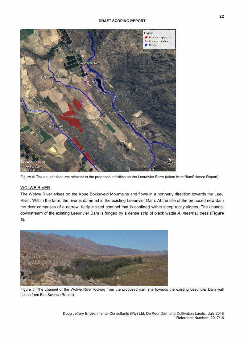
Figure 4: The aquatic features relevant to the proposed activities on the Leeurivier Farm (taken from BlueScience Report) WOLWE RIVER The Wolwe River arises on the Koue Bokkeveld Mountains and flows in a northerly direction towards the Leeu River. Within the farm, the river is dammed in the existing Leeurivier Dam. At the site of the proposed new dam the river comprises of a narrow, fairly incised channel that is confined within steep rocky slopes. The channel downstream of the existing Leeurivier Dam is fringed by a dense strip of black wattle A. mearnsii trees (Figure 5).
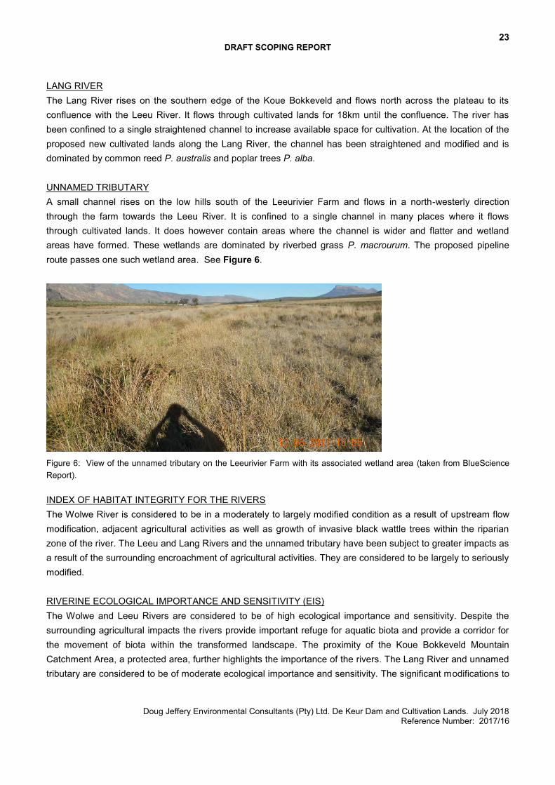
Figure 5: The channel of the Wolwe River looking from the proposed dam site towards the existing Leeurivier Dam wall (taken from BlueScience Report)
23 DRAFT SCOPING REPORT
Doug Jeffery Environmental Consultants (Pty) Ltd. De Keur Dam and Cultivation Lands. July 2018 Reference Number: 2017/16
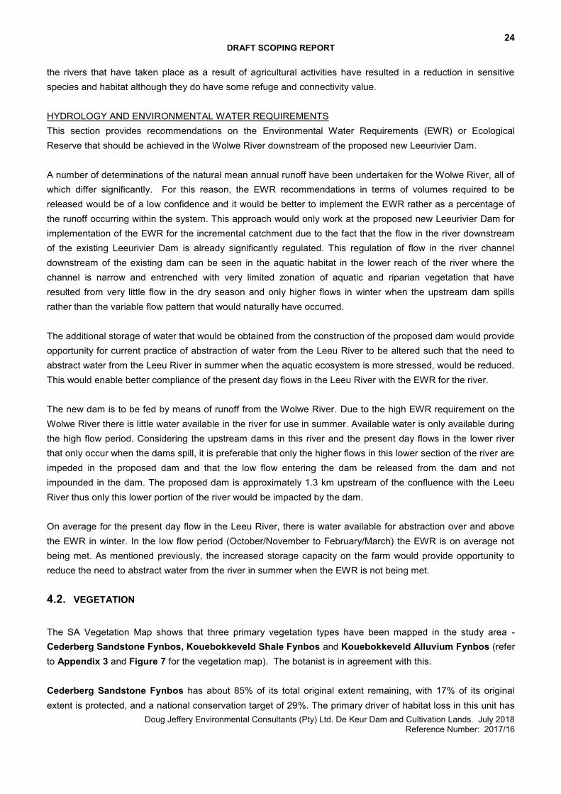
LANG RIVER The Lang River rises on the southern edge of the Koue Bokkeveld and flows north across the plateau to its confluence with the Leeu River. It flows through cultivated lands for 18km until the confluence. The river has been confined to a single straightened channel to increase available space for cultivation. At the location of the proposed new cultivated lands along the Lang River, the channel has been straightened and modified and is dominated by common reed P. australis and poplar trees P. alba. UNNAMED TRIBUTARY A small channel rises on the low hills south of the Leeurivier Farm and flows in a north-westerly direction through the farm towards the Leeu River. It is confined to a single channel in many places where it flows through cultivated lands. It does however contain areas where the channel is wider and flatter and wetland areas have formed. These wetlands are dominated by riverbed grass P. macrourum. The proposed pipeline route passes one such wetland area. See Figure 6.
Figure 6: View of the unnamed tributary on the Leeurivier Farm with its associated wetland area (taken from BlueScience Report). INDEX OF HABITAT INTEGRITY FOR THE RIVERS The Wolwe River is considered to be in a moderately to largely modified condition as a result of upstream flow modification, adjacent agricultural activities as well as growth of invasive black wattle trees within the riparian zone of the river. The Leeu and Lang Rivers and the unnamed tributary have been subject to greater impacts as a result of the surrounding encroachment of agricultural activities. They are considered to be largely to seriously modified. RIVERINE ECOLOGICAL IMPORTANCE AND SENSITIVITY (EIS) The Wolwe and Leeu Rivers are considered to be of high ecological importance and sensitivity. Despite the surrounding agricultural impacts the rivers provide important refuge for aquatic biota and provide a corridor for the movement of biota within the transformed landscape. The proximity of the Koue Bokkeveld Mountain Catchment Area, a protected area, further highlights the importance of the rivers. The Lang River and unnamed tributary are considered to be of moderate ecological importance and sensitivity. The significant modifications to
24 DRAFT SCOPING REPORT
Doug Jeffery Environmental Consultants (Pty) Ltd. De Keur Dam and Cultivation Lands. July 2018 Reference Number: 2017/16
the rivers that have taken place as a result of agricultural activities have resulted in a reduction in sensitive species and habitat although they do have some refuge and connectivity value. HYDROLOGY AND ENVIRONMENTAL WATER REQUIREMENTS This section provides recommendations on the Environmental Water Requirements (EWR) or Ecological Reserve that should be achieved in the Wolwe River downstream of the proposed new Leeurivier Dam. A number of determinations of the natural mean annual runoff have been undertaken for the Wolwe River, all of which differ significantly. For this reason, the EWR recommendations in terms of volumes required to be released would be of a low confidence and it would be better to implement the EWR rather as a percentage of the runoff occurring within the system. This approach would only work at the proposed new Leeurivier Dam for implementation of the EWR for the incremental catchment due to the fact that the flow in the river downstream of the existing Leeurivier Dam is already significantly regulated. This regulation of flow in the river channel downstream of the existing dam can be seen in the aquatic habitat in the lower reach of the river where the channel is narrow and entrenched with very limited zonation of aquatic and riparian vegetation that have resulted from very little flow in the dry season and only higher flows in winter when the upstream dam spills rather than the variable flow pattern that would naturally have occurred. The additional storage of water that would be obtained from the construction of the proposed dam would provide opportunity for current practice of abstraction of water from the Leeu River to be altered such that the need to abstract water from the Leeu River in summer when the aquatic ecosystem is more stressed, would be reduced. This would enable better compliance of the present day flows in the Leeu River with the EWR for the river. The new dam is to be fed by means of runoff from the Wolwe River. Due to the high EWR requirement on the Wolwe River there is little water available in the river for use in summer. Available water is only available during the high flow period. Considering the upstream dams in this river and the present day flows in the lower river that only occur when the dams spill, it is preferable that only the higher flows in this lower section of the river are impeded in the proposed dam and that the low flow entering the dam be released from the dam and not impounded in the dam. The proposed dam is approximately 1.3 km upstream of the confluence with the Leeu River thus only this lower portion of the river would be impacted by the dam. On average for the present day flow in the Leeu River, there is water available for abstraction over and above the EWR in winter. In the low flow period (October/November to February/March) the EWR is on average not being met. As mentioned previously, the increased storage capacity on the farm would provide opportunity to reduce the need to abstract water from the river in summer when the EWR is not being met.
4.2. VEGETATION
The SA Vegetation Map shows that three primary vegetation types have been mapped in the study area - Cederberg Sandstone Fynbos, Kouebokkeveld Shale Fynbos and Kouebokkeveld Alluvium Fynbos (refer to Appendix 3 and Figure 7 for the vegetation map). The botanist is in agreement with this. Cederberg Sandstone Fynbos has about 85% of its total original extent remaining, with 17% of its original extent is protected, and a national conservation target of 29%. The primary driver of habitat loss in this unit has
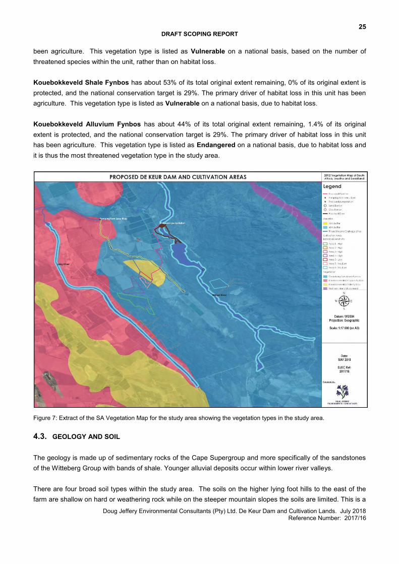
25 DRAFT SCOPING REPORT
Doug Jeffery Environmental Consultants (Pty) Ltd. De Keur Dam and Cultivation Lands. July 2018 Reference Number: 2017/16
been agriculture. This vegetation type is listed as Vulnerable on a national basis, based on the number of threatened species within the unit, rather than on habitat loss. Kouebokkeveld Shale Fynbos has about 53% of its total original extent remaining, 0% of its original extent is protected, and the national conservation target is 29%. The primary driver of habitat loss in this unit has been agriculture. This vegetation type is listed as Vulnerable on a national basis, due to habitat loss. Kouebokkeveld Alluvium Fynbos has about 44% of its total original extent remaining, 1.4% of its original extent is protected, and the national conservation target is 29%. The primary driver of habitat loss in this unit has been agriculture. This vegetation type is listed as Endangered on a national basis, due to habitat loss and it is thus the most threatened vegetation type in the study area.
Figure 7: Extract of the SA Vegetation Map for the study area showing the vegetation types in the study area.
4.3. GEOLOGY AND SOIL The geology is made up of sedimentary rocks of the Cape Supergroup and more specifically of the sandstones of the Witteberg Group with bands of shale. Younger alluvial deposits occur within lower river valleys. There are four broad soil types within the study area. The soils on the higher lying foot hills to the east of the farm are shallow on hard or weathering rock while on the steeper mountain slopes the soils are limited. This is a
26 DRAFT SCOPING REPORT
Doug Jeffery Environmental Consultants (Pty) Ltd. De Keur Dam and Cultivation Lands. July 2018 Reference Number: 2017/16
key water intake area and little land use is possible on these soils. Most of the existing cultivated lands on the Leeurivier Farm occur on Plinthic catena. These are undifferentiated soils which have moderately high natural fertility. They occur on alluvium and consist of shale and feldspathic sandstone of the Ceres Subgroup. The soils along the Wolwe River, as well as at the location of certain of the proposed new agricultural lands are Glenrosa and/or Mispah forms. These soils occur predominantly on quartzitic sandstone. The soils along the Lang River are mapped as miscellaneous land classes, consisting of undifferentiated deep deposits, underlain by alluvium with shale and feldspathic sandstone.
27 DRAFT SCOPING REPORT
Doug Jeffery Environmental Consultants (Pty) Ltd. De Keur Dam and Cultivation Lands. July 2018 Reference Number: 2017/16
5. OPPORTUNITIES AND CONSTRAINTS
Below is a discussion of the opportunities and constraints of the site that have been considered throughout the process and have provided input into the proposed site development layouts. This information has been obtained from the relevant specialists who are undertaking the related impact assessments.
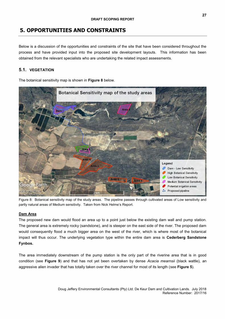
5.1. VEGETATION The botanical sensitivity map is shown in Figure 8 below.
Figure 8: Botanical sensitivity map of the study areas. The pipeline passes through cultivated areas of Low sensitivity and partly natural areas of Medium sensitivity. Taken from Nick Helme’s Report. Dam Area The proposed new dam would flood an area up to a point just below the existing dam wall and pump station. The general area is extremely rocky (sandstone), and is steeper on the east side of the river. The proposed dam would consequently flood a much bigger area on the west of the river, which is where most of the botanical impact will thus occur. The underlying vegetation type within the entire dam area is Cederberg Sandstone Fynbos. The area immediately downstream of the pump station is the only part of the riverine area that is in good condition (see Figure 9) and that has not yet been overtaken by dense Acacia mearnsii (black wattle), an aggressive alien invader that has totally taken over the river channel for most of its length (see Figure 5).
28 DRAFT SCOPING REPORT
Doug Jeffery Environmental Consultants (Pty) Ltd. De Keur Dam and Cultivation Lands. July 2018 Reference Number: 2017/16
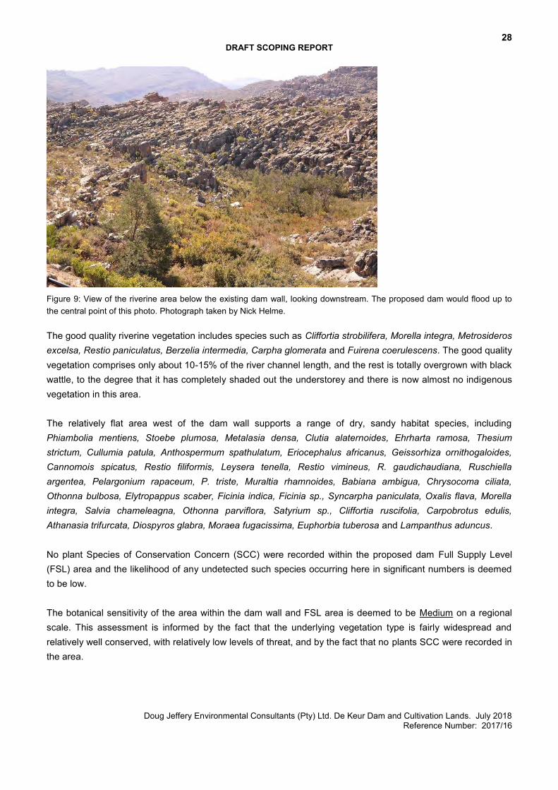
Figure 9: View of the riverine area below the existing dam wall, looking downstream. The proposed dam would flood up to the central point of this photo. Photograph taken by Nick Helme. The good quality riverine vegetation includes species such as Cliffortia strobilifera, Morella integra, Metrosideros excelsa, Restio paniculatus, Berzelia intermedia, Carpha glomerata and Fuirena coerulescens. The good quality vegetation comprises only about 10-15% of the river channel length, and the rest is totally overgrown with black wattle, to the degree that it has completely shaded out the understorey and there is now almost no indigenous vegetation in this area. The relatively flat area west of the dam wall supports a range of dry, sandy habitat species, including Phiambolia mentiens, Stoebe plumosa, Metalasia densa, Clutia alaternoides, Ehrharta ramosa, Thesium strictum, Cullumia patula, Anthospermum spathulatum, Eriocephalus africanus, Geissorhiza ornithogaloides, Cannomois spicatus, Restio filiformis, Leysera tenella, Restio vimineus, R. gaudichaudiana, Ruschiella argentea, Pelargonium rapaceum, P. triste, Muraltia rhamnoides, Babiana ambigua, Chrysocoma ciliata, Othonna bulbosa, Elytropappus scaber, Ficinia indica, Ficinia sp., Syncarpha paniculata, Oxalis flava, Morella integra, Salvia chameleagna, Othonna parviflora, Satyrium sp., Cliffortia ruscifolia, Carpobrotus edulis, Athanasia trifurcata, Diospyros glabra, Moraea fugacissima, Euphorbia tuberosa and Lampanthus aduncus. No plant Species of Conservation Concern (SCC) were recorded within the proposed dam Full Supply Level (FSL) area and the likelihood of any undetected such species occurring here in significant numbers is deemed to be low. The botanical sensitivity of the area within the dam wall and FSL area is deemed to be Medium on a regional scale. This assessment is informed by the fact that the underlying vegetation type is fairly widespread and relatively well conserved, with relatively low levels of threat, and by the fact that no plants SCC were recorded in the area.
29 DRAFT SCOPING REPORT
Doug Jeffery Environmental Consultants (Pty) Ltd. De Keur Dam and Cultivation Lands. July 2018 Reference Number: 2017/16
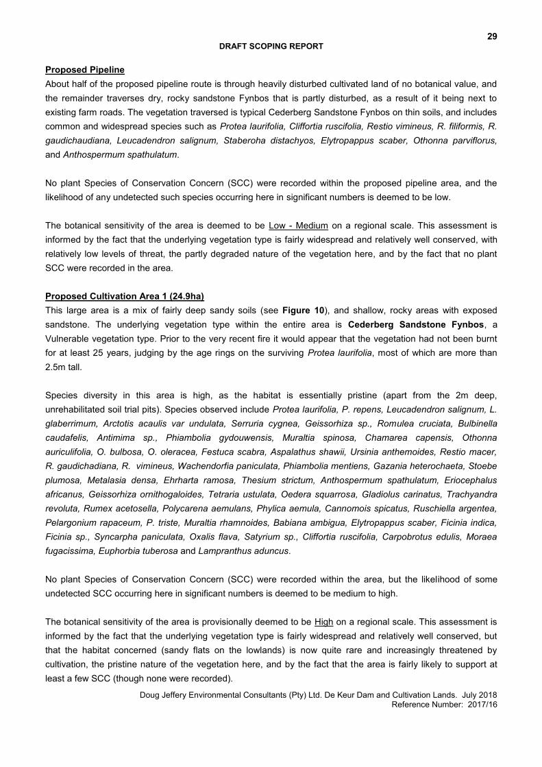
Proposed Pipeline About half of the proposed pipeline route is through heavily disturbed cultivated land of no botanical value, and the remainder traverses dry, rocky sandstone Fynbos that is partly disturbed, as a result of it being next to existing farm roads. The vegetation traversed is typical Cederberg Sandstone Fynbos on thin soils, and includes common and widespread species such as Protea laurifolia, Cliffortia ruscifolia, Restio vimineus, R. filiformis, R. gaudichaudiana, Leucadendron salignum, Staberoha distachyos, Elytropappus scaber, Othonna parviflorus, and Anthospermum spathulatum. No plant Species of Conservation Concern (SCC) were recorded within the proposed pipeline area, and the likelihood of any undetected such species occurring here in significant numbers is deemed to be low. The botanical sensitivity of the area is deemed to be Low - Medium on a regional scale. This assessment is informed by the fact that the underlying vegetation type is fairly widespread and relatively well conserved, with relatively low levels of threat, the partly degraded nature of the vegetation here, and by the fact that no plant SCC were recorded in the area. Proposed Cultivation Area 1 (24.9ha) This large area is a mix of fairly deep sandy soils (see Figure 10), and shallow, rocky areas with exposed sandstone. The underlying vegetation type within the entire area is Cederberg Sandstone Fynbos, a Vulnerable vegetation type. Prior to the very recent fire it would appear that the vegetation had not been burnt for at least 25 years, judging by the age rings on the surviving Protea laurifolia, most of which are more than 2.5m tall. Species diversity in this area is high, as the habitat is essentially pristine (apart from the 2m deep, unrehabilitated soil trial pits). Species observed include Protea laurifolia, P. repens, Leucadendron salignum, L. glaberrimum, Arctotis acaulis var undulata, Serruria cygnea, Geissorhiza sp., Romulea cruciata, Bulbinella caudafelis, Antimima sp., Phiambolia gydouwensis, Muraltia spinosa, Chamarea capensis, Othonna auriculifolia, O. bulbosa, O. oleracea, Festuca scabra, Aspalathus shawii, Ursinia anthemoides, Restio macer, R. gaudichadiana, R. vimineus, Wachendorfia paniculata, Phiambolia mentiens, Gazania heterochaeta, Stoebe plumosa, Metalasia densa, Ehrharta ramosa, Thesium strictum, Anthospermum spathulatum, Eriocephalus africanus, Geissorhiza ornithogaloides, Tetraria ustulata, Oedera squarrosa, Gladiolus carinatus, Trachyandra revoluta, Rumex acetosella, Polycarena aemulans, Phylica aemula, Cannomois spicatus, Ruschiella argentea, Pelargonium rapaceum, P. triste, Muraltia rhamnoides, Babiana ambigua, Elytropappus scaber, Ficinia indica, Ficinia sp., Syncarpha paniculata, Oxalis flava, Satyrium sp., Cliffortia ruscifolia, Carpobrotus edulis, Moraea fugacissima, Euphorbia tuberosa and Lampranthus aduncus. No plant Species of Conservation Concern (SCC) were recorded within the area, but the likelihood of some undetected SCC occurring here in significant numbers is deemed to be medium to high. The botanical sensitivity of the area is provisionally deemed to be High on a regional scale. This assessment is informed by the fact that the underlying vegetation type is fairly widespread and relatively well conserved, but that the habitat concerned (sandy flats on the lowlands) is now quite rare and increasingly threatened by cultivation, the pristine nature of the vegetation here, and by the fact that the area is fairly likely to support at least a few SCC (though none were recorded).
30 DRAFT SCOPING REPORT
Doug Jeffery Environmental Consultants (Pty) Ltd. De Keur Dam and Cultivation Lands. July 2018 Reference Number: 2017/16
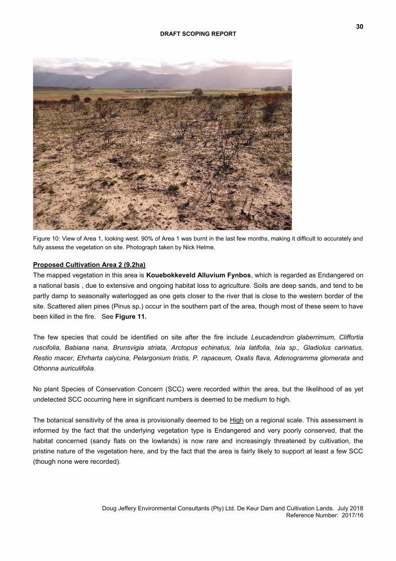
Figure 10: View of Area 1, looking west. 90% of Area 1 was burnt in the last few months, making it difficult to accurately and fully assess the vegetation on site. Photograph taken by Nick Helme. Proposed Cultivation Area 2 (9.2ha) The mapped vegetation in this area is Kouebokkeveld Alluvium Fynbos, which is regarded as Endangered on a national basis , due to extensive and ongoing habitat loss to agriculture. Soils are deep sands, and tend to be partly damp to seasonally waterlogged as one gets closer to the river that is close to the western border of the site. Scattered alien pines (Pinus sp.) occur in the southern part of the area, though most of these seem to have been killed in the fire. See Figure 11. The few species that could be identified on site after the fire include Leucadendron glaberrimum, Cliffortia ruscifolia, Babiana nana, Brunsvigia striata, Arctopus echinatus, Ixia latifolia, Ixia sp., Gladiolus carinatus, Restio macer, Ehrharta calycina, Pelargonium tristis, P. rapaceum, Oxalis flava, Adenogramma glomerata and Othonna auriculifolia. No plant Species of Conservation Concern (SCC) were recorded within the area, but the likelihood of as yet undetected SCC occurring here in significant numbers is deemed to be medium to high. The botanical sensitivity of the area is provisionally deemed to be High on a regional scale. This assessment is informed by the fact that the underlying vegetation type is Endangered and very poorly conserved, that the habitat concerned (sandy flats on the lowlands) is now rare and increasingly threatened by cultivation, the pristine nature of the vegetation here, and by the fact that the area is fairly likely to support at least a few SCC (though none were recorded).
31 DRAFT SCOPING REPORT
Doug Jeffery Environmental Consultants (Pty) Ltd. De Keur Dam and Cultivation Lands. July 2018 Reference Number: 2017/16
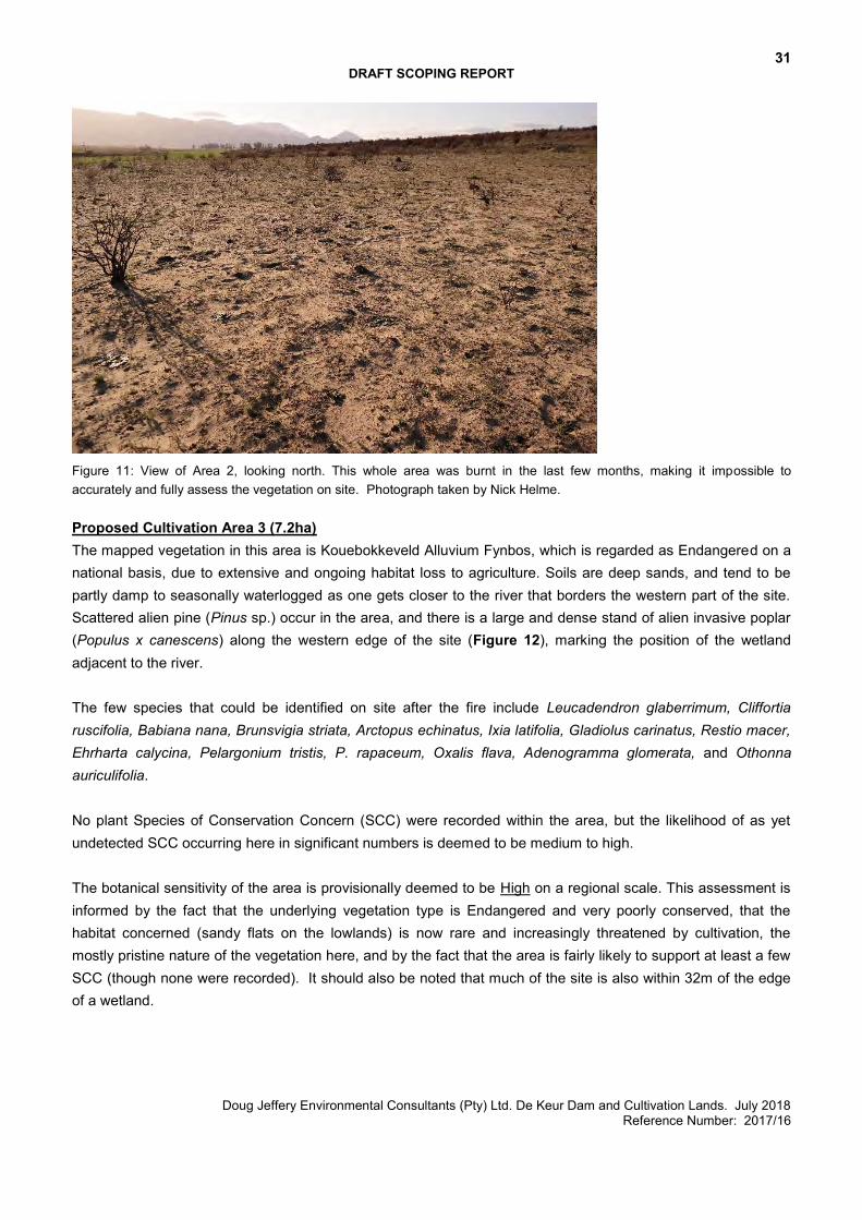
Figure 11: View of Area 2, looking north. This whole area was burnt in the last few months, making it impossible to accurately and fully assess the vegetation on site. Photograph taken by Nick Helme. Proposed Cultivation Area 3 (7.2ha) The mapped vegetation in this area is Kouebokkeveld Alluvium Fynbos, which is regarded as Endangered on a national basis, due to extensive and ongoing habitat loss to agriculture. Soils are deep sands, and tend to be partly damp to seasonally waterlogged as one gets closer to the river that borders the western part of the site. Scattered alien pine (Pinus sp.) occur in the area, and there is a large and dense stand of alien invasive poplar (Populus x canescens) along the western edge of the site (Figure 12), marking the position of the wetland adjacent to the river. The few species that could be identified on site after the fire include Leucadendron glaberrimum, Cliffortia ruscifolia, Babiana nana, Brunsvigia striata, Arctopus echinatus, Ixia latifolia, Gladiolus carinatus, Restio macer, Ehrharta calycina, Pelargonium tristis, P. rapaceum, Oxalis flava, Adenogramma glomerata, and Othonna auriculifolia. No plant Species of Conservation Concern (SCC) were recorded within the area, but the likelihood of as yet undetected SCC occurring here in significant numbers is deemed to be medium to high. The botanical sensitivity of the area is provisionally deemed to be High on a regional scale. This assessment is informed by the fact that the underlying vegetation type is Endangered and very poorly conserved, that the habitat concerned (sandy flats on the lowlands) is now rare and increasingly threatened by cultivation, the mostly pristine nature of the vegetation here, and by the fact that the area is fairly likely to support at least a few SCC (though none were recorded). It should also be noted that much of the site is also within 32m of the edge of a wetland.
32 DRAFT SCOPING REPORT
Doug Jeffery Environmental Consultants (Pty) Ltd. De Keur Dam and Cultivation Lands. July 2018 Reference Number: 2017/16
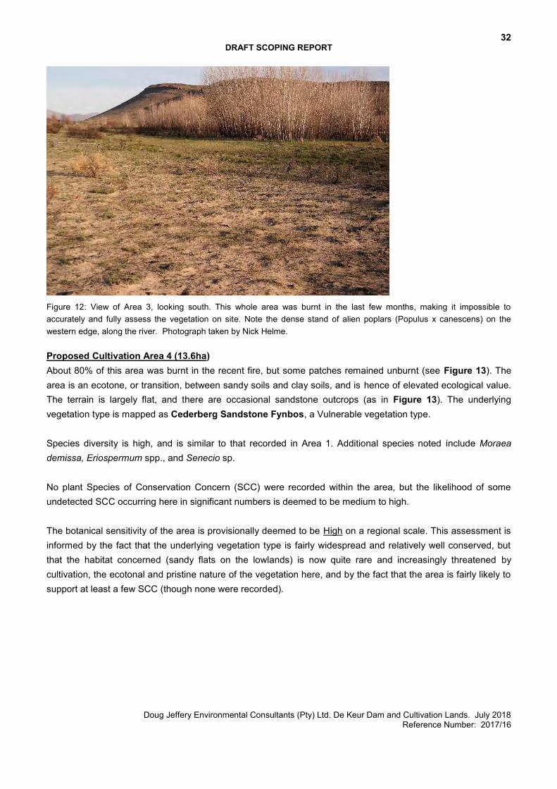
Figure 12: View of Area 3, looking south. This whole area was burnt in the last few months, making it impossible to accurately and fully assess the vegetation on site. Note the dense stand of alien poplars (Populus x canescens) on the western edge, along the river. Photograph taken by Nick Helme. Proposed Cultivation Area 4 (13.6ha) About 80% of this area was burnt in the recent fire, but some patches remained unburnt (see Figure 13). The area is an ecotone, or transition, between sandy soils and clay soils, and is hence of elevated ecological value. The terrain is largely flat, and there are occasional sandstone outcrops (as in Figure 13). The underlying vegetation type is mapped as Cederberg Sandstone Fynbos, a Vulnerable vegetation type. Species diversity is high, and is similar to that recorded in Area 1. Additional species noted include Moraea demissa, Eriospermum spp., and Senecio sp. No plant Species of Conservation Concern (SCC) were recorded within the area, but the likelihood of some undetected SCC occurring here in significant numbers is deemed to be medium to high. The botanical sensitivity of the area is provisionally deemed to be High on a regional scale. This assessment is informed by the fact that the underlying vegetation type is fairly widespread and relatively well conserved, but that the habitat concerned (sandy flats on the lowlands) is now quite rare and increasingly threatened by cultivation, the ecotonal and pristine nature of the vegetation here, and by the fact that the area is fairly likely to support at least a few SCC (though none were recorded).
33 DRAFT SCOPING REPORT
Doug Jeffery Environmental Consultants (Pty) Ltd. De Keur Dam and Cultivation Lands. July 2018 Reference Number: 2017/16
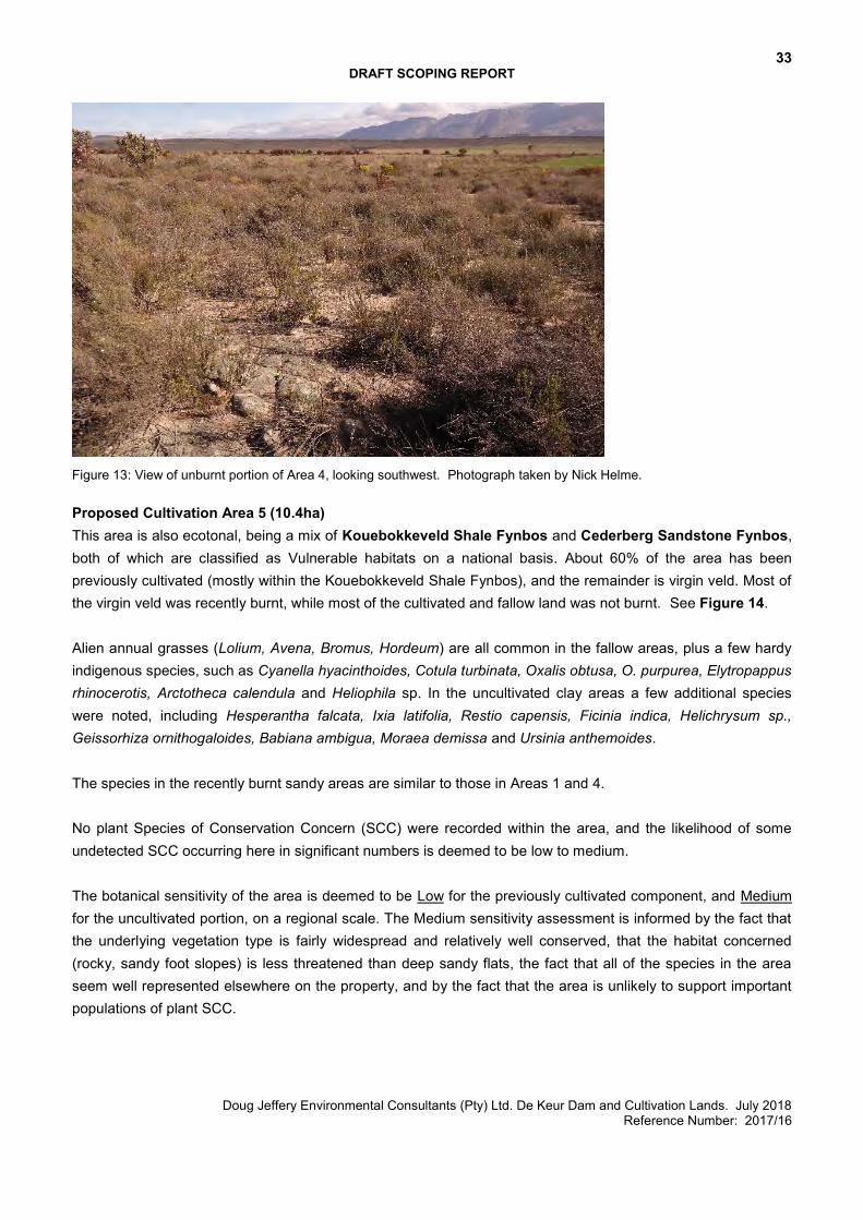
Figure 13: View of unburnt portion of Area 4, looking southwest. Photograph taken by Nick Helme. Proposed Cultivation Area 5 (10.4ha) This area is also ecotonal, being a mix of Kouebokkeveld Shale Fynbos and Cederberg Sandstone Fynbos, both of which are classified as Vulnerable habitats on a national basis. About 60% of the area has been previously cultivated (mostly within the Kouebokkeveld Shale Fynbos), and the remainder is virgin veld. Most of the virgin veld was recently burnt, while most of the cultivated and fallow land was not burnt. See Figure 14. Alien annual grasses (Lolium, Avena, Bromus, Hordeum) are all common in the fallow areas, plus a few hardy indigenous species, such as Cyanella hyacinthoides, Cotula turbinata, Oxalis obtusa, O. purpurea, Elytropappus rhinocerotis, Arctotheca calendula and Heliophila sp. In the uncultivated clay areas a few additional species were noted, including Hesperantha falcata, Ixia latifolia, Restio capensis, Ficinia indica, Helichrysum sp., Geissorhiza ornithogaloides, Babiana ambigua, Moraea demissa and Ursinia anthemoides. The species in the recently burnt sandy areas are similar to those in Areas 1 and 4. No plant Species of Conservation Concern (SCC) were recorded within the area, and the likelihood of some undetected SCC occurring here in significant numbers is deemed to be low to medium. The botanical sensitivity of the area is deemed to be Low for the previously cultivated component, and Medium for the uncultivated portion, on a regional scale. The Medium sensitivity assessment is informed by the fact that the underlying vegetation type is fairly widespread and relatively well conserved, that the habitat concerned (rocky, sandy foot slopes) is less threatened than deep sandy flats, the fact that all of the species in the area seem well represented elsewhere on the property, and by the fact that the area is unlikely to support important populations of plant SCC.

34 DRAFT SCOPING REPORT
Doug Jeffery Environmental Consultants (Pty) Ltd. De Keur Dam and Cultivation Lands. July 2018 Reference Number: 2017/16
Figure 14: Previously cultivated but fallow land in Area 5, looking north. Photograph taken by Nick Helme. Proposed Cultivation Area 6 (12ha) This area lies east of the main river system, on a sandy plateau, with occasional shallow sandstone bedrock. See Figure 15. The vegetation is typical Cederberg Sandstone Fynbos on thin soils and includes common and widespread species such as Protea laurifolia, Cliffortia ruscifolia, Restio vimineus, R. filiformis, R. gaudichaudiana, R. capensis, R. bolusii, Staberoha distachyos, Thamnochortus lucens, Elegia filacea, Diosma hirsuta, Leucadendron salignum, L. glaberimum. Elytropappus scaber, E. glandulosus, Othonna parviflorus, Arctotis verbascifolia, Metalasia densa, Antimima sp., Felicia filifolia, Syncarpha canescens, Cannomois spicata, Eriocephalus africanus, Serruria pedunculata, Albuca canadense, Willdenowia teres, Lachnospermum fasciculatum, Phiambolia mentiens, Tenaxia stricta, Passerina corymbosa, Phylica aemula, Tetraria ustulata, Gazania krebsiana, Athanasia flexuosa, Chrysocoma ciliata, Microdon polygaloides, Psammotropha quadrangularis, Thesium sp., Struthiola ciliata, Erica spp., Trachyandra arenicola, Leysera tenella, Aspalathus linearis, Serruria cygnea, Ursinia anthemoides, Cullumia bisulca, Arctopus echinatus and Anthospermum spathulatum. No plant Species of Conservation Concern (SCC) were recorded within the area, and the likelihood of some undetected SCC occurring here in significant numbers is deemed to be low to medium. It should be noted that the Antimima is a local endemic that has not yet been described and is known from thin soils throughout most of the Skurweberg, where much of its habitat should be secure. The botanical sensitivity of the area is deemed to be Medium, on a regional scale. The Medium sensitivity assessment is informed by the fact that the underlying vegetation type is widespread and relatively well conserved, that the habitat concerned (rocky, sandy foot slopes) is less threatened than deep sandy flats, the fact that all of the species in the area seem well represented elsewhere on the property, and by the fact that the area is unlikely to support important populations of plant SCC.
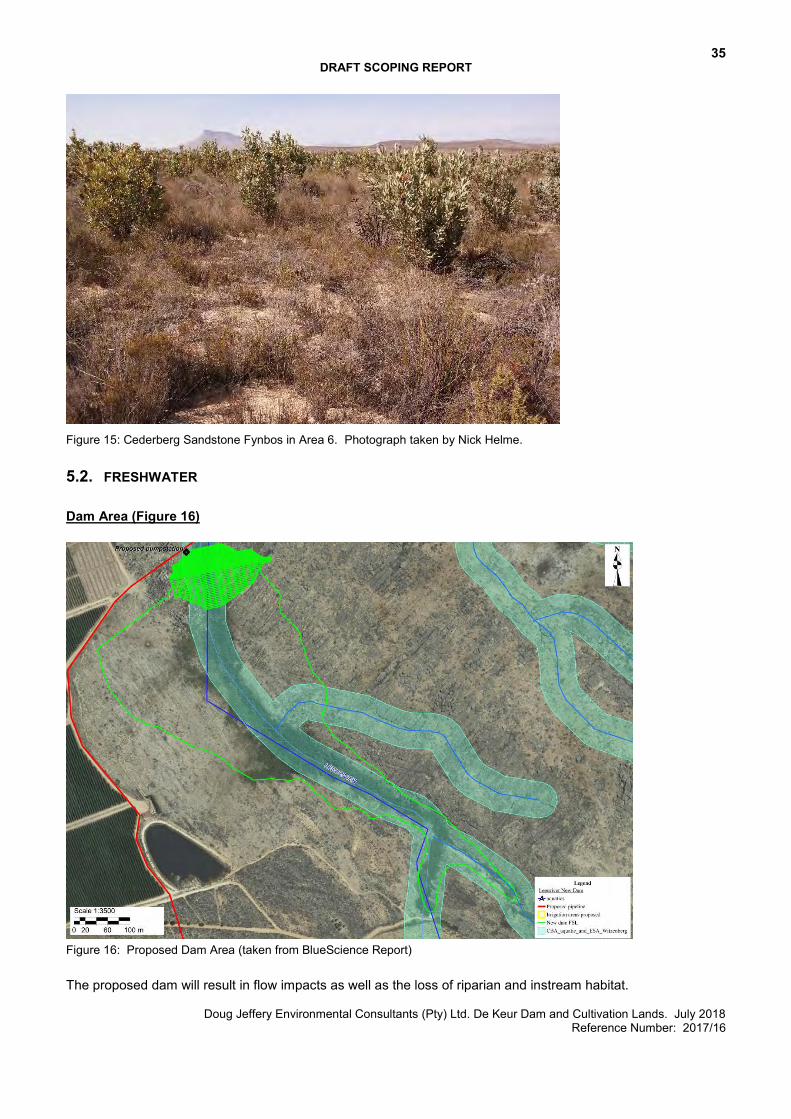
35 DRAFT SCOPING REPORT
Doug Jeffery Environmental Consultants (Pty) Ltd. De Keur Dam and Cultivation Lands. July 2018 Reference Number: 2017/16
Figure 15: Cederberg Sandstone Fynbos in Area 6. Photograph taken by Nick Helme.
5.2. FRESHWATER Dam Area (Figure 16)
Figure 16: Proposed Dam Area (taken from BlueScience Report) The proposed dam will result in flow impacts as well as the loss of riparian and instream habitat.
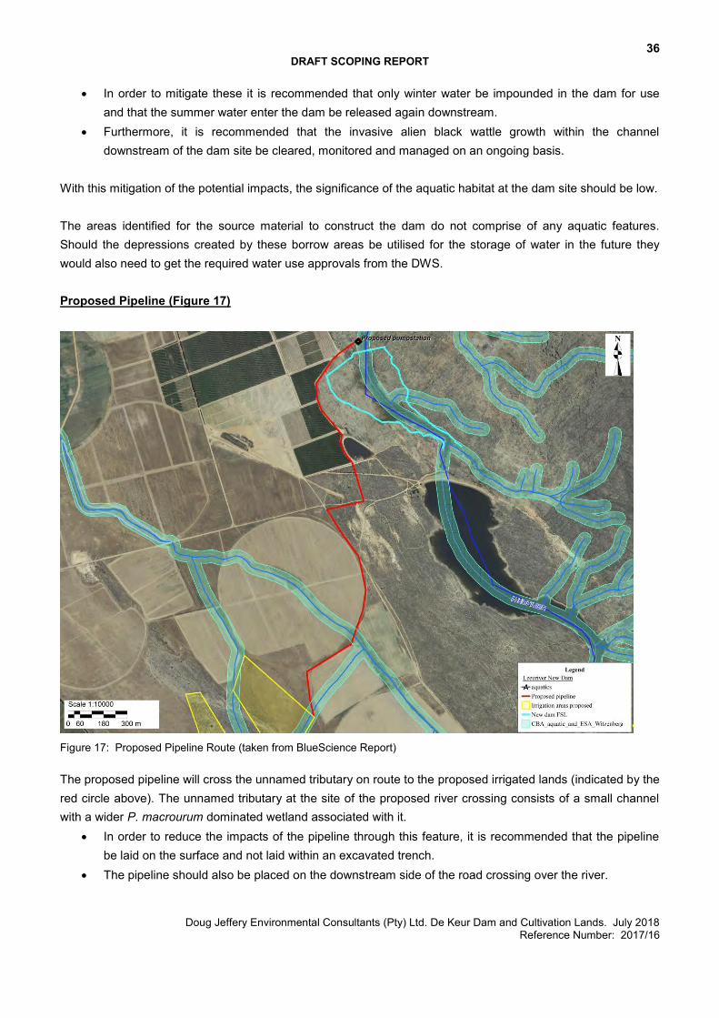
36 DRAFT SCOPING REPORT
Doug Jeffery Environmental Consultants (Pty) Ltd. De Keur Dam and Cultivation Lands. July 2018 Reference Number: 2017/16
In order to mitigate these it is recommended that only winter water be impounded in the dam for use and that the summer water enter the dam be released again downstream.
Furthermore, it is recommended that the invasive alien black wattle growth within the channel downstream of the dam site be cleared, monitored and managed on an ongoing basis.
With this mitigation of the potential impacts, the significance of the aquatic habitat at the dam site should be low. The areas identified for the source material to construct the dam do not comprise of any aquatic features. Should the depressions created by these borrow areas be utilised for the storage of water in the future they would also need to get the required water use approvals from the DWS. Proposed Pipeline (Figure 17)
Figure 17: Proposed Pipeline Route (taken from BlueScience Report) The proposed pipeline will cross the unnamed tributary on route to the proposed irrigated lands (indicated by the red circle above). The unnamed tributary at the site of the proposed river crossing consists of a small channel with a wider P. macrourum dominated wetland associated with it.
In order to reduce the impacts of the pipeline through this feature, it is recommended that the pipeline be laid on the surface and not laid within an excavated trench.
The pipeline should also be placed on the downstream side of the road crossing over the river.
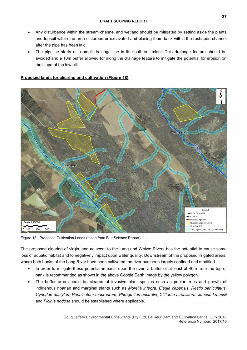
37 DRAFT SCOPING REPORT
Doug Jeffery Environmental Consultants (Pty) Ltd. De Keur Dam and Cultivation Lands. July 2018 Reference Number: 2017/16
Any disturbance within the stream channel and wetland should be mitigated by setting aside the plants and topsoil within the area disturbed or excavated and placing them back within the reshaped channel after the pipe has been laid.
The pipeline starts at a small drainage line in its southern extent. This drainage feature should be avoided and a 10m buffer allowed for along the drainage feature to mitigate the potential for erosion on the slope of the low hill.
Proposed lands for clearing and cultivation (Figure 18)
Figure 18: Proposed Cultivation Lands (taken from BlueScience Report) The proposed clearing of virgin land adjacent to the Lang and Wolwe Rivers has the potential to cause some loss of aquatic habitat and to negatively impact upon water quality. Downstream of the proposed irrigated areas, where both banks of the Lang River have been cultivated the river has been largely confined and modified.
In order to mitigate these potential impacts upon the river, a buffer of at least of 40m from the top of bank is recommended as shown in the above Google Earth image by the yellow polygon.
The buffer area should be cleared of invasive plant species such as poplar trees and growth of indigenous riparian and marginal plants such as Morella integra, Elegia capensis, Restio paniculatus, Cynodon dactylon, Pennisetum macrourum, Phragmites australis, Cliffortia strobilifera, Juncus kraussii and Ficinia nodosa should be established where applicable.
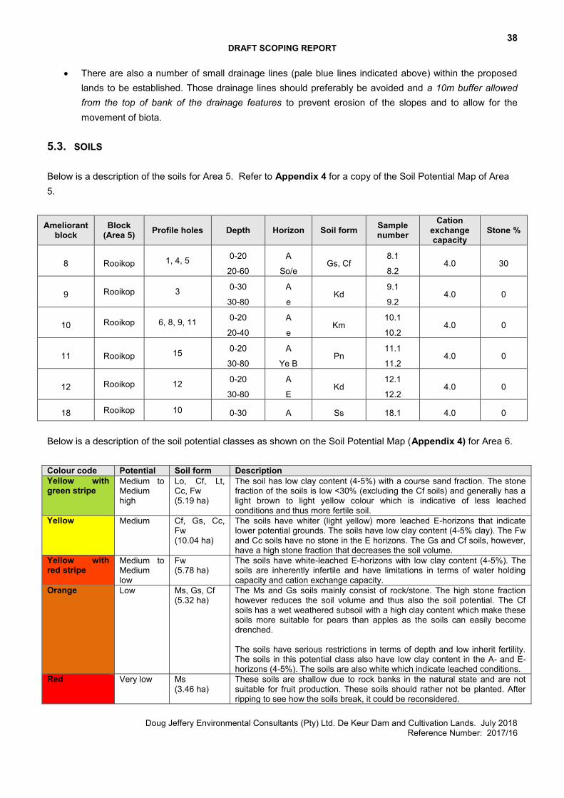
38 DRAFT SCOPING REPORT
Doug Jeffery Environmental Consultants (Pty) Ltd. De Keur Dam and Cultivation Lands. July 2018 Reference Number: 2017/16
There are also a number of small drainage lines (pale blue lines indicated above) within the proposed lands to be established. Those drainage lines should preferably be avoided and a 10m buffer allowed from the top of bank of the drainage features to prevent erosion of the slopes and to allow for the movement of biota.
5.3. SOILS Below is a description of the soils for Area 5. Refer to Appendix 4 for a copy of the Soil Potential Map of Area 5.
Ameliorant block
Block (Area 5) Profile holes Depth Horizon Soil form Sample
number Cation
exchange capacity
Stone %
8 Rooikop 1, 4, 5 0-20
20-60
A
So/e Gs, Cf
8.1
8.2 4.0 30
9 Rooikop 3 0-30
30-80
A
e Kd
9.1
9.2 4.0 0
10 Rooikop 6, 8, 9, 11 0-20
20-40
A
e Km
10.1
10.2 4.0 0
11 Rooikop 15 0-20
30-80
A
Ye B Pn
11.1
11.2 4.0 0
12 Rooikop 12 0-20
30-80
A
E Kd
12.1
12.2 4.0 0
18 Rooikop 10 0-30 A Ss 18.1 4.0 0 Below is a description of the soil potential classes as shown on the Soil Potential Map (Appendix 4) for Area 6. Colour code Potential Soil form Description Yellow with green stripe
Medium to Medium high
Lo, Cf, Lt, Cc, Fw (5.19 ha)
The soil has low clay content (4-5%) with a course sand fraction. The stone fraction of the soils is low <30% (excluding the Cf soils) and generally has a light brown to light yellow colour which is indicative of less leached conditions and thus more fertile soil.
Yellow Medium Cf, Gs, Cc, Fw (10.04 ha)
The soils have whiter (light yellow) more leached E-horizons that indicate lower potential grounds. The soils have low clay content (4-5% clay). The Fw and Cc soils have no stone in the E horizons. The Gs and Cf soils, however, have a high stone fraction that decreases the soil volume.
Yellow with red stripe
Medium to Medium low
Fw (5.78 ha)
The soils have white-leached E-horizons with low clay content (4-5%). The soils are inherently infertile and have limitations in terms of water holding capacity and cation exchange capacity.
Orange Low Ms, Gs, Cf (5.32 ha)
The Ms and Gs soils mainly consist of rock/stone. The high stone fraction however reduces the soil volume and thus also the soil potential. The Cf soils has a wet weathered subsoil with a high clay content which make these soils more suitable for pears than apples as the soils can easily become drenched. The soils have serious restrictions in terms of depth and low inherit fertility. The soils in this potential class also have low clay content in the A- and E-horizons (4-5%). The soils are also white which indicate leached conditions.
Red Very low Ms (3.46 ha)
These soils are shallow due to rock banks in the natural state and are not suitable for fruit production. These soils should rather not be planted. After ripping to see how the soils break, it could be reconsidered.
39 DRAFT SCOPING REPORT
Doug Jeffery Environmental Consultants (Pty) Ltd. De Keur Dam and Cultivation Lands. July 2018 Reference Number: 2017/16
5.4. WATER At present, there are 165 ha of irrigable land on the property used as either permanent crops and land used as rotational crops. The existing water rights on the property are for the irrigation of 82.98 ha of vegetables. This application is for the taking of an additional 65 ha of water, at 9500 m3/ha/annum. Using the Department of Agriculture’s water usage standard of 7000 m³ per hectare, the new dam will allow for the irrigation of an additional 88.21 ha of land. This application includes the clearing and cultivation of 22.4ha of land. There is therefore sufficient water to irrigate the new proposed lands and allow the farmer the opportunity to increase his cultivated lands in the future. An application for the validation and verification of water use has been submitted and the preliminary findings for the extent and lawfulness of the water use(s) have been determined. The preliminary findings for the lawful water use in terms of Section 35 of the NWA for taking of water for irrigation purposes is 788319 m³/annum from the Lang River. Preliminary findings for lawful water use in terms of Section 35 of the NWA for storing of water and stream flow reduction activities is 1130000 m³/annum from the Lang River. Refer to Appendix 5.
5.5. CBAS
CBA1: This defined as, “Areas in a natural condition that are required to meet biodiversity targets, for species, ecosystems or ecological processes and infrastructure”. The management objective of CBA1 is to “maintain in a natural or near-natural state, with no further loss of natural habitat”. Degraded areas should be rehabilitated. Only low-impact, biodiversity-sensitive land uses are appropriate. ESA1 and 2: These are areas that are not essential for meeting biodiversity targets, but that play an important role in supporting the functioning of PAs or CBAs, and are often vital for delivering ecosystem services. The management objective of ESA1 is to maintain in a functional, near-natural state. Some habitat loss is acceptable, provided the underlying biodiversity objectives and ecological functioning are not compromised. The management objective of ESA2 is to restore and/or manage to minimize impact on ecological processes and ecological infrastructure functioning, especially soil and water-related services, and to allow for faunal movement. The CapeNature Spatial Biodiversity Plan 2017 indicates that most of Areas 2 & 3 are CBA1, and most of Areas 1, 4 and 6 are terrestrial ESA1s, along with part of Area 5. Refer to Appendix 3 and Figure 19 below. The intention is to only clear Areas 5 and 6. They are mapped as an ESA1 for the following reasons:
Vunerable vegetation type covering the area Possibility of Cape Mountain Zebra occurring here Located above the Koue Bokkeveld Aquifer
40 DRAFT SCOPING REPORT
Doug Jeffery Environmental Consultants (Pty) Ltd. De Keur Dam and Cultivation Lands. July 2018 Reference Number: 2017/16
The proposed clearing will impact on the vegetation but it is unlikely to affect the presence of Zebra or interfere with groundwater recharge. A botanist has been appointed to assess the botanical impacts. Drainage features across the farm, as well as the Wolwe River and Lang River corridor have been mapped as aquatic ESA 2 (Figure 19). The Leeu River and certain reaches of the Lang River are mapped at aquatic CBAs. A portion of the new proposed dam is located within the terrestrial ESA1. The reason for this category is the area has been mapped as part of a climate change adaptation corridor and a water recharge area. Water Recharge Protection is essential for delivering ecosystem services, and may support the functioning of PAs or CBAs. It also consists of areas overlying aquifers, fulfilling the role of feeding the aquifers. Climate Change Adaptation Corridors are important in terms of landscape connectivity, as well as supporting the functioning of PAs or CBAs. In this case, the area in question is located adjacent to a Protected Area (Koue Bokkeveld Mountain Catchment Area) and above the Koue Bokkeveld Aquifer. The proposed dam will not restrict ecological connectivity nor interfere with groundwater recharge. Freshwater Ecosystem Priority Areas (FEPA) are intended to provide strategic spatial priorities for conserving South Africa’s freshwater ecosystems and supporting sustainable use of water resources. The maps were determined through a process of systematic biodiversity planning and were identified using a range of criteria for serving ecosystems and associated biodiversity of rivers, wetlands and estuaries. The river and wetland FEPAs are required to be maintained in a largely natural ecological state while fish support areas should not be allowed to degrade from their existing ecological condition. The Wolwe River and the Leeu River have been mapped as Upstream Catchments to the Groot River which is FEPA River (Figure 19). Upstream Management Areas, shown in very pale green, are sub‐quaternary catchments in which human activities need to be managed to prevent degradation of downstream river FEPAs for the Groot River. A number of small dams in the Wolwe, Lang and Leeu River catchments have been mapped as artificial FEPA wetlands. Figure 19 illustrates that the activity is proposed in a location with high ecological sensitivities and value.
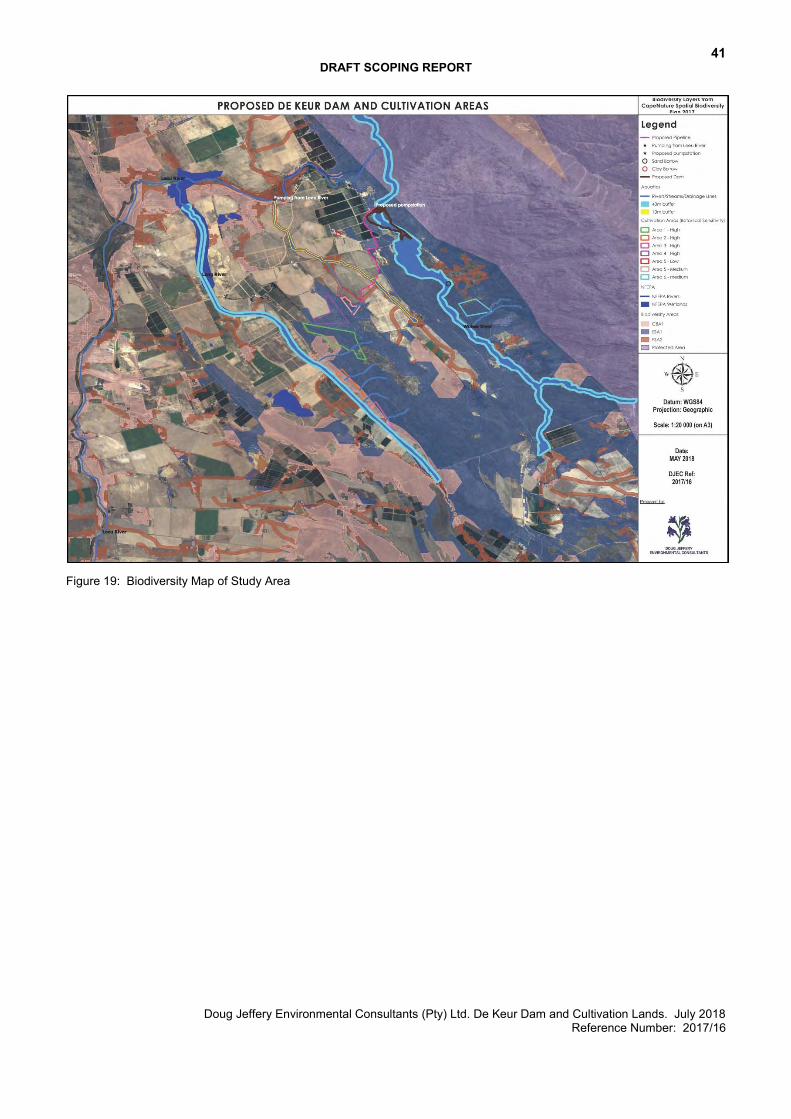
41 DRAFT SCOPING REPORT
Doug Jeffery Environmental Consultants (Pty) Ltd. De Keur Dam and Cultivation Lands. July 2018 Reference Number: 2017/16
Figure 19: Biodiversity Map of Study Area
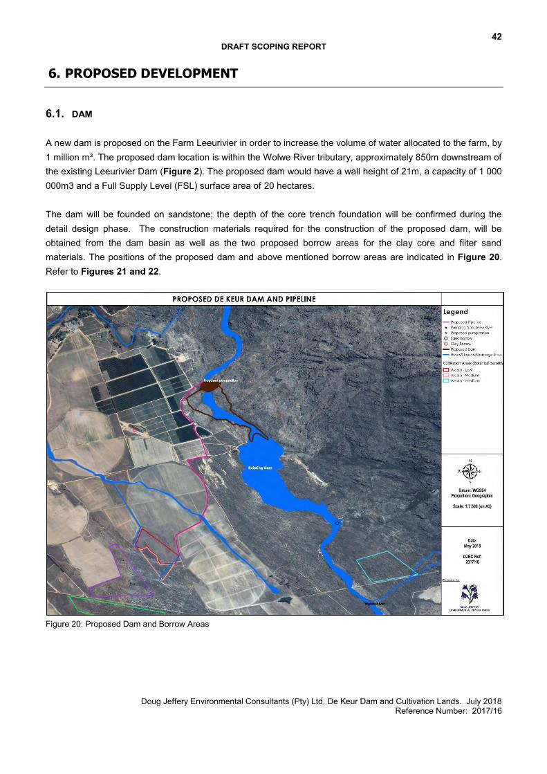
42 DRAFT SCOPING REPORT
Doug Jeffery Environmental Consultants (Pty) Ltd. De Keur Dam and Cultivation Lands. July 2018 Reference Number: 2017/16
6. PROPOSED DEVELOPMENT
6.1. DAM A new dam is proposed on the Farm Leeurivier in order to increase the volume of water allocated to the farm, by 1 million m³. The proposed dam location is within the Wolwe River tributary, approximately 850m downstream of the existing Leeurivier Dam (Figure 2). The proposed dam would have a wall height of 21m, a capacity of 1 000 000m3 and a Full Supply Level (FSL) surface area of 20 hectares. The dam will be founded on sandstone; the depth of the core trench foundation will be confirmed during the detail design phase. The construction materials required for the construction of the proposed dam, will be obtained from the dam basin as well as the two proposed borrow areas for the clay core and filter sand materials. The positions of the proposed dam and above mentioned borrow areas are indicated in Figure 20. Refer to Figures 21 and 22.
Figure 20: Proposed Dam and Borrow Areas
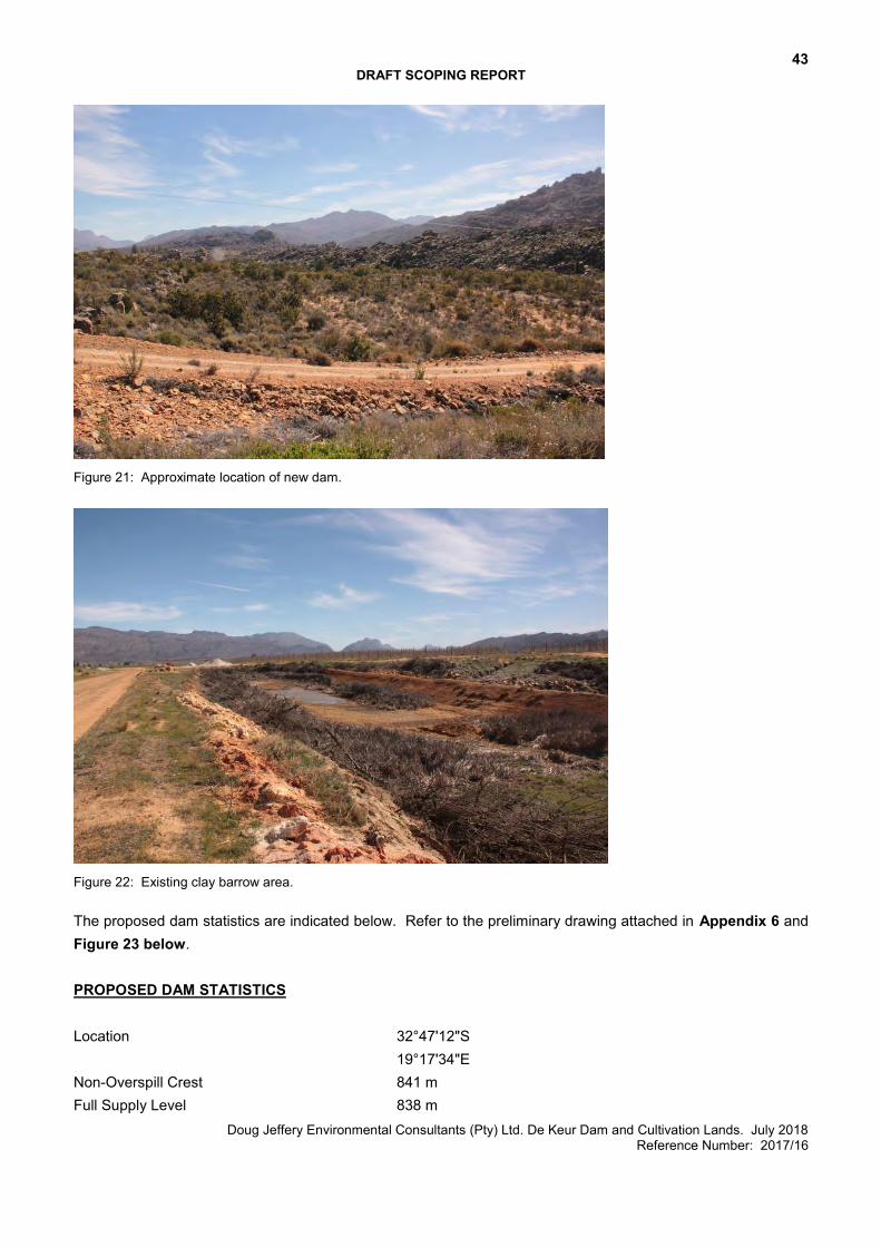
43 DRAFT SCOPING REPORT
Doug Jeffery Environmental Consultants (Pty) Ltd. De Keur Dam and Cultivation Lands. July 2018 Reference Number: 2017/16
Figure 21: Approximate location of new dam.
Figure 22: Existing clay barrow area. The proposed dam statistics are indicated below. Refer to the preliminary drawing attached in Appendix 6 and Figure 23 below. PROPOSED DAM STATISTICS Location 32°47'12"S
19°17'34"E Non-Overspill Crest 841 m Full Supply Level 838 m
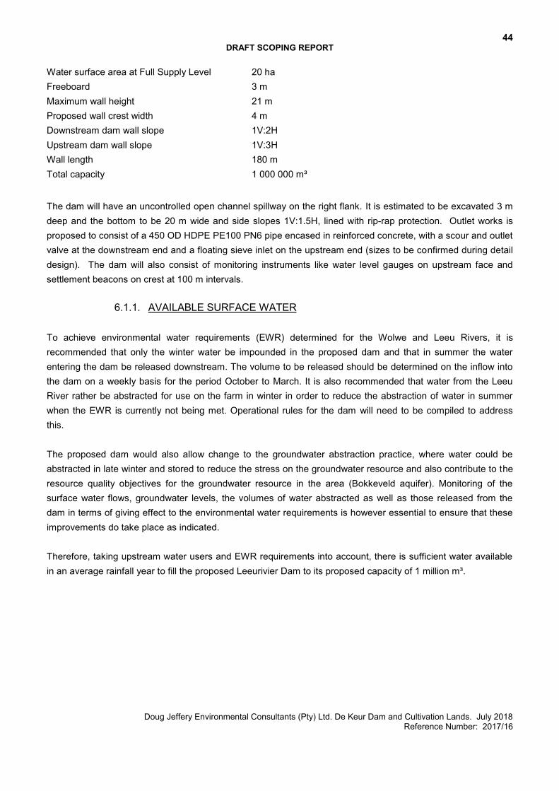
44 DRAFT SCOPING REPORT
Doug Jeffery Environmental Consultants (Pty) Ltd. De Keur Dam and Cultivation Lands. July 2018 Reference Number: 2017/16
Water surface area at Full Supply Level 20 ha Freeboard 3 m Maximum wall height 21 m Proposed wall crest width 4 m Downstream dam wall slope 1V:2H Upstream dam wall slope 1V:3H Wall length 180 m Total capacity 1 000 000 m³
The dam will have an uncontrolled open channel spillway on the right flank. It is estimated to be excavated 3 m deep and the bottom to be 20 m wide and side slopes 1V:1.5H, lined with rip-rap protection. Outlet works is proposed to consist of a 450 OD HDPE PE100 PN6 pipe encased in reinforced concrete, with a scour and outlet valve at the downstream end and a floating sieve inlet on the upstream end (sizes to be confirmed during detail design). The dam will also consist of monitoring instruments like water level gauges on upstream face and settlement beacons on crest at 100 m intervals.
6.1.1. AVAILABLE SURFACE WATER
To achieve environmental water requirements (EWR) determined for the Wolwe and Leeu Rivers, it is recommended that only the winter water be impounded in the proposed dam and that in summer the water entering the dam be released downstream. The volume to be released should be determined on the inflow into the dam on a weekly basis for the period October to March. It is also recommended that water from the Leeu River rather be abstracted for use on the farm in winter in order to reduce the abstraction of water in summer when the EWR is currently not being met. Operational rules for the dam will need to be compiled to address this. The proposed dam would also allow change to the groundwater abstraction practice, where water could be abstracted in late winter and stored to reduce the stress on the groundwater resource and also contribute to the resource quality objectives for the groundwater resource in the area (Bokkeveld aquifer). Monitoring of the surface water flows, groundwater levels, the volumes of water abstracted as well as those released from the dam in terms of giving effect to the environmental water requirements is however essential to ensure that these improvements do take place as indicated. Therefore, taking upstream water users and EWR requirements into account, there is sufficient water available in an average rainfall year to fill the proposed Leeurivier Dam to its proposed capacity of 1 million m³.
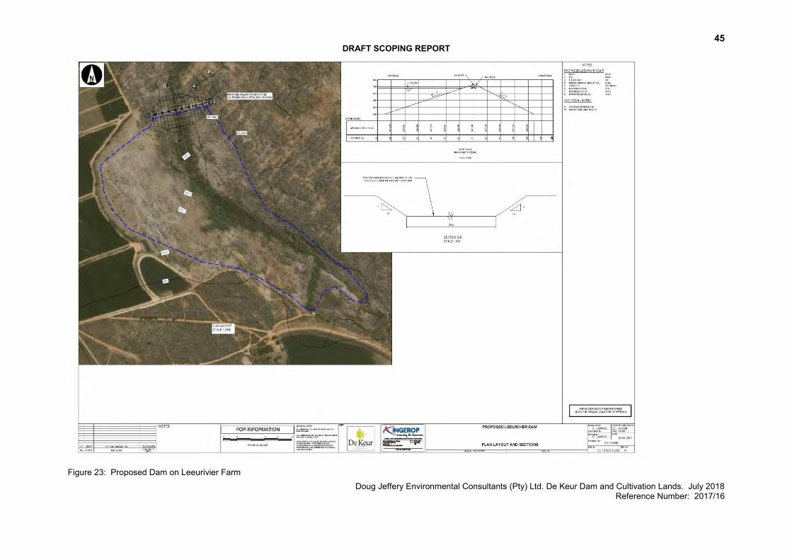
45 DRAFT SCOPING REPORT
Doug Jeffery Environmental Consultants (Pty) Ltd. De Keur Dam and Cultivation Lands. July 2018 Reference Number: 2017/16
Figure 23: Proposed Dam on Leeurivier Farm
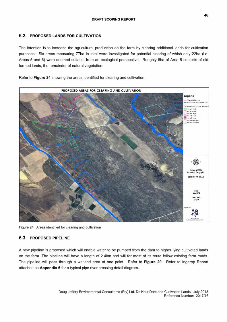
46 DRAFT SCOPING REPORT
Doug Jeffery Environmental Consultants (Pty) Ltd. De Keur Dam and Cultivation Lands. July 2018 Reference Number: 2017/16
6.2. PROPOSED LANDS FOR CULTIVATION The intention is to increase the agricultural production on the farm by clearing additional lands for cultivation purposes. Six areas measuring 77ha in total were investigated for potential clearing of which only 22ha (i.e. Areas 5 and 6) were deemed suitable from an ecological perspective. Roughly 6ha of Area 5 consists of old farmed lands, the remainder of natural vegetation. Refer to Figure 24 showing the areas identified for clearing and cultivation.
Figure 24: Areas identified for clearing and cultivation
6.3. PROPOSED PIPELINE A new pipeline is proposed which will enable water to be pumped from the dam to higher lying cultivated lands on the farm. The pipeline will have a length of 2.4km and will for most of its route follow existing farm roads. The pipeline will pass through a wetland area at one point. Refer to Figure 20. Refer to Ingerop Report attached as Appendix 6 for a typical pipe river crossing detail diagram.
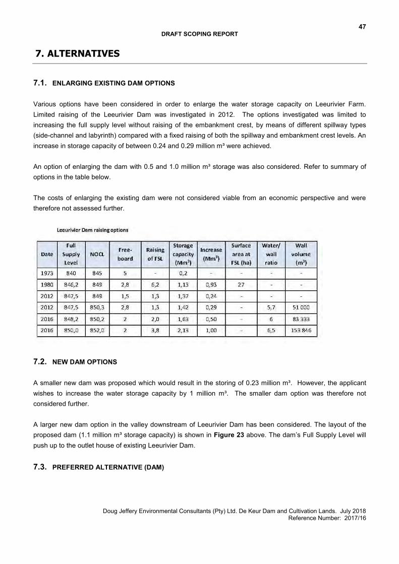
47 DRAFT SCOPING REPORT
Doug Jeffery Environmental Consultants (Pty) Ltd. De Keur Dam and Cultivation Lands. July 2018 Reference Number: 2017/16
7. ALTERNATIVES
7.1. ENLARGING EXISTING DAM OPTIONS Various options have been considered in order to enlarge the water storage capacity on Leeurivier Farm. Limited raising of the Leeurivier Dam was investigated in 2012. The options investigated was limited to increasing the full supply level without raising of the embankment crest, by means of different spillway types (side-channel and labyrinth) compared with a fixed raising of both the spillway and embankment crest levels. An increase in storage capacity of between 0.24 and 0.29 million m³ were achieved. An option of enlarging the dam with 0.5 and 1.0 million m³ storage was also considered. Refer to summary of options in the table below. The costs of enlarging the existing dam were not considered viable from an economic perspective and were therefore not assessed further.
7.2. NEW DAM OPTIONS A smaller new dam was proposed which would result in the storing of 0.23 million m³. However, the applicant wishes to increase the water storage capacity by 1 million m³. The smaller dam option was therefore not considered further. A larger new dam option in the valley downstream of Leeurivier Dam has been considered. The layout of the proposed dam (1.1 million m³ storage capacity) is shown in Figure 23 above. The dam’s Full Supply Level will push up to the outlet house of existing Leeurivier Dam.
7.3. PREFERRED ALTERNATIVE (DAM)
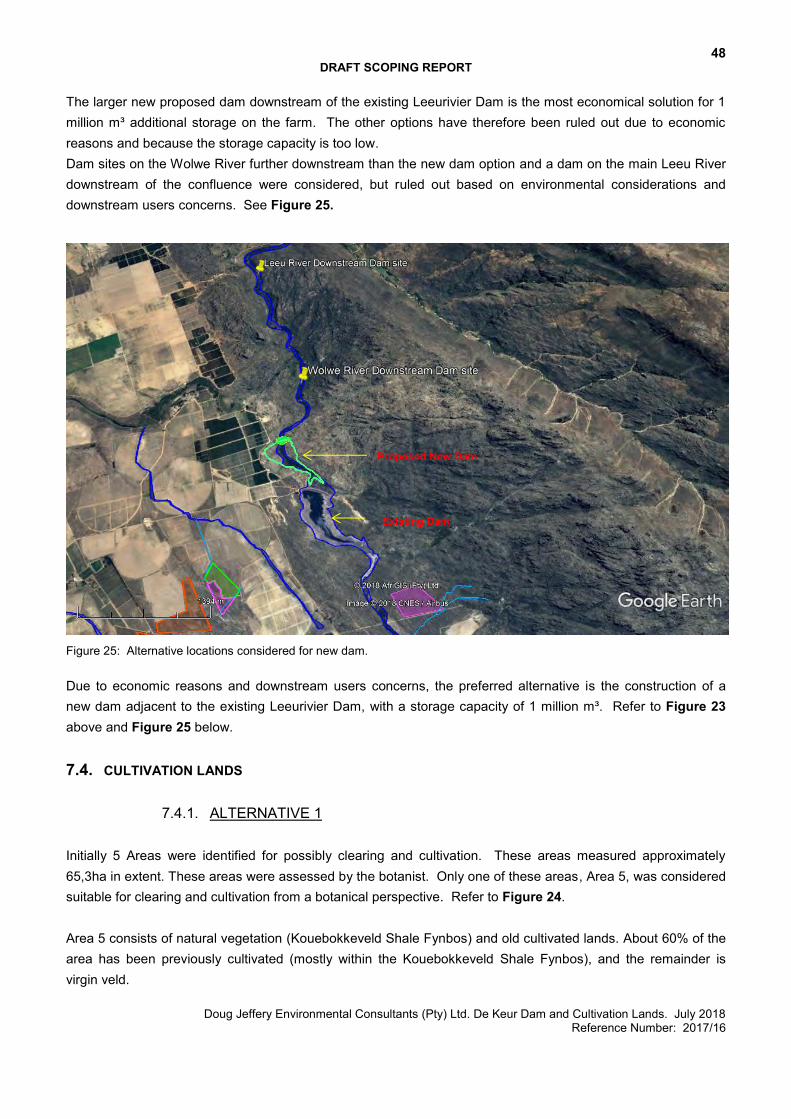
48 DRAFT SCOPING REPORT
Doug Jeffery Environmental Consultants (Pty) Ltd. De Keur Dam and Cultivation Lands. July 2018 Reference Number: 2017/16
The larger new proposed dam downstream of the existing Leeurivier Dam is the most economical solution for 1 million m³ additional storage on the farm. The other options have therefore been ruled out due to economic reasons and because the storage capacity is too low. Dam sites on the Wolwe River further downstream than the new dam option and a dam on the main Leeu River downstream of the confluence were considered, but ruled out based on environmental considerations and downstream users concerns. See Figure 25.
Figure 25: Alternative locations considered for new dam. Due to economic reasons and downstream users concerns, the preferred alternative is the construction of a new dam adjacent to the existing Leeurivier Dam, with a storage capacity of 1 million m³. Refer to Figure 23 above and Figure 25 below. 7.4. CULTIVATION LANDS
7.4.1. ALTERNATIVE 1 Initially 5 Areas were identified for possibly clearing and cultivation. These areas measured approximately 65,3ha in extent. These areas were assessed by the botanist. Only one of these areas, Area 5, was considered suitable for clearing and cultivation from a botanical perspective. Refer to Figure 24. Area 5 consists of natural vegetation (Kouebokkeveld Shale Fynbos) and old cultivated lands. About 60% of the area has been previously cultivated (mostly within the Kouebokkeveld Shale Fynbos), and the remainder is virgin veld.
Proposed New Dam
Existing Dam
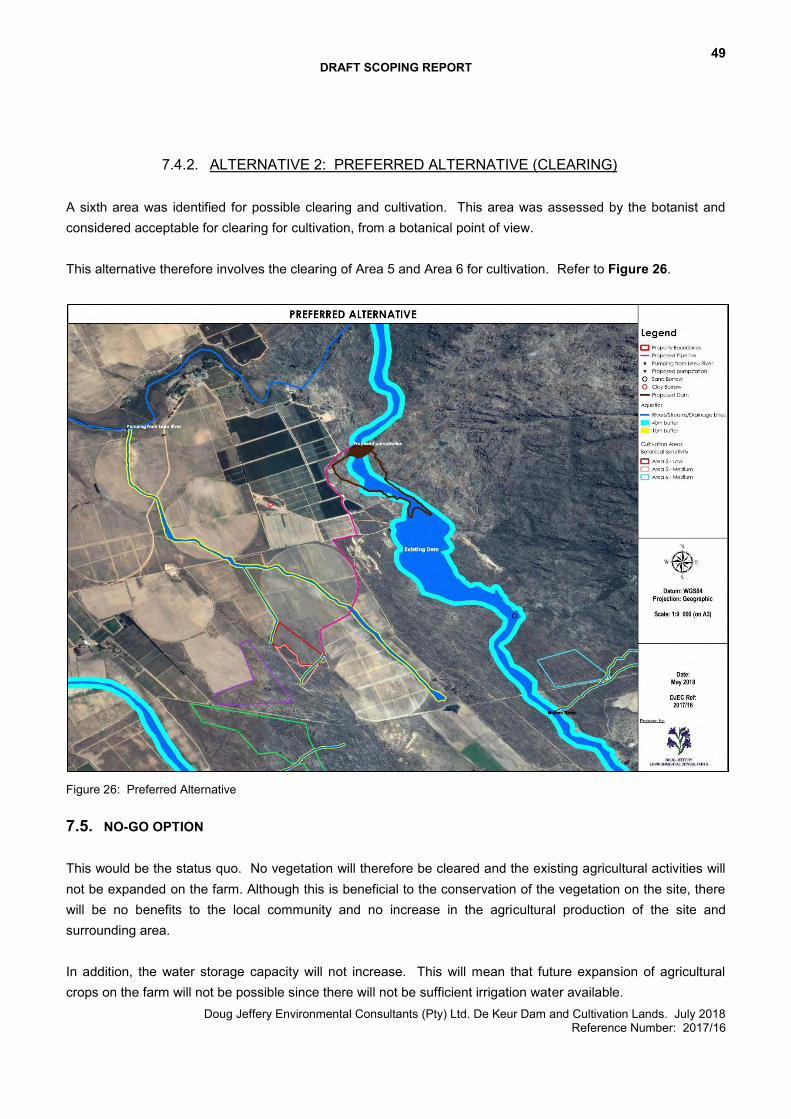
49 DRAFT SCOPING REPORT
Doug Jeffery Environmental Consultants (Pty) Ltd. De Keur Dam and Cultivation Lands. July 2018 Reference Number: 2017/16
7.4.2. ALTERNATIVE 2: PREFERRED ALTERNATIVE (CLEARING) A sixth area was identified for possible clearing and cultivation. This area was assessed by the botanist and considered acceptable for clearing for cultivation, from a botanical point of view. This alternative therefore involves the clearing of Area 5 and Area 6 for cultivation. Refer to Figure 26.
Figure 26: Preferred Alternative
7.5. NO-GO OPTION This would be the status quo. No vegetation will therefore be cleared and the existing agricultural activities will not be expanded on the farm. Although this is beneficial to the conservation of the vegetation on the site, there will be no benefits to the local community and no increase in the agricultural production of the site and surrounding area. In addition, the water storage capacity will not increase. This will mean that future expansion of agricultural crops on the farm will not be possible since there will not be sufficient irrigation water available.
50 DRAFT SCOPING REPORT
Doug Jeffery Environmental Consultants (Pty) Ltd. De Keur Dam and Cultivation Lands. July 2018 Reference Number: 2017/16
8. SITE SELECTION MATRIX
The property for the proposed development was selected since the Applicant owns the land and wishes to expand the existing agricultural land on the farm. In order to do so, additional water will be required for irrigation purposes and this will be achieved by means of constructing a new dam. The site selection process involved a two stage approach:
1. The selection of areas suitable for cultivation from a farming perspective and the selection of a suitable site for the new dam. These areas were identified by the Applicant.
2. The selection of the footprint for the proposed development, i.e. areas to be cleared within the Applicant’s target areas.
8.1. AREAS SUITABLE FOR CULTIVATION AND NEW DAM
A map was provided by the Applicant showing the area identified for further agricultural expansion (Figure 24). This map showed 5 areas suitable for expansion. Proposed Cultivation Area 1 (24.9ha) The underlying vegetation type within the entire area is Cederberg Sandstone Fynbos, a Vulnerable vegetation type. The botanical sensitivity of the area is provisionally deemed to be High on a regional scale. Proposed Cultivation Area 2 (9.2ha) The mapped vegetation in this area is Kouebokkeveld Alluvium Fynbos, which is regarded as Endangered on a national basis. The botanical sensitivity of the area is provisionally deemed to be High on a regional scale. Proposed Cultivation Area 3 (7.2ha) The mapped vegetation in this area is Kouebokkeveld Alluvium Fynbos, which is regarded as Endangered on a national basis. The botanical sensitivity of the area is provisionally deemed to be High on a regional scale. Most of this area is also within 32m of the edge of a wetland. Proposed Cultivation Area 4 (13.6ha) The underlying vegetation type is mapped as Cederberg Sandstone Fynbos, a Vulnerable vegetation type. The botanical sensitivity of the area is provisionally deemed to be High on a regional scale. Proposed Cultivation Area 5 (10.4ha) This area is also ecotonal, being a mix of Kouebokkeveld Shale Fynbos and Cederberg Sandstone Fynbos, both of which are classified as Vulnerable habitats on a national basis. About 60% of the area has been previously cultivated (mostly within the Kouebokkeveld Shale Fynbos), and the remainder is virgin veld. The botanical sensitivity of the area is deemed to be Low for the previously cultivated component, and Medium for the uncultivated portion, on a regional scale.
51 DRAFT SCOPING REPORT
Doug Jeffery Environmental Consultants (Pty) Ltd. De Keur Dam and Cultivation Lands. July 2018 Reference Number: 2017/16
Alternative Dam Sites Dam sites on the Wolwe and Leeu River were considered, downstream of the existing dam. These sites were ruled out due to downstream users concerns. Refer to Figure 25 showing the alternative sites that were initially investigated.
8.2. FOOTPRINT SELECTION PROCESS
The selection of the areas within the farm followed a risk adverse approach, in order to ensure that the impacts of the proposed developments can be avoided as far as possible. This avoidance approach reduces the degree of mitigation required in order ensure that potential environmental impacts are within acceptable levels. This approach was achieved by means of appointing a Botanist and Freshwater Specialist to undertake baseline studies and sensitivity analysis for the entire study area. These constraints were used to determine the areas acceptable for cultivation from an ecological perspective, ensuring potential impacts on freshwater systems and natural vegetation are kept to an absolute minimum. Of the 5 areas identified for clearing, only one area was considered acceptable from a botanical perspective, i.e. Area 5. A sixth area was then selected for clearing and cultivation with input from the botanist. Proposed Cultivation Area 6 (12ha) The vegetation is typical Cederberg Sandstone Fynbos on thin soils. The botanical sensitivity of the area is deemed to be Medium, on a regional scale. Areas 5 and 6 were further refined by the Aquatic Constraints. There are a number of small drainage lines and trenches within the vicinity of these areas. These drainage lines must be avoided and a 10m buffer is recommended to prevent erosion of the slopes and to allow for the movement of biota. The resulting areas are indicated in Figure 26. The constraints are discussed in Section 5 of this Report and the resulting preferred layout is show in Section 7.4.2 of this Report (i.e. Alternative 2).
52 DRAFT SCOPING REPORT
Doug Jeffery Environmental Consultants (Pty) Ltd. De Keur Dam and Cultivation Lands. July 2018 Reference Number: 2017/16
9. RATIONALE FOR THE PROPOSED DEVELOPMENT
The consideration of ‘need and desirability’ requires the consideration of the context of the proposal along with the broader societal needs and the public interest. According to the DEADP’s Guidelines on Need and Desirability, the concept of need and desirability can be explained as need refers to time and desirability to place – i.e. is this the right time and place for locating the type of land use being proposed? Need and desirability can be equated to wise use of land – i.e. the question of what is the most sustainable use of land. It is believed that through the adequate consideration of need and desirability throughout the environmental process, it will ensure that the “best practicable environmental option” is pursued. The table below is based on the Guideline for Need and Desirability (DEA, 2014) and is used to motivate the Need and Desirability of this proposal. Please note this table will be further informed by the outcomes of the Scoping Phase and Impact Assessment Reports and will be updated and included in the Environmental Impact Report.
Guideline EAP Response
How will this development (and its separate elements/aspects) impact on the ecological integrity of the area?
How were the following ecological integrity considerations taken into account: Threatened Ecosystems, Sensitive, vulnerable, highly dynamic or stressed
ecosystems, such as coastal shores, estuaries, wetlands, and similar systems require specific attention in management and planning procedures, especially where they are subject to significant human resource usage and development pressure,
Critical Biodiversity Areas (“CBAs”) and Ecological Support Areas (“ESAs”),
Conservation targets, Ecological drivers of the ecosystem, Environmental attributes and management proposals
contained in relevant Environmental Management Frameworks,
Environmental attributes and management proposals contained in relevant Spatial Development Framework, and
Global and international responsibilities relating to the environment (e.g. RAMSAR sites, Climate Change, etc.).
Ecological impacts will be assessed and included in the Environmental Impact Report. The following specialist studies were commissioned and will determine the impact on the ecological integrity of the area:
Botany Freshwater
The proposed site development layout attempts to consider all the specialists constraints, thereby avoiding ecologically sensitive areas. Refer to Section 5 of this report for an explanation of all the ecological constraints and refer to the maps included in Appendix 3. Areas 2 & 3 are CBA1, and most of Areas 1, 4 and 6 are terrestrial ESA1s, along with part of Area 5. The intention is to only clear Areas 5 and 6. They are mapped as an ESA1 for the following reasons:
Vunerable vegetation type covering the area Possibility of Cape Mountain Zebra occurring here Located above the Koue Bokkeveld Aquifer
The proposed clearing will impact on the vegetation but it is unlikely to affect the presence of Zebra or interfere with groundwater recharge. A botanist has been appointed to assess the botanical impacts. Drainage features across the farm, as well as the Wolwe River and Lang River corridor have been mapped as aquatic ESA 2. The Leeu River and certain reaches of the Lang River are mapped at aquatic CBAs. A portion of the new proposed dam is located within the terrestrial ESA1. The reason for this category is the area has been mapped as part of a climate change adaptation corridor and a water recharge area. In this case, the area in question is located adjacent to a Protected Area (Koue
53 DRAFT SCOPING REPORT
Doug Jeffery Environmental Consultants (Pty) Ltd. De Keur Dam and Cultivation Lands. July 2018 Reference Number: 2017/16
Bokkeveld Mountain Catchment Area) and above the Koue Bokkeveld Aquifer. The proposed dam will not restrict ecological connectivity nor interfere with groundwater recharge. Refer to Section 5.5 of the Report. Section 13 and 14 of this Report discusses the potential impacts expected. Potential botanical impacts include:
Permanent loss of all natural and partly natural vegetation within the site development footprints (likely to be about 77ha of cultivation plus about 13ha of dam footprint).
Disturbance to natural and partly natural vegetation (a long term impact; mainly from part of the pipeline route).
Loss of areas mapped as CBA and ESA. Habitat fragmentation and loss of current
ecological connectivity across the site. Possible pesticides spray drift.
Potential freshwater impacts include:
- Flow modification and habitat modification as well as short term water quality impacts associated with the proposed new dam on the Wolwe River
- Loss of riparian and instream habitat and bed/bank modification impacts associated with the construction of associated infrastructure (pipeline)
- Disturbance/degradation of aquatic habitat impacts associated with the expansion of agricultural areas
Further detail will be provided in the Environmental Impact Report (EIR).
How will this development disturb or enhance ecosystems and/or result in the loss or protection of biological diversity? What measures were explored to firstly avoid these negative impacts, and where these negative impacts could not be avoided altogether, what measures were explored to minimise and remedy?
How will this development pollute and/or degrade the biophysical environment? What measures were explored to firstly avoid these impacts, and where impacts could not be avoided altogether, what measures were explored to minimise and remedy (including offsetting) the impacts? What measures were explored to enhance positive impacts?
Positive and negative ecological impacts will be assessed in the specialist studies mentioned above. The iterative process followed by the project team has firstly tried to avoid negative impacts by using the specialists’ constraints analyses to inform the layout. Where impacts could not be avoided, specialists will provide mitigation measures in order to reduce the negative impacts to an acceptable level. Management/Operational measures will also be discussed continued management and operations are required. This will all be discussed in the specialist studies, the Environmental Impact Report and the Environmental Management Programme. The Soil Potential Map indicates Area 6 contains soils of medium and medium high potential (15.23 ha) and low potential soils (14.56 ha). The Soil Potential Map for Area 5 (Rooikop) contains soils of medium low, medium, medium high and low potential soils. Medium and medium high soils are marginally suitable for apples and suitable for pears. The low potential soils are slightly suitable for pears. This application is for the taking of an additional 65 ha of water, at 9500 m3/ha/annum. Using the Department of Agriculture’s water usage standard of 7000 m³ per hectare, the dam will allow for the irrigation of an additional 88.21 ha of land. This application includes the clearing and
54 DRAFT SCOPING REPORT
Doug Jeffery Environmental Consultants (Pty) Ltd. De Keur Dam and Cultivation Lands. July 2018 Reference Number: 2017/16
cultivation of 22.4ha of land. There is therefore sufficient water to irrigate the new proposed lands and allows the farmer the opportunity to increase his cultivated lands in the future.
What waste will be generated by this development? What measures were explored to firstly avoid waste, and where waste could not be avoided altogether, what measures were explored to minimise, reuse and/or recycle the waste? What measures have been explored to safely treat and/or dispose of unavoidable waste?
No waste or pollution will be generated by this proposal. The vegetation that has been removed will either be used for domestic purposes (fire wood) or it will be stockpiled into many heaps which will be burned on days suitable for burning or during the burning season.
How will this development use and/or impact on non-renewable natural resources? What measures were explored to ensure responsible and equitable use of the resources? How have the consequences of the depletion of the non-renewable natural resources been considered? What measures were explored to firstly avoid these impacts, and where impacts could not be avoided altogether, what measures were explored to minimise and remedy (including offsetting) the impacts? What measures were explored to enhance positive impacts?
The proposed development entails the expansion of an existing agricultural operation in terms of cultivated lands and water storage for irrigation purposes. No non-renewable resources will be required. No further infrastructure will need to be constructed other than the necessary farm roads and irrigation pipes.
How will this development use and/or impact on renewable natural resources and the ecosystem of which they are part? Will the use of the resources and/or impact on the ecosystem jeopardise the integrity of the resource and/or system taking into account carrying capacity restrictions, limits of acceptable change, and thresholds? What measures were explored to firstly avoid the use of resources, or if avoidance is not possible, to minimise the use of resources? What measures were taken to ensure responsible and equitable use of the resources? What measures were explored to enhance positive impacts?
Does the proposed development exacerbate the increased dependency on increased use of resources to maintain economic growth or does it reduce resource dependency (i.e. de-materialised growth)? (note: sustainability requires that settlements reduce their ecological footprint by using less material and energy demands and reduce the amount of waste they generate, without compromising their quest to improve their quality of life)
Does the proposed use of natural resources constitute the best use thereof? Is the use justifiable when considering intra- and intergenerational equity, and are there more important priorities for which the resources should be used (i.e. what are the opportunity costs of using these resources for the proposed development alternative?).
Do the proposed location, type and scale of development promote a reduced dependency on resources?
Use of non-renewable resources, such as electricity and water, will be limited. A small amount of power will be required to irrigate the crops. Water efficient irrigation and efficient irrigation scheduling will be used, which will reduce the irrigation water demands. To achieve environmental water requirements (EWR) determined for the Wolwe and Leeu Rivers, it is recommended that only the winter water be impounded in the proposed dam and that in summer the water entering the dam be leased downstream. The volume to be released should be determined on the inflow into the dam on a weekly basis for the period October to March. It is also recommended that water from the Leeu River rather be abstracted for use on the farm in winter in order to reduce the abstraction of water in summer when the EWR is currently not being met. The proposed dam would also allow change the groundwater abstraction practice, where water could be abstracted in late winter and stored to reduce the stress on the groundwater resource and also contribute to the resource quality objectives for the groundwater resource in the area (Bokkeveld aquifer).
How will the ecological impacts resulting from this Measures to avoid, mitigate and manage impacts will be
55 DRAFT SCOPING REPORT
Doug Jeffery Environmental Consultants (Pty) Ltd. De Keur Dam and Cultivation Lands. July 2018 Reference Number: 2017/16
development impact on people’s environmental right in terms following: o Negative impacts: e.g. access to resources,
opportunity costs, loss of amenity (e.g. open space), air and water quality impacts, nuisance (noise, odour, etc.), health impacts, visual impacts, etc. What measures were taken to firstly avoid negative impacts, but if avoidance is not possible, to minimise, manage and remedy negative impacts?
o Positive impacts: e.g. improved access to resources, improved amenity, improved air or water quality, etc. What measures were taken to enhance positive impacts?
o Describe the linkages and dependencies between human wellbeing, livelihoods and ecosystem services applicable to the area in question and how the development’s ecological impacts will result in socio-economic impacts (e.g. on livelihoods, loss of heritage site, opportunity costs, etc.)?
o Based on all of the above, how will this development positively or negatively impact on ecological integrity objectives/targets/considerations of the area?
o Considering the need to secure ecological integrity and a healthy biophysical environment, describe how the alternatives identified (in terms of all the different elements of the development and all the different impacts being proposed), resulted in the selection of the “best practicable environmental option” in terms of ecological considerations?
o Describe the positive and negative cumulative ecological/biophysical impacts bearing in mind the size, scale, scope and nature of the project in relation to its location and existing and other planned developments in the area?
included within the Environmental Management Programme that will be compiled during the EIA Phase and included within the Environmental Impact Report.
What is the socio-economic context of the area, based on, amongst other considerations, the following considerations?: o The IDP (and its sector plans’ vision, objectives,
strategies, indicators and targets) and any other strategic plans, frameworks of policies applicable to the area,
o Spatial priorities and desired spatial patterns (e.g. need for integrated of segregated communities, need to upgrade informal settlements, need for densification, etc.),
o Spatial characteristics (e.g. existing land uses, planned land uses, cultural landscapes, etc.), and
o Municipal Economic Development Strategy (“LED Strategy”).
The site is zoned for agriculture and the larger farm has existing crops which are successfully farmed. The sites are surrounded by agricultural land/operating farms consisting of orchards, farm dams, farm worker housing and homesteads. The proposed development will therefore be consistent with the existing land use on the farm as well as the surrounding areas.
Considering the socio-economic context, what will the socio-economic impacts be of the development (and its separate elements/aspects), and specifically also on the socio-economic objectives of the area?
o Will the development complement the local socio-economic initiatives (such as local economic
Although the proposed activity will offer a relatively small benefit to society in general and may not be considered a societal priority, it will still have a positive benefit for the local community. The proposal will result in positive impacts for the community as those already employed on the farm will have increased job security, additional employment
56 DRAFT SCOPING REPORT
Doug Jeffery Environmental Consultants (Pty) Ltd. De Keur Dam and Cultivation Lands. July 2018 Reference Number: 2017/16
development (LED) initiatives), or skills development programs?
opportunities will be created for the local community (who live in close proximity to the farm) and the economic development of the area will benefit. An indirect impact of the proposal is an increase in agricultural produce which is not only beneficial to the local area but to the entire region and possibly the country too. The direct and indirect positive impacts resulting from the proposed activity can be safeguarded through the implementation of best-farming practises and compliance with any recommendations made by the Department of Agriculture.
How will this development disturb or enhance landscapes and/or sites that constitute the nation’s cultural heritage? What measures were explored to firstly avoid these impacts, and where impacts could not be avoided altogether, what measures were explored to minimise and remedy (including offsetting) the impacts? What measures were explored to enhance positive impacts?
Agriculture is standard practice within the area and therefore little impact will be caused to people’s health and wellbeing (in terms of noise, odours, visual character and sense of place) as a result of this activity. The location of the site also limits the impacts that the activity will have on people as the site is located outside any towns. No negative socio-economic impacts are therefore expected should this proposal be approved. In addition, no significant cultural or heritage impacts will result from the proposed clearing activities. The sites are located on an operational farm located within an agricultural area – the sense of place and history of the area will not be affected by the expansion of agricultural land and the construction of a new irrigation dam.
How will this development address the specific physical, psychological, developmental, cultural and social needs and interests of the relevant communities?
Those already employed on the farm will have increased job security, additional employment opportunities will be created for the local community (who live in close proximity to the farm) and the economic development of the area will benefit. There will be an increase in agricultural produce which is not only beneficial to the local area but to the entire region.
Will the development result in equitable (intra- and inter-generational) impact distribution, in the short- and long-term? Will the impact be socially and economically sustainable in the short- and long-term?
The proposed development entails the expansion of an existing agricultural operation in terms of cultivated lands and water storage for irrigation purposes.
In terms of location, describe how the placement of the proposed development will: o result in the creation of residential and employment
opportunities in close proximity to or integrated with each other,
o reduce the need for transport of people and goods, o result in access to public transport or enable non-
motorised and pedestrian transport (e.g. will the development result in densification and the achievement of thresholds in terms public transport),
o compliment other uses in the area, o be in line with the planning for the area, o for urban related development, make use of
underutilised land available within the urban edge, o optimise the use of existing resources and
The proposed development entails the expansion of an existing agricultural operation in terms of cultivated lands and water storage for irrigation purposes.
57 DRAFT SCOPING REPORT
Doug Jeffery Environmental Consultants (Pty) Ltd. De Keur Dam and Cultivation Lands. July 2018 Reference Number: 2017/16
infrastructure, consider opportunity costs in terms of bulk infrastructure expansions in non-priority areas (e.g. not aligned with the bulk infrastructure planning for the settlement that reflects the spatial reconstruction priorities of the settlement), discourage “urban sprawl” and contribute to compaction/densification,
o contribute to the correction of the historically distorted spatial patterns of settlements and to the optimum use of existing infrastructure in excess of current needs,
o encourage environmentally sustainable land development practices and processes,
o take into account special locational factors that might favour the specific location (e.g. the location of a strategic mineral resource, access to the port, access to rail, etc.),
o result in investment in the settlement or area in question that will generate the highest socioeconomic returns (i.e. an area with high economic potential),
o impact on the sense of history, sense of place and heritage of the area and the socio-cultural and cultural-historic characteristics and sensitivities of the area, and
o in terms of the nature, scale and location of the development, promote or act as a catalyst to create a more integrated settlement?
How were a risk-averse and cautious approach applied
in terms of socio-economic impacts?: o What are the limits of current knowledge (note: the
gaps, uncertainties and assumptions must be clearly stated)?
o What is the level of risk (note: related to inequality, social fabric, livelihoods, vulnerable communities, critical resources, economic vulnerability and sustainability) associated with the limits of current knowledge?
o Based on the limits of knowledge and the level of risk, how and to what extent was a risk-averse and cautious approach applied to the development (and its alternatives)?
The proposed development entails the expansion of an existing agricultural operation in terms of cultivated lands and water storage for irrigation purposes.
How will the socio-economic impacts resulting from this development impact on people’s environmental right in terms following: o Negative impacts: e.g. health (e.g. HIV-Aids), safety,
social ills, etc. What measures were taken to firstly avoid negative impacts, but if avoidance is not possible, to minimise, manage and remedy negative impacts?
o Positive impacts. What measures were taken to enhance positive impacts?
I&APs and Stakeholders will be allowed the opportunity to consider and submit comment, thereby ensuring that all people’s needs, rights and concerns will be addressed through this process.
Considering the linkages and dependencies between human wellbeing, livelihoods and ecosystem services,
No natural resources will be over-utilised. The specialists will assess the impact of the proposed development on the
58 DRAFT SCOPING REPORT
Doug Jeffery Environmental Consultants (Pty) Ltd. De Keur Dam and Cultivation Lands. July 2018 Reference Number: 2017/16
describe the linkages and dependencies applicable to the area in question and how the development’s socio-economic impacts will result in ecological impacts (e.g. over utilisation of natural resources, etc.)?
natural environment. This will be discussed in the EIA phase.
What measures were taken to pursue the selection of the “best practicable environmental option” in terms of socio-economic considerations?
The proposed development entails the expansion of an existing agricultural operation in terms of cultivated lands and water storage for irrigation purposes.
What measures were taken to pursue environmental justice so that adverse environmental impacts shall not be distributed in such a manner as to unfairly discriminate against any person, particularly vulnerable and disadvantaged persons (who are the beneficiaries and is the development located appropriately)?
Those already employed on the farm will have increased job security, additional employment opportunities will be created for the local community (who live in close proximity to the farm) and the economic development of the area will benefit. There will be an increase in agricultural produce which beneficial to the local area and region.
Considering the need for social equity and justice, do the alternatives identified, allow the “best practicable environmental option” to be selected, or is there a need for other alternatives to be considered?
The preferred alternative is considered the best practicable environmental option.
What measures were taken to pursue equitable access to environmental resources, benefits and services to meet basic human needs and ensure human wellbeing, and what special measures were taken to ensure access thereto by categories of persons disadvantaged by unfair discrimination?
The proposed development entails the expansion of an existing agricultural operation in terms of cultivated lands and water storage for irrigation purposes. Those already employed on the farm will have increased job security and additional employment opportunities will be created for the local community should the farm increase its agricultural lands.
What measures were taken to ensure that the responsibility for the environmental health and safety consequences of the development has been addressed throughout the development’s life cycle?
What measures were taken to ensure that the interests, needs and values of all interested and affected parties were taken into account, and that adequate recognition were given to all forms of knowledge, including traditional and ordinary knowledge?
An EMPr for the construction and operational phases of the proposed development will be developed in the EIA phase and will specify responsibilities for environmental issues throughout the life of the development. The Public Participation Process to be undertaken as part of the Scoping and EIA process is detailed in Section 10 of this report. Various methods will be employed to notify potential Interested and Affected Parties of the proposed project, including site notices, advertisements in newspapers and written notifications of all adjacent landowners and occupiers.
Considering the interests, needs and values of all the interested and affected parties, describe how the development will allow for opportunities for all the segments of the community (e.g.. a mixture of low-, middle-, and high-income housing opportunities) that is consistent with the priority needs of the local area (or that is proportional to the needs of an area)?
The public participation process will incorporate engagement with local councillors and community leaders. The local community will have an opportunity to raise any concerns they may have and these concerns will be addressed throughout the process.
What measures have been taken to ensure that current and/or future workers will be informed of work that potentially might be harmful to human health or the environment or of dangers associated with the work, and what measures have been taken to ensure that the right of workers to refuse such work will be respected and
An EMPr will be developed to address health and safety concerns. An Environmental Control Officer will be appointed to monitor compliance.
59 DRAFT SCOPING REPORT
Doug Jeffery Environmental Consultants (Pty) Ltd. De Keur Dam and Cultivation Lands. July 2018 Reference Number: 2017/16
protected? Describe how the development will impact on job
creation in terms of, amongst other aspects: o the number of temporary versus permanent jobs that
will be created, o whether the labour available in the area will be able
to take up the job opportunities (i.e. do the required skills match the skills available in the area), the distance from where labourers will have to travel, the location of jobs opportunities versus the location of impacts (i.e. equitable distribution of costs and benefits), and
o the opportunity costs in terms of job creation (e.g. a mine might create 100 jobs in the short and medium term, but impact on 1000 permanent agricultural jobs, etc.).
Farm workers already employed on the farm will have increased job security and additional employment opportunities may become available to those living in close proximity to the farm, should the cultivated land increase on the farm.
What measures were taken to ensure: o that there were intergovernmental coordination and
harmonisation of policies, legislation and actions relating to the environment, and
o that actual or potential conflicts of interest between organs of state were resolved through conflict resolution procedures?
THE AUTHORITY CONSULTATION PROCESS CARRIED OUT BY THE
EAP WILL ASSIST IN COORDINATING THE POLICIES,
LEGISLATION AND MANDATES OF THE VARIOUS STATE
DEPARTMENTS/ORGANS OF STATE. THIS WILL BE DONE AS
PER THE REQUIREMENTS OF DEA&DP’S CIRCULAR EADP
0028/2014: ONE ENVIRONMENTAL MANAGEMENT
SYSTEM
In terms of the Agreement for the One Environmental System (section 50A of the NEMA and sections 41 (5) and 163 A of the NWA) the process for a Water Use License Application (WULA) and EIA will be aligned and integrated with respect to the fixed synchronised timeframes, as prescribed in the EIA Regulations 2014, as amended and the 2017 WULA Regulations (GN R. 267 of 24 March 2017). The EIA process will therefore take cognisance of this and will be carried out accordingly.
What measures were taken to ensure that the environment will be held in public trust for the people, that the beneficial use of environmental resources will serve the public interest, and that the environment will be protected as the people’s common heritage?
The EIA process, including the public participation, is a means of managing potential impacts on environmental resources and determining whether the proposed use of resources is in the public interest. This will be evaluated in the specialist impact assessments.
Are the mitigation measures proposed realistic and what long-term environmental legacy and managed burden will be left?
Mitigation measures are to be further developed in the EIA Phase
What measures were taken to ensure that the costs of remedying pollution, environmental degradation and consequent adverse health effects and of preventing, controlling or minimising further pollution, environmental damage or adverse health effects will be borne by those responsible for harming the environment?
Mitigation measures are to be further developed in the EIA Phase. These measures will become conditions of approval in the Environmental Authorisations, should the proposal be granted, and will form a key part of the EMPr for the proposed development. Responsibility for their implementation and for compliance with any authorisations would lie with the Applicant.
60 DRAFT SCOPING REPORT
Doug Jeffery Environmental Consultants (Pty) Ltd. De Keur Dam and Cultivation Lands. July 2018 Reference Number: 2017/16
Considering the need to secure ecological integrity and a healthy bio-physical environment, describe how the alternatives identified (in terms of all the different elements of the development and all the different impacts being proposed), resulted in the selection of the best practicable environmental option in terms of socio-economic considerations?
A preliminary identification of alternatives is included in Section 7 this Scoping Report. Further alternatives may be identified during the scoping and EIA phases of this process. The current preferred alternative is considered the best practicable environmental option since it is located on agricultural land and it takes the botanical and freshwater constraints of the farm into account. The construction of the dam will enable the farmer to farm more land, thereby increasing his agricultural produce. At present, there are 165 ha of irrigable land on the property used as either permanent crops and land used as rotational crops. The existing water rights on the property is for the irrigation of 82 ha of cultivated lands. This application is for the taking of an additional 65 ha of water, at 9500 m3/ha/annum. Using the Department of Agriculture’s water usage standard of 7000 m³ per hectare, the dam will allow for the irrigation of an additional 88.21 ha of land. This application includes the clearing and cultivation of 22.4ha of land. There is therefore sufficient water to irrigate the new proposed lands and allows the farmer the opportunity to increase his cultivated lands in the future.
Describe the positive and negative cumulative socio-
economic impacts bearing in mind the size, scale, scope and nature of the project in relation to its location and other planned developments in the area?
To be discussed in the EIR. A preliminary discussion of Potential Impacts and Cumulative impacts is included in Section 13 and 14 of this Report.
61 DRAFT SCOPING REPORT
Doug Jeffery Environmental Consultants (Pty) Ltd. De Keur Dam and Cultivation Lands. July 2018 Reference Number: 2017/16
10. PUBLIC PARTICIPATION PROCESS
The section below outlines the various tasks to be undertaken as part of the Public Participation Process as per Regulation 41 of the EIA Regulations 2014, as amended, and DEA&DP’s Guideline and Information Document Series [Guideline on Public Participation]. The issues and concerns raised during this pre-application scoping phase will be considered and evaluated in the statutory Scoping and EIA phase of this application. All documentation will be in English and advertisements will be provided in English and Afrikaans. The Executive Summary will be available in Afrikaans, on request.
10.1. TASKS UNDERTAKEN AND TO BE UNDERTAKEN DURING THE SCOPING PHASE
Interested and Affected Parties (I&APs) will be identified throughout the process. Initial identification of I&APs include immediate landowners, ward councillor, Witzenberg Municipality, Cape Winelands Municipality and relevant state departments and organs of state (Appendix 7).
Notification letters will be posted to all identified I&APs informing them of the proposal, the opportunity to comment and the availability of the pre-application Scoping Report.
Notification letters will be posted to all identified I&APs informing them of the proposal, the opportunity to comment and the availability of the pre-application Scoping Report.
The applicant will be requested to place A3 notices at ‘gathering points’ on the relevant farms in order to notify occupiers of the site, i.e. farm workers.
Neighbouring landowners will be requested to inform all those residing on their farms of the application and the opportunity to comment.
A site notice will be set up at the entrance to the farm. An advertiseement will be placed in the Witzenberg Herald. A copy of the Scoping Report will be lodged at the Op-die-Berg Library and on our company website
www.dougjeff.co.za Copies of the report will be delivered to relevant State Departments and Organs of State. Their comment
will be requested in terms of 24O of NEMA. A 30 day commenting period will be allowed. All comments received during this commenting period will be included in the Draft Scoping Report which
will be circulated to registered I&APs, Organs of State and State Departments for a further 30 day commenting period in the statutory process.
A Comments and Response Table will also be included – this table summarises the comments received and each comment is responded to.
Proof of the pre-application Public Participation Process will be included in the Draft Scoping Report.
62 DRAFT SCOPING REPORT
Doug Jeffery Environmental Consultants (Pty) Ltd. De Keur Dam and Cultivation Lands. July 2018 Reference Number: 2017/16
10.2. RELEVANT STATE DEPARTMENTS AND ORGANS OF STATE
Department of Agriculture National Department of Agriculture, Forestry and Fisheries Department of Water and Sanitation: BG-CMA Cape Nature Witzenberg Municipality Cape Winelands Municipality
63 DRAFT SCOPING REPORT
Doug Jeffery Environmental Consultants (Pty) Ltd. De Keur Dam and Cultivation Lands. July 2018 Reference Number: 2017/16
11. ENVIRONMENTAL ISSUES
Environmental issues were raised through informal discussions with the project team, specialists and authorities. All issues raised will be assessed by the specialist reports and will form part of the Environmental Impact Report. The main issues and concerns that were foreseen by the EAP include: Vegetation: Clarity on the vegetation type on site and ecological significance. Clearing impacts and impacts of farming operations on the existing and surrounding vegetation.
A Botanist has been appointed to assess these potential impacts. The constraints are discussed in Section 5.1 above and the assessment of impacts will be included in the EIA phase of the process. Preliminary discussions of potential impacts are included in Section 13 of this report.
Freshwater:
Clearing impacts and impacts of farming operations on the existing drainage lines on site. Clarity regarding what drainage lines exists on site. Impact of the proposed new dam on the river, riverine habitat and downstream users.
A Freshwater Ecologist was appointed to assess the potential impacts of the proposal on the watercourses and to suggest appropriate buffers in order to avoid negative impacts as far as possible. The constraints are discussed in Section 5.2 above and the assessment of impacts will be included in the EIA phase of the process. Preliminary discussions of potential impacts are included in Section 14 of this report.
Soils:
Are the soils suitable for farming?
A soil study was done for the two portions identified for clearing – refer to Appendix 4.
Water:
How much water will be available for irrigation?
The Water Use License Application (WULA) will explain in detail, how much additional water will be taken for the proposed dam and how much will be available for the irrigation of crops. The WULA will be included in the Environmental Impact Report (EIR).
OTHER ENVIRONMENTAL IMPACTS/CONCERNS MAY BE INDENTIFIED IN THE PUBLIC PARTICIPATION PROCESS AND WILL BE DEALT WITH IN THE NEXT PHASE OF THE ENVIRONMENTAL PROCESS.
64 DRAFT SCOPING REPORT
Doug Jeffery Environmental Consultants (Pty) Ltd. De Keur Dam and Cultivation Lands. July 2018 Reference Number: 2017/16
12. PLAN OF STUDY FOR EIA
Section (i) of Appendix 2 of Regulation 982 states that the following must be included in the Plan of Study for undertaking the Environmental Impact Assessment Process:
1. A description of the alternatives to be considered and assessed within the preferred site, including the option of not proceeding with the activity.
2. A description of the aspects to assessed as part of the Environmental Impact Assessment Process. 3. Aspects to be assessed by specialists. 4. A description of the proposed method of assessing the environmental aspects, including a description of
the proposed method of assessing the environmental aspects including aspects to be assessed by specialists.
5. A description of the proposed method of assessing duration and significance. 6. An indication of the stages at which the competent authority will be consulted. 7. Particulars of the public participation process that will be conducted during the Environmental Impact
Assessment Process. 8. A description of the tasks that will be undertaken as part of the Environmental Impact Assessment
Process. 9. Identify suitable measures to avoid, reverse, mitigate or manage identified impacts and to determine the
extent of the residual risks that need to be managed and monitored.
12.1. DESCRIPTION OF THE ALTERNATIVES TO BE CONSIDERED AND ASSESSED
The following alternatives have been considered in this Scoping Report and where relevant will be assessed during this Environmental Process:
Site Alternatives Technical Alternatives No Go Alternative
Please refer to Section 7 of this report, where alternatives are discussed in detail.
12.2. ASPECTS TO BE ASSESSED
Potential impacts have been identified in this Scoping Report and have and will be assessed in the Impact Assessment Phase of this Environmental Process. Please refer to Section 13 and 14 of this report where potential environmental impacts have been preliminary assessed.
65 DRAFT SCOPING REPORT
Doug Jeffery Environmental Consultants (Pty) Ltd. De Keur Dam and Cultivation Lands. July 2018 Reference Number: 2017/16
12.3. ASPECTS TO BE ASSESSED BY SPECIALISTS
The following specialists will finalise their Assessment of Impacts in their respective disciplines:
Vegetation – Nick Helme of Nick Helme Botanical Surveys Freshwater – Toni Belcher of BlueScience
In addition to the studies above, the following studies have been completed:
Soil Study Dam Engineering Report
Refer to Sections 13 and 14 of this report where the impact assessments are discussed in more detail.
12.4. ASSESSMENT METHODOLOGY
The criteria is based on the EIA Regulations, published by the Department of Environmental Affairs and Tourism (April 1998) in terms of the Environmental Conservation Act No. 73 of 1989 and the Department of Environmental Affairs and Development Planning, Guidelines for involving Biodiversity Specialists in EIA Processes, 2005. Impact criteria should include the following: Nature of the impact This is an appraisal of the type of effect the construction, operation and maintenance of a development would have on the affected environment. This description should include what is to be affected and how. Extent of the impact Describe whether the impact will be: local extending only as far as the development site area; or limited to the site and its immediate surroundings; or will have an impact on the region, or will have an impact on a national scale or across international borders. Duration of the impact The specialist should indicate whether the lifespan of the impact would be short term (0-5 years), medium term (5-15 years), long term (16-30 years) or permanent. Intensity The specialist should establish whether the impact is destructive or benign and should be qualified as low, medium or high. The specialist study must attempt to quantify the magnitude of the impacts and outline the rationale used.
66 DRAFT SCOPING REPORT
Doug Jeffery Environmental Consultants (Pty) Ltd. De Keur Dam and Cultivation Lands. July 2018 Reference Number: 2017/16
Probability of occurrence The specialist should describe the probability of the impact actually occurring and should be described as improbable/unlikely (low likelihood), probable (distinct possibility), highly probable (most likely) or definite (impact will occur regardless of any prevention measures). Reversibility
Completely reversible – the impact can be reversed with the implementation of minor mitigation measures.
Partly reversible – the impact is reversible but more intense mitigation measures are required Barely reversible – the impact is unlikely to be reversed even with intense mitigation measures Irreversible – the impact is irreversible and no mitigation measures exist
Irreplaceable loss of resources Describes the degree to which resources will be irreplaceably lost due to the proposed activity. It can be no loss of resources, marginal loss, significant loss or complete loss of resources. Cumulative effect An effect which in itself may not be significant but may become significant if added to other existing or potential impacts that may result from activities associated with the proposed development. The cumulative effect can be:
Negligible – the impact would result in negligible to no cumulative effect Low – the impact would result in insignificant cumulative effects Medium – the impact would result in minor cumulative effects High – the impact would result in significant cumulative effects
Significance Significance of impacts are determined through a synthesis of the assessment criteria and is described as –
Low negative– where it would have negligible effects and would require little or no mitigation Low positive – the impact will have minor positive effects Medium negative – the impact will have moderate negative effects and will require moderate mitigation Medium positive – the impact will have moderate positive effects High negative – the impact will have significant effects and will require significant mitigation measures to
achieve an accepted level of impact High positive – the impact will have significant positive effects Very high negative – the impact will have highly significant effects and are unlikely to be able to be
mitigated adequately High positive – the impact will have highly significant positive effects
12.5. CONSULTATION WITH COMPETENT AUTHORITY
The competent authority has been identified as the Provincial Department of Environmental Affairs and Development Planning (DEA&DP). Engagement with the competent authority will be ongoing throughout the environmental process and will include the following as a minimum:
Submission of the Notice of Intent to Develop (Completed).
67 DRAFT SCOPING REPORT
Doug Jeffery Environmental Consultants (Pty) Ltd. De Keur Dam and Cultivation Lands. July 2018 Reference Number: 2017/16
Pre Application Meeting (Still to be held). Circulation of the Pre-Application Scoping Report for comment (This Report). Submission of application form. Provision of a copy of Scoping report firstly for comment and then decision making. Provision of a copy of the Environmental Impact Report for comment and decision making. Undertaking a site inspection with the competent authority if deemed necessary.
12.6. PUBLIC PARTICIPATION PARTICULARS AND TASKS TO BE CONDUCTED DURING THE EIA
The following is a list of tasks to be performed as part of the EIA Phase of the Environmental Impact Assessment Process.
EIA PROCESS Receive approval for the Scoping Report and the Plan of Study for EIA. Compile Draft Environmental Impact Report (EIR) for public comment based on specialist information. Submit copies of the Draft EIR (including WULA) to DEA&DP and relevant State Departments and Organs of State and notify them of the commenting period (in terms of Section 24O of NEMA). Notify Registered I&APs of the opportunity to comment on the EIR. Make the EIR (including EMPr and WULA) available for a 60-day commenting period. Receive comments on the EIR. Preparation of a EIR for submission to DEA&DP including proof of the Public Participation Process, comments received and our responses to these comments. The Environmental Impact Report for the proposed dam and clearing of vegetation for cultivation purposes will consider and comply with the legislated requirements.
12.7. MEASURES TO AVOID, REVERSE, MITIGATE OR MANAGE IDENTIFIED IMPACTS
As shown in this scoping report, this application followed a risk adverse approach, whereby primary specialist input was utilised to ensure that the project is developed in such a way as to avoid impacts, thus reducing the need for further mitigation and management. The EAP and participating specialists, as part of the Impact Assessment Phase, will provide mitigation measures to ensure that any the potential impacts are further reduced to acceptable levels of significance. An Environmental Management Programme (EMPr) will be developed to ensure management and monitoring of additional impacts during the construction and operational phase as well as any tasks related to rehabilitation.
68 DRAFT SCOPING REPORT
Doug Jeffery Environmental Consultants (Pty) Ltd. De Keur Dam and Cultivation Lands. July 2018 Reference Number: 2017/16
In addition, any recommendations or conditions resulting from the Water Use License Application will be implemented.
12.8. CONTENTS OF THE ENVIRONMENTAL IMPACT ASSESSMENT REPORT
The EIR should as a minimum include the following sections:
Executive Summary Name, Expertise And Declaration Introduction
o Scope Of Study o Assumptions And Limitations o Gaps In Knowledge
Description Of The Site Assessment Of Impacts (Pre-Construction, Construction And Operational Phases) For Each Alternative Mitigation Measures/Recommendations (Pre-Construction, Construction And Operational Phases) For
Each Alternative Cumulative Impacts Impact Tables (Construction And Operation) Management And Monitoring Requirements Discussion Conclusions
In terms of the 2014 EIA regulations, as amended, an environmental impact assessment report must contain the following information:
CONTENTS OF THE EIR a) Details of –
i. The EAP who prepared the report; and ii. The expertise of the EAP, including curriculum vitae.
b) The location of the development footprint of the activity on the approved site as contemplated in the accepted
scoping report, including: i. The 21 digit Surveyor General code of each cadastral land parcel; ii. Where available, the physical address and farm name; and iii. Where the required information in items (i) and (ii) is not available, the coordinates of the boundary of the
property or properties
c) A plan which locates the proposed activity or activities applied for as well as the associated structures and infrastructure at an appropriate scale, or, if it is –
i. A linear activity, a description and coordinates of the corridor in which the proposed activity or activities is to be undertaken;
ii. On land where the property has not been defined, the coordinates within which the activity is to be undertaken.
d) A description of the scope of the proposed activity, including – i. All listed and specified activities triggered and being applied for; and ii. A description of the associated structures and infrastructure related to the development.
e) A description of the policy and legislative context within which the development is located and an explanation of
how the proposed development complies with and responds to the legislation and policy context.
69 DRAFT SCOPING REPORT
Doug Jeffery Environmental Consultants (Pty) Ltd. De Keur Dam and Cultivation Lands. July 2018 Reference Number: 2017/16
f) A motivation for the need and desirability for the proposed development, including the need and desirability of the
activity in the context of the preferred development footprint within the approved site as contemplated in the accepted scoping report;
g) A motivation for the preferred development footprint within the approved site as contemplated in the accepted scoping report;
h) A full description of the process followed to reach the proposed development footprint within the approved site as contemplated in the accepted scoping report, including:
i. Details of the development footprint alternatives considered; ii. Details of the public participation process undertaken in terms of regulation 41 of the Regulations,
including copies of the supporting documents and inputs; iii. A summary of the issues raised by interested and affected parties, and an indication of the manner in
which the issues were incorporated, or the reasons for not including them; iv. The environmental attributes associated with the development footprint alternatives focusing on the
geographical, physical, biological, social, economic, heritage and cultural aspects; v. The impacts and risks identified including the nature, significance, consequence, extent, duration and
probability of the impacts, including the degree to which these impacts – aa) can be reversed; bb) may cause irreplaceable loss of resources; and cc)can be avoided, managed or mitigated;
vi. The methodology used in determining and ranking the nature, significance, consequences, extent, duration and probability of potential environmental impacts and risks;
vii. Positive and negative impacts that the proposed activity and alternatives will have on the environment and on the community that may be affected focusing on the geographical, physical, biological, social, economic, heritage and cultural aspects;
viii. The possible mitigation measures that could be applied and level of residual risk; ix. If no alternative development footprints for the activity were investigated, the motivation for not
considering such; and x. A concluding statement indicating the location of the preferred alternative development footprint within
the approved site as contemplated in the approved scoping report;
i) A full description of the process undertaken to identify, assess and rank the impacts the activity and associated structures and infrastructure will impose on the preferred development footprint on the approved site as contemplated in the accepted scoping report through the life of the activity, including:
i. a description of all environmental issues and risks that were identified during the environmental impact assessment process; and
ii. an assessment of the significance of each issue and risk and an indication of the extent to which the issue and risk could be avoided or addressed by the adoption of mitigation measures;
j) An assessment of each identified potentially significant impact and risk, including – i. Cumulative impacts; ii. The nature, significance and consequences of the impact and risk; iii. The extent and duration of the impact and risk; iv. The probability of the impact and risk occurring; v. The degree to which the impact and risk can be reversed vi. The degree to which the impact and risk may cause irreplaceable loss of resources; and vii. The degree to which the impact and risk can be mitigated
k) Where applicable, a summary of the findings and recommendations of any specialist report complying with
Appendix 6 to these Regulations and an indication as to how these findings as to how these findings and recommendations have been included in the final assessment report.
l) An environmental impact statement which contains – i. A summary of the key findings of the environmental impact assessment ii. A map at an appropriate scale which superimposes the proposed activity and its associated structures
and infrastructure on the environmental sensitivities of the preferred development footprint on the approved site as contemplated in the accepted scoping report indicating any areas that should be avoided, including buffers; and
iii. A summary of the positive and negative impacts and risks of the proposed activity and identified alternatives;
m) Based on the assessment, and where applicable, recommendations from specialist reports, the recording of proposed impact management outcomes for the development for inclusion in the EMPr as well as for inclusion as
70 DRAFT SCOPING REPORT
Doug Jeffery Environmental Consultants (Pty) Ltd. De Keur Dam and Cultivation Lands. July 2018 Reference Number: 2017/16
conditions of authorisation;
n) The final proposed alternatives which respond to the impact management measures, avoidance, and mitigation measures identified through the assessment.
o) Any aspects which were conditional to the findings of the assessment either by the EAP or specialist which are to be included as conditions of authorisation.
p) A description of any assumptions, uncertainties and gaps in knowledge which relate to the assessment and mitigation measures proposed.
q) A reasoned opinion as to whether the proposed activity should or should not be authorised, and if the opinion is that it should be authorised, any conditions that should be made in respect of that authorisation.
r) Where the proposed activity does not include operational aspects, the period for which the environmental authorisation is required and the date on which the activity will be concluded and the post construction monitoring requirements finalised.
s) An undertaking under oath or affirmation by the EAP in relation to: i. The correctness of the information provided in the reports; ii. The inclusion of comments and inputs from stakeholders and I&APs iii. The inclusion of inputs and recommendation from the specialist reports where relevant; and iv. Any information provided by the EAP to interested and affected parties and any responses by the EAP to
comments or inputs made by interested or affected parties.
t) Where applicable, details of any financial provisions for the rehabilitation, closure, and ongoing post decommissioning management of negative environmental impacts.
u) An indication of any deviation from the approved scoping report, including the plan of study, including – i. Any deviation from the methodology used in determining the significance of potential environmental
impacts and risks; and ii. A motivation for the deviation.
v) Any specific information that may be required by the competent authority.
w) Any other matters required in terms of section 24(4)(a) and (b) of the Act.
12.9. BRIEFS FOR SPECIALIST STUDIES TO BE UNDERTAKEN AS PART OF THE EIA
Each specialist is required to consider the project in as much detail as is required to inform his/her impact assessment.
12.9.1. BOTANICAL IMPACT ASSESSMENT This study is being carried out by Nick Helme. The Terms of Reference for this study are:
Undertake a site visit in order to assess the natural vegetation on site. Describe the plant communities and vegetation types present in the study area. Identify any plant Species of Conservation Concern found on site. Make reference to all relevant and available conservation planning literature for the area, putting the site
into a regional conservation perspective. Provide a botanical sensitivity map of the area (on Google Earth imagery).
71 DRAFT SCOPING REPORT
Doug Jeffery Environmental Consultants (Pty) Ltd. De Keur Dam and Cultivation Lands. July 2018 Reference Number: 2017/16
Identify and assess the likely botanical impacts of the proposed cultivation, pipeline and dam development in these areas.
Provide suitable and feasible mitigation recommendations that would help avoid or minimise the identified botanical impacts.
Identify acceptable areas for development, and assess the botanical impact of the development of these areas.
12.9.2. FRESHWATER IMPACT ASSESSMENT
This study is being done by Toni Belcher. The Terms of Reference are:
Undertake a site visit to the study area and compile a specialist report that addresses the following: Take cognizance of, and comply with, the substantive content requirements outlined within Appendix 6
of GN R982, which outlines the legal minimum content requirements for specialist studies in terms of the 2014 NEMA EIA Regulations;
Indicate and confirm the presence of surface water present on and or adjacent to the site (including but not limited to perennial rivers, non-perennial rivers, permanent wetland(s), seasonal wetland(s) and artificial wetland(s)), and where relevant provide a description of each. Watercourses must be illustrated on an aerial photograph or suitable map;
An overview of the ecological status of the watercourses that would potentially be affected by the proposed activities;
72 DRAFT SCOPING REPORT
Doug Jeffery Environmental Consultants (Pty) Ltd. De Keur Dam and Cultivation Lands. July 2018 Reference Number: 2017/16
13. POTENTIAL BOTANICAL IMPACTS
The nature of the potential botanical impacts and the recommended mitigation measures are discussed below. Scoping level impact tables are included for each identified impact.
13.1. KEY ISSUES The original natural vegetation in the study area is Cederberg Sandstone Fynbos (Vulnerable; Areas 1, 4, 5 & 6), Kouebokkeveld Shale Fynbos (Vulnerable; Area 5) and Kouebokkeveld Alluvium Fynbos (Endangered; Areas 2 & 3). No plant Species of Conservation Concern were found in the study areas, but the likelihood of there being such species in Areas 1-4 is deemed to be fairly high.
13.2. PRELIMINARY ASSESSMENT OF IMPACTS Botanical impacts may be both direct and indirect, the former usually occurring at the construction phase, and the latter during the operational phase. Direct impacts will be both permanent (>15 years) and long term (5-15 years).
13.2.1. CONSTRUCTION PHASE IMPACTS
Permanent loss of all natural and partly natural vegetation within the site development footprints (likely to be about 77ha of cultivation plus about 13ha of dam footprint).
Disturbance to natural and partly natural vegetation (a long term impact; mainly from part of the pipeline route).
The primary construction phase botanical impact would be loss and degradation of High, Medium and Low sensitivity natural vegetation in the development footprints. No plant Species of Conservation Concern (SCC) were recorded anywhere within the study areas, but the likelihood of such species being present is deemed to be fairly high in many of the areas. The apparent absence of such species at this stage may be real, but is more likely to be a function of the very recent fire in Areas 1-5, followed by a drought.
Loss of areas mapped as CBA and ESA (see Figure 19; all proposed development areas have one or both of these categories mapped within them).
Loss of mapped CBAs and ESAs prior to mitigation would be significant. The extent of the impacts are local, regional and national, as all three vegetation types concerned are restricted to the Western Cape, and thus any loss will impact on the national conservation status of these already Vulnerable and Endangered vegetation types.
73 DRAFT SCOPING REPORT
Doug Jeffery Environmental Consultants (Pty) Ltd. De Keur Dam and Cultivation Lands. July 2018 Reference Number: 2017/16
Proposed Mitigation Measures:
New agricultural development should be restricted to Areas 5 and 6. All other areas must be resurveyed in spring 2018, should the applicant wish to apply for the clearing of
these areas, assuming that there is at least average rainfall in winter 2018, and the assessment of these areas must thereafter be updated.
The proposed pipeline must be on plinths at least 300mm above the ground where it runs through natural vegetation, in order to minimise disturbance to the nearby vegetation. The pipeline can be underground where it crosses cultivated land.
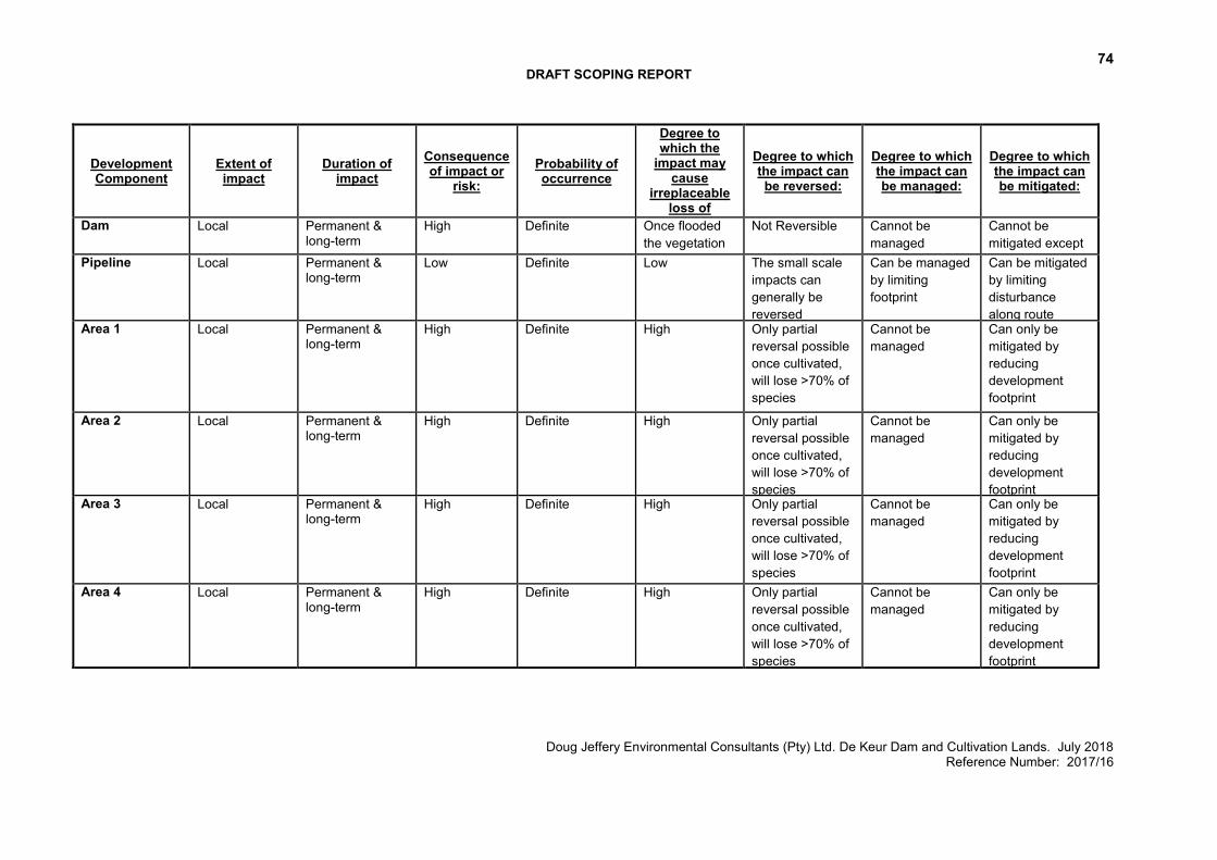
74 DRAFT SCOPING REPORT
Doug Jeffery Environmental Consultants (Pty) Ltd. De Keur Dam and Cultivation Lands. July 2018 Reference Number: 2017/16
Development Component
Extent of impact
Duration of impact
Consequence of impact or
risk: Probability of occurrence
Degree to which the
impact may cause
irreplaceable loss of
resources:
Degree to which the impact can be reversed:
Degree to which the impact can be managed:
Degree to which the impact can be mitigated:
Dam Local Permanent & long-term
High Definite Once flooded the vegetation will be lost, and hence cannot be replaced in situ
Not Reversible Cannot be managed
Cannot be mitigated except by removing all invasive alien vegetation in remaining riverine areas on property
Pipeline
Local Permanent & long-term
Low Definite Low The small scale impacts can generally be reversed
Can be managed by limiting footprint
Can be mitigated by limiting disturbance along route
Area 1 Local Permanent & long-term
High Definite High Only partial reversal possible once cultivated, will lose >70% of species
Cannot be managed
Can only be mitigated by reducing development footprint
Area 2 Local Permanent & long-term
High Definite High Only partial reversal possible once cultivated, will lose >70% of species
Cannot be managed
Can only be mitigated by reducing development footprint
Area 3 Local Permanent & long-term
High Definite High Only partial reversal possible once cultivated, will lose >70% of species
Cannot be managed
Can only be mitigated by reducing development footprint
Area 4 Local Permanent & long-term
High Definite High Only partial reversal possible once cultivated, will lose >70% of species
Cannot be managed
Can only be mitigated by reducing development footprint
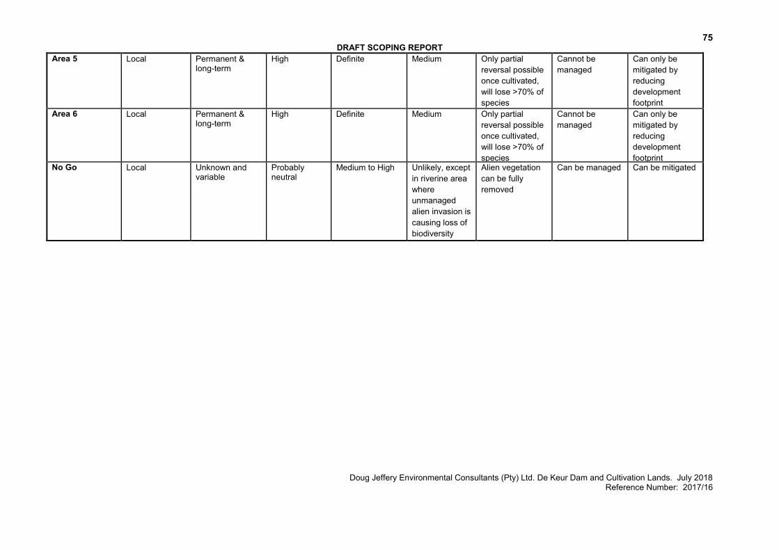
75 DRAFT SCOPING REPORT
Doug Jeffery Environmental Consultants (Pty) Ltd. De Keur Dam and Cultivation Lands. July 2018 Reference Number: 2017/16
Area 5 Local Permanent & long-term
High Definite Medium Only partial reversal possible once cultivated, will lose >70% of species
Cannot be managed
Can only be mitigated by reducing development footprint
Area 6 Local Permanent & long-term
High Definite Medium Only partial reversal possible once cultivated, will lose >70% of species
Cannot be managed
Can only be mitigated by reducing development footprint
No Go Local Unknown and variable
Probably neutral
Medium to High Unlikely, except in riverine area where unmanaged alien invasion is causing loss of biodiversity
Alien vegetation can be fully removed
Can be managed Can be mitigated
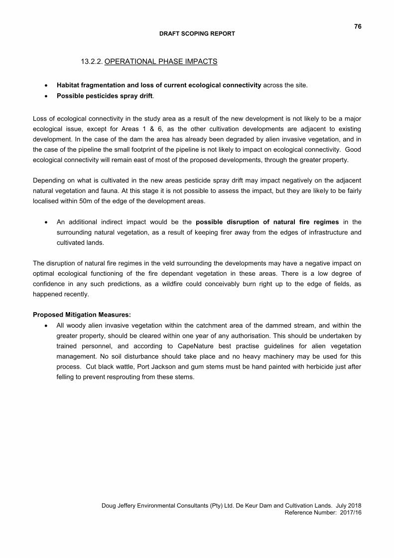
76 DRAFT SCOPING REPORT
Doug Jeffery Environmental Consultants (Pty) Ltd. De Keur Dam and Cultivation Lands. July 2018 Reference Number: 2017/16
13.2.2. OPERATIONAL PHASE IMPACTS
Habitat fragmentation and loss of current ecological connectivity across the site. Possible pesticides spray drift.
Loss of ecological connectivity in the study area as a result of the new development is not likely to be a major ecological issue, except for Areas 1 & 6, as the other cultivation developments are adjacent to existing development. In the case of the dam the area has already been degraded by alien invasive vegetation, and in the case of the pipeline the small footprint of the pipeline is not likely to impact on ecological connectivity. Good ecological connectivity will remain east of most of the proposed developments, through the greater property. Depending on what is cultivated in the new areas pesticide spray drift may impact negatively on the adjacent natural vegetation and fauna. At this stage it is not possible to assess the impact, but they are likely to be fairly localised within 50m of the edge of the development areas.
An additional indirect impact would be the possible disruption of natural fire regimes in the surrounding natural vegetation, as a result of keeping firer away from the edges of infrastructure and cultivated lands.
The disruption of natural fire regimes in the veld surrounding the developments may have a negative impact on optimal ecological functioning of the fire dependant vegetation in these areas. There is a low degree of confidence in any such predictions, as a wildfire could conceivably burn right up to the edge of fields, as happened recently. Proposed Mitigation Measures:
All woody alien invasive vegetation within the catchment area of the dammed stream, and within the greater property, should be cleared within one year of any authorisation. This should be undertaken by trained personnel, and according to CapeNature best practise guidelines for alien vegetation management. No soil disturbance should take place and no heavy machinery may be used for this process. Cut black wattle, Port Jackson and gum stems must be hand painted with herbicide just after felling to prevent resprouting from these stems.
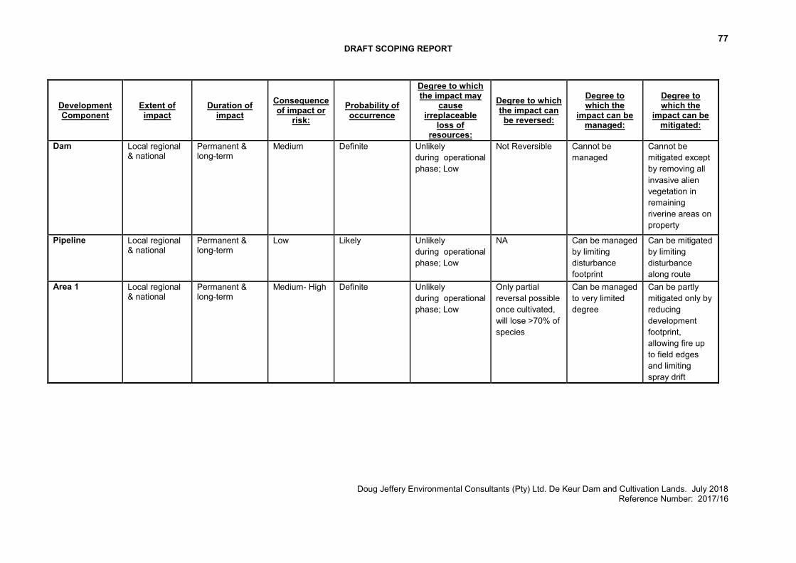
77 DRAFT SCOPING REPORT
Doug Jeffery Environmental Consultants (Pty) Ltd. De Keur Dam and Cultivation Lands. July 2018 Reference Number: 2017/16
Development Component
Extent of impact
Duration of impact
Consequence of impact or
risk: Probability of occurrence
Degree to which the impact may
cause irreplaceable
loss of resources:
Degree to which the impact can be reversed:
Degree to which the
impact can be managed:
Degree to which the
impact can be mitigated:
Dam Local regional & national
Permanent & long-term
Medium Definite Unlikely during operational phase; Low
Not Reversible Cannot be managed
Cannot be mitigated except by removing all invasive alien vegetation in remaining riverine areas on property
Pipeline
Local regional & national
Permanent & long-term
Low Likely Unlikely during operational phase; Low
NA Can be managed by limiting disturbance footprint
Can be mitigated by limiting disturbance along route
Area 1 Local regional & national
Permanent & long-term
Medium- High Definite Unlikely during operational phase; Low
Only partial reversal possible once cultivated, will lose >70% of species
Can be managed to very limited degree
Can be partly mitigated only by reducing development footprint, allowing fire up to field edges and limiting spray drift
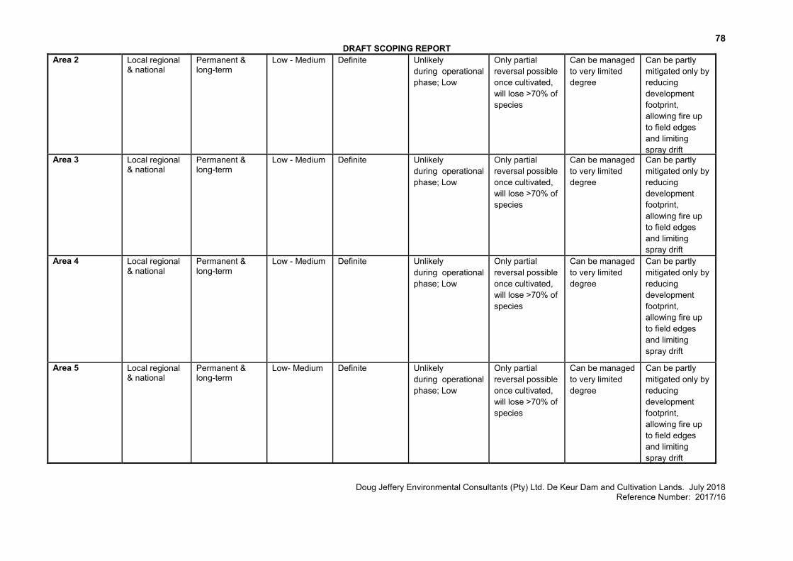
78 DRAFT SCOPING REPORT
Doug Jeffery Environmental Consultants (Pty) Ltd. De Keur Dam and Cultivation Lands. July 2018 Reference Number: 2017/16
Area 2 Local regional & national
Permanent & long-term
Low - Medium Definite Unlikely during operational phase; Low
Only partial reversal possible once cultivated, will lose >70% of species
Can be managed to very limited degree
Can be partly mitigated only by reducing development footprint, allowing fire up to field edges and limiting spray drift
Area 3 Local regional & national
Permanent & long-term
Low - Medium Definite Unlikely during operational phase; Low
Only partial reversal possible once cultivated, will lose >70% of species
Can be managed to very limited degree
Can be partly mitigated only by reducing development footprint, allowing fire up to field edges and limiting spray drift
Area 4 Local regional & national
Permanent & long-term
Low - Medium Definite Unlikely during operational phase; Low
Only partial reversal possible once cultivated, will lose >70% of species
Can be managed to very limited degree
Can be partly mitigated only by reducing development footprint, allowing fire up to field edges and limiting spray drift
Area 5 Local regional & national
Permanent & long-term
Low- Medium Definite Unlikely during operational phase; Low
Only partial reversal possible once cultivated, will lose >70% of species
Can be managed to very limited degree
Can be partly mitigated only by reducing development footprint, allowing fire up to field edges and limiting spray drift
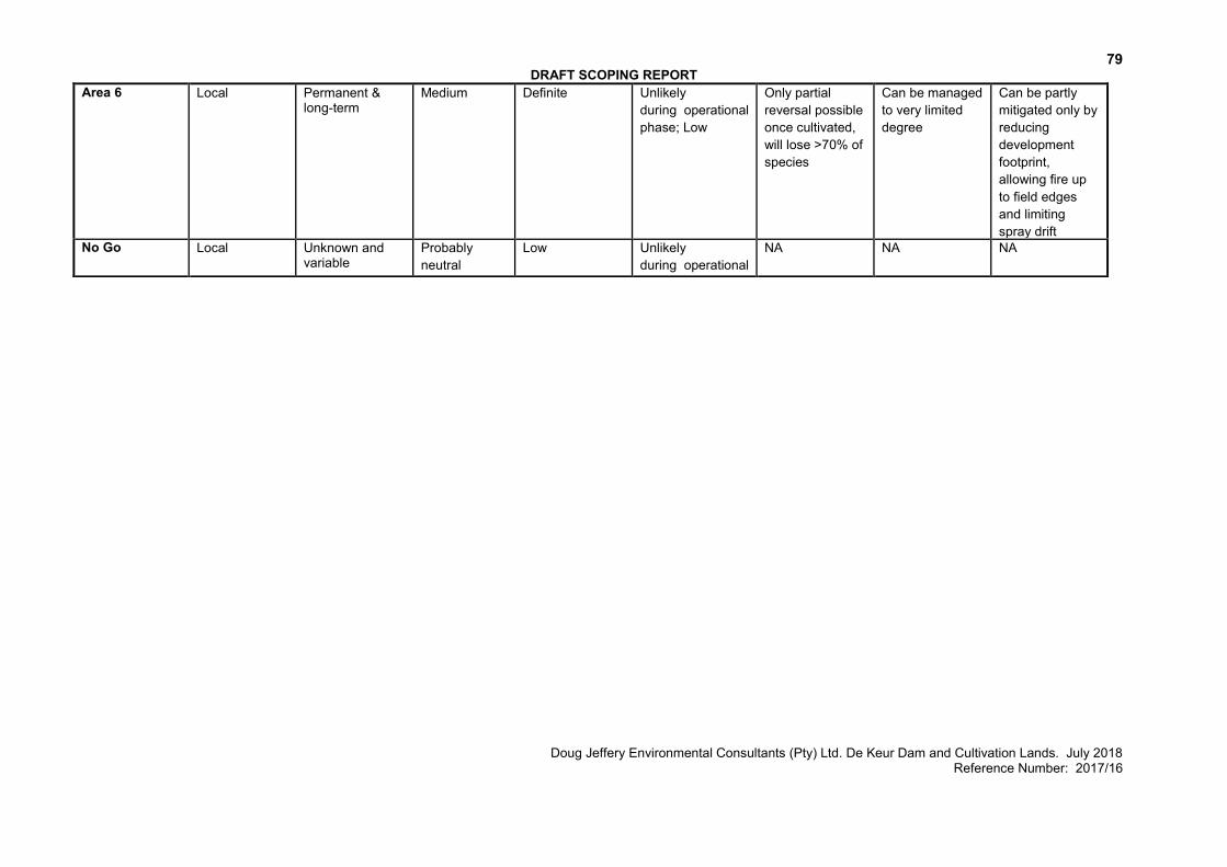
79 DRAFT SCOPING REPORT
Doug Jeffery Environmental Consultants (Pty) Ltd. De Keur Dam and Cultivation Lands. July 2018 Reference Number: 2017/16
Area 6 Local Permanent & long-term
Medium Definite Unlikely during operational phase; Low
Only partial reversal possible once cultivated, will lose >70% of species
Can be managed to very limited degree
Can be partly mitigated only by reducing development footprint, allowing fire up to field edges and limiting spray drift
No Go Local Unknown and variable
Probably neutral
Low Unlikely during operational phase; Low
NA NA NA
80 DRAFT SCOPING REPORT
Doug Jeffery Environmental Consultants (Pty) Ltd. De Keur Dam and Cultivation Lands. July 2018 Reference Number: 2017/16
13.2.1. CUMULATIVE IMPACTS The cumulative botanical impacts are in many ways equivalent to the regional botanical impacts, in that the vegetation type is likely to be impacted by the proposed development have been, and will continue to be, impacted by numerous developments and other factors (the cumulative impacts) within the region.
13.3. EIA PHASE
A more detailed assessment of the potential botanical impacts will be included in the Environmental Impact Report (EIR).
81 DRAFT SCOPING REPORT
Doug Jeffery Environmental Consultants (Pty) Ltd. De Keur Dam and Cultivation Lands. July 2018 Reference Number: 2017/16
14. POTENTIAL FRESHWATER IMPACTS
The nature of the impacts of the freshwater ecosystems and the recommended mitigation measures are discussed below. Scoping level impact tables are included for each identified impact.
14.1. KEY ISSUES The freshwater features that would potentially be impacted by the proposed new dam consist of:
The Wolwe River upstream and downstream of the proposed dam site; Lang River adjacent to the proposed new agricultural areas; An unnamed tributary that would be crossed by the proposed pipeline; and The Leeu River downstream of the existing abstraction point.
The Wolwe River is in a moderately to largely modified condition as a result of upstream flow modification, adjacent agricultural activities as well as growth of invasive black wattle trees within the riparian zone of the river. The Leeu and Lang Rivers and the unnamed tributary have been subject to greater impacts as a result of the surrounding encroachment of agricultural activities. They are considered to be largely to seriously modified. The Wolwe and Leeu Rivers are considered to be of high ecological importance and sensitivity. Despite the surrounding agricultural impacts the rivers provide important refuge for aquatic biota and provide a corridor for the movement of biota within the transformed landscape. The proximity of the Kouebokkeveld Mountain Catchment Area, a protected area, further highlights the importance of the rivers. The Lang River and unnamed tributary are of moderate ecological importance and sensitivity. The significant modifications to the rivers that have taken place as a result of agricultural activities have resulted in a reduction in sensitive species and habitat although they do have some refuge and connectivity value.
14.2. PRELIMINARY ASSESSMENT OF IMPACTS The following proposed activities may result in impacts on the freshwater ecosystems:
Construction of the new dam on the Wolwe River Laying of a new pipeline from the new dam to proposed irrigated land Establishment of new irrigated areas
14.2.1. CONSTRUCTION PHASE IMPACTS
Impact associated with the proposed new dam on the Wolwe River
The proposed will result in the inundation of ~900m of the current channel with an associated modification of aquatic habitat. This habitat is already significantly impacted by a modified flow regime as a result of the upstream dams as well as a dense invasion of the river channel with black wattle trees. The construction activities also provide the potential for water quality impacts as well as growth of alien invasive plants and

82 DRAFT SCOPING REPORT
Doug Jeffery Environmental Consultants (Pty) Ltd. De Keur Dam and Cultivation Lands. July 2018 Reference Number: 2017/16
erosion in the river channel downstream of the dam site. Further modification to the aquatic habitat and flow of the river downstream of the new proposed dam could be expected. The proposed dam would also allow change to the groundwater abstraction practice, where water could be abstracted in late winter and stored to reduce the stress on the groundwater resource and also contribute to the resource quality objectives for the groundwater resource in the area (Bokkeveld aquifer). There is some potential during the construction phase of the proposed dam for some impairment of the surface water quality to occur if the activities take place when there is flow in the river. An increase in suspended solids in the river downstream could be expected as a result of increased availability of sediment at the proposed dam site due to removal of the cover vegetation. Contamination of the stream may also occur as a result of other pollutants available at the construction site. Core material for the dam will be obtained from the existing Leeurivier Dam basin as well as two existing borrows pits on the property. There are no associated impacts with this activity. Proposed Mitigation Measures:
To address the environmental water requirement (EWR)recommendations, it is recommended that only the winter water be impounded in the proposed dam proposed dam and that in summer the water entering the dam be leased downstream.
The volume to be released should be determined on the inflow into the dam on a weekly basis for the period October to March.
It is also recommended that water from the Leeu River rather be abstracted for use on the farm in winter in order to reduce the abstraction of water in summer when the EWR is currently not being met. This will thus contribute towards meeting the resource quality objectives.
Operational rules for the dam will need to be compiled to address this. Groundwater can be abstracted in late winter and stored to reduce the stress on the groundwater
resource and also contribute to the resource quality objectives. Monitoring of the surface water flows, groundwater levels, the volumes of water abstracted as well as
those released from the dam in terms of giving effect to the environmental water requirements is however essential to ensure that these improvements do take place as indicated.
Invasive alien black wattle growth within the channel downstream of the dam site must be cleared, monitored and managed on an ongoing basis.
After the construction phase, the riparian area should be rehabilitated and the area re-vegetated with suitable indigenous riparian vegetation to reduce the risk of erosion in the stream. The dam wall in particular should be covered with appropriate indigenous vegetation upon completion of the construction activities to prevent erosion of the dam wall and increased turbidity in the watercourse of the dam.
The spillway of the dam needs to be designed in such a way as to prevent it, as well as the stream immediately downstream of the dam from being eroded and overgrown with invasive alien vegetation.
Any water quality impacts during the construction phase should be addressed through the Construction Environmental Management Plan for the project, and implemented by an on-site Environmental Officer. If construction is to take place during the summer months when the stream is mostly dry, this impact can be overcome successfully.
83 DRAFT SCOPING REPORT
Doug Jeffery Environmental Consultants (Pty) Ltd. De Keur Dam and Cultivation Lands. July 2018 Reference Number: 2017/16
Longer term maintenance activities for the dam should be according to a Maintenance Management Plan for the project.
Should the depressions created by the borrow areas be utilised for the storage of water in the future, they will need to obtain the required water use approvals from the DWS.
Impact associated with the construction of associated infrastructure (pipeline)
The proposed pipeline will cross the unnamed tributary of the Leeu River on route to the irrigated lands proposed to be established. The unnamed tributary at the site of the proposed river crossing consists of a small channel with a wider P. macrourum dominated wetland associated with it. A probable impact is the direct loss of aquatic habitat (instream and riparian) at the river crossing point. There is also the potential after construction activities in the river for some sedimentation and erosion to downstream of the activities as a result of the disturbance and the removal of indigenous vegetation in the river channel. Some localised water quality impacts may also occur during the construction activities that relate mostly to increased sedimentation. Proposed Mitigation Measures:
It is recommended that the pipeline be laid on the surface and not within an excavated trench. The pipeline must also be placed on the downstream side of the road crossing over the river. The pipeline at the river channels must not impede or concentrate the flow in the channel. Any disturbance within the stream channel and wetland must be mitigated by setting aside the plants
and topsoil within the area disturbed or excavated and placing them back within the reshaped channel after the pipe has been laid.
The pipeline starts at a small drainage line in its southern extent. This drainage feature must be avoided and a 10m buffer allowed for along the drainage feature to mitigate the potential for erosion on the slope of the low hill.
Longer term maintenance of the pipeline at the watercourses must be according to a Maintenance Management Plan for the project.
Impact associated with the expansion of agricultural areas
The final proposed layout for the new agricultural areas is to be located outside of the larger aquatic features and the recommended buffer zones. Proposed Mitigation Measures:
A buffer of at least of 40m from the top of bank is recommended as shown in Figure 27 by the light blue polygon.
The buffer area should be cleared of invasive plant species such as poplar trees and growth of indigenous riparian and marginal plants such as Morella integra, Elegia capensis, Restio paniculatus, Cynodon dactylon, Pennisetum macrourum, Phragmites australis, Cliffortia strobilifera, Juncus kraussii and Ficinia nodosa should be established where applicable.
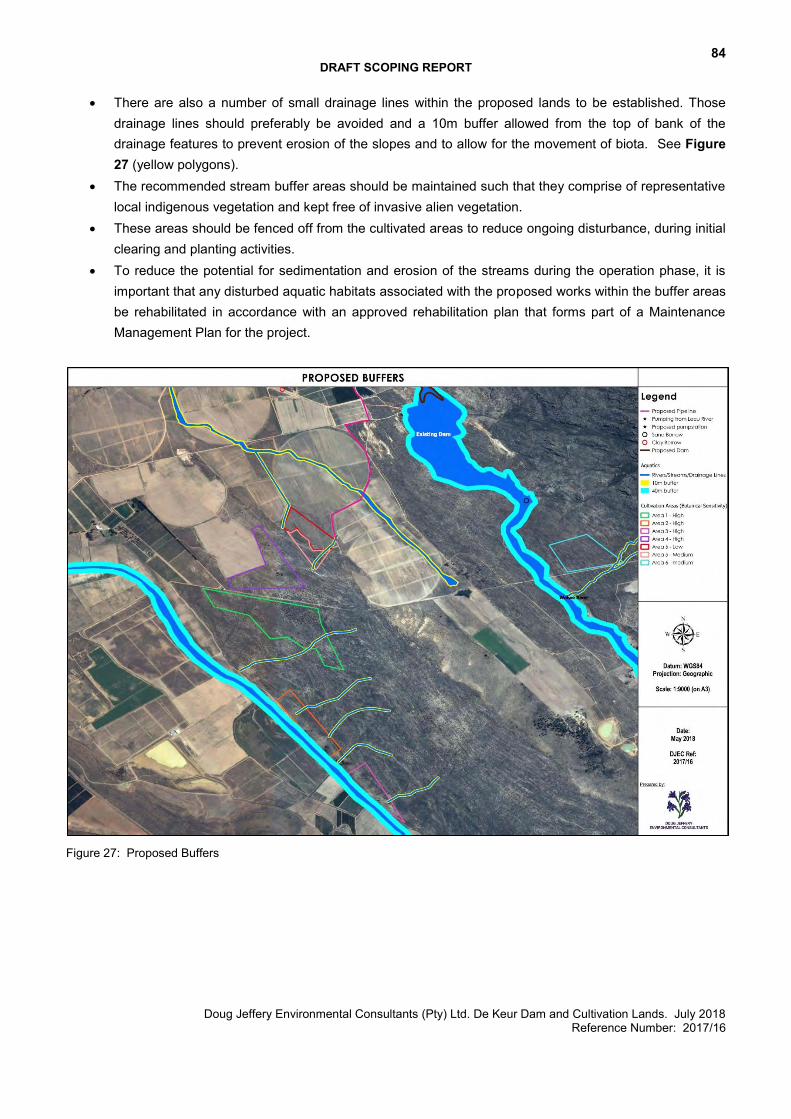
84 DRAFT SCOPING REPORT
Doug Jeffery Environmental Consultants (Pty) Ltd. De Keur Dam and Cultivation Lands. July 2018 Reference Number: 2017/16
There are also a number of small drainage lines within the proposed lands to be established. Those drainage lines should preferably be avoided and a 10m buffer allowed from the top of bank of the drainage features to prevent erosion of the slopes and to allow for the movement of biota. See Figure 27 (yellow polygons).
The recommended stream buffer areas should be maintained such that they comprise of representative local indigenous vegetation and kept free of invasive alien vegetation.
These areas should be fenced off from the cultivated areas to reduce ongoing disturbance, during initial clearing and planting activities.
To reduce the potential for sedimentation and erosion of the streams during the operation phase, it is important that any disturbed aquatic habitats associated with the proposed works within the buffer areas be rehabilitated in accordance with an approved rehabilitation plan that forms part of a Maintenance Management Plan for the project.
Figure 27: Proposed Buffers
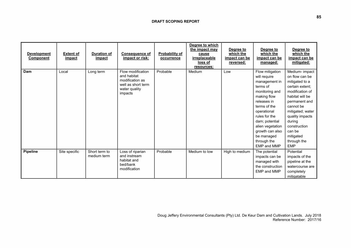
85 DRAFT SCOPING REPORT
Doug Jeffery Environmental Consultants (Pty) Ltd. De Keur Dam and Cultivation Lands. July 2018 Reference Number: 2017/16
Development Component
Extent of impact
Duration of impact
Consequence of impact or risk:
Probability of occurrence
Degree to which the impact may
cause irreplaceable
loss of resources:
Degree to which the
impact can be reversed:
Degree to which the
impact can be managed:
Degree to which the
impact can be mitigated:
Dam Local Long term Flow modification and habitat modification as well as short term water quality impacts
Probable Medium Low Flow mitigation will require management in terms of monitoring and making flow releases in terms of the operational rules for the dam; potential alien vegetation growth can also be managed through the EMP and MMP
Medium- impact on flow can be mitigated to a certain extent; modification of habitat will be permanent and cannot be mitigated; water quality impacts during construction can be mitigated through the EMP
Pipeline Site specific Short term to medium term
Loss of riparian and instream habitat and bed/bank modification
Probable Medium to low High to medium The potential impacts can be managed with the construction EMP and MMP
Potential impacts of the pipeline at the watercourse are completely mitigatable

86 DRAFT SCOPING REPORT
Doug Jeffery Environmental Consultants (Pty) Ltd. De Keur Dam and Cultivation Lands. July 2018 Reference Number: 2017/16
Cultivation Areas Local Short term to long term
Increased deposition of sediment and erosion as well as growth of invasive alien plants within the river corridors that modifies aquatic habitat
Possible Medium Medium The potential impacts can be managed with the MMP for the watercourses ito erosion control, removal of alien vegetation and maintaining watercourse buffers
Potential impacts are mitigatable through monitoring and control of alien vegetation and eroded areas as well as maintaining watercourse buffer areas
No Go Local Long term Some degradation of aquatic habitat integrity as a result of alien vegetation growth and abstraction of water for use in summer
Possible Medium to Low High Medium through alien vegetation control
Medium through maintenance of watercourse buffers and control of alien vegetation
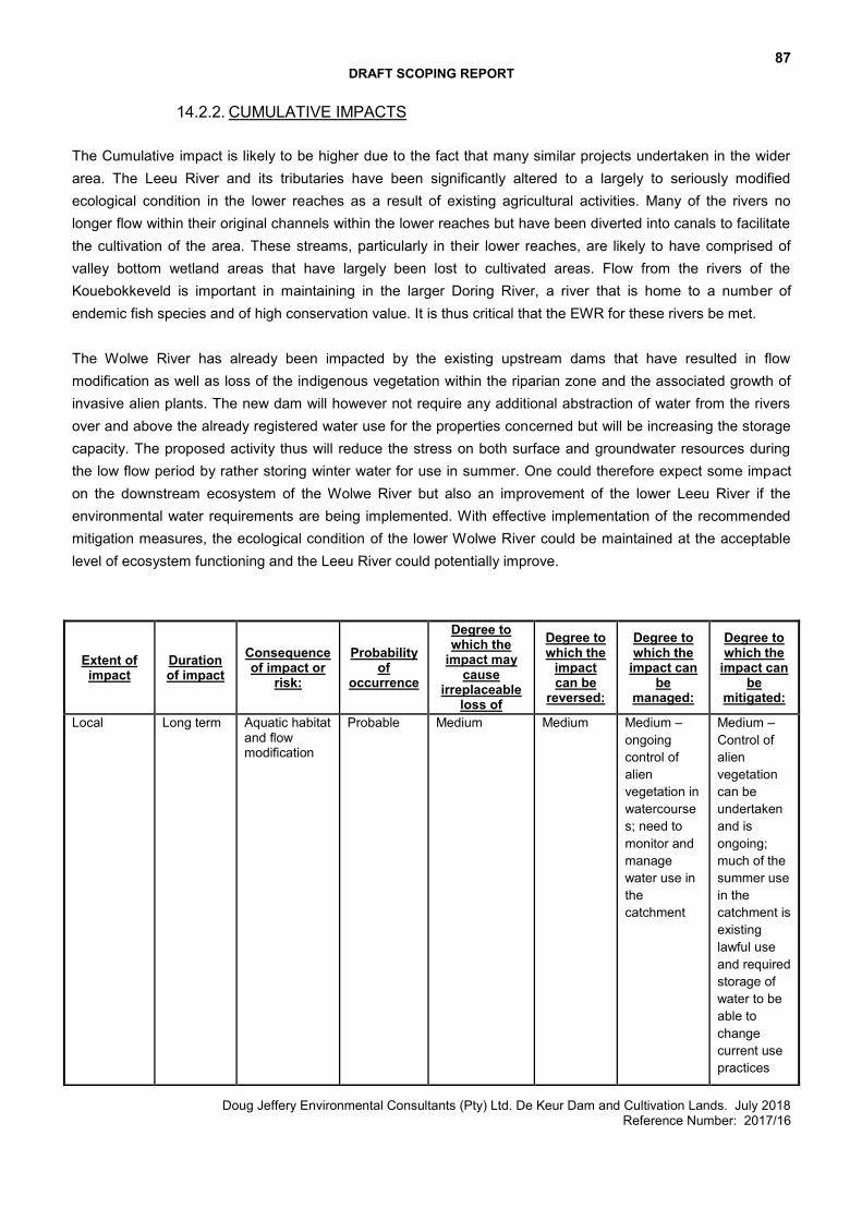
87 DRAFT SCOPING REPORT
Doug Jeffery Environmental Consultants (Pty) Ltd. De Keur Dam and Cultivation Lands. July 2018 Reference Number: 2017/16
14.2.2. CUMULATIVE IMPACTS The Cumulative impact is likely to be higher due to the fact that many similar projects undertaken in the wider area. The Leeu River and its tributaries have been significantly altered to a largely to seriously modified ecological condition in the lower reaches as a result of existing agricultural activities. Many of the rivers no longer flow within their original channels within the lower reaches but have been diverted into canals to facilitate the cultivation of the area. These streams, particularly in their lower reaches, are likely to have comprised of valley bottom wetland areas that have largely been lost to cultivated areas. Flow from the rivers of the Kouebokkeveld is important in maintaining in the larger Doring River, a river that is home to a number of endemic fish species and of high conservation value. It is thus critical that the EWR for these rivers be met. The Wolwe River has already been impacted by the existing upstream dams that have resulted in flow modification as well as loss of the indigenous vegetation within the riparian zone and the associated growth of invasive alien plants. The new dam will however not require any additional abstraction of water from the rivers over and above the already registered water use for the properties concerned but will be increasing the storage capacity. The proposed activity thus will reduce the stress on both surface and groundwater resources during the low flow period by rather storing winter water for use in summer. One could therefore expect some impact on the downstream ecosystem of the Wolwe River but also an improvement of the lower Leeu River if the environmental water requirements are being implemented. With effective implementation of the recommended mitigation measures, the ecological condition of the lower Wolwe River could be maintained at the acceptable level of ecosystem functioning and the Leeu River could potentially improve.
Extent of impact
Duration of impact
Consequence of impact or
risk:
Probability of
occurrence
Degree to which the
impact may cause
irreplaceable loss of
resources:
Degree to which the
impact can be
reversed:
Degree to which the
impact can be
managed:
Degree to which the
impact can be
mitigated:
Local Long term Aquatic habitat and flow modification
Probable Medium Medium Medium – ongoing control of alien vegetation in watercourses; need to monitor and manage water use in the catchment
Medium – Control of alien vegetation can be undertaken and is ongoing; much of the summer use in the catchment is existing lawful use and required storage of water to be able to change current use practices
88 DRAFT SCOPING REPORT
Doug Jeffery Environmental Consultants (Pty) Ltd. De Keur Dam and Cultivation Lands. July 2018 Reference Number: 2017/16
14.3. EIA PHASE
A more detailed assessment of the potential freshwater impacts will be included in the Environmental Impact Report (EIR).
89 DRAFT SCOPING REPORT
Doug Jeffery Environmental Consultants (Pty) Ltd. De Keur Dam and Cultivation Lands. July 2018 Reference Number: 2017/16
15. SOIL
Refer to the Soil Potential Maps included in Appendix 4. The Soil Potential Map indicates Area 6 contains soils of medium and medium high potential (15.23 ha) and low potential soils (14.56 ha). The Soil Potential Map for Area 5 (Rooikop) contains soils of medium low, medium, medium
high and low potential soils. Medium and medium high soils are marginally suitable for apples and suitable for pears. The low potential soils are slightly suitable for pears. Many orchards are already established on similar soils and produces good returns. With the correct management and input, apples and pears should deliver a good production. Due to the sandiness and stone contents, the water holding capacity and cation exchange capacity of the soils is low. By mulching the soils and applying compost the soil potential will improve. The soils in the area vary in stone content, colour and effective depth. The yellower soils have better potential since the soils are less leached and therefore it has better potential for fruit production. Several stone ridges and outcrops (rocky hills) occur in the area. The low and very low potential soils are limited mainly in terms of soil depth (shallow rock and stone). All soils should preferably be cross ripped to ensure that all the outcrops and ridges have been lifted. Ideally, the first ripping should be done two seasons prior to planting, to allow for rocks to slake with winter rain. The parts that are lifted can be planted, provided that the stone broke up favourably. A few test strips must be ripped to determine how the parent material responds to the rip action. If it does not bring up a lot of boulders and breaks up the rocks, it can be worked in. For more information regarding the soils, soil preparation, irrigation, etc., refer to the Soil Studies included as Appendix 4.
90 DRAFT SCOPING REPORT
Doug Jeffery Environmental Consultants (Pty) Ltd. De Keur Dam and Cultivation Lands. July 2018 Reference Number: 2017/16
16. CONCLUSIONS AND RECOMMENDATIONS
This scoping exercise is currently being undertaken to present concept proposals to the public and potential Interested & Affected Parties (I&APs) and to identify environmental issues and concerns raised as a result of the proposed development. This will allow I&APs, authorities, the project team, as well as specialists to provide input and raise issues and concerns, based on specialist studies undertaken. In addition, this Scoping Report summarises the process to date, reports on the findings of relevant studies. The EAP is of the opinion that the information contained in this Scoping Report and the documentation attached hereto is sufficient to allow the general public and key stakeholders to apply their minds to the potential negative and/or positive impacts associated with the development, in respect of the activities applied for.