Embed Size (px)
Citation preview
SR 5
20
I90
MAPLE VALLEY HWYI5
SR 167
SR 522
SR 5
09
SR 527
I5
Lynnwood TC
Canyon Park
Bothell-UW Campus
Brickyard
Totem Lake
Bellevue TC
S. Renton
Burien TC
Tukwila Intl Blvd
In-line stationat NE 85th St
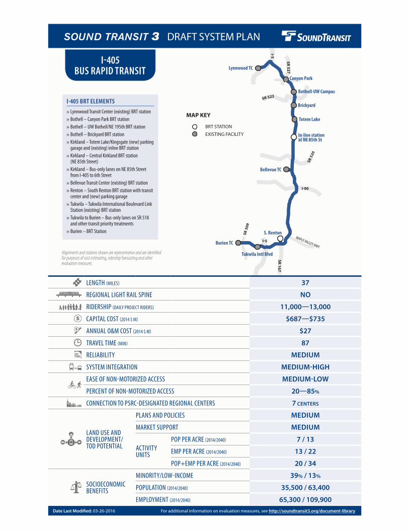
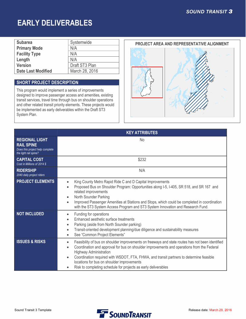
Alignments and stations shown are representative and are identified for purposes of cost estimating, ridership forecasting and other evaluation measures.
LENGTH (MILES) 37
REGIONAL LIGHT RAIL SPINE NO
RIDERSHIP (DAILY PROJECT RIDERS) 11,000—13,000
CAPITAL COST (2014 $ M) $687—$735
ANNUAL O&M COST (2014 $ M) $27
TRAVEL TIME (MIN) 87
RELIABILITY MEDIUM
SYSTEM INTEGRATION MEDIUM-HIGH
EASE OF NON-MOTORIZED ACCESS MEDIUM-LOW
PERCENT OF NON-MOTORIZED ACCESS 20—85%
CONNECTION TO PSRC-DESIGNATED REGIONAL CENTERS 7 CENTERS
LAND USE AND DEVELOPMENT/ TOD POTENTIAL
PLANS AND POLICIES MEDIUM
MARKET SUPPORT MEDIUM
ACTIVITY UNITS
POP PER ACRE (2014/2040) 7 / 13
EMP PER ACRE (2014/2040) 13 / 22
POP+EMP PER ACRE (2014/2040) 20 / 34
SOCIOECONOMIC BENEFITS
MINORITY/LOW-INCOME 39% / 13%
POPULATION (2014/2040) 35,500 / 63,400
EMPLOYMENT (2014/2040) 65,300 / 109,900
I-405 BUS RAPID TRANSIT
BRT STATION
MAP KEY
EXISTING FACILITY
I-405 BRT ELEMENTS
» Lynnwood Transit Center (existing) BRT station » Bothell – Canyon Park BRT station » Bothell – UW Bothell/NE 195th BRT station » Bothell – Brickyard BRT station » Kirkland – Totem Lake/Kingsgate (new) parking garage and (existing) inline BRT station
» Kirkland – Central Kirkland BRT station (NE 85th Street)
» Kirkland – Bus-only lanes on NE 85th Street from I-405 to 6th Street
» Bellevue Transit Center (existing) BRT station » Renton – South Renton BRT station with transit center and (new) parking garage
» Tukwila – Tukwila International Boulevard Link Station (existing) BRT station
» Tukwila to Burien – Bus-only lanes on SR 518 and other transit priority treatments
» Burien – BRT Station
For additional information on evaluation measures, see http://soundtransit3.org/document-libraryDate Last Modified: 03-26-2016
DRAFT SYSTEM PLAN
I-405 Bus Rapid Transit
Sound Transit 3 Template Release date: March 29, 2016 Page 1 of 6
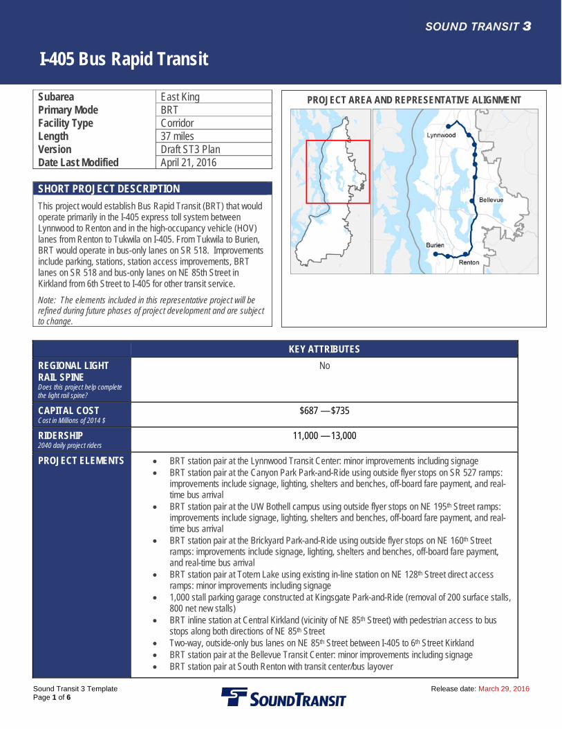
Subarea East King Primary Mode BRT Facility Type Corridor Length 37 miles Version Draft ST3 Plan Date Last Modified April 21, 2016 SHORT PROJECT DESCRIPTION
This project would establish Bus Rapid Transit (BRT) that would operate primarily in the I-405 express toll system between Lynnwood to Renton and in the high-occupancy vehicle (HOV) lanes from Renton to Tukwila on I-405. From Tukwila to Burien, BRT would operate in bus-only lanes on SR 518. Improvements include parking, stations, station access improvements, BRT lanes on SR 518 and bus-only lanes on NE 85th Street in Kirkland from 6th Street to I-405 for other transit service.
Note: The elements included in this representative project will be refined during future phases of project development and are subject to change.
KEY ATTRIBUTES
REGIONAL LIGHT RAIL SPINE Does this project help complete the light rail spine?
No
CAPITAL COST Cost in Millions of 2014 $
$687 — $735
RIDERSHIP 2040 daily project riders
11,000 — 13,000
PROJECT ELEMENTS
BRT station pair at the Lynnwood Transit Center: minor improvements including signage BRT station pair at the Canyon Park Park-and-Ride using outside flyer stops on SR 527 ramps:
improvements include signage, lighting, shelters and benches, off-board fare payment, and real-time bus arrival
BRT station pair at the UW Bothell campus using outside flyer stops on NE 195th Street ramps: improvements include signage, lighting, shelters and benches, off-board fare payment, and real-time bus arrival
BRT station pair at the Brickyard Park-and-Ride using outside flyer stops on NE 160th Street ramps: improvements include signage, lighting, shelters and benches, off-board fare payment, and real-time bus arrival
BRT station pair at Totem Lake using existing in-line station on NE 128th Street direct access ramps: minor improvements including signage
1,000 stall parking garage constructed at Kingsgate Park-and-Ride (removal of 200 surface stalls, 800 net new stalls)
BRT inline station at Central Kirkland (vicinity of NE 85th Street) with pedestrian access to bus stops along both directions of NE 85th Street
Two-way, outside-only bus lanes on NE 85th Street between I-405 to 6th Street Kirkland BRT station pair at the Bellevue Transit Center: minor improvements including signage BRT station pair at South Renton with transit center/bus layover
PROJECT AREA AND REPRESENTATIVE ALIGNMENT
I-405 Bus Rapid Transit
Sound Transit 3 Template Release date: March 29, 2016 Page 2 of 6
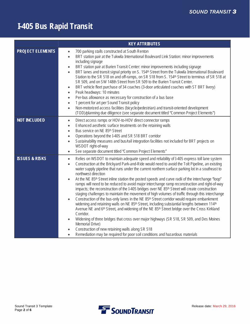
KEY ATTRIBUTES
PROJECT ELEMENTS 700 parking stalls constructed at South Renton BRT station pair at the Tukwila International Boulevard Link Station: minor improvements
including signage BRT station pair at Burien Transit Center: minor improvements including signage BRT lanes and transit signal priority on S. 154th Street from the Tukwila International Boulevard
Station to the SR 518 on and off-ramps, on SR 518 from S. 154th Street to terminus of SR 518 at SR 509, and on SW 148th Street from SR 509 to the Burien Transit Center.
BRT vehicle fleet purchase of 34 coaches (3-door articulated coaches with ST BRT livery) Peak headways: 10 minutes Per-bus allowance as necessary for construction of a bus base 1 percent for art per Sound Transit policy Non-motorized access facilities (bicycle/pedestrian) and transit-oriented development
(TOD)/planning due diligence (see separate document titled “Common Project Elements”)
NOT INCLUDED Direct access ramps or HOV-to-HOV direct connector ramps Enhanced aesthetic surface treatments on the retaining walls Bus service on NE 85th Street Operations beyond the I-405 and SR 518 BRT corridor Sustainability measures and bus/rail integration facilities not included for BRT projects on
WSDOT right-of-way See separate document titled “Common Project Elements”
ISSUES & RISKS Relies on WSDOT to maintain adequate speed and reliability of I-405 express toll lane system Construction at the Brickyard Park-and-Ride would need to avoid the Tolt Pipeline, an existing
water supply pipeline that runs under the current northern surface parking lot in a southeast to northwest direction
At the NE 85th Street inline station the posted speeds and curve radii of the interchange “loop” ramps will need to be reduced to avoid major interchange ramp reconstruction and right-of-way impacts; the reconstruction of the I-405 bridges over NE 85th Street will create construction staging challenges to maintain the movement of high volumes of traffic through this interchange
Construction of the bus-only lanes in the NE 85th Street corridor would require embankment widening and retaining walls on NE 85th Street, including substantial lengths between 114th Avenue NE and 6th Street, and widening of the NE 85th Street bridge over the Cross Kirkland Corridor.
Widening of three bridges that cross over major highways (SR 518, SR 509, and Des Moines Memorial Drive)
Construction of new retaining walls along SR 518 Remediation may be required for poor soil conditions and hazardous materials
I-405 Bus Rapid Transit
Sound Transit 3 Template Release date: March 29, 2016 Page 3 of 6
Sound Transit has developed a conceptual scope of work for this candidate project for the purpose of generating a representative range of costs, both capital and operating; and benefits, including ridership forecasts, TOD potential, multi-modal access and others. This information is being developed to assist the Sound Transit Board as it develops an ST3 system plan, including phasing of investments and financial plan, for voter consideration. Final decisions on project elements (e.g., alignment, profile, station locations, and number of parking stalls) will be determined after completion of system planning, project level environmental review, and preliminary engineering during which additional opportunities for public participation will be provided. Therefore, this scope definition should not be construed as a commitment that all representative features will be included in the final developed project.
Long Description: This project would establish BRT that would operate primarily in the I-405 express toll system for approximately 30 miles between Lynnwood to Renton via I-405, in the HOV lanes for most of the 4 miles from Renton to Tukwila via I-405, and in new BRT lanes on SR 518 for approximately 3 miles (37 total miles). Improvements include parking, stations, station access improvements, and bus/BRT-only lanes. A 1,000 stall parking garage will be constructed at Kingsgate Park-and-Ride, and a 700 stall parking facility would be constructed at the S. Renton Transit Center. The Central Kirkland BRT inline station would include elevators to bus stops on NE 85th Street. Bus-only lanes would be constructed in Kirkland on NE 85th Street between I-405 and 6th Street. BRT lanes would be constructed between the Tukwila International Boulevard Link Station and the Burien Transit Center on S. 154th Street, SR 518, and SW 148th Street. BRT would serve the Lynnwood Transit Center, Canyon Park, UW Bothell, Brickyard, Totem Lake, Central Kirkland, Bellevue Transit Center, S. Renton Transit Center, Tukwila International Boulevard Link Station, and the Burien Transit Center.
Assumptions: BRT would operate in general purpose lanes on I-5 (between the Lynnwood Transit Center and I-405) BRT would operate in general purpose lanes on I-405 between I-5 and Brickyard (using shoulder bus lanes in southbound direction in two
segments) Leaving Brickyard, BRT would transition from general purpose lanes to I-405 express toll lanes, continuing to Totem Lake freeway station BRT would operate in I-405 express toll lanes between Totem Lake and South Renton, accessing the Bellevue Transit Center from the NE
6th Street HOV direct access ramp From the South Renton transit center, southbound BRT buses would enter I-405 on Rainier Avenue general purpose on-ramp and weave
over to the inside HOV lanes towards I-5. Close to I-5, buses would weave over to general purpose lanes continuing to SR 518 and the Tukwila International Boulevard Link Station. Northbound BRT buses would follow this routing in the reverse direction.
The Tukwila International Boulevard station to the Burien Transit Center would include new bus-only lanes on SR 518 For the UW Bothell station, pedestrian improvements are included for access to the BRT stations along the NE 195th corridor; in addition,
the design estimate includes station/system access allowance costs for additional access improvements, possibly connecting to the existing North Creek trail
Construction of a parking garage at Kingsgate will temporarily displace parking and parking may be temporarily provided nearby; costs for temporary parking replacement have been included in the cost estimate for this project, but a specific location for the parking replacement has not been identified
At the Brickyard Park-and-Ride, the new northbound flyer stop will be served by a braided ramp that connects directly to I-405 and SR 522; this braided ramp is currently under construction; buses using the northbound flyer station stop and continuing north on I-405 will need to weave across general purpose traffic
New or upgraded traffic signals would be provided along NE 85th Street for the bus-only lanes Multiple retaining walls along the north and south sides of NE 85th Street in Kirkland to accommodate bus-only lanes Widening of the NE 85th Street bridge over the Cross Kirkland Corridor to accommodate bus-only lanes Multiple bridge widenings and retaining walls for the BRT-only lanes along S. 154th Street, SR 518, and SW 148th Street. For non-motorized station access allowances, the Lynnwood Transit Center and Bellevue Transit Center stations are categorized as urban
stations and intermodal transit centers, and the Canyon Park, UW Bothell, Brickyard, Totem Lake, Central Kirkland, and S. Renton stations are characterized as suburban stations. The Tukwila International Boulevard BRT Station is categorized as a suburban station and an intermodal transit center. The Burien Transit Center BRT station is categorized as an urban station.
Environmental: Sound Transit will complete project-level state and federal environmental reviews as necessary; provide mitigation for significant impacts; obtain and meet the conditions of all required permits and approvals; and strive to exceed compliance and continually improve its environmental performance.
Utilities: Utility relocation as needed to complete the project, including fiber optics, sewer, water, overhead electric/communications, etc. Construction at the Brickyard Park-and-Ride will need to avoid the Tolt pipeline
I-405 Bus Rapid Transit
Sound Transit 3 Template Release date: March 29, 2016 Page 4 of 6
Right-of-Way and Property Acquisition: Right-of-way acquisition and easements as needed to complete the project For the Central Kirkland inline station, property acquisition will be needed along both on-ramps to I-405 for the widening of the mainline
required by the inline station in the I-405 median For the bus-only lanes in the NE 85th Street corridor in Kirkland, property acquisition will be needed along both sides of NE 85th Street
between 120th Avenue NE and 6th Street. The new and improved flyer stops at Canyon Park, UW Bothell, and Brickyard, the improved Totem Lake in-line station and the new
Kingsgate parking garage will be constructed within WSDOT right-of-way Per-bus allowance as necessary for construction of a bus base. It assumed that a bus base will be built along this corridor.
Potential Permits/Approvals Needed: FHWA approval for modifications to interchanges and ramps WSDOT and FHWA approvals for use of and/or crossings of I-5, I-405, SR 518 and SR 509 rights-of-way Agreements with WSDOT and King County Metro for use of park-and-rides, outside flyer stops, and in-line stations Building permits: Electrical, Mechanical, Plumbing Utility connection permits Construction-related permits (clearing and grading, stormwater management, street use, haul routes, use of city right-of-way) Master use Land use approvals (Conditional use, design review, site plans, Comprehensive Plan or development code consistency, Special Use
Permits) All required local, state, and federal environmental permits NEPA/SEPA and related regulations
Project Dependencies: WSDOT I-405 Master Plan widening projects
Potential Project Partners: WSDOT Cities of Lynnwood, Bothell, Kirkland, Bellevue, Renton,
Tukwila, Seatac, and Burien UW Bothell
King County FHWA Transit partners serving project: Community Transit & King
County Metro FTA
I-405 Bus Rapid Transit
Sound Transit 3 Template Release date: March 29, 2016 Page 5 of 6
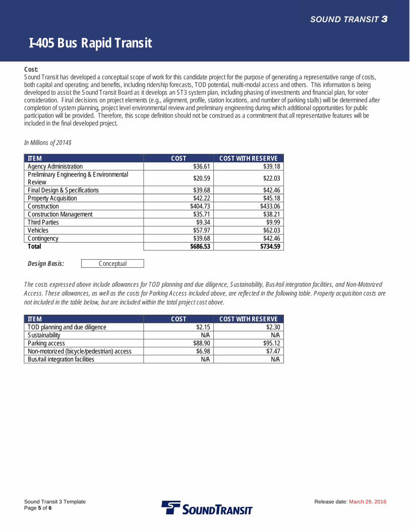
Cost: Sound Transit has developed a conceptual scope of work for this candidate project for the purpose of generating a representative range of costs, both capital and operating; and benefits, including ridership forecasts, TOD potential, multi-modal access and others. This information is being developed to assist the Sound Transit Board as it develops an ST3 system plan, including phasing of investments and financial plan, for voter consideration. Final decisions on project elements (e.g., alignment, profile, station locations, and number of parking stalls) will be determined after completion of system planning, project level environmental review and preliminary engineering during which additional opportunities for public participation will be provided. Therefore, this scope definition should not be construed as a commitment that all representative features will be included in the final developed project.
In Millions of 2014$
ITEM COST COST WITH RESERVE Agency Administration $36.61 $39.18 Preliminary Engineering & Environmental Review
$20.59 $22.03
Final Design & Specifications $39.68 $42.46 Property Acquisition $42.22 $45.18 Construction $404.73 $433.06 Construction Management $35.71 $38.21 Third Parties $9.34 $9.99 Vehicles $57.97 $62.03 Contingency $39.68 $42.46 Total $686.53 $734.59
Design Basis: Conceptual
The costs expressed above include allowances for TOD planning and due diligence, Sustainability, Bus/rail integration facilities, and Non-Motorized Access. These allowances, as well as the costs for Parking Access included above, are reflected in the following table. Property acquisition costs are not included in the table below, but are included within the total project cost above.
ITEM COST COST WITH RESERVE TOD planning and due diligence $2.15 $2.30 Sustainability N/A N/A Parking access $88.90 $95.12 Non-motorized (bicycle/pedestrian) access $6.98 $7.47 Bus/rail integration facilities N/A N/A
I-405 Bus Rapid Transit
Sound Transit 3 Template Release date: March 29, 2016 Page 6 of 6
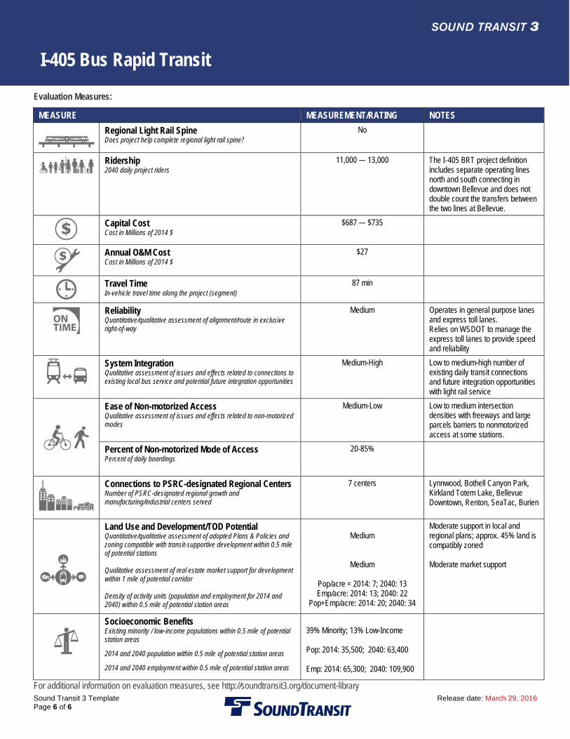
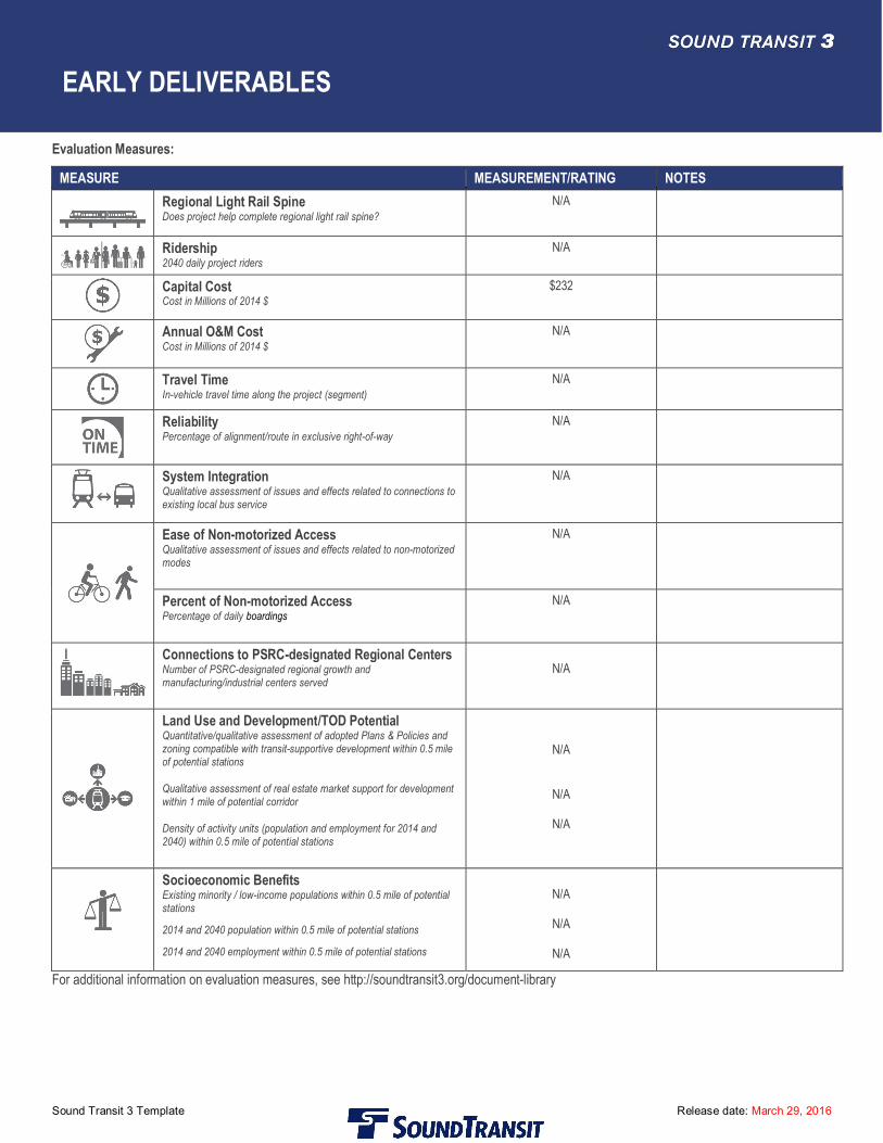
Evaluation Measures:
MEASURE MEASUREMENT/RATING NOTES
Regional Light Rail Spine Does project help complete regional light rail spine?
No
Ridership 2040 daily project riders
11,000 — 13,000 The I‐405 BRT project definition includes separate operating lines north and south connecting in downtown Bellevue and does not double count the transfers between the two lines at Bellevue.
Capital Cost Cost in Millions of 2014 $
$687 — $735
Annual O&M Cost Cost in Millions of 2014 $
$27
Travel Time In-vehicle travel time along the project (segment)
87 min
Reliability Quantitative/qualitative assessment of alignment/route in exclusive right-of-way
Medium
Operates in general purpose lanes and express toll lanes. Relies on WSDOT to manage the express toll lanes to provide speed and reliability
System Integration Qualitative assessment of issues and effects related to connections to existing local bus service and potential future integration opportunities
Medium-High Low to medium-high number of existing daily transit connections and future integration opportunities with light rail service
Ease of Non-motorized Access Qualitative assessment of issues and effects related to non-motorized modes
Medium-Low Low to medium intersection densities with freeways and large parcels barriers to nonmotorized access at some stations.
Percent of Non-motorized Mode of Access Percent of daily boardings
20-85%
Connections to PSRC-designated Regional Centers Number of PSRC-designated regional growth and manufacturing/industrial centers served
7 centers Lynnwood, Bothell Canyon Park, Kirkland Totem Lake, Bellevue Downtown, Renton, SeaTac, Burien
Land Use and Development/TOD Potential Quantitative/qualitative assessment of adopted Plans & Policies and zoning compatible with transit-supportive development within 0.5 mile of potential stations Qualitative assessment of real estate market support for development within 1 mile of potential corridor Density of activity units (population and employment for 2014 and 2040) within 0.5 mile of potential station areas
Medium
Medium
Pop/acre = 2014: 7; 2040: 13 Emp/acre: 2014: 13; 2040: 22
Pop+Emp/acre: 2014: 20; 2040: 34
Moderate support in local and regional plans; approx. 45% land is compatibly zoned Moderate market support
Socioeconomic Benefits Existing minority / low-income populations within 0.5 mile of potential station areas
2014 and 2040 population within 0.5 mile of potential station areas
2014 and 2040 employment within 0.5 mile of potential station areas
39% Minority; 13% Low-Income Pop: 2014: 35,500; 2040: 63,400 Emp: 2014: 65,300; 2040: 109,900
For additional information on evaluation measures, see http://soundtransit3.org/document-library
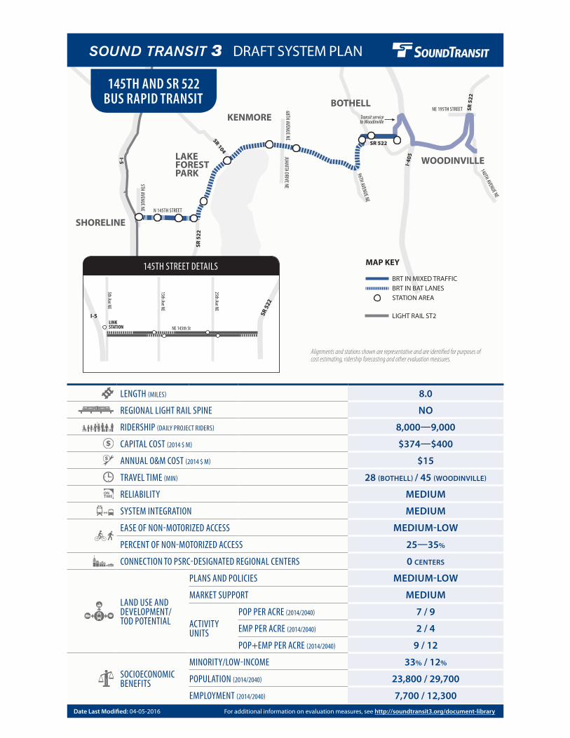
Transit serviceto Woodinville
I5
I40
5
SR 522
SR 5
22
SR 5
22
SR 104
JUANITA DRIVE NE68TH AVENUE NE
NE 195TH STREET
140TH AVENUE NE
5TH AVENUE NE N 145TH STREET96TH AVENUE NE
SHORELINE
LAKEFORESTPARK
KENMORE
BOTHELL
WOODINVILLE
LENGTH (MILES) 8.0
REGIONAL LIGHT RAIL SPINE NO
RIDERSHIP (DAILY PROJECT RIDERS) 8,000—9,000
CAPITAL COST (2014 $ M) $374—$400
ANNUAL O&M COST (2014 $ M) $15
TRAVEL TIME (MIN) 28 (BOTHELL) / 45 (WOODINVILLE)
RELIABILITY MEDIUM
SYSTEM INTEGRATION MEDIUM
EASE OF NON-MOTORIZED ACCESS MEDIUM-LOW
PERCENT OF NON-MOTORIZED ACCESS 25—35%
CONNECTION TO PSRC-DESIGNATED REGIONAL CENTERS 0 CENTERS
LAND USE AND DEVELOPMENT/ TOD POTENTIAL
PLANS AND POLICIES MEDIUM-LOW
MARKET SUPPORT MEDIUM
ACTIVITY UNITS
POP PER ACRE (2014/2040) 7 / 9
EMP PER ACRE (2014/2040) 2 / 4
POP+EMP PER ACRE (2014/2040) 9 / 12
SOCIOECONOMIC BENEFITS
MINORITY/LOW-INCOME 33% / 12%
POPULATION (2014/2040) 23,800 / 29,700
EMPLOYMENT (2014/2040) 7,700 / 12,300
145TH AND SR 522 BUS RAPID TRANSIT
Alignments and stations shown are representative and are identified for purposes of cost estimating, ridership forecasting and other evaluation measures.
MAP KEY
LIGHT RAIL ST2
BRT IN BAT LANESSTATION AREA
BRT IN MIXED TRAFFIC
5th Ave NE
15th Ave NE
NE 145th St
25th Ave NE
I-5 SR 5
22
LINKSTATION
145TH STREET DETAILS
For additional information on evaluation measures, see http://soundtransit3.org/document-libraryDate Last Modified: 04-05-2016
DRAFT SYSTEM PLAN
145th and SR 522 Bus Rapid Transit
Sound Transit 3 Template Release date: March 29, 2016Page 1 of 6
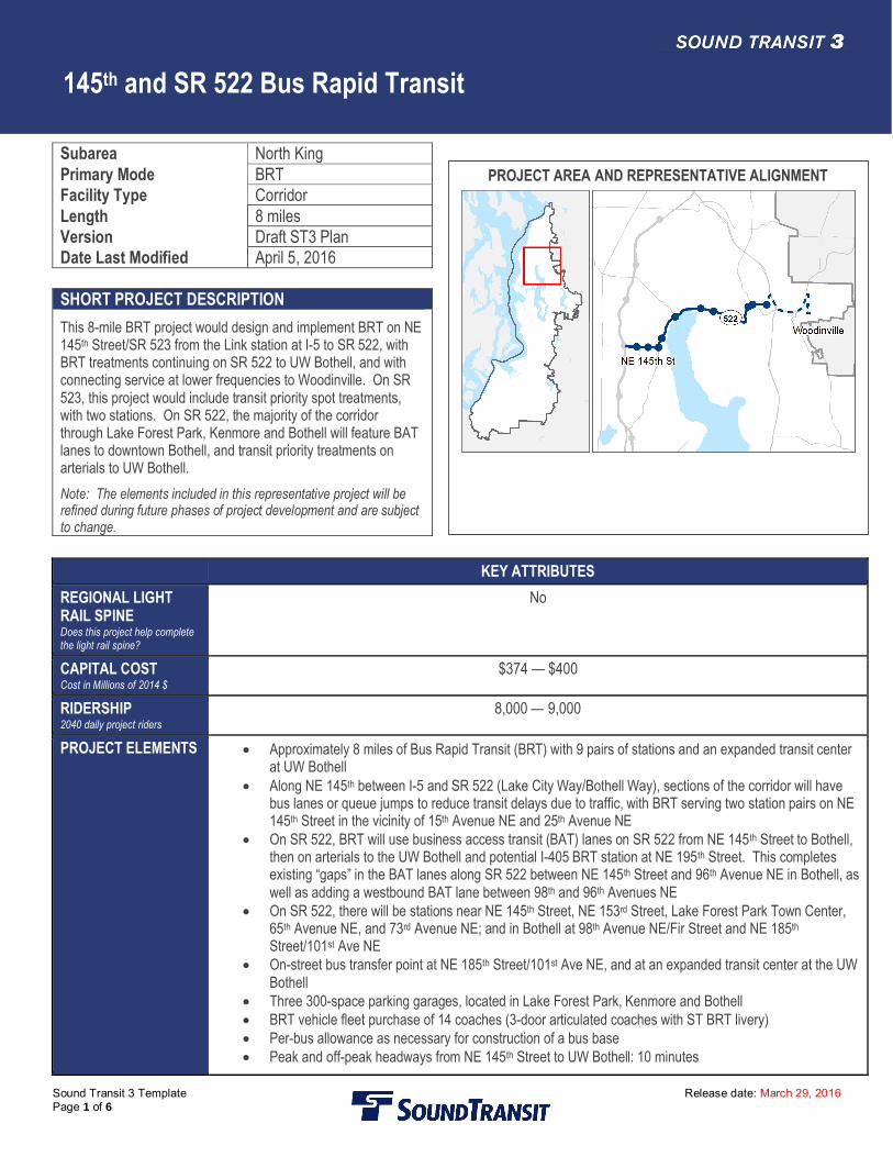
Subarea North KingPrimary Mode BRTFacility Type CorridorLength 8 milesVersion Draft ST3 PlanDate Last Modified April 5, 2016
SHORT PROJECT DESCRIPTIONThis 8-mile BRT project would design and implement BRT on NE145th Street/SR 523 from the Link station at I-5 to SR 522, withBRT treatments continuing on SR 522 to UW Bothell, and withconnecting service at lower frequencies to Woodinville. On SR523, this project would include transit priority spot treatments,with two stations. On SR 522, the majority of the corridorthrough Lake Forest Park, Kenmore and Bothell will feature BATlanes to downtown Bothell, and transit priority treatments onarterials to UW Bothell.Note: The elements included in this representative project will berefined during future phases of project development and are subjectto change.
KEY ATTRIBUTESREGIONAL LIGHTRAIL SPINEDoes this project help completethe light rail spine?
No
CAPITAL COSTCost in Millions of 2014 $
$374 — $400
RIDERSHIP2040 daily project riders
8,000 — 9,000
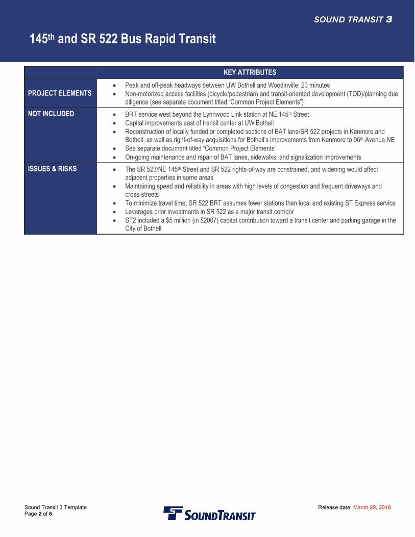
PROJECT ELEMENTS · Approximately 8 miles of Bus Rapid Transit (BRT) with 9 pairs of stations and an expanded transit centerat UW Bothell
· Along NE 145th between I-5 and SR 522 (Lake City Way/Bothell Way), sections of the corridor will havebus lanes or queue jumps to reduce transit delays due to traffic, with BRT serving two station pairs on NE145th Street in the vicinity of 15th Avenue NE and 25th Avenue NE
· On SR 522, BRT will use business access transit (BAT) lanes on SR 522 from NE 145th Street to Bothell,then on arterials to the UW Bothell and potential I-405 BRT station at NE 195th Street. This completesexisting “gaps” in the BAT lanes along SR 522 between NE 145th Street and 96th Avenue NE in Bothell, aswell as adding a westbound BAT lane between 98th and 96th Avenues NE
· On SR 522, there will be stations near NE 145th Street, NE 153rd Street, Lake Forest Park Town Center,65th Avenue NE, and 73rd Avenue NE; and in Bothell at 98th Avenue NE/Fir Street and NE 185th
Street/101st Ave NE· On-street bus transfer point at NE 185th Street/101st Ave NE, and at an expanded transit center at the UW
Bothell· Three 300-space parking garages, located in Lake Forest Park, Kenmore and Bothell· BRT vehicle fleet purchase of 14 coaches (3-door articulated coaches with ST BRT livery)· Per-bus allowance as necessary for construction of a bus base· Peak and off-peak headways from NE 145th Street to UW Bothell: 10 minutes
PROJECT AREA AND REPRESENTATIVE ALIGNMENT
145th and SR 522 Bus Rapid Transit
Sound Transit 3 Template Release date: March 29, 2016Page 2 of 6
KEY ATTRIBUTES
PROJECT ELEMENTS· Peak and off-peak headways between UW Bothell and Woodinville: 20 minutes· Non-motorized access facilities (bicycle/pedestrian) and transit-oriented development (TOD)/planning due
diligence (see separate document titled “Common Project Elements”)NOT INCLUDED · BRT service west beyond the Lynnwood Link station at NE 145th Street
· Capital improvements east of transit center at UW Bothell· Reconstruction of locally funded or completed sections of BAT lane/SR 522 projects in Kenmore and
Bothell, as well as right-of-way acquisitions for Bothell’s improvements from Kenmore to 96th Avenue NE· See separate document titled “Common Project Elements”· On-going maintenance and repair of BAT lanes, sidewalks, and signalization improvements
ISSUES & RISKS · The SR 523/NE 145th Street and SR 522 rights-of-way are constrained, and widening would affectadjacent properties in some areas
· Maintaining speed and reliability in areas with high levels of congestion and frequent driveways andcross-streets
· To minimize travel time, SR 522 BRT assumes fewer stations than local and existing ST Express service· Leverages prior investments in SR 522 as a major transit corridor· ST2 included a $5 million (in $2007) capital contribution toward a transit center and parking garage in the
City of Bothell
145th and SR 522 Bus Rapid Transit
Sound Transit 3 Template Release date: March 29, 2016Page 3 of 6
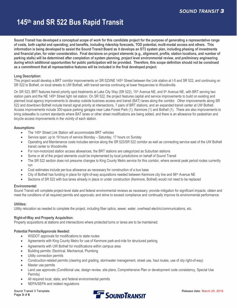
Sound Transit has developed a conceptual scope of work for this candidate project for the purpose of generating a representative rangeof costs, both capital and operating; and benefits, including ridership forecasts, TOD potential, multi-modal access and others. Thisinformation is being developed to assist the Sound Transit Board as it develops an ST3 system plan, including phasing of investmentsand financial plan, for voter consideration. Final decisions on project elements (e.g., alignment, profile, station locations, and number ofparking stalls) will be determined after completion of system planning, project level environmental review, and preliminary engineeringduring which additional opportunities for public participation will be provided. Therefore, this scope definition should not be construedas a commitment that all representative features will be included in the final developed project.
Long Description:This project would develop a BRT corridor improvements on SR 523/NE 145th Street between the Link station at I-5 and SR 522, and continuing onSR 522 to Bothell, on local streets to UW Bothell, with transit service continuing at lower frequencies to Woodinville.On SR 523, BRT features transit priority spot treatments at Lake City Way (SR 522), 15th Avenue NE, and 5th Avenue NE, with BRT serving twostation pairs and the NE 145th Street light rail station. On SR 522, the project features capital and service improvements to build on existing andplanned local agency improvements to develop outside business access and transit (BAT) lanes along the corridor. Other improvements along SR522 and downtown Bothell include transit signal priority at intersections, 7 pairs of BRT stations, and an expanded transit center at UW Bothell.Access improvements include 300-space parking garages near Lake Forest Park (1), Kenmore (1) and Bothell (1). There are also improvements tobring sidewalks to current standards where BAT lanes or other street modifications are being added, and there is an allowance for pedestrian andbicycle access improvements in the vicinity of each station.
Assumptions:· The 145th Street Link Station will accommodate BRT vehicles· Service span: up to 19 hours of service Monday – Saturday, 17 hours on Sunday· Operating and Maintenance costs includes service along the SR 523/SR 522 corridor as well as connecting service east of the UW Bothell
transit center to Woodinville· For non-motorized station access allowances, the BRT stations are categorized as Suburban stations· Some or all of the project elements could be implemented by local jurisdictions on behalf of Sound Transit· The SR 522 section does not presume changes to King County Metro service for this corridor, where several peak period routes currently
run· Cost estimates include per-bus allowance as necessary for construction of a bus base· City of Bothell has funding in place for right-of-way acquisitions needed between Kenmore city line and 96th Avenue NE· Sections of SR 522 with bus lanes already in place or under construction (Kenmore, Bothell) would not need to be replaced
Environmental:Sound Transit will complete project-level state and federal environmental reviews as necessary; provide mitigation for significant impacts; obtain andmeet the conditions of all required permits and approvals; and strive to exceed compliance and continually improve its environmental performance.
Utilities:Utility relocation as needed to complete the project, including fiber optics, sewer, water, overhead electric/communications, etc.
Right-of-Way and Property Acquisition:Property acquisitions at stations and intersections where protected turns or lanes are to be maintained.
Potential Permits/Approvals Needed:· WSDOT approvals for modifications to state routes· Agreements with King County Metro for use of Kenmore park-and-ride for structured parking· Agreements with UW Bothell for modifications within campus area· Building permits: Electrical, Mechanical, Plumbing· Utility connection permits· Construction-related permits (clearing and grading, stormwater management, street use, haul routes, use of city right-of-way)· Master use permits· Land use approvals (Conditional use, design review, site plans, Comprehensive Plan or development code consistency, Special Use
Permits)· All required local, state, and federal environmental permits· NEPA/SEPA and related regulations
145th and SR 522 Bus Rapid Transit
Sound Transit 3 Template Release date: March 29, 2016Page 4 of 6
Project Dependencies:· Completion of Lynnwood Link Extension station at NE 145th Street
Potential Project Partners:· WSDOT· Cities of Seattle, Shoreline, Lake Forest Park, Kenmore,
Bothell· FHWA· King County
· FTA· UW Bothell· Transit partners serving project corridor: King County
Metro, Community Transit

145th and SR 522 Bus Rapid Transit
Sound Transit 3 Template Release date: March 29, 2016Page 5 of 6
Cost:Sound Transit has developed a conceptual scope of work for this candidate project for the purpose of generating a representative range of costs,both capital and operating; and benefits, including ridership forecasts, TOD potential, multi-modal access and others. This information is beingdeveloped to assist the Sound Transit Board as it develops an ST3 system plan, including phasing of investments and financial plan, for voterconsideration. Final decisions on project elements (e.g., alignment, profile, station locations, and number of parking stalls) will be determined aftercompletion of system planning, project level environmental review, and preliminary engineering during which additional opportunities for publicparticipation will be provided. Therefore, this scope definition should not be construed as a commitment that all representative features will beincluded in the final developed project.In Millions of 2014$
ITEM COST COST WITH RESERVEAgency Administration $20.03 $21.43Preliminary Engineering & EnvironmentalReview
$10.63 $11.38
Final Design & Specifications $19.77 $21.15Property Acquisition & Permits $55.36 $59.23Construction $201.61 $215.73Construction Management $17.79 $19.03Third Parties $4.75 $5.09Vehicles $23.87 $25.54Contingency $19.77 $21.15Total $373.58 $399.73
Design Basis: Conceptual
The costs expressed above include allowances for TOD planning and due diligence, Sustainability, Bus/rail integration facilities, and Non-MotorizedAccess. These allowances, as well as the costs for Parking Access included above, are reflected in the following table. Property acquisition costs arenot included in the table below, but are included within the total project cost above.
ITEM COST COST WITH RESERVETOD planning and due diligence $1.55 $1.66Sustainability N/A N/AParking access $47.00 $50.29Non-motorized (bicycle/pedestrian) access $4.83 $5.17Bus/rail integration facilities N/A N/A
145th and SR 522 Bus Rapid Transit
Sound Transit 3 Template Release date: March 29, 2016Page 6 of 6
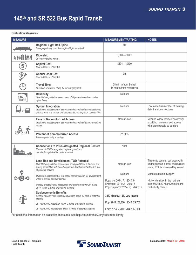
Evaluation Measures:
MEASURE MEASUREMENT/RATING NOTESRegional Light Rail SpineDoes project help complete regional light rail spine?
No
Ridership2040 daily project riders
8,000 — 9,000
Capital CostCost in Millions of 2014 $
$374 — $400
Annual O&M CostCost in Millions of 2014 $
$15
Travel TimeIn-vehicle travel time along the project (segment)
28 min to/from Bothell45 min to/from Woodinville
ReliabilityQuantitative/qualitative assessment of alignment/route in exclusiveright-of-way
Medium
System IntegrationQualitative assessment of issues and effects related to connections toexisting local bus service and potential future integration opportunities
Medium Low to medium number of existingdaily transit connections
Ease of Non-motorized AccessQualitative assessment of issues and effects related to non-motorizedmodes
Medium-Low Medium to low intersection densityproviding non-motorized accesswith large parcels as barriers
Percent of Non-motorized AccessPercentage of daily boardings
25-35%
Connections to PSRC-designated Regional CentersNumber of PSRC-designated regional growth andmanufacturing/industrial centers served
None
Land Use and Development/TOD PotentialQuantitative/qualitative assessment of adopted Plans & Policies andzoning compatible with transit-supportive development within 0.5 mileof potential stations
Qualitative assessment of real estate market support for developmentwithin 1 mile of potential corridor
Density of activity units (population and employment for 2014 and2040) within 0.5 mile of potential stations
Medium-Low
Medium
Pop/acre: 2014: 7; 2040: 9Emp/acre: 2014: 2; 2040: 4Pop+Emp/acre: 2014: 9; 2040: 12
Three city centers, but areas withlimited support in local and regionalplans; 25% land compatibly zoned
Moderate Market Support
Higher densities in the northernside of SR 522 near Kenmore andBothell city centers
Socioeconomic BenefitsExisting minority / low-income populations within 0.5 mile of potentialstations
2014 and 2040 population within 0.5 mile of potential stations
2014 and 2040 employment within 0.5 mile of potential stations
33% Minority; 12% Low-Income
Pop: 2014: 23,800; 2040: 29,700
Emp: 2014: 7,700; 2040: 12,300
For additional information on evaluation measures, see http://soundtransit3.org/document-library
EARLY DELIVERABLES
Sound Transit 3 Template Release date: March 29, 2016
Subarea SystemwidePrimary Mode N/AFacility Type N/ALength N/AVersion Draft ST3 PlanDate Last Modified March 28, 2016
SHORT PROJECT DESCRIPTIONThis program would implement a series of improvementsdesigned to improve passenger access and amenities, existingtransit services, travel time through bus on shoulder operationsand other related transit priority elements. These projects wouldbe implemented as early deliverables within the Draft ST3System Plan.
KEY ATTRIBUTESREGIONAL LIGHTRAIL SPINEDoes this project help completethe light rail spine?
No
CAPITAL COSTCost in Millions of 2014 $
$232
RIDERSHIP2040 daily project riders
N/A
PROJECT ELEMENTS · King County Metro Rapid Ride C and D Capital Improvements· Proposed Bus on Shoulder Program: Opportunities along I-5, I-405, SR 518, and SR 167 and
related improvements· North Sounder Parking· Improved Passenger Amenities at Stations and Stops, which could be completed in coordination
with the ST3 System Access Program and ST3 System Innovation and Research Fund.NOT INCLUDED · Funding for operations
· Enhanced aesthetic surface treatments· Parking (aside from North Sounder parking)· Transit-oriented development planning/due diligence and sustainability measures· See “Common Project Elements”
ISSUES & RISKS · Feasibility of bus on shoulder improvements on freeways and state routes has not been identified· Coordination and approval for bus on shoulder improvements and operations from the Federal
Highway Administration· Coordination required with WSDOT, FTA, FHWA, and transit partners to determine feasible
locations for bus on shoulder improvements· Risk to completing schedule for projects as early deliverables
PROJECT AREA AND REPRESENTATIVE ALIGNMENT
EARLY DELIVERABLES
Sound Transit 3 Template Release date: March 29, 2016
Sound Transit has developed a conceptual scope of work for this candidate project for the purpose of generating a representative rangeof costs, both capital and operating; and benefits, including ridership forecasts, TOD potential, multi-modal access and others. Thisinformation is being developed to assist the Sound Transit Board as it develops an ST3 system plan, including phasing of investmentsand financial plan, for voter consideration. Final decisions on project elements (e.g., alignment, profile, station locations, and number ofparking stalls) will be determined after completion of system planning, project level environmental review, and preliminary engineeringduring which additional opportunities for public participation will be provided. Therefore, this scope definition should not be construedas a commitment that all representative features will be included in the final developed project.
Long Description:This program would implement a series of improvements designed to improve passenger access and amenities, existing transit services,travel time through bus-on-shoulder and other related transit priority elements. These projects would be implemented as early deliverableswithin the ST3 System Plan. Program elements include:
· King County Metro Rapid Ride C and D Capital ImprovementsThis project would design and implement transit priority improvements along King County Metro’s Rapid Ride C and D lines that provide serviceto Ballard and West Seattle as an early deliverable to provide improved speed and reliability, in advance of light rail starting operations to theseareas. This project would be completed in coordination with King County Metro.
· Proposed Bus on Shoulder Program: Opportunities along I-5, I-405, SR 518, and SR 167This program proposes to enable buses to use shoulders on freeway and state route facilities during periods of congestion in general trafficand/or HOV lanes. This program will require coordination and further study with transit partners, WSDOT, and Federal Highway Administrationin order to determine locations that may be feasible for this program.
· North Sounder Parking and Access ImprovementsThis project would provide an early deliverable within the ST3 System Plan by providing additional parking at Mukilteo and Edmonds SounderStations and an opportunity for access improvements prioritized per Sound Transit’s System Access Policy.
· Improved Passenger Amenities at Stations and StopsThis program would provide improved passenger amenities at stations and stops, including access improvements for bikes/pedestrian access,real time information expansion at stations/stops; Expanded use of ORCA and/or Mobile Pay options; Access for drop-off and pick-up capacityat stations, transit services, car share services, and private vehicles.
Assumptions:· Coordination and study with WSDOT to determine feasible locations for bus on shoulder will be required. Specific locations within the
opportunity areas have not yet been identified for these type of treatments· Improvements along RapidRide C and D routes would enable faster travel time and reliability for these services· The schedule for completing these project would be within the first 3-8 years of Sound Transit’s System Plan· North Sounder improvements include parking, but other access improvements can be considered depending on the prioritization per the
ST System Access Policy and in coordination with local jurisdictions
Environmental:Sound Transit will complete project-level state and federal environmental reviews as necessary to provide mitigation for significant impacts, obtainand meet the conditions of all required permits and approvals, and strive to exceed compliance and continually improve its environmentalperformance.
Utilities:Utility relocation as needed to complete projects, including fiber options, sewer, overhead electric/communications, etc.
Right-of-Way and Property Acquisition:Property acquisitions may be needed for transit capital improvements.
Potential Permits/Approvals Needed:· WSDOT approvals for modifications to a state route· Approval by FHWA for bus on shoulder operation· Building permits: Electrical, Mechanical, Plumbing
EARLY DELIVERABLES
Sound Transit 3 Template Release date: March 29, 2016
· Utility connection permits· Right-of-way permits· Construction-related permits (clearing and grading, stormwater management, street use, haul routes, use of city right-of-way)· All required local, state, and federal environmental permits· NEPA/SEPA and related regulations
Project Dependencies:· Identification of locations where bus on shoulder operation is feasible· Approval by FHWA and WSDOT for bus on shoulder operation· Identification of improvements on Rapid Ride C and D lines that would improve travel time along these corridors
Potential Project Partners:· Federal Highway Administration· King County Metro· Transit partners· Washington Department of Transportation
· Cities and jurisdictions along the corridors· Federal Transit Administration· BNSF
EARLY DELIVERABLES
Sound Transit 3 Template Release date: March 29, 2016
Cost:Sound Transit has developed a conceptual scope of work for this candidate project for the purpose of generating a representative range of costs,both capital and operating; and benefits, including ridership forecasts, TOD potential, multi-modal access and others. This information is beingdeveloped to assist the Sound Transit Board as it develops an ST3 system plan, including phasing of investments and financial plan, for voterconsideration. Final decisions on project elements (e.g., alignment, profile, station locations, and number of parking stalls) will be determined aftercompletion of system planning, project level environmental review, and preliminary engineering during which additional opportunities for publicparticipation will be provided. Therefore, this scope definition should not be construed as a commitment that all representative features will beincluded in the final developed project.
In Millions of 2014$
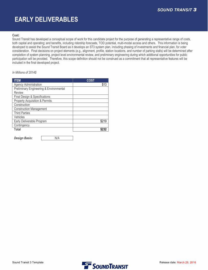
ITEM COSTAgency Administration $13Preliminary Engineering & EnvironmentalReviewFinal Design & SpecificationsProperty Acquisition & PermitsConstructionConstruction ManagementThird PartiesVehiclesEarly Deliverable Program $219ContingencyTotal $232
Design Basis: N/A
EARLY DELIVERABLES
Sound Transit 3 Template Release date: March 29, 2016
Evaluation Measures:
MEASURE MEASUREMENT/RATING NOTESRegional Light Rail SpineDoes project help complete regional light rail spine?
N/A
Ridership2040 daily project riders
N/A
Capital CostCost in Millions of 2014 $
$232
Annual O&M CostCost in Millions of 2014 $
N/A
Travel TimeIn-vehicle travel time along the project (segment)
N/A
ReliabilityPercentage of alignment/route in exclusive right-of-way
N/A
System IntegrationQualitative assessment of issues and effects related to connections toexisting local bus service
N/A
Ease of Non-motorized AccessQualitative assessment of issues and effects related to non-motorizedmodes
N/A
Percent of Non-motorized AccessPercentage of daily boardings
N/A
Connections to PSRC-designated Regional CentersNumber of PSRC-designated regional growth andmanufacturing/industrial centers served
N/A
Land Use and Development/TOD PotentialQuantitative/qualitative assessment of adopted Plans & Policies andzoning compatible with transit-supportive development within 0.5 mileof potential stations
Qualitative assessment of real estate market support for developmentwithin 1 mile of potential corridor
Density of activity units (population and employment for 2014 and2040) within 0.5 mile of potential stations
N/A
N/A
N/A
Socioeconomic BenefitsExisting minority / low-income populations within 0.5 mile of potentialstations
2014 and 2040 population within 0.5 mile of potential stations
2014 and 2040 employment within 0.5 mile of potential stations
N/A
N/A
N/A
For additional information on evaluation measures, see http://soundtransit3.org/document-library
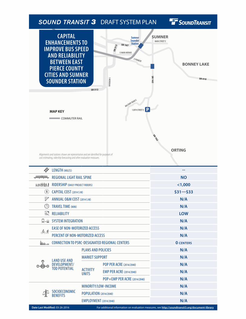
SR 512
MAIN STREET E
E MAIN AVENUE
MILITARY ROAD E
128TH STREET E
E PIONEER
S MERIDIAN
SR 512
SR 5
12
SR 167
SR 162
SR 162
SR 410
P
BONNEY LAKE
SumnerSounder Station
ORTING
SUMNER
LENGTH (MILES) --
REGIONAL LIGHT RAIL SPINE NO
RIDERSHIP (DAILY PROJECT RIDERS) <1,000
CAPITAL COST (2014 $ M) $31—$33
ANNUAL O&M COST (2014 $ M) N/A
TRAVEL TIME (MIN) N/A
RELIABILITY LOW
SYSTEM INTEGRATION N/A
EASE OF NON-MOTORIZED ACCESS N/A
PERCENT OF NON-MOTORIZED ACCESS N/A
CONNECTION TO PSRC-DESIGNATED REGIONAL CENTERS 0 CENTERS
LAND USE AND DEVELOPMENT/ TOD POTENTIAL
PLANS AND POLICIES N/A
MARKET SUPPORT N/A
ACTIVITY UNITS
POP PER ACRE (2014/2040) N/A
EMP PER ACRE (2014/2040) N/A
POP+EMP PER ACRE (2014/2040) N/A
SOCIOECONOMIC BENEFITS
MINORITY/LOW-INCOME N/A
POPULATION (2014/2040) N/A
EMPLOYMENT (2014/2040) N/A
CAPITAL ENHANCEMENTS TO
IMPROVE BUS SPEED AND RELIABILITY
BETWEEN EAST PIERCE COUNTY
CITIES AND SUMNER SOUNDER STATION
Alignments and stations shown are representative and are identified for purposes of cost estimating, ridership forecasting and other evaluation measures.
COMMUTER RAIL
MAP KEY
For additional information on evaluation measures, see http://soundtransit3.org/document-libraryDate Last Modified: 03-26-2016
DRAFT SYSTEM PLAN
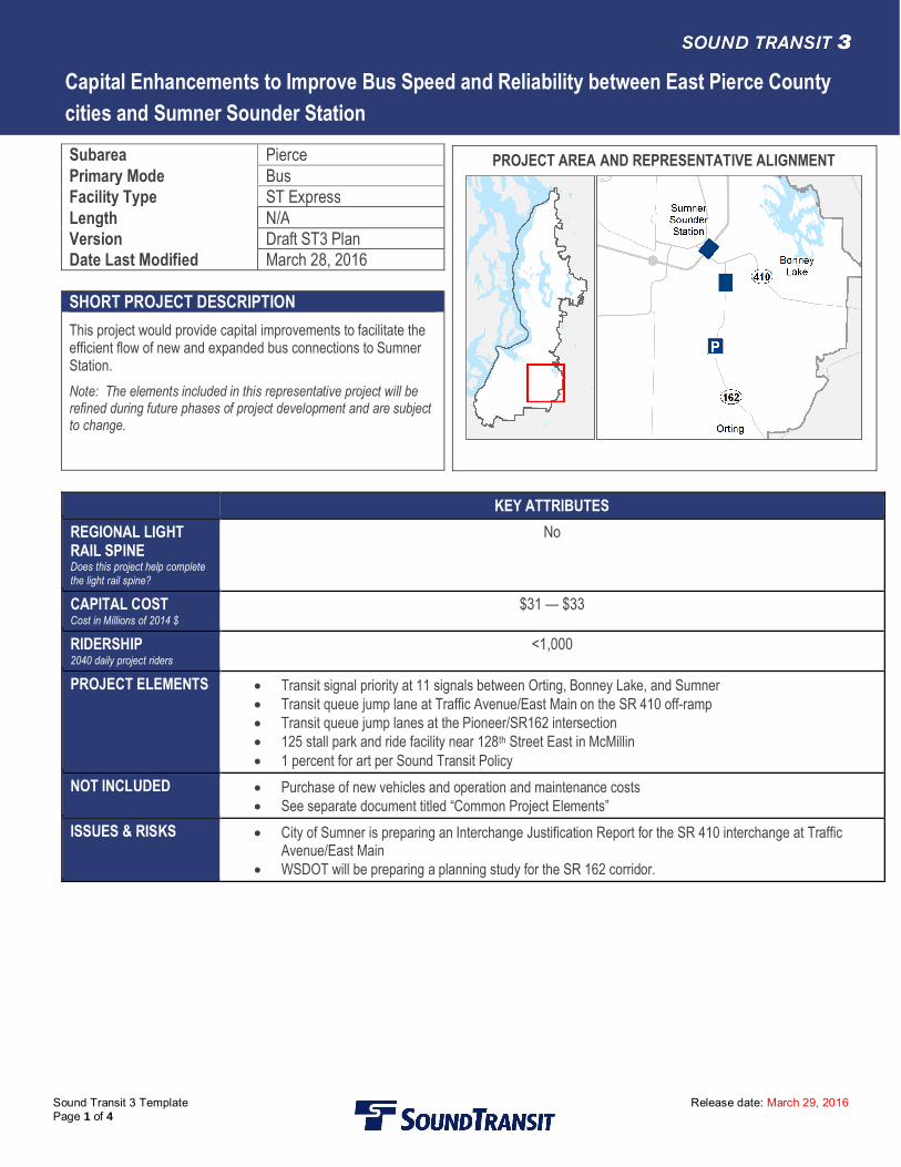
Capital Enhancements to Improve Bus Speed and Reliability between East Pierce Countycities and Sumner Sounder Station
Sound Transit 3 Template Release date: March 29, 2016Page 1 of 4
Subarea PiercePrimary Mode BusFacility Type ST ExpressLength N/AVersion Draft ST3 PlanDate Last Modified March 28, 2016
SHORT PROJECT DESCRIPTIONThis project would provide capital improvements to facilitate theefficient flow of new and expanded bus connections to SumnerStation.Note: The elements included in this representative project will berefined during future phases of project development and are subjectto change.
KEY ATTRIBUTESREGIONAL LIGHTRAIL SPINEDoes this project help completethe light rail spine?
No
CAPITAL COSTCost in Millions of 2014 $
$31 — $33
RIDERSHIP2040 daily project riders
<1,000
PROJECT ELEMENTS · Transit signal priority at 11 signals between Orting, Bonney Lake, and Sumner· Transit queue jump lane at Traffic Avenue/East Main on the SR 410 off-ramp· Transit queue jump lanes at the Pioneer/SR162 intersection· 125 stall park and ride facility near 128th Street East in McMillin· 1 percent for art per Sound Transit Policy
NOT INCLUDED · Purchase of new vehicles and operation and maintenance costs· See separate document titled “Common Project Elements”
ISSUES & RISKS · City of Sumner is preparing an Interchange Justification Report for the SR 410 interchange at TrafficAvenue/East Main
· WSDOT will be preparing a planning study for the SR 162 corridor.
PROJECT AREA AND REPRESENTATIVE ALIGNMENT
Capital Enhancements to Improve Bus Speed and Reliability between East Pierce Countycities and Sumner Sounder Station
Sound Transit 3 Template Release date: March 29, 2016Page 2 of 4
Sound Transit has developed a conceptual scope of work for this candidate project for the purpose of generating a representative rangeof costs, both capital and operating; and benefits, including ridership forecasts, TOD potential, multi-modal access and others. Thisinformation is being developed to assist the Sound Transit Board as it develops an ST3 system plan, including phasing of investmentsand financial plan, for voter consideration. Final decisions on project elements (e.g., alignment, profile, station locations, and number ofparking stalls) will be determined after completion of project level environmental review and preliminary engineering during whichadditional opportunities for public participation will be provided. Therefore, this scope definition should not be construed as acommitment that all representative features will be included in the final developed project.
Long Description:This project would make a capital contribution to help fund improvements at SR 410 to facilitate the efficient flow of buses at Traffic Ave/East Main inthe Sumner area, for the purpose of supporting new and expanded bus connections to Sumner Station.
Assumptions:Bus service could be provided as part of ST Express Service.
Environmental:Sound Transit will complete project-level state and federal environmental reviews as necessary; provide mitigation for significant impacts; obtain andmeet the conditions of all required permits and approvals; and strive to exceed compliance and continually improve its environmental performance.
Utilities:Utility relocation as needed to complete the project, including fiber optics, sewer, water, overhead electric/communications, etc.
Right-of-Way and Property Acquisition:Minimal right-of-way acquisition to accommodate transit-only queue jump lanes will be required.
Potential Permits/Approvals Needed:· Right-of-way permits· WSDOT approval for work within the SR 162 and SR 410 ROW· Utility connection permits· Construction-related permits (clearing and grading, stormwater management, street use, haul routes, use of city right-of-way)· All required local, state, and federal environmental permits· NEPA/SEPA and related regulations
Project Dependencies:The project would need to coordinate with WSDOT’s SR 162 Corridor Study expected to start in late 2015.
Potential Project Partners:· WSDOT· Cities of Sumner, Bonney Lake, Orting· Pierce County
· Pierce Transit
Capital Enhancements to Improve Bus Speed and Reliability between East Pierce Countycities and Sumner Sounder Station
Sound Transit 3 Template Release date: March 29, 2016Page 3 of 4
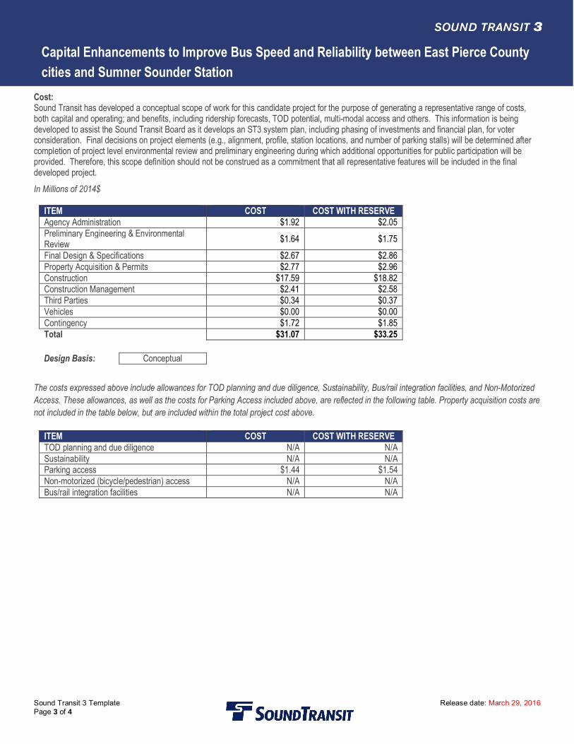
Cost:Sound Transit has developed a conceptual scope of work for this candidate project for the purpose of generating a representative range of costs,both capital and operating; and benefits, including ridership forecasts, TOD potential, multi-modal access and others. This information is beingdeveloped to assist the Sound Transit Board as it develops an ST3 system plan, including phasing of investments and financial plan, for voterconsideration. Final decisions on project elements (e.g., alignment, profile, station locations, and number of parking stalls) will be determined aftercompletion of project level environmental review and preliminary engineering during which additional opportunities for public participation will beprovided. Therefore, this scope definition should not be construed as a commitment that all representative features will be included in the finaldeveloped project.In Millions of 2014$
ITEM COST COST WITH RESERVEAgency Administration $1.92 $2.05Preliminary Engineering & EnvironmentalReview $1.64 $1.75
Final Design & Specifications $2.67 $2.86Property Acquisition & Permits $2.77 $2.96Construction $17.59 $18.82Construction Management $2.41 $2.58Third Parties $0.34 $0.37Vehicles $0.00 $0.00Contingency $1.72 $1.85Total $31.07 $33.25
Design Basis: Conceptual
The costs expressed above include allowances for TOD planning and due diligence, Sustainability, Bus/rail integration facilities, and Non-MotorizedAccess. These allowances, as well as the costs for Parking Access included above, are reflected in the following table. Property acquisition costs arenot included in the table below, but are included within the total project cost above.
ITEM COST COST WITH RESERVETOD planning and due diligence N/A N/ASustainability N/A N/AParking access $1.44 $1.54Non-motorized (bicycle/pedestrian) access N/A N/ABus/rail integration facilities N/A N/A
Capital Enhancements to Improve Bus Speed and Reliability between East Pierce Countycities and Sumner Sounder Station
Sound Transit 3 Template Release date: March 29, 2016Page 4 of 4
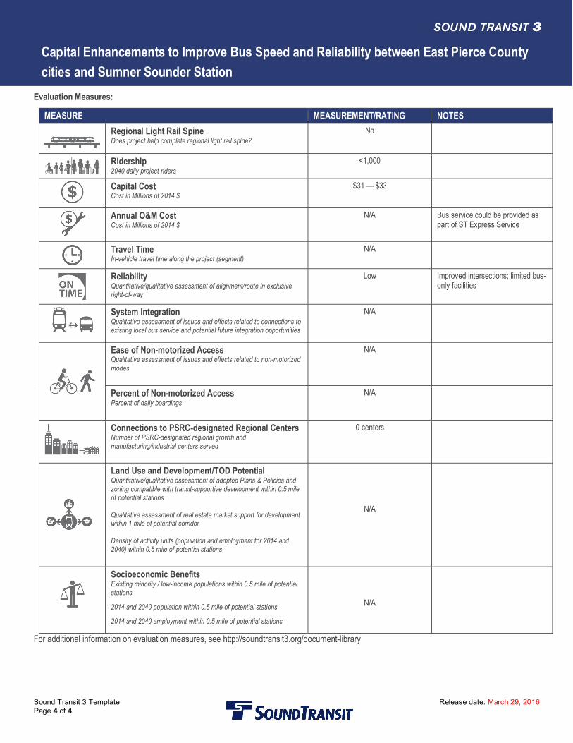
Evaluation Measures:
MEASURE MEASUREMENT/RATING NOTESRegional Light Rail SpineDoes project help complete regional light rail spine?
No
Ridership2040 daily project riders
<1,000
Capital CostCost in Millions of 2014 $
$31 — $33
Annual O&M CostCost in Millions of 2014 $
N/A Bus service could be provided aspart of ST Express Service
Travel TimeIn-vehicle travel time along the project (segment)
N/A
ReliabilityQuantitative/qualitative assessment of alignment/route in exclusiveright-of-way
Low Improved intersections; limited bus-only facilities
System IntegrationQualitative assessment of issues and effects related to connections toexisting local bus service and potential future integration opportunities
N/A
Ease of Non-motorized AccessQualitative assessment of issues and effects related to non-motorizedmodes
N/A
Percent of Non-motorized AccessPercent of daily boardings
N/A
Connections to PSRC-designated Regional CentersNumber of PSRC-designated regional growth andmanufacturing/industrial centers served
0 centers
Land Use and Development/TOD PotentialQuantitative/qualitative assessment of adopted Plans & Policies andzoning compatible with transit-supportive development within 0.5 mileof potential stations
Qualitative assessment of real estate market support for developmentwithin 1 mile of potential corridor
Density of activity units (population and employment for 2014 and2040) within 0.5 mile of potential stations
N/A
Socioeconomic BenefitsExisting minority / low-income populations within 0.5 mile of potentialstations
2014 and 2040 population within 0.5 mile of potential stations
2014 and 2040 employment within 0.5 mile of potential stations
N/A
For additional information on evaluation measures, see http://soundtransit3.org/document-library
S 84TH STREET
152ND STREET E
176TH STREET E
PACIFIC AVENUE
CANYON ROAD E
S 56TH STREET
I-5SR 512
SR 16
I-5
I-705
SR 167
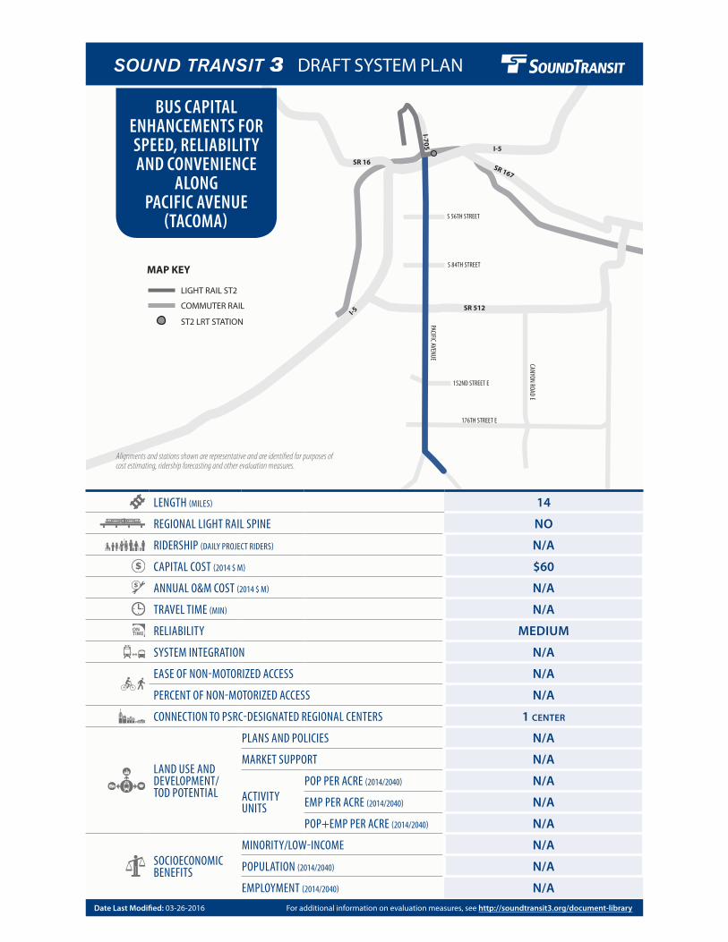
LENGTH (MILES) 14
REGIONAL LIGHT RAIL SPINE NO
RIDERSHIP (DAILY PROJECT RIDERS) N/A
CAPITAL COST (2014 $ M) $60
ANNUAL O&M COST (2014 $ M) N/A
TRAVEL TIME (MIN) N/A
RELIABILITY MEDIUM
SYSTEM INTEGRATION N/A
EASE OF NON-MOTORIZED ACCESS N/A
PERCENT OF NON-MOTORIZED ACCESS N/A
CONNECTION TO PSRC-DESIGNATED REGIONAL CENTERS 1 CENTER
LAND USE AND DEVELOPMENT/ TOD POTENTIAL
PLANS AND POLICIES N/A
MARKET SUPPORT N/A
ACTIVITY UNITS
POP PER ACRE (2014/2040) N/A
EMP PER ACRE (2014/2040) N/A
POP+EMP PER ACRE (2014/2040) N/A
SOCIOECONOMIC BENEFITS
MINORITY/LOW-INCOME N/A
POPULATION (2014/2040) N/A
EMPLOYMENT (2014/2040) N/A
BUS CAPITAL ENHANCEMENTS FOR SPEED, RELIABILITY AND CONVENIENCE
ALONG PACIFIC AVENUE
(TACOMA)
Alignments and stations shown are representative and are identified for purposes of cost estimating, ridership forecasting and other evaluation measures.
LIGHT RAIL ST2
COMMUTER RAIL
MAP KEY
ST2 LRT STATION
For additional information on evaluation measures, see http://soundtransit3.org/document-libraryDate Last Modified: 03-26-2016
DRAFT SYSTEM PLAN
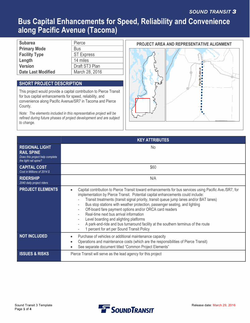
Bus Capital Enhancements for Speed, Reliability and Conveniencealong Pacific Avenue (Tacoma)
Sound Transit 3 Template Release date: March 29, 2016Page 1 of 4
Subarea PiercePrimary Mode BusFacility Type ST ExpressLength 14 milesVersion Draft ST3 PlanDate Last Modified March 28, 2016
SHORT PROJECT DESCRIPTIONThis project would provide a capital contribution to Pierce Transitfor bus capital enhancements for speed, reliability, andconvenience along Pacific Avenue/SR7 in Tacoma and PierceCounty.Note: The elements included in this representative project will berefined during future phases of project development and are subjectto change.
KEY ATTRIBUTESREGIONAL LIGHTRAIL SPINEDoes this project help completethe light rail spine?
No
CAPITAL COSTCost in Millions of 2014 $
$60
RIDERSHIP2040 daily project riders
N/A
PROJECT ELEMENTS · Capital contribution to Pierce Transit toward enhancements for bus services using Pacific Ave./SR7, forimplementation by Pierce Transit. Potential capital enhancements could include:- Transit treatments (transit signal priority, transit queue jump lanes and/or BAT lanes)- Bus stop stations with weather protection, passenger seating, and lighting- Off-board fare payment options and/or ORCA card readers- Real-time next bus arrival information- Level boarding and alighting platforms- A park-and-ride and bus turnaround facility at the southern terminus of the route- 1 percent for art per Sound Transit Policy
NOT INCLUDED · Purchase of vehicles or additional maintenance capacity· Operations and maintenance costs (which are the responsibilities of Pierce Transit)· See separate document titled “Common Project Elements”
ISSUES & RISKS Pierce Transit will serve as the lead agency for this project
PROJECT AREA AND REPRESENTATIVE ALIGNMENT
Bus Capital Enhancements for Speed, Reliability and Conveniencealong Pacific Avenue (Tacoma)
Sound Transit 3 Template Release date: March 29, 2016Page 2 of 4
Sound Transit has developed a conceptual scope of work for this candidate project based on a concept developed by Pierce Transit. Thisinformation is being developed to assist the Sound Transit Board as it develops an ST3 system plan, including phasing of investmentsand financial plan, for voter consideration. Final decisions on project elements will be determined after completion of system planning,project level environmental review, and preliminary engineering during which additional opportunities for public participation will beprovided.
Long Description:This project would be a capped contribution by Sound Transit to Pierce Transit toward a project along Pacific Avenue/SR 7 (where Pierce TransitRoute 1 currently operates), providing capital improvements that support efficient flow of buses, such as traffic signal pre-emption, exclusive buslanes, stop amenities/station improvements, etc. A Pacific Avenue/SR 7 BRT route would provide direct connections between downtown Tacoma,Tacoma Dome Sounder Station and transit hub, central/south Tacoma, Parkland and Spanaway areas. Business access and transit (BAT) lanescould be constructed at various segments along the corridor comprising approximately 50 percent of the corridor length.
Assumptions:Pierce Transit would be responsible for all environmental review, design, construction, operation, and maintenance implementation and costs.
Environmental:Pierce Transit will be the lead agency for this project and as such will bear responsibility for compliance with any required project-level local, stateand federal environmental review and documentation, and implementation of any required mitigation measures. The lead agency also bearsresponsibility to obtain and meet the conditions of all required local, state, and federal permits and approvals.
Utilities:Pierce Transit will be the lead agency for utility relocation as needed to complete the project, including fiber optics, sewer, water, overheadelectric/communications, etc.
Right-of-Way and Property Acquisition:Pierce Transit will be the lead agency for right-of-way acquisition which could be required to widen Pacific Avenue at intersections where transitqueue jump lanes or BAT lanes are provided.
Potential Permits/Approvals Needed:· WSDOT approval· Building permits: Electrical, Mechanical, Plumbing· Utility connection permits· Construction-related permits (clearing and grading, stormwater management, street use, haul routes, use of city right-of-way)· Master use· Land use approvals (Conditional use, design review, site plans, Comprehensive Plan or development code consistency, Special Use Permits)· All required local, state, and federal environmental permits· NEPA/SEPA and related regulations
Project Dependencies:N/A
Potential Project Partners:· WSDOT· City of Tacoma
· Pierce County· Transit partner serving project: Pierce Transit
Bus Capital Enhancements for Speed, Reliability and Conveniencealong Pacific Avenue (Tacoma)
Sound Transit 3 Template Release date: March 29, 2016Page 3 of 4
Cost:Sound Transit has developed a conceptual scope of work for this candidate project based on a concept developed by Pierce Transit. Thisinformation is being developed to assist the Sound Transit Board as it develops an ST3 system plan, including phasing of investments and financialplan, for voter consideration. Final decisions on project elements will be determined after completion of system planning, project level environmentalreview, and preliminary engineering during which additional opportunities for public participation will be provided.In Millions of 2014$
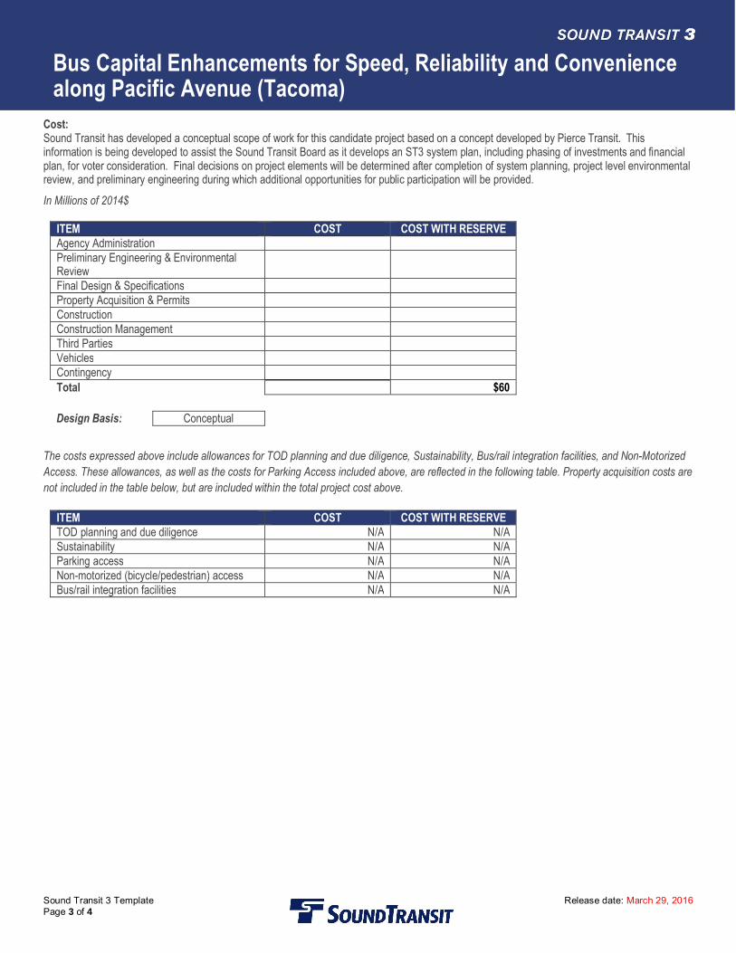
ITEM COST COST WITH RESERVEAgency AdministrationPreliminary Engineering & EnvironmentalReviewFinal Design & SpecificationsProperty Acquisition & PermitsConstructionConstruction ManagementThird PartiesVehiclesContingencyTotal $60
Design Basis: Conceptual
The costs expressed above include allowances for TOD planning and due diligence, Sustainability, Bus/rail integration facilities, and Non-MotorizedAccess. These allowances, as well as the costs for Parking Access included above, are reflected in the following table. Property acquisition costs arenot included in the table below, but are included within the total project cost above.
ITEM COST COST WITH RESERVETOD planning and due diligence N/A N/ASustainability N/A N/AParking access N/A N/ANon-motorized (bicycle/pedestrian) access N/A N/ABus/rail integration facilities N/A N/A
Bus Capital Enhancements for Speed, Reliability and Conveniencealong Pacific Avenue (Tacoma)
Sound Transit 3 Template Release date: March 29, 2016Page 4 of 4
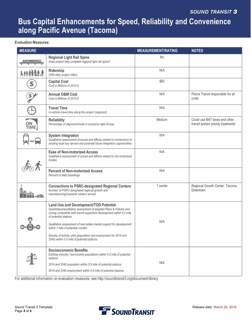
Evaluation Measures:
MEASURE MEASUREMENT/RATING NOTESRegional Light Rail SpineDoes project help complete regional light rail spine?
No
Ridership2040 daily project riders
N/A
Capital CostCost in Millions of 2014 $
$60
Annual O&M CostCost in Millions of 2014 $
N/A Pierce Transit responsible for allcosts
Travel TimeIn-vehicle travel time along the project (segment)
N/A
ReliabilityPercentage of alignment/route in exclusive right-of-way
Medium Could use BAT lanes and othertransit system priority treatments
System IntegrationQualitative assessment of issues and effects related to connections toexisting local bus service and potential future integration opportunities
N/A
Ease of Non-motorized AccessQualitative assessment of issues and effects related to non-motorizedmodes
N/A
Percent of Non-motorized AccessPercent of daily boardings
N/A
Connections to PSRC-designated Regional CentersNumber of PSRC-designated regional growth andmanufacturing/industrial centers served
1 center Regional Growth Center: TacomaDowntown
Land Use and Development/TOD PotentialQuantitative/qualitative assessment of adopted Plans & Policies andzoning compatible with transit-supportive development within 0.5 mileof potential stations
Qualitative assessment of real estate market support for developmentwithin 1 mile of potential corridor
Density of activity units (population and employment for 2014 and2040) within 0.5 mile of potential stations
N/A
Socioeconomic BenefitsExisting minority / low-income populations within 0.5 mile of potentialstations
2014 and 2040 population within 0.5 mile of potential stations
2014 and 2040 employment within 0.5 mile of potential stations
N/A
For additional information on evaluation measures, see http://soundtransit3.org/document-library

![WELCOME [] · WELCOME T&ES High Capacity Transit Corridor Work Group February 16, 2012 ... Duke Street Bike Lanes Alternative 3a – Without Duke Street Bike Lanes Alternative 3b](https://img.pdfslide.net/doc/110x75/5ac209577f8b9a1c768d7e34/welcome-tes-high-capacity-transit-corridor-work-group-february-16-2012-.jpg)