Embed Size (px)
Citation preview

Eurobodalla Shire Council
Draft Tomaga River CZMP
Public Exhibition - Submissions Report
November 2014

EUROBODALLA SHIRE COUNCIL TOMAGA RIVER CZMP – SUBMISSIONS REPORT
PROJECT 14-017 – TOMAGA RIVER CZMP
REV DESCRIPTION AUTHOR REVIEW APPROVAL DATE
0 Draft for ESC review R. Campbell M. Howland M. Howland 25/11/14
Prepared on behalf of Eurobodalla Shire Council by Hydrosphere Consulting.
Suite 6, 26-54 River Street PO Box 7059, BALLINA NSW 2478 Telephone: 02 6686 0006 Facsimile: 02 6686 0078 © Copyright 2014 Hydrosphere Consulting
EUROBODALLA SHIRE COUNCIL TOMAGA RIVER CZMP – SUBMISSIONS REPORT
Page i
CONTENTS
1. INTRODUCTION ................................................................................................................................. 1
2. EXHIBITION PROCESS ..................................................................................................................... 1
3. WRITTEN SUBMISSIONS RECEIVED .............................................................................................. 1
REFERENCES ................................................................................................................................................... 9
APPENDIX 1 – WRITTEN SUBMISSIONS ...................................................................................................... 11
TABLES
Table 1: Summary of Written Submissions ........................................................................................................ 2

EUROBODALLA SHIRE COUNCIL TOMAGA RIVER CZMP – SUBMISSIONS REPORT
Page 1
1. INTRODUCTION
Hydrosphere Consulting has prepared a Draft Coastal Zone Management Plan (CZMP) for Tomaga River
(Hydrosphere Consulting, 2014) on behalf of Eurobodalla Shire Council (ESC). The draft CZMP was
prepared during 2014 with the following major steps:
April/May 2014: Data review, investigations and stakeholder consultation (community/agency
workshop and field trip);
June-August 2014: Preparation of first Draft CZMP;
August/September 2014: Council review of first Draft CZMP and Councillor briefing; and
October/November 2014: Public exhibition (Final Draft for public exhibition, Hydrosphere
Consulting, 2014).
Three submissions were received during the public exhibition phase. Further details of the exhibition process
and the submissions received are provided in the following sections.
2. EXHIBITION PROCESS
At the Ordinary Council meeting of 14 October 2014, Council resolved to place the Final Draft CZMP on
public exhibition. The Final Draft CZMP (Hydrosphere Consulting, 2014) was placed on public exhibition
between 20 October 2014 and 17 November 2014 (4 weeks). Public promotion of the exhibited plan
included:
Information on Council’s ‘Public Exhibition’ page;
Information on Council’s ‘Coastal Projects’ page; and
Notification to relevant agency stakeholders.
3. WRITTEN SUBMISSIONS RECEIVED
The three submissions received during the public exhibition period are summarised in Table 1 together with
a response to the points raised in the submissions. The submissions are attached in Appendix 1.
EUROBODALLA SHIRE COUNCIL TOMAGA RIVER CZMP – SUBMISSIONS REPORT
Page 2
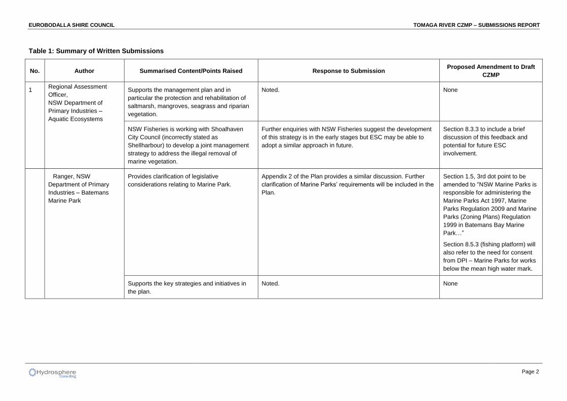
Table 1: Summary of Written Submissions
No. Author Summarised Content/Points Raised Response to Submission Proposed Amendment to Draft
CZMP
1 Supports the management plan and in
particular the protection and rehabilitation of
saltmarsh, mangroves, seagrass and riparian
vegetation.
Noted. None
NSW Fisheries is working with Shoalhaven
City Council (incorrectly stated as
Shellharbour) to develop a joint management
strategy to address the illegal removal of
marine vegetation.
Further enquiries with NSW Fisheries suggest the development
of this strategy is in the early stages but ESC may be able to
adopt a similar approach in future.
Section 8.3.3 to include a brief
discussion of this feedback and
potential for future ESC
involvement.
Provides clarification of legislative
considerations relating to Marine Park.
Appendix 2 of the Plan provides a similar discussion. Further
clarification of Marine Parks’ requirements will be included in the
Plan.
Section 1.5, 3rd dot point to be
amended to “NSW Marine Parks is
responsible for administering the
Marine Parks Act 1997, Marine
Parks Regulation 2009 and Marine
Parks (Zoning Plans) Regulation
1999 in Batemans Bay Marine
Park…”
Section 8.5.3 (fishing platform) will
also refer to the need for consent
from DPI – Marine Parks for works
below the mean high water mark.
Supports the key strategies and initiatives in
the plan.
Noted. None
Regional Assessment
Officer,
NSW Department of
Primary Industries –
Aquatic Ecosystems
Ranger, NSW
Department of Primary
Industries – Batemans
Marine Park
EUROBODALLA SHIRE COUNCIL TOMAGA RIVER CZMP – SUBMISSIONS REPORT
Page 3
No. Author Summarised Content/Points Raised Response to Submission Proposed Amendment to Draft
CZMP
TCA would like to bring forward Actions 1.1 –
Control of pedestrian on the spit, 1.2 –
education and information signs and 1.3 –
education and awareness program for spit
erosion to be undertaken as soon as possible.
These actions were programmed for 2015/16 which is the first
year of the implementation program, assuming that the Plan is
adopted in early 2015 with commencement in the 2015/16
financial year.
None
Cautions the removal of fencing along the spit
as some fencing has been effective in
preserving vegetation and controlling erosion.
The Plan recommends removal of the fencing at the base of the
dune on the river side as it is redundant as an erosion control
measure. As the spit continually erodes, the fence on the river
side has been progressively moved further east. Although some
vegetation has been protected by this fence, it has not been
effective in controlling erosion. The plan proposes
repair/extension of other fences along the dune crest and ocean
side which will provide better protection without the issues
associated with the river side fence.
None
Community feedback on the viewing platform
at the northern end of the spit is mixed. TCA
suggests a disability-friendly platform at the
entrance of Tomakin Beach or a boardwalk
from the beach to the river.
The viewing platform at the northern end of the spit was
proposed to assist in keeping people off the dune and direct
them along the desired tracks, enhance scenic amenity and
provide a focal point for pedestrians. The platform could be
located at any point along the spit but should be connected to
pathways and be easily visible to direct pedestrians along
formed pathways rather than disturbing other parts of the dune.
A boardwalk would serve a similar purpose but would be more
expensive and the additional investment is not considered
necessary as a pathway from the beach to the river already
exists. Due to the environmental and cultural heritage
constraints in this area, there are potential delays/risks in
approval for this work.
The consideration of other
locations and the potential
environmental and cultural heritage
constraints will be noted in Table
14 and Figure 56., Section 8.1.2
3 Tomakin Community
Association (TCA)
EUROBODALLA SHIRE COUNCIL TOMAGA RIVER CZMP – SUBMISSIONS REPORT
Page 4
No. Author Summarised Content/Points Raised Response to Submission Proposed Amendment to Draft
CZMP
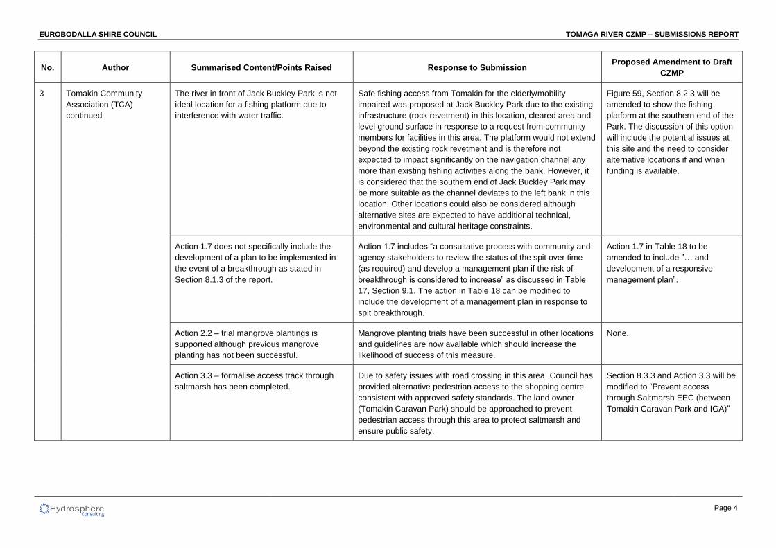
The river in front of Jack Buckley Park is not
ideal location for a fishing platform due to
interference with water traffic.
Safe fishing access from Tomakin for the elderly/mobility
impaired was proposed at Jack Buckley Park due to the existing
infrastructure (rock revetment) in this location, cleared area and
level ground surface in response to a request from community
members for facilities in this area. The platform would not extend
beyond the existing rock revetment and is therefore not
expected to impact significantly on the navigation channel any
more than existing fishing activities along the bank. However, it
is considered that the southern end of Jack Buckley Park may
be more suitable as the channel deviates to the left bank in this
location. Other locations could also be considered although
alternative sites are expected to have additional technical,
environmental and cultural heritage constraints.
Figure 59, Section 8.2.3 will be
amended to show the fishing
platform at the southern end of the
Park. The discussion of this option
will include the potential issues at
this site and the need to consider
alternative locations if and when
funding is available.
Action 1.7 does not specifically include the
development of a plan to be implemented in
the event of a breakthrough as stated in
Section 8.1.3 of the report.
Action 1.7 includes “a consultative process with community and
agency stakeholders to review the status of the spit over time
(as required) and develop a management plan if the risk of
breakthrough is considered to increase” as discussed in Table
17, Section 9.1. The action in Table 18 can be modified to
include the development of a management plan in response to
spit breakthrough.
Action 1.7 in Table 18 to be
amended to include ”… and
development of a responsive
management plan”.
Action 2.2 – trial mangrove plantings is
supported although previous mangrove
planting has not been successful.
Mangrove planting trials have been successful in other locations
and guidelines are now available which should increase the
likelihood of success of this measure.
None.
Action 3.3 – formalise access track through
saltmarsh has been completed.
Due to safety issues with road crossing in this area, Council has
provided alternative pedestrian access to the shopping centre
consistent with approved safety standards. The land owner
(Tomakin Caravan Park) should be approached to prevent
pedestrian access through this area to protect saltmarsh and
ensure public safety.
Section 8.3.3 and Action 3.3 will be
modified to “Prevent access
through Saltmarsh EEC (between
Tomakin Caravan Park and IGA)”
3 Tomakin Community
Association (TCA)
continued
EUROBODALLA SHIRE COUNCIL TOMAGA RIVER CZMP – SUBMISSIONS REPORT
Page 5
No. Author Summarised Content/Points Raised Response to Submission Proposed Amendment to Draft
CZMP
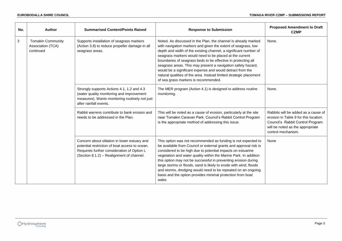
Supports installation of seagrass markers
(Action 3.8) to reduce propeller damage in all
seagrass areas.
Noted. As discussed in the Plan, the channel is already marked
with navigation markers and given the extent of seagrass, low
depth and width of the existing channel, a significant number of
seagrass markers would need to be placed at the current
boundaries of seagrass beds to be effective in protecting all
seagrass areas. This may present a navigation safety hazard,
would be a significant expense and would detract from the
natural qualities of the area. Instead limited strategic placement
of sea grass markers is recommended.
None.
Strongly supports Actions 4.1, 1.2 and 4.3
(water quality monitoring and improvement
measures). Wants monitoring routinely not just
after rainfall events.
The MER program (Action 4.1) is designed to address routine
monitoring.
None.
Rabbit warrens contribute to bank erosion and
needs to be addressed in the Plan.
This will be noted as a cause of erosion, particularly at the site
near Tomakin Caravan Park. Council’s Rabbit Control Program
is the appropriate method of addressing this issue.
Rabbits will be added as a cause of
erosion in Table 9 for this location.
Council’s Rabbit Control Program
will be noted as the appropriate
control mechanism.
Concern about siltation in lower estuary and
potential restriction of boat access to ocean.
Requests further consideration of Option L
(Section 8.1.2) – Realignment of channel.
This option was not recommended as funding is not expected to
be available from Council or external grants and approval risk is
considered to be high due to potential impacts on estuarine
vegetation and water quality within the Marine Park. In addition
this option may not be successful in preventing erosion during
large storms or floods, sand is likely to erode with wind, floods
and storms, dredging would need to be repeated on an ongoing
basis and the option provides minimal protection from boat
wake.
None
3 Tomakin Community
Association (TCA)
continued
EUROBODALLA SHIRE COUNCIL TOMAGA RIVER CZMP – SUBMISSIONS REPORT
Page 6
No. Author Summarised Content/Points Raised Response to Submission Proposed Amendment to Draft
CZMP
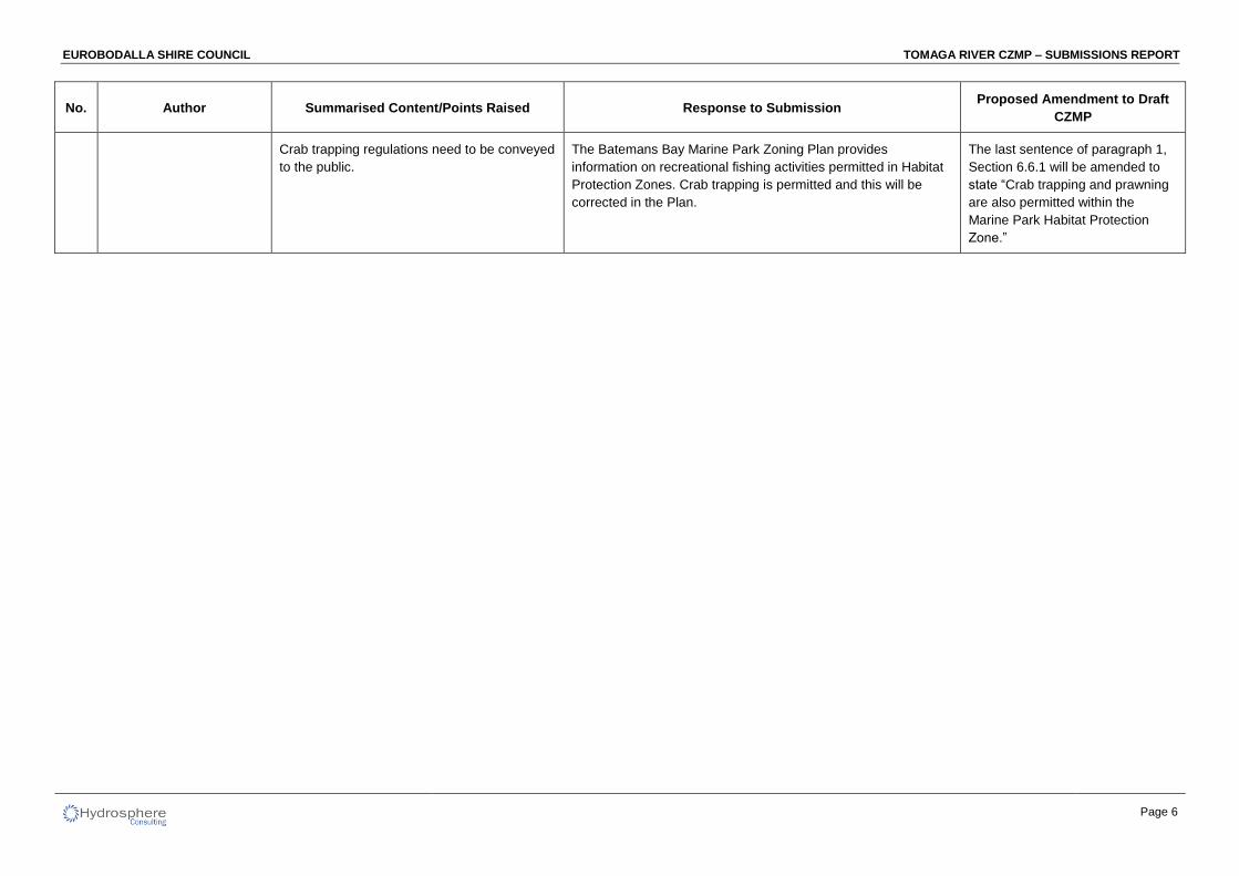
Crab trapping regulations need to be conveyed
to the public.
The Batemans Bay Marine Park Zoning Plan provides
information on recreational fishing activities permitted in Habitat
Protection Zones. Crab trapping is permitted and this will be
corrected in the Plan.
The last sentence of paragraph 1,
Section 6.6.1 will be amended to
state “Crab trapping and prawning
are also permitted within the
Marine Park Habitat Protection
Zone.”
EUROBODALLA SHIRE COUNCIL TOMAGA RIVER CZMP – SUBMISSIONS REPORT
Page 7
No. Author Summarised Content/Points Raised Response to Submission Proposed Amendment to Draft
CZMP
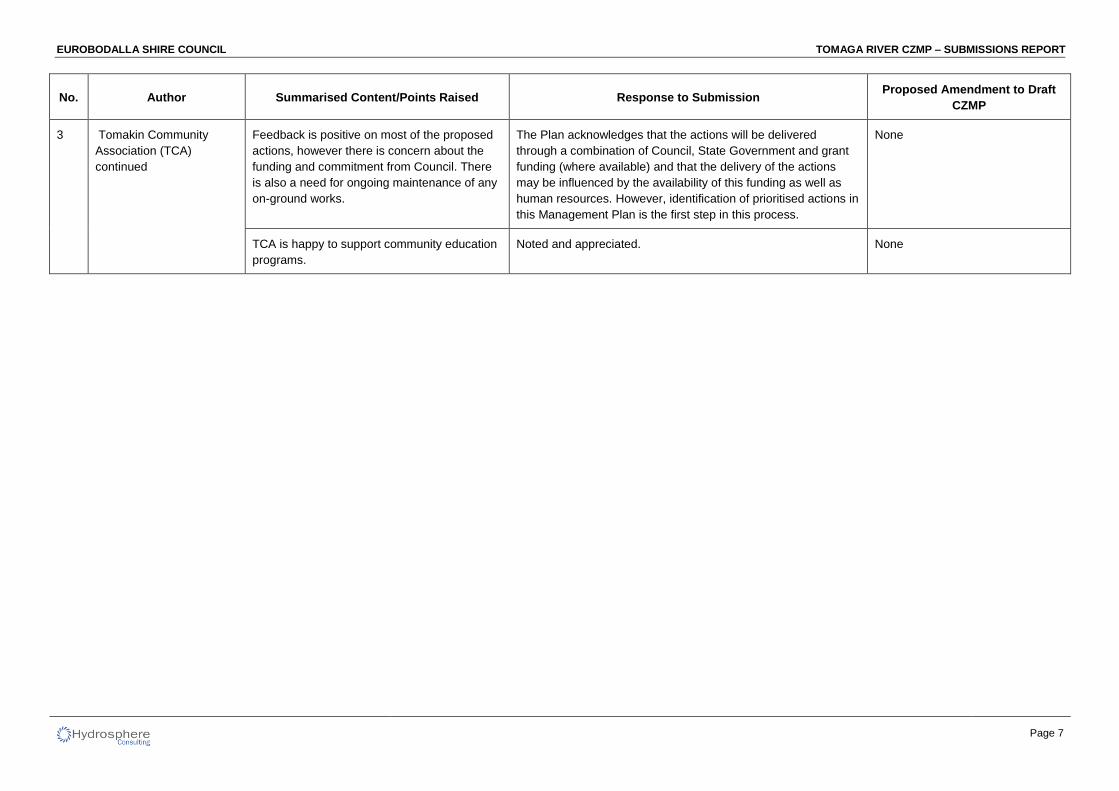
Feedback is positive on most of the proposed
actions, however there is concern about the
funding and commitment from Council. There
is also a need for ongoing maintenance of any
on-ground works.
The Plan acknowledges that the actions will be delivered
through a combination of Council, State Government and grant
funding (where available) and that the delivery of the actions
may be influenced by the availability of this funding as well as
human resources. However, identification of prioritised actions in
this Management Plan is the first step in this process.
None
TCA is happy to support community education
programs.
Noted and appreciated. None
3 Tomakin Community
Association (TCA)
continued
EUROBODALLA SHIRE COUNCIL TOMAGA RIVER CZMP – SUBMISSIONS REPORT
Page 8
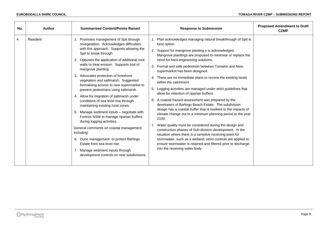
No. Author Summarised Content/Points Raised Response to Submission Proposed Amendment to Draft
CZMP
2. Opposes the application of additional rock
walls to treat erosion. Supports trial of
mangrove planting
3. Advocates protection of foreshore
vegetation and saltmarsh. Suggested
formalising access to new supermarket to
prevent pedestrians using saltmarsh.
4. Allow for migration of saltmarsh under
conditions of sea level rise through
maintaining existing rural zones.
5. Manage sediment inputs – negotiate with
Forests NSW to manage riparian buffers
during logging activities.
General comments on coastal management
including:
6. Dune management to protect Barlings
Estate from sea level rise
7. Manage sediment inputs through
development controls on new subdivisions.
1. Plan acknowledges managing natural breakthrough of Spit is
best option.
2. Support for mangrove planting s is acknowledged.
Mangrove plantings are proposed to minimise or replace the
need for hard engineering solutions.
3. Formal and safe pedestrian between Tomakin and New
supermarket has been designed.
4. There are no immediate plans to rezone the existing lands
within the catchment
5. Logging activities are managed under strict guidelines that
allow for retention of riparian buffers
6. A coastal hazard assessment was prepared by the
developers of Barlings Beach Estate. The subdivision
design has a coastal buffer that is resilient to the impacts of
climate change out to a minimum planning period to the year
2100.
7. Water quality must be considered during the design and
construction phases of Sub-division development. In the
situation where there is a sensitive receiving point for
stormwater, such as a wetland, strict controls are applied to
ensure stormwater is retained and filtered prior to discharge
into the receiving water body.
4 Resident 1. Promotes management of Spit through
revegetation. Acknowledges difficulties
with this approach. Supports allowing the
Spit to break through.
EUROBODALLA SHIRE COUNCIL TOMAGA RIVER CZMP – SUBMISSIONS REPORT
Page 9
REFERENCES
Hydrosphere Consulting (2014) Coastal Zone Management Plan for Tomaga River Estuary, Final Draft for
Public Exhibition.
EUROBODALLA SHIRE COUNCIL TOMAGA RIVER CZMP – SUBMISSIONS REPORT
Page 11
APPENDIX 1 – WRITTEN SUBMISSIONS
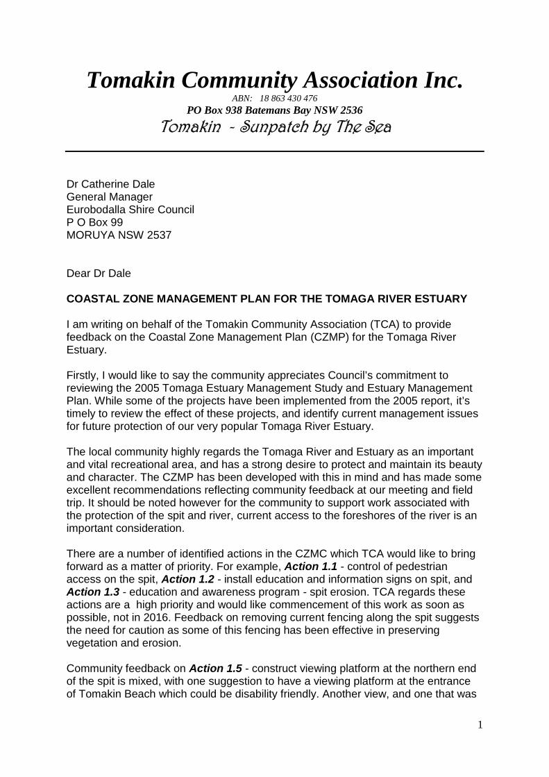
1
Tomakin Community Association Inc.ABN: 18 863 430 476
PO Box 938 Batemans Bay NSW 2536
Tomakin - Sunpatch by The Sea
Dr Catherine DaleGeneral ManagerEurobodalla Shire CouncilP O Box 99MORUYA NSW 2537
Dear Dr Dale
COASTAL ZONE MANAGEMENT PLAN FOR THE TOMAGA RIVER ESTUARY
I am writing on behalf of the Tomakin Community Association (TCA) to providefeedback on the Coastal Zone Management Plan (CZMP) for the Tomaga RiverEstuary.
Firstly, I would like to say the community appreciates Council’s commitment toreviewing the 2005 Tomaga Estuary Management Study and Estuary ManagementPlan. While some of the projects have been implemented from the 2005 report, it’stimely to review the effect of these projects, and identify current management issuesfor future protection of our very popular Tomaga River Estuary.
The local community highly regards the Tomaga River and Estuary as an importantand vital recreational area, and has a strong desire to protect and maintain its beautyand character. The CZMP has been developed with this in mind and has made someexcellent recommendations reflecting community feedback at our meeting and fieldtrip. It should be noted however for the community to support work associated withthe protection of the spit and river, current access to the foreshores of the river is animportant consideration.
There are a number of identified actions in the CZMC which TCA would like to bringforward as a matter of priority. For example, Action 1.1 - control of pedestrianaccess on the spit, Action 1.2 - install education and information signs on spit, andAction 1.3 - education and awareness program - spit erosion. TCA regards theseactions are a high priority and would like commencement of this work as soon aspossible, not in 2016. Feedback on removing current fencing along the spit suggeststhe need for caution as some of this fencing has been effective in preservingvegetation and erosion.
Community feedback on Action 1.5 - construct viewing platform at the northern endof the spit is mixed, with one suggestion to have a viewing platform at the entranceof Tomakin Beach which could be disability friendly. Another view, and one that was
2
included in the 2005 EMP, is to build a boardwalk from the beach to the river. Thesetwo suggestions could be combined with a fishing platform on the river side andwould be a great benefit for the community.
Notwithstanding the above suggestion, the river in front of Jack Buckley Park is notan ideal fishing location for a platform (Action 5.2) as the channel in the river is verynarrow along this area and a platform could interfere with water ‘traffic’.Consideration should be given to finding an alternative site that is disability friendly.TCA would be happy to offer advice on a more suitable location.
Actions 1.6 and 1.7 refer to monitoring spit profile and consult with community andagency stakeholders. It does not specifically include the development of a plan to beimplemented in the event of a breakthrough as stated in Section 8.1.3 of the report.TCA strongly supports a plan being developed in readiness of a breakthrough, whichwould ensure action could be taken on a timely basis should a breakthrough occur.
Action 2.2 – trial mangrove plantings (refer Figure 58 in report), toe protection andbank revegetation is supported. It should be noted however informal mangroveplanting was undertaken along this area some years ago and was not successful.
It should be noted that Action 3.3 - formalise access track through saltmarsh EEC(between Tomakin Caravan Park and IGA) has already been completed, and TCAacknowledges the good work done here.
Incomplete actions from the 2005 EMP 7.12.2 (page 11 of report) state thatseagrass markers have not been installed. Action 3.8 identifies the placement ofseagrass markers in the lower estuary. TCA believes there is a real need to upgradecurrent markers to reduce prop damage in all seagrass areas. This is a particularconcern with rental power boats from The Moorings.
Actions 4.1, 4.2 and 4.3 are strongly supported. Monitoring however should bedone routinely - not just after an event, such as heavy rainfall. This would forexample, ensure illegal dumping of contaminated waste would be detected.
Section 7.5 of the report identifies erosion along the river bank near the TomakinCaravan Park and the effect on local heritage sites. Rabbit warrens are a largecontributor to erosion along the river bank and needs to be urgently addressed andincluded as an action item in the CZMP Implementation Program.
There is community concern the channel from the boat ramp to the river mouth isdifficult to navigate at low tide and is silting up, therefore over time this could restrictboat access to the ocean from Tomakin. Section 8.1.2 Option 1L of the report -realignment of the channel, would be a good option to address this issue and TCArequests further consideration of this option to be included as an action item in theCZMP Implementation Program.
The report identifies crab trapping is only allowed upstream of the George BassDrive bridge (refer Section 6.6.1 of the report). This needs to be addressed, as crabtrapping does occur in all areas of the river. Information about this restriction needs
3
to be better conveyed to the public and needs to be included as an action item in theCZMP Implementation Program.
As stated previously, feedback has been very positive on most of the identifiedactions, however there is concern about the funding and commitment from Councilon the CZMP Implementation Program. The community has also raised the need forCouncil to commit to on-going maintenance of any construction work on the spit i.e.signs, fencing, access ways, platforms, boardwalks etc.
TCA would be very happy to support in any community education programs throughTCA’s Facebook Page and newsletters.
Hydrosphere Consulting, Office of Environment and Heritage, and Council havedone an excellent job with the report and its recommendations. TCA and thecommunity look forward to seeing Council’s on-going support of the CZMPImplementation Program through funding of identified actions.
Thank you for the opportunity to provide feedback.
Yours sincerely
President16 November 2014
Eurobodalla Shire Council
Email [email protected]
Attention: Norm Lenehan
Comments on the review of the Tomaga Estuary Management Plan andCoastal Management
If I am not too late I would like you and the consultants to consider the following comments:–
Estuary Management
1. Manage the Spit – I agree with the suggestions to try revegetation and exclusion ofpedestrians but acknowledge this may not be possible. Allowing the spit to break throughthen minimising the impact seems the most sensible proposal.
2. Moderate erosion of the banks – Placing more rocks on the approaches to the bridge(south bank) has led to more erosion just upstream. Apart from being very expensive (andunlikely to be funded) rock walls seem to create as many problems as they solve. It may beworthwhile planting mangrove seedlings if the shore profile is suitable and people willtolerate them.
3. Protect foreshore habitat – The government is currently preparing legislation that mayaffect the Crown land adjoining the river. The relevant department/s should be asked toretain this land and ensure it is managed to protect riparian vegetation.
The saltmarsh between the caravan park and George Bass Drive at Tomakin needs to beprotected from pedestrian and other access. Fencing and a walkway beside the servicestation may help redirect people.
Saltmarshes throughout the estuary are threatened by sea level rise. Even with a smallelevation in sea level they will be converted to mangrove forest and may eventually betotally submerged. Wherever there is low-lying rural land that could become saltmarsh infuture this should be identified and remain rural. As sea level rise becomes more obviousthere may be ways to compensate landowners so that the land is converted to saltmarshand not kept dry by levees etc.
4. Manage sediment inputs – As well as the proposals in the current plan, there needs to bemore co-operation with Forests NSW. Heavier logging and post harvest burns leave moresoil exposed to erosion so wide and effective riparian buffers are more important thanever.
Coastal Management
Tomakin and the Barlings Beach Estate remain very vulnerable to climate change and sealevel rise.
1. Dune protection should be given top priority with fencing and revegetation.

2. When the land behind Barlings Swamp is developed run-off will increase dramatically andthe swamp will overflow through the current caravan park and residential estate. This willbe made much worse if predictions of more intense rainfall events and higher storm surgesprove true. Some proposals to limit the impact of run-off from future subdivisions shouldbe included in the new plans.
Thankyou for the opportunity to comment
1
Myree Mcilveen
Dear Council,
Thank you for the opportunity to comment on the Draft Tomaga Estuary Management Plan.
Fisheries supports the management plan and believe that a number of positive protection measures havebeen proposed.
In particular the protection and rehabilitation of saltmarsh, mangroves, seagrass and riparian vegetationalign with Fisheries NSW responsibility to ensure that there is no net loss of key fish habitats and that fishstocks are conserved.
The illegal removal of marine vegetation continues to be an ongoing threat to key fish habitat and anongoing issue for Fisheries compliance officers throughout the state. Currently our compliance officers areworking with the Shellharbour City Council to develop a joint management strategy for this issue.
Fisheries looks forward to working with the Estuary Management Committee and the Eurobodalla Councilin the future to preserve and enhance the natural values of the Tomaga Estuary
Regards,
Conserve, Share, Provide
This message is intended for the addressee named and may contain confidential information. If you are not theintended recipient, please delete it and notify the sender. Views expressed in this message are those of the individualsender, and are not necessarily the views of their organisation.
| Regional Assessment OfficerNSW Department of Primary Industries | Aquatic Ecosystems4 Woollamia Road | PO Box 97 | Huskisson NSW 2540T: 02 | F: 02 4441 8961 E:W: www.dpi.nsw.gov.au/fisheries
From:Sent: Monday, 17 November 2014 11:52 AMTo: CouncilCc:Subject: Tomago Estuary Management Plan
Batemans Marine Park | NSW Department of Primary Industries Corner Graham and Burrawang Street | PO Box 341 | Narooma NSW 2546
Tel: 02 4476 0802 Fax: 02 4476 0833 www.mpa.nsw.gov.au ABN: 72 189 919 072
Reference: OUT14/37924 Mr Norm Lenehan Coastal and Flood Management Planner Eurobodalla Shire Council PO Box 99 Moruya NSW 2537 Dear Mr Lenehan,
Re: Draft Coastal Zone Management Plan for Tomaga Estuary
With reference to the abovementioned draft plan we wish to make these comments. In S 1.5 (page 3), regarding the marine park please refer to the following legislation; Marine Parks Act 1999; Marine Parks Regulations 2009 and Marine Parks (Zoning Plans) Regulation 1999. We would also like to clarify that since the implementation of the Batemans Marine Park in 2007 the Tomaga River estuary lies within a habitat protection zone of the marine park, the objects of this zone are:
(a) to provide a high level of protection for biological diversity, habitat, ecological processes, natural features and cultural features (both Aboriginal and non-Aboriginal) in the zone, and
(b) where consistent with paragraph (a), to provide opportunities for recreational and commercial activities (including fishing), scientific research, educational activities and other activities, so long as they are ecologically sustainable and do not have a significant impact on any fish populations or on any other animals, plants or habitats.
Consent in the form of a permit is only to be given under subclause (1):
(a) for research, environmental protection, public health, traditional use or public safety purposes, or (b) for the purposes of an ecologically sustainable use that does not have a significant impact on fish
populations within the zone or on any other animals, plants or habitats.
Please also note that commercial businesses operating from within the estuary require a permit. Permit approval is also required for any works below the mean high water mark, such as the construction or repair of jetties and boat ramps etc. Further developments within or affecting the marine park must also be referred to Batemans Marine Park for consideration, comment and in turn formal approval through the permitting process if required.
We support the key strategies and initiatives outlined in the plan and where possible look forward to working with council and the community to achieve these objectives into the future. If you have any queries regarding the above please contact me at the Batemans Marine Park office on 4476 0804.
Yours sincerely,
Ranger Batemans Marine Park

Batemans Marine Park | NSW Department of Primary Industries Corner Graham and Burrawang Street | PO Box 341 | Narooma NSW 2546
Tel: 02 4476 0802 Fax: 02 4476 0833 www.mpa.nsw.gov.au ABN: 72 189 919 072
30 September 2014

BMP(E)14003/71017 Page 1 of 4
NSW MARINE PARKS PERMIT Permit No: BMP(E)14003/071017
NSW Marine Parks (Zoning Plans) Regulation 1999 Part 1 Division 3, Clause 1.34 (1) (a) - sporting competition, tournament
This permission remains in force for the period from 07/10/2014 to 07/10/2017 unless sooner varied, suspended or cancelled.
Permission is granted to:
Permittee: Mr John Reed
Trading As: Batemans Bay Sailing Club
Address:
PO Box 356 Batemans Bay NSW 2536 Ph: 02 6291 7250 Mobile: 0488 077 760 Fax: 02 6291 7250
This permit and all conditions herein extend to all employees of the Permittee, and other persons acting on behalf of or at the direction of the Permittee for the purposes specified in this permit. Use and entry authorised to the following New South Wales Marine Park/s:
Batemans Marine Park Permitted zone/s and location/s:
All zones within Batemans Bay Marine Park except where such authorised entry and/or use of a zone or location is contrary to the Zoning Plan.
Use and entry authorised for the following activities:
Conduct of :- Organised sporting competition or tournament.
Permitted activities being :- Sailing Club Races and Events
An average of 20 yachts between 6 to 12 metres with 2 to 10 crew.
Frequency/ Duration of Trips: As listed in BBSC Program
in accordance with the details above and subject to conditions stated on the following pages.
……………………………………………………. Date: 30 September 2014 Delegate of the NSW Marine Parks Authority.
BMP(E)14003/71017 Page 2 of 4
WARNINGS
1) All activities, the subject of this permit, must be undertaken in accordance with the provisions of the laws in force from time to time in the State of New South Wales and, in particular, the provisions of the Marine Parks Act 1997, NSW Marine Parks (Zoning Plans) Regulation 1999 and the NSW Marine Parks Regulation 2009.
2) A breach by the Permittee/s or any person to whom this permit extends, of the Marine Parks
Act 1997 or Regulations including any permit condition contained herein may result in the variation, suspension or cancellation of this permit.
STANDARD CONDITIONS
3) The Permittee must ensure that when events are conducted in the Marine Park under this
permit, the permit or a certified copy of the permit is held at the site where the event is to be conducted by the club officials.
4) The Permittee must produce a copy of this permit on site when requested to do so by a
Marine Park Ranger. 5) The Permittee must inform all members participating in the event of any restrictions applying
under this permit. 6) The Permittee must notify the Marine Parks Authority within seven (7) days of :
a) any change to the Permittee details; and/or b) the cessation of operations to which this permit relates.
7) Where the activity, the subject of this permit, requires a current license or permit from another
government agency including, but not limited to NSW Maritime, NSW Department of Primary Industries - Fisheries and the Office of Environment and Heritage (National Parks & Wildlife Service) for such an activity to occur, it is a condition of this permit that other license/s or permit/s are issued and are current.
8) The Permittee or any person to whom this permit extends must not anchor on seagrass beds. 9) The Permittee or any person to whom this permit extends, must provide all people competing
under this permit with a copy of the Batemans Marine Park – Zoning Plan User Guide and/or explain any restrictions under the zoning plan which may affect their activities.
10) The Permittee or any person to whom this permit extends must not land their vessel at any
island that is within a National Park or Nature Reserve within the Batemans Marine Park unless licensed to do so by the Office of Environment and Heritage (National Parks & Wildlife Service).
11) The Permittee or any person to whom this permit extends, must ensure that they operate in a
responsible manner at all times when operating within the Batemans Marine Park, this permit does not provide for any ‘right of priority’ over the use of any area within the park.
12) The Permittee must provide a current schedule of proposed club events to be undertaken under
this permit each year by 1 May to Batemans Marine Park Ranger Shamaram Eichmann; ([email protected]).
13) The Permittee must advise the Marine Park Ranger of any alterations to the schedule of
proposed club events to be undertaken under this permit as soon as these alterations are known, and at least 48 hours prior to the commencement of those activities within the marine park.
BMP(E)14003/71017 Page 3 of 4
MARINE PARKS AUTHORITY MOORING USE CONDITIONS
17) In addition to Clause 1.26 of the Marine Parks (Zoning Plans) Regulation 1999, the Permittee must not occupy a Marine Parks Authority mooring:
a) if other vessels are waiting to use that mooring, for a duration greater than what is reasonably required to undertake the permitted activities
b) without the constant on-board attendance of a licensed boat operator; c) if the mooring appears to be damaged or in disrepair in such a manner that the safe
use of the mooring is questionable. 18) The Permittee must not manoeuvre the vessel under power while still attached to a mooring or
use the mooring line as a diving descent line.
INSURANCE CONDITIONS
19) The Permittee must at all times during the period of the permit, maintain a policy of public liability
insurance for a sum of not less than ten million dollars ($10,000,000) to indemnify itself, from and against liability for all action, suits, demands, costs, losses, damages and expenses (hereinafter called claims) which the Permittee may pay, sustain or be put to by reason of damage to property or injury to persons (including death) caused by or arising in any way out of the conduct of the Permittee on any lands or waters managed by the Batemans Marine Park or generally as a result of the presence of the Permittee, or the Permittee’s agents or clients on lands or waters managed by the Batemans Marine Park.
20) The Permittee must not cancel or alter the insurance policy without first obtaining written
consent from the Batemans Marine Park. 21) In the event the insurer cancels the insurance policy prior to the expiration of the insurance
policy, the Permittee must advise the Batemans Marine Park in writing within three (3) business days of receiving advice of the cancellation from the insurer.
22) In the event the insurance policy expires prior to the expiration date of this permit, the Permittee
must produce to the Batemans Marine Park evidence of renewal of the insurance policy no fewer than 28 days prior to the expiry of the insurance policy.
23) The Permittee must provide a copy of the insurance policy and a copy of the certificate of
currency of the insurance policy, to the delegate when required by the Batemans Marine Park. 24) The Permittee must notify the Batemans Marine Park as soon as possible of any fatal accident
or serious injury sustained by a participant/s resulting from the conduct of the permitted activity listed in this permit on lands or waters of a marine park. All other accidents or injuries must be reported to the Authority in writing within seven (7) days of the occurrence.
NATIVE TITLE CONDITIONS
25) In the event that native title rights and interests are, or would be, affected by the grant of this
Permit and this Permit is not authorised under the Native Title Act 1993 (Cth) so that the Permit may be ‘invalid’ within the meaning of the Native Title Act 1993 (Cth) then:
The Permittee agrees that it will not seek to recover any compensation, damages, costs, losses or expenses whatsoever resulting from the invalidity from the Authority;
The parties agree that the valid parts of the Permit continue in force unaffected by the invalid parts.
26) The Permittee must not interfere with or prevent any person holding native title in the Marine
Park from having reasonable access to the Marine Park.

BMP(E)14003/71017 Page 4 of 4
INTERPRETATION AND DEFINITIONS
27) A word or phrase in this permit has the same meaning as the word or phrase has in the NSW
Marine Parks Act 1997, NSW Marine Parks (Zoning Plans) Regulation 1999 and the NSW Marine Parks Regulation 2009.
A reference to a date includes that date. ‘Authority’ means the Marine Parks Authority constituted by section 29 of the NSW Marine Parks Act 1997.