Embed Size (px)
Citation preview
Annual Joint Meeting with the Pittsburgh
Chapters of AEG and ASCE Geo-Institute
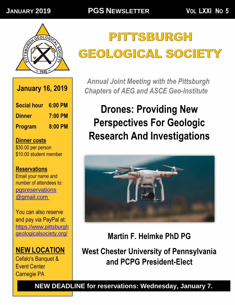
Drones: Providing New
Perspectives For Geologic
Research And Investigations
Martin F. Helmke PhD PG
West Chester University of Pennsylvania
and PCPG President-Elect
JANUARY 2019 PGS NEWSLETTER VOL LXXI NO 5
January 16, 2019
Social hour 6:00 PM
Dinner 7:00 PM
Program 8:00 PM
Dinner costs $30.00 per person
$10.00 student member
Reservations Email your name and
number of attendees to:
pgsreservations
@gmail.com
You can also reserve
and pay via PayPal at: https://www.pittsburgh
geologicalsociety.org/
NEW LOCATION
Cefalo's Banquet &
Event Center
Carnegie PA
NEW DEADLINE for reservations: Wednesday, January 7.
2
Speaker Abstract
Unoccupied Aerial Systems (UAS, or drones)
have rapidly become popular and powerful
research tools for geologists. In addition to
providing an aerial view of a project site, drone
imagery and 3-dimensional photogrammetry
can be used to document site environmental
conditions, evaluate structural geology, conduct
fracture trace analysis, monitor sinkholes and
subsidence, evaluate coal mine fires, record
mass movement, delineate wetlands, and
document paleontological specimens among
other applications.
Drones equipped with scientific instruments
such as telephoto lenses, thermal cameras,
multispectral imagers, geophysical devices, and
chemical sensors are capable of recording
precise scientific measurements in locations
inaccessible by traditional methods. The
objective of this presentation is to review
geologic case studies across the US that have
benefitted from drone technology and help
geologists become more familiar with drone
capabilities, legal limitations, best practices,
and business models before taking to the sky.
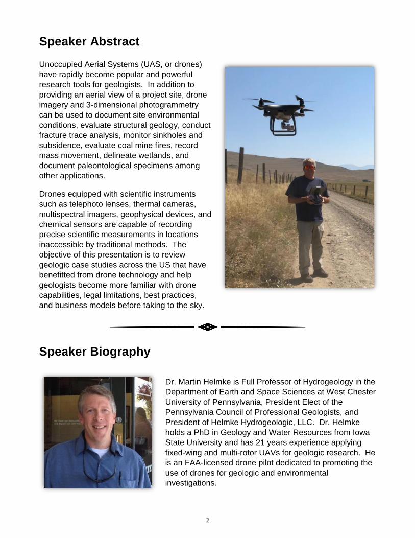
Speaker Biography
Dr. Martin Helmke is Full Professor of Hydrogeology in the
Department of Earth and Space Sciences at West Chester
University of Pennsylvania, President Elect of the
Pennsylvania Council of Professional Geologists, and
President of Helmke Hydrogeologic, LLC. Dr. Helmke
holds a PhD in Geology and Water Resources from Iowa
State University and has 21 years experience applying
fixed-wing and multi-rotor UAVs for geologic research. He
is an FAA-licensed drone pilot dedicated to promoting the
use of drones for geologic and environmental
investigations.
3
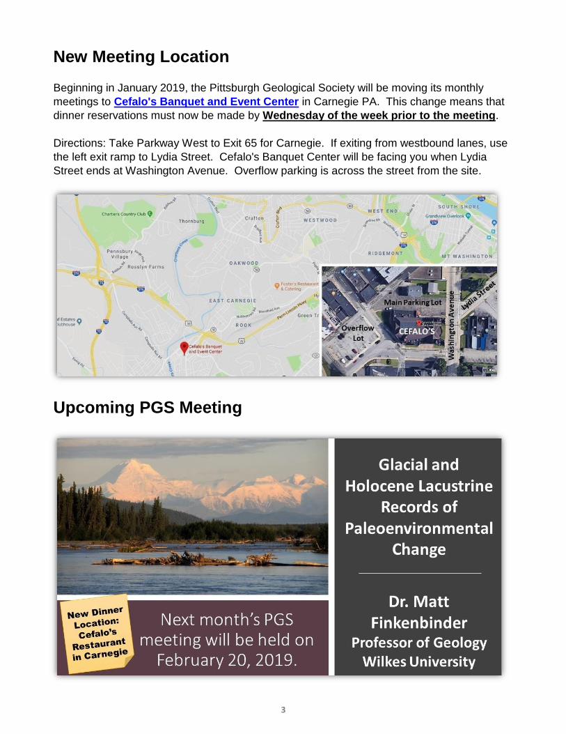
New Meeting Location
Beginning in January 2019, the Pittsburgh Geological Society will be moving its monthly
meetings to Cefalo's Banquet and Event Center in Carnegie PA. This change means that
dinner reservations must now be made by Wednesday of the week prior to the meeting.
Directions: Take Parkway West to Exit 65 for Carnegie. If exiting from westbound lanes, use
the left exit ramp to Lydia Street. Cefalo's Banquet Center will be facing you when Lydia
Street ends at Washington Avenue. Overflow parking is across the street from the site.
Upcoming PGS Meeting
4
THIS ISSUE IS DEDICATED IN MEMORY
OF PGS HONORARY MEMBER, PAST
PRESIDENT, AND TIRELESS VOLUNTEER
FRANK BENACQUISTA
(1958 – 2018)
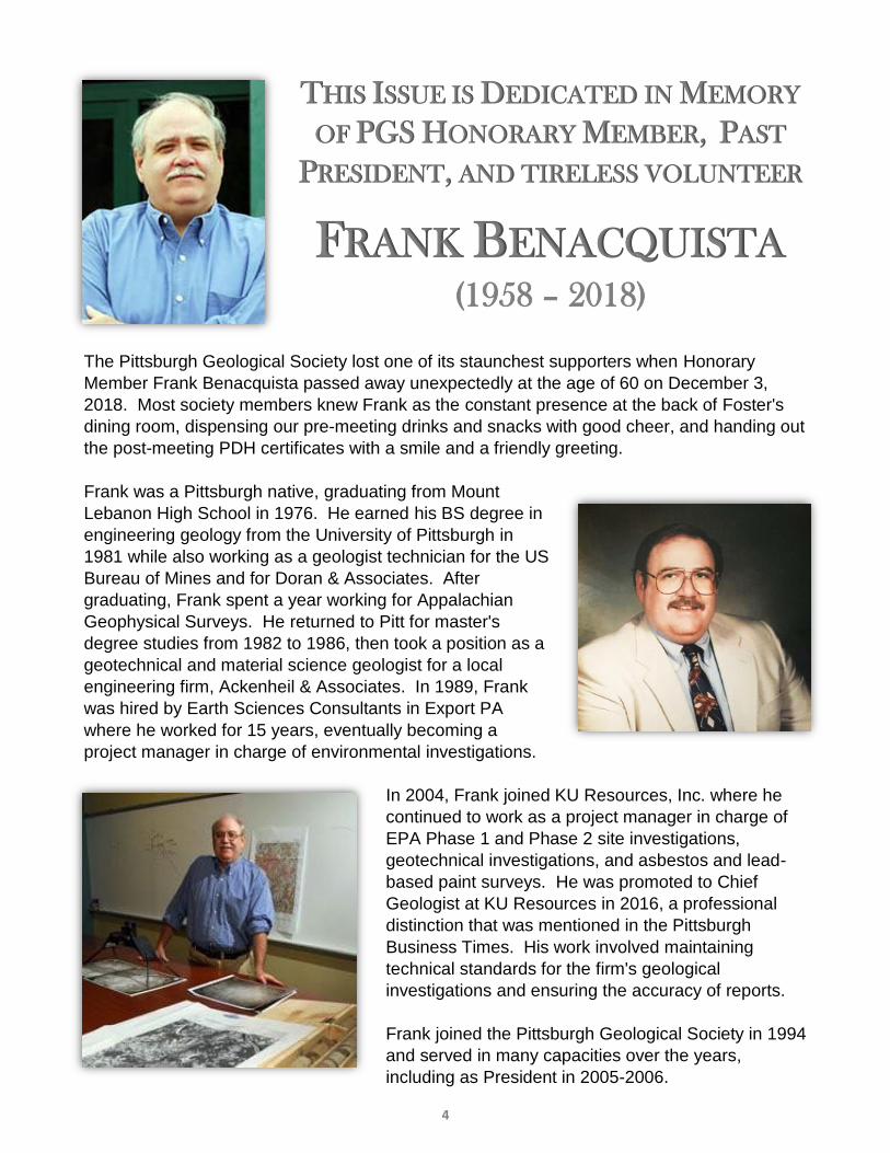
The Pittsburgh Geological Society lost one of its staunchest supporters when Honorary
Member Frank Benacquista passed away unexpectedly at the age of 60 on December 3,
2018. Most society members knew Frank as the constant presence at the back of Foster's
dining room, dispensing our pre-meeting drinks and snacks with good cheer, and handing out
the post-meeting PDH certificates with a smile and a friendly greeting.
Frank was a Pittsburgh native, graduating from Mount
Lebanon High School in 1976. He earned his BS degree in
engineering geology from the University of Pittsburgh in
1981 while also working as a geologist technician for the US
Bureau of Mines and for Doran & Associates. After
graduating, Frank spent a year working for Appalachian
Geophysical Surveys. He returned to Pitt for master's
degree studies from 1982 to 1986, then took a position as a
geotechnical and material science geologist for a local
engineering firm, Ackenheil & Associates. In 1989, Frank
was hired by Earth Sciences Consultants in Export PA
where he worked for 15 years, eventually becoming a
project manager in charge of environmental investigations.
In 2004, Frank joined KU Resources, Inc. where he
continued to work as a project manager in charge of
EPA Phase 1 and Phase 2 site investigations,
geotechnical investigations, and asbestos and lead-
based paint surveys. He was promoted to Chief
Geologist at KU Resources in 2016, a professional
distinction that was mentioned in the Pittsburgh
Business Times. His work involved maintaining
technical standards for the firm's geological
investigations and ensuring the accuracy of reports.
Frank joined the Pittsburgh Geological Society in 1994
and served in many capacities over the years,
including as President in 2005-2006.
5
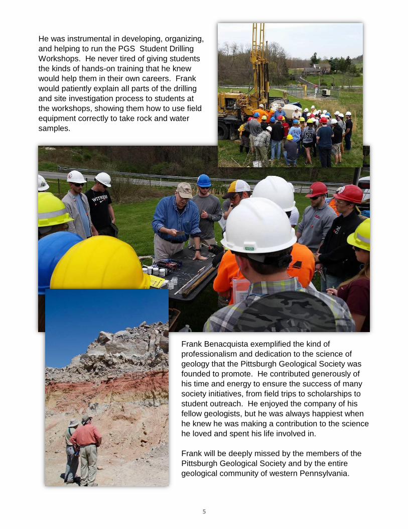
He was instrumental in developing, organizing,
and helping to run the PGS Student Drilling
Workshops. He never tired of giving students
the kinds of hands-on training that he knew
would help them in their own careers. Frank
would patiently explain all parts of the drilling
and site investigation process to students at
the workshops, showing them how to use field
equipment correctly to take rock and water
samples.
Frank Benacquista exemplified the kind of
professionalism and dedication to the science of
geology that the Pittsburgh Geological Society was
founded to promote. He contributed generously of
his time and energy to ensure the success of many
society initiatives, from field trips to scholarships to
student outreach. He enjoyed the company of his
fellow geologists, but he was always happiest when
he knew he was making a contribution to the science
he loved and spent his life involved in.
Frank will be deeply missed by the members of the
Pittsburgh Geological Society and by the entire
geological community of western Pennsylvania.
6
PRESIDENT’S STATEMENT Happy New Year!
As another year
begins, PGS will
have many
changes,
beginning with the
new meeting
venue. Starting
this month the
meetings will be
held at Cefalo’s
Banquet & Event Center. This will mean a new
menu, a cash bar, and limited snacks.
We will also start the New Year with a newly-
adopted code of conduct (look for it on the PGS
website soon) and the initiation in fall 2019 of a
PGS academic scholarship. The academic
scholarship will be named after Frank
Benacquista to honor his long service and
outstanding dedication to PGS.
This month’s newsletter also honors Frank and
his commitment to the student members, the
geology profession and to PGS. Frank was an
honorary member of PGS and the winner of the
2009 Walt Skinner Award. He spent many
hours making sure that the snack plates were
filled and that drinks were supplied at each
meeting. I remember meeting Frank at my first
PGS meeting in the fall of 2002. He greeted me
with a smile and a handshake, and proceeded
to introduce me to others around him. After that
first initial introduction, I felt comfortable as a
new member walking into the meetings knowing
that a friendly face was there to greet me.
As years passed, Frank and I would chat about
the interesting projects he was working on and
how I could incorporate geologic issues into the
classroom. His knowledge of the industrial
history of Pittsburgh was remarkable and I
loved listening to his stories. Most of the time I
had no idea where the sites were that he was
talking about, but it didn’t really matter and I
always walked away knowing just a little bit
more about the geology of Pittsburgh.
Frank’s commitment to educating others on the
geology of Pittsburgh extended well beyond the
monthly meetings. He committed much of his
time to planning and organizing the student
drilling workshop, providing the field resources
and teaching the students about geology and
field techniques. We will continue offering the
student drilling workshop using the same
organizational scheme he worked so hard to
master. He had dedicated his time to PGS and
for this we are truly grateful. His presence at the
workshop and at each meeting will be sorely
missed. Please feel free to share stories or any
photograph of Frank in the coming newsletters.
I would also like to take a moment to thank the
following corporate sponsors that have
committed to fund PGS this year. We are
grateful for your generosity and support. These
include: ACA Engineering, Inc., American
Geosciences, Inc., American Geotechnical and
Environmental Services, Inc., Ammonite
Resources, AWK Engineering, Barner
Consulting, LLC, Battelle, Billman Geologic
Consultants, Inc., Enviro-Equipment Inc.,
Falcede Energy Consulting, LLC, Geo
Environmental Drilling Company, LLC,
Groundwater and Environmental Services, Inc.,
HDR Engineering, Inc., Howard Concrete
Pumping Co., Huntley and Huntley, Inc., Key
Environmental, Inc., Moody and Associates,
Inc., Pennsylvania Drilling Co., Range
Resources, Appalachia, LLC, and THG
Geophysics. To our corporate sponsors, please
take a moment to review the information on our
website and let us know if we need to change
or update any information.
In closing, I would like to wish everyone a
happy and healthy New Year. May this year be
filled with success, happiness, prosperity, and
good health.
See you at the meeting!
Tamra
7
The Pittsburgh Geological
Society welcomes the following
new society members:
Emily R. Stahl, Student,
University of Pittsburgh
Rachel A. Miller
Geotechnical Designer
Navarro & Wright Consulting Engineers
The Pittsburgh Geological
Society Endowment Fund
Established May 8th, 2014 through the
Contributions can be made through bequests,
memorials, and gifts to the Pittsburgh Geological
Society / Endowment Fund or directly to the
Community Foundation Serving the Heart of
Western Pennsylvania at 220 South Jefferson
Street, Suite B, Kittanning, PA 16201. For more
information please contact Ray Follador, PGS
Finance Committee Chair at (724) 744-0399.
SOCIETY OF PETROLEUM
ENGINEERS
January 8, 2019 (lunch meeting) "Drilling Extended Laterals in the Marcellus
Shale" by Josh Doak, Director of Drilling, Range
Resources.
Cefalo’s Banquet & Event Center,
Carnegie PA
GEOPHYSICAL SOCIETY OF
PITTSBURGH
January 9, 2019 (lunch meeting)
"Depth Imaging in the Appalachian Basin,
Challenges and Approaches for Utica and
Marcellus PSDM : a Roundtable Discussion"
Cefalo’s Banquet & Event Center,
Carnegie PA
AMERICAN CHEMICAL SOCIETY-
ENERGY TECHNOLOGY GROUP
Thursday, January 17, 2019
“Shale Gas Extraction & Public Health” by
Heather Harr of the League of Women
Voters of Pennsylvania
Lombardozzi’s Restaurant, Pittsburgh PA
LOCAL GEOLOGICAL EVENTS
8
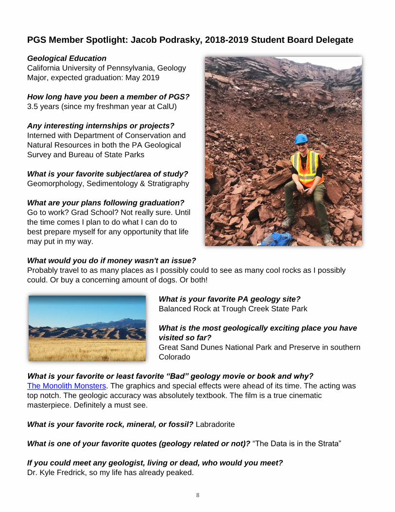
PGS Member Spotlight: Jacob Podrasky, 2018-2019 Student Board Delegate
Geological Education
California University of Pennsylvania, Geology
Major, expected graduation: May 2019
How long have you been a member of PGS?
3.5 years (since my freshman year at CalU)
Any interesting internships or projects?
Interned with Department of Conservation and
Natural Resources in both the PA Geological
Survey and Bureau of State Parks
What is your favorite subject/area of study?
Geomorphology, Sedimentology & Stratigraphy
What are your plans following graduation?
Go to work? Grad School? Not really sure. Until
the time comes I plan to do what I can do to
best prepare myself for any opportunity that life
may put in my way.
What would you do if money wasn't an issue?
Probably travel to as many places as I possibly could to see as many cool rocks as I possibly
could. Or buy a concerning amount of dogs. Or both!
What is your favorite PA geology site?
Balanced Rock at Trough Creek State Park
What is the most geologically exciting place you have
visited so far?
Great Sand Dunes National Park and Preserve in southern
Colorado
What is your favorite or least favorite “Bad” geology movie or book and why?
The Monolith Monsters. The graphics and special effects were ahead of its time. The acting was
top notch. The geologic accuracy was absolutely textbook. The film is a true cinematic
masterpiece. Definitely a must see.
What is your favorite rock, mineral, or fossil? Labradorite
What is one of your favorite quotes (geology related or not)? “The Data is in the Strata”
If you could meet any geologist, living or dead, who would you meet?
Dr. Kyle Fredrick, so my life has already peaked.

9
UPCOMING EVENTS OF INTEREST TO STUDENT MEMBERS OF PGS
This announcement is provided as a courtesy to the Pennsylvania Council of Professional
Geologists, who generously underwrite the PGS – AEG - ASCE Student Night. For more
information about PCPG 2019 poster session and competition, please check their link at:
https://pcpg.wildapricot.org/2019PosterSessionCompetition
10
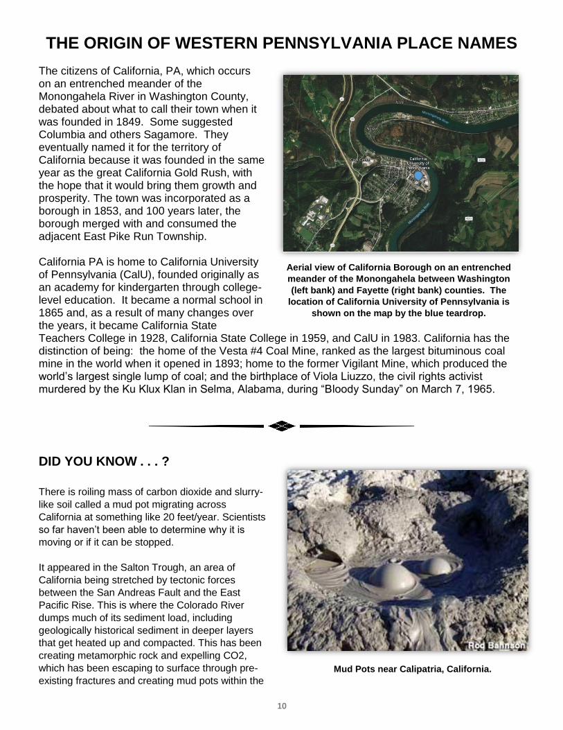
THE ORIGIN OF WESTERN PENNSYLVANIA PLACE NAMES
The citizens of California, PA, which occurs on an entrenched meander of the Monongahela River in Washington County, debated about what to call their town when it was founded in 1849. Some suggested Columbia and others Sagamore. They eventually named it for the territory of California because it was founded in the same year as the great California Gold Rush, with the hope that it would bring them growth and prosperity. The town was incorporated as a borough in 1853, and 100 years later, the borough merged with and consumed the adjacent East Pike Run Township. California PA is home to California University of Pennsylvania (CalU), founded originally as an academy for kindergarten through college-level education. It became a normal school in 1865 and, as a result of many changes over the years, it became California State Teachers College in 1928, California State College in 1959, and CalU in 1983. California has the distinction of being: the home of the Vesta #4 Coal Mine, ranked as the largest bituminous coal mine in the world when it opened in 1893; home to the former Vigilant Mine, which produced the world’s largest single lump of coal; and the birthplace of Viola Liuzzo, the civil rights activist murdered by the Ku Klux Klan in Selma, Alabama, during “Bloody Sunday” on March 7, 1965.
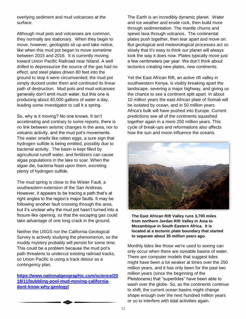
DID YOU KNOW . . . ?
There is roiling mass of carbon dioxide and slurry-
like soil called a mud pot migrating across
California at something like 20 feet/year. Scientists
so far haven’t been able to determine why it is
moving or if it can be stopped.
It appeared in the Salton Trough, an area of
California being stretched by tectonic forces
between the San Andreas Fault and the East
Pacific Rise. This is where the Colorado River
dumps much of its sediment load, including
geologically historical sediment in deeper layers
that get heated up and compacted. This has been
creating metamorphic rock and expelling CO2,
which has been escaping to surface through pre-
existing fractures and creating mud pots within the
Aerial view of California Borough on an entrenched
meander of the Monongahela between Washington
(left bank) and Fayette (right bank) counties. The
location of California University of Pennsylvania is
shown on the map by the blue teardrop.
Mud Pots near Calipatria, California.
11
overlying sediment and mud volcanoes at the
surface.
Although mud pots and volcanoes are common,
they normally are stationary. When they begin to
move, however, geologists sit up and take notice,
like when this mud pot began to move sometime
between 2015 and 2016. It is currently moving
toward Union Pacific Railroad near Niland. A well
drilled to depressurize the source of the gas had no
effect, and steel plates driven 80 feet into the
ground to stop it were circumvented; the mud pot
simply ducked under them and continued its linear
path of destruction. Mud pots and mud volcanoes
generally don’t emit much water, but this one is
producing about 40,000 gallons of water a day,
leading some investigator to call it a spring.
So, why is it moving? No one knows. It isn’t
accelerating and contrary to some reports, there is
no link between seismic changes in the area, nor to
volcanic activity, and the mud pot’s movements.
The water smells like rotten eggs, a sure sign that
hydrogen sulfide is being emitted, possibly due to
bacterial activity. The basin is kept filled by
agricultural runoff water, and fertilizers can cause
algae populations in the lake to soar. When the
algae die, bacteria feast upon them, excreting
plenty of hydrogen sulfide.
The mud spring is close to the Wister Fault, a
southeastern extension of the San Andreas.
However, it appears to be tracing a path that’s at
right angles to the region’s major faults. It may be
following another fault crossing through the area,
but it’s unclear why the mud pot hasn’t turned into a
fissure-like opening, so that the escaping gas could
take advantage of one long crack in the ground.
Neither the USGS nor the California Geological
Survey is actively studying the phenomenon, so the
muddy mystery probably will persist for some time.
This could be a problem because the mud pot’s
path threatens to undercut existing railroad tracks,
so Union Pacific is using a track detour as a
contingency plan.
https://www.nationalgeographic.com/science/20
18/11/bubbling-pool-mud-moving-california-
dont-know-why-geology/
The Earth is an incredibly dynamic planet. Water
and ice weather and erode rock, then build more
through sedimentation. The mantle churns and
spews lava through volcanos. The continental
plates push together, then tear apart and move on.
But geological and meteorological processes act so
slowly that it's easy to think our planet will always
look the way it does now. Plates typically move just
a few centimeters per year. We don’t think about
tectonics creating new plates, new continents.
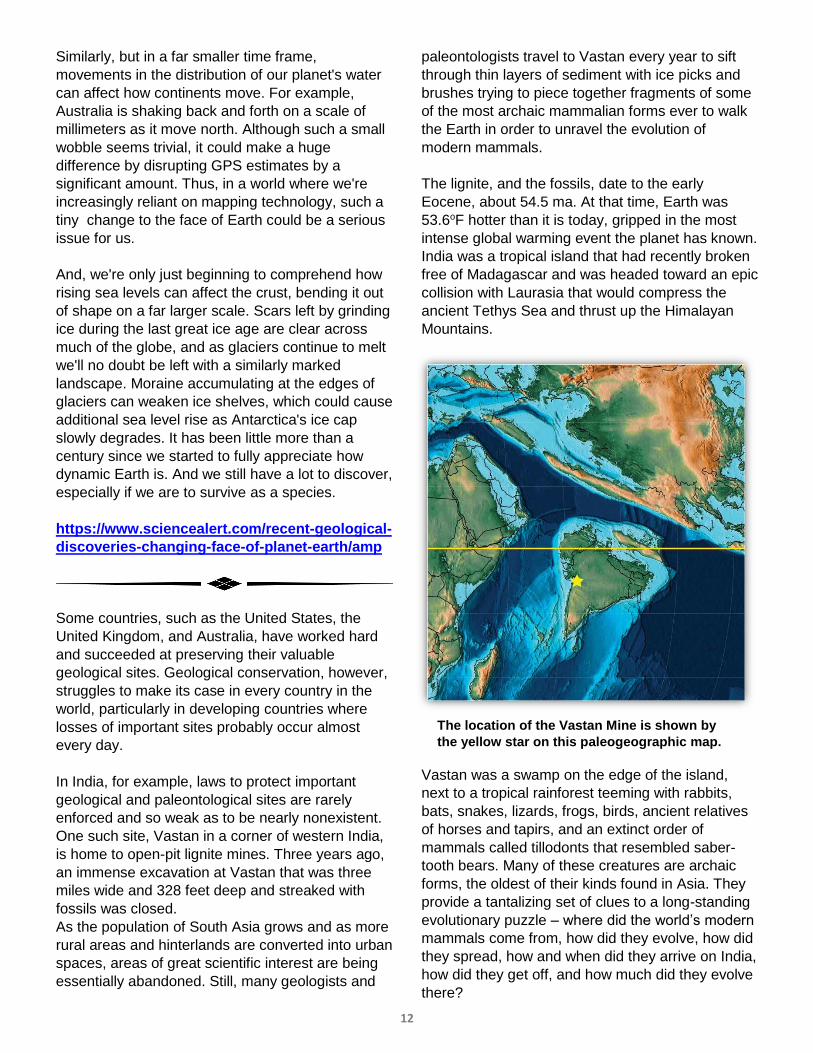
Yet the East African Rift, an active rift valley in
southwestern Kenya, is visibly breaking apart the
landscape, severing a major highway, and giving us
the chance to see a continent split apart. In about
10 million years the east African plate of Somali will
be isolated by ocean, and in 50 million years
Africa's bulk will have pushed into Europe. Current
predictions see all of the continents squashed
together again in a mere 250 million years. This
cycle of break-ups and reformations also affects
how the sun and moon influence the oceans.
Monthly tides like those we're used to seeing can
only occur when there are sizeable basins of water.
There are computer models that suggest tides
might have been a lot weaker at times over the 250
million years, and it has only been for the past two
million years (since the beginning of the
Pleistocene) that “supertides” have been able to
wash over the globe. So, as the continents continue
to shift, the current ocean basins might change
shape enough over the next hundred million years
or so to interfere with tidal activities again.
The East African Rift Valley runs 3,700 miles
from northern Jordan Rift Valley in Asia to
Mozambique in South Eastern Africa. It is
located at a tectonic plate boundary that started
to separate about 35 million years ago.
12
Similarly, but in a far smaller time frame,
movements in the distribution of our planet's water
can affect how continents move. For example,
Australia is shaking back and forth on a scale of
millimeters as it move north. Although such a small
wobble seems trivial, it could make a huge
difference by disrupting GPS estimates by a
significant amount. Thus, in a world where we're
increasingly reliant on mapping technology, such a
tiny change to the face of Earth could be a serious
issue for us.
And, we're only just beginning to comprehend how
rising sea levels can affect the crust, bending it out
of shape on a far larger scale. Scars left by grinding
ice during the last great ice age are clear across
much of the globe, and as glaciers continue to melt
we'll no doubt be left with a similarly marked
landscape. Moraine accumulating at the edges of
glaciers can weaken ice shelves, which could cause
additional sea level rise as Antarctica's ice cap
slowly degrades. It has been little more than a
century since we started to fully appreciate how
dynamic Earth is. And we still have a lot to discover,
especially if we are to survive as a species.
https://www.sciencealert.com/recent-geological-
discoveries-changing-face-of-planet-earth/amp
Some countries, such as the United States, the
United Kingdom, and Australia, have worked hard
and succeeded at preserving their valuable
geological sites. Geological conservation, however,
struggles to make its case in every country in the
world, particularly in developing countries where
losses of important sites probably occur almost
every day.
In India, for example, laws to protect important
geological and paleontological sites are rarely
enforced and so weak as to be nearly nonexistent.
One such site, Vastan in a corner of western India,
is home to open-pit lignite mines. Three years ago,
an immense excavation at Vastan that was three
miles wide and 328 feet deep and streaked with
fossils was closed.
As the population of South Asia grows and as more
rural areas and hinterlands are converted into urban
spaces, areas of great scientific interest are being
essentially abandoned. Still, many geologists and
paleontologists travel to Vastan every year to sift
through thin layers of sediment with ice picks and
brushes trying to piece together fragments of some
of the most archaic mammalian forms ever to walk
the Earth in order to unravel the evolution of
modern mammals.
The lignite, and the fossils, date to the early
Eocene, about 54.5 ma. At that time, Earth was
53.6oF hotter than it is today, gripped in the most
intense global warming event the planet has known.
India was a tropical island that had recently broken
free of Madagascar and was headed toward an epic
collision with Laurasia that would compress the
ancient Tethys Sea and thrust up the Himalayan
Mountains.
Vastan was a swamp on the edge of the island,
next to a tropical rainforest teeming with rabbits,
bats, snakes, lizards, frogs, birds, ancient relatives
of horses and tapirs, and an extinct order of
mammals called tillodonts that resembled saber-
tooth bears. Many of these creatures are archaic
forms, the oldest of their kinds found in Asia. They
provide a tantalizing set of clues to a long-standing
evolutionary puzzle – where did the world’s modern
mammals come from, how did they evolve, how did
they spread, how and when did they arrive on India,
how did they get off, and how much did they evolve
there?
The location of the Vastan Mine is shown by
the yellow star on this paleogeographic map.
13
The Vastan area is uniquely positioned to answer
these questions. Paleontologists had long been
hunting for the lineages of modern mammals, such
as cattle and camels, horses and tapirs. Finds at
Vastan suggest the lineages stretch back to India
from where the mammals may have immigrated.
Some roots of life might well be traced back to
Vastan.
For example, one group of paleontologists identified
a small-hoofed creature as the descendant of the
original ancestor of modern horses and tapirs. The
creature’s anatomy, they found, combined the traits
of two wildly disparate groups. Its fused jaw
resembled that of the first horses and rhinos, but its
teeth and limb anatomy placed it further back in
time, helping the paleontologists fill a missing gap in
the record of archaic hoofed animals. The
creature’s presence in Vastan just before India
made contact with Eurasia suggests that the
ancestors of horses and rhinos quite likely
originated in India.
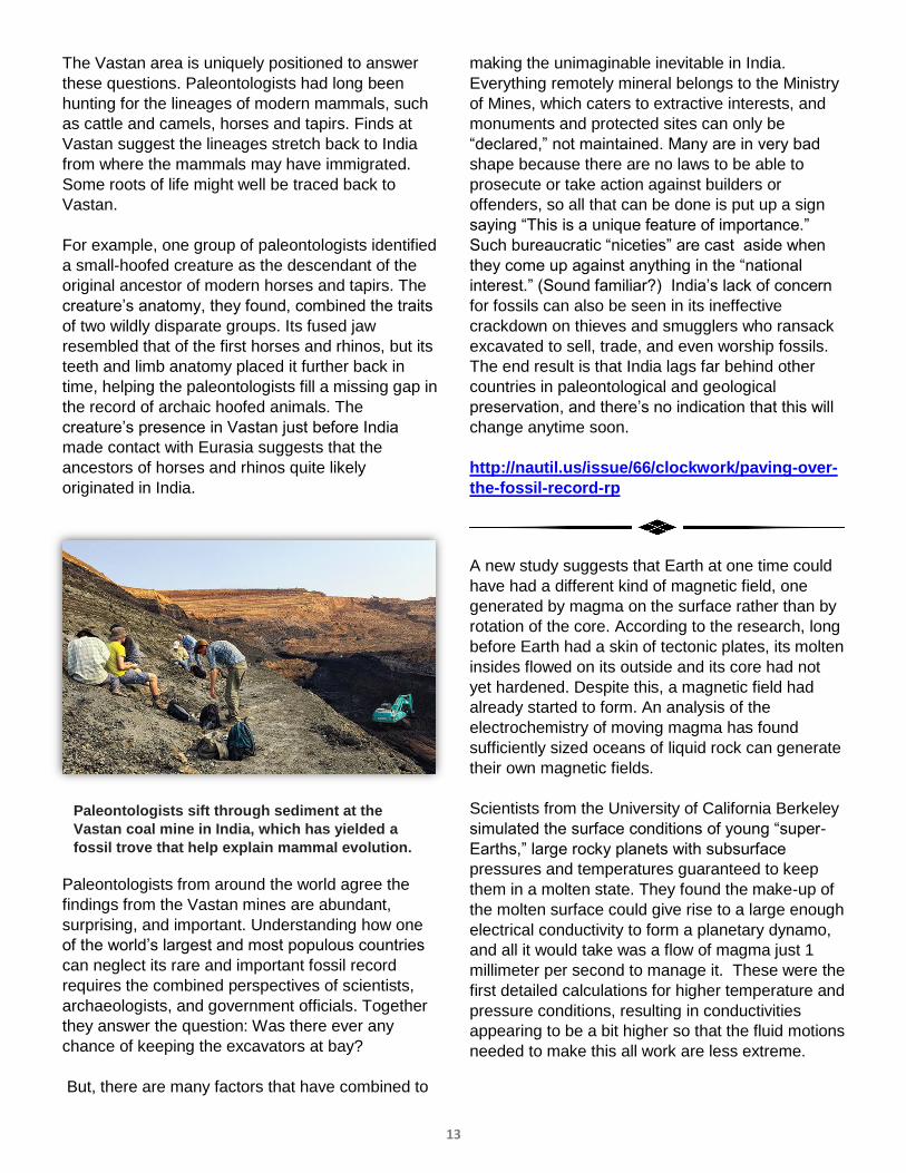
Paleontologists from around the world agree the
findings from the Vastan mines are abundant,
surprising, and important. Understanding how one
of the world’s largest and most populous countries
can neglect its rare and important fossil record
requires the combined perspectives of scientists,
archaeologists, and government officials. Together
they answer the question: Was there ever any
chance of keeping the excavators at bay?
But, there are many factors that have combined to
making the unimaginable inevitable in India.
Everything remotely mineral belongs to the Ministry
of Mines, which caters to extractive interests, and
monuments and protected sites can only be
“declared,” not maintained. Many are in very bad
shape because there are no laws to be able to
prosecute or take action against builders or
offenders, so all that can be done is put up a sign
saying “This is a unique feature of importance.”
Such bureaucratic “niceties” are cast aside when
they come up against anything in the “national
interest.” (Sound familiar?) India’s lack of concern
for fossils can also be seen in its ineffective
crackdown on thieves and smugglers who ransack
excavated to sell, trade, and even worship fossils.
The end result is that India lags far behind other
countries in paleontological and geological
preservation, and there’s no indication that this will
change anytime soon.
http://nautil.us/issue/66/clockwork/paving-over-
the-fossil-record-rp
A new study suggests that Earth at one time could
have had a different kind of magnetic field, one
generated by magma on the surface rather than by
rotation of the core. According to the research, long
before Earth had a skin of tectonic plates, its molten
insides flowed on its outside and its core had not
yet hardened. Despite this, a magnetic field had
already started to form. An analysis of the
electrochemistry of moving magma has found
sufficiently sized oceans of liquid rock can generate
their own magnetic fields.
Scientists from the University of California Berkeley
simulated the surface conditions of young “super-
Earths,” large rocky planets with subsurface
pressures and temperatures guaranteed to keep
them in a molten state. They found the make-up of
the molten surface could give rise to a large enough
electrical conductivity to form a planetary dynamo,
and all it would take was a flow of magma just 1
millimeter per second to manage it. These were the
first detailed calculations for higher temperature and
pressure conditions, resulting in conductivities
appearing to be a bit higher so that the fluid motions
needed to make this all work are less extreme.
Paleontologists sift through sediment at the
Vastan coal mine in India, which has yielded a
fossil trove that help explain mammal evolution.
14
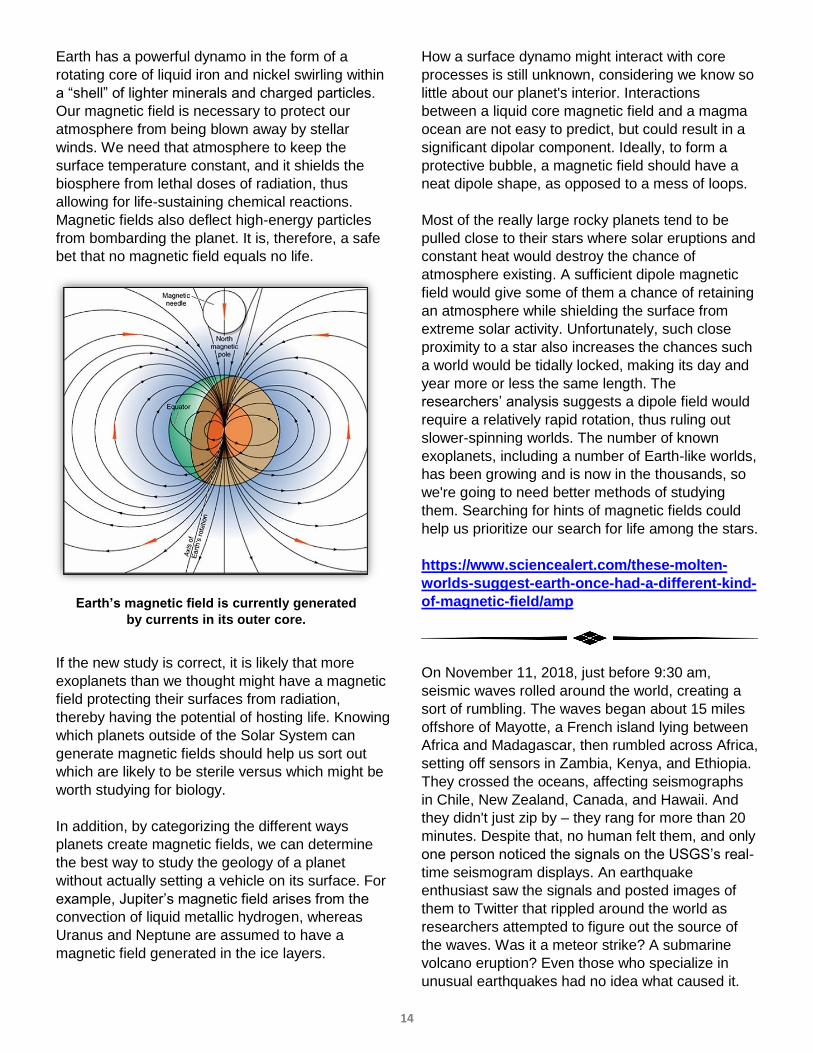
Earth has a powerful dynamo in the form of a
rotating core of liquid iron and nickel swirling within
a “shell” of lighter minerals and charged particles.
Our magnetic field is necessary to protect our
atmosphere from being blown away by stellar
winds. We need that atmosphere to keep the
surface temperature constant, and it shields the
biosphere from lethal doses of radiation, thus
allowing for life-sustaining chemical reactions.
Magnetic fields also deflect high-energy particles
from bombarding the planet. It is, therefore, a safe
bet that no magnetic field equals no life.
If the new study is correct, it is likely that more
exoplanets than we thought might have a magnetic
field protecting their surfaces from radiation,
thereby having the potential of hosting life. Knowing
which planets outside of the Solar System can
generate magnetic fields should help us sort out
which are likely to be sterile versus which might be
worth studying for biology.
In addition, by categorizing the different ways
planets create magnetic fields, we can determine
the best way to study the geology of a planet
without actually setting a vehicle on its surface. For
example, Jupiter’s magnetic field arises from the
convection of liquid metallic hydrogen, whereas
Uranus and Neptune are assumed to have a
magnetic field generated in the ice layers.
How a surface dynamo might interact with core
processes is still unknown, considering we know so
little about our planet's interior. Interactions
between a liquid core magnetic field and a magma
ocean are not easy to predict, but could result in a
significant dipolar component. Ideally, to form a
protective bubble, a magnetic field should have a
neat dipole shape, as opposed to a mess of loops.
Most of the really large rocky planets tend to be
pulled close to their stars where solar eruptions and
constant heat would destroy the chance of
atmosphere existing. A sufficient dipole magnetic
field would give some of them a chance of retaining
an atmosphere while shielding the surface from
extreme solar activity. Unfortunately, such close
proximity to a star also increases the chances such
a world would be tidally locked, making its day and
year more or less the same length. The
researchers’ analysis suggests a dipole field would
require a relatively rapid rotation, thus ruling out
slower-spinning worlds. The number of known
exoplanets, including a number of Earth-like worlds,
has been growing and is now in the thousands, so
we're going to need better methods of studying
them. Searching for hints of magnetic fields could
help us prioritize our search for life among the stars.
https://www.sciencealert.com/these-molten-
worlds-suggest-earth-once-had-a-different-kind-
of-magnetic-field/amp
On November 11, 2018, just before 9:30 am,
seismic waves rolled around the world, creating a
sort of rumbling. The waves began about 15 miles
offshore of Mayotte, a French island lying between
Africa and Madagascar, then rumbled across Africa,
setting off sensors in Zambia, Kenya, and Ethiopia.
They crossed the oceans, affecting seismographs
in Chile, New Zealand, Canada, and Hawaii. And
they didn't just zip by – they rang for more than 20
minutes. Despite that, no human felt them, and only
one person noticed the signals on the USGS’s real-
time seismogram displays. An earthquake
enthusiast saw the signals and posted images of
them to Twitter that rippled around the world as
researchers attempted to figure out the source of
the waves. Was it a meteor strike? A submarine
volcano eruption? Even those who specialize in
unusual earthquakes had no idea what caused it.
Earth’s magnetic field is currently generated
by currents in its outer core.
15
Many of the features of the waves were strange.
For example, they had a surprisingly monotone,
low-frequency “ring.” During a normal earthquake,
the P-waves and S-waves have relatively high
frequencies that generate a sort of “ping” rather
than rumbling. Surface waves are more similar to
the strange waves that rolled out of Mayotte.
However, there were no earthquakes involved, and
while most earthquakes send out waves of different
frequencies, Mayotte's signal was monochromatic,
that is, clean and dominated by one type of wave
that took a steady 17 seconds to repeat.
Based on the research that has been done so far,
the tremors seem to be related to a seismic swarm
that has gripped Mayotte since last May. Hundreds
of earthquakes have rattled the small nation during
that time, most radiating from just east of the
strange seismic event. Most of those were minor
tremblors, with a magnitude 5.8 being the largest
recorded in the island's history. Yet the frequency of
these shakes has declined in recent months and no
traditional quakes rumbled there when the mystery
waves began on November 11.
The French Geological Survey has been monitoring
the recent quakes closely, and it suggests that a
new center of volcanic activity may be developing
off the coast. Mayotte is a volcanic isle, but the
volcano has been quiet for over 4,000 years. The
Survey’s analysis suggests that the new activity
may point to magmatic movement miles offshore
under thousands of feet of water, in an area that
hasn't been studied in detail. GPS data show the
island has moved more than 2.4 inches east and
1.2 inches south, leading researchers to estimate
that a magma body measuring about a 1/3 cubic
mile is rising through the oceanic crust near
Mayotte. One researcher filtered out the low-
frequency signals and found what appear to have
been P- and S-waves of tiny tremors associated
with magma moving and fracturing rock as it makes
its way through the crust. But even those signals
were a little strange, seeming to be a little too
perfect to be considered natural.
Other researchers think the November 11 incident
actually began with an earthquake of sorts that
came and went largely unnoticed because it was a
slow earthquake. Such slow quakes, which are
quieter than normal quakes because they result
from a gradual release of stress over hours or even
days, are typically associated with volcanic activity.
However, although a submarine eruption could
have produced the low rumblings, there has not yet
been any evidence shown for one.
Most educated guesses tie the event to resonance
in a magma chamber that was triggered by a
subsurface shift or a chamber collapse. It is also
possible that the signal's odd uniformity could be
partly due to the local geology, which might be
filtering the sounds and letting the single 17-second
wave period escape. Mayotte sits in a region
crisscrossed by faults, including fracture zones from
the final breakup of Gondwana. In addition, the
underlying crust is somewhat transitional, shifting
between continental and oceanic crusts. Because
of the difficulties involved, the exact cause of the
signal might not be known for some time to come.
https://www.nationalgeographic.com/science/20
18/11/strange-earthquake-waves-rippled-
around-world-earth-geology/
During the Early Pleistocene, about 1.8 ma, Earth
was full of large animals (megafauna) such as:
lions, dire wolves, and giant sloths in North
America; camel-like creatures and 4,500-lb bears in
South America; rhinoceroses and cave hyenas in
Eurasia; and giant wombats and 7-ft flightless birds
in Australia. In addition, elephant relatives like
woolly mammoths and mastodons occurred on
many of those continents, as well as on many
islands. Then, during the Pleistocene, they all went
extinct.
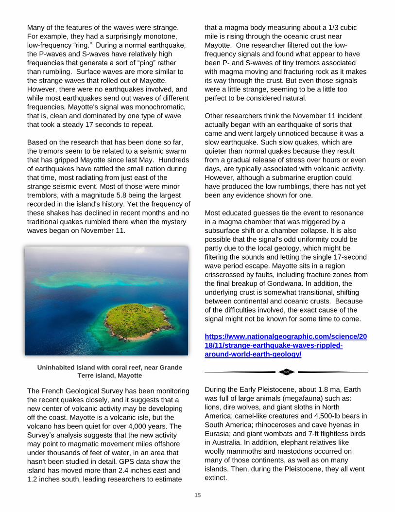
Uninhabited island with coral reef, near Grande
Terre island, Mayotte
16
Today, most of what constitutes megafauna exists
only in Africa, and there’s not that many of those
left. Archaeologists and environmentalists came to
a damning conclusion – humans were to blame.
The “overkill hypothesis,” as it is known, states that
the arrival of modern humans in each new part of
the world brought with it the extinction of all the
megafauna, whether through
hunting or outcompeting them for
resources. If we didn’t exist, all
those animals would still be
around.
But, can humans really be to
blame for all of the extinctions?
Some scientists say no, citing new
data for the lack of modern humans
at the time the extinctions took
place. Researchers recently found
human artifacts in the Madjedbebe
rock shelter in northern Australian
that indicate humans arrived on the
continent around 65 ka, 10,000
year earlier than previously
thought. Australian megafauna
didn’t start going extinct until
sometime between 60 ka and 40
ka, however, showing that people
were on the landscape well before
megafauna started suffering
population stress and showing signs
of extinction. Similarly, a recent study
suggests humans arrived in North America 100,000
years earlier than previously thought. If humans
were to blame for the Pleistocene extinctions, the
extinctions should have started with the arrival of
human, not thousands or tens of thousands of
years later.If humans DIDN’T kill the megafauna, it
might suggest our relationship is more one of being
just another species on the landscape, rather than a
total domination and inflicting environmental
violence.
Of course, not everyone agrees with the
archaeologists. Some geologists suggest that the
recent data actually confirm the “overkill
hypothesis.” An earlier argument against a human
role in the Australian megafaunal extinction was
that humans first appeared there around 50 ka.
Since the megafauna were extinct almost
immediately afterward, humans couldn’t have been
involved because they wouldn’t have had enough
time to build a population size sufficient to have any
kind of impact. The new data helps solve this
discrepancy, the geologists say. An earlier arrival
date gives humans time to increase in population
size and to spread across the landscape, eating
whatever they came across and transforming the
environment.
Since humans preying on some of the large animals
must be undeniable, it must also be undeniable that
something happened to the ecosystem structure
and function at about the same time. As evidence of
human predation, one researcher from Colorado
has spent years studying the burnt remains of eggs
laid by giant flightless birds in Australia that went
extinct approximately 47,000 years ago. He has
argued that the burn patterns on eggshells found in
more than 200 hearth sites across Australia were
very different from patterns created by natural
wildfires. Although he can’t make a firm statement,
he thinks the smart money is that the megafauna
would still be around if humans hadn’t arrived.
https://www.smithsonianmag.com/science-
nature/what-happened-worlds-most-enormous-
animals-180964255/
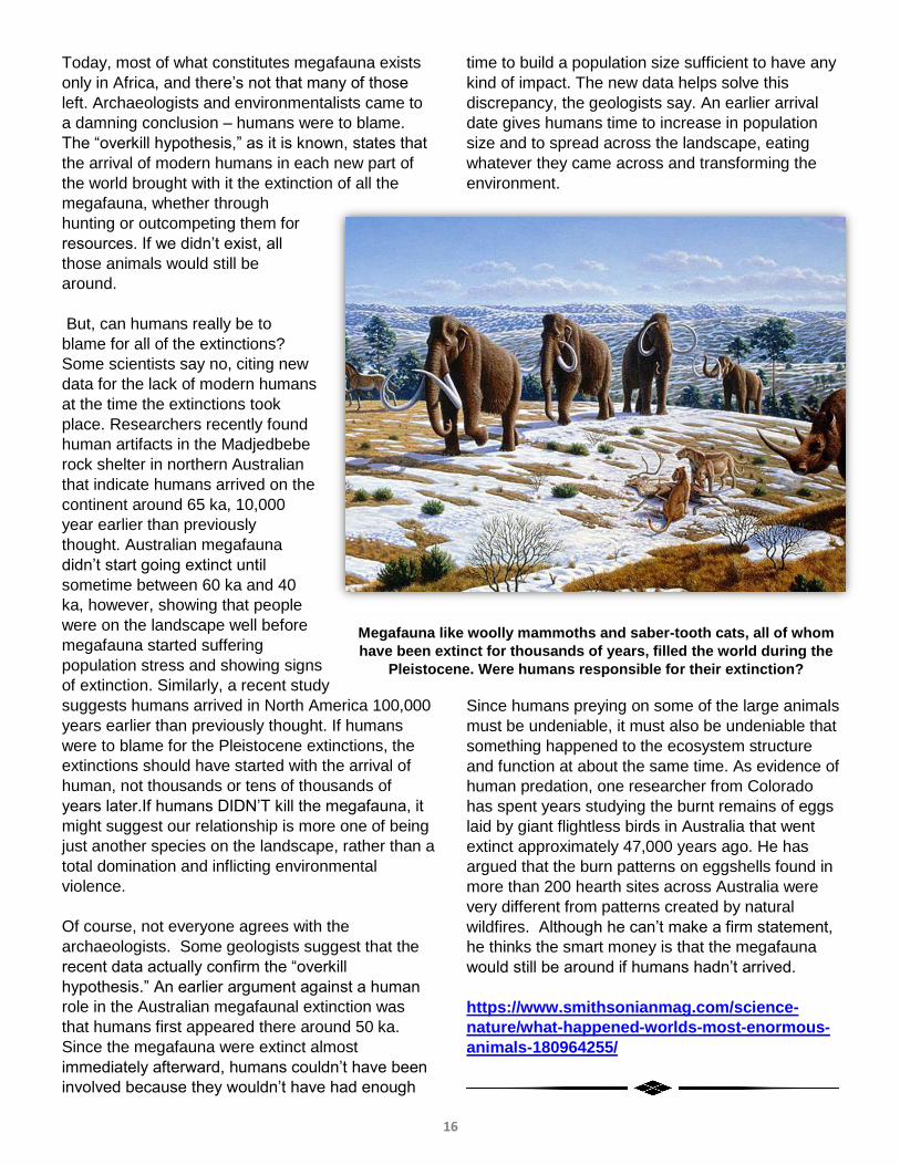
Megafauna like woolly mammoths and saber-tooth cats, all of whom
have been extinct for thousands of years, filled the world during the
Pleistocene. Were humans responsible for their extinction?
17
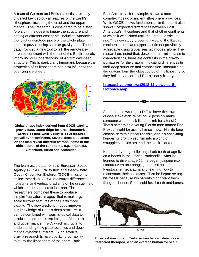
A team of German and British scientists recently
unveiled key geological features of the Earth's
lithosphere, including the crust and the upper
mantle. Their research is considered to be a step
forward in the quest to image the structure and
setting of different continents, including Antarctica,
the least understood piece of the whole plate
tectonic puzzle, using satellite gravity data. These
data provided a new tool to link the remote ice-
covered continent with the rest of the Earth, thereby
improving our understanding of Antarctica's deep
structure. This is particularly important, because the
properties of its lithosphere can also influence the
overlying ice sheets.
The team used data from the European Space
Agency’s (ESA), Gravity field and steady-state
Ocean Circulation Explorer (GOCE) mission to
collect their data. GOCE measures differences in
horizontal and vertical gradients of the gravity field,
which can be complex to interpret. The
researchers combined these to produce
simpler “curvature images” that reveal large-
scale tectonic features of the Earth more
clearly. The new gradient images improve
our knowledge of Earth's deep structure. It
can be combined with seismological data to
produce more consistent images of the crust
and upper mantle in 3-D, which is crucial to
understanding how plate tectonics and deep
mantle dynamics interact. Such satellite
gravity research is revolutionizing our ability
to study the lithosphere of the entire Earth.
East Antarctica, for example, shows a more
complex mosaic of ancient lithosphere provinces.
While GOCE shows fundamental similarities, it also
shows unexpected differences between East
Antarctica’s lithosphere and that of other continents
to which it was joined until the Late Jurassic 160
ma. The new study presents a view of the Earth's
continental crust and upper mantle not previously
achievable using global seismic models alone. The
researchers noted that, despite their similar seismic
characteristics, there are contrasts in the gravity
signatures for the cratons, indicating differences in
their deep structure and composition. Inasmuch as
the cratons form the oldest cores of the lithosphere,
they hold key records of Earth's early history.
https://phys.org/news/2018-11-views-earth-
tectonics.amp
Some people would just DIE to have their own
dinosaur skeleton. What could possibly make
someone want to risk life and limb for a fossil?
That’s something a young Florida man named Eric
Prokopi might be asking himself now. His life-long
obsession with dinosaur fossils, and his escalating
hunger for profit, lured him into a world of
smugglers, collectors, and the black-market.
He started young, collecting shark teeth at age five
on a beach in the Florida Panhandle. After he
learned to dive at age 10, he began jumping into
Florida rivers and bringing up fossil bones of
Pleistocene megafauna and learning how to
reconstruct their skeletons. Then he began selling
his fossils because his parents didn’t want them
filling the house. So he sold fossil teeth and bones,
Global shape index derived from GOCE satellite
gravity data. Dome-ridge features characterize
Earth’s oceans while valley to bowl features
prevail over continents. Several deep blue areas
on the map reveal different cratons -some of the
oldest cores of the continents, e.g. in Canada,
Greenland, Africa and Antarctica.
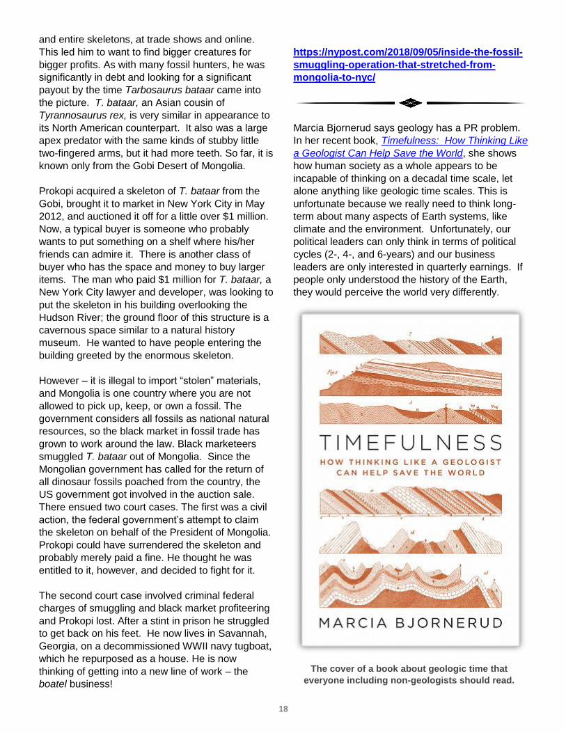
T. rex’s Asian cousin, Tarbosaurus bataar, shown as a feathered theropod, with an average human for scale.
18
and entire skeletons, at trade shows and online.
This led him to want to find bigger creatures for
bigger profits. As with many fossil hunters, he was
significantly in debt and looking for a significant
payout by the time Tarbosaurus bataar came into
the picture. T. bataar, an Asian cousin of
Tyrannosaurus rex, is very similar in appearance to
its North American counterpart. It also was a large
apex predator with the same kinds of stubby little
two-fingered arms, but it had more teeth. So far, it is
known only from the Gobi Desert of Mongolia.
Prokopi acquired a skeleton of T. bataar from the
Gobi, brought it to market in New York City in May
2012, and auctioned it off for a little over $1 million.
Now, a typical buyer is someone who probably
wants to put something on a shelf where his/her
friends can admire it. There is another class of
buyer who has the space and money to buy larger
items. The man who paid $1 million for T. bataar, a
New York City lawyer and developer, was looking to
put the skeleton in his building overlooking the
Hudson River; the ground floor of this structure is a
cavernous space similar to a natural history
museum. He wanted to have people entering the
building greeted by the enormous skeleton.
However – it is illegal to import “stolen” materials,
and Mongolia is one country where you are not
allowed to pick up, keep, or own a fossil. The
government considers all fossils as national natural
resources, so the black market in fossil trade has
grown to work around the law. Black marketeers
smuggled T. bataar out of Mongolia. Since the
Mongolian government has called for the return of
all dinosaur fossils poached from the country, the
US government got involved in the auction sale.
There ensued two court cases. The first was a civil
action, the federal government’s attempt to claim
the skeleton on behalf of the President of Mongolia.
Prokopi could have surrendered the skeleton and
probably merely paid a fine. He thought he was
entitled to it, however, and decided to fight for it.
The second court case involved criminal federal
charges of smuggling and black market profiteering
and Prokopi lost. After a stint in prison he struggled
to get back on his feet. He now lives in Savannah,
Georgia, on a decommissioned WWII navy tugboat,
which he repurposed as a house. He is now
thinking of getting into a new line of work – the
boatel business!
https://nypost.com/2018/09/05/inside-the-fossil-
smuggling-operation-that-stretched-from-
mongolia-to-nyc/
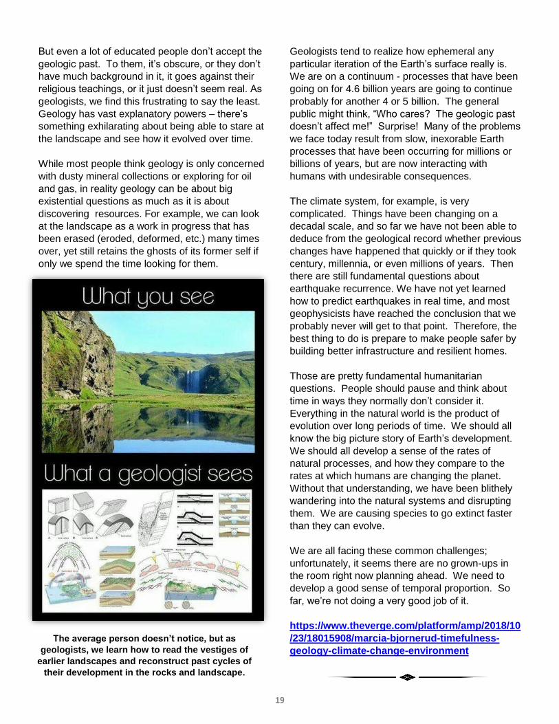
Marcia Bjornerud says geology has a PR problem.
In her recent book, Timefulness: How Thinking Like
a Geologist Can Help Save the World, she shows
how human society as a whole appears to be
incapable of thinking on a decadal time scale, let
alone anything like geologic time scales. This is
unfortunate because we really need to think long-
term about many aspects of Earth systems, like
climate and the environment. Unfortunately, our
political leaders can only think in terms of political
cycles (2-, 4-, and 6-years) and our business
leaders are only interested in quarterly earnings. If
people only understood the history of the Earth,
they would perceive the world very differently.
The cover of a book about geologic time that
everyone including non-geologists should read.
19
But even a lot of educated people don’t accept the
geologic past. To them, it’s obscure, or they don’t
have much background in it, it goes against their
religious teachings, or it just doesn’t seem real. As
geologists, we find this frustrating to say the least.
Geology has vast explanatory powers – there’s
something exhilarating about being able to stare at
the landscape and see how it evolved over time.
While most people think geology is only concerned
with dusty mineral collections or exploring for oil
and gas, in reality geology can be about big
existential questions as much as it is about
discovering resources. For example, we can look
at the landscape as a work in progress that has
been erased (eroded, deformed, etc.) many times
over, yet still retains the ghosts of its former self if
only we spend the time looking for them.
Geologists tend to realize how ephemeral any
particular iteration of the Earth’s surface really is.
We are on a continuum - processes that have been
going on for 4.6 billion years are going to continue
probably for another 4 or 5 billion. The general
public might think, “Who cares? The geologic past
doesn’t affect me!” Surprise! Many of the problems
we face today result from slow, inexorable Earth
processes that have been occurring for millions or
billions of years, but are now interacting with
humans with undesirable consequences.
The climate system, for example, is very
complicated. Things have been changing on a
decadal scale, and so far we have not been able to
deduce from the geological record whether previous
changes have happened that quickly or if they took
century, millennia, or even millions of years. Then
there are still fundamental questions about
earthquake recurrence. We have not yet learned
how to predict earthquakes in real time, and most
geophysicists have reached the conclusion that we
probably never will get to that point. Therefore, the
best thing to do is prepare to make people safer by
building better infrastructure and resilient homes.
Those are pretty fundamental humanitarian
questions. People should pause and think about
time in ways they normally don’t consider it.
Everything in the natural world is the product of
evolution over long periods of time. We should all
know the big picture story of Earth’s development.
We should all develop a sense of the rates of
natural processes, and how they compare to the
rates at which humans are changing the planet.
Without that understanding, we have been blithely
wandering into the natural systems and disrupting
them. We are causing species to go extinct faster
than they can evolve.
We are all facing these common challenges;
unfortunately, it seems there are no grown-ups in
the room right now planning ahead. We need to
develop a good sense of temporal proportion. So
far, we’re not doing a very good job of it.
https://www.theverge.com/platform/amp/2018/10
/23/18015908/marcia-bjornerud-timefulness-
geology-climate-change-environment
The average person doesn’t notice, but as
geologists, we learn how to read the vestiges of
earlier landscapes and reconstruct past cycles of
their development in the rocks and landscape.
20
PGS Board-of-Directors President: Tamra Schiappa Director-at-Large: Albert Kollar Director-at-Large: Wendell Barner
Vice President: Dan Harris Director-at-Large: Ray Follador Director-at-Large: Erica Love
Treasurer: Kyle Fredrick Director-at-Large: Brian Dunst Counselor: John Harper
Secretary: Ken LaSota Director-at-Large: Mary Ann Gross Counselor: Charles Shultz
Past President: Peter Michael PGS Student Board Member Delegate: Jacob Podrasky (CalU)
Other PGS Positions: Newsletter Editor / Webmaster: Karen Rose Cercone Historian: Judy Neelan
AAPG Delegates: Dan Billman and Andrea Reynolds Continuing Ed: Brian Dunst
Officer Contacts: If you wish to contact a PGS Officer, you can email Tamra Schiappa, President, at
[email protected]; Dan Harris, Vice President at [email protected]; Kyle
Fredrick, Treasurer, at [email protected]; or Ken LaSota, Secretary, at
Memberships: For information about memberships, please write PGS Membership Chair, PO Box
58172, Pittsburgh PA 15209, or e-mail [email protected]. Membership
information may also be found at our website: www.pittsburghgeologicalsociety.org.
Programs: If you would like to make a presentation at a PGS meeting or have a suggestion for a
future speaker, contact Dan Harris, Program Chair at [email protected].
Newsletter: To contact the Newsletter Editor, Karen Rose Cercone, with questions or suggestions
for articles, job postings or geological events, please email [email protected].
Facebook: Follow the PGS at https://www.facebook.com/PittsburghGeologicalSociety
Twitter: PGS can be followed on Twitter by searching out the username @PghGeoSociety
LinkedIn: To join the PGS Group, click https://www.linkedin.com/groups/12018505
Fun Fact Having Nothing to Do with Geology
The largest snowflake ever reported was 15 inches wide and 8
inches thick, discovered by a rancher in Montana in 1887.
https://earthsky.org/space/mapping-the-
threat-of-small-near-earth-asteroids
PGS WEBSITE OF
THE MONTH

21
ACA Engineering, Inc.
www.acaengineering.com
American Geosciences, Inc.
www.amergeo.com
American Geotechnical &
Environmental Services, Inc.
www.AGESInc.com
Ammonite Resources
www.ammoniteresources.com
Applied Geology and
Environmental Science, Inc.
www.appliedgeology.net
APTIM Environmental & Infrastructure, Inc.
www.aptim.com
AWK Consulting Engineers, Inc.
www.awkengineers.com/
22
Barner Consulting, LLC
The Baron Group Inc.
Batelle https://www.battelle.org/
Billman Geologic Consultants, Inc.
www.billmangeologic.com
DiGioia, Gray & Associates, LLC
http://www.digioiagray.com
DORSO LP
Enviro-Equipment https://www.enviroequipment.com/
Falcede Energy Consulting, LLC
Gannett-Fleming http://www.gfnet.com/
23
Geo-Environmental Drilling Co., Inc.
www.geoenv.com
Groundwater & Environmental
Services, Inc.
hwww.gesonline.com
HDR Engineering, Inc.
www.hdrinc.com
Howard Concrete Pumping Co., Inc.
www.howardconcretepumping.com
Huntley & Huntley, Inc.
www.huntleyinc.com
The Insite Group
http://insitegroup.org/
Key Environmental
http://www.keyenvir.com/
Laurel Mountain Energy
laurelmountainenergy.com
Montrose Air Quality Services www.montrose-env.com

24
Moody and Associates Inc.
www.moody-s.com
PA Council of Professional Geologists
http://www.pcpg.org/
Pennsylvania Drilling Co.
www.pennsylvaniadrillingco.com
Pennsylvania Rock and Soil
http://www.pasoilrock.com/
Range Resources - Appalachia
www.rangeresources.com
Rosebud Mining Company
www.rosebudmining.com/
Seneca Resources Company LLC
www.natfuel.com/seneca
Stahl Sheaffer Engineering
http://www.sse-llc.com/
TD Geologic LLC
https://www.tdgeologic.com/
25
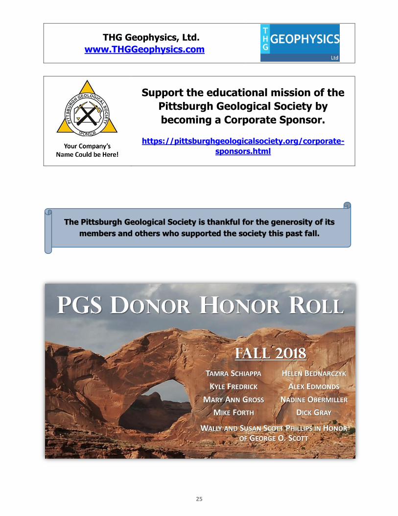
THG Geophysics, Ltd.
www.THGGeophysics.com
Support the educational mission of the
Pittsburgh Geological Society by
becoming a Corporate Sponsor.
https://pittsburghgeologicalsociety.org/corporate-
sponsors.html
The Pittsburgh Geological Society is thankful for the generosity of its
members and others who supported the society this past fall.

![major fault minor fault · Waltham, T., Bell, F. & Culshaw, M. [2005] Sinkholes and Subsidence – Karst and Cavernous Rocks in Engineering and Construction. – 384 p.; Berlin (Springer)](https://img.pdfslide.net/doc/110x75/5f0a98707e708231d42c67ee/major-fault-minor-fault-waltham-t-bell-f-culshaw-m-2005-sinkholes.jpg)